Late Pleistocene tectonic-geomorphological development within a passive margin — The Cariatá trough, northeastern Brazil Francisco H.R. Bezerra a, ⁎ , Benjamim B. Brito Neves b , Antonio C.B. Corrêa c , Alcina M.F. Barreto d , Kenitiro Suguio b,e a Departamento de Geologia, Universidade Federal do Rio Grande do Norte, Natal, RN, 59072-970, Brazil b Instituto de Geociências, Universidade de São Paulo, São Paulo, SP, 05508-080, Brazil c Departamento de Ciências Geográficas, Universidade Federal de Pernambuco, Recife, PE, 50740-530, Brazil d Departamento de Geologia, Universidade Federal de Pernambuco, Recife, PE, 50740-530, Brazil e Centro de Pós-Graduação, Pesquisa e Extensão, Universidade de Guarulhos, São Paulo, SP, 07023-070, Brazil Received 5 June 2006; received in revised form 6 September 2007; accepted 9 September 2007 Available online 20 September 2007 Abstract Studies on the geomorphological evolution of the South American passive margin have been based on the pediplanation model, which predicts that its morphology is a response to regional uniform uplift and concomitant development of erosion surfaces. We combined remote sensing, geological mapping, lithostratigraphic and facies analyses, and luminescence dating in the Cariatá trough, northeastern Brazil, in order to determine how brittle tectonics and climate influenced colluviation and the shaping of local landforms in the Quaternary. Our work indicates that Cariatá is an asymmetrical trough ∼ 40 km long, ∼ 25 km wide, 250–550 m deep, and delimited by ENE–WSW-trending faults to the north and south. We recognized an ENE–WSW-oriented compression related to a strike-slip faulting regime, which corresponds to the present-day stress field in the region. This faulting event led to the deposition of colluvial fans, shed from adjacent uplifted crustal blocks, in a tectonically controlled depression. The colluvial succession is ∼ 45 m thick and presents two facies assemblages that filled the southern and, in particular, the northern borders of the trough: non-cohesive debrisflow and mudflow deposits. Optically stimulated luminescence dates of the sedimentary infill yielded ages at 224–128 ka and 45–28 ka, dominated by debrisflow and mudflow deposits, respectively. These ages may be over-estimated due to poor bleaching of colluvium, but they and our field data suggest that the margins of the trough were tectonically uplifted and eroded twice in the Late Pleistocene. The spasmodic colluvial accretion reflects the occurrence of high-magnitude, low-recurrence episodes probably associated with climate shifts in a semi-arid hillslope system. It follows that the present-day low-lying piedmont in which the Cariatá trough occurs is a juxtaposition of surfaces of various ages. This trough may have counterparts across the region. These conclusions do not corroborate the application of the cyclical pediplanation hypothesis in the area. © 2007 Elsevier B.V. All rights reserved. Keywords: Passive margin; Colluvium; Quaternary; Neotectonics; Luminescence dating 1. Introduction The morphology and sedimentation of passive margins have been related to several controlling factors, the most important of which have been regarded as Available online at www.sciencedirect.com Geomorphology 97 (2008) 555 – 582 www.elsevier.com/locate/geomorph ⁎ Corresponding author. Tel.: +55 84 3215 3807; fax: +55 84 3215 3806. E-mail address: [email protected] (F.H.R. Bezerra). 0169-555X/$ - see front matter © 2007 Elsevier B.V. All rights reserved. doi:10.1016/j.geomorph.2007.09.008

Welcome message from author
This document is posted to help you gain knowledge. Please leave a comment to let me know what you think about it! Share it to your friends and learn new things together.
Transcript
Available online at www.sciencedirect.com
2008) 555–582www.elsevier.com/locate/geomorph
Geomorphology 97 (
Late Pleistocene tectonic-geomorphological development within apassive margin — The Cariatá trough, northeastern Brazil
Francisco H.R. Bezerra a,⁎, Benjamim B. Brito Neves b, Antonio C.B. Corrêa c,Alcina M.F. Barreto d, Kenitiro Suguio b,e
a Departamento de Geologia, Universidade Federal do Rio Grande do Norte, Natal, RN, 59072-970, Brazilb Instituto de Geociências, Universidade de São Paulo, São Paulo, SP, 05508-080, Brazil
c Departamento de Ciências Geográficas, Universidade Federal de Pernambuco, Recife, PE, 50740-530, Brazild Departamento de Geologia, Universidade Federal de Pernambuco, Recife, PE, 50740-530, Brazil
e Centro de Pós-Graduação, Pesquisa e Extensão, Universidade de Guarulhos, São Paulo, SP, 07023-070, Brazil
Received 5 June 2006; received in revised form 6 September 2007; accepted 9 September 2007Available online 20 September 2007
Abstract
Studies on the geomorphological evolution of the South American passive margin have been based on the pediplanation model,which predicts that its morphology is a response to regional uniform uplift and concomitant development of erosion surfaces. Wecombined remote sensing, geological mapping, lithostratigraphic and facies analyses, and luminescence dating in the Cariatátrough, northeastern Brazil, in order to determine how brittle tectonics and climate influenced colluviation and the shaping of locallandforms in the Quaternary. Our work indicates that Cariatá is an asymmetrical trough ∼40 km long, ∼25 km wide, 250–550 mdeep, and delimited by ENE–WSW-trending faults to the north and south. We recognized an ENE–WSW-oriented compressionrelated to a strike-slip faulting regime, which corresponds to the present-day stress field in the region. This faulting event led to thedeposition of colluvial fans, shed from adjacent uplifted crustal blocks, in a tectonically controlled depression. The colluvialsuccession is ∼45 m thick and presents two facies assemblages that filled the southern and, in particular, the northern borders of thetrough: non-cohesive debrisflow and mudflow deposits. Optically stimulated luminescence dates of the sedimentary infill yieldedages at 224–128 ka and 45–28 ka, dominated by debrisflow and mudflow deposits, respectively. These ages may be over-estimateddue to poor bleaching of colluvium, but they and our field data suggest that the margins of the trough were tectonically uplifted anderoded twice in the Late Pleistocene. The spasmodic colluvial accretion reflects the occurrence of high-magnitude, low-recurrenceepisodes probably associated with climate shifts in a semi-arid hillslope system. It follows that the present-day low-lying piedmontin which the Cariatá trough occurs is a juxtaposition of surfaces of various ages. This trough may have counterparts across theregion. These conclusions do not corroborate the application of the cyclical pediplanation hypothesis in the area.© 2007 Elsevier B.V. All rights reserved.
Keywords: Passive margin; Colluvium; Quaternary; Neotectonics; Luminescence dating
⁎ Corresponding author. Tel.: +55 84 3215 3807; fax: +55 84 32153806.
E-mail address: [email protected] (F.H.R. Bezerra).
0169-555X/$ - see front matter © 2007 Elsevier B.V. All rights reserved.doi:10.1016/j.geomorph.2007.09.008
1. Introduction
The morphology and sedimentation of passivemargins have been related to several controlling factors,the most important of which have been regarded as
556 F.H.R. Bezerra et al. / Geomorphology 97 (2008) 555–582
tectonics and climate. Some features related to thesefactors also frequently quoted are thermal subsidenceand sea-level change, respectively (e.g., Lavier et al.,2001). The contribution of these individual factors inshaping the morphology and sediment supply of passivemargins is, however, difficult to isolate.
The first factor, intraplate tectonics, has long beenrecognized as a mechanism related to the post-breakupdevelopment of sedimentary basins along rifted passivemargins. There is a common assumption in the literaturethat these margins were uplifted and remained elevatedsince their rift phase (e.g., Lidmar-Bergström et al.,2000; Japsen et al., 2006). This assumption is, in part,due to the fact that the quantification of post-breakupdenudation has proved to be difficult. This probablyexplains why landform development of a few passivemargins has been based on oversimplified models.
Increasingly, however, observations of many passivemargins indicate uplifts and subsidence on a local scaleand that involves mechanisms not applicable to theentire margin. A few examples demonstrate theexistence of these mechanisms. In West Greenland,Japsen et al. (2006) proposed that the uplift of rift flanksto present-day elevation post-dates rifting and occurredmostly in the Cenozoic. This uplift has been nothomogeneous and has offset paleosurfaces of Mesozoicand Cenozoic age. Bonow et al. (2006) added that thesepaleosurfaces present inclinations across major struc-turally controlled blocks. The boundaries between theseblocks form scarps and topographic breaks associatedwith fault reactivation. In the Fennoscandia passivemargin, post-rift uplift has not been the same across themargin. A Plio–Pleistocene uplift, for example, oc-curred in certain areas such as southern Norway. Itproduced differential denudation rates and the develop-ment of sedimentary basins (Riis, 1996). Anotherexample is reported in the Antarctica margin, north ofVictoria Land, where apatite fission-track dates indicatea significantly different cooling history of the tectonicblocks caused by differentiated regional denudation(Lisker, 2002).
The second factor, climate, also has great signifi-cance for geomorphological studies. Dissected passivemargins, whether from the tropics or the sub-tropics,appear to exhibit many major geomorphologicalfeatures in common (Thomas, 1995). But the role ofclimate in shaping morphology and sediment produc-tion, especially in the tropics, is still elusive, mostlybecause there are important gaps in the knowledge ofregional paleoclimates. For example, low resolutionstudies of sediments can miss episodic events such asclimate shifts that may take 102 years to occur. On the
other hand, high-resolution studies may identify inter-annual climate variability only (Thomas and Thorpe,1995).
One way forward has been the investigation ofclimate-sensitive sediments. Among the sedimentsclosely related to climate shifts and some peculiartopographic features such as hillslopes, colluvium hasbeen described as one of the most significant. Severalstudies demonstrated that colluvium occurs morefrequently as a result of changes in the frequency ofhigh-magnitude rainfall related to climatic shifts(Thomas, 1998). Although the geomorphological liter-ature is replete with references to colluvium, it hasscarcely been investigated because of the relative lack ofcase studies, which probably indicates the absence ofgeomorphological/geological criteria that could makecolluvium easier to identify in the stratigraphic record(Blikra and Nemec, 1998; Nemec and Kazanci, 1999).
In eastern South America and western Africanpassive margins, there is mounting evidence that thefactors cited above play a determinant role in sedimen-tary-basin and landform development. Despite mount-ing evidence of local mechanisms of uplift andsubsidence operating within shorter time frames thatultimately led to landform development, landscapeevolution continues to be addressed, in a significantpart of the literature, solely by the interplay betweenlong-term denudation and regional uplift as proposed byKing (e.g., 1956, 1967). This model has played asignificant role in explaining both tectonics (or itsabsence) and climate as driving mechanisms ofmorphogenesis in these passive margins.
In the Brazilian passive margin, a few problems havearisen because of the pediplanation model approach:
1. Despite their important conclusions, previous studiesmainly emphasized the early (rift) history ofsedimentary basins. After the rifting stage, the poorlyinvestigated crustal movements have led to theparadigm of stable areas. In Brazil, these ideas areexpressed in studies that have used simplistic modelsof regional or even worldwide planation. Moreover,the post-rift period has been regarded as a period offew active faults, if any, with no topographic orsedimentary expression. The description of Neogenefaults usually has been limited to meso-scale featuresunrelated to landforms.
2. Sedimentary basins have been regarded as tectoni-cally inactive, with sedimentation and any resultantgeomorphological history reflecting the passivestructural controls of the rifted basement bedrock.Late Neogene deposits have usually been described
557F.H.R. Bezerra et al. / Geomorphology 97 (2008) 555–582
capping older faults and the top of grabens ofMesozoic age. In spite of mounting evidence to thecontrary, few studies have questioned these assump-tions. In addition, few studies have investigated therole of Neogene faults in the supply of sediments tothe sedimentary basins. Therefore, geological andgeomorphological studies have described Neogenesediments as the product of solely climatic-controlledprocesses that led to the erosion of laterites of Eoceneand Neogene age.
3. Neogene sedimentary covers occurring along thecoast in the shape of low-lying (50–200 m asl)dissected tablelands have been grouped as a singlestratigraphic unit. Most of the time, such sedimentarycovers are affiliated with the so-called Miocene–Pliocene Barreiras formation, following straightfor-ward rationales such as: (a) geographic positionalong the coastline; (b) height of tablelands notexceeding 200 m in elevation; and (c) roughlyaccordant summits with the contiguous inlanddissected hilltops shaped on crystalline rocks, fromwhich sedimentary covers should have been derivedas a depositional ‘glacis’ following application of acyclic denudation chronology. In the circumstanceslisted above, elevation played a key role inidentifying erosion surfaces and ancient weatheringmantles. Little effort has been made to differentiatesediment properties, possible local controls on sourceareas, depositional environments, or to obtain anabsolute chronology.
4. Following the pediplanation model that associateslandscape evolution with prevailing semi-arid con-ditions, several studies proposed a direct linkbetween semi-arid conditions and colluviation notonly in Brazil but also in Africa. These semi-aridconditions extended from the subtropical regions(∼34°S) to the equator. However, there is noconclusive evidence that a long-lasting semi-aridepisode would produce sufficient sedimentation orlead to the formation of thick regoliths that wouldaccount for pervasive regional colluviation.
It follows that the refinement of long-term landscapeevolution, its spatial and temporal relationship with faultactivity and sedimentation will then require a moredetailed analysis of sedimentary deposits and theirformation processes. This approach requires a multidis-ciplinary investigation.
The main purpose of this study is to explore theseissues further using an integrated geological andgeomorphological approach to unravel the spatial andtemporal patterns of fault activity and their relationship
to sedimentation and erosion. The study area is theCariatá trough, first identified by Brito Neves et al.(2004), and its surrounding area. It lies between theinterior highlands (Borborema highlands) and the low-lying tablelands of the coastal plains of northeasternBrazil (Fig. 1).
2. Establishing the research framework
2.1. Relief development in the passive margins ofeastern South America and western Africa
The passive margins of both eastern South Americaand western Africa have been described by severalstudies as being formed by successive pediplains,developed at progressively higher elevations from thecoastal regions inland. One of the pioneering andseminal studies on pediplanation in these passivemargins was presented by King (1956). It was followedby several other publications.
The foundation of King's model is based on thefollowing premises: (1) continental areas uplift episod-ically, almost synchronously, and uniformly; this kind ofuplift is of global extent; (2) parallel-scarps retreat(backwearing) prevails over downwearing, which isregarded as minimum; this retreat propagates inland asdenudation progresses; (3) knickpoints retreat inlandover long distances along rivers and slopes. Theapproach used in this model favors the spatialcorrelation of erosion (or planation) surfaces, usuallywidely scattered, which would be based on theirelevation and relative position in the landscape. Thiscorrelation would eventually lead to an estimated age oferosion surfaces, especially if a link could be establishedbetween the erosion surface and a sedimentary depositof known age.
Based on the premises above, King (1956, 1967,1983) suggested that both the African and SouthAmerican passive margins experienced the samedenudation cycles and, more likely, present the sameerosion surfaces from the Jurassic to the present.Moreover, King (1956) proposed a chronological andmorphological link between Africa and South America.He also proposed that variation in lithology, climaticchanges, and local tectonics did not disturb the generalpediplanation trend.
This approach has been widely applied in Brazil.Many studies have tried to match King's (1956)proposal by applying several erosion surface modelsand nomenclatures to the stepped landforms of Brazil.Most such studies have proposed four periods ofmechanical morphogenesis related to uniform uplift
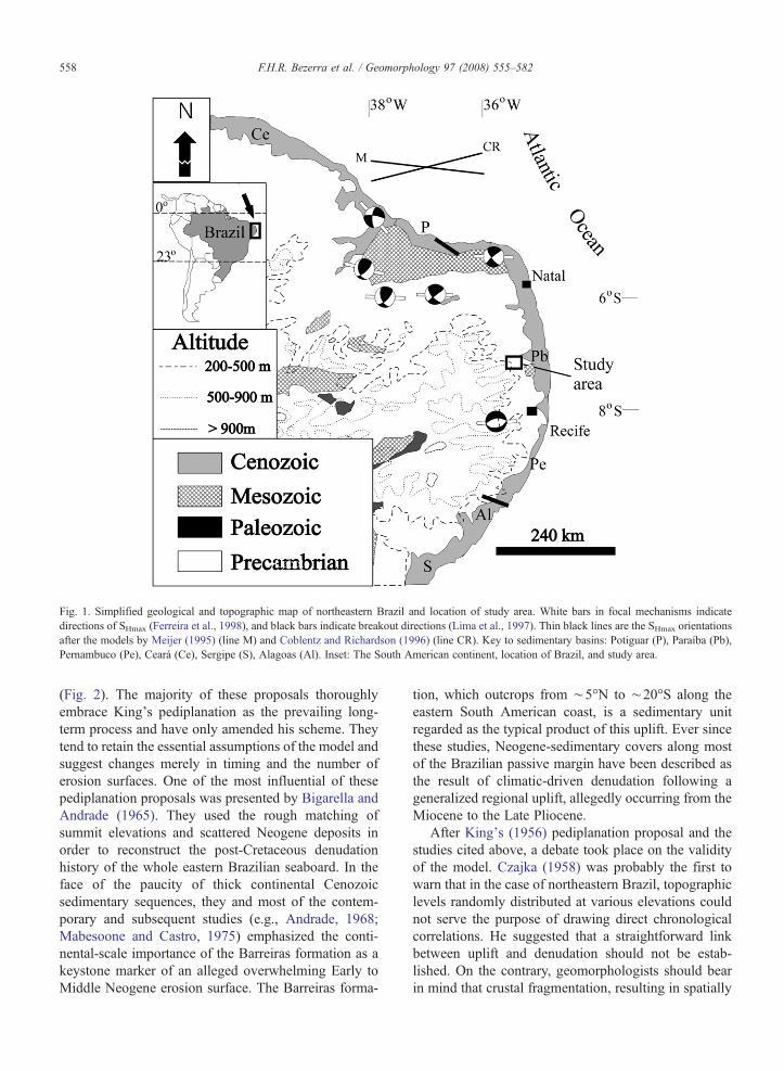
Fig. 1. Simplified geological and topographic map of northeastern Brazil and location of study area. White bars in focal mechanisms indicatedirections of SHmax (Ferreira et al., 1998), and black bars indicate breakout directions (Lima et al., 1997). Thin black lines are the SHmax orientationsafter the models by Meijer (1995) (line M) and Coblentz and Richardson (1996) (line CR). Key to sedimentary basins: Potiguar (P), Paraíba (Pb),Pernambuco (Pe), Ceará (Ce), Sergipe (S), Alagoas (Al). Inset: The South American continent, location of Brazil, and study area.
558 F.H.R. Bezerra et al. / Geomorphology 97 (2008) 555–582
(Fig. 2). The majority of these proposals thoroughlyembrace King's pediplanation as the prevailing long-term process and have only amended his scheme. Theytend to retain the essential assumptions of the model andsuggest changes merely in timing and the number oferosion surfaces. One of the most influential of thesepediplanation proposals was presented by Bigarella andAndrade (1965). They used the rough matching ofsummit elevations and scattered Neogene deposits inorder to reconstruct the post-Cretaceous denudationhistory of the whole eastern Brazilian seaboard. In theface of the paucity of thick continental Cenozoicsedimentary sequences, they and most of the contem-porary and subsequent studies (e.g., Andrade, 1968;Mabesoone and Castro, 1975) emphasized the conti-nental-scale importance of the Barreiras formation as akeystone marker of an alleged overwhelming Early toMiddle Neogene erosion surface. The Barreiras forma-
tion, which outcrops from ∼5°N to ∼20°S along theeastern South American coast, is a sedimentary unitregarded as the typical product of this uplift. Ever sincethese studies, Neogene-sedimentary covers along mostof the Brazilian passive margin have been described asthe result of climatic-driven denudation following ageneralized regional uplift, allegedly occurring from theMiocene to the Late Pliocene.
After King's (1956) pediplanation proposal and thestudies cited above, a debate took place on the validityof the model. Czajka (1958) was probably the first towarn that in the case of northeastern Brazil, topographiclevels randomly distributed at various elevations couldnot serve the purpose of drawing direct chronologicalcorrelations. He suggested that a straightforward linkbetween uplift and denudation should not be estab-lished. On the contrary, geomorphologists should bearin mind that crustal fragmentation, resulting in spatially
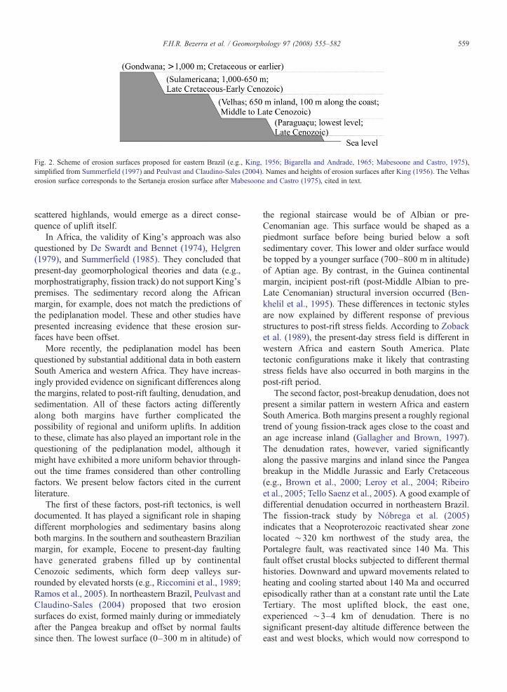
Fig. 2. Scheme of erosion surfaces proposed for eastern Brazil (e.g., King, 1956; Bigarella and Andrade, 1965; Mabesoone and Castro, 1975),simplified from Summerfield (1997) and Peulvast and Claudino-Sales (2004). Names and heights of erosion surfaces after King (1956). The Velhaserosion surface corresponds to the Sertaneja erosion surface after Mabesoone and Castro (1975), cited in text.
559F.H.R. Bezerra et al. / Geomorphology 97 (2008) 555–582
scattered highlands, would emerge as a direct conse-quence of uplift itself.
In Africa, the validity of King's approach was alsoquestioned by De Swardt and Bennet (1974), Helgren(1979), and Summerfield (1985). They concluded thatpresent-day geomorphological theories and data (e.g.,morphostratigraphy, fission track) do not support King'spremises. The sedimentary record along the Africanmargin, for example, does not match the predictions ofthe pediplanation model. These and other studies havepresented increasing evidence that these erosion sur-faces have been offset.
More recently, the pediplanation model has beenquestioned by substantial additional data in both easternSouth America and western Africa. They have increas-ingly provided evidence on significant differences alongthe margins, related to post-rift faulting, denudation, andsedimentation. All of these factors acting differentlyalong both margins have further complicated thepossibility of regional and uniform uplifts. In additionto these, climate has also played an important role in thequestioning of the pediplanation model, although itmight have exhibited a more uniform behavior through-out the time frames considered than other controllingfactors. We present below factors cited in the currentliterature.
The first of these factors, post-rift tectonics, is welldocumented. It has played a significant role in shapingdifferent morphologies and sedimentary basins alongboth margins. In the southern and southeastern Brazilianmargin, for example, Eocene to present-day faultinghave generated grabens filled up by continentalCenozoic sediments, which form deep valleys sur-rounded by elevated horsts (e.g., Riccomini et al., 1989;Ramos et al., 2005). In northeastern Brazil, Peulvast andClaudino-Sales (2004) proposed that two erosionsurfaces do exist, formed mainly during or immediatelyafter the Pangea breakup and offset by normal faultssince then. The lowest surface (0–300 m in altitude) of
the regional staircase would be of Albian or pre-Cenomanian age. This surface would be shaped as apiedmont surface before being buried below a softsedimentary cover. This lower and older surface wouldbe topped by a younger surface (700–800 m in altitude)of Aptian age. By contrast, in the Guinea continentalmargin, incipient post-rift (post-Middle Albian to pre-Late Cenomanian) structural inversion occurred (Ben-khelil et al., 1995). These differences in tectonic stylesare now explained by different response of previousstructures to post-rift stress fields. According to Zobacket al. (1989), the present-day stress field is different inwestern Africa and eastern South America. Platetectonic configurations make it likely that contrastingstress fields have also occurred in both margins in thepost-rift period.
The second factor, post-breakup denudation, does notpresent a similar pattern in western Africa and easternSouth America. Both margins present a roughly regionaltrend of young fission-track ages close to the coast andan age increase inland (Gallagher and Brown, 1997).The denudation rates, however, varied significantlyalong the passive margins and inland since the Pangeabreakup in the Middle Jurassic and Early Cretaceous(e.g., Brown et al., 2000; Leroy et al., 2004; Ribeiroet al., 2005; Tello Saenz et al., 2005). A good example ofdifferential denudation occurred in northeastern Brazil.The fission-track study by Nóbrega et al. (2005)indicates that a Neoproterozoic reactivated shear zonelocated ∼320 km northwest of the study area, thePortalegre fault, was reactivated since 140 Ma. Thisfault offset crustal blocks subjected to different thermalhistories. Downward and upward movements related toheating and cooling started about 140 Ma and occurredepisodically rather than at a constant rate until the LateTertiary. The most uplifted block, the east one,experienced ∼3–4 km of denudation. There is nosignificant present-day altitude difference between theeast and west blocks, which would now correspond to
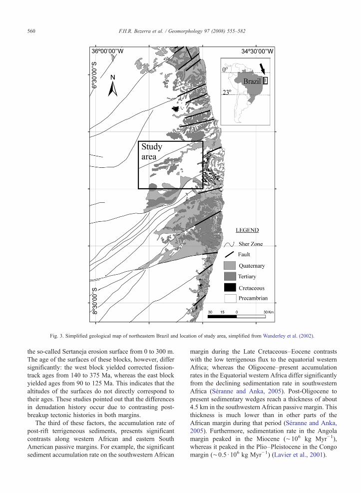
Fig. 3. Simplified geological map of northeastern Brazil and location of study area, simplified from Wanderley et al. (2002).
560 F.H.R. Bezerra et al. / Geomorphology 97 (2008) 555–582
the so-called Sertaneja erosion surface from 0 to 300 m.The age of the surfaces of these blocks, however, differsignificantly: the west block yielded corrected fission-track ages from 140 to 375 Ma, whereas the east blockyielded ages from 90 to 125 Ma. This indicates that thealtitudes of the surfaces do not directly correspond totheir ages. These studies pointed out that the differencesin denudation history occur due to contrasting post-breakup tectonic histories in both margins.
The third of these factors, the accumulation rate ofpost-rift terrigeneous sediments, presents significantcontrasts along western African and eastern SouthAmerican passive margins. For example, the significantsediment accumulation rate on the southwestern African
margin during the Late Cretaceous–Eocene contrastswith the low terrigenous flux to the equatorial westernAfrica; whereas the Oligocene–present accumulationrates in the Equatorial western Africa differ significantlyfrom the declining sedimentation rate in southwesternAfrica (Séranne and Anka, 2005). Post-Oligocene topresent sedimentary wedges reach a thickness of about4.5 km in the southwestern African passive margin. Thisthickness is much lower than in other parts of theAfrican margin during that period (Séranne and Anka,2005). Furthermore, sedimentation rate in the Angolamargin peaked in the Miocene (∼106 kg Myr−1),whereas it peaked in the Plio–Pleistocene in the Congomargin (∼0.5 ·106 kg Myr−1) (Lavier et al., 2001).
561F.H.R. Bezerra et al. / Geomorphology 97 (2008) 555–582
The fourth factor, climate, played an important part inthe evolution of these passive margins, but the interac-tions with geodynamics and surface processes have to beconsidered in order to understand the different responseof the margin segments to climate changes (Lucazeauet al., 2003). The pediplanation model would imply thatclimate was a minor factor that would not disturb thegeneral denudation cycles, broadly governed by timeitself. Paleoclimatic studies, however, have increasinglydemonstrated the importance of climate in regulating thesupply of sediments reaching the basins along passivemargins (e.g., Wylie Poag and Sevon, 1989). The globalclimatic shifts and associated eustatic fluctuations havehad a major impact on the stratigraphy of passivemargins (e.g., Lavier et al., 2001). For example, Joshiand Kale (1997) and Thomas (1998) presented importantconstraints of colluvial and alluvial production associ-ated with climatic shifts. Knowledge of these shifts andthe long-term rates of geomorphological processes isincreasingly accurate thanks to more available sedimentchronology (Stokes, 1999).
2.2. Main geological features of northeastern Brazil
The passive margin of northeastern Brazil is formedby an elevated interior composed of a Precambrianbasement and a few sedimentary basins surrounded bydissected low-lying table-like plateaus composed ofsedimentary rocks and narrow coastal plains. ThePrecambrian basement encompasses the Borboremastructural province in the eastern part of the northeasternregion of the South American platform (Fig. 1). Theequivalent of the Borborema province in Africa is thedeformed province between the western Africa andCongo cratons. The Borborema province is mainlycomposed of Paleoproterozoic, Eo–Neoproterozoic, andNeoproterozoic deformed terrains and covers an area thatexceeds 450,000 km2. Most of the tectonic fabric wasgenerated or reworked during the Pan-African–Brazi-liano collage at ∼600 Ma. The most prominent featuresof the tectonic fabric are Precambrian shear zones, whichpresent sigmoidal geometry (Almeida et al., 2000; BritoNeves et al., 2000, 2001) (Figs. 1 and 3).
The last major tectonic phase to affect the Borboremaprovince occurred in the Mesozoic during the Pangeabreakup. It later evolved into a passive margin character-ized by a rift and a post-rift phase. The main rift phase ledto the development of basins along the passive marginsand aborted rifts inland (Fig. 1) (Françolin and Szatmari,1987; Matos, 1992). It started to form in the EarlyCretaceous (Aptian) with the reactivation of Neoproter-ozoic shear zones. This process led to the development of
the marginal and interior basins, which started from theBarriasian to the Barremian (Matos, 1992; Françolin et al.,1994). Most of the sedimentary basins present post-riftsedimentary sequences, which were developed at theopen-ocean stage of the passive margin evolution (Fig. 3).In the post-rift stage, faulting continued, although in a lessintense mode.
The Late Tertiary period was marked by the depositionof a widespread continental to shallow marine sedimen-tary cover recognized as the Barreiras formation (Fig. 3).Arai (2006) presented paleontological data that indicatethat Barreiras formation formed during the Mioceneglobal eustatic rise, which reached its maximum from theBurdigalian to the Serravallian (12–20 Ma). Sedimenta-tion was interrupted in the Tortonian (early LateMiocene)during global eustatic fall. Finally, renewed eustatic rise inthe Zanclean, (4–5 Ma, Pliocene) initiated a seconddepositional phase. The Barreiras formation exhibitsfacies association characterized by continental (Moraiset al., 2006; Araújo et al., 2006) and transitional shelf tomarine facies (Rossetti, 2006). These studies presentevidence that the deposition of these facies was associatedwith syntectonic movements.
The Quaternary coastal record comprises alluvial,aeolian, coastal, and marine deposits (Fig. 3). Thefluvial deposits are still grouped in a sole stratigraphicunit (Moura formation) and regarded as Plio–Pleisto-cene sediments correlated to the last pediplanation cycle(Mabesoone and Campos e Silva, 1972). Quaternarycoastal sand dunes occur as far as 50 km inland. Theyformed during six main phases from 390–326 ka to thepresent, indicated by luminescence dates (Barreto et al.,2003, 2004). At least two main intertidal (beach)deposits occur along the coastal area. Barreto et al.(2002) obtained luminescence dates of 220–206 ka and117–110 ka and correlated them with sea-level high-stands of oxygen-isotope stages 7 and 5.
Faults cut across the coastal zone, composed of LateCretaceous, Tertiary, and Quaternary units. They offsetmainly the Barreiras formation. Most of these faultscorrespond to the reactivation of the previous ductilePrecambrian or brittle Cretaceous fabric, but in a fewcases they form new structures. We present a compila-tion of these faults and the units they affect in Fig. 3.Faults partitioned between strike-slip and normal-slipand generated a sequence of graben and horst structuresalong the coastal plain (Bezerra and Vita-Finzi, 2000;Bezerra et al., 2001; Furrier et al., 2006; Nogueira et al.,2006).
Part of the present-day deformation is expressed inthe form of seismicity. Historical seismicity in the regionis known since 1808, and instrumental seismicity has
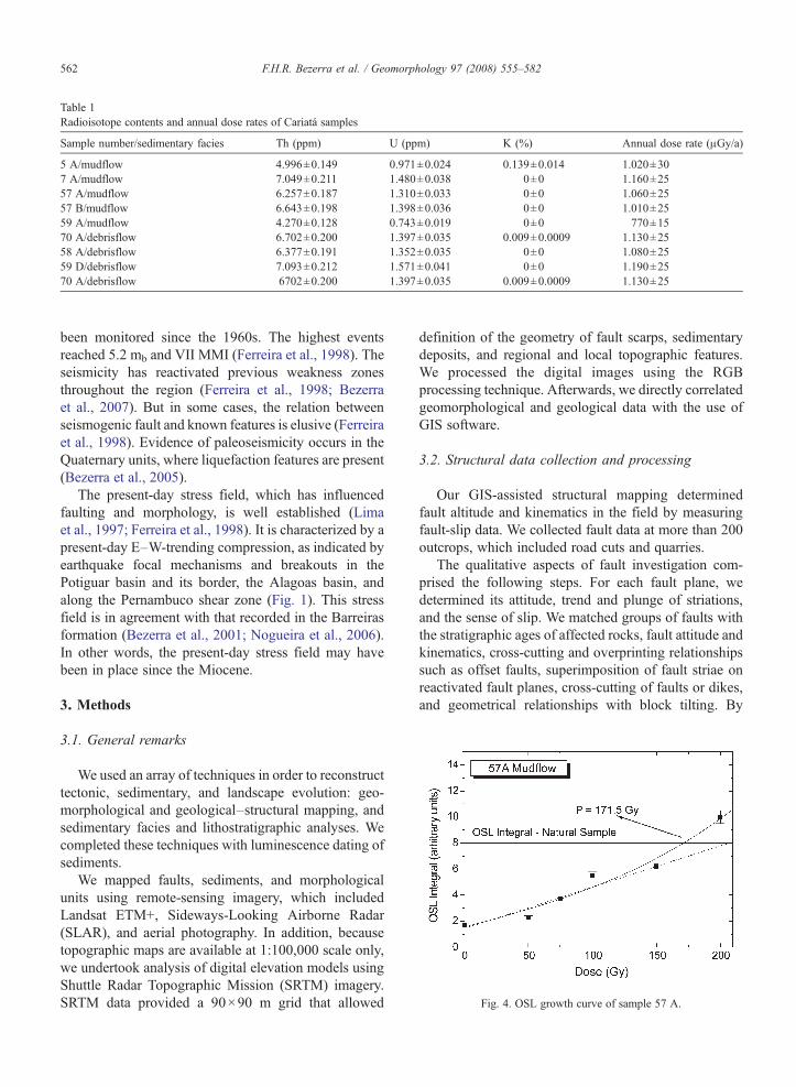
Table 1Radioisotope contents and annual dose rates of Cariatá samples
Sample number/sedimentary facies Th (ppm) U (ppm) K (%) Annual dose rate (μGy/a)
5 A/mudflow 4.996±0.149 0.971±0.024 0.139±0.014 1.020±307 A/mudflow 7.049±0.211 1.480±0.038 0±0 1.160±2557 A/mudflow 6.257±0.187 1.310±0.033 0±0 1.060±2557 B/mudflow 6.643±0.198 1.398±0.036 0±0 1.010±2559 A/mudflow 4.270±0.128 0.743±0.019 0±0 770±1570 A/debrisflow 6.702±0.200 1.397±0.035 0.009±0.0009 1.130±2558 A/debrisflow 6.377±0.191 1.352±0.035 0±0 1.080±2559 D/debrisflow 7.093±0.212 1.571±0.041 0±0 1.190±2570 A/debrisflow 6702±0.200 1.397±0.035 0.009±0.0009 1.130±25
Fig. 4. OSL growth curve of sample 57 A.
562 F.H.R. Bezerra et al. / Geomorphology 97 (2008) 555–582
been monitored since the 1960s. The highest eventsreached 5.2 mb and VII MMI (Ferreira et al., 1998). Theseismicity has reactivated previous weakness zonesthroughout the region (Ferreira et al., 1998; Bezerraet al., 2007). But in some cases, the relation betweenseismogenic fault and known features is elusive (Ferreiraet al., 1998). Evidence of paleoseismicity occurs in theQuaternary units, where liquefaction features are present(Bezerra et al., 2005).
The present-day stress field, which has influencedfaulting and morphology, is well established (Limaet al., 1997; Ferreira et al., 1998). It is characterized by apresent-day E–W-trending compression, as indicated byearthquake focal mechanisms and breakouts in thePotiguar basin and its border, the Alagoas basin, andalong the Pernambuco shear zone (Fig. 1). This stressfield is in agreement with that recorded in the Barreirasformation (Bezerra et al., 2001; Nogueira et al., 2006).In other words, the present-day stress field may havebeen in place since the Miocene.
3. Methods
3.1. General remarks
We used an array of techniques in order to reconstructtectonic, sedimentary, and landscape evolution: geo-morphological and geological–structural mapping, andsedimentary facies and lithostratigraphic analyses. Wecompleted these techniques with luminescence dating ofsediments.
We mapped faults, sediments, and morphologicalunits using remote-sensing imagery, which includedLandsat ETM+, Sideways-Looking Airborne Radar(SLAR), and aerial photography. In addition, becausetopographic maps are available at 1:100,000 scale only,we undertook analysis of digital elevation models usingShuttle Radar Topographic Mission (SRTM) imagery.SRTM data provided a 90×90 m grid that allowed
definition of the geometry of fault scarps, sedimentarydeposits, and regional and local topographic features.We processed the digital images using the RGBprocessing technique. Afterwards, we directly correlatedgeomorphological and geological data with the use ofGIS software.
3.2. Structural data collection and processing
Our GIS-assisted structural mapping determinedfault altitude and kinematics in the field by measuringfault-slip data. We collected fault data at more than 200outcrops, which included road cuts and quarries.
The qualitative aspects of fault investigation com-prised the following steps. For each fault plane, wedetermined its attitude, trend and plunge of striations,and the sense of slip. We matched groups of faults withthe stratigraphic ages of affected rocks, fault attitude andkinematics, cross-cutting and overprinting relationshipssuch as offset faults, superimposition of fault striae onreactivated fault planes, cross-cutting of faults or dikes,and geometrical relationships with block tilting. By
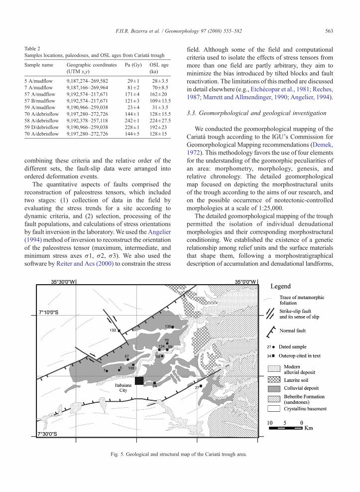
Table 2Samples locations, paleodoses, and OSL ages from Cariatá trough
Sample name Geographic coordinates(UTM x,y)
Pa (Gy) OSL age(ka)
5 A/mudflow 9,187,274–269,582 29±1 28±3.57 A/mudflow 9,187,166–269,964 81±2 70±8.557 A/mudflow 9,192,574–217,671 171±4 162±2057 B/mudflow 9,192,574–217,671 121±3 109±13.559 A/mudflow 9,190,966–259,038 23±4 31±3.570 A/debrisflow 9,197,280–272,726 144±1 128±15.558 A/debrisflow 9,192,378–257,118 242±1 224±27.559 D/debrisflow 9,190,966–259,038 228±1 192±2370 A/debrisflow 9,197,280–272,726 144±5 128±15
563F.H.R. Bezerra et al. / Geomorphology 97 (2008) 555–582
combining these criteria and the relative order of thedifferent sets, the fault-slip data were arranged intoordered deformation events.
The quantitative aspects of faults comprised thereconstruction of paleostress tensors, which includedtwo stages: (1) collection of data in the field byevaluating the stress trends for a site according todynamic criteria, and (2) selection, processing of thefault populations, and calculations of stress orientationsby fault inversion in the laboratory.We used the Angelier(1994) method of inversion to reconstruct the orientationof the paleostress tensor (maximum, intermediate, andminimum stress axes σ1, σ2, σ3). We also used thesoftware by Reiter and Acs (2000) to constrain the stress
Fig. 5. Geological and structural m
field. Although some of the field and computationalcriteria used to isolate the effects of stress tensors frommore than one field are partly arbitrary, they aim tominimize the bias introduced by tilted blocks and faultreactivation. The limitations of this method are discussedin detail elsewhere (e.g., Etchécopar et al., 1981; Reches,1987; Marrett and Allmendinger, 1990; Angelier, 1994).
3.3. Geomorphological and geological investigation
We conducted the geomorphological mapping of theCariatá trough according to the IGU's Commission forGeomorphological Mapping recommendations (Demek,1972). This methodology favors the use of four elementsfor the understanding of the geomorphic peculiarities ofan area: morphometry, morphology, genesis, andrelative chronology. The detailed geomorphologicalmap focused on depicting the morphostructural unitsof the trough according to the aims of our research, andon the possible occurrence of neotectonic-controlledmorphologies at a scale of 1:25,000.
The detailed geomorphological mapping of the troughpermitted the isolation of individual denudationalmorphologies and their corresponding morphostructuralconditioning. We established the existence of a geneticrelationship among relief units and the surface materialsthat shape them, following a morphostratigraphicaldescription of accumulation and denudational landforms,
ap of the Cariatá trough area.
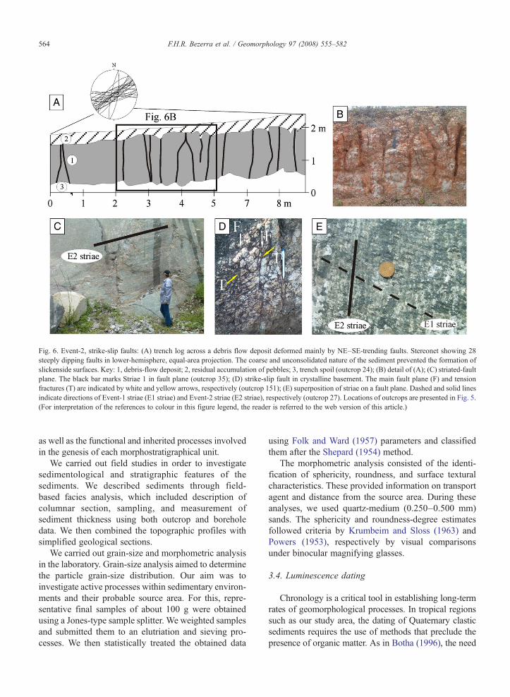
Fig. 6. Event-2, strike-slip faults: (A) trench log across a debris flow deposit deformed mainly by NE–SE-trending faults. Stereonet showing 28steeply dipping faults in lower-hemisphere, equal-area projection. The coarse and unconsolidated nature of the sediment prevented the formation ofslickenside surfaces. Key: 1, debris-flow deposit; 2, residual accumulation of pebbles; 3, trench spoil (outcrop 24); (B) detail of (A); (C) striated-faultplane. The black bar marks Striae 1 in fault plane (outcrop 35); (D) strike-slip fault in crystalline basement. The main fault plane (F) and tensionfractures (T) are indicated by white and yellow arrows, respectively (outcrop 151); (E) superposition of striae on a fault plane. Dashed and solid linesindicate directions of Event-1 striae (E1 striae) and Event-2 striae (E2 striae), respectively (outcrop 27). Locations of outcrops are presented in Fig. 5.(For interpretation of the references to colour in this figure legend, the reader is referred to the web version of this article.)
564 F.H.R. Bezerra et al. / Geomorphology 97 (2008) 555–582
as well as the functional and inherited processes involvedin the genesis of each morphostratigraphical unit.
We carried out field studies in order to investigatesedimentological and stratigraphic features of thesediments. We described sediments through field-based facies analysis, which included description ofcolumnar section, sampling, and measurement ofsediment thickness using both outcrop and boreholedata. We then combined the topographic profiles withsimplified geological sections.
We carried out grain-size and morphometric analysisin the laboratory. Grain-size analysis aimed to determinethe particle grain-size distribution. Our aim was toinvestigate active processes within sedimentary environ-ments and their probable source area. For this, repre-sentative final samples of about 100 g were obtainedusing a Jones-type sample splitter. We weighted samplesand submitted them to an elutriation and sieving pro-cesses. We then statistically treated the obtained data
using Folk and Ward (1957) parameters and classifiedthem after the Shepard (1954) method.
The morphometric analysis consisted of the identi-fication of sphericity, roundness, and surface texturalcharacteristics. These provided information on transportagent and distance from the source area. During theseanalyses, we used quartz-medium (0.250–0.500 mm)sands. The sphericity and roundness-degree estimatesfollowed criteria by Krumbeim and Sloss (1963) andPowers (1953), respectively by visual comparisonsunder binocular magnifying glasses.
3.4. Luminescence dating
Chronology is a critical tool in establishing long-termrates of geomorphological processes. In tropical regionssuch as our study area, the dating of Quaternary clasticsediments requires the use of methods that preclude thepresence of organic matter. As in Botha (1996), the need
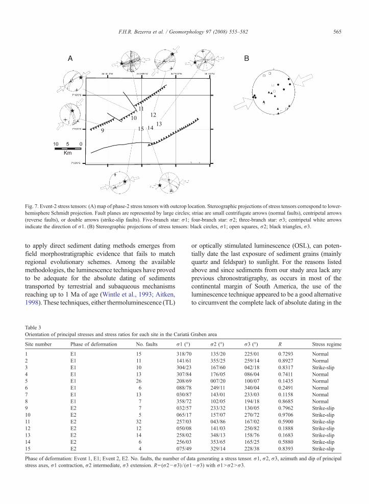
Fig. 7. Event-2 stress tensors: (A) map of phase-2 stress tensors with outcrop location. Stereographic projections of stress tensors correspond to lower-hemisphere Schmidt projection. Fault planes are represented by large circles; striae are small centrifugate arrows (normal faults), centripetal arrows(reverse faults), or double arrows (strike-slip faults). Five-branch star: σ1; four-branch star: σ2; three-branch star: σ3; centripetal white arrowsindicate the direction of σ1. (B) Stereographic projections of stress tensors: black circles, σ1; open squares, σ2; black triangles, σ3.
565F.H.R. Bezerra et al. / Geomorphology 97 (2008) 555–582
to apply direct sediment dating methods emerges fromfield morphostratigraphic evidence that fails to matchregional evolutionary schemes. Among the availablemethodologies, the luminescence techniques have provedto be adequate for the absolute dating of sedimentstransported by terrestrial and subaqueous mechanismsreaching up to 1 Ma of age (Wintle et al., 1993; Aitken,1998). These techniques, either thermoluminescence (TL)
Table 3Orientation of principal stresses and stress ratios for each site in the Cariatá
Site number Phase of deformation No. faults σ1 (°)
1 E1 15 318/702 E1 11 141/613 E1 10 304/234 E1 13 307/845 E1 26 208/696 E1 6 088/787 E1 13 030/878 E1 7 358/729 E2 7 032/5710 E2 5 065/1711 E2 32 257/0312 E2 12 050/0813 E2 14 258/0214 E2 6 256/0315 E2 4 075/49
Phase of deformation: Event 1, E1; Event 2, E2. No. faults, the number of dastress axes, σ1 contraction, σ2 intermediate, σ3 extension. R=(σ2−σ3) / (σ1
or optically stimulated luminescence (OSL), can poten-tially date the last exposure of sediment grains (mainlyquartz and feldspar) to sunlight. For the reasons listedabove and since sediments from our study area lack anyprevious chronostratigraphy, as occurs in most of thecontinental margin of South America, the use of theluminescence technique appeared to be a good alternativeto circumvent the complete lack of absolute dating in the
Graben area
σ2 (°) σ3 (°) R Stress regime
135/20 225/01 0.7293 Normal355/25 259/14 0.8927 Normal167/60 042/18 0.8317 Strike-slip176/05 086/04 0.7411 Normal007/20 100/07 0.1435 Normal249/11 340/04 0.2491 Normal143/01 233/03 0.1158 Normal102/05 194/18 0.8685 Normal233/32 130/05 0.7962 Strike-slip157/07 270/72 0.9706 Strike-slip043/86 167/02 0.5900 Strike-slip141/03 250/82 0.1888 Strike-slip348/13 158/76 0.1683 Strike-slip353/65 165/25 0.5880 Strike-slip329/14 228/38 0.8393 Strike-slip
ta generating a stress tensor. σ1, σ2, σ3, azimuth and dip of principal−σ3) with σ1Nσ2Nσ3.
566 F.H.R. Bezerra et al. / Geomorphology 97 (2008) 555–582
region. Therefore, we adopted the OSL dating techniqueas opposed to other techniques. However, we use the OSLtechnique with caution as the ages of colluviummay yieldoverestimated results due to poor bleaching of sediments.In our study, we collected samples by pushing orhammering plastic tubes into freshly cleaned verticaltrench walls to prevent exposure to sunlight.
OSL dating was carried out at the Laboratory ofGlasses and Dating of the Faculdade de Tecnologia deSão Paulo, Brazil (FATEC-SP). To prevent problemsassociated with translocation of fine grains (fine silt andclay particles), quartz grains 88–180 μm in size wereobtained after chemical treatments of 20% HF for45 min, 20% HCl for 2 h, and heavy liquid (SPT)separation. OSL shine-down curves were measured witha Daybreak Nuclear and medical Systems Incorporated,Model 1100-series automated TL/OSL System. Quartzcrystals were stimulated with green light emitted by Xe-lamp and filtered with an optical filter. The optical filterHoya U-340 (290–370 nm) was used for detection ofthe OSL. All of the γ-irradiation was performed with a60Co source, and for bleaching experiments the sampleswere submitted directly to sunlight for 16 h. Naturalradioactive isotope contents in the samples weredetermined with gamma spectroscopy using an Inspec-tor portable spectroscopy workstation, lead shield model727, and a Canberra 802 NaI(Tl) detector.
Paleodose values were obtained using the totalregeneration method and multi-aliquot protocols. In thistechnique, one frustrating limitation is the frequentoccurrence of high levels of scatter with growth curves.This occurs because of variations in mass and other
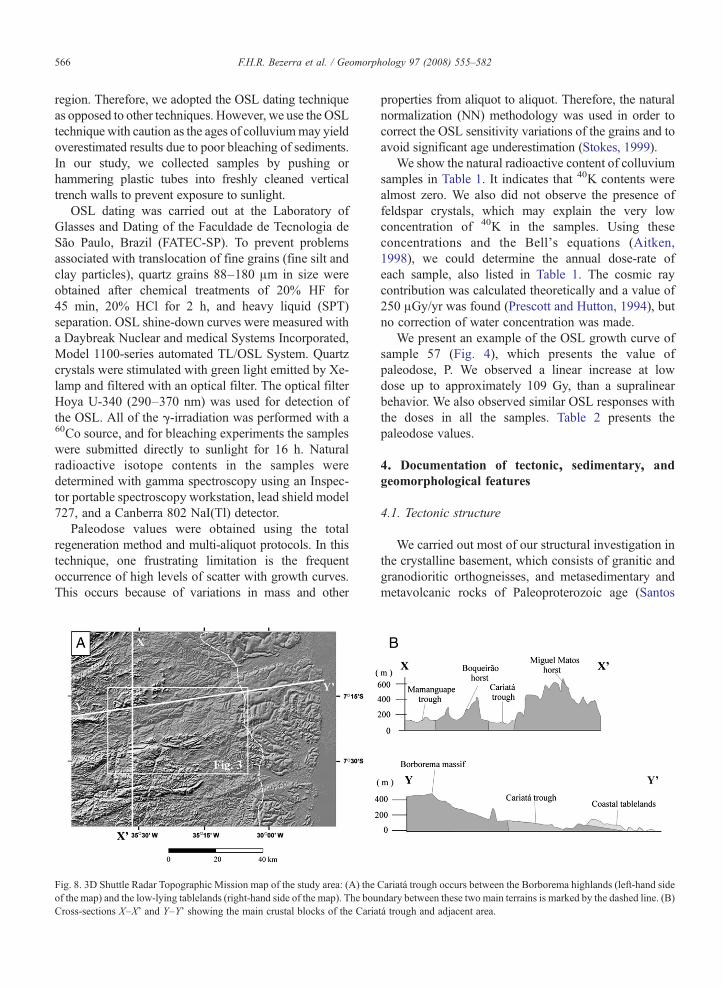
Fig. 8. 3D Shuttle Radar Topographic Mission map of the study area: (A) theof the map) and the low-lying tablelands (right-hand side of the map). The bouCross-sections X–X' and Y–Y' showing the main crustal blocks of the Caria
properties from aliquot to aliquot. Therefore, the naturalnormalization (NN) methodology was used in order tocorrect the OSL sensitivity variations of the grains and toavoid significant age underestimation (Stokes, 1999).
We show the natural radioactive content of colluviumsamples in Table 1. It indicates that 40K contents werealmost zero. We also did not observe the presence offeldspar crystals, which may explain the very lowconcentration of 40K in the samples. Using theseconcentrations and the Bell's equations (Aitken,1998), we could determine the annual dose-rate ofeach sample, also listed in Table 1. The cosmic raycontribution was calculated theoretically and a value of250 μGy/yr was found (Prescott and Hutton, 1994), butno correction of water concentration was made.
We present an example of the OSL growth curve ofsample 57 (Fig. 4), which presents the value ofpaleodose, P. We observed a linear increase at lowdose up to approximately 109 Gy, than a supralinearbehavior. We also observed similar OSL responses withthe doses in all the samples. Table 2 presents thepaleodose values.
4. Documentation of tectonic, sedimentary, andgeomorphological features
4.1. Tectonic structure
We carried out most of our structural investigation inthe crystalline basement, which consists of granitic andgranodioritic orthogneisses, and metasedimentary andmetavolcanic rocks of Paleoproterozoic age (Santos
Cariatá trough occurs between the Borborema highlands (left-hand sidendary between these two main terrains is marked by the dashed line. (B)tá trough and adjacent area.
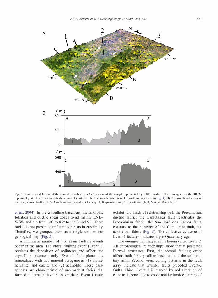
Fig. 9. Main crustal blocks of the Cariatá trough area: (A) 3D view of the trough represented by RGB Landsat ETM+ imagery on the SRTMtopography. White arrows indicate directions of master faults. The area depicted is 45 km wide and is shown in Fig. 3; (B) Cross-sectional views ofthe trough area. A–B and C–D sections are located in (A). Key: 1, Boqueirão horst; 2, Cariatá trough; 3, Manoel Matos horst.
567F.H.R. Bezerra et al. / Geomorphology 97 (2008) 555–582
et al., 2004). In the crystalline basement, metamorphicfoliation and ductile shear zones trend mainly ENE–WSW and dip from 30° to 85° to the S and SE. Theserocks do not present significant contrasts in erodibility.Therefore, we grouped them as a single unit on ourgeological map (Fig. 5).
A minimum number of two main faulting eventsoccur in the area. The oldest faulting event (Event 1)predates the deposition of sediments and affects thecrystalline basement only. Event-1 fault planes aremineralized with two mineral parageneses: (1) biotite,hematite, and calcite and (2) actinolite. These para-geneses are characteristic of green-schist facies thatformed at a crustal level ≤10 km deep. Event-1 faults
exhibit two kinds of relationship with the Precambrianductile fabric: the Camutanga fault reactivates thePrecambrian fabric; the São José dos Ramos fault,contrary to the behavior of the Camutanga fault, cutacross this fabric (Fig. 5). The collective evidence ofEvent-1 features indicates a pre-Quaternary age.
The youngest faulting event is herein called Event 2.All chronological relationships show that it postdatesEvent-1 structures. First, the second faulting eventaffects both the crystalline basement and the sedimen-tary infill. Second, cross-cutting patterns in the faultarray indicate that Event-1 faults preceded Event-2faults. Third, Event 2 is marked by red alteration ofcataclastic zones due to oxide and hydroxide staining of
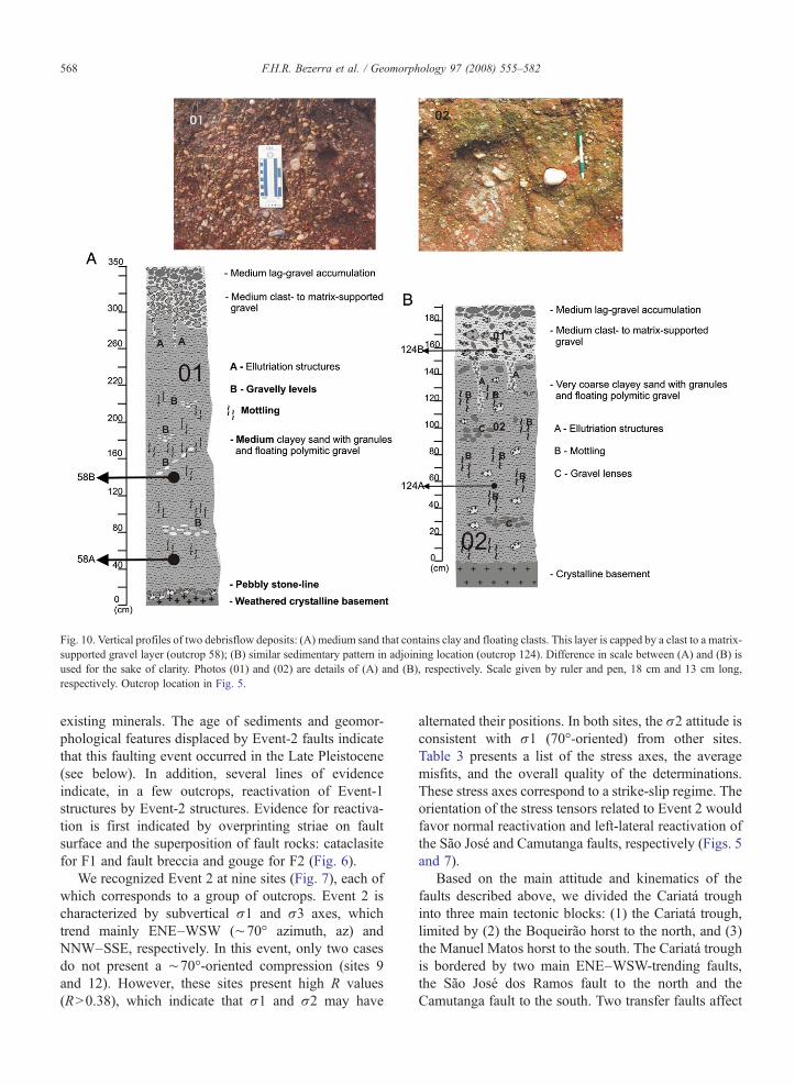
Fig. 10. Vertical profiles of two debrisflow deposits: (A) medium sand that contains clay and floating clasts. This layer is capped by a clast to a matrix-supported gravel layer (outcrop 58); (B) similar sedimentary pattern in adjoining location (outcrop 124). Difference in scale between (A) and (B) isused for the sake of clarity. Photos (01) and (02) are details of (A) and (B), respectively. Scale given by ruler and pen, 18 cm and 13 cm long,respectively. Outcrop location in Fig. 5.
568 F.H.R. Bezerra et al. / Geomorphology 97 (2008) 555–582
existing minerals. The age of sediments and geomor-phological features displaced by Event-2 faults indicatethat this faulting event occurred in the Late Pleistocene(see below). In addition, several lines of evidenceindicate, in a few outcrops, reactivation of Event-1structures by Event-2 structures. Evidence for reactiva-tion is first indicated by overprinting striae on faultsurface and the superposition of fault rocks: cataclasitefor F1 and fault breccia and gouge for F2 (Fig. 6).
We recognized Event 2 at nine sites (Fig. 7), each ofwhich corresponds to a group of outcrops. Event 2 ischaracterized by subvertical σ1 and σ3 axes, whichtrend mainly ENE–WSW (∼70° azimuth, az) andNNW–SSE, respectively. In this event, only two casesdo not present a ∼70°-oriented compression (sites 9and 12). However, these sites present high R values(RN0.38), which indicate that σ1 and σ2 may have
alternated their positions. In both sites, the σ2 attitude isconsistent with σ1 (70°-oriented) from other sites.Table 3 presents a list of the stress axes, the averagemisfits, and the overall quality of the determinations.These stress axes correspond to a strike-slip regime. Theorientation of the stress tensors related to Event 2 wouldfavor normal reactivation and left-lateral reactivation ofthe São José and Camutanga faults, respectively (Figs. 5and 7).
Based on the main attitude and kinematics of thefaults described above, we divided the Cariatá troughinto three main tectonic blocks: (1) the Cariatá trough,limited by (2) the Boqueirão horst to the north, and (3)the Manuel Matos horst to the south. The Cariatá troughis bordered by two main ENE–WSW-trending faults,the São José dos Ramos fault to the north and theCamutanga fault to the south. Two transfer faults affect
569F.H.R. Bezerra et al. / Geomorphology 97 (2008) 555–582
the São Miguel dos Ramos fault. The geological map(Fig. 5) reflects this tectonic division and presents thelimits of these blocks. Figs. 8 and 9 present therelationship between tectonic blocks and morphology.
4.2. Sedimentary infill
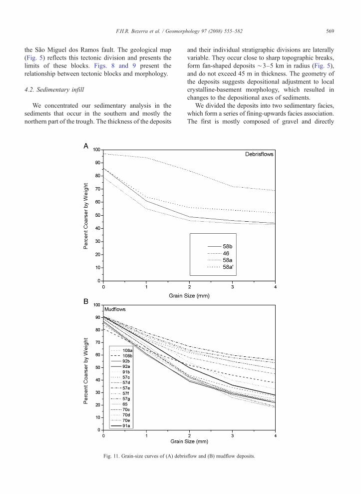
We concentrated our sedimentary analysis in thesediments that occur in the southern and mostly thenorthern part of the trough. The thickness of the deposits
Fig. 11. Grain-size curves of (A) debris
and their individual stratigraphic divisions are laterallyvariable. They occur close to sharp topographic breaks,form fan-shaped deposits ∼3–5 km in radius (Fig. 5),and do not exceed 45 m in thickness. The geometry ofthe deposits suggests depositional adjustment to localcrystalline-basement morphology, which resulted inchanges to the depositional axes of sediments.
We divided the deposits into two sedimentary facies,which form a series of fining-upwards facies association.The first is mostly composed of gravel and directly
flow and (B) mudflow deposits.
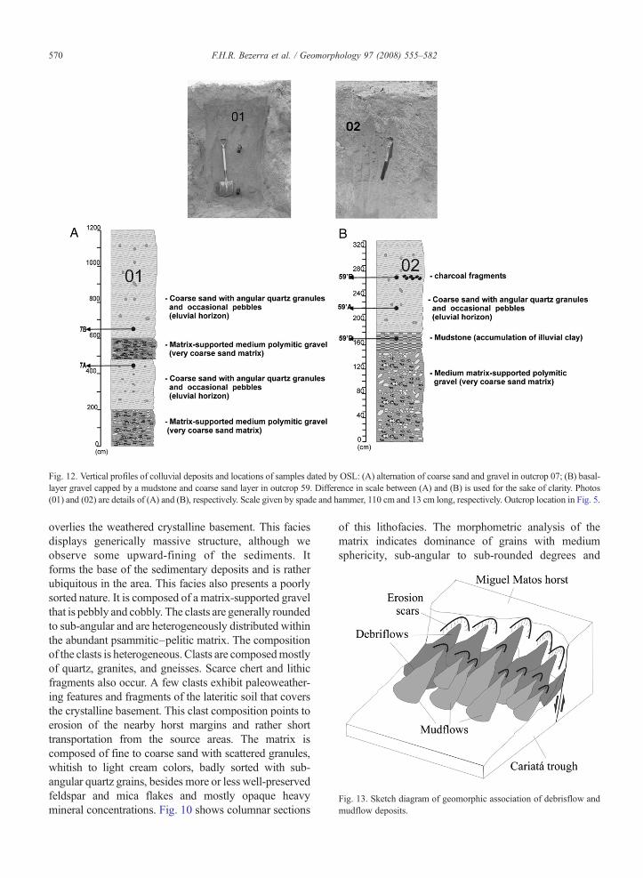
Fig. 12. Vertical profiles of colluvial deposits and locations of samples dated by OSL: (A) alternation of coarse sand and gravel in outcrop 07; (B) basal-layer gravel capped by a mudstone and coarse sand layer in outcrop 59. Difference in scale between (A) and (B) is used for the sake of clarity. Photos(01) and (02) are details of (A) and (B), respectively. Scale given by spade and hammer, 110 cm and 13 cm long, respectively. Outcrop location in Fig. 5.
Fig. 13. Sketch diagram of geomorphic association of debrisflow andmudflow deposits.
570 F.H.R. Bezerra et al. / Geomorphology 97 (2008) 555–582
overlies the weathered crystalline basement. This faciesdisplays generically massive structure, although weobserve some upward-fining of the sediments. Itforms the base of the sedimentary deposits and is ratherubiquitous in the area. This facies also presents a poorlysorted nature. It is composed of a matrix-supported gravelthat is pebbly and cobbly. The clasts are generally roundedto sub-angular and are heterogeneously distributed withinthe abundant psammitic–pelitic matrix. The compositionof the clasts is heterogeneous. Clasts are composedmostlyof quartz, granites, and gneisses. Scarce chert and lithicfragments also occur. A few clasts exhibit paleoweather-ing features and fragments of the lateritic soil that coversthe crystalline basement. This clast composition points toerosion of the nearby horst margins and rather shorttransportation from the source areas. The matrix iscomposed of fine to coarse sand with scattered granules,whitish to light cream colors, badly sorted with sub-angular quartz grains, besides more or less well-preservedfeldspar and mica flakes and mostly opaque heavymineral concentrations. Fig. 10 shows columnar sections
of this lithofacies. The morphometric analysis of thematrix indicates dominance of grains with mediumsphericity, sub-angular to sub-rounded degrees and
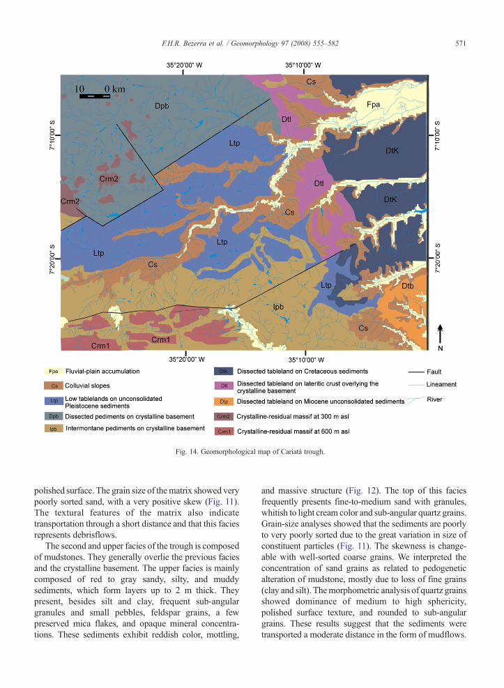
Fig. 14. Geomorphological map of Cariatá trough.
571F.H.R. Bezerra et al. / Geomorphology 97 (2008) 555–582
polished surface. The grain size of thematrix showed verypoorly sorted sand, with a very positive skew (Fig. 11).The textural features of the matrix also indicatetransportation through a short distance and that this faciesrepresents debrisflows.
The second and upper facies of the trough is composedof mudstones. They generally overlie the previous faciesand the crystalline basement. The upper facies is mainlycomposed of red to gray sandy, silty, and muddysediments, which form layers up to 2 m thick. Theypresent, besides silt and clay, frequent sub-angulargranules and small pebbles, feldspar grains, a fewpreserved mica flakes, and opaque mineral concentra-tions. These sediments exhibit reddish color, mottling,
and massive structure (Fig. 12). The top of this faciesfrequently presents fine-to-medium sand with granules,whitish to light cream color and sub-angular quartz grains.Grain-size analyses showed that the sediments are poorlyto very poorly sorted due to the great variation in size ofconstituent particles (Fig. 11). The skewness is change-able with well-sorted coarse grains. We interpreted theconcentration of sand grains as related to pedogeneticalteration of mudstone, mostly due to loss of fine grains(clay and silt). Themorphometric analysis of quartz grainsshowed dominance of medium to high sphericity,polished surface texture, and rounded to sub-angulargrains. These results suggest that the sediments weretransported a moderate distance in the form of mudflows.
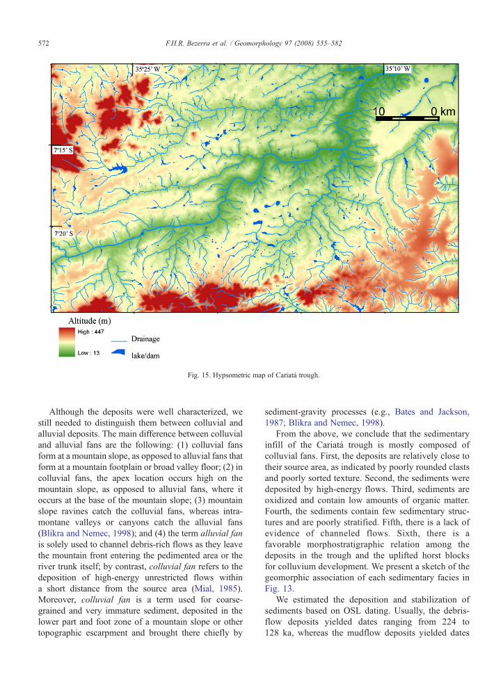
Fig. 15. Hypsometric map of Cariatá trough.
572 F.H.R. Bezerra et al. / Geomorphology 97 (2008) 555–582
Although the deposits were well characterized, westill needed to distinguish them between colluvial andalluvial deposits. The main difference between colluvialand alluvial fans are the following: (1) colluvial fansform at a mountain slope, as opposed to alluvial fans thatform at a mountain footplain or broad valley floor; (2) incolluvial fans, the apex location occurs high on themountain slope, as opposed to alluvial fans, where itoccurs at the base of the mountain slope; (3) mountainslope ravines catch the colluvial fans, whereas intra-montane valleys or canyons catch the alluvial fans(Blikra and Nemec, 1998); and (4) the term alluvial fanis solely used to channel debris-rich flows as they leavethe mountain front entering the pedimented area or theriver trunk itself; by contrast, colluvial fan refers to thedeposition of high-energy unrestricted flows withina short distance from the source area (Mial, 1985).Moreover, colluvial fan is a term used for coarse-grained and very immature sediment, deposited in thelower part and foot zone of a mountain slope or othertopographic escarpment and brought there chiefly by
sediment-gravity processes (e.g., Bates and Jackson,1987; Blikra and Nemec, 1998).
From the above, we conclude that the sedimentaryinfill of the Cariatá trough is mostly composed ofcolluvial fans. First, the deposits are relatively close totheir source area, as indicated by poorly rounded clastsand poorly sorted texture. Second, the sediments weredeposited by high-energy flows. Third, sediments areoxidized and contain low amounts of organic matter.Fourth, the sediments contain few sedimentary struc-tures and are poorly stratified. Fifth, there is a lack ofevidence of channeled flows. Sixth, there is afavorable morphostratigraphic relation among thedeposits in the trough and the uplifted horst blocksfor colluvium development. We present a sketch of thegeomorphic association of each sedimentary facies inFig. 13.
We estimated the deposition and stabilization ofsediments based on OSL dating. Usually, the debris-flow deposits yielded dates ranging from 224 to128 ka, whereas the mudflow deposits yielded dates
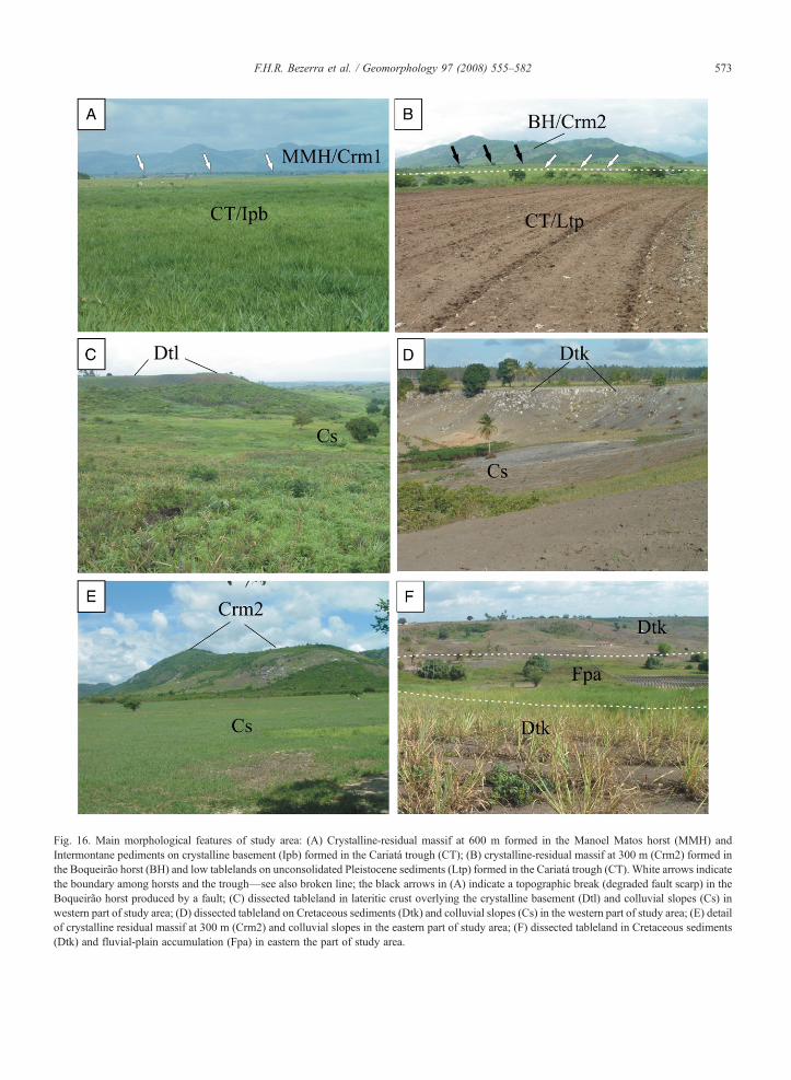
Fig. 16. Main morphological features of study area: (A) Crystalline-residual massif at 600 m formed in the Manoel Matos horst (MMH) andIntermontane pediments on crystalline basement (Ipb) formed in the Cariatá trough (CT); (B) crystalline-residual massif at 300 m (Crm2) formed inthe Boqueirão horst (BH) and low tablelands on unconsolidated Pleistocene sediments (Ltp) formed in the Cariatá trough (CT). White arrows indicatethe boundary among horsts and the trough—see also broken line; the black arrows in (A) indicate a topographic break (degraded fault scarp) in theBoqueirão horst produced by a fault; (C) dissected tableland in lateritic crust overlying the crystalline basement (Dtl) and colluvial slopes (Cs) inwestern part of study area; (D) dissected tableland on Cretaceous sediments (Dtk) and colluvial slopes (Cs) in the western part of study area; (E) detailof crystalline residual massif at 300 m (Crm2) and colluvial slopes in the eastern part of study area; (F) dissected tableland in Cretaceous sediments(Dtk) and fluvial-plain accumulation (Fpa) in eastern the part of study area.
573F.H.R. Bezerra et al. / Geomorphology 97 (2008) 555–582
574 F.H.R. Bezerra et al. / Geomorphology 97 (2008) 555–582
from 45 to 28 ka. The exceptions are mudflow samples7A and 7B, which yielded ages from 221 to 70 ka. Wepresent the annual doses, paleodoses, and OSL ages inTable 2.
4.3. Geomorphological features
The Cariatá trough is located at the foot of theBorborema highlands, a regional dome-shaped water-shed divide of northeastern Brazil that comprises a set ofmodest rejuvenated crystalline massifs, ridges, andtable-like plateaus that reach up to 1000–1200 m asland overlook coastal and inland low-lying sedimentaryplateaus and plains (Fig. 1). We defined ten morphos-tructural units in the Cariatá trough area that have aclose link with tectonic structure and lithology (Figs. 14and 15).
Two residualmassifs occur in the uplifted blocks of theCariatá trough (Fig. 14). The crystalline residual massif at600 m asl (Crm1) refers to the elevated and dissected unitlying to the south of the trough and forming its limitinghorst. This unit is formed on crystalline Precambrianrocks, and its northern border ismarked by the Camutangafault. These massifs integrate the larger Borboremahighlands. The crystalline residual massif at 300 m asl(Crm2) occurs to the north of the trough and correspondsto its northern limit. It is characterized by a series ofdissected inselbergs structured on crystalline basementrocks and limited to the south by the São José dos Ramosfault (Figs. 14, 15, and 16A,B,E).
Three surfaces of dissected tablelands occur to theeast of the trough (Figs. 14 and 15). The tablelands weredeveloped predominantly on sedimentary rocks of theBarreiras formation, but they also developed onCretaceous siliciclastic sedimentary rocks and on thecrystalline basement. The dissected tableland onMiocene unconsolidated sediments (Dtp) representsthe only occurrence of the Miocene Barreiras formationin the study area, where it is restricted to thesoutheastern corner. This unit is characterized by theoccurrence of dissected table-like surfaces structured onmassif sandy sediments with remarkable mottling andlinear slopes as a response to strong fluvial incision. Thedissected tableland on lateritic crust (Dtl) overlying thecrystalline basement represents a structured surfacecontrolled by the outcropping of table-like remains of alateritic duricrust, which directly overlies the crystallinebasement (Fig. 16C). The in situ dissolution of the ironcrust forms an elluviated horizon due to the flatness ofthis summit surface, which favors water percolation andpedogenesis. Under remote-sensing imagery, this unitcan be easily mistaken for the Barreiras formation itself.
The dissected tableland on Cretaceous sedimentaryrocks (Dtk) occurs in the eastern border of the trough onSantonian–Campanian sandstones of the Beberibeformation. The top of this tableland reaches elevationsabove 200 m (Fig. 16D).
Two pediment surfaces occur mostly on the upliftedblocks of Cariatá trough (Figs. 14 and 15). Theintermontane pediments on crystalline basement (Ipb)are concentrated to the south of the trough and are markedby well-developed pedimented levels poorly dissectedand lacking any Neogene sedimentary cover (Fig. 16A).They pass into residual massifs forming concave knickpoints. The dissected pediments on crystalline basement(Dpb) occur along the stripped front of the low tablelandin the form of an exhumed surface. They occur on thenorthern uplifted block and are limited to the south by theSão José dos Ramos fault. Their presence on the land-scape is generally marked by the outcrop of the ground-water table forming a spring line.
The three last morphostructural units are closelylinked to the Pleistocene sedimentary units (Figs. 14and 15). The low tablelands in unconsolidated Pleisto-cene sediments (Ltp) present table-like summits formingtwo depositional facies of Late Pleistocene age: a basalmatrix-supported gravelly deposit (debrisflow facies)and an overlying sandy-clay unconsolidated deposit(mudflow facies). In plane view, they present a fanshape, which coalesce into aprons (Fig. 16B). Thecolluvial slopes (Cs) accompany the break of the slopebetween the low-lying fluvial plains and pediments, andthe top of the tablelands (Fig. 16C, D, E). The fluvial-plain accumulation (Fpa) occurs along the course of theParaíba River and its main tributaries (Fig. 16F). Thisunit passes laterally into an erosion surface ofpedimented aspects. The Paraíba River itself, whosecourse follows roughly the same trough alignment in itsmiddle portion, is passive-structurally conditioned.
5. Discussion
5.1. Main purpose and questions of this study
This research attempted to describe the development ofsedimentary deposits and their related denudation/accu-mulation landforms as a response to brittle tectonics andclimate in a passive margin context. As a by-product ofthe primary findings, the concept of erosion surfaces, asapplied to the studied area, was also debated andquestioned. In the following sections, we first discussthe meaning of luminescence dates of the colluvium, thenwe move to its likely climate and tectonic control. Onthe basis of the regional knowledge, we expand our
575F.H.R. Bezerra et al. / Geomorphology 97 (2008) 555–582
conclusion to the regional level and to the pre-Quaternaryperiod.
5.2. The meaning of luminescence chronology ofcolluvial sediments
There has been an increase in application ofluminescence dating in environments where the trans-port of sediments, including colluvium, has beenpredominantly waterlain or gravity-controlled. Lumi-nescence dating in colluvium has already been estab-lished. Wintle et al. (1993) were among the first to reportluminescence dating of colluvium using the infrared-stimulated luminescence (IRSL) in grains of K-feldspar.Botha et al. (1994) also used IRSL of feldspar from gullysediments in South Africa. Porat et al. (1996) datedcolluvial edges in the Dead Sea rift, Israel, using both TLand OSL (IRSL) techniques. Eriksson et al. (2000) usedOSL-dating regenerative protocol on quartz described byRoberts et al. (1998) in Late Quaternary colluvialsediments from Tanzania. More recently, Lang andHönscheidt (1999) and Lang and Mauz (2006) usedmulti-aliquot, additive protocol to date gully sediments.They concluded that the degree of bleaching of sedimentin this kind of system is grain-size dependent. Yanchouet al. (2002) dated slope-wash deposits from China usingmulti-aliquot (GLSL [green light stimulated lumines-cence] and IRSL) techniques. Using the modifiedregeneration protocol (Australian slide), Prescott et al.(1993) concluded that the fine-grain fraction of sedi-ments contains a substantial amount of wind-blown dustand proposed that such a grain-size fraction could bedated by OSL because it should be well zeroed. Techmeret al. (2005) dated colluvium in the lower Rhine area,Germany, using multiple aliquot additive dose (MAAD)method, multi-aliquot additive dose (infrared MAA),and single-aliquot regeneration dose (SAR) followingthe protocol described by Wallinga et al. (2000) forcoarse-grain feldspar. They proposed that some ages ofthe sediments represent minimum ages.
Although these studies present dates for colluvium indifferent settings, they set limits to the use of lumines-cence dating on colluvium. One of these limits is that thecomplete bleaching of the luminescence signal is crucialto obtain accurate ages before any geomorphological orpaleoenvironmental reconstruction can be undertaken(Clarke et al., 1999). Therefore, studies on the lumines-cence dating of colluvium have raised questions about thevalidity of the OSL technique in colluvium investigationsand in areas where independent sediment chronology isabsent. A question that must be asked is whether thesediment has had its luminescence clock reset. The
validity is questioned because in colluvial deposits there isa strong possibility that not all grains in the deposit havebeen adequately bleached at the time of their deposition.In conventional OSL dating, the luminescence signal ofmany grains is analyzed together. Given the nature of thecolluvial sediments, it is unlikely that all grains have beencompletely bleached before deposition. In case a samplecontains some grains that were not completely bleached,the age of sediment burial will then be overestimated (e.g.,Lamothe et al., 1994; Olley et al., 1996; Roberts et al.,1998; Olley et al., 1998). In addition, the complexity ofdeposit stratigraphy could complicate dose-rate determi-nations (e.g., Rendell and Sheffer, 1996).
We dated the Cariatá colluvium using only quartzcrystals because of the lack of feldspar in the samples.We corrected the OSL sensitivity variation of each diskusing natural normalization (NN) protocols to avoidsignificant age underestimation. The technique isconvenient for old samples, as is the present case.
In the present context of the Cariatá trough, wheresediments traveled only a short distance from the source,it is advisable to assume that only part of the sedimenthas been completely bleached. The finer sedimentsdeposited in more distal parts of the scarp may becompletely bleached and present more reliable ages. Butbecause our ages could result from the mixing of grainsof different ages, our OSL results may be overestimated.Therefore, we interpret them as maximum ages for theformation of colluvium.
Although the limited accuracy of the OSL dates inour study precludes detailed chronology and preciseclimatic correlation, our results have enabled us torecognize two patterns representing two maximumperiods of deposition. The OSL dates we obtained forthe debrisflow deposits at all locations fall within the224–128 ka period, whereas the OSL dates for allmudflow deposits fall within the 45–28 ka period. Thesemaximum dates, in our case, could correspond toperiods of deposition. The dates are consistent withthe stratigraphic position of the sediments. The oldestdates are from the underlying sediments, whereas theyoungest dates are from the overlying debrisflowdeposits.
Even if such chronology is not tightly accurate, it isimportant to consider this in tropical areas wherecolluvium provides a significant fraction of sedimentand where little is known about colluviation. Untilrecently, the timing of sediments in structurallycontrolled troughs in the region, similar to the oneinvestigated in our study, has remained the subject ofspeculation. The unraveling of this chronology byluminescence dating should play a significant role in
576 F.H.R. Bezerra et al. / Geomorphology 97 (2008) 555–582
the study of colluvium that crops out in the regionbecause many of these sediments should be within thetechnique's dating range.
Modern techniques that may be applied to poorlybleached sediments are increasingly available. Use ofsingle-aliquot procedures (SAR) is now preferred overthe multi-aliquot method because of their high precisionand accuracy, as well as the absence of the need fornormalization of the former (e.g., Wallinga et al., 2000).This high precision also arises from the independence ofvariations in growth-curve shape and specific lumines-cence (Duller et al., 2003). Therefore, we suggest thatthe OSL dates presented in our study should be testedwith SAR in further investigations.
5.3. Climate influence on the deposition of colluvialsediments
The first factor that may have controlled colluvium inCariatá is climate. Large colluviation events haveoccurred in tropical environments, ranging from seasonalsavannas to pre-humid and rainforest areas (Thomas,1998). In this context, many studies have pointed out thatclimatic shifts produce colluviation. As demonstrated bystudies such as Thomas (1994), regional-scale colluvia-tion is a phenomenon mostly associated with rapidenvironmental shifts rather than with the maintenance ofstable climatic or biogeographic conditions. The accep-tance of this model of climate-driven colluviation undercircumstances of fast-paced, high-magnitude landformingevents, as initially put forward by Knox (1972),jeopardizes the regionally adopted interpretation of hill-slope sediments as derived from long, steady-state phasesof pedimentation under prevailing semi-arid conditions(Bigarella and Andrade, 1965).
In more recent studies, within the tropics, this patternof colluviation triggered by climatic shifts was observedalong the western passive margin of India (Joshi andKale, 1997). Colluviation has also occurred at the startof the Late Pleistocene wet period and/or immediatelybefore or after the younger Dryas period (Dietrich andDorn, 1984; Thomas and Thorpe, 1995). In theQuaternary record, abrupt climatic shifts match thetimeframe of glacial–interglacial cycles, correspondingto ca. 105 yr. Within the time frame considered (glacial–interglacial shifts) landscape response to climatic shiftscan be defined down to a maximum temporal resolutionof 1 ka, which reflects a reorganization of hillslopes,pediments, and alluvial landscape systems. This climaticshift induced energy input in the environmental systemand governed the occurrence of weathered mantles anderosive processes (Thomas, 1998).
There is also evidence that colluviation is a spasmodicphenomenon. Thomas and Thorpe (1995) pointed out thata particular sediment closely related to landforms, suchas colluvium, may represent a single geomorphic eventspanning a time interval of 10−2–10−1 (days, months).There is ample evidence in the current literature thatthese climatic shifts recorded by colluviation haveoccurred as spasmodic events in the Quaternary, andthey seem to have been more accentuated within the last1 Ma (Adams et al., 1999).
The present-day landscape dynamics in the humid–subhumid tropical boundary, as seen in our study area, isnot conducive to the production of hillslope sedimentsby landsliding or any other slope-associated mass-wasting process. Much to the contrary, current land-scape in the Cariatá area is being dissected by fluvial orgully erosion. Therefore, as pointed out by Thomas andThorpe (1995), topographically constricted Neogenedeposits such as those from the Cariatá trough mightreflect the operation of high-magnitude, low-recurrenceepisodes most likely to be caused by significant climaticshifts throughout the Pleistocene.
It follows that very few colluvial facies, in isolation,can be used to diagnose climate. Debrisflows, forexample, may occur in a wide variety of climates. It is,however, the slope response to climate that leads to theprocesses that determine colluvial facies (Nemec andKazanci, 1999). Therefore, in light of the available data,we suggest the following broad appraisals on climate-controlled geomorphic processes in the area. Correlationbetween colluvial facies and climate suggests thatmudflows might have occurred within stadial periodswith temperatures reduced to 6 °C in relation to presenttemperatures. By contrast, debrisflows tend to grouparound interglacial episodes or interstadials, withtemperatures similar to or only slightly lower thancurrent ones in the region (Bradley and Jones, 1995).This depositional pattern is in good accordance with themodel of sandy-colluvial formation as proposed byThomas (1998) for semi-arid tropical environmentsregarding the migration of silty–clayey facies alongsidelow-viscosity debrisflows.
Deposition of colluvium in the Cariatá troughpresents discrepancies with other colluvium or associ-ated clastic deposits throughout the tropics, especiallyin Brazil. These discrepancies might also reflect thepeculiar sedimentary conditions of the semi-arid envi-ronment of northeastern Brazil, which, in the presentday, lie just a few tens of kilometers west of the studyarea. One of these discrepancies is that sedimentationin the Cariatá trough did not reach the bottom of thetopographic depression, currently dominated by the
577F.H.R. Bezerra et al. / Geomorphology 97 (2008) 555–582
alluvial sedimentation of the Paraíba River. This depres-sion is laterally bordered by narrow rock-pedimentstrips covered by in situ thin kaolinitic regoliths.
In contrast, in other Neogene troughs and basins insoutheastern and southern Brazil (e.g., Riccomini et al.,1989; Salamuni et al., 2003), the prevailing humidtropical conditions have led to the deep weathering ofthe source areas. The result was a complete infill of suchtectonically controlled depressions by superveningclimate-driven surface processes. In humid tropicallandscapes of eastern Brazil, the current drainagenetwork and its associated alluvial plains are entrencheddirectly on the Neogene sediment infills.
In summary, the probable pattern of climate shiftsindicated by the colluvial deposits from Cariatá trough isinconsistent with the hypothesis of a long-lasting, semi-arid episode in the region in the Late Quaternary. Inaddition, contemporary semi-arid conditions in theregion do not lead to the deposition of any significanthill-slope deposit, and mass-wasting processes arealmost completely absent. Following the evidence, weconclude that prevailing semi-arid conditions through-out the Late Quaternary would not explain the massivemudflows in Cariatá trough. This pattern is consistentwith studies in southern Africa that points to climaticshifts and not a long-lasting arid period in the LatePleistocene (e.g., Stokes et al., 1998).
5.4. Fault influence on the deposition of colluvialsediments
The second factor that may contribute to colluviationis faulting. As already stated by Thomas and Thorpe(1995), it is necessary to consider the likelihood of non-climatic events such as earthquakes (and thereforefaults) as the trigger mechanisms for slope instability.Colluvium may be a valuable record of faulting andfundamental to understand the interplay betweendenudation and tectonics (e.g., Wallace, 1980; McCal-pin et al., 1993; McCalpin, 1997). The identification ofcolluvial sediments associated with faults has increasedin past decades. Wallace (1977), for example, proposeda model of fault-scarp degradation and the production ofcolluvium. He suggested that scarp retreat is closelyrelated to climate but also to mechanical properties offaulted material. He also added that scarp-derivedcolluvium accounts for the largest volume of sedimentsrelated to normal faulting. In the same line of thought,Nelson (1992) concluded that immediately after faulting,colluvium is deposited mainly near the free face. As thescarps broaden with weathering, wash-dominated collu-viation will push the new deposition away from the scarp.
Most studies that present colluvial sediments asso-ciated with faults describe plate boundary settings, butcolluvium has also been linked to faulting processes inintraplate settings. According to Wylie Poag and Sevon(1989), faulting regulates sediment supply and influ-ences landform development and the generation ofcolluvial ramps in the U.S. middle-Atlantic continentalmargin. Yanchou et al. (2002) investigated colluvialdeposits associated with fault scarps in the western hillsof Beijing, China, where they described colluvialwedges associated with intraplate paleoearthquakes. InJordan, Turner and Makhlouf (2002) pointed out thatfault-controlled uplift and/or rapid stream incision couldresult in the development of unstable scarp face subjectto rapid erosion and development of colluvial fans.Techmer et al. (2005) investigated colluvial deposits inthe lower Rhine area of Germany, which they interpretas related to paleoseismic activity in the region. All ofthese studies have demonstrated the important role offault scarp in the generation of colluvium.
As far as colluvial sources are concerned, the likelysources of the deposits in the Cariatá trough are theuplifted horst areas, mainly the one in the northern partof the study area. This is indicated by morphostructuraland geological maps, which show that most of thecolluvial sedimentation is concentrated in the leftmargin of the Paraíba River. It is also possible that thedevelopment of the two colluvial facies can beexplained by differences in the source areas, but thisneeds further investigation.
The fans are located only at the basin margins andspread out to the basin center, but they did not reach thecenter of the trough. This could be explained by themodel by Lang and Hönscheidt (1999), who demon-strated that colluvial–depositional systems operate in acascade mode in which the younger deposits are foundprogressively further away from the source. This seemsto be a reasonable model under constant local base-levellowering as evidenced by the erosive features of ourstudy area. Here, erosion processes continued afterdeposition of colluvial sediments. The local base-levelcontrol of the area led to the dissection of colluvial unitsin low-lying tablelands in the form of the flat-toppedplateaus.
Our study presents similarities with other investiga-tions in the Brazilian passive margin. Peulvast andClaudino-Sales (2004) noted that fault-scarp retreat ledto the accumulation of colluvium and debris innortheastern Brazil. They cited many examples, mostlyin the interior part of the continent. In addition, thecolluvial deposits from Cariatá present a shape similar tothat of the deposits investigated by Modenesi-Gauttieri
578 F.H.R. Bezerra et al. / Geomorphology 97 (2008) 555–582
and Toledo (1996) in the Itatiaia alkaline intrusion insoutheastern Brazil, where neotectonic joint systemscontrolled the production and location of rock debris.This is an example of intensively dissected erosionallandscape in which bedrock-reactivated structuresdirectly correlate with relief features.
These findings contradict several regional studies(e.g., Mabesoone, 1994) that have described Neogenesediments solely as climatic-controlled deposits. Theyalso indicate that local uplift of tectonic blocks, notpredicted by the pediplanation model, plays an impor-tant role in the deposition of sediments shed fromuplifted blocks in tectonically controlled troughs.
5.5. Implications for the evolution of the passive marginof northeastern Brazil
The data we present from the Cariatá trough and theinsights drawn from the literature and regional mapshave implications for the development of the passivemargin of northeastern Brazil.
The first implication is the role of faults in shapingthe morphology and influencing the sedimentary supplyof basins along the coast. Our new data and data fromthe current literature indicate that along this passivemargin, many studies have largely bypassed theevidence of fault reactivation and their associatedgeomorphological results. In this regard, most workshave considered northeastern Brazil as being tectoni-cally inactive since the mid-Tertiary, and most geomor-phological studies have thereafter tended to be erosionbiased. We propose that in the Cariatá trough,reactivation of previous faults led to downwearing andbackwearing. We also propose that in the region, faultreactivation in zones of weaknesses accelerated denu-dation locally. This local pattern would then superim-pose on the regional denudation pattern.
From the existing data, the pattern of post-breakupfault reactivation and denudation may have differedalong the margin of northeastern Brazil. The timing andamount of denudation in the Neogene, however, isdifficult to determine because of the widespreadoccurrence of the Precambrian crystalline basement. Inplaces, the occurrence of sedimentary deposits fills thisgap and helps to unravel this Neogene history.
The low-lying coastal plain that forms the so-calledSertaneja surface of supposed Late Cenozoic agepresents no significant topographic contrast for fourmain reasons: (1) faults are usually of strike-slip natureand are unlikely to cause great offsets in the topography;(2) faults exhibit slip rates that are roughly similar to thatof long-term denudation, i.e., 0.01 mm yr−1; (3) faults
usually offset coastal sediments, which are not resistantto erosion and could not result in significant topographicbreaks; and (4) fault-slip rates along Neogene faults arelower than erosion rates (Peulvast et al., 2006). Theconsequences are that the major structural featuresoriginated in the Cretaceous or Tertiary. The moststriking examples are the scarps that form the edge of theBorborema massif affected by backwearing since theCretaceous (Peulvast and Claudino-Sales, 2004).
In the coastal plain, however, Bezerra et al. (2001)pointed out that topographic breaks along the coast wererelated to fault scarps. These fault scarps mainly affectthe Barreiras formation. Most of these faults areassociated with topographic breaks 30–40 m highalong the coast and offsets that may reach 260 m.
This tectonic pattern disturbs one of the most strikinggeomorphological features of this passive margin, theconspicuous and apparently regular tablelands. A fewstudies indicate that post-rift faulting, erosion, andreworking of these tablelands have contributed to thepresent configuration of the coastal plain (Bezerra et al.,2001; Furrier et al., 2006; Lima et al., 2006). Thesefaults not only uplifted and tilted these tablelands, butalso accelerated downcutting and dissection.
Geomorphological data from the Cariatá troughprovide evidence that the tableland morphology is notnecessarily formed by the Barreiras formation. Thesetablelands present a polygenetic nature and are formedby several terrains as diverse as weathered crystallinebasement, Cretaceous rocks, Miocene rocks, andunconsolidated Pleistocene colluvium. Therefore, thecriteria proposed by the pediplanation model that thesetablelands represent a homogeneous detrital pavementoriginated from an erosion cycle do not correspond toreality. As Summerfield (1997) has already pointed outfor other passive margins, although erosion surfaces innortheastern Brazil could be detected in a local or evenregional context, they are normally controlled bystructure and lithology. This sort of observation contra-dicts the homogeneous uplift predicted by the pedipla-nation model in our study area.
We conclude that in the case of tectonically drivensedimentation, all major depositional events cannot beexpected to coincide with well-established globalclimatic shifts as could occur in the Cariatá trough.Therefore, it is reasonable to infer that althoughtectonics has provided the locus for sedimentation,climate has ultimately triggered it.
It follows that colluvial deposits may be far morecommon than generally recognized. It is possible, as ithas been suggested for other passive margins (e.g.,Nemec and Kazanci, 1999), that a few deposits
579F.H.R. Bezerra et al. / Geomorphology 97 (2008) 555–582
identified in the stratigraphic record are in fact colluvialdeposits. These deposits may include basin-marginbreccias, proximal conglomerates, footwall fans, andmass-wastage aprons.
6. Conclusion
The purpose of this study was to apply remotesensing, geological and geomorphological mapping,lithostratigraphic and facies analyses, and luminescencedating to investigate the sedimentary and geomorpho-logical history of the Cariatá trough and its surroundingarea in northeastern Brazil.
Fault-slip data indicate that an ENE–WSW-orientedcompression reactivated pre-Quaternary faults and in-duced subsidence of the Cariatá trough. The compressioncorresponds to the present-day stress field and the ongoingwestward movement of the South American plate.
In the Cariatá trough area, part of the upliftedmargins of the horst blocks may be associated with earlyphases of faulting. However, the Late Pleistocenefaulting is in part responsible for the relative subsidenceof the trough. The creation of accommodation space wasclosely related to the uplift of source areas. It favored thestripping of the regolith from the hillslopes andinfluenced colluvium-accumulation rates. This tectonicrejuvenation of the landform was the triggeringmechanism for the increase in terrigenous sedimentsupply. The trough acted as a sediment-storage areaduring both debrisflows and mudflows.
We identified a sedimentary infill at least ∼45 mthick formed by colluvial fans, where we distinguishedtwo main sedimentary facies based on sedimentaryphysical properties and structures: debrisflow andmudflow deposits. These facies form clastic depositscharacterized by weakly cemented gravels, sands, silts,and mud. The debrisflow deposits are usually capped bythe mudflow deposits. The ages of colluvial sedimentssuggest that spasmodic colluvial accretion and burial ofbedrock pediment occurred in the Late Pleistocene.Accumulation of two colluvial units occurred over awide area and yielded two age periods: ∼224–128 kaand ∼45–28 ka. These results may be overestimatedand we have interpreted them as maximum ages. Thischronology, however, suggests important shifts incolluviation triggering mechanisms. In addition, thissedimentary infill is in accordance with climatic shifts ina semi-arid hillslope system.
Our study indicates that in the passive margin ofnortheastern Brazil, fault activity in a post-breakup periodinfluences morphology and sedimentation. Accordingly,sedimentary basins along the passive margin should not
be regarded as tectonically inactive. This suggests thatsignificant differences in sedimentation and morphologyalong the margin have also been controlled by thereactivation of both Precambrian and rift-stage-inheritedstructures. Moreover, Neogene covers could not begrouped in a sole unit, regarded as the result of uniformuplift and stripping of erosion surfaces. The geomorpho-logical history of this passive margin is more complicatedthan the one predicted by the pediplanation model.
Acknowledgments
We thank four anonymous reviewers and Geomor-phology Editor Andrew Plater for careful revision andpositive criticism, which greatly improved our work. Thisresearch was mainly supported by FAPESP Grantno. 2003/06874 awarded to B.B. Brito Neves. The federaluniversities of the states of Pernambuco and Rio Grandedo Norte provided additional laboratory facilities. FHRB,BBBN, and KS thank CNPq for their PQ grants. CristianaC. Duarte, Cybele C.S. Miranda, Bruno C. Tavares, andMoacir E.P. Bezerra helped with GIS processing anddrawings. Sonia Tatumi provided an early revision of theluminescence part of the manuscript.
References
Adams, J., Maslin, M., Thomas, E., 1999. Sudden climatic transitionsduring the Quaternary. Progress in Physical Geography 23, 1–36.
Aitken, M.J., 1998. An Introduction to Optical Dating. OxfordUniversity Press, Oxford.
Almeida, F.F.M., Brito Neves, B.B., Carneiro, C.D.R., 2000. Theorigin and evolution of the South American Platform. Earth-Science Reviews 50, 77–111.
Andrade, G.O., 1968. Gênese do relevo nordestino: estado atual dosconhecimentos. Revista Estudos Sedimentológicos 2–3, 1–13.
Angelier, J., 1994. Tectonic analysis of fault slip data sets. Journal ofGeophysical Research 89, 5835–5848.
Arai, M., 2006. A Grande Elevação Eustática do Mioceno e suaInfluência na origem do Grupo Barreiras. Geologia USP SérieCientífica 6, 1–6.
Araújo, V.D., Reyes-Peres, Y.A., Lima, R.O., Pelosi, A.P.M.R.,Menezes, L., Córdoba, V.C., Lima-Filho, F.P., 2006. Fácies eSistemas Deposicionais da Formação Barreiras na Região daBarreira do Inferno, Litoral Oriental do Rio Grande do Norte.Geologia USP Série Científica 6, 43–50.
Barreto, A.M.F., Bezerra, F.H.R., Suguio, K., Tatumi, S.H., Momose,E.F., Paiva, R.P., Munita, C.S., 2002. Late Pleistocene marineterrace sequences in northeastern Brazil: sea-level changes andtectonic implications. Palaeogeography, Palaeoclimatology,Palaeoecology 179, 57–69.
Barreto, A.M.F., Suguio, K., Bezerra, F.H.R., Tatumi, S.H., Gozzi, G.,Koata, E., Yee, M., Oliveira, P.E., 2003. Aspectos e idades porluminescência do campo de dunas inativas da costa norte daParaíba. Revista Estudos Geológicos 12, 3–12.
Barreto, A.M.F., Suguio, K., Bezerra, F.H.R., Tatumi, S.H., Yee, M.,Giannini, P.C.F., 2004. Geologia e Geomorfologia do Quaternário
580 F.H.R. Bezerra et al. / Geomorphology 97 (2008) 555–582
Costeiro do Rio Grande do Norte. Geologia USP Série Científica4, 1–12.
Bates, R.L., Jackson, J.A. (Eds.), 1987. Glossary of Geology, 3rd ed.American Geological Institute, Falls Church (Virginia).
Benkhelil, J., Mascle, J., Tricart, P., 1995. The Guinea continentalmargin: an example of a structurally complex transform margin.Tectonophysics 248, 117–137.
Bezerra, F.H.R., Vita-Finzi, C., 2000. How active is a passive margin?Paleoseismicity in northeastern Brazil. Geology 28, 591–594.
Bezerra, F.H.R., Amaro, V.E., Vita-Finzi, C., Saadi, A., 2001.Pliocene–Quaternary fault control of sedimentation and coastalplain morphology in NE Brazil. Journal of South American EarthSciences 14, 61–75.
Bezerra, F.H.R., Fonseca, V.P., Vita-Finzi, C., Lima-Filho, F.P., Saadi,A., 2005. Liquefaction-induced structures in Quaternary alluvialgravels and gravelly sediments, NE Brazil. In: Obermeier, S.F.(Ed.), Paleoliquefaction and Appraisal of Seismic Hazards.Engineering Geology, vol. 76, pp. 191–208.
Bezerra, F.H.R., Takeya, M.K., Sousa, M.O.L., Do Nascimento, A.F.,2007. Coseismic reactivation of the Samambaia fault, Brazil.Tectonophysics 430, 27–39.
Bigarella, J.J., Andrade, G.O., 1965. Contribution to the study of theBrazilian Quaternary. The Geological Society of America, SpecialPaper 84, 433–451.
Blikra, L.H., Nemec, W., 1998. Postglacial colluvium in westernNorway: depositional processes, facies and palaeoclimatic record.Sedimentology 45, 909–958.
Bonow, J.M., Lidmar-Bergström, K., Japsen, P., 2006. Palaeosurfacesin central West Greenland as reference for identification of tectonicmovements and estimation of erosion. Global and PlanetaryChange 50, 161–183.
Botha, G.A., 1996. Cyclical colluvial accretion on bedrock pedimentsduring the Late Quaternary in northern Kwazulu-Natal, SouthAfrica. Z. Geomorph. 103, 85–102.
Botha, G.A., Wintle, A.G., Vogel, J.C., 1994. Episodic LateQuaternary palaeogully erosion in northern KwaZulu-Natal,South Africa. Catena 23, 327–340.
Bradley, R.S., Jones, P.D. (Eds.), 1995. Climate Since A.D. 1500,Revised edition. Routledge, London.
Brito Neves, B.B., dos Santos, E.J., Van Schmus, W.R., 2000. Tectonichistory of the Borborema Province, northeastern Brazil. In:Cordani, U., Milani, E.J., Thomaz Filho, A., Campos, D.A.(Eds.), Tectonic Evolution of South America. Proceedings of theThirty-first International Geological Congress, Rio de Janeiro,Brazil, pp. 151–182.
Brito Neves, B.B., Campos Neto, M.C., Van Schmus, W.R.,Fernandes, T.M.G., Souza, S., 2001. O Terreno Alto Moxotó noLeste da Paraíba (“Maciço Caldas Brandão”). Revista Brasileira deGeociências 31, 16–31.
Brito Neves, B.B., Riccomini, C., Fernandes, T.M.G., Sant'anna, L.G.,2004. O Sistema Tafrogênico terciário do Saliente orientalnordestino na Paraíba: um legado proterozóico. Revista Brasileirade Geociências 34, 127–134.
Brown, R.D., Gallagher, K., Gleadow, A.J.W., Summerfield, M.A.,2000. Morphotectonic evolution of the South Atlantic margins ofAfrica and South America. In: Summerfield, M.A. (Ed.),Geomorphology and Global Tectonics. Wiley.
Clarke, M.L., Rendell, H.M., Wintle, A.G., 1999. Quality assurance inluminescence dating. Geomorphology 29, 173–185.
Coblentz, D.D., Richardson, R.M., 1996. Analysis of the SouthAmerican intraplate stress field. Journal of Geophysical Research101, 8643–8657.
Czajka, W., 1958. Estudos Geomorfológicos do Nordeste Brasileiro.Revista Brasileira de Geografia 2, 135–180.
De Swardt, A.M.J., Bennet, G., 1974. Structural and physiographicdevelopment of Natal since the Late Jurassic. Transactions of theGeological Society of Africa 77, 309–322.
Manual of detailed geomorphological mapping. In: Demek, J. (Ed.),IGU, Comm. Geomorph. Surv. Mapping. Praga. 368pp.
Dietrich, W.E., Dorn, R., 1984. Significance of thick deposits ofcolluvium on hillslopes: a case study involving the use of pollenanalysis in the coastal mountains of Northern California. Journal ofGeology 92, 147–158.
Duller, G.A.T., Bøtter-Jensen, L., Murray, A.S., 2003. Combininginfrared and green-laser stimulation sources in single-grainluminescence measurements of feldspar and quartz. RadiationMeasurements 37, 543–550.
Eriksson, M.G., Olley, J.M., Payton, R.W., 2000. Soil erosion historyin central Tanzania based on OSL dating of colluvial and alluvialhillslope deposits. Geomorphology 36, 107–128.
Etchécopar, A., Vasseur, G., Daignières, M., 1981. An inverseproblem in microtectonics for the determination of stress tensorsfrom fault striation analysis. Journal of Structural Geology 3,51–65.
Ferreira, J.M., Oliveira, R.T., Takeya, M.K., Assumpção, M., 1998.Superposition of local and regional stresses in NE Brazil: evidencefrom focal mechanisms around the Potiguar marginal basin.Geophysical Journal International 134, 341–355.
Folk, R.L., Ward, W.C., 1957. Brazos River bar, a study in thesignificance of grain-size parameters. Journal of SedimentaryPetrology 27, 2–26.
Françolin, J.B.L., Szatmari, P., 1987. Mecanismo de Rifteamento daPorção Oriental da margem Norte Brasileira. Revista Brasileira deGeociências 17, 196–207.
Françolin, J.B.L., Cobbold, P.R., Szatmari, P., 1994. Faulting in theEarly Cretaceous Rio do Peixe basin (NE Brazil) and itssignificance for the opening of the Atlantic. Journal of StructuralGeology 16, 647–661.
Furrier, M., Araújo, M.E., Meneses, L.F., 2006. Geomorfologia eTectônica da Formação Barreiras no Estado da Paraíba. GeologiaUSP Série Científica 6, 61–70.
Gallagher, K., Brown, R.W., 1997. The onshore record of continentalbreak-up inferred from apatite fission track analysis. Journal of theGeological Society (London) 154, 451–457.
Helgren, D.M., 1979. Rivers of diamonds: an alluvial history of theLower Vaal Basin, South Africa. University of Chicago,Department of Geography. Research Paper, vol. 185.
Japsen, P., Bonow, J.M., Green, P.F., Chalmers, J.A., Lidmar-Bergström, K., 2006. Elevated, passive continental margins:long-term highs or Neogene uplifts? New evidence from WestGreenland. Earth and Planetary Science Letters 248, 330–339.
Joshi, V.U., Kale, V.S., 1997. Colluvial deposits in northwest Deccan,India: their significance in the interpretation of Late Quaternaryhistory. Journal of Quaternary Science 12, 391–403.
King, L.C., 1956. A Geomorfologia do Brasil oriental. RevistaGeográfica Brasileira, 18, 147–265.
King, L.C., 1967. The Morphology of the Earth, 2nd edition. Oliverand Boyd, Edinburgh.
King, L.C., 1983. Wandering Continents and Spreading Sea Floors onan Expanding Earth. Wiley, Chichester.
Knox, J.C., 1972. Valley alluviation in south-western Wisconsin.Annals of the American Association of Geographers 62, 401–410.
Krumbeim, W.C., Sloss, L.L., 1963. Stratigraphy and Sedimentation,2nd ed. Freeman, San Francisco. 660pp.
581F.H.R. Bezerra et al. / Geomorphology 97 (2008) 555–582
Lamothe, M., Balescu, S., Auclair, M., 1994. Natural IRSL intensitiesand apparent luminescence ages of single feldspar grains extractedfrom partially bleached sediments. Radiation Measurements 23,555–561.
Lang, A., Hönscheidt, S., 1999. Age and source of colluvial sedimentsat Vaihingen — Enz, Germany. Catena 38, 89–107.
Lang, A., Mauz, B., 2006. Towards chronologies of gully formation:optical dating of gully fill sediments fromCentral Europe. QuaternaryScience Reviews 25, 2666–2675.
Lavier, L.L., Steckler, M.S., Brigaud, F., 2001. Climatic and tectoniccontrol on Cenozoic evolution of the West African margin. MarineGeology 178, 63–80.
Leroy, M., Dauteuil, O., Cobbold, P.R., 2004. Incipient shortening of apassive margin: the mechanical roles of continental and oceaniclithospheres. Geophysical Journal International 159, 400–411.
Lidmar-Bergström, K., Ollier, C.D., Sulebak, J.R., 2000. Landformsand uplift history of southern Norway. Global and PlanetaryChange 24, 211–231.
Lima, C., Nascimento, E., Assumpção, M., 1997. Stress orientations inBrazilian sedimentary basins from breakout analysis: implicationsfor force models in the South American plate. Geophysical JournalInternational 130, 112–124.
Lima, C.C.U., Vilas Boas, G.S., Bezerra, F.H.R., 2006. Faciologia eAnálise Tectônica Preliminar da Formação Barreiras no Litoral Suldo Estado da Bahia, Brasil. Geologia USP Série Científica 6,71–79.
Lisker, F., 2002. Review of fission track studies in northern VictoriaLand, Antarctica — passive margin evolution versus uplift of theTransantartic Mountains. Tectonophysics 349, 57–73.
Lucazeau, F., Brigaud, F., Leturmy, P., 2003. Dynamic interactionsbetween the Gulf of Guinea passive margin an the Congo Riverdrainage basin: 2. Isostasy and Uplift. Journal of GeophysicalResearch 108, ETG 9-1.
Mabesoone, J.M., 1994. Sedimentary Basins of Northeast Brazil.Geological Studies Special Publication, Federal University of thestate of Pernambuco.
Mabesoone, J.M., Campos e Silva, A., 1972. Formação Moura:depósito correlativo do Interior do Nordeste. Revista EstudosSedimentológicos 2, 35–41.
Mabesoone, J.M., Castro, C., 1975. Desenvolvimento Geomorfoló-gico do Nordeste Brasileiro. Boletim do Núcleo Nordeste daSociedade Brasileira de Geologia (Recife) 3, 5–35.
Marrett, R., Allmendinger, R.W., 1990. Kinematic analysis of fault slipdata. Journal of Structural Geology 12, 973–986.
Matos, R.M.D., 1992. The Northeastern Brazilian rift systems.Tectonics 11, 766–791.
McCalpin, J.P., 1997. Paleoseismology in extensional environments.In: McCalpin, J.P. (Ed.), Paleoseismology. Academic Press, SanDiego. Chap. 3, 85–146.
McCalpin, J.P., Zuchiewicz, W., Jones, L.C.A., 1993. Sedimentologyof fault-scarp-derived colluvium from the 1983 Borah Peakrupture, central Idaho. Journal of Sedimentary Petrology 63,120–130.
Meijer, P.T., 1995. Dynamics of active continental margins: the Andesand the Aegean region, PhD thesis, Utrecht University, TheNetherlands.
Mial, A.D., 1985. Architectural-element analysis: a new method offacies analysis applied to fluvial deposits. Earth Science Reviews22, 261–308.
Modenesi-Gauttieri, M.C., Toledo, M.C.M., 1996. Weathering and theformation of hillslope deposits in the tropical highlands of Itataia—southeastern Brazil. Catena 27, 81–103.
Morais, R.M.O., Mello, C.L., Costa, F.O., Santos, P.F., 2006. FáciesSedimentares e Ambientes Deposicionais Associados aos Depós-itos da Formação Barreiras no Estado do Rio de Janeiro. GeologiaUSP Série Científica 6, 19–30.
Nelson, A.R., 1992. Lithofacies analysis of colluvial sediments — anaid in interpreting the recent history of Quaternary normal faults inthe Basin and Range province, western United States. Journal ofSedimentary Petrology 62, 607–621.
Nemec, W., Kazanci, N., 1999. Quaternary colluvium in west-centralAnatholia: sedimentary facies and palaeoclimatic significance.Sedimentology 46, 139–170.
Nóbrega,M.A., Sá, J.M., Bezerra, F.H.R., Hadler Neto, J.C., Iunes, P.J.,Guedes, S., Tello Saenz, C.A., Hackspacher, P.C., Lima-Filho, F.P.,2005. The use of apatite fission track thermochronology toconstrain fault movement and sedimentary basin evolution innortheastern Brazil. Radiation Measurements 39, 627–633.
Nogueira, F.C.C., Bezerra, F.H.R., Castro, D.L., 2006. DeformaçãoRúptil em Depósitos da Formação Barreiras na Porção Leste daBacia Potiguar. Geologia USP Série Científica 6, 51–60.
Olley, J.M.,Murray,A.S., Roberts, R.G., 1996. The effect of disequilibriain the uranium and thorium decay chains on burial dose rates influvial sediments. Quaternary Science Reviews 15, 751–760.
Olley, J.M., Caitcheon, G., Murray, A.S., 1998. The distribution ofapparent dose as determined by Optically Stimulated Lumines-cence in small aliquots of fluvial quartz: implication for datingyoung sediments. Quaternary Geochronology 17, 1033–1040.
Peulvast, J.P., Claudino-Sales, V., 2004. Stepped surfaces and palaeo-landforms in the northern Brazilian “Nordeste”: constraints onmodels of morphotectonic evolution. Geomorphology 62, 89–122.
Peulvast, J.P., Claudino-Sales, V., Bezerra, F.H.R., Betard, F., 2006.Landforms and neotectonics in the equatorial passive margin ofBrazil. Geodinamica Acta 19, 51–71.
Porat, N., Wintle, A.G., Amit, R., Enzel, Y., 1996. Late Quaternaryearthquake chronology from luminescence dating of colluvial andalluvial deposits of the Arava Valey, Israel. Quaternary Research46, 107–117.
Powers, M.C., 1953. A new roundness scale for sedimentary particles.Journal of Sedimentary Petrology 23, 117–119.
Prescott, J.R., Hutton, J.T., 1994. Cosmic ray contributions to doserates for luminescence and ESR dating: large depths and long-termtime variations. Radiation Measurements 23, 497–500.
Prescott, J.R., Huntley, D.J., Hutton, J.T., 1993. Estimation ofequivalent dose in thermoluminescence dating — the “Australianslide” method. Ancient TL 11, 1–5.
Ramos, R.R.C., Mello, C.L., Sanson, M.R.S., 2005. Bacias sedimen-tares brasileiras — Bacia de Resende. Phoenix 76, 1–6.
Reches, Z., 1987. Determination of tectonic stress tensor from slipalong faults that obey the Coulomb yield condition. Tectonics 6,849–861.
Reiter, F., Acs, Peter, 2000. TectonicsFP Operating Manual.Rendell, H.M., Sheffer, N.L., 1996. Luminescence dating of sand
ramps in the Eastern Mojave Desert. Geomorphology 17,187–197.
Ribeiro, L.F.B., Hacspacker, P.C., Ribeiro, M.C.S., Hadler Neto, J.C.,Tello Saenz, C.A., Iunes, P.J., Franco, A.O.B., Godoy, D.F., 2005.Thermotectonic and fault dynamic of Precambrian and Tectonicconstraints with the Paraná basin. Radiation Measurements 39,669–673.
Riccomini, C., Pellogia, A.U.G., Saloni, J.C., Kohnke, M.W., Figueira,R.M., 1989. Neotectonic activity in the Serra do Mar Rift System,Southeastern Brazil. Journal of South American Earth Sciences 2,191–197.
582 F.H.R. Bezerra et al. / Geomorphology 97 (2008) 555–582
Riis, F., 1996. Quantification of Cenozoic vertical movements ofScandinavia by correlation of morphological surfaces withoffshore data. Global and Planetary Change 12, 331–357.
Roberts, R.G., Bird, M., Olley, J.M., Galbraith, R., Lawson, E.,Laslett, G., Yoshida, H., Jones, R., Fullagar, R., Jacobsen, G., Hua,Q., 1998. Optical and radiocarbon dating at Jimmium rock shelterin northern Australia. Nature 393, 358–362.
Rossetti, D.F., 2006. Evolução Sedimentar Miocênica nos Estados doPará e Maranhão. Geologia USP Série Científica 6, 7–18.
Salamuni, E., Ebert, H.D., Borges, M.S., Hasui, Y., Costa, J.B.S.,Salamuni, R., 2003. Tectonics and sedimentation in the CuritibaBasin. Journal of South American Earth Sciences 15, 901–910.
Santos, E.J., Nutman, A.P., Brito Neves, B.B., 2004. Idade SHRIMPU–Pb do Complexo Sertânia: Implicações Sobre a EvoluçãoTectônica da Zona Transversal, Província Borborema. Revista doInstituto de Geociências — Geol. USP, Série Científica 4, 1–12.
Séranne, M., Anka, Z., 2005. South Atlantic continental margins ofAfrica: a comparison of the tectonic vs. climate interplay on theevolution of Equatorial West Africa and SW African margins.Journal of African Earth Sciences 43, 283–300.
Shepard, F.D., 1954. Nomenclature based on sand–silt–clay rations.Journal of Sedimentary Petrology 24, 151–158.
Stokes, S., 1999. Luminescence dating applications in geomorpho-logical research. Geomorphology 29, 153–171.
Stokes, S., Haynes, G., Thomas, D.S.G., Horrocks, J.L., Higginson,M., Malifa, M., 1998. Punctuated aridity in southern Africa duringthe last glacial cycle: the chronology of linear dune construction inthe northeastern Kalahari. Palaeogeography, Palaeoclimatology,Palaeoecology 137, 305–322.
Summerfield, M.A., 1985. Plate tectonics and Landscape developmentof the African continent. In: Morisawa, M., Hack, J.T. (Eds.),Tectonic Geomorphology, pp. 27–51.
Summerfield, M.A., 1997. Global Geomorphology. Longman, Essex.537pp.
Techmer, A., Skupin, K., Pelzing, R., Schollmeyer, G., Frechen, M.,Klostermann, J., 2005. Optical luminescence dating of palaeo-seismological activity at the Viersen Fault, Lower Rhine Area(Germany). Geophysical Research Abstract. European Geos-ciences Union 7, 02775.
Tello Saenz, C.A., Hadler Neto, J.C., Iunes, P.J., Guedes, S.,Hackspacher, P.C., Ribeiro, L.F.B., Paulo, S.R., Osori, A.M.,2005. Thermochronology of the South American Platform in theState of São Paulo, Brazil, through apatite fission tracks. RadiationMeasurements 39, 635–640.
Thomas, M.F., 1994. Geomorphology in the Tropics. Wiley, Chichester.460pp.
Thomas, M.F., 1995. Models for landform development on passivemargins: some implications for relief development in glaciatedareas. Geomorphology 12, 3–15.
Thomas, M.F., 1998. Late Quaternary landscape instability in thehumid and sub-humid tropics. In: Benito, G., Baker, V.R., Gregory,K.J. (Eds.), Palaeohydrology and Environmental Change. Wiley,pp. 247–258. chap. 18.
Thomas, M.F., Thorpe, M.B., 1995. Geomorphic response to rapidclimatic and hydrologic change during the Late Pleistocene andEarly Holocene in the humid and sub-humid tropics. QuaternaryScience Reviews 14, 193–207.
Turner, B.R., Makhlouf, I., 2002. Recent colluvial sedimentation inJordan: fans evolving into sand ramps. Sedimentology 49,1283–1289.
Wallace, R.E., 1977. Profiles and ages of young fault scarps, north-centralNevada. Geological Society of America Bulletin 88, 1267–1281.
Wallace, R.E., 1980. Degradation of the Hebgen Lake fault scarps of1959. Geology 8, 225–229.
Wallinga, J., Murray, A., Wintle, A., 2000. The single-aliquotregenerative-dose (SAR) protocol applied to coarse-grain feldspar.Radiation Measurements 32, 529–533.
Wanderley, A.A., Santos, E.J., Ferreira, C.A., Silva Jr., J.M.F., 2002.Geologia e RecursosMinerais do Estado da Paraíba. DepartamentoNacional da Produção Mineral. Brazilian Ministry of Mines andEnergy, Brasília.
Wintle, A.G., Li, S.H., Botha, G.A., 1993. Luminescence dating ofcolluvial deposits from Natal, South Africa. Suid-AfrikaanseTydskrif vir Wetenskap 89, 77–82.
Wylie Poag, C., Sevon, W.D., 1989. A record of Appalachiandenudation in postrift Mesozoic and Cenozoic sedimentarydeposits of the U.S. Middle Atlantic Continental Margin.Geomorphology 2, 119–157.
Yanchou, L., Prescott, J.R., Hua, Z., Jie, C., Lanying, W., 2002.Optical dating of colluvial deposits from Xiyangfang, China, andthe relation to palaeo-earthquake events. Quaternary ScienceReviews 21, 1087–1097.
Zoback, M.L., Zoback, M.D., Adams, J., Assumpção, M., Bell, S.,Bergam, E.A., Bliimling, P., Brereton, N.R., Dreham, D., Ding, J.,Fushs, R., Gay, N., Gregersen, S., Gupta, H.K., Gvishiani, A., Jacob,K., Klein, R., Konll, P., Magee, M., Mercier, J.L., Müller, B.C.,Paquim, C., Rajendran, K., Stephansson, O., Suarez, G., Suter, M.,Udias, A., Xu, Z.H., Zhizhin, M., 1989. Global patterns of tectonicstress. Nature 341, 291–298.
Related Documents