JOURNAL OF QUATERNARY SCIENCE (2006) 21(8) 859–877 Copyright ß 2006 John Wiley & Sons, Ltd. Published online 31 August 2006 in Wiley InterScience (www.interscience.wiley.com). DOI: 10.1002/jqs.1009 Late Pleistocene and Holocene environmental changes in the coastal zone of northwestern Portugal G. SOARES DE CARVALHO, 1 * H. M. GRANJA, 2 E. LOUREIRO 2 and R. HENRIQUES 2 1 Rua Elı ´sio de Moura, 62, r/c, 4710-422 Braga, Portugal 2 University of Minho, Earth Sciences Department, Campus de Gualtar, 4710-057 Braga, Portugal Carvalho, de G. S., Granja, H. M., Loureiro, E., Henriques, R. 2006. Late Pleistocene and Holocene environmental changes in the coastal zone of northwestern Portugal. J. Quaternary Sci., Vol. 21 pp. 859–877. ISSN 0267–8179. Received 17 December 2004; Revised 31 October 2005; Accepted 6 January 2006 ABSTRACT: This paper examines the Quaternary changes in the coastal zone of northwestern Portugal through the relationship between sediments and landforms. By interpolating the available data from geomorphology, lithostratigraphy, sedimentology and geochronology, it was possible to reconstruct existing palaeoenvironments, the oldest of which date back to the last interglacial. The main landforms are a high and a low platform bounded by scarps. River sands and silty sediments formed in a lacustrine environment (Antas Formation, MIS 5) are associated with the high platform. Two deposits are associated with the low platform: the Cepa ˜es Formation (MIS 3) consisting of a lower set of river sand beds and an upper gravel beach bed, and the Aguc ¸adoura Formation (MIS 1) consisting of Holocene lagoonal beds. Copyright ß 2006 John Wiley & Sons, Ltd. KEYWORDS: coastal zone change; Pleistocene; Holocene; Marine Isotope Stages Introduction The aim of this paper is to present our methodology that links the main geomorphological features, i.e. the landscape of a coastal segment, to the clastic deposits that are preserved in the area. The purpose of this methodology is to help understand changes of the coastal landscape as well as the sea-level changes over the late Pleistocene and Holocene. The coastal segment studied is situated in the coastal zone of Minho and Douro Litoral, between the Neiva River (Esposende) and Po ´ voa de Varzim (Fig. 1). The main geomorphological fea- tures of the landscape can be recognised on topographic maps; for instance. Figure 2 shows a high relief zone on the eastern side reaching an altitude of 225 m at Sanfins. Scarps separate this zone from a lower surface at altitudes from 10 to 60 m. This surface has a slightly westward incline, where an area between approximately 60 and 40 m, and another, flatter, one between 40 and 10 m can be distinguished. Deposits can be observed in various restricted outcrops, but they do not contain organic remains, fossils, or sedimentary structures that could help in understanding their origin and age. Only the most recent Holocene sedimentary units contain remains of wood, peat, diatoms and pollen. This means that in order to understand the different environments in which the sediments have accumulated, and the changes they represent during the Pleistocene and Holocene, a combination of methods is required. Pioneering work on the Quaternary of Portugal by Zbyszewski (1940) and Ribeiro et al. (1943) was done in this area. These studies were the starting point of later investigations that devel- oped environmental change models for the coastal zone of northwestern Portugal during the Quaternary (Zbyszewski and Teixeira, 1949; Meireles and Texier, 1994, 2000; Texier and Meireles, 1991). These models postulated the existence of either seven mar- ine terraces (Zbyszewski and Teixeira, 1949; Teixeira, 1949, 1979; Teixeira and Assunc ¸a ˜o, 1961, 1963; Teixeira and Medeiros, 1965; Teixeira and Zbyszewski, 1976; Teixeira et al., 1962, 1972), or 10 stepped marine levels (Batista, 1991; Meireles and Texiet, 1991; Meireles, 1994; Meireles and Texier, 1994, 2000). They assumed that the upper surface altitude of the deposits could be used for stratigraphic correla- tion and that all deposits had a marine origin (altitudinal cri- teria). In the field, most of the marine terraces or marine levels of the models are relict deposits, sometimes only consisting of thin concentrations of pebbles with a limited lateral extension. They cannot provide data for understanding coastal environ- mental changes, because they are inappropriate for providing undisturbed sedimentological or stratigraphic samples. Our own field and laboratory work since 1990 has led us to develop a new Quaternary coastal environmental changes model (Carvalho and Granja, 1997a, b; Carvalho et al., 2002; Granja, 1990, 1999; Granja and Carvalho, 1994, * Correspondence to: G. Soares de Carvalho, Rua Elı ´sio de Moura, 62, r/c, 4710-422 Braga, Portugal. E-mail: [email protected]

Welcome message from author
This document is posted to help you gain knowledge. Please leave a comment to let me know what you think about it! Share it to your friends and learn new things together.
Transcript
JOURNAL OF QUATERNARY SCIENCE (2006) 21(8) 859–877Copyright � 2006 John Wiley & Sons, Ltd.Published online 31 August 2006 in Wiley InterScience (www.interscience.wiley.com). DOI: 10.1002/jqs.1009
Late Pleistocene and Holocene environmentalchanges in the coastal zone of northwesternPortugalG. SOARES DE CARVALHO,1* H. M. GRANJA,2 E. LOUREIRO2 and R. HENRIQUES21 Rua Elısio de Moura, 62, r/c, 4710-422 Braga, Portugal2 University of Minho, Earth Sciences Department, Campus de Gualtar, 4710-057 Braga, Portugal
Carvalho, de G. S., Granja, H. M., Loureiro, E., Henriques, R. 2006. Late Pleistocene and Holocene environmental changes in the coastal zone of northwestern Portugal.J. Quaternary Sci., Vol. 21 pp. 859–877. ISSN 0267–8179.
Received 17 December 2004; Revised 31 October 2005; Accepted 6 January 2006
ABSTRACT: This paper examines the Quaternary changes in the coastal zone of northwesternPortugal through the relationship between sediments and landforms. By interpolating the availabledata from geomorphology, lithostratigraphy, sedimentology and geochronology, it was possible toreconstruct existing palaeoenvironments, the oldest of which date back to the last interglacial. Themain landforms are a high and a low platform bounded by scarps. River sands and silty sedimentsformed in a lacustrine environment (Antas Formation, MIS 5) are associated with the high platform.Two deposits are associated with the low platform: the Cepaes Formation (MIS 3) consisting of alower set of river sand beds and an upper gravel beach bed, and the Agucadoura Formation (MIS1) consisting of Holocene lagoonal beds. Copyright � 2006 John Wiley & Sons, Ltd.
KEYWORDS: coastal zone change; Pleistocene; Holocene; Marine Isotope Stages
Introduction
The aim of this paper is to present our methodology that linksthe main geomorphological features, i.e. the landscape of acoastal segment, to the clastic deposits that are preserved inthe area. The purpose of this methodology is to help understandchanges of the coastal landscape as well as the sea-levelchanges over the late Pleistocene and Holocene.The coastal segment studied is situated in the coastal zone of
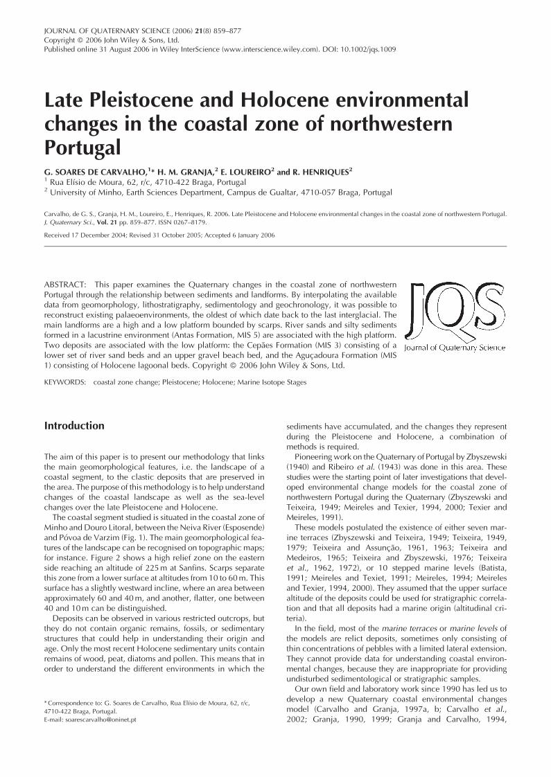
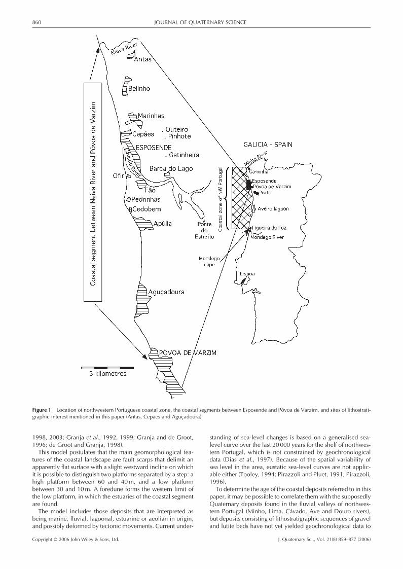
Minho and Douro Litoral, between the Neiva River (Esposende)and Povoa de Varzim (Fig. 1). The main geomorphological fea-tures of the landscape can be recognised on topographic maps;for instance. Figure 2 shows a high relief zone on the easternside reaching an altitude of 225m at Sanfins. Scarps separatethis zone from a lower surface at altitudes from 10 to 60m. Thissurface has a slightly westward incline, where an area betweenapproximately 60 and 40m, and another, flatter, one between40 and 10m can be distinguished.Deposits can be observed in various restricted outcrops, but
they do not contain organic remains, fossils, or sedimentarystructures that could help in understanding their origin andage. Only the most recent Holocene sedimentary units containremains of wood, peat, diatoms and pollen. This means that inorder to understand the different environments in which the
sediments have accumulated, and the changes they representduring the Pleistocene and Holocene, a combination ofmethods is required.Pioneering work on theQuaternary of Portugal by Zbyszewski
(1940) and Ribeiro et al. (1943) was done in this area. Thesestudies were the starting point of later investigations that devel-oped environmental change models for the coastal zone ofnorthwestern Portugal during the Quaternary (Zbyszewski andTeixeira, 1949; Meireles and Texier, 1994, 2000; Texier andMeireles, 1991).These models postulated the existence of either seven mar-
ine terraces (Zbyszewski and Teixeira, 1949; Teixeira, 1949,1979; Teixeira and Assuncao, 1961, 1963; Teixeira andMedeiros, 1965; Teixeira and Zbyszewski, 1976; Teixeiraet al., 1962, 1972), or 10 stepped marine levels (Batista,1991; Meireles and Texiet, 1991; Meireles, 1994; Meirelesand Texier, 1994, 2000). They assumed that the upper surfacealtitude of the deposits could be used for stratigraphic correla-tion and that all deposits had a marine origin (altitudinal cri-teria).In the field, most of the marine terraces or marine levels of
the models are relict deposits, sometimes only consisting ofthin concentrations of pebbles with a limited lateral extension.They cannot provide data for understanding coastal environ-mental changes, because they are inappropriate for providingundisturbed sedimentological or stratigraphic samples.Our own field and laboratory work since 1990 has led us to
develop a new Quaternary coastal environmental changesmodel (Carvalho and Granja, 1997a, b; Carvalho et al.,2002; Granja, 1990, 1999; Granja and Carvalho, 1994,
*Correspondence to: G. Soares de Carvalho, Rua Elısio de Moura, 62, r/c,4710-422 Braga, Portugal.E-mail: [email protected]
1998, 2003; Granja et al., 1992, 1999; Granja and de Groot,1996; de Groot and Granja, 1998).This model postulates that the main geomorphological fea-
tures of the coastal landscape are fault scarps that delimit anapparently flat surface with a slight westward incline on whichit is possible to distinguish two platforms separated by a step: ahigh platform between 60 and 40m, and a low platformbetween 30 and 10m. A foredune forms the western limit ofthe low platform, in which the estuaries of the coastal segmentare found.The model includes those deposits that are interpreted as
being marine, fluvial, lagoonal, estuarine or aeolian in origin,and possibly deformed by tectonic movements. Current under-
standing of sea-level changes is based on a generalised sea-level curve over the last 20 000 years for the shelf of northwes-tern Portugal, which is not constrained by geochronologicaldata (Dias et al., 1997). Because of the spatial variability ofsea level in the area, eustatic sea-level curves are not applic-able either (Tooley, 1994; Pirazzoli and Pluet, 1991; Pirazzoli,1996).To determine the age of the coastal deposits referred to in this
paper, it may be possible to correlate them with the supposedlyQuaternary deposits found in the fluvial valleys of northwes-tern Portugal (Minho, Lima, Cavado, Ave and Douro rivers),but deposits consisting of lithostratigraphic sequences of graveland lutite beds have not yet yielded geochronological data to
Figure 1 Location of northwestern Portuguese coastal zone, the coastal segments between Esposende and Povoa de Varzim, and sites of lithostrati-graphic interest mentioned in this paper (Antas, Cepaes and Agucadoura)
860 JOURNAL OF QUATERNARY SCIENCE
Copyright � 2006 John Wiley & Sons, Ltd. J. Quaternary Sci., Vol. 21(8) 859–877 (2006)
allow any correlation with the coastal deposits (Alves, 1995a, b,2004; Alves and Pereira, 1999; Braga, 1989). Some of the bedsfrom the Minho and Cavado river deposits contain plantfossils which are considered to be Late Pliocene to Early Pleisto-cene (Teixeira et al., 1969; Teixeira, 1979; Alves, 1995a, 2004).On the basis of the estimated ages of the sands (radiocarbon
and OSL, i.e. optical stimulated luminescence datings), we havecorrelated our Quaternary stratigraphic units with the global cli-mate change data from Marine Isotope Stages (MIS) chronostra-tigraphy (van Andel and Tzedakis, 1996; van Andel, 2003).
Geological background of the area
The bedrock of the area consists of two Palaeozoic formationsand granites, crossed by quartz veins (Teixeira, 1956; Teixeiraand Assuncao, 1963; Teixeira and Medeiros, 1965; Teixeiraet al., 1969; Pereira, 1992). The Palaeozoic formations are:the ‘Formacao de Esposende’ (Esposende Formation), consist-ing of quartzites with small conglomerate lenses, phyllites andshales; and the ‘Formacao da Barca do Lago’ (Barca do Lago
Figure 2 Detail of the topographic map of the coastal zone between the Neiva River and the Cavado estuary showing the main landscape features.Areas with crowded contour lines indicate the positions of fault scarps
LATE PLEISTOCENE AND HOLOCENE CHANGES IN NORTHWESTERN PORTUGAL 861
Copyright � 2006 John Wiley & Sons, Ltd. J. Quaternary Sci., Vol. 21(8) 859–877 (2006)
Formation), consisting of pelitic psammites, quartzites, andgraphitic schists. From a chronostratigraphic point of viewthe first formation is attributed to the Ordovician and the sec-ond to the Silurian (Sousa, 1988, 1989). Structurally, the twoformations constitute a syncline with a NW–SE axis. Its east-ern flank is in contact with the granites through faults andshear zones that are also orientated NW–SE. The synclinel’swestern flank is located offshore for the main part, and is sub-merged. Some NW–SE orientation outcrops of Ordovicianquartzite, such as the so-called ‘Cavalos de Fao’ (Fao Horses)emerge, however, especially during low tide. The Ordovicianrocks of the western flank constitute the bedrock of thebeaches.The Pleistocene–Holocene sediments accumulated on top
of the rocks forming the syncline. The orientation of theshoreline in the area is controlled by the fault strikes thatcross the synclinal structure (NW–SE, NE–SW and E–W).Some of these faults were reactivated during Pleistocene–Holocene times (Cabral, 1993). Before turning NW–SE attheir estuaries, the NE–SW oriented channels of the Cavadoand Neiva, the main rivers of the area, are examples of thisstructural dependency.In the western part of the area and north of the Cavado
River estuary, shingle beaches with beach-cusps consistingof Ordovician quartzite and shale pebbles are found. Southof the Cavado River estuary the beaches are sandy. Theyare fringed by erosion cliffs in parabolic dunes which covera medieval necropolis in the village of Fao. These sand dunesdate back to the Little Ice Age (Almeida, 1988; Almeida et al.,1990–92). The rapid erosion dynamics contribute to beachlosses, not only through retreat, but also by marine overwash-ing. The sea thus invades the agricultural fields and built-uphousing areas to the east of the dunes.
Definitions, concepts
The coastal zone definition given by the Land–Ocean Interac-tion in the Coastal Zone Project (LOICZ; Holligan and deBoois, 1993) is perfectly adapted to the coastal segmentsdescribed in this paper. The genetic interpretation of the pre-served Late Pleistocene and Holocene deposits correspondsto flooding and exposure events, related to Quaternary trans-gressions and regressions in the area. In our model the term‘platform’ describes apparently flat landforms: (1) with residualdeposits of limited extent and width; or (2) associated with sedi-mentary deposits of different origin and age, which can consti-tute a stratigraphic sequence. Later, we apply this term to theflat landforms of the coastal zone that are associated with poly-genic sediments (marine, lagoonal, estuarine, aeolian, etc.).Deposits of very limited extension and residual features suchas scattered pebbles are not considered here, because theydo not contain enough information for any reliable environ-mental or age interpretation.
Methodology
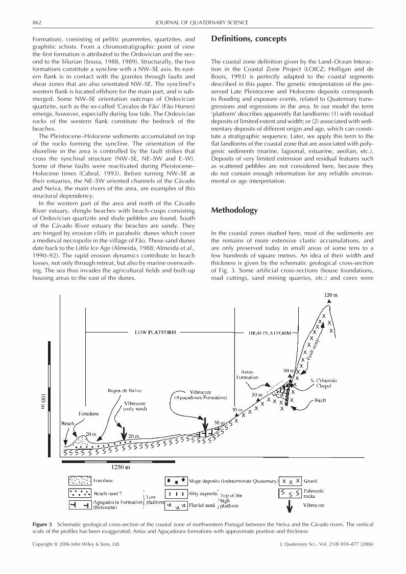
In the coastal zones studied here, most of the sediments arethe remains of more extensive clastic accumulations, andare only preserved today in small areas of some tens to afew hundreds of square metres. An idea of their width andthickness is given by the schematic geological cross-sectionof Fig. 3. Some artificial cross-sections (house foundations,road cuttings, sand mining quarries, etc.) and cores were
Figure 3 Schematic geological cross-section of the coastal zone of northwestern Portugal between the Neiva and the Cavado rivers. The verticalscale of the profiles has been exaggerated; Antas and Agucadoura formations with approximate position and thickness
862 JOURNAL OF QUATERNARY SCIENCE
Copyright � 2006 John Wiley & Sons, Ltd. J. Quaternary Sci., Vol. 21(8) 859–877 (2006)
helpful in defining sedimentary sequences, units of whichwere sampled in order to understand their origin and chronol-ogy.The model must be considered a regional one because the
deposits are found very locally, and they cannot yet be corre-lated with deposits in neighbouring areas—either becausethere is no satisfactory sedimentary and chronological informa-tion available for the Quaternary in those areas or there are nocomparable deposits and geoforms, such as those in the coastalsegments south of Espinho and Aveiro (Granja and Carvalho,1994, 2003; Granja and de Groot, 1996; de Groot and Granja,
1998; Carvalho et al., 2002) or in the coastal zone of Galicia,Spain (Mosquera-Sante, 2002; Vidal-Romani, 2002; Lopez-Cancelo, 2004).
Geomorphology
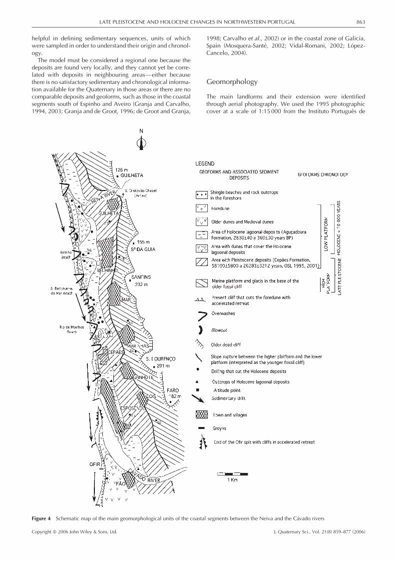
The main landforms and their extension were identifiedthrough aerial photography. We used the 1995 photographiccover at a scale of 1:15 000 from the Instituto Portugues de
Figure 4 Schematic map of the main geomorphological units of the coastal segments between the Neiva and the Cavado rivers
LATE PLEISTOCENE AND HOLOCENE CHANGES IN NORTHWESTERN PORTUGAL 863
Copyright � 2006 John Wiley & Sons, Ltd. J. Quaternary Sci., Vol. 21(8) 859–877 (2006)
Cartografia e Cadastro (Portuguese Institute of Cartography andCadastre) and the 1996 colour photographs on a scale of1:8000 from the Instituto Nacional da Agua (National WaterInstitute). Interpretation was controlled by detailed fieldworkusing the 1:25 000 scale 1997 maps of Esposende (number68) and Marinhas (54), of the Instituto Geografico do Exercito(Geographic Institute of the Army). During fieldwork the linkbetween the geoforms and the sedimentary units discussed inthis paper was established (see Fig. 4).
Lithostratigraphy
The framework of the Quaternary stratigraphic scheme that wehave defined for the coastal zone of northwestern Portugal,which includes the districts of Esposende and Povoa deVarzim, is based on the stratigraphic criteria Hedberg (1994).Where possible, the lithostratigraphic units were dated by14C or optically stimulated luminescence (OSL).
Sedimentology and palaeoenvironments
The determination of the palaeoenvironments is based on thegenetic interpretation of the sediments that constitute thelandforms or that are associated with them. Data used are:sedimentary structures, grain-size analysis (statistical para-meters and correlation diagrams), pebble morphometry andimbrication, organic remains, and micro-organisms (diatomsand pollen). Sedimentary structures, however, were often verydiffuse or even non-existent, especially in the older deposits,either because of primary deposition characteristics orbecause of later diagenetic and biogenic processes. Trenchesthrough each bed, more or less perpendicular to the bedding,were made for sampling (Lewis and McConchie, 1994b); allthe beds observed in each section were sampled. The samplesfor OSL dating are spot samples from the bed when it was pos-sible to bury a 12 cm long PCB pipe, and quickly wrap it inblack plastic. The pebble samples are composites of spotsamples.
Grain-size data
Sediment classification is based on the mean and standarddeviation of dimensional distribution according to Folk andWard (1957) and Lewis and McConchie (1994b).Grain-size analysis was done by a combination of sieve and
pipette analyses following the methodology of Krumbein(1934), Krumbein and Pettijohn (1965), Tucker (1988, 2001),and Lewis and McConchie (1994b) and a laboratory routineadopted by the Sedimentology Laboratory of the Earth SciencesDepartment (University of Minho).The processing of the grain-size data was based on the
moment’s method and some Friedman statistics (Friedman,1967, 1979a, b). The statistics were calculated with a softwareprogram developed by Henriques (2003), which also generatesthe Friedman plots.The statistical measures used are: standard deviation, skew-
ness (third moment), mean-cubed deviation, simple sortingmeasure, and simple skewness measure (Friedman, 1979a).Plots of standard deviation and skewness, mean-cubed
deviation and skewness, simple skewness measure and simplesorting measure of the size distributions were used to distin-guish beach sands from river sands (Friedman, 1967), and near-shore dunes from river sands (Friedman, 1979b). All beds of thecross-sections were sampled.
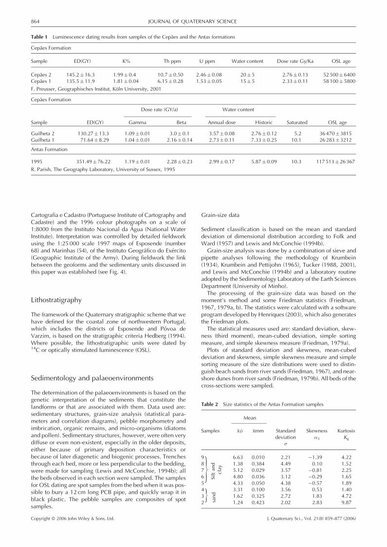
Table 1 Luminescence dating results from samples of the Cepaes and the Antas formations
Cepaes Formation
Sample ED(GY) K% Th ppm U ppm Water content Dose rate Gy/Ka OSL age
Cepaes 2 145.2� 16.3 1.99� 0.4 10.7� 0.50 2.46� 0.08 20� 5 2.76� 0.13 52500�6400Cepaes 1 135.5� 11.9 1.81�0.04 6.15� 0.28 1.53� 0.05 15� 5 2.33� 0.11 58100�5800
F. Preusser, Geographisches Institut, Koln University, 2001
Cepaes Formation
Dose rate (GY/a) Water content
Sample ED(GY) Gamma Beta Annual dose Historic Saturated OSL age
Guilheta 2 130.27�13.3 1.09� 0.01 3.0� 0.1 3.57� 0.08 2.76� 0.12 5.2 36470�3815Guilheta 1 71.64� 8.29 1.04� 0.01 2.16� 0.14 2.73� 0.11 7.33� 0.25 10.1 26283�3212
Antas Formation
1995 351.49� 76.22 1.19� 0.01 2.28� 0.23 2.99� 0.17 5.87� 0.09 10.3 117 513� 26367
R. Parish, The Geography Laboratory, University of Sussex, 1995
}}
Table 2 Size statistics of the Antas Formation samples
Mean
Samples �x� �xmm Standard Skewness Kurtosisdeviation �3 Kg
�
9 6.63 0.010 2.21 �1.39 4.228 1.38 0.384 4.49 0.10 1.527 5.12 0.029 3.57 �0.81 2.256 4.80 0.036 3.12 �0.29 1.655 4.33 0.050 4.38 �0.57 1.894 3.31 0.100 3.56 0.53 1.403 1.62 0.325 2.72 1.83 4.722 1.24 0.423 2.02 2.83 9.87
Siltan
dclay
sand
864 JOURNAL OF QUATERNARY SCIENCE
Copyright � 2006 John Wiley & Sons, Ltd. J. Quaternary Sci., Vol. 21(8) 859–877 (2006)
Imbrication
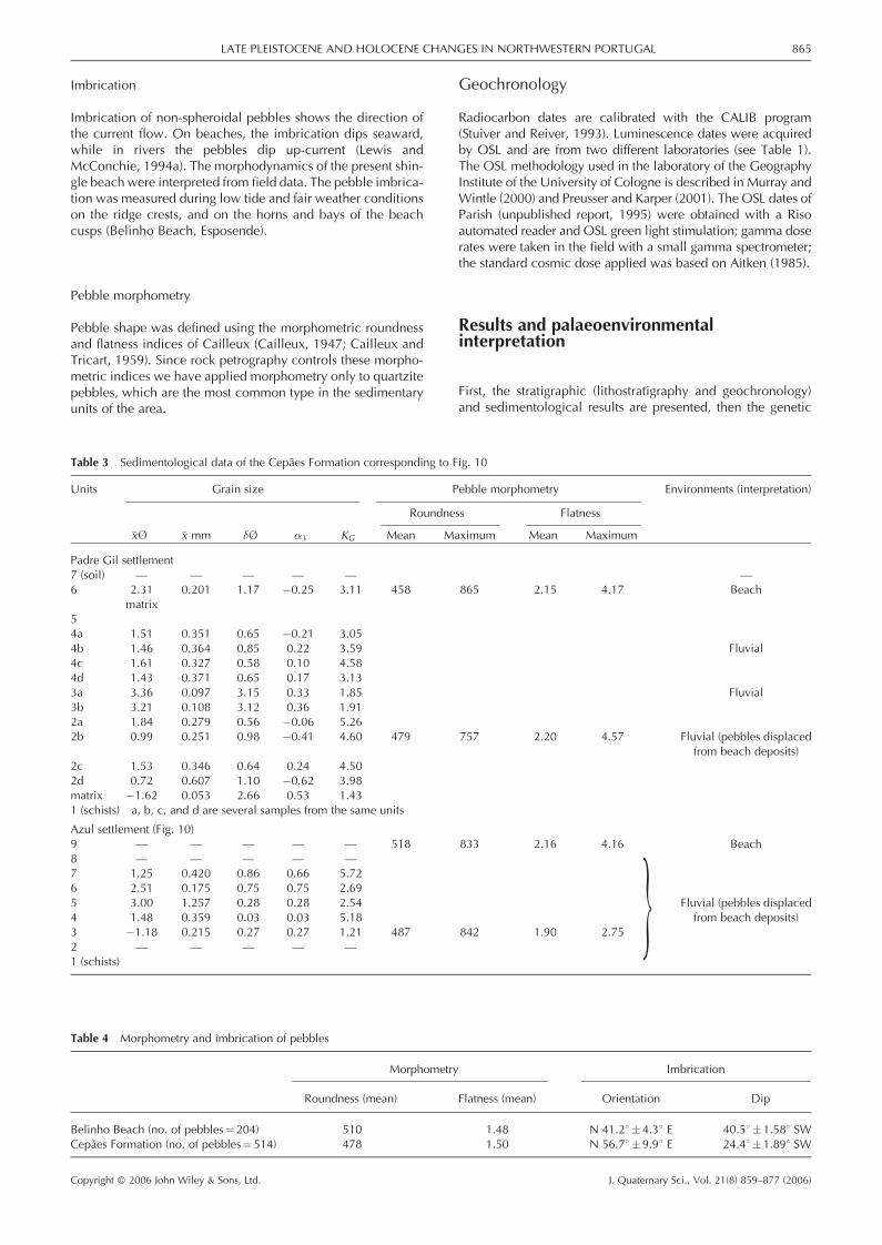
Imbrication of non-spheroidal pebbles shows the direction ofthe current flow. On beaches, the imbrication dips seaward,while in rivers the pebbles dip up-current (Lewis andMcConchie, 1994a). The morphodynamics of the present shin-gle beach were interpreted from field data. The pebble imbrica-tion was measured during low tide and fair weather conditionson the ridge crests, and on the horns and bays of the beachcusps (Belinho Beach, Esposende).
Pebble morphometry
Pebble shape was defined using the morphometric roundnessand flatness indices of Cailleux (Cailleux, 1947; Cailleux andTricart, 1959). Since rock petrography controls these morpho-metric indices we have applied morphometry only to quartzitepebbles, which are the most common type in the sedimentaryunits of the area.
Geochronology
Radiocarbon dates are calibrated with the CALIB program(Stuiver and Reiver, 1993). Luminescence dates were acquiredby OSL and are from two different laboratories (see Table 1).The OSL methodology used in the laboratory of the GeographyInstitute of the University of Cologne is described in Murray andWintle (2000) and Preusser and Karper (2001). The OSL dates ofParish (unpublished report, 1995) were obtained with a Risoautomated reader and OSL green light stimulation; gamma doserates were taken in the field with a small gamma spectrometer;the standard cosmic dose applied was based on Aitken (1985).
Results and palaeoenvironmentalinterpretation
First, the stratigraphic (lithostratigraphy and geochronology)and sedimentological results are presented, then the genetic
}
Table 3 Sedimentological data of the Cepaes Formation corresponding to Fig. 10
Units Grain size Pebble morphometry Environments (interpretation)
Roundness Flatness
�x� �x mm �� �3 KG Mean Maximum Mean Maximum
Padre Gil settlement7 (soil) — — — — — —6 2.31 0.201 1.17 �0.25 3.11 458 865 2.15 4.17 Beach
matrix54a 1.51 0.351 0.65 �0.21 3.054b 1.46 0.364 0.85 0.22 3.59 Fluvial4c 1.61 0.327 0.58 0.10 4.584d 1.43 0.371 0.65 0.17 3.133a 3.36 0.097 3.15 0.33 1.85 Fluvial3b 3.21 0.108 3.12 0.36 1.912a 1.84 0.279 0.56 �0.06 5.262b 0.99 0.251 0.98 �0.41 4.60 479 757 2.20 4.57 Fluvial (pebbles displaced
from beach deposits)2c 1.53 0.346 0.64 0.24 4.502d 0.72 0.607 1.10 �0.62 3.98matrix �1.62 0.053 2.66 0.53 1.431 (schists) a, b, c, and d are several samples from the same units
Azul settlement (Fig. 10)9 — — — — — 518 833 2.16 4.16 Beach8 — — — — —7 1.25 0.420 0.86 0.66 5.726 2.51 0.175 0.75 0.75 2.695 3.00 1.257 0.28 0.28 2.54 Fluvial (pebbles displaced4 1.48 0.359 0.03 0.03 5.18 from beach deposits)3 �1.18 0.215 0.27 0.27 1.21 487 842 1.90 2.752 — — — — —1 (schists)
Table 4 Morphometry and imbrication of pebbles
Morphometry Imbrication
Roundness (mean) Flatness (mean) Orientation Dip
Belinho Beach (no. of pebbles¼204) 510 1.48 N 41.28�4.38 E 40.58�1.588 SWCepaes Formation (no. of pebbles¼514) 478 1.50 N 56.78�9.98 E 24.48�1.898 SW
LATE PLEISTOCENE AND HOLOCENE CHANGES IN NORTHWESTERN PORTUGAL 865
Copyright � 2006 John Wiley & Sons, Ltd. J. Quaternary Sci., Vol. 21(8) 859–877 (2006)
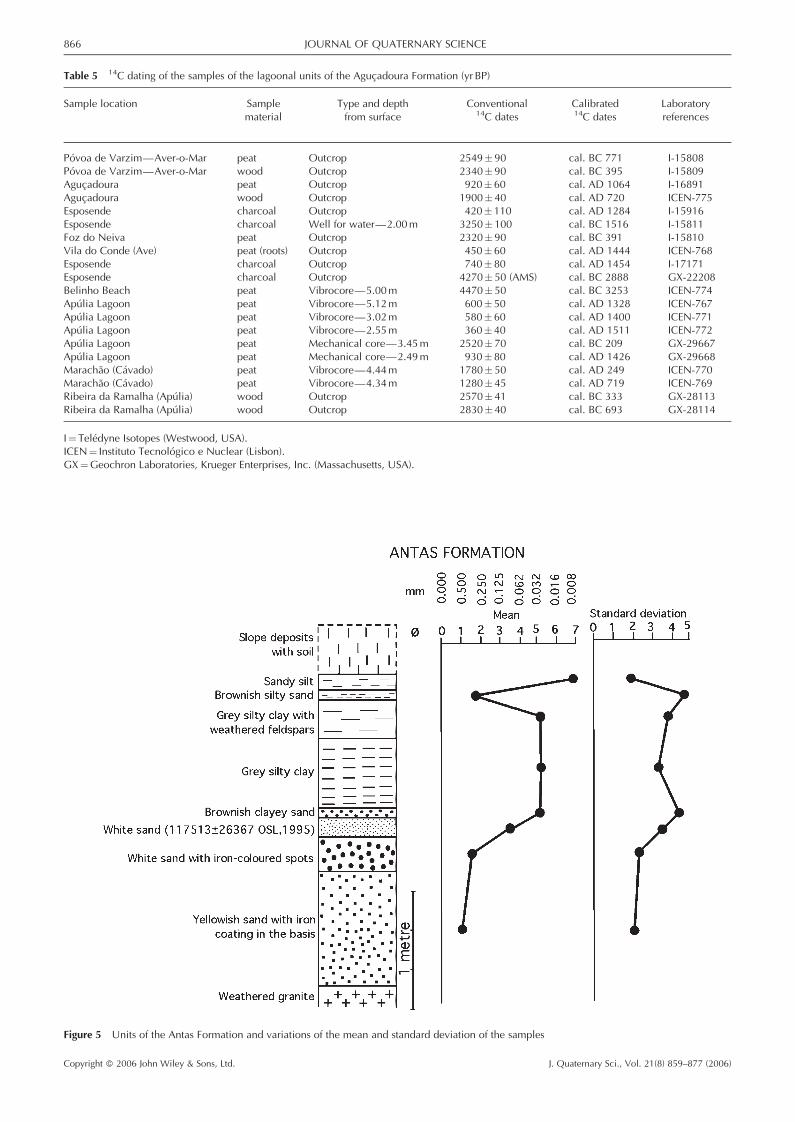
Table 5 14C dating of the samples of the lagoonal units of the Agucadoura Formation (yr BP)
Sample location Sample Type and depth Conventional Calibrated Laboratorymaterial from surface 14C dates 14C dates references
Povoa de Varzim—Aver-o-Mar peat Outcrop 2549� 90 cal. BC 771 I-15808Povoa de Varzim—Aver-o-Mar wood Outcrop 2340� 90 cal. BC 395 I-15809Agucadoura peat Outcrop 920� 60 cal. AD 1064 I-16891Agucadoura wood Outcrop 1900� 40 cal. AD 720 ICEN-775Esposende charcoal Outcrop 420� 110 cal. AD 1284 I-15916Esposende charcoal Well for water—2.00m 3250� 100 cal. BC 1516 I-15811Foz do Neiva peat Outcrop 2320� 90 cal. BC 391 I-15810Vila do Conde (Ave) peat (roots) Outcrop 450� 60 cal. AD 1444 ICEN-768Esposende charcoal Outcrop 740� 80 cal. AD 1454 I-17171Esposende charcoal Outcrop 4270� 50 (AMS) cal. BC 2888 GX-22208Belinho Beach peat Vibrocore—5.00m 4470� 50 cal. BC 3253 ICEN-774Apulia Lagoon peat Vibrocore—5.12m 600� 50 cal. AD 1328 ICEN-767Apulia Lagoon peat Vibrocore—3.02m 580� 60 cal. AD 1400 ICEN-771Apulia Lagoon peat Vibrocore—2.55m 360� 40 cal. AD 1511 ICEN-772Apulia Lagoon peat Mechanical core—3.45m 2520� 70 cal. BC 209 GX-29667Apulia Lagoon peat Mechanical core—2.49m 930� 80 cal. AD 1426 GX-29668Marachao (Cavado) peat Vibrocore—4.44m 1780� 50 cal. AD 249 ICEN-770Marachao (Cavado) peat Vibrocore—4.34m 1280� 45 cal. AD 719 ICEN-769Ribeira da Ramalha (Apulia) wood Outcrop 2570� 41 cal. BC 333 GX-28113Ribeira da Ramalha (Apulia) wood Outcrop 2830� 40 cal. BC 693 GX-28114
I¼ Teledyne Isotopes (Westwood, USA).ICEN¼ Instituto Tecnologico e Nuclear (Lisbon).GX¼Geochron Laboratories, Krueger Enterprises, Inc. (Massachusetts, USA).
Figure 5 Units of the Antas Formation and variations of the mean and standard deviation of the samples
866 JOURNAL OF QUATERNARY SCIENCE
Copyright � 2006 John Wiley & Sons, Ltd. J. Quaternary Sci., Vol. 21(8) 859–877 (2006)
interpretation is reported formation by formation. Finally, wepropose a sequence of palaeoenvironments that we considerto have prevailed in the coastal segment during the Pleistoceneand the Holocene. Table 6 and the geomorphological sche-matic map of Fig. 4 synthesise the interpretations.
The high platform
The units that constitute the Antas and the Cepaes formationsare devoid of fossils. Sedimentological interpretations of theclastic deposits are therefore needed to establish the environ-mental conditions in which they were generated. In theabsence of clearly recognisable sedimentary structures in thefield, the interpretations presented here are based on grain-sizeanalysis of the sands and silts (Friedman plots), on pebble mor-phometry (Cailleux, 1947; Cailleux and Tricart, 1959) and onpebble imbrication.
The Antas Formation
The high platform is limited on the Eastern side by scarps thatcorrespond to faults oriented NW–SE and NE–SW, intersectedby a minor fault with variable trends (Granja et al., 1992). The
faults are recognised in the field by their fault breccias in thegranites.At Antas, near the St. Cristovao Chapel, a sand-mining expo-
sure shows beds which are characteristic of the formation(Fig. 5 and Table 2): a lower set of sand beds overlain bysilty-clay beds (Granja, 1990). The beds are in lateral contactwith the granitic outcrops through fault breccias with graniticand silty-clay bed remains, and small silty-clay injectionsthrough the crushed granite. The topographic altitude of thetop of the sequence is about 90m.
SedimentologyNo sedimentary structures can be recognised in the field. Thestandard deviation of the lower sands (between 2.02� and4.38�) classifies them as poorly to very poorly sorted sand (Folkand Ward, 1957; Folk, 1966; Lewis and McConchie, 1994a,b;Tucker, 2001) (Fig. 5).The grain-size characteristics of the upper beds have a mean
between 1.38� and 6.63� (between 0.010 and 0.050mm, siltand clay), and a standard deviation between 2.21� and 4.38�,(very poorly sorted).
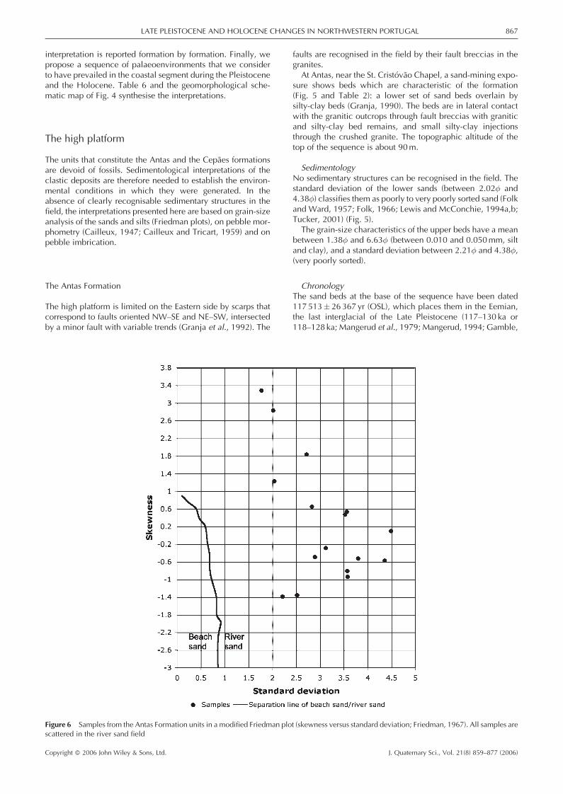
ChronologyThe sand beds at the base of the sequence have been dated117 513� 26367 yr (OSL), which places them in the Eemian,the last interglacial of the Late Pleistocene (117–130 ka or118–128 ka; Mangerud et al., 1979; Mangerud, 1994; Gamble,
Figure 6 Samples from the Antas Formation units in a modified Friedman plot (skewness versus standard deviation; Friedman, 1967). All samples arescattered in the river sand field
LATE PLEISTOCENE AND HOLOCENE CHANGES IN NORTHWESTERN PORTUGAL 867
Copyright � 2006 John Wiley & Sons, Ltd. J. Quaternary Sci., Vol. 21(8) 859–877 (2006)
1996). It was not possible to obtain any datings from the uppersilty-clay beds.
Environmental interpretationStandard deviation versus skewness of all the poorly and verypoorly sorted sands of the lower beds (Fig. 6) fall within theriver sands domain according to Friedman (1967, 1979a, b).The grain size of the very poorly sorted silty and clayey sand
of the upper beds suggests an environment of quiet water, asoccurs in a lacustrine environment.
Other clastic deposits linked to the high platform
The eastern side of the high platform is limited by conspicuousscarps in the landscape. These scarps correspond to faults, as is
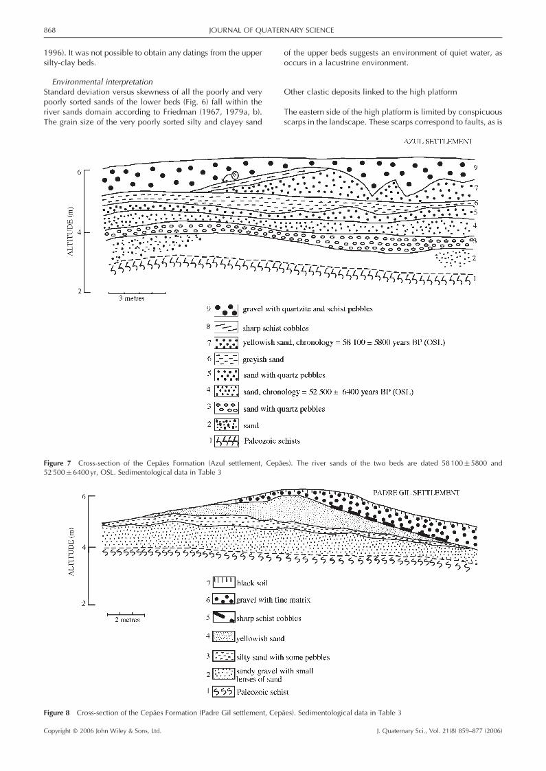
Figure 7 Cross-section of the Cepaes Formation (Azul settlement, Cepaes). The river sands of the two beds are dated 58100�5800 and52500� 6400 yr, OSL. Sedimentological data in Table 3
Figure 8 Cross-section of the Cepaes Formation (Padre Gil settlement, Cepaes). Sedimentological data in Table 3
868 JOURNAL OF QUATERNARY SCIENCE
Copyright � 2006 John Wiley & Sons, Ltd. J. Quaternary Sci., Vol. 21(8) 859–877 (2006)
shown by the presence of granitic breccias, and injections ofthe silty and clayey upper beds of the Antas Formation in thebreccias. The clastic deposits (Pinhote Conglomerate, OuteiroConglomerate and Gatinheira-Gois Sands) observed west ofthe scarps and linked to the high platform are very thin (lessthan 1m) and separate from each other. The Pinhote Conglom-erate consists of granitic pebbles embedded in a sandy matrix,and is observed at the base of the scarps. The Outeiro Con-glomerate consists of a sandy matrix with quartzite and quartzpebbles, and is found in the western part of the high platform.The Gatinheira-Gois Sands are coarse sands, accumulated nearthe dead cliff and between the granitic outcrops of the highplatform. The high platform is interpreted as having beenreworked by marine processes because the Outeiro Conglom-erate has a marine morphometry (mean pebble flatness of 1.99and mean roundness of 459). This morphometry data can beinterpreted as having been produced by beach processes, whenthe fault scarps acted as a cliff.With the exception of the Antas Formation, which is located
against the cliff, we do not have any further information aboutthe age of the deposits associated with the high platform.
The low platform
A slope break in the landscape marks the boundary betweenthe high and the low platforms. It is interpreted as a youngerabandoned cliff, representing the western limit of the highplatform.
In the low platform, two sets of clastic deposits of differentorigin and chronology were identified: the Cepaes Formationand the Agucadoura Formation.
Cepaes Formation
The Cepaes Formation corresponds to a 4–6m thick sedimen-tary sequence, observed near Cepaes in the foundations of thesettlements of Padre Gil, Azul and Carda (Figs. 7 and 8).
SedimentologyThe sedimentary sequence, with no recognisable structures,can be subdivided into a lower set of sand beds, mostly poorlyor very poorly sorted, and a gravel bed at the top consisting ofquartzite pebbles with a roundness of 518–459 and flatnessaround 2.00. Its base consists of some channels and a bandof sharp schist cobbles. The sedimentology of the bedsobserved in the settlements of Padre Gil and Azul is sum-marised in Table 3 and Fig. 7 and 8.
GeochronologyThe dated samples from the Cepaes Formation were taken inthe yellowish sands of bed 7, and bed 4 of the Azul settlement(Fig. 7). The estimated ages are 58 100� 5800 yr (OSL) and52 500� 6400 yr (OSL). The other dated samples were takenin a cross-section at Guilheta (Esposende), in a sand bed witha thickness of about 1m, below a gravel bed similar to bed 9of the Azul settlement and bed 6 of the Padre Gil settlement.Since the gravel occurs at the top of the Azul and Padre
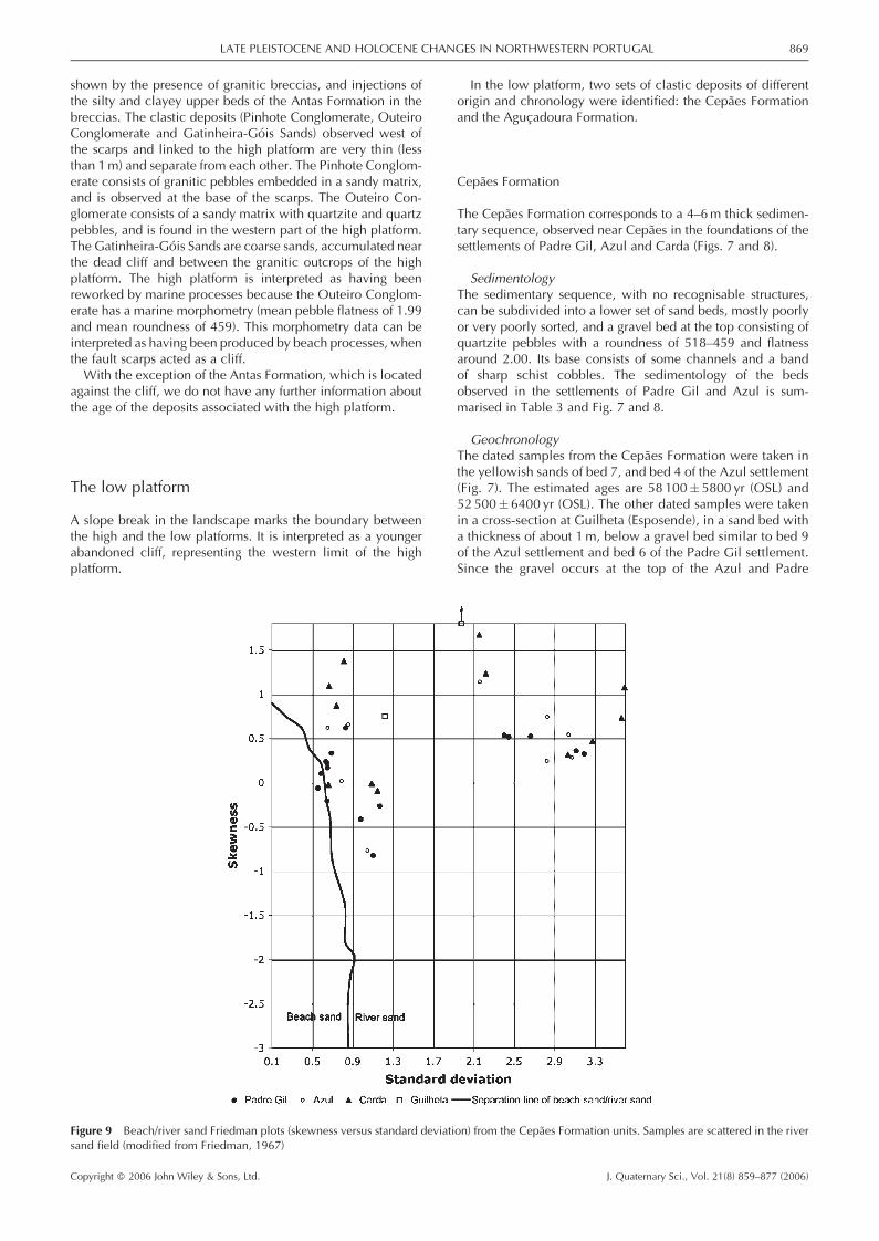
Figure 9 Beach/river sand Friedman plots (skewness versus standard deviation) from the Cepaes Formation units. Samples are scattered in the riversand field (modified from Friedman, 1967)
LATE PLEISTOCENE AND HOLOCENE CHANGES IN NORTHWESTERN PORTUGAL 869
Copyright � 2006 John Wiley & Sons, Ltd. J. Quaternary Sci., Vol. 21(8) 859–877 (2006)

Gil settlements, we may assume that the estimated ages ofGuilheta correspond to the ending of the sequence. The bedsof the Cepaes Formation accumulated during the MiddleWeichselian.
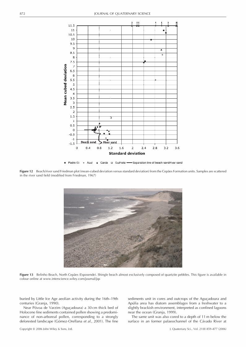
Palaeoenvironmental interpretationNeither fossils nor sedimentary structures are present, so grain-size data and pebble morphometry were used for the interpre-tation. They are summarised in Table 3. The interpretation ofthe grain-size data can be made by using Friedman plots (skew-ness versus standard deviation, mean-cubed deviation versusstandard deviation, and simple skewness measure versus sim-ple sorting measure). Most of the samples fall within the riversands domain (Figs. 9–12).By contrast, the units at the top of the sequence (unit 9 in
the Azul settlement, Fig. 7, and unit 6 in the Padre Gil settle-ment, Fig. 8) are composed of quartzite with a high roundnessindex (mean between 427 and 518) and flatness index (meanbetween 1.90 and 2.20), which suggest a beach environment(Table 3). This is in accordance with the morphometric dataof the pebbles of shingle beaches on the coastal segmentnorth of the Azul settlement near Cepaes and Esposende(Loureiro and Granja, 2001) and south of the Neiva Riverestuary (Fig. 13). Most beaches of the recent coastal segmentsare almost exclusively formed of quartzite pebbles with aroundness index between 586� 110 and 435� 101 and aflatness index between 2.07� 0.13 and 1.90� 0.08 (Lour-eiro, 1999).
In the cross-section of the Cepaes Formation (Figs. 7 and 8)sharp schist cobbles are observed at the base of bed 9 (Azul set-tlement, Fig. 7) and at the base of bed 6 (Padre Gil settlement,Fig. 8); they are interpreted as beach cobbles. The same type ofcobbles is found on the higher levels of recent shingle beaches(e.g. the beaches between Belinho Beach and Regos de Baixo,Esposende), originating from the Ordovician schists that out-crop in the foreshore and nearshore. The top unit of thecross-section can be interpreted as part of a beach ridge formedat the beginning of the gravel accumulation.In some sandy units of the fluvial sequence there are also
quartzite and quartz pebbles with a high roundness index,but their sand samples in the Friedman plots point to a fluvialorigin instead. Examples are unit 2 of the Padre Gil settlement(mean roundness 479 and mean flatness 2.16, Table 3) and unit3 of the Azul settlement (mean roundness 487 and mean flat-ness 1.90; Fig. 11). Our interpretation is that the rounded clas-tic pebbles could have come from high platform deposits andbeen included in the fluvial deposits.
Pebble imbrication of the Cepaes FormationIn the study of the imbrication of the Cepaes Formation, 514discoid and elongated quartzite pebbles between 40 and150mm in length were used. The imbrication shows that mostof the pebbles have a dip of 24.48� 1.898 SW and an orienta-tion of N 56.78� 9.98 E.On Belinho Beach, North of Cepaes (Esposende), the presentshingle beaches are formed almost exclusively of quartzite
Figure 10 Nearshore dunes/river sand Friedman plot (skewness versus standard deviation) from the Cepaes Formation units. Samples are scattered inthe river sand field (modified from Friedman, 1979a)
870 JOURNAL OF QUATERNARY SCIENCE
Copyright � 2006 John Wiley & Sons, Ltd. J. Quaternary Sci., Vol. 21(8) 859–877 (2006)
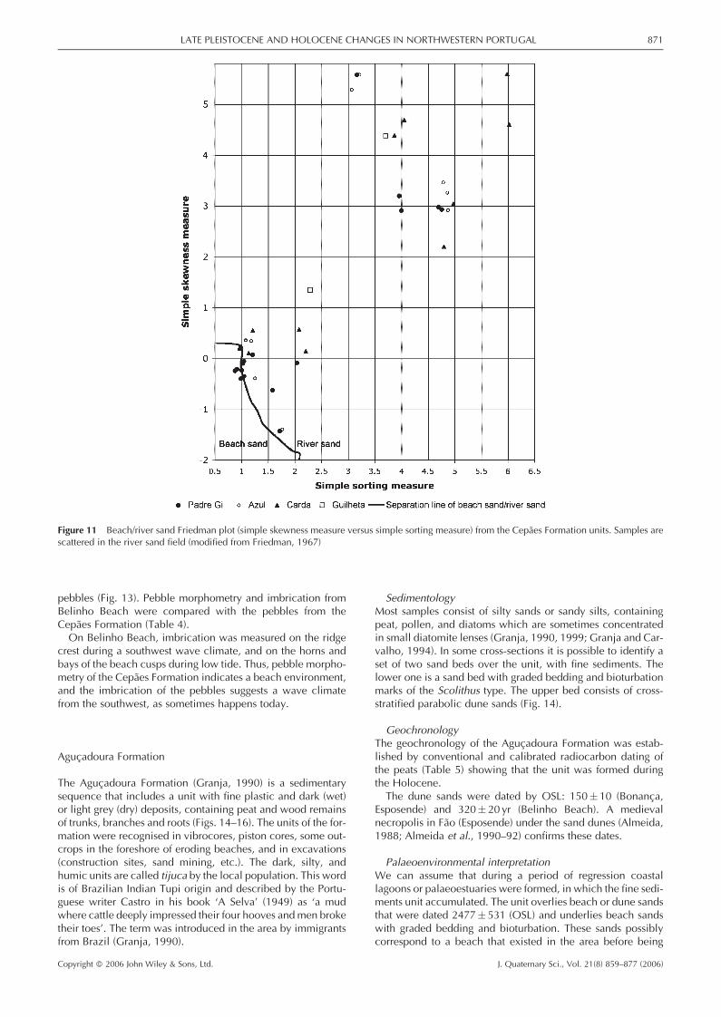
pebbles (Fig. 13). Pebble morphometry and imbrication fromBelinho Beach were compared with the pebbles from theCepaes Formation (Table 4).On Belinho Beach, imbrication was measured on the ridge
crest during a southwest wave climate, and on the horns andbays of the beach cusps during low tide. Thus, pebble morpho-metry of the Cepaes Formation indicates a beach environment,and the imbrication of the pebbles suggests a wave climatefrom the southwest, as sometimes happens today.
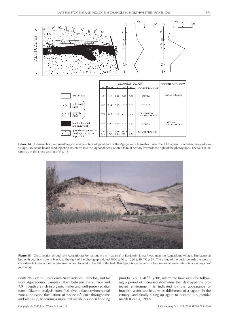
Agucadoura Formation
The Agucadoura Formation (Granja, 1990) is a sedimentarysequence that includes a unit with fine plastic and dark (wet)or light grey (dry) deposits, containing peat and wood remainsof trunks, branches and roots (Figs. 14–16). The units of the for-mation were recognised in vibrocores, piston cores, some out-crops in the foreshore of eroding beaches, and in excavations(construction sites, sand mining, etc.). The dark, silty, andhumic units are called tijuca by the local population. This wordis of Brazilian Indian Tupi origin and described by the Portu-guese writer Castro in his book ‘A Selva’ (1949) as ‘a mudwhere cattle deeply impressed their four hooves andmen broketheir toes’. The term was introduced in the area by immigrantsfrom Brazil (Granja, 1990).
SedimentologyMost samples consist of silty sands or sandy silts, containingpeat, pollen, and diatoms which are sometimes concentratedin small diatomite lenses (Granja, 1990, 1999; Granja and Car-valho, 1994). In some cross-sections it is possible to identify aset of two sand beds over the unit, with fine sediments. Thelower one is a sand bed with graded bedding and bioturbationmarks of the Scolithus type. The upper bed consists of cross-stratified parabolic dune sands (Fig. 14).
GeochronologyThe geochronology of the Agucadoura Formation was estab-lished by conventional and calibrated radiocarbon dating ofthe peats (Table 5) showing that the unit was formed duringthe Holocene.The dune sands were dated by OSL: 150� 10 (Bonanca,
Esposende) and 320� 20 yr (Belinho Beach). A medievalnecropolis in Fao (Esposende) under the sand dunes (Almeida,1988; Almeida et al., 1990–92) confirms these dates.
Palaeoenvironmental interpretationWe can assume that during a period of regression coastallagoons or palaeoestuaries were formed, in which the fine sedi-ments unit accumulated. The unit overlies beach or dune sandsthat were dated 2477� 531 (OSL) and underlies beach sandswith graded bedding and bioturbation. These sands possiblycorrespond to a beach that existed in the area before being
Figure 11 Beach/river sand Friedman plot (simple skewness measure versus simple sorting measure) from the Cepaes Formation units. Samples arescattered in the river sand field (modified from Friedman, 1967)
LATE PLEISTOCENE AND HOLOCENE CHANGES IN NORTHWESTERN PORTUGAL 871
Copyright � 2006 John Wiley & Sons, Ltd. J. Quaternary Sci., Vol. 21(8) 859–877 (2006)
buried by Little Ice Age aeolian activity during the 16th–19thcenturies (Granja, 1990).Near Povoa de Varzim (Agucadoura) a 30 cm thick bed of
Holocene fine sediments contained pollen showing a predomi-nance of non-arboreal pollen, corresponding to a stronglydeforested landscape (Gomez-Orellana et al., 2001). The fine
sediments unit in cores and outcrops of the Agucadoura andApulia area has diatom assemblages from a freshwater to aslightly brackish environment, interpreted as confined lagoonsnear the ocean (Granja, 1999).The same unit was also cored to a depth of 11m below the
surface in an former palaeochannel of the Cavado River at
Figure 12 Beach/river sand Friedman plot (mean-cubed deviation versus standard deviation) from the Cepaes Formation units. Samples are scatteredin the river sand field (modified from Friedman, 1967)
Figure 13 Belinho Beach, North Cepaes (Esposende). Shingle beach almost exclusively composed of quartzite pebbles. This figure is available incolour online at www.interscience.wiley.com/journal/jqs
872 JOURNAL OF QUATERNARY SCIENCE
Copyright � 2006 John Wiley & Sons, Ltd. J. Quaternary Sci., Vol. 21(8) 859–877 (2006)
Ponte do Estreito (Barqueiros-Necessidades, Barcelos), not farfrom Agucadoura. Samples taken between the surface and7.9m depth are rich in organic matter and well-preserved dia-toms. Diatom analysis identified five palaeoenvironmentalzones, indicating fluctuations of marine influence through timeand silting-up, becoming a supratidal marsh. A sudden flooding
prior to 1780� 50 14C yr BP, inferred to have occurred follow-ing a period of increased storminess that destroyed the pro-tected environment, is indicated by the appearance ofbrackish water species, the establishment of a lagoon in theestuary, and finally silting-up again to became a supratidalmarsh (Granja, 1999).
Figure 14 Cross-section, sedimentological and geochronological data of the Agucadoura Formation, near the ‘O Cacador’ snack-bar, Agucadouravillage. Holocene beach sand injection structures into the lagoonal beds, related to fault activity (towards the right of the photograph). The fault is thesame as in the cross-section of Fig. 15
Figure 15 Cross-section through the Agucadoura Formation, in the ‘masseira’ of Benjamim Lima Alves, near the Agucadoura village. The lagoonalbed with peat is visible in black, to the right of the photograph, dated 1900�40 to 1220� 40 14C yr BP. The tilting of the beds towards the west isconsidered of neotectonic origin, from a fault located to the left of the bed. This figure is available in colour online at www.interscience.wiley.com/journal/jqs
LATE PLEISTOCENE AND HOLOCENE CHANGES IN NORTHWESTERN PORTUGAL 873
Copyright � 2006 John Wiley & Sons, Ltd. J. Quaternary Sci., Vol. 21(8) 859–877 (2006)
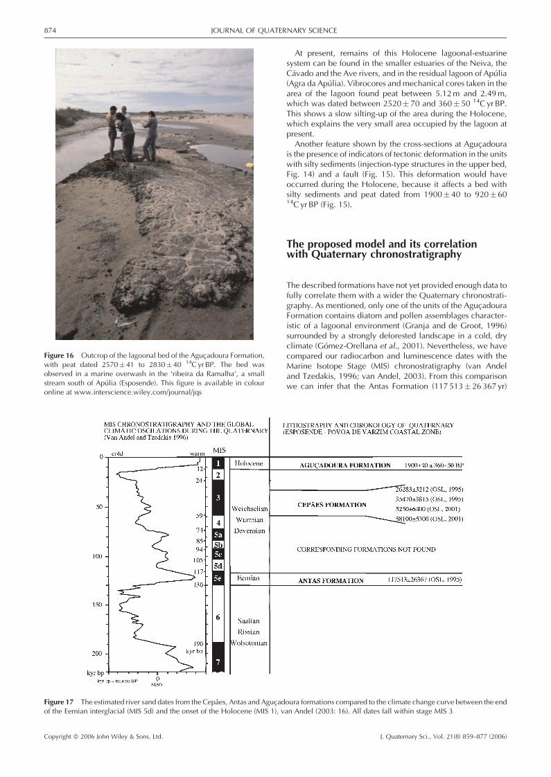
At present, remains of this Holocene lagoonal-estuarinesystem can be found in the smaller estuaries of the Neiva, theCavado and the Ave rivers, and in the residual lagoon of Apulia(Agra da Apulia). Vibrocores and mechanical cores taken in thearea of the lagoon found peat between 5.12m and 2.49m,which was dated between 2520� 70 and 360� 50 14C yr BP.This shows a slow silting-up of the area during the Holocene,which explains the very small area occupied by the lagoon atpresent.Another feature shown by the cross-sections at Agucadoura
is the presence of indicators of tectonic deformation in the unitswith silty sediments (injection-type structures in the upper bed,Fig. 14) and a fault (Fig. 15). This deformation would haveoccurred during the Holocene, because it affects a bed withsilty sediments and peat dated from 1900� 40 to 920� 6014C yr BP (Fig. 15).
The proposed model and its correlationwith Quaternary chronostratigraphy
The described formations have not yet provided enough data tofully correlate them with a wider the Quaternary chronostrati-graphy. As mentioned, only one of the units of the AgucadouraFormation contains diatom and pollen assemblages character-istic of a lagoonal environment (Granja and de Groot, 1996)surrounded by a strongly deforested landscape in a cold, dryclimate (Gomez-Orellana et al., 2001). Nevertheless, we havecompared our radiocarbon and luminescence dates with theMarine Isotope Stage (MIS) chronostratigraphy (van Andeland Tzedakis, 1996; van Andel, 2003). From this comparisonwe can infer that the Antas Formation (117 513� 26 367 yr)
Figure 16 Outcrop of the lagoonal bed of the Agucadoura Formation,with peat dated 2570� 41 to 2830�40 14C yr BP. The bed wasobserved in a marine overwash in the ‘ribeira da Ramalha’, a smallstream south of Apulia (Esposende). This figure is available in colouronline at www.interscience.wiley.com/journal/jqs
Figure 17 The estimated river sand dates from the Cepaes, Antas and Agucadoura formations compared to the climate change curve between the endof the Eemian interglacial (MIS 5d) and the onset of the Holocene (MIS 1), van Andel (2003: 16). All dates fall within stage MIS 3
874 JOURNAL OF QUATERNARY SCIENCE
Copyright � 2006 John Wiley & Sons, Ltd. J. Quaternary Sci., Vol. 21(8) 859–877 (2006)
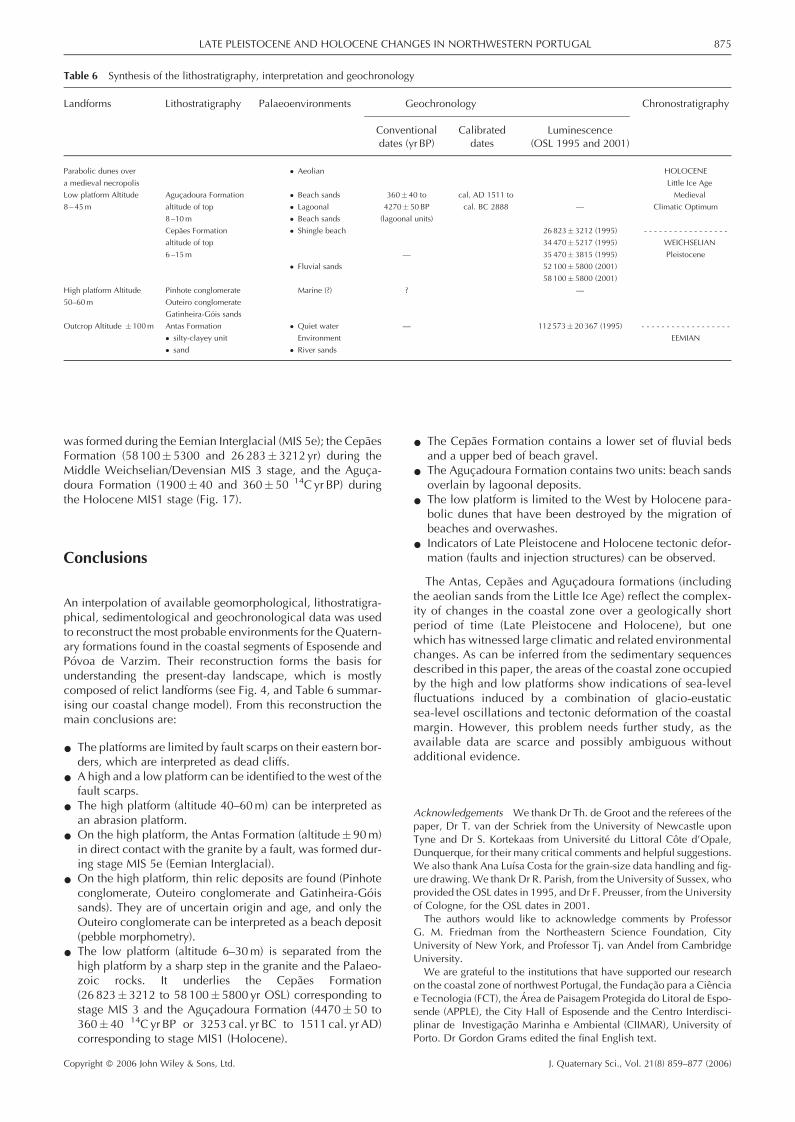
was formed during the Eemian Interglacial (MIS 5e); the CepaesFormation (58 100� 5300 and 26 283� 3212 yr) during theMiddle Weichselian/Devensian MIS 3 stage, and the Aguca-doura Formation (1900� 40 and 360� 50 14C yr BP) duringthe Holocene MIS1 stage (Fig. 17).
Conclusions
An interpolation of available geomorphological, lithostratigra-phical, sedimentological and geochronological data was usedto reconstruct the most probable environments for the Quatern-ary formations found in the coastal segments of Esposende andPovoa de Varzim. Their reconstruction forms the basis forunderstanding the present-day landscape, which is mostlycomposed of relict landforms (see Fig. 4, and Table 6 summar-ising our coastal change model). From this reconstruction themain conclusions are:
* The platforms are limited by fault scarps on their eastern bor-ders, which are interpreted as dead cliffs.
* A high and a low platform can be identified to the west of thefault scarps.
* The high platform (altitude 40–60m) can be interpreted asan abrasion platform.
* On the high platform, the Antas Formation (altitude� 90m)in direct contact with the granite by a fault, was formed dur-ing stage MIS 5e (Eemian Interglacial).
* On the high platform, thin relic deposits are found (Pinhoteconglomerate, Outeiro conglomerate and Gatinheira-Goissands). They are of uncertain origin and age, and only theOuteiro conglomerate can be interpreted as a beach deposit(pebble morphometry).
* The low platform (altitude 6–30m) is separated from thehigh platform by a sharp step in the granite and the Palaeo-zoic rocks. It underlies the Cepaes Formation(26 823� 3212 to 58 100� 5800 yr OSL) corresponding tostage MIS 3 and the Agucadoura Formation (4470� 50 to360� 40 14C yr BP or 3253 cal. yr BC to 1511 cal. yr AD)corresponding to stage MIS1 (Holocene).
* The Cepaes Formation contains a lower set of fluvial bedsand a upper bed of beach gravel.
* The Agucadoura Formation contains two units: beach sandsoverlain by lagoonal deposits.
* The low platform is limited to the West by Holocene para-bolic dunes that have been destroyed by the migration ofbeaches and overwashes.
* Indicators of Late Pleistocene and Holocene tectonic defor-mation (faults and injection structures) can be observed.
The Antas, Cepaes and Agucadoura formations (includingthe aeolian sands from the Little Ice Age) reflect the complex-ity of changes in the coastal zone over a geologically shortperiod of time (Late Pleistocene and Holocene), but onewhich has witnessed large climatic and related environmentalchanges. As can be inferred from the sedimentary sequencesdescribed in this paper, the areas of the coastal zone occupiedby the high and low platforms show indications of sea-levelfluctuations induced by a combination of glacio-eustaticsea-level oscillations and tectonic deformation of the coastalmargin. However, this problem needs further study, as theavailable data are scarce and possibly ambiguous withoutadditional evidence.
Acknowledgements We thank Dr Th. de Groot and the referees of thepaper, Dr T. van der Schriek from the University of Newcastle uponTyne and Dr S. Kortekaas from Universite du Littoral Cote d’Opale,Dunquerque, for their many critical comments and helpful suggestions.We also thank Ana Luısa Costa for the grain-size data handling and fig-ure drawing.We thank Dr R. Parish, from the University of Sussex, whoprovided the OSL dates in 1995, and Dr F. Preusser, from the Universityof Cologne, for the OSL dates in 2001.The authors would like to acknowledge comments by Professor
G. M. Friedman from the Northeastern Science Foundation, CityUniversity of New York, and Professor Tj. van Andel from CambridgeUniversity.We are grateful to the institutions that have supported our research
on the coastal zone of northwest Portugal, the Fundacao para a Cienciae Tecnologia (FCT), the Area de Paisagem Protegida do Litoral de Espo-sende (APPLE), the City Hall of Esposende and the Centro Interdisci-plinar de Investigacao Marinha e Ambiental (CIIMAR), University ofPorto. Dr Gordon Grams edited the final English text.
Table 6 Synthesis of the lithostratigraphy, interpretation and geochronology
Landforms Lithostratigraphy Palaeoenvironments Geochronology Chronostratigraphy
Conventional Calibrated Luminescencedates (yr BP) dates (OSL 1995 and 2001)
Parabolic dunes over � Aeolian HOLOCENE
a medieval necropolis Little Ice Age
Low platform Altitude Agucadoura Formation � Beach sands 360� 40 to cal. AD 1511 to Medieval
8 – 45m altitude of top � Lagoonal 4270� 50BP cal. BC 2888 — Climatic Optimum
8–10m � Beach sands (lagoonal units)
Cepaes Formation � Shingle beach 26 823� 3212 (1995) - - - - - - - - - - - - - - - - -
altitude of top 34 470� 5217 (1995) WEICHSELIAN
6–15m — 35470� 3815 (1995) Pleistocene
� Fluvial sands 52 100� 5800 (2001)
58 100� 5800 (2001)
High platform Altitude Pinhote conglomerate Marine (?) ? —
50–60m Outeiro conglomerate
Gatinheira-Gois sands
Outcrop Altitude � 100m Antas Formation � Quiet water — 112573� 20 367 (1995) - - - - - - - - - - - - - - - - - -
� silty-clayey unit Environment EEMIAN
� sand � River sands
LATE PLEISTOCENE AND HOLOCENE CHANGES IN NORTHWESTERN PORTUGAL 875
Copyright � 2006 John Wiley & Sons, Ltd. J. Quaternary Sci., Vol. 21(8) 859–877 (2006)
References
Aitken MJ. 1985. Thermoluminescence Dating. Academic Press:London.
Almeida CAB. 1988. Carta Arqueologica do concelho de Esposende.Boletim Cultural de Esposende 13–14: 21–44.
Almeida CAB, Antunes JV, Sousa MJ, Cunha RC. 1990–92. Necropolemedieval das Barreiras, Fao. Boletim Cultural de Esposende 17: 111–126.
Alves MI. 1995a.Materiais Plio-Quaternarios do Alto Minho: produtosde meteorizacaoe fluviais na bacia do Rio Lima e regiao de Alvaraes.PhD thesis, University of Minho, Braga.
Alves MI. 1995b. Terracos fluviais do Alto Minho: bacia do rio Lima edepositos de Alvaraes. Memorias do Museu e Laboratorio Mineralo-gico e Geologico da Universidade do Porto 4: 395–399.
Alves MI. 2004. A sedimentacao fluvial cenozoica na regiao do Entre-Douro-e Minho (NW de Portugal). In Geomorfologia do NW daPenınsula Iberica, Araujo MA, Gomes A (eds). Faculdade de Letrasda Universidade do Porto, GEDES: Porto; 93–115.
Alves MI, Pereira D. 1999. Revisao dos dados sedimentologicos epaleontologicos das bacias do Minho: contribuicao para o conheci-mento da evolucao plio-quaternaria regional. Encontros de Geomor-fologia (Comunicacoes), Universidade de Coimbra; 123–129.
Batista JLM. 1991. As industrias lıticas pre historicas do litoral minhoto(Portugal no seu contexto cronoestrat-igradefico e paleoambiental).PhD thesis, University of Minho, Braga.
BragaMAS. 1989.Arenas e depositos associados da bacia de drenagemdo rio Cavado (Portugal). Contribuicao para o estudo da arenizacao.PhD thesis, University of Minho, Braga.
Cabral JML. 1993. Neotectonica de Portugal continental. PhD thesis,University of Lisbon.
Cailleux A. 1947. L’indice d’emousse: definition et premiere applica-tion. Compte-rendus Sommaires de la Societe Geologique de France10: 250–252.
Cailleux A, Tricart J. 1959. Initiation a l’etude des Sables et des Galets.Centre de Documentation Universitaire: Paris.
Carvalho GS, Granja HM. 1997a. Realismo e pragmatismo: uma neces-sidade para o aproveitamento dos recursos naturais da zona costeira(o exemplo da zona costeira do noroeste de Portugal). In Colectaneade Ideias Sobre a Zona Costeira de Portugal, Carvalho GS, VelosoGomes F, Taveira Pinto F (eds). Associacao EUROCOAST-PORTU-GAL: Porto; 25–66.
Carvalho GS, Granja HM. 1997b. Terracos versus litostratigrafia e geo-cronologia do Plistocenico e do Holocenico da zona costeira doMinho (Portugal). Estudos do Quaternario 1: 23–40.
Carvalho GS, Granja HM, Gomes P, Loureiro E, Henriques R, CarrilhoI, Costa AL, Ribeiro P. 2002. New data and new ideas concerningrecent geomorphological changes in the NW Coastal Zone of Portu-gal. In The Changing Coast, Vol. 2, Proceedings Littoral 2002.EUROCOAST: Porto; 399–410.
Castro F. 1949. A Selva. In Ferreira de Castro, Obras Completas. Gui-maraes e Co.: Lisbon.
de Groot T, Granja HM. 1998. Coastal environments, sea level andneotectonism from cored boreholes (Northwest Portugal). Prelimin-ary results. Journal of Coastal Research 26: 115–124.
Dias JMA, Rodrigues A, Magalhaes F. 1997. Evolucao da linha de costa,em Portugal, desde o ultimo maximo glaciario ate a actualidade: sın-tese dos conhecimentos. Estudos do Quaternario 1: 53–66.
Folk RL. 1966. A review of grain-size parameters. Sedimentology 6:73–93.
Folk RL,WardWC. 1957. Brazos river bar: a study in the significance ofgrain size parameters. Journal of Sedimentary Petrology 27: 3–26.
Friedman GM. 1967. Dynamic processes and statistical parameterscompared for size frequency distribution of beach and river sands.Journal of Sedimentary Petrology 37: 327–354.
Friedman GM. 1979a. Address of the retiring President of the Interna-tional Association of Sedimentologists: differences in size distribu-tions of populations of particles among sands of various origins.Sedimentology 26: 3–32.
Friedman GM. 1979b. Differences in size distributions of populationsof particles among sands of various origins: addendum to IAS Presi-dent Address. Sedimentology 26: 859–862.
Gamble C. 1996. The Paleolithic Settlement of Europe. CambridgeUniversity Press: Cambridge.
Gomez-Orellana RL, Ramil-Rego P, Sanches SM. 2001. Landscapemod-ifications during the Upper Pleistocene—Holocene in the NW Atlan-tic margin of Iberian Peninsula. Estudos do Quaternario 4: 79–96.
Granja HM. 1990. Repensar a geodynamica da zona costeira: o pas-sado e o presente; que futuro ? PhD thesis, University of Minho,Braga.
Granja HM. 1999. Late Pleistocene and Holocene sea-level, neotec-tonic and climatic indicators in the northwest coastal zone ofPortugal. Geologie en Mijnbouw 77: 233–245.
Granja HM, Carvalho GS. 1994. How can the Holocene help to under-stand coastal zone evolution? In Proceedings Littoral 1994, Vol. 1.EUROCOAST: Lisbon; 149–167.
Granja HM, Carvalho GS. 1998. The landscape of the Coastal Zone ofNorthwest Portugal its degradation and management. In ProceedingsLittoral 1998. EUROCOAST: Barcelona; 95–100.
Granja HM, Carvalho GS. 2003. Mudancas ambientais na zona cost-eira do noroeste de Portugal desde o Plistocenico–Holocenico atea actualidade. Ciencias da Terra (Special issue): H73–H75.
Granja HM, de Groot TAM. 1996. Sea-level rise and neotectonism in aHolocene coastal environment at Cortegaca Beach (NW Portugal): acase study. Journal of Coastal Research 12: 160–170.
Granja HM, Sousa M, Carvalho GS. 1992. Quaternary movements inthe NW coastal zone of Portugal (around Cavado estuary). Bulletinof INQUA Neotectonic Commission 15: 12–17.
Granja HM, Ribeiro I, Carvalho GS, Matias MS. 1999. Some neotec-tonic indicators in Quaternary formations of the northwest coastalzone of Portugal. Physics and Chemistry of the Earth 24: 323–336.
Hedberg HD (ed.). 1994. International Stratigraphic Guide. A Guide toStratigraphic Classification, Terminology and Procedure. Interna-tional Union of Geological Sciences and the Geological Society ofAmerica (eds). Amos Salvador: Boulder, Colorado.
Henriques R. 2003. SEDMAC/SEDPC: programa informatico de apoio aanalise dimensional de populacoes detrıticas. Ciencias da Terra(Special issue no. 5); 6th Congresso Nacional de Geologia, Lisbon;40.
Holligan PM, de Boois H (eds). 1993. Land–Ocean Interactions in theCoastal Zone (LOICZ) Science Plan. IGBP Report no. 25, IGBP:Stockholm.
KrumbeinWC. 1934. Size frequency distributions of sediments. Journalof Sedimentary Petrology 4: 65–77.
KrumbeinWC, Pettijohn FJ. 1965.Manual of Sedimentary Petrography.Appleton-Century-Crofts: New York.
Lewis DW, McConchie D. 1994a. Practical Sedimentology. Chapman& Hall: New York.
Lewis DW, McConchie D. 1994b. Analytical Sedimentology. Chap-man & Hall: New York.
Lopez-Cancelo. 2004. Cambios paleoambientales en el NW peninsu-lar durante el Holoceno determinados a partir del estudio de forami-naferos bentonicos. PhD thesis, University of A Coruna.
Loureiro E, Granja HM. 2001. Short-termmorphodynamics of a shinglebeach (Esposende, Northwest Portugal). In Ecology and Geomor-phology of Coastal Shingle, Packham JR, Randall RR, Barnes RSK,Neal A (eds). Westbury Academic and Scientific Publishing: Otley,UK; 148–159.
Mangerud J. 1994. The last interglacial/glacial cycle in NorthernEurope. In Quaternary Landscapes, Shane LCK, Cushing EJ (eds).Belhaven Press: London; 38–75.
Mangerud J, Sønstegaard E, Sejrup HP. 1979. Correlation of Eemian(interglacial stage) and the deep-sea oxygen-isotope stratigraphy.Nature 277: 189–192.
Meireles J. 1994. As industrias lıticas pre-historicas do litoral do Minho(Portugal e o seu quadro litostratigrafico). Trabalhos de Antropologiae Etnologia 34: 18–42.
Meireles J, Texier JP. 1994. O Quaternario do Litoral do Minho. Umasıntese lito e crono-estratigrafica. Actas da 3a Reuniao do Quater-nario Iberico, Coimbra. Universidade de Coimbra; 395–408.
Meireles J, Texier JP. 2000. Etude morpho-stratigraphique des depot lit-toraux du Minho (NW du Portugal). Le Quaternaire 11: 21–29.
Mosquera-Sante MJ. 2002. Evolucion post-glacier del nivel del mar enel NO de la peninsula iberica: el caso del Golfo Antabro. PhD thesis,University of A Coruna.
876 JOURNAL OF QUATERNARY SCIENCE
Copyright � 2006 John Wiley & Sons, Ltd. J. Quaternary Sci., Vol. 21(8) 859–877 (2006)
Murray AS, Wintle AG. 2000. Luminescence dating of quartz using animproved single-aliquot regenerative-dose protocol. Radiation Mea-surements 32: 57–73.
Pereira E (ed.). 1992. Carta Geologica de Portugal, Escala 1/200 000,Notıcia Explicativa da Folha 1. Servicos Geologicos de Portugal:Lisbon.
Pirazzoli PA. 1996. Sea-level Changes. The Last 20,000 Years. Wiley:Chichester.
Pirazzoli PA, Pluet J. 1991. World Atlas of Holocene Sea-levelChanges. Elsevier Science Publishers: Amsterdam.
Preusser F, Karper HU. 2001. Comparison of dose rate determinationusing high resolution gamma spectrometry and inductively coupledplasma-mass spectrometry. Ancient TL 19: 19–23.
Ribeiro O, Neiva JMC, Teixeira C. 1943. Depositos e nıveis quaternar-ios dos arredores do Porto. Boletim da Sociedade Geologica dePortugal 3: 95–103.
Sousa M. 1988. Litostratigrafia e estrutura do Paleozoico de Esposende.Boletim Cultural de Esposende 15–16: 103–144.
Sousa M. 1989. Litostratigrafia e estrutura do Paleozoico de Espo-sende (continuacao). Boletim Cultural de Esposende 13–14:123–163.
Stuiver M, Reiver PJ. 1993. Extended 14C database and revised CALIBradiocarbon program. Radiocarbon 35: 215–230.
Teixeira C. 1949. Plages anciennes et terrasses fluviatiles dulittoral du Nord-ouest de la Peninsule Iberique. Boletim doMuseu Mineralogico e Geologico da Universidade de Lisboa 17:3–18.
Teixeira C. 1956. Carta Geologica de Portugal. Notıcia Explicativa daFolha 1-A, na escala 1:50 000, Valenca. Servicos Geologicos dePortugal: Lisbon.
Teixeira C. 1979. Plistocenico de Portugal. Comunicacoes dos ServicosGeologicos de Portugal 65: 35–46.
Teixeira C, Assuncao C. 1961. Carta Geologica de Portugal. NotıciaExplicativa da Folha 1-C, na escala 1:50 000, Caminha. ServicosGeologicos de Portugal: Lisbon.
Teixeira C, Assuncao CT. 1963. Carta Geologica de Portugal, na escala1:50 000. Notıcia Explicativa da Folha 13-C, Ovar. Servicos Geolo-gicos de Portugal: Lisbon.
Teixeira C, Medeiros AC. 1965. Carta Geologica de Portugal, na escala1:50 000. Notıcia Explicativa da Folha 9-A, Povoa de Varzim. Servi-cos Geologicos de Portugal: Lisbon.
Teixeira C, Zbyszewski G. 1976. Carta Geologica de Portugal, naescala 1:50 000. Notıcia Explicativa da Folha 16-A, Aveiro. ServicosGeologicos de Portugal: Lisbon.
Teixeira C, Perdigao J, Assuncao CT. 1962. Carta Geologica de Portu-gal, na escala 1:50 000. Notıcia Explicativa da Folha 13-A, Espinho.Servicos Geologicos de Portugal: Lisbon.
Teixeira C, Medeiros AC, Alves CAM, Moreira MM. 1969. Carta Geo-logica de Portugal, na escala 1:50 000. Notıcia Explicativa da Folha5-C, Barcelos. Servicos Geologicos de Portugal: Lisbon.
Teixeira C, Medeiros AC, Coelho AP. 1972. Carta Geologica de Portu-gal, na escala 1:50 000. Notıcia Explicativa da Folha 5-A, Viana doCastelo. Servicos Geologicos de Portugal: Lisbon.
Texier JP, Meireles J. 1991. Les formations littorales quaternaires duMinho (Portugal): propositions pour une nouvelle approche cli-mato-chronologique et dynamique. Datation et caracterisation desMilieux pleistocenes. Cahiers du Quaternaire 16: 115–133.
Tooley MJ. 1994. Long term changes in eustatic sea level. In Climateand Sea Level Change: Observations, Projections and Implications,Warrick RA, Barrow EM, Wigley TML (eds). Cambridge UniversityPress: Cambridge; 81–107.
Tucker ME. 1988. Techniques in Sedimentology. Blackwell ScientificPublications: Oxford.
Tucker ME. 2001. Sedimentary Petrology. An Introduction to the Originof Sedimentary Rocks. Blackwell Science: Oxford.
van Andel TH. 2003. Glacial environments I: Weichselian climate inEurope between the end of OIS-5 Interglacial and the last glacialmaximum. In Neanderthals and Modern Humans in the EuropeanLandscape during the Last Glaciation, van Andel TH, Davies W(eds). McDonald Institute Monographs, University of Cambridge:Cambridge; 9–19.
van Andel TH, Tzedakis PC. 1996. Palaeolithic landscapes of Europeand environs 150000–25000 years ago: an overview. QuaternaryScience Reviews 15: 481–500.
Vidal-Romani JR. 2002. El relieve de Galicia. Obra Galicia. Natureza.Historia Natural. Xeoloxia 36: 306–341.
Zbyszewski G. 1940. Contribution a l’etude du littoral quaternaire duPortugal. Publicacoes do Museu e Laboratorio Mineralogico e Geo-logico da Faculdade de Ciencias do Porto 15: 50.
Zbyszewski G, Teixeira C. 1949. Le niveau quaternaire marin de 5–8metres du Portugal. Boletim da Sociedade Geologica de Portugal3: 1–6.
LATE PLEISTOCENE AND HOLOCENE CHANGES IN NORTHWESTERN PORTUGAL 877
Copyright � 2006 John Wiley & Sons, Ltd. J. Quaternary Sci., Vol. 21(8) 859–877 (2006)
Related Documents