Spatial Bpundaries and Social Dynamics Case Studies from Food-Producing Societies Augustin Holl Thomas; Levy INTERNATIONAL MONOGRAPHS- IN PREHISTORY.-.rïT^ ^^^^ . - ' -^-i-i

Welcome message from author
This document is posted to help you gain knowledge. Please leave a comment to let me know what you think about it! Share it to your friends and learn new things together.
Transcript
Spatial Bpundaries and Social Dynamics
Case Studies from Food-Producing Societies
Augustin Holl
Thomas; Levy
I N T E R N A T I O N A L M O N O G R A P H S -
IN PREHISTORY .-.rïT^
^^^^ . - ' -^-i-i
7. Late Neolithic Cultural Landscape in Southeastem Mauritania: An Essay in Spatiometrics
Augustin Holl
Prologue
I n the Dhar Tichitt-Walata région of southeaste m Mauritania , the impressive Neolithic sites char-acterized by massive dry masoniy have become fa-mous i n West Af i i can archaeology primarily because of the discovery of macro-botanical remains i n pot-sherds by P. J . Munson (1971,1976). This discovery, later supported by additional findings (Amblard and Pemès 1989), has been used to support the idea of local domestication ofbulrush mOlet (Pennisetum sp.), whose cultivation went along w i t h the opportimistic exploitation of vrild grains. The Neolithic occupation of this arid area of sandstone difis lasted from ca. 4000B.P. to 2000 B.P., and différent competingmodels have been used to explain the processes which may best explain the nature and characteristics of the archaeological record observed (Amblard 1984; Munson 1981; Hol l 1985a, 1986a, 1986 b, 1989; 1990). I n gênerai, there is a consensus on two elementary issues:
1) The Neolithic communities inhabiting important villages bui l tvr i th dry stone masonry techniques practised mixed farming based on grain cultivation and the animal husbandiy of cattle, sheep and goats.
2) Their subsistence was complemented by fishing ofnile perch {Lates niloticus) and siluridae {Clarias sp.), hxmting of gazelles, antelopes, hippopotamus, etc., and the gathering of wOd grains and fruits. Thèse gênerai statements, derived from the study of mate-rial culture items such as stone and bone tools, pot-tery, rock art , plant and animal remains collected during many fîeld campaigns, are obviously very Hm-ited i n scope i f we wish to understand and explain the diversity and variabil ity of pattems of past behavior which have generated the impressive archaeological record observed i n the southwestem Sahara today. I n this chapter, I emphasize the fact that the study of larger quantities of malerial ai l ture data alone vri l l not lead to sophisticaUd and genuine explana-tions of Neolithic sodoeconomic organization, nor of its settlement dynamics, congment w i t h what we expectfit)m archaeological research today. As pointed outby Renfrew (1984:3), in studying the human past
itisnotenoughsimplytoreconstructwhathappened. Reconstruction is indeed one of the legitimate con-cems of the historian and the archaeologist, and a necessary prehminary to further analysis, but we need to Imow more. We need to understand i n some sensé how and why i t happened. We have to discem some pattem, to identify some simpHfyingprincipIes. We hâve to dedde what is sigmficant for us.
Without new methods of analysis, archaeological theory œxâd not expand efBdently, since a modem empirical disdpline oug^t to be able to aim at a more rewarding resuit than the pihng up of data and a steady out-put of i m i t a t i o n history. (Redman et aL 1978:5)
To achieve such an aim, we w i l l have to shift our focus and move from the sole study of spedal catégories of artifacts, e.g., stone tools, pottery, and animal bones, to the study ofhigher-level components which may give meanings to thèse more discrète finds. Such components wiU have to be selected according to what we know about the dynamics of sodal Systems which are congruent vr i th the cases imder investigation. The household, the comm\mity inhabiting the same village or site, and aggregates of communities shar-ing the same terr i tory are such units. The study of settlement pattems is thus a better research strat-egy, which may lead to a deeper imderstanding of the processes that formed the Neolithic cultural landscape i n southeastem Matir i tania .
C u l t u r a l L a n d s c a p e i n Spatiometric Perspective
Theoretically, any action of man on the natural landscape may produce imprints , but some imprbts are more important and irréversible than oth'trs. When such imprints are pattemed and enter into the archaeological record, they are amenable to syst^m-atic study. Settlement pattems belong to this cat-egory of human imprints on the natural landsc j^ , and their S3^tematic study reveals what is tenned in this chapter the cultural landscape. Consequently, cultural landscape may be defined as any System of
95
Augustin Holl
structural features necessary for h u m a n life, bu i l t and located i n multidimensional space according to actual social rules. Such rules concem issues related to social distance between individuals and/or groups and govem their spatiallocation relative to each othen e.g., kinship, alliance relations, domination/subordination, man/ woman, senior^unior, parents/children, public/private, etc. Thèse rules generate sets of pattemed and fluctuating modes of spatial behavior vary ing in a continuum from t ight clustering, prefer-ential aggregation, through loose distr ibution to tot a l dispersai. I n this perspective, at différent levels of any social System, individual spatial modules are always integrated into higher-level spatial components, and some of them, such as the domestic, com-munity , district, and régional units , w i l l be consid-ered i n this chapter.
The issues discxissed can be darifîed through the form\ilation of a number of straightforward questions:
- How is the domestic space organized and why? - How is the site layout organized and why? -Howare district settlementpattems structured
and why? - How is régional settlement p a t t e m structured
and why? Différent approaches are equaUy relevant for the
study of the issues outlined above, and i t seems to me obvions that the différent aspects of sodal distance between individuals and groups are less a matter of mere measurements of physic^ distances than quali tative statements about the spatial location of i n d i viduals relative to each other i n daily interaction. I consider that an important part of thèse qualitative statements is amenable to systematic investigation, which may bring to light a hidden dimension of both present-day and past sodeties. Consequently, I have coined the term spatiometrics, combining the idea of semiotics, a hybrid disdpline conceming the study of the structures and meanings of signs, and cliometry which is used to characterize a part of scholarship i n history based mainly on the use of quantitative methods. I n his critique of the quantitative approach i n history, Finley (1987:112) points out:
I t is precisely by reducing the number of variables to be considered that cliometry has succeeded in achieving the status of sdence andhas producedits most significant results. but one may add that, by doing this i t has payed a h i ^ cost, that of omit t ing the most important partof die human lives so recorded. {Translation nurue)
This objection wams ns about the overemphasis which is always possible when using a particular
method and reducing the complexity of the issues being investigated to only few aspects of the problem being investigated. The spatiometric approach de-vised here is complementary to former research on the Neolithic sodeties of the Dhar Tichitt published elsewhere. However, i t aims to study NeoUthic spat i a l behavior and its Unks vr i th sodal dynamics. I n simple terms, the research problem i n this chapter concems the sodal meanings of the spatial distributions of bmlt fadhties at both i n t r a - and intersite levels. Technically, the method is based on séries of measurements of the size ofthe différent spatial units recorded i n the southwestem Sahara, such as com-potinds, aggregates of compotmds, sites, aggregates of sites, and the distances i n straight lines between villages at différent levels of the settlement System. I n terms of quantitative methods, we have chosen to resistthe appeal of sophisticated mathematical techniques which are now easUy accessible, and use simple statistical methods which are more congruent w i t h our research problems, and i n agreement w i t h Whallon (1987:148-9) who states that :
. . . i t must be our archaeological ideas, mod-els, or theory that générâtes expectations, potentiaUy observable conséquences for the archaeological record, which we then can examine against available statistical methods to see i f adéquate and effective approaches exist tha t w i l l allow \is to test for the présence or absence of such expectations or to observe the degree of congruence to, or déviation from, thèse predicted conséquences.
The research strategy outlined above opérâtes vrithin a few constraints, the most important being the degree of resolution of the studied sample, which wiU condition the pertinence of the measurements and their congmence w i t h the research problems. The problems of the degree of resolution corictm the visibUity of archaeological featvtres, the adéquate assessment of the total extent of sites, and the adéquate coverage of the whole landscape under investigation. I n other words, adéquate information is needed on the size of any single site, on every compound, the areal extent of each site, the number and location of each site i n every part of the study area, and the région as a whole. Due to the building? mate-rial used by the Neolithic peoples of the souÂ-Jvest-e m Sahara and the preferential location of their settlements on the top of sandstone chffs, the accumulat ion of sédiments on structural features aft«r their abandonment is minimal . Some small sites and portions of larger sites located at lower elevatirjna are indeed buried imder dr i f t ing sand. However, in the majority of cases (86 sites out ofa total of 90) there are
96
Late Neolithic Cultural Landscape in Southeastem Mauritania
no sédiments masking the archaeological features. Thiis, the layout of bui l t features i n sites is easily accessible through surveys (Mission Préhistorique de Tichitt n.d.) and the use of high-resolution air photos espedally made for the Tichitt Prehistoric Mission by the Ins t i tut Géographique National (Mission I G N M a u 80). Enlarged versions of thèse a ir -photos, each measuring one meter square (i.e., 1:12,500), v?ere used to produce a séries of village maps. When needed, thèse aerial photos were checked and corrected i n the field (Amblard 1984).
Research Perspect ives
The Neohthic occupation of the southwestem Saharalasted from ca 4000 B.P.. to ca. 2000 B .P. .(3830 ± 260 B.P., GIF-2884) to 2170 ± 105 B.P. (1-3819), when the area was abandoned due to increasing ar id -i ty . Dur ing thèse two thousand years, the whole area was colonized, settled, and dotted vrith nimierous villages of différent sizes, generating a cultural landscape which can also be considered as a sociopoUtical map. Obviously, the process of expansion of human settlement alongthe séries of sandstone cHffs located i n southeastem Mauritania was generated by the combination of many factors which may have amph-fied some trends while inhibiting others. Some of thèse factors which are amenable to systematic archaeological investigation wOl identifîed and dis-cussed.
The research presented in this chapter concems
the bvdldup of différent spatial modules generated by the dynamics of the subsistence System, the sodoeconomic organization, and the poUtical organization and how thèse différent components have shaped the Neolithic cultural landscape fossilized today i n the ardiaeological record. Thèse Neolithic communities practised mixed fa rming ; the i r subsistence was complemented by hunt ing , fishing, and gathering of w i l d grains and finiits. The environment as reconsti-tuted through the use of pollen analj^is and fauna (Holl 1986a, 1986b) and geomoiphological analysis of sédiments accumulated i n formerfreshwaterlakes (Hugot 1977), was characterized by an open savanna w i t h a very l ight tree component inhabited by herds of antelopes and gazelles, vpith a séries of freshwater lakes located i n the lowland, i n interd imal dépressions, w i t h populations of fishes such as nile perch {Lates niloticus) and siluridae {Clarias sp.), crocodiles, and hippopotamus. During this period, the cU-mate appears to have been dry and characterized by two contrasted seasons: a short wet season lasting three to five months and a long dry season (Servant and Servant 1980; Munson 1981; Maley 1981; Nicholson and Flohn 1980; Lézine 1988,1989).
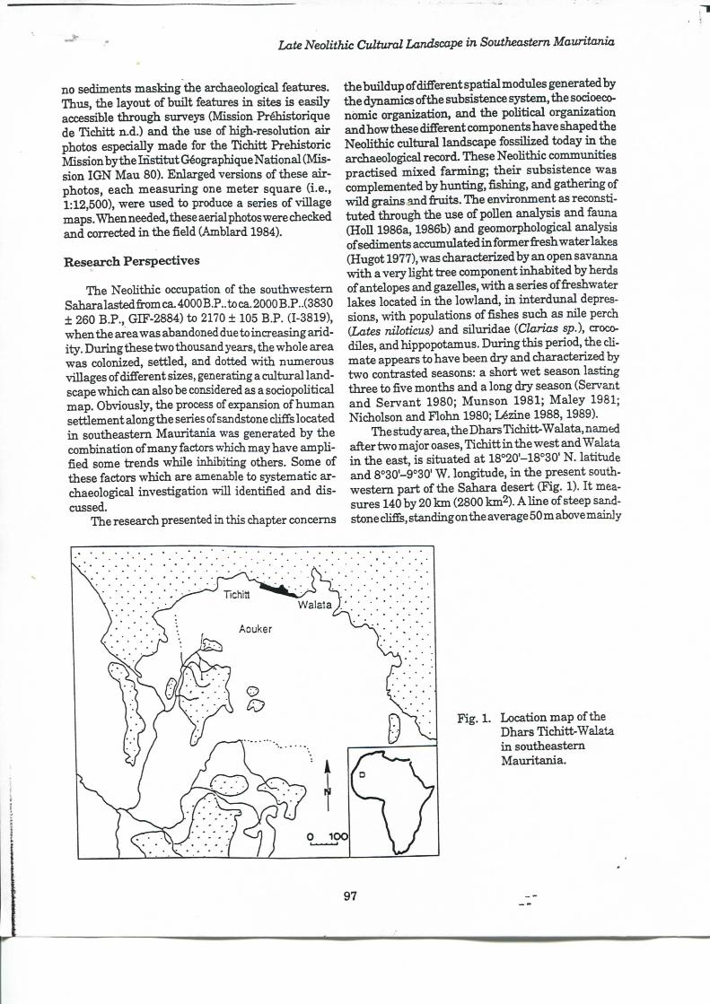
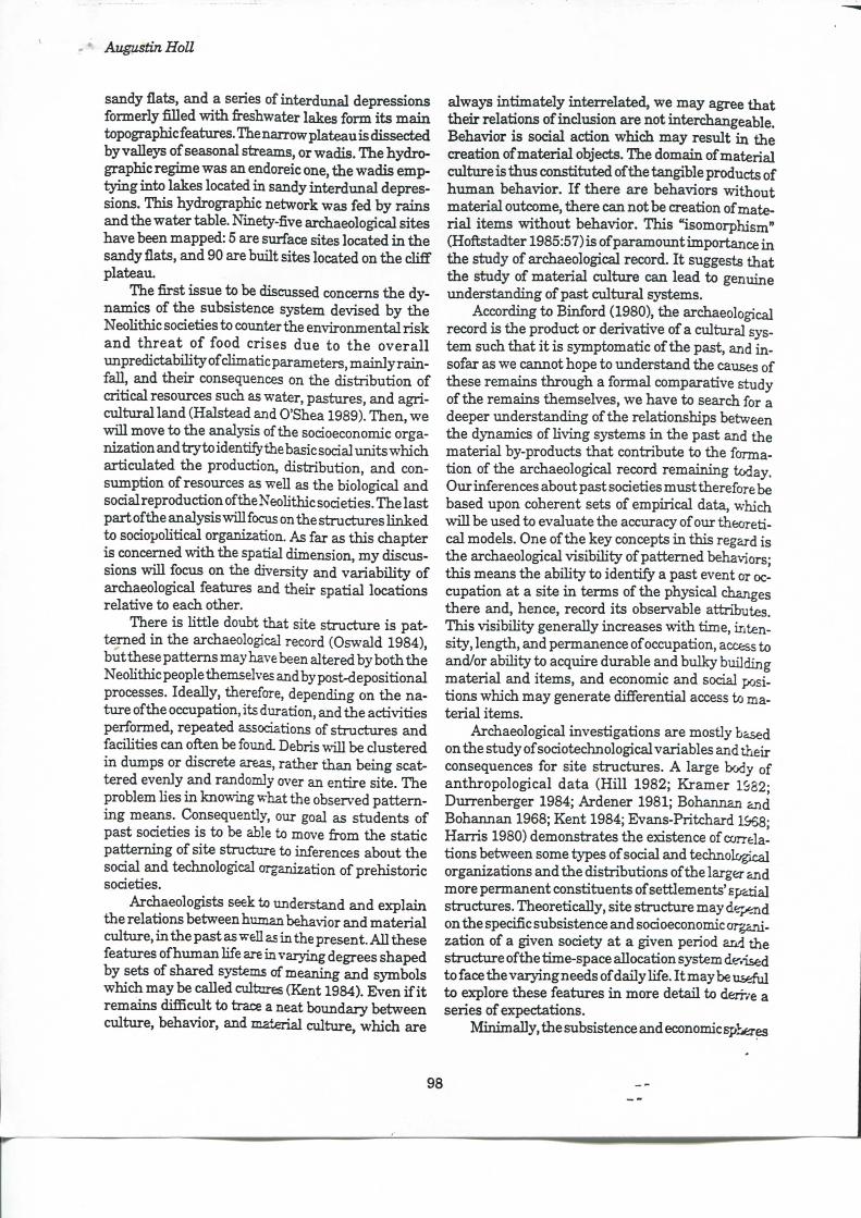
The study area, the Dhars Tidiitt^Walata, named after two major oaises, T i d i i t t i n the west and Walata i n the east, is situated at 18°20'-18°30' N . latitude and 8°30'-9°30' W. longitude, i n the présent southwestem part of the Sahara désert (Fig. 1). I t mea-sures 140 by 20 k m (2800 km2). A line of steep sandstone cMs, standing on the average 50 m above mainly
Fig. 1. Location map of the Dhars Tichitt-Walata i n southeastem Maur i tania .
97
Augustin Holl
sandy flats, and a séries of interdunal dépressions fonnerly fîlled w i t h freshwater lakes fonn its m a i n topographie features. The narrow plateau is dissected by valleys of seasonal streams, orwadis. The hydrographie régime was an endoreic one, the wadis emp-tyùig into lakes located i n sandy interdtmal dépressions. This hydrographie network was fed by rains and the water table. Ninety-five archaeological sites have been mapped: 5 are surface sites located i n the sandy flats, and 90 are built sites located on the d i f f plateau.
The fîrst issue to be discussed concems the dynamics of the subsistence system devised by the Neolithic sodeties to counter the environment^ risk a n d t h r e a t o f food crises due to t h e o v e r a l l unpredictabnity of dimaticparameters, ma in ly ra in -fal l , and their conséquences on the distribution of critical resoTirces such as water, pastures, and agri -cultural land (Halstead and O'Shea 1989). Then, we vd l l move to the analysis of the sodoeconomic organization and t r y to identify thebasicsodal tmits which articulated the production, distribution, and con-siunption of resources as well as the biological and sodal reproduction of the Neolithic sodeties. The last part of the analysis w i l l focus on the stmctures l inked to sodopolitical organization. As far as this chapter is concemed vrith the spatial dimension, my discussions wiU focus on the diversity and variabi l i ty of archaeological features and their spatial locations relative to each other.
There is htt le doubt that site structure is pattemed i n the archaeological record (Oswald 1984), but thèse pattems may have been altered by both the Neolithic people themselves and by post-depositional processes. Ideally, therefore, depending on the nature of the occupation, its duration, and the activities performed, repeated associations of structures and facilities can often be found. Débris wiU be dustered i n dumps or discrète areas, rather than being scat-tered evenly and randomly over an entire site. The problem lies i n knowing what the observed p a t t e m ing means. Consequently, our goal as students of past sodeties is to be able to move ôt)m the static patteming of site structure to inferences about the sodal and technological organization of prehistoric sodeties.
Archaeologists seek to understand and explain the relations between human behavior and material culture, i n the past as well as in the présent. A i l thèse features of human hfe are in vaiying degrees shaped by sets of shared s j ^ m s of meaning and symbols which may be caUed cultures (Kent 1984). Even i f i t remains difBcult to trace a neat boundary between culture, behavior, and material culture, which are
alwa3^ intimately interrelated, we may agrée that their relations of inclusion are not interchangeable. Behavior is sodal action w h i d i may resuit i n the création of material objects. The domain of material culture is thus constituted of the tangible products of human behavior. I f there are behaviors vrithout material outcome, there can not be création of material items wi thout behavior. This "isomorphism" (Hoftstadter 1985:57) is of paramount importance i n the study of archaeological record. I t suggests that the study of material culture can lead to genuine understanding of past cultural Systems.
According to Binford (1980), the archaeological record is the product or derivative of a cultural System such that i t is symptomatic of the past, and i n -sofar as we cannot hope to understand the causes of thèse remains through a formai comparative study of the remains themselves, we have to search for a deeper understanding of the relationships between the dynamics of Hving Systems i n the past and the material by-products that contribute to the format ion of the archaeological record remaining today. Our inferences about past sodeties must therefore be based upon cohérent sets of empirical data, which wiU be \ised to evaluate the accuracy of o\ir theoreti-cal models. One of the key concepts i n this regard is the archaeological visibi l i ty of pattemed behaviors; this means the abiHty to identify a past event or occupation at a site i n terms of the physical changes there and, hence, record its observable attributes. This visibOity generally increases w i t h time, inten-sity, length, and permanence of occupation, access to and/or ability to acquire d\irable and bulky building material and items, and économie and social positions which may generate differential access to mater ial items.
Archaeological investigations are mostly based on the study of sodotechnological variables and their conséquences for site stmctures. A large body of anthropological data (HiU 1982; Kramer 19S2; Durrenberger 1984; Ardener 1981; Bohannan and Bohannan 1968; Kent 1984; Evans-Pritchard 1&68; Harris 1980) demonstrates the existence of corrélations between some types of sodal and technological organizations and the distributions of the larger and more permanent constituents of settlements' spatial stmctures. Theoretically, site stmcture may dépend on the spécifie subsistence and sodoeconomic organization of a given sodety at a given period and the stmcture of the time-space allocation System de-.ised to face the varying needs of daily Hfe. I t may be usdul to explore thèse feattires i n more détail to derr/e a séries of expectations.
Minimally, the subsistence and économie sphères
98
Late Neolithic Cultural Landscape in Southeastem Mauritania
of any social System may be defined as the combined results of multiple individual and collective décisions regardingthe procvirement, processing, distribution and consumption of resources, varions kinds of goods, and services. I n this perspective, subsistence and économie activities are always socially organized; the research problem lies i n our ability to identify the structural nodes which artieulate any spécifie subsistence and économie System. Hence, i f we consider subsistence and economy as sets of activities through which the consumer population organizes, intégrâtes, and manages varions kinds of resources, goods, and services for its own biological as well as social maintenance and reproduction, they appear to be characterized by two major components: 1) the forces of production, that is, land and its potential and effective resources, knowledge or stock of information, and technological skQls, and 2) the social relations of production, e.g., division of labor, social distribution of rôles, tasks, and products. Thèse two aspects are always intimately interrelated so that i t is possible to identify spécifie modes of production, i f this st imulat-ing concept had not been used as a "smoke screen" concept i n a part of the Mandst historical and an-thropologicalUterature(cf.Godeliern.d., 1980,1984).
I n the context of économie Systems based exclu-sively on man's bare labor force for the procurement and production of plant and animal resources, the concept of mode of exploitation of land, whatever its l imitations may be (Testart 1982) is useful. According to Meillassoux (1977), in hunting and gathering économies, land is an "object of labor." The resource procurement system consists of the extraction of natural resomees through foraging and collecting. I n food-producing économies such as agricultm-e, pas-tora l i sm, and agro-pastoralism, land becomes a "means of labor" to a varying degree. This happens because the labor force is invested i n the land, or hvestock, or both, w i th the expectation of a delayed r e t u m . Thèse kinds of societies witnessed major changes i n their social, poHtical, andideological struc-twces and i n their relation to the natural landscape. W i t h mixed farming économies the management of
^ productive activities and their necessary conditions may be made more expUdl by pinpointing some simple prindples related to time-space allocation Systems which may seem trivial at the first glance but vd l l be shown to be very important i n the final analysis.
The first prindple is related to the discrète nature of himian beings. We can notyet be at more t h a n one spatial location at ths same time; th is may be termed the prindple of "non-ubiquity." Faeed vr i th the differential distribution of potential resoxirces i n space i n any given r ^ j o n , human sodeties have to
devise some stratégies to cope w i t h this gênerai s i tuation. Thèse stratégies dépend on the nature of the resoxirces desired and processed.
The second prindple is related to the spécifie nature of t ime, which can not be stored. Time is irréversible, i t is a unidirectional and continuons flow (Bailey 1983; Carlstein 1982). Time can thtis be par-titioned into three main aspects:
1) "duration," which refers to a block of time during which an event occurs and also the interval of t ime between two events follovring each other,
2) "succession," which refers to the séquence of events i n a continuimi, and
3) "simultaneity," referring to the co-occurrence of two or more events vrithin the same block of time référence.
Thèse two prindples have tremendotis implications for every sodoeconomic system. According to the mechanical properties of facilities needed for the performance of productive activities, their locations i n space, the equipment required, logistics, and the labor force needed, some économie tasks may be successive and/or simultaneous, may last for short or long periods of t ime, and may mobilize a few indi -\'iduals or large groups. To deal w i t h thèse fluctuat-ingfeatures, sodeties create différent managing struc-ttires among which pattemed divisions of labor, spécifie task groups, and procédures of recruitment and mobilization of labor force. W i t h the émergence of differential skiUs, varions kinds of craft specializa-t ion develop. The household may be considered as such a unit . I f i t is able to face aU the organizational problems of the sodoeconomic system, i t may be i n some contexts an autonomoiis xiiàt of production and consumption. Consequently, vr i th in the Neolithic économie system of the southwestem Sahara, vnth its ecological context characterized by seasonal fluctuations of potential resom-ees, we would expect the development of productive stratégies to counter en-vironmental hazards, such as semi-nomadism, fission and fusion of sodal groups, and mobUity of at least a part of commimities i n the région.
I n order to infer sodal and technological organization fi-om the archaeological record, two sets of problems must be considered i n any attempt to aria-lyze site stmcture, the mechanical properties of activities performed, and their sodotechnological contexts. The first concems the procédures and materi-als assodated w i t h ai l activities which crQss<xtt ail sodal and ethnie affiliations and establish th* basic spatial reqiiirements for every task. The second l i m -its the way i n which space can be organized to acoom-modate the mechanical needs of any activity, Hence, any Mnd of activity has scheduling pattems -whidi
99
Augustin Holl
dépend on basic characteristics such as frequency, periodidty, dxrration, number of part idpants , facQ-i t y requirements, and the relative bulk of assodated materials (Oswald 1984; Kent 1987). I n this chapter, after a short discussion of the subsistence system we wiU focus on the structures of xmits of production and consumption and explore the i r intégration in to higher-level sodal imits such as the community, districts, and the région.
Subsistence P a t t e m s
The model presented to account for the subsistence pattems of the Neohthic communities of southwestem Sahara takes into considération the d i s t r i bution of sites i n the whole area, their morphology, their topographie location, the differential d istr ibut ion of plant macro-remains, the dynamics of the ecosystem, and relevant ethnographie analogies.
The study of site morphology (size and nvunber of compounds) and topographie location (upland and lowland) allows for the identification of two main sites catégories: the fîrst is composed of b\ult sites vrith dry stone masonry stmctures, located on the plateau above the cUfE; and the second is composed of surface sites without built stmctures, located i n the sandy interdunal dépressions on the shores of former fi-eshwater lakes.
I f we examine the differential d istr ibut ion of macro plant remains between thèse two catégories of sites, i t appears that wild grains oîCenchrus biflorus, Panicum laetum, Brachiaria deflexa, and Echinochloa sp. were heavily expldted at surface sites located i n the sandy interdunal dépressions (more t h a n 90%), and cultivated grains ofbulrush mil let (Pennisetum sp. ) were preferentially consumed i n sites located on the plateau (fi-om 60 to 70%). Wi ld plants grow on seasonaUy flooded sandy soils, and their grains mature during the dry season, the time of the year during which they are easily available for gathering (Holl 1986a: 156-7).
D i u i n g the Neolithic occupation, ecosystem dynamics were characterized by the existence of two contrasting seasons: a short rainy season and a long d iy season (Hugot 1977; Munson 1981). The streams were seasonal and emptied into fi-eshwater lakes located i n the interdunal dépressions. I n this endoreic hydrographie network, due to the differential seasonal balance of water between rainfal l , evaporation and inf i l t rat ion , the interdimal dépressions were probably flooded during the rainy season, and the plateau was devoid of water during the dry season. The laek of any water control features such as wells and dstems i n the whole area during the Neolithic
occupation gives additional support to the hypoth-esis of a drastic seasonal shortage of water. This variation i n the seasonal availability of water may have conditioned the distribution of pasture necessary for hvestock herding.
Thus, the southwestem Sahara appears to have been settled during the late Holocene by shortrrange, semi-nomadic agro-pastoral societies. The m a i n settlements located on the plateau may have been inhabited by a whole community at eadi individual site dmingt i ie rainy season, the optimal period of the year for agricultural activities. Dxiring the dry season, at least a part of the communities of each v i l lage—spedal task groups such as herders and fîsh-ermen—may have settled i n temporary camps, the dry season camps, for purposes of animal husbandry and fishing, and may have reHed on the gathering of vrild grains and fi-uits as complementary food. Depending on the duration of the dry season (the lean period of the year), shortages of cultivated grain may have led to l i i e gathering of additional wOd grains which were ineluded i n the diet, and the consumption oflarger quantities of fish as attested by the high fi-equency of fish bones i n the archaeological record of lowland sites.
However, there is a large gap i n the archaeological record between the nmnber of "upland" sites (90) and that of "lowland" sites (5). This discrepancy results from the combination of two factors and is not a real challenge to the model proposed here. The first factor is the fascination exerted by the unerpected and impressive bui l t villages of the plateau on ail the researchers i n this area. As a resuit, many surface scatters of archaeological material were observed and poorly reported without further considération. The second factor concems the dynamics of the system itself. I shall argue that i n short-range, semi-nomadic sodeties, there is no direct corrélation bety/een the number of permanent villages and the number of dry season camps, and people fi-om différent settlements may share the same dîy season camps. O\'ercrowd-ing which may oeem: around some perenmal water sources such as the large 20-hectare surface site of Ngoungou, which is located on the shore ofa former fî-eshwater lake (Munson 1971), is not unkno-ATi i n the ethnographie record, and I have had the opportu-ni ty to observe a similar pattem among the .Shuwa-Arab pastoralists of the southem Chad basin. Consequently, this numerieal discrepancy is almost pre-dictable i n the pat tem of settlement among semi-nomadic societies.
I n terms of the cultural landscape, the eubsis-tenee-settlement S5^tem was organized and stme-tured i n two différent and complementary parts of
100
Late Neolithic Cultural Landscape in Southeastem Mauritania
the Neolithic tenitories: 1) a dry season camping area i n the lowland, w i t h
its séries of freshwater lakes and ponds, settled by a part of the popiilation w i t h temporary features, and
2) the upland w i t h its séries of permanent v i l lages, consisting of habitations bui l t of dry masonry structures, located on the plateau.
The sandstone cliff constitutes the démarcation line between thèse two subsistence zones. Neohthic people coming from différent villages probably met i n the dry season camps and certainly took that op-portunity to create new social relations or reinforce preexisting ones.
Socioeconomic Organ iza t i on
Subsistence pattems resuit from the dynamics of socioeconomic organization, which concems the intégration of social units that manage the économie continumn of proem-ement-processing-distribution-consumption. Otu* research problem i n this regard may be formulated as follows: what are the charac-teristic \mits of production and consumption of the Neohthic communities of southwestem Sahara? Are they visible i n the archaeological record?
Units of Production
Units of production may be defrned as min imal labor communities i n which a part or the total range of a production process is accompUshed (Digard 1981:170). I t is not always possible to translate such a définition into archaeological terms, due to the overlapping of varying and diversified actix-ities i n some archaeological features. However, i t is often possible to identify an archaeological stmcti ire vr i th a spécifie function or a site w i th a spedal purpose. Thèse sites may indicate, e.g., the procurement of raw materials such as flint, elay, or ore, the processing of thèse raw materials into lithic tools, pottery, or métal objects i n workshops, hunting and/or butdier -ingoflarge animais (butcheringsites).These archaeological remains reflect différent imits of production, even i f i t remains difâcult to know predsely the nature of the sodal entities responsible for thèse attested activities.
Units of Consumption
Units of consumption are defined as the min imal sodal entity i n which individuals are i n daily interaction and share food and other commodities such as shelter. Analytical difièrentiation between produc
tion and consumption is theoretically valid and is based on the assumption that production is a precon-dition to consumption; however, there is always a part of one i n the other. Situations of shared consumption of food and other commodities may vary from spécifie and strict sodal drcumstanees to more generalized and long-lasting ones. Faeed w i t h severe difficulties of définition due the h igh degree of var i abil ity of both units of production and units of consumption, as wel l as problems of ardiaeological vis-ibihty, we wiU have to shift our focus and concentrate on another analsiical unit : the hoxisehold.
Modelling Household Dynamics
A fimctional définition of household is difficult because the characteristics of this sodal unit vary from one sodety to another (Deetz 1982; Kent 1990; Kramer 1982; Wamier 1985; W i l k and Rathje 1982). However, following Hammel (1980:251), the household may be defined as "the smallest grouping w i t h the maximum corporate fonction." I f the différent activities carried out by a household are conceptual-ized as constituting "activity sphères," i t is possible to see that thèse sphères overlap considerably. Consequently,
A group that shares a l iv ing space (coresi-denee), a group that shares i n the activities of food préparation and consumption and a group tiiat sodalizes children oflen overlap eompletely; they are one and the same. De-fining the household i n a particular sodal setting does not require that each household have the same overlapping sphères of activi t y but tha t i n each case we find.. .the smallest groupings w i t h the maximum corporate function. (Wilk and Nett ing 1984:5)
I t appears therefore that households perfbrm five pr imary catégories of activities: production, distr i bution, reproduction, coresidence, and transmission. The first two sphères of activities are directly related to sodoeconomic organization, the th i rd to the biological reproduction of individuals, the fourth to the stmctural features for habitation, and the laït to the transmission of wealth and sodal position from one génération to the next. Conceming the économie sphère of activities, production Systems are either diverse, requiring the exécution of différent tasks simultaneously, or simple, w i t h productive activities executed successively. I f the household is considered as a labor group, the yearly fluctuations of workloads wiU have strong effects on its optimal siz*. I t w i l l have to devise adéquate space-time allocation 53^-tems w h i d i mvLst face variation i n productive tasks.
101

• Augustin Holl
A t some times of the year the demand for labor is low, and at other times this demand is very h igh and may generate act iv i ty "bottlenecks." The scheduling mechanisms developed w i l l have to integrate vsithin the yearly cycle both the absolute t iming of the productive tasks and their sequendng or ordering :
From this perspective we can generate some testable hypothèses about the direction and the nature of household adaptation to particular différences i n schediiling. We expect thatthe more simultaneous the labor requirements of major productive tasks, and the more diverse the productive tasks wdthin the yearly cycle, the more tendency we w i l l see for larger households groups. Unless there is some other reason for large hoiiseholds to exist, we expect that hnear tasks arranged i n asimple yearly çydefavor the smallhouse-hold as a productive group. (Wilk and Nett i n g 1984:7-8)
Duringthe hfe cycle ofhouseholds, there are also variations i n démographie structure, number of members, social position, and économie status. Chayanov (1966, cf. Durrenberger 1984:39) has shown that there are sets of structural relations between the démographie composition of households, their potential labor force, their farming capadties and agricultural output. I n this perspective, according to its position i n its hfe cycle, the same hoiisehold is a totally différent "working machine," w i t h periods of increasing labor force potentials foUowed by periods of decrease.
A t the heart of ChayanoVs approach to the analysis of peasant économies is the idea that , technology being constant, there is a natural Umit to increasing output, determined by the balance or unstable equi-hbr ium of increasing drudgery of labor and the de-creasing marginal retum of output. According to Chayanov (1966:5-6), the amount of labor product is determined mainly by the size and the démographie composition of the working household and the number of its members capable of work, then by the pro-duetivity of the labor imit, and the degree of self-exploitation through which the working members effect a certain quantity of labor imits i n the course of the year. Thus, he considers some key variables, and mainly their intersections, to study the dynamics of peasant farm organization, such as the con-sumerAvorker ratio, which varies w i t h the Ufe cycle of the household, and the marginal utOity/dmdgery ratio which l imits the amo-unt of labor i n p u t at certa in levels:
Thus every family, depending on i ts âge, is i n its différent phases of development a eom
pletely distinct labor machine as regard la bor force, intensity of demand, consumer/ worker ratio and the possibihty of applying t h e p r i n c i p l e o f eomplex coopération. (Chayanov 1966:60)
Through what he termed the "natural history" of the household, C!hayanov developed the concept of démographie differentiation, according to which the size andintemal composition ofhouseholds vary from the time of marriage of a yoxmg couple through the grovrtii of their children to work ing âge and finally marriage of this second génération.
This theory of peasant economy is very stimulat-ing for ardiaeological research. The fact that there are strong corrélations between the démographie stmcture of a household, its size, i ts potential labor force, its wealth, its sodal position, and probably its spatial layout is amenable to archaeological model building. The dynamics of the household outlined above, l inked to the process of generational segmentation, may be useftd i n the imderstanding of processes of settlement expansion at both intra- and extra-site levels.
A number of anthropologists (Bohannan and Bohannan 1968; Dumas-Champion 1983; H i l l 1982; Sahlins 1969) have observed the dynamics ofhouseholds i n some of their case studies. I n ai l thèse sodeties, kinship is the base stmctxire of households, since very low proportions of its members are unre-lated to the household head, whether by consanguin-i ty , marriage, or adoption. I n dealing w i t h régions i n India and northem Nigeria which are characterized by dry grain farming, HUl (1982:91-2) observed that married sons find considérable difSculty i n cstab-lishing independent, viable households that are dépendent mainly on farming their own land, unless they receive some help from their father. But fathers generally prefer family labor to h ired labor. Thus, they are usuaUy anxious to retain the services of their married sons as mueh as possible, espedally since the heads of large extended households are apt to be weU respected by the village community, but at the same time this générâtes tensions between générations. Bohannan and Bohannan (1968) have tvsnd the same feature among the Tiv , where a large compound vrith many vrives and children is the opdmal type of maximization for any individual Tiv, leading to prestige and wealth.
The household as sodal t m i t can also be conad-ered i n spatial terms as a micro-territorial module. Hence, the analysis of the mult iple spatial dimensions of human sodal Systems is more productive i f we can consider space not as a given, static physical category but as representing sets of spedfie pattems
102
Late Neolithic Cultural Landscape in Southeastem Mauritania
regarding, for instance, activities, social distance, relations of production, etc. (Agorsah 1988; Ardener 1981; HiUier 1985; Hoïï 1990; Kent 1984; Levy and Hol l 1987). Once space has been bounded and shaped, i t is no longer merely a neutral background, i t exerts its ovm influence, i t becomes, following Ardener's words ( 1981:13), a "social map" or, i n the terms of this chapter, a cultural landscape.
Archaeology and Household ^
One of the major problems i n the archaeology of hoiiseholds concems the archaeological v is ib i l i ty and the identification of ahousehold unit. The coresidence factor, wlule being one of its necessary conditions, does not seem sufiScientto some researchers (Kramer 1982a, 1982b) who wam us to be cautions i n our process of inference building about households i n archaeological contexts. Accord ing to Deetz (1982:717), households and houses are not components of an isomorphic relation. Conditions of préservation, the extent of excavation, sampHng errors, and punctual analogy can generate serions short-comings. However, even i f we do not deny the eomplex nature of the relations between households, hoiises, and familles, i t seems unquestionable t h a t households are a real socioeconomic microcosm w i t h a necessary spatial dimension:
Yet a doubt has been fi-equently raised as to the status of "résidence" as a criterion for the analysis of the family, whether eomparisons are being made over space or through time. There are nonetheless perfectly soimd rea-sons for considering that the knot of persons who sleep and fi-equently, i f not invariably, take meals together under the same roof constitute a unit for social analysis, and can form a basis for reveahng inter-society eomparisons, particularly i f due attention is given to the means by which that u n i t has been brought together. (Smith 1984:ix)
Under a set of conditions such as i n this research program, given its excavation techniques and the degree of préservation of the archaeological record, the household as an archaeological u n i t of analysis présents many advantages for the study of past societies:
1) This un i t may be spatiaUy circumscribed, espedally i f the building material and architectural techniques are bulky.
2) The distribution of activity areas i n that spatiaUy circumscribed unit may allow an analysis of the sodal organization rfthe domestic area.
3) I n some situations, when the household is
considered as pr imary u n i t of sodal reproduction (Friedman and Rowlands 1977; Sahlins 1968; 1976; Tr ingham 1983:4), i t may allow a discussion of changes i n sodal stractm-es through the study of various dimensions of the stmctural transformations of its spatial layout.
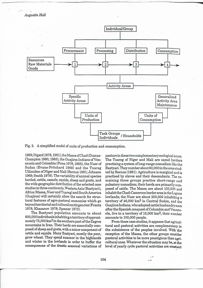
Thus a research procediu-e for the study ofhouse-hold organization w h i d i bridges the gap between S3^temie and archaeological contexts can be outlined. Raw materials, resovu-ces, goods, or, for short, matter is channeUed i n sodal system follovvdng a schedule of productive activities. According to their timing and sequendng, thèse activities take place i n spécifie locations. Daily l iv ing activities or maintenance tasks are more oflen than not executed i n the domestic area. Even i f this spatial uni t is sometimes well stme-tiired, we may provisionally consider i t as a "gener-ahzed activity" area, the core of the household domain. Some spedfie activity areas may be ineluded i n the domestic space, sudi as storage and working areas, or located immediately outside (Fig. 2). The combination of varioiis activity areas ranging fi-om spécifie to generalized is the easiest archaeological s t r a t t ^ for reconstmeting the household.
Dynamics ofan Agro-pastoral Economy
FuUy or partially pastoral économie Systems have been the subjectof intensive anthropological research. I n the extensive anthropological Mterature on thèse Systems, various researchers have outlined a range of récurrent features that are characteristic of this spécifie mode of exploitation of natura l resources (cf. Johnson 1969; Khazanov 1984; Nelson 1973; Spooner 1973; Weissleder 1978). Mixed agro-pastoral économies combine i n varying degrees:
1) agrie\iltural activities, the production of plant resources, relatively immobile i n space, and
2) pastoral activities, the management of animais, often mobile i n space and time.
I n the yearly cycle, both sets of productive activities have periods of low and h igh demands on labor, which may generate serions problems of scheduling. I n this regard, one may seek to know what are successive and/or simultaneous productive acti'vitiÊS i n the yearly cycle, the nature of the scheduling mechanisms and what are the dominant features of divi sion of labor i n eadi set of activities.
I w i l l not attempt to discuss a i l thèse issues i n détails. However, an overview o fa number of ethnographie case studies wiQ help to identify some key mechanisms which stmcture the dynamics of agropastoral sodoeconomic Systems. The seledtd case studies are the Baxtyari nomads of I ran (Jobnson
103
Augustin HoU
Individual /Group
Procurement
Resources Raw Materials Goods
Processing Dis tr ibut ion ConsTimption
Act iv i ty Areeis
Spécifie Activity Areas
Generalized Act iv i ty Area Maintenance
Uni t s of Production
Uni t s of Consumption
Task Groups , „ , Individuals /Households
Pig. 2. A simplified model of units of production and consinnption.
1969; Digard 1978,1981), the Massa of Chad (Dumas-Champion 1980,1983), the Guajiros Indians of Venezuela and Colombia (Picon 1978,1983), the Nuer of Sudan (Evans-Pritchard 1968) and the Tuareg Ull imiden of Niger and Mali (Bemus 1981; Johnson 1969; Smith 1978). The variabiHty of animal species herded, cattle, camels, equids, sheep and goats, and the wide géographie distribution of the selected case studies i n three continents. Western Asia (Baxtyari), Afi-ica (Massa, Nuer and Tuareg) and South America (Guajiros) wiU certainly allow the search for struct u r a l features of agro-pastoral économies which go beyond territorial and cultural contingencies (Frantz 1978; Khazanov 1978; Spooner 1973).
The B a x t y a r i population amounts to about 600,000 individuals inhabiting a territory of approxi-mately 75,000 k m ^ i n the southem part of the Zagros mountains i n I r a n . Their herds are essentially composed of sheep and goats, with a minor component of cattle and equids. Many Baxtyari, mostly the poor, grow wheat. They spend summer i n the highlands and vrinter i n the lowiands i n order to buffer the conséquences of the drastic seasonal variations of
pasture i n thèse two complementary ecological zones. The Tuareg of Niger and M a l i are camel herders practising a system of long-range nomadism Uke the Baxtyari . They number about 80,000in the area studied by Bemus (1981). Agriculture is marginal and is practised by slaves and their descendants. The rem a i n i n g three groups praetiee short-range and pulsatory nomadism; their herds are primarily composed of cattle. The Massa are about 150,O(>0 and inhabitthe Chad-Cameroon border area i n the Logone lowiands; the Nuer are about 200,000 inhabitirig a terr i tory of 48,000 km2 i n Central Sudan, and the Guajiros Indians, who adopted cattle husbandry vxin after the Spanish conquest of Colimibia and Venezuela, live i n a terr itory of 15,000 km^; their number amounts to 100,000 people.
From thèse case studies, i t appears that agricult u r a l and pastoral activities are complementary i n the subsistence of the peoples involved. With the exception of the Massa, the other groups conrider pastoral activities to be more prestigious than agricultural ones. Whatever the situation may be, at the level of yearly cycle pastoral activities are contant
104
Late Neolithic Cultural Landscape in Southeastem Mauritania
and impose a r h y t h m on œmmrmity hfe i n both the practical and ideological sphères. Agriculture is not a socially valued activity, and work is done as fast as possible (Nuer), done by slaves (Tuareg), by wage workers and the poor (Baxtyari), or by the poor (Guajiros). Nevertheless, in spite of this value hierarchy, agriculture andpastoralism belongto the same annual cycle of activities, and their articulation leads to the specificity of each of the Systems examined.
The exécution of necessary subsistence tasks, agricultural as wel l as pastoral, demands the availabil ity of a sufficient labor force. Due to the multiphc-i t y of such tasks, the nuclear family is obviously i n adéquate as a self-sustaining socioeconomic un i t ; i t is therefore always ineluded in set of social relations or larger social units such as extended familles, labor parties, camps or villages, which behave Uke units of production. This situation is common for matters of animal herding. On the other hand, agricultural activities are often executed at the household level, which may be composed of one or several nuclear familles.
During the dry season, the search for water and pasture is the dominant activity, while being the dead season for agriculture. Pastoral activities are carried out by spécial piupose groups of yoimg boys i n the process of init iat ion (Massa) or "speciaUzed" herders (Guajiros, Tuareg, Baxtj-ari), who spend the major part of their time out of the main settlement, l iv ing i n temporary camps moviag from place to place. Himt ing , fishing, and foraging of wild resources generally complément the daily food intake dur ing this lean period of the year.
I n terms of the cultural landscape, each of thèse ethnie groups has différent names for the part of its territory settled during each season, such as Yeylag (simimer territories) and Garmasir (winter t e n i t o ries) for the Baxtyari or Cierig (permanent villages) and Wec (dry season camps) for the Nuer (Evans-Pri tchard 1986). According to Digard (1981:14), Yeylag and Garmasir finally represent more than simple names of places, they represent authentic Baxtyari ways of life, and tiie mo\'e from one place to the other during the faU appears to be a k i n d of rite of passage. The move irom main settlements to dry season camps or from one part of the terr itory to the other according to the seasonal variation of water and pasture thus plays an important social rôle i n some of the societies examined here and ensiires the passage from childhoodto adalthood, supportingthe hypothesis of the crucial importance of the cultural landscape.
Neolithic Household: Compounds and Spatial Organization
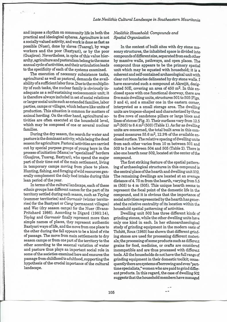
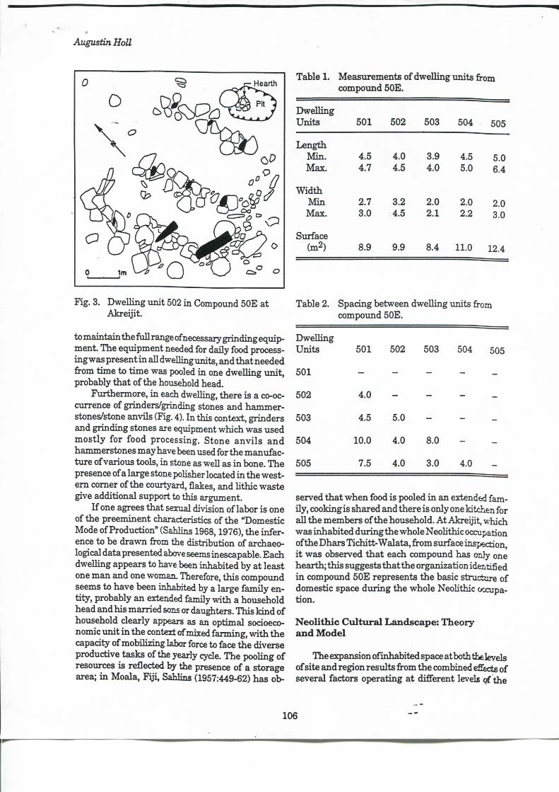
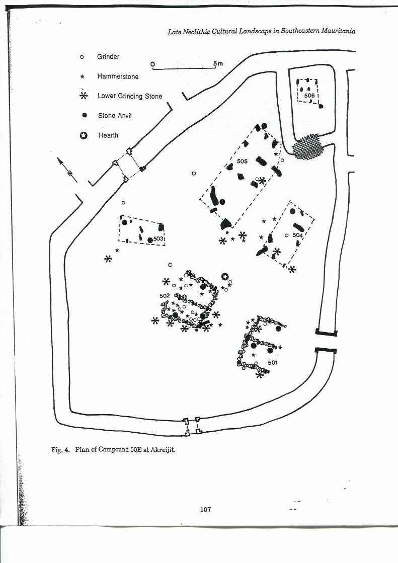
I n the context of bu i l t sites w i t h dry stone masonry structures, the inhabited space is divided into compounds of différent size, separated from each other by massive walls, pathways, and open places. The compoimd thus appears to be the primary spatial i m i t which may be equated w i t h household; i t is a cohérent and self-contained archaeological un i t w i th clear eut botmdaries delineated by dry stone walls. I have excavated such a compoimd at Akrei j i t , desig-nated 50E, covering an area of 450 m2. I n this en-closed space vrith one functional doorway, there are five main dwelhng units , structures 501 to 505 (Figs. 3 and 4), and a smaller one i n the eastem corner, interpreted as a small storage area. The dweUing units are trapeze-shaped and characterized by three to five rows of sandstone pillars or large blocs and lines of stones (Fig. 3). Their siirfaces vary from 12.5 m2 (505) to 8.4 nfi (503) (Table 1). As far as dwelling units are concemed, the total bui l t area i n this com-potmd measm-es 55.6 m^, 12.3% of the available en-closed surface. The relative spacing of dwelling units from each other varies from 10 m between 501 and 503 to 3 m between 504 and 505 (Table 2). There is also one hearth near 502, located at the center of the compound.
The first s tr ik ing feature of the spatial patteming of archaeological stmctures i n this compound is the central place of the hearth and dwelling unit 502. The remaining dweUings are located at an average distance of 4.75 m from the hearth, varying from 5.5 m (503) to 4 m (505). This imique hearth seems to represent the focal point of the domestic life i n the compound, and i t is obvions that the importance of social activities represented by the hearth has generated the relative centrahty of its location vrithin the household spatial pat teming of activities.
Dwelling u n i t 502 has three différent kinds of grinding stones, while the other dwelling units ha-.-e only one k i n d i n each. I n her ethnoarehaeological study of grinding equipment i n the modem oasis of Tichitt , Roux (1983) has shovra that différent grinding stones are used for processing différent materials; the processing of some products such as différent grains for food, medicine, or crafts are considered incompatible and are thus processed vrith différent tools. AU the households do not have the fiill range of grinding equipment i n their domestic toolkit; consequently there are Systems ofborrovring and even "part-t ime specialists," women who are paid to grind difCer-ent products. I n this regard, the case of dwelling .%2. suggests thatthe household members have manage
105
Augustin Holl
Table 1. Measurements of dwelling units from compoimd 50E.
Fig. 3. Dwell ing unit 502 i n Compound 50E at Akre i j i t .
to maintain the fu l l range of necessary grinding equipment. The equipment needed for daily food processing was présent i n ail dwelling units, and that needed from time to t ime was pooled i n one dwelling un i t , probably that of the household head.
Furthermore, i n each dweUing, there is a co-occurrence of grinders/grinding stones and hammer-stonea/stone anvils (Fig. 4). I n this context, grinders and grinding stones are equipment which was used most ly for food processing. Stone anv i l s and hammerstones may have been used for the manufacture of various tools, in stone as well as i n bone. The présence of a large stone poHsher located i n the western corner of the coxu-tyard, flakes, and hthic waste give additional support to this argument.
I f one agrées that sexual division of labor is one of the prééminent characteristics of the "Domestic Mode of Production" (Sahlins 1968,1976), the inference to be drawn from the distribution of archaeological data presented above seems inescapable. Each dwelling appears to have been inhabited by at least one man and one woman. Therefore, this compound seems to have been inhabited by a large family entity, probably an extended family w i t h a household head and his married sons or daughters. This k i n d of household clearly appears as an optimal socioeconomic un i t i n the context of mixed farming, w i t h the capadty of mobilizing labor force to face the diverse productive tasks of the yearly cyde. The pooling of resources is reflected by the présence of a storage area; i n Moala, F i j i , Sahlins (1957:449-62) has ob-
Dwell ing Units 501 502 503 504 505
Length M i n . Max.
4.5 4.7
4.0 4.5
3.9 4.0
4.5 5.0
5.0 6.4
W i d t i i M i n
Max. 2.7 3.0
3.2 4.5
2.0 2.1
2.0 2.2
2.0 3.0
Surface (m2) 8.9 9.9 8.4 11.0 12.4
Table 2. Spacing between compoimd 50E.
dwelling units from
Dwell ing Units 501 502 503 504 505
501 - - - - -502 4.0 - - - -503 4.5 5.0 - - -504 10.0 4.0 8.0 - -505 7.5 4.0 3.0 4.0 -
served that when food is pooled i n an extended fam-i ly , cooking is shared and there is only one Mtchen for ai l the members of the hoiisehold. A t Akreijit , which was inhabited duringthe whole Neohthic occupation of the Dhars Tichitt-Walata, from surface inspection, i t was observed that each compound has only one hearth; this suggests that the organization identified i n compoimd 50E represents the basic structure of domestic space during the whole Neohthic occupation.
Neolithic C u l t u r a l L a n d s c a p e : Theory a n d Model
The expansion of inhabited space atboththelevels of site and région results from the combined efiècts of several factors operating at différent levels of the
106
Late Neolithic Cultural Landscape in Southeastem Mauritania
Augustin HoU
sodal Systems. I t may resuit from fission afber disputes, ihe seardi for new agricultural and grazing lands, or as the conséquence ofwarfare or trade. Here, our disCTission wiU focus on some of those factors amenable to systematic archaeological study i n the context of the Neolithic sodeties of southeastem Mauritania . We w i l l first consider the dynamics of the sodoeconomic system atthe household level and its conséquences for the growth of inhabited space. I n this discussion, our basic assumption is that of the natxu-al growth of the local population from the earHest period of settlement. I f economy is defined as a set of sphères of sodal activities dealing w i t h the procurement of resources, goods, and services, their processing, distribution and consumption, for the maintenance and biological and sodal reproduction of the sodety as a whole, the household appears i n many cases to be the primary sodoeconomic i m i t . One of the most critical features of the household economy is the recruitment of labor. From this point of view, i n self-sustaining mixed farming sodeties the forces of production are essentiaUy tools and land. While thèse are esisily accessible to members of the sodal group, labor force and the skills necessary to achieve diverse and overlapping sodoeconomic tasks provide those who possess them w i t h genuine au-thority over the laymen. This is because the continua t i on of the group dépends on thèse features (Meillassoux 1980a). The pooling of labor force and knowledge are ofi«n acquired wi th seniority, thus supporting the fondamental senior/^imior relationships. The man/woman relationship is not parallel to i t but i t has its ovm dynamics which may be complementary or contradictory in the household stmcture. Considering the overlapping nature of the generational stmcture i n ail sodeties, one may agrée that there are always at least three générations présent i n a hving sodety: the old, the middle-aged, and the young, vrith each génération playing a rôle i n the maintenance and the reproduction of the whole sodety:
Sodeties need some mechanism which a l lows individuals to give to the old and have confidence that they in t u m w i l l be the récipients of gifts when they are old. Money, ritualknowledge, dubs, land, kinship groups, and a host of others are ail sodal arrangements which help to inspire this confidence and to achieve an optimal allocation of consumption. (Walsh 1983:647)
I n this perspective, kinship relations i n a household are a t the same time relations of production, w i t h two kinds of circulation of resources, goods and services. The seniors recei\-e the juniors' prestations
and then supervise the whole group output. I n this spécifie case, the generalized reciprocity model (Sahlins 1968,1972) is inaccm-ate and the concept of delayed redprodty seems more appropriate. According to Bouju (1984:19), the prestation/redistribution cyde is the expression ofan asymmetrical and complementary sodal relationship. I n that relation every transfer of goods or services is a response to the simple obhgation ineluded i n the set of rights and duties imphed by kinship status. A hoxisehold head may therefore t i y to have a large ntmiber of people dépendent on h i m i n order to secure a labor force, a large amoimt of output, authority, and prestige. The qualitative hnk between household stradure and the com-mtmity and régional levels is based upon thèse features. I n the anthropological hterature, surplus production is sometimes considered to be the key var i able i n vertical sodal differentiation. I n a review of théories of sodal stratification i n sodology and an-thropology, Candan (1976:230-1) persuasively argued that the idea that stratification resulted from the création of a material surplus is not only a simpUstic view, but also hsis htt le support, since its définition i n absolute terms is not workable. However, in relative terms this concept may be usefol as an indication of an inereased output beyond the subsistence requirements o fa production i m i t . Economie difi'eren-tiation based on the contiol of people and consequentiy their productive and reproductive capadties is not operative i n terms of so-eaUed "surplus" production but mainly i n terms of prestige and sodal influence arising from a large and "wealthy" household.
A t t h e household level, kinship relations, recruit-mentoflaborforee,thesemor/5uniorrelationsh5pwith its eorollary, delayed redprodty, output intensification, and circulation of prestige items are in a state of ptmetuated equdhbrixmi and generate différent and overlapping sodal networks which l ink this primary sodoeconomic u n i t t o community, régional, artd even extraregional networks. Population increase and generational segmentation allow territorial expansion (Bohaiman and Bohannan 1968; Bouju 1984; Pollet and Winter 1980; SaWins 1961,1969) through the search for new agricultural and grazing lands. Given enough t ime, one woii ld expect a wide distri bution of socially and historically related communities i n a given région, a cumulative growth process of a e\iltiu-al landscape which may be slowed irn-n or aeeelerated according to actual démographie and environmental drcumstanees. Household heads, having a large following and large producti.'ïa output, may therefore be i n a position to achieve greater distributive capadties, prestige, and eUte g<»ds^ i n centives to vertical differentiation amonghousdjolds.
108
Late Neolithic Cultural Landscape in Southeastem Mauritania
We may thus expect larger households to have i n habited larger compounds.
A t the community level, coopération and compét i t ion are both présent. Household heads w i t h the greatest distributive capadties and prestige have better opportunities to reach, directly or indirectly, positions of authority as community elders or ded-sion-makers, organizing communaJ works for the benefit of the entire community (Harris 1879:98). Due to community dynamics, land availabihty, population increase, and environmental conditions, given enough time, daughter communities may develop i n the surroundings. I n mixed farming économies thèse new settlements may dépend, at least i n their pioneer stage, on the accumulation and storage of foods and seeds from their former communities (Meillassoux 1980b). Thèse relations may be of a various, pohtical, économie, ideological nature, or a i l of thèse, and may create régional networks. I n this regard, the very existence of technology, subsistence activities, and sodal relations afFects sodeties as they are sym-boheallymediated(Ck)e 1981; Freidel 1981; Keatinge 1981; Sahlins 1980). Idéologies and rehgious prae-tiees are more than simple epiphenomena of the techno-environmental-politieal realm. The difBcul-ties of studying them i n the material record of prehistoric sodeties does not mean that they are not significant:
I n the absence of naked coerdve force, rehgious sanctions provided a path toward the development of poUtical centraUzation. The amount of resources both human and natural , expended on reUgion i n the form of temple construction and tribute must have a pro-found effed on the configuration of early state économies as weU as on the forms of poUtical organization de\'eloped to organize and d i rect the exploitation of thèse resources. (Keatinge 1981:187)
I n this regard, the senior>5unior relationship previously examined i n our discussion of household sodoeconomic dynamics may provide one possibihty for \mderstanding the lineage system's ideology. For example, land aUocation s>'stems, or, more gener-aUy, the access to means of production, is strongly controUed by a segmentary sodetys ideology, particularly i n the cases of communal ownership of land (Bouju 1984:104).
A t the régional level, communities are horizon-taUy and/orverticaUy difierentiated. To ensure their sodal and biological reproduction, communities are involved i n mtUtiple exdiange networks of people, goods and services. The nodes of difîerential concentration of people and habitation fadUties i n the con-
tinuxun of population distribution over the landscape o f a région may generate ségrégation. This concept refers to the extent to which households or groups of households are independent of each other. We may thus expect the émergence of pattems of distinct and changing sodal networks w i t h preferential exchange partners. Exchange of people, goods, services, prestige items, and tr ibute may be channeled through the networks thus created
.. .Linkages between spedalized subsystems may take the form of transactions i n the context of central institutions. Chieflainships, govemments and markets are such examples of such c e n t r a l i n s t i t u t i o n s . (B lanton 1976:251)
Differential concentration of people and historical factors such as "anteriority" (e.g., historicaUy earUer settlers) may lead to a hierarchy of settlements, which may have been reinforced by tribute flow from lower to higher centers, and prestige goods flow i n the inverse direction (Friedman and Rov^lands 1977; Steponaitis 1978, 1981). I n gênerai, information needed for the opération of the system is not avaUable everywhere i n the same quantity and qual-i t y but is spatiaUy variable. The influence of distance as a fi-ictional force i n attenuatinginformation flows, suggests that settlement hierarchy plays a critical roleinchanneUinginformationflows. The géographie location of m a i n centers is therefore an important variable i n determining the form and extent of différent levels of a soeietj^s ciUtural landscape (Llo>-d and Dicken 1977:317). Thèse features have relatively dear archaeological correlates, which can be partly nr.-ealed by locational analysis.
I n the model presented here, I have derived som e expectations which wiU help make sensé of the southeastem M a u r i t a n i a n archaeological record. The model has fragments ofa deterministic approach to sodal Systems. FoUowing Harr i s (1979:105j, i t is argued that i t is not by denying the existence of a deterministic component i n social processes that one w i l l improve that situation, and, for the sake of intel -UgibiUty, i t is necessary to deUneate such a component. The empirical test impUcations of this model involve the archaeological analysis of the spa:ûal distr ibut ion of compounds i n différent sites and of the settlement pattems at the district and regior:al levels. Four sites have been selected for detailed analysis, according to their size, location, and pœiâon i n the hierarchy of settlement which is composed of four ranks: régional center, large viUage or district center, smaU viUage and hamlet.
109
Augustin HoU
Chronology a n d Settlement E x p a n s i o n
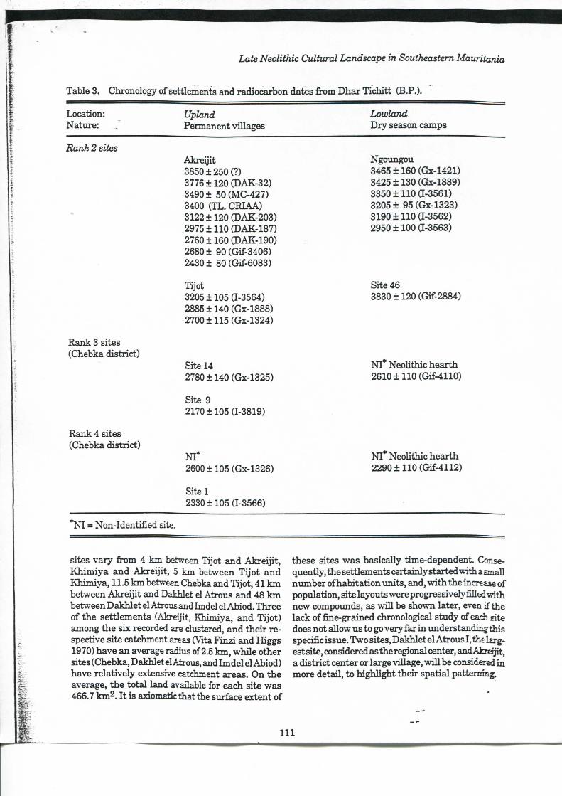
The chronology of settlement expansion of the Neohthic societies of southeastem Maur i tan ia is based exdusively on the researdi carried out i n the Dhar Tichitt région, situatedinthe westemmostpart of the study area, where more intensive fieldwork has been undertaken (Amblard 1984, 1986; H o l l 1985a, 1985b, 1986a, 1986b, 1989; Munson 1971; Vemet 1984,1986). My chronological ordering of the Dhar Tichitt settlement dynamics is not yet \miver-sally accepted by students of the Neohthic sodeties of southwestem Sahara(Vemet 1988; Munson 1989), partly because of basic différences i n the research perspectives adopted and also because of the relative smaÛ nimaber of radiocarbon dates and their uneven distribution between sites. However, i t seems to me that that chronological ordering is the most congment w i t h the data base available today for the Neohthic sodeties of southeastem Mauritania. I t appears that the stirface sites or dry season camps studied by M\mson (1971) and located on the shores of former freshwater lakes insandyinterdimal dépression were settled dviring the whole NeoUthic séquence and date from ca. 4000 B.P. (3830 ± 120 B.P., Gif-2884) to ca. 2000B.P. (2290+110 B.P., Gif-4110). Sites bu i l t v d t h dry stone features and located on the plateau of the sandstone cliff, which are considered to have been permanent villages, were settled over the same length of time and have been dated from 3850 ± 250 B.P. to 2170 ± 105 B.P., (1-3819) (Table 3). This first chronological ordering suggests that the exploitation of différent but complementary ecological zones was a permanent feature of the NeoUthic sodoeconomic System.
According to their size and location, the permanent vUlages i n the Dhar Tichitt archaeological record can be partitioned into three classes of what appears to be a hierarchy of settlements. There are fom: rank 1 sites. Their sinface extents vary from 3.5 ha w i t h 120 compounds at Chebka to 17.5 ha and 180 com-poimds at Khimiya . AU of them are located near or on the edge of the cUff escarpment, i n what appears to have been an optimal location considering the dynamics of the mixed farming system—on the démarcation line between the lowland and the upland. I n gênerai, thèse sites are the earUest NeoUthic sites of the study area (Table 3, Fig. 5a).
Tentatively, i t may be argued t h a t from thèse pioneer sites settlements were created i n the whole région. I t appears that rank 2 sites, characterized by the présence of 21 to 50 compoimds, were settled from ca. 3000 B.P. (2780 ± 140 B.P., GX-1325) and
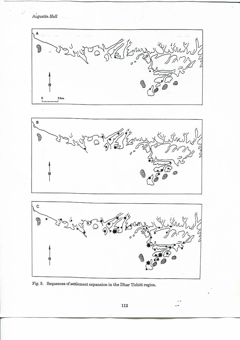
lasted up to the end of the NeoUthic occupation at ca. 2000 B.P. (2170 ± 105 B.P., 1-3819). Thèse rank 2 sites are distributed i n two dusters, one vpith four sites i n the surroundings of Akre i j i t and the other w i t h six sites i n the v i d n i t y of Chebka (Pig. 5b), and are located along the edges of the main wadis and isolated sandstone massifs. The 28 rank 3 sites, con-tainingless than twenty compounds each, were settled from ca. 2500 B.P. (2600 ± 105 B.P., Gx-1326) to ca. 2000 B.P. (2330 ± 105 B.P., 1-3566), andmost of them are located along the edges of secondary vaUeys (Fig 5c). I t appears t h a t settlement expansion, which certainly results from the dynamics of the sodoeconomic System, started ve iy slowly and aeeelerated through time. FVom four sites during the pioneer séquence, we have 14 i n the middle séquence and 42 i n the late and final séquence. The number of sites was m u l t i -pUed by 3.5 (from 4 to 14) i n a period of 1,000 years, w i t h the appearance of rank 1 and 2 sites, and then multipUed by 3 (from 14 to 42) over a period of 500 years, w i t h tiie addition of rank 3 sites.
I h i s chronological model from the Dhar Tichitt région wUl be expanded and used to study the buildup of the NeoUthic cultural landscape at a larger t e r r i torial scale, that of the Dhars Tichitt-Walata ardiaeological record. Thus, i n this chapter, the largest sites wUl be considered as the earUest settiements, which have witnessed séquences of expansion during the whole NeoUthic occupation of the study area This pioneer settlement stage was foUowed by the émergence of small viUages during the middle séquence andhamlets duringthe late séquence. I t i s the buildup of this larger NeoUthic cultural landscape which wUl now be discussed.
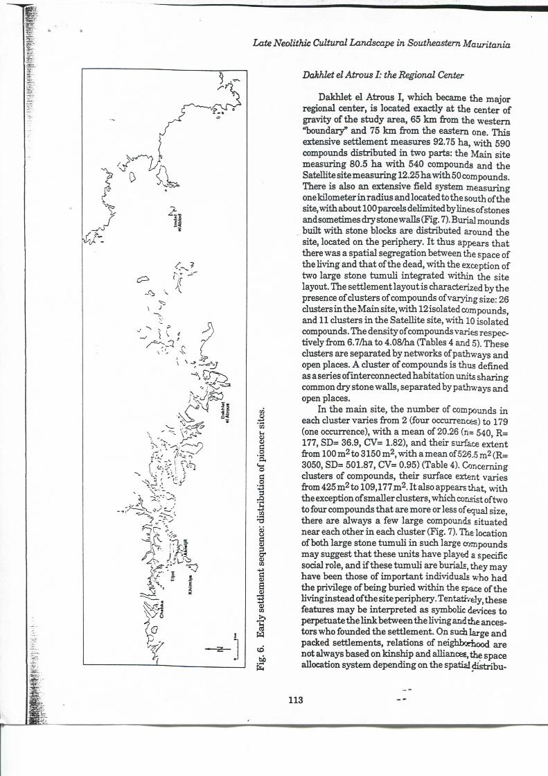
C u l t u r a l L a n d s c a p e I : the E a r l y Settlement Séquence (ca. 4000-3000 B.P.)
The early settlement séquence lasted for one thousand radiocarbon years and started around 4000 B.P. Six sites belong to this séquence, from the west tothe east: Chebka, Tijot, Khimiya , Akreij it , Dakhlet el Atrous, and Imdel el Abiod. Three are located on or near the main escarpment of the eUff and Ihe three others on isolated sandstone massifs i n what appears to be the démarcation zone between two complementary ecological areas, the sandy interdunal Lwland and the sandstone plateau upland (Fig. 6). In terms of the dynamics of mixed farming Systems, tins site location strategy appears optimal, aUowing direct access to both ecological zones. The cultural landscape was actuaUy characterized by a linear pattem of settiements. Distances between nearest-na^bor
110
Late Neolithic Cultural Landscape in Southeastem Mauritania
Table 3. Chronology of settlements and radiocarbon dates from Dhar Tichitt (B.P.).
Location: Upland Lowland Nature: , Permanent villages Dry season camps
Rank 2 sites Akrei j i t 3850 ±250 (?) 3776 ± 120 (DAK-32) 3490 ± 50 (MO427) 3400 (TL. CRLA^.) 3122 ± 120 (DAK-203) 2975 ±110 (DAK-187) 2760 ± 160 (DAK-190) 2680 ± 90(Gif-3406) 2430 ± 80(Gif-6083)
Ngoungou 3465 ± 160 (Gx-1421) 3425 ±130 (Gx-1889) 3350 ± 110 a-3561) 3205 ± 95 (Gx-1323) 3190 ±110 (1-3562) 2950 ±100 (1-3563)
Tijot 3205 ±105 (1-3564) 2885 ± 140 (Gx-1888) 2700 ± 115 (Gx-1324)
Site 46 3830 ±120 (Gif-2884)
Rank 3 sites (Chebka district)
Site 14
2780 ± 140 (Gx-1325)
Site 9 2170 + 105 (1-3819)
N I * Neohthic hearth 2610 ±110 (Gif-4110)
Rank 4 sites (Chebka district)
N T
2600 ±105 (Gx-1326)
S i t e l 2330 ±105 (1-3566)
N I * Neohthic hearth 2290 ±110 (Gif-4112)
* N I = Non-Identified site.
sites vary from 4 k m between Tijot and Akre i j i t , K h i m i y a and Akre i j i t , 5 k m between Ti jo t and Khimiya, 11.5 k m between Chebka and Tijot, 41 k m between Akre i j i t and Dakhlet el Atrovis and 48 k m between Dakhlet el Atrous and Imdel el Abiod. Three of the settlements (Akreijit, Khimiya, and Tijot) among the six recorded are cliistered, and their respective site catchment areas (Vita Finzi and Higgs 1970) have an averzige radius of 2.5 k m , while other sites (Chebka, Dakhlet el Atrous, and Imdel el Abiod) have relatively extensive catchment areas. On the average, the total land available for each site was 466.7 km2. I t is axiomatic that the surface extent of
thèse sites was basically time-dependent. Consequently, the settlements certainly started wi th asmall nmnber of habitation \mits, and, w i t h the increase of population, site layouts were progressivelyfilled w i t h new compoimds, as vriU be shown later, e\'en i f the lack of fîne-grained chronological study of each site does not allow us to go very far i n imderstandirig this spécifie issue. Two sites, Dakhlet el Atrous I , the largest site, considered as the régional center, and Abej j i t , a district center or large village, w i l l be considered i n more détail, to highhght their spatial patteming.
111
112
Late Neolithic Cultural Landscape in Southeastem Mauritania
. 1
k l
U
g
O g '•S S
ï g .
10
i
w CD bb
s
Dakhlet el Atrous I : the Régional Center
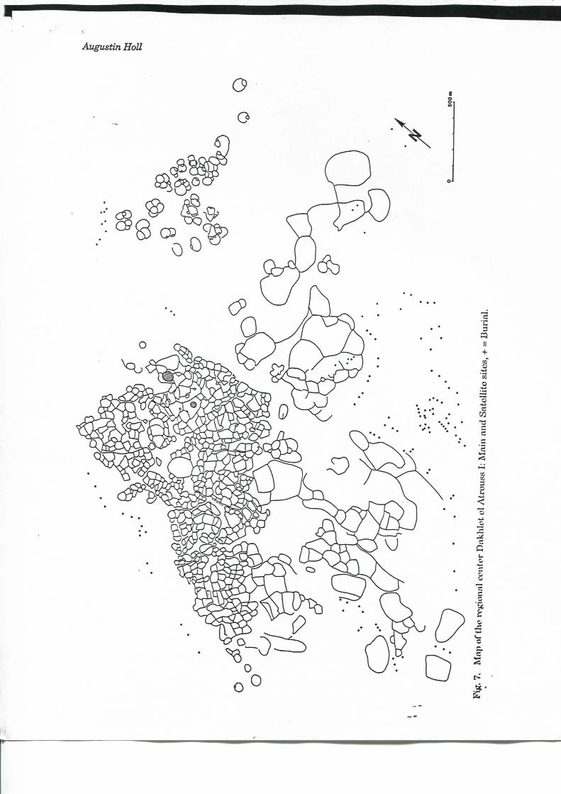
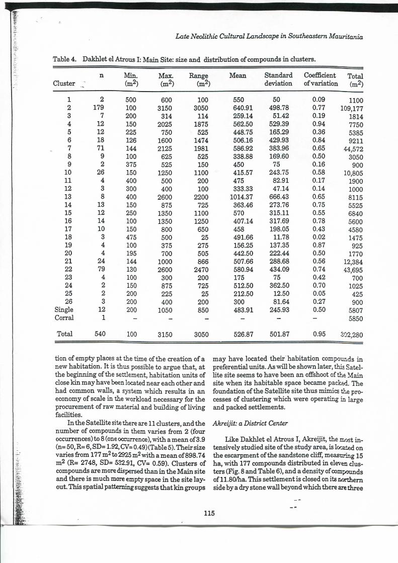
Dakhlet el Atrous I , which became the major régional center, is located exactly at the center of gravity of the study area, 65 k m from the western "boundary" and 75 k m fi^m the eastem one. This extensive settlement measures 92.75 ha, w i t h 590 compoimds distributed i n two parts: the Main site measiiring 80.5 ha w i t h 540 compoimds and the SateUite site measuring 12.25 ha w i l i i 50 compounds. There is also an extensive field system measuring one kilometer i n radius and located to the sou th of the site, w i th about 100 parcels dehmitedby lines of stones andsometimes dry stone walls (Fig. 7). Burial mounds built w i t h stone blocks are distributed around the site, located on the periphery. I t thus appears tha t there was a spatial ségrégation between the space of the Hving and that of the dead, w i t h the exception of two large stone t imiuH integrated within the site layout. The settlement layout is characterized by the présence of clusters of compounds of varying size: 26 clusters i n the Main site, w i t h 12 isolated compounds, and 11 clusters i n the SateUite site, w i t h 10 isolated compounds. The density of compoimds varies respec-tively from 6.7/ha to 4.08/ha (Tables 4 and 5). Thèse clusters are separated by networks of pathways and open places. A cluster of compounds is thus defined as a séries of interconnected habitation units sharing common dry stone waUs, separated by pathways and open places.
I n the main site, the number of compounds i n each cluster varies from 2 (four occurrences) to 179 (one occurrence), w i t h a mean of 20.26 (n= 540, R= 177, SD= 36.9, CrV= 1.82), and their surface extent from 100 m2 to 3150 m2, w i t h a mean of526.5 m2 (R= 3050, SD= 501.87, CV= 0.95) (Table 4). Conceming clusters of compounds, their surface extent varies from425m2to 109,177m2.Italsoappearsthat, w i t h the exception of smaUer clusters, which corisist of two to four compounds that are more or less of equal size, there are always a few large compounds situated near each other i n each cluster (Fig. 7). The location of both large stone tumuU i n such large compounds may suggest tha t thèse units have played a spedfie sodal rôle, and i f thèse tumuU are burials, they may have been those of important individuals who had the privilège of being buried w i t h i n the space of the Uvinginstead of the site periphery. Tentatr/ely, thèse features may be interpreted as symbolic déviées to perpetuate the l i n k between the Hving and the anees-tors who founded the settlement. On such large and paeked settlements, relations of nd^iborhood are not always based on kinship and alUanœs, the space aUocation system depending on the spatial distribu-
113
Augustin Holl
Late Neolithic Cultural Landscape in Southeastem Mauritania
Table 4. Dakhlet el Atrous I : Ma in Site: size and distribution of compounds i n clusters.
Quster n M i n .
(m2) Max. (m2)
Range (m2)
Mean Standard déviation
Coefficient of variation
Total (m2)
1 2 500 600 100 550 50 0.09 1100 2 179 100 3150 3050 640.91 498.78 0.77 109,177 3 7 200 314 114 259.14 51.42 0.19 1814 4 12 150 2025 1875 562.50 529.39 0.94 7750 5 12 225 750 525 448.75 165.29 0.36 5385 6 18 126 1600 1474 506.16 429.93 0.84 9211 7 71 144 2125 1981 586.92 383.96 0.65 44,572 8 9 100 625 525 338.88 169.60 0.50 3050 9 2 375 525 150 450 75 0.16 900
10 26 150 1250 1100 415.57 243.75 0.58 10,805 11 4 400 500 200 475 82.91 0.17 1900 12 3 300 400 100 333.33 47.14 0.14 1000 13 8 400 2600 2200 1014.37 666.43 0.65 8115 14 13 150 875 725 363.46 273.76 0.75 5525 15 12 250 1350 1100 570 315.11 0.55 6840 16 14 100 1350 1250 407.14 317.69 0.78 5600 17 10 150 800 650 458 198.05 0.43 4580 18 3 475 500 25 491.66 11.78 0.02 1475 19 4 100 375 275 156.25 137.35 0.87 925 2Q 4 195 700 505 442.50 222.44 0.50 1770 21 24 144 1000 866 507.66 288.68 0.56 12,384 22 79 130 2600 2470 580.94 434.09 0.74 43,695 23 4 100 300 200 175 75 0.42 700 24 2 150 875 725 512.50 362.50 0.70 1025 25 2 200 225 25 212.50 12.50 0.05 425 26 3 200 400 200 300 81.64 0.27 900
Single 12 200 1050 850 483.91 245.93 0.50 5807 Corral 1 - - - - — — 5850
Total 540 100 3150 3050 526.87 501.87 0.95 302,280
tion of empty places at the time of the création o fa new habitation. I t is thus possible to argue that , at the beginning of the settlement, habitation \mits of close k i n may have been located near each other and had common walls, a system which results i n an economy of scale i n the workload necessary for the procurement of raw material and building of Hving faciHties.
I n the SateUite site there are 11 clusters, and the ntmiber of compounds in them varies from 2 (four occurrences) to 8 (one occurrence), w i t h a mean of 3.9 (n= 50, R= 6, SD= 1.92, CV= 0.49) (Table 5). Their size varies from 177 m2 to 2925 m2 vrith a mean of898.74 m2 (R= 2748, SD= 0-3251, CV= 0.59). Clusters of compoimds are more dispersed than i n the M a i n site and there is much more empty space i n the site layout. This spatial patteming suggests that k i n groups
may have located their habitat ion compounds i n preferential units. As vriU be shovra later, this Satel-Ute site seems to have been an ofFshoot of thé Main site when its habitable space became pacLed. The foundation of the SateUite site thus mimics the processes of clustering which were operating in large and paeked settlements.
Akreijit: a District Center
Like Dakhlet el Atrous I , Akrei j i t , the most i n -tensively studied site of the study area, is locaied on the escarpment of the sandstone cliff, measuring 15 ha, w i t h 177 compounds distributed i n eleven clusters (Fig. 8 and Table 6), and a density of conçounds of 11.80/ha. This settlementis closed on its northem side by a dry stone waU beyond w h i d i there are three
115
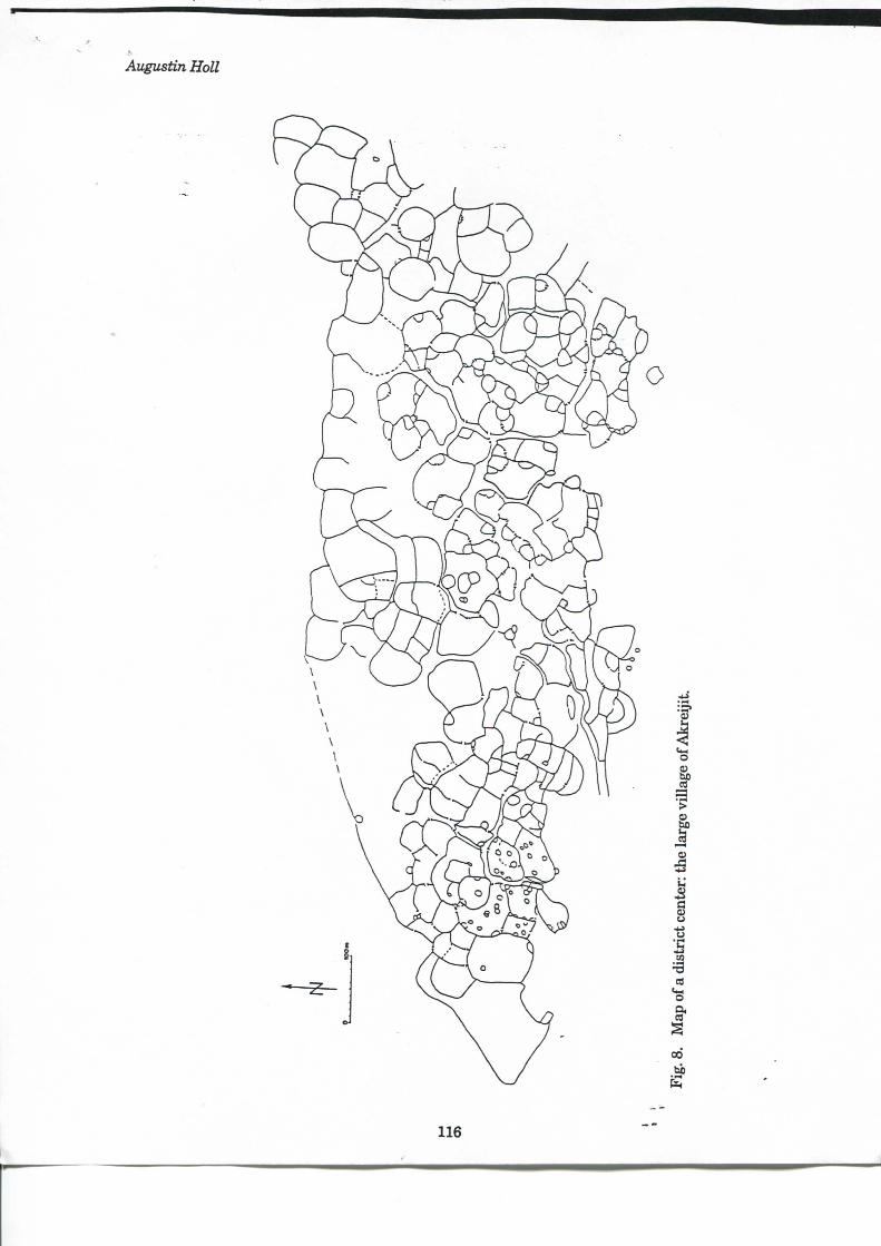
Augustin Holl
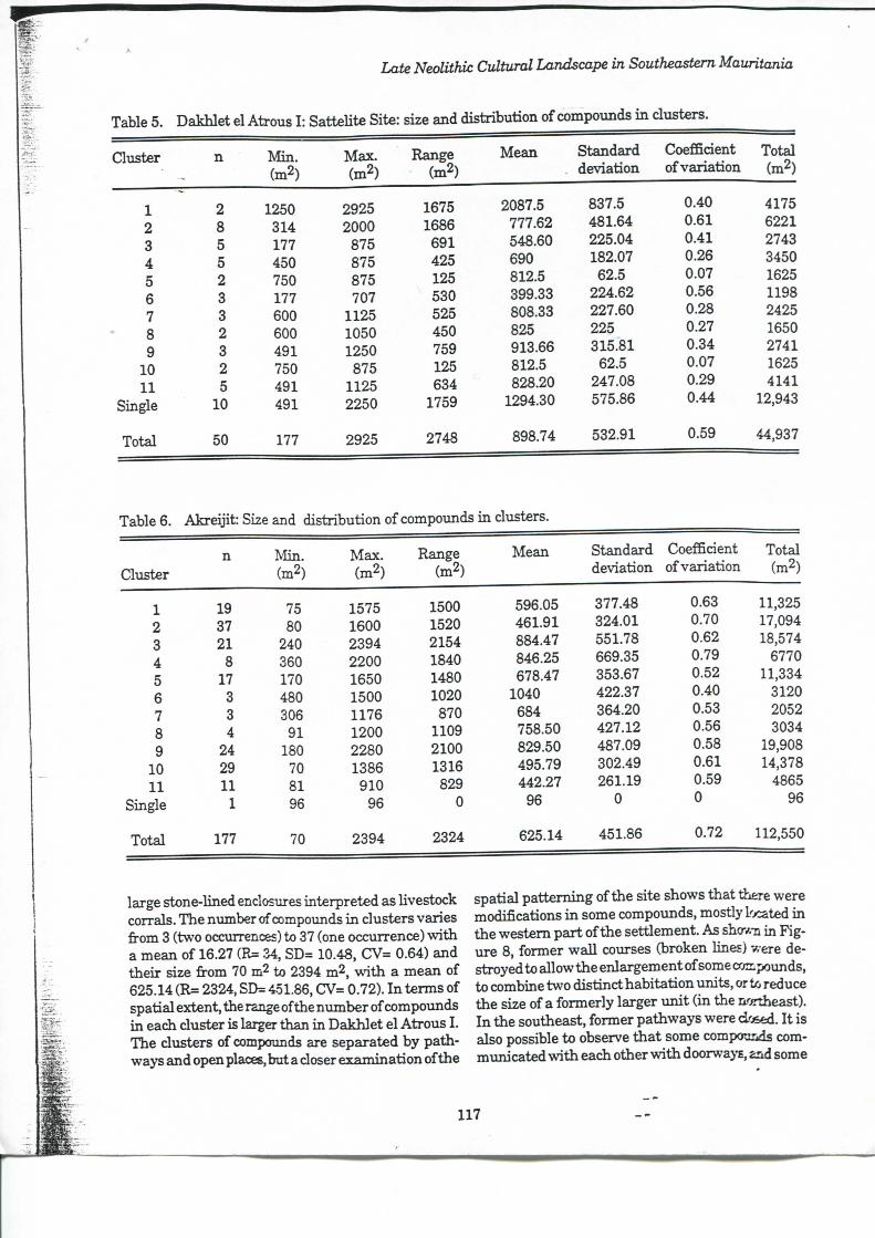
Late Neolithic Cultural Landscape in Southeastem Mauritania
Table 5. Dakhlet el Atrous I : Sattehte Site: size and distribution of compounds i n clusters.
Clxister n M i n . Max. Range Mean Standard Coefficient Total (m2) (m2) (m2) déviation of variation (m2)
1 2 1250 2925 1675 2087.5 837.5 0.40 4175 2 8 314 2000 1686 777.62 481.64 0.61 6221 3 5 177 875 691 548.60 225.04 0.41 2743 4 5 450 875 425 690 182.07 0.26 3450 5 2 750 875 125 812.5 62.5 0.07 1625 6 3 177 707 530 399.33 224.62 0.56 1198 7 3 600 1125 525 808.33 227.60 0.28 2425 8 2 600 1050 450 825 225 0.27 1650 9 3 491 1250 759 913.66 315.81 0.34 2741
10 2 750 875 125 812.5 62.5 0.07 1625 11 5 491 1125 634 828.20 247.08 0.29 4141
Single 10 491 2250 1759 1294.30 575.86 0.44 12,943
Total 50 177 2925 2748 898.74 532.91 0.59 44,937
Table 6. Akrei j i t : Size and distribution of compounds i n clusters.
n Min . Max. Range Mean Standard Coefficient Total Cluster (m2) (m2) (m2) déviation of variation (m2)
1 19 75 1575 1500 596.05 377.48 0.63 11,325 2 37 80 1600 1520 461.91 324.01 0.70 17,094 3 21 240 2394 2154 884.47 551.78 0.62 18,574 4 8 360 2200 1840 846.25 669.35 0.79 6770 5 17 170 1650 1480 678.47 353.67 0.52 11,334 6 3 480 1500 1020 1040 422.37 0.40 3120 7 3 306 1176 870 684 364.20 0.53 2052 8 4 91 1200 1109 758.50 427.12 0.56 3034 9 24 180 2280 2100 829.50 487.09 0.58 19,908
10 29 70 1386 1316 495.79 302.49 0.61 14,378 11 11 81 910 829 442.27 261.19 0.59 4865
Single 1 96 96 0 96 0 0 96
Total 177 70 2394 2324 625.14 451.86 0.72 112,550
large stone-lined enclosures interpreted as Uvestock corrals. The nimiber of compounds i n clusters varies from 3 (two occurrences) to 37 (one occtirrence) vrith a mean of 16.27 (R= ZA, SD= 10.48, CV= 0.64) and their size from 70 m2 to 2394 m2, w i t h a mean of 625.14 (R= 2324, SD= 451.86, CJV= 0.72). I n terms of spatial extent, the range of the number of compounds i n each cluster is larger than i n Dakhlet el Atrous I . The clusters of compounds are separated by pathways and open places, but a doser examination of the
spatial patteming of the site shows that there were modifications i n some compounds, mostly located i n the westem part of the settlement. As shov,-n in Fig-vire 8, former w a l l courses (broken hnes) were de-stroyed to allow the enlargement of some compounds, to combine two distinct habitation units, or i/j reduce the size ofa formerly larger u n i t ( in the nordieast). I n the southeast, former pathways were dosed. I t is also possible to observe that some compounds com-mimicated w i t h each other w i t h doorwaj's, and some
117
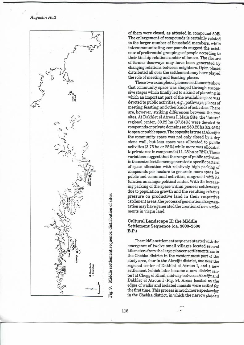
Augustin HoU
of them were closed, as attested i n compomid 50E. The enlargement of compounds is certainly related to the larger niunber of household members, while intercommunicating compounds suggest the existence of preferential groupings of people according to their kinship relations and/or alliances. The closure of former doorways may have been generated by changing relations between neighbors. Open places distributed ai l over the settlement may have played the rôle of meeting and feasting places.
Thèse two examples of pioneer settlements show that community space was shaped through successive stages which finally led to a k i n d of planning i n which an important part of the available space was devoted to pubhc activities, e.g., pathways, places of meeting, feasting, and other kinds of activities. There are, however, s tr ik ing différences between the two sites. A t Dakhlet el Atrotis I , Ma in Site, the "future" régional center, 30.22 ha (37.54%) were devoted to compoimds or private domains and 50.28ha (62.45%) to open or pubhc space. The opposite is true at Akreijit: the community space was not only closed by a dry stone waU, but less space was allocated to pubhc activities (3.75 ha or 25%) whQe more was aUocated to private use i n compounds (11.25 ha or 75%). Thèse variations suggest that the range of pubhc activities i n the central settlement generated a spécifie pattem of space allocation vsdth relatively h igh packing of compoimds per hectare to generate more space for pubhc and communal activities, congment with its function as a major pohtical center. W i t h the increasing packing of the space vidthin pioneer settlements due to population growth and the resulting relative pressure on productive land i n t h e i r respective catchment areas, the process of generational segmentation may have generated the création of new settlements i n v i rg in land.
Cultural L a n d s c a p e H : the Middle Settlement Séquence (ca. 3000-2500 B.P.)
The middle settlement séquence started with the émergence of twelve small villages located several Idlometers fi-om the large pioneer settlements: d i i n the Chebka district i n the westemmost part of the study area, four i n the Akre i j i t district, one near the régional center of Dakhlet el Atrous I , and a new settlement (which later became a new district center) at (Thegg el Khai l , midway between Akreijit and Dakhlet el Atrous I (Fig. 9). Areas located on the edges of wadis and isolated massifs were setti&d for the first time. This process is much more spectacolar i n the Chebka district, i n which the narrow pI^Leau
118
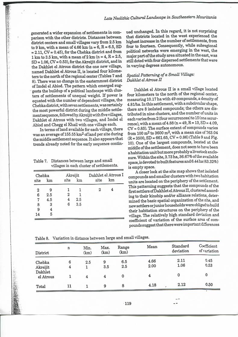
Late Neolithic Cultural Landscape in Southeastem Mauritania
generated a wider expansion of settlements i n com-parison w i t h the other districts. Distances between district centers and small villages vary from 2.5 k m to 9 k m , w i t h a mean of 4.66 k m (n = 6, R = 6.5, SD = 2.11, CV = 0.45), for the Chebka district and from 1 k m to 3.5 k m , w i t h a mean of 2 k m (n = 4, R = 2.5, SD = 1.06, CV=0.53), for the Akrei j i t district, and i n the Dakhlet el Atrous district the one new village, named Dakhlet el Atrous I I , is located four Idlometers to the north of the régional center (Tables 7 and 8). There was no change i n the eastemmost district of Imdel el Abiod. The pattem which emerged suggests the biuldup of a pohtical landscape vrith clusters of settlements of miequal weight. I f power is equated w i t h the number of dépendent villages, the Chebka district, vrith seven settlements, was certainly the most powerful district during the middle settlement séquence, foUowed by Akrei j i t w i t h five villages, Dakhlet el Atrous w i t h two villages, and Imdel el Abiod and Chegg el Khail vrith one viUage each.
I n terms of land available for each viUage, there was an average of 155.55 km2 of land per site during the middle settlement séquence. I t also appears that trends already noted for the early séquence contin-
Table 7. Distances between large and smaU viUages in each cluster of settlements.
Chebka Akreijit Dakhlet el Atrous I site k m site km site k m
2 9 1 1 2 4 6 2.5 2 1 7 4.5 4 2.5 8 3 6 3.5 9 4
14 5
ued unchanged. I n this regard, i t is not surprising that districts located i n the west experienced the highest increase i n the nvmiber of settlements, from four to fourteen. Consequently, whUe subregional poUtical networks were emerging i n the west, the major part of the study area situated i n the east, was stiU doted vr i th four dispersed settlements that were i n varying degrees autonomous.
Spatial Patteming ofa Small Village: Dakhlet el Atrous I I
Dakhlet el Atrous I I is a smaU viUage located four kilometers to the n o r t h of the régional center, measuring 10.17 ha vr i th 49 compounds, a density of 4.81/ha. I n this settlement, vr i th a subdrcular shape, there are 8 isolated compounds; the others are distributed i n nine clusters, and the number of imits i n each varies from 2 (four occmrences) to 15 (one occiur-rence), w i t h a mean of 4.88 (n = 49, R = 13, SD = 4.09, CJV = 0.83). The simface extent of compoimds varies from 100 m2 to 3600 m2, vr i th a mean size of 763.04 (R = 3500, SD = 661.65, CV = 0.86) (Table 9 and Fig. 10). One of the largest compounds, located at the middle of the settlement, does not seem to have been ahabitat ionunitbutmore probably a Uvestock enclo-sure. W i t h i n the site, 3.73 ha, 36.67% of the available space, is devoted to bui l t features and 6.44 ha (63.32%) is empty space.
A doser look at the site map shows that isolated compounds and smaUer dusters vrith two habitation units are located on the periphery of the settlement. This patteming suggests t h a t the compounds of the first settlers ofDakhlet el Atrous I I , dustered according to their kinship and/or aUiance relations, determined the basic spatial organization of the site, and new settlers or junior households were obUged tobuild their habitation stmctures on the periphery of the viUage. The relatively h igh standard déviation and coefficient of variat ion of the surface area of compounds suggest that there were importantdiSerences
Table 8. Variation in distance between large and smaU viUages.
District n Min .
(km) Max. (km)
Range (km)
Mean Standard déviation
CoeSdent of variation
Chebka 6 2.5 9 6.5 4.66 2.11 0.45 Akrei j i t 4 1 3.5 2.5 2.00 1.06 0.53 Dakhlet
el Atrous 1 4 4 0 4 0 0
Total 11 1 9 8 4.18 2.12 0.50
119
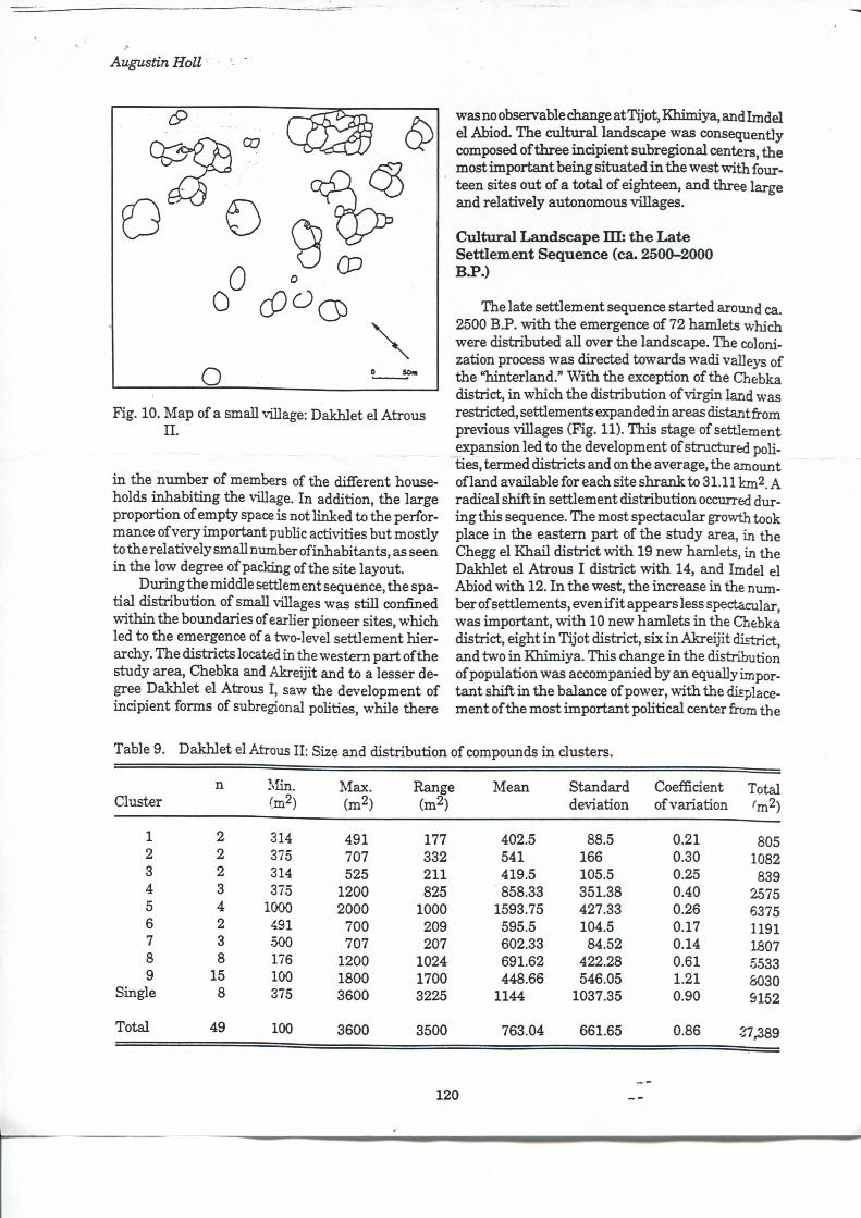
Augustin Holl
O Fig. 10. Map o fa small \'illage: Dakhlet el Atroiis
I I .
i n the number of members of the différent households inhabit ing the village. I n addition, the large proportion of empty space is not l inked to the performance of very important pubhc activities but mostly totherelativelysmallnumberofinhabitants, as seen i n the low degree of packing of the site layout.
Duringthe middle settlement séquence, the spat i a l distribution of small villages was st i l l confîned w i t h i n the boxmdaries of earher pioneer sites, which led to the émergence of a two-level settlement hierarchy. The districts located in the westem part of the study area, Chebka and Akreijit and to a lesser degree Dakhlet el Atrous I , saw the development of incipient forms of subregional pohties, while there
was no observable change at Tijot, Khimiya, and Imdel el Abiod. The cultural landscape was consequently composed of three incipient subregional centers, the most important being situated i n the west vrith fourteen sites out of a total of eighteen, and three large and relatively autonomous villages.
Cultura l L a n d s c a p e I I I : the L a t e Settlement Séquence (ca. 2500-2000 B.P.)
The late settlement séquence started around ca. 2500 B.P. w i t h the émergence of 72 hamlets which were distributed aU over the landscape. The coloni-zation process was directed towards wadi valleys of the "hinterland." W i t h the exception of the Chebka district, i n which the distribution of v irgin land was restricted, settlements expanded i n areas distant from previous villages (Fig. 11). This stage of settlement expansion led to the development of stmctured pohties, termed districts and on the average, the amoimt of land available for each site shrank to 31.11 km2. A radical shift i n settlement distribution occurred during this séquence. The most spectacular growth took place i n the eastem part of the study aresi, in the Chegg el Kha i l district w i t h 19 new hamlets, in the Dakhlet el Atrous I district w i t h 14, and Imdel el Abiod vrith 12. I n the west, the increase i n the number of settlements, even i f i t appears less spectacular, was important, vr i th 10 new hamlets i n the Qjebka district, eight i n Tijot district, six i n Akrei j i t district, and two i n Khimiya . This change i n the distribution of population was accompanied by an equally important shift i n the balance of power, w i t h the displacement of the most important poHtical center from the
Table 9. Dakhlet el Atrous I I : Size and distribution of compounds i n clusters.
n Min Max. Range Mean Standard Coefficient Total Cluster ^m2) (m2) (m2) déviation of variation ^m2)
1 2 314 491 177 402.5 88.5 0.21 805 2 2 375 707 332 541 166 0.30 1082 3 2 314 525 211 419.5 105.5 0.25 839 4 3 375 1200 825 858.33 351.38 0.40 2.575 5 4 1000 2000 1000 1593.75 427.33 0.26 6375 6 2 491 700 209 595.5 104.5 0.17 1191 7 3 .500 707 207 602.33 84.52 0.14 1807 8 8 176 1200 1024 691.62 422.28 0.61 5533 9 15 100 1800 1700 448.66 546.05 1.21 8030
Single 8 375 3600 3225 1144 1037.35 0.90 9152
Total 49 100 3600 3500 763.04 661.65 0.86 27,389
120
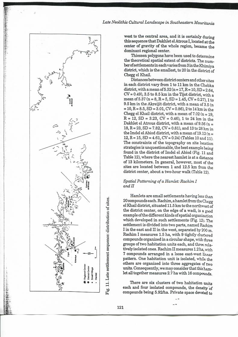
Late Neolithic Cultural Landscape in Southeastem Mauritania
U
o c o
•c
S c o; 3 C U 03
- U
c s 03 03
es
west to the central area, and i t is certainly during this séquence t h a t Dakhlet el Atrous I , located at the center of gravity of the whole région, became the dominant régional center.
Thiessen polygons have been used to détermine the theoretical spatial extent of districts. The ntmi ber of settlements i n each varies from 3 i n the Khimiya district, which is the smallest, to 20 i n the district of Chegg el Kha i l .
Distances between district centers and other sites i n each district vary from 1 to 11 k m i n the Chebka district, w i t h a mean of 5.32 (n = 17, R = 10, SD = 2.64, CV = 0.49), 3.5 to 8.5 k m i n the Tijot district, wi th a mean of 5.37 (n = 8, R = 5, SD = 1.45, CV = 0.27), 1 to 9.5 k m i n the Akre i j i t district, w i t h a mean of 3.5 (n = 10, R = 8.5, SD = 3.01, CV = 0.86), 2 to 14 km in the Chegg el Kha i l district, w i t h a mean of 7.02 (n = 19, R = 12, SD = 3.23, CV = 0.46), 1 to 24 km in the Dakhlet el Atrous district, w i t h a mean of 9.56 (n = 18, R = 23, SD = 7.82, CV = 0.81), and 13 to 28 km in the Imdel el Abiod district, w i t h a mean of 19.12 (n = 12, R = 15, SD = 4.61, CV = 0.24) (Tables 10 and 11). The constraints of the topography on site location stratégies is unquestionable, the best example being found in the district of Imdel el Abiod (Fig. 11 and Table 12), where the nearest hamlet is at a distance of 13 kilometers. I n gênerai, however, most of the sites are located between 1 and 12.5 k m from the district center, about a two-hour walk (Table 12).
Spatial Patteming ofa Hamlet: Rachim I and II
Hamlets are smaU settlements haNdng less than 20 compounds each. Rachim, a hamlet from the Chegg el Khai l district, situated 11.5 k m to the northwest of the district center, on the edge of a wadi, is a good example of the difFerent kinds of spatial organization which developed in such settlements (Fig. 12j. The settlement is divided into two parts, named Rachim I i n the east and I I i n the west, separated by 200 m. Rachim I measures 1.5 ha, vrith 9 t ightly clu=t«-ed compounds organized in a circular shape, with three groups of two habitation units each, and three relatively isolated ones. Rachim I I measures 1.2 ha, v,ith 7 compounds arranged in a loose east-west Hn^ar pattem. One habitation uni t is isolated, while the others are organized into three aggregates of two imits. Consequently, we may consider that thiî hamlet ail together meaisures 2.7 ha w i t h 16 compwinds.
There are six clusters of two habitation onits each and four isolated compounds, the density of compounds being 5.92/ha. Private space devoted to
121
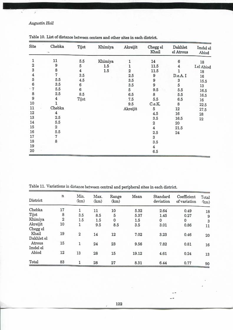
Augustin Holl
Table 10. L i s t of distance between centers and other sites i n each district.
Site Chebka Tijot Khimiya Akrei j i t Chegg el K h a i l
Dakhlet el Atrous
Imdel el Abiod
1 U 5.5 Kh imiya 1 14 6 18 2 9 5 1.5 1 11.5 4 I.el Abiod 3 8 4 1.5 2 11.5 1 18 4 7 3.5 2.5 9 D . e A I 16 5 5.5 4.5 3.5 9 3 15.5 6 3.5 6 3.5 9 5 13
•7 5.5 6 5 9.5 5.5 16.5 8 2.5 8.5 6.5 8 5.5 16.5 9 4 Tijot 7.5 5.5 6.5 16
10 1 9.5 C.e.K 8 22.5 11 Chebka Akrei j i t 5 12 27.5 12 4 4.5 16 28 13 2.5 3.5 16.5 22 14 5.5 2 20 15 2 4 21.5 16 5.5 2.5 24 17 7 3 18 8 3.5 19 4 20 - 6.5
Table 11. Variations i n distance between central and peripheral sites i n each district.
District n Min .
(km) Max. (km)
Range (km)
Mean Standard déviation
Coefficient of variation
Total Ton)
Chebka 17 1 11 10 5.32 2.64 0.49 18 Tijot 8 3.5 8.5 5 5.37 1.45 0.27 9 Khimiya 2 1.5 1.5 0 L 5 0 0 3 Akre i j i t 10 1 9.5 8.5 3.5 3.01 0.86 11 Chegg el
K h a i l 19 2 14 12 7.02 3.23 0.46 20 Dakhlet el
20
Atrous 15 1 24 23 9.56 7.82 0.81 16 Imdel el
16
Abiod 12 13 28 15 19.12 4.61 0.24 13
Total 83 1 28 27 8.31 6.44 0.77 90
122
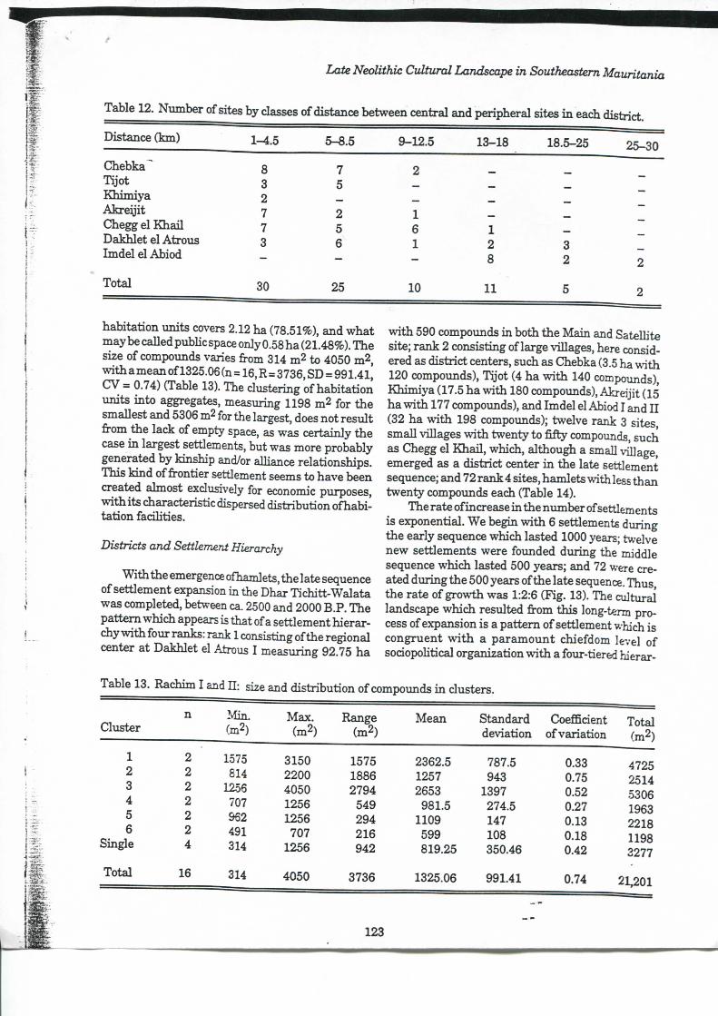
Late Neolithic Cultural Landscape in Southeastem Mauritania
Table 12. Number of sites by classes of distance between central and peripheral sites i n each district.
Distance (Irm) 1-4.5 5-8.5
Chebka^ 8 7 Tijot 3 5 Khimiya 2 Akre i j i t 7 2 Chegg el K h a i l 7 5 Dakhlet el Atrous 3 Imdel el Abiod - -Total 30 25
habitation units covers 2.12 ha (78.51%), and w h a t may be caUed pubhc space only 0.58 ha (21.48%). The size of compoimds varies from 314 m^ to 4050 m^, w i t h amean of1325.06 (n = 16, R=3736, SD = 991.41, CV = 0.74) (Table 13). The clustering of habitation units into aggregates, measuring 1198 m2 for the smallest and 5306 m2 for the largest, does not resuit from the lack of empty space, as was certainly the case i n largest settlements, but was more probably generated by kinship and/or alhance relationships. This k ind of frontier settlement seems to have been created ahnost exdusively for économie purposes, w i t h its characteristic dispersed distribution ofhabi-tat ion fadhties.
Districts and Settlement Hierarchy
W i t h the émergence ofhamlets, the late séquence of settlement expansion in the Dhar Tichitt-Walata was completed, between ca. 2500 and 2000 B.P. The pat tem which appears is that ofa settlement hierarchy vrith four ranks: rank 1 consisting of the régional center at Dakhlet el Atrous I measuring 92.75 ha
9-12.5 13-18 18.5-25 25-30
2
1 - - -6 1 -1 2 3 - 8 2 2
10 11 5 2
w i t h 590 compounds i n both the Main and SateUite site; rank 2 consisting of large viUages, here considered as district centers, such as Chebka (3.5 ha w i t h 120 compounds), Tijot (4 ha w i t h 140 compounds), Khimiya (17.5 ha w i t h 180 compounds), A k r d j i t (15 ha w i t h 177 compounds), and Imdel el Abiod I and I I (32 ha vr i th 198 compounds); twelve rank 3 sites, smaU viUages w i t h twenty to fifty compounds, such as Chegg el KhaU, which, although a smaU viUage, emerged as a district center i n the late settlement séquence; and 72 rank 4 sites, hamlets w i th less than twenty compounds each (Table 14).
The rate of increase i n the number of settlements is exponential. We begui w i t h 6 settlements during the early séquence which lasted 1000 years; twelve new settlements were founded during the middle séquence which lasted 500 years; and 72 were created during the 500 years of the late séquence. Thus, the rate of growth was 1:2:6 (Fig. 13). The cultural landscape which resulted from this long-term process of expansion is a pattem of settlement which is congruent w i t h a paramount chiefdom level of sodopoUtical organization w i t h a four-tiered hierar-
Table 13. Rachim I and I I : size and distribution of compounds i n clusters.
Cluster n Min.
(m2) Max.
(m2) Range
(m2) Mean Standard
déviation Coeffident
of variation Total (m2)
1 2 1575 3150 1575 2362.5 787.5 0.33 4725 2 2 814 2200 1886 1257 943 0.75 2514 3 2 1256 4050 2794 2653 1397 0.52 5306 4 2 707 1256 549 981.5 274.5 0.27 1963 5 2 962 1256 294 1109 147 0.13 2218 6 2 491 707 216 599 108 0.18 1198
Single 4 314 1256 942 819.25 350.46 0.42 2277
Total 16 314 4050 3736 1325.06 991.41 0.74 21,201
123
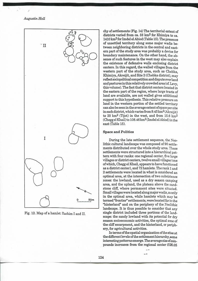
Fig. 12. Map of a hamlet: Rachim I and I I .
chy of settlements (Fig. 14) The terr i tor ial extent of districts varied from ca. 33 km2 for Khimiya to ca. 1410 km2 for Imdel el Abiod (Table 15). The présence of mxsettled terr i tory along some major wadis between neighboring districts i n the central and easte m part of the study area was probably a device for boundary maintenance. On the other hand, the absence of such features i n the west may also explain the existence of défensive walls enclosing district centers. I n this regard, the waUed villages from the westem part of the study area, such as Chebka, Khimiya, Akre i j i t , and Site 2 (Chebka district), may reflect sodopohtical compétition and dispute over land and pastures i n this relatively crowded area (cf. Levy, this volimie). The fact that district centers located i n the eastem part of the région, where large tracts of land are available, are not walled gives additional support to this hypothesis. This relative pressure on land i n the westem portion of the settled territory can also be seen i n the average extent of space per site i n each district, which varies from 9.45 km2 (Akreijit) to 20 km2 (Tijot) i n the west, and from 15.6 km2 (Chegg el Khail ) to 108.46 km2 (Imdel el Abiod) in the east (Table 15).
Space a n d Polit ies
During the late settlement séquence, the Neohthic cultural landscape was composed of 90 settlements distributed over the whole study area. Thèse settlements were stmctured into a hierarchical patt e m w i t h four ranks: one régional center, five large villages or district centers, twelve smaU villages (one of which, Chegg el Khaf l , appears to have functioned as a district center), and 72 hamlets. The rank 1 and 2 settlements were located i n what is considered an optimal area, at the intersection of two subsistence zones: the lowland, used as a dry season camping area, and the upland, the plateau above the sandstone chfî", where permanent sites were situated. Small villages were located alongmajorwadis, mostly i n the optimal area, while hamlets which may be termed %-ontier" settlements, were located far in the "hinterland" and on the periphery of the Neolithic landscape. I t is thus possible to consider that any single district ineluded three portions of the landscape: the sandy lowland vrith its potential for dry season sodoeconomic activities, the optimal z/me of the cliff escarpment, and the hinterland, or periphery, for agricultural activities.
I n terms of the spatial organization of the Eit« at the différent levels of the settlement hieranhy, some interesting pattems émerge. The average size of compounds increases from the régional center (o2iS.05
124
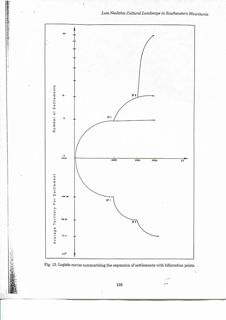
Late Neolithic Cultural Landscape in Southeastem Maurita;
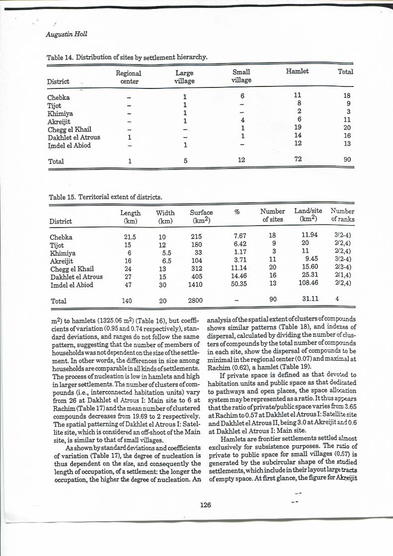
Augustin Holl
Table 14. Distribution of sites by setûement hierarchy.
Régional Large Small Hamlet Total District , center village village
Chebka - 1 6 11 18 Tîjot - 1 - 8 9 Khimiya _ i - 2 3 Akre i j i t - 1 4 6 H Chegge lKhai l - - 1 19 20 Dakhlet el Atrous 1 - 1 14 16 Imdel el Abiod - 1 - 12 13
Total 1 5 12 72 90
Table 15. Territorial extent of districts.
District Length
(km) W i d t i i (km)
Surface (km2)
% Number of sites
Land/site (km2)
Number of ranks
Chebka 2L5 10 215 7.67 18 11.94 3(2-4) Tijot 15 12 180 6.42 9 20 2^2,4) Khimiya 6 5.5 33 1.17 3 11 2^2,4) Akre i j i t 16 6.5 104 3.71 11 9.45 3(2-4) Chegg el K h a i l 24 13 312 11.14 20 15.60 2(3-4) Dakhlet el Atrous 27 15 405 14.46 16 25.31 2(1,4) Imdel el Abiod 47 30 1410 50.35 13 108.46 2/2,4) Total 140 20 2800 90 3 L 1 1 4
m2) to hamlets (1325.06 m2) (Table 16), but coefficients of variation (0.95 and 0.74 respectively), standard déviations, and ranges do not follow the same pattem, suggesting that the number of members of households was not dépendent on the size of the settlement. I n other words, the différences i n size among households are comparable in ail kinds of settlements. The process of nucleation is low in hamlets and h igh i n larger settiements. The number of clusters of compoimds (i.e., interconnected habitation units) vary fi-om 26 at Dakhlet el Atrous I : Main site to 6 at Rachim (Table 17) and the mean number of dustered compounds decreases from 19.69 to 2 respectively. The spatial patteming ofDakhlet el Atrous I : Satel-hte site, which is considered an ofF-shoot of the M a i n site, is similar to that of smaH villages.
As shown by standard déviations and coeffidents of variation (Table 17), the degree of nucleation is thus dépendent on the size, and consequently the length of occupation, ofa settiement: the longer the occupation, the higher the d^ree of nudeation. A n
analj^is ofthe spatial extent of clusters of compounds shows similar pattems (Table 18), and indexes of dispersai, calculated by di\iding the number of clusters of compounds by the total niunber of compounds i n each site, show the dispersai of compounds to be min imal i n the régional center (0.07) and maximal at Rachim (0.62), a hamlet (Table 19).
I f private space is defined as that devoted to habitation imits and pubhc space as that dedicated to pathwa}^ and open places, the space allocation System may be represented as a ratio. I t thus appears that the ratio ofprivate/pubhc space varies fi-om 3.65 at Rachim to 0.57 at Dakhlet el Atrous I : Satellite site and Dakhlet el Atroiis I I , being 3.0 at Akrei j i t and 0.6 at Dakhlet el Atrous I : Ma in site.
Hamlets are fi-ontier settlements settled almost excltisively for subsistence purposes. The ratio of private to pubhc space for small villages (0j57) is generated by the subdrcular shape of the studied settiements, which indude i n their layout large tracts of empty space. A t first glance, the figure for A k r d j i t
126
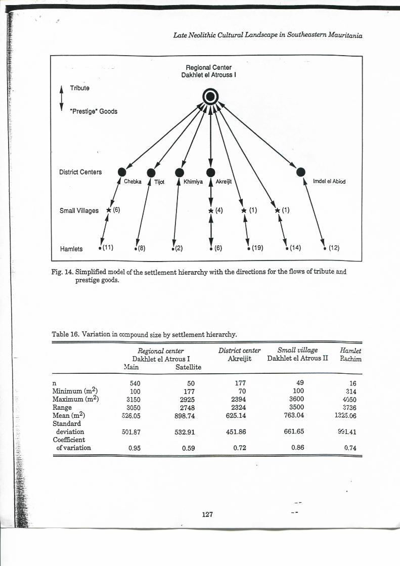
Late Neolithic Cultural Landscape in Southeastem Mauritania
Régional Center Dakhlet el Atrouss I
Fig. 14. Simphfîed model ofthe settlement hierarchy w i t h the directions for the flows of tribute and prestige goods.
Table 16. Variation in compound size by settlement hierarchy.
Régional center District center Small village Hamlet Dakhlet el Atrous I Akre i j i t Dakhlet el Atrous I I Rachim
Main SateUite
n 540 50 177 49 16 M i n i m u m (m^) 100 177 70 100 314 Maximum (m^) 3150 2925 2394 3600 4050 Range 3050 2748 2324 3500 3736 Mean (m^) 526.05 898.74 625.14 763.04 1325.06 Standard
déviation 501.87 532.91 451.86 661.65 &3L41 Coefficient
of variation 0.95 0.59 0.72 0.86 0.74
127
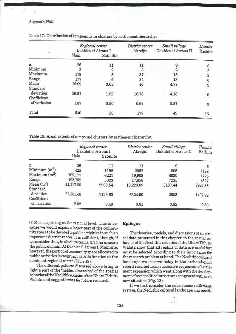
Augustin Holl
Table 17. Distribution of compounds i n clusters by settlement hierarchy.
Régional center District center SmaU village Hamlet Dakhlet el Atrous I Akrei j i t Dakhlet el Atrous I I Rachim
Main SateUite
n 26 11 U 9 6 M i n i m u m 2 2 3 2 2 Maximum 179 8 3 7 15 2 Range 177 6 3 4 13 0 Mean 19.69 3.63 16 4.77 2 Standard >
déviation 36.91 1.82 10.78 4.18 0 CoefBcient
of variation 1.87 0.50 0.67 0.87 0
Total 540 50 177 49 16
Table 18. Areal extents of compound cliisters by settlement hierarchy.
Régional center District center Small village Hamlet Dakhlet el Atrous I Akrei j i t Dakhlet el Atrous I I Rachim
Main SateUite
n 26 11 11 9 6 M i n i m i m i (m^) 425 1198 2052 805 1198 Maximimi (m^) 109,177 6221 19,908 8030 4725 Range 108,752 5023 17,856 7225 8527 Mean (m^) 11,117.80 2908.54 10,223.09 3137.44 2987.33 Standard
10,223.09
déviation 22,561.40 1429.63 6324.50 2603 1497.92 CoefBcient
of variation 2.02 0.49 0.61 0.82 0.50
(3.0) is surprising at the régional level. This is because we would expect a larger part o f the community space to be devoted to pubUc activities i n such an important district center. I t is sufBcient, though, i f we consider that , i n absolute terms, 3.75 ha concem the pubhc domain. At Dakhlet el Atrous I : Ma in site, however, the portion of community space aUocated to pubUc activities is congruent with its fonction as the dominant régional center (Table 19).
The difFerent pattems discussed above br ing to Ught a part ofthe "hidden dimension" o f the spatial behavior ofthe NeoUthic sodeties ofthe Dhars Tichit t -Walata and suggest issues for future research.
Epilogue
The théories, models, and discussions of C T i p i r i -cal data presented i n this chapter on the spatial behavior ofthe NeoUthic sodeties ofthe Dhars Tichitt-Walata show that aU realms of data are useful but must be selected according to their importajjce for the research problem at hand. The NeoUthic cultural landscape we observe today i n the archaeol-^gjcal record resulted from successive séquences of settlement expansion which went along vrith the de'.-elop-ment of sodopoUtical stmctures congment with each new situation (Fig. 13).
I f we f irst consider the subsistence-settlemènt System, the NeoUthic cultural landscape was «msti-
128
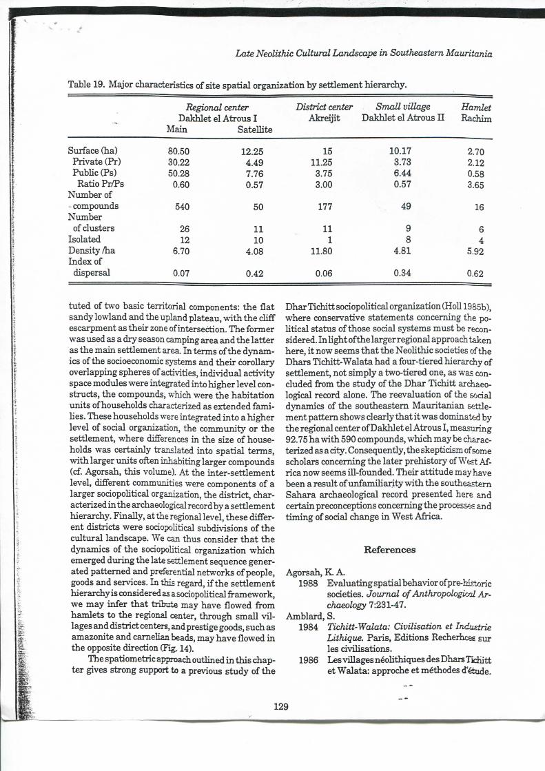
Late Neolithic Cultural Landscape in Southeastem Mauritania
Table 19. Major characteristics of site spatial organization by settlement hierarchy.
Régional center District center Small village Hamlet Dakhlet el Atroiis I Akrei j i t Dakhlet el Atrous I I Rachim
Main SateUite
Smface Qia) 80.50 12.25 15 10.17 2.70 Private (Pr) 30.22 4.49 11.25 3.73 2.12 Pubhc (Ps) 50.28 7.76 3.75 6.44 0.58
Ratio Pr/Ps 0.60 0.5t 3.00 0.57 3.65 Number of
compounds 540 50 177 > 49 16 Nimiber
of clusters 26 11 11 9 6 Isolated 12 10 1 8 4 Density /ha 6.70 4.08 11.80 4.81 5.92 Index of
dispersai 0.07 0.42 0.06 0.34 0.62
tuted of two basic territorial components: the flat sandy lowland and the upland plateau, w i t h the cUff escarpment as their zone of intersection. The former was used as a dry season camping area and the latter as the main settlement area. I n terms ofthe dynamics ofthe socioeconomic Systems and their coroUary overlapping sphères of activities, individual activity space mod\iles were integrated into higher level con-structs, the compounds, which were the habitation units ofhouseholds characterized as extended fami -Ues. Thèse households were integrated into a higher level of social organization, the commimity or the settlement, where différences i n the size of households was certainly translated into spatial terms, vdth larger units often inhabiting larger compounds (cf. Agorsah, this volume). At the inter-settlement level, différent communities were components of a larger sociopoUtical organization, the district, characterized i n the archaeological record by a settlement hierarchy. FinaUy, at the régional level, thèse différent districts were sociopoUtical subdivisions of the cultural landscape. We can thus consider that the dynamics of the sociopoUtical organization which emerged during the late settlement séquence generated pattemed and preferential networks of people, goods and services. I n this regard, i f the settlement hierarchy is considered as a sodopoUtical framework, we may infer that tribute may have flowed from hamlets to the régional center, through smaU v i l lages and district centers, and prestige goods, such as amazonite and camelian beads, may have flowed i n the opposite direction (Fïg. 14).
The spatiometric approach outlined i n this chapter gives strong suppcnt to a previous study of the
Dhar Tichitt sodopoUtical organization (HoU 19S5b), where conservative statements conceming the poUtical status of those social Systems must be recon-sidered. I n Ught ofthe larger régional approach taken here, i t now seems that the NeoUthic sodeties ofthe Dhars Tichitt-Walata had a four-tiered hierarchy of settlement, not simply a two-tiered one, as was con-cluded from the study ofthe Dhar Tichitt archaeological record alone. The réévaluation of the sodal dynamics of the southeastem Mauritanian settlement pattem shows clearly that i t was dominated by the régional center ofDakhlet el Atrous I , measuring 92.75 ha w i t h 590 compoimds, which may be characterized as a dîy. Consequently, the skepticism of some scholars conceming the later prehistory of West Af-rica now seems Ul-founded. Their attitude may have been a resuit of imfamUiarity w i t h the southeastem Sahara archaeological record presented here and certain preconceptions conceming the processes and t iming of sodal change i n West Afiica.
Références
Agorsah, K A. 1988 Evaluating spatial behavior of pre-hîstoric
sodeties. Journal of AnthropologirM Archaeology 7:231-47.
Amblard, S. 1984 Tichitt-Walata: Civilisation et Industrie
Lithique. Paris, Editions Recherhces sur les dviUsations.
1986 Les villages néoUthiques des Dhars T id i i t t et Walata: approche et méthodes détude.
129
Augustin HoU
I n Actes du Symposium Archéologie AfrUxdneet Sciences deUiNature Appliquée à l'Archéologie, pp. 61-97. Bordeaux.
Amblard, S. & J . Pemès 1989 The identification of cultivated pearl m i l
let {Pennisetum) amongst plant impressions on pottery fi-om Oued Chebbi (Dhar Oualata, Mauritania) . The African Archaeological Review l:\n 126.
Ardener, S. 1981 Groimd rules and social maps for women:
an introduction. I n Women and Space: GroundRulesandSocialMaps, S. Ardener (éd.), 11-34. London: Ooom Helm.
Bailey, G. 1983 Ck)nceptsoftime i n quatemary prehistory.
Annual Review ofAnthropology 12:165-92. Bemus, E.
1981 Touaregs nigériens: unité culturelle et diversité régionale d'un peiple pasteur. Paris: Editions de l'OfiBce de la Recherche Scientifique et Technique d'Outre-Mer.
Binford, L . R. 1980 WiUow smoke and dogs'tails: himter-gath-
erer settlement Systems and archaeological siteformation_AmencanAniigiiiiïy 45:4-20.
Blanton, R. E. 1976 Anthropological studies of cities. Annual
Review ofAnthropology 5:249-64. Bohannan, P. & L . Bohannan.
1968 Tiv Economy. London, Longmans. Bouju, J .
1984 Graine de l'Homme, Enfant du MU. Paris: Société d'ethnographie.
Cancian, F. 1976 Social stratification. Annual Review of
Anthropology 5:227-48. Carlstein, T.
1982 TimeResources, Society and Ecology.London: Allen and Unwin.
Chayanov, A V . 1966 The Theory of Peasant Economy. D .
Thomer, B. Kerblay and R. E. F. Smith (eds.). Homewood: R. D. I r w i n Inc.
Coe, M . D 1981 Rehgion and the rise ofthe Mesoamerican
state. I n The Transition to Statehood in theNew World. G. D. Jones and R. R. Kautz (eds.),157-17L Cambridge: Cambridge University Press.
Deetz, J . F. 1982 Households: A structural key to archaeo
logical explanation. American Behavioral Scientist 25:717-24.
Digard, J . P. 1978 The segmentai s j^tem: nature model or
anthropological constmction? Discussion of an Iranian example. I n The Nomadic Alternative, W. Weissleder (éd.), 315-17. The Hague, Paris: Mouton.
1981 Techniques des Nomades Baxtyari d'Iran. London, Paris: Cambridge Univers i ty Press, Maison des sciences de l'Homme.
Dumas-Champion, Fr. 1980 Le rôle social et r i t u e l du bétail chez les
Massa du Tchad. Africa 50:161-81. 1983 Les Massa du Tchad: Bétail et Société.
London, Paris: Cambridge Univers i ty Press, Maison des sciences de l'Homme.
Durrenberger, E. P. 1984 Operationalizing (Chayanov. I n C/iayanoy,
Peasants and Economie Anthropology, E. P. Dvurenberger (éd.), 39-50. London: Académie Press.
Evans-Pritchard, E. E. 1968 Les Nuer. Paris: Gal l imard.
Finley, M . 1987 Sur l'Histoire Ancienne: la Matière, la
FormeetlaMéthode. Paris: LaDécouverte. Frantz, Ch.
1978 Ecology and social organization among nigérian fulbe (Fulani). I n The Nomadic AZfemafii;e.W.Weissleder(ed.)97-118,The Hague, Paris: Mouton.
Freidel, D A . 1981 Cîivihzation as a state ofmind: the cultural
évolution of the Lowland M a y a I n The Transition to Statehood in theNew World, G. D. Jones and R. R. Kautz (eds.), 188-227. Cambridge: Cambridge University Press.
Friedman, J . & M . J . Rowlands. 1977 Notes towards an epigenetic model of the
évolution of "civihsation". I n The Evolution of Social Systems, J . Friedman and M . J . Rowlands (eds.), 201-76. London: Duckworth.
CîodeHer, M n.d. La notion de formation sociale économique. 1980 The concept of "Asiatic Mode of Produc
tion" and Mandst models of social évolution. InRelations ofProduction, D. .Seddon (éd.), 209-57. London: Frank Cass,
1984 L'Idéel et le Matériel. Taris: FayaT± Halstead, P. & J . O'Shea.
1989 Introduction:culturalresponsestoriïtand
130
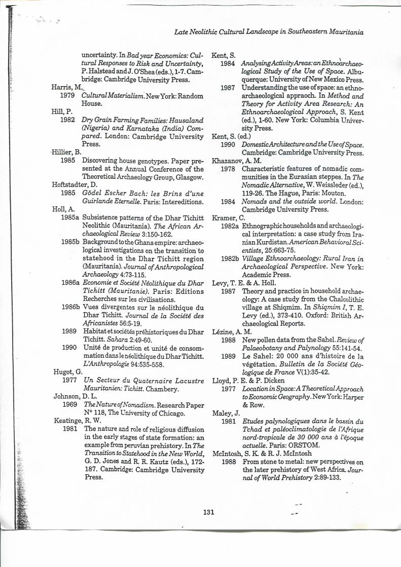
Late Neolithic Cultural Landscape in Southeastem Mauritania
uncertainty. la. Bcuî year Economies: Cultural Responses to Risk and Uncertainty, P. Halstead and J . O'Shea (eds.), 1-7. Cambridge: Cambridge University Press.
Harris , M , , 1979 Cultural Materialism. New York: Random
House. H i l l , P.
1982 Dry Grain Farming Familles: Hausaland (Nigeria) and Kamataka Gndia) Com-pared. London: Cambridge U n i v e r s i t y Press.
HiUier, B. 1985 Discovering house génotypes. Paper pre
sented at the Annual Conférence of the Theoretical Archaeology Group, Glasgow.
Hoftstadter, D. 1985 Gôdel Escher Bach: les Brins d'une
Guirlande Etemelle. Paris: Intereditions. HoU, A .
1985a Subsistence pattems ofthe Dhar Tich i t t NeoUthic (Mauritania). The African Archaeological Review 3:150-162.
1985b Bacl^oimdtotheGhanaempire:archaeo-logical investigations on the transit ion to statehood i n the Dhar T i c h i t t région (Mauritania). Journal of Anthropological Archaeology 4:73-115.
1986a Economie et Société Néolithique du Dhar Tichitt (Mauritanie). Par i s : E d i t i o n s Recherches sur les civUisations.
1986b Vues divergentes sur le néoUthique d u Dhar Tichitt. Journal de la Société des Africanistes 56:5-19.
1989 Habitat et sociétés préhistoriques du Dhar Tichitt . Sahara 2:49-60.
1990 Unité de production et unité de consommation dans le néoUthique du Dhar Tichitt . L'Anthropologie 94:535-558.
Hugot, G. 1977 Un Secteur du Quaternaire Lacustre
Mauritanien: Tichitt. Chambery. Johnson, D. L .
1969 TheNature of Nomadism. Research Paper N° 118, The University of Chicago.
Keatinge, R. W. 1981 The nature and rôle ofreUgiousdifFasion
i n the early stages of state formation: an example irom pemvian prehistory. I n The Transition to Statehood in the New World, G. D. Jones and R R. Kautz (eds.), 172-187. Cambridge: Cambridge Univers i ty Press.
Kent, S. ^ 1984 AnalysingActivity Areas: an Ethnoarchaeo-
logical Study of the Use of Space. Albu-querque: University of New Mexico Press.
1987 Understanding the use of space: an ethno-archaeological appraodi. I n Method and Theory for Activity Area Research: An Ethnoarchaeological Approach, S. Kent (éd.), 1-60. New York: Columbia University Press.
Kent, S. (ed.) 1990 Domestic Architecture andthe Use of Space.
Cambridge: Cambridge University Press. Khazanov, A. M .
1978 C3iaracteristic features of nomadic communities i n the Eurasian steppes. I n The Nomadic Alternative, W. Weissleder (éd.), 119-26. The Hague, Paris: Mouton.
1984 Nomads and the outside world. London: Cambridge University Press.
Kramer, C. 1982a Ethnographichoiiseholds and archaeologi
cal interprétation: a case study from I r a nian Kurdistan. A/nericon Behavioral Sci-entists, 25:663-75.
1982b Village Ethnoarchaeology: Rural Iran in Archaeological Perspective. New York: Académie Press.
Levy, T. E . & A . H 0 U . 1987 Theory and praetiee i n household archae
ology: A case study from the ChalcoUthic village at Shiqmim. I n Shiqmim I, T. E. Levy (éd.), 373-410. Oxford: British A r chaeological Reports.
Lézine, A . M . 1988 New poUen data from the Sahel./îetfeluo/"
Palaeobotany and Palynology 55:141-54. 1989 Le Sahel: 20 000 ans dhis to i re de la
végétation. Bulletin de la Société Géologique de France V(l):35-42.
Uoyd, P. E. & P. Dicken 1977 Locationin Space: ATheoretical Approach
to Economie Geography. New York Harper & R o w .
Maley, J . 1981 Etudes palynologiques dans le basizin du
Tchad et paléoclimatologie de l'Afrique nord-tropicale de 30 000 ans à l'époque actuelle. Paris: ORSTOM.
Mcintosh, S. K & R. J . Meintosh 1988 From stone to métal: new perspectives on
the later prehistory of West Africa. Journal of World Prehistory 2:89-133.
131
Augustin HoU
Meillassoux, Cl. 1977 Terrains et Théories. Paris: Anthropos. 1980a T h e economy" i n agricultural self-sustain
ing societies: a preliminary analj^is. I n Relations ofProduction, D. Seddon (éd.), 127-57. London: Frank Cass.
1980b The social organization ofthe peasantry: the economicbasis of kinship. InRelations ofProduction, D. Seddon (éd.), 159-169. London: Frank Cass.
Mission Préhistorique de Tichitt n.d. Rapport Préliminaire, (1980). unpubl.
Mvuison, P. J . 1971 Tichitt Tradition:ALatePrehistoric Occu
pation in Southwestem Sahara. PhD dissertation, Urbana Champaign: University ofDlinois.
1976 Archaeological data on the origins of cul t i vation i n southwestem Sahara and their imphcation for West Africa. I n Origins of Afkcan Plant Domestication. J . R. Har lan , J . M . J . de Wet and A M . B. Stemler (eds.), 187-209. The Hague, Paris: Mouton.
1981 A late Holocene (4500-2300 B.P.) chmate chronology for the southwestem Sahara.
• Paleoecology of Africa 13:53-60. 1989 About "Economie et société néolithique du
Dhar TichittT. Sahara 2:106-8. Nelson, C. (ed.)
1973 The Désert and the Sown: Nomads in the wider Society. Berkeley: Un ivers i ty of Califomia.
Nicholson, S. & H . Flohn. 1980 A f r i c a n env i ronmenta l a n d c l i m a t e
changes and the gênerai atmospheric circulation i n late Pleistocene and Holocene. Climatic Change 2:313-48.
Oswald, D. 1984 The use ofsite stmcture to infer social and
technological organization from the archaeological record. I n Frontiers: Southem African Archaeology Today, M . H a l l et al . (eds.), 297-309. Oxford: Brit ish Archaeological Reports.
Picon, Fr . 1978 L'adoption de Télevage chez les Indiens
Guajiros. Techniques et Culture 3:5-45. 1983 Pasteurs du Nouveau Monde: Adoption de
l'Elevage chez les Indiens Guajiros. Paris: Editions de la Maison des sciences de l'Homme.
Pollet, E. & G. Winter 1980 The social organization of agricultural la
bor among the Soninke (Diahunu, Mah).
InRelations ofProduction, D. Seddon (éd.), 331-356. London: Frank Cass.
Redman, Ch., W. T. Langhome, M . J . Berman, N . Versagi, E. V. Cur t in & J . C. Wanser.
1978 Social Archaeology: Beyond Subsistence and Dating. London: Académie Press.
Renfrew, C. A. 1984 Appraoches to Social Archaeology. Edin-
burgh: Edinbxu-gh University Press. Roux, V.
1983 Etude Ethnoarchéologique du Matériel de Broyage (Tichitt, Mauritanie). PhD thesis, Nanterre: Université de Paris X.
Sahlins, M . 1961 The segmentary lineage: an organization
of predatory es:ç3X\s,\on.. American Anthro-pologist 63:322-45.
1968 Tribesmen. New Jersey: Prentice Hall . 1969 Land use and extended family i n Moala,
F i j i . I n Environment and Cultural Behavior, A.P. Vayda (éd.), 395-415. New York: The Natura l History Press.
1976 Age de Pierre, âge d'Abondance: l'Ecoriomie des Sociétés Primitives. Paris: Gallimard.
1980 Au Coeur des Sociétés: Raison Utilitaire et Raison Culturelle. Paris: Gallimard.
Servant, M . & Servant-Vildary, S. 1980 L'environnement quatemaire du bassin du
lac Tchad. I n The Sahara and the Nile, M . A. J . Wilhams and H . Faiire (eds.), 132-162. Rotterdam: A. A . Balkema.
Smith, S. E. 1980 The environmental adaptations of nomads
i n the West African Sahel: A key to urider-stand prehistoric pastorahsts. I n 77i« Sahara and the Nile, M . A J . Williams ar»d H . Faure (eds.), 467-488. Rotterdam: A A. Balkema.
Smith, R. 1984 Préface. I n Land, Kinship and Life<ycle,
R. Smith (ed), i x -x i i i . London: Cambridge University Press.
Spooner, B. 1973 The Cultural Ecology of Pastoral Norrjids.
Addison-Wesley Module i n Anthropology. N° 45.
Steponaitis, V . P. 1978 Location theory and eomplex ehiefdoms: A
Mississipian example. I n Missistipian Settlement Patterns, B. D. Smith (ed),417-453. New York, London: Académie Press.
1981 Settlement hiérarchies and pohtical complexity i n nonmarket societies: the Forma-
132
Late Neolithic Cultural Landscape in Southeastem Mauritania
tive period of the valley of Mexico. American Anthropologist 83:320-363.
Testart, A . 1982 Les Chasseurs-cueUleurs ou l'Origine des
Inégalités. Paris: Société d'Ethnographie. Tringham, R.
1983 The development of the household as the primary uni t of production i n neohthic and eneohthic south-east Europe. Paper presented at the Annual meeting ofthe Society for American Archaeology, Pittsbi irgh, PA.
Vemet, R. 1984 La préhistoire de la Mauritanie: Etat de la
Question. PhD thesis, Paris: Université de Paris I .
1986 Le néolithique m a u r i t a n i e n ; essai de synthèse. Acies du SymposiumArchéologie AfiicaineetSciencesdelaNatureappliquée à l'Archéologie, 71-85. Bordeaux.
1988 A propos de "Vues divergentes sur le néohthique du Dhar Tichitt" . Journal de laSociétédesAfricanistes5ia-2):296-299.
Vita-Finzi , Cl. & E. S. ffiggs. 1970 Site catchment analysis. iVoceedin^sofiAe
Prehistoric Society 36:1-37 Walsh, C E .
1983 Saving i n primitive économies. American Anthropologist 85:643-49.
Wamier , J . P. 1985 Echanges, Développement et Hiérarchies
dansleBamerida Pré-colonial (Cameroun). Stuttgart: F. Steiner Verlag.
Weissleder, W. (ed.) 1978 TheNomadicAîernative.TheU2igne,Pans:
Mouton. Whallon, R.
1987 Sim-plestatisùcs.lnQuantitative Research inArchaeology:Progress and Prospects, M . S.Aldenderfer(ed.),135-150.London:Sage Pubhcations.
W i l k , R . R . & W . L . Rathje. 1982 Household archaeology. American Behav
ioral Scientist 25:617-39. Wi lk , R. R. & R. McC. Netting.
1984 Households: Changing forms and func-tions. I n Homeholds: Comparative and Historical Studies of the Domestic Group, R. McC. Netting, R. R. W i l k and E. J . Amould (eds.), 1-28. Berkeley: University of Califomia Press.
133
Related Documents