Late Mesozoic to Paleogene stratigraphy of the Salar de Atacama Basin, Antofagasta, Northern Chile: Implications for the tectonic evolution of the Central Andes Constantino Mpodozis a, T , Ce ´sar Arriagada b , Matilde Basso c , Pierrick Roperch d , Peter Cobbold e , Martin Reich f a Servicio Nacional de Geologı ´a y Minerı ´a, now at Sipetrol. SA, Santiago, Chile b Departamento de Geologı ´a, Universidad de Chile, Santiago, Chile c Servicio Nacional de Geologı ´a y Minerı ´a, Santiago, Chile d IRD/Dep. de Geologı ´a, Universidad de Chile, Santiago, Chile e Ge ´osciences-Rennes (UMR6118 du CNRS), France f Department of Geological Sciences University of Michigan, United States Abstract The Salar de Atacama basin, the largest bpre-AndeanQ basin in Northern Chile, was formed in the early Late Cretaceous as a consequence of the tectonic closure and inversion of the Jurassic–Early Cretaceous Tarapaca ´ back arc basin. Inversion led to uplift of the Cordillera de Domeyko (CD), a thick-skinned basement range bounded by a system of reverse faults and blind thrusts with alternating vergence along strike. The almost 6000-m-thick, upper Cretaceous to lower Paleocene sequences (Purilactis Group) infilling the Salar de Atacama basin reflects rapid local subsidence to the east of the CD. Its oldest outcropping unit (Tonel Formation) comprises more than 1000 m of continental red sandstones and evaporites, which began to accumulate as syntectonic growth strata during the initial stages of CD uplift. Tonel strata are capped by almost 3000 m of sandstones and conglomerates of western provenance, representing the sedimentary response to renewed pulses of tectonic shortening, which were deposited in alluvial fan, fluvial and eolian settings together with minor lacustrine mudstone (Purilactis Formation). These are covered by 500 m of coarse, proximal alluvial fan conglomerates (Barros Arana Formation). The top of the Purilactis Group consists of Maastrichtian-Danian alkaline lava and minor welded tuffs and red beds (Cerro Totola Formation: 70–64 Ma K/Ar) deposited during an interval of tectonic quiescence when the El Molino–Yacoraite Late Cretaceous sea covered large tracts of the nearby Altiplano-Puna domain. Limestones interbedded with the Totola volcanics indicate that this marine incursion advanced westwards to reach the eastern CD slope. CD shortening in the Late Cretaceous was accompanied by volcanism and continental sedimentation in fault bounded basins associated to strike slip along the north Chilean magmatic arc to the west of the CD domain, indicating that oblique plate convergence prevailed during the Late T Corresponding author. E-mail addresses: [email protected] (C. Mpodozis)8 [email protected] (C. Arriagada)8 [email protected] (M. Basso)8 [email protected] (P. Roperch)8 [email protected] (P. Cobbold)8 [email protected] (M. Reich).

Welcome message from author
This document is posted to help you gain knowledge. Please leave a comment to let me know what you think about it! Share it to your friends and learn new things together.
Transcript
Late Mesozoic to Paleogene stratigraphy of the Salar de Atacama
Basin, Antofagasta, Northern Chile: Implications for the tectonic
evolution of the Central Andes
Constantino Mpodozisa,T, Cesar Arriagadab, Matilde Bassoc, Pierrick Roperchd,
Peter Cobbolde, Martin Reichf
aServicio Nacional de Geologıa y Minerıa, now at Sipetrol. SA, Santiago, ChilebDepartamento de Geologıa, Universidad de Chile, Santiago, Chile
cServicio Nacional de Geologıa y Minerıa, Santiago, ChiledIRD/Dep. de Geologıa, Universidad de Chile, Santiago, Chile
eGeosciences-Rennes (UMR6118 du CNRS), FrancefDepartment of Geological Sciences University of Michigan, United States
Abstract
The Salar de Atacama basin, the largest bpre-AndeanQ basin in Northern Chile, was formed in the early Late Cretaceous as a
consequence of the tectonic closure and inversion of the Jurassic–Early Cretaceous Tarapaca back arc basin. Inversion led to
uplift of the Cordillera de Domeyko (CD), a thick-skinned basement range bounded by a system of reverse faults and blind
thrusts with alternating vergence along strike. The almost 6000-m-thick, upper Cretaceous to lower Paleocene sequences
(Purilactis Group) infilling the Salar de Atacama basin reflects rapid local subsidence to the east of the CD. Its oldest
outcropping unit (Tonel Formation) comprises more than 1000 m of continental red sandstones and evaporites, which began to
accumulate as syntectonic growth strata during the initial stages of CD uplift. Tonel strata are capped by almost 3000 m of
sandstones and conglomerates of western provenance, representing the sedimentary response to renewed pulses of tectonic
shortening, which were deposited in alluvial fan, fluvial and eolian settings together with minor lacustrine mudstone (Purilactis
Formation). These are covered by 500 m of coarse, proximal alluvial fan conglomerates (Barros Arana Formation). The top of
the Purilactis Group consists of Maastrichtian-Danian alkaline lava and minor welded tuffs and red beds (Cerro Totola
Formation: 70–64 Ma K/Ar) deposited during an interval of tectonic quiescence when the El Molino–Yacoraite Late Cretaceous
sea covered large tracts of the nearby Altiplano-Puna domain. Limestones interbedded with the Totola volcanics indicate that
this marine incursion advanced westwards to reach the eastern CD slope. CD shortening in the Late Cretaceous was
accompanied by volcanism and continental sedimentation in fault bounded basins associated to strike slip along the north
Chilean magmatic arc to the west of the CD domain, indicating that oblique plate convergence prevailed during the Late
T Correspondi
E-mail addr
ng author.
esses: [email protected] (C. Mpodozis)8 [email protected] (C. Arriagada)8 [email protected] (M. Basso)8
chile.cl (P. Roperch)8 [email protected] (P. Cobbold)8 [email protected] (M. Reich).

C. Mpodozis et al.
Cretaceous. Oblique convergence seems to have been resolved into a highly partitioned strain system where margin-parallel
displacements along the thermally weakened arc coexisted with margin-orthogonal shortening associated with syntectonic
sedimentation in the Salar de Atacama basin. A regionally important Early Paleocene compressional event is echoed, in the
Salar de Atacama basin by a, distinctive, angular unconformity which separates Paleocene continental sediments from Purilactis
Group strata. The basin also records the Eocene–Early Oligocene Incaic transpressional episode, which produced, renewed
uplift in the Cordillera de Domeyko and triggered the accumulation of a thick blanket of syntectonic gravels (Loma Amarilla
Formation).
1. Introduction
The Salar de Atacama basin is the largest negative
topographic anomaly along the generally bsmoothQwestern slope of the Central Andes in northern Chile
(Isacks, 1988; Gephart, 1994, Figs. 1 and 2). The
basin overlaps the prominent Central Andean Gravity
High (CAGH), a first order oblique NW-trending
feature of the residual gravity field (Gotze and
Kirchner, 1997; Gotze and Krause, 2002). The basin
Fig. 1. Topography of the Central Andes between 10 and 308S showing
(Salar de Atacama, Punta Negra, Pedernales and Maricunga) in the forear
has been a long-lived subsiding region since the
Paleozoic (Ramırez and Gardeweg, 1982; Breitkreutz
et al., 1992; Hartley et al., 1992a; Flint et al., 1993;
Munoz et al., 1997, 2002) and is now filled by more
than 8 km of sedimentary rocks (4 s TWT, Macellari
et al., 1991). One of the key elements of the basin
fill (Fill Unit 2 of Flint et al., 1993) is a sedimentary,
with minor volcanics, Cretaceous to Paleogene unit,
almost 6 km thick, and generally described in the
literature as the bPurilactis GroupQ. The understand-
main morphological units and location of major pre-Andean basins
c region of northern Chile.

Fig. 2. Simplified geological map of the Antofagasta Region. CS, Cordillera de la Sal, LP, Llano de la Paciencia, SBF, Sierra El Buitre Fault.
(Data from Marinovic and Garcıa, 1999; Cortes, 2000; 1:1,000,000 Geological Map of Chile, 2002 and Basso and Mpodozis, in preparation).
C. Mpodozis et al.
ing of the stratigraphy, age, facies and sedimentary
history of the Purilactis Group is key to any model
that tries to account for the Cretaceous to Paleogene
tectonic evolution of the Central Andes, as the
Purilactis Group has been frequently compared with
the sediments of the Salta Rift System in North-
western Argentina (Salfity et al., 1985; Salfity and
Marquillas, 1994, 1999; Galliski and Viramonte,
1988; Coutand et al., 2001) and the sedimentary
Cretaceous to Tertiary sequences of southwestern
Bolivia (Welsink et al., 1995; Sempere et al., 1997;
Horton et al., 2001; McQuarrie et al., 2005).
Purilactis strata crop out along the western margin
of the Salar de Atacama basin along the El Bordo
Escarpment, an NNE-trending, 120 km long, 800 m
high cliff, which bounds the basin to the west and
defines the eastern edge of the Cordillera de
Domeyko (Mpodozis et al., 1993a,b; Maksaev and
Zentilli, 1999). Purilactis strata have been imaged
by industry seismic lines in the modern Salar basin
and tested at the Toconao 1 deep exploration oil
well (Munoz and Charrier, 1999; Munoz et al.,
1997, 2002).
Numerous authors have studied the stratigraphy of
the Purilactis Group (Bruggen, 1934, 1942, 1950;
Dingman, 1963; Ramırez and Gardeweg, 1982;
Marinovic and Lahsen, 1984; Hartley et al., 1988,
1992a; Flint et al., 1989; Charrier and Reutter, 1990,
1994; Hammerschmidt et al., 1992; Arriagada, 1999;
Mpodozis et al., 1999). In spite of this, important
disagreements about the stratigraphy and age of the
Purilactis Group persist, which is no surprise consid-
ering the non-fossiliferous nature of the sequence and
the scarcity of interbedded volcanic horizons suitable
for dating. Consequently, conflicting models about the
tectonic evolution of the basin have been proposed.
These discrepancies have made it difficult to validate
proposed regional correlations with successions in
southwestern Bolivian and northwestern Argentina
and, in turn, has led to incomplete or faulty regional
C. Mpodozis et al.
tectonic syntheses for this important period of the
Central Andean history.
In this contribution we present a reassessment of
the stratigraphy and age of the Purilactis Group and
discuss its implications for regional tectonic models.
Detailed mapping carried out during 1997–2002 the
recognition of major unconformities, the study of
lateral facies changes, the revision of all previously
published age-significant data and 10 new K/Ar ages
from previously undated volcanic horizons serve as
the starting point to develop the new stratigraphic
synthesis that we propose in this contribution.
2. Geological framework of the Salar de Atacama
basin
The Salar de Atacama basin is relatively a low-
lying region, 150 km (N–S) long by 80 km (E–W)
wide, at a minimum altitude of about 2300 m, located
in the modern Andean fore arc of northern Chile
between 22830V and 24830VS. Its center is occupied by
the active Salar (salt pan) de Atacama (Figs. 1 and 2).
The basin is located directly west of a sharp bend in
the present Central Andean arc (Western Cordillera)
which, in this particular area, retreats 60 km eastwards
from its regional north–south trend (Fig. 1). The basin
is bounded to the west by the Cordillera de Domeyko
(or Precordillera), a basement range that was uplifted
as a consequence of Cretaceous and Eocene tectonic
events and reaches an average altitude of 3000 m.a.s.l.
(Ramırez and Gardeweg, 1982; Flint et al., 1993;
Charrier and Reutter, 1990, 1994; Mpodozis et al.,
1993a,b, 1999).
The main morphological features of the western
Salar de Atacama basin and eastern Cordillera de
Domeyko region include, from west to east, the
Cordillera de Domeyko, El Bordo Escarpment, Llano
de La Paciencia, the Cordillera de la Sal and, finally,
the active Salar de Atacama salt pan (Fig. 2). The
Cordillera de Domeyko is formed by Late Carbon-
iferous to Early Permian rhyolitic ignimbrites and
domes, associated with volumetrically minor basaltic
to andesitic lavas and intruded by granitoid plutons
which yield K/Ar, Rb/Sr and U/Pb (zircon) ages
ranging between 300 and 200 Ma (Davidson et al.,
1985; Mpodozis et al., 1993a; Breitkreutz and van
Schmus, 1996). The upper levels of the volcanic
succession include, north of Cerro Quimal (Fig. 4),
1200 m of fossiliferous, plant-bearing, lacustrine
strata, which recently have been attributed a Triassic
age (fossil flora, U/Pb ages, Basso and Mpodozis, in
preparation). The eastern border of the Cordillera de
Domeyko coincides with the dEl BordoT Escarpment
where, unconformably overlying the Paleozoic and
Triassic basement, a thick succession of Cretaceous to
Miocene continental sediments, including the Puri-
lactis Group, is exposed (see below). Further east the
Llano de la Paciencia is a narrow 80 km long N–S,
and 8 km wide sub-basin filled by coalescing
Quaternary alluvial fans (Jolley et al., 1990) separated
from the main Salar de Atacama basin by the
Cordillera de la Sal, a still tectonically active north–
south ridge of complexly deformed Oligocene–Plio-
cene, evaporite-rich, continental sediments and ignim-
brites (Ramırez and Gardeweg, 1982; Flint, 1985;
Flint et al., 1993; Wilkes and Gorler, 1994; Kape,
1996; Mpodozis et al., 2000; Blanco et al., 2000). The
older and best exposed sequences of the Mesozoic to
Cenozoic Salar de Atacama basin fill occur in a series
of major E–W to NW–SE trending canyons, cutting
through the El Bordo Escarpment (Dingman, 1963;
Ramırez and Gardeweg, 1982; Naranjo et al., 1994;
Flint et al., 1993; Charrier and Reutter, 1994;
Mpodozis et al., 2000). Further to the east, but
unexposed, the Purilactis Group also forms the lower
section of the Llano de la Paciencia and part of the
modern Salar de Atacama basin sedimentary fill
(Macellari et al., 1991; Munoz et al., 1997).
3. Stratigraphy and structure of the El Bordo
Escarpment area
Recent regional 1:50,000 and 1:100,000 mapping
along the El Bordo Escarpment (Arriagada, 1999;
Mpodozis et al., 1999; Arriagada et al., 2002) allowed
the identification of seven major stratigraphic sequen-
ces, probably spanning the Late Cretaceous–Oligo-
cene time interval. Mpodozis et al. (1999) included all
seven of these units within the Purilactis Group and
briefly described their main stratigraphic character-
istics. However, after recognizing the importance of a
regional unconformity between the Paleocene
bOrangeQ Formation and the older strata (see Fig. 3)
we prefer here to limit the Purilactis Group to the

Fig. 3. Generalized stratigraphic section of the Purilactis Group and Paleogene strata cropping out along El Bordo Escarpment, showing main
units and internal relations. (1) 39Ar/40Ar ages from Hammerschmidt et al. (1992); (D1–D5): major regional unconformities; (a–c) field
photographs. More details in text.
C. Mpodozis et al.

Fig. 4. Main geological elements of the northern El Bordo Escarpment domain (Cuesta de Barros Arana region). Location in Fig. 3.
C. Mpodozis et al.

Fig. 5. Main geological elements of the southern El Bordo Escarpment domain (Cerro Quimal–Cerro Negro region). Location in Fig. 4.
C. Mpodozis et al.
C. Mpodozis et al.
lowermost four units, which share an interrelated
evolution and history. The redefined Purilactis Group
comprises (from bottom to top) the Tonel, Purilactis,
Barros Arana and Totola Formations (Figs. 3–5).
During the Neogene the basin continued to evolve
showing a complex history of Neogene sedimentation,
volcanism and deformation (see Wilkes and Gorler,
1994; Blanco et al., 2000; Kape, 1996; Mpodozis et
al., 2000), to be discussed elsewhere.
The main structure affecting the Cretaceous sedi-
mentary sequences along the El Bordo Escarpment is a
large (up to 15 km wavelength) syncline (Barros Arana
Syncline), which extends for more than 80 km between
Cerro Totola and Pampa Vizcachita (Figs. 4 and 5).
Fold geometry changes from open-concentric to the
north (Cuesta de Barros Arana) to tight-chevron in the
south (east of Cerro Quimal) while the trend of its axial
surface shifts from NNE (Barros Arana area, Fig. 4) to
N608E (Cerro Totola region, Fig. 5). Near Cuesta de
Barros Arana, the syncline is bounded to the west by
outcrops of east dipping Late Paleozoic volcanics
which form the easternmost ranges of the Cordillera de
Domeyko (Cerros de Tuina) although the contact
between basement and Cretaceous strata is buried
below Neogene gravels (Fig. 4). Only further south,
around Cerro Quimal can a complete structural section
be investigated. There, Tonel Formation strata forming
the western limb of the Barros Arana Syncline
unconformably overlie Triassic sediments and vol-
canics which are deformed in an east-verging, over-
turned anticline (Quimal Anticline, Fig. 4). The
anticline appears to be a fault propagation fold
associated with a blind thrust, rooted to the west in
the Late Paleozoic basement core of the Cordillera de
Domeyko.
All the Cretaceous units (Tonel, Purilactis, Barros
Arana and Totola) are folded. A strong angular
unconformity between the bOrange FormationQ (see
below) and the Purilactis Group south of Cerro Totola
suggests that the Quimal-Barros Arana fold system
was already formed by the early Paleocene although
its original geometry was later modified during
Eocene (Incaic) and Neogene deformation episodes
(see Arriagada et al., 2000). Late stage reactivation
can be seen along the western limb of the Barros
Arana Syncline at Cerros de Purilactis where a
detachment separating the Purilactis Formation from
the upper evaporites of the Tonel Formation acts as
the decollement level for a west verging back-thrust
(Purilactis Fault) carrying Purilactis strata over Mio-
cene gravels (Fig. 4). Secondary west-verging back-
thrusts tectonically repeat Purilactis beds along the
western limb of the syncline.
Folding of the axis of the Barros Arana Syncline
around the Cerro Quimal basement block (Figs. 4 and
5) was considered by Arriagada et al. (2002, 2003) to
be a consequence of the clockwise rotation of crustal
blocks during the Eocene Incaic deformation. The
effects of the Incaic episode seem to be especially
important in the Cerro Negro area (Fig. 5) where
discrete basement blocks are thrust eastwards over the
Purilactis Group, post-Purilactis Paleocene–Eocene
strata (bOrangeQ Formation) and syntectonic
Eocene–Oligocene strata (Loma Amarilla Formation).
Deformation is particularly important in the thrust
footwalls where the Orange Formation show a
complex array of tight, hectometric scale isoclinal to
chevron folds with subvertical axial surfaces.
4. Lower Purilactis Group (Late Cretaceous?):
Tonel, Purilactis and Barros Arana Formations
The lowermost sedimentary units of the redefined
Purilactis Group are essentially the same originally
recognized by Bruggen (1942). The Tonel Formation
was first described by Bruggen as the Salina de
Purilactis Formation and was renamed as the Tonel
Formation by Dingman (1963). The Purilactis For-
mation was also described first by Bruggen
(bPorphyritic Purilactis FormationQ). Finally, the
Barros Arana Formation (Barros Arana Strata in
Arriagada, 1999 and Mpodozis et al., 1999), which
crops out at the core of the Barros Arana Syncline
(Fig. 4) is equivalent to the Conglomerados de
Purilactis Formation of Bruggen. It was also recog-
nized as a separate unit by Hartley et al. (1992a) and
Flint et al. (1993), which they included within the
Cinchado Formation, described further south by
Ramırez and Gardeweg (1982).
5. Tonel Formation
This succession comprises red beds and evaporites
deposited in gentle angular unconformity (D1, Fig. 3)

C. Mpodozis et al.
over Late Triassic volcanic and sedimentary rocks
northeast of Cerro Quimal (Fig. 4). Its outcrops extend
for more than 60 km along the El Bordo Escarpment
(Cordon de Barros Arana to Cerro Oscuro). The lower
beds of the Tonel Formation (T1, Fig. 3) include 60 m
of medium grained breccias and conglomerates with
basement-derived andesitic, rhyolitic and sedimentary
clasts (alluvial fan facies, deposited in a proximal
alluvial fan/valley fill environment, Hartley et al.,
1992a). The middle Tonel (T2), in contrast, is formed
of 400 to 1000 m of finely bedded, laminated red-
brown sandstones, some of them displaying planar
cross bedding, and gypsum nodules. In places the
sandstones alternate with thin (centimeter-thick) gyp-
sum layers. At Cerros de Tonel, massive and com-
plexly deformed anhydrite deposits of unknown total
thickness form the upper Tonel Formation (T3, Figs. 3
and 4). According to Hartley et al. (1992a), the Tonel
Formation represents a playa/sabkha facies association
accumulated in playa mudflat and fringing sand flat
environment. Paleocurrent measurements generally
indicate a western source provenance. Numerous,
disrupted lamproitic blocks, (bhornblenditesQ Ding-
man, 1963) several meters in diameter, clearly visible
as bred specksQ in the TM satellite images are
embedded within the upper anhydrite sequence. These
coarse, typically green, porphyritic rocks, present large
(1–4 mm) amphibole, pyroxene and plagioclase
phenocrysts. In many places they show clear intrusive
contacts with the host rocks and possibly represent part
of a dismembered, post Tonel, dyke swarm complex.
6. Purilactis Formation
A faulted (detached) contact over the Tonel
Formation marks an abrupt upward transition to the
Purilactis Formation in the Barros Arana Syncline
(Fig. 4). The Purilactis Formation as a whole
comprises almost 3000 m of sandstones, red mudstone
and minor conglomerate with andesitic to rhyolitic
clasts quartz and abundant potassium feldspar. Clasts
of the mafic hornblende-rich dykes, that intrude the
Tonel Formation, and fossil-bearing Jurassic lime-
stone are also present (Bruggen, 1942; Dingman,
1963; Ramırez and Gardeweg, 1982). Paleocurrent
data indicate a western source for the sediments
(Hartley et al., 1988, 1992a).
Hartley et al. (1992a) divided the formation into
five members of regional extent. The lowermost
(Limon Verde) includes 400 m of fine to coarse,
reddish, cross-bedded sandstones, conglomerates and
thin red mudstones deposited as sheet floods in an
alluvial fan setting (Hartley et al., 1992a). An over-
lying member of 700 m of red sandstones, mudstones,
minor conglomerate and evaporites (Lican Member),
which represent channel and sheet flood sediments
accumulated in a medial/distal alluvial fan and playa
environment. Continuing upwards (Fig. 3), the Viz-
cachita Member, is formed by almost 300 m of light-
green, cross-bedded, eolian sandstones and structure-
less fluvial sands which, near the top in Quebrada
Seilao, include a 40 m thick, strongly altered,
porphyritic andesitic lava. The Vizcachita sandstones
gradually merge upwards with more than 1000 m of
coarse conglomerates and sandstones (Seilao Mem-
ber, Fig. 3) with volcanic clasts up to 30 cm in
diameter, which accumulated as sheet flood and
channelized sandstones during repeated cycles of
alluvial fan progradation from the west (Hartley et
al., 1992a). Finally, the top of the Formation in the
Barros Arana and Cerros de Purilactis areas corre-
sponds to 250 m of bvarvedQ black mudstones and
sandstones (Rıo Grande Member) which Hartley et al.
(1992a) considered to have been deposited in a
shallow lake environment.
7. Barros Arana Formation
The Purilactis Formation is overlain by a sequence
of 550 m of coarse-grained conglomerates, which
crops out at the core of the Barros Arana Syncline
(Figs. 3 and 4). The reddish, well-cemented conglom-
erates and associated sandstones form laterally exten-
sive beds, up to 50 m thick, with subrounded and
moderately sorted clasts up to 20 cm in diameter,
composed mainly by Paleozoic granitoids and rhyo-
lites and minor andesite and limestone. Imbrication
indicates a western provenance. According to Hartley
et al. (1992a), this unit corresponds to an association
of facies accumulated as proximal sheet and channel
conglomerates and high-density flood and debris
flows deposited in a proximal alluvial fan setting.
Similar rocks are also exposed at Cerros de
Ayquina, approximately 45 km to the north of Cerros

C. Mpodozis et al.
de Purilactis (Marinovic and Lahsen, 1984). When
compared to the underlying Purilactis Formation
clasts, the Barros Arana Formation (and the Ayquina
conglomerates) shows a noticeably larger volume of
basement-derived granitoid clasts which may indicate
deep exhumation of the Cordillera de Domeyko
during an increasing period of erosion and uplift as
is also reflected by the much more energetic deposi-
tional environment.
8. Age constraints
One of the main difficulties in relation to the
Purilactis, Tonel and Barros Arana Formations con-
cerns their poorly constrained ages. No hard data
about the age of the Tonel Formation is available
although the formation is undoubtedly post-Triassic as
indicated by a new 240 Ma U/Pb age obtained on the
underlying dacitic tuffs near Cerro Quimal (Basso and
Mpodozis, in preparation). Two K/Ar whole rock
dates of the altered, dismembered lamproitic dykes
associated with the upper member of the Tonel
Formation (PC-1 and PC-22, Table 1) collected by
Table 1
Radioisotopic ages
Sample UTM
(N, Lat)
Coordinates
(E, Long)
Geological unit
PC-1 7465998 557760 Dismembered lamproitic dykes
PC-22 7469772 555538 Dismembered lamproitic dykes
KP3L (1) 7476621 565866 Lava in Vizcachita Member
PC-26 7428249 540074 Totola Formation
PC-27 7428898 535909 Totola Formation
PC-28 7414484 535575 Totola Formation
PC-29 7418040 536420 Dyke (intruding Totola Fm)
PC-33 7434314 542265 Dyke (intruding Purilactis Fm)
PC-39 7460116 551591 Dyke (intruding Tonel Fm)
PC-40 7437536 542930 Dyke (intruding Tonel Fm)
PC-17 7415123 534538 Dyke intruding Purilactis Fm)
PC-52 7416397 536318 Porphyritic stock
MAF-306 (2) 7446800 534900 Cerro Quimal stock
MAF-325-C (2) 7446500 529500 Cerro Quimal stock
Pu-1 (3) 7390991 537328 Loma Amarilla Fm
Pu-13 (3) 7419224 536576 Loma Amarilla Fm
To-432 (2) 7398000 535500 Loma Amarilla Fm
PC-13 7398993 535322 Loma Amarilla Fm
(1) Flint et al. (1989), (2) Ramırez and Gardeweg (1982), (3) Hammerscha Minimum age.b Value of unknown significance.
the authors south of Cordon de Barros Arana (Fig. 4)
gave ages of 40.6F2.4 and 47.9F1.6 Ma. Macellari et
al. (1991) obtained an older, whole rock, age of
63.6F2.8 Ma for the same hornblende-rich dykes at
Quebrada Los Condores even though they admit that
this may represent a minimum age considering the
strongly altered state of the dykes. We concur and
believe that these results represent only reset values as
an andesitic dyke intruding the middle member of the
Tonel Formation yielded a K/Ar age of ca. 68 Ma (see
below). These data only allow the Tonel to be placed
in the general Jurassic–Cretaceous interval.
Tighter constraints exist, however, for the Purilac-
tis Formation. The occurrence of reworked mid-
Jurassic marine fossils (Vaugonia v. l. gottschei
Moericke, Perisphinctes sp.; Ramırez and Gardeweg,
1982) and the fact that part of the strata are
unconformably covered by 66–64 Ma volcanic rocks
of the Totola Formation (Figs. 4 and 5), as well as
intruded by a late Cretaceous complex of dykes and
stocks dated (K/Ar) between 70 and 61 Ma (see
below) constrain the age of the Purilactis Formation to
the Late Jurassic–Cretaceous interval. Flint et al.
(1989) reported a 39Ar/40Ar date from a lava flow
Method Material %K Ar rad.
(nl/g)
%Ar
atm.
Age
(Ma)
Error
(2 Sig)
K/Ar Whole rock 0.565 0.901 59 40.6a 2.4
K/Ar Whole rock 2658 5015 24 47.9a 1.6
Ar/Ar Clinopyroxene 64.0b 10.0
K/Ar Whole rock 0.944 2429 20 65.0 2.0
K/Ar Whole rock 3704 9695 10 66.0 2.0
K/Ar Whole rock 1597 3863 26 61.0 2.0
64 2.0
K/Ar Whole rock 3.28 8604 26 66.0 2.0
K/Ar Biotite 5712 14,872 13 66.0 2.0
K/Ar Biotite 7018 19,017 36 68.0 2.0
K/Ar Whole rock 2203 5315 58 61.0 3.0
K/Ar Amphibole 1372 3391 11 63.0 2.0
K/Ar Amphibole 1038 2.88 23 70.0 2.0
K/Ar Biotite 7598 19,967 22 66.4 1.4
K/Ar Biotite 7071 18,055 15 64.6 1.1
Ar/Ar Biotite 43.8 0.5
Ar/Ar Biotite 42.2 0.9
K/Ar Plagioclase 0.362 0.567 76 39.9 3.0
K/Ar Amphibole 0.355 0.473 54 33.9a 1.5
midt et al. (1992).
C. Mpodozis et al.
interbedded in the middle part of the Purilactis
Formation (Vizcachita Member) at Quebrada Seilao,
which yielded an bageQ of 63.8F1.9 Ma (Fig. 3).
However, the extremely disturbed Ar release spectra,
the strongly altered nature of the sampled rocks and
the very low K content of the analyzed clinopyroxene
led us to consider this value as a bminimum ageQ withuncertain geological meaning.
Arriagada et al. (2000) carried out a detailed
paleomagnetic survey on the Tonel and Purilactis
Formations, sampling 10 sites in the middle member
of the Tonel Formation and 20 other sites mainly in
the lower part of the Purilactis Formation (Limon
Verde and Lican). Results indicate that all these
samples acquired their characteristic magnetization
during a normal polarity interval. This observation
and the Late Cretaceous age of the overlying volcanic
rocks of Cerro Totola strata (which, in contrast, show
both normal and reverse polarities) led Arriagada et al.
(2000) to suggest that deposition and magnetization of
the lowermost units of the Purilactis Group occurred
during the Cretaceous normal polarity superchron,
between 119 and 84 Ma (Cande et al., 1988; Besse
and Courtillot, 1991). Hartley et al. (1991, 1992b)
also report paleomagnetic data for the Purilactis
Formation in the Barros Arana area (Fig. 4). Samples
came, apparently, from higher stratigraphic levels and
exhibit both normal and reverse polarities which is
consistent with their younger age, although Arriagada
et al. (2000) draw attention to the possibility that these
may be secondary magnetizations and not primary
values.
9. Tectonic controls on sedimentation
Flint et al. (1989), based on the study of the
outcrops along the Barros Arana region, suggested
that the Purilactis basin was formed in a contractional
setting after a compressive deformation event, which
led to the emergence of the Proto-Cordillera de
Domeyko in the bmid-CretaceousQ. However, the
study of some of the ENAP (Chilean National Oil
Company) seismic lines which seemingly show that
the Purilactis Group strata thickens westwards later
led Flint et al. (1993) to propose that the tectonic
environment during deposition of the Purilactis was
dominantly extensional instead. Macellari et al.
(1991) suggested that the Purilactis Fault, which
bound to the west the Cretaceous outcrop belt, may
have formed in the Early Cretaceous as an east-
dipping listric normal fault, which originally
delineated the western boundary of the Purilactis
basin and was inverted during the Tertiary.
However, even if structural relations in the Barros
Arana area (Fig. 4) do not totally disagree with an
extensional origin for a forerunner of the Neogene
Purilactis fault, during the earliest stages of basin
development, our observations near Cerro Quimal
indicate that, at least there, the lower units of the
Purilactis Group (Tonel Formation) were deposited
under a compressional regime. The sandstones of the
Tonel Middle Member (T2) exposed along the eastern
limb of the east-verging Quimal Anticline, form part
of a panel which exhibit progressive internal uncon-
formities as shown by a systematic decrease in dip
from very steep (808E) to gentle (308E) when moving
away (eastwards) from the basement-cover contact.
Individual bed thickness increase from west to east
(see Fig. 6) while the strata are deformed by second-
order upwards attenuated synclines, following a
pattern described elsewhere as typical for syntectonic
growth strata deposited in an active compressional
environment (Riba, 1976; Barrier, 2002). Growth
structures and compressional folding led us to infer
that the lower and middle section (T1, T2, Fig. 3) of
the Tonel Formation accumulated in a compressional
context during the growth of the Quimal Anticline in
the Late(?) Cretaceous (Arriagada et al., 2002).
The evaporites of the Upper Tonel indicate a period
of reduced sediment supply (and relative tectonic
quiescence?), which culminated with the emplace-
ment of the Tonel mafic dyke swarm (hornblendites).
The drastic facies change of the evaporites of Tonel
Formation to the thick sequences of sandstones and
conglomerates of alluvial fan and eolian-lacustrine
facies of Purilactis Formation shows an important
increase in the accommodation space and sediment
supply, possibly triggered by renewed uplift and
shortening in the Cordillera de Domeyko, although
we are not been able to find, as in the Tonel case strata
with clear bgrowthQ geometrical arrays. Finally, the
conglomeratic Barros Arana Formation can be con-
sidered an independent unit which prograde, probably,
from the west into the Purilactis basin although its age
is poorly constrained. The large volume of Paleozoic

Fig. 6. Syntectonic growth strata in the middle member (T2) of the Tonel Formation, due east of Cerro Quimal.
C. Mpodozis et al.
granitoid clasts in the Barros Arana Formation
(Hartley et al., 1992a), which are almost absent in
the Purilactis Formation, indicate deep erosion and the
unroofing of Paleozoic intrusive complexes, that
today constitute most of the exposed rocks in the
Cordillera de Domeyko to the west.
10. Upper Purilactis Group (Maastrichtian-
Danian): the Totola Formation
To the southeast of Cerro Quimal, playa and
alluvial playa fan facies of the Lican Member of the
Purilactis Formation and red beds of the Tonel
Formation are unconformably overlain (D2 uncon-
formity, Fig. 3) by a volcanic-sedimentary sequence,
described by Arriagada (1999) and Mpodozis et al.
(1999). The sequence, at the core of the Barros Arana
Syncline, includes 800 m of andesitic, andesitic-
basaltic and minor dacitic lava flows, interbedded
with welded rhyolitic ignimbrites, and, nears the base,
coarse red, volcaniclastic conglomerates and sand-
stones. Some 60 km south of Cerro Totola, at Cerro
Pintado, another small outcrop of the Totola For-
mation can be found. Its base is not exposed and to the
west it is overthrust by mafic Late Paleozoic lavas.
This outcrop is specially interesting because 100 m of
andesitic to basaltic flows are capped by 150 m of red
conglomerates and calcite-cemented sandstones which
alternate with gray limestone beds up to 5 m thick
composed mainly by sparry calcite but including some
bioclastic material which point to an organic (marine)
origin. The Cerro Totola basalts and basaltic andesites
are porphyritic rocks with idiomorphic plagioclase
and clinopyroxene phenocrysts. Groundmass is pilo-
taxitic in part and includes plagioclase microlites,
pyroxene and opaque minerals. The intermediate
portion of the lava flows is massive, while the flow
tops exhibit quartz and zeolite-filled vesicles. The
andesitic lavas include albitized plagioclase, amphib-
ole and biotite phenocrysts embedded in a micro-
granular array of plagioclase and opaque minerals.
Calcite occurs in fractures and veins throughout the
flows. Dacites are also porphyritic with albitized
plagioclase phenocrysts immersed in a devitrified
glassy groundmass with plagioclase microlites and
opaque minerals. Finally, the ignimbrites are rhyolitic,
biotite-amphibole rich, welded tuff, with stretched
pumice fragments, and andesitic lithic fragments in a
devitrified groundmass.
11. Totola-related intrusives
At Cerro Totola the lavas are intruded by a swarm
of subvertical basaltic to dacitic dykes, less than 10 m
thick, which also cut the Tonel and Purilactis
Formations southeast of Cerro Quimal where they
seem to form a radial array around the Cerro Quimal
stock. The latter is a Late Cretaceous granodiorite
stock, 5 km in diameter, emplaced in Triassic
volcanics of the Cordillera de Domeyko basement.
North of Quebrada El Salto, dykes trend N608W and
N30–408W. These dykes may represent feeders to the
Totola volcanics as they share the same chemistry and
age (Tables 1 and 2). Irregular, smaller stocks,
hundred of meters in diameter, also intrude the Totola
and Tonel Formations near Quebrada Tonel, Quebrada

Table 2
Representative major and trace elements whole-rock analyses from mafic lavas of the Totola Formation and related dykes
Sample Lavas Dykes
PC-49 PC-26 PC-28 PC-53 PC-45 PC-27 PC-40 PC-41 PC-33
SiO2 66.8 63.7 66.0 66.9 66.3 64.2 67.2 72.2 62.7
SiO2 46.42 46.49 49.53 50.30 53.13 56.46 44.81 47.99 51.69
Al2O3 17.50 17.66 17.32 17.26 19.84 20.49 15.04 16.16 17.92
TiO2 1.21 1.25 0.93 0.92 0.68 0.48 1.05 0.79 0.77
Fe2O3 8.77 9.14 8.95 7.04 4.25 3.16 6.11 5.55 4.50
FeO 2.16 2.27 1.04 1.37 1.21 0.72 5.10 3.60 2.01
CaO 8.37 8.65 9.48 7.55 4.29 3.92 9.32 6.91 5.19
MgO 4.66 4.36 3.99 4.68 1.74 1.07 6.47 5.89 2.77
MnO 0.18 0.18 0.18 0.18 0.17 0.14 0.25 0.17 0.18
Na2O 4.43 4.35 3.34 4.33 4.94 5.78 2.99 4.25 4.10
K2O 1.63 1.41 2.57 2.39 5.35 5.02 3.37 3.03 5.79
P2O5 0.7 0.66 0.7 0.37 0.53 0.29 0.57 0.62 0.48
LOI 3.67 3.44 1.95 3.16 3.58 2.38 4.71 4.85 4.91
Total 99.69 99.86 99.98 99.55 99.71 99.92 99.8 99.82 99.91
Ba 1500 1500 615 645 2000 1400 852 1000 1800
Rb 27 13 61 57 60 91 73 59 118
Sr 1200 1400 944 718 1300 1600 534 699 407
Y 23 19 24 21 18 18 19 20 21
Ni 15 13 7 15 – – 26 22 –
Cr 23 29 19 54 6 6 52 95 7
Nb 10 6 5 8 15 12 – – 10
Zr 115 102 104 115 165 199 67 96 157
La 22 25 18.6 18.9 26 24 11 16.5 27
Ce 51 49 43 42 55 51 25 39 53
Pr 6 5.7 5.2 4.9 6.1 5.10 3.1 4.7 –
Nd 27 25 25 23 25 21 15.8 23 26
Sm 6 5.6 5.8 5 4.9 4.3 4.2 5.3 5.38
Eu 1.87 1.67 1.74 1.59 1.43 1.31 1.41 1.58 1.61
Gd 5.5 5.1 5.5 4.7 4.2 3.7 4.4 4.9 4.91
Tb 0.82 0.77 0.81 0.67 0.62 0.6 0.71 0.78 0.79
Dy 4.3 4 4.6 3.9 3.5 3.10 3.7 3.9 3.99
Ho 0.84 0.74 0.85 0.80 0.68 0.59 0.71 0.75 0.73
Er 2.2 2.1 2.5 2.2 1.7 1.77 2 2 2.12
Tm 0.29 0.26 0.32 0.29 0.26 0.23 0.24 0.25 0.28
Yb 1.98 1.89 2.3 2.1 1.94 1.85 1.65 1.79 2.01
Lu 0.29 0.28 0.32 0.31 0.29 0.27 0.24 0.26 0.29
C. Mpodozis et al.
El Salto and southeast of Cerro Pichungo (Fig. 5). The
large (25 km2) Cerro Quimal stock comprises
medium-grained amphibole–biotite granodiorites but
also small (1 km2) pyroxene bearing diorite stocks
occur west and south of Cerro Quimal. Dacitic stocks
and dykes further east display a porphyritic texture,
albitized plagioclase amphibole and a small percent-
age of clinopyroxene (b2%) while the basaltic
andesitic to andesitic dykes, outcropping in the same
general area are also porphyritic, with plagioclase and
pyroxene phenocrysts including biotite in the less
acidic facies.
12. Geochemistry and age
Nine whole-rock major and trace element analyses
of mafic lavas from the Cerro Totola Formation and
associated dykes are presented in Table 2. Silica
content varies from 46% to 51% SiO2. All the rocks
show high Na2O+K2O values, which allow them to be
classified as an alkaline suite according to the various
criteria summarized in Rollinson (1993). Chemically
the lavas are trachybasalts and basaltic according to the
TAS classification of Lemaitre et al. (1989). The dykes
(44% to 52% SiO2) show a slightly higher alkali
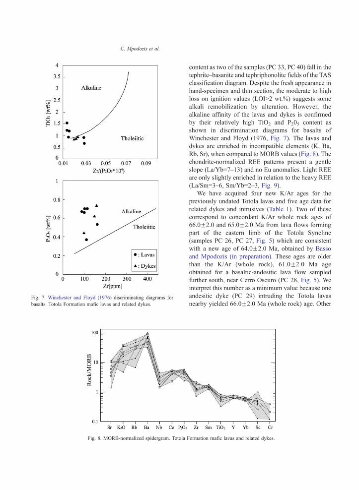
Fig. 7. Winchester and Floyd (1976) discriminating diagrams for
basalts. Totola Formation mafic lavas and related dykes.
Fig. 8. MORB-normalized spidergram. Totola F
C. Mpodozis et al.
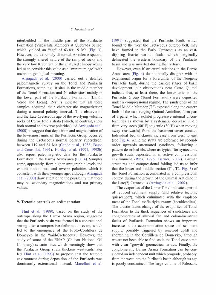
content as two of the samples (PC 33, PC 40) fall in the
tephrite–basanite and tephriphonolite fields of the TAS
classification diagram. Despite the fresh appearance in
hand-specimen and thin section, the moderate to high
loss on ignition values (LOIN2 wt.%) suggests some
alkali remobilization by alteration. However, the
alkaline affinity of the lavas and dykes is confirmed
by their relatively high TiO2 and P205 content as
shown in discrimination diagrams for basalts of
Winchester and Floyd (1976, Fig. 7). The lavas and
dykes are enriched in incompatible elements (K, Ba,
Rb, Sr), when compared to MORB values (Fig. 8). The
chondrite-normalized REE patterns present a gentle
slope (La/Yb=7–13) and no Eu anomalies. Light REE
are only slightly enriched in relation to the heavy REE
(La/Sm=3–6, Sm/Yb=2–3, Fig. 9).
We have acquired four new K/Ar ages for the
previously undated Totola lavas and five age data for
related dykes and intrusives (Table 1). Two of these
correspond to concordant K/Ar whole rock ages of
66.0F2.0 and 65.0F2.0 Ma from lava flows forming
part of the eastern limb of the Totola Syncline
(samples PC 26, PC 27, Fig. 5) which are consistent
with a new age of 64.0F2.0 Ma, obtained by Basso
and Mpodozis (in preparation). These ages are older
than the K/Ar (whole rock), 61.0F2.0 Ma age
obtained for a basaltic-andesitic lava flow sampled
further south, near Cerro Oscuro (PC 28, Fig. 5). We
interpret this number as a minimum value because one
andesitic dyke (PC 29) intruding the Totola lavas
nearby yielded 66.0F2.0 Ma (whole rock) age. Other
ormation mafic lavas and related dykes.
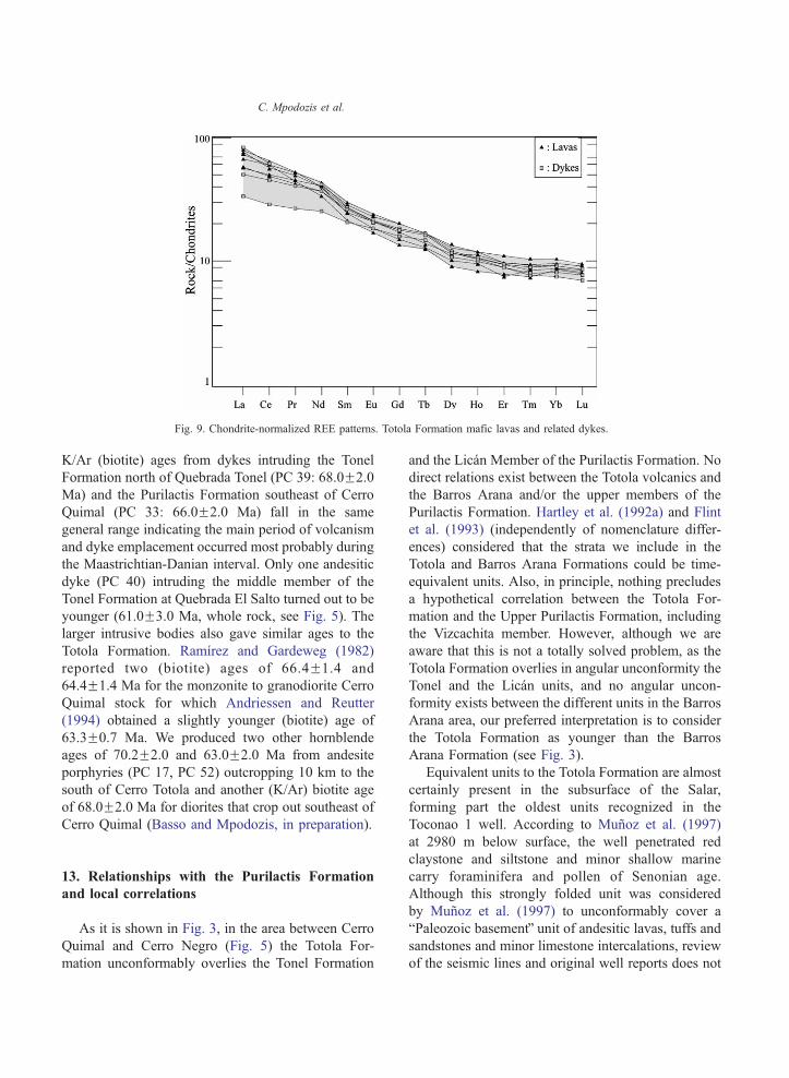
Fig. 9. Chondrite-normalized REE patterns. Totola Formation mafic lavas and related dykes.
C. Mpodozis et al.
K/Ar (biotite) ages from dykes intruding the Tonel
Formation north of Quebrada Tonel (PC 39: 68.0F2.0
Ma) and the Purilactis Formation southeast of Cerro
Quimal (PC 33: 66.0F2.0 Ma) fall in the same
general range indicating the main period of volcanism
and dyke emplacement occurred most probably during
the Maastrichtian-Danian interval. Only one andesitic
dyke (PC 40) intruding the middle member of the
Tonel Formation at Quebrada El Salto turned out to be
younger (61.0F3.0 Ma, whole rock, see Fig. 5). The
larger intrusive bodies also gave similar ages to the
Totola Formation. Ramırez and Gardeweg (1982)
reported two (biotite) ages of 66.4F1.4 and
64.4F1.4 Ma for the monzonite to granodiorite Cerro
Quimal stock for which Andriessen and Reutter
(1994) obtained a slightly younger (biotite) age of
63.3F0.7 Ma. We produced two other hornblende
ages of 70.2F2.0 and 63.0F2.0 Ma from andesite
porphyries (PC 17, PC 52) outcropping 10 km to the
south of Cerro Totola and another (K/Ar) biotite age
of 68.0F2.0 Ma for diorites that crop out southeast of
Cerro Quimal (Basso and Mpodozis, in preparation).
13. Relationships with the Purilactis Formation
and local correlations
As it is shown in Fig. 3, in the area between Cerro
Quimal and Cerro Negro (Fig. 5) the Totola For-
mation unconformably overlies the Tonel Formation
and the Lican Member of the Purilactis Formation. No
direct relations exist between the Totola volcanics and
the Barros Arana and/or the upper members of the
Purilactis Formation. Hartley et al. (1992a) and Flint
et al. (1993) (independently of nomenclature differ-
ences) considered that the strata we include in the
Totola and Barros Arana Formations could be time-
equivalent units. Also, in principle, nothing precludes
a hypothetical correlation between the Totola For-
mation and the Upper Purilactis Formation, including
the Vizcachita member. However, although we are
aware that this is not a totally solved problem, as the
Totola Formation overlies in angular unconformity the
Tonel and the Lican units, and no angular uncon-
formity exists between the different units in the Barros
Arana area, our preferred interpretation is to consider
the Totola Formation as younger than the Barros
Arana Formation (see Fig. 3).
Equivalent units to the Totola Formation are almost
certainly present in the subsurface of the Salar,
forming part the oldest units recognized in the
Toconao 1 well. According to Munoz et al. (1997)
at 2980 m below surface, the well penetrated red
claystone and siltstone and minor shallow marine
carry foraminifera and pollen of Senonian age.
Although this strongly folded unit was considered
by Munoz et al. (1997) to unconformably cover a
bPaleozoic basementQ unit of andesitic lavas, tuffs andsandstones and minor limestone intercalations, review
of the seismic lines and original well reports does not
C. Mpodozis et al.
prove any definite unconformity and, contrary to
described, any Paleozoic diagnostic fossil assemblage.
Strata akin to the Totola Formation also outcrop
further north along strike with the structural axis of
the Barros Arana Syncline, some 100 km NNE of
Cerro Quimal where they have been described as the
Lomas Negras Formation (Lahsen, 1969; Marinovic
and Lahsen, 1984). This unit (base unexposed) crops
out in an erosional window below Miocene–Pliocene
volcanics and includes 500 m of bandesiticQ lavas,
interbedded with multicolored conglomerates, sand-
stone, mudstone and thin beds (1–3 m) of marine,
fossiliferous, (oolitic) limestones including bivalves
(Brachiodontes sp.), foraminifera, fish bones, trace
fossils and plant remains (Marinovic and Lahsen,
1984). It can be considered a direct equivalent to the
Totola Formation as it shown by a 39Ar/40Ar (biotite)
plateau age of 66.6F1.2 Ma for a lapilli tuff near the
base of the formation reported by Hammerschmidt et
al. (1992).
14. Post Purilactis Paleogene sequences
14.1. The Paleocene–Eocene bOrangeQ Formation
Folded Mesozoic units of the Purilactis Group and
volcanics rocks of the Cerro Totola Formation (and
associated intrusives) forming part of the Barros
Arana Syncline are overlain by a clastic sequence
up to 900 m thick, with a characteristic orange color
(bOrangeQ Formation). The sequence outcrops mainly
to the south of Cerro Totola and in the area around
Cerro Negro, where it is deformed by a complex set of
tight (tens to hundreds of meters wavelength) upright
folds (Fig. 5). The base of the Orange Formation is
exposed north of the road connecting the Salar de
Atacama with the Gaby porphyry copper deposit
where remarkable angular unconformity (D3, Fig. 3)
separate shallow dipping strata of the Orange For-
mation from deformed, subvertical sandstones of the
middle member of the Tonel Formation (Fig. 5). This
fining upward succession was first recognized as an
independent unit by Arriagada (1999) and Mpodozis
et al. (1999). The lowermost levels of the formation
are constituted by roughly 400 m thick, coarse red
conglomerates with clasts up to 1 m in diameter,
intercalated with coarse reddish, laminated cross
bedded, arkosic sandstones. Clasts are mainly derived
from the Cordillera de Domeyko basement (gran-
itoids, rhyolitic porphyries, mafic lavas) but dacitic
and porphyritic andesite clasts similar to the Late
Cretaceous and Paleocene volcanics outcropping west
of the Cordillera de Domeyko (Cinchado and Que-
brada Mala Formations, Montano, 1976; Marinovic
and Garcıa, 1999) are also found. The proximal
alluvial fan facies association of the lower member
grades upward into 500 m of borangeQ channelized
and sheet-flood medium- to fine-grained sandstones
showing both planar and cross bedded stratification
which alternate with thin mudstone layers and
evaporites (gypsum) that became increasingly thick
towards the upper levels of the formation (saline lake
and/or playa facies association).
14.1.1. Age and tectonic setting
The Orange Formation is equivalent to a thick (up
to 1400 m) sedimentary sequence (Unit H, Jordan et
al., submitted for publication), which in the Salar
subsurface onlaps folded Late Cretaceous strata and
fills the intervening synclinal depressions. In the
Toconao 1 borehole Unit H is formed by volcano-
clastic sandstones interbedded with conglomerates
and claystones (Munoz et al., 1997, 2002; Jordan et
al., submitted for publication). Some 70 km south of
Cerro Quimal (Pan de Azucar, region) andesitic lava
horizons interbedded in the Formation have been
dated at 57.9F1.9 and 58.0F3 Ma (K/Ar, whole rock,
Gardeweg et al., 1994) suggesting a Late Paleocene
age. At Loma Amarilla (Fig. 5) the unit is covered
unconformably by Eocene–Oligocene strata (Loma
Amarilla Formation, Fig. 3). The strong angular
unconformity at the base of the Orange Formation
and the rapid upward change from proximal alluvial
fan to playa lake facies is consistent with the unit
being a post-tectonic sedimentary sequence, which
accumulated after a new and intense pulse of
compressional deformation, which probably occurred
during the early Paleocene (see Discussion below).
14.2. The Eocene–Early Oligocene Loma Amarilla
Formation
A thick sequence of mostly unconsolidated, coarse,
reddish to gray, gravels and conglomerates, identified
here as the Loma Amarilla Formation, forms most of

C. Mpodozis et al.
the El Bordo ridgeline from Cuesta de Barros Arana to
Cerro Negro (Figs. 4 and 5) where it unconformably
overlie almost all the older units. Earlier workers
considered most of this sequence to be of Miocene
age (Ramırez and Gardeweg, 1982; Marinovic and
Lahsen, 1984; Hartley et al., 1992a). The Loma
Amarilla gravels fill a very irregular topography
carved in the Cretaceous and Paleocene–Eocene
sequences, to the west of the El Bordo Escarpment
is sculptured by a gently west dipping pediplain
surface above which rest remains of Late Miocene
(10–8 Ma) ignimbrites are found (Naranjo et al., 1994;
Mpodozis et al., 2000). North of Cerro Quimal,
subhorizontal Loma Amarilla strata onlap Paleozoic
and Purilactis outcrops although the same gravels
appear almost subvertical, east of the El Bordo
ridgeline. Progressive internal unconformities visible
at the northern termination of the Loma Amarilla
syncline and along the El Litio-Baquedano road (Fig.
5) indicate the syntectonic character of the sequence.
The exposed thickness of the Loma Amarilla For-
mation can surpass 2500 m. Its lower levels include
(Loma Amarilla–Cerro Negro area) up to 200 m of
white tuffs, coarse conglomerates with tuffaceous
matrix and reworked coarse pyroclastic flows with
abundant, porphyritic dacitic clasts (Fig. 3). The thick
upper beds are a monotonous succession of massive,
poorly bedded coarse conglomerates, unconsolidated
gravels, and minor sandstone. Conglomerates contain
clasts from 5 to 50 cm in diameter, including
subrounded boulders of Paleozoic granitoids, rhyo-
lites, dacite and andesite. According to Hartley et al.
(1992a), who carefully studied a detailed section
south of Cerro Negro, they represent an association of
proximal alluvial fan facies including hyperconcen-
trated debris flow deposits.
14.2.1. Age and tectonic setting
The only horizon suitable for dating in the gravel-
rich Loma Amarilla Formation is the tuffaceous
basal horizon where Ramırez and Gardeweg (1982)
first obtained a K/Ar plagioclase age of 39.9F3.0
Ma. This value was later refined by Hammerschmidt
et al. (1992) who obtained two 39Ar/40Ar plateau
(biotite) ages of 43.8F0.5 (Pu-1) and 44.2F0.9 Ma
(Pu-13) which indicate that accumulation of the
Loma Amarilla Formation began during the middle
Eocene. As a complement, we obtained a new K/Ar
age of 59.1F2 Ma (BF-451) for an amphibole-
bearing andesite clast from a volcanoclastic con-
glomerates near the base of the formation. This value
is similar to the ages reported for the lavas
interbedded within the Orange Formation south of
the Salar basin by Gardeweg et al. (1994) and the
numerous 63 to 55 Ma K/Ar ages informed for lavas
of the Cinchado Formation exposed west of the
Cordillera de Domeyko (Marinovic and Garcıa,
1999) indicating the sedimentary reworking of
Paleocene volcanic units. Another (porphyritic) clast
from volcanoclastic conglomerates, 100 m above the
basal contact of the formation yielded a younger (K/
Ar, hornblende) age of 33.9F0.3 Ma. Straightfor-
ward acceptance of these data implies that the entire
Late Eocene is traversed in the first 100 m of he
formation although the very low potassium content
(0.36% K2O) of the analyzed material casts doubt
over the accuracy of the age. It is noteworthy that
this value falls in the range of the total degassing39Ar/40Ar biotite ages (32.05+0.6; 36.4F1.0 Ma) of
samples Pu-1 and Pu-13 reported by Hammerschmidt
et al. (1992) which may well indicate a regional
event of Ar loss, probably initiated in the Miocene,
according to the 20–10 Ma age of the lowest
temperatures steps in both samples.
Studies of seismic lines in the Salar allow Loma
Amarilla strata to be compared to seismic sequence J
in the Salar subsurface (Jordan et al., submitted for
publication), which, in the Toconao 1 borehole are
represented by 600 m of multicolored sandstone and
conglomerates (Munoz et al., 1997). Sequence J
overlies (Paleocene–Eocene?) sequence H above a
prominent erosional unconformity and is overlain by
seismic sequence K, which can be correlated with the
Oligocene–Lower Miocene Paciencia Group. This
latter unit, which crops out extensively in the
Cordillera de la Sal (Fig. 4), includes thin ash layers
whose ages span from ca. 28 to 20 Ma (Marinovic
and Lahsen, 1984; Mpodozis et al., 2000). These age
constraints indicate that the Loma Amarilla Forma-
tion was deposited during the Late Eocene–Oligocene
interval being no older than 44 Ma and no younger
than 28 Ma. The Loma Amarilla Formation is herein
interpreted as a thick sedimentary blanket, syntec-
tonic with the Eocene bIncaicQ deformation that
affected large tracts of Northern Chile approximately
between 45 and 35 Ma.

C. Mpodozis et al.
15. Discussion
15.1. Origins: what kind of basin?
Initiation of compressional uplift associated with
east-verging, high-angle reverse faults and fault-
propagation folds along the eastern edge of the
Cordillera de Domeyko in the El Bordo Escarpment
region triggered the accumulation of the syntectonic
sediments of the Tonel Formation. These new
findings seem to disprove the extensional hypothesis
for the origin of the Salar de Atacama basin presented
by Macellari et al. (1991), Hartley et al. (1992a) and
Flint et al. (1993) and better support contraction-
dominated models as suggested by Charrier and
Munoz (1994) and Munoz et al. (1997) who
considered that the Salar de Atacama formed as a
foreland basin related to Cretaceous east-vergent
thrusting. More recently, McQuarrie et al. (2005)
suggested that during the Cretaceous ba fold-thrust
belt existed in the western portion of the Central
Andes as early as Cretaceous to early Paleocene
timeQ. According to these models, east-directed
thrusting along the Cordillera de Domeyko should
have produced a thrust-loaded foredeep in which
sediments of the lower Purilactis Group may have
been deposited (see also Horton et al., 2001).
The Cordillera de Domeyko is not, however, a
thin-skinned thrust belt. Detailed regional mapping
(Mpodozis et al., 1993a; Marinovic et al., 1995;
Cornejo and Mpodozis, 1996) indicates that this
tectonic domain which is a complexly deformed
basement involved belt cored by Late Paleozoic
volcanic and intrusives that was first uplifted during
the Late Cretaceous inversion of the Jurassic–Early
Cretaceous back arc basin of Northern Chile
(Mpodozis and Ramos, 1990; Amilibia et al.,
2000; Tomlinson et al., 2001). Since then it has
been a feature of positive relief that was reactivated
by Tertiary episodes of deformation (Paleocene,
Eocene–Oligocene, Miocene) including the trans-
pressional Eocene–Oligocene bIncaicQ event that
formed the Domeyko Fault System (Maksaev,
1990; Reutter et al., 1991; Tomlinson et al., 1994,
1997; Tomlinson and Blanco, 1997; Cornejo et al.,
1997; Maksaev and Zentilli, 1999). Whereas crustal
thickening and associated lithospheric flexure are
the primary causes of subsidence in foreland basins
adjacent to thin-skinned thrust belts, subsidence in
basins adjacent to reverse-fault bounded basement
blocks seems to require more than simple flexural
response to thickening (Jordan, 1995). The Salar de
Atacama basin has been a subsiding region not
only during the Cretaceous, but also during most of
the Cenozoic (see Flint et al., 1993). Even today
the basin is topographically more than 1 km below
the theoretical altitude to be expected if the local
crustal column were in isostatic equilibrium (Yuan
et al., 2002). Gotze and Krause (2002) speculated
that the unusual CAGH gravimetric anomaly out-
lines an early Paleozoic (?) mafic to ultramafic rock
body at mid-crustal (10–38 km) level below the
Atacama basin. Although it is possible that the
mass excess of this body may help to explain the
protracted history of basin subsidence during the
Late Cretaceous and Tertiary we still do not know
how important this feature may be.
The Cordillera de Domeyko runs N–S for more
than 800 km between 218 and 288S, including its
northern extension of the Sierra de Moreno–Sierra del
Medio ((Figs. 1, 2, 10)). Late Cretaceous compres-
sional deformation has also been documented in the
Sierra de Moreno (Fig. 10), although the gross
geometry of the system is different than that of the
Salar de Atacama segment. The Sierra de Moreno
constitutes an N–S elongate basement block bounded
on both sides by high-angle reverse faults. The
system of west-verging, high-angle reverse faults
along its western edge (Sierra de Moreno Fault
system, SMFS, Tomlinson et al., 2001) constitutes
the dominant structural system and carries the
Paleozoic basement over deformed Jurassic–Early
Cretaceous continental and marine sedimentary rocks
(Ladino et al., 1997; Tomlinson et al., 2001, Fig. 10).
Geochronological constraints on the age of inception
of uplift and shortening have been presented for the
Sierra de Moreno by Ladino et al. (1997, 1999) and
Tomlinson et al. (2001) who, studying syntectonic
intrusions and sedimentary rocks, demonstrated that
west-verging thrusting initiated there between 109
and 83 Ma.
Syntectonic continental sediments of eastern
provenance (Tambillos Formation), equivalent to
the Lower Purilactis sequence, accumulated in a
bforelandQ position unconformably above deformed
Jurassic–Lower Cretaceous strata in the SMFS

Fig. 10. Late Cretaceous–Early Tertiary paleogeography of the Western Central Andes (21–268S). (1) Cordillera de Domeyko basement, (2)
Late Cretaceous syntectonic deposits, (3) Arc volcanics and intra-arc basin sediments, (4) Continental sediments of the Salta Rift System, (5)
Alkaline mafic lavas of the Totola Formation, (6) Shallow marine deposits of the El Molino–Yacoraite sea, (7) Continental sequences of the
Sierra de Almeida region, (8) Sediment provenance direction, Ce: Cerro Empexa Fm., Ta: Tambillos Fm., To: Tolar Fm., Qm: Quebrada Mala
Fm., Ll: Llanta Fm., LPu: Lower Purilactis Group, Ar-Ch: Airofilla-Chaunaca Formations, SMFS: Sierra de Moreno Fault System, SBF: Sierra
El Buitre Fault, CB: Calama basin, Po: Poquis, Hu: Huaitiquina, Vi: Vilque well, Ln: Lomas Negras, To: Cerro Totola. Discussion in text.
C. Mpodozis et al.
footwall (Bogdanic, 1991; Tomlinson et al., 2001).
At the same time, continental conglomerates and
sandstones of the Tolar Formation accumulated east
of the basement uplift in a separate basin (Fig. 10).
Paleocurrent analysis (Bogdanic, 1991; Tomlinson
et al., 2001) indicates an eastern provenance for the
Tambillos clastics and a western provenance for the
Tolar. A 109F4 Ma (K/Ar, biotite) age obtained for
an andesitic clast from the basal conglomerates of
the Tolar Formation (Quebrada Quinchamale) and
another (biotite) age of 77F3 Ma for a tuff 460 m
above the base (Sierra del Medio) establish the Late
Cretaceous age for the sequence (Ladino et al.,
1997; Tomlinson et al., 2001).
15.2. Interactions with the Late Cretaceous intra-arc
basins of northern Chile
The Late Cretaceous sequences deposited in the
pre-Andean basins are not the only units of this age in
northern Chile. West of the Cordillera de Domeyko,
volcanic and sedimentary units such as the Cerro
Empexa Formation, west of the Sierra de Moreno
block (Tomlinson et al., 2001), the Quebrada Mala
Formation, west of the Salar de Atacama basin
(Montano, 1976; Marinovic et al., 1996; Marinovic
and Garcıa, 1999; Cortes, 2000) and the Llanta
Formation, further south, west of the Pedernales basin
(Cornejo et al., 1993, 1997), accumulated in a north–

C. Mpodozis et al.
south series of discontinuous fault-bounded basins
(Fig. 10). The Quebrada Mala Formation, which
unconformably overlies Late Jurassic–Early Creta-
ceous sediments and early Late Cretaceous (98–94
Ma) volcanic rocks, is a very thick (3700 m) unit of
conglomerates and sandstones, interbedded with calc-
alkaline andesitic lavas and welded tuffs dated (K/Ar)
between 86 and 66 Ma (Williams, 1992; Marinovic
and Garcıa, 1999; Cortes, 2000). It was deposited in a
small, rhomb-shaped basin bounded to the east by an
NNE-trending, west-dipping, high-angle fault (Sierra
El Buitre Fault) formed in the Late Cretaceous as a
normal fault along the southeastern basin edge
(Marinovic and Garcıa, 1999; Figs. 2 and 10).
Thus there exists the potentially contradictory
evidence of extension-related basins along the volcanic
arc and coeval shortening in the Cordillera de
Domeyko. Nevertheless, the discontinuous nature of
the intra-arc basins, thick volcanic and sedimentary
infill, and the orientation of related faults is consistent
with the basins being formed in a (right-lateral?) strike-
slip setting as Arevalo et al. (1994) and Arevalo (1999)
suggested for the Late Cretaceous Hornitos basin in the
Copiapo region (26–278S). Coexistence of zones of
margin-parallel strike-slip faulting and margin-perpen-
dicular shortening is not, however, rare in active
continental margins where plate convergence is obli-
que, as has been discussed in recent tectonic models for
the Late Cenozoic southern Andes (i.e. Cembrano et
al., 2002; Folgera et al., 2003). Theoretical models such
as that of Saint Blanquant et al. (1998) show that
oblique plate convergence along active margins may
produce a strain-partitioned transpressional structural
array characterized by arc-parallel strike-slip faults,
which may be associated with local pull-apart basins,
along the thermally weakened arc. Strike-slip motion
may coexist with arc-orthogonal shortening and
thrusting in the back arc region (bmagma facilitated
strike-slip partitioningQ). This model, which has been
verified for the active Sumatra arc (see Mount and
Suppe, 1992; Tikoff and Teysier, 1994), may be
applicable to the tectonic conditions that prevailed in
Northern Chile during the Late Cretaceous (Fig. 10).
15.3. Regional comparisons of basins
The Salar de Atacama basin is located at the
western slope of the vast Altiplano-Puna plateau
where a thick sequence of sedimentary rocks accu-
mulated during the Cretaceous and Tertiary, both in
Bolivia (Sempere et al., 1997; Horton et al., 2001) and
northwestern Argentina (Allmendinger et al., 1997;
Salfity and Marquillas, 1999; Coutand et al., 2001).
Studies on the timing, distribution and provenance of
sediments have led some authors to suggest a western
source for the Cretaceous sediments outcropping in
southwestern Bolivia (Sempere et al., 1997; Horton et
al., 2001; McQuarrie et al., 2005). The Cordillera de
Domeyko must be considered to be of the western
source terrain while the Salar de Atacama basin and
the string of bpre-AndeanQ basins to 278S in Chile
(Mpodozis and Clavero, 2002, Fig. 1) may correspond
with the more proximal depocenters of the Bolivia and
northwestern Argentina Basin System. However, as
the connection between the northern Chile depo-
centers and the rest of the Altiplano-Puna basins was
cut by the onset of volcanism along the Western
Cordillera at 26 Ma (Coira et al., 1982; Jordan and
Gardeweg, 1988; Kay et al., 1999) correlations
between the two now separated domains have been
difficult to establish.
15.3.1. Connections with the Salta Rift Basins and the
Huaytiquina High
The Purilactis basin appears to have been a
narrow trough, separated on its east by one or more
basement ridges from the Salta Rift Basin. Directly
east of the El Bordo Escarpment, chronologically
equivalent units to the Lower Purilactis Group have
not been found in the deep Toconao 1 well drilled in
the center of the Salar de Atacama basin. As we
mentioned earlier, this well proved a volcanic
sequence correlated to the Totola Formation, with
thin layers of shallow-water marine limestones
bearing Late Cretaceous (bSenonianQ) foraminifera
(Munoz et al., 1997; Munoz and Townsed, 1997).
The well was drilled over the northern extension of
the Cordon de Lila, a basement ridge formed by
Ordovician granitoids, Late Devonian–Early Carbon-
iferous sediments and Permian igneous complexes,
which protrudes as a peninsula at the southern end of
the Salar de Atacama (Ramırez and Gardeweg, 1982,
Fig. 2). South of the Salar, at Cerros Colorados and
Quebrada Guanaqueros, the Paleozoic units are
unconformably covered by 500 m of fine-grained
red sandstones and shales interbedded with thin
C. Mpodozis et al.
limestones layers Campanian to Maastrichtian dino-
saur (Titanosauridade) bones (Pajonales Formation,
Salinas et al., 1991). Such observations indicate that
Lower Purilactis Group accumulated in a narrow,
NS-trending depocenter between the Cordillera de
Domeyko and a basement massif (Huaytiquina
High), which separated the basin from the Creta-
ceous depocenters of the Salta rift System to the east
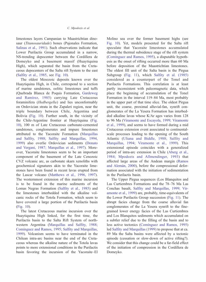
(Salfity et al., 1985, see Fig. 10).
The oldest Mesozoic deposits known over the
Huaytiquina High, in Chile, correspond to a section
of marine sandstones, oolitic limestones and tuffs
(Quebrada Blanca de Poquis Formation, Gardeweg
and Ramırez, 1985) carrying Late Cretaceous
foraminifera (Hedbergella) and lies unconformably
on Ordovician strata in the Zapaleri region, near the
triple boundary between Chile, Argentina and
Bolivia (Fig. 10). Further south, in the vicinity of
the Chile-Argentine frontier at Huaytiquina (Fig.
10), 100 m of Late Cretaceous carbonate-cemented
sandstones, conglomerates and impure limestones
attributed to the Yacoraite Formation (Marquillas
and Salfity, 1988; Salfity and Marquillas, 1994,
1999) also overlie Ordovician sediments (Donato
and Vergani, 1987; Marquillas et al., 1997). More-
over, Yacoraite limestones seem to be an important
component of the basement of the Late Cenozoic
CVZ volcanic arc, as carbonate skarn xenoliths with
geochemical signatures akin to the Yacoraite lime-
stones have been found in recent lavas erupted from
the Lascar volcano (Matthews et al., 1996, 1997).
The westernmost extension of this marine incursion
is to be found in the marine sediments of the
Lomas Negras Formation (Salfity et al., 1985) and
the limestones interbedded with the alkaline vol-
canic rocks of the Totola Formation, which seem to
have covered a large portion of the Purilactis basin
(Fig. 10).
The latest Cretaceous marine incursion over the
Huaytiquina High linked, for the first time, the
Purilactis basin to the Salta Rift System of north-
western Argentina (Marquillas and Salfity, 1988;
Comınguez and Ramos, 1995; Salfity and Marquillas,
1999). Volcanism seems to have terminated in the
Chilean intra-arc basins near the end of the Creta-
ceous whereas the alkaline nature of the Totola lavas
points to more extensional conditions in the Purilactis
basin favoring the incursion of the Yacoraite–El
Molino sea over the former basement highs (see
Fig. 10). Yet, models presented for the Salta rift
speculate that Yacoraite limestones accumulated
during the thermal subsidence stage of the rift system
(Comınguez and Ramos, 1995), a disputable hypoth-
esis as the onset of rifting occurred more than 60 Ma
before deposition of the Maastrichtian limestones.
The oldest fill unit of the Salta basin is the Pirgua
Subgroup (Fig. 11), which Salfity et al. (1985)
considered as a counterpart of the Tonel and
Purilactis Formations. This correlation is at least
partly inconsistent with paleomagnetic data, which
place the beginning of accumulation of the Tonel
Formation in the interval 119–84 Ma, most probably
in the upper part of that time slice. The oldest Pirgua
unit, the coarse, proximal alluvial-fan, synrift con-
glomerates of the La Yesera Formation has interbed-
ded alkaline lavas whose K/Ar ages varies from 128
to 96 Ma (Viramonte and Escayola, 1999; Viramonte
et al., 1999), and seems to have formed during a mid
Cretaceous extension event associated to continental-
scale processes leading to the opening of the South
Atlantic (Uliana and Biddle, 1988; Salfity and
Marquillas, 1994; Viramonte et al., 1999). This
extensional episode coincides with a generalized
period of intra-arc extension in Chile (Aberg et al.,
1984; Mpodozis and Allmendinger, 1993) that
affected large areas of the Andean margin (Ramos
and Aleman, 2000), before the compressional defor-
mation associated with the initiation of sedimentation
in the Purilactis basin.
The Upper Pirgua sequences (Los Blanquitos and
Las Curtiembres Formations and the 78–76 Ma Las
Conchas basalt, Salfity and Marquillas, 1999; Vir-
amonte et al., 1999) are, probably, time-equivalents of
the Lower Purilactis Group succession (Fig. 11). The
abrupt facies change from the coarse alluvial fan
conglomerates of the La Yesera synrift to the fine-
grained lower energy facies of the Las Curtiembres
and Los Blanquitos sediments which accumulated on
a subtler relief due to the filling of the basin and to
less active tectonics (Comınguez and Ramos, 1995)
led Salfity and Marquillas (1999) to propose that at ca.
89 Ma the Salta basins were affected by a tectonic
episode (cessation or slow-down of active rifting?).
We consider that this change could be a far-field effect
of the initiation of compression in the Cordillera de
Domeyko.
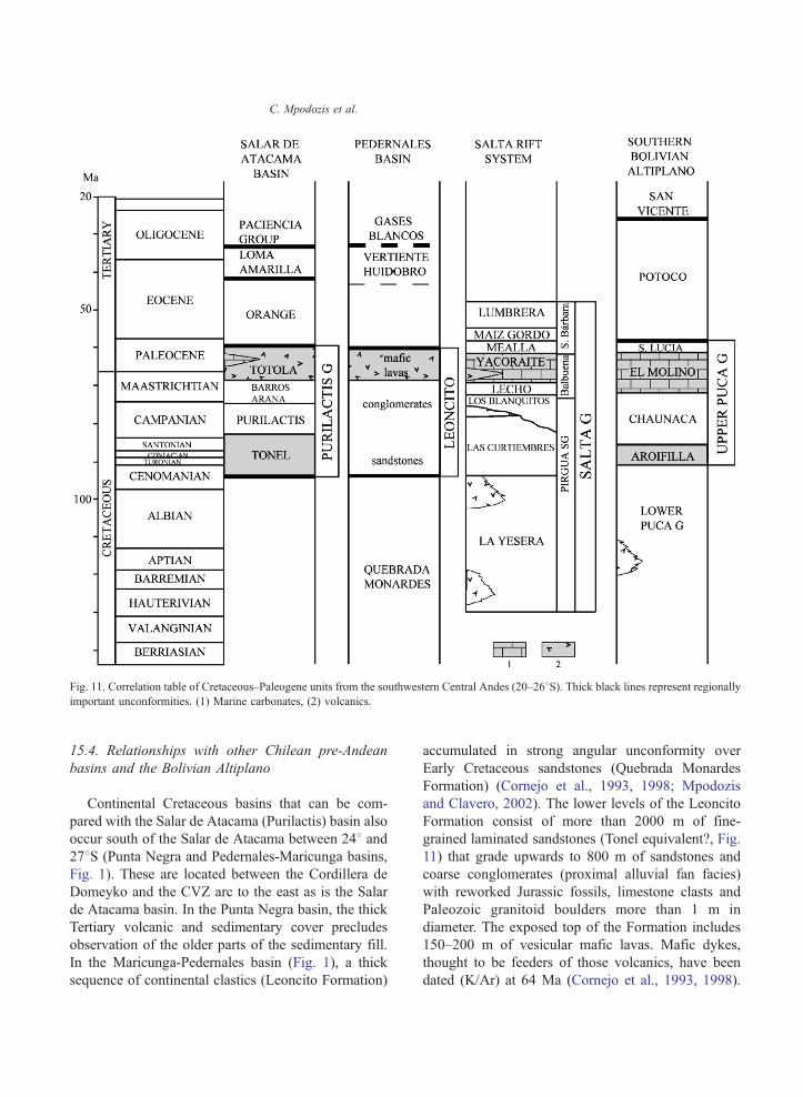
Fig. 11. Correlation table of Cretaceous–Paleogene units from the southwestern Central Andes (20–268S). Thick black lines represent regionallyimportant unconformities. (1) Marine carbonates, (2) volcanics.
C. Mpodozis et al.
15.4. Relationships with other Chilean pre-Andean
basins and the Bolivian Altiplano
Continental Cretaceous basins that can be com-
pared with the Salar de Atacama (Purilactis) basin also
occur south of the Salar de Atacama between 248 and278S (Punta Negra and Pedernales-Maricunga basins,
Fig. 1). These are located between the Cordillera de
Domeyko and the CVZ arc to the east as is the Salar
de Atacama basin. In the Punta Negra basin, the thick
Tertiary volcanic and sedimentary cover precludes
observation of the older parts of the sedimentary fill.
In the Maricunga-Pedernales basin (Fig. 1), a thick
sequence of continental clastics (Leoncito Formation)
accumulated in strong angular unconformity over
Early Cretaceous sandstones (Quebrada Monardes
Formation) (Cornejo et al., 1993, 1998; Mpodozis
and Clavero, 2002). The lower levels of the Leoncito
Formation consist of more than 2000 m of fine-
grained laminated sandstones (Tonel equivalent?, Fig.
11) that grade upwards to 800 m of sandstones and
coarse conglomerates (proximal alluvial fan facies)
with reworked Jurassic fossils, limestone clasts and
Paleozoic granitoid boulders more than 1 m in
diameter. The exposed top of the Formation includes
150–200 m of vesicular mafic lavas. Mafic dykes,
thought to be feeders of those volcanics, have been
dated (K/Ar) at 64 Ma (Cornejo et al., 1993, 1998).

C. Mpodozis et al.
The Leoncito sedimentary episode reflects the onset
of uplift and unroofing of the Cordillera de Domeyko
during the Late Cretaceous (Mpodozis and Clavero,
2002) and its basal unconformity above Lower
Cretaceous rocks places a good constrain on the age
of the beginning of sedimentation in the pre-Andean
basins of northern Chile.
Northwest of the Salar de Atacama, the NNE
trending active deforming zone of the El Bordo
Escarpment and Cordillera de La Sal (Fig. 1) pass
below the NNW trending active Andean arc to emerge
in Bolivia as the Uyuni-Khenayani Fault Zone (Baby
et al., 1990; Welsink et al., 1995; Elger and Onken,
2002). There, and also further to the northeast
(Sevaruyo region), Cretaceous to Paleogene sediments
of the Puca Group unconformably overlie Paleozoic
strata (Lohman and Branisa, 1962; Cherroni, 1974;
Sempere, 1995; Sempere et al., 1990, 1997; Welsink
et al., 1995). The Kimmeridgian-Albian Lower Puca
is a sequence of continental conglomerates and red
sandstones, accumulated, in an extensional setting
similar to that of the Lower Pirgua subgroup. That
extensional phase culminated with a Cenomanian-
Turonian marine episode (Miraflores Formation, Fig.
11). The Upper Puca Cycle started at 89 Ma with the
deposition of red mudstones, fine-grained laminated
sandstones, evaporites (gypsum beds) and pink-brown
gypsiferous mudstones (Aroifilla Formation, latest
Turonian-Coniacian) deposited, like the Tonel For-
mation, in a distal alluvial or desiccated lacustrine
(playa-lake) environment (Sempere et al., 1997). The
overlying Santonian-Campanian (86–73 Ma) Chau-
naca Formation, inaugurated by a short-lived
restricted marine episode, is also an association of
playa-lake facies dominated by red-brown mudstones.
In the Central Altiplano domain the Chaunaca mud-
stones possibly intermingle to the west with more
proximal sandstones and mudstones of western
provenance (Coroma Formation) that may be com-
pared with the Purilactis Formation.
The Upper Puca cycle terminated with the 100 to
500 m thick Maastrichtian-Danian (73–60 Ma) El
Molino Formation, whose shallow to restricted marine
facies (carbonates, black shales and mudstones)
alternate with tuffaceous horizons dated (39Ar/40Ar)
at 71.6 and 72.5 Ma (Sempere et al., 1997). As in
Northern Chile, the marine transgression advanced
over the high ground east of the basin axis as
illustrated in the Vilque-X1 well (Fig. 10) to the east
of the Uyuni-Khenayani fault zone, where El Molino
limestones directly overlie Silurian? strata (Welsink et
al., 1995).
Sempere et al. (1997) suggested that at ~89 Ma
(Late Turonian–Early Coniacian), the Early Creta-
ceous extensional conditions prevailing in the south-
ern Altiplano began to change towards a more
compressional setting and considered that the accu-
mulation of the younger Upper Aroifilla and
Chaunaca Formations occurred in a distal foreland
basin related to compression occurring to the west,
i.e. in Chile. Horton and DeCelles (1997) and
McQuarrie et al. (2005) also proposed that Late
Cretaceous sedimentation in the Altiplano took place
in an early foreland basin related to initial Andean
shortening. The more complex model presented by
McQuarrie et al. (2005) envisaged that the upper
Puca sedimentation occurred to the east of an
elevated forebulge which separated the Bolivian
basin from a western bforedeepQ close to the zone
of active deformation where Purilactis Group equiv-
alents may have been deposited (see also Horton et
al., 2001). However, we do not see conclusive
evidence for the existence of a forebulge, as the
Tonel Formation crops out directly along strike with
the Upper Puca sequences (Aroifilla-Chaunaca) of
the Uyuni-Khenayani Fault zone (Fig. 10). An
alternative proposition may be that the Bolivian
basins were during the Coniacian-Campanian con-
nected along strike with the Purilactis depocenter and
also stretched further south possibly trough the
Pedernales basin. This western realm, bounded to
the west by the Cordillera de Domeyko, was
separated by the Huaytiquina High from the Salta
Rift System. Only during the Maastrichtian when the
Yacoraite–El Molino sea advanced over the basement
highs did the two domains become depositionally
connected (Fig. 10).
15.5. Post Purilactis Paleogene tectonics
The (D3) unconformity at the base of the Orange
Formation marks the end of accumulation of the
Purilactis Group. We interpret the fining-upward
Orange Formation whose facies change from coarse
conglomerates to sandstones and evaporites, as
sedimentary strata post-dating a regional pulse of

C. Mpodozis et al.
compressional deformation, which affected large
expanses of northern Chile in the earliest Paleocene
and produced renewed uplift in the Cordillera de
Domeyko as indicated by an apatite fission track age
of 64.5F0.9 Ma for the Cerro Quimal intrusive
reported by Andriessen and Reutter (1994) which
trace rapid cooling, probably related to exhumation
and uplift shortly after pluton emplacement at around
66 to 64 Ma. West of the Cordillera de Domeyko, the
Late Cretaceous Quebrada Mala basin, in the Central
Depression of the Antofagasta region (Figs. 2 and 10)
was inverted before the accumulation of Paleocene
lavas and tuffs of the Cinchado Formation (Marinovic
et al., 1996; Marinovic and Garcıa, 1999). The basal
Paleocene unconformity has been also documented at
the subsurface of the Salar de Atacama basin, where
Seismic Unit H onlaps over a system of folds affecting
strata comparable to the Totola Formation (Munoz et
al., 2002; Jordan et al., submitted for publication). The
same situation has been documented further south, in
the El Salvador-Copiapo region (26–288S) were a
regional unconformity separates Paleocene volcanics
from Late Cretaceous strata (Cornejo et al., 1993,
1999; Arevalo et al., 1994; Iriarte et al., 1996).
The Paleocene was a time of extensive volcanism
in the Central Depression both in Antofagasta and
Copiapo-El Salvador (Arevalo et al., 1994; Cornejo
and Mpodozis, 1996; Marinovic et al., 1996). Geo-
chemical data indicate that the continental Andean
crust in northern Chile was thickened as a result of the
early Paleocene deformation episode as Paleocene–
Eocene magmas evolved at higher pressures than
during the Late Cretaceous in a crust already able to
stabilize hornblende (Cornejo et al., 1999; Cornejo
and Matthews, 2001).
The early Paleocene deformation seems to be have
affected, primarily, the western Andean domain. To
the east of the Salar de Atacama basin, in the Zapaleri
region (Fig. 2) continental sandstones of the Chofjias
Formation (Gardeweg and Ramırez, 1985), which are
possible distal equivalents of the Orange Formation
conformably overlie the Upper Cretaceous marine
strata. Reduced sediment thickness and the presence
of numerous paleosol horizons characterize the
Paleocene in the southern Bolivian Altiplano (Santa
Lucıa, lowermost Potoco and Impora Formations,
Sempere et al., 1997), suggesting a period of low
sedimentation rates. This is also recorded in the thin
Paleocene lacustrine sequences of the Santa Barbara
Subgroup (Mealla and Maız Gordo Formations),
which concordantly overlie the Yacoraite limestones
in the western Puna and the Salta basins (Salfity and
Marquillas, 1999).
During the Eocene–Early Oligocene gravels were
shed eastward from the Cordillera de Domeyko, into
the Salar basin, forming the synorogenic Loma
Amarilla conglomerates. The Loma Amarilla synoro-
genic sediments are associated with the Eocene
bIncaicQ deformation (Coira et al., 1982), when the
whole Cordillera de Domeyko was affected by left-
lateral transpression which led to localized thrusting,
strike-slip faulting, clockwise block rotations, major
uplift and porphyry copper emplacement (Maksaev,
1990; Reutter et al., 1991; Cornejo et al., 1997;
Mpodozis et al., 1993a,b; Arriagada et al., 2000). Very
rapid uplift and important erosion was suggested by
Alpers and Brimhall (1988) to explain the relation
between porphyry copper emplacement and supergene
enrichment at La Escondida mine. Maksaev and
Zentilli (1999), modeling fission track (apatite) data,
indicate that at least 4 to 5 km of rocks were exhumed
from the Cordillera de Domeyko at rates as high as
100 to 200 m/my during the bIncaicQ deformation
episode between 50 and 30 Ma.
The onset of the Incaic deformation near 45 Ma
occurred at the beginning of a period of very high
rates of oblique convergence between the Farallon and
South American plates (Pilger, 1984; Pardo-Casas and
Molnar, 1987). At the same time there was also an
eastward migration of the magmatic front from the
Central Depression to the Cordillera de Domeyko
axis. However, there was very little Eocene volcanism
and magmatism is represented only by discontinuous
clusters of small-volume, shallow-level stocks, includ-
ing copper-rich porphyry stocks emplaced between 42
and 37 Ma along the traces of the Domeyko Fault
System (Maksaev, 1990; Sillitoe, 1992; Cornejo et al.,
1997, 1999). Extreme transpressional conditions
prevailed during this period. These conditions seems
to have prevented easy magma ascent, favoring the
ponding of magmas at the base of the crust which led,
in turn, to ductile transpressional failure of the lower
crust and localized tectonic thickening below the
Cordillera de Domeyko (Mpodozis et al., 1993a,b;
Yanez et al., 1994; Tomlinson et al., 1994; Arriagada
et al., 2000).

C. Mpodozis et al.
Steep REE patterns of Eocene–Early Oligocene
intrusives (Maksaev, 1990; Cornejo et al., 1999;
Richards et al., 2001) indicate the progressive stabi-
lization of garnet in the source region of the Eocene
magmas, which is consistent with the formation of a
significant crustal root below the Cordillera de
Domeyko at that time (Cornejo et al., 1999). Rapid
isostatic rebound triggered by the creation of the
crustal root may explain the rapid uplift recorded in the
Cordillera de Domeyko during Eocene–Early Oligo-
cene times. The regional distribution of the Loma
Amarilla Formation indicates that sedimentation was
controlled by the formation of a regional uplifted area
centered along the topographic axis of the Cordillera
de Domeyko (Maksaev and Zentilli, 1999) from which
sediments were shed to the west and east to almost
completely conceal the previous structural landscape
along the El Bordo Escarpment (Mpodozis et al., 2000;
Arriagada et al., 2002; Figs. 4 and 5).
Thick (up to 6000 m) Late Eocene to Oligocene
continental sequences also cover large tracts of the
southern Altiplano in Bolivia (i.e. Potoco and
Tiahuanacu Formations, Sempere et al., 1997; Lamb
and Hoke, 1997; Horton et al., 2001; Rochat, 2002)
and the Puna, in Argentina (Geste and Quinoas
Formations, Jordan and Alonso, 1987; Allmendinger
et al., 1997; Kraemer et al., 1999; Coutand et al.,
2001; Voss, 2003). Provenance studies and the
discontinuities existing between depocenters indicate
that sedimentation was associated not only with uplift
in the western Andes but also with the uplift of the
Eastern Cordillera block in Bolivia (Lamb and Hoke,
1997) and discrete blocks in the Argentine Puna (Boll
and Hernandez, 1986; Kraemer et al., 1999; Coutand
et al., 2001). The distributed nature of the deforma-
tion, which affected a very wide swath of the central
Andes, including the westernmost Sierras Pampeanas
at 278S (Coughlin et al., 1998), may be an indication
that the Eocene (Incaic) orogeny was associated with
a shallowing of the subducting slab as has been
suggested for southern Peru (Sandeman et al., 1995;
James and Sacks, 1999).
16. Conclusions
The Salar de Atacama basin is a deep depocenter,
which exhibits a well-preserved Mesozoic to Cen-
ozoic sedimentary record of the earliest tectonics
events, which led to the formation of the Central
Andes. New field and geochronological data support
the presentation of an updated stratigraphic division
for the early basin fill (Purilactis Group). This scheme
better reflects the geodynamics and allows the
development of basin history. Unlike previous
hypotheses we consider that the basin was formed
not as an extensional basin, nor a classic foreland
basin produced by lithospheric flexure. Instead it was
created in the early Late Cretaceous as a consequence
of inversion of the Mesozoic back arc basin of
northern Chile. Inversion led to the formation of the
proto-Cordillera de Domeyko as a narrow, thick-
skinned, basement range bounded by high-angle
reverse faults and blind reverse faults, which shift
vergence along strike. Syntectonic sediments were
deposited in basins both to the west (Tambillos
Formation) and east of the Cordillera de Domeyko
(Purilactis Group in the Salar de Atacama Basin).
The extremely thick Cretaceous to Paleogene fill of
the Salar de Atacama (Purilactis) basin seems to be, in
some sort, related to the presence, below the Salar de
Atacama basin of inherited (Paleozoic) anomalously
dense crustal body, which originated the CAGH
anomaly. Repeated episodes of uplift related to
moderate amounts of shortening along the eastern
border the Cordillera de Domeyko led to the
accumulation of syntectonic sediments of the Tonel,
Purilactis and Barros Arana Formations during the
Late Cretaceous. During the same time interval, but
closer to the continental margin, in the central part of
the Antofagasta region, volcanism and sedimentation
seems to have occurred in basins controlled by strike-
slip faults along thermally weakened active Andean
arc. The prevalent tectonic regime during the Late
Cretaceous in Northern Chile seems to have been
controlled by oblique plate convergence which led to
the partitioning of regional strain into a margin-
parallel component, along the arc, and a margin-
perpendicular component in the back arc. Back arc
compression favored the inversion of the former
Jurassic–Early Cretaceous back arc basin and the
accumulation of syntectonic sediments in the Salar de
Atacama basin.
The Salar de Atacama basin is the westernmost
Cretaceous–Paleogene depocenter of the Altiplano
Puna domain and events recorded in its sedimentary

C. Mpodozis et al.
fill are consistent with the reported history of more
distal areas of northwestern Argentina and south-
eastern Bolivia. Nevertheless, comparison with the
Salta Rift System of northwestern Argentina shows
that the Salta Rift System was formed during Early
Cretaceous extension, also recorded in Bolivia
(Lower Puca) and along the Chilean active margin.
It pre-dates the Purilactis basin. Far-field effects of
the Early Late Cretaceous inversion of the northern
Chile back arc basin and initial uplift of the
Cordillera de Domeyko have been recognized both
in the southern Bolivian Altiplano and the Salta Rift
System.
Acknowledgements
Research funds were provided by FONDECYT,
Chile (Grants 1970002, 199009), a cooperative
program IRD/Departamento de Geologıa, Universi-
dad de Chile and the Servicio Nacional de Geologıa y
Minerıa. Discussions and comments on earlier ver-
sions of the manuscript by Teresa Jordan, Nicolas
Blanco, Moyra Gardeweg and Andrew Tomlinson
and reviews by Stephen Flint and Thierry Sempere
greatly helped us to develop the ideas we present in
this paper.
References
Aberg, G., Aguirre, L., Levi, B., Nystrom, J.O., 1984. Spreading-
subsidence and generation of ensialic marginal basin: an
example from the Early Cretaceous of Central Chile. Spec.
Publ.-Geol. Soc. Lond. 16, 185–193.
Allmendinger, R.W., Jordan, T.E., Kay, S.M., Isacks, B.L., 1997.
The evolution of the Altiplano-Puna Plateau of the Central
Andes. Annu. Rev. Earth Planet. Sci. 25, 139–174.
Alpers, C.N., Brimhall, G.H., 1988. Middle Miocene climatic
change in the Atacama Desert, northern Chile; evidence from
supergene mineralization at La Escondida. Geol. Soc. Amer.
Bull. 100, 1640–1656.
Amilibia, A., Sabat, F., Chong, G., Munoz, J.A., Roca, E., Gelabert,
B., 2000. Criterios de inversion tectonica: ejemplos de la
Cordillera de Domeyko (II Region de Antofagasta). Proc. IX
Congr. Geol. Chileno 2, 548–552.
Andriessen, P.A., Reutter, K.J., 1994. K–Ar and fission track
mineral age determinations of igneous rocks related to multiple
magmatic arc systems along the 238S Latitude of Chile and
Argentina. Tectonics of the Southern Central Andes. Springer-
Verlag, Berlin, pp. 141–154.
Arevalo, C., 1999. The Coastal Cordillera/Precordillera boundary in
the Tierra Amarilla area of Northern Chile and the structural
setting of the Candelaria Cu–Au deposit, PhD thesis, Kingston
University, pp. 1–204.
Arevalo, C., Rivera, O., Iriarte, S., Mpodozis, C., 1994. Cuencas
extensionales y campos de calderas del Cretacico Superior-
Terciario Inferior en la Precordillera de Copiapo (278–288S),Chile. Proc. VII Congr. Geol. Chileno 2, 1288–1292.
Arriagada, C., 1999. Geologıa y Paleomagnetismo del Borde
Oriental de la Cordillera de Domeyko entre los 22845V y
23830V latitud Sur. II Region, Chile. MSc thesis, Univ.
pp. 1–176.
Arriagada, C., Roperch, P., Mpodozis, C., 2000. Clockwise
block rotations along the eastern border of the Cordillera
Domeyko, northern Chile (22845V–23830VS). Tectonophysics326, 153–171.
Arriagada, C., Cobbold, P.R., Mpodozis, C., Roperch, P., 2002.
Cretaceous to Paleogene compressional tectonics during the
deposition of the Purilactis Group, Salar de Atacama. Proc. V
IRD-ISAG, Tolouse, pp. 41–44.
Arriagada, C., Roperch, P., Mpodozis, C., Dupont-Nivet, G.,
Cobbold, P.R., Chauvin, A., Cortes, J., 2003. Paleogene
clockwise tectonic rotations in the fore-arc of Central Andes,
Antofagasta region, Northern Chile. J. Geophys. Res. 108 (B1)
doi:10.1029/2001JB001598.
Baby, P., Sempere, T., Oller, J., Barrios, L., Herail, G., Marocco, R.,
1990. A late Oligocene–Miocene intermountain foreland basin
in the southern Bolivian Altiplano. C. R. Acad. Sci., Paris, Ser.
II 311, 341–347.
Barrier, L., 2002. Interactions deformations-sedimentation dans les
systemes compressifs supracrustaux: examples numeriques et
modelisation analogique, PhD thesis, Univ., pp. 1–181.
Basso, M., Mpodozis, C., in preparation. Hoja Cerro Quimal. Serv.
Nac. Geol. Min., Mapas Geol. (1:100,000).
Besse, J., Courtillot, T.V., 1991. Revised and synthetic apparent
polar wander paths of the African, Eurasian, North American
and Indian plates and true polar wander since 200 Ma. J.
Geophys. Res. 96, 4029–4050.
Blanco, N., Mpodozis, C., Gardeweg, M., Jordan, T.E., 2000.
Sedimentacion del Mioceno Superior–Plioceno en la cuenca
del Salar de Atacama. Estratigrafıa de la Formacion Vilama,
II Region de Antofagasta. Proc. IX Congr. Geol. Chileno 1,
446–450.
Bogdanic, T., 1991. Evolucion paleogeografica del Cretacico–
Terciario Inferior, entre los 218–238 S, Region de Antofagasta,
Chile. Proc. VI Congr. Geol. Chileno 1, 857–861.
Boll, A., Hernandez, R.M., 1986. Interpretacion estructural del area
Tres Cruces. Bol. Inf. Petrol., Buenos Aires 7, 2–14.
Breitkreutz, C., van Schmus, W.R., 1996. U–Pb geochronology and
significance of Late Permian ignimbrites in Northern Chile. J.
South Am. Earth Sci. 9 (5/6), 281–293.
Breitkreutz, C., Helmdach, F.F., Kohring, R., Mosbruger, V., 1992.
Late Carboniferous intra-arc sediments in the North Chilean
Andes: stratigraphy, paleogeography and paleoclimate. Facies
26, 67–80.
Bruggen, J., 1934. Las Formaciones de Sal y Petroleo de la Puna de
Atacama. Bol. Min. Petrol., Santiago 32, 105–122.

C. Mpodozis et al.
Bruggen, J., 1942. Geologıa de la Puna de San Pedro de Atacama y
sus formaciones de areniscas y arcillas rojas. Proc. Congr. Pan.
Ing. Min. Geol., Santiago 2, 342–367.
Bruggen, J., 1950. Fundamentos de la Geologıa de Chile. Inst.
Geog. Militar, Santiago, 1–374.
Cande, S.C., La Brecque, J.L., Haxby, W.F., 1988. Plate kinematics
of the South Atlantic: Chron C34 to present. J. Geophys. Res.
93, 13479–13492.
Cembrano, J., Lavenu, A., Reynolds, P., Arancibia, G., Lopez, G.,
Sanhueza, A., 2002. Late Cenozoic transpressional ductile
deformation north of the Naza–South-America–Antarctica triple
junction. Tectonophysics 354, 289–314.
Charrier, R., Munoz, N., 1994. Jurassic–Cretaceous paleogeo-
graphic evolution of the Chilean Andes at 238–248 south
latitude: a comparative analysis. Tectonics of the Southern
Central Andes. Springer-Verlag, Berlin, pp. 141–154.
Charrier, R., Reutter, K.J., 1990. The Purilactis group of
Northern Chile: link between arc and backarc during Late
Cretaceous and Paleogene. Proc. I ORSTOM-ISAG, Grenoble,
pp. 249–252.
Charrier, R., Reutter, K.J., 1994. The Purilactis group of Northern
Chile: boundary between arc and back arc from Late Cretaceous
to Eocene. Tectonics of the Southern Central Andes. Springer-
Verlag, Berlin, pp. 189–202.
Cherroni, C., 1974. Geologıa de la region Corocoro. Rev.Tec.YPFB,
Santa Cruz 4 (3), 125–154.
Coira, B., Davidson, J., Mpodozis, C., Ramos, V.A., 1982. Tectonic
and magmatic evolution of the Andes of northern Argentina and
Chile. Earth-Sci. Rev. 18, 303–332.
Comınguez, A.H., Ramos, V.A., 1995. Geometry and Seismic
expression of the Cretaceous Salta Group. Am. Assoc. Pet.
Geol. Mem. 62, 325–340.
Cornejo, P., Matthews, S.J., 2001. Evolution of magmatism from the
uppermost Cretaceous to Oligocene and its relationship to
changing tectonic regime. Proc. III South Am. Symp. Isotop.
Geol., Santiago, pp. 558–561.
Cornejo, P., Mpodozis, C., 1996. Geologıa de la Region de Sierra
Exploradora (258–268S): Serv. Nac. Geol. Min., Informe
Registrado, IR-96-09, pp. 1–330.
Cornejo, P., Mpodozis, C., Ramırez, C., Tomlinson, C.F., 1993.
Estudio Geologico de la Region de El Salvador y Potrerillos.
Serv. Nac. Geol., Min. Informe Registrado, IR-93-1, pp. 1–258.
Cornejo, P., Tosdal, R., Mpodozis, C., Tomlinson, A.J., Rivera, O.,
Fanning, M., 1997. El Salvador Porphyry Copper revisited:
geologic and geochronologic framework. Int. Geol. Rev. 39,
22–54.
Cornejo, P., Mpodozis, C., Tomlinson, A., 1998. Hoja Salar de
Maricunga. Serv. Nac. Geol. Min., Mapas Geol., 7 (1:100.000).
Cornejo, P., Mpodozis, C., Matthews, S., 1999. Geologıa y
Evolucion Magmatica del Distrito Indio Muerto y Yacimiento
El Salvador. Serv. Nac. Geol. Min. Informe Registrado, IR-98-
14, pp. 1–99.
Cortes, J., 2000. Hoja Palestina, Region de Antofagasta., Serv. Nac.
Geol. Min., Mapas Geol., 19 (1:100.000).
Coughlin, T.J., O’Sullivan, B., Kohn, B.P., Holcombe, R.J.,
1998. Apatite fission-track thermochronology of the Sierras
Pampeanas, central western Argentina: implications for the
mechanism of plateau uplift in the Andes. Geology 26 (11),
999–1002.
Coutand, I., Cobbold, P.R., de Urreiztieta, M., Gautier, P., Chauvin,
A., Gapais, D., Rossello, E., Gamundi, O.L., 2001. Style and
history of Andean deformation. Puna plateau, northwestern
Argentina. Tectonics 20 (2), 210–234.
Davidson, J., Ramırez, C.F., Brook, M., Pankhurst, R., 1985.
Calderas del Paleozoico superior-Triasico inferior y mineraliza-
cion asociada. Comunicaciones, Dep. Geol. Univ. Chile. 35,
53–57.
Dingman, R.J., 1963. Cuadrangulo Tulor. Inst. Invest. Geol., Carta
Geol. Chile 11 (1:50.000), 1–35.
Donato, E., Vergani, G., 1987. Estratigrafıa de la Formacion
Yacoraite (Cretacico) en Paso Huyatiquina, Salta, Argentina.
Proc. IX Congr. Geol. Argentino 1, 263–266.
Elger, K., Onken, O., 2002. The pattern of deformation related to
growth of the southern Altiplano plateau (Bolivia). Proc. V
IRD-ISAG, Tolouse, pp. 203–206.
Flint, S., 1985. Alluvial fan and playa sedimentation in an Andean
arid closed basin: the Paciencia Group, Antofagasta Province,
Chile. J. Geol. Soc. (Lond.) 142, 533–546.
Flint, S., Hartley, A., Rex, D., Guise, P., Turner, P., 1989.
Geochronology of the Purilactis Formation, Northern Chile:
an insight into Late Cretaceous/Early Tertiary basin dynamics of
the Central Andes. Rev. Geol. Chile 16, 241–246.
Flint, S., Turner, P., Jolley, E., Hartley, A., 1993. Extensional
tectonics in convergent margin basins: an example from the
Salar de Atacama, Chilean Andes. Geol. Soc. Amer. Bull. 105,
603–617.
Folgera, A., Ramos, V., Melnik, D., 2003. Particion de la
deformacion en la zona del arco volcanico de los Andes
neuquinos (368–398S) en los ultimos 30 millones de anos. Rev.
Geol. Chile 29 (2), 227–240.
Galliski, M.A., Viramonte, J.G., 1988. The Cretaceous paleorift in
northwestern Argentina: a petrologic approach. J. South Am.
Earth Sci. 1 (4), 329–342.
Gardeweg, M., Ramırez, C.F., 1985. Hoja Rıo Zapaleri, Region de
Antofagasta. Serv. Nac. Geol. Min., Carta Geol. Chile 66
(1:250.000), 1–89.
Gardeweg, M., Pino, H., Ramırez, C.F., Davidson, J., 1994. Mapa
Geologico del area de Imilac y Sierra Almeida, Region de
Antofagasta. Serv. Nac. Geol. Min., Doc. Trabajo 7 (1:100,000).
Gephart, J., 1994. Topography and subduction geometry in the
central Andes: clues to the mechanics of a noncollisional
orogen. J. Geophys. Res. 99, 12279–12288.
Gotze, H.-J., Kirchner, A., 1997. Interpretation of gravity and geoid
in the Central Andes between 208 and 298S. J. South Am. Earth
Sci. 10 (2), 179–188.
Gotze, H.-J., Krause, S., 2002. The Central Andean Gravity High, a
relic of an old subduction complex? J. South Am. Earth Sci. 114
(8), 79–811.
Hammerschmidt, K., Doebel, R., Friedrichsen, H., 1992. Implication
of 40Ar/39Ar dating of early Tertiary volcanic rocks from the
North-Chilean Precordillera. Tectonophysics 202, 55–58.
Hartley, A., Flint, S., Turner, P., 1988. A proposed lithostratigraphy
for the Cretaceous Purilactis Formation, Antofagasta Province,
northern Chile. Proc. V Congr. Geol. Chileno 3, H83–H99.

C. Mpodozis et al.
Hartley, A., Jolley, E., Turner, P., Flint, S., 1991. Preliminary
paleomagnetic results from the Late Cretaceous Tonel For-
mation (Purilactis Group), Precordillera of Northern Chile:
constraints on thrust sheet rotation. Proc. VI Congr. Geol.
Chileno, 1–15.
Hartley, A., Flint, S., Turner, P., Jolley, E.J., 1992a. Tectonic
controls on the development of a semi-arid, alluvial basin as
reflected in the stratigraphy of the Purilactis Group (Upper
Cretaceous–Eocene), northern Chile. J. South Am. Earth Sci. 5
(3/4), 275–296.
Hartley, A.J., Jolley, E.J., Turner, P., 1992b. Paleomagnetic
evidence for rotation in the Precordillera of northern Chile:
structural constraints and implications for the evolution of the
Andean fore-arc. Tectonophysics 205, 49–64.
Horton, B.K., DeCelles, P.G., 1997. The modern foreland basin
system adjacent to the Central Andes. Geology 25, 895–898.
Horton, B.K., Hampton, B.A., Waanders, S.G.L., 2001. Paleogene
synorogenic sedimentation in the Altiplano plateau and impli-
cations for initial mountain building in the Central Andes. Geol.
Soc. Amer. Bull. 113, 1387–1400.
Iriarte, S., Arevalo, C., Mpodozis, C., Rivera, O., 1996. Mapa
Geologico de la Hoja Carrera Pinto. Serv. Nac. Geol. Min.,
Mapas Geol. 3 (1:100.000).
Isacks, B.L., 1988. Uplift of the central Andean plateau and bending
of the Bolivian orocline. J. Geophys. Res. 93, 3211–3231.
James, D.E., Sacks, I.S., 1999. Cenozoic formation of the Central
Andes: a geophysical perspective. Soc. Ec. Geol., Spec. Pub. 7,
1–25.
Jolley, E.J., Turner, P., Williams, G.D., Hartley, A.J., Flint, S., 1990.
Sedimentological response of an alluvial system to Neogene
thrust tectonics, Atacama Desert, northern Chile. J. Geol. Soc.
(Lond.) 147, 769–784.
Jordan, T.E., 1995. Retroarc foreland and related basins. In: Busby,
C., Ingersoll, R. (Eds.), Tectonics of Sedimentary Basins.
Blackwell, Oxford, pp. 31–362.
Jordan, T.E., Alonso, R.N., 1987. Cenozoic stratigraphy and basin
tectonics of the Andes Mountains, 208–288 south latitude. Am.
Assoc. Pet. Geol. Bull. 7, 49–64.
Jordan, T.E., Gardeweg, M., 1988. Tectonic evolution of the Late
Cenozoic Central Andes (208–338S). Oxf. Monogr. Geol.
Geophys. 8, 193–207.
Jordan, T.E., Munoz, N., Mpodozis, C., Blanco, N., Pananont, P.,
Gardeweg, M., submitted for publication. Cenozoic subsurface
stratigraphy and structure of the Salar de Atacama basin,
northern Chile. J. South Am. Earth Sci.
Kape, S.J., 1996. Basin Analysis of the Oligo-Miocene Salar de
Atacama, Northern Chile. PhD thesis, Univ., pp. 1–256.
Kay, S., Mpodozis, C., Coira, B., 1999. Neogene magmatism,
tectonism and mineral deposits of the Central Andes (228–338SLatitude). Soc. Ec. Geol., Spec. Publ. 7, 27–59.
Kraemer, B., Aldeman, D., Alten, M., Schnurr, W., Erpstein, K.,
Kiefer, E., van den Bogaaard, P., Gorler, K., 1999. Incorporation
of the Paleogene foreland into the Negene Punaplateau: the
Salar de Antofalla area, NWArgentina. J. South Am. Earth Sci.
12 (2), 157–182.
Ladino, M., Tomlinson, A., Blanco, N., 1997. Nuevos antecedentes
para la edad de la deformacion cretacica en Sierra de Moreno,
region de Antofagasta, Chile. Proc. VIII Congr. Geol. Chileno 1,
103–107.
Ladino, M., Tomlinson, A., Blanco, N., 1999. New constrains for
the age of Cretaceous compressional deformation in the Andes
of Northern Chile (Sierra de Moreno 218–22810VS). Proc. IVIRD-ISAG, Gottingen, pp. 407–410.
Lahsen, A., 1969. Geologıa del area comprendida entre El Tatio y
los cerros de Ayquina. Comite Geotermico CORFO (internal
report), pp. 1–75.
Lamb, S.H., Hoke, L., 1997. Origin of the high plateau in the
Central Andes, Bolivia. South America. Tectonics 16, 623–649.
Lemaitre, R.W., Bateman, P., Dudek, A., Keller, J., Lameyre Le
Bas, M.J., Sabine, P.A., Shmid, R., Sorensen, H., Streckeisen,
A., Wooley, A.R., Zanettin, B., 1989. A Classification of
Igneous Rocks and Glossary of Terms. Blackwell, Oxford.
Lohman, H.H., Branisa, L., 1962. Estratigrafıa y Paleontologıa de
Grupo Puca en el sinclinal de Miraflores, Potosı. Petrol. Boliv.
4, 9–16.
Macellari, C.E., Su, M., Townsend, F., 1991. Structure and seismic
stratigraphy of the Atacama Basin, Northern Chile. Proc. VI
Congr. Geol. Chileno, pp. 133–137.
Maksaev, V., 1990. Metallogeny, geological evolution and thermo-
chronology of the Chilean Andes between latitudes 218 and 268South, and the origin of major porphyry copper deposits. PhD
thesis, Dalhousie University, 1–544.
Maksaev, V., Zentilli, M., 1999. Fission track thermochronology of
the Domeyko Cordillera, northern Chile; implications for
Andean tectonics and porphyry copper metallogenesis. Explor.
Min. Geol. 8, 65–89.
Marinovic, N., Garcıa, M., 1999. Hoja Pampa Union. Region de
Antofagasta. Serv. Nac. Geol. Min., Mapas Geol. 9 (1:100.000).
Marinovic, N., Lahsen, A., 1984. Hoja Calama. Serv. Nac. Geol.
Min., Carta Geol. Chile 58 (1:250.000), 1–140.
Marinovic, N., Smoje, I., Herve, M., Mpodozis, C., 1995. Hoja
Aguas Blancas. Serv. Nac. Geol. Min., Carta Geol. Chile 70
(1.250.0000), 1–150.
Marinovic, N., Cortes, J., Garcıa, M., 1996. Estudio geologico
regional de la zona comprendida entre Sierra del Buitre y Pampa
San Roman. Serv. Nac. Geol. Min., Informe Registrado IR-96-8,
pp. 1–140.
Marquillas, R., Salfity, J.A., 1988. Tectonic framework and
correlations of the Cretaceous–Eocene Salta Group,
Argentina. In: Bahlburg, H., Breitzkreutz, C. (Eds.), The
Southern Central Andes, Lecture Notes in Earth Sciences, vol.
17. Springer-Verlag.
Marquillas, R., Salfity, J., Gonzalez, R., Matthews, S., Battaglia, R.,
1997. Geologıa del Grupo Salta (Cretacico–Eoceno) en la
comarca de Huaytiquina, Puna Argentina. Proc. VIII Congr.
Geol. Chileno 1, 139–143.
Matthews, S.J., Marquillas, R.J., Kemp, A.J., Grange, F.K.,
Gardeweg, M.C., 1996. Active skarn formation beneath Lascar
volcano, northern Chile: a petrographic and geochemical study
of xenoliths in eruption products. J. Metamorph. Geol. 14,
509–530.
Matthews, S.J., Marquillas, R., Kemp, J., 1997. The lateral
extent of the Yacoraite Formation (Maastrichtian) beneath
the Tertiary–Recent volcanic deposits of NE Chile and

C. Mpodozis et al.
NW Argentina at 238S. Proc. VIIII. Congr. Geol. Chileno 2,
534–536.
McQuarrie, N., Horton, B., Zandt, G., Beck, S., DeCelles, P., 2005.
Lithospheric evolution of the Andean fold-thrust belt, Bolivia
and the origin of the central Andean plateau. Tectonophysics
399, 15–37, doi:10.1016/j.tecto.2004.12.013 (this issue).
Montano, J.M., 1976. Estudio geologico de la zona de Caracoles y
areas vecinas, con enfasis en el sistema Jurasico. Provincia de
Antofagasta, II Region, Chile. Memoria de Tıtulo, Univ., Chile,
pp. 1–168.
Mount, V.S., Suppe, J., 1992. Present-day stress orientation adjacent
to active strike-slip faults: California and Sumatra. J. Geophys.
Res. 97, 1195–12013.
Mpodozis, C., Allmendinger, R.W., 1993. Extensional tectonics,
Cretaceous Andes, northern Chile (278S). Geol. Soc. Amer.
Bull. 105, 1462–1477.
Mpodozis, C., Clavero, J., 2002. Tertiary tectonic evolution of the
southwestern edge of the Puna plateau: Cordillera Claudio
Gay (268–278S), Northern Chile. Proc. V IRD-ISAG, Tolouse,
pp. 445–448.
Mpodozis, C., Ramos, V.A., 1990. The Andes of Chile and
Argentina. Geology of the Andes and its relation to hydrocarbon
and mineral resources. Circum-Pac, Counc. En. Min. Res., Earth
Sci. Ser., pp. 59–90.
Mpodozis, C., Marinovic, N., Smoje, I., Cuitino, L., 1993a. Estudio
Geologico-Estructural de la Cordillera de Domeyko entre Sierra
Limon Verde y Sierra Mariposas, Region de Antofagasta. Serv.
Nac. Geol. Min. Informe Registrado IR-93-04, pp. 1–282.
Mpodozis, C., Marinovic, N., Smoje, I., 1993b. Eocene Left Lateral
Strike Slip Faulting and Clockwise Block Rotations in the
Cordillera de Domeyko, West of the Salar de Atacama, Northern
Chile. Proc. II ORSTOM-ISAG, Oxford, pp. 225–228.
Mpodozis, C., Arriagada, C., Roperch, P., 1999. Cretaceous to
Paleogene geology of the Salar de Atacama basin, northern
Chile: a reappraisal of the Purilactis Group stratigraphy. Proc.
IV IRD-ISAG, Gottingen, pp. 523–526.
Mpodozis, C., Blanco, N., Jordan, T., Gardeweg, M.C., 2000.
Estratigrafıa y deformacion del Cenozoico Tardıo en la
region norte de la Cuenca del Salar de Atacama: la zona de
Vilama-Pampa Vizcachitas. Proc. IX Congr. Geol. Chileno 2,
598–603.
Munoz, N., Charrier, R., 1999. Interactions between the basement
and the cover, Salar de Atacama basin, northern Chile. Proc.
Thrust Tectonics Conf., Univ. London, pp. 278–281.
Munoz, N., Townsed, F., 1997. Estratigrafıa de la cuenca Salar de
Atacama, Resultados del pozo exploratorio Toconao 1.
Implicancias Regionales. Proc VIII Congr. Geol. Chileno 1,
555–558.
Munoz, N., Charrier, R., Reutter, K.J., 1997. Evolucion de la
Cuenca del Salar de Atacama: Inversion tectonica y relleno de
una cuenca de antepaıs de retroarco. Proc. VIII Congr. Geol.
Chileno 1, 5–199.
Munoz, N., Charrier, R., Jordan, T.E., 2002. Interactions between
basement and cover during the evolution of the Salar de Atacama
Basin, Northern Chile. Rev. Geol. Chile 29 (1), 55–80.
Naranjo, J.A., Ramırez, C.F., Paskoff, R., 1994. Morphostrati-
graphic evolution of the northwestern margin of the Salar
de Atacama basin (238S–688W). Rev. Geol. Chile 21 (1),
91–103.
Pardo-Casas, F., Molnar, P., 1987. Relative motion of the Nazca
(Farallon) and South American plates since late Cretaceous
time. Tectonics 6, 233–248.
Pilger, R.H., 1984. Cenozoic plate kinematics, subduction and
magmatism: South American Andes. J. Geol. Soc. (Lond.) 141,
793–802.
Ramırez, C.F., Gardeweg, M.C., 1982. Hoja Toconao, Region de
Antofagasta. Serv. Nac. Geol. Min., Carta Geol. Chile 54
(1:250.000), 1–122.
Ramos, V.A., Aleman, A., 2000. Tectonic evolution of the Andes,
tectonic evolution of South America. 31th Int. Geol. Cong. (Rio
de Janerio), pp. 635–685.
Reutter, K., Scheuber, E., Helmcke, D., 1991. Structural
evidence of orogen-parallel strike-slip displacements in
the Precordillera of Northern Chile. Geol. Rundsch. 80 (1),
135–153.
Riba, O., 1976. Syntectonic unconformities of the alto Cardener,
Spanish Pyrenees: a genetic interpretation. Sediment. Geol. 15,
213–233.
Richards, J.P., Boyce, A.J., Pringle, M.S., 2001. Geological
evolution of the Escondida area, northern Chile: a model for
spatial and temporal localization of porphyry Cu mineralization.
Ec. Geol. 96, 271–305.
Rochat, Ph., 2002. Structures et Cinematique de l’Altiplano Nord-
Bolivien au sein des Andes Centrales. Lab. Geol. Univ.
Grenoble, Mem H.S. 38, 1–193.
Rollinson, H., 1993. Using geochemical data: evaluation, presenta-
tion, interpretation. Longman, pp. 1–352.
Saint Blanquant, M., Tikoff, B., Teyssier, C., Vigneresse, J.L., 1998.
Transpressional kinematics and magmatic arcs. Spec. Publ.-
Geol. Soc. Lond. 135, 327–340.
Salfity, J.A., Marquillas, R., 1994. Tectonic and sedimentary
evolution of the Cretaceous–Eocene Salta Group Basin,
Argentina, Friedr. Vieweg & Sohn, pp. 266–315.
Salfity, J.A., Marquillas, R.A., 1999. La Cuenca Cretacica-terciaria
del Norte Argentino, Geologıa Argentina. Inst. Geol. Rec. Nat.,
Anales 29 (19), 613–626.
Salfity, J.A., Marquillas, R., Gardeweg, M.C., Ramırez, C.F.,
Davidson, J., 1985. Correlaciones en el Cretacico superior del
norte de la Argentina y Chile. Proc. IV Congr. Geol. Chileno,
pp. 1-654–1-667.
Salinas, P., Sepulveda, P., Marshall, L., 1991. Hallazgo de restos
oseos de dinosaurios (Sauropodos) en la Formacion Pajonales
(Cretacico Superior), Sierra de Almeida, Region de Antofagasta,
Chile: Implicancia Cronologica. Proc. VI Congr. Geol. Chileno,
pp. 534–537.
Sandeman, H.A., Clark, A.H., Farrar, E., 1995. An integrated
tectono-magmatic model for the evolution of the southern
Peruvian Andes (13–208S) since 55 Ma. Int. Geol. Rev. 37,
1039–1073.
Sempere, T., 1995. Phanerozoic evolution of Bolivia and adjacent
regions. Am. Assoc. Pet. Geol. Mem. 62, 207–230.
Sempere, T., Herail, G., Oller, J., Bonhomme, M.G., 1990. Late
Oligocene–early Miocene major tectonic crisis and related
basins in Bolivia. Geology 18, 946–949.

C. Mpodozis et al.
Sempere, T., Butler, R.F., Richards, D.R., Marshal, L.G., Sharp, W.,
Swisher, C.C., 1997. Stratigraphy and chronology of late
Cretaceous–early Paleogene strata in Bolivia and northern
Argentina. Geol. Soc. Amer. Bull. 109, 709–727.
Sillitoe, R.H., 1992. Gold and copper metallogeny of the Central
Andes—past, present and future exploration objectives. Ec.
Geol. 87, 2205–2216.
Tikoff, B., Teysier, B., 1994. Strain modeling of displacement field
partitioning in transpressional orogens. J. Struct. Geol. 16,
1575–1588.
Tomlinson, A.J., Blanco, N., 1997. Structural evolution and
displacement history of the West Fault System, Precordillera:
Part 1. Synmineral history. Proc. VIII Congr. Geol. Chileno 3,
1873–1877.
Tomlinson, A.J., Mpodozis, C., Cornejo, P., Ramırez, C.F., Dimitru,
T., 1994. El Sistema de Fallas Sierra Castillo-Agua Amarga:
transpresion sinistral eocena en la Precordillera de Potrerillos-El
Salvador. Proc. VII Congr. Geol. Chileno 2, 1459–1463.
Tomlinson, A.J., Blanco, N., Maksaev, V., Dilles, J., Grunder, A.L.,
Ladino, M., 2001. Geologıa de la Precordillera Andina de
Quebrada Blanca-Chuquicamata, Regiones I y II (20830V–22830VS). Serv. Nac. Geol. Min., Informe Registrado IR-01-
20, pp. 1–444.
Uliana, M., Biddle, K.T., 1988. Mesozoic–Cenozoic palegeographic
evolution of Southern South America. Rev. Bras. Geocienc. 18,
172–190.
Viramonte, J., Escayola, M., 1999. El Magmatismo Cretacico–
Paleogeno del Noroeste Argentino. XIV Congr. Geol. Argen-
tino, Relatorio, 284–291.
Viramonte, J.G., Kay, S.M., Becchio, R., Escayola, M., Novitki, I.,
1999. Cretaceous rift related magmatism in central-western
South America. J. South Am. Earth Sci. 12, 109–121.
Voss, R., 2003. Cenozoic stratigraphy of the southern Salar de
Antofalla region, northwestern Argentina. Rev. Geol. Chile 29
(2), 167–189.
Welsink, H.J., Martınez, E., Aranıbar, O., Jarandilla, J., 1995.
Structural inversion of a Cretaceous rift basin, southern
Altiplano, Bolivia. Am. Assoc. Pet. Geol. Mem. 62, 305–324.
Wilkes, E., Gorler, K., 1994. Sedimentary and structural evolution
of the Salar de Atacama depression. Proc. V Congr. Geol.
Chileno 1, A117–A188.
Williams, W.C., 1992. Magmatic and structural controls on
mineralization in the Paleocene magmatic arc between 22840Vand 23845V south latitude, Antofagasta region, Chile. PhD thesis,
University of Arizona, pp. 1–182.
Winchester, J.A., Floyd, P.A., 1976. Geochemical magma type
discrimination: application to altered and metamorphosed
igneous rocks. Earth Planet. Sci. Lett. 28, 459–469.
Yanez, G., Mpodozis, C., Tomlinson, A., 1994. Eocene dextral
oblique convergence and sinistral shear along the Domeyko
fault System: a thin viscous sheet approach with asthenospheric
drag at the base of the crust. Proc. VII Congr. Geol. Chileno 2,
1478–1482.
Yuan, X., Sobolev, S., Kind, R., 2002. Moho topography in the
central Andes and its geodynamic implications. Earth Planet.
Sci. Lett. 199, 389–402.
Related Documents