Late Holocene high precipitation events recorded in lake sediments and catchment geomorphology, Lake Vuoksj avr atje, NW Sweden ANNIKA BERNTSSON, KRISTER N. JANSSON, MALIN E. KYLANDER, FRANCOIS DE VLEESCHOUWER AND SEBASTIEN BERTRAND Berntsson, A., Jansson, K. N., Kylander, M. E., De Vleeschouwer, F. & Bertrand, S.: Late Holocene high precipitation events recorded in lake sediments and catchment geomorphology, Lake Vuoksj avr atje, NW Sweden. Boreas . 10.1111/bor.12127. ISSN 0300-9483. In this paper, we show the potential of combining multi-proxy analysis of lake sedimentswith catchment geomor- phology to better understand palaeoenvironmental changes. Previous studies have suggested that alpine lakes in N Sweden may be highly sensitive to variations in catchment erosion and precipitation, and that this sensitivity may influence ecologically based reconstructions of past temperature changes. We analysed lake sediments cover- ing the last 5100 years from the alpine Lake Vuoksj avr atje in NW Sweden in order to identify different erosional regimes in the lake catchment, sediment sources and lake sedimentary processes, which ultimately affect the palae- oecological record. The measured proxies include elemental geochemistry from XRF core scanning, grain size, sediment accumulation rates, fraction of terrestrial organic carbon and geomorphological mapping, supported by previously published chironomid and total organic carbon data. From the integrated results we identified time intervals when increased intensityof precipitation altered sedimentation and lake catchment erosional processes. The most prominent event occurred c. 2900 cal. a BP and is interpreted to be the result of excessive precipitation, possibly related to the climatic shift towards cooler and wetter conditions referred to as the 2.8 ka event. Annika Berntsson ([email protected]) and Krister N. Jansson, Department of Physical Geography, Stockholm University, SE-106 91 Stockholm, Sweden; Annika Berntssonand Malin E. Kylander, The Bolin Centre, Stockholm University, SE-106 91 Stockholm, Sweden; Malin E. Kylander, Department of Geological Sciences, Stockholm University, SE-106 91, Stockholm, Sweden; Francois De Vleeschouwer, INP, UPS, EcoLab (Laboratoire Ecologie Fonctionnelle et Environnement), ENSAT, Universit e de Toulouse, Avenue de l’Agrobiopole, 31326 Castanet Tolosan, France, and EcoLab, CNRS, 31326 Castanet Tolosan, France; Sebastien Bertrand, Renard Centre of Marine Geology, Ghent University, Krijgslaan 281 S8, 9000 Gent, Belgium; received 24th August 2014, accepted 9th April 2015. Lake sediment records are often used to reconstruct past changes in the frequency and timing of flood events (e.g. Arnaud et al. 2005; Støren et al. 2010; Gig- uet-Covex et al. 2012; Glur et al. 2013; Swierczynski et al. 2013) and rapid slope processes such as ava- lanches and debrisflows (Blikra & Nemec 1998; Sletten et al. 2003; Vasskog et al. 2011). These studies typi- cally combine physical and geochemical analyses and have linked, for example, intervals of wetter conditions during the late Holocene to increases in the frequency of mass movements and floods (e.g. Vasskog et al. 2011; Wilhelm et al. 2013). As high-latitude alpine lakes, such as those in the Scandes Mountains, are usually less anthropogenical- ly disturbed than lakes at more densely populated lower latitudes (e.g. Heiri et al. 2003; Lavrieux et al. 2013; Simonneau et al. 2013), they have often been used for palaeoclimate reconstructions based on bio- tic proxies (e.g. Ros en et al. 2001; Bigler et al. 2002; Larocque & Hall 2004; Bergman et al. 2005). Ru- bensdotter & Rosqvist (2003) showed, however, that minerogenic sedimentation varies significantly from one lake to another depending upon catchment con- figuration and geomorphology. These factors together with changes in hydrological regimes influ- ence lake biota such as diatoms and chironomid lar- vae and may have significant effects on species composition (Berntsson et al. 2014), thereby affecting quantitative temperature reconstructions (Juggins 2013). A better understanding of climate-driven and catchment-specific geomorphological processes and how they affect sediment deposition is thus impor- tant for lake sediment-based environmental/climate reconstructions. This study sought to explore this issue by identifying different erosional regimes and processes behind sedi- ment transport and deposition in Lake Vuoksj avr atje and its catchment, and to understand how these are related to past environmental changes. A 5-ka sedi- ment core was investigated using a combined geochem- ical (elemental chemistry, bulk organic geochemistry), sedimentological (grain size), ecological (subfossil chir- onomids) and geomorphological approach to identify variations in erosional regimes. Site description Lake Vuoksj avr atje (latitude 66°14 0 56.50″N, longitude 15°43 0 7.73″E) is situated 38 km NW of Ammarn€ as in Vindelfj€ allen in the Scandes Mountains of northern Sweden (Fig. 1A). Here the bedrock consists of Cam- bro-Silurian phyllite (Gavelin & Kulling 1955). Addi- tionally on Mount Ajvuotj ahkka some conglomerates and metamorphic limestone/dolomites occur (Fig. 1A; Gavelin & Kulling 1955). The general pattern of ice retreat in the region was towards the southwest DOI 10.1111/bor.12127 © 2015 Collegium Boreas. Published by John Wiley & Sons Ltd

Welcome message from author
This document is posted to help you gain knowledge. Please leave a comment to let me know what you think about it! Share it to your friends and learn new things together.
Transcript
Late Holocene high precipitation events recorded in lake sediments andcatchment geomorphology, Lake Vuoksj�avr�atje, NW Sweden
ANNIKA BERNTSSON, KRISTER N. JANSSON, MALIN E. KYLANDER, FRANCOIS DE VLEESCHOUWER ANDSEBASTIEN BERTRAND
Berntsson, A., Jansson, K. N., Kylander, M. E., De Vleeschouwer, F. & Bertrand, S.: Late Holocene highprecipitation events recorded in lake sediments and catchment geomorphology, Lake Vuoksj�avr�atje, NW Sweden.Boreas. 10.1111/bor.12127. ISSN 0300-9483.
In this paper, we show the potential of combining multi-proxy analysis of lake sediments with catchment geomor-phology to better understand palaeoenvironmental changes. Previous studies have suggested that alpine lakes inN Sweden may be highly sensitive to variations in catchment erosion and precipitation, and that this sensitivitymay influence ecologically based reconstructions of past temperature changes. We analysed lake sediments cover-ing the last 5100 years from the alpine Lake Vuoksj�avr�atje in NW Sweden in order to identify different erosionalregimes in the lake catchment, sediment sources and lake sedimentary processes, which ultimately affect the palae-oecological record. The measured proxies include elemental geochemistry from XRF core scanning, grain size,sediment accumulation rates, fraction of terrestrial organic carbon and geomorphological mapping, supported bypreviously published chironomid and total organic carbon data. From the integrated results we identified timeintervals when increased intensity of precipitation altered sedimentation and lake catchment erosional processes.The most prominent event occurred c. 2900 cal. a BP and is interpreted to be the result of excessive precipitation,possibly related to the climatic shift towards cooler and wetter conditions referred to as the 2.8 ka event.
Annika Berntsson ([email protected]) and Krister N. Jansson, Department of Physical Geography,Stockholm University, SE-106 91 Stockholm, Sweden; Annika Berntsson and Malin E. Kylander, The Bolin Centre,Stockholm University, SE-106 91 Stockholm, Sweden; Malin E. Kylander, Department of Geological Sciences,Stockholm University, SE-106 91, Stockholm, Sweden; Francois De Vleeschouwer, INP, UPS, EcoLab (LaboratoireEcologie Fonctionnelle et Environnement), ENSAT, Universit�e de Toulouse, Avenue de l’Agrobiopole, 31326Castanet Tolosan, France, and EcoLab, CNRS, 31326 Castanet Tolosan, France; Sebastien Bertrand, RenardCentre of Marine Geology, Ghent University, Krijgslaan 281 S8, 9000 Gent, Belgium; received 24th August 2014,accepted 9th April 2015.
Lake sediment records are often used to reconstructpast changes in the frequency and timing of floodevents (e.g. Arnaud et al. 2005; Støren et al. 2010; Gig-uet-Covex et al. 2012; Glur et al. 2013; Swierczynskiet al. 2013) and rapid slope processes such as ava-lanches and debrisflows (Blikra & Nemec 1998; Slettenet al. 2003; Vasskog et al. 2011). These studies typi-cally combine physical and geochemical analyses andhave linked, for example, intervals of wetter conditionsduring the late Holocene to increases in the frequencyof mass movements and floods (e.g. Vasskog et al.2011; Wilhelm et al. 2013).
As high-latitude alpine lakes, such as those in theScandes Mountains, are usually less anthropogenical-ly disturbed than lakes at more densely populatedlower latitudes (e.g. Heiri et al. 2003; Lavrieux et al.2013; Simonneau et al. 2013), they have often beenused for palaeoclimate reconstructions based on bio-tic proxies (e.g. Ros�en et al. 2001; Bigler et al. 2002;Larocque & Hall 2004; Bergman et al. 2005). Ru-bensdotter & Rosqvist (2003) showed, however, thatminerogenic sedimentation varies significantly fromone lake to another depending upon catchment con-figuration and geomorphology. These factorstogether with changes in hydrological regimes influ-ence lake biota such as diatoms and chironomid lar-vae and may have significant effects on speciescomposition (Berntsson et al. 2014), thereby affecting
quantitative temperature reconstructions (Juggins2013). A better understanding of climate-driven andcatchment-specific geomorphological processes andhow they affect sediment deposition is thus impor-tant for lake sediment-based environmental/climatereconstructions.
This study sought to explore this issue by identifyingdifferent erosional regimes and processes behind sedi-ment transport and deposition in Lake Vuoksj�avr�atjeand its catchment, and to understand how these arerelated to past environmental changes. A 5-ka sedi-ment core was investigated using a combined geochem-ical (elemental chemistry, bulk organic geochemistry),sedimentological (grain size), ecological (subfossil chir-onomids) and geomorphological approach to identifyvariations in erosional regimes.
Site description
Lake Vuoksj�avr�atje (latitude 66°14056.50″N, longitude15°4307.73″E) is situated 38 km NW of Ammarn€as inVindelfj€allen in the Scandes Mountains of northernSweden (Fig. 1A). Here the bedrock consists of Cam-bro-Silurian phyllite (Gavelin & Kulling 1955). Addi-tionally on Mount �Ajvuotj�ahkka some conglomeratesand metamorphic limestone/dolomites occur (Fig. 1A;Gavelin & Kulling 1955). The general pattern ofice retreat in the region was towards the southwest
DOI 10.1111/bor.12127 © 2015 Collegium Boreas. Published by John Wiley & Sons Ltd
bs_bs_banner

(Blomdin 2009) and the valley running SW of LakeLuspasj�avrrie (Fig. 1B) is characterized by deglaciallandforms such as glacifluvial deposits and meltwaterchannels. Higher terrain often displays patternedground (Blomdin 2009). At the end of the last deglaci-ation, a local ice lobe filled the Lake Vuoksj�avr�atjecatchment, with an ice flow towards the NE (Blomdin2009). The alpine catchment covers an area of~1.99 km2 and ranges from 850 m a.s.l. (the lake sur-face) to 1130 m a.s.l. at the slope of Mount�Ajvuotj�ahkka. Lake Vuoksj�avr�atje (Fig. 2) has a sur-face area of ~0.05 km2 and the catchment to lake arearatio is 40:1. A relatively flat area in the lake basin(24% of the total area) covers the depth between 8 mand the maximum depth of 11.5 m. It is a headwaterlake with three permanent to semi-permanent rivuletinlets fed by groundwater, precipitation and meltwaterfrom semi-permanent snow patches. In addition, thelake is fed by groundwater and sheetflow during rain-fall. The water retention time/turnover of the lake is10 weeks and oxygen isotope measurements from inletand outlet suggest that evaporation during summer isnegligible (Berntsson et al. 2014). Lake water pH was~7.5 in July 2009. The lake outlet flows into the lowerpart of the Se€arNjiejuhka River, a tributary of the
Vindel€alven River. The present mountain birch treeline is situated at ~720 m a.s.l.
The modern climate at Lake Vuoksj�avr�atje is char-acterized by cool summers (mean July temperature9.9 °C) and cold winters (mean January temperature�16.7 °C) with an annual mean temperature of�1.4 °C, according to altitude-adjusted values (AD1961–1990) from Ammarn€as meteorological station(Laaksonen 1976; Alexandersson & Eggertsson Kar-lstr€om 2001). Annual precipitation at Ammarn€as is566 mm a�1 (Alexandersson & Eggertsson Karlstr€om2001) and there is snow cover >225 days per year(Swedish Meteorological and Hydrological Institute2009a). Small lakes (<10 km2) in this part of Sweden aregenerally ice covered from early November to early June(Swedish Meteorological and Hydrological Institute2009b,c).
Material and methods
Geomorphological mapping
Detailed landform mapping using b/w orthorectifiedaerial photographs with a spatial resolution of 191 mpixel size (Digitala Kartbiblioteket SWEREF 99,
Seärnj
iejuh
ka
Luspasjávrrie
10001100
1200
900
10001100
1200Vuoksjávrátje
70°N
15°E
65°N
25°E
Arctic Circle
Vuoksjávrátje
SWEDENNORWAY
FINLAND
KirunaAbisko
StreamLake
Wetland
1 km
River
A B
100 km
Fig. 1. A. Location of Lake Vuoksj�avr�atje in NW Sweden. B. Catchment and hydrological system of Lake Vuoksj�avr�atje. Contour lines in ma.s.l.
Lake Vuoksjávrátje Lake outlet
Alluvial fanSolifluction lobes Area of solifluction lobesDeltaLake inlet
Fig. 2. Lake Vuoksj�avr�atje photographed from the south towards the north. Well-defined inlets exist at the delta and the alluvial fan. The lakeis approximately 300 m across from the delta to the western shore.
2 Annika Berntsson et al. BOREAS
Lantm€ateriet 2009) was performed in ArcGIS 10.Additional mapping was conducted in Google Earthand the catchment was defined using the hydrologytoolbox in ArcGIS by using the 50-m national eleva-tion data set of Sweden. Mapped landforms wereexamined in the field and lake depth was measured at289 locations using an echo-sounder in July 2009.Coordinates of echo-sounder measurement points wererecorded using a hand-held GPS. The 289 depthmeasurements together with 310 GPS measurementsof the lake perimeter were used to interpolate the depthraster image by using the inverse distance-weightedtechnique.
Coring and core subsampling
A 285-cm core (Vuok C) was retrieved from LakeVuoksj�avr�atje in March 2009 using a 3-m-long, 90-mm-diameter Livingstone corer. The core was storedat 4 °C. It was then split and one half was subsam-pled for 14C-dating, total organic carbon (TOC),carbon/nitrogen (C/N) and chironomid analysis inNovember 2009. The remaining half was described,logged on a XRF core scanner and subsampled forgrain-size analysis. Comparison of TOC concentra-tions between the upper part of core Vuok C and asurface sediment core, Vuok A, demonstrated thatthe upper 5 cm of core Vuok C was missing. Assuch, 5 cm was added to the top of core Vuok C.Methods for lithological description, TOC, C/N andchironomid analysis are described in Berntsson et al.(2014).
Chronology
The core chronology was constructed using the CLAM2.2 software (Blaauw 2010), after calibration of theradiocarbon ages based on IntCal13 (Reimer et al.2013). The age-depth model is based on 14 AMSradiocarbon ages obtained on terrestrial macrofossilsretrieved from core Vuok C, complemented by 210Pband 137Cs chronologies from the upper part of sedi-ment core Vuok A (Berntsson et al. 2014). Settings forCLAM were adjusted as follows: spline smoothing0.65, number of iterations 4000, three dates wereassigned as outliers as in Berntsson et al. (2014) andthe deposit at 207–185 cm was defined as instanta-neous.
XRF core scanning
The Vuok C core was scanned at the Department ofGeological Sciences at Stockholm University using anITRAX XRF Core Scanner from Cox Analytical Sys-tems (Gothenburg, Sweden). The XRF analyses wereconducted using a Mo tube set at 30 kV and 20 mAwith a step size of 1 mm and a dwell time of 25 s and
were normalized according to Kylander et al. (2011,2013a).
Grain-size analysis
Approximately 500 mg of sediment was taken from 505-mm-thick samples. The depths were chosen so theydid not obviously cross sediment layer boundaries. Theterrigenous fraction was isolated by boiling the sampleswith 35% H2O2 and 10% HCl. As no diatoms or opalwere identified in the sediment, biogenic silica removalwas not necessary. Samples were decanted, rinsed usingH2O mQ and settled. They were boiled and disaggre-gated using 300 mg of sodium pyrophosphate, thencooled to room temperature and measured with a laserparticle size analyser (Horiba, LA-950; HORIBA,Ltd., Kyoto, Japan), which registered volume percent-ages for 92 log-distributed grain-size classes between0.011 and 3000 lm. The statistical parameters of thegrain-size distributions were calculated using GRADI-STAT version 8.0 (Blott & Pye 2001).
Fraction of terrestrial organic carbon
Carbon and nitrogen contents were analysed with anelemental analyser (cf. Berntsson et al. 2014). The frac-tion of terrestrial organic carbon (fT) in Lake Vu-oksj�avr�atje sediments was calculated (Eqn 1) from thesedimentary N/C atomic ratios [(N/C)V] using the mix-ing equation of Perdue & Koprivnjak (2007). As N/Cvalues of the terrestrial [(N/C)T] and aquatic [(N/C)A]end-members of Lake Vuoksj�avr�atje are not available,we used the values published in Bertrand et al. (2010),which are considered as representative of mid-high lati-tude environments [(N/C)T = 0.13; (N/C)A = 0.069]:
fT ¼NC
� �V � N
C
� �A
NC
� �T � N
C
� �A
ð1Þ
Resulting fT negative values (n=1) were set to 0 andvalues >1 (n=4) were set to 1.
Classification of chironomid taxa
For this study previously published chironomid data(Berntsson et al. 2014) were grouped into rheophilictaxa, terrestrial/semi-terrestrial taxa and other taxabased on ecological information in Wiederholm(1983), Brooks et al. (2007) and Cranston (2010). Thepercentages of rheophilic and terrestrial/semi-terres-trial taxa are used as proxies for fluvial input andcatchment erosion.
Statistical analyses
To test the relationship between elements and whetheror not selected elemental ratios could be used as
BOREAS Late Holocene precipitation events, Lake Vuoksj�avr�atje, NW Sweden 3

high-resolution proxies for grain size, Pearson’scorrelations were calculated between grain-size sam-ples and averages of XRF ratios from correspondingdepths. Significance levels (p-values) were then calcu-lated for the correlations.
To explore associations amongst elements, principalcomponent analysis (PCA) was applied to z-scores(Eriksson et al. 1999) of the XRF core scanning dataset using the statistical software JMP 10.0.0 (SASInstitute Inc., Cary, NC, USA) set in correlation modeand using a Varimax rotation. The number ofextracted factors was determined based on a cut-offlevel of 85% for cumulative explanatory power andscree plot evaluation. Communalities were calculatedin Excel 10 based on the squared factor loadings. Theratio between incoherent and coherent scattering (inc/coh), which are measurements from the XRF corescanning, was included in the PCA as a substitute forTOC (Thomson et al. 2006; Moreno et al. 2008; Liuet al. 2013) and/or water content (Boyle et al. in press;
Schillereff et al. in press). Using this substitution wecircumvented the problem of matching subsampleswith different sampling resolutions.
Results
Geomorphology
Minerogenic sediments in the Lake Vuoksj�avr�atjecatchment are mainly of glacigenic origin (unsortedsilt-rich till blanket and moraine; Fig. 3). Glacifluvial/fluvial sediments are deposited in the Se€arnjiejuhkaValley, in the active delta (~800 m2) at the easternflank of Lake Vuoksj�avr�atje and in the fossil alluvialfan (~2500 m2) at the opposite shore (Figs 3, 4). Themain sediment source, at least for the delta, is assumedto be the till blanket. Exposed bedrock, mainly of eas-ily eroded metamorphic rocks of sedimentary origin(Gavelin & Kulling 1955), and residual soils present athigher ground (Blomdin 2009), may have also contrib-
15°45'0"E
15°43'40"E
66°15'10"N
66°14'50"N
66°14'30"N
Landslide depositsAlluvial fan Fluvial deposits
Core site Echo-sounder point
LakeVuoksjávrátje
Mount Ájvuotjåhkka
River Seärnjiejuhka
860
860
860
880
900
Contour lines (m a.s.l.) Lake/river/rivulet
Moraine ridge
Exposed bedrock
Meltwater chanel
Watershed
Active delta
400 0 400 m200
900
880
900
940 1160
1020
°43'12"E
1
1
5
5
°43'4"E
15°42'56"E66°15'0"N
66°14'56"N
15°42'20"E
0 50m Lake bathymetry contours (1 m interval)
Fig 3. Geomorphology of Lake Vuoksj�avr�atje catchment and surrounding area. Insert shows lake bathymetry and echo-sounder measure-ment points.
4 Annika Berntsson et al. BOREAS

uted sediment. Active slope processes, identified duringthe field study, include solifluction and associatedslumping. Rill erosion through the till blanket andassociated fluvial transport and sorting occur mainlyat the eastern flank of the lake. Some rill erosion alsotakes place in association with flooding of the wetlandsin the NE and SW sector of the lake (Fig. 3). Apartfrom a landslide deposit (that does not reach the lake),active slumping was observed where solifluction lobesreached the shore close to the W corner of the alluvialfan (Figs 3, 4). Solifluction lobes also reach the Nshore of the lake. Except for these slope processes andthe geomorphology created thereof, glacifluvial/fluvialchannels are the only visible erosional landform atpresent. Of these, the channel running from higher
ground in the west is interpreted to be of glacifluvialorigin as no hydrological catchment area can be identi-fied in the present landscape. How the large channelrunning from Se€arnjiejuhka River through LakeVuoksj�avr�atje and further towards the SW was origin-ally formed is unclear.
Lithology and chronology
The studied succession was visually and texturallycharacterized as laminated silty gyttja to laminatedgyttja silt, with the main exception of a coarseningthen fining-upward sand deposit at 207–185 cm depth(Fig. 5). The sediment are predominantly minerogenicwith low TOC values (range: 0.05–5.0%, mean 1.4%;
DeltaDelta
Rill erosionRill erosionTentsTents
Area of rill erosionArea of rill erosion
Landslide scarLandslide scarAlluvial fanAlluvial fan
Area of rill erosionArea of rill erosion
Alluvial fanAlluvial fanLandslide scarLandslide scar
DeltaDelta
River Seärnjiejuhka
A
C D
E
B
Fig 4. Photographs of Lake Vuoksj�avr�atje and the surrounding area. A. Southeastern slope of the lake catchment displaying abundant soli-fluction lobes. B. View from the channel leading to the alluvial fan (Fig. 3). C. Se€arnjiejuhka River photographed from the northern drainagedivide of the Lake Vuoksj�avr�atje catchment towards the northeast. D. The northern shore photographed towards the west. Note the solifluct-ion lobes associated with the landslide scar and west of the alluvial fan close to the shore. E. Google Earth image showing an oblique view ofthe Lake Vuoksj�avr�atje catchment (white line) and the area flooded in July 2009 (in blue). Green lines mark the 855 m a.s.l. contour, which isthe elevation of the col between the Se€arnjiejuhka River and Lake Vuoksj�avr�atje.
BOREAS Late Holocene precipitation events, Lake Vuoksj�avr�atje, NW Sweden 5

Berntsson et al. 2014). Microscopic inspection ofsediment samples prepared for diatom analysis showedthat diatoms and other siliceous microfossils (biogenicsilica) were absent below ~10 cm depth.
According to the age model (Fig. 6, Table S1) thebottom of core Vuok C was deposited c. 5120 cal. aBP. A layer interpreted as being instantaneously depos-ited is located between 207 and 185 cm. The meanaccumulation rate below this layer was 0.42 mm a�1.Above the instantaneous deposit up to 153 cm themean accumulation rate was 0.69 mm a�1. Between153 and 100 cm the mean accumulation rate was0.39 mm a�1 and between 100 cm and the top of thesuccession it was 1.21 mm a�1 (Fig. 5).
chiro
nomids (%)
Silt gyttja, unconsolidated, oxidized Gyttja silt, laminated Silt gyttja, laminated Gyttja, coarse detritus
Sand, medium-fineSilt, homogenous Sandy silt
Si/Ti
Rb/ZrSan
d (%)
Clay (%
)
F
FFFF
F
MED
S
SS
SS
S
S
Terres
trial
and
semi-te
rrestr
ial
Silt (%
)
0 0.5 1 1.5 2
Rheophilic
chiro
nomids (%)
0 20 40 60 80 100
0 1 2 0 0.05 0.1 0.15 0.2 0.25
TOC (%)
0 1 2 3 4
Mean grai
n
size (μm
)
Sorting
10010 1000
0 1 2 3
0
50
100
150
200
250
300
Dep
th (c
m)
Acccu
mulation
rate (
mm a-
1 )
50 20 40 60 80 100
0 20 40 60 80 100
Fractio
n terre
strial
organ
ic C (f T
)
0 1.00.5
0 10 20
0 40 80 120 160
Inc/
coh
2.4 4.43.4
Instantaneous
Fig. 5. Multi-proxy record plotted against depth: Sediment accumulation rate, grain-size proxies (mean (log-normal in metric units), sorting(arithmetic units), percentages of sand, silt and clay), geochemical proxies (XRF core scanning elemental ratios Rb/Zr, Si/Ti, inc/coh scatter-ing, including weighted averages (11 points) and fraction of terrestrial organic carbon) and chironomids (percentages of rheophilic and terres-trial/semi-terrestrial taxa) from Lake Vuoksj�avr�atje. Lithology and TOC are from Berntsson et al. (2014). S = minor slump; F = flooddeposit; MED = major event deposit. Light blue zones mark periods interpreted as representing a minor increase in catchment erosion.
5000 4000 3000 2000 1000 0
300
250
200
150
100
50
0
Cal. a BP
Dep
th (c
m)
MED
Fig. 6. Chronology of the Lake Vuoksj�avr�atje stratigraphy. The age–depth model was constructed by combining 210Pb and 137Cs ages (ingreen; Berntsson et al. 2014) and 14 calibrated AMS radiocarbondates obtained for terrestrial macrofossils in CLAM 2.2 (Blaauw2010). The individual calibrated 14C dates, including 95% probabilityintervals are shown in blue. Outliers are indicated by red crosses.Radiocarbon calibration is based on the IntCal13 atmospheric radio-carbon calibration curve (Reimer et al. 2013). The grey horizontalrectangle represents an event deposit (MED).
Table 1. Correlation matrix of XRF elemental data.
Si K Ca Ti Rb Sr Zr
SiK 0.44Ca 0.48 0.42Ti 0.62 0.90 0.50Rb 0.19 0.91 0.29 0.79Sr 0.62 0.55 0.57 0.71 0.50Zr 0.65 0.60 0.43 0.77 0.53 0.77inc/coh �0.56 �0.78 �0.38 �0.84 �0.74 �0.70 �0.73
6 Annika Berntsson et al. BOREAS

XRF core scanning data
Geochemical elements associated with detrital inputs(Si, K, Ca, Ti, Rb, Sr and Zr) were selected to recon-struct erosional processes and sediment movements asshown in previous studies (Koinig et al. 2003; Morenoet al. 2008; Bertrand et al. 2012; Kylander et al.2013a). There are clear positive correlations (Table 1)amongst K, Ti and Rb (r=0.90, 0.91, 0.79, respectively;p<0.001), all of which have negative correlations withinc/coh (r=�0.78, �0.84, �0.74; p<0.001). Silica dis-plays its highest correlation with Zr (r=0.65; p<0.001).Calcium has its highest correlation with Sr (r=0.57;p<0.001). Strontium is most highly correlated to Zr(r=0.77; p<0.001), whereas Zr is equally correlated toTi.
According to the PCA based on the selected ele-ments and inc/coh ratios, eigenvalues of 5.33 (66.6%),1.14 (14.2%) and 0.64 (7.9%) were found for the first,second and third component, respectively. Togetherthey explain 88.8% of the total variance in the data set.Varimax rotated factor loadings for each element areshown in Table 2. Factor 1 explains 40.5% of the totalvariance and is most strongly associated with Rb, Kand Ti, and to a lesser degree with Zr and Sr (Fig. 7).It is strongly negatively related to the inc/coh ratios.Factor 2 explains 27.2% of the total variance and Si, Sr
and Zr have the highest positive loadings, whereas theinc/coh ratios have the strongest negative loadings withthis factor. Factor 3 explains 14.8% of the total vari-ance and the element with the highest factor loading isCa, although Sr and Si also have positive loadings.
Grain-size distributions
Lake Vuoksj�avr�atje sediments are dominated by coarsesilts with sporadic sand-rich layers (Fig. 5). Thesamples analysed for grain size ranged from mediumsilt to very coarse silty medium sand, with most sam-ples consisting of very fine sandy coarse silt. The mostdistinct shift is from the core background level of~80% silt to ~80% sand at 200–192 cm depth. Sorting(Fig. 5) ranges from 32 to 173, with the highest valuescorresponding to the coarsest sand at 200–192 cmdepth. The percentages of clay, silt and sand arebetween 0.0–2.0% (mean 0.6%), 18.2–92.3% (mean77.1%) and 6.0–81.8% (mean 22.3%), respectively. Thegrain-size mode of the background sediments is ratherconstant at 16.1�1.5 lm (Fig. S1). Samples in the mid-dle of the sand layer are unimodal with a mean of248 lm. However, some samples are bimodal. Bimodalsamples adjacent to the sand layer have a second modeat 79�28 lm. The other bimodal samples have a sec-ond mode at 67�11.5 lm.
Fraction of terrestrial organic carbon
fT values are generally lower below 212 cm depth(mean 0.52) than above (mean 0.71), and some of thehighest values are found within the sand deposit at207–185 cm and in the uppermost 101 cm of the stra-tigraphy (Fig. 5). The overall values suggest a high ter-restrial component in the TOC in the LakeVuoksj�avr�atje sediments for the last 5100 years, withan increase towards the upper part of the record.
Classification of chironomid taxa
Rheophilic taxa include: Chaetocladius, Chaetocladiusdentiforceps-type, Chaetocladius piger-type, Diamesaabberrata-type, Diamesa spinacies-type, Eukiefferiellaclaripennis-type, Eukiefferiella, Parametriocnemus–Pa-raphaenocladius, Rheocricotopus, Rheotanytarsus, Thi-enemanniella and Tvetenia bavarica-type. Togetherthese taxa contribute between 0% and 19.5% (Fig. 5)of the total chironomid composition in each sample(mean 4.6%, median 4.6%). Taxa classified asterrestrial/semi-terrestrial include: Gymnometriocne-mus–Bryophaenocladius, Limnophyes–Paralimnophyes,Metriocnemus eurynotus-type, Metriocnemus fuscipes-type, Metriocnemus, Metriocnemus terrester-type,Pseudosmittia and Smittia folicea-type. Together, theycontribute between 0% and 100% (Fig. 5; mean 8.1%,median 1.6%).
Table 2. Varimax rotated factor loadings from principal componentanalysis of XRF core scanning elemental data. The inc/coh ratio is asurrogate for TOC and/or water content (Thomson et al. 2006; Liuet al. 2013).
Factor 1 Factor 2 Factor 3
Rb 0.97 0.10 0.10K 0.90 0.27 0.20Ti 0.76 0.54 0.24Zr 0.44 0.79 0.12Sr 0.38 0.71 0.36Ca 0.18 0.28 0.94Si 0.08 0.88 0.23inc/coh �0.72 �0.57 �0.07
0 0.2 0.4 0.6 0.8 1
Ca
Si
Sr
Zr
Inc/coh
Ti
K
Rb
Factor 1 Factor 2 Factor 3
Fig. 7. Communality based on squared PCA factor loadings show-ing the proportion of each element associated with a factor/underly-ing process.
BOREAS Late Holocene precipitation events, Lake Vuoksj�avr�atje, NW Sweden 7
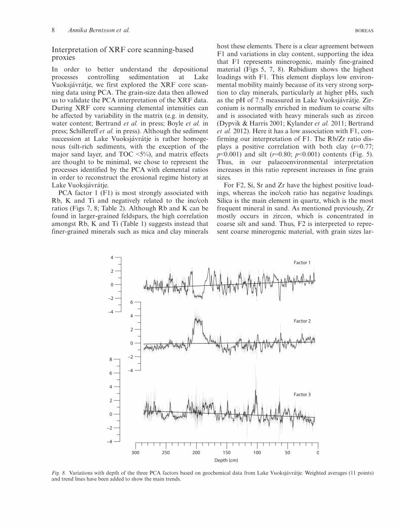
Interpretation of XRF core scanning-basedproxies
In order to better understand the depositionalprocesses controlling sedimentation at LakeVuoksj�avr�atje, we first explored the XRF core scan-ning data using PCA. The grain-size data then allowedus to validate the PCA interpretation of the XRF data.During XRF core scanning elemental intensities canbe affected by variability in the matrix (e.g. in density,water content; Bertrand et al. in press; Boyle et al. inpress; Schillereff et al. in press). Although the sedimentsuccession at Lake Vuoksj�avr�atje is rather homoge-nous (silt-rich sediments, with the exception of themajor sand layer, and TOC <5%), and matrix effectsare thought to be minimal, we chose to represent theprocesses identified by the PCA with elemental ratiosin order to reconstruct the erosional regime history atLake Vuoksj�avr�atje.
PCA factor 1 (F1) is most strongly associated withRb, K and Ti and negatively related to the inc/cohratios (Figs 7, 8; Table 2). Although Rb and K can befound in larger-grained feldspars, the high correlationamongst Rb, K and Ti (Table 1) suggests instead thatfiner-grained minerals such as mica and clay minerals
host these elements. There is a clear agreement betweenF1 and variations in clay content, supporting the ideathat F1 represents minerogenic, mainly fine-grainedmaterial (Figs 5, 7, 8). Rubidium shows the highestloadings with F1. This element displays low environ-mental mobility mainly because of its very strong sorp-tion to clay minerals, particularly at higher pHs, suchas the pH of 7.5 measured in Lake Vuoksj�avr�atje. Zir-conium is normally enriched in medium to coarse siltsand is associated with heavy minerals such as zircon(Dypvik & Harris 2001; Kylander et al. 2011; Bertrandet al. 2012). Here it has a low association with F1, con-firming our interpretation of F1. The Rb/Zr ratio dis-plays a positive correlation with both clay (r=0.77;p<0.001) and silt (r=0.80; p<0.001) contents (Fig. 5).Thus, in our palaeoenvironmental interpretationincreases in this ratio represent increases in fine grainsizes.
For F2, Si, Sr and Zr have the highest positive load-ings, whereas the inc/coh ratio has negative loadings.Silica is the main element in quartz, which is the mostfrequent mineral in sand. As mentioned previously, Zrmostly occurs in zircon, which is concentrated incoarse silt and sand. Thus, F2 is interpreted to repre-sent coarse minerogenic material, with grain sizes lar-
Fig. 8. Variations with depth of the three PCA factors based on geochemical data from Lake Vuoksj�avr�atje. Weighted averages (11 points)and trend lines have been added to show the main trends.
8 Annika Berntsson et al. BOREAS

ger than those represented by F1. Indeed, F2 mirrorsthe sand-sized fraction (Table 2; Figs 5, 7, 8). Silicahas its highest loadings with F2 and the Si/Ti ratio isused to represent coarse grain sizes where Si is themain element in sand, and Ti is associated with clayminerals (Brady 1990; Kylander et al. 2013a). Peaks inSi/Ti correspond to peaks in sand (Fig. 5) and correla-tion analysis showed that Si/Ti is a good proxy forsand content (r=0.82, p<0.001). The correlationbetween Si/Ti and D90 (not shown) is r=0.80(p<0.001). Low values are interpreted as representinghigh silt content (r=�0.83; p<0.001). The negative cor-relation with clay is weak (r=�0.37; p<0.01), suggestingthat Si/Ti mainly represents differences in the propor-tions of sand and silt. It should be noted that Si/Ti issometimes used as a proxy for biogenic silica and dia-tom productivity (Brown et al. 2007; Brigham-Gretteet al. 2013). However, microscopic analysis suggestedthat contribution from biogenic silica is unlikely forthe studied stratigraphy, apart from the uppermostcentimetres.
For F3 the element with the highest loading is Ca,but Sr and Si also have positive loadings. Differentprocesses could be behind the co-variance of Ca andSr. These elements are more easily weathered than Si,K, Ti and Rb and their deposition may thereforeresult in other patterns in the sediment succession.The co-variance of Ca and Sr can also be related tobiological productivity (Wetzel 2001). The presence ofChara oospores and Ostracoda shells amongst themacrofossil remains in the sediments of LakeVuoksj�avr�atje suggests that at least part of the Casignal is the result of biologically precipitated carbon-ates. Comparison with fT (Fig. 5) shows that high F3in the lower part of the core (below ~130 cm; Fig. 8)corresponds to low fT. However, peaks in F3 in theupper part of the core correspond to high terrestrialvalues, suggesting that F3 is not only related towithin-lake productivity, but also sometimes to ero-sion events. Samples with a second coarse mode in thegrain-size distribution (Fig. S1) coincide with some ofthe peaks in F3, which further indicates that F3 maypartly be related to erosion and also to input of mate-rial from a different source, such as previously unex-posed till. Some limestone may be present in the tillwithin the catchment as metamorphic limestone/dolo-mite is mapped in nearby areas; however, phylliteclearly dominates the catchment (Gavelin & Kulling1955). The driver of F3 most likely varies along thelength of the core, with productivity being moreimportant in the lower part of the core and erosionbeing more important in the upper part of the core.Correlation analysis shows that Ca/Ti is not suitableas a proxy for grain-size variations as it has no signifi-cant relationships with D90 (r=0.22; p>0.05), sand(r=0.27; p>0.05) or silt (r=�0.27; p>0.05), and only aweak negative correlation with clay (r=�0.45; p<0.01).
Erosional regimes of Vuoksj�avr�atje catchmentand lake sedimentation
The main source of the sediments deposited in LakeVuoksj�avr�atje is the local till blanket. During possibleepisodic flooding events, the local till may have beenmixed with minerogenic input from the adjoiningnortherly Se€arnjiejuhka River catchment. Restrictedinput from the local bedrock and residual soils isinferred based on the drainage pattern and the outlineof the catchment (Figs 3, 4). The origin of the till isunknown but phyllite dominates in the Se€arNjiejuhkaValley, between Lake Luspasjaure and LakeVuoksj�avr�atje (Fig. 1B) and southwest of the studiedcatchment (Gavelin & Kulling 1955). Owing to theirlocal presence and weak particle cohesion (Garz�onet al. 2012), phyllites are a likely source of clay- andsilt-sized material within the till blanket and ultimately,in the lake sediments. The uncomplicated lake configu-ration suggests a simple sediment distribution pattern.With a maximum fetch of ~300 m and water depth of11.5 m, reworking as a result of wind stress is unlikelyto be an important process. Both a generally wetterclimate and intense precipitation events are thought toimpact catchment erosion and to be reflected in lakesedimentation. A thinner vegetation cover and chan-ged species composition due to a colder climate orincreased grazing may enhance catchment erosion andcontribute both to increasing background sedimenta-tion and to the effect of distinct erosive events (Giguet-Covex et al. 2012, 2014).
Superimposed on the long-term trends in back-ground sedimentation in the Vuok C core are short-term fluctuations, or event deposits, defined here aslayers that are visually distinct from the backgroundsediments and are concurrently reflected in two ormore of the presented proxies. Three types of eventdeposits were identified based on grain size, TOC andXRF proxies: a major event deposit (MED), flooddeposits (F) and slump deposits (S) (Table 3).
Background sedimentation
We regard sedimentation associated with rill and rivu-let erosion as reflecting long-term trends in the activityof slope processes (Figs 3, 4; Table 3). Precipitationfalling within the catchment contributes to rill and riv-ulet erosion, transport and input of sediments to thelake continuously, but with varying intensity. Further-more, increased solifluction and/or decreased vegeta-tion cover may expose sediments in the catchment torill and rivulet erosion. Because of the size of the rillswe assume that only small volumes of water are trans-ported in this way and only small grain sizes arethought to have been transported into the lake basin.Larger particles like sand are thought to have beendeposited in the rill channels or at the delta (Fig. 4).
BOREAS Late Holocene precipitation events, Lake Vuoksj�avr�atje, NW Sweden 9

The background sediment is characterized by a siltcontent of ~80% and laminae with relatively higher orlower organic contents (Fig. 5). Background minero-genic sedimentation and its long-term changes, asreflected by e.g. accumulation rates, are assumed toreflect rill and rivulet erosion, and indirectly solifluct-ion (Table 3; Fig. 4A, E); all of which are expected toincrease as the result of increased wetness in the lakecatchment (Ridefelt et al. 2009a). Higher sedimentaccumulation rates and higher percentages of rheophil-ic and terrestrial/semi-terrestrial chironomids withoutconcurrent event layers are interpreted to represent ageneral increase in solifluction, sheet flow, stream dis-charge and rill erosion. As a result of the weak cohe-sion between silt particles, silty sediments areespecially prone to solifluction (cf. Easterbrook 1999).Ridefelt et al. (2009b) found that wetness togetherwith altitude were the main controls on the spatial var-iation of solifluction within an area of uniform bed-rock in northern Swedish Lapland. An increase incatchment wetness would thus increase solifluctionand thereby generate more sediment deposition in thelake.
Slump deposits (S)
As mentioned previously, solifluction is interpreted tocontribute indirectly to background sedimentation. Inaddition to this process, we interpret layers that havepeaks in clay content, reflected by Rb/Zr and that aregenerally poorly sorted (>56) and with low TOC, asbeing the result of slumping associated with solifluction
front lobe collapse at the lake shore and/or shoreerosion of solifluction lobes (Fig. 5; Table 3) and withlow TOC. Solifluction is a slow-working slope processand slumping is thought to have caused sorting alongthe basin floor with coarse clasts staying close to theshore and successively finer material settling in thedeeper parts of the basin.
Flood deposits (F)
Flooding of low-lying areas within the catchment, andsubsequent rapid discharge, may result in erosion andtransport into the lake. During fieldwork in July 2009,the catchment was flooded (Fig. 4E) after several daysof intense summer rain. Both till-covered and wetlandareas were affected. Alluvial sediments deposited as aresult of such events are expected to display a mix ofcoarse minerogenic and coarse organic detritus fromthe flooded wetland and higher elevations. We there-fore suggest that sediment layers displaying coarseminerogenic material (sand), increased Si/Ti ratios,peaks in TOC and decreased Rb/Zr ratios and claycontent, and generally higher sorting values (>56)(Table 3, Fig. 5), represent extensive flooding of thelower parts of the Lake Vuoksj�avr�atje catchment(Fig. 4E). Although of lower subsampling resolution,higher percentages of rheophilic and terrestrial/semi-terrestrial chironomids (Fig. 5) nevertheless suggestthat erosion of wetlands and increased stream flowoccurred during periods with higher frequencies offlooding events. Some of the identified F layers show abimodal grain-size distribution (Fig. S1), suggesting
Table 3. Interpretation of sediment sources and landforms associated with sediment deposition in Lake Vuoksj�avr�atje.
Catchment process Sediment source Sedimentation in lake Proxy indicators in core Interpretation
Rill and rivuleterosion and deltaformation (active)
Till blanket Spatial sorting withincatchment, fining basinwardwith larger clasts along rillsor delta and fines(clay – silt) in lake
Background minerogenic content.Increase indicated by higheraccumulation rates, high proportionof terrestrial/semi-terrestrialchironomids and possibly increasingtrend in F1 and F2
Increase reflects generalincrease in wetness anddischarge and possible lossof vegetation cover
Slumping or shoreerosion ofsolifluction lobes
Till blanket Event-like deposition ofpoorly sorted sediment,spatial sorting within lake,coarsening landward
High Rb/Zr (clay), relatively highclay content, generally highersorting values (>56) and lower TOC
Intensified solifluctionactivity caused by generalwetness (S in Fig. 5)
Surface erosion ofwetland
Till blanket andwetlandvegetation
Event-like deposition ofpoorly sorted coarseminerogenic (sand) mixedwith organogenic material
High Si/Ti (sand) and TOC, andlow Rb/Zr (clay), generally highersorting values (>56)
Flooding of catchmentcaused by intenseprecipitation (F in Fig. 5)
Alluvial fanformation (fossil)
Till blanket andglacifluvialdeposits incatchment northof study area
High energy influx. Spatialsorting, possible transportof fines out of lake
Coarsening-upwards grain size inlower part of the succession, highSi/Ti (sand) and low Rb/Zr (clay)in the mid-part and fining upwardsin upper part, low–high–lowsorting trend, low chironomidconcentration
High discharge flood causedby precipitation, temporaryreconfiguration ofcatchment (MED in Fig. 5)
10 Annika Berntsson et al. BOREAS

two different sources of particles and/or another trans-port mechanism. These could have been caused by amixing of particles transported by rills and particlestransported from the till blanket through extensive sur-face runoff. The two modes may also be the result oftwo processes having been recorded in one subsamplewithout having occurred simultaneously.
Major event deposit (MED)
The MED (Fig. 5) is unique during the 5100 years ofsedimentation recorded in Lake Vuoksj�avr�atje.Increasing Si/Ti and decreasing Rb/Zr ratios, con-firmed by increasing mean grain sizes and sand con-tent, suggest a coarsening-upward of the lower third ofthe MED (Table 3). The values of these proxies wererather stable in the mid-part of the MED (Fig. 5). Inthe upper third of the MED there is a fining-upwardtrend, with decreasing mean grain size and sand con-tent, reflected in decreasing Si/Ti and increasing Rb/Zrratios. Sorting displays a low–high–low pattern withinthe MED (Fig. 5). Based on the internal grain-sizeevolution of the deposit, the MED is interpreted as aflood turbidite (e.g. Gilli et al. 2013). The deposit ischaracterized by very low absolute concentrations ofchironomid head capsules (Berntsson et al. 2014),probably stemming from the rapid accumulation of thedeposit and turbulent conditions. The few head cap-sules encountered belong to terrestrial/semi-terrestrialtaxa (Fig. 5). The grain-size distribution shows abimodal pattern within the lower part of the MED, fol-lowed by a unimodal distribution in the middle of thedeposit, different from the core background mode, andagain a bimodal distribution in the upper part (Fig.S1). According to the age model the MED occurred c.2900 cal. a BP (2790–3004 cal. a BP; 95%; Fig. 3).Possible sources for these sands are quartzite upstreamin the Se€arNjiejuhka Valley (Gavelin & Kulling 1955)or quartz incorporated in the local phyllite bedrock orthe till blanket.
A channel running from the Se€arNjiejuhka Rivercatchment in the N ends in a currently inactive alluvialfan at the NW shore of Lake Vuoksj�avr�atje (Fig. 3).We consider that three alternative formation processesof this alluvial fan and the associated channel are pos-sible: (i) a flood, associated with high precipitationand discharge, caused the Se€arNjiejuhka River to rise~3 m above the present-day river level (from 852 to855 m a.s.l. according to the Swedish National DEM);(ii) the drainage of Se€arNjiejuhka River was blockedby river ice during a spring flood, which forced thewater over the col into the Lake Vuoksj�avr�atje catch-ment; (iii) formation by meltwater during the lastdeglaciation. Of these alternatives, the latter does notfit with the suggested ice-retreat pattern during thedeglaciation (Blomdin 2009). We therefore find it unli-kely. The other two explanations imply a temporary
reconfiguration of the hydrological system in whichwater spilled over from the Se€arNjiejuhka River catch-ment into the Lake Vuoksj�avr�atje catchment (Fig. 3).We find it less likely that such a redirection of thedrainage was caused by ice damming as this could beexpected to happen more often than once in5100 years. In both cases however, it would be causedby excessive amounts of precipitation (summer-autumn precipitation and/or snow-melt) and the sedi-mentary imprint would be similar.
Based on its thickness and fluvial character, we sug-gest that the MED (Fig. 5) in Lake Vuoksj�avr�atje wasformed by the same major flood that built the alluvialfan at the lake shore. The two modes of the bimodalgrain-size distributions (Fig. S1) in the upper andlower part of the MED may represent a mix of sedi-ment transported in suspension by the river and sedi-ment eroded by the river passing the sill to the lake, ora mix of sediment from the normal Lake Vuoksj�avr�atjecatchment and sediment transported from the Se€arNji-ejuhka River catchment. The basal coarsening-upwardportion of the MED very likely represents the risinglimb of the flood, whereas the upper fining-upwardportion is believed to be the signature of the waningphase of the flood. The uppermost part of the depositis composed of a thin ‘clay cap’ that probably repre-sents the final deposition of fine-grained particles thatremained in suspension in the water column. We find itless likely that a slow process like solifluction triggereda current that led to the deposition of the MED. A tur-bidite deposit resulting from such a slope failure wouldpresent a continuous fining-upward trend, i.e. it wouldnot display the coarsening-upward basal layer that istypical of flood turbidites. In addition, if solifluctionwere responsible for the deposit, similar signals in thesediments would be seen in more recent times, which isnot the case. As the sediment core only extends back toc. 5100 cal. a BP it cannot be excluded the alluvial fanstarted to form earlier than identified in this study.Today the alluvial fan is inactive and covered with veg-etation, and solifluction lobes overlay its W and NEparts (Figs 3, 4D), suggesting that it has been inactivefor some time.
Environmental and climatic implications
Here we describe the erosion history of the LakeVuoksj�avr�atje catchment over the last 5100 years asregistered in the sediment succession (Fig. 9; Table 3),and discuss it in relation to regional palaeoenvironmen-tal and palaeoclimatic changes. The stratigraphy wasseparated into four units based on interpretation of thecombined proxy record (Figs 5, 9). These broadly coin-cide with previously published zones based on chirono-mid composition in the stratigraphy except for theuppermost zone limit, which was placed at 1050 cal. aBP based on chironomids only (Berntsson et al. 2014).
BOREAS Late Holocene precipitation events, Lake Vuoksj�avr�atje, NW Sweden 11

5120 to 2900 cal. a BP (290–207 cm depth)
During this period, geomorphological processes arethought to have been dominated by constant slow soli-fluction and rill and rivulet erosion (Fig. 3) as sug-gested by silt-dominated sediments (~80% silt), lowvariations in Rb/Zr and Si/Ti ratios and low accumula-tion rates (mean 0.42 mm a�1), with an increasearound 4000 cal. a BP (Figs 5, 9). The low percentage(mean 1.1%) of terrestrial/semi-terrestrial chironomidtaxa also suggests that catchment surface erosion waslow, whereas a moderate increase in rheophilic taxaindicates progressively increased wetness (Fig. 9), witha peak (7.6%) at c. 3800 cal. a BP. The fT stayed ataround 0.5 until c. 3800 cal. a BP, after which valuesfluctuated more. With the exception of higher clay sug-gesting minor slumping or shore erosion of solifluctionlobes around 3800 and 2950 cal. a BP (Fig. 9), thisperiod appears to have been relatively stable from anerosional point of view. The chironomid-based Julytemperature reconstruction showed a decrease from~9.7 to 8.6°C between 5100 and 4100 cal. a BP and
temperatures stayed low until c. 3600 cal. a BP (Bern-tsson et al. 2014). Numerous studies from Fennoscan-dia have identified a cooling around this time (e.g.Barnekow 1999; Bergman et al. 2005; Jessen et al.2005; Velle et al. 2005; Antonsson et al. 2006), and ithas also been suggested that the climate became wetterfrom c. 4000 cal. a BP compared with earlier parts ofthe Holocene (Kullman 1995; Hammarlund et al.2004; Rosqvist et al. 2004; V€aliranta et al. 2007; Borg-mark & Wasteg�ard 2008; Jonsson et al. 2010). Studiesof proglacial lake sediments have indicated increasedglacial activity and accordingly the period is oftenreferred to as the Neoglacial (Karl�en & Matthews1992; Dahl & Nesje 1996; Davis et al. 2009). No signsof Holocene glaciation were found in the LakeVuoksj�avr�atje catchment.
2900–2400 cal. a BP (207–153 cm depth)
This time interval is characterized by increased wet-ness and discharge leading to catchment instabilitywith increased solifluction and event deposits in the
TOC (%)
Acccu
mulation
rate (
mm a–
1 )
Rb/ZrTerres
trial
and
semi-te
rrestr
ial
chiro
nomids (%)
Rheophilic
chiro
nomids (%)
Si/Ti
Age
(cal
. a B
P)
Fractio
n terre
strial
organ
ic C (f T
)
5000
4500
4000
3500
3000
2500
2000
1500
1000
500
0
Instantaneous
0 0.50 1.0
0 1 2 5 6430 0.4 0.8 21.61.20 20 40 100
0 0.05 0.100 10 30200 1 2 3
FFFFF
FMED
SSS
SSS
S
Fig. 9. Selected proxies plotted against age: Sediment accumulation rate, erosion and wetness indicating chironomids (rheophilic and terres-trial/semi-terrestrial taxa), Rb/Zr and Si/Ti, including weighted averages (11 points) as proxies for grain size, TOC and fraction of terrestrialorganic carbon. S = minor slump; F = flood deposit; MED = major event deposit. Light blue zones mark periods interpreted as representinga minor increase in catchment erosion.
12 Annika Berntsson et al. BOREAS

lake. The MED (2900 cal. a BP), which is unique forthe 5100 years of sedimentation in Lake Vu-oksj�avr�atje, marks the onset of this period and wasmost probably formed by a unusually high dischargefrom the Se€arNjiejuhka River catchment caused byexcessive precipitation. The very few chironomidhead capsules found in this deposit (Berntsson et al.2014) were all terrestrial (Fig. 9). Similarly, the fTwas high. In the centuries following this major floodevent, minor slumps or shore erosion of solifluctionlobes occurred (Fig. 9), followed by relatively highsediment accumulation rates (up to 0.88 mm a�1).Erosion of the newly formed alluvial fan may alsohave contributed. During this time the chironomidconcentrations remained low, with anomalously highproportions of terrestrial and semi-terrestrial chiron-omids (Fig. 9; Berntsson et al. 2014).
Studies from northern and west-central Europe sug-gest a transition to a cool and wet climate during thistime interval (van Geel et al. 1996, 1998, 2000, 2014;Grudd et al. 2002; Speranza et al. 2003; Mauquoyet al. 2004; Chambers et al. 2010; Sejrup et al. 2011),mainly characterized by higher bog surface wetness innorthern Europe (Granlund 1932; Gunnarson et al.2003; Gunnarson 2008; Andersson & Schoning 2010;Chambers et al. 2010; Kylander et al. 2013b). Theincreased wetness during this time has been attributedto a reorganization of the North Atlantic current andto reduced solar activity (van Geel et al. 1996, 1998,2000; Speranza et al. 2003; Mauquoy et al. 2004;Chambers et al. 2007; Wang et al. 2012). The elevatedsediment accumulation rates in Lake Vuoksj�avr�atjeduring the following centuries may be related to thisclimate deterioration or catchment instability resultingfrom the major flood event.
2400–1400 cal. a BP (153–117 cm depth)
During this time interval, erosion processes are inter-preted to have been dominated by solifluction and rillerosion as sediment accumulation rates are lower andpossible event layers are less pronounced than duringthe previous interval. The decrease in accumulationrates indicates some stabilization of the catchmentslopes. The less pronounced erosion is reflected in thelithology and the relatively higher TOC compared withprevious intervals (Figs 5, 9). There are minor peaks inSi/Ti ratios with concurrent peaks in TOC and fT(Fig. 9), possibly reflecting minor flooding eventsalthough the Si/Ti level is relatively low. Chironomidcompositions show relative stability (Fig. 9) and thereconstructed temperatures are similar to modernreference temperatures but with a slight decreasingtrend (Berntsson et al. 2014). Lake levels in southernSweden suggest intermediate wetness at c. 2500–1600 cal. a BP (Harrison & Digerfeldt 1993), in accor-dance with our results.
1400 cal. a BP to present (117 cm – top of core)
From 1400 cal. a BP onwards conditions in the catch-ment became more unstable as suggested by theincreased number of pronounced event layers (Fig. 9)followed by increasing sediment accumulation ratesfrom c. 1000 cal. a BP, peaking around 670 cal. a BP(2.33 mm a�1). Higher percentages of terrestrial/semi-terrestrial and rheophilic chironomids from c. 1000 cal.a BP and high fT from 620 cal. a BP to the top of therecord further support an interpretation of increasedcatchment erosion (Figs 5, 9). Peaks in coarse-grained,relatively highly sorted sediment mixed with organicmaterial interpreted to represent flooding eventsoccurred at c. 1360, 1100, 950, 800 and 620 cal. a BP(Figs 5, 9; Table 3). It is possible that these floods partlyemerged from the Se€arNjiejuhka River catchment andcontributed to the build-up of the alluvial fan (Fig. 3).Minor slumps or erosion of solifluction lobes close tothe lake shore occurred c. 780, 730 and 460 cal. a BP(Figs 5, 9; Table 3).
The anomalous proportions of rheophilic and terres-trial/semi-terrestrial chironomids in the lake biased thechironomid-inferred July temperature reconstructionfor the period between 1050 to 100 cal. a BP in LakeVuoksj�avr�atje (Berntsson et al. 2014). Other studiessuggest that the climate in Fennoscandia was generallycooler and wetter during the last millennium comparedwith the Holocene as a whole (Moberg et al. 2005;Wanner et al. 2008). In mid-Sweden, reconstructedwater tables show increased wetness between 1000 and50 cal. a BP (Andersson & Schoning 2010). High lakelevels and low peat humification show that wetnessincreased in southern Sweden during the last millen-nium (Harrison & Digerfeldt 1993; Kylander et al.2013b). However, there were also large changes in pre-cipitation within this period. Increased summer precip-itation at 950–870, 590–510 and 130–50 cal. a BP hasbeen inferred from two highly resolved lake sedimentrecords in NW and west-central Sweden (Rosqvistet al. 2013). From c. 510 cal. a BP there was a shiftfrom a situation with relatively more summer thanwinter precipitation to a greater influence of winterprecipitation, marking the beginning of the Little IceAge (Rosqvist et al. 2013). We suggest that increasedwinter precipitation during this period (Rosqvist et al.2013) led to intensified solifluction because of waterlogging resulting from snow-melt. This solifluctioncould have been further enhanced by frozen subsurfaceground hampering water permeability (Easterbrook1999). Intensified reindeer herding at c. 800 cal. a BPhas had permanent effects on the local tree line at indi-vidual nearby sites in the Vindelfj€allen Mountains(Karlsson et al. 2007; Staland et al. 2011), and couldhave also had an effect on the Lake Vuoksj�avr�atjecatchment, leading to enhanced erosion from that time(Giguet-Covex et al. 2012, 2014).
BOREAS Late Holocene precipitation events, Lake Vuoksj�avr�atje, NW Sweden 13

Conclusions
We combined abiotic and biotic proxies in lakesediments as well as catchment analysis to investigatethe importance of catchment geomorphology in theinterpretation of lake sediment records in terms of pala-eoenvironments and palaeoclimate. The results showthat Si/Ti and Rb/Zr ratios can be used as high-resolu-tion proxies of grain size. Additionally, we conclude thatchironomids can be useful indicators of fluvial andcatchment erosion.
The early part of our record, which began accumu-lating 5100 years ago, indicates relatively stable climateconditions until c. 2900 cal. a BP. Then, the recorddisplays increasingly variable sediment input, inter-preted as the result of increased wetness and intenseprecipitation events. We suggest that c. 2900 cal. a BPan extreme discharge event caused the overflow ofSe€arNjiejuhka River, resulting in the formation of analluvial fan and a turbidity current in Lake Vu-oksj�avr�atje. Following this major event, minor floodsand minor slumping caused by shore erosion of soli-fluction lobes became more frequent and/or the allu-vial fan was eroded. This period of more frequentevents and elevated sediment accumulation rates lastedfor c. 500 years before the erosional environment sta-bilized again. From c. 1400 cal. a BP a series of eventlayers suggest intense precipitation events. The lastc. 1000 years were characterized by generally increasedwetness leading to greater catchment erosion, both interms of rill and rivulet erosion and solifluction, asreflected by higher sediment accumulation rates andincreased percentages of rheophilic and terrestrial/semi-terrestrial chironomids in Lake Vuoksj�avr�atje.
Previous research has suggested that lakes in similaralpine settings but with differences in catchment geo-morphology may result in very different lake sedimen-tation patterns. From the present study it is confirmedthat geomorphological processes should also be consid-ered when interpreting lake sediments from lakes withgently sloping catchments. By combining lake sedimentcore analysis with geomorphological mapping, it hasbeen possible to achieve a more complete understand-ing of the processes taking place at the catchment level,the factors governing the erosional regimes and the wayin which these are recorded in lake sediments.
Acknowledgements. – We are grateful to: Andrew Mercer, GunhildRosqvist and Ulf Eskilsson, who assisted with the sediment coring;Robin Blomdin, who assisted with the summer field mapping; SteveBrooks and Lars Eriksson, who helped with identification of criticalsubfossil chironomids; Caroline George, who carried out TOC mea-surements; Ludvig L€owemark, who ran the ITRAX core scanner;Virginie Payre-Suc who performed the grain-size laboratory analysis.Fieldwork and analyses were supported by Andreefonden (SvenskaS€allskapet f€or Antropologi och Geografi), G€oran Gustafssons stift-else f€or forskning i Lappland, Mannerfeldts Fond f€or geografiskforskning and De Geers Stiftelse f€or kvart€argeologisk forskning.Gunhild Rosqvist, Richard Chiverrell and Fabien Arnaud contrib-uted valuable comments that improved the manuscript.
References
Alexandersson, H. & Eggertsson Karlstr€om, C. 2001: Temperaturenoch nederb€orden i Sverige 1961–1990. Referensnormaler. 71 pp.Sveriges Meteorologiska och Hydrologiska Institut, Norrk€oping.
Andersson, S. & Schoning, K. 2010: Surface wetness and mire devel-opment during the late Holocene in central Sweden. Boreas 39,749–760.
Antonsson, K., Brooks, S. J., Seppa, H., Telford, R. J. & Birks, H. J. B.2006: Quantitative palaeotemperature records inferred from fossilpollen and chironomid assemblages from Lake Gilltjarnen, north-ern central Sweden. Journal of Quaternary Science 21, 831–841.
Arnaud, F., Revel, M., Chapron, E., Desmet, M. & Tribovillard, N.2005: 7200 years of Rhone river flooding activity in Lake Le Bour-get, France: a high-resolution sediment record of NWAlps hydrol-ogy. The Holocene 15, 420–428.
Barnekow, L. 1999: Holocene tree-line dynamics and inferred cli-matic changes in the Abisko area, northern Sweden, based on mac-rofossil and pollen records. The Holocene 9, 253–265.
Bergman, J., Hammarlund, D., Hannon, G., Barnekow, L. & Wohlf-arth, B. 2005: Deglacial vegetation succession and Holocene tree-line dynamics in the Scandes Mountains, west-central Sweden:stratigraphic data compared to megafossil evidence. Review ofPalaeobotany and Palynology 134, 129–151.
Berntsson, A., Rosqvist, G. C. & Velle, G. 2014: Late-Holocene tem-perature and precipitation changes in Vindelfjallen, mid-westernSwedish Lapland, inferred from chironomid and geochemicaldata. The Holocene 24, 78–92.
Bertrand, S., Hughen, K. & Giosan, L. in press: Limited influence ofsediment grain-size on elemental XRF core scanner measurements.In Rothwell, R. G. & Croudace, I. W. (eds.): Developments inPalaeoenvironmental Research: Micro-XRF Studies of SedimentCores. Springer, Dordrecht.
Bertrand, S., Hughen, K., Sep�ulveda, J. & Pantoja, S. 2012: Geo-chemistry of surface sediments from the fjords of Northern Chil-ean Patagonia (44–47°S): spatial variability and implications forpaleoclimate reconstructions. Geochimica et Cosmochimica Acta76, 125–146.
Bertrand, S., Sterken, M., Vargas-Ramirez, L., De Batist, M.,Vyverman, W., Lepoint, G. & Fagel, N. 2010: Bulk organicgeochemistry of sediments from Puyehue Lake and its watershed(Chile, 40°S): implications for paleoenvironmental reconstructions.Palaeogeography, Palaeoclimatology, Palaeoecology 294, 56–71.
Bigler, C., Larocque, I., Peglar, S. M., Birks, H. J. B. & Hall, R. I.2002: Quantitative multiproxy assessment of long-term patterns ofHolocene environmental changes from a small lake near Abisko,northern Sweden. The Holocene 12, 481–496.
Blaauw, M. 2010: Methods and code for ‘classical’ age-modelling ofradiocarbon sequences. Quaternary Geochronology 5, 512–518.
Blikra, L. H. & Nemec, W. 1998: Postglacial colluvium in westernNorway: depositional processes, facies and palaeoclimatic record.Sedimentology 45, 909–959.
Blomdin, R. 2009: Deglaciationsf€orloppet och isd€amda sj€oar i Vin-del€alvens k€allomr�ade, norr om Ammarn€as. B.Sc. thesis, StockholmUniversity, 51 pp.
Blott, S. J. & Pye, K. 2001: GRADISTAT: a grain size distributionand statistics package for the analysis of unconsolidated sediments.Earth Surface Processes and Landforms 26, 1237–1248.
Borgmark, A. & Wasteg�ard, S. 2008: Regional and local patterns ofpeat humification in three raised peat bogs in V€armland, south-central Sweden. GFF 130, 161–176.
Boyle, J., Chiverrell, R. & Schillereff, D. in press: Approaches towater content correction and calibration for µXRF core scanning:comparing x-ray scatter with simple regression of elemental con-centrations. In Rothwell, R. G. & Croudace, I. W. (eds.): Develop-ments in Palaeoenvironmental Research: Micro-XRF Studies ofSediment Cores. Springer, Dordrecht.
Brady, N. C. 1990: The Nature and Properties of Soils. 621 pp. Mac-Millan, New York.
Brigham-Grette, J., Melles, M., Minyuk, P., Andreev, A., Tarasov, P.,DeConto, R., Koenig, S., Nowaczyk, N., Wennrich, V., Ros�en, P.,Haltia, E., Cook, T., Gebhardt, C., Meyer-Jacob, C., Snyder, J. &
14 Annika Berntsson et al. BOREAS

Herzschuh, U. 2013: Pliocene warmth, polar amplification, andstepped Pleistocene cooling recorded in NE Arctic Russia. Science340, 1421–1427.
Brooks, S. J., Langdon, P. G. & Heiri, O. 2007: The identificationand use of Palaearctic Chironomidae larvae in palaeocology.Quaternary Research Association, Technical Guide 10. 276 pp.
Brown, E. T., Johnson, T. C., Scholz, C. A., Cohen, A. S. & King, J.W. 2007: Abrupt change in tropical African climate linked to thebipolar seesaw over the past 55 000 years. Geophysical ResearchLetters 34, L20702, doi:10.1029/2007GL031240.
Chambers, F. M., Daniell, J. R. G. & ACCROTELM Members.2010: Peatland archives of late-Holocene climate change in north-ern Europe. PAGES Newsletter 18, 4–6.
Chambers, F. M., Mauquoy, D., Brain, S. A., Blaauw, M. & Daniell,J. R. G. 2007: Globally synchronous climate change 2800 yearsago: proxy data from peat in South America. Earth and PlanetaryScience Letters 253, 439–444.
Cranston, P. 2010: Chiro Key. Available at: http://chirokey.skullis-land.info/ (accessed 09.06.2014).
Dahl, S. O. & Nesje, A. 1996: A new approach to calculating Holo-cene winter precipitation by combining glacier equilibrium-linealtitudes and pine-tree limits: a case study from Hardangerjøkulen,central southern Norway. The Holocene 6, 381–398.
Davis, P. T., Menounos, B. & Osborn, G. 2009: Holocene and latestPleistocene alpine glacier fluctuations: a global perspective. Qua-ternary Science Reviews 28, 2021–2033.
Dypvik, H. & Harris, N. B. 2001: Geochemical facies analysis offine-grained siliciclastics using Th/U, Zr/Rb and (Zr+Rb)/Sr ratios.Chemical Geology 181, 131–146.
Easterbrook, D. J. 1999: Surface Processes and Landforms. 546 pp.Prentice-Hall, New Jersey.
Eriksson, L., Johansson, E., Kettaneh-Wodl, N. & Wold, S. 1999:Introduction to Multi and Mega-Variate Data Analysis using Pro-jection Methods (PCA & PLS). 490 pp. Umetrics AB, Ume�a.
Garz�on, E. G., Ru�ız-Conde, A. & S�anchez-Soto, P. J. 2012: Multivar-iate statistical analysis of phyllite samples based on chemical(XRF) and mineralogical data by XRD. American Journal of Ana-lytical Chemistry 3, 347–363.
Gavelin, S. & Kulling, O. 1955: Berggrundskarta €over V€asterbottensl€an. Pre-Quaternary Rocks of the V€asterbotten County. 1:400000.Sveriges Geologiska Unders€okning, Stockholm.
van Geel, B., Buurman, J. & Waterbolk, H. T. 1996: Archaeologicaland palaeoecological indications of an abrupt climate change inThe Netherlands, and evidence for climatological teleconnectionsaround 2650 BP. Journal of Quaternary Science 11, 451–460.
van Geel, B., Heijnis, H., Charman, D. J., Thompson, G. & Engels,S. 2014: Bog burst in the eastern Netherlands triggered by the 2.8kyr BP climate event. The Holocene 24, 1465–1477.
van Geel, B., Heusser, C. J., Renssen, H. & Schuurmans, C. J. E.2000: Climatic change in Chile at around 2700 BP and globalevidence for solar forcing; a hypothesis. The Holocene 10, 659–664.
van Geel, B., van der Plicht, J., Kilian, M. R., Klaver, E. R., Kou-wenberg, J. H. M., Renssen, H., Reynaud-Farrera, I. & Waterbolk,H. T. 1998: The sharp rise of d14C ca. 800 cal BC: possible causes,related climatic teleconnections and the impact on human environ-ments. Radiocarbon 40, 535–550.
Giguet-Covex, C., Arnaud, F., Enters, D., Poulenard, J., Millet, L.,Francus, P., David, F., Rey, P.-J., Wilhelm, B. & Delannoy, J.-J.2012: Frequency and intensity of high-altitude floods over the last3.5 ka in northwestern French Alps (Lake Anterne). QuaternaryResearch 77, 12–22.
Giguet-Covex, C., Pansu, J., Arnaud, F., Rey, P.-J., Griggo, C., Giel-ly, L., Domaizon, I., Coissac, E., David, F., Choler, P., Poulenard,J. & Taberlet, P. 2014: Long livestock farming history and humanlandscape shaping revealed by lake sediment DNA. Nature Com-munications 5, 1–7.
Gilli, A., Anselmetti, F. S., Glur, L. & Wirth, S. B. 2013: Lake sedi-ments as archives of recurrence rates and intensities of past floodevents. In Schneuwly-Bollschweiler, M., Stoffel, M. & Rudolf-Mik-lau, F. (eds.): Dating Torrential Processes on Fans and Cones, 225–242. Advances in Global Change Research 47, Springer Nether-lands, Dordrecht. Advances in Global Change Research 47.
Glur, L., Wirth, S., B€untgen, U., Gilli, A., Haug, G., Sch€ar, C., Beer,J. & Anselmetti, F. S. 2013: Frequent floods in the European Alpscoincide with cooler periods of the past 2500 years. ScientificReports 3, 1–5.
Granlund, E. 1932: De svenska h€ogmossarnas geologi. Sveriges Geo-logiska Unders€okning C 26, 193 pp.
Grudd, H., Briffa, K. R., Karl�en, W., Bartholin, T. S., Jones, P. D. &Kromer, B. 2002: A 7400-year tree-ring chronology in northernSwedish Lapland: natural climatic variability expressed on annualto millennial timescales. The Holocene 12, 657–665.
Gunnarson, B. E. 2008: Temporal distribution pattern of subfossilpines in central Sweden: perspective on Holocene humidity fluctu-ations. The Holocene 18, 569–577.
Gunnarson, B. E., Borgmark, A. & Wasteg�ard, S. 2003: Holocenehumidity fluctuations in Sweden inferred from dendrochronologyand peat stratigraphy. Boreas 32, 347–360.
Hammarlund, D., Velle, G., Wolfe, B. B., Edwards, T. W. D., Barne-kow, L., Bergman, J., Holmgren, S., Lamme, S., Snowball, I.,Wohlfarth, B. & Possnert, G. 2004: Palaeolimnological and sedi-mentary responses to Holocene forest retreat in the ScandesMountains, west-central Sweden. The Holocene 14, 862–876.
Harrison, S. P. & Digerfeldt, G. 1993: European lakes as palaeohy-drological and palaeoclimatic indicators. Quaternary ScienceReviews 12, 233–248.
Heiri, O., Wick, L., van Leeuwen, J. F. N., van der Knaap, W. O. &Lotter, A. F. 2003: Holocene tree immigration and the chironomidfauna of a small Swiss subalpine lake (Hinterburgsee, 1515 m a.s.l.).Palaeogeography, Palaeoclimatology, Palaeoecology 189, 35–53.
Jessen, C. A., Rundgren, M., Bjorck, S. & Hammarlund, D. 2005:Abrupt climatic changes and an unstable transition into a lateHolocene Thermal Decline: a multiproxy lacustrine record fromsouthern Sweden. Journal of Quaternary Science 20, 349–362.
Jonsson, C. E., Andersson, S., Rosqvist, G. C. & Leng, M. J. 2010:Reconstructing past atmospheric circulation changes using oxygenisotopes in lake sediments from Sweden. Climate of the Past 6,49–62.
Juggins, S. 2013: Quantitative reconstructions in palaeolimnology:new paradigm or sick science? Quaternary Science Reviews 64, 20–32.
Karl�en, W. & Matthews, J. A. 1992: Reconstructing Holocene glaciervariations from glacial lake sediments: studies from Nordvestlan-det and Jostedalsbreen-Joutenheimen, southern Norway. Geogra-fiska Annaler, Series A, Physical Geography 74, 327–348.
Karlsson, H., H€ornberg, G., Hannon, G. & Nordstr€om, E. M. 2007:Long-term vegetation changes in the northern Scandinavian forestlimit: a human impact-climate synergy? The Holocene 17, 37–49.
Koinig, K. A., Shotyk, W., Lotter, W. A., Ohlendorf, C. & Sturm, M.2003: 9000 years of geochemical evolution of lithogenic major andtrace elements in the sediment of an alpine lake – the role of cli-mate, vegetation and land-use history. Journal of Paleolimnology30, 307–320.
Kullman, L. 1995: Holocene tree-limit and climate history from theScandes Mountains, Sweden. Ecology 76, 2490–2502.
Kylander, M. E., Ampel, L., Wohlfarth, B. & Veres, D. 2011: High-resolution X-ray fluorescence core scanning analysis of Les Echets(France) sedimentary sequence: new insights from chemical prox-ies. Journal of Quaternary Science 26, 109–117.
Kylander, M. E., Bindler, R., Mart�ınez Cortizas, A., Gallagher, K.,M€orth, C.-M. & Rauch, S. 2013b: A novel geochemical approachto paleorecords of dust deposition and effective humidity:8500 years of peat accumulation at Store Mosse (the ‘Great Bog’),Sweden. Quaternary Science Reviews 69, 69–82.
Kylander, M. E., Klaminder, J., Wohlfarth, B. & L€owemark, L.2013a: Geochemical responses to paleoclimatic changes in south-ern Sweden since the late glacial: the H€asseldala Port lake sedi-ment record. Journal of Paleolimnology 50, 57–70.
Laaksonen, K. 1976: The dependence of mean air temperatures uponlatitude and altitude in Fennoscandia (1921–1950). Annales Aca-demiæ Scientiarum Fennicæ A III, 1–18.
Larocque, I. & Hall, R. I. 2004: Holocene temperature estimates andchironomid community composition in the Abisko Valley, north-ern Sweden. Quaternary Science Reviews 23, 2453–2465.
BOREAS Late Holocene precipitation events, Lake Vuoksj�avr�atje, NW Sweden 15

Lavrieux, M., Disnar, J. R., Chapron, E., Breheret, J. G., Jacob, J.,Miras, Y., Reyss, J. L., Andrieu-Ponel, V. & Arnaud, F. 2013:6700 yr sedimentary record of climatic and anthropogenic signalsin Lake Aydat (French Massif Central). The Holocene 23, 1317–1328.
Liu, X., Colman, S. M., Brown, E. T., Minor, E. C. & Li, H. 2013:Estimation of carbonate, total organic carbon, and biogenic silicacontent by FTIR and XRF techniques in lacustrine sediments.Journal of Paleolimnology 50, 387–398.
Mauquoy, D., van Geel, B., Blaauw, M., Speranza, A. & van derPlicht, J. 2004: Changes in solar activity and Holocene climaticshifts derived from 14C wiggle-match dated peat deposits. TheHolocene 14, 45–52.
Moberg, A., Sonechkin, D. M., Holmgren, K., Datsenko, N. M.& Karl�en, W. 2005: Highly variable Northern Hemispheretemperatures reconstructed from low- and high-resolution proxydata. Nature 433, 613–617.
Moreno, A., Valero-Garc�es, B. L., Gonz�alez-Samp�eriz, P. & Rico,M. 2008: Flood response to rainfall variability during the last2000 years inferred from the Taravilla Lake record (Central Ibe-rian Range, Spain). Journal of Paleolimnology 40, 943–961.
Perdue, E. M. & Koprivnjak, J.-F. 2007: Using the C/N ratio to esti-mate terrigenous inputs of organic matter to aquatic environments.Estuarine Coastal and Shelf Science 73, 65–72.
Reimer, P. J., Bard, E., Bayliss, A., Beck, J. W., Blackwell, P. G.,Bronk Ramsey, C., Buck, C. E., Edwards, R. L., Friedrich, M.,Grootes, P. M., Guilderson, T. P., Haflidason, H., Hajdas, I.,Hatt�e, C., Heaton, T. J., Hoffmann, D. L., Hogg, A. G., Hughen,K. A., Kaiser, K. F., Kromer, B., Manning, S. W., Niu, M., Reimer,R. W., Richards, D. A., Scott, E. M., Southon, J. R., Turney, C. S.M. & van der Plicht, J. 2013: IntCal13 and Marine13 radiocarbonage calibration curves, 0–50 000 years cal BP. Radiocarbon 55,1869–1887.
Ridefelt, H., �Akerman, J., Beylich, A. A., Boelhouwers, J., Kolstrup,E. & Nyberg, R. 2009a: 56 years of solifluction measurements inthe Abisko mountains, northern Sweden – Analysis of temporaland spatial variations of soil surface movement. GeografiskaAnnaler, Series A, Physical Geography 91A, 215–232.
Ridefelt, H., Boelhouwers, J. & Eiken, T. 2009b: Measurement ofsolifluction rates using multi-temporal aerial photography. EarthSurface Processes and Landforms 34, 725–737.
Ros�en, P., Segerstr€om, U., Eriksson, L., Renberg, I. & Birks, H. J. B.2001: Holocene climatic change reconstructed from diatoms, chir-onomids, pollen and near-infrared spectroscopy at an alpine lake(Sjuodjijaure) in northern Sweden. The Holocene 11, 551–562.
Rosqvist, G. C., Leng, M. J., Goslar, T., Sloane, H. J., Bigler, C.,Cunningham, L., Dadal, A., Bergman, J., Berntsson, A., Jonsson,C. & Wasteg�ard, S. 2013: Shifts in precipitation during the last mil-lennium in northern Scandinavia from lacustrine isotope records.Quaternary Science Reviews 66, 22–34.
Rosqvist, G., Jonsson, C., Yam, R., Karl�en, W. & Shemesh, A. 2004:Diatom oxygen isotopes in pro-glacial lake sediments from north-ern Sweden: a 5000 year record of atmospheric circulation. Qua-ternary Science Reviews 23, 851–859.
Rubensdotter, L. & Rosqvist, G. 2003: The effect of geomorphologi-cal setting on Holocene lake sediment variability, northern Swed-ish Lapland. Journal of Quaternary Science 18, 757–767.
Schillereff, D., Chiverrell, R., Boyle, J. & Croudace, I. in press: Aninter-comparison of µXRF scanning analytical methods. In Roth-well, R. G. & Croudace, I. W. (eds.): Developments in Palaeoenvi-ronmental Research 17: Micro-XRF Studies of Sediment Cores.Springer, Dordrecht.
Sejrup, H., Haflidason, H. & Andrews, J. 2011: A Holocene NorthAtlantic SST record and regional climate variability. QuaternaryScience Reviews 30, 3181–3195.
Simonneau, A., Doyen, E., Chapron, E., Millet, L., Vanni�ere, B., DiGiovanni, C., Bossard, N., Tachikawa, K., Bard, E., Alb�eric, P.,Desmet, M., Roux, G., Lajeunesse, P., Berger, J. F. & Arnaud, F.2013: Holocene land-use evolution and associated soil erosion inthe French Prealps inferred from Lake Paladru sediments andarchaeological evidences. Journal of Archaeological Science 40,1636–1645.
Sletten, K., Blikra, L. H., Ballantyne, C. K., Nesje, A. & Dahl, S. O.2003: Holocene debris flows recognized in a lacustrine sedimentarysuccession: sedimentology, chronostratigraphy and cause of trig-gering. The Holocene 13, 907–920.
Swedish Meteorological and Hydrological Institute. 2009a: Normaltantal dygn med sn€ot€acke per�ar. Available at: http://www.smhi.se/klimatdata/meteorologi/sno/normalt-antal-dygn-med-snotacke-per-ar-1.7937 (accessed 29.05.2014).
Swedish Meteorological and Hydrological Institute. 2009b: Normalisl€aggning sm�a sj€oar (<10 km2). Available at: http://www.smhi.se/klimatdata/hydrologi/is-pa-sjoar-och-vattendrag/normal-islaggning-sma-sjoar-10-km2-1.8004 (accessed 29.05.2014).
Swedish Meteorological and Hydrological Institute. 2009c: Normalislossning sm�a sj€oar (<10 km2). Available at: http://www.smhi.se/klimatdata/hydrologi/is-pa-sjoar-och-vattendrag/normal-islossning-sma-sjoar-10-km2-1.8016 (accessed 29.05.2014).
Speranza, A., van Geel, B. & van der Plicht, J. 2003: Evidence ofsolar forcing of climate change at c. 850 cal BC from a Czech peatsequence. Global and Planetary Change 35, 51–65.
Staland, H., Salmonsson, J. & H€ornberg, G. 2011: A thousand yearsof human impact in the northern Scandinavian mountain range:long-lasting effects on forest lines and vegetation. The Holocene21, 379–391.
Støren, E. N., Dahl, S. O., Nesje, A. & Paasche, Ø. 2010: Identifyingthe sedimentary imprint of high-frequency Holocene river floodsin lake sediments: development and application of a new method.Quaternary Science Reviews 29, 3021–3033.
Swierczynski, T., Lauterbach, S., Dulski, P., Delgado, J., Merz, B.& Brauer, A. 2013: Mid- to late Holocene flood frequencychanges in the northeastern Alps as recorded in varved sedi-ments of Lake Mondsee (Upper Austria). Quaternary ScienceReviews 80, 78–90.
Thomson, J., Croudace, I. W. & Rothwell, R. G. 2006: A geochemicalapplication of the ITRAX scanner to a sediment core containingeastern Mediterranean sapropel units. In Rothwell, R. G. (ed.):New Techniques in Sediment Core Analysis, 65–77. GeologicalSociety, London, Special Publication 267.
V€aliranta, M., Korhola, A., Sepp€a, H., Tuittila, E.-S., Sarmaja-Kor-jonen, K., Laine, J. & Alm, J. 2007: High-resolution reconstructionof wetness dynamics in a southern boreal raised bog, Finland, dur-ing the late Holocene: a quantitative approach. The Holocene 17,1093–1107.
Vasskog, K., Nesje, A., Støren, E. N., Waldmann, N., Chapron, E. &Ariztegui, D. 2011: A Holocene record of snow-avalanche andflood activity reconstructed from a lacustrine sedimentarysequence in Oldevatnet, western Norway. The Holocene 21, 597–614.
Velle, G., Brooks, S. J., Birks, H. J. B. & Willassen, E. 2005: Chirono-mids as a tool for inferring Holocene climate: an assessment basedon six sites in southern Scandinavia. Quaternary Science Reviews24, 1429–1462.
Wang, T., Surge, D. & Mithen, S. 2012: Seasonal temperature vari-ability of the Neoglacial (3300–2500 BP) and Roman Warm Period(2500–1600 BP) reconstructed from oxygen isotope ratios of limpetshells (Patella vulgata), Northwest Scotland. Paleogeography, Pa-leoclimatology, Paleoecology 317–318, 104–113.
Wanner, H., Beer, J., B€utikofer, J., Crowley, T. J., Cubasch, U.,Fl€uckiger, J., Goosse, H., Grosjean, M., Joos, F., Kaplan, J. O.,K€uttel, M., M€uller, S. A., Prentice, I. C., Solomina, O., Stocker, T.F., Tarasov, P., Wagner, M. & Widmann, M. 2008: Mid- to LateHolocene climate change: an overview. Quaternary ScienceReviews 27, 1791–1828.
Wetzel, R. G. 2001: Limnology - Lake and River Ecosystems. 1006 pp.Elsevier Academic Press, San Diego.
Wiederholm, T. 1983: Chironomidae of the Holartic region – Keysand diagnoses. Part 1. Larvae. Entomologica Scandinavica, Supple-ment 19, 1–457.
Wilhelm, B., Arnaud, F., Sabatier, P., Magand, O., Chapron, E.,Courp, T., Tachikawa, K., Fanget, B., Malet, E., Pignol, C., Bard,E. & Delannoy, J. J. 2013: Palaeoflood activity and climate changeover the last 1400 years recorded by lake sediments in the north-west European Alps. Journal of Quaternary Science 28, 189–199.
16 Annika Berntsson et al. BOREAS

Supporting Information
Additional Supporting Information may be found inthe online version of this article at http://www.bor-eas.dk.
Fig. S1. Grain-size distribution.
Table S1. AMS radiocarbon dates obtained on terres-trial macrofossils from Lake Vuoksj�avr�atje coreVuok C.
BOREAS Late Holocene precipitation events, Lake Vuoksj�avr�atje, NW Sweden 17
Related Documents