1 Meteorology: Meteorology: Weather and Climate Weather and Climate Large Scale Weather Systems Lecture 1 Tropical Cyclones: Location and Structure Prof. Roy Thompson Crew building Large Large- scale Weather Systems scale Weather Systems Tropical cyclones (1-2) Location, Structure, Life-cycle Formation, Maintenance and Feedback Mechanisms Airmasses (3-4) Airmasses general characteristics, source regions and modification, airmasses that effect the British Isles Airmasses affecting the British Isles and their properties Fronts (5-6) Warm, cold, occluded and stationary fronts Mid-latitude depressions and anticyclones (7-10) Life-cycle of a depression, upper-air flow and 3-D conveyor belt structure Secondary and other types of depressions Anticylones: structure, warm, cold and blocking highs Tropical cyclones Tropical cyclones- lecture 1 lecture 1 Definition and associated weather Locations regions and conditions for formation, pathways and dissipation Structure Physical features, airflow, cross-section Resources for lectures 1 and 2: Ahrens Chapter 16 Hurricanes- online meteorology guide: http://ww2010.atmos.uiuc.edu NASA: http://earthobservatory.nasa.gov/Libra ry/Hurricanes/ NOAA: http://www.aoml.noaa.gov/hrd/tcfaq/tcf aqHED.html Tropical Cyclones Tropical Cyclones Flooding What is a tropical cyclone? What is a tropical cyclone? A tropical cyclone is a non-frontal synoptic scale low-pressure system over tropical waters with organized convection (i.e. thunderstorm activity) and cyclonic surface wind circulation. Tropical cyclones: Called hurricanes in North and Central America – most powerful storms on earth Called typhoons in western north Pacific, known as cyclones in Australia and Indian Ocean Tropical Cyclone locations Tropical Cyclone locations

Welcome message from author
This document is posted to help you gain knowledge. Please leave a comment to let me know what you think about it! Share it to your friends and learn new things together.
Transcript

1
Meteorology: Meteorology:
Weather and ClimateWeather and Climate
Large Scale Weather Systems
Lecture 1
Tropical Cyclones: Location and Structure
Prof. Roy Thompson Crew building
LargeLarge--scale Weather Systemsscale Weather SystemsTropical cyclones (1-2)
Location, Structure, Life-cycle
Formation, Maintenance and Feedback Mechanisms
Airmasses (3-4)Airmasses general characteristics, source regions and modification, airmasses that effect the British Isles
Airmasses affecting the British Isles and their properties
Fronts (5-6)Warm, cold, occluded and stationary fronts
Mid-latitude depressions and anticyclones (7-10)Life-cycle of a depression, upper-air flow and 3-D conveyor belt structure
Secondary and other types of depressions
Anticylones: structure, warm, cold and blocking highs
Tropical cyclonesTropical cyclones-- lecture 1lecture 1Definition and associated weatherLocations
regions and conditions for formation, pathways and dissipation
Structure
Physical features, airflow, cross-sectionResources for lectures 1 and 2:
Ahrens Chapter 16Hurricanes- online meteorology guide: http://ww2010.atmos.uiuc.edu
NASA:http://earthobservatory.nasa.gov/Library/Hurricanes/NOAA:
http://www.aoml.noaa.gov/hrd/tcfaq/tcfaqHED.html
Tropical Cyclones Tropical Cyclones
Flooding
What is a tropical cyclone?What is a tropical cyclone?
A tropical cyclone is a non-frontal synoptic scale low-pressure system over tropical waters with organized convection (i.e. thunderstorm activity) and cyclonic surface wind circulation.
Tropical cyclones:Called hurricanes in North and Central America – most powerful storms on earth
Called typhoons in western north Pacific, known as cyclones in Australia and Indian Ocean
Tropical Cyclone locations Tropical Cyclone locations
2
Tropical cyclones: basicsTropical cyclones: basicsTypical synoptic scales of 100’s km
Numbers:
Hurricanes: ~5 per/year in Atlantic/Gulf of Mexico
~9 per/year in the East Pacific off Mexico
~16 typhoons per/year in W. Pacific
Bring:
Heavy rains
Strong winds (hurricane winds > 74 miles/hr)
Storm surges
Tropical cyclones :locationsTropical cyclones :locations--
regions and conditions for regions and conditions for
formationformation
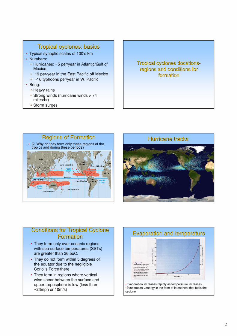
Regions of FormationRegions of FormationQ. Why do they form only these regions of the tropics and during these periods?
Hurricane tracksHurricane tracks
Conditions for Tropical Cyclone Conditions for Tropical Cyclone
FormationFormationThey form only over oceanic regions
with sea-surface temperatures (SSTs) are greater than 26.5oC.
They do not form within 5 degrees of
the equator due to the negligible
Coriolis Force there
They form in regions where vertical
wind shear between the surface and
upper troposphere is low (less than ~23mph or 10m/s)
Evaporation and temperatureEvaporation and temperature
•Evaporation increases rapidly as temperature increases•Evaporation =energy in the form of latent heat that fuels the cyclone

3
Regions and seasons T>26.5oCRegions and seasons T>26.5oC
Orange/yellow regions - tropics between June and December
Reasons why cyclones do not Reasons why cyclones do not
form in certain tropical regionsform in certain tropical regions
Cold currents
Without the Coriolis force, surface winds
cannot gain sufficient rotation to converge and the low pressure of the
disturbance cannot be maintained
Large values of vertical wind shear
disrupt the formation of a tropical
cyclone by interfering with the
organization of deep convection around the cyclone centre
Tropical cyclones: locationsTropical cyclones: locations--
pathways and dissipationpathways and dissipationPath of IsabelPath of Isabel
Hurricane PathsHurricane PathsHurricanes in the N. Atlantic/N. Pacific
After formation tropical cyclones movement migrate westward (NW in HH; SW in SH) driven by the easterly or Trade Winds
Then steer polewardaround the sub-tropical Bermuda High
If they move far enough northward into the path of mid-latitude Westerlies, they are then blown eastward
Some take erratic pathsAnalysis of the altimeter-derived Tropical Cyclone Heat Potential product shows that Katrina encountered a ring of deep warm water associated with the Loop Current coincident with the time
period of intensification to a category five hurricane.

4
Tropical cyclone dissipationTropical cyclone dissipationTypical lifetime is less than 1 week
Record hurricane John (1994) -31 days
Weaken rapidly when they lose their heat source:
Reach more northerly locations and cooler waters
Travel over land – a) energy source removed b) friction at land-surface decreases surface winds causing central pressure to rise
Encounter large vertical shear e.g. in mid-latitude jet-stream
Tropical cyclone: StructureTropical cyclone: Structure
Tropical cyclone/Hurricane structureTropical cyclone/Hurricane structure
Up to 500 km in diameter.
The “Eye” the most notable feature –clear calm conditions
The eye is surrounded by the eye wall. The strongest winds and rainfall are located in the eye wall.
The eye wall is surrounded by spiral rain bands
StructureStructure-- physical featuresphysical features
Eye -a roughly circular area of light winds mostly devoid of clouds.
It is the region of lowest surface pressure and warmest temperatures aloft
Eyes range in size from 8 km to over 200 km (generally 30-60km) across
Eye wall -a circular rotating region of intense thunderstorms extending up to the tropopause (~15 km).
Area of highest surface winds
Spiral rain bands – lines of thunderstorms, spiraling anticlockwise (in N. hemisphere)
StructureStructure--airflowairflow
In the “eye” air is slowly sinking (causes compressional warming and “warm core”
The eye wall has a net upward airflow as a result of numerous updrafts and downdrafts.
Near the top of the eye-wall clouds relatively dry air flows outwards from the centre. This diverging air aloft extending outwards for ~100s km. As the outflow reaches the cyclones edges it sinks
In the spiral rain bands, air converges at the surface, ascends through these bands, diverges aloft, and descends on both sides of the bands.
StructureStructure--airflowairflow

5
Vertical crossVertical cross--section and airflowsection and airflow
5
10
15 kmtropopause
50 100 150 km0
Eye wall
Eye Spiral bands
outflow
Cross sectionCross section--meteorologymeteorologyStrong pressure gradient within eyewall
Responsible for strong
hurricane winds. Speed is fastest on “right” side of hurricane: sum of rotational and forward
velocity
Rain occurs in eyewall(heaviest) and spiral
rainbands
Temperatures increase in
the eye because of descending air
ON HANDOUT
RadarRadar observations of the Cat observations of the Cat
5 storm Emily5 storm EmilyHurricane Hurricane ––meteorologymeteorology
The front right-hand side of a hurricane has the
most intense winds and storm surges
Lecture 1 Summary Lecture 1 Summary
Form in tropical waters with SSTs > 26.5°C,
but not within 5°of equator or in areas with
large vertical shear
Dissipate when heat source is lost or
encounter large vertical shear
Structure: eye, eyewall and spiral bands
Air subsides in the eye creating warm clear
conditions
Eyewall is region of vigorous thunderstorms
surface air rises; outflow aloft
Meteorology: Meteorology:
Weather and ClimateWeather and Climate
Large Scale Weather Systems Lecture 2
Tropical Cyclones: formation,maintenance and feedback mechanisms
Prof. Roy Thompson, Crew building
6
Tropical cyclonesTropical cyclones-- lecture 2lecture 2Development stages, disturbance sources and formation process
Growth and maintenance through positive feedback mechanisms
Resources for lectures 1 and 2
Ahrens Chapter 16Hurricanes- online meteorology guide:
http://ww2010.atmos.uiuc.eduNASA:http://earthobservatory.nasa.gov/Library/Hurricanes/
NOAA:http://www.aoml.noaa.gov/hrd/tcfaq/tcfaqHED.html
Tropical cyclone formation Tropical cyclone formation
and development stagesand development stages
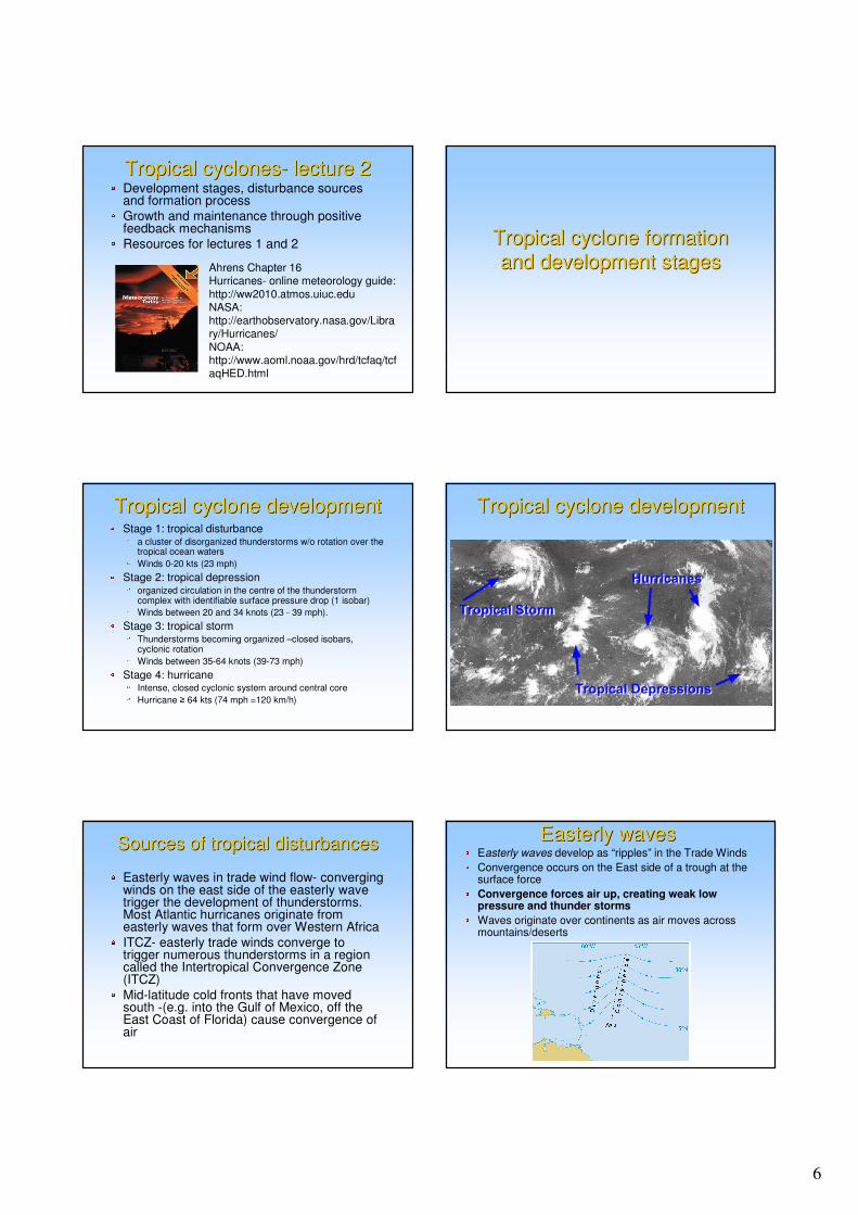
Tropical cyclone developmentTropical cyclone developmentStage 1: tropical disturbance
a cluster of disorganized thunderstorms w/o rotation over the tropical ocean waters
Winds 0-20 kts (23 mph)
Stage 2: tropical depressionorganized circulation in the centre of the thunderstormcomplex with identifiable surface pressure drop (1 isobar)
Winds between 20 and 34 knots (23 - 39 mph).
Stage 3: tropical stormThunderstorms becoming organized –closed isobars, cyclonic rotation
Winds between 35-64 knots (39-73 mph)
Stage 4: hurricaneIntense, closed cyclonic system around central core
Hurricane � 64 kts (74 mph =120 km/h)
Tropical cyclone developmentTropical cyclone development
Sources of tropical disturbancesSources of tropical disturbances
Easterly waves in trade wind flow- converging winds on the east side of the easterly wave trigger the development of thunderstorms. Most Atlantic hurricanes originate from easterly waves that form over Western Africa
ITCZ- easterly trade winds converge to trigger numerous thunderstorms in a region called the Intertropical Convergence Zone (ITCZ)
Mid-latitude cold fronts that have moved south -(e.g. into the Gulf of Mexico, off the East Coast of Florida) cause convergence of air
Easterly wavesEasterly wavesEasterly waves develop as “ripples” in the Trade Winds
Convergence occurs on the East side of a trough at the surface force
Convergence forces air up, creating weak low pressure and thunder storms
Waves originate over continents as air moves across mountains/deserts

7
Tropical cyclones often develop along easterly waves. These waves, or
oscillations, in the trade winds move from east to west across the tropics.
Satellite imagery provides the best view of an easterly wave. As low-level winds enter the trough of the wave, they converge, causing convection.
InterTropicalInterTropical Convergence ZoneConvergence Zone
Easterly trade winds converge near the Equator
Warm moist air rises ���� thunderstorms form
Formation processFormation processSurface water evaporates and is convectedupward
Air rises and diverges; some air is forced towards the eye centre, where it sinks
Compressional heating in the eye creates the warm core and clear conditions
Divergence aloft and warmer air results in lower surface pressure
lncreased surface pressure gradient yields increased surface winds
Evaporation increases and the cycle strengthens
Formation processFormation processSurface convergence
and convection
Subsidence in eye
and outflow
Core warms and
surface pressure lowers
Satellite photo of the tropical N Satellite photo of the tropical N
Atlantic on August 31st, 1996 Atlantic on August 31st, 1996

8
Tropical cyclone growth and Tropical cyclone growth and
maintenance feedback maintenance feedback
mechanismsmechanisms
Growth and MaintenanceGrowth and Maintenance
Occurs by means of two positive
feedback mechanisms
CISK =Conditional instability of the second kind
Isothermal warming
Requires:
Evaporation by winds from the ocean
surface to the atmosphere
Conservation of angular momentum
CISK positive feedback CISK positive feedback
MechanismMechanism
CISK=Conditional instability of the
second kind:
low-level convergence in the wind
field produces convection and
cumulus formation, thereby releasing
latent heat.
This enhances the convergence and
further increases convection � apositive feedback
Lapse ratesLapse rates
CISK MechanismCISK Mechanism
Surface air spirals into the centre of a low pressure system creates convergence and forces air to rise in the centre
This air cools and moisture condenses into clouds and releases latent heat into the air
This warms the surrounding air
Since warm air is less dense than cooler air, the warmer air takes up more space. This expansion of this air forces more air outside away from the centre of the storm and the surface pressure (the weight of the air above the surface) decreases.
CISK MechanismCISK Mechanism
When the surface pressure decreases, a larger pressure gradient is formed, and more air converges towards the centre of the storm (conservation of angular momentum)
This creates more surface convergence and causes more warm moist surface air to rise above the surface releasing even more latent heat
This cycle continuously repeats itself each time intensifying the storm (positive feedback)

9
Conservation of angular Conservation of angular
momentummomentum
Horizontal pressure gradient at surface � winds spiral towards low pressure centre
Conservation of angular momentum �tangential wind velocity x radial distance from centre = constant or
V=const. R-1 (due to friction R-0.6)
� air accelerates toward eye centre
� greater convergence
Aids feedback process
Conservation of angular Conservation of angular
momentummomentum
V = constant r -0.6
Win
d s
pee
d
Radial distance from eye centre (r)
Friction alters the relationship V ∝ r-1 to V∝ r-0.6
Eye
Centre
Eye wall
Lab experiment
Isothermal warming definitionIsothermal warming definition
Isothermal warming is the addition of heat at constant temperature = energy as air in contact with the ocean surface flows towards the hurricane centre
Isothermal warming positive Isothermal warming positive
feedback mechanismfeedback mechanismAir spiralling in towards lower pressures near the surface is made warmer through isothermal warming by contact with the uniformly warm sea-surface
Warm moist air rises and clouds form and latent heat released
Air warms and diverges outwards
Surface pressure falls � a positive feedback
Isothermal warming positive Isothermal warming positive
feedback mechanismfeedback mechanism
Cyclone core behaves as a “heat engine”Heat is taken in at the ocean surface
Potential energy converted to kinetic energy (energy of motion)
Lost at tropopause through radiative cooling
A warmer ocean surfacegreater heat transfer and temperature of hurricane core
lower minimum pressure and higher wind speeds
Core warmth or minimum pressure is a measure of the energy of the cyclone
Hurricane effect on sea surface Hurricane effect on sea surface
temperature temperature
10
Tropical cyclone dissipationTropical cyclone dissipation
Tropical cyclone dissipationTropical cyclone dissipation
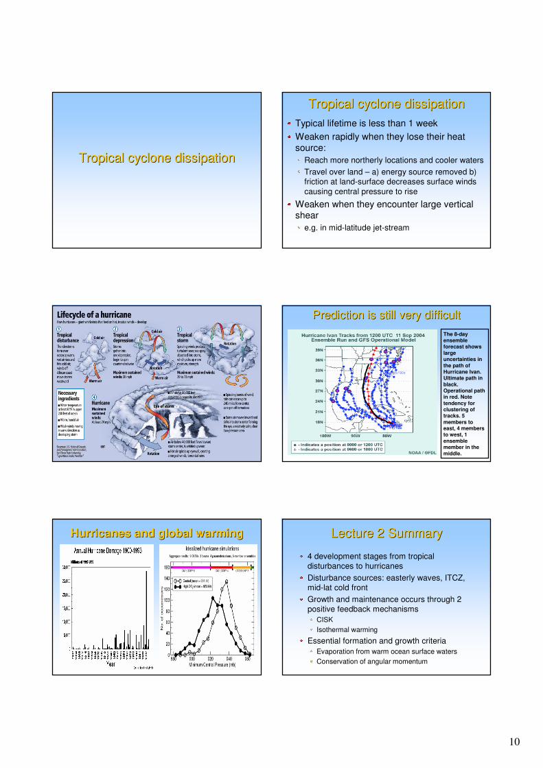
Typical lifetime is less than 1 week
Weaken rapidly when they lose their heat
source:
Reach more northerly locations and cooler waters
Travel over land – a) energy source removed b)
friction at land-surface decreases surface winds
causing central pressure to rise
Weaken when they encounter large vertical shear
e.g. in mid-latitude jet-stream
Prediction is still very difficultPrediction is still very difficult
The 8-day ensemble forecast shows
large uncertainties in
the path of Hurricane Ivan. Ultimate path in
black. Operational path in red. Note
tendency for clustering of tracks. 5
members to east, 4 members to west, 1
ensemble member in the
middle.
Hurricanes and global warmingHurricanes and global warming Lecture 2 SummaryLecture 2 Summary
4 development stages from tropical
disturbances to hurricanes
Disturbance sources: easterly waves, ITCZ,
mid-lat cold front
Growth and maintenance occurs through 2
positive feedback mechanisms
CISK
Isothermal warming
Essential formation and growth criteria
Evaporation from warm ocean surface waters
Conservation of angular momentum
Related Documents