Long Term Resource Monitoring Program Technical Report 98-T002 Large River Sediment Transport and Deposition: An Annotated Bibliography April 1998

Welcome message from author
This document is posted to help you gain knowledge. Please leave a comment to let me know what you think about it! Share it to your friends and learn new things together.
Transcript
Long Term Resource Monitoring Program
Technical Report98-T002
Large River Sediment Transport and Deposition:
An Annotated Bibliography
April 1998
LTRMP Technical Reports provide Long Term Resource Monitoring Programpartners with scientific and technical support.
All reports in this series receive anonymous peer review.
Environmental ManagementTechnical Center
CENTER DIRECTORRobert L. Delaney
APPLIED RIVER SCIENCEACTING DIRECTOR
Ken Lubinski
SYSTEMS ECOLOGISTRobert Gaugush
PROGRAM OPERATIONSACTING DIRECTOR
Linda E. Leake
REPORT EDITORDeborah K. Harris
Cover graphic by Cheri Staege
Mention of trade names or commercial products does not constitute endorsementor recommendation for use by the U.S. Geological Survey, U.S. Department of the Interior.
Printed on recycled paper
Large River SedimentTransport and Deposition:An Annotated Bibliography
by
Henry C. DeHaanResource Studies Center
St. Mary's University of Minnesota700 Terrace Heights
Winona, Minnesota 55987
April 1998
Prepared for
U.S. Geological SurveyEnvironmental Management Technical Center
575 Lester AvenueOnalaska, Wisconsin 54650

Suggested citation:
DeHaan, H. C. 1998. Large river sediment transport and deposition: An annotated bibliography. U.S. Geological Survey,Environmental Management Technical Center, Onalaska, Wisconsin, April 1998. LTRMP 98-T002. 85 pp.
Additional copies of this report may be obtained from the National Technical Information Service, 5285 Port Royal Road,Springfield, VA 22161 (1-800-553-6847 or 703-487-4650). Also available to registered users from the Defense TechnicalInformation Center, Attn: Help Desk, 8725 Kingman Road, Suite 0944, Fort Belvoir, VA 22060-6218 (1-800-225-3842 or703-767-9050).
iii
Contents
Page
Preface . . . . . . . . . . . . . . . . . . . . . . . . . . . . . . . . . . . . . . . . . . . . . . . . . . . . . . . . . . . . . . . . . . . . . . . . . v
Abstract . . . . . . . . . . . . . . . . . . . . . . . . . . . . . . . . . . . . . . . . . . . . . . . . . . . . . . . . . . . . . . . . . . . . . . . . 1
Introduction . . . . . . . . . . . . . . . . . . . . . . . . . . . . . . . . . . . . . . . . . . . . . . . . . . . . . . . . . . . . . . . . . . . . . 1
Acknowledgments . . . . . . . . . . . . . . . . . . . . . . . . . . . . . . . . . . . . . . . . . . . . . . . . . . . . . . . . . . . . . . . . 3
References . . . . . . . . . . . . . . . . . . . . . . . . . . . . . . . . . . . . . . . . . . . . . . . . . . . . . . . . . . . . . . . . . . . . . . 3
Keyword Index . . . . . . . . . . . . . . . . . . . . . . . . . . . . . . . . . . . . . . . . . . . . . . . . . . . . . . . . . . . . . . . . . . 82
Tables
Table 1. Frequency of citations per period . . . . . . . . . . . . . . . . . . . . . . . . . . . . . . . . . . . . . . . . . . . . . . 2
Table 2. Keyword list with number of citations concerning these subjects . . . . . . . . . . . . . . . . . . . . . . 2
v
Preface
The Long Term Resource Monitoring Program (LTRMP) was authorized under the Water ResourcesDevelopment Act of 1986 (Public Law 99-662) as an element of the U.S. Army Corps of Engineers'Environmental Management Program. The LTRMP is being implemented by the Environmental ManagementTechnical Center, a U.S. Geological Survey science center, in cooperation with the five Upper MississippiRiver System (UMRS) States of Illinois, Iowa, Minnesota, Missouri, and Wisconsin. The U.S. Army Corpsof Engineers provides guidance and has overall Program responsibility. The mode of operation and respectiveroles of the agencies are outlined in a 1988 Memorandum of Agreement.
The UMRS encompasses the commercially navigable reaches of the Upper Mississippi River, as well asthe Illinois River and navigable portions of the Kaskaskia, Black, St. Croix, and Minnesota Rivers. Congresshas declared the UMRS to be both a nationally significant ecosystem and a nationally significant commercialnavigation system. The mission of the LTRMP is to provide decision makers with information for maintainingthe UMRS as a sustainable large river ecosystem given its multiple-use character. The long-term goals of theProgram are to understand the system, determine resource trends and effects, develop management alternatives,manage information, and develop useful products.
This report was prepared under Strategy 1.2.1, Determine Effects of Sedimentation and Sediment TransportProcesses on the Upper Mississippi River System Ecosystem, Task 2.2.5.3, Work Unit B—Data Identificationand Compilation, and Strategy 3.1.2, Predict Future Conditions Without Change in Management of theOperating Plan (U.S. Fish and Wildlife Service 1993). It was developed with funding provided by the Long TermResource Monitoring Program.
Large River SedimentTransport and Deposition:An Annotated Bibliography
by
Henry C. DeHaan
Abstract
The Upper Mississippi River System (UMRS) has been dramatically altered by changing land use andmanagement practices within its basin. One consequence of these changes is the severe environmental problemof increased sedimentation in river backwater areas. The Long Term Resource Monitoring Program is addressingthis problem by expanding and initiating new research of sediment movement in the UMRS. As part of its newresearch, this annotated bibliography was generated to identify, review, and provide information about studiesassociated with sediment transport and deposition in large river environments. It contains 275 citations andabstracts for works that were published primarily between 1970 and early 1995. A list of 41 keywords is includedto help differentiate between the various subjects associated with river sediment. A keyword index is also providedto assist readers in rapidly locating information about specific topics.
Introduction
The Upper Mississippi River System (UMRS)is a unique and important national resource. Itsustains a diverse mosaic of natural habitats andwildlife and supports a large navigation systemmade up of 27 dams that assist in maintaining a9-foot channel. The Upper Mississippi Riverextends from Lake Itaska in northern Minnesotato Cairo, Illinois, draining an area of about 50million hectares.
The UMRS has been dramatically alteredbecause of escalating development in its basin.Activities such as increased navigation, dredging,urban sprawl, industrial waste discharges,intensive agricultural practices, and recreationalpressures have stressed many areas of the systemand threaten the natural and economic resourcesof the entire region (U.S. Fish and Wildlife Service1993). The problems related to these activities arenumerous and need to be addressed before theybecome irreversible.
One of the primary environmental problems onthe UMRS is the sedimentation occurring inbackwater areas (GREAT I 1980; Hawkins andStewart 1990; U.S. Fish and Wildlife Service1993; Gaugush and Wilcox 1994). Sedimentationhas increased in these areas because of changingland use practices causing much higher rates of
upland erosion and discharge of sediment overpresettlement rates (Knox et al. 1975; Knox 1977;Demissie et al. 1992). This problem is beingaddressed by the Long Term Resource MonitoringProgram (LTRMP).
The LTRMP was initiated because of a criticalneed to collect, analyze, and provide soundscientific information to the various users andmanagers of UMRS resources (U.S. Fish andWildlife Service 1993). Its primary goals are tomonitor resource change and develop alternativesfor enhanced management of the UpperMississippi River to maintain it as a sustainablelarge river ecosystem.
This bibliography is considered part of theoverall approach introduced by Gaugush andWilcox (1994) to expand LTRMP research ofsediment transport and deposition in theMississippi River. The proposed research includesa literature review (i.e., annotated bibliography) onsediment-related studies, compilation and reviewof existing geomorphological and sediment data,expansion of the present sediment monitoringnetwork, investigation of sediment movementthroughout the system, and prediction of the futureconfiguration of channels and floodplain. Resultsof the research will be used to determine the bestmanagement practices for maintaining andenhancing the natural and cultural resources of theUMRS.
2
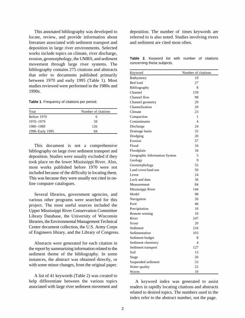
This annotated bibliography was developed to deposition. The number of times keywords arelocate, review, and provide information about referred to is also noted. Studies involving riversliterature associated with sediment transport and and sediment are cited most often.deposition in large river environments. Selectedworks include topics on climate, river discharge,erosion, geomorphology, the UMRS, and sedimentmovement through large river systems. Thebibliography contains 275 citations and abstractsthat refer to documents published primarilybetween 1970 and early 1995 (Table 1). Moststudies reviewed were performed in the 1980s and1990s.
Table 1. Frequency of citations per period.
Year Number of citations
Before 1970 61970–1979 591980–1989 1261990–Early 1995 84
This document is not a comprehensivebibliography on large river sediment transport anddeposition. Studies were usually excluded if theytook place on the lower Mississippi River. Also,most works published before 1970 were notincluded because of the difficulty in locating them.This was because they were usually not cited in on-line computer catalogues.
Several libraries, government agencies, andvarious other programs were searched for thisproject. The most useful sources included theUpper Mississippi River Conservation CommitteeLibrary Database, the University of Wisconsinlibraries, the Environmental Management TechnicalCenter document collection, the U.S. Army Corpsof Engineers library, and the Library of Congress.
Abstracts were generated for each citation inthe report by summarizing information related to thesediment theme of the bibliography. In someinstances, the abstract was obtained directly, orwith some minor changes, from the original paper.
A list of 41 keywords (Table 2) was created tohelp differentiate between the various topicsassociated with large river sediment movement and
Table 2. Keyword list with number of citationsconcerning these subjects.
Keyword Number of citations
Bathymetry 19Bed load 27Bibliography 8Channel 159Channel flow 98Channel geometry 29Channelization 29Climate 23Compaction 1Contaminants 4Discharge 24Drainage basin 32Dredging 20Erosion 57Flood 34Floodplain 34Geographic Information System 5Geology 9Geomorphology 55Land cover/land use 50Levee 24Lock and dam 36Measurement 84Mississippi River 144Model 98Navigation 26Pool 46Precipitation 10Remote sensing 10River 247Scour 20Sediment 216Sedimentation 103Sediment budget 8Sediment chemistry 4Sediment transport 127Soil 13Stage 26Suspended sediment 53Water quality 22Waves 10
A keyword index was generated to assistreaders in rapidly locating citations and abstractsrelated to desired topics. The numbers used in theindex refer to the abstract number, not the page.

3
Acknowledgments
This project was initiated with the assistance andoversight of Robert Gaugush. Thanks to MaryCraig, Kenneth Lubinski, and Joseph Wlosinski fortheir insightful suggestions regarding the subjectmaterial. The editorial assistance of GeorginiaArdinger is also greatly appreciated.
References
Demissie, M., L. Keefer, and R. Xia. 1992. Erosionand sedimentation in the Illinois River Basin.Illinois State Water Survey, Champaign.ILENR/RE-WR-92/04. n.p.
Gaugush, R. F., and D. B. Wilcox. 1994. Planningdocument: Investigate sediment transport/deposition and predict future configuration ofUMRS channels and floodplain. NationalBiological Survey, Environmental ManagementTechnical Center, Onalaska, Wisconsin,December 1994. LTRMP 94-P004. 9 pp. +Appendixes A–E
GREAT I. 1980. Great river environmental actionteam study of the Mississippi River. Volume 7.Public Participation and Plan Formulation. 62 pp.
Hawkins, Jr., A. S., and J. L. Stewart. 1990. Pilotproject on the middle branch WhitewaterWatershed 1990. Report by the U.S. Fish andWildlife Service, Upper Mississippi RiverNational Wildlife and Fish Refuge, Winona,Minnesota, for the U.S. Fish and WildlifeService, Environmental Management TechnicalCenter, Onalaska, Wisconsin, September 1990.EMTC 90-03. 34 pp. (NTIS # PB91-122655)
Knox, J. C. 1977. Human impacts on Wisconsinstream channels. Annals of the Association ofAmerican Geographers 67:323–342.
Knox, J. C., P. J. Bartlein, and K. K. Hirschboeck.1975. The response of floods and sedimentyields to climatic variation and land use in theUpper Mississippi River Valley. NationalTechnical Information Service, Springfield,Virginia. 76 pp. (NTIS # PB-247086)
U.S. Fish and Wildlife Service. 1993. OperatingPlan for the Upper Mississippi River SystemLong Term Resource Monitoring Program.Environmental Management Technical Center,Onalaska, Wisconsin, Revised September 1993.EMTC 91-P002R. 179 pp. (NTIS #PB94-160199)
Large River Sediment Transport and Deposition:An Annotated Bibliography
7
1. ABRAHAMS, A. D., AND D. M. MARK. 1986. The random topology model of channel networks: Biasin statistical tests. Professional Geographer 38:77–81.
The random topology model was introduced in 1966. It quantitatively predicts several generalcharacteristics of drainage basin geomorphology. A few limitations of using the model are discussed.
Keywords: Channel, drainage basin, geomorphology, model, river
2. ADAMS, J. R. 1992. Identification of study approaches to determine physical impacts of commercialnavigation on the Upper Mississippi River System. Report by the Illinois State Water Survey,Champaign, Illinois, for the U.S. Fish and Wildlife Service, Environmental Management TechnicalCenter, Onalaska, Wisconsin, in fulfillment of Project Number FWS 14-16-0003-80-973, November1992. EMTC 92-S005. 11 pp. (NTIS # PB93-127694)
Dimensional analysis is used to model the physical effects of navigation on constricted waterways.Parameters characterizing the physical effects of tow passages are reviewed. They include velocity,turbulence intensity, wave height, wave speed, drawdown, and sediment concentration.
Keywords: Channel, channel flow, Mississippi River, model, navigation, river, sediment, suspendedsediment, waves
3. ADAMS, J. R. 1992. Bed material characteristics of the Mississippi River within Pool 19. Illinois StateWater Survey, Champaign, Illinois. Contract Report 535, ISSN 0733-3927. Reprinted by U.S. Fishand Wildlife Service, Environmental Management Technical Center, Onalaska, Wisconsin, January1993. EMTC 93-R006. 113 pp. (NTIS # PB94-154655)
The nature of the bed materials, or substrates, in Pool 19 of the Upper Mississippi River System isaddressed. The bathymetric and bed material characteristics of this pool are illustrated and describedat 13 main channels, 2 side channels, 1 tributary mouth, 1 island cross channel, and several spotlocations in side channels.
Keywords: Bathymetry, channel, measurement, Mississippi River, pool, river, sediment,sedimentation
4. ADAMS, J. R. 1992. Sediment concentration changes caused by barge tows. Pages 677–682 inMarshall Jennings and Nani G. Bhowmik, editors. Proceedings of the American Society of CivilEngineers' Hydraulic Engineering Sessions at Water Forum '92, Baltimore, Maryland, August 2–6,1992. Reprinted by U.S. Fish and Wildlife Service, Environmental Management Technical Center,Onalaska, Wisconsin, March 1993. EMTC 93-R023. 6 pp. (NTIS # PB94-112091)
Suspended sediment samples are collected and examined in the channel border area at severallocations on the Upper Mississippi and Illinois Rivers during tow passages. Patterns of rapid increaseand gradual decrease in concentration following tow passage are observed. In comparison with theIllinois River site, the Mississippi River site underwent smaller changes in sediment concentration.Several parameters describing tow characteristics are discussed. Waves and drawdown (causedby the tow passage) are determined to be the major causes of increased suspended sedimentconcentrations.
8
Keywords: Channel, measurement, Mississippi River, navigation, river, sediment, suspendedsediment, waves
5. ADAMS, J. R., N. G. BHOWMIK, AND E. DELISIO. 1989. Measuring resuspension of sediment by bargetows. Pages 765–770 in Sam S. Y. Wang, editor. Proceedings of the International Symposium of theHydraulics Division of the American Society of Civil Engineers, New Orleans, Louisiana, August14–18, 1989. Reprinted by U.S. Fish and Wildlife Service, Environmental Management TechnicalCenter, Onalaska, Wisconsin, April 1993. EMTC 93-R002. 6 pp. (NTIS # PB94-108982)
Early efforts to measure resuspension of sediment relied on U.S. standard depth-integrating sedimentsamplers. In designing a new method for collecting field data on resuspension, the advantage ofobtaining samples at several points in a single vertical column is recognized. The field installationincludes ISCO pump samplers with intakes mounted at several distances above the river bed.Background samples are collected every hour. Vessel passages trigger an intensive period of samplecollection. Typical data collected for a straight reach on the Illinois River during low flow in fall 1988are presented and discussed.
Keywords: Channel, channel flow, measurement, navigation, river, sediment, suspended sediment
6. ADAMS, J. R., AND E. DELISIO. 1990. Ambient suspended sediment concentration and turbidity levels.Pages 865–869 in Richard M. Shane, editor. Proceedings of the 1990 National Conference of theHydraulics Division of the American Society of Civil Engineers, San Diego, California, July30–August 3, 1990. Reprinted by U.S. Fish and Wildlife Service, Environmental ManagementTechnical Center, Onalaska, Wisconsin, February 1993. EMTC 93-R018. 5 pp. (NTIS #PB94-111291)
The variations of suspended sediment concentration and turbidity over time is an important componentof the riverine environment. Suspended sediment in the Illinois River is monitored and found to slowlyvary in suspended sediment concentration with moderate to small temporal variability. An attempt ismade to determine a correlation equation relating sediment concentrations and turbidity over 2-hperiods of measurement. However, this proves unsuccessful. The general trend is similar, but thevariability of turbidity is considerably less, and the correlation is poor.
Keywords: Measurement, navigation, river, sediment, suspended sediment
7. ADAMS, J. R., AND E. DELISIO. 1990. Temporal and lateral distributions of resuspended sedimentfollowing barge tow passage on the Illinois River. In Howard H. Chang and Joseph C. Hill, editors.Volume 2. Proceedings of the 1990 National Conference of the Hydraulics Division of the AmericanSociety of Civil Engineers, San Diego, California, July 30–August 3, 1990. Reprinted by U.S. Fishand Wildlife Service, Environmental Management Technical Center, Onalaska, Wisconsin, March1993. EMTC 93-R011. 6 pp. (NTIS # PB94-108784)
9
Suspended sediment concentration samples that were collected on the Illinois River during 10 bargetow passages in May 1989 are examined. The suspended sediment sampling scheme is discussed andtypical data are presented. Increases are found to be as much as 500 mg/L near the river bed afterbarge tow passage.
Keywords: Measurement, navigation, river, sediment, suspended sediment
8. AHEARN, S. C., R. D. MARTIN, AND J. H. WLOSINSKI. 1989. Recommendations for estimatingsuspended solids in the Upper Mississippi River System using remote sensing. Report by theUniversity of Minnesota, St. Paul, and the U.S. Fish and Wildlife Service, EnvironmentalManagement Technical Center, Onalaska, Wisconsin, August 1989. EMTC 89-01. 23 pp. (NTIS #PB89 236715/AS)
Sedimentation is a significant factor in limiting fish and wildlife resources in the Upper MississippiRiver System (UMRS). An attempt is made to determine the feasibility of obtaining estimates ofsuspended solid concentrations (SSC) in the UMRS using remote sensing and to outline the stepsnecessary to initiate such a study. Remote sensing is found to provide reasonably accurate spatialestimates of SSC. However, because of high costs and infrequent satellite passes, satellite imagerydata are not recommended for collecting accurate temporal differences in SSC (especially overrelatively short periods). In-place sensors and aerial photography are best suited for such studies.
Keywords: Measurement, Mississippi River, remote sensing, river, sediment, suspended sediment
9. ALONSO, C. V., AND S. T. COMBS. 1986. Channel width adjustment in straight alluvial streams.Proceedings of the Fourth Federal Interagency Sedimentation Conference 2:5-31–5-40.
Alluvial streams construct their own geometries in response to changes imposed by nature or humans.Channel width adjustment is analyzed by considering vertical and lateral scour and fill. Themechanisms associated with these changes are used to formulate a mathematical model of widthadjustment during channel aggradation and degradation. The model, although dependent onapproximate assumptions and a prior knowledge of certain bank stability properties, reproducesexpected behavior with reasonable accuracy.
Keywords: Channel, channel geometry, geomorphology, model, river, scour, sediment, sedimentation
10. ALONSO, C. V., AND S. T. COMBS. 1990. Streambank erosion due to bed degradation—a modelconcept. Transactions of the ASAE 33:1239–1248.
Bank erosion occurring in alluvial streams is investigated and discussed. A mathematical model isformulated to evaluate bed degradation in cases where bed lowering causes bank instability.Application of the model to a laboratory experiment verifies the behavior of the model.
Keywords: Erosion, model, river, scour
11. ALONSO, C. V., W. H. NEIBLING, AND G. R. FOSTER. 1981. Estimating sediment transport capacity inwatershed modeling. Transactions of the ASAE 24:1211–1220, 1226.
10
A number of the sediment transport formulas suitable for watershed modeling are evaluated. The firstsection of the paper describes the criteria followed in selecting the formulas. The second section liststhe characteristics of these data, which included 739 tests from natural streams, laboratory flumes, anderosion plots. The third section examines how well each formula fits the data when it is used directly,without modification or readjustment of its coefficients. Recommendations are made regarding theapplicability of the formulas within different ranges of the data. Of the nine sediment transportformulas compared with flume field data, the Yang formula best estimates streamflow carryingcapacity in the range of fine to coarse sands. The Laursen formula reasonably predicts smallstreamflows carrying very fine sands and silts. However, it should be used with some reservations forcomputing transport of lighter materials. The Yalin formula can be used to compute sediment transportcapacities for overland flows. It gave satisfactory results for the range of sizes and densitiescharacteristic of field situations and can also be used with confidence to predict transport rates of lightmaterials in streamflows. The other formulas considered are Ackers-White, EM-1, EM-2,Engelund-Hansen, Bagnold, and Meyer-Peter Muller.
Keywords: Channel, channel flow, drainage basin, erosion, model, river, sediment, sediment transport
12. AMERICAN SOCIETY OF CIVIL ENGINEERS. 1989. Sediment transport modeling: Proceedings of theinternational symposium. 829 pp.
Recent developments in numerical models that accurately simulate three-dimensional hydrodynamicand sediment transport phenomena are reviewed and summarized. The WAQUA and PHOENICSmathematical models are discussed.
Keywords: Model, sediment, sediment transport
13. ANDERSON, M. G. 1988. Modeling geomorphological systems. John Wiley & Sons, New York.458 pp.
The author evaluates current modeling research in hillslope and river channel processes. Models innetwork geomorphology, channel morphology, channel flow, sedimentation, and sediment transportare discussed in detail.
Keywords: Channel, channel flow, channel geometry, erosion, geomorphology, model, river,sediment, sedimentation, sediment transport
14. ANDERSON, M. G., AND T. P. BURT. 1985. Hydrological forecasting. John Wiley & Sons, New
York. 604 pp.
The authors address the most recent forecasting capabilities developed in the field of hydrology.Currently available simulation models are reviewed and potential future developments areconsidered. Particular emphasis is given to major hydrological areas relevant to watersheds.
Keywords: Drainage basin, model, river

11
15. ANONYMOUS. 1992. Sediment and aquatic habitat in river systems. Journal of HydraulicEngineering 118:669–687.
The present-day knowledge of associations between sediment and riverine aquatic habitats issummarized. Physical processes governing aquatic-habitat quality and development are discussed. Itis determined that engineering approaches can be used to evaluate and predict aquatic-habitatconditions.
Keywords: River, sediment, sedimentation, sediment transport
16. BEACH, T. 1990. The utility of soil surveys to assess floodplain sediment storage in southeasternMinnesota. Professional Geographer 42:170–181.
A comparison is made between sedimentation data, collected from field corings, and informationderived from three county soil surveys in southeastern Minnesota. Two soil surveys prove to beunsatisfactory data sources for sedimentation rates, but the third is useful for one drainage basin. Eventhe third soil survey would require calibration for use in a geographic information system, however,because it is only the survey's maximum estimate that agrees with the field data.
Keywords: Floodplain, sediment, sedimentation, soil
17. BEACH, T. 1992. Estimating soil loss from medium-size drainage basins. Physical Geography13:206–224.
Several methods of estimating historical soil loss from medium-sized watersheds are available, butnone of them are perfect. By using a variety of methods and comparing their results for convergence,one can maximize the accuracy for soil-loss estimates. In this study, four different methods ofestimating soil loss from two medium-sized watersheds in southeastern Minnesota are compared.These methods include the soil-survey and soil-truncation method, gully-erosion estimates, reservoir-sedimentation measurements combined with estimated sediment-delivery ratios, and estimates derivedfrom the Universal Soil Loss Equation (USLE). The results of the varying methods converged aroundthe USLE estimate, ranging from 44% to 128% of the USLE. This convergence between the USLEand the other watershed soil-loss methods lends a measure of credibility to the overall accuracy of theestimates.
Keywords: Drainage basin, erosion, measurement, model, sediment, soil
18. BEACH, T. 1994. The fate of eroded soil: Sediment sinks and sediment budgets of agrarian landscapesin southern Minnesota, 1851–1988. Annals of the Association of American Geographers 84:5–28.
An attempt is made to gain an understanding of the distribution of sediment storage in three medium-sized drainage basins in southern Minnesota. This is accomplished by tracing the distribution oferoded sediment and constructing sediment budgets (i.e., comparing long-term sediment storage anderosion in watersheds). It is established that a high percentage of sediment is stored in the uplandsand in the lower main valley floodplains. Higher sediment storage in the lower valley is attributedto the base-level control of the Mississippi River floodplain.
12
Keywords: Drainage basin, erosion, floodplain, measurement, sediment, sedimentation, sedimentbudget, sediment transport, soil
19. BEDIENT, P. B. 1992. Hydrology and floodplain analysis. Addison-Wesley, Reading, Massachusetts.692 pp.
This text is divided into two principal sections. The first addresses traditional hydrological topics ofprecipitation, evaporation, infiltration, rainfall–runoff analysis, flood frequency, and flood routingmethods. The second section reviews the detailed theory and application of three of the most widelyused computer models in hydrology today. The models are applied to actual watershed and floodoccurrences. The application of spreadsheet software to hydrological computation is also discussed.
Keywords: Flood, floodplain, model, precipitation, river, sediment
20. BEGIN, Z. B. 1982. Stream curvature and bank erosion: A model based on the momentum equation.Journal of Geology 89:497–504.
Based on the momentum equation of flow, the force per unit area, which the flow exerts radially onthe outer bank of a stream bend, is expressed by an equation in which the force is explicitly relatedto the curvature ratio R/w (curve radius/channel width). A dimensionless curvature coefficient isdefined, and after observing changes of this coefficient with R/w (varying values of bed load friction),a functional relation is revealed.
Keywords: Bed load, channel, channel flow, channel geometry, erosion, model, river
21. BELT, C. B. 1975. The 1973 flood and man's constriction of the Mississippi River. Science189:681–684.
The 1973 flood broke the stage records between Burlington, Iowa, and Cape Girardeau, Missouri, adistance of 562 km. At St. Louis, the flood began on March 10 and continued for 77 consecutive days,exceeding the record set in 1844 when the river was in flood for 58 days during the entire year. Theriver crested at St. Louis on April 28, 1973, at a gage height of 13.18 m (4.03 m above flood stage)and a peak discharge of 24,100 m³/s. The stage topped the 189-year record by 0.3 m. The flood peakwas 0.61 m higher in 1973 than in 1844, but the discharge was about 33% less than the estimated flowfor 1844. The 1908 flood had the same flow as the 1973 flood but the peak was 2.51 m lower. Thisstudy analyzes hydrographic data to determine the reasons behind the record-breaking stages. Itconcludes that the progressive constriction of the Mississippi River for navigation since 1837 hascaused bottom erosion in some stretches. In others, the bottom oscillates up and down with time.Constriction of the river channel causes flooding and forces floods to be higher, thus navigation worksdegrade the protection afforded by levees. The combination of navigation works and levees causessignificant rises in the stages of floods. Additional channel constriction and levee building will causefurther problems. The 1973 flood's stage record was determined to be human-made.
Keywords: Channel, channel flow, channelization, discharge, flood, levee, Mississippi River, river,sediment, stage
13
22. BENEKE, F. D. 1927. The flood of 1927: Mississippi River and tributaries; containing photographicviews of America's greatest peace-time disaster, in the over-flowed sections of Illinois, Missouri,Kentucky, Tennessee, Arkansas, Mississippi, and Louisiana. F. D. Beneke, editor. Mississippi RiverFlood Control Association, Memphis. 64 pp.
This document contains photographic and map views displaying the flooded sections of the Illinoisand Mississippi Rivers in 1927. It explains how 506,250 ha (12,500,00 acres) of alluvial land(including large areas devoted to sugarcane and cotton production) were inundated by floodwater.
Keywords: Flood, floodplain, Mississippi River, river
23. BHARGAVA, D. S., AND D. W. MARIAM. 1991. Effects of suspended particle size and concentration onreflectance measurements. Photogrammetric Engineering & Remote Sensing 57:519–529.
Remote sensing technology is used to estimate sediment conditions in large bodies of water. Modelsare developed for the prediction of suspended sediment concentration, turbidity, and modified Secchidepths from measured reflectance values for a given soil type and particle size. Modeled and observedvalues display good agreement.
Keywords: Measurement, model, remote sensing, river, sediment, soil, suspended sediment
24. BHOWMIK, N. G. 1987. Some natural and human influences on streams and rivers (Illinois River,Mississippi River). Water International 12:55–59.
Some specific examples of human-made and natural influences on water resources are discussed.Stream alteration activities such as channelization and construction of lock and dams and their effecton flow and sediment transport are discussed. It is observed that significant changes in flow andsediment transport characteristics occur at the confluences of tributaries with the main stream becauseof human activities.
Keywords: Channel, channel flow, channelization, land cover/land use, lock and dam, MississippiRiver, river, sediment, sediment transport
25. BHOWMIK, N. G. 1989. Physical impacts of human alterations within river basins: The case of theKankakee, Mississippi, and Illinois Rivers. Pages B-139–B-146 in Proceedings of the ThirteenthCongress of the International Association for Hydraulic Research, Ottawa, Canada, August 21–25,1989. Reprinted by U.S. Fish and Wildlife Service, Environmental Management Technical Center,Onalaska, Wisconsin, March 1993. EMTC 93-R004. 8 pp. (NTIS # PB94-108891)
Effects of human alterations within large river basins are examined. Sediment delivery, which is amajor factor in system change over time, is the primary topic studied. The effects of channelizationare illustrated by a case study of the Kankakee River. The effects of lock and dam construction forcommercial navigation are illustrated by case studies of the Mississippi and Illinois Rivers.
Keywords: Channel, channel flow, channelization, land cover/land use, lock and dam, MississippiRiver, pool, river, sediment, sedimentation, sediment transport, stage
14
26. BHOWMIK, N. G. 1989. Resuspension and lateral movement of sediment due to commercial navigationin the Mississippi River System. Pages 953–959 in Proceedings of the Fourth InternationalSymposium on River Sedimentation, Beijing, China, June 5–9, 1989. Reprinted by the NationalBiological Survey, Environmental Management Technical Center, Onalaska, Wisconsin, March 1994.LTRMP 94-R003. (NTIS # PB94-162930)
Research is performed on the Upper Mississippi River System to determine the physical effects ofnavigation, including the resuspension and lateral movement of sediment. It is observed that themovement of tows with barges increases the suspended sediment concentrations above the valuespresent within an undisturbed river environment. Moreover, the increase in suspended sedimentconcentration persists for a period of 60 to 90 min after the passage of the tow. The increase insediment concentration is more significant when the ambient suspended sediment concentration islow, and the increase was found to be higher in shallow and narrow channels than in deep and widechannels.
Keywords: Channel, measurement, Mississippi River, navigation, river, sediment, sediment transport,suspended sediment
27. BHOWMIK, N. G. 1991. Physical changes due to navigation in the Upper Mississippi River System.In Proceedings of the 1991 Governor's Conference on the Management of the Illinois River System,Third Biennial Conference, Peoria, Illinois, October 22–23, 1991. Reprinted by U.S. Fish and WildlifeService, Environmental Management Technical Center, Onalaska, Wisconsin, April 1993.EMTC 93-R019. 9 pp. (NTIS # PB94-108917)
Movement of barge traffic through the Upper Mississippi River System creates significantdisturbances of the river environment. The disturbances include waves and drawdown, altered velocityand pressure regimes, resuspension and lateral movement of sediment, and temporary changes in flowdirection due to the return flow. These navigation-caused physical changes in large-river environmentsare reviewed.
Keywords: Channel, channel flow, Mississippi River, navigation, river, sediment, suspendedsediment, waves
28. BHOWMIK, N. G. 1992. Hydraulic changes in rivers due to navigation. Pages 10–22 to 10–40 inProceedings of the Fifth Federal Interagency Sedimentation Conference, Las Vegas, Nevada, March18–21, 1991. U.S. Fish and Wildlife Service, Environmental Management Technical Center,Onalaska, Wisconsin, December 1992. EMTC 92-S020. (NTIS # PB94-126166) Report out of print.Request 92-R001.
The author investigates alterations associated with the movement of barge traffic within a restrictedwaterway. Fully loaded barge traffic is found to temporarily increase the suspended sedimentconcentrations, especially near channel border areas. These increases are greater near the bed than inthe near-surface zone and can last from 40 to 60 min or more. Maximum velocity changes (caused bybarges) occur very close to the bed.
Keywords: Channel, channel flow, Mississippi River, navigation, river, sediment, suspended sediment,waves
15
29. BHOWMIK, N. G. 1993. Effects of natural and man-made events on the land–water interfaces of largeriver basins. Pages 101–122 in B. Gopal, editor. Wetlands and ecotones: Studies on land–waterinteractions. National Institute of Ecology, New Delhi, India. Reprinted by the National BiologicalSurvey, Environmental Management Technical Center, Onalaska, Wisconsin, March 1994.LTRMP 94-R001. (NTIS # PB94-157542)
The shape, form, surficial features, and future changes in the geomorphology of any large river systemare the result of all the natural and human interventions on the system for the last several decades.Specific examples of these changes are examined on the Mississippi and Illinois Rivers. River changesare demonstrated through a series of examples, citing research conducted over the past severaldecades.
Keywords: Channel, channel geometry, channelization, erosion, geomorphology, lock and dam,Mississippi River, navigation, pool, river, sediment, sedimentation
30. BHOWMIK, N. G., AND J. R. ADAMS. 1985. Geomorphic trends in Keokuk Pool, Mississippi River.American Geographic Union 1985 spring meeting. EOS, Transactions, American Geophysical Union66(18):261.
Three areas of extensive sedimentation in Keokuk Pool of the Mississippi River are assessed forphysical change and biological succession, and projections of future changes are made. The pool isexpected to attain a state of dynamic equilibrium by 2050 on the basis of present sediment trapefficiency trends.
Keywords: Geomorphology, Mississippi River, pool, river, sediment, sedimentation
31. BHOWMIK, N. G., AND J. R. ADAMS. 1986. The hydrologic environment of Pool 19 of the MississippiRiver. Pages 21–29 in Ecological perspectives of the Mississippi River. Dr. W. Junk Publishers. TheHague, Netherlands.
The flood of 1973 and the drought of 1977 are used to demonstrate the effects of extreme events onriverine ecosystems. The characteristics of sediment inflows, transport, volume changes, and outflowsare addressed. The means by which these characteristics determine the environment for aquatic plantsand animals in a given reach of the Mississippi River are also examined.
Keywords: Channel, channel flow, climate, flood, land cover/land use, Mississippi River, pool, river,sediment, sedimentation, sediment transport
32. BHOWMIK, N. G., AND J. R. ADAMS. 1989. Successional changes in habitat caused by sedimentationin navigation pools. Hydrobiologia 176/177:17–27. Reprinted by U.S. Fish and Wildlife Service,Environmental Management Technical Center, Onalaska, Wisconsin, April 1993. EMTC 93-R025.11 pp. (NTIS # PB94-1102372)
Many pools in the Upper Mississippi River System have nearly reached a new equilibrium conditionfor scour and deposition of sediment. The original open-water habitats in these pools have beenchanging to aquatic macrophyte beds and then to marsh or terrestrial floodplain conditions becauseof sediment deposition. Pool 19 and Peoria Lake have had well over 50% of their original volume
16
filled with sediment. The authors conclude that these river reaches will become a narrow channelwithout any broad and highly productive channel borders.
Keywords: Channel, land cover/land use, lock and dam, Mississippi River, pool, river, scour,sediment, sedimentation
33. BHOWMIK, N. G., AND J. R. ADAMS. 1990. Sediment transport, hydraulic retention devices, and aquatichabitat in sand-bed channels. Pages 1110–1115 in H. H. Chang and J. C. Hill, editors. Volume 2.Proceedings of the National Conference of the Hydraulics Division of the American Society of CivilEngineers, San Diego, California, July 30–August 3, 1990. Reprinted by U.S. Fish and WildlifeService, Environmental Management Technical Center, Onalaska, Wisconsin, April 1993.EMTC 93-R024. 6 pp. (NTIS # PB94-108792)
Aquatic ecologists have tended to view any change in sediment transport conditions as a threat to thequality of riverine ecosystems. However, because of various transport processes and morphologicalcharacteristics, sand bed channels naturally create retention and detention devices that may or may notbe beneficial to the aquatic habitats of the riverine environment. Examples and case studies of avariety of habitats in sand bed streams are examined. It is concluded that, in small streams,longitudinal features (e.g., pools and riffles) define the major habitat types. In larger rivers, lateralfeatures (e.g., side channels, shallow-point bars, and bed forms) provide a variety of habitat types.
Keywords: Channel, land cover/land use, pool, river, sediment, sedimentation, sediment transport
34. BHOWMIK, N. G., J. R. ADAMS, AND R. E. SPARKS. 1986. Fate of navigation pool on Mississippi River.Journal of Hydraulic Engineering 112:967–970. ISSN 0733-9429/86/0010-0967. Paper 20939.Reprinted by U.S. Fish and Wildlife Service, Environmental Management Technical Center,Onalaska, Wisconsin, March 1993. EMTC 93-R001. 4 pp. (NTIS # PB94-111960)
Morphological changes of Pool 19 on the Mississippi River are investigated. Approximately 55% ofthe pool's original capacity was lost by 1980, and it is estimated that 80% of its capacity will be lostby 2050. The changes on this pool are progressing through a predictable pattern. It is assumed thatsimilar pools on other navigable waterways may follow the same general pattern.
Keywords: Channel, channelization, climate, dredging, geomorphology, land use/land cover, levee,lock and dam, Mississippi River, pool, river
35. BHOWMIK, N. G., W. C. BOGNER, AND J. A. SLOWIKOWSKI. 1991. Sediment sources analysis for PeoriaLake along the Illinois River. In Proceedings of the National Conference of the American Society ofCivil Engineers, Nashville, Tennessee, July 29–August 2, 1991. Reprinted by the National BiologicalSurvey, Environmental Management Technical Center, Onalaska, Wisconsin, March 1994.LTRMP 94-R006. 6 pp. (NTIS # PB94-176344)
The lower Illinois River flows within an oversized valley formed by an old course of the MississippiRiver and glacial outwashes. This portion of the river developed into a low-gradient, aggrading bedstream with large backwater areas. Sedimentation in the river threatens to convert the system from oneof river–backwater areas to one of channel–marshes. The sediment budget of Peoria Lake, a majorbackwater lake along the river, includes input and output through the Illinois River and inputs from
17
several small direct tributaries. These small tributaries are significant contributors to the Peoria Lakesediment budget.
Keywords: Measurement, river, sediment, sedimentation, sediment budget, suspended transport
36. BHOWMIK, N. G., W. C BOGNER, J. A. SLOWIKOWSKI, AND J. RODGER ADAMS. 1993. Sourcemonitoring and evaluation of sediment inputs for Peoria Lake. Office of Hydraulics and RiverMechanics, Illinois State Water Survey, Champaign, Illinois. Illinois Department of Energy andNatural Resources Report ILENR/RE-WR-93/01. Reprinted by U.S. Fish and Wildlife Service,Environmental Management Technical Center, Onalaska, Wisconsin, September 1993.EMTC 93-R016. 60 pp. (NTIS # PB 93-188472)
A summary is presented on the results of a 2-year sediment study of Peoria Lake and its localtributaries. Ten local tributaries were monitored to determine the inflow of sediment and water. Asediment budget was not determined because of a lack of sedimentation survey and sediment outflowdata from the lake. The analysis did indicate that about 1.2 million tons of sediment flowed into PeoriaLake in 1989 and about 2.7 million tons in 1990.
Keywords: Measurement, river, sediment, sediment transport
37. BHOWMIK, N. G., AND M. DEMISSIE. 1982. Carrying capacity of floodplains. Journal of the HydraulicsDivision, American Society of Civil Engineers 108(HY3):443–453.
Several factors affect the carrying capacity of floodplains including the nature of the floodplain,characteristics of the main channel, and the flood frequency. The field data of flood flows for severalstreams are analyzed to determine the distribution of flow in the main channel and in the floodplains.In general, the carrying capacity of floodplains increases with the return period of the flood.
Keywords: Channel, channel flow, flood, floodplain, river
38. BHOWMIK, N. G., AND M. DEMISSIE. 1989. Sedimentation in the Illinois River Valley and backwaterlakes. Journal of Hydrology 105:187–195. Reprinted by U.S. Fish and Wildlife Service,Environmental Management Technical Center, Onalaska, Wisconsin, February 1993. EMTC 93-R013.9 pp. (NTIS # PB94-112521)
The Illinois River valley has experienced an enormous influx of sediment over the past few decades.Many backwater lakes along the river have lost 30 to 100% of their capacity to sediment deposition.Newly implemented nonpoint source pollution control measures are now beginning to show theireffects on the receiving bodies of water.
Keywords: Channel, channel flow, measurement, river, sediment, sedimentation
39. BHOWMIK, N. G., M. DEMISSIE, AND C. Y. GUO. 1982. Waves generated by river and wind on theIllinois and Mississippi Rivers. Illinois Water Resources Center, Urbana. Water Resources Center,Research Report 167. 90 pp.
18
Data concerning waves caused by river traffic and winds on the Mississippi and Illinois Rivers arecollected and analyzed. The information is gathered to address several topics including thecharacteristics of waves from tows, barges, and boats; wave intensity changes caused by increasedriver traffic; the similarities and dissimilarities between waves caused by traffic and waves producedby natural effects; and the associated bank erosion with waves of different origin and size.
Keywords: Erosion, Mississippi River, navigation, river, waves
40. BHOWMIK, N. G., AND B. S. MAZUMDER. 1990. Physical forces generated by barge-tow traffic withina navigable waterway. Pages 604–609 in Howard H. Chang and Joseph C. Hill, editors. Volume 1,Hydraulic Engineering. Proceedings of the National Conference of the Hydraulics Division of theAmerican Society of Civil Engineers, San Diego, California, July 30–August 3, 1990. Reprinted byU.S. Fish and Wildlife Service, Environmental Management Technical Center, Onalaska, Wisconsin,February 1993. EMTC 93-R020. 6 pp. (NTIS # PB94-110145)
Various physical forces within a river are altered by the movement of navigation traffic. The changesin these forces can be evaluated and quantified. The physical forces examined include waves anddrawdown, increase or decrease in the pressure field, altered velocity distributions, and directionalchanges of the flow within the zones of return flows.
Keywords: Channel, channel flow, Mississippi River, navigation, river, waves
41. BHOWMIK, N. G., A. C. MILLER, AND B. S. PAYNE. 1990. Techniques for studying the physical effectsof commercial navigation traffic on aquatic habitats. U.S. Army Corps of Engineers WaterwaysExperiment Station, Vicksburg, Mississippi. Technical Report EL-90-10. Reprinted by U.S. Fish andWildlife Service, Environmental Management Technical Center, Onalaska, Wisconsin, January 1993.EMTC 93-R007. 129 pp. (NTIS # PB94-151446)
The primary objective of this report is to outline procedures that can be used for the measurement andanalysis of physical data to assess changes generated with the movement of navigation traffic in largerivers. It includes summaries of recent investigations, descriptions of required data, study evaluations,explanations of data-collecting equipment, development plans for data collection, and procedures thatcan be followed for the analysis of the data.
Keywords: Channel, channel flow, land cover/land use, measurement, Mississippi River, navigation,river, sediment, sedimentation, sediment transport, waves
42. BHOWMIK, N. G., AND R. XIA. 1992. Hydraulic and geomorphic classification of the Upper MississippiRiver System: Pilot study of three pools. Pages 666–671 in M. Jennings and N. G. Bhowmik, editors.Proceedings of the American Society of Civil Engineers Hydraulic Engineering Sessions at WaterForum '92, Baltimore, Maryland, August 2–6, 1992. Reprinted by the National Biological Survey,Environmental Management Technical Center, Onalaska, Wisconsin, August 1994. LTRMP 94-R007.6 pp. (NTIS # PB94-209533)
A pilot classification system is developed for three trend analysis pools—4, 8, and 13—on the UpperMississippi River System. Various physical parameters (e.g., widths, radius of curvatures, anddeflection angles) and attributes (e.g., orientation of various nonmain channel areas) are utilized in this
19
classification system. This system is required to properly manage the river for the benefit ofnavigation, commerce, recreation, ecology, and the environment.
Keywords: Channel, channel geometry, geomorphology, Mississippi River, pool, river
43. BHOWMIK, N. G., AND R. XIA. 1993. Turbulent velocity fluctuations in natural rivers. In Hydraulic
Engineering '93, Proceedings of the 1993 Conference, sponsored by the Hydraulics Division/ASCE,San Francisco, California, July 25–30, 1993. Reprinted by the National Biological Survey,Environmental Management Technical Center, Onalaska, Wisconsin, April 1994. LTRMP 94-R005.(NTIS # PB94-178142)
The Illinois State Water Survey is presently collecting and analyzing detailed velocity data from theIllinois and Mississippi Rivers with two-dimensional electromagnetic current meters. The primary goalof this research is to understand and evaluate the turbulent flow structure in natural river systems,especially near the channel border areas. The collection and analysis of data from a study site on theIllinois River is reviewed. Flow velocities at this site are measured at six different lateral locations andthree different vertical elevations.
Keywords: Channel, channel flow, Mississippi River, river
44. BORAH, D. K. 1989. Scour depth prediction under armoring conditions. Journal of HydraulicEngineering 115:1421–1425.
Accurate forecasting of scour depth may assist in engineering and planning for water flow overalluvial beds. A simple procedure is demonstrated for calculating the scour depth on an alluvial bedunder armoring conditions. The estimation of scour depth requires several variables including flowdepth, bed slope, bed porosity, particle size distribution of the bed material, and a few commonlyavailable constants.
Keywords: Channel, channel flow, river, scour, sediment
45. BORAH, D. K., AND P. K. BORDOLOI. 1989. Nonuniform sediment transport model. Transactions of theASAE 32:1631–1636.
A nonuniform sediment transport model is evaluated by applying it to laboratory data. The model(called STREAM) was developed for simulating graded sediment transport in alluvial streams. Themodel performed extremely well in predicting sediment discharges for the experimental runsproducing complete armor surfaces and the runs without producing any armoring, but showedconsiderable discrepancies with the runs producing partial armoring. Predicted size distributions oferoded materials and materials at the armor surface are reasonable for most of the runs.
Keywords: Model, river, scour, sediment, sedimentation, sediment transport
46. BORDAS, M. P., AND D. E. WALLING, EDITORS. 1988. Sediment budgets. International Association ofHydrological Sciences, IAHS Publication 174. 591 pp.
20
A wide range of recent research in the hydrological sciences is drawn on to discuss holistic modelingof sediment budgets. In the past, many studies have focused on the erosion processes operating withina watershed or the sediment yield at its outlet. Here these two subjects are integrated to establishsediment budgets that quantify the relations between the various components of the overall drainagebasin erosion—transport—deposition system.
Keywords: Erosion, model, sediment, sedimentation, sediment budget, sediment transport
47. BOVEE, K. D., AND R. MILHOUS. 1978. Hydraulic simulation in instream flow studies: Theory andtechniques. U.S. Fish and Wildlife Service, Instream Flow Information Paper 5. FWS/OBS-78/33.131 pp.
The authors examine how changes in stream discharge quantitatively affect the distribution and sizeof velocities, depths, and substrates. They accomplish this by utilizing several simulation techniquesfor the prediction of the stage–discharge relation and the velocity distribution–discharge relation. Datarequirements, equipment needs, data collection methods, precision specifications, site-imposedconstraints, and limitations of each simulation technique are discussed. Last, the authors provide abrief description of several computer hydraulic simulation programs.
Keywords: Channel, channel flow, discharge, model, river, stage
48. BROWN, D. G., L. BIAN, AND S. J. WALSH. 1993. Response of a distributed watershed erosion modelto variations in input data aggregation levels. Computers and Geosciences 19:499–509.
Distributed watershed models require that mapped variables be characterized by some number ofdiscrete units. Data resolution (i.e., grid cell size), used to spatially represent the watershed variables,is an important factor that affects the results of hydrologic and geomorphic process-response models.The ANSWERS model uses soil, terrain, hydrography, and land cover information on a cell by cellbasis for estimating erosion and deposition patterns within a watershed, and for defining modelresponses at the basin outlet. A raster-based geographic information system, interfaced to ANSWERS,organizes the model input data for iterative calculations of erosion and deposition patterns andmagnitudes through model responses for selected data aggregation levels. Spatial aggregation levelsevaluated in this study include 30, 60, 120, 180, 240, 300, 420, and 600 m square cells. The accuracyof the model is closely monitored and conclusions are drawn.
Keywords: Drainage basin, erosion, geographic information system, geomorphology, land cover/landuse, model, sediment, sedimentation, sediment transport, soil
49. BROWN, R. J. 1976. Reservoir and lake sedimentation: A bibliography with abstracts. NationalTechnical Information Service, Springfield, Virginia. 171 pp.
The deposition and effects of sedimentation in reservoirs and lakes are cited. Reports on silting,control techniques, and causes are also included.
Keywords: Bibliography, measurement, pool, sediment, sedimentation
21
50. BRUNE, G. M. 1948. Rates of sediment production in midwestern United States. U.S. SoilConservation Service, Report SCS-TP-65. 40 pp.
This publication summarizes available sediment records for the Upper Midwest (including the UpperMississippi River Basin). It primarily examines suspended sediment and sedimentation data measuredin this area and attempts to compile, evaluate, and translate them into comparable units. The periodof the data collection (for differing sites) is commonly from the early 1920s to the late 1940s.
Keywords: Drainage basin, measurement, Mississippi River, river, sediment, sedimentation,suspended sediment
51. BURKHAM, D. E. 1981. Uncertainties resulting from changes in river form. Proceedings of theAmerican Society of Civil Engineers 107(Hydraulics Division 5, 16245):593–610.
The hydrologic implications and uncertainties that are created by changes in alluvial-channel form inlarge watersheds are discussed. Historical evidence of river-form change is first presented. Subsequentsections include brief examinations of hydrologic implications and uncertainties in relation to channel-form changes and land use, flood characteristics of alluvial streams, and hydrology and sedimentyields for basins in the Southwest.
Keywords: Channel, channel geometry, drainage basin, flood, land cover/land use, river, sediment,sediment transport
52. CAO, S., AND L. LERCHE. 1994. A quantitative model of dynamical sediment deposition and erosionin three dimensions. Computers and Geosciences 20:635–663.
The authors introduce modeling of sediment deposition in three dimensions by taking estimates ofsediments, released at different locations on a basinal slope, and allowing them to flow constrainedby the existing topography of basin slope and previously deposited sediment flows. Deposition takesplace according to the parameter values assigned to each lithologic type. Default values are arrangedso that coarse-grained material is deposited first and fine-grained material last. The computer based-model, named MOSED3D (Model of Sediment Deposition in 3-Dimensions), is written in C andrunable on a SUN SPARC workstation. Model results are displayed in contour map form, as isopleths,and also as 2-D cross-sections drawn in arbitrary, user-defined, directions across the system. The paperdescribes the mathematical formulation, program structure, and some test cases designed to illustrateindividual factors the code is capable of handling.
Keywords: Drainage basin, erosion, geology, model, sediment, sedimentation, sediment transport
53. CARIS, S., AND M. PAVISH. 1975. Bibliography, environmental geomorphology. Council of PlanningLibrarians, Monticello, Illinois. 32 pp.
This bibliography consolidates portions of the available literature on environmental geomorphology.Sections are on geomorphology (1966–1971) and sedimentology (1972–1973).
Keywords: Bibliography, geomorphology, sediment, sedimentation, sediment transport
22
54. CARSON, M. A. 1989. Measure of flow intensity as predictors of bed load. Journal of HydraulicEngineering 113:1402–1421.
The merits of varying measures of flow intensity as predictors of bed load transport rates are assessed.It is observed that tractive stress, when based on depth and slope, is a poor predictor, especially innarrow channels. By eliminating the wall and bedform roughness, leaving only the stress acting on the bedgrains, excellent correspondence with bed load rates is found.
Keywords: Bed load, channel, channel flow, measurement, river, sediment, sediment transport
55. CARSON, M. A., AND G. A. GRIFFITHS. 1989. Influence of channel width on bed load transportcapacity. Journal of Hydraulic Engineering 113:1489–1509.
An attempt is made to determine the effects of channel width on bed load capacity in river reacheshaving various slopes, water discharge, and channel-bed material is examined. The authorsdemonstrate the existence of an optimum width that maximizes transport capacity. The optimum widthis based on the relation between bed load transport rates and flow intensity, and the relation betweenflow resistance and depth.
Keywords: Bed load, channel, channel flow, channel geometry, discharge, measurement, model, river,sediment, sediment transport
56. CELIK, I., AND W. RODI. 1988. Modeling suspended sediment transport in nonequalibrium situations.Journal of Hydraulic Engineering 114:1157–1191.
A mathematical model for calculating suspended sediment transport in unidirectional channel flowunder general, nonequalibrium conditions is presented. The model includes a flexible hydrodynamiccomponent (for calculating the flow field and the turbulence characteristics) and a scalar transportmodel.
Keywords: Channel, channel flow, model, river, sediment, sediment transport, suspended sediment
57. CHANG, H. H. 1984. Modeling of river channel changes. Journal of Hydraulic Engineering110:157–172.
The author describes a flood and sediment routing model that simulates river channel changes. Thiscomputer-based model is applied in the case study of a disturbed river. It merges the interrelatedchanges in channel bed profile, width, and lateral migration in channel bends.
Keywords: Channel, channel geometry, flood, model, river, sediment, sediment transport
58. CHANG, H. H. 1985. River morphology and thresholds. Journal of Hydraulic Engineering 111:503–519.
23
Channel geometry and patterns of alluvial rivers are examined by an energy approach together withthe physical relations of flow continuity, flow resistance, and sediment transport. River features arediscussed, and certain regime relations for channel width and depth are established.
Keywords: Channel, channel flow, channel geometry, geomorphology, model, river, sediment, sedimenttransport
59. CHANG, H. H. 1986. River channel changes: Adjustments of equilibrium. Journal of HydraulicEngineering 112:43–55.
A technique for predicting river channel adjustments of equilibrium is introduced and illustrated byexamples. This method is based on the quantitative relations among the variables of water discharge,bed-material discharge, slope, sediment size, channel width, and depth for sand-bed rivers underdynamic equilibrium. By using this technique, the directions and magnitudes of adjustments forselected variables in response to changes of other river variables are determined.
Keywords: Bed load, channel, channel flow, channel geometry, discharge, geomorphology, model,river, sediment, sediment transport
60. CHAUDHRY, M. H. 1993. Open-channel flow. Prentice Hall, Englewood Cliffs, New Jersey. 484 pp.
The primary objective of this book is to present up-to-date information and computational analysesprocedures for open-channel flow. It is written to be used as both a textbook and a reference. The bookis divided into two parts. The first section discusses steady flow and the second addresses unsteadyflow.
Keywords: Channel, channel flow, model
61. CHEETHAM, R. N., JR., AND L. M. AHL. 1977. Erosion and sedimentation in Wisconsin counties withdrainage to the Mississippi River and to the Wisconsin River below Prairie du Sac Dam. U.S. SoilConservation Service, Economic Research Service, Forest Service. Reference Report 4. 135 pp.
This report summarizes data collected with an erosion and sedimentation questionnaire. It was sentto 17 district conservationists of the U.S. Department of Agriculture, Soil Conservation Service. Thestudy encompasses the area between Lock and Dams 1 and 10 along the Mississippi River. Topicsinclude gullying, streambank erosion, and roadside erosion.
Keywords: Erosion, Mississippi River, river, sediment, sedimentation
62. CHEN, Y. H., AND D. B. SIMONS. 1975. Mathematical modeling of alluvial channels. Pages 466–483in Symposium on Modeling Techniques, Volume I. Second Annual Symposium of the Waterways,Harbors, and Coastal Engineering Division of the American Society of Civil Engineers.
A mathematical model is created to study the important aspects of the unsteady flow phenomena inalluvial channels. The model is developed by formulating the unsteady flow of sediment-laden waterwith the one-dimensional partial differential equations representing the conservation of mass for
24
sediment, and the conservation of mass and momentum for sediment-laden water. The effects of lateralwater and sediment inflow, sediment motion, fluid friction, and irregular channel geometry areconsidered. The set of equations is solved by a linear-implicit method using a computer. Themathematical model is valuable for studying various types of unsteady flow problems in open channels(e.g., the flood routing of water and sediment in channels, degradation and aggradation near hydraulicstructures, and channel response to development). To test the mathematical model, two practicalapplications are analyzed. First, the mathematical model is used to simulate the propagation of sandwaves in a laboratory flume. Next, the mathematical model is used to study the geomorphic changesin the Upper Mississippi River and the adjacent land. The simulated flows, generated by themathematical model, compared well with field-measured data.
Keywords: Channel, channel flow, channel geometry, erosion, flood, geomorphology, hydraulic,Mississippi River, modeling, river, scour, sediment, sedimentation, sediment transport, suspendedsediment
63. CHEN, Y. H., AND D. B. SIMONS. 1979. Geomorphic study of the Upper Mississippi River. Journal ofthe Waterway, Port, Coastal, and Ocean Division, American Society of Civil Engineers, ProceedingsPaper 14778 105(WW3):313–328.
The past and present geomorphic features of the Upper Mississippi River are examined to estimatethe effects of snag removal, dike construction, revetment, and lock and dam development on the rivergeomorphology. The geomorphic features studied include river position, river surface area, islandsurface area, number of islands, riverbed surface area, surface widths, water depth, side channels, andriverbed elevations. The study results indicate that natural and human-induced activities in the last150 years have produced subtle changes in the river geomorphology. The low dike fields narrowedthe river, created new islands and chutes, and enlarged old islands. Lock and dams have widened theriver and increased the number of islands in the pools. It is concluded that 50 years from now the riverscene of the Upper Mississippi River will be essentially as it is today if no major human-made changesor natural events occur.
Keywords: Channel, channel geometry, dredging, geomorphology, levee, lock and dam, MississippiRiver, river, sediment, sedimentation
64. CHEN, Y. H., D. B. SIMONS, R. M. LI, AND S. S. ELLIS. 1984. Investigation of effects of navigationtraffic activities on hydrologic, hydraulic, and geomorphic characteristics in the Upper Mississippi RiverSystem. Pages 299–324 in Proceedings of the fifteenth annual meeting of the Mississippi RiverResearch Consortium.
A mathematical model is generated to determine the effects of navigation traffic on the physicalenvironment of a river channel. The following factors are considered: boat-generated wave heightsand velocity changes, bed material resuspension and suspended sediment concentrations, turbidity,and sediment volume entering side channels and backwater areas. A comparison of model output todata collected in the Upper Mississippi and Illinois Rivers shows close agreement between calculatedand measured values. Suspended sediment concentrations are predicted to be 96–144% greater in theyear 2000 and 60–167% greater in the year 2040 when compared with 1977. Tow traffic in 1977produced increases in sediment volume entering backwater areas by 2.0–3.4% above natural levels.Predicted values for 2000 and 2040 are 4.3–9.3% and 3.5–10.2%, respectively, above natural levels.Navigation effects are greatest when tow boats sail close to the banks and when traffic is heavy.
25
Keywords: Channel, channel flow, erosion, geomorphology, model, Mississippi River, navigation,river, sediment, sedimentation, sediment transport, suspended sediment, waves
65. CHESTERS, G., G. SIMSIMAN, T. DANOVICH, V. NOVOTNY, T. LAZEWSKI, AND G. STOUT. 1981.Resource description of the Upper Mississippi River System. Volume 3. Water quantity and quality.Report to the Upper Mississippi River Conservation Committee. 256 pp.
The authors present a comprehensive inventory of water quantity and quality parameters for the UpperMississippi River System (UMRS). A range and magnitude of pertinent parameters (primarily for thewater years 1977 and 1979) are provided that help determine problem areas according to water andsediment quality criteria. The volume is structured to provide (1) a description of the flowcharacteristics of the UMRS; (2) a discussion of sources of pollutants including point, nonpoint,accidents, and spillage; (3) evaluation of instream water quality conditions; and (4) identification ofsediment sources and characteristics.
Keywords: Channel, channel flow, contaminants, Mississippi River, river, sediment, stage, waterquality
66. CHIN, E. H., J. SKELTON, AND H. P. GUY. 1975. The 1973 Mississippi River Basin flood: Compilationand analyses of meteorologic, streamflow, and sediment data. U.S. Geological Survey, Washington,D.C. Geological Survey Professional Paper 937. 137 pp.
This study discusses the meteorological setting, general characteristics of precipitation, and significantprecipitation occurrences related to the Mississippi River flood of 1973. It summarizes stream stages,discharges, flood volumes, and sediment data where available. Flood profile data for the main stem andselected tributary streams are also included.
Keywords: Channel, channel flow, climate, discharge, flood, Mississippi River, precipitation, river,sediment, stage, suspended sediment
67. CHOW, V. T. 1964. Handbook of applied hydrology. McGraw-Hill, New York. n.p.
A reference is developed for hydrology and water resources technology. It is roughly divided into foursections, including (1) the sciences upon which hydrology depends (e.g., meteorology, hydrogeology,and geomorphology); (2) phases of the hydrologic cycle; (3) the practice and application of hydrologyin various fields (e.g., flow determination, flood routing, and sedimentation); and (4) severalsocioeconomic aspects of hydrology.
Keywords: Channel, channel flow, erosion, flood, geomorphology, measurement, river, sediment,sedimentation
68. CLARKE, R. T. 1994. Statistical modelling in hydrology. John Wiley & Sons, New York. 412 pp.
The author first reviews simple statistical models used for analyzing characteristics of river flow (e.g.,frequencies of floods and droughts). He then discusses linear models used to estimate flowcharacteristics of ungaged rivers and generate synthetic flow sequences of water resource systems.
26
Next, he examines nonlinear models used to describe river-basin response to rainfall. Last, the authordiscusses hydrological applications of General Linear Models and the spatial analysis of hydrologicalvariability.
Keywords: Channel, channel flow, climate, flood, model, precipitation, river
69. CLIFFORD, N. J., J. R. FRENCH, AND J. HARDISTY. 1993. Turbulence: Perspectives on flow andsediment transport. John Wiley & Sons, New York. 360 pp.
This text outlines the fundamental principles of measurement and analysis of turbulent flow andsediment transport. It reviews the last 30 years of laboratory work on near-boundary flow structure.It also provides more recent research dealing with the high-frequency monitoring and modeling ofsediment transport. The practicalities of measurement and modeling under field conditions areemphasized.
Keywords: Channel, channel flow, measurement, model, sediment, sediment transport
70. COOPER, C. M., AND J. R. MCHENRY. 1989. Sediment accumulation and its effects on a MississippiRiver oxbow lake. Environmental Geology and Water Sciences 13:33–37.
Sediment accumulation rates are measured in Moon Lake, a large (10.1 km²) Mississippi River oxbowlake. The lake exhibits depositional patterns that are associated with points of inflow, flow patterns,and lake morphology. It is observed that changes in cropping systems (now requiring less cultivation)have reduced sedimentation rates in areas that flow into the lake. If present rates of sedimentationcontinue, open-water habitat in the lake will be reduced by 3% to 7% during the next 50 years.
Keywords: Channel, channel flow, geomorphology, land cover/land use, measurement, MississippiRiver, river, sediment, sedimentation
71. CRAWFORD, G. A. 1976. Post-inundation depositional history of the Weaver Bottoms, UpperMississippi River, based on cesium-137 data. M.S. Thesis. University of Wisconsin–Madison. n.p.
The Weaver Bottoms area has undergone major changes in vegetation and sedimentation ratesbetween 1930 and 1975. Compared with the vegetation change between 1935 and 1965, emergentvegetation has been disappearing from this backwater area at an alarming rate since 1965. Very littlesediment has been deposited in Weaver Bottoms since impoundment. Therefore, high sedimentationrates are not the cause of the rapid decrease in marsh vegetation.
Keywords: Channel, channel flow, land cover/land use, measurement, Mississippi River, river,sediment, sedimentation
72. CROLEY, T. E. II, K. N. RAJA RAO, AND F. KARIM. 1978. Reservoir sedimentation model withcontinuing distribution, compaction, and sediment slump. Iowa Institute of Hydraulic Research, IowaCity. IIHR Report 198:1–136.
27
A comprehensive reservoir simulation model is developed to estimate changes in the reservoir profilecaused by sedimentation over any length of reservoir operation. The sedimentation submodel estimatesthe total volume of sediment trapped in the reservoir in a selected time interval, and then distributesthis over the height of the reservoir. The simulation model (at the end of each time interval) outputsthe water outflow, the reservoir pool elevation, the volume of deposited sediment with its distributionover the reservoir height, the resulting new zero elevation, and the adjusted elevation–area–volumerelation.
Keywords: Channel, channel flow, compaction, model, sediment, sedimentation
73. DAGGETT, L. L. 1984. Study of the impacts of reduced dredging procedures on the navigability of theUpper Mississippi River. Pages 274–279 in Third United States–The Netherlands Meeting onDredging and Related Technology, Final Report.
The effects of channel width and depth on tow maneuvering capabilities are examined. Five channelsizes are tested including 11 × 300-feet, 13 × 300-feet, 11 × 450-feet, and 13 × 450-feet. The fifthchannel consists of a minimum channel for emergency conditions. Each of the conditions tested aredeveloped by first establishing the bottom contours expected following dredging. Then, atwo-dimensional model of the water currents for the test flow condition of 19,000 feet³/s is used todevelop the velocity patterns expected with the respective channels.
Keywords: Bathymetry, channel, channel flow, dredging, Mississippi River, model, navigation, river
74. DANIEL, P. 1977. Deep'n as it come: The 1927 Mississippi River flood. Oxford University Press, NewYork. 162 pp.
Historical efforts to control Mississippi River floods are discussed.
Keywords: Flood, Mississippi River, river
75. DARDEAU, E. A. 1990. Downward trend in Mississippi River suspended sediment loads: PotamologyProgram (P-1): Report 5. U.S. Army Engineer Waterways Experiment Station, Vicksburg,Mississippi. 67 pp.
A three-phase sediment study was initiated for the Mississippi River Basin. Phase I involved theinventorying of sediment sample collection stations in the Mississippi River Basin. Phase II identifieda downward trend in Mississippi River suspended sediment loads that began around the middle of the20th century. Phase III, the present study, evaluates suspended sediment sampling, analysis, and loadcomputation procedures used at key stations on major streams in the Mississippi River Basin and thepossible influence of these procedures on the downward trend of sediment.
Keywords: Bed load, Mississippi River, river, sediment, sediment transport, suspended sediment
76. DEMETRACOPOULOS, A. C., AND H. G. STEFAN. 1983. Model of Mississippi River pool: Masstransport. Journal of Environmental Engineering 109:1006–1034.
28
Gravity and wind-driven flow in a river impoundment are simulated by using a network ofinterconnected channels. The forcing wind is simulated by using a step-function, and the response iscalculated by quasi-steady state simulation for each timestep. A cells-in-series approach withappropriately sized subdivisions to account for dispersion is used to simulate the transport of dissolvedmaterial through the system. The model is formulated and applied to Pool 2 of the Mississippi River.
Keywords: Channel, channel flow, Mississippi River, model, pool, river
77. DEMISSIE, M., AND N. G. BHOWMIK. 1987. Long-term impacts of river basin development on lakesedimentation: The case of Peoria Lake. Water International 12:23–32.
The deterioration of Peoria Lake, due to excessive sedimentation, is investigated. It has lost 68% ofits original volume and now has an average depth of 2.6 feet. Due to poor water quality, much of thelake is unsuitable for aquatic habitat. The authors assert that the present condition of Peoria Lake isa good example of the long-term effects of river basin development without appropriate managementimplemented from the start.
Keywords: Drainage basin, erosion, measurement, river, sediment, sedimentation, water quality
78. DIETRICH, W. E., T. DUNNE, N. F. HUMPHREY, AND L. M. REID. 1982. Construction of sedimentbudgets for drainage basins. Pages 5–23 in F. J. Swanson, editor. Sediment budgets and routing inforested drainage basins. U.S. Forest Service, Pacific Northwest Forest and Range Experiment Station,General Technical Report PNW-141.
A drainage basin sediment budget is a quantitative estimate of sediment material production, transport,and discharge rates. The authors review the methods involved in constructing sediment budgets. Toconstruct a sediment budget for a drainage basin, one must integrate the temporal and spatialvariations of transport and storage processes. This requires recognition and quantification of transportand storage processes and identification of the linkages among these processes.
Keywords: Drainage basin, sediment, sedimentation, sediment budget, sediment transport
79. DITMARS, J. D., D. L. MCCOWN, AND R. A. PADDOCK. 1986. Movement of dredged sand at thalwegdisposal sites. Proceedings of the Fourth Federal Interagency Sedimentation Conference 2:337–346.
Experiments are conducted by the U.S. Army Corps of Engineers to determine the movement ofdredged sand at three sites on the Upper Mississippi River. The general pattern of behavior is similarat all three sites. Downstream movement of dredged sand is confined predominately to the mainchannel and occurs in response to periods of high river discharge. There is no statistically significantevidence of dredged sand dispersing from the main channel into nearby backwater areas.
Keywords: Channel, discharge, dredging, measurement, Mississippi River, river, sediment,sedimentation, sediment transport
80. DUNNE, T., AND L. B. LEOPOLD. 1978. Water in environmental planning. W. H. Freeman and Co.,New York.
29
Methods of hydrological and geomorphological analysis used in environmental planning are reviewedand discussed. The chapters are grouped into four parts: field examples, hydrology, geomorphology,and river quality. The authors assert that knowledge of hydrology, fluvial geomorphology, and riverquality is useful in maintaining or reclaiming environmental quality and avoiding environmentaldegradation.
Keywords: Bed load, channel, climate, discharge, drainage basin, erosion, flood, geomorphology,land cover/land use, model, precipitation, river, sediment, sedimentation, sediment transport, soil,stage, water quality
81. ECKBLAD, J. W., N. L. PETERSON, AND K. OSTLIE. 1977. The morphometry, benthos, andsedimentation rates of a floodplain lake in Pool 9 of the Upper Mississippi River. American MidlandNaturalist 97:433–443.
Big Lake is a shallow (mean depth 0.89 m), 256-ha backwater lake on the Mississippi Riverfloodplain. Between 1896 and 1973, roughly 76 cm of sediment had accumulated in the original basinwith a recent sedimentation rate of 1.7 cm/year. The calculated annual reduction in lake volume is37,400 m³/year, giving the lake a projected life span of 61 years. About 16% of the surface area iscovered by emergent stands of Sagittaria, which extend to a depth of 0.3 m. With a projecteddecreased depth accompanying sedimentation, there should be continued expansion of the Sagittariastands. A similar expansion would also be expected for floating Nelumbo lutea and Nymphaeaodorata, which are also common. Sphaerium and Hexegenia are the dominant macroinvertebratetaxa, making up 81% of the biomass. Both taxa show greatly reduced abundance and biomass amongthe Sagittaria stands. As Sagittaria continues to encroach on the open water, the presentmacroinvertebrate dominance will likely shift to a dominance of Chironomidae, Oligochaeta, andGastropoda, which will also influence organisms at higher trophic levels.
Keywords: Bathymetry, floodplain, geomorphology, land cover/land use, measurement, MississippiRiver, pool, river, sediment, sedimentation
82. ENGEL, P., AND Y. L. LAN. 1980. Computation of bed load using bathymetric data. Proceedings of theAmerican Society of Civil Engineers 106 (Hydraulics Division 3, 15255):369–380.
A method for computing bed load by using data obtained directly from surveys of river-bed profilesis presented. It has the advantage of being simple, since only basic operations are required for the useof the profile data. Experimental data are used to test this method.
Keywords: Bathymetry, bed load, measurement, sediment, sediment transport
83. ENGMAN, E. T., AND R. J. GURNEY. 1991. Remote sensing in hydrology. Chapman and Hall, London.225 pp.
Hydrological applications of remote sensing are examined. The authors emphasize the ability of usingremote sensing to measure and analyze spatial information, as opposed to point data, from which mostof our hydrologic concepts and models have been developed.
Keywords: Channel, channel flow, remote sensing, river
30
84. FAN, S. 1988. Twelve selected computer stream sedimentation models developed in the United States.Federal Energy Regulatory Commission, Interagency Advisory Committee on Water Data,Washington, D.C. 552 pp.
A review is provided of 12 computer stream sedimentation models produced in the United States. Themodels include two major categories: privately owned models (i.e., CHARIMA, SEDICOUP,FLUVIAL-12, HEC2SR, TWODSR, and RESSED) and federally owned models (i.e., HEC6, TABS2,IALLUVIAL, STARS, GSTARS, and ONED3X). The primary goal of the study is to aid the publicin the selection and proper use of these models.
Keywords: Model, river, sediment, sedimentation, sediment transport
85. FAULKNER, D. J. 1994. Historical land use, erosion, and sedimentation in the Lower Buffalo Riverwatershed, west-central Wisconsin. Ph.D. Thesis, University of Wisconsin–Madison. 245 pp.
The author analyzes spatial and temporal variations in valley-bottom sedimentation since the 1850sin the Lower Buffalo River watershed (located in west-central Wisconsin). Field investigations,historical documents, and aerial photography are used to identify and explain the historical changesin sedimentation.
Keywords: Drainage basin, erosion, land cover/land use, measurement, sediment, sedimentation
86. FRANCO, J. J. 1967. Effects of stages on scour along riverbanks. Pages 232–239 in Proceedings forthe Twelfth Congress of the International Association for Hydraulic Research. Paper A29.
Surveys are made along several reaches of the Mississippi River through a high-water season todetermine the effects of changes in river stage on depth of scour along concave riverbanks. It isobserved that scour or deposition can occur along riverbanks depending on river stage and thegeometric configuration of the channel upstream and downstream. In general, the depth of scourincreases with an increase in river stage, but the alignment of the channel can cause deposition tooccur with rising stages. Also, the location of maximum scour or deposition can change with varyingstage. These observations may be used to assess how regulating and stabilizing structures are affectedby the changes in river stage.
Keywords: Channel, channel flow, channel geometry, measurement, Mississippi River, river, scour,sediment, sedimentation, sediment transport, stage
87. FRANCO, J. J. 1973. Guidelines for the design, adjustment, and operation of models for the study ofriver sedimentation problems. U.S. Army Corps of Engineers Waterways Experiment Station,Technical Report H-78-1. n.p.
This report is a general guide for laboratory engineers and technicians involved with modelinvestigations of sedimentation problems in alluvial streams. It can be used with large or small streamsbecause both have many of the same general characteristics and their evolution depends on the samebasic laws. The text describes principles and procedures used in the design, adjustment, and operation
31
of movable-bed models. It also discusses the factors to be considered in the interpretation of modelresults and the development of improvement plans.
Keywords: Model, river, sediment, sedimentation
88. FREMLING, C. R. 1984. Ecological history of the Upper Mississippi River. Pages 5–24 in Proceedingsof the fifteenth annual meeting of the Mississippi River Research Consortium.
The Upper Mississippi River has a rich and diverse environmental history. Several important periodsand topics examined here include presettlement, the first explorations by Joliet (1670s), the beginningof steamboat travel (1820s), navigation improvement conducted by the U.S. Army Corps of Engineers(1820s), channel-deepening projects (1870s–1900s), declining fisheries (1870s–1900s), fish rescueoperations (1870s–1950s), the development of a 9-foot channel (1930s), and present-day conditions(1980s).
Keywords: Channel, channelization, erosion, land cover/land use, levee, lock and dam, MississippiRiver, navigation, river, sediment, sedimentation, sediment transport, water quality
89. FREMLING, C. R., D. N. NIELSON, D. R. MCCONVILLE, R. N. VOSE, AND R. FABER. 1979. Thefeasibility and environmental effects of opening side channels in five areas of the Mississippi River.Volumes 1 and 2. U.S. Fish and Wildlife Service, Final reports. Contract 14-16-0008-9. n.p.
The authors investigate the feasibility and environmental effects of opening side channels in the areasof the West Newton Chute, Murphy's Cut, Half Moon Lake; Fountain City Bay and Slough; and SamGordy's Slough. They address three general objectives: (1) predicting site-specific environmentalconsequences of altering freshwater flows to backwater areas by opening side channels;(2) determining which environmental parameters have the greatest predictive value in determining theenvironmental effect of future side channel openings or modifications; and (3) providing data that canbe utilized in predictive models that evaluate effects of side channel modifications in other areas of theMississippi River.
Keywords: Channel, channel flow, Mississippi River, model, river
90. GALATOWITSCH, S. M., T. V. MCADAMS, AND E. E. KLAAS. 1998. Biological information ondistribution and requirements of plants used by migratory birds on the Upper Mississippi River. IowaCooperative Fish and Wildlife Research Unit, Ames, Iowa. Unit Cooperative Agreement 14-16-0009-1560, Work order 36. 176 pp. In press.
A major focus of river monitoring over the past 25 years has been to document patterns of vegetativecover within the Upper Mississippi River. A literature review is developed as a first step towardpredicting habitat changes and developing habitat management strategies. Information is given onwater levels, depths, water-level fluctuations, and how the plant community responds to each.
Keywords: Land cover/land use, Mississippi River, river, stage
32
91. GARDE, R. J. 1985. Mechanics of sediment transportation and alluvial stream problems. John Wiley& Sons, New York. 618 pp.
The vast amount of information on sediment transport and problems related to alluvial streams issummarized. The first eight chapters discuss the theory of sediment transport. The last eight chaptersreview applied problems of stable channels, alluvial streams, sediment control, sediment samplers, andsampling.
Keywords: Channel, measurement, river, sediment, sediment transport
92. GAUGUSH, R. F. 1993. Kriging and cokriging applied to water quality studies. Pages 236–253 inProceedings of the Third National U.S. Fish and Wildlife Service Geographic Information SystemsWorkshop, La Crosse, Wisconsin, May 3–6, 1992. Reprinted by U.S. Fish and Wildlife Service,Environmental Management Technical Center, Onalaska, Wisconsin, February 1993. EMTC 93-R027.18 pp. (NTIS # PB93-174365)
Suspended sediment data from U.S. Geological Survey stream stations (located in the UpperMississippi River Basin) are subjected to a kriging analysis. Kriging the available stream data resultsin isopleth maps of annual loading rates, which can be used to investigate basinwide trends. Thisprocedure also produces error estimates to evaluate the confidence that can be placed in the loadingestimates. Kriging represents a viable and extremely useful technique for the analysis of large-scalewater quality patterns.
Keywords: Drainage basin, Mississippi River, model, river, sediment, suspended sediment, waterquality
93. GAUGUSH, R. F., AND D. B. WILCOX. 1994. Planning document: Investigate sediment transport/deposition and predict future configuration of UMRS channels and floodplain. National BiologicalSurvey, Environmental Management Technical Center, Onalaska, Wisconsin, December 1994.LTRMP 94-P004. 9 pp. + Appendixes A–E (NTIS # PB95-166351)
Discussions at the Environmental Management Technical Center concerning the addition of asediment transport and deposition initiative led to the inclusion of a new work unit in the FY 1994Annual Work Plan. This work unit was to form a Sediment Transport and Geomorphology WorkingGroup that would develop a detailed set of initial tasks to be carried out over the next 3 to 5 years.After formulation of the Working Group, members were sent a draft planning document for theirreview. They then met to discuss the document and identify any gaps in its approach. The discussionsand suggestions of the Working Group were used to revise the draft document. The planningdocument's primary goal is to outline tasks that will assist in predicting the influence of sedimenttransport and deposition on the future geomorphology of the Upper Mississippi River System.
Keywords: Channel, floodplain, geomorphology, Mississippi River, river, sediment, sedimentation,sediment transport
94. GENT, R. D., M. GRIFFIN, AND S. GRITTERS. 1990. Summary of water quality characteristics at selectedhabitat sites, Navigation Pool 13 of the Mississippi River, August 1 through October 31, 1988. Reportby the Iowa Department of Natural Resources, Bellevue, Iowa, for the U.S. Fish and Wildlife Service,
33
Environmental Management Technical Center, Onalaska, Wisconsin, August 1990. EMTC 90-02.21 pp. (NTIS # PB91-105338)
A summary is generated for weekly water quality measurements that are taken in Navigation Pool 13(of the Mississippi River) July through October 1988. Mean nephelometric turbidity values displaya wide fluctuation during the sampling period with backwater areas having higher turbidity thanchannel habitats. Higher turbidity levels in the backwaters are attributed to resuspension by windaction or fish disturbance. Sampling was performed during record low water conditions, which mayhave given atypical water quality readings.
Keywords: Channel, measurement, Mississippi River, pool, river, sediment, water quality
95. GERSMEHL, P., D. A. BROWN, AND K. A. ANDERSON. 1987. File structure design and data specificationfor water resources geographic information systems. P. Gersmehl and D. Brown, editors. Universityof Minnesota, St. Paul, Water Resources Research Center Special Publication 10. n.p.
The authors focus on developing appropriate designs for the collection, manipulation, and analysisof water resources data in geographic information systems. Included is discussion on file structure,cell size, methods of analysis, and modeling procedures for various types of data. Water resources dataaddressed consist of climate, land cover, soil, elevation, groundwater, and hydrographic information.Analysis and modeling of soil water systems, soil erosion, and groundwater systems are also discussed.
Keywords: Climate, erosion, geographic information system, land cover/land use, model, river, soil
96. GOODWIN, J. H. 1981. Sedimentology and hydrography of Pool 26, Mississippi River; Alton, Illinois,to Winfield, Missouri. Volume 1. Sedimentology. U.S. Army Corps of Engineers, Mobile District.Upper Mississippi River Basin Commission. 41 pp.
The sedimentology and hydrography of Pool 26 on the Mississippi River are examined. Thedistribution of particle sizes in the pool's bottom sediment is the primary subject of this investigation.Attempts are made to analyze the effects of human-made structures and activities on the distributionof sediment.
Keywords: Lock and dam, measurement, Mississippi River, pool, river, sediment, sedimentation
97. GOODWIN, J. H. 1981. Sedimentology and hydrology of Pool 26, Mississippi River; Alton, Illinois,to Winfield, Missouri. Volume 2. Bathymetry. Illinois State Geological Survey. 25 pp.
The bathymetry of Pool 26 on the Mississippi River is examined. The geomorphological structure andsedimentology of the river bottom are analyzed and attempts are made to correlate these with human-made structures and activities.
Keywords: Bathymetry, geomorphology, lock and dam, measurement, Mississippi River, pool, river,sediment, sedimentation
34
98. GOODWIN, J. H. 1983. Sedimentology and bathymetry of Pool 26, Mississippi River. Illinois StateGeological Survey, Environmental Geology Notes 103. 76 pp.
During July and August 1980, 160 km of bathymetric profiling was performed and 239 bottom-sediment samples were collected from the main channel and selected side channels of Pool 26 of theMississippi River. The author reviews and summarizes this information.
Keywords: Bathymetry, channel, measurement, Mississippi River, pool, river, sediment,sedimentation
99. GRAF, W. H. 1971. Hydraulics of sediment transport. McGraw-Hill, New York. 513 pp.
This text is divided into four sections: Section 1 provides a short history of sediment transport,section 2 describes the hydrodynamics of fluid-particle systems, section 3 is concerned with sedimenttransport in open channels, and section 4 describes sediment transport in closed pipes.
Keywords: Channel, channel flow, river, sediment, sediment transport
100. GREAT I TEAM. 1980. A study of the Upper Mississippi River, GREAT I. Volumes 1–9. U.S.Government Printing Office 1980-665-155/47-6. n.p.
The GREAT I final report consists of nine volumes. Volume one is the main report and providesbackground information on the Upper Mississippi River and the GREAT I study. It also describes thestudy process, presents recommendations of the GREAT I team, and provides a guide forimplementation of the recommended actions. Volumes two through seven furnish information that ledto the conclusions and recommendations of the final report. Volume 8 presents substantial detail onhow the navigation channel, within the GREAT I study area (from Minneapolis, Minnesota, toGuttenberg, Iowa), should be maintained. Volume 9 presents an environmental impact statement withregard to the GREAT I channel maintenance plan.
Keywords: Channel, channel flow, dredging, erosion, floodplain, lock and dam, measurement,Mississippi River, navigation, pool, river, sediment, sedimentation, sediment transport, water quality
101. GREAT II TEAM. 1980. A study of the Upper Mississippi River, GREAT II. Great RiverEnvironmental Action Team, Rock Island, Illinois. n.p.
The GREAT II study is similar to GREAT I in its scope of work and findings. The study's primaryobjectives are to evaluate current resource management practices and develop a management plan forthe Mississippi River (from Guttenberg, Iowa, to Saverton, Missouri). Subject areas addressed by theGREAT II study include commercial navigation, channel maintenance, erosion and sediment,floodplain management, fish and wildlife, water quality, and recreation.
Keywords: Channel, channel flow, dredging, erosion, floodplain, lock and dam, measurement,Mississippi River, navigation, pool, river, sediment, sedimentation, sediment transport, water quality
35
102. GRUBAUGH, J. W., AND R. V. ANDERSON. 1988. Spatial and temporal availability of floodplain habitat:Long-term changes in Pool 19, Mississippi River. American Midland Naturalist 119:402–411.
The 107-year record of daily water elevations for the Upper Mississippi River at Burlington, Iowa, isexamined to assess changes in hydrologic patterns and floodplain availability resulting from dam andlevee construction. After completion of Lock and Dam 19 in 1913, mean low, mean high, and overallmean water levels significantly increased (P < 0.05). Extensive reaches of floodplain habitat were lostbecause of inundation and levee construction.
Keywords: Channel, channel flow, floodplain, land cover/land use, levee, lock and dam, MississippiRiver, pool, river, stage
103. HADLEY, R. F., EDITOR. 1986. Drainage basin sediment delivery. International Association ofHydrological Sciences, American Geophysical Union, Washington, D.C. IAHS-AISH Publication159. 487 pp.
The primary objective of this symposium review is to examine the processes and mechanisms in theconveyance and storage of eroded material in drainage networks from upland slopes to streamchannels. The relation between erosion and sediment delivery as it affects estimates of basin sedimentyield and the problems caused by scale in drainage basin studies are also discussed. The papers in thisvolume are divided into five categories, including sediment sources, processes and sediment delivery,storage and mobilization of sediment, modeling of sediment yield and delivery, and data acquisition andanalyses.
Keywords: Drainage basin, erosion, model, river, sediment, sedimentation, sediment transport
104. HADLEY, R. F., AND D. E. WALLING. 1984. Erosion and sediment yield: Some methods ofmeasurement and modelling. Geo Books, Norwich, England. 218 pp.
Several methods of measuring erosion and sediment yield (caused by fluvial processes) are presented.Some procedures utilize erosion and sediment yield data to develop regression equations and models.
Keywords: Erosion, measurement, model, river, sediment, sediment transport
105. HAGEN, R., L. WERTH, AND M. MEYER. 1977. Upper Mississippi River habitat inventory. Universityof Minnesota, St. Paul, Final Report—Phase I, High Stage 1:24,000 CIR, Guttenberg, Iowa, to Cairo,Illinois. 18 pp.
The authors investigate the methods involved in producing cover-type maps of the Mississippi Riverfloodplain from Guttenberg, Iowa, to Cairo, Illinois. Maps are developed by using 1:24,000 colorinfrared aerial photography flown in mid-August 1975. Aquatic, marsh, and upland vegetation areinterpreted for the maps using a 1 ha (2.5 acre) minimum mapping unit.
Keywords: Floodplain, land cover/land use, Mississippi River, remote sensing, river
36
106. HAI CHEN, Y., AND D. B. SIMONS. 1979. Geomorphic study of the Upper Mississippi River.Proceedings of the American Society of Civil Engineers 105 (Waterway, Port, Coastal, and OceanDivision 3, 14778):313–328.
The past and present geomorphic features of the Upper Mississippi River are studied to estimate theeffects of snag removal, dike construction, revetment, and lock and dam development on rivergeomorphology. The geomorphic features studied include river position, river surface area, islandsurface area, number of islands, riverbed surface area, surface widths, water depth, side channels, andriverbed elevations. The study results indicate that natural and human-induced activities in the last150 years have produced subtle changes in the river geomorphology. The low dike fields narrowedthe river, created new islands and chutes, and enlarged old islands. Lock and dams have widened theriver and increased the number of islands in the pools. It is concluded that 50 years from now the riverscene of the Upper Mississippi River will be essentially as it is today if no major human-made ornatural changes occur.
Keywords: Bathymetry, channel, geomorphology, levee, lock and dam, Mississippi River, pool, river
107. HAI CHEN, Y., AND D. B. SIMONS. 1986. Hydrology, hydraulics, and geomorphology of the UpperMississippi River System. Pages 5–19 in Ecological Perspectives of the Upper Mississippi River.Dr. W. Junk Publishers. The Hague, Netherlands.
A review is provided on the hydrologic, hydraulic, and geomorphic characteristics of the UpperMississippi River System resulting from navigation development and maintenance activities. Specificfeatures studied include river discharges, stages, sediment transport, river position, river surface area,island surface area, and riverbed elevation. Water and sediment transport effects on dredging are alsoexamined.
Keywords: Bathymetry, channel, channel geometry, discharge, dredging, geomorphology, hydrology,lock and dam, Mississippi River, river, sediment, sediment transport, stage
108. HELMS, D. R, AND T. L. BOLAND. 1972. Upper Mississippi River natural resources bibliography.Upper Mississippi River Conservation Committee. 62 pp.
This bibliography serves as a reference for questions pertaining to the past, present, and futureconditions of the Mississippi River natural resources. The author includes 707 published andunpublished works pertaining to fisheries, game, law enforcement, pollution, recreation, andmiscellaneous natural resources of the Upper Mississippi River.
Keywords: Bibliography, contaminants, land cover/land use, Mississippi River, river
109. HEY, R. D. 1980. Determinate hydraulic geometry of river channels. Proceedings of the AmericanSociety of Civil Engineers 104 (Hydraulics Division 6, 13830):869–885.
Many attempts have been made to predict the hydraulic geometry of stable alluvial channels over thepast century. The equations that have been developed give significantly different results when usedfor design purposes because many of these methods are dissimilar in their approach to the problem.The reasons for this diversity of opinion are discussed and a framework is presented that enables a
37
general deterministic model to be established. This model, based on an understanding of the processesthat operate in alluvial channels, indicates that it is possible to predict the bankfull hydraulic geometryof unstable as well as stable channels.
Keywords: Channel, channel flow, channel geometry, model, river
110. HICKIN, E. J. 1995. River geomorphology. International Association of Geomorphologists,Publication 2. John Wiley & Sons, New York. n.p.
Several river studies were presented in August 1993 at the Third International GeomorphologyConference of the International Association of Geomorphologists. They reflect the rich diversity ofpresent-day geomorphological studies being conducted throughout the world. Topics examined weresediment (e.g., sediment size, transport, and landforms), modeling overbank sedimentation, effectivedischarge for bed load transport, channel adjustment (e.g., large-scale channel changes derived fromsatellite imagery), and the effect of river regulation.
Keywords: Bed load, channel, channel geometry, discharge, geomorphology, measurement, river,sediment, sedimentation, sediment transport
111. HIEBERT, T. I., H. F. BERNHARD, P. H. HOWE, AND D. R. HELMS. 1984. Sedimentation rates andstanding stock estimates in selected sloughs of Pool 14 of the Mississippi River. Page 28 inProceedings of the fifteenth annual meeting of the Mississippi River Research Consortium.
Sedimentation rates within two selected sloughs in Pool 14 of the Mississippi River are estimated. Theshallowest slough received a higher volume of flow during periods of elevated river stages. Resultssuggest that, since 1954, as much as 1.2 m of sediment have been deposited in the shallower sloughand about 0.6 m in the deeper site.
Keywords: Channel, channel flow, measurement, Mississippi River, pool, river, sediment,sedimentation, stage
112. HINDALL, S. M. 1976. Measurement and prediction of sediment yields in Wisconsin streams.U.S. Geological Survey, Water Resources Division, Madison, Wisconsin. 27 pp.
The U.S. Geological Survey began collecting sediment data at 118 stream gaging sites throughoutWisconsin in 1935. The average concentration of suspended sediment for Wisconsin streams is foundto be lower in comparison with the rest of the United States. Sediment yield prediction equations aredeveloped for the Northern Highland province, the Central Plain province, the Eastern Ridges andLowlands province, and the Driftless area. These four equations make it possible to predict averageannual suspended sediment yields at any point on approximately 95% of the streams in the state.
Keywords: Measurement, river, sediment, sedimentation, sediment transport, suspended sediment
113. HIPEL, K. W., AND A. I. MCLEOD. 1994. Time series modelling of water resources and environmentalsystems. Elsevier, New York. 1013 pp.
38
Water resources time series modeling is examined. In time series modeling and analysis, models arefit to one or more time series describing the system for purposes that include forecasting, simulation,trend assessment, and a better understanding of the dynamics of the system. A time series model isa set of observations appearing in chronological order for a given input or output variable beingmonitored.
Keywords: Model, river
114. HOBBS, H. C. 1985. Quaternary history of southeastern Minnesota. Pages 11–14 in R. S. Lively,editor. Pleistocene Geology and Evolution of the Upper Mississippi River Valley. Minnesota GeologicalSurvey, St. Paul.
Discussion is provided on the geology of southeastern Minnesota along the Mississippi River. Theauthor reviews work accomplished by the Minnesota Geological Survey in Winona County and appliesthis to the entire region.
Keywords: Geology, Mississippi River, river
115. HOGGAN, D. H. 1989. Computer-assisted floodplain hydrology and hydraulics. McGraw-Hill, NewYork. 518 pp.
This text is a valuable reference for computer programs that model floodplain hydrologic andhydraulic systems. Topics include an explanation of the hydrologic concepts needed to understand thetheoretical basis of modeling basin hydrology; the analytic tools and methodology required to performa complete floodplain information study; step-by-step procedures for utilizing some of the mostvaluable hydrological modeling software available today (e.g., HEC-1 and HEC-2); and floodway andchannel improvement analysis, river basin modeling, and rainfall-runoff simulation and frequencyanalysis.
Keywords: Channel, channel flow, channelization, drainage basin, flood, floodplain, model, river
116. HOLE, F. D. 1968. Soils of Wisconsin. Wisconsin Geological and Natural History Survey, Madison.1 p. (map)
A map is created to depict an aggregated classification of soils in Wisconsin.
Keyword: Soil
117. HOLLAND-BARTELS, L. E. 1992. Water quality changes and their relation to fishery resources in theUpper Mississippi River. Pages 159–180 in Water Quality in North American River Systems. BattellePress, Columbus, Ohio.
The author addresses the dramatic changes in water quality of the Upper Mississippi River occurringafter the construction of the lock and dam system in the 1930s. The low-head dam system created adiversity of habitats, but it also changed the stage and sediment transport characteristics of the river.By 1975, 5–9% of the open-water areas of the pools had been lost, primarily in the highly productive

39
side channel and backwater areas. The report also explains that, with existing conditions, a loss of anadditional 22–49% of existing aquatic habitats will occur within the next 50 years.
Keywords: Land cover/land use, lock and dam, Mississippi River, pool, river, sediment, sedimenttransport, stage, water quality
118. HSU, C. 1982. A sediment-budget analysis for the Upper Mississippi River between Guttenberg, Iowa,and Saverton, Missouri. M.S. Thesis, University of Iowa, Iowa City. 112 pp.
A sediment budget analysis was conducted for the Upper Mississippi River reach between Guttenberg,Iowa, and Saverton, Missouri. Quantitative estimates of sediment balances for each pool were madeusing available field data such as cross-section data, measured water and sediment discharges,dredging records, and suspended sediment size distributions. Deposition and scour rates for individualpools were estimated separately for the main channel and side channels.
Keywords: Channel, discharge, dredging, Mississippi River, pool, river, scour, sediment, sedimentation,sediment budget, sediment transport, suspended sediment
119. HSU, S. M., AND F. M. HOLLY, JR. 1992. Conceptual bed load transport model and verification ofsediment mixtures. Journal of Hydraulic Engineering 118:1135–1152.
A conceptual transport model for bed load mixtures is proposed. The model predicts the transportedgradation by using the concept of joint probability. In this approach, instead of using a hiding factoror exposure correction, the relative mobility of each particle size and the availability of each size classon the bed surface are considered. The mean hydraulic conditions of the flow and properties of thetransported material are used to determine the total transport rate.
Keywords: Bed load, channel, channel flow, model, sediment, sediment transport
120. HUPP, C. R. 1988. Plant ecological aspects of flood geomorphology and paleoflood history. Pages335–356 in V. R. Baker, R. C. Kochel, and P. C. Patton, editors. Flood geomorphology. John Wiley& Sons, Inc., New York.
Floods have two long-term effects on bottomland woody vegetation. First, periodic floods of varyingmagnitude affect vegetation patterns, including the creation of "new" areas (e.g., point bars) forvegetation establishment. Second, infrequent floods damage the bottomland plants such that theirgrowth form reveals the effects of past floods either as outwardly evident stem deformations or asanomalous growth patterns in their serial tree ring sequence. Both vegetation patterns and damageallow for the interpretation of hydrogeomorphic conditions at a bottomland site.
Keywords: Flood, floodplain, geomorphology, land cover/land use, river
121. ITAKURA, T., AND T. KISHI. 1980. Open channel flow with suspended sediments. Proceedings of theAmerican Society of Civil Engineers 106 (Hydraulics Division 8, 15650):1325–1343.
40
Many studies on the behavior of suspended sediment-laden flow have been made with varying degreesof success. The following conclusions for open-channel flows with suspended sediments are drawnfrom these studies.
1. The friction factor for the flow decreases as an effect of suspended materials prevails.2. The van Karman universal constant, k, which has been given the value of about 0.4 in a pure water
flow, may be smaller in flows with suspended sediment.3. The mixing length and the scale of turbulence for the flow are reduced because of suspended
sediments in the flow.4. The velocity gradient du/dy becomes larger with increasing suspended sediment concentrations.5. Measured velocities in a region near the bottom of the channel seem to be large compared with
values predicted by the velocity defect law.6. The concentration of suspended sediments near the bottom is generally lower than a value
computed from the generally accepted classical equation.
Keywords: Channel, channel flow, river, sediment, sediment transport, suspended sediment
122. JACOBSON, R. B., K. A. OBERG, AND J. A. WESTPHAL. 1993. The Miller City, Illinois, levee break andincipient meander cutoff; an example of geomorphic change accompanying the Upper MississippiRiver flood, 1993. American Geophysical Union 1993 Fall Meeting. EOS, Transactions, AmericanGeophysical Union 74(43 supplement):61.
During the 1993 flood, the Mississippi River broke through a levee near Miller City, Illinois. Flowthrough the break crossed a high-amplitude meander bend and then reentered the main channel. Thisresulting meander cutoff is one of the more dramatic geomorphological changes that occurred duringthe Mississippi River flood of 1993. This report examines the implications of this change and predictsfuture changes that might occur.
Keywords: Channel, flood, geomorphology, levee, Mississippi River, river
123. JANSSON, M. B. 1988. A global survey of sediment yield. Geografiska Annaler 70:81–98.
Sediment yield is affected by many factors such as climate, relief, soil, vegetation, and humaninfluence. Climate is one of the major factors controlling net erosion rates. It is examined here toidentify correlations that might exist between worldwide climate and sediment yield.
Keywords: Climate, erosion, sediment, sediment transport
124. JOHNSON, A. G., AND J. T. KELLEY. 1984. Temporal, spatial, and textural variation in the mineralogyof Mississippi River suspended sediment. Journal of Sedimentary Petrology 54:67–72.
An evaluation is made of suspended sediment mineralogy in the Mississippi River by seasonalsampling and detailed examination of the mineralogy of several silt and clay size classes. The largestsource of variation in suspended material is sediment size. This variation results from differences insoil mineralogy (in the drainage basins of major tributaries) and the time-varying contributions of thetributaries. Results of this analysis contribute to the understanding of sediment transport in theMississippi River.
41
Keywords: Measurement, Mississippi River, river, sediment, sediment chemistry, sediment transport,suspended sediment
125. JOHNSON, J. H. 1976. Effects of tow traffic on the resuspension of sediments and on dissolved oxygenconcentrations in the Illinois and Upper Mississippi Rivers under normal pool conditions. NationalTechnical Information Service, Springfield, Virginia. Technical Report Y-76-1. 181 pp.
In total, 19 separate tows are monitored on the Mississippi River and 21 tows on the Illinois River atlocations chosen to correspond to upper, middle, and lower river reaches. Specific sampling sites areselected so that maximum effects (changes in concentrations) of tow traffic on potentially productiveside channel habitats could be tested. The analyses indicate that tow traffic on the Illinois and UpperMississippi Rivers during normal pool conditions contributes to existing levels of suspended sedimentmeasured as both suspended solids and turbidity; and, furthermore, that sediments resuspended fromthe main channel move laterally to shoreward areas, including potentially productive side-channelareas. As judged by the relative responses of suspended solids concentrations and turbidity levelsfollowing the passage of tow traffic, the Illinois River seems to be more susceptible to tow trafficeffects than the Mississippi River. Information collected about each tow (e.g., size, speed, draft,direction of travel, horsepower, and type) is examined and compared with elicited responses to observeif any relations exist. Although there are some apparent relations, no clear predictive patterns areevident from inspection of the data because of the complexity of the problem and the lack of controlof the traffic monitored.
Keywords: Channel, measurement, Mississippi River, navigation, river, sediment, sedimentation,sediment transport, suspended load, water quality
126. KAPLER, J. E. 1994. An analysis of flooding of the Mississippi River at Dubuque, Iowa. Proceedingsof the Mississippi River Research Consortium 26:19–20.
The Upper Midwest flooding in 1993 prompted an examination of past records in Dubuque to providea better understanding of the problem. This was the most disastrous flooding ever recorded in theUpper Mississippi River Basin, with 60 days of flooding occurring at Dubuque. Flooding has becomean increasing problem and factors affecting this are discussed. These include annual precipitation,deforestation, destruction of wetlands, changes in agricultural practices, and increasing urbanization.(Abstract only)
Keywords: Climate, flood, land cover/land use, Mississippi River, precipitation, river
127. KARIM, M. F., AND J. F. KENNEDY. 1987. Velocity and sediment-concentration profiles in river flows.Journal of Hydraulic Engineering 113:159–178.
The authors describe the development of an equation for the exponent in the power-law velocitydistribution. It is formulated by relating the rate of energy dissipation (due to turbulent shear of thesediment bed layer) to the increased rate of fluid-shear energy dissipations (produced by movingsediment). The suspended sediment concentration distribution corresponding to the power-lawvelocity profile is calculated and simplified.
42
Keywords: Bed load, channel, channel flow, model, river, sediment, sediment transport, suspendedsediment
128. KARIM, M. F., AND J. F. KENNEDY. 1990. Menu of coupled velocity and sediment discharge relationsfor rivers. Journal of Hydraulic Engineering 116:978–996.
Relations among the velocity, sediment discharge, bed-form geometry, and friction factor of alluvialrivers are derived by nonlinear multiple-regression analysis. A database made up of 339 river flows and608 flume flows is used in the analysis. A hierarchy of formulations involving progressively moreinterdependencies among velocity, depth, sediment discharge, and bed-form geometry is developed.Procedures for computing velocity- and sediment-rating curves are also presented.
Keywords: Channel, channel flow, measurement, model, river, sediment, sediment transport
129. KEABLES, M. J. 1988. Spatial association of midtropospheric circulation and Upper Mississippi RiverBasin hydrology. Annals of the Association of American Geographers 78:74–92.
Associations that exist between the summer midtropospheric circulation and the hydrology of theUpper Mississippi River Basin (UMRB) are identified. The primary objectives of this study includethe identification of spatial associations between midtropospheric height anomalies, UMRBprecipitation frequency and maximum stream discharge, and the calculation of the occurrenceprobabilities of precipitation frequency and maximum stream discharge for the variousmidtropospheric anomaly patterns.
Keywords: Climate, discharge, Mississippi River, precipitation, river
130. KEOWN, M. P. 1977. Inventory of sediment sample collection stations in the Mississippi River Basin:Final report. U.S. Army Corps of Engineers Waterways Experiment Station, Vicksburg, Mississippi.Report M-77-1. 49 pp.
An inventory is developed for sediment sample collection stations located in the Mississippi RiverBasin. Data for 433 stations are located and collected. A portion of the collected information includedthe station number, station name, station location (geographic coordinates), period of record,frequency, and types of data collected. In addition, narrative summaries are prepared for 74 keystations selected on the basis of location, period of record, and reliability of reported data.
Keywords: Drainage basin, measurement, Mississippi River, river, sediment, sedimentation,suspended sediment
131. KEOWN, M. P. 1986. Historic trends in the sediment flow regime of the Mississippi River. U.S. ArmyCorps of Engineers Waterways Experiment Station. Water Resources Research WRERAQ22:1555–1564.
Historical changes of sediment flow in the Mississippi River are examined. Major emphasis is givento interpreting how the placement of flood control structures and other channel improvement features
43
and the implementation of improved land management practices have changed the suspendedsediment flow regime of the main stem.
Keywords: Channel, channel flow, channelization, land cover/land use, levee, lock and dam,Mississippi River, river, sediment, sediment transport, suspended sediment
132. KHANBILVARDI, R. M., AND A. S. ROGOWSKI. 1984. Mathematical model of erosion and deposition
on a watershed. Transactions of the ASAE 27:73–79.
An erosion model is applied to two watersheds, one in Pennsylvania and the other in Nebraska. Soiland topographic maps are used as the primary data sources for the model with information beingcollected using a 100- × 100-m grid. Soil loss potential is calculated with universal soil loss equation.The eroded soil available for transport at all grid points and net amounts of soil eroded in any part ofthe watershed are also computed. The model estimates the sediment load at the boundaries and outletsand is also used to investigate the effects of median particle size on the sediment load.
Keywords: Drainage basin, erosion, model, sediment, sedimentation, sediment transport, soil,suspended sediment
133. KIRKBY, M. J. 1994. Process models and theoretical geomorphology. British GeomorphologicalResearch Group symposia series. John Wiley & Sons, New York. 417 pp.
This text represents a comprehensive review of modern modeling approaches, techniques, andapplications in geomorphology. One of its four sections is entirely devoted to river channel processes.
Keywords: Channel, geomorphology, model, river
134. KLEIN, W. M., R. H. DALEY, AND J. WEDUM. 1975. Environmental inventory and assessment ofNavigation Pools 24, 25, and 26, Upper Mississippi and lower Illinois Rivers; a vegetational study.National Technical Information Service, Springfield, Virginia. Contract Report Y-75-1. 143 pp.
A vegetation map and descriptions of vegetational types and their successional patterns are developedfor Pools 24, 25, and 26 on the Upper Mississippi and lower Illinois Rivers. These are then used inan environmental impact analysis of the effects of maintenance and operation of the 9-foot navigationchannel. Seven categories of vegetation are determined: old fields, wetlands, willow, silvermaple–cottonwood, silver maple–cottonwood–pin oak, pin oak, and oak–hickory. All categories aremapped with the exception of old fields, which are omitted because they are often subject tocultivation after a short period of abandonment. The silver maple–cottonwood community is the mostextensive type. Analysis of successional trends indicate that ash and American elm may become moreimportant in many of the silver maple forests, and that pin oak forests may also replace them,particularly in areas protected from flooding by levees. It is observed that existing forest patterns arerelated to geomorphology. Prediction of future plant communities rests strongly on the prediction ofthe geomorphic environment.
Keywords: Channel, channelization, floodplain, geomorphology, land cover/land use, Mississippi River,pool, river
44
135. KNOX, J. C. 1977. Human impacts on Wisconsin stream channels. Annals of the Association ofAmerican Geographers 67:323–342.
The effect of land cover change on erosion, sedimentation, and stream channel adjustment is examinedin the Platte watershed of southwestern Wisconsin. The alteration of vegetative cover increasedsurface runoff causing a three- to fivefold increase in flood magnitudes. Increasing sediment yields,due to land cover change, altered the shape of channel cross-sections. Headwater and tributarychannels generally widened out and became shallower while most downstream main channel reachesnarrowed and grew deeper. Much of the sediment related to human-induced accelerated surface runoffhas been transported only short distances and deposited on alluvial fans and floodplain surfaces. Thehistorical floodplain alluviation varies in thickness from about 0.5 m of deposited sediment in theheadwater floodplains to about 4 m in the main channel floodplain near the mouth of the river.
Keywords: Channel, drainage basin, erosion, flood, floodplain, land cover/land use, measurement,river, sediment, sedimentation, sediment transport
136. KNOX, J. C. 1977. The response of floods and sediment yields to climate variation in the UpperMississippi River Valley. Geological Society of America, Abstract Programs 9:614–615.
The author reviews the importance of climate as a variable influencing short-term variations of floodsand sediment yields. Many investigators assume that climate variations are random, but this isfrequently not supported by long historical records of climate and hydrologic events. Nonrandomnessin hydrologic time series occur because climate circulation regimes are often characterized by positiveand negative feedback mechanisms that lead to persistence of anomalous conditions. Persistence ofanomaly patterns, in turn, affects the size and frequency characteristics of floods and sediment yields.
Keywords: Climate, flood, river, sediment, sediment transport
137. KNOX, J. C. 1987. Historical valley floor sedimentation in the Upper Mississippi River Valley. Annalsof the Association of American Geographers 77:224–244.
Variation in floodplain sedimentation rates due to human activity (post-1820) is evaluated in the Lead-Zinc district of the Upper Mississippi River Valley. It is determined that postsettlement rates ofoverbank floodplain sedimentation greatly exceed presettlement postglacial rates. Sedimentation ratesrose rapidly on both tributary and main valley floodplains in the late nineteenth century. This wascaused by poor agricultural land management and frequent above-average rainfall in the early growingseason. Since the implementation of better farming practices (in the 1930s and 1940s), the rates offloodplain sedimentation have been greatly reduced, but still exceed presettlement sedimentation rates.
Keywords: Climate, floodplain, land cover/land use, measurement, river, sediment, sedimentation
138. KNOX, J. C. 1988. Climatic influence on Upper Mississippi River Valley floods. Pages 279–300 inV. R. Baker, R. C. Kochel, and P. C. Patton, editors. Flood geomorphology. John Wiley & Sons, Inc.,New York.
45
Historical streamflow records show that climatic variation is a probable cause of changes in theseasonal concentration of floods during historical time. Throughout the Holocene (postglacial), arelatively steep climatic gradient has occurred across the Upper Mississippi River Basin and it isassociated with a major ecotone separating mixed hardwood forest to the northeast from prairie to thesouthwest. Natural floods in the Upper Mississippi River Valley result from snowmelt, excessiverainfall, and various combinations of snowmelt and rainfall. Nearly 75% of all floods occur in Marchand July. Statistical analyses show that magnitudes of annual maximum floods correlate best withmagnitudes of winter snow depth and early summer rainfall. The magnitudes of floods in the UpperMississippi River Valley reflect their season occurrence. Short-term changes in flood seasonalitysuggest that the mean and variance of flood series often do not remain stationary as the time scalelengthens. Long-term Holocene records of high-frequency floods, reconstructed from dimensions ofrelict stream channels, also indicate nonstationarity of the mean and variance of flood series. Themagnitudes and frequencies of floods in the Upper Mississippi River Valley show nonrandombehavior during historical and Holocene time. Correlation of flood characteristics with records ofhistorical climate and with fossil pollen indicates that climatic change is the principal cause of thenonrandom behavior. The strong association of flood magnitudes with the amount of winter snowfalland the amount of early summer rainfall indicates that annual maximum and most large floods tendto respond best to the direct effects of climatic activity.
Keywords: Channel, channel flow, climate, flood, precipitation, river
139. KNOX, J. C. 1989. Long and short-term episodic storage and removal of sediment in watersheds ofsouthwestern Wisconsin and northwestern Illinois. Pages 157–164 in Sediment and the Environment:Proceedings of a Symposium of the International Association of Hydrological Sciences, Baltimore,Maryland. IAHS Publication 184.
Average annual rates of erosion and sedimentation are commonly used to evaluate long-term movementand storage of sediment in watersheds. Average rates often poorly represent actual ratesbecause changing environmental factors may dramatically alter surface runoff, flooding, and channelstability. The dating of historical, Holocene (postglacial), and late-Wisconsin (late glacial) hillslopeand floodplain sediments in southwestern Wisconsin and northwestern Illinois indicate that rates ofsediment erosion, storage, and transportation fluctuate episodically because of changing watershedenvironmental conditions. In the humid climate of the Upper Mississippi River Valley, periods ofsediment storage tend to be relatively slow and progressive, whereas removal of sediment from storagetends to be episodic with short periods of dramatically high rates separating longer periods ofrelatively low rates. Historical erosion and sedimentation rates usually poorly represent long-termnatural rates because of anthropogenic disturbance of land cover. The replacement of prairie and forestby agricultural land use in the Upper Mississippi River Valley resulted in accelerated floodplainsedimentation that averages 30–50 cm deep on tributary floodplains and as much as 3–4 m deep onfloodplains in lower reaches of main valleys near the Mississippi River. The use of lead and zinc tracemetals associated with historical mining shows that decadal-scale average historical rates of overbankfloodplain sedimentation range from about 0.3 cm/year to 4.0–5.0 cm/year and greatly exceed theaverage presettlement postglacial floodplain vertical accretion rate of 0.02 cm/year that is determinedfrom radiocarbon-dated alluvial deposits.
Keywords: Channel, climate, drainage basin, erosion, flood, floodplain, land cover/land use,measurement, river, sediment, sedimentation, sediment transport
46
140. KNOX, J. C. 1993. Large increases in flood magnitude in response to modest changes in climate.Nature 361:430–432.
The author discusses how minor changes in climate can have a great influence on river change andflood events. Presented here is a 7,000-year geological record of overbank floods for UpperMississippi River tributaries, which provides solid evidence for high sensitivity of flood occurrenceto changing climate.
Keywords: Climate, flood, Mississippi River, river, sediment, sedimentation
141. KNOX, J. C., P. J. BARTLEIN, AND K. K. HIRSCHBOECK. 1975. The response of floods and sedimentyields to climatic variations and land use in the Upper Mississippi River Valley. National TechnicalInformation Service, Springfield, Virginia. PB-247 086. 76 pp.
Flooding and sediment yield responses are identified, described, and calibrated according to theinteractions between climatic and hydrologic systems. A major focus of this study is assessing theeffect of climatic variability as determined by patterns of upper atmospheric circulation. Attention isalso devoted to the varying effects of climatic–hydrologic interactions as distributed over watershedsthat differ according to size and land use.
Keywords: Climate, drainage basin, flood, land cover/land use, measurement, river, sediment,sediment transport
142. KNOX, J. C., P. MCDOWELL, AND W. C. JOHNSON. 1981. Holocene fluvial stratigraphy and climaticchange in the Driftless area, Wisconsin. Pages 107–127 in W. C. Mahaney, editor. QuaternaryPaleoclimate.
Sedimentation rates and flood magnitudes have varied in the Driftless area during the last 10,000 yearsbecause of climate change. Average characteristics of temperature and moisture have changed fromcool and moist to warm and dry, and back to cool and moist. Annual stream runoff of the maximumperiod of warm and dry is estimated at 40–60% less than present average runoff. Three majordepositional units, produced by the three climatic episodes, reflect long-term changes in sedimentsources and flooding characteristics.
Keywords: Climate, flood, measurement, river, sediment, sedimentation
143. KORSCHGEN, C. E., G. A. JACKSON, L. F. MUESSIG, AND D. C. SOUTHWORTH. 1987. Sedimentation inLake Onalaska, Navigation Pool 7, Upper Mississippi River, since impoundment. U.S. Fish andWildlife Service, Water Resources Bulletin 23(2):221–226.
Sediment deposition is analyzed in the Lake Onalaska portion of the Upper Mississippi River.Computer models are used to process bathymetric data and generate maps of water depth for the area.The bathymetric data (from 1983) is then compared to preimpoundment data (before 1937). It isobserved that Lake Onalaska has lost less than 10% of its original mean depth in the 46 years sinceimpoundment. Previous estimates of sedimentation rates using Cesium-137 sediment core analysisseem to have been overestimated.
47
Keywords: Bathymetry, hydrology, lock and dam, measurement, Mississippi River, model, pool,river, sediment, sedimentation
144. KOUTITAS, C., AND B. O'CONNOR. 1981. Turbulence model for flow over dredged channels.Proceedings of the American Society of Civil Engineers 107 (Hydraulics Division 8,16449):989–1002.
A discussion is provided on the use of computer methods to model flow and mixing patterns in asteep-sided channel, dredged at right angles to the main direction of the flow and sediment transport.
Keywords: Channel, channel flow, dredging, model, river, sediment, sediment transport
145. KOVACS, A., AND G. PARKER. 1994. A new vectorial bed load formulation and its application to thetime evolution of straight river channels. Journal of Fluid Mechanics 267:153–183.
The authors examine the evolution process resulting from bank erosion in the presence of bed load.The development of a new vectorial bed load formulation for the transport of coarse sediment by fluidflow is presented first, followed by a mathematical model of the time evolution of straight riverchannels.
Keywords: Bed load, channel, channel flow, erosion, model, river, sediment, sediment transport
146. KRISHNAPPAN, B. G. 1977. Mathematical modeling of sediment-laden flows in natural streams. InlandWaters Directorate, Canada Center for Inland Waters, Burlington, Ontario. 48 pp.
A mathematical model is introduced that estimates sediment transport in streams. The modelincorporates the most recent advances in the field of sediment transport and is capable of yieldingreliable predications of natural stream responses to changes in flow and sediment inputs. It forecastschanges in geometry due to river crossings, protection works, and realignment. Flow charts, input datadescriptions, computer program listings, and sample model output are provided and discussed.
Keywords: Channel, channel flow, channel geometry, channelization, levee, model, river, sediment,sediment transport
147. LAGASSE, P. F. 1986. River response to dredging. Journal of Waterway, Port, Coastal and OceanEngineering 112:1–14.
The effect of dredging on the Mississippi River is assessed. Dredging, contraction dikes, and disposalof dredged material in the dike fields can induce major changes in the cross-sectional characteristicsof a river. This direct physical displacement of bed material, and the resulting change in channel shape,can retard the movement of bed load sediments though a river system.
Keywords: Bed load, channel, channel geometry, dredging, geomorphology, levee, Mississippi River,river, sediment, sediment transport
48
148. LAMB, M. S., AND L. T. ETHERIDGE. 1991. Sediment management on the Mississippi. Pages 1.1–1.8in Proceedings of the Fifth Federal Interagency Sedimentation Conference.
The authors investigate sediment distribution in the Mississippi River. They also review methods ofmanaging the river sediment as it moves through the system.
Keywords: Mississippi River, river, sediment, sedimentation, sediment transport
149. LEHMANN, E. J. 1975. Sediment transport in rivers: A bibliography with abstracts. National TechnicalInformation Service, Springfield, Virginia. n.p.
Reports covering all aspects of river sediment transport are cited. Included are sediment transportstudies concerned with stream erosion, scouring, particle size, water quality, flow rate, river mouthprocesses, and streambed degradation.
Keywords: Bibliography, channel, channel flow, erosion, measurement, river, scour, sediment,sediment transport, water quality
150. LEYTHAM, K. M. 1979. Watershed erosion and sediment transport model. Environmental ProtectionAgency, Office of Research and Development, Environmental Research Laboratory, Athens, Georgia.Available from the National Technical Information Service, Springfield, Virginia. 357 pp.
The Watershed Erosion and Sediment Transport model is developed and evaluated. The modelsimulates hydrological and erosional processes and the movement of water and sediment through achannel system. It is tested with data from the East Fork River (in Wyoming) and the accuracy ofresults are discussed.
Keywords: Channel, channel flow, drainage basin, erosion, model, river, sediment, sediment transport
151. LINDER, W. M. 1976. Designing for sediment transport. Water Spectrum (spring–summer):36–43.
The author addresses the importance of considering sediment transport characteristics before makingriver modifications. Examples demonstrate that failure to do this can result in human-mademodifications requiring periodic repair. The planning and design of channel modification projects(which consider river sediment processes) create a much more permanent and stable alteration.
Keywords: Channel, channelization, river, sediment, sedimentation, sediment transport
152. LINK, L. E., JR., AND A. N. WILLIAMSON, JR. 1976. Use of automated remote sensing techniques todefine the movement of tow-generated suspended material plumes on the Illinois and UpperMississippi Rivers. National Technical Information Service, Springfield, Virginia. Technical ReportM-76-6. 56 pp.
Sequential color-infrared aerial photos and corresponding surface water samples are obtained atselected sites on the Illinois and Upper Mississippi Rivers to analyze the movement of tow-generatedsuspended material plumes. The aerial photos are digitized with a scanning microdensitometer, andoptical density values are extracted for correlation with suspended material concentration data
49
obtained by laboratory analysis of the water samples. A poor correlation between optical density andconcentration values prevents quantitative definition (from the imagery) of the distribution ofsuspended material concentrations at the sites as a function of time. Digital data handling proceduresenhance the visibility on the imagery of the tow-generated plumes. The procedures applied aresuccessful in delineating the movement and dissipation of the tow-generated plumes under favorablesun and water conditions.
Keywords: Measurement, Mississippi River, navigation, remote sensing, river, sediment,sedimentation, sediment transport, suspended sediment
153. LOHNES, R. A. 1991. A method for estimating land loss associated with stream channel degradation.Engineering Geology 31(2):115–130.
Since the early 1900s, stream channel widening has accompanied channel degradation in areas of thickloess deposits along the Mississippi River. It has been established that the main cause of bank retreatis not the tractive force of flowing water, but mass movement. The intent of this study is to presentimproved methods of estimating land loss associated with this process.
Keywords: Channel, erosion, geomorphology, Mississippi River, river, sediment
154. LUBINSKI, K. S. 1993. A conceptual model of the Upper Mississippi River System ecosystem. U.S.Fish and Wildlife Service, Environmental Management Technical Center, Onalaska, Wisconsin, March1993. EMTC 93-T001. 23 pp. (NTIS # PB93-174357)
The author discusses a conceptual model designed to help identify and explain the factors that controlthe ecological structure and function of the floodplain reaches within the Upper Mississippi RiverSystem. Major factors (abiotic and biotic) and disturbances (natural and human-induced) that operateon the system are reviewed.
Keywords: Channel, channelization, erosion, floodplain, land cover/land use, lock and dam,Mississippi River, model, river, sediment
155. LUBINSKI, K. S., G. CARMODY, D. WILCOX, AND B. DRAZKOWSKI. 1991. Development of water levelregulation strategies for fish and wildlife, Upper Mississippi River System. Regulated Rivers:Research & Management 6:117–124.
Water-level regulation is proposed as a tool for maintaining or enhancing fish and wildlife resourcesin navigation pools and associated floodplains of the Upper Mississippi River System. Researchstrategies include investigations of cause and effect relations, spatial and temporal patterns of resourcecomponents, and alternative problem solutions. Spatial analyses are under way to predict themagnitude and location of habitat changes that will result from controlled changes in water elevation.
Keywords: Floodplain, land cover/land use, Mississippi River, pool, river, stage
156. LYN, D. A. 1987. Unsteady sediment transport modeling. Journal of Hydraulic Engineering 113:1–15.
50
Standard one-dimensional equations of unsteady sediment transport and multiple time (or length)scales are reviewed. The coupling of hydraulic and sediment variables is investigated where rapidchanges in both fluid and sediment discharge are imposed at the upstream boundary.
Keywords: Channel, discharge, model, river, sediment, sedimentation, sediment transport
157. MACK, F. J. 1970. Sediment yields in the Upper Mississippi River Basin. Proceedings of a seminaron sediment transport in rivers and reservoirs. U. S. Army Corps of EngineersHydrologic Engineering Center. Paper 4. 10 pp.
Sediment yield rates vary considerably throughout the Upper Mississippi River Basin, which drainsan area of 46,620 km² (18,000 square miles). Sediment yields in the extreme southern portion of thebasin are approximately 200 to 250 times greater than yields in the extreme northern part of the basin.As the size of the drainage area increases, the rate of sediment production per square mile decreases.This is because chances for a storm to completely cover a watershed decreases as the watershedbecomes larger. Also, the percentage of steep erosional surfaces decreases with larger basin area.
Keywords: Drainage basin, erosion, geomorphology, measurement, Mississippi River, river, sediment,sediment transport
158. MACMURRY, H. L., AND M. N. R. JAEGGI. 1990. Modeling erosion of sand and silt bed rivers. Journalof Hydraulic Engineering 116:1080–1089.
A conventional numerical river model (that failed to adequately reproduce the erosion of a 20-kmstretch of a sand-bed river) is modified to allow much of the eroded material to be transported as washload. The observed erosion is satisfactorily reproduced by assuming the proportion of silt to be 40%.
Keywords: Channel, channel flow, erosion, model, river, sediment
159. MADSON, J. 1985. Up on the river. Nick Lyon Books: Schocken Books, New York. 276 pp.
This text describes the history of the Mississippi River. It includes descriptions of the river andsurrounding area before and after the development of the 9-foot navigation channel.
Keywords: Channel, channelization, floodplain, land cover/land use, levee, lock and dam, MississippiRiver, river
160. MAIDMENT, D. R. 1994. Hydrologic modeling using Arc/Info. Seminar at the fourteenth annualEnvironmental Systems Research Institute User Conference, Palm Springs, California. n.p.
The capability of geographic information system technology to model hydrological systems isexplored. Subjects on required data, data sources, sediment transport, and hydraulic modeling arediscussed.
Keywords: Channel, channel flow, geographic information system, model, river, sediment, sedimenttransport
51
161. MARCUS, A. 1989. Lag-time routing of suspended sediment concentrations during unsteady flow.Geological Society of America Bulletin 101:644–651.
Variations in timing and magnitude of suspended sediment concentrations are usually explained asa function of sediment supply, baseflow dilution, and forces controlling sediment entrainment.Unsteady flow, however, generates variations in sediment concentration because the flood wavemoves downstream more rapidly than the stream flow in which sediments are entrained. This causesa variation in the relative positions of the flood wave and locus of suspended sediments. Theperformance of a simple lag model for predicting the timing and magnitude of sedimentconcentrations during passage of a flood wave is examined.
Keywords: Channel, channel flow, flood, model, river, sediment, sedimentation, sediment transport,suspended sediment
162. MAY, J. R. 1982. Engineering geology and geomorphology of streambank erosion; Report 3, Theapplication of waterborne geophysical techniques in fluvial environments. U.S. Army Corps ofEngineers Waterways Experimental Station, Vicksburg, Mississippi. Technical Report 79-7. 239 pp.
The performance, application, and capability of selected waterborne acoustic profiling systems forstreambank erosion studies in fluvial environments are evaluated on areas of the White, Mississippi,Missouri, and Ohio Rivers. The application of continuous seismic reflection profiling and side-scanning sonar systems reveals that the newest of these systems are sufficiently developed forapplication to streambank erosion studies, as well as the engineering, geologic, hydrologic, andhydraulic investigations in the fluvial environment.
Keywords: Erosion, geology, geomorphology, measurement, Mississippi River, river
163. MCCUEN, R. H. 1982. A guide to hydrologic analysis using SCS methods. Prentice-Hall, EnglewoodCliffs, New Jersey. 145 pp.
This document provides a summary of the basic concepts underlying the Soil Conservation Service'shydrologic analysis methods. It is also a guide to their use.
Keywords: Channel, channel flow, erosion, measurement, model, river, sediment, sedimentation,sediment transport
164. MCHENRY, J. R. 1978. An assessment of the sediment accumulation in Lake Onalaska, Pool 7, of theUpper Mississippi River. Sedimentation Laboratory, Oxford, Mississippi. 37 pp.
In 1977, a study on sediment deposition rates was conducted in Lake Onalaska by the U.S.Department of Agriculture sedimentation laboratory. It was part of a larger study encompassing theentire Upper Mississippi River corridor. The methodology, data collected, and results of thesedimentation study for Lake Onalaska are discussed.
Keywords: Measurement, Mississippi River, pool, river, sediment, sedimentation
52
165. MCHENRY, J. R., J. C. RITCHIE, AND J. VERDON. 1976. Sedimentation rates in the Upper MississippiRiver. Symposium on Inland Waterways for Navigation, Flood Control, and Water Diversions2:1339–1349.
Because of recent concern about the amount of sediment deposition in backwater areas along theUpper Mississippi River, a study was initiated to determine 1975 and earlier rates of sedimentation.Sources of backwater river sediment include farmland areas and dredging sites that work atmaintaining the 9-foot navigation channel in the Mississippi River. Results indicate that sedimentationrates in these areas have slightly decreased since 1957.
Keywords: Measurement, Mississippi River, river, sediment, sedimentation
166. MCHENRY, J. R., J. C. RITCHIE, J. VERDON, AND C. M. COOPER. 1984. Recent rates of sedimentationin the Mississippi River. Pages 99–117 in Contaminants in the Upper Mississippi River, Butterworth,Boston.
Mean sedimentation rates in several backwater lakes and pools in the Upper Mississippi River Valleywere 3.4 cm/year from 1954 to 1964 and 1.8 cm/year from 1965 to 1975. In spite of the decrease insedimentation, many of these lakes are expected to become marshes within the next 50 to 100 years.Before the backwater lakes were formed by the construction of lock and dams, sediment depositionon the floodplains was largely unnoticed. Within the last few years, the more noticeable sedimentationhas caused public concern. Maximum soil conservation measures are necessary to preserve the riverinehabitat as long as possible.
Keywords: Contaminants, floodplain, geology, land cover/land use, lock and dam, measurement,Mississippi River, pool, river, sediment, sedimentation, water quality
167. MCLEAN, S. R. 1991. Depth-integrated suspended load calculations. Journal of Hydraulic Engineering117:1440–1458.
By integrating the product of sediment concentration and velocity over water depth, the net transportof sediment by suspension is estimated. For many flows, accurate estimations must include effects ofdensity stratification by suspended sediment, as well as effects due to bed forms and a mixture ofsediment sizes. Results are presented for a depth-integrated product of sediment concentration andvelocity for a wide range of flow and sediment conditions.
Keywords: Channel, channel flow, model, river, sediment, sediment transport, suspended load
168. MEADE, R. H., AND R. S. PARKER. 1986. Issues in sediment research in rivers of the United States.Proceedings of the Fourth Federal Interagency Sedimentation Conference 1:483–489.
There are several major problems concerned with sediment in rivers of the United States includingthe effects of dams and reservoirs, the implications of sediment storage, and the importance of large,infrequent storms. Dams and reservoirs have reduced by half the amount of sediment that theMississippi River formerly transported to its delta. Sediment stored in river valleys alters river channelgeometry and stores pollutant substances. A better understanding of the frequencies and magnitudes
53
of the largest sediment transporting events is needed to improve the ability to predict the rates at whichsediment is discharged by rivers.
Keywords: Channel, channel geometry, climate, flood, lock and dam, Mississippi River, precipitation,river, sediment, sedimentation, sediment transport
169. MEADE, R. H., T. R. YUZYK, AND T. J. DAY. 1990. Movement and storage of sediment in rivers of theUnited States and Canada. Pages 255–280 in M. G. Wolman and H. C. Riggs, editors. Surface waterhydrology: The geology of North America. Geological Society of America, Boulder, Colorado.
The authors examine large scale sediment transport and deposition in this study. Specific topicscovered include: how sediment is moved by rivers, the natural and anthropogenic factors thatinfluence sediment yields, the storage of sediment in river systems at different time scales, and thequantities of sediment transported by rivers of the North American continent.
Keywords: Measurement, river, sediment, sedimentation, sediment transport
170. MINOR, J. M., L. M. CARSON, AND M. P. MEYER. 1977. Upper Mississippi River habitat inventory.University of Minnesota, St. Paul, Final report—Phase 3. Detailed mapping...1:9600 CIR, Hastings,Minnesota, and Guttenberg, Iowa. 18 pp.
A habitat inventory is developed for selected portions of the Upper Mississippi River betweenHastings, Minnesota, and Guttenberg, Iowa. The primary objective of this inventory is to developdetailed vegetation cover type overlays (with a minimum mapping unit of 0.2 ha [0.5 acre]) for1:6,000-scale photomaps developed by the U.S. Army Corps of Engineers. Text and graphics areincluded, which fully describe the project, methodology, and further analyses conducted on the data.
Keywords: Floodplain, land cover/land use, Mississippi River, remote sensing, river
171. MISRI, R. L., R. J. GARDE, R. RANGA, AND G. KITTUR. 1984. Bed load transport of coarse nonuniformsediment. Journal of Hydraulic Engineering 110:312–328.
The authors review experiments concerned with bed load transport rates of different fractions in amixture. A theoretical model that simulates the effect of a particular size of sediment on the transportrates of other sizes of sediment is proposed. Experimental data are analyzed to assess the accuracy ofexisting methods of estimating bed load transport and to propose a new method of computation.
Keywords: Bed load, model, sediment, sediment transport
172. MOLINAS, A., G. T. AUBLE, C. A. SEGELQUIST, AND L. S. ISCHINGER, EDITORS. 1988. Assessmentof the role of bottomland hardwoods in sediment and erosion control. National Technical InformationService, Springfield, Virginia. Report PB88-190640. 116 pp.
The authors examine the relations between bottomland hardwood forest cover types, soils, hydrology,and water quality. Attempts are made to quantify and model these relations. Models are applied toselected areas along the Mississippi River to determine the effectiveness of various management
54
alternatives. It is observed that the root structure and litter layer of bottomland forests help stabilizethe erosive soil. Therefore, the sediment contribution from bottomland hardwood areas is much lessthan that from agricultural areas.
Keywords: Erosion, land cover/land use, measurement, Mississippi River, model, river, sediment,soil, water quality
173. MOLINAS, A., C. W. DENZEL, AND C. T. YANG. 1986. Application of streamtube computer model.Proceedings of the Fourth Federal Interagency Sedimentation Conference 2:6-55–6-64.
A computer model utilizing the stream tube concept is used to study erosion patterns at the Stage Icofferdam site of Lock and Dam 26. The 5-mile modeling reach is located between the then existingLock and Dam 26, near St. Louis, Missouri, and Hartford, Illinois, on the Mississippi River. Thecomputer model was originally developed for the U.S. Bureau of Reclamation to route water andsediment in alluvial channels. The concept of stream tubes allows the lateral and longitudinal variationof hydraulic conditions as well as sediment activity at cross sections along a study reach. Thecomputer program is a semi-two-dimensional program with the third dimension, depth, beingincorporated into the computations. Daily stage-discharge values at the gaging station, located at thedownstream end of the study reach, are used for the hydraulic computations. Sediment routingcomputations are performed beginning with the existing sediment size distribution. Simulation resultsat the cofferdam site, presented in the form of topographic maps of the channel bed, indicate closeagreement to actual measured data.
Keywords: Channel, channel flow, discharge, erosion, lock and dam, Mississippi River, model, river,sediment, sedimentation, sediment transport, stage
174. MOODY, J. A., AND R. H. MEADE. 1993. Hydrologic and sedimentologic data collected during fourcruises at high water on the Mississippi River and some of its tributaries March 1989–June 1990.U.S. Geological Survey, Open-File Report 92-652. 227 pp.
The collection of water and sediment samples at 33 sites on the Mississippi River and several of itstributaries is reviewed. Four periods of sampling were conducted at high water during 16 months fromMarch 9, 1989, to June 27, 1990. This was mostly a drought period. The data collected includecross-sectional area of the river, water depths, depth-averaged velocities, water discharge, surfacetemperature, suspended sediment concentration, and particle sizes of bed material and suspendedsediment.
Keywords: Bed load, channel, channel flow, discharge, measurement, Mississippi River, river,sediment, sediment transport, stage, suspended sediment
175. MORSE, B., AND R. D. TOWNSEND. 1989. Modeling mixed sediment suspended load profiles. Journalof Hydraulic Engineering 115:766–780.
An investigation is conducted to identify potential errors in calculating vertical suspended sedimentconcentration profiles in river flows carrying mixed sediments. Suspended sediment concentrationestimates are found to be particularly sensitive when the chosen reference level is small and thefraction width is large. The discrepancy between the actual representative fall velocity of a fraction
55
and that of the geometric mean size of the fraction are corrected for by introducing fall velocitycoefficients.
Keywords: Channel, channel flow, model, river, sediment, suspended sediment
176. MUELLER, D. S. 1990. Impact of changes in suspended sediment loads on the regime of alluvial rivers.Potamology Program (P-1): Report 6. U.S. Army Corps of Engineers Waterways Experiment Station,Vicksburg, Mississippi. 126 pp.
This investigation is the last of a four-phase study of the sediment regime of the Mississippi RiverBasin. It analyzes the changes in suspended sediment loads as they relate to the regime of alluvialrivers.
Keywords: Bed load, Mississippi River, river, sediment, sediment transport, suspended sediment
177. MULLER, E., H. DECAMPS, AND M. K. DOBSON. 1993. Contribution of space remote sensing to riverstudies. Freshwater Biology 29:301–312.
A review is given of the types of satellite remote sensing data presently available, and their recent usesin studies of river systems. Observational needs (e.g., spectral bands, ground resolution, andacquisition frequency) are addressed. River studies discussed are large-scale assessments of relativewater quality, determining the extent of inundation and damage caused by flooding, and the mappingof river-related resources (e.g., riparian vegetation).
Keywords: Flood, land cover/land use, remote sensing, river, water quality
178. MURPHY, P. J., M. AGUIRRE, AND J. EDUARDO. 1985. Bed load or suspended load. Journal ofHydraulic Engineering 111:93–107.
Differences in sediment transport processes of bed load and suspended load are explained andquantified. The time required for sand particles leaving the bed to attain the free-fall velocity is shownto be the critical parameter for the saltation–suspension distinction.
Keywords: Bed load, sediment, sediment transport, suspended load
179. NAKATO, T. 1979. Mississippi River shoaling; a diagnostic study. Proceedings of the AmericanSociety of Civil Engineers 105 (Hydraulics Division 11, 14978):1375–1391.
An investigation is conducted on the causes of river shoaling in the Mississippi River. Attempts arealso made to explain why different river reaches may have varying sediment transport capabilities,even if they are virtually identical.
Keywords: Channel, channel flow, Mississippi River, river, sediment, sedimentation, sedimenttransport
56
180. NAKATO, T. 1981. A review of sediment transport studies of the GREAT-I and GREAT-II reaches ofthe Upper Mississippi River. Iowa Institute of Hydrological Research, University of Iowa, Iowa City.52 pp.
The author discusses factors influencing sediment input and transport capacity within the UpperMississippi River and reviews computer-based numerical models that assist in modeling thesesediment processes. The use of corrective measures (e.g., dredging and channelization) on theMississippi River and their effect on sediment input and transport are also discussed.
Keywords: Channel, channelization, dredging, Mississippi River, model, river, sediment, sedimenttransport
181. NAKATO, T. 1981. Sediment budget study for the Upper Mississippi River, GREAT II reach. IowaInstitute of Hydrological Research, University of Iowa, Iowa City. 111 pp.
A sediment budget analysis along the Upper Mississippi River is performed using limited field datafor the GREAT II reach between Guttenberg, Iowa, and Saverton, Missouri. Detailed pool-by-poolestimates of sediment balance including sediment inputs and outputs on each pool boundary, averagesediment deposition, and average sediment scour within each pool are accomplished.
Keywords: Mississippi River, pool, river, scour, sediment, sedimentation, sediment budget, sedimenttransport
182. NAKATO, T., AND J. F. KENNEDY. 1977. Field study of sediment transport characteristics of theMississippi River near Fox Island (RM 355-356) and Buzzard Island (RM 349-350). NationalTechnical Information Service, Springfield, Virginia. AD-A045 244. 92 pp.
A field study is conducted to obtain a better understanding of the flow and sediment transportmechanisms responsible for the recurrent shoaling that has been experienced in the vicinities of FoxIsland (between RM 355 and RM 356) and Buzzard Island (between RM 349 and RM 350) in theMississippi River. Three sets of detailed data on transverse and streamwise distributions of flowvelocity, suspended sediment discharge, bed load discharge, bed-material properties, and flow depthare obtained for high, intermediate, and low river stages during May–September 1976.
Keywords: Bed load, channel, channel flow, discharge, geology, measurement, Mississippi River,river, sediment, sedimentation, sediment transport, stage, suspended sediment
183. NAKATO T., AND J. VADNAL. 1978. Assessment of available field sedimentation data for GREAT-IIwatershed. Iowa Institute of Hydrological Research, University of Iowa, Iowa City. Report 216. 72 pp.
An inventory study concerning available stream sediment and flow data for the Upper MississippiRiver and its tributaries is discussed. Existing methods of estimating sediment yields are reviewed andrough estimates of annual sediment yield are calculated at sampling stations. A plan of study todetermine quantities of sediment delivered by tributary sources into the Mississippi River is alsoproposed.
57
Keywords: Channel, channel flow, discharge, drainage basin, measurement, Mississippi River, river,sediment, sedimentation, sediment transport, stage, suspended sediment
184. NAKATO T., AND J. VADNAL. 1981. Field study and tests of several one-dimensional sedimenttransport computer models for Pool 20, Mississippi River. Iowa Institute of Hydrological Research,University of Iowa, Iowa City (a GREAT II study). 125 pp.
A recommended procedure is offered for conducting sediment sampling field studies and how the dataobtained from these field studies can be utilized in the calibration and evaluation of numericalsimulation models. The first section of the report describes the detailed results from a sedimentsampling field study conducted in 1978 near Buzzard Island (RM 347–355) in Pool 20 of theMississippi River. Variations in the longitudinal and transverse sediment distributions are presentedfor various flow quantities and sediment characteristics. The last section of the report evaluates theperformance of four mathematical simulation models in predicting the 1978 conditions observed inthe field study. The four models evaluated are (1) the HEC-6 model provided by the HydrologicEngineering Center in Davis, California; (2) the CHAR2 model used by Sogreah consulting firm inGrenoble, France; (3) the SUSR model; and (4) the UUWSR model employed at Colorado StateUniversity, Fort Collins.
Keywords: Measurement, Mississippi River, model, pool, river, sediment, sediment transport,suspended sediment
185. NELSON, J. C., C. H. THEILING, AND R. E. SPARKS. 1993. Effects of navigation dams on water regimes:Hydrological changes at Navigation Pool 26, Mississippi River. Page 40 in Proceedings of theMississippi River Research Consortium, Inc. Volume 25.
The annual hydrographs of undisturbed temperate large floodplain river systems are characterized bya seasonal flood pulse. Normally, flooding expands main river channels into backwater and floodplainhabitats. This natural process was severely altered by the construction of navigation dams on theMississippi River. Some implications of this hydrological change are (1) reductions in spatial andtemporal availability of floodplain habitats to riverine organisms, (2) abrupt water-level changes inlower pool reaches during critical life stages of some river fishes, and (3) artificially low river stagesin middle and lower pool reaches that encourage floodplain development and result in greatereconomic losses when inevitable high flows occur. (Abstract only)
Keywords: Channel, channel flow, flood, floodplain, lock and dam, Mississippi River, pool, river, stage
186. NIELSEN, D. N., R. G. RADA, AND M. M. SMART. 1984. Sediments of the Upper Mississippi River:Their sources, distribution, and characteristics. Pages 67–98 in Proceedings of the fifteenth annualmeeting of the Mississippi River Research Consortium.
This report reviews the geology, hydrology, and land use of the Upper Mississippi River Basin. It thenaddresses how these factors are related to the type and amount of sediment delivered to the river.
Keywords: Bathymetry, drainage basin, erosion, geology, land cover/land use, Mississippi River,river, sediment, sedimentation, sediment transport, suspended sediment
58
187. NORDIN, C. F. 1992. Particle size distributions of bed sediments along the thalweg of the MississippiRiver, Cairo, Illinois, to head of passes, September 1989. Department of Civil Engineering, ColoradoState University, Fort Collins. 93 pp.
Changes in Mississippi River bed sediment size between 1932 and 1989 are investigated. Sampleswere collected at 417 locations along the thalweg of the river in 1989. The 1989 data were thencompared to a similar sampling program conducted in 1932. In general, the 1989 bed contained lesscoarse sand and gravel and less very fine sand than the 1932 bed.
Keywords: Bed load, measurement, Mississippi River, river, sediment, sedimentation
188. ODGAARD, A. J. 1989. River-meander model I: Development. Journal of Hydraulic Engineering115:1433–1464.
Meander flow and planform development are analyzed to help generate a steady, two-dimensionalmodel of flow and bed topography in an alluvial channel with variable curvature. The model isdeveloped from the equations for conservation of mass (water and sediment) and momentum, andfrom a stability criterion for sediment particles on the stream bed. It estimates the velocity and depthdistribution in meandering channels and the rate and direction of channel migration.
Keywords: Bathymetry, channel, channel flow, channel geometry, model, river, sediment
189. ODGAARD, A. J. 1989. River-meander model II: Applications. Journal of Hydraulic Engineering115:1433–1464.
An analytical model that predicts the flow and bed topography in river meanders is evaluated. It istested with data from rivers in India, Pakistan, and the United States. The model is steady, two-dimensional, and linear, and it describes the channel flow as a damped, oscillating system withcurvature as a forcing function.
Keywords: Bathymetry, channel, channel flow, channel geometry, model, river
190. OLSON, K. N. 1980. Assessment of Upper Mississippi River floodplain changes with sequential aerialphotography. Ph.D. Thesis, University Microfilms International, Ann Arbor, Michigan. GAX81-15024.284 pp.
The author identifies the types and extent of natural and human-influenced changes of floodplainfeatures in the Upper Mississippi River Valley from Minneapolis, Minnesota, to Guttenberg, Iowa,over the 35-year period following completion of the 9-foot navigation project in 1938. Marsh areasincreased quite uniformly, the increase averaging 7.59% throughout the area. Meadows decreased andforest increased due to decreased agricultural activity and lower incidence of fire. Emergent aquaticsdo not show a clear cut case of having uniformly increased or decreased in area. Altered flow patterns,turbidity, and the expansion of marsh vegetation have caused some areas to decrease. Sedimentationhas allowed emergent aquatics to become established in other areas. Agriculture has decreased in allpools due to the raised water tables and lowland flooding and land purchase by the Federalgovernment. Residential areas have increased slightly overall, but will probably remain static due to the
59
pattern of Federal land ownership and flooding potential. The area of dredged material disposalsites increased in all pools due to the continued maintenance activities of the U.S. Army Corps ofEngineers.
Keywords: Channel, channel flow, dredging, erosion, floodplain, land cover/land use, MississippiRiver, remote sensing, river, sediment, sedimentation, suspended sediment
191. OLSON, K. N., AND M. P. MEYER. 1976. Assessment of Upper Mississippi River floodplain changeswith sequential aerial photography. Pages 167–171 in Proceedings of the annual meeting of theAmerican Society of Photogrammetry, Washington, D.C.
The type and extent of long-term natural and human-made changes in floodplain features of the UpperMississippi River Valley are determined. Aerial photos are flown for this section of the river, andstream features (e.g., channels, backwater, vegetation, and location and condition of dredge spoil) aremapped. These 1973 baseline maps are then compared with conditions portrayed on 1939 AgricultureAdjustment Administration and Agriculture Stabilization and Conservation Service aerial photographsof the area. The results of these comparisons and the apparent changes in the river floodplain from1939 to 1973 are summarized.
Keywords: Channel, channel flow, dredging, erosion, floodplain, land cover/land use, MississippiRiver, remote sensing, river, sediment, sedimentation, suspended sediment
192. PARKER, G., AND N. L. COLEMAN. 1986. Simple model of sediment-laden flows. Journal of HydraulicEngineering 112:356–375.
The authors discuss a theoretical model of sediment-laden flow that is applied to dilute open-channelsuspensions. It is established that the effect of sediment is exhibited in reduced depth, a diminishedcoefficient of resistance, and an increased mean flow velocity.
Keywords: Channel, channel flow, model, sediment, sedimentation, suspended sediment
193. PARKER, R. S. 1988. Uncertainties in defining the suspended sediment budget for large drainagebasins. Pages 523–532 in M. P. Bordas and D. E. Walling, editors. Sediment budgets. U.S. GeologicalSurvey, IAHS publication 174.
Errors that may occur with estimates of sediment budgets for large drainage basins are addressed.A sediment budget within a river reach can be generated by considering the measured sedimenttransport from upstream, from intervening tributaries, and from the outlet of the reach. One factoroften overlooked when estimating sediment budgets is the sediment that is eroded or deposited in thereach. Natural variability may cause this factor to be masked by error.
Keywords: Drainage basin, river, scour, sediment, sedimentation, sediment budget, sedimenttransport, suspended sediment
194. PARRETT, C., N. B. MELCHER, AND R. W. JAMES. 1993. Flood discharges in the Upper MississippiRiver Basin, 1993. U.S. Geological Survey, Circular 1120-A. n.p.
60
This report provides a summary of 1993 Mississippi River flood flow information. It describesconditions before and during the flood event. It also reviews stages and discharges that occurredthroughout the system during the 1993 flood.
Keywords: Channel, channel flow, climate, discharge, flood, Mississippi River, river, stage
195. PECK, J. H., AND M. M. SMART. 1986. An assessment of the aquatic and wetland vegetation of theUpper Mississippi River. Hydrobiologia 136:57–76.
Many studies have been performed on the ecology of aquatic macrophytes and wetland vegetation ofthe Upper Mississippi River and its floodplain. The authors evaluate the findings of these studies withrespect to floristics, vegetation dynamics (patterns, history, production, and management), andenvironmental changes affecting vegetation.
Keywords: Floodplain, land cover/land use, Mississippi River, river, sediment
196. PRASAD, S. N., AND C. V. ALONSO. 1976. Integral-equation analysis of flows over eroding beds.Proceedings of the American Society of Civil Engineers Symposium on Inland Waterways forNavigation, Flood Control, and Water Diversions 1:760–772.
The steady, uniform flow in an alluvial channel cross-section with a partially eroding bed isconsidered. The wetted perimeter is divided into an inner region in which the known critical tractiveforces are exceeded, surrounded by a region where the fluid velocity is known to vanish. This mixedboundary value problem is formulated in a dual series that leads to the solution of a Fredholm integralequation of the second kind. This solution determines the extent of the eroding zone and thedistribution of the bed-slip velocity.
Keywords: Channel, channel flow, erosion, river, scour, sediment, sediment transport
197. QEEN, B. S., C. F. NORDIN, AND R. E. RENTSCHLER. 1991. Mississippi River sediment size changes,1932 to 1989. Pages 5.17–5.24 in Proceedings of the Fifth Federal Interagency SedimentationConference.
The authors investigate Mississippi River sediment size changes through the system and over time.A decrease in downstream bed particle size was observed in 1932. Using the same sampling methodsin 1989, the bed material was found to be finer than what was previously measured.
Keywords: Measurement, Mississippi River, river, sediment, sedimentation, sediment transport
198. RAY, P. K. 1976. Structure and sedimentological history of the overbank deposits of a MississippiRiver point bar. Journal of Sedimentary Petrology 46(4):788–801.
The sequence of structures in a Mississippi River point bar and their correlations with a flood cycleare examined. The sequence comprised (from bottom to top) (1) initial overbank flooding in lowerflow regime and formation of ripple drift lamination, (2) high turbulence during rising flood andformation of deformational structures, (3) upper flow regime during maximum flood and horizontal
61
laminations (erosion occurred at this stage), (4) lower flow regime in the falling stage of flood andformation of small-scale trough cross-stratification, and (5) formation of clay drapes.
Keywords: Erosion, flood, floodplain, measurement, Mississippi River, river, scour, sediment,sedimentation
199. REESE, M. C., AND K. S. LUBINSKI. 1983. A survey and annotated checklist of late summer aquatic andfloodplain vascular flora, middle and lower Pool 26, Mississippi and Illinois Rivers. Castanea48:305–316.
Information is provided on the distribution and abundance of aquatic and floodplain plants in themiddle and lower reaches of Pool 26, Illinois and Mississippi Rivers. Findings of a vegetation survey(made up of 36 sites throughout the study area) are summarized. Aquatic vegetation is discussed inrelation to river sediment characteristics.
Keywords: Floodplain, land cover/land use, Mississippi River, pool, river, sediment, sedimentation,suspended sediment
200. REESE, T. F., AND J. F. RANVILLE. 1990. Collection and analysis of colloidal particles transported inthe Mississippi River, U.S.A. Journal of Contaminant Hydrology 6(3):241–250.
The collection, concentration, and characterization of colloid (i.e., clay-sized) particles in theMississippi River are described. Colloid concentrations, particle-size distributions, mineralcompositions, and electrophoretic mobilities are determined.
Keywords: Measurement, Mississippi River, river, sediment, sedimentation, sediment chemistry,suspended sediment
201. REGAN, R. S. 1986. A computer program for analyzing channel geometry. U.S. Department of theInterior, Geological Survey, Reston, Virginia. Open-File Services Section, Western DistributionBranch, Denver, Colorado. 49 pp.
A computer program is presented that permits the analysis, interpretation, and quantification of thephysical properties in an open-channel reach. The program is primarily used to estimate the area,width, wetted perimeter, and hydraulic radius of cross-sections at successive increments of water-surface elevation. Longitudinal rates-of-change of cross-sectional properties and the average propertiesof a channel reach are also computed.
Keywords: Channel, channel geometry, model, river, stage
202. RHODES, D. D., AND G. P. WILLIAMS, EDITORS. 1979. Adjustments of the fluvial system: Aproceedings volume of the tenth annual geomorphology symposia series. Kendall/Hunt PublishingCompany, Dubuque, Iowa. 372 pp.
62
The tenth annual geomorphology symposium meeting, sponsored by the State University of New Yorkat Binghamton, is reviewed. Topics discussed include fluvial theory, channel processes, streamadjustments caused by natural events, and adjustments caused by humans.
Keywords: Channel, channel geometry, erosion, geomorphology, river, sediment, sedimentation,sediment transport
203. RICHARDS, K. 1982. Rivers; form and process in alluvial channels. Methuen & Company, New York.358 pp.
This text offers a detailed review of alluvial river form and process and attempts to integrate theapproaches of geomorphologists, geologists, and engineers. It outlines the environmental catchmentfactors that control the development of channel equilibrium. The text also provides a detailed accountof the sediment transport processes that represent the physical mechanisms by which channeladjustment occurs.
Keywords: Channel, channel geometry, geomorphology, river, sediment, sediment transport
204. ROGALA, J. T., AND J. H. WLOSINSKI. 1992. Development of a spatial data base of longitudinal waterlevel fluctuations within selected navigation pools of the Upper Mississippi River. Page 59in Proceedings of the Mississippi River Research Consortium. Volume 24.
Water surface coverages are created for Mississippi River Pools 4, 8, 13, and 26 by using a geographicinformation system. Data for the coverages are obtained from water surface measurements recordedover an 18-year period and from backwater curves computed by the U.S. Army Corps of Engineers.The coverages depict the spatial changes that occur in water surfaces. (Abstract only)
Keywords: Bathymetry, geographic information system, land cover/land use, measurement,Mississippi River, pool, river, stage
205. ROSE, W. J. 1992. Sediment transport, particle sizes, and loads in lower reaches of the Chippewa,Black, and Wisconsin Rivers in western Wisconsin. U.S. Army Corps of Engineers, U.S. GeologicalSurvey, Madison, Wisconsin. Water-Resources Investigation Report 90-4124. 38 pp.
Hydraulic and sediment data were collected at one site on the Black River, three sites on the ChippewaRiver, and one site on the Wisconsin River during water years 1977–83. This report summarizes aninterpretation of those data including a description of the relation of suspended sediment, bed load,and total-sediment discharge to water discharge; a description of particle size characteristics of bedmaterial, bed load, and suspended sediment; and estimates of annual and average annual suspendedload, bed load, and total-sediment load.
Keywords: Bed load, discharge, measurement, river, sediment, sediment transport, suspended sediment
63
206. RUFF, J. F., M. M. SKINNER, B. R. WINKLEY, D. SIMONS, AND D. DORRATCAGUE. 1976. Remotesensing of Mississippi River characteristics. Journal of Waterways, Harbors, and Coastlines(Engineering Division)102(WW2):189–202.
The Potamology Section of the U.S. Army Corps of Engineers initiated a program directed towarddeveloping a better understanding of the transport of water and sediment in the Mississippi River. Inline with this effort, a comprehensive data collection program was initiated on selected reaches of theriver in 1966. A study utilizing remotely sensed data was also initiated to improve the data collectionprocess. The feasibility and usefulness of the remote sensing procedures and data are discussed.
Keywords: Channel, channel flow, measurement, Mississippi River, remote sensing, river, sediment,sediment transport
207. SAMAGA, B. R., R. RANGA, G. KITTUR, AND R. J. GARDE. 1986. Bed load transport of sedimentmixtures. Journal of Hydraulic Engineering 112:1003–1018.
The authors review experiments that were conducted on alluvial beds of four sediment mixtureshaving different arithmetic mean diameters and standard deviations. Einstein's method, Proffitt andSutherland's method, and Misri's method of bed load transport calculation of individual fractions forsediment mixtures are checked with collected laboratory data. By carefully analyzing the data, thesemethods of calculating bed load transport rate for individual fractions are modified to make themapplicable over a wide range of parameters.
Keywords: Bed load, sediment, sediment transport
208. SAUER, V. B., AND J. M. FULFORD. 1983. Floods of December 1982 and January 1983 in central andsouthern Mississippi River Basin. U.S. Geological Survey, Atlanta, Georgia. Open-File Report 83-213.
The peak stage and discharge data are presented for gaging stations and miscellaneous sites in theareas affected by the December 1982 and January 1983 floods. The floods affected an area, about 402km (250 miles) wide and 1,609 km (1,000 miles) long through the central and southern portions ofthe Mississippi River Basin.
Keywords: Discharge, flood, Mississippi River, river, stage
209. SCHELLHAASS, S. M., AND G. L. BENJAMIN. 1990. Summary of water quality characteristics at selectedhabitat sites, Navigation Pool 8 of the Mississippi River, July 17 through October 31, 1988. Reportby the Wisconsin Department of Natural Resources, La Crosse, Wisconsin, for the U.S. Fish andWildlife Service, Environmental Management Technical Center, Onalaska, Wisconsin, August 1990.EMTC 90-01. 19 pp. (NTIS # PB90-267394)
Weekly water quality measurements were collected in Navigation Pool 8 (of the Mississippi River)from July 17 through October 31, 1988. Weekly trends are similar in all habitat types throughout thesampling period. Water clarity increases through the sampling period with a decrease in averageturbidity and an increase in average Secchi depth transparencies. Velocities are variable, fluctuating
64
with the flow at the lock and dam. Data collected during the sampling period are representative ofunusually hot and dry conditions.
Keywords: Channel, channel flow, land cover/land use, measurement, Mississippi River, pool, river,sediment, suspended sediment, water quality
210. SCHELLHAASS, S. M., AND H. A. LANGREHR. 1992. A summary of water quality characteristics atselected habitat sites in Navigation Pool 8 of the Mississippi River for January 1 through December30, 1989. Report by the Wisconsin Department of Natural Resources, La Crosse, for the U.S. Fish andWildlife Service, Environmental Management Technical Center, Onalaska, Wisconsin, December1992. EMTC 92-S022. 47 pp. (NTIS # PB94-103538)
Weekly water quality measurements were collected in Navigation Pool 8 (of the Mississippi River)in 1989. Similar weekly trends are observed in all habitats studied. Water clarity decreases from winterto summer, then increases in late summer and fall.
Keywords: Channel, channel flow, land cover/land use, measurement, Mississippi River, pool, river,sediment, suspended sediment, water quality
211. SCHIELEN, R., A. DOELMAN, AND H. E. DESWART. 1993. On the nonlinear dynamics of free bars instraight channels. Journal of Fluid Mechanics 252:325–356.
A simple morphological model that describes the interaction between a unidirectional flow and anerodible bed in a straight channel is evaluated. Assuming periodic behavior of the envelope wave,simulations of the dynamics of the Ginzburg-Landau equation using spectral models are carried out,and it is shown that quasi-periodic behavior of the bar pattern appears.
Keywords: Channel, channel flow, geomorphology, model, river, sediment
212. SCHNOOR, J. L., A. R. GIAQUINTA, D. D. MUSGROVE, AND W. W. SAYRE. 1980. Suspended sedimentmodeling of dredge-disposal effluent in the GREAT II study reach. Iowa Institute of HydraulicResearch, University of Iowa, Iowa City. IIHR-72. 241 pp.
The authors consider the utilization of existing, and the development of new, dredge disposal modelsin predicting the distribution and quantity of suspended solids resulting from the disposal of dredgedmaterial in the Upper Mississippi River. The hydraulically dredged material is discharged onto nearbyislands or bends and the excess water flows back into the river. This water contains suspended solidsand forms a suspended solids plume where it enters and rejoins the river. Comparisons are madebetween predicted and observed conditions and conclusions are drawn.
Keywords: Dredging, Mississippi River, model, river, sediment, suspended sediment
213. SCHOELLHAMER, D. H., AND P. B. CURWICK. 1986. Selected functions for sediment transport models.Proceedings of the Fourth Federal Interagency Sedimentation Conference 2:311–320.
65
Several functions that describe the erosion and deposition processes of suspended sediment in riversare analyzed by using data from the Mississippi River. These erosion and deposition functions areincorporated into subroutines of a one-dimensional Lagrangian transport model. Six sets of suspendedsediment data (collected at river mile 295.6 in the Mississippi River) are used to calibrate and verifythe model. Shear stress functions and a reference equilibrium concentration function successfullymodel the suspended sediment, but a bed load layer dependence function was unsuccessful. Theresults of this study will improve the modeler's ability to simulate suspended sediment transport formany practical applications.
Keywords: Bed load, erosion, Mississippi River, model, river, scour, sediment, sedimentation, sedimenttransport, suspended sediment
214. SCHUMM, S. A. 1987. Experimental fluvial geomorphology. John Wiley & Sons, New York. 413 pp.
In 1969, the Engineering Research Center at Colorado State University (Fort Collins) began a seriesof experimental studies on drainage basin evolution and hydrology, river-channel and valleymorphology and behavior, and alluvial-fan morphology and sedimentology. The experimental resultsfrom these studies are assembled and integrated into this text. It is organized into three parts, whichinclude the morphology and dynamics of drainage basins, rivers and valleys, and alluvial fans andsedimentary deposits.
Keywords: Channel, drainage basin, erosion, geomorphology, river, sediment, sedimentation, sedimenttransport
215. SCHUMM, S. A., M. A. STEVENS, AND D. B. SIMONS. 1974. Geomorphology of the Middle MississippiRiver. U.S. Army Corps of Engineers Waterways Experiment Station, Vicksburg, Mississippi. ReportY-74-2. 110 pp.
Comprehensive studies on the historical geomorphology of the Middle Mississippi River areperformed to determine the physical effect of river contraction works on river morphology, behavior,and subsequent effects on the side channels. The studies include physical model studies of the riverand side channels, the combined effects of navigation improvement structures and flood protectionworks on flood stages, and a review of the history of development and modification of the MiddleMississippi River.
Keywords: Channel, channelization, geomorphology, levee, lock and dam, Mississippi River, model,river, sediment
216. SCHUMM, S. A., AND B. R. WINKLEY. 1994. The variability of large alluvial rivers. American Societyof Civil Engineers Press, New York. 467 pp.
The primary aim of this publication is to bring to the attention of river scientists that, in addition tohydrologic and hydraulic controls, there are significant geologic and geomorphic controls on largealluvial rivers. The text is divided into five sections with the first containing chapters about rivers thathave multiple controls (e.g., tectonic, sedimentologic, and human). The remaining chapters aregrouped into four parts that review rivers controlled primarily by geology, sediment, time, and humanfactors.
66
Keywords: Geology, geomorphology, land cover/land use, river, sediment
217. SHELTON, M. L. 1985. Modeling hydroclimatic processes in large watersheds. Annals of theAssociation of American Geographers 75:185–202.
Spatial and temporal variations in the processes that transform precipitation into runoff are a commonsource of error in watershed models. The author presents the conceptual structure of a hydroclimaticmodel that simulates the runoff process as four functionally discrete subsystems linked in series.Modeled characteristics for the Deschutes River Basin in Oregon illustrate the ability of the model toshow important spatial and temporal differences in the runoff process.
Keywords: Climate, drainage basin, model, precipitation, river
218. SHIMIZU, Y., H. YAMAGUCHI, AND T. ITAKURA. 1990. Three-dimensional computation of flow andbed deformation. Journal of Hydraulic Engineering 116:1090–1106.
The authors discuss the development of a three-dimensional (3D) flow model to improve the defectsof a two-dimensional (2D) model proposed by Shimizu and Itakura. Calculated results of the 3Dmodel are compared with results of the 2D model, and it is found that the 3D model more accuratelypredicts the flow field.
Keywords: Channel, channel flow, model, sediment
219. SIMONS, D. B. 1974. A geomorphic study of Pools 24, 25, and 26 in the Upper Mississippi and LowerIllinois Rivers. Engineering Research Center, Colorado State University, Fort Collins. n.p.
The past and present geomorphic features of Pools 24, 25, and 26 of the Upper Mississippi RiverSystem are examined. Anticipated future geomorphic changes that result from past, present, andplanned future developments of these reaches are also presented. The study utilizes a mathematicalmodel of the river system. It is estimated that in 50 years the pools will be essentially as they are todaywith no major changes occurring.
Keywords: Channel, channelization, geomorphology, levee, lock and dam, Mississippi River, model,pool, river, sediment
220. SIMONS, D. B. 1974. Geomorphology of the Middle Mississippi River. Engineering Research Center,Colorado State University, Fort Collins. Report AEWES-CR-Y-74-2. 110 pp.
The author analyzes the present and historical geomorphology of the Middle Mississippi River todetermine the physical effects of human activities (e.g., transportation, levees, lock and dams). Thereport includes physical model studies of the river and side channels, the combined effects ofnavigation improvement structures and flood protection works on flood stages, and a review of thehistory of development and modification of the Middle Mississippi River.
Keywords: Channel, channelization, geomorphology, levee, lock and dam, Mississippi River, model,navigation, river, sediment
67
221. SIMONS, D. B. 1975. Environmental inventory and assessment of Navigation Pools 24, 25, and 26,Upper Mississippi and Lower Illinois Rivers: A geomorphic study. Final report. U.S. Army Corps ofEngineers Waterways Experiment Station, Vicksburg, Mississippi. Contract Report Y-75-3. 100 pp.
The past and present geomorphic features of Pools 24, 25, and 26 of the Upper Mississippi RiverSystem are examined. Anticipated future geomorphic changes that result from past, present, andplanned future developments of these reaches are also presented. The study utilizes a mathematicalmodel of the river system. It is estimated that in 50 years the pools will be essentially as they are todaywith no major changes occurring.
Keywords: Channel, channelization, geomorphology, levee, lock and dam, Mississippi River, model,pool, river, sediment
222. SIMONS, D. B. 1976. A geomorphic study of Pool 4 and tributaries of the Upper Mississippi River.Engineering Research Center, Colorado State University, Fort Collins. 117 pp.
The author investigates geomorphic changes that have occurred through time in Navigation Pool 4 ofthe Upper Mississippi River and its tributaries. The geomorphic changes analyzed include riverposition, river surface area, island surface area, number of islands, riverbed elevation, river width, sidechannels, discharge, and stage. The report explores several of the main causes of geomorphic change,including construction of the lock and dams and sediment input from tributaries.
Keywords: Bathymetry, channel, channel geometry, channelization, discharge, geomorphology, levee,lock and dam, Mississippi River, pool, river, sediment, stage
223. SIMONS, D. B. 1979. Effects of stream regulation on channel morphology. Pages 95–111 in J. V. Wardand J. A. Stanford, editors. The ecology of regulated streams, Plenum, New York.
The design of dams, diversion structures, and river-training works requires detailed evaluation of theeffects such designs may impose on watersheds and river systems. The author reviews the informationrequired to analyze the effects of water-resource development (e.g., sediment load, sediment size,deposition of sediment).
Keywords: Channel, channelization, lock and dam, sediment, sedimentation, suspended load
224. SIMONS, D. B. 1980. A mathematical model of Pools 5 through 8 in the Upper Mississippi RiverSystem. Engineering Research Center, Colorado State University, Fort Collins. 176 pp.
A mathematical model is developed for Pools 5 through 8 of the Upper Mississippi River System. Themodel is used to evaluate different management alternatives and their effects on the physicalenvironment of the river (e.g., sediment transport through the river system).
Keywords: Channel, channel flow, Mississippi River, model, pool, river, sediment, sediment transport
68
225. SIMONS, D. B. 1981. Hydrologic, hydraulic, and geomorphic characteristics of Pool 9 in the UpperMississippi River System. Simons, Li & Associates, Inc., Fort Collins, Colorado. 71 pp.
The past and present geomorphic features of Pool 9 in the Upper Mississippi River System aredescribed. Major emphasis is given to the changes resulting from human-induced activities (e.g.,construction of dikes and lock and dams, operation of lock and dams, and dredging). Maps, aerialphotographs, hydrologic information, and sediment data are analyzed to determine the changes ingeomorphic features. Specific features examined include open-water surface areas, water surfaceelevations, riverbed elevations, island numbers, and surface areas.
Keywords: Bathymetry, channel, channelization, dredging, geomorphology, levee, lock and dam,Mississippi River, pool, river, sediment
226. SIMONS, D. B. 1981. Investigation of effects of navigation development and maintenance activities onhydrologic, hydraulic, and geomorphic characteristics in the Upper Mississippi River System. UpperMississippi River Basin Commission, Minneapolis, Minnesota. 76 pp.
The author describes the general geomorphic, hydrologic, and hydraulic characteristics of the upperand middle Mississippi River Systems. Methods for studying the physical environment of the UpperMississippi River System and predicting its changes in response to development are proposed.Navigation development and maintenance activities are determined to be the primary causes of changein the characteristics of the river.
Keywords: Bathymetry, channel, channelization, dredging, geomorphology, levee, lock and dam,Mississippi River, pool, river, sediment
227. SIMONS, D. B. 1981. Investigation of effects of navigation traffic activities on hydrologic, hydraulic,and geomorphic characteristics. Upper Mississippi River Basin Commission, Minneapolis, Minnesota.n.p.
Towboat-induced changes to the physical environment of the Mississippi River are investigated. Bargetraffic is shown to increase water velocity and generate wave action against the shore resulting inincreased suspended-sediment concentrations and turbidity levels. Several factors are considered here,including natural flow velocity and turbidity, boat-generated wave heights and velocity changes, wavewash in relation to bank stability, sediment resuspension and suspended sediment concentrations, andsediment volumes entering side channels and backwater areas.
Keywords: Channel, channel flow, erosion, geomorphology, measurement, Mississippi River,navigation, river, sediment, suspended sediment, wave
228. SIMONS, D. B. 1992. Sediment transport technology: Water and sediment dynamics. Water ResourcesPublications, Littleton, Colorado. 897 pp.
This text presents accepted theories and fundamental concepts of geomorphology, hydrology,hydraulics, and sediment transport. One of its primary goals is to provide a realistic information basefrom which dependable actions and decisions can be formulated and defended. It also focuses ondemonstrating how environmental and engineering claims can be more accurately quantified.
69
Keywords: Geomorphology, river, sediment, sediment transport
229. SIMONS, D. B., Y. HAI CHEN, R. LI, AND S. S. ELLIS. 1981. Evaluation of the applicability andusefulness of data in determining the hydrologic, hydraulic, and geomorphic characteristics of theUpper Mississippi River System. Simons, Li & Associates, Inc. 97 pp.
Resource data collected on the Upper Mississippi River System are reviewed to evaluate theirusefulness in determining the present and future hydrologic, hydraulic, and geomorphic characteristicsof the system. Data needs for conducting hydrologic, hydraulic, and geomorphic studies are outlined.Existing resource description data are identified and data gaps are discussed. The informationevaluated includes topographic, hydrographic, geologic, soil, hydrologic, hydraulic, sediment, andclimatological data.
Keywords: Channel, climate, discharge, Mississippi River, river, sediment, soil, stage, suspendedsediment
230. SIMONS, D. B., Y. HAI CHEN, R. LI, S. S. ELLIS, AND T. P. CHANG. 1981. Hydrologic, hydraulic, andgeomorphic characteristics of Pool 26 in the Upper Mississippi River System. Simons, Li &Associates, Inc. 76 pp.
The authors describe the past and present geomorphic features of Pool 26 in the Upper MississippiRiver System. Major emphasis is given to the changes resulting from human-induced activities(e.g., construction of dikes and lock and dams, operation of lock and dams, and dredging). Maps,aerial photographs, hydrologic information, and sediment data are analyzed to determine the changesin geomorphic features. Specific features examined include open water surface areas, water surfaceelevations, riverbed elevations, island numbers, and surface areas.
Keywords: Bathymetry, channel, channelization, dredging, geomorphology, levee, lock and dam,Mississippi River, pool, river, sediment
231. SIMONS, D. B., Y. HAI CHEN, AND S. A. SCHUMM. 1977. A geomorphic study of the Upper MississippiRiver. Geological Society of America, Abstract Programs 9:651–652.
Many alterations have been carried out on the Mississippi River to improve its potential for navigation.These alterations include the removal of snags, the construction of dikes, and the development of aseries of lock and dams. Attempts are made to estimate the effects of these activities on the rivergeomorphology by examining the past and present geomorphic features of the Upper MississippiRiver. Features studied include the river position, river surface area, island surface area, number ofislands, riverbed surface area, surface widths, water depth, side channels, and riverbed elevations.Results indicate that natural and human-induced activities in the last 150 years have produced subtlechanges in the river geomorphology. In general, the low dike fields narrowed the river, created newislands and chutes, and enlarged old islands. Lock and dams have widened the river and increased thenumber of islands in the pools.
Keywords: Bathymetry, channel, channel geometry, channelization, geomorphology, levee, lock anddam, Mississippi River, navigation, river
70
232. SLOFF, C. J. 1993. Analysis of basic equations for sediment-laden flows. Delft University ofTechnology, Delft, Netherlands. Communications on Hydraulic and Geotechnical Engineering Report93-8. 54 pp.
Development and analysis of basic equations for one-dimensional sediment-laden flow (concentrationsof as much as 10% of volume) on a mobile bed are presented. Equations of mass and momentumconservation are derived by means of a control section and depth integration. A three-layer approachis used that incorporates the bed layer, bed load layer, and suspended load layer.
Keywords: Bed load, channel, channel flow, model, sediment, sediment transport, suspended load
233. SOHMER, S. H. 1975. The vascular flora of transects across Navigation Pools 7 and 8 on the UpperMississippi River. Wisconsin Academy of Science, Arts, and Letters 63:221–226.
In summer 1973, the River Studies Research Group at the University of Wisconsin–La Crosseparticipated in studies on the environmental effect of maintaining the 9-foot navigation channel on theUpper Mississippi River. The primary objective was to examine and catalogue the composition andrelative abundance of vascular flora, both aquatic and terrestrial, across Navigation Pools 7 and 8.
Keywords: Land cover/land use, Mississippi River, pool, river, sediment
234. SOILEAU, C. W., R. W. RENTSCHLER, F. L. OGDEN, AND C. F. NORDIN. 1992. Changes in bed sedimentsize distributions along the Mississippi and Atchafalaya Rivers, 1932–1991. American GeophysicalUnion 1992 spring meeting. Eos, Transactions, American Geophysical Union 73(14 supplement):136.
During the low-flow seasons of 1932–34, the U.S. Army Corps of Engineers collected bed sedimentsamples from the thalwegs of the Mississippi River. This sampling program was repeated during thelow flows of 1989–91. These data were used to document changes in bed sediment sizes and todetermine the factors causing these changes. The study found smaller fractions of gravel and very finesand during 1989–91, but the trend in mean sizes along the river were not greatly changed over time.The major influencing factors on particle size changes are identified, but it was found to be difficultto estimate their relative importance or to quantify their effects.
Keywords: Measurement, Mississippi River, river, sediment, sedimentation
235. SOLLER, D. R. 1992. Text and references to accompany "Map showing the thickness and character ofQuaternary sediments in the glaciated United States east of the Rocky Mountains." U.S. GeologicalSurvey, Reston, Virginia. For sale by Book and Open-File Report Sales, Denver, Colorado. 54 pp.
A 1:100,000-scale map of Quaternary deposits was compiled for the glaciated area of the UnitedStates east of the Rocky Mountains. It is the first regional three-dimensional view of these deposits.This report provides supporting information for the map and preliminary interpretations of sedimentdistribution.
Keywords: Geology, sediment, soil
71
236. SOLOMON, R. C., D. R. PARSONS, D. A. WRIGHT, B. K. COLBERT, AND C. FERRIS. 1975. Environmentalinventory and assessment of Navigation Pools 24, 25, and 26, Upper Mississippi and Lower IllinoisRivers; summary report. National Technical Information Service, Springfield, Virginia. TechnicalReport Y-75-1. 97 pp.
An investigation is performed by Colorado State University (Fort Collins) to evaluategeomorphological changes in river reaches before and after human-made changes. Additionally, trendsof future geomorphic changes that could result from existing and potential future developments areaddressed with the aid of a mathematical simulation model. Vegetation and vegetative successionalpatterns of the floodplain are characterized by the Missouri Botanical Garden, St. Louis. An inventoryof the animals and their habitats is also conducted by Southern Illinois University, Carbondale.
Keywords: Channel, channel geometry, channelization, discharge, dredging, floodplain,geomorphology, land cover/land use, levee, lock and dam, Mississippi River, model, river, sediment,stage, water quality
237. SOONG, T. W., AND N. G. BHOWMIK. 1991. Two-dimensional hydrodynamic modeling of a reach ofthe Mississippi River in Pool 19. Pages 900–905 in R. M. Shane, editor. Hydraulic Engineering.Proceedings of the 1991 National Conference of the Hydraulics Division of the American Society ofCivil Engineers, Nashville, Tennessee, July 29–August 2, 1991. Reprinted by U.S. Fish and WildlifeService, Environmental Management Technical Center, Onalaska, Wisconsin, April 1993.EMTC 93-R003. 6 pp. (NTIS # PB94-108990)
The hydraulic characteristics of the Mississippi River floodplain-river system are studied by using adepth-integrated finite-element model (i.e., an RMA-2V model in the TABS-2 program). The primaryarea of focus for this study is a large oval eddy observed to form in Pool 19 near the downstream endof the Devil's Creek Delta. Causative factors for this eddy are identified by using the numerical model.Results indicate that the eddy can be simulated by this model and that numerical study is a feasibleway to examine the mechanisms of eddy formation.
Keywords: Channel, channel flow, floodplain, Mississippi River, model, pool, river
238. SOONG, T. W., AND N. G. BHOWMIK. 1992. Characteristics of waves and drawdown generated by bargetraffic on the Upper Mississippi River System. Pages 672–676 in M. Jennings and N. G. Bhowmik,editors. Saving a Threatened Resource—In Search of Solutions. Proceedings of the Water Forum '92,Hydraulic Engineering Sessions of the American Society of Civil Engineers, Baltimore, Maryland,August 2–6, 1992. Reprinted by U.S. Fish and Wildlife Service, Environmental ManagementTechnical Center, Onalaska, Wisconsin, February 1993. EMTC 93-R015. 5 pp. (NTIS #PB94-108966)
The authors discuss the characteristics of waves and drawdown generated by barge traffic in inlandwaterways. Field data for 77 events are collected from several sites along the Illinois and MississippiRivers. Three case studies are selected to illustrate the range of variations in waves and drawdown inthe inland waterways. A synchronized comparison between waves and drawdown, local velocity, andturbidity level at the nearshore zone is also presented.
Keywords: Channel, channel flow, measurement, Mississippi River, navigation, river, sediment,suspended sediment, waves
72
239. SOONG, T. W., W. C. BOGNER, AND W. F. REICHELT. 1990. Data acquisition for determining thephysical impacts of navigation. Pages 616–621 in Howard H. Chang and Joseph C. Hill, editors.Hydraulic Engineering. Volume 1, Proceedings of the National Conference of the Hydraulics Divisionof the American Society of Civil Engineers, San Diego, California, July 30–August 3, 1990. Reprintedby U.S. Fish and Wildlife Service, Environmental Management Technical Center, Onalaska,Wisconsin, March 1993. EMTC 93-R009. 6 pp. (NTIS # PB94-108925)
Intensive research is being conducted to determine the physical effects of navigation on the UpperMississippi River System (UMRS). Data related to various aspects of navigation within the UMRSare collected and analyzed. The Illinois State Water Survey uses automated data logging systems toacquire data. Measuring instruments include current meters, electronic wave gages, wind monitors,turbidity meters, and pressure transducers. Suspended sediment is collected by a series of continuouslypumped sampling systems.
Keywords: Channel, channel flow, measurement, Mississippi River, navigation, river, sediment,suspended sediment, waves
240. SONI, J. P. 1980. Aggradation in streams due to overloading. Proceedings of the American Society ofCivil Engineers 106(Hydraulics Division 1, 15147):117–132.
Discussion is provided on the aggradation caused in an alluvial stream (originally in equilibrium)because of increases in the supply of sediment. During this type of condition, the streambed bothupstream and downstream of the increased sediment supply would aggrade. Increase in sedimentsupply was assumed to be taking place continuously and at a constant rate.
Keywords: Measurement, river, sediment, sedimentation, sediment transport
241. STEFAN, H. G., AND A. C. DEMETRACOPOULOS. 1981. Cells-in-series simulation of riverine transport.Proceedings of the American Society of Civil Engineers 107(Hydraulics Division 6, 16349):675–697.
The authors introduce a cells-in-series (CIS) formulation that simulates riverine transport of dissolvedmaterial in water quality models. The characteristics of the model are compared with another modelthat uses the conventional one-dimensional advection-dispersion (AD) equation, and the advantagesand disadvantages of the CIS model are illustrated. Both models are applied to a 17.2 km (10.7-mile)reach of the Upper Mississippi River in which dye-tracing experiments have been conducted by theU.S. Geological Survey.
Keywords: Mississippi River, model, river, sediment, sediment transport, suspended sediment, waterquality
242. STEVENS, H. H. 1989. Summary and use of selected fluvial sediment-discharge formulas. Departmentof the Interior, U.S. Geological Survey: Open-File Service Section, Western Distribution Branch,Denver, Colorado. 62 pp.
Two versions of computer programs for computing fluvial sediment discharge are assessed. A reviewof published formula-comparison studies indicates that the bed load formulas of Schoklitsch (1934)
73
and Meyer-Peter and Muller (1948) are the most reliable. The most accurate bed-material formulasare those of Yang (1973) for sand; and Ackers and White (1973), Engelund and Hansen (1967), andYang (1984) for gravel. Suggested procedures are presented for formula selection when field data areavailable and also when they are absent.
Keywords: Bed load, model, river, sediment, sedimentation, sediment transport
243. STEVENS, M. A., D. B. SIMONS, AND S. A. SCHUMM. 1975. Man-induced changes of MiddleMississippi River. Journal of Waterway, Harbor, and Coastline Engineering Division101(WW2):119–133.
A review is provided on the past 150 years of human-alterations on the Middle Mississippi River andtheir effects on the system. The primary alterations discussed include channel improvement, leveedevelopment, and lock and dam construction. Physical changes in the river include reduction of islandarea, decreasing water surface, and shrinking riverbed area.
Keywords: Bathymetry, channel, channelization, dredging, erosion, geomorphology, levee, lock anddam, Mississippi River, river, sediment
244. SWAMEE, P. K., AND C. S. P. OJHA. 1991. Bed load and suspended load transport of nonuniformsediments. Journal of Hydraulic Engineering 117:774–787.
Useful empirical equations for the bed load and suspended load transport rates of nonuniformsediments are evaluated. Previous studies on nonuniform sediments are limited. These studies, ingeneral, lacked simplicity, and often made use of various correction factors to be read from a seriesof tables and graphs. This not only made the evaluation cumbersome, but also resulted in loss ofaccuracy at each stage. The new equations discussed eliminate the need for accuracy-altering tablesand graphs.
Keywords: Bed load, model, river, sediment, sediment transport, suspended load
245. TEETER, A. W. 1987. Fine-grained sediments: An annotated bibliography on their dynamic behaviorin aquatic systems. Springfield, Virginia: U.S. Army Corps of Engineers Waterways ExperimentStation, Vicksburg, Mississippi. Technical Report HL-87-6. 525 pp.
This bibliography includes citations on consolidation, deposition, engineering works, erosion, fieldstudies, hydrodynamics, modeling, sediment properties, study methods, and transport aspects of fine-grained sediment behavior in fluvial systems.
Keywords: Bibliography, erosion, measurement, model, river, scour, sediment, sedimentation,sediment chemistry, sediment transport
246. THOMAS, W. A., AND W. H. MCANALLY, JR. 1985. User's manual for the generalized computerprogram system open-channel flow and sedimentation TABS-2, main text. U.S. Army Corps ofEngineers Waterways Experiment Station, Vicksburg, Mississippi. IRHL-85-1. 35 pp.
74
TABS-2 is a generalized numerical modeling system for open channel flows, sedimentation, andconstituent transport. It consists of more than 40 computer programs to perform modeling and relatedtasks. This report reviews the methods and uses of the various components of the TABS-2 modelingsystem.
Keywords: Channel, channel flow, model, sediment, sedimentation, sediment transport
247. THORNE, C. R. 1991. Bank erosion and meander migration of the Red and Mississippi Rivers, U.S.A.Pages 301–313 in F. VandeVen, editor. Proceedings of the Hydrology for the Water Management ofLarge River Basins Symposium, Vienna, Austria.
The author investigates processes of bank erosion and meander migration with examples from the Redand Mississippi Rivers. Bank erosion is controlled by a number of factors, including the resistance ofthe bank material to be eroded by fluvial action; the resistance of the bank material to mass failureunder gravity; and the capacity of the river flow to entrain and remove bed, bank, and failed material.Historical evidence from the Mississippi and Red River systems show how the type of materialsencountered in the outer stream bank affects both the rate and distribution of bank erosion in a bend,thus influencing the speed and direction of bend migration and the overall pattern of channelevolution.
Keywords: Channel, channel flow, channel geometry, erosion, Mississippi River, river, scour,sediment, soil
248. TRIMBLE, S. W. 1993. The distributed sediment budget model and watershed management in thePaleozoic Plateau of the upper midwestern United States. Physical Geography 14(3):285–303.
A distributed sediment budget model is used to estimate sediment storage and distribution changesin three basin zones on the Paleozoic Plateau in the Midwest. The basin zones include tributaries, theupper main valley, and the lower main valley.
Keywords: Drainage basin, floodplain, model, river, sediment, sedimentation, sediment budget,sediment transport
249. U.S. ARMY CORPS OF ENGINEERS. 1975. Mississippi River, floodplain information: Mile 261.0 toMile 608.5. Five volumes. U.S. Army Corps of Engineers, Rock Island District. n.p.
The primary focus of these reports is to determine and display the floodplain areas along theMississippi River that are prone to flooding. Included is a history of floods occurring in theMississippi River floodplain in 1947, 1965, 1969, and 1973. The reports also discuss methods inwhich future floodplain development should proceed to reduce the flood hazard.
Keywords: Flood, floodplain, Mississippi River, river
250. U.S. GEOLOGICAL SURVEY. 1950–1970. Quality of surface waters of the United States, 1950–1970.Parts 5–6, Hudson Bay and Upper Mississippi River Basins and Missouri River Basin. U.S.Geological Survey, Reston, Virginia. n.p.
75
Water quality data for the Hudson Bay Basin, Upper Mississippi River Basin, and Missouri RiverBasin are presented. The U.S. Geological Survey maintains stations on streams to study chemical andphysical characteristics of surface water. Samples are collected daily, monthly, and less frequently atmany other points. Water temperatures are measured and quantities of suspended sediment arerecorded. Sediment samples are collected one or more times daily at most stations, depending on therate of flow and changes in stage of the stream. Particle-size distributions of sediments are thendetermined.
Keywords: Channel, channel flow, measurement, Mississippi River, river, sediment, sedimentation,sediment transport, stage, suspended sediment, water quality
251. U.S. GEOLOGICAL SURVEY. 1993. U.S. geodata: Elevation data, planimetric data, land use and landcover data, geographic names information, software. U.S. Geological Survey, Reston, Virginia (toorder data call 1-800-USA-MAPS). 3 pp. (brochure)
This three-page brochure describes elevation, planimetric, land cover/land use, and geographic namesdata for sale from the U.S. Geological Survey. The digital information is available on 9-track magnetictapes and CD-ROMs.
Keywords: Geographic information system, land cover/land use, river
252. NATIONAL TECHNICAL INFORMATION SERVICE. 1982. Channel erosion (1977–July 82) (bibliography).National Technical Information Service, Springfield, Virginia. n.p.
A bibliography was generated that includes citations and related abstracts regarding channel erosionand sediment transport in rivers. River flows studied range from normal to flood flow.
Keywords: Bibliography, channel, erosion, measurement, river, scour, sediment, sediment transport
253. NATIONAL TECHNICAL INFORMATION SERVICE. 1990. Stream erosion and scouring processes. June1970–May 1990 (bibliography). National Technical Information Service, Springfield, Virginia. n.p.
Citations are provided for studies involving erosional processes of rivers and streams. The erosion ofstream and river banks, bridge supports, levees, and other hydraulic structures is discussed. The useof computer models to describe erosional processes is also considered. Citations pertaining exclusivelyto sediment transport studies and erosion from surface runoff are excluded.
Keywords: Bibliography, erosion, levee, model, river, scour
254. NATIONAL TECHNICAL INFORMATION SERVICE. 1995. Sediment transport in rivers (bibliography).National Technical Information Service, Springfield, Virginia. n.p.
This bibliography includes citations concerned with a variety of topics pertaining to river sedimenttransport processes. Topics include channel degradation and aggradation, water quality, andmonitoring studies in specific areas. Considerable attention is given to computer simulations oftransport processes.
76
Keywords: Bibliography, channel, erosion, measurement, model, river, scour, sediment,sedimentation, sediment transport, water quality
255. UPPER MISSISSIPPI RIVER BASIN COMMISSION. 1981. Geomorphic and land use classification of thefloodplains of the Mississippi River and its navigable tributaries above Cairo, Illinois. UpperMississippi River Basin Commission, Minneapolis, Minnesota. 74 pp.
A river categorization scheme that could be used for studies of dredged material disposal is developedfor the Mississippi River. Estimates of land cover/land use are made for each Mississippi River mileabove Cairo, Illinois, using 7.5-min topographic maps. Four categories of land cover/land use areused, including agriculture, forest, wetland, and urban/transportation. Topographic maps are also usedto determine and categorize general valley forms for each river mile. This information is collected inthe form of profiles across the river displaying floodplain, terrace, and bluff locations.
Keywords: Dredging, floodplain, geomorphology, land cover/land use, Mississippi River, river
256. UPPER MISSISSIPPI RIVER BASIN COMPREHENSIVE BASIN STUDY COORDINATING COMMITTEE. 1970.Upper Mississippi River comprehensive basin study. Appendix G—Fluvial sediment. UpperMississippi River Comprehensive Basin Study Coordinating Committee Report 3:G1–G100.
A study on sedimentation and related problems in the Upper Mississippi River Basin is reviewed.Issues addressed include a definition of the sediment problems; the areal distribution, magnitudes,variability, and characteristics of sediment; and trends in sediment yields. A method is provided toestimate the likely rate of sediment deposition in reservoirs.
Keywords: Channel, channel flow, land cover/land use, measurement, Mississippi River, river,sediment, sedimentation, sediment transport
257. UPPER MISSISSIPPI RIVER BASIN COMPREHENSIVE BASIN COORDINATING COMMITTEE. 1972. UpperMississippi River comprehensive basin study. Volumes 1–9. Upper Mississippi River BasinComprehensive Basin Study Coordinating Committee, Washington, D.C. n.p.
A framework is determined and recommended for using fluvial resources in the Upper MississippiRiver Basin. This framework includes a comprehensive plan for the improvement of flood control,navigation, hydroelectric power, water supply, and other water-related activities. The study considersall purposes served by conservation, development, and the use of water and related land resources.
Keywords: Flood, Mississippi River, navigation, river
258. VAN DE VEN, F. H. M., D. GUTKNECHT, D. P. LOUCKS, AND K. A. SALEWICZ, EDITORS. 1991.Hydrology for the water management of large river basins. International Association of HydrologicalSciences, International Union of Geodesy and Geophysics. IAHS Publication 201. 400 pp.
The symposium report's primary goal is to improve the understanding of various hydrologicalprocesses and to investigate the availability of tools and methods used to analyze the hydrological
77
response to changes in large watersheds. The report covers four main topics, including watermanagement and cooperation in large river basins; flow regimes and water management in relationto changes in climate, river development, and land use; water quality and sediment transportmanagement in a large river environment; and operation flow and water quality forecasting.
Keywords: Channel, channel flow, climate, drainage basin, land cover/land use, measurement, river,sediment, sediment transport, water quality
259. VAN RIJN, L. C. 1984. Sediment transport. Part 1. Bed load transport. Journal of HydraulicEngineering 110:1431–1456.
The author presents a method of computing bed load transport as a product of the saltation height,particle velocity, and bed load concentration. The equations of motions for a single particle are solvednumerically to determine the saltation height and particle velocity. Experiments with gravel particles(transported as bed load) are selected to calibrate the mathematical model using the lift coefficient asa free parameter. The model is used to compute the saltation heights and lengths for a range of flowconditions.
Keywords: Bed load, channel, channel flow, model, river, sediment, sediment transport
260. VAN RIJN, L. C. 1984. Sediment transport. Part 2. Suspended load transport. Journal of HydraulicEngineering 110:1613–1636.
A technique for computing suspended load as the depth-integration of the product of the localconcentration and flow velocity is assessed. It is based on the computation of reference concentrationsfrom the bed load transport. The computation is calibrated by using measured concentration profiles.
Keywords: Bed load, channel, channel flow, model, river, sediment, sediment transport, suspendedload
261. VAN RIJN, L. C. 1984. Sediment transport. Part 3. Bed forms and alluvial roughness. Journal ofHydraulic Engineering 110:1733–1754.
A method is introduced that makes the classification of bed forms, the prediction of the bed formdimensions, and the effective hydraulic roughness of the bed forms feasible. The proposed relationsare based on the analysis of reliable flume and field data. The method used in this study yieldsconsiderably better results for field conditions than previously proposed techniques, which arereviewed here.
Keywords: Geomorphology, river, sediment, sediment transport
262. VAN RIJN, L. C. 1987. Mathematical modeling of morphological processes in the case of suspendedsediment transport. Delft Hydraulics Laboratory, Delft, Netherlands. Delft HydraulicsCommunications 382. n.p.
78
The morphological processes of suspended sediment transport are analyzed by using a two-dimensional vertical model and a three-dimensional mathematical model. The principal equation usedin these models is the convection–diffusion equation for suspended sediment particles.
Keywords: Model, river, sediment, sediment transport, suspended sediment
263. WAHL, K. L., K. C. VINING, AND G. J. WICHE. 1994. Precipitation in the Upper Mississippi RiverBasin, January 1 through July 31, 1993. U.S. Geological Survey Circular 1120-B. 13 pp.
Precipitation conditions and events before and during the 1993 Mississippi River flood aresummarized. Monthly precipitation data are examined at 10 weather station locations in the flood-affected region to illustrate precipitation patterns and amounts.
Keywords: Climate, flood, Mississippi River, precipitation, river
264. WANG, S. Y. 1982. Computer simulation of sedimentation processes. Pages 16-35–16-45 in TheFourth International Conference on Finite Elements in Water Resources.
This paper reviews Mississippi River sedimentation processes. It provides a brief survey on historicaldevelopment of both analytical and experimental studies on sedimentation. It also providesinformation about computer simulation methodology and a finite element model developed by theauthor.
Keywords: Mississippi River, model, river, sediment, sedimentation, sediment transport
265. WANG, S. Y. 1988. Development of a sediment transport model for field application. Water ResourcesResearch Institute, Mississippi State University, Mississippi State. Technical Interim Report G1431-06.31 pp.
The primary goal of this project is to modify and improve sediment transport models developed bythe Center for Computational Hydroscience and Engineering at the University of Mississippi, Oxford.A mixed-dimensional model is constructed using individual 1-d, 2-d, and 3-d models as buildingblocks. This model is then tested with some typical examples of field application and satisfactoryresults are obtained.
Keywords: Mississippi River, model, river, sediment, sediment transport
266. WANG, X., AND N. QIAN. 1989. Turbulence characteristics of sediment-laden flow. Journal ofHydraulic Engineering 115:781–800.
The authors measure and analyze the turbulence structure of open-channel flow. Turbulence propertiesin clear-water flow are consistent with existing data. Turbulence intensity of a sediment-laden flowis weaker, its turbulence frequency is smaller, and the longitudinal sizes of turbulence eddies are largerthan that of a clear-water flow.
Keywords: Channel, channel flow, river, sediment
79
267. WAYTHOMAS, C. F., AND G. P. WILLIAMS. 1988. Sediment yield and spurious correlation: Toward abetter portrayal of the annual suspended sediment load of rivers. Geomorphology 1:309–316.
Techniques for portraying the annual suspended sediment load of rivers are presented. One methodinvolves comparing suspended sediment load (tons per year) with the distance downstream. It isobserved that suspended sediment load does not necessarily have a linear relation with distance. Asecond method involves comparing annual suspended sediment with drainage basin area. The authorstates that both methods more accurately illustrate fundamental relations between annual sediment loadand drainage basin characteristics than does the yield–area relation because spurious correlationis avoided.
Keywords: Drainage basin, erosion, geomorphology, Mississippi River, river, sediment, sedimentation,sediment transport, suspended sediment
268. WEINER, J. G., R. V. ANDERSON, AND D. R. MCCONVILLE, EDITORS. 1984. Contaminants in the UpperMississippi River. Proceedings of the fifteenth annual meeting of the Mississippi River ResearchConsortium. Butterworth Publishers, Boston. 368 pp.
Papers concerning the future of the Upper Mississippi River are presented. The ecological history ofthe river emphasizes the effects of channel improvement that began with rudimentary works in 1824.The degraded Illinois River is described as a possible fate of the Upper Mississippi River.Sedimentation studies show the origin and transport of sediments, and that many backwater lakes arelikely to become marshes within 50 to 100 years. Analysis of trace substances in water, wildlife,plants, and sediments indicate that levels of several metals, including cadmium, mercury, and lead,are high in certain sections, namely Lake Pepin, Fountain City Bay, and other pools downstream ofthe Twin Cities region. Monthly water chemistry monitoring of 12 common parameters shows thatmost variations were related to river discharge rates.
Keywords: Channel, channelization, contaminants, discharge, erosion, lock and dam, measurement,Mississippi River, model, navigation, pool, river, sediment, sediment chemistry, sediment transport,water quality
269. WIBERG, P. L., AND J. D. SMITH. 1989. Model for calculating bed load transport of sediment. Journalof Hydraulic Engineering 115:101–123.
Predictions of bed load flux are made using a bed load transport model based on the mechanics ofsediment moving by saltation. The model determines the parameters required for the calculation ofbed load transport, including particle velocity, bed load sediment concentration, and the height of thebed load layer. It does this by computing the sequences of trajectories for individual saltating grainsand by estimating the concentration of moving grains that a flow could support.
Keywords: Bed load, channel, channel flow, model, river, sediment, sediment transport
270. WINKLEY, B. R. 1973. Metamorphosis of a river—a comparison of the Mississippi River before andafter cutoffs. Mississippi State University, Water Resources Research Institute Publication OWRR
80
A-999-MISS(9B). National Technical Information Service, Springfield, Virginia. Report PB-229648.42 pp.
The efficiency of the Mississippi River to move sediment is less today than it was in 1950, and theriver is possibly even less efficient than it was as a natural river. The geometry of the river haschanged quickly in response to the numerous cutoffs resulting in a poorly aligned river that has lostflood efficiency, proper sediment transport, and possibly some navigation control. The long-termresponse of the river is important to consider. The author states that raising levees may only worsenthe present trend.
Keywords: Channel, channelization, geomorphology, levee, Mississippi River, river, sediment,sedimentation, sediment transport
271. WINKLEY, B. R., AND L. G. ROBBINS. 1970. Geometric stability analysis of an alluvial river. Pages75–102 in Proceedings of the Water Resources Conference. Mississippi State University, WaterResources Research Institute Publication OWRR A-999-MISS(6).
Geometric analysis of the Mississippi River indicates that there is an optimum depth at which anystream will scour and a specific spacing of bars and pools that is dependent on the discharge. In anychannel improvement project the general alignment of the natural channel must be studied todetermine the geometric relations that must be preserved. For an improved channel to operateproperly, the bars must be locked into natural deposition areas, the widths must be controlled, andtransitions must be smooth from pools to crossings and back to pools.
Keywords: Channel, channel geometry, channelization, discharge, erosion, geomorphology,Mississippi River, pool, river, scour, sediment, sediment transport
272. WRIGHT, H. E. 1985. History of the Mississippi River in Minnesota below St. Paul. In Pleistocene
geology and evolution of the Upper Mississippi River Valley. U.S. Geological Survey, St. Paul,Minnesota. n.p.
The author provides a general overview of the origin and geology of the Upper Mississippi Riverlandscape.
Keywords: Geology, Mississippi River, river
273. YANG, C. T., AND J. B. STALL. 1976. Applicability of unit stream power equation. Journal of theHydraulics Division, American Society of Civil Engineers 102(Hydraulics Division 5,12103):559–568.
The usefulness of a sediment transport equation in engineering depends on its ability to model naturalrivers. Collected data from six river stations are used to compare the accuracy and applicability ofdifferent equations. It is observed that the dimensionless unit stream power equation provides the mostaccurate predictions of total sediment discharge in natural rivers under diversified flow and sedimentcondition. The limitations to which this dimensionless unit stream power equation can be applied areexplained.
81
Keywords: Channel, channel flow, Mississippi River, model, river, sediment, sediment transport
274. ZHANG, H., AND R. KAHAWITA. 1991. Linear hyperbolic model for alluvial channels. Journal ofHydraulic Engineering 116:478–493.
With the assumption of quasi-steady flow, linear solutions for sediment transport and bed-formevolution are obtained using the St. Venant shallow-water equations. The equations may be used foralluvial channels of variable length. They are used in this study to predict aggradation in a channelcaused by constant overloading.
Keywords: Channel, geomorphology, model, river, sediment, sedimentation, sediment transport
275. ZHAO, D. H., H. W. SHEN, AND G. Q. TABIOS III. 1994. Finite-volume two-dimensional unsteady-flowmodel for river basins. Journal of Hydraulic Engineering 120:863–883.
A two-dimensional unsteady-flow model for river basins is presented. It takes several factors intoaccount, including the wetting and drying processes for floodplain and wetland studies, subcritical andsupercritical flows, and dam-breaking phenomena involving discontinuous flows. The computations oftributary inflows and regulated flows through gates, weirs, culverts, and bridges are also discussed.
Keywords: Channel, channel flow, climate, drainage basin, floodplain, model, river
83
Keyword Index
Bathymetry 3, 73, 81, 82, 97, 98, 106, 107, 143, 186, 188, 189, 204, 222, 225, 226, 230, 231, 243
Bed load 20, 54, 55, 59, 75, 80, 82, 110, 119, 127, 145, 147, 171, 174, 176, 178, 182, 187, 205, 207, 213, 232,242, 244, 259, 260, 269
Bibliography 49, 53, 108, 149, 245, 252–254
Channel 1–5, 9, 11, 13, 20, 21, 24–29, 31–34, 37, 38, 40–44, 47, 51, 54–60, 62–73, 76, 79, 80, 83, 86, 88, 89,91, 93, 94, 98–102, 106, 107, 109–111, 115, 118, 119, 121, 122, 125, 127, 128, 131, 133–135, 138, 139,144–147, 149–151, 153, 154, 156, 158, 159–161, 163, 167, 168, 173–175, 179, 180, 182, 183, 185,188–192, 194, 196, 201–203, 206, 209–211, 214, 215, 218–227, 229–232, 236–239, 243, 246, 247, 250,252, 254, 256, 258–260, 266, 268–271, 273–275
Channel flow 2, 5, 11, 13, 20, 21, 24, 25, 27, 28, 31, 37, 38, 40, 41, 43, 44, 47, 54–56, 58–60, 62, 64–73, 76,83, 86, 89, 99–102, 109, 111, 115, 119, 121, 127, 128, 131, 138, 144–146, 149, 150, 158, 160, 161, 163,167, 173–175, 179, 182, 183, 185, 188–192, 194, 196, 206, 209–211, 218, 224, 227, 232, 237–239, 246,247, 250, 256, 258–260, 266, 269, 273, 275
Channel geometry 9, 13, 20, 29, 42, 51, 55, 57–59, 62, 63, 86, 107, 109, 110, 146, 147, 168, 188, 189,201–203, 222, 231, 236, 247, 271
Channelization 21, 24, 25, 29, 34, 88, 115, 131, 134, 146, 151, 154, 159, 180, 215, 219–223, 225, 226, 230,231, 236, 243, 268, 270, 271
Climate 31, 34, 66, 68, 80, 95, 123, 126, 129, 136–142, 168, 194, 217, 229, 258, 263, 275
Compaction 72
Contaminants 65, 108, 166, 268
Discharge 21, 47, 55, 59, 66, 79, 80, 107, 110, 118, 129, 156, 173, 174, 182, 183, 194, 205, 208, 222, 229, 236,268, 271
Drainage basin 1, 11, 14, 17, 18, 48, 50–52, 77, 78, 80, 85, 92, 103, 115, 130, 132, 135, 139, 141, 150, 157,183, 186, 193, 214, 217, 248, 258, 267, 275
Dredging 34, 63, 73, 79, 100, 101, 107, 118, 144, 147, 180, 190, 191, 212, 225, 226, 230, 236, 243, 255
Erosion 10, 11, 13, 17, 18, 20, 29, 39, 46, 48, 52, 61, 62, 64, 67, 77, 80, 85, 88, 95, 100, 101, 103, 104, 123, 132,135, 139, 145, 149, 150, 153, 154, 157, 158, 162, 163, 172, 173, 186, 190, 191, 196, 198, 202, 213, 214,227, 243, 245, 247, 252, 253, 254, 267, 268, 271
Flood 19, 21, 22, 31, 37, 51, 57, 62, 66–68, 74, 80, 115, 120, 122, 126, 135, 136, 138–142, 161, 168, 177, 185,194, 198, 208, 249, 257, 263
Floodplain 16, 18, 19, 22, 37, 81, 93, 100–102, 105, 115, 120, 134, 135, 137, 139, 154, 155, 159, 166, 170, 185,190, 191, 195, 198, 199, 236, 237, 248, 249, 255, 275
84
Geographic Information System 48, 95, 160, 204, 251
Geology 52, 114, 162, 166, 182, 186, 216, 235, 272
Geomorphology 1, 9, 13, 29, 30, 34, 42, 48, 53, 58, 59, 62–64, 67, 70, 80, 81, 93, 97, 106, 107, 110, 120, 122,133, 134, 147, 153, 157, 162, 202, 203, 211, 214–216, 219, 220–222, 225–228, 230, 231, 236, 243, 255,261, 267, 270, 271, 274
Land cover/land use 24, 25, 31–33, 41, 48, 51, 70, 71, 80, 81, 85, 88, 90, 95, 102, 105, 108, 117, 120, 126,131, 134, 135, 137, 139, 141, 154, 155, 159, 166, 170, 172, 177, 186, 190, 191, 195, 199, 204, 209, 210,216, 233, 236, 251, 255, 256, 258
Levee 21, 34, 63, 88, 102, 106, 122, 131, 146, 147, 159, 215, 219–222, 225, 226, 230, 231, 236, 243, 253, 270
Lock and dam 24, 25, 29, 32, 34, 63, 88, 96, 97, 100–102, 106, 107, 117, 131, 143, 154, 159, 166, 168, 173,185, 215, 219–223, 225, 226, 230, 231, 236, 243, 268
Measurement 3–8, 17, 18, 23, 26, 35, 36, 38, 41, 49, 50, 54, 55, 67, 69–71, 77, 79, 81, 82, 85, 86, 91, 94,96–98, 100, 101, 104, 110–112, 124, 125, 128, 130, 135, 137, 139, 141–143, 149, 152, 157, 162–166,169, 172, 174, 182–184, 187, 197, 198, 200, 204–206, 209, 210, 227, 234, 238–240, 245, 250, 252, 254,256, 258, 268
Mississippi River 2–4, 8, 21, 22, 24–32, 34, 39–43, 50, 61–66, 70, 71, 73–76, 79, 81, 86, 88, 89, 90, 92–94,96–98, 100–102, 105–108, 111, 114, 117, 118, 122, 124–126, 129–131, 134, 140, 143, 147, 148,152–155, 157, 159, 162, 164–166, 168, 170, 172–174, 176, 179–187, 190, 191, 194, 195, 197–200, 204,206, 208–210, 212, 213, 215, 219–222, 224–227, 229–231, 233, 234, 236–239, 241, 243, 247, 249, 250,255–257, 263–265, 267, 268, 270–273
Model 1, 2, 9–14, 17, 19, 20, 23, 45–48, 52, 55–60, 64, 68, 69, 72, 73, 76, 80, 84, 87, 89, 92, 95, 103, 104, 109,113, 115, 119, 127, 128, 132, 133, 143–146, 150, 154, 156, 158, 160, 161, 163, 167, 171–173, 175, 180,184, 188, 189, 192, 201, 211–213, 215, 217–221, 224, 232, 236, 237, 241, 242, 244–246, 248, 253, 254,259, 260, 262, 264, 265, 268, 269, 273–275
Navigation 2, 4–7, 26–29, 39–41, 64, 73, 88, 100, 101, 125, 152, 220, 227, 231, 238, 239, 257, 268
Pool 3, 25, 29–34, 42, 49, 76, 81, 94, 96–98, 100–102, 106, 111, 117, 118, 134, 143, 155, 164, 166, 181, 184,185, 199, 204, 209, 210, 219, 221, 222, 224–226, 230, 233, 237, 268, 271
Precipitation 19, 66, 68, 80, 126, 129, 138, 168, 217, 263
Remote sensing 8, 23, 83, 105, 152, 170, 177, 190, 191, 206
River 1–11, 13–15, 19–45, 47, 50, 51, 54–59, 61–68, 70, 71, 73–77, 79–81, 83, 84, 86–115, 117, 118, 120–122,124–131, 133–170, 172–177, 179–191, 193–206, 208–217, 219, 220, 221, 222, 224–231, 233, 234,236–245, 247–275
Scour 9, 10, 32, 44, 45, 62, 86, 118, 149, 181, 193, 196, 198, 213, 245, 247, 252–254, 271
85
Sediment 2–9, 11–13, 15–19, 21, 23–33, 35, 36, 38, 41, 44–46, 48–59, 61–67, 69–72, 75, 77–82, 84–88,91–94, 96–101, 103, 104, 107, 110–112, 117–119, 121, 123–125, 127, 128, 130–132, 135–137, 139–154,156–158, 160, 161, 163–169, 171–176, 178–184, 186–188, 190–193, 195–200, 202, 203, 205–207,209–216, 218–230, 232–236, 238–248, 250, 252, 254, 256, 258–262, 264–271, 273, 274
Sedimentation 3, 9, 13, 15, 16, 18, 25, 29–33, 35, 38, 41, 45, 46, 48–50, 52, 53, 61–64, 67, 70, 71, 72, 77–81,84–88, 93, 96–98, 100, 101, 103, 110–112, 118, 125, 130, 132, 135, 137, 139, 140, 142, 143, 148, 151,152, 156, 161, 163–166, 168, 169, 173, 179, 181–183, 186, 187, 190–193, 197–200, 202, 213, 214, 223,234, 240, 242, 245, 246, 248, 250, 254, 256, 264, 267, 270, 274
Sediment budget 18, 35, 46, 78, 118, 181, 193, 248
Sediment chemistry 124, 200, 245, 268
Sediment transport 11–13, 15, 18, 24–26, 31, 33, 36, 41, 45, 46, 48, 51–59, 62, 64, 69, 75, 78, 79, 80, 82, 84,86, 88, 91, 93, 99–101, 103, 104, 107, 110, 112, 117–119, 121, 123, 124, 125, 127, 128, 131, 132, 135,136, 139, 141, 144–152, 156, 157, 160, 161, 163, 167–169, 171, 173, 174, 176, 178–184, 186, 193, 196,197, 202, 203, 205–207, 213, 214, 224, 228, 232, 240–242, 244–246, 248, 250, 252, 254, 256, 258–262,264, 265, 267–271, 273, 274
Soil 16–18, 23, 48, 80, 95, 116, 132, 172, 229, 235, 247
Stage 21, 25, 47, 65, 66, 80, 86, 90, 102, 107, 111, 117, 155, 173, 174, 182, 183, 185, 194, 201, 204, 208, 222,229, 236, 250
Suspended sediment 2, 4–8, 23, 26–28, 50, 56, 62, 64, 66, 75, 92, 112, 118, 121, 124, 127, 130, 131, 132, 152,161, 174–176, 182–184, 186, 190–193, 199, 200, 205, 209, 210, 212, 213, 227, 229, 238, 239, 241, 250,262, 267
Water quality 65, 77, 80, 88, 92, 94, 100, 101, 117, 125, 149, 166, 172, 177, 209, 210, 236, 241, 250, 254, 258,268
Waves 2, 4, 27, 28, 39–41, 64, 238, 239
REPORT DOCUMENTATION PAGE Form ApprovedOMB No. 0704-0188
Public reporting burden for this collection of information is estimated to average 1 hour per response, including the time for reviewing instructions,searching existing data sources, gathering and maintaining the data needed, and completing and reviewing the collection of information. Send commentsregarding this burden estimate or any other aspect of this collection of information, including suggestions for reducing this burden, to WashingtonHeadquarters Services, Directorate for Information Operations and Reports, 1215 Jefferson Davis Highway, Suite 1204, Arlington, VA 22202-4302, and tothe Office of Management and Budget, Paperwork Reduction Project (0704-0188), Washington, D.C. 20503
1. AGENCY USE ONLY (Leave blank) 2. REPORT DATE 3. REPORT TYPE AND DATES COVERED
April 1998
4. TITLE AND SUBTITLE 5. FUNDING NUMBERS
Large river sediment transport and deposition: An annotated bibliography
6. AUTHOR(S)
Henry C. DeHaan
7. PERFORMING ORGANIZATION NAME AND ADDRESS 8. PERFORMING ORGANIZATION
Resource Studies CenterSt. Mary's University of Minnesota700 Terrace HeightsWinona, Minnesota 55987
REPORT NUMBER
9. SPONSORING/MONITORING AGENCY NAME(S) AND ADDRESS(ES) 10. SPONSORING/MONITORING
U.S. Geological Survey Environmental Management Technical Center 98-T002575 Lester AvenueOnalaska, Wisconsin 54650
AGENCY REPORT NUMBER
11. SUPPLEMENTARY NOTES
12a. DISTRIBUTION/AVAILABILITY STATEMENT 12b. DISTRIBUTION CODE
Release unlimited. Available from National Technical Information Service, 5285 Port Royal Road, Springfield, VA22161 (1-800-553-6847 or 703-487-4650). Also available to registered users from the Defense TechnicalInformation Center, Attn: Help Desk, 8725 Kingman Road, Suite 0944, Fort Belvoir, VA 22060-6218 (1-800-225-3842 or 703-767-9050).
13. ABSTRACT (Maximum 200 words)
The Upper Mississippi River System (UMRS) has been dramatically altered by changing land use and management practices within its basin. Oneconsequence of these changes is the severe environmental problem of increased sedimentation in river backwater areas. The Long Term ResourceMonitoring Program is addressing this problem by expanding and initiating new research of sediment movement in the UMRS. As part of its new research,this annotated bibliography was generated to identify, review, and provide information about studies associated with sediment transport and deposition inlarge river environments. It contains 275 citations and abstracts for works that were published primarily between 1970 and early 1995. A list of 41keywords is included to help differentiate between the various subjects associated with river sediment. A keyword index is also provided to assist readersin rapidly locating information about specific topics.
14. SUBJECT TERMS 15. NUMBER OF PAGES
Annotated bibliography, geomorphology, sediment, sedimentation, sediment transport, Upper Mississippi River 85 pp.
16. PRICE CODE
17. SECURITY CLASSIFICATION 18. SECURITY CLASSIFICATION 19. SECURITY CLASSIFICATION 20. LIMITATION OF ABSTRACT OF REPORT OF THIS PAGE OF ABSTRACT
Unclassified Unclassified Unclassified

The Long Term Resource Monitoring Program (LTRMP) for the Upper MississippiRiver System was authorized under the Water Resources Development Act of 1986 as an element of the Environmental Management Program. The mission of the LTRMPis to provide river managers with information for maintaining the Upper Mississippi River System as a sustainable large river ecosystem given its multiple-use character.The LTRMP is a cooperative effort by the U.S. Geological Survey, the U.S. Army Corpsof Engineers, and the States of Illinois, Iowa, Minnesota, Missouri, and Wisconsin.
Related Documents