For permission to copy, contact [email protected] © 2008 Geological Society of America Large-magnitude Miocene extension of the Eocene Caetano caldera, Shoshone and Toiyabe Ranges, Nevada Joseph P. Colgan David A. John U.S. Geological Survey, Menlo Park, California 94025, USA Christopher D. Henry Nevada Bureau of Mines and Geology, Reno, Nevada 89557, USA Robert J. Fleck U.S. Geological Survey, Menlo Park, California 94025, USA 107 Geosphere; February 2008; v. 4; no. 1; p. 107–130; doi: 10.1130/GES00115.1; 11 figures; 4 tables; 1 plate. [email protected] ABSTRACT Because major mineral deposits in north- central Nevada predate significant Basin and Range extension, a detailed understanding of the timing and kinematics of extensional faulting is necessary to place these deposits in their original structural context. The com- plexity of pre-Cenozoic deformation in north- ern Nevada makes restoring Basin and Range faulting difficult without locating well-dated, regionally extensive Cenozoic units that can be used to restore slip along normal faults. The goal of this study is to reconstruct exten- sional faulting in the Shoshone and northern Toiyabe Ranges by using Cenozoic rocks in and around the Caetano caldera, which formed ca. 33.8 Ma during eruption of the Caetano Tuff. The caldera filled with more than 4 km of intracaldera tuff during initial caldera-forming eruptions, and additional sedimentary and volcanic rocks subsequently filled the topographic depression left by the caldera collapse. These rocks are conform- able over the interval 34–25 Ma, consistent with little, if any, extension during that time. The 34–25 Ma rocks were later cut by a set of closely spaced (1–3 km) normal faults that accommodated significant extension and foot- wall rotations of 40º–50º. Restored structural cross sections indicate that the present ~42 km (east-west) width of the Caetano caldera has been extended 110%, resulting in 22 ± 3 km westward translation of the Fish Creek Mountains relative to the southern Cortez Range. Major normal faults mapped within the caldera continue south and north along strike into the surrounding Paleozoic base- ment rocks; therefore it is likely that parts of surrounding areas are also significantly extended. Miocene (16–12 Ma) sedimentary rocks in the hanging walls of major normal faults include both fluvial/lacustrine facies and coarser alluvial fan deposits. Where exposed, the bases of the Miocene sedimen- tary sections are in angular conformity with underlying ~40°E tilted 34–25 Ma volcanic and sedimentary rocks. The distribution, composition, and geometry of these deposits are best explained by accumulation in a set of half-graben basins that formed in response to slip on basin-bounding faults. Extension thus appears to have taken place in the middle Miocene, beginning at or shortly after 16 Ma, and was mostly completed by 10–12 Ma. Fault blocks and basins formed during mid- dle Miocene extension are cut by younger, more widely spaced, high-angle normal faults that began forming more recently than 10–12 Ma. These faults outline the modern basins and ranges in the study area and some have remained active into the Holocene. Keywords: Basin and Range Province, Mio- cene, extensional tectonics, calderas. INTRODUCTION Many of the major mineral deposits in north-central Nevada (including the world- class Carlin-type gold deposits) formed dur- ing the Eocene–early Oligocene (e.g., Hofstra et al., 1999; Ressel and Henry, 2006) and thus predate major extension in the northern Basin and Range, which took place primarily during the Miocene (e.g., Dickinson, 2006). Mineral deposits and potential mineralized host rocks have been variably disrupted by this faulting; therefore understanding Basin and Range defor- mation in this region is key for placing these deposits in their original structural context and for locating unexposed deposits beneath sedi- mentary or structural cover. In this paper we focus on Cenozoic deformation of the southern Shoshone–northern Toiyabe range area, site of the historic Cortez and Gold Acres deposits and the active (ca. 2007) Pipeline and Cortez Hills deposits. Basin and Range deformation in this region is difficult to quantify, because exposed bed- rock consists primarily of Paleozoic siliceous “western facies” rocks of the Roberts Moun- tains allochthon. These highly deformed, thrust- imbricated slices of argillite, quartzite, chert, and greenstone are the product of a complex history of Late Paleozoic contractional deformation overprinted by Cenozoic extension (e.g., Rob- erts et al., 1958; Gilluly and Gates, 1965). These rocks tend to be poorly exposed and offer few reliable stratigraphic markers that can be used to restore slip along normal faults. To understand Cenozoic extension, it is thus desirable to find well-dated, regionally extensive, pre-extensional Cenozoic rocks that can be matched across nor- mal faults and used to restore extension of the underlying Paleozoic units. The most extensive Cenozoic unit in the study area is the late Eocene Caetano Tuff (Gil- luly and Masursky, 1965), exposed in the north- ern Toiyabe and southern Shoshone Ranges (Fig. 1). It was originally interpreted as filling the eastern part of an east-west–trending, ~90

Welcome message from author
This document is posted to help you gain knowledge. Please leave a comment to let me know what you think about it! Share it to your friends and learn new things together.
Transcript
For permission to copy, contact [email protected]© 2008 Geological Society of America
Large-magnitude Miocene extension of the Eocene Caetano caldera, Shoshone and Toiyabe Ranges, Nevada
Joseph P. ColganDavid A. JohnU.S. Geological Survey, Menlo Park, California 94025, USA
Christopher D. HenryNevada Bureau of Mines and Geology, Reno, Nevada 89557, USA
Robert J. FleckU.S. Geological Survey, Menlo Park, California 94025, USA
107
Geosphere; February 2008; v. 4; no. 1; p. 107–130; doi: 10.1130/GES00115.1; 11 fi gures; 4 tables; 1 plate.
ABSTRACT
Because major mineral deposits in north-central Nevada predate signifi cant Basin and Range extension, a detailed understanding of the timing and kinematics of extensional faulting is necessary to place these deposits in their original structural context. The com-plexity of pre-Cenozoic deformation in north-ern Nevada makes restoring Basin and Range faulting diffi cult without locating well-dated, regionally extensive Cenozoic units that can be used to restore slip along normal faults. The goal of this study is to reconstruct exten-sional faulting in the Shoshone and northern Toiyabe Ranges by using Cenozoic rocks in and around the Caetano caldera, which formed ca. 33.8 Ma during eruption of the Caetano Tuff. The caldera fi lled with more than 4 km of intracaldera tuff during initial caldera-forming eruptions, and additional sedimentary and volcanic rocks subsequently fi lled the topographic depression left by the caldera collapse. These rocks are conform-able over the interval 34–25 Ma, consistent with little, if any, extension during that time. The 34–25 Ma rocks were later cut by a set of closely spaced (1–3 km) normal faults that accommodated signifi cant extension and foot-wall rotations of 40º–50º. Restored structural cross sections indicate that the present ~42 km (east-west) width of the Caetano caldera has been extended 110%, resulting in 22 ± 3 km westward translation of the Fish Creek Mountains relative to the southern Cortez Range. Major normal faults mapped within
the caldera continue south and north along strike into the surrounding Paleozoic base-ment rocks; therefore it is likely that parts of surrounding areas are also signifi cantly extended. Miocene (16–12 Ma) sedimentary rocks in the hanging walls of major normal faults include both fl uvial/lacustrine facies and coarser alluvial fan deposits. Where exposed, the bases of the Miocene sedimen-tary sections are in angular conformity with underlying ~40°E tilted 34–25 Ma volcanic and sedimentary rocks. The distribution, composition, and geometry of these deposits are best explained by accumulation in a set of half-graben basins that formed in response to slip on basin-bounding faults. Extension thus appears to have taken place in the middle Miocene, beginning at or shortly after 16 Ma, and was mostly completed by 10–12 Ma. Fault blocks and basins formed during mid-dle Miocene extension are cut by younger, more widely spaced, high-angle normal faults that began forming more recently than 10–12 Ma. These faults outline the modern basins and ranges in the study area and some have remained active into the Holocene.
Keywords: Basin and Range Province, Mio-cene, extensional tectonics, calderas.
INTRODUCTION
Many of the major mineral deposits in north-central Nevada (including the world-class Carlin-type gold deposits) formed dur-ing the Eocene–early Oligocene (e.g., Hofstra et al., 1999; Ressel and Henry, 2006) and thus predate major extension in the northern Basin
and Range, which took place primarily during the Miocene (e.g., Dickinson, 2006). Mineral deposits and potential mineralized host rocks have been variably disrupted by this faulting; therefore understanding Basin and Range defor-mation in this region is key for placing these deposits in their original structural context and for locating unexposed deposits beneath sedi-mentary or structural cover. In this paper we focus on Cenozoic deformation of the southern Shoshone–northern Toiyabe range area, site of the historic Cortez and Gold Acres deposits and the active (ca. 2007) Pipeline and Cortez Hills deposits.
Basin and Range deformation in this region is diffi cult to quantify, because exposed bed-rock consists primarily of Paleozoic siliceous “western facies” rocks of the Roberts Moun-tains allochthon. These highly deformed, thrust-imbricated slices of argillite, quartzite, chert, and greenstone are the product of a complex history of Late Paleozoic contractional deformation overprinted by Cenozoic extension (e.g., Rob-erts et al., 1958; Gilluly and Gates, 1965). These rocks tend to be poorly exposed and offer few reliable stratigraphic markers that can be used to restore slip along normal faults. To understand Cenozoic extension, it is thus desirable to fi nd well-dated, regionally extensive, pre-extensional Cenozoic rocks that can be matched across nor-mal faults and used to restore extension of the underlying Paleozoic units.
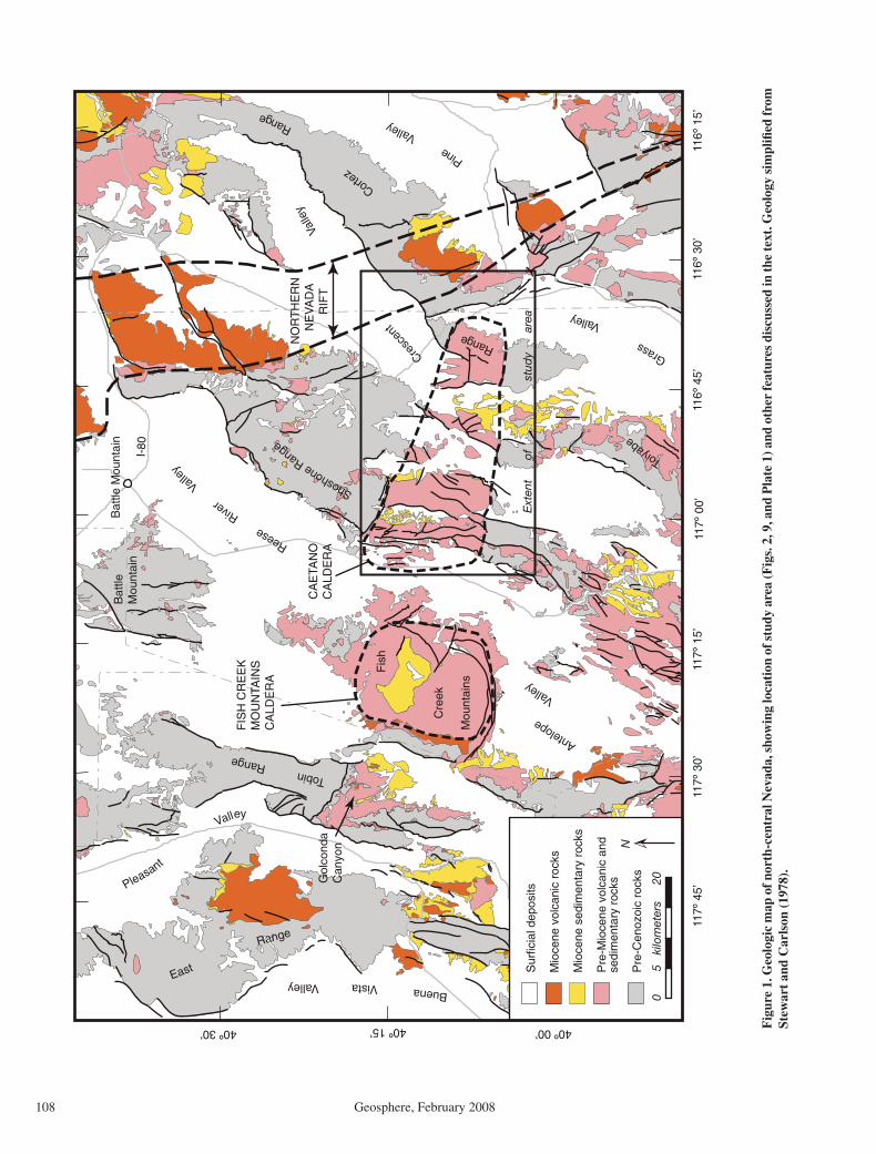
The most extensive Cenozoic unit in the study area is the late Eocene Caetano Tuff (Gil-luly and Masursky, 1965), exposed in the north-ern Toiyabe and southern Shoshone Ranges (Fig. 1). It was originally interpreted as fi lling the eastern part of an east-west–trending, ~90
Colgan et al.
108 Geosphere, February 2008
Reese R
iver
Vall
ey
Fis
h
Cre
ek
Mou
ntai
ns
Tobin Range
East
Range
FIS
H C
RE
EK
MO
UN
TAIN
SC
ALD
ER
A
NO
RT
HE
RN
N
EV
AD
A
RIF
T
Shoshone Range
Bat
tle M
ount
ain
I-80
40º 00’40º 15’40º 30’
116º
30’
116º
45’
117º
00’
117º
15’
117º
30’
117º
45’
116º
15’
Cresc
ent
V
alle
y
Toiyabe
R
ange
Grass
Valley
CA
ETA
NO
CA
LDE
RA
C
ortez
Range
Ext
ent
o
f
s
tud
y
are
a
Pleasant
Valley
Buena Vista Valley
Antelope
Valley
Pine
Valley
Bat
tleM
ount
ain
Gol
cond
aC
anyo
n
Sur
ficia
l dep
osits
Mio
cene
vol
cani
c ro
cks
Mio
cene
sed
imen
tary
roc
ks
Pre
-Mio
cene
vol
cani
c an
d se
dim
enta
ry r
ocks
Pre
-Cen
ozoi
c ro
cks
0
5
kilo
met
ers
2
0
N
Fig
ure
1. G
eolo
gic
map
of n
orth
-cen
tral
Nev
ada,
sho
win
g lo
cati
on o
f stu
dy a
rea
(Fig
s. 2
, 9, a
nd P
late
1) a
nd o
ther
feat
ures
dis
cuss
ed in
the
text
. Geo
logy
sim
plifi
ed fr
om
Stew
art
and
Car
lson
(19
78).

Caetano caldera extension
Geosphere, February 2008 109
× 20 km “volcano-tectonic trough” (Masursky, 1960; Burke and McKee, 1979). The western part of this “trough” has since been shown to consist of the structurally intact Fish Creek Mountains caldera (Fig. 1; McKee, 1970), dated to 24.72 ± 0.05 Ma (John et al., 2008). New geologic map-ping, geochronology, and geochemical data indi-cate a similar caldera origin for the Caetano Tuff in the eastern part of the “trough,” referred to hereafter as the Caetano caldera (this study; John et al., 2008). The present east-west elongation of the Caetano caldera (Figs. 1 and 2) is the result of east-west extension along north-striking normal faults, making the caldera an ideal strain marker for restoring later Cenozoic deformation.
John et al. (2008) present detailed fi eld observations, geochemical data, and 40Ar/39Ar age data that establish an ~33.8 Ma age for the Caetano Tuff and demonstrate that it fi lls a structurally dismembered caldera (all 40Ar/39Ar dates in this paper are referenced to sanidine from the Fish Canyon Tuff with an assigned age of 28.02 Ma (Renne et al., 1998)). The purpose of this paper is to restore deformation of the caldera and thereby establish the timing and kinematics of Basin and Range extension in this region. We present a new geologic map and cross-sections (Plate 1) that document the magnitude and structural style of extension, together with new 40Ar/39Ar dates and tephra correlations from synextensional basins that establish the timing of faulting.
We conclude that the ca. 34 Ma Caetano caldera remained undeformed until the middle Miocene (ca. 16 Ma), at which point it was dis-membered by large-magnitude, roughly east-west extension along north-striking normal faults that accommodated ~110% (~22 km) extension. Extension began ca. 16 Ma and took place in two main phases. We interpret 16–12 Ma sedimentary rocks to record large-magni-tude middle Miocene extension and tilting of the Caetano caldera. Fault blocks and basins formed during middle Miocene extension were subsequently cut by a second generation of more widely spaced, high-angle normal faults that strike more northeast. The onset of younger faulting is not well established but is thought to be younger than ca. 10 Ma.
GEOLOGIC SETTING
In the following section, map units in paren-theses refer to designations on the schematic stratigraphic column (Fig. 3), geologic map (Plate 1), and restored cross sections (Fig. 4). Geographic locations discussed in the text can be found in Figure 2 in addition to Plate 1. Plate 1 was compiled from new 1:24,000-scale geologic mapping of key localities (John et al.,
2008), new 1:100,000-scale mapping of the cal-dera fi ll and Miocene sedimentary rocks (this study; John et al., 2008), and published geologic maps of the (mostly Paleozoic) rocks outside the caldera (sources listed in Plate 1).
Pre-Cenozoic Rocks
Exposed pre-Cenozoic basement in the southern Shoshone Range and northern Toiyabe Range (Fig. 2) consists primarily of lower Paleo-zoic (Upper Cambrian–Devonian) siliceous rocks of the Roberts Mountains allochthon (the upper plate), deposited in a deep ocean basin west of the North American continent and thrust eastward onto the continental shelf during the Late Devonian–Mississippian Antler orogeny (e.g., Roberts et al., 1958; Miller et al., 1992). These rocks have been divided into several for-mal and informal units by different authors; the most extensive of these include the Valmy For-mation (argillite, quartzite, chert, greenstone; Roberts, 1951), Vinini Formation (argillite, quartzite, shale, chert; Merriam and Anderson, 1942), Slaven Chert, and Elder Sandstone (Gil-luly and Gates, 1965). Within the upper plate, these units are repeated by numerous thrust faults and highly deformed at both outcrop and map scale (e.g., Gilluly and Gates, 1965). For the purpose of this study we consider these rocks to represent a single tectonic-stratigraphic package (Pzrm). In the northwestern part of the study area, we estimate that the upper plate was no more than ~2 km thick in the middle Mio-cene, although an unknown amount may have been removed by erosion before that time.
Underlying lower plate rocks (Pzlc) of the lower Paleozoic (Cambrian–Devonian) con-tinental shelf (predominantly carbonate) are locally exposed in structural windows beneath the siliceous upper plate (Plate 1). In the south-ern Cortez Range, this sequence is at least 1.8 km thick with Cambrian rocks exposed at the base (Gilluly and Masursky, 1965). Lower plate carbonate rocks are an important host rock for the major gold deposits in the area, including the giant Pipeline deposit (2005 reserves ~11 Moz; past production ~9 Moz; Muntean, 2006). In the southern Cortez Range, the lower plate was exposed by mid-Tertiary erosion prior to extensional faulting (Gilluly and Masursky, 1965; John et al., 2008), but we argue here that some lower-plate windows may be exhumed in the footwalls of Miocene nor-mal faults; this interpretation is discussed in a later section.
Upper Paleozoic rocks deposited unconform-ably on the Roberts Mountains allochthon fol-lowing its emplacement—the Antler overlap assemblage—have been described by Moore
et al. (2000) and Racheboeuf et al. (2004) in the southwestern part of the study area (Pzo). Equivalent units are exposed in the south-cen-tral Cortez Range (Fig. 1) to the northeast of the study area (Muffl er, 1964). In the southwestern Shoshone Range, these rocks were overthrust in the Late Permian–Early Triassic by deep-water siliceous rocks of the Golconda allochthon (Pzg; Moore et al., 2005).
Cenozoic Rocks that Predate the Caetano Caldera
Few Cenozoic rocks in the study area are known to predate eruption of the Caetano Tuff and formation of the Caetano caldera. Sparse, undated andesitic lava fl ows are exposed on the caldera fl oor in the Toiyabe Range (Figs. 2 and 3; included in unit Tad; note that this unit also includes post-caldera lavas). Coarse clastic sediments containing abundant carbonate clasts derived from lower-plate rocks are exposed on the caldera fl oor near Wenban Spring (Fig. 2). These exposures may correlate with an exten-sive but poorly exposed >400-m-thick gravel deposit fi lling a paleovalley in the southern Cortez Range (Tog). To the north of our study area, local outcrops of outfl ow tuff previously mapped as Caetano Tuff (Stewart and McKee, 1977; Doebrich, 1995) are demonstrated by John et al. (2008) to be the tuff of Cove Mine, a similar but petrographically and geochemically distinct, slightly older (34.2 Ma) tuff that pre-dates the Caetano caldera. Southwest of Wilson Pass in the Shoshone Range (Fig. 2), a small outcrop of the tuff of Cove Mine (Tcm) over-lies a small outcrop of mafi c lava (Tob). Both of these units are stratigraphically beneath the lower intracaldera cooling unit of the Caetano Tuff, and thus represent the fl oor of the caldera (discussed in detail by John et al., 2008).
Caetano Tuff and Related Units
Detailed petrographic data, geochemical anal-yses, and 40Ar/39Ar age data for the Caetano Tuff and related units are presented in a companion paper (John et al., 2008). Here we summarize aspects of these units relevant to our discussion of extensional faulting.
Intracaldera Tuff: Lower UnitMost of the intracaldera Caetano Tuff is a
single compound cooling unit as much as 3.4 km thick (Tcl), although the top and bottom of the caldera fi ll are never exposed in the same struc-tural block. For the purpose of this study, we conservatively estimate that this unit is as thick as 3.6 km, although the maximum thickness may be slightly greater (John et al., 2008). The tuff

Colgan et al.
110 Geosphere, February 2008
Fig
ure
2. S
hade
d-re
lief
map
of
stud
y ar
ea (
sam
e ex
tent
as
Fig
. 9 a
nd P
late
1),
sho
win
g lo
cati
on o
f cr
oss
sect
ions
, geo
grap
hic
feat
ures
, and
min
eral
dep
osit
s di
scus
sed
in th
e te
xt. D
ashe
d gr
ay li
ne is
app
roxi
mat
e ex
tent
of C
aeta
no c
alde
ra. G
ray
lines
are
impr
oved
gra
vel (
bold
) and
dir
t roa
ds (t
hin,
sol
id a
nd d
ashe
d). B
ase
map
sam
e as
Pla
te 1
.
Caetano caldera extension
Geosphere, February 2008 111
in the eastern part of the caldera in the northern Toiyabe Range is relatively fresh, with vitro-phyre locally preserved at the base. In contrast, the intracaldera tuff west of Carico Lake Valley (Fig. 2) is strongly hydrothermally altered; in some cases, it is diffi cult to tell if the rock was formerly extrusive or a shallow intrusion.
Intracaldera Tuff: Upper UnitA distinct cooling break is present in the
upper part of the intracaldera Caetano Tuff, most prominently exposed between Rocky Pass and Red Mountain in a series of small fault blocks west of Tub Spring (Fig. 2). Above
this cooling break, the Caetano Tuff consists of as much as 1000 m of generally poorly exposed, poorly welded ash-fl ow tuff, locally interbedded with fi nely laminated tuffaceous siltstone and sandstone. Thin (5–10 m) ledges of densely welded tuff within this unit are geo-chemically and petrographically similar to the main intracaldera Caetano Tuff, and yield sta-tistically indistinguishable 40Ar/39Ar ages (John et al., 2008). Where exposed, this sequence is a useful marker for restoring slip on normal faults, and we designate all caldera fi ll above the top of the lower cooling unit (Tcl) as a separate map unit (Tcu). Both the upper and
lower units are hydrothermally altered in the western part of the caldera, and, where we have not mapped them in detail, they are shown as intracaldera tuff, undivided (Tcc).
BrecciaLarge (>10 m) breccia blocks and crudely
bedded sheets composed of crushed and bro-ken Paleozoic quartzite and chert (locally with a tuffaceous matrix) are exposed along the margins of the caldera, consistent with catastrophic collapse during eruption of the Caetano Tuff. Breccia deposits large enough to be shown in Plate 1 are designated “Tcb,”
xRedMountain
x MountCaetano
x MountTenabo
x HorseMountain
x ElephantHead
Sto
ne
Cab
in
B
asin
G R
A S
S V
A L L E
Y
C R E
S C
E N
T
V A L L E Y
WilsonPass
Wood Spring Canyon
x BaldMountain
RockyPass
Wilso
n
R
E E
S E
R I
V E
R
V A
L L
E Y
C A
R I
C O
L A
K E
V A
L L
E Y
CaricoLake
Tub Spring
WenbanSpring
xCaetanoRanch
Figure 12
Figure 18
Figure 15
Figure 19
Figure 14
ELE
PH
AN
T
HEA
D
F
AULT
THE
C
ED
AR
S
FAU
LT
RED
RO
CK
C
AN
YO
N
FA
ULT
Qal
Qaf
Qaf
Qaf
Qaf
Tcl
Qaf Qal
Pzrm
Qaf
Qaf
Qaf
Pzrm
Tog
Tcc
Tcu Qaf
Ts
Pzlc
Ts
Qal
Tcu
Pzrm
Pzrm
Ts
Jgr
Qaf
Qaf
Pzo
Ts
Qaf
Tcl
Pzrm Pzrm
Qal
Qaf
Ts
Tcc
Tcl
Tad
Pzrm
Tcs
Tcs?
Pzrm
Qp
Pzlc
Ts
Pzrm
Qaf
Tcl
Qaf
Tcu
Tcl
Tcl
Tcs
Tcs
Tb
Pzrm
Tbm
Tcic
Ts?
Tcs
Tcu
Pzrm
Pzrm
Tcu
Pzlc
Tcc
Tcu
Tad
Pzrm
Tct
Qaf
Tcic
Tcl
Tcs
Qaf
Tcs
Tcl
Tbm
Tcs
Tbm
Tcu
Pzrm
Tcl
Pzlc
Tbm
Tbm?
Tcu
Ts?
Tcl
Tcb
Ts
Pzlc
Tad
Ts
Tbm
Tcu
Tci
Tbm?
Tcb
Tbm
Tog
Tcu
Pzlc
Tcl
Tct
Tbm
Pzo
Tct
Qp
Tct
Tbm
Tcu
Tcic
Tbm
Tad
Tbm
Qal
Tad?
Tad
Tbm
Tcu
Tad
Tog?
Tbm
Tad
Pzh
Tbm
Tad
Tad
Tog
Tcu
Pzh
Tad
Tad
Pzrm
Tct?
Tct
Tcs
Tct
Tcic
Tcic
Pzrm
Tbm?
Tct
Tcic
PzrmPzo
Tcs
Pzrm
Tct?
Tob
Qaf
Ts?Cortez
Pipeline pitsand dumps (2006)
Greystonemine
Tad
40
TOIY
AB
E
MIN
E
F
AU
LT
C
OR
TE
Z
FA
ULT
MO
SS
CR
EE
K
F
AU
LT
S
TO
NE
C
AB
IN
F
AU
LT
Pzrm
MILL CANYON STOCK
Tad
Toiyabe
PzoTcl
Tbm?
Tcs
Qal
Tcic
Tcc
Tbm?
Tcs
Qaf
Qaf
Tcs?
Tcs
DR
Y
CA
NYON
FAULT
MO
SS
CR
EE
k
FA
ULT
G
RE
YS
TO
NE
F
AU
LT ?
Tcu
60
Barite pit
GoldAcres
Ts
Tcl
CA
ETA
NO
RA
NC
H
F
AU
LT
WENBAN FAULT
Tcir
Tcb
CR
ES
CENT
F
AULT
RED
MOU
NTA
IN
FAU
LT
Tmr
Tor
Tor
Tcu?
Tcm
Tcu
TcuTcl
Tad
Tcu
s s
s s
s s
s s
s s
s s
s
s s
R E
D R
O C
K C
A N
Y O
N
s
s s s s s
s s s
s s
s s
s
Tad
Tad
TctTad
TbmR
OC
KY
PA
SS
FAULT
GR
EY
ST
ON
E
F
AU
LT
Qaf
?
?
Tcb
Tcl
Ts
Ts
Ts
Ts
Pzrm
Tcs
Qaf
Tcl
Qal27
Tbm
Tor
Tcb
60Qal
35
Qaf
Qaf
CJV2
Qaf
l l l l l l l l l l l l
l l l l
l ll
l l
l l l l
Tci
TbmTcir
Tcir
TclTcu
Tbm
l l l l l l l l
l l
l l
Ts
l l
l l l l
l l l l l l
Tcir
Tbm
Tcir
l l
l l
l l
l
ll
l
l
l ll
l l
l l l l l l
l l
l l
l l l l
Qaf
Tcl
Tcl
QafQaf
Tcu
Tcu
Tcc
Tcc
ll ll l l l l l l ll l l l l l l l
l l
ll l
l l
l l
ll l
l l
l l
l l
l l
l
l
l l
l l
l
l
ll l
l l
l l
l l
l l
l l
?
Tad
Tct
Cortez
CortezHills
Pediment HorseCanyon
D’
C’
B’
A’3
2
1
0
A
kilo
met
ers
3
2
1
0
B
kilo
met
ers
3
2
1
0
C
kilo
met
ers
3
2
1
0
D
kilo
met
ers
3
2
1
0
kilometers
3
2
1
0
kilometers
kilometers
3
2
1
0
kilometers
3
2
1
0
?
Ts
Tbm
Tcs
Tbm
Tcl
TbmTbm
Redrock Canyon
REDROCK CYN F
LT
THE CEDARS FLT?
Tcs Ts
Tad
MO
SS
C
RE
EK
FLT
THE CEDARS FLT?
Redrock Canyon
Caldera marginfaulted out
Pzrm
Tcl
Tcc TclTcs
Tcc?
TcsTad
Reese River Valley
Reese River Valley Wilson Canyon
GREYSTONE FLT
Cooks Creek Carico Lake Valley
Ts? Pzrm
Ts
TOIYBALE MINE FLT? ROBERTS THRUST? CAETANO RANCH FLT?
Pzrm?Pzlc?Pzrm QTs
Pzlc/Pzrm?
Pzrm
Crescent Valley Cortez Range
CRESCENT FLT
CORTEZ FLT?
fault obliqueto section
Tog
Tcc
Tcs
faulted Tcs/Tad?Tcc?
TcuTs
Tcir? Tcu
Tob?
Pzrm?
Tcic Tcic?
Ts
Tcl
Rocky PassCarico Lake Valley
ROCKY PASS FLT
GREYSTONE FLT?
Tcc
Redrock Canyon pluton Carico Lake pluton
TclTclTclTOIYABE MINE FLT
TcuTs
Tog
Pzrm?
Ts
Pzlc
Tcl
Grass ValleyToiyabe Range
CORTEZ FLT
CR
ESC
ENT
FLT
Pzrm?
Pzrm Tmr
Tb
Cortez Range
Grass Valley Cortez Range
ROBERTS MTN THRUST
faulted Tcs/Tad?
Reese River Valley Elephant Head
Tcc
THE CEDARS
FLT
Tcc
Tcs
MO
SS C
RE
EK F
LT
? Tbm
Tcl
STO
NE
CA
BIN
FLT
Tbm
Tcc
Ts?
Carico Lake Valley Tub Spring
ROCKY PASS FLT?
GREYSTONE FLT?
Tcu
Tcl
Caetano Ranch Mt. Caetano
TclTcl
Ts
CAETANO RANCH FLT
TOIYABE MINE FLT
Tcl
Tcu
Pzo? Tad?
Tad
PzoPzrm?
Tcl TogPzlc Pzrm
ROBERTS MTN THRUST
Ts?
Pzrm
Pzlc?
caldera floor exposed2 km north of A–A’
caldera floor exposed?1 km south of D–D’
structures projected north from B–B’
Pzrm; structure unknown
Grass Valley Cortez Range
Buried Ts?
Bald Mountain
Tog
Pzrm
CORTEZ FLT
TOIYABE MINE FLT
Ts Ts
Tbm
TctPzrm
Wood Spring CanyonRed Mountain
DRY CANYON FLT
Pzo?Pzrm
Ts?
Carico Lake Valley
Pzrm
STO
NE
CA
BIN
FLT
THE CEDARS F
LT
Inferred structure beneath Carico Lake Valley(see Colgan et al., 2008)
PzoTad
Pzrm
Pzh
Tad
The Cedars
MO
SS
CR
EE
K F
LT
Tcu
Pzlc?
s s
Pzlc?
Upper Caetano considered too thickand probably repreated by unmapped fault(s)
(see Colgan et al., 2008)
Tcl
Tog?
QafQafQaf
Qaf
Qaf
caldera floor inferredfrom Tog exposure
inferred caldera floor
Qaf Qal/Qp
QafQaf
QafQafQaf Qal
Qaf Qal
ELEPHANT HEAD FLT
QafQafQafQafQaf
Qaf
Qaf
ROCKY PASS FAULT?
MO
SS
C
REE
K F
LT
Tcu s
s
Tog
Tcb
s s s
Tad?/Tct?Tct
Tct
CORTEZ FLT
Tbm
Tcir
Tcir?
Tcir?
?Tbm?
Tcic?
Tcl
REDROCK CYN FLTTcu
Tcm?
TclTcu
Tcu
Stone Cabiin Basin
Tcu?
Qaf Qaf
Qaf
Tcs
Qal
CT107
CT108
CT116
H05-62
CT101CT102
CT121
CT120
00DJ34
H03-84
H03-82
H03-96
99DJ80
H03-94
06DJ13
H03-88B
H03-89
05DJ27
05DJ27
DC99-15334m
8
6
6
7
95
9
25
20
15
15
25
20
20
30
35
40
30
25
15
25
35
30
30
30
45
50
3545
45
55
50
32
25
25
60
50
40
40
37
48
29
40
27
2820
3723
20
30
40
53
62
11
21
12
3744
45 4343
90
2842
52
12
40
40
452550
3452
72
46
30
6035
35
35
35
40
20
45
40
605025
10
30
5020
25
15
6020
25
40
2535
2530
45
40
45
25
25
40
3545
40
30
30
5025
40
3545
4040
7572
25
10
30
45
40
45
40
52
4050
15
30
80
30
40
18
49
5145
28
50
30
3450
50
62
40
44
67
40
30
46
50
60
3032
44
35
3945
24
30
43
70
48
2328
46
35
3740
16
3050
60
7080
47
3575
4035
3729
26
85
30
75
46
42
33
70
3533 37
2534
10
20
43
30
55
48
45
41
55
4245
40
33
66
40
23
37
39
50
50
77
70
77
25
45
26
26
30
22
40
30
35
13
21
31
36
24
46
65
68
47
41
6144
64
31
2120 47
62
69
6480
38
38
41
42
63
21
40
37
87 73
37
37
47
116º 37’ 30”116º 45’ 00”116º 52’ 30”117º 00’ 00”
40º 07’ 30”
40º 15’ 00” 40º 15’ 00”
40º 07’ 30”
116º 37’ 30”116º 45’ 00”116º 52’ 30”117º 00’ 00”
SCALE 1:100,000
01 1 2 3 4 5 6 7 8 9 10 KILOMETERS
0 543211 MILES
15°
TR
UE
NO
RT
H
MA
GN
ET
IC N
OR
TH
APPROXIMATE MEANDECLINATION, 2000
GEOLOGIC MAP AND CROSS-SECTIONS OF THE CAETANO CALDERA, LANDER COUNTY, NEVADA
ByJoseph P. Colgan, Christopher D. Henry, and David A. John
2008
Sources of map data
1. New mapping by the authors.2. Gilluly and Gates (1965)3. Gilluly and Masursky (1965)4. McKee and Stewart (1969)5. Stewart and McKee (1969)6. Moore et al. (2007)7. Roberts et al. (1967)8. Stewart and McKee (1969)9. Stewart and McKee (1977)
1,8,9
1,6
1,3,9 1,3,7
1,2,9 72
1,4,9
NATIONAL GEODETIC VERTICAL DATUM OF 1983
Shaded-relief topography from USGS National Elevation Dataset (30m grid; http://ned.usgs.gov).Base map from USGS Crescent Valley and Fish Creek Mountains quadrangles (1:100,000 scale).UTM Projection, Zone 11
MAP LOCATION
NEVADA
A
B
C
D
C’
D’
B’
A’
Contact—Solid where observed in the field by the authors. Dashed where interpreted from air photos or other published maps.
Normal Fault—Ball and bar on downthrown side. Arrow indicates dip and dip direction. Solid where observed in the field by the authors. Dashed where interpreted from air photos or other published maps. Dotted where concealed by alluvium.
Caldera Margin—Tick marks toward caldera interior. Solid where observed in the field by the authors. Dashed where interpreted from air photos or other published maps. Dotted where concealed by alluvium.
Thrust Fault—Teeth on upper plate. Solid where observed in the field by the authors. Dashed where interpreted from air photos or other published maps. Dotted where concealed by alluvium.
Strike and dip of inclined bedding
Strike and dip of compaction foliation in ash-flow tuff
40Ar/39Ar sample locality
40Ar/39Ar sample locality from drill hole—Depth in meters.
Tephrachronology sample locality
40Ar/39Ar and tephrachronology sample locality
Mineral deposit
Extent of detailed geologic map—Figure numbers correspond to 1:24,000-scale geologic maps in John et al. (2008).
EXPLANATION
REFERENCES
Bingler, E.C., 1978, Abandonment of the name Hartford Hill Rhyolite Tuff and adoption of new formation names for middle Tertiary ash-flow tuffs in the Carson City-Silver City area, Nevada: Nevada Bureau of Mines and Geology Bulletin 1457-D, 19 p.
Colgan, J.P., John, D.A., and Henry, C.D., 2008, Large-magnitude Miocene extension of the Eocene Caetano caldera, Shoshone and Toiyabe Ranges, Nevada: Geosphere, doi: 10.1130/GES00115.1.
Deino, A.L., 1989, Single crystal 40Ar/39Ar dating as an aid in correlation of ash flows: Examples from the Chimney Springs/New Pass Tuffs and the Nine Hill/Bates Mountain Tuffs of California and Nevada: New Mexico Bureau of Mines and Mineral Resources, Continental Magmatism Abstracts Bulletin 131, p. 70.
Faulds, J.E., Henry, C.D., and dePolo, C.M., 2003, Preliminary geologic map of the Tule Peak Quadrangle, Washoe County, Nevada: Nevada Bureau of Mines and Geology Open-File Report 03-10, 1:24,000.
Gilluly, J., and Gates, O., 1965, Tectonic and igneous geology of the northern Shoshone Range, Nevada: U.S. Geological Survey Professional Paper 465, 153 p., scale 1:31,680.
Gilluly, J., and Masursky, H., 1965, Geology of the Cortez quadrangle, Nevada: U.S. Geological Survey Bulletin 1175, scale 1:62,500.
Gromme, C.S., McKee, E.H., and Blake, M.C., Jr., 1972, Paleomagnetic correlations and potassium-argon dating of middle Tertiary ash-flow sheets in the eastern Great Basin, Nevada and Utah: Geological Society of America Bulletin, v. 83, p. 1619–1638.
Henry, C.D., Faulds, J.E., dePolo, C.M., and Davis, D.A., 2004, Geology of the Dogskin Mountain Quadrangle, northern Walker Lane, Nevada: Nevada Bureau of Mines and Geology Map 148, scale 1:24,000, 13 p. text.
John, D.A., Henry, C.D., and Colgan, J.P., 2008, Magmatic and tectonic evolution of the Caetano caldera, north-central Nevada: A tilted mid-Tertiary eruptive center and source of the Caetano Tuff: Geosphere, doi: 10.1130/GES00116.1.
McKee, E.H., 1968, Geologic map of the Spencer Hot Springs Quadrangle, Lander and Eureka Counties, Nevada: U.S. Geological Survey Geologic Quadrangle Map GQ-770.
McKee, E.H., and Conrad, J.E., 1987, Geologic map of the Desatoya Mountains Wilderness Study Area, Churchill and Lander counties, Nevada: U.S. Geological Survey Miscellaneous Field Studies Map MF-1944, scale 1:62,500.
McKee, E.H., and Stewart, J.H., 1969, Geologic map of The Cedars [15'] quadrangle, Lander County, Nevada: U.S. Geological Survey Open-File Report 69-268, scale 1:62,500.
Moore, T.E., O'Sullivan, P.B., Murchey, B.L., Moring, B.C., Harris, A.G., Blodgett, R.B., and Fleck, R.J., 2005, Geologic map of The Cedars quadrangle, southern Shoshone Range, Nevada: Window to the world: Reno, Nevada, Geological Society of Nevada Symposium Proceedings, May 14-18, p. 67.
Mortensen, J.K., Thompson, J.F.H., and Tosdal, R.M., 2000, U-Pb age constraints on magmatism and mineralization in the northern Great Basin, Nevada, in Cluer, J.K., Price, J.G., Struhsacker, E.M., Hardyman, R.F., and Morris, C.L., eds.,
Geology and ore deposits 2000: The Great Basin and beyond: Reno, Nevada, Geological Society of Nevada Symposium Proceedings, May 15-18, p. 419-438.
Racheboeuf, P.R., Moore, T.E., and Boldgett, R.B., 2004, A new species of Dyoros (brachiopoda, chonetoidea) from Nevada (United States) and stratigraphic implication for the Pennsylvanian and Permian Antler overlap assemblage: Geobios, v. 37, p. 382-394.
Roberts, R.J., Montgomery, K.M., and Lehner, R.E., 1967, Geology and mineral resources of Eureka County, Nevada: Nevada Bureau of Mines and Geology Bulletin 64, 164 p., scale 1:250,000.
Sargent, K.A., and McKee, E.H., 1969, The Bates Mountan Tuff in northern Nye County, Nevada: U.S. Geological Survey Bulletin, v. 1294-E, 12 p.
Stewart, J.H., and McKee, E.H., 1968, Geologic map of the Mount Callaghan Quadrangle, Lander County, Nevada: U.S. Geological Survey Geologic Quadrangle Map GQ-730, 1:62,500.
Stewart, J.H., and McKee, E.H., 1969, Geology of the Carico Lake quadrangle, Lander County, Nevada: U.S. Geological Survey Open-File Report 69-268, scale 1:62,500.
Stewart, J.H., and McKee, E.H., 1977, Geology and mineral deposits of Lander County, Nevada: Nevada Bureau of Mines and Geology Bulletin 88, 114 p., scale 1:250,000.
Wells, J.D., Elliott, J.E., and Obradovich, J.D., 1971, Age of the igneous rocks associated with ore deposits, Cortez-Buckhorn area, Nevada: U.S. Geological Survey Professional Paper 750-C, p. C127-C135.
CORRELATION OF MAP UNITS
Qal Qaf
Ts
Tad
Tog
Tob
Jgr
Pzh
Qp
QTs
Pzo
Pzrm
MIOCENE
PLIOCENE
OLIGOCENE
EOCENE
JURASSIC
NEOGENE
QUATERNARY
PALEOGENE
CENOZOIC
MESOZOIC
PALEOZOIC
Pzlc
GOLCONDA THRUST
ROBERTS MOUNTAIN THRUST
Tct
Tcs
cross-sections only
Tmr
Tb
Tcu
Tct
Tcb
Tcl
Tad
Tcm
Tor
Tog
Tob
Pzh
Jgr
Pzo
Pzrm
Pzlc
CAETANO CALDERA AND RELATED ROCKS
Carico Lake pluton (Eocene)—Carico Lake pluton consists of 50–60%, 1–5 mm phenocrysts of smoky quartz, sanidine, plagioclase and 2–3% biotite and hornblende in a microcrystalline quartz-feldspar groundmass. Scattered sanidine phenocrysts are as much as 2 cm long. Small miarolitic cavities are common. Locally flow banded. Intrudes and deforms Caetano Tuff. Sanidine 40Ar/39Ar age is 33.78 ± 0.05 Ma (John et al., 2008).
Redrock Canyon pluton (Eocene)—Strongly altered fine- to medium-grained granite porphyry containing about 30% phenocrysts of rounded smoky quartz and altered sanidine and plagioclase in a felsite groundmass now altered to kaolinite a n d q u a r t z . U n d a t e d b u t p r e s u m e d t o b e l a t e E o c e n e . I n t r u d e s a n d hydrothermally alters Caetano Tuff.
Caetano intrusive rocks, undivided (Eocene)—Small ring-fracture intrusion in northwestern Carico Lake Valley is a fine- to medium-grained porphyry with sparse white K-feldspar phenocrysts as much as 1 cm long. It consists of about 45% phenocrysts of plagioclase, K-feldspar, and dark-gray quartz and 3% biotite and sparse hornblende in a microcrystalline groundmass. Small intrusion 2 km northwest of Carico Lake is fine-grained granite porphyry containing about 25–30%, 0.1–3 mm phenocrysts of rounded smoky quartz, sanidine, and plagioclase, and 1-2% biotite and hornblende in an aphanitic groundmass containing abundant miarolitic cavities. Both intrusions are undated but presumed to be late Eocene.
Caetano Tuff, outflow sheet (Eocene)—Densely welded, crystal-rich rhyolite ash-flow tuff identical in composition and age to intracaldera Caetano Tuff (unit Tcc). Forms densely welded, reddish weathering ledges with up to 250 m composite thickness. Black vitrophyric zones locally present. Sanidine 40Ar/39Ar ages are 33.83 ± 0.05 and 33.75 ± 0.06 Ma (John et al., 2008).
Caetano Tuff, breccia (Eocene)—Mesobreccia and megabreccia dominated by coarse clasts of quartzi te and chert . Mesobreccia is massive to thick bedded, quartzite-dominated breccia containing clasts up to 2 m in diameter, mostly matrix supported. Matrix varies from tuffaceous to finely ground quartzite. Also includes matrix-supported, quartzite-argillite pebble layers and sparse interbeds of volcanic sandstone and tuff. Probably deposited by rock falls and debris flows, and possibly by fluvial processes. Megabreccia is composed of individual blocks up to 50 m in diameter, mostly of chert or quartzite, but also Eocene (35 Ma) rhyolite in the northeastern part of the caldera (probably equivalent to Tor), and composite areas of blocks up to ~1 km across, locally with a tuffaceous matrix.
Caetano Tuff, upper intracaldera unit (Eocene)—Multiple, thin, cooling units of poorly welded to moderately or (rarely) densely welded ash-flow tuffs locally interbedded with coarse conglomerate, sandstone, and fine, platy tuffaceous siltstone. Generally forms pale or banded slopes punctuated by thin ledges of more resistant welded tuff. Tuffs commonly contain angular fragments of densely welded lower Caetano Tuff up to 1.4 m in diameter and locally contain hornblende-pyroxene andesite and Paleozoic fragments to 15 cm. Poorly to moderately welded tuffs are characterized by distinctive orange pumice fragments. Up to 1000 m thick; base of unit defined as a prominent welding break at the top of the lower unit (Tcc), which generally forms a conspicuous slope break marked by a vitrophyre or several meters of conglomerate or sandstone.
Caetano Tuff, lower intracaldera unit (Eocene)—Compound cooling unit of densely welded, crystal-rich, rhyolite ash-flow tuff, containing about 35–50 volume % phenocrysts as much as 5 mm in maximum dimension. Quartz, sanidine, and plagioclase form >90% total phenocrysts. Distinctive quartz phenocrysts are dark gray to black (smoky) and partly resorbed. Total mafic mineral content generally <4 volume %, consisting mainly of biotite with minor opaque minerals and locally trace hornblende. Euhedral allanite crystals as much as 1 mm long, apatite, and zircon are common accessory phenocryst phases. Strongly flattened pumice fragments generally are crystal rich and contain phenocryst assemblages similar to the matrix. Exposed thickness ranges from 1800 to >3400 m. Weighted mean of nine sanidine 40Ar/39Ar ages from both upper and lower units is 33.80 ± 0.05 Ma (John et al., 2008).
Caetano Tuff, upper and lower units (Tcu and Tcl) undivided.
Hydrothermal alteration—Hydrothermally altered Caetano Tuff and intrusive rocks. W h i t e , d a r k - g r a y, a n d d a r k y e l l o w - g r a y, c o m m o n l y r e d w e a t h e r i n g hydrothermally altered rocks. Variable intermediate and advanced argillic alteration assemblages in which plagioclase phenocrysts replaced by kaolinite, sanidine is unaltered, perthitic, or replaced by kaolinite, biotite replaced by kaolinite, white mica, and/or opaque oxides, and groundmass replaced by fine-grained silica and/or kaolinite and fine-grained pyrite. Locally, plagioclase and sanidine are completely leached leaving prominent voids in a siliceous matrix. Most pyrite is oxidized. Locally contains abundant hematite.
CENOZOIC ROCKS PREDATING THE CAETANO CALDERA
Tuff of Cove Mine (Eocene)—Crystal-rich, rhyolite ash-flow tuff with 30–50% phenocrysts of quar tz , sanidine, p lagioclase , b iot i te , and hornblende. Distinguished from the petrographically similar Caetano Tuff by greater total mafic mineral (6–10 volume %) and plagioclase content. Typically contains 5–8 volume % biotite and 1–2% hornblende. Weighted mean of four sanidine 40Ar/39Ar ages is 34.22 ± 0.01 Ma (John et al., 2008).
Rhyolite domes and dikes (Eocene)—Flow-banded, finely, sparsely porphyritic sanidine-quartz-biotite rhyolite lava dome in the southern Cortez Range and numerous dikes in the northern Toiyabe Range. U-Pb zircon age of lava dome is 35.2 ± 0.2 Ma (Mortensen et al., 2000). K-Ar ages from lava dome are 35.2 ± 1.1 Ma (sanidine) and 35.3 ± 1.2 Ma (biotite); K-Ar ages from dikes are 34.7 ± 1.1 to 35.8 ± 1.2 Ma (Wells et al., 1971, recalculated).
Andesite and dacite lava (Eocene and Oligocene)—Finely to coarsely porphyritic andesite and dacite lava flows with phenocrysts comprised mostly of plagioclase and pyroxene with local hornblende. Composite unit includes lavas that predate formation of the Caetano caldera together with flows interbedded in post-caldera sedimentary rocks (unit Tcs). Includes dacite of Wood Canyon mapped by Moore et al. (2007) in the southwestern part of the map area.
Basaltic lava flows (Eocene)—Dark gray, weakly propylitized, fine-grained sparsely porphyritic plagioclase-pyroxene basalt lava flows on the floor of the Caetano caldera west of Wilson Pass. Undated but stratigraphically beneath the tuff of Cove Mine.
Boulder to pebble conglomerate and sandstone (Miocene to Eocene)—Poorly sorted and poorly lithified unit deposited unconformably on Paleozoic basement. More than 400 m thick in the southern Cortez Range, where it contains blocks up to 10 m across of Paleozoic rocks , grani t ic rocks , porphyri t ic andesi tes , flow-banded rhyolites, Caetano Tuff, and several units of Bates Mountain Tuff. Sanidine 40Ar/39Ar age from a reworked ash layer in this deposit is 33.97 ± 0.20 Ma (John et al., 2008). Forms part of the caldera floor near Wenban Spring in Toiyabe Range, where it is dark red, moderately well bedded and calcite cemented with angular to subrounded clasts of Paleozoic limestone, chert, and minor quartzite to 90 cm. Also inferred to form part of caldera floor on northwest edge of Toiyabe Range, where lithified conglomerate contains subrounded clasts of quartzite, chert, argillite, granite, diorite, and flow-banded porphyritic rhyolite as much as 1.5 m in diameter in a sandy non-calcareous matrix.
MESOZOIC ROCKS
Mill Canyon Stock (Jurassic)—Biotite quartz monzonite, locally with plagioclase phenocrysts. Zircon U-Pb age is 158.4 ± 0.6 Ma (Mortensen et al., 2000).
PALEOZOIC ROCKS
Havallah Sequence (Golconda Allochthon) (Permian to Mississippian)—Argillite, chert, sand, and siltstone mapped by Moore et al. (2005) in the southwestern part of the map area.
Antler Overlap Assemblage (Permian to Pennsylvanian)—Rocks deposited in angular unconformity on the Roberts Mountains Allochthon. Includes predominantly clastic rocks of the Permian Horseshoe Basin Sequence (Raucheboeuf et al., 2004) and the Pennsylvanian and Permian Cedars Sequence (Moore et al., 2005).
Roberts Mountains Allochthon (Devonian to Ordovician)—Argillite, chert, quartzite, sandstone, greenstone, and minor limestone. Includes rocks assigned to the Valmy Formation, Vinini Formation, Elder Sandstone, and Slaven Chert (Gilluly and Gates, 1965; Gilluly and Masursky, 1965).
Lower plate of Roberts Mountains Allochthon (Devonian to Cambrian)—Limestone, dolomite, quartzite, and shale. Includes rocks assigned to the Wenban Limestone, Roberts Mountains Formation, Hanson Creek Formation, Eureka Quartzite, and Hamburg Dolomite (Gilluly and Gates, 1965; Gilluly and Masursky, 1965).
Tcic
Tcir
Tci
Tor
Tcm
Tbm
Unconformity
Unconformity
Unconformity
s s
s s
Qal
Qaf
Qp
QTs
Tb
Tcs
Ts
DESCRIPTION OF MAP UNITS
Tbm
Tbm
Tbm
Tbm
Alluvium (Holocene)—Unconsolidated alluvial sand and gravel and lacustrine deposits in modern stream beds and valleys.
Alluvial-fan deposits (Quaternary)—Unconsolidated to poorly consolidated deposits of boulders, gravel, and sand that form the modern alluvial fans and pediment surfaces mostly developed on Miocene sedimentary rocks.
Playa deposits (Quaternary)—Clay, silt, and sand forming surface deposits in ephemeral lake basins in Carico Lake Valley
Basin fill (Quaternary to late Miocene)—Sediments filling Crescent Valley, shown in cross section only. Inferred to have been deposited during late Miocene to Holocene slip on the Crescent Fault.
Rhyolite dome (Miocene)—Flow-banded rhyolite dome intruding Paleozoic sedimentary rocks and Tertiary gravel (Tog) along crest of Cortez Range. Sanidine K-Ar age is 15.6 ± 0.4 Ma (Wells et al., 1971, recalculated).
Basaltic andesite (Miocene)—Basaltic andesite lava flows up to 100 m thick on the southeastern crest of the Cortez Range. Whole-rock 40Ar/39Ar ages are 16.36 ± 0.05 and 16.67 ± 0.14 Ma (Colgan et al., 2008).
MIDDLE MIOCENE SEDIMENTARY ROCKS
Sedimentary rocks (Miocene)—Poorly exposed sandstone and conglomerate with lesser finer-grained tuffaceous deposits. Mostly light gray-brown, fine- to medium-grained sandstone in beds 10–20 cm thick, containing variable amounts of pyroclastic material including glass shards and crystal and lithic fragments. Sandstones locally contain thin (~10 cm) lenticular beds of conglomerate with 1–5 cm clasts of quartzite, chert, and/or volcanic rocks. More extensive conglomerate deposits consist of poorly consolidated, light-brown, massively bedded, medium- to fine-grained sandstone containing matrix-supported (locally channelized), angular to subrounded cobbles as much as 50 cm across (generally 1–5 cm). Clasts most commonly consist of gray Paleozoic quartzite and chert and locally of Caetano Tuff. Sandstone and conglomerate interbedded with thinly laminated (<1 cm), white tuffaceous shale and 2–5 m thick beds of l ight gray to whi te volcanic ash. Age approximately 16–12 Ma, based on sanidine 40Ar/39Ar dates and tephra correlations (Colgan et al., 2008).
CENOZOIC ROCKS POSTDATING THE CAETANO CALDERA
Bates Mountain Tuff (Oligocene)—Composite map unit composed of rhyolite ash-flow tuffs and locally interbedded sedimentary rocks (Tcs). This unit encompasses three genetically unrelated ash-flow tuffs corresponding to units B, C, and D of the Bates Mountain Tuff as defined for exposures at Bates Mountain about 60 km south of the map area (Stewart and McKee, 1968; McKee, 1968; Sargent and McKee, 1969; Gromme et al., 1972). Not all units are present in all sections. 40Ar/39Ar ages from John et al. (2007).
D unit of Bates Mountain Tuff—Mostly densely welded, pumice-rich, and sparsely porphyr i t ic ash- f low tuff conta in ing ~5% phenocrys ts of san id ine , anorthoclase, plagioclase, and sparse quartz and biotite. Sanidine 40Ar/39Ar age is 25.27 ± 0.07 Ma. Equivalent to Nine Hill Tuff (Bingler, 1978; Deino, 1989).
C unit of Bates Mountain Tuff—Poorly to densely welded, pumiceous, sparsely porphyritic ash-flow tuff containing phenocrysts of plagioclase, sanidine, prominent embayed quartz, and biotite. Sanidine 40Ar/39Ar age is 28.64 ± 0.06 Ma. Equivalent to tuff of Campbell Creek in central and western Nevada (McKee and Conrad, 1987; Henry et al., 2004; Faulds et al., 2005).
B unit of Bates Mountain Tuff—Moderately to densely welded, sparsely pumiceous, moderately porphyritic ash-flow tuff containing phenocrysts of plagioclase, sanidine, and biotite. Sanidine 40Ar/39Ar age is 30.48 ± 0.07 Ma. Equivalent to tuff of Sutcliffe in western Nevada (Henry et al., 2004; Faulds et al., 2005).
Post-caldera sedimentary rocks (Oligocene)—Platy to poorly bedded, pale gray to greenish weathering, tuffaceous sandstone and siltstone, white finely laminated shale, and boulder to pebble conglomerate containing clasts of porphyritic andesite to 60 cm in diameter and some Paleozoic rocks. Present within the Caetano caldera where they overlie Caetano Tuff. Probably deposited in lacustrine, fluvial and (locally) alluvial fan settings.
7
33
00DJ34
s s s s
b
c
d
Tcc
Tmr
CT101
27
l l l l l l l l l l l l l l l l
CT107
DC99334m
Figure 12
Tcb
Tcl
Tcir
CAETANO CALDERA
Tcu
Tcic Tci
Geologic Map and Cross Sections of the Caetano Caldera, Lander County, NevadaColgan et al.Plate 1Supplement to Geosphere, v. 4, no. 1 (February 2008)
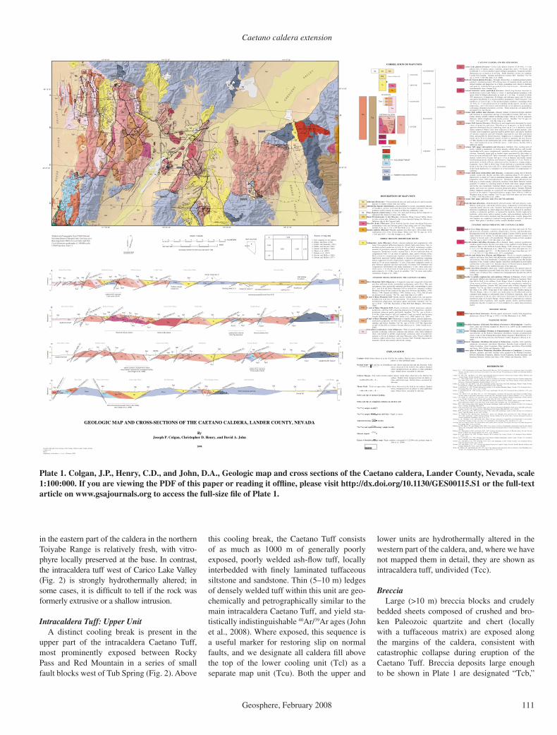
Plate 1. Colgan, J.P., Henry, C.D., and John, D.A., Geologic map and cross sections of the Caetano caldera, Lander County, Nevada, scale 1:100:000. If you are viewing the PDF of this paper or reading it offl ine, please visit http://dx.doi.org/10.1130/GES00115.S1 or the full-text article on www.gsajournals.org to access the full-size fi le of Plate 1.
Colgan et al.
112 Geosphere, February 2008
but they are locally present elsewhere along the caldera margins.
Intrusive RocksThe central part of the caldera in Carico Lake
Valley (Fig. 2) is underlain by the Carico Lake pluton, a poorly exposed granite porphyry (Tcic) that intrudes and deforms the surrounding intra-caldera tuff. This granite is dated as 33.78 ± 0.05 Ma (40Ar/39Ar sanidine; John et al., 2008), and we interpret it to represent a resurgent intrusion derived from the same magma chamber that produced the Caetano Tuff. The Redrock Can-yon pluton (Tcir) crops out sporadically across the western part of the caldera between Redrock Canyon and Carico Lake Valley (Fig. 2), where
it intrudes the altered upper unit of the Caetano Tuff. This intrusion is strongly altered, and John et al. (2008) infer that it was the source of heat and/or hydrothermal fl uids that altered the western part of the caldera.
Outfl ow SheetOutside the caldera, the Caetano Tuff is locally
present within the study area as an outfl ow sheet generally deposited on pre-Cenozoic basement to the south and west of the caldera. The outfl ow sheet, shown as a separate unit (Tct) in Plate 1, is as much as 300 m thick where it fi lls paleo-topography in Golconda Canyon in the Tobin Range (Fig. 1; Gonsior and Dilles, 2008; John et al., 2008).
Bates Mtn.Tuff (Tbm)
Caetano Tuff33.8 Ma
Resurgent domeintrusions33.7 Ma
TadTog
Tci
Tcl
Tcu
Tcc
Tcs Tad
Ts
16–12 Masedimentary rocks in fault-boundbasins
Hydrothermalalteration zone
Caldera floor
Caetano Tuff:upper cooling units
Caetano Tuff:lower cooling unit
Post-calderasedimentary rocks
QTs
30.5 Ma
28.6 Ma
25.3 Ma
B
C
DTad
Pre-CaetanoCenozoic rocks Paleozoic
basement
Breccia blocksand sheets
Late Miocene toHolocene(?) fillin modern basins
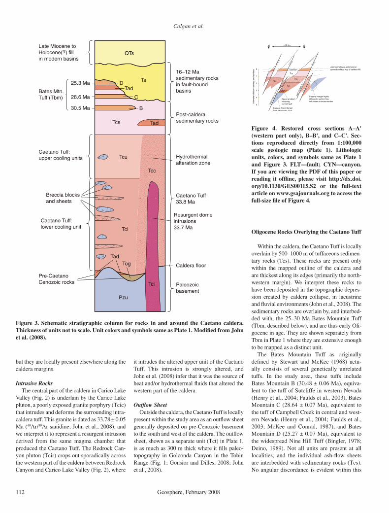
Pzu
Figure 3. Schematic stratigraphic column for rocks in and around the Caetano caldera. Thickness of units not to scale. Unit colors and symbols same as Plate 1. Modifi ed from John et al. (2008).
RE
DR
OC
K C
YN
FLT
GR
EY
STO
NE
FLT
a1
0
1
2
3
4
5
kilo
met
ers
belo
w in
ferr
ed la
nd s
urfa
ce Tad/Tbm
Tcs
Tcc
Caldera margin highlyoblique to section line;not shown in cross-section
Approximate pre-extensionalground surface (top of caldera fill)
~4.9 km
Caldera floor inferredfrom exposures 2 km
Tcu
Tcl
Space problemrestoringcurved fault
a2
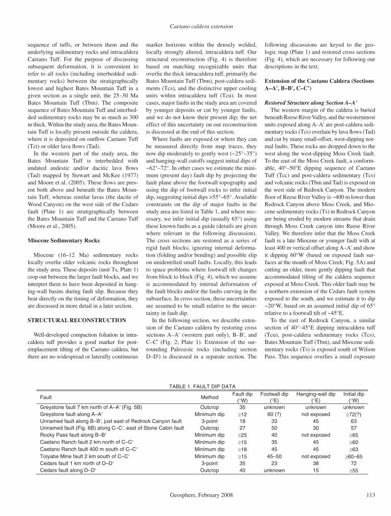
Figure 4. Restored cross sections A–A' (western part only), B–B', and C–C'. Sec-tions reproduced directly from 1:100,000 scale geologic map (Plate 1). Lithologic units, colors, and symbols same as Plate 1 and Figure 3. FLT—fault; CYN—canyon. If you are viewing the PDF of this paper or reading it offl ine, please visit http://dx.doi.org/10.1130/GES00115.S2 or the full-text article on www.gsajournals.org to access the full-size fi le of Figure 4.
Oligocene Rocks Overlying the Caetano Tuff
Within the caldera, the Caetano Tuff is locally overlain by 500–1000 m of tuffaceous sedimen-tary rocks (Tcs). These rocks are present only within the mapped outline of the caldera and are thickest along its edges (primarily the north-western margin). We interpret these rocks to have been deposited in the topographic depres-sion created by caldera collapse, in lacustrine and fl uvial environments (John et al., 2008). The sedimentary rocks are overlain by, and interbed-ded with, the 25–30 Ma Bates Mountain Tuff (Tbm, described below), and are thus early Oli-gocene in age. They are shown separately from Tbm in Plate 1 where they are extensive enough to be mapped as a distinct unit.
The Bates Mountain Tuff as originally defi ned by Stewart and McKee (1968) actu-ally consists of several genetically unrelated tuffs. In the study area, these tuffs include Bates Mountain B (30.48 ± 0.06 Ma), equiva-lent to the tuff of Sutcliffe in western Nevada (Henry et al., 2004; Faulds et al., 2003), Bates Mountain C (28.64 ± 0.07 Ma), equivalent to the tuff of Campbell Creek in central and west-ern Nevada (Henry et al., 2004; Faulds et al., 2003; McKee and Conrad, 1987), and Bates Mountain D (25.27 ± 0.07 Ma), equivalent to the widespread Nine Hill Tuff (Bingler, 1978; Deino, 1989). Not all units are present at all localities, and the individual ash-fl ow sheets are interbedded with sedimentary rocks (Tcs). No angular discordance is evident within this
Caetano caldera extension
Geosphere, February 2008 113
sequence of tuffs, or between them and the underlying sedimentary rocks and intracaldera Caetano Tuff. For the purpose of discussing subsequent deformation, it is convenient to refer to all rocks (including interbedded sedi-mentary rocks) between the stratigraphically lowest and highest Bates Mountain Tuff in a given section as a single unit, the 25–30 Ma Bates Mountain Tuff (Tbm). The composite sequence of Bates Mountain Tuff and interbed-ded sedimentary rocks may be as much as 300 m thick. Within the study area, the Bates Moun-tain Tuff is locally present outside the caldera, where it is deposited on outfl ow Caetano Tuff (Tct) or older lava fl ows (Tad).
In the western part of the study area, the Bates Mountain Tuff is interbedded with undated andestic and/or dacitic lava fl ows (Tad) mapped by Stewart and McKee (1977) and Moore et al. (2005). These fl ows are pres-ent both above and beneath the Bates Moun-tain Tuff, whereas similar lavas (the dacite of Wood Canyon) on the west side of the Cedars fault (Plate 1) are stratigraphically between the Bates Mountain Tuff and the Caetano Tuff (Moore et al., 2005).
Miocene Sedimentary Rocks
Miocene (16–12 Ma) sedimentary rocks locally overlie older volcanic rocks throughout the study area. These deposits (unit Ts, Plate 1) crop out between the larger fault blocks, and we interpret them to have been deposited in hang-ing-wall basins during fault slip. Because they bear directly on the timing of deformation, they are discussed in more detail in a later section.
STRUCTURAL RECONSTRUCTION
Well-developed compaction foliation in intra-caldera tuff provides a good marker for post-emplacement tilting of the Caetano caldera, but there are no widespread or laterally continuous
marker horizons within the densely welded, locally strongly altered, intracaldera tuff. Our structural reconstruction (Fig. 4) is therefore based on matching recognizable units that overlie the thick intracaldera tuff, primarily the Bates Mountain Tuff (Tbm), post-caldera sedi-ments (Tcs), and the distinctive upper cooling units within intracaldera tuff (Tcu). In most cases, major faults in the study area are covered by younger deposits or cut by younger faults, and we do not know their present dip; the net effect of this uncertainty on our reconstruction is discussed at the end of this section.
Where faults are exposed or where they can be measured directly from map traces, they now dip moderately to gently west (~25°–35°) and hanging-wall cutoffs suggest initial dips of ~62°–72°. In other cases we estimate the mini-mum (present day) fault dip by projecting the fault plane above the footwall topography and using the dip of footwall rocks to infer initial dip, suggesting initial dips >55°–65°. Available constraints on the dip of major faults in the study area are listed in Table 1, and where nec-essary, we infer initial dip (usually 65°) using these known faults as a guide (details are given where relevant in the following discussion). The cross sections are restored as a series of rigid fault blocks, ignoring internal deforma-tion (folding and/or bending) and possible slip on unidentifi ed small faults. Locally, this leads to space problems where footwall tilt changes from block to block (Fig. 4), which we assume is accommodated by internal deformation of the fault blocks and/or the faults curving in the subsurface. In cross section, these uncertainties are assumed to be small relative to the uncer-tainty in fault dip.
In the following section, we describe exten-sion of the Caetano caldera by restoring cross sections A–A' (western part only), B–B', and C–C' (Fig. 2; Plate 1). Extension of the sur-rounding Paleozoic rocks (including section D–D') is discussed in a separate section. The
following discussions are keyed to the geo-logic map (Plate 1) and restored cross sections (Fig. 4), which are necessary for following our descriptions in the text.
Extension of the Caetano Caldera (Sections A–A', B–B', C–C')
Restored Structure along Section A–A'The western margin of the caldera is buried
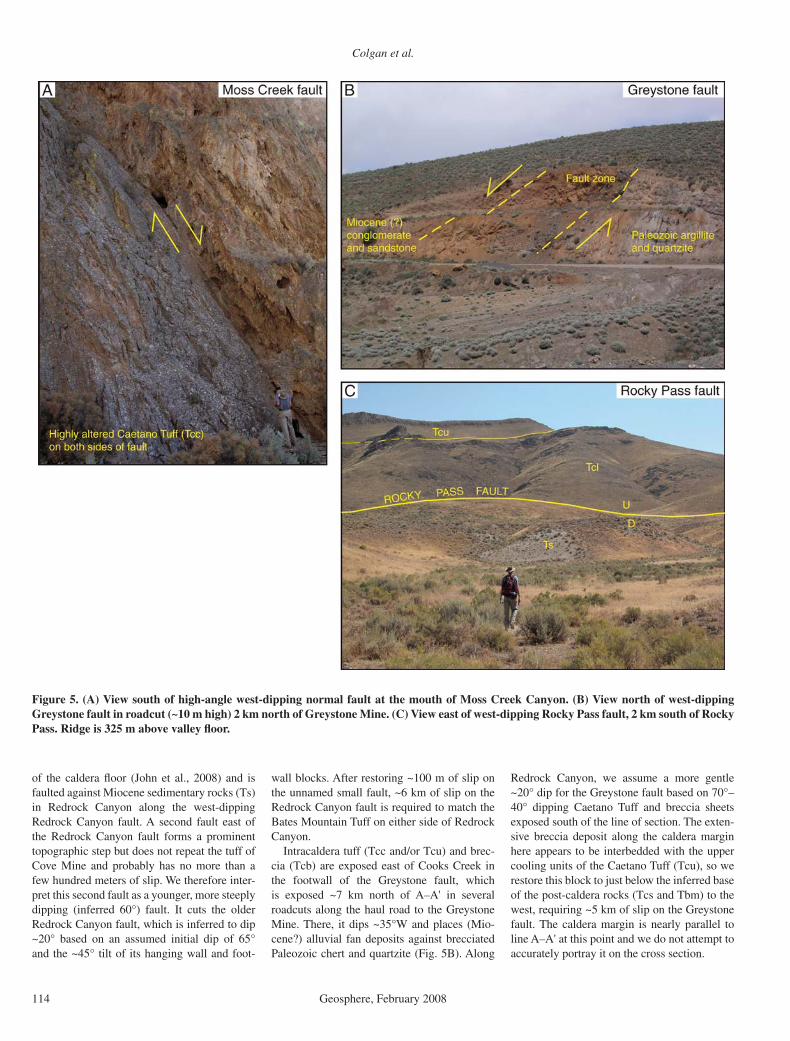
beneath Reese River Valley, and the westernmost units exposed along A–A' are post-caldera sedi-mentary rocks (Tcs) overlain by lava fl ows (Tad) and cut by many small-offset, west-dipping nor-mal faults. These rocks are dropped down to the west along the west-dipping Moss Creek fault. To the east of the Moss Creek fault, a conform-able, 40°–50°E dipping sequence of Caetano Tuff (Tcc) and post-caldera sedimentary (Tcs) and volcanic rocks (Tbm and Tad) is exposed on the west side of Redrock Canyon. The modern fl oor of Reese River Valley is ~400 m lower than Redrock Canyon above Moss Creek, and Mio-cene sedimentary rocks (Ts) in Redrock Canyon are being eroded by modern streams that drain through Moss Creek canyon into Reese River Valley. We therefore infer that the Moss Creek fault is a late Miocene or younger fault with at least 400 m vertical offset along A–A' and show it dipping 60°W (based on exposed fault sur-faces at the mouth of Moss Creek; Fig. 5A) and cutting an older, more gently dipping fault that accommodated tilting of the caldera sequence exposed at Moss Creek. This older fault may be a northern extension of the Cedars fault system exposed to the south, and we estimate it to dip ~20°W, based on an assumed initial dip of 65° relative to a footwall tilt of ~45°E.
To the east of Redrock Canyon, a similar section of 40°–45°E dipping intracaldera tuff (Tcu), post-caldera sedimentary rocks (Tcs), Bates Mountain Tuff (Tbm), and Miocene sedi-mentary rocks (Ts) is exposed south of Wilson Pass. This sequence overlies a small exposure
TABLE 1. FAULT DIP DATA
Fault Method Fault dip
( W) Footwall dip
( E)Hanging-wall dip
( E)Initial dip
( W) Greystone fault 7 km north of A–A (Fig. 5B) Outcrop 35 unknown unknown unknown Greystone fault along A–A Minimum dip 12 60 (?) not exposed 72(?)Unnamed fault along B–B , just east of Redrock Canyon fault 3-point 18 33 45 63 Unnamed fault (Fig. 6B) along C–C , east of Stone Cabin fault Outcrop 27 50 30 57 Rocky Pass fault along B–B Minimum dip 25 40 not exposed 65Caetano Ranch fault 2 km north of C–C Minimum dip 15 35 45 60Caetano Ranch fault 400 m south of C–C Minimum dip 18 45 45 63Toiyabe Mine fault 2 km south of C–C Minimum dip 15 45–50 not exposed 60–65Cedars fault 1 km north of D–D 3-point 35 23 38 72 Cedars fault along D–D Outcrop 40 unknown 15 55
Colgan et al.
114 Geosphere, February 2008
of the caldera fl oor (John et al., 2008) and is faulted against Miocene sedimentary rocks (Ts) in Redrock Canyon along the west-dipping Redrock Canyon fault. A second fault east of the Redrock Canyon fault forms a prominent topographic step but does not repeat the tuff of Cove Mine and probably has no more than a few hundred meters of slip. We therefore inter-pret this second fault as a younger, more steeply dipping (inferred 60°) fault. It cuts the older Redrock Canyon fault, which is inferred to dip ~20° based on an assumed initial dip of 65° and the ~45° tilt of its hanging wall and foot-
wall blocks. After restoring ~100 m of slip on the unnamed small fault, ~6 km of slip on the Redrock Canyon fault is required to match the Bates Mountain Tuff on either side of Redrock Canyon.
Intracaldera tuff (Tcc and/or Tcu) and brec-cia (Tcb) are exposed east of Cooks Creek in the footwall of the Greystone fault, which is exposed ~7 km north of A–A' in several roadcuts along the haul road to the Greystone Mine. There, it dips ~35°W and places (Mio-cene?) alluvial fan deposits against brecciated Paleozoic chert and quartzite (Fig. 5B). Along
Redrock Canyon, we assume a more gentle ~20° dip for the Greystone fault based on 70°–40° dipping Caetano Tuff and breccia sheets exposed south of the line of section. The exten-sive breccia deposit along the caldera margin here appears to be interbedded with the upper cooling units of the Caetano Tuff (Tcu), so we restore this block to just below the inferred base of the post-caldera rocks (Tcs and Tbm) to the west, requiring ~5 km of slip on the Greystone fault. The caldera margin is nearly parallel to line A–A' at this point and we do not attempt to accurately portray it on the cross section.
Figure 5. (A) View south of high-angle west-dipping normal fault at the mouth of Moss Creek Canyon. (B) View north of west-dipping Greystone fault in roadcut (~10 m high) 2 km north of Greystone Mine. (C) View east of west-dipping Rocky Pass fault, 2 km south of Rocky Pass. Ridge is 325 m above valley fl oor.

Caetano caldera extension
Geosphere, February 2008 115
The footwall of the Greystone fault is covered by alluvium at the north end of Carico Lake Val-ley, and no known Cenozoic rocks are exposed farther east along A–A'. Undated, poorly exposed gravel deposits north of Rocky Pass may be Miocene sedimentary rocks (Ts?) in the hanging wall of the Rocky Pass fault system, although it is unclear where this fault (or faults) extends north into Paleozoic rocks. Approximately 3 km south of line A–A', 37°–43°E dipping Caetano Tuff (Tcl) crops out along the north wall of the caldera, suggesting that west-dipping faults continue at least several kilometers north in the Paleozoic rocks. Paleozoic rocks in this area are complexly faulted (Gilluly and Gates, 1965), and it is extremely diffi cult to tell whether faults have thrust or normal displacement, let alone their age. The eastern ~19 km of line A–A' is buried beneath late Miocene(?) to Holocene basin fi ll in Crescent Valley. On line A–A', we show the approximate position of faults exposed along line B–B' 4–5 km to the south, as they would project if they continued north beneath Crescent Valley.
Restoring the Caetano caldera over the west-ern part of section A–A', between the surface trace of the Moss Creek fault (a1) and the sur-face trace of Greystone fault (a2), yields ~5.6 km of extension (10.5–4.9 km) or ~115% strain. Given the lack of Cenozoic marker units north-east of the caldera and the extent of young cover in Crescent Valley, it is impossible to restore the eastern ~30 km of the section.
Restored Structure along Section B–B'West of the Moss Creek fault, line B–B' is
covered by alluvium in Reese River Valley, although it is inferred at depth to consist of faulted post-caldera sedimentary rocks (Tcs) and lava fl ows (Tad) by analogy to line A–A'. The Moss Creek fault is assumed to dip ~60ºW and cut an older fault that dips ~25°W (assumed initial dip of 65°), with ~40°E dipping intracal-dera Caetano Tuff, post-caldera sedimentary rocks (Tcs), and Bates Mountain Tuff (Tbm) in its footwall. This older fault may be the north-ern extension of the Cedars fault or fault system, and the footwall is locally complicated along B–B' by a minor down-to-the east fault that dies out to the north.
To the east of Redrock Canyon, line B–B' crosses the Redrock Canyon fault and two other west-dipping faults that drop 40°–45°E dipping sedimentary rocks (Tcs) and Bates Mountain Tuff down against highly altered intracaldera tuff (Tcc) and the Redrock Canyon pluton (Tcir). Redrock Canyon is bound on the east side by the Redrock Canyon fault, which places Miocene sedimentary rocks against the Redrock Canyon pluton. We assume a 35°W dip for the Redrock
Canyon fault along B–B', somewhat less than along A–A', consistent with less steeply dip-ping Bates Mountain Tuff in its hanging wall. Approximately 2.5 km of slip on the Redrock Canyon fault, together with 2.5 km combined slip on the two gently west dipping faults to the east is required to restore the Bates Mountain Tuff (Tbm) on either side of Redrock Canyon. This system of west-dipping faults is cut at a high angle by two northeast-striking, down-to-the southeast faults that form prominent linea-ments on aerial photographs but appear to have only a few hundred meters of offset at most.
Within Carico Lake Valley, line B–B' crosses alluvial cover and the Carico Lake pluton (Tci), interpreted as a resurgent intrusion within the Caetano caldera (John et al., 2008). In the low hills between lines B–B' and C–C', 35°E dipping Bates Mountain Tuff is exposed just south of the intrusion, requiring a west-dipping fault to bring it up relative to east-dipping exposures of Bates Mountain Tuff and sedimentary rocks (Tcs) to the west. We infer this fault to be a southern extension of the Greystone fault system extend-ing south down Carico Lake Valley. Along B–B', this fault drops Caetano Tuff and overlying rocks down against the pluton, although it is unclear how far west the pluton extends in the subsurface. The east side of Carico Lake Valley is bound by the west-dipping Rocky Pass fault, which places 24°E dipping Miocene sedimen-tary rocks (Ts) against 40°–45°E dipping intra-caldera Caetano Tuff (Tcl and Tcu) exposed along the steep ridge south of Rocky Pass (Fig. 5C). The Rocky Pass fault is not exposed, but is inferred to dip ~25°W, based on an assumed initial dip of 65° and a footwall tilt of 40° (Table 1). The exposed top of the upper Caetano Tuff (Tcu) in the footwall of the Rocky Pass fault is assumed to restore to a preextensional strati-graphic position just beneath the Bates Moun-tain Tuff. Approximately 8.5–9.0 km of total slip along the Rocky Pass fault and inferred Greystone fault is therefore required to restore the upper Caetano Tuff (Tcu) beneath the Bates Mountain Tuff (Tbm) in the southern Shoshone Range. To the east of Rocky Pass, the Caetano Tuff is assumed to be overlain by Miocene sedi-mentary rocks (Ts), which dip 10°–20°E where exposed along strike to the south.
The northern Toiyabe Range is bound to the west by the west-dipping Toiyabe Mine fault. The present dip of this fault is unknown, but we estimate ~20°–25°, assuming an initial dip of 65°–70° and a footwall tilt of 45°E, based on measured dips in the upper Caetano Tuff (Tcu) and overlying sedimentary rocks (Tcs) exposed 6 km to the south near Caetano Ranch. The foot-wall of the Toiyabe Mine fault along line B–B' consists almost entirely of densely welded intra-
caldera tuff (Tcl), which is cut by several small-offset, west-dipping faults assumed to have a geometry similar to that of the Toiyabe Mine fault. John et al. (2008) interpret a small expo-sure of conglomerate just east of the Toiyabe Mine fault to predate the Caetano Tuff, correla-tive with conglomerate (Tog) exposed on the fl oor of the caldera east of Caetano Ranch (2 km south of C–C'). The exposure of caldera fl oor portrayed in B–B' is based on this interpretation, assuming the conglomerate is no more than 400 m thick. Assuming that the lower Caetano Tuff is ~3.6 km thick (consistent with its >3.4 km thickness in the footwall of the Caetano Ranch fault just to the east), ~7–8 km of combined slip on the Toiyabe Mine fault and the next west-dip-ping fault to the east is required to exhume the caldera fl oor. We assume very little slip on the other two west-dipping faults, consistent with no additional exposures of the caldera fl oor to the east. Interpretation of the gravel deposit (Tog) as caldera fl oor affects the stratigraphic position of the restored footwall of the Toiyabe Mine fault (and thus the total slip on each fault), but has very little effect on the amount of extension.
The easternmost block in the northern Toi-yabe Range is bound along B–B' by the south-ernmost trace of the Crescent fault, a young (late Miocene(?) to Holocene) high-angle fault that cuts the older, more gently dipping Caetano Ranch fault. We infer an initial dip of 65°W for the Caetano Ranch fault, which currently dips >15°–18° (Table 1). The amount of slip on the Crescent fault is not known, but is inferred to be small because it dies out 2–3 km to the south; we show ~500 m of slip in the cross section. South of B–B', the Caetano Tuff is unbroken by major faults and dips 35°–45°E. This is the greatest exposed thickness of the lower Caetano Tuff (~3.4 km), and we assume it to be close to the maximum thickness (inferred 3.6 km; John et al., 2008), although additional fi ll may be concealed upsection beneath northern Grass Valley. After restoring the Crescent fault, ~2 km of slip on the Caetano Ranch fault is required to restore this thick section of intracaldera tuff with similar exposures to the west, although this is dependent upon the caldera fl oor being exposed in the footwall of the Toiyabe Mine fault. The eastern margin of the caldera is shown in Plate 1 as the subsurface extent of the Caetano Tuff defi ned by Barrick Gold Corporation from geo-physical and drill-hole data (K. Hart, 2006, writ-ten commun.).
The breccia deposit (Tcb) along the caldera margin in B–B' was mapped by Gilluly and Masursky (1965) as in-place Paleozoic rocks, but John et al. (2008) interpret it as megabrec-cia blocks of Paleozoic rocks within the caldera, on the basis of fi eld relationships and drilling

Colgan et al.
116 Geosphere, February 2008
data (R. Leonardson, 2007, oral commun.). Northern Grass Valley is bound to the east by the west-dipping Cortez fault, which drops Miocene conglomerate and sandstone down against lower-plate Paleozoic rocks intruded by the 158 Ma Mill Canyon Stock (Gilluly and Masursky, 1965). We estimate ~4 km of slip on the Cortez fault. Both the Cortez fault and Miocene sedimentary rocks in its footwall are cut by the younger Crescent fault, which strikes nearly east-west and dips 60°N where it truncates the northern end of Grass Valley at the Cortez Mine (Fig. 6A). The Cortez Range footwall block is structurally intact and tilted
gently east-southeast. Miocene (16.7–16.4 Ma; Table A1) basalt fl ows on the crest of the range dip <10°SE, and lower-plate carbonate rocks adjacent to the Cortez fault dip as much as ~30°E (Gilluly and Masursky, 1965). We inter-pret the Cortez fault as the breakaway fault for the system of west-dipping faults that extended the Caetano caldera, with footwall tilt within the Cortez Range increasing toward the Cortez fault, possibly due to fl exural uplift and bend-ing of the Cortez Range footwall block during fault slip.
Restoration of section B–B', between the surface trace of the Moss Creek fault (b1)
and the surface trace of the Cortez fault (b2), yields 20.0 km of extension (38.2–18.2 km), or ~112% strain.
Restored Structure along Section C–C'The western end of line C–C' is covered by
Reese River Valley and is close to the southern caldera margin, which parallels the section line. The west side of the Shoshone Range forms a steep front that rises 800 m above Reese River Valley, suggesting a somewhat greater amount of slip on the Moss Creek fault (we estimate ~1 km) than to the north (see B–B'). East of the Moss Creek fault, the Caetano Tuff dips 30°–40°E and
Figure 6. (A) View east of north-dipping Crescent fault at the Cortez Mine. (B) View north of west-dipping fault north of Stone Cabin Basin. (C) View east of Red Mountain fault on east side of Carico Lake Valley; note prominent fault scarp. Ridge along skyline is 300 m above valley fl oor. U—upthrown; D—downthrown.
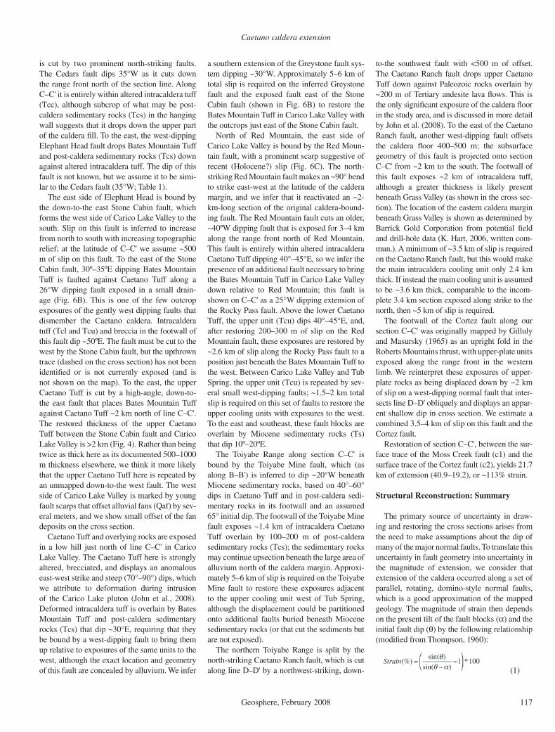
Caetano caldera extension
Geosphere, February 2008 117
is cut by two prominent north-striking faults. The Cedars fault dips 35°W as it cuts down the range front north of the section line. Along C–C' it is entirely within altered intracaldera tuff (Tcc), although subcrop of what may be post-caldera sedimentary rocks (Tcs) in the hanging wall suggests that it drops down the upper part of the caldera fi ll. To the east, the west-dipping Elephant Head fault drops Bates Mountain Tuff and post-caldera sedimentary rocks (Tcs) down against altered intracaldera tuff. The dip of this fault is not known, but we assume it to be simi-lar to the Cedars fault (35°W; Table 1).
The east side of Elephant Head is bound by the down-to-the east Stone Cabin fault, which forms the west side of Carico Lake Valley to the south. Slip on this fault is inferred to increase from north to south with increasing topographic relief; at the latitude of C–C' we assume ~500 m of slip on this fault. To the east of the Stone Cabin fault, 30º–35ºE dipping Bates Mountain Tuff is faulted against Caetano Tuff along a 26°W dipping fault exposed in a small drain-age (Fig. 6B). This is one of the few outcrop exposures of the gently west dipping faults that dismember the Caetano caldera. Intracaldera tuff (Tcl and Tcu) and breccia in the footwall of this fault dip ~50ºE. The fault must be cut to the west by the Stone Cabin fault, but the upthrown trace (dashed on the cross section) has not been identifi ed or is not currently exposed (and is not shown on the map). To the east, the upper Caetano Tuff is cut by a high-angle, down-to-the east fault that places Bates Mountain Tuff against Caetano Tuff ~2 km north of line C–C'. The restored thickness of the upper Caetano Tuff between the Stone Cabin fault and Carico Lake Valley is >2 km (Fig. 4). Rather than being twice as thick here as its documented 500–1000 m thickness elsewhere, we think it more likely that the upper Caetano Tuff here is repeated by an unmapped down-to-the west fault. The west side of Carico Lake Valley is marked by young fault scarps that offset alluvial fans (Qaf) by sev-eral meters, and we show small offset of the fan deposits on the cross section.
Caetano Tuff and overlying rocks are exposed in a low hill just north of line C–C' in Carico Lake Valley. The Caetano Tuff here is strongly altered, brecciated, and displays an anomalous east-west strike and steep (70°–90°) dips, which we attribute to deformation during intrusion of the Carico Lake pluton (John et al., 2008). Deformed intracaldera tuff is overlain by Bates Mountain Tuff and post-caldera sedimentary rocks (Tcs) that dip ~30°E, requiring that they be bound by a west-dipping fault to bring them up relative to exposures of the same units to the west, although the exact location and geometry of this fault are concealed by alluvium. We infer
a southern extension of the Greystone fault sys-tem dipping ~30°W. Approximately 5–6 km of total slip is required on the inferred Greystone fault and the exposed fault east of the Stone Cabin fault (shown in Fig. 6B) to restore the Bates Mountain Tuff in Carico Lake Valley with the outcrops just east of the Stone Cabin fault.
North of Red Mountain, the east side of Carico Lake Valley is bound by the Red Moun-tain fault, with a prominent scarp suggestive of recent (Holocene?) slip (Fig. 6C). The north-striking Red Mountain fault makes an ~90° bend to strike east-west at the latitude of the caldera margin, and we infer that it reactivated an ~2-km-long section of the original caldera-bound-ing fault. The Red Mountain fault cuts an older, ~40ºW dipping fault that is exposed for 3–4 km along the range front north of Red Mountain. This fault is entirely within altered intracaldera Caetano Tuff dipping 40°–45°E, so we infer the presence of an additional fault necessary to bring the Bates Mountain Tuff in Carico Lake Valley down relative to Red Mountain; this fault is shown on C–C' as a 25°W dipping extension of the Rocky Pass fault. Above the lower Caetano Tuff, the upper unit (Tcu) dips 40°–45°E, and, after restoring 200–300 m of slip on the Red Mountain fault, these exposures are restored by ~2.6 km of slip along the Rocky Pass fault to a position just beneath the Bates Mountain Tuff to the west. Between Carico Lake Valley and Tub Spring, the upper unit (Tcu) is repeated by sev-eral small west-dipping faults; ~1.5–2 km total slip is required on this set of faults to restore the upper cooling units with exposures to the west. To the east and southeast, these fault blocks are overlain by Miocene sedimentary rocks (Ts) that dip 10º–20ºE.
The Toiyabe Range along section C–C' is bound by the Toiyabe Mine fault, which (as along B–B') is inferred to dip ~20°W beneath Miocene sedimentary rocks, based on 40°–60° dips in Caetano Tuff and in post-caldera sedi-mentary rocks in its footwall and an assumed 65° initial dip. The footwall of the Toiyabe Mine fault exposes ~1.4 km of intracaldera Caetano Tuff overlain by 100–200 m of post-caldera sedimentary rocks (Tcs); the sedimentary rocks may continue upsection beneath the large area of alluvium north of the caldera margin. Approxi-mately 5–6 km of slip is required on the Toiyabe Mine fault to restore these exposures adjacent to the upper cooling unit west of Tub Spring, although the displacement could be partitioned onto additional faults buried beneath Miocene sedimentary rocks (or that cut the sediments but are not exposed).
The northern Toiyabe Range is split by the north-striking Caetano Ranch fault, which is cut along line D–D' by a northwest-striking, down-
to-the southwest fault with <500 m of offset. The Caetano Ranch fault drops upper Caetano Tuff down against Paleozoic rocks overlain by ~200 m of Tertiary andesite lava fl ows. This is the only signifi cant exposure of the caldera fl oor in the study area, and is discussed in more detail by John et al. (2008). To the east of the Caetano Ranch fault, another west-dipping fault offsets the caldera fl oor 400–500 m; the subsurface geometry of this fault is projected onto section C–C' from ~2 km to the south. The footwall of this fault exposes ~2 km of intracaldera tuff, although a greater thickness is likely present beneath Grass Valley (as shown in the cross sec-tion). The location of the eastern caldera margin beneath Grass Valley is shown as determined by Barrick Gold Corporation from potential fi eld and drill-hole data (K. Hart, 2006, written com-mun.). A minimum of ~3.5 km of slip is required on the Caetano Ranch fault, but this would make the main intracaldera cooling unit only 2.4 km thick. If instead the main cooling unit is assumed to be ~3.6 km thick, comparable to the incom-plete 3.4 km section exposed along strike to the north, then ~5 km of slip is required.
The footwall of the Cortez fault along our section C–C' was originally mapped by Gilluly and Masursky (1965) as an upright fold in the Roberts Mountains thrust, with upper-plate units exposed along the range front in the western limb. We reinterpret these exposures of upper-plate rocks as being displaced down by ~2 km of slip on a west-dipping normal fault that inter-sects line D–D' obliquely and displays an appar-ent shallow dip in cross section. We estimate a combined 3.5–4 km of slip on this fault and the Cortez fault.
Restoration of section C–C', between the sur-face trace of the Moss Creek fault (c1) and the surface trace of the Cortez fault (c2), yields 21.7 km of extension (40.9–19.2), or ~113% strain.
Structural Reconstruction: Summary
The primary source of uncertainty in draw-ing and restoring the cross sections arises from the need to make assumptions about the dip of many of the major normal faults. To translate this uncertainty in fault geometry into uncertainty in the magnitude of extension, we consider that extension of the caldera occurred along a set of parallel, rotating, domino-style normal faults, which is a good approximation of the mapped geology. The magnitude of strain then depends on the present tilt of the fault blocks (α) and the initial fault dip (θ) by the following relationship (modifi ed from Thompson, 1960):
(1)
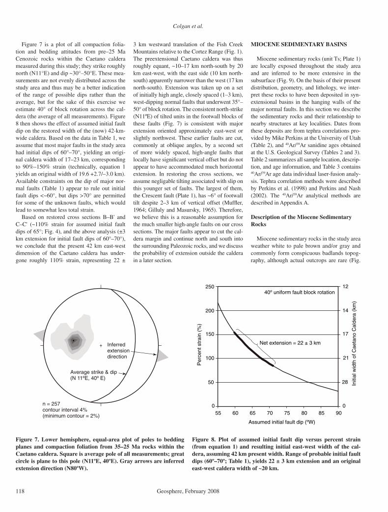
Colgan et al.
118 Geosphere, February 2008
Figure 7 is a plot of all compaction folia-tion and bedding attitudes from pre–25 Ma Cenozoic rocks within the Caetano caldera measured during this study; they strike roughly north (N11°E) and dip ~30°–50°E. These mea-surements are not evenly distributed across the study area and thus may be a better indication of the range of possible dips rather than the average, but for the sake of this exercise we estimate 40° of block rotation across the cal-dera (the average of all measurements). Figure 8 then shows the effect of assumed initial fault dip on the restored width of the (now) 42-km-wide caldera. Based on the data in Table 1, we assume that most major faults in the study area had initial dips of 60°–70°, yielding an origi-nal caldera width of 17–23 km, corresponding to 90%–150% strain (technically, equation 1 yields an original width of 19.6 +2.7/–3.0 km). Available constraints on the dip of major nor-mal faults (Table 1) appear to rule out initial fault dips <~60°, but dips >70° are permitted for some of the unknown faults, which would lead to somewhat less total strain.
Based on restored cross sections B–B' and C–C' (~110% strain for assumed initial fault dips of 65°; Fig. 4), and the above analysis (±3 km extension for initial fault dips of 60°–70°), we conclude that the present 42 km east-west dimension of the Caetano caldera has under-gone roughly 110% strain, representing 22 ±
3 km westward translation of the Fish Creek Mountains relative to the Cortez Range (Fig. 1). The preextensional Caetano caldera was thus roughly equant, ~10–17 km north-south by 20 km east-west, with the east side (10 km north-south) apparently narrower than the west (17 km north-south). Extension was taken up on a set of initially high angle, closely spaced (1–3 km), west-dipping normal faults that underwent 35°–50° of block rotation. The consistent north-strike (N11ºE) of tilted units in the footwall blocks of these faults (Fig. 7) is consistent with major extension oriented approximately east-west or slightly northwest. These earlier faults are cut, commonly at oblique angles, by a second set of more widely spaced, high-angle faults that locally have signifi cant vertical offset but do not appear to have accommodated much horizontal extension. In restoring the cross sections, we assume negligable tilting associated with slip on this younger set of faults. The largest of them, the Crescent fault (Plate 1), has ~6° of footwall tilt despite 2–3 km of vertical offset (Muffl er, 1964; Gilluly and Masursky, 1965). Therefore, we believe this is a reasonable assumption for the much smaller high-angle faults on our cross sections. The major faults appear to cut the cal-dera margin and continue north and south into the surrounding Paleozoic rocks, and we discuss the probability of extension outside the caldera in a later section.
MIOCENE SEDIMENTARY BASINS
Miocene sedimentary rocks (unit Ts; Plate 1) are locally exposed throughout the study area and are inferred to be more extensive in the subsurface (Fig. 9). On the basis of their present distribution, geometry, and lithology, we inter-pret these rocks to have been deposited in syn-extensional basins in the hanging walls of the major normal faults. In this section we describe the sedimentary rocks and their relationship to nearby structures at key localities. Dates from these deposits are from tephra correlations pro-vided by Mike Perkins at the University of Utah (Table 2), and 40Ar/39Ar sanidine ages obtained at the U.S. Geological Survey (Tables 2 and 3). Table 2 summarizes all sample location, descrip-tion, and age information, and Table 3 contains 40Ar/39Ar age data individual laser-fusion analy-sis. Tephra correlation methods were described by Perkins et al. (1998) and Perkins and Nash (2002). The 40Ar/39Ar analytical methods are described in Appendix A.
Description of the Miocene Sedimentary Rocks
Miocene sedimentary rocks in the study area weather white to pale brown and/or gray and commonly form conspicuous badlands topog-raphy, although actual outcrops are rare (Fig.
n = 257contour interval 4%(minimum contour = 2%)
Average strike & dip(N 11ºE, 40º E)
Inferredextensiondirection
0 0
50
100
150
200
250
55 60 65 70 75 80 85 90
28
21
17
14
12
Assumed initial fault dip (ºW)
Per
cent
str
ain
(%)
Initi
al w
idth
of C
aeta
no C
alde
ra (
km)
40º uniform fault block rotation
Net extension = 22 ± 3 km
Figure 7. Lower hemisphere, equal-area plot of poles to bedding planes and compaction foliation from 35–25 Ma rocks within the Caetano caldera. Square is average pole of all measurements; great circle is plane to this pole (N11ºE, 40ºE). Gray arrows are inferred extension direction (N80ºW).
Figure 8. Plot of assumed initial fault dip versus percent strain (from equation 1) and resulting initial east-west width of the cal-dera, assuming 42 km present width. Range of probable initial fault dips (60º–70º; Table 1), yields 22 ± 3 km extension and an original east-west caldera width of ~20 km.
Caetano caldera extension
Geosphere, February 2008 119
Mioce
nebas
alt
flows
116º
37’
30”
116º
45’
00”
116º
52’
30”
117º
00’
00”
40º 07’ 30”40º 15’ 00”
WILSON CA
NYO
N
??
??
?
Qua
tern
ary
allu
vial
cov
erTe
phra
sam
ple
loca
lity
Nor
mal
faul
ts40
/Ar/
39A
r sa
mpl
e lo
calit
yM
ioce
ne s
edim
ents
infe
rred
bene
ath
youn
ger
allu
vium
Mio
cene
sed
imen
tary
roc
ks(1
6-12
Ma)
Pre
-16
Ma
Cen
ozoi
cvo
lcan
ic a
nd s
edim
enta
ry r
ocks
Pal
eozo
ic b
asem
ent r
ocks
DC99
-15
C
ARICO
LAKE
VALLEY
GRASS VALLEY
CRESCENT
V
ALLEY
REESE RIVER VALLEY
?? ?
?
REDROCK CANYON
WOOD SPRING C
ANYON
H05
-62
CT1
01 CT1
02
CT1
07
CT1
08
CT1
16CJV
-2
0 1
2
3
4
5
km
CT1
20
CT1
21
Fig
ure
9. M
ap s
how
ing
appr
oxim
ate
exte
nt o
f M
ioce
ne s
edim
enta
ry r
ocks
in t
he s
tudy
are
a (s
ame
exte
nt a
s F
ig. 2
and
Pla
te 1
). T
ephr
a co
rrel
atio
ns a
nd 40
Ar/
39A
r da
ta p
rese
nted
in T
able
s 2
and
3. S
impl
ifi ed
fro
m P
late
1.

Colgan et al.
120 Geosphere, February 2008
10A). They consist predominantly of light gray and/or brown, fi ne- to medium-grained sandstones in beds 10–20 cm thick, contain-ing variable amounts of pyroclastic material, including glass shards and crystal and lithic fragments. Locally, the sandstones contain thin (~10–20 cm) lenticular beds of conglom-erate, with 1–5 cm clasts of (variably) quartz-ite, chert, and volcanic rocks (Fig. 10B). Less commonly, the section contains thinly lami-nated (<1 cm) tuffaceous shales or siltstones. The most conspicuous layers in the Miocene basins consist of 2–5 m thick layers of silver-gray and white tephra (Fig. 10C) in 5-cm-thick to 1-m-thick beds that often consist of nearly pure volcanic glass shards. Tephra deposits are locally cross-bedded at the scale of 10–50 cm and mixed with coarser crystal and lithic fragments, which we interpret as evidence of local reworking. Tephra and sandstone layers are locally bioturbated and sometimes display conspicuous folds interpreted as soft-sedi-ment deformation (Fig. 10C). We interpret the tuffaceous sandstones and shales to have been deposited in fl uvial, lacustrine, and medial to distal alluvial-fan settings with frequent pyroclastic input, both from direct ash fall and material washing in from the surrounding
highlands. Based on tephra correlations (this study; Table 2), the pyroclastic material was derived from eruptions in northern Nevada and southwestern Idaho (Perkins and Nash, 2002; Perkins et al., 1998) and does not represent local volcanic activity during deposition of the Miocene sedimentary rocks.
Coarser deposits of sandstone and conglom-erate are also present in the Miocene basins, although they rarely crop out and generally form soft slopes covered with angular clasts weathering out of an unexposed matrix. These deposits are generally light brown– to yel-lowish-weathering, predominantly medium-grained but locally coarse-grained sandstones, often with a silty matrix. Bedding is commonly massive but is 10 cm to more than 2 m where observed. Sandstone layers contain angular to subangular clasts of Paleozoic quartzite, chert, and Cenozoic volcanic rocks. Clasts are typi-cally 1–5 cm across, but locally exceed 50 cm. Clast abundance ranges from absent to >50%; where present, clasts are matrix supported and often coarsen crudely upward (Fig. 10D). We interpret these deposits to represent debris-fl ow and sheet-fl ood deposits formed on allu-vial fans (e.g., Whipple and Dunne, 1992; Blair and McPherson, 1994; Sohn et al., 1999).
Miocene Basin at Redrock Canyon
In Redrock Canyon, Miocene sedimentary rocks overlie units C and D of the Bates Moun-tain Tuff with no apparent angular discordance. At the upper (east) end of Moss Creek Canyon, the base of the section consists of coarse sand-stone and conglomerate dipping 42°E and over-lying unit C (28.8 Ma) of the Bates Mountain Tuff. The basal conglomerate contains clasts of Paleozoic quartzite and Tertiary volcanic rocks (to 50 cm). The coarse deposits are only a few meters thick, and are overlain by as much as ~200 m of poorly exposed, thinly bedded, white tuffaceous shale. Overlying the shale, an ~20-m-thick sequence of ash-rich beds crops out for ~500 m along strike in a low ridge. Tephra beds are locally cross-bedded and chaotically folded by what we infer to be soft-sediment deformation (Fig. 10C). Sanidine from a layer of relatively pure, silver-gray volcanic glass in this sequence (sample CT107) yielded multi-grain laser fusion ages ranging from 26.30 to 15.73 Ma, indicating contamination by older feldspar grains. A weighted mean of the four youngest analyses gives an age of 15.84 ± 0.15 Ma (Table 3), but this should be considered a maximum age for the sample. This tephra
TABLE 2. SAMPLE LOCATION AND AGE DATA FROM MIOCENE SEDIMENTARY ROCKS Samplenumber
Latitude( N)*
Longitude( W)*
Sampledescription
Tephracorrelation
Age(Ma)
JC06-CT107 40 13 04 117 00 26 Near base of section above Moss Creek canyon, conformable on unit C of Bates Mountain Tuff
Buffalo Canyon type, several matches in the 15.3–16 Ma interval
15.84 ± 0.15†
JC06-CT120 40 13 11 117 00 23 Near base of section above Moss Creek canyon, conformable on unit C of Bates Mountain Tuff
n/a 15.68 ± 0.14†
JC06-CT108 40 11 51 116 59 53 South-central Redrock Canyon, east of 4wd road south of Smith Flat
Cougar Point V 12.07‡
JC06-CT116 40 12 47 116 55 19 Base of section at south end of Wilson Canyon, conformable on unit D of Bates Mountain Tuff
Yellowstone hotspot tephra; several matches in the 13–15 Ma interval
15.38 ± 0.30†
JC06-CT121 40 12 46 116 55 19 Base of section at south end of Wilson Canyon, 25 ± 5 m upsection from CT116
n/a 15.03 ± 0.10†
H05-62 40 10 33 116 49 00 Hanging wall of Rocky Pass Fault, northern Carico Lake Valley
Twin Falls type Yellowstone hotspot tephra, several matches in the 8.5–10.5 and 10.5–15.25 Ma interval
15.21 ± 0.07†
JC06-CT101 40 07 28 116 47 16 Along creek east of Toiyabe Mine haul road, 0.5 km east of Tub Spring
Cougar Point III 12.69‡
JC06-CT102 40 07 26 116 47 14 20–30 m upsection from CT101 Cougar Point V 12.07‡
CJV2 40 14 59 116 43 18 Pipeline Mine Buffalo Canyon type, several matches in the 15.3–16 Ma interval
15.88 ± 0.1§
DC99-15 40 09 28 116 36 31 From 334 m depth in drill hole west of Cortez Fault. Collected by Barrick Gold Corp.
n/a 15.24 ± 0.17†
*North American Datum of 1927. †Sanidine 40Ar/39Ar age (this study; Table 3). ‡Age known from tephra correlation only (Perkins et al., 1998; Perkins and Nash, 2002). §Sanidine 40Ar/39Ar age (John et al., 2008).
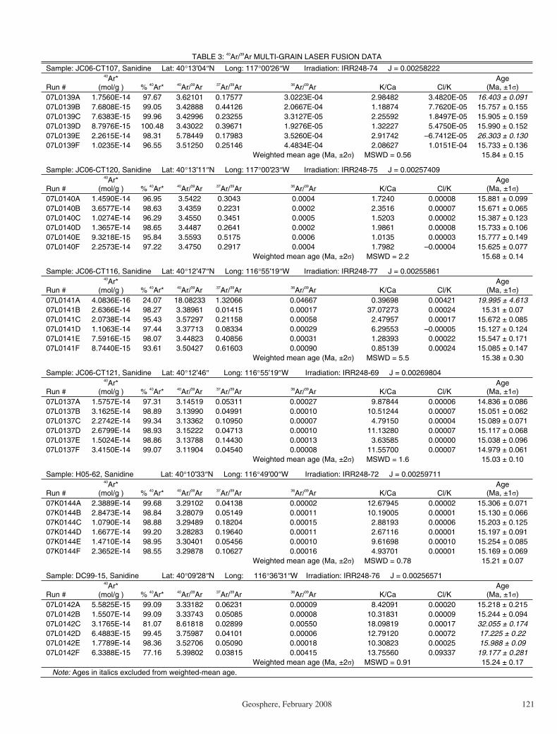
Caetano caldera extension
Geosphere, February 2008 121
TABLE 3: 40Ar/39Ar MULTI-GRAIN LASER FUSION DATA
Sample: JC06-CT107, Sanidine Lat: 40 13 04 N Long: 117 00 26 W Irradiation: IRR248-74 J = 0.00258222
Run #
40Ar*(mol/g ) % 40Ar* 40Ar/39Ar 37Ar/39Ar 36Ar/39Ar K/Ca Cl/K
Age(Ma, ±1 )
07L0139A 1.7560E-14 97.67 3.62101 0.17577 3.0223E-04 2.98482 3.4820E-05 16.403 ± 0.091 07L0139B 7.6808E-15 99.05 3.42888 0.44126 2.0667E-04 1.18874 7.7620E-05 15.757 ± 0.155 07L0139C 7.6383E-15 99.96 3.42996 0.23255 3.3127E-05 2.25592 1.8497E-05 15.905 ± 0.159 07L0139D 8.7976E-15 100.48 3.43022 0.39671 1.9276E-05 1.32227 5.4750E-05 15.990 ± 0.152 07L0139E 2.2615E-14 98.31 5.78449 0.17983 3.5260E-04 2.91742 –6.7412E-05 26.303 ± 0.130 07L0139F 1.0235E-14 96.55 3.51250 0.25146 4.4834E-04 2.08627 1.0151E-04 15.733 ± 0.136 Weighted mean age (Ma, ±2 ) MSWD = 0.56 15.84 ± 0.15
Sample: JC06-CT120, Sanidine Lat: 40 13 11 N Long: 117 00 23 W Irradiation: IRR248-75 J = 0.00257409
Run #
40Ar*(mol/g ) % 40Ar* 40Ar/39Ar 37Ar/39Ar 36Ar/39Ar K/Ca Cl/K
Age(Ma, ±1 )
07L0140A 1.4590E-14 96.95 3.5422 0.3043 0.0004 1.7240 0.00008 15.881 ± 0.099 07L0140B 3.6577E-14 98.63 3.4359 0.2231 0.0002 2.3516 0.00007 15.671 ± 0.065 07L0140C 1.0274E-14 96.29 3.4550 0.3451 0.0005 1.5203 0.00002 15.387 ± 0.123 07L0140D 1.3657E-14 98.65 3.4487 0.2641 0.0002 1.9861 0.00008 15.733 ± 0.106 07L0140E 9.3218E-15 95.84 3.5593 0.5175 0.0006 1.0135 0.00003 15.777 ± 0.149 07L0140F 2.2573E-14 97.22 3.4750 0.2917 0.0004 1.7982 –0.00004 15.625 ± 0.077 Weighted mean age (Ma, ±2 ) MSWD = 2.2 15.68 ± 0.14
Sample: JC06-CT116, Sanidine Lat: 40 12 47 N Long: 116 55 19 W Irradiation: IRR248-77 J = 0.00255861
Run #
40Ar*(mol/g ) % 40Ar* 40Ar/39Ar 37Ar/39Ar 36Ar/39Ar K/Ca Cl/K
Age(Ma, ±1 )
07L0141A 4.0836E-16 24.07 18.08233 1.32066 0.04667 0.39698 0.00421 19.995 ± 4.613 07L0141B 2.6366E-14 98.27 3.38961 0.01415 0.00017 37.07273 0.00024 15.31 ± 0.07 07L0141C 2.0738E-14 95.43 3.57297 0.21158 0.00058 2.47957 0.00017 15.672 ± 0.085 07L0141D 1.1063E-14 97.44 3.37713 0.08334 0.00029 6.29553 –0.00005 15.127 ± 0.124 07L0141E 7.5916E-15 98.07 3.44823 0.40856 0.00031 1.28393 0.00022 15.547 ± 0.171 07L0141F 8.7440E-15 93.61 3.50427 0.61603 0.00090 0.85139 0.00024 15.085 ± 0.147 Weighted mean age (Ma, ±2 ) MSWD = 5.5 15.38 ± 0.30
Sample: JC06-CT121, Sanidine Lat: 40 12 46 Long: 116 55 19 W Irradiation: IRR248-69 J = 0.00269804
Run #
40Ar*(mol/g ) % 40Ar* 40Ar/39Ar 37Ar/39Ar 36Ar/39Ar K/Ca Cl/K
Age(Ma, ±1 )
07L0137A 1.5757E-14 97.31 3.14519 0.05311 0.00027 9.87844 0.00006 14.836 ± 0.086 07L0137B 3.1625E-14 98.89 3.13990 0.04991 0.00010 10.51244 0.00007 15.051 ± 0.062 07L0137C 2.2742E-14 99.34 3.13362 0.10950 0.00007 4.79150 0.00004 15.089 ± 0.071 07L0137D 2.6799E-14 98.93 3.15222 0.04713 0.00010 11.13280 0.00007 15.117 ± 0.068 07L0137E 1.5024E-14 98.86 3.13788 0.14430 0.00013 3.63585 0.00000 15.038 ± 0.096 07L0137F 3.4150E-14 99.07 3.11904 0.04540 0.00008 11.55700 0.00007 14.979 ± 0.061 Weighted mean age (Ma, ±2 ) MSWD = 1.6 15.03 ± 0.10
Sample: H05-62, Sanidine Lat: 40 10 33 N Long: 116 49 00 W Irradiation: IRR248-72 J = 0.00259711
Run #
40Ar*(mol/g ) % 40Ar* 40Ar/39Ar 37Ar/39Ar 36Ar/39Ar K/Ca Cl/K
Age(Ma, ±1 )
07K0144A 2.3889E-14 99.68 3.29102 0.04138 0.00002 12.67945 0.00002 15.306 ± 0.071 07K0144B 2.8473E-14 98.84 3.28079 0.05149 0.00011 10.19005 0.00001 15.130 ± 0.066 07K0144C 1.0790E-14 98.88 3.29489 0.18204 0.00015 2.88193 0.00006 15.203 ± 0.125 07K0144D 1.6677E-14 99.20 3.28283 0.19640 0.00011 2.67116 0.00001 15.197 ± 0.091 07K0144E 1.4710E-14 98.95 3.30401 0.05456 0.00010 9.61698 0.00010 15.254 ± 0.085 07K0144F 2.3652E-14 98.55 3.29878 0.10627 0.00016 4.93701 0.00001 15.169 ± 0.069 Weighted mean age (Ma, ±2 ) MSWD = 0.78 15.21 ± 0.07
Sample: DC99-15, Sanidine Lat: 40 09 28 N Long: 116 36 31 W Irradiation: IRR248-76 J = 0.00256571
Run #
40Ar*(mol/g ) % 40Ar* 40Ar/39Ar 37Ar/39Ar 36Ar/39Ar K/Ca Cl/K
Age(Ma, ±1 )
07L0142A 5.5825E-15 99.09 3.33182 0.06231 0.00009 8.42091 0.00020 15.218 ± 0.215 07L0142B 1.5507E-14 99.09 3.33743 0.05085 0.00008 10.31831 0.00009 15.244 ± 0.094 07L0142C 3.1765E-14 81.07 8.61818 0.02899 0.00550 18.09819 0.00017 32.055 ± 0.174 07L0142D 6.4883E-15 99.45 3.75987 0.04101 0.00006 12.79120 0.00072 17.225 ± 0.22 07L0142E 1.7789E-14 98.36 3.52706 0.05090 0.00018 10.30823 0.00025 15.988 ± 0.09 07L0142F 6.3388E-15 77.16 5.39802 0.03815 0.00415 13.75560 0.09337 19.177 ± 0.281 Weighted mean age (Ma, ±2 ) MSWD = 0.91 15.24 ± 0.17
Note: Ages in italics excluded from weighted-mean age.

Colgan et al.
122 Geosphere, February 2008
was independently correlated with 16.0–15.3 Ma Buffalo Canyon–type tephra (Table 2; Per-kins and Nash, 2002). Sanidine from a second tephra sample in this sequence (sample CT120) yielded an age of 15.68 ± 0.14 Ma based on six reproducible multigrain laser fusion analyses (Table 3). From these dates, we conclude that deposition of the middle Miocene sedimentary rocks at Redrock Canyon began at or shortly before 15.8–15.6 Ma. Although we interpret the conglomerate and shale between the dated tephra horizon and the Bates Mountain Tuff to be middle Miocene (close to 16 Ma), it is impor-tant to note that geologic relationships permit it to be anywhere between 29 and 16 Ma.
To the south of Moss Creek Canyon, the base of the Miocene section overlies unit D (25.3 Ma) of the Bates Mountain Tuff (unit C is also pres-ent). Approximately 2 km southeast of Moss Creek, an isolated outcrop of relatively fresh white tephra (sample CT106; Fig. 9) was cor-related with the 12.07 Ma Cougar Point V tuff (Table 2; Perkins and Nash, 2002). This expo-sure would be 600–700 m upsection from the Bates Mountain Tuff, although most of the inter-vening section is covered and we cannot rule out repetition by unexposed faults. Although the rest of the section to the east (upsection) is also cov-ered by younger alluvium, we estimate at least 200–300 m of additional section above the ca. 12 Ma tephra. From this date, we conclude that deposition in the Redrock Canyon basin con-tinued up to and after 12 Ma. The low hills on the east (fault bound) side of Redrock Canyon consist of soft, sandy and silty soil weathering out small (<10 cm) angular chips of tuff and Paleozoic quartzite. We interpret these deposits as poorly consolidated conglomerate within the Miocene sedimentary section, but we have not observed any actual outcrops. These deposits are concealed and truncated by a pediment sur-face covered with large (up to several meters) boulders of Caetano Tuff presumably derived from the adjacent highlands.
Miocene Basin at Wilson Canyon
At the mouth of Wilson Canyon, 40°E dip-ping tuffaceous sandstones with interbedded tephra layers conformably overlie unit D (25.3 Ma) of the Bates Mountain Tuff. Sanidine from a prominent, white, thinly bedded (~2 cm), 1-m-thick layer of tephra ~10 m above the Bates Mountain Tuff (sample CT116; Fig. 9) yielded multigrain laser-fusion 40Ar/39Ar ages rang-ing from 15.09 ± 0.05 to 20.0 ± 4.6 Ma (Table 3), indicating contamination by older feldspar grains. Excluding the 20 Ma date and calcu-lating a weighted mean of the remaining fi ve multigrain analyses (15.67–15.09 Ma; Table
3) yields an age of 15.38 ± 0.30 Ma, although the eruptive age may be as young as 15.09 Ma. This sample was independently correlated with any of several Yellowstone hotspot–type teph-ras ranging in age from 13 to 15 Ma (Table 2; Perkins and Nash, 2002). Upsection from this tephra bed, the section grades to tan, medium-grained sandstone in beds 20–150 cm thick, with a silty matrix and local small lenticular conglomerate beds (Fig. 10B). Sanidine from a tephra layer interbedded with these sandstones (sample CT121) yielded an 40Ar/39Ar age of 15.03 ± 0.10 Ma (Table 3) from the weighted mean of six reproducible multigrain laser-fusion analyses. From these dates, we conclude that deposition of the middle Miocene sedimentary rocks at Wilson Canyon began ca. 15.4–15.0 Ma, after a 10 m.y. hiatus following deposition of the Bates Mountain Tuff.
Much of the remaining section to the east is covered by younger alluvium at the north-west end of Carico Lake Valley, but a small sandstone outcrop 1.5 km to the southeast (an unknown distance upsection) dips 18°E. On the east side of this basin, along the haul road to the Greystone Mine, sandstone and con-glomerate are exposed in roadcuts in the hang-ing wall of the Greystone fault, locally in direct contact with the fault (Fig. 5B). Although much of the section is covered by younger alluvium, we estimate it to be >1 km thick, assuming no repetition by unmapped faults.
Miocene Basin at Wood Spring Canyon
The most extensive and best-exposed (rela-tive to the others) Miocene basin occupies the hanging wall of the Toiyabe Mine fault, between the Rocky Pass–Red Mountain block and the northern Toiyabe Range (Fig. 9). In the west-central part of the basin, east of Tub Spring, tuffaceous sandstones and shales (Ts) are mostly covered by a thin layer of younger alluvium (shown as Qaf in Plate 1). These units dip 20°–5°E where they are exposed in mod-ern drainages (Fig. 10A). Two samples from this section (CT101 and CT102; Fig. 9) were correlated with the Cougar Point III (12.69 Ma) and Cougar Point V (12.07 Ma) tephras, respectively (Table 2; Perkins and Nash, 2002). The section is cut by at least one small fault (Plate 1) that appears to offset the ground sur-face as much as 100 m and is therefore assumed to be young (Pleistocene?), with essentially no displacement at the scale of cross section C–C' (Fig. 4). Assuming the section is not repeated by additional unmapped faults, ~300–400 m of section probably overlies the 12 Ma tephra layer. Much of it is covered by younger allu-vium, but on the east side of the basin, close to
the Toiyabe Mine fault, fi ne-grained tuffaceous sandstones and shales are overlain by medium- to coarse-grained, silty sandstones with uncom-mon matrix-supported clasts of Paleozoic quartzite. From the above dates, we conclude that deposition of the middle Miocene sedimen-tary rocks at Wood Spring Canyon continued up to and after 12 Ma.
The southwestern part of the basin, in the hanging wall of the Dry Canyon fault, consists primarily of gently east dipping (~12°) tuffa-ceous sandstone and shale, with the base of the section largely obscured by younger alluvium. Just west of the Dry Canyon fault, the basin contains coarse sandstone and conglomerate with subangular clasts of greenish Paleozoic chert (>80% of clasts), quartzite, and (presum-ably Cenozoic) volcanic rocks (to ~50 cm). The chert clasts are probably derived from similar-looking Paleozoic chert in the footwall of the Dry Canyon fault exposed <100 m to the east. These deposits are locally calcite cemented and crop out in highly resistant ledges, which we interpret as fossil spring deposits.
The southeast part of the basin, adjacent to the Toiyabe Mine fault, appears to consist primarily of medium-grained sandstone with a silty matrix, with varying amounts of matrix-supported angu-lar Paleozoic chert and (predominantly) quartz-ite clasts (Fig. 10D). Outcrops of this deposit are very rare, but where exposed they exhibit poorly developed 50–150 cm bedding that dips gently (<10°) northeast. These deposits form a range of deeply dissected hills that rise to 7250 ft (2210 m) west of the Toiyabe Mine, and we esti-mate the section to be at least 1 km thick, with an unknown, but probably signifi cant, thickness removed by erosion. The Toiyabe Mine fault occupies a deep canyon (200–300 m) between Paleozoic footwall rocks and hanging-wall basin sediments (Plate 1). The base of this section appears to (along D–D') overlie Bates Mountain Tuff (units C and D), but it is unclear whether the bulk of the overlying deposits is older or younger than the 12 Ma tuffs in the central part of the basin 5 km to the north (along C–C'). Although the deposits west of Toiyabe Mine are now topo-graphically more prominent than the northern part of the basin, they dip gently northeast and may project under the 12 Ma tuffs to the north.
Other Miocene Basin Exposures
Several other exposures of Miocene sedimen-tary rocks in the study area yielded useful age constraints, although they are not from sections as complete or extensive as those described above. Along the east side of Carico Lake Valley, ~2 km southwest of Rocky Pass, fi ne-grained tuffaceous sandstones dip 24°E in the
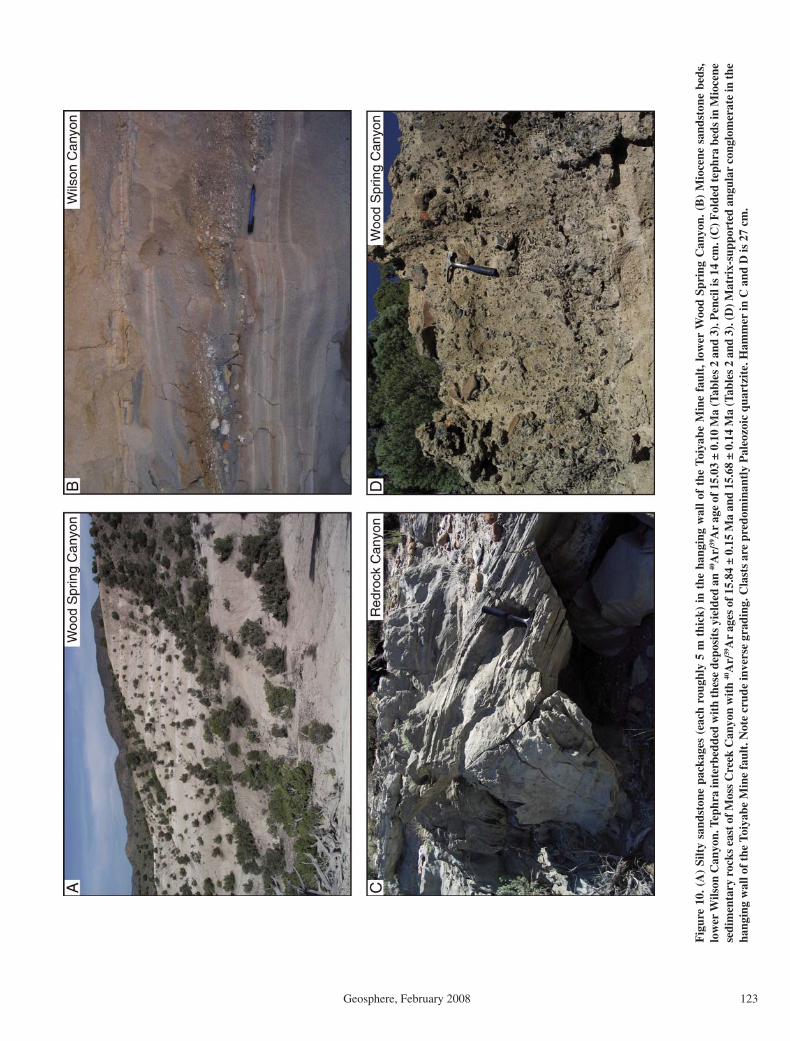
Caetano caldera extension
Geosphere, February 2008 123
Fig
ure
10. (
A)
Silt
y sa
ndst
one
pack
ages
(ea
ch r
ough
ly 5
m t
hick
) in
the
han
ging
wal
l of
the
Toi
yabe
Min
e fa
ult,
low
er W
ood
Spri
ng C
anyo
n. (
B)
Mio
cene
san
dsto
ne b
eds,
lo
wer
Wils
on C
anyo
n. T
ephr
a in
terb
edde
d w
ith
thes
e de
posi
ts y
ield
ed a
n 40
Ar/
39A
r ag
e of
15.
03 ±
0.1
0 M
a (T
able
s 2
and
3). P
enci
l is
14 c
m. (
C) F
olde
d te
phra
bed
s in
Mio
cene
se
dim
enta
ry r
ocks
eas
t of M
oss
Cre
ek C
anyo
n w
ith
40A
r/39
Ar
ages
of 1
5.84
± 0
.15
Ma
and
15.6
8 ±
0.14
Ma
(Tab
les
2 an
d 3)
. (D
) Mat
rix-
supp
orte
d an
gula
r co
nglo
mer
ate
in th
e ha
ngin
g w
all o
f th
e To
iyab
e M
ine
faul
t. N
ote
crud
e in
vers
e gr
adin
g. C
last
s ar
e pr
edom
inan
tly
Pal
eozo
ic q
uart
zite
. Ham
mer
in C
and
D is
27
cm.

Colgan et al.
124 Geosphere, February 2008
hanging wall of the Rocky Pass fault. Sanidine from a tephra interbedded with these sandstones yielded an 40Ar/39Ar age of 15.21 ± 0.07 Ma, from a weighted mean of six reproducible mul-tigrain laser-fusion analyses (sample H05–62; Fig. 9). This tephra was independently corre-lated with Twin Falls–type Yellowstone hotspot tephra, with a possible age ranging from 13 to 15.3 Ma (Table 2; Perkins and Nash, 2002).
Barrick Gold Corporation provided a tephra sample from a drill hole in the hanging wall of the Cortez fault (sample DC99–15; Fig. 9). Sanidine from this tephra yielded multigrain laser-fusion ages ranging from 32.1 to 15.2 Ma, indicating signifi cant contamination by older feldspar grains. The two youngest analyses give a weighted mean age of 15.24 ± 0.17 Ma, and we consider this the best estimate for the age of the sample, although it may be slightly younger. We infer that the conglomerates and sandstones exposed in the footwall of the Crescent fault 4 km to the north (Fig. 6A) are correlative with the sedimentary rocks in this drill hole.
An additional sample was collected from exposures in the pit wall at the Pipeline Mine, where Miocene sedimentary rocks are deposited on lower-plate Paleozoic basement. Sanidine from a tephra within these deposits (sample CJV2; Fig. 9) yielded an 40Ar/39Ar age of 15.88 ± 0.10 Ma (John et al., 2008), and the same sample was independently correlated with 16.0–15.3 Ma Buffalo Canyon–type tephra (Table 2; Perkins and Nash, 2002).
Miocene Basins: Interpretation
From the geologic relationships and age data discussed above, we infer that Miocene sedimen-tation across the study area began at or shortly before 16–15 Ma, at which time the underlying 25–35 Ma volcanic and sedimentary rocks were essentially fl at lying. With the exception of the paleovalley in the southern Cortez Range (John et al., 2008), pre–middle Miocene Cenozoic sedimentary rocks in the study area are older than 25 Ma and are confi ned to the topographic depression left by the Caetano caldera (Fig. 9). The absence of 25–16 Ma rocks in the study area suggests a period of tectonic quiescence, consistent with the presence of a low-relief land surface incised by paleovalleys, possibly with external drainage to the west (e.g., Henry, 2008; Gonsior and Dilles, 2008; John et al., 2008). In contrast to older sedimentary rocks, the middle Miocene (younger than 16 Ma) sedimentary rocks are confi ned to north-south elongate basins bound by north-striking normal faults. With the exception of the Redrock Canyon basin, the Miocene basins and north-striking normal faults cut directly across the old caldera margin
(Fig. 9). We interpret this pattern to be strong evidence that the onset of the extensional fault-ing that dismembered the Caetano caldera was coeval with the onset of basin sedimentation at 16 Ma. Extensional faulting created accommo-dation space for the basins, supplied them with sediment from the eroding footwall blocks, and cut off any external drainage system that may have existed prior to 16 Ma.
Coarser deposits (conglomerate and sand-stone) in Redrock Canyon, Wood Spring (Fig. 10D), and Wilson Canyons (Fig. 5B) (the best-preserved basins) appear to be concentrated on the east (fault bound) sides of the basins. Because rocks in these basins currently dip east, the coarser deposits are also the youngest exposures, so it is unclear whether this distri-bution represents upward coarsening related to changes in the rate of erosion and/or fault slip, or merely an oblique traverse across a lateral facies change that persisted for the lifetime of the basin. Where exposed at Wilson and Moss Creek Canyons, there is no signifi cant angular unconformity between the base of the Miocene sedimentary section and the underlying Oligo-cene tuffs, and the dip of the overlying Miocene deposits appears to shallow upsection to the east (Plate 1). The base of the Miocene section at Wood Spring Canyon has not been mapped, but the dip of the exposed part of the section decreases eastward (upsection) from ~20° to <10°, while the underlying Caetano Tuff dips ~40°E. This geometry is consistent with deposi-tion during fault slip and tilting of the basins, although some component of tilting may be caused by unmapped intrabasin faults or tilting of the entire basin (and its bounding fault) by a younger generation of faults. Overall, however, the distribution and geometry of the Miocene sedimentary rocks are consistent with deposi-tion in small (2–3 km across), active half-graben basins, with the coarser material deposited adja-cent to the bounding faults, and lower-energy deposits in the distal part of the basins (e.g., Leeder and Gawthorpe, 1987).
The style of faulting and sedimentation in the study area appears more analogous to the supra-detachment basins developed over and around metamorphic core complexes than to the wide (20–30 km across), gently tilted (<10°) half-graben basins forming in Nevada today. Sedi-mentation in supradetachment systems often begins in a single broad basin and becomes confi ned to narrow, rapidly tilting half-grabens as faulting progresses, and the basins are often broken up by numerous faults (e.g., Dickinson, 1991; Miller and John, 1999; McClaughry and Gaylord, 2005). Middle Miocene sedimentary rocks in our study area are currently restricted to discrete basins, but it is possible that they
were originally more extensive and have been removed by erosion. We have not mapped any signifi cant faults within the basins, although more detailed mapping may reveal some, par-ticularly in the Wood Spring Canyon basin. Overall, although the basin geometry is similar, the structure of our study area is considerably simpler than true supradetachment basins, prob-ably due to less extreme strain, which was not suffi cient to exhume the mid-crustal underpin-nings of the extended area.
We consider the simplest interpretation of the observed distribution, geometry, and age of the Miocene sedimentary rocks to be deposition in synextensional basins that formed in response to slip on the major normal faults that dismem-bered the Caetano caldera. Deposition appears to have begun across the study area at or shortly before 16–15 Ma and continued, at least locally, until sometime more recently than 12 Ma. Mid-dle Miocene sedimentary rocks similar to those described in this study crop out across much of northeastern Nevada (Stewart and Carlson, 1978), where they are assigned to the Humboldt Formation (Sharp, 1939; Smith and Ketner, 1976, Wallace et al., 2008) and the informal Car-lin formation (Regnier, 1960). These formations range from 16 to 15 Ma to ca. 10 Ma (Smith and Ketner, 1976; Perkins and Nash, 2002; Wallace et al., 2008), and therefore we suggest a similar 10 Ma upper age limit for the Miocene basins described in this study.
DISCUSSION AND CONCLUSIONS
Timing and Structural Style of Extension
Lack of Evidence for Pre-Miocene ExtensionThe lack of angular discordance between 34
and 25 Ma deposits within the Caetano caldera demonstrates that no signifi cant deformation took place in the study area over that interval, aside from local doming related to magma resurgence within the caldera (Fig. 11A). Very few Cenozoic rocks in the study area predate the Caetano caldera, and those that do are small-volume lava fl ows and gravels that appear to fi ll <1 km of paleotopography in the southern Cortez Range (John et al., 2008). Where related rocks crop out on the caldera fl oor near Wen-ban Spring (Fig. 2), they are conformable with the overlying Caetano Tuff (John et al., 2008). Given the lack of direct evidence for Eocene or older extension (in the form of faults, angular unconformities, or sedimentary basins), we con-clude that the study area underwent essentially no Cenozoic deformation prior to the onset of extension in the middle Miocene. The absence of any units in the 25–16 Ma interval is consis-tent with low relief and external drainage such

Caetano caldera extension
Geosphere, February 2008 125
0 1 2 3 4 5 6 7
0 1 2 3 4 5 6 7
A. P
re-e
xten
sion
B. E
xten
sion
alo
ng c
lose
ly s
pace
d (1
–3 k
m),
rot
atin
g fa
ults
, 16
to (
12–1
0) M
a
C. E
xten
sion
on
wid
ely
spac
ed, h
igh-
angl
e fa
ults
, pos
t 10
Ma
0 1 2 3 4 5
futu
re fa
ults
0 1 2 3 4 5
Intr
acal
dera
tuff
Pos
t-ca
lder
a tu
ffsse
dim
enta
ry r
ocks
Bas
ins
fill d
urin
gfa
ult s
lip
Old
er fa
ults
and
bas
in fi
ll bu
ried
bene
ath
youn
ger
depo
sits
Res
urge
ntpl
uton
s
Alte
ratio
n
zo
ne
Pre
-cal
dera
Cen
ozoi
c ro
cks
Pal
eova
lley
in
Cor
tez
Ran
ge
Cal
dera
floo
rflo
or lo
cally
expo
sedbr
ecci
a
0 1 2 3 4 50 1 2 3 4 5
WWE E
Old
er fa
ults
inac
tive
Old
er s
edim
enta
ry r
ocks
uplif
ted
and
diss
ecte
d
Rob
erts
Mtn
s.th
rust
Upp
er p
late
Low
erpl
ate
km
km kmW
E
Youn
ger
depo
sits
in m
oder
n va
lleys
Fig
ure
11. I
llust
rati
on o
f M
ioce
ne e
xten
sion
of
the
Cae
tano
cal
dera
. Sec
tion
s ar
e ea
st-w
est
thro
ugh
the
cent
er o
f th
e ca
lder
a. N
o ve
rtic
al e
xagg
erat
ion.
(A
) P
re-e
xten
sion
al C
aeta
no
cald
era,
mod
ifi ed
from
Fig
ure
20D
of J
ohn
et a
l. (2
008)
. (B
) Mid
dle
Mio
cene
ext
ensi
on o
n cl
osel
y sp
aced
, dom
ino-
styl
e no
rmal
faul
ts, w
ith
sedi
men
tati
on in
sm
all h
alf-
grab
en b
asin
s.
(C) W
idel
y sp
aced
, hig
h-an
gle
norm
al f
ault
ing
wit
h br
oad
sedi
men
tary
bas
ins.

Colgan et al.
126 Geosphere, February 2008
as the paleovalleys documented in nearby areas (John et al., 2008; Gonsior and Dilles, 2008; Henry, 2008).
Large-Magnitude Middle Miocene ExtensionMiddle Miocene extension was accommo-
dated by initially high angle (≥60°), closely spaced (1–3 km) faults that underwent sig-nifi cant rotation during fault slip (Fig. 11B). Although these faults are cut by younger faults, the younger faults appear to represent a distinct, more recent period of faulting with a different regional stress fi eld (e.g., Zoback et al., 1994), rather than successive generations of crosscut-ting normal faults formed during progressive footwall rotation (e.g., Proffett, 1977; Miller et al., 1983). Given the poor exposure of faults and the diffi culty of tracing them through intracal-dera tuff and Paleozoic basement, however, it is possible that we are simply unable to distinguish crosscutting faults formed very closely in time and space. Likewise there are few subsurface data that bear on the geometry of these faults at depth. The simplest interpretation is that faults mapped at the surface originally merged downward into a brittle-ductile transition zone, beneath which extension was accommodated by ductile fl ow (e.g., Gans, 1987). Regardless of precisely how the strain was accommodated in the subsurface, it is clear that the upper crust in the study area underwent signifi cant (~100% strain) extension.
Based on our interpretation of the middle Miocene synextensional basins, we conclude that this faulting began at or shortly before 16 Ma, but the rate and duration of subsequent extension are more diffi cult to determine. The 12 Ma tephra layers in the Redrock Canyon and Wood Spring basins are east tilted, consistent with some tilting—and presumably faulting—after this time. Continued slip on the Miocene basin-bounding normal faults after 12 Ma is consistent with ongoing deposition in the adja-cent basins (above the 12 Ma tephras), which may be as young as 10 Ma. Alternatively, entire basins, together with their bounding faults and footwalls, may have been tilted somewhat by later slip on a younger generation of normal faults (discussed below), although even the larg-est of these faults appear to tilt nearby rocks only 6°–7°. At present, the simplest conclusion is that extension of the Caetano caldera began ca. 16 Ma and slip on the major faults continued until as recently as 10 Ma, although faulting need not have proceeded at a constant rate over that inter-val, nor at exactly the same time and/or rate in each individual basin. Apatite fi ssion-track and (U-Th)/He data from the nearby East Range (Fig. 1) document rapid exhumation and fault slip ca. 17–15 Ma (Fosdick et al., 2006), provid-
ing somewhat independent evidence for middle Miocene extension in this part of Nevada.
Late Miocene and Younger ExtensionGently dipping faults, tilted footwall blocks,
and hanging-wall basins formed during middle Miocene extension were subsequently cut by younger faults and are now exhumed to vary-ing degrees in the footwalls of these faults (Fig. 11C). This is most spectacularly evident at the Cortez Mine (Fig. 2), where the Crescent fault (Fig. 6A) cuts the Cortez fault and its hanging-wall basin at a right angle, exposing it in cross section. It is these younger, more widely spaced (20–30 km) faults that are responsible for the modern topography of the basins and ranges in the study area. Although they accommodate relatively little horizontal extension, these faults dip steeply (50°–60°) and some have signifi cant vertical offset (2–3 km), forming large, deep basins (e.g., Crescent and Reese River Val-leys; Fig. 2). They strike more northeast than the older, middle Miocene faults, particularly in the vicinity of the northern Nevada Rift (Fig. 1). Several of these faults have evidence for Holocene offset, including the Crescent fault (Friedrich et al., 2004), and the faults bounding the Shoshone Range to the west and north (Wes-nousky et al., 2005). Several faults documented in this study may have Holocene displacement, notably the Red Mountain fault (Fig. 6C) and additional faults on the west side of Carico Lake Valley (Plate 1).
The onset of this faulting is more diffi cult to determine. Regionally, it must postdate ca. 15 Ma basalt fl ows on the crest of the Shoshone and Cortez Ranges (Fig. 1; Armstrong, 1970; John et al., 2000). In the study area, a signifi cant part of it must postdate the youngest dated Miocene sedimentary rocks (at least 12 Ma, and possibly 10 Ma) that have been uplifted relative to the modern valley fl oors. Present-day slip rates for Basin and Range normal faults are on the order of 0.2–0.4 mm/yr (e.g., Bennett et al., 2003; Niemi et al., 2004); if these are indicative of long-term rates, then the largest of the late Miocene faults must have been active for millions of years. This is supported by apatite (U-Th)/He ages as young as 9–10 Ma from the Cortez Range (Fig. 1; Colgan and Metcalf, 2006) and the East Range (Fig. 1; Fosdick et al., 2006), which require sig-nifi cant (>2 km) exhumation since that time, although in both cases, faulting may have begun more recently. It is therefore unclear at present whether there was a signifi cant time lag in cen-tral Nevada between the end of large-magnitude middle Miocene extension and the onset of mod-ern Basin and Range extension, or if there was a continuous transition between these two differ-ent styles of deformation.
Extension of Areas Surrounding the Caetano Caldera
Given signifi cant (100% or more) extensional strain documented across the Caetano caldera, how far does this style and magnitude of defor-mation extend along strike into nearby areas? For Miocene extension to have been confi ned to the caldera, the caldera margin would need to have functioned as a strike-slip accommoda-tion zone with kilometers of offset (e.g., Faulds and Varga, 1998). Detailed mapping of the cal-dera margin at Wilson Pass, Elephant Head, Red Mountain, and the northern Toiyabe Range (Plate 1; Fig. 2) reveals no evidence for sig-nifi cant strike-slip faulting (John et al., 2008). Muntean et al. (2001) also examined the caldera margin in the Shoshone Range and came to the same conclusion, although they did not interpret the boundary as a caldera margin. Everywhere it is exposed, the caldera margin appears to be a high-angle fault or buttress unconformity that juxtaposes intracaldera tuff and breccia with Paleozoic wall rocks, all of which are east tilted by later normal faults (this study; John et al., 2008). Even if the caldera margin were a large-offset strike-slip fault, that deformation would have to predate the Miocene normal faults and basins that demonstrably cut the caldera margin, requiring extension have taken place on an ear-lier (pre–16 Ma) set of faults and/or basins that left no trace in the geologic record. Therefore, it seems almost certain that large-magnitude extension is not confi ned to the caldera. In the following section, we examine evidence for late Cenozoic extension of the areas immediately south (section D–D'; Plate 1) and north of the caldera (Toiyabe and Shoshone Ranges).
Late Cenozoic Extension South of the Caetano Caldera (Section D–D')
Many of the major faults and Miocene exten-sion basins mapped within the Caetano caldera can be shown to continue along strike to the south, cutting the caldera margin and adjacent wall rocks (Plate 1). The lack of reliable Ceno-zoic marker units and complex deformation of Paleozoic basement rocks make it impractical to restore cross section D–D', but it highlights locations where deformation (faulting and tilt-ing) of the caldera can be shown to continue into surrounding Paleozoic rocks.
The western part of D–D' crosses the Cedars area (Fig. 2) in the southern Shoshone Range, mapped in detail (scale 1:24,000) by Moore et al. (2005). At this latitude, the Shoshone Range is a horst block, bound to the west by the southern extension of the Moss Creek fault system and to the east by the Stone Cabin fault. Internally, the range is split by the north-striking Cedars fault,

Caetano caldera extension
Geosphere, February 2008 127
which dips ~40°W where exposed in the central part of the range. The Cedars fault drops upper Paleozoic Overlap assemblage (Pzo) overlain by ca. 34 Ma dacite lava fl ows (Tad) down against siliceous upper-plate lower Paleozoic rocks (Moore et al., 2005). At least 1.5–2.0 km of slip is required to restore the overlap sequence in the hanging wall of the Cedars fault above the lower plate in the footwall. To the east, upper-plate rocks in the footwall of the Cedars fault are cut by the west-dipping Elephant Head fault, which was inferred by Moore et al. (2005) to die out southward and merge with (or be cut by) the Cedars fault just north of section D–D'. Both the Cedars and Elephant Head faults clearly cut the caldera margin in the southern Shoshone Range (this study; Moore et al., 2005). We sug-gest that the upper Paleozoic Overlap assem-blage and overlying Cenozoic rocks (Tad and Tct?) that must once have overlain upper-plate rocks in the footwall of the Cedars fault are now buried beneath alluvium in Carico Lake Valley, although there are no subsurface data to confi rm this interpretation.
On the east side of Carico Lake Valley, upper-plate Paleozoic quartzite and chert are exposed at Red Mountain in the footwall of a west-dipping normal fault. Where the caldera margin is exposed just north of Red Mountain, intracaldera Caetano Tuff dips 30°–40°E and is cut by an ~40°W dip-ping fault observed to cut south across the caldera margin and into surrounding rocks. It is unclear, however, if the fault bounding Red Mountain to the west along D–D' is part of the Rocky Pass or Greystone fault systems, or if the fault is related to the younger Red Mountain fault (Fig. 6C) that cuts older faults and appears to have undergone late Quaternary slip. In either case, it is clear that Paleozoic rocks at Red Mountain have been exhumed and east tilted in the footwall of the same fault system that exhumed the Caetano cal-dera 2.5 km to the north.
Between Red Mountain and the Toiyabe Mine, upper-plate rocks exposed in the footwall of the Dry Canyon fault are overlain unconform-ably by outfl ow Caetano Tuff and Bates Moun-tain Tuff. The Cenozoic tuffs generally dip east (~25°–35°), but are locally complicated by sev-eral small faults and anomalous west dips in the Bates Mountain Tuff. The footwall of the Dry Canyon fault is surrounded by Miocene sedi-mentary rocks (Ts), and it is unclear if or how the Dry Canyon fault continues north through or beneath the basin. The lack of Cenozoic rocks on the east side of Red Mountain makes restor-ing this fault diffi cult, but along D–D' the Dry Canyon fault appears to have 2–3 km of slip.
The Toiyabe Mine fault cuts the southern margin of the caldera (the Wenban fault of Gil-luly and Masursky, 1965) and is named for the
Toiyabe Mine along section D–D'. Here, the Toiyabe Mine fault drops Miocene sandstone and conglomerate (Ts) down against Paleozoic rocks. The fault now occupies a deep canyon separating hanging-wall sedimentary rocks from footwall Paleozoic rocks. With the excep-tion of lower-plate rocks near the Toiyabe Mine, the footwall of the Toiyabe Mine fault along D–D' exposes only upper-plate rocks across the width of the Toiyabe Range, and it is unclear if or where the Caetano Ranch fault continues to the south across the caldera margin. If the Toi-yabe Range along D–D' was intact and tilted 40º–60ºE like the intracaldera tuff to the north, the upper plate would be >5 km thick, which seems unreasonable given its documented 1–2 km thickness elsewhere in and around the study area (this study; Gilluly and Masursky, 1965; Gilluly and Gates, 1965). Therefore, we believe it likely that the Caetano Ranch fault cuts the southern caldera margin and repeats the upper-plate rocks in the northern Toiyabe Range.
Late Cenozoic Extension North of the Caetano Caldera
Toiyabe Range. The northeastern margin of the caldera in the Toiyabe Range (the Copper fault of Gilluly and Masursky, 1965) is the best-preserved and most laterally continuous (4 verti-cal km) exposure of the caldera margin (John et al., 2008). South of this caldera margin, intracal-dera tuff and breccia deposits dip ~40ºE (section B–B'; Fig. 4; Plate 1). We infer that tilting of the tuff resulted from slip on the Caetano Ranch fault, which was later cut at an oblique angle by the younger Crescent fault. Because there is no evidence for structural decoupling of the Caetano caldera from the Paleozoic rocks north of the caldera margin in the Toiyabe Range, it follows that the Paleozoic rocks (and associated mineral deposits) in and around the Cortez mine (Fig. 2) were also east tilted during Miocene extension.
To the north of the Toiyabe Range, the mar-gin of the Caetano caldera is covered by allu-vium at the south end of Crescent Valley, and it is unclear if or how the major faults mapped within the caldera continue along strike to the north. Given the signifi cant displacement on the Toiyabe Mine and Caetano Ranch faults along section B–B', we consider it likely that they con-tinue at least some distance north beneath Cres-cent Valley. They are shown schematically on section A–A' as they would project from expo-sures along B–B', although we have no subsur-face data to confi rm this interpretation. If the extended area continues 9–10 km north of A–A' (Plate 1), it is possible that the Pipeline deposit (Fig. 2) has been displaced several kilometers westward from its original location.
Shoshone Range. The northern Shoshone Range (Fig. 1) exposes a large expanse of highly deformed Paleozoic rocks in the upper plate of the Roberts Mountains allochthon, punctuated by rare lower-plate windows, numerous Tertiary intrusions, and isolated outcrops of Tertiary volcanic rocks (Gilluly and Gates, 1965). The northern caldera margin is not widely exposed in the Shoshone Range, and no pre–16 Ma Cenozoic rocks are exposed within our study area that would provide a marker for late Ceno-zoic extension north of the caldera (Plate 1). However, given signifi cant extension of the caldera just south of the margin (western part of A–A'; Fig. 4), together with the lack of evi-dence for signifi cant strike-slip displacement along the caldera margin, we consider it likely that the Shoshone Range in the northern part of our study area (Plate 1) was extended together with the adjacent caldera. Muntean et al. (2001) raised the possibility of signifi cant extension in the Shoshone Range, but proposed that defor-mation was localized along a detachment fault at the base of the Tertiary and that the Paleo-zoic basement was relatively little deformed by normal faults. Here, we propose that the Sho-shone Range (at least within a few kilometers of the northern caldera margin) was extended along the same set of west-dipping, initially high-angle normal faults that dismembered the Caetano caldera to the south.
The Greystone fault cuts the caldera mar-gin along A–A' (Fig. 4; Plate 1) and continues north for at least 7 km into the Shoshone Range, where it is exposed in several roadcuts (Fig. 5B). The caldera margin here juxtaposes 40°–60°E dipping intracaldera tuff and breccia with Paleozoic wall rocks and is cut by a small ring-fracture intrusion (John et al., 2008). We have found no evidence for strike-slip faulting along the caldera margin, so presumably the Paleozoic rocks immediately north of the caldera margin are also east tilted. Miocene sedimentary rocks exposed east of Wilson Canyon in the hanging wall of the Greystone fault also strike north across the caldera margin, consistent with Mio-cene extensional faults cutting the caldera mar-gin and extending at least 7–8 km north into the Shoshone Range.
The Redrock Canyon fault has ~6 km of slip along section A–A' (Fig. 4), <4 km south of caldera margin in the western Shoshone Range (Plate 1). Slip on this fault does not appear to diminish signifi cantly to the north and was suf-fi cient to expose the caldera fl oor only a few hundred meters south of the caldera margin west of Wilson Pass (Plate 1). Only a few hundred meters north of the caldera margin, lower-plate rocks are exposed beneath the Robert Moun-tains thrust on the west side of Horse Mountain
Colgan et al.
128 Geosphere, February 2008
(Plate 1). Gilluly and Gates (1965) mapped this lower-plate window as the core of an anticline, with the Roberts Mountains thrust and overly-ing upper plate dipping east and west away from Horse Mountain. We suggest instead that lower-plate rocks at Horse Mountain are exposed in the footwall of the Redrock Canyon fault, which cuts the caldera margin and strikes north into the Shoshone Range. In this interpretation, the west-ern “thrust” contact between upper and lower-plate rocks at Horse Mountain would actually be a down-to-the-west normal fault. This fault contact is about 1 km north along strike from the mapped trace of the Redrock Canyon fault within the caldera, although the exact point where the fault would cut the caldera margin is covered by colluvium (Plate 1). Although we have not mapped the Tertiary rocks north of the caldera margin (north of Plate 1), we have observed the tuff of Cove Mine and another tuff (probably unit B of the Bates Mountain Tuff) dipping 35°–60°E at the mouth of Harry Can-yon (~6 km north of caldera margin), consistent with Miocene extension and tilting of the Sho-shone Range north of the Caetano caldera.
Extension and the Northern Nevada Rift
The northern Nevada rift is a prominent north-northwest–trending magnetic anomaly in central Nevada that coincides in part with a zone of mafi c dikes and lava fl ows at the sur-face (Fig. 1; e.g., Zoback et al., 1994). The rift formed between ca. 16.5 and 15 Ma, coeval with the widespread middle Miocene magmatic epi-sode that produced the Columbia River Basalts and similar rocks in Washington, Oregon, and northwestern Nevada (e.g., Zoback et al., 1994; John et al., 2000). Structurally, the rift is a 5–15-km-wide zone bound by high-angle faults and fi lled with ~500 m (locally >1 km) of mafi c lava fl ows and minor sedimentary rocks. A 3–5-km-wide zone of mafi c dikes intrudes basement rocks and Miocene volcanic rocks within the rift zone (John et al., 2000). The rift is currently broken by north- to northeast-striking, late Mio-cene (?) and younger normal and oblique-slip faults, but it was formed along the western edge of a middle Miocene stable (unextended) block that included the modern Cortez Range (Fig. 1). The orientation of the rift is thought to refl ect a Basin and Range–wide middle Miocene exten-sion direction oriented ~N70°E (Zoback and Thompson, 1978; Zoback et al., 1994).
The oldest dates from Miocene sedimen-tary basins within our study area are 15.0–15.6 Ma—within the age range of northern Nevada rift mafi c dikes and lava fl ows in the nearby Shoshone and Cortez Ranges (Fig. 1) (16.8–15.0 Ma; John et al., 2000). If we are correct
that these basins formed contemporaneously with extensional faulting, then extension of the Caetano caldera began shortly after inception of the northern Nevada rift at 16.5 Ma, and initial extension was contemporaneous with emplace-ment of nearby rift dikes. Based on the tilting of intracaldera tuffs and sedimentary rocks (Fig. 7), we infer that extension of the Caetano cal-dera was oriented ~N80°W, or ~30° different than the extension direction inferred from the northern Nevada rift (N65°–70°E; Zoback et al., 1994). Either the regional shift from extension oriented ~N70°E (the rift direction) to ~N70°W (the modern direction; Zoback et al., 1994) took place during the later stages of rift magmatism (ca. 15.5 Ma or later), or the rift does not truly refl ect the regional middle Miocene extension direction across the northern Basin and Range. A number of workers have suggested that the northern Nevada rift may have been localized by a pre-Cenozoic structure (e.g., Wooden et al., 1998; Theodore et al., 1998; John et al., 2000). If this is the case, then it is plausible that the orientation of the rift may simply refl ect the orientation of this structure or structures, rather than the regional extension direction. There is a growing body of data documenting middle Miocene extension (contemporaneous with the northern Nevada rift) across a wide area of the northern Basin and Range (e.g., McQuarrie and Wernicke, 2005, and references therein). Signifi cantly, the kinematic data compiled by McQuarrie and Wernicke (2005) demonstrate that extension across the northern and central Basin and Range was oriented approximately N78°W, much closer to the N80°W documented by this study than to the N70°E direction indi-cated by the northern Nevada Rift.
APPENDIX A. 40Ar/39Ar ANALYTICAL METHODS
Samples for 40Ar/39Ar dating were irradiated for 16 hours in the U.S. Geological Survey TRIGA Reac-tor Facility in Denver, Colorado. An intralaboratory standard sanidine, TCR-2 (Taylor Creek Rhyolite), was used for calculation of the neutron fl ux in all irra-diations. Decay and abundance constants for all ages reported are those recommended by Steiger and Jäger (1977). Ages in Table 3 and Table A1 were recalcu-lated to an age of 28.02 Ma for Fish Canyon Tuff sani-dine standard (Renne et al., 1998).
40Ar/39Ar ages reported in Table 3 were obtained by
laser-fusion analyses on 4 to 8 crystals of sanidine sep-
arated from each sample by standard separation tech-niques. Laser-fusion 40Ar/39Ar dating is especially use-ful to detect and overcome the effects of xenocrystic contamination (LoBello et al., 1987; Fleck and Carr, 1990) and incomplete extraction of radiogenic Ar from alkali feldspar (McDowell, 1983). Multiple splits of each sample were analyzed and ages and uncertainties reported are the weighted mean and standard error of these analyses. Outliers related to contamination are identifi able from the bulk of the analyses and are omit-
ted. Ages reported for each sample are represented by the weighted means of replicate laser-fusion analyses, with the inverse variance of propagated, within-run (i.e., “internal”) errors used as the weighting factors (Taylor, 1982). The goodness of fi t parameter, mean square of weighted deviates (MSWD; McIntyre et al., 1966), is calculated for these means and is used to determine the presence of any error component in excess of estimated analytical error (an “external” error). Where the MSWD of a mean is greater than 1.0, analytical errors are multiplied by the square root of MSWD, as discussed by Ludwig (2003) and Fleck et al. (1996), to incorporate this error.
40Ar/39Ar ages reported for whole-rock basalts in Table A1 were obtained by incremental-heating analysis, i.e., sequential extraction of the argon from the sample at progressively higher temperatures until the sample is fused. Samples were crushed and sized to between 250 and 180 micrometers and wrapped in Cu packets for irradiation. Incremental-heating analyses utilized a low-blank, tantalum and molybde-num, resistance-heated furnace, commonly releasing all of the Ar in 8 to 15 temperature-controlled heat-ing increments. Reported ages are 40Ar/39Ar plateau ages, defi ned as the weighted mean ages of contigu-ous gas fractions representing more than 50% of the 39Ar released for which no difference can be detected between the ages of any two fractions at the 95% level of confi dence (Fleck et al., 1977).
ACKNOWLEDGMENTS
This research was supported by a U.S. Geological Survey Mendenhall Postdoctoral Research Fellow-ship to Colgan. We thank Barrick Gold Corporation for access to the Pipeline, Toiyabe, and Cortez Mine sites, and for sharing subsurface data and samples. Mike Perkins provided tephra correlations from his extensive database. Conversations and fi eld work with Alan Wallace, Tom Moore, and Keith Howard helped to clarify the ideas presented here. We thank Keith Howard, Tom Chapin, and Sherman Gromme for comments on an earlier version of the manuscript, and Alan Wallace and David Rodgers for thorough journal reviews.
REFERENCES CITED
Armstrong, R.L., 1970, Geochronology of Tertiary igne-ous rocks, eastern Basin and Range Province, western Utah, eastern Nevada, and vicinity, U.S.A: Geochi-mica et Cosmochimica Acta, v. 34, p. 203–232, doi: 10.1016/0016-7037(70)90007-4.
Bennett, R.A., Wernicke, B.P., Niemi, N.A., Friedrich, A.M., and Davis, J.L., 2003, Contemporary strain rates in the northern Basin and Range province from GPS data: Tectonics, v. 22, 1008, p. 1–29, doi: 10.1029/2001TC001355.
Bingler, E.C., 1978, Abandonment of the name Hartford Hill Rhyolite Tuff and adoption of new formation names for middle Tertiary ash-fl ow tuffs in the Carson City-Sil-ver City area, Nevada: U.S. Geological Survey Bulletin 1457-D, 19 p.
Blair, T.C., and McPherson, J.G., 1994, Alluvial fans and their natural distinction from rivers based on morphol-ogy, hydraulic processes, sedimentary processes, and facies assemblages: Journal of Sedimentary Research, v. A64, p. 450–489.
Burke, D.B., and McKee, E.H., 1979, Mid-Cenozoic volcano-tectonic troughs in central Nevada: Geo-logical Society of America Bulletin, v. 90, part 1, p. 181–184, doi: 10.1130/0016-7606(1979)90<181:MVTICN>2.0.CO;2.
Colgan, J.P., and Metcalf, J.R., 2006, Apatite fi ssion-track

Caetano caldera extension
Geosphere, February 2008 129
and (U-Th)/He dating of slip on the Crescent Fault, Nevada: American Geophysical Union, Fall meeting, abs. T11D-0466.
Deino, A.L., 1989, Single crystal 40Ar/39Ar dating as an aid in correlation of ash fl ows: Examples from the Chim-ney Springs/New Pass Tuffs and the Nine Hill/Bates Mountain Tuffs of California and Nevada: New Mexico Bureau of Mines and Mineral Resources: Continental Magmatism Abstracts Bulletin, v. 131, p. 70.
Dickinson, W.R., 1991, Tectonic setting of faulted Tertiary strata associated with the Catalina core complex in southern Arizona: Geological Society of America Spe-cial Paper 264, 106 p.
Dickinson, W.R., 2006, Geotectonic evolution of the Great Basin: Geosphere, v. 2, p. 353–368, doi: 10.1130/GES00054.1.
Doebrich, J.L., 1995, Geology and mineral deposits of the Antler Peak 7.5 minute quadrangle, Lander County, Nevada: Nevada Bureau of Mines and Geology Bul-letin 109, scale 1:24,000, 44 p.
Faulds, J.E., and Varga, R., 1998, The role of accommoda-tion zones and transfer zones in the regional segmenta-tion of extended terranes, in Faulds, J.E., and Stewart, J.H., eds., Accommodation zones and transfer zones: The regional segmentation of the Basin and Range Province: Geological Society of America Special Paper 323, p. 1–46.
Faulds, J.E., Henry, C.D., and dePolo, C.M., 2003, Pre-liminary geologic map of the Tule Peak Quadrangle, Washoe County, Nevada: Nevada Bureau of Mines and Geology Open-File Report 03-10, scale 1:24,000.
Fleck, R.J., and Carr, M.D., 1990, The age of the Keystone thrust: Laser-fusion 40Ar/39Ar dating of foreland basin
deposits, southern Spring Mountains, Nevada: Tecton-ics, v. 9, p. 467–476.
Fleck, R.J., Sutter, J.F., and Elliot, D.H., 1977, Interpretation of discordant 40Ar/39Ar age-spectra from Antarctica: Geochimica et Cosmochimica Acta, v. 41, p. 15–32.
Fleck, R.J., Turrin, B.D., Sawyer, D.A., Warren, R.G., Champion, D.E., Hudson, M.R., and Minor, S.A., 1996, Age and character of basaltic rocks of the Yucca Mountain region, southern Nevada: Journal of Geo-physical Research, v. 101, no. B4, p. 8205–8227, doi: 10.1029/95JB03123.
Fosdick, J.C., and Colgan, J.P., 2008, Miocene extension in the East Range, Nevada: A two-stage history of fault-ing in the northern Basin and Range: Geological Soci-ety of America Bulletin, v. 120, doi: 10.1130/B26201.1 (in press).
Friedrich, A.M., Lee, J., Wernicke, B.P., and Sieh, K., 2004, Geologic context of geodetic data across a Basin and Range normal fault, Crescent Valley, Nevada: Tecton-ics, v. 23, TC2015, doi: 10.1029/2003TC001528.
Gans, P.B., 1987, An open-system, two-layer crustal stretch-ing model for the eastern Great Basin: Tectonics, v. 6, p. 1–12.
Gilluly, J., and Gates, O., 1965, Tectonic and igneous geol-ogy of the northern Shoshone Range, Nevada, with sections on gravity in Crescent Valley by D. Plouff and economic geology by K.B. Ketner: U.S. Geological Survey Professional Paper 465, 135 p.
Gilluly, J., and Masursky, H., 1965, Geology of the Cortez Quadrangle, Nevada: U.S. Geological Survey Bulletin 1175, 117 p.
Gonsior, Z.J., and Dilles, J.H., 2008, The timing and evolu-tion of Cenozoic extensional normal faulting and mag-
matism in the southern Tobin Range, Nevada: Geo-sphere, v. 4, doi: 10.1130/GES00137.1 (in press).
Henry, C.D., 2008, Ash-fl ow tuffs and paleovalleys in northeastern Nevada: Implications for Eocene paleo-geography and extension in the Sevier hinterland, northern Great Basin: Geosphere, v. 4, doi: 10.1130/GES00122.1 (in press).
Henry, C.D., Faulds, J.E., dePolo, C.M., and Davis, D.A., 2004, Geology of the Dogskin Mountain Quadrangle, northern Walker Lane, Nevada: Nevada Bureau of Mines and Geology Map 148, scale 1:24,000, 13 p.
Hofstra, A.H., Snee, L.W., Rye, R.O., Folger, H.W., Phin-isey, J.D., Loranger, R.J., Dahl, A.R., Naeser, C.W., Stein, H.J., and Lewchuk, M., 1999, Age constraints on Jerritt Canyon and other Carlin-type gold deposits in the western United States—Relationship to mid-Ter-tiary extension and magmatism: Economic Geology and the Bulletin of the Society of Economic Geolo-gists, v. 94, p. 769–802.
John, D.A., Wallace, A.R., Ponce, D.A., Fleck, R.B., and Conrad, J.E., 2000, New perspectives on the geology and origin of the Northern Nevada rift, in Cluer, J.K., et al., eds., Geology and ore deposits 2000: The Great Basin and beyond: Geological Society of Nevada Sym-posium Proceedings, May 15–18, 2000, p. 127–154.
John, D.A., Henry, C.D., and Colgan, J.P., 2008, Magmatic and tectonic evolution of the Caetano caldera, north-central Nevada: A tilted mid-Tertiary eruptive center and source of the Caetano Tuff: Geosphere, v. 4, p.75–106, doi: 10.1130/GES00116.1.
Leeder, M.R., and Gawthorpe, R.L., 1987, Sedimentary models for extensional tilt-block/half graben basins, in Coward, M.P., et al., eds., Continental extensional
TABLE A1: 40Ar/39Ar INCREMENTAL HEATING DATA Sample: 00DJ-1, Whole Rock Basalt Lat: 40°10?56?N Long: 116°30?12?W Irradiation: IRR166-4 J = 0.00428805 Step(°C)
% 39ArK Rel % 40Ar* 40Ar/39Ar 37Ar/39Ar 36Ar/39Ar K/Ca Cl/K Age
(Ma, ±1?)550 0.63 29.47 8.63907 3.56665 2.1538E-02 0.137 19.637 ± 0.985 625 4.90 62.92 3.97329 1.79484 5.4339E-03 0.273 19.258 ± 0.181 700 8.49 73.83 3.14107 1.97962 3.2784E-03 0.247 17.875 ± 0.135 775 10.48 70.23 3.10471 1.93648 3.6127E-03 0.253 16.811 ± 0.124 850 14.15 84.18 2.52867 1.50837 1.7249E-03 0.325 16.409 ± 0.109 900 12.26 88.62 2.38171 1.31476 1.2371E-03 0.372 16.268 ± 0.109 950 10.62 86.50 2.46387 1.22982 1.4227E-03 0.398 16.425 ± 0.114 1000 10.93 80.75 2.63492 0.93298 1.9351E-03 0.525 16.394 ± 0.115 1075 12.33 75.29 2.81209 1.20843 2.6430E-03 0.405 16.317 ± 0.131 1150 5.34 60.44 3.49324 7.09681 6.5348E-03 0.069 16.336 ± 0.226 1225 5.67 56.99 3.69852 7.40628 7.3240E-03 0.066 16.312 ± 0.220 1350 4.20 59.04 3.62111 5.81123 6.5355E-03 0.084 16.527 ± 0.269
Plateau age (Ma, ±2?) MSWD = 0.27 16.36 ± 0.05 Isochron age (Ma, ±2?) MSWD = 7.1 16.35 ± 0.09
Sample: 00DJ-2, Whole-Rock Basalt Lat: 40°07?08?N Long: 116°30?26?W Irradiation: IRR166-5 J = 0.00421173 Step(°C)
% 39ArK Rel % 40Ar* 40Ar/39Ar 37Ar/39Ar 36Ar/39Ar K/Ca Cl/K Age
(Ma, ±1?)550 2.07 55.80 3.57266 1.03657 5.5895E-03 0.472 15.275 ± 0.537 625 13.58 73.63 2.88598 1.42050 2.9233E-03 0.345 16.281 ± 0.131 700 25.12 80.02 2.71629 1.59179 2.2302E-03 0.307 16.654 ± 0.112 750 20.25 83.59 2.60751 1.89801 1.9226E-03 0.258 16.705 ± 0.116 800 15.16 86.22 2.51372 2.46546 1.7982E-03 0.198 16.616 ± 0.156 850 10.59 83.77 2.50323 3.21770 2.2008E-03 0.152 16.088 ± 0.197 900 5.89 76.72 2.66284 4.16674 3.1762E-03 0.117 15.685 ± 0.322 975 3.26 66.48 2.83744 5.01555 4.5225E-03 0.097 14.497 ± 0.562 976 0.87 67.31 2.66066 5.02382 4.2499E-03 0.097 13.765 ± 0.47 1075 2.34 52.11 2.37053 7.37284 5.7730E-03 0.066 9.521 ± 0.195 1200 0.88 31.66 4.18851 99.28629 3.6068E-02 0.005 10.903 ± 0.919
Plateau age (Ma, ±2?) MSWD = 0.27 16.67 ± 0.14 Isochron age (Ma, ±2?) MSWD = 4.7 16.70 ± 0.32
Note: Ages in italics excluded from plateau age.
Colgan et al.
130 Geosphere, February 2008
tectonics: Geological Society [London] Special Publi-cation 28, p. 139–152.
LoBello, P., Feraud, G., Hall, C.M., York, D., Lavina, P., and Bernat, M., 1987, 40Ar/39Ar step-heating and laser fusion dating of a Quaternary pumice from Neschers, Massif Central, France: The defeat of xenocrystic con-tamination: Chemical Geology, v. 66, p. 61–71.
Ludwig, K.R., 2003, User’s Manual for ISOPLOT 3.0, a geochronological tool kit for Microsoft Excel: Berkeley Geochronology Center Special Publication No. 4, 70 p.
Masursky, H., 1960, Welded tuffs in the northern Toiyabe Range, Nevada, in Geological Survey research 1960: U.S. Geological Survey Professional Paper 400B, p. B281–B283.
McClaughry, J.D., and Gaylord, D.R., 2005, Middle Eocene sedimentary and volcanic infi lling of an evolving supradetachment basin: White Lake Basin, south-cen-tral British Columbia: Canadian Journal of Earth Sci-ences, v. 42, p. 49–66, doi: 10.1139/e04-105.
McDowell, F.W., 1983, K-Ar dating—Incomplete extraction of radiogenic argon from alkali feldspar: Isotope Geo-science, v. 1, p. 119–126.
McIntyre, G.A., Brooks, C., Compston, W., and Turek, A., 1966, The statistical assessment of Rb-Sr isochrons: Journal of Geophysical Research, v. 71, p. 5459–5468.
McKee, E.H., 1970, Fish Creek Mountains Tuff and volcanic center, Lander County, Nevada: U.S. Geological Sur-vey Professional Paper 681, 17 p.
McKee, E.H., and Conrad, J.E., 1987, Geologic map of the Desatoya Mountains Wilderness Study Area, Churchill and Lander counties, Nevada: U.S. Geological Sur-vey Miscellaneous Field Studies Map MF-1944, scale 1:62,500.
McQuarrie, N., and Wernicke, B.P., 2005, An animated tectonic reconstruction of southwestern North Amer-ica since 36 Ma: Geosphere, v. 1, p. 147–172, doi: 10.1130/GES00016.1.
Merriam, C.W., and Anderson, C.A., 1942, Reconnaissance survey of the Roberts Mountains, Nevada: Geological Society of America Bulletin, v. 65, p. 1284–1285.
Miller, E.L., Gans, P.B., and Garing, J., 1983, The Snake Range decollement: An exhumed mid-Tertiary ductile-brittle transition: Tectonics, v. 2, p. 239–263.
Miller, E.L., Miller, M.M., Stevens, C.H., Wright, J.E., and Madrid, R., 1992, Late Paleozoic paleogeographic and tectonic evolution of the Western U.S. Cordillera, in Burchfi eld, B.C., et al., eds., The Cordilleran orogen: Conterminous U.S.: Boulder, Colorado, Geological Society of America, Geology of North America, v. G-3, p. 57–106.
Miller, J.M.G., and John, B.E., 1999, Sedimentation patterns support seismogenic low-angle normal faulting, southeast-ern California and Arizona: Geological Society of Amer-ica Bulletin, v. 111, p. 1350–1370, doi: 10.1130/0016-7606(1999)111<1350:SPSSLA>2.3.CO;2.
Moore, T.E., Murchey, B.L., and Harris, A.G., 2000, Signifi -cance of geologic and biostratigraphic relations between the overlap assemblage and Havallah sequence, south-ern Shoshone Range, Nevada, in Cluer, K.J., et al., eds., Geology and ore deposits 2000: The Great Basin and beyond: Geological Society of Nevada Symposium Proceedings, May 15–18, 2000, p. 397–418.
Moore, T.E., O’Sullivan, P.B., Murchey, B.L., Moring, B.C., Harris, A.G., Blodgett, R.B., and Fleck, R.J., 2005, Geologic map of The Cedars quadrangle, southern Shoshone Range, Nevada: Window to the world: Geo-logical Society of Nevada Symposium Proceedings, May 14–18, Reno, Nevada, p. 67.
Muffl er, L.J.P., 1964, Geology of the Frenchie Creek quad-rangle, north-central Nevada: U.S. Geological Survey Bulletin 1179, scale 1:62,500, 99 p.
Muntean, J.L., 2006, Major precious-metal deposits, in The Nevada mineral industry—2005: Nevada Bureau of Mines and Geology Special Publication MI-2005, p. 29–51.
Muntean, J., Tarnocai, C., Coward, M., Rouby, D., and Jack-son, A., 2001, Styles and restorations of Tertiary exten-sion in north-central Nevada, in Shaddrick, D.R., et al., eds., Regional tectonics and structural control of ore: The major gold trends of northern Nevada: Geological Society of Nevada Special Publication 33, p. 55–69.
Niemi, N.A., Wernicke, B.P., Friedrich, A.M., Simons, M., Bennett, R.A., and Davis, J.L., 2004, BARGEN con-tinuous GPS data across the eastern Basin and Range province, and implications for fault system dynamics: Geophysical Journal International, v. 159, p. 842–862, doi: 10.1111/j.1365-246X.2004.02454.x.
Perkins, M.E., and Nash, B.P., 2002, Explosive silicic vol-canism of the Yellowstone hotspot: The ash-fall tuff record: Geological Society of America Bulletin, v. 114, p. 367–381, doi: 10.1130/0016-7606(2002)114<0367:ESVOTY>2.0.CO;2.
Perkins, M.E., Brown, F.H., Nash, W.P., McIntosh, W., and Williams, S.K., 1998, Sequence, age, and source of silicic fallout tuffs in middle to late Miocene basins of the northern Basin and Range province: Geological Society of America Bulletin, v. 110, p. 344–360, doi: 10.1130/0016-7606(1998)110<0344:SAASOS>2.3.CO;2.
Proffett, J.M., Jr., 1977, Cenozoic geology of the Yerington District, Nevada, and implications for the nature and ori-gin of Basin and Range faulting: Geological Society of America Bulletin, v. 88, p. 247–266, doi: 10.1130/0016-7606(1977)88<247:CGOTYD>2.0.CO;2.
Racheboeuf, P.R., Moore, T.E., and Boldgett, R.B., 2004, A new species of Dyoros (brachiopoda, chonetoidea) from Nevada (United States) and stratigraphic implica-tion for the Pennsylvanian and Permian Antler overlap assemblage: Geobios, v. 37, p. 382–394, doi: 10.1016/j.geobios.2003.03.011.
Regnier, J., 1960, Cenozoic geology in the vicinity of Carlin, Nevada: Geological Society of America Bulletin, v. 71, p. 1189–1210, doi: 10.1130/0016-7606(1960)71[1189:CGITVO]2.0.CO;2.
Renne, P.R., Swisher, C.C., Deino, A.L., Karner, D.B., Owens, T.L., and DePaolo, D.J., 1998, Intercalibra-tion of standards, absolute ages and uncertainties in 40Ar/39Ar dating: Chemical Geology, v. 145, p. 117–152, doi: 10.1016/S0009-2541(97)00159-9.
Ressel, M.W., and Henry, C.D., 2006, Igneous geology of the Carlin Trend, Nevada: Development of the Eocene plutonic complex and signifi cance for Carlin-type gold deposits: Economic Geology and the Bulletin of the Society of Economic Geologists, v. 101, p. 347–383.
Roberts, R.J., 1951, Geology of the Antler Peak quadrangle, Nevada: U.S. Geological Survey Quadrangle Map GQ-10, scale 1:25,000.
Roberts, R.J., Ferguson, H.G., Gilluly, J., and Hotz, P.E., 1958, Paleozoic rocks of north-central Nevada: Ameri-can Association of Petroleum Geologists Bulletin, v. 42, p. 2813–2857.
Sharp, R.P., 1939, The Miocene Humboldt Formation in northeastern Nevada: Journal of Geology, v. 47, no. 2, p. 133–160.
Smith, F.J., and Ketner, K.B., 1976, Stratigraphy of post-Paleozoic rocks and summary of resources in the Car-lin-Pinon Range area, Nevada: U.S. Geological Survey Professional Paper 867-B, 48 p.
Sohn, Y.K., Rhee, C.W., and Kim, B.C., 1999, Debris fl ow and hyperconcentrated fl ood-fl ow deposits in an allu-vial fan, northwestern part of the Cretaceous Yong-dong Basin, central Korea: Journal of Geology, v. 107,
p. 111–132, doi: 10.1086/314334.Steiger, R.H., and Jäger, E., 1977, Subcommission on geo-
chronology: Convention on the use of decay constants in geo- and cosmochronology: Earth and Planetary Science Letters, v. 36, p. 359–362, doi: 10.1016/0012-821X(77)90060-7.
Stewart, J.H., and Carlson, J.E., compilers, 1978, Geologic map of Nevada: U.S. Geological Survey State Geo-logic Map, scale 1:500,000.
Stewart, J.H., and McKee, E.H., 1968, Geologic map of the Mount Callaghan Quadrangle, Lander County, Nevada: U.S. Geological Survey Quadrangle Map GQ-730, scale 1:62,500.
Stewart, J.H., and McKee, E.H., 1977, Geology and mineral deposits of Lander County, Nevada: U.S. Geological Survey Bulletin 88, scale 1:250,000, 114 p.
Taylor, J.R., 1982, An introduction to error analysis: The study of uncertainties in physical measurements: Mill Valley, California, University Science Books, 270 p.
Theodore, T.G., Armstrong, A.K., Harris, A.G., Stevens, C.H., and Tosdal, R.M., 1998, Geology of the northern terminus of the Carlin trend, Nevada—Links between crustal shortening during the late Paleozoic Humboldt orogeny and northeast-striking faults, in Tosdal, R.M., ed., Contributions to the gold metallogeny of northern Nevada: U.S. Geological Survey Open-File Report 98-338, p. 69–105.
Thompson, G.A., 1960, Problem of the late Cenozoic struc-ture of the Basin Ranges: Proceedings, International Geological Congress, 21st, Copenhagen, Session 18, p. 62–68.
Wallace, A.R., Perkins, M.E., and Fleck, R.J., 2008, Late Cenozoic paleogeographic evolution of northeastern Nevada: Evidence from the sedimentary basins: Geo-sphere, v. 4, p. 36–74 doi: 10.1130/GES00114.1.
Wesnousky, S.G., Barron, A.D., Briggs, R.W., Caskey, J.S., Kumar, S., and Owen, L., 2005, Paleoseis-mic transect across the northern Great Basin: Jour-nal of Geophysical Research, v. 110, B05408, doi: 10.1029/2004JB003283.
Whipple, K.X., and Dunne, T., 1992, The infl uence of debris-fl ow rheology on fan morphology, Owens Valley, Cali-fornia: Geological Society of America Bulletin, v. 104, p. 887–900, doi: 10.1130/0016-7606(1992)104<0887:TIODFR>2.3.CO;2.
Wooden, J.L., Kistler, R.W., and Tosdal, R.M., 1998, Pb iso-topic mapping of crustal structure in the northern Great Basin and relationships to Au deposit trends, in Tosdal, R.M., ed., Contributions to the gold metallogeny of northern Nevada: U.S. Geological Survey Open-File Report 98-338, p. 20–33.
Zoback, M.L., and Thompson, G.A., 1978, Basin and Range rifting in northern Nevada: Clues from a mid-Miocene rift and its subsequent offsets: Geology, v. 6, p. 111–116, doi: 10.1130/0091-7613(1978)6<111:BARRIN>2.0.CO;2.
Zoback, M.L., McKee, E.H., Blakely, R.J., and Thomp-son, G.A., 1994, The northern Nevada rift: Regional tectonomagmatic relations and middle Miocene stress direction: Geological Society of America Bulletin, v. 106, p. 371–382, doi: 10.1130/0016-7606(1994)106<0371:TNNRRT>2.3.CO;2.
MANUSCRIPT RECEIVED 30 MARCH 2007REVISED MANUSCRIPT RECEIVED 6 SEPTEMBER 2007MANUSCRIPT ACCEPTED 7 SEPTEMBER 2007
Related Documents