Landslide Hazards in Kentucky What is a landslide? Landslides are the downslope movement of rock, soil, or both under the influence of gravity. Different landslide types are classified by rate of movement and the type of material. Velocity of landslide movement can also vary from slow to very rapid. Where do landslides occur? Landslides pose a hazard to hundreds of thousands of people in the United States every year, occurring in every state and U.S. territory. Kentucky’s landslides occur in all regions of the state, mostly in the Eastern Kentucky Coal Field, Outer Bluegrass, the Knobs region, and along the Ohio River Valley. Areas generally prone to landslides include preexisting landslides, highly developed hillsides, poorly compacted artificial fill slopes, and steep drainage hollows or concave slopes with moderate to thick soils. Socioeconomic significance: According to the U.S. Geological Survey, landslides cause $1 to 2 billion dollars in damages and more than 25 deaths on average each year in the U. S. Population increase, rapid urbanization, and development will cause a rising trend in landslide activity. Direct costs of landslides include repairs and maintenance of roads and other property. Indirect costs (loss of tax revenue on devalued property, loss of real estate value in landslide-prone areas, and environmental effects such as water quality) may even exceed direct costs. In Kentucky, costs of landslides and rockfall repair exceed $4 million annually, largely costs incurred by the Kentucky Transportation Cabinet. However, many slides unrelated to transportation which go unreported also pose significant hazards to people and infrastructure. Landslide projects from 2003 to 2013 funded from a Kentucky Hazard Mitigation Grant Program that acquires landslide damaged homes or stabilizes the area totals approximately $5 million. The most expensive landslide mitigation effort in the state occurred in Hickman where the federal government secured $17 million to stabilize a large slide on the bluff of the Mississippi River. Causes and Triggers: A stable slope is one whose resisting forces are greater than the downslope driving forces. Landslides occur when gravity and other driving forces exceed the strength of slope materials (rocks and soil), destabilizing the slope. Triggering mechanisms coincide with the pre-existing causes that create potential for slope failure. Causes: Geology, soils, and steep slopes – Easily weathered rock types and soils, especially on steep slopes, form the underlying causes; when combined with the triggers below, create landslide susceptibility. Triggers: Intense rainfall–Soil and rock material on slopes may have high moisture levels, increasing pore-water pressure, which destabilizes the slope and causes slides. It is important to be aware of storm-water drainage near homes, offices, and other buildings. Water-level change–Rapid lowering of groundwater against a slope can trigger landslides, especially along dams, coastlines, reservoirs, and rivers. The pore pressure in soil or rock material may not be able to adjust to a sudden drawdown of water, causing slope instability. Erosion–Natural stream water erosion can destabilize slopes and cause failure. This is common at the toe (bottom) of a slope. Human activities–These include vegetation removal, excavation of toe slopes, loading on a slope, leakage from pipes, and surface and underground mining. Earthquakes–Ground shaking during earthquakes can cause landslides in many different topographic and geologic settings. What to look for: Steep Slopes–The steeper the slope, the greater the likelihood of slope failure. Modified slopes–Human activities are a principal cause of slope failures: cuts and fills; addition of runoff from new roads, roofs, and parking lots; water from overuse of septic tanks and excessive lawn watering. Stream banks–These fail from erosion (under cutting) on outside stream bends and from a rapid drop in water level in the stream, which leaves excess pore pressure in silts and sands. Broken or leaking pipes–Many landslides are associated with cracked or broken sewer lines or water lines that saturate the slope. Be sure to locate every one and check for leaks. Scarps in soil–Offsets in the soil with displacement ranging from inches to feet that runs mostly parallel to slope; indicate active slide movement over There are over 2,300 landslides in the Kentucky Geological Survey landslide inventory database. Data sources include existing maps, state and local government agencies, KGS field work, LiDAR mapping, media alerts, and the public. However, there are many landslides that go unreported and it’s important to know the causes and risks of landslides. Kentucky Geological Survey • University of Kentucky, Lexington • FACT SHEET Landslides

Welcome message from author
This document is posted to help you gain knowledge. Please leave a comment to let me know what you think about it! Share it to your friends and learn new things together.
Transcript
Landslide Hazards in KentuckyWhat is a landslide?
Landslides are the downslope movement of rock, soil, orboth under the influence of gravity. Different landslide typesare classified by rate of movement and the type of material.Velocity of landslide movement can also vary from slow tovery rapid.
Where do landslides occur?Landslides pose a hazard to hundreds of thousands of
people in the United States every year, occurring in everystate and U.S. territory. Kentucky’s landslides occur in allregions of the state, mostly in the Eastern Kentucky CoalField, Outer Bluegrass, the Knobs region, and along the OhioRiver Valley. Areas generally prone to landslides includepreexisting landslides, highly developedhillsides, poorly compacted artificialfill slopes, and steep drainage hollowsor concave slopes with moderateto thick soils.
Socioeconomic significance:According to the U.S. Geological Survey, landslides cause
$1 to 2 billion dollars in damages and more than 25 deathson average each year in the U. S. Population increase, rapidurbanization, and development will cause a rising trend inlandslide activity. Direct costs of landslides include repairsand maintenance of roads and other property. Indirect costs(loss of tax revenue on devalued property, loss of real estatevalue in landslide-prone areas, and environmental effectssuch as water quality) may even exceed direct costs.
In Kentucky, costs of landslides and rockfall repair exceed$4 million annually, largely costs incurred by the KentuckyTransportation Cabinet. However, many slides unrelated totransportation which go unreported also pose significanthazards to people and infrastructure. Landslide projects from2003 to 2013 funded from a Kentucky Hazard MitigationGrant Program that acquires landslide damaged homes orstabilizes the area totals approximately $5 million. The mostexpensive landslide mitigation effort in the state occurred inHickman where the federal government secured $17 millionto stabilize a large slide on the bluff of the Mississippi River.
Causes and Triggers:A stable slope is one whose resisting forces are greater
than the downslope driving forces. Landslides occur whengravity and other driving forces exceed the strength of slopematerials (rocks and soil), destabilizing the slope. Triggeringmechanisms coincide with the pre-existing causes that createpotential for slope failure.
Causes:Geology, soils, and steep slopes – Easily weathered rock
types and soils, especially on steep slopes, form the underlyingcauses; when combined with the triggers below, createlandslide susceptibility.
Triggers:Intense rainfall–Soil and rock material on slopes may
have high moisture levels, increasing pore-water pressure,which destabilizes the slope and causes slides. It is
important to be aware of storm-water drainage nearhomes, offices, and other buildings.
Water-level change–Rapid lowering ofgroundwater against a slope can trigger landslides,
especially along dams, coastlines, reservoirs,and rivers. The pore pressure in soil or rock
material may not be able to adjust to a suddendrawdown of water, causing slope instability.
Erosion–Natural stream water erosion candestabilize slopes and cause failure. This is common
at the toe (bottom) of a slope.Human activities–These include vegetation removal,
excavation of toe slopes, loading on a slope, leakage frompipes, and surface and underground mining.
Earthquakes–Ground shaking during earthquakes cancause landslides in many different topographic and geologicsettings.
What to look for:Steep Slopes–The steeper the slope, the greater the
likelihood of slope failure.Modified slopes–Human activities are a principal cause
of slope failures: cuts and fills; addition of runoff from newroads, roofs, and parking lots; water from overuse of septictanks and excessive lawn watering.
Stream banks–These fail from erosion (under cutting) onoutside stream bends and from a rapid drop in water level inthe stream, which leaves excess pore pressure in silts andsands.
Broken or leaking pipes–Many landslides are associatedwith cracked or broken sewer lines or water lines that saturatethe slope. Be sure to locate every one and check for leaks.
Scarps in soil–Offsets in the soil with displacementranging from inches to feet that runs mostly parallel toslope; indicate active slide movement
over
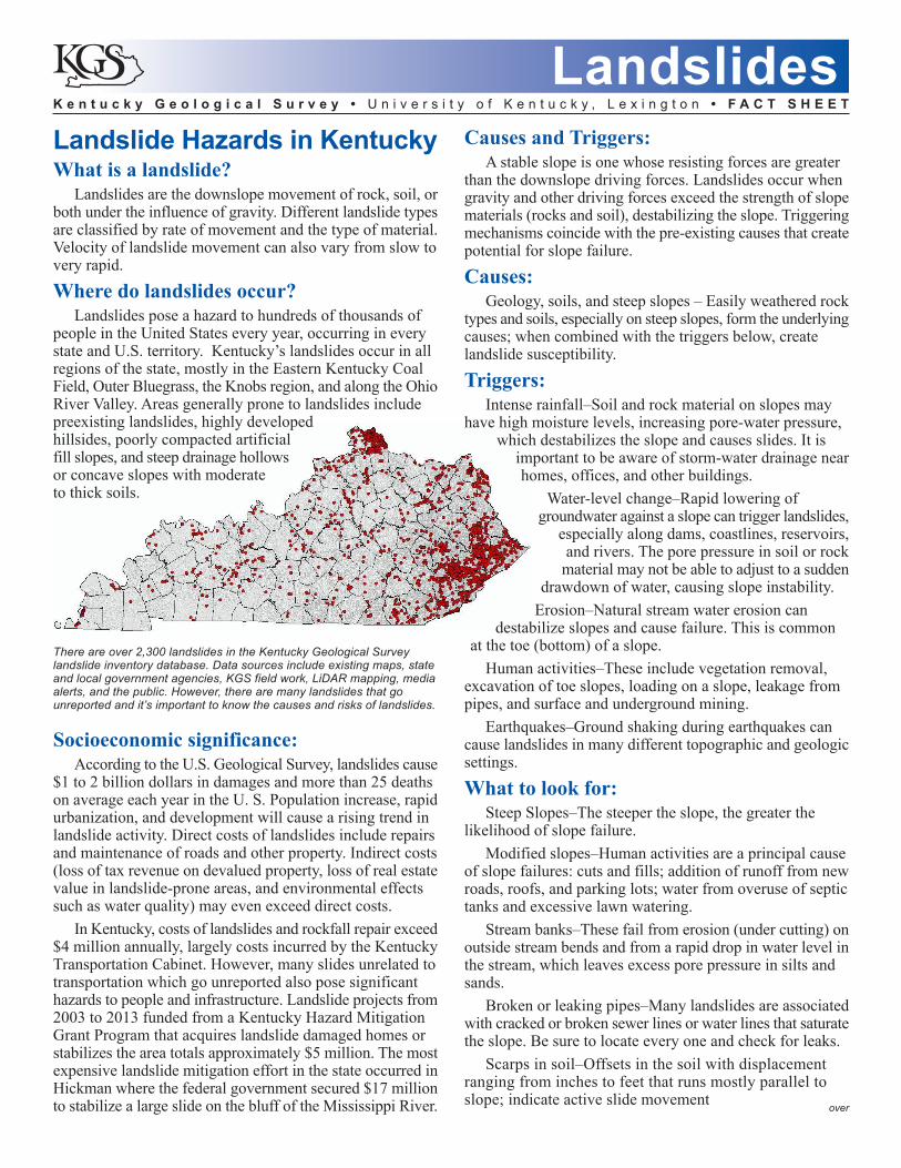
There are over 2,300 landslides in the Kentucky Geological Surveylandslide inventory database. Data sources include existing maps, stateand local government agencies, KGS field work, LiDAR mapping, mediaalerts, and the public. However, there are many landslides that gounreported and it’s important to know the causes and risks of landslides.
K e n t u c k y G e o l o g i c a l S u r v e y • U n i v e r s i t y o f K e n t u c k y , L e x i n g t o n • F A C T S H E E T
Landslides
For more information see our website at www.uky.edu/KGS or contact Mike Lynch at (859) 323-0561 or [email protected]
Tilted trees, poles, posts, and walls–These conditions ona slope are easy-to-recognize indicators of hillside movement.
Cracks in buildings, walls and roads–Failures are mucheasier to see when they cut hard structures. Look for cracksthat line up, that have a noticeable offset, or arc-shapeddisplacement.
Avoidance and remediation:The best method for avoiding damages from landslides
and having to mitigate the hazard is to avoid construction onsteep slopes. As this is not an entirely possible, consultingsoil and geologic maps in the early investigation fordevelopment of a property is important. Check for descriptionsof soil and rock types that may be susceptible to landslides.Simple practices to avoid slope failure include:
• Good site selection• Proper drainage well away from slide area• Avoiding removal of trees and vegetation where possible• Adding no unnecessary weight (i.e. fill material) to the
slopeRemediation efforts of existing landslides should always
be done with the help of a professional geotechnical engineer.Basic rules of thumb include:
• Draining water well away from the slope• Removal of soil from the head of the landslide (do not
remove material at the toe of the slide, as this will furtherreduce stability)
• Planting trees and bushes to help remove water fromthe slope
• Reducing the height of the slope and adding cover ofrip-rap toward the lower part of the slope to stabilize.
Advanced retaining wall remediation techniques, such asdrilled piers, piles, steel or timber bins, gabions, or tie-backsare expensive and require professional geotechnical expertise.
Technical assistance:• Kentucky Emergency Management: www.kyem.ky.gov• Federal Emergency Management Agency (FEMA): www.fema.gov• United State Department of Agriculture, (USDA), NaturalResources Conservation Service (NRCS):www.nrcs.usda.gov. County offices provide detailed soilmaps and engineering properties of soils.
You should be aware of government agencies (county,municipality managers, planning commissions, etc.)who may help or respond to a landslide.
Helpful resources:• Kentucky Emergency Management Hazard MitigationProgram:http:kyem.ky.gov/recovery/pages/hazardmitigation.aspx• Kentucky Geological Survey, Landslides:www.uky.edu/kgs/geologicalhazards/landslide.htm• United States Geological Survey Landslide Hazards Program:http://landslides.usgs.gov/• Highland, L. M., and Bobrowsky , Peter, 2008, The landslidehandbook – a guide to understanding landslides: U.S.Geological Survey Circular 1325, 129phttp://pubs.usgs.gov/circ/1325/• Crawford, M.M., 2012, Using LiDAR to map landslides inKenton and Campbell Counties, Kentucky: KentuckyGeological Survey, ser. 12, Report of Investigations 24, 12p.
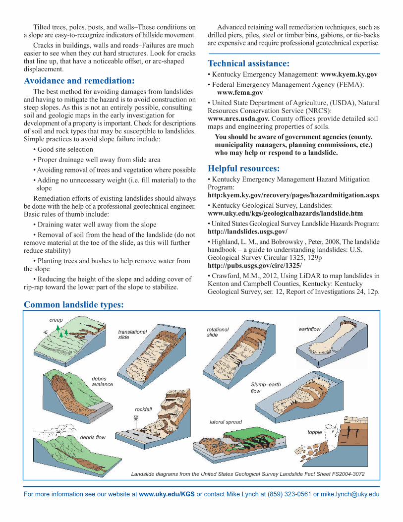
Landslide diagrams from the United States Geological Survey Landslide Fact Sheet FS2004-3072
Common landslide types:
translationalslide
rotationalslide
earthflow
creep
debrisavalance
debris flow
lateral spread
rockfall
topple
Slump–earthflow
Related Documents