Top Banner
Landslides in Vermont George Springston Norwich University Dept. of Geology and Environmental Science Northfield, VT, October, 2010
25

Landslides in Vermont · • “The downslope movement of soil, rock and organic materials under the influence of gravity and also the landform that results from such a movement”

Aug 26, 2018

Download

Documents

phamcong
Welcome message from author
This document is posted to help you gain knowledge. Please leave a comment to let me know what you think about it! Share it to your friends and learn new things together.
Transcript
Page 1: Landslides in Vermont · • “The downslope movement of soil, rock and organic materials under the influence of gravity and also the landform that results from such a movement”

Landslides in Vermont

George Springston Norwich University Dept. of Geology and Environmental Science

Northfield, VT, October, 2010

Page 2: Landslides in Vermont · • “The downslope movement of soil, rock and organic materials under the influence of gravity and also the landform that results from such a movement”

Outline

• Definitions

• Mad River

• Vermont Highway Rockfall Hazards

• Smugglers Notch

• Jeffersonville

Page 3: Landslides in Vermont · • “The downslope movement of soil, rock and organic materials under the influence of gravity and also the landform that results from such a movement”

• “The downslope movement of soil, rock and organic materials under the influence of gravity and also the landform that results from such a movement” (The Landslide Handbook, USGS Circular 1325, p. 4).

Figure from USGS Fact Sheet 2004-3072 http://pubs.usgs.gov/fs/2004/3072/fs-2004-3072.html

Landslide on Winooski River, Cate Farm, Plainfield, 2009

Page 4: Landslides in Vermont · • “The downslope movement of soil, rock and organic materials under the influence of gravity and also the landform that results from such a movement”
Page 5: Landslides in Vermont · • “The downslope movement of soil, rock and organic materials under the influence of gravity and also the landform that results from such a movement”

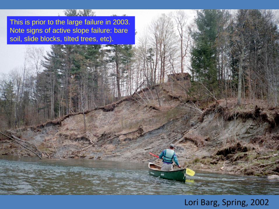
Lori Barg, Spring, 2002

This is prior to the large failure in 2003. Note signs of active slope failure: bare soil, slide blocks, tilted trees, etc).

Page 6: Landslides in Vermont · • “The downslope movement of soil, rock and organic materials under the influence of gravity and also the landform that results from such a movement”

Spring, 2003

Page 7: Landslides in Vermont · • “The downslope movement of soil, rock and organic materials under the influence of gravity and also the landform that results from such a movement”

6/3/2003

Page 8: Landslides in Vermont · • “The downslope movement of soil, rock and organic materials under the influence of gravity and also the landform that results from such a movement”

5/28/2003

Page 9: Landslides in Vermont · • “The downslope movement of soil, rock and organic materials under the influence of gravity and also the landform that results from such a movement”

Stratigraphy

• 0.7 - 1.2 m pebbly medium sand (fluvial).

• 12.2 m fine sand and silty fine sand with layers of massive silty clay (lacustrine).

• 9.1 m varved silt, silty clay and clay with 2-4 cm couplets (lacustrine).

Page 10: Landslides in Vermont · • “The downslope movement of soil, rock and organic materials under the influence of gravity and also the landform that results from such a movement”

Fluvial terrace deposit of pebbly medium sand with some cobbles.

Page 11: Landslides in Vermont · • “The downslope movement of soil, rock and organic materials under the influence of gravity and also the landform that results from such a movement”

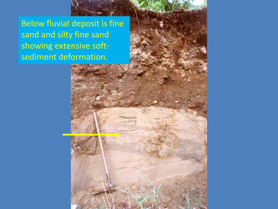
Below fluvial deposit is fine sand and silty fine sand showing extensive soft-sediment deformation.

Page 12: Landslides in Vermont · • “The downslope movement of soil, rock and organic materials under the influence of gravity and also the landform that results from such a movement”

Spring, 2003

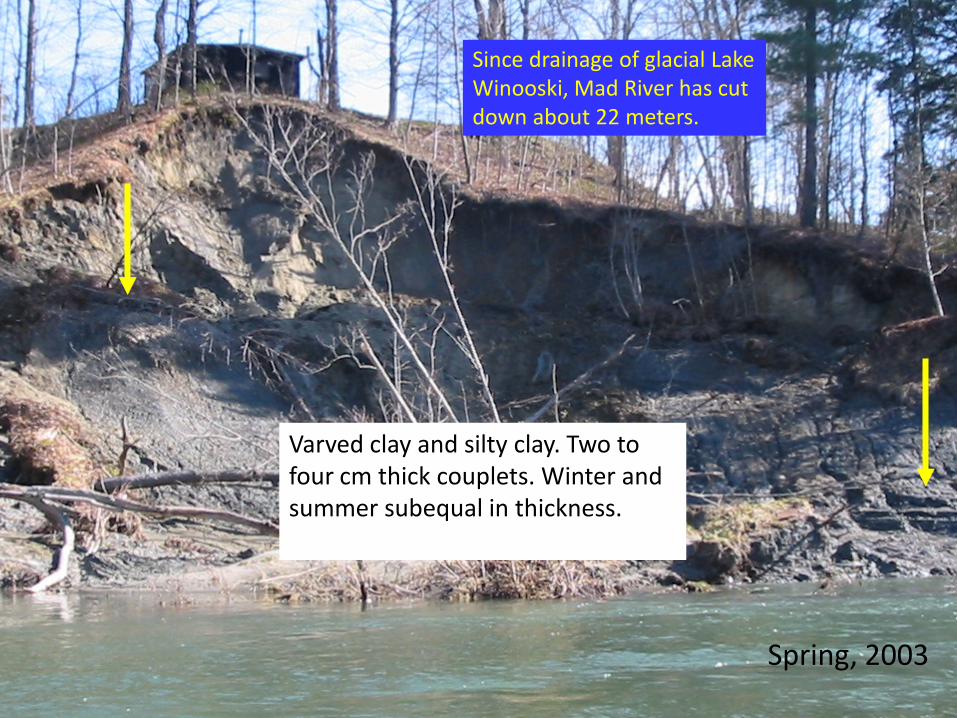
Varved clay and silty clay. Two to four cm thick couplets. Winter and summer subequal in thickness.

Since drainage of glacial Lake Winooski, Mad River has cut down about 22 meters.

Page 13: Landslides in Vermont · • “The downslope movement of soil, rock and organic materials under the influence of gravity and also the landform that results from such a movement”

Dimensions

• 43 m (140 ft) wide • 76 m (248 ft) long (N-

S) • 22 m (70 ft) high • 15.5º slope overall • 4000 m3 (5300 yd3)

volume of displaced mass

Page 14: Landslides in Vermont · • “The downslope movement of soil, rock and organic materials under the influence of gravity and also the landform that results from such a movement”

Erosion of Toe

• >10 m (33 ft) eroded since 5/28/03

• >700 m3 (900 yards3) carried away by river

• Turbidity visible at least to Waterbury -26 km downstream

5/28/03

Page 15: Landslides in Vermont · • “The downslope movement of soil, rock and organic materials under the influence of gravity and also the landform that results from such a movement”

1873 Beers Atlas

Washington County

Historical Analysis

Page 16: Landslides in Vermont · • “The downslope movement of soil, rock and organic materials under the influence of gravity and also the landform that results from such a movement”

1:24,000 Original: USGS WSP 424

1:24,000 Original

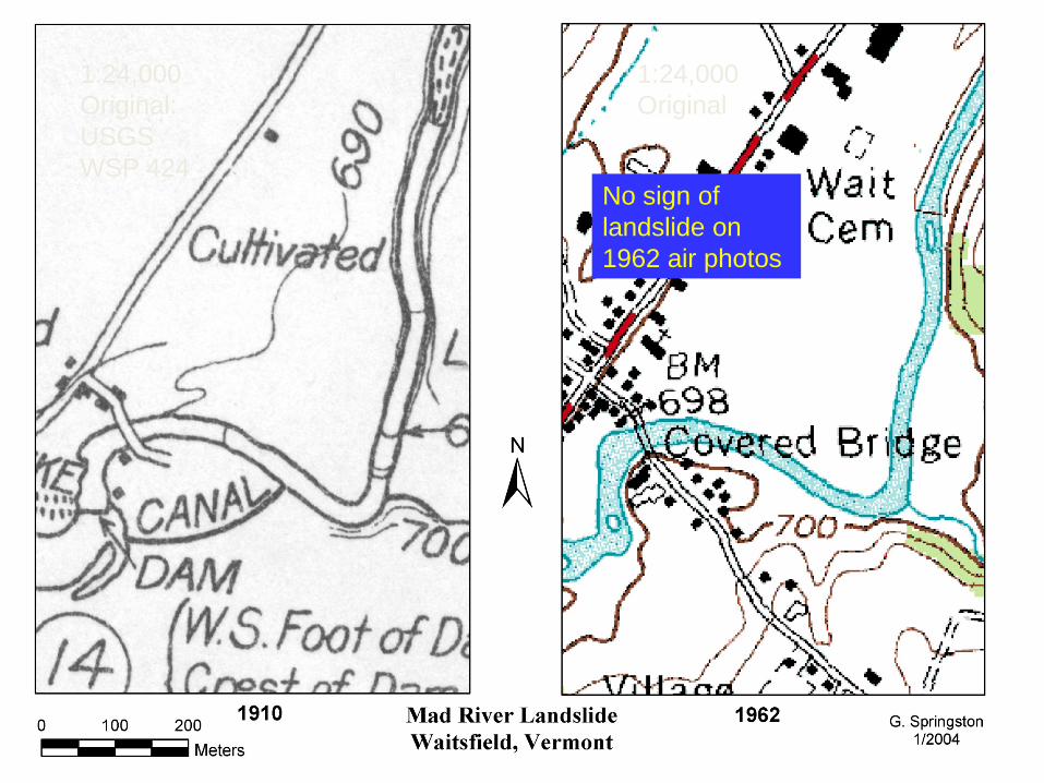
No sign of landslide on 1962 air photos

Page 17: Landslides in Vermont · • “The downslope movement of soil, rock and organic materials under the influence of gravity and also the landform that results from such a movement”

1:20,000 Original

1:30,000 Original

No sign of landslide.

Landslide present.

Page 18: Landslides in Vermont · • “The downslope movement of soil, rock and organic materials under the influence of gravity and also the landform that results from such a movement”

May 16 May 23

Cumulative Precipitation at USGS stream gage downstream at Moretown.

Page 19: Landslides in Vermont · • “The downslope movement of soil, rock and organic materials under the influence of gravity and also the landform that results from such a movement”

Sliding reported on 16th and 23rd

Stage (in feet) at USGS stream gage downstream at Moretown.

Apparently no landslide activity right after May 2 peak.

Page 20: Landslides in Vermont · • “The downslope movement of soil, rock and organic materials under the influence of gravity and also the landform that results from such a movement”

6/3/2003

Triggering the Slide

1. Erosion due to high flows.

2. High ground water levels/soil moisture.

3. Removal of support with falling stage.

Page 21: Landslides in Vermont · • “The downslope movement of soil, rock and organic materials under the influence of gravity and also the landform that results from such a movement”

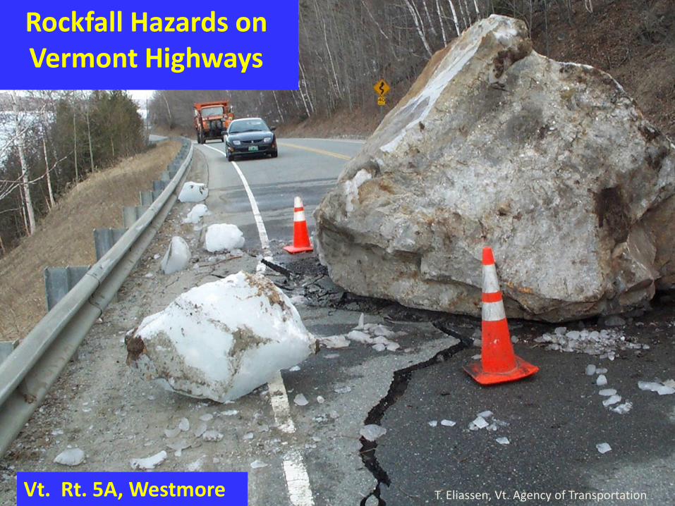
T. Eliassen, Vt. Agency of Transportation Vt. Rt. 5A, Westmore

Rockfall Hazards on Vermont Highways

Page 22: Landslides in Vermont · • “The downslope movement of soil, rock and organic materials under the influence of gravity and also the landform that results from such a movement”

Vt. Route 105, Jay G. Springston, Norwich U. Dept. Geology

Plane failure: slabs dipping toward road.

Page 23: Landslides in Vermont · • “The downslope movement of soil, rock and organic materials under the influence of gravity and also the landform that results from such a movement”

I-91 South-bound, Weathersfield

Steep potential wedge failure resulting from intersection of the joint sets.

Foliation-parallel joint set with steep dip toward road.

Joint set dipping steeply to right.

G. Springston, Norwich U. Dept. Geology

Page 24: Landslides in Vermont · • “The downslope movement of soil, rock and organic materials under the influence of gravity and also the landform that results from such a movement”

Fracture-bounded Column

U.S. Rt. 7, Exit 2, Bennington, G. Springston, Norwich U. Dept. Geology

Tension Crack Cc

Ow

Page 25: Landslides in Vermont · • “The downslope movement of soil, rock and organic materials under the influence of gravity and also the landform that results from such a movement”

Rockfall Hazards on Vermont Highways

TOTAL CUTS = 3,647

A (High Rockfall Potential) = 174 Other

RHRS PRELIMINARY RANKING

4% 2%10%

8%

76%

High A

Significant B+

Elevated B

Moderate B-

Low C