Landscape Journal 32:2 ISSN 0277-2426 © 2013 by the Board of Regents of the University of Wisconsin System Landscapes and Instruments Brian Davis ABSTRACT John Dewey’s instrumental theory of knowl- edge offers a starting point for the exploration of new territory in landscape architecture, specifically the gap between intention and reality. This space is always at issue in landscape architectural practice and yet remains largely untouched by contemporary theoretical and tech- nical projects. In recent years the discipline has become concerned and engaged with design issues caused by the unintended consequences of our society’s industrial leg- acy and rapidly changing ecological and economic reali- ties through the conceptualization of landscapes that can perform multiple functions through time. This paper pre- sents the results of ongoing research that grapples with the gap between intention and reality and suggests that this approach to landscape architecture is an appropri- ate and promising disciplinary response to extreme and changing conditions. It does so first through a critique of current theories and then proposes new conceptual and technical tools for analysis and representation through a speculative project for an industrial shipping canal land- scape on the edge of the Rio de la Plata Estuary in the heart of Buenos Aires, Argentina. KEYWORDS Landscape instrumentalism, technique, representation, John Dewey, ends and means, theory It still remains true that the troubles which men undergo are the forces that lead them to project pictures of a better state of things. But the picture of the better is shaped so that it may become an instrumentality of action . . . (Dewey 1920, 118). INTRODUCTION Recent decades have seen an expansion of the role of the landscape architecture discipline and a renewed importance placed on understanding and engaging with ecological and material realities. Theoretical and technical projects have developed to both guide and respond to these new dimensions and demands in landscape architecture. 1 After nearly a half-century of sublimation into planning and architecture, the field has reasserted itself through alliances with newly hybridized disciplines including landscape ecology and landscape urbanism. However, the above quote by John Dewey points to one important aspect that has remained largely lacking in the prominent theoretical projects of this time, and the key to this aspect lies in the idea of instrumentality. While exciting tools are being developed that model aspects of ecological performance and social scientists work to design methods for engaging the human communities that are part of any landscape (Hayden 1997), the discipline of landscape architec- ture has not yet developed a theoretical-technical project that examines the fundamental gap between design intent and the reality of the material, political, and economic situations with which the discipline is inherently engaged. A renewed focus on instrumen- tality offers a theoretical and technical framework to develop the conceptual tools needed to integrate and synthesize techniques for modeling, computa- tion, analysis, and construction of multi-functional landscapes (Weller 2006, 73). This may offer a way to

Welcome message from author
This document is posted to help you gain knowledge. Please leave a comment to let me know what you think about it! Share it to your friends and learn new things together.
Transcript
Land
scap
e Jo
urna
l32
:2IS
SN 0
277-
2426
© 2
013
by
the
Boa
rd o
f Reg
ents
of t
he U
nive
rsit
y of
Wis
cons
in S
yste
mLandscapes and Instruments
Brian Davis
ABSTRACT John Dewey’s instrumental theory of knowl-edge offers a starting point for the exploration of new territory in landscape architecture, specifically the gap between intention and reality. This space is always at issue in landscape architectural practice and yet remains largely untouched by contemporary theoretical and tech-nical projects. In recent years the discipline has become concerned and engaged with design issues caused by the unintended consequences of our society’s industrial leg-acy and rapidly changing ecological and economic reali-ties through the conceptualization of landscapes that can perform multiple functions through time. This paper pre-sents the results of ongoing research that grapples with the gap between intention and reality and suggests that this approach to landscape architecture is an appropri-ate and promising disciplinary response to extreme and changing conditions. It does so first through a critique of current theories and then proposes new conceptual and technical tools for analysis and representation through a speculative project for an industrial shipping canal land-scape on the edge of the Rio de la Plata Estuary in the heart of Buenos Aires, Argentina.
KEYWORDS Landscape instrumentalism, technique, representation, John Dewey, ends and means, theory
It still remains true that the troubles which men undergo are the forces that lead them to project pictures of a better state of things. But the picture of the better is shaped so that it may become an instrumentality of action . . . (Dewey 1920, 118).
INTRODUCTIONRecent decades have seen an expansion of the role of
the landscape architecture discipline and a renewed
importance placed on understanding and engaging
with ecological and material realities. Theoretical
and technical projects have developed to both guide
and respond to these new dimensions and demands
in landscape architecture.1 After nearly a half- century
of sublimation into planning and architecture, the
fi eld has reasserted itself through alliances with newly
hybridized disciplines including landscape ecology
and landscape urbanism. However, the above quote by
John Dewey points to one important aspect that has
remained largely lacking in the prominent theoretical
projects of this time, and the key to this aspect lies in
the idea of instrumentality.
While exciting tools are being developed that
model aspects of ecological performance and social
scientists work to design methods for engaging the
human communities that are part of any landscape
(Hayden 1997), the discipline of landscape architec-
ture has not yet developed a theoretical- technical
project that examines the fundamental gap between
design intent and the reality of the material, political,
and economic situations with which the discipline is
inherently engaged. A renewed focus on instrumen-
tality off ers a theoretical and technical framework
to develop the conceptual tools needed to integrate
and synthesize techniques for modeling, computa-
tion, analysis, and construction of multi- functional
landscapes (Weller 2006, 73). This may off er a way to
294 Landscape Journal 32:2
overcome the false schism between ends and means
and contend with the liminal space between intent and
reality (Eldridge 1998, 104).
Reconsidering InstrumentalityThe term instrumentality and related words such as
instrumentalize carry a negative connotation, meaning
to execute the intentions of some entity. This defi ni-
tion implies that any instrument can only fulfi ll these
intentions—it never falls short or overshoots, but only
executes precisely what was intended. Therefore, to
instrumentalize something, whether a person, a theory,
or an oscillating spindle sander, is to reduce it to the
manifestation of some intent without remainder. This
idealist interpretation is not, however, the only way to
use the word.
Theodoro Adorno showed that “objects do not
go into their concepts without leaving a remainder,”
and because of this fact, reality will always in some
way exceed our knowledge and control (Bennett 2010,
14). Jane Bennett speaks “of healthy and enabling
instrumentalizations, rather than of treating people as
ends- in- themselves” in an eff ort to construct a more
nuanced and inclusive account of complex societies
and events (2010, 12). In this paper I use the term
instrument (and its derivatives) to mean something
much closer to Dewey’s preferred defi nition: not a
means to reach certain “desired results,” but a proposi-
tion to attain a grounded belief (J Dewey 2008, 175).
In this defi nition, ends and means exist along a con-
tinuum and are historical. Ends, goals, or ideals do not
arise out of nothing, but are developed through action
as a method for dealing with a real situation. And
these ideas, what Dewey would call “ends- in- view,”
are also means or instruments by which to achieve
eventual real ends (Eldridge 1998, 25 and 104).
The question of ends and means is one that has
been the subject of much discussion in the last 20 years
within landscape architecture. In his infl uential essay
“Terra Fluxus,” James Corner spells out his version of
landscape urbanism’s theoretical objectives, stating
that it is “strategic, emphasizing means over ends and
operational logic over compositional design” (Cor-
ner 2006, 31). This theoretical project has created a
productive discussion that seeks to invert what Corner
saw as the then- dominant approach of landscape and
urban design. Landscape Instrumentalism, however,
does not seek an inversion, but rather aims to follow
Dewey and ally ends and means along a continuum of
thoughtful action in a historical reality.
Instrumentalism does not imply that specula-
tions, fi ctions, and critique have no place, but rather
that a spectator position which assumes a world can
be observed through the senses and then conceptual-
ized and rationalized while emphasizing the synop-
tic view is not valid.2 John Dewey was interested in
undoing the spectator theory of knowledge (Moore
1961, 193). He vociferously argued for grappling with
situations as a full participant and for engaging the
medium at hand through experimentation. For Dewey,
ideas were instruments used by people to guide them
in reorganizing their environment and initiating new
lines of action, and all experience was experimental,
as no reality ever lined up perfectly with the imag-
ined or ideal (Eldridge 1998, 103). It follows then that
the object of knowledge is the future—consequences
and possibilities—rather than rationalizing the
observed past with a general or unifying theory.
By drawing from Dewey, instrumentality might be
resuscitated. Dewey’s project sought to “make intel-
ligible connections present in experience” (Eldridge
1998, 4). In its most basic form, his instrumentalism is a
unity of theory and practice (Moore 1961), an approach
that seems particularly apt for landscape architecture
as a discipline. In this way, landscape instrumental-
ism does not seek to reduce everything to a mere tool
that does only what something else intends. Rather,
it hypothesizes that a landscape is made of instru-
ments whose actions never align perfectly with a user’s
intention but are always doing more and less, creating
a liminal space between intent and reality (Figure 1).
This robust concept of instrumentality promises a way
to bridge some gaps between conceptual and technical
developments in landscape practice and research.
OBJECT- ORIENTED LANDSCAPESLandscape instrumentalism is interested in the agency
of things;3 some of those things include humans
and their collectives, their interpretations and ideas,
and their histories. But other things must also be
grappled with. The decisions and desires of migra-
tory warblers and Swainson’s thrushes also construct
the landscape, as does the movement of a toxic plume
of polycyclic aromatic hydrocarbons through glacial
clasts on the shores of Lake Michigan. The idea of
an object- oriented landscape, wherein everything in

Davis 295
the landscape is an object, does not reduce humans
to “slabs of inert matter” awaiting commands (Har-
man 2011, 251) but rather elevates all objects to a plane
of autonomous existence capable of changing things,
producing eff ects, and having other roles “besides that
of carriers of necessity, or ‘plastic’ vehicles for ‘human
ingenuity,’ or ‘a simple white screen to support the
diff erentiation of society’” (Bennett 2010, 31).
This gap that is created between the design intent
and reality is always at issue in landscape architecture.4
Unanticipated erosion across a newly graded slope,
volunteer species in a densely planted garden, fi ssures
of decomposition in expensive slate pavers, or patterns
of use in an urban plaza always contain some measure
of novelty and surprise. This fact becomes even more
pronounced at extremely large scales, where coastal
subsidence, extreme weather events, or geo- political
decisions can radically alter a landscape in unforeseen
ways. Lefebvre observed this when he wrote, “even
technocratic planners and programmers cannot pro-
duce a space with a perfectly clear understanding of
cause and eff ect, motive and implication” (1991, 37).
The space between intent and reality is one of
the great, unexplored regions of our discipline, and
holds much promise for considering the types and
scales of landscape that have become central in recent
decades. Until now, this space has been treated as a
remainder, something to be made up for with change
orders or some fuzzily determined and standardized
maintenance operation, but it calls for a bolder
response. We might create concepts and techniques to
contend with this territory in an expansive way, just
as the concepts of interchangeable parts and project
specifi cations were developed 200 years ago in an
attempt to minimize it.5 This frontier beckons land-
scape designers to chart and mold its topography, and
to make the conceptual leap down from the spectator’s
tower and into the dirt.
Setting the TableThis project requires tools, both conceptual and techni-
cal, that can contend with this liminal space. How can
a designer begin to grapple with this gap? History sug-
gests that it is unlikely that simply trying to eradicate
it will prove helpful, despite recent advances in fabri-
cation technologies and systems thinking. However,
the current push toward multi- functional landscapes
is illuminating. The idea conjures forth the need for
specifi city: which functions should be aligned and why,
and ultimately how will these functions fi t with other
functions? This call echoes Richard Weller’s assertion
that “critical pragmatism empowers and liberates land-
scape architecture . . . through an acute sense of site
specifi city, a sense that the site itself is the regulatory
idea of the project” (Weller 2008, 254). We must pursue
specifi city and pragmatism by constructing methods to
examine landscapes for their functions and eff ects, how
they relate in space, time, and materials.
Figure 1“The Drive in Central Park, New York, September 1860” by Winslow Homer, from Harper’s Weekly, September 15, 1860. This image showing Central Park in process—simultaneously under construction and in use—suggests that it is not the formal aesthetic moves that make the landscape Central Park, but rather the array of instruments at work (carriage drives, horses, top hats, may poles, topographic slopes) that constantly make and remake the landscape (courtesy the Smithsonian American Art Museum).
296 Landscape Journal 32:2
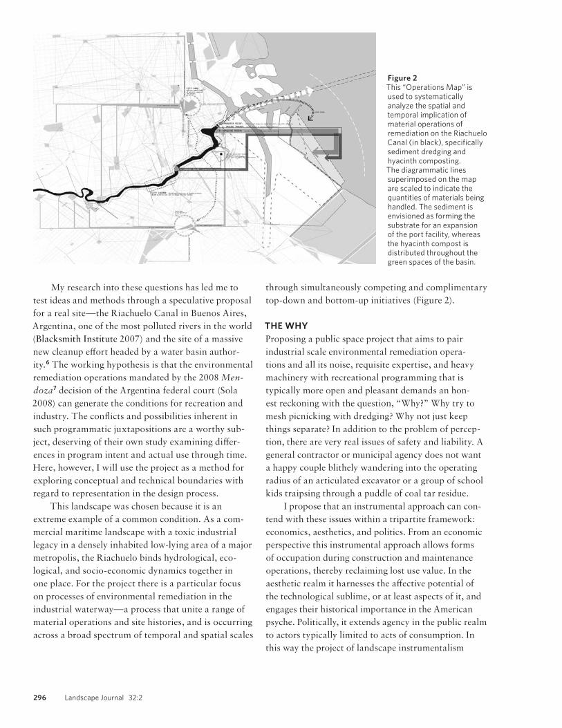
My research into these questions has led me to
test ideas and methods through a speculative proposal
for a real site—the Riachuelo Canal in Buenos Aires,
Argentina, one of the most polluted rivers in the world
(Blacksmith Institute 2007) and the site of a massive
new cleanup eff ort headed by a water basin author-
ity.6 The working hypothesis is that the environmental
remediation operations mandated by the 2008 Men-
doza7 decision of the Argentina federal court (Sola
2008) can generate the conditions for recreation and
industry. The confl icts and possibilities inherent in
such programmatic juxtapositions are a worthy sub-
ject, deserving of their own study examining diff er-
ences in program intent and actual use through time.
Here, however, I will use the project as a method for
exploring conceptual and technical boundaries with
regard to representation in the design process.
This landscape was chosen because it is an
extreme example of a common condition. As a com-
mercial maritime landscape with a toxic industrial
legacy in a densely inhabited low- lying area of a major
metropolis, the Riachuelo binds hydrological, eco-
logical, and socio- economic dynamics together in
one place. For the project there is a particular focus
on processes of environmental remediation in the
industrial waterway—a process that unite a range of
material operations and site histories, and is occurring
across a broad spectrum of temporal and spatial scales
through simultaneously competing and complimentary
top- down and bottom- up initiatives (Figure 2).
THE WHYProposing a public space project that aims to pair
industrial scale environmental remediation opera-
tions and all its noise, requisite expertise, and heavy
machinery with recreational programming that is
typically more open and pleasant demands an hon-
est reckoning with the question, “Why?” Why try to
mesh picnicking with dredging? Why not just keep
things separate? In addition to the problem of percep-
tion, there are very real issues of safety and liability. A
general contractor or municipal agency does not want
a happy couple blithely wandering into the operating
radius of an articulated excavator or a group of school
kids traipsing through a puddle of coal tar residue.
I propose that an instrumental approach can con-
tend with these issues within a tripartite framework:
economics, aesthetics, and politics. From an economic
perspective this instrumental approach allows forms
of occupation during construction and maintenance
operations, thereby reclaiming lost use value. In the
aesthetic realm it harnesses the aff ective potential of
the technological sublime, or at least aspects of it, and
engages their historical importance in the American
psyche. Politically, it extends agency in the public realm
to actors typically limited to acts of consumption. In
this way the project of landscape instrumentalism
Figure 2This “Operations Map” is used to systematically analyze the spatial and temporal implication of material operations of remediation on the Riachuelo Canal (in black), specifically sediment dredging and hyacinth composting. The diagrammatic lines superimposed on the map are scaled to indicate the quantities of materials being handled. The sediment is envisioned as forming the substrate for an expansion of the port facility, whereas the hyacinth compost is distributed throughout the green spaces of the basin.

Davis 297
attempts to extend and expand current norms within
the discipline of landscape architecture.
Economics: Use ValueEconomic value is the result of two main factors—
use value and exchange value (Marx 1915, 125–131).
Following Marx, a commodity is something that is
defi ned by its exchange value—the abstract correlation
of the object to monetary value—whereas use value is
determined by an object’s utility. A person purchases
a shovel because it has use value as an instrument for
digging, not because it can be easily exchanged for
another unrelated object.
Landscape projects have a life cycle. Typically a
public landscape is only public after construction or
maintenance operations are completed. Future users
are kept at bay until a “substantial stage of comple-
tion” is reached, or until the mowing is fi nished. For
large projects, this can mean that signifi cant portions
are not usable for months, years, or in the case of
Orange County Great Park, decades. This is occasion-
ally mitigated through phasing the implementation
of a project, or by instigating intermediate and provi-
sional programs. In the case of smaller projects such
as a playground or neighborhood plaza, the landscape
is often closed for a season as new play equipment or
plantings are installed, grading and drainage pipes are
reconstructed, or fencing is replaced.8
The recovery of this use value could have signifi -
cant economic impact. The exchange value of land-
scapes, specifi cally the infl uence of well- maintained
parkland on local real estate values, has been thor-
oughly studied and is a fundamental theme in land-
scape architectural practice dating back to Olmsted.9
The evidence regarding use value is sparser. However,
a recent study in 2009 by the Trust for Public Land
examined this aspect of a city park system. This study
considered only “direct use value,” which excludes use
value lacking a commercial corollary. By this measure
the Boston city park system was examined and found
to have provided over $354 million in direct use value
in 2006 alone (Harnik and Welle 2009, 5–7). If land-
scape designers can develop and propose methods for
capturing the use value of these public spaces lost dur-
ing construction and maintenance, even at some addi-
tional initial expense, the result would be a net gain.
This might provide an impetus for municipalities to
fi nd a way to recapture more of that value, especially
for landscapes such as infrastructural projects or
large- scale remediation eff orts, where the construction
is likely to take years.
Aesthetics: The technological sublimeAt its most basic, the sublime can be understood as an
experience of astonishment, meaning “that state of the
soul in which all its motions are suspended, with some
degree of horror,” (Burke 1997, 230). In The American
Technological Sublime, David Nye asserts the his-
torical importance of the sublime aesthetic in the
American landscape, noting that “ever since the early
national period the sublime has served as an element of
social cohesion, an element that was already quite evi-
dent when the fi rst canals were dug and steam engines
were fi rst harnessed to trains,” (1996, XIV).
Nye’s breakthrough was to recognize that within
the North American psyche, the sublime experience
was not limited to geologic objects such as mountains
and gorges, but could be an “amalgamation of natural,
technological, classical, and religious elements into
a single aesthetic,” (Nye 1996, 23). Importantly, he
makes the connection that the technological sublime
is concerned with a politics of perception. The public’s
experience of technologies in operation can create spe-
cifi c, attractive eff ects; a landscape of the technologi-
cal sublime can off er aesthetic experience that does
not only privilege the beautiful or the picturesque
(Meyer 1994) but rather off ers bystanders and users
an overwhelming and captivating moment. Dewey’s
understanding of a public not as a pre- existing
monolithic block, but as a community that forms in
response to a particular stimulus or problem is help-
ful here. Landscape instrumentalism draws from the
insight that a public “consists of all those who are
aff ected by the indirect consequences of [events] to
such an extent that it is deemed necessary to have
those consequences systematically cared for” (Dewey
1927, 16). Relative to landscape practices, designers
might build on the fact that the political eff ects of the
technological sublime can off er a very real and power-
ful mechanism to bind communities together and add
value to public landscapes. By devising methods that
bring people into proximity with landscapes in pro-
cess, we can design landscapes that off er an expanded
range of aesthetic experience.10

298 Landscape Journal 32:2
Politics: The Right to the CityThe right to the city is understood here as the right of
urban inhabitants to engage with all of the decisions
and actions that produce urban space (Harvey 2008).
This includes the right of participation, as well as the
more radical right of appropriation (Purcell 2002). In
the fi rst case, inhabitants’ desires and ideas are fi ltered
through institutions of the state in traditional ways.
The second right is a bit more complicated.
There are very good reasons that the right to
appropriation is not legitimized to the same degree as
the right to participation. Take an extreme example;
a Philadelphia in which anyone who wants could go
around blasting holes in the sidewalk, ripping up sec-
tions of street, or planting new trees in the middle of
Independence Mall would be problematic, if exciting.
And so the default seems to be to almost totally deny
this impulse,11 despite the violently negative ramifi ca-
tions it infl icts on our democracies and urban spaces
elucidated so well by Henri Lefebvre. With a focus
on specifi city and instrumental eff ects, landscape
Figure 3Plan, overall perspective, and detail perspective of fluid dynamics analysis of the Riachuelo. This 3- D computational fluid dynamics model uses Integrated Environmental Systems—Virtual Environment (IES- VE) to test the effects of design elements on the hydrodynamics of the canal. Multiple scenarios and configurations were first tested in a 2D cfd model using TAS Ambiens, which is much faster but only considers two dimensions. Here you can see certain pinch points, where the water is moving faster (white zones), and where water is moving much slower (black zones), likely causing suspended sediment to drop out.

Davis 299
architects might devise ways that enable landscapes to
be appropriated by citizens.
METHODS AND TECHNIQUESThe methods presented and discussed here are opera-
tive lines of action meant to grapple with the gap
between intent and reality (R. Dewey 1977). Far
from simply trying to eliminate this gap, a landscape
instrumentalist methodology might at times seek to
minimize it and at other times to exploit or use it as a
point of leverage. In Dewey’s instrumentalism methods
were of utmost importance as “the value of any cogni-
tive conclusion depends upon the method by which it
is reached” (J. Dewey 1929, 200).
In landscape instrumentalism, methods are instru-
ments used as a guide in an attempt to initiate new
lines of action. This approach diff ers from others in
that the designer is an active participant in the crea-
tion of knowledge, but only one among many, albeit
with a specifi c role. That is, the designer is neither the
passive, disinterested recorder, nor the all- powerful
maker of worlds, capable of construing and construct-
ing entire new realities though the power of the map.
Rather, the designer is actively engaged with a host of
other objects in the activities knowing and acting in a
specifi c situation.
The importance of technique in this undertak-
ing cannot be overstated. In 2006, James Corner
emphasized that “the techniques to address the sheer
scope of issues here are desperately lacking—and this
area alone, it would seem to me, is deserving of our
utmost attention and research” (2006, 32). For a long
time, conceptualization has reigned from a privileged
position over execution, ideas over technique. This is
a tendency that Corner has noted: “while there has
been no shortage of new ideas and theories in design
and planning, there has been little advancement and
invention of those specifi c tools and techniques that
are so crucial for the eff ective construal and construc-
tion of new worlds,” (1999, 217). And the dichotomy
that elevates ideas above execution shares symptoms of
the modern binary thinking in landscape theory that
Elizabeth Meyer identifi es as “incapable of describing
and identifying that which [is] unique to the modern
built landscape” (1994, 19).
In recent years great strides have been made in the
development and application of new tools of represen-
tation and computation.12 The potential to relate them
to specifi c concepts and practical applications through
the development of a theoretical- technical project
holds much promise and suggests that perhaps we are
now coming to a time when technique is being prop-
erly valued again.13
ModelingMuch of the modeling done by landscape architects
has historically been tectonic in nature. Drawn from
architecture, tectonic modeling methods are use-
ful for studying and communicating the way things
fi t together and the resulting formal aesthetic eff ects.
They are, however, extremely limited with respect to
how things might perform and change over time. For
this project, I used three modeling modes—analog
models, computational fl uid dynamic models, and
a sediment calculator. Each of these has particular
strengths, built- in assumptions, and limitations. The
goal was to develop a design process and workfl ow
that moved between the various modeling environ-
ments to develop a more instrumental landscape design
process that explored and expanded the limits of each
mode of working and thinking.
Computational Fluid Dynamics. Computational fl uid
dynamics is an area of investigation in the fi eld of fl uid
mechanics. Industry uses for this type of software
typically concentrate on the movement of air through
buildings or around objects, such as a plane fuselage in
a wind tunnel. However, landscape architecture might
begin to adapt these methods to study the eff ects of
design elements on the movement of water in a chan-
nel or along a surface. For this project, I used TAS
Ambiens (TAS) and Integrated Environmental Systems
Virtual Environment (IES- VE). TAS allows for rapid
two- dimensional prototyping and IES- VE enables a
more complex three- dimensional analysis.
In this project, I used the software to test and
develop strategies for the size and distribution of
elements such as wing dams, dredge pits, and pole
fi elds to aff ect water fl ow in the channel (Figure 3).
This enabled approximations of the specifi c eff ects of
design interventions on the fl ow rates and direction of
water currents—where are eddies created, where are
zones of fast water, and what is the diff erence in speed
between the two? What spatial distribution of wing
dams will provide an optimal fl ow rate? Probing for
these answers allowed informed speculation about real
300 Landscape Journal 32:2
future eff ects. Limitations of this modeling method are
that these programs do not consider sediment at all—
the fl uid is imagined as a clean material, much closer to
air than a river.
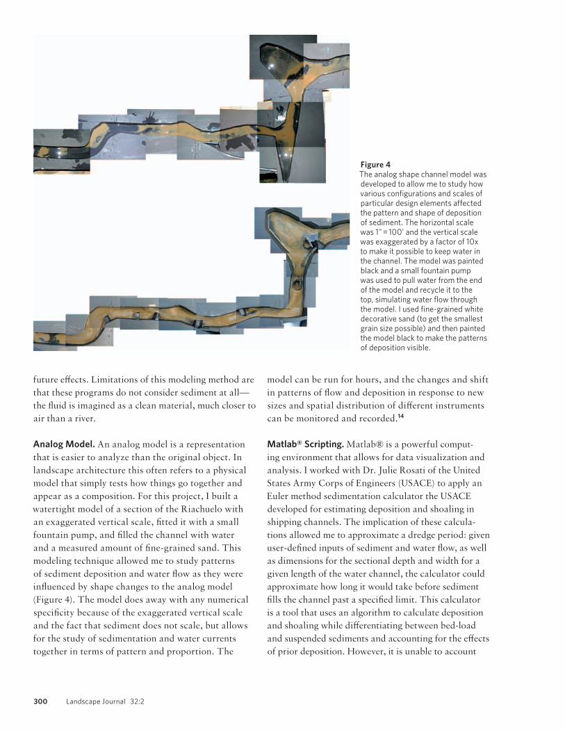
Analog Model. An analog model is a representation
that is easier to analyze than the original object. In
landscape architecture this often refers to a physical
model that simply tests how things go together and
appear as a composition. For this project, I built a
watertight model of a section of the Riachuelo with
an exaggerated vertical scale, fi tted it with a small
fountain pump, and fi lled the channel with water
and a measured amount of fi ne- grained sand. This
modeling technique allowed me to study patterns
of sediment deposition and water fl ow as they were
infl uenced by shape changes to the analog model
(Figure 4). The model does away with any numerical
specifi city because of the exaggerated vertical scale
and the fact that sediment does not scale, but allows
for the study of sedimentation and water currents
together in terms of pattern and proportion. The
model can be run for hours, and the changes and shift
in patterns of fl ow and deposition in response to new
sizes and spatial distribution of diff erent instruments
can be monitored and recorded.14
Matlab® Scripting. Matlab® is a powerful comput-
ing environment that allows for data visualization and
analysis. I worked with Dr. Julie Rosati of the United
States Army Corps of Engineers (USACE) to apply an
Euler method sedimentation calculator the USACE
developed for estimating deposition and shoaling in
shipping channels. The implication of these calcula-
tions allowed me to approximate a dredge period: given
user- defi ned inputs of sediment and water fl ow, as well
as dimensions for the sectional depth and width for a
given length of the water channel, the calculator could
approximate how long it would take before sediment
fi lls the channel past a specifi ed limit. This calculator
is a tool that uses an algorithm to calculate deposition
and shoaling while diff erentiating between bed- load
and suspended sediments and accounting for the eff ects
of prior deposition. However, it is unable to account
Figure 4The analog shape channel model was developed to allow me to study how various configurations and scales of particular design elements affected the pattern and shape of deposition of sediment. The horizontal scale was 1" = 100' and the vertical scale was exaggerated by a factor of 10x to make it possible to keep water in the channel. The model was painted black and a small fountain pump was used to pull water from the end of the model and recycle it to the top, simulating water flow through the model. I used fine- grained white decorative sand (to get the smallest grain size possible) and then painted the model black to make the patterns of deposition visible.
Davis 301
for shape changes in the water channel as it assumes a
single cross- section extruded along a given distance.
When I paired this use of Matlab® with the
other forms of modeling it was possible to localize the
inquiry. I could focus the sedimentation calculations
on specifi c stretches of the canal that exhibited the
same pattern of deposition over time (Figure 5). This
means that the dredging operation could be situated in
diff erent stretches of the canal, a result that has radical
implications for the design. This off ered a method for
working between models and the ability establish a
periodicity and sediment volume for the dredge cycle
in specifi c places along the Riachuelo.15
Orthographic ProjectionPlan. Adapting and synthesizing existing drawing
conventions has a long tradition in landscape practice.
Drawing on topology (as opposed to Euclidean geom-
etry), plans are rethought as a series of “charts,” and
specifi city rather than synthesis is prioritized. The
landscape and its objects are understood to be too
complex to represent in a single map—conceptual
fl attening still occurs but is no longer a foundational
construct. This move, modeled after nautical charts
and landscape construction documentation practices,
de- emphasizes the synoptic view and re- structures
narrative (Figure 6). While this might seem to be
simply a failure of nerve with regard to current interest
in mappings, it can also be seen as alternative direction.
By undoing the emphasis on fl attened synthesis, greater
attention can be paid to the specifi c movements of the
host of objects that make up the landscape.
Section. My proposed variation for the section adapts
the popular technique of stacking; rather than look-
ing at a series of strategic locations at one generalized
moment, I look at one important location over a series
of specifi c moments. This simple move visualizes
ephemeral spatial qualities, but also allows for some
measure of quantitative analysis and comparison over
time. Rather than relying solely on intuition to perceive
interesting spatial moments, the important moments
Figure 5This graph approximates the proposed 18- month dredging regime for the Riachuelo, developed by testing the analog shape channel model and the Matlab sedimentation calculator against one another. This resulted in adaptations to the diagram of the Operations Map. The crosshair symbols and vertical notations indicate a dredging operation. Three different scales of operation, each with its own instruments, zones of operation, schedule, and effects on other landscape processes are visualized.
Figure 6Chart 3 combines techniques from nautical and topological charts with architectural plans, with an emphasis on specificity in the landscape, including, mechanical actions, zones of operation, amplitude and intensity of processes, and aesthetic effects. The black is the Riachuelo, the thick white central line is the dredged channel, the grey is the surface kept free of water hyacinth with a tensile mesh system. Trees stretch back into adjacent neighborhoods along streets and wing dams protrude into the canal as focal points, landing areas for small boats, termini for local streets, and they help the water to scour an open channel for navigation.

302 Landscape Journal 32:2
to study in section are chosen with the assistance of a
new device—the correlation wheel—introduced below.
Quantitative analysis is enabled with a new notational
system—the instrument table, also introduced below.
This type of section is useful for understanding and
speculating on landscape change through time—
novelty, emergence, phasing, and other forms. This
could supplement and compliment existing techniques
and tools such as simulation and diagramming.
Notational SystemsInstrument Table. The instrument table is a two- axis
chart that becomes a notational system when used in
conjunction with plans or sections. Based on the idea
that an instrument can be understood through the con-
ceptual triad, explained below, the two axes are used
to identify the eff ect of the particular object as well as
the larger assemblage or activity in which it is embed-
ded (Figure 7). A more specifi c understanding of the
function of that particular instrument is achieved by
plotting these two aspects of an object and tying them
directly to its spatial form, and then drawing them in
relation to other instruments of the landscape.
Correlation Wheel. The correlation wheel is used to
link activities occurring at a specifi c time according
to the relative intensity of those activities. This tech-
nique draws from British nurse Florence Nightingale’s
“Diagram of the causes of mortality of the armies in the
East” (1858) and emphasizes cyclical relationships. In
this project I set the period for the wheel to one year.
Scales of intensity are established for each activity mov-
ing out from the center to the periphery, and months are
arrayed on the diagram in a radial pattern (Figure 8).
This technique allows the designer to be specifi c
about the chosen activities which are imagined to be
occurring in a given place during a specifi c period
(year, month, day, decade). It has serious limitations;
for instance, many of these activities operate on diff er-
ent temporal scales (a soccer game is played at a spe-
cifi c time, for instance, not all day and night usually,
whereas a river is always fl owing). This level of detail
Figure 7The instrument table allows the designer to be specific about the triad that defines an instrument—its form, its effect, and its assemblage or activity in which it takes part. When multiple tables are grouped together to catalogue and study different landscape instruments, the designer can begin to choreograph interactions and patterns on a formal level and also in terms of effects and activities. These work with a range of conventional representations including plan and section.
Figure 8The correlation wheel allows the designer to correlate cyclical processes through time. Each activity is indexed in the key and then played out through a year within a specific, bounded space that the diagram is tied to (indicated by a section or plan). For instance, the specific dredging operations occurring at the mouth of the river have a different schedule of operation and therefore potential effect on pedestrians and planting techniques, which this wheel allows the designer to approximate and study. This technique could be adapted to any single temporal scale.
Davis 303
is not approached, a shortcoming that is addressed
somewhat by an accompanying “time stamp.” By mak-
ing possible an immediate understanding of the types
of activities occurring in a given landscape at a specifi c
time during the year, the correlation wheel is a simple
and powerful tool that helps the designer understand
and engage in the temporal nature of spatial relations.
THEORETICAL CONCLUSIONSThe Conceptual TriadA working theory of landscape instrumentalism
calls for techniques that allow us to grapple with
the autonomy, potency, and the generative capacity
of landscapes themselves; not just human users or
spectator- designers. To achieve this, it is important to
understand the instrument as consisting of a concep-
tual triad: form, eff ect, and the assemblage in which
it takes part. The form of an instrument pertains to
its shape; its eff ect can be understood as its relation to
other objects. The fi nal leg of the stool is the assem-
blage in which something takes part, referring to the
larger activity or set of actions. For instance, there
may be a boating dock and many paddleboats at a
recreational lake, along with the water in the lake and
human users. All of these instruments are part of the
same assemblage—recreational boating on the lake—
though they may all take on wildly diff erent forms and
produce diff erent eff ects. These instruments might all
be part of other assemblages simultaneously or at dif-
ferent times, and these relationships are all “traceable
connections” (Latour 2005, 196). If we can develop
the necessary techniques to pursue them, some might
be leveraged as moments of opportunity for design
intervention, ecological catalysis, or meaningful social
interaction (Figure 9).
Radical DifferenceThere is another important concept that underlies the
theory of landscape instrumentalism: radical diff er-
ence. Landscape instrumentalism theorizes every
object in the landscape as an instrument—people, rats,
tennis shoes, silt fences, rivers, plane trees, and build-
ing facades. The theory must be further elaborated
in the future; right now it brings up more questions
than it answers. But if for a moment it can be accepted,
then the work of the designer is left to two areas: one,
determining which instruments are actionable, acces-
sible, or otherwise important to model, trace, map, and
develop possibilities with; and two, understanding at
which point changes in the assembly and operation of
instruments introduces a radical change and funda-
mentally alters the landscape itself—radical diff erence.
To understand this, it is useful to take the example that
is the object of this study—the Riachuelo.
The Riachuelo was originally a sinuous sediment-
laden river remade as an ad- hoc industrial thru- way,
later fashioned into a full- fl edged industrial shipping
canal and port facility, then taking the form of a sani-
tation canal, and fi nally becoming a remediation site
that might generate new port economies and recreation
ecologies throughout the river basin while causing po-
litical fl are ups and demanding economic investment.
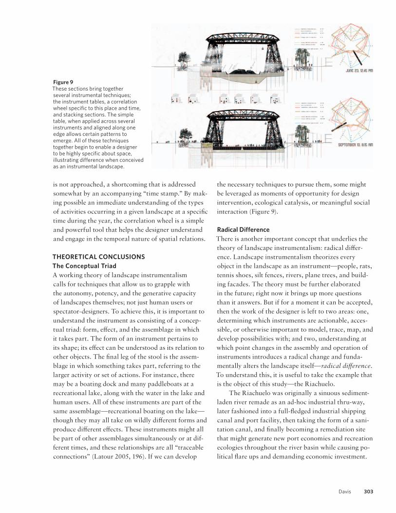
Figure 9These sections bring together several instrumental techniques; the instrument tables, a correlation wheel specific to this place and time, and stacking sections. The simple table, when applied across several instruments and aligned along one edge allows certain patterns to emerge. All of these techniques together begin to enable a designer to be highly specific about space, illustrating difference when conceived as an instrumental landscape.
304 Landscape Journal 32:2
At what point does it stop becoming the Riachuelo
landscape? When did it become the Riachuelo land-
scape? One could argue that it always persists—the
Riachuelo is the Riachuelo landscape, at least since
humans entered the scene. But what if the watercourse
is diverted? What if the low part of the city fl oods? Or
the river dries up completely?
Ultimately, this is a topological question, con-
cerned with the ability of a landscape to maintain
a certain characteristic integrity while undergoing
processes of continual change over time. It calls for a
reckoning with the fact that all of the various original
design ideas might be functionally identical, or rela-
tively irrelevant, but simple changes in maintenance
practices, municipal funding, or erosion control
regimes can summon an entirely new landscape.
SPECULATIVE PROPOSITIONSThere are three implications that a landscape instru-
mentalist approach points to that might become
objects of future research and practice. Two of these
have close, existing corollaries in current architec-
tural practice, while the third seems to be a possibility
unique to landscape architecture.
Landscape Information ModelingIn 2011, Travis Flohr provided a review of Build-
ing Information Modeling technology (BIM) in this
journal (2011). He noted that BIM integrates “building
geometry, spatial relationships, geographic informa-
tion, material properties, and quantities of all building
components” (2011, 69) in a single computer modeling
environment, and that this working method held great
promise for landscape projects in terms of effi ciency in
project delivery. He also noted that these technologies
currently lack landscape components and make work-
fl ow between software platforms diffi cult, and ended
with a call for professional organizations to lobby to be
included in the future development of BIM software.
It is a compelling argument but ignores a set of
important issues related to landscape practice that
spring from the realization that architecture and
landscape are diff erent mediums. While sharing many
concepts, materials, working methodologies, and his-
tories, there is no reason to suggest that our represen-
tational, investigative, and project delivery tools should
be the same, or should have more in common than do
landscape architecture and forestry, or sedimentary
geology. In fact, I believe my work provides evidence
to the contrary. Initial results thus far point away from
trying to fi nd a single computational environment for
landscape representation, especially one built on the
conceit of abstract, limitless space. Instead, it is the
process of working between modes—comparing
them, interrogating the assumptions and limitations
of each—that has been most useful and revelatory in
my work. This suggests that in addition to lobbying for
the inclusion of landscape as a subset in the develop-
ment of BIM technology, we should be learning from,
appropriating, and synthesizing the representational
models of ecologists, civil engineers, and sedimentary
geologists to construct methods of landscape informa-
tion modeling.
Post Occupancy Evaluation The United States General Services Administration
(GSA) uses post- occupancy evaluations to “take a close
look at end- user satisfaction, sustainability, opera-
tional eff ectiveness, and compliance with GSA’s design
standards” (General Services Administration 2013).
While construction administration and punch lists
are well- established methods for evaluating structural
soundness and formal quality, and contractor guaran-
tees commonly ensure the establishment of plantings
for a predetermined time, the opportunity for evaluat-
ing the performance of a landscape project has only
recently been taken up through the Landscape Per-
formance Series (LPS) of the Landscape Architecture
Foundation, and the Sustainable Sites Initiative.
Built on the Mark Francis report from 1999 and
drawing from a rich history of precedent study within
the discipline, the LPS employs a case study method-
ology as a resource and tool infl uencing current and
future landscape practices and projects, albeit with a
focus on capital projects. These case studies attempt
to remedy the lack of systematic analysis while provid-
ing object lessons for theoretical development, practi-
cal application, and teaching (Francis 1999, 10). This
method collects facts (for example, permeable area of
the site was increased from 38 percent to 81 percent
through the use of concrete pavers) and conveys them
in narrative form, with as- built photos and plans serv-
ing as visual aids. In its current form the results seem
text- heavy, and that text reads as a sort of checklist
of factoids and truisms that narrate before/after sce-
narios, and ignores the gap between intent and reality.
Davis 305
Nonetheless, it provides a valuable and robust platform
that beckons further refi nement and exploration.
Some of the tools of landscape instrumentalism
suggest that notational systems might be developed
and representational methods employed to enable the
sort of performance analysis that could illuminate
future design decisions and maintenance practices.
Moreover, these tools might be equally eff ective during
both the design process and a post- occupancy evalua-
tion, as they exhibit the instrumental characteristic of
an ends- means continuum. The array of speculative
instrument tables produced during design could be
quickly and easily charted and compared to a new set
created at the specifi ed post- occupancy date; the specu-
lative correlation wheel that anticipates future popula-
tions and programmatic intensities might be compared
to an actual set of wheels created post- occupancy. Case
studies could become not only generalized analytical
tools, but would allow a landscape to be compared to
itself. These tools would enable an analysis of the real
landscape alongside the intended project, and would
do so in a way that better integrates facts with visual
aids. Moreover, their simplicity suggests that a host
of related and refi ned tools might be developed for
landscape types that focus on issues such as pollutant
migration or bio- diversity.
Maintenance as Design Practice By taking seriously Dewey’s proposition to under-
stand ends and means along a continuum, landscape
instrumentalism points towards a new paradigm of
landscape maintenance and management. Landscape
maintenance includes everything from trimming
hedges with a pair of shears to 800 pound chainsaws
swinging 11 rotary blades from a helicopter with a 90-
foot boom line while trimming powerline easements.
These operations range in scale from the individual to
the regulatory apparatus of public bureaucracy, and
attempt to constantly recreate the landscape as a medi-
ated equilibrium. By foregrounding instruments in all
of their forms and scales, an instrumentalist approach
makes clear that maintenance practices have far more
agency than is typically acknowledged.
Current landscape architectural practice hews
closely to the architectural model that prioritizes capital
projects. In the future, landscape architecture might re-
embrace maintenance to exploit the gap between intent
and reality through a more place- based practice. It is
yet another form our discipline might take as we climb
down from the spectator’s tower and get in to the dirt.
CONCLUSIONIn recent decades, the fi eld of landscape architecture
has been the site of many promising developments and
productive discussions that point toward the develop-
ment of multi- functional landscape practices at pre-
cisely the moment when our society faces major issues
such as climate change. The specifi city required by
these realizations is attempted in this initial landscape
instrumentalism project through the multi- modal mod-
eling method, the instrument table and the correlation
wheel, and the conceptual tools of the triad and radical
diff erence. In the future, I imagine many more and bet-
ter techniques might be developed.
An instrumental theory of landscape suggests that
if a space is a landscape, and not some other type of
space, then all of its objects and their dynamic rela-
tions are instruments, but not dumb drills, retaining
walls, and land use policies. Rather, they are dynamic
objects in relation to one another within a bounded ter-
ritory containing some measure of human intent. John
Dewey’s instrumental theory of knowledge off ers a the-
oretical and technical framework to develop the tools
needed to integrate and synthesize new techniques for
modeling, computation, analysis and construction of
multi- functional landscapes, and to chart a way for-
ward into the frontier between intent and reality.
ACKNOWLEDGEMENTS I owe a large debt of gratitude to my thesis adviser Elizabeth Meyer, whose intellectual generosity was a guiding light in carrying out much of this research at the University of Virginia. I would also like to thank Dr. Julie Rosati of the US Army Corps of Engineers as well as Andrés Carsen of ACUMAR and Silvia Rafaelli of Argentina Capacity Network to help for their help gath-ering information and applying techniques discussed in this work. Lastly, ongoing conversations with landscape designers Michael Geffel (University of Virginia) and Julian Raxworthy (RMIT, Melbourne) have been a tre-mendous help in developing this work.
306 Landscape Journal 32:2
NOTES1. See “Performance practices” by Chris Reed (2005) for a
compelling account of the possibilities inherent in this approach, written at a time when Landscape Urbanism was gaining a great deal of traction in popular discourse and achieving a certain hegemony in academic pedagogy and research.
2. The synoptic view so heavily emphasized in the mapping projects of the last generation is the clearest manifestation of assuming this spectator position, as shown by Peter Con-nelly (2004) in his essay “Embracing openness.”
3. In this way it breaks away from, or at least seeks to radicalize the tradition fully developed in the late 20th century in works such as The Language of Landscape by Ann Spirn (1998) and
“The hermeneutic landscape” by James Corner (2002).
4. As acknowledged by Peruvian landscape theorist Wiley Ludena Urquiza as well as J.B. Jackson, the necessity of some human presence or intent is fundamental to a landscape. An assortment of rocks and materials gath-ered together in a place that has never seen or even been perceived by a human is not a landscape, but rather some other type of space entirely.
5. Technological historians such as Thomas P. Hughes and Merritt Roe Smith have explored this particular (human) gap in agency and intentionality in material practices, and the effort to minimize it through standardization, in fasci-nating detail. Harpers Ferry Armory and the New Technology by Merritt Roe Smith (1980) details the story of the United States Armory at Harpers Ferry, West Virginia prior to the Civil War and the struggle to force the workers to manufac-ture weapons as a series of interchangeable parts and not artisanal pieces.
6. La Autoridad de Cuenca Matanza Riachuelo (ACUMAR) shares a lineage with the Tennessee Valley Authority as one of the few water basin authorities to have capital funds and so the ability to control and direct their own infrastruc-tural projects.
7. Mendoza Beatriz Silva et al vs. State of Argentina et al on damages (damages resulting from environmental pollution of Matanza/Riachuelo river). File M. 1569.
8. Taking the middle ground as a representative example, a neighborhood park might be closed for a year while undergoing reconstruction that costs $2 million. In New York City, these places are typically reconstructed once a generation due to economic and social cycles (baseball becomes less popular, the equipment is worn out, and the city parks department benefits from a financially support-ive administration, for instance). Additionally, closures for seasonal maintenance such as reseeding, tree pruning, or the regrading of the infield adds up to another year of clo-sure over a generation, and cost an additional $20,000 per year. This means that roughly 10 percent of the use value of the park (2 years in 20) is lost; in our case that translates to $400,000 out of the total cost of $2.4 million (capital
cost of $2 million plus $400,000 in maintenance and operations) that is lost to closures and reconstruction. In more extreme cases where major urban infrastructures are adjacent, above, or below the site these periods are often more unpredictable and protracted. If a sewer main is being reconstructed, a road enlarged, or an exit ramp realigned, the loss of use value can be 20 to 40 percent.
9. In his 1893 report on building the Columbian Exposition, Frederick Law Olmsted noted “it is a common thing with town governments, when they find bodies of land which . . . are not favorable to the ends of dealers in building- lots, to regard them as natural reservations for pleasure- grounds . . .” (Olmsted 1893, 152). He later noted that this was not an ideal practice for the creation of the landscape itself, hinting at the fact that it was in part driven by real estate concerns. In recent decades this relationship has been proven in a more explicit and quantitative way (Brill and Di Palermo 2002; Crompton 2005).
10. This includes not only the vast machines operating in contemporary landscapes, but also the technological- historical demons of our industrial and environmental legacy such as the contamination plumes, garbage collec-tions, and other residues.
11. The Citizen Pruners program in New York City is an inter-esting exception. Volunteers are required to undergo basic safety and horticultural training and are then given the right to prune the trees and other vegetation on any public lands in the city. The requirement of training seems to keep away most who would abuse this ability.
12. The work of Anuradha Mathur and Bradley Cantrell are two different and influential strains within this recent rediscovery.
13. David Fletcher claims this in the foreword of Modeling the Environment by Cantrell and Yates (2012).
14. Perhaps the most ambitious example of this type of model-ing is the US Army Corps of Engineer’s water basin model of the Mississippi River outside of Clinton, Mississippi. For an examination of the impact of this model on landscape architecture see Krystie Dykema Cheramie’s article “The scale of nature: Modeling the Mississippi River” (2011).
15. While undertaking this research I had the good fortune to hear Bradley Cantrell speak at the University of Virginia in March 2012 about his work with representation, computa-tional modeling, physical models, and potential for working between modalities.
REFERENCESUnless otherwise stated, all figures are courtesy the author.
Bennett, Jane. Vibrant Matter: A Political Ecology of Things. Duke University Press, 2010.
Blacksmith Institute. 2007. The World’s Worst Polluted Places. New York: Blacksmith Institute.

Davis 307
Bowker, Geoffrey and Vann, Katie. 2001. Instrumentalizing the truth of practice. Social Epistemology 15(3): 247–262.
Burke, Edmund. 1997. In The Writings and Speeches of Edmund Burke: Volume 1: The Early Writings, ed. T.O. McLoughlin, James Boulton, and William Tod, 230. Oxford, UK: Oxford University Press.
Brill, Glenn, and Di Palermo, Christian. 2002. How Smart Parks Investment Pays its Way: Executive Summary of Analysis of Secondary Economic Impacts Resulting From Park Expenditures. New York: New Yorkers For Parks and Ernst and Young. http://www.ny4p.org/research/other- reports/or- smartinvestment.pdf [June 24, 2013].
Cantrell, Bradley, and Natalie Yates. 2012. Modeling the Environment. Hoboken, NJ: John Wiley and Sons.
Cheramie, Kristi Dykema. 2011. The scale of nature: Modeling the Mississippi River. Places. http://places.designobserver.com/feature/the- scale- of- nature- modeling- the- mississippi- river/25658/ [June 24, 2013].
Connelly, Peter. 2004. Embracing openness. In The Mesh Book: Landscape/Infrastructure, ed. Julian Raxworthy and Jessica Blood, 200–219. Melbourne: RMIT Press.
Crompton, John L. 2005. The impact of parks on property values: Empirical evidence from the past two decades in the United States. Managing Leisure 10, 203–218.
Corner, James. 1999. Agency of mapping. In Mapping, ed. Denis Cosgrove, 213–252. London: Reaktion Books.
––––––– . 2002. The hermeneutic landscape. In Theory in Landscape Architecture: A Reader, ed. Simon Swaffield, 130–131. Philadelphia: University of Pennsylvania Press. Originally published as “A discourse on theory II: Three tyrannies of contemporary theory and the alternative hermeneutics,” Landscape Journal 10(2): 115–133
____ . 2006. Terra Fluxus. In Landscape Urbanism Reader, ed. Charles Waldheim, 21–33. New York: Princeton Architectural Press.
Dewey, John. 1920. Reconstruction in Philosophy. New York: Henry Holt and Company.
––––––– . 1927. The Public and Its Problems. New York: Henry Holt.
––––––– . 1929. The Quest for Certainty: A Study of the Relation of Knowledge and Action. New York: Minton, Balch and Company.
____ . 2008. Propositions, warranted assertibility, and truth. In The Later Works of John Dewey, Volume 14, 1925–1953; 1939–1941, Essays, Reviews and Miscellany, ed. Jo Ann Boydston. Carbondale: Southern Illinois University Press.
Dewey, Robert. 1977. The Philosophy of John Dewey: A Critical Exposition of His Method, Metaphysics and Theory of Knowledge. Amsterdam, NL: Martinus Nijhoff Publishers.
Eldridge, Michael. 1998. Transforming Experience: John Dewey’s Cultural Instrumentalism. Nashville, TN: Vanderbilt University Press.
Francis, Mark. 1999. A Case Study Method for Landscape Architecture. Washington DC: Landscape Architecture Foundation. http://
www.lafoundation.org/myos/my- uploads/2010/08/19/casestudymethod.pdf [June 24, 2013].
Flohr, Travis. A landscape architect’s review of building information technology. Landscape Journal 30(1): 169–170.
General Services Administration. 2013. Post Occupancy Evaluation. Washington DC: General Services Administration. http://www.gsa.gov/portal/content/103959 [June 24, 2013].
Halprin, Lawrence. 1984. Motation. In Process: Architecture 4, 51–62.
Harman, Graham. 2011. Guerrilla Metaphysics: Phenomenology and the Carpentry of Things. Chicago, IL: Open Court Publishing.
Harman, Graham. 2002. Tool- Being: Heidegger and the Metaphysics of Objects. Chicago, IL: Open Court Publishing.
Harnick, Peter, and Welle, Ben. 2009. Measuring the Economic Value of a City Park System. San Francisco, CA: The Trust for Public Land. http://cloud.tpl.org/pubs/ccpe- econvalueparks- rpt.pdf [June 24, 2013].
Harvey, David. 2008. The right to the city. New Left Review 53 (September–October): 23–40.
Hayden, Dolores. 1997. Urban landscape history: The sense of place and the politics of space. In Understanding Ordinary Landscapes, ed. Paul Groth and Todd W. Bressi, 111–133. New Haven, CT: Yale University Press.
Hughes, Thomas P. 1998. Rescuing Prometheus: Four Monumental Projects that Changed Our World. New York: Pantheon Books.
Huergo, Luis A. 1904. El Puerto de Buenos Aires. Buenos Aires: Revista Tecnica.
Latour, Bruno. 2005. Reassembling the Social. Oxford, UK: Oxford University Press.
Lefebvre, Henri. 1991. The Production of Space, trans. Donald Nicholson Smith. Oxford, UK: Wiley- Blackwell Press.
Marx, Karl. 1915. Capital: a Critique of Political Economy. Chicago, IL: C. H. Kerr and Company.
Meyer, Elizabeth. 1992. Situating modern landscape architecture. Paper presented at annual meeting of the Council of Educators in Landscape Architecture: Design + Values. Charlottesville, VA. October 17–20.
––––––– . 1994. Landscape architecture as modernity’s other and postmodern ground. In The Culture of Landscape Architecture, eds. Harriet Edquist and Vanessa Bird, 13–34. Melbourne, Australia: Edge Publishers.
Moore, Edward C. 1961. American Pragmatism: Peirce, Dewey, and James. New York: Columbia University Press.
Nightingale, Florence. 1858. Notes on Matters Affecting the Health, Efficiency, and Hospital Administration of the British Army Founded Chiefly on the Experience of the Late War. Presented by request to the Secretary of State for War. London: Harrison and Sons.
Nye, David. 1996. American Technological Sublime. Cambridge, MA: MIT Press.
––––––– . 2008. Technology Matters: Questions to Live With. Cambridge, MA: MIT Press.

308 Landscape Journal 32:2
Olmsted, Frederick Law. 1893. A report upon the landscape architecture of the Columbian Exposition to the American Institute of Architects. The American Architect and Building News, September 9, 1893.
Purcell, Mark. 2002. Excavating Lefebvre: The right to the city and its urban politics of the inhabitant. GeoJournal 58(2): 99–108.
Reed, Chris. 2005. Performance practices. 306090: A Journal of Emergent Architecture and Design 9: 82–91.
Smith, Merritt Roe. 1980. Harpers Ferry and the New Technology: the Challenge of Change. Ithaca, NY: Cornell University Press.
Sola, Juan Vicente. 2008. La Corte Suprema y el Riachuelo. La Nacion, July 21. http://www.lanacion.com.ar/1032031- la
- corte- suprema- y- el- riachuelo/ [June 24, 2013].
Spirn, Ann. 1998. The Language of Landscape. New Haven: Yale University Press.
Waldheim, Charles. 2006. Landscape as urbanism. In The Landscape Urbanism Reader, ed Charles Waldheim, 35–53. New York: Princeton Architectural Press.
Weller, Richard. 2006. An art of instrumentality: Thinking through landscape urbanism. In The Landscape Urbanism Reader, ed. Charles Waldheim, 69–86. New York: Princeton Architectural Press.
Weller, Richard. 2008. Landscape (sub)urbanism in theory and practice. Landscape Journal 27(2): 247–267.
Zeiger, Mimi. 2011. The interventionists tool kit [parts 1–4]. Places. http://places.designobserver.com/feature/the
- interventionists- toolkit/24308/ [June 24, 2013].
AUTHOR Brian Davis is a visiting instructor in the Cornell University Landscape Architecture Department. He has lived and worked as a practicing landscape designer and writer in Buenos Aires and New York City. His current research considers the relationship between instruments and landscapes. He also studies historical and contemporary landscapes in Latin America.
Related Documents