LANDFIRE National Data Product Descriptions 13 Anderson Fire Behavior Fuel Models These standard 13 fire behavior fuel models serve as input to Rother- mel’s mathematical surface fire behavior and spread model (Rothermel 1972). Fire behavior fuel models represent distinct distribu- tions of fuel loading found among surface fuel components (live and dead), size classes, and fuel types. The fuel models are described by the most common fire-carrying fuel type (grass, brush, timber litter, or slash), loading and surface area-to-volume ratio by size class and component, fuelbed depth, and moisture of extinction. These fire be- havior fuel models can serve as input to the FARSITE fire growth simulation model (Finney 1998) and FlamMap fire potential simulator (Stratton 2004). Further detail on these original fire behavior fuel mod- els can be found in Anderson (1982) and Rothermel (1983). 40 Scott and Burgan Fire Behavior Fuel Models This recently developed set of standard fire behavior fuel models con- tains more fuel models in every fuel type (grass, shrub, timber, and slash) than does Anderson's set of 13 fuel models. The main objective in creating these new models was to increase the ability to illustrate the effects of fuel treatments using fire behavior modeling. These fire behavior fuel models can serve as input to the FARSITE fire growth simulation model (Finney 1998), FlamMap fire potential simulator (Stratton 2004), BehavePlus fire behavior model (Andrews and others 2005), NEXUS crown fire potential model (Scott 2003), and FFE-FVS forest stand simulator (Reinhardt and Crookston 2003). Nomographs for estimating fire behavior using the new fuel models without the use of a computer are now available (through Rocky Mountain Research Station Publications). Further detail about these 40 fire behavior fuel models can be found in Scott and Burgan (2005). LANDFIRE National Data Product Descriptions Canadian Forest Fire Danger Rating System The Canadian Forest Fire Danger Rating System (CFFDR) was created for Alaska only. The CFFDRS was cross-referenced to create the Alaska LANDFIRE product. These fuel types have been defined "as an identifiable association of fuel elements of distinctive species, form, size, arrangement, and continuity that will exhibit characteristic fire be- havior under defined burning conditions" (Pyne, Andrews, and Laven, 1996; Stocks and others 1989). The CFFDRS arranges fuel types into five major groups with 16 discrete fuel types that are qualitatively distin- guished by variations in their forest floor and organic layer, their surface and ladder fuels, and their stand structure and composition. The CFFDRS assignments for Alaska were made by fire behavior and fuels experts based on Existing Vegetation Type (EVT) descriptions and rep- resentative photos. LANDFIRE Map Zone 71 Canadian Forest Fire Danger Rating System

Welcome message from author
This document is posted to help you gain knowledge. Please leave a comment to let me know what you think about it! Share it to your friends and learn new things together.
Transcript

LANDFIRE National Data Product Descriptions
13 Anderson Fire Behavior Fuel Models These standard 13 fire behavior fuel models serve as input to Rother-mel’s mathematical surface fire behavior and spread model (Rothermel 1972). Fire behavior fuel models represent distinct distribu-tions of fuel loading found among surface fuel components (live and dead), size classes, and fuel types. The fuel models are described by the most common fire-carrying fuel type (grass, brush, timber litter, or slash), loading and surface area-to-volume ratio by size class and component, fuelbed depth, and moisture of extinction. These fire be-havior fuel models can serve as input to the FARSITE fire growth simulation model (Finney 1998) and FlamMap fire potential simulator (Stratton 2004). Further detail on these original fire behavior fuel mod-els can be found in Anderson (1982) and Rothermel (1983).
40 Scott and Burgan Fire Behavior Fuel Models This recently developed set of standard fire behavior fuel models con-tains more fuel models in every fuel type (grass, shrub, timber, and slash) than does Anderson's set of 13 fuel models. The main objective in creating these new models was to increase the ability to illustrate the effects of fuel treatments using fire behavior modeling. These fire behavior fuel models can serve as input to the FARSITE fire growth simulation model (Finney 1998), FlamMap fire potential simulator (Stratton 2004), BehavePlus fire behavior model (Andrews and others 2005), NEXUS crown fire potential model (Scott 2003), and FFE-FVS forest stand simulator (Reinhardt and Crookston 2003). Nomographs for estimating fire behavior using the new fuel models without the use of a computer are now available (through Rocky Mountain Research Station Publications). Further detail about these 40 fire behavior fuel models can be found in Scott and Burgan (2005).
LANDFIRE National Data Product Descriptions
Canadian Forest Fire Danger Rating System
The Canadian Forest Fire Danger Rating System (CFFDR) was created for Alaska only. The CFFDRS was cross-referenced to create the Alaska LANDFIRE product. These fuel types have been defined "as an identifiable association of fuel elements of distinctive species, form, size, arrangement, and continuity that will exhibit characteristic fire be-havior under defined burning conditions" (Pyne, Andrews, and Laven, 1996; Stocks and others 1989). The CFFDRS arranges fuel types into five major groups with 16 discrete fuel types that are qualitatively distin-guished by variations in their forest floor and organic layer, their surface and ladder fuels, and their stand structure and composition. The CFFDRS assignments for Alaska were made by fire behavior and fuels experts based on Existing Vegetation Type (EVT) descriptions and rep-resentative photos.
LANDFIRE Map Zone 71 Canadian Forest Fire Danger Rating System
LANDFIRE National Data Product Descriptions
2
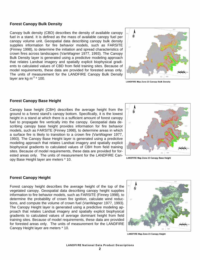
Forest Canopy Base Height Canopy base height (CBH) describes the average height from the ground to a forest stand’s canopy bottom. Specifically, it is the lowest height in a stand at which there is a sufficient amount of forest canopy fuel to propagate fire vertically into the canopy. Geospatial data de-scribing canopy base height provides information for fire behavior models, such as FARSITE (Finney 1998), to determine areas in which a surface fire is likely to transition to a crown fire (VanWagner 1977, 1993). The Canopy Base Height layer is generated using a predictive modeling approach that relates Landsat imagery and spatially explicit biophysical gradients to calculated values of CBH from field training sites. Because of model requirements, these data are provided for for-ested areas only. The units of measurement for the LANDFIRE Can-opy Base Height layer are meters * 10.
Forest Canopy Height Forest canopy height describes the average height of the top of the vegetated canopy. Geospatial data describing canopy height supplies information to fire behavior models, such as FARSITE (Finney 1998), to determine the probability of crown fire ignition, calculate wind reduc-tions, and compute the volume of crown fuel (VanWagner 1977, 1993). The Canopy Height layer is generated using a predictive modeling ap-proach that relates Landsat imagery and spatially explicit biophysical gradients to calculated values of average dominant height from field training sites. Because of model requirements, these data are provided for forested areas only. The units of measurement for the LANDFIRE Canopy Height layer are meters * 10.
Forest Canopy Bulk Density Canopy bulk density (CBD) describes the density of available canopy fuel in a stand. It is defined as the mass of available canopy fuel per canopy volume unit. Geospatial data describing canopy bulk density supplies information for fire behavior models, such as FARSITE (Finney 1998), to determine the initiation and spread characteristics of crown fires across landscapes (VanWagner 1977, 1993). The Canopy Bulk Density layer is generated using a predictive modeling approach that relates Landsat imagery and spatially explicit biophysical gradi-ents to calculated values of CBD from field training sites. Because of model requirements, these data are provided for forested areas only. The units of measurement for the LANDFIRE Canopy Bulk Density layer are kg m-3 * 100.
LANDFIRE National Data Product Descriptions
3
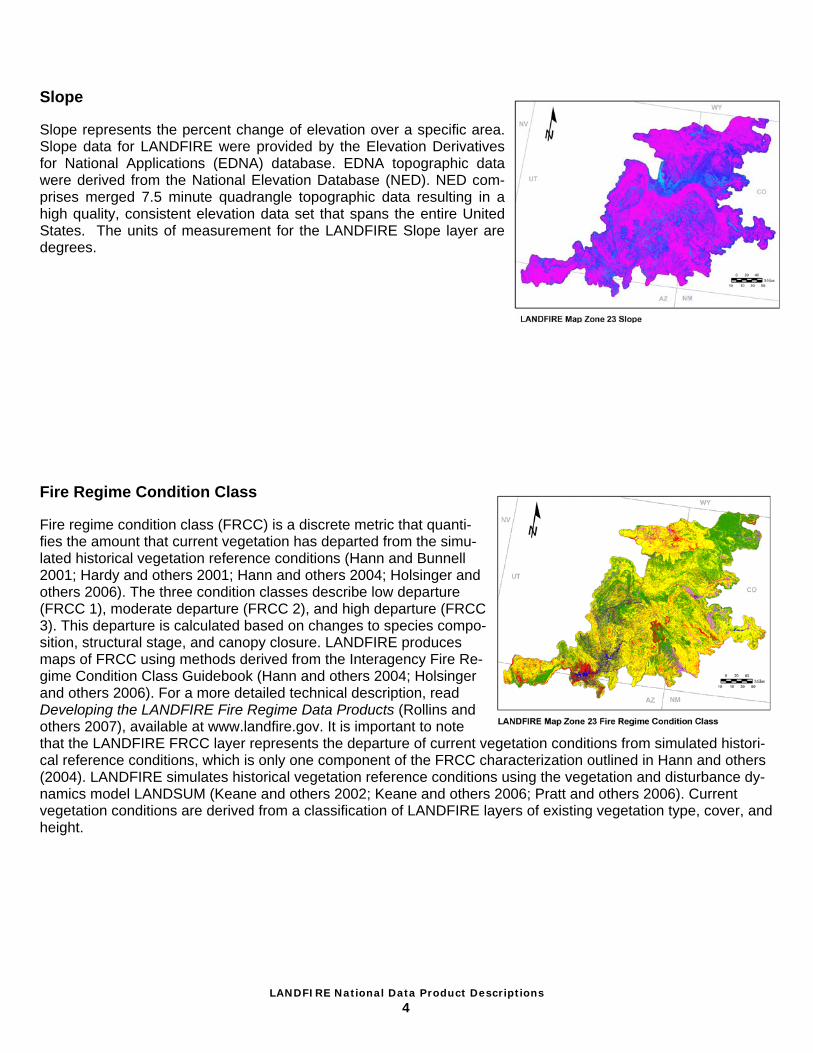
Elevation Elevation represents land height, in meters, above mean sea level. Elevation data for LANDFIRE were provided by the Elevation Deriva-tives for National Applications (EDNA) database. EDNA topographic data were derived from the National Elevation Dataset (NED). NED comprises merged 7.5 minute quadrangle topographic data resulting in a high quality, consistent elevation data set that spans the entire United States. The units of measurement for the LANDFIRE Elevation layer are meters above mean sea level.
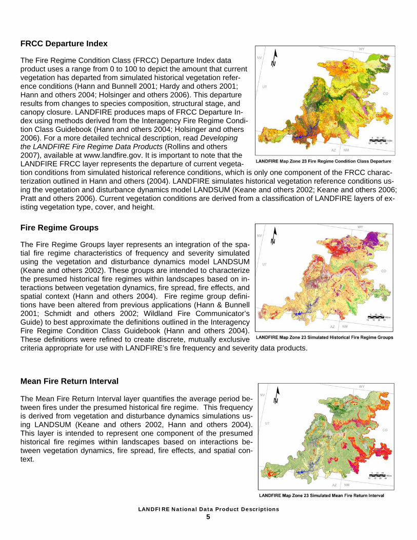
Aspect Aspect represents the azimuth of the sloped surfaces across a land-scape. Aspect data for LANDFIRE were provided by the Elevation De-rivatives for National Applications (EDNA) database. EDNA topographic data were derived from the National Elevation Database (NED). NED comprises merged 7.5 minute quadrangle topographic data resulting in a high quality, consistent elevation data set that spans the entire United States. The units of measurement for the LANDFIRE Aspect layer are degrees.
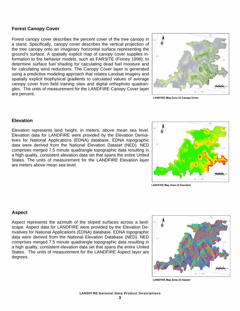
Forest Canopy Cover Forest canopy cover describes the percent cover of the tree canopy in a stand. Specifically, canopy cover describes the vertical projection of the tree canopy onto an imaginary horizontal surface representing the ground’s surface. A spatially explicit map of canopy cover supplies in-formation to fire behavior models, such as FARSITE (Finney 1998), to determine surface fuel shading for calculating dead fuel moisture and for calculating wind reductions. The Canopy Cover layer is generated using a predictive modeling approach that relates Landsat imagery and spatially explicit biophysical gradients to calculated values of average canopy cover from field training sites and digital orthophoto quadran-gles. The units of measurement for the LANDFIRE Canopy Cover layer are percent.
LANDFIRE National Data Product Descriptions
4
Fire Regime Condition Class Fire regime condition class (FRCC) is a discrete metric that quanti-fies the amount that current vegetation has departed from the simu-lated historical vegetation reference conditions (Hann and Bunnell 2001; Hardy and others 2001; Hann and others 2004; Holsinger and others 2006). The three condition classes describe low departure (FRCC 1), moderate departure (FRCC 2), and high departure (FRCC 3). This departure is calculated based on changes to species compo-sition, structural stage, and canopy closure. LANDFIRE produces maps of FRCC using methods derived from the Interagency Fire Re-gime Condition Class Guidebook (Hann and others 2004; Holsinger and others 2006). For a more detailed technical description, read Developing the LANDFIRE Fire Regime Data Products (Rollins and others 2007), available at www.landfire.gov. It is important to note that the LANDFIRE FRCC layer represents the departure of current vegetation conditions from simulated histori-cal reference conditions, which is only one component of the FRCC characterization outlined in Hann and others (2004). LANDFIRE simulates historical vegetation reference conditions using the vegetation and disturbance dy-namics model LANDSUM (Keane and others 2002; Keane and others 2006; Pratt and others 2006). Current vegetation conditions are derived from a classification of LANDFIRE layers of existing vegetation type, cover, and height.
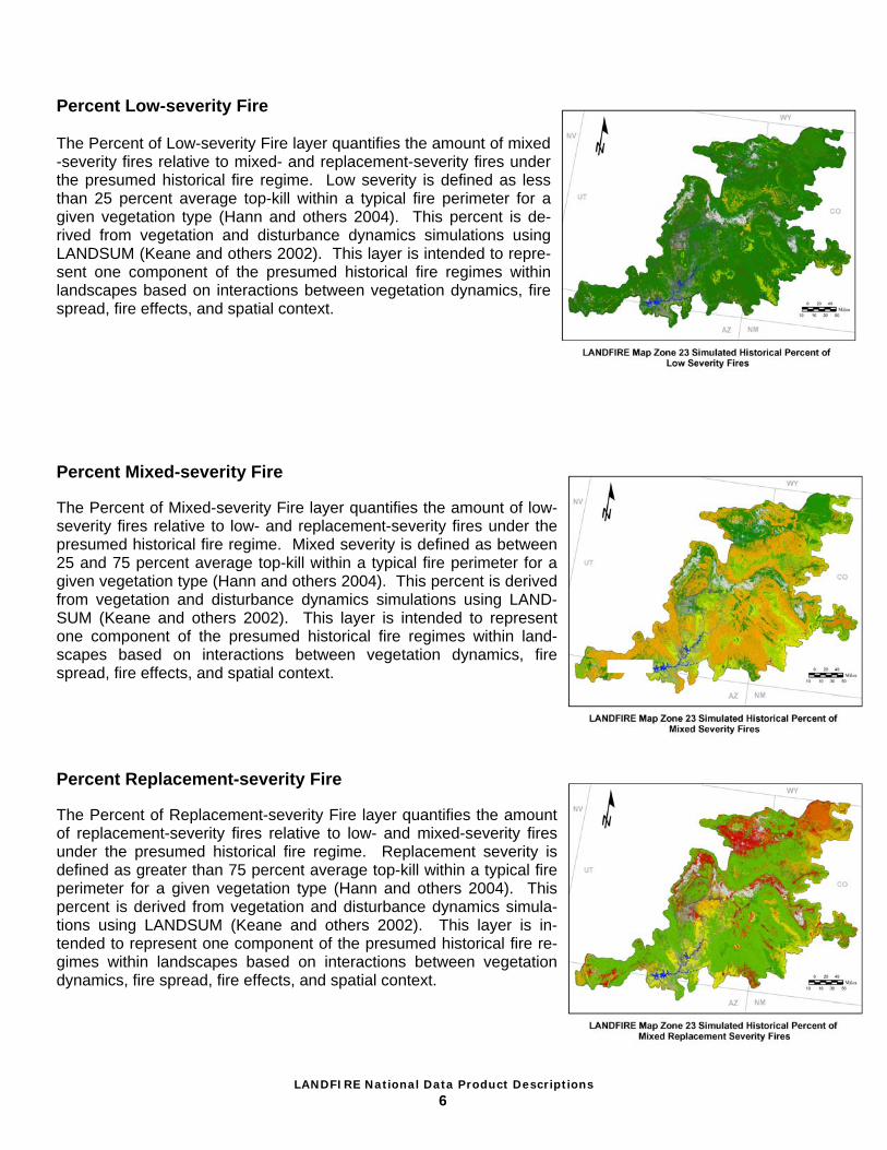
Slope Slope represents the percent change of elevation over a specific area. Slope data for LANDFIRE were provided by the Elevation Derivatives for National Applications (EDNA) database. EDNA topographic data were derived from the National Elevation Database (NED). NED com-prises merged 7.5 minute quadrangle topographic data resulting in a high quality, consistent elevation data set that spans the entire United States. The units of measurement for the LANDFIRE Slope layer are degrees.
LANDFIRE National Data Product Descriptions
5
Mean Fire Return Interval The Mean Fire Return Interval layer quantifies the average period be-tween fires under the presumed historical fire regime. This frequency is derived from vegetation and disturbance dynamics simulations us-ing LANDSUM (Keane and others 2002, Hann and others 2004). This layer is intended to represent one component of the presumed historical fire regimes within landscapes based on interactions be-tween vegetation dynamics, fire spread, fire effects, and spatial con-text.
Fire Regime Groups The Fire Regime Groups layer represents an integration of the spa-tial fire regime characteristics of frequency and severity simulated using the vegetation and disturbance dynamics model LANDSUM (Keane and others 2002). These groups are intended to characterize the presumed historical fire regimes within landscapes based on in-teractions between vegetation dynamics, fire spread, fire effects, and spatial context (Hann and others 2004). Fire regime group defini-tions have been altered from previous applications (Hann & Bunnell 2001; Schmidt and others 2002; Wildland Fire Communicator’s Guide) to best approximate the definitions outlined in the Interagency Fire Regime Condition Class Guidebook (Hann and others 2004). These definitions were refined to create discrete, mutually exclusive criteria appropriate for use with LANDFIRE’s fire frequency and severity data products.
FRCC Departure Index The Fire Regime Condition Class (FRCC) Departure Index data product uses a range from 0 to 100 to depict the amount that current vegetation has departed from simulated historical vegetation refer-ence conditions (Hann and Bunnell 2001; Hardy and others 2001; Hann and others 2004; Holsinger and others 2006). This departure results from changes to species composition, structural stage, and canopy closure. LANDFIRE produces maps of FRCC Departure In-dex using methods derived from the Interagency Fire Regime Condi-tion Class Guidebook (Hann and others 2004; Holsinger and others 2006). For a more detailed technical description, read Developing the LANDFIRE Fire Regime Data Products (Rollins and others 2007), available at www.landfire.gov. It is important to note that the LANDFIRE FRCC layer represents the departure of current vegeta-tion conditions from simulated historical reference conditions, which is only one component of the FRCC charac-terization outlined in Hann and others (2004). LANDFIRE simulates historical vegetation reference conditions us-ing the vegetation and disturbance dynamics model LANDSUM (Keane and others 2002; Keane and others 2006; Pratt and others 2006). Current vegetation conditions are derived from a classification of LANDFIRE layers of ex-isting vegetation type, cover, and height.
LANDFIRE National Data Product Descriptions
6
Percent Mixed-severity Fire The Percent of Mixed-severity Fire layer quantifies the amount of low-severity fires relative to low- and replacement-severity fires under the presumed historical fire regime. Mixed severity is defined as between 25 and 75 percent average top-kill within a typical fire perimeter for a given vegetation type (Hann and others 2004). This percent is derived from vegetation and disturbance dynamics simulations using LAND-SUM (Keane and others 2002). This layer is intended to represent one component of the presumed historical fire regimes within land-scapes based on interactions between vegetation dynamics, fire spread, fire effects, and spatial context.
Percent Replacement-severity Fire The Percent of Replacement-severity Fire layer quantifies the amount of replacement-severity fires relative to low- and mixed-severity fires under the presumed historical fire regime. Replacement severity is defined as greater than 75 percent average top-kill within a typical fire perimeter for a given vegetation type (Hann and others 2004). This percent is derived from vegetation and disturbance dynamics simula-tions using LANDSUM (Keane and others 2002). This layer is in-tended to represent one component of the presumed historical fire re-gimes within landscapes based on interactions between vegetation dynamics, fire spread, fire effects, and spatial context.
Percent Low-severity Fire The Percent of Low-severity Fire layer quantifies the amount of mixed-severity fires relative to mixed- and replacement-severity fires under the presumed historical fire regime. Low severity is defined as less than 25 percent average top-kill within a typical fire perimeter for a given vegetation type (Hann and others 2004). This percent is de-rived from vegetation and disturbance dynamics simulations using LANDSUM (Keane and others 2002). This layer is intended to repre-sent one component of the presumed historical fire regimes within landscapes based on interactions between vegetation dynamics, fire spread, fire effects, and spatial context.

LANDFIRE National Data Product Descriptions
7
Environmental Site Potential The LANDFIRE Environmental Site Potential (ESP) layer represents the vegetation that could be supported at a given site based on the bio-physical environment. This layer is used in LANDFIRE to inform the ex-isting vegetation and fuel mapping processes. Map units are based on NatureServe’s Ecological Systems classification, which is a nationally consistent set of mid-scale ecological units (Comer and others 2003). LANDFIRE’s use of these classification units to describe environmental site potential differs from their intended use as units of existing vegeta-tion. As used in LANDFIRE, map unit names represent the natural plant communities that would become established at late or climax stages of successional development in the absence of disturbance. They reflect the current climate and physical environment, as well as the competitive potential of native plant species. The LANDFIRE ESP concept is similar to that used in classifications of potential vegetation, including habitat types (Daubenmire 1968; Pfister and others 1977) and plant associations (Henderson and others 1989). The ESP layer was generated using a predictive modeling approach that relates spatially explicit layers representing biophysical gradients and topography to field training sites assigned to ESP map units. It is important to note that ESP is an abstract concept and represents neither current nor historical vegetation.
Succession Classes Succession classes (termed vegetation-fuel classes in the Interagency Fire Regime Condition Class Guidebook version 1.0, Hann and others 2004) characterize current vegetation conditions with respect to the vegetation species composition, vegetation cover, and vegetation height ranges of successional states that occur within each biophysical setting. The historical reference conditions of these successional states are simulated using the vegetation and disturbance dynamics model LANDSUM (Keane and others 2002). The existing succession classes can also represent uncharacteristic vegetation components, such as exotic species, that are not found within the compositional or structural variability of successional states defined for a biophysical setting. The area contained in succession classes is compared to the simulated historical reference conditions to calculate measurements of vegetation departure, such as fire regime condition class. It is important to note that succession classes do not directly quantify fuel characteristics of the current vegetation, but rather represent vegetative states with unique succession or disturbance-related dynamics, such as structural development or fire frequency.

LANDFIRE National Data Product Descriptions
8
Existing Vegetation Height Vegetation height represents the average height of the dominant vege-tation for a 30-m grid cell. The Canopy Height layer was generated us-ing a predictive modeling approach that related Landsat imagery and spatially explicit biophysical gradients to calculated values of average dominant height from field training sites.
Existing Vegetation Type The Existing Vegetation Type (EVT) layer represents the vegetation currently present at a given site. LANDFIRE vegetation map units are derived from NatureServe’s Ecological Systems classification, which is a nationally consistent set of mid-scale ecological units (Comer and others 2003). Existing vegetation is mapped through a predictive mod-eling approach using a combination of field reference information, Landsat imagery, and spatially explicit biophysical gradient data. Field data keyed to dominant vegetation type at the plot level were used as "training data" to drive the modeling process. Attribute information is provided that links the LANDFIRE EVT map units to existing classifica-tions such as the National Vegetation Classification System and those of the Society of American Foresters and Society of Range Management.
Biophysical Settings The Biophysical Settings (BpS) layer represents the vegetation that may have been dominant on the landscape prior to Euro-American set-tlement and is based on both the current biophysical environment and an approximation of the historical disturbance regime. It is a refinement of the Environmental Site Potential layer; in this refinement, we attempt to incorporate current scientific knowledge regarding the functioning of ecological processes – such as fire – in the centuries preceding non-indigenous human influence. Map units are based on NatureServe’s Ecological Systems classification, which is a nationally consistent set of mid-scale ecological units (Comer and others 2003). LANDFIRE’s use of these classification units to describe biophysical settings differs from their intended use as units of existing vegetation. As used in LAND-FIRE, map unit names represent the natural plant communities that may have been present during the reference period. Each BpS map unit is matched with a model of vegetation succession, and both serve as key inputs to the LANDSUM landscape succession model (Keane and others 2002). The LANDFIRE BpS concept is similar to the concept of potential natural vegetation groups used in mapping and modeling efforts related to fire regime condi-tion class (Schmidt and others 2002; www.frcc.gov).
LANDFIRE National Data Product Descriptions
9
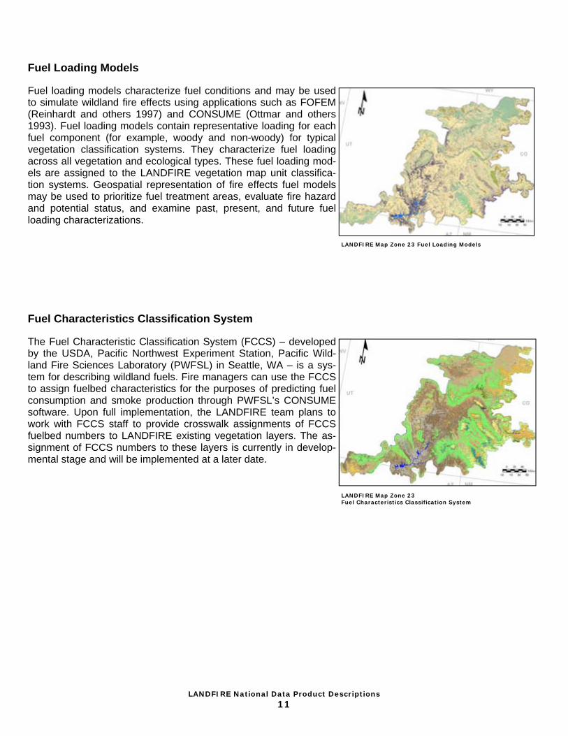
Vegetation Dynamics Models Vegetation dynamics models describe the vegetation dynamics and disturbance regimes of each biophysical setting (BpS). Models consist of two parts: (1) a comprehensive model description and (2) a quantitative state-and-transition model developed using the software Vegetation Dynamics Development Tool (VDDT; ESSA Technologies Ltd. 2005). Descriptions explain the indicator species, geographic distribution, biophysical char-acteristics, succession stages, and disturbance regimes of each BpS. Descriptions also document the assump-tions behind, the outstanding questions about, the contributors to, the resources used for, and the evolution of each model. To quantify the rates and pathways of succession and the frequencies and effects of distur-bances, a state-and-transition model (Westoby and others 1989) is created for each BpS in VDDT. LANDFIRE vegetation models are created through a series of expert workshops attended by a variety of local and regional vegetation and fire ecologists, and the models then undergo a rigorous review process.
Model description State and transition model
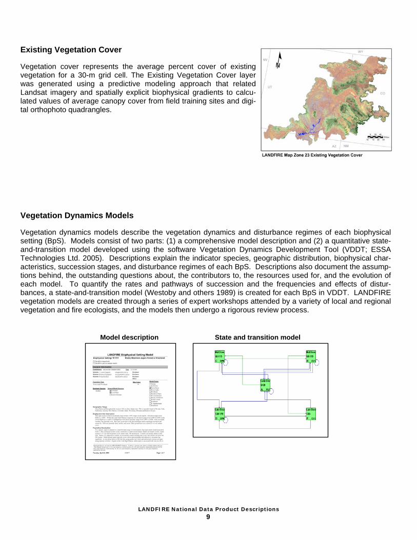
Existing Vegetation Cover Vegetation cover represents the average percent cover of existing vegetation for a 30-m grid cell. The Existing Vegetation Cover layer was generated using a predictive modeling approach that related Landsat imagery and spatially explicit biophysical gradients to calcu-lated values of average canopy cover from field training sites and digi-tal orthophoto quadrangles.

LANDFIRE National Data Product Descriptions
10
LANDFIRE Reference Database Click RE Reference Database LANDFIRE National mapping was supported by a vast database of field-referenced data. The LANDFIRE Refer-ence Database (LFRDB) used for LANDFIRE National product development included vegetation and fuel data from approximately 800,000 geo-referenced sampling units located throughout the United States. These data were amassed from numerous sources and in large part from existing information resources of out-side entities, such as the USFS Forest In-ventory and Analysis (FIA) Program, the USGS National Gap Analysis Program, and state natural heritage programs. Vegetation data drawn from these sources and used by LANDFIRE included natural community oc-currence records, estimates of canopy cover and height per plant taxon, and measurements (such as diameter, height, crown ratio, crown class, and density) of individual trees. Fuel data used included biomass estimates of downed woody mate-rial, percentage cover and height of shrub and herb layers, and canopy base height estimates. Digital photos of the sampled units were also archived, when available. Toney and others (2007) explain in detail how these types of field data, specifically those collected by FIA, have been acquired, incorporated into the LFRDB, and used in LANDFIRE. To meet needs of LANDFIRE, several key attributes were systematically derived from the acquired data and in-cluded in the LFRDB. These attributes include existing and potential vegetation type in the form of NatureServe's Ecological Systems (Comer and others 2003; Toney and others 2007), uncompacted crown ratios (Toney and Reeves 2009), and several canopy fuel metrics (such as bulk density) derived from the FuelCalc program (Reinhardt and others 2006). At various stages in data compilation, including after the attribution of Ecological Systems, records were carefully screened for information or spatial errors. Questionable data were either identi-fied accordingly or removed from the LFRDB, depending on confidence in the assessment. Accepted data points were processed for associations with a number of ancillary datasets via a series of spatial overlays. These data-sets included a Landsat image suite, the National Land Cover Database (Homer and others 2004), the digital ele-vation model and derivatives (USGS 2005), soil depth and texture layers (for example, USDA NRCS 2005), and a set of 42 simulated biophysical gradient layers (such as evapotranspiration, soil temperature, and degree days). These biophysical gradient layers were generated using WX-BGC, an ecosystem simulator derived from BIOME-BGC (Running and Hunt 1993) and GMRS-BGC (Keane and others 2002). The extracted values from each of these overlays were archived in the LFRDB as predictor variables for the mapping process. Public Access A subset of the full suite of field-sampled data used in the production of LANDFIRE National deliverables has been made available for public access, as stipulated in the LANDFIRE Executive Charter. In accordance with agreements between LANDFIRE and its data contributors, certain proprietary or otherwise sensitive data have been removed to create this publically available version of the LFRDB. The public version of the LANDFIRE Ref-erence Database can be downloaded by geographic area at www.landfire.gov. Please consult the table lutVisits-SourceID in the database for more information about the datasets included in, and excluded from, this release.
LANDFIRE National Data Product Descriptions
11
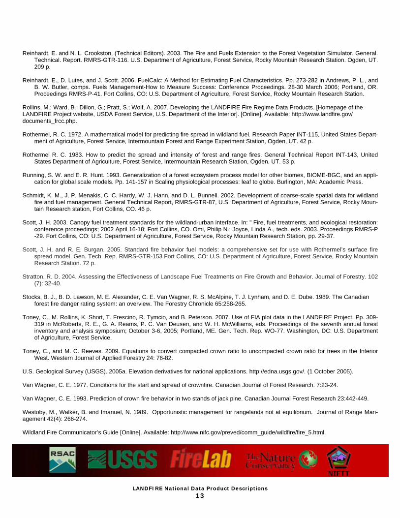
Fuel Characteristics Classification System The Fuel Characteristic Classification System (FCCS) – developed by the USDA, Pacific Northwest Experiment Station, Pacific Wild-land Fire Sciences Laboratory (PWFSL) in Seattle, WA – is a sys-tem for describing wildland fuels. Fire managers can use the FCCS to assign fuelbed characteristics for the purposes of predicting fuel consumption and smoke production through PWFSL’s CONSUME software. Upon full implementation, the LANDFIRE team plans to work with FCCS staff to provide crosswalk assignments of FCCS fuelbed numbers to LANDFIRE existing vegetation layers. The as-signment of FCCS numbers to these layers is currently in develop-mental stage and will be implemented at a later date.
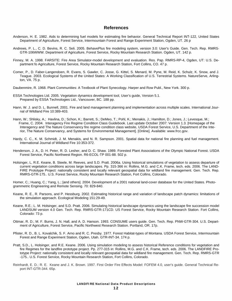
Fuel Loading Models Fuel loading models characterize fuel conditions and may be used to simulate wildland fire effects using applications such as FOFEM (Reinhardt and others 1997) and CONSUME (Ottmar and others 1993). Fuel loading models contain representative loading for each fuel component (for example, woody and non-woody) for typical vegetation classification systems. They characterize fuel loading across all vegetation and ecological types. These fuel loading mod-els are assigned to the LANDFIRE vegetation map unit classifica-tion systems. Geospatial representation of fire effects fuel models may be used to prioritize fuel treatment areas, evaluate fire hazard and potential status, and examine past, present, and future fuel loading characterizations.
LANDFIRE Map Zone 23 Fuel Loading Models
LANDFIRE Map Zone 23 Fuel Characteristics Classification System
LANDFIRE National Data Product Descriptions
12
References Anderson, H. E. 1982. Aids to determining fuel models for estimating fire behavior. General Technical Report INT-122, United States
Department of Agriculture, Forest Service, Intermountain Forest and Range Experiment Station, Ogden, UT. 26 p Andrews, P. L., C. D. Bevins, R. C. Seli. 2005. BehavePlus fire modeling system, version 3.0: User's Guide. Gen. Tech. Rep. RMRS-
GTR-106WWW. Department of Agriculture, Forest Service, Rocky Mountain Research Station. Ogden, UT. 142 p. Finney, M. A. 1998. FARSITE: Fire Area Simulator-model development and evaluation. Res. Pap. RMRS-RP-4, Ogden, UT: U.S. De-
partment fo Agriculture, Forest Service, Rocky Mountain Research Station, Fort Collins, CO. 47 p. Comer, P., D. Faber-Langendoen, R. Evans, S. Gawler, C. Josse, G. Kittel, S. Menard, M. Pyne, M. Reid, K. Schulz, K. Snow, and J.
Teague. 2003. Ecological Systems of the United States: A Working Classification of U.S. Terrestrial Systems. NatureServe, Arling-ton, VA. 75 p.
Daubenmire, R. 1968. Plant Communities: A Textbook of Plant Synecology. Harper and Row Publ., New York. 300 p. ESSA Technologies Ltd. 2005. Vegetation dynamics development tool, User’s guide, Version 5.1.
Prepared by ESSA Technologies Ltd., Vancouver, BC. 188 pp. Hann, W. J. and D. L. Bunnell, 2001. Fire and land management planning and implementation across multiple scales. International Jour-
nal of Wildland Fire 10:389-403. Hann, W.; Shlisky, A.; Havlina, D.; Schon, K.; Barrett, S.; DeMeo, T.; Pohl, K.; Menakis, J.; Hamilton, D.; Jones, J.; Levesque, M.; Frame, C. 2004. Interagency Fire Regime Condition Class Guidebook. Last update October 2007: Version 1.3. [Homepage of the
Interagency and The Nature Conservancy fire regime condition class website, USDA Forest Service, U.S. Department of the Inte-rior, The Nature Conservancy, and Systems for Environmental Management]. [Online]. Available: www.frcc.gov.
Hardy, C. C., K. M. Schmidt, J. M. Menakis, and N. R. Sampson. 2001. Spatial data for national fire planning and fuel management.
International Journal of Wildland Fire 10:353-372. Henderson, J. A., D. H. Peter, R. D. Lesher, and D. C. Shaw. 1989. Forested Plant Associations of the Olympic National Forest. USDA
Forest Service, Pacific Northwest Region. R6-ECOL-TP 001-88. 502 p. Holsinger, L, R.E. Keane, B. Steele, M. Reeves, and S.D. Pratt. 2006a. Using historical simulations of vegetation to assess departure of
current vegetation conditions across large landscapes. Pp. 315-366 in: Rollins, M.G. and C.K. Frame, tech. eds. 2006. The LAND-FIRE Prototype Project: nationally consistent and locally relevant geospatial data for wildland fire management. Gen. Tech. Rep. RMRS-GTR-175.. U.S. Forest Service, Rocky Mountain Research Station, Fort Collins, Colorado.
Homer, C.; Huang, C.; Yang, L.; [and others]. 2004. Development of a 2001 national land-cover database for the United States. Photo-grammetric Engineering and Remote Sensing. 70: 829-840. Keane, R. E., R. Parsons, and P. Hessburg. 2002. Estimating historical range and variation of landscape patch dynamics: limitations of
the simulation approach. Ecological Modeling 151:29-49. Keane, R.E.; L. M. Holsinger, and S.D. Pratt. 2006. Simulating historical landscape dynamics using the landscape fire succession model
LANDSUM version 4.0 Gen. Tech. Rep. RMRS-GTR-171CD. US Forest Service, Rocky Mountain Research Station. Fort Collins, Colorado: 73 p.
Ottmar, R. D.; M. F. Burns, J. N. Hall, and A. D. Hanson. 1993. CONSUME users guide. Gen. Tech. Rep. PNW-GTR-304. U.S. Depart-
ment of Agriculture, Forest Service, Pacific Northwest Research Station. Portland, OR. 17p. Pfister, R. D., B. L. Kovalchik, S. F. Arno and R. C. Presby. 1977. Forest Habitat-types of Montana. USDA Forest Service, Intermountain
Forest and Range Experiment Station, Ogden, Utah. GTR-INT-34. 174 p. Pratt, S.D., L. Holsinger, and R.E. Keane. 2006. Using simulation modeling to assess historical Reference conditions for vegetation and
fire Regimes for the landfire prototype project. Pp. 277-315 in: Rollins, M.G. and C.K. Frame, tech. eds. 2006. The LANDFIRE Pro-totype Project: nationally consistent and locally relevant geospatial data for wildland fire management. Gen. Tech. Rep. RMRS-GTR-175.. U.S. Forest Service, Rocky Mountain Research Station, Fort Collins, Colorado.
Reinhardt, E. D.; R. E. Keane and J. K. Brown. 1997. First Order Fire Effects Model: FOFEM 4.0, user’s guide. General Technical Re-
port INT-GTR-344. 65p.
LANDFIRE National Data Product Descriptions
13
Reinhardt, E. and N. L. Crookston, (Technical Editors). 2003. The Fire and Fuels Extension to the Forest Vegetation Simulator. General.
Technical. Report. RMRS-GTR-116. U.S. Department of Agriculture, Forest Service, Rocky Mountain Research Station. Ogden, UT. 209 p.
Reinhardt, E., D. Lutes, and J. Scott. 2006. FuelCalc: A Method for Estimating Fuel Characteristics. Pp. 273-282 in Andrews, P. L., and
B. W. Butler, comps. Fuels Management-How to Measure Success: Conference Proceedings. 28-30 March 2006; Portland, OR. Proceedings RMRS-P-41. Fort Collins, CO: U.S. Department of Agriculture, Forest Service, Rocky Mountain Research Station.
Rollins, M.; Ward, B.; Dillon, G.; Pratt, S.; Wolf, A. 2007. Developing the LANDFIRE Fire Regime Data Products. [Homepage of the LANDFIRE Project website, USDA Forest Service, U.S. Department of the Interior]. [Online]. Available: http://www.landfire.gov/documents_frcc.php. Rothermel, R. C. 1972. A mathematical model for predicting fire spread in wildland fuel. Research Paper INT-115, United States Depart-
ment of Agriculture, Forest Service, Intermountain Forest and Range Experiment Station, Ogden, UT. 42 p. Rothermel R. C. 1983. How to predict the spread and intensity of forest and range fires. General Technical Report INT-143, United
States Department of Agriculture, Forest Service, Intermountain Research Station, Ogden, UT. 53 p. Running, S. W. and E. R. Hunt. 1993. Generalization of a forest ecosystem process model for other biomes, BIOME-BGC, and an appli-
cation for global scale models. Pp. 141-157 in Scaling physiological processes: leaf to globe. Burlington, MA: Academic Press. Schmidt, K. M., J. P. Menakis, C. C. Hardy, W. J. Hann, and D. L. Bunnell. 2002. Development of coarse-scale spatial data for wildland
fire and fuel management. General Technical Report, RMRS-GTR-87, U.S. Department of Agriculture, Forest Service, Rocky Moun-tain Research station, Fort Collins, CO. 46 p.
Scott, J. H. 2003. Canopy fuel treatment standards for the wildland-urban interface. In: " Fire, fuel treatments, and ecological restoration:
conference proceedings; 2002 April 16-18; Fort Collins, CO. Omi, Philip N.; Joyce, Linda A., tech. eds. 2003. Proceedings RMRS-P-29. Fort Collins, CO: U.S. Department of Agriculture, Forest Service, Rocky Mountain Research Station, pp. 29-37.
Scott, J. H. and R. E. Burgan. 2005. Standard fire behavior fuel models: a comprehensive set for use with Rothermel’s surface fire
spread model. Gen. Tech. Rep. RMRS-GTR-153.Fort Collins, CO: U.S. Department of Agriculture, Forest Service, Rocky Mountain Research Station. 72 p.
Stratton, R. D. 2004. Assessing the Effectiveness of Landscape Fuel Treatments on Fire Growth and Behavior. Journal of Forestry. 102
(7): 32-40. Stocks, B. J., B. D. Lawson, M. E. Alexander, C. E. Van Wagner, R. S. McAlpine, T. J. Lynham, and D. E. Dube. 1989. The Canadian
forest fire danger rating system: an overview. The Forestry Chronicle 65:258-265. Toney, C., M. Rollins, K. Short, T. Frescino, R. Tymcio, and B. Peterson. 2007. Use of FIA plot data in the LANDFIRE Project. Pp. 309-
319 in McRoberts, R. E., G. A. Reams, P. C. Van Deusen, and W. H. McWilliams, eds. Proceedings of the seventh annual forest inventory and analysis symposium; October 3-6, 2005; Portland, ME. Gen. Tech. Rep. WO-77. Washington, DC: U.S. Department of Agriculture, Forest Service.
Toney, C., and M. C. Reeves. 2009. Equations to convert compacted crown ratio to uncompacted crown ratio for trees in the Interior
West. Western Journal of Applied Forestry 24: 76-82. U.S. Geological Survey (USGS). 2005a. Elevation derivatives for national applications. http://edna.usgs.gov/. (1 October 2005). Van Wagner, C. E. 1977. Conditions for the start and spread of crownfire. Canadian Journal of Forest Research. 7:23-24. Van Wagner, C. E. 1993. Prediction of crown fire behavior in two stands of jack pine. Canadian Journal Forest Research 23:442-449. Westoby, M., Walker, B. and Imanuel, N. 1989. Opportunistic management for rangelands not at equilibrium. Journal of Range Man-agement 42(4): 266-274. Wildland Fire Communicator’s Guide [Online]. Available: http://www.nifc.gov/preved/comm_guide/wildfire/fire_5.html.
Related Documents