LAND USE POLICY IN KENYA – Experiences from Taita Taveta district University of Helsinki Department of Geography Master’s thesis Planning geography Taru Hermunen November 2004

Welcome message from author
This document is posted to help you gain knowledge. Please leave a comment to let me know what you think about it! Share it to your friends and learn new things together.
Transcript
LAND USE POLICY IN KENYA –
Experiences from Taita Taveta district
University of Helsinki Department of Geography Master’s thesis Planning geography Taru Hermunen November 2004

HELSINGIN YLIOPISTO ) HELSINGFORS UNIVERSITET ) UNIVERSITY OF HELSINKITiedekunta/Osasto ) Fakultet/Sektion ) Faculty Laitos ) Institution ) Department
Tekijä ) Författare ) Author
Työn nimi ) Arbetets titel ) Title
Oppiaine ) Läroämne ) Subject
Työn laji ) Arbetets art ) Level Aika ) Datum ) Month and year Sivumäärä ) Sidoantal) Number of pages
Tiivistelmä ) Referat ) Abstract
Avainsanat ) Nyckelord ) Keywords
Säilytyspaikka ) Förvaringsställe ) Where deposited
Muita tietoja ) Övriga uppgifter ) Additional information

iii
FOREWORDS
In Finland, the winter is coming – it is snowing at the moment. But no matter of the
frosty weather outside, my mind is always warm when thinking backwards my Kenya-
excursion in the beginning of the year – the experiences are unforgettable. Africa and,
especially, Kenya – the sceneries, the atmosphere and the people – made an ineradicable
impression on me. Although my excursion was much beyond a regular tourist visit, many
places still remained unseen and many things undone. Therefore, I hope that some day I
will have a possibility to revisit Kenya and Taita Hills and experience something new
again.
This PDF-version of the thesis differs a little from the official, inspected version that is
deposited in the Kumpula Science Library. However, the changes have been only minor
and the content of the study has not been modified anyhow.
It has not been a simple process to finish the study, but now I can proudly state that it is
done. The whole process has learnt me a lot, and I hope the study is found interesting and
useful. As a notice, all the opinions presented in the study are solely my own. Also, I take
full responsibility of all the possible misunderstandings and mistakes of the study.
In Espoo, in November 2004 Taru Hermunen
iv
ACKNOWLEDGEMENTS
The study would not have been possible without the many supporting organisation in
Finland as well as in Kenya. I would like to present my gratitude for the following or-
ganisations and persons that have contributed to my studies in a way or another:
• Academy of Finland, Council of Development Studies
Taita-project (no. 201343)
• East African Wildlife Society
• Embassy of Finland, Nairobi
• Ministry of Environment, Natural Resources and Wildlife, Nairobi
• Ministry of Lands and Settlement, Nairobi
• National Environment Management Authority, Nairobi
• Taita Taveta District Information and Documentation Centre, Wundanyi
• Taita Taveta Wildlife Forum
• University of Helsinki: Faculty of Science and Department of Geography
• University of Nairobi: Department of Geography.
A special appreciation needs to be given for the Taita Taveta district officers, who kindly
shared their time, knowledge and opinions with me: District Commissioner Mr Chege
Mwangi, District Development Officer Mr Dickson A. Makuba, District Agricultural Of-
ficer Mr Samuel Nyumoo, District Farm Management Officer Mr Simiyu K. Divid, Dis-
trict Land Officer Mr Stephen M. Kihenjo, District Surveyor Mr Mark Kinanda, District
Land and Settlement Officer Mr Kennedy Njenga, District Officer Mr Francis M. Sila,
and Taita Taveta County Council, Chairman Mr Richard Mwabili and District Adminis-
trator Ms Elipida Mwakamba.
Last, but not least, I want to thank my fellow students who shared the experiences, the
better and the worse, with me ‘at the place’ in Kenya. This work would not have been
possible without your support. Also I thank my friend Anna Suominen, who helped me
with with my English. And of course, a special thank is given to Ville Kuusela, who has
given me his support and love during the rough times and with whom I conquered ‘the
roof of Africa’.
Taru Hermunen
v
CONTENTS ABSTRACT TIIVISTELMÄ FOREWORDS ACKNOWLEDGEMENTS TABLE OF CONTENTS LIST OF FIGURES LIST OF TABLES ABBREVIATIONS 1 INTRODUCTION ..................................................................................................................... 1
1.1 OBJECTIVES AND AIMS OF THE STUDY................................................................................... 2 1.2 TAITA-PROJECT...................................................................................................................... 3 1.3 TERMINOLOGY....................................................................................................................... 4
1.3.1 Land...........................................................................................................................................4 1.3.2 Land use vs. land cover and landscape......................................................................................4 1.3.3 Land use policy ..........................................................................................................................5 1.3.4 Land policy ................................................................................................................................6 1.3.5 Policy .........................................................................................................................................7 1.3.6 Land use planning......................................................................................................................7 1.3.7 Sustainable development............................................................................................................8 1.3.8 Development ..............................................................................................................................8
1.4 THE THEORETICAL FRAMEWORK OF THE STUDY ................................................................... 9 1.4.1 Research compilation of the study ...........................................................................................10 1.4.2 Restrictions of the study...........................................................................................................11
1.5 METHODS............................................................................................................................. 11 1.5.1 Analysis of the material ...........................................................................................................14 1.5.2 Problems of the research – behind the methods ......................................................................15
1.6 THE STRUCTURE OF THE THESIS........................................................................................... 16 2 KENYA AND TAITA TAVETA – GEOGRAPHICAL FACTS AND FEATURES......... 17
2.1 BASIC INFORMATION ABOUT KENYA................................................................................... 18 2.1.1 Physical features......................................................................................................................18 2.1.2 Human geographical features..................................................................................................22
2.2 TERRITORIAL DIVISION OF KENYA AND TAITA TAVETA DISTRICT...................................... 24 2.3 BASIC FEATURES OF TAITA TAVETA DISTRICT.................................................................... 25
2.3.1 Physical features......................................................................................................................25 2.3.2 Human geographical features..................................................................................................28
2.4 BASICS OF LAND USE IN KENYA .......................................................................................... 30 3 POLICY FOR SUSTAINABLE LAND USE ........................................................................ 32
3.1 LAND AS AN OBJECT OF EXPLOITATION – ASPECTS ............................................................. 32 3.1.1 Affects of land tenure into land use..........................................................................................33
3.2 LAND USE POLICY – AN ARENA FOR DECISION-MAKING...................................................... 34
vi
3.2.1 Decisions on land use ..............................................................................................................34 3.2.2 The basis of – and the need for – national land use policy......................................................35 3.2.3 The objectives of land use policy – an environmental approach to policy making..................37 3.2.4 The means of land use policy ...................................................................................................38
3.3 LAND USE PLANNING – APPROACHES AND PROCEDURES .................................................... 39 3.3.1 Land use planning – environmental planning..........................................................................40 3.3.2 Land use planning procedure ..................................................................................................41
3.3.2.1 Observation .................................................................................................................................42 3.3.2.2 Compilation .................................................................................................................................43 3.3.2.3 Implementation............................................................................................................................44 3.3.2.4 Evaluation....................................................................................................................................44 3.3.2.5 Continuity of planning.................................................................................................................45
3.4 SUSTAINABLE DEVELOPMENT IN RELATION WITH LAND USE POLICY ................................. 45 3.4.1 The rise of sustainability in land use planning ........................................................................46 3.4.2 Planning for sustainability.......................................................................................................47
3.4.2.1 The means of assessment.............................................................................................................47 3.4.2.2 Public participation......................................................................................................................48 3.4.2.3 Structural integration ...................................................................................................................49
3.4.3 About problems of sustainable development in land use planning ..........................................49 3.5 NATURE CONSERVATION – AN ISSUE OF VALUES ................................................................ 51
3.5.1 The two faces of conservation..................................................................................................52 3.5.2 National parks .........................................................................................................................53 3.5.3 Nature conservation, planning and sustainability ...................................................................54
3.6 QUESTION OF LAND USE IN RELATION TO DEVELOPMENT ................................................... 55 4 LAND USE POLICY IN KENYA.......................................................................................... 57
4.1 HISTORICAL BACKGROUND ................................................................................................. 57 4.1.1 Indigenous natural resource management...............................................................................57 4.1.2 Colonial imperatives................................................................................................................58 4.1.3 Land as a basis for African nationalism ..................................................................................60 4.1.4 The case of natural resource conservation and management in the colonial era....................62
4.2 POST-COLONIAL DEVELOPMENTS ........................................................................................ 63 4.2.1 The state of natural environment .............................................................................................64 4.2.2 Developments in land policy....................................................................................................66 4.2.3 New structures for natural resource management...................................................................67
4.3 LAND USE POLICY TODAY.................................................................................................... 67 4.3.1 Administration .........................................................................................................................68 4.3.2 Planning...................................................................................................................................70
4.3.2.1 Decentralisation of planning........................................................................................................73 4.3.3 EMCA and NEMA – new approach to environmental management?......................................74
4.4 CURRENT ISSUES IN LAND USE POLICY ................................................................................ 76 4.4.1 Conflicting conservation..........................................................................................................76
4.4.1.1 National parks..............................................................................................................................76 4.4.1.2 Forests .........................................................................................................................................78

vii
4.4.2 Development issues in land policy ...........................................................................................78 4.5 CALL FOR NATIONAL LAND USE POLICY.............................................................................. 79
4.5.1 Responding to the challenges...................................................................................................81 4.5.2 Expectations from the new Government ..................................................................................82
5 EXPERIENCES FROM TAITA TAVETA DISTRICT ...................................................... 83 5.1 LAND USE POLICY MAKING AT THE DISTRICT LEVEL........................................................... 83
5.1.1 Administration .........................................................................................................................83 5.1.2 Land use planning....................................................................................................................87
5.1.2.1 Public participation......................................................................................................................89 5.1.2.2 Problems of the District Focus Policy .........................................................................................90
5.1.3 Other actors on the scene of policy making and planning.......................................................91 5.2 FEW PREVAILING ISSUES IN TAITA TAVETA ........................................................................ 92
5.2.1 Human-wildlife conflict ...........................................................................................................92 5.2.2 Land ownership .......................................................................................................................94 5.2.3 CORE – a model for enhancing natural resource management ..............................................96
5.3 DEPENDENCE ON NATIONAL POLICY ACTIONS..................................................................... 98 5.3.1 Future prospects ....................................................................................................................100
6 CONCLUSIONS .................................................................................................................... 101 7 SUMMARY ............................................................................................................................ 109 REFERENCES........................................................................................................................... 113
APPENDICES
viii
LIST OF FIGURES
Figure 1. Small-scale farming on the slopes of Vuria in Taita Hills in January 2004. .................... 1 Figure 2. The theoretical framework of the study............................................................................ 9 Figure 3. The structure of the thesis............................................................................................... 16 Figure 4. Kenya (The world factbook 2004, modified). ................................................................ 17 Figure 5. The physical geographical regions of Kenya (Soja 1968: 7). A=Coastal plain, B=Arid low plateaus, C=Kenya highlands, D=Lake Victoria borderlands. The dark area (mainly in region C) illustrates the land higher than 1500 meters above the sea level. The Rift Valley breaks the highlands region in north south –direction. ................................................................................... 18 Figure 6. The two peaks of Mount Kenya in January 2004. .......................................................... 19 Figure 7. The zones of agro-ecological potential in Kenya. I-III high to medium potential zones, IV-VI low-potential zones (Lundgren 1975: 222). ........................................................................ 20 Figure 8. Composition of GDP in Kenya, percentages (The World factbook 2004). .................... 23 Figure 9. The territorial division of Kenya: provinces and Taita Taveta district (Taita Taveta district development plan 2002-2008… s.a.: 3; The World factbook 2004, modified). ................ 24 Figure 10. The territorial division of Taita Taveta district: divisions (Taita Taveta district development plan 2002-2008… s.a.: 5, modified)......................................................................... 24 Figure 11. The fields are dry in the shelter areas in Taita Hills in January 2004........................... 26 Figure 12. Ngangao forest in Taita Hills in January 2004. ............................................................ 27 Figure 13. Inside the Ngangao forest in Taita Hills in January 2004............................................. 27 Figure 14. Gully erosion in Mwatate, Taita Hills, in January 2004............................................... 28 Figure 15. Terrace-cultivation on the slopes of Taita Hills in January 2004. ................................ 29 Figure 16. A cow grazing on the slope in Mwanda in Taita Hills in January 2004....................... 29 Figure 17. Land use in Kenya (Mwagore 2002: iii, modified). ..................................................... 30 Figure 18. The office of the Ministry of Agriculture and Livestock Development in Wundanyi in February 2004. ............................................................................................................................... 84 Figure 19. The office of the Ministry of Lands and Settlement in Wundanyi in February 2004... 84 Figure 20. Local authorities in Taita Taveta district area and their territories in February 2004: Taveta Urban Council, Taita Taveta County Council and Voi Municipal Council. A photograph of a map on the wall of the premises of Taita Taveta County Council.......................................... 85 Figure 21. Black rhino in the rhino sanctuary of Tsavo West national park in February 2004. .... 94 Figure 22. Giraffes in Tsavo West national park in February 2004............................................... 94 Figure 23. LUMO wildlife sanctuary in January 2004. Taita Hills in the background.................. 97 Figure 24. Bandas for accommodation in LUMO’s eco-lodge in the middle of LUMO wildlife sanctuary in January 2004.............................................................................................................. 97 Pictures on the cover: Sceneries around Taita Hills in January-February 2004.
ix
LIST OF TABLES
Table 1. The age structure in Kenya (2004 estimation) (The world factbook 2004). .................... 22 Table 2. The size of the divisions and the population distribution by divisions in Taita Taveta district (Taita Taveta district development plan 2002-2008… s.a.: 7, modified). ......................... 29 Table 3. The process of land use planning (Lundgren 1975: 322-327, modified) in relation with the stages of rational planning in general (Lein 2003: 5-6). .......................................................... 42 Table 4. Ministries of Republic of Kenya and responsibilities of some of the ministries in relation with land use policy (2003/2004 Estimates of development expenditure of the government of Kenya for the year ending 30th June, 2004 2003: iii; Kinanda 2004; Masinde & Shakaba 2004; Ministries 2004; Odete et al. 2004), synthesis by the author. ........................................................ 69 Table 5. SWAP-analysis of the content of land use policy in the case of Kenya. ....................... 102 Table 6. SWOT-analysis of the procedure of land use policy in Kenya...................................... 104
x
ABBREVIATIONS Agenda 21 The Global Programme of Action on Environment and Development ASAL Arid and semi-arid land CBO Community-based organisation CC County Council CORE Conservation of Resources through Enterprise DANIDA Danish International Development Agency DAO District Agricultural Officer DC District Commissioner DDC District Development Committee DDO District Development Officer DDP District Development Plan DEC District Executive Committee DFMO District Farm Management Officer DFP District Focus Policy for Rural Development DFRD District Focus for Rural Development Strategy DLO District Land Officer DVDC Divisional Development Committee EAWLS East African Wildlife Society EIA Environmental Impact Assessment EMCA Environmental Management and Coordination Act EU European Union FORD Forum for the Restoration of Democracy GDP Gross Domestic Product IBEAC Imperial British East Africa Company ITCZ Inter-Tropical Convergence Zone KADU Kenya African Democratic Union KANU Kenya African National Union KAU Kenya African Union KCA Kikuyu Central Association KFMP Kenya Forestry Master Plan KWS Kenya Wildlife Service NARC National Rainbow Coalition NEAP National Environment Action Plan NEC National Environment Council NEMA National Environment Management Authority NDP National Development Plan NGO Non-governmental organisation NIMBI ‘Now I must be involved’ NIMBY ‘Not in my back yard’ PRA Participatory Rural Appraisal PRSP Poverty Reduction Strategy Paper RRA Rapid Rural Appraisal SEA Strategic environmental assessment TTAP Taita Taveta Agricultural Project UNCED United Nations Conference on Environment and Development USAID United States Agency for International Development USD United States Dollar SWAP Strengths, Weaknesses, Aims, Problems SWOT Strengths, Weaknesses, Opportunities, Threats
1
1 INTRODUCTION
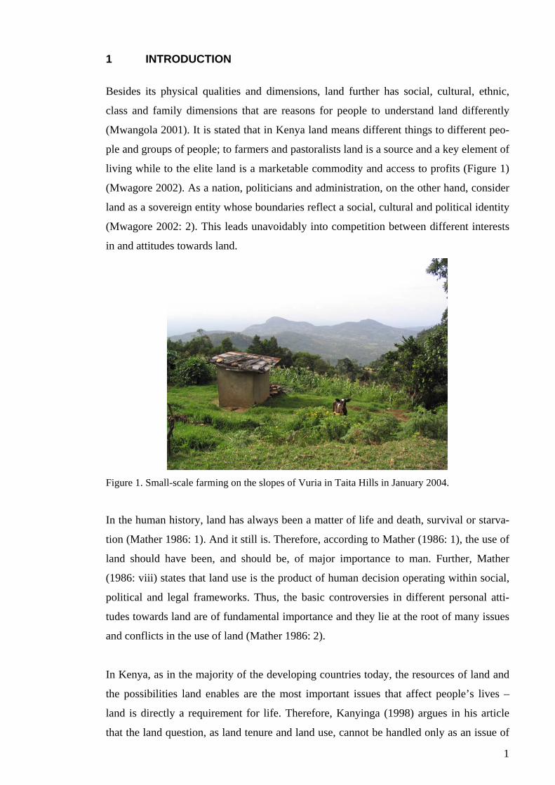
Besides its physical qualities and dimensions, land further has social, cultural, ethnic,
class and family dimensions that are reasons for people to understand land differently
(Mwangola 2001). It is stated that in Kenya land means different things to different peo-
ple and groups of people; to farmers and pastoralists land is a source and a key element of
living while to the elite land is a marketable commodity and access to profits (Figure 1)
(Mwagore 2002). As a nation, politicians and administration, on the other hand, consider
land as a sovereign entity whose boundaries reflect a social, cultural and political identity
(Mwagore 2002: 2). This leads unavoidably into competition between different interests
in and attitudes towards land.
Figure 1. Small-scale farming on the slopes of Vuria in Taita Hills in January 2004.
In the human history, land has always been a matter of life and death, survival or starva-
tion (Mather 1986: 1). And it still is. Therefore, according to Mather (1986: 1), the use of
land should have been, and should be, of major importance to man. Further, Mather
(1986: viii) states that land use is the product of human decision operating within social,
political and legal frameworks. Thus, the basic controversies in different personal atti-
tudes towards land are of fundamental importance and they lie at the root of many issues
and conflicts in the use of land (Mather 1986: 2).
In Kenya, as in the majority of the developing countries today, the resources of land and
the possibilities land enables are the most important issues that affect people’s lives –
land is directly a requirement for life. Therefore, Kanyinga (1998) argues in his article
that the land question, as land tenure and land use, cannot be handled only as an issue of
2
agricultural development alone, but, in fact, the land question is in the centre of social
and political organisation – land involves the development of whole society and its proc-
esses. The land question has, however, been outside of the economic, political and social
discourse not only in Kenya but also in most of the other countries in Sub-Saharan Africa
(Kanyinga 1998). This is somehow surprising, land being the most important resource in
these areas and agriculture being the most important source of livelihood.
Furthermore, despite of the many human interests, land is not only for humans to use, but
also environment has its needs for land; land is a basis of a rich biodiversity and nature’s
polymorphism. Thus, there is a conflict not only between different human desires but also
between man and environment as human activity changes natural environment. Hereby, it
needs to be asked: can they both, needs and demands of natural environment and human
society, be taken into account at the same time, and, what is the place and the best way to
do this harmonisation?
1.1 Objectives and aims of the study
The aim of the study is to describe the present state of land use policy in Kenya at na-
tional and district levels. This main objective can be modified into five research questions
wherein the focus of the study is directed:
• What are the relations between land policy, land use policy and land use in the
case of Kenya?
• What and how significant is the role of land policy when dealing with land ques-
tions in general in Kenya?
• What and how significant is the role of national (land) policy in land use policy
and planning at the district level?
• What are the contents of land use planning in Kenya; what does it include and
how does it work? How is planning related to policy making in land issues?
• How are the aspects of sustainable development integrated into land use policy
and planning in Kenya? Is the current land use policy in line with sustainable
development (planning)?
The main questions are first examined at the national level, but the practice of national
policy and planning is simulated based on the example of Taita Taveta district, where the
fieldwork of the research was done.
3
Through the description of present land use policy and its development, the study aims to
provide elements for discussion about the future of the land use policy in Kenya. There-
fore, the focus of the study is on the future, as it is arguably always the case when dealt
with planning issues. The study has succeeded if, in the end, it evokes some thoughts
about the future direction of land use policy in Kenya.
In the research on land issues in Kenya and in East Africa, the aspects of land tenure have
played a dominant role whereas the actual (planning) process of land use and the role of
land policy (land tenure and laws) in the process have been more or less ignored. The aim
of the study presented here is to provide new information about and for land use policy
and planning processes in Kenya. The aim is also to provide basic information about dis-
trict land use policy for the further consideration of local land use changes from a policy
perspective. This will have a great significance in future actions when developing na-
tional land use policy in Kenya and promoting sustainable development, as well as, in
bringing the land question in its place as a part of development discourse.
1.2 Taita-project
The thesis is a part of a larger research project, named as Taita-project. The project is car-
ried out by the Department of Geography at the University of Helsinki. The overall objec-
tive of the project is “development of land use change detection methodology in the East
African highlands applying geographic information systems” (Pellikka et al. 2004; Taita-
project 2003). The objectives of this thesis contribute to one of the sub-objectives of the
Taita-project; that of studying land use changes as a reflection of human nature interac-
tion. The study produces information about the political and planning framework of land
use in Kenya and Taita Taveta district area. The results can and should later be joined
with results of the other research connected to the Taita-project.
But then, why am I interested about these issues? –It is a fine question. I admit that with-
out the Taita-project I would have probably never ended up with a topic of any kind of
this. But now when I did, I could not be any happier about it. This is exactly what I had
already a while hoped for my Master’s thesis; this was a great opportunity for me to
combine the parts of my studies of planning geography, development studies and political
science.
4
1.3 Terminology
Many of the important terms related to land use policy are concepts that have many-
faceted, multilateral and interrelated meanings, and therefore the different terms are not
always easily identified from the others. In any case, land use policy is a complex issue
and the complexity begins already in defining the concepts relating to the topic. The defi-
nitions below are hoped to open up this complexity so that the multiple links of land use
policy could later be understood.
1.3.1 Land
Land is an area of the earth’s surface, meaning of all the attributes of the biosphere verti-
cally above and below this area including those of the atmosphere, the soil, the geology,
the hydrology, the plant and animal populations and the results of past and present human
activity (Vink 1983: 13). The physical quality, relative location, accessibility and form of
ownership of a certain piece of land will make it more or less suited for certain activities
(Rutten 1992: 37).
The meaning of land to people or to one person, however, is a more complex and even a
philosophical question; land represents different things to different people, as it was al-
ready described in the beginning of the chapter. In Kenya, the people have maintained an
emotional and psychological investment in land because land represents their link with
revered ancestors and because for many African ethnic communities it is even the reason
of existence (Harbeson 1973). These different aspects need to be fully realised in order to
understand the basis of use of land that directly reflects the attitudes towards it.
1.3.2 Land use vs. land cover and landscape
Vink (1983: 6, 10-13) defines land use as “an expression of man’s management of eco-
systems in order to produce some of his needs”. Similarly, Mather (1986: 98) refers to
human action indicating land use by stating that land use is formed by a choice made by
the individual land user operating within broad environmental limitation and government
influences. It must, therefore, be separated from the concept of land cover that “relates to
the physical nature or form of the land surface” (Mather 1986: 99). In many cases, the
type of land use can be deduced from the nature of the land cover, but not always the liai-
son between the two is so apparent (Mather 1986: 99). Furthermore, land use needs to be
5
separated from the concept of landscape, which means the surface of the earth, or the
region – a delineated area on the earth’s surface, with all its phenomena including land,
synonymous with physiography (Vink 1983: 13-14).
In defining the term of land use, also Virtanen (1995: 13) refers to the duality between
land cover and land use by separating a) the physical character and b) the action or func-
tion practised in an area. According to him, the same physical character of an area can
include variety of functions. For example, a forest can be either a conservation area, in
economic use or a training field of the army, and on the other hand, in the same looking
buildings there can be apartments, offices or even industry (Virtanen 1995: 13). Land
cover, the physical character of land, can be identified visually, for example, in the field
or by remote-sensing techniques, but the actual land use, the function of an area, is not
always apparent on this traditional mapping (Mather 1986: 99; Virtanen 1995: 13).
Land use can also be understood as use of regions. These both, however, may feel only as
two-dimensional phenomenon and, therefore, use of space could be even more descrip-
tive and a three-dimensional term for land use (Virtanen 1995: 12). In all these defini-
tions, also water bodies are considered as land, and land use planning therefore refers also
to management of the water areas (see Vink 1983: 10-12 and Virtanen 1995: 12).
Anyhow, land use is based on certain rights as ownership and right of use, which can be
determined either by societal regulations or by private agreements and decisions (see land
policy) (Virtanen 1995: 13). These rights further determine the choices that can be made
up about land use by an individual land user.
1.3.3 Land use policy
Land use policy considers the way land and natural resources are used and managed,
placing issues of ownership/tenure secondary (Mwagore 2002: vii). By land use policy,
Virtanen (1995: 14) means primarily the intentions, programs and operations of public
authority to control land use in desirable direction. Referring to the Finnish planning sys-
tem, he further divides land use policy into three parts, every part having a different na-
ture of its own: control system, monitoring system and administrative system. The control
system consists of different plan documents, conservation decisions and other plans that
concern a specific area/region/space. The issue of whether these plans of land use are re-
6
alized or not is handled within the monitoring system, in which also environmental im-
pacts are assessed. The administrative system (either public or private) is responsible for
producing, and also partly for executing, land use plans (Virtanen 1995: 14).
Based on Mwagore’s (2002) definition, land use policy is, in the study, understood as the
framework to manage and control land use and natural resources, excluding the detailed
examination of land tenure and land laws. Thus, land use policy can be partly assimilated
with the broader concept of environmental management wherein land use policy acts one
of the most important parts. This linkage is mostly formed by a regard to the Finnish pol-
icy and planning structure that places land use policy under the environmental policy
leaded by the Ministry of Environment (see Finland’s environmental administration
2004). This liaison is, however, also encouraged by Vink (1983) who puts land use in the
category of environmental management. Furthermore, he has a strong ecological ap-
proach to land use in general and he states that land use may only be treated from an eco-
logical standpoint. This study does not go any further in ecology as such, but recognises
the important presence of physical environment in the heart of the concept of land use
(policy).
1.3.4 Land policy
The most important factor that determines land use policy is land policy, which is a
broader concept that focuses on land tenure/ownership and may also include aspects of
law (Mwagore 2002: vii). West (1986), however, does not consider land policy separately
from land use policy, but land policy as a term includes also the elements of land use pol-
icy. He divides land policy into three dimensions: environmental dimension, spatial di-
mension and tenure dimension. Collectively, these three dimensions determine the con-
tent of land policy (West 1986). Virtanen (1995: 15), on the contrary, determines land
policy as a part of land use policy where it is included primarily in the administrative sys-
tem defined earlier (see land use policy). Here land policy means the operations of public
authority in tenure questions and promoting, especially, the legal intentions of land use
policy (Virtanen 1995: 15).
In the study, land policy is regarded separate from land use policy and, thereby, aspects
of land law and tenure are not in the direct focus of examination. Though, issues of land

7
policy need, anyway, to be discussed at some extent because of land policy’s authorita-
tive relation with land use policy.
1.3.5 Policy
Overall policy is formed by the prevailing political power structures, the political parties
and the leading political persons at the highest levels of political decision-making struc-
ture in the government. Policy –word refers here, as also Virtanen (1995: 14) determines,
to “general principles and proceedings”. Politics, as a word or expression, on the other
hand, refers to often-conflicting political opinions of different political parties (Virtanen
1995: 14). Thus, politics forms the basis of policy and continuously modifies it. How pol-
icy is understood in the question of land use, the issue is already handled above (see land
use policy).
1.3.6 Land use planning
Planning here refers to decision-making process that is fundamental in policy making.
Planning is problem-driven, information dependent and never an absolute or perfect an-
swer (Lein 2003: 1-22). Land use planning is a process examining different land use op-
tions, choosing between them and making of a land use plan to make the chosen priorities
to come true. Land use planning is one of the most important means of land use policy; it
realises the outcomes of land use policy. Hereby, land use planning can also be under-
stood as environmental planning.
Viitala (1999: 9) writes about the traditional division of the planning process into three
phases: normative, strategic and operative phase. The normative planning considers value
discussion, setting out the overall long-term political intentions by prioritising values,
opinions about the options, under discussion. The strategic planning considers setting out
the concrete objectives, for example, in about ten years temporal perspective. The opera-
tive phase, planning of implementation, again considers determining the particular ac-
tions to achieve the stated objectives. These phases are also included in land use plan-
ning.
Though some (phase of) planning is always involved when making decisions about land
use, the term land use planning usually involves some level of government and “is usu-
ally concerned with reconciling the goals and objectives of individuals and groups in so-
8
ciety” (Mather 1986: 212). Thus, land use planning reflects the value discussion between
individual land users and the nation as a whole and is concerned with establishing com-
promises between different participants (Mather 1986: 212).
1.3.7 Sustainable development
“Sustainable development is development that meets the needs of the present without
compromising the ability of future generations to meet their own needs” (Our common
future 1987: 43). This is how The World Commission on Environment and Development,
leaded by Mss. Brundtland, defined the concept of sustainable development. This multi-
faceted concept united ecological imperatives with the need for development and for
global inter-generational equity (Our common future 1987, Owens & Cowell 2002: 2-3).
But despite the fact that sustainable development has become universal ideal and that
administration and politics have actively been mainstreaming it through all policy sectors,
the actual definition of and approach to apply the concept have remained in enormous
dispute (Owens & Cowell 2002: 2-3). As Owens and Cowell (2002: 3) bring up, there is
no exclusive or complete interpretation of ‘need’ and ‘development’ of sustainability, and
the ecological and social conditions for sustainability have not been fully described and
detailed.
However, the most important aspect of sustainable development concerning this study is
that the processes of land use planning and regulation are considered “as key instruments
for delivering a more sustainable society” (Owens & Cowell 2002: 4, 12-27). This argu-
ment is discussed more profoundly in the section 3.4.
1.3.8 Development
Development here gets the meaning that Simon (1990) gives to it. He characterises de-
velopment as a multifaceted process whereby the quality of life and ‘personality’ of indi-
viduals and groups improve. The concept of development could be argued and disputed a
lot but it is not the purpose of this study to do, and therefore, I settle with this Simon’s
definition if and when development is discussed in the study.
9
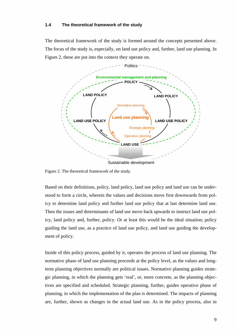
1.4 The theoretical framework of the study
The theoretical framework of the study is formed around the concepts presented above.
The focus of the study is, especially, on land use policy and, further, land use planning. In
Figure 2, these are put into the context they operate on.
POLICY
LAND POLICY
LAND USE POLICYLAND USE POLICY
LAND USE
LAND POLICY
LAND USE POLICYLAND USE POLICYLand use planning
Normative planning
Strategic planning
Operative planning
Environmental management and planning
Sustainable development
Politics
Figure 2. The theoretical framework of the study.
Based on their definitions, policy, land policy, land use policy and land use can be under-
stood to form a circle, wherein the values and decisions move first downwards from pol-
icy to determine land policy and further land use policy that at last determine land use.
Then the issues and determinants of land use move back upwards to instruct land use pol-
icy, land policy and, further, policy. Or at least this would be the ideal situation; policy
guiding the land use, as a practice of land use policy, and land use guiding the develop-
ment of policy.
Inside of this policy process, guided by it, operates the process of land use planning. The
normative phase of land use planning proceeds at the policy level, as the values and long-
term planning objectives normally are political issues. Normative planning guides strate-
gic planning, in which the planning gets ‘real’, or, more concrete, as the planning objec-
tives are specified and scheduled. Strategic planning, further, guides operative phase of
planning, in which the implementation of the plan is determined. The impacts of planning
are, further, shown as changes in the actual land use. As in the policy process, also in
10
planning process the experiences of practice, land use, are, or should, give an input for
further normative planning.
Further, land in itself cannot be separated from its environmental background, and, there-
fore, land use policy and planning processes are set in the context of environmental man-
agement and planning, of which they are important parts. The functioning of land use
policy and planning processes, and thus environmental management, again, operate
within and affect the politics and that of sustainable development. As a means of land use
policy, land use planning is argued to contribute to sustainable development, which is,
finally, partly determined by the land use practices. It needs to be noticed, however, that
in order to generate sustainable development land use planning is to consider both natural
and social environments and to seek compromises and balance between these two.
In spite of the policy performed, land use is determined by local actions, people. The dif-
ferent meanings of land also create many wishes and desire to use land. These are deter-
mined by cultural traditions but also, and more importantly, by the satisfaction of daily
basic needs. The significance of policy for land use is determined on the basis of how
well it guides the practice and how much it affects local actions of land use. There are
more or less three options: 1) the policy is authoritative and converts to practice through
rules and regulations, 2) the policy is flexible and converts into practice through compre-
hensiveness and common interests or 3) the policy is irrelevant in practice and does not
affect local actions. If policy and practice are not in any contact or interaction, the policy
can hardly be assumed to be sustainable.
1.4.1 Research compilation of the study
The study presents planning geographical research. As such, the studying of land use pol-
icy and land use planning is basic research: the study simply asks, what is land use policy
and planning in Kenya and in Taita Taveta district. But, because the focus is especially in
land use policy and land use planning, and not all policy and planning actions in Kenya
and Taita Taveta, the study is directed also towards applied research. This applied nu-
ance of the study is intensified through the study objectives to explain the way Kenyan
land use policy has worked in relation with its integrative role in land and natural re-
source management. Considerations about the sustainability of land use policy belong, as
well, in the field of applied research.
11
1.4.2 Restrictions of the study
The study acknowledges that the local experiences from Taita Taveta district cannot be
generalised straight to the national level or handled as an all-covering example of actions
in other districts. This limitation is fully admitted, even though it can later be seen that
the example of Taita Taveta is not that poor either, nor totally useless in characterising
the general situation of land use policy in Kenya.
About the study restrictions it can be said that in the question of land use and land use
policy, the study does not pay any special regard to urbanisation. Although it is an impor-
tant aspect of land use and its planning and policy and an increasing issue in Kenya as
well as in Taita Taveta district, it is a case of another study (see, for example, Hurskainen
2004). Also, for example, sustainable development cannot be examined in its whole
wideness; only few of its characteristics are taken under further study and, thereby, this
study does not either present critique towards the concept and its philosophy but takes it
as one of the approaches to examine the issue of the study.
Furthermore, the history of Kenya is examined only shortly and only in the context of
land use issues, although a wider examination of history would provide even more
ground information about the subject. Hopefully, the interested readers will become fa-
miliar with African and Kenyan history through an adequate literature. Moreover, the
roles of the supra-national institutions like the World Bank or the International Monetary
Fund in the development of Kenyan land affairs are not examined any closer in this
study, although, through relevant literature it can easily be understood that these have had
enormous effects into the development affairs in Kenya.
Almost all the concepts and approaches presented in the study could form the basis of
their own study. Anyhow, here they are examined strictly in the light of the study ques-
tions of this thesis, although many more and various arguments could be presented either
for or against them.
1.5 Methods
The study material was gathered in January-February 2004, during about seven-week
field period in Kenya, mostly in Taita Hills, namely in Wundanyi, in Taita Taveta district.
12
The empirical material consists of RRA- (Rapid Rural Appraisal) and in-depth inter-
views, unstructured interviews, questionnaires and of research journal.
The field studies began by a study excursion in which 14 students of geography, from the
University of Helsinki, and three researchers took part. As a part of this excursion and the
Taita-project, RRA-interviews were carried out by the whole group of students in four
villages around Taita Hills: Mwatate, Mwanda, Werugha and Dembwa (see the question-
naires and the results in Pellikka et al. 2004). RRA-methods began to develop in the
1970’s when some geographers, specialised in development studies, began to question the
meaning of statistical methods and, thereby, they began to gather information by asking
local people to tell and teach them about, for example, cultivation methods or environ-
mental factors (Laitinen 2002: 26-27). RRA is based on the idea that data is bound to the
time and the place and that, therefore, no intentions are made to generalise it. ‘Rapid’
refer to rapid data collection; getting results do not require time-consuming input and
analysis of questionnaire data because the data is gathered through more informal and
small-scale discussions (Laitinen 2002: 26). In the end of 1980’s, the method was further
developed to PRA (Participatory Rural Appraisal) that emphasised the importance of
genuine participation of the local people, not only for the benefit of researchers but also
for the benefit of the locals themselves, who now were given the opportunity to control,
analyse and use the information and data (collected like RRA) in order to develop and
enhance their possibilities to decide their own lives (Laitinen 2002: 28). Since their de-
velopment, RRA and PRA-methods have been strongly emphasised especially in devel-
opment cooperation.
The information from the RRA-exercises provides important ground information for this
study; this information is not analysed in this study but in Pellikka et al. 2004 – it has,
however, formed a basis of the understanding of the local life, problems and procedures.
Experiences on the more specific issues of this study, land use policy, were gathered by
expert interviews, more unofficial unstructured interviews (representing RRA-approach)
and questionnaires, of which the target group was the administrative officers of Taita
Taveta district.
Expert interviews were performed as in-depth interviews (theme interviews). Five per-
sons were interviewed along the questions in Appendix 1:
• District Commissioner (DC) Mr Chege Mwangi,
13
• District Development Officer (DDO) Mr Dickson A. Makuba,
• District Farm Management Officer (DFMO) Mr Simiyu K. Divid,
• District Land Officer (DLO) Mr Stephen M. Kihenjo and
• District Agricultural Officer (DAO) Mr Samuel Nyumoo.
In addition to these interviews, I had several informal discussions, or unstructured theme
interviews, of which the most valuable took place with District Surveyor Mr Mark Ki-
nanda, District Land and Settlement Officer Mr Kennedy Njenga, District Officer (DO)
Mr Francis M. Sila and the chairman of County Council Mr Richard Mwabili, who would
have all been on my list for interviews as well, but with whom it was not eventually pos-
sible to arrange a proper meeting for the purpose.
The questionnaire, containing the nine firsts questions of the in-depth interviews (Appen-
dix 2), was directed to the 60 members of District Development Committee (DDC) and
the 18 members of County Council (CC) of Taita Taveta. The questionnaire was used in
the hope of getting more opinions from the persons I did not have time and possibility to
meet personally, and because the groups did not have meetings while on my stay in the
Taita Hills. However, though I had agreed on this questionnaire with few district’s offi-
cers working closely with DDC, I suppose it was never delivered for or the answers gath-
ered from the members of DDC, because not a single answer was returned to me. Never-
theless, from the members of CC I got five fine answers. In addition, five employees of
the Ministry of Lands and Settlement shared their opinions with me through the question-
naire.
In addition, in the end of the field period, the Embassy of Finland had organised a possi-
bility to visit few ministries in Nairobi, and, with few other students, I had discussions
(unstructured interviews) with officers in the Ministry of Environment, Natural Resources
and Wildlife and the Ministry of Lands and Settlement and, in addition, in the headquar-
ters of the National Environment Management Authority (NEMA).
Furthermore, a research journal was written about the many and various empirical obser-
vations, for example, about peoples attitudes towards me, my study and my questions,
modes of action in local administration and among the people in general and the general
way of life in Kenya, Wundanyi and around Taita Hills. Also the various unofficial dis-
cussions with district’s officers and other people are included in the journal.
14
In addition, it can also be noticed that a lot of relevant literary material and important
documents were found from Taita Taveta District Information and Documentation Cen-
tre, located in Wundanyi, Taita Hills. In many parts, these documents are used in order to
examine the study issues.
1.5.1 Analysis of the material
Any particular method is not used for analysing the study material, but the aim is to pre-
sent the different point of views of different people, documents and the experiences gath-
ered from the discussions and own observations in order to discuss the situation of land
use policy. Expert-interviews and the questionnaires are analysed, or the answers are pre-
sented, so that single opinions cannot be personalised – a promise of this was the only
way to get any comments and opinions at all. However, when referred to a fact or a more
non-subjective and general information, the source is mentioned.
However, in order to conclude the study, the content and the practice of Kenya’s land use
policy are analysed through SWAP- and SWOT-analyses, in which the study information
is summed up. The SWAP-analysis examines the strengths, weaknesses, aims and prob-
lems of the content and the practice of land use policy in the case of Kenya. The strengths
and weaknesses analyse the content of land use policy in general level, though anyway of
course placed in the Kenyan context, and the aims and problems analyse, especially, the
content of Kenyan land use policy as it appears on the basis of the study.
SWOT-analysis, again, examines the strengths, weaknesses, opportunities and threats of
the procedure of land use policy in Kenya. The strengths and weaknesses are used in or-
der to analyse Kenya’s ability to perform and realise land use policy at the present, and
the opportunities and threats, again, analyse the same with a regard to the future.
Both of these fourfold table analyses are developed, especially, for analysing information,
and usually they are used in order to form a picture of the object of planning. Thus, usu-
ally they start the further planning activities, like the preparation of a development pro-
gram or the planning of a specific region. However, because of its nature of basic re-
search, the study naturally ends to an analysis of the situation described in it. Hereby, the
SWAP- and SWOT-analyses are used as a way to draw conclusions of the study. Al-
though this is rather unusual way to use the analyses, it, however, suits to this study.
15
Moreover, the analyses are useful in this task because they present the points in visual,
understandable and stimulating form.
1.5.2 Problems of the research – behind the methods
I cannot but admit the many problems related to the study. However, at the same time, it
needs to be acknowledged that the problems could not have been avoided completely, no
matter what, because the issue of the study could not be properly studied in advance be-
fore the actual field studies. The customs and the culture of the procedures in the local
level were to be found out only at the place, because there was no or only vague informa-
tion, for example about the current institutions and administration, available in advance.
In spite of the research plan and planned schedules, the whole work was to begin from the
start when arriving to Taita Hills. The first thing was to find out what things are done in
which offices, who is responsible of what, how is it possible to get information and how
would I get the information I wanted and needed.
A major cultural difference between the locals and me was the different comprehension
of time. As a Finn, I have used to schedule my doings and accurately hold on to the
agreed appointments. Well, as I soon found out, in Africa, the time is not defined by the
clock, but it is more like a philosophical question – things are done when suited. Nor was
I familiar with the “official” three-hour lunch break in the middle of a working day – a
break, when, naturally, nobody was available. No matter how admirable I find this ap-
proach to daily life, I need to admit that it made my work little more complicated, be-
cause appointments and interviews were difficult to arrange. Furthermore, this was one
reason I could not interview all the people I would have wanted, and maybe needed, to
talk with. But, pole pole, as said in Swahili, or, Kiswahili – take it easy.
Moreover, it did not help the task that sometimes I felt I was not understood or I did not
understand. I simply did not speak with my study the ‘same language’ with the officers
and administrators; the terms, concepts and the conceptualisations I used were hard to
convert into discussions and sometimes I could not help the fact that when discussing
something with somebody, we both used the same terms but talked about completely dif-
ferent things. Anyway, finally I did not care about this anymore because nothing was to
be done to it. I just hope that I have understood at least something right despite the occa-
sional confusion.
16
The last thing was that the time ran out. At the time I needed to leave, I felt that I had just
got started; the people were beginning to trust me and my studies, I finally knew whom I
would have been needed to meet and what questions would have been needed to ask in
order to get useful information for my study. Moreover, in the becoming next two weeks,
there would have been meetings of DDC and CC, which I could have visited and fol-
lowed.
Overall, in Kenya, land is a very sensitive issue to talk about. Maybe this was partly the
reason why people hesitated their sayings about it and even were reluctant to answer my
questions. And when I finally felt like I had gained people’s trust on me and my study, it
was time to leave the place. But perhaps this was to be the case – I had learned some-
thing. Some aspects of the misunderstandings are presented also in the text as a part of
the results of the study, because I think some of them really are actually results more than
only methodological problems and failures.
1.6 The structure of the thesis
The structure of the thesis is presented in Figure 3.
Experiences from Taita Taveta district
Introduction
Kenya and Taita Taveta – geographical facts and features
Policy for sustainable land use
Land use policy in Kenya
Conclusions
Summary
Part I
Part II
Part III Figure 3. The structure of the thesis.
The study contains three parts. The first part gives an introduction to the subject and pre-
sents the geographical and theoretical context of the study. Thus, the first part excludes
the historical aspects, which are discussed in the second part of the study. The second part
discusses the development of Kenyan land use policy and presents, further, the present
17
state of land use policy, both at national and district levels, on the basis of the study mate-
rial (interviews, questionnaires, planning documents). The analysis of the current land use
policy is done in the third part of the study, which, thus, presents the study results and
further conclusions and provides a summary of the study.
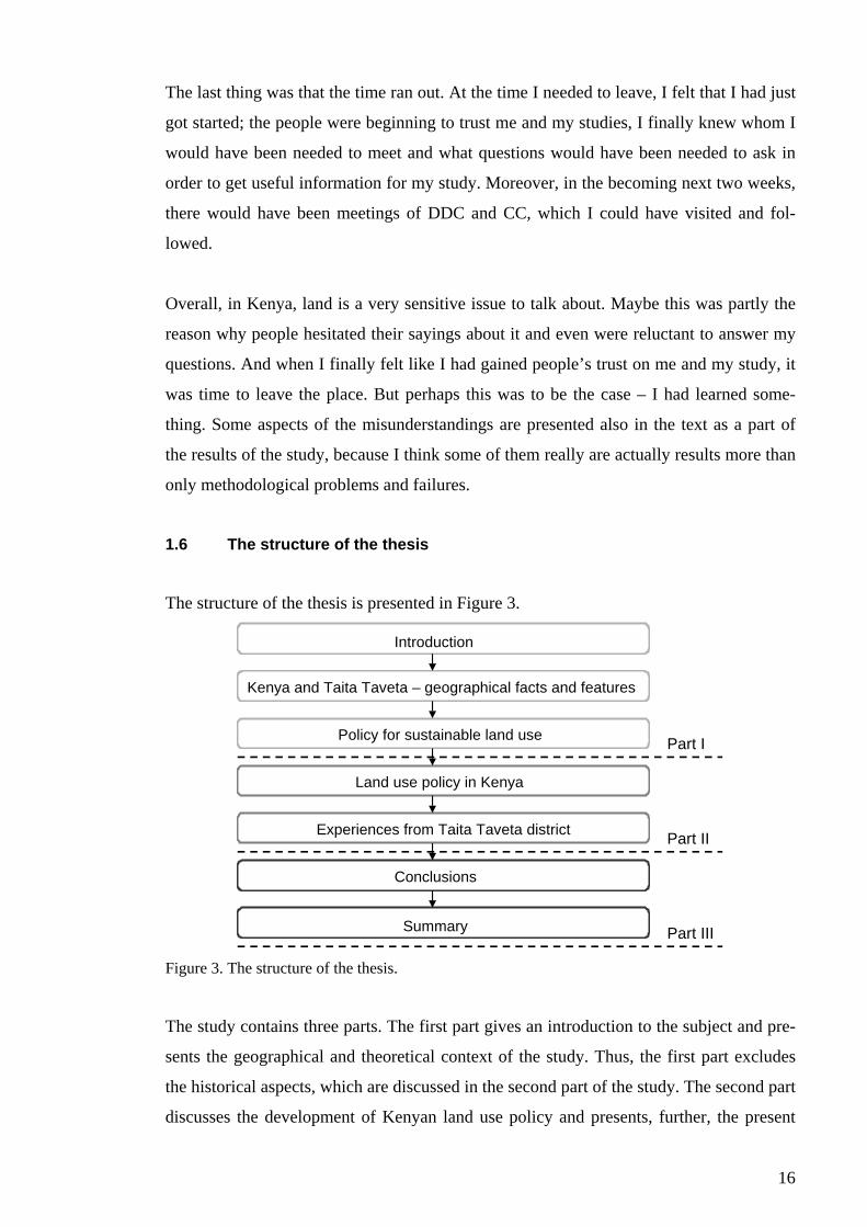
2 KENYA AND TAITA TAVETA – GEOGRAPHICAL FACTS AND FEATURES
Kenya is located in the equator, approximately between the latitudes 5°S and 5°N and the
longitudes 34°-42°E (Figure 4). Kenya is one of the countries of East Africa, others being
the neighbouring Tanzania, in the south-west, and Uganda in the west. In addition, Kenya
shares border with Somalia in the east and Sudan and Ethiopia in the north. In the south-
east, Kenya is delimited by the Indian Ocean. Kenya covers an area of approximately 582
650 km² of which 569 250 km² is land surface, inland waters covering 13 400 km². The
coastline is about 536 km (The world factbook 2004). The capital of Kenya is Nairobi.
The main seaport is Mombasa and the lake port in Lake Victoria is Kisumu.
Tana
ETHIOPIASUDAN
UGANDA
TANZANIA
SOMALIAKENYA
Nairobi
0
3
0
3
3
36 39 42
39 42
Indian Ocean
LakeVictoria
LakeTurkana
Mombasa
Malindi
LamuMachakos
Garissa
Meru
Nakuru
KisumuEldoret
Lodwar Moyale
Marsabit
Wajir
MountKenya
State border
Capital
Town
Mountain
River
Water area0 100 200 km
N
Figure 4. Kenya (The world factbook 2004, modified).
The highest point of Kenya is Mount Kenya (5200 metres) that is also the second highest
point of Africa. In the west, Kenya has an access to Lake Victoria, the largest fresh water
18
lake in Africa, and in the northern Kenya exists the Lake Turkana. In addition, several
smaller lakes are found within the Rift Valley (see also Figure 5). The biggest permanent
rivers in the country are Athi and Tana, falling to Indian Ocean.
2.1 Basic information about Kenya
2.1.1 Physical features
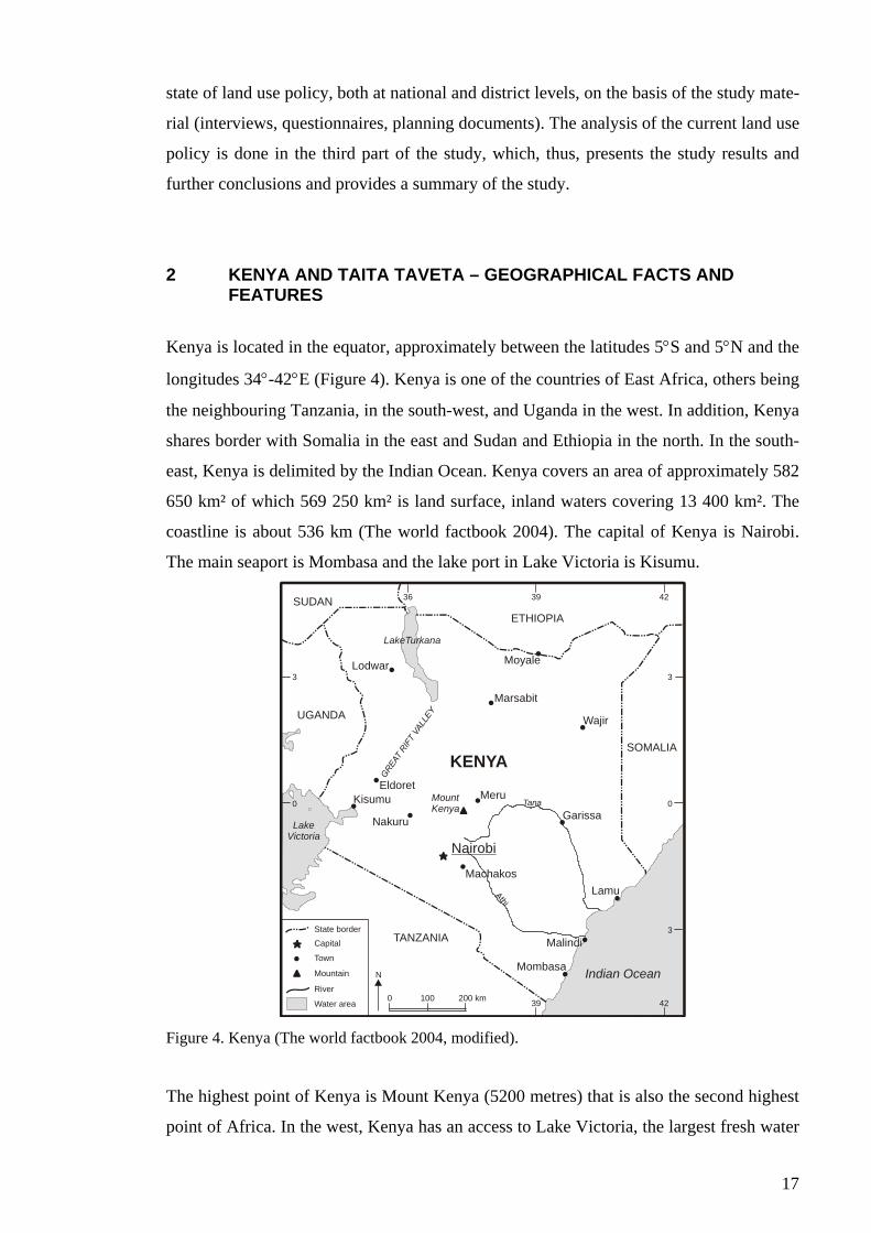
Kenya lies mostly on the East African plateau, of which the border breaks the country
along the Rift Valley. Landforms range from coastal plains through dry nyika
(=wilderness) plateau to savannah grasslands and the highlands on both sides of the Rift
Valley. Soja (1968: 7) has classified Kenya’s physical geographical regions (Figure 5),
through which he describes the physical characteristics of Kenya.
Figure 5. The physical geographical regions of Kenya (Soja 1968: 7). A=Coastal plain, B=Arid low plateaus, C=Kenya highlands, D=Lake Victoria borderlands. The dark area (mainly in region C) illustrates the land higher than 1500 meters above the sea level. The Rift Valley breaks the highlands region in north south –direction.
The coastal plain (the region A) is relatively narrow, never more than 65 km wide. The
coast is fringed with mangroves, lagoons and coral reefs. The arid low plateaus (the re-
gion B) are characterised by scarce and erratic rainfall, usually less than 500 mm/year,
and the region is mostly covered by scrub bush. However, several small highland en-
19
claves diverge from the plateaus, Taita Hills being one of them, as they reach higher ele-
vation to obtain higher rainfall. The Kenya highlands (the region C) are a series of higher
plateaus and volcanic surfaces mainly in altitudes between 1200 and 3000 meters. Due to
the higher altitudes, the highlands also get higher rainfall than the lower plateaus, usually
more than 500 mm/year but even 2000 mm/year. In highlands, most of the soils are vol-
canic in origin and are the most fertile in Africa. The Lake Victoria borderlands (the re-
gion D) are composed of heavily eroded, non-volcanic plateau surfaces. The region has
fairly reliable and evenly distributed rainfall that almost everywhere exceeds 760
mm/year (Soja 1968: 6-8).
In overall, the climate in Kenya is dry and hot. The climate is influenced by the country’s
equatorial location and its position on the Indian Ocean seaboard. Annual rainfall follows
a strong seasonal pattern, which varies regionally following the movement of the inter-
tropical convergence zone (ITCZ) and the altitudinal differences. In general, the main
rains come between March and May and the minor rains between October and December.
However, Kenya experiences recurrent droughts: minor droughts every 2 to 3 years and
major droughts after 8 to 10 years (Mwagore 2002: 18-19).
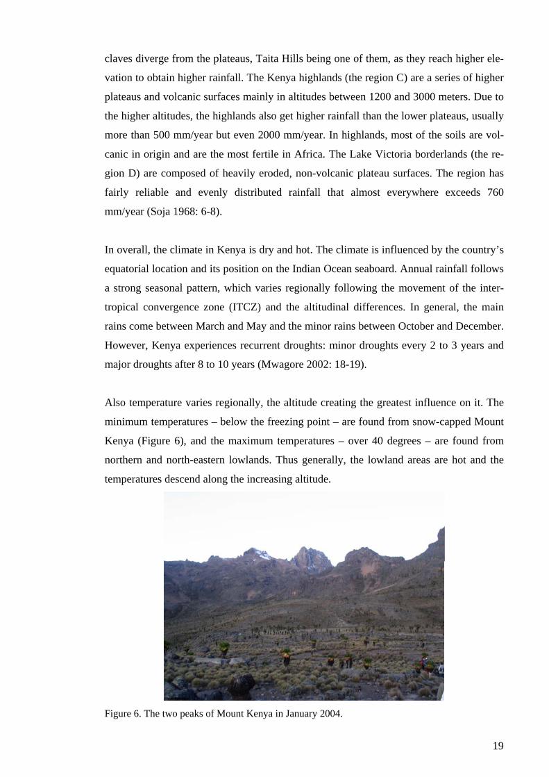
Also temperature varies regionally, the altitude creating the greatest influence on it. The
minimum temperatures – below the freezing point – are found from snow-capped Mount
Kenya (Figure 6), and the maximum temperatures – over 40 degrees – are found from
northern and north-eastern lowlands. Thus generally, the lowland areas are hot and the
temperatures descend along the increasing altitude.
Figure 6. The two peaks of Mount Kenya in January 2004.
20
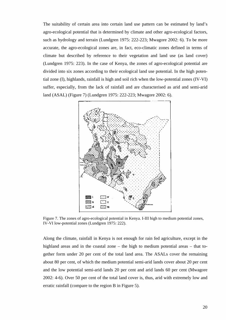
The suitability of certain area into certain land use pattern can be estimated by land’s
agro-ecological potential that is determined by climate and other agro-ecological factors,
such as hydrology and terrain (Lundgren 1975: 222-223; Mwagore 2002: 6). To be more
accurate, the agro-ecological zones are, in fact, eco-climatic zones defined in terms of
climate but described by reference to their vegetation and land use (as land cover)
(Lundgren 1975: 223). In the case of Kenya, the zones of agro-ecological potential are
divided into six zones according to their ecological land use potential. In the high poten-
tial zone (I), highlands, rainfall is high and soil rich when the low-potential zones (IV-VI)
suffer, especially, from the lack of rainfall and are characterised as arid and semi-arid
land (ASAL) (Figure 7) (Lundgren 1975: 222-223; Mwagore 2002: 6).
Figure 7. The zones of agro-ecological potential in Kenya. I-III high to medium potential zones, IV-VI low-potential zones (Lundgren 1975: 222).
Along the climate, rainfall in Kenya is not enough for rain fed agriculture, except in the
highland areas and in the coastal zone – the high to medium potential areas – that to-
gether form under 20 per cent of the total land area. The ASALs cover the remaining
about 80 per cent, of which the medium potential semi-arid lands cover about 20 per cent
and the low potential semi-arid lands 20 per cent and arid lands 60 per cent (Mwagore
2002: 4-6). Over 50 per cent of the total land cover is, thus, arid with extremely low and
erratic rainfall (compare to the region B in Figure 5).
21
The major land cover types in Kenya are forests, savannahs, grasslands, wetlands, fresh
and saline water bodies and deserts. Forests cover only approximately 1,7 per cent of the
total land area (Odete et al. 2004). This means only the gazetted forests, but the portion is
not much higher even if the non-gazetted forests are included, total coverage being about
2 per cent of the county’s land area (Odete et al. 2004). However, forests are fragmented
into many small units. Indigenous forests grow mainly in the high potential areas in the
(central) highlands and costal zone (Juma 1991; Mwagore 2002: 10). In the ASALs, for-
ests are found in isolated mountain ranges and narrow strips along rivers (Mwagore 2002:
10).
The forest area has been declining increasingly; invasion of forests for settlement and
agricultural land is the most destructive (Mwagore 2002: 11-14). But when the forests
disappear, so do the water catchment areas because the forests are not there anymore to
control the circulation of water. This causes destruction of ecosystems and direct water
shortages.
Deforestation is also a major factor contributing to soil erosion that is a considerable
problem in Kenya. Erosion, including both water and wind erosion, is quite active: water
erosion in the rainy areas and high lands and wind erosion especially in the ASALs. The
driving force behind the problem is removal of vegetation cover, which exposes the soil
surface to external impacts, such as of raindrops and wind. Transportation of detached
soil particles washes away the topsoil and its nutrients making the remaining sub-soil less
fertile and less suitable for vegetation and plant growth. This means also loss of the soil
moisture-storage capacity, and thus eroded soil is even more vulnerable to further ero-
sion. Hereby, erosion causes definitive land degradation and, for example, siltation as the
silt transported by rivers and winds is deposited in the lakes and the ocean.
Not only erosion but, furthermore, extensive desertification is a large question in Kenya.
Desertification process occurs mainly within dry land ecosystems and, thus, the most af-
fected areas are the ASALs, especially the most arid areas in the northern Kenya (see
Figure 17). It is stimulated by climatic variations, as for example droughts, together with
inappropriate human activities, for example, due to the under-appreciation of ASAL as an
ecosystem. Desertification extends at the rate of 18-40 km per year (Mwagore 2002: 16),
which means that the process is ever-growing problem.
22
2.1.2 Human geographical features
Kenya became independent in 1963, and the Republic of Kenya was established. The first
president of independent state was Jomo Kenyatta (Kenya African National Union –
KANU) who was in power from 1963 until his death in 1978 when President Daniel Tor-
oitich arap Moi (KANU) took the power. From 1969 onwards the country was one-party
state the sole legal party being KANU. Political liberalisation occurred not until the 1991
when Moi finally acceded to both internal and external political pressure. The Moi’s era
ended in December 2002 following elections through which Mwai Kibaki (National
Rainbow Coalition – NARC) became the president.
The legislative branch of Kenya is National Assembly that consists of 224 members of
which 210 members are elected and 12 members nominated by the president. The presi-
dential election and parliamentary elections are organised according to the same cycle in
every five years. Nowadays there are three main political parties represented in the Na-
tional Assembly (elected members): NARC with 125 seats; KANU with 64 seats; and
Forum for the Restoration of Democracy-People (FORD-People) with 14 seats, others
having 7 seats.
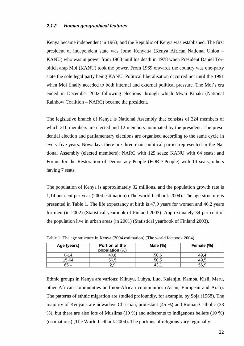
The population of Kenya is approximately 32 millions, and the population growth rate is
1,14 per cent per year (2004 estimation) (The world factbook 2004). The age structure is
presented in Table 1. The life expectancy at birth is 47,9 years for women and 46,2 years
for men (in 2002) (Statistical yearbook of Finland 2003). Approximately 34 per cent of
the population live in urban areas (in 2001) (Statistical yearbook of Finland 2003).
Table 1. The age structure in Kenya (2004 estimation) (The world factbook 2004).
Age (years) Portion of the population (%)
Male (%) Female (%)
0-14 40,6 50,6 49,4 15-64 56,5 50,5 49,5 65 – 2,9 43,1 56,9
Ethnic groups in Kenya are various: Kikuyu, Luhya, Luo, Kalenjin, Kamba, Kisii, Meru,
other African communities and non-African communities (Asian, European and Arab).
The patterns of ethnic migration are studied profoundly, for example, by Soja (1968). The
majority of Kenyans are nowadays Christian, protestant (45 %) and Roman Catholic (33
%), but there are also lots of Muslims (10 %) and adherents to indigenous beliefs (10 %)
(estimations) (The World factbook 2004). The portions of religions vary regionally.
23
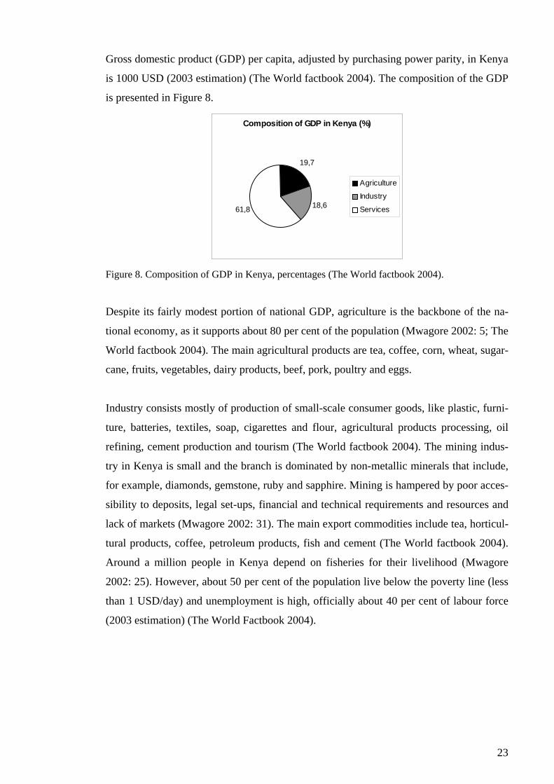
Gross domestic product (GDP) per capita, adjusted by purchasing power parity, in Kenya
is 1000 USD (2003 estimation) (The World factbook 2004). The composition of the GDP
is presented in Figure 8.
Composition of GDP in Kenya (%)
19,7
18,661,8
Agriculture
Industry
Services
Figure 8. Composition of GDP in Kenya, percentages (The World factbook 2004).
Despite its fairly modest portion of national GDP, agriculture is the backbone of the na-
tional economy, as it supports about 80 per cent of the population (Mwagore 2002: 5; The
World factbook 2004). The main agricultural products are tea, coffee, corn, wheat, sugar-
cane, fruits, vegetables, dairy products, beef, pork, poultry and eggs.
Industry consists mostly of production of small-scale consumer goods, like plastic, furni-
ture, batteries, textiles, soap, cigarettes and flour, agricultural products processing, oil
refining, cement production and tourism (The World factbook 2004). The mining indus-
try in Kenya is small and the branch is dominated by non-metallic minerals that include,
for example, diamonds, gemstone, ruby and sapphire. Mining is hampered by poor acces-
sibility to deposits, legal set-ups, financial and technical requirements and resources and
lack of markets (Mwagore 2002: 31). The main export commodities include tea, horticul-
tural products, coffee, petroleum products, fish and cement (The World factbook 2004).
Around a million people in Kenya depend on fisheries for their livelihood (Mwagore
2002: 25). However, about 50 per cent of the population live below the poverty line (less
than 1 USD/day) and unemployment is high, officially about 40 per cent of labour force
(2003 estimation) (The World Factbook 2004).
24
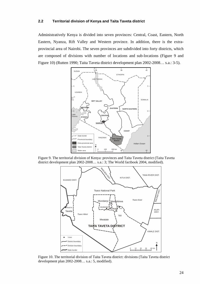
2.2 Territorial division of Kenya and Taita Taveta district
Administratively Kenya is divided into seven provinces: Central, Coast, Eastern, North
Eastern, Nyanza, Rift Valley and Western province. In addition, there is the extra-
provincial area of Nairobi. The seven provinces are subdivided into forty districts, which
are composed of divisions with number of locations and sub-locations (Figure 9 and
Figure 10) (Rutten 1990; Taita Taveta district development plan 2002-2008… s.a.: 3-5).
ETHIOPIA
SUDAN
UGANDA
TANZANIA
SOMALIA
0
3
0
3
3
36 39 42
39 42
Indian Ocean
LakeVictoria
Lake Turkana
State border
Provincial boundary
Extra-provincial area
Taita Taveta district
Water area
N
0 100 200 km
NORTH EASTERN
NAIROBI
EASTERN
CENTRAL
RIFT VALLEY
WESTERN
NYANZA
COAST
Taita Tavetadistrict
Figure 9. The territorial division of Kenya: provinces and Taita Taveta district (Taita Taveta district development plan 2002-2008… s.a.: 3; The World factbook 2004, modified).
0 10 20 30 40 Km
N
Tsavo National Park
Wundanyi
Voi
Mwatate
TavetaTausa
Mwambirwa
TAVETA WUNDANYIVOI
Tsavo East
Tsavo West
KAJIADO DIST.
MAKUENI DIST. KITUI DIST.TANA RIVER DIST.
MAL
IND
I DIS
T.
KILIFIDIST.
KWALE DIST.
TAITA TAVETA DISTRICT
TOWN
District boundary
Division boundary
State border Figure 10. The territorial division of Taita Taveta district: divisions (Taita Taveta district development plan 2002-2008… s.a.: 5, modified).
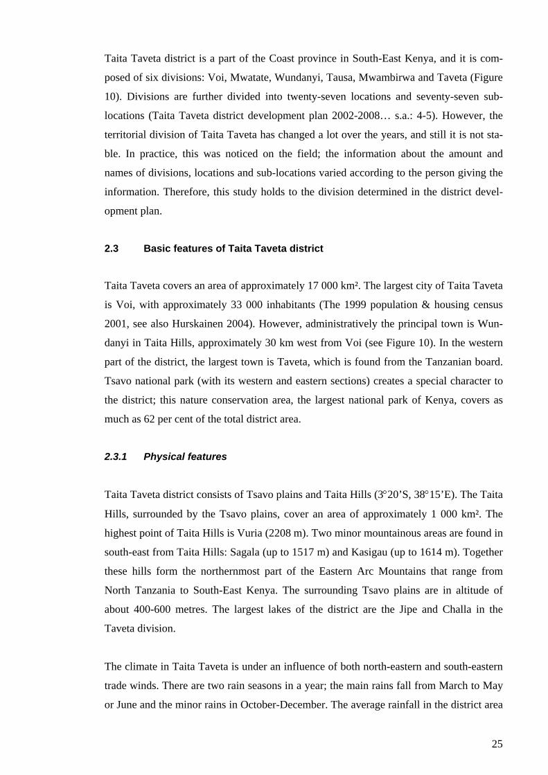
25
Taita Taveta district is a part of the Coast province in South-East Kenya, and it is com-
posed of six divisions: Voi, Mwatate, Wundanyi, Tausa, Mwambirwa and Taveta (Figure
10). Divisions are further divided into twenty-seven locations and seventy-seven sub-
locations (Taita Taveta district development plan 2002-2008… s.a.: 4-5). However, the
territorial division of Taita Taveta has changed a lot over the years, and still it is not sta-
ble. In practice, this was noticed on the field; the information about the amount and
names of divisions, locations and sub-locations varied according to the person giving the
information. Therefore, this study holds to the division determined in the district devel-
opment plan.
2.3 Basic features of Taita Taveta district
Taita Taveta covers an area of approximately 17 000 km². The largest city of Taita Taveta
is Voi, with approximately 33 000 inhabitants (The 1999 population & housing census
2001, see also Hurskainen 2004). However, administratively the principal town is Wun-
danyi in Taita Hills, approximately 30 km west from Voi (see Figure 10). In the western
part of the district, the largest town is Taveta, which is found from the Tanzanian board.
Tsavo national park (with its western and eastern sections) creates a special character to
the district; this nature conservation area, the largest national park of Kenya, covers as
much as 62 per cent of the total district area.
2.3.1 Physical features
Taita Taveta district consists of Tsavo plains and Taita Hills (3°20’S, 38°15’E). The Taita
Hills, surrounded by the Tsavo plains, cover an area of approximately 1 000 km². The
highest point of Taita Hills is Vuria (2208 m). Two minor mountainous areas are found in
south-east from Taita Hills: Sagala (up to 1517 m) and Kasigau (up to 1614 m). Together
these hills form the northernmost part of the Eastern Arc Mountains that range from
North Tanzania to South-East Kenya. The surrounding Tsavo plains are in altitude of
about 400-600 metres. The largest lakes of the district are the Jipe and Challa in the
Taveta division.
The climate in Taita Taveta is under an influence of both north-eastern and south-eastern
trade winds. There are two rain seasons in a year; the main rains fall from March to May
or June and the minor rains in October-December. The average rainfall in the district area
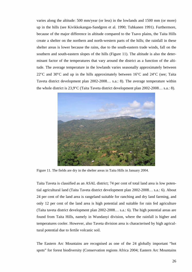
26
varies along the altitude: 500 mm/year (or less) in the lowlands and 1500 mm (or more)
up in the hills (see Kivikkokangas-Sandgren et al. 1990; Tuhkanen 1991). Furthermore,
because of the major difference in altitude compared to the Tsavo plains, the Taita Hills
create a shelter on the northern and north-western parts of the hills; the rainfall in these
shelter areas is lower because the rains, due to the south-eastern trade winds, fall on the
southern and south-eastern slopes of the hills (Figure 11). The altitude is also the deter-
minant factor of the temperatures that vary around the district as a function of the alti-
tude. The average temperature in the lowlands varies seasonally approximately between
22°C and 30°C and up in the hills approximately between 16°C and 24°C (see; Taita
Taveta district development plan 2002-2008… s.a.: 8). The average temperature within
the whole district is 23,9°C (Taita Taveta district development plan 2002-2008… s.a.: 8).
Figure 11. The fields are dry in the shelter areas in Taita Hills in January 2004.
Taita Taveta is classified as an ASAL district; 74 per cent of total land area is low poten-
tial agricultural land (Taita Taveta district development plan 2002-2008… s.a.: 6). About
24 per cent of the land area is rangeland suitable for ranching and dry land farming, and
only 12 per cent of the land area is high potential and suitable for rain fed agriculture
(Taita taveta district development plan 2002-2008… s.a.: 6). The high potential areas are
found from Taita Hills, namely in Wundanyi division, where the rainfall is higher and
temperatures cooler. However, also Taveta division area is characterised by high agricul-
tural potential due to fertile volcanic soil.
The Eastern Arc Mountains are recognised as one of the 24 globally important “hot
spots” for forest biodiversity (Conservation regions Africa 2004; Eastern Arc Mountains
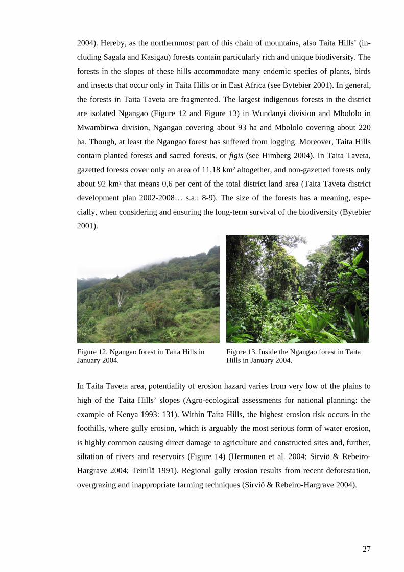
27
2004). Hereby, as the northernmost part of this chain of mountains, also Taita Hills’ (in-
cluding Sagala and Kasigau) forests contain particularly rich and unique biodiversity. The
forests in the slopes of these hills accommodate many endemic species of plants, birds
and insects that occur only in Taita Hills or in East Africa (see Bytebier 2001). In general,
the forests in Taita Taveta are fragmented. The largest indigenous forests in the district
are isolated Ngangao (Figure 12 and Figure 13) in Wundanyi division and Mbololo in
Mwambirwa division, Ngangao covering about 93 ha and Mbololo covering about 220
ha. Though, at least the Ngangao forest has suffered from logging. Moreover, Taita Hills
contain planted forests and sacred forests, or figis (see Himberg 2004). In Taita Taveta,
gazetted forests cover only an area of 11,18 km² altogether, and non-gazetted forests only
about 92 km² that means 0,6 per cent of the total district land area (Taita Taveta district
development plan 2002-2008… s.a.: 8-9). The size of the forests has a meaning, espe-
cially, when considering and ensuring the long-term survival of the biodiversity (Bytebier
2001).
Figure 12. Ngangao forest in Taita Hills in January 2004.
Figure 13. Inside the Ngangao forest in Taita Hills in January 2004.
In Taita Taveta area, potentiality of erosion hazard varies from very low of the plains to
high of the Taita Hills’ slopes (Agro-ecological assessments for national planning: the
example of Kenya 1993: 131). Within Taita Hills, the highest erosion risk occurs in the
foothills, where gully erosion, which is arguably the most serious form of water erosion,
is highly common causing direct damage to agriculture and constructed sites and, further,
siltation of rivers and reservoirs (Figure 14) (Hermunen et al. 2004; Sirviö & Rebeiro-
Hargrave 2004; Teinilä 1991). Regional gully erosion results from recent deforestation,
overgrazing and inappropriate farming techniques (Sirviö & Rebeiro-Hargrave 2004).
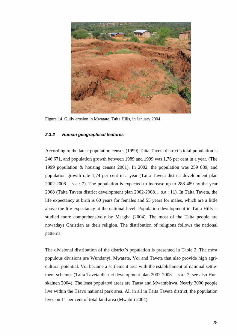
28
Figure 14. Gully erosion in Mwatate, Taita Hills, in January 2004.
2.3.2 Human geographical features
According to the latest population census (1999) Taita Taveta district’s total population is
246 671, and population growth between 1989 and 1999 was 1,76 per cent in a year. (The
1999 population & housing census 2001). In 2002, the population was 259 889, and
population growth rate 1,74 per cent in a year (Taita Taveta district development plan
2002-2008… s.a.: 7). The population is expected to increase up to 288 489 by the year
2008 (Taita Taveta district development plan 2002-2008… s.a.: 11). In Taita Taveta, the
life expectancy at birth is 60 years for females and 55 years for males, which are a little
above the life expectancy at the national level. Population development in Taita Hills is
studied more comprehensively by Msagha (2004). The most of the Taita people are
nowadays Christian as their religion. The distribution of religions follows the national
patterns.
The divisional distribution of the district’s population is presented in Table 2. The most
populous divisions are Wundanyi, Mwatate, Voi and Taveta that also provide high agri-
cultural potential. Voi became a settlement area with the establishment of national settle-
ment schemes (Taita Taveta district development plan 2002-2008… s.a.: 7; see also Hur-
skainen 2004). The least populated areas are Tausa and Mwambirwa. Nearly 3000 people
live within the Tsavo national park area. All in all in Taita Taveta district, the population
lives on 11 per cent of total land area (Mwabili 2004).
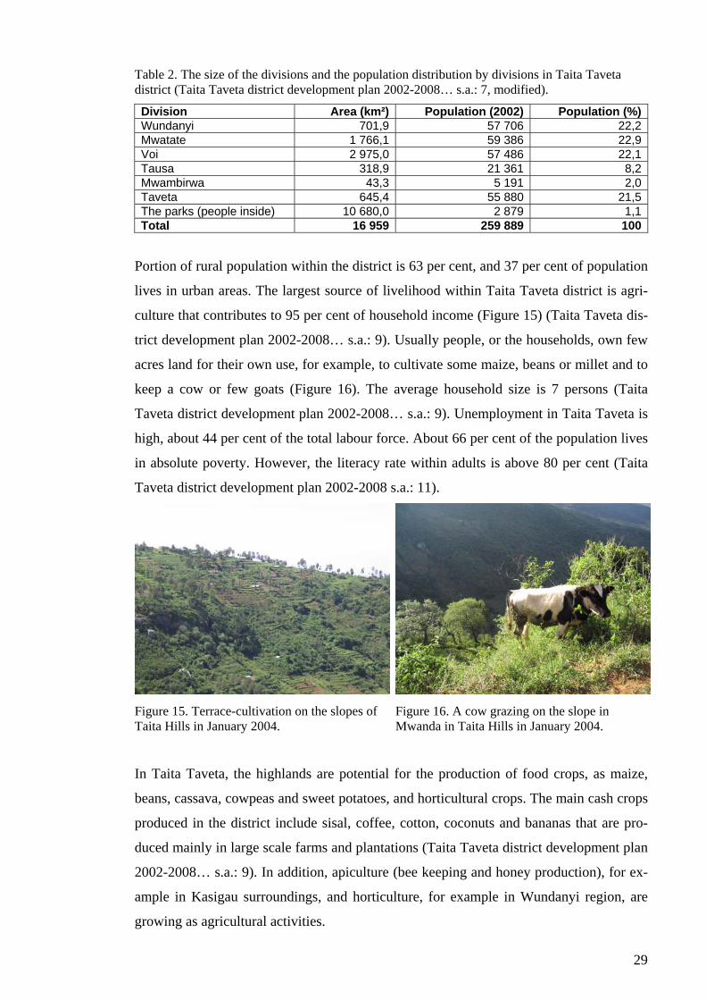
29
Table 2. The size of the divisions and the population distribution by divisions in Taita Taveta district (Taita Taveta district development plan 2002-2008… s.a.: 7, modified).
Division Area (km²) Population (2002) Population (%)Wundanyi 701,9 57 706 22,2Mwatate 1 766,1 59 386 22,9Voi 2 975,0 57 486 22,1Tausa 318,9 21 361 8,2Mwambirwa 43,3 5 191 2,0Taveta 645,4 55 880 21,5The parks (people inside) 10 680,0 2 879 1,1Total 16 959 259 889 100
Portion of rural population within the district is 63 per cent, and 37 per cent of population
lives in urban areas. The largest source of livelihood within Taita Taveta district is agri-
culture that contributes to 95 per cent of household income (Figure 15) (Taita Taveta dis-
trict development plan 2002-2008… s.a.: 9). Usually people, or the households, own few
acres land for their own use, for example, to cultivate some maize, beans or millet and to
keep a cow or few goats (Figure 16). The average household size is 7 persons (Taita
Taveta district development plan 2002-2008… s.a.: 9). Unemployment in Taita Taveta is
high, about 44 per cent of the total labour force. About 66 per cent of the population lives
in absolute poverty. However, the literacy rate within adults is above 80 per cent (Taita
Taveta district development plan 2002-2008 s.a.: 11).
Figure 15. Terrace-cultivation on the slopes of Taita Hills in January 2004.
Figure 16. A cow grazing on the slope in Mwanda in Taita Hills in January 2004.
In Taita Taveta, the highlands are potential for the production of food crops, as maize,
beans, cassava, cowpeas and sweet potatoes, and horticultural crops. The main cash crops
produced in the district include sisal, coffee, cotton, coconuts and bananas that are pro-
duced mainly in large scale farms and plantations (Taita Taveta district development plan
2002-2008… s.a.: 9). In addition, apiculture (bee keeping and honey production), for ex-
ample in Kasigau surroundings, and horticulture, for example in Wundanyi region, are
growing as agricultural activities.
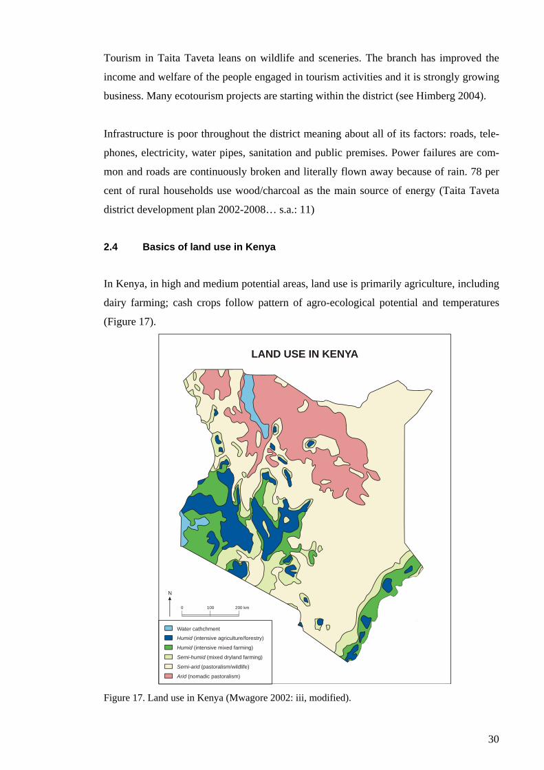
30
Tourism in Taita Taveta leans on wildlife and sceneries. The branch has improved the
income and welfare of the people engaged in tourism activities and it is strongly growing
business. Many ecotourism projects are starting within the district (see Himberg 2004).
Infrastructure is poor throughout the district meaning about all of its factors: roads, tele-
phones, electricity, water pipes, sanitation and public premises. Power failures are com-
mon and roads are continuously broken and literally flown away because of rain. 78 per
cent of rural households use wood/charcoal as the main source of energy (Taita Taveta
district development plan 2002-2008… s.a.: 11)
2.4 Basics of land use in Kenya
In Kenya, in high and medium potential areas, land use is primarily agriculture, including
dairy farming; cash crops follow pattern of agro-ecological potential and temperatures
(Figure 17).
0 100 200 km
Water cathchment
Humid (intensive agriculture/forestry)
Humid (intensive mixed farming)
Semi-humid (mixed dryland farming)
Semi-arid (pastoralism/wildlife)
Arid (nomadic pastoralism)
N
LAND USE IN KENYA
Figure 17. Land use in Kenya (Mwagore 2002: iii, modified).
31
However, these few high and medium potential areas support also about 80 per cent of
the Kenya’s population mainly in urban centres, forests, lakes and industry (The Kenya
national environment action plan (NEAP) report 1994: 11; Rutten 1992: 85). ASALs, on
their behalf, support only 20 per cent of population but about 50 per cent of the national
livestock herd. Also, a major portion of the wildlife resources of Kenya occurs in the
ASALs. The land use in semi-arid areas are characterised by agro-pastoralism and the
most arid areas by pastoralism. In semi-arid areas, irrigated flower farming has in the re-
cent past emerged as a major type of land use alongside of agro-pastoralism (Mwagore
2002: 4).
The Kenya National Environment Action Plan (NEAP) (1994: 11) lists some identified
problems concerning land use in Kenya: falling agricultural productivity due to over ex-
ploitation of the soil resources; land sub-division to unsustainable sizes; land degradation
due to inappropriate soil conservation technologies and soil erosion; land use conflicts
caused by urban and industrial expansion; and prolonged unpredictable droughts. These
are products of several factors, as land use is determined and controlled by, for example,
climate, soils and agro-ecological potential, labour, technology and markets. In Kenya,
the climate, especially rainfall, is the primary physical feature determining land use.
Although climate has the determinant role regarding land use and its planning, it needs to
be remembered that the classification of Kenya’s agro-ecological zones (presented in
Figure 7) does not recognise the differences of soils or temperatures at different altitudes,
nor does it consider the important influences of climatic extremes or the human impact on
vegetation and indicator plants that are, nevertheless, used to delineate climatic bounda-
ries (Lundgren 1975: 225). This is why the map cannot be directly used as a basis of de-
tailed planning, but the zones should be determined more specifically and individually
regarding to the specific planning area and the nature of the planning problem in accor-
dance with the other land use determinants.
What is a bit surprising in the case of Kenya is the fact that, in many cases, the soil is of
good quality and fertile but it is no use because of inadequate rainfall, as for example in
the ASALs. Here, competition for water is severe, especially, in dry seasons. The hydro-
power dams upstream of many rivers, formerly abundantly flowing and flooding, have
reduced the available water resources of downstream communities and thus made crop
cultivation rather impossible in many areas. In addition, the groundwater is extremely

32
variable in chemical composition and quantities, as well as, by its location (The Kenya
national… 1994: 13). This limits the use of land and taking advantage of the fertile soil.
Still, the Kenya’s population is dependent on land and its resources. Due to the fact that
land in the highlands has already mostly been taken into use, the ASALs are used to cush-
ion the continuously increasing population pressure, which further increases the environ-
mental constraints in these areas.
On the one hand, land in Kenya is heavily over-used because of the varying physical con-
ditions, population pressure and unsuitable land use practices. On the other hand, also
under-utilisation of the agricultural potential is reported to happen, for example, in west-
ern Kenya; the region has the best potentiality for agricultural production, but the land
use practices within the area do not support profitable production (see Mwagore 2002).
Too intensive land use prevents land from keeping its strength, because dry soil is easily
eroded and exposed to desertification. Soil erosion is common throughout the country
causing definitive land degradation contributing further to desertification process. Soil
erosion is both an ecological and socio-economic problem; erosion in cultivated land is
closely related to rainfall, landform, soil type, land use and the level of conservation
measures (Mwagore 2002: 37). The main source of energy in Kenya is biomass, particu-
larly fuel wood and charcoal – fuel wood consumption is considered a major cause of de-
vegetation and degradation of woody resources (Mwagore 2002: 34-36). Further, fuel
wood demand is expected to rise along the increasing population. Hereby, the manage-
ment of soil erosion and the prevention of desertification will be one of the most impor-
tant environmental issues in Kenya in the future.
3 POLICY FOR SUSTAINABLE LAND USE
The chapter examines the basis of land use policy and land use planning and their contri-
butions regarding to sustainable development.
3.1 Land as an object of exploitation – aspects
As there are many thoughts about the meaning of land, Mather (1986: 5) addresses that
there are also diverse of uses to which land may be put; land is useful in many different

33
ways and thus it is perhaps better to regard land as a resource base rather than a resource
in itself. Mather (1986: 6-15) examines land as ecosystem, as space and as landscape,
which all relate with each other: “land as ecosystem is set in space and has definite physi-
cal dimensions, and the use of both land as space and land as ecosystem has definite con-
sequences on land as landscape”. He continues with a simplification that in its ecological
sense, land may be regarded as a renewable or ‘flow’ resource and a ‘flow’ of goods can
be produced indefinitely when land is husbanded properly. On the other hand, land as a
space resembles a non-renewable or ‘fund’ resource, because the land surface and the
space to use are limited. Mather (1986: 15) concludes that land, because its dual charac-
teristics of flow and fund resource, does not fit clearly into the conventional classification
of natural resources. Furthermore, in the sense of landscape, no material use is made of
the land and it is not used in the sense of being consumed: though land is not materially
used as landscape, it is, however, valued, for example, for aesthetic reasons (Mather
1986: 6-15), and thus, for example, possible objective of conservation actions.
Anyhow, every kind of changes in land use and land cover has some kind of effects on
the natural environment. The nature of these impacts varies according to the type of land
use and land management, although, also it depends on the nature of the environment
itself – some environments are more stable, while others are fragile and vulnerable under
change (Mather 1986: 147-148). On the other hand, also land use is under continuous
change due to the forces of nature, but also due to the activity that follows the decisions
of the public authority and other decision-makers (Virtanen 1995: 16). The main factors
affecting ‘land use’ of untouched natural environment are solely physical or biological.
However, in human used regions, land use is affected also by population, economic and
institutional factors (Virtanen 1995: 40). The physical and biological factors determine
each area their natural condition and restrictions, while the human created factors create
certain needs to use certain areas of land (Virtanen 1996: 40).
3.1.1 Affects of land tenure into land use
Davis (1976: 13) aligns the importance of control of land because of the finite nature of
land. In control of land, the basic means is that of ownership. The basic concept of land
ownership, again, is land tenure that means the right or capacity to have and to hold land
for certain uses (Davis 1976: 13). As a word, tenure means the right of management to
use the land but does not include the right to dispose of the land that is held by a superior.
34
Thereby, tenure does not straightforwardly give full individual private ownership because
the rights are determined through a superior. However, this is quite literal and strict de-
termination of land tenure. For this reason, it is more useful to turn to West (1986) who
deals with land tenure in more general level and examines different forms of land owner-
ships under the ‘land tenure’ (see also Okoth-Ogendo 1976; Rutten 1992: 18).
West (1986) states that land tenure is concerned with the distribution of ownership and
rights in land and water among persons or groups in society, and thereby, is closely in-
volved with the form and composition of the whole social power structure relating to land
(see also Okoth-Ogendo 1976). This power structure governs access to natural resources,
shapes the incentive, opportunity, equity and reward patterns in land use, brings together
governmental, planning, professional, corporate, family and personal endeavours and in-
vestment (West 1986).
Only few, if any, forms of land tenure straightforwardly preclude environmental effects
(Mather 1986: 149). This may be due to the fact that exercise of the rights of ownership,
within the power structure relating to land, is complex and is the subject of a large area of
law (Davis 1976: 16). Land reforms mean the occurrence of very profound and strong
interference of land policy in prevailing relations within land ownership and management
structures (Virtanen 1995: 169). These kinds of adjustments have inevitably their conse-
quences into land use policy as well, and thus, also into land use in practices through re-
structuring the powers relating to land within society – the powers that determine peo-
ple’s rights to use land.
3.2 Land use policy – an arena for decision-making
3.2.1 Decisions on land use
Land use is formed by an individual choice that is made by considering the factors of
land production: the physical nature of land and its location, available capital and its dis-
tribution and the availability and cost of labour within the social and political climate in
which they operate (Mather 1986: 23-24, 98). However, the process of decision-making
about land use is extremely complex; it needs decisions about type of use, intensity of use
and form of management and these are dependent on the objectives and goals of the land
user and on the decision-making process that she/he takes part (Mather 1986: 43). In ad-
dition to the personal characteristics of individual land user, also the type of ownership
35
and occupancy, individual perception of environment, available information and different
social and cultural factors influence the decision-making (Mather 1986: 43-60). And
these all operate within a broader political and social system. At the institutional level,
optimal land use and forms of land management often represent a compromise between
political and economic criteria and outcomes aim to offer room for future changes
(Mather 1986: 95).
Associated with the decision-making about land use, Mather (1986: 62-64) addresses a
difficulty related to the role of past decisions. He states that existing land use carries the
legacy of the past and the relationship of this legacy to the present state, especially in an
economic sense, is a key variable in decision-making – this makes radical changes diffi-
cult to make and modifies the nature of change when it is recognised to be required.
Government interference with land use and the decision-making about it can be seen
through land policy and relating supporting policies, for example, in the field of agricul-
tural policy (see Mather 1986: 74-79). Government, in many cases, is also a major land-
owner and land user in its own right (Mather 1986: 90).
Every decision has some impact on the environment, especially regarding to the physical
environment. Land management and land use control are to identify, govern and direct
these impacts. Thus, decisions on land use – land use policy – are gradual in determining
future of development in both short and long term.
3.2.2 The basis of – and the need for – national land use policy
In general, it can briefly be determined that land is a limited resource and, thus, use of it
must be planned carefully. According to Ervin et al. (1977: 1-2), in the absence of an ex-
plicit national policy, land use is determined by three interdependent forces. Firstly, indi-
vidual decision-makers follow their incentives to maintain or alter existing patterns of
land use in order to maximize their economic profit from the land they own. Secondly,
public policies in various sectors are undertaken primarily to achieve objectives not di-
rectly related to land use. Policies of, for example, taxation or locating public services
change market signals that, further, modify the incentives for private action. Thirdly, land
use decisions are affected by public policies specifically designed to alter or preserve
prevailing land use patterns, especially, in the level of local government (Ervin et al.
36
1977: 1-2). Thereby, in the absence of a national land use policy, land use in itself is not
fully regarded but it rather is a battlefield of other (sectoral) policies and individual inter-
ests that determine the use of land, even without paying any regards to environmental or
social needs and desires or longer-term plans.
Hereby, Virtanen (1995: 17-26, see also Ervin et al. 1977) argues the need for land use
policy by stating that coordinated planning leaded by public authority:
• Addresses land to the best suitable use along its qualities and preferences of so-
ciety;
• Reduces by laws and regulations the possible defects resulting from implementa-
tion of certain land use;
• Is needed to guarantee persistence of land use planning in order to manage often
irreversible land use decisions, and to respond to the often very extensive land
use problems caused by inappropriate and uncoordinated land use policy;
• Is required to produce the basic and public commodities and services equally for
everyone, to maintain and to enhance environmental quality (especially when
conservation is needed) and to create secured and healthy community;
• Promotes participating and, thus, democratisation;
• Contributes to equality by balancing differences in welfare through offering
proper living environments.
However, Virtanen (1995: 26-30) emphasises that land use policy is not an independent
part of or disconnected from the integrity of social policy. On the contrary, land use pol-
icy is involved in the most of the needs and actions within the society; every main sec-
toral policies: economy, social, cultural and environmental policies, have their own inter-
ests towards land use which become concrete for example through agricultural, conserva-
tion and regional policies (see also Kanyinga 1998). Therefore, land use policy touches
everyone and its significance should not be underestimated.
Thus, there is arguably a social need for land use policy. But, what makes people inter-
ested about it – why should there be one or what use is it for an ordinary man? Ervin et al.
(1977: 3) claim that it is some basic dissatisfaction with existing states of affairs that
causes the public to resort to land use planning. Thus, dissatisfaction with decisions af-
fecting land use, whether they affect directly or indirectly, derives the public to seek
some coordination for development through land use policy. Also NIMBY – phenome-
37
non of ‘not in my back yard’ – is connected with the dissatisfaction Ervin et al. (1977)
refer to. NIMBY simply points at the fact that, many times, people get interested in and
involved with (land use) decisions and decision-making not until those are about to get
concrete literally in their own back yards. Nevertheless, whatever the public’s intentions
were, increased participation demands also changes in policy field in order to gain or sus-
tain legitimacy of actions.
3.2.3 The objectives of land use policy – an environmental approach to policy making
Virtanen (1995: 66-68) presents objectives of land use policy of which the most impor-
tant ones, regarding the study, can be tighten as follows:
• Optimal and rational land use distribution in order to gain the maximum benefit
on use of land and regions and to prevent their abuse;
• Optimal and equal location of different socio-economic activities in their rela-
tion to each other and to the area under consideration;
• Conservation of healthy environment and high-quality soil and water and im-
provement of low-quality areas;
• Acceptable structure of land tenure and management;
• Legitimacy and reasonableness of land use.
On the basis of these objectives, it is clear that land use policy really means a wide
framework for using and managing natural resources, and thus, environmental manage-
ment. The objectives presented above state, that under land use policy, the matters of
natural environment are as equally important as the matters of human environment, and
the other way around. The objectives acknowledges the importance of satisfying peoples
needs and equal rights to use land and guaranteeing everyone equal possibilities to benefit
the physical community structure carried out by reasonable land use. But, the land use
actions cannot realise on the expense of natural environment – the environmental quality
needs to be maintained and improved. Land use policy seeks to accommodate the well
being of natural environment and human society together, thus, it brings environment as
an integral part of policy making.
Though the issues of land tenure are outside the focus of the study and though we have
already stated that land policy determines land use policy, it is anyhow rather important
38
to understand that also land use policy can modify the terms of land policy through af-
fecting the structures of land tenure and management. This may even be one of the most
important objectives of land use policy, at least when the structures of land management
are not stable and legitimate.
It also needs to be stated that land use policy is not a stable but dynamic phenomenon
changing in time. Therefore, land use policy needs to change itself and seek desirable
change for the modes of land use (Virtanen 1995: 67).
3.2.4 The means of land use policy
Virtanen (1995: 68-70) classifies the means of land use policy under following catego-
ries:
• Land use plans and the regulations directly connected with these plans,
• Other legislation that is to affect land use decisions,
• Economic means, and
• Land tenure and land policy.
The most obvious means of land use policy is land use planning and zoning by which a
specific area of land is assigned for some specific use, for housing, agriculture or industry
for example. A land use plan can also protect some specific area of land from changes by
putting it under conservation. A plan can include several kinds of regulations, like con-
servation or building regulations that govern the land use of the planning area.
Land use planning and zoning can take place in various levels, but it is usually, following
the Finnish land use planning system, directed from national planning and national land
use objectives to lower level planning in regional and local levels in provinces and mu-
nicipalities, where land use planning is to follow the national intentions (see Finland’s
environmental administration 2004). National land use planning objectives are universal
and only approximate by their nature, but they sharpen and get more detailed on the
lower levels of planning, and the most exact land use planning is proceeded in the local
level in municipalities (in Finland). A hierarchical land use planning system encourages
planning for the common interests and objectives at its all levels.
39
An important means of land use policy is also to plead its objectives through other legis-
lation that affects land use decisions, like, for example, environmental, building or indus-
trial legislation. If the legislation in its integrity does not support the objectives of land
use, they are hardly to be met at any stage.
Economic means of land use policy consists mostly of ‘free markets’ that are commonly
supposed to lead to optimal and capability oriented land use of each area (Virtanen 1995:
69). The most essential means of public authority is taxation, though, its relation to land
use policy is not yet examined sufficiently (Virtanen 1995: 69).
The impacts of land tenure on land use are examined in the section 3.1.1. Because of their
strong nature, means of land tenure and land policy can be stated to represent immediate
influence to realise the objectives of land use policy (Virtanen 1995: 69).
In addition to these means of land use policy, I hereby make a suggestion myself; an im-
portant means of land use policy is to enhance and increase cooperation between different
actors relating to land use issues: the public, researchers, professional planners and policy
makers in all levels and sectors of decision-making. In my opinion, effective and inte-
grated cooperation within and between different policy and planning sectors is essential
also in executing the four means presented above. Though, this is probably the most dif-
ficult means, requiring the sharing of information, knowledge and even financial re-
sources with the other partners or stakeholders, and thus meaning a decrease in individual
power to plead for own interests.
3.3 Land use planning – approaches and procedures
In the section 3.2.2 we have already determined some needs and advantages of land use
planning that contribute directly to achieving the objectives of land use policy. Evidently,
the purpose of land use planning is to support the consistency of land use policy. Lein
(2003: 4-5) characterises a plan as a description of a type of decision-making where goals
and objectives are used to help select among alternative solutions. Thus, Lein continues,
planning is a form of proactive decision-making where the risks and uncertainties of the
future are minimised and a course of action or program takes form that facilitates the wise
allocation of important and potentially scarce resources; through planning the goals and
needs of a community can be prioritised and scarcity managed with improved efficiency.
40
Hereby, land use planning contributes to management of natural resources by foreseeing
and taking into consideration the possible (environmental) impacts caused by the deci-
sions on land use. Thus, land use planning is an important and powerful means of land
use policy.
Land use planning as such, however, is no guarantee for successful development, or sus-
tainable land use policy – on the contrary, implementation of large scale centralised land
use plans may lead to severe fails if the plan is based on insufficient knowledge about the
limitations of the physical environment and about the effects of manipulating the land
resources or if it disregards the socio-economic context in which it is to be implemented
(Lundgren 1975: 202-203). Hereby, also planning, accomplished improperly, can cause
land degradation and destruction and can be an obstacle for socio-economic development
within a society. In addition, there is a risk of ‘over-planning’ the utilisation of land re-
sources. This is particularly present in centrally planned developing countries that have
the ambition to quickly achieve a more efficient use of land resources (Lundgren 1975:
203). Thus, over-planning as over-exploitation may also result as degradation of land re-
sources.
Ultimately, as Mather (1986: 241) concludes, land use planning depends on the distribu-
tion and exercising of political power. Values determine the ends and objectives of land
use planning, which are, thereby, highly political in nature; professional planners can
contribute only some of the means of planning (Mather 1986: 241).
3.3.1 Land use planning – environmental planning
Land use planning can also be assimilated with the concept of environmental planning
because of their common approach to planning; environmental planning, like land use
planning, is not conceived as a sectoral policy, because, unlike a sectoral policy, it repre-
sent a moment of coordination of all the sectoral policies of government action (Archi-
bugi 1994).
According to Lein (2003: 1-4), environmental planning can be distinguished from com-
munity planning or urban planning because of its concern with understanding the connec-
tion between human landscape and the ecological and physical processes that directly and
indirectly shape our existence. Thus, environmental planning acknowledges the need to
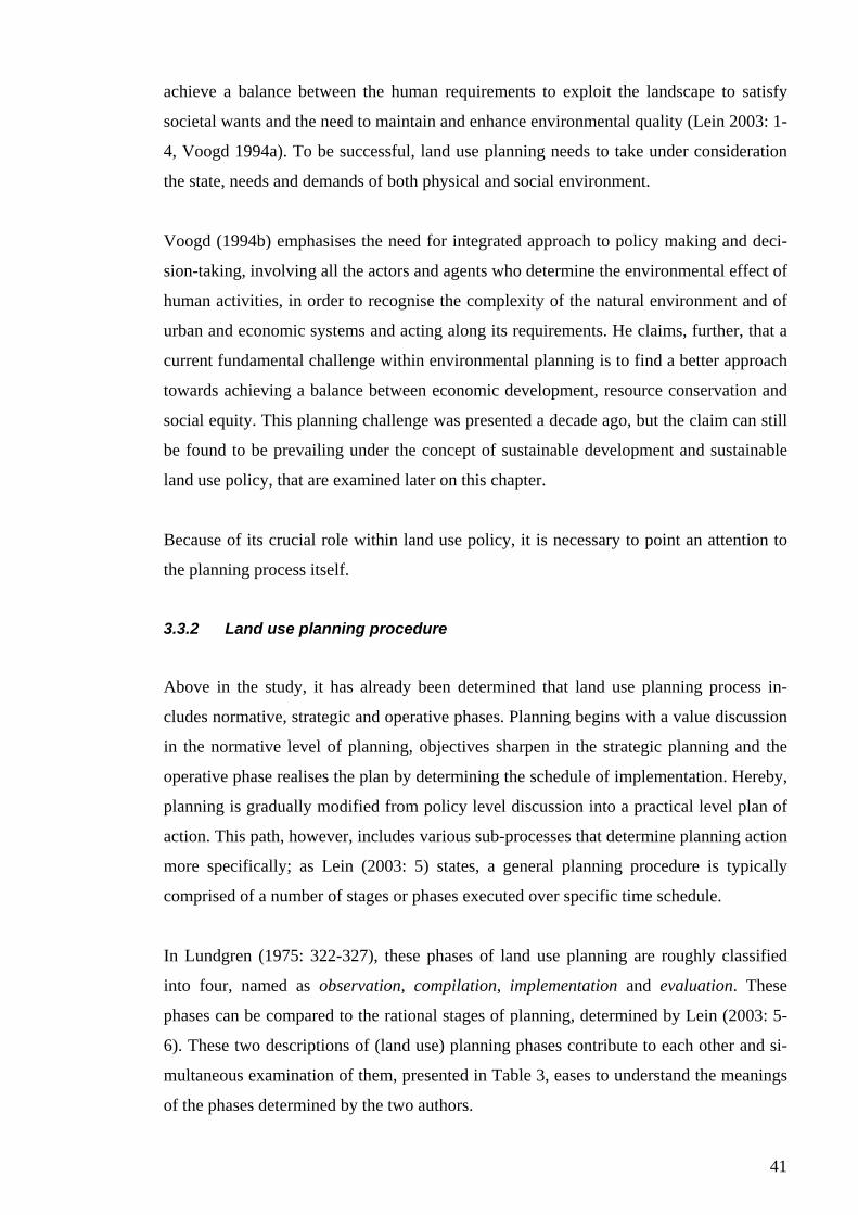
41
achieve a balance between the human requirements to exploit the landscape to satisfy
societal wants and the need to maintain and enhance environmental quality (Lein 2003: 1-
4, Voogd 1994a). To be successful, land use planning needs to take under consideration
the state, needs and demands of both physical and social environment.
Voogd (1994b) emphasises the need for integrated approach to policy making and deci-
sion-taking, involving all the actors and agents who determine the environmental effect of
human activities, in order to recognise the complexity of the natural environment and of
urban and economic systems and acting along its requirements. He claims, further, that a
current fundamental challenge within environmental planning is to find a better approach
towards achieving a balance between economic development, resource conservation and
social equity. This planning challenge was presented a decade ago, but the claim can still
be found to be prevailing under the concept of sustainable development and sustainable
land use policy, that are examined later on this chapter.
Because of its crucial role within land use policy, it is necessary to point an attention to
the planning process itself.
3.3.2 Land use planning procedure
Above in the study, it has already been determined that land use planning process in-
cludes normative, strategic and operative phases. Planning begins with a value discussion
in the normative level of planning, objectives sharpen in the strategic planning and the
operative phase realises the plan by determining the schedule of implementation. Hereby,
planning is gradually modified from policy level discussion into a practical level plan of
action. This path, however, includes various sub-processes that determine planning action
more specifically; as Lein (2003: 5) states, a general planning procedure is typically
comprised of a number of stages or phases executed over specific time schedule.
In Lundgren (1975: 322-327), these phases of land use planning are roughly classified
into four, named as observation, compilation, implementation and evaluation. These
phases can be compared to the rational stages of planning, determined by Lein (2003: 5-
6). These two descriptions of (land use) planning phases contribute to each other and si-
multaneous examination of them, presented in Table 3, eases to understand the meanings
of the phases determined by the two authors.
42
Table 3. The process of land use planning (Lundgren 1975: 322-327, modified) in relation with the stages of rational planning in general (Lein 2003: 5-6).
PHASES OF LAND USE PLANNING STAGES OF PLANNING I OBSERVATION Physical land characteristics
1 Identification of the problem and determination of need
Present land use Human aspects
2 Collection and analysis of data
II COMPILATION Land unit identification Physical land potential Land use requirements
3 Development of goal and objectives
Feasibility aspects Ecological considerations Social and economic consideration Development aims
4 Classification and diagnosis of the problem and surrounding issues
5 Identification of alternative solutions
6 Analysis of alternatives
Land use plan development
7 Evaluation and recommendation of actions
III IMPLEMENTATION Land use plan implementation
8 Development of an implementation program
IV EVALUATION Baseline evaluation Evaluation of impacts
Ecological aspects Socio-economic and technical aspects
9 Surveillance, monitoring and evaluation of the outcome
The phases of land use planning process are listed on the left side of the table. Each of
them form themselves a separate process that also proceeds through different phases of
action. The purpose of the duties of each of the four phases is to support the planning in
the next, superior, phase. The same goes with the stages of planning with a rational ap-
proach, that are presented on the right side of the table; each stage leads to the next by
giving a background information and input to it. However, the phases and sub-steps of
them do not necessarily proceed accurately along the order but they vary in detail in rela-
tion to the nature of the (planning) problem (Lein 2003: 5).
3.3.2.1 Observation
Land use planning begins from observing the present situation. This includes examination
of the physical land characteristics, present land use and the human aspects, like popula-
tion and administration, for example (Lundgren 1975: 325). Thus, what describes these
undertakings is land classification and land evaluation in relation to different characteris-
tics of physical environment and land use and socio-economic and institutional circum-
stances (Vink 1983: 199-200). For example, inventory of present land use must include
43
an assessment of the relation between land use and physical land characteristics and hu-
man aspects.
In this phase, becoming aware of the needs, partly on the basis of the gathered observa-
tion data, identifies the planning problem for the first time. Nevertheless, after specific
identification of the problem and a clear expression of the planning goals and objectives,
more data specific to the goals and, especially, analysis of the data are required. As Lein
(2003: 10) expresses, “data, information and intelligence are essential for good planning”.
Here, data is useless unless it can become information, and information, further, describes
the level of knowledge needed to solve the problem (Lein 2003: 10). Intelligence is
needed to collect right amount of right kind of data in order to produce sufficiently right
type of information. Davis (1976: 108) states that planning cannot be better than the qual-
ity of ideas, experience and information that supports it; these give the basis for success-
ful formulation of policies. Sound land use planning uses also modern scientific knowl-
edge together with the various empirical data (Vink 1983: 201).
3.3.2.2 Compilation
In the compilation phase, planning continues from the basis of the phase of observation
and data collection. First, land units, suitable for planning and management, are identi-
fied. Then the physical land potential and land use requirements of the planning unit are
examined, through which the planning goals and objectives are further developed. In ad-
dition, the feasibility aspects must be taken under consideration; the planning problem
needs to be classified and diagnosed together and in relation with surrounding issues, as
different ecological, social and economic aspects. Furthermore, the goals and objectives
need to be adjusted in line with national development and land use aims.
After all the preparatory action, the actual land use plan can be developed as a synthesis
of the study of human aspects, present land use, physical land potential and feasibility
aspects (Lundgren 1975: 327). Especially studies of land use potential or capability are
essential and valuable for the decision-maker (Mitchell 1979: 65, 79). Because every goal
or objective can be achieved in various different ways, identifying and examining alterna-
tives is an essential part of the planning process (Lein 2003: 11). Thus, a proper land use
planning identifies alternative land use solutions and analyses and evaluates these possi-
ble solutions before giving any recommendations of actions or doing any final decisions.
The analysis and evaluation of alternatives can be, and often are, parts of the process of
44
environmental impact assessment (EIA). Shortly, within the EIA the possible and prob-
able consequences of a human action are carefully examined before an irreversible com-
mitment is made into a decision that possible has an adverse environmental change (Lein
2003: 198, Voogd 1994a). Public participation is an integral part and also a method and
requirement of EIA process (Lein 2003: 210-203).
3.3.2.3 Implementation
Implementation phase simply consists out of development of an implementation program
and the actual implementation of the land use plan. Implementation, however, requires
sufficient financial, organisational and employee resources (Lundgren 1975: 327). It is
also essential that the implementation is coordinated with the evaluation; the working
systems for the interaction between these two phases must be available already at the be-
ginning of the implementation (Lundgren 1975: 327).
3.3.2.4 Evaluation
As stated above, evaluation of a land use plan needs to be in interaction with its imple-
mentation. Surveillance, monitoring and evaluation of the outcome form important in-
formation for implementation of the plan, which is to be corrected along the produced
information. Basically the evaluation has two courses: firstly, it focuses on the achieve-
ment of the aims determined by the land use plan, and, secondly, it examines the effects
and possible side effects of the implementation of the land use plan (Lundgren 1975:
327). The effects and the side effects can be either expected or unexpected by their na-
ture.
Evaluation should examine both ecological and socio-economic aspects. In order to fulfil
this duty, periodic monitoring of natural resources and environmental change (for exam-
ple land degradation and land productivity), and socio-economic circumstances is funda-
mental (Helldén 1985, Babu & Reidhead 2000). This creates a challenge for developing
evaluation criteria that best illustrate the examined change and the indicators that would
give the best monitoring information. Furthermore, evaluation in the end of the planning
process, again, gives an input to the observation phase in the beginning of the process
and, thus, keeps the planning process continuously dynamic.
45
3.3.2.5 Continuity of planning
The process of planning hardly ever ends, but instead, the implementation and evaluation
of a plan is always the beginning of next one; land use planning, as planning in general, is
a dynamic process. This is due to the fact that every planning problem is of its own kind
and changes over time; thus, they all need their own kind of solutions. This is why the
phases and stages of planning, presented above, do not necessarily always appear wholly
or in the exact order.
The continuity and dynamics of the planning process is mainly encouraged by evaluation
process, which in fact begins right from the beginning of whole planning process and,
thus, is not present only in the end of planning process. On the contrary, evaluation is
essential in every phase and stage of planning (Lundgren 1975: 314-315) through ex ante
–evaluation, intermediary evaluation and ex post –evaluation, as the evaluations in the
different planning phases are usually classified. Hereby, evaluation is the main means of
planning process to improve itself. Eventually, this appears as better planning and im-
proved land use.
3.4 Sustainable development in relation with land use policy
The predominant threat to sustainability in land use emanates from the stress imposed on
the natural system when land is changed from its natural state to some other form (Lein
2003: 39). Then, what would make land use changes sustainable?
Sustainable development is commonly associated with three fundamental principles: 1)
inter-generational equity (futurity), 2) intra-generational equity and 3) transfrontier re-
sponsibility (Selman 1996: 11, see also Our common future 1987). Along ‘inter-
generational equity’, one generation should hand on the earth to the next generation in at
least as good condition as it inherited it (Selman 1996: 11). ‘Intra-generational equity’, or
social justice, refers to the importance of containing the principle of human needs within
the sustainable development (Selman 1996: 11). This means that everyone should have
equal rights and possibilities to satisfy their needs and to benefit from the use of re-
sources, both within and between countries. A particular regard is given to world’s poor.
Finally, the principle of ‘transfrontier responsibility’ emphasises that sustainability in one
locality, region or country cannot be achieved at the expense of environmental conditions
46
elsewhere, but, the responsibility for any impacts of activities needs to be accepted at the
place (Selman 1996: 11).
It has already been stated that the ends and objectives of land use planning are often
highly political in their nature and that this is because land use planning depends on the
actions of political power. For this reason it can be stated, further, that sustainability of
land use is determined by the flexibility of a regulating policy; sustainable development
requires “an administrative system that is flexible and has the capacity for self-
correction” (Our common future 1987: 43, 46, 65).
3.4.1 The rise of sustainability in land use planning
Owens and Cowell (2002: 13) state that interest in national and land use planning coin-
cided with, and was promoted by, spreading attention to sustainable development starting
from the work of the Brundtland’s Commission in 1987. International attention towards
environmental matters increased, largely stimulated by accumulating scientific evidence
about human-induced change in critical natural systems (Selman 1996: 12). Expansion of
the concept continued by the arguments of the 1992 United Nations Conference on Envi-
ronment and Development (UNCED) that declared the importance of production and im-
plementation of strategies or plans in addressing the interrelated problems of environment
and development (Owens & Cowell 2002: 13). The main statement of principles for ac-
tion agreed in UNCED (signed in the Rio conference 1992), Agenda 21 – the Global Pro-
gramme of Action on Environment and Development, regarded ‘environmentally sound
physical planning’ as essential to sustainable development in urban areas and desirable in
the integrated, and thus sustainable, management of land resources in non-urban areas
(Koch & Grubb 1997, Owens & Cowell 2002: 13).
Through the emergence of strategic planning and sustainable development as an objective
of development, planning and, especially, land use planning was seen as a means to pro-
mote sustainable development (Owens & Cowell 2002: 16). This belief followed (and
still follows) from the role of planning to be an arena for discussion about the meaning of
the term “sustainable”, its function in reconciling development and conservation and its
role when decisions are to determine what is sustained (Owens & Cowell 2002: 16). In
the spirit of sustainable development, land use planning now had the duty to recognise
interrelationships between land use, resource consumption and environmental processes
47
extending across space and time; the duty of the planning system was to promote sustain-
able use of resources through appropriate policies and design (Owens & Cowell 2002:
17). Lein (2003: 43) emphasises the same issue by stating that environmental planning is
an important step to ensure long-term sustainability because of its focus on integrating
environmental ideals and information into the planning process.
The concept of sustainable development emphasises the meaning of value discussion in
the planning process, thus, the importance of the normative level of planning. And when
it is a question of values, legitimate interests, rights and obligations constantly conflict in
policies and decision-making (Owens & Cowell 2002:39) – confusing the expected con-
crete of sustainability even more. However, no decisions or plans can be made out of
value discussion alone, but usually conclusions need the values to be put in some order.
This again needs a dialogue, and Owens and Cowell (2002: 43) think it is arguable that
land use planning provides one forum for the purpose.
3.4.2 Planning for sustainability
Owens and Cowell (2002: 48-72) approach the concrete planning for sustainability from
three different aspects: 1) the means of assessment, 2) public participation and 3) struc-
tural integration. These are examined in following.
3.4.2.1 The means of assessment
Owens and Cowell (2002: 50-53) present, by referring several scientists, that, first of all,
sustainability can be aimed by environmental assessment which includes methods for
identifying, predicting and evaluating the impacts of particular actions, and, procedures
for ensuring that analysis takes place and informs the decision-making process. The main
critics given to this approach consists of doubt that genuine alternatives would really be
considered and of concern that the system does not question the wider strategies of which
some individual project is only a part. This is why, according to Owens and Cowell
(2002: 51) there is growing support for strategic environmental assessment (SEA), which
focuses, in addition to environmental impacts, to plans, programmes and policies, and
thereby, gives an opportunity to question policies and development strategies through
dominant institutions and values.
48
Assessment is present also in evaluating environmental capacity (for development)
(Owens & Cowell 2002: 53-56). Capacity studies give the primacy to environmental con-
siderations and undermine dependence of sustainability on balancing or integrating com-
peting priorities. Owens and Cowell (2002: 80) claim that the planning system can be
seen as a forum in which environmental capacities – the space for a new land use inter-
vention – could be delineated. This, however, in addition to the present land use, needs
the examination of land (use) limitations, or, the analysis of land suitability, which also is
called land (use) capability (Vink 1983: 215-216). In this exercise, resolving the agro-
ecological potentiality of land provides a fine starting point to proceed.
Even though the techniques of valuation and cost-benefit analysis have had less impact in
land use planning than in some related areas of policy, monetary valuation and cost-
benefit analysis have been used in supporting decision-making about whether or not par-
ticular environments are critical (Owens & Cowell 2002: 56-58). This third means of as-
sessment, however, easily hide political and ethical assumptions behind its methodologi-
cal choices. Hence, Owens and Cowell (2002: 58) suggest that assessments are moving
more into the direction of some combination of SEAs and capacity studies.
3.4.2.2 Public participation
Secondly, Owens and Cowell (2002: 58-64) determine participation as a way to promote
sustainability in planning. They bring up that it is even matter of democracy and of jus-
tice, that people are involved in decisions that affect their lives, and, further, they summa-
rise that inclusive public participation is essential for a truly sustainable community. Also
Selman (1996: 123) argues that participation by the public increases the legitimacy of the
planning process, leads to the production of better-informed decisions and raises public
interest in planning issues. Through public involvement in planning, new ideas and dif-
ferent opinions and worldviews have been introduced to challenge the official concep-
tions of sustainable development and consensual strategies for sustainable development
have been generated (Owens & Cowell 2002: 58-64). Moreover, the public is not only
offered an opportunity to contribute to the planning process as such, but the planning
through a plan becomes central as a forum of debate and communication, which is essen-
tial for sustainable development (Selman 1996: 124). The participatory planning proce-
dures enjoy public confidence to move from NIMBY – ‘not in my back yard’ – to NIMBI
– ‘now I must be involved’ (see Voogd 1994a).

49
Selman (1996: 124) notes that the importance of the locality is emphasised as an arena for
effective citizen action and public participation. The power, centralised in Government or
corporations, should be brought down in order to genuinely empower individual citizens
in the planning process (Selman 1996: 147). This is because people are apathetic to envi-
ronmental issues, and thus to get involved in planning, because they feel it is the respon-
sibility of those in authority, even though, at the same time, they show only weak trust in
the competence, honesty and ability of governments and businesses to manage environ-
mental resources to the benefit of public interest (Selman 1996: 147).
3.4.2.3 Structural integration
Thirdly Owens and Cowell (2002: 64-70) talk about structural integration promoting sus-
tainability. Structural integration is usually regarded essential in promoting all the other
kinds of integrations, for example, integration of different parts of state apparatus, public
and private sector, sectoral policies, the many considerations and participants at the re-
gional scale and regions or planning objectives of various sectors. Although evaluation
and monitoring techniques along with participatory planning methods are assumed to im-
prove integration, and therefore better sustainability, the mechanisms through which inte-
gration might promote sustainable development are still unclear. The most important
here, however, is to focus on the approaches of power and advantage to integration in-
stead of administrative or technical approaches (Owens & Cowell 2002: 68-70).
3.4.3 About problems of sustainable development in land use planning
None of the technical, participatory or integrative approaches lead directly to more sus-
tainable development. As a matter a fact, they all are in the middle of power struggle that
actively and constantly construct and negotiate the conception of what is sustainable
(Owens & Cowell 2002: 70). An illustration of this is, for example, the status of partici-
pation in the planning process. Though participation is widely seen as a positive and im-
portant feature along the planning process, it also seems problematic because the forces
in political culture still doubts the ability of public to contribute to governance and plan-
ning (Lein 2003: 53).
And though it maybe somehow clear that sustainable development needs planning, it has
been difficult to translate the expectations into coherent actions (Owens & Cowell 2002:
22). This resulted from the wide range of definitions given to sustainable development –
50
over the times, it has been difficult to create any concrete out of arguments that, on one
hand, has brought threatening global scale phenomenon to concern of everybody’s daily
lives, and on the other, has emphasised the local scale qualitative matters. In addition,
there is the debate of ‘needs’ that is remarked, for example, by Voogd (1994b). He criti-
cises the definition of sustainable development made by the Brundtland’s Commission
“to meet the needs of the present without compromising the ability of future generations
to meet their own needs” (Our common future 1987: 43) – if interpreted from a ‘needs’
perspective and seen with the eyes of an environmentalist, sustainability does not neces-
sarily guarantee a prevention of environmental degradation, because the ‘needs’ override
environmental considerations.
According to Voogd (1994b), tradeoffs are essential in order to arrive at planning solu-
tions in which a multiplicity of different interests are involved. He argues that the concept
of sustainability lacks the ability to make the tradeoffs, both the spatial tradeoffs – “here
or there” – and the temporal tradeoffs – “now or then or never”. Moreover, he continues
that this is why sustainable development is lacking sufficient flexibility to be applied di-
rectly on a local planning level – the impossibility of tradeoffs limits the possibility to
make optional choices needed especially at the local planning level, and thus, planning
for sustainable development can be threatened.
The same problem is also recognised by Owens and Cowell (2002: 137) who state that
local plans are difficult to base on conceptions of sustainable development that require
deviation from the priorities of national policy, for example, when deciding using assets
like natural resources. National policy about and interests in management and use of
natural resources passes easily the local needs and interests. The traditional ‘national
need’ versus ‘local impacts’ dichotomy of planning creates a conflict and again makes
determining what is sustainable a problem for all levels of government (Owens & Covell
2002: 140). This has unavoidably consequences in implementing sustainable land use
planning and land use practices, at the local as well as at the national level.
Finally, if planning is agreed to be a forum for a discussion about the meaning of sustain-
able development, also a conclusion, that planning does not support sustainable develop-
ment if an unsustainable meaning of the concept is accepted and realised within it, can be
drawn. But that would not be sustainable, would it? And that is why planning would
never do such of an acceptance, would not it?
51
3.5 Nature conservation – an issue of values
Nature conservation is a form of human land use – in general it tries to conserve certain
natural ecosystems and natural components of cultural ecosystems (Vink 1983: 129). The
concept includes both nature protection and nature conservation that can also be called
nature management. The aim of nature protection is to find support in human society for
the protection of natural or semi-natural ecosystems in general or in specific areas. Nature
management, instead, means the actual management of nature reserves consisting of natu-
ral or semi-natural ecosystems or cultural ecosystems with some special value. To the
latter belong several kinds of forests, for example the sacred forests, and some of the
more traditional kinds of grazing and arable land agriculture (Vink 1983: 129-130). The
fundamental principle of conservation is maintenance of (biological) diversity (ecosys-
tems, species and genetic resources), and it is becoming, or has become, a major interna-
tional issue (Juma 1991; Mather 1986: 208-210).
Conservation is based on the relationship between man and his environment, in particular
in man’s attitude towards his environment (Mather 1986: 182). According to Davis
(1976: 9), history tells that people usually do what they think they have to regarding their
natural resources and will destroy them if necessary to live. We can ask, why should na-
ture be conserved, what is it in the nature that is worth of protection and why and when
should such values take priority over other claims, especially the ‘needs’ (Owens &
Cowell 2002: 111). According to Mather (1986: 182, 210), conservation is about acting
along certain values historically adopted from religion and from generation to another. He
states that the main problem of conservation today is how to create agreement on these
basic values and how to translate them into frameworks of practical action. The goals or
objectives of conservation, as of land use, must stem with people’s values. Marekia
(1991) refers to the same issue by stating that conservation approaches must respond to
the changing needs of the society. Therefore conservation should not be seen as a static
science that seeks only to preserve – it must also be dynamic if it is to survive.
In the globalised society, no value is anymore acknowledged better than another only
because of historical tradition without adequate argumentation. In addition, when discuss-
ing the valuation of nature, we must keep in mind, that today, unlike at the time of past,
societies face these questions of values and approach the necessary choices through a va-
riety of institutions that increasingly enforce the available options (see Mather 1986,

52
Owens & Cowell 2002). Furthermore, Owens and Cowell (2002: 111) remind that ideas
about what is considerable and in what circumstances are also formalised by national and
international legal frameworks for nature conservation and planning which, thus, affect
the choices of a society.
All in all, according to Vink (1983: 128-129), living resource conservation is not just a
limited sector of protection, but rather a process that must be considered by all sectors of
human activity in rural areas. Particularly Vink (1983) calls an emphasis on long-term
planning with a view to the destructibility of natural ecosystems and the irreversibility of
their destruction. The same issue is raised also by the concept of sustainable development
that names ‘conserving and enhancing resource base’ as one of the critical objectives of
environment and development policies; on the one hand, nature conservation is a moral
obligation to other living beings and future generations, and on the other hand, conserva-
tion and enhancement of natural resource base is essential if needs and development goals
are to be met on a sustainable basis (Our common future 1987: 49, 57-60).
3.5.1 The two faces of conservation
Above, suggestions for sustainable policy formulation approached conservation through
two aspects. The dual meaning or objectives of conservation are emphasised also by
Mather (1986: 186, 203) who determines conservation as follows; either conservation can
mean saving for future use or saving from harm or damage. Nevertheless, saving from
damage is not necessarily related to saving for future use. A resource, as land, can be
saved from harm or decay because of some “perceived value” based in ethics and phi-
losophical reasons, or, its conservation can be based on pragmatism of protecting it to be
useful in the present and the future. The pragmatism in conservation can also be com-
pared with the avoidance of waste (Mather 1986: 186). Furthermore, Mather (1986: 187)
makes a rough division between nature conservation and resource conservation. He de-
termines that nature conservation is concerned mainly with the protection of environment
for its own sake – saving from, and, resource conservation, on the other hand, is con-
cerned more with the protection of the usefulness of the land – saving for. When regard-
ing land as an object of conservation, the both of these meanings have an important role
whether it is a question of examining the present state of land, its use or planning the fu-
ture use of land – saving for and saving from merge, and should merge, together.
53
Especially, the both, pragmatic and philosophical, aspects of saving land are, according to
Mather (1986: 203), emphasised when thinking of landscape conservation. Pragmatic
reason to conserve landscape is, for example, to try to protect the resource base of an in-
dustry like tourism in the same way in which soil conservation is to protect farmland or
some specific soil type. Beautiful scenery can be conserved also because of less material
reasons; some scenery can be valuable and worth of protecting for its own sake, irrespec-
tive of any economic reasons (Mather 1986: 203). Countries have designated areas for
landscape conservation, either in national parks and wilderness areas or in other designa-
tions such as areas of great landscape value or of outstanding natural beauty (Mather
1986: 203-204). Regarding to Mather (1986: 203-204), in natural parks, usually both the
scenery and wildlife are the objects of conservation and many times they are protected for
both pragmatic and philosophical reasons, for example, because of tourism, natural
beauty and rich biodiversity.
3.5.2 National parks
Mather (1986: 204-208) discusses the original park idea, originated in North America in
the late nineteenth century, that conceived of national or federal ownership and manage-
ment of a large area of natural landscape (see also Davis 1976). He points out fundamen-
tal questions that emerge from this classical model of national park in relation to the goals
of conservation and in the means by which it is to be achieved: should the goal be to con-
serve landscape as it was at the time of designation, to “freeze” landscape at one moment
of time, and if so, how much change and what kinds of changes are permissible? How
can the goals be achieved when the land is occupied by numerous individual land users
with their own land use goals, which are unlikely to coincide with those of the nation in
designating the park? One of the Mather’s most profound questions is whether conserva-
tion management should seek to maintain the original form of the area, or rather maintain
the natural processes that through time lead to chancing the form. Weighting of these
questions together with the pragmatic and philosophical reasons to conserve of a land
area, a waters or a landscape have its consequences in adjusting the reality of a conserva-
tion area or national park through the rules of management and use of the area.
According to Vink (1983: 131), national parks in most countries have a multiple function;
they are, on one hand, established for nature conservation, but on the other, they often
have a secondary objective to maintain resting areas for wild animals in order to, for ex-
54
ample, keep a certain level of game-cropping for the population in the surrounding areas.
The latter is for maintaining food-security of the local population regarding game as a
source of proteins (Vink 1983: 131).
Nevertheless, Mather (1986: 208) presents a weakness in the concept of the protected
area in conservation. According to him, there is a risk that little thought is given to con-
servation within the areas unprotected by special designations, though, it would at least in
some level be equally important. This can lead, for example, to a situation where land and
nature is under severe degradation and natural biodiversity decreasing right outside the
border of a conservation area or a national park or where all other forests, except the con-
served ones, are heavily overused and decayed.
3.5.3 Nature conservation, planning and sustainability
The Brundtland’s Commission (Our common future 1987) state that conservation is es-
sential requirement in order to sustain environmental quality and ecosystems and to con-
tribute to sustainable development. Owens and Cowell (2002: 102) state, further, that be-
cause the fate of ecosystems is depended on the use of land, should conservation aspects,
and thus those of sustainability, be a matter of foremost concern for all involved with
land use change. Owens and Cowell (2002: 124) continue that effective land use planning
is fundamental to nature conservation in a number of ways: it has a key role in instituting
appropriate frameworks and rules, in site protection, in introducing and conducting more
holistic concepts of conservation and, moreover, in contributing to the cultivation of re-
spect for non-human nature. Land use policy needs to ensure that, within the conservation
unit, only ecologically sound and sustainable land use practices are practiced (Marekia
1991).
In the context of sustainable development, nature conservation policies combine interna-
tional, national and local dimensions, and their relations with land use exemplify the new
challenges of planning, requiring comprehension of links between development and envi-
ronmental change at all scales (Owens & Cowell 2002: 102). Responding to the new
planning challenges demands a strategic approach to conservation and to the enhance-
ment of biodiversity, and, therefore, biodiversity needs to become a true consideration in
the development objectives of key economic sectors (Owens & Cowell 2002: 102, 106).
55
Owens and Cowell (2002: 109) suggest that delineation of wildlife habitats could form
part of the environmental basis for policy formulation and would, thus, be constitutive of
the environmental, and also other, objectives of the development plan. Further, it might
contribute to strategic environmental assessment as its input. This way biodiversity would
really be a concrete basis for planning.
3.6 Question of land use in relation to development
The economic systems are primarily related to the existing environment, although envi-
ronmental factors also affect non-economic aspects of social life (Lundgren 1975: 21). As
so, it can be concluded that environment is a key factor in determining people’s social life
and economic systems.
Social and economic development is a many-faceted problem. But to achieve develop-
ment, one of the most fundamental prerequisites is to use the land resources in a way that
meets the needs to feed people and, moreover, creates the surplus necessary for growth
(Lundgren 1975: 14, see also Pender 2002). In developing countries, especially the role
of agricultural use of land is of major importance regarding to enhancement of food secu-
rity and economic development possibilities. Unplanned and badly managed development
may cause environmental problems and, therefore, there is a need to develop policies and
institutions that will manage, develop and implement viable programmes in protecting
and preserving the resources (Korir-Koech 1991). Traditional development plans have
given an emphasis on maximising economic returns from the available land, but new ap-
proaches to development, on the contrary, are calling for the use of a conservation ethic
to guide growth strategies (Juma 1996). The way land use is governed reflects the man-
agement of political affairs, and according to Juma (1996), it may be argued that the gov-
ernance of land use is the most important political issue in most African countries.
Planning for optimal land use and subsequent sound agricultural and economic develop-
ment, that is sustainable in the long term, requires a good knowledge of land resource
endowment and land’s potential, and rational using of this knowledge for planning (Agro-
ecological assessments… 1993: 1, 140). This implies taking a responsible attitude toward
protection of the environment and conservation of the natural productive resources upon
which the well being of the nation depends – plans cannot be made in ignorance (Agro-
ecological assessments… 1993: 140). Field-Juma (1996) states that since the natural en-
56
vironment creates the very basis of social and economic development and specifies the
limits of the resources available for such development, it is also a reasonable starting
place for defining the basic limits of (our) actions. The most benefit, in developing coun-
tries, is gained by investigating the likely consequences of decisions and investments in
advance and by systematising planning procedures (Agro-ecological assessments… 1993:
140).
Two major bottlenecks in creating rational, non-destructive land use in the developing
countries are, according to Lundgren (1975: 14), a) inadequate knowledge about the
physical resources and b) lack of expertise to evaluate and translate existing knowledge
into sound land use practices. One of the main problems is, according to Juma (1991),
that in many African countries, there is no systematic collection of information on natural
resource management available. This is of major importance when knowledge and infor-
mation about the state of natural resources and the possible needs for improvement form
the basis of proper land use policy formulation and planning, and when evaluation is the
key to get information about impacts and to improve the processes of land use and its
planning. Field-Juma (1996) notes also that though public attitudes towards the environ-
ment have come to recognise the threats of pollution and natural resource depletion over
the past three decades, changes is behavioural norms and their codifications in law and
institutions have lagged behind.
Furthermore, we cannot ignore the influence of global elements of policy formulation and
actions in developing countries. Rules for natural resource utilisation have been guided
by the logic of economic and political power which state that increased consumption is
the primary stimulus to economic growth and human development, and, consequently,
limitations of consumption are accepted only when they do not endanger and limit indi-
vidual’s right to use the natural environment to which she or he has access (Field-Juma
1996). Too often international community pushes the elements of economic development
and override national, or local, environmental values and needs.
57
4 LAND USE POLICY IN KENYA
4.1 Historical background
4.1.1 Indigenous natural resource management
At the arrival of colonial rule, the different ethnic groups had reached a territorial distri-
bution where the characteristics of the areas they occupied were largely suited to their
respective occupation (Lundgren 1975: 17, 83). Different tribes were living in harmony
with their surrounding environment and each of them could practise their own occupa-
tions in peace through reciprocal relations among families and communities (Field-Juma
1996; Lundgren 1975: 17, 83; Soja 1968: 8).
According to Field-Juma (1996), traditional, indigenous resource management systems in
Africa reflected the way communities organised their lives within the constraints of the
environment in which they lived – decision-making institutions based the use and man-
agement of environmental resources on the knowledge of the community (see also
Okoth-Ogendo 1976). Hence, the decisions were made strongly based on community’s
ethics, norms and beliefs, and the resource users and the decision-makers were in very
close proximity (Field-Juma 1996). Field-Juma (1996) continues that indigenous knowl-
edge enabled communities to avoid over-exploitation of an area through monitoring its
status and adjusting their resource use patterns. Also, far from being static, indigenous
natural resource management – or land use policy – systems have shown that, they have
embodied the responsiveness, resilience and complexity of the ecology upon which they
are based (Field-Juma 1996).
Within the indigenous natural resource management systems land was not owned by any-
one, as the terms of private ownership, but it was under communal ownership (Masinde
& Shakaba 2004). The intergenerational transfer of land rights proceeded within family
under the control of the community, and thus indigenous tenure systems often provided
high tenure security (Field-Juma 1996, Okoth-Ogendo 1976). Notwithstanding the com-
munal land ownership, it is stated that customary land tenure systems in Africa evolved
over time from collective to more specific and individual rights (Field-Juma 1996).
Marekia (1991) describes that during the pre-colonial times conservation was closely
linked to the imperatives of co-existence between humans and the natural environment.
58
There was plenty of land and human population density was lower than today. Hence, it
was relatively easy to maintain natural ecosystems in their natural state. Wamalwa (1991)
determine this as “holistic approach”, in which it is difficult to identify specific conserva-
tion strategies among traditional land management systems because the entire society was
behaving for the conservation objective. This can be illustrated, for example, by Mutiso’s
(1991) example: by leaving stumps and some trees in agricultural land, the farmers in-
creased infiltration of whatever rain fell.
4.1.2 Colonial imperatives
Until 1884, Zanzibar was the centre of commerce in East Africa and also Europeans did
trade in the area through sultan of Zanzibar (Kaikkonen et al. 1989: 206). But the com-
mand moved into European hands finally in 1886 when Britain and German agreed on
the division of the area; the border was directed from the Lake Victoria to the coast
through Mount Kilimanjaro; the northern areas (Kenya) were to be under British and the
southern areas (Tanzania) under German rule (Kaikkonen et al. 1989: 207, 212; Soja
1968: 16).
In 1894, the Imperial British East Africa Company (IBEAC), operating formerly from
Mombasa, established a protectorate to Uganda, and further British East African protec-
torate, consisting of Kenya (Kaikkonen et al. 1989: 208). The land between Mombasa
and Uganda was important to the British Government for two reasons: 1) Britain needed
to establish her jurisdiction in the area and 2) Britain wished East Africa to become self-
sustaining – these results were to be achieved by European settlement, and a railroad was
built to link the economies of Uganda and the coast (Harbeson 1973: 8).
In the next two decades, the dominant concerns of the British Government were to secure
administrative control of Kenya and encourage European settlement to facilitate its eco-
nomic development (Harbeson 1973: 8). The settlers considered Africans incapable of
administering their affairs, and the policy of separate development or segregation of races
was introduced (Akivaga et al. 1985: 15). This meant different administrative structures
for different races in different areas. Permanent European settlement was formed in
Kenya in the beginning of 1900’s, Nairobi being the biggest centre (Soja 1968: 16-17).
The “unoccupied” and “unused” highland areas were kept ideal for European settlement
59
and agriculture – the “Kenya highlands” was renamed as the “White highlands”
(Kaikkonen et al. 1989: 211-212; Soja 1968: 17),
Throughout Kenya’s years as a British dependency, the distribution, use and tenure of the
limited reservoir of high potential agricultural land caused political struggles among
European settlers, African communities and the colonial government (Harbeson 1973,
Okoth-Ogendo 1976). The English established new land tenure in their conquest of the
‘New World’ (Davis 1976: 14) – this happened also in Kenya where there, as noted
above, was no idea of individual landownership whatsoever. Between 1890 and inde-
pendence in 1963, the colonial government progressively alienated land from the African
indigenous population for European settlement and entrenched European private property
rights (Field-Juma 1996).
The British Government assumed control of “unoccupied” land, land of indigenous peo-
ple, and presented it to European farmers as 999-year leaseholds (Harbeson 1973: 9).
From the standpoint of their own and the British Government, The Crown Lands Ordi-
nances of 1902 and 1915 gave the European settlers legal security on their new farms
(Harbeson 1973: 9). Hereby, in 1920, when the East African Protectorate was renamed
Kenya Colony, all land was taken to the possession of the Crown and African people
were made tenants-at-will of the British (Harbeson 1973; Lundgren 1975: 84; Okoth-
Ogendo 1999; Sagay & Wilson 1978: 368).
In 1930, the Trust Lands Ordinance statutorily declared reserves for the use and benefit of
the African inhabitants and their control was vested in a trust board separate from the lo-
cal administration (Lundgren 1975: 84-85). Administrative chiefs and tribal boundaries
were created in order to provide a locally based administrative unit with which colonial
authorities could deal. This consequently reduced the reciprocity between ethnic groups
by stressing ethnic identity, creating competition for increasingly scarce natural resources
and preventing the ecologically sound migratory processes through which communities
had earlier responded, for example, to land shortage and temporal environmental changes
(Field-Juma 1996; Lundgren 1975: 84; Okoth-Ogendo 1976).
The most important struggles involving land occurred, indispensably, in the eastern high-
lands and the Rift Valley, the former Kikuyu region and current “White Highlands” – the
agricultural and political heartland of Kenya, wherein, at the same time, the greatest con-
60
tributions to Kenya’s economic development were made (Harbeson 1973). But it can be
argued that the conflict was not the most eminent between the Europeans and Africans
but it finally occurred between different African communities that were forced into com-
petition about the scarce resources within the reservations addressed to them (Harbeson
1973).
4.1.3 Land as a basis for African nationalism
The most aggressive group to defend their rights and to plead for the return of “stolen
lands” was formed within the Kikuyu; the Kikuyu Central Association (KCA), with Jomo
Kenyatta as its leading figure, represented the Africans in the national government (Har-
beson 1973: 18-19). During the World War II, African political organisations were sus-
pended, which made them more extreme by driving them underground (Sagay & Wilson
1978: 371). After the war, Kenya African Union (KAU) continued with increasing mili-
tancy as a successor to the KCA (Harbeson 1973: 18). KAU was the first really national
political movement, and it, for example, rejected the Government’s attempts to improve
African economies by soil-conservation techniques in the fear of it replacing the recovery
of “stolen lands” (Harbeson 1973: 21-22; Sagay & Wilson 1978: 372). In the 1950’s, as a
product of growing African, primarily Kikuyu, alienation from the existing regime, the
Mau Mau emergency was originated, lasting from 1952 to 1960 – primarily as an African
civil war between those Africans who had gained and those who had not gained during
the years of European settlement and colonial administration (Harbeson 1973: 18-23; Sa-
gay & Wilson 1978: 371).
In the 1950’s, Mau Mau resulted as various complex political actions by colonial gov-
ernment to respond to the distress of people of Kenya by creating agricultural solution to
Kenya’s development problems (see Harbeson 1973: 31-74). The purpose was to improve
productivity by land reforms and political multiracialism that were ought to better the
conditions of Africans by ending the racial exclusiveness of the White Highlands through
notable resettlement programs and to transfer political power in Kenya from the colonial
administration to an independent African government.
These actions already anticipated the processes of decolonisation but were strongly Euro-
peanised; the processes were undertaken on European terms and with European interests
given the foremost consideration, as, for example, in the Africanising of the White High-
61
lands that by late 1950s comprised of 75 per cent of the total high potential land in Kenya
(Harbeson 1973: 31-79; Rutten 1992: 69). The colonial government ensured that settlers’
agricultural leases were converted into freehold tenure, private property was made sacro-
sanct and expropriation was outlawed except full compensation (Field-Juma 1996). Also,
the property rights of some Africans were entrenched in order to ensure the development
of an African landed middle-class, which would share the same economic and political
interests with the settlers (Field-Juma 1996). This emerging elite of African farmers con-
stituted particularly of businessmen, politicians and civil servants (Rutten 1992: 88).
Prior to the decolonisation, in 1960, mainly Kikuyu contributed to the origin of KANU,
Jomo Kenyatta becoming the president of it (Kaikkonen et al. 1989: 220). The other
communities, however, established a competing alliance: Kenya African Democratic Un-
ion (KADU), with Daniel Arap Moi as one of its leading figures (Kaikkonen et al. 1989:
220). The parties were, however forced into cooperation along the extensive resettlement
programs carried out in the beginning of 1960’s along the land reforms. The pre-
independence constitutional changes resulted from this close cooperation, or political
consensus – the politics of harambee, evident between KANU and KADU as partners in
the coalition government (Harbeson 1973: 135-172).
There were, however differences between the two parties about becoming administrative
structure of independent nation state; KANU advocated a strong central government,
while KADU represented the small ethnic communities that supported a degree of re-
gional autonomy to protect themselves from the larger communities such as the Luo and
Kikuyu (Harbeson 1973: 72). This distinction appeared most intensively before the 1963
election; the question was whether the regionalism – majimbo – was, as a structure, nec-
essary or desirable to guarantee individual rights of Kenyans (Harbeson 1973: 166).
KANU won the election and Kenyatta became the first prime minister of Kenya’s internal
self-government leading Kenya to independence by the end of the year (Harbeson 1973:
167; Kaikkonen et al. 1989: 220). One year later, Kenya became a republic with Kenyatta
as its first president. In 1965, KADU was disbanded, the Senate was dissolved and Kenya
became a one-party state (Sagay & Wilson 1978: 374).
62
4.1.4 The case of natural resource conservation and management in the colonial era
During the colonial period, the natural environment was seen as a free good and the pur-
pose of the colonial government was to control as much as possible of it for their own
economic benefit (Field-Juma 1996). The indigenous holistic view about conservation
was shifted by colonising culture, and conservation was thus undertaken as “special pro-
jects” and even by individuals or groups separate from those involved in utilising the en-
vironment and contributing to its degradation (Wamalwa 1991).
Kenya’s first national park was established in Nairobi in December 1946, and soon fol-
lowed the parks of Tsavo (in 1948) and Mt. Kenya (in 1949). Marekia (1991) emphasises
that the areas, where parks were established, did not necessarily support the largest vari-
ety or largest possible concentration of wildlife – rather, the areas were chosen on the
colonialist basis that they were “unlikely to be required for other purposes”. This meant
that they were too arid for agriculture, at least in permanent use. Most of all, the parks
were established by whites for whites; it was not imagined that the native people should
or would be interested in the parks, although the parks were in the grazing lands of many
communities, but in fact, the idea of establishing parks was to protect nature from the
natives (Marekia 1991).
On the one hand, the decades under colonial rule could be called the ”golden era” for
natural resource conservation in Kenya: the natural resources suffered only little destruc-
tion, clearing of indigenous forests was minimal and wildlife protection “was probably at
its best” because the colonial laws were followed by the letter (Mwagore 2002: 62-63).
On the other hand, this is, however, an absurd statement. The laws were irrelevant from
the reality of needs and capacities of indigenous Africans and they underestimated the
skills and adaptability of the Africans to new concepts and practices (Korir-Koech 1991).
Soil losses due to increasing erosion within the areas reserved for Africans were signifi-
cant as a consequence of increasing human population within the reserves, disappearance
of indigenous shifting cultivation methods and the absence of crop rotation techniques
(Juma 1991; Korir-Koech 1991; Mwagore 2002: 62-63). Moreover, the land African
population was shifted into, mainly consisting of low potential ASALs, had not been util-
ised continuously before the colonial period, because the agricultural communities knew
that a continuous strain over the areas would have damaged the land (Mutiso 1991). The
alienation of land for national parks also pushed many people into more and more arid
63
areas (Mutiso 1991). In addition to these, the continued subdivisions, due to the inheri-
tance, together with intensive agricultural practices on these ever shrinking plots intensi-
fied soil erosion (Korir-Koech 1991).
In all, the colonial implementation of environmental policy measures was coercive for the
indigenous Kenyans and lax for the European settlers (Korir-Koech 1991). For example,
the colonial authorities regarded overgrazing as the main reason for the soil degradation
in the ASAL areas, and systematic destocking of local cattle was introduced as part of the
colonial programme to control overstocking and, thus, soil degradation (Juma 1991).
4.2 Post-colonial developments
Because of the close attachment of Kenya and Kenyans to land, land became, at the time
of independence, the prime focus of African nationalism in Kenya (Harbeson 1973). But
the problem for the independent Government was to rid off the processes of nation build-
ing from the legacy of European influence; both the land redistribution and emphasis on
broadening participation in the political decision-making have been discarded as viable
nation-building objectives primarily in favour of economic development (Harbeson 1973:
78). The principles and objectives of the independent Government were stated in Ses-
sional Paper No. 10 of 1965 “African Socialism and Its Application to Planning in
Kenya” (see African socialism and its application to planning 1965). Nation-building is-
sues were expressed through principles of African socialism in Kenyan style, in which
particular emphasis was given to political democracy, distinguished from communism,
and mutual social responsibility – harambee, which tied everybody to participate in soci-
ety’s prosperity (Harbeson 1973: 173). However, the post-colonial politics centred on the
issue of bureaucratic influences on policy making, and Government’s objective was to
retain the well-established central administration inherited from the colonial authorities
(Hyden 1979).
In 1964, the former Crown Land, including all estates, interests and rights in and over it,
was vested in the Government of Kenya (Land: mali umma 2001). The land tenure cate-
gories were regrouped into: government land (public land), trust land (former native land)
and private land (see Rutten 1992: 19). The legal arrangements on land were, hereby, pre-
served under the sanctity of private property in high potential areas and under the state’s
control in the ASAL areas through a trust mechanism, in which the primary control is
64
retained in the relevant government ministry and administered through administrative
chiefs and local authorities (Field-Juma 1996).
Land policy was to be one of the prime illustrations of African socialism in operation and
it gave an emphasis on the land consolidation and registration; the individual titles to land
were seen as a prerequisite to effective development of land (Harbeson 1973: 174; Onalo
1986: 5). However, land policies followed the trends set by the colonial government, and
the land reform programmes were continued (Lundgren 1975: 86). Especially the two
reforms, which were begun just before independence, continued: 1) the adjudication and
registration programme and 2) the land transfer programme (Lundgren 1975: 86, Rutten
1992: 80). Land adjudication and registration aimed at consolidation of scattered frag-
ments of land belonging to one farm and registration of consolidated holdings. The land
transfer programme continued transferring land from Europeans to Africans in the forms
of smallholdings or of large-scale farms (Lundgren 1975: 86). These have so far re-
mained as the primary themes of the Government’s land use policy (Rutten 1992: 80, 88).
4.2.1 The state of natural environment
After the independence in 1963, the new Government needed to ‘humanise’ the abrupt
land use policy of the colonial authority in order of nation building. But, instead of mak-
ing improvements on the laws, the Government practically ignored them by being reluc-
tant to stress the colonial conservation policies (Mwagore 2002: 63). In this “benevolence
age”, the need to conserve natural resources for future generations was written down to
the Government’s central policy papers, as reflected in African socialism… (1965),
which made conservation part of the political agenda (Mwagore 2002: 63). At the time of
independence, there were ten national parks and game reserves – initiated and imple-
mented by the colonialists with no regard for African aspirations and needs – that were
fully legitimised by the political leaders of Kenya who saw their economic potential in
the form of tourism (Marekia 1991).
However, environmental issues were not taken seriously the real objective being to use
economic resources effectively for the interests of economic development (Harbeson
1973: 176; Juma 1991). The institution of private property entrenched ownership in the
landed elite that controlled the most productive agricultural resources and denied access
to them from other agriculturalists and pastoralists (Field-Juma 1996). In the remaining
65
areas, this inevitably led to severe stress over the environment. But still, concern was fo-
cused on the settlement schemes and on improving agriculture in the humid areas, and
ASAL problems were outside the policy arena; soil conservation regulations remained in
force but their enforcement was “lax” (Korir-Koech 1991; Mutiso 1991). As the human
population continued to increase, the pressure on land became intensive and extensive
(Korir-Koech 1991). Furthermore, high-level corruption was developed affecting, espe-
cially, the wildlife that encountered dramatic loss between 1975 and 1983 despite the ban
of hunting in 1977, after which game cropping has not been permitted (Marekia 1991;
Mwagore 2002: 63).
From the year 1983 onwards, policies and legal and institutional reforms were at an ad-
vanced state, technology was brought within to support sustainable natural resource man-
agement and international protocols and cooperation was realised as national programmes
regarding, for example, sustainable development (Mwagore 2002: 63). Despite all the
gains, there has been no political will to support conservation of natural resources; be-
cause of the short-term political survival interest and corruption in the power structures
and government system, the policies, laws and institutions have been ignored and forests,
wildlife and wetlands intensely destroyed (Mwagore 2002: 63; Wamukoya & Situma
2000: 3). Whether undertaken by local authorities or the Government itself, the numerous
conservation programmes planned in the mid-1980 have not been implemented due to the
lack of funds (Juma 1991). Irony and contradictions have been characterised this “dark
age” of natural resource management (Mwagore 2002: 63).
Based on the above arguments, I can only wonder the conclusion made by Korir-Koech
(1991) that with regards to President Moi’s era “it can be observed that development and
environmental management strategies in Kenya continue to contribute towards an im-
proved environment… conservation and management without destruction will go a long
way in a sustainable development fashion.” I truly find irony and contradiction here and
suppose that perhaps the strategies and policies have contributed to natural environment
on paper, but in practice the implementation has been poor or totally disregarded. This
assumption is supported by my own observations and discussions in Kenya.
66
4.2.2 Developments in land policy
In the whole East Africa, rather than restructuring land relations in accordance with their
new development imperatives, the independent countries have re-entrenched and even
expanded the scope of colonial land policy and law (Okoth-Ogendo 1999). In Kenya,
land law is not directly developed from customary law to statute law but it is intertwined
with European, mainly British, settlement in the country (Onalo 1986: 3). As an illustra-
tion of this, private ownership rights remain as legitimate as they were in colonial times;
‘native lands’, now called ‘trust lands’, are still held by statutory trustees rather than di-
rectly by indigenous people, and unalienated land remains the private property of the
Government (Okoth-Ogendo 1999). In Kenya, only little effort has been made to design
innovative land rights systems and complimentary infrastructure for the country (Okoth-
Ogendo 1999).
Okoth-Ogendo (1999) presents some common issues, which have influenced contempo-
rary land policy development in all the three countries of East Africa. Firstly, introduced
by colonialism and perpetuated by the post-colonial state, the state became, in law, the
ultimate authority in matters of control and management of land. Most evidently in
Kenya, the state has always had an overriding interest over matters of access, control and
management of land irrespective of the tenure category under which it is held or owned.
Secondly, the customary land tenure has always been generally despised. In Kenya, the
official policy of the Government has been the extinguishment of customary tenure
through systematic adjudication of rights and registration of title and its replacement with
a system akin to the English freehold. Thirdly, land law has adopted essentially adminis-
trative character – instead of enacting substantive property law statutes, the colonial gov-
ernment concentrated rather on the development of an administrative infrastructure
around land relations. Thus, not only was customary land law undeveloped but the sub-
stantive content of imported English property law was not developed either, because it
was presumed (by the colonialists) to be already fully developed. The result is that land
law has become, in fact, the law of land administration and land tenure part of administra-
tive law – regulating the access to land has become tool for the administration of the so-
ciety (Mwangola 2001; Okoth-Ogendo 1999).
67
4.2.3 New structures for natural resource management
As nation-states came into existence, the distance between the resource user and the deci-
sion-makers increased by virtue of their having different world views, and national sys-
tems tend to be characterised by centralised structures, which separated the resource users
from the decision-makers even more (Field-Juma 1996). Now, environmental problem
solving was done in the ministries and other agencies and research in special-focus insti-
tutions rather than in the course of resource management activities (Field-Juma 1996).
These new structures disregarded indigenous knowledge by drawing their models and
concepts from western traditions and, consequently, affected to land law and land use
(see Rothermund 1994). By the private property, traditional land use systems, which
based on the needs of community members, were disrupted and the natural resource utili-
sation strategies of society as a whole were limited (Field-Juma 1996).
Regarding to the role of state and its administrative bureaucracy in land issues, serious
doubts have emerged about the competence of that organ in matters of land management
and stewardship. To land using public, land bureaucracy has become inefficient, largely
insensitive and corrupt, and moreover, the costs of these abuses have been passed on
them (Okoth-Ogendo 1999).
4.3 Land use policy today
Nowadays, there are 77 laws about environment and “too many laws on land” – this re-
sults as conflicts and confusion between different sectoral laws including, for example,
the constitution of Kenya, land tenure and land use legislation, forestry legislation, wild-
life legislation, water laws and agriculture legislation (Masinde & Shakaba 2004; Mbe-
gerea 2004; Wamukoya & Situma 2000: 2-5). The laws of different sectors can go and
often goes cross and, therefore, none of the laws are implemented properly (Masinde &
Shakaba 2004). Fragmented policy and strict central government, as strongly centralised
and vertically integrated development administration and planning machinery, was inher-
ited and passed on to these days from the colonial times; colonial system and regulations,
concerning land and environment, have not changed in independence (Masinde &
Shakaba 2004; Odete et al. 2004, Rutten 1990). As colonial authority regulated through
ordinances, the same are under the independent Government called acts (Masinde &
Shakaba 2004). Planning has mainly been restricted to the British tradition of budgeting
as a task of the central authorities (Rutten 1990).
68
From this basis, this section of the study presents some elements of today’s land use pol-
icy in Kenya for consideration whether the “dark age” of the state’s natural resource
management is possibly still continuing or left behind along a new policy tendency. The
discussion is totally based on my own understanding. I even had to argue repeatedly,
while staying in Kenya, why I am doing research about the land use policy when, accord-
ing to several Kenyans, there is not such thing in Kenya… Nevertheless, here I present
my own impression of land use policy in Kenya, its administration, means and future.
4.3.1 Administration
Kenya’s central government operates through the Office of the President and the different
ministries. Traditionally, the Office of the President, with the president as its leader, has
had a strong power in national policy making. The ministries, in turn, are highly special-
ised. Comprehensively, they are responsible for establishing national sectoral polices and
ensuring that the same are incorporated in national and district plans (District focus for
rural development strategy review, draft document 2002: 10). Ministries involve and
guide districts in budgetary processes and implementation of policies. They are, further,
expected to give technical support to district level staff to enable and empower them to
perform in their duties (District focus… 2002: 10).
The current ministries and government departments and their responsibilities are stated
and defined in the Presidential Circular No. 1 of 2003. This first announcement of the
‘new’ Government, was not, however, found from the district’s ministerial offices in
Wundanyi, though for my request it was properly looked for. Instead, I was told that the
only place where the document could be found was the Office of the President in Nairobi,
and I should try to get it there. This, however, was not possible for me during my stay in
Nairobi. Luckily I found a list of ministries in a budget report of the Government. Ac-
cording to it, there are twenty ministries working under the Government (Table 4)
(2003/2004 Estimates of development expenditure of the government of Kenya for the
year ending 30th June, 2004 2003: iii). A list of the ministries is also available in the
Internet (Ministries 2004), but the list differs from the one in the budget report by stating
that there are 24 ministries in Kenya. Anyhow, I decided to trust to the ‘more official’ list
of twenty ministries. But in the absence of the Presidential Circular, the responsibilities of
the different ministries cannot unfortunately be presented in detailed.
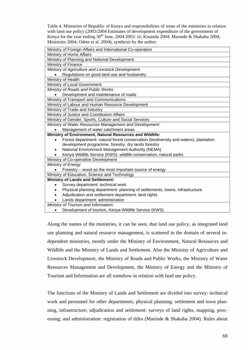
69
Table 4. Ministries of Republic of Kenya and responsibilities of some of the ministries in relation with land use policy (2003/2004 Estimates of development expenditure of the government of Kenya for the year ending 30th June, 2004 2003: iii; Kinanda 2004; Masinde & Shakaba 2004; Ministries 2004; Odete et al. 2004), synthesis by the author.
Ministry of Foreign Affairs and International Co-operation Ministry of Home Affairs Ministry of Planning and National Development Ministry of Finance Ministry of Agriculture and Livestock Development:
• Regulations on good land use and husbandry Ministry of Health Ministry of Local Government Ministry of Roads and Public Works:
• Development and maintenance of roads Ministry of Transport and Communications Ministry of Labour and Human Resource Development Ministry of Trade and Industry Ministry of Justice and Constitution Affairs Ministry of Gender, Sports, Culture and Social Services Ministry of Water Resources Management and Development:
• Management of water catchment areas Ministry of Environment, Natural Resources and Wildlife:
• Forest department: natural forest conservation (biodiversity and waters), plantation development programme, forestry, dry lands forestry
• National Environment Management Authority (NEMA) • Kenya Wildlife Service (KWS): wildlife conservation, natural parks
Ministry of Co-operative Development Ministry of Energy
• Forestry – wood as the most important source of energy Ministry of Education, Science and Technology Ministry of Lands and Settlement:
• Survey department: technical work • Physical planning department: planning of settlements, towns, infrastructure • Adjudication and settlement department: land rights • Lands department: administration
Ministry of Tourism and Information: • Development of tourism, Kenya Wildlife Service (KWS)
Along the names of the ministries, it can be seen, that land use policy, as integrated land
use planning and natural resource management, is scattered in the domain of several in-
dependent ministries, mostly under the Ministry of Environment, Natural Resources and
Wildlife and the Ministry of Lands and Settlement. Also the Ministry of Agriculture and
Livestock Development, the Ministry of Roads and Public Works, the Ministry of Water
Resources Management and Development, the Ministry of Energy and the Ministry of
Tourism and Information are all somehow in relation with land use policy.
The functions of the Ministry of Lands and Settlement are divided into survey: technical
work and personnel for other departments; physical planning: settlement and town plan-
ning, infrastructure; adjudication and settlement: surveys of land rights, mapping, proc-
essing; and administration: registration of titles (Masinde & Shakaba 2004). Rules about
70
what is regarded as good land use and husbandry are, further, determined in the Ministry
of Agriculture and Livestock Development (see also Okoth-Ogendo 1991). Moreover,
responsibility of maintenance and development of roads belongs to the Ministry of Roads
and Public Works.
I find it rather odd that the affairs concerning the management of land and environment
are separated. Land administration and management belongs to responsibilities of the
Ministry of Lands and Settlement and the management of environment is a duty of the
Ministry of Environment, Natural Resources and Wildlife. Within the latter, the activities
are focused into the forest issues along the Forest Department under the ministry; other
functions have been pointed to separate institutions as NEMA and Kenya Wildlife Ser-
vice (KWS). KWS was established in 1989 to be in charge of wildlife conservation and
management (Kenya Wildlife Service s.a.; Marekia 1991). Through its functions and re-
sponsibilities it is in connection with the Ministry of Environment, Natural Resources and
Wildlife and the Ministry of Tourism and Information. NEMA, again, is much newer in-
stitution and environmental authority – it is, however, examined more in section 4.3.3.
All in all, Peters (s.a.) argues that Kenya’s administrative system is complex and over-
strains the resources, which are particularly scarce: technical, managerial and financial
capacities. This is seen, for example, in the case of land use policy, of which the admini-
stration in national level is, based on the above, fragmented into several pieces that are
taken care of by several separate authorities. As Hyden (1979) discusses, bureaucracy
enjoys a high degree of institutional autonomy and hence dominates the policy-making
process.
4.3.2 Planning
As the government in Kenya is strongly centralised, so is the national planning, which
has been based on the Sessional Paper No. 10 of 1965: African socialism and its applica-
tion to planning. The major outcomes of national planning are the National Development
Plans (NDP) in which the development objectives of all sectors have been gathered to-
gether by the ministries; it contains a broad policy framework for attaining policy goals
within the plan period and usually a theme which highlights the main policy objectives
and targets to be achieved by various sectors (Resource mobilization for sustainable de-
velopment 1994: 59). The planning cycle of NDPs was five years until it changed into
71
three-year cycle by the Seventh NDP in 1994 because of budgetary needs and the de-
mands of donor agencies (Resource mobilization… 1994: 59). Nowadays, national plan-
ning is strongly bound to the Poverty Reduction Strategy Paper (PRSP) that follows the
trends of international development policy.
Environmental policies have been incorporated in the NDPs of 1973-83, 1984-88 and the
1989-1993 (Korir-Koech 1991) and, further in the Seventh NDP 1994-1996: Resource
Mobilization for Sustainable Development, which also continued the process of structural
adjustment program begun with Sessional Paper No.1 of 1986 “Economic Management
for Renewed Growth” (see Resource mobilization… 1994). About land use policy, the
Seventh NDP states:
“The Government’s strategy towards the need to use land optimally in line with
the theme of this plan, is to ensure that all land is planned, surveyed, adjudicated
and registered with a view to issuing title deeds. This provides security of tenure
and encourages the people to develop their land, and therefore leads to higher
incomes, increased productivity, general rise in economic growth and improved
standards of living” (Resource mobilization… 1994: 23).
Thus, on the basis of this development plan, a strategy for sustainable land use is to
broaden and strengthen individual land ownership as a means of economic development.
The ideas of sustainable development became into national planning through the UNCED
declaration in 1992 and the adoption of Agenda 21. This global process of planning for
sustainable development and healthy environments resulted in Kenya not only as regards
in NDP but, especially, as creation of National Environment Action Plan (NEAP) in
1994. The NEAP aims at providing a broad framework for the coordination of environ-
mental activities by all actors and describes itself as “a step towards integrating environ-
ment and development for a better management of resources” (The Kenya national envi-
ronment action plan (NEAP), report 1994: viii).
The same environmental atmosphere contributed also to the processing of Kenya Forestry
Master Plan (KFMP) that was also finalised in 1994 (see Kenya forestry master plan de-
velopment programmes 1994). Respectively, the KFMP is concerned with the develop-
ment of the forests, tree growth outside the forests and woody biomass resources gener-
ally for the benefit of present and coming generations. One of the most important aims of
the KFMP was to change the sectoral understanding of forests into more holistic one:

72
forests as integrated component of national development across all the sectors. It empha-
sises the cooperation of different forestry development partners and the need for sound
framework of policy, legislation and implementing actions for conservation, develop-
ment, management and utilisation of the forests (Kenya forestry... 1994).
Despite the fact that, environmental policies have been pushed along variety of plans and
programmes, Mutiso (1991) regrets the lack of ASAL policies, particularly the lack of
policy supporting adoption of innovative techniques through other government policies.
This seems to be generally the case in environmental policies in general – environmental
policies have been regarded as its own sector apart from, for example, land policies and
economy.
Physical land use planning (under the Ministry of Lands and Settlement) is concentrated
into settlement and town planning in which zoning is one method in use. However,
Masinde & Shakaba (2004) argue that zoning should be much more regulatory and guid-
ing part of land use planning. But they further acknowledge that the problem here is the
enforcement of laws. Especially the problem is the title deeds that give the owner of land
full rights to do what ever he wants with his land.
Despite the existence of various legal instruments, there has not been proper and compre-
hensive land use or environmental planning and coordination in Kenya, but the land use
planning activities have been addressed largely at sectoral level (Wamukoya & Situma
2000: 3). All the national level plans are products of planning in several hierarchical
committees, secretariats and task forces that are considered representing participatory
planning, while in reality, according to Mbegerea (2004), planning in practice has not
been participatory but it has retained the power in the Government.
It seems that the extensive policy papers have, in many cases, have been lacking real in-
struments and resources of implementation and, thus, they have remained on the paper.
Also, structurally the plans, and thereby planning, differentiate the phases of preparation,
decision-making, implementation and monitoring to different bodies of authority within
the central government. The consequence of this has been uncoordinated and unsuitable
land uses, conflicts and environmental degradation, increasing inequity in land distribu-
tion and loss of biodiversity (Wamukoya & Situma 2000: 3).
73
4.3.2.1 Decentralisation of planning
In June 1983, the Government of Kenya, with strong presidential backing, issued the Dis-
trict Focus Policy for Rural Development (DFP) through which the decentralisation of
national development planning has been attempted. Juma (1991) and Mutiso (1991) ar-
gue, that under the pressure of growing population and declining arable land availability,
a decentralised development strategy has been undertaken a means by the Government to
provide the basis for investment in the arid and semi-arid areas.
Peters (s.a.) states that this decentralisation process was, indeed, the most far-reaching
reforms of the Government of that time. The DFP transferred planning responsibility
from ministerial and provincial headquarters to the district level officers, but the respon-
sibility for general policy and the planning of multi-district and national programmes re-
mained within the ministries and, thus, within the Government (District focus… 2002: 4;
Rutten 1990). However, the objectives of DFP are to:
• Broaden the basis of rural development by moving planning decisions and man-
agement closer to the area of implementation and the beneficiaries,
• Encourage community participation,
• Accelerate development in the districts,
• Promote equity in the allocation of resources,
• Reduce delays in decision-making and speed up project implementation,
• Arrest rural-urban migration,
• Increase coordination and sharing of development resources,
• Promote sharing of costs of development projects between local people, gov-
ernment and donor agencies,
• Increase employment opportunities in rural areas, and
• Enhance utilisation of local resources (District focus… 2002).
Thus, the objectives of and the expectations on DFP have been quite high, and not with-
out a reason; it needs to be admitted that at least the objectives of the policy can be fully
supported. However, also DFP is a government invented and implemented policy that is
institutionalised downwards from Government to the local level. The effects of DFP and
its proceedings at the district level are further discussed in chapter 5.
74
4.3.3 EMCA and NEMA – new approach to environmental management?
As continuation to the NEAP, the Government of Kenya established the Environmental
Management and Coordination Act (EMCA) in 1999, and it came into force in 2000 (Na-
tional environment management authority 2004; Wamukoya & Situma 2000). EMCA
establishes a link between environmental protection and the right of all individual citizens
to a clean and healthy environment. This is based to the fact that EMCA gave every per-
son a right to complain about environmental defects, whether “the right to a clean and
healthy environment has been, is being or is likely to be violated” (Wamukoya & Situma
2000: 13). In this process, the court of justice is guided by the principles of sustainable
development that include, for example, the principle of public participation, the tradi-
tional cultural and social principles of communities to environmental and natural resource
management, the principle of equity and the polluter-pays and precautionary principle
(National environment… 2004; Wamukoya & Situma 2000: 14).
EMCA is administered by and in responsibility of National Environment Management
Authority (NEMA), a Government’s parastatal that became operational in June 2002 (Na-
tional environment… 2004; Mbegerea 2004; Odete et al. 2004). However, the policy
formulation on matters relating to the management on environment is in responsibility of
its own policy making body the National Environment Council (NEC) that works under
the Ministry of Environment, Natural Resources and Wildlife (Wamukoya & Situma
2000: 16). Moreover, although NEMA is the coordinative body of EMCA, the implemen-
tation of the act is in responsibility of different sectors (Odete et al. 2004).
Anyhow, NEMA is supposed to coordinate all matters and acts regarding to the environ-
ment and it is the principal instrument of the Government in the implementation of all
policies relating to environment (Mbegerea 2004; Odete 2004; Wamukoya & Situma
2000: 18). NEMA’s work includes research, planning and coordination (Mbegerea 2004).
The list of the objectives and functions of the NEMA is long, but the most important
ones, regarding to the future of land use policy, are to:
• “Promote the integration of environmental considerations into development
policies, plans, programmes and projects with a view to ensuring the proper
management and rational utilisation of environmental resources on a sustainable
yield basis for the improvement of the quality of human life”;
75
• “Take stock of the natural resources in Kenya and their utilisation and conserva-
tion”;
• “Establish and review, in consultation with the relevant lead agencies, land use
guidelines”;
• “Examine land use patterns to determine their impact on the quality and quantity
of natural resources”; and
• “ Prepare and issue and annual report on the state of the environment in Kenya”
(citations from Wamukoya & Situma 2000: 18-19).
Within these functions, an important responsibility is to formulate environmental stan-
dards, regulations and long-term guidelines to address environmental issues. The first
instruments for this should be ready by the December 2004 (Mbegerea 2004).
Within the EMCA, environmental planning is accomplished through NEAP that will
identify and assess key environmental issues, recommend solutions and outline strategies
and programmes to redress the problems – the NEAP shall “set out operational guidelines
for the planning and management of the environment and natural resources” (Wamukoya
& Situma 2000: 32-33).
Through the EMCA, also environmental impact assessment (EIA) was brought to the
planning process; nowadays EIA is required in all large-scale projects that have an effect
to environment (Odete et al. 2004). Due to the alternative designs, EIA is addressed as an
important development planning tool (Wamukoya & Situma 2000: 47). According to
Mbegerea (2004), the main objective of EIA-processes is to increase participation, al-
though he also pointed out that, in his opinion, participatory planning and decision-
making takes and requires time, which makes decision-making longer and more expen-
sive, especially at the start when much needs to be resourced to education.
The national coordination of environmental planning is in responsibility of NEMA, and
planning itself is done in special committees. At the national level, National Environment
Action Plan Committee is working to get environment integrated into planning process
(through NEAP), and at provincial and district levels, Provincial and District Environ-
ment Committees are responsible for the management of the environment within the
province and district and for accommodating the interests of different stakeholders (Mbe-
gerea 2004; Odete et al. 2004; Wamukoya & Situma 2000: 28). Thus, though the inten-
tion of EMCA and NEMA is to gather together the responsibilities and activities around
76
environmental issues, I find the administration and planning systems within them quite
complex and hierarchical and, thereby, difficult to follow and understand. This is unlikely
contributing to the overall effort to integrate environmental administration – rather it
forms a new level of authorities in the already confusing field.
However, both of these the act and the body – EMCA and NEMA – are still very new
and, therefore, the both still need further development (Mbegerea 2004; Odete et al.
2004). Mbegerea (2004) states that in order to stabilise these institutions, more emphasis
should be laid on environmental education, for example, by pushing environmental edu-
cation into schools. He thinks that education is needed, for example, to raise environ-
mental awareness in general and to increase knowledge about NEMA itself. According to
him, personal capacity building in every level needs to be quite huge before people know
how to act along the new possibilities.
Finally, Mbegerea (2004) states that expectations about NEMA are high – it is expected
to develop environmental standards and regulations and to really bite. I agree with him –
NEMA has got lots of potentiality to raise environmental issues across the sectors.
4.4 Current issues in land use policy
This section presents few current issues relating Kenyan land use policy and planning that
would need decisions in order to be solved, like conservation issues and land tenure.
4.4.1 Conflicting conservation
Kenya’s policy on nature conservation is based on various ministerial statements, na-
tional development plans, sessional papers and relevant laws – there is no exclusive con-
servation policy, but the main instruments for conservation have been the laws (Juma
1991; Marekia 1991).
4.4.1.1 National parks
There are now more than 50 national parks and game reserves in Kenya, covering about
eight per cent of the country’s space (Kenya Wildlife Service s.a.). Juma (1991) states
that even though Kenya’s ecological diversity provides habitat for various plants, animals
and micro-organisms of ecological and economic value, conservation efforts in Kenya
77
have concentrated on animal species, wildlife being the most known conservation prob-
lem, and forest resources (especially in water catchment areas). The role of wildlife has
been emphasised because of the tourism; the special sites are protected and conserved in
order to gain in tourism incomes. This has resulted partly as a destruction of natural envi-
ronment in the non-protected areas, for example, as intense deforestation. Thereby,
through the national park concept, conservation in Kenya is emphasised more as saving
for future (or tourism use) than comprehensively saving from damage. Further, Marekia
(1991) states that: “Kenya’s mode of wildlife conservation is the national park concept
that involves wrapping nature in protected areas” – the principles of conservation (saving
for and saving from) are performed only in the special conservation areas.
Wildlife in Kenya is classified as national heritage held in trust for the benefit of the pub-
lic (Wamukoya & Situma 2000: 3). This, however, does no seem so evident because,
continuously, a conflict is formed between the good intentions to conserve and the inter-
ests of local people to use the areas in other ways. This is due to the fact that prior to the
existence of national parks and reserves, the areas were subsistence for many local com-
munities (Marekia 1991). As a result, the people around the parks have resented the fact
that the animals – and the lands – have been conserved at their expense with no substan-
tial advantages to them (Marekia 1991). The issue is that the human populations sur-
rounding the game sanctuaries look to them as waste lands which could be put to better
use (Marekia 1991). The conflicts between humans and wildlife are two folded; on the
one hand, conflicts involve damage by wildlife on human beings, crops and livestock,
while on the other hand, humans causing damage to wildlife through poaching and de-
stroying habitats (Mwagore 2002: 30). In addition, conflicts in the management and own-
ership of wildlife resources may lead to loss of property, life or interest in wildlife con-
servation (Mwagore 2002: 30).
The current laws do not take a stand in the question whether the park areas should be
fully enclose or not, and, thereby, the role of and the relation between communities and
wildlife remains unsolved (Odete et al. 2004; Wamukoya & Situma 2000: 3). At the mo-
ment, under prevailing policy framework and legislation, there are no instruments to deal
with the emerging trends of human-wildlife relationship.
78
4.4.1.2 Forests
Forests in Kenya have been suffered destruction over the past 20-25 years. One reason to
this is the fact that forests often are in high potential areas that are also the best areas for
agricultural production. Odete et al. (2004) state that this causes a conflict between the
conservation of forests and the farmers who would gladly take the areas under cultiva-
tion. Odete et al. (2004) further discuss that in order to avoid unnecessary downfall of
forests, farmers would need incentives to invest in forestry instead of other agriculture. In
this change, Odete et al. (2004) emphasised the meaning of renewal of land policy. In
addition, it would need rejuvenating the efforts of implementing the KFMP (Wamukoya
& Situma 2000: 3).
4.4.2 Development issues in land policy
Okoth-Ogendo (1999) determines some development issues that have become the focus
of land policy discourse in East Africa. Firstly, a reform is needed to re-determine the
role of state and its agents in land matters. Secondly, a secure system of land tenure needs
to be innovated and implemented in order to ensure that tenure regimes confer social se-
curity and equity, permit economic efficiency and facilitate the sustainable management
of land. This is an important issue, as according to Juma (1991), the prevailing land ten-
ure system contributes to the lack of interest, for example, to undertake environmental
conservation; farmers who do not have rights over the land they are living on, using or
cultivating are not likely to invest in land when it is likely to take a longer time to get any
benefits if ever.
Thirdly, Okoth-Ogendo (1999) argues that land policy needs to resolve how to maintain
social stability and integrity at the time when changes in land rights take place, for exam-
ple, by protecting social systems against adverse consequences of change or by compen-
sating for loss of accrued rights and interests. Fourthly, the concern is to design policies
and laws that ensure proper oversight in the exploitation of resources without delimiting
proprietary freedom. Fifthly, development of land right systems needs also coordinative
reform of complementary institutions relating to physical infrastructure, supply of agrar-
ian inputs and services.
These issues set many challenges for future actions in Kenya. Okoth-Ogendo (1999) ar-
gues that genuine development requires designing truly innovative tenure regimes to suit
79
the variety of complex land use systems that characterise the African landscape; a tenure
system suited to agricultural communities is not tenable to serve pastoral and nomadic
economies. Therefore, evolution and development of customary land tenure and law
needs to be supported. This can be achieved only by democratising land administration
systems and structures, which now are heavily overloaded, inefficient and retarded. Fi-
nally, customary land tenure rules need to be codified and integrated into statutory law
(Okoth-Ogendo 1999).
In Kenya, these challenges will be faced in the constitutional reform process that has al-
ready been begun by the new Government. However, hitherto the reforms have usually,
for example in Kenya, been characterised by a bureaucratic nature and by an assumption
that policy and legal development can be undertaken in the usual course of administration
(Okoth-Ogendo 1999). But if the legal inconveniences are not somehow handled in the
near future, pressure for reform will eventually explode into demands for fundamental
change – political activism in defence of public land rights is expected to crystallise along
Kenya’s constitutional review process (see Okoth-Ogendo 1999; Rutten 1992: 88).
4.5 Call for national land use policy
The poverty reduction is a recurrent subject in Kenya’s development efforts, and the
question of poverty is a major item on the sustainable development agenda (Juma 1991).
But the issue has largely been viewed solely from an economic point of view, which em-
phasises the (individual’s) access to natural resources (Juma 1991). However, the ques-
tion of access needs to be accompanied by technical knowledge on resource utilisation
and management (Juma 1991). As Juma (1991) and Okoth-Ogendo (1999) argues, land
tenure systems should look for alternatives that reflect the productive needs of various
economic systems, and the ecological aspects of land use need to be taken into considera-
tion when viewing those. Individual land ownership as the dominant national system is
problematic, especially, in the ASAL areas where land cannot be used continuously with-
out major improvements in land use (Mutiso 1991).
The Government has initiated a number of policies aimed at improving the living condi-
tions of the people. They include decentralising the planning process, promoting small-
scale industries, increasing the use of science and technology in development, reforming
the educational system and reviewing the land tenure system (Juma 1991). However,
80
land-holding problem has not been given attention to in development programs, because
it has been seen as a political – not planning – question (Mutiso 1991). Research activi-
ties could contribute to a, more comprehensive, review of land tenure system; policy-
making by itself is likely to resolve this task alone (Juma 1991).
Juma (1991) argues that environmental awareness in Kenya has grown, though the capac-
ity of the country to integrate environmental considerations into the development process
is still limited because of the limitations in available knowledge on natural resource man-
agement and economic policy. He states that there is a need to embark on more system-
atic efforts to collect and analyse information to enable policy makers and practitioners to
identify policy options. What is lacking is a major research programme that would iden-
tify policy options for consideration; in most cases, policy decisions are based on a nar-
row range of choices, which do not take into account the full implications of certain
courses of action (Juma 1991). He also points out, that most of the research conducted in
Kenya on natural resource management has underplayed the role of indigenous knowl-
edge and practices. This presents the legacy of past of the colonial era, when the complex
patterns of natural resource utilisation practised by the local population were not ade-
quately understood and they were eradicated (Marekia 1991).
Changes over land use, land tenure and conservation should be done coordinatedly, be-
cause changes in land use and land tenure have, for example, adverse effects on seasonal
wildlife mitigation – land reform practices should take into consideration the need to con-
serve the environment (Juma 1991; Marekia 1991). Wildlife conservation, nevertheless,
needs to be practised wherever wildlife is found, because it is a unique asset. However,
the greatest threat to wildlife conservation in Kenya may be the agricultural expansion.
Not just through the land use, cultivation, but through other activities such as pesticides
and fertiliser use, charcoal burning, apiculture, burning of forests and grass lands and ir-
rigation that affect the wildlife habitat or create new conflicts (Marekia 1991). This will
involve public education of the value of wildlife and public responsibility towards its pro-
tection (Marekia 1991).
Education is needed also in general in order to enhance environmental awareness and to
give the people knowledge to use the new possibilities to participate and influence. Ac-
cording to Mbegerea (2004), the problem of education in developing country is the fact
that resources are small and that there are many competing interests to use the limited
81
resources – many times education cannot get as much as it would need. Odete et al.
(2004) think that non-governmental organisations (NGOs) are important in this task, be-
cause they are good, for example, in establishing relations with civil society and, thus, in
building strong learning relationships within it. Learning within civil society is needed so
that it can manage its new responsibilities. In overall, the role of civil society is regarded
very important in land matters (Masinde & Shakaba 2004).
Conservation is increased if it is for the benefit of actors (Odete et al. 2004). This means
that local communities and other land owners must be recognised and incorporated into
conservation activities (Wamukoya & Situma 2000: 4). The conservation, in its whole
extent, requires a broader ecosystem-based approach, which can be achieved only by
eradicating the cross-sectoral conflicts (Wamukoya & Situma 2000: 4).
4.5.1 Responding to the challenges
The multiplicity of laws regulating the management of land related resources in Kenya
has over the years led to the establishment of various agencies responsible of overseeing
the implementation of these laws. Administration of the different sectors involved in land
use is not coordinated, but the institutions are distorted in their approach, thus, creating
conflicts (Mwangola 2001). Wamukoya & Situma (2000: 4) argue that many of the land
related challenges could be overcome and the incorporation of local communities into
environmental (conservation) activities would be feasible with a clearly defined land use
policy. However, based on national level examination, land use policy in Kenya seems to
be defined rather unclear. Further, as it can be noticed, land related administration and
bureaucracy has grown into enormous extents.
The Kenya national environment action plan (1994: 13) claims that ”in order to achieve
sustainable management of the land resources, the land use policy must provide a system
of laws, rules, regulation and practices that govern the rights and obligations of land
owners together with appropriate guidelines on optimal utilisation of available land.
There are good reasons for land use planning…” In addition, NEAP lists formulating a
comprehensive land use policy as one of its ”major strategies to realise objectives” (The
Kenya national… 1994: 2). At the moment, these objectives are rising again. Masinde
and Shakaba (2004) claim that the formulation process of national land use policy has
already been started and that it is supposed to gather all the piece-policies together. This
82
will take place in institutionalising EMCA and NEMA and in building new constitution,
in which land and environment are ought to be handled together by harmonisation of laws
regarding the two.
Masinde & Shakaba (2004) also emphasise the relation of land use issues in develop-
ment, and that new holistic land use policy is really necessary for development. New pol-
icy should, further, address and develop proper (development) planning system.
4.5.2 Expectations from the new Government
In the elections in the end of 2002, Mwai Kibaki became the president of Kenya and his
party NARC displaced the long-dominated KANU in the Parliament. Following the new
president and Government, many policy improvements are widely expected. However,
many of the leader persons of the NARC have a KANU-background, and, therefore, also
doubts was presented about the rainbow coalition’s ability to generate political renewals
(Hiilamo 2003).
However, Kibaki soon started to proceed in his agenda, for example, against corruption
and for reducing administration (Hiilamo 2003). The driving intention to make renewals
has been to attract donors in order to increase development cooperation and finance. The
new Government’s political manifesto and plan of action, that is called Economic Recov-
ery Strategy for Wealth and Employment Creation 2003-2007 (2003), was announced in
June 2003.
Regarding to land issues, the plan gives a special emphasis on ASALs, as their develop-
ment is discussed in its own chapter (see Recovery strategy… 2003). However, the ap-
proach to the development of ASALs is concisely economic, as the development aspect
of the whole plan. On the other hand, the plan does raise some land use related and envi-
ronmental questions as crosscutting issues that include, for example, land administration
and survey, environment and natural resources, water and sanitation and regional authori-
ties. But, even though this kind on approach is rather new compared to the former NDPs,
the plan does not seem to provide any new ideas or instruments for dealing with the mat-
ters. Nor does it define how the crosscutting issues are mainstreamed within the sectoral
policies. The statements about environment and natural resources settle to repeat the
83
needs that have been already identified in the previous plans. Environment and natural
resource management is still taken as its own separate sector.
However, the most important, and the most challenging, task of Kibaki’s Government
will be leading the process of constitution renewal which is widely expected to change,
for example, land rights system for the benefit of large public and to establish equity be-
tween the different ethnical groups in the country. Based on my own experiences, people
really count on Kibaki’s Government regarding these issues, and especially regarding
improvements in land tenure and environmental management. The Government is also
expected to proceed with the institutionalisation and development of EMCA and NEMA.
Also Hiilamo (2003) seems confident as he states that now Kenya has Government that
pushes renewals in every sector. However, as it has been discovered though the daily
news, the Government has started to slow and even hinder the constitution renewal proc-
ess, which has caused social instability and large scale demonstrations, for example, in
Nairobi. Thereby, it seems that, because some profound social and institutional change
has been waited for so long in Kenya, the consequences of fails in the renewal processes
can be devastating.
5 EXPERIENCES FROM TAITA TAVETA DISTRICT
This chapter studies the district level content and procedure of Kenyan land use policy
and land use planning. In addition to the literal material and documents about the issue,
an emphasis is given to the information and experiences attained from the field studies.
5.1 Land use policy making at the district level
5.1.1 Administration
In Kenya, unlike in Finland, there is no independent local government, but the local ad-
ministration follows the DFP, the provincial administration as its backbone. This admin-
istrative structure follows a regional hierarchy:
• Provincial and District Commissioners: province/district
• District Officers: division
• Chiefs: location
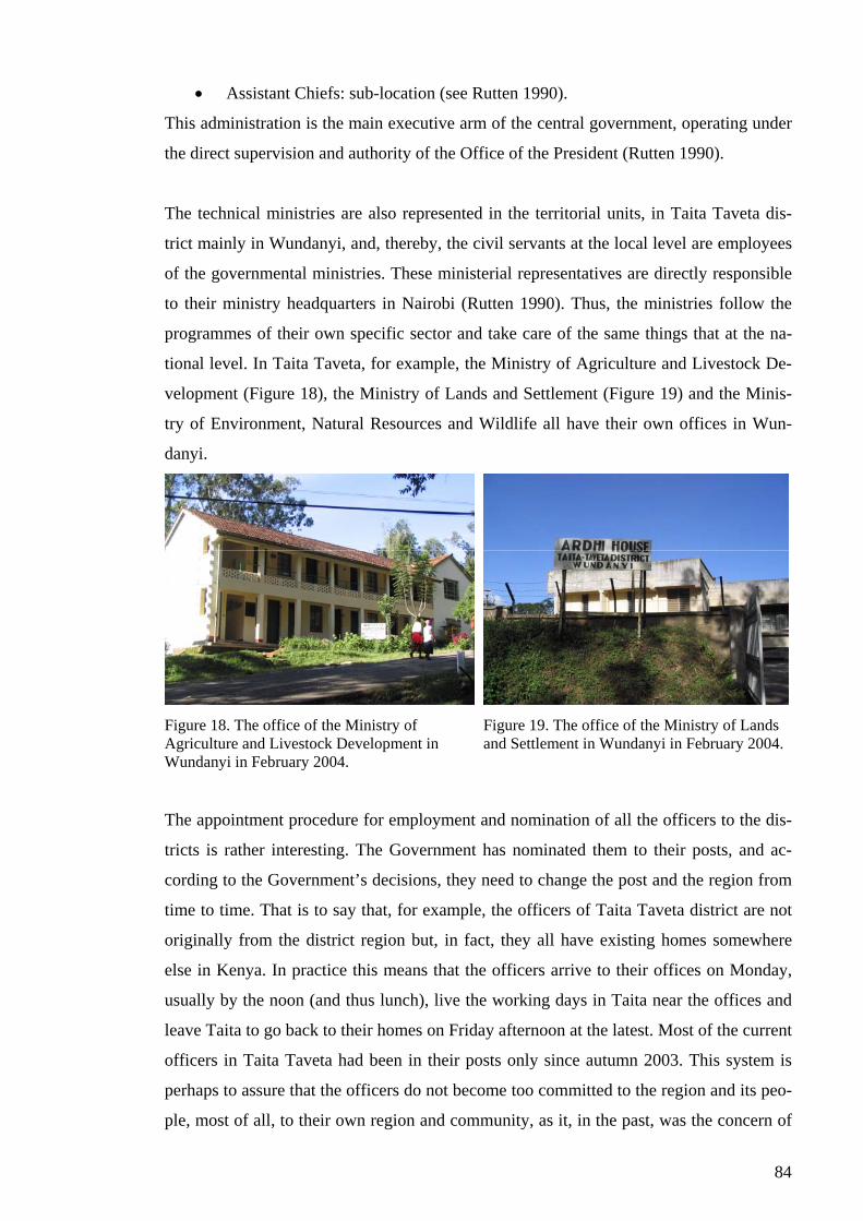
84
• Assistant Chiefs: sub-location (see Rutten 1990).
This administration is the main executive arm of the central government, operating under
the direct supervision and authority of the Office of the President (Rutten 1990).
The technical ministries are also represented in the territorial units, in Taita Taveta dis-
trict mainly in Wundanyi, and, thereby, the civil servants at the local level are employees
of the governmental ministries. These ministerial representatives are directly responsible
to their ministry headquarters in Nairobi (Rutten 1990). Thus, the ministries follow the
programmes of their own specific sector and take care of the same things that at the na-
tional level. In Taita Taveta, for example, the Ministry of Agriculture and Livestock De-
velopment (Figure 18), the Ministry of Lands and Settlement (Figure 19) and the Minis-
try of Environment, Natural Resources and Wildlife all have their own offices in Wun-
danyi.
Figure 18. The office of the Ministry of Agriculture and Livestock Development in Wundanyi in February 2004.
Figure 19. The office of the Ministry of Lands and Settlement in Wundanyi in February 2004.
The appointment procedure for employment and nomination of all the officers to the dis-
tricts is rather interesting. The Government has nominated them to their posts, and ac-
cording to the Government’s decisions, they need to change the post and the region from
time to time. That is to say that, for example, the officers of Taita Taveta district are not
originally from the district region but, in fact, they all have existing homes somewhere
else in Kenya. In practice this means that the officers arrive to their offices on Monday,
usually by the noon (and thus lunch), live the working days in Taita near the offices and
leave Taita to go back to their homes on Friday afternoon at the latest. Most of the current
officers in Taita Taveta had been in their posts only since autumn 2003. This system is
perhaps to assure that the officers do not become too committed to the region and its peo-
ple, most of all, to their own region and community, as it, in the past, was the concern of
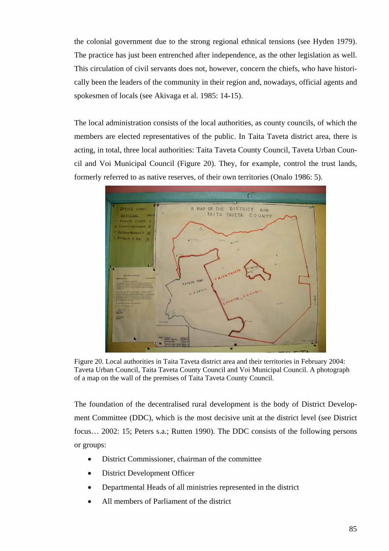
85
the colonial government due to the strong regional ethnical tensions (see Hyden 1979).
The practice has just been entrenched after independence, as the other legislation as well.
This circulation of civil servants does not, however, concern the chiefs, who have histori-
cally been the leaders of the community in their region and, nowadays, official agents and
spokesmen of locals (see Akivaga et al. 1985: 14-15).
The local administration consists of the local authorities, as county councils, of which the
members are elected representatives of the public. In Taita Taveta district area, there is
acting, in total, three local authorities: Taita Taveta County Council, Taveta Urban Coun-
cil and Voi Municipal Council (Figure 20). They, for example, control the trust lands,
formerly referred to as native reserves, of their own territories (Onalo 1986: 5).
Figure 20. Local authorities in Taita Taveta district area and their territories in February 2004: Taveta Urban Council, Taita Taveta County Council and Voi Municipal Council. A photograph of a map on the wall of the premises of Taita Taveta County Council.
The foundation of the decentralised rural development is the body of District Develop-
ment Committee (DDC), which is the most decisive unit at the district level (see District
focus… 2002: 15; Peters s.a.; Rutten 1990). The DDC consists of the following persons
or groups:
• District Commissioner, chairman of the committee
• District Development Officer
• Departmental Heads of all ministries represented in the district
• All members of Parliament of the district

86
• Chairmen of local authorities
• Representative of ruling political party
• Chairmen of Divisional Development Committee (DVDC)
• Representatives of non-governmental development-related organisations
(NGOs)
• Representatives of major private sector organisations
• Representatives of major faith based organisations
• Representatives of major umbrella women organisations (District focus… 2002:
13).
The departmental Heads of the ministries represented in the district and the Divisional
District Officers are not actually members of the committee but will attend the meetings
of DDC as technical advisers (District focus… 2002: 13). In Taita Taveta, the DDC con-
sists of 88 members.
The functions of the DDC include: reviewing and monitoring the implementation of on
going projects, considering new proposals submitted by the DVDC, establishing priorities
for future projects in the District Development Plan (DDP), reviewing and endorsing all
project proposals of local authorities, regional development authorities and NGOs and,
finally, ensuring adequate resources for operation and maintenance of the existing infra-
structure and facilities – the objective is to identify and analyse local development needs,
development potential and establish district development priorities (District focus…
2002: 10, 15).
The DDC is supported by the District Executive Committee (DEC), which provides tech-
nical support for the DDC’s activities, including preparation of plans and management
and implementation of projects (District focus… 2002: 16; Rutten 1990). The DEC also
serves promoting inter-ministerial coordination of development activities in the district
(District focus… 2002: 16).
Hereby, land use issues in Taita Taveta district, as seemingly at all planning levels in
Kenya, are a concern of several more or less independent bodies, without any formal co-
ordination. Kinanda (2004) confirms this by stating that there are many departments
working around land issues, but there is not much of cooperation between these.
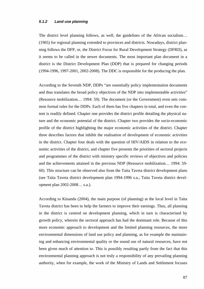
87
5.1.2 Land use planning
The district level planning follows, as well, the guidelines of the African socialism…
(1965) for regional planning extended to provinces and districts. Nowadays, district plan-
ning follows the DFP, or, the District Focus for Rural Development Strategy (DFRD), as
it seems to be called in the newer documents. The most important plan document in a
district is the District Development Plan (DDP) that is prepared for changing periods
(1994-1996, 1997-2001, 2002-2008). The DDC is responsible for the producing the plan.
According to the Seventh NDP, DDPs “are essentially policy implementation documents
and thus translates the broad policy objectives of the NDP into implementable activities”
(Resource mobilization… 1994: 59). The document (or the Government) even sets com-
mon formal rules for the DDPs. Each of them has five chapters in total, and even the con-
tent is readily defined. Chapter one provides the district profile detailing the physical na-
ture and the economic potential of the district. Chapter two provides the socio-economic
profile of the district highlighting the major economic activities of the district. Chapter
three describes factors that inhibit the realisation of development of economic activities
in the district. Chapter four deals with the question of HIV/AIDS in relation to the eco-
nomic activities of the district, and chapter five presents the priorities of sectoral projects
and programmes of the district with ministry specific reviews of objectives and policies
and the achievements attained in the previous NDP (Resource mobilization… 1994: 59-
60). This structure can be observed also from the Taita Taveta district development plans
(see Taita Taveta district development plan 1994-1996 s.a.; Taita Taveta district devel-
opment plan 2002-2008… s.a.).
According to Kinanda (2004), the main purpose (of planning) at the local level in Taita
Taveta district has been to help the farmers to improve their earnings. Thus, all planning
in the district is centred on development planning, which in turn is characterised by
growth policy, wherein the sectoral approach has had the dominant role. Because of this
more economic approach to development and the limited planning resources, the more
environmental dimensions of land use policy and planning, as for example the maintain-
ing and enhancing environmental quality or the sound use of natural resources, have not
been given much of attention to. This is possibly resulting partly from the fact that this
environmental planning approach is not truly a responsibility of any prevailing planning
authority, when for example, the work of the Ministry of Lands and Settlement focuses
88
on titles and settlement schemes, the Ministry of Environment, Natural Resources and
Wildlife handles mainly only forest issues and the Ministry of Agriculture and Livestock
development concentrates on improving agricultural production. However, according to
Kinanda (2004) and Njenga (2004), the cooperation between the ministries, for example
between the Ministry of Lands and Settlement and the Ministry of Agriculture and Rural
Development, has increased during the last year since the new Government stepped in.
Land use planning at the district level is based on Government’s extensive policy papers
that are, however, no use for the purpose or they are ineffective in local land use planning
(Kinanda 2004). Physical land use planning follows the national policy lines of the Min-
istry of Lands and Settlement. The process of land use planning within the ministry fol-
lows the procedure outlined by Njenga (2004): 1) the department of lands and settlement
identifies an area (for planning interventions) and its needs, 2) the survey department
provides technical staff for the survey of the defined area, 3) physical planning of the area
is conducted within the physical planning department, 4) the area is registered by the de-
partment of adjudication and settlement and 5) the lands department conducts the clarifi-
cation and enforcement of the plan. Thus, the district land use planning procedure reflects
directly the duties of the ministry at the national stage, the land adjudication and registra-
tion.
About the overlapping land use issues between the different ministries, one specific ex-
ample was raised. The slope gradients in many places around Taita Hills are steep, and
therefore, Ministry of Agriculture and Livestock Development has regulated that when
slope gradient exceeds 55 per cent, any kind of agricultural activities are not allowed in
order to prevent landslides and erosion. However, the Ministry of Lands and Settlement
registers also these regions and grants title deeds after which the landowner, under the
private ownership, has all the rights to use these lands also in agricultural purposes. Thus,
in many cases, the regulation of the Ministry of Agriculture and Livestock Development
is not accomplished because the laws are contradictory.
EMCA and NEMA were not familiar in Taita Taveta district and, thus, not in practice
either. Neither did it become clear whether a District Environment Committee operated in
the district or not. EMCA and NEMA were, however, heard of and it was assumed that
they might evolve stronger in the future, although they were also regarded to belong to
the affairs of environmental sector and, thus, not affecting the other policies.

89
5.1.2.1 Public participation
Odete et al. (2004) emphasise the meaning of participation of different stakeholders and
think that local communities are nowadays participated well within different issues. An
initiative for local public participation has been introduced through the DFP, of which a
major objective is to increase communication between local communities, government
officers and other stakeholders in the district (District focus… 2002: 19-20). It is in the
responsibility of the DC and the DDC to ensure community participation in all matters
related to development (District focus… 2002: 20).
Participation is conducted as preparation of project suggestions in the communities; the
suggestions compiled into a community action plan are forwarded to the DVDC, which
considers the project proposals, prioritises them and submits them to the DDC. Finally,
the DDC prioritises the community action plans and decides whether they, or which one
of them, are included in the DDP and subsequently into district annual work plans as an-
nexes to the current DDP (District focus… 2002: 20-21).
Mutiso (1991) argues that given the pressure for community participation, the district
focus strategy took a different path with the DDCs being proxy for community participa-
tion. Hereby, community participation was compressed within the hierarchy of adminis-
trative structure and regional plans. Thus, it really can be doubted whether the current
system represents genuine participation of local communities. Mutiso (1991) further
claims that the DDPs are, however, no more than catalogues or shopping lists put to-
gether by DDOs from information supplied by the various ministries. This claim is sup-
ported by the fact that, principally, the Government has fully determined the content of
the plan and that the emphasis is given to the ministry specific objectives. Thus, it is ar-
guable that the DDP is not an arena for local development objectives and planning needs.
However, Odete et al. (2004) argue that the empowerment of localities is about to in-
crease due to the new policy (prepared by the new Government). But they also remind
that, in any case, the people are always developing and working faster than the policy.
This is true, but nevertheless, it should not be a reason to give up on improving the pre-
vailing participation practices that are discovered somehow improper.
90
5.1.2.2 Problems of the District Focus Policy
Though the DFP was established already in the 1980s, it still remains rather undeveloped.
This is due to the various shortcomings, of which I think the most decisive include the
followings:
• On the contrary to the planning of district specific projects, the decisions on
funding of these projects is still centralised; the DDC, and its sub-committees
have been wakened because they have no finances of their own to fund their dis-
trict priorities,
• Inadequate collaboration,
• Duplication of the administrative structures in the district and provincial admini-
stration,
• Lack of formal linkages between community and the development committees;
inadequate local representation and involvement of NGOs in the planning com-
mittees and decision-making,
• Inexistence of a legal framework to backup the operations and decisions of the
DFP,
• Inadequate involvement of districts in the PRSP budget process,
• Lack of linkages between district planning and allocation of national resources,
• Lack of operational tools and equipment at the district level, and
• Inadequate training of field staff (District focus… 2002: 6-7).
Districts themselves are responsible for identifying, planning and implementing district
specific projects. However, it seems that they do not have the needed instruments, capa-
bility or finance to do this. Thus, districts mainly accomplish the duties that they are
given from the Government and the ministries. The approach is highly sectoral, as there
is not much of collaboration either between the actors within the district or with the upper
level of government. Neither have the public and civil society been engaged to the plan-
ning processes.
Through the DFP, decentralisation of planning has been attempted, but the effort has not
practically succeeded since the supportive changes have not been done within the legal
framework. Nor have the districts been seriously taken into national planning, in which
the PRSP processes nowadays have a major importance. All this, of course, affects the

91
whole functionality of the district, which is not now working on its own or for its own
purposes. The decentralisation of planning, thus, remains rather delusive.
5.1.3 Other actors on the scene of policy making and planning
In Kenya and, especially, in Taita Taveta district, the arena for (land use) policy making
and (land use) planning is not fulfilled only by ministerial officers and sectoral depart-
ments, but important stakeholders in the district are also the various parastatals of the
Government, NGOs, community-based organisations (CBOs), donor agencies and the
private sector (see, for example, Taita Taveta district development plan 2002-2008…
s.a.). Principally, these all have their own development agendas and programs they fund
and administer in various sectors that in many cases crosscut also land use affairs, though
from various different aspects.
KWS represents one of the most important parastatal of the Government in Taita Taveta
district. This is due to the Tsavo national park, which is managed by KWS. Especially in
the sector of infrastructure, the National Water Conservation and Pipeline Corporation,
Kenya Railways, Kenya Power & Lighting Company Ltd. and Telekom Ltd. are expected
to work closely with the line ministries and the DDC (Taita Taveta district development
plan 2002-2008… s.a.: 43). NGOs include, for example, Plan International, World Vi-
sion, Heifer Project International, African Wildlife Foundation, East African Wildlife
Society (EAWLS), Catholic Church and Anglican Church of Kenya. CBOs, again, refer
to, for example, production cooperatives or established specialised trust boards.
The most important donor agencies within Taita Taveta are Danish International Devel-
opment Agency (DANIDA), European Union (EU), United States Agency for Interna-
tional Development (USAID) and the World Bank. DANIDA funds, for example, the
Taita Taveta Agricultural Project (TTAP), which has already been in operation for years,
and the Roads 2000 Project. In addition, programs and organisations of United Nations
have had projects in the district.
The private sector, like the agricultural plantations of Taveta, Voi and Mwatate sisal es-
tates and all the ranch managements, are expected to play an important role, especially, in
the development of infrastructure facilities within their jurisdiction (Taita Taveta district
development plan 2002-2008… s.a.: 43). Furthermore, the provincial authorities affect
92
the district level actions. These include, for example the Coast Development Authority
that is ought to initiate and coordinate development activities within the Coast province.
The work of all of these organisations is highly appreciated in the district administration.
However, it was pointed out, that the work of the different parties should be more coordi-
nated; nowadays work is not harmonised, which causes some overlapping and unaware-
ness about the proceeded programs. Most of all, it is generally hoped that the produced
information would be better shared among the actors. From the district officers’ point of
view, it was considered a problem that, for example, some NGOs do not often send their
plans of action to the district administration or do not participate, for example, the meet-
ings of DDC though they are invited. This way much of information remains unshared
which in turn is a constraint for cooperation and development in the long run.
5.2 Few prevailing issues in Taita Taveta
This section presents current land related issues that were regarded the most important in
Taita Taveta district. The main issues are the same that at national level discussion – con-
servation and land tenure. However, here the matters are presented as they are faced in
the context of Taita Taveta district. Furthermore, also one development project is given
attention to as an example of fairly new approach to conservation and natural resource
management in Taita Taveta.
These issues are, however, only a selection of the land use issues in the district, though
the conservation, or the human-wildlife conflict, and the land tenure aspects were empha-
sised widely. Anyhow, also the securing of daily needs, like food, water and housing,
were strongly placed under the most important land related issues. Also the forest issue,
referring to state wide problems presented in the section 4.4.1.2, was seen to be prevail-
ing in Taita Taveta. The following issues, however, illustrate best the policy aspects
within land use questions.
5.2.1 Human-wildlife conflict
“The human-wildlife conflict is intense where croplands border national parks such as in
Taita Taveta” (Mwagore 2002: 30). This is due to the fact that at the time of establishing
the Tsavo national park the livelihood of Taita people was obtained from these lands (see
93
Marekia 1991). Time has past, but the human-wildlife conflict has not disappeared nor
even eased. Rather, it is considered one of the main prevailing issues in Taita Taveta.
Indeed, as the Tsavo national park covers approximately 62 per cent of the total district
land area, it is a considerable restriction for the land use and land use planning in the dis-
trict. The issue, however, is not publicly raised as a planning dilemma: for example, the
Taita Taveta district development plan 2002-2008 does not notice it as any problem.
The conflict can be discussed, for example, through Marekia’s (1991) question: “How to
deal with land use conflicts in wildlife areas in a manner that will meet both the wildlife
conservation requirements and human needs?” One example, perhaps, are the game re-
serves that are run by local authorities (county councils). Within this arrangement, local
inhabitants can practice their traditional cattle rearing in the wildlife sanctuaries, and pro-
ceeds obtained from tourism are paid to the county council, which is to share the revenue
among the local inhabitants in the reserves (Marekia 1991). This, however, is not the case
with national parks which have not formerly been (native) reserves but in which the lands
are owned by the Government, like in the case of Tsavo. Hereby, income obtained from,
for example, gate fees of the park goes to the Government/state and, thus, does not bene-
fit the district and the local people. However, as already mentioned, the park area is a ma-
jor constraint for the district’s land use and planning, also in economic sense, and, more-
over, the people need to live with the wildlife menace on their land.
The system is regarded truly unfair for Taita Taveta district; the lands of Tsavo are ex-
cluded from the use of people in the district, and, even though Tsavo is one of the largest
tourist attractions in Kenya hosting thousands of tourists every year, none of the incomes
are left to the district. It has been suggested that a portion of funds generated from tour-
ism in wildlife areas would be paid into an insurance scheme to compensate for crop and
livestock damage (Marekia 1991). This could partly be an answer to the question, al-
though, any system alike has not realised. Nowadays, the Government does not give any
compensation for people and farmers because of destruction of crops or livestock caused
by wildlife; only a loss of human life is somehow compensated (Odete et al. 2004). Thus,
usually small-farmers are not likely to get anything, though they can lose everything in
one single wildlife invasion. Moreover, the tourism incomes would be greatly needed for
the development of the district.
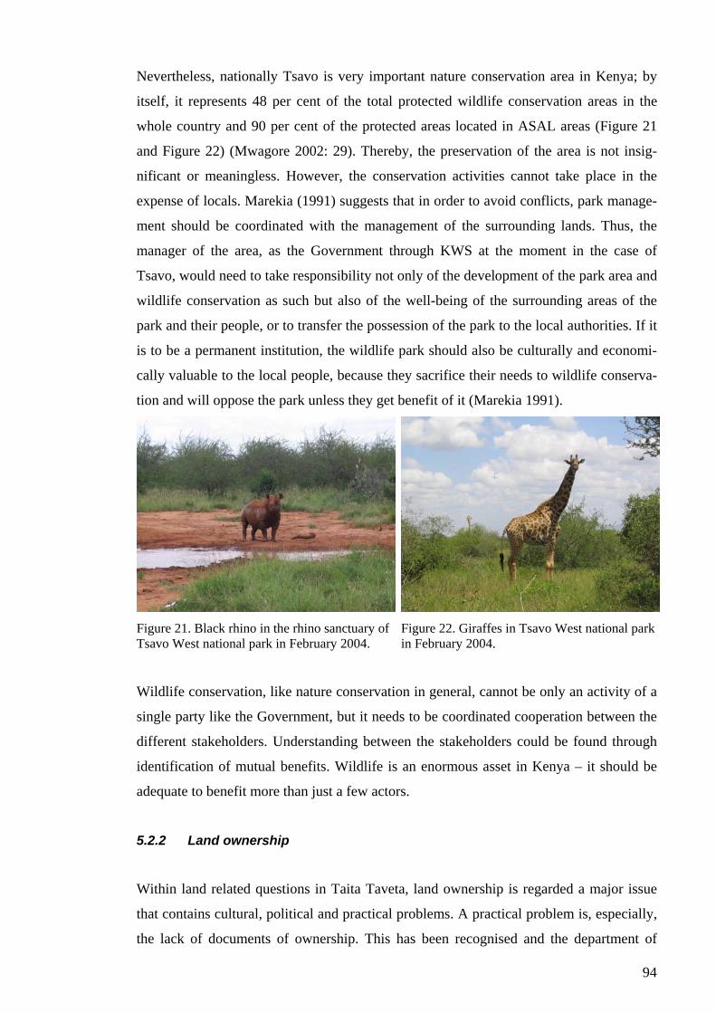
94
Nevertheless, nationally Tsavo is very important nature conservation area in Kenya; by
itself, it represents 48 per cent of the total protected wildlife conservation areas in the
whole country and 90 per cent of the protected areas located in ASAL areas (Figure 21
and Figure 22) (Mwagore 2002: 29). Thereby, the preservation of the area is not insig-
nificant or meaningless. However, the conservation activities cannot take place in the
expense of locals. Marekia (1991) suggests that in order to avoid conflicts, park manage-
ment should be coordinated with the management of the surrounding lands. Thus, the
manager of the area, as the Government through KWS at the moment in the case of
Tsavo, would need to take responsibility not only of the development of the park area and
wildlife conservation as such but also of the well-being of the surrounding areas of the
park and their people, or to transfer the possession of the park to the local authorities. If it
is to be a permanent institution, the wildlife park should also be culturally and economi-
cally valuable to the local people, because they sacrifice their needs to wildlife conserva-
tion and will oppose the park unless they get benefit of it (Marekia 1991).
Figure 21. Black rhino in the rhino sanctuary of Tsavo West national park in February 2004.
Figure 22. Giraffes in Tsavo West national park in February 2004.
Wildlife conservation, like nature conservation in general, cannot be only an activity of a
single party like the Government, but it needs to be coordinated cooperation between the
different stakeholders. Understanding between the stakeholders could be found through
identification of mutual benefits. Wildlife is an enormous asset in Kenya – it should be
adequate to benefit more than just a few actors.
5.2.2 Land ownership
Within land related questions in Taita Taveta, land ownership is regarded a major issue
that contains cultural, political and practical problems. A practical problem is, especially,
the lack of documents of ownership. This has been recognised and the department of
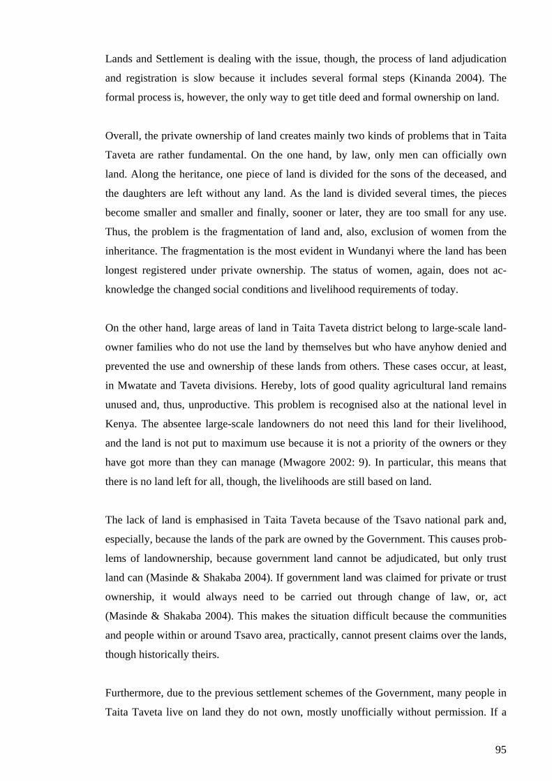
95
Lands and Settlement is dealing with the issue, though, the process of land adjudication
and registration is slow because it includes several formal steps (Kinanda 2004). The
formal process is, however, the only way to get title deed and formal ownership on land.
Overall, the private ownership of land creates mainly two kinds of problems that in Taita
Taveta are rather fundamental. On the one hand, by law, only men can officially own
land. Along the heritance, one piece of land is divided for the sons of the deceased, and
the daughters are left without any land. As the land is divided several times, the pieces
become smaller and smaller and finally, sooner or later, they are too small for any use.
Thus, the problem is the fragmentation of land and, also, exclusion of women from the
inheritance. The fragmentation is the most evident in Wundanyi where the land has been
longest registered under private ownership. The status of women, again, does not ac-
knowledge the changed social conditions and livelihood requirements of today.
On the other hand, large areas of land in Taita Taveta district belong to large-scale land-
owner families who do not use the land by themselves but who have anyhow denied and
prevented the use and ownership of these lands from others. These cases occur, at least,
in Mwatate and Taveta divisions. Hereby, lots of good quality agricultural land remains
unused and, thus, unproductive. This problem is recognised also at the national level in
Kenya. The absentee large-scale landowners do not need this land for their livelihood,
and the land is not put to maximum use because it is not a priority of the owners or they
have got more than they can manage (Mwagore 2002: 9). In particular, this means that
there is no land left for all, though, the livelihoods are still based on land.
The lack of land is emphasised in Taita Taveta because of the Tsavo national park and,
especially, because the lands of the park are owned by the Government. This causes prob-
lems of landownership, because government land cannot be adjudicated, but only trust
land can (Masinde & Shakaba 2004). If government land was claimed for private or trust
ownership, it would always need to be carried out through change of law, or, act
(Masinde & Shakaba 2004). This makes the situation difficult because the communities
and people within or around Tsavo area, practically, cannot present claims over the lands,
though historically theirs.
Furthermore, due to the previous settlement schemes of the Government, many people in
Taita Taveta live on land they do not own, mostly unofficially without permission. If a
96
new national settlement scheme took place, these people could be removed to some other
region in the country. Neither do the people within Tsavo area have legal rights and secu-
rity over the land they live on because of the Government ownership. Thus, for a reason,
people do not feel their lands, lives and livelihoods secured.
Furthermore, because people do not own the land they are living and cultivating they are
not willing to invest in it either, nor have they interests to protect the land, for example,
from erosion. The consequences of this are well illustrated, especially, in Mwatate, where
severe gully erosion is common partly due to the people’s ignorance.
5.2.3 CORE – a model for enhancing natural resource management
The Conservation of Resources through Enterprise (CORE) is a natural resources man-
agement program of USAID in which Taita Taveta is one of the four focal areas in Kenya
(others being South Coast, Laikipia/Samburu and Greater Amboseli) (The CORE pro-
gram and the role of EAWLS in the program s.a.). The overall objective of CORE is to
improve the conservation and management of natural resources through increased bene-
fits to community and landowners in areas adjacent to government protected areas. Bene-
fits are ought to be increased by strengthening and facilitating the creation of businesses
that are linked to the conservation and sustainable use of natural resources. More specifi-
cally, CORE aims to:
• Increase socio-economic benefits to target communities and landowners through
nature-focused businesses,
• Promote relevant policies, legislation and tools to encourage community incen-
tives for wildlife conservation,
• Increase the size and visibility of domestic constituency for conservation
amongst the Kenyan citizenry,
• Increase capacity to conserve and manage natural resources outside target parks
and reserves and
• Improve monitoring, evaluation and reporting systems within the KWS (The
CORE program… s.a.).
CORE began in 1999 and terminates in 2004.
In Taita Taveta district, CORE is implemented by Pact Inc. and its sub-grantee EAWLS
together with KWS. There are three particular projects undergoing in Taita Taveta:
97
LUMO community wildlife conservation trust, Kasigau conservation trust and Kishushe
ranching cooperative society. In order to illustrate these community development pro-
jects, I demonstrate the LUMO wildlife sanctuary little further.
LUMO was established in 1997 as three ranches, formerly for livestock production,
merged together to form a conservancy in Mwatate division (The CORE program… s.a.).
LUMO covers an area of 66 750 hectares, and it forms part of the wildlife dispersal area
of Tsavo East and West national parks (Figure 23). The driving force in establishment of
LUMO was the understanding of the potential of the ranches in generating wildlife-based
income instead of the livestock production that had failed. To realise this potential, the
LUMO trust has got external finance from EU and USAID, which is used in building an
eco-lodge and other infrastructure needed for tourism activities (Figure 24).
Figure 23. LUMO wildlife sanctuary in January 2004. Taita Hills in the background.
Figure 24. Bandas for accommodation in LUMO’s eco-lodge in the middle of LUMO wildlife sanctuary in January 2004.
In addition to the three community development projects, an important output of the
CORE has been the establishment of Taita Taveta Wildlife Forum that acts as a local
level forum for communities in conservation and development affairs and, thus, supports
communities’ efforts in business creation.
The intentions of CORE provide an important new approach to integration of conserva-
tion and development affairs. In a wider sense, the objectives could be argued to provide
a model example of strategies for (sustainable) natural resource management, or, land use
policy – they, indeed, contribute to the development of natural resources management
and the planning process, for example, by their intentions to develop monitoring, evalua-
tion and reporting. Therefore, I argue that the same (kind of) intentions would be worth of
realisation not only in the district level, but also at national level. However, I cannot
98
fence this argument with facts, because I was not able to get detailed monitoring and
evaluation information about the proceedings of the program and about the achievement
of the objectives.
5.3 Dependence on national policy actions
All in all, land related questions were seen highly important in Taita Taveta district. The
importance of climate and the agro-ecological zones in determining land use of a specific
area is well understood in the district. As most of the respondents live in or near the town
of Wundanyi, also topography was emphasised in many parts. Human settlement and cul-
tural factors were also regarded as main factors of land use.
Local officers regard they can affect land questions on the basis of their legal responsi-
bilities. Mainly in agricultural affairs, they regard their role also educative. The role of
County Council is regarded to be restricted to the management of trust lands, collecting
fees from hiring land plots they own for commercial activities, for example in Wundanyi,
and in the process of gazetting reserves. In land use policy, the DDC is thought to have
the largest role, for example, in deciding on the regional development programs and im-
plementing governmental policies.
The two most influential ministries in land affairs are thought to be the Ministry of Agri-
culture and Livestock Development and the Ministry of Lands and Settlement. Also the
Ministry of Water Development was mentioned. Some officers truly think that ministries
work hand in hand around land issues, as every one of them and their departments deal
with their own sectoral objectives. However, in overall, the names of different ministries
caused little confusion, as the official titles and responsibilities of them were not known.
When it comes to the question, whether the local people can affect land issues or not, my
estimation is that their possibilities are fairly week. This argument is based on my experi-
ences, as trying to find out about these things for my study. Either intentionally or unin-
tentionally, the policy issues seem to be hidden behind the administration. The first thing
that appeared to me was the fact that everything, within the administration and within the
people that ‘know’, was talked about using abbreviations about the plans, organisations,
offices and the personal titles of the officers. Thus, in the beginning it was difficult to
understand anything about the system and its actors because not having the knowledge
99
about the used concepts. Secondly, getting answers to the questions about policy issues
was difficult, because it required talking with everybody – every officer and people in
charge knew, or were ready to discuss, only about the affairs concerning directly their
own specific field of action. Thus, establishing a ‘bigger picture’ from these pieces was to
be formed by the person who set the questions in the first place. In my opinion, this way
administration is strongly diverged from the public and discourages public’s interest to-
wards the policy issues. And how could the public affect things without adequate infor-
mation?
Hereby, the system can be illustrated by Harbeson’s (1976: 178) claims that, in overall,
the planning process and implementation of the plans in Kenya are a two-step process: 1)
decision-making and 2) the response, either positive or negative. At the local level, the
decision-response model operates between the administrative officers, who make the de-
cisions or deliver them from the upper levels, and the ordinary citizens, who are supposed
to respond favourably. Though Harbeson presented these claims already almost three
decades ago, I could argue, that the basic elements of this dichotomy are still alive in the
district level planning. Moreover, the two-step procedure, monocular dichotomy, illus-
trates also the planning process of the whole country – decisions are made and the re-
sponse to them is supposed to be positive.
Notwithstanding the decentralised district planning, the central government takes the
main initiative on all policies relating to major local government services like education,
public health, housing, water supplies, etc. – though, initiatives are articulated through the
(district) development committees (Akivaga 1985: 56). Only few policies have been de-
veloped to serve the areas on their own terms (Wamalwa 1991). Mainly, this still seems
to be the case. The decentralisation has been attempted, through DFP, but it has, however,
been criticised of its bureaucratic nature and the tendency on interests still to flow from
top-down rather than from the bottom-up (Field-Juma 1996). Overall, districts admini-
stration works tightly under the control of central government. Thereby, local land use
matters are unlikely to be raised in policy making that is mostly done by national bodies
or at least the conducting of them is limited. However, land-holding and land use im-
provements are essential, if any progress is expected – also at the district level.
100
5.3.1 Future prospects
“The ideal land use policy in Kenya and Taita Taveta district is using the land in the most
appropriate way and enhance for production to eradicate poverty.” This opinion of one of
the members of Taita Taveta County Council illustrates well the local desires about land,
its use and the policy regulating its use. According to the local opinions, land use policy
should guarantee some land for everybody and secure the people’s rights on their land, or
shambas as said in Kiswahili. Furthermore, farmers should be trained how to use their
lands properly and taught the modern methods of farming. In the long term, land use pol-
icy should contribute to food production and livestock development, thus to food secu-
rity. Especially, land use policy should provide a “roadmap”, long-term objectives, for
this purpose.
In addition, it was generally seen that afforestation should be encouraged in Taita Taveta
in order to reduce soil erosion. One of the members of the CC stated that deforestation in
Taita Hills could be reduced by providing irrigation water to the lower zones of the hills
to support settlement and agriculture there and, thus, to balance the living possibilities
and population density between the hills and the lower zones, which would also lessen
the cutting of forests up in the hills.
Also, “concrete land use policy should be made to avoid corruption which is the enemy
of land use in Kenya as well as in Taita Taveta district”, as it was put by one of the mem-
bers of the CC. At the moment, the existence of corruption is real. As an illustrator of
this, the Kenya Times, a national newspaper, wrote in 20th February 2004, about a re-
search, conducted by Transparency International, that had examined the corruption within
Kenya. The research listed forty the most corrupted institutions of Kenya; the first place
was held by the Kenya police department, and what was especially interesting was the
fact that the Ministry of Lands and Settlement was listed on the eighth place and the local
authorities on the twentieth place (Corruption in Kenya 2004). However, the issue of cor-
ruption was not mentioned at once in any interview or discussion, and, thus, it is difficult
to evaluate the real state of the affair.
On the other hand, some respondent thought that there is no ideal of land use policy be-
cause of the disparities of different communities and their culture, or that any ideal could
never be reached. Based on this, it was seen that ideal would simply be to solve the ques-
101
tion around landownership through legal instruments of private ownership. Thereby, it
was partially thought that any changes in the current policy are not needed.
Though many supportable ideas about the ideal land use policy were presented by many
of the respondents, they are, unfortunately, unlikely having any direct impacts on the de-
velopment on land use issues. The district has no power of its own in the development of
these affairs. However, the majority of the respondents were hopeful about the actions of
the new Government and changes were expected, for example, through the new constitu-
tion.
6 CONCLUSIONS
All in all, the main actor of land use policy in Kenya is the Government by establishing
the control system of land use policy, through the plans, regulations and laws, and a part
of the administrative system by preparing and conducting most of the plans, regulations
and laws on its own. On the other parts, the administrative system of land use policy is
based on the regional ministerial offices that have the responsibility of the regional im-
plementation of the national programs and plans. Monitoring system, however, seems to
be currently absent both nationally and regionally. Fundamentally the content of the con-
trol system is meant to be implemented directly nationally and regionally either by the
regional administration or by the Government’s parastatals, and any regional variations
do not seem to appear in national level plans. Nor are the impacts of the national pro-
grams and plans assessed.
By today, land use policy has not been taken very seriously in Kenya, but it has rather
formed a playground for other policies and for decision-makers themselves, as a clear
national coordination of the land use affairs has been missing. Land use policy is embed-
ded under land policy, as the various and multiple laws on land and environment have
had a full hegemony in all regulation related to land and its use. Land policy is the major
determinant of land use, mainly through the private ownership.
On the basis of the study, my experience is that, in Kenya, the field of land use policy is
quite confusing and hidden behind the shadows of laws, administration, bureaucracy and
conceptual complexity. The governing (of land use) has been carried out through bu-
reaucracy rather than policy making (see, for example, Harbeson 1976: 327-339). Any-
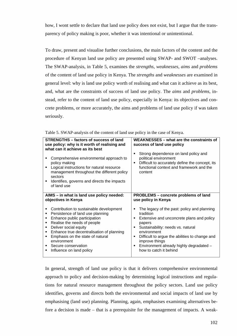
102
how, I wont settle to declare that land use policy does not exist, but I argue that the trans-
parency of policy making is poor, whether it was intentional or unintentional.
To draw, present and visualise further conclusions, the main factors of the content and the
procedure of Kenyan land use policy are presented using SWAP- and SWOT –analyses.
The SWAP-analysis, in Table 5, examines the strengths, weaknesses, aims and problems
of the content of land use policy in Kenya. The strengths and weaknesses are examined in
general level: why is land use policy worth of realising and what can it achieve as its best,
and, what are the constraints of success of land use policy. The aims and problems, in-
stead, refer to the content of land use policy, especially in Kenya: its objectives and con-
crete problems, or more accurately, the aims and problems of land use policy if was taken
seriously.
Table 5. SWAP-analysis of the content of land use policy in the case of Kenya.
STRENGTHS – factors of success of land use policy: why is it worth of realising and what can it achieve as its best Comprehensive environmental approach to
policy making Logical instructions for natural resource
management throughout the different policy sectors
Identifies, governs and directs the impacts of land use
WEAKNESSES – what are the constraints of success of land use policy Strong dependence on land policy and
political environment Difficult to accurately define the concept, its
functional context and framework and the content
AIMS – in what is land use policy needed: objectives in Kenya Contribution to sustainable development Persistence of land use planning Enhance public participation Realise the needs of people Deliver social equity Enhance true decentralisation of planning Emphasis on the state of natural
environment Secure conservation Influence on land policy
PROBLEMS – concrete problems of land use policy in Kenya The legacy of the past: policy and planning
tradition Extensive and unconcrete plans and policy
papers Sustainability: needs vs. natural
environment Difficult to argue the abilities to change and
improve things Environment already highly degradated –
how to catch it behind
In general, strength of land use policy is that it delivers comprehensive environmental
approach to policy and decision-making by determining logical instructions and regula-
tions for natural resource management throughout the policy sectors. Land use policy
identifies, governs and directs both the environmental and social impacts of land use by
emphasising (land use) planning. Planning, again, emphasises examining alternatives be-
fore a decision is made – that is a prerequisite for the management of impacts. A weak-
103
ness of land use policy is that, in general, it is dependent on its most important determi-
nant, land policy. Also, it is difficult to accurately define land use policy as a term and
concept, its functional context and framework and its full content, as these are highly de-
pendent on the used definitions.
The arguments for land use policy in Kenya are various, as it, by today, has not had its
own aims, or they have been overridden by the aims of other policies. If implemented
properly, land use policy would contribute to sustainable development by supporting the
persistence of and improvements in land use and environmental planning, which, in turn,
would promote participation in policy making. Through public participation, the needs
would be better identified and delivered to decision-making, which could realise them
and thus deliver social equity. Enhancement of participation means also enhancement of
participation of different levels and bodies of planning and policy making, and, therefore,
land use policy would also contribute to genuine decentralisation and institutional col-
laboration. On the other hand, proper land use policy always considers the human needs
in relation to the state and limitations of natural environment. Thereby sustainable land
use policy also secures conservation and introduces the biodiversity as a basis of plan-
ning. Moreover, through land use policy, conservation ethics could be stronger promoted
to guide growth strategies in national development. Proper land use policy would also
balance the hegemony of land policy and contribute to the changes within it. All in all,
the aims here could be understood also as future possibilities of land use policy to im-
prove land use, its impacts and environmental management.
However, a problem in land use policy is that it always keeps the legacy of the past pol-
icy and planning tradition with it, which affects also to its content making it difficult to
redefine. Thus, in Kenya, it is difficult to overcome the problems that have been intro-
duced at the colonial era. A problem is also that, in Kenya, the plans and policy papers
are extensive and they do not provide concrete proposals for action, even though the ob-
jectives as such were properly defined. Furthermore, a major problem is the concept and
conceptualisation of sustainable development; the question is, especially, how can the
needs be met without violations to the natural environment. Therefore, it is also difficult
to define, how could land use policy then provide anything new and how could it really
improve things. Natural environment is already degradated in Kenya and it will be prob-
lematic even to stop further degradation, much less making improvements on it - how
could land use policy contribute to this?
104
The SWOT-analysis, in turn, in Table 6, examines the strengths, weaknesses, opportuni-
ties and threats of the procedure (or, practice) of land use policy in Kenya. The strengths
and weaknesses examine the procedure as it is at the moment, and opportunities and
threats describe the future issues of the procedure.
Table 6. SWOT-analysis of the procedure of land use policy in Kenya.
STRENGTHS – what are Kenya’s strengths in making and realising land use policy Strong administrative structure Trust on the president and the Government Positive atmosphere in doing things, trust
on the future
WEAKNESSES – what are the most obvious weaknesses in making and realising land use policy Extensive administration and bureaucracy Strong policy and administrative authorities Fragmented sectoral policies Inadequate collaboration Self-power of decision-makers and large-
scale land owners Ignorance about environmental issues Weak and inadequate environmental
monitoring and reporting (information) Implementation Weak local empowerment and public
participation
OPPORTUNITIES – what are the factors that support performing sustainable national land use policy Institutionalisation of EMCA and NEMA Strong base of traditional and indigenous
knowledge Community-based development actions Districts’ ministerial operators Support from donors, NGOs and other
organisations
THREATS – what factors can aggravate taking advantage of the opportunities and realising national land use policy Failure of the Government to proceed in
renewals Formation of an unfavourable development
environment Competing interests in limited resources
Kenya’s strength in realising national (land use) policy is the strong administrative struc-
ture that could accomplish much of things if coordinated properly. There is also a positive
atmosphere in realising things, which rises from people’s strong trust on the future. Much
of this energy is, at the moment, focused on the president and the Government as a trust
for them to proceed in their agenda for renewals.
But the administrative structure also forms the worst weakness of the procedure of land
use policy; extensive administration and bureaucracy, strong policy and administrative
authorities and fragmented sectoral policies have seriously complicated realising coordi-
nated national land use policy, as collaboration between the different departments and
institutions is only weak or completely missing and as the system has not had capacity, or
will, for self-correction. An integrated approach to land use issues has not been possible
105
either because of the self-power of decision-makers and, for example, large-scale land-
owners who have been concentrated in securing their own benefits. A weakness is also
the wide ignorance about environmental issues in general, which is partly resulting from
weak and inadequate environmental monitoring and reporting processes, techniques and
information. Though extensive policy papers have been produced, the implementation of
plans, laws and decisions has been weak. In addition, local, or regional, empowerment
has been weak, as well as the processes for public participation. For example, decentrali-
sation of planning has been attempted through DFP, but, at least in the preparation of the
national plans, it has not had any effects – the development objectives still come from the
Government, as, for example, the DDP is more like an implementation scheme of na-
tional development objectives than a plan document of the district planning. The same
reflects to the planning procedure in the districts, where genuine participatory planning
processes have not been developed or used and where the development objectives, there-
fore, fall down from the administration.
However, there are strong opportunities for future developments in land use policy. Al-
ready established EMCA and NEMA contain potentiality to develop as authorities of en-
vironmental management and land use policy. For example, the monitoring system of
land use policy can be expected to get stronger and more visible if EMCA and NEMA get
properly institutionalised, as they emphasise, for example, EIAs. Furthermore, there are
lots of traditional and indigenous knowledge about natural resource management that
could contribute to national land use policy if wanted – one example could be the com-
munity-based development approach. Therefore, instead of the ministry operators imple-
menting the national programmes in the districts, it would be desirable them to gather
data for use (Mutiso 1991). Indeed, they could deliver up-to-date district data, and
thereby the ‘local message’, upwards to the Government, if that is where the plans are
made. In addition, an opportunity for land use policy exists in cooperating with the sup-
porting donors, NGOs and other (development) organisations that operate within the
country and different regions. All these bodies produce enormously information and pro-
vide many development resources that could support also governmental policy and deci-
sion-making.
The future threats of the procedure of land use policy rise from the possible delays or
failures in policy renewals undertaken by the Government, which could cause creation of
an unfavourable development environment, wherein the current weaknesses of the proce-

106
dure would continue existent. Thereby, a threat is that the opportunities remain unutilised.
A threat to proceedings in land use issues, and to proceedings in land use policy making,
is also the continuous competition of interests in using the scarce and limited (develop-
ment) resources, like finance and technology.
The weaknesses of the land use policy procedure reflect also the weaknesses of the land
use planning process, which is also rather unclear and confusing; different parts of the
planning process are scattered, and thus, one part cannot provide support for the other
one. The normative planning objectives are set by the control system of land use policy,
the Government; thus, it does not form a forum for the discussion of the values but au-
thoritatively controls further planning. The values of planning, as such, have been fo-
cused on economic incentives. Further, the plans in Kenya seem to remain to the strategic
phase, though, for example, at the district level actions and development programs are
followed yearly. The problem of implementation probably is due to the fact that no true
operative planning of implementation seems to be practiced – the regulations set by the
control system of land use policy are enforced at lower levels without further considera-
tion or revising. Implementation faces problems also because of the missing monitoring
system of land use policy; the implementation of laws and regulations is not supervised
by any unit of administration.
At the moment, planning processes in Kenya do not appear as sustainable development
planning, as the process in itself is not practised properly. Land use planning, as practiced
in Kenya, does not truly control the land use. On the one hand, laws and regulations are
forced into practice without further considerations, and land use is to implement these
rules. But the surveillance of their true execution is lacking. Thus, on the other hand, land
use is formed by the realised land use practices without any consideration about the laws
and regulations – people simply do what they can and how they know. Regarding to the
policy making and planning in Kenya, the interaction between the policy level and the
practise is missing. They both have their own manners to control land use, which, how-
ever, do not meet at any level, nor form any synthesis of the both.
Hereby, it can be stated that following the state of land use policy also land use planning
is embedded under the aims and means of land policy and other policies. Mostly, land use
planning works as an instrument of land policy to maintain the preceding power struc-
tures under the system of private land ownership. Therefore, land use planning cannot be
107
claimed to contribute to the integrity of environmental management because the envi-
ronmental approach is missing from it. Furthermore, and because of the above, I cannot
agree with Mbegerea (2004) on his statement that land policy and environmental policy
in Kenya goes hand in hand.
As Wamalwa (1991) expresses, the modern technological world has created divisions
between those who know about the environment, those who plan for its use and those
who use it. A separate group of decision- or policy-makers could be added to the list. In
order to create sustainable development, planning needs to search for policies and strate-
gies, which take innovative approaches to natural resource management, thus land use
policy, and conservation (see Wamalwa 1991). Planning as itself is not enough, nor only
with strengthened evaluations or integration of institutions; sustainable development does
not survive without genuine participation. This, again, may need returning to the closer
examination and re-implementation of indigenous natural resource management proce-
dures and techniques in order to reunite the knowledge, planner, resource user – and the
decision-maker. This would, furthermore, contribute to the whole planning process by
improving the basis of it right from the beginning of observations and data collection – in
order to ensure that the decisions on land use are based on essential information and
knowledge, resource users should be in close interaction with the decision-makers.
From land use perspective, traditional knowledge had, in earlier times, valuable contribu-
tions to make, and therefore, also the source of new innovations still lies within the in-
digenous communities (Mutiso 1991; Wamalwa 1991). For example, recent research
shows that mixed systems benefit not only the soil but also the farmers’ pocket, and
therefore, it seems important that farmers continue to practise these techniques that have
been “forgotten” during the past century (Mutiso 1991). In addition, tenure systems
which allow, for example, multiple use of resources and simultaneous production of, for
example, wildlife, livestock, tree crops, fuel wood and medicinal plants, are as relevant
today as they were hundred years ago, and hence, governance structures and statutory
institutions suited to multiple use should be considered (Field-Juma 1996).
In Kenya, the conservation policy is a major issue under land use policy and environ-
mental management. The national parks are a major economic asset, which continues to
grow along the increasing number of visitors (Marekia 1991). As Marekia (1991) points
out, poor planning may result in the destruction of the same species –or natural beauty or

108
scenery – that visitors pay to see. In order to support planning and wildlife conservation a
more practical strategy would have to involve local people and enable also other land
uses on the boundaries of protected areas (Marekia 1991). And, whether it was a question
of conservation of wildlife, land or a scenery, it needs to be noticed, that the current is-
sues and constraints related to property rights, especially land ownership, make it difficult
for the poor to undertake long-term conservation activities (Juma 1991).
Overall, Kenya is experiencing major economic and ecological problems (Juma 1991).
Therefore, reforms also in land use policy are needed. However, local communities need
to participate the reform processes – otherwise any changes are unlike to lead in any im-
provements, but on the contrary, to the deepening of the current aggravated policy and
planning system. As Mutiso (1991) argues, designing and improving land use for physi-
cal, social and psychological development is the most effective through community proc-
esses and participation. Improvements need, however, to give the first consideration for
development and poverty reduction – policies aimed at reducing poverty will make it
possible for sustainable development policies to succeed (Juma 1991). The CORE pro-
gram provides an example of community-based development program, which contributes
to natural resource management, poverty reduction and sustainable development.
Closure
Finally, when looking the study backwards, I can only discover how wide and complex
the issue of land use policy is in Kenya. At the same time it needs to be admitted that this
complexity has also affected reporting of it, as the presented aspects and points of it occa-
sionally seem little confusing, as well as the presentation on some parts. However, it can,
anyway, be stated that the aims of the study were achieved, as all the research questions
have been somehow answered and thoughts about the future development of land issues
in Kenya have been evoked. At least I have learnt a lot and got much to think about. Also,
I have realised how different policy making and planning can be outside the borders of
Finland, and this has been a broadening experience.
On the other hand, now in the end I also discover how small piece of the whole wide land
use issue I have been able to include to the study and how much there is things I do not
even know. However, this is why the study also provides good basis and starting point for
further studies. Even a larger research about the very issue of this study would be appro-
109
priate because of the many aspects it can be examined through. Especially, an interesting
research objective would be the planning process as such. For example, the modelling of
the process and evaluation of it would be useful as a basis of possible improvements in it
and also in policy making. Also, it would be useful to study the causalities between the
actions and results within policy making in general in Kenya, and to study better the
roles, responsibilities and the proceedings of different actors of policy making. Also more
profound study of the aspects of sustainable development in planning and policy making
or the Kenya’s conservation policy and conflicts would be recommendable.
7 SUMMARY
The aim of the study was to examine land use policy in Kenya; the main intention was to
characterise Kenya’s current land use policy and planning system at national level and at
district level through the example of Taita Taveta district. The study was divided into
three parts. The first part provided the grounds of the study by presenting the theoretical
and geographical basis of it. The second part presented the development and the current
state of Kenyan land use policy – its contents, procedures and some prevailing issues of
it, firstly, at national level and, secondly, at the district level. The discussion was based
on the study material that consisted mainly of thematic/in-depth interviews, unstructured
interviews of the officers in Taita Taveta district and some ministry officers in Nairobi,
and of research journal. In addition, literal material, like planning documents/reports, was
used. The third part of the study, again, consisted of the conclusions of the study that
were presented using SWAP (strengths, weaknesses, aims, problems) and SWOT
(strengths, weaknesses, opportunities and threats) –analyses.
In the first part of the study, the term of land use policy was conceptually separated from
land policy; in the study, land use policy was understood as a way to control and manage
the use of land and (other) natural resources. Land policy, again, is the main determinant
of land use policy as it considers the questions of land ownership and other land laws.
Hereby, the focus of the study was directed to land use policy and (land use) planning
excluding the detailed examination of legal control of land use. Through its definition,
land use policy was also associated with the concept of environmental management and
planning. Planning was identified as the most important means of land use policy, and the
most importantly, it was identified that (land use) planning contributes to the sustainable
development through its technical advances like assessments/evaluations, promoting par-
110
ticipation in the planning process and encouraging the structural integration of planning
objectives and the different stakeholders in public and private sector.
The geographical determinants of land use policy in Kenya include, most importantly, the
climate and the population pressure. The climate in Kenya varies regionally along the
altitude, which, mainly through the rainfall, affects directly the land use possibilities, for
example, through the agro-ecological potentiality. The high and medium potential areas
cover only 20 per cent of the Kenya’s total land area; these areas are not only under in-
tensive agricultural use but support also about 80 per cent of the population of 32 million,
the forests, lakes and the industry. Because these areas are already intensively used, the
arid and semi arid lands (ASALs) are use to cushion the increasing population pressure.
However, due to the intensive and inappropriate land use methods, continuous removal of
vegetation and deforestation, and increased and prolonged droughts land has in many re-
gions severely degradated, which means that erosion and desertification are growing
problems of land use also in policy level.
In Taita Taveta district, 75 per cent of the land area is classified as ASAL. However,
along the higher altitude and rainfall, the Taita Hills provide high potentiality land and
preserve a rich forest biodiversity as a part of Eastern Arc Mountains. Thus, the natural
determinants of land use vary regionally around the district. The Tsavo national park cre-
ates a major land use restriction in the district as it covers approximately 62 per cent of
the districts land area.
It can easily be noticed that in Kenya the land use policy of today has its roots deeply in
the colonial era that replaced the indigenous knowledge about and methods of natural
resource management with the British land ownership and administration systems. Since
the colonial era, the laws and government of land use and the procedures of policy mak-
ing have not been changed but, on the contrary, they have even been entrenched without
further developing. As a consequence of this, the national field of policy making is heav-
ily centralised and, on the other hand, deeply sectoral. Land use issues are in the respon-
sibility of many ministerial and parastatal bodies. Collaboration between these has been
rather week as well as the harmonisation of different land laws and land use regulations
set by different sectors. Thereby the implementation of laws and plans has also faced
problems because nobody is responsible of controlling and monitoring them. As the ad-
ministrative bodies are various, also bureaucracy is enormous.
111
Hereby, the study argues that the transparency of the land use policy is weak in Kenya;
bureaucracy in administration and planning systems makes it confusing to an ordinary
citizen. The public has not much of possibilities to affect policy making and planning
when decentralisation of planning and participatory planning processes, for example in
the district level, are only nominal – the power of decision-making and the financial re-
sources still centralise solely within the Government. Moreover, land use policy is cur-
rently embedded under the objectives and procedures of land policy; land use policy has
evolved as implementation of land policy, and, hereby, land use is determined by the laws
of land ownership. On the other hand, regardless to the laws and regulations, people,
however, use the land they live on as they know and need to. Thus, the political control
and the actual practice of land use do not meet at any level.
In overall, the situation cannot be argued to contribute to sustainable development. How-
ever, the study identified that also development possibilities for land use policy exist.
These include, for example, the Environmental Management and Coordination Act
(EMCA) and the National Environment Management Authority (NEMA). EMCA is to
gather together and harmonise the various laws on environment, thus considering land
also. NEMA, again, is the new body to manage and implement the objectives of EMCA,
thus it is also responsible of monitoring the realisation of laws and regulations. If institu-
tionalised properly, EMCA and NEMA together have the possibility to strengthen land
use policy – to integrate the policy and the practice of land use by enhancing planning
processes. This would also contribute to sustainability as the environment would be better
taken as the basis of land use decisions and policy making and as the public would have
better possibilities to participate in planning and raise their objectives in decision-making.
In the regional level, a development possibility could be found from changing the role of
districts’ ministerial operators. Instead of implementing the national development pro-
grams and plans at their jurisdiction, it would be desirable them to gather up-to-date re-
gional data for the use of, not only the district’s planners and decision-makers, but also
the ministries and the Government at the national level. This would enhance regional de-
velopment possibilities as their own needs and objectives would be better taken into con-
sideration in preparing regional and national development programmes and plans. At the
moment, a district has only limited possibilities to contribute to its development, because
the plans and programmes are done in the upper level of the government.
112
An asset for developing land use policy and its sustainability is also found from the
strong indigenous, traditional knowledge about natural resource and environmental man-
agement. This asset could provide a lot even for today’s policy making, and therefore, in
order to utilise this forgotten capacity, the public should be better participated in planning
and decision-making. Herein, community-based development programmes provide one
good example and approach.
Nevertheless, the whole land question is always connected with the social and political
structures and operations of the society. Therefore, all the legal and political reforms and
renewals regarding land use, land use policy and land policy are dependent on the actions
of the Government to realise new policy and politics of collaboration, harmonisation and
development. The task is challenging because it reaches the whole current power struc-
ture of society and will introduce major changes in it through the new laws and modes of
operation. However, the task is possible.
Finally, it can be stated that the study fulfilled its purpose and that it forms a good basis
for further studies of land use issues in Kenya.

113
REFERENCES African socialism and its application to planning (1965). Sessional Paper: 10. Republic
of Kenya. 56 p. Agro-ecological assessments for national planning: the example of Kenya (1993). FAO
soils bulletin 67. 154 p. Akivaga,, S. K., W. Kulundu-Bitonye & M. W. Opi (1985). Local authorities in Kenya.
89 p. Heinemann Educational Books, Nairobi. Archibugi, Franco (1994). The Disciplinary implications of environmental planning and
evaluation. In Voogd, Henk (ed.). Issues in environmental planning. European research in regional science 4, 164-175. Pion Limited, London.
Babu, Suresh Chandra & William Reidhead (2000). Monitoring natural resources for policy interventions: a conceptual framework, issues, and challenges. Land Use Policy 17: 1. 11 p.
Bytebier, Benny (2001). Taita Hills biodiversity project report. 121 p. National Museums of Kenya, Nairobi. (Also available at <http://www.uia.ac.be/bio/deco/THBP_final_report.pdf>.)
Conservation regions, Africa (2004). Conservation International. 21.10.2004. <http://www.conservation.org/xp/CIWEB/regions/africa/africa.xml>.
The CORE program and the role of EAWLS in the program (s.a.). A handout. 7 p. Corruption in Kenya (2004). Kenya Times 20.2.2004. Davis, Kenneth Pickett (1976). Land use. 324 p. McGraw-Hill Book Company, New
York. District focus for rural development strategy review, draft document (2002). 100 p.
Unpublished handout. Taita Taveta District Information and Documentation Centre, Wundanyi.
Eastern Arc Mountains (2004). Eastern Arc Mountains Information Source. 21.10.2004. <http://www.easternarc.org>.
Economic recovery strategy for wealth and employment creation 2003-2007 (2003). 50 p. Government of Kenya, Ministry of Planning and National Development. PDF-version, 22.4.2004. <http://www.planning.go.ke/pdf/economic_recovery_plan.pdf>.
Ervin, David E., James B. Fitch, R. Kenneth Godwin, W. Bruce Shepard & Herbert H. Stoevener (1977). Land use control. Evaluating economic and political effects. 184 p. Ballinger Publishing Company, Cambridge.
2003/2004 Estimates of development expenditure of the government of Kenya for the year ending 30th June, 2004 (2003). 707 p. Republic of Kenya. Government Printer, Nairobi.
Field-Juma, Alison (1996). Governance and sustainable development. In Juma, Calestous & J. B. Ojwang (ed). In land we trust: environment, private property and constitutional change, 9-38. African Centre for Technology Studies (ACTS) environmental policy series: 7. Initiatives Publishers, Nairobi.
Finland’s environmental administration (2004). Ministry of the Environment. 12.10.2004. <http://www.environment.fi>/<http://www.ymparisto.fi>.
Harbeson, John W. (1973). Nation-building in Kenya – the role of land reform. 367 p. Northwestern University Press, Evanston.
Helldén, Ulf (1985). Land degradation and land productivity monitoring – needs for an integrated approach. In Hjort, Anders (ed). Land management and survival, 77-87. Scandinavian Institute of African Studies, Uppsala.
Hermunen, Taru, Antero Keskinen, Milla Lanne, Katja Masalin & Tommi Sirviö (2004). Mwatate – trading post with soil erosion problem. In Pellikka, Petri, Jussi Ylhäisi & Barnaby Clark (ed). Taita Hills and Kenya, 2004 – seminars reports and journal of a field expedition to Kenya. Expedition Reports of Department of

114
Geography, University of Helsinki 40, 96-101. Also available in <http://www.helsinki.fi/science/taita/fieldreport.html>.
Hiilamo, Heikki (2003). Kenian hallitus haastaa korruption. Kehitys – Utveckling 1.2003, 39-41.
Himberg, Nina (2004). Community based ecotourism as a sustainable development option in Taita Taveta, Kenya. In Pellikka, Petri, Jussi Ylhäisi & Barnaby Clark (ed). Taita Hills and Kenya, 2004 – seminars reports and journal of a field expedition to Kenya. Expedition Reports of Department of Geography, University of Helsinki 40, 87-95. Also available in <http://www.helsinki.fi/science/taita/fieldreport.html>.
Hurskainen, Pekka (2004). The informal settlements of Voi. In Pellikka, Petri, Jussi Ylhäisi & Barnaby Clark (ed). Taita Hills and Kenya, 2004 – seminars reports and journal of a field expedition to Kenya. Expedition Reports of Department of Geography, University of Helsinki 40, 64-78. Also available in <http://www.helsinki.fi/science/taita/fieldreport.html>.
Hyden, Goran (1979). Administration and public policy. In Barkan, Joel D. & John J. Okumu (ed). Public policy in Kenya and Tanzania, 93-113. Praeger Publishers, New York.
Juma, Calestous (1991). Sustainable development and economic policy in Kenya. In Kiriro, Amos & Calestous Juma (ed). Gaining ground: institutional innovations in land-use management in Kenya, 51-86. African Centre for Technology Studies (ACTS) environmental policy series: 2. Acts Press and African Centre for Technology Studies, Nairobi.
Juma, Calestous (1996). Introduction. In Juma, Calestous & J. B. Ojwang (ed). In land we trust: environment, private property and constitutional change, 1-5. African Centre for Technology Studies (ACTS) environmental policy series: 7. Initiatives Publishers, Nairobi.
Kaikkonen, Olli, Seppo Rytkönen & Seppo Sivonen (1989). Afrikan historia. 269 p. Gummerrus kirjapaino Oy, Jyväskylä.
Kanyinga, Karuti (1998). Politics and struggles for access to land: ‘grants from above’ and ‘squatters’ in coastal Kenya. European Journal of Development Research 1998: 2, 50-69.
Kenya forestry master plan development programmes (1994). 422 p. Ministry of Environment and Natural Resources, Nairobi.
The Kenya national environment action plan (NEAP), report (1994). 203 p. Ministry of Environment and Natural Resources, Nairobi.
Kenya Wildlife Service (s.a.). A brochure about Kenya’s wildlife protection. 6 p. Kenya Wildlife Service.
Kinanda, Mark (2004). Taita Taveta District Surveyor, Ministry of Lands and Settlement. Interview in Wundanyi 28.1.2004.
Kivikkokangas-Sandgren, Ritva, Riitta Paalanen & Sakari Tuhkanen (ed) (1990). The Taita Hills - a verdant mountain massif surrounded by a dry savanna in southeastern Kenya. Occasional Papers of the Finnish Association for Development Geography: 24. 171 p.
Koch, Matthias & Michael Grubb (1993). Agenda 21. In Owen, Lewis & Tim Unwin (ed) (1997). Environmental management: readings and case studies, 455-459. Blackwell Publishers Ltd, Oxford. (Originally published in Grubb, M., M. Koch, K. Thomson, A. Munson & F. Sullivan (1993). The ‘earth summit’ agreements: a guide and assessment. An analysis of the Rio ’92 UN Conference on Environment and Development. Earthscan Publications, London.)
Korir-Koech, Michael (1991). Evolution of environmental management in Kenya. In Kiriro, Amos & Calestous Juma (ed). Gaining ground: institutional innovations in land-use management in Kenya, 21-34. African Centre for Technology
115
Studies (ACTS) environmental policy series: 2. Acts Press and African Centre for Technology Studies, Nairobi.
Laitinen, Hanna (2002). Kenen ehdoilla? Osallistaminen kehitysyhteistyössä. Kehitysyhteistyön palvelukeskuksen julkaisusarja 23. Kehitysyhteistyön palvelukeskus Kepa ry, Helsinki. 96 p.
Land: mali umma (2001). 22 p. Kenya Land Alliance/Kituo cha Sheria and Friedrich Ebert Siftung (FES), Nairobi. PDF-version 5.11.2002. <http://www.oxfam.org.uk/landrights/publicKA.pdf>.
Lein, James K. (2003). Integrated environmental planning. 228 p. Blackwell Science Ltd, Oxford.
Lundgren, Björn (ed) (1975). Land use in Kenya and Tanzania – the physical background and present situation and an analysis of the needs for its rational planning. 354 p. Royal College of Forestry, International Rural Development Division, Stockholm.
Marekia, E. Njeri (1991). Managing wildlife in Kenya. In Kiriro, Amos & Calestous Juma (ed). Gaining ground: institutional innovations in land-use management in Kenya, 155-176. African Centre for Technology Studies (ACTS) environmental policy series: 2. Acts Press and African Centre for Technology Studies, Nairobi.
Masinde, G. V. & Chiboli I. Shakaba (2004). Ministry of Lands and Settlement. Interview in Ardhi House, Nairobi 20.2.2004.
Mather, Alexander Smith (1986). Land use. 286 p. Longman Group (FE) Limited, Hong Kong.
Mbegerea, Maurice (2004). Director of Compliance and Enforcement, New Environ-mental Management Aurhority (NEMA). Interview in Nairobi 19.2.2004.
Ministries (2004). Government of Kenya, ministries. 22.9.2004. <http://www.kenyaweb.com/governmnet/ministries/ministries.html>.
Mitchell, Bruce (1979). Geography and resource analysis. 399 p. Longman Group Limited, London.
Msagha, Johanna (2004). Population development in Taita Hills, Kenya. In Pellikka, Petri, Jussi Ylhäisi & Barnaby Clark (ed). Taita Hills and Kenya, 2004 – seminars reports and journal of a field expedition to Kenya. Expedition Reports of Department of Geography, University of Helsinki 40, 39-46. Also available in <http://www.helsinki.fi/science/taita/fieldreport.html>.
Mutiso, Gideon Cyrus (1991). Managing arid and semi-arid areas in Kenya. In Kiriro, Amos & Calestous Juma (ed). Gaining ground: institutional innovations in land-use management in Kenya, 87-114. African Centre for Technology Studies (ACTS) environmental policy series: 2. Acts Press and African Centre for Technology Studies, Nairobi.
Mwabili, Richard (2004). Chairman of Taita Taveta County Council. Interview in Wundanyi 13.2.2004.
Mwagore, Dali (ed) (2002). Land use in Kenya – the case of a national land use policy. 79 p. Printfast Kenya Limited, Nairobi. PDF-version 5.11.2002. <http://www.oxfam.org.uk/landrights/KLAfull.pdf>.
Mwangola, Ada (2001). Brainstorming/planning Kenya Land Alliance workshop on land policy and land law reforms in Kenya, 22-23 February 2001, Machacos. 6 p. 5.11.2002. <http://www.oxfam.org.uk/landrights/KLAMach.rtf>.
National environment management authority (NEMA) (2004). About NEMA Kenya. 12.10.2004. <http://www.nema.go.ke/aboutnema.htm>.
Njenga, Kennedy (2004). Taita Taveta District Land and Settlement Officer, Ministry of Lands and Settlement. Interview in Wundanyi 28.1.2004.
Odete (Mr), Jennifer Ngigi & A. M. Jabane (2004). Ministry of Environment, Natural Resources and Wildlife. Interview in Maji House, Nairobi 19.2.2004.

116
Okoth-Ogendo, H. W. O. (1976). African land tenure reform. In Heyer, Judith, J. K. Maitha & W. M. Senga (ed). Agricultural development in Kenya, and economic assessment, 152-185. Oxford University Press, Nairobi.
Okoth-Ogendo, H. W. O. (1991). Managing watersheds in Kenya. In Kiriro, Amos & Calestous Juma (ed). Gaining ground: institutional innovations in land-use management in Kenya, 115-123. African Centre for Technology Studies (ACTS) environmental policy series: 2. Acts Press and African Centre for Technology Studies, Nairobi.
Okoth-Ogendo, H. W. O. (1999). Land policy development in East Africa, a survey of recent trends. A regional overview paper for the DFID workshop on ”Land rights and sustainable development in Sub-Saharan Africa” held at Sunningdale Park conference centre, Berkshire, England, 16-19 February, 1999. 5.11.2002. <http://www.oxfam.org.uk/landrights/EAFOVER.rtf>.
Onalo, P. L. (1986). Land law and conveyancing in Kenya. 298 pp. General Printers Ltd, Nairobi.
Our common future (1987). 400 p. Oxford University press, Oxford. Owens, Susan & Richard Cowell (2002). Land and limits – interpreting sustainability in
the planning process. 244 p. Routledge, London. Pellikka, Petri, Jussi Ylhäisi & Barnaby Clark (ed) (2004). Taita Hills and Kenya, 2004 –
seminars reports and journal of a field expedition to Kenya. Expedition Reports of Department of Geography, University of Helsinki 40. 148 p. Also available in <http://www.helsinki.fi/science/taita/fieldreport.html>.
Pender, John (2002). Policies for sustainable land management in the East African highlands: research background, objectives, conceptual framework and activities. In Benin, Samuel, John Pender & Simeon Ehui (ed). Policies for sustainable land management in the East African highlands, summary of papers and proceedings of the conference held at the United Nations Economic Commission for Africa, Addis Ababa, Ethiopia, April 24-26, 2002. EPTD workshop summary paper 13, 21-27.
Peters, Ralph-Michael (s.a.). The institutionalisation of local self-government in Kenya’s present-day constitutional process. In Traditional local participation, 391-407. PDF-version. 9.12.2003. <http://www.kas.org.za/Publications/SeminarReports/ Traditionallocalparticipation/tradlocalpart.asp>.
The 1999 population & housing census, counting our people for development (2001). Central Bureau of Statistics, Ministry of Planning and National Development, Republic of Kenya, Nairobi.
Resource mobilization for sustainable development (1994). The seventh national development plan. A handbook version of the development plan 1994-1996. 64 p. Office of the Vice-President and Ministry of Planning and National Development, Republic of Kenya.
Rothermund, Dietmar (1994). Introduction. In de Moor, Jap & Dietmar Rothermund (ed). Our laws, their lands: land laws and land use in modern colonial societies, 1-4. Lit Verlag, Münster.
Rutten, Marcel M. E. M. (1990). The district focus policy for rural development in Kenya: the decentralization of planning and implementation, 1983-9. In Simon, David (ed). Third world regional development – a reappraisal, 154-170. Paul Chapman Publishing Ltd, London.
Rutten, Marcel M. E. M. (1992). Selling wealth to buy poverty: the process of the individualization of landownership among the Maasai pastoralists of Kajiado district, Kenya, 1980-1990. 510 p. Verlag breitenbach Publishers, Saarbrüken.
Sagay, J. O. & D. A. Wilson (1978). Africa: A modern history (1800-1975). 425 p. Evans Brothers Limited, London.
117
Selman, Paul Harry (1996). Local sustainability, managing and planning ecologically sound places. 175 pp. Paul Chapman Publishing Ltd, London.
Simon, David (1990). Introduction. In Simon, David (ed). Third world regional development – a reappraisal: xiii-xix. Paul Chapman Publishing Ltd, London.
Sirviö, Tommi & Andrew Rebeiro-Hargrave (2004). Hazardous foothills – an overview of gully erosion in Taita Hills. In Pellikka, Petri, Jussi Ylhäisi & Barnaby Clark (ed). Taita Hills and Kenya, 2004 – seminars reports and journal of a field expedition to Kenya. Expedition Reports of Department of Geography, University of Helsinki 40, 79-86. Also available in <http://www.helsinki.fi/science/taita/fieldreport.html>.
Soja, Edward W. (1968). The geography of modernization in Kenya – a spatial analysis of social, economic and political change. 143 p. Syracuse University Press, New York.
Statistical yearbook of Finland 2003 (2003). 704 p. Statistics Finland, Helsinki. Taita-project (2003). 15.9.2003. <http://www.helsinki.fi/science/taita/>. Taita Taveta district development plan 1994-1996 (s.a.). 214 p. Republic of Kenya,
Office of the Vice-President and Ministry of Planning and National Development.
Taita Taveta district development plan 2002-2008 – Effective management for sustainable economic growth and poverty reduction (s.a.). 76 p. Republic of Kenya, Ministry of finance and planning.
Teinilä, Yrjö (1991). Soil erosion as a natural hazard in the Taita Hills. In Kivikkokangas-Sandgren, Ritva, Sakari Tuhkanen & Jyrki Uotila (ed). Land use and strategies for survival in the Taita Hills, Taita Taveta districts, southeastern Kenya. Occasional Papers of the Finnish Association for Development Geography 25, 23-33.
Tuhkanen, Sakari (1991). The Taita Hills – a verdant mountain massif surrounded by a dry savanna in southeast Kenya, regional orientation. In Kivikkokangas-Sandgren, Ritva, Sakari Tuhkanen & Jyrki Uotila (ed). Land use and strategies for survival in the Taita Hills, Taita Taveta districts, southeastern Kenya. Occa-sional Papers of the Finnish Association for Development Geography 25, 1-6.
Viitala, Pentti (1999). Suunnittelumaantieteellinen tutkimus. Helsingin yliopiston maantieteen laitos, opetusmoniste 43. 78 p. Helsingin yliopiston maantieteen laitos, Helsinki.
Vink, A. P. A. (1983). Landscape ecology and land use. 264 p. Longman Group Limited, London.
Virtanen, Pekka V. (1995). Maankäytön perusteista, 565. 180 p. Otatieto Oy, Helsinki. Voogd, Henk (1994a). The environment as an object of planning. In Voogd, Henk (ed).
Issues in environmental planning. European research in regional science 4, 9-30. Pion Limited, London.
Voogd, Henk (1994b). Issues in environmental planning: introduction. In Voogd, Henk (ed). Issues in environmental planning. European research in regional science 4, 1-8. Pion Limited, London.
Wamalwa, Betty Nafuna (1991). Indigenous knowledge and ecological management. In Kiriro, Amos & Calestous Juma (ed). Gaining ground: institutional innovations in land-use management in Kenya, 35-49. African Centre for Technology Studies (ACTS) environmental policy series: 2. Acts Press and African Centre for Technology Studies, Nairobi.
Wamukoya, George M. & Francis D. P. Situma (ed) (2000). Environmental management in Kenya: a guide to the environmental management and coordination act. 101 p. The Centre for Research and Education on Environmental Law (CREEL), Nairobi.
118
West, H. W. (1986). Land tenure, policy and management in English-speaking African countries. In Arntzen, J. W., Ngcongco, L. D. & S. D. Turner (ed). Land policy and agriculture in Eastern and Southern Africa, 1-22. The United Nations University, Tokyo.
The world factbook (2004). Kenya. 28.9.2004. <http://www.cia.gov/cia/publications/factbook/print/ke.html>.
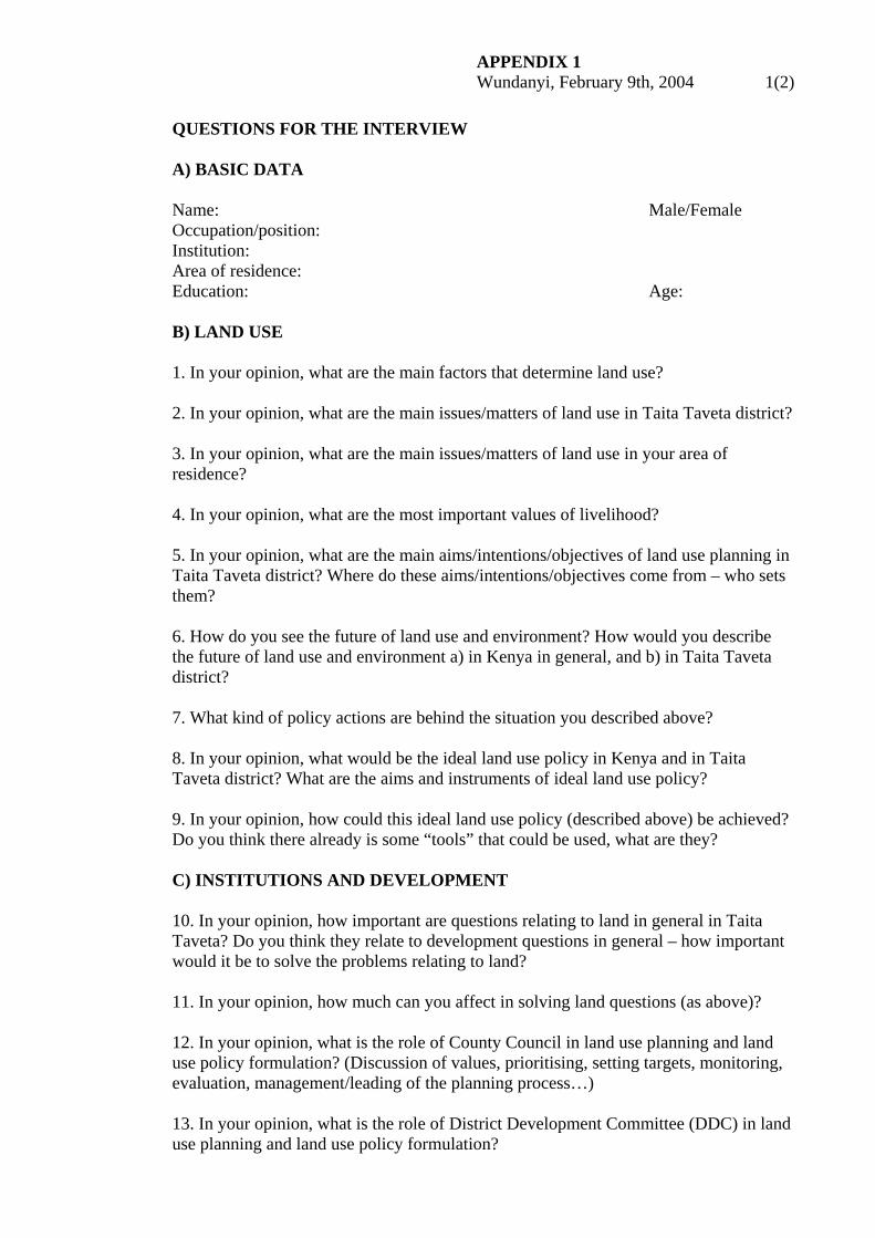
APPENDIX 1 Wundanyi, February 9th, 2004 1(2) QUESTIONS FOR THE INTERVIEW A) BASIC DATA Name: Male/Female Occupation/position: Institution: Area of residence: Education: Age: B) LAND USE 1. In your opinion, what are the main factors that determine land use? 2. In your opinion, what are the main issues/matters of land use in Taita Taveta district? 3. In your opinion, what are the main issues/matters of land use in your area of residence? 4. In your opinion, what are the most important values of livelihood? 5. In your opinion, what are the main aims/intentions/objectives of land use planning in Taita Taveta district? Where do these aims/intentions/objectives come from – who sets them? 6. How do you see the future of land use and environment? How would you describe the future of land use and environment a) in Kenya in general, and b) in Taita Taveta district? 7. What kind of policy actions are behind the situation you described above? 8. In your opinion, what would be the ideal land use policy in Kenya and in Taita Taveta district? What are the aims and instruments of ideal land use policy? 9. In your opinion, how could this ideal land use policy (described above) be achieved? Do you think there already is some “tools” that could be used, what are they? C) INSTITUTIONS AND DEVELOPMENT 10. In your opinion, how important are questions relating to land in general in Taita Taveta? Do you think they relate to development questions in general – how important would it be to solve the problems relating to land? 11. In your opinion, how much can you affect in solving land questions (as above)? 12. In your opinion, what is the role of County Council in land use planning and land use policy formulation? (Discussion of values, prioritising, setting targets, monitoring, evaluation, management/leading of the planning process…) 13. In your opinion, what is the role of District Development Committee (DDC) in land use planning and land use policy formulation?
APPENDIX 1 Wundanyi, February 9th, 2004 2(2) 14. In your opinion, what is the role of different ministries in land use planning and land use policy formulation? (Ministry of Lands and Settlement; Environment, Natural Resources and Wildlife Roads and Public Works; Water Resources Management and Development…) 15. In your opinion, is there still some other (important) agents/participants in land use planning and land use policy formulation? (NGO’s, chiefs, assistant chiefs, community (environment) groups, donor organisations…) 16. In your opinion, what should be the role of different agents/participants discussed above in land use planning and land use policy formulation processes? 17. In your opinion, which institution is the most important actor regarding to land use planning in Taita Taveta district? Why? 18. In your opinion, which institution is the most important actor regarding to development of land use, land use policy and planning? Why? 19. What are the most important prerequisites of development in Taita Taveta district? Is there some regional differences/disparities in these matters, what are they? 20. In your opinion, which institution is the most important actor regarding to development in Taita Taveta district? Why? 21. How do you see the future of Taita Taveta district? What are Taita’s best qualities and chances to go on in development?
APPENDIX 2 Wundanyi, February 9th, 2004 1(1)
Dear Recipient, I am studying planning geography in the University of Helsinki in Finland. At the moment, I am preparing my Master’s thesis about land use policy in Kenya and especially in Taita Taveta district. This questionnaire is made to collect data for my study. Hopefully you have time to read the questionnaire through and fill in your opinions about land use issues and environment. Given information will be analysed so that single opinions cannot be personalised. You may continue your answers on a separate paper if the space is not enough. Please, return this questionnaire by to the following place/address: Thank you for your co-operation! When ready, the thesis will be sent to Wundanyi for your use. Sincerely yours, Ms Taru Hermunen, University of Helsinki, Finland A) BASIC DATA Name: Male/Female Occupation/position: Institution: Area of residence: Education: Age: B) LAND USE 1. In your opinion, what are the main factors that determine land use? 2. In your opinion, what are the main issues/matters of land use in Taita Taveta district? 3. In your opinion, what are the main issues/matters of land use in your area of residence? 4. In your opinion, what are the most important values of livelihood? 5. In your opinion, what are the main aims/intentions/objectives of land use planning in Taita Taveta district? Where do these aims/intentions/objectives come from – who sets them? 6. How do you see the future of land use and environment? How would you describe the future of land use and environment a) in Kenya in general, and b) in Taita Taveta district? 7. What kind of policy actions are behind the situation you described above? 8. In your opinion, what would be the ideal land use policy in Kenya and in Taita Taveta district? What are the aims and instruments of ideal land use policy? 9. In your opinion, how could this ideal land use policy (described above) be achieved? Do you think there already is some “tools” that could be used, what are they?
Related Documents