Land Use Planning and Management A Resource Management Strategy of the California Water Plan California Department of Water Resources July 29, 2016

Welcome message from author
This document is posted to help you gain knowledge. Please leave a comment to let me know what you think about it! Share it to your friends and learn new things together.
Transcript

Land Use Planning and Management
A Resource Management Strategy of the California Water Plan California Department of Water Resources
July 29, 2016


Land Use Planning and Management
July 29, 2016 i
Table of Contents
Land Use Planning and Management ........................................................................................................ 1 Land Use Planning and Management in California .................................................................................. 1
State, Regional, and Local Land Use Planning Framework ................................................................. 2 Key State Agencies ........................................................................................................................... 2
Governor’s Office of Planning and Research ............................................................................... 3 Strategic Growth Council.............................................................................................................. 5 Other State Agencies ..................................................................................................................... 5
Regional Planning Agencies ............................................................................................................. 6 Local Agencies .................................................................................................................................. 7
Coordinating Land Use Planning and Management with Key Components ........................................ 7 Climate Change ................................................................................................................................. 8 Adaptation ......................................................................................................................................... 8
Mitigation .................................................................................................................................... 10 Coordinating Land Use and Water Supply ..................................................................................... 10 Coordinating Land Use and Flood Management ............................................................................ 11
Key State Flood Management Legislation .................................................................................. 12 Coordinating Land Use and Water Quality ..................................................................................... 13 Land Use Planning, Water, and California Native American Tribes .............................................. 13
Compact and Sustainable Development ............................................................................................. 14 Need for Compact and Sustainable Development .......................................................................... 14 Compact and Sustainable Development Improves Water Resources Management........................ 15
Reduced Water Usage ................................................................................................................. 15 Opportunities for Improved Watershed Management ................................................................. 15 Reducing Flood Impacts ............................................................................................................. 16 Reducing Risks and Vulnerabilities to Hazards .......................................................................... 17 Low-Impact Development (LID) ................................................................................................ 17
State Policies Encouraging Compact Sustainable Development .................................................... 18 Key State Legislation .................................................................................................................. 18 Regional Blueprint Planning Grants ........................................................................................... 20
Sustainable Rural Land Use and Water .......................................................................................... 20 The Challenge of Sustainable Rural Land Use ........................................................................... 20 Key Agricultural Land Preservation Programs ........................................................................... 20
Potential Benefits .................................................................................................................................... 22 Potential Costs ........................................................................................................................................ 23
General Plan Updates .......................................................................................................................... 23 Local Strategies for Greenhouse Gas Emissions Reduction ............................................................... 23 Transportation Planning and Investments ........................................................................................... 24 Water Supply Planning and Investments ............................................................................................ 24 Sustainable Rural Development .......................................................................................................... 25 Timber and Agricultural Mitigation .................................................................................................... 25 Recreational Opportunities ................................................................................................................. 26 Infrastructure and Property Values ..................................................................................................... 26
Major Implementation Issues .................................................................................................................. 26 Disincentives for Change .................................................................................................................... 26 Fiscal Policy and Constraints .............................................................................................................. 26 Coordinating Land Use and Water Policies ........................................................................................ 27

Land Use Planning and Management
ii July 29, 2016
Incorporating Regional Transportation with Sustainable Communities Strategies and Local General Plans .................................................................................................................................................... 27 Regulatory Improvement and Streamlining ........................................................................................ 28 Issues for Sustainable Rural Development ......................................................................................... 28
Recommendations ................................................................................................................................... 28 Promote Cross-Cutting Funding and Planning Programs ................................................................... 28 Integrate Regional Water Management and Regional/Local Land Use Plans .................................... 29 Provide Funding, Incentives, and Technical Assistance ..................................................................... 30 Enhance Research and Data Gathering ............................................................................................... 31 Promote Interagency Coordination ..................................................................................................... 31
References ............................................................................................................................................... 32 References Cited ................................................................................................................................. 32 Additional References ......................................................................................................................... 33
Figures Figure 1 Decision Tree Graphic and Status Report on Pilot Project ......................................................... 9
Boxes Box 1 Key Resource Management Strategy Cross-Cutting Links ............................................................ 2 Box 2 Other Planning Efforts.................................................................................................................... 4 Box 3 LEED for Neighborhood Development........................................................................................ 14 Box 4 Leadership in Energy and Environmental Design ........................................................................ 17 Box 5 California Regional Blueprint Planning Program Goals .............................................................. 21 Box 6 Low-Impact Development Runoff Control Objectives ................................................................ 23 Box 7 Integrating Water and Land Management .................................................................................... 25

Land Use Planning and Management
July 29, 2016 iii
Acronyms and Abbreviations
AB Assembly Bill
APG Climate Change Adaptation Policy Guide
APS Alternative Planning Strategy
ARB California Air Resources Board
BMP best management practice
CALAFCO California Association of Local Agency Formation Commissions
Cal EMA California Emergency Management Agency
CALGreen California Green Building Code
Caltrans California Department of Transportation
CCLU-In Climate Change, Land Use, and Infrastructure Working Group
CEQA California Environmental Quality Act
COG Regional Councils of Government
CVFPP Central Valley Flood Protection Plan
DLRP Department of Conservation’s Division of Land Resource Protection
DWR California Department of Water Resources’
EGPR Environmental Goals and Policy Report
EIR environmental impact report
EPA U.S. Environmental Protection Agency
GHG greenhouse gas
HCD California Department of Housing and Community Development
HMP Cal EMA Hazard Mitigation Program
IRWM integrated regional water management
Land Use Planning and Management
iv July 29, 2016
IRWMP integrated regional water management plan
IWM integrated water management
LAFCO Local Agency Formation Commission
LEED Leadership in Energy and Environmental Design
LEED-ND LEED for Neighborhood Development
LHMP local hazard mitigation plan
LID low-impact development
MPO metropolitan planning organization
MW megawatt
NAHC Native American Heritage Commission
RHNA regional housing needs assessment
RTP regional transportation plan
RTPA regional transportation planning authorities
SB Senate Bill
SCS sustainable communities strategy
SGC Strategic Growth Council
SUSMP Standard Urban Storm Water Mitigation Plan
SWRCB State Water Resources Control Board
UWMP urban water management plan
VMT vehicle miles traveled

Land Use Planning and Management
July 29, 2016 1
Land Use Planning and Management
Land Use Planning and Management in California Land use planning and management cuts across many resource management strategies (see Box 1). More efficient and effective land use is linked to several resource management strategies including watershed, water use efficiency, groundwater quality, flood management, parks and recreation, climate change adaptive management, and agricultural lands stewardship. Directing development away from agricultural lands permits multi-objective management of these lands for agricultural preservation, floodplain management, water quality, habitat conservation, and sustainable development. In addition, planning for more compact and sustainable communities, both urban and rural, will assist in reducing reliance on the state’s water supply, and result in more efficient use of California’s water resources. Important considerations of water issues and land use planning include not only the effects of the physical environment, but also the economic and social impacts of land use planning and development.
Stronger collaboration between land use planners and water managers can promote more efficient and effective land-use patterns and integrated regional water management (IRWM) practices, which can produce safer and more resilient communities. Integrating land use and water management consists of planning for the housing and economic development needs of a growing population, while providing for the efficient use of water, water quality, energy, and other resources. The way in which Californians use land — the type of land use, transportation, and level of use — has a direct relationship to water supply and quality, flood management, hazard mitigation, and other water issues. Likewise, the better integrated water resources are, the more efficient local communities can be at producing land use planning benefits and opportunities. For example, compact development patterns in existing urban areas can limit the amount of development in floodplains, leading to improved flood management and safety and more efficient infrastructure.
Land use planners consider water throughout the local land use planning process, and water is a critical element in adopting efficient land use planning policies. The availability of water supplies, water resource features such as streams, wetlands, and groundwater recharge areas, and policies and regulations about water quality, drainage, and flooding are all considered for a community’s land use vision. Planners should also consider the benefits of integrating water- related features for flood management, water supply and quality, recreation, and climate change adaptive management.
California’s projected growth and urban development increases the pressure on natural resource conservation, and amplifies the need for a comprehensive land use decision-making process integrated with water management. This advisory resource management strategy describes the co-benefits of a working relationship between land use planning and water management by demonstrating how sustainable land use decisions, in both urban and rural areas, can improve water supply affordability and quality, increase flood protection, conserve vital natural habitats, lead to more efficient energy and public resource use, and produce land use benefits from improved water management. Although many of these issues are discussed in greater detail in other resource management strategies, this section focuses on the impact that land use can have on them.

Land Use Planning and Management
2 July 29, 2016
Box 1 Key Resource Management Strategy Cross-Cutting Links
This resource management strategy is consistent with the State’s planning goals and policies for more compact sustainable development established in Assembly Bill (AB) 857 (2002), Senate Bill (SB) 732 (2008), and SB 375 (2008); strategies developed by the California Air Resources Board (ARB) to achieve AB 32 (2006) greenhouse gas (GHG) reduction target; and regional blueprint planning funded by the California Department of Transportation (Caltrans). California has enacted policies and programs designed to meet the water management benefit potential of land use with the understanding that these policies are implemented regionally and locally. These policies, and this resource management strategy, reflect the diversity of California’s communities and land use types.
State, Regional, and Local Land Use Planning Framework
Key State Agencies State government has typically played a limited or indirect role in land use planning, leaving the lion’s share of land use authority to local governments. State government generally prepares strategic and functional plans for issues such as air pollution, water quality, transportation, housing, solid waste management, and climate change adaptation to provide assistance on local department programs, decisions, and projects. Unlike most other resources subject to State oversight, and in some cases management, there is no State oversight agency for land use.
State law requires that State policies, to the extent they support land use, be expressed through local general plans and land use regulations. The State Planning and Zoning Laws establish a detailed process for local planning, but with limited exceptions, do not require local plans to achieve substantive State policies. The exceptions are the housing element requirements and flood management legislation (see the section on Coordinating Land Use and Flood Management).
Also, State regulatory authority for air and water pollution is increasingly affecting land use decisions. The issue of stormwater runoff has led to the creation of many watershed planning efforts that operate on a regional or sub-regional level and may be part of an IRWM planning effort (see the resource
Land use planning and management share strategies and benefits with watershed planning and management, agricultural lands stewardship, water use efficiency, water quality, and climate change, to name a few. The themes of flood risk and surface water management can meet sustainability issues in land use planning — place making. These strategies benefit from participation by all levels of government relying on local knowledge and management capacity. In common with many other cross-cutting themes in local government, the quality of outcomes depends on joining services and various stakeholders effectively. These listed management strategies and others tie in with the following sustainability issues:
• Climate change adaptation includes preparing for flooding.
• Biodiversity — sustaining existing biodiversity and its potential enhancement — comes by managing waterways well.
• Community engagement increases public awareness of the issue.
• Development and provision of green infrastructure increases sustainability.
The following are key, but not the only, cross-cutting strategies described in these resource management strategy reports: Flood Management; Conjunctive Management and Groundwater Storage, Pollution Prevention, Urban Stormwater Runoff Management; Agricultural Land Stewardship, Forest Management; Watershed Management, Economic Incentives, and Outreach and Engagement.

Land Use Planning and Management
July 29, 2016 3
management strategy report, Urban Stormwater Runoff Management). Efforts to control stormwater runoff and non-point source pollution are likely to affect the design, character, and even the location of local urban development by encouraging green stormwater solutions (wetlands restoration, use of pervious surfaces) rather than more traditional engineering approaches such as channelization (see Box 2 for descriptions of other planning efforts).
The Governor’s Office of Planning and Research (OPR) and the Strategic Growth Council (SGC) provide critical support to local and regional governments related to land use planning for rural and urban communities.
Governor’s Office of Planning and Research The Governor’s Office of Planning and Research is responsible for coordinating State functional plans and ensuring consistency with State policies. OPR, created by statute in 1970, is part of the Office of the Governor. OPR serves as staff to the governor and his cabinet for long-range planning and research, and constitutes the comprehensive State planning agency (Government Code Section 65040). In addition, the Government and Public Resources Codes set forth multiple functions for OPR, including:
• Formulation of long-range land use goals and policies. • Conflict resolution among State agencies. • Coordination of federal grants for environmental goals. • Coordination of statewide environmental monitoring. • Coordination of research on growth and development. • Management of State planning grants and encouragement of local and regional planning. • Creation and adoption of general plan guidelines. • Drafting of California Environmental Quality Act (CEQA) guidelines for adoption by the
Secretary of Natural Resources. • Creation of a State environmental goals and policy report (EGPR), every four years. • Operation of the State Clearinghouse for distribution and review of CEQA documents. • Coordination of environmental justice activities. • Coordination with U.S. military for land use and other issues in the state.
One of OPR’s primary responsibilities is working with State agencies and departments, regional planning organizations, and local jurisdictions on topics relating to land use planning. OPR has developed numerous resources to assist local governments in managing land use-related issues, including information related to infill, renewable energy, general plan guidelines, transportation, and more.
OPR is preparing an EGPR for California. The 2013 EGPR will provide an overview of the State’s environmental goals and key steps to achieving these goals, as well as develop a framework of metrics and indicators to help inform decision- making, at all levels, to help the state reach these goals.
California has established a series of ambitious environmental goals (e.g., the Renewable Portfolio Standard and the GHG emission reduction goals), including efforts to reduce GHG emissions, develop a clean economy, and provide clean air and water for all residents. By 2035, California is projected to have a population of 50 million residents. The decisions that are made to accommodate this growth need to be made with the achievement of these environmental goals in mind. OPR is seeking to prepare an EGPR that is inspirational and forward-looking, broad and inclusive, and engaging and interactive.

Land Use Planning and Management
4 July 29, 2016
Box 2 Other Planning Efforts
There are multiple statewide planning efforts that utilize land use planning and management strategies. The following are described in more detail; this is not intended to be an exhaustive list.
• Integrated Regional Water Management (IRWM) Planning. The California State government is guiding integrated regional water management (IRWM) to diversify and strengthen water management. The IRWM program provides guidance to regions for developing and implementing plans that integrate water management for water supply and quality, flood management, drought preparedness, land use, natural habitat and conservation, and reduced dependence on imported water among other objectives.
• The IRWM Planning Act provides a general definition of an IRWM plan as well as a requirement for state guidelines that must include standards for identifying a region for the purposes of developing or modifying an IRWM plan. This regional definition objective is to effectively integrate water management programs and projects within a hydrologic region. SB X2 1 (2008) authorized grant funding for IRWM as approved by voters for Proposition 84 and Proposition 1E.
• FloodSAFE is a long-term strategic initiative developed to reduce flood risk in California. It is designed with the recognition that addressing risks of flood damage statewide will take decades. FloodSAFE is also an important component of the California Department of Water Resources’ (DWR’s) IWM Initiative, which is designed to achieve a sustainable, robust, and resilient flood and water management system for the benefit of all Californians.
• California's Flood Future: Recommendations for Managing the State's Flood Risk (2013). IWM is the strategic approach that combines flood management, water supply, land use, and ecosystem actions for multiple benefits. An IWM approach promotes management flexibility and resiliency to accommodate changing conditions, such as climate change and flood or drought events. Long-term commitments through land use and alignment among responsible public agencies are necessary to create sustainable, affordable water resources systems.
• Urban Water Management Plan (UWMP). DWR provides urban water management planning services to local and regional urban water suppliers. In 1983, the California Legislature enacted the UWMP Act. The act states that every urban water supplier that provides water to 3,000 or more customers, or that provides over 3,000 acre-feet of water annually, should make every effort to ensure the appropriate level of reliability in its water service sufficient to meet the needs of its various categories of customers during normal, dry, and multiple dry years. The act describes the contents of the UWMP, as well as how urban water suppliers should adopt and implement the plans. It is the intention of the Legislature, in enacting this part, to permit levels of water management planning commensurate with the numbers of customers served and the volume of water supplied.
• Best management practices (BMPs) are techniques used to control stormwater runoff, sediment control, and soil stabilization, as well as management decisions to prevent or reduce non-point source pollution. The U.S. Environmental Protection Agency defines a BMP as a “technique, measure or structural control that is used for a given set of conditions to manage the quantity and improve the quality of storm water runoff in the most cost-effective manner.”
• Stormwater management BMPs are control measures taken to mitigate changes to both quantity and quality of urban runoff caused through changes to land use. Generally, BMPs focus on water quality problems caused by increased impervious surfaces from land development. BMPs are designed to reduce stormwater volume, peak flows, and/ or non-point source pollution through evapotranspiration, infiltration, detention, and filtration or biological and chemical actions. Stormwater BMPs can be classified as “structural” or “non-structural.”
o Low-impact development (LID) is a term to describe a land planning and engineering design approach to managing stormwater runoff. LID emphasizes conservation and use of on-site natural features to protect water quality. This approach implements engineered small-scale hydrologic controls to replicate the pre-development hydrologic regime of watersheds through infiltrating, filtering, storing, evaporating, and detaining runoff close to its source. Planners select structural LID practices for an individual site in consideration of the site’s land use, hydrology, soil type, climate, and rainfall patterns. There are many variations of LID practices, and some practices may not be suitable for a given site. Many are practical for retrofit or site renovation projects, as well as for new construction. Frequently used practices include:
o Bioretention cells, also known as rain gardens.
o Cisterns and rain barrels.
o Green roofs.
o Pervious concrete, also called “porous pavement,” similar to permeable paving.
o Grassed swales, also known as bioswales.
(See also Box 6, “Low-Impact Development (LID) Runoff Control Objectives.”)

Land Use Planning and Management
July 29, 2016 5
Strategic Growth Council The Strategic Growth Council (SGC), established through SB 732 in 2008, is a committee of the agency secretaries from Business, Transportation, and Housing; California Health and Human Services; California Environmental Protection Agency; and California Natural Resources Agency; as well as the director of the Governor’s Office of Planning and Research and one public member appointed by the governor. The SGC is charged with four main tasks to encourage the development of sustainable communities, summarized as follows:
• Coordinate State programs to achieve sustainability objectives. • Provide local assistance. • Fund and distribute data and information. • Recommend policies advancing sustainable communities.
Based on these four strategies, the SGC works toward a broad range of sustainability objectives: • Improve air and water quality. • Improve protection of natural resources and agricultural lands. • Increase the availability of affordable housing. • Improve public health. • Improve transportation. • Encourage sustainable land use plans and greater infill development. • Revitalize urban and community centers in a sustainable manner. • Reduce GHG emissions.
Local assistance is provided by the SGC through its grant programs that help local governments plan for future population growth and climate change impacts, assist metropolitan planning organizations (MPOs) in developing tools to support SB 375 (2008) requirements, and support various greening projects in urban communities.
In January 2012, the SGC adopted its first Strategic Plan (http://sgc.ca.gov/docs/workplan/ strategicplan-01-24-12.pdf), which articulates the SGC’s action plan for 2012-2014.
Other State Agencies There are several additional State entities that affect local land use planning and regulation. These include:
• The California Coastal Commission, which regulates land use planning and development in the coastal zone together with cities, counties, and other local agencies.
• The California Energy Commission, which has exclusive permitting authority for thermal power plants 50 megawatts (MW) or greater and serves as lead agency under CEQA for projects within its jurisdiction.
• The Climate Change, Land Use, and Infrastructure Working Group (CCLU-In) for the Climate Action Team, which coordinates State efforts at the interface of land use and climate change and to ensure that various planning efforts (water resources, housing and development, transportation, public health, etc.) address the linkages between mitigation measures and adaptation strategies. Potential climate change impacts to land use include urban climate and heat island effects, flooding, land use patterns and planning, significant adverse impacts to air quality, population, energy and water consumption, waste issues, public health, vehicle use strategies, and traffic.

Land Use Planning and Management
6 July 29, 2016
• The California Department of Housing and Community Development (HCD), which implements the California Green Building Code (CALGreen). CALGreen, the first in the nation, is designed to lighten carbon footprints and lower energy and water consumption. CALGreen provides a framework for reducing energy consumption and increasing the state’s sustainability through statewide building standards that reduce water use, improve air quality, conserve energy, reduce California’s carbon footprint, and help mitigate the effects of global climate change. In addition, HCD completes the review of housing elements.
• California Emergency Management Agency (Cal EMA), which is responsible for the coordination of emergency preparedness for California and works cooperatively with all entities to ensure the protection and safety of the populace. The federal Disaster Mitigation Act of 2000 requires that local governments prepare local hazard mitigation plans (LHMPs) as a precondition for receiving certain hazard mitigation grant funds. It also requires that states review LHMPs as part of the State hazard mitigation planning process. The intent is two-fold: (1) to gather hazard, vulnerability, and mitigation information from the local level for use in state-level planning, and (2) to ensure that state and local hazard mitigation planning is coordinated to the greatest extent practical. The Cal EMA Hazard Mitigation Program (HMP) administers the LHMP program for the state. Cal EMA supports and assists local governments in the development of LHMPs and tracks the progress and effectiveness of plan updates and projects. In addition, State planning law requires that a city, county, or city and county General Plan contain specified elements, including a safety element for the protection of the community from any unreasonable risks associated with the effects of seismically induced surface rupture, ground shaking, ground failure, tsunami, seiche, dam failure, slope instability leading to mudslides and landslides, subsidence, liquefaction, and other seismic, geologic, and fire hazards.
Regional Planning Agencies Several types of regional planning agencies exist in California.
• Regional regulatory land use agencies include the San Francisco Bay Conservation and Development Commission, the Tahoe Regional Planning Agency, the Delta Protection Commission, and the Delta Stewardship Council.
• Regional Councils of Government (COGs) are joint powers agencies that conduct regional planning in most of the state. They differ from region to region in organization and regional responsibilities, but in general, COGs serve as MPOs for federal transportation planning and funding purposes. COGs acting as MPOs prepare Regional Transportation Plans that for larger regions must meet SB 375 requirements. COGs also prepare regional housing needs allocations (RHNAs) that allocate “fair share” housing to cities and counties within their region.
• Local Agency Formation Commissions (LAFCOs) are regional organizations with responsibilities relating to Municipal Services, including water infrastructure. According to the California Association of Local Agency Formation Commissions (CALAFCO), “LAFCOs review proposals for the formation of new local governmental agencies and for changes in the organization of existing agencies. Agency boundaries are often unrelated to one another and sometimes overlap at random, often leading to higher service costs to the taxpayer and general confusion regarding service area boundaries. LAFCO decisions strive to balance the competing needs in California for [the] conservation of natural resources” (California Association of Local Agency Formation Commissions 1971).

Land Use Planning and Management
July 29, 2016 7
Local Agencies Cities and counties have primary jurisdiction over land use planning and regulation in California. Their authority derives from their rights under the California Constitution to regulate land use to protect the public health, safety, and welfare. The following areas highlight some of the intersections between State and local land use planning.
• General Plans. Several State statutes specifically authorize the preparation of local general plans and specific plans, and regulation of land use through zoning and subdivision regulations. OPR publishes the General Plan Guidelines (http://opr.ca.gov/docs/General_ Plan_Guidelines_2003.pdf), which provides guidance to local governments regarding the inclusion of an optional water element, and other advisory guidance to assist local governments in land use planning and management. The housing element must contain a site-specific inventory and identify adequate sites with appropriate zoning densities and infrastructure to meet the community’s need for housing (including its need for housing for low, very low, and extremely low income households and mobile homes, farmworker housing, and emergency shelters) that will be made available during the planning period (Section 65583(c) (1) and Section 65583.2).
• California Environmental Quality Act (CEQA). CEQA is an important tool for local land use planning and regulation. Although it is intended as an environmental full disclosure law for discretionary local government decisions, in practice CEQA is often the main forum for local governments to make project-level land use decisions and consider the potential impacts of those decisions. This includes a public comment process to address concerns. CEQA also expressly states that feasible mitigation measures must be adopted for any significant environmental effects resulting from a project.
• Tribal Consultation. State planning law, known as SB 18 (2004), requires cities and counties to consult with California Native American Tribes during the local planning process for the purpose of protecting traditional tribal cultural places. OPR’s 2005 Supplemental State General Plan Guidelines provides advice and requirements for SB 18.
• Flood Management. Several laws were created in 2007 to strengthen the link between land use and flood management. The laws, described later in this report, establish a comprehensive approach to improving flood management at the state and local levels. The California Department of Water Resources’ (DWR’s) Implementing California Flood Legislation into Local Land Use Planning: A Handbook for Local Communities (http:// www.water.ca.gov/floodmgmt/lrafmo/fmb/docs/Oct2010_DWR_Handbook_web.pdf) outlines the 2007 California flood risk management legislation affecting cities’ and counties’ responsibilities related to local planning requirements such as general plans, zoning ordinances, development agreements, tentative maps, and other actions.
Coordinating Land Use Planning and Management with Key Components Effective land use planning is central to several important components, such as climate change policy, water supply, flood management, water quality, and tribal consultation. Significant progress has been made in coordinating land use planning with each of these components, as described below. This Land Use Planning and Management resource management strategy, which emphasizes additional strategies to promote compact and sustainable urban and rural development, uses these accomplishments as a foundation.

Land Use Planning and Management
8 July 29, 2016
Translating these strategies into action and implementation was a challenge in California Water Plan Update 2009 (Update 2009). Planners and other stakeholders proposed a land-use decision tool (see the original “decision tree”) to provide a basis for comparing business-as-usual to low- impact development (LID) approaches for regional, local, or project-specific planning. A major component of this land-use and water-supply calculator tool is the life-of-the-project maintenance cost for 25, 50, and 100 years. This tool was adopted for the final Update 2009, and a pilot project program was launched for Update 2013. (See Figure 1; see also in Volume 4, Reference Guide, the article “Suburban Case Study and Locally Adaptable Tool Findings,” and in Volume 5, Technical Guide, the “User Guide” for the application of the tool in Update 2013.)
Climate Change Climate change is expected to entail significant changes to California’s water supply, food production systems, and ecosystems (California Department of Water Resources 2008). Our built environment depends on these natural resources and associated processes for food, fiber, recreation, and ecosystem services. Land use patterns Californians adopt in the near future will dramatically affect our ability to mitigate as well as adapt to climate change. Sprawling development patterns encourage vehicular rather than pedestrian or bike travel for work and recreation, increasing emissions and precluding options for climate adaptation. Compact and sustainable development, on the other hand, provides multiple co-benefits that include climate change mitigation and adaptation as well as other water-related benefits.
Potential climate change impacts important to consider in land use planning include increased extreme flood events; increased energy and water demand, especially in drought years; an increase in extreme heat days; significant adverse impacts on air quality and public health; and increased wildfire risk in urban areas adjacent to forests or scrublands. Planning for climate adaptation will be most effective when land use planners and water managers work together to understand their regional vulnerabilities to inevitable climate changes and find common goals and actions that will help them prepare.
Adaptation Cross-sector collaboration on resources management will be critical for dealing with climate change impacts as they unfold. Urban planners, water managers, and ecosystem managers commonly work independently to plan for the future. Many observe that this “independent planning” is inefficient and ineffective, as these efforts involve activities that are connected and interdependent. However, to address the additional challenges effectively that climate change will bring, it will be imperative that both the built and natural environments are managed in a cohesive fashion at a landscape level rather than as isolated, smaller pieces of the whole, which has been done in the past.
DWR’s Integrated Regional Water Management (IRWM) Program is an example of a process that brings diverse stakeholders to the table for coordinated regional planning on water issues. As noted in DWR’s White Paper, Managing an Uncertain Future: Climate Change Adaptation Strategies for California’s Water (California Department of Water Resources 2008), IRWM planning, in combination with other regional planning efforts, such as for transportation and land use, can serve as the basis for regional climate adaptation planning leading to increased resilience in all sectors.

Land Use Planning and Management
July 29, 2016 9
Figure 1 Decision Tree Graphic and Status Report on Pilot Project
As mentioned previously, the CCLU-In is the Climate Action Team subgroup that works to coordinate State efforts on climate adaptation in the land use sector. Many planning efforts for the built environment including those related to water resources, housing, transportation, hazard mitigation, and others will need to incorporate both mitigation and adaptation moving forward in the future. A Web portal (http://www.climatechange.ca.gov/action/cclu/) containing information and links about the multitude of State documents and tools on climate change has been developed by the CCLU-In to assist local planners with incorporating climate change into their general plan updates and other key planning documents.

Land Use Planning and Management
10 July 29, 2016
Another key source of climate change information for resource managers is the California Climate Change Portal (http://www.climatechange.ca.gov/). The Climate Change Adaptation Policy Guide (APG) for local governments and other important guidance for planners and resource managers can be found on this Web site. The APG addresses climate change adaptation at the local government level. It provides local government and regions with information and tools to assess anticipated changes and risks for that region due to the effects of climate change including sea level rise, greater flood intensity, and increased local flood risk. Once the assessment is done, the local government can review the APG for mitigation and adaptation measures for existing and future development.
One effort that could be important in coordinating planning efforts for the natural and built environments is the U.S. Department of Interior-led Landscape Conservation Cooperatives (www.fws.gov/science/shc/pdf/LCC_FAQs_2012.pdf). These management-science partnerships inform and promote integrated science, natural resource management, and conservation to address climate change and other stressors within and across ecosystems. Representatives from State and federal agencies, universities, non-governmental organizations, tribes, and other interested parties work together to identify research gaps, fund projects, and disseminate information about climate change and other threats to the sustainability of California’s natural resources. The California Landscape Conservation Cooperative (CA LCC) (http://californialcc. org/) has created an “Affiliate” level of participation to engage all parties interested in integrated natural resource management. Urban planners and local government officials working on climate adaptation can become CA LCC Affiliates and will have an avenue for directly connecting with top scientists and managers in California who are planning for landscape-level ecosystem integrity. This important communication channel could provide an unprecedented opportunity for cross-sector information sharing and planning.
Mitigation There is growing recognition of the relationship between land use policies, water use policies, and production of the GHG emissions that contribute to climate change. AB 32, Sustainable Communities Strategies SCSs pursuant to SB 375, Climate Action Plans, and CEQA are the main vehicles for regional and local governments to identify and reduce GHG emissions related to land use and transportation planning. Collaboration on GHG issues between local governments and water providers, although not currently required by law, can provide opportunities for communities to meet their GHG reduction targets more quickly, and to ensure the longevity and sustainability of their community in the face of climate change.
Coordinating Land Use and Water Supply Local land use planning and water supply planning are coordinated through a patchwork of existing State laws and policies. Regional water wholesalers, such as Metropolitan Water District and San Diego County Water Authority, base their water supply plans on regional growth projections developed by regional planning agencies. Information sharing is a good first step. However, more reliable water supplies can be achieved by enhanced coordination with land use planners and water managers. The effectiveness of existing programs and regulations in steering development toward areas with existing reliable water supplies and away from areas where new water supplies, must be developed and has not been comprehensively assessed.
Increased coordination, particularly at a regional level, demonstrates the advantages and benefits of proactive growth management planning and water supply planning to support projected long-term

Land Use Planning and Management
July 29, 2016 11
regional population growth. SB 610 and SB 221 (2001) are intended to improve the coordination between land use planning and development and available long-term water supplies. These laws require assessment and verification, respectively, of water supply reliability prior to approval of specified large land use projects. SB 610 applies during the CEQA process, and SB 221 applies to subdivision approvals.
Both laws require a demonstration of sufficient, reliable 20-year water supplies to serve both the proposed project and other water users relying on the same water supplies during normal years, a single dry year, and multiple dry years. They require the water agencies responsible for water resource planning to work with the local land use agencies that often have little control over water supplies.
Urban water management plans (UWMPs), as established by the Urban Water Management Planning Act, must be prepared by large water purveyors (3,000 acre-feet/year or 3,000 customers), must evaluate water supplies and demands over a 20-year period, and must be updated every five years. UWMPs are also required to plan for a 20 percent reduction in per capita water use by 2020. These plans can provide the basis on which the justifications for available water supply are made when applying SB 610 and SB 220 assessments.
Other State laws and policies play a more indirect role in coordinating land use and water supply planning. The OPR General Plan Guidelines encourage local governments to plan at a watershed level for better regional self-sufficiency and to consider adopting an optional water element in general plans to address water supply and other water-related impacts of land use policies.
In 2002, California voters approved Proposition 50, the Water Security, Clean Drinking Water, Coastal, and Beach Protection Act of 2002. It authorizes the Legislature to appropriate $500 million for IRWM projects. The intent of the IRWM Grant Program is to encourage integrated regional strategies for management of water resources and to provide funding for projects that protect communities from drought, protect and improve water quality, and improve local water security by reducing dependence on imported water. Proposition 84 (2006) allocated $1 billion for integrated regional water management plans (IRWMPs). Subsequent legislation altered the IRWMP requirements. IRWMPs typically include growth forecasts and opportunities exist for increased collaboration between land use planners and IRWMP preparers.
Coordinating Land Use and Flood Management The potential for flooding is a significant risk for many localities in California. Flood events can cause substantial economic, social, and environmental damage. In addition, many flood management practices can be costly and have considerable effects on the environment. One of the most effective ways to reduce the vulnerability to potential flooding is through careful land use planning that is fully informed by and reflective of applicable flood information and flood management practices.
Integrated flood management considers the benefits of compact development by avoiding putting people and structures at increased risk and the infrastructure and maintenance costs associated with traditional flood protection. Utilizing compact and low-impact development can reduce the need for expensive structures and provide more room for uncertainty associated with climate change and storm and flood events.

Land Use Planning and Management
12 July 29, 2016
Several laws were enacted in 2007 to improve public safety by coordinating flood management and land development within floodplains, consistent with the approach in SB 221 and SB 610 to coordinate the actions of water supply agencies and local land use authorities. See Flood Management on page 24-6 and Implementing California Flood Legislation into Local Land Use Planning: A Handbook for Local Communities that identifies new code requirements, notes additional factors and actions that jurisdictions should consider, highlights the schedule for compliance, and directs readers to where they can obtain more information and assistance (California Department of Water Resources 2010). Selected 2007 legislation is reviewed below.
Key State Flood Management Legislation SB 5 Flood Management (2008): SB 5 requires DWR and the Central Valley Flood Protection Board to prepare and adopt a Central Valley Flood Protection Plan (CVFPP) by 2012. The bill also requires cities and counties within the Central Valley to amend their general plans and zoning ordinances within a specified timeframe following adoption of the CVFPP. By 2015 cities or counties in the Central Valley are prohibited from entering into a development agreement, approving any permit, entitlement, or subdivision map unless the city or county makes one of the certain findings, including an urban level of flood protection. SB 5 defines “urban level of flood protection” as the level of protection necessary to withstand flooding that has a 1-in-200 chance of occurring in any given year.” The Sacramento-San Joaquin Valley includes the area subject to flooding by the Sacramento or San Joaquin rivers or their tributaries.
AB 5 Flood Management (2007): AB 5 includes technical cleanup amendments to bills addressing flood legislation.
AB 156 Flood Control (2007): AB 156 provides DWR and the Central Valley Flood Protection Board with specific authorizations that would enhance information regarding the status of flood protection in the Central Valley. The bill specifically directs DWR to map areas at risk of flooding, prepare a status report on the Central Valley’s State Plan of Flood Control, identify levee flood protection zones, and notify property owners in levee flood protection zones of flood risk and flood insurance. AB 156 also requires DWR to specify how a State flood project facility needs to be fixed (including a cost estimate) if DWR determines that the facility is not being maintained adequately or the local agency responsible for maintenance requests should be relieved of its responsibility. Components of this bill apply statewide.
AB 70 Flood Liability (2007): AB 70 provides that a city or county may be responsible for its reasonable share of property damage caused by a flood, if that city or county has increased the State’s exposure to liability for property damage by approving new development. It applies only to decisions made by local governments after January 1, 2008.
AB 162 General Plans (2007): AB 162 requires the land use element of general plans to annually review areas covered by the general plan that are subject to flooding as identified by flood plain mapping prepared by the Federal Emergency Management Agency or DWR. The bill also requires, upon the next revision of the housing element, that the conservation element of the general plan identifies rivers, creeks, streams, flood corridors, riparian habitat, and land that may accommodate floodwater for purposes of groundwater recharge and stormwater management.

Land Use Planning and Management
July 29, 2016 13
Coordinating Land Use and Water Quality State regulatory authority for water pollution is increasingly affecting land use decisions. The issue of stormwater runoff has led to the creation of many watershed planning efforts that operate on a regional or sub-regional level and may be part of an IRWM planning effort (see resource management strategy report, Urban Stormwater Runoff Management). Efforts to control stormwater runoff and non-point source pollution are likely to affect the design, character, and even the location of local urban development by encouraging green stormwater solutions (wetlands restoration, use of pervious surfaces) rather than more traditional engineering approaches such as channelization (see Box 2 for descriptions of other planning efforts). Urban development and the paving of large areas of the landscape can have significant negative impacts on water resources. Suburban and rural construction and development can affect water supply (reducing percolation functions) and water quality through erosion. Many rural regions, such as those in the Sierra Nevada, are at the headwaters and origins of major rivers and tributaries. Although growth and land use change may be inevitable in many communities, the way in which the construction and growth takes place affects its impact on water quality. With careful planning and a commitment to protect streams, rivers, and groundwater, watershed-based land use practices can be implemented that balance the need for jobs, housing, and economic development with protection of the natural environment. Effective land use planning can contribute to increased groundwater and surface water protection by protecting these resources from runoff and waste percolation in the water table.
Sustainable planning should include appropriate groundwater and surface water protection measures. This may be implemented through the general plan and zoning development processes where certain activities are prohibited near sensitive areas, such as production wells, water bodies, and recharge areas. Likewise, improved coordination of flood management and land development within floodplains could provide public safety and ecosystem improvements. Development that takes place without such considerations, however, can lead to significant degradation of streams, groundwater, and water supply resulting from pollution.
The location of urban development can affect water quality, which can result in changes to available water supply. An integrated water resource management approach on a watershed basis, such as IRWMPs approved by DWR, identifies the opportunities and constraints for the impacted land uses.
Many jurisdictions use Leadership in Energy and Environmental Design (LEED) for Neighborhood Development as a measurement tool for sustainable development, extending the benefits of LEED beyond the building footprint into the neighborhoods and the watershed context. This LEED approach provides standards for sustainable site development, water quality, and efficiency. Consideration and mitigation of potential water quality impacts in both watershed and project-specific planning can decrease the risk of contamination of water supply sources (see Box 3, “LEED for Neighborhood Development”).
Land Use Planning, Water, and California Native American Tribes State planning law, known as SB 18 (2004), requires cities and counties to consult with California Native American Tribes during the local planning process for the purpose of protecting traditional tribal cultural places. The 2005 Supplemental State General Plan Guidelines provides advice and requirements for SB 18.

Land Use Planning and Management
14 July 29, 2016
Box 3 LEED for Neighborhood Development
As of March 1, 2005, cities and counties must conduct consultations with California Native American Tribes (Civil Code Section 815.3, a federally recognized California Native American Tribe or a non-federally recognized California Native American Tribes; and Government Code Section 65352, California Native American Tribe) that are on the Native American Heritage Commission’s (NAHC) contact list and have traditional lands located within the city or county’s jurisdiction prior to adopting or amending their general plans.
Because this is a local government consultation requirement, there is a difference in expectations what SB 18 obligations entail. There is a need to clarify what land use planning efforts trigger the implementation of consultation requirements under SB 18.
Nearly every California Native American Tribe has traditional stories about water and recognized sacred water sources (springs, wetlands, lakes, and watersheds), which serve as a place for story, ceremony, healing, subsistence, and other purposes. Local planning and land use decisions relating to watersheds and floodplains affect many of the cultural interests that SB 18 is intended to protect in general plans updates and revisions.
In watershed and floodplain management, there is a need to ensure that regular and early collaboration, communication, and consultation as appropriate occurs between local governments/planners and California Native American Tribes. This will provide California Native American Tribes an opportunity to participate in local land use decisions at an early planning stage for the purpose of protecting or mitigating land use impacts to watersheds and floodplains of which tribes have an interest. Failure to adhere to early and meaningful communication, collaboration, and consultation can result in costly delays in local planning efforts when California Native American Tribal input, knowledge, and concerns are not identified early in these local planning processes.
The ongoing process of early engagement and involvement of California Native American Tribes supports respecting, protecting, and planning to achieve the overall goal for everyone to respect, protect, plan, and partner. This helps ensure:
• Long-term viability of the source. • The highest level of water quality. • Watershed and watershed heritage protection.
Compact and Sustainable Development
Need for Compact and Sustainable Development Changes in the state’s demographics, economy, policies, climate, and investments are guiding local land use decisions toward a more sustainable pattern. This change in land use direction creates new
LEED for Neighborhood Development (LEED-ND) is a collaboration between the U.S. Green Building Council, the Congress for the New Urbanism, and the Natural Resources Defense Council. The LEED-ND Rating System integrates the principles of smart growth, urbanism, and green building into the first national system for neighborhood design. LEED guidelines encourage site planning to consider natural water courses and to utilize the landscape for water conservation and water quality protection.

Land Use Planning and Management
July 29, 2016 15
opportunities for land use planners and water managers to collaborate. Population growth projections indicate there may be as many as 50 million people in California by 2050, an increase from more than 37 million in the 2010 Census. Land use patterns are changing in many California regions from a post-World War II supply of single-family homes in suburban, auto-dependent locations to mixed-used development that is generally urban-centered and transit- dependent. In the past, local government and private sector decisions on the placement of offices, industrial sites, and retail centers were driven by a combination of workforce availability, and State tax policy reinforced this traditional pattern of development. Private and public investments more commonly supported the traditional pattern of development, which often encouraged the conversion of agricultural and open space lands to developed uses. However, as described in the Urban Land Institute Housing Opportunity 2013 In Depth: Demographics as Destiny (http:// www.uli.org/centers-initiatives/housing-opportunity-2013-in-depth-demographics-as-destiny/), more and more housing consumers, including empty nesters and young professionals, are choosing to live in more compact areas, closer to their workplaces or services/amenities, and in areas which are less reliant upon new infrastructure development and services.
Local policies, land use plans, and projects are emerging throughout California that reflect these compact and sustainable concepts. Compact sustainable development offers several opportunities for land use planners to meet integrated flood and groundwater management goals, to meet hazard mitigation requirements, and to collaborate with water managers on integrated water management (IWM), and to help achieve the State target of 20 percent reduction in urban per capita water use by 2020 (Water Conservation Act of 2009, or SB X7-7).
Compact and Sustainable Development Improves Water Resources Management Reduced Water Usage Traditional suburban-style development landscaped with nonindigenous plants creates high water demand for landscaping. As urban development occurs in hotter regions of the state, this pattern of land use and landscaping is projected to increase water use to a higher amount of residential water demand. More compact mixed-use urban development reduces landscaping-related water demand by minimizing front and back yards and their associated landscape water demands (see resource management strategy report, Urban Water Use Efficiency). Trends of rural communities creating larger residential lots of half-acre to five-acre forest estates which convert forest and grazing lands also use more water than the indigenous vegetation and trees.
The U.S. Environmental Protection Agency (EPA) recognizes these traditional land use patterns in both urban and rural settings consume more water and increase surface runoff, relative to more compact and sustainable development. In Growing toward More Efficient Water Use: Linking Development, Infrastructure, and Drinking Water Policies, the EPA writes, “Applying smart growth principles can significantly reduce the cost of water provided by communities and the quantity of water demanded by their residents. More compact development allows for shorter transmission systems, making them more efficient to operate and less susceptible to water loss through leakage. Encouraging compact neighborhood design on smaller lots reduces water demand for landscaping. Directing development to areas served by existing infrastructure and maintaining that infrastructure can make systems more efficient” (U.S. Environmental Protection Agency 2006).
Opportunities for Improved Watershed Management Watershed management is a broad-based method used by planners for resolving water issues by linking
Land Use Planning and Management
16 July 29, 2016
land use and water resources within a drainage basin (see resource management strategy report, Watershed Management). Compact sustainable development can result in improved watershed management, particularly in reducing impervious surfaces. Conversely, land use practices on small portions of a watershed can still have significant consequences. For example, impervious surfaces such as roads, buildings, and parking lots result in more rapid and larger amounts of surface water runoff. This change in runoff can alter streamflow and watershed hydrology, reduce groundwater recharge, increase stream sedimentation, and increase the need for infrastructure to control storm runoff. Compact sustainable developments can be designed with native landscapes or other alternatives to traditional lawns to benefit conservation and help with runoff reduction goals for stormwater. It should also be noted that urban seasonal creek runoff and flows can be significantly impacted by infill projects. Collaboration between water managers and planners can identify mutually beneficial opportunities to integrate ecosystem functions and low-impact development practices as part of rural and urban development. These approaches apply to different scales of development, such as more urban-to-rural, within the watershed.
Reducing Flood Impacts Flooding is a natural process which contributes to replenishing soils through sedimentation and recharging groundwater among many other benefits. When urban development is located within floodplains, the floodplain functions can be diminished or eliminated, which can place residents and structures at greater risk and increase overall cost. By focusing development in established urban areas and avoiding more development in floodplains, this risk can be reduced, protecting critical infrastructure and easing the burden on flood managers. Climate change adaptation includes assessing the increasing probability of flooding intensity and extent, and mitigating or avoiding this future exposure. Collaboration between land use planners, flood managers, and natural resource managers has the potential to produce the co-benefits of reducing flood risk to new developments and creating new developments that help to capture water that would otherwise contribute to flooding in other areas.
Additional benefits using floodplain management include recreational opportunities. The San Joaquin River Parkway and Conservation Trust is one example of how a floodplain can be used for recreation. Planners can incorporate recreational elements into floodplain management and low-impact development. Land set aside for urban greenways can function with designated floodplains, reducing flood impacts and increasing water infiltration, improve public health and residents’ qualify of life, increase water and air quality, and increase the economic benefits for the region by supporting recreation and tourism-based businesses, as well as improving the quality of life for residents.
Several tools are available to planners and water managers to coordinate water quality and flood protection (see Box 4, “Leadership in Energy Environmental Design”). For example, by utilizing compact urban development approaches where appropriate, and supporting water-wise and storm-runoff building strategies in other areas, costs of expensive flood control structures are avoided. In addition, the use of surface and natural watercourses and floodplains for stormwater and floodwater limits pollution runoff, as the vegetated watercourses and floodplains treat urban runoff. Recreation close to development can be part of LID planning. The U.S. Green Building Council’s LEED program has a Water Efficiency category to “encourage smarter use of water, inside and out” (U.S. Green Building Council 2011). Other advantages of these techniques are more fully described in the various resource management strategies.
Land Use Planning and Management
July 29, 2016 17
Box 4 Leadership in Energy and Environmental Design
Reducing Risks and Vulnerabilities to Hazards Hazard mitigation generally involves alteration of physical environments, significantly reducing risks and vulnerability to hazards by altering the built environment so that life and property losses can be avoided or reduced. Mitigation also makes it faster and less expensive to respond to and recover from disasters. One example of hazard mitigation planning is found in the CAL FIRE Forest and Range Assessment, completed in 2010 (http://frap.fire.ca.gov/assessment2010.html). This document identifies communities at risk from wildland fires. Chapter 3.3 is titled “Planning for and Reducing Wildfire Risks” (http://frap.fire.ca.gov/assessment2010/pdfs/3.3planning_for_ wildfire_risks.pdf).
Climate change is a relatively new and increasingly important factor in hazard mitigation planning. Climate change intensifies the impacts of many natural hazards and is already affecting California. The state has seen rising sea levels, increased average temperatures, more extreme hot days, fewer cold nights, a lengthening of the growing season, and changes in precipitation.
Extreme weather events, such as heat waves, wildfires, droughts, and floods, are likely to be some of the earliest impacts of climate change. Actions to reduce carbon emissions and adapt to climate change are becoming increasingly important.
The California Natural Resources Agency, in partnership with the California Emergency Management Agency and with technical support from California Polytechnic State University, San Luis Obispo, published the Adaptation Policy Guide (APG) (http://resources.ca.gov/climate_ adaptation/local_government/adaptation_policy_guide.html) to provide guidance and support for local and regional collaboratives to address the unavoidable consequences of climate change and to aid in the interpretation of climate science for reducing risks. The APG is not intended to provide a prescriptive set of strategies. Instead, it will provide a framework to guide decision- makers through the critical considerations necessary for adaptation policy development.
Low-Impact Development (LID) Discouraging traditional large-lot urban development in favor of more mixed-use projects that place jobs, schools, recreation, shopping, and other services close to housing has several benefits, including water use efficiency. Using LID design can mitigate the potential effects of the increased impermeable surfaces associated with compact development projects. Within the range of LID strategies, consideration must be given to the physical conditions of soil, hydrology, and other factors. Mixed-use development reduces vehicle miles traveled (VMT) by making walking an option to driving. A reduction in VMT will have a corresponding decrease of GHG emissions, as well as overall energy use related to fossil fuels.
LEED certification provides independent, third-party verification that a development’s location and design meet accepted, high levels of environmentally responsible, sustainable development. The LEED Green Building Rating System is a nationally accepted benchmark for the design, construction, and operation of high-performance green buildings. Administered by the US Green Building Council, LEED promotes a whole-building approach to sustainability by recognizing performance in five key areas of human and environmental health: sustainable site development, water savings, energy efficiency, materials selection, and indoor environmental quality.
Land Use Planning and Management
18 July 29, 2016
State Policies Encouraging Compact Sustainable Development State policies generally support compact sustainable development including higher density and mixed-use development. Mixed-use development combines residential, commercial and retail services, and job centers where appropriate, and can create more efficient patterns of land use. Public and private investment and financing are shaping land development in some of the most densely populated regions of the state. For example, the Bay Area, Los Angeles, Sacramento, and San Diego regions are making headway to grow more compactly, provide jobs closer to housing, and offer public transit to connect people with community resources and centers of employment.
Key State Legislation AB 857 (2002) establishes three State planning priorities and requires that all State strategic plans and capital improvement plans — including the California Water Plan — to be consistent with them. These priorities, briefly stated, are to promote infill development and equity, protect environmental and agricultural resources, and encourage efficient development patterns.
AB 857 also requires the State’s EGPR, prepared by OPR, to be consistent with these planning priorities (http://www.opr.ca.gov/s_egpr.php). The EGPR is intended to provide a 20- to 30-year overview of state growth and development as well as articulate the governor’s environmental goals and policies including, but not limited to, land use, population growth and distribution, development, conservation of natural resources, and air and water quality. The EGPR serves as the basis for judgments about major State investments and capital projects, including the allocation of State resources through the budget and appropriations process.
AB 32 (2006), Global Warming Solutions Act, establishes a target to reduce statewide carbon emissions to 1990 levels by 2020. ARB is responsible for developing a comprehensive program of regulatory and market mechanisms to achieve quantifiable, cost-effective reductions of GHG emissions in accordance with the statutory target. ARB’s Climate Change Scoping Plan identifies the framework for implementing AB 32 and recommends modification of development patterns as a means of achieving the State’s emissions reduction goal. SB 375 is the primary mechanism for implementation of the Scoping Plan and target reductions.
SB 375 (2008), which builds on AB 32, helps reduce GHG emissions by linking transportation and land use planning to reduce vehicle miles traveled. SB 375 provides emission-reduction targets around which regions can integrate planning activities and provides incentives for local governments and developers to support new sustainable growth patterns. The legislation directed ARB to develop regional GHG emissions reduction targets to be achieved from the automobile and light truck sectors for 2020 and 2035.
The 18 MPOs responsible for preparing regional transportation plans (RTPs) are required to develop a sustainable communities strategy (SCS) to achieve their regional GHG reduction targets, and to base RTPs and regional housing needs assessments (RHNAs) on the SCS. Local governments must amend their general plan housing elements to be consistent with the RHNA for their region within 18 months of SCS adoption. SB 375 also provides new CEQA provisions for projects consistent with adopted SCSs.
SB 375 does not require SCSs to address water issues specifically. However, to achieve regional GHG reduction targets, SCSs can call for more compact sustainable development that can have water supply,
Land Use Planning and Management
July 29, 2016 19
water quality, and flood management benefits. For up-to-date information on SB 375, go to ARB’s Sustainable Communities Web site: http://www.arb.ca.gov/cc/sb375/sb375.htm.
SB 732 (2008) provides a statutory framework to implement new programs under Proposition 84, the $5.4 billion initiative voters passed in 2006 for safe drinking water, water quality and supply, flood control, natural resource protection, and park improvements. The bill also establishes the SGC which, as noted previously, is tasked with coordination of programs to improve air and water quality and natural resource protection, increase the availability of affordable housing, improve transportation, meet the goals of AB 32, encourage sustainable land use planning, and revitalize urban community centers in a sustainable manner.
SB 226 (2011) exempts certain rooftop solar projects from CEQA, and also creates a new streamlining tool for infill projects that meet specified criteria and satisfy a set of performance standards. OPR developed guidelines and performance standards for this new streamlined process for infill projects.
SB 244 (2011) requires local agencies to plan for disadvantaged unincorporated communities through the LAFCO planning process and general plan updates. SB 244 requires that on or before the next adoption of its housing element, a city or county must review and update the land use element of its general plan to include an analysis of the presence of island, fringe, or legacy unincorporated communities, as well as water, wastewater, stormwater drainage, and structural fire protection deficiencies in those communities and financially feasible ways to extend those services. SB 244 offers an opportunity for local governments to plan for the provision of infrastructure in unincorporated communities. To do this effectively and to produce sustainable solutions will require cooperation and collaboration between LAFCOs, the local governments, and the local water and wastewater service providers. These planning efforts will need to address the complex challenges of providing infrastructure to existing communities without promoting sprawl.
AB 900 (2011), the Jobs and Economic Improvement through Environmental Leadership Act, requires the governor to establish procedures for projects, including infill projects, to apply for streamlined CEQA review. The bill sets up specific criteria which must be met by large projects to be eligible for streamlined CEQA review. The Governor’s Office guidelines for this bill are available on the OPR Web site at http://www.opr.ca.gov.
SB 1087 (2005) requires local governments to provide a copy of the adopted housing element to water and sewer providers. In addition, water and sewer providers must grant priority for service allocations to proposed developments that include housing units with affordable to lower income households.
AB 685 (2012) ensures universal access to clean water, recognizing that by law “every human being has the right to safe, clean, affordable, and accessible water adequate for human consumption, cooking, and sanitary purposes.” AB 685 requires all relevant State agencies, including DWR, the State Water Resources Control Board, and the California Department of Public Health, to consider this State policy when revising, adopting, or establishing policies, regulations, and grant criteria when those policies, regulations, and grant criteria are pertinent to the uses of water described above. (International Human Rights Law Clinic 2013)

Land Use Planning and Management
20 July 29, 2016
Regional Blueprint Planning Grants Originally established by the Legislature as a two-year program, the California Regional Blueprint Planning Program is administered by Caltrans and OPR (see Box 5, “California Regional Blueprint Planning Program Goals”). The Regional Blueprint Planning Program is a voluntary, competitive grant program for MPOs and their COGs and rural regional transportation planning authorities (RTPAs) to conduct comprehensive scenario planning that results in informed consent by regional leaders, local governments, and stakeholders to a preferred growth scenario or “blueprint” to achieve certain objectives for a 20-year or longer planning horizon. Through the blueprint planning process, regions throughout California develop preferred land use planning and transportation scenarios that encourage compact sustainable development and also meet GHG emissions reduction targets. In some regions, blueprint plans have served as the starting point for development of Sustainable Communities Strategies under SB 375.
Nearly $22 million in federal regional transportation planning funds have been awarded by Caltrans since the program was initiated in 2005. For fiscal year 2010-2011, more than $600,000 were granted to eight rural RTPAs to support transportation planning activities across rural California. Since the genesis of the Regional Blueprint Planning Program, there have been a total of 17 MPOs and 15 RTPAs that have participated in the grant program and have enhanced or initiated a blueprint in their regions. The blueprints may provide helpful information to water managers so that they may anticipate patterns of future growth. In addition, the patterns of future infrastructure development may provide opportunities for integration and cost savings if infrastructure is planned and constructed simultaneously instead of serially. For the most up-to- date information on this program, go to http://calblueprint.dot.ca.gov/.
Sustainable Rural Land Use and Water The Challenge of Sustainable Rural Land Use Water management strategies can affect the sustainability of rural land use in several ways. For example, agricultural-urban water transfers through “third party effects” can potentially impact the sustainability of agriculture and agriculture-dependent small towns in rural areas if land fallowing is involved (Hanak 2003). Timberland management, including harvesting, can affect watershed capacity. Similarly, large-scale restoration, flood management, and mitigation projects may be proposed on agricultural and timberlands, again potentially affecting the sustainability of agriculture and agriculture and timber-dependent small towns. CEQA documents prepared for water transfers and other water projects offer the opportunity to analyze and mitigate these impacts on rural areas.
University of California, Davis, found that nitrate leaching from agriculture is responsible for 96 percent of the current groundwater contamination in four California counties with the largest agricultural production in the nation. Disadvantaged communities in some rural areas may lack safe and reliable drinking water supplies and safe wastewater systems, and may also be subject to flood hazards. Comprehensive and integrated land use and water management planning offers the opportunity to address these problems in the future.
Key Agricultural Land Preservation Programs The resource management strategy report, Agricultural Land Stewardship, provides a detailed description of numerous federal, State, and local laws and programs intended to preserve agricultural lands. Some of the most important programs are summarized below.

Land Use Planning and Management
July 29, 2016 21
Box 5 California Regional Blueprint Planning Program Goals
The Williamson Act (Government Code Section 51200 et seq.) is California’s oldest agricultural land preservation program, dating back to 1965. The Williamson Act offers agricultural landowners reduced property tax assessments if they contract with counties or cities to restrict their land voluntarily to agricultural and open space uses. In return, restricted parcels are assessed for property taxes at rates consistent with their actual uses, rather than potential market value (Revenue and Taxation Code Section 423 et seq.) The State has historically provided subventions to local governments to compensate for reduced property revenues associated with Williamson Act contracts, but these subventions have been eliminated from recent budgets, a cut that places this program and its inherent benefits at substantial risk.
Guidelines sets forth an initial study checklist used to determine whether a project’s environmental impacts are potentially significant. Under Appendix G, a project would have significant effects on agricultural resources if the project would:
• Convert prime farmland, unique farmland, or farmland of statewide importance, as shown on Department of Conservation’s Division of Land Resource Protection (DLRP) maps, to non- agricultural use.
• Conflict with existing agricultural zoning or a Williamson Act contract. • Involve other environmental changes that could result in the conversion of farmland to non-
agricultural use.
Conservation easements are another important tool for agricultural land and open space preservation. A statutory conservation easement is a recorded deed restriction voluntarily executed by a landowner with the purpose of retaining land predominantly in its natural, agricultural, or open space condition (Civil Code Section 815.1). Funding for conservation easements is provided by several programs, including the California Farmland Conservancy Program Act (Public Resources Code Section 10200 et seq.), the Open Space Easement Act (Government Code Section 510070 et seq.), and the Federal Farm and Ranch Lands Protection Program (7 Code of Federal Regulations Part 1491).
Foster more efficient land use patterns and transportation systems that:
• Support improved mobility and reduced dependency on single-occupant vehicle trips, and reduce congestion.
• Increase transit use, walking, and bicycling.
• Encourage infill development.
• Accommodate an adequate supply of housing for all incomes.
• Reduce impacts on valuable habitat and productive farmland.
• Improve air quality. • Increase efficient use of energy and other resources.
• Result in safe and vibrant neighborhoods.
• Provide consumers with more housing and transportation choices.
• Improve California’s economic competitiveness and quality of life.
• Establish a process for public and stakeholder engagement that can be replicated to build awareness of and support for critical infrastructure and housing needs.

Land Use Planning and Management
22 July 29, 2016
Potential Benefits Land use planning and management that promotes compact and sustainable development has at least six main benefits:
• Climate change: Reduces GHG emissions and improves adaptation to climate change impacts. • Water supply: Reduces municipal and industrial water demand through water use efficiency,
recycling, capturing and reusing stormwater, recharging and protecting groundwater, protecting ground and surface water from failed septic systems, and encourages growth in areas with sufficient reliable water supplies.
• Flood management: Keeps people and structures out of flood hazard zones and reduces runoff volumes and intensity.
• Water quality: Reduces runoff volumes, improves runoff water quality, and improves water affordability.
• Ecosystem preservation: Encourages ecosystem preservation by planning development in non-critical habitat areas.
• Recreation: Provides opportunities for use of floodplains, flood greenways, and LID designs while providing public benefits for walking, biking, and other passive and active activities.
Compact, mixed-use development, can reduce water and energy demand, even with moderate increases in density. Specifically, compact development can reduce landscaped areas and, therefore, reduce landscape-related water use. As a rule of thumb, landscaping irrigation accounts for almost half of residential water use. Although higher density development may actually increase impervious surfaces and increase traffic congestion in localized urban areas, it can reduce the total development footprint in the state and reduce urbanization impacts to farmlands, habitat, watershed functions, and groundwater recharge areas. In addition, LID approaches incorporated in the more dense development further reduce the impact of runoff and water pollution (see Box 6, “LID Runoff Control Objectives,” and resource management strategy report, Urban Stormwater Runoff Management).
Providing water supply for urban uses consumes a significant amount of energy for capturing, storing, conveying, and treating water. Thus, efficient water use is also an energy conservation and GHG emissions reduction strategy. A smaller urban footprint reduces impervious surfaces. This generates less surface runoff and minimizes intrusion into watersheds and groundwater recharge areas, which receive the runoff. Total infrastructure costs can be reduced in areas of compact development.
Sustainable rural development has several additional specific benefits. Strong agricultural and rural communities can:
• Increase agritourism. • Provide opportunities for carbon sequestration. • Provide wildlife habitat on timber and agricultural lands. • Provide fuels for biomass energy projects that reduce GHG emissions. • Provide rural transit programs and other initiatives that reduce VMTs. • Provide local foods for restaurants, farmers markets, and consumers, again reducing GHG
emissions. • Provide recreation and wildlife habitat in both timber and open space. • Provide watershed management for water quality and supply. • Provide watershed functions and protection of communities at wildland urban interfaces.
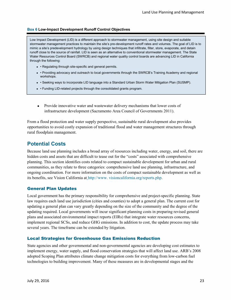
Land Use Planning and Management
July 29, 2016 23
Box 6 Low-Impact Development Runoff Control Objectives
• Provide innovative water and wastewater delivery mechanisms that lower costs of infrastructure development (Sacramento Area Council of Governments 2011).
From a flood protection and water supply perspective, sustainable rural development also provides opportunities to avoid costly expansion of traditional flood and water management structures through rural floodplain management.
Potential Costs Because land use planning includes a broad array of resources including water, energy, and soil, there are hidden costs and assets that are difficult to tease out for the “costs” associated with comprehensive planning. This section identifies costs related to compact sustainable development for urban and rural communities, as they relate to three categories: comprehensive land use planning, infrastructure, and ongoing coordination. For more information on the costs of compact sustainable development as well as its benefits, see Vision California at http://www. visioncalifornia.org/reports.php.
General Plan Updates Local government has the primary responsibility for comprehensive and project-specific planning. State law requires each land use jurisdiction (cities and counties) to adopt a general plan. The current cost for updating a general plan can vary greatly depending on the size of the community and the degree of the updating required. Local governments will incur significant planning costs in preparing revised general plans and associated environmental impact reports (EIRs) that integrate water resources concerns, implement regional SCSs, and reduce GHG emissions. In addition to cost, the update process may take several years. The timeframe can be extended by litigation.
Local Strategies for Greenhouse Gas Emissions Reduction State agencies and other governmental and non-governmental agencies are developing cost estimates to implement energy, water supply, and flood conservation strategies that will affect land use. ARB’s 2008 adopted Scoping Plan attributes climate change mitigation costs for everything from low-carbon fuel technologies to building improvement. Many of these measures are in developmental stages and the
Low Impact Development (LID) is a different approach to stormwater management, using site design and suitable stormwater management practices to maintain the site’s pre-development runoff rates and volumes. The goal of LID is to mimic a site’s predevelopment hydrology by using design techniques that infiltrate, filter, store, evaporate, and detain runoff close to the source of rainfall. LID is seen as an alternative to conventional stormwater management. The State Water Resources Control Board (SWRCB) and regional water quality control boards are advancing LID in California through the following:
• • Regulating through site-specific and general permits.
• • Providing advocacy and outreach to local governments through the SWRCB’s Training Academy and regional workshops.
• • Seeking ways to incorporate LID language into a Standard Urban Storm Water Mitigation Plan (SUSMP).
• • Funding LID-related projects through the consolidated grants program.

Land Use Planning and Management
24 July 29, 2016
estimated costs, emission reductions, applicable technologies, and other factors will likely change as they move through the regulatory process.
In terms of local and regional governments, economic costs will result from policies to reduce GHG emissions by changing how we grow and build our communities (http://www.arb.ca.gov/ cc/scopingplan/document/adopted_scoping_plan.pdf) (California Air Resources Board 2008). ARB estimates the cost to implement this land use strategy within the constraints noted above, as well as part of a cap-and-trade program. The State should provide cap-and-trade monies to local government to incentivize the implementation of this land use planning and management resource management strategy. The potential state, local, and private benefits for promoting higher density and more compact development may offset the costs of implementing this land use planning-and-management resource management strategy.
Transportation Planning and Investments Transportation planning efforts, which aim to achieve compact and sustainable development, are a major cost to regional and local governments. In addition to planning costs, there are implementation costs for capital projects, road, maintenance yards, bus stops, and intermodal stations. Maintenance and operations are often a separate budget cost, and most funding sources are restricted from being used for sustained operations. The three tiers of federal, State, and local transportation planning and transit programs are supported at various levels of funding. Federal funds support regional transportation, which must be aligned with State and regional programs and policies.
Implementation of compact and sustainable development will incur increased transit costs. Sustainable Communities Strategies may require increased investments in transit facilities and reduced investments in highways, relative to past trends. However, federal, State, and local funding programs may be constrained in their ability to shift highway investments to transit investments.
Water Supply Planning and Investments Federal, State, and local governments (often water districts) prepare various water supply plans. The federal and State planning is in the larger context of state hydrology and operations. Local governments must prepare the UWMP, and water districts likewise prepare plans, sometimes coordinating these local plans region-wide. State law provides for local land use jurisdictions to identify water supply sources. The cost of water supply planning can be high due to the technical nature of the data.
Although there may be significant new costs associated with changing the way local, regional, and State agencies plan urban areas, there are expected savings from avoided costs, especially in terms of future energy and long-term maintenance of infrastructure and other life cycle costs.
However, immediate costs are projected for increased planning, communication, coordination, and information sharing among land use agencies, water suppliers, agencies which regulate water quality, and climate change benefits of compact development. To achieve development of urban infill, there may also be substantial costs associated with upgrading urban infrastructure needed to support higher density development (see Box 7).

Land Use Planning and Management
July 29, 2016 25
Box 7 Integrating Water and Land Management
Sustainable Rural Development Rural areas include agricultural land, forests, and floodplains that may contain low-density development and small towns. Many rural California counties have large areas of land owned by the State or federal government, accounting for 50-75 percent in many areas. Some local governments strive to protect the floodplain and natural recharge areas for groundwater and find it challenging to also meet other State mandates.
Sustainable rural development incurs many of the planning and infrastructure costs mentioned above. Smaller rural cities and counties have especially limited financial resources for land use planning and infrastructure improvement due to smaller tax bases. In addition, water and flood management agencies may incur substantial costs to mitigate the impacts of their projects on timber and agricultural land and timber and agriculture-dependent small towns. There may be costs associated with the effects on recreation and resource-dependent communities. These costs may include not just direct land acquisition costs, but also financial assistance to compensate for reduced tax revenues.
Timber and Agricultural Mitigation In addition, water and flood management agencies may incur substantial costs to mitigate the impacts of their projects on timber and agricultural land and timber and agriculture-dependent small towns. There may be costs associated with the effects on recreation and resource-dependent communities. These costs may include not just direct land acquisition costs, but also financial assistance to compensate for reduced tax revenues.
The Integrated Water and Land Management Tool (California Department of Water Resources and Sonoma State University 2013) demonstrates that reducing hardscape is a critical component to minimizing water resource impacts and that it is possible to minimize costs and impacts while using standard building materials. The tool is user-friendly and easily modified to reflect local conditions for calculating development approaches for low-impact strategies for stormwater runoff and water supply benefits. This tool is a new, open-source application that will grow and develop over time as additional case studies and applications are completed. Because of the range of spatial scales the tool addresses, the results will apply to a wide user base, including homeowners interested in testing possible retrofits to their properties and examining costs versus benefits; residential developers seeking to evaluate different design strategies; local agency officials, including planning and public works staff; and elected and appointed decision-makers, such as council members and planning commissioners. The tool is intended to be useful for evaluating the effectiveness of water conservation measures being considered in a project or by suggested redesign or conditioning. Local agencies may also use the model to help generate standards that would apply to new developments through general plan, zoning, and subdivision regulations; design guidelines; or other planning documents designed to give guidance to private project proponents. The tool effectively demonstrates real differences in consumption at the lot and neighborhood levels when applied to case study sites. It is most useful for preliminary planning and conceptual design. In all of the case studies discussed in the report Integrating Land and Water Management: A Suburban Case Study and User-Friendly, Locally Adaptable Tool (California Department of Water Resources and Sonoma State University 2013), the environmental and monetary impacts of public infrastructure were sufficiently large that they overwhelmed many of the lot-by-lot choices. Public infrastructure may be the most critical component of a development. With further development of lifecycle costs calculations, it is likely that there will be an increasingly strong case for green infrastructure.

Land Use Planning and Management
26 July 29, 2016
Recreational Opportunities More compact development utilizing LID designs will require more public recreational opportunities that may include trails along urbanized, suburban, and rural waterways providing alternative routes for schools and work. Recreation demands will increase and coordinating and combining these recreational needs in an IWM approach services multiple purposes and provides public health benefits at an affordable economic scale.
Infrastructure and Property Values There are on-the-ground costs associated with developing more compact and sustainable land use patterns. Property values in outlying open space and agricultural areas may be reduced to the extent they reflect development potential that can no longer be realized. However, property values of urban infill sites would tend to increase. To achieve significant urban infill, there may be substantial costs associated with upgrading urban infrastructure needed to support higher density development, as discussed below (see Box 7).
Major Implementation Issues
Disincentives for Change Local governments have the authority to make most of the local land use decisions in California. Although many local governments are revising their land use plans and policies to promote compact and sustainable development, some local governments may not promote or implement compact and sustainable development patterns for many legitimate reasons. Their decisions might be guided by one or more of the following reasons:
• Community resistance to infill projects and/or higher density development. • Traditional and antiquated local zoning ordinances that, for instance, segregate retail uses from
residential uses or require higher parking ratios. • The cost to update general plans, prepare general plan EIRs, and revise zoning codes. • The cost and potential liability associated with pursuing infill projects, especially on brownfield
sites. • CEQA mitigation strategies that have been shown to inadvertently encourage lower density
development. • Environmental hazards. • Urban infrastructure limitations.
Fiscal Policy and Constraints California’s development patterns are driven by fiscal policies as local governments seek to balance revenues and expenditures by way of land use decisions, including balancing commercial and residential land uses in their jurisdictions, which may create competing retail centers or inefficient land uses. Additionally, lack of public financing resources due to Propositions 13 and 218, reducing the role of property-based taxation as a local government revenue source combined with the declining federal and State financing for infrastructure, have forced many local governments to focus increasingly on the potential fiscal effects of land use decisions.

Land Use Planning and Management
July 29, 2016 27
Additional federal fiscal policies, such as low capital gains tax rates, make property ownership an attractive investment, adding to the urban development expansion in recent years. These fiscal policies combine to generate potential encouragement for local governments to seek and approve development that increases sales tax revenue, such as regional retail and commercial uses.
Some local governments seek higher priced housing over moderately priced housing because housing development only produces property tax at a fixed rate, which is less than the rate of inflation for providing city-based services such as road repair, infrastructure maintenance, parks, libraries, fire protection, and public safety. Rural communities may seek forest and agricultural estates (large home sites with some agricultural potential) for property tax benefits, but such development may erode the necessary cluster of resource lands for timber or working farms.
Therefore, this cluster withers. Focusing on higher end housing has the potential to establish a higher tax base to support the provision of ongoing municipal services. Overall, simple economics dictates that counties and cities will, as a practical matter, favor development that generates higher property and sales tax.
Financially strapped cities and counties are more inclined to favor tax-generating land uses, such as retail and commercial, over housing. For residential projects, communities typically have adopted “development pays its way” policies to cover infrastructure improvements. Developers are assessed a variety of development impact fees to cover the cost of such services and amenities as roads, parks, water, public safety, and other social infrastructure costs. The net result of these fiscal constraints is that the short-term need for revenue generated by this type of land use is often pursued without budgeting for the long-term costs. As a result of these property tax policies, local communities often compete with one another for businesses that generate sales tax. Community needs for jobs and housing are often outweighed by the competition for revenue-driven development.
Coordinating Land Use and Water Policies Coordination of land use and water policies at multiple levels is a primary challenge in meeting state and local water needs. Increased coordination will also be necessary among all levels of government to facilitate inter-agency planning, to develop reliable and complete data and information which can form the basis for consistent government decision-making, and to interpret and share data and information to optimize the relationship of land use planning and water resources planning. For example, California Government Code and the Water Code require local governments to determine whether there will be enough water to supply a proposed development project before it can be approved. For more information on the relationship between land use and water supply planning, see the Urban Land Institute’s report on SB 375 at http://www.uli.org/ publications/resource-library/.
Incorporating Regional Transportation with Sustainable Communities Strategies and Local General Plans An SCS or Alternative Planning Strategy (APS), developed by an MPO or other regional designee, is required under SB 375 as a part of the regional transportation plan (RTP) development process. MPOs prepare land use allocations within the RTP to achieve each region’s GHG emissions reduction targets. SB 375 and SB 732 provide incentives to meet emissions reduction targets, and SB 732 authorizes funding for the planning and development of sustainable communities.

Land Use Planning and Management
28 July 29, 2016
SB 375 should result in more certainty to the development community as to where development should occur and the type of development that is encouraged. The path to the development approval process should also be easily comprehensible in order to create more certainty. Currently, there is minimal coordination between SCSs and regional water planning. Additional planning and coordination costs may be incurred by MPOs to incorporate water resources management issues and concerns into future SCSs. Similarly, additional planning and coordination costs may be incurred by DWR and IRWMP preparers to use SCS growth forecasts as the demographic and land use basis for regional water planning
Transportation planning efforts which aim to achieve compact and sustainable urban development mentioned above are a major cost to regional and local governments. SB 375 will require regional planning agencies to incur increased planning costs to develop new land use allocations supporting RTPs. The new RTP EIRs will increase in cost and complexity. In addition to planning costs, there are much greater planning and implementation costs for RTP implementation as listed below in the Recommendations section.
Regulatory Improvement and Streamlining The existing regulatory framework across federal, State, regional, and local levels contains some inherent conflicts and contradictory directives, such as designated infill priority development areas conflicting with flood zones, environmental guidelines limiting proximity of housing to freeways or school location, and configuration guidelines that favor low density environments. Some State guidance can be considered separately from larger regional land use and transportation policies, which might confuse local jurisdictions on how to comply with multiple policy directions from the State.
Issues for Sustainable Rural Development Landowner incentives for maintaining agricultural land in agricultural use include the Williamson Act and conservation easements. However, State subventions to local governments for reduced property taxes associated with Williamson Act contracts have been eliminated, which may result in non-renewal of Williamson Act contracts over the long term. Also, funding for conservation easements is threatened by the state’s economic downturn, as well as reduced federal and State discretionary spending in budgets. As noted above, State subventions to local governments for reduced property taxes associated with Williamson Act contracts have been eliminated, which may result in non-renewal of Williamson Act contracts over the long term and thus jeopardize this popular and effective program.
Recommendations
Promote Cross-Cutting Funding and Planning Programs 1. The State should provide additional incentives to developers and local governments to plan and
build using more compact and sustainable development patterns. This could be done through further CEQA streamlining for infill development and associated infrastructure, depending on SB 226’s effectiveness, further reductions in brownfields liability for innocent land purchasers (depending upon the restoration of the Comprehensive Environmental Response, Compensation and Liability Act of 1980, also known as Superfund (refer to http://www.epa.gov/superfund/policy/index.htm and http://www.epa.gov/oecaerth/cleanup/ revitalization/ilo.html)), prioritizing planning grants, and providing further incentives (financial and other) to encourage compact and sustainable development.

Land Use Planning and Management
July 29, 2016 29
2. The State should develop and promote performance-based planning with metrics. Examples include establishing a baseline for each watershed for impervious surfaces, reduction of vehicle miles traveled per capita, planning and resource management that integrates multiple agencies and viewpoints, comprehensive flood management using floodplain planning, and land coverage. These metrics should be the basis for evaluating projects that request discretionary State funding, grants, and other financial assistance.
3. Local, regional, and State land use and water planning agencies should generally conduct an integrated review of long-range land use planning documents, infrastructure master plans, and financing strategies to ensure adequate support for long-term growth, and sustainable development in urban and rural areas.
4. The State should provide incentives for developing IWM elements in local general plans.
Integrate Regional Water Management and Regional/Local Land Use Plans 5. Regional planning agencies should continue and expand their participation in the regional
blueprint planning process. A. The State should provide mapping, funding, and technical assistance in order that local
governments may consider relevant water management issues. 6. Regional planning agencies should address water management issues in their blueprint plans,
groundwater management plans, and SCSs. 7. LAFCOs should consider water management issues in the context of their principal purposes,
which include discouraging urban sprawl, preserving open space and prime agricultural lands, efficiently provide government services, and encouraging the orderly formation and development of local agencies based upon local conditions and circumstances (Government Code 56301).
8. Local governments should coordinate with water planning agencies to promote integration of land use and water management planning. Examples of how this is currently being done include: A. Reviewing and submitting comments on the UWMPs adopted by water agencies within
their jurisdiction. B. Participating in the IRWM planning and implementation processes. C. Continuing to implement SB 610 and SB 221 (2001) effectively, which require land use
approvals to consider whether sufficient water supplies are available to serve new development.
D. Engaging relevant water management agencies to participate in general plan updates that address water issues.
9. When conducting general plan updates, local governments should address relevant water management issues including water supply, water quality, water affordability, flood risk reduction, and adequacy of services residents. This can be done by adding water management policies to the general plan elements currently required by statute, or by preparing an optional water element not required by statute. The discussion of water issues in general plans should be informed by IRWMPs and California Water Plan Regional Reports applicable to the city or county.
10. Local and regional water management and flood agencies should coordinate with local governments to promote integration of land use and water management planning. This should be done by:

Land Use Planning and Management
30 July 29, 2016
A. Participating in the general plan process in the communities they serve and submitting comments on general plan updates.
B. Including local agency representatives, regional water management groups, which are the governing bodies for IRWMPs.
C. Collaborating with local governments to identify opportunities to maximize water conservation, groundwater recharge, stormwater capture, and other water management strategies that rely on local land use planning for effective implementation.
11. To foster better coordination, collaboration, and communication, the State should facilitate tribal participation in IRWM and the Strategic Growth Council programs and policies, and link State and local funding, grants, and permits. The State should develop model protocols for local land use jurisdictions on working with tribes when feasible.
12. Local governments should implement specific land use planning and regulatory measures to reduce flood risks, as described in the resource management strategy recommendations in resource management strategy report, Flood Management. A. Technical assistance, data, and community participation should be funded.
13. Local government should consider integrating recreational amenities into flood and water management plans to provide multiple benefits associated with IWM.
Provide Funding, Incentives, and Technical Assistance 14. Increased State funding and technical assistance should be provided for the following programs
and policies that promote compact, sustainable development: A. Development and implementation of regional blueprint plans. B. Development and implementation of SCSs. C. General plan updates that implement blueprint plans and SCSs, and address water issues. D. General plan updates, zoning code updates, specific plans, and other land use controls that
promote compact sustainable development in addition to provisions in blueprint plans and SCSs.
E. Coordinated State and local government programs that incentivize infill development. These are especially important since tax increment financing by redevelopment agencies is no longer available as a tool to incentivize infill development.
F. General plan updates and other local government programs that use land use policies to help adapt to climate change.
G. Local government adoption of green building codes with LID principles that include water conservation and reduction of impervious surfaces.
H. Continued use of the CEQA process to mitigate the significant impacts of new development on resources including, but not only, prime agricultural land, wildlife habitat, open space, floodplains, recharge areas, wetlands, and water supply.
15. State grant and funding decisions should provide incentives and give priority to projects that are consistent with: A. Strategic Growth Council sustainability objectives. B. AB 857: State planning priorities that promote urban infill, and protect environmental and
agricultural resources. C. Regional sustainable communities strategies. D. Integrated regional water management plans. E. Regional blueprint plans.

Land Use Planning and Management
July 29, 2016 31
F. Green building codes that incorporate LID principles and reduce impervious surfaces, especially near waterways, and design standards such as LEED-ND and CALGreen.
16. State grant and funding decisions should recognize the unique challenges of promoting sustainable rural development.
17. Regional planning agencies should provide financial incentives and technical assistance to local governments to implement blueprint plans and SCSs in their communities.
18. The State should develop, make available, and provide technical assistance for a land use tool that allows planning and water resources agencies to evaluate the life cycle water resources infrastructure costs of conventional development patterns, as compared to compact and sustainable development patterns.
Enhance Research and Data Gathering 19. The State should provide funding, technical information, and best practices, as well as publicize
accurate and relevant water resources information for use by local governments and developers. The State could serve as an information clearinghouse for regional water supply, water quality, flood management, and climate change vulnerability information that local governments can use in preparing general plans. Such information would also provide comprehensive water resources information and policies to land use project applicants during pre-application meetings.
20. The State should encourage and support more scientific, engineering, planning, social, and economic research on the benefits and impacts of resource-efficient development patterns; develop an inventory of best practices by local governments, natural resource managers, and land management agencies; and provide a user-friendly portal for information access.
21. The State should evaluate the effectiveness of the package of flood management laws that were enacted in 2007 (see the “Coordinating Land Use and Flood Management” section in this report) in coordinating land use, flood planning, and natural resources and work to provide recommendations for changes to existing laws and their implementation as appropriate.
22. The State should evaluate the effectiveness of SB 610 and SB 221 in coordinating land use and water supply planning, and recommend improvements to these laws or their implementation as appropriate. The State should develop guidance on how SB 610 and SB 221 water supply assessments and verifications should address the effects of climate change and Delta export uncertainties on supply reliability.
Promote Interagency Coordination 23. The State should identify strategies, including performance metrics to improve communication,
coordination, and information sharing among local agencies, regional planning agencies, and local water agencies and watershed managers.
24. The State should promote improved coordination between local general plans and LAFCO policies on boundary changes to ensure adequate house and water supply with effective flood management.
Land Use Planning and Management
32 July 29, 2016
References
References Cited California Association of Local Agency Formation Commissions. 1971. What Is LAFCo? Sacramento
(CA): California Association of Local Agency Formation Commissions. [Web site.] Viewed online at: http://www.calafco.org/ about.htm.
California Air Resources Board. 2008. Climate Change Scoping Plan, A Framework for Change. Sacramento (CA): California Air Resources Board. 133 pp. Viewed online at: http://www.arb.ca.gov/cc/scopingplan/document/ adopted_scoping_plan.pdf.
California Department of Water Resources. 2008. Managing an Uncertain Future: Climate Change Adaptation Strategies for California’s Water. Sacramento (CA): California Department of Water Resources. 34 pp.Viewed online at: http://www.water.ca.gov/climatechange/docs/ClimateChangeWhitePaper.pdf.
———. 2010. Implementing California Flood Legislation into Local Land Use Planning: A Handbook for Local Communities. Sacramento (CA): California Department of Water Resources. 152 pp. Viewed online at: http:// www.water.ca.gov/floodmgmt/lrafmo/fmb/docs/Oct2010_DWR_Handbook_web.pdf.
Hanak, E. 2003. Who Should be Allowed to Sell Water in California? Third Party Issues and the Water Market. San Francisco (CA): Public Policy Institute of California. 196 pp. Viewed online at: http://www.ppic.org/content/pubs/ report/r_703ehr.pdfhttp://www.ppic.org/content/pubs/report/r_703ehr.pdf.
International Human Rights Law Clinic. 2013. The Human Right to Water Bill in California: An Implementation Framework for State Agencies. Berkeley (CA): University of California, Berkeley, School of Law. 20 pp. Viewed online at: http://www.law.berkeley.edu/files/Water_Report_2013_Interactive_FINAL.pdf.
Sacramento Area Council of Governments. 2011. Rural-Urban Connections Strategy. Sacramento (CA): Sacramento Area Council of Governments. 24 pp. Viewed online at: http://www.sacog.org/rucs/pdf/RUCS%20Booklet%20 2011%20Web.pdf.
U.S. Environmental Protection Agency. 2006. Growing Toward More Efficient Water Use: Linking Development, Infrastructure, and Drinking Water Policies. Washington (DC): U.S. Environmental Protection Agency. Smart Growth Program. Development, Community, and Environment Division. 39 pp. Viewed online at: http://www. epa.gov/smartgrowth/pdf/growing_water_use_efficiency.pdf.
U.S. Green Building Council. 2011. Rating Systems. LEED. Washington (DC): U.S. Green Building Council. [Web site.] Viewed online at: http://www.usgbc.org/DisplayPage.aspx?CMSPageID=1989.

Land Use Planning and Management
July 29, 2016 33
Additional References American Planning Association. 2012. Policy Guide on Smart Growth. Washington (DC): Update ratified
by American Planning Association Board of Directors. [Web site.] Viewed online at: http://www.planning.org/policy/guides/ adopted/smartgrowth.htm.
California Department of Transportation. 2009. “Regional Blueprints.” Sacramento (CA): California Department of Transportation. [Web site.] Viewed online at: http://calblueprint.dot.ca.gov/. Accessed: Dec., 2009.
California Department of Water Resources. 2008. Draft White Paper: Evapotranspiration Adjustment Factor. 18 pp. Viewed online at: http://www.water.ca.gov/wateruseefficiency/docs/etWhitePaper.pdf.
———. 2009. California Water Plan Update 2009. Viewed online at: http://www.waterplan.water.ca.gov/cwpu2009/ index.cfm.
———. 2010. Implementing California Flood Legislation into Local Land Use Planning: A Handbook for Local Communities. Sacramento (CA): Division of Flood Management. 176 pp. Viewed online at: http://www.water. ca.gov/floodmgmt/lrafmo/fmb/docs/Oct2010_DWR_Handbook_web.pdf.
California Emergency Management Agency, California Natural Resources Agency. 2012. DRAFT: California Climate Change Adaptation Policy Guide. Sacramento (CA): 214 pp. Viewed online at: http://resources.ca.gov/climate_ adaptation/docs/DRAFT_APG_Public_Review_April_2012.pdf.
California Natural Resources Agency. 2010. The Future of Natural Resources Management - A White Paper and Action Plan. Sacramento (CA): California Natural Resources Agency. Viewed online at: http://resources.ca.gov/docs/ IRM_Action_Plan12-10.pdf.
City of Santa Monica. 2010. Land Use and Circulation Element. Santa Monica (CA): Department of Planning and Community Development. Viewed online at: http://www.shapethefuture2025.net/.
Garrett C, Collins-Burgard E, Waterman R, Klopf A. 2008. Addressing Climate Change through Land Use and Transportation. Planning: California’s SB 375 and SB 732 — A Legislative Trend?” New York (NY): Client Alert. Number 770. Dec. 2, 2008. 11 pp. Latham & Watkins LLP. [E-news.] Viewed online at: http://www.lw.com/ upload/pubContent/_pdf/pub2390_1.pdf.
Governor’s Office of Planning and Research. 2003a. Governor’s Environmental Goals and Policy Report. Sacramento (CA): Governor’s Office of Planning and Research. 185 pp. Viewed online at: http://www.opr.ca.gov/planning/ publications/EGPR—11-10-03.pdf.
———. 2003b. General Plan Guidelines Update. Sacramento (CA): Governor’s Office of Planning and Research. 290 pp. Viewed online at: http://opr.ca.gov/docs/General_Plan_Guidelines_2003.pdf.

Land Use Planning and Management
34 July 29, 2016
——— . 2011. The California Planners’ Book of Lists 2011. Sacramento (CA): Governor’s Office of Planning and Research. Viewed online at: http://www.cnps.org/cnps/conservation/conference/2011/pdf/book-of-lists-2011.pdf.
Jacob JS, Crossley D. 2005. “Choices for growth: Quality of life and the natural environment.” College Station (TX): Texas Coastal Watershed Program Texas A& M University. .16 pp. TAMU-SG-05-701. [Bulletin.] Viewed online at: http://tcwp.tamu.edu/files/2012/06/urban_growth_primer_5.pdf.
League of California Cities. 2006. League Smart Growth Principles. Sacramento (CA): League of California Cities. 2 pp. Viewed online at: www.cacities.org. Accessed: Nov., 2009.
Low Impact Development Center. 2005. Low-Impact Development Strategies and Tools for Local Governments: Building a Business Case. Beltsville (MD): Report Summary. Low Impact Development Center. 2 pp. Viewed online at: http://www.lowimpactdevelopment.org/lidphase2/pubs/LMI%20LID%20Report%20Summary.pdf. Accessed: Nov., 2009.
———. 2009. Low Impact Development Strategies and Tools for NPDES Phase II Communities. Beltsville (MD): Low Impact Development Center. [Web site.] Viewed online at: http://www.lowimpactdevelopment.org/lidphase2. Accessed: Nov., 2009.
National Association of Realtors. 2009. Smart Growth Program. Chicago (IL): [Web site.] Viewed online at: http://www. realtor.org/programs/smart-growth-program. Accessed: Nov., 2009.
Nelson AC. 2011. The New California Dream: How Demographic and Economic Trends May Shape the Housing Market A Land Use Scenario for 2020 and 2035. Executive Summary. Los Angeles (CA): Report prepared for the Urban Land Institute – Los Angeles. 6 pp. Viewed online at: http://www.uli.org/wp-content/uploads/2012/06/ULI- Voices-Nelson-The-New-California-Dream.ashx_1.pdf.
Powell LM, Rohr ES, Canes ME, Cornet JL, Dzuray EJ, McDougle LM. 2005. Low-Impact Development Strategies and Tools for Local Governments: Building a Business Case. Executive Summary. Washington (DC). LID50T1. 35 pp. Viewed online at: http://www.lowimpactdevelopment.org/lidphase2/pubs/LMI%20LID%20Report.pdf.
The President’s Council on Sustainable Development. 1996. Sustainable America: A New Consensus for Prosperity, Opportunity, and a Healthy Environment for the Future. Washington (DC): The President’s Council on Sustainable Development. 186 pp.
Union of British Columbia Municipalities, Green Communities Committee, Smart Planning for Communities 2009. “Business Case for Climate Action.” British Columbia (Canada): BC Climate Action Toolkit. Union of British Columbia Municipalities, Green Communities Committee, and Smart Planning for Communities, a program of the Fraser Basin Council. Viewed online at: http://www.toolkit.bc.ca/big-picture/business-case. Accessed: Dec., 2009.

Land Use Planning and Management
July 29, 2016 35
Urban Land Institute. 2008. California 2020. Responsible Land Use: A Path to a Sustainable California by 2020. Viewed online at: http://sf.uli.org/wp-content/uploads/2011/05/CA_2020_Chavez-FINAL-REPORT.pdf.
U.S. Environmental Protection Agency. 2001. Our Built and Natural Environments: A Technical Review of the Interactions between Land Use, Transportation, and Environmental Quality. Washington (DC): U.S. Environmental Protection Agency. Development, Community, and Environment Division. EPA 231-R-01-002. 102 pp. Viewed online at: http://www.epa.gov/dced/pdf/built.pdf.
U.S. Green Building Council. 2009. Washington (DC): [Web site.] Viewed online at: http://www.usgbc.org/Default.aspx. Accessed: December, 2009.
Waterman R. 2004. “Addressing California’s Uncertain Water Future by Coordinating Long-Term Land Use and Water Planning: Is a Water Element in the General Plan the Next Step?” Comment. Ecology Law Quarterly. 31(1):117- 142.
Yolo County. 2011. Climate Action Plan: A Strategy for Smart Growth Implementation, Greenhouse Gas Reduction, and Adaptation to Global Climate Change. Adopted by Yolo County Board of Supervisors Resolution 11-17. Prepared by AECOM, Ascent Environmental, Inc., Fehr & Peers Transportation Consultants and CTG for The County of Yolo. 236 pp. Viewed online at: http://www.yolocounty.org/Index.aspx?page=2004.
Related Documents