IJSRSET151373 | Received: 20 June 2015 | Accepted: 25 June 2015 | May-June 2015 [(1)3: 334-348] © 2015 IJSRSET | Volume 1 | Issue 3 | Print ISSN : 2395-1990 | Online ISSN : 2394-4099 Themed Section: Science 334 Land Use Changes at Ezulwini Peri - Urban Area in Swaziland (1992-2012) Sithole T. N 1 , Salam A. 2 , Al-Hosani N. 3 1 Department of Geography, Environmental science and Planning, Kwaluseni, University of Swaziland, Swaziland 2, 3 Department of Geography and Urban Planning, UAE University, Al Ain, UAE ABSTRACT Swaziland is facing varying rates of urbanization and this directly affects lands use changes. This study was designed to investigate the land use changes at Ezulwini peri-urban area from 1992 to 2012 and to evaluate how the land use changes have affected the lives of the people in the area. Questionnaires and GIS techniques were used to conducting the study. Open and closed ended questionnaires were directed to residents of study area. Result shows that land use changes took place at the study area and settlements were swallowing agricultural land. The causes of land use changes were development of the local town, low agricultural returns and the construction of a major road. Land use changes brought affluent and educated people to the study area. Residents responded by selling their fields, building rental houses and seeking formal employment. The study concluded that land use changes affect livelihood and governance of peri-urban residents. Keywords: Agricultural Land, Heads of Households, Land Use, Peri-Urban, Urbanization I. INTRODUCTION The economically less developed countries like Swaziland are facing varying rates of urbanization. The rapid process of urbanization result to population growth, increase and development of human settlement and change from agricultural activities to non-agricultural activities. The results of urbanization directly affect peri- urban areas (Rakodi, 2007). 1.1 Peri-urban areas Peri-urban areas refer to places outside formal urban boundaries and jurisdiction (MHUD, 2001). According to Mandere and Ness (2010), peri-urban areas refer to rural land surrounding cities. These areas are found within a commuting distance to the cities. For the purposes of this study, peri- areas refer to areas within the buffer zone of Ezulwini municipality. These areas include Mvutjini, Nyonyane, Gelekeceni, Somnjalose, Nshakabili Ebuka Longalaza and Elangeni. The peri- urban areas are direct recipients of urban growth and development. The development and growth of urban areas entail encroachment into peri-urban areas. As a result many peri-urban areas have many characteristics of nearby cities (Adell, 1999). Peri-urban areas in Swaziland are urbanized by a mixture of planned and unplanned buildings as well as densely populated. Most peri-urban areas in Swaziland are found between Ngwenya and Manzini corridor. Many Swazi people prefer to settle in peri-urban areas because land is affordable yet it is closer to places of employment. Another advantage of settling in peri-urban areas is that they may be incorporated into a nearby urban area (Dlamini and Masuku, 2011). As peri-urban areas develop, land use changes. Agricultural land use may be replaced by residential, commercial, industrial and recreational land use. Land use change may affect land administration and land tenure (Rakodi, 2007). The government of Swaziland defines peri-urban areas as those that are outside formal boundaries and urban jurisdictions, which are in a process of urbanization and

Welcome message from author
This document is posted to help you gain knowledge. Please leave a comment to let me know what you think about it! Share it to your friends and learn new things together.
Transcript
IJSRSET151373 | Received: 20 June 2015 | Accepted: 25 June 2015 | May-June 2015 [(1)3: 334-348]
© 2015 IJSRSET | Volume 1 | Issue 3 | Print ISSN : 2395-1990 | Online ISSN : 2394-4099 Themed Section: Science
334
Land Use Changes at Ezulwini Peri - Urban Area in Swaziland (1992-2012)
Sithole T. N
1, Salam A.
2, Al-Hosani N.
3
1 Department of Geography, Environmental science and Planning, Kwaluseni, University of Swaziland, Swaziland
2, 3 Department of Geography and Urban Planning, UAE University, Al Ain, UAE
ABSTRACT
Swaziland is facing varying rates of urbanization and this directly affects lands use changes. This study was
designed to investigate the land use changes at Ezulwini peri-urban area from 1992 to 2012 and to evaluate how the
land use changes have affected the lives of the people in the area. Questionnaires and GIS techniques were used to
conducting the study. Open and closed ended questionnaires were directed to residents of study area. Result shows
that land use changes took place at the study area and settlements were swallowing agricultural land. The causes of
land use changes were development of the local town, low agricultural returns and the construction of a major road.
Land use changes brought affluent and educated people to the study area. Residents responded by selling their
fields, building rental houses and seeking formal employment. The study concluded that land use changes affect
livelihood and governance of peri-urban residents.
Keywords: Agricultural Land, Heads of Households, Land Use, Peri-Urban, Urbanization
I. INTRODUCTION
The economically less developed countries like
Swaziland are facing varying rates of urbanization. The
rapid process of urbanization result to population growth,
increase and development of human settlement and
change from agricultural activities to non-agricultural
activities. The results of urbanization directly affect peri-
urban areas (Rakodi, 2007).
1.1 Peri-urban areas
Peri-urban areas refer to places outside formal urban
boundaries and jurisdiction (MHUD, 2001). According
to Mandere and Ness (2010), peri-urban areas refer to
rural land surrounding cities. These areas are found
within a commuting distance to the cities. For the
purposes of this study, peri- areas refer to areas within
the buffer zone of Ezulwini municipality. These areas
include Mvutjini, Nyonyane, Gelekeceni, Somnjalose,
Nshakabili Ebuka Longalaza and Elangeni. The peri-
urban areas are direct recipients of urban growth and
development. The development and growth of urban
areas entail encroachment into peri-urban areas. As a
result many peri-urban areas have many characteristics
of nearby cities (Adell, 1999).
Peri-urban areas in Swaziland are urbanized by a
mixture of planned and unplanned buildings as well as
densely populated. Most peri-urban areas in Swaziland
are found between Ngwenya and Manzini corridor.
Many Swazi people prefer to settle in peri-urban areas
because land is affordable yet it is closer to places of
employment. Another advantage of settling in peri-urban
areas is that they may be incorporated into a nearby
urban area (Dlamini and Masuku, 2011).
As peri-urban areas develop, land use changes.
Agricultural land use may be replaced by residential,
commercial, industrial and recreational land use. Land
use change may affect land administration and land
tenure (Rakodi, 2007).
The government of Swaziland defines peri-urban areas
as those that are outside formal boundaries and urban
jurisdictions, which are in a process of urbanization and
International Journal of Scientific Research in Science, Engineering and Technology (ijsrset.com)
335
therefore assume many of the characteristics of urban
areas. They are urbanizing through fast and unplanned
growth resulting in environmental and health issues
(MHUD, 2001).
1.2. Land tenure in peri-urban areas in Swaziland
Land tenure may be defined as the terms and conditions
on which land is held, used and transacted (Adams,
Sibanda and Turner, 1999). There are two dominant land
tenure systems in Swaziland. These are Swazi Nation
Land (SNL) and Title Deed Land (TDL).
Swazi Nation Land is land held in trust by the king for
the Swazi nation. It is governed by the chiefs and is
acquired through kukhonta. Kukhonta is a traditional
process through which an individual seeks residence in
the chiefdom by approaching local authorities.
Title Deed Land (TDL) is private land owned by
individuals, companies and government. This land can
be sold to anyone who can afford it (IFAD, 2007). TDL
is mostly found in urban areas.
Peri-urban areas are developing at a faster rate than
expected in the last two decades (Mandere and Ness,
2010). The process of peri-urban development is most
dominant in Africa and Asian cities. Swaziland is also
facing challenges of peri-urban development. The
fastest developing peri-urban area in Swaziland is
Ezulwini. The main causes or drivers of peri-urban
development vary from country to country and from
town to town. They may include Foreign Direct
Investment FDI or local investment, government policy
or shortage of land in the nearby urban area or city. The
investments may be used in the setting up of industries
in peri-urban areas. As a result agricultural land will be
converted to residential land.
As the peri-urban area develops, land uses change.
Agricultural land is swallowed by other land uses such
as industrial and residential. The change in land use may
result in population growth. The growth of population
will create pressure on basic services such as roads,
water supply and recreational facilities. The provision
of these services will also swallow agricultural land.
The loss of agricultural land may cause problems for
peri-urban people. This is because some of them depend
on agriculture for livelihood.
The change of land use may cause governance problems.
Land tenure may also be affected. Traditional and
municipal authorities may be affected by the influx of
people. Land use change in peri-urban areas poses
several challenges (Webster, 2002). However, literature
review reveals that there is no clear understanding of
these challenges. The response by people to these
challenges has also not been investigated (Buxton and
Choy, 2012). This study will investigate the land use
changes at Ezulwini peri-urban area in Swaziland from
1992-2012
1.3 Government’s efforts to monitor and control
peri-urban development in Swaziland
The government of Swaziland has developed policies to
regulate and monitor peri-urban development. The
purpose of these policies is to mitigate the impacts of
peri-urban development. These policies include National
Land Policy (NLP), National Housing Policy (NHP) and
Peri-Urban Growth Policy (PUGP).
1.3.1 National Housing Policy (NHP)
Government in May 1993 in response to challenges of
rapid population growth, rapid urbanization, urban
growth and deepening poverty approved the national
housing policy. The National Housing Policy focuses on:
Improving the efficiency of the housing market in
urban areas;
Improving the efficiency of the housing market in
urban areas;
Incorporating peri-urban areas within Mbabane and
Manzini so that all households acquire services of
health, safety, water, sanitation and waste removal.
1.3.2 National Land Policy (NLP)
The national land policy was developed to control land
acquisition and management (Sihlongonyane, 2003).
The objectives of the National Land Policy are to:
Improve access to land and tenure;
Encourage the rational and sustainable use of land;
Improve productivity, income and living conditions
and alleviate poverty;
Reduce land related conflicts;
Develop an efficient and effective system of land
administration.
International Journal of Scientific Research in Science, Engineering and Technology (ijsrset.com)
336
1.3.3 The Peri -Urban Growth Policy (PUGP)
The Peri-Urban Growth Policy (PUGP) was developed
for better management of the urbanization process in
peri-urban areas. The objectives of the Peri-Urban
Growth Policy are to:
Provide affordable infrastructure and safe services in
order to ensure introduction and maintenance of
minimum health standards;
Direct and channel urban expansion and market
forces towards urban amenity, including the
retention of green belt areas; and
Mitigate the problems related to spontaneous human
settlements through policies and programmes that
anticipate unplanned settlements.
The Peri-Urban Growth Policy proposes a gradual
process of recognizing current land uses and
incorporating them into urban areas. It calls for the
formation of the Peri-Urban Authority (PUA) that will
have responsibility for all structures in peri-urban areas.
The peri-urban authority shall have jurisdiction on all
land whether SNL or TDL.
1.4 Features of peri-urban areas
Peri-urban areas are places or land surrounding the
urban boundary. Peri-urban areas have various
characteristics according to the literature review.
According to Browder, Bohland and Scarpadi (1995)
peri-1urban areas are urbanization by a diversity of land
uses. The land uses are influenced by the nearby cities.
If the nearby town is a tourist town the peri-urban
residents will provide rental housing to hotel staff.
1.5 Land use change models
Land use change models such as California Urban
Futures (CUF) Model developed in Northern California
Bay region (EPA, 2000), Delta Model developed by
David Simmonds in 1998, Land Use Change Analysis
System (LUCAS) developed in 1994 and UPLAN Urban
growth model developed by Robert Johnston in 1998 are
used by researchers and professionals to study and
monitor land use patterns. They are also used to study
the effects of land use change on human activities and
environment.
1.6 Land uses in Swaziland
Swaziland is experiencing a rapid population growth,
rapid industrialization and urbanization, increasing
agricultural demand and a declining economy.
According to Mndzebele (2001) the major land use
problems is land degradation due to overstocking and
deterioration of grazing areas, soil erosion, deforestation,
rapid urbanization and unplanned settlements in both
urban and rural areas.
The ever-increasing human population in Swaziland has
increased the demand for land for food production.
Riverbanks and slopes above 14% have been cultivated
with considerable loss of soil through erosion. Natural
forests have also been cleared to make way for human
settlements, pastures, arable land civil structures such as
dams and roads (Mwendera, Manyatsi Mangwenzi and
Dlamini, 2002). Moreover, people residing on Swazi
Nation Land do not have secure property rights with
regards to land. This means that it is very risky to
engage in land improvement measures because the land
does not actually belong to the inhabitants, hence there
is no guarantee of ownership.
Another land use problem has been the indiscriminate
shift from crop production to commercial crop farming.
In the past, irrigated sugar cane was grown only in the
lowveld of Swaziland especially around Simunye,
Mhlume, Tshaneni and Big Bend. At the moment a
considerable proportion of the total arable land in
Swaziland has been turned into sugarcane plantations,
even in the Middleveld, due to the crop‟s ability to
generate profit within a short space of time (Manyatsi,
1997).
1.7 Ethical considerations of the study
According to Tevera and Peter (2008), ethics have an
overriding implication for data collection, analysis and
research output. Due to this reason, several ethical issues
were raised in the study. It was explained to the
respondents that this was an academic research. It will
not directly benefit them but would help the researcher
and other stakeholders to understand the impact of land
use changes on peri-urban areas. Moreover, strict
confidentiality was observed in the study. The
respondents were informed of the voluntary nature of the
study. Interviews were administered only to willing
International Journal of Scientific Research in Science, Engineering and Technology (ijsrset.com)
337
participants who had granted their consent after the
researcher had explained the purpose of the research.
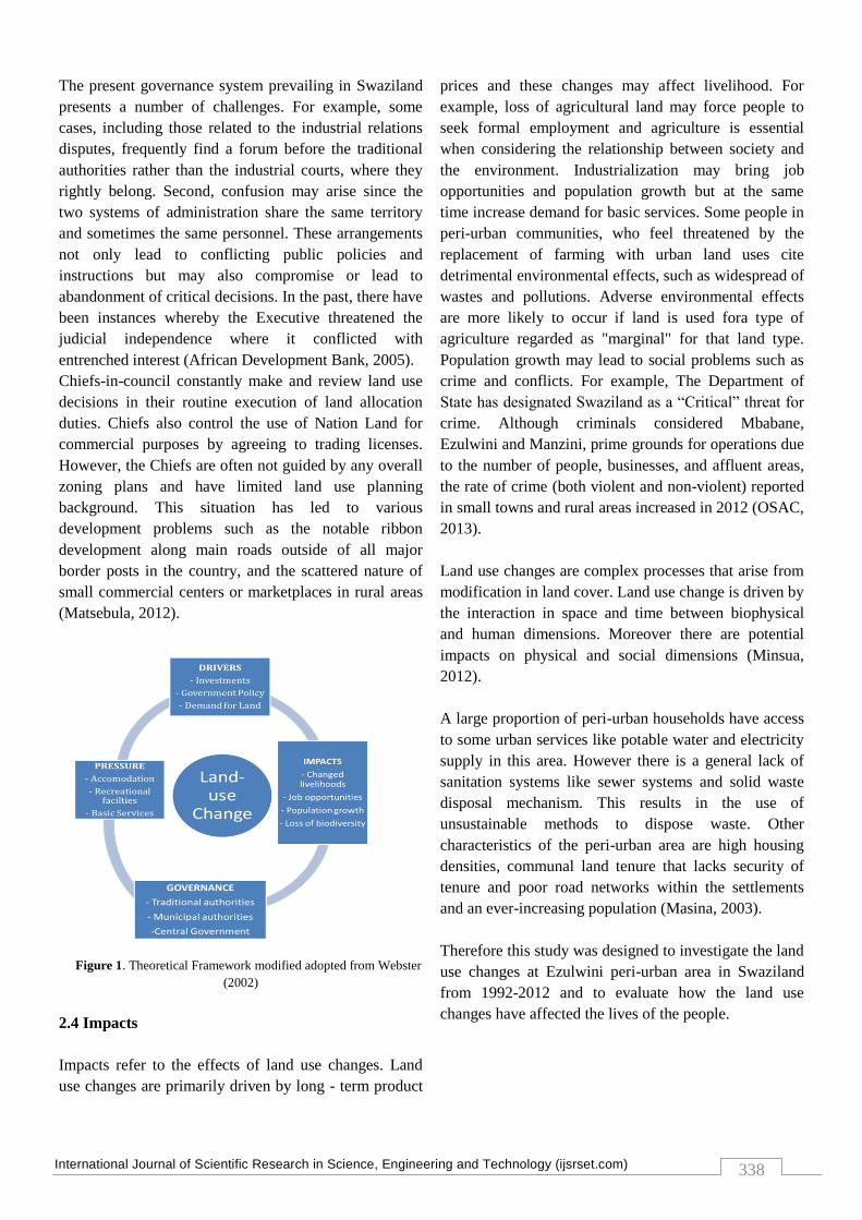
2.0 Theoretical framework
The theoretical framework in this study was derived and
modified from the Pressure-State-Impact-Response
(DPSIR) scheme (Figure 1). The different causes and
effects of land use change are explained. It is widely
used as a tool to link several environmental and socio-
economic factors by explaining causal relationships. The
DPSIR model illustrates the effects of human actions on
the environment in an easy way.
The DSPIR concept is the links of several components
preliminary with „drivers‟ such as investments,
government policy and demand for land through
„pressures‟ such as accommodation, residential facilities,
basic services to „governance‟ central government,
traditional and municipal authority and leading to
„impacts‟ change livelihood, job opportunity, population
growth and lose of biodiversity.
2.1 Drivers
Drivers refer to the causes of peri-urbanization and can
cause change in the systems. Land use change in peri-
urban area is not only the change from non-urban to
urban land but also exoduses in the competition between
drivers and land use. The types of change include social,
financial, and ecological and all can be either positive or
negative. The drivers include foreign direct investment
(FDI), for example, according to (Webster, 2002)
foreign direct investment is a major cause of peri-
urbanization approximately large African and Asian
cities. Ezulwini town is increasingly proving to be the
investors‟ center of attraction, among others. This can be
illustrated by the influx of investors that are showing an
interest of investing in the arguably fastest growing town
in the kingdom. One of the investors that have plans to
invest at the valley is Tibiyo Properties. The Tibiyo
Taka Ngwane investee company will construct a
multimillion commercial center at the town. In that
commercial center, the mall construction was to
complement the under construction International
Convention Centre (ICC) and Five-Star hotel at the area.
The commercial center will be located next to the MTN
Swaziland. Other companies that are set to invest in
Ezulwini is the Swaziland Revenue Authority (SRA),
which will be constructing head offices.
Domestic investment can also play a role in peri-
urbanization and will create demand for land.
Government policy of locating heavy industries on the
outskirts of towns can also spark peri-urban growth. The
introduction of manufacturing industries will cause land
use change and it can create pressure. Drivers are the
social, demographic and economic growths in societies
and the consistent changes in life styles. Overall levels
of consumption and production patterns to provide basic
services such as food, shelter and health will have much
impact in the area. These driving forces may originate
and act locally regionally or globally.
2.2 Pressures
Drivers function through human activities, which may
purposely or accidentally apply pressures on the
environment. Pressures depend on the kind and level of
expertise involved in different activities, and can vary
across geographic regions. Usually these changes are
unwanted and are seen as negative impact.
The pressure on the land clearly resected on the
development, agriculture and use of land. As a result of
pressure on the land various indicators are affected, by
the several spatial sections in different scales over a
period of time. The pressures exerted by society may
directly affect the ecosystem, such as harvesting or
dredging, or may be transported and transformed
through a variety of natural processes to indirectly cause
changes in ecosystem conditions. Human activities
caused by drivers will also increase the demand of
accommodation, recreational facilities and basic services
in the area.
2.3 Governance
Governance refers to anyone involved in the
administration of land. These include traditional
authorities (chiefs), municipal authorities and central
government. As a peri-urban area develops, more
people will approach the chiefs for land. Municipal
authorities will be affected because the people will want
municipal services such as water supply. The authorities
will take agriculture land and use it for residential
purposes hence land-related conflicts may arise.
International Journal of Scientific Research in Science, Engineering and Technology (ijsrset.com)
338
The present governance system prevailing in Swaziland
presents a number of challenges. For example, some
cases, including those related to the industrial relations
disputes, frequently find a forum before the traditional
authorities rather than the industrial courts, where they
rightly belong. Second, confusion may arise since the
two systems of administration share the same territory
and sometimes the same personnel. These arrangements
not only lead to conflicting public policies and
instructions but may also compromise or lead to
abandonment of critical decisions. In the past, there have
been instances whereby the Executive threatened the
judicial independence where it conflicted with
entrenched interest (African Development Bank, 2005).
Chiefs-in-council constantly make and review land use
decisions in their routine execution of land allocation
duties. Chiefs also control the use of Nation Land for
commercial purposes by agreeing to trading licenses.
However, the Chiefs are often not guided by any overall
zoning plans and have limited land use planning
background. This situation has led to various
development problems such as the notable ribbon
development along main roads outside of all major
border posts in the country, and the scattered nature of
small commercial centers or marketplaces in rural areas
(Matsebula, 2012).
Figure 1. Theoretical Framework modified adopted from Webster
(2002)
2.4 Impacts
Impacts refer to the effects of land use changes. Land
use changes are primarily driven by long - term product
prices and these changes may affect livelihood. For
example, loss of agricultural land may force people to
seek formal employment and agriculture is essential
when considering the relationship between society and
the environment. Industrialization may bring job
opportunities and population growth but at the same
time increase demand for basic services. Some people in
peri-urban communities, who feel threatened by the
replacement of farming with urban land uses cite
detrimental environmental effects, such as widespread of
wastes and pollutions. Adverse environmental effects
are more likely to occur if land is used fora type of
agriculture regarded as "marginal" for that land type.
Population growth may lead to social problems such as
crime and conflicts. For example, The Department of
State has designated Swaziland as a “Critical” threat for
crime. Although criminals considered Mbabane,
Ezulwini and Manzini, prime grounds for operations due
to the number of people, businesses, and affluent areas,
the rate of crime (both violent and non-violent) reported
in small towns and rural areas increased in 2012 (OSAC,
2013).
Land use changes are complex processes that arise from
modification in land cover. Land use change is driven by
the interaction in space and time between biophysical
and human dimensions. Moreover there are potential
impacts on physical and social dimensions (Minsua,
2012).
A large proportion of peri-urban households have access
to some urban services like potable water and electricity
supply in this area. However there is a general lack of
sanitation systems like sewer systems and solid waste
disposal mechanism. This results in the use of
unsustainable methods to dispose waste. Other
characteristics of the peri-urban area are high housing
densities, communal land tenure that lacks security of
tenure and poor road networks within the settlements
and an ever-increasing population (Masina, 2003).
Therefore this study was designed to investigate the land
use changes at Ezulwini peri-urban area in Swaziland
from 1992-2012 and to evaluate how the land use
changes have affected the lives of the people.
International Journal of Scientific Research in Science, Engineering and Technology (ijsrset.com)
339
II. METHODS AND MATERIAL
3.1 Country setting of the study area
Ezulwini is situated in Swaziland, a land locked country
in the southeastern part of Africa. Swaziland has a total
area of 17 364 km² (Vilakati, 2005). The general climate
of Swaziland is sub-tropical, dry and cool winter, wet
and hot in summer, approximately 75% of the rainfall is
received during the months of September to March
(Vilakati, 2005). Swaziland has a population of 1 184
936, growth rate of 1.5% and a population density of
67.9 per kilometer square (IFAD, 2009). It is estimated
that 10% of the population own 40% of the country‟s
resources, whilst 66% of the population survive on
disposable income below us$10 per month (Manyatsi,
2003).
3.1.1 Location of the study area
Ezulwini is located in close proximity to two major odes
in Swaziland, namely Mbabane the capital city of
Swaziland, and Matsapha the industrial hub of
Swaziland. In terms of longitude, it is found between
31°09´04´´ and 31°15´22´´ east. Latitudinally, it is
found between 26°28´22´´ and 31° 30´22‟‟ South
(Vilakati, 2005). The study area is found along the
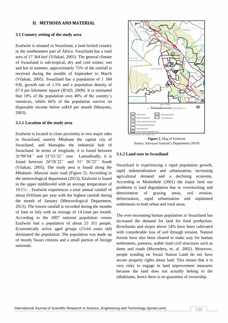
Mbabane- Manzini main road (Figure 2). According to
the meteorological department (2013), Ezulwini is found
in the upper middleveld with an average temperature of
19.1°c. . Ezulwini experiences a total annual rainfall of
about 9165mm per year with the highest rainfall during
the month of January (Meteorological Department,
2013). The lowest rainfall is recorded during the months
of June to July with an average of 14.1mm per month.
According to the 2007 national population census
Ezulwini had a population of about 23 351 people.
Economically active aged groups (15-64 years old)
dominated the population. The population was made up
of mostly Swazi citizens and a small portion of foreign
nationals.
Figure 2. Map of Ezulwini
Source; Surveyor General‟s Department (2010)
3.1.2 Land uses in Swaziland
Swaziland is experiencing a rapid population growth,
rapid industrialization and urbanization, increasing
agricultural demand and a declining economy.
According to Mndzebele (2001) the major land use
problems is land degradation due to overstocking and
deterioration of grazing areas, soil erosion,
deforestation, rapid urbanization and unplanned
settlements in both urban and rural areas.
The ever-increasing human population in Swaziland has
increased the demand for land for food production.
Riverbanks and slopes above 14% have been cultivated
with considerable loss of soil through erosion. Natural
forests have also been cleared to make way for human
settlements, pastures, arable land civil structures such as
dams and roads (Mwendera, et, al. 2002). Moreover,
people residing on Swazi Nation Land do not have
secure property rights about land. This means that it is
very risky to engage in land improvement measures
because the land does not actually belong to the
inhabitants, hence there is no guarantee of ownership.
International Journal of Scientific Research in Science, Engineering and Technology (ijsrset.com)
340
Another land use problem has been the indiscriminate
shift from crop production to commercial crop farming.
In the past, irrigated sugar cane was grown only in the
lowveld of Swaziland especially around Simunye,
Mhlume, Tshaneni and Big Bend. At the moment a
considerable proportion of the total arable land in
Swaziland has been turned into sugarcane plantations,
even in the Middleveld, due to the crop‟s ability to
generate profit within a short space of time (Manyatsi,
1997).
3.2 Method
The study adopted the “after only design”. This design is
used to assess an event after its occurrence (Tevera and
Seyama 2008). Information required by the study
includes the patterns of land use changes at Ezulwini
peri-urban area between 1992, 2002 and 2012. In
addition, information about divers or causes of land use
change was required. Information about the impacts of
the land use changes to the livelihood of the people was
required. Moreover, information about the responses of
the residents to the impacts of land use changes was
required.
The study employed both primary and secondary data
sources. Primary data was collected from heads of
homestead including men, women and any individual
from 18 years and above. Local authorities such as
chiefs and royal councils were used as informants. The
Ezulwini municipality town clerk was used as a resource
person.
Additional information was sourced from central
government departments. These include the Ministry of
Housing and Urban Development (MHUD), ministry of
Tinkhundla and Administration and the Land
Management Board. Data on land use changes was
sourced from aerial photographs and orthophoto maps
from 1992, 2002 and 2012. The aerial photographs and
orthophoto maps were obtained from the Surveyor
Generals Department.
A sample or subset of the population of individuals was
taken to provide information for the study. This technic
is appropriate where the population to be studied is too
large or where the collection of information for the
whole area is impossible or costly in terms of time,
effort and money (Tevera and Seyama 2008). The
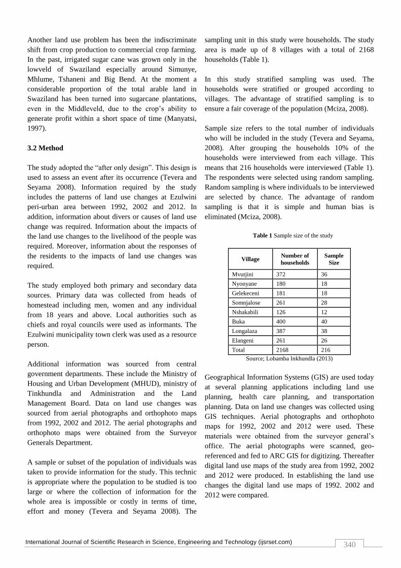
sampling unit in this study were households. The study
area is made up of 8 villages with a total of 2168
households (Table 1).
In this study stratified sampling was used. The
households were stratified or grouped according to
villages. The advantage of stratified sampling is to
ensure a fair coverage of the population (Mciza, 2008).
Sample size refers to the total number of individuals
who will be included in the study (Tevera and Seyama,
2008). After grouping the households 10% of the
households were interviewed from each village. This
means that 216 households were interviewed (Table 1).
The respondents were selected using random sampling.
Random sampling is where individuals to be interviewed
are selected by chance. The advantage of random
sampling is that it is simple and human bias is
eliminated (Mciza, 2008).
Table 1 Sample size of the study
Village Number of
households
Sample
Size
Mvutjini 372 36
Nyonyane 180 18
Gelekeceni 181 18
Somnjalose 261 28
Nshakabili 126 12
Buka 400 40
Longalaza 387 38
Elangeni 261 26
Total 2168 216
Source; Lobamba Inkhundla (2013)
Geographical Information Systems (GIS) are used today
at several planning applications including land use
planning, health care planning, and transportation
planning. Data on land use changes was collected using
GIS techniques. Aerial photographs and orthophoto
maps for 1992, 2002 and 2012 were used. These
materials were obtained from the surveyor general‟s
office. The aerial photographs were scanned, geo-
referenced and fed to ARC GIS for digitizing. Thereafter
digital land use maps of the study area from 1992, 2002
and 2012 were produced. In establishing the land use
changes the digital land use maps of 1992. 2002 and
2012 were compared.

International Journal of Scientific Research in Science, Engineering and Technology (ijsrset.com)
341
Questionnaires administered by the researcher were used
to collect socio-economic causes and impacts of land use
change at Ezulwini peri-urban area. The questionnaires
were directed to the heads of households. The
questionnaires comprised both closed and open ended
questions. Face to face, interviews were conducted.
Residents were interviewed on causes and effects of land
use changes. In addition the town clerk of Ezulwini
Town Board was interviewed. A discussion was
conducted with the inner counsel from Ezulwini
umphakatsi. Moreover the senior housing officer in the
Ministry of Housing and Urban Development was
interviewed. Furthermore a focus group discussion was
conducted with the Land Management Board.
The collected data was coded and analysed using
Statistical Package for Social Sciences (SPSS).The data
is presented using graphical techniques like bar graphs,
tables and pie charts. The data on land use changes is
presented using digital land use maps.
III. RESULTS AND DISCUSSION
4.1 Land use change at Ezulwini peri-urban areas
The data for 1992, 2002 and 2012 on land use changes
and pattern is presented using figures and digital land
use maps of Ezulwini peri-urban area.
4.1.1 Land uses in 1992
The land use map of the study area in 1992 show that
homesteads were dispersed. These homesteads were
surrounded by vast amounts of arable or agricultural
land. This means that most people had enough land to
practise agriculture. The 1992 land use map further
shows vast amounts of grasslands. This enabled people
to keep livestock. Moreover in 1992, the recreational
land use covered a small proportion of the study area.
The recreational facilities included the Somhlolo
National Stadium and Elangeni Sports Ground (Figure
3).
Figure 3. Land use map of Ezulwini peri-urban area in 1992
4.1.2 Land uses in 2002
In 2002, figure 4 show that the number of homesteads
increased drastically. The homesteads were nucleated
especially at Nshakabili, Mvutjini and Ebuka. The
increase in the number of homesteads swallows
agricultural land. The reasons for the increase of
settlements are due to various reasons. According to the
Ezulwini Royal Council the increase of settlements in
the study area was caused by inheritance. Siblings
divided land parcels where agriculture was practised and
built their homesteads. Secondly the residents started to
sell their fields to people from different areas. The new
settlers at Ezulwini peri-urban area were attracted by the
area`s proximity to towns such as Mbabane, Manzini,
Ezulwini and Matsapha. Moreover in 2002 commercial
land use was added. These included the shopping areas
at Mvutjini and Mlindazwe.
The constant conversion of agricultural land to urban
uses forces people to change occupations since it is
difficult to get access to farmlands. According to Minsua
(2012) small land size and poor land quality are some of
the reasons that made individuals engage in non-
agricultural activities. This is a survival strategy for
vulnerable households and individuals in peri-urban
areas. Furthermore, the exposure of the communities to

International Journal of Scientific Research in Science, Engineering and Technology (ijsrset.com)
342
urban monetary economy attracts farmers to take
advantage of urbanization (Abass and Afua, 2013).
Figure 4. Land use map of Ezulwini peri-urban area in 2002
4.1.3 Land Uses in 2012
In 2012 (Figure 5) shows that land uses such as
recreation and commercial increased. The Olympic
Centre and the Football Associations Technical Centre
were built next to Somhlolo National stadium. More
shopping facilities were built at Longalaza and Mvutjini.
Furthermore, in 2012 two new land uses emerged. These
include the waste treatment plant at Gelekeceni and the
light industry in the same area. Homesteads continue to
cluster agricultural land. Villages such as Somnjalose,
Ebuka and Nshakabili are congested with homesteads.
The use maps of Ezulwini peri-urban reflects a pattern
of growth in areal extent with residential land use
dominating.
Land use changes impact peri-urban areas
environmentally, economically, infrastructurally and
socially. The increasing pressure from urban expansion
has compelled most people to diversify their income
sources or secure alternative livelihood other than
agriculture. Infrastructural, urban expansion increases
demand for roads, piped water, electricity, telephone
lines and recreational facilities in peri-urban areas
(Oduro, 2010). However, due to failure of local
governments to plan and regulate development, the rate
of residential development usually outpaces the
provision of basic infrastructure. Table 2 shows the
extent of land use change at Ezulwini.
Table 2 Extent of land use change in Hectares (ha)
Land Use Category Area
in (ha)
1992
Area
in (ha)
2012
Change
(%)
Forest 90 73 -18
Grassland 74 45 -39
Recreational 11 66 500
Residential/Agriculture 152 204 34
Commercial 1 5 500
Waste treatment plant 0 2 200
Industrial 0 2 200
Homesteads 97 2231 2200
Table 2 shows that there has been a change in land use at
Ezulwini peri-urban area from 1992 to 2012. Forest
decreased from 90 hectares to 73 hectares. This means
that forestland use was reduced by 18 %. Grasslands
decreased from 74 hectares to 45 hectares. This accounts
for 39 % reduction.
Recreational land use increased from 11(ha) to 66(ha).
This accounts for 500% change. The increase is caused
by the construction of the Olimpia Africa Centre,
Football Association technical centre and Elangeni
Sports Ground. Residential land use increased from 152
(ha) to 204 (ha). This accounts for 34% increase. Forests
and grasslands were cleared for residential and
agriculture purposes. Commercial land use increased
from 1 (ha) to 5 (ha). This accounts for 500%. This was
caused by the development of shopping centres at
Elangeni, Longalaza and Mvutjini. Moreover, waste
treatment and industrial land use were not there in 1990.
4.1.4 Demographic characteristics of respondents
The results of the study show that the study area has
more male-headed homesteads than female-headed
homesteads. Out of the 216 homesteads that were
International Journal of Scientific Research in Science, Engineering and Technology (ijsrset.com)
343
sampled 132 were male headed whilst 84 were female
headed. Male-headed homesteads account for 61 %
whilst female-headed families account for 39 %.
4.1.5 Highest Academic Qualification of the
Respondents
The level of education of the respondents was
established. This was done to show the socio-economic
status of the respondents (Table 3).
Table 3 Level of education of the respondents
Qualification Female Male Total %
Tertiary 35 49 84 39
Secondary 41 60 101 47
Primary 8 23 31 14
Total 84 142 216 100
The Ezulwini peri-urban area has educated residents.
Table 3 indicates that 39 % of the residents have tertiary
qualifications, 47 % have secondary education and 14 %
have primary education. The sample population
indicates that Ezulwini peri-urban area has a literate
population.
4.1.6 Year of settling at Ezulwini
The year of arrival at Ezulwini peri-urban area was
established. This was done to determine the history of
land use changes (table 4).
Table 4 Year of arrival at Ezulwini
Year No of arrivals %
Before 1992 54 25
Between 1992 and
2002
70 32
Between 2002 and
2012
92 43
Total 216 100
The results indicate that new comers dominate the study
area. Table 4 shows that 25% arrived before 1992, 32%
settled between 1992 and 2002 and 43 % settled
between 2002 and 2012.
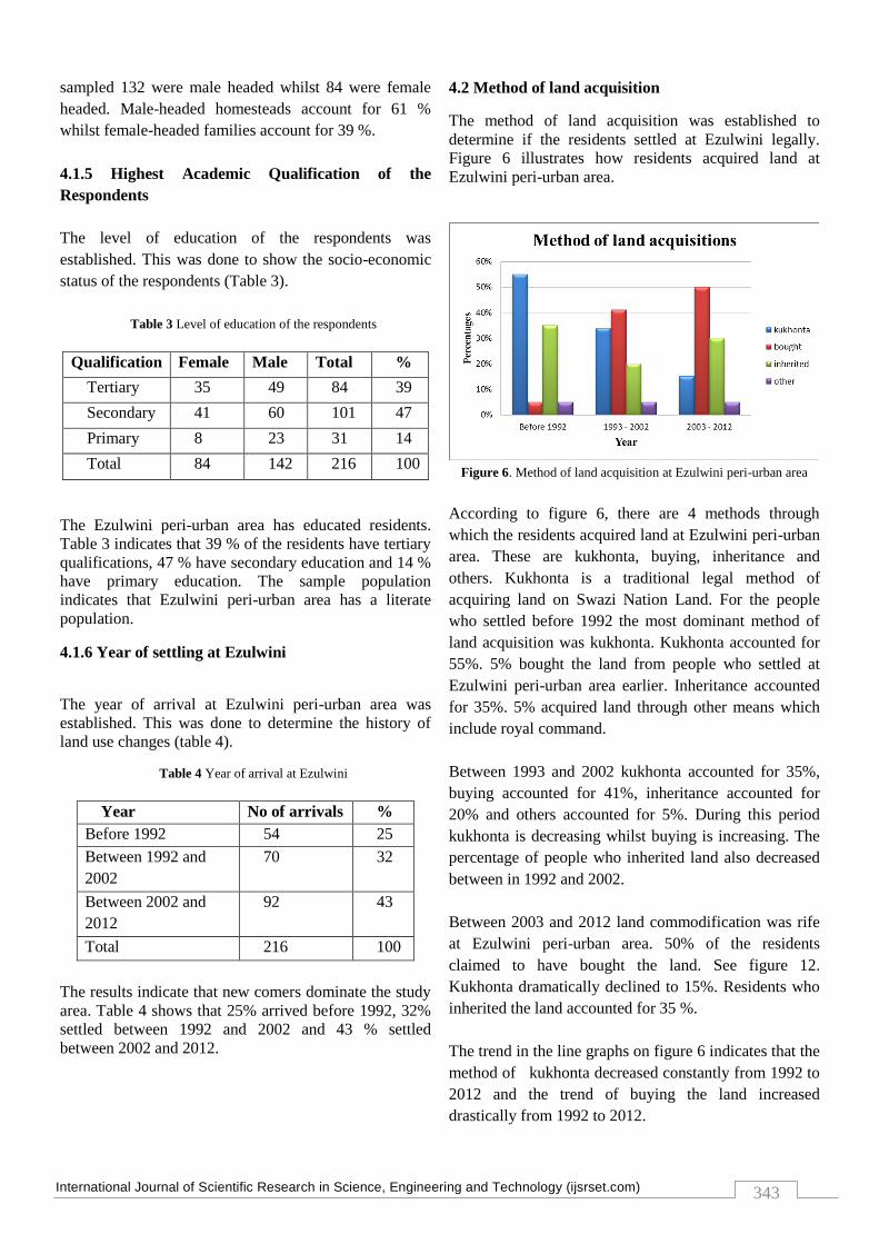
4.2 Method of land acquisition
The method of land acquisition was established to
determine if the residents settled at Ezulwini legally.
Figure 6 illustrates how residents acquired land at
Ezulwini peri-urban area.
Figure 6. Method of land acquisition at Ezulwini peri-urban area
According to figure 6, there are 4 methods through
which the residents acquired land at Ezulwini peri-urban
area. These are kukhonta, buying, inheritance and
others. Kukhonta is a traditional legal method of
acquiring land on Swazi Nation Land. For the people
who settled before 1992 the most dominant method of
land acquisition was kukhonta. Kukhonta accounted for
55%. 5% bought the land from people who settled at
Ezulwini peri-urban area earlier. Inheritance accounted
for 35%. 5% acquired land through other means which
include royal command.
Between 1993 and 2002 kukhonta accounted for 35%,
buying accounted for 41%, inheritance accounted for
20% and others accounted for 5%. During this period
kukhonta is decreasing whilst buying is increasing. The
percentage of people who inherited land also decreased
between in 1992 and 2002.
Between 2003 and 2012 land commodification was rife
at Ezulwini peri-urban area. 50% of the residents
claimed to have bought the land. See figure 12.
Kukhonta dramatically declined to 15%. Residents who
inherited the land accounted for 35 %.
The trend in the line graphs on figure 6 indicates that the
method of kukhonta decreased constantly from 1992 to
2012 and the trend of buying the land increased
drastically from 1992 to 2012.
International Journal of Scientific Research in Science, Engineering and Technology (ijsrset.com)
344
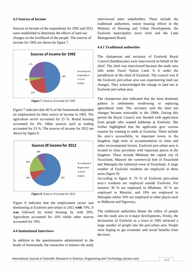
4.3 Sources of Income
Sources of income of the respondents for 1992 and 2012
were established to determine the effects of land use
changes on the livelihood of the people. The sources of
income for 1992 are shown by figure 7.
Figure 7. Sources of income for 1992
Figure 7 indicates that 48 % of the homesteads depended
on employment for their source of income in 1992. The
agriculture sector accounted for 25 %. Rental housing
accounted for 4%. Other sources such as trading
accounted for 23 %. The sources of income for 2012 are
shown by figure 8.
Figure 8. Sources of income for 2012
Figure 8 indicates that the employment sector was
dominating at Ezulwini peri-urban in 2012 with 70%. It
was followed by rental housing by with 20%.
Agriculture accounted for 10% whilst other sources
accounted for 10%.
4.4 Institutional Interviews
In addition to the questionnaires administered to the
heads of homesteads, the researcher to balance the study
interviewed other stakeholders. These include the
traditional authorities, senior housing officer in the
Ministry of Housing and Urban Development, the
Ezulwini municipality town clerk and the Land
Management Board.
4.4.1 Traditional authorities
The chairperson and secretary of Ezulwini Royal
Council (bandlancane) were interviewed on behalf of the
chief. The chief was interviewed because the study area
falls under Swazi Nation Land. It is under the
jurisdiction of the chief of Ezulwini. The council was if
the Ezulwini peri-urban area was experiencing land use
changes. They acknowledged the change in land use at
Ezulwini peri-urban area.
The chairperson also indicated that the most dominant
pattern is settlements swallowing or replacing
agricultural land. The secretary said the land use
changes became noticeable in the 1990s. During this
period the Royal Council was flooded with application
from people who wanted kukhonta at Ezulwini. She
further highlighted that the applicants give various
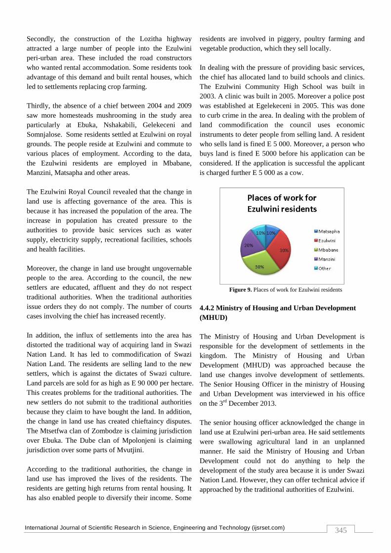
reasons for wanting to settle at Ezulwini. These include
the area‟s accessibility to important towns in the
kingdom, high rents of accommodation in cities and
other environmental factors. Ezulwini peri-urban area is
located in close proximity with important places in the
kingdom. These include Mbabane the capital city of
Swaziland, Manzini the commercial hub of Swaziland
and Matsapha the industrial town of Swaziland. A large
number of Ezulwini residents are employed in these
areas (figure 9).
According to figure 9, 70 % of Ezulwini peri-urban
area‟s residents are employed outside Ezulwini. For
instance 30 % are employed in Mbabane, 20 % are
employed in Manzini, and 10% are employed in
Matsapha whilst 10% are employed in other places such
as Malkerns and Ngwenya.
The traditional authorities blame the influx of people
into the study area to 4 major developments. Firstly, the
declaration of Ezulwini as a town in 1995 attracted a
large number of people into the peri-urban area. People
were hoping to get economic and social benefits from
the town.
International Journal of Scientific Research in Science, Engineering and Technology (ijsrset.com)
345
Secondly, the construction of the Lozitha highway
attracted a large number of people into the Ezulwini
peri-urban area. These included the road constructors
who wanted rental accommodation. Some residents took
advantage of this demand and built rental houses, which
led to settlements replacing crop farming.
Thirdly, the absence of a chief between 2004 and 2009
saw more homesteads mushrooming in the study area
particularly at Ebuka, Nshakabili, Gelekeceni and
Somnjalose. Some residents settled at Ezulwini on royal
grounds. The people reside at Ezulwini and commute to
various places of employment. According to the data,
the Ezulwini residents are employed in Mbabane,
Manzini, Matsapha and other areas.
The Ezulwini Royal Council revealed that the change in
land use is affecting governance of the area. This is
because it has increased the population of the area. The
increase in population has created pressure to the
authorities to provide basic services such as water
supply, electricity supply, recreational facilities, schools
and health facilities.
Moreover, the change in land use brought ungovernable
people to the area. According to the council, the new
settlers are educated, affluent and they do not respect
traditional authorities. When the traditional authorities
issue orders they do not comply. The number of courts
cases involving the chief has increased recently.
In addition, the influx of settlements into the area has
distorted the traditional way of acquiring land in Swazi
Nation Land. It has led to commodification of Swazi
Nation Land. The residents are selling land to the new
settlers, which is against the dictates of Swazi culture.
Land parcels are sold for as high as E 90 000 per hectare.
This creates problems for the traditional authorities. The
new settlers do not submit to the traditional authorities
because they claim to have bought the land. In addition,
the change in land use has created chieftaincy disputes.
The Mtsetfwa clan of Zombodze is claiming jurisdiction
over Ebuka. The Dube clan of Mpolonjeni is claiming
jurisdiction over some parts of Mvutjini.
According to the traditional authorities, the change in
land use has improved the lives of the residents. The
residents are getting high returns from rental housing. It
has also enabled people to diversify their income. Some
residents are involved in piggery, poultry farming and
vegetable production, which they sell locally.
In dealing with the pressure of providing basic services,
the chief has allocated land to build schools and clinics.
The Ezulwini Community High School was built in
2003. A clinic was built in 2005. Moreover a police post
was established at Egelekeceni in 2005. This was done
to curb crime in the area. In dealing with the problem of
land commodification the council uses economic
instruments to deter people from selling land. A resident
who sells land is fined E 5 000. Moreover, a person who
buys land is fined E 5000 before his application can be
considered. If the application is successful the applicant
is charged further E 5 000 as a cow.
Figure 9. Places of work for Ezulwini residents
4.4.2 Ministry of Housing and Urban Development
(MHUD)
The Ministry of Housing and Urban Development is
responsible for the development of settlements in the
kingdom. The Ministry of Housing and Urban
Development (MHUD) was approached because the
land use changes involve development of settlements.
The Senior Housing Officer in the ministry of Housing
and Urban Development was interviewed in his office
on the 3rd
December 2013.
The senior housing officer acknowledged the change in
land use at Ezulwini peri-urban area. He said settlements
were swallowing agricultural land in an unplanned
manner. He said the Ministry of Housing and Urban
Development could not do anything to help the
development of the study area because it is under Swazi
Nation Land. However, they can offer technical advice if
approached by the traditional authorities of Ezulwini.
International Journal of Scientific Research in Science, Engineering and Technology (ijsrset.com)
346
4.4.3 Land management board
The Land Management Board was established in terms
of section 212 subsection of The Constitution of
Swaziland (2005). The board is responsible for the
overall management and for the regulation of any right
or interest in land whether urban or rural. The Land
Management Board was interviewed on 23 January 2014
at the Ministry of Natural Resources. The chairperson of
the board stated clearly that they are against what is
happening at Ezulwini peri-urban area. He further
mentioned that settlements are swallowing agriculture
land in the study area. He said as a board they are
currently lobbying for bills that would give them power
to enforce their decisions. Currently they rely on
policies, which make them toothless.
4.4.4 Ezulwini town board
The study area is in the periphery of the Ezulwini
Municipality. Due to this reason, the town clerk of
Ezulwini Town Board was interviewed on 16 January
2014 in his office. The town clerk acknowledged the
change in land use in the peri-urban area with
settlements swallowing agricultural land. He said that as
a municipality they benefit from this process because the
peri-urban area provides their employees with affordable
accommodation. The urban residents are able to get
affordable employees such as gardeners, house cleaners
and shopkeepers from the peri-urban area.
On another note, the town clerk admitted that the influx
of settlements in the peri-urban area give problems to
the municipality. It harbors criminals. The peri-urban
residents also use facilities of the municipality. He said
as a municipality they have not done anything to control
development of the peri-urban area because they do not
have jurisdiction.
5.0 Discussion
Throughout the discussion DPSIR model are able to help
to find out the driving force behind the complex system
of peri-urban area in Ezulwini. This was helpful when
identifying where to target responses, such that they can
be specifically linked to socio -economic sectors or
human activities.
The local residence of the area losing their agricultural
field very rapidly. The consequences of agricultural and
forestland degradation has been the increasing emission
of greenhouse gases (GHGs) with warming effects on
local climate. This would affect subsistent rain-fed
agriculture, which dominates the local area. In this study
DPSIR approach can encourage and support decision-
making, by pointing to clear steps in the causal chain
where the chain can be broken by policy action.
5.1 Drivers or causes of land use changes at Ezulwini
peri-urban area
The study established that land use took place at
Ezulwini peri-urban area from 1992 to 2012.
Agricultural land use was largely reduced and residential
land use became dominant. The drivers or causes of land
use changes were the construction of the Mbabane,
Lozitha Matsapha highway. Moreover, the declaration of
Ezulwini as a town in 1995 attracted many settlements
into the peri-urban area. The residents began to sell their
fields to people who wanted to settle at the study area.
The rapid development of Ezulwini town attracted many
people who wanted accommodation. The residents
constructed rental houses to meet this demand. The
results concur with other authors in the literature review
as well as DPSIR model in this study. According to
Webster (2002), the construction highways malls and
industries may change land uses in peri-urban areas.
5.2 Impact of land use changes on the governance of
peri-urban areas
The land use changes negatively affected the governance
of Ezulwini peri-urban area. It brought affluent and
educated people who do not respect traditional
authorities. It also forced residents to sell their fields to
newcomers. As a result, the traditional custom of
kukhonta was distorted. Residents sold their fields for as
high as E 90 000. Moreover, the land use changes
caused chieftaincy disputes at Ezulwini peri-urban area.
The Mtsetfwa clan of Zombodze is claiming jurisdiction
over Ebuka. The Dube clan of Mpolonjeni is claiming
jurisdiction over some parts of Mvutjini.
International Journal of Scientific Research in Science, Engineering and Technology (ijsrset.com)
347
5.3 Impacts of land use changes on the livelihoods of
the people
The land use changes have affected the way of life of the
residents of Ezulwini peri-urban area. They have
changed their sources of income. They have abandoned
agriculture in favor of formal employment and rental
housing. Some have resorted to selling land parcels. The
increasing pressure from urban expansion have
compelled most people to diverse their income sources
or secure alternative livelihood other than agriculture.
According to Abass and Afua (2013), 8% of Kumasi‟s
peri-urban populations diversify their income. “With the
expansion of Kumasi, residents are left with no other
alternative livelihood activity than to switch from land
based livelihood activities to non-land based income
generating activities‟‟(Abass and Afua, 2013:7).
Infrastructurally, the land use changes have increased
the demand for roads, piped water, electricity, telephone
lines and recreational facilities at Ezulwini peri-urban
area. Due to failure of local governments to plan and
regulate development, the rate of residential
development usually outpaces the provision of basic
infrastructure (Oduro, 2010).
5.4 Response of the people towards the impacts of
land use changes
The people of Ezulwini peri-urban area have adopted
several strategies in response to the land use changes.
These include income diversification, intensification and
migration. This was caused by the transformation of
peri-urban economy from being agrarian to urban
(Abbas and Kafua, 2013). The residents of Ezulwini
peri-urban area have multiple sources of income. They
are formally employed in Mbabane, Manzini, Matsapha
and locally. They also practice rental housing.
IV. CONCLUSION
The used model (DPSIR) in this study is simple and
good tool to identify and conceptualize the possible
factors for the land use change. Therefore, on one hand,
the casual relation between the different indicators and
drivers was determined and identified, and on the other
hand, the sequence of change detection process was also
explored in the study area. Based on the findings the
study concludes that, land use changes are taking place
at peri-urban areas due to infrastructural development.
Moreover, land use changes in peri-urban areas affect
governance and livelihood of the people and put
pressure on basic services. The people adopt several
strategies to deal with the impacts of land use changes.
Furthermore, land use change is a continuous process.
The construction of highway roads and malls in peri-
urban areas attracts people into the area. Moreover, the
proximity of peri-urban areas to towns attracts people.
This is because they enjoy all the urban services at low
costs. The influx of people into peri-urban areas cause
land use changes. Agricultural land use is replaced by
other land uses such as residential, industrial and
recreational. The peri-urban residents sell land parcels to
newcomers.
The loss of agricultural land prompt people to look for
alternative livelihood strategies. These include rental
housing and formal employment. The increase of
population in the peri-urban areas causes pressure in
basic services such as schools, clinics, water and
electricity. The present policy environment
acknowledges the wider economic, social and an
environmental issue presented by land use change, and
enables them to be addressed in a cohesive and
coordinated framework.
V. RECOMMENDATIONS
Based on the findings of the study, the following
recommendations were made;
The development of peri-urban areas should be
controlled. The Ministry of Housing and Urban
Development and the Ministry of Agriculture can do
this. These ministries should approve any residential
development or structure in the peri-urban area. This
will decrease the unplanned and haphazard development
of peri-urban areas.
In addition, urban centers should be used as markets for
peri-urban products. This will encourage urban residents
to practice agriculture because returns will increase. The
residents cited low agricultural cash returns as one of the
reasons of land use changes. Creating local markets will
increase return.
There is a need for a study that would investigate the
livelihood strategies in the peri-urban areas of
International Journal of Scientific Research in Science, Engineering and Technology (ijsrset.com)
348
Swaziland. There is a need for a study that would
investigate the perception of peri-urban residents to peri-
urbanization.
VI. ACKNOWLEDGEMENTS
The authors are grateful to the people of Ezulwini
community and those who helped in making this study a
success.
VII. REFERENCES
[1] African Development Bank (2005) Kingdom of Swaziland
Country Governance Profile, operation department
http://www.afdb.org/fileadmin/uploads/afdb/Documents/Proj
ect-and Operations/ADB-BD-IF-2005-158-EN-
SWAZILAND-COUNTRYGOVERNANCE-PROFILE.PDF
(20/2/2015).
[2] Abbas, K. and Afua, J. (2013). Household Responses to
Livelihood Transformation in Peri-urban Kumasi. Journal of
Sustainable Development. Vol 6. No 6.
[3] Adams, M. Sibanda, S and Turner, S (1999). Natural
Resource perspectives: Land Tenure Reform and Rural
Livelihood in South Africa. Retrieve from
http//www.equ.sagepub.com (18/8/2013).
[4] Adell, G (1999) Strategic Environmental Planning and
Management of the Peri-urban Interface: Theories and
Models. A Changing Concept of landscape. Retrieved from
http//www.ucl.al.uk/dpu.pul.com 10/8/2013
[5] Buxton, M and Choy, L (2012) Change in Peri-urban
Australia: Implications for Land Use Policies. Retrieve from
www.ccsne.org.journal/index (21/8/2013)
[6] Dlamini, D. and Masuku, B. (2011). Land Tenure and Land
Productivity: A Case of Maize Production in Swaziland,
Asia Journal of Agricultural Sciences. Retrieve from
www.agric.asia.com. (18/8/2013)
[7] IFAD (2007). The Rural Poor to Overcome Poverty in
Swaziland. Retrieve from http//ruralpovertyportal.org
(18/8/2013)
[8] IFAD (2009) A Joint Issue on Rural Institution with Progress
in Eastern and Southern Africa. Newsletters issue no 12 of
2009.
[9] Manyatsi, A. (2003) Land Use Strategies in Swaziland and
Their Effects on Sustainable Use and Management of
Agricultural Resources. (Vol 1 pages 337-358)
[10] Manyatsi, A. (1997) Procedure for Assessing Land
Degradation Status in Swaziland Using Remotely Sensed
Data, UNISWA Journal of Agriculture, vol 6
[11] Mwendera, E., Manyatsi E., Mangwenzi, O and Dlamini, S
(2002) Water Demand Management in Swaziland, IUCN
(World Conservation Union)
[12] Matsebula, B. (2012). Factors Influencing the Growth of
Informal Rental Housing in Swaziland The Case of
Matsapha Peri-urban Areas, Wits University, South Africa.
[13] Mandere, N. and Ness, B. (2010) Peri-urban Development,
Livelihood Change and Income. A Case Study Nyahururu
Kenya.
[14] Mciza, T. (2008). Macmillan Geography for Southern
Africa. Macmillan Publishers, Botswana.
[15] MHUD. (2001). Housing Sector Analysis. Ministry of
Housing and Urban Development, Mbabane.
[16] Minsua, K. (2012). Peri-Urbanization and its Impacts on
Rural Livelihoods in Mumbai Urban Fringe; 48th Iso Carp
Congress. Retrieve from www.agric.asia.com (10/8/2013)
[17] Mndzebele, A. (2001) Evaluation of Community Soil
Conservation Projects: A Case Study of Ekukhanyeni in
Manzini, BSC Dissertation, University of Swaziland,
Luyengo Campus.
[18] Mwendera, E., Manyatsi E., Mangwenzi, O and Dlamini, S
(2002) Water Demand Management in Swaziland, IUCN
(World Conservation Union)
[19] Swaziland Meteorological Service, (2013), Swaziland
Agrometeorological update report, issue 10, Mbabane,
Swaziland
[20] Overseas Security Advisory Council (OSAC) (2013).
Swaziland 2013 Crime and Safety Report, Bureau of
Diplomatic Security, U.S. Department of State Washington,
D.C.
[21] Oduro, P (2010) Effects of Rapid Urbanization on the Peri-
urban areas of Accra, Ghana.Retrieve from http//unep.com
(18/8/2013)
[22] Rakodi, C (1999) Poverty and Wellbeing in the Peri-urban
Interface of Developing Country Cities; A Review of NRSP
Prgramme Report PD 070.
[23] Rakodi, C (2007) “Review of the Poverty Relevance of the
Peri-urban Interface Production System Research”. Report of
the DFID Natural Resources Systems Research Programme
2nd Draft.
[24] Sihlongonyane, M. (2003). Rural urban encounters in
Swaziland: the peri-urban interface in Manzini City. Town
and Regional Planning.
[25] Tevera, S. and Seyama, S (2008). Initial steps in the research
process. In: Tevera, S. and Singwane, S. (Eds). Conducting
Geographical Research. Department of Geography
Environmental Sciences and planning
[26] The Constitution of Swaziland (2005). The Constitution of
the Kingdom of Swaziland Act, 2005, (Act No: 001 of 2005)
Retrieve from 27/02/2015
http://www.ilo.org/wcmsp5/groups/public/---ed_protect/---
protrav/---
ilo_aids/documents/legaldocument/wcms_125409.pdf
[27] Vilakati, S (2005). Macmillan Junior Secondary Geography,
Macmillan publishers, Manzini, Swaziland.
[28] Webster, D (2002). On the Edge; Shaping the Future of Peri-
urban East Asia, Retrieve from
http//www.unep.com.10/9/2013
List of acronyms
EZDR Ezulwini Development Report
LMB Land Management Board
MHUD Ministry of Housing and Urban Development
M0EPD Ministry of Economic Planning and
Development
NHP National Housing Policy
PUGP Peri-Urban Growth Policy
SNL Swazi Nation Land
TDL Title Deed Land
Related Documents