Land Use Analysis

Land Use Analysis
Mar 06, 2016
Kitchener, Ontario - Fairview Mall District Land Use Inventory / Analysis Report
Welcome message from author
This document is posted to help you gain knowledge. Please leave a comment to let me know what you think about it! Share it to your friends and learn new things together.
Transcript

Land Use Analysis

HEESUK LEEKAREN LUI
ANSON (Hoi Yan) YIM
PLAN 409LAND USE ANALYSIS

TabLE of Contentspg. 4 Land Use – Completepg. 6 Land Use – Residentialpg. 8 Land Use – Commercialpg. 10 Land Use – Agriculturalpg. 12 Land Use – Existing Usepg. 14 Land Use – Business Park (Proposed Zone)pg. 16 Land Use – Institutionalpg. 18 Land Use – Park / Open Spacepg. 20 Land Use – Industrial
pg. 22 Publicly Owned Landpg. 24 Key Buildings – Commercialpg. 26 Key Buildings – Institutionalpg. 28 Key Buildings – Industrialpg. 30 Parking / Vacant Lotspg. 32 Clusters / Trendpg. 34 Opportunities / Constraintspg. 38 References

NMap Information
0 340 680 1,020 1,360170Meters
Map Provider: Region of Waterloo, City of KitchenerMap Projection: NAD_1983_UTM_Zone_17N
Legend
4
Land UseCity of Kitchener: Land Use Districts
The Land Use Districts in the City of Kitchener have been established to:
1) “Maintain a desirable diversity of land use within the city;
2) Channel growth into groupings of complementary land used to utilize conditions most suited
to the requirements of each group;
3) Establish a land use pattern which ensures that services and utilize may be effectively used;
and
4) Promote the Downtown as the major multi-use focus of community life and commerce fo
r the City and the Region.”
Source: City of Kitchener. City of Kitchener Official Plan (2005) General Land Use Plan. Section 1 – Land Use
Districts.
AgriculturalBusiness ParkCommercialExisting UseInstitutionalIndustrialOpen Space/Park LandResidential
1:13,000

King
Wilson
Fairway
River
Bleams
WeberKing Street Bypass
Courtland
Vanier
Wabanaki
Kingsway
Manitou
Fifth
Nin
th
Kinzie
Fran
klin
Morrison
Tray
nor
Morgan
She
lley
Conestoga
Dixon
Homer W
atson
Sixt
hThaler
Eigh
th
Clark
Greenfield
Fallowfield
Four
thHidden Valley
Connaught
Fergus
Doo
n
Byron
Webster
Balzer
Third
Woo
dhav
en
Goodrich
Kipling
Siebert
Mas
sey
Country H
ill
Grand River
Manor
Century Hill Otonabee
Grulke
Jansen
Firs
tSe
cond
Cor
nell
Plymouth
Hayward
Harbe
rArdelt
Sout
hill
Block Line
Lewis
Sce
nic
Harold
Stonegate
Bon
iface
Cait
Belwood
Huber
River Birch
Car
rol
Carwood
Rutherford
Kraft
Cameo
Southwood
Guerin
Falesy
Walker
Cress
Chandos
Highpark
Balfour
Brisbane
Gerard
Mun
roeWalton
Eule
r
Quinte
Overland
Mayw
ood
Cherry HillCoach Hill
Reyburn
Martinglen
Hanson
Arlin
gton
Obermeyer
Riv
er V
alle
y
Underhill
Volta
Lant
ern
Pine
cres
t
Oneida
Old Country
Gre
enda
le
Cedarwoods
Chandaria
Broad
moo
r
Tina
taw
a
Manitoulin
Pep
perw
ood
Kingsbury
Centreville
Fairl
awn
Win
dom
Woodview
Kevco
Murrayhill
St Jerome
Chicopee
Wyandotte
Primrose
Fallview
Gra
nd H
ill
Brit
ton
Pad
dock
Can
ters
Hanover
BerwickKing
Con
esto
ga
Land Use - complete
5

NMap Information
0 340 680 1,020 1,360170Meters
Map Provider: Region of Waterloo, City of KitchenerMap Projection: NAD_1983_UTM_Zone_17N
Residential
High Density ResidentialMedium Density ResidentialLow Density Residential
Legend
6
Low Rise Residential
A full range of low density housing types shall be accommodated in Low Rise Residential Districts. The
City encourages integration of different forms of housing to achieve an overall low intensity of use as well
as a mix of non-residential uses, such as convenience commercial, religious institutions, and small offices,
in Low Rise Residential Districts. The maximum net residential density in Low Rise Residential Districts is 25
units per hectare. A maximum Floor Space Ratio of 0.6 shall be applied to multiple dwellings. No
residential building is to exceed three stories in height at street elevation.
Medium Rise Residential
A range of housing types shall be accommodated in Medium Rise Residential Districts. The City
encourages integration of different forms of housing to achieve an overall medium intensity of use as
well as a mix of non-residential uses, such as convenience commercial, religious institutions, and small
offices, in Medium Rise Residential Districts. Medium Rise Residential Districts shall be generally located
near centres and nodes where they can be combined with transit stops, commercial sites, and other
non-residential uses. There shall be a strong focus on pedestrian and cyclist connectivity between
Medium Rise Residential Districts and the surrounding non-residential uses. The range of net residential
density in Low Rise Residential Districts is from 26 to 200 units per hectare. A maximum Floor Space Ratio
of 2.0 shall be applied. No residential building is to exceed eight stories in height at street elevation.
High Rise Residential
A limited range of housing types at a high intensity of use shall be accommodated in High Rise
Residential Districts. The City encourages, where appropriate, the integration of office and convenience
commercial uses at grade to high rise residential development. The minimum net residential density of
High Rise Residential Districts is 100 units per hectare. The Floor Space Ratio must be no less than 1.0 and
no more than 4.0.
Source: City of Kitchener. City of Kitchener Official Plan (2005) General Land Use Plan. Section 3– Residential
Districts.
1:13,000

King
Fairway
Wilson
River
WeberKing Street Bypass
Courtland
Vanier
Fran
klin
Kingsway
Fifth
Bleams
Morrison
Kinzie
Conestoga
Thaler
Nin
th
Wabanaki
Tray
nor
Morgan
She
lley
Manitou
Dixon
Floral
Sixt
h
Eigh
th
Homer W
atson
Fergus
Clark
Greenfield
Fallowfield
Shuh
Four
thHidden Valley
Connaught
Doo
n
Prospect
Byron
Webster
Balzer
Rockway
Third
Woo
dhav
en
Goodrich
Kipling
Country H
ill
Siebert
Mas
sey
Grand River
Manor
Grulke
Century Hill
Jansen
Ardelt
Sims Estate
Wilf
red
Ros
s
Firs
tSe
cond
Block Line
Cor
nell
Plymouth
HaywardHar
ber
Sydn
ey
Sout
hill
Lewis
Sce
nic
Harold
Stonegate
Bon
iface
Cait
Belwood
Huber
River Birch
Car
rol
Carwood
Rutherford
Kraft
Cameo
Guerin
Falesy
Walker
Cress
Hanson
Highpark
Balfour
Otonabee
Brisbane
Gerard
Mun
roe
Cherry Hill
Bedford
Walton
Eule
r
Quinte
Overland
Chando
Mayw
ood
Coach Hill
Reyburn
Martinglen
Arlin
gton
Obermeyer
Riv
er V
alle
y
Underhill
Volta
Hillside
Pine
cres
t
Oneida
Gre
enda
le
Cedarwoods
Chandaria
Broad
moo
r
Emer
ald
Tina
taw
a
Mon
tgom
ery
Manitoulin
Pep
perw
ood
Kingsbury
Centreville
Fairl
awn
Win
dom
Woodview
Murrayhill
St JeromeC
hicopee
Wyandotte
Primrose
Fallview
Brit
ton
Pad
dock
Can
ters
Hanover
Berwick
King
King
Con
esto
ga
land use - residential
7

NMap Information
0 340 680 1,020 1,360170Meters
Map Provider: Region of Waterloo, City of KitchenerMap Projection: NAD_1983_UTM_Zone_17N
Commercial
Arterial Commercial CorridorPrimary NodeMixed Use Commercial Corridor
Legend
8
Arterial Commercial Corridor
Arterial Commercial Corridors are to provide a large range of industrial and commercial uses. These
corridors are located along arterial roads and are vehicle oriented. Arterial Commercial Corridors
are seen as opportunities for redevelopment.
Primary Node/Fairview Park Mall Retail District
Kitchener’s sole Primary Node is located along Fairway Road between King Street East and
Courtland Avenue, commonly known as the area including and surrounding Fairview Park Mall. This
area is intended to service both city-wide and regional areas and is to provide a mix and
concentration of employment, tourism, housing, and cultural uses. This Primary Node is to be
recognized as a major transportation hub for both public and private transportation facilities within
Kitchener. The City aims to not only accommodate vehicular traffic flow, but appropriate
pedestrian traffic flow as well. The maximum Floor Space Ratio is 1.0 and there will be no maximum
size restrictions for new permitted uses.
Mixed Use Commercial Node
Mixed Use Nodes are distributed throughout Kitchener, generally near major arterial road
intersections. These nodes will allow for intensive and transit supportive development with a
balanced distribution of commercial, residential, and institutional uses in close proximity. It is noted
that these areas have strong pedestrian linkages. The Floor Space Ratio generally ranges from 0.6
to 2.0, except for specific cases within Kitchener where the minimum Floor Space Ratio is 1.0 and
the maximum is 4.0.
Source: City of Kitchener. City of Kitchener Official Plan (2005) General Land Use Plan. Section 4–
Commercial Areas.
1:13,000

Land Use - Commercial
9
King
Wilson
Fairway
River
Bleams
WeberKing Street Bypass
Courtland
Vanier
Wabanaki
Kingsway
Manitou
Fifth
Nin
th
Kinzie
Fran
klin
Morrison
Tray
nor
Morgan
She
lley
Conestoga
Dixon
Homer W
atson
Sixt
h
Thaler
Eigh
th
Clark
Greenfield
Fallowfield
Four
th
Hidden Valley
Connaught
Fergus
Doo
n
Byron
Webster
Balzer
Third
Woo
dhav
en
Goodrich
Kipling
Siebert
Mas
sey
Country H
ill
Grand River
Manor
Century Hill Otonabee
Grulke
Jansen
Firs
tSe
cond
Cor
nell
Plymouth
Hayward
Harbe
r
Ardelt
Sout
hill
Block Line
Lewis
Sce
nic
Harold
Stonegate
Bon
iface
Cait
Belwood
Huber
River Birch
Car
rol
Carwood
Rutherford
Kraft
Cameo
Southwood
Guerin
Falesy
Walker
Cress
Chandos
Highpark
Balfour
Brisbane
Gerard
Mun
roeWalton
Eule
r
Quinte
Overland
Mayw
ood
Cherry HillCoach Hill
Reyburn
Martinglen
Hanson
Arlin
gton
Obermeyer
Riv
er V
alle
y
Underhill
Volta
Lant
ern
Pine
cres
t
Oneida
Old Country
Gre
enda
le
Cedarwoods
Chandaria
Broad
moo
r
Tina
taw
a
Manitoulin
Pep
perw
ood
Kingsbury
Centreville
Fairl
awn
Win
dom
Woodview
Kevco
Murrayhill
St Jerome
Chicopee
Wyandotte
Primrose
Fallview
Gra
nd H
ill
Brit
ton
Pad
dock
Can
ters
Hanover
Berwick
King
Con
esto
ga

NMap Information
0 340 680 1,020 1,360170Meters
Map Provider: Region of Waterloo, City of KitchenerMap Projection: NAD_1983_UTM_Zone_17N
Only MU3
Agricultural
Agricultural ZoneLegend
10
Agricultural Districts may include, but are not limited to the following uses:
1) Agriculture,
2) Forestry,
3) Mineral extraction, and
4) Recreation
Source: City of Kitchener. City of Kitchener Official Plan (2005) General Land Use Plan. Section 9– Agricultural
District.
1:13,000

land use - agricultural
11
King
Fairway
WilsonRiver
WeberKing Street Bypass
Courtland
Vanier
Fran
klin
Kingsway
Fifth
Bleams
Morrison
Kinzie
Conestoga
Thaler
Nin
th
Wabanaki
Tray
nor
MorganS
helle
y
Manitou
Dixon
Floral
Sixt
h
Eigh
th
Homer W
atson
Fergus
Clark
Greenfield
Fallowfield
Shuh
Four
thHidden Valley
Connaught
Doo
n
Prospect
Byron
Webster
Balzer
Rockway
Third
Woo
dhav
en
Goodrich
Kipling
Country H
ill
Siebert
Mas
sey
Grand River
Manor
Grulke
Century Hill
Jansen
Ardelt
Sims Estate
Wilf
red
Ros
s
Firs
tSe
cond
Block Line
Cor
nell
Plymouth
HaywardHar
ber
Sydn
ey
Sout
hill
Lewis
Sce
nic
Harold
Stonegate
Bon
iface
Cait
Belwood
Huber
River Birch
Car
rol
Carwood
Rutherford
Kraft
Cameo
Guerin
Falesy
Walker
Cress
Hanson
Highpark
Balfour
Otonabee
Brisbane
Gerard
Mun
roe
Cherry Hill
Bedford
Walton
Eule
r
Quinte
Overland
Chandos
Mayw
ood
Coach Hill
Reyburn
Martinglen
Arlin
gton
Obermeyer
Riv
er V
alle
y
Underhill
Volta
Hillside
Pine
cres
t
Oneida
Gre
enda
le
Cedarwoods
Chandaria
Broad
moo
r
Emer
ald
Tina
taw
a
Mon
tgom
ery
Manitoulin
Pep
perw
ood
Kingsbury
Centreville
Fairl
awn
Win
dom
Woodview
Murrayhill
St JeromeC
hicopee
Wyandotte
Primrose
Fallview
Brit
ton
Pad
dock
Can
ters
Hanover
BerwickKing
King
Con
esto
ga

NMap Information
0 340 680 1,020 1,360170Meters
Map Provider: Region of Waterloo, City of KitchenerMap Projection: NAD_1983_UTM_Zone_17N
Existing Use
Existing Use ZoneLegend
12
Existing Use Zones are intended for the continuous use of the existing usage type determined on the
date of the E-1 Zoning designation. (By-law 2003-163, S.45)
City of Kitchener. City of Kitchener Zoning By-law 85-1 Section 48 (By-law 94-183, S.39) Existing Use Zone (E-1)
Existing Use Zones are currently used as residential and open space (part of Wilson Park) within our
site context.
1:13,000

King
Fairway
WilsonRiver
WeberKing Street Bypass
Courtland
Vanier
Fran
klin
Kingsway
Fifth
Bleams
Morrison
Kinzie
Conestoga
Thaler
Nin
th
Wabanaki
Tray
nor
Morgan
She
lley
Manitou
Dixon
Floral
Sixt
h
Eigh
th
Homer W
atson
Fergus
Clark
Greenfield
Fallowfield
Shuh
Four
th
Hidden Valley
ConnaughtD
oon
Prospect
Byron
Webster
Balzer
Rockway
Third
Woo
dhav
en
Goodrich
Kipling
Country H
ill
Siebert
Mas
sey
Grand River
Manor
Grulke
Century Hill
Jansen
Ardelt
Sims Estate
Wilf
red
Ros
s
Firs
tSe
cond
Block Line
Cor
nell
Plymouth
Hayward
Harbe
r
Sydn
ey
Sout
hill
Lewis
Sce
nic
Harold
Stonegate
Bon
iface
Cait
Belwood
Huber
River Birch
Car
rol
Carwood
Rutherford
Kraft
Cameo
Guerin
Falesy
Walker
Cress
Hanson
Highpark
Balfour
Otonabee
Brisbane
Gerard
Mun
roe
Cherry Hill
Bedford
Walton
Eule
r
Quinte
Overland
Chando
Mayw
ood
Coach Hill
Reyburn
Martinglen
Arlin
gton
Obermeyer
Riv
er V
alle
y
Underhill
Volta
Hillside
Pine
cres
t
Oneida
Gre
enda
le
Cedarwoods
Chandaria
Broad
moo
r
Emer
ald
Tina
taw
a
Mon
tgom
ery
Manitoulin
Pep
perw
ood
Kingsbury
Centreville
Fairl
awn
Win
dom
Woodview
Murrayhill
St JeromeC
hicopee
Wyandotte
Primrose
Fallview
Brit
ton
Pad
dock
Can
ters
Hanover
BerwickKing
King
Con
esto
galand use - Existing Use
13

NMap Information
0 340 680 1,020 1,360170Meters
Map Provider: Region of Waterloo, City of KitchenerMap Projection: NAD_1983_UTM_Zone_17N
Business Park
Business Park ZoneRestricted Business Park ZoneBusiness Park Service Centre Zone
Legend
14
Business Park Districts primarily cater to technical and/or scientific businesses, such as computer,
electronic, research, and other related firms, by providing additional office, commercial, and
service uses that are not permitted in other industrial areas. Business Park Districts are often
strategically located in areas with access to major transportation corridors with high visibility
Source: City of Kitchener. City of Kitchener Official Plan (2005) General Land Use Plan. Section 5– Industrial
District.
Majority of land that is zoned as Business Park is currently being used as agricultural lands. Thus, we
will see Business Park development in future.
1:13,000

King
Fairway
WilsonRiver
WeberKing Street Bypass
Courtland
Vanier
Fran
klin
Kingsway
Fifth
Bleams
Morrison
Kinzie
Conestoga
Thaler
Nin
th
Wabanaki
Tray
nor
MorganS
helle
y
Manitou
Dixon
Floral
Sixt
h
Eigh
th
Homer W
atson
Fergus
Clark
Greenfield
Fallowfield
Shuh
Four
th
Hidden Valley
Connaught
Doo
n
Prospect
Byron
Webster
Balzer
Rockway
Third
Woo
dhav
en
Goodrich
Kipling
Country H
ill
Siebert
Mas
sey
Grand River
Manor
Grulke
Century Hill
Jansen
Ardelt
Sims Estate
Wilf
red
Ros
s
Firs
tSe
cond
Block Line
Cor
nell
Plymouth
HaywardHar
ber
Sydn
ey
Sout
hill
Lewis
Sce
nic
Harold
Stonegate
Bon
iface
Cait
Belwood
Huber
River Birch
Car
rol
Carwood
Rutherford
Kraft
Cameo
Guerin
Falesy
Walker
Cress
Hanson
Highpark
Balfour
Otonabee
Brisbane
Gerard
Mun
roe
Cherry Hill
Bedford
Walton
Eule
r
Quinte
Overland
Chandos
Mayw
ood
Coach Hill
Reyburn
Martinglen
Arlin
gton
Obermeyer
Riv
er V
alle
y
Underhill
Volta
Hillside
Pine
cres
t
Oneida
Gre
enda
le
Cedarwoods
Chandaria
Broad
moo
r
Emer
ald
Tina
taw
a
Mon
tgom
ery
Manitoulin
Pep
perw
ood
Kingsbury
Centreville
Fairl
awn
Win
dom
Woodview
Murrayhill
St JeromeC
hicopee
Wyandotte
Primrose
Fallview
Brit
ton
Pad
dock
Can
ters
Hanover
BerwickKing
King
Con
esto
ga
land use - Business Park (Proposed Zone)
15

NMap Information
0 340 680 1,020 1,360170Meters
Map Provider: Region of Waterloo, City of KitchenerMap Projection: NAD_1983_UTM_Zone_17N
Institutional
Neighbourhood Institutional ZoneCommunity Institutional ZoneMajor Institutional Zone
Legend
16
Institutional Districts are predominantly for the use of institutional establishments devoted to the
promotion or delivery of a public service or charitable interest. Such establishments hold most of the
following characteristics:
1) “They serve a population beyond that found in neighbourhoods immediately surrounding
their location;
2) They generate large volumes of vehicular traffic which generally cannot be
accommodated on local streets;
3) They require large areas of land to accommodate buildings, outdoor activity areas and
on-site parking;
4) They generally have extended hours of operation including weekday evenings and
weekends. In some cases they may operate 24 hours a day, all year round.”
Examples of institutional establishments are hospitals, small and large residential care
facilities, educational establishments, museums, libraries, religious institutions, and more.
Source: City of Kitchener. City of Kitchener Official Plan (2005) General Land Use Plan. Section 7 – Major
Institutional District.
1:13,000

King
Fairway
WilsonRiver
WeberKing Street Bypass
Courtland
Vanier
Fran
klin
Kingsway
Fifth
Bleams
Morrison
Kinzie
Conestoga
Thaler
Nin
th
Wabanaki
Tray
nor
MorganS
helle
y
Manitou
Dixon
Floral
Sixt
h
Eigh
th
Homer W
atson
Fergus
Clark
Greenfield
Fallowfield
Shuh
Four
th
Hidden Valley
Connaught
Doo
n
Prospect
Byron
Webster
Balzer
Rockway
Third
Woo
dhav
en
Goodrich
Kipling
Country H
ill
Siebert
Mas
sey
Grand River
Manor
Grulke
Century Hill
Jansen
Ardelt
Sims Estate
Wilf
red
Ros
s
Firs
tSe
cond
Block Line
Cor
nell
Plymouth
HaywardHar
ber
Sydn
ey
Sout
hill
Lewis
Sce
nic
Harold
Stonegate
Bon
iface
Cait
Belwood
Huber
River Birch
Car
rol
Carwood
Rutherford
Kraft
Cameo
Guerin
Falesy
Walker
Cress
Hanson
Highpark
Balfour
Otonabee
Brisbane
Gerard
Mun
roe
Cherry Hill
Bedford
Walton
Eule
r
Quinte
Overland
Chandos
Mayw
ood
Coach Hill
Reyburn
Martinglen
Arlin
gton
Obermeyer
Riv
er V
alle
y
Underhill
Volta
Hillside
Pine
cres
t
Oneida
Gre
enda
le
Cedarwoods
Chandaria
Broad
moo
r
Emer
ald
Tina
taw
a
Mon
tgom
ery
Manitoulin
Pep
perw
ood
Kingsbury
Centreville
Fairl
awn
Win
dom
Woodview
Murrayhill
St JeromeC
hicopee
Wyandotte
Primrose
Fallview
Brit
ton
Pad
dock
Can
ters
Hanover
Berwick
King
King
Con
esto
ga
land use - Institutional
17

NMap Information
0 340 680 1,020 1,360170Meters
Map Provider: Region of Waterloo, City of KitchenerMap Projection: NAD_1983_UTM_Zone_17N
Park/Open space
P-1: Public Park ZoneP-2: Open Space ZoneP-3: Hazard Land ZoneP-4: Golf Course Zone
Legend
18
Open Space Districts must fulfill at least one of the following objectives:
1) “The provision of outdoor recreation;
2) The preservation and enjoyment of distinctive natural features;
3) The enhancement of the urban environment by introducing open land or water as an
interruption to urban development patterns and as a buffer between land uses;
4) The creation of a continuous linear open space system; and/or
5) The prohibition of development on hazard lands for public safety and reduction of damage
to new development.”
Source: City of Kitchener. City of Kitchener Official Plan (2005) General Land Use Plan. Section 6 – Open
Space District.
1:13,000

King
Fairway
Wilson
River
WeberKing Street Bypass
Courtland
Vanier
Fran
klin
Kingsway
Fifth
Bleams
Morrison
Kinzie
Conestoga
Thaler
Nint
h
Wabanaki
Tray
nor
MorganSh
elle
y
Manitou
Dixon
Floral
Sixt
h
Eigh
th
Homer Watson
Fergus
Clark
Greenfield
Fallowfield
Shuh
Four
thHidden Valley
Connaught
Doo
n
Prospect
Byron
Webster
Balzer
Rockway
Third
Woo
dhav
en
Goodrich
Kipling
Country Hill
Siebert
Mas
sey
Grand River
ManorGrulke
Century Hill
Jansen
Ardelt
Sims Estate
Wilfr
edRos
s
Firs
tSe
cond
Block Line
Cor
nell
Plymouth
HaywardHa
rber
Sydn
ey
Sout
hill
Lewis
Scen
icHarold
Stonegate
Boni
face
Cait
Belwood
Huber
River Birch
Carro
l
Carwood
Rutherford
Kraft
Cameo
Guerin
Falesy
Walker
Cress
Hanson
Highpark
Balfour
Otonabee
Brisbane
Gerard
Mun
roe
Cherry Hill
Bedford
Walton
Eule
r
Quinte
Overland
Chando
Maywood
Coach Hill
Reyburn
Martinglen
Arlin
gton
Obermeyer
Riv
er V
alle
y
Underhill
Volta
Hillside
Pine
cres
t
Oneida
Gre
enda
le
Cedarwoods
Chandaria
Broa
dmoo
r
Emer
ald
Tina
taw
a
Mon
tgom
ery
Manitoulin
Pepp
erw
ood
Kingsbury
Centreville
Fairl
awn
Wind
om
Woodview
Murrayhill
St Jerome
Chicopee Wyandotte
Primrose
Fallview
Britt
on
Padd
ock
Can
ters
Hanover
Berwick
King
King
Con
esto
ga
land use - Park/Open space
19

NMap Information
0 340 680 1,020 1,360170Meters
Map Provider: Region of Waterloo, City of KitchenerMap Projection: NAD_1983_UTM_Zone_17N
Industrial
Heavy Industrial ZoneGeneral Industrial Zone
Legend
20
General Industrial
General Industrial Districts are generally located in the inner city and other industrial areas/parks
that may be located along Arterial Roads and certain undeveloped areas. These areas contain a
broad range of industrial uses and businesses. Industrial businesses can be identified has businesses
focusing on industrial operations with a commercial component that may require a large area for
good/product storage.
Heavy Industrial
Heavy industrial Districts permit other industrial uses they may not be permitted in General Industrial
Districts due to obnoxious noise, emission, odour, or vibrations. These areas are to be separated
from residential areas due to the possibility disturbing the neighbouring residents.
Source: City of Kitchener. City of Kitchener Official Plan (2005) General Land Use Plan. Section 5– Industrial
District.
1:13,000

land use - Industrial
21
King
Fairway
Wilson
River
WeberKing Street Bypass
Courtland
Vanier
Fran
klin
Kingsway
Fifth
Bleams
Morrison
Kinzie
Conestoga
Thaler
Nin
th
Wabanaki
Tray
nor
Morgan
She
lley
Manitou
Dixon
Floral
Sixt
h
Eigh
th
Homer W
atson
Fergus
Clark
Greenfield
Fallowfield
Shuh
Four
thHidden Valley
Connaught
Doo
n
Prospect
Byron
Webster
Balzer
Rockway
Third
Woo
dhav
en
Goodrich
Kipling
Country H
ill
Siebert
Mas
sey
Grand River
Manor
Grulke
Century Hill
Jansen
Ardelt
Sims Estate
Wilf
red
Ros
s
Firs
tSe
cond
Block Line
Cor
nell
Plymouth
Hayward
Harbe
r
Sydn
ey
Sout
hill
Lewis
Sce
nic
Harold
Stonegate
Bon
iface
Cait
Belwood
Huber
River Birch
Car
rol
Carwood
Rutherford
Kraft
Cameo
Guerin
Falesy
Walker
Cress
Hanson
Highpark
Balfour
Otonabee
Brisbane
Gerard
Mun
roe
Cherry Hill
Bedford
Walton
Eule
r
Quinte
Overland
Chandos
Mayw
ood
Coach Hill
Reyburn
Martinglen
Arlin
gton
Obermeyer
Riv
er V
alle
y
Underhill
Volta
Hillside
Pine
cres
t
Oneida
Gre
enda
le
Cedarwoods
Chandaria
Broad
moo
r
Emer
ald
Tina
taw
a
Mon
tgom
ery
Manitoulin
Pep
perw
ood
Kingsbury
Centreville
Fairl
awn
Win
dom
Woodview
Murrayhill
St Jerome
Chicopee
Wyandotte
Primrose
Fallview
Brit
ton
Pad
dock
Can
ters
Hanover
BerwickKing
King
Con
esto
ga
No M1

22
Publicly owned landPublicly owned land includes Right of Way, city owned land, park, municipally owned land, and regionally owned land. With limited data access to all publicly owned land information, the data that was available to us was ROW, park, and city owned land.

k
600m
1200
m
¯1:15,000
k Light Rail Transit Station
SURFACE WATER
ROW
Buffer
Park
City Owned Land 23

Only MU3
24
Wilson
Fairway
King
River
WeberKing Street Bypass
Vanier
Wabanaki
Bleams
Kingsway
Manitou
Fifth
Nint
h
Kinzie
Fran
klin
Tray
nor
MorganSh
elle
y
Sixt
h
Dix
on
Thaler
Eigh
th
Clark
Courtland
GreenfieldFo
urth
Hidden Valley
Connaught
Fergus
Fallowfield
Con
esto
ga
Doo
n
Byron
Webster
Balzer
Third
Woo
dhav
en
Goodrich
Kipling
Siebert
Mas
sey
Homer Watson O
tonabee
Grulke
Jansen
Firs
tSe
cond
Cor
nell
Plym
outh
Harb
er
Sout
hill
Scen
icHarold
Boni
face
Cait
Belwood
Huber
River Birch
Carro
l
Rutherford
Kraft
Cameo
Guerin
Falesy
Walker
Cress
Highpark
Balfour
Gerard
Mun
roe
Eule
r
Brisbane
Maywood
Reyburn
Manor
Arlin
gton
Obermeyer
Riv
er V
alle
y
Volta
Stonegate
Pine
cres
t
Gre
enda
le
Cedarwoods
Chandaria
Broa
dmoo
rGrand River
Martinglen
Pepp
erw
ood
Kingsbury
Centreville
Qui
nte
Fairl
awn
Wind
om
Kevco
St Jerome
Chicopee
Fallview
Carlin
Padd
ock
Can
ters
Berwick
Conestoga
King
1
2
3
5
4
6
7
8
9
10
Key Map - Commercial:
25
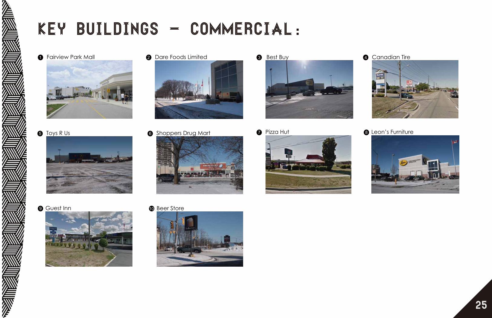
1 Fairview Park Mall
Key Buildings - Commercial:2 Dare Foods Limited
20
Best Buy Canadian Tire
Toys R Us
3 4
5 6 Shoppers Drug Mart 7 Pizza Hut 8 Leon’s Furniture
9 Guest Inn 10 Beer Store

26
Key Map - institutional:
Wilson
Fairway
King
River
WeberKing Street Bypass
Vanier
Wabanaki
Bleams
Kingsway
Manitou
Fifth
Nint
h
Kinzie
Fran
klin
Tray
nor
MorganSh
elle
y
Sixt
h
Dix
on
Thaler
Eigh
th
Clark
Courtland
GreenfieldFo
urth
Hidden Valley
Connaught
Fergus
Fallowfield
Con
esto
ga
Doo
n
Byron
Webster
Balzer
Third
Woo
dhav
en
Goodrich
Kipling
Siebert
Mas
sey
Homer Watson O
tonabee
Grulke
Jansen
Firs
tSe
cond
Cor
nell
Plym
outh
Harb
er
Sout
hill
Scen
icHarold
Boni
face
Cait
Belwood
Huber
River Birch
Carro
l
Rutherford
Kraft
Cameo
Guerin
Falesy
Walker
Cress
Highpark
Balfour
Gerard
Mun
roe
Eule
r
Brisbane
Maywood
Reyburn
Manor
Arlin
gton
Obermeyer
Riv
er V
alle
y
Volta
Stonegate
Pine
cres
t
Gre
enda
le
Cedarwoods
Chandaria
Broa
dmoo
rGrand River
Martinglen
Pepp
erw
ood
Kingsbury
Centreville
Qui
nte
Fairl
awn
Wind
om
Kevco
St Jerome
Chicopee
Fallview
Carlin
Padd
ock
Can
ters
Berwick
Conestoga
King
1
2
3
4
6
7
10
12
9
813
14`
5

27
Key Buildings - institutional:1 2Trinity Village Care Center 3St. Aloysiud Catholic Elementary School 4St. Aloysiud Church 5
6
Emmanuel Village Retirement Residence
7
Emmanuel Bible College
8Sunnyside Public School The Gathering Place New Apostolic Church 10Holy Trinity Anglican Church
11
Wilson Avenue Public School
St. Philip’s Lutheran Church
9
12 Rockway Public School 13 Sunshine Montessori School 14 Centreville Chicopee Community Center

28
Key Map - industrial:
Wilson
Fairway
King
River
WeberKing Street Bypass
Vanier
Wabanaki
Bleams
Kingsway
Manitou
Fifth
Nint
h
Kinzie
Fran
klin
Tray
nor
MorganSh
elle
y
Sixt
h
Dix
on
Thaler
Eigh
th
Clark
Courtland
GreenfieldFo
urth
Hidden Valley
Connaught
Fergus
Fallowfield
Con
esto
ga
Doo
n
Byron
Webster
Balzer
Third
Woo
dhav
en
Goodrich
Kipling
Siebert
Mas
sey
Homer Watson O
tonabee
Grulke
Jansen
Firs
tSe
cond
Cor
nell
Plym
outh
Harb
er
Sout
hill
Scen
icHarold
Boni
face
Cait
Belwood
Huber
River Birch
Carro
l
Rutherford
Kraft
Cameo
Guerin
Falesy
Walker
Cress
Highpark
Balfour
Gerard
Mun
roe
Eule
r
Brisbane
Maywood
Reyburn
Manor
Arlin
gton
Obermeyer
Riv
er V
alle
y
Volta
Stonegate
Pine
cres
t
Gre
enda
le
Cedarwoods
Chandaria
Broa
dmoo
rGrand River
Martinglen
Pepp
erw
ood
Kingsbury
Centreville
Qui
nte
Fairl
awn
Wind
om
Kevco
St Jerome
Chicopee
Fallview
Carlin
Padd
ock
Can
ters
Berwick
Conestoga
King
1
26
7
3
4
5
8
9
10
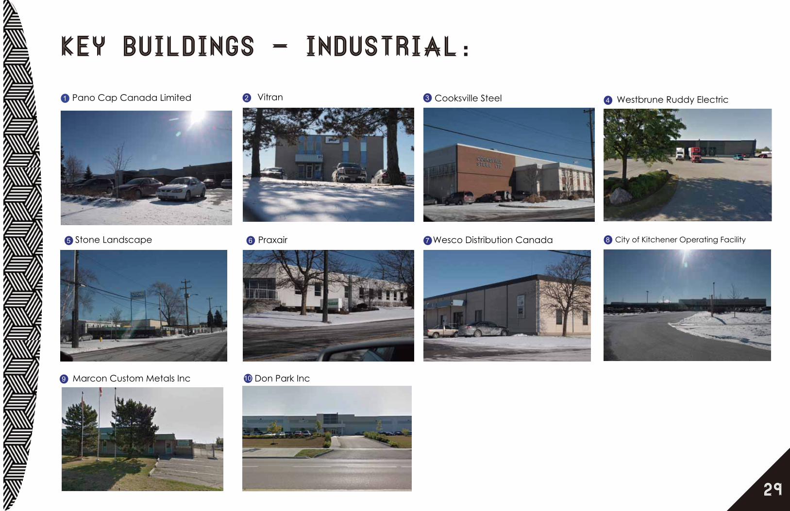
29
Key Buildings - industrial:1 2 3 4Pano Cap Canada Limited Vitran Cooksville Steel Westbrune Ruddy Electric
5 6 7 8Stone Landscape Praxair City of Kitchener Operating FacilityWesco Distribution Canada
9 10Marcon Custom Metals Inc Don Park Inc

K ing
F airway
W ils on
R iver
WeberK ing S treet B ypas s
Courtland
Vanier
F ran
klin
K ings way
F ifth
B leams
Morris on
K inz ie
Cones toga
T haler
Nin
th
Wabanaki
T ray
nor
Morgan
She
lley
Manitou
D ixon
F loral
Six
th
Eig
hth
H omer W
ats on
F ergus
Cla
rkGreenfield
Fallow
field
S huh
F our
th
H idden Valley
Connaught
Doo
n
P ros pect
B yron
W ebs ter
B alz er
R ockway
T hird
Woo
dhav
en
Goodrich
K ipling
Country H
ill
S iebert
Mas
sey
Grand R iver
Manor
Grulke
Century H ill
Jans en
Ardelt
S ims E s tate
Wilf
red
Ros
s
F ir s
tS
econ
d
B lock L ine
Cor
nell
P lymouth
H ayward
Har
ber
S ydne
y
Sou
thill
L ewis
Sce
nic
H arold
S tonegate
Bon
iface
Cait
B elwood
Huber
R iver B irch
Car
rol
Carwood
R utherford
K raft
Cameo
Guer in
F ales y
Walker
Cres s
Hans on
H ighpark
B alfour
Otonabee
B r is bane
Gerard
Mun
roe
Cherry H ill
B edford
Walton
Eul
er
Quinte
Over land
Chandos
Mayw
ood
Coach H
ill
R eyburn
Martinglen
Arli
ngto
n
Oberm
eyer
Riv
er V
alle
y
U nderhi ll
Volta
Hills ide
Pin
ecre
s t
Oneida
Gre
enda
le
Cedarwoods
Chandaria
B road
moo
r
Em
eral
d
Tina
taw
a
Mon
tgom
ery
Manitoulin
Pep
perw
ood
K ings bury
Centreville
Fair l
awn
Win
dom
W oodview
Murrayhill
S t Jerome
Chicopee
Wyandotte
P r imros e
F allview
Brit
ton
Pad
dock
Can
ters
Hanover
B erwick
K ing
K ing
Con
esto
ga
P
P
P
P
P
PPP
P
P
P
P
PP
V
V
V
V
V
16
1718
19
P
P
P
P
P
PP
P
P
P
P
P
P
P
P P
PP
PPPPPP
PP
P
P
P
P
P
P
P
P P
P
P
PP
P
P P
P P
P PP
6
9
15
3
8
7
10 11
35
13
1412
20
1
2
4
PP
PPV
P
V21
30
parking / vacant lots
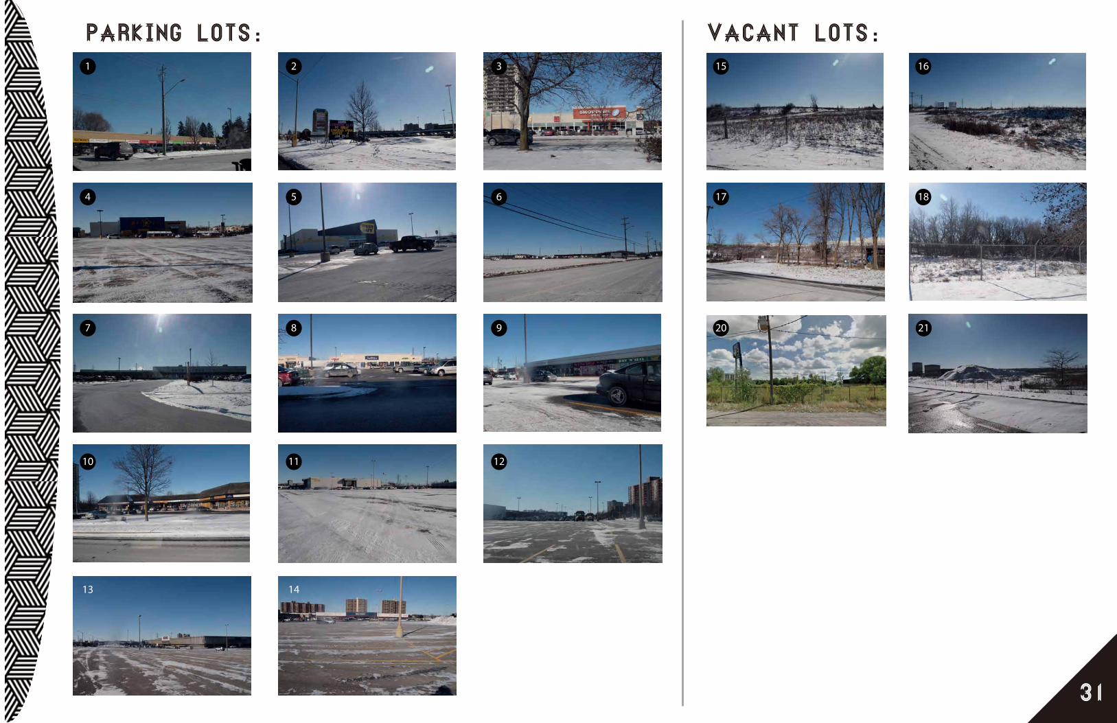
31
Parking Lots: Vacant Lots:1 2 3
4 5 6
7 8 9
10 11 12
13 14
15 16
17 18
20 21

32
ClustersSingle Detached HousingThere is an abundance of single detached housing located on the study site in close proximity to the Fairview Mall District. Although this neighbourhood is well established, redevelopment and intensification is feasible due to the building style as well as the existing land use patterns in the surrounding neighbourhood that support such redevelopment.
Medium / High Density HousingBoth medium and high density housing can be found adjacent to the Fairview Mall District on the north side of the study site. This housing area is a transition zone between a commercial and single detached housing area. The medium/high density housing is fairly well maintained and occupied, but some of the structures show need of redevelopment.
Commercial DistrictThe main commercial district within the study site is focused on Fairway Road, encompassing Fairview Park Mall and stretching from the Highway 8 exit to Vanier Street. There are several big box commercial buildings found within the many plazas in this district. These plazas range in age as well as popularity. The newer plazas are well utilized and show high customer activity; whereas the older plazas seem worn out in comparison with less activity. These older plazas can be seen as potential redevelopment sites.
Industrial ZoneThe study site has an abundance of industrial space and establishments. Such establishments include focuses on electronics, steel, stone, construction, and more. The industrial space within the study site is quite substantial, considering the service lanes and parking space required for large trucks. In the event that redevelopment occurs in the commercial district, industrial activity in the neighbouring industrial lands may not be ideal. Relocation of heavy industrial uses within the Industrial District may be reconsidered in the future.
Natural Green SpaceNatural green space is located southeast of the study site, adjacent to the Industrial District. This green space can be utilized to create more green connectivity throughout the study site. Currently, there are agricultural lands surrounding the natural green space, but these lands are zoned as business park area. This zoning change is considered to be appropriate based on the current land-use trends and its location. This space is not highly visible to both pedestrians and vehicular drivers. Because this land is zoned as a business park, this is an opportunity to introduce more and new business activity to the area.
Single Detached Housing
Commercial District
Industrial
Medium/ High Dens
ity H
ousing
NaturalGreen Space
NaturalGreen Space
Single Detached Housing
Single Detached Housing
Single DetachedHousing
Commercial Corridor
N
* this diagram is based on personal observation, thus may not be accurate.
Fairview Mall

33
Trend
37% 32% 15% 8% 4% 2% 1% Residential Park / Open Space Industrial Commercial Institutional Business Park Agricultural & (Proposed) Existing Use
Study Area Boundary
This diagram shows percentage of each land use in our site context. For this particular study, the map shown top right of this page was used. To collect the information, Kitchener Zoning map (2012) was very helpful. After finding land use for each parcels, ArcGIS was used to get land area dimension. The calculation indicates the biggest land use is residential being 37 % of the study area. Second biggest use was surprisingly parks and open space. Because parks and open space is so dispersed with no connectivity, it does not feel that it takes such a huge chunk in our study site.

OpportunitiesFor future
34
1
2
3
4
5
6
Weber Street. Weber Street has potential to be another strong commercial district. If higher density is introduced on our site, there is a potential that Weber Street serves as a secondary commercial district.
Fairview Mall.Fairview Mall is the biggest and busiest shopping centre in Kitchener-Waterloo area. Our site is located just off of Highway 8 which connects to Highway 401, in a fast growing urban core. In near future, rapid transit will connect to Fairview Mall, which creates potential to become a major commercial and transit node locally and regionally.
Future LRT/BRTLRT/BRT will change current hydro corridor as a transit node. Currently a lot of local residents informally use hydro corridor as an open space, but rapid transit will potentially formalize it as a park / pedestrian path.
Residential Intensification OpportunityAlong the rapid transit node, there are medium density residential buildings and some single family housings. Since these some of these residential buildings are not in their best condition, these builldings can redevelop into higher density residential towers.
Hidden Valley StreetNew Business Park Proposal in Hidden Valley Road will bring up the employment rate. Since these Business Parks are located so close to existing commercial district, this can bring in positive energy to commercial district.
Hidden Valley Open SpaceCurrently, this open space is not visible to both pedestrians and drivers due to its location and surrounding land uses. However, as development occurs, Hidden Valley open space can be the place where visitors and residents of our site can walk and see the natural greenery.

Opportunities
35
2
3 5
6
5
1
4
1:18
,352
0.6
00.
61.
20.
3ki
lom
etre
s
N

ConstraintsTo overcome
36
1
2
3
4
5
Highway 8Highway 8 is a physical barrier that will block pedestrian’s movement from Fairway Road to Weber Street. Currently, there is no pedestrian path that connects these two roads. Weber Street has a potential to become secondary commercial district in Kitchener, thus providing pedestrian connectivity will be important but challenging.
Fairway RoadFairway Road is a main arterial road in our site. Fairway Road is fairly wide with extremely high automobile traffic and does not provide pedestrian friendly environment. It will be a challenge to make the street pedestrian friendly due to existing form and automobile traffic.
Existing Single Family ResidentialNIMBYism (Not In My Backyard) can create difficulty to redevelopment. Our site consists of well established neigbourhood next to big Fairview Mall and LRT route (hydro corridor). If redevelopment proposal is introduced, there is possibility that residents will be against the proposal.
Existing RailwayThere is an existing railway behind the commercial strip, South of Fairway Road. Any proposal should keep this in mind that there will be 30m buffer zone for residential development.
Existing Industrial LandOur site has active industrial zones. Industrial zones are important for city’s employment rate; however, location of this use is highly questionable. If industrial sites are to be kept, it will be a challenge to create pedestrian welcoming environment and pedestrian connectivity.

Constraints
37
1:18
,352
0.6
00.
61.
20.
3ki
lom
etre
s
1
3
5
4
2
Single Detached HousingThere is an abundance of single detached housing located on the study site in close proximity to the Fairview Mall District. Although this neighbourhood is well established, redevelopment and intensification is feasible due to the building style as well as the existing land use patterns in the surrounding neighbourhood that support such redevelopment.
Medium / High Density HousingBoth medium and high density housing can be found adjacent to the Fairview Mall District on the north side of the study site. This housing area is a transition zone between a commercial and single detached housing area. The medium/high density housing is fairly well maintained and occupied, but some of the structures show need of redevelopment.
Commercial DistrictThe main commercial district within the study site is focused on Fairway Road, encompassing Fairview Park Mall and stretching from the Highway 8 exit to Vanier Street. There are several big box commercial buildings found within the many plazas in this district. These plazas range in age as well as popularity. The newer plazas are well utilized and show high customer activity; whereas the older plazas seem worn out in comparison with less activity. These older plazas can be seen as potential redevelopment sites.
Industrial ZoneThe study site has an abundance of industrial space and establishments. Such establishments include focuses on electronics, steel, stone, construction, and more. The industrial space within the study site is quite substantial, considering the service lanes and parking space required for large trucks. In the event that redevelopment occurs in the commercial district, industrial activity in the neighbouring industrial lands may not be ideal. Relocation of heavy industrial uses within the Industrial District may be reconsidered in the future.
Natural Green SpaceNatural green space is located southeast of the study site, adjacent to the Industrial District. This green space can be utilized to create more green connectivity throughout the study site. Currently, there are agricultural lands surrounding the natural green space, but these lands are zoned as business park area. This zoning change is considered to be appropriate based on the current land-use trends and its location. This space is not highly visible to both pedestrians and vehicular drivers. Because this land is zoned as a business park, this is an opportunity to introduce more and new business activity to the area.
N

References:
City of Kitchener. City of Kitchener Official Plan (2005)City of Kitchener. City of Kitchener Zoning By-law 85-1 (2012)Google Street View

January 30 2013Land Use Analysis
Heesuk LeeKaren Lui
Hoi Yan Anson Yim
Related Documents