Land Titling Costs: Evidence from Literature and Cases Using FFP REYDON, B.P., MOLENDIJK, M, LEMMENS, C, and SIQUEIRA, G P. the Netherlands RESUME The necessity to improve Land Administration has been proposed in many different forum’s and in literature in general for many years. The role of Land Administration in its many aspects, from geodetical, legal, financial, gender, environment and humanitarian. But the advances in Land Administration, in the developing world, the region that mostly needs it, is still very slow, as Deininger (2017), based on a sample of countries estimated, that in average 70 % of the properties around the world are not formally registered. The main aim of this article is to show how the Fit for Purpose (FFP) method can solve, with low costs and simple methods, and so diminishing the time spend to one of the most difficult aspects of Land Administration requirements in the developing countries: the titling of the informal landholders. For that the article will start with a revision on Land Administration showing why land titling is one of its main problems and on different experiences that will show some existing estimations of the costs and time to title informal landholders in different countries. Surely the reasons for such different costs are linked to the legal countries characteristics and its procedures of titling, that will be highlighted. Further the article will show cases were using a Fit for Purpose approach, in general, reduced significantly the costs and time for titling The conclusions of the articles aims to wrap up and stress that titling is an important part of the Land Administration System but mostly it needs institutional and legal changes for its improvement. Key words: Land regularization, costs, property rights.

Welcome message from author
This document is posted to help you gain knowledge. Please leave a comment to let me know what you think about it! Share it to your friends and learn new things together.
Transcript
Land Titling Costs: Evidence from Literature and Cases Using FFP
REYDON, B.P., MOLENDIJK, M, LEMMENS, C, and SIQUEIRA, G P. the
Netherlands
RESUME
The necessity to improve Land Administration has been proposed in many different forum’s
and in literature in general for many years. The role of Land Administration in its many
aspects, from geodetical, legal, financial, gender, environment and humanitarian.
But the advances in Land Administration, in the developing world, the region that mostly
needs it, is still very slow, as Deininger (2017), based on a sample of countries estimated, that
in average 70 % of the properties around the world are not formally registered.
The main aim of this article is to show how the Fit for Purpose (FFP) method can solve, with
low costs and simple methods, and so diminishing the time spend to one of the most difficult
aspects of Land Administration requirements in the developing countries: the titling of the
informal landholders.
For that the article will start with a revision on Land Administration showing why land titling
is one of its main problems and on different experiences that will show some existing
estimations of the costs and time to title informal landholders in different countries. Surely the
reasons for such different costs are linked to the legal countries characteristics and its
procedures of titling, that will be highlighted. Further the article will show cases were using a
Fit for Purpose approach, in general, reduced significantly the costs and time for titling
The conclusions of the articles aims to wrap up and stress that titling is an important part of
the Land Administration System but mostly it needs institutional and legal changes for its
improvement.
Key words: Land regularization, costs, property rights.
Land Titling Costs: Evidence from Literature and Cases Using FFP (10927)
Bastiaan Reydon (Netherlands)
FIG e-Working Week 2021
Smart Surveyors for Land and Water Management - Challenges in a New Reality
Virtually in the Netherlands, 21–25 June 2021
Land Titling Costs: Evidence from Literature and Cases Using FFP
REYDON, B.P., MOLENDIJK, M, LEMMENS, C, and SIQUEIRA, G P. the
Netherlands
INTRODUCTION
The necessity to improve Land Administration has been proposed in many different
forum’s and in literature in general for many years [p.e. De Soto (2003), Deininger (2003),
Deininger (2009), Reydon (2017) Williamson (2010)]. Some, like Fernandes (2017), inspired
by Payne ( 2007) have even been able to show, from a large literature review, that better land
administration has strong impacts on different aspects of economic development: its
economic side (increase in productivity, in investment and in credit obtaining), the gender
equality side and on the environment side (better soil use and less deforestation). The role of
Land Administration in its many aspects, from geodetical, legal, financial, gender,
environment and humanitarian has got more attention recently by the VGGT/FAO been
signed by many countries in 2012, by its role in the SDG approval at the UN conference in
2015 and by the recent document from IPCC1 that stated clearly that good land administration
plays a very important role in diminishing climate change and its impacts. On its urban side
UN HABITAT (2016) established that for the inclusive sustainable development Land
Administration is crucial2. Besides that the ISO 19152 – LAND ADMINISTRATION
DOMAIN MODE certification establishes clear ways forward in the improving of Land
administration for any country as well as the IGIF-UN-GGIM is mainstreaming the need for
1 https://www.ipcc.ch/site/assets/uploads/2019/08/Edited-SPM_Approved_Microsite_FINAL.pdf 2 UN HABITAT (2016: 13 and 27) states it clearly in its articles 35 and 104: “We commit ourselves to promoting, at the appropriate level of government, including subnational and local government, increased security of tenure for all, recognizing the plurality of tenure types, and to developing fit-for-purpose and age-, gender- and environment-responsive solutions within the continuum of land and property rights, with particular attention to security of land tenure for women as key to their empowerment, including through effective administrative systems.”(…)” 104. We will promote compliance with legal requirements through strong, inclusive management frameworks and accountable institutions that deal with land registration and governance, applying transparent and sustainable management and use of land, property registration and sound financial systems. We will support local governments and relevant stakeholders, through a variety of mechanisms, in developing and using basic land inventory information, such as cadastres, valuation and risk maps, and land and housing price records, to generate the high-quality, timely and reliable data — disaggregated by income, sex, age, race, ethnicity, migration status, disability, geographic location and other characteristics relevant in the national context — needed to assess changes in land values, while ensuring that these data will not be used for discriminatory land-use policies.”
Land Titling Costs: Evidence from Literature and Cases Using FFP (10927)
Bastiaan Reydon (Netherlands)
FIG e-Working Week 2021
Smart Surveyors for Land and Water Management - Challenges in a New Reality
Virtually in the Netherlands, 21–25 June 2021
good land administration. On the other hand, the issue of guaranteeing adequate land rights is
getting stronger in the business world also, with different initiatives that can be synthesized in
the IFC/WB Standards certification3.
But the advances in Land Administration, in the developing world, the region that
mostly needs, it is still very slow. The many aspects of Land Administration requires a very
integrated and long term actions from many different stakeholders in the country from
institutional reforms, reaching legal rearrangements, and in the long term it accomplishes
economic, social and environmental improvements in the countries. But mostly the needs and
difficulties are exacerbated, as many stakeholders state that good Land administration is very
costly, as they look at countries that have solved it already. Surely if everything is done
technically in a very perfect way it will be very costly and will take much time. But as the
solution are mostly linked to the need that new institutional settings and legislation are created
so that the stakeholders (public and private) adapt themselves to exchange information the
cost, is rather low. For that to happen the biggest need are trust, confidence and attribution of
responsibilities between all the stakeholders that all information will be shared and there
won’t be any kind of misuse of the information.
The main aim of this article is to show how the Fit for Purpose (FFP)4 method can
solve, with low costs and simple methods, and so diminishing the time spend to one of the
most difficult aspects of Land Administration in the developing countries: providing land
rights to all the informal landholders, including the ones that hold customary rights.
For that the article will start with a revision on Land Administration showing why land
titling is one of its main problems. After that, based on existing literature on costs and time
requirements of titling will show how and why there are so many different real costs. The
next item will show some existing estimations of the costs of titling informal landholders
around the world.
The next item, based on the Brazilian reality will start trying to quantify the
informality in the rural landownership based on the Atlas fundiario estimates and then will
3 See for that: NOTE, I. G. (2012). 4 For that see Enemark et al (2014).
Land Titling Costs: Evidence from Literature and Cases Using FFP (10927)
Bastiaan Reydon (Netherlands)
FIG e-Working Week 2021
Smart Surveyors for Land and Water Management - Challenges in a New Reality
Virtually in the Netherlands, 21–25 June 2021
show the costs for some Brazilian experiences of the traditional way of giving titles to rural
small owners.
The last item before the conclusions will show that it is possible to lower well the
costs and its possible to reduce the time for titling based on cases from Colombia, Brazil and
Benin, that used the Fit for Purpose methodology to document different rights of small
landholders.
The conclusions of the articles aims to wrap up what was presented along the article
and make it clear that it is possible to reduce significantly the costs and the time spend in
titling landholders. But at the same time it wants to stress that there exists no pandora box that
will solve all titling problems. The titling is an important part of the Land Administration
System but as the whole of it needs the participation of all stakeholders and needs institutional
and legal changes to happen to all the informal land sector.
1. LAND ADMINISTRATION AND LAND RIGHTS REGISTRATION
Williamson (2010) has established that Sustainable Development can only be achieved
when it has a Land Administration System in place, as can be seen below with the Graph 1,
that consists of: a) a mapped cadaster (to identify the properties) b) secure legal rights (land
tenure), c) land values (for taxation and others) c) Control over land use and d) the Land
development definition. The Land Administration System to help building up to an suitable
land ownership and land use has to have the correct human resources, an adequate
institutional and legal settings. Many countries do not have the main precondition for an
adequate Land Administration System that is a good mapped cadaster, a good register system
and all what is behind to maintain it actual. In many countries with this lack, the way to try to
control land use and land ownership is by creating more strict legislations, but as the
landholders are not recognizable punishment or legislation enforcement is impossible.
Chart 1. Land Administration System - Schematic
Land Titling Costs: Evidence from Literature and Cases Using FFP (10927)
Bastiaan Reydon (Netherlands)
FIG e-Working Week 2021
Smart Surveyors for Land and Water Management - Challenges in a New Reality
Virtually in the Netherlands, 21–25 June 2021
Source: Enemark, Williamson (2010)
So one of the main problems to have an adequate Land Administration System is that
many properties in the undeveloped world are not officially registered. That can be evidenced
by table 1, obtain by Deininger (2017), were samples of countries were used to estimate the
average amount of properties in the world that are not registered or formalized. It can be seen
from that table that around 70 % of the properties around the world are not formally
registered. It can be seen, from the same table, that among these regions the ones that have
more informal properties are in Sub-Sahara and Latin America and Caribbean countries.
Table 1. Formal land tenure in the world
Total SSA ECA LAC MNA OECD SAS EAP
Private plots in city
registered 0.22 0.04 0.32 0.03 0.14 0.68 0.25 0.24
Private plots in city mapped 0.46 0.13 0.60 0.31 0.48 0.97 0.25 0.52
Private plots in country
registered 0.22 0.04 0.32 0.03 0.14 0.68 0.13 0.24
Land Titling Costs: Evidence from Literature and Cases Using FFP (10927)
Bastiaan Reydon (Netherlands)
FIG e-Working Week 2021
Smart Surveyors for Land and Water Management - Challenges in a New Reality
Virtually in the Netherlands, 21–25 June 2021
Source: Deininger (2017)
So to improve the world’s land use for agriculture production, for a better
environment, for housing and social rights, there is a need of an adequate Land
Administration System, that as shoved, needs to document and guarantee urban and rural
landholdings rights. But even though large amounts of money have been spend with this by
different international and multilateral institutions around the world this is still an important
issue to be faced. One of the main reasons is that in most countries the requirements for it are
so complex, so time-consuming, and costly that it does not occur in reality.
2. THE COST OF LAND TITLING IN THE LITERATURE
There aren’t many academic studies presenting the costs of the process of
regularization, titling or formalization of the possessions. An important, but a bit old study,
that shows the costs of the regularization is Holstein (1996: 22) that in a clear way states that:
“There is still only sketchy information available on the costs of
land titling in World Bank supported projects. These figures
come from Holstein (1993): The Thailand projects achieved
US$33 to $47 per hectare (average rural parcel size 0.9
hectares), that is about $40 per parcel; Brazil North East Land
Tenure project - US$6.5 per hectare (average parcel size 47
hectares); and from Staff Appraisal Reports (SAR), Algeria
US$5.5 per hectare; Costa Rica US$ 14 per hectare. It is clear
that Indonesian costs will be similar to Thailand's - $40 to $50
per parcel. In the breakdown of costs between the various parts
Private plots in country
mapped 0.24 0.02 0.40 0.03 0.14 0.71 0.13 0.28
No. of countries 189 47 25 32 21 31 8 25
Land Titling Costs: Evidence from Literature and Cases Using FFP (10927)
Bastiaan Reydon (Netherlands)
FIG e-Working Week 2021
Smart Surveyors for Land and Water Management - Challenges in a New Reality
Virtually in the Netherlands, 21–25 June 2021
of the process mapping takes about 24% of total budget,
adjudication about 18%, survey 22 %; registration 23%; and
institution building about 13%. These figures are +/- 5% based
on Thailand, Brazil, and the Algeria projects as calculated in
1993. Certainly more work and studies should be conducted into
land titling and registration costing.”
But these results are quite impacting as it shows that the costs can vary from around
US$ 40 a parcel but also the participation of the different components of the regularization
process, mapping being the largest, with 24 %, registration with 23 %, surveying 22%
adjudication 18 % and institutional building 13 %. As most recent innovations are been made
in the capturing information and the mapping process big changes are happening in this cost
structure. But the study does not go into the different types of expenditures that a landholders
incurs when trying to legalize their property.
Landholders without formal documentation have various types of costs during a
normal land registration process to arrive at the final product: a fully registered parcel. Not
only the economic cost, but also the time they have to spend, going to many different offices
to reach that aim. In this article the costs will refer to all expenses associated with the process
of registering a possession to make it into an official property, but there is a need to categorize
them.
De Vries et al (2003), using the Institutional definition of transaction cost, analyzed
the regularization process of urban plots in Namibia. They came to costs between US$ 533
and US$ 3.588 per plot in average in that country. They also evidenced that the process took
between 282 to 684 days depending in the type plot that was being regularized.
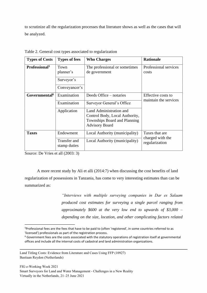
The costs types proposed by De Vries (2003) can be used as a bases to compare the
countries cost in a more accurate way. So table 2 has the 3 main costs associated to the
process of regularization: professional costs, governmental costs and taxes. Many times the
studies do not separate these kinds of expenses. This study will use these categories of costs
Land Titling Costs: Evidence from Literature and Cases Using FFP (10927)
Bastiaan Reydon (Netherlands)
FIG e-Working Week 2021
Smart Surveyors for Land and Water Management - Challenges in a New Reality
Virtually in the Netherlands, 21–25 June 2021
to scrutinize all the regularization processes that literature shows as well as the cases that will
be analyzed.
Table 2. General cost types associated to regularization
Types of Costs Types of fees Who Charges Rationale
Professional5 Town
planner’s
The professional or sometimes
de government
Professional services
costs
Surveyor’s
Conveyancer’s
Governmental6 Examination Deeds Office – notaries Effective costs to
maintain the services Examination Surveyor General’s Office
Application Land Administration and
Control Body, Local Authority,
Townships Board and Planning
Advisory Board
Taxes Endowment Local Authority (municipality) Taxes that are
charged with the
regularization Transfer and
stamp duties
Local Authority (municipality)
Source: De Vries et all (2003: 3)
A more recent study by Ali et alli (2014:7) when discussing the cost benefits of land
regularization of possessions in Tanzania, has come to very interesting estimates than can be
summarized as:
“Interviews with multiple surveying companies in Dar es Salaam
produced cost estimates for surveying a single parcel ranging from
approximately $600 at the very low end to upwards of $3,000 –
depending on the size, location, and other complicating factors related
5Professional fees are the fees that have to be paid to (often 'registered', in some countries referred to as 'licensed') professionals as part of the registration process. 6 Government fees are the costs associated with the statutory operations of registration itself at governmental offices and include all the internal costs of cadastral and land administration organizations.
Land Titling Costs: Evidence from Literature and Cases Using FFP (10927)
Bastiaan Reydon (Netherlands)
FIG e-Working Week 2021
Smart Surveyors for Land and Water Management - Challenges in a New Reality
Virtually in the Netherlands, 21–25 June 2021
to local government administration. The Tanzanian Ministry of Lands
estimates systematic demarcation at scale costs approximately 150,000
to 250,000 per parcel ($96 to $160), though the basis for these estimates
is somewhat opaque. (….) The combined cost of town planning and
surveying for the project was considerably below the Ministry’s
estimates, at roughly 70,000 shillings per parcel (approximately $45).”
Again it can be seen that depending on what is taken in account the costs can vary
quite a bit, for this case just the demarcation, professional costs in our table, between 100 and
160 US$, and the governmental application would make it range between 145 and 200 US$,
without all other governmental costs.
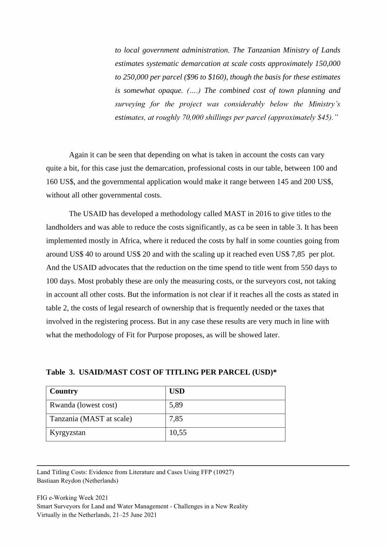
The USAID has developed a methodology called MAST in 2016 to give titles to the
landholders and was able to reduce the costs significantly, as ca be seen in table 3. It has been
implemented mostly in Africa, where it reduced the costs by half in some counties going from
around US$ 40 to around US$ 20 and with the scaling up it reached even US$ 7,85 per plot.
And the USAID advocates that the reduction on the time spend to title went from 550 days to
100 days. Most probably these are only the measuring costs, or the surveyors cost, not taking
in account all other costs. But the information is not clear if it reaches all the costs as stated in
table 2, the costs of legal research of ownership that is frequently needed or the taxes that
involved in the registering process. But in any case these results are very much in line with
what the methodology of Fit for Purpose proposes, as will be showed later.
Table 3. USAID/MAST COST OF TITLING PER PARCEL (USD)*
Country USD
Rwanda (lowest cost) 5,89
Tanzania (MAST at scale) 7,85
Kyrgyzstan 10,55
Land Titling Costs: Evidence from Literature and Cases Using FFP (10927)
Bastiaan Reydon (Netherlands)
FIG e-Working Week 2021
Smart Surveyors for Land and Water Management - Challenges in a New Reality
Virtually in the Netherlands, 21–25 June 2021
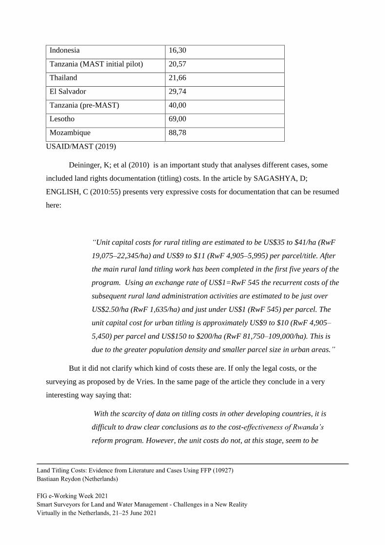
Indonesia 16,30
Tanzania (MAST initial pilot) 20,57
Thailand 21,66
El Salvador 29,74
Tanzania (pre-MAST) 40,00
Lesotho 69,00
Mozambique 88,78
USAID/MAST (2019)
Deininger, K; et al (2010) is an important study that analyses different cases, some
included land rights documentation (titling) costs. In the article by SAGASHYA, D;
ENGLISH, C (2010:55) presents very expressive costs for documentation that can be resumed
here:
“Unit capital costs for rural titling are estimated to be US$35 to $41/ha (RwF
19,075–22,345/ha) and US$9 to $11 (RwF 4,905–5,995) per parcel/title. After
the main rural land titling work has been completed in the first five years of the
program. Using an exchange rate of US$1=RwF 545 the recurrent costs of the
subsequent rural land administration activities are estimated to be just over
US$2.50/ha (RwF 1,635/ha) and just under US$1 (RwF 545) per parcel. The
unit capital cost for urban titling is approximately US$9 to $10 (RwF 4,905–
5,450) per parcel and US$150 to $200/ha (RwF 81,750–109,000/ha). This is
due to the greater population density and smaller parcel size in urban areas.”
But it did not clarify which kind of costs these are. If only the legal costs, or the
surveying as proposed by de Vries. In the same page of the article they conclude in a very
interesting way saying that:
With the scarcity of data on titling costs in other developing countries, it is
difficult to draw clear conclusions as to the cost-effectiveness of Rwanda’s
reform program. However, the unit costs do not, at this stage, seem to be
Land Titling Costs: Evidence from Literature and Cases Using FFP (10927)
Bastiaan Reydon (Netherlands)
FIG e-Working Week 2021
Smart Surveyors for Land and Water Management - Challenges in a New Reality
Virtually in the Netherlands, 21–25 June 2021
excessive. In fact, these appear to be at a level that could be covered by
reasonable fee payments (discussed in the final section). The key factor is how
they compare to the potential benefits.
The report prepared by DFID [English D et al (2019:24)] aiming the presentation of
the Lessons and guiding principles on land tenure regularisation and land sector has a quite
large amount of economic information on land titling. They presented that the titling cost in
Ethiopia was with their project of US$ 5,2 per plot. But again it is not clear if all of the
regularization is included or only parts of it.
As most titling projects are done by partnership between governmental entities and
multilateral institutions its most important part is the planning of the activities and surely what
comes with it is the costs estimation. This item will start by obtaining some costs estimations
existing in several propositions and will finish with the estimations that COFLAS established
based on a focus group methodology7.
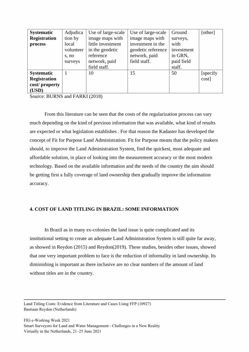
The COFAS experience was systematized by Burns and Farki (2018), that so have
written a very accessible guide, based on the Fit for Purpose methodology, to develop a Land
Administration System, with the steps to take and the clear evaluation of the costs of each
methodology. The next table 3 shows the relative estimated average costs of the different
settings of registrations based on the different types of methodologies linked to the available
information and the will of each country. But again it does not take into account all the costs
that were proposed by De Vries et al (2003). But in any case it gives an important hint on the
relative cost of each of the use of field staff (surveyors) and the type of geodesic information
available or desired.
Table 4: Estimated unit cost of systematic registration
7 The focus group is an well-known methodology that estimates prices, costs and other variables from consensus obtained by
expertise groups. The experience shows that the results are comparable to significant statistics sampling results.
Land Titling Costs: Evidence from Literature and Cases Using FFP (10927)
Bastiaan Reydon (Netherlands)
FIG e-Working Week 2021
Smart Surveyors for Land and Water Management - Challenges in a New Reality
Virtually in the Netherlands, 21–25 June 2021
Systematic
Registration
process
Adjudica
tion by
local
volunteer
s, no
surveys
Use of large-scale
image maps with
little investment
in the geodetic
reference
network, paid
field staff.
Use of large-scale
image maps with
investment in the
geodetic reference
network, paid
field staff.
Ground
surveys,
with
investment
in GRN,
paid field
staff.
[other]
Systematic
Registration
cost/ property
(USD)
1 10 15 50 [specify
cost]
Source: BURNS and FARKI (2018)
From this literature can be seen that the costs of the regularization process can vary
much depending on the kind of previous information that was available, what kind of results
are expected or what legislation establishes . For that reason the Kadaster has developed the
concept of Fit for Purpose Land Administration. Fit for Purpose means that the policy makers
should, to improve the Land Administration System, find the quickest, most adequate and
affordable solution, in place of looking into the measurement accuracy or the most modern
technology. Based on the available information and the needs of the country the aim should
be getting first a fully coverage of land ownership then gradually improve the information
accuracy.
4. COST OF LAND TITLING IN BRAZIL: SOME INFORMATION
In Brazil as in many ex-colonies the land issue is quite complicated and its
institutional setting to create an adequate Land Administration System is still quite far away,
as showed in Reydon (2015) and Reydon(2019). These studies, besides other issues, showed
that one very important problem to face is the reduction of informality in land ownership. Its
diminishing is important as there inclusive are no clear numbers of the amount of land
without titles are in the country.
Land Titling Costs: Evidence from Literature and Cases Using FFP (10927)
Bastiaan Reydon (Netherlands)
FIG e-Working Week 2021
Smart Surveyors for Land and Water Management - Challenges in a New Reality
Virtually in the Netherlands, 21–25 June 2021
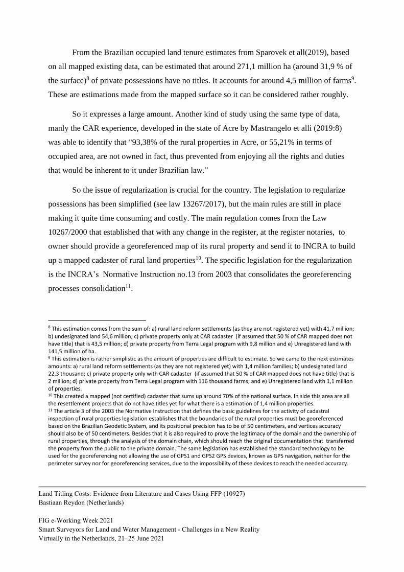
From the Brazilian occupied land tenure estimates from Sparovek et all(2019), based
on all mapped existing data, can be estimated that around 271,1 million ha (around 31,9 % of
the surface)8 of private possessions have no titles. It accounts for around 4,5 million of farms9.
These are estimations made from the mapped surface so it can be considered rather roughly.
So it expresses a large amount. Another kind of study using the same type of data,
manly the CAR experience, developed in the state of Acre by Mastrangelo et alli (2019:8)
was able to identify that “93,38% of the rural properties in Acre, or 55,21% in terms of
occupied area, are not owned in fact, thus prevented from enjoying all the rights and duties
that would be inherent to it under Brazilian law.”
So the issue of regularization is crucial for the country. The legislation to regularize
possessions has been simplified (see law 13267/2017), but the main rules are still in place
making it quite time consuming and costly. The main regulation comes from the Law
10267/2000 that established that with any change in the register, at the register notaries, to
owner should provide a georeferenced map of its rural property and send it to INCRA to build
up a mapped cadaster of rural land properties10. The specific legislation for the regularization
is the INCRA’s Normative Instruction no.13 from 2003 that consolidates the georeferencing
processes consolidation11.
8 This estimation comes from the sum of: a) rural land reform settlements (as they are not registered yet) with 41,7 million; b) undesignated land 54,6 million; c) private property only at CAR cadaster (if assumed that 50 % of CAR mapped does not have title) that is 43,5 million; d) private property from Terra Legal program with 9,8 million and e) Unregistered land with 141,5 million of ha. 9 This estimation is rather simplistic as the amount of properties are difficult to estimate. So we came to the next estimates amounts: a) rural land reform settlements (as they are not registered yet) with 1,4 million families; b) undesignated land 22,3 thousand; c) private property only with CAR cadaster (if assumed that 50 % of CAR mapped does not have title) that is 2 million; d) private property from Terra Legal program with 116 thousand farms; and e) Unregistered land with 1,1 million of properties. 10 This created a mapped (not certified) cadaster that sums up around 70% of the national surface. In side this area are all the resettlement projects that do not have titles yet for what there is a estimation of 1,4 million properties. 11 The article 3 of the 2003 the Normative Instruction that defines the basic guidelines for the activity of cadastral inspection of rural properties legislation establishes that the boundaries of the rural properties must be georeferenced based on the Brazilian Geodetic System, and its positional precision has to be of 50 centimeters, and vertices accuracy should also be of 50 centimeters. Besides that it is also required to prove the legitimacy of the domain and the ownership of rural properties, through the analysis of the domain chain, which should reach the original documentation that transferred the property from the public to the private domain. The same legislation has established the standard technology to be used for the georeferencing not allowing the use of GPS1 and GPS2 GPS devices, known as GPS navigation, neither for the perimeter survey nor for georeferencing services, due to the impossibility of these devices to reach the needed accuracy.
Land Titling Costs: Evidence from Literature and Cases Using FFP (10927)
Bastiaan Reydon (Netherlands)
FIG e-Working Week 2021
Smart Surveyors for Land and Water Management - Challenges in a New Reality
Virtually in the Netherlands, 21–25 June 2021
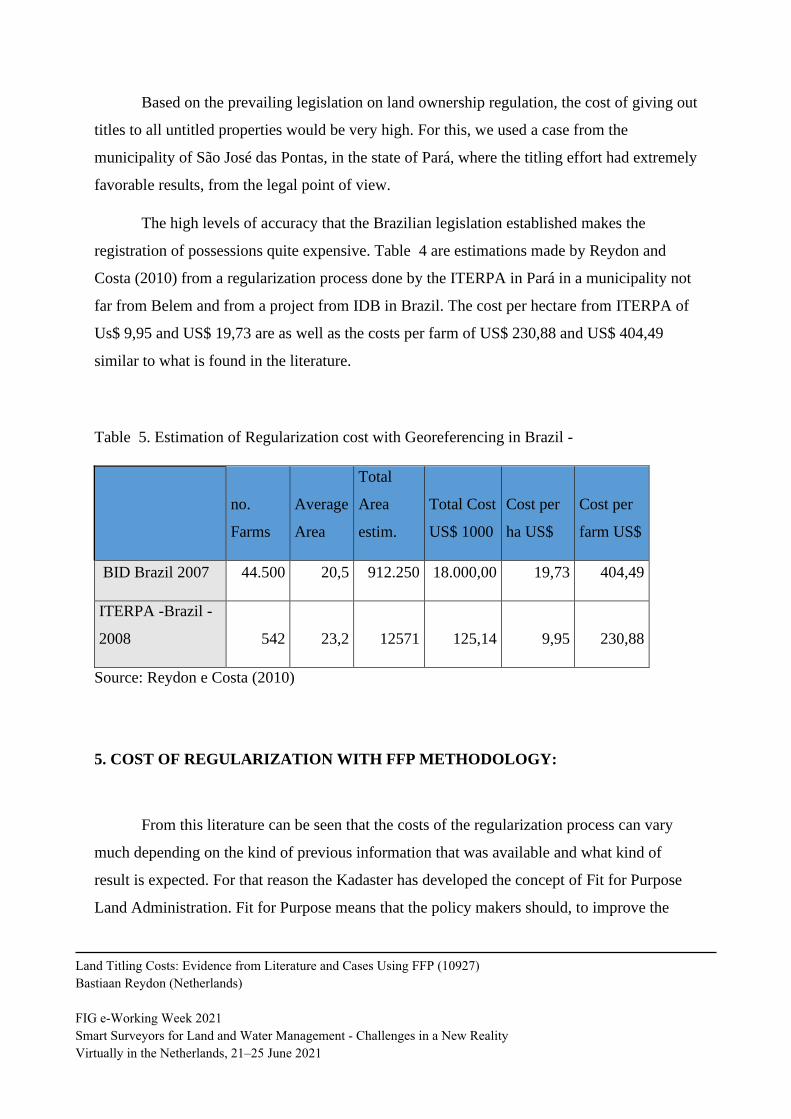
Based on the prevailing legislation on land ownership regulation, the cost of giving out
titles to all untitled properties would be very high. For this, we used a case from the
municipality of São José das Pontas, in the state of Pará, where the titling effort had extremely
favorable results, from the legal point of view.
The high levels of accuracy that the Brazilian legislation established makes the
registration of possessions quite expensive. Table 4 are estimations made by Reydon and
Costa (2010) from a regularization process done by the ITERPA in Pará in a municipality not
far from Belem and from a project from IDB in Brazil. The cost per hectare from ITERPA of
Us$ 9,95 and US$ 19,73 are as well as the costs per farm of US$ 230,88 and US$ 404,49
similar to what is found in the literature.
Table 5. Estimation of Regularization cost with Georeferencing in Brazil -
no.
Farms
Average
Area
Total
Area
estim.
Total Cost
US$ 1000
Cost per
ha US$
Cost per
farm US$
BID Brazil 2007 44.500 20,5 912.250 18.000,00 19,73 404,49
ITERPA -Brazil -
2008 542 23,2 12571 125,14 9,95 230,88
Source: Reydon e Costa (2010)
5. COST OF REGULARIZATION WITH FFP METHODOLOGY:
From this literature can be seen that the costs of the regularization process can vary
much depending on the kind of previous information that was available and what kind of
result is expected. For that reason the Kadaster has developed the concept of Fit for Purpose
Land Administration. Fit for Purpose means that the policy makers should, to improve the
Land Titling Costs: Evidence from Literature and Cases Using FFP (10927)
Bastiaan Reydon (Netherlands)
FIG e-Working Week 2021
Smart Surveyors for Land and Water Management - Challenges in a New Reality
Virtually in the Netherlands, 21–25 June 2021
Land Administration System, find the quickest, most adequate and affordable solution, in
place of looking into the measurement accuracy or the most modern technology. Based on the
available information and the needs of the country the aim should be getting first a fully
coverage of land ownership then gradually improve the information accuracy. For that an
important analytical step was done with the creation of the Fit for Purpose methodology that
Enemark et al (2014:6), proposed as:
“the approach used for building land administration systems in less developed
countries should be flexible and focused on citizens’ needs, such as providing
security of tenure and control of land use, rather than focusing on top-end
technical solutions and high accuracy surveys.” A fit-for-purpose approach
includes the following elements:
- Flexible in the spatial data capture approaches to provide for varying
use and occupation.
- Inclusive in scope to cover all tenure and all land.
- Participatory in approach to data capture and use to ensure community
support.
- Affordable for the government to establish and operate, and for society
to use.
- Reliable in terms of information that is authoritative and up-to-date.
- Attainable in relation to establishing the system within a short
timeframe and within available resources.
- Upgradeable with regard to incremental upgrading and improvement
over time in response to social and legal needs and emerging economic
opportunities.
A country’s legal and institutional framework must be revised to apply
the elements of the fit-for-purpose approach. This means that the fit-for-
purpose approach must be enshrined in law, it must still be implemented within
a robust land governance framework, and the information must be made
accessible to all users.”
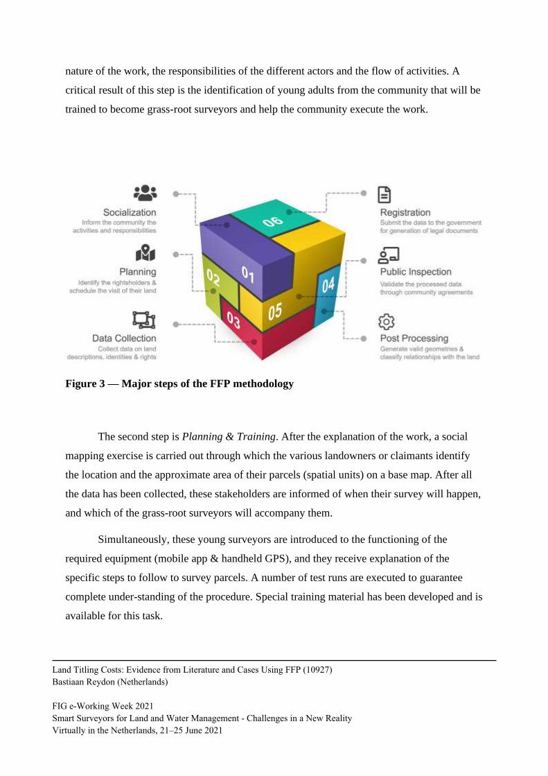
The overall procedure used for land rights documentation, following the Fit-For-
Purpose (FFP) philosophy, used with some adaptations, consist of six major steps (see Figure
3)12. The first step is Socialization. During this step, leaders of the community (-ies) located in
the work area are contacted to organize a general meeting in which the FFP team explains the
12 As can be seen in Enemark et ali(2014) the whole Fit for Purpose methodology also includes the legal adaptation, the
institutional changes, the mapping procedures and others.
Land Titling Costs: Evidence from Literature and Cases Using FFP (10927)
Bastiaan Reydon (Netherlands)
FIG e-Working Week 2021
Smart Surveyors for Land and Water Management - Challenges in a New Reality
Virtually in the Netherlands, 21–25 June 2021
nature of the work, the responsibilities of the different actors and the flow of activities. A
critical result of this step is the identification of young adults from the community that will be
trained to become grass-root surveyors and help the community execute the work.
Figure 3 — Major steps of the FFP methodology
The second step is Planning & Training. After the explanation of the work, a social
mapping exercise is carried out through which the various landowners or claimants identify
the location and the approximate area of their parcels (spatial units) on a base map. After all
the data has been collected, these stakeholders are informed of when their survey will happen,
and which of the grass-root surveyors will accompany them.
Simultaneously, these young surveyors are introduced to the functioning of the
required equipment (mobile app & handheld GPS), and they receive explanation of the
specific steps to follow to survey parcels. A number of test runs are executed to guarantee
complete under-standing of the procedure. Special training material has been developed and is
available for this task.
Land Titling Costs: Evidence from Literature and Cases Using FFP (10927)
Bastiaan Reydon (Netherlands)
FIG e-Working Week 2021
Smart Surveyors for Land and Water Management - Challenges in a New Reality
Virtually in the Netherlands, 21–25 June 2021
The third step is Data Collection. Following the previously drawn plan, various survey
teams are dispatched to cover the whole area and to collect simultaneously the spatial,
administrative and legal data of the landholders.
The fourth step is Post-Processing. This step is used to transform surveyed data into
topologically correct representations of real-world land parcels in a semi-automated way.
Additionally, an analysis on the various classes of rights is made and compared with existing
government registers when applicable.
The fifth step is called Public Inspection. During this step, the processed results are
presented to the community in a public forum for approval. Signatures are collected as
validation of the results, which indicate agreement between the parties.
The sixth and last step is Registration. All parcels that received approval by the
authorities and the community are incorporated into the national registers so that official
documents can be generated for the various rightholders. In some cases, the right can be
immediately formalized and leading to land titles. For others, which fall into different
categories of rights, a different procedure applies, but they can potentially lead to titles too.
The next two items will show two cases using the Fit for Purpose methodology in
South America, in the Brazil and in Colombia. Besides showing the costs of regularization
with traditional methods and with the Fit for Purpose method the cases wil show the
difference in time frame for the regularization. Surely the legal and institutional settings of the
countries have a great influence in the process of regularization. This experience has as main
aim show that costs can diminish strongly if using the FFP methodology.
5.1. THE CASE OF COLOMBIA
The Apartado’s municipality pilot took place in the village of: Los Mandarinos
(including the “private” area of El Trebol), El Tigre, La Balsa and La Linda comprising 252
parcels In Los Mandarinos, field data of the whole village has been collected, including state
Land Titling Costs: Evidence from Literature and Cases Using FFP (10927)
Bastiaan Reydon (Netherlands)
FIG e-Working Week 2021
Smart Surveyors for Land and Water Management - Challenges in a New Reality
Virtually in the Netherlands, 21–25 June 2021
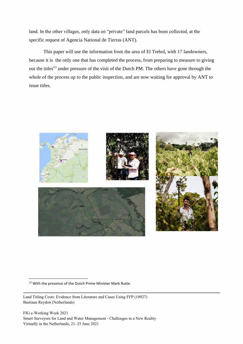
land. In the other villages, only data on “private” land parcels has been collected, at the
specific request of Agencia National de Tierras (ANT).
This paper will use the information from the area of El Trebol, with 17 landowners,
because it is the only one that has completed the process, from preparing to measure to giving
out the titles13 under pressure of the visit of the Dutch PM. The others have gone through the
whole of the process up to the public inspection, and are now waiting for approval by ANT to
issue titles.
13 With the presence of the Dutch Prime Minister Mark Rutte.
Land Titling Costs: Evidence from Literature and Cases Using FFP (10927)
Bastiaan Reydon (Netherlands)
FIG e-Working Week 2021
Smart Surveyors for Land and Water Management - Challenges in a New Reality
Virtually in the Netherlands, 21–25 June 2021
5.1.1. The images and field work
A first meeting was held with leaders of the communities from the villages from the
area of el Trebor. The field data collection aims to create an overview of all people to land
relationships. Those relationships can be formal land rights or recognized customary or
indigenous land rights. It is also possible that informal relationships are observed. There may
be disputes. Mapping of overlapping claims is included in the methodology. This means
agreed disagreement is mapped, the disputed holders are the “claimants” (Parties).
The methodology further aims at the creation of complete coverage of land
administration1 based on the outcomes of field data collection. The people to land
relationships should be formally registered where possible.
Field data collection succeeds procedural steps such as project block selection,
preparations, awareness raising, announcement, as well as training. All this was done for the
pilots – in close cooperation with the national institutions with responsibilities in land
administration, that is the ANT, SNR, IGAC, DNP, the Cadastre of Antioquia, as well as the
Universidad Distrita l (ingenieria catastral), the University of Twente (ITC) and
ESRI/TRIMBLE Colombia. The collected data from the field require data handling
afterwards and should be available for public inspection and for a confrontation with legally
data from the land registry under SNR and IGAC. This means that the collected data from
reality will be compared with the legal data as a basis for decision making on land titling.
Participatory, because people themselves will be actively involved in the data
collection, especially in post conflict veredas to enhance trust in the collected data (includ ing
accepting considerable differences in the expected area of the parcel and the measured area)
and regain overall trust in the government.
For this process step standard software is used, the Esri Collector App. Parameters in
this app are set in such a way that the data collection can be done according to the Colombian
definition of LADM. The project team has tight connections to the development team of the
Land Titling Costs: Evidence from Literature and Cases Using FFP (10927)
Bastiaan Reydon (Netherlands)
FIG e-Working Week 2021
Smart Surveyors for Land and Water Management - Challenges in a New Reality
Virtually in the Netherlands, 21–25 June 2021
collector app in order to discuss bugs and functional demands, but on this part the project
does not develop software component by itself.
Part of the exercise was digitalizing the titles that existed. Of the parcels that were
measured in this pilot, 4 of them had a registered title. These documents were digitalized by
reconstructing the textual description of the boundaries that was found in the titles. In case
that there was a usable map, this map was georeferenced using visual objects that could be
seen in the satellite image. Without guaranteeing a high precision, all these parcels could be
reconstructed.
5.1.2. Post-processing of field data and Public Inspection
With the collector app parcels are measured as closed polygons. This implies that each
common parcel boundary was measured twice. ITC en Universidad Distrital developed
dedicated software for post-processing. With this software double collected boundaries can be
combined to one common boundary, taking into account the precision of the measurement of
the collected boundary points. Some days after the measurements in the field, the Public
Inspection was held in one of the local churches in Apartado. At this event most of the owners
agreed on their boundaries and so titles could be given some months later, as the information
still had to be processed by the ANT.
5.1.3. Comparing the regularization costs
Table 6 is an estimation of the titling costs of this experience of Fit for Purpose
approach, the comparable ANT regularization process14 and the legal regularizing land
possessions process, based on the de Vries (2004) scheme. In the surveyors cost from the FFP
experience has all efforts of getting the local people together and all other steps included. The
14 The Agencia Nacional de Tierras (ANT) is responsible for the regularization of all rural areas that are not titled. The institution was created by the decree 2363/2015.
Land Titling Costs: Evidence from Literature and Cases Using FFP (10927)
Bastiaan Reydon (Netherlands)
FIG e-Working Week 2021
Smart Surveyors for Land and Water Management - Challenges in a New Reality
Virtually in the Netherlands, 21–25 June 2021
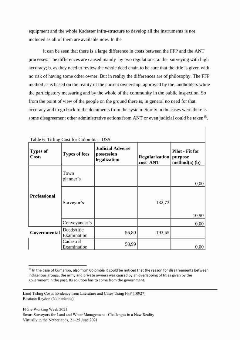
equipment and the whole Kadaster infra-structure to develop all the instruments is not
included as all of them are available now. In the
It can be seen that there is a large difference in costs between the FFP and the ANT
processes. The differences are caused mainly by two regulations: a. the surveying with high
accuracy; b. as they need to review the whole deed chain to be sure that the title is given with
no risk of having some other owner. But in reality the differences are of philosophy. The FFP
method as is based on the reality of the current ownership, approved by the landholders while
the participatory measuring and by the whole of the community in the public inspection. So
from the point of view of the people on the ground there is, in general no need for that
accuracy and to go back to the documents from the system. Surely in the cases were there is
some disagreement other administrative actions from ANT or even judicial could be taken15.
Table 6. Titling Cost for Colombia - US$
Types of
Costs Types of fees
Judicial Adverse
possession
legalization Regularization
cost ANT
Pilot - Fit for
purpose
method(a) (b)
Professional
Town
planner’s
0,00
Surveyor’s 132,73
10,90
Conveyancer’s 0,00
Governmental Deeds/title
Examination 56,80 193,55
Cadastral
Examination 58,99
0,00
15 In the case of Cumaribo, also from Colombia it could be noticed that the reason for disagreements between indigenous groups, the army and private owners was caused by an overlapping of titles given by the government in the past. Its solution has to come from the government.
Land Titling Costs: Evidence from Literature and Cases Using FFP (10927)
Bastiaan Reydon (Netherlands)
FIG e-Working Week 2021
Smart Surveyors for Land and Water Management - Challenges in a New Reality
Virtually in the Netherlands, 21–25 June 2021
Deed/Title
Application 58,17
0,00
Taxes
Endowment 0,00
Transfer and
stamp duties
0,00
TOTAL 173,96 326,28 10,90
Source: field work KI and ANT.
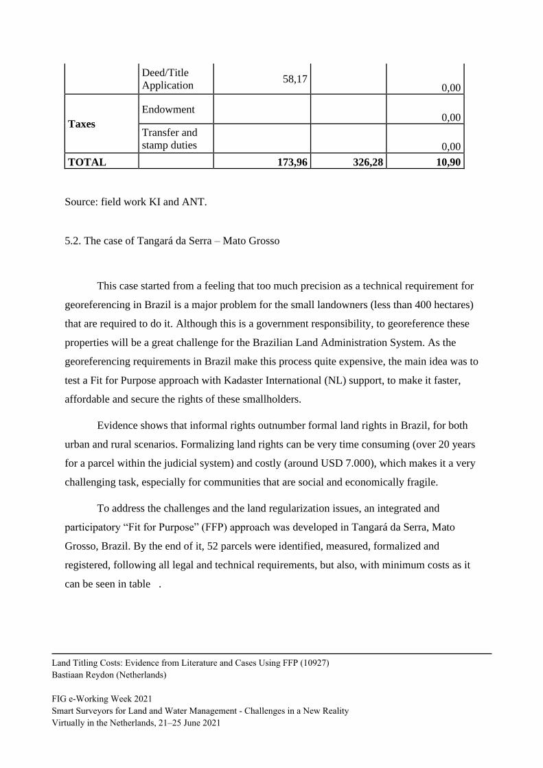
5.2. The case of Tangará da Serra – Mato Grosso
This case started from a feeling that too much precision as a technical requirement for
georeferencing in Brazil is a major problem for the small landowners (less than 400 hectares)
that are required to do it. Although this is a government responsibility, to georeference these
properties will be a great challenge for the Brazilian Land Administration System. As the
georeferencing requirements in Brazil make this process quite expensive, the main idea was to
test a Fit for Purpose approach with Kadaster International (NL) support, to make it faster,
affordable and secure the rights of these smallholders.
Evidence shows that informal rights outnumber formal land rights in Brazil, for both
urban and rural scenarios. Formalizing land rights can be very time consuming (over 20 years
for a parcel within the judicial system) and costly (around USD 7.000), which makes it a very
challenging task, especially for communities that are social and economically fragile.
To address the challenges and the land regularization issues, an integrated and
participatory “Fit for Purpose” (FFP) approach was developed in Tangará da Serra, Mato
Grosso, Brazil. By the end of it, 52 parcels were identified, measured, formalized and
registered, following all legal and technical requirements, but also, with minimum costs as it
can be seen in table .
Land Titling Costs: Evidence from Literature and Cases Using FFP (10927)
Bastiaan Reydon (Netherlands)
FIG e-Working Week 2021
Smart Surveyors for Land and Water Management - Challenges in a New Reality
Virtually in the Netherlands, 21–25 June 2021
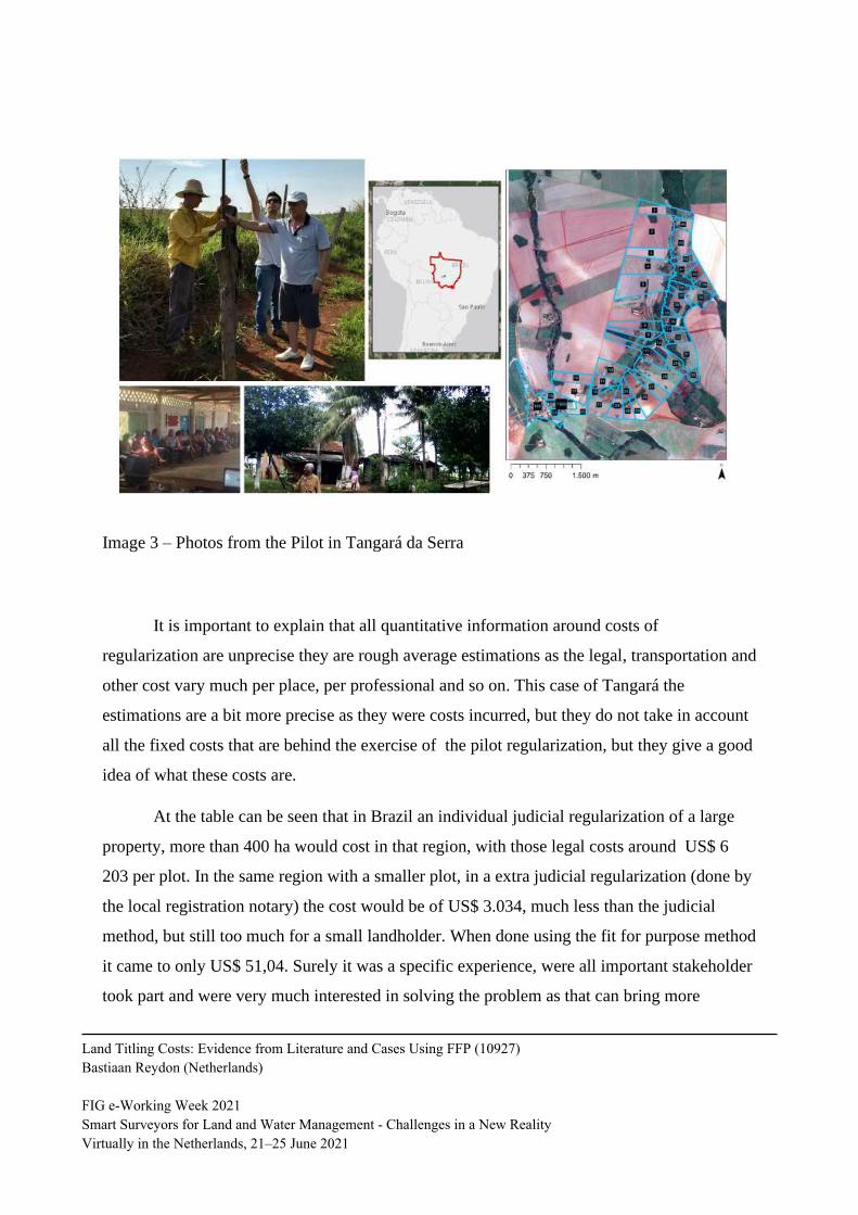
Image 3 – Photos from the Pilot in Tangará da Serra
It is important to explain that all quantitative information around costs of
regularization are unprecise they are rough average estimations as the legal, transportation and
other cost vary much per place, per professional and so on. This case of Tangará the
estimations are a bit more precise as they were costs incurred, but they do not take in account
all the fixed costs that are behind the exercise of the pilot regularization, but they give a good
idea of what these costs are.
At the table can be seen that in Brazil an individual judicial regularization of a large
property, more than 400 ha would cost in that region, with those legal costs around US$ 6
203 per plot. In the same region with a smaller plot, in a extra judicial regularization (done by
the local registration notary) the cost would be of US$ 3.034, much less than the judicial
method, but still too much for a small landholder. When done using the fit for purpose method
it came to only US$ 51,04. Surely it was a specific experience, were all important stakeholder
took part and were very much interested in solving the problem as that can bring more
Land Titling Costs: Evidence from Literature and Cases Using FFP (10927)
Bastiaan Reydon (Netherlands)
FIG e-Working Week 2021
Smart Surveyors for Land and Water Management - Challenges in a New Reality
Virtually in the Netherlands, 21–25 June 2021
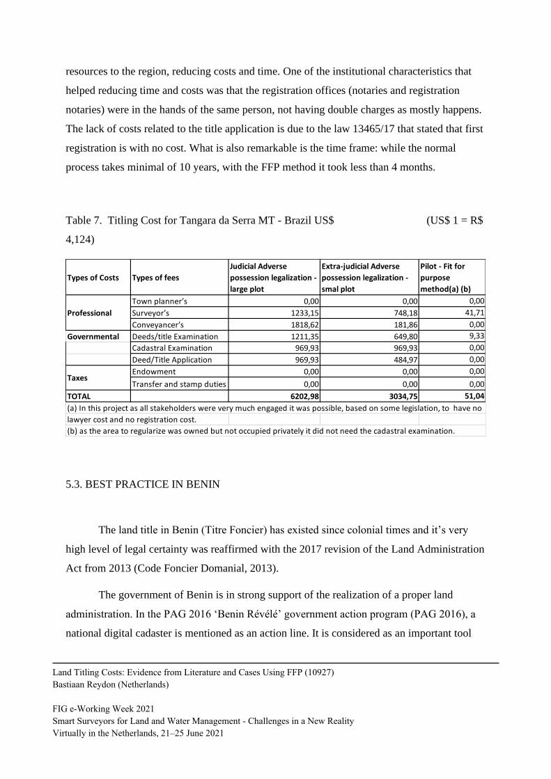
resources to the region, reducing costs and time. One of the institutional characteristics that
helped reducing time and costs was that the registration offices (notaries and registration
notaries) were in the hands of the same person, not having double charges as mostly happens.
The lack of costs related to the title application is due to the law 13465/17 that stated that first
registration is with no cost. What is also remarkable is the time frame: while the normal
process takes minimal of 10 years, with the FFP method it took less than 4 months.
Table 7. Titling Cost for Tangara da Serra MT - Brazil US$ (US$ 1 = R$
4,124)
5.3. BEST PRACTICE IN BENIN
The land title in Benin (Titre Foncier) has existed since colonial times and it’s very
high level of legal certainty was reaffirmed with the 2017 revision of the Land Administration
Act from 2013 (Code Foncier Domanial, 2013).
The government of Benin is in strong support of the realization of a proper land
administration. In the PAG 2016 ‘Benin Révélé’ government action program (PAG 2016), a
national digital cadaster is mentioned as an action line. It is considered as an important tool
Types of Costs Types of fees
Judicial Adverse
possession legalization -
large plot
Extra-judicial Adverse
possession legalization -
smal plot
Pilot - Fit for
purpose
method(a) (b)
Town planner’s 0,00 0,00 0,00
Surveyor’s 1233,15 748,18 41,71
Conveyancer’s 1818,62 181,86 0,00
Governmental Deeds/title Examination 1211,35 649,80 9,33
Cadastral Examination 969,93 969,93 0,00
Deed/Title Application 969,93 484,97 0,00
Endowment 0,00 0,00 0,00
Transfer and stamp duties 0,00 0,00 0,00
TOTAL 6202,98 3034,75 51,04
(a) In this project as all stakeholders were very much engaged it was possible, based on some legislation, to have no
lawyer cost and no registration cost.
(b) as the area to regularize was owned but not occupied privately it did not need the cadastral examination.
Professional
Taxes
Land Titling Costs: Evidence from Literature and Cases Using FFP (10927)
Bastiaan Reydon (Netherlands)
FIG e-Working Week 2021
Smart Surveyors for Land and Water Management - Challenges in a New Reality
Virtually in the Netherlands, 21–25 June 2021
for further economic development. Benin has chosen for a centralized land administration and
has the intention to record land rights for the entire national territory. The execution of the
land administration in Benin is assigned to the l’Agence Nationale du Domaine et du Foncier
(ANDF), that was established by the law of 2013 and which has started its activities in 2016.
It is estimated that there are about five million cadastral plots in Benin and that currently only
50,000 plots have a land title and have been registered in accordance with the Land
Administration Act.
Mekking et al (2020) state that one of the reasons for the slow increase in the number
of titles are the costs. Before the introduction of the 2013 Land Administration Act, high costs
were involved and it could take several years of time to obtain an official confirmation of land
ownership. With the introduction of the Land Administration Act a guaranteed lead time of
120 days and a fixed price of 200 US dollars for the application of a land title was provided.
Additional costs are to be made for obtaining a municipal source document, that in rural areas
has a fixed price of about 43 US dollars, and in more urban areas the prize depends on plot
size or transaction costs. Next to that a fee has to be paid for measurements by certified
private surveyors. It is estimated that the total costs for a land title are about 500 US dollars.
These are very high costs for Benin citizens.
Within this context an alternative approach was developed that is more cost and time
efficient and that is not based on a land title (Titre Foncier) but on a ‘verified presumption of
ownership’. This presumed ownership is recorded in the national land administration and
provides initial tenure security at low costs. This can later be upgraded to a formal land title
and paid for by the owner, for example in case of high value parcels.
This approach was developed within the perspective of Fit For Purpose Land
Administration and uses, amongst others, the following principles; a tenure security that is
based on ‘verified presumption of ownership’ instead of a formal land title, allowing
testimonies instead of source documents, acceptance of a spatial measurement accuracy of 1
meter instead of cm accuracy and substantial assistance of local population in collecting the
data.
Land Titling Costs: Evidence from Literature and Cases Using FFP (10927)
Bastiaan Reydon (Netherlands)
FIG e-Working Week 2021
Smart Surveyors for Land and Water Management - Challenges in a New Reality
Virtually in the Netherlands, 21–25 June 2021
This ‘fit for purpose’ approach was tested in four municipalities across Benin in 2019.
During a three months period, a total of 2,349 land parcels with a total surface of 3,500
hectares were collected. The average costs were about 17 US dollars per parcel and about 19
US dollars per hectare. These costs do not include the software costs for a Land
Administration System software nor the costs for capacity building of the cadastral
organization. As a follow-up this approach will be scaled up within several municipalities in
Benin from 2020 onwards.
Table 8. Costs for formal Land Title and Fit For Purpose ‘presumed ownership’ in Benin –
US dollar
Types of
Costs
Types of fees Formal process leading to
formal Land Title
Fit For Purpose
approach leading to
‘verified presumed
ownership’ 1)
Professional Town planner’s unknown 17 2)
Surveyor’s
Conveyancer’s
Governmental Deeds/title
examination
200
Cadastral
examination
Deed/title
application
Taxes Endowment Rural area fixed price:
43
Urban area: based on
parcel size or transaction
price
Transfer and
stamp duties
Total Estimation of total costs:
500
17 2)
1): Based on a 3 months test with 2349 parcels and a surface of 3500 hectare.
2): Excluding costs for the Land Administration System software and capacity building for
the cadastral organization
Land Titling Costs: Evidence from Literature and Cases Using FFP (10927)
Bastiaan Reydon (Netherlands)
FIG e-Working Week 2021
Smart Surveyors for Land and Water Management - Challenges in a New Reality
Virtually in the Netherlands, 21–25 June 2021
FINAL REMARKS
The main aim of the article was to show how the Fit for Purpose (FFP)16 method can
solve, with low costs and simple methods, and so diminishing the time spend to one of the
most difficult aspects of Land Administration in the developing countries: providing land
rights to all the informal landholders, including the ones that hold customary rights.
The article started with a revision on Land Administration showing why providing
land rights to all the informal landholders, including the ones that hold customary rights is one
of its main problems. After that, reviewed literature and was able to see that there are some
important advances in showing experiments with low costs. But the results are quite different
as the criteria used to explicit the costs are not always very clear.
In this review de Vries(2003) paper has to be highlighted as it based on the case of
Namibia, proposed a classification of the different costs and requirements of titling: the
professional, the governmental and the taxes, that can be used for all kinds of rights
concession\. With this classification, better comparation could be made between the studies to
achieve a better understanding were are the bottlenecks of the process of giving out the
landholders rights.
The next item, based on the Brazilian reality made some estimates on the amount of
informal landholdings exists in the rural reality, based on the Atlas fundiario. After that,
showed the costs for some Brazilian experiences of the traditional way of giving titles to rural
small owners.
The last item, before the conclusions, showed, based on Fit for Purpose cases
developed in Colombia, Brazil and Benin, that it is possible to lower well the costs and its
possible to reduce the time to document different rights of small landholders. But at the same
time it wants to stress that there exists no pandora box that will solve all titling problems. The
titling is an important part of the Land Administration System but as the whole of it needs the
participation of all stakeholders and needs institutional and legal changes to happen to all the
informal land sector.
16 For that see Enemark et al (2014).
Land Titling Costs: Evidence from Literature and Cases Using FFP (10927)
Bastiaan Reydon (Netherlands)
FIG e-Working Week 2021
Smart Surveyors for Land and Water Management - Challenges in a New Reality
Virtually in the Netherlands, 21–25 June 2021

Land Titling Costs: Evidence from Literature and Cases Using FFP (10927)
Bastiaan Reydon (Netherlands)
FIG e-Working Week 2021
Smart Surveyors for Land and Water Management - Challenges in a New Reality
Virtually in the Netherlands, 21–25 June 2021
REFERENCES
ALI D, COLLIN M, DEININGER K, DERCON S, SANDEFUR J, ZEITLIN A (2014) The
Price of Empowerment: Experimental Evidence on Land Titling in Tanzania, Working Paper
369, Centre for Global Development, Pp. 1-34, Accessed from:
https://www.cgdev.org/sites/default/files/priceempowerment-land-titling-tanzania.pdf
BURNS, T.; FAIRLIE, K. (2018) Framework for Costing and Financing Land
Administration Services- securing land and property rights for all. CoFLAS. UN-
Habitat/FIG/GLTN. https://gltn.net/2018/09/26/framework-for-costing-and-financing-land-
administration-services-coflas/
CODE FONCIER DOMANIAL (2013). Loi n°2013‐01 du 14 janvier 2013 portant Code
foncier et domanial en République du Bénin. Modifiée par la loi n°2017‐15 du 26 mai 2017.
DE VRIES, W. T.; GEORGIADOU, Y.; LEWIS, J. The cost of land registration: a case study
of cost efficiency in Namibia. Australian surveyor, v. 48, n. 1, p. 7-20, 2003.
DE SOTO, H. The Mystery of Capital: Why Capitalism Triumphs in the West and Fails
Everywhere Else. Basci Books, 2003.
DEININGER, K. Land Policies for Growth and Poverty Reduction. A World Bank Policy
Research Report. Washington, DC: World Bank and Oxford University Press, 2003. 292 p.
DEININGER, K.; FEDER, G. Land Registration, Governance, and Development: Evidence
and Implications for Policy. Oxford University Press, 2009.
DEININGER, K., AUGUSTINUS, C., ENEMARK, S., & MUNRO-FAURE, P. (Eds.).
(2010). Innovations in land rights recognition, administration, and governance. The World
Bank.
ENGLISH, C, LOCKE A, QUAN J, AND FEYERTAG, J (2019) Securing land rights at
scale. LEGEND Land: Enhancing Governance for Economic Development.
https://landportal.org/library/resources/securing-land-rights-scale
Land Titling Costs: Evidence from Literature and Cases Using FFP (10927)
Bastiaan Reydon (Netherlands)
FIG e-Working Week 2021
Smart Surveyors for Land and Water Management - Challenges in a New Reality
Virtually in the Netherlands, 21–25 June 2021
https://gltn.net/2018/09/26/framework-for-costing-and-financing-land-administration-services-coflas/
ENEMARK, S., BELL, K. C., LEMMEN, C. H. J., & MCLAREN, R. (2014). Fit-for-purpose
land administration. International Federation of Surveyors (FIG).
FERNANDES, V.B. (2018) A relação entre a governança de terras e o desenvolvimento
econômico – Tese de Doutoramento – UNICAMP – Campinas- 2018.
HABITAt, U. N. (2016). Habitat III: New urban agenda. Quito. Online at: http://habitat3.
org/wp-content/uploads/NUA-English. pdf: UN Habitat.
HOLSTEIN, Lynn. Towards best practice from World Bank experience in land titling and
registration. In: International Conference on Land Tenure and Administration. 1996. p. 1-26.
MASTRANGELO, J. P. S. ; REYDON, B. P. ; CAVALCANTE FILHO, P. G. ; BALLINI, R.
; FELÍCIO, A. S. G. ; SOUZA, D. ; CAVALCANTE, C. ; SILVA, A. M. ; GARRAFIEL, R. .
Informality in access to land and deforestation in the legal Amazon: an empirical study of the
state of Acre. In: Land and Poverty Conference 2019, 2019. Land and Poverty Conference
2019: Catalyzing Innovation.
MEKKING ET AL (2020) (Paper is accepted but not published yet at FIG 2020). Mekking S.,
Kougblenou V., Vranken M., Kossou F., Van den Berg C. Upscaling land administration in
Benin towards national coverage, balancing between time, quality and costs. This paper has
been accepted but not published yet at the FIG Working Week 2020, Amsterdam.
MOLENDIJK, M., SANTOS DUKON, T., LEMMEN, C. H. J., MORALES GUARIN, J. M.,
ENDO, V., RESTREPO RODRIGUEZ, S., GONZALEZ DUEÑAS, J. F., MATIZ
SANCHEZ, I. E., SPIJKERS, P., UNGER, E. M. AND MORENO HORTA, I. A. (2018)
Land and Peace in Colombia: FFP Methodology for Field Data Collection and Data Handling.
In: Land Governance in an Interconnected World. Annual World Bank Conference on Land
and Poverty 2018 - The World Bank Building, Washington D.C., United States 19 - 23 March
2018. 19 p.
MORALES, J; LEMMEN, C, DE BY, R; MOLENDIJK, M.; OOSTERBROEK E. and
ORTIZ DAVILA, A (2019) On the Design of a Modern and Generic Approach to Land
Registration: The Colombia Experience 8th International FIG workshop on the Land
Administration Domain Model 1-3 October 2019, Kuala Lumpur, Malaysia
Land Titling Costs: Evidence from Literature and Cases Using FFP (10927)
Bastiaan Reydon (Netherlands)
FIG e-Working Week 2021
Smart Surveyors for Land and Water Management - Challenges in a New Reality
Virtually in the Netherlands, 21–25 June 2021
NOTE, I. G. (2012). 5: Land Acquisition and Involuntary Resettlement. International Finance
Corporation: Washington, DC, USA.
PAG (2016) Programma d’Actions du Gouvernement, Benin Révélé,
http://revealingbenin.com/wp-content/uploads/2017/03/Le-Programme-dActions.pdf,
accessed at 20-02-2020
PAYNE, G; DURAND-LASSERVE, A; RAKODI, C. Social and economic impacts of land
titling programmes in urban and peri-urban areas: A review of literature (chapter 6), 2007. In:
LALL, S.V; FREIRE, M; YUEN, B; RAJACK, R; HELLUIN, J (Ed). Urban Land Markets:
Improving Land Management for Successful Urbanization. Springer Science & Business, Oct.
7, 2009.
REYDON, B.P. (2019) Challenges of current land governance in Brazil: beyond the
historical, political and social demands for land reform, In: Antonio M. Buainain, Rodrigo
Lanna, Zander Navarro. (Org.). Agricultural Development in Brazil: The Rise of a Global
Agro-food Power. 1ed.: Routledge , 2019, v. , p. 70-90.
REYDON, B.P., TELLES, T., FERNANDES, V.B. (2014). Land tenure in Brazil: The
question of regulation and governance. Land Use Policy 42 (2015), p. 509-516.
REYDON, Bastiaan Philip, COSTA, Anderson Simões. O custo da regularização das
propriedades rurais brasileiras: uma estimativa. Revista de Política Agrícola. , v.1, p.50 - 64,
2010. ISSN 1413-4969
SAGASHYA, D; ENGLISH, C Designing and Establishing a Land Administration System
for Rwand: Technical and Economic Analysis. In: DEININGER, K., AUGUSTINUS, C.,
ENEMARK, S., & MUNRO-FAURE, P. (Eds.). (2010). Innovations in land rights
recognition, administration, and governance. The World Bank.
SPAROVEK, G ; REYDON, B. P. ; GUEDES PINTO, L. F. ; FARIA, V. ; DE FREITAS, F.
L. M. ; AZEVEDO-RAMOS, C. ; GARDNER, T. ; HAMAMURA, C. ; RAJÃO, R. ;
CERIGNONI, F. ; SIQUEIRA, G. P. ; CARVALHO, T. ; ALENCAR, A. ; RIBEIRO, V. .
Who owns Brazilian lands?. LAND USE POLICY, v. 87, p. 104062, 2019
Land Titling Costs: Evidence from Literature and Cases Using FFP (10927)
Bastiaan Reydon (Netherlands)
FIG e-Working Week 2021
Smart Surveyors for Land and Water Management - Challenges in a New Reality
Virtually in the Netherlands, 21–25 June 2021
WILLIAMSON, I. et al. (2010) Land Administration for Sustainable Development.
California: Readlands. 2010.
Land Titling Costs: Evidence from Literature and Cases Using FFP (10927)
Bastiaan Reydon (Netherlands)
FIG e-Working Week 2021
Smart Surveyors for Land and Water Management - Challenges in a New Reality
Virtually in the Netherlands, 21–25 June 2021
Related Documents