Land system science and the social–environmental system: the case of Southern Yucata ´n Peninsular Region (SYPR) project BL Turner II 1 , J Geoghegan 2 , D Lawrence 3 , C Radel 4 , B Schmook 5 , C Vance 6 , S Manson 7 , E Keys 8 , D Foster 9 , P Klepeis 10 , H Vester 5 , J Rogan 11 , R Roy Chowdhury 11 , L Schneider 12 , R Dickson 13 and Y Ogenva-Himmelberger 14 Land system science axiomatically addresses social– environmental systems by integrating the dynamics of land uses (social) and land covers (environment), invariably including the use of remote sensing data and often, spatially explicit models of land change. This kind of research is illustrated through the Southern Yucata ´n Peninsular Region project (1997–2008) aimed at understanding, predicting, and projecting spatially explicit land change in a region with juxtaposed land uses-agriculture and a biosphere reserve. The successes of the project, its contributions to contemporary land system science, and the organizational mechanisms that fostered the research are identified as well as various corrections, which if applied, may have refined and extended the project’s goals. Overall, the project demonstrates the kind of integrated research required to advance understanding of a social-environment system and the team-based methods used in the process. Addresses 1 School of Geographical Sciences & Urban Planning, School of Sustainability, Arizona State University, Tempe, AZ 85281, USA 2 Department of Economics, Clark University, Worcester, MA 01610, USA 3 Department of Environmental Science, University of Virginia, Charlottesville, VA 22904, USA 4 Department of Environment & Society, Utah State University, Logan, UT 84322, USA 5 Departamento de Conservacio ´n de la Biodiversidad, El Colegio de la Frontera Sur—Unidad Chetumal, Chetumal, QR MX 770414, Mexico 6 Rheinisch-Westfa ¨ lisches Institut fu ¨r Wirtschaftsforschung, Essen, GR 45182 & School of Humanities and Social Science, Jacobs University Bremen, Bremen GR 28759, Germany 7 Department of Geography, Environment and Society, University of Minnesota, Minneapolis, MN, 55455, USA 8 AAAS Science & Technology Fellow, National Science Foundation, Arlington VA, 22230, USA 9 Harvard Forest, Petersham, MA 01366, USA 10 Department of Geography, Colgate University, Hamilton, NY 13346, USA 11 Graduate School of Geography, Clark University, Worcester, MA 01601, USA 12 Department of Geography, Rutgers University, Piscataway, NJ 08854, USA 13 Terra Carbon Project and Wake Forest University, Winston Salem, NC 27106, USA 14 Department of International Development, Community, and Environment, Clark University, Worcester, MA 01601, USA Corresponding author: Turner, BL ([email protected]) Current Opinion in Environmental Sustainability 2016, 19:18–29 This review comes from a themed issue on Sustainability science Edited by Hal Mooney Received 3 July 2015; Accepted 25 August 2015 http://dx.doi.org/10.1016/j.cosust.2015.08.014 1877-3435/Published by Elsevier Ltd. Integrated research linked to sustainability Sustainability science addresses human–environment relationships as signified by the base phenomenon of study, the social–environmental system (SES) [1]. Ana- lytically, this phenomenon is typically treated as two subsystems requiring specialists from the social and natural sciences to team together to understand the interactions between the subsystems and their conse- quences for the SES as a whole. This approach is neces- sitated because (1) the complexity of SESs requires a range of knowledge that few, if any, researcher can master alone, and (2) reflexive agents (humans) make the social subsystem analytically distinct from ambient environmental processes. As a result, funding and re- search programs increasingly champion integrated, team- based approaches to SES problem solving (e.g., the Coupled Natural-Human System program of the Nation- al Science Foundation [U.S.] or the emerging interna- tional program of Future Earth). With roots extending back to Alexander von Humboldt and the subsequent German Landschaft (landscape) tra- dition [2], if not earlier, various research approaches have treated land (or landscape) systems as SESs [3–7]. Global environmental change and sustainability research frame SESs explicitly through the lens of science, with attention to understanding the processes at play within SESs, Available online at www.sciencedirect.com ScienceDirect Current Opinion in Environmental Sustainability 2016, 19:18–29 www.sciencedirect.com

Welcome message from author
This document is posted to help you gain knowledge. Please leave a comment to let me know what you think about it! Share it to your friends and learn new things together.
Transcript

Land system science and the social–environmentalsystem: the case of Southern Yucatan PeninsularRegion (SYPR) projectBL Turner II1, J Geoghegan2, D Lawrence3, C Radel4,B Schmook5, C Vance6, S Manson7, E Keys8, D Foster9,P Klepeis10, H Vester5, J Rogan11, R Roy Chowdhury11,L Schneider12, R Dickson13 and Y Ogenva-Himmelberger14
Available online at www.sciencedirect.com
ScienceDirect
Land system science axiomatically addresses social–
environmental systems by integrating the dynamics of land
uses (social) and land covers (environment), invariably including
the use of remote sensing data and often, spatially explicit
models of land change. This kind of research is illustrated
through the Southern Yucatan Peninsular Region project
(1997–2008) aimed at understanding, predicting, and
projecting spatially explicit land change in a region with
juxtaposed land uses-agriculture and a biosphere reserve. The
successes of the project, its contributions to contemporary
land system science, and the organizational mechanisms that
fostered the research are identified as well as various
corrections, which if applied, may have refined and extended
the project’s goals. Overall, the project demonstrates the kind
of integrated research required to advance understanding of a
social-environment system and the team-based methods used
in the process.
Addresses1 School of Geographical Sciences & Urban Planning, School of
Sustainability, Arizona State University, Tempe, AZ 85281, USA2 Department of Economics, Clark University, Worcester, MA 01610,
USA3 Department of Environmental Science, University of Virginia,
Charlottesville, VA 22904, USA4 Department of Environment & Society, Utah State University, Logan,
UT 84322, USA5 Departamento de Conservacion de la Biodiversidad, El Colegio de la
Frontera Sur—Unidad Chetumal, Chetumal, QR MX 770414, Mexico6 Rheinisch-Westfalisches Institut fur Wirtschaftsforschung, Essen, GR
45182 & School of Humanities and Social Science, Jacobs University
Bremen, Bremen GR 28759, Germany7 Department of Geography, Environment and Society, University of
Minnesota, Minneapolis, MN, 55455, USA8 AAAS Science & Technology Fellow, National Science Foundation,
Arlington VA, 22230, USA9 Harvard Forest, Petersham, MA 01366, USA10 Department of Geography, Colgate University, Hamilton, NY 13346,
USA11 Graduate School of Geography, Clark University, Worcester, MA
01601, USA12 Department of Geography, Rutgers University, Piscataway, NJ 08854,
USA13 Terra Carbon Project and Wake Forest University, Winston Salem, NC
27106, USA14 Department of International Development, Community, and
Environment, Clark University, Worcester, MA 01601, USA
Corresponding author: Turner, BL ([email protected])
Current Opinion in Environmental Sustainability 2016, 19:18–29
Current Opinion in Environmental Sustainability 2016, 19:18–29
This review comes from a themed issue on Sustainability science
Edited by Hal Mooney
Received 3 July 2015; Accepted 25 August 2015
http://dx.doi.org/10.1016/j.cosust.2015.08.014
1877-3435/Published by Elsevier Ltd.
Integrated research linked to sustainabilitySustainability science addresses human–environment
relationships as signified by the base phenomenon of
study, the social–environmental system (SES) [1]. Ana-
lytically, this phenomenon is typically treated as two
subsystems requiring specialists from the social and
natural sciences to team together to understand the
interactions between the subsystems and their conse-
quences for the SES as a whole. This approach is neces-
sitated because (1) the complexity of SESs requires a
range of knowledge that few, if any, researcher can
master alone, and (2) reflexive agents (humans) make
the social subsystem analytically distinct from ambient
environmental processes. As a result, funding and re-
search programs increasingly champion integrated, team-
based approaches to SES problem solving (e.g., the
Coupled Natural-Human System program of the Nation-
al Science Foundation [U.S.] or the emerging interna-
tional program of Future Earth).
With roots extending back to Alexander von Humboldt
and the subsequent German Landschaft (landscape) tra-
dition [2], if not earlier, various research approaches have
treated land (or landscape) systems as SESs [3–7]. Global
environmental change and sustainability research frame
SESs explicitly through the lens of science, with attention
to understanding the processes at play within SESs,
www.sciencedirect.com

Land system science in Southern Yucatan Turner II et al. 19
modeling their interactions, and projecting the implica-
tions of their change. This framing dominated the SESs
research advanced by the International Geosphere-Bio-
sphere Program (IGBP), especially its ecology compo-
nents, and in partnership with the International Human
Dimensions of Global Environmental Change Program
(IHDP) sponsored the development of an international
effort on Land Use and Cover Change (LUCC) in 1991,
formally launching a research project by that name in
1994. Focused on land systems, it was reorganized as the
Global Land Project (IGBP-IHDP) in 2005 and remains
on-going. Paralleling this effort, DIVERSITAS, estab-
lished in 1991, increasingly adopted an SES framing for
much of its biodiversity research, especially that on
ecoSERVICES established in 2014 and intended to fuse
into Future Earth.
These origins strongly shaped the research efforts of, and
SES approaches applied within, land system science [8]
and complementary research on the resilience of SESs
[9]. Global change research communities required atten-
tion to the observation and projection of the kind,
amount, and location of land changes. Land system
science was challenged to improve observations through
advances in the remote sensing data of land cover and
model-based assessments of land-cover change, especial-
ly in regard to spatio-temporal resolution. Remote sensing
science and modeling joined the natural and social
sciences as the four legs of SES research on land systems
[10–12]. Integrated research teams emerged composed of
environmental, social, and remote sensing, and in many
cases, modeling specialists, especially in regard to the
integration of social and environmental subsystems.
Unlike its complementary environmental research pro-
grams, land system science found it difficult to establish
research objectives based on standard sets of theories and
hypotheses about the operation of SESs. This lacuna
followed from the distinctions in the operations of the
two subsystems, from the different perspectives in the
social sciences regarding the value of addressing proximate
(e.g., population pressures) or distal (e.g., political econo-
my) drivers of land change [3,11], and from the complexity
of land systems. Rather, its international goals have been
defined in terms of measuring, modeling, and understand-
ing land-based SESs (aka coupled human–environment
systems), commonly involving exploratory research of the
environmental and socio-political-economic factors at play,
although individual projects may address specific theories
and hypotheses relevant to either subsystem. The critical
point is that rather than focusing on a set of a priori theses
and theories, land system science tends to engage case
studies of the connections between land-use and land-
cover, revealing the intricacies of the phenomena and
processes of the SESs that might be missed in deductive
approaches. The complexity of SESs fosters attention to
model projections as much as predictions of land change,
www.sciencedirect.com
and plays to the interests of the social sciences in theory of
middle range [13], usually concerning some component of
the SES, as opposed to, for example, systems theory’s
search for patterns and principles about the system itself
as exemplified in resilience research [14]. This same com-
plexity promotes place-based studies, consistent with that
proposed for sustainability science [15]. Once important
linkages in the SES are revealed, hypotheses may be
tested, frequently through natural experiments in which
variance in the system is not controlled. It is noteworthy
that no formal criteria have been established to determine
the boundaries of a place (area or region), but land system
science tends to link some dimension of land cover (e.g.,
tropical forest or savanna) and use (e.g., slash-and-burn
cultivation or livestock herding), often within one gover-
nance jurisdiction (i.e., rarely crossing major governance
boundaries).
Various reviews of the contributions of land system sci-
ence exist [7,9,10,11] and need not be reiterated here.
Rather, we draw on one of the original projects linked to
LUCC and GLP to illustrate integrated, team-based SES
research of this kind, the various challenges confronted
and the understanding gained in this effort, and on
reflection, changes in the design and operation of the
project that may have improved its performance and
science contributions.
Southern Yucatan Peninsular Region project:an integrated effort to address a SESThe Southern Yucatan Peninsular Region project (SYPR),
operating from 1997 to 2008, sought to observe, understand,
and model changes in land-use and land-cover in the forests
of southern Quintana Roo and Campeche, Mexico
(Figure 1). The study region was selected for several
strategic reasons. First, it contains biodiverse, seasonal
tropical to evergreen forests that were affected by ancient
Maya land uses but remained minimally disturbed for
nearly a millennium after Maya abandonment about
C.E. 950 [16]. Second, agricultural settlements (ejidos)and cattle operations proliferated with the late 1960s con-
struction of a highway crossing the peninsula, generating a
regional ‘hotspot’ of tropical deforestation, a large portion of
which was designated as the Calakmul Biosphere Reserve
in 1989, part of the MesoAmerican Biological Corridor [17].
Third, a small, precursor project helped to identify the base
research problem and establish initial links to El Colegio de
la Frontera Sur (ECOSUR)-Unidad Chetumal, a Mexican
research institution in the region. And fourth, the principal
investigator of the SYPR project had undertaken extensive
research on ancient Maya land uses in the region, providing
insights about longer-term SES dynamics.
The SYPR project addressed a major problem throughout
the tropical world: maintaining older growth forest land-
scapes in the context of pressures for economic develop-
ment. This issue was particularly acute in the region
Current Opinion in Environmental Sustainability 2016, 19:18–29

20 Sustainability science
Figure 1
Approximate study area
CalakmulBiosphere Reserve
Ejido boundaries
Disputed state boundary
0 25 50 km
MEXIC
O
CAMPECHE
QUINTANAROO
GUATEMALA
BELIZ
E
N
AreaEnlarged
Current Opinion in Environmental Sustainability
The Southern Yucatan Peninsular Region of Quintana Roo and Campeche, Mexico.
Box 1 Research goals of the project
1. Identify the drivers of changes in land covers and the con-
sequences of these changes for the SES at large but with an
emphasis on households and forests.
2. Document changes underway in the land covers of the region,
foremost changes in amount and kind of older growth forests,
using Landsat data.
3. Generate robust models explaining and projecting the location
and amount of changes in land uses and covers over a decadal
period and under different socioeconomic and climate conditions.
4. Understand the land system consequences of placing a tropical
biosphere reserve within a region of existing agricultural com-
munities.
because of attempts to create eco-archaeo-tourism in a
landscape interspersed with farm-land and reserve-land.
Despite its implications for various government and NGO
programs present in southern Quintana Roo and Cam-
peche, the SYPR project was not designed to inform these
programs per se (but see below). Rather, consistent with
land system science promoted by the LUCC agenda and
NASA’s complementary Land-Cover and Land-Use
Change program, the SYPR project explored land dynam-
ics, foremost the identifications of the drivers and major
consequences of deforestation, while making advances in
observations of land-cover changes with Landsat data and
in spatially explicit models of land-cover and land-use
changes. Consistent with case-study approaches, the proj-
ect was not orchestrated around a priori theory or hypoth-
eses to test, but rather permitted a talented research team
to uncover various dimensions of SES dynamics relevant
to the broader problem, from which hypotheses and
specific needs in advancing methods emerged.
Selected topics, questions, hypotheses andadvances: gains from integrationExploration of its base research problems (Box 1) engaged
the project in a large number of topics, examples of which
Current Opinion in Environmental Sustainability 2016, 19:18–29
are listed in Figure 2. These dealt with implications of
swidden (slash-and-burn) and intensive chili cultivation
on forest recovery, species invasion, biodiversity, and
nutrient cycling for the environmental subsystem, and
household characteristics and land-use decisions, labor
migration and remittances, governance structures, and
policy impacts for the social subsystem. Many of these
topics became questions addressed explicitly or implicitly
as hypotheses, which are too numerous to review in full. A
www.sciencedirect.com

Land system science in Southern Yucatan Turner II et al. 21
Figure 2
Remote Sensing Research
Socioeconomic Research
Ecological Research
Integrated Field Research
Modeling
• distribution of forest types, crop-fallow land, secondary forests, & bracken fern invasion• landscape matrix (above)• changes in land covers (above)• locations & frequency of burning• land surface temperature by land-cover type
• characteristics of forest types• successional characteristics by forest types & cropping history• biomass & carbon stocks• nutrient flows• soil moisture –land cover interactions• biotic diversity• species invasion
• individual parcel use history (crops, fallow cycles)• household composition, age social capital & gender dynamics• household assets & income portfolios (farm, off farm, remittances)• level of commercial & subsistence, livestock rearing land engagement• community tenure and governance• labor migration & remittances• state policies & market relations
Empirically informed, spatially explicit (household &community scales)• econometric models• agent based models& tests of various hypotheses of land uses
Current Opinion in Environmental Sustainability
Range of Research Topics undertaken in the Four Parts of the SYPR Project (see Box 1 for the overarching research questions).
selection embedded within or crossing the two subsys-
tems is provided in Table 1 (the specific question, state of
understanding, hypothesis or quasi-hypothesis, under-
standing gained and key references). Addressing the
broader goals of the project also required advances in
remote sensing and modeling methods listed in Table 2
(question/task, state of the art, advance made and key
references). Given this detail, the information in the
tables is not reiterated here. Rather, the selections are
clustered and discussed in terms of the project integra-
tion, information and the outcomes gained by the inte-
gration (Figure 3).
The questions posed about the environmental subsystem
required field study, informed by the location (from
remote sensing) of the field site relative to other land
covers within the landscape matrix, and the kind, timing,
and frequency of past land uses (e.g., crop-fallow cycles
on parcels with secondary vegetation; from household
surveys) on, or in proximity to, the field site (Figure 3).
Integrating these data improved understanding of forest
www.sciencedirect.com
recovery from human uses, including carbon stocks and
the capacity of land cover to capture phosphorus (P), a key
nutrient in the forest ecosystem and agriculture (Table 1
#1, 2 and 4). Beyond this, integration helped to explain
various environmental conditions. For example, loss of
male head-of-households due to labor migration, tended
to reduce cultivation, lowering biomass and crop yields, a
relationship discovered that improved modeling results.
Remote sensing identified the range of the invasive
species, Pteridium aquilinum or bracken fern, and the
characteristics of affected and non-affected parcels,
whereas household surveys provided information on tim-
ing of invasion relative to crop-fallow cycles and the
decisions about invaded parcel use or abandonment
(Table 1 #3).
The questions that addressed the social subsystem trea-
ted household conditions (e.g., size, age, ethnicity, social
capital) and dynamics (e.g., subsistence or mixed subsis-
tence-commercial behavior), informed by the land-cover
conditions of individual household parcels and adjacent
Current Opinion in Environmental Sustainability 2016, 19:18–29
22 Sustainability science
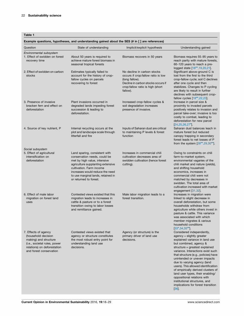
Table 1
Example questions, hypotheses, and understanding gained about the SES (# in [ ] are references)
Question State of understanding Implicit/explicit hypothesis Understanding gained
Environmental subsystem
1. Effect of swidden on forest
recovery time
About 50 years is required to
achieve mature forest biomass in
seasonal tropical forests
Biomass recovers in 50 years Biomass requires 55–95 years to
reach parity with mature forests,
60–120 years to reach a pre-
logged state [18��,19,20,21].
2. Effect of swidden on carbon
stocks
Estimates typically failed to
account for the history of crop-
fallow cycles on parcels
recovering to forest
No decline in carbon stocks
occurs if crop:fallow ratio is low
(long fallow).
Decline in carbon stocks occurs if
crop:fallow ratio is high (short
fallow).
Significant above-ground C is
lost from the first to the third
crop-fallow cycle; soil C declines
after one cycle and then
stabilizes. Changes to P cycling
are likely to result in further
declines with subsequent crop-
fallow cycles [18��,22,23].
3. Presence of invasive
bracken fern and effect on
deforestation
Plant invasions occurred in
degraded lands impeding forest
succession & leading to
deforestation.
Increased crop-fallow cycles &
soil degradation increases
presence of invasive.
Increase in parcel size &
proximity to invaded parcels
positively relates to invasion and
parcel take-over; invasive is too
costly to combat, leading to
deforestation for new parcel
[24,25,26,27�].
4. Source of key nutrient, P Internal recycling occurs at the
plot and landscape scale through
litterfall and fire
Inputs of Saharan dust are critical
to maintaining P levels & forest
function
Saharan dust balances leach in
mature forest but reduced
canopy trapping in secondary
forest leads to net losses of P
from the system [28��,29,30��].
Social subsystem
5. Effect of agricultural
intensification on
deforestation
Land sparing, consistent with
conservation needs, could be
met by high value, intensive
agriculture supplanting extensive
cultivation. Farm income
increases would reduce the need
to use marginal lands, retained in
or returned to forest.
Increases in commercial chili
cultivation decreases area of
swidden cultivation (hence forest
cutting).
Owing to constraints on chili
farm-to-market system,
environmental vagaries of the
chili market and nature (yields),
and shifting household
economics, increases in
commercial chili were not
matched by decreases in
swidden. The total area of
cultivation increased with market
engagement [31,32].
6. Effect of male labor
migration on forest land
uses
Contested views existed that this
migration leads to increases in
cattle & pasture or to a forest
transition owing to labor losses
and remittance gained.
Male labor migration leads to a
forest transition.
Increases in migration were
linked to slight decrease in
overall deforestation, but some
households withdraw from
agriculture while others invest in
pasture & cattle. This variance
was associated with which
member migrates & various
household conditions
[33�,34,35��].
7. Effects of agency
(household decision
making) and structure
(i.e., societal rules, power
relations) on deforestation
and forest conservation
Contested views existed that
agency or structure constitutes
the most robust entry point for
understanding land use
decisions.
Agency (or structure) is the
primary driver of land use
decisions.
Considered independently,
agency = slightly greater
explained variance in land use
but combined, agency &
structure = greatest explained
variance. Interactions exist such
that structure (e.g., policies) have
unintended or uneven impacts
due to varying agency (land
users). This allowed identification
of empirically derived clusters of
land user types, their enabling/
oppositional relations with
institutional structures, and
implications for forest transition
[36].
Current Opinion in Environmental Sustainability 2016, 19:18–29 www.sciencedirect.com

Land system science in Southern Yucatan Turner II et al. 23
Table 1 (Continued )
Question State of understanding Implicit/explicit hypothesis Understanding gained
8. Effects of environmental
policies on forest
conservation
Minimal work existed at that time
using spatially and ecologically
validated empirical data on
impacts of countervailing
conservation policies.
Improved forest succession and
biodiversity of parcels or
landscape created by
participation in conservation
programs.
Conservation structures/policies
have unintended or uneven
impacts due to varying
household dynamics and/or
biophysical constraints to local
farming (e.g., fail to arrest
deforestation due to
displacement effect) [37��,38].
parcels of other households (from remote sensing), and
the environmental implications of the land covers (from
environmental field work) (Table 1 #5–7; Figure 3). This
integration revealed the complex array of household
types associated with different cropping and forest out-
comes, with implications for various theses about tropical
deforestation. The rapid spread of intensive, commercial
chili cultivation at the time expanded rather than re-
duced deforestation (Table 1 #5) because an ephemeral
market and the vagaries of nature made the maintenance
Figure 3
Remote Sensing Research
Socioeconomic R
[A] Enlarge identified landcover types[B] Improve detection ofswidden burning
extent & location of types →proximity of invasivedominated parcels →← verification of for← phases of forest
.↑checks on reported croppinghistory by households & parcels↓
[5] intensification as land spa[6] labor migration & forest tr[7] agency & structure as driv[8] conservation policy & fore
↓ evidence for retro-cast of the model output (modelvalidation)↓ household characteristics & variance in land uses↑ projections of deforestation & carbon stocks
Data flow among SYPR project parts. Solid rectangles = (# or letter) of ques
rectangles = example of data flows with small arrows indicating direction of
www.sciencedirect.com
of subsistence (swidden) essential. Households losing
male labor to migration, in contrast, deforested less, in
part because labor constraints favored short-fallow par-
cels, leaving other parcels to regrow (Table 1 #6), but
resulting in a downward spiral for those parcels under
cultivation. Integrating the various data permitted a test
of the agency-structure debate that ranged across multi-
ple human-environment subfields-what are the relative
roles of household decision making and societal struc-
tures in explaining the intensity of cultivation or degree
Ecological Research
esearch
Modeling
Improve spatially explicit [C] economic and[D] agent based models of land change
land-cover
species
est typesgrowth
[1] Biomass recovery[2] Carbon stocks[3] Invasive species[4] Dust derived phosphorous
↑ age of successional growth &bracken fern↑ crop- fallow cycles↓ nutrient decline by crop-fallowcycle↓ fallow recovery time
ringansitioners of land changest outcomes
Current Opinion in Environmental Sustainability
tiones/hypotheses/advances in Tables 1 and 2. Dashed
flow.
Current Opinion in Environmental Sustainability 2016, 19:18–29

24 Sustainability science
Table 2
Questions and advances in remote sensing and modeling (# in [ ] are references)
Question/task State of the art Advances made
Remote sensing
A. Enlarge the number of land cover types,
especially for forests, identified with
Landsat TM data alone
3–5 land cover classes were common to
studies using these data alone, often with
only 1–2 forest cover classes
Developing a step-wise method of
assessment, 14 land cover classes were
identified, including deciduous, evergreen,
and wetland forest types and several stages
of secondary forest with an accuracy of
>80% [39��,40].
B. Improve the accuracy of the detection
of fire frequency & location in dry tropical
forests using MODIS thermal imagery
MODIS Terra (for morning) and MODIS
Aqua (for afternoon) were the major
sources for fire detections, generating the
standard product or Global Fire Monitoring
Standard products had a 77% fire omission
rate because they were insensitive to small,
cool fires used in swidden cultivation.
Recalibrating for the local conditions, major
detection improved by lowering the MODIS
thermal band threshold from 310 K to 305 K
[41�].
Modeling
C. Develop econometric spatial model
of deforestation
Such models were bifurcated at the time:
theoretical models tested via aggregate
data; & empirical models with spatially
disaggregate data based on past land
uses and environmental factors
Using detailed time series (remote sensing)
and household data with GIS and spatial
econometric techniques, spatially explicit
econometric models were developed with
superior results compared with previous
approaches and are capable of assessing
policy implications [18��,42–43].
D. Develop spatially explicit agent based
models (ABMs) of agriculture & attendant
deforestation
ABMs were in their preliminary stage of
development across the social & natural
sciences, and were of interest to various
academic communities because they
offered a way to better (compared to many
other modeling approaches) capture local
interactions. Many social science and
ecological efforts tended to employ rule
sets for agents not grounded on empirical
specification
Using much of the same data as the
econometric models, the project developed
simulation approaches to represent real-
world, bounded decision making processes
based on empirical data, and developed
scenarios that captured a range of dynamics
including population growth, migration,
institutional change, and varying cultivation
practices. This and other empirical
specification permitted identification at
household plot scale of areas of fallow &
secondary forest to be cut [44��,45–47].
of deforestation? Our tests revealed the amount of
explained variance lost by focusing on one or the
other dimensions and that gained by combining them
(Table 1 #7). Overall, differences among households led
to distinctively different responses to various policies
intended to shape cultivation or forest practices (Table 1
#8).
Innovations in the remote sensing of land covers
(Table 2A), foremost the ‘step-wise’ method of land-
cover identification, were only made possible by informa-
tion gained from the SES research. Linking spectral
signals to forest types (upland deciduous, evergreen,
secondary, and seasonal wetland forests) and bracken
fern employed household information about cultivated
parcels (Figure 3). Likewise, enhancements in fire detec-
tion relied on household information regarding parcels
burned (Table 2B).
Advances in econometric spatial models of deforestation
combined remote sensing time series and household data
to improve assessments of how many and which parcels of
Current Opinion in Environmental Sustainability 2016, 19:18–29
secondary and older growth forest would fall, and by
adding environmental data (biomass/carbon), produced
assessments of carbon storage and emissions under dif-
ferent policies (Table 2C; Figure 3). Finally, improve-
ments followed the agent based models on land change,
as various integrated inputs provided an empirically rich
parameterization of rules applied to the agents, leading to
robust projections of cultivation and deforestation at the
parcel or plot scale.
An unintended, theoretical contribution of the project
was the use of its findings, such as the role of forest canopy
capture of P, coupled with the PI’s previous research on
ancient land uses in the region, to generate a new syn-
thesis of the collapse and depopulation of the Maya in the
region [48�]. This synthesis links the impacts of intensive
land-uses to the amplification of climatic drought and to a
decline in P, creating new levels of constraint on agricul-
ture and water. These constraints, in tandem with eco-
nomic losses from changes in trade routes, created a
human-environment threshold that played a role in the
Maya abandonment of the region.
www.sciencedirect.com
Land system science in Southern Yucatan Turner II et al. 25
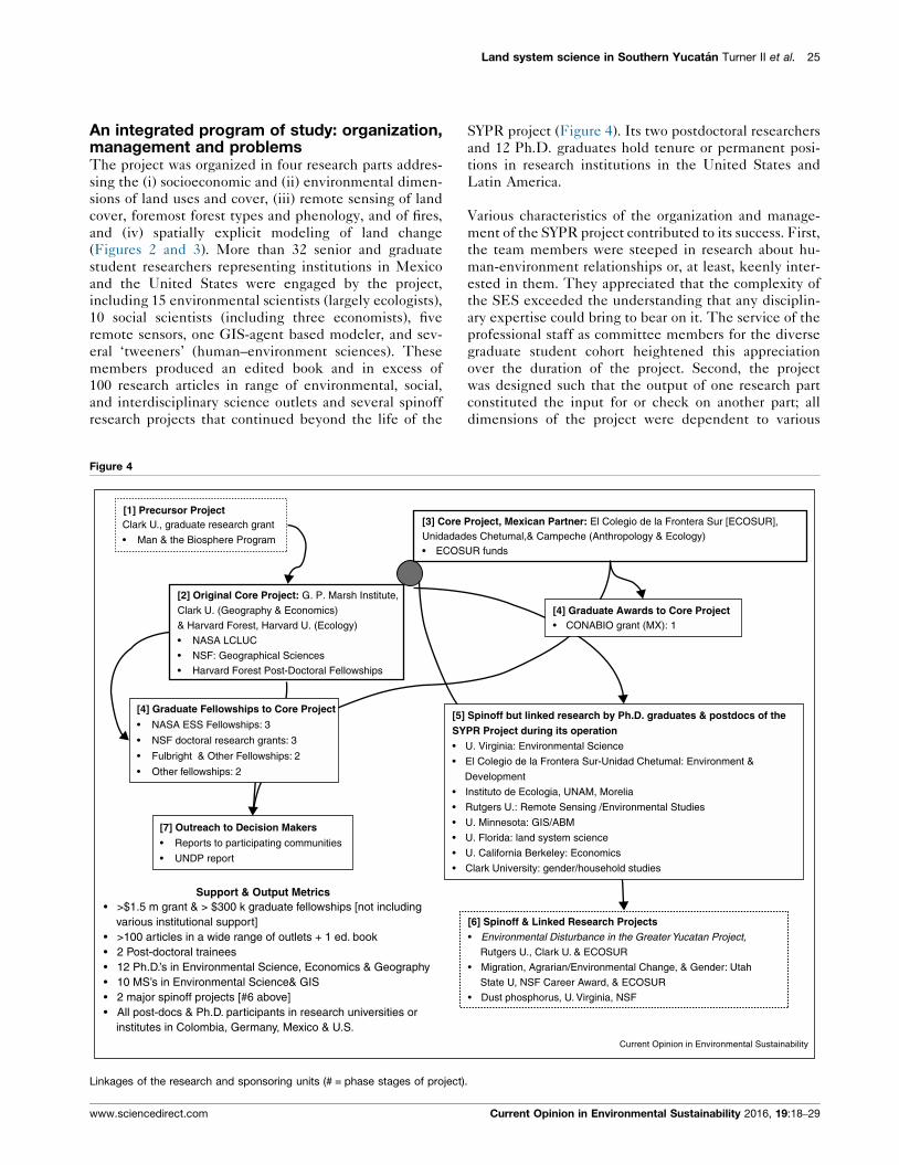
An integrated program of study: organization,management and problemsThe project was organized in four research parts addres-
sing the (i) socioeconomic and (ii) environmental dimen-
sions of land uses and cover, (iii) remote sensing of land
cover, foremost forest types and phenology, and of fires,
and (iv) spatially explicit modeling of land change
(Figures 2 and 3). More than 32 senior and graduate
student researchers representing institutions in Mexico
and the United States were engaged by the project,
including 15 environmental scientists (largely ecologists),
10 social scientists (including three economists), five
remote sensors, one GIS-agent based modeler, and sev-
eral ‘tweeners’ (human–environment sciences). These
members produced an edited book and in excess of
100 research articles in range of environmental, social,
and interdisciplinary science outlets and several spinoff
research projects that continued beyond the life of the
Figure 4
[1] Precursor Project
[7] Outreach to Decision Makers
• Reports to participating communities
• UNDP report
• >$1.5 m grant & > $300 k graduate fellowships [not including various institutional support]• >100 articles in a wide range of outlets + 1 ed. book• 2 Post-doctoral trainees• 12 Ph.D.’s in Environmental Science, Economics & Geography• 10 MS’s in Environmental Science& GIS• 2 major spinoff projects [#6 above]• All post-docs & Ph.D. participants in research universities or institutes in Colombia, Germany, Mexico & U.S.
Support & Output Metrics
[3] Core Unidadad• ECOS
Clark U., graduate research grant
• Man & the Biosphere Program
[2] Original Core Project: G. P. Marsh Institute,
Clark U. (Geography & Economics)
& Harvard Forest, Harvard U. (Ecology)
• NASA LCLUC
• NSF: Geographical Sciences
• Harvard Forest Post-Doctoral Fellowships
[4] Graduate Fellowships to Core Project
• NASA ESS Fellowships: 3
• NSF doctoral research grants: 3
• Fulbright & Other Fellowships: 2
• Other fellowships: 2
[5]SY•
•
•
•
•
•
•
•
Linkages of the research and sponsoring units (# = phase stages of project)
www.sciencedirect.com
SYPR project (Figure 4). Its two postdoctoral researchers
and 12 Ph.D. graduates hold tenure or permanent posi-
tions in research institutions in the United States and
Latin America.
Various characteristics of the organization and manage-
ment of the SYPR project contributed to its success. First,
the team members were steeped in research about hu-
man-environment relationships or, at least, keenly inter-
ested in them. They appreciated that the complexity of
the SES exceeded the understanding that any disciplin-
ary expertise could bring to bear on it. The service of the
professional staff as committee members for the diverse
graduate student cohort heightened this appreciation
over the duration of the project. Second, the project
was designed such that the output of one research part
constituted the input for or check on another part; all
dimensions of the project were dependent to various
[6] Spinoff & Linked Research Projects• Environmental Disturbance in the Greater Yucatan Project,
Rutgers U., Clark U. & ECOSUR
• Migration, Agrarian/Environmental Change, & Gender: Utah
State U, NSF Career Award, & ECOSUR
• Dust phosphorus, U. Virginia, NSF
Project, Mexican Partner: El Colegio de la Frontera Sur [ECOSUR],es Chetumal,& Campeche (Anthropology & Ecology)UR funds
[4] Graduate Awards to Core Project• CONABIO grant (MX): 1
Spinoff but linked research by Ph.D. graduates & postdocs of thePR Project during its operationU. Virginia: Environmental Science
El Colegio de la Frontera Sur-Unidad Chetumal: Environment &
Development
Instituto de Ecologia, UNAM, Morelia
Rutgers U.: Remote Sensing /Environmental Studies
U. Minnesota: GIS/ABM
U. Florida: land system science
U. California Berkeley: Economics
Clark University: gender/household studies
Current Opinion in Environmental Sustainability
.
Current Opinion in Environmental Sustainability 2016, 19:18–29

26 Sustainability science
degrees on the others (Figure 3). Third, the specific
objectives of each part of the project were developed
by the research specialists in cooperation with the team as
whole. These objectives were revised and enlarged as
needed, generally related to research discoveries by the
team or as new members of the project were added.
Fourth, all project members visited the field site at least
once, and the overwhelming majority, on multiple occa-
sions. In addition, the project as a whole met in various
configurations at two-to-three year intervals over its
12 years of operation to discuss findings, problems, and
other facets of the research in what might be labeled an
‘adaptive management’ approach. Fifth, the participants
operated within the problem framing of post-positivist (or
mainstream) science, reducing possible friction from al-
ternative problem framings (e.g., structuralist or construc-
tivist approaches), which can loom large within the social
sciences. Finally, there were few, if any, limitations set on
individual researcher activities and publications or on the
ability of junior researchers to connect to the project.
Emergent research ideas were encouraged.
The number of organizational and management problems
were few and largely involved generic issues that all
international, field-based, and SES projects encounter:
for example, initial difficulties understanding the meth-
ods, framework, and analytical approach of other disci-
plines. We overcame these potential constraints by
meeting frequently to reframe the project, presenting
research to one another, and making joint visits to the
field. Working at the same sites, including parcels and
households, was essential to building interconnected data
sets and facilitated research integration by increasing the
appreciation for the perspectives and interests of other
team members.
Achieving sufficient funds to support fully the breadth of
research required is always an issue for a project this kind.
Approximately $1.5 million (US) was generated from
several NASA and NSF sources for base project research,
in addition to about $300,000 for graduate fellowships
from those and other sources. In addition, substantial add-
on support was provided by Harvard Forest for postdoc-
toral researchers, by ECOSUR and other Mexican sources
for ECOSUR researchers, and for graduate students from
their home-institutions (Figure 4). The need to maintain
a base camp and field vehicles, which funding agencies
are often reluctant to support, escalated overall costs.
Efforts to obtain additional funding typically required
adding new dimensions to project, stretching the capacity
of the project in regard to labor, time, and field-access
constraints.
Ensuring data access and sharing in a thorough and timely
fashion and navigating different disciplinary publication
norms presented occasional problems. Data sharing was,
for the most part, unproblematic because of the project’s
Current Opinion in Environmental Sustainability 2016, 19:18–29
design and the trust developed through shared field work.
Facilitating data access from a central storage location
proved to be somewhat problematic, however. Data were
initially housed with the lead researcher collecting them.
Many leads made data available for central storage at
Clark University, but some did not, largely owing to the
inconvenience involved in doing so. Only one sticky point
emerged regarding data sharing, affecting one sub-aim of
the project. Modest issues arose over disciplinary rules of
authorship (e.g., credit for analysis versus collection of
data). Considerable leadership attention was given to
ensuring that the large number of doctoral candidates,
post-doctoral researchers, and junior-level professors on
the project were protected regarding authorship, necessi-
tating care in regard to ‘first call’ on the data (e.g., for
dissertations) versus the data needs of the larger project
objectives.
Reflections on project improvementsSeveral facets of the project could have been implemen-
ted during its development and duration that would have
improved the output of the research, at least in principle.
These are briefly discussed here in order of their signifi-
cance to the overall output of the project.
Programmatically, it took several years to build accept-
able levels of integration between the U.S. and ECOSUR
participants, in part because ECOSUR was a distant
partner in original funding, and its members had to adjust
their research, as did the project at large, as both parties
negotiated their way forward. While improvements in
cooperation grew throughout the project’s existence, a
more strongly co-designed and funded effort from the
outset would have been a superior, facilitating the two
units’ research interests and programmatic needs.
The flow of researchers through the project brought new
interests and ideas that expanded understanding of one or
more parts of the research effort (Figure 4). This under-
standing, however, was not always fully integrated into
the input-output linkages of the initial project design. As
a result, model development was not as complete in the
SES interactions as originally intended. The biophysical
and socioeconomic processes examined were used to
produce robust economic and agent-based models of
the amount of deforestation, usually of secondary growth
in fallowed areas, and its location, down to the household
scale. The models did not fully address the reverse,
however, such as land abandoned owing to invasive
species. A more myopic program of research may have
achieved more end-to-end integrated models, but per-
haps not uncovered the full range of processes operating
in the SES.
The SYPR project was anchored in and funded for
primary land system science research, not for outreach
to decision making, despite the obvious relevance of the
www.sciencedirect.com
Land system science in Southern Yucatan Turner II et al. 27
project to various Mexican and NGO programs operating
in the region. Several discussions between the project and
these programs failed to produce much cooperation, given
time and funding constraints for all parties. Direct ties to
these communities were left largely to individual
researchers or to ECOSUR as part of its mandate, with
two exceptions. A ‘community report’ in Spanish was
delivered to each community (ejido) cooperating with
the project. In simple language, figures, pictures and
maps, it provided quantitative information on land and
environmental conditions by individual community. In
addition, the United Nations Development Program co-
ordinator for the Yucatan Peninsula asked ECOSUR to
formulate criteria and indicators for assessment of finan-
cial support for projects dealing with environment and
development in the Calakmul area. The SYPR project
data and results contributed significantly to this report
[49]. The SYPR project had the potential to inform
regional efforts in practice more than it did, although
such efforts would have required increased support, both
fiscal and labor in kind.
Remote sensing provided base information for all parts of
the SYPR project, including modeling. This part of the
project would have been enhanced and made more effi-
cient by the role of a consistent research leader through-
out the project’s duration, whereas three different leaders
were involved at different stages of the project. Fortu-
nately, each remote sensing lead integrated with and
enlarged the research of the former lead, strongly assisted
by outstanding graduate students bridging the transitions.
While the SYPR project was not framed in terms of a
priori theory and hypotheses, specific questions-hypoth-
eses emerged through an inductive process, many
addressed experimentally, the results leading to new
questions and hypotheses. The process is akin to what
others have labeled ‘event ecology’ following a process of
abduction (or reasoning from events to causation) [50�].The tradeoffs between this approach and an a priori,
theory/hypothesis-experimental one are not clear. Focus-
ing on a set of theories, such the ‘hollow frontier’ [51] or
forest transition, would likely have produced more defin-
itive assessments of theory. This approach, however, may
have constrained attention to other, important relation-
ships relevant to the SYPR effort, as advanced by cham-
pions of abduction [50�], as well as limiting its
attractiveness to the talented pool of researchers who
found the latitude of the project conducive to their
research interests.
Beyond the SYPR caseThe question-based, exploratory case studies common in
land system science, often engaged in natural experi-
ments, tend to demonstrate how the variance in the
conditions and interactions of SESs affect general propo-
sitions applied to them, potentially altering or enlarging
www.sciencedirect.com
the relationship in question. The SYPR project generated
a number of examples of this kind, as well as important
methodological advances. Exemplary are the various
insights about general SES dynamics testable in other
cases: for example, the nature of forest recovery from
swidden cultivation in tropical forests, including carbon
stocks constrained by nutrient cycling, the impact of
household conditions on forest transitions, and ‘hollow’
economic frontiers generating pasture. The SYPR also
advanced new land classification and modeling methods
applicable for all studies employing Landsat TM data and
seeking to predict and project land changes and their
consequences.
AcknowledgementsMultiple programs and agencies provided funding for various parts of theSYPR project, all of to whom we are grateful for their support. The initialand base funding for project, however, was provided by the Land-Use andLand-Cover Change, NASA (NAG 564006, NAG5-11134, NAG-06GD98G),Center for Integrated Studies, Carnegie Mellon University (NSF-SBR 95-21914), and NSF BCS-0410016. We also thank our Mexican partners, ElColegio de la Frontera Sur (ECOSUR), for their strong support, especiallythat of Dr. Pedro Antonio Macario Mendoza who transitioned the precursorresearch effort into the full-blown SYPR project. Barbara Trapido-Lurieprepared our graphics.
References and recommended readingPapers of particular interest, published within the period of review,have been highlighted as:
� of special interest�� of outstanding interest
1. Turner BL II: Vulnerability and resilience: coalescing orparalleling approaches for sustainability science? GlobalEnviron Change 2010, 20:570-576.
2. Turner BL II: Contested identities: human–environmentgeography and disciplinary implications in a restructuringacademy. Ann Assoc Am Geogr 2003, 92:52-74.
3. Turner BL II, Robbins P: Land change science and politicalecology: similarities, differences, and implications forsustainability science. Annu Rev Environ Res 2008, 33:6.1-6.22.
4. Moran E: People and Nature: An Introduction to Human EcologicalRelationships. John Wiley & Sons; 2009.
5. Rappaport RA: Pigs for the Ancestors: Ritual in the Ecology of aNew Guinea People. Yale University Press; 1967.
6. Butzer KW: Archaeology as Human Ecology: Method and Theoryfor a Contextual Approach. Cambridge University Press; 1982.
7. Wu J: Landscape sustainability science: ecosystem servicesand human well-being in changing landscapes. LandscapeEcol 2013, 28:999-1023.
8. Turner BL II, Lambin E, Reenberg A: The emergence of landchange science for global environmental change andsustainability. Proc Natl Acad Sci U S A 2007, 10:20666-20671.
9. Forbes BC, Stammier F, Kumpula T, Meschtyb N, Pajunen A,Kaarlejarvi E: High resilience in the Yamal-Nenets social–ecological system, West Siberian Arctic Russia. Proc Natl AcadSci U S A 2009, 106:22041-22048.
10. Gutman G, Janetos A, Justice C, Moran E, Mustard J, Rindfuss R,Skole D, Turner II BL. Land Change Science: ObservingMonitoring, and Understanding Trajectories of Change on theEarth’s Surface. Kluwer; 2004.
11. Verburg PH, Veldkamp A: Introduction to the special issue onspatial modeling to explore land use dynamics. Int J Geogr InfSci 2005, 19:99-102.
Current Opinion in Environmental Sustainability 2016, 19:18–29

28 Sustainability science
12. Lambin E, Turner BL II, Geist H, Agbola S, Angelsen A, Bruce J,Coomes O, Dirzo R, Fischer G, Folke C et al.: The causes of land-use and land-cover change—moving beyond the myths. GlobalEnviron Change 2001, 11:5-13.
13. Merton RK: Social Theory and Social Structure. Simon andSchuster; 1968.
14. Berkes F, Colding J, Folke C (Eds): Navigating Social–EcologicalSystems: Building Resilience for Complexity and Change.Cambridge University Press; 2002.
15. Kates R, Clark WC, Hall JM, Jaeger C, Lowe I, McCarthy JJ,Schellnhuber HJ, Bolin B, Dickson NM, Faucheux S et al.:Sustainability science. Science 2000, 292:641-642.
16. Gomez-Pompa A: On Maya silviculture. Mex Stud 1987, 3:1-17.
17. Turner II BL, Geoghegan JG, Foster DR (Eds): Integrated Land-Change Science and Tropical Deforestation in the SouthernYucatan: Final Frontiers. Clarendon Press/Oxford University Press;2004.
18.��
Geoghegan J, Lawrence D, Schneider L, Tully K: Accounting forcarbon stocks in models of land-use change: an application tosouthern Yucatan. Reg Environ Change 2010, 10:247-260.
Using satellite data on land cover, linked with census socioeconomic dataand other biophysical spatial data, a spatial econometric multinomial logitmodel of ten land-cover classes estimates carbon stocks under low andhigh development growth. This new method holds considerable implica-tions for PES and REDD + assessments.
19. Lawrence D, Foster D: Recovery of nutrient cycling andecosystem properties following swidden cultivation: regionaland stand-level constraints. In Integrated Land-ChangeScience and Tropical Deforestation in the Southern Yucatan: FinalFrontiers. Edited by Turner II BL, Geoghegan J, Foster D.Clarendon Press/Oxford University Press; 2004:81-104.
20. Read L, Lawrence D: Litter nutrient dynamics duringsuccession in dry tropical forests of the Yucatan: regional andseasonal effects. Ecosystems 2003, 6:747-761.
21. Read L, Lawrence D: Recovery of biomass following shiftingcultivation in dry tropical forests of the Yucatan. Ecol Appl2003, 13:85-97.
22. Eaton J, Lawrence D: Woody debris stocks and fluxes duringsuccession in a dry topical forest. Forest Ecol Manage 2006,232:46-55.
23. Eaton JM, Lawrence D: Loss of carbon sequestration potentialafter several decades of shifting cultivation in the southernYucatan. Forest Ecol Manage 2009, 258:949-958.
24. Schneider LC: Bracken fern invasion in southern Yucatan: acase for land-change science. Geogr Rev 2004, 94:229-241.
25. Schneider LC, Nelun Fernando D: An untidy cover: invasion ofbracken fern in the shifting cultivation systems of southernYucatan, Mexico. Biotropica 2010, 42:41-148.
26. Schneider LC: Plant Invasions in an agricultural frontier: linkingsatellite, ecological and household survey data. In LandChange Science in the Tropics: Changing Agricultural Landscapes.Edited by Millington A, Jepson W. Kluwer; 2008:117-140.
27.�
Schneider LC, Geoghegan J: Land abandonment in anagricultural frontier after a plant invasion: the case of brackenfern in southern Yucatan, Mexico. Agric Res Econ Rev 2006,35:167-177.
One of the few articles to test why smallholder farmers abandon orcombat pervasive invasive species. It finds that households with moreoff-farm labor option were more prone to abandon invaded agriculturalfields.
28.��
Lawrence D, D’Odorico P, Diekmann L, DeLonge M, Das R,Eaton J: Ecological feedbacks following deforestation createthe potential for a catastrophic ecosystem shift in tropical dryforest. Proc Natl Acad Sci U S A 2007, 104:20696-20701.
Available soil P declines by 44% after the third crop-fallow cycle inswidden cultivation. Canopy trapping of dust-borne P declines withdecreased biomass and leaf area, reducing deposition. Long-term nega-tive balances develop for P, limiting biomass recovery and, ultimately,inducing sparser vegetation, resulting in a downward spiral for the SES.
Current Opinion in Environmental Sustainability 2016, 19:18–29
29. Das R, Lawrence D, D’Odorico P, DeLonge M: Impact of land usechange on atmospheric P inputs in a tropical dry forest (2005–2012). J Geophys Res-Biogeosci 2011, 116:G01027.
30.��
Das R, Evan A, Lawrence D: Contributions of long-distance dusttransport to atmospheric P inputs in the Yucatan Peninsula.Global Biogeochem Cycl 2013, 27:1-13.
Based on models and observation in the seasonal tropical forests of thesouthern Yucatan Peninsula for a ten-year period, the authors calculatethat the long distance dust transport accounts for 25% of the totalatmospheric phosphorus inputs in the system
31. Keys E: Commercial agriculture as creative destruction ordestructive creation: a case study of chili cultivation and plant-pest disease in the southern Yucatan region. Land DegradDevelop 2004, 15:397-409.
32. Keys E: Hurdles to forest friendly farming: sustainabilitylessons from southeastern Mexico. Sustainability 2012 2010,2:3129-3141.
33.�
Schmook B, Radel C: International labor migration from atropical development frontier: globalizing households andan incipient forest transition the southern Yucatan case.Hum Ecol 2008, 36:891-908.
Based on a survey of 203 households in 14 communities, the modestforest transition in the region is examined in regard to male labor migrationand remittances. A higher percentage of households with male migrationhad converted crop-land to pasture-land, but not necessarily in greaterarea than other household types. The rural economic dynamics appear tobe too volatile to point to a sustained forest transition, and explanations ofit require attention to migration.
34. Radel C, Schmook B, Roy Chowdhury R: Agricultural livelihoodtransition in the Southern Yucatan region: diverging paths andtheir accompanying land changes. Reg Environ Change 2010,10:205-218.
35.��
Lawrence D, Radel C, Tully K, Schmook B, Schneider L:Untangling a decline in tropical forest resilience: constraintson the sustainability of shifting cultivation across the globe.Biotropica 2009, 42:21-30.
Drawing extensively on the project’s research, this article links socialsciences, remote sensing and ecological methods to understand both theultimate and proximate reasons why shifting cultivation is sustainable insome tropical regions and not in others.
36. Roy Chowdhury R, Turner BL II: Reconciling agency and structurein empirical analysis: smallholder land use in the southernYucatan, Mexico. Ann Assoc Am Geogr 2006, 96:302-322.
37.��
Roy Chowdhury R: Differentiation concordance in smallholderland use strategies in southern Mexico’s conservationfrontier. Proc Natl Acad Sci U S A 2010, 107:5780-5785.
The author identifies clusters of land-user types, their enabling/opposi-tional relations with institutional structures, and the implications for foresttransition. Focusing on the most common cluster generates under esti-mations of deforestation.
38. Roy Chowdhury R: Household land management andbiodiversity: secondary succession in a forest-agriculturemosaic in southern Mexico. Ecol Soc 2007, 12:31 http://www.ecologyandsociety.org/vol12/iss2/art31/.
39.��
Schmook B, Dickson R, Sangermano F, Vadjunec J, Eastman JR,Rogan J: A step-wise land-cover classification of the tropicalforests of the southern Yucatan, Mexico. Int J Remote Sens2011, 32:1139-1164.
A hybrid supervised and unsupervised classification method permits thesearch of underlying characteristics of Landsat TM imagery, permitting14 ecologically distinctive classes of vegetation with an overall accuracyof 87%. Distinctions in forest types are especially robust.
40. Neeti N, Rogan J, Christman Z, Eastman JR, Millones M,Schneider L, Nickl E, Schmook B, Turner BL II, Chimire B: Mappingseasonal trends in vegetation using AVHRR-NDVI time series inthe Yucatan peninsula Mexico. Remote Sens Lett 2012, 3:433-442.
41.�
Cuba M, Rogan J, Christman Z, Williams CW, Schneider L,Lawrence D, Millones M: Modeling dry season deciduousnessin Mexican Yucatan forest using MODIS EVI data (2000–2011).GISci Remote Sens 2013, 50:26-49.
Based on MODIS EVI data, the authors document the annual variation inthe degree of deciduousness of the seasonal tropical forests of thesouthern Yucatan Peninsula, statistically associating with rain shadow
www.sciencedirect.com

Land system science in Southern Yucatan Turner II et al. 29
areas at moderate elevation and atypical hot conditions more so thanatypical dry conditions.
42. Vance C, Geoghegan J: Temporal and spatial modeling oftropical deforestation: a survival analysis linking satellite andhousehold survey data. Agric Econ 2002, 27:317-332.
43. Geoghegan J, Schneider LC, Vance C: Temporal dynamics andspatial scales: modeling deforestation in the SouthernYucatan Peninsular Region. GeoJournal 2004, 61:353-363.
44.��
Manson SM, Evans T: Agent-based modeling of deforestationin southern Yucatan. Mexico, and reforestation in the MidwestUnited States. Proc Natl Acad Sci U S A 2007, 104:20678-20683.
This work exemplifies the use of ABMs to further land system andsustainability science by integrating multiple methods in order to advancetheory. Methodologically, it demonstrates how ABMs provide a frame-work for blending approaches ranging from qualitative field research toquantitative laboratory experiments and interpretation of remotely sensedimagery. Conceptually, it demonstrates how ABMs can extend standardeconomic theories of decision making to include the role of uncertaintyand limited information, preferences, differential household attributes,and social and ecological feedbacks.
45. Manson SM: Land use in the Southern Yucatan PeninsularRegion of Mexico: scenarios of population and institutionalchange. Comput Environ Urban Syst 2006, 30:230-253.
46. Manson SM: Bounded rationality in agent-based models:experiments with evolutionary programs. Int J Geogr Inf Sci2006, 20:991-1012.
www.sciencedirect.com
47. Manson SM: Agent-based modeling and genetic programmingfor modeling land change in the Southern Yucatan PeninsularRegion of Mexico. Agric Ecosyst Environ 2005, 111:47-62.
48.�
Turner BL II, Sabloff J: Classic Period collapse of the centralMaya Lowlands: insights about human–environmentrelationships for sustainability. Proc Natl Acad Sci U S A 2012,109:13908-13914.
Synthesizing environmental, paleo-environmental, and archaeologicalresearch, the authors demonstrate the human-environment interactionsthat, in tandem with climate change and changes in long-distance trade,may have led to a ‘tipping point’ that result in the collapse of the lowlandsMaya civilization.
49. Schmook B, Rivera A, Calme S, Vester H: Linea de base para elprograma COMPACT en Calakmul. Internal Report UNDP 2006.2006.
50.�
Walters BB, Vayda AP: Event ecology, causal historicalanalysis, and human–environment research. Ann Assoc AmGeogr 2014, 99:534-553.
The case is made that human–environment or SES problems are bestentertained through the process of abduction in which various causes ofan event are considered and resolved and then linked to the next event,and so on. A priori theory is seen as forcing understanding in toorestrictive ways.
51. Busch C, Vance C: The diffusion of cattle ranching anddeforestation: prospects for a hollow frontier in Mexico’sYucatan. Land Econ 2011, 87:682-698.
Current Opinion in Environmental Sustainability 2016, 19:18–29
Related Documents


![ENVIRONMENTAL LAND USE RESTRICTION AND PROPERTY VALUESvjel.vermontlaw.edu/files/2013/06/Environmental-Land-Use-Restrictio… · 2010] Environmental Land Use Restriction and Property](https://static.cupdf.com/doc/110x72/5f0a264b7e708231d42a4093/environmental-land-use-restriction-and-property-2010-environmental-land-use-restriction.jpg)

