1 Land Sector Modernization Cadastral Survey Records Reconstruction (LandS Mode: CadSRR) GEODETIC ENGINEERS OF THE PHILIPPINES REGIONAL DIVISION III 45 th ANNUAL REGIONAL CONVENTION Deane Leonard M. Bool Research Associate Training Center for Applied Geodesy and Photogrammetry University of the Philippines [email protected] D.L.M. Bool, V.L.DL. Azucena, L.P. Balicanta & J.L.D. Fabila

Welcome message from author
This document is posted to help you gain knowledge. Please leave a comment to let me know what you think about it! Share it to your friends and learn new things together.
Transcript
1
Land Sector Modernization
Cadastral Survey Records Reconstruction
(LandS Mode: CadSRR)
GEODETIC ENGINEERS OF THE PHILIPPINES
REGIONAL DIVISION III
45th ANNUAL REGIONAL CONVENTION
Deane Leonard M. Bool
Research Associate
Training Center for Applied Geodesy and Photogrammetry
University of the Philippines
D.L.M. Bool, V.L.DL. Azucena, L.P. Balicanta & J.L.D. Fabila

2
GeoSurvLAV
GEP R3 – 45TH ANNUAL REGIONAL CONVENTION

3GEP R3 – 45TH ANNUAL REGIONAL CONVENTION
LandS Mode
Three-Dimensional
Cadastre for Lands
(3DCad)
Unified Projection System
for Cadastral Data
(UPSCad)
Cadastral Survey
Records Reconstruction
(CadSRR)
LandS Mode
4GEP R3 – 45TH ANNUAL REGIONAL CONVENTION
CADSRR: Objectives
▪ Come up with processes and methodologies in the Cadastral data reconstruction activities
▪ Use GIS-Based software in handling and processing lot data
5GEP R3 – 45TH ANNUAL REGIONAL CONVENTION
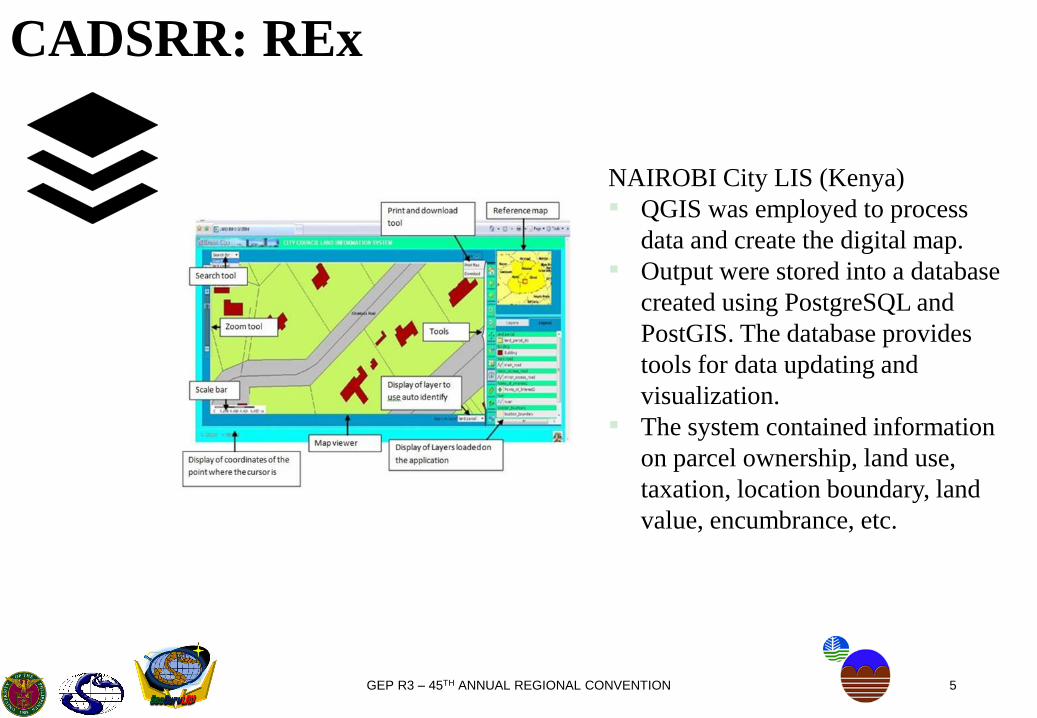
CADSRR: REx
NAIROBI City LIS (Kenya)
▪ QGIS was employed to process
data and create the digital map.
▪ Output were stored into a database
created using PostgreSQL and
PostGIS. The database provides
tools for data updating and
visualization.
▪ The system contained information
on parcel ownership, land use,
taxation, location boundary, land
value, encumbrance, etc.
6GEP R3 – 45TH ANNUAL REGIONAL CONVENTION
CADSRR: REx
Cadastral Survey Reconstruction (Kosovo)
▪ The graphical cadastral data was compared with the alpha-numeric data in
relation to the presence or completeness of the documents based on the:
○ No. of parcels in the graphical evidences
○ No. of parcels in the textual evidences
○ No. of parcels that are not recorded or documented in the registries
(but exists in the locality).
▪ The georeferencing and vectorization of scanned cadastral maps were done
using a GIS software.
7GEP R3 – 45TH ANNUAL REGIONAL CONVENTION
CADSRR: REx
National Land Records Modernization Programme (India)
▪ Includes automation/resurvey of cadastral maps using modern cadastral techniques.
▪ Land records data are available as (a) textual data, and (b) spatial data (cadastral maps).
▪ Existing paper maps converted into GIS-ready digital format and then integrated with corresponding textual data.
▪ Cadastral Survey/Resurvey were carried out using modern surveying technologies namely GPS/ETS, high-resolution satellite imagery and aerial photogrammetric approach depending up land terrain and existing map.
8GEP R3 – 45TH ANNUAL REGIONAL CONVENTION
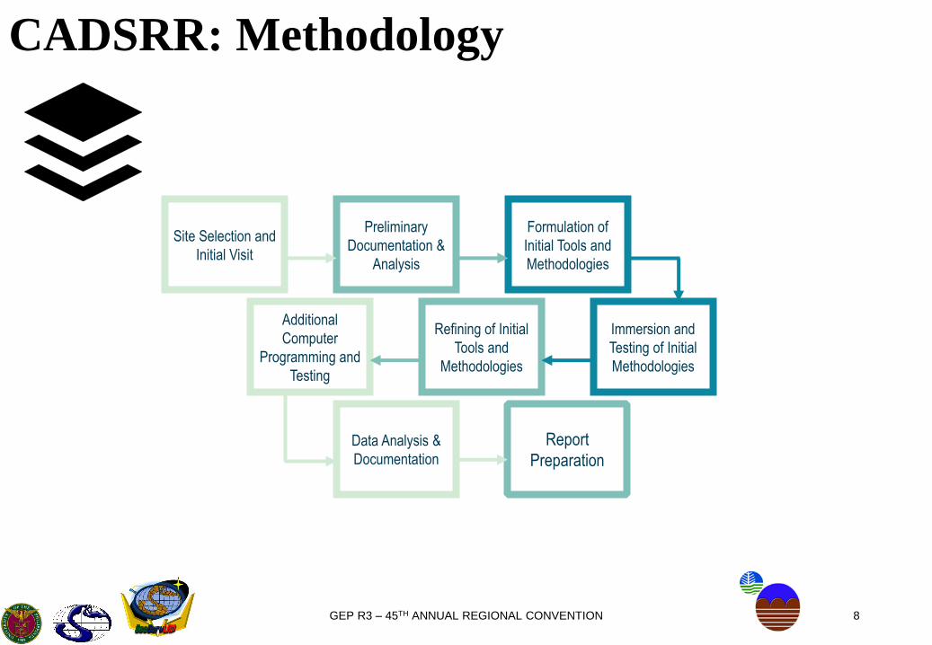
CADSRR: Methodology
Site Selection and
Initial Visit
Formulation of
Initial Tools and
Methodologies
Preliminary
Documentation &
Analysis
Additional
Computer
Programming and
Testing
Immersion and
Testing of Initial
Methodologies
Refining of Initial
Tools and
Methodologies
Data Analysis &
Documentation
Report
Preparation
9GEP R3 – 45TH ANNUAL REGIONAL CONVENTION
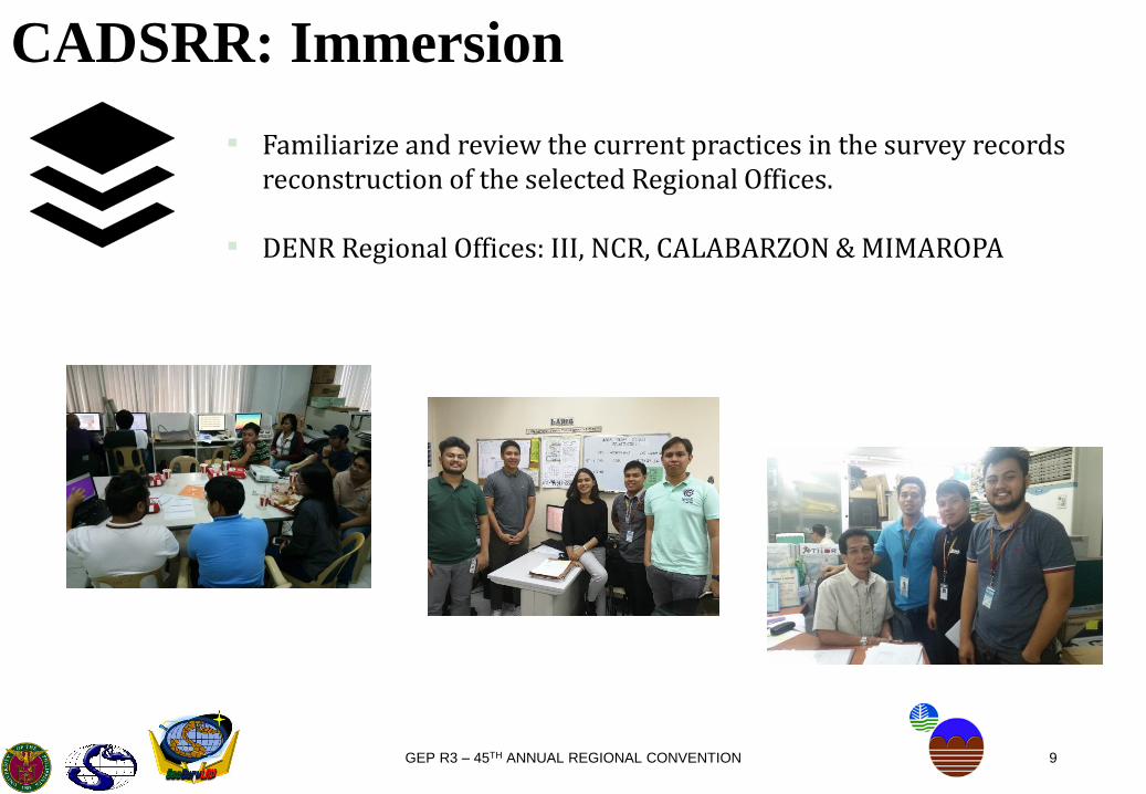
CADSRR: Immersion
▪ Familiarize and review the current practices in the survey records reconstruction of the selected Regional Offices.
▪ DENR Regional Offices: III, NCR, CALABARZON & MIMAROPA
10GEP R3 – 45TH ANNUAL REGIONAL CONVENTION
CADSRR: Immersion
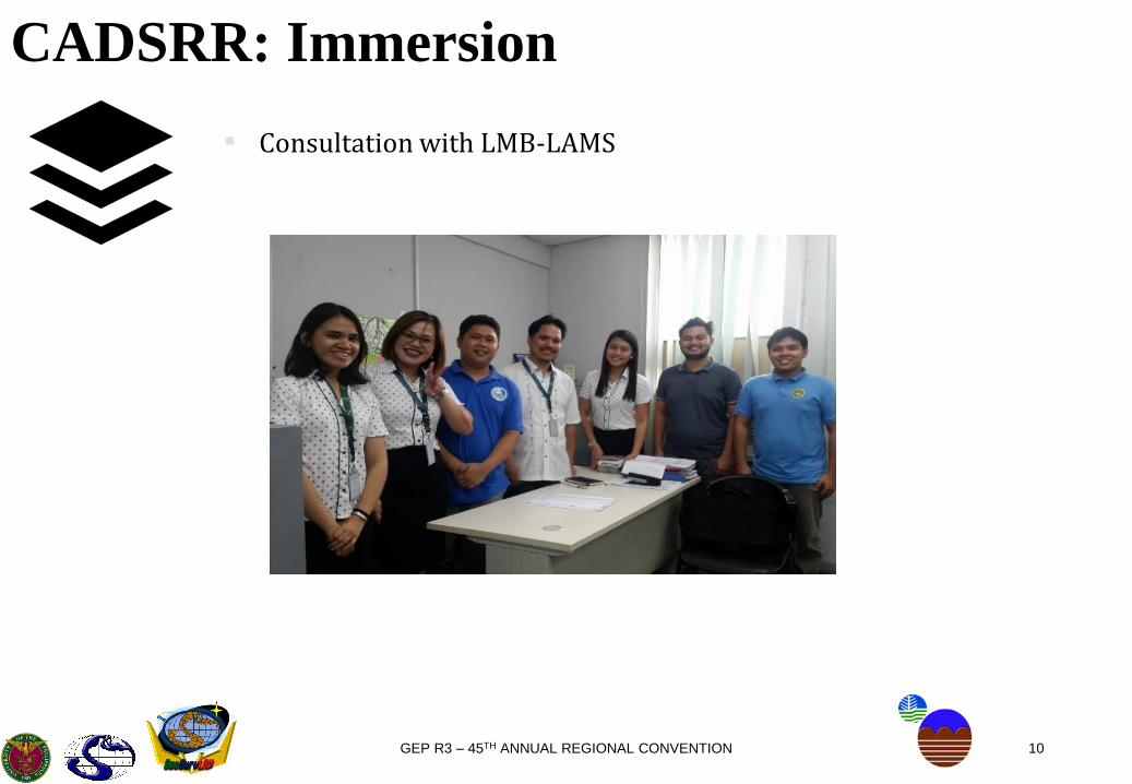
▪ Consultation with LMB-LAMS

11GEP R3 – 45TH ANNUAL REGIONAL CONVENTION
CADSRR: Immersion
Region III
CALABARZON
NCR

12GEP R3 – 45TH ANNUAL REGIONAL CONVENTION
CADSRR: Immersion
RECONSTRUCTION ACTIVITIES PER REGION
III CALABARZON MIMAROPA NCR
DataBearing-distance data,
Coordinates
Bearing-distance data,
Coordinates, Cadastral
and Projection Maps
Coordinates from LMB
and Private GEs
Bearing-distance data,
Coordinates of
Cadastral Lots
Encoding/Plotting Excel → AutoCAD AutoCAD AutoCAD AutoCAD (GE Survey)
Error of ClosureAdjustments with the
aid of Excel
Graphical Adjustment
(allowable area
difference must not
exceed 1m2/ha)
-
Graphical Adjustment
(allowable linear error of
closure must not
exceed 0.01m)
Edge Matching
Area Solver, TD
Matcher
Adjustments in Excel
Adjustments in Manifold
(CMs, PMs and DCDB
as basis)
-
Adjustments in
AutoCAD (Approved
isolated surveys as
basis)
Disclaimer: Data was collected during the months of March, April and May of 2018

13GEP R3 – 45TH ANNUAL REGIONAL CONVENTION
CADSRR: Immersion
RECONSTRUCTION ACTIVITIES PER REGION
III CALABARZON MIMAROPA NCR
Strengths
Systematic way of
reconstructing lots
Fast-paced work for
reconstruction of lotsLocal GEs providing
them with data
containing coordinates
Old Cadastral Maps
contain distances and
bearings for lot lines
Always aim to return the
same technical
description with respect
to its source
Utilizes Manifold for
observation of
Cadastral Maps
overlaid by the lot data
Use of database for
linkage of reconstructed
lots
WeaknessTedious and lengthy
procedure
Technical description
does not always match
from its sources
Reconstruction is still
limited to data obtained
from Lot Data
Computation Sheets
Limited data
Disclaimer: Data was collected during the months of March, April and May of 2018

14GEP R3 – 45TH ANNUAL REGIONAL CONVENTION
CADSRR: GIS Based Solutions
Coordinate Data (Lot Data
Computation Sheet)
Bearing-Distance Data
(Technical Description)Scanned Maps (Cadastral
Maps, Projection Maps, etc.)

15GEP R3 – 45TH ANNUAL REGIONAL CONVENTION
CADSRR: GIS Based Solutions
TD/LDCS Excel Template for
AdjustmentGIS Plugin for
PlottingScanned MapsGIS Processing
(Georeferencing
and Digitization)
Layers of shapefiles
How does the “digitized maps”
fare against the reconstructed
lots from TD/LDCS?
16GEP R3 – 45TH ANNUAL REGIONAL CONVENTION
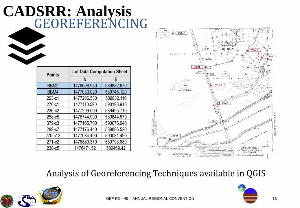
CADSRR: AnalysisGEOREFERENCING
PointsLot Data Computation Sheet
N E
BBM2 1476608.930 589882.670
BBM4 1477033.020 589745.120
293-c1 1477206.530 589882.110
276-c1 1477110.590 590193.910
236-c2 1477299.590 589495.710
258-c5 1476744.990 589844.570
379-c3 1477165.700 590076.940
289-c7 1477176.440 589886.520
270-c12 1477034.490 590081.490
271-c2 1476889.370 589793.880
238-c5 1476471.52 589469.42
Analysis of Georeferencing Techniques available in QGIS
17GEP R3 – 45TH ANNUAL REGIONAL CONVENTION
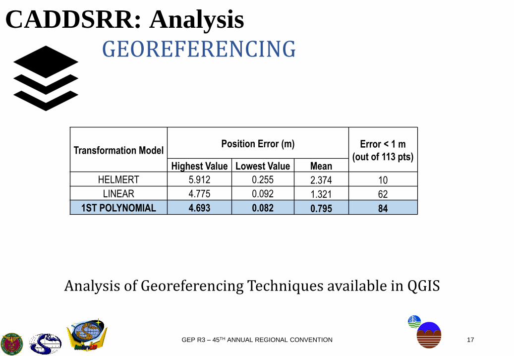
CADDSRR: Analysis
Transformation ModelPosition Error (m) Error < 1 m
(out of 113 pts)Highest Value Lowest Value Mean
HELMERT 5.912 0.255 2.374 10
LINEAR 4.775 0.092 1.321 62
1ST POLYNOMIAL 4.693 0.082 0.795 84
GEOREFERENCING
Analysis of Georeferencing Techniques available in QGIS

18GEP R3 – 45TH ANNUAL REGIONAL CONVENTION
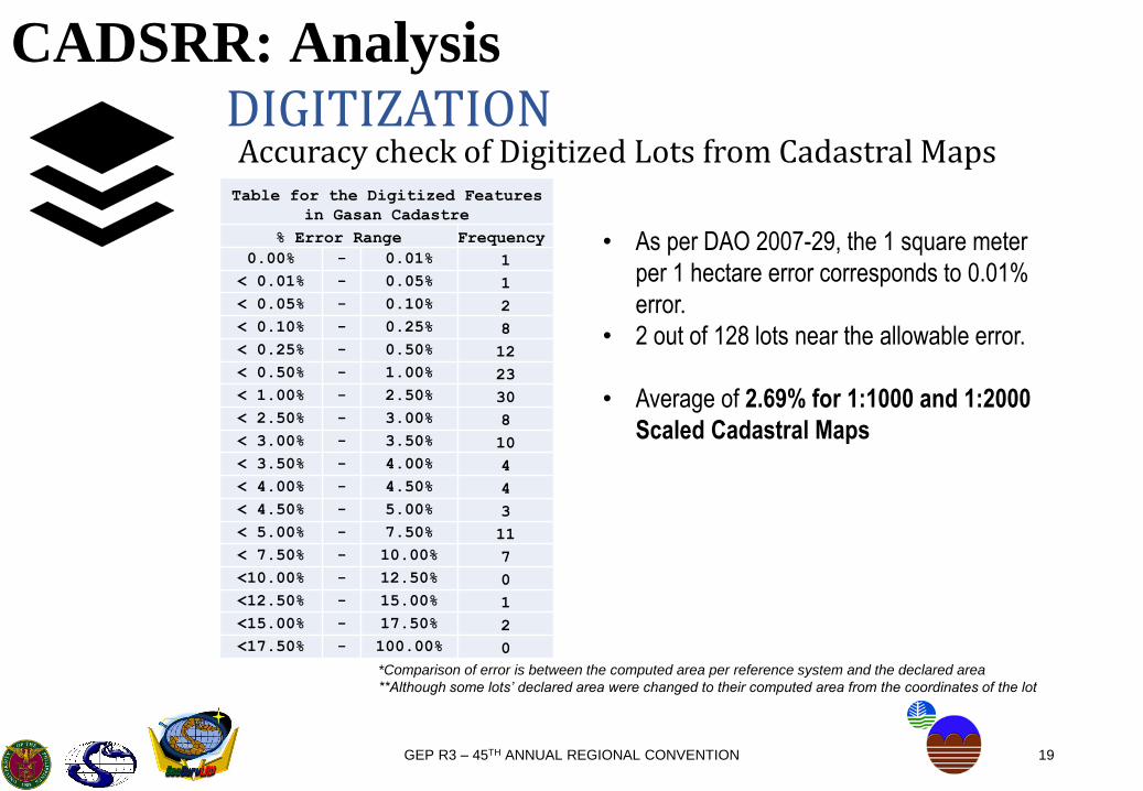
CADSRR: AnalysisDIGITIZATION
Accuracy check of Digitized Lots from Cadastral Maps
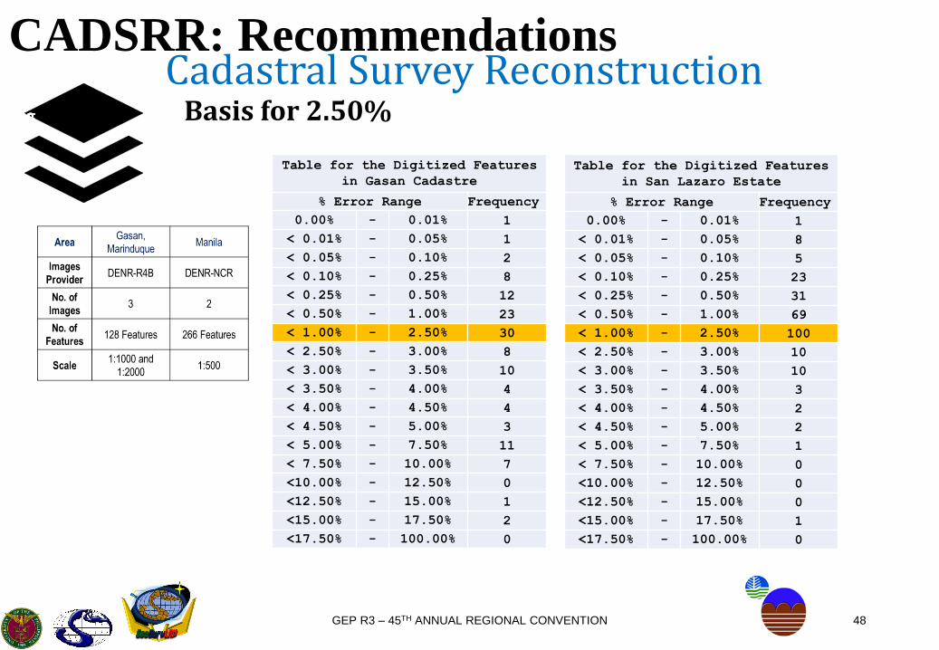
Area Gasan, Marinduque Manila
Images
ProviderDENR-R4B DENR-NCR
No. of
Images3 2
No. of
Features128 Features 266 Features
Scale 1:1000 and 1:2000 1:500
19GEP R3 – 45TH ANNUAL REGIONAL CONVENTION
CADSRR: AnalysisDIGITIZATIONAccuracy check of Digitized Lots from Cadastral MapsTable for the Digitized Features
in Gasan Cadastre
% Error Range Frequency
0.00% - 0.01% 1
< 0.01% - 0.05% 1
< 0.05% - 0.10% 2
< 0.10% - 0.25% 8
< 0.25% - 0.50% 12
< 0.50% - 1.00% 23
< 1.00% - 2.50% 30
< 2.50% - 3.00% 8
< 3.00% - 3.50% 10
< 3.50% - 4.00% 4
< 4.00% - 4.50% 4
< 4.50% - 5.00% 3
< 5.00% - 7.50% 11
< 7.50% - 10.00% 7
<10.00% - 12.50% 0
<12.50% - 15.00% 1
<15.00% - 17.50% 2
<17.50% - 100.00% 0
• As per DAO 2007-29, the 1 square meter
per 1 hectare error corresponds to 0.01%
error.
• 2 out of 128 lots near the allowable error.
• Average of 2.69% for 1:1000 and 1:2000
Scaled Cadastral Maps
*Comparison of error is between the computed area per reference system and the declared area
**Although some lots’ declared area were changed to their computed area from the coordinates of the lot
20GEP R3 – 45TH ANNUAL REGIONAL CONVENTION
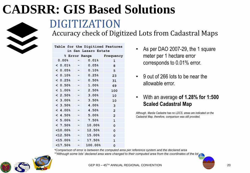
CADSRR: GIS Based SolutionsDIGITIZATIONAccuracy check of Digitized Lots from Cadastral Maps
Table for the Digitized Features
in San Lazaro Estate
% Error Range Frequency
0.00% - 0.01% 1
< 0.01% - 0.05% 8
< 0.05% - 0.10% 5
< 0.10% - 0.25% 23
< 0.25% - 0.50% 31
< 0.50% - 1.00% 69
< 1.00% - 2.50% 100
< 2.50% - 3.00% 10
< 3.00% - 3.50% 10
< 3.50% - 4.00% 3
< 4.00% - 4.50% 2
< 4.50% - 5.00% 2
< 5.00% - 7.50% 1
< 7.50% - 10.00% 0
<10.00% - 12.50% 0
<12.50% - 15.00% 0
<15.00% - 17.50% 1
<17.50% - 100.00% 0
• As per DAO 2007-29, the 1 square
meter per 1 hectare error
corresponds to 0.01% error.
• 9 out of 266 lots to be near the
allowable error.
• With an average of 1.28% for 1:500
Scaled Cadastral Map
Although, Manila Cadastre has no LDCS, areas are indicated on the
Cadastral Map, therefore, comparison was still provided.
*Comparison of error is between the computed area per reference system and the declared area
**Although some lots’ declared area were changed to their computed area from the coordinates of the lot
21GEP R3 – 45TH ANNUAL REGIONAL CONVENTION
CADSRR: Outputs
• Data Templates• GIS Procedures in Reconstruction• Plugins• Training Modules
22GEP R3 – 45TH ANNUAL REGIONAL CONVENTION
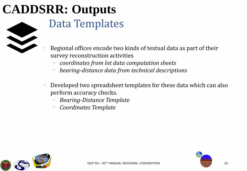
CADDSRR: OutputsData Templates
Regional offices encode two kinds of textual data as part of their survey reconstruction activities coordinates from lot data computation sheets bearing-distance data from technical descriptions
Developed two spreadsheet templates for these data which can also perform accuracy checks. Bearing-Distance Template Coordinates Template
23GEP R3 – 45TH ANNUAL REGIONAL CONVENTION
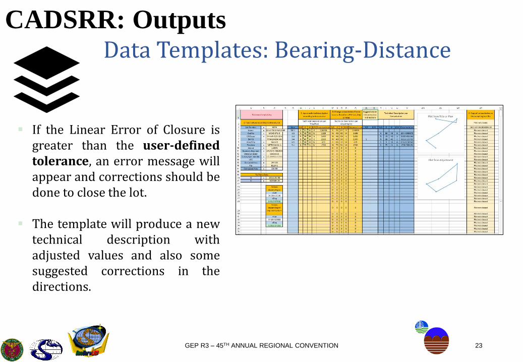
CADSRR: OutputsData Templates: Bearing-Distance
If the Linear Error of Closure isgreater than the user-definedtolerance, an error message willappear and corrections should bedone to close the lot.
The template will produce a newtechnical description withadjusted values and also somesuggested corrections in thedirections.

24GEP R3 – 45TH ANNUAL REGIONAL CONVENTION
CADSRR: OutputsData Templates: Coordinates
This template is from the lotdata computation used bythe DENR Regional Offices,which is an input for one ofthe plugins
25GEP R3 – 45TH ANNUAL REGIONAL CONVENTION
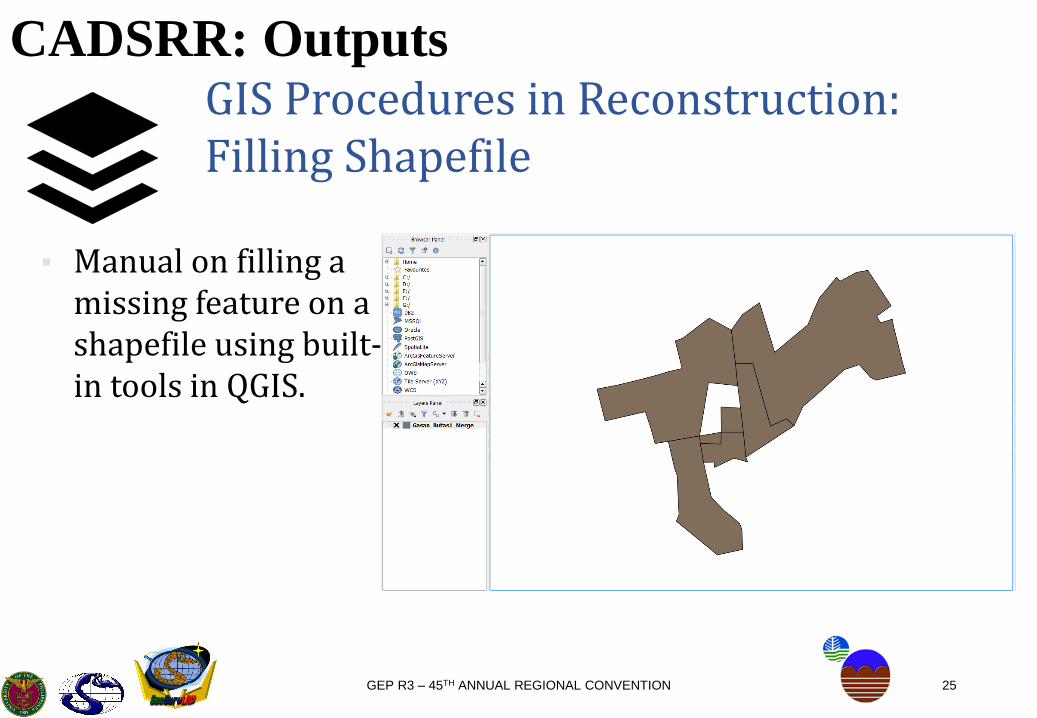
CADSRR: OutputsGIS Procedures in Reconstruction:Filling Shapefile
▪ Manual on filling a missing feature on a shapefile using built-in tools in QGIS.

26GEP R3 – 45TH ANNUAL REGIONAL CONVENTION
CADSRR: OutputsGIS Procedures in Reconstruction:Filling Shapefile
▪ Disclaimer:▪ There should be no gaps in
between adjoining features, unless, it is the missing lot.
▪ The filled lot is the cluster of the missing lots. If identified to be one missing lot, the filled lot is the missing lot.
27GEP R3 – 45TH ANNUAL REGIONAL CONVENTION
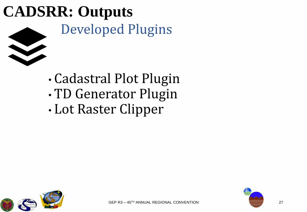
CADSRR: OutputsDeveloped Plugins
• Cadastral Plot Plugin• TD Generator Plugin• Lot Raster Clipper

28GEP R3 – 45TH ANNUAL REGIONAL CONVENTION
CADSRR: OutputsPlugin: Cadastral Plot
/25/03

29GEP R3 – 45TH ANNUAL REGIONAL CONVENTION
CADSRR: OutputsPlugins: Cadastral Plot
/25/03
CadastralPlot is a QGIS plugin that plots cadastral data (technical descriptions and lot data computation) into a shapefile. Accepts spreadsheet files (.xls/.xlsx) with specialized format.

30GEP R3 – 45TH ANNUAL REGIONAL CONVENTION
CADSRR: OutputsPlugins: Cadastral Plot
/25/03
The output shapefile of thisplugin has the capacity to storethe geographic location, shape,and other associated attributes ofthe lot such as lot number,claimant, area, date surveyed, GEwho performed the survey,barangay, province, etc.
31GEP R3 – 45TH ANNUAL REGIONAL CONVENTION
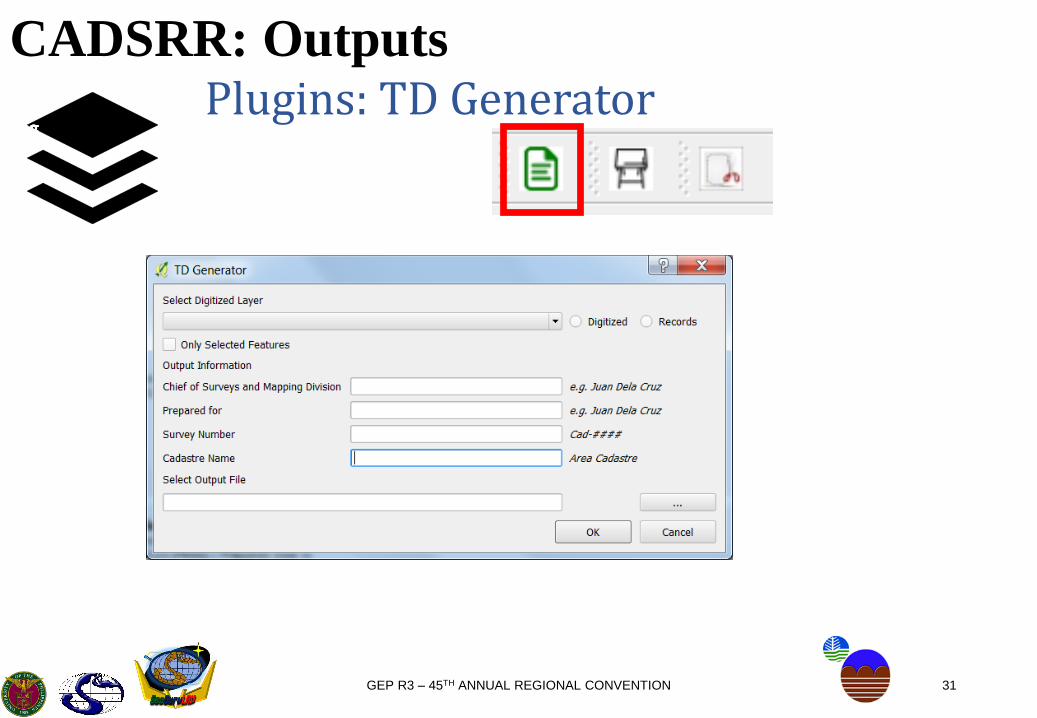
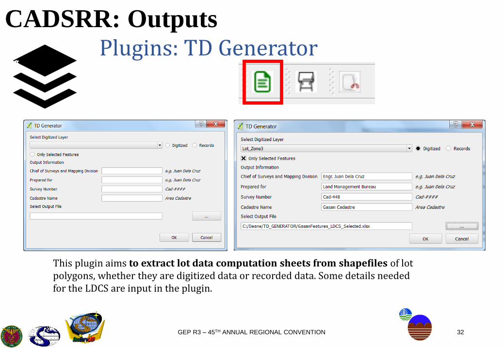
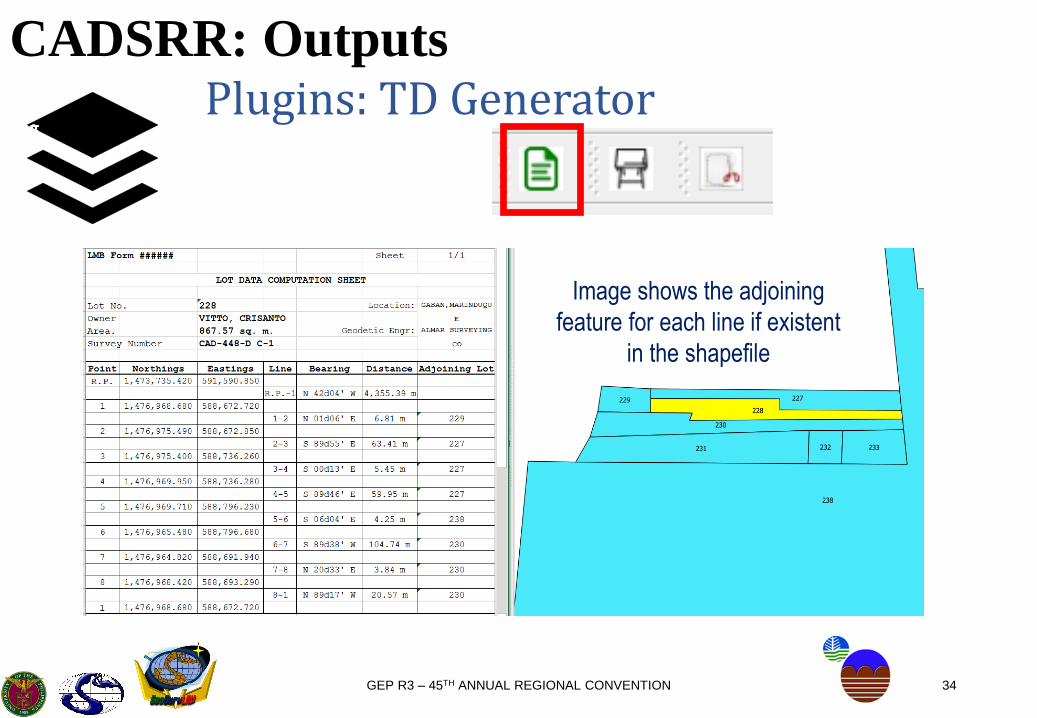
CADSRR: OutputsPlugins: TD Generator
/25/03/25/03
32GEP R3 – 45TH ANNUAL REGIONAL CONVENTION
CADSRR: OutputsPlugins: TD Generator
/25/03/25/03
This plugin aims to extract lot data computation sheets from shapefiles of lot polygons, whether they are digitized data or recorded data. Some details needed for the LDCS are input in the plugin.
33GEP R3 – 45TH ANNUAL REGIONAL CONVENTION
CADSRR: OutputsPlugins: TD Generator
/25/03/25/03
34GEP R3 – 45TH ANNUAL REGIONAL CONVENTION
CADSRR: OutputsPlugins: TD Generator
/25/03/25/03
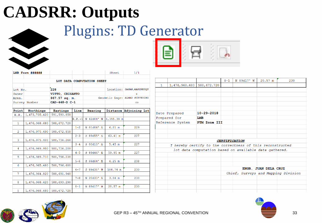
Image shows the adjoining
feature for each line if existent
in the shapefile
35GEP R3 – 45TH ANNUAL REGIONAL CONVENTION
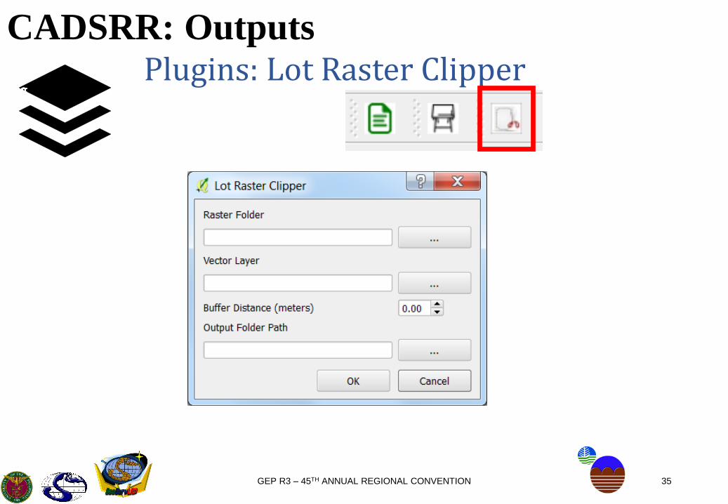
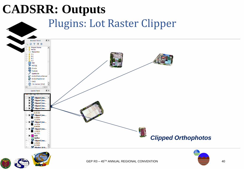
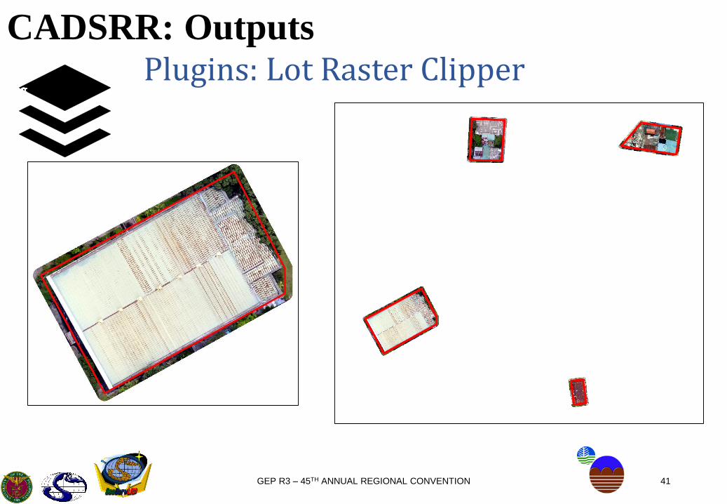
CADSRR: OutputsPlugins: Lot Raster Clipper
/25/03/25/03

36GEP R3 – 45TH ANNUAL REGIONAL CONVENTION
CADSRR: OutputsPlugins: Lot Raster Clipper
/25/03/25/03
Plugin for buffering multiplefeatures in a single shapefile,and clipping from multipleraster data (DEM, DSM,Orthophotos) obtained from3D Cadastre .

37GEP R3 – 45TH ANNUAL REGIONAL CONVENTION
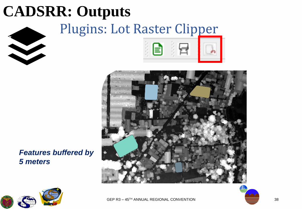
CADSRR: OutputsPlugins: Lot Raster Clipper
/25/03/25/03
Sample Features
in DSM of GTO
38GEP R3 – 45TH ANNUAL REGIONAL CONVENTION
CADSRR: OutputsPlugins: Lot Raster Clipper
/25/03/25/03
Features buffered by
5 meters
39GEP R3 – 45TH ANNUAL REGIONAL CONVENTION
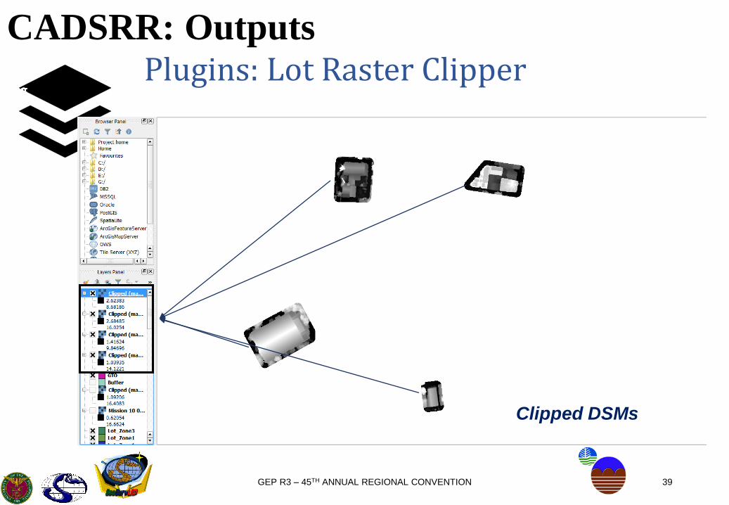
CADSRR: OutputsPlugins: Lot Raster Clipper
/25/03/25/03
Clipped DSMs
40GEP R3 – 45TH ANNUAL REGIONAL CONVENTION
CADSRR: OutputsPlugins: Lot Raster Clipper
/25/03/25/03
Clipped Orthophotos
41GEP R3 – 45TH ANNUAL REGIONAL CONVENTION
CADSRR: OutputsPlugins: Lot Raster Clipper
/25/03/25/03
42GEP R3 – 45TH ANNUAL REGIONAL CONVENTION
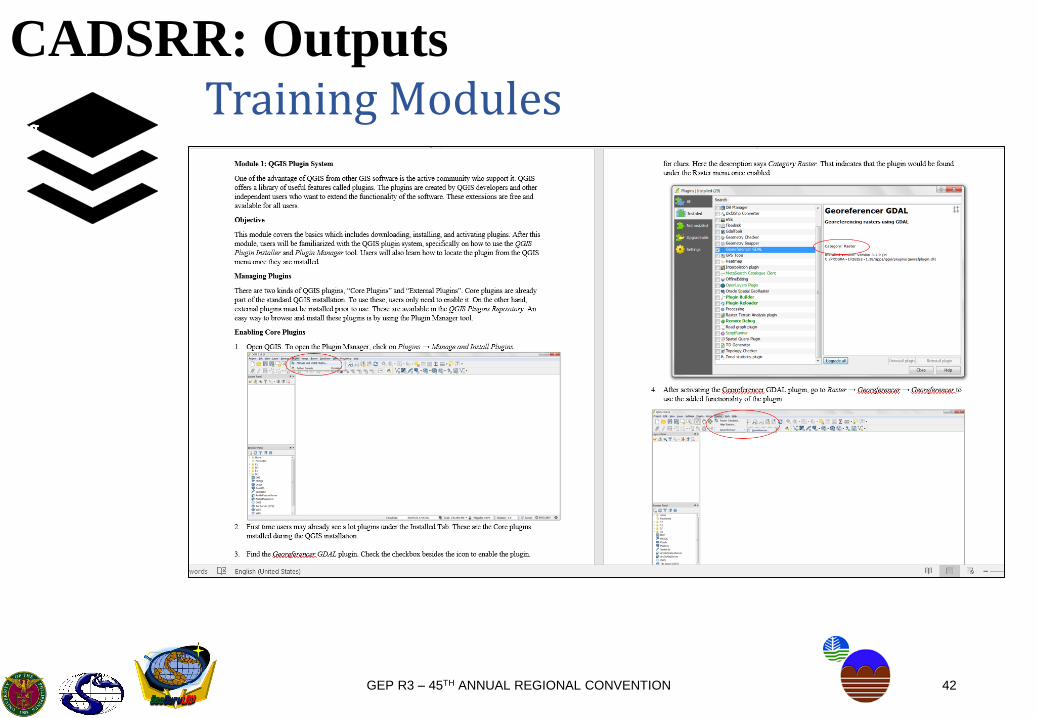
CADSRR: OutputsTraining Modules
/25/03/25/03

43GEP R3 – 45TH ANNUAL REGIONAL CONVENTION
CADSRR: OutputsTraining Modules
/25/03/25/03

44GEP R3 – 45TH ANNUAL REGIONAL CONVENTION
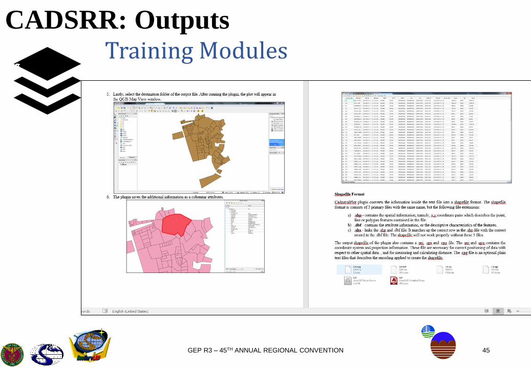
CADSRR: OutputsTraining Modules
/25/03/25/03
45GEP R3 – 45TH ANNUAL REGIONAL CONVENTION
CADSRR: OutputsTraining Modules
/25/03/25/03

46GEP R3 – 45TH ANNUAL REGIONAL CONVENTION
CADSRR: Recommendations
/25/03/25/03Cadastral Survey Reconstruction
▪ The step and approach in reconstruction of records shall depend on the source data or records identified during the research process.
▪ The output can be categorized into 2: survey-accurate and non-survey-accurate data.
▪ Survey Accurate – reconstructed from numerical data▪ Non-Survey Accurate – extracted from maps
Condition Numerical Graphical (CM, PM)
Case 1 ✓ ✓
Case 2 ✓ -
Case 3 - ✓
*CM – Cadastral Map
*PM – Projection Map

47GEP R3 – 45TH ANNUAL REGIONAL CONVENTION
CADSRR: Recommendations
/25/03/25/03Cadastral Survey Reconstruction
Case 1: Both Numerical and Graphical Data are available▪ Numerical data will be used for reconstruction while graphical data
will serve as basis for cleansing (identification and correction of erroneous, gaps and overlaps).
Condition Recommendations
Error of Closure
• The maximum allowable error of closure is 2.50% of the area (for reconstruction
purposes only). Once the data of its adjoining lots becomes available, the lot can
be reconstructed by extracting its corners from its surrounding lots.
Erroneous/Missing Tie Line
Description
• Using adjoining lots.
• Overlaying a georeferenced map where the map will guide the translation of
the displaced lot.
48GEP R3 – 45TH ANNUAL REGIONAL CONVENTION
CADSRR: Recommendations
/25/03/25/03
Cadastral Survey ReconstructionBasis for 2.50%
Table for the Digitized Features
in San Lazaro Estate
% Error Range Frequency
0.00% - 0.01% 1
< 0.01% - 0.05% 8
< 0.05% - 0.10% 5
< 0.10% - 0.25% 23
< 0.25% - 0.50% 31
< 0.50% - 1.00% 69
< 1.00% - 2.50% 100
< 2.50% - 3.00% 10
< 3.00% - 3.50% 10
< 3.50% - 4.00% 3
< 4.00% - 4.50% 2
< 4.50% - 5.00% 2
< 5.00% - 7.50% 1
< 7.50% - 10.00% 0
<10.00% - 12.50% 0
<12.50% - 15.00% 0
<15.00% - 17.50% 1
<17.50% - 100.00% 0
Table for the Digitized Features
in Gasan Cadastre
% Error Range Frequency
0.00% - 0.01% 1
< 0.01% - 0.05% 1
< 0.05% - 0.10% 2
< 0.10% - 0.25% 8
< 0.25% - 0.50% 12
< 0.50% - 1.00% 23
< 1.00% - 2.50% 30
< 2.50% - 3.00% 8
< 3.00% - 3.50% 10
< 3.50% - 4.00% 4
< 4.00% - 4.50% 4
< 4.50% - 5.00% 3
< 5.00% - 7.50% 11
< 7.50% - 10.00% 7
<10.00% - 12.50% 0
<12.50% - 15.00% 1
<15.00% - 17.50% 2
<17.50% - 100.00% 0

49GEP R3 – 45TH ANNUAL REGIONAL CONVENTION
CADSRR: Recommendations
/25/03/25/03Cadastral Survey Reconstruction
Case 2: Only Numerical Data are available
▪ For lots with missing or erroneous tie lie description, place it in a separate layer for cleansing.
▪ Cluster the lots by block and according to number to easily translate them all at once. Use adjoining lots for edge matching.
50GEP R3 – 45TH ANNUAL REGIONAL CONVENTION
CADSRR: Recommendations
/25/03/25/03Cadastral Survey Reconstruction
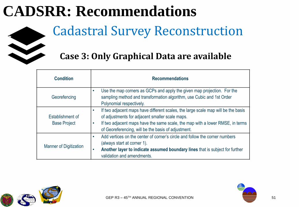
Case 3: Only Graphical Data are available
▪ In case there are no numerical data present, georeferenced map can be digitized to extract lot data. These reconstructed lots will fall under the non-survey accurate category and will be stored in a separate layer.
▪ Digitized data cannot be used as substitute for re-survey and will only be used for the completion of DCDB.
▪ Digitized data will be connected to a reference point nearest to the lot cluster.
▪ Digitized data can be extracted from High Definition Orthophotos, where possible boundaries can be extracted.
51GEP R3 – 45TH ANNUAL REGIONAL CONVENTION
CADSRR: Recommendations
/25/03/25/03Cadastral Survey Reconstruction
Case 3: Only Graphical Data are available
Condition Recommendations
Georefencing
• Use the map corners as GCPs and apply the given map projection. For the
sampling method and transformation algorithm, use Cubic and 1st Order
Polynomial respectively.
Establishment of
Base Project
• If two adjacent maps have different scales, the large scale map will be the basis
of adjustments for adjacent smaller scale maps.
• If two adjacent maps have the same scale, the map with a lower RMSE, in terms
of Georeferencing, will be the basis of adjustment.
Manner of Digitization
• Add vertices on the center of corner’s circle and follow the corner numbers
(always start at corner 1).
• Another layer to indicate assumed boundary lines that is subject for further
validation and amendments.
52GEP R3 – 45TH ANNUAL REGIONAL CONVENTION
CADSRR: Possible Future
/25/03/25/03
▪ Extend the plugins’ input and output to several type of files, making itcompatible to various format such as variations of spreadsheet files for inputand output of the Cadastral Plot and TD Generator Plugins, respectively. (dbfformat, LAMS Spreadsheet)
▪ TD Generator plugin for multiple shapefiles consisting of varying surveynumbers, beneficial for filling the adjoining lot column.
53
“The application of GIS is limited only by the imagination of
those who use it.” - Jack Dangermond
GEP R3 – 45TH ANNUAL REGIONAL CONVENTION
Related Documents