Land Remote Sensing in Romania Alexandru BADEA Romanian Space Agency / USAMV

Welcome message from author
This document is posted to help you gain knowledge. Please leave a comment to let me know what you think about it! Share it to your friends and learn new things together.
Transcript

Land Remote Sensing in Romania
Alexandru BADEA Romanian Space Agency / USAMV

The Romanian activities in the field of remote sensing have a considerable tradition
Due to the fact that the problems of assessment of available natural resources, agriculture activities and, more later , environmental pollution were considered as priority for any administration, the possibility to use remote sensing was taken into account. Romanian researchers, trained in USA after 1968, become promoters of this amazing technology in Romania. Their effort convinced the authorities to create the Romanian Commission for Space Activities (CRAS) under the coordination of the National Council for Science and Technology.

The creator of the Romanian school of Remote sensing was Nicolaie Oprescu, professor at the College of Civil Engineering of Bucharest.
Professor Oprescu organized the first Remote Sensing Laboratory in Romania at the beginning of Landsat era. Being selected as principal investigator by NASA, he coordinated important studies especially for wet ecosystems (Danube Delta) and costal areas (Black Sea).

The covers of reports of one study of Prof. Oprescu (1976)*
*ntrs.nasa.gov/.../nasa/casi...nasa.../19770004551 *ntrs.nasa.gov/.../nasa/casi...nasa.../1976001351

The Remote Sensing laboratory created by professor Oprescu in the Danube Delta
Field test (equivalent of two ERTS 1 pixels)

Other teams initiating remote sensing activities for thematic applications
• Institute of Geodesy , Photogrammetry, Cartography and Land Management -IGFCOT- (Mihai Albotă) • Institute of Soil Sciences and Agro-Chemistry – (Ion Munteanu and Dumitru Teaci) • National Institute of Meteorology – (Horia Grumăzescu) • Geological Institute of Romania • Military Surveying Service • Forest Research and Management Institute

A second important step for the developpment of Land Remote Sensing in Romania was the constitution of two specialized
laboratories (1985-1986)*
• Institute of Studies and Design for Land Reclamations (ISPIF) • Institute of Geology and Geophysics (IGG)
* Complete analogical and digital processing chains equipped the two laboratories

Analogical equipment for RS studies - The MSP-4C multispectral projector Made by Carl Zeiss Jena (DDR) for the multispectral and/or multitemporal analysis of the images taken by MKF 4 or MKF 6 cameras installed on aircrafts and space platforms, the instrument consists of : • four individual projectors each equipped
with six color filters and one clear glass; • electromechanical setting units for a
correct registration of the images selected for generating color composites
The MSP4 had four channels for producing a superimposed image for visual evaluation. It was possible to variate the spectral range and the density of each channel .

Analogical equipment for RS studies - The RECTIMAT–C precision rectifier
Made by Carl Zeiss Jena (DDR) for producing color composite images from multiband photographs with high resolution. The "Rectimat-C" rectifier was created for correcting space photos obtained by space platforms to a cartographic projection. The methods for calculating the errors caused by the curvature of the Earth surface and refraction of light beams in the atmosphere and a peculiar technology for composing multispectral color images was elaborated.

Characteristics of RESURS F satellite films
After Eugene A. Sharkov

Spectrozonal images for processing with RECTIMAT-C
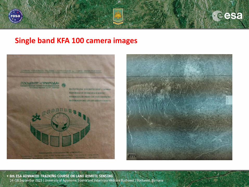
Single band KFA 100 camera images
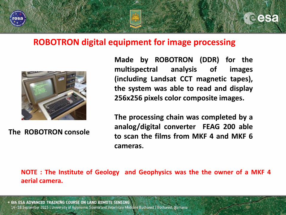
ROBOTRON digital equipment for image processing
Made by ROBOTRON (DDR) for the multispectral analysis of images (including Landsat CCT magnetic tapes), the system was able to read and display 256x256 pixels color composite images. The processing chain was completed by a analog/digital converter FEAG 200 able to scan the films from MKF 4 and MKF 6 cameras.
NOTE : The Institute of Geology and Geophysics was the the owner of a MKF 4 aerial camera.
The ROBOTRON console

After 1990 started a new important period for the development of Land Remote Sensing in Romania
The setup of the Romanian Center for Remote Sensing Apply (CRUTA), based on the implementation of coherent projects in cooperation with the Joint Research Center of the European Union and CNES, generated a new concept regarding the remote sensing development. Operational applications become reality. The well known Romanian Crop Information System transferred the European knowhow for fully implementing the MARS (Monitoring Agriculture by Remote Sensing) methods. This project, started in 1992 with small pilot applications, was concluded in 1998 at country level. When it was launched, the Crop Information System Project was considered as being a too ambitious operation given the economic state of Romania.

After 1990 started a new important period for the development of Land Remote Sensing in Romania
The “Crop Information System” project occurred together with the first structural modification of Romanian agriculture, generated by Land Law application. These modification leaded to:
•an excessive fragmentation of parcels; •an increased number of landowners (from about 3,000 to 4,000,000).

The use of printed images for collecting ground information
FIELD DOCUMENT (SPOT P IMAGE)
(Copyright CNES 1997
IF 11

In parallel with the setup of CRUTA, under the co-ordination of the Ministry of Agriculture, at national level another more
important initiative occurred : constitution of the Romanian Space Agency (ROSA)
After 1995 the RS activities developed for agriculture were considered as a key development target. As result, since 2001, the National Program for Research and Development includes as main topics agriculture and environmental space applications. A part of the experienced researchers working for CRUTA have been nominated for coordination of RS activities at ROSA. Very important projects were developed by the common group of experts ROSA / CRUTA.

Romanian Space Agency
• ROSA - National Space Agency established 1995 • Public organization in the system of the Ministry
responsible for Research and Technology • Representative and Coordinator of space activities in
Romania • Financing agency for research in Space, and Security
Research • Developer and integrator of its own RTD programmes by
the ROSA Research Centre (RRC)

Several R&D projects developed by ROSA and CRUTA (in partnership with JRC and FAO) foreshadowed compulsory components of the National Spatial Infrastructure :
- IACS/LPIS (2002-2007) - LCCS database (2003-present) - ROENV geoportal (2007-2009)

IACS-LPIS and CwRS (Integrated Administration and Control System - Land Parcel Identification System in Romania and Control with Remote Sensing) as next step of the MARS (Monitoring of Agriculture with Remote Sensing) implementation.
IACS/LPIS (2002-2007)

The creation of the National LPIS/IACS system started with pilot projects for evaluation of data sources for creating the geografical data base (aerial old photo vs. VHR satellite images)

THE FARMER IS ABLE TO LOCATE THE FIELD
THE LAND REDISTRIBUTION MAP HASN’T A REAL INFORMATIVE VALUE
THE OWNERSHIP SITUATION IS VERY DYNAMIC … … AND THE WORK COULD BE REALISED
BY AD-HOC AGREEMENTS
The value of Remote Sensing studies for agriculture depends of an objective understanding regarding the “de jure” and “the facto” situation of the land ownership as well as the local agricultural practices. The Romanian territory still depends of solving the problem of ownership.

The creation of the Land Cover Classification System LCCS, based on the FAO
concept, offers the possibility to follow the dynamics of the landscape. Major
rapid changes of the parcel structure generated errors in the elaboration of
strategies for agricultural development. This objective method tested with
good results as basis of analysis in different domains remains a priority for
future developments.
LCCS database (2003-present)

Romania
Dynamics of the landscape LCCS – Land Cover Classification System – in Romania

Romania
Dynamics of the landscape LCCS – Land Cover Classification System – in Romania

Romania
Dynamics of the landscape LCCS – Land Cover Classification System – in Romania

Land cover is (according to FAO):
• one of the most important elements for description and study of the environment
• the easiest detectable indicator of human interventions on the land
• a critical parameter for environmental databases
• changing quickly over time
• the basic geographic feature that environmental applications can use as reference

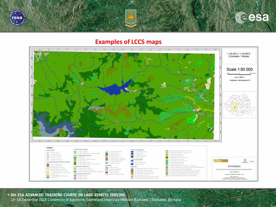
Examples of LCCS maps

Examples of LCCS maps
Examples of LCCS maps

The use of LCCS data base for evaluation of damages during the floods occurred in 2005

The experience acquired in the implementation of CIS, LCCS and LPIS/IACS projects offered the possibility to establish new certitudes.
Remote Sensing has moved beyond its traditional role of mapping natural resources, environment, infrastructure and risk mitigation, to making geo-spatial data infrastructure and services one important pillar supporting the information society. The main development directions are oriented towards :
– Implementation of dedicated applications to answer problematic concerning traceability and make better agronomy on all crops (fruits and vegetables, wine growing...)
– Production of land cartography, creation of geographic information systems on agri-environmental issues at local and national scales, for public and private institutional clients.

Technical Assistance to Develop Romanian Environmental related GIS maps / PHARE project RO 2005/017-553.03.03.04.01 -
The project realized in the framework of EU Phare program had as main goal the production of thematic harmonized data for the Romanian Ministry of Environment and Sustainable Development (MESD) keeping in mind the EU regulations for ensuring the interoperability between the interior (local, regional, national) and EU level.

Elaboration of GIS Maps and Datasets -

• More than 50 datasets are available for the use of the Ministry of Environment.
• Considering the implementation of the INSPIRE directive, the ROEnvGeoPortal offers wider access to geographic data and services, serving as a catalyst for advancing Spatial Data Infrastructure (SDI) activities in Romania.
• The implementation provides users with a set of tools to easily discover, query, and access information on geospatial data holdings and services, including the ability to interactively display and query the data and services.
• The deployment of the operational ROEnv GeoPortal allows easy discovery, query and use of geospatial data, Web services, and organizations from existing national, county, and local geographic information system assets.

The implementation of the projects was possible grace of a very confident partnership with experts working for important national and international organizations. It was possible to adapt the local experience taking into account the opinion of external advisors and to understand that Land Remote Sensing is a work for multi-thematic teams. But that is not enough …. We have to accept a modern management approach in the context of a critical spatial thinking.
Final considerations-

A new management approach : As technology becomes easier and
mass use, what does everyone need to know?
(David Maguire, Bucharest, April 2009)
Critical spatial thinking: Understanding the fundamental concepts
behind the technology (David Maguire, Bucharest, April 2009

Cooperation with ESA The first pilot project realized in 1992 concluded by the study : “Use of ERS-1 SAR data for land use monitoring, contribution to monitor the privatization process in territorial profile”

Thank you for your attention !
Related Documents