LAND REFORMS OR A TRAGEDY OF THE COMMONS? Kanjhawala Cluster in Delhi and the Punjab Minoti Chakravarty-Kaul Prologue: Time stood still for a cluster of villages in North West Delhi in September 1978. A modern government - Delhi Administration - had ignored the customary authority of the malikan-deh (the proprietory body of the village) in the rural political economy of Union Territory of Delhi and had leased 123 acres out of the village commons in Kanjhawala, the leader or tika village of the Bisagama (twenty villages) cluster, to a similar number of Harijans (untouchables) in the village. The circumstance came to light when the villagers of the cluster, ignoring the ban on public processions, agitated in front of Parliament House and courted arrest. The incident evidenced the resilience of the "village republic" like the Bisagama cluster in large tracts of northern India or for that matter in the south as well. 1 Such survival of a grassroots self-governing system of collective action is a reality despite erosion from two long term processes in operation in northern India over a matter of two centuries : the first, being the ever-intruding tendency of political centralisation and institutions of statutory control by a nation-state and the second, was the increasing market orientation in the political economy owing to growing demand pressures. The paper will focus on the outcome of the underlying tension between the institutions of a modern state which supported and encouraged market orientation and individual decision making against those of customary law of the community. Elsewhere in my book 2 an attempt has been made to analyse these trends in northern India at the two levels of the region and the eco-system within it i.e. Greater Punjab and the Cis-Sutlej. Here we will go down to the third level, the micro terrain - the Bisagama or the Kanjhawala cluster- from 1858 to 1996. Historic precedence : Common property is an important determinant of tenure in land and therefore rights to them are very important to the status holders in any rural community. One has only to examine customary rules which agrarian communities organize to govern access, use and to police the 1 Robert Wade, Village Republics: Economic Conditions for Collective Action in South India, Cambridge, 1988. 2 Minoti Chakravarty-Kaul, Common Lands and Customary Law, Institutional Change in North India over the Past Two Centuries, New Delhi, 1996.

Welcome message from author
This document is posted to help you gain knowledge. Please leave a comment to let me know what you think about it! Share it to your friends and learn new things together.
Transcript
LAND REFORMS OR A TRAGEDY OF THE COMMONS?
Kanjhawala Cluster in Delhi and the Punjab
Minoti Chakravarty-Kaul
Prologue:
Time stood still for a cluster of villages in North West Delhi in September 1978. A modern
government - Delhi Administration - had ignored the customary authority of the malikan-deh
(the proprietory body of the village) in the rural political economy of Union Territory of
Delhi and had leased 123 acres out of the village commons in Kanjhawala, the leader or tika
village of the Bisagama (twenty villages) cluster, to a similar number of Harijans
(untouchables) in the village. The circumstance came to light when the villagers of the
cluster, ignoring the ban on public processions, agitated in front of Parliament House and
courted arrest. The incident evidenced the resilience of the "village republic" like the
Bisagama cluster in large tracts of northern India or for that matter in the south as well.1 Such
survival of a grassroots self-governing system of collective action is a reality despite erosion
from two long term processes in operation in northern India over a matter of two centuries :
the first, being the ever-intruding tendency of political centralisation and institutions of
statutory control by a nation-state and the second, was the increasing market orientation in
the political economy owing to growing demand pressures.
The paper will focus on the outcome of the underlying tension between the
institutions of a modern state which supported and encouraged market orientation and
individual decision making against those of customary law of the community. Elsewhere in
my book 2 an attempt has been made to analyse these trends in northern India at the two
levels of the region and the eco-system within it i.e. Greater Punjab and the Cis-Sutlej. Here
we will go down to the third level, the micro terrain - the Bisagama or the Kanjhawala
cluster- from 1858 to 1996.
Historic precedence : Common property is an important determinant of tenure in land and therefore rights to them
are very important to the status holders in any rural community. One has only to examine
customary rules which agrarian communities organize to govern access, use and to police the
1Robert Wade, Village Republics: Economic Conditions for Collective
Action in South India, Cambridge, 1988. 2 Minoti Chakravarty-Kaul, Common Lands and Customary Law, Institutional Change in North India over the Past Two Centuries, New Delhi, 1996.
commons to realize the implications of tenurial patterns in determining the distribution of
production among all those who derive sustenance from agri-pastoral occupations. The
significance sharpens in uncertain legal and natural environments where risks are high and
property status are unequally distributed among resource users like landless tenants, labourers
and transhumant or nomadic pastoralists. The commons then are central to collective
governance determining the survival both of natural resources and those who depend on
them.
A well-known historical example is the enclosure of common lands by means of
legislation in England in the centuries prior to the nineteenth. Such tenurial change destroyed
the rural communities and over-night the peasants had “disappeared” from the English
country-side causing de-population of the rural areas and dis-enfranchisement of the rural
population from the effective governance of rural resources.
Curiously enough nineteenth century political economists generally unrecognised the
dangers of poverty and of under-consumption associated with it. It was only Robert Malthus
alone who recognized that enclosures caused deepening of rural insecurity and that the
immiserisation was symptomatic of a crisis in the political economy. Thus as Keynes points
out if only economics had gone the way of Malthusian analysis, the likelihood of a crisis like
the Great Depression of 1939 could have been foreseen! The redeeming feature of the
century was John Stuart Mill’s espousal of land reforms in England so as to undo the
wrongful exclusion of the poor from off the commons. In 1871 he became the first President
of the Land Tenure Reforms Association. However even though there was much truth in
Mills’ recommendation for nineteenth century England, nevertheless the twentieth century
formulation of land reforms as a standard measure for the alleviation of poverty,
recommended even by well-intentioned experts, helped only to erode the commons.
This historic association of poverty with the enclosure of the commons was all but
forgotten in the discourse on land tenure reforms in the Third World. Therefore after the
Second World War various programs of land tenure reform became the economic and social
counterpart of political movements in Asia and Africa to counter subjugation from foreign
rule. A parallel can also be found in Japan albeit under American occupation. Hence it was
assumed that no political agenda in newly independent “developing” countries would be
complete without a programme of land tenure reforms. But such historic expectation
unfortunately generated a field day for political games; not all indigenous communities,
interests groups or political parties were equally schooled in terms of what was involved in
tenurial reforms.

It is in this milieu that legislated reform in land tenure patterns in post 1947 India led
to the creation of “open access” to the commons and to the so-called “tragedy of the
commons” in northern India. This has happened because reforms standardized institutions for
the commons in a country as vast and diverse as the sub-continent. And even though each
State of the federation was allowed to legislate for itself nevertheless they tended to imitate
the general myopia born out of ignorance regarding the fact of diverse eco-systems and their
specific need for flexible customary institutions of land use and rights. Illustratively, states in
India legislated to remove the power of every ‘landlord’ over the commons since they were
symbols of exploitation of the poor. However in the process they overlooked the difference in
the size of holdings and the power that was wielded by any landlord; hence the laudable
political intentions of land reforms in 1947 to undo the “historic wrongs” of the colonial
property rights system failed to give credit to village communities in northern India which
controlled 90% of the land and where users of the commons were not all landed and were
certainly poor.
Thus it is that the process of attenuation of collective control over the commons began
and was further exacerbated by the poverty alleviation programmes of the 1970s by state
governments like the Delhi State which distributed parcels of the village commons to the
poor and landless. So while the commons started to ‘disappear’ the Government however did
acquire political foothold at the village level and in a democracy it meant cadre-building and
partisan politicking impacting on the village each time the elections came round. In such an
environment of uncertainty and attrition of collective control by the proprietary body over the
commons meant ‘free riding’ by politicians even of the agenda for alleviating poverty and the
mis-use of the ‘poor’ as pawns for partisan ends unrelated to the collective welfare of the
village.
The above consequences seemed not to affect governments of newly emerging
democracies in the Third World and what is more even eluded the well-intentioned policy
makers of international aid agencies. In recommending “reforming tenurial patterns” there is
a general failure to discern the inherent contradiction in undoing the wrongs of a colonial
past by relying on the very methods of governance which had been condemned. Thus it is
that we have here the best example of the divergence between political rhetoric to undo social
injustice by creating “open access” to the commons and the reality of poverty alleviation. It is
this politicking on the commons to win over the rural constituency of the poor which has
downsized local skills of the community to “lift themselves by their own bootstraps” and
creating dependence on central governance.
Along with the above analysis our panel here will examine various tenurial reforms in
the second half of the twentieth century in Asiatic and African countries, newly independent
from foreign rule and eager to overthrow exploitation in the internal economy and the
political subjugation of foreign rule. These stories will link institutional change, policy-
making and the fate of common property. In the lengthy processes of nation-building in new
nations, agrarian reforms has often been a double-edged strike on common property.
Secondary collectives organized around territorial commons based on customary rights were
often perceived as threats to the emerging nations. Thus it was often ideology and politics
that provided the rhetoric for tenurial reforms while it was the politicking during institutional
design and implementation which prevented the realization of the intended goals of poverty
alleviation, gender equity and social justice.
The Commons in Tenure and Tenurial Reforms
Theory and History Here we will briefly examine a selection from some of the influential ideas 3 which
have shaped the intellectual discourse on common property resources in modern times. These
compel us to re-assess collective action as a third alternative set of institutions to solve
problems of natural resources use and distribution as opposed to market-led and state-supported
solutions. We will focus on only those aspects of theory which are directly relevant to the
history of institutions which governed the commons in northern India in general and the
Bisagama in particular.
Classical economics has attributed much of the efficiency in natural resource use to the
influence of the market, tempered with the institutions of the modern state. In much of this
analysis it has been assumed that the medieval peasant was "dumb" for their arrangements like
the system of open fields and scattered strips. Consequently it has been argued that the
enclosure of the commons in England led to a re-orientation of land use which made agriculture
more efficient. The market won over customary practices.
An early challenge to this assumption came via no less an utilitarian economist than
John Stuart Mill and later in the pan-European debate on the community as a source of law,
which exercised the minds of leading lights in the field of comparative jurisprudence in the last
part of the nineteenth century. The leader in this discussion was Henry Sumner Maine,
supported by the Belgian economist Emille de Levalaye and others in Germany and equally
3 Ibid.
fiercely opposed by Fustel de Coulanges across the channel!4 Even though we will not follow
their arguments in detail here, it is important to note that Maine influenced the British
Government of India at two levels : he was the legal adviser to the Governor General and
taught law in Cambridge and Oxford Universities where officials sent to India were trained. He
was instrumental in getting statutory recognition given to Customary Law in Greater Punjab,
although it was his friend and successor as Legal Advisor to the Viceroy - James Fitzjames
Stephen who actually authored the Punjab Laws Act of 1872! Maine also influenced the
officials of British India, like Charles Lewis Tupper who supervised the recording of
Customary Law in the various districts of rural Punjab in 1881.5
Already on the other hand another strand of argument had developed which assigned an
important role to the State or Leviathan, as Thomas Hobbes described the phenomenon. The
argument had been extended by A. C. Pigou who suggested the use of State fiscal weapons to
solve the problem of externalities arising out of the use of a common pool resource in his
famous example of the factory smoke and the house-wife's laundry.6 Ultimately a neo-
Malthusian form of the discourse brought on the most dramatic turn to the discourse on the
commons which fielded the population explosion as an example of "free-riding the commons"
and the resultant "tragedy of the commons" argument. Garrett Hardin illustrated his argument
about the "freedom to breed" akin to each shepherd putting one more sheep to graze on the
commons and thereby increasing his private benefit at the social cost of "a tragedy of the
commons". His suggestion was also tantamount to State intervention or alternatively a set of
institutions which commoners could adopt to "mutually coerce".7
The commons are analyzed in yet another way. Carl Dahlman 8 uses the transaction
costs approach to explain that the village communities in medieval England achieved
minimization of transaction costs when they collectively devised institutions to manage
uncertainty and risk; and that the community also realized economies of scale in the arable and
the pastoral by complementing the scattered strips in the arable with the compact commons for
grazing.
4 For details of this debate see Paolo Grossi, An Alternative to Private Property, Collective Property in the Juridical Consciousness of the Nineteenth Century, Chicago, 1981. 5 C.L.Tupper, Punjab Customary Law, 1,2 & 3, Simla, 1881. 6 A.C. Pigou, The Economics of Welfare, London, 1952. 7 Garrett Hardin, ' The Tragedy of the Commons', Science, December 1968, pp 1243-8. 8 Carl J. Dahlman, The Openfield System and Beyond, London, 1980.

Another window on common pool resources which throws light on the self-governing
capacity of the contemporary community has now been provided by a large body of literature
generated by the new institutionalist school led by Vincent Ostrom9 and in Governing the
Commons, 10 Elinor Ostrom observes that "neither the state nor the market is uniformly
successful in enabling individuals to sustain long term, productive use of natural resources
systems. Further, communities of individuals have relied on institutions resembling neither the
state nor the market to govern resources systems with reasonable degrees of success over long
periods of time."
Theory and the "tragedy" of the community in Punjab :
The evolution of institutional analysis has clearly provided us with a framework of a
political economy within which to juxtapose the commons and land tenure reform. The above
theories clearly lead us to several positions. Firstly, we must not infer that the nineteenth
century village commons or for that matter what the British called the "waste" were "open
access" or that the community of users did not have any restraining institutions to prevent "free-
riding" on them. We know so little about the customary institutions at the village level, even
though so much has been written about the "village republics" of India in the nineteenth
century.11 We need to also give up generalizations about the communities breaking down, and
instead turn to examine the endurance stories of those which survived despite the inroads of
statutes of a modern state, both colonial and national and the support it gives to a market for
land and property rights of the individual.
Secondly, there is much in the historical analyses of writers from Maine to Carl
Dahlman to draw our attention to early nineteenth century primary records of the commons in
the Punjab villages like Kanjhawala. There is an uncanny similarity between the cis-Sutlej
"village republics" and the institutions of land use in the "open fields" system so characteristic
of medieval England and the "mark" of Teutonic communities. Thus Kanjhawala too had a
system of open fields where scattering of strips was done for privately held arable land to
complement the compact village grazing commons or shamilat-deh. The pattern was almost
9 Vincent Ostrom, 'Cryptoimperialism, Predatory States and Self
Governance', in Vincent Ostrom, David Feeny et al ed. Rethinking Institutional Analysis and Development, Issues Alternatives and Choices, San Francisco, 1988.
10 E. Ostrom, Governing the Commons, The Evolution of Institutions for Collective Action, Cambridge, 1990. 11 'Common Lands and Customary Law', 1990.

universal in the Cis-Sutlej which clearly underscored a strategy of the agri-pastoral village
communities to induce collective action in "governing the commons" of village Punjab.
Thirdly, the “Kanjhawala incident”, coming as it has in the last quarter of the twentieth
century when environmentalists and the State are looking for agencies to manage externalities,
compels us to revive the seminal debate about common property and customary law versus
statute which had preoccupied some of the foremost historians of jurisprudence in Europe like
Von Savigny and Henry Sumner Maine etc mentioned above.
Thus it is with statutory intervention in customary institutions that we witness the
demise of common property resources - in England enclosure of the commons was brought
about by the Private Acts of Parliament while the Land Reforms Acts of 1947 impacted on the
commons in India. The processes were however different - whereas in England a revolution in
agriculture took place following enclosure and large scale farming was possible with the
innovations that followed; in the Punjab the State has opened access to the commons by statute
and so has created a situation of heightened uncertainty in which free-riding is induced not only
by private individuals but also by a crypto-imperialist modern state, a notion so graphically
analyzed by Vincent Ostrom. And a tragedy of the commons and the community followed.
Towards the unfolding of this tragedy - we will map out first the institutions of the
community and the tenurial pattern in the Bisagama cluster keeping in mind that Delhi lay
within the eco-system defined by the rivers Sutlej and the Yamuna; further this eco-system was
at the extreme south-eastern flank of the northern region we know as Greater Punjab. On this
landscape we will transpose the institutions of Land Reforms after 1947 and the Poverty
Alleviation Programmes of the 1970s.
Rights over Private Property and Rights over Common Property 1880-1986
Communal Roots of Customary Tenure and the Commons-
Bisagama or the Kanjhawala cluster was a social artefact, consisting of a group of
twenty villages situated in north-west Delhi and just like other such social formations the
"Chaurasi" in the Karnal District and the "Chaubisi" in the Rohtak District12 are intact even
today. Such resilience lend credence to the 1830 observation of Charles Metcalfe that the "little
republics having nearly everything that they want within themselves" are like a bundle of sticks
12 News paper reports March-April 1990 about Meham.
which do not break down in a storm even though political circumstances of the region change.13
These formations usually grew out of tribal or clan settlements in one area which then spread
out into the surrounding "waste" each time a splinter group set up a new village or mauza.
Invariably the splinter group recognized and maintained its links with the original or parent
village through inter-village panchayat meetings of the clan or the tribe on important social
occasions such as the death of the head of the tika village. In times of trouble like droughts and
famines, the smaller villages sought relief from the larger and more substantial ones. When the
individual was in trouble "he was assisted by his bhybunds".14 For example if a man died
leaving behind a widow and children, the other sharers in the village lands were "bound by
acknowledged principle or morality and duty to take care of the widow and the children."15
In Kanjhawala we have an example of how the institutions of property rights both
individual and collective complemented each other. This in turn matched with the
complementarity of arable with the pastoral. Perhaps the most important root of common
property resources lay in the economics of land-use pattern not only to minimise risk of agri-
pastoral production but also to maximise the returns to scale of both agriculture and livestock in
a situation where there were recurring uncertainties both natural and the political. For the
community to endure, it was necessary to place the individual in a situation where his chances
of survival increased when he co-operated.16 The map of Kanjhawala and the records of land
use from the Misl Haqiyat illustrate the logic of keeping the municipal areas in common like
the residential area or the abadi-deh, and so also pathways and roads or sadak and raasta; the
location of the village ponds or johads, the field channels or dhana; and the woodlot which
were all kept in common without any possible partition. The system of scattering holdings by
khet bat was carried out by dividing the entire village land into two or three open fields or har,
sometimes more, each having homogeneous qualities of soil and moisture conditions
determining its classification. These fields had been at some point of time cultivated in rotation
so that the short fallow cultivation was alternated with the long fallows used for grazing in
common. Over time as individuals developed a sense of private property in the pieces of land
they cultivated, the rotation had been stopped and some of the long fallows, banjar kadim
continued to be kept in common for grazing while the cultivated short fallows, banjar jadid
were cut into strips and scattered over the several fields, or har. The major founding families of
13 Charles Metcalfe 1830, quoted in Rohtak SR, 1873-79, p.16. 14 John Lawrence, Collector of Delhi, 1844, quoted in Delhi SR,
1872-80,p. 3. 15 Ibid. 16 See Common Lands and Customary Law for a details of this argument.
the village or their descendants were allocated a number of strips in each of the fields. Such
complex land-use management required co-operation and co-ordination. Such was induced in
Kanjhawala by individuals having to accept the khet bat system in its entirety, i.e. the savings
in transaction costs possible through collective action along with its liabilities; by reaping
private benefit of scale economies in both arable and pastoral activities but also accepting to be
rule bound by customary village usages.
Such a pattern of land-use gave rise to tenurial rights in village Delhi which were rooted
in the history of communal origins of the villages. Individual rights emanated from the
communal system of rights and obligations, and individual land holding complemented the
rights to communal land, and with exceptions, neither existed without the other. So prominent
was this feature that officials of the East India Company, very early in the history of Delhi had
recommended revenue settlements be made with the mahal (the whole estate) and not with
individual ryots (holder) as they had done in the south and the west of the country.17
However, the historicity of the community as a collective body was officially
recognized only in the 1872-80 Regular Settlement of the Delhi District by Oswald Wood and
Robert Maconachie. The documentation of this was elaborate. First, the joint body of elders in
the village recorded their collective memory in the Shajra Nasb which then drew up the
genealogy of the heads of all the families who were deemed to be share-holders in all the
village lands or deh; Second, this recognition was confirmed by the principle of "joint revenue
liability" used to finalise the jumma or revenue settlement with the "proprietary body" or
malikan-deh of the village communities of the Cis-Sutlej and then later in the Punjab. Third, as
against this liability the community was accorded the right to record its joint institutions in the
Village Administration Paper or the Wajib-ul-arz in which an elaborate set of rules of access to
and use of the commons or shamilat-deh of the village was laid out together with prescribed
sanctions for any violations of the same. And the final act was to distribute the land revenue
liability on the provisions of customary law of the tribe or clan. These customs of inheritance
had less to do with personal law prescribed by any religious tract and more to do with tribal
declarations of their customs and later recorded in the District Customary Law Document or the
Riwaj-i-am . A very special provision in this document was the one regulating inheritance of
shares in the village commons by the community.
17 T. Fortescue, Secretary to Govt. in Territorial Dept. 28/4/1820.
Punjab Records of the Delhi Residency and Agency, 1911. Also Land Rev. Progs. 2-5A, March 1832.

This was perhaps for the first time in British India that land tenure operationalized the
principles of customary village law traditionally used by the community itself for dividing the
commons. Thus the Pattidari tenure used the principle of ancestral shares in the village
common lands because the share-holders had inherited the land from a single founder family. A
Malguzari tree or the genealogy tree was drawn up on the basis of the family tree or Patti. If
however several families unrelated to each other had set up the village then Bhaiachara or the
principle of actual share in the brotherhood’s common lands was the customary principle of
division - i.e. the rights to the commons were determined by the amount of land each member
of the community actually held in possession proportionate to the whole village or hasb rasad
raqba khewat.
Over time a reversal in the relationship occurred, i.e. instead of the village tenure
determining the status of the commons, it is the fate of the latter that determined the former. A
Bhaiachara tenure would be imperfect Bhaiachare or bhaiachara ghair mukammal if the
commons were held intact but the moment the commons were partitioned the tenure would be
perfect or Bhaiachara.mukammal. Similarly if the commons were not partitioned a Pattidari
village would be ghair mukammalPattidari and would become perfect or mukammalPattidari
once the partition took place. The process occurred usually through partition of the village
lands at the time of one generation of landholders dying, but could also take place due to
collective decision to partition the commons. Thus if the village was owned by a zamindar and
if he had four sons, then at his death there would be four shareholders and the tenure would be
Zamindari be-ilijmal18 or communal landlord! This trend was observable in Delhi between
the settlements of 1880 by R. Maconachie and that by H.C. Beadon in 1910; but this change
was not observable in the case of the cluster, which indicated that there was no such partition.
Table 1 : Tenurial change in Delhi : 1880-1910 1880 settlement 1910 settlement 810 villages 773 villages
Landlord 26 48 Zamindari Communal 70 96 Perfect 25 271 Pattidari Imperfect 314 339 Perfect 4 454 Bhaiachara Imperfect 371 375
Total 810 773 NB: Villages were less in 1910 because of diluvion and amalgamation of villages. Source: Delhi SR, 1872-80; Delhi SR, 1906-10.
18 Delhi SR, 1872-80, p.69.
A third root of common property may have lain in cultural coherence. For example,
most of the cultivators in the population of Delhi consisted of Jats, who owned nearly half the
area of the Delhi district in 1880.19 The Jat and the Gujar were conquering tribes and hence had
a feeling of superiority over those whom they called in to help cultivate. Baden Powell
observed in 1892 that such communal control over village land by the Jats and the Gujars was
due to "the strong tribal feeling".20 These tribes also "had and still have the 'family' idea of
property, the joint succession and the same feeling of superiority which accompany the
'landlord' claim over village allotments."21 Again, Kessinger opines that "the proprietary body's
control of Vilayatpur was based on its clearing of the land and the settlement of the village, and
the power to sustain its dominance."22 The dominant land-owning tribe maintained a hold over
not only the rest of the village residents, but also held out as a cluster against any threats from
outsiders.
Yet again another root may have been to do with political survival in Mughal Delhi.
Communities ensured survival by being regular in their payment of land revenue which they
ensured by the principle of “joint liability” backing it by economic viability in producing food
and fodder for Mughal Delhi. Such collective identity was particularly true of the Hindu Jats
whose strong feelings of property towards land in villages held by the tribe generated
institutional capacity to exclude outsiders or non-agriculturists from gaining berth in the village
economy. (see section below on customary usage)
In modern times, in the absence of state-sponsored insurance against calamity, social
security may yet be a practical reason for adhering to a collective identity which may very well
have been an inducement to keep common property resources undivided.
Tenure in the Kanjhawala cluster23-
The ramifications of the three types of tenure can be illustrated from the pattern in the
Bisagama cluster of twenty villages which had then sub-clusters of two (dugama), three
(tigama) and four (chaugatha or chaugama) villages each. The cluster then spread over 24,558
acres of upland or bangur land in the north-west of the 573 square miles of the Union Territory
of Delhi and now the state of Delhi. At one time the cluster boasted a collective arrangement
for sharing the Jumna Canal waters, not any more though.
19 Delhi Gaz, 1883-84, p. 69. 20 B.H. Baden Powell, The Land Systems in British India, I, Oxford, 1892;
Delhi 1974, p. 107. 21 Tom G.Kessinger, Vilayatpur, Berkeley, 1974, p. 24. 22 Ibid. 23 Shajra Nasb, of the twenty mauzas of the cluster, Bundobast 1880.
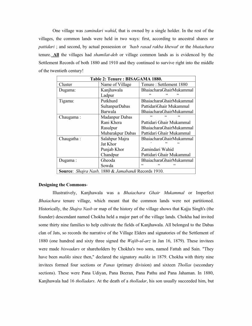
One village was zamindari wahid, that is owned by a single holder. In the rest of the
villages, the common lands were held in two ways: first, according to ancestral shares or
pattidari ; and second, by actual possession or 'hasb rasad rakba khewat' or the bhaiachara
tenure. All the villages had shamilat-deh or village common lands as is evidenced by the
Settlement Records of both 1880 and 1910 and they continued to survive right into the middle
of the twentieth century!
Table 2: Tenure : BISAGAMA 1880. Cluster Name of Village Tenure : Settlement 1880 Dugama:
Kanjhawala Ladpur
BhaiacharaGhairMukammal “ “ “
Tigama:
Putkhurd SultanpurDabas Barwala
BhaiacharaGhairMukammal PattidariGhair Mukammal BhaiacharaGhairMukammal
Chaugama :
Madanpur Dabas Rani Khera Rasulpur Mubarakpur Dabas
“ “ “ Pattidari Ghair Mukammal BhaiacharaGhairMukammal Pattidari Ghair Mukammal
Chaugatha :
Salahpur Majra Jat Khor Punjab Khor Chandpur
BhaiacharaGhairMukammal ´ ” “ Zamindari Wahid Pattidari Ghair Mukammal
Dugama :
Gheoda Sowda
BhaiacharaGhairMukammal “ “ “
Source: Shajra Nasb, 1880 & Jamabandi Records 1910.
Designing the Commons-
Illustratively, Kanjhawala was a Bhaiachara Ghair Mukammal or Imperfect
Bhaiachara tenure village, which meant that the common lands were not partitioned.
Historically, the Shajra Nasb or map of the history of the village shows that Kajju Singh's (the
founder) descendant named Chokha held a major part of the village lands. Chokha had invited
some thirty nine families to help cultivate the fields of Kanjhawala. All belonged to the Dabas
clan of Jats, so records the narrative of the Village Elders and signatories of the Settlement of
1880 (one hundred and sixty three signed the Wajib-ul-arz in Jan 16, 1879). These invitees
were made biswadars or shareholders by Chokha's two sons, named Fattah and Sain. "They
have been maliks since then," declared the signatory maliks in 1879. Chokha with thirty nine
invitees formed four sections or Panas (primary division) and sixteen Thollas (secondary
sections). These were Pana Udiyan, Pana Beeran, Pana Pathu and Pana Jahaman. In 1880,
Kanjhawala had 16 tholladars. At the death of a tholladar, his son usually succeeded him, but
capability was of consideration in the appointment, too. The name of the tholla was changed if
the new appointee was not of the same family as that of the dead man.
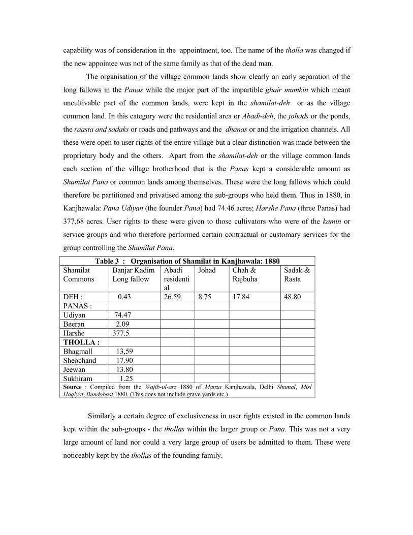
The organisation of the village common lands show clearly an early separation of the
long fallows in the Panas while the major part of the impartible ghair mumkin which meant
uncultivable part of the common lands, were kept in the shamilat-deh or as the village
common land. In this category were the residential area or Abadi-deh, the johads or the ponds,
the raasta and sadaks or roads and pathways and the dhanas or and the irrigation channels. All
these were open to user rights of the entire village but a clear distinction was made between the
proprietary body and the others. Apart from the shamilat-deh or the village common lands
each section of the village brotherhood that is the Panas kept a considerable amount as
Shamilat Pana or common lands among themselves. These were the long fallows which could
therefore be partitioned and privatised among the sub-groups who held them. Thus in 1880, in
Kanjhawala: Pana Udiyan (the founder Pana) had 74.46 acres; Harshe Pana (three Panas) had
377.68 acres. User rights to these were given to those cultivators who were of the kamin or
service groups and who therefore performed certain contractual or customary services for the
group controlling the Shamilat Pana.
Table 3 : Organisation of Shamilat in Kanjhawala: 1880 Shamilat Commons
Banjar Kadim Long fallow
Abadi residential
Johad Chah & Rajbuha
Sadak & Rasta
DEH : 0.43 26.59 8.75 17.84 48.80 PANAS : Udiyan 74.47 Beeran 2.09 Harshe 377.5 THOLLA : Bhagmall 13,59 Sheochand 17.90 Jeewan 13.80 Sukhiram 1.25 Source : Compiled from the Wajib-ul-arz 1880 of Mauza Kanjhawala, Delhi Shumal, Misl Haqiyat, Bundobast 1880. (This does not include grave yards etc.)
Similarly a certain degree of exclusiveness in user rights existed in the common lands
kept within the sub-groups - the thollas within the larger group or Pana. This was not a very
large amount of land nor could a very large group of users be admitted to them. These were
noticeably kept by the thollas of the founding family.
The Community and Customary Institutions
The community's institutional devices to close access to outsiders and similarly to
prevent cheating, shirking and free-riding by insiders could take several forms but the most
important ones were to induce collective action by preventing either unequal distribution of the
income from the common lands in its undivided form or of the common lands at the time of its
partition. The fact that the usages of the shamilat deh or the village commons were recorded on
the evidence of the one hundred and sixty three maliks who signed the Wajib-ul-arz or The
Village Administration Paper on Jan 16, 1879 was proof of collective will.24 The Maconachie
Settlement of 1880 had 59 separate sections in this document for all the Delhi villages.
Additionally since all the villages in the cluster belonged to the Dabas Jats there was a
similarity in the customs.25 It is a tribute to their capacity to resolve disputes at the ground
level, that we do not have any court case from here sent up to the Chief Court in the course of
the nineteenth and early twentieth century.
A very major aspect of collective action was economy in joint fiscal solvency, which
meant that revenue payments could be made on time. This meant (1) that revenue collection
was done by the lambardars or headmen in return for which they got a percentage of the
amount collected and 1% was given to the Ala Lambardar or Chief Headman and Zaildar who
was from Kanjhawala; (2) the collection of the cesses for roads, school and post-office was also
done by the lambardars after each harvest; (3) the expenditure for common purposes or the
malba accounts was a very important item through which common responsibilities were shared;
as against this any income from the common lands formed an important part of the revenue for
the village and since every biswadar or shareholder had the right to inspect and audit the
accounts or bujharat, and thus there was seemingly some sort of control over the action of the
lambardars.
The de facto managers of the villages were the lambardars, who represented their
respective thollas sometimes even two thollas as in the case of Kanjhawala which had 8
lambardars looking after 16 thollas of four panas. The chief headman was usually chosen from
among these and in the case of the founder pana as in Kanjhawala the headman of the village
was from the leading family. At his death the son took his place. Decision making for the entire
village was different from that of the sub-groups. In the latter, decisions had to be flexible and
24 Wajib-ul-arz, Misl Haqiyat, Jamabandi, Mauza Kanjhawala, Bundobast
1880. Henceforth only W-U-A. 25 H.C. Beadon, Customary Law in the District of Delhi, 1911; and the
translated Wajib-ul-arz.

also quick because the long fallows could be switched between cultivation and grazing. So
could they police user rights more effectively.
A certain degree of de-centralisation also helped in large villages as in Kanjhawala (see
table 4) and Gheora 26 where the sub-divisions of the village managed their separated shamilat
or commons. In fact the latter had NO shamilat deh in common for the whole village except the
village site which was not partible. In contrast some small villages like Sowda 27 (dugama of
Gheora) did not have any shamilat in the panas and the thollas but had Shamilat-deh for the
entire village. Separated shamilat interests also existed on the basis of religion. In Jat Khor28
there was a Pana Hinduan or sub-group of Hidus and a Pana Mussalman or sub-group of
Muslims.
Customs of access -
Access to the banjar kadim or long fallows of the village commons lands was qualified
by residence in the village or sakin-deh .Therefore not much of this could be given over to
cultivation on any large scale because it reduced the banjar or waste available for common
grazing. Customs were designed to keep outsiders from intervening in decision making. This
explains why daughters of the village had no rights in the village lands and, why a bride's
dowry did not include immovable property like land. This was a safety net because the custom
of exogamous marriages prevented a girl from marrying within the same village. Since a girl's
in-laws invariably belonged to another village it prevented the outsiders from coming in. The
assumption here was, of course, that the village was peopled by members of the same clan or
'got' and marriage within the same 'got' was not allowed.
Another hurdle for outsiders was the custom of limiting inheritance to only male
collaterals. Widows of the deceased land-holder held his property only till she remained a
widow and did not remarry. Widows could have only a life interest in the land. A marriage
custom of the Jats was karewa whereby the widow married her brother-in-law and so the
property remained within the family.
Thirdly, when the man died without leaving any descendant at all, the land passed on to
the members of the same tholla or sub-section of the same village or among the members of the
same patti or pana.29 The assumption here was that the members of the same patti, pana or
tholla were related.
26 W-U-A, Mauza Gheora, 1880. 27 W-U-A, Mauza Sowda, 1880. 28 W-U-A, Mauza Jat Khor, 1880. 29 Kanjhawala's Shajra Nasb illustrates this.
Fourthly, a gift of any village land did not make the donee a co-sharer in the common
land or of the income from the common lands of the village. These gifts were generally
recognised as separate tenures like makbuza tenures, and the holders of such tenures were given
a separate status of malik kabza. The ownership of such a malik extended only to the actual
land given to him and did not carry any proportionate share in the common land or common
income. This then impaired even the State's ability to grant a muafi or rent-free tenure in any
village.
Fifthly, the most effective way to police access to the commons was to strictly enforce
the rules for Nau Tor30, that is cultivation of the virgin waste. This rule was strictly enforced as
since any one who broke new waste could claim rights of ownership. This was a major way of
keeping access closed to both outsiders who entered through the land market to become maliks
or owners of private land and ghair maurusi or tenants-at-will who aspired to become land
owners via statutory provisions of occupancy rights. For that matter nau tor was denied to even
the malikan-deh or the proprietary body for this would upset the share of land each malik held
in proportion to the others and so disturb the distribution of revenue liability which was in
proportion of his share of land. Hence the rule for nau tor was an effective and simple means of
keeping the balance in land ownership. And so long as this was so the collectivity held.
Customs of user -
Clarity of rules of user in the commons was a significant aspect of excluding certain
sections of the village residents. For example (a) a malik or proprietor could build, re-build and
mortgage the plot in the abadi on which his house was built but the ghair-malik or non-
proprietor could not;
(b) a malik could graze his cattle on the grazing grounds but a ghair malik needed permission to
do so 31 and in some cases grazing fees had also to be paid as in the villages of Gheora and
Sowda;
(c) but no one from outside could come and graze their cattle even if they were of the same
tribe or even from the same cluster;
(d) no one could cut trees from the shamilat without the permission of the proprietary body and
since ghair maliks or non-proprietor had the right to cut trees that they planted, they were not
allowed to plant trees either!
30 Nau Tor means breaking up virgin land, W-U-A, Section X, Mauza
Kanjhawala, 1880. 31 W-U-A, Section XV, Mauza Kanjhawala, 1880.
(e) particular care was taken about the garbage and the cow dung which had to be thrown in the
common heap in the gitbadh a place synonymous to the gora deh (in Punjab) or empty space
for cattle to stand just outside the abadi deh or residential area.
Even though these were recorded, customary rules could be changed between one
settlement and another as for example the proprietary bodies could ask for the imposition of
grazing fees as some villages in Delhi did to prevent free-riding.
The economics of large scale municipal organisation also accounted for the provision of
common pathways in between the houses and for the common drains and garbage dumps. This
also prevented the use of low lying cultivable land from being used for housing. The rules for
use of the various areas in the abadi-deh were carefully maintained in the Village
Administration Paper. Any commercial use of the abadi, for example setting up of indigo vats
or oil presses could be undertaken only with the permission granted by the proprietary body.32
There was special provision for the planting of trees in the abadi. A non-proprietor could not
cut trees in his courtyard if the tree was planted by the owner. Similarly if he planted the tree,
the proprietor could not claim it. The most important rule in the wajib-ul-arz was that the
non-proprietor could not extend the abadi-deh or the residential site of the village.
Customs of Policing -
Policing customs of access and user was operationally the most important part of
collective action. Large villages succeeded in closing access to the banjar as common lands by
separating control for the panas and the thollas almost akin to "enclosure" without raising any
physical barrier. For example, Kanjhawala had three panas holding the banjar or common
waste exclusive to them in one compact area (Table 3) called Harshe Pana Shamilat. These
sub-group commons that is the pana and tholla shamilat could be more easily given out for
cultivation and also be partitioned, but before 1947 even these sub-group shamilat was kept
mainly for grazing.
Policing the abadi-deh, or the common of residence was a decisive aspect of collective
action since the abadi-deh decided the identity of a rural settlement as against an urban
township. In the pre-colonial period, villages particularly in politically insecure areas were built
upon a compact residential site without any formal partition. The lower castes particularly the
scavenging castes were allowed to stay in a particular section of the abadi. In some cases the
abadi may have been divided according to the different pana and tholla grouping. In
Kanjhawala for instance, the founder pana, the house of Bhaktavar and Bhagmall, separated 32 See the disputes in the Punjab Chief Court Common Lands and Customary Law.

their houses from the rest of the village. No malik or proprietor had the right to alienate his plot
but they could mortgage or give in gift. Non-maliks were specially not allowed to either
mortgage, sell or gift the house or the plot on which the house stood.
Increasingly the policing of common lands became difficult because there were other
ways in which the maliks could acquire more land than their shares, like for example through
gifts. Here the customary rule was not to allow a gift to convey a share in the shamilat deh or
village commons per se. If a gift of land was made in the instance where a malik died without
an heir or la wald, care was taken to prevent any encroachment on the shamilat. This happened
in Rani Khera in 1915 when the Saugama Village Panchayat or 100 Village Panchayat of the
Dabas Jats partitioned all the common lands among the existing maliks of the two Panas of the
village33 and thus pre-empted access to the commons by the donees of a land gift from a malik
who had died without heirs in the village. Similarly the rules of pre-emption prevented a malik
to sell the land to an outsider especially since it carried with it a share in the shamilat of the
Pana and the share in the shamilat deh.34 This was truer still of any resident's house in the
abadi-deh.
The State is a State
Free-riding the Commons? Urban Delhi has been free-riding rural Delhi ever since the Mughals made it their
capital. The Colonial State after 1861, assumed that "the waste" was open access and therefore
available for it to appropriate. Although there was no formal law to acquire land, to build the
Imperial City of New Delhi in 1911, nevertheless it grew on urbanisation of several villages via
the ‘legal formalities’ for creation of “townships”. When the colonial Revenue Department
started to set up villages on the waste it caused a hemming in effect on the village communities
which had previously supplemented the grazing on the village common lands with the waste
outside their boundaries. This also pressed on the cultivated lands to produce more fodder. At
the same time the complementary relationship of agri-pastoral communities got disrupted.
Nomadic pastoralists found negotiating their winter grazing grounds in Delhi's villages
increasingly difficult which in turn prevented them from taking the cattle of the plains to the
33 Oscar Lewis' Field Notes. 34 For court cases involving the conveyance of the shamilat-deh rights
see Common Lands and Customary Law.
hills in summer. Thus the common lands of Delhi's villages got no respite from grazing
pressure in the lean summer months.
After 1947, a national Government carried the hemming-in effect further with the
acquisition of several villages for the Asiad Games and the housing colonies and transport
companies. The provision of power and water for urban Delhi, required several dams to be set
up in the foothills of the Siwaliks causing a reduction of pastures in those regions for
professional herders and which in turn has reduced their capacity to accommodate the pastoral
arrangements for the cattle of Delhi’s villages.
Second, as the pressure on the commons grew and village communities sought help to
formalise customs which could stand up in law courts, the Colonial State can be said to have
initiated a process of free-riding of the commons because it strengthened pressures within the
village community in opposition to customary usages and on the other hand backed up
individualisation through institutional means. So, even though neither the colonial State nor the
modern nation State could forcibly implant anyone on the village lands, both were responsible
for the act of commission. In the nineteenth century the village customary law did not recognise
an outsider's share in the common lands, however the colonial government gave muafi grants
and recognised the malik kabza tenure, which did not necessarily carry shares in common
lands. Similarly the State's right of escheat was also limited by the rules of village customs yet
the colonial State did ever so often take over land of heirless estates.
A move in the same direction took place after 1954, the Delhi Administration took up
the project of allocating land from the common lands (which are now referred to as the Gaon
Sabha lands) to the "weaker sections" and "scheduled castes". These grants were of two kinds --
(a) plots of cultivable waste land; (b) plots for living space in the "abadi". In 1975-76, 2500 35
acres of land was distributed to the landless labourers and scheduled castes in the various
villages of Delhi and all this has been from the common lands of the villages. In the same year,
4638 house sites36 were allocated in what was known as the "extended abadi" or outside Lal
Dora limit which demarcated the residential area of the village abadi.
The implications of such action will be discussed with reference to the Bisagama cluster
because the data for land allocation is not available at the district level. The scheduled castes
and the number of homeless however were not the only ones to seek relief, an additional source
of demand for use of common resources were the number of marginal and small farmers as
35 The Delhi Administration Report, 1975-76 36 Ibid.
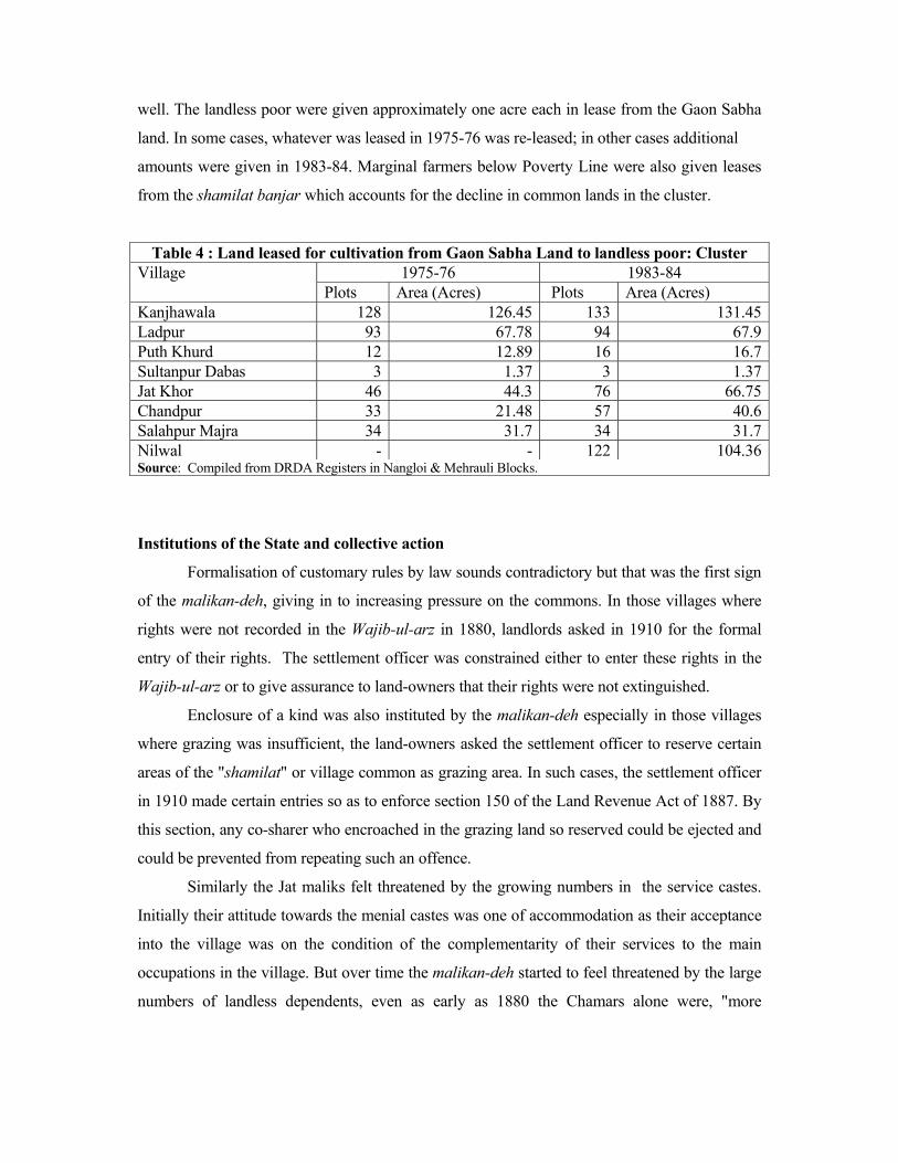
well. The landless poor were given approximately one acre each in lease from the Gaon Sabha
land. In some cases, whatever was leased in 1975-76 was re-leased; in other cases additional
amounts were given in 1983-84. Marginal farmers below Poverty Line were also given leases
from the shamilat banjar which accounts for the decline in common lands in the cluster.
Table 4 : Land leased for cultivation from Gaon Sabha Land to landless poor: Cluster 1975-76 1983-84 Village
Plots Area (Acres) Plots Area (Acres) Kanjhawala 128 126.45 133 131.45Ladpur 93 67.78 94 67.9Puth Khurd 12 12.89 16 16.7Sultanpur Dabas 3 1.37 3 1.37 Jat Khor 46 44.3 76 66.75 Chandpur 33 21.48 57 40.6Salahpur Majra 34 31.7 34 31.7 Nilwal - - 122 104.36Source: Compiled from DRDA Registers in Nangloi & Mehrauli Blocks.
Institutions of the State and collective action
Formalisation of customary rules by law sounds contradictory but that was the first sign
of the malikan-deh, giving in to increasing pressure on the commons. In those villages where
rights were not recorded in the Wajib-ul-arz in 1880, landlords asked in 1910 for the formal
entry of their rights. The settlement officer was constrained either to enter these rights in the
Wajib-ul-arz or to give assurance to land-owners that their rights were not extinguished.
Enclosure of a kind was also instituted by the malikan-deh especially in those villages
where grazing was insufficient, the land-owners asked the settlement officer to reserve certain
areas of the "shamilat" or village common as grazing area. In such cases, the settlement officer
in 1910 made certain entries so as to enforce section 150 of the Land Revenue Act of 1887. By
this section, any co-sharer who encroached in the grazing land so reserved could be ejected and
could be prevented from repeating such an offence.
Similarly the Jat maliks felt threatened by the growing numbers in the service castes.
Initially their attitude towards the menial castes was one of accommodation as their acceptance
into the village was on the condition of the complementarity of their services to the main
occupations in the village. But over time the malikan-deh started to feel threatened by the large
numbers of landless dependents, even as early as 1880 the Chamars alone were, "more

powerful in number than any other class or tribe in the district except the Jats".37 In Rani Khera,
the serving classes formed nearly 40% of the total population.38 Additionally the service castes
posed problems for the malikan-deh for they being landless veered towards market
opportunities more than any one else.
Further the Colonial State modified the control of the malikan-deh and their relationship
with tenants and other residents of the villages - the Sakin Deh - by changing the terms and
conditions under which tenancy was regulated. The main tribes in Delhi, as in the cluster
accounted for 91%, of the land holdings, but they were not antagonistic to tenants since the
latter generally belonged of the same tribes.
Thus it was that tenants' customary rights of usage in the village commons got
recognition in the Regular Settlement of 1880 in the Wajib-ul-arz. These were different for
occupancy tenants (maurusi) who had heritable rights to the commons whereas it was not for
the tenants-at-will (ghair-maurusi). This was an important legal difference although generally
the two categories did not pay very different types of rent in 1880 or in 1910. In Delhi, in most
cases, tenants paid only the government revenue on the land they cultivated;39 and their position
in Delhi was considerably strengthened by the Punjab Tenancy Act, 1868, which granted
occupancy rights to a tenant who paid no rent and rendered no service in return for the land
cultivated by him.
This did not matter in 1880, where the large Jat villages had cent percent owner
cultivation or khud kasht. But in the district as a whole, tenants cultivated 35% of the land and,
near Delhi, the proportion was 25%. By 1912, tenants cultivated some 44% of the land. In
1912, 9-1/2% of the cultivated land in Delhi was held in occupancy tenancy. The majority paid
rents at revenue rates, that is, without paying malikana or the additional amount paid in
recognition of the superior rights of the owner. This showed their strong position. And, even if
a higher rent was due, an official report stated in 1910 40 that the landlord seldom took the
matter to court because the occupancy tenants could retaliate by "claiming rights under a more
privileged section"41 of the Punjab Tenancy Act of 1868 amended in 1887.
37 Delhi SR, 1872-80, p.3. 38 Oscar Lewis, Village Life in Northern India, 1954, p.158. Monica
Dasgupta, "Population Trends and Changes in Village Organisation : Rampur Re-visited," 1975, (Unpublished Thesis, University of Sussex, 1981, p. 46.
39 Delhi SR, 1872-80, p. 76. Delhi SR, 1906-10, Chap IV. 40 Delhi SR, 1906-10, Chap. IV. 41 Ibid.

Additionally, the number of occupancy tenants increased as a result of recording rent
free tenures of Brahmins and menials as occupancy tenancy tenures in the settlements. Thus,
these tenures, given originally for religious and other purposes, also became more or less
permanent tenancies. The result was that the number of tenants with permanent rights of
cultivation became large and well-entrenched sections. But, they were small men. Even as early
as 1912, the average holding of an occupancy tenant was no more than 2 acres.
Even the ghair maurusi, cultivated about 32-1/2% of the land in Delhi in 1906-10.
These were also "usually of the same agricultural tribe as the landlords and hereditary tenants"
and they also seldom paid anything more than the Government revenue. They regarded
themselves "as owners and are quite prepared to contest a demand for enhanced rent by
claiming either proprietary or occupancy rights".42
Tenurial Reforms and Tenure 1947 Controlling access to the commons was weakened by a major re-organisation of land
ownership executed under a general blanket set of reforms in land tenure. The Delhi Land
Reforms Act of 1954 statutorily transferred all lands held in common by the proprietary body
of a village to an elected body known as the Gaon Sabha and also enforced consolidation of
holdings. This meant three changes : Firstly, all Shamilat Land - Shamilat Deh, Shamilat Pana
and Shamilat Tholla no longer belonged in common to the Malikan Deh or to the major
sections of the proprietors or even to the subsections of the proprietors.43 Secondly, the
management and user rights were taken away from the groups of individual owners known as
the Malikan Deh in the colonial period and transferred to the larger body of the entire village or
rather their representative body - the Gaon Sabha.
Thirdly, consolidation of holdings removed the system of khet bat which had "coerced" the
villages to act collectively. 42 Ibid. 43 "All rights of an individual proprietor or proprietors pertaining to
waste lands, grazing of forest produce from forests, of fish from fisheries, lands of common utility, such as customary common pasture lands, cremation or burial grounds, abadi sites, pathways, public wells, tanks and water channels, or khalihans whether covered by an existing contract between such proprietor or proprietors and any other person or not shall with effect from the commencement of this Act be terminated in accordance with the provision of sub-section (2) and the said contracts, if any, shall become void with effect from such commencement:" Two, these rights in common would be transferred from the individual proprietors and groups of proprietors to the Gaon Sabha or any person or authority appointed by the Chief Commissioner. Delhi Land Reforms Act, 1954.
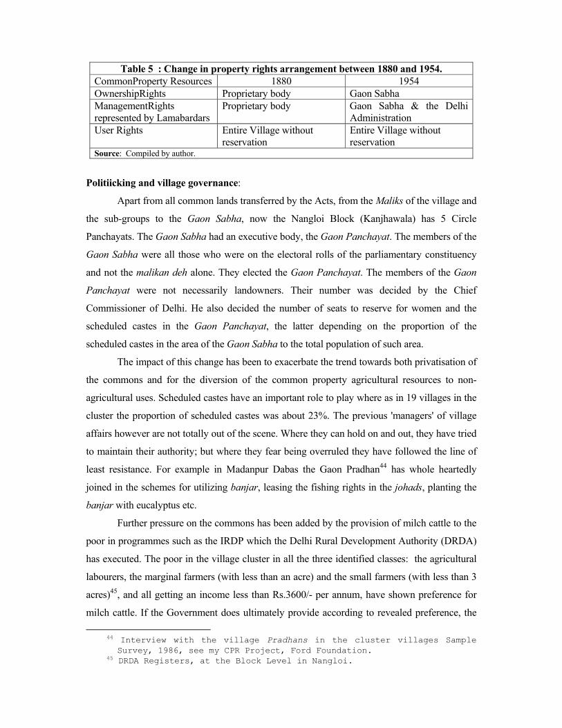
Table 5 : Change in property rights arrangement between 1880 and 1954. CommonProperty Resources 1880 1954 OwnershipRights Proprietary body Gaon Sabha ManagementRights represented by Lamabardars
Proprietary body Gaon Sabha & the Delhi Administration
User Rights Entire Village without reservation
Entire Village without reservation
Source: Compiled by author.
Politiicking and village governance:
Apart from all common lands transferred by the Acts, from the Maliks of the village and
the sub-groups to the Gaon Sabha, now the Nangloi Block (Kanjhawala) has 5 Circle
Panchayats. The Gaon Sabha had an executive body, the Gaon Panchayat. The members of the
Gaon Sabha were all those who were on the electoral rolls of the parliamentary constituency
and not the malikan deh alone. They elected the Gaon Panchayat. The members of the Gaon
Panchayat were not necessarily landowners. Their number was decided by the Chief
Commissioner of Delhi. He also decided the number of seats to reserve for women and the
scheduled castes in the Gaon Panchayat, the latter depending on the proportion of the
scheduled castes in the area of the Gaon Sabha to the total population of such area.
The impact of this change has been to exacerbate the trend towards both privatisation of
the commons and for the diversion of the common property agricultural resources to non-
agricultural uses. Scheduled castes have an important role to play where as in 19 villages in the
cluster the proportion of scheduled castes was about 23%. The previous 'managers' of village
affairs however are not totally out of the scene. Where they can hold on and out, they have tried
to maintain their authority; but where they fear being overruled they have followed the line of
least resistance. For example in Madanpur Dabas the Gaon Pradhan44 has whole heartedly
joined in the schemes for utilizing banjar, leasing the fishing rights in the johads, planting the
banjar with eucalyptus etc.
Further pressure on the commons has been added by the provision of milch cattle to the
poor in programmes such as the IRDP which the Delhi Rural Development Authority (DRDA)
has executed. The poor in the village cluster in all the three identified classes: the agricultural
labourers, the marginal farmers (with less than an acre) and the small farmers (with less than 3
acres)45, and all getting an income less than Rs.3600/- per annum, have shown preference for
milch cattle. If the Government does ultimately provide according to revealed preference, the 44 Interview with the village Pradhans in the cluster villages Sample
Survey, 1986, see my CPR Project, Ford Foundation. 45 DRDA Registers, at the Block Level in Nangloi.

total number of cattle required will be 2187 heads of cattle with shrinking grazing reserves. At
the same time 95% of the recipients will be without any land of their own. The cattle will
depend on the fodder grown elsewhere either within the village or other villages in the area. In
fact a large amount of fodder is now provided by the Government through fair price shops.
These schemes are likely to raise the level of dependence on the same over-used grazing land
and also on the Government for further support.
Decisions regarding the use of common lands or Gaon Sabha Land as they are now
called are bound to be dictated by considerations other than those of the erstwhile malikan-deh.
The Gaon Sabha is allowed to lease out the common land, and is enjoined to give preference to
co-operatives which would be set up among the landless labourers. This hope is belied; none of
the leases or cultivation have been to co-operatives. Land has been leased to the landless, but on
an individual basis.
The Delhi Administration has also sanctioned small plots for house- sites and has
already given 617 plots involving 15.72 acres of land in seven villages of the cluster. In
Kanjhawala 807 plots were to be given in 1990 to the majority of scheduled castes. The result
has been the steady incorporation of increased numbers of non-landed residents in the cluster
villages on a permanent footing.
By-passing the Community and imposing a Tragedy?
It is clear that all these put the village customs to the test. Policing the pattern of use of
the commons as banjar kadim and as the abadi-deh became most difficult. The change in the
use of the banjar kadim, or the waste was reflected in two major trends which occurred all over
Punjab and Delhi but to a lesser extent in the cluster : first, by the increased cultivation of the
shamilat or the areas held in common; and second, by increased partition of the common
banjar.
Decline of the long fallows :
The control over the cultivation of the long fallows or Nau Tor broke down in the face of
demographic factors. The cultivated land availability per capita in the cluster had fallen from
1.11 acres in 1880 to 0.35 acres per capita in 1980. The fall in the area of uncultivated land
makes the per capita availability even less. This implies that the room for further extension in
cultivation with the increase in population is very narrow. The extensive margin being limited
made it compulsory to exploit the intensive margin of cultivation.
The availability of banjar shows an even greater decline in relative terms. In 1880 the
average extent of the banjar per 100 of the population was 36 acres which is a little more than
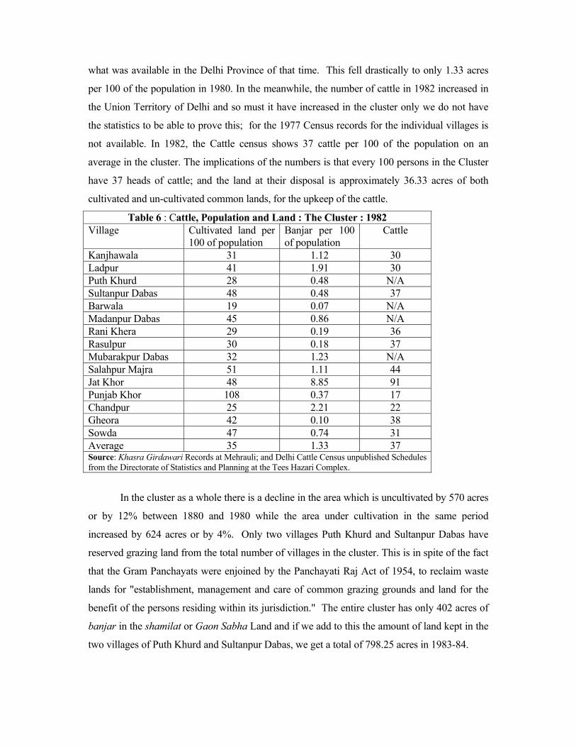
what was available in the Delhi Province of that time. This fell drastically to only 1.33 acres
per 100 of the population in 1980. In the meanwhile, the number of cattle in 1982 increased in
the Union Territory of Delhi and so must it have increased in the cluster only we do not have
the statistics to be able to prove this; for the 1977 Census records for the individual villages is
not available. In 1982, the Cattle census shows 37 cattle per 100 of the population on an
average in the cluster. The implications of the numbers is that every 100 persons in the Cluster
have 37 heads of cattle; and the land at their disposal is approximately 36.33 acres of both
cultivated and un-cultivated common lands, for the upkeep of the cattle.
Table 6 : Cattle, Population and Land : The Cluster : 1982 Village Cultivated land per
100 of population Banjar per 100 of population
Cattle
Kanjhawala 31 1.12 30 Ladpur 41 1.91 30 Puth Khurd 28 0.48 N/A Sultanpur Dabas 48 0.48 37 Barwala 19 0.07 N/A Madanpur Dabas 45 0.86 N/A Rani Khera 29 0.19 36 Rasulpur 30 0.18 37 Mubarakpur Dabas 32 1.23 N/A Salahpur Majra 51 1.11 44 Jat Khor 48 8.85 91 Punjab Khor 108 0.37 17 Chandpur 25 2.21 22 Gheora 42 0.10 38 Sowda 47 0.74 31 Average 35 1.33 37 Source: Khasra Girdawari Records at Mehrauli; and Delhi Cattle Census unpublished Schedules from the Directorate of Statistics and Planning at the Tees Hazari Complex.
In the cluster as a whole there is a decline in the area which is uncultivated by 570 acres
or by 12% between 1880 and 1980 while the area under cultivation in the same period
increased by 624 acres or by 4%. Only two villages Puth Khurd and Sultanpur Dabas have
reserved grazing land from the total number of villages in the cluster. This is in spite of the fact
that the Gram Panchayats were enjoined by the Panchayati Raj Act of 1954, to reclaim waste
lands for "establishment, management and care of common grazing grounds and land for the
benefit of the persons residing within its jurisdiction." The entire cluster has only 402 acres of
banjar in the shamilat or Gaon Sabha Land and if we add to this the amount of land kept in the
two villages of Puth Khurd and Sultanpur Dabas, we get a total of 798.25 acres in 1983-84.
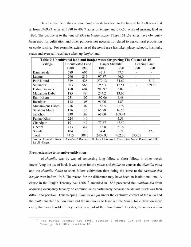
Thus the decline in the common banjar waste has been to the tune of 1611.68 acres that
is from 2409.93 acres in 1880 to 402.7 acres of banjar and 395.55 acres of grazing land in
1980. The decline is to the tune of 83% in banjar alone. These 1611.68 acres have obviously
been used for cultivation and other purposes not necessarily related to agricultural production
or cattle raising. For example, extension of the abadi area has taken place, schools, hospitals,
roads and even railways have taken up banjar land.
Table 7: Uncultivated land and Banjar waste for grazing The Cluster of 15 Uncultivated Land Banjar Shamilat Grazing Land Village 1880 1980 1880 1980 1880 1980
Kanjhawala 589 605 42.5 57.7 - - Ladpur 296 215 97.87 66.0 - - Puth Khurd 339 428 279.12 34.69 - 3.19 Sultanpur 603 566 255.3 12.51 - 359.66 Dabas Barwala 458 604 283.97 3.02 Madanpur Daba 185 48 244.2 13.63 Rani Khera 251 107 192.06 4.48 Rasulpur 112 105 91.06 1.83 Mubarakpur Dabas 216 107 188.5 21.97 Salahpur Majra 176 115 65.78 16.55 Jat Khor 238 199 61.00 108.44 Punjab Khor 224 140 - 5.51 Chandpur 191 149 77.87 47.50 Gheora 433 344 113.8 3.16 Sowda 104 113 34.4 5.71 32.7 Total 4415 3845 2409.93 402.70 395.55 Source: Compiled from: 1. Jamabandi Records 1880 for all Mauzas 2. Khasra Girdawari Records of 1980 for all villages.
From extensive to intensive cultivation -
-of shamilat was by way of converting long fallow to short fallow, in other words
intensifying the use of land. It was easier for the panas and thollas to convert the shamilat pana
and the shamilat tholla to short fallow cultivation than doing the same to the shamilat-deh
banjar even before 1947. The reason for the difference may have been an institutional one. A
clause in the Punjab Tenancy Act 1868 46 amended in 1887 prevented the malikan-deh from
acquiring occupancy tenancy on common lands particularly because the shamilat-deh was then
difficult to partition. Thus keeping shamilat banjar under the exclusive control of the pana and
the tholla enabled the panadars and the tholladars to lease out the banjar for cultivation more
easily than was feasible if they had been a part of the shamilat-deh. Besides, the maliks within
46 The Punjab Tenancy Act 1868, Section 9 clause II; and The Punjab
Tenancy Act 1887, section 10.
the panas and the thollas could also take on the tenancy in the banjar themselves or give them
out to the kamins as a part of their service conditions to the pana and the tholla. This was the
case of the Harshe Pana Shamilat in Kanjhawala and also in the Tholla shamilat of the
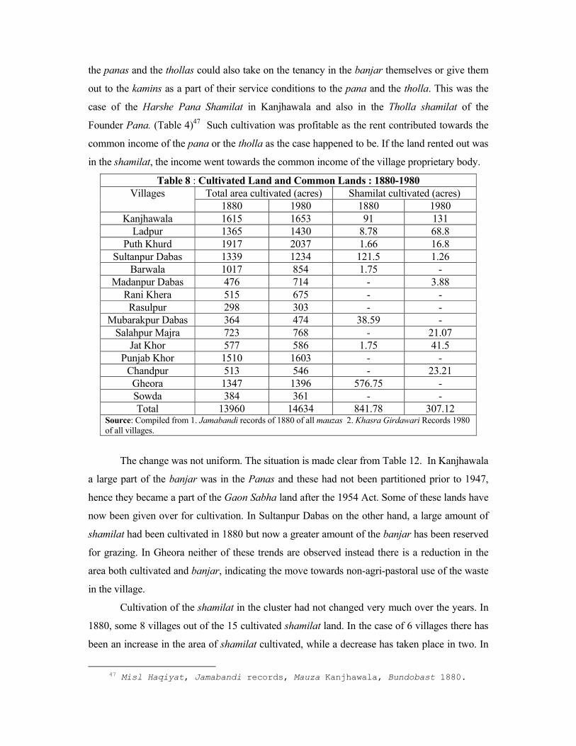
Founder Pana. (Table 4)47 Such cultivation was profitable as the rent contributed towards the
common income of the pana or the tholla as the case happened to be. If the land rented out was
in the shamilat, the income went towards the common income of the village proprietary body.
Table 8 : Cultivated Land and Common Lands : 1880-1980 Total area cultivated (acres) Shamilat cultivated (acres) Villages
1880 1980 1880 1980 Kanjhawala 1615 1653 91 131
Ladpur 1365 1430 8.78 68.8 Puth Khurd 1917 2037 1.66 16.8
Sultanpur Dabas 1339 1234 121.5 1.26 Barwala 1017 854 1.75 -
Madanpur Dabas 476 714 - 3.88 Rani Khera 515 675 - - Rasulpur 298 303 - -
Mubarakpur Dabas 364 474 38.59 - Salahpur Majra 723 768 - 21.07
Jat Khor 577 586 1.75 41.5 Punjab Khor 1510 1603 - -
Chandpur 513 546 - 23.21 Gheora 1347 1396 576.75 - Sowda 384 361 - - Total 13960 14634 841.78 307.12
Source: Compiled from 1. Jamabandi records of 1880 of all mauzas 2. Khasra Girdawari Records 1980 of all villages.
The change was not uniform. The situation is made clear from Table 12. In Kanjhawala
a large part of the banjar was in the Panas and these had not been partitioned prior to 1947,
hence they became a part of the Gaon Sabha land after the 1954 Act. Some of these lands have
now been given over for cultivation. In Sultanpur Dabas on the other hand, a large amount of
shamilat had been cultivated in 1880 but now a greater amount of the banjar has been reserved
for grazing. In Gheora neither of these trends are observed instead there is a reduction in the
area both cultivated and banjar, indicating the move towards non-agri-pastoral use of the waste
in the village.
Cultivation of the shamilat in the cluster had not changed very much over the years. In
1880, some 8 villages out of the 15 cultivated shamilat land. In the case of 6 villages there has
been an increase in the area of shamilat cultivated, while a decrease has taken place in two. In
47 Misl Haqiyat, Jamabandi records, Mauza Kanjhawala, Bundobast 1880.

the case of Gheora, for example, a large amount of shamilat was cultivated even in 1880, but it
was in the hands of the panas. Such exclusive use of the common lands protected them against
transfer to the Gaon Sabha after 1954! Nevertheless a large amount of the Pana shamilat was
acquired for the extension of the abadi and the railway track that was set up.
Reduced areas of shamilat (common lands)-
-is again evidence that the malikan-deh have tried a last ditch attempt to protect the
shamilat by partition or that their customs of access have given way to pressure. Surprisingly,
in the Delhi territory, even though partition of common lands did take place in the period
following Beadon's settlement in 1910, nevertheless in 1915-16, the total number of shamilat
holdings were 959 spread over 337 villages with 72,972 acres of land which meant, on an
average, 2.45 holdings per village with an area of 189 acres per village. A part of the holdings
were cultivated which on the average was about 27 acres per village so that grazing land per
village was 152.55 acres. The size of each holding of shamilat was not less than 100 acres.
Even if parts of these large holdings were used in small plots, there is no doubt large holdings
were still kept that way for the purpose of grazing for the entire village. Common lands still
represented 21% of the total area, which was 4% of the total holdings in rural Delhi. Private
ownership was 72% and Government a mere 1% of the total area.48
Statistics show evidence of both the percentage of the total area kept in shamilat in the
sub-clusters and the proportion that continued to be kept so even as late as 1980. In fact in one
of the villages there were no common lands in 1880 but had 128 acres of shamilat in 1910!
Inter sub-cluster relationships have been fairly strong and even though there may not be direct
dealing on an every day basis, there is nevertheless a certain amount of clan influence at work
on several occasions. This is true not only within the sub-clusters but also between the larger
groups. Oscar Lewis' field notes of Rani Khera village, 1952, reveal the occasions when the
entire One Hundred Village Panchayat or Saugama, had meetings in the early part of the
century to resolve disputes. This happened in Rani Khera in 1915 when the Saugama panchayat
met as described above. 49 It happened again in 1978 on the occasion we mentioned in the
beginning of the article and again in 1986 when the Maha Jat Sabha met over the issue of land
being appropriated by the Delhi Administration in the Delhi villages for setting up IGNOU! 48 RADP, 1915-16. 49 Oscar Lewis' Field Notes kindly lent by Monica Dasgupta; also Oscar
Lewis, 'Peasant Culture in India and Mexico, A comparative Analysis, Rani Khera Village in October 1952 and Tepotzlan in Mexico', in Mc Kim Marriot ed. Village India: Studies in the Little Community, Bombay,1961, p.155.
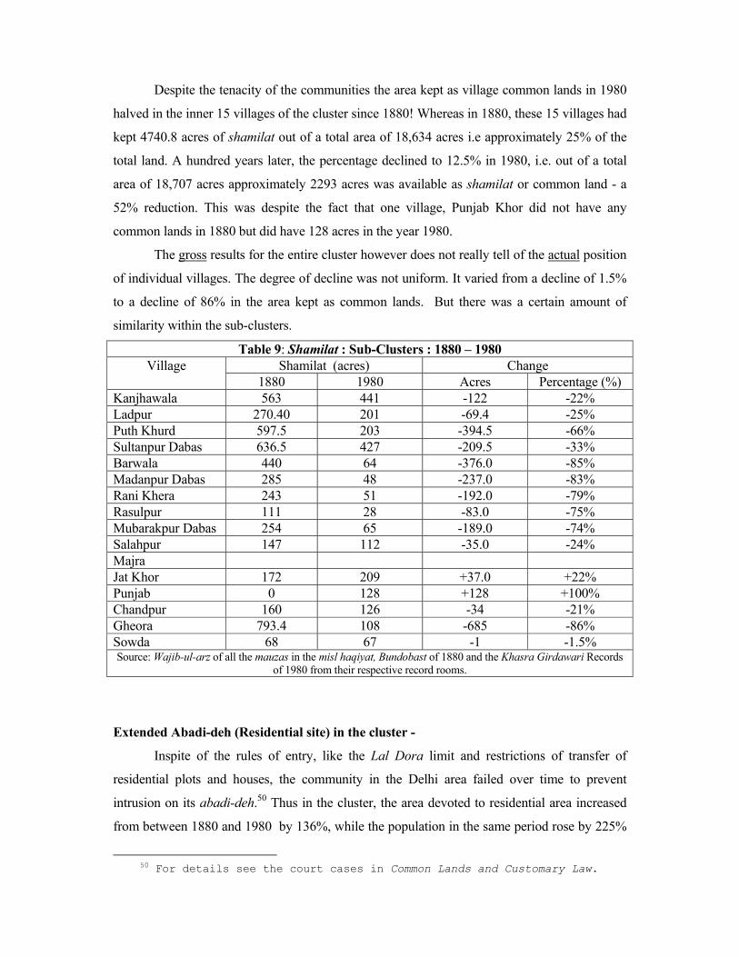
Despite the tenacity of the communities the area kept as village common lands in 1980
halved in the inner 15 villages of the cluster since 1880! Whereas in 1880, these 15 villages had
kept 4740.8 acres of shamilat out of a total area of 18,634 acres i.e approximately 25% of the
total land. A hundred years later, the percentage declined to 12.5% in 1980, i.e. out of a total
area of 18,707 acres approximately 2293 acres was available as shamilat or common land - a
52% reduction. This was despite the fact that one village, Punjab Khor did not have any
common lands in 1880 but did have 128 acres in the year 1980.
The gross results for the entire cluster however does not really tell of the actual position
of individual villages. The degree of decline was not uniform. It varied from a decline of 1.5%
to a decline of 86% in the area kept as common lands. But there was a certain amount of
similarity within the sub-clusters.
Table 9: Shamilat : Sub-Clusters : 1880 – 1980 Shamilat (acres) Change Village
1880 1980 Acres Percentage (%) Kanjhawala 563 441 -122 -22% Ladpur 270.40 201 -69.4 -25% Puth Khurd 597.5 203 -394.5 -66% Sultanpur Dabas 636.5 427 -209.5 -33% Barwala 440 64 -376.0 -85% Madanpur Dabas 285 48 -237.0 -83% Rani Khera 243 51 -192.0 -79% Rasulpur 111 28 -83.0 -75% Mubarakpur Dabas 254 65 -189.0 -74% Salahpur 147 112 -35.0 -24% Majra Jat Khor 172 209 +37.0 +22% Punjab 0 128 +128 +100% Chandpur 160 126 -34 -21% Gheora 793.4 108 -685 -86% Sowda 68 67 -1 -1.5% Source: Wajib-ul-arz of all the mauzas in the misl haqiyat, Bundobast of 1880 and the Khasra Girdawari Records
of 1980 from their respective record rooms.
Extended Abadi-deh (Residential site) in the cluster -
Inspite of the rules of entry, like the Lal Dora limit and restrictions of transfer of
residential plots and houses, the community in the Delhi area failed over time to prevent
intrusion on its abadi-deh.50 Thus in the cluster, the area devoted to residential area increased
from between 1880 and 1980 by 136%, while the population in the same period rose by 225%
50 For details see the court cases in Common Lands and Customary Law.
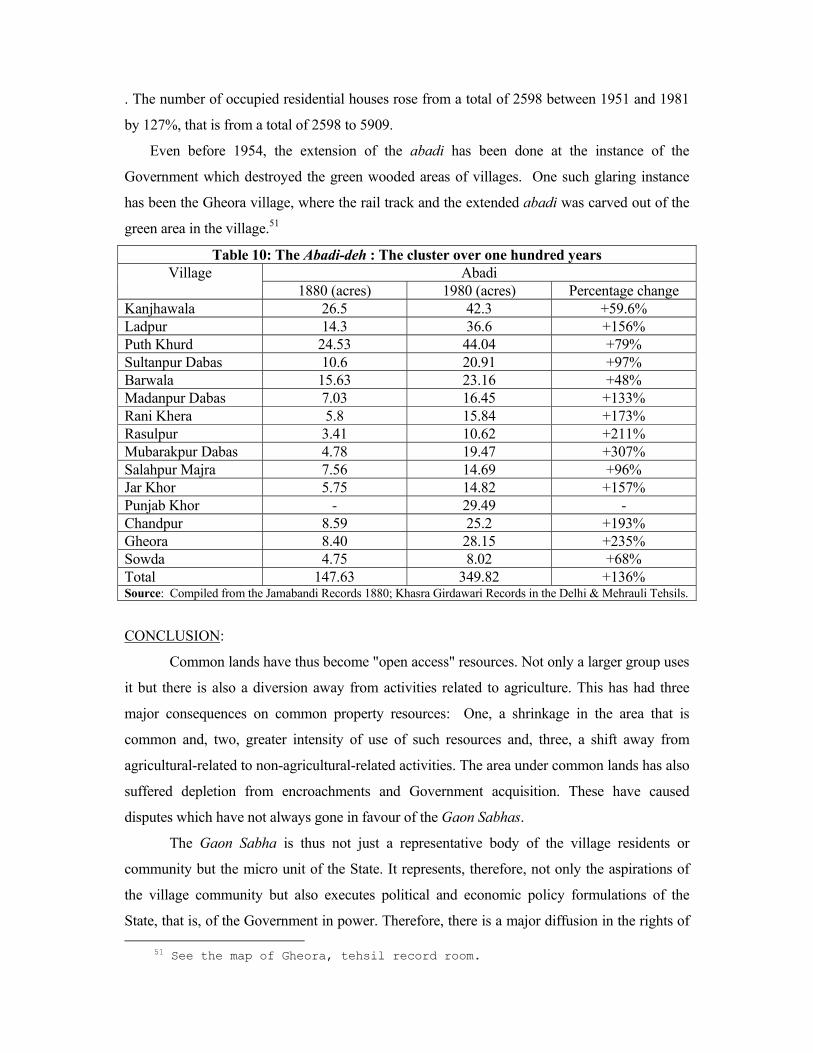
. The number of occupied residential houses rose from a total of 2598 between 1951 and 1981
by 127%, that is from a total of 2598 to 5909.
Even before 1954, the extension of the abadi has been done at the instance of the
Government which destroyed the green wooded areas of villages. One such glaring instance
has been the Gheora village, where the rail track and the extended abadi was carved out of the
green area in the village.51
Table 10: The Abadi-deh : The cluster over one hundred years Abadi Village
1880 (acres) 1980 (acres) Percentage change Kanjhawala 26.5 42.3 +59.6% Ladpur 14.3 36.6 +156% Puth Khurd 24.53 44.04 +79% Sultanpur Dabas 10.6 20.91 +97% Barwala 15.63 23.16 +48% Madanpur Dabas 7.03 16.45 +133% Rani Khera 5.8 15.84 +173% Rasulpur 3.41 10.62 +211% Mubarakpur Dabas 4.78 19.47 +307% Salahpur Majra 7.56 14.69 +96% Jar Khor 5.75 14.82 +157% Punjab Khor - 29.49 - Chandpur 8.59 25.2 +193% Gheora 8.40 28.15 +235% Sowda 4.75 8.02 +68% Total 147.63 349.82 +136% Source: Compiled from the Jamabandi Records 1880; Khasra Girdawari Records in the Delhi & Mehrauli Tehsils.
CONCLUSION:
Common lands have thus become "open access" resources. Not only a larger group uses
it but there is also a diversion away from activities related to agriculture. This has had three
major consequences on common property resources: One, a shrinkage in the area that is
common and, two, greater intensity of use of such resources and, three, a shift away from
agricultural-related to non-agricultural-related activities. The area under common lands has also
suffered depletion from encroachments and Government acquisition. These have caused
disputes which have not always gone in favour of the Gaon Sabhas.
The Gaon Sabha is thus not just a representative body of the village residents or
community but the micro unit of the State. It represents, therefore, not only the aspirations of
the village community but also executes political and economic policy formulations of the
State, that is, of the Government in power. Therefore, there is a major diffusion in the rights of 51 See the map of Gheora, tehsil record room.
ownership, management and user in the common property resources of the villages. Such
resources are, therefore, not adjuncts to agricultural activity in the village but are rather
subsidiary to social and political activity of the Delhi Administration.
The implications of these trends are first of reducing the incentive for collective
management thereby attenuating the policing of the commons; secondly, at the same time
increasing opportunities for free-riding on the shrinking waste lands for grazing with the
consequence of degrading such land and the impossibility of reversing the trend towards
desertification of the soil. Thirdly, of intensifying cultivation as a result of increasing demand
from the demographic and cattle expansion in the rural areas of Delhi. Fourthly, of market-led
urbanized use of common resources which helps in further diverting agricultural and grazing
land to non-arable and non-pastoral use.
Now urban Delhi free-rides the rural hinterland. While the "policy framework" of the
Government was instrumental in laying down an economic infrastructure of electricity,
transportation, communications, markets and industrial estates in Delhi, this has helped in the
retention of the population in Delhi's villages.
The history of the Bisagama cluster thus illustrates both the institutional construction of
communities at work which preserved communal control over common property resources in
the long run and the deconstruction of the same through legislative intervention of the State
over the last century and half.
Related Documents