Unclassified Land Information Ontario Data Description OTN Trailhead Disclaimer This technical documentation has been prepared by the Ministry of Natural Resources (the “Ministry”), representing Her Majesty the Queen in right of Ontario. Although every effort has been made to verify the information, this document is presented as is, and the Ministry makes no guarantees, representations or warranties with respect to the information contained within this document, either express or implied, arising by law or otherwise, including but not limited to, effectiveness, completeness, accuracy, or fitness for purpose. The Ministry is not liable or responsible for any loss or harm of any kind arising from use of this information. Some of the information in this document is nonconvertible or has not yet been made accessible and may not be compatible with assistive technologies. If you need any of the information in an alternate format, please contact LIO Support at [email protected] or (705) 755-1878. ©Queens Printer for Ontario, 2012

Welcome message from author
This document is posted to help you gain knowledge. Please leave a comment to let me know what you think about it! Share it to your friends and learn new things together.
Transcript
Unclassified
Land Information Ontario Data Description
OTN Trailhead
Disclaimer This technical documentation has been prepared by the Ministry of Natural Resources (the “Ministry”), representing Her Majesty the Queen in right of Ontario. Although every effort has been made to verify the information, this document is presented as is, and the Ministry makes no guarantees, representations or warranties with respect to the information contained within this document, either express or implied, arising by law or otherwise, including but not limited to, effectiveness, completeness, accuracy, or fitness for purpose. The Ministry is not liable or responsible for any loss or harm of any kind arising from use of this information. Some of the information in this document is nonconvertible or has not yet been made accessible and may not be compatible with assistive technologies. If you need any of the information in an alternate format, please contact LIO Support at [email protected] or (705) 755-1878.
©Queens Printer for Ontario, 2012
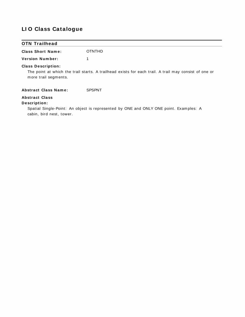
LIO Class Catalogue OTN Trailhead
Class Short Name:
Version Number:
Class Description:
OTNTHD 1
The point at which the trail starts. A trailhead exists for each trail. A trail may consist of one or more trail segments.
Abstract Class Name:
Abstract Class Description:
SPSPNT
Spatial Single-Point: An object is represented by ONE and ONLY ONE point. Examples: A cabin, bird nest, tower.
Tables in LIO Class:
OTN Trailhead OTN_TRAILHEAD_FT
The point at which the trail starts. A trailhead exists for each trail. A trail may consist of one or more trail segments.
Column Name Column Type
Mandatory Short Name Valid Values
OGF_ID NUMBER (13,0)
Yes OGF_ID
A unique numeric provincial identifier assigned to each object.
TRAIL_NAME VARCHAR2 (200)
The name that the trail is most commonly known as.
TRAIL_GROUPING VARCHAR2
(75)
Yes TRAIL_NAME No GROUPING Aaron Provincial Park, Abitibi-De-
Troyes Provincial Park, Adam Creek Provincial Nature Reserve, Agassiz Peatlands Provincial Park, Albany River Provincial Park, Albert Lake Mesa Provincial Nature Reserve, ... (See OTN_TRAIL_GROUPING_LIST table)
Individual trails or organizations associated with a larger trail organization or association (ex. Bruce Trail, Voyageur Trail, Algonquin Park).
TRAIL_ASSOCIATION VARCHAR2
(100)
Yes ASSOC
The managing trail group that can be contacted regarding issues related to trail information, maintenance, operations, administration and problems on the trail.
TRAIL_ASSOCIATION_WEBSITE VARCHAR2
(200)
The URL for the trail association website address.
ACTIVITY VARCHAR2 (25)
No WEBSITE Yes ACTIVITY Both, Motorized, Non-Motorized
(See OTN_ACTIVITY_LIST table)
The activity permitted on a trail segment.
LENGTH_KMS NUMBER (6,1)
Yes LENGTH_KMS
The length as identified by the trail association or calculated by the sum of trail segment lengths. Measured in Kilometers.
DESCRIPTION VARCHAR2
(2000)
No DESCRIPT
Text providing details about something.
TRILLIUM_TRAIL_NETWORK_TYPE VARCHAR2 (25)
No TRILLIUM_T Blue Sector, Gold Sector, Green
Sector (See OTN_TRILLIUM_NETWORK_TYPE_LIST table)
A classification system assigned by the Trillium Trail Network to trails. The Trillium Trail Network (TTN) represents an opportunity for trails to link together between regions and communities in Ontario. The TTN consists of Ontario Trail Council member trails registering their trail as a network member. Trails will: - Be readily accessible to communities along the TTN - Incorporate multi and single use trails - Can have both year-round and single season trails - Include trails of different lengths, topography, uses and locations
OFSC_TRAIL_DESIGNATION VARCHAR2
(10)
No OFSC_DESIG Club, Connector, Feeder, Trunk
(See OTN_OFSC_TRAIL_DESIG_LIST
table)
Name of the trail designation as defined by the OFSC Ontario Federation of Snowmobile Clubs.
ORCKA_SWIFTWATER_CLASS VARCHAR2 (15)
No ORCKA_CLAS Class I, Class II, Class III, Class IV,
Class V, Class VI (See OTN_ORCKA_SWIFTWATER_LIST table)
A classification of the water defined by the Ontario Recreational Canoeing and Kayaking Association. Defined by international categories of swiftwater for determining moving water. Applies to trails on open water only (canoe routes).
UNESCO_WORLD_HERITAGE_SITE_IND VARCHAR2
(3)
No UNESCO Yes, No
Indicates the trail is designated as a United Nations Educational, Scientific and Cultural Organization (UNESCO) site for the identification, protection and preservation of cultural and natural heritage of outstanding value to humanity.
SIGNAGE_IND VARCHAR2
(3)
Indicates whether signage exists on trails or not.
ENVIRONMENTAL_CONCERNS VARCHAR2 (2000)
A Description of known Environmental concerns.
HAZARD_COMMENT VARCHAR2
(2000)
No SIGNAGE Yes, No No ENVIRON No HAZARD_COM
Unstructured description, additional notes, or further explanation regarding sources of danger at a feature.
MIN_WIDTH_CLEARANCE_METERS NUMBER
(3,1)
No MIN_WIDTH
The minimum width of the trail. This is critical for people who use mobility devices such as strollers, walkers and wheelchairs. The average manual wheelchair has a wheelbase width of less than 28 inches(0.71 meters). If a trail narrows to 26 inches (0.66 meters), persons in a 28-inch wheelchair will know that they will not be a ble to venture past this point unless they are capable of transferring out of their chair and maneuvering their chair through this narrow location. Equestrians are another example of trail users that require a specific width, depending on the size of the horse. Defined in meters.
MIN_VERTICAL_CLEARANCE_METERS NUMBER
(3,1)
No MIN_VERTIC
The minimum height above the trail that is free from protruding objects and overhead obstructions, such as tree branches and bridges. Measured in meters.
MAX_GRADE NUMBER
(4,1)
No MAX_GRADE
The maximum grade of the trail. Grade is defined as the maximum percent grade of rise (ascent) or fall (descent) of the slope of the trail tread parallel to the path of travel. Calculated as "vertical distance/horizontal distance".
MAX_CROSS_SLOPE NUMBER
(3,1)
No MAX_SLOPE
The maximum cross slope on the trail. Cross slope is the average elevation change from one side of the trail across to the other side, measured at a right angle to the path of travel.
OTC_TRAIL_CHALLENGE VARCHAR2
(25)
No OTC_CHALL Challenging, Easy, Extreme,
Moderate, Other (See OTN_OTC_TRAIL_CHALLENGE_LIST table)
The difficulty of the trail, defined by the Ontario Trails Council. Defined by the maximum trail challenge over the length of the trail.
STRUCTURE_DESCR VARCHAR2
(250)
No STRUCT_D
A description of the trail structure.
MAX_POSTED_SPEED_LIMIT_KMH NUMBER No MAX_SPEED
(3,0)
Posted speed limit that is different from the Trail default. For a shared use trail, where there are different speed limits for different modes of transportation, the maximum posted speed limit will be recorded. Measured in kilometers per hour.
LOCATION_ACCURACY VARCHAR2
(25)
Yes ACCURACY Not Applicable, Over 10,000 metres,
Within 1 metre, Within 10 metres, Within 10,000 metres, Within 100 metres, ... (See LOCATION_ACCURACY_LIST table)
The degree of conformity or closeness of a measurement within the database to its true value in the world.
LOCATION_DESCR VARCHAR2
(2000)
No LOC_DES
Description of the area or directions on how to get to the site.
GEOMETRY_UPDATE_DATETIME DATE No GEO_UPD_DT
Date/time the geometry was created or last modified in the source database.
EFFECTIVE_DATETIME DATE Yes EFF_DATE
Date/time the record was created or last modified in the source database.
CLASS_ALIAS_NAME
Location name for the geographic feature. Only one primary local name is allowed per area. Other local names are alias names.
Column Name Column
Type
Mandatory Short Name Valid Values
OGF_ID NUMBER
(13,0)
Yes OGF_ID
A unique numeric provincial identifier assigned to each object.
LOCAL_NAME VARCHAR2 (75)
Local name of geographic unit.
CLASS_SHORT_NAME VARCHAR2
(8)
Yes LOCAL_NAME Yes CLASS_NAME
System-generated column denoting the concrete class which this record is part of.
PRIMARY_NAME_IND VARCHAR2
(3)
Yes PRIM_IND Yes, No
Indication of whether this is the primary local or common name.
EFFECTIVE_DATETIME DATE Yes EFF_DATE
Date/time the record was created or last modified in the source database.
CLASS_DATABASE_REFERENCE
A link to an external database or an internal object in the same database.
Column Name Column
Type
Mandatory Short Name Valid Values
OGF_ID NUMBER
(13,0)
Yes OGF_ID
A unique numeric provincial identifier assigned to each object.
INTERNAL_EXTERNAL_FLG VARCHAR2
(10)
Yes INT_EXT Internal, External
A flag indicating if the database being referenced is internal (NRVIS/LIO) or external.
DATABASE_REFERENCE_IDENT VARCHAR2 Yes IDENT
(50)
Identifier of a reference that is linked e.g. Land Use Permit Number, LIS Number, the FMF Object ID of a Concrete Class.
CLASS_SHORT_NAME VARCHAR2
(8)
Yes CLASS_NAME
Static short name that will be used by for the concrete class.
DATABASE_REFERENCE_DETAIL VARCHAR2 (2000)
No DETAIL
Details on the rationale, use, dependency, or comments on the database reference. If a dependence on other data class geometry exists, this can be identified in this field.
RELATED_CLASS_SHORT_NAME VARCHAR2
(8)
No CLASS_NAME
The static short name that is used by the related concrete class.
EXT_REF_TYPE_CODE VARCHAR2 (8)
No EXT_TYPE
The type of external database that the identifier pertains to e.g. LUPS, LIS, etc.
TYPE_OTHER_DESCR VARCHAR2
(60)
A full description of the type when set to "other".
No OTH_DESCR
EFFECTIVE_DATETIME DATE Yes EFF_DATE
Date/time the record was created or last modified in the source database.
CLASS_JUSTIFICATION
The justification for the addition of or changes to a geographic feature.
Column Name Column
Type
Mandatory Short Name Valid Values
OGF_ID NUMBER
(13,0)
Yes OGF_ID
A unique numeric provincial identifier assigned to each object.
JUSTIFICATION_REASON VARCHAR2 (2000)
Yes REASON
Reason for justification of the existence of a geographic feature.
CLASS_SHORT_NAME VARCHAR2 (8)
Yes CLASS_NAME
System-generated column denoting the data class which this record is part of.
JUSTIFICATION_DATE DATE Yes JUSTIF_DT
Date that the geographic feature was justified.
EFFECTIVE_DATETIME DATE Yes EFF_DATE
Date/time the record was created or last modified in the source database.
CLASS_OTHER_INFORMATION
This table allows the NRVIS/LIO users to enter local-needs type of information, currently not captured in the NRVIS or LIO database. The table content will be analysed periodically to determine if the field(s) should be incorporated into the regular data class structure.
Column Name Column
Type
Mandatory Short Name Valid Values
OGF_ID NUMBER
(13,0)
Yes OGF_ID
A unique numeric provincial identifier assigned to each object.
FIELD_NAME VARCHAR2 (30)
Yes FIELD_NAME
The attribute name for the information.
CLASS_SHORT_NAME VARCHAR2 (8)
Yes CLASS_NAME
System-generated column denoting the concrete class which this record is part of.
FIELD_TYPE VARCHAR2
(8)
Yes FIELD_TYPE String, Integer, Double
The type of field.
FIELD_VALUE_STRING VARCHAR2 (50)
A field used to store character strings.
FIELD_VALUE_INTEGER NUMBER
(5,0)
No VALUE_S No VALUE_I
A field used to store integer values (small numbers).
FIELD_VALUE_DOUBLE NUMBER (10,3)
No VALUE_D
A field used to store decimal data with up to two decimals.
EFFECTIVE_DATETIME DATE Yes EFF_DATE
Date/time the record was created or last modified in the source database.
CLASS_PARTY_ROLE
A link to an external contact database.
Column Name Column
Type
Mandatory Short Name Valid Values
OGF_ID NUMBER
(13,0)
Yes OGF_ID
A unique numeric provincial identifier assigned to each object.
PARTY_IDENT VARCHAR2 (25)
Yes PARTY_ID
An identifier for a party (group or individual). It should reference an identifier in an external database which would contain further information. The identifier should not contain personal information (i.e. Social Insurance Number, Outdoors Card Number, phone number, name etc.).
PARTY_DATABASE VARCHAR2
(100)
Yes PARTY_DB
The database that contains the party information.
ROLE_TYPE VARCHAR2
(50)
Yes ROLE_TYPE Affiliated With, Approver,
Authority Holder, Claim Holder, Contact, Contractor, ... (See ROLE_TYPE_LIST table)
The role that an organization or an individual plays.
CLASS_SHORT_NAME VARCHAR2
(8)
Yes CLASS_NAME
System-generated column denoting the concrete class which this record is part of.
ROLE_DETAIL VARCHAR2 (200)
Additional details about the role.
No DETAIL
START_DATE DATE No START_DATE
The date when a Party starts to play a Role.
END_DATE DATE No END_DATE
The date when a Party ceases to play a Role.
EFFECTIVE_DATETIME DATE Yes EFF_DATE
Date/time the record was created or last modified in the source database.
CLASS_SOURCE
Intersection table between the data class and Source List table.
Column Name Column
Type
Mandatory Short Name Valid Values
OGF_ID NUMBER
(13,0)
Yes OGF_ID
A unique numeric provincial identifier assigned to each object.
SOURCE_NAME VARCHAR2
(100)
Yes SOURCE_NAM AFFM Provincial
Administrative Maps, Aerial Photography, Aerial Survey, Book/Publication, CIR Photograpy, City of Ottawa Borehole Database, ... (See SOURCE_LIST table)
The name of the source.
SOURCE_DETAIL VARCHAR2
(254)
Yes SOURCE_DET
What part of the source pertains to the feature. Examples: Summary data from a data base, pages in a book or atlas, figure number and page from a publication, a section of a map, record in a database.
CLASS_SHORT_NAME VARCHAR2
(8)
Yes CLASS_NAME
Unique abbreviation of the concrete class name (primary key)
SOURCE_DESCR VARCHAR2
(2000)
Text providing details about the source.
METHOD_DESCR VARCHAR2 (2000)
No SOURCE_DES No METHOD
The type of method, tools, and techniques used in observing/collecting/recording the Source. It may also include a URL where users could get further information on the method used.
SOURCE_APPLICABILITY VARCHAR2
(20)
No APPLICABIL
How the source contributes to the feature's definition.
EFFECTIVE_DATETIME DATE Yes EFF_DATE
Date/time the record was created or last modified in the source database.
CLASS_SUPPORTING_MATERIAL
Material (document/file/picture) that provides more information on a geographic feature.
Column Name Column
Type
Mandatory Short Name Valid Values
OGF_ID NUMBER
(13,0)
Yes OGF_ID
A unique numeric provincial identifier assigned to each object.
MATERIAL_NAME VARCHAR2 (200)
Yes NAME
A name or brief description of the material.
MATERIAL_LOCATION VARCHAR2 (200)
Yes LOCATION
The location where the supporting material is stored. This may be a physical location or a link to a storage location.
CLASS_SHORT_NAME VARCHAR2
(8)
Yes CLASS_NAME
System-generated column denoting the concrete class which this record is part of.
URL_ENG VARCHAR2 (500)
No URL_ENG
The address of a computer or a document in English on the Internet that consists of a communications protocol followed by a colon and two slashes (as http://), the identifier of a computer (as www.m-w.com) and usually a path through a directory to a file -- called also universal resource locator.
URL_FRE VARCHAR2
(500)
No URL_FRE
The address of a computer or a document in French on the Internet that consists of a communications protocol followed by a colon and two slashes (as http://), the identifier of a computer (as www.m-w.com) and usually a path through a directory to a file -- called also universal resource locator.
EFFECTIVE_DATETIME DATE Yes EFF_DATE
Date/time the record was created or last modified in the source database.
EXTERNAL_REF_TYPE_LIST
List of valid EXTERNAL_REFERENCE_TYPE codes.
Column Name Column
Type
Mandatory Short Name Valid Values
EXT_REF_TYPE_CODE VARCHAR2
(8)
Yes EXT_REF_TY
The type of external database that the identifier pertains to e.g. LUPS, LIS, Other.
EXT_REF_TYPE_DESCR VARCHAR2
(60)
Yes EXT_REF_TY
Description of the type of external reference.
EFFECTIVE_DATETIME DATE Yes EFF_DATE
Date/time the record was created or last modified in the source database.
EXPIRY_DATETIME DATE No EXP_DATE
Date/time that the record was expired from use.
LOCATION_ACCURACY_LIST
List of valid LOCATION_ACCURACYs.
Column Name Column
Type
Mandatory Short Name Valid Values
LOCATION_ACCURACY VARCHAR2
(25)
Yes ACCURACY
The accuracy of the location of the feature at an OBM scale. The degree of conformity or closeness of a measurement to the true value.
EFFECTIVE_DATETIME DATE Yes EFF_DATE

Date/time the record was created or last modified in the source database. EXPIRY_DATETIME DATE No EXP_DATE
Date/time that the record was expired from use.
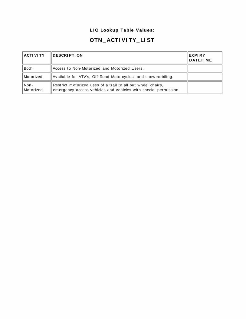
OTN_ACTIVITY_LIST
List of valid OTN ACTIVITYs.
Column Name Column
Type
Mandatory Short Name Valid Values
ACTIVITY VARCHAR2
(25)
Yes ACTIVITY
The activity permitted on a trail segment.
DESCRIPTION VARCHAR2 (2000)
A description of an inspection findings.
Yes DESCRIPTIO
EFFECTIVE_DATETIME DATE Yes EFF_DATE
Date/time the record was created or last modified in the source database.
EXPIRY_DATETIME DATE No EXP_DATE
Date/time that the record was expired from use.
OTN_AMENITY_LIST
List of valid OTN AMENITYs.
Column Name Column
Type
Mandatory Short Name Valid Values
AMENITY VARCHAR2
(50)
Yes AMENITY
Features located on trail, includes infrastructure, signage, reservation information etc.
EFFECTIVE_DATETIME DATE Yes EFF_DATE
Date/time the record was created or last modified in the source database.
EXPIRY_DATETIME DATE No EXP_DATE
Date/time that the record was expired from use.
OTN_OFSC_TRAIL_DESIG_LIST
Lookup table for Ontario Federation of Snowmobile Club designation.
Column Name Column
Type
Mandatory Short Name Valid Values
OFSC_TRAIL_DESIGNATION VARCHAR2
(10)
Yes OFSC_DESIG
Name of the trail designation as defined by the OFSC Ontario Federation of Snowmobile Clubs.
DESCRIPTION VARCHAR2 (2000)
Yes DESCRIPTIO
The description of Ontario Federation of Snowmobile Club names.
EFFECTIVE_DATETIME DATE Yes EFF_DATE
Date/time the record was created or last modified in the source database.
EXPIRY_DATETIME DATE No EXP_DATE
Date/time that the record was expired from use.
OTN_ORCKA_SWIFTWATER_LIST
Lookup table for Ontario Recreational Canoe and Kayak Association swiftwater classification system.
Column Name Column
Type
Mandatory Short Name Valid Values
ORCKA_SWIFTWATER_CLASS VARCHAR2
(15)
Yes ORCKA_CLAS
A classification of the water defined by the Ontario Recreational Canoeing and Kayaking Association. Defined by international categories of swiftwater for determining moving water. Applies to trails on open water only (canoe routes).
DESCRIPTION VARCHAR2
(300)
Yes DESCRIPTIO
The description of the Ontario Recreational Canoe and Kayaking Association swiftwater classifications. Defined by international categories of swiftwater for determining moving water. Applies to trails on open water only. (Canoe routes).
EFFECTIVE_DATETIME DATE Yes EFF_DATE
Date/time the record was created or last modified in the source database.
EXPIRY_DATETIME DATE No EXP_DATE
Date/time that the record was expired from use.
OTN_OTC_TRAIL_CHALLENGE_LIST
Lookup table for Ontario Trails Council Trail Challenge categories.
Column Name Column
Type
Mandatory Short
Name
Valid Values
OTC_TRAIL_CHALLENGE VARCHAR2
(25)
Yes OTC_CHALL
The difficulty of the trail, defined by the Ontario Trails Council. Defined by the maximum trail challenge over the length of the trail.
DESCRIPTION VARCHAR2
(2000)
Yes DESCRIPTIO
The description of the Ontario Trail Council Challenge Name Classification. The OTC Challenge is a difficulty rating defined by the council.
EFFECTIVE_DATETIME DATE Yes EFF_DATE
Date/time the record was created or last modified in the source database.
EXPIRY_DATETIME DATE No EXP_DATE
Date/time that the record was expired from use.
OTN_OTC_TRAIL_CHARACTER
Information related to the trail character.
Column Name Column Type
Mandatory Short Name
Valid Values
OTN_TRAILHEAD_ID NUMBER (13,0)
Yes TRAIL_ID
A unique numeric provincial identifier (FMF Object Id).
OTC_TRAIL_CHARACTER VARCHAR2 (15)
Yes OTC_CHAR Historic, Natural, Rail Trail, Scenic,
Urban, Water (See OTN_OTC_TRAIL_CHARACTER_LIST table)
The trail character as defined by the Ontario Trails Council. e.g. Historic, Urban, Natural.
EFFECTIVE_DATETIME DATE Yes EFF_DATE
Date/time the record was created or last modified in the source database.
OTN_OTC_TRAIL_CHARACTER_LIST
Lookup table for Ontario Trails Council Character categories.
Column Name Column
Type
Mandatory Short
Name
Valid Values
OTC_TRAIL_CHARACTER VARCHAR2
(15)
Yes OTC_CHAR
The trail character as defined by the Ontario Trails Council. e.g. Historic, Urban, Natural.
DESCRIPTION VARCHAR2 (2000)
Yes DESCRIPTIO
The description associated with the OTC Trail Character Name. The character of the trail defined by the Ontario Trails Council.
EFFECTIVE_DATETIME DATE Yes EFF_DATE
Date/time the record was created or last modified in the source database.
EXPIRY_DATETIME DATE No EXP_DATE
Date/time that the record was expired from use.
OTN_PERMITTED_USE_LIST
List of valid OTN PERMITTED_USEs.
Column Name Column
Type
Mandatory Short Name Valid Values
PERMITTED_USE VARCHAR2
(100)
Yes PERM_USE
Use permitted on the trail segment. Examples include skiing, hiking etc.
EFFECTIVE_DATETIME DATE Yes EFF_DATE
Date/time the record was created or last modified in the source database.
EXPIRY_DATETIME DATE No EXP_DATE
Date/time that the record was expired from use.
OTN_TRAILHEAD_AND_TRAIL_SEG
Index table for many to many relationship between trail segment and trailhead.
Column Name Column
Type
Mandatory Short Name Valid Values
OTN_TRAIL_SEGMENT_ID NUMBER
(13,0)
Yes SEGMENT_ID
Unique ID for Trail Segment.
OTN_TRAILHEAD_ID NUMBER
(13,0)
Yes TRAIL_ID
Unique ID for Trailhead.
EFFECTIVE_DATETIME DATE Yes EFF_DATE
Date/time the record was created or last modified in the source database.
OTN_TRAIL_ACCESS_POINT
Locations through which a trail can be accessed.
Column Name Column Mandatory Short Name Valid Values
Type
OGF_ID NUMBER (13,0)
Yes OGF_ID
A unique numeric provincial identifier assigned to each object.
OTN_TRAILHEAD_ID NUMBER
(13,0)
Yes TRAIL_ID
A unique numeric provincial identifier (FMF Object Id).
LATITUDE NUMBER (10,7)
Yes LATITUDE
The latitude in decimal degrees. For example: 50.1234567
LONGITUDE NUMBER
(10,7)
Yes LONGITUDE
The longitude in decimal degrees. Note that all longitude values in the Western Hemisphere will be negative. For example: -85.1234567
EFFECTIVE_DATETIME DATE Yes EFF_DATE
Date/time the record was created or last modified in the source database.
OTN_TRAIL_AMENITY
Amenities located at a trail point.
Column Name Column
Type
Mandatory Short Name Valid Values
OTN_TRAILHEAD_ID NUMBER
(13,0)
Yes TRAIL_ID
Unique ID for Trailhead.
AMENITY VARCHAR2 (50)
Yes AMENITY Beach, Bicycle Rental, Boat
Launch, Camping, Designated Rest Areas, Dogs Permitted off a Leash, ... (See OTN_AMENITY_LIST table)
Features located on trail, includes infrastructure, signage, reservation information etc.
EFFECTIVE_DATETIME DATE Yes EFF_DATE
Date/time the record was created or last modified in the source database.
OTN_TRAIL_GROUPING_LIST
Look up table listing high level trail grouping for a trailhead.
Column Name Column
Type
Mandatory Short Name Valid Values
TRAIL_GROUPING VARCHAR2
(75)
Yes GROUPING
Individual trails or organizations associated with a larger trail organization or association (ex. Bruce Trail, Voyageur Trail, Algonquin Park).
EFFECTIVE_DATETIME DATE Yes EFF_DATE
Date/time the record was created or last modified in the source database.
EXPIRY_DATETIME DATE No EXP_DATE
Date/time that the record was expired from use.
OTN_TRAIL_OPERATIONAL_SEASON
Information related to the trails operational season and hours of operation.
Column Name Column Type
Mandatory Short Name Valid Values
OGF_ID NUMBER
(13,0)
Yes OGF_ID
A unique numeric provincial identifier assigned to each object.
OTN_TRAILHEAD_ID NUMBER (13,0)
Yes TRAIL_ID
Unique ID for Trailhead.
OPERATIONAL_SEASON VARCHAR2
(10)
No SEASON Spring, Summer, Fall,
Winter, Annual
A description of the season of operations for the trail. Permissible values: Spring, Summer, Fall, Winter, Annual
OPENING_DATE DATE No OPENING_DT
The date when the trail opens.
CLOSING_DATE DATE No CLOSING_DT
The date when the trail closes.
OPERATIONAL_DAYS VARCHAR2 (100)
List of days that the trail is operational.
HOURS_OF_OPERATION VARCHAR2
(100)
No DAYS No HOURS
Hours of operation. Opening time to closing time. Described using either time stamps or a description (sunrise to sunset).
FEES VARCHAR2
(30)
No FEES None, Day Pass, Season
Pass, Annual Pass, Donation, Reservations Required,Other
A description of whether the trail requires any fees. Fees may include permitting or admission. Permissible values: None, Day Pass, Season Pass, Annual Pass, Donation, Reservations Required, Other.
EFFECTIVE_DATETIME DATE Yes EFF_DATE
Date/time the record was created or last modified in the source database.
OTN_TRAIL_PERMITTED_USE
The permitted uses on a trail.
Column Name Column
Type
Mandatory Short Name Valid Values
OTN_TRAILHEAD_ID NUMBER
(13,0)
Yes TRAIL_ID
Unique ID for Trailhead.
PERMITTED_USE VARCHAR2 (100)
Yes PERM_USE All-terrain vehicles (ATV),
Canoeing or paddling, Cycling - offroad or mountain, Cycling - road or path, Dog sledding, Equestrian, ... (See OTN_PERMITTED_USE_LIST table)
Use permitted on the trail segment. Examples include skiing, hiking etc.
EFFECTIVE_DATETIME DATE Yes EFF_DATE
Date/time the record was created or last modified in the source database.
OTN_TRILLIUM_NETWORK_TYPE_LIST
Lookup table for Trillium Trail Network classifications for trails.
Column Name Column
Type
Mandatory Short
Name
Valid Values
TRILLIUM_TRAIL_NETWORK_TYPE VARCHAR2
(25)
Yes TRILLIUM_T
A classification system assigned by the Trillium Trail Network to trails. The Trillium Trail Network (TTN) represents an opportunity for trails to link together between regions and communities in Ontario. The TTN consists of Ontario Trail Council member trails registering their trail as a network member. Trails wil l: - Be readily accessible to communities along the TTN - Incorporate multi and single use trails - Can have both year-round and single season trails - Include trails of different lengths, topography, uses and locations
DESCRIPTION VARCHAR2
(2000)
Yes DESCRIPTIO
The description of Trillium Trail Network codes. The Trillium Trail Network represents an opportunity for trails to link together between regions and communities in Ontario. The TTN consists of Ontario Trail Council member trails registering their trail as a network member.
EFFECTIVE_DATETIME DATE Yes EFF_DATE
Date/time the record was created or last modified in the source database.
EXPIRY_DATETIME DATE No EXP_DATE
Date/time that the record was expired from use.
ROLE_TYPE_LIST
List of valid party role types.
Column Name Column
Type
Mandatory Short Name Valid Values
ROLE_TYPE VARCHAR2
(50)
Yes ROLE_TYPE
The role that an organization or an individual plays.
ROLE_TYPE_DESCR VARCHAR2
(2000)
Yes DESCR
Description of Role Type.
EFFECTIVE_DATETIME DATE Yes EFF_DATE
Date/time the record was created or last modified in the source database.
EXPIRY_DATETIME DATE No EXP_DATE
Date/time that the record was expired from use.
SOURCE_LIST
A description of the source information that is the basis for creating or changing information about a geographic feature. In may be an observation, possibly resulting from a field survey or an adhoc report or a reference to a published or unpublished document.
Column Name Column
Type
Mandatory Short Name Valid Values
SOURCE_NAME VARCHAR2
(100)
Yes NAME
The name of the source.
SOURCE_DATE VARCHAR2 (50)
No SRC_DATE
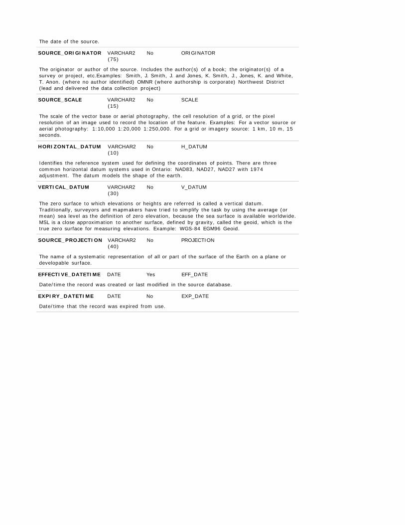
The date of the source.
SOURCE_ORIGINATOR VARCHAR2 (75)
No ORIGINATOR
The originator or author of the source. Includes the author(s) of a book; the originator(s) of a survey or project, etc.Examples: Smith, J. Smith, J. and Jones, K. Smith, J., Jones, K. and White, T. Anon. (where no author identified) OMNR (where authorship is corporate) Northwest District (lead and delivered the data collection project)
SOURCE_SCALE VARCHAR2
(15)
No SCALE
The scale of the vector base or aerial photography, the cell resolution of a grid, or the pixel resolution of an image used to record the location of the feature. Examples: For a vector source or aerial photography: 1:10,000 1:20,000 1:250,000. For a grid or imagery source: 1 km, 10 m, 15 seconds.
HORIZONTAL_DATUM VARCHAR2
(10)
No H_DATUM
Identifies the reference system used for defining the coordinates of points. There are three common horizontal datum systems used in Ontario: NAD83, NAD27, NAD27 with 1974 adjustment. The datum models the shape of the earth.
VERTICAL_DATUM VARCHAR2
(30)
No V_DATUM
The zero surface to which elevations or heights are referred is called a vertical datum. Traditionally, surveyors and mapmakers have tried to simplify the task by using the average (or mean) sea level as the definition of zero elevation, because the sea surface is available worldwide. MSL is a close approximation to another surface, defined by gravity, called the geoid, which is the true zero surface for measuring elevations. Example: WGS-84 EGM96 Geoid.
SOURCE_PROJECTION VARCHAR2
(40)
No PROJECTION
The name of a systematic representation of all or part of the surface of the Earth on a plane or developable surface.
EFFECTIVE_DATETIME DATE Yes EFF_DATE
Date/time the record was created or last modified in the source database.
EXPIRY_DATETIME DATE No EXP_DATE
Date/time that the record was expired from use.
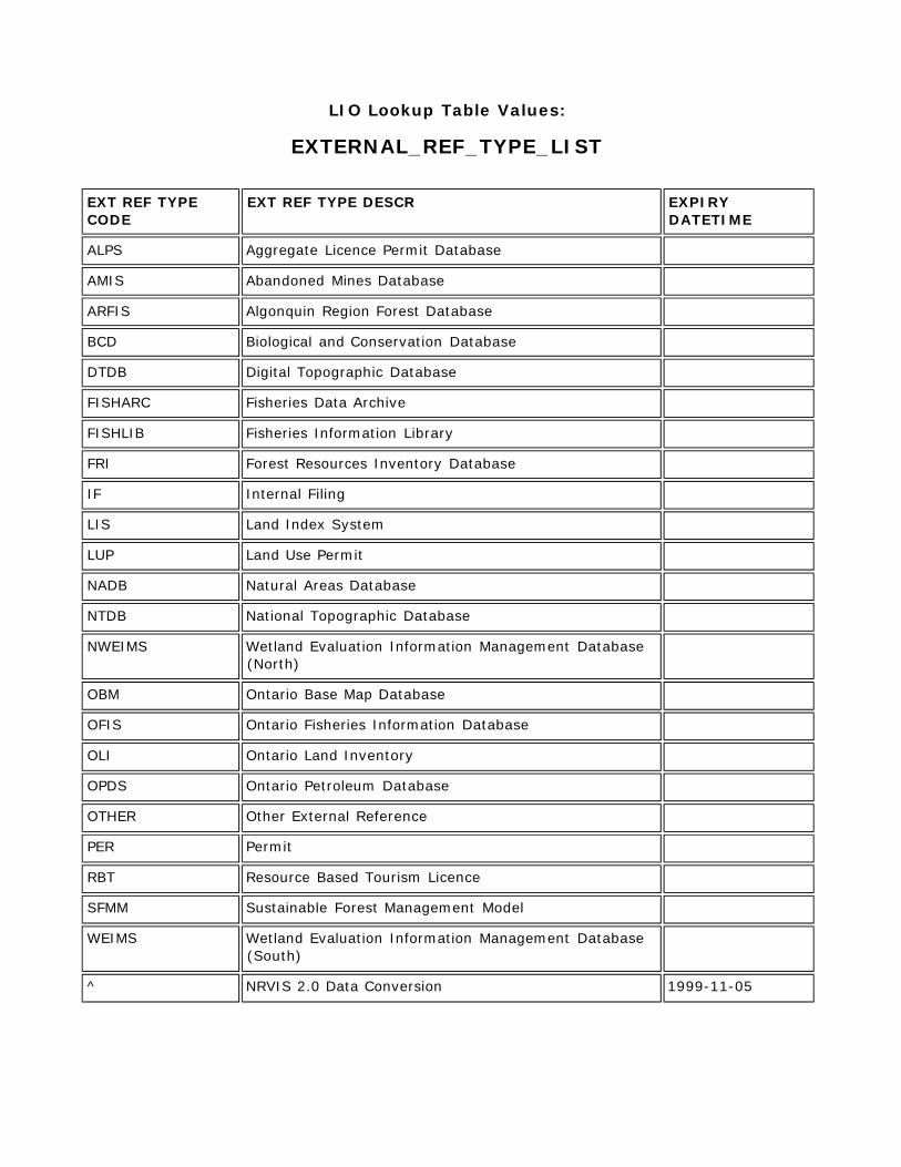
LIO Lookup Table Values:
EXTERNAL_REF_TYPE_LIST
EXT REF TYPE CODE
EXT REF TYPE DESCR EXPIRY DATETIME
ALPS Aggregate Licence Permit Database
AMIS Abandoned Mines Database
ARFIS Algonquin Region Forest Database
BCD Biological and Conservation Database
DTDB Digital Topographic Database
FISHARC Fisheries Data Archive
FISHLIB Fisheries Information Library
FRI Forest Resources Inventory Database
IF Internal Filing
LIS Land Index System
LUP Land Use Permit
NADB Natural Areas Database
NTDB National Topographic Database
NWEIMS Wetland Evaluation Information Management Database (North)
OBM Ontario Base Map Database
OFIS Ontario Fisheries Information Database
OLI Ontario Land Inventory
OPDS Ontario Petroleum Database
OTHER Other External Reference
PER Permit
RBT Resource Based Tourism Licence
SFMM Sustainable Forest Management Model
WEIMS Wetland Evaluation Information Management Database (South)
^ NRVIS 2.0 Data Conversion 1999-11-05
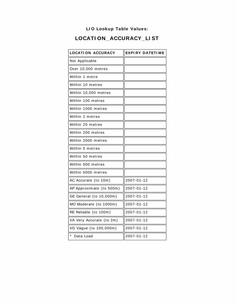
LIO Lookup Table Values:
LOCATION_ACCURACY_LIST
LOCATION ACCURACY EXPIRY DATETIME
Not Applicable
Over 10,000 metres
Within 1 metre
Within 10 metres
Within 10,000 metres
Within 100 metres
Within 1000 metres
Within 2 metres
Within 20 metres
Within 200 metres
Within 2000 metres
Within 5 metres
Within 50 metres
Within 500 metres
Within 5000 metres
AC Accurate (to 10m) 2007-01-12
AP Approximate (to 500m) 2007-01-12
GE General (to 10,000m) 2007-01-12
MO Moderate (to 1000m) 2007-01-12
RE Reliable (to 100m) 2007-01-12
VA Very Accurate (to 2m) 2007-01-12
VG Vague (to 100,000m) 2007-01-12
^ Data Load 2007-01-12
LIO Lookup Table Values:
OTN_ACTIVITY_LIST
ACTIVITY DESCRIPTION EXPIRY
DATETIME
Both Access to Non-Motorized and Motorized Users.
Motorized Available for ATV's, Off-Road Motorcycles, and snowmobiling.
Non- Motorized
Restrict motorized uses of a trail to all but wheel chairs, emergency access vehicles and vehicles with special permission.
LIO Lookup Table Values:
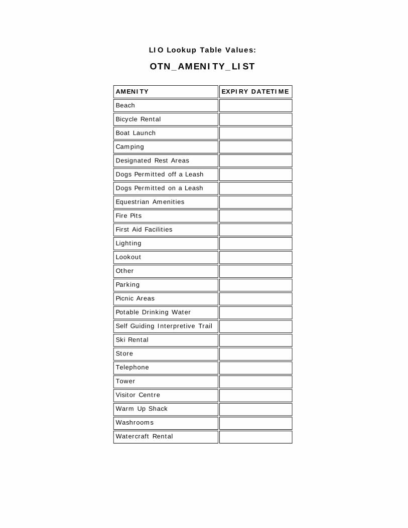
OTN_AMENITY_LIST
AMENITY EXPIRY DATETIME
Beach
Bicycle Rental
Boat Launch
Camping
Designated Rest Areas
Dogs Permitted off a Leash
Dogs Permitted on a Leash
Equestrian Amenities
Fire Pits
First Aid Facilities
Lighting
Lookout
Other
Parking
Picnic Areas
Potable Drinking Water
Self Guiding Interpretive Trail
Ski Rental
Store
Telephone
Tower
Visitor Centre
Warm Up Shack
Washrooms
Watercraft Rental

LIO Lookup Table Values:
OTN_OFSC_TRAIL_DESIG_LIST
OFSC TRAIL DESIGNATION
DESCRIPTION EXPIRY DATETIME
Club Club trails are all other Snowmobile Trails maintained by the Club. Club trails are NOT TOPS Trails. Club trails provide access to local communities or services. Club trails are sanctioned and maintained to the same standards as TOPS Trails.
Connector Connector trails link one Trunk Trail to another. They are designated by a one letter - three digit number - one letter combination (e.g. "A101D") where the letters indicate which two trunk Trails are being connected. Connector Trails are TOPS trails.
Feeder Feeder trails feed traffic to Trunk Trails. These routes are designated by a letter and a 3-digit number (e.g. "C112"), where the letter indicates the Trunk Trail to which the trail leads. Feeder trails are TOPS trails.
Trunk Trunk trails are the main routes for trans-provincial touring. They are designated by a single letter of the alphabet (e.g. "A") and are colour coded RED. Trunk trails are TOPS trails
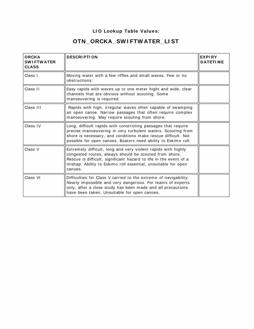
LIO Lookup Table Values:
OTN_ORCKA_SWIFTWATER_LIST
ORCKA SWIFTWATER CLASS
DESCRIPTION EXPIRY DATETIME
Class I Moving water with a few riffles and small waves. Few or no obstructions.
Class II Easy rapids with waves up to one meter hight and wide, clear channels that are obvious without scouting. Some manoeuvering is required
Class III Rapids with high, irregular waves often capable of swamping an open canoe. Narrow passages that often require complex manoeuvering. May require scouting from shore.
Class IV Long, difficult rapids with constricting passages that require precise manoeuvering in very turbulent waters. Scouting from shore is necessary, and conditions make rescue difficult. Not possible for open canoes. Boaters need ability to Eskimo roll.
Class V Extremely difficult, long and very violent rapids with highly congested routes, always should be scouted from shore. Rescue is difficult, significant hazard to life in the event of a mishap. Ability to Eskimo roll essential, unsuitable for open canoes.
Class VI Difficulties for Class V carried to the extreme of navigability. Nearly impossible and very dangerous. For teams of experts only, after a close study has been made and all precautions have been taken. Unsuitable for open canoes.
LIO Lookup Table Values:
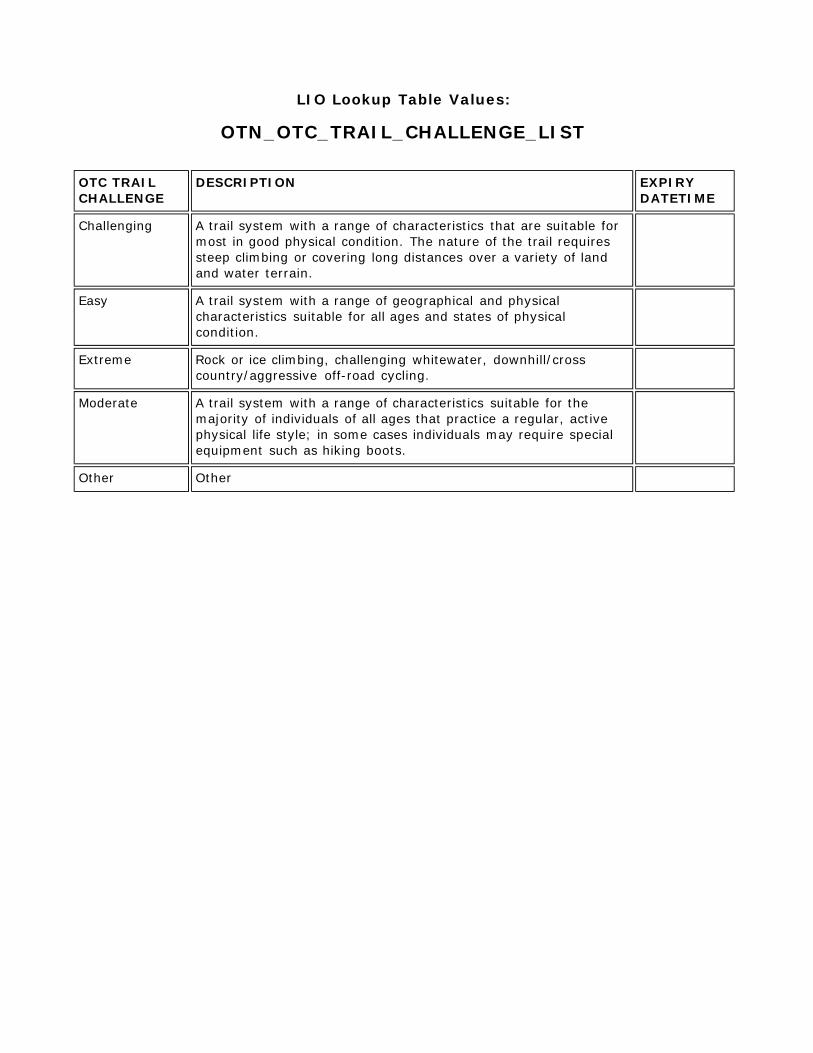
OTN_OTC_TRAIL_CHALLENGE_LIST
OTC TRAIL CHALLENGE
DESCRIPTION EXPIRY DATETIME
Challenging A trail system with a range of characteristics that are suitable for most in good physical condition. The nature of the trail requires steep climbing or covering long distances over a variety of land and water terrain.
Easy A trail system with a range of geographical and physical characteristics suitable for all ages and states of physical condition.
Extreme Rock or ice climbing, challenging whitewater, downhill/cross country/aggressive off-road cycling.
Moderate A trail system with a range of characteristics suitable for the majority of individuals of all ages that practice a regular, active physical life style; in some cases individuals may require special equipment such as hiking boots.
Other Other
LIO Lookup Table Values:
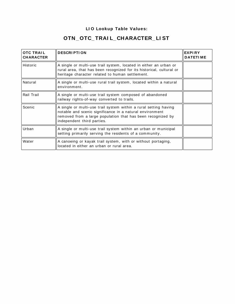
OTN_OTC_TRAIL_CHARACTER_LIST
OTC TRAIL CHARACTER
DESCRIPTION EXPIRY DATETIME
Historic A single or multi-use trail system, located in either an urban or rural area, that has been recognized for its historical, cultural or heritage character related to human settlement.
Natural A single or multi-use rural trail system, located within a natural environment.
Rail Trail A single or multi-use trail system composed of abandoned railway rights-of-way converted to trails.
Scenic A single or multi-use trail system within a rural setting having notable and scenic significance in a natural environment removed from a large population that has been recognized by independent third parties.
Urban A single or multi-use trail system within an urban or municipal setting primarily serving the residents of a community.
Water A canoeing or kayak trail system, with or without portaging, located in either an urban or rural area.
LIO Lookup Table Values:
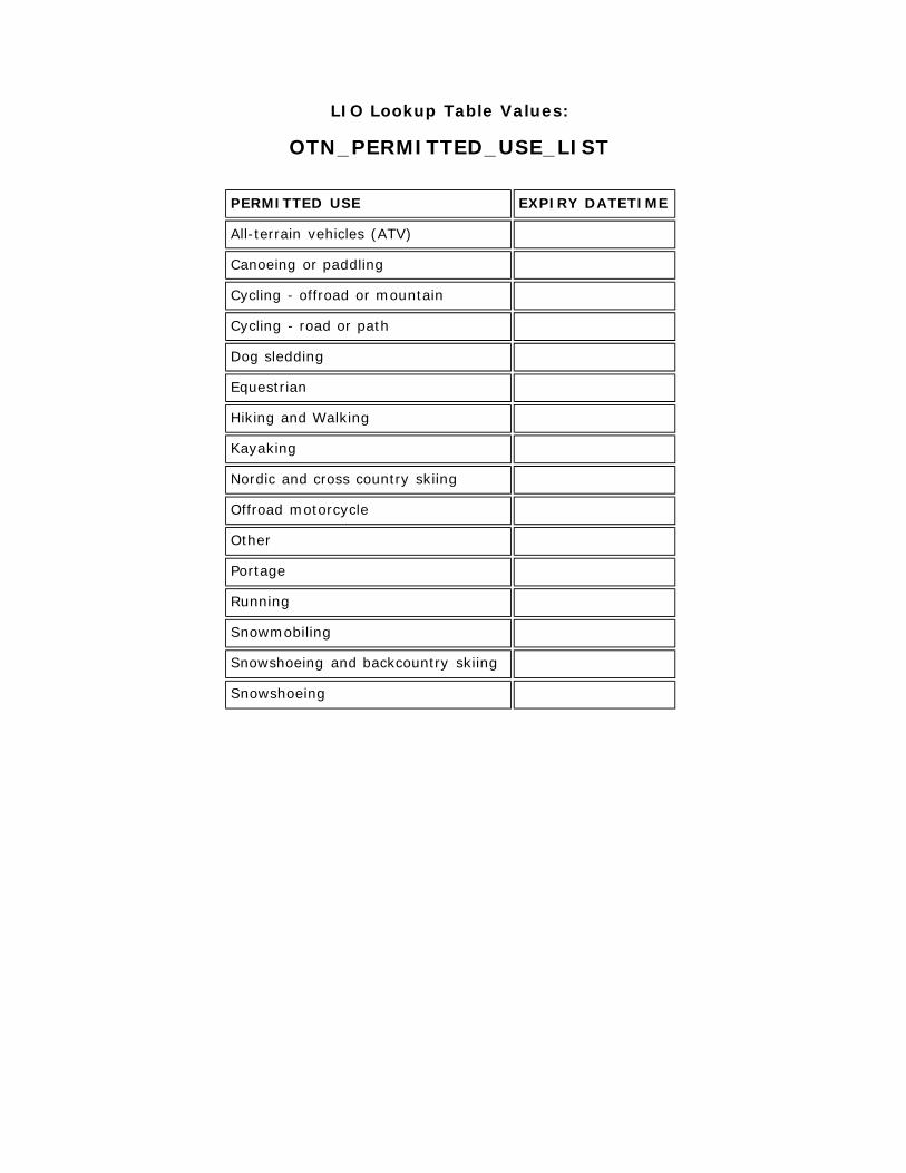
OTN_PERMITTED_USE_LIST
PERMITTED USE EXPIRY DATETIME
All-terrain vehicles (ATV)
Canoeing or paddling
Cycling - offroad or mountain
Cycling - road or path
Dog sledding
Equestrian
Hiking and Walking
Kayaking
Nordic and cross country skiing
Offroad motorcycle
Other
Portage
Running
Snowmobiling
Snowshoeing and backcountry skiing
Snowshoeing
LIO Lookup Table Values:
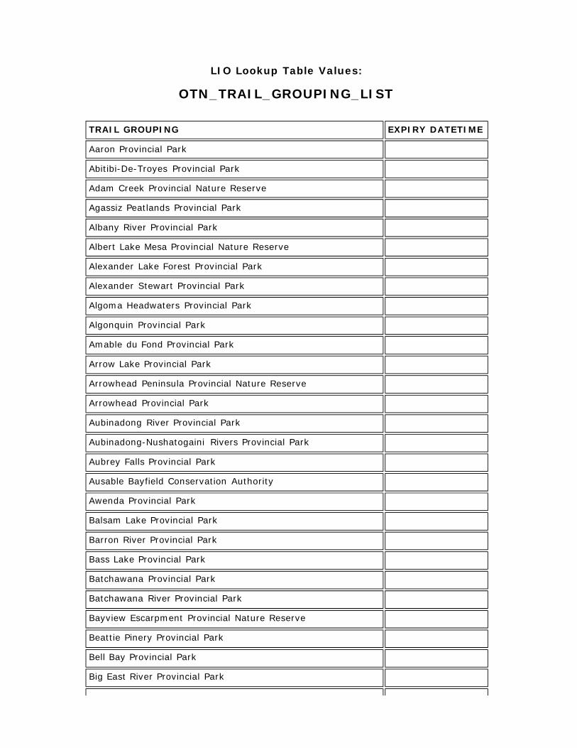
OTN_TRAIL_GROUPING_LIST
TRAIL GROUPING EXPIRY DATETIME
Aaron Provincial Park
Abitibi-De-Troyes Provincial Park
Adam Creek Provincial Nature Reserve
Agassiz Peatlands Provincial Park
Albany River Provincial Park
Albert Lake Mesa Provincial Nature Reserve
Alexander Lake Forest Provincial Park
Alexander Stewart Provincial Park
Algoma Headwaters Provincial Park
Algonquin Provincial Park
Amable du Fond Provincial Park
Arrow Lake Provincial Park
Arrowhead Peninsula Provincial Nature Reserve
Arrowhead Provincial Park
Aubinadong River Provincial Park
Aubinadong-Nushatogaini Rivers Provincial Park
Aubrey Falls Provincial Park
Ausable Bayfield Conservation Authority
Awenda Provincial Park
Balsam Lake Provincial Park
Barron River Provincial Park
Bass Lake Provincial Park
Batchawana Provincial Park
Batchawana River Provincial Park
Bayview Escarpment Provincial Nature Reserve
Beattie Pinery Provincial Park
Bell Bay Provincial Park
Big East River Provincial Park
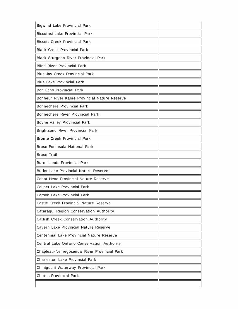
Bigwind Lake Provincial Park
Biscotasi Lake Provincial Park
Bissett Creek Provincial Park
Black Creek Provincial Park
Black Sturgeon River Provincial Park
Blind River Provincial Park
Blue Jay Creek Provincial Park
Blue Lake Provincial Park
Bon Echo Provincial Park
Bonheur River Kame Provincial Nature Reserve
Bonnechere Provincial Park
Bonnechere River Provincial Park
Boyne Valley Provincial Park
Brightsand River Provincial Park
Bronte Creek Provincial Park
Bruce Peninsula National Park
Bruce Trail
Burnt Lands Provincial Park
Butler Lake Provincial Nature Reserve
Cabot Head Provincial Nature Reserve
Caliper Lake Provincial Park
Carson Lake Provincial Park
Castle Creek Provincial Nature Reserve
Cataraqui Region Conservation Authority
Catfish Creek Conservation Authority
Cavern Lake Provincial Nature Reserve
Centennial Lake Provincial Nature Reserve
Central Lake Ontario Conservation Authority
Chapleau-Nemegosenda River Provincial Park
Charleston Lake Provincial Park
Chiniguchi Waterway Provincial Park
Chutes Provincial Park
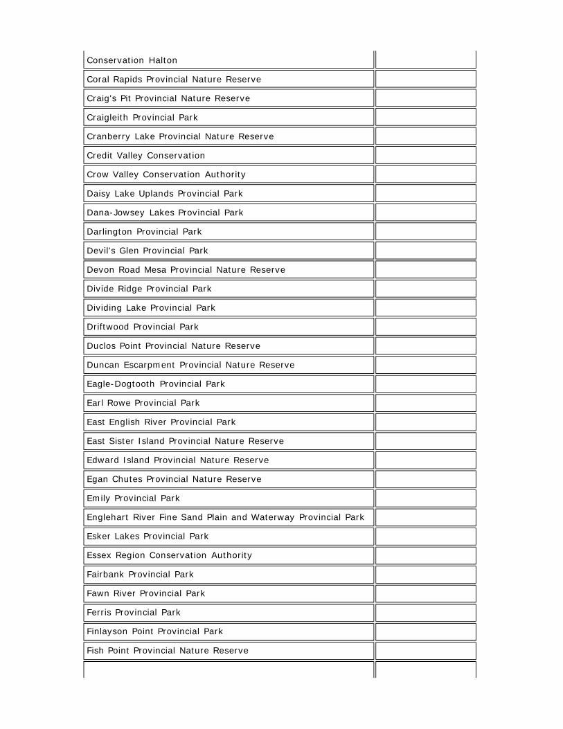
Conservation Halton
Coral Rapids Provincial Nature Reserve
Craig's Pit Provincial Nature Reserve
Craigleith Provincial Park
Cranberry Lake Provincial Nature Reserve
Credit Valley Conservation
Crow Valley Conservation Authority
Daisy Lake Uplands Provincial Park
Dana-Jowsey Lakes Provincial Park
Darlington Provincial Park
Devil's Glen Provincial Park
Devon Road Mesa Provincial Nature Reserve
Divide Ridge Provincial Park
Dividing Lake Provincial Park
Driftwood Provincial Park
Duclos Point Provincial Nature Reserve
Duncan Escarpment Provincial Nature Reserve
Eagle-Dogtooth Provincial Park
Earl Rowe Provincial Park
East English River Provincial Park
East Sister Island Provincial Nature Reserve
Edward Island Provincial Nature Reserve
Egan Chutes Provincial Nature Reserve
Emily Provincial Park
Englehart River Fine Sand Plain and Waterway Provincial Park
Esker Lakes Provincial Park
Essex Region Conservation Authority
Fairbank Provincial Park
Fawn River Provincial Park
Ferris Provincial Park
Finlayson Point Provincial Park
Fish Point Provincial Nature Reserve

Fitzroy Provincial Park
Five Mile Lake Provincial Park
Forks of the Credit Provincial Park
Foy Property Provincial Park
Fraleigh Lake Provincial Nature Reserve
Frederick House Lake Provincial Nature Reserve
French River Provincial Park
Frontenac Provincial Park
* Not a complete list.
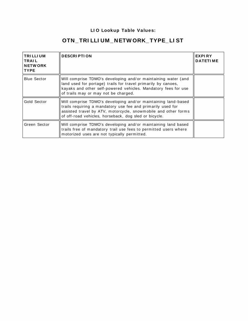
LIO Lookup Table Values:
OTN_TRILLIUM_NETWORK_TYPE_LIST TRILLIUM TRAIL NETWORK TYPE
DESCRIPTION EXPIRY DATETIME
Blue Sector Will comprise TDMO's developing and/or maintaining water (and land used for portage) trails for travel primarily by canoes, kayaks and other self-powered vehicles. Mandatory fees for use of trails may or may not be charged.
Gold Sector Will comprise TDMO's developing and/or maintaining land-based trails requiring a mandatory use fee and primarily used for assisted travel by ATV, motorcycle, snowmobile and other forms of off-road vehicles, horseback, dog sled or bicycle.
Green Sector Will comprise TDMO's developing and/or maintaining land based trails free of mandatory trail use fees to permitted users where motorized uses are not typically permitted.
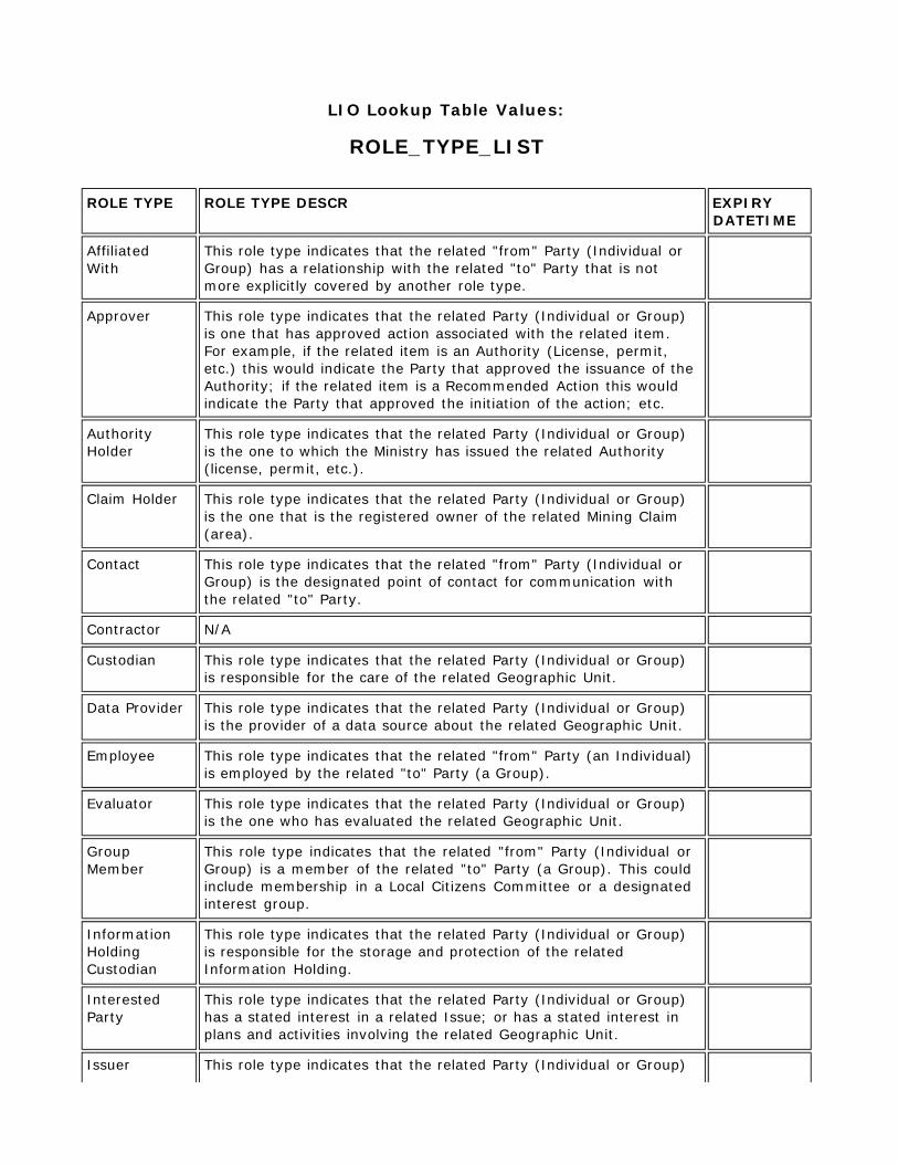
LIO Lookup Table Values:
ROLE_TYPE_LIST ROLE TYPE ROLE TYPE DESCR EXPIRY
DATETIME
Affiliated With
This role type indicates that the related "from" Party (Individual or Group) has a relationship with the related "to" Party that is not more explicitly covered by another role type.
Approver This role type indicates that the related Party (Individual or Group) is one that has approved action associated with the related item. For example, if the related item is an Authority (License, permit, etc.) this would indicate the Party that approved the issuance of the Authority; if the related item is a Recommended Action this would indicate the Party that approved the initiation of the action; etc.
Authority Holder
This role type indicates that the related Party (Individual or Group) is the one to which the Ministry has issued the related Authority (license, permit, etc.).
Claim Holder This role type indicates that the related Party (Individual or Group) is the one that is the registered owner of the related Mining Claim (area).
Contact This role type indicates that the related "from" Party (Individual or Group) is the designated point of contact for communication with the related "to" Party.
Contractor N/A
Custodian This role type indicates that the related Party (Individual or Group) is responsible for the care of the related Geographic Unit.
Data Provider This role type indicates that the related Party (Individual or Group) is the provider of a data source about the related Geographic Unit.
Employee This role type indicates that the related "from" Party (an Individual) is employed by the related "to" Party (a Group).
Evaluator This role type indicates that the related Party (Individual or Group) is the one who has evaluated the related Geographic Unit.
Group Member
This role type indicates that the related "from" Party (Individual or Group) is a member of the related "to" Party (a Group). This could include membership in a Local Citizens Committee or a designated interest group.
Information Holding Custodian
This role type indicates that the related Party (Individual or Group) is responsible for the storage and protection of the related Information Holding.
Interested Party
This role type indicates that the related Party (Individual or Group) has a stated interest in a related Issue; or has a stated interest in plans and activities involving the related Geographic Unit.
Issuer This role type indicates that the related Party (Individual or Group)
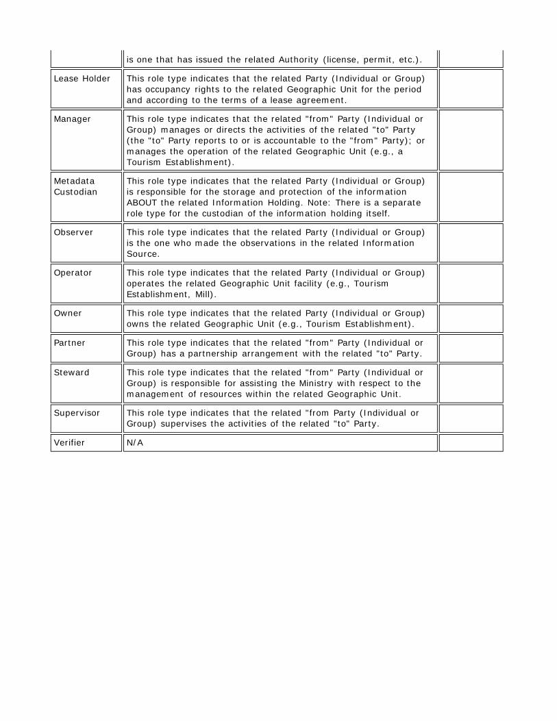
is one that has issued the related Authority (license, permit, etc.).
Lease Holder This role type indicates that the related Party (Individual or Group) has occupancy rights to the related Geographic Unit for the period and according to the terms of a lease agreement.
Manager This role type indicates that the related "from" Party (Individual or Group) manages or directs the activities of the related "to" Party (the "to" Party reports to or is accountable to the "from" Party); or manages the operation of the related Geographic Unit (e.g., a Tourism Establishment).
Metadata Custodian
This role type indicates that the related Party (Individual or Group) is responsible for the storage and protection of the information ABOUT the related Information Holding. Note: There is a separate role type for the custodian of the information holding itself.
Observer This role type indicates that the related Party (Individual or Group) is the one who made the observations in the related Information Source.
Operator This role type indicates that the related Party (Individual or Group) operates the related Geographic Unit facility (e.g., Tourism Establishment, Mill).
Owner This role type indicates that the related Party (Individual or Group) owns the related Geographic Unit (e.g., Tourism Establishment).
Partner This role type indicates that the related "from" Party (Individual or Group) has a partnership arrangement with the related "to" Party.
Steward This role type indicates that the related "from" Party (Individual or Group) is responsible for assisting the Ministry with respect to the management of resources within the related Geographic Unit.
Supervisor This role type indicates that the related "from Party (Individual or Group) supervises the activities of the related "to" Party.
Verifier N/A

LIO Lookup Table Values:
SOURCE_LIST SOURCE NAME SOURCE
DATE SOURCE ORIGINATOR
SOURCE SCALE
HORIZONTAL DATUM
VERTICAL DATUM
SOURCE PROJECTION
EXPIRY DATETIME
AFFM Provincial Administrative Maps
Ministry of Natural Resources
600000
Aerial Photography
Ministry of Natural Resources
15840
Aerial Survey
Book/Publication
CIR Photograpy Ministry of
Natural Resources
City of Ottawa Borehole Database
1883 - 2006
City of Ottawa Varies Mean
Average Sea Level
Geodetic and UTM
Digital File
Digital Map
Field Survey\Site Visit
File System/Filing Cabinet Information
Forest Resources Inventory
Ministry of Natural Resources
NAD27 UTM
GPS Data Collection
Hard Copy/Paper Map
IKONOS Multispectral
Ministry of Natural Resources
IKONOS Panchromatic
Ministry of Natural Resources
IRS Multispectral Ministry of
Natural Resources
IRS Panchromatic
Ministry of Natural Resources
IRS Pansharpened
Ministry of Natural Resources
Landsat-1,2,3 MSS
Ministry of Natural Resources
Landsat-4,5 MSS
Ministry of Natural Resources
Landsat-7 ETM Ministry of
Natural Resources
Local Borehole Drilling Program Results
2006 Ministry of
Northern Development and Mines
Mean Average Sea Level
Local Knowledge
MNDM Assesment File
MNDM Client/Company Information
MNR Based Observation
MTO Engineering Reports
Varies Ministry of
Transportation
Varies Mean
Average Sea Level
NRCan - CanVec 2008 Natural
Resources Canada
50000 NAD83
NRCan - National Hydro Network
2008 Natural
Resources Canada
50000 NAD83
NTS Map 1:250000
1970 to 2003
Department of Natural Reosurces
250000 NAD27
NTS Map 1:50000
1970 to 2003
Department of Natural Resources
50000 NAD27
Ontario Base Map 1:10000
1978 to 1995
Ministry of Natural Resources
10000 NAD27 UTM
Ontario Base Map 1:20000
1978 to 1995
Ministry of Natural Resources
20000 NAD27 UTM
Ontario Geological Survey Fieldwork Mapping
Varies to 2004
Ontario Geological Survey
1:50,000 NAD83 Mean
Average Sea Level
Universal Transvers Mercator
Ontario Parcel NAD83
OrthoImagery Ministry of
Natural Resources
Public Observation
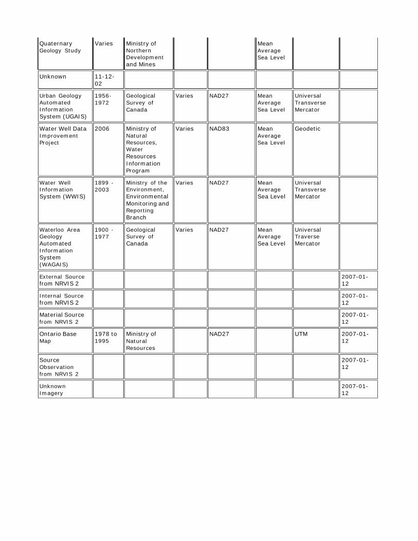
Quaternary Geology Study
Varies Ministry of Northern Development and Mines
Mean Average Sea Level
Unknown 11-12- 02
Urban Geology Automated Information System (UGAIS)
1956- 1972
Geological Survey of Canada
Varies NAD27 Mean Average Sea Level
Universal Transverse Mercator
Water Well Data Improvement Project
2006 Ministry of Natural Resources, Water Resources Information Program
Varies NAD83 Mean Average Sea Level
Geodetic
Water Well Information System (WWIS)
1899 - 2003
Ministry of the Environment, Environmental Monitoring and Reporting Branch
Varies NAD27 Mean Average Sea Level
Universal Transverse Mercator
Waterloo Area Geology Automated Information System (WAGAIS)
1900 - 1977
Geological Survey of Canada
Varies NAD27 Mean Average Sea Level
Universal Traverse Mercator
External Source from NRVIS 2
2007-01- 12
Internal Source from NRVIS 2
2007-01- 12
Material Source from NRVIS 2
2007-01- 12
Ontario Base Map
1978 to 1995
Ministry of Natural Resources
NAD27 UTM 2007-01- 12
Source Observation from NRVIS 2
2007-01- 12
Unknown Imagery
2007-01- 12
Related Documents