414 IEEE SYSTEMS JOURNAL, VOL. 2, NO. 3, SEPTEMBER 2008 Land-Cover Observations as Part of a Global Earth Observation System of Systems (GEOSS): Progress, Activities, and Prospects Martin Herold, Associate Member, IEEE, Curtis E. Woodcock, Thomas R. Loveland, John Townshend, Michael Brady, Chris Steenmans, and Christiane C. Schmullius Abstract—The international land-cover community has been working with GEO since 2005 to build the foundations for land-cover observations as an integral part of a Global Earth Observation System of Systems (GEOSS). The Group on Earth Observation (GEO) has provided the platform to elevate the societal relevance of land cover monitoring and helped to link a diverse set of global, regional, and national activities. A dedicated 2007–2009 GEO work plan task has resulted in achievements on the strategic and implementation levels. Integrated Global Observations of the Land (IGOL), the land theme of the Inte- grated Global Observation Strategy (IGOS), has been approved and is now in the process of transition into GEO implementation. New global land-cover maps at moderate spatial resolutions (i.e., GLOBCOVER) are being produced using guidelines and stan- dards of the international community. The Middecadal Global Landsat Survey for 2005–2006 is extending previous 1990 and 2000 efforts for global, high-quality Landsat data. Despite this progress, essential challenges for building a sustained global land-cover-ob- serving system remain, including: international cooperation on the continuity of global observations; ensuring consistency in land monitoring approaches; community engagement and country par- ticipation in mapping activities; commitment to ongoing quality assurance and validation; and regional networking and capacity building. Index Terms—Global Earth Observation (GEO), Global Earth Observation System of Systems (GEOSS), global, Integrated Global Observations of the Land (IGOL), land cover, remote sensing. I. INTRODUCTION I N ITS 10-year reference document [1], the Group on Earth Observation (GEO) has highlighted the importance of land cover for all areas of societal benefits (Fig. 1). In addressing this Manuscript received September 18, 2007; revised April 10, 2008. First pub- lished July 18, 2008; current version published September 17, 2008. M. Herold and C. C. Schmullius are with the GOFC-GOLD Land Cover Project Office, Department of Geography, Friedrich-Schiller University, 07743 Jena, Germany (e-mail: [email protected]). C. E. Woodcock is with the Department of Geography, Boston University, Boston, MA 02215 USA (e-mail: [email protected]). T. R. Loveland is with the Geographic Information Science Center of Excel- lence (GIScCE), Brookings, SD 57007 USA (e-mail: [email protected]). J. Townshend is with the Department of Geography, University of Maryland, College Park, MD 20742 USA (e-mail: [email protected]). M. Brady is with the Canadian Forest Service, Natural Resources Canada, Edmonton, AB, T6H 3S5 Canada (e-mail: [email protected]). C. Steenmans is with the European Environment Agency, 1050 Copenhagen K, Denmark (e-mail: [email protected]). Color versions of one or more of the figures in this paper are available online at http://ieeexplore.ieee.org. Digital Object Identifier 10.1109/JSYST.2008.925983 importance, the aim of this paper is to demonstrate progress, de- scribe approaches and activities, and show prospects of the inter- national land=cover community working with GEO to develop global land cover observing as part of a Global Earth Observa- tion System of Systems (GEOSS). Land cover is one of the most important properties for observing, describing,, and studying the environment. Reli- able land-cover and land-cover-change observations are of crucial importance to: 1) understanding and mitigating climate change and its impacts; 2) sustainable development; 3) natural resource management; 4) conserving biodiversity; and 5) understanding of ecosystems and biogeochemical cycling. As an example, land-cover characteristics reveal ongoing processes of deforestation, desertification, urbanization, loss of biodiversity and ecosystem functions, changing boundary conditions for vector-borne diseases, and water and energy management. Agenda 21 of the United Nations Conference on Environment and Development (UNCED), the World Summit on Sustainable Development (WSSD) in Johannesburg 2002, and existing United Nations conventions, most prominently the United Nations Framework Convention on Climate Change (UNFCCC), have all highlighted the importance of land cover in their implementation [2], [3] and strengthened recognition within the international community of the necessity of timely and accurate land-cover information. In situ and satellite-based land-observation efforts as well as different disciplines (e.g., geography, ecology, geology, forestry, and land management and planning) use and refer to land cover as an obvious and detectable indicator of land-surface characteristics. Despite the fundamental importance of land-cover informa- tion and other land-surface characteristics, it is important to recognize that land observations are not operational, as com- pared with other earth observation domains such as oceans and the atmosphere. Although numerous satellites acquire data suit- able for land-cover monitoring, large-scale regional and global mapping and monitoring programs have not reached operational status for delivering internationally accepted land-cover and, in particular, land-cover-change data to serve the many uses and applications. The field of land-cover observations is heterogeneous in many ways, i.e., in terms of the land surface itself, the ap- proaches to acquire land-cover data, and the users of such information. Basically, each land surface worldwide has been mapped and characterized several times, and many countries 1932-8184/$25.00 © 2008 IEEE

Welcome message from author
This document is posted to help you gain knowledge. Please leave a comment to let me know what you think about it! Share it to your friends and learn new things together.
Transcript

414 IEEE SYSTEMS JOURNAL, VOL. 2, NO. 3, SEPTEMBER 2008
Land-Cover Observations as Part of a Global EarthObservation System of Systems (GEOSS): Progress,
Activities, and ProspectsMartin Herold, Associate Member, IEEE, Curtis E. Woodcock, Thomas R. Loveland, John Townshend,
Michael Brady, Chris Steenmans, and Christiane C. Schmullius
Abstract—The international land-cover community has beenworking with GEO since 2005 to build the foundations forland-cover observations as an integral part of a Global EarthObservation System of Systems (GEOSS). The Group on EarthObservation (GEO) has provided the platform to elevate thesocietal relevance of land cover monitoring and helped to link adiverse set of global, regional, and national activities. A dedicated2007–2009 GEO work plan task has resulted in achievementson the strategic and implementation levels. Integrated GlobalObservations of the Land (IGOL), the land theme of the Inte-grated Global Observation Strategy (IGOS), has been approvedand is now in the process of transition into GEO implementation.New global land-cover maps at moderate spatial resolutions (i.e.,GLOBCOVER) are being produced using guidelines and stan-dards of the international community. The Middecadal GlobalLandsat Survey for 2005–2006 is extending previous 1990 and 2000efforts for global, high-quality Landsat data. Despite this progress,essential challenges for building a sustained global land-cover-ob-serving system remain, including: international cooperation onthe continuity of global observations; ensuring consistency in landmonitoring approaches; community engagement and country par-ticipation in mapping activities; commitment to ongoing qualityassurance and validation; and regional networking and capacitybuilding.
Index Terms—Global Earth Observation (GEO), Global EarthObservation System of Systems (GEOSS), global, IntegratedGlobal Observations of the Land (IGOL), land cover, remotesensing.
I. INTRODUCTION
I N ITS 10-year reference document [1], the Group on EarthObservation (GEO) has highlighted the importance of land
cover for all areas of societal benefits (Fig. 1). In addressing this
Manuscript received September 18, 2007; revised April 10, 2008. First pub-lished July 18, 2008; current version published September 17, 2008.
M. Herold and C. C. Schmullius are with the GOFC-GOLD Land CoverProject Office, Department of Geography, Friedrich-Schiller University, 07743Jena, Germany (e-mail: [email protected]).
C. E. Woodcock is with the Department of Geography, Boston University,Boston, MA 02215 USA (e-mail: [email protected]).
T. R. Loveland is with the Geographic Information Science Center of Excel-lence (GIScCE), Brookings, SD 57007 USA (e-mail: [email protected]).
J. Townshend is with the Department of Geography, University of Maryland,College Park, MD 20742 USA (e-mail: [email protected]).
M. Brady is with the Canadian Forest Service, Natural Resources Canada,Edmonton, AB, T6H 3S5 Canada (e-mail: [email protected]).
C. Steenmans is with the European Environment Agency, 1050 CopenhagenK, Denmark (e-mail: [email protected]).
Color versions of one or more of the figures in this paper are available onlineat http://ieeexplore.ieee.org.
Digital Object Identifier 10.1109/JSYST.2008.925983
importance, the aim of this paper is to demonstrate progress, de-scribe approaches and activities, and show prospects of the inter-national land=cover community working with GEO to developglobal land cover observing as part of a Global Earth Observa-tion System of Systems (GEOSS).
Land cover is one of the most important properties forobserving, describing,, and studying the environment. Reli-able land-cover and land-cover-change observations are ofcrucial importance to: 1) understanding and mitigating climatechange and its impacts; 2) sustainable development; 3) naturalresource management; 4) conserving biodiversity; and 5)understanding of ecosystems and biogeochemical cycling.As an example, land-cover characteristics reveal ongoingprocesses of deforestation, desertification, urbanization, lossof biodiversity and ecosystem functions, changing boundaryconditions for vector-borne diseases, and water and energymanagement. Agenda 21 of the United Nations Conference onEnvironment and Development (UNCED), the World Summiton Sustainable Development (WSSD) in Johannesburg 2002,and existing United Nations conventions, most prominentlythe United Nations Framework Convention on Climate Change(UNFCCC), have all highlighted the importance of land coverin their implementation [2], [3] and strengthened recognitionwithin the international community of the necessity of timelyand accurate land-cover information. In situ and satellite-basedland-observation efforts as well as different disciplines (e.g.,geography, ecology, geology, forestry, and land managementand planning) use and refer to land cover as an obvious anddetectable indicator of land-surface characteristics.
Despite the fundamental importance of land-cover informa-tion and other land-surface characteristics, it is important torecognize that land observations are not operational, as com-pared with other earth observation domains such as oceans andthe atmosphere. Although numerous satellites acquire data suit-able for land-cover monitoring, large-scale regional and globalmapping and monitoring programs have not reached operationalstatus for delivering internationally accepted land-cover and, inparticular, land-cover-change data to serve the many uses andapplications.
The field of land-cover observations is heterogeneous inmany ways, i.e., in terms of the land surface itself, the ap-proaches to acquire land-cover data, and the users of suchinformation. Basically, each land surface worldwide has beenmapped and characterized several times, and many countries
1932-8184/$25.00 © 2008 IEEE
HEROLD et al.: LAND COVER OBSERVATIONS AS PART OF A GEOSS: PROGRESS, ACTIVITIES, AND PROSPECTS 415
have some kind of monitoring system in place (i.e., forest,agriculture, and cartographic information systems and invento-ries [4]). In addition, there are a number of global land-covermapping activities [5]–[9, App. A]. They have evolved withthe availability of continuous global moderate resolution satel-lite observations since the early 1990s. Related projects andprograms have generally remained in the research domain andhave just recently started to evolve into operational programs.
A global land-cover observing system requires long-termsatellite and in situ observations, a sustained processing systemto derive and disseminate land-cover information datasets, andan international coordinating mechanism to ensure relevance,acceptance, accuracy, and usability of such new global products.Suitable historic and recent satellite datasets exist at differentscales, significantly reducing technical and logistical barriersassociated with implementing a global land-cover monitoring[10]. The success of many recent land-cover mapping projectshas demonstrated the feasibility of producing land-cover mapswhen sufficient resources are provided. Previous global, re-gional, and national land-cover assessment activities, however,have widely remained independent. The approaches and map-ping standards to acquire and represent land characteristicshave become as diverse as the land surface itself. While mostmapping projects are developed for specific applications andpurposes, the resulting inconsistency between the differentland-cover map products or change accounting systems under-mines our ability to successfully synthesize land assessmentson regional and global scales. In addition, the user communityfor land-cover data is vast and complex and has been growingcontinuously with the evolution of the information age andprogress in spatial data analysis and modeling. The variousfields of application tend to have different perspectives on howthey understand land cover and what they seek in terms ofland-cover products. Land-cover data aiming to serve multipleapplications must provide flexibility (in terms of data accessand thematic and cartographic standards) not present in manyexisting environmental databases [11], [12].
Building a sustained global land-cover observing systemrequires international agreement and cooperation on: 1) thecontinuity of global observations; 2) the consistency in map-ping and monitoring specifications and land-cover assessmentapproaches; and 3) sustained engagement and participation inmapping activities, regional networking, and capacity building.Thus, the objectives of this paper are to show how GEO canhelp to overcome some of the known issues and problemsmentioned and help to evolve a sustained global land-coverobservation system as part of a GEOSS. The paper addressesthe following:
• GEO’s role in improving global land cover observations;• the land-cover community’s experience working with
GEO and its instruments;• achievements on the strategic and implementation level;• pathways toward operational global land cover observa-
tions.Overall, the GEO contribution of the global land-cover com-
munity is to ensure that technical capabilities are understood
Fig. 1. GEO areas of societal benefits and key land-cover observation needsemphasize the multitude of services from continuous and consistent global ter-restrial observations.
and adopted by high-level political processes. This involves anadvocacy role for participating in an international coordinationand cooperation mechanisms (led by GEO) specifying land ob-servation strategies from existing user requirements and puttingthem into operation.
II. ROLE FOR GEO
GEO is a result of three ministerial-level earth-observationsummits. It aims to build and maintain a Global Earth Obser-vation System of Systems (GEOSS) [13]. GEOSS will buildon and add value to existing earth-observation systems bycoordinating their efforts, addressing critical gaps, supportingtheir interoperability, sharing information, reaching a commonunderstanding of user requirements, and improving delivery ofinformation to users [1]. GEO, as a high-level political process(currently 66 member states and 46 participating organizations),has defined nine areas where society directly benefits fromearth observations: disasters, energy, health, climate, water,weather, agriculture, ecosystems, and biodiversity (Fig. 1).Although being global in scope, GEO also seeks to stimulatenational and regional implementation activities.
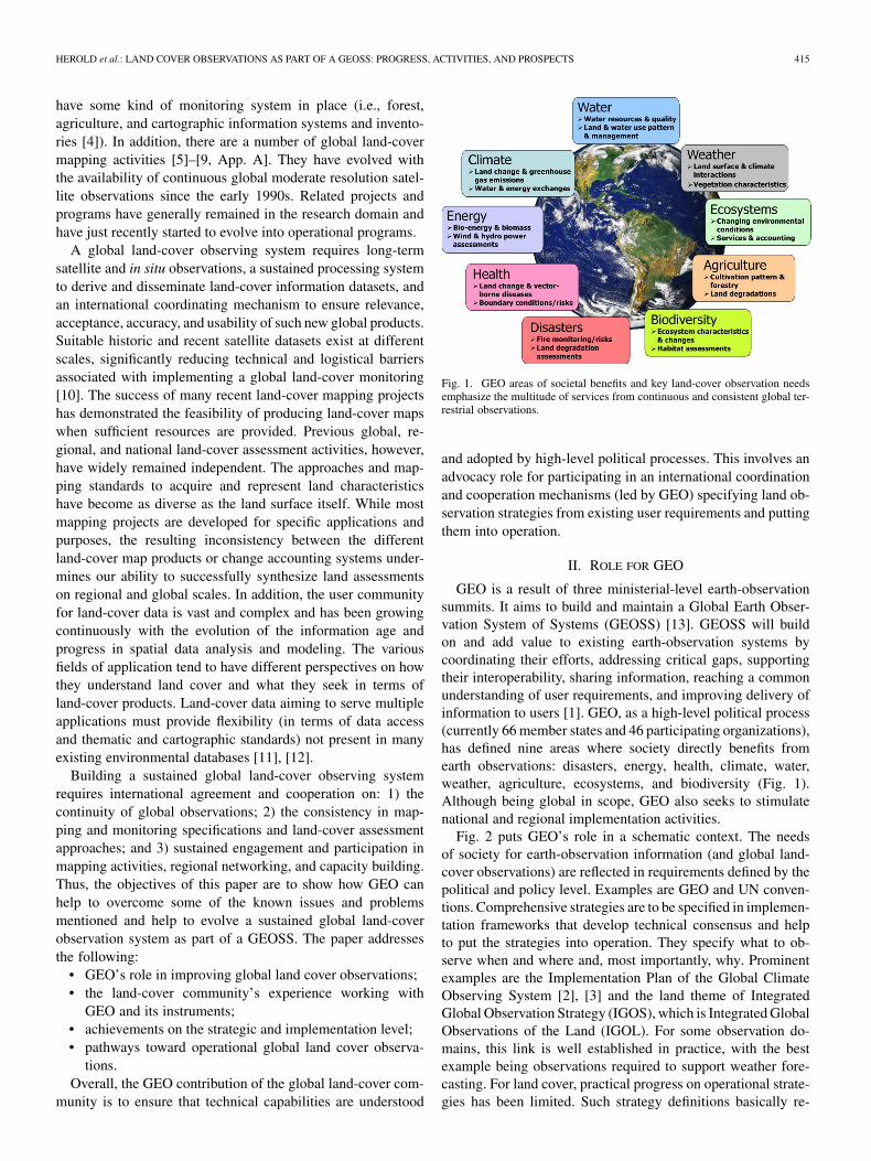
Fig. 2 puts GEO’s role in a schematic context. The needsof society for earth-observation information (and global land-cover observations) are reflected in requirements defined by thepolitical and policy level. Examples are GEO and UN conven-tions. Comprehensive strategies are to be specified in implemen-tation frameworks that develop technical consensus and helpto put the strategies into operation. They specify what to ob-serve when and where and, most importantly, why. Prominentexamples are the Implementation Plan of the Global ClimateObserving System [2], [3] and the land theme of IntegratedGlobal Observation Strategy (IGOS), which is Integrated GlobalObservations of the Land (IGOL). For some observation do-mains, this link is well established in practice, with the bestexample being observations required to support weather fore-casting. For land cover, practical progress on operational strate-gies has been limited. Such strategy definitions basically re-
416 IEEE SYSTEMS JOURNAL, VOL. 2, NO. 3, SEPTEMBER 2008
Fig. 2. Scheme for moving from societal needs to benefits through a series ofsteps from observations requirements, strategies, and implementation guidelinesto monitoring operations and applications.
flect the interface between the domains of society and polit-ical discussions on the one hand (i.e., through multilateral en-vironmental agreements), and the earth observation arena onthe other. Following the circle in Fig. 2, the next stage refersto more detailed technical implementation guidelines based onscientific and technical consensus on suitable earth-observationdata and methods for operational global and regional land-covermapping and monitoring. Common issues discussed in this con-text relate to consistency and continuity in global satellite ob-servations, harmonization, and standardization of land-cover in-formation [14] validation protocols [15] and consensus tech-nical protocols for global land cover and change monitoring.In essence, such guidelines provide internationally agreed tech-nical specifications for implementing global land-cover obser-vations. The resulting land-cover information products are thenapplied to support land policy and management for the bene-fits of society. Prominent examples are global environmentalassessments, forest resources assessments, national carbon ac-counting systems, and others. Although GEO’s initial role isto link societal needs, political will, and land-cover observingstrategies, it should and perhaps will have an impact on all ac-tivities downstream toward the benefits to society. This role re-quires the support and leadership of the technical land-covercommunity.
In consideration of Fig. 2 and GEO’s role to add valuethrough coordination of existing earth-observation efforts,there are a number of resulting issues to overcome the currentheterogeneity (i.e., in terms of data, mapping standards, anddata access) and, given the current lack of coordinated landcover observations globally, GEO has provided a platformfor improvement and has been driving progress on land coverobservations through the following:
• highlighting the societal needs and relevance of land coverobservations;
• advocating for global land cover mapping and monitoring;• fostering integrated perspectives for continuity and consis-
tency of land observations, in particular for coordinatedinternational efforts to provide baseline observations anddata suitable to monitor land cover globally.
• helping to evolve and apply international standards for landcover characterization and validation.
• advocating coordinated international participation in on-going global mapping activities, as well as regional net-working and capacity building in developing countries.
GEO has helped to further develop international partnershipsinvolving producers, users, and the scientific community to im-prove use of existing databases and produce better new datasets.
III. RELEVANT GEO WORK PLAN TASKS
GEO activities and its secretariat have evolved considerablysince their initiation in 2005. The first GEO 2006 work plan in-volved a large number of individual tasks. Early GEO activities(in 2005 and 2006) focused on setting up appropriate instru-ments and committees, sorting of roles and responsibilities, andcoordinating organizations leading or contributing to the GEOwork plan. GEO itself is not a funding mechanism for many or-ganizations involved, and activities had to be built upon effortsand organizations already active in this arena with an emphasison where GEO could make a direct contribution.
Given the large number of tasks and topics GEO aims toaddress, it became obvious that GEO activities will have tobecome more focused and deliver distinct success stories. The2007–2009 work plan was one important step to provide a con-solidated plan for GEO implementation. As in the 2006 plan,a specific task in the GEO 2007–2009 work plan (DA-07-02)has been to advocate “global land cover.” The overall goalof the task is to provide a suite of global land-cover datasets,initially based on improved and validated moderate resolutionland-cover maps and eventually including land-cover change athigh resolution. The task is lead by the U.S. Geological Service(USGS) and the land-cover team of Global Observations ofForest Cover and Land Dynamics [16] and is under the auspicesof the Architecture and Data Committee (ADC).
The detailed activities defined for this task are shown inTable I. The main objective is to initiate regular analysis andreporting on land-cover change and promulgate the use ofthe resulting mapping products and information, especiallyin developing countries. On the level of moderate-resolutionland-cover observations, the activities range from efforts toprovide a common basis for land-cover characterization andvalidation, exploring the synergy of existing products, andfostering the further processing and analysis of global satellitedata (Work Items 1 and 2). Significant progress should be ac-complished within the 2007–2009 work plan commitment forthese two issues. Land-cover change observations at fine-reso-lution scales are required to fully achieve the societal benefits.Work Item 3 involves a number of related issues for evolvinginternational agreement on land-cover dataset specifications,ensuring that appropriate Landsat-type data are available insufficient quality and the land-cover-change data products areeventually produced. Such efforts require a close interactionwill the countries and, thus, aims beyond 2009 to be completed.

HEROLD et al.: LAND COVER OBSERVATIONS AS PART OF A GEOSS: PROGRESS, ACTIVITIES, AND PROSPECTS 417
TABLE IWORK ITEMS AND DESCRIPTIONS OF ACTIVITIES TO BE PERFORMED AS PART OF GEO 2007–2009 WORK PLAN TASK DA-07-02
Further work is advocated to improve access to existing datasets(Work Item 4), identify application examples demonstratingsocietal benefits (Work Item 5), and building national capacity(Work Item 6). On Work Item 5, one particular issues relatesto the UNFCC process (in particular, 2007–2009) of ReducingEmissions from Deforestation and Forest Degradation (REDD)and the role satellite observations have to play for relatedmonitoring activities [23]. This task emphasizes the role ofdeveloping countries and their involvement in both producingand using national and global land-cover data [24, and seeDA-07-02 work item 6].
A few other tasks in the 2007–2009 work plan are directlyrelated to DA-07-02. They include the task AG-06-04 on globalforest monitoring that aims to integrate international efforts onassessment and monitoring of forests and forest changes usinga combination of ground and satellite information and interna-tionally agreed upon standards. An additional task (US-06-02)is initiating pilot communities of practice for forest observa-tions to identify and further refine users’ needs, in particularon cross-cutting areas, building upon the initial experience ofcommunity of practice and on information provided by national,regional, and project-level surveys. Additional common objec-tives exist with task DA 07-03 on the Land Surface ImagingConstellation to coordinate the efforts of member nations to col-lect, process, and make openly available Landsat-type imageryfrom a variety of earth-observation missions for the 2009–2011time period.
IV. EXAMPLES OF ACTIVITIES AND PROGRESS IN 2007
GEO Global Land Cover Task DA-07-02 aims to deliver asuite of results and the planned outputs including:
• a survey of existing land-cover datasets and a web site database including technical specifications and access condi-tions;
• improved, validated, and up-to-date global moderate-res-olution land-cover datasets available for specific societalbenefits;
• specifications and implementation plan for production andvalidation of high-resolution land-cover and land-cover-change data products;
• global land-cover maps at high resolution repeated on afive-year cycle;
• global land-cover change maps at high resolution repeatedinitially on a five-year cycle and, where appropriate, even-tually on an annual basis;
• operational and updated (“living”) reference database ofland-cover validation test sites;
• capacity-building workshops.Certainly, most items defined in Table I are long-term goals
that have evolved through GEO processes. The following twosections describe the global land-cover observation and moni-toring progress achieved as part of the GEO global land-coveractivities.

418 IEEE SYSTEMS JOURNAL, VOL. 2, NO. 3, SEPTEMBER 2008
TABLE IILINKING GEO AREAS OF SOCIETAL BENEFITS AND GLOBAL LAND COVER OBSERVATION REQUIREMENTS AND PRODUCTS
RECOMMENDED BY IGOL AND OTHER USER ORGANIZATIONS
A. Strategic Level
The IGOS partnership was established in 1998 to providea comprehensive framework to harmonize the common inter-ests of the major space-based and in situ systems for globalearth observation. In 2004, the IGOS partnership started todevelop an additional theme covering all land requirements
outside of those covered by other established themes. Thenew theme, IGOL, defines detailed observations requirementsfor different application areas such as agriculture, forestry,land degradation, ecosystem goods and services, biodiversityand conservation, human health, water resource management,disasters, energy, urbanization, and climate change. An IGOLreport was presented and approved at the 14th Plenary Meeting

HEROLD et al.: LAND COVER OBSERVATIONS AS PART OF A GEOSS: PROGRESS, ACTIVITIES, AND PROSPECTS 419
Fig. 3. Framework for integrated global observations of land cover andvegetation.
of the IGOS Partnership on 30 May 2007 in Paris.1 The IGOLreport represents the first comprehensive and integrated globalobservation strategy for the land domain.
The IGOS partnership will now be transitioned into GEO. Allindividual IGOS themes are asked to propose transition arrange-ments and, thus, the land community has initiated the processof integrating the IGOL observational requirements into GEOimplementation. The IGOL requirements address a number ofissues (e.g., land cover, land use, biodiversity, and fire), but herethe focus will be on the land-cover domain as an example. Theland-cover requirements of IGOL are reflected in the relatedGEO task DA-07-02. To emphasize this point, Table II linksthe GEO areas of societal benefits with global land-cover ob-servation requirements defined by IGOL. The table reflects thesuite of recommended products and the multitude of applica-tions and benefits from land observations. This variety of userrequirements, however, poses particular technical implementa-tion challenges. As stated by IGOL, only a system taking ad-vantage of the different levels of observations can provide sus-tained and efficient global monitoring able to deliver societalbenefits. The idea of an integrated observing system is illus-trated in Fig. 3. An operational global observing system for landintegrates information from different scales, i.e., moderate- andhigh-resolution satellite data, and in situ observations (or veryhigh-resolution satellite data). All of these measurements havetheir strengths and weakness for global monitoring in terms ofspatial and thematic detail and temporal updates. An integratedsystem combines their advantages to provide worldwide consis-tency and link the local and global observation levels.
The framework shown in Fig. 3 assumes that there is observa-tion continuity on all of these scales and that the data and infor-mation products are consistent and compatible. This assumesthe availability of coordinated operational global satellite andin situ observations and common approaches to characterize,describe, and compare land-cover information (harmonizationand validation), and to facilitate the joint application of mapping
1[Online]: Available. http://www.ioc-goos.org/IGOS-P-14
products. In essence, these requirements are congruent with ob-jectives and the Work Items defined for GEO Task DA-07-02and, thus, this task ensures that the IGOS land-cover require-ments are considered in GEO implementation.
B. Implementation Activities
In addition to progress achieved on the strategic level, thereare a number of activities on the implementation level con-tributing to GEO progress in global land-cover observations.Here, they are exemplified through some key developments in2007. On the level of moderate-resolution observations, theESA-funded GLOBCOVER project will provide global landmaps based on 2005/06 ENVISAT MERIS data and providethe highest resolution (300 m) consistent global land-covermap [9]. The data products will be fully compliant with inter-national standards for land-cover characterization [12], [14]and validation [15]. The preprocessed MERIS image data andthe land-cover map will be available free of charge.2 The firstglobal map product was delivered prior to the GEO ministerialsummit in November 2007. Additional progress can be reportedfor the next-level global MODIS-based land-cover mapping.It is important to emphasize the role of moderate-resolutionobservations for integrated global land-cover monitoring.Such data provide consistent global perspective and the mostcomprehensive historical time series to assess inter-annual andintra-annual land dynamics. Coarse-resolution information candrive acquisition strategies for higher resolution datasets (i.e., interms of clouds, phenology, change, and validation) and assistin consistent and effective preprocessing of high-resolutiondatasets. Due to the coarse spatial resolution, observed landchange may provide solid estimates for large and aggregatechanges and indicate hot spots, however, they are not ableto provide quantitative change information required to fullyaddress societal benefits as defined by GEO.
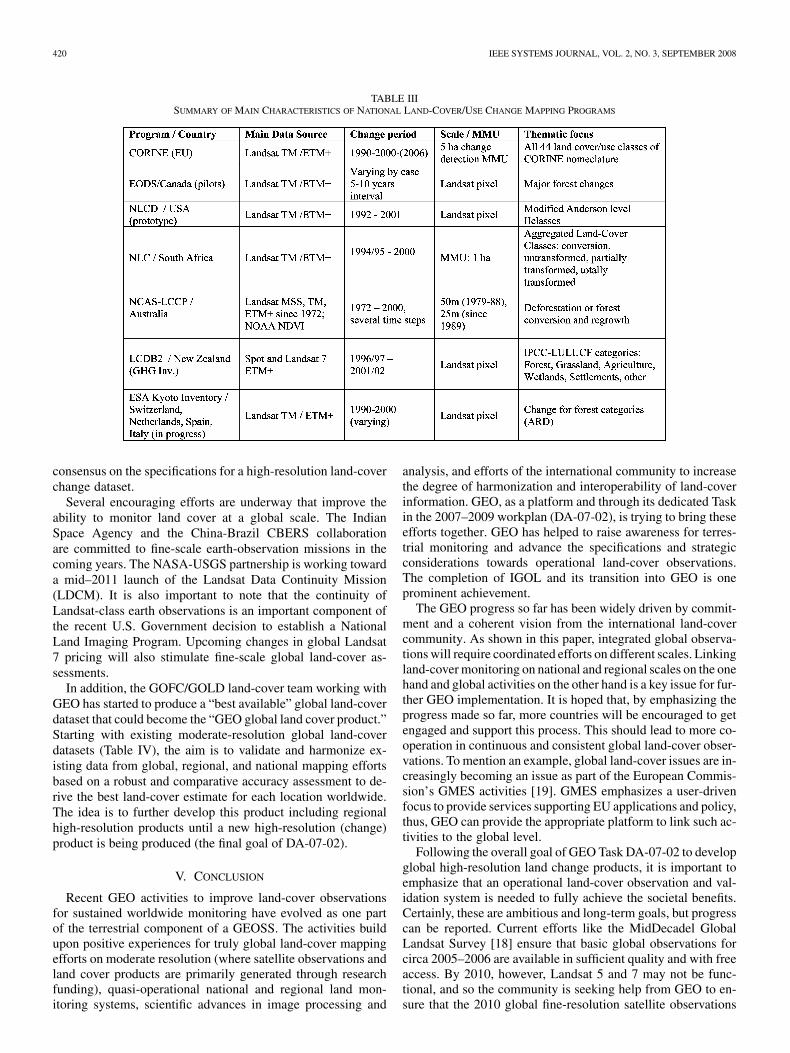
Global availability of basic observations data at coarse res-olution is less of a challenge than for the fine scales. NASAand USGS have been making progress acquiring fine-resolutionimagery for the Middecadal Global Land Survey that will pro-vide consistent, preprocessed, global, free-of-charge Landsatdata for circa 2005. The effort extends the existing 1990 and2000 Tri-Decadal Landsat global dataset [17]. There are chal-lenges in constructing consistent global observations such asintegration of different satellite observation sources [18]. Thisnew dataset for circa 2005 provides a major contribution ofbasic data support for global and regional land-mapping ac-tivity at a time when nearly all user communities are askingfor land change information at least every five years and manynational programs already work with such data. For example,there is a suite of existing national and regional high-resolu-tion land-cover mapping programs including CORINE and theGlobal Monitoring for Environment and Security (GMES) ser-vice, the U.S. National Land Cover Database, and new prod-ucts evolving in countries like Canada and China, and as partof the UN Global Land Cover Network (Table III). The charac-teristics and experiences from existing change monitoring pro-grams will provide the guidance to the developing international
2[Online]. Available: www.esa.int/due/ionia/globcover/
420 IEEE SYSTEMS JOURNAL, VOL. 2, NO. 3, SEPTEMBER 2008
TABLE IIISUMMARY OF MAIN CHARACTERISTICS OF NATIONAL LAND-COVER/USE CHANGE MAPPING PROGRAMS
consensus on the specifications for a high-resolution land-coverchange dataset.
Several encouraging efforts are underway that improve theability to monitor land cover at a global scale. The IndianSpace Agency and the China-Brazil CBERS collaborationare committed to fine-scale earth-observation missions in thecoming years. The NASA-USGS partnership is working towarda mid–2011 launch of the Landsat Data Continuity Mission(LDCM). It is also important to note that the continuity ofLandsat-class earth observations is an important component ofthe recent U.S. Government decision to establish a NationalLand Imaging Program. Upcoming changes in global Landsat7 pricing will also stimulate fine-scale global land-cover as-sessments.
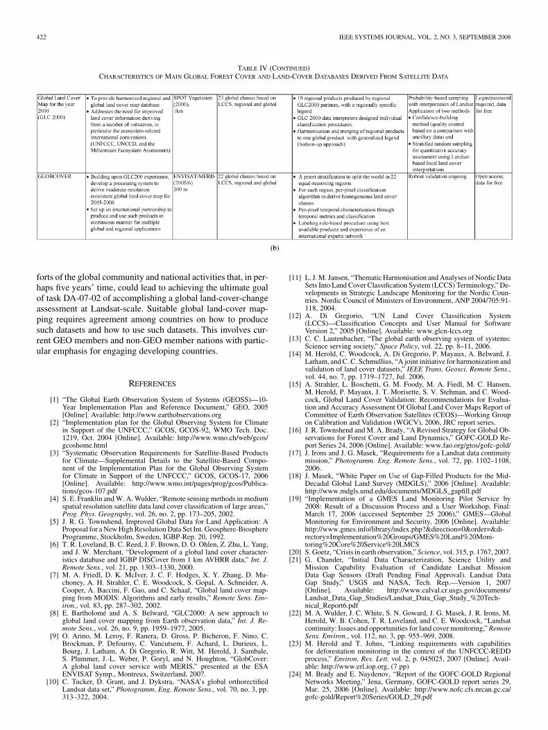
In addition, the GOFC/GOLD land-cover team working withGEO has started to produce a “best available” global land-coverdataset that could become the “GEO global land cover product.”Starting with existing moderate-resolution global land-coverdatasets (Table IV), the aim is to validate and harmonize ex-isting data from global, regional, and national mapping effortsbased on a robust and comparative accuracy assessment to de-rive the best land-cover estimate for each location worldwide.The idea is to further develop this product including regionalhigh-resolution products until a new high-resolution (change)product is being produced (the final goal of DA-07-02).
V. CONCLUSION
Recent GEO activities to improve land-cover observationsfor sustained worldwide monitoring have evolved as one partof the terrestrial component of a GEOSS. The activities buildupon positive experiences for truly global land-cover mappingefforts on moderate resolution (where satellite observations andland cover products are primarily generated through researchfunding), quasi-operational national and regional land mon-itoring systems, scientific advances in image processing and
analysis, and efforts of the international community to increasethe degree of harmonization and interoperability of land-coverinformation. GEO, as a platform and through its dedicated Taskin the 2007–2009 workplan (DA-07-02), is trying to bring theseefforts together. GEO has helped to raise awareness for terres-trial monitoring and advance the specifications and strategicconsiderations towards operational land-cover observations.The completion of IGOL and its transition into GEO is oneprominent achievement.
The GEO progress so far has been widely driven by commit-ment and a coherent vision from the international land-covercommunity. As shown in this paper, integrated global observa-tions will require coordinated efforts on different scales. Linkingland-cover monitoring on national and regional scales on the onehand and global activities on the other hand is a key issue for fur-ther GEO implementation. It is hoped that, by emphasizing theprogress made so far, more countries will be encouraged to getengaged and support this process. This should lead to more co-operation in continuous and consistent global land-cover obser-vations. To mention an example, global land-cover issues are in-creasingly becoming an issue as part of the European Commis-sion’s GMES activities [19]. GMES emphasizes a user-drivenfocus to provide services supporting EU applications and policy,thus, GEO can provide the appropriate platform to link such ac-tivities to the global level.
Following the overall goal of GEO Task DA-07-02 to developglobal high-resolution land change products, it is important toemphasize that an operational land-cover observation and val-idation system is needed to fully achieve the societal benefits.Certainly, these are ambitious and long-term goals, but progresscan be reported. Current efforts like the MidDecadel GlobalLandsat Survey [18] ensure that basic global observations forcirca 2005–2006 are available in sufficient quality and with freeaccess. By 2010, however, Landsat 5 and 7 may not be func-tional, and so the community is seeking help from GEO to en-sure that the 2010 global fine-resolution satellite observations

HEROLD et al.: LAND COVER OBSERVATIONS AS PART OF A GEOSS: PROGRESS, ACTIVITIES, AND PROSPECTS 421
TABLE IVCHARACTERISTICS OF MAIN GLOBAL FOREST COVER AND LAND-COVER DATABASES DERIVED FROM SATELLITE DATA
will be available and appropriately assembled. Thus, continuityof observations is not ensured at this point, and basic data supplyremains one of the current challenges to sustaining land moni-toring. Worldwide monitoring may not rely on one national assetalone [20]. Luckily, many countries have Landsat-type satel-lite assets. However, their viability for use in coordinated globalland-cover monitoring efforts has yet to be demonstrated. Inter-national coordination is required to ensure that appropriate dataproducts and mosaics are created from existing observational as-sets [21]. GEO has dedicated a task to the concept of CEOS con-stellations that involves a land-surface imager designed to en-sure the relevant synergy among different satellite data sources[22].
From a more general point of view, GEO should influence theway we do earth observation and, thus, its level of societal sup-
port, use, and acceptance, which is an issue of particular rele-vance for terrestrial observations. GEO provides the opportunityto specify how to best achieve sustained satellite-based land-cover monitoring of global relevance and to stimulate countriesto support its operational implementation. With consistency andcontinuity in observations, it is possible to engage user commu-nities previously not, or less, involved in earth observation. Theexperiences and progress reported here demonstrate initial GEOsuccess that should evolve and be extended to related issues thatcurrently are effectively addressed by GEO (i.e., fire observa-tions). Some activities, however, would need further GEO en-gagement, i.e., land use observations, the monitoring of humansettlements, and joint acquisition strategies for optical and radardata (as advocated by IGOL). In addition, GEO should use itsunique role to further strengthen the relationships between ef-
422 IEEE SYSTEMS JOURNAL, VOL. 2, NO. 3, SEPTEMBER 2008
TABLE IV (CONTINUED)CHARACTERISTICS OF MAIN GLOBAL FOREST COVER AND LAND-COVER DATABASES DERIVED FROM SATELLITE DATA
forts of the global community and national activities that, in per-haps five years’ time, could lead to achieving the ultimate goalof task DA-07-02 of accomplishing a global land-cover-changeassessment at Landsat-scale. Suitable global land-cover map-ping requires agreement among countries on how to producesuch datasets and how to use such datasets. This involves cur-rent GEO members and non-GEO member nations with partic-ular emphasis for engaging developing countries.
REFERENCES
[1] “The Global Earth Observation System of Systems (GEOSS)—10-Year Implementation Plan and Reference Document,” GEO, 2005[Online]. Available: http://www.earthobservations.org
[2] “Implementation plan for the Global Observing System for Climatein Support of the UNFCCC,” GCOS, GCOS-92, WMO Tech. Doc.1219, Oct. 2004 [Online]. Available: http://www.wmo.ch/web/gcos/gcoshome.html
[3] “Systematic Observation Requirements for Satellite-Based Productsfor Climate—Supplemental Details to the Satellite-Based Compo-nent of the Implementation Plan for the Global Observing Systemfor Climate in Support of the UNFCCC,” GCOS, GCOS-17, 2006[Online]. Available: http://www.wmo.int/pages/prog/gcos/Publica-tions/gcos-107.pdf
[4] S. E. Franklin and W. A. Wulder, “Remote sensing methods in mediumspatial resolution satellite data land cover classification of large areas,”Prog. Phys. Geography, vol. 26, no. 2, pp. 173–205, 2002.
[5] J. R. G. Townshend, Improved Global Data for Land Application: AProposal for a New High Resolution Data Set Int. Geosphere-BiosphereProgramme, Stockholm, Sweden, IGBP-Rep. 20, 1992.
[6] T. R. Loveland, B. C. Reed, J. F. Brown, D. O. Ohlen, Z. Zhu, L. Yang,and J. W. Merchant, “Development of a global land cover character-istics database and IGBP DISCover from 1 km AVHRR data,” Int. J.Remote Sens., vol. 21, pp. 1303–1330, 2000.
[7] M. A. Friedl, D. K. McIver, J. C. F. Hodges, X. Y. Zhang, D. Mu-choney, A. H. Strahler, C. E. Woodcock, S. Gopal, A. Schneider, A.Cooper, A. Baccini, F. Gao, and C. Schaaf, “Global land cover map-ping from MODIS: Algorithms and early results,” Remote Sens. Env-iron., vol. 83, pp. 287–302, 2002.
[8] E. Bartholomé and A. S. Belward, “GLC2000: A new approach toglobal land cover mapping from Earth observation data,” Int. J. Re-mote Sens., vol. 26, no. 9, pp. 1959–1977, 2005.
[9] O. Arino, M. Leroy, F. Ranera, D. Gross, P. Bicheron, F. Nino, C.Brockman, P. Defourny, C. Vancutsem, F. Achard, L. Durieux, L.Bourg, J. Latham, A. Di Gregorio, R. Witt, M. Herold, J. Sambale,S. Plummer, J.-L. Weber, P. Goryl, and N. Houghton, “GlobCover:A global land cover service with MERIS,” presented at the ESAENVISAT Symp., Montreux, Switzerland, 2007.
[10] C. Tucker, D. Grant, and J. Dykstra, “NASA’s global orthorectifiedLandsat data set,” Photogramm. Eng. Remote Sens., vol. 70, no. 3, pp.313–322, 2004.
[11] L. J. M. Jansen, “Thematic Harmonisation and Analyses of Nordic DataSets Into Land Cover Classification System (LCCS) Terminology,” De-velopments in Strategic Landscape Monitoring for the Nordic Coun-tries. Nordic Council of Ministers of Environment, ANP 2004/705:91-118, 2004.
[12] A. Di Gregorio, “UN Land Cover Classification System(LCCS)—Classification Concepts and User Manual for SoftwareVersion 2,” 2005 [Online]. Available: www.glcn-lccs.org
[13] C. C. Lautenbacher, “The global earth observing system of systems:Science serving society,” Space Policy, vol. 22, pp. 8–11, 2006.
[14] M. Herold, C. Woodcock, A. Di Gregorio, P. Mayaux, A. Belward, J.Latham, and C. C. Schmullius, “A joint initiative for harmonization andvalidation of land cover datasets,” IEEE Trans. Geosci. Remote Sens.,vol. 44, no. 7, pp. 1719–1727, Jul. 2006.
[15] A. Strahler, L. Boschetti, G. M. Foody, M. A. Fiedl, M. C. Hansen,M. Herold, P. Mayaux, J. T. Morisette, S. V. Stehman, and C. Wood-cock, Global Land Cover Validation: Recommendations for Evalua-tion and Accuracy Assessment Of Global Land Cover Maps Report ofCommittee of Earth Observation Satellites (CEOS)—Working Groupon Calibration and Validation (WGCV), 2006, JRC report series.
[16] J. R. Townshend and M. A. Brady, “A Revised Strategy for Global Ob-servations for Forest Cover and Land Dynamics,” GOFC-GOLD Re-port Series 24, 2006 [Online]. Available: www.fao.org/gtos/gofc-gold/
[17] J. Irons and J. G. Masek, “Requirements for a Landsat data continuitymission,” Photogramm. Eng. Remote Sens., vol. 72, pp. 1102–1108,2006.
[18] J. Masek, “White Paper on Use of Gap-Filled Products for the Mid-Decadal Global Land Survey (MDGLS),” 2006 [Online]. Available:http://www.mdgls.umd.edu/documents/MDGLS_gapfill.pdf
[19] “Implementation of a GMES Land Monitoring Pilot Service by2008: Result of a Discussion Process and a User Workshop, Final:March 17, 2006 (accessed September 25 2006),” GMES—GlobalMonitoring for Environment and Security, 2006 [Online]. Available:http://www.gmes.info/library/index.php?&direction=0&order=&di-rectory=Implementation%20Groups/GMES%20Land%20Moni-toring%20Core%20Service%20LMCS
[20] S. Goetz, “Crisis in earth observation,” Science, vol. 315, p. 1767, 2007.[21] G. Chander, “Initial Data Characterization, Science Utility and
Mission Capability Evaluation of Candidate Landsat MissionData Gap Sensors (Draft Pending Final Approval). Landsat DataGap Study,” USGS and NASA, Tech. Rep.—Version 1, 2007[Online]. Available: http://www.calval.cr.usgs.gov/documents/Landsat_Data_Gap_Studies/Landsat_Data_Gap_Study_%20Tech-nical_Report6.pdf
[22] M. A. Wulder, J. C. White, S. N. Goward, J. G. Masek, J. R. Irons, M.Herold, W. B. Cohen, T. R. Loveland, and C. E. Woodcock, “Landsatcontinuity: Issues and opportunities for land cover monitoring,” RemoteSens. Environ., vol. 112, no. 3, pp. 955–969, 2008.
[23] M. Herold and T. Johns, “Linking requirements with capabilitiesfor deforestation monitoring in the context of the UNFCCC-REDDprocess,” Environ. Res. Lett. vol. 2, p. 045025, 2007 [Online]. Avail-able: http://www.erl.iop.org, (7 pp)
[24] M. Brady and E. Naydenov, “Report of the GOFC-GOLD RegionalNetworks Meeting,” Jena, Germany, GOFC-GOLD report series 29,Mar. 25, 2006 [Online]. Available: http://www.nofc.cfs.nrcan.gc.ca/gofc-gold/Report%20Series/GOLD_29.pdf

HEROLD et al.: LAND COVER OBSERVATIONS AS PART OF A GEOSS: PROGRESS, ACTIVITIES, AND PROSPECTS 423
Martin Herold (A’07) was born in Leipzig,Germany. in 1975. He received the Diploma in ge-ography from both the Friedrich Schiller University,Jena, Germany, and from the Bauhaus University ofWeimar, Germany, in 2000, and the Ph.D. degree ingeography from the University of California, SantaBarbara, in 2004.
HE is currently coordinating the ESA GOFCGOLD Land Cover Project Office at the FriedrichSchiller University. Earlier in his career, his interestswere in multifrequency, polarimetric. and interfero-
metric SAR data analysis for land-surface parameter derivation and modeling.He joined the Remote Sensing Research Unit, University of California, SantaBarbara, in 2000 where his research focused on remote sensing of urban areasand the analysis and modeling of urban growth and land-use change processes.His most recent interests are in international coordination and cooperationtowards operational terrestrial observations with specific emphasis on theharmonization and validation of land cover datasets.
Dr. Herold is a member of the German Society of Photogrammtry and RemoteSensing and the Thuringian Geographical Union.
Curtis E. Woodcock received the Ph.D. degree in ge-ography from the University of California, Santa Bar-bara, in 1986.
He is a is a Professor with the Department ofGeography, Boston University, Boston, MA, wherehis research interests are in biophysical remotesensing, particularly focusing on forests and naturalvegetation, canopy reflectance models and theirinversion, spatial modeling, and change detection,biogeography, spatial analysis, geographic informa-tion systems, and digital image processing. He is
currently Co-chair of the GOFC-GOLD land cover implementation team.
Thomas R. Loveland received the B.S. and M.S. de-grees in geography from South Dakota State Univer-sity, Brookings, and the Ph.D. degree in geographyfrom the University of California, Santa Barbara.
He is a Research Geographer with EROS and Di-rector of the U.S. Geological Survey (USGS) LandCover Institute. He has been engaged in research onthe use of remote sensing for land use and land-coverinvestigations for over 25 years and has conductedstudies that have spanned local to global scales. Hewas among the first to create continental and global-
scale land-cover datasets derived from remotely sensed imagery. He currentlyleads a USGS research team that is developing a contemporary land-cover his-tory of the United States. In addition, he is leading the Landsat Continuity Mis-sion Science Team and is a member of the NASA National Polar-orbiting Oper-ational Environmental Satellite System (NPOESS) Preparatory Project scienceteam. He has published almost 90 scientific papers.
Dr. Loveland was the recipient of career achievement awards from the Amer-ican Society of Photogrammetry and Remote Sensing and the Association ofAmerican Geographers.
John Townshend received the B.A. degree ingeography with subsidiary in geology and the Ph.D.degree in geography from the University CollegeLondon, London, U.K., in 1967 and 1971, respec-tively.
He is a Professor and Chair of Geography at theUniversity of Maryland, College Park. His researchinterests are in land-cover change, remote sensing,and environmental information systems. He is amember of NASA’s MODIS Science Team and Prin-cipal Investigator of the Global Land Cover Facility.
He was Chair of GOFC-GOLD from 2000–2006 and co-chair of the IGOS-P’sLand Theme from 2004 to the present. He serves as chair of the UNEP’sDivision of Environmental Information, Assessment and Early Warning forNorth America. In 2007, he was the Terrestrial Lead for the Committee forEarth Observing System’s Response Team to the Global Climate ObservingSystem’s Implementation Plan. From 1995 to 1998, he was Chairman of theJoint Scientific and Technical Committee of GCOS.
Michael Brady received the B.Sc. degree in giologyfrom Acadia University, Wolfville, NS, Canada, in1981 and the M.Sc. degree in forest managementand the Ph.D. degree in forest science from theUniversity of British Columbia, Vancouver, BC,Canada, in 1984 and 1997, respectively. His master’swork focused on natural revegetation of century oldmining disturbances in the Yukon Territory, Canada,and his doctoral work focused on organic matterdynamics of peat forests in Southeast Asia, with afocus on biomass burning in 1997.
He is currently with the Canadian Forest Service, Edmonton, AB, Canada.There, he leads the Wildland Fire Information Systems group and co-managesan International Polar Year study on climate change effects on vegetation andpeat dynamics in the Northwest Territories. He also acts as the GOFC-GOLDExecutive Director and manages the Project Office based at the Canadian ForestService. He is actively contributing to a forest observation community of prac-tice, which is part of the GEO User Interface Committee.
Chris Steenmans received the M.Sc. degree inphysical geography from the Catholic University ofLeuven (KUL), Leuven, Belgium, in 198.
He is head of the Geospatial Information SystemGroup, European Environment Agency (EEA),Copenhagen, Denmark. He is responsible at EEAfor developing the Shared Environmental Informa-tion System (SEIS). He is actively involved in theEC/ESA initiative on Global Monitoring for Envi-ronment and Security (GMES) i.e., the Europeanland monitoring core services as well as the initiative
for building a European Spatial Data Infrastructure (INSPIRE). He was a Re-search Assistant with the Department of Cartography, KUL, until 1985. Duringthe past 20 years, he has been strongly involved in the European CORINE(Coordination of Information on the Environment) activities as coordinator forproducing coherent seamless European land cover datasets. Before joining theEEA in 1997 as a Project Manager on land and remote sensing, he workedduring 12 years for several private companies providing remote sensing, GIS,and mapping services.
Christiane C. Schmullius received the M.A. degreein geography/remote sensing from the University ofCalifornia, Santa Barbara, in 1986 and the Ph.D. de-gree from the Institute of Space Sciences, Free Uni-versity, Berlin, Germany, in 1991. Her doctoral workfocused on radar remote sensing of agricultural crops.
From 1991 to 2000, she was a group leader og “Ge-omatics” with the German Aerospace Center, DLR.In 1994, she coordinated the SIR-C/X-SAR ScienceTeam and in 2000 became DLR’s Project Scientistfor the Shuttle Radar Topography Mission (SRTM).
She has coordinated several European Union projects in Siberia, especially onradar interferometry applications for climate change parameter mapping. Since2000, she has been a Professor of remote sensing with the Friedrich SchillerUniversity, Jena, Germany.
Related Documents