Department of Conservation, Forests & Lands LAND CAPABILITY STUDY IN THE SHIRE OF MANSFIELD EROSION RISK ASSESSMENT OTHER LAND USE CONSTRAINTS LAND MANAGEMENT GUIDELINES Prepared by: J F Wood, Senior Soil Conservationist R G Patrick, Senior Soil Conservationist P R Burns, Conservation Assistant J F Grimes, Area Soil Conservationist February, 1985 Soil Conservation Authority 378 Cotham Road, Kew, 3101 SC/S/123

Welcome message from author
This document is posted to help you gain knowledge. Please leave a comment to let me know what you think about it! Share it to your friends and learn new things together.
Transcript
Department of Conservation, Forests & Lands
LAND CAPABILITY STUDY IN THE
SHIRE OF MANSFIELD
EROSION RISK ASSESSMENT OTHER LAND USE CONSTRAINTS LAND MANAGEMENT GUIDELINES
Prepared by: J F Wood, Senior Soil Conservationist
R G Patrick, Senior Soil Conservationist P R Burns, Conservation Assistant
J F Grimes, Area Soil Conservationist
February, 1985
Soil Conservation Authority 378 Cotham Road, Kew, 3101
SC/S/123
TABLE OF CONTENTS
PREFACE......................................................................................................................................... ii
DEPARTMENTAL RE-ORGANISATION: ................................................................................... ii
THE SCOPE AND LIMITATIONS OF THE REPORT................................................................. iii
PART 1 – SUMMARY AND CONCLUSIONS...............................................................................1
Outline of the Study...................................................................................................1 Conclusions................................................................................................................1
PART 2 – TECHNICAL ASPECTS OF THE STUDY ....................................................................4
Outline of the Methods ..............................................................................................4 Assessment of Erosion Risk.......................................................................................4 Management Guidelines ............................................................................................6 Areas of Special Conservation Interest......................................................................9
REFERENCES ................................................................................................................................10
APPENDICES
Appendix A - Land Unit Descriptions .............................................................................................11
Appendix B – Soil Conservation and Land Utilisation Acts. ..........................................................29
Appendix C ......................................................................................................................................30
i
PREFACE Three requirements for sound land use planning area:-
* An understanding of the extent to which the use will be limited by the natural characteristic of the land,
* The effect the use will have on the land and the water derived from it,
* The need for special land management or structural design to overcome limitations or to restrict the impacts to acceptable levels.
Land capability assessment is a rational and systematic means of obtaining this information. The Soil Conservation Authority is able to provide land capability information for a range of uses and at different scales to meet the various needs of planning. The information provides a relatively stable base on which to superimpose other planning considerations.
DEPARTMENTAL RE-ORGANISATION: This report has been prepared as a function of the Soil Conservation Authority as expressed under the terms of the Soil Conservation and Land Utilization Act. The report refers, therefore, to the Soil Conservation Authority (SCA) throughout. With an amalgamation of various government agencies into the Department of Conservation, Forests & Lands currently proceeding it is likely that an arm of that Department will assume the responsibility for administering this function.
ii
iii
THE SCOPE AND LIMITATIONS OF THE REPORT
* This report is based on an assessment of the physical characteristics of the land, social, economic and other factors which may influence planning have not been considered. Such factors may be the subject of further input by the Soil Conservation Authority.
* The scale of the assessment has necessitated some generalization, site-specific data will be required for detailed planning.
* The precision with which boundaries are mapped is affected by the scale of the map. Subsequent enlargement of the map does not improve the precision and may be misleading.
* The boundaries on the maps usually represent readily seen changes in the land. However, where an important land characteristic changes gradually, the boundary indicates approximately where there is a significant change in the effect on land use.
* No material may be extracted from the report for publication without the written permission of the Soil Conservation Authority.

PART 1 – SUMMARY AND CONCLUSIONS
Outline of the Study The study was undertaken at the request of the Department of Planning for use as an aid to planning and development in the Shire of Mansfield. The report describes erosion risk and other characteristics of the land which may impose constraints on land development in the Shire. Mansfield Shire (see locality plan) has an area of approximately 3 915 km2 and varies from undulating plains at about 320 metres elevation up to steep mountainous country at 1 866 metres elevation, with annual rainfall ranging from 630 millimetres to more than 1 500 millimetres in the Alps. Approximately 35% of the Shire is freehold land, the remainder being largely forested public land. The study concentrates on the freehold land and is less detailed on the public land. Areas of Special Interest to the Soil Conservation Authority are the Upper Goulburn (Eildon) Water Supply Catchment and the Upper Delatite Water Supply Catchment and the Lake Nillahcootie Water Supply Catchment. These are detailed in Part 2.
Conclusions The erosion risk classes in the Sire are shown on the enclosed maps. General management guidelines are presented in Table 2. The main conclusions and recommendations are summarised below.
(i) Land with severe risk (Class 5). This land is considered highly hazardous and should have strong limitations placed upon its development.
* It is recommended that subdivision of land in Erosion Risk Class 5 should not be permitted unless the developer can demonstrate to the satisfaction of the Soil Conservation Authority that the development will not result in increased soil erosion from the area.
* Permanent clearing of Class 5 land should be prohibited and reafforestation should be actively encouraged. In general, such land should be considered as best used for forestry and passive recreation.
(ii) Land with a high erosion risk (Class 4).
* Intensive small-lot subdivision and clearing should be discouraged.
* It is recommended that all proposals for development of land in Erosion Risk Class 4 be referred to the Soil Conservation Authority for specific advice on soil conservation requirements at the earliest possible stage.
(iii) Land with a moderate erosion risk (Class 3). Development of most of the moderate risk land should be possible without causing increased erosion provided specialised techniques and careful management, which take account of the natural characteristics of the land, are adopted.
In particular, areas where water naturally concentrates should not be disturbed, and disposal of water which would be concentrated by development should be carefully planned.
* Advice on the need for specialised design and construction techniques and follow-up management should be sought from the Soil Conservation Authority prior to approval of any development.
1

(iv) Although land in Erosion Risk Classes 2 and 1 is not generally regarded as presenting significant erosion problems there may be small areas of higher risk which would require special management within the areas shown in those Classes on the map. Where such areas become apparent, the Soil Conservation Authority should be consulted for advice on appropriate management.
2

Locality plan – Shire of Mansfield
3

PART 2 – TECHNICAL ASPECTS OF THE STUDY
Outline of the Methods In order to identify and map areas of land with differing land capability, a systematic study of the natural characteristics of the land has been made. Ares of land which have consistent slope, soils and native vegetation on similar rock types and with a limited range of climate are identified. Such areas are referred to as land units. Within the Shire, eighty land units have been identified, which are shown on the enclosed maps. The land unit information has been used together with local knowledge of the erosion risk of the various land types to categorise each of these units into erosion risk classes. The land unit descriptions (Appendix A) provide a range of information which can be adapted for use by planners for purposes other than erosion control. In particular, areas subject to prolonged wetness or having poor effluent disposal or water holding characteristics can be identified. Where these constraints may exist they are referred to in the Constraints section of the tables in Appendix A. Warning: The information provided in the Constraints section of Appendix A has been compiled by field observation only and needs to be confirmed by appropriate field and/or laboratory tests.
Assessment of Erosion Risk Erosion risk is best defined as a means of rating the potential of land to erode is subjected to poor management or soil disturbance. Factors considered in this rating for each land unit are: Steepness of the land, erodibility of the soil, soil depth, permeability and structured and soil/water balance. The erosion risk is assessed in five classes – Class 5 being highest. Definitions of the classes are presented in Table 1. It should be realized that because of the broad scale of mapping (1:25,000 and 1:50,000) the map units can only represent a general level of erosion risk over relatively large areas. Obviously at a more detailed level, local variations will be found. It is important therefore, that where areas of land are nominated for intensive development, the need for further detailed mapping at a much larger scale be recognised.
4

Table 1 – Erosion Risk Classes
Class Erosion Risk General Limitations on Development
1 None to very slight Erosion risk does not occur or is very slight. Standard designs and installation techniques and normal site preparation and management should be possible without risk of erosion.
2 Slight Slight erosion risk exists. Careful planning, and use of standard specifications for site preparation, construction and follow up management should be satisfactory to minimise erosion.
3 Moderate Moderate erosion risk exists which may lead to difficulties during and after construction but which can be overcome. Specialised design, constriction techniques and follow up management are necessary to minimise erosion.
4 High High erosion risk. Avoidance of erosion during and after construction is difficult and long term problems may occur. Adverse effects may be inflicted upon adjoining land. Extensively modified design and installation techniques, exceptionally careful site preparation and management would be necessary.
5 Severe Severe erosion risk and/or danger of large landslides is prevalent. Any development will cause instability which cannot be practically overcome.
5

Management Guidelines There are considerable variations in standards of land management which can substantially effect stability, particularly in areas with high erosion risk. Similarly, techniques of earthworks construction and follow-up treatment can vary considerably with possible significant or drastic effect upon stability where these are inadequate or inappropriate. The guidelines in Table 2 outline the type and levels of management considered necessary to guard against unacceptable land deterioration within each erosion risk map unit. Table 2 – land Management Guidelines
Class Erosion Risk General Limitations on Development
1 None to very slight Generally no specific conservation management practices are required in this map unit, except along drainage lines where erosion may occur.
To minimise the danger of erosion in drainage lines, avoid disturbance and maintain a protective vegetative cover.
Roads which cross drainage lines where high flows are likely should be designed with adequate culvert capacity or alternatively low profile floodway fords, at right angles to the flow to minimise cost and erosion potential.
To avoid problems with spillways when siting farm dams in drainage lines which carry large flows, off-stream storages are recommended.
2 Slight Generally only limited special management inputs are required in this map unit to prevent soil erosion, except along drainage lines where erosion is likely to occur.
To minimise the danger of erosion in drainage lines, avoid disturbance and maintain a protective vegetative cover.
Roads which cross drainage lines where high flows are likely, should be designed as for Unit 1 above. In addition, roads should be aligned close to contour and have adequate surface and/or subsurface cross drainage or be aligned directly up and down the slope with drainage water dispersed laterally.
Disturbed areas caused during construction works should be revegetated by topsoiling and sowing.
To avoid problems with spillways when siting farm dams in drainage lines which carry large flows, off-stream storages are recommended.
Planning for fence locations should take account of significant topographical features so that it is possible to conform to the criteria above.
6

Class Erosion Risk General Limitations on Development
3 Moderate Specialised land management techniques are required to minimise soil erosion. Moreover, localised areas of higher risk occur in which intensive development of any kind should be avoided.
To minimise the danger of erosion in drainage lines, avoid disturbance and maintain a protective vegetative cover.
Employ contour cultivation or minimum tillage techniques for cropping and pasture establishment.
Locate roads and fences on contour, along ridges or directly up and down slope. Disperse water from roads at frequent intervals by surface or subsurface drainage. Design roads as recommended under Unit 1 above.
Take care to minimise disturbed areas during construction and undertake adequate soil conservation measures. Conserve topsoil for respreading after construction. Revegetation of these areas may require special treatment as well as sowing and adequate maintenance.
All dams constructed in this unit will require careful siting, design and construction techniques.
Generally a vigorous vegetative ground cover should be maintained throughout this unit.
Subdivision into areas of small lots could cause increased erosion unless due consideration is given to topographical features. Planning of fence locations should also take into account these features so that it is possible to conform to the above criteria.
It is recommended that:
Advice on the need for specialised design and construction techniques and follow up management should be sought from the SCA prior to approval of any development.
4 High High inputs of specialised land management techniques are required to minimise soil erosion and/or landslides. Localised areas of higher risk occur in which any development should be avoided.
Employ contour cultivation or aerial seeding for pasture establishment. Specialised management techniques for grazing are required. Cropping is not advisable. SCA advice should be sought.
A vigorous vegetative ground cover should be maintained throughout this unit. Further forest clearing is undesirable and tree planting should be encouraged.
7
Class Erosion Risk General Limitations on Development
All clearing or earthworks, including dam construction, roading and other construction works, should employ conservation specifications suitable for each site and include topsoil saving, revegetation, and other soil stabilisation measures and maintenance.
Limited subdivision may be possible with due consideration to topographical features. SCA advice should be sought at the earliest planning stage.
Planning of fence locations should take into account topographical features to avoid stock concentration in hazardous areas. SCA advice should be sought.
It is recommended that:
All proposals for development of land in Unit 4 be referred to the SCA for specific advice on soil conservation requirements at the earliest possible stage.
Intensive small-lot subdivision and clearing should be discouraged, and tree planting should be encouraged.
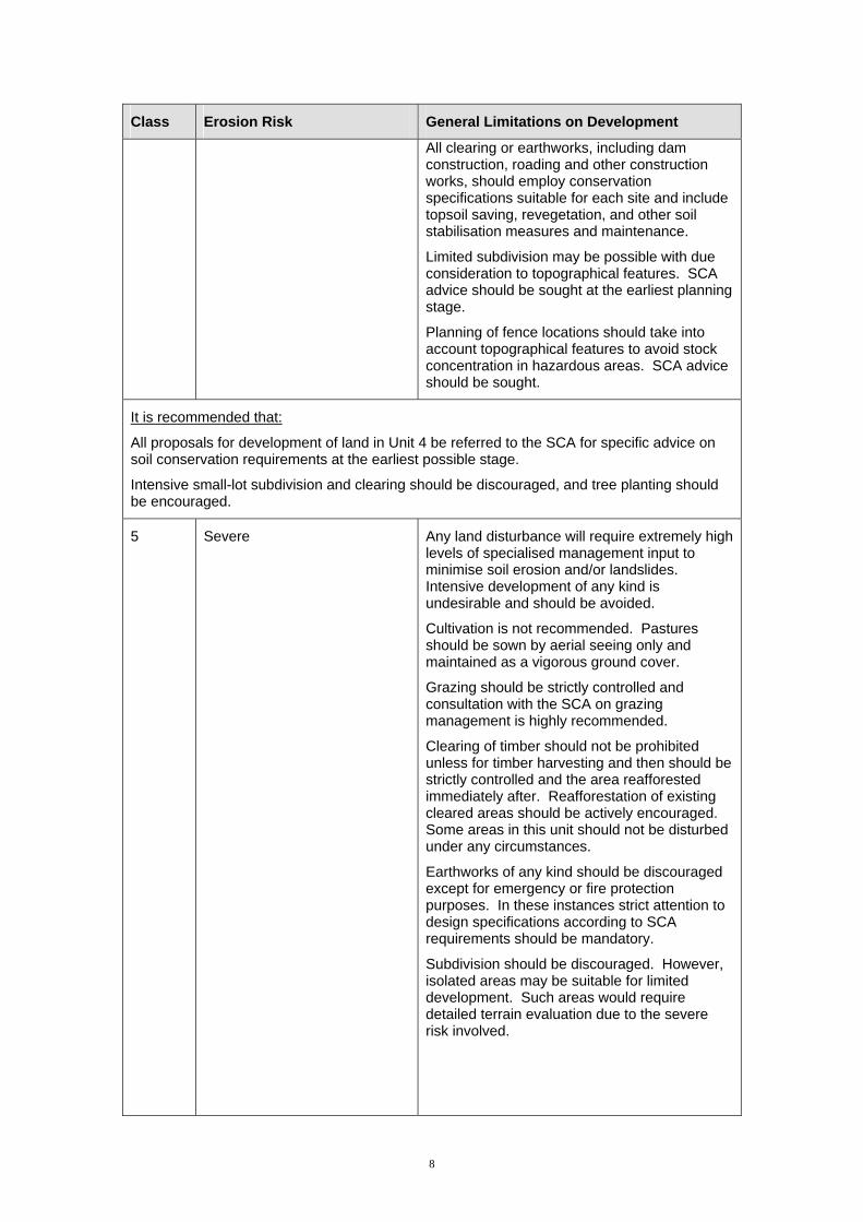
5 Severe Any land disturbance will require extremely high levels of specialised management input to minimise soil erosion and/or landslides. Intensive development of any kind is undesirable and should be avoided.
Cultivation is not recommended. Pastures should be sown by aerial seeing only and maintained as a vigorous ground cover.
Grazing should be strictly controlled and consultation with the SCA on grazing management is highly recommended.
Clearing of timber should not be prohibited unless for timber harvesting and then should be strictly controlled and the area reafforested immediately after. Reafforestation of existing cleared areas should be actively encouraged. Some areas in this unit should not be disturbed under any circumstances.
Earthworks of any kind should be discouraged except for emergency or fire protection purposes. In these instances strict attention to design specifications according to SCA requirements should be mandatory.
Subdivision should be discouraged. However, isolated areas may be suitable for limited development. Such areas would require detailed terrain evaluation due to the severe risk involved.
8
Class Erosion Risk General Limitations on Development
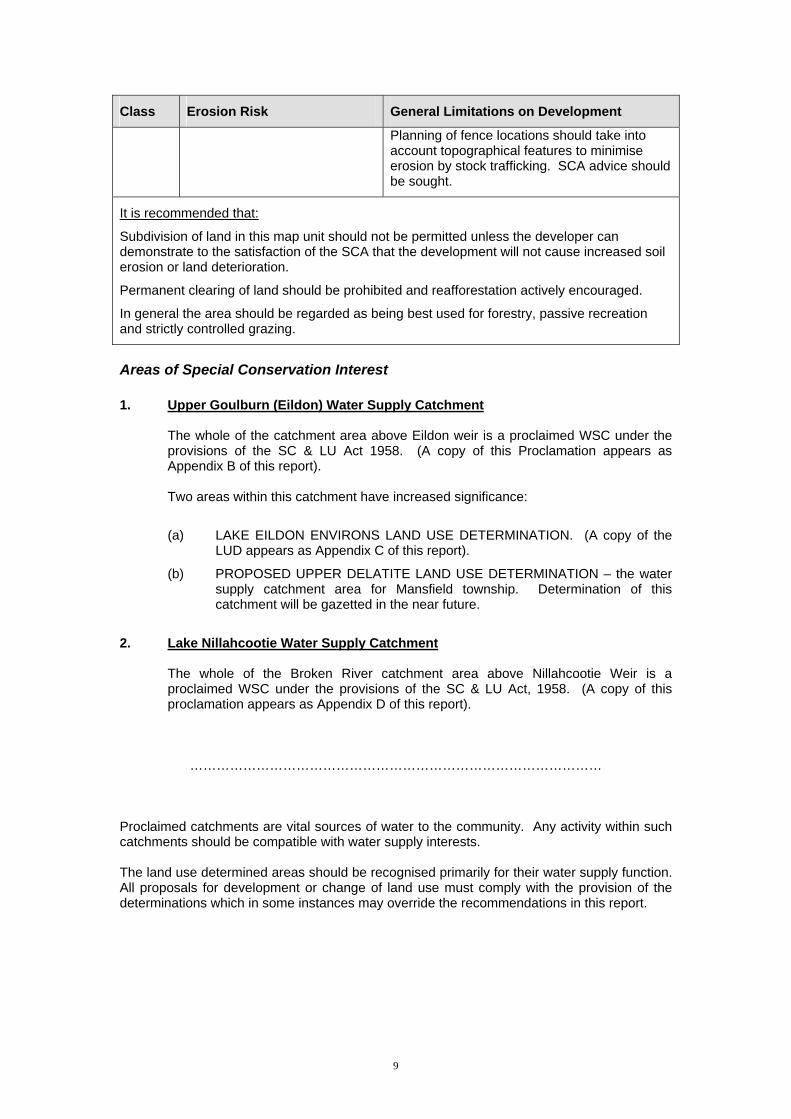
Planning of fence locations should take into account topographical features to minimise erosion by stock trafficking. SCA advice should be sought.
It is recommended that:
Subdivision of land in this map unit should not be permitted unless the developer can demonstrate to the satisfaction of the SCA that the development will not cause increased soil erosion or land deterioration.
Permanent clearing of land should be prohibited and reafforestation actively encouraged.
In general the area should be regarded as being best used for forestry, passive recreation and strictly controlled grazing.
Areas of Special Conservation Interest 1. Upper Goulburn (Eildon) Water Supply Catchment The whole of the catchment area above Eildon weir is a proclaimed WSC under the
provisions of the SC & LU Act 1958. (A copy of this Proclamation appears as Appendix B of this report).
Two areas within this catchment have increased significance:
(a) LAKE EILDON ENVIRONS LAND USE DETERMINATION. (A copy of the LUD appears as Appendix C of this report).
(b) PROPOSED UPPER DELATITE LAND USE DETERMINATION – the water supply catchment area for Mansfield township. Determination of this catchment will be gazetted in the near future.
2. Lake Nillahcootie Water Supply Catchment The whole of the Broken River catchment area above Nillahcootie Weir is a
proclaimed WSC under the provisions of the SC & LU Act, 1958. (A copy of this proclamation appears as Appendix D of this report).
………………………………………………………………………………… Proclaimed catchments are vital sources of water to the community. Any activity within such catchments should be compatible with water supply interests. The land use determined areas should be recognised primarily for their water supply function. All proposals for development or change of land use must comply with the provision of the determinations which in some instances may override the recommendations in this report.
9

10
REFERENCES A Study of the Land in the Catchment of Lake Eildon Allen S. Rundle (1977) Soil Conservation Authority, Victoria. A Study of the Land in the Catchment of the Broken River Allen S Rundle & R K Rowe (1974, Soil Conservation Authority, Victoria.

Appendix A - Land Unit Descriptions
SHIRE OF MANSFIELD Land unit name: Alpine Geology Tertiary basalt, Devonian granite & Granodiorite, and some metamorphosed Hornfels and spotted sediments Rainfall: 1,500 mm Map Symbol AR M AH AS AV Erosion Risk Rating
5 5 5 5 5
Land Form Gentle to moderate slopes
Moderate sloping broad ridges
Moderate to steep long slopes
Moderate to steep slopes
Rugged upper slopes and sharp
crests
Slope % 5 – 10 8 – 15 20 – 25 20 – 30 30 - 550 Soils Organic loams,
Sandy loams Alpine organic
loams Shallow organic loams & deeper gradational or
duplex
Organic loams Shallow stony organic loams
Native Vegetation Alpine Ash, Mountain Gum, Snow Gum, with Alpine herbs and grasses Shallow soils Shallow soils & rock Stones & gravel Shallow soil, stones
& gravel Constraints
Alpine herb vegetation is very sensitive to trafficking. It is very difficult to re-establish vegetation on disturbed sites due to climatic extremes, short growing season, frost heave, high activity, low natural fertility, shallow soils
and on-going trafficking pressures.
11

SHIRE OF MANSFIELD Land unit name: Buttercup Geology Lower carboniferous sandstone, siltstone Rainfall: 800-1,200 mm Map Symbol BR BM BH BS BV Erosion Risk Rating
3 3 3 4 5
Land Form Rolling plateau & crests
Moderate slopes Hilly & generally dissected
Steep slope Very steep slopes & escarpments
Slope % 3 – 10 8 – 15 10 – 25 20 – 30 30+ Soils Friable red & brown
gradational Variable, brown gradational to yellow duplex
Stony gradational, some duplex
Stony loams & red gradational
Stony loams & occasional brown
gradational
Native Vegetation Narrow leaf Peppermint, Long leaf Box, Yellow Box, Stringybark with some Messmate, Blue Gum, Candlebark and Red Gum
Occasional rock outcrops
Contains areas of poor drainage and
springs
Shallow soils Shallow soils & rock outcrops
Shallow soil & rock outcrops common
Constraints
Cold wet winters are a restriction on management and makes revegetation difficult following disturbance. Construction activities should be restricted to the dryer months
Springs and wet areas should be avoided.
12

SHIRE OF MANSFIELD Land unit name: Currajong Geology Quaternary Alluvium Rainfall: 1,250-1,500 mm Map Symbol CM CH CHA CS CV CVR Erosion Risk Rating
2 3 4 5 5 5
Land Form Moderate slopes Moderate to steep valley sides & lower
slope
Dissected lower slopes
Steep sides of incised drainage
lines
Very steep long slopes
Very steep slopes on shallow rock
Slope % 8 – 12 12 – 17 15 – 25 25 – 35 30 – 50 40 - 60 Soils Yellow duplex Red duplex &
uniform sands Variable but mainly
yellow duplex Uniform dark sandy
loam Uniform sandy loam Friable stony gradational
Native Vegetation Narrow leaf Peppermint, Broad leaf Peppermint, Candlebark, Blue Gum and Alpine Ash Access to this unit
usually difficult Many small steep
sections not mapped
Shallow soils & moderate risk of
land slips. Highly dissected
Steepness, erodibility and high probability of siltation of streams restricts
development.
Steepness & shallow soils Constraints
Specific comments on any developmental proposal by qualified authorities would be essential in these units. Springs and soaks may also pose problems throughout.
13
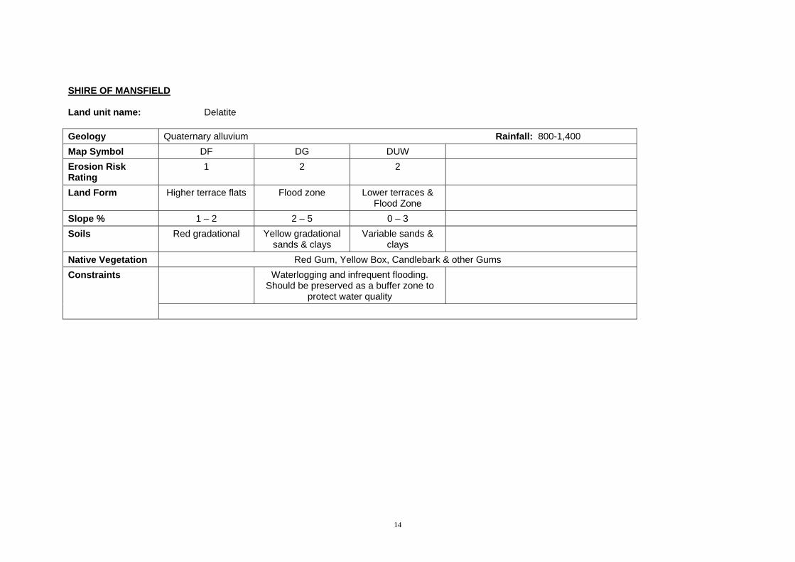
SHIRE OF MANSFIELD Land unit name: Delatite Geology Quaternary alluvium Rainfall: 800-1,400 Map Symbol DF DG DUW Erosion Risk Rating
1 2 2
Land Form Higher terrace flats Flood zone Lower terraces & Flood Zone
Slope % 1 – 2 2 – 5 0 – 3 Soils Red gradational Yellow gradational
sands & clays Variable sands &
clays
Native Vegetation Red Gum, Yellow Box, Candlebark & other Gums Waterlogging and infrequent flooding.
Should be preserved as a buffer zone to protect water quality
Constraints
14

SHIRE OF MANSFIELD Land unit name: Eildon Geology Devonian sedimentary sandstone, Siltstone, Claystone Rainfall: 760-1,150 mm Map Symbol EU EG ER EM EH ES Erosion Risk Rating
1 2 2 3 4 5
Land Form Undulating slopes of valley floor
Gentle slopes of valley floor
Rolling slope Moderate slopes Hilly Steep slope
Slope % 1 – 3 2 – 5 4 – 10 8 – 15 10 – 25 20 – 35 Soils Dark uniform yellow
gradational yellow duplex
Dark gradational yellow duplex
Weakly bleached gradational, yellow
duplex
Friable brown gradational
Friable red gradational
Stony loams & red gradational
Native Vegetation Red Box, Red Stringybark, Narrow leaf Peppermint, Broad leaf Peppermint, Long leaf Box, Blue Gum, Candlebark Subject to flooding Slope and shallow soils Constraints
Gravel seams and rockiness limit the availability of dam sites High runoff poses a hazard to land immediately down slope.
Susceptible to severe sheet erosion if the land is devoid of reasonable vegetative ground cover.
15

SHIRE OF MANSFIELD Land unit name: Eildon (continuation) Geology Devonian, Sandstone, Siltstone, Claystone Rainfall: 760-1,150 00 Map Symbol EV Erosion Risk Rating
5
Land Form Very steep slopes Slope % 30+ Soils Stony loams,
weakly bleached gradational
Native Vegetation Slope & shallow
soils Constraints
Gravel seams, rockiness and steepness limit the availability of dam sites. High runoff poses a hazard to land immediate downslope. Susceptible to severe sheet erosion if the land is devoid of reasonable vegetative ground cover.
16
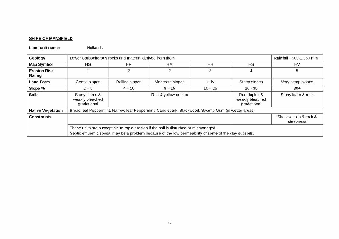
SHIRE OF MANSFIELD Land unit name: Hollands Geology Lower Carboniferous rocks and material derived from them Rainfall: 900-1,250 mm Map Symbol HG HR HM HH HS HV Erosion Risk Rating
1 2 2 3 4 5
Land Form Gentle slopes Rolling slopes Moderate slopes Hilly Steep slopes Very steep slopes Slope % 2 – 5 4 – 10 8 – 15 10 – 25 20 - 35 30+ Soils Stony loams &
weakly bleached gradational
Red & yellow duplex Red duplex & weakly bleached
gradational
Stony loam & rock
Native Vegetation Broad leaf Peppermint, Narrow leaf Peppermint, Candlebark, Blackwood, Swamp Gum (in wetter areas) Shallow soils & rock &
steepness Constraints
These units are susceptible to rapid erosion if the soil is disturbed or mismanaged. Septic effluent disposal may be a problem because of the low permeability of some of the clay subsoils.
17
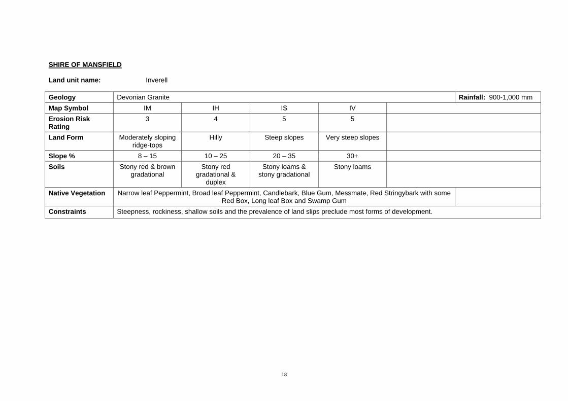
SHIRE OF MANSFIELD Land unit name: Inverell Geology Devonian Granite Rainfall: 900-1,000 mm Map Symbol IM IH IS IV Erosion Risk Rating
3 4 5 5
Land Form Moderately sloping ridge-tops
Hilly Steep slopes Very steep slopes
Slope % 8 – 15 10 – 25 20 – 35 30+ Soils Stony red & brown
gradational Stony red
gradational & duplex
Stony loams & stony gradational
Stony loams
Native Vegetation Narrow leaf Peppermint, Broad leaf Peppermint, Candlebark, Blue Gum, Messmate, Red Stringybark with some Red Box, Long leaf Box and Swamp Gum
Constraints Steepness, rockiness, shallow soils and the prevalence of land slips preclude most forms of development.
18
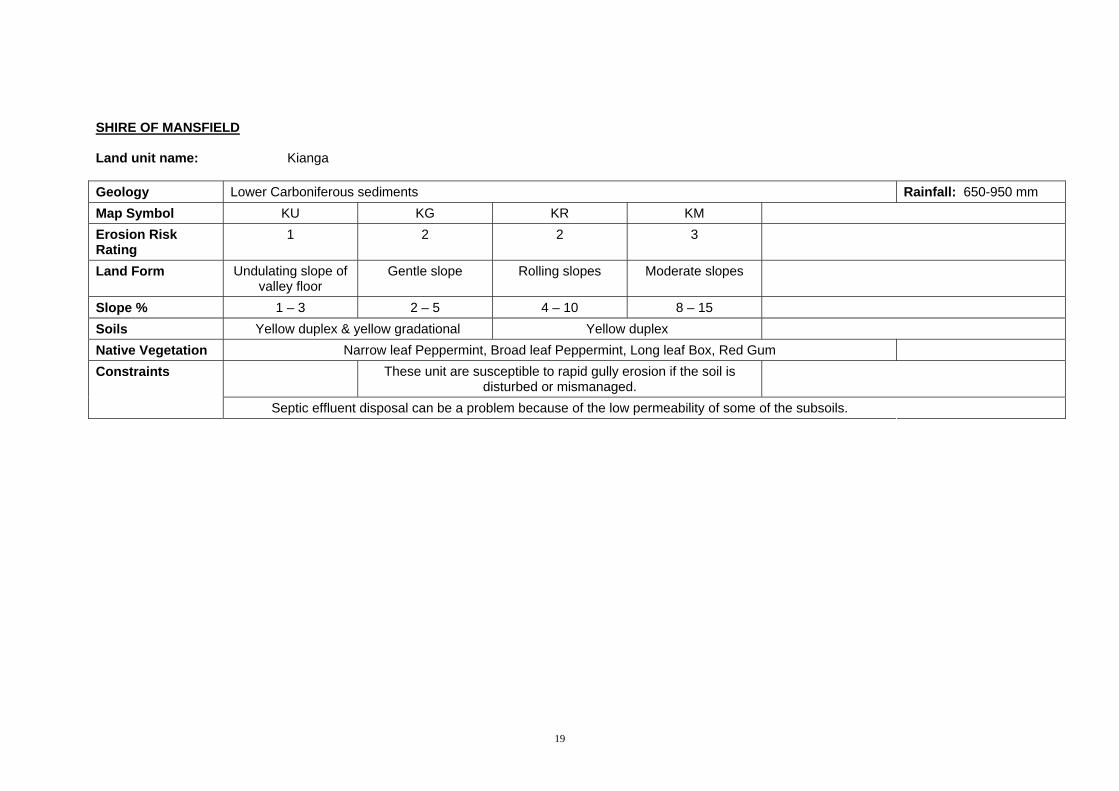
SHIRE OF MANSFIELD Land unit name: Kianga Geology Lower Carboniferous sediments Rainfall: 650-950 mm Map Symbol KU KG KR KM Erosion Risk Rating
1 2 2 3
Land Form Undulating slope of valley floor
Gentle slope Rolling slopes Moderate slopes
Slope % 1 – 3 2 – 5 4 – 10 8 – 15 Soils Yellow duplex & yellow gradational Yellow duplex Native Vegetation Narrow leaf Peppermint, Broad leaf Peppermint, Long leaf Box, Red Gum
These unit are susceptible to rapid gully erosion if the soil is disturbed or mismanaged.
Constraints
Septic effluent disposal can be a problem because of the low permeability of some of the subsoils.
19

SHIRE OF MANSFIELD Land unit name: Loombar Geology Devonian rhyodacite Rainfall: 1,100-1,270 mm Map Symbol LR LM LH LS Erosion Risk Rating
3 3 4 5
Land Form Rolling slopes Moderate slopes Hilly Steep slopes Slope % 4 – 10 8 – 15 10 – 25 20 – 35 Soils Stony gradational
yellow duplex Stony loams
Yellow duplex stony gradational
Red duplex & uniform stony loams
Uniform stony loams & occasional
red duplex
Native Vegetation Narrow leaf Peppermint, Broad leaf Peppermint, Red Box, Red Gum, Long leaf Box, Yellow Box, Stringybark, Candlebark and Blue Gum
Land slips Constraints Water storage is not assured due to the porous nature of most of the sub-surface material
These units are susceptible to rapid erosion if the soil is disturbed or mismanaged Springs may cause large areas of inundation
Septic effluent disposal may be hazardous in some of the soils due to shallowness of permeable soil over rock or other impervious materials
20

SHIRE OF MANSFIELD Land unit name: Merrijig Geology Lower carboniferous sandstones, siltstones Rainfall: 630-900 mm Map Symbol MU MUG MG MGG MGP MR Erosion Risk Rating
3 1 2 2 2 2
Land Form Undulating plain Gilgaid undulating plain
Gentler lower slopes & plains
Gilgaid gentle lower slopes & plains
Gentle crests Gentle to moderate slopes
Slope % 0-3 0-3 2-5 2-5 2-5 4-10 Soils Yellow or dark duplex Yellow or red
duplex Yellow duplex Gradational & red
duplex Friable brown gradational
Native Vegetation Red Gum, Yellow Box Poorly drained, seasonally wet Moderate to poor drainage and seasonally
wet Shallow soils Constraints
The steeper units are subject to rapid erosion if the soil is disturbed or mismanaged. Septic effluent disposal can be a problem because of the low permeable nature of some of the sub soils.
21
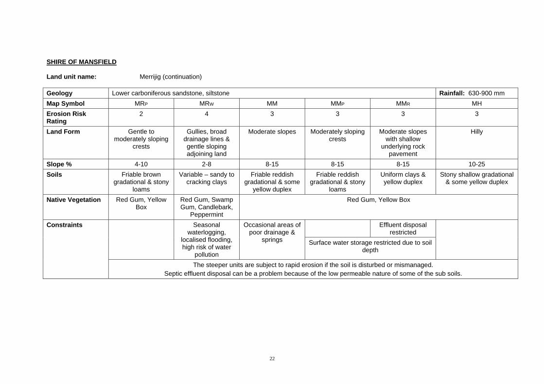
SHIRE OF MANSFIELD Land unit name: Merrijig (continuation) Geology Lower carboniferous sandstone, siltstone Rainfall: 630-900 mm Map Symbol MRP MRW MM MMP MMR MH Erosion Risk Rating
2 4 3 3 3 3
Land Form Gentle to moderately sloping
crests
Gullies, broad drainage lines & gentle sloping adjoining land
Moderate slopes Moderately sloping crests
Moderate slopes with shallow
underlying rock pavement
Hilly
Slope % 4-10 2-8 8-15 8-15 8-15 10-25 Soils Friable brown
gradational & stony loams
Variable – sandy to cracking clays
Friable reddish gradational & some
yellow duplex
Friable reddish gradational & stony
loams
Uniform clays & yellow duplex
Stony shallow gradational & some yellow duplex
Native Vegetation Red Gum, Yellow Box
Red Gum, Swamp Gum, Candlebark,
Peppermint
Red Gum, Yellow Box
Effluent disposal restricted
Seasonal waterlogging,
localised flooding, high risk of water
pollution
Occasional areas of poor drainage &
springs Surface water storage restricted due to soil depth
Constraints
The steeper units are subject to rapid erosion if the soil is disturbed or mismanaged. Septic effluent disposal can be a problem because of the low permeable nature of some of the sub soils.
22

SHIRE OF MANSFIELD Land unit name: Merrijig (continuation) Geology Lower carboniferous sandstone, siltstone Rainfall: 630-900 Map Symbol MS Erosion Risk Rating
4
Land Form Steep slopes Slope % 20-30 Soils Shallow stony
gradational, some yellow duplex
Native Vegetation Red Gum, Yellow Box
Rock outcrops, shallow soil
Constraints
The steeper units are subject to rapid erosion if the soil is disturbed or mismanaged. Septic effluent disposal can be a problem because of the low permeability of some of the subsoils.
23

SHIRE OF MANSFIELD Land unit name: Nillahcootie Geology Devonian granite and Granite alluvium Rainfall: 800-950 mm Map Symbol NG NR NM NH NS Erosion Risk Rating
2 2 3 4 4
Land Form Gentle lower slopes Rolling slopes Moderate slopes Hilly upper slopes Steep upper slopes Slope % 2-5 4-10 8-15 10-25 20-35 Soils Uniform coarse sands with some yellow duplex and pale gradational Native Vegetation Red Stringybark, Red Box, Broad leaf Peppermint with Apple Box, Candlebark and Swamp Gum in wetter
areas.
Constraints Surface springs occur throughout these units and may cause large areas of inundation over prolonged periods. The ability of soils to hold water is variable and unpredictable because of the prevalence of uniform sands.
Septic effluent disposal may be hazardous in some of the soils due to the shallowness of permeable soil over rock or other impermeable material.
Susceptible to rapid erosion of the soil is disturbed or mismanaged.
24

SHIRE OF MANSFIELD Land unit name: Strathbogie Geology Devonian granite and material derived from it Rainfall: 900-1,000 mm Map Symbol SR SM SH SS Erosion Risk Rating
3 3 3 4
Land Form Rolling slopes Moderate slopes Hilly side slopes Steep slopes Slope % 4-10 8-15 10-25 20-35 Soils Red duplex & some
yellow duplex Red duplex & some
yellow duplex Red duplex & some
yellow duplex Massive gradational
Native Vegetation Broad leaf Peppermint, Narrow leaf Peppermint, Candlebark, with occasional Blue Gum and Blackwood, and Swamp Gum in wetter areas.
Prone to landslips Rock outcrops Rocky tors & scattered surface
rock
Constraints
Surface water storage is not assured due to the porous nature of the sub surface material. Particularly prone to sheet and gully erosion if disturbed or mismanaged.
25
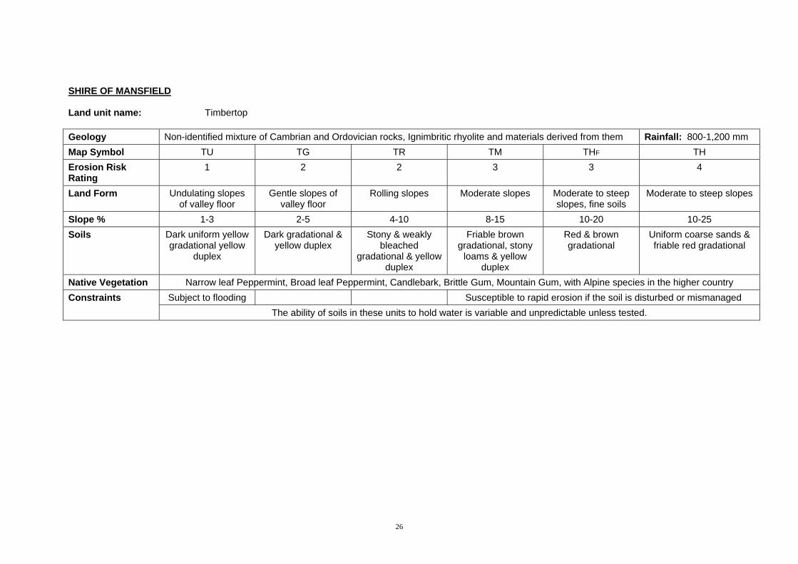
SHIRE OF MANSFIELD Land unit name: Timbertop Geology Non-identified mixture of Cambrian and Ordovician rocks, Ignimbritic rhyolite and materials derived from them Rainfall: 800-1,200 mm Map Symbol TU TG TR TM THF TH Erosion Risk Rating
1 2 2 3 3 4
Land Form Undulating slopes of valley floor
Gentle slopes of valley floor
Rolling slopes Moderate slopes Moderate to steep slopes, fine soils
Moderate to steep slopes
Slope % 1-3 2-5 4-10 8-15 10-20 10-25 Soils Dark uniform yellow
gradational yellow duplex
Dark gradational & yellow duplex
Stony & weakly bleached
gradational & yellow duplex
Friable brown gradational, stony
loams & yellow duplex
Red & brown gradational
Uniform coarse sands & friable red gradational
Native Vegetation Narrow leaf Peppermint, Broad leaf Peppermint, Candlebark, Brittle Gum, Mountain Gum, with Alpine species in the higher country Subject to flooding Susceptible to rapid erosion if the soil is disturbed or mismanaged Constraints
The ability of soils in these units to hold water is variable and unpredictable unless tested.
26

SHIRE OF MANSFIELD Land unit name: Timbertop (continuation) Geology Non identified mixture of Cambrian and Ordovician Rocks, Ignimbritic rhyolite and materials derived from them Rainfall: 1.000+ mm Map Symbol TSF TS TV Erosion Risk Rating
5 5 5
Land Form Steep slopes, fine soils
Steep slopes Very steep slopes
Slope % 25-40 20-35 35+ Soils Red & brown
gradational Uniform coarse sands & shallow stony gradational
Shallow stony gradational & sands
Native Vegetation Narrow leaf Peppermint, Broad leaf Peppermint, Candlebark, Brittle Gum, Mountain Gum, with Alpine species in the higher country
Shallow soils Shallow soil, rockiness
Steepiness, rockiness, shallow
soils
Constraints
Susceptible to rapid erosion if the soil is disturbed or mismanaged The ability of soils in these units to hold water is variable and unpredictable unless tested.
27

28
SHIRE OF MANSFIELD Land unit name: Wombat Geology Tertiary Basalt Rainfall: 1,000-1,250 mm Map Symbol WG WR WM WH WS Erosion Risk Rating
1 2 2 3 3
Land Form Gentle slopes Gentle to moderate slopes
Moderate slopes Moderate to steep slopes
Steep slopes
Slope % 2-5 4-10 8-15 10-25 20-35 Soils Friable red gradational (sometimes light clays) with well structured sub soils. Native Vegetation Messmate, Narrow leaf Peppermint, Candlebark, Manna Gum, Blue Gum & Blackwood Constraints Surface springs may cause large areas of inundation over prolonged periods.
These units are susceptible to rapid erosion if disturbed or mismanaged The storage of surface water may be impractical because of the non-dispersive nature of the soils.
Appendix B – Soil Conservation and Land Utilisation Acts.
Upper Goulburn Catchment
Proclamation
By His Excellency the Governor of the State of Victoria and its Dependencies in the Commonwealth of Australia., &c., &c., &c. I, the Governor of the State of Victoria in the Commonwealth of Australia by and with the advice of the Executive Council of the said state and in pursuance of the provisions contained in section 22 of the Soil Conservation and Land Utilization Act, 1947 do by this my Proclamation define the water supply catchment to be known as the Upper Goulburn Catchment as follows: Commencing at the eastern end of the wall of the Eildon dam on the Goulburn River, thence southerly along the watershed between Snobs Creek and Jerusalem Creek to Mt Torbreck; thence continuing southerly along the watershed between the head waters of Snobs Creek, Royston and Taggerty Rivers on the west and the Big River on the east to Mt Arnold; Great Dividing Range over Mt Matlock and Mt Singleton to Mt Selma; then generally in a north easterly, north westerly and northerly direction along the Great Dividing Range to Mt Macdonald; thence continuing along the Great Dividing Range generally in an easterly and north easterly direction over Mt Magdala to Mt Howitt; thence generally in a north westerly direction along the watershed between the head waters of the King River to the north east and Howqua and Delatite Rivers to the south west; thence continuing generally westerly and north westerly along the watershed between the Broken River on the north and Ford and Brnkeet Creeks on the south; thence in a generally south westerly direction along the water shed between the Seven Creeks on the north west and the Gerar and Merton Creeks on the south east to a point on the water shed west of the township of Meeton; thence generally in a south easterly direction along the water shed between the headwaters of the Home, Colonial and U.T. Creeks on the south west and the immediate catchment of the western or Delatite Arm of the Eildon Reservoir to the western end of the wall of Eildon Dam; thence across the crest of the Dam to the commencing point. The area described is more particularly defined on a plan lodged at the Head Office of the Soil Conservation Authority, 378 Cotham Road, Kew.
……………………………………………….. Given under my Hand and the Seal of the State of Victoria aforesaid at Melbourne, this eighteenth day of December in the year of our Lord One thousand nine hundred and fifty-six, and in the fifth year of the reign of Her Majesty Queen Elizabeth II.
(signed) DALLAS BROOKS By His Excellency’s Command
H E Bolte Minister for Conservation
GOD SAVE THE QUEEN!
29

Appendix C
30

31
Related Documents