Lakes of Missouri Volunteer Program University of Missouri- Columbia The Missouri’s Lakes and Reservoirs The Missouri Department of Natural Resources Region V11, US Environmental Protection Agency, through the Missouri Department of Natural Resources, has provided partial funding for this project under Section 319 of the Clean Water Act Tony Thorpe Dan Obrecht Jack Jones

Lakes of Missouri Volunteer Program University of Missouri-Columbia The Missouri’s Lakes and Reservoirs The Missouri Department of Natural Resources Region.
Dec 14, 2015
Welcome message from author
This document is posted to help you gain knowledge. Please leave a comment to let me know what you think about it! Share it to your friends and learn new things together.
Transcript

Lakes of Missouri Volunteer Program
University of Missouri-Columbia
The
Missouri’s Lakes and Reservoirs
The Missouri Department of Natural Resources
Region V11, US Environmental Protection Agency, through the Missouri Department of Natural Resources, has provided partial funding for this project under Section 319 of the Clean Water Act
Tony Thorpe Dan Obrecht Jack Jones

405 Classified Lakes/Reservoirs
• ~108 are Drinking Water Supply (LC1)
• 14 are Major Reservoirs (LC2)
Most are man-made reservoirs, with about 15 - 20 oxbow lakes.

Of the 405 Classified Waterbodies, we have at least 4 years worth of data on 134
What follows is a summary of the physical features of those 134 waterbodies
“A central paradigm of modern limnology is that external nutrient loading, modified by morphology and hydrology, determines the trophic state of a lake.”
Jones et al. 2005

Lake Morphology• Surface Area• Depth• Volume
Lake Hydrology• Watershed Area• Residence Time
External Loading• Land Use

Surface Area
Ranges from 6 to 53,814 acres in size, with a median of 103 acres.

Break down by size
1 - 10 acres
11 - 20 acres
21 - 40 acres
41 - 75 acres
76 - 150 acres
151 - 300
301 - 10001,001 - 2,0002,001 - 10,000> 10,000
acres
30% of classified lakes are 20 acres or less in size.
10% are greater than 300 acres in size.

Average Depth
Ranges from 3.7 feet to 62 feet, with a median of 11.6 feet.

Lake Volume
Ranges from 48 to 2,700,000 acre-feet, with a median of 1,675 acre-feet.
1 acre-foot = 325,851 gallons
1 acre1 foot

Lake Hydrology

Watershed Area
Ranges from 83 to > 4,000,000 acres, with a median of 2,516
acres.
Residence Time
Ranges from 2.6 days to 9 years, with a median of 10.5 months.

External Loading

Land Cover within watersheds
Forest = 0 – 95%
Grass = 0 – 78%
Crop = 0 – 74%
Urban = 0 – 96%
Using the 134 classified lakes for which we have >= 4 years worth of data

7
20
55
148
To
tal
Ph
osp
ho
rus
(g
/L)
Medium
Amount of Row Crop in the Watershed
Low High
Land Cover and Water Quality:Row Crop
Data points based on summertime averages near the dam

7
20
55
148
To
tal
Ph
osp
ho
rus
(g
/L)
Medium
Amount of Forest in the Watershed
Low High
Land Cover and Water Quality:Forest
Data points based on summertime averages near the dam

Trophic Classification
Oligo Meso Eutro Hyper
TP 10 36 81 7
TN 11 22 92 9
CHL a 15 23 92 4

Distributions based on long-term averages

Phosphorus (micrograms per liter)
0 20 40 60 80 100 120 140 160 180 2000
10
20
30
4050%
# of
wat
erbo
dies IX – 20 ug/L
XI – 8 ug/L
(EPA recommendations as of July 2002)

Nitrogen (micrograms per liter)
# of
wat
erbo
dies
0
10
20
30
50%
IX – 360 ug/LXI – 460 ug/L
(EPA recommendations as of July 2002)

Chlorophyll (micrograms per liter)
# of
wat
erbo
dies
0 5 10 15 20 25 30 35 40 45 50 55 600
10
20
30
50%
IX – 4.9 ug/LXI – 2.8 ug/L
(EPA recommendations as of July 2002)

Break down by size
“Small” Reservoirs:
less than 2000 acres
“Large” Reservoirs:
more than 2000 acres

“Large” Reservoirs
0 10 20 30 40Phosphorus (ug/L)
Long Branch
Mark Twain
Smithville
Stockton 3
Taneycomo
Lake Ozarks 13
Pomme de Terre
Table Rock
Bull Shoals 7
2004 LMVP Data

0 50 100 150 200
Phosphorus (ug/L)
Creve Couer
Ashland
Grindstone
Cameron 3
Springfield
Simpson
Prairie Lee
JenningsLamar
Butler
Binder
Springfork
Little Dixie
Eureka
Mahoney
Sugar Creek
Longview
Water Works
Rothwell
Tri City
JacomoBlue Springs
Bowling Green 1Bowling Green 2
0 10 20 30 40Phosphorus (ug/L)
Long Branch
Mark Twain
Smithville
Stockton 3
Taneycomo
Lake Ozarks 13
Pomme de Terre
Table Rock
Bull Shoals 7
“Small” Reservoirs
Inset is to scale
2004 LMVP Data

Types of Variability
• Temporal
• Spatial

Temporal Variability

Little Dixie Lake – Seasonal Patterns
2004 LMVP Data
Ph
osp
ho
rus
(ug
/L)
30
40
50
60
70
80
90
4/23/2004 5/13/2004 6/2/2004 6/22/2004 7/12/2004 8/1/2004 8/21/2004 9/10/2004 9/30/2004
LMVP

Little Dixie Lake – Seasonal PatternsP
ho
sph
oru
s (u
g/L
)
30
40
50
60
70
80
90
4/23/2004 5/13/2004 6/2/2004 6/22/2004 7/12/2004 8/1/2004 8/21/2004 9/10/2004 9/30/2004
Daily Project
LMVP

1989199019911992199319941995199619971998199920002001200220032004
Year
20
40
60
80
Ph
os
ph
oru
s (
ug
/L)
Range = 37 - 95 ug/LRange = 37 – 95 ug/L

Spatial Variability

Phosphorus Concentrations: Lake of the Ozarks
Variability within a lake2002 LMVP Data

Phosphorus Concentrations: Table Rock Lake
Variability within a lake2002 LMVP Data
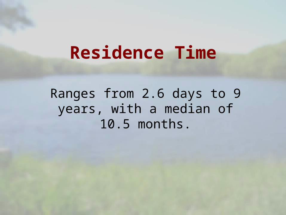
930 acresApproximately 1 mile between the two sites.
25
27
Phosphorus Concentrations: Longview Lake
Variability within a lake
Related Documents