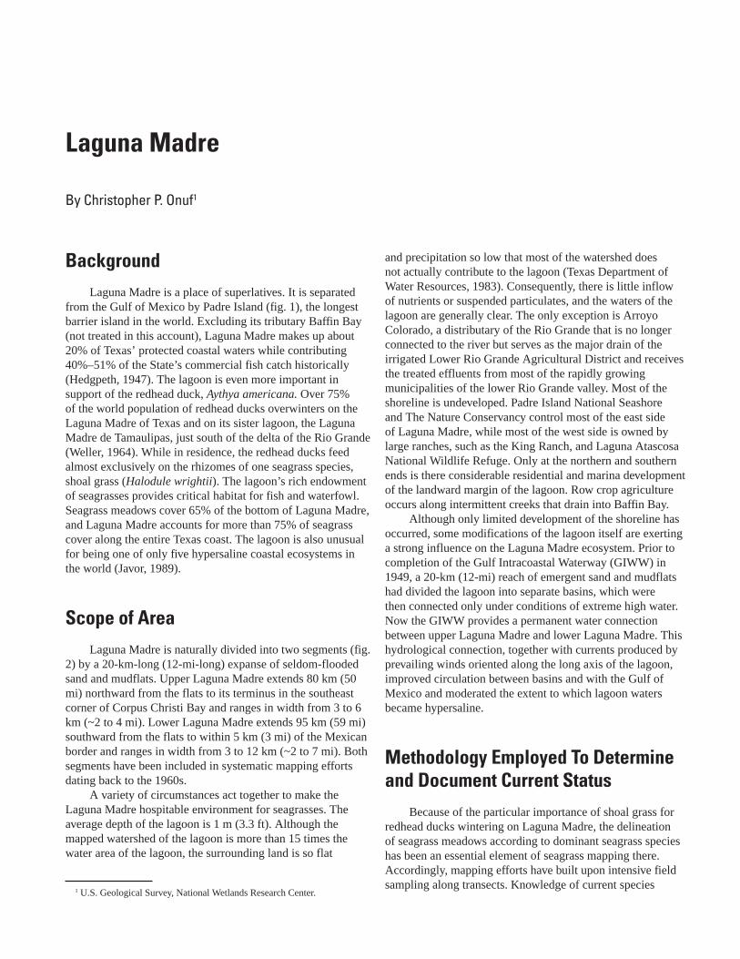
Background Laguna Madre is a place of superlatives. It is separated from the Gulf of Mexico by Padre Island (fig. 1), the longest barrier island in the world. Excluding its tributary Baffin Bay (not treated in this account), Laguna Madre makes up about 20% of Texas’ protected coastal waters while contributing 40%–51% of the State’s commercial fish catch historically (Hedgpeth, 1947). The lagoon is even more important in support of the redhead duck, Aythya americana. Over 75% of the world population of redhead ducks overwinters on the Laguna Madre of Texas and on its sister lagoon, the Laguna Madre de Tamaulipas, just south of the delta of the Rio Grande (Weller, 1964). While in residence, the redhead ducks feed almost exclusively on the rhizomes of one seagrass species, shoal grass (Halodule wrightii). The lagoon’s rich endowment of seagrasses provides critical habitat for fish and waterfowl. Seagrass meadows cover 65% of the bottom of Laguna Madre, and Laguna Madre accounts for more than 75% of seagrass cover along the entire Texas coast. The lagoon is also unusual for being one of only five hypersaline coastal ecosystems in the world (Javor, 1989). Scope of Area Laguna Madre is naturally divided into two segments (fig. 2) by a 20-km-long (12-mi-long) expanse of seldom-flooded sand and mudflats. Upper Laguna Madre extends 80 km (50 mi) northward from the flats to its terminus in the southeast corner of Corpus Christi Bay and ranges in width from 3 to 6 km (~2 to 4 mi). Lower Laguna Madre extends 95 km (59 mi) southward from the flats to within 5 km (3 mi) of the Mexican border and ranges in width from 3 to 12 km (~2 to 7 mi). Both segments have been included in systematic mapping efforts dating back to the 1960s. A variety of circumstances act together to make the Laguna Madre hospitable environment for seagrasses. The average depth of the lagoon is 1 m (3.3 ft). Although the mapped watershed of the lagoon is more than 15 times the water area of the lagoon, the surrounding land is so flat and precipitation so low that most of the watershed does not actually contribute to the lagoon (Texas Department of Water Resources, 1983). Consequently, there is little inflow of nutrients or suspended particulates, and the waters of the lagoon are generally clear. The only exception is Arroyo Colorado, a distributary of the Rio Grande that is no longer connected to the river but serves as the major drain of the irrigated Lower Rio Grande Agricultural District and receives the treated effluents from most of the rapidly growing municipalities of the lower Rio Grande valley. Most of the shoreline is undeveloped. Padre Island National Seashore and The Nature Conservancy control most of the east side of Laguna Madre, while most of the west side is owned by large ranches, such as the King Ranch, and Laguna Atascosa National Wildlife Refuge. Only at the northern and southern ends is there considerable residential and marina development of the landward margin of the lagoon. Row crop agriculture occurs along intermittent creeks that drain into Baffin Bay. Although only limited development of the shoreline has occurred, some modifications of the lagoon itself are exerting a strong influence on the Laguna Madre ecosystem. Prior to completion of the Gulf Intracoastal Waterway (GIWW) in 1949, a 20-km (12-mi) reach of emergent sand and mudflats had divided the lagoon into separate basins, which were then connected only under conditions of extreme high water. Now the GIWW provides a permanent water connection between upper Laguna Madre and lower Laguna Madre. This hydrological connection, together with currents produced by prevailing winds oriented along the long axis of the lagoon, improved circulation between basins and with the Gulf of Mexico and moderated the extent to which lagoon waters became hypersaline. Methodology Employed To Determine and Document Current Status Because of the particular importance of shoal grass for redhead ducks wintering on Laguna Madre, the delineation of seagrass meadows according to dominant seagrass species has been an essential element of seagrass mapping there. Accordingly, mapping efforts have built upon intensive field sampling along transects. Knowledge of current species Laguna Madre By Christopher P. Onuf 1 1 U.S. Geological Survey, National Wetlands Research Center.

Welcome message from author
This document is posted to help you gain knowledge. Please leave a comment to let me know what you think about it! Share it to your friends and learn new things together.
Transcript
BackgroundLaguna Madre is a place of superlatives. It is separated
from the Gulf of Mexico by Padre Island (fig. 1), the longest barrier island in the world. Excluding its tributary Baffin Bay (not treated in this account), Laguna Madre makes up about 20% of Texas’ protected coastal waters while contributing 40%–51% of the State’s commercial fish catch historically (Hedgpeth, 1947). The lagoon is even more important in support of the redhead duck, Aythya americana. Over 75% of the world population of redhead ducks overwinters on the Laguna Madre of Texas and on its sister lagoon, the Laguna Madre de Tamaulipas, just south of the delta of the Rio Grande (Weller, 1964). While in residence, the redhead ducks feed almost exclusively on the rhizomes of one seagrass species, shoal grass (Halodule wrightii). The lagoon’s rich endowment of seagrasses provides critical habitat for fish and waterfowl. Seagrass meadows cover 65% of the bottom of Laguna Madre, and Laguna Madre accounts for more than 75% of seagrass cover along the entire Texas coast. The lagoon is also unusual for being one of only five hypersaline coastal ecosystems in the world (Javor, 1989).
Scope of AreaLaguna Madre is naturally divided into two segments (fig.
2) by a 20-km-long (12-mi-long) expanse of seldom-flooded sand and mudflats. Upper Laguna Madre extends 80 km (50 mi) northward from the flats to its terminus in the southeast corner of Corpus Christi Bay and ranges in width from 3 to 6 km (~2 to 4 mi). Lower Laguna Madre extends 95 km (59 mi) southward from the flats to within 5 km (3 mi) of the Mexican border and ranges in width from 3 to 12 km (~2 to 7 mi). Both segments have been included in systematic mapping efforts dating back to the 1960s.
A variety of circumstances act together to make the Laguna Madre hospitable environment for seagrasses. The average depth of the lagoon is 1 m (3.3 ft). Although the mapped watershed of the lagoon is more than 15 times the water area of the lagoon, the surrounding land is so flat
and precipitation so low that most of the watershed does not actually contribute to the lagoon (Texas Department of Water Resources, 1983). Consequently, there is little inflow of nutrients or suspended particulates, and the waters of the lagoon are generally clear. The only exception is Arroyo Colorado, a distributary of the Rio Grande that is no longer connected to the river but serves as the major drain of the irrigated Lower Rio Grande Agricultural District and receives the treated effluents from most of the rapidly growing municipalities of the lower Rio Grande valley. Most of the shoreline is undeveloped. Padre Island National Seashore and The Nature Conservancy control most of the east side of Laguna Madre, while most of the west side is owned by large ranches, such as the King Ranch, and Laguna Atascosa National Wildlife Refuge. Only at the northern and southern ends is there considerable residential and marina development of the landward margin of the lagoon. Row crop agriculture occurs along intermittent creeks that drain into Baffin Bay.
Although only limited development of the shoreline has occurred, some modifications of the lagoon itself are exerting a strong influence on the Laguna Madre ecosystem. Prior to completion of the Gulf Intracoastal Waterway (GIWW) in 1949, a 20-km (12-mi) reach of emergent sand and mudflats had divided the lagoon into separate basins, which were then connected only under conditions of extreme high water. Now the GIWW provides a permanent water connection between upper Laguna Madre and lower Laguna Madre. This hydrological connection, together with currents produced by prevailing winds oriented along the long axis of the lagoon, improved circulation between basins and with the Gulf of Mexico and moderated the extent to which lagoon waters became hypersaline.
Methodology Employed To Determine and Document Current Status
Because of the particular importance of shoal grass for redhead ducks wintering on Laguna Madre, the delineation of seagrass meadows according to dominant seagrass species has been an essential element of seagrass mapping there. Accordingly, mapping efforts have built upon intensive field sampling along transects. Knowledge of current species
Laguna Madre
By Christopher P. Onuf1
1 U.S. Geological Survey, National Wetlands Research Center.
Figure 1. Watershed for Laguna Madre.
Corpus Christi
37
McAllen
Brownsville
Corpus Christi Bay
Rio Grande
Padr
e Is
land
Arro
yoColorado
Low
erLa
guna
Mad
re
Upp
erLa
guna
Mad
re
Gulf
of M
exic
o
Mexico
Laguna Madre
Watershed boundary
City
Interstate highwayRiverGulf IntracoastalWaterwayCounty line
403020100km
20 25151050mi
N
30 Seagrass Status and Trends in the Northern Gulf of Mexico: 1940–2002
distribution is based on a survey conducted mostly in 1998, but sampling efforts continued into 2000 to resolve questions arising during production of the maps.
In lower Laguna Madre, sampling was along east-west transects at 2’ intervals of latitude from 26° 4’ N to 26° 48’ N. In upper Laguna Madre, transects generally conformed to those first used in a survey conducted in the mid-1970s (Merkord, 1978) and resampled in 1988 (Quammen and Onuf, 1993). Spacing was irregular, but most transects were oriented perpendicular to the long axis of the lagoon and ranged from 1’ to 5’ of latitude apart. In 1998, transects were added in the biggest gaps and eliminated where they were closer than 2’ of latitude to provide more uniform coverage. Along each transect, four 10-cm-diameter (4-inch-diameter) cores were collected at stations located 0.25’ longitude apart as determined by a Rockwell Precision Lightweight Global Positioning System (GPS) Receiver with Federal Precise Positioning Service. Species of seagrass present in each core and on the anchor were recorded in order of abundance, and the station was classified according to dominant species. Where cover type changed between stations, the boundary was established by sampling at successively smaller intervals until different species were dominant or the presence or absence of seagrass coverage occurred at stations less than 0.01’ (17 m) apart. Samples were not collected unless the GPS unit was operating with a positional accuracy of less than 10 m (33 ft).
The boundary coordinates of meadows and dominant species were plotted on 25 U.S. Geological Survey (USGS) 7.5’ topographic sheets representing the frequently submerged parts of the lagoon. National Aerial Photography Program imagery flown in 1995 was projected onto the topographic sheets to aid in interpolation of boundaries between transects. Maps were sent to the USGS National Wetlands Research Center in Lafayette, La., for digitization and geographic information system (GIS) analysis.
Methodology Employed To Analyze Historical Trends
Whole lagoon surveys of seagrass distribution have been conducted about every 10 yr since the mid-1960s. The 1960s maps were taken from Federal aid projects conducted by the Texas Parks and Wildlife Department (TPWD) (McMahan, 1965–67), based on transects across the lagoon at about 1.6-km (1-mi) intervals with stations 0.5 km (0.3 mi) apart. Visual estimates of abundance were made in clear water and from 10 samples taken with a posthole digger in turbid locations. The mid-1970s maps taken from Merkord (1978) were based on a less dense and less uniform set of transects with stations at 0.4-km (0.25-mi) intervals, coupled with aerial photointerpretation. Cover was estimated visually or from posthole digger samples. Quammen and Onuf (1993) reported the results of a survey conducted in 1988, following the sampling array of Merkord (1978), but relied entirely on three
or four 10-cm-diameter (4-inch-diameter) core samples plus material brought up on the anchor to determine the occurrence of seagrasses at a location.
The source maps for the earlier surveys are small format and have been digitized and transferred to a common scale for this analysis of trends. The shore is of such low relief along much of Laguna Madre, particularly on the west side of Padre Island, that the landward limits are poorly defined. No attempt has been made to reconcile differences in shorelines between surveys. They either arise from differing interpretations of ambiguous features on aerial photographs or real differences in water levels between mapping periods. These discrepancies led to large uncertainty in the extent of bare areas in the lagoon. Almost no dredge islands were shown on the 1960s maps, but they appear on USGS quadrangles from the same period. Little change was seen in these features between the mid-1960s and the mid-1970s. Consequently, island polygons from the 1970s mapping were added to the 1960s map so that seagrass coverage estimates for the 1960s would not be artificially inflated. One area erroneously classified as “emergent and unvegetated submergent dredged material” on the 1970s map was redrawn to show an area of surviving seagrass.
No assessment of map accuracy was attempted. Boundaries in the 1960s map could be off by as much as 0.5 km (0.3 mi) because of the spacing of stations and by an unknown additional amount arising from errors in compass and dead-reckoning navigation. This uncertainty in seagrass boundaries, however, is mitigated by the facts that seagrass cover was continuous across the whole lagoon on many transects and there was a very limited occurrence of any species except shoal grass. The resolution of the mapping improved in successive surveys to 17 m (56 ft) on transects in 1998, but with greater uncertainty for interpolated boundaries between transects. North-south limits of seagrass cover were usually resolved to 0.01’ of latitude, but north-south limits between species were not resolved between transects in most cases. Because of these limits on the resolution of the maps, differences in seagrass coverage between surveys (decades) of less than 5 km2 (2 mi2) may not be indicative of change, unless the trend continues into subsequent surveys. As noted above, differences between surveys in what was considered “bare” bottom are even more uncertain.
Status and Trends
Lower Laguna Madre
The far right panel of figure 3 illustrates seagrass coverage in lower Laguna Madre in 1998. Seagrasses covered 67% of the permanently and regularly flooded portions of the basin. Deep areas (>1.3 m, or 4 ft) at the north and south ends of the basin accounted for most of the bare bottom there. Turtle grass (Thalassia testudinum) strongly dominated
Status and Trends 31
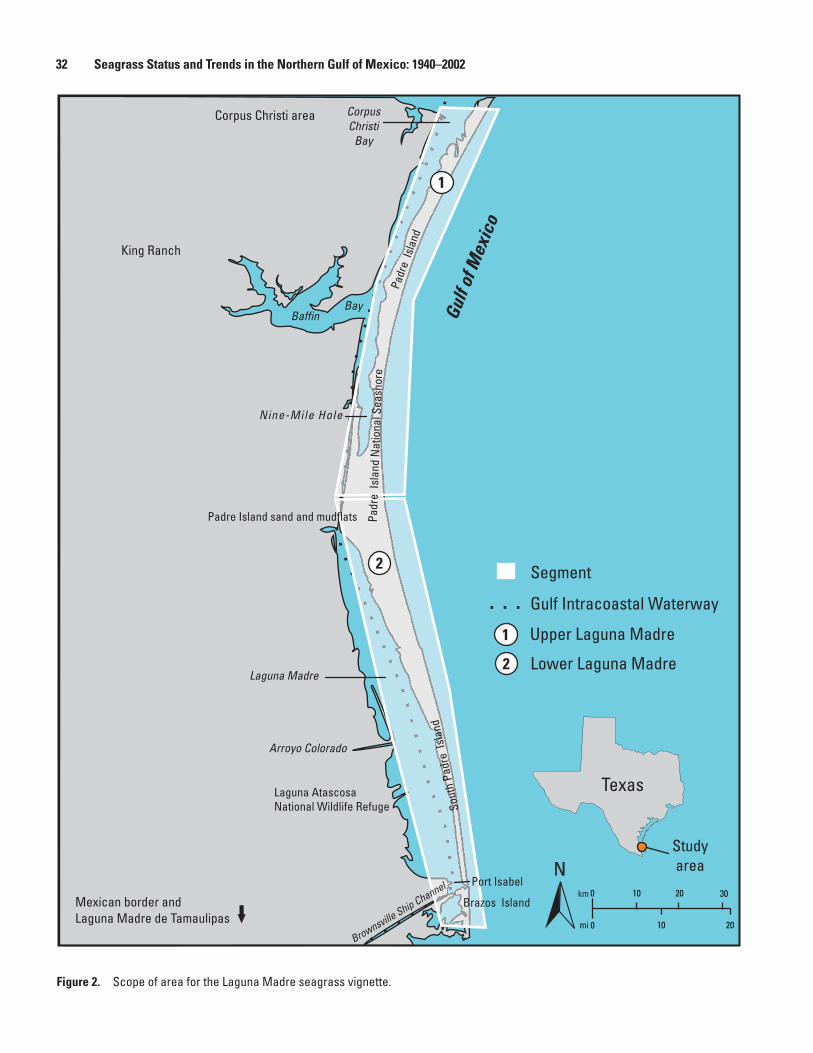
Figure 2. Scope of area for the Laguna Madre seagrass vignette.
1
2
Segment
Brownsville Ship Channel
Texas
NStudy area
2
1
Corpus Christi area
Laguna AtascosaNational Wildlife Refuge
Arroyo Colorado
Laguna Madre
Mexican border and Laguna Madre de Tamaulipas
Baffin
Nine-Mile Hole
Bay Gulf
of M
exic
oPadre Island sand and mudflats
Brazos Island
Port Isabel
Sout
h Pa
dre
Isla
nd
King Ranch
Padr
e Is
land
Padr
e Is
lan d
Nat
iona
l Sea
shor
e
CorpusChristi
Bay
Gulf Intracoastal Waterway
Upper Laguna Madre
Lower Laguna Madre
km 3020100
20100mi
32 Seagrass Status and Trends in the Northern Gulf of Mexico: 1940–2002
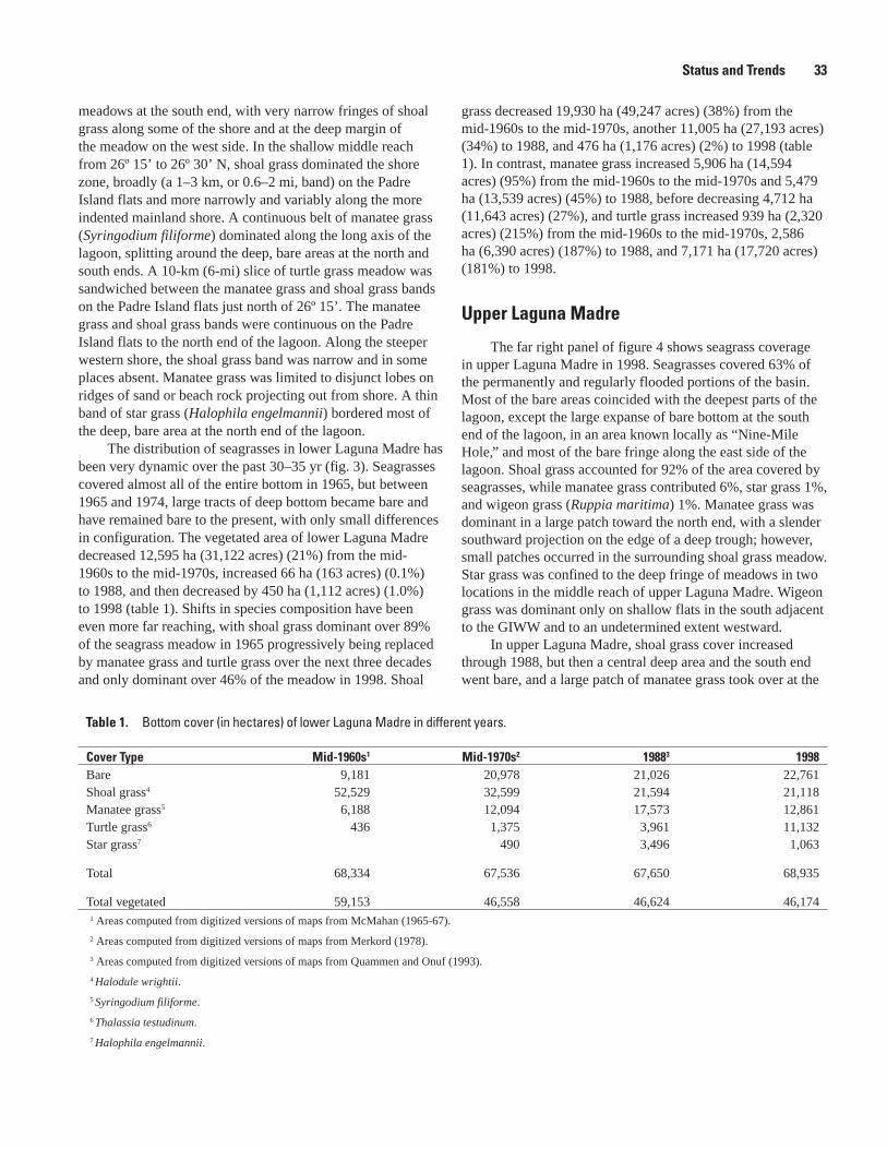
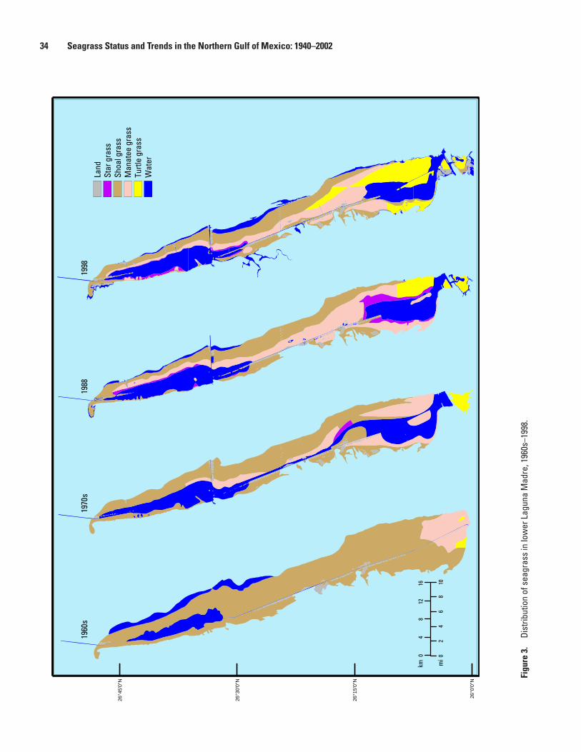
meadows at the south end, with very narrow fringes of shoal grass along some of the shore and at the deep margin of the meadow on the west side. In the shallow middle reach from 26º 15’ to 26º 30’ N, shoal grass dominated the shore zone, broadly (a 1–3 km, or 0.6–2 mi, band) on the Padre Island flats and more narrowly and variably along the more indented mainland shore. A continuous belt of manatee grass (Syringodium filiforme) dominated along the long axis of the lagoon, splitting around the deep, bare areas at the north and south ends. A 10-km (6-mi) slice of turtle grass meadow was sandwiched between the manatee grass and shoal grass bands on the Padre Island flats just north of 26º 15’. The manatee grass and shoal grass bands were continuous on the Padre Island flats to the north end of the lagoon. Along the steeper western shore, the shoal grass band was narrow and in some places absent. Manatee grass was limited to disjunct lobes on ridges of sand or beach rock projecting out from shore. A thin band of star grass (Halophila engelmannii) bordered most of the deep, bare area at the north end of the lagoon.
The distribution of seagrasses in lower Laguna Madre has been very dynamic over the past 30–35 yr (fig. 3). Seagrasses covered almost all of the entire bottom in 1965, but between 1965 and 1974, large tracts of deep bottom became bare and have remained bare to the present, with only small differences in configuration. The vegetated area of lower Laguna Madre decreased 12,595 ha (31,122 acres) (21%) from the mid-1960s to the mid-1970s, increased 66 ha (163 acres) (0.1%) to 1988, and then decreased by 450 ha (1,112 acres) (1.0%) to 1998 (table 1). Shifts in species composition have been even more far reaching, with shoal grass dominant over 89% of the seagrass meadow in 1965 progressively being replaced by manatee grass and turtle grass over the next three decades and only dominant over 46% of the meadow in 1998. Shoal
grass decreased 19,930 ha (49,247 acres) (38%) from the mid-1960s to the mid-1970s, another 11,005 ha (27,193 acres) (34%) to 1988, and 476 ha (1,176 acres) (2%) to 1998 (table 1). In contrast, manatee grass increased 5,906 ha (14,594 acres) (95%) from the mid-1960s to the mid-1970s and 5,479 ha (13,539 acres) (45%) to 1988, before decreasing 4,712 ha (11,643 acres) (27%), and turtle grass increased 939 ha (2,320 acres) (215%) from the mid-1960s to the mid-1970s, 2,586 ha (6,390 acres) (187%) to 1988, and 7,171 ha (17,720 acres) (181%) to 1998.
Upper Laguna Madre
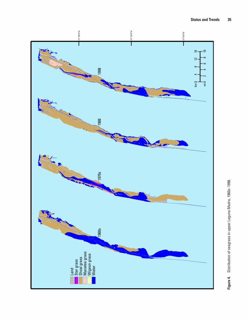
The far right panel of figure 4 shows seagrass coverage in upper Laguna Madre in 1998. Seagrasses covered 63% of the permanently and regularly flooded portions of the basin. Most of the bare areas coincided with the deepest parts of the lagoon, except the large expanse of bare bottom at the south end of the lagoon, in an area known locally as “Nine-Mile Hole,” and most of the bare fringe along the east side of the lagoon. Shoal grass accounted for 92% of the area covered by seagrasses, while manatee grass contributed 6%, star grass 1%, and wigeon grass (Ruppia maritima) 1%. Manatee grass was dominant in a large patch toward the north end, with a slender southward projection on the edge of a deep trough; however, small patches occurred in the surrounding shoal grass meadow. Star grass was confined to the deep fringe of meadows in two locations in the middle reach of upper Laguna Madre. Wigeon grass was dominant only on shallow flats in the south adjacent to the GIWW and to an undetermined extent westward.
In upper Laguna Madre, shoal grass cover increased through 1988, but then a central deep area and the south end went bare, and a large patch of manatee grass took over at the
Cover Type Mid-1960s1 Mid-1970s2 19883 1998Bare 9,181 20,978 21,026 22,761Shoal grass4 52,529 32,599 21,594 21,118Manatee grass5 6,188 12,094 17,573 12,861Turtle grass6 436 1,375 3,961 11,132Star grass7 490 3,496 1,063
Total 68,334 67,536 67,650 68,935
Total vegetated 59,153 46,558 46,624 46,1741 Areas computed from digitized versions of maps from McMahan (1965-67).
2 Areas computed from digitized versions of maps from Merkord (1978).
3 Areas computed from digitized versions of maps from Quammen and Onuf (1993).
4 Halodule wrightii.
5 Syringodium filiforme.
6 Thalassia testudinum.
7 Halophila engelmannii.
Table 1. Bottom cover (in hectares) of lower Laguna Madre in different years.
Status and Trends 33
Figu
re 3
. Di
strib
utio
n of
sea
gras
s in
low
er L
agun
a M
adre
, 196
0s–1
998.
1960
s 19
70 s
1988
19
98
26 °0
'0 "N
26 °1
5' 0"
N
26 °3
0' 0"
N
26 °4
5' 0"
N
Wat
er
Land
St
ar g
rass
Sh
oal g
rass
M
anat
ee g
rass
Tu
rtle
gras
s
10
04
8 12
16
km
02
46
8
mi
34 Seagrass Status and Trends in the Northern Gulf of Mexico: 1940–2002
27°0
'0"N
27°1
5'0"
N
27°3
0'0"
N
Figu
re 4
. Di
strib
utio
n of
sea
gras
s in
upp
er L
agun
a M
adre
, 196
0s–1
998.
Status and Trends 35
north end by 1998 (fig. 4). In contrast to the lower Laguna Madre, the area of vegetated bottom in upper Laguna Madre increased 7,934 ha (19,605 acres) (64%) from the mid-1960s to the mid-1970s, increased again 2,648 ha (6,543 acres) (13%) to 1988, and then decreased 460 ha (1,137 acres) (2%) to 1998 (table 2). Shoal grass cover increased 7,323 ha (18,095 acres) (59%) from the mid-1960s to the mid-1970s, increased again 3,259 ha (8,053 acres) (17%) to 1988, and then decreased 2,350 ha (5,807 acres) (10%) by 1998. Manatee grass was not recorded in the first two surveys, covered an insufficient area to be mapped in 1988, but by 1998 dominated 1,452 ha (3,588 acres) of the bottom, accounting for 4% of the seagrass meadow.
Laguna Madre as a Whole
From the mid-1960s to 1998, the area of vegetated bottom decreased 2,856 ha (7,057 acres) (4%) for the lagoon as a whole. Cover of turtle grass increased from barely present to dominating 11% of lagoon bottom, and manatee grass first increased from 6% to 17% but then fell back to 14%. All of these increases were at the expense of shoal grass, which covered 64% of lagoon bottom in the earliest survey but diminished to 40% by 1998 (table 3).
Causes of Change
Lower Laguna Madre
Between 1965 and 1974, 118 km2 (46 mi2) of vegetated bottom became bare. Noting the alignment of new unvegetated bottom with the GIWW and adjacent naturally deep parts of the lagoon, Merkord (1978) proposed that reduced light resulting from turbidity caused by maintenance dredging of the waterway was likely responsible for the loss of seagrass. Intensive monitoring of the light regime 3 months before and 15 months after a maintenance dredging project in 1988 supported this interpretation. The study documented increased light attenuation to the end of the study in the region where seagrasses had been lost (Onuf, 1994). Although turbidity from dredging activity dissipates within hours of the cessation of dredging, the mounds of dredged material left behind are much more prone to resuspension. Laguna Madre is renowned for its winds, and frequent episodes of resuspension of the fine, unconsolidated deposits by waves and dispersion by currents assure propagation of dredging effects over long spans of space and time.
The GIWW is also involved in the major shifts in species composition that have occurred over the last 35 yr and that are still in progress. Prior to completion of the waterway in 1949,
Cover Type Mid-1960s1 Mid-1970s2 19883 1998
Bare 20,826 10,785 9,893 12,950Shoal grass4 12,321 19,644 22,903 20,553Manatee grass5 0 0 0 1,452Star grass6 0 611 0 307Wigeon grass7 0 0 0 132
Total 33,147 31,040 32,796 35,394
Total Vegetated 12,321 20,255 22,903 22,4441 Areas computed from digitized versions of maps from McMahan (1965–67).
2 Areas computed from digitized versions of maps from Merkord (1978).
3 Areas computed from digitized versions of maps from Quammen and Onuf (1993).
4 Halodule wrightii.
5 Syringodium filiforme.
6 Halophila engelmannii.
7 Ruppia maritima.
Table 2. Bottom cover (in hectares) of upper Laguna Madre in different years.
36 Seagrass Status and Trends in the Northern Gulf of Mexico: 1940–2002
a 30-km (19-mi) reach of usually exposed sand and mudflats effectively isolated the two sections of the lagoon. Because of limited water exchange with the Gulf of Mexico, infrequent freshwater inflow, and average annual evaporation that was approximately twice the average annual precipitation, it was not uncommon to find salinities double that of the adjacent gulf in lower Laguna Madre and triple that of the gulf in the southern extremity of upper Laguna Madre. The 40-m-wide by 4-m-deep (125-ft-wide by 12-ft-deep) channel that was cut through the flats provided the first permanent water connection between the two segments of the lagoon. Prevailing winds along the long axis of the lagoon now enhance exchange within the lagoon and between the lagoon and the Gulf of Mexico, considerably moderating hypersaline conditions within the lagoon. Since completion of the waterway, salinities never rise much above 50 ppt.
Life history and competitive characteristics of the plants almost certainly account for the time-course of change evident in this trends analysis. Not only is shoal grass the only species that can tolerate salinities greater than 60 ppt, but it is also superior to manatee grass or turtle grass as a colonizer. Therefore, shoal grass was probably widespread before construction of the waterway, although there are only incidental reports from a few locations for that period. Given its strong colonizing abilities, it is not surprising that shoal
grass overwhelmingly dominated lower Laguna Madre by the time of the first systematic survey of seagrass cover in the mid-1960s, while the other species were still limited to within 12 km of the natural gulf outlet at the extreme south end of the lagoon (fig. 3). Gradual displacement of shoal grass from the south by manatee grass, which in its turn was later displaced by turtle grass (fig. 3), is consistent with what we know of the relative colonizing and competitive abilities of these species under conditions of moderate salinity (Quammen and Onuf, 1993; Onuf, 1995).
Upper Laguna Madre
Upper Laguna Madre has experienced the same system shift in salinity regime as did lower Laguna Madre, yet its trajectory of seagrass change has been very different. While shoal grass cover increased by 85% through 1988 in upper Laguna Madre (fig. 4), it decreased by almost 60% in lower Laguna Madre (fig. 3). Manatee grass was not even seen in upper Laguna Madre until 1988 (Quammen and Onuf, 1993) and was not detected in a decennial sampling program until 1998 (fig. 4). Changes in upper Laguna Madre seem to lag those in lower Laguna Madre by 20 or 30 yr. The extreme hypersalinity of the southern section of upper Laguna Madre before completion of the GIWW probably accounts
Cover Type Mid-1960s1 Mid-1970s2 19883 1998
Bare 30,007 31,763 30,919 35,711Shoal grass4 64,850 52,243 44,497 41,671Manatee grass5 6,188 12,094 17,573 14,313Turtle grass6 436 1,375 3,961 11,132Star grass7 0 1,101 3,496 1,370Wigeon grass8 0 0 0 132
Total 101,481 98,576 100,446 104,329
Total Vegetated 71,474 66,813 69,527 68,6181 Areas computed from digitized versions of maps from McMahan (1965-67).
2 Areas computed from digitized versions of maps from Merkord (1978).
3 Areas computed from digitized versions of maps from Quammen and Onuf (1993).
4 Halodule wrightii.
5 Syringodium filiforme.
6 Thalassia testudinum.
7 Halophila engelmannii.
8 Ruppia maritima.
Table 3. Bottom cover (in hectares) of Laguna Madre (whole lagoon) in different years.
Causes of Change 37
for the difference in responses between parts of the lagoon. Even shoal grass cannot tolerate salinities over 100 ppt. Consequently, it was probably absent from most of upper Laguna Madre at least through 1949, except in areas near Corpus Christi Bay. Because source populations were much farther away, colonization of shoal grass continued until 1988 in upper Laguna Madre, as opposed to already being maximal in lower Laguna Madre by 1965. Similarly, the establishment of manatee grass in upper Laguna Madre took even longer because, in 1965, source populations were even more remote, at the south end of lower Laguna Madre or across Corpus Christi Bay, near the closest gulf outlet to the north. Not surprisingly, establishment of manatee grass in upper Laguna Madre was long delayed compared to lower Laguna Madre, where it was present from the outset (Onuf and others, 2003).
Other recent changes in upper Laguna Madre have reversed the trend of increasing seagrass cover seen through 1988. Laguna Madre was renowned for its crystal clear water until June 1990 with the appearance of the “Texas brown tide.” This phytoplankton bloom varied in intensity but was continually present from 1990 to 1997 and has flared up sporadically since. Over large areas, light at 1 m (3.3 ft) was reduced to half of what it had been before the brown tide, and shoal grass gradually died back in deep areas (fig. 4) (Onuf, 1996a). Although a suite of factors played a role in the initiation and unprecedented persistence of the brown tide (Stockwell and others, 1993; Buskey and others, 1997, 2001), nutrients regenerated from the gradual dieback of the seagrass meadow almost certainly were involved in sustaining the bloom, until steady state was reached between seagrass distribution and the brown-tide-influenced light regime (Onuf, 2000). A disturbing aspect of this perturbation is that as yet there is little sign of recovery. Apparently because of the loss of seagrass cover, the bottom is much more prone to sediment resuspension. Because new recruits have no reserves to tide them over during episodes of low light, establishment has not occurred.
The loss of shoal grass in relatively shallow water at the south end of upper Laguna Madre between 1988 and 1998 (fig. 4) is problematic. The area was not visited between surveys, and nothing is known of environmental conditions that might have precipitated the loss. Multiple shoal grass patches were seen in this area in 2003 (K.H. Dunton, University of Texas, written commun., 2004), indicating partial recovery to that time.
Monitoring for Seagrass HealthThe status of seagrasses in Laguna Madre is determined
from transect sampling. The dominant seagrass species and occurrence of other seagrasses and algae are recorded for
each of the four 10-cm-diameter (4-inch-diameter) cores taken at each station, plus similar information for what is brought up on the anchor. A subset of cores is retained for biomass determination. From these data, detailed information on patchiness and condition of seagrasses can be extracted beyond the mapped distributional patterns. Biomass change presaged distributional change by a couple of years in assessments of the impact of the brown tide on seagrasses (Onuf, 1996a, 2000). Fixed, underwater, light-monitoring stations (Dunton, 1994; Onuf, 1996a) and continuous monitoring of chlorophyll and turbidity are also in progress and will provide critical information in the assessment of seagrass health near the monitoring stations. As yet, no systematic assessment of seagrass health has been performed; however, much higher biomass of macroalgae found in the middle reach of lower Laguna Madre than elsewhere in the lagoon in 1988 (Onuf, 1996b) may point to localized nutrient overenrichment.
Mapping and Monitoring NeedsIn 1999 the “Seagrass Conservation Plan for Texas”
was adopted by the TPWD, the Texas General Land Office (TGLO), and the Texas Commission on Environmental Quality (TCEQ), which are the State agencies charged with protection of seagrass habitats. One of the highest priority needs outlined in the plan was to develop a statewide seagrass mapping and monitoring plan. In July 2000 the TCEQ added seagrass as an “Aquatic Life Use” in the Texas Surface Water Quality Standards (http://www.tnrcc.state.tx.us/permitting/waterperm/wqstand, p. 16, 39). This designation is currently pending U.S. Environmental Protection Agency (EPA) approval. The adoption of seagrass as an aquatic life use only increases the need for a routine monitoring plan. Currently, State and Federal agencies as well as seagrass researchers are developing such a plan.
Unlike other Texas coastal estuaries, there have been seagrass distribution studies of the whole Laguna Madre system conducted approximately once a decade since the mid-1960s (McMahan, 1965–67; Merkord, 1978; Quammen and Onuf, 1993; this report). This decade-cyclic sampling used for determining the status and trends reported in this vignette has revealed many interesting changes in seagrass distribution in the Laguna Madre. These mapping efforts also prove the need for more intensive monitoring at targeted locations in order to better understand factors affecting the health and changes of seagrass beds. These targeted locations should include areas near development, such as in the town of South Padre Island or in the vicinity of potential large inputs of nutrients such as at the mouth of the Arroyo Colorado.
38 Seagrass Status and Trends in the Northern Gulf of Mexico: 1940–2002
Restoration and Enhancement Opportunities
Seagrass restoration and enhancement opportunities in the Laguna Madre primarily focus around U.S. Army Corps of Engineers (USACE) programs such as the management of maintenance dredged material from the GIWW and mitigation for regulated permit actions such as oil and gas exploration, residential canal subdivisions, and dredging. Two other areas of focus include the reduction of nutrients into the Laguna Madre ecosystem and educating the public about boat propeller impacts (scarring) to seagrass meadows.
In 1988, seagrasses covered 730 km2 (282 mi2), or about three-quarters of the subtidal area of the Laguna Madre (Onuf, 1996b). Therefore, activities which are regulated under the USACE Section 10 (Rivers and Harbors Act of 1899) and Section 404 (Clean Water Act of 1976) programs have a high potential for impacting seagrasses. Sections 10 and 404 activities such as marinas, oil and gas exploration, pipelines, residential canal subdivisions, and channels are often planned in areas containing ecologically sensitive seagrass beds. As such, the State and Federal natural resource agencies (TPWD, TGLO, TCEQ, U.S. Fish and Wildlife Service (USFWS), EPA, USACE, and National Park Service) work closely with applicants in an effort to avoid and minimize seagrass impacts as much as possible. Compensatory mitigation (in the form of seagrass creation or restoration) is sought for justifiable and unavoidable impacts. Significant efforts have been made to avoid and/or minimize impacts over performing compensatory mitigation. Seagrass mitigation is very costly and often unsuccessful. Furthermore, it appears that seagrass mitigation sites take many years before they begin to function like natural seagrass beds (Montagna, 1993). There are very few areas that are currently available to be used as seagrass mitigation sites in the Laguna Madre. The resource agencies and academia are currently evaluating strategies to address the aforementioned issues and to identify the most beneficial way to approach seagrass mitigation associated with USACE permit actions.
There is evidence that maintenance dredging activities along the GIWW may have caused significant loss of seagrass in the Laguna Madre (Onuf, 1994). Concerns about disposal of maintenance dredged material in the Laguna Madre prompted a lawsuit in September 1994 by the National Audubon Society and other local environmental groups against the USACE. The lawsuit ultimately led to a settlement wherein the USACE agreed to develop a supplemental environmental impact statement (SEIS) for the Laguna Madre reach of the GIWW. The USACE and the Texas Department of Transportation (TxDOT is the non-Federal sponsor of the project) committed to identifying solutions that allowed continued navigation and addressed environmental concerns (Texas Department of Transportation, 2000). To this end the USACE and TxDOT developed an interagency coordination team for the Laguna
Madre. This interagency team consists of members from the USACE, TxDOT, EPA, USFWS, National Marine Fisheries Service, TGLO, TCEQ, TPWD, and the Texas Water Development Board. The team’s charter included objectives to identify the environmental concerns associated with the GIWW in the Laguna Madre and to develop scopes of work to address these environmental concerns. The team began work in February 1995 and continues to the present. Currently, the draft SEIS is being finalized. If past maintenance dredging activities have adversely affected seagrasses, it is hoped that, through the work of the team, solutions will be found and recolonization of affected areas will take place.
In the lower Laguna Madre, nutrient input from the Arroyo Colorado is becoming a concern. Onuf (1996b) found algal biomass to be three times greater near the Arroyo Colorado as compared to other areas of the Laguna Madre. The Arroyo Colorado is the only major drainage into the lower Laguna Madre. This drainage receives much of the municipal, industrial, and agricultural wastewater generated in the lower Rio Grande valley. Consequently, the tidal segment of the arroyo does not meet the dissolved oxygen standard for aquatic life use, and nutrient concentrations exceed screening levels. Currently, to address the water-quality problems in the arroyo, a total maximum daily load (TMDL) assessment is being conducted by the TCEQ. Once the TMDL is completed and implemented, reduction in nutrient loading might benefit lower Laguna Madre.
Recently, propeller scarring in seagrass beds by recreational boaters was found to be significant in some areas of the upper Laguna Madre (Dunton and Schonberg, 2002). Because propeller scarring has been implicated in seagrass bed fragmentation and loss (Zieman, 1976), the Corpus Christi Bay National Estuary Program funded informational signs currently being installed at many upper Laguna Madre boat ramps. These signs are 1.2 m wide and 2.5 m long (4 ft by 8 ft) and are designed to educate boaters about the importance of seagrasses as well as give boat operators information to help minimize damage from propellers. At the southern extremity of upper Laguna Madre, TPWD designated a mandatory no-motor zone in 2000, and adjacent to it, Padre Island National Seashore has designated a voluntary no-motor zone. In 2005, TPWD will evaluate the effectiveness of the no-motor zone and decide whether to continue the designation.
AcknowledgmentsThe author thanks Beau Hardegree, U.S. Fish and
Wildlife Service, Ecological Services Division, Corpus Christi, Tex., for assistance in preparing the sections on mapping and monitoring needs and restoration and enhancement opportunities.
Acknowledgments 39
References Cited
Buskey, E.J., Liu, H., Collumb, C., and Bersano, J.G.F., 2001, The decline and recovery of a persistent Texas brown tide algal bloom in the Laguna Madre (Texas, USA): Estuaries, v. 24, p. 337–346.
Buskey, E.J., Montagna, P.A., Amos, A.F., and Whitledge, T.E., 1997, Disruption of grazer populations as a contributing factor to the initiation of the Texas brown tide algal bloom: Limnology and Oceanography, v. 42, p. 1215–1222.
Dunton, K.H., 1994, Seasonal growth and biomass of the subtropical seagrass Halodule wrightii in relation to continuous measurements of underwater irradiance: Marine Biology, v. 120, p. 479–489.
Dunton, K.H., and Schonberg, S.V., 2002, Assessment of propeller scarring in seagrass beds of the South Texas coast: Journal of Coastal Research, v. 37, p.100–110.
Hedgpeth, J.W., 1947, The Laguna Madre of Texas: North American Wildlife Conference, v. 12, p. 364–380.
Javor, B., 1989, Hypersaline environments: New York, Springer-Verlag, 328 p.
McMahan, C.A., 1965–67, Ecology of principal waterfowl foods of Laguna Madre: Texas Parks and Wildlife Department job completion reports, Federal aid projects W-29-R-18 to 20.
Merkord, G.W., 1978, The distribution and abundance of seagrasses in Laguna Madre of Texas: Kingsville, Texas A&I University, M.S. thesis, 56 p.
Montagna, P.A., 1993, Comparison of ecosystem structure and functions of created and natural seagrass habitats in Laguna Madre, Texas: Port Aransas, University of Texas Marine Science Institute technical report TR/93-007, 72 p.
Onuf, C.P., 1994, Seagrasses, dredging and light in Laguna Madre, Texas, USA: Estuarine Coastal and Shelf Science, v. 39, p. 75–91.
Onuf, C.P., 1995, Seagrass meadows of the Laguna Madre of Texas, in LaRoe, E.T., Farris, G.S., Puckett, C.E., Doran, P.D., and Mac, M.J., eds., Our living resources: a report to the Nation on the distribution, abundance, and health of U.S. plants, animals, and ecosystems: Washington, D.C., U.S. Department of the Interior, National Biological Service, p. 275–277.
Onuf, C.P., 1996a, Seagrass responses to long-term light reduction by brown tide in upper Laguna Madre, Texas: distribution and biomass patterns: Marine Ecology Progress Series, v. 138, p. 219–231.
Onuf, C.P., 1996b, Biomass patterns in seagrass meadows of the Laguna Madre, Texas: Bulletin of Marine Science, v. 58, p. 404–420.
Onuf, C.P., 2000, Seagrass responses to and recovery (?) from seven years of brown tide: Pacific Conservation Biology, v. 5, p. 306–313.
Onuf, C.P., Phillips, R.A., Moncreiff, C.A., Raz-Guzman, A., and Herrera-Silveira, J.A., 2003, Gulf of Mexico, in Green, E.P., Short, F.T., and Spalding, M.D., eds., World atlas of seagrasses: present status and future conservation: Berkeley, University of California Press, chap. 22, p. 224–233.
Quammen, M.L., and Onuf, C.P., 1993, Laguna Madre: seagrass changes continue decades after salinity reduction: Estuaries, v. 16, p. 302–310.
Stockwell, D.A., Buskey, E.J., and Whitledge, T.E., 1993, Studies on conditions conducive to the development and maintenance of a persistent ‘brown tide’ in Laguna Madre, Texas, in Smayda, T.J., and Shimizu, Y., eds., Toxic phytoplankton blooms in the sea: New York, Elsevier Science Publishers, p. 693–698.
Texas Department of Transportation, 2000, The Gulf Intracoastal Waterway in Texas: Texas Department of Transportation, Transportation Planning and Programming Division, report submitted to the 77th session of the Texas Legislature.
Texas Department of Water Resources, 1983, Laguna Madre estuary: a study of the influence of freshwater inflows: Austin, Texas Department of Water Resources, report LP-182.
Weller, M.W., 1964, Distribution and migration of the redhead: Journal of Wildlife Management, v. 28, p. 64–103.
Zieman, J.C., 1976, The ecological effects of physical damage from motorboats on turtle grass beds in Southern Florida: Aquatic Botany, v. 2, p. 127–139.
40 Seagrass Status and Trends in the Northern Gulf of Mexico: 1940–2002
Related Documents