Lab No 13 Structure Contour Maps University of Sulaimani School of Science Department of Geology Practical Structural Geology Instructor: Halko M. Mahmoud 2014-2015

Lab No 13 Structure Contour Maps University of Sulaimani School of Science Department of Geology Practical Structural Geology Instructor: Halko M. Mahmoud.
Dec 18, 2015
Welcome message from author
This document is posted to help you gain knowledge. Please leave a comment to let me know what you think about it! Share it to your friends and learn new things together.
Transcript
Lab No 13
Structure Contour Maps
University of SulaimaniSchool of Science
Department of Geology
Practical Structural Geology
Instructor: Halko M. Mahmoud
2014-2015

Structure contour lines
A topographic contour line is a line that connects points of equal elevation on the topographic surface, while a structure contour line is a line that connects points of equal elevation on the top or bottom of stratigraphic unit.
Examples of such surfaces include the top or bottom of a stratigraphic unit; marker beds and horizons; and surfaces of unconformity, of mineral deposits or of aquifers.
The data used in constructing a structure-contour map may be obtained from geological surveys, the drilling of holes, mining, or geophysical investigations.

N
400
300
200
100300 m
200 m
100 m
400 m
N
400
300
200
100
(Horizontal Plane)
400
300
200
100
Structure contour lines

Structure contour lines
Sometimes the bed is cut by a fault in such case the structure contours drawn for the top or the bottom of the stratigraphic unit has discontinuities and intersect the fault plane.
Structure contour maps are highly significant to map horizons of interest at certain depth and to recognize structures at the subsurface.

Exercise
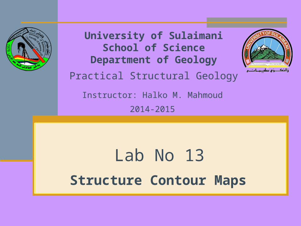
Structure of the Bed
Dip angle between any two points = tan-1 (ΔE / X * scale)
The structural geology of the bed: There are of 4 folds that have a general trend of NW-
SE. Two plunging anticlines in the NW and South. The
anticlines are rather symmetrical. Another anticline on the East of the map that plunges
to the NW. There is also a syncline between the eastern and
the southern anticlines.
Related Documents