La direttiva INSPIRE e il monitoraggio per la protezione del suolo Edoardo A.C. Costantini CRA-ABP Centro di ricerca per l’agrobiologia e la pedologia, Florence, Italy. www.soilmaps.it

Welcome message from author
This document is posted to help you gain knowledge. Please leave a comment to let me know what you think about it! Share it to your friends and learn new things together.
Transcript

La direttiva INSPIRE e il
monitoraggio per la
protezione del suolo
Edoardo A.C. Costantini
CRA-ABP Centro di ricerca per l’agrobiologia e la pedologia,
Florence, Italy.
www.soilmaps.it

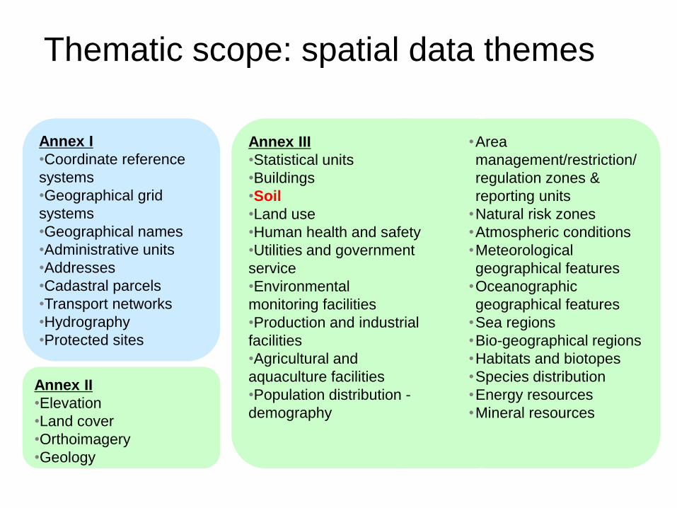
Thematic scope: spatial data themes
Annex I
•Coordinate reference
systems
•Geographical grid
systems
•Geographical names
•Administrative units
•Addresses
•Cadastral parcels
•Transport networks
•Hydrography
•Protected sites
Annex II
•Elevation
•Land cover
•Orthoimagery
•Geology
Annex III
•Statistical units
•Buildings
•Soil
•Land use
•Human health and safety
•Utilities and government
service
•Environmental
monitoring facilities
•Production and industrial
facilities
•Agricultural and
aquaculture facilities
•Population distribution -
demography
•Area
management/restriction/
regulation zones &
reporting units
•Natural risk zones
•Atmospheric conditions
•Meteorological
geographical features
•Oceanographic
geographical features
•Sea regions
•Bio-geographical regions
•Habitats and biotopes
•Species distribution
•Energy resources
•Mineral resources


Interoperability of data –
The starting point ...
user user
dataset dataset dataset
... ...
• Access to spatial data in various
ways
• User has to deal with interpreting
heterogeneous data in different
formats, identify, extract and post-
process the data he needs
lack of interoperability
Annex II/III kick-off

Interoperability of data –
... and what INSPIRE is aiming at
... ...
Network
Service
Network
Service
Network
Service
• Provide access to spatial data via
network services and according to a
harmonised data specification to
achieve interoperability of data
! Datasets used in Member States may
stay as they are
! Data or service providers have to
provide a transformation between their
internal data model and the harmonised
data specification
dataset dataset dataset
Annex II/III kick-off
user user

Development of INSPIRE data
specifications - a multi-step process
Directive
(2007)
Modelling
Framework
for INSPIRE
data
specifications
(2008)
Data
specifications
for the 9
Annex I
data themes
(2009)
Data
specifications
for the 25
Annex II/III
data themes
(2012)
Annex II/III kick-off
Interoperability of spatial data sets
and services (Implementing Rule)
(2009..2012)


Thematic Strategy for Soil Protection (COM(2006)231 “soil is generally defined
as the top layer of the earth’s crust, formed by mineral particles, organic matter,
water, air and living organisms. It is the interface between earth, air and water
and hosts most of the biosphere”.


Exchange data in a SDIIMRO (GML-file)
IMWA (GML-file)
Node
Spatial data
Infrastructure
Application
e
Adapter
Data sets
XML/GML-file
Real world
Universe of Discourse
(how does he worls look like)
IMWE (UML class diagram/OCL) IMWE (GML-file)
Data
acquisition

Prelimenary Model Soil class Soil
«featureType»
SoilProfile
+ SoilProperty: SoilPropertyParameter
«featureType»
Observ edSoilProfile«featureType»
Deriv edSoilProfile
«type»
SoilAssociation
+ DominantSubSurfacTextureClass: codelist
+ DominantSurfaceClass: codelist
+ SecondarySurfaceClass: codelist
+ SecundarySubSurfacTextureClass: codelist
+ STU: STUpart [1..*]
«type»
SoilTypologicalUnit
+ soilParameter: any [1..*]
+ STUname: STUclassifiedName
«featureType»
SoilHorizon
+ horizonLowerBoundary: int
+ horizonNotation: HorizonNotationType
+ horizonUpperBoundery: int
«featureType»
SoilLayer
+ layerLowerBoundary: int
+ layerParameter: any
+ layerUpperBoundary: int
«featureType»
SoilObserv ationLocation
+ Land use: char [0..1]
+ LocationType: LocationTtypeList
+ Vegetation: char [0..1]
SoilAssociationArea
+ dominantUse: char
+ LimitationToAgriculturalUse: char
«featureType»
SoilObsertv ation
+ Location: GM_Object
«type»
SoilSample
CreatingPocess
«featureType»
SoilPropertyObject
«type»
SoilPropertyUnit
«featureType»
SoilPropertyArea
+Is part of
+contains
% STU
+results from
+determines
+uses
+is used by

class Soil
«featureType»
SoilProfile
+ SoilProperty: SoilPropertyParameter
«featureType»
Observ edSoilProfile«featureType»
Deriv edSoilProfile
«type»
SoilAssociation
+ DominantSubSurfacTextureClass: codelist
+ DominantSurfaceClass: codelist
+ SecondarySurfaceClass: codelist
+ SecundarySubSurfacTextureClass: codelist
+ STU: STUpart [1..*]
«type»
SoilTypologicalUnit
+ soilParameter: any [1..*]
+ STUname: STUclassifiedName
«featureType»
SoilHorizon
+ horizonLowerBoundary: int
+ horizonNotation: HorizonNotationType
+ horizonUpperBoundery: int
«featureType»
SoilLayer
+ layerLowerBoundary: int
+ layerParameter: any
+ layerUpperBoundary: int
«featureType»
SoilObserv ationLocation
+ Land use: char [0..1]
+ LocationType: LocationTtypeList
+ Vegetation: char [0..1]
SoilAssociationArea
+ dominantUse: char
+ LimitationToAgriculturalUse: char
«featureType»
SoilObsertv ation
+ Location: GM_Object
«type»
SoilSample
CreatingPocess
«featureType»
SoilPropertyObject
«type»
SoilPropertyUnit
«featureType»
SoilPropertyArea
+Is part of
+contains
% STU
+results from
+determines
+uses
+is used byProfiles
information Soil map
information
Observation & Measurements
information Soil thematic map
information
Soil transfer
Function
information

1) Erosione idrica ed eolica
2) Declino in sostanza organica
3) Frane e smottamenti
4) Salinizzazione, sodificazione ed
alcalinizzazione
5) Compattamento
6) Contaminazione
Monitoraggio dei sistemi di
degradazione del suolo
“Strategia tematica per la protezione del suolo” COM (2006) 231”

Procedura europea di monitoraggio e lotta
alla degradazione del suolo
Source: COM(2006) 231


Related Documents