L L I I N N E E S S & P P O O I I N N T T S S Volume 28: Issue 2 April, 2017 www.plsw.org THE EQUALITY STATE SURVEYOR PROFESSIONAL LAND SURVEYORS OF WYOMING

Welcome message from author
This document is posted to help you gain knowledge. Please leave a comment to let me know what you think about it! Share it to your friends and learn new things together.
Transcript

LL II NN EE SS &&
PP OO II NN TT SS
Volume 28: Issue 2April, 2017
www.plsw.org
THE EQUALITY STATE SURVEYORProfessional land surveyors of Wyoming

Lines & Points
1|Page

Click Here for Field Notes
Section corner MonuMent
(Photo by Lee Wilson, BLM Cadastral Surveyor)
On
The
Cov
er LL II NN EE SS
&&
PP OO II NN TT SS
Volume 28: Issue 2April, 2017
www.plsw.org
THE EQUALITY STATE SURVEYORProfessional land surveyors of Wyoming
PRESIDENT’S MESSAGE
ANNouNCEMENTS
GovERNoR’S PRoCLAMATIoN SIGNINGBy: Dennis Dawson, P.L.S.
GEoDETIC SuRvEyING: PART X I:Ferdinand rudolph hassler and the u.s. Coast survey: part 3
By: Herbert W. Stoughton, P.L.S., P.E., Ph. D., C.P.
GILLETTE MADISoN PIPELINE PRojECTBy: David L. vliem, P.L.S.
BLM NEWSBy: joel Ebner, P.L.S.
CONTENTSPage 3
Page 4
Page 5
Page 8
Page 15
Page 19
President
President Elect
Secretary/Treasurer
Publications committee
Karl Scherbel, PLS
Geno Ferrero, PLS
john “jack” Studley, PLS
Mark Corbridge, PLS
Cotton jones, PLS
PLSW (Professional Land Surveyors of Wyoming; Po Box 8, Cheyenne, Wy 82003) is a statewide organization of Land Surveyors registered to practice in the Equality State of Wyoming. PLSW is dedicated to improving the technical, legal, and business aspects of surveying in the State of Wyoming. PLSW is affiliated with the National Society of Professional Surveyors (NSPS) and the Western Federation of Professional Land Surveyors (WestFed).
Lines and Points is published by the Professional Land Surveyors of Wyoming. Lines and Points is not copyrighted and permission is hereby granted to reprint articles with appropriate credit. The Professional Land Surveyors of Wyoming assume no responsibility for statements made or opinions expressed in this publication. The articles and opinions as put forth in this journal are not necessarily those of PLSW or the Editorial staff of this journal.
Advertising InformationDigital-ready, full-color advertising with payment should be mailed to Lines & Points, P.o. Box 8, Cheyenne, Wy 82003.
Advertising rates are as follows: year Issue Full Page $810 $210 Half Page $540 $140 Quarter Page $310 $80 Business Card $40 $10 Employment Free Free
Special Rates apply for PLSW Chapters and cover placements.
For more information please contact jack Studley.
•Jenn Heinrich - Frontier Precision Inc.•John Baffert - Surv-KAP, LLC•Chris Farnsworth - RDO Integrated Controls•Kelly Goff - Underground Consulting Solutions•Susan Hall - Trimble•Tim Klaben - Berntsen International Inc.•Troy Langston - Monsen Engineering
Steven “Dennis” Dawson, [email protected]
Michael Flaim, [email protected]
john “jack” Studley, [email protected]
joel Ebner, [email protected]
Herbert W. Stoughton, PhD, PELS, CP [email protected]
Sonja “Suzie” Sparks, [email protected]
Pete Hutchison, [email protected]
Larry Perry, [email protected]
CommitteeChairEditor
in ChiefTreasurer
& AdvertisingCirculation
CopyEditor
Website
EmeritusMember
EmeritusMember
Area Director
Wyoming Delegate
April 2017
Page|2
When I was 12 years old, my father led our scout troop (all four of us) on a hike to Wyoming Peak. The first part of the trail was well traveled and easy to follow. After a while, the trail started to disappear and we boys were stymied as to how to progress. My father took a moment to show us a tree that had been marked with a blaze to indicate the trail. So, we took off, each of us competing to see who could find the next blaze. Too soon, we left the trees and were once again stymied. We could see the peak above us but knew there had to be a better way than straight up. once again, my father took a moment and pointed out the rock cairns that had been set up. Following these cairns, we traversed the slopes and found an easy way to reach the top.
Chances are pretty good that had we not had an experienced mentor on the path with us, we four boys would have given up when the easy trail ended and the path was no longer clear, or we would have gone straight up the mountain to the peak, probably using up all our strength in
the process and ruining any future desire to hike, because it’s just too darn hard. Wyoming Peak used to be a fire watch lookout. On the peak is an abandoned building. The blazes and cairns were placed there by those who traveled the trail in years past to mark the way for those to follow.
We are leaders in the field of boundaries. Each of us has put in our time to be educated and through actual experience we have acquired knowledge and wisdom to practice to the art of gathering evidence, interpreting facts and making a determination as to where to locate boundaries and other points on the surface of the earth. But, what are we doing about those who follow?
The term “servant leadership” is a contemporary term for an ages old concept of leading by example. I think that the most important principle of this concept is that of “train your replacement”. While the gadgets and tools that we use on a daily basis are indeed fantastic, I am convinced that these alone are not going to be what draw newcomers to the profession. As we work with those coming up through the ranks, let us mentor them by giving them the opportunity to actually apply the skills they have acquired. We need to teach and lead by example beyond merely collecting points, and consciously mentor them through the boundary determination process.
This year, please take an opportunity to be a mentor: whether it is a coworker or a new hire, someone who is interested, or even volunteering with your local Boy or Girl Scout groups. I look forward to hearing your success stories.
Karl Scherbel, P.L.S.President, Professional Land Surveyors of Wyoming
PRESIDENT’S MESSAGE
3|Page
Lines & Points
ATTENTION! SAFETY MANUAL FOR SURVEYORS
NOW AVAILABLE FROM THE SW CHAPTER OF PROFESSIONAL LAND SURVEYORS OF
WYOMING ___________________________
COMPREHENSIVE, AFFORDABLE, ADAPTABLE!
Special Offer - Only $50 + $2 SHIPPING!
CD CONTAINS ENTIRE 206 PAGE MANUAL IN BOTH “WORD” AND ADOBE “.pdf” FORMATS THAT CAN BE EDITED AND ADAPTED FOR YOUR PARTICULAR USE
Contact Secretary/Treasurer: Olian T. Shockley
[email protected] or phone 307-875-0146
ANNOUNCEMENTS
C o n g r a t u l a t i o n s !The members of the Professional Land Surveyors of Wyoming would like to recognize the achievement of the following new Wyoming registrants:jesse Frisbee Worland, Wy SI 172Scott Bruce Gillette, Wy SI 173jason Smith Kalispell, MT LS 15847Frederick Ballard Montrose, Co LS 15848Dennis Sullivan Gering, NE LS 15884
lines and Points artiCle rotation submission sChedule by ChaPter
Responsible Chapter First Call Date Last Call Date Publication DateNortheast Chapter thank you!! (see “Gillette Madison pipeline projeCt” in this issue)Northwest Chapter june 1 june 15 july 1, 2017
West Chapter September 1 September 15 october 1, 2017Central Chapter December 1 December 15, 2017 january 1, 2018
CORNER SITE RESTORATIONMembers of the Professional Surveyors
Association of Nebraska (PSAN) are working on plans to restore the site of the NW corner of Nebraska, SW corner of South Dakota on the Wyoming State Line. Apparently the monument itself is in good shape but a sign and fence around the site need to be repaired or replaced. A member of the PSAN historical committee, Carl Gilbert, is in charge of the project. Tentative plans are for the work to take place in june of this year.
If you’re interesting in helping or would like more information on the project you can contact one of the following PSAN committee members:
Carl Gilbert - Phone: 308-632-3123jerry Penry – Phone: 402-441-7681Dennis Sullivan – Phone: 308-635-1926
Page|4
April 2017

5|Page
Lines & Points
2017 land surveyor’s Week For WyoMinG
5-6
April 2017
Page|6
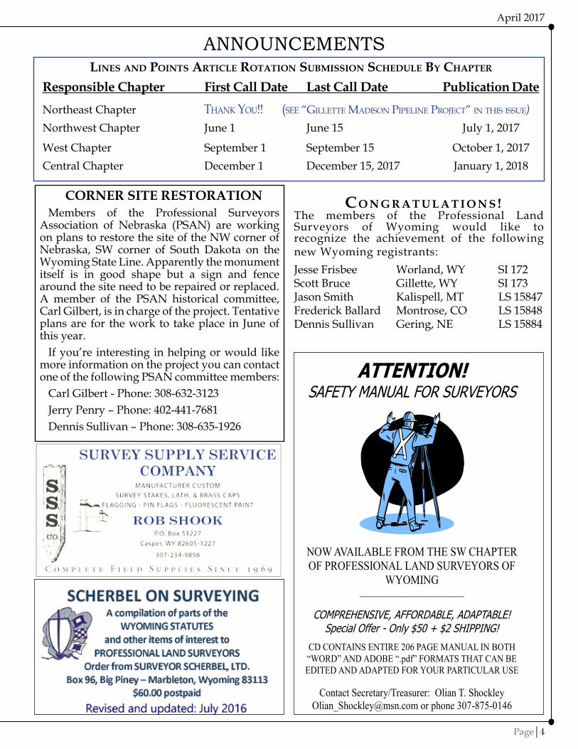
On Tuesday March 21, 2017 Shannon Stanfill, Troy Niesen, Krista Wilson and Governor Mead met with members of the Profession Land Surveyors of Wyoming along with Dr. Anthony Denzer uW Applied Science Department Head, and Ballie Miller, Coordinator of Alumni for uW to kickoff observation of the 2017 Land Surveyor’s Week for Wyoming. The event was attended by about 22 people and was held in the Governor’s Kendrick Gallery Conference Room, which included a robotic total station was demonstration by Mark Corbtridge. Governor Mead recognized the importance of supporting attracting younger people to the Land Surveying profession and Karl Scherbal gave some brief remarks about the Land Surveyor’s Week observation. Karl’s comments are included following:
Thank you, Shannon, and Governor Mead, for your words addressing the role of the land surveyor. It is a privilege to speak on behalf of the members of the Professional Land Surveyors of Wyoming. I’m probably one of the few people that when asked what I wanted to be when I grew up answered “a land surveyor”. I am a third generation land surveyor, and for me, it is more than just a profession, it is a way of life. Trips like these are what my wife refers to as a “survey-cation”. A few years ago we took a road trip to Mount Rushmore just so we could see Gutzon Borglum’s monument to three surveyors.
Land Surveyors Week seeks to recognize the role of every individual in the many disciplines of the surveying profession. You’ll find land surveyors plying their trade on archeological sites, construction sites, military installations and battlefields, national parks, theme parks, collecting and analyzing data from space explorations of the moon
and distant planets, and so much more. The ranks of the land surveyor include explorers and adventurers from all over the world who were tasked with finding new lands and territories or trade routes, over land and sea, and returning with a report and description of those lands to their sovereign. William A. Richards, a surveyor, was Governor of Wyoming from 1895 - 1899. In 1873 and 1874 he and his brother, US Astronomer Alonzo V. Richards, and their field crew, surveyed the south and west boundaries of the State of Wyoming, setting a monument every mile along the boundary.
Surveying is recognized as the world’s oldest legal profession. From the time that man ceased his nomad ways and set his hand to the plow to make a living
off the land by planting and harvesting crops, it has been necessary to correctly identify and interpret land ownership and boundaries. The right to own property has always been a critical attribute of a free man. Arthur Lee, a Virginia colonist said, “The right of property is the guardian of every other right, and to deprive people of this is in fact to deprive them of their liberty”.
Unique among all Land Surveyors is the role of the Professional Land Surveyor, especially in the United States of America, as an essential element in our land tenure system. Few other countries rely on the boundary surveyor as do the people in America, because no other country identifies and applies property rights as we do. Only the duly licensed professional surveyor is tasked as a disinterested third party to collect evidence, determine facts in relation to applicable boundary law, and prepare reports in the form of maps and descriptions to identify and correctly interpret boundaries.
Education is the foundation for tomorrow’s surveyors, especially in the STEAM fields of Science, Technology, Education, Art and Mathematics. The modern professional land surveyor needs a wide background of technical training and experience as well as be able to exercise a considerable amount of independent judgment. He must have a thorough knowledge of mathematics, computers, a solid understanding of surveying history, theory, instruments and methods of geodesy, photogrammetry, remote sensing, cartography, economics, geography, geology, astronomy, dendrology, drafting, art, and interpersonal and public communication skills. If you are going to work in Wyoming, you’ll also be sure to need a working knowledge of wilderness survival, back country first aid, small engine repair and know the difference between a Black bear and a Grizzly bear. Perhaps most important is staying up-to- date and knowledgeable with the laws that apply to land and boundaries.
5-6

7|Page
Lines & Points
7-8

Geodetic Surveying: Part XI Ferdinand Rudolph Hassler and the U.S. Coast Survey: Part 3
Herbert W. Stoughton, PhD, PELS, CP
on 9 july 1832, one day prior to the enactment of the amended law governing the survey of the coast, Hassler transmitted to Edward Livingston, Secretary of State, “Principle Considerations Relating to the Coast Survey.” The document contained fifteen proposals/comments. No. 5 reads: “It is absolutely necessary, for the credit of the Government and the usefulness of the work, that it be conducted in a scientific manner.” He went on to state: “The general conduct of the work must be in the hands of a man of science, and under a secretary that can call to its assistance from where it can be properly obtained.” In No. 11 he wrote: “This work must be the foundation of all future surveys and similar works, . . .”. And in No. 12: “When properly conducted, this work will furnish several more useful results besides those of the mere survey: in a scientific respect, in spreading useful knowledge . . .”. Lastly, in No. 14: “If this work is not introduced so as to reach honorably all these aims, it leads to discredit, and is not worth the public attention and expense.”
Immediately following “Principle Considerations”, Hassler wrote a detailed document dated “july 1832”. This document is “. . . the principles and views of my plan of operation, which, in 1807, was selected from among thirteen under consideration . . .”. He continued, “The length of time that has since elapsed appears to have obliterated the recollection of its nature and tendency . . .”. “The subject appearing therefore as if new, I must take the liberty to enter into details, occasioning repetitions of things that I have formerly stated; for which I hope I may be excused.” Hassler then listed 31 topics. Between the nearly 190 page document in APS Transactions (v. 2, N.S., 1825) and this document there is no doubt as to the technical scope, operational planning, and resulting products which would be achieved.
on 6 August 1832, Hassler signed the document “upon the Articles of Agreement between the Treasury Department of the united States and F.R. Hassler, relative to the Survey of the Coast of the united States” and “Instruments, Implements, and Assistance Required”. on 9 August 1832, Secretary of the Treasury Louis M’Lane wrote the letter of appointment “. . . to make, under the superintendance of this department, the Survey of the Coast of the united States, . . .”. Hassler
acknowledged this letter of appointment on 12 August 1832. on 19 September 1832, Hassler wrote Secretary M’Lane that he had received the journals of his former work and the instruments.
Hassler immediately searched for a staff from the military, navy, and civilian communities. Capt. William Swift, uSA, became his chief administrative assistant, a position he filled for many years. He also enlisted Edmund Blunt, jr., of the famous Blunt charting and mapping firm (New york). He also hired the civilians james Ferguson (previously an assistant on the survey of the northwest boundary with Canada); Charles Loss (assistant to Dr. Tiarks on the survey of the parallel of 45° east of Lake Champlain); and Robert Livingston (grandson of Edward Livingston, Secretary of State).
The attention to administrative details by Hassler were well demonstrated in a letter to Secretary M’Lane. Apparently, there had been a fire in the Treasury offices. Hassler stated, “As I always have copies of any document, letter, or other paper, relating to my connections with the Department, I am able to replace any of importance . . .”.
on 12 March 1834, the only letter written to Hassler by Secretary of the Treasury Roger B. Taney, informed the recipient that the superintendance of the Coast Survey was transferred to the Navy Department. Two days later Hassler resigned. Hassler then met with President jackson to address his concerns. on 22 March 1834, he wrote Secretary of the Navy Levi Woodbury stating that he yielded to President jackson’s wishes to continue as superintendent (of the Coast Survey).
In May 1834, Hassler submitted a report to Secretary Woodbury containing 55 sections, describing all the activities of the Coast Survey since 1817. In Section 32, the practice of observing vertical angles as well as horizontal angles at all the main stations was described. It was stated, “These observations will furnish in time an interesting collection of data upon the elevation of all these points over the elevation of the sea . . .”.
The spring of 1834 saw Mr. Blunt executing surveys on Long Island, and Mr. Ferguson and Midshipman john Dalghren monument stations and executing surveys on the north side of Long Island Sound (Connecticut). Hassler then assembled his staff and temporary employees to
April 2017
Page|8
7-8

recon, monument, and measure the Fire Island Base Line. Hassler had supervised earlier base line measurements, which were for the lesser triangulation supporting plane table mapping and hydrographic soundings. The Fire Island Base Line was specifically designed to be a primary base line for the major triangulation network. The base line apparatus was described in the previously cited APS Transactions (v. II, N.S.; 1825; pp. 273 - 286). The base line was measured in August, September, and october 1834. Figure 1 depicts the base line configuration. The projected base (West Base - East Base ) line ran over the sand hills and rough topography. Hassler ran a line along the beach where the terrain was nearly flat (West Base - East Point (5) - (4) - (3) - (2) ). The line West Base - East Point (5) - (4) - (3) was a single tangent. The final adjusted distances are listed in the table appended to Figure 1. Charles A. Schott (7 August 1826 - 13 july1901) wrote in The Eastern oblique Arc of the United States (1902) the uncertainty in the final length as 4.16 ppm (1:240,270) or 58.5 mm. All the original directions observed for the base network extension ( East Base, West Base, West Hills, Ruland, Bald Hill, and Tashua ) were observed by
Hassler between 1833 and 1836. The base line was along the southerly shore of Long Island. Stations West Hills and Ruland were north of the base line atop the range of hills midway across Long Island. The next group of stations north of West Hills and Ruland were across Long Island Sound and inland in Connecticut.
Hassler and the Coast Survey were left relatively undisturbed in executing the scientific aspects of the work. It was the handling of the finances which produced the friction. Amos Kendall, Auditor, and Hassler would have numerous confrontations which extended over nearly two years. This confrontation would only be quieted when the Coast Survey was transferred to the Treasury Department. Many of these arguments involved Secretary of the Navy Mahlon Dickerson and President jackson. During this period Hassler was employed by the Treasury Department (Office of Weights and Measures) and the Navy (Coast Survey). At that time Hassler produced 100 sets of standards for the custom houses (tasked 10 March 1835; delivered 1 December 1835). Hassler’s efforts in this matter required his talents as a chemist and metallurgist.
Figure 1. The layouT oF The Fire island Base line
9|Page
Lines & Points
9-10

CUSTOMER SERVICE...we stake our reputation on it.
EASY ONLINE ORDERING!Your Satisfaction, Guaranteed.
SURV-KAP.comSURVEY MARKERS, CAPS AND ACCESSORIES
800-445-5320
on 8 March 1836, Hassler hand-carried a letter to President jackson; subject: “REASoNS for placing the Coast Survey in the Treasury Department, and neither in the War, nor Navy Departments.” Three points supported the transfer, and ten points were complaints about the management of the Survey under the Navy. By the end of March 1836, the Coast was transferred to the Treasury. After the transfer, the Coast Survey and the Office of Weights and Measures prospered and expanded. This can not be attributed to Hassler’s “rougher edges and diplomacy”. As Lt. Wilkes commented in his reminiscences, Hassler was a demanding perfectionist who tried anyone’s patience. He was, however, able to assemble and retain a cadre of excellent assistants and technicians. Although Hassler and the Coast Survey encountered trying times during the early portion of jackson’s presidency, President jackson established policies conducive for the Office of Weights and Measures and the Coast Survey to grow and prosper. jackson and his successor, President Martin van Buren, supported the need of these two agencies and American science. The Coast Survey’s 1832 appropriation was $20,000. In the 1840 and 1841 the appropriation was $100,000 (or five fold)!
Hassler organized the Coast Survey operations into seven distinct phases. Personnel were employed for each phase and they received training to perform the technical operations. The phases were:
(1) reconnaissance for primary triangulation.(2) base line measurement.(3) primary triangulation, including astronomic
determination (latitude, longitude, and azimuth).
(4) secondary triangulation.(5) plane table mapping.(6) hydrography/sounding operations.(7) measurement of a new/verification base line.
Hassler personally performed the reconnaissance for the triangulation. The primary stations were inland from the coast/shore in order to have them elevated on high ridges. This produced lines of sight from 20 to 40 miles between primary stations, thus producing higher accuracy and increasing the distance between primary baselines. Hassler personally executed all the angular observations at the primary stations.
Secondary triangulation subdivided (broke (Continued on paGe 17)
April 2017
Page|10
9-10

Gillette Madison PiPeline Project
The new 42 inch Madison Pipeline essentially follows the same route as the original 30 inch Madison pipeline, which was built in the early 80’s and has recently undergone an extensive rehabilitation. As stated in the synopsis above, this pipeline’s capacity is no longer adequate to meet the projected needs of Gillette and the surrounding area. In 2008-2009, the Gillette Regional Master Plan was generated to address the region’s water needs. Entities involved included the City of Gillette, Campbell County, Wyoming Water Development Commission (WWDC), the towns of Wright, Moorcroft, Pine Haven and Rozet, and various Regional Water Districts. In 2010, the design consultant team of Burns & McDonnell and Morrison-Maierle were selected to proceed with the design. Also at this time a joint Powers Board was formed including Gillette, Campbell County and the WWDC. A local Capital Facilities Tax of 1% was passed by voters in 2011 for the amount of $110 million ($75 million for the Regional Water Supply Project, $20 million for Rural Water District Connections and $15 million for the town of Wright). In the first quarter of 2015, the $110 million goal was met – 18 months ahead of the projected timeline. These funds were in addition to funding provided by the state. Total projected cost for the initial main pipeline, wells
“Due to a population boom in NE Wyoming during the past decade, Gillette’s current water demands have reached the capacity of current available water supplies. Existing groundwater supplies within the Fort Union Aquifer and other local aquifers within the Gillette Regional Area are dwindling. The population of Gillette and the immediate Regional Area surrounding Gillette currently exceeds 37,000. The primary purpose of the Gillette Regional Water Supply Project is to provide a new water supply, install regional extensions to serve local water districts, and make improvements to internal distribution systems of existing water districts who choose to participate. The Gillette Regional Water Supply Project will serve the Regional Area for the next 30 years, or to serve a regional population in excess of 57,000.”
(City of Gillette Website – Gillette Regional Water Supply Project) http://www.gillettewy.gov/city-government/what-s-happening/gillette-
regional-water-supply-project
and facilities was $217 million. Construction of the 42 inch pipeline began in 2012 and was projected for completion in late 2016.
PCA Engineering, Inc. was awarded a contract to provide boundary surveying services to the primary engineering firms involved in the design of this project (Burns & McDonnell as primary and Morrison & Maierle Inc. as subconsultant). our scope of services was to provide boundary surveying and easement acquisition documents as required for the 50+ mile pipeline project.
11|Page
Lines & Points

By: David L. Vliem, PLS
(Map courtesy of City of Gillette)
data management
one of the first areas of concern was data management on a project of this size and scope. We needed a system that was simple, but allowed for the quick tracking and retrieval of information on approximately 250 individual land parcels strung out over roughly 50 miles of route consisting of rural lands with aliquot descriptions as well as areas traversing through multiple subdivisions and lots. We decided the best approach was to give each parcel a unique parcel number with the primary
designator being the Township and Range number followed by a number designation for that parcel. When a parcel was within a platted subdivision, the number was prefaced with an abbreviation designating that particular subdivision and lot or tract number. These parcel designations were then cross-referenced in a spreadsheet with all relevant data such as tax ID, ownership, title report number, etc. This system proved to be invaluable throughout the course of this project.
April 2017
Page|12

Lines & Points
13|Page
researCh
This project, commencing at the water well fields north of Keyhole Reservoir and finally reaching the City of Gillette after winding through ten townships in two counties, this project necessarily involved a great deal of research. We reviewed and analyzed more than 150 title reports, including exception documents. A great deal of time was spent in the county courthouses in Sundance and Gillette. As a side note, Crook County now has nearly all its data available online and it is well organized and readily searchable - this was extremely beneficial and made one wish that all county clerks would follow suit. We spent a lot of time corresponding with the WyDoT right of way department as well as the local offices. All were quite helpful, but some areas, mainly various reroutes and revisions, were just not well documented through the years.
We also had challenges in retracing the Burlington Northern Santa Fe railroad (formerly the Chicago, Burlington & Quincy) right of way between Gillette and Moorcroft, eventually discovering very useful right of way maps at the Rockpile Museum dating from 1930. The registrar informed us that copies were available at the Campbell County Clerk’s Office, which we finally recovered with the assistance of staff as the right of way maps are not indexed. By the end of this project, we had accumulated more than 5,800 individual files sorted in nearly 600 folders, all in digital format.
(Map courtesy of City of Gillette)

April 2017
Page|14
Field surveys
The Gillette Madison Pipeline Project (GMPP) project control was established by Morrison-Maierle Engineering utilizing static Global Navigation Satellite System (GNSS) observations encompassing the entire project and incorporating many published NGS Horizontal and vertical control stations. The coordinate system utilized was Wyoming State Plane – East Zone (4901) on Horizontal Datum NAD83(2007) and vertical Datum NAvD88 (Geoid 03), with units in u.S. Foot. The project was designed and built utilizing this system with no surface adjustment being applied.
In the course of conducting our field work on this project, more than 700 monuments were recovered and surveyed. This included PLSS corners, property corners and right of way (RoW) monuments. This project paralleled or ran within many roadway rights of way as well as the railroad right of way and crossed many more rights of way. Therefore, one of the major undertakings was the retracement of these assorted rights of way. In the course of our research and retracement, we found multiple instances where the WyDoT right of way included the use of spiral curves. This certainly added to the complexity of subsequent easement descriptions along the pipeline route! Many hours were spent diligently searching along RoW lines - often cursing tall grass, sage brush and the overall ineffectiveness of metal detectors when in close proximity to fences. We were fortunate that in the majority of the townships through which the
route traversed, BLM resurveys had been performed, simplifying our ability to retrace the PLSS. overall, most properties were found to be well documented and monumented, while some properties were lacking reliable monumentation along with questionable ties to the PLSS – in large part due to relatively recent resurveys by the BLM which for various reasons do not always fit with often unreliable ties called for in documents predating these resurveys. In these instances, lines of occupation, landowner testimony and adjoiner descriptions were often utilized in determining boundary location. As is often the case on projects of this type, probably 80% of our efforts were spent on only 20% of the individual parcels trying to sift through sparse and often conflicting evidence to arrive at a boundary solution. Having the data management system in place allowed us to quickly and easily retrieve relevant right of way and adjoiner data made this task significantly more efficient.

Lines & Points
15|Page
DOCumENT PREPARATIONAs mentioned previously, data management was critical to efficient workflows. To this end, we
prepared templates for various description types and exhibit formats (e.g., metes and bounds, uniform width strips, variable width strips, etc.) for both permanent and temporary easement acquisitions. This increased our efficiency and made for a more uniform and consistent end product.
The design engineers determined those areas where easements were required and sent us CAD line work depicting the general footprint needed. We then refined this line work to fit our resolved boundary lines and prepared the necessary descriptions and map exhibits to be incorporated within subsequent landowner agreements and filing documents. This was at times an iterative process requiring multiple revisions as landowner negotiations progressed. Good lines of communication and thorough documentation of final documents as well as revisions were essential components in this process.

April 2017
Page|16
Gillette Madison Pipeline Installation (photo courtesy of Morrison-Maierle)
CONCLuSIONThe Gillette Madison Pipeline Project was an interesting as well as challenging undertaking. We
were able to complete all these tasks with a survey staff of three personnel. There were definitely times where it was a bit overwhelming due to time constraints and delivery deadlines, but this also kept us motivated. This project provided invaluable boundary experience for the entire staff, but particularly for our LSIT (now a PLS) as this project almost exclusively met her boundary experience requirement to be eligible for her PLS license. Many valuable lessons were learned in the course of this project and, as surveyors, we wish we had the opportunity to perform boundary surveys on a similar scale more often.
Lines & Points
17|Page
down) the primary triangulation, and covered the shore area for topographic plane table mapping and hydrographic sounding. The secondary triangulation was executed by james Ferguson and Edmund Blunt (and Lt. john Dahlgren for a short time) with stations placed at ten-mile intervals.
Immediately behind the minor triangulation parties came the plane table crews. The first plane table crew was headed by Swiss emigrant, Charles Renard (1834). In 1835, a second plane table crew was formed under C.M. Eakin (former Army topographic engineer). Renard and Eakin trained additional plane table survey crews. By 1838, there were ten plane table parties compiling topography.
In the early years of the Coast Survey, the organization’s office resided in Hassler’s home. By about 1840, the Government rented three adjacent houses and a foundry (across the street). In each house at least two persons (assistants, the clerk, workmen, and Hassler) slept. These offices contained 12 drafting tables, 9 writing desks and tables, and five book cases of a “few hundred volumes of valuable mathematical and astronomical works,”.
Hassler required that all the calculations be
executed three times (a check and a double check). In 1842, he received the long awaited dividing engine (from Edward Troughton) and a copper plate printing press. The dividing engine was “at least capable of discerning one second of arc” (1 part in 1, 296,000 part of a circle). At the same time, the Coast Survey employed two German engravers (Selmar Siebert and T.A. Rolle) for engraving the copper plates for printing the charts. Also, Edward Troughton Hassler and William Wurdemann were technicians using various lathes and other machines to manufacture finely machined standards of weights and measures, as well as new and modified instruments for the Coast Survey.
In 1841, the political situation changed with the defeat of President van Buren and the exit of Secretary of the Treasury Levi Woodbury. Navy Lt. James Glynn influenced Representative Caleb Cushing (Massachusetts) to initiate a debate concerning Hassler and the Coast Survey. Cushing castigated Hassler in matters of “character, the science, and the morals of M. Hassler”. Representatives Henry Wise (virginia), Horace Everett (vermont), and Isaac Holmes (South Carolina) jointly and severally rose to Hassler’s defense. Holmes commented upon “.
(Continued FroM paGe 10)

“journeys: one Individual’s Excursions into the Surveying
and Mapping Professions: volume I”
by Herbert W. Stoughton
Price: $30.00 (includes S&H)Proceeds from the sale will be invested
in the PLSW Scholarship fund.Send orders to:
2821 Carey AvenueCheyenne, Wy 82001
April 2017
Page|18
. .the extraordinary course of the gentleman of Massachusetts in making a premeditated attack upon the character, the science, the morals of M. Hassler and said that the gentleman had undertaken to slander the subject of his remarks, for the purpose of prejudicing in advance the minds of the members of the House.” Representative Everett joined in with, “. . . had not the gentleman from Massachusetts made the resolution the occasion of a reiterated attack on the character of the gentleman having charge of the Coast Survey - - - of sending forth what he (Everett) deemed unfounded, unwarranted, and wanton slanders . . . He was not disposed to put an unfavorable construction on the gentleman’s motives, with them he had nothing to do, but he could attribute his course only to a want of information of what had been done, and to the prompting of some discontented Lieutenant.”
on 24 june 1841, the House of Representatives issued a resolution of 16 items. Hassler responded on 2 December 1841. In his closing remarks, Hassler tied the works of the Coast Survey and the Office of Weights and Measures together, each requiring similar applications of mathematical and physical science with similar mechanical means, which mutually assist each other.
In early 1842, the House of Representative select committee overseeing the Coast Survey chose to initiate a time consuming investigation. The five members were Cushing, Wise, Holmes, john Aycrigg (New jersey), and Francis Mallory (virginia). Mallory was determined to prove Hassler was physically and mentally incompetent. Aycrigg desired to strike out the Coast Survey appropriation and supported Naval surveys.
The full content of the hearings were printed in Reports of Committees, 27th Congress, 3rd Session, Report No. 43, House of Representatives (12 january 1843). A second report, which was very unfavorable to Hassler was authored solely by Aycrigg [ Reports of Committees, 27th Congress,3 rd Session, Report No. 170, House of Representatives (9 February 1843)]. Hassler testified before the select committee from 17 March to 24 March 1842. There were 120 questions. When Mallory sent a private engraver, W.j. Stone, to inspect a chart being engraved, Hassler wrote: “This man I and my assistants know to well, to be inimical (hostile) to my engraving arrangement; however to him of course, the map was shown, . . . he measured the map with a foot rule, like an undertaker, to make a coffin for a dead body . . .”.
In December 1842, the Congressional debate for the Coast Survey appropriation was initiated, and was not resolved until 3 March 1843. Coupled with Mallory’s three charges of mental and physical incompetence, three additional complaints were added - old age, eccentricity, and arrogance. Representative Wise rose to the occasion. Representative Wise stated, “. . . Mr. Hassler had higher accuracy in science than either his colleague (Mallory) or the gentleman from New jersey (Aycrigg); with respect to this, they might sit down at Mr. Hassler’s feet as children and learn.” Holmes continued, “. . . that so far from being convinced of any thing like mental inferiority of his (Hassler’s) part, . . .” Also, “. . . in which the examination were invariably put down, . . .”. Holmes concluded by asking the House if it was fair “to destroy not only the character of an illustrious scholar, but prostrate at the same time a work which was first projected by Jefferson, . . .”.
Hassler went on the offensive and wrote three documents: (1) Notice of the Impediments and Delays which the Survey of the Coast has encountered previous to 1842 (21 December 1842); (2) Origin and History of the Attack of Mr. Cushing Upon the Coast Survey, And of the Select Committee of Investigation, or Examination, Upon the Work (21 December 1842); and (3) Survey of the Coast of the United States - - Further Rectification of Facts Alleged in the Discussion of Congress in December 1842 (10 january 1843). on 7 january 1843, Hassler wrote a letter which was inserted into Aycrigg’s Report No. 170. He closed, “Besides, please to observe, that every stroke you may think to do at the coast survey, by raising doubts upon its accuracy, and reviling it, may be also a stroke at some vessel, bearing, perhaps, a
(Continued on paGe 21)

REQUEST A CATALOG877.686.8561 @@ FIND US ONLINE
www.berntsen.com @@
SURVEY MARKING PRODUCTS• Survey MarkerS & MonuMentS• ConCrete MarkerS & Drill BitS• Survey nailS & WaSherS• refleCtive targetS & PriSMS• flagging & WitneSS PoStS
Marking the infraStruCture of the WorlD™ | WWW.BerntSen.CoM
19|Page
Lines & Points
BLM NEWSThis letter is to inform you of the official cadastral surveys that were approved in Wyoming in 2016
and have been published to BLM Wyoming’s Cadastral Survey website. Copies of these images can be viewed or printed from this website: http://www.wy.blm.gov/cadastral/plats16.htm
Township and Range Type of Survey Meridian AcceptedT. 46 N., R. 60 W. Dep. Res. & Subd. 6 P.M. 02/11/2016 T. 14 N., R. 88 W. Dep. Res. & Subd. 6 P.M. 02/11/2016T. 21 N., R. 88 W. Dep. Res. 6 P.M. 03/16/2016T. 24 N., R. 112 W. Dep. Res. & Subd. 6 P.M. 08/11/2016T. 25 N., R. 112 W. Dep. Res. & Subd. 6 P.M. 08/11/2016T. 13 N., R. 82 W. Dep. Res. & Subd. 6 P.M. 08/11/2016T. 54 N., R. 85 W. Dep. Res. & Subd. 6 P.M. 08/11/2016T. 13 N., R. 77 W. Dep. Res. & Subd. 6 P.M. 08/11/2016T. 14 N., R. 84 W. Dep. Res. 6 P.M. 08/11/2016T. 29 N., R. 100 W. Dep. Res. & Subd. 6 P.M. 08/11/2016T. 18 N., R. 80 W. Dep. Res. 6 P.M. 08/11/2016T. 50 N., R. 63 W. Dep. Res. & Subd. 6 P.M. 08/11/2016T. 31 N., R. 109 W. Dep. Res. & Subd. 6 P.M. 08/11/2016T. 13 N., R. 101 W. Dep. Res. & Subd. 6 P.M. 11/08/2016T. 26 N., R. 71 W. Dep. Res. & Subd. 6 P.M. 11/08/2016T. 26 N., R. 72 W. Dep. Res. & Subd. 6 P.M. 11/08/2016T. 53 N., R. 65 W. Dep. Res. & Subd. 6 P.M. 11/08/2016T. 53 N., R. 66 W. Dep. Res. & Subd. 6 P.M. 11/08/2016

p.l.s.W.pins, hats & deCals
ContaCt jaCk studley [email protected]
10
Dependent Resurvey of a Portion of the Subdivisional Lines T. 31 N., R. 109 W., Sixth Principal Meridian, Wyoming
ChainsN. 0° 28' E., beginning new measurement.
Over nearly level terrain.
20.01 The cor. of secs. 1, 2, 11 and 12, monumented with an iron post, 2½ ins. diam., firmly set, projecting 7 ins. above the ground, with a mound of stone, 4 ft. base, 3 ft. high, NW. of the cor., enclosed in a wooden fence structure, with brass cap mkd.
T31N R109W S 2│S 1 ────┼──── S 11│S 12
1968
Cor. is located at corner of fences extending N. and W.
___________________________________________________________
From the point for the cor. of secs. 1, 6, 7 and 12, on the E. bdy. of the Tp.
N. 85° 49' W., bet. secs. 1 and 12.
Over nearly level terrain; across accreted lands.
2.11 Point for the meander cor. of secs. 1 and 12, on the right bank of New Fork River, at proportionate distance; there is no remaining evidence of the 1968 cor. position. Point not monumented.
While working on a survey near the New Fork River in Sublette County, Lee Wilson, BLM Cadastral Surveyor, recovered an iron post set in 1968 with this large mound of stone alongside. It’s hard to see in the picture, but a portion of the iron post is visible in the enclosure at the lower right corner of the mound. For whatever reason, somebody got serious about preserving this position.
Because of the unique situation of the mound of stone enclosed in the wooden structure, a picture was included with the description in the official BLM field note record.
Now That’s a Mound of Stone!
April 2017
Page|20

21|Page
Lines & Points
APPLy NoW FoR A PLSW
SCHoLARSHIPIf you are attending
college with the intent of pursuing a career in Land Surveying in Wyoming, we want to
give you money!A Scholarship Application is
available on our website
http://www.plsw.org
FREE MONEY AVAILABLE!!!
Having Filled With Honor Both In His Native And Adopted CountryOffices Of High Trust And Responsibility
Died In PhiladelphiaNov. 20, 1843
In The Midst Of His Labors As Superintendent OfThe United States Coast Survey
And Standards Of Weights And MeasuresBoth Great National Works From Their Origin Entrusted To
And Conducted By Him With Distinguished Reputation And Success
Strict Integrity And Love Of Truth, With StrengthAnd Activity Of Intellect, Characterized Him As A Man,
Whilst His Various Scientific Writings As Well AsThe Two National Works Projected By Him Are Alike
Memorial Of His Laborious Life And Of His ContributionAs A Man Of Science To The Instruction And Improvement
Of His Fellow Men.
friend or relation of yours, whose groans will cry vengeance upon you, for having prevented, or discredited, the execution of an accurate survey of the coast upon which you may be long in search of his corpse.”
on 3 March 1843, Mallory offered an amendment on the Coast Survey appropriation, which confirmed Hassler’s original request ($100,000). Shortly after this action a board convened to reorganize the Coast Survey. The opening statement was a dramatic vindication of Hassler’s
efforts and victories over opponents. only one significant change occurred in the previous organizational operations. In paragraph 1.g, the publication/dissemination of the Survey’s results would be expedited. President john Tyler approved the reorganization and directed the Coast Survey would remain in the Treasury Department.
on 10 March 1843, john Quincy Adams introduced Hassler to the new Secretary of the Treasury, john C. Spencer. Adams wrote in his diary, “I introduced him, and almost immediately left them together, but not without perceiving
the seeds of conflict already germinating between two proud spirits, . . .”.
The summer and fall witnessed Hassler in the field surveying in New jersey and Delaware. In mid November, Hassler had contracted a severe cold. His daughter, Rosalie Laetitie Hassler Norris, wrote that her father described the attempt to secure the instruments when a severe hail storm ravaged the camp. She continued, “. . . to save the instruments he had been thrown on a pointed rock which hurt the left side of his chest. - - . . . then being obliged to remain several hours in the cold wind and rain had given him the severe cold he had.” Hassler then went to
Philadelphia to a hotel. He wrote his annual report to Congress, and continued writing in his personal journal until 24 hours before he died. Hassler died on 20 November 1843.
Hassler’s body laid in state at the hall of the American Philosophical Society for final viewing. Ferdinand Rudolph Hassler was buried in Laurel Hill Cemetery. The Officers of the U.S. Navy and the u.S. Army who had served with him erected a memorial tablet, which in part stated.
At the time of Hassler’s death, the Coast Survey consisted of numerous field parties, five operating vessels, an instrument shop engaged in work for both the Office of Standards and Weights and the Coast Survey operations, an engraving group, the beginnings of a chart printing facility, and even a clerk who addressed day-to-day administrative functions. Hassler had left the Coast Survey satisfactorily staffed and financed to enter into the future.
(Continued FroM paGe 18)
21-22

ND | MN | CO | WY | AK | MT | ID
The Trimble® SX10 scanning total station redefines the capabilities of everyday survey equipment by providing the world’s most innovative solution for surveying, engineering, and scanning professionals. The Trimble® SX10 is the world’s first scanning total station that truly merges high-speed 3D scanning, enhanced Trimble VISION imaging, and high-accuracy total station measurements in a single instrument.
WWW.FRONTIERPRECISION.COM | GEOSPATIAL TECHNOLOGY EXPERTS WANT MORE INFORMATION? CONTACT: Jason Dysthe, Geospatial Sales Representative | [email protected] West 60th Avenue, Unit A | Arvada, CO 80003 | 720.214.3500 or 800.652.1522 [Toll Free] | Fax: 720.214.3503
Completely Integrated into Familiar Survey Workflows!
INTRODUCING THE TRIMBLE® SX10 SCANNING TOTAL STATION
AND THEN THERE
WAS ONE
AN EMPLOYEE OWNED COMPANY
April 2017
Page|22
21-22
Digital Terrain Models
Digital Elevation Models
Orthometric Photos
Topographic Mapping
3-D As-Builts
Contour Maps
State-of-the-art LiDAR & Digital Imaging High Accuracy LiDAR Maximum rate of 200,000 KHz which translates to a point
cloud as high as 150 points/m².
High Definition Digital Images Our Leica 39 megapixel RCD 105 Digital Camera produces
images at two inches per pixel or higher.
Real-time Decision-making Our field & flight crews are staffed with Professional Engineers &
Land Surveyors who truly understand data collection in real-time.
Reliable Topographic Mapping The helicopter flies at low altitudes and is capable of providing
elevations at two-tenths of a foot or less.
T e l ( 3 0 7 ) 6 3 2 - 5 6 5 6 5 9 0 8 Y e l l o w s t o n e R d , C h e y e n n e , W Y w w w . w r d - l t d . c o m
Please Recycle
LINES AND POINTS
P.O. BOX 8
CHEYENNE, WY 82003
Related Documents