N. 14 - giugno / June 2010

Welcome message from author
This document is posted to help you gain knowledge. Please leave a comment to let me know what you think about it! Share it to your friends and learn new things together.
Transcript

N. 14 - giugno / June 2010
Rivista semestrale / Six-monthly magazine
contributi & crediticollaborations & creditsAlessandro Beltrame: cover, 1, 2, 3, 6-7, 10, 11, 12, 13, 26-27, 29, 31 top, 31 bottom, back cover - Tullio Bernabei: 8, 9 top - Giuseppe Conti: 28, 30 - Antonio De Vivo: 14 - Martino Frova: 4 - Paolo Pezzolato: 9 bottom - Leonardo Piccini: 20, 23 - Filippo Serafini: 2nd cover, 16-17, 18, 19 top, 19 bottom, 21, 22 - Shorty Lungkata Tjungurray: 32
Roberto AbiusoGiovanni BadinoTeresa BellagambaAlvise BelottiAlessandro BeltrameTullio BernabeiGaetano BoldriniGiuseppe CasagrandeCorrado ConcaCarla CorongiuVittorio CrobuFrancesco Dal Cin †Alicia DavilaAntonio De VivoDavide DomeniciFulvio EccardiMartino FrovaGiuseppe GiovineItalo Giulivo
Esteban GonzalezElizabeth Gutiérrez F.Carlos LazcanoEnrique LippsMassimo LiveraniFrancesco Lo MastroIvan MartinoLuca MassaMarco MecchiaRolando MenardiFabio NegroniMauricio Náfate L.Jorge Paz T.Paolo PetrignaniLeonardo PicciniMonica PoncePier Paolo PorcuEnzo ProcopioAlessio Romeo
Natalino RussoAntonella SantiniFrancesco SauroGiuseppe SavinoLudovico ScortichiniGiuseppe SoldanoPeter L. TaylorRoberta TedeschiGianni TodiniMarco TopaniAgostino ToselliRoberto TreviUgo VaccaFreddy Vergara
Onorari / Honorary membersRaul AriasPaolino Cometti † Viviano DomeniciPaolo FortiAmalia GianolioAdrian G. Hutton †Edmund Hillary †Ernesto PianaTim StratfordThomas Lee Whiting
Sostenitori / Subscribing membersLuciana SuricoLuciano TonellatoGabriele CentazzoGraziano LazzarottoAlfredo GrazianiFernando Guzmán Herrera
LA VENTASoci / Members
Tullio Bernabei Davide DomeniciRoberto Abiuso, Teresa BellagambaAlvise Belotti, Antonio De Vivo, Marco Mecchia, Leonardo Piccini,Natalino Russo, Francesco Sauro, Giuseppe Savino.
Matteo Casagrande
Grafiche Tintoretto (TV) - Italy Antonio De Vivo, Karen Gustafson,Chris Loffredo, Tim Stratford, Libero Vitiello.
Via del Giardino 202046 Magliano Sabina - Italytel. +39 0744 919296e-mail: [email protected]
Europa € 15, resto del mondo € 20Europe € 15, rest of the world € 20Via Priamo Tron, 35/F31100 Treviso - Italytel./fax +39 0422 320981www.laventa.itViedma Glacier, Patagonia, Argentina
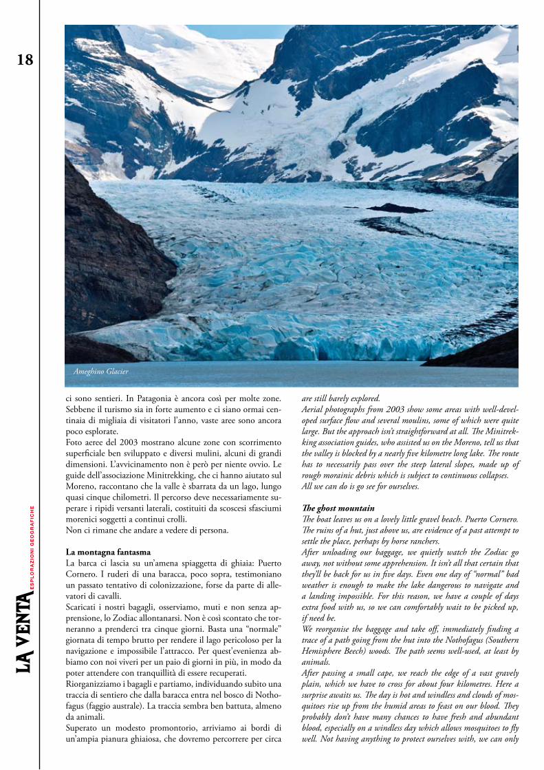
Ameghino Glacier, Patagonia, Argentina
Dir. responsabile / Editor in ChiefCaporedattore / Senior editor
Redazione / Editorial Staff
Grafica e impaginazione / Layout
Stampa / Printing Traduzione / Translation
Contatti / Contacts
Abbonamento annuale (2 numeri) Annual subscription rates (2 issues) La Venta Associazione Culturale
Esplorazioni Geografiche
Foto di copertina / Cover photo
Seconda di copertina / Second cover
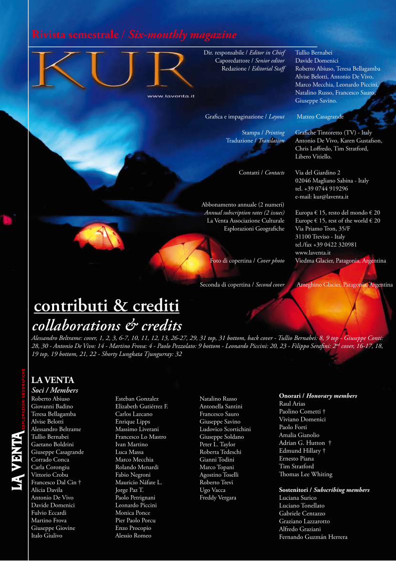
EditorialeUn inizio anno da brivido: ricognizione a Naica, straordinario giro in Patagonia, amplissima ricognizione in Venezuela, splen-dide esplorazioni in Chiapas, ricognizione a Socotra, un libro nuovo e uno in uscita, mostre itineranti, partecipazione a mani-festazioni, film... Non siamo ancora a metà anno, ma in termini esplorativi questo 2010 pare avviato a diventare il più produttivo da quando è stata fondata l’associazione, nonostante il duro ri-verbero della crisi economica sui nostri bilanci. L’ampliamento dell’attività è frutto di un’evoluzione dell’impostazione delle spe-dizioni che ora non sono più realizzate da soli soci La Venta, ma includono esterni che vengono così a formare un gruppo di col-laboratori che in futuro amplierà l’associazione. L’obiettivo non è tanto quello di aumentare l’attività -già eccessiva, mi pare-, ma soprattutto quello di articolarla di più, dedicando i nostri sforzi ad approfondirla in particolare su due punti: modi di documen-tare e aspetti scientifici. Vediamo meglio, anche alla luce dei con-tenuti di questo numero di Kur. Le possibilità documentative stanno crescendo in maniera espo-nenziale -letteralmente-, i nuovi strumenti danno al singolo di-lettante, in grotta, delle possibilità di ripresa che sino a dieci anni fa erano accessibili solo a intere troupe elitrasportate di profes-sionisti, e dieci anni prima inconcepibili. Tele e fotocamere sono diventate leggerissime, capaci di memorizzare infinità d’immagi-ni, che a loro volta sono gestibili e montabili anche nei posti più remoti ed avversi. Ma l’avere la possibilità non significa potere, perché gli strumenti ampliano anche le possibilità di commettere errori e buttare via il proprio tempo. Ne parla Alessandro Beltra-me in queste pagine. Come in tutte le cose, più che lo strumento conta l’essere capace ad utilizzarlo e quindi non solo è necessario stare dietro a svi-luppi tecnici continui, ma anche addestrarsi e provare, provare e provare, consci che solo una parte delle cose che si imparano ci
A thrilling start to the year: a reconnaissance at Naica, an extraor-dinary tour in Patagonia, a very extended reconnaissance in Ven-ezuela, splendid explorations in Chiapas, reconnaissance at Socotra, a new book published and one about to come out, traveling exhibi-tions, participation in shows, films… We haven’t even reached mid-year yet, but from an explorative point of view, 2010 is on its way to becoming the most productive since the Association was founded, despite the negative effects of the economic crisis on our budget. This expanded activity is the result of an evolution in the formulation of our expeditions, which are now no longer carried out only by Association members, but also include external members, forging a group of collaborators which will enlarge the Association in the future. The goal isn’t so much to increase our activity – which is already excessive in my opinion – but mainly that to articulate and deepen it especially in two areas: modes of documentation and sci-entific aspects. We’ll see how more precisely, also through the contents of this issue of Kur.The documentative possibilities are growing exponentially – liter-ally – as new equipment allows a single amateur, in a cave, to have the shooting possibilities which until ten years ago were pos-sible only by using entire troupes of professionals carried in by heli-copter. Ten years before that, such shots would have simply been impossible. Still and video cameras have become extremely light, capable of memorizing a nearly infinite number of images, which in turn can be managed and edited in the most remote and hostile places. But having the possibility doesn’t mean having the power, as this equipment also increases the chances of making mistakes and wasting one’s time. Alessandro Beltrame writes about that in this issue. As in all things, it’s the ability to use the tool rather than the tool itself which is important. Therefore, it’s not only necessary to keep up to date regarding the technical developments, but also to train oneself and to try, retry and try again, keeping in mind
editorialEditorialeGIovanni badino
1
Sulla via del ritorno, Bai Sun Tau, Uzbekistan / On the way back, Bai Sun Tau, UzbekistanCampo base / Base camp, Perito Moreno Glacier, Argentina

servirà in futuro. In particolare sta cambiando la sostanza di ciò che significa “documentare”. Sino a pochi anni fa per noi era l’in-sieme di quattro punti ben definiti: a) migliaia di foto, b) un paio d’articoli per riviste specializzate, c) un documentario televisivo, d) un libro completo per specialisti.Ora tutto sta mutando, anche su questi quattro punti classici. Le foto prodotte da ogni spedizione sono ormai decine di migliaia, e quindi il problema reale è diventato quello di gestirle. Gli articoli devono puntare ad uscire dalla cerchia ristretta degli specialisti, e internazionalizzarsi. I documentari stanno cambian-do forma e contenuti, e possono orientarsi ad un pubblico più vasto; grazie al loro costo sempre più limitato, si potrà uscire dall’obbligo di utilizzare i soliti format che li rendono “vendibili” alla televisione. Anche i libri stanno cambiando impostazione. I volumi con il contenuto totale di una ricerca sono utili per un territorio, ma sono costosissimi da fare -in tempo e denaro- e assai poco leggibili. Possiamo quindi realizzare questi libri per l’interesse delle popolazioni locali, ma dobbiamo imparare a scri-verne delle sintesi per chi ne vive lontano. I punti documentativi usuali devono quindi seguire i tempi che cambiano, ma il mutamento vero è il sorgere di nuovi modi di documentare, che si avviano a diventare più importanti di quelli tradizionali. Il fatto di essere quasi costantemente collegati alla Rete sta creando davvero un nuovo modo di comunicare i ri-sultati delle spedizioni, e mi riferisco in particolare ai blog. Su di essi, inizialmente, ero assai scettico, mi parevano una roba da adolescenti con problemi d’identità. Quale errore! Possono invece mostrare la speleologia mentre si sviluppa, al contrario dei resoconti finali delle spedizioni che sono scritti da persone che sanno com’è andata a finire, e quindi fanno un’operazione di digestione, “linearizzano” le operazioni, perdendo freschezza e interesse. Nei blog questo non accade, si segue lo sviluppo delle ricerche in tempo reale, mostrando dubbi ed errori, e questo li rende molto interessanti per il nostro tipo di comunicazione, a metà fra il resoconto di tipo scientifico e la cronaca di tipo per-sonale. Il lato oscuro è che questo sta aprendo un nuovo fronte d’impegni durante le spedizioni, bisogna anche tenere aggior-nato il blog, che è un lavoro che si è dimostrato più pesante del previsto. Termino con un breve commento sull’aspetto scientifi-co delle spedizioni. E’ appena rientrata un’importante spedizione in Patagonia che ha studiato l’evoluzione del carsismo glaciale a quindici anni dal-la spedizione precedente; in queste pagine Leo Piccini mostra che abbiamo ottenuto risultati speleologicamente modesti ma scientificamente molto più rilevanti dell’atteso. E in modo simile sta andando col progetto Tepui, che sta assumendo dimensioni e interesse che un paio d’anni fa potevamo solo sognarci. Forse è stato l’effetto del Progetto Naica, forse la nostra cre-scita, forse altro; ma la strada di lavorare su progetti multi-disciplinari e con spessore scientifico e documentativo inter-nazionale è giusta, e dobbiamo imparare a percorrerla con maggiore determinazione.
that only a few of the things so learned will be useful in the future. In particular, the essence of what “documenting” means is chang-ing. Until a few years ago, for us it was four well-defined points; a) thousands of photographs, b) a couple of articles for specialist publications, c) a television documentary and d) a complete book aimed at specialists. Now everything is changing, even concerning these four classical points. The photographs produced by each expe-dition are by now tens of thousands, so the real problem has become how to manage them. Articles have to aim at breaking out of the narrow group of specialists and also become more international. Documentaries are changing their form and content, also aiming for a wider public: thanks to their ever decreasing cost, we can leave behind the need to use the usual formats which make them “sella-ble” to television. Also books are changing their approach. Volumes with the entire content of a research project are useful for a region or a jurisdiction, but are extremely costly to make - both in money and time – and not very readable. We can therefore produce such books to answer the needs of local populations, but we need to learn to also write abridged versions for those who live further away. The usual documentative points need, therefore, to follow the changing times. But the biggest change is the rise of new ways of documenting, which are starting to become more important than the traditional ones. Being almost constantly connected to the Web is really creating a new way of broadcasting expedition results: I’m particularly referring to blogs.At the beginning, I was very skeptical about them: they seemed to be something suitable for self identity-challenged adolescents. What a mistake! Instead, they can show speleology as it’s being done, un-like the expedition’s final accounts which are written by people who know how things ended up, thus digesting and “linearising” the events, losing freshness and human interest in the process.This doesn’t happen in blogs. The research progress is tracked in real time, showing doubts and errors, which makes blogs very interest-ing for our kind of communication, which is halfway between a scientific report and a personal chronicle. The negative side of this is that it cretaes a new series of duties during the expeditions, as the blog has to be kept up to date, a job which has turned out to be more difficult than expected.I’ll end with a brief comment on the scientific side of the expedi-tions. An important expedition has just returned from Patago-nia, where it studied the evolution of glacial karsts fifteen years after the previous expedition. Leo Piccini shows that we reached results which are speleologically fairly modest, but scientifically much more relevant than expected. A similar thing is happening with the Tepui project, which is taking shapes and arousing a degree of interest which we could only have dreamed of a couple of years ago.Maybe it was the effect of the Naica Project, maybe our own growth, maybe something else: but the direction we took, of work-ing on multidisciplinary projects having international and docu-mentary relevance, is the right one. We have to learn to follow that direction with ever greater engagement and determination.
2
Documentazione / Documentation, Perito Moreno Glacier, Argentina

SOMMARIOSUMMARY
1 Editoriale / Editorial
4 Notizie / News 6 Ritorno al Moreno / Back to Moreno Antonio De Vivo, Marco Mecchia
14 Diari – El Chaltén vent’ anni dopo/ Diaries – El Chaltén twenty years later Antonio De Vivo 16 Il ghiacciaio fantasma / The ghost glacier Leonardo Piccini
24 Grotte di carta – Le montagne della follia / Paper caves – At The Mountains of Madness
Leonardo Piccini 26 Spedizioni digitali / Digital expeditions Alessandro Beltrame
32 Memorie del buio - Pozza d’acqua in grotta / Memories of the Dark – Waterhole in a Cave Davide Domenici
3
Perit
o M
oren
o G
lacie
r, Ar
gent
ina

Prosegue senza sosta l’attività editoriale dell’associazione. Dopo una lunga gestazione è uscito “Tra deserti e foreste – viaggio nelle grotte del Messico”. Il volume, 156 pagine, formato 22 x 22 cm, rappresenta un compendio di vent’anni di esplorazioni speleolo-giche realizzate dall’associazione La Venta negli stati di Chiapas, Chihuahua, Oaxaca, Coahuila e Yucatán. Un primo capitolo, a firma di Carlos Lazcano, presenta le aree carsiche e i principali sistemi sotterranei del Messico; un secondo capitolo narra crono-logicamente le attività esplorative dell’associazione a partire dai primi anni ’90. I tre capitoli successivi sono dedicati ai tre prin-cipali progetti: Rio La Venta, in Chiapas, Rio Juquila, a Oaxaca, e Cuatro Ciénegas, a Coahuila. Il volume è ricco di immagini e contiene i rilievi delle principali cavità esplorate. “Tra deserti e foreste”, edito in tre lingue (italiano, inglese, spagnolo), è dispo-nibile online su www.ecstore.it.Sempre con il Messico ha a che fare la riedizione di “Río La Venta – Tesoro de Chiapas”, richiesta in 5000 copie dal Governo dello Stato alla fine del 2009 e da poco giunta via nave al porto di Veracruz. A distanza di oltre 10 anni dalla prima edizione è una grande soddisfazione constatare che un libro che parla di carsismo e di mondi sotterranei rappresenti ancora un punto di riferimento per un’area protetta come quella del Rio La Venta e della Selva El Ocote. Considerando le varie ristampe e le varie edizioni (italiano, spagnolo, inglese, francese) il volume ha raggiunto una tiratura di 13.000 copie. Un bella quota per un libro di speleologia.
SOCOTRA 2010
La presenza dell’associazione La Venta a Socotra fa seguito ad un invito del Prof. Mauro Fasola, del Dipartimento di Biologia Animale dell’Università di Pavia, che da alcuni anni conduce, con la sua equipe, ricerche sugli straordinari endemismi naturali dell’isola. Scopo era quello di valutare insieme la possibilità di una collaborazione nell’ambito di un futuro progetto di esplorazione speleologica dell’isola. In virtù dei regolamenti del codice etico dell’UIS (Unione In-ternazionale di Speleologia) e della “Carta di Casola”, prima di organizzare la prospezione La Venta ha intrapreso contatti con alcune istituzioni locali, tra cui l’Environment Protection Agency (EPA), l’agenzia governativa responsabile dei progetti di ricerca e tutela del territorio sull’isola, e con i belgi Kay Van Damme e
The publishing activities of the Association continue unabated. Fi-nally, after a long gestation period, “From Forests to Deserts – a journey in the caves of Mexico” has been released. This book, 156 pages presented in a 22 x 22 cm format, is a compendium of two decades of cave exploration of La Venta in the states of Chiapas, Chihuahua, Oaxaca, Coahuila and Yucatan. The first chapter, written by Carlos Lazcano, presents the main karstic areas and underground systems of Mexico. The second chapter narrates, chronologically, the exploration activities of the association since the early 90ies. The three subsequent chapters are devoted to the three main projects: Rio La Venta (Chiapas), Rio Juquila (Oaxaca) and Cuatro Cienegas (Coahuila). The book is rich with images and contains the maps of the main caves explored. “From Forests to Deserts” published in three languages (English, Italian, Spanish), is available online at www.ecstore.it.The reissuing of “Rio La Venta - Tesoro de Chiapas” has also to do with Mexico, as 5000 copies, which recently arrived by ship at the port of Veracruz, have been requested by the State Government in late 2009. After more than ten years since the first edition, it is a great satisfaction to realize that a book about karst and subter-ranean worlds is still a reference point for a protected area like Rio La Venta and the Selva El Ocote. Considering the various print-ings and various editions (Italian, Spanish, English, French), the volume has reached a circulation of 13,000 copies. Quite a result for a speleology book.
SOCOTRA 2010
La Venta’s involvement with Socotra followed an invitation from Prof. Mauro Fasola of the Department of Animal Biology, Uni-versity of Pavia. For some years he has lead his research team in examining the ex-traordinary endemisms of this island. The purpose of our trip was to evaluate the possibility of setting up a collaboration in the con-text of a future speleological exploration of the island. In accordance with the code of ethics of UIS (International Un-ion of Speleology) and the “Casola Charter”, before engaging in any project, La Venta established contact with various local in-stitutions. These included the Environmental Protection Agency (EPA), the government agency responsible for the island’s research and environmental protection projects, and the Belgians Kay Van
NotizieNotizieATTIVITà EDITORIALI 2010 EDITORIAL ACTIVITIES 2010
news4
Altopiano carsico a Socotra / Karst plateau in Socotra, Yemen

NotizieNotiziePeter De Geest che portano avanti da circa un decennio ricerche speleologiche sull’isola con il Socotra Karst Project (SKP). Non c’è dubbio che l’isola presenti un interessante potenziale car-sico. Le montagne più alte (fino a circa 1500 metri s.l.m.) sono costituite da rocce granitiche, mentre i rilievi circostanti sono di natura calcarea, comprese le alte falesie a picco sul mare, e quindi presentano notevoli fenomeni carsici.La viabilità interna è molto limitata. Poche le strade asfaltate, e solo una parte dell’isola è percorsa da un fitto reticolo di sterrate, mulattiere e sentieri, la cui percorrenza presenta non poche diffi-coltà, che raggiungono piccoli villaggi in quota e lungo la costa. L’avvicinamento alle grotte si effettua molto spesso a piedi su in-terminabili pietraie o lungo le falesie a picco sul mare. Quattro le persone impegnate nella prospezione: due dell’asso-ciazione La Venta e due esperti naturalisti che hanno effettua-to, oltre ad una dettagliata catalogazione della flora e della fauna incontrate, anche una documentazione dell’avifauna locale con foto e riprese video; altre riprese hanno riguardato l’avvicinamen-to ed esplorazione delle cavità incontrate. Durante i nove giorni di permanenza sull’isola sono stati effettuati diversi sopralluoghi, raggiungendo una diecina di cavità inesplorate e registrando nu-merose segnalazioni dagli abitanti dei villaggi toccati.In conclusione vi sono buone possibilità per un progetto di ricerca scientifica ben articolato che comprenda cavità carsiche, grotte ma-rine, speleotemi, flora, fauna e altro, includendo, in collaborazione con l’EPA, anche l’aspetto turistico e didattico speleologico.
MUSEO DI FIRENZE
I musei stanno diventando sempre più spesso luoghi dedicati alla divulgazione culturale e soprattutto scientifica, più che alla semplice conservazione di beni artistici e naturali. In molti pa-esi si stanno investendo grosse risorse e anche i musei scientifici cominciano a diventare un vero e proprio “business”. La sfida è di riuscire a coinvolgere il visitatore, attraverso un approccio or-mai necessariamente multimediale. Schermi passivi, da guardare, o attivi, da toccare, sono ormai un accessorio indispensabile nei moderni musei. Da ciò nasce la necessità di avere dei prodotti video di carattere divulgativo adatti ad essere mostrati al pubblico in questi contesti. È in quest’ottica che nasce la collaborazione tra la sezione di Mineralogia e Litologia del Museo di Storia Naturale di Firenze, uno dei più prestigiosi in Italia e uno dei più antichi al mondo, e la nostra associazione, per realizzare dei brevi filmati da proiettare a ciclo continuo su un grande schermo posto nella prima sala del museo. Per l’occasione sono stati montati tre video di 4-5 minuti ciascuno, di cui uno dedicato, immancabilmente, alla grotta di Naica, in Messico, e ai suoi incredibili cristalli di gesso. Gli altri due filmati, pur rimanendo in tema speleologico, si legano al percorso didattico del museo presentandoci le grotte in ghiaccio, anch’esso un minerale a tutti gli effetti, e le grotte in rocce costituite da quarzo, il minerale più abbondante della crosta terrestre. La sezione di Mineralogia e Litologia del Museo di Firenze, che è stata recentemente ristrutturata, ospita una ric-chissima collezione di minerali, con molti pezzi unici, soprattutto per quanto riguarda alcuni campioni dell’Isola d’Elba provenienti dalle antiche collezioni medicee. Consigliamo caldamente di an-dare a visitarlo. Per informazioni: http://www.msn.unifi.it
Damme and Peter DE Geest, who have been involved in speleo-logical research with the Socotra Karst Project (SKP) for close to a decade. There is no doubt that the island has got an interest-ing karstic potential. The highest mountains (up to 1500 meters above sea level) consist of granite, while the surrounding relief is limestone, including the high cliffs overlooking the sea, thus present-ing notable karstic phenomena. The inland road network is very limited. Few roads are paved and only part of the island is crossed by a tight network of dirt roads, mule tracks and paths. As hard as they are to travel through, they allow reaching the tiny villages that sit high in the mountains and along the coast. Getting to the caves often involved walking through endless stony fields or climbing the vertical cliffs overlooking the sea.Four people were involved with the project: two from La Venta As-sociation and two skilled naturalists. Besides cataloguing in details the island’s flora and fauna, they also documented the local avi-fauna through pictures and video footage. More footage was taken while reaching and exploring of the caves. During their nine-day stay on the island, they surveyed several locations, reaching approxi-mately ten unexplored cavities and recording numerous indications from the local villagers.In conclusion, there are good possibilities to develop a well-designed research project, which will comprise karstic and marine caves, spe-leothems, flora and fauna. Besides, thanks to a collaboration with EPA the project will also include the touristic and speleo-didactic aspects.
MUSEUM OF FLORENCE
Museums are becoming more and more sites devoted to scientific and cultural diffusion, rather than simply the preservation of artis-tic and natural things. Many countries are investing huge resources to this end and even science museums are becoming a real “busi-ness.” The challenge is how to engage the visitor directly using a now indispensable multimedia approach. Passive screens, to look at, or active screens, to be touched, have become indispensable accessories in modern museums; hence the necessity to have quality video prod-uct suitable for public viewing in these contexts.Thus was born the collaboration between the Mineralogy and Li-thology section of the Museum of Natural History in Florence, one of the most prestigious in Italy and one of the oldest in the world, and our association. The goal was to produce several short continuous cycle videos to be projected onto a large screen in the first room of the museum. We hence prepared three videos of 4 to 5 minutes in length, one of which is, of course, dedicated to the Naica Cave in Mexico and its amazing gypsum crystals. The other two videos, though still in keep-ing with a caving theme, relate directly to the Museum’s didactic plan. They show caves made of ice, itself a mineral to all means and purposes, and rock caves consisting of quartz, the most plentiful of the earth’s minerals. The recently renovated Mineralogy and Lithology section of the Museum of Natural History in Florence houses a rich collection of minerals, many of them one of the kind, such as some samples from the Elba Island and belonging to ancient Medici collections.We strongly recommend you make a visit. For information go to http://www.msn.unifi.it
news 5
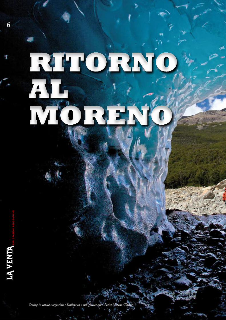
6
Scallop in cavità subglaciale / Scallops in a sub-glacier cave, Perito Moreno Glacier
RITORNO AL MORENO
Back to Moreno
7
Antonio De Vivo, Marco Mecchia
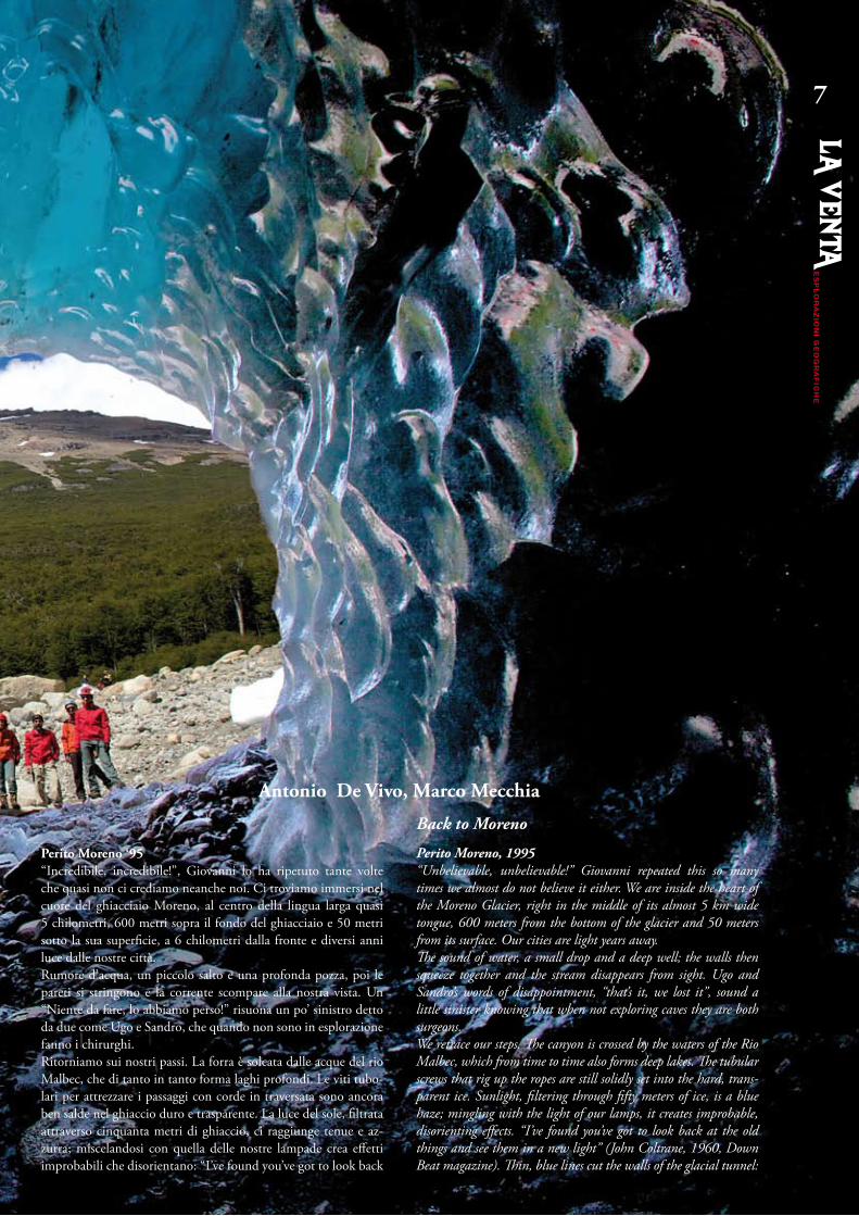
Perito Moreno ‘95“Incredibile, incredibile!”, Giovanni lo ha ripetuto tante volte che quasi non ci crediamo neanche noi. Ci troviamo immersi nel cuore del ghiacciaio Moreno, al centro della lingua larga quasi 5 chilometri, 600 metri sopra il fondo del ghiacciaio e 50 metri sotto la sua superficie, a 6 chilometri dalla fronte e diversi anni luce dalle nostre città.Rumore d’acqua, un piccolo salto e una profonda pozza, poi le pareti si stringono e la corrente scompare alla nostra vista. Un “Niente da fare, lo abbiamo perso!” risuona un po’ sinistro detto da due come Ugo e Sandro, che quando non sono in esplorazione fanno i chirurghi.Ritorniamo sui nostri passi. La forra è solcata dalle acque del rio Malbec, che di tanto in tanto forma laghi profondi. Le viti tubo-lari per attrezzare i passaggi con corde in traversata sono ancora ben salde nel ghiaccio duro e trasparente. La luce del sole, filtrata attraverso cinquanta metri di ghiaccio, ci raggiunge tenue e az-zurra; miscelandosi con quella delle nostre lampade crea effetti improbabili che disorientano: “I’ve found you’ve got to look back
Perito Moreno, 1995“Unbelievable, unbelievable!” Giovanni repeated this so many times we almost do not believe it either. We are inside the heart of the Moreno Glacier, right in the middle of its almost 5 km wide tongue, 600 meters from the bottom of the glacier and 50 meters from its surface. Our cities are light years away.The sound of water, a small drop and a deep well; the walls then squeeze together and the stream disappears from sight. Ugo and Sandro’s words of disappointment, “that’s it, we lost it”, sound a little sinister knowing that when not exploring caves they are both surgeons.We retrace our steps. The canyon is crossed by the waters of the Rio Malbec, which from time to time also forms deep lakes. The tubular screws that rig up the ropes are still solidly set into the hard, trans-parent ice. Sunlight, filtering through fifty meters of ice, is a blue haze; mingling with the light of our lamps, it creates improbable, disorienting effects. “I’ve found you’ve got to look back at the old things and see them in a new light” (John Coltrane, 1960, Down Beat magazine). Thin, blue lines cut the walls of the glacial tunnel:

8
glacier scars, hinting at a recent deformation of the ice. Perhaps it happened only weeks before our arrival: the ice mass cracked, open-ing fractures that were immediately filled with water, which in turn rapidly froze into new ice.We follow the torrent upstream until we come to a junction at a wide, nearly dry passage. An intense light radiates from its end; a few more meters in and we reach the base of the large shaft we named after the great saxophonist John Coltrane. The “moulin” has been neatly rigged by Tono just few days ago. “Let him go ahead; he’s nearly blind and cannot get scared”: it is the usual, predictable tease. He pretends to be offended, tells us off, wears his glasses as thick as a bottle-bottom and gets into his harness, smugly.Being careful not to cut the rope with the tips of our spikes, we climb into a surreal play of light. The well is almost dry. The mighty Mal-bec River funnels into another fissure along its course, few dozen meters upstream the Coltrane. It only reappears at the bottom of the shaft, in the englacial torrent we just covered. The evolution rate of glaciers is impressive: what takes hundreds of thousands of years in other Earth’s environments here takes place in just few days.Outside the last sun of the day awaits us. It is not that cold; at an al-titude of 400 meters the temperature is not particularly low, even on the surface of the glacier. The average daily temperature drops below zero only a couple of months each year. The return to base camp in the looming darkness is somewhat nerve-racking. It is easy to get lost on a glacier and ending up in the labyrinth of seracs that surrounds the moulins belt. We planted marker flags in the most difficult spots and we are keeping them in sight, but the ice melting and the wind took away many of them and only few are left.We have now spent 16 days moving around on the belly of the glacier. The La Venta expedition on Perito Moreno started off on March 4, 1995 in El Calafate on the shores of the large Lago Ar-gentino, which collects the melting waters of the Hielo Patagonia Sur. A few days later 15 of us were camped around the Buscaini shelter, on the right bank of the glacier, eight kilometres from the wharf. Our goals were ambitious: to explore and document eng-lacial moulins and caves and to study the dynamics and internal structure of the glacier. But we also wanted to scuba dive inside the flooded conduits, shoot a documentary and organize a live satellite broadcast during an Italian TV program. All this by making the best use of the 1700 kilos of equipment we carried from Italy to the very edge of the glacier.
at the old things and see them in a new light” (John Coltrane, 1960, Down Beat magazine). Sottili linee blu tagliano le pare-ti della galleria glaciale: cicatrici del ghiacciaio, indizi della sua deformazione avvenuta forse qualche settimana prima del nostro passaggio, quando la massa glaciale deve essersi spezzata, aprendo fratture subito invase dall’acqua che si trasforma di nuovo rapida-mente in ghiaccio.Risaliamo il torrente fino ad bivio con una grande galleria laterale, quasi asciutta; dal suo fondo si irradia un chiarore più intenso. Pochi metri, e siamo alla base del grande pozzo che abbiamo in-titolato al grande sassofonista John Coltrane. Il “mulino” è stato elegantemente armato da Tono qualche giorno fa: “facciamo scen-dere lui, che tanto è quasi cieco e non può spaventarsi…”; è il solito scontato ritornello, mentre lui ci insulta, fa finta di offender-si, inforca due fondi di bottiglia davanti agli occhi e compiaciuto indossa l’imbrago. Attenti a non tagliare la corda con le punte dei ramponi, risaliamo in un irreale gioco di luci. Il pozzo è quasi del tutto asciutto: il poderoso rio Malbec si rovescia nella fessura che si è aperta lungo il suo percorso, poche decine di metri più a monte del Coltrane, per ricomparire solo sul fondo del pozzo, nel torrente endoglaciale che abbiamo appena percorso. La rapidità dell’evoluzione dei ghiacciai è impressionante: quello che in altri ambienti della Terra richiede centinaia di migliaia di anni qui si verifica nel giro di pochi giorni. Fuori ci aspetta l’ultimo sole della giornata. Non fa molto freddo, siamo solo a 400 metri di quota e la temperatura non è partico-larmente bassa, nemmeno sulla superficie del ghiacciaio. Solo per un paio di mesi l’anno la media giornaliera scende al di sotto dello zero. Il ritorno al campo base con il buio incombente mette una certa tensione: non è difficile perdersi sul ghiacciaio e terminare nel labirinto di seracchi che circonda la fascia dei mulini. Nella parte più insidiosa abbiamo piantato bandierine che marcano i passaggi-chiave; non dobbiamo perderle di vista, ma la fusione del ghiaccio e il vento ne hanno fatte sparire parecchie e il loro nume-ro si è molto ridotto. Sono ormai 16 giorni che ci muoviamo sulla pancia del ghiacciaio. La spedizione La Venta sul Perito Moreno si è avviata il 4 marzo 1995 a El Calafate, sulle sponde del gran-de lago Argentino che raccoglie le acque di fusione dello Hielo Patagonico Sur. Pochi giorni più tardi eravamo in quindici perso-ne, accampate intorno alla capanna Buscaini, sulla riva destra del ghiacciaio, a otto chilometri dall’imbarcadero. Gli obiettivi erano
Immersione in un crepaccio allagato, 1995 / Diving in a flooded crevasse, 1995
9
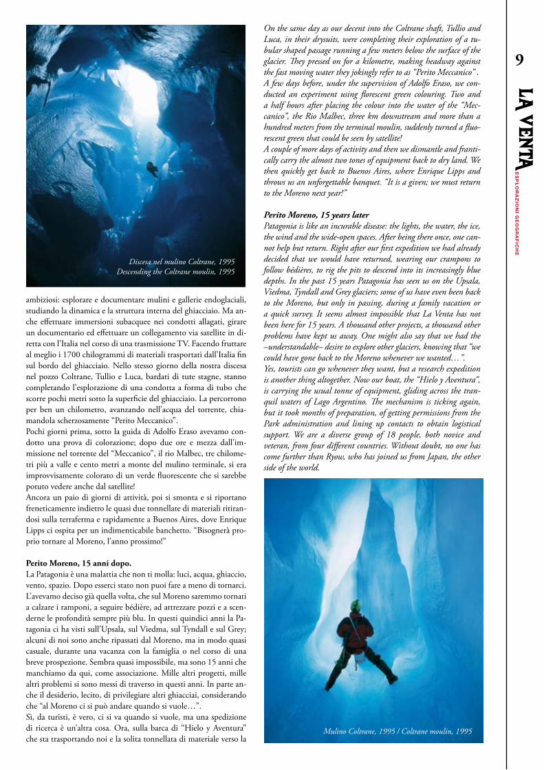
On the same day as our decent into the Coltrane shaft, Tullio and Luca, in their drysuits, were completing their exploration of a tu-bular shaped passage running a few meters below the surface of the glacier. They pressed on for a kilometre, making headway against the fast moving water they jokingly refer to as “Perito Meccanico” .A few days before, under the supervision of Adolfo Eraso, we con-ducted an experiment using florescent green colouring. Two and a half hours after placing the colour into the water of the “Mec-canico”, the Rio Malbec, three km downstream and more than a hundred meters from the terminal moulin, suddenly turned a fluo-rescent green that could be seen by satellite!A couple of more days of activity and then we dismantle and franti-cally carry the almost two tones of equipment back to dry land. We then quickly get back to Buenos Aires, where Enrique Lipps and throws us an unforgettable banquet. “It is a given; we must return to the Moreno next year!”
Perito Moreno, 15 years laterPatagonia is like an incurable disease: the lights, the water, the ice, the wind and the wide-open spaces. After being there once, one can-not help but return. Right after our first expedition we had already decided that we would have returned, wearing our crampons to follow bédières, to rig the pits to descend into its increasingly blue depths. In the past 15 years Patagonia has seen us on the Upsala, Viedma, Tyndall and Grey glaciers; some of us have even been back to the Moreno, but only in passing, during a family vacation or a quick survey. It seems almost impossible that La Venta has not been here for 15 years. A thousand other projects, a thousand other problems have kept us away. One might also say that we had the –understandable– desire to explore other glaciers, knowing that “we could have gone back to the Moreno whenever we wanted…”.Yes, tourists can go whenever they want, but a research expedition is another thing altogether. Now our boat, the “Hielo y Aventura”, is carrying the usual tonne of equipment, gliding across the tran-quil waters of Lago Argentino. The mechanism is ticking again, but it took months of preparation, of getting permissions from the Park administration and lining up contacts to obtain logistical support. We are a diverse group of 18 people, both novice and veteran, from four different countries. Without doubt, no one has come further than Ryow, who has joined us from Japan, the other side of the world.
ambiziosi: esplorare e documentare mulini e gallerie endoglaciali, studiando la dinamica e la struttura interna del ghiacciaio. Ma an-che effettuare immersioni subacquee nei condotti allagati, girare un documentario ed effettuare un collegamento via satellite in di-retta con l’Italia nel corso di una trasmissione TV. Facendo fruttare al meglio i 1700 chilogrammi di materiali trasportati dall’Italia fin sul bordo del ghiacciaio. Nello stesso giorno della nostra discesa nel pozzo Coltrane, Tullio e Luca, bardati di tute stagne, stanno completando l’esplorazione di una condotta a forma di tubo che scorre pochi metri sotto la superficie del ghiacciaio. La percorrono per ben un chilometro, avanzando nell’acqua del torrente, chia-mandola scherzosamente “Perito Meccanico”. Pochi giorni prima, sotto la guida di Adolfo Eraso avevamo con-dotto una prova di colorazione; dopo due ore e mezza dall’im-missione nel torrente del “Meccanico”, il rio Malbec, tre chilome-tri più a valle e cento metri a monte del mulino terminale, si era improvvisamente colorato di un verde fluorescente che si sarebbe potuto vedere anche dal satellite!Ancora un paio di giorni di attività, poi si smonta e si riportano freneticamente indietro le quasi due tonnellate di materiali ritiran-dosi sulla terraferma e rapidamente a Buenos Aires, dove Enrique Lipps ci ospita per un indimenticabile banchetto. “Bisognerà pro-prio tornare al Moreno, l’anno prossimo!”
Perito Moreno, 15 anni dopo.La Patagonia è una malattia che non ti molla: luci, acqua, ghiaccio, vento, spazio. Dopo esserci stato non puoi fare a meno di tornarci. L’avevamo deciso già quella volta, che sul Moreno saremmo tornati a calzare i ramponi, a seguire bédière, ad attrezzare pozzi e a scen-derne le profondità sempre più blu. In questi quindici anni la Pa-tagonia ci ha visti sull’Upsala, sul Viedma, sul Tyndall e sul Grey; alcuni di noi sono anche ripassati dal Moreno, ma in modo quasi casuale, durante una vacanza con la famiglia o nel corso di una breve prospezione. Sembra quasi impossibile, ma sono 15 anni che manchiamo da qui, come associazione. Mille altri progetti, mille altri problemi si sono messi di traverso in questi anni. In parte an-che il desiderio, lecito, di privilegiare altri ghiacciai, considerando che “al Moreno ci si può andare quando si vuole…”. Sì, da turisti, è vero, ci si va quando si vuole, ma una spedizione di ricerca è un’altra cosa. Ora, sulla barca di “Hielo y Aventura” che sta trasportando noi e la solita tonnellata di materiale verso la
Discesa nel mulino Coltrane, 1995 Descending the Coltrane moulin, 1995
Mulino Coltrane, 1995 / Coltrane moulin, 1995

10
It is mid-February 2010 and we have been in Patagonia for a cou-ple of days. We plan to set up base camp in the same fairy tale loca-tion as in ’95, at Capanna Buscaini. This time, however, we must make do without a helicopter. In ’95, the Gendarmeria transported most of our equipment and some of us to the base camp. At the time we also had the diving gear for 3 people, a compressor and 16 mm camera equipment. Luckily, this time we are traveling a little lighter and in any case the park agency has not authorized any flights. We will have to manage with our backs and those of our minitrekking guides, the young men who work for Hielo y Aventura, who usually take tourists to the glacier.There is about a three and a half hour walk between the minitrek-king base camp and the Capanna, partly on moraine and partly on glacier. The trekking guides work until late with tourists and therefore we go alone. The trail is roughly marked and our first transport ends up being a very creative, very long and very tiring hike. However, we finally reach the desired destination: a rough log hut covered with a heavy black, polyethylene tarpaulin, immersed in a forest of southern beech trees. We expect it will take a couple of days to transport all our equipment and to set up camp. Some of us head back to pick up a second load.Weight is the nightmare of every expedition; no matter how much people try to trim off non-essential items, the total load always ends up being a daunting one. On one hand, equipment has become lighter but on the other hand the quantity of technology we must carry has increased. We no longer have a 16-mm camera and tripod and its heavy supporting arm as we did in ’95, but to compensate we have now computers, satellite phones, countless battery chargers, an electric generator, and solar panels for any eventuality. In addi-tion, we now have a 9-meter camera crane that even when folded represents quite a transport rebus.During the first few days, we reacquaint ourselves with the glacier. We locate access routes and seek to understand what and how much has changed since our last visit. Some of us are seeing the glacier, named after the Argentine explorer Francisco Pascacio Moreno, for
fronte del ghiacciaio, scivolando sulle acque tranquille del Lago Argentino, il meccanismo si è rimesso in moto, ma sono passati mesi di preparativi, di richiesta di permessi all’amministrazione del Parco, di contatti per ottenere appoggi e logistica. Siamo in 18, un gruppo eterogeneo di novizi e veterani del ghiaccio, prove-nienti da quattro nazioni. Chi ha fatto più strada è senza dubbio Ryow, che ci ha raggiunto dal lontano Giappone, esattamente agli antipodi. Siamo a metà febbraio del 2010, in Patagonia da un paio di giorni. Faremo campo base a Capanna Buscaini, lo stesso luogo fiabesco in cui facemmo il campo nel ’95. Ma questa volta dovremo fare a meno dell’elicottero. Nel ’95 fu quello della Gendarmeria a trasportare quasi tutto il materiale e una parte di noi al campo base; allora avevamo anche attrezzatura subacquea per tre persone, il compressore e materiale cinematografico in 16 mm. Questa volta per fortuna siamo un po’ più leggeri, e in ogni caso l’ente parco non ha autorizzato il volo; dovremo arrangiarci con le nostre spalle e quelle delle guide di minitrekking, i ragazzi che lavorano per Hielo y Aventura, accompagnando i turisti sul ghiacciaio.Tra la base di minitrekking e la capanna ci sono circa tre ore e mezza di cammino, parte su sentiero, parte su morena, parte su ghiacciaio. I ragazzi di minitrekking lavorano fino a tardi e quindi saliamo da soli. La traccia è segnata in modo approssimativo, e durante il primo giro di trasporto riusciamo a disegnare un per-corso molto creativo, molto lungo e molto faticoso. Raggiungia-mo comunque l’agognata meta: una rozza capanna di tronchi coperta da un foglio di pesante polietilene nero, immersa in un bosco di faggi australi. Abbiamo previsto un paio di giorni per trasportare e allestire il campo, e alcuni di noi tornano a valle per un secondo carico. I pesi sono l’incubo di ogni spedizione, e per quanto si tenti di limare ogni aspetto superfluo o non indispensabile ci si ritrova sempre a combattere con carichi quasi depressivi. Il problema è che se da una parte le attrezzature si sono alleggerite, dall’altra è aumentata la quantità di tecnologia che ci si porta dietro: non
Antro di Dedalo (J. Houel, 1782)Grande ingresso subglaciale nei pressi del campo base, 2010 / Huge sub-glacier entrance nearby the base camp, 2010

11
the first time. Our approach to the ice is made easier by glorious weather. After a long summer of bad weather, it appears our arrival has finally brought the sun.Below base camp, where the river that comes down from the moun-tain collides with the right side of the glacier, we see the gigantic subglacial cavern that collapsed in ’95, 48 hours after our visit. The cavern appears even larger this time, and the repeated collapses make its vault to constantly move backwards. Entering is not an option; even getting close would be unadvisable because of the blocks of ice hanging loosely around the entrance.About an hour upstream base camp, climbing the side moraine, we find another subglacial cavern. It is not very big but appears much more solid. We climb down to the rocky bottom into the intense blue. We shoot film and take pictures, and discover the unusual de-tails in the transparent ice: the water flowing into tiny veins makes the glacier look like as if it were a living organism.In the days that follow, we try reaching the rivers, epidermal caves and shafts we explored in ’95, when we named them after wine and jazz artists. We have the GPS co-ordinates from 15 years back but the structure of the glacier has changed. In order to get to its central part we must first cross an area of ice-blades and long longitudinal fractures.On arrival, Moreno appears in good health. When looked at from the front, nothing appears changed: it keeps moving downward and crumbling into Lago Argentino, to the delight of thousands of tour-ists who flock to the lookout point across the lake. However, after climbing along the right side of the glacier, it is clear it has been re-ceding over the years and by quite a lot. Initially we could not even recognize our original landing point, simply because at the time the moraine was very small, closed off on one side by mountains and on the other by the wall of the glacier. This area is now an open space, the glacier moved by at least 100 meters. From the front, Moreno looks unchanged but in reality it stretched, weakened and fractured. The long cavern named Perito Meccanico, its name a word play of
abbiamo più una cinepresa da 16 mm e un cavalletto e un braccio pesantissimi come nel ’95, ma in compenso abbiamo i computer, i telefoni satellitari, miliardi di caricabatterie, il gruppo elettroge-no e i pannelli fotovoltaici per qualsiasi evenienza. E un crane (un braccio cinematografico) che arriva a 9 metri di lunghezza e che anche compattato rappresenta un bel rebus di trasporto. Durante i primi giorni riprendiamo confidenza con il ghiacciaio, troviamo le vie di accesso, cerchiamo di capire quanto sia cam-biato. Alcuni di noi vedono il ghiacciaio, intitolato all’esploratore argentino Francisco Pascacio Moreno, per la prima volta. L’ap-proccio con il ghiaccio è favorito da giornate splendide. Dopo un lungo periodo estivo caratterizzato da maltempo sembra che il nostro arrivo abbia portato finalmente il sole. Sotto il campo, dove il fiume che scende dalla montagna entra in collisione con il lato destro del ghiacciaio, torniamo a vedere la gigantesca cavità subglaciale che nel ’95 crollò 48 ore dopo la nostra visita. Ora appare ancora più grande, e i ripetuti crolli fanno arretrare continuamente la volta della galleria. Di entrare non se ne parla, ma anche avvicinarsi troppo non è consigliabile: i blocchi di ghiaccio incombenti rendono pericolosa una vasta zona intorno all’ingresso.Circa un’ora a monte del campo, risalendo la morena laterale, troviamo un’altra subglaciale: non è molto vasta ma in compen-so appare molto più solida. Scendiamo sul fondo roccioso in un blu intensissimo, facendo foto e riprese e scoprendo dettagli in-consueti nel ghiaccio trasparente: l’acqua che scorre in minuscole vene fa apparire il ghiacciaio come un organismo vivente…Nei giorni successivi cerchiamo di raggiungere i fiumi, le grotte epidermiche e i mulini esplorati nel ’95, dedicati a vini e jazzisti. Abbiamo i punti GPS di quindici anni fa, ma la morfologia del ghiacciaio è cambiata e per raggiungere la zona centrale bisogna superare dapprima una zona di vele e di lunghe fratture longitu-dinali. Apparentemente il Moreno è in buona salute e visto dalla fronte nulla è cambiato. Continua a scendere e a crollare nel lago Argen-tino, per la gioia dei turisti che a migliaia affollano il belvedere dall’altra parte del lago. Ma risalendo lungo il suo fianco destro ci si accorge che in questi anni si è ritirato, e di molto. Inizialmente non riuscivamo neppure a riconoscere il luogo dell’atterraggio, semplicemente perché allora lo spazio della morena era molto ri-dotto, chiuso da una parte dalla montagna e dall’altra dalla parete del ghiacciaio. Ora quel luogo è uno spazio aperto, il ghiacciaio si è spostato di almeno 100 metri. Sulla fronte è tutto uguale, ma il Moreno si è come stirato, indebolendosi e fratturandosi. La lunga cavità Perito Meccanico (chiamata così per un gioco di parole con Perito Moreno), la più lunga cavità endoglaciale del mondo, non c’è più, spazzata negli anni da ablazioni estive sem-pre più intense. Sappiamo bene che queste grotte sono effimere, ma non trovarne traccia fa uno strano effetto: ora esiste solo nel ricordo di chi l’ha percorsa, nelle immagini e nel rilievo. Un at-timo fuggente.Ritroviamo invece la grande bédière del Rio Malbec e il suo in-ghiottitoio, il pozzo Coltrane, o meglio il suo omonimo attivo. Nel ‘95 scendemmo il mulino fossile appena a valle, forse uno dei pozzi glaciali più belli che abbiamo esplorato in questi anni. Ma ora il fossile è decisamente più a valle e non ha certo le dimensioni di allora. Decidiamo di tentare la discesa nell’attivo, ben sapendo che oltre una certa profondità l’acqua della cascata, nebulizzata, occuperà tutto lo spazio disponibile. Ma ne vale comunque la pena, e il fascino del blu è aumentato dall’acqua che ti circonda e dal rumore dello scroscio che ti abbraccia.Troviamo e scendiamo altri mulini, ma inaspettatamente la zona più interessante sembra essere più a valle. Gli amici del minitrek-king ci indicano un bellissimo mulino proprio lungo il percorso “turistico”, ma l’intera zona sembra ricca di fenomeni carsici. Nel-
Sul fondo del mulino Mingus / At the bottom of Mingus moulin
12
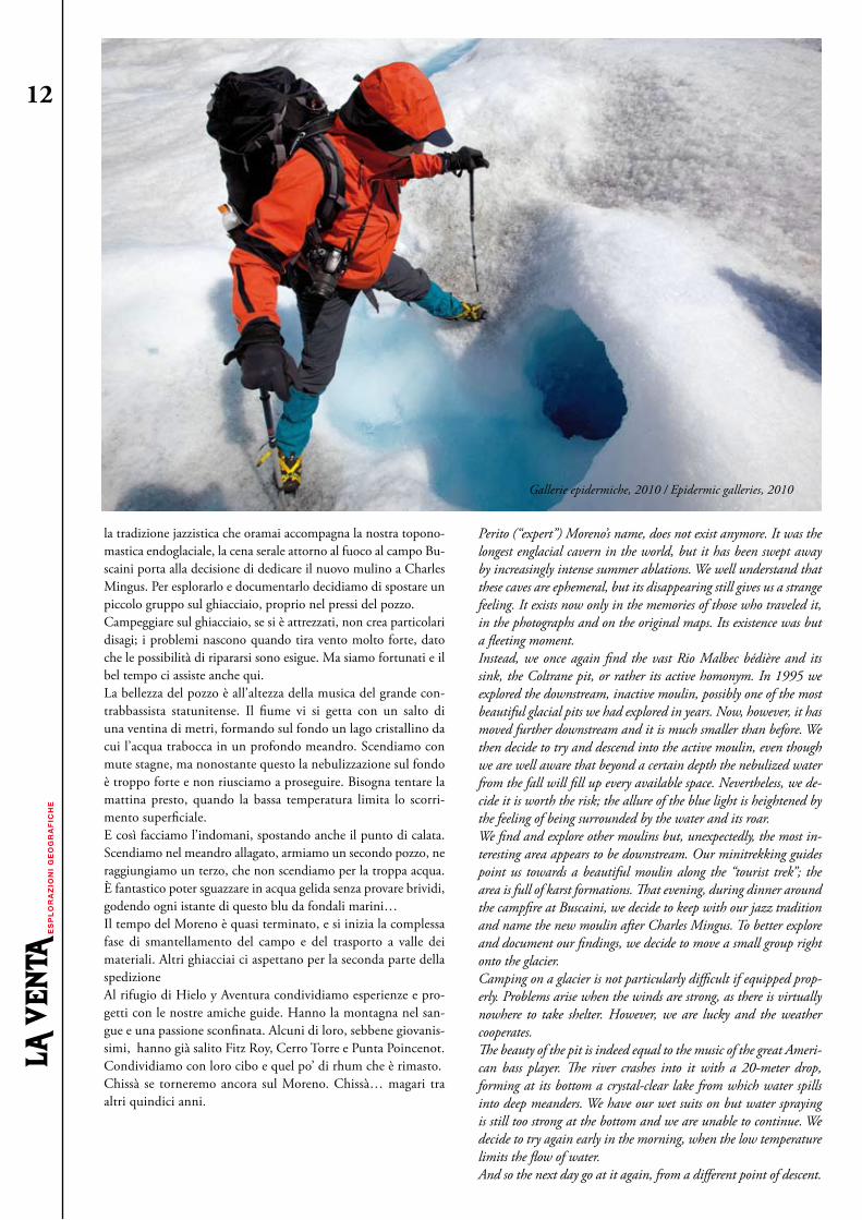
Perito (“expert”) Moreno’s name, does not exist anymore. It was the longest englacial cavern in the world, but it has been swept away by increasingly intense summer ablations. We well understand that these caves are ephemeral, but its disappearing still gives us a strange feeling. It exists now only in the memories of those who traveled it, in the photographs and on the original maps. Its existence was but a fleeting moment.Instead, we once again find the vast Rio Malbec bédière and its sink, the Coltrane pit, or rather its active homonym. In 1995 we explored the downstream, inactive moulin, possibly one of the most beautiful glacial pits we had explored in years. Now, however, it has moved further downstream and it is much smaller than before. We then decide to try and descend into the active moulin, even though we are well aware that beyond a certain depth the nebulized water from the fall will fill up every available space. Nevertheless, we de-cide it is worth the risk; the allure of the blue light is heightened by the feeling of being surrounded by the water and its roar.We find and explore other moulins but, unexpectedly, the most in-teresting area appears to be downstream. Our minitrekking guides point us towards a beautiful moulin along the “tourist trek”; the area is full of karst formations. That evening, during dinner around the campfire at Buscaini, we decide to keep with our jazz tradition and name the new moulin after Charles Mingus. To better explore and document our findings, we decide to move a small group right onto the glacier.Camping on a glacier is not particularly difficult if equipped prop-erly. Problems arise when the winds are strong, as there is virtually nowhere to take shelter. However, we are lucky and the weather cooperates.The beauty of the pit is indeed equal to the music of the great Ameri-can bass player. The river crashes into it with a 20-meter drop, forming at its bottom a crystal-clear lake from which water spills into deep meanders. We have our wet suits on but water spraying is still too strong at the bottom and we are unable to continue. We decide to try again early in the morning, when the low temperature limits the flow of water.And so the next day go at it again, from a different point of descent.
la tradizione jazzistica che oramai accompagna la nostra topono-mastica endoglaciale, la cena serale attorno al fuoco al campo Bu-scaini porta alla decisione di dedicare il nuovo mulino a Charles Mingus. Per esplorarlo e documentarlo decidiamo di spostare un piccolo gruppo sul ghiacciaio, proprio nel pressi del pozzo. Campeggiare sul ghiacciaio, se si è attrezzati, non crea particolari disagi; i problemi nascono quando tira vento molto forte, dato che le possibilità di ripararsi sono esigue. Ma siamo fortunati e il bel tempo ci assiste anche qui. La bellezza del pozzo è all’altezza della musica del grande con-trabbassista statunitense. Il fiume vi si getta con un salto di una ventina di metri, formando sul fondo un lago cristallino da cui l’acqua trabocca in un profondo meandro. Scendiamo con mute stagne, ma nonostante questo la nebulizzazione sul fondo è troppo forte e non riusciamo a proseguire. Bisogna tentare la mattina presto, quando la bassa temperatura limita lo scorri-mento superficiale. E così facciamo l’indomani, spostando anche il punto di calata. Scendiamo nel meandro allagato, armiamo un secondo pozzo, ne raggiungiamo un terzo, che non scendiamo per la troppa acqua. È fantastico poter sguazzare in acqua gelida senza provare brividi, godendo ogni istante di questo blu da fondali marini…Il tempo del Moreno è quasi terminato, e si inizia la complessa fase di smantellamento del campo e del trasporto a valle dei materiali. Altri ghiacciai ci aspettano per la seconda parte della spedizione Al rifugio di Hielo y Aventura condividiamo esperienze e pro-getti con le nostre amiche guide. Hanno la montagna nel san-gue e una passione sconfinata. Alcuni di loro, sebbene giovanis-simi, hanno già salito Fitz Roy, Cerro Torre e Punta Poincenot. Condividiamo con loro cibo e quel po’ di rhum che è rimasto. Chissà se torneremo ancora sul Moreno. Chissà… magari tra altri quindici anni.
Gallerie epidermiche, 2010 / Epidermic galleries, 2010

13
Hanno partecipato alla spedizione Moreno 1995 / Moreno 1995 team membersGiovanni Badino, Tullio Bernabei, Gaetano Boldrini, Antonio De Vivo, Adolfo Eraso, Sandro Irsara, Luca Massa, Marco Mec-chia, Ugo Vacca, Carmen Dominguez, Alessandro Gatti.
La spedizione “Perito Moreno 2010” si è svolta dal 12 febbraio al 5 marzo 2010. The “Perito Moreno 2010” expedition took place from February 12th
to March 5th 2010.
Hanno partecipato / Team members: Roberto Abiuso, Silvia Arri-ca, Giovanni Badino, Teresa Bellagamba, Omar Belloni, Alessan-dro Beltrame, Giuseppe Conti, Tono De Vivo, Giuseppe Giovine, Esteban González, Elizabeth Gutiérrez, Giampaolo Mariannelli, Ryow Matsuzawa, Andrea Mezzetti, Michele Pazzini, Leonardo Piccini, Filippo Serafini, Valerio Ulivi.
Mulino Mingus, 2010 / Mingus moulin, 2010
We climb down into the flooded meander, rig up a second pit and reach a third one, into which we do not enter because there is too much water. It is fantastic to splash around in freezing water and not shiver, savoring every moment of this deep sea-like blue…Our time at Moreno is almost up and so we begin the complex process of dismantling the camp and taking all the equipment back to the foot of the glacier. More glaciers await us in the second part of our expedition. We share our experiences and research with our guide friends back at the Hielo y Aventura shelter. Their passion is boundless, the mountains, in their blood. Though still young, some of them have already climbed the Fitz Roy, the Cerro Torre and the Punta Poincenot. We share with them what little food and rum is left. I cannot but wonder if ever we will return to the Moreno. Who knows… perhaps in another fifteen years!
Hanno patrocinato la spedizione / Sponsoring Institutions: Società Speleologica Italiana, Club Alpino Italiano, Instituto del Hielo Conti-nental Patagónico, Parque Nacional Los GlaciaresHanno reso possibile la spedizione / Special thanks to: Gendarmeria Nacional Argentina, Prefectura Naval Argentina, Hielo y Aventura, Napapijri, Ferrino, Dolomite, GT Line, GeD Cucine, Icebreaker, Scubapro, Dragon Sub, Intermatica, ABC, Mastrel, New Foods, Am-phibious.
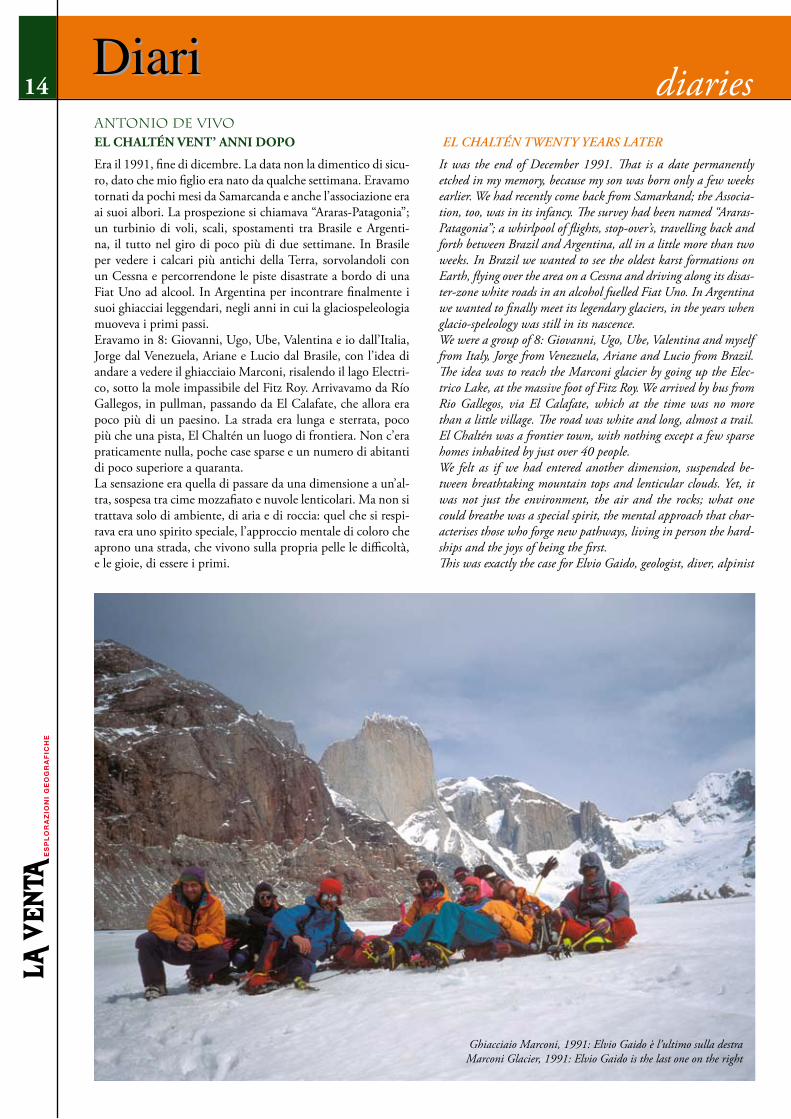
Era il 1991, fine di dicembre. La data non la dimentico di sicu-ro, dato che mio figlio era nato da qualche settimana. Eravamo tornati da pochi mesi da Samarcanda e anche l’associazione era ai suoi albori. La prospezione si chiamava “Araras-Patagonia”; un turbinio di voli, scali, spostamenti tra Brasile e Argenti-na, il tutto nel giro di poco più di due settimane. In Brasile per vedere i calcari più antichi della Terra, sorvolandoli con un Cessna e percorrendone le piste disastrate a bordo di una Fiat Uno ad alcool. In Argentina per incontrare finalmente i suoi ghiacciai leggendari, negli anni in cui la glaciospeleologia muoveva i primi passi. Eravamo in 8: Giovanni, Ugo, Ube, Valentina e io dall’Italia, Jorge dal Venezuela, Ariane e Lucio dal Brasile, con l’idea di andare a vedere il ghiacciaio Marconi, risalendo il lago Electri-co, sotto la mole impassibile del Fitz Roy. Arrivavamo da Río Gallegos, in pullman, passando da El Calafate, che allora era poco più di un paesino. La strada era lunga e sterrata, poco più che una pista, El Chaltén un luogo di frontiera. Non c’era praticamente nulla, poche case sparse e un numero di abitanti di poco superiore a quaranta.La sensazione era quella di passare da una dimensione a un’al-tra, sospesa tra cime mozzafiato e nuvole lenticolari. Ma non si trattava solo di ambiente, di aria e di roccia: quel che si respi-rava era uno spirito speciale, l’approccio mentale di coloro che aprono una strada, che vivono sulla propria pelle le difficoltà, e le gioie, di essere i primi.
It was the end of December 1991. That is a date permanently etched in my memory, because my son was born only a few weeks earlier. We had recently come back from Samarkand; the Associa-tion, too, was in its infancy. The survey had been named “Araras-Patagonia”; a whirlpool of flights, stop-over’s, travelling back and forth between Brazil and Argentina, all in a little more than two weeks. In Brazil we wanted to see the oldest karst formations on Earth, flying over the area on a Cessna and driving along its disas-ter-zone white roads in an alcohol fuelled Fiat Uno. In Argentina we wanted to finally meet its legendary glaciers, in the years when glacio-speleology was still in its nascence.We were a group of 8: Giovanni, Ugo, Ube, Valentina and myself from Italy, Jorge from Venezuela, Ariane and Lucio from Brazil. The idea was to reach the Marconi glacier by going up the Elec-trico Lake, at the massive foot of Fitz Roy. We arrived by bus from Rio Gallegos, via El Calafate, which at the time was no more than a little village. The road was white and long, almost a trail. El Chaltén was a frontier town, with nothing except a few sparse homes inhabited by just over 40 people.We felt as if we had entered another dimension, suspended be-tween breathtaking mountain tops and lenticular clouds. Yet, it was not just the environment, the air and the rocks; what one could breathe was a special spirit, the mental approach that char-acterises those who forge new pathways, living in person the hard-ships and the joys of being the first.This was exactly the case for Elvio Gaido, geologist, diver, alpinist
Diari14
antonIo De VIVoEL ChALTéN VENT’ ANNI DOPO el chaltén twenty yearS later
Diari diaries
Ghiacciaio Marconi, 1991: Elvio Gaido è l’ultimo sulla destra Marconi Glacier, 1991: Elvio Gaido is the last one on the right

Diari
Era esattamente così anche per Elvio Gaido, geologo, subac-queo, alpinista e speleologo che aveva deciso di vivere a El Chaltén dopo aver scoperto, qualche anno prima, durante una spedizione al Fitz Roy, che quello era il luogo della sua vita. Elvio aveva vissuto anche in Italia e aveva praticato speleolo-gia con il Gruppo Speleologico Piemontese: Giovanni, Ube e Valentina lo conoscevano bene, io lo incontravo per la prima volta. Che si trattasse di una persona particolare non vi era dubbio: preparammo i materiali e il cibo nella sua casa, ancora in costruzione. Una stanza, poco più, ma con una particola-rità: a differenza delle altre case del paese quella di Elvio era totalmente in pietra. Non a caso era soprannominato “pica-piedras”, spaccapietre appunto. Aveva deciso che la sua casa doveva essere solida, indifferente ai venti patagonici. Con Elvio passammo giornate memorabili, tra le mura del rifugio Los Troncos, alla ricerca di mulini sul ghiacciaio Mar-coni, accampati sulle sponde del Lago Eléctrico. Chiamammo scherzosamente quel campo “La Playa”, e ora quel nome ap-pare sulle carte topografiche della zona, passato chissà come dalla tradizione orale al segno scritto. I mulini che scendem-mo in quei giorni di dicembre furono per molti anni le grotte più meridionali della Terra. Fu un’esperienza straordinaria che ci fece innamorare della Patagonia, aiutati sicuramente anche dalla presenza di Elvio. Era una forza della natura, e la sua gioia era contagiosa. Scendiamo dal pullman in una stazione nuova di zecca. Sap-piamo di essere a El Chaltén perché sopra di noi vigilano mon-tagne su cui non ci si può sbagliare, ma certo i ricordi faticano a orientarsi nel paese reale. Siamo tornati per tentare una pro-spezione al ghiacciaio Viedma, e ovviamente abbiamo avvisa-to Elvio e sua moglie Karina. Non potranno venire con noi perché sono nel pieno della stagione turistica, ma perlomeno avremo la possibilità di salutarli. Alla stazione dei pullman non ci sono, così Giovanni ed io decidiamo di raggiungerli a casa. Il nome del loro B&B è, non a caso, “La casa de piedra”, e tutti lo conoscono, sebbene ora il paese conti più di 1000 abitanti. Dobbiamo chiedere informazioni, perché Chaltén è proprio un altro posto. Il luogo di frontiera non è più qui, la linea si è spostata, il paese è un luogo di passaggio per raggiungerla. Camminiamo veloci lungo la strada asfaltata quando qualcu-no urla il nome di Giovanni. Sono Elvio e Karina, che stavano venendo a prenderci alla stazione. Fermano il fuoristrada in mezzo alla via (il traffico fortunatamente è ancora poco), e nel caldo sole pomeridiano ci abbracciamo. Elvio ci ringrazia per aver fatto così tanta strada per festeggiare il suo compleanno. “Come, il tuo compleanno?” “Certo, compio gli anni oggi, stasera festeggiamo!” “La casa de piedra” è ancora al suo posto, inossidabile, inglo-bata in un edificio molto più grande, uno dei tanti che costitu-iscono l’attività di Elvio e Karina. Negli anni hanno ampliato l’attività, costruendo tutto da soli, ma la casa di pietra non poteva e non doveva sparire. Era ed è il simbolo di uno spirito di avventura che in loro non si è mai sopito. Lo si vede negli occhi di Elvio quando ti dice sorridendo che la mattina la pri-ma cosa che vede dalla finestra della stanza è la parete del Fitz Roy che cambia colore al levar del sole, e che al mondo non può esserci altro luogo migliore di questo.
and speleologist, who lived in El Chaltén. A few years ago Elvio had arrived there for an expedition on the Fitz Roy and had de-cided that that was the place he wanted to settle in for life. Until then he had lived in Italy and had practiced speleology with the Piedmont Speleology Group. Giovanni, Ugo and Valentina knew him well but I was meeting him for the first time.He was unique, there is no doubt. We prepared our equipment and food in his home, which was still under construction. It was little more than one room, but with a distinctive feature that set is apart from all the others in the village: Elvio’s was completely made of stone. Aptly, locals had nicknamed him “picapiedras”: stonebreaker. Elvio had decided that his home had to be solid, impervious to Patagonian winds.We had memorable days in Elvio’s company; inside the Los Tron-cos shelter, searching for moulins on the Marconi glacier, and camping on the shores of Lake Electrico. Jokingly, we called that camp “La Playa” and now that name appears in the topographical maps of the area; who knows how the transition from oral tradi-tion to written sign actually happens. For a long time, the moulins we explored in those days remained the southernmost caves in the world. It was an extraordinary experience, one that made us fall in love with Patagonia. The presence of Elvio surely contributed to this love affair; he was a storm; his joy, infectious.We get off the bus in a brand new terminal. We know we are in El Chaltén because of the unmistakable mountains looming overhead, but we are having a hard time to match our memories to the village we now see. We have returned to attempt a survey of the Viedma glacier and of course we have got in touch with Elvio and his wife Karina beforehand. They won’t be able to come with us because they are in the middle of the busy tourist season, but at least we’ll be able to say hello to them. They are nowhere to be seen at the bus terminal, so Giovanni and I decide to call on them at their place. Their B&B is aptly named “La casa de piedra” and everybody knows about it, even though the village now numbers more than 1000. We have to ask for directions though; Chaltén really is a different place now. The frontier is no longer here; the line has moved and the village is now a place along the route to get there.We walk briskly along the paved road when somebody shouts Gio-vanni’s name. It is Elvio and Karina, who were on their way to pick us up at the terminal. They stop their 4x4 truck in the mid-dle of the road (fortunately, traffic is still scarce here) and we hug in the warm afternoon sun. Elvio thanks us for having travelled such a long way to celebrate his birthday. “What do you mean it’s your birthday?” “Of course, today is my birthday; we’ll have a party tonight!”The “Casa de piedra” is still there, rugged, but now part of a much larger building; one of the many comprising Elvio and Karina’s business. With the passage of time, they have expanded their activ-ity, building everything on their own. Yet, the stone house could not, and should not, disappear; it was, and still is, the symbol of the untamed spirit that still lives within them. You can see it in Elvio’s eyes, when he smiles and tells you that the first things he sees from his window each morning is the Fitz Roy, changing its colour as the sun rises, and that there is no place in the world better than this.
15Diari diaries

16
Resti di gallerie epidermiche / Relict epidermic galleries, Ameghino Glacier
IL GHIACCIAIO FANTASMA

Leonardo Piccini
17
The ghost glacierÈ una chiara e fresca mattina estiva. Lo Zodiac cabinato della Prefectura fila ad oltre 30 nodi sulle calme acque del Lago Argentino, trasportando noi, i nostri otto zaini e una cassa piena di cibo.Il nostro obiettivo è l’Ameghino. Un ghiacciaio minore, di questo settore di Patagonia, la cui lingua si estende per una decina di chilometri poco a nord del ben più grande Glaciar Perito Moreno, da cui siamo rientrati solo due giorni prima.Dopo anni dedicati ai più grandi ghiacciai della Patagonia (Viedma, Upsala, Tyndall, Grey, per citare i più importan-ti) abbiamo deciso di dare un’occhiata anche a quelli di di-mensioni più ridotte ma con caratteristiche particolarmente idonee per lo sviluppo di grotte: lingue regolari, non troppo complesse e non troppo estese. L’Ameghino è un ghiacciaio di dimensioni alpine, soggetto a intensa fusione e che, in que-sti ultimi decenni, ha subito un arretramento di circa 60 m l’anno. Sembra fare proprio al caso nostro ma le informazio-ni che abbiamo sono molto scarse. Il ghiacciaio non fa parte dei percorsi solitamente frequentati dagli escursionisti e non
It’s a bright and cool summer morning. The Prefectura’s cabined Zodiac speeds over the calm waters of the Lago Argentino at over 30 knots, carrying us, our eight backpacks and a chest full of food.Our destination is Ameghino. A minor glacier, in this part of Pat-agonia, whose tongue extends for ten or so kilometres, a little to the north of the much larger Glaciar Perito Moreno, from which we had returned only two days previously.After dedicating years to Patagonia’s larger glaciers (Viedma, Upsala, Tyndall and Grey, just to mention the main ones), we decided to also take a look at smaller ones which had the right characteristics for the formation of caves: having regular tongues and not too complex or extended. Ameghino is an alpine-sized glacier which is affected by intensive melt processes, causing it to recede about 60 metres a year in the last few decades. It seems to fit our requirements, but we only have very little information about it. The glacier isn’t part of the routes normally travelled by excursionists and there are no trails. In Patagonia, this is still the case in many areas. Even though tourism is increasing rapidly, with hundreds of thousands of visitors per year by now, vast areas
18
ci sono sentieri. In Patagonia è ancora così per molte zone. Sebbene il turismo sia in forte aumento e ci siano ormai cen-tinaia di migliaia di visitatori l’anno, vaste aree sono ancora poco esplorate.Foto aeree del 2003 mostrano alcune zone con scorrimento superficiale ben sviluppato e diversi mulini, alcuni di grandi dimensioni. L’avvicinamento non è però per niente ovvio. Le guide dell’associazione Minitrekking, che ci hanno aiutato sul Moreno, raccontano che la valle è sbarrata da un lago, lungo quasi cinque chilometri. Il percorso deve necessariamente su-perare i ripidi versanti laterali, costituiti da scoscesi sfasciumi morenici soggetti a continui crolli.Non ci rimane che andare a vedere di persona.
La montagna fantasmaLa barca ci lascia su un’amena spiaggetta di ghiaia: Puerto Cornero. I ruderi di una baracca, poco sopra, testimoniano un passato tentativo di colonizzazione, forse da parte di alle-vatori di cavalli.Scaricati i nostri bagagli, osserviamo, muti e non senza ap-prensione, lo Zodiac allontanarsi. Non è così scontato che tor-neranno a prenderci tra cinque giorni. Basta una “normale” giornata di tempo brutto per rendere il lago pericoloso per la navigazione e impossibile l’attracco. Per quest’evenienza ab-biamo con noi viveri per un paio di giorni in più, in modo da poter attendere con tranquillità di essere recuperati.Riorganizziamo i bagagli e partiamo, individuando subito una traccia di sentiero che dalla baracca entra nel bosco di Notho-fagus (faggio australe). La traccia sembra ben battuta, almeno da animali.Superato un modesto promontorio, arriviamo ai bordi di un’ampia pianura ghiaiosa, che dovremo percorrere per circa
are still barely explored. Aerial photographs from 2003 show some areas with well-devel-oped surface flow and several moulins, some of which were quite large. But the approach isn’t straightforward at all. The Minitrek-king association guides, who assisted us on the Moreno, tell us that the valley is blocked by a nearly five kilometre long lake. The route has to necessarily pass over the steep lateral slopes, made up of rough morainic debris which is subject to continuous collapses.All we can do is go see for ourselves.
The ghost mountainThe boat leaves us on a lovely little gravel beach. Puerto Cornero. The ruins of a hut, just above us, are evidence of a past attempt to settle the place, perhaps by horse ranchers.After unloading our baggage, we quietly watch the Zodiac go away, not without some apprehension. It isn’t all that certain that they’ll be back for us in five days. Even one day of “normal” bad weather is enough to make the lake dangerous to navigate and a landing impossible. For this reason, we have a couple of days extra food with us, so we can comfortably wait to be picked up, if need be.We reorganise the baggage and take off, immediately finding a trace of a path going from the hut into the Nothofagus (Southern Hemisphere Beech) woods. The path seems well-used, at least by animals.After passing a small cape, we reach the edge of a vast gravely plain, which we have to cross for about four kilometres. Here a surprise awaits us. The day is hot and windless and clouds of mos-quitoes rise up from the humid areas to feast on our blood. They probably don’t have many chances to have fresh and abundant blood, especially on a windless day which allows mosquitoes to fly well. Not having anything to protect ourselves with, we can only
Ameghino Glacier

19
quattro chilometri. Qui ci attende una sorpresa. La giornata è calda e senza vento e dalle zone umide si sollevano nugo-li di zanzare che corrono a banchettare con il nostro sangue. Probabilmente non capita spesso di avere sangue fresco e in abbondanza, soprattutto in una giornata che consente alle zanzare di volare agevolmente per mancanza di vento. Non avendo niente con cui proteggersi non ci rimane che restare ben coperti, nonostante il caldo, e cercare di superare la zona degli acquitrini il prima possibile.Dopo un’ora di facile cammino un cordone morenico ci sbarra la strada. Superato l’ostacolo, sulla sinistra, ci appare davanti la splendida visione della Laguna Ameghino, in cui galleggiano grandi témpanos (iceberg), segno che la fronte del ghiacciaio è soggetta a frequenti crolli. Appare subito chiaro che non sarà facile andare oltre.Lasciamo i pesanti zaini e ci dividiamo in due gruppi di perlu-strazione: uno sul fianco di sinistra e l’altro su quello di destra. Quest’ultimo farà poca strada. Verso destra la strada è presto sbarrata dall’emissario del lago: un tumultuoso fiume largo una ventina di metri e decisamente insuperabile.A sinistra (destra idrografica) siamo più fortunati. Il percorso ci obbliga a continui saliscendi sul fianco della valle. In qualche caso occorre arrampicare su non facili passaggi a pelo d’acqua. Altre volte occorre risalire e traversare su sfasciumi morenici che sfidano le leggi di gravità.Pochi altri terreni sono instabili come le morene. I detriti di versante trasportati dall’acqua o dalla gravità tendono solita-mente a formare pendii relativamente stabili e la cui penden-za non può comunque superare i 35-40°. Il materiale delle morene, soprattutto quelle laterali, è invece delicatamente ap-poggiato dal ghiaccio, via via che questo si ritira, come un im-menso castello di carte pronto a sbriciolarsi sotto i nostri piedi. Trattandosi di materiale di dimensioni eterogenee, forma muri anche verticali, ma del tutto privi di un qualche cemento. Ne-anche le imprese edili della mafia osano tanto. Non ci vuole niente per innescare un crollo. Il trucco sta nella continuità: basta non fermarsi saltando di crollo in crollo.Troviamo infine un buon posto per le tende, e decidiamo di
keep well covered, despite the heat, and try to leave the boggy areas behind as quickly as possible.After an hour of easy walking, a morainic arc blocks our way. Having passed the obstacle, the splendid vision of the Ameghino Lagoon appears on the left, in which large témpanos (icebergs) float, a sign that the glacier’s front is subject to frequent collapses. It becomes immediately clear that it won’t be easy to continue.We leave our heavy backpacks and divide into two search groups; one for the left flank and one for the right one. The second group won’t go far. To the right, the way is quickly blocked by the lake’s outflow: A raging river about twenty metres wide which is defi-nitely impassable.To the left (hydrographic right), we are luckier. The way forces us to continually climb and descend along the valley’s edge. In some
Traversata sulla laguna AmeghinoTraverse on the Ameghino Lagoon
Stones of Stennes, Orkney Islands, United KingdomApprodo verso il ghiacciaio, lago Argentino / Landing approaching Ameghino Glacier, Lake Argentino

20
spostarci qui, sulla sponda destra del lago, per il primo campo anche se oltre il percorso appare complesso. Alcune pareti ver-ticali, da cui cadono alte cascate, sembrano sbarrare la strada a meno di non salire molto in alto. Sicuramente l’indomani sapremo se il ghiacciaio è raggiungibile o no.Il posto è di una bellezza mozzafiato. Dalle tende vediamo la fronte e la lunga lingua snodarsi tra montagne che cadono sul ghiacciaio con pareti impressionanti. Una di queste cime, il Cerro Fantasma, offre ai nostri sguardi l’immensa parete sud, uno scudo triangolare di nera roccia, alto 1500 metri, che in-cute un timore reverenziale. Le guide ci hanno detto che la vetta, incredibilmente aguzza, è ancora inviolata. Di sicuro la parete sud aspetterà a lungo la cordata di pazzi che vorranno tentare di scalarla. Il tramonto ci offre uno spettacolo di luci e colori che si riflettono nel lago. Pare che l’Ameghino sia di-sposto ad accoglierci degnamente.
Dislivelli orizzontaliAl mattino decidiamo di spostare il campo il più avanti possi-bile, per avvicinarsi ulteriormente al ghiaccio. Una bella spiag-gia di sabbia offre un posto accogliente, poco prima delle zone di frana.Rimontiamo velocemente il campo e, scarichi, iniziamo a tracciare la via. Cerchiamo prima di stare in alto; ma il percor-so si rivela difficile e pericoloso. Alla fine troviamo una via che corre a pelo d’acqua, che ci obbliga a passaggi di quarto grado ed oltre su roccia viscida, sino alla prima cascata, dove dobbia-mo giocoforza risalire un canalone instabile, che attrezziamo con una corda, sino a raggiungere un terrazzo roccioso.Da qui in poi la strada sembra più agevole. Iniziamo un lungo
points we have some pretty difficult climbs at the water’s edge. Other times we have to climb up and cross morainic debris which seems to defy the laws of gravity.Few terrains are as unstable as moraines. Slope debris which is transported by water or gravity usually form relatively stable slopes, which don’t exceed about 35-40°. Morainic material, in-stead, especially on the sides, is delicately deposited by the ice as it slowly retreats, like an immense card castle which is ready to collapse under our feet. As it is heterogeneous material, it also forms vertical walls, but without any kind of cement to hold it together. Not even Mafia-owned construction companies are so daring. It takes almost nothing to provoke a collapse. The trick is in maintaining a flow: just not stopping while jumping from one collapse to the next. We finally find a good tent spot and decide to move here, on the right shore of the lake, for the first camp. Even if the way beyond seems very complicated. Some vertical walls, from which high waterfalls descend, seem to block the way, unless very high climbs are attempted. Certainly tomorrow we’ll know whether the glacier is reachable or not.The place is breathtakingly beautiful. From our tents we see the front and the long tongues wind through the mountains which tower over the glacier with impressive cliffs. One of these peaks, the Cerro Fantasma (Ghost Mountain), shows us its immense south wall, a triangular black stone shield, 1500 metres high, which inspires a reverential fear. The guides have told us that the peak, which is incredibly pointed, hasn’t ever been ascended. The south wall will certainly have a long wait for the team of madmen who will want to try to climb it. The sunset offers us a spectacle of lights and colours which are reflected in the lake. It seems as though Ameghino is willing to give us a fitting welcome.
Ameghino Glacier

21
traverso in quota che alterna tratti relativamente tranquilli a pendii instabili. Le scivolate sono all’ordine del giorno, ma per fortuna la pendenza non è tale da non riuscire più a fermarsi.Alla fine, dopo cinque ore di tentativi, riusciamo a raggiunge-re il ghiaccio, tracciando un percorso lungo e complesso, ma relativamente sicuro: 500 m di dislivello per guadagnare solo 20 m di quota!È ormai pomeriggio inoltrato. Diamo una rapida occhiata al ghiacciaio, che appare oggetto di fusione molto intensa. C’è acqua che scorre dappertutto. Grandi crepacci allagati e alcuni mulini sono presenti già nella parte bassa, tra la fronte e una fascia di seracchi che sbarra verso monte la strada per la parte superiore.Tentiamo di superare i seracchi in corrispondenza della more-na centrale, ma una serie di lame di ghiaccio alte 10-15 metri non ci permette di fare molta strada. Tenteremo l’indomani a destra, costeggiando il ghiacciaio lungo la morena laterale. Il ritorno al campo è lungo ma abbastanza agevole. Ormai la strada è tracciata con una lunga fila di “ometti” di pietre.
ColleventoSecondo giorno di lavoro sul ghiacciaio. Ci dividiamo in due squadre. Una tenterà di raggiungere la zona alta del ghiaccia-io, proprio sotto la parete del Cerro Fantasma, l’altra inizierà l’esplorazione dei mulini nella zona bassa.L’attraversamento della zona di seracchi non sarà banale, so-prattutto oggi, a causa del forte vento che ci obbliga a muover-ci con cautela sulle creste di ghiaccio che separano i crepacci.È un terreno infido. Niente di tecnicamente difficile. Ma basta un passo falso per finire testa in giù in qualche frattura. E di passi dobbiamo farne migliaia…E poi il vento. Una vera giornata “patagonica”: tempo mutevo-lissimo, nuvoloni neri si susseguono a rapide schiarite. Pioggia tesa, con raffiche a oltre 150 km/h. Ogni tanto ti senti spinto con forza a terra. Devi accucciarti o appoggiarti ai bastoncini
Horizontal level differencesIn the morning we decide to move the camp as far ahead as pos-sible, in order to get closer to the glacier. A beautiful sandy beach gives us a hospitable place, shortly before the collapse areas.We quickly rebuild the camp and, unloaded, start finding a way. At first we try to keep high, but the way turns out to be difficult and dangerous. Finally, we find a way at water level, which in-volves grade four and beyond climbs on slimy rock, until the first waterfall.Then we are forced to climb up an unstable debris slope, which we equip with a rope, until we reach a rocky terrace.From here on the way seems easier. We begin a long high-level traverse, which alternates relatively easy stretches with unsta-ble slopes. Slips are frequent, but fortunately the slope isn’t steep enough to keep us from stopping ourselves.Finally, after five hours of attempts, we reach the glacier, having traced a long and complicated, but relatively safe route to it. 500 metres of climbs and descents to only gain 20 metres altitude!By now it’s late afternoon. We give the glacier a quick look. It seems to be affected by intensive melting. Water flows everywhere. Large flooded crevasses and some moulins are already present in the lower part, between the front and a band of seracs which block the way up to the upper part.We try to cross the seracs, at the height of the central moraine, but a series of ice blades 10-15 metres high keep us from getting very far. Tomorrow we’ll try to the right, flanking the glacier along the lateral moraine. The return to camp is long but fairly easy. By now the way is marked out with long line of cairns.
WindhillSecond day of work on the glacier. We divide into two groups. One will try to reach the upper part of the glacier, right beneath the cliffs of Cerro Fantasma. The other will begin exploring the moulins in the lower part.Crossing the seracs area won’t be easy, especially today, because of
Campo base: sullo sfondo, il Cerro Fantasma Base camp: on the background, the Cerro Fantasma (ghost peak)

22
cercando un equilibrio difficile da trovare.Raggiunto il bordo destro del ghiacciaio, superiamo una zona di morena superficiale. Le morene epiglaciali sono spesso il punto chiave per muoversi sui ghiacciai. La maggiore fusione, legata al rilascio di calore del detrito roccioso, le rende zone depresse e meno accidentate.Zone comode, in cui si riesce a muoversi velocemente. Ma come ogni regola anche questa ha le sue eccezioni. È come essere in un labirinto. Devi indovinare il passaggio giusto tra mille possibilità e spesso per andare in una direzione devi fare un lungo giro in direzione opposta.Dopo un paio d’ore di tentativi raggiungiamo di nuovo la mo-rena centrale, che si snoda come un nastro regolare nel mezzo del ghiacciaio. Il GPS ci mostra fin qui una traccia assurda, aggrovigliata come un rotolo di spago finito tra le zampe di un gatto. Il tempo a nostra disposizione non è molto. Ci lanciamo con-tro vento lungo la morena, che si fa via via più facile da per-correre, diretti verso una collinetta morenica che scorgiamo a un paio di chilometri da noi. È una corsa contro il vento e contro il tempo. Piove.Ai lati il ghiacciaio si fa pianeggiante. Intravediamo qualche mulino, molte bédière. Sulla cima della collinetta non si rie-sce a stare in piedi. Sopra di noi incombe la parete del Cerro Fantasma. Supremo guardiano di questo sperduto ghiacciaio. Intorno, un’ampia zona libera da crepacci indica che il posto è quello. Siamo nella zona vista dalle immagini aeree; i mulini sono là, a poche centinaia di metri da noi, ma fuori dalla nostra portata. Il tempo non è molto e la strada del ritorno lunga e complessa. Ci abbracciamo soddisfatti e felici in uno di quei momenti in cui ti rendi conto di quanto emozionanti e forti possano essere certe esperienze. Niente di eroico o di tecnicamente difficile. Solo incredibilmente bello.
the strong wind which forces us to move cautiously along the ice ridges which divide the crevasses.It’s treacherous ground. Nothing technically difficult. But one misstep is enough to fall headfirst into a fracture. And we have thousands of steps ahead of us...And then the wind. A real “Patagonian” day: Very changeable weather, black clouds alternating with quick bright spells. Pound-ing rain with gusts over 150 kmh. Every so often one feels oneself pushed violently to the ground. You have to crouch or lean on the walking poles, trying to find some kind of precarious balance.On reaching the right edge of the glacier, we cross an area of superficial moraine. Epiglacial moraines are the key to moving around a glacier. The greater degree of melting, due to the release of heat from the rocky debris, often leaves them flattened and less rugged.Comfortable areas through which we can move quickly. But like every rule, even this one has its exceptions. It’s like being in a labyrinth. One has to find the right way among a thousand pos-sibilities and to go in one direction often involves a long detour in the opposite direction.After a couple of hours worth of tries, we reach the central mo-raine again. It winds like a ribbon through the centre of the gla-cier. Our GPS shows an absurd track log so far, tangled up like a ball of string played with by a cat. We don’t have much time available. We take off against the wind along the moraine, which slowly becomes easier to travel, heading towards a small morainic hill a couple of kilometres away. It’s a race against the wind and against time. It’s raining.To the sides, the glacier levels out. We notice many bédière. On top of the little hill, we can’t remain standing. Above us looms the face of Cerro Fantasma. The supreme guardian of this lonely glacier. Around us, a wide area free from crevasses tells us that this is the place. We’re in the area shown in the aerial photos, the moulins are there, a few hundred metres from us, but out of our reach.
Cerro Fantasma

23
Hanno partecipato alla prospezione al Ghiacciaio Ameghino/Team members: Silvia Arrica, Omar Belloni, Giuseppe Giovi-ne, Giampaolo Mariannelli, Ryow Matsuzawa, Michele Pazzi-ni, Leonardo Piccini, Filippo Serafini.
There is little time and the way back is long and complex.It was a moment of satisfaction and joy. One of those moments when you realise how strong and emotional certain experiences can be. Nothing heroic or technically difficult. Just incredibly beautiful.
Discesa in un mulino / Descending a moulin

Howard Phillips Lovecraft nasce a Providence (Rhode Island, USA) il 20 agosto del 1880. Figlio di una famiglia medio bor-ghese, fin da giovanissimo rivela un’innata predisposizione alla scrittura. Ancora adolescente, inizia ad interessarsi all’astro-nomia e alle scienze in generale e a scrivere racconti, che nel tempo s’indirizzano sempre più alla letteratura fantastica, per poi approdare in quella dell’orrore e spiccatamente macabra. Da molti è considerato uno dei maestri indiscussi di questo genere letterario, che conta precedenti illustri come Edgar Al-lan Poe o Arthur Conan Doyle. Di sicuro, pochi altri scrittori hanno saputo creare atmosfere altrettanto cupe e dense di ten-sione emotiva. Molti racconti sono ambientati in luoghi sot-terranei, ma uno in particolare merita menzione per l’attenta ambientazione, basata sulle conoscenze scientifiche dell’epoca. Il racconto, intitolato “Le Montagne della Follia”, fu scritto nel 1931, ma esce solo cinque anni più tardi sulla nota rivista “Astounding Stories”, ed è tra i più lunghi della produzione di Lovecraft, in pratica un romanzo breve. La storia raccon-ta gli esiti infausti di una spedizione geologica in Antartide, nel 1930, a pochi anni dalle esplorazioni dei vari Amundsen, Scott e Schackleton. Durante una ricognizione, un gruppo di ricercatori trova, nelle zone più interne e desolate del continente, un’immane catena montuosa con cime che superano i 30.000 piedi (oltre 10.000 metri). Ai piedi di queste montagne, durante una tri-vellazione, viene scoperta una grotta naturale, al cui interno si trova un ricco giacimento di fossili in cui sono mescolate ossa appartenenti a molti generi diversi di animali, dai dinosau-ri del Mesozoico, ai mammiferi moderni, come se in quello sperduto continente questi animali avessero vissuto insieme per milioni di anni. La scoperta più sconcertante sono però degli strani organismi ottimamente conservati, lunghi alcuni metri, a forma di barile, con simmetria pentagonale e muniti di lunghi tentacoli. Esseri che nulla hanno a che vedere con le specie terrestri viventi o fossili mai rinvenute prima.Dopo una furiosa tempesta, temendo per le sorti del grup-po in avanscoperta del quale non si hanno più notizie, una squadra di soccorso, costituita da due degli scienziati rimasti al campo principale, parte in aereo per andare a vedere cosa è successo. Quello che trovano è uno spettacolo agghiacciante. Campo e macchinari distrutti, tende laboratorio saccheggiate, i cani uccisi e gli uomini misteriosamente mutilati, salvo uno che pare scomparso nel nulla. Degli strani esseri fossili nessuna traccia. Come per istinto, i superstiti sentono che la risposta sta al di là di quella folle catena montuosa e decidono di andare a vedere di persona con uno degli aerei ancora funzionanti, alleggerito per superare quelle quote. Oltrepassata la catena montuosa, ai due piloti appare un vasto altopiano su cui giacciono a perdita d’occhio delle strutture apparentemente rocciose di forma geo-metrica e disposte con regolarità. Ben presto si rendono conto che si tratta dei resti di un’antichissima città che certamente non può essere opera dell’uomo. Atterrati in un vasto spazio aperto i due esploratori iniziano a percorrere i grandi palazzi di pietra attraverso corridoi e vasti saloni. Lunghe serie di basso-rilievi narrano la storia di un’antica civiltà, venuta dallo spazio oltre mille milioni di anni fa e cui si deve anche l’inizio della vita sulla terra. Inutile dire che gli abitanti di quella città altro
Howard Phillips Lovecraft was born into a middle class family in Providence (Rhode Island, USA) on August 20 1881. His innate predisposition to story writing became obvious at a very young age. As a teenager, he cultivated an interested in astronomy and the sciences in general; he also wrote short stories, which in time shifted from fantasy to horror, to distinctly macabre. Today, he is considered a master of the horror genre along with such illustrious predecessors as Edgar Allan Poe and Arthur Conan Doyle. Cer-tainly, few writers have managed to create atmospheres as dark and full of emotional tension. Many of his stories have subterra-nean settings. One story in particular deserves mention because of its carefully crafted setting based on the scientific knowledge of the day. At the Mountains of Madness was written in 1931 and published five years later in the well-known magazine, Astoun-ding Stories. Long enough to be a novella, it recounts the unhappy outcome of a geological expedition to Antarctica in 1930, a few years after the expeditions of Amundsen, Scott and Shackleton. The story is as follows:During an inland reconnaissance mission of the most barren and desolate areas of the continent, the explorers come across an immense mountain range with peaks over 30,000 feet (about 10,000 metres). While boring into the base of the mountains, they discover a cave filled with a mix of fossilised animal bones, from dinosaur bones of the Mesozoic period to modern mammals. It is as if these animals had lived in this lost continent for millions of years. Even more disconcerting is the discovery of weird, well preserved, barrel-shaped creatures with five symmetrical sides and long tentacles. A few metres long, they bear no resemblance to anything living or any fossil ever found on Earth.After a fierce storm, no more news arrives from the research team. Fearing the worst, a two-man rescue team from base camp ta-kes off by plane to investigate. What they find is terrifying: the camp and equipment destroyed, laboratory tents looted, the dogs slaughtered and the men mysteriously maimed, save one, who has
paper caves24leonarDo pIccInILE MONTAGNE DELLA fOLLIA
Grotte di cartaAt tHE MouNtAiNS of MADNESS
Grotte di carta

paper caves 25
non erano che gli strani esseri col corpo a prisma pentagonale.Tutto appare abbandonato da tempi lunghissimi, probabil-mente da milioni di anni. I palazzi sono corrosi dal tempo e dalle intemperie e in gran parte inglobati nel ghiaccio. Alcune tracce fanno però pensare che qualcuno li abbia preceduti da poche ore. I due esploratori non ci mettono molto a capire che si tratta delle impronte lasciate dagli strani esseri scomparsi dal campo, che stanno cercando gli eventuali superstiti della loro antica civiltà, dopo milioni di anni di ibernazione.I due esploratori si trovano a percorrere un dedalo di lunghe gallerie subglaciali sino ad un grande camera dove si apre una voragine in roccia che scende nelle profondità.Una lunga galleria in discesa conduce in un mondo sotterra-neo abitato da pinguini troglobi, bianchi e ciechi, adattati al buio. Ma ben altre presenze, assai più inquietanti, popolano quelle oscurità. Dopo essere scesi per molte centinaia di metri, i due esploratori trovano i corpi degli strani esseri pentagonali massacrati da qualcosa di ancora più terribile e potente di loro. Senza pensarci due volte iniziano a risalire precipitosamente verso l’uscita, con la sensazione di avere qualcuno o “qualcosa” che li sta inseguendo, e del quale arriva loro solo un misterioso grido e un fetore immondo.Solo per un attimo trovano il coraggio di girarsi indietro, intra-vedendo un essere informe, che scorre come un fluido lungo la galleria; come il Blob cinematografico degli anni ’50, nel film diretto da I. S. Yeaworth. I due riescono a salvarsi per miracolo e ne escono scioccati e psichicamente distrutti. Solo molti anni dopo, uno di loro si decide a raccontare la loro terribile avven-tura, di cui il romanzo rappresenta la testimonianza scritta, per impedire a future spedizioni di tornare in quei luoghi con il rischio di risvegliare un mondo remoto e spaventoso che è me-glio non disturbare. Si tratta di un racconto che oltre all’aspet-to emotivo denota, da parte dell’autore, un’approfondita do-cumentazione sull’Antartide e sulle conoscenze geologiche di allora. In quegli anni, la teoria delle placche di Alfred Wegener era stata formulata da poco e non era ancora accettata da tutta la comunità scientifica e certo era ignota al grande pubblico. L’idea quindi che il continente antartico fosse abitabile in pas-sato, a causa di una sua diversa posizione, non era cosa scon-tata come lo è oggi. Inoltre, da pochi anni l’applicazione delle tecniche di datazione assoluta sui minerali contenenti uranio aveva permesso di stimare l’età della Terra in modo assai più preciso di quanto non si pensasse nel diciannovesimo secolo, ponendo la sua nascita in un remoto passato vecchio di miliardi di anni. Lovecraft appare profondamente affascinato dall’idea che la Terra sia così antica e che la comparsa dell’uomo sia in realtà cosa recentissima. Un tempo immenso su cui srotolare senza limiti la propria fantasia, riempiendolo di avvenimenti misteriosi e spaventosi allo stesso tempo.
disappeared without a trace. There are no strange fossilised crea-tures anywhere in sight. Instinctively, the survivors know that the answers lie beyond the crazy mountain range and decide to go see by themselves. They take one of the planes that are still operational, after lightening it up as much as possible to be able to pass those high peaks. Just beyond the mountains is a vast plateau with what appears to be a series of regularly dispersed geometric rock structures, stretching as far as the eye can see. Soon the two pilots realise that this is the remains of an ancient city that could not possibly have been built by humans. Upon landing in a huge open space, they begin to explore these great stone palaces, crossing enormous rooms, stone corridors and vast halls. A long series of bas-reliefs tell the story of an ancient civilization from outer space that had arrived more than a thousand million years ago and was also responsible for the beginning of life on Earth. Needles to say, the strange five-sided beings were the inhabitants of this ancient city.At first, everything appears abandoned, probably for millions of years. The time-weathered buildings are now largely incorporated into the surrounding ice. However, there are indications that some-one had been there a few hours before. It does not take them long to realise that these are the marks left by the aliens who had disappea-red from the camp. They had been searching for possible survivors of their ancient civilization after millions of years in hibernation.The two explorers find themselves in a maze of sub-glacial tun-nels, ending at a large room opening onto a rocky chasm that descends into dark obscurity. One large tunnel leads to a subter-ranean world of cave dwelling penguins, completely white and totally blind, but well adapted to the dark. However, much more disturbing presences lurk in the darkness.After descending several hundred metres more, they find the li-feless bodies of the strange beings massacred by something even more terrible and powerful. Without a moment’s hesitation, they scramble toward the exit, sensing that someone or ‘something’ is chasing them. What does reach them is a mysterious cry and a foul stench. For just a moment, they summon the courage to look back and catch a glance of a shapeless, fluid-like entity oozing along the tunnel (kind of like the 1950’s movie The Blob, directed by I.S. Yeaworth.) Miraculously, the two manage to escape, though in shock and psychologically broken. Many years later, one of them decides to publish a written account of their horrific misadven-ture. The novel’s purpose is to deter further explorers from going back to those places and risking once again the awakening of a frightening world best left undisturbed. In this novel Lovecraft goes beyond mere emotional manipulation, demonstrating a thorough familiarity with the Antarctic geologi-cal knowledge of the time. In those years, Alfred Wegener’s theory of plates had just been formulated and had not yet found ac-ceptance within the scientific community and was certainly unk-nown to the general public. Hence, the idea that Antarctica could have been inhabited in the past, thanks to a different position on the globe, was not obvious at all. Furthermore, the novel dating techniques based on uranium-containing minerals had allowed the calculation of Earth’s age much more precisely than what had been possible before, setting its origin in a billion years-old past. Lovecraft was deeply fascinated by the idea that the Earth was so ancient and that man’s appearance was in reality a very recent occurrence. Onto such an immense time slate he was able to unle-ash his imagination, creating stories full of events both mysterious and frightening.
Grotte di cartaGrotte di carta

26
Braccio, testa fluida e videocamera Crane, fluid head and camera, Perito Moreno Glacier
Articolo multimediale - durante la lettura troverete dei link a spezzoni video riferiti al testo appena letto
Multimedia article – in the text you will find links to the video sequences the text refers to
Cerro Fantasma

27
Alessandro Beltrame
Digital expeditions
Mi sono chiesto tante volte cosa vuol dire “documentare” una spedizione; o meglio, come riuscire a raccontare e descrivere ciò che facciamo e, soprattutto, a coinvolgere ed emozionare lo spettatore. I fattori che influenzano il conseguimento di un buon risul-tato sono moltissimi: esperienza, talento, organizzazione, tec-nica, velocità di reazione agli imprevisti, fortuna e soprattutto buone idee. Tutte variabili che è facile gestire in spedizioni “predisposte” per essere documentate, dove i tempi sono cal-colati e le priorità stabilite a favore di una produzione cinema-tografica il più possibile professionale. Diverso è invece il caso, di solito più frequente, di spedizioni in cui le priorità sono al-tre: ricognizione, esplorazione, ricerca scientifica, conoscenza del territorio. Questa differenza è fondamentale e deve essere ben valutata durante la preparazione e l’impostazione di una produzione foto/video di spedizione.Dobbiamo sapere in anticipo su quante persone possiamo contare, quanti tecnici, che tempi di spostamento prevedia-
I’ve often asked myself what it means to record or “document” an expedition. Or, better, how to succeed in telling and de-scribing what we do and, especially, managing to involve and thrill the viewer in the process.The factors which influence reaching a good result are many: experience, talent, organisation, technique, speed of reaction to unexpected events, luck and, especially, good ideas.All factors which are easy to manage during expeditions which are “planned” for being documented: where the times are cal-culated and the priorities set to favour a cinematographic pro-duction which is to be as professional as possible. It’s quite dif-ferent, as more frequently happens, during expeditions where the priorities lie elsewhere: where reconnaissance, exploration, scientific research and getting to know the area come first.This difference is fundamental and needs to be carefully consi-dered during the preparation and the setting up of an expedi-tion photo/video production.How many people can we count on, how many technicians,
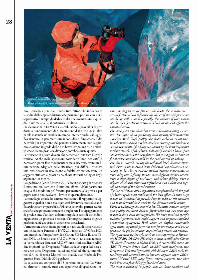
28
mo, i carichi, i pesi, ecc… sono tutti fattori che influenzano la scelta delle apparecchiature che possiamo portare con noi e soprattutto il tempo da dedicare alla documentazione e quin-di, in ultima analisi, il potenziale risultato.Da alcuni anni in La Venta si sta valutando la possibilità di pro-durre autonomamente documentazione d’alto livello, in altre parole materiale utilizzabile in campo internazionale. Ciò signi-fica rientrare in parametri ormai considerati fondamentali dai network più importanti del pianeta. Chiaramente non sappia-mo se saremo in grado di farlo in breve tempo, ma è un obietti-vo che ci siamo posti e la direzione potrebbe essere questa.Per riuscire in questo diventa fondamentale innalzare il livello tecnico. Anche nelle spedizioni cosiddette “non dedicate” è necessario poter fare movimenti camera ricercati, avere un’il-luminazione adeguata nelle situazioni più difficili, ottenere una resa elevata in risoluzione e fedeltà cromatica, avere un soggetto studiato a priori e una chiara narrazione logica degli argomenti in mente.La spedizione Perito Moreno 2010 è stata pensata per ottenere il massimo risultato con il minimo sforzo. Un’impostazione in qualche modo un po’ forzata, per mettersi alla prova e per capire come può evolvere il lavoro in questa direzione.La tecnologia attuale ha aiutato moltissimo. Il rapporto tra leg-gerezza e qualità non è mai stato così favorevole; solo due anni fa sarebbe stato impensabile. Abbiamo coinvolto partner tecnici specifici che potessero sostenere e migliorare l’equipaggiamento di produzione. Con loro abbiamo stipulato accordi sostenibili, organizzato un potenziale ritorno d’immagine, messo in gioco professionalità acquisite in esperienze precedenti.L’attrezzatura che ci siamo portati con noi era di tutto rispetto: una telecamera Panasonic HVX 201 formato DVCPro HD, una macchina fotografica/video Canon 5D Mark II, una Ni-kon D90, un braccio crane ABC di 9 metri, una testa remota-ta (comandata a distanza) ABC V5, una mini steadicam ABC, due impianti luci Dragonsub Videolux da 24 super led ciascu-no e tre torce Dragonsub da sei superled ad alta autonomia, vari fari led di scena Mastrel, vari stativi, due Macbook Pro, quattro Hard Disk da 320 gigabyte.La squadra era composta di 18 persone: nove soci La Venta ed altrettanti esterni, tutti con esperienze di spedizione im-
what moving times are foreseen, the loads, the weights, etc… are all factors which influence the choice of the equipment we can bring with us and, especially, the amount of time which can be used for documentation, which in the end affects the potential result.For some years now there has been a discussion going on wi-thin La Venta about producing high quality documentation ourselves. With “high quality” we mean usable in an interna-tional context, which implies somehow meeting standards now considered essential for being considered by the most important media networks of the planet. Obviously, we don’t know if we can achieve that in the near future, but it is a goal we have set for ourselves and that could be the road we end up taking.For this to succeed, raising the technical levels becomes essen-tial. Even in the so-called “non-dedicated” expeditions it’s ne-cessary to be able to execute studied camera movements, to have adequate lighting in the most difficult circumstances, have a high degree of resolution and colour fidelity, have a subject which was examined beforehand and a clear and logi-cal narration of the desired content.The Perito Moreno 2010 expedition was planned with the goal of obtaining the most results with the least effort. In some ways it was an “overdone” approach, done in order to test ourselves and to understand how work in this direction could evolve.Current technology has helped a lot. The ratio between weight and quality has never been so favourable: only two years ago it would have been unimaginable. We have involved specific technical partners, who could support and improve standard production equipment. With them we drafted sustainable agreements, organised potential uses for the images and put to good use the professionalism acquired in previous experiences.The equipment we brought with us was impressive; a Panaso-nic HVX 201 DVCPro HD video camera, a still/video Canon 5D Mark II camera, a Nikon D90, a 9 metre ABC crane, an ABC V5 remote-driven head, an ABC mini steadycam, two Dragonsub Videolux light units with 24 super-LED’s each, th-ree Dragonsub torches with six low consumption super-LED’s, several Mastrel LED stage lights, several supports, two Mac book Pros and four 320 gigabyte hard disks.The team consisted of 18 people: nine La Venta members and
Foto macro in cavità subglaciale Macro photography in a sub-glacier cave, Perito Moreno Glacier

29
portanti e con capacità alpinistiche, speleologiche e logistiche d’alto livello. Nessuno aveva invece competenze specifiche di documentazione video, tranne lo scrivente. È stato necessario, di conseguenza, pianificare il tempo di-sponibile per permettere di coprire più ruoli ed ottimizzare i tempi, in un territorio vastissimo e con tempi di spostamento amplificati dalle distanze.Non sono mancati gli imprevisti, come l’indisponibilità dell’elicottero per caricare il campo, e la difficoltà di avere portatori locali. Alcuni malfunzionamenti tecnici, che avreb-bero compromesso le riprese, sono stati risolti per fortuna sul posto. Essere tecnicamente attrezzatissimi con le più moderne apparecchiature digitali ci rende “pericolosamente” dipen-denti dall’energia. Ecco perché un generatore previsto per il campo base sul ghiacciaio, che ha smesso di funzionare, stava per compromettere tutto l’andamento della produzione. I soli pannelli solari non sarebbero bastati a soddisfare il fabbiso-gno energetico delle nostre attrezzature. Il problema è stato risolto in un giorno e mezzo, con tre attrezzi multiuso, un po’ d’ingegno e molta fortuna. In quel momento abbiamo capito come un lavoro così impegnativo rimane pur sempre molto vulnerabile in ambienti così particolari ed isolati.I primi giorni di perlustrazione sul Perito Moreno sono serviti a valutare le distanze degli spostamenti, decidere le location più interessanti ed iniziare a girare alcune immagini.La possibilità di avere ottiche intercambiabili ha incrementato notevolmente le occasioni creative di ripresa. Uno degli ambi-ti su cui abbiamo puntato è stato l’ambiente macro, un’ottica Canon 100 mm 1:1,8 montata su una macchina che consente di scattare a 21 megapixel e riprendere a risoluzione 1920 x 1080 progressivo, si è rivelata perfetta allo scopo.L’idea era di passare da situazioni visive di spazi aerei, immen-si, dove le linee di fuga sono enfatizzate dalla prospettiva e dalla luce, al microcosmo della fusione dei cristalli di ghiaccio, dei flussi nei microcanali di drenaggio; volevamo riprendere anche i dettagli, quello che l’occhio umano non percepisce facilmente. Il mondo della macro, nella narrazione del do-cumentario, può aiutarci a raccontare meglio l’approccio di ricerca al progetto, a spiegare visivamente le teorie degli scien-ziati, oltre che a creare un data base d’immagini da analizzare e su cui confrontarci in seguito.
the same number of externals, all having notable expedition experience and high level alpinist, speleological and logistical capacities. But no one, apart from myself, had any specific competence in the field of video recording. It was therefore necessary to use the available time, in order to be able to cover several roles and to optimise the use of time in a very vast territory having displacement times amplified by the distances.There were a few unexpected events, such as the unavailability of the helicopter for loading the camp and the difficulty getting local porters. On the other hand, some technical malfunctions which could have jeopardised the filming were sorted out on the spot. Being technically well-equipped with the latest digital equipment made us “dangerously” dependant on energy. That is the reason why a generator, which was planned for the gla-cier base camp, nearly sabotaged the production when it stop-ped working. Solar panels alone wouldn’t have been enough to power and recharge all the equipment in the time which was available. The problem was solved in a day and a half, with 3 multi-tools, a little ingenuity and lots of luck. It was then that we realised how such a challenging project can still be very vulnerable in such peculiar and isolated environments.The first days of reconnaissance on the Perito Moreno were used to assess the size of displacements, to choose the most interesting and significant locations and to start recording some images.The possibility of using interchangeable lenses greatly enhanced the creative possibilities. One of the areas we were aiming to explore was the macro scale. A Canon 100 mm 1:1.8 lens, used with a camera capable of delivering 21 mega pixel images and filming at 1920 x 1080, turned out to be ideal for that use.The idea was to range from visuals of the immense aerial spa-ces, where the lines of sight are emphasised by perspective and light, to the microcosms of melting ice crystals and flowing mi-cro drainage channels. We wanted to record even the details, things the human eye doesn’t easily perceive.The macro scale, in the narration of a documentary, can help us better illustrate the research approach to the project, to vi-sually explain the scientists’ theories, as well as creating a col-lection of images to analyse and compare later on.http://www.vimeo.com/10780564But the biggest challenge, as far as emotional involvement is
Controllo remoto, mulino Coltrane Remote control, Coltrane moulin, Perito Moreno Glacier
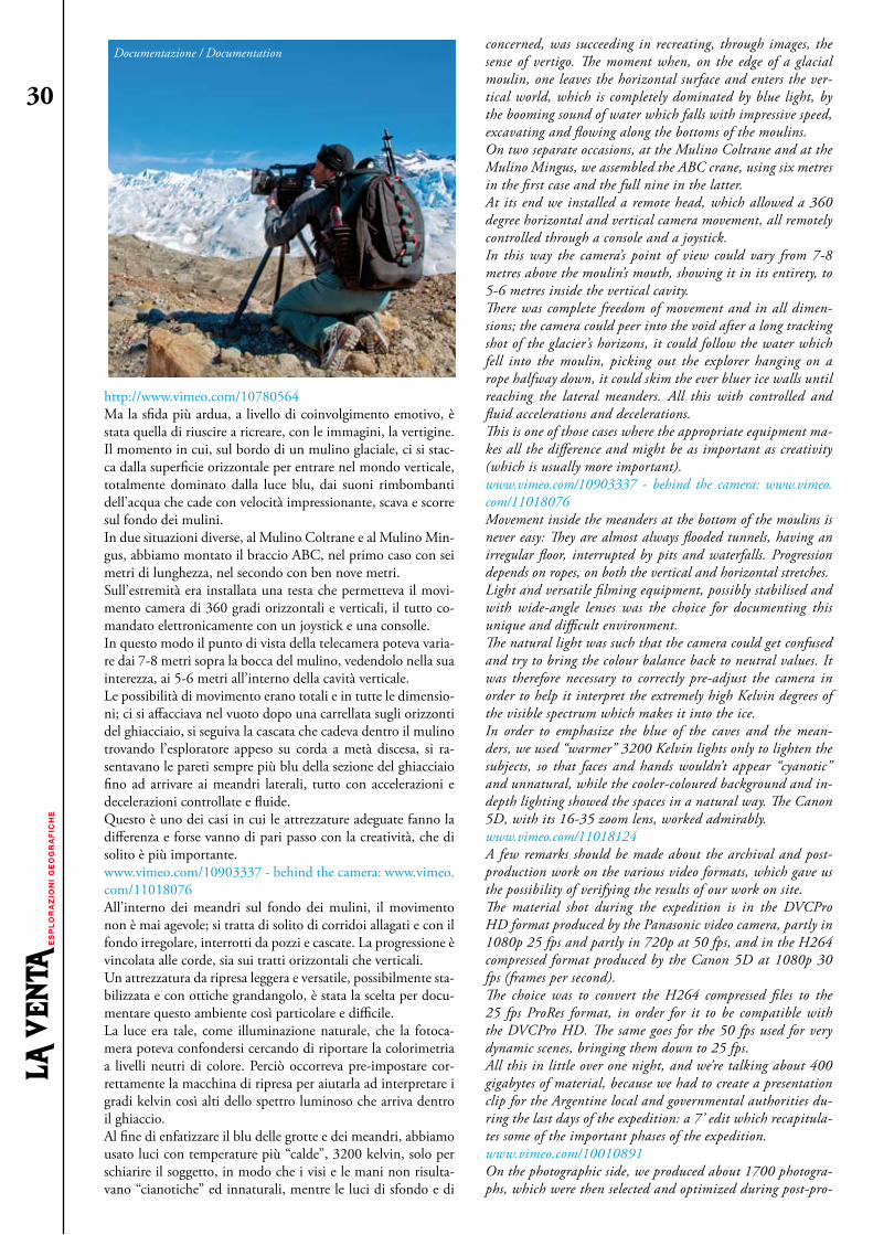
30
http://www.vimeo.com/10780564Ma la sfida più ardua, a livello di coinvolgimento emotivo, è stata quella di riuscire a ricreare, con le immagini, la vertigine. Il momento in cui, sul bordo di un mulino glaciale, ci si stac-ca dalla superficie orizzontale per entrare nel mondo verticale, totalmente dominato dalla luce blu, dai suoni rimbombanti dell’acqua che cade con velocità impressionante, scava e scorre sul fondo dei mulini.In due situazioni diverse, al Mulino Coltrane e al Mulino Min-gus, abbiamo montato il braccio ABC, nel primo caso con sei metri di lunghezza, nel secondo con ben nove metri.Sull’estremità era installata una testa che permetteva il movi-mento camera di 360 gradi orizzontali e verticali, il tutto co-mandato elettronicamente con un joystick e una consolle.In questo modo il punto di vista della telecamera poteva varia-re dai 7-8 metri sopra la bocca del mulino, vedendolo nella sua interezza, ai 5-6 metri all’interno della cavità verticale.Le possibilità di movimento erano totali e in tutte le dimensio-ni; ci si affacciava nel vuoto dopo una carrellata sugli orizzonti del ghiacciaio, si seguiva la cascata che cadeva dentro il mulino trovando l’esploratore appeso su corda a metà discesa, si ra-sentavano le pareti sempre più blu della sezione del ghiacciaio fino ad arrivare ai meandri laterali, tutto con accelerazioni e decelerazioni controllate e fluide.Questo è uno dei casi in cui le attrezzature adeguate fanno la differenza e forse vanno di pari passo con la creatività, che di solito è più importante.www.vimeo.com/10903337 - behind the camera: www.vimeo.com/11018076All’interno dei meandri sul fondo dei mulini, il movimento non è mai agevole; si tratta di solito di corridoi allagati e con il fondo irregolare, interrotti da pozzi e cascate. La progressione è vincolata alle corde, sia sui tratti orizzontali che verticali.Un attrezzatura da ripresa leggera e versatile, possibilmente sta-bilizzata e con ottiche grandangolo, è stata la scelta per docu-mentare questo ambiente così particolare e difficile.La luce era tale, come illuminazione naturale, che la fotoca-mera poteva confondersi cercando di riportare la colorimetria a livelli neutri di colore. Perciò occorreva pre-impostare cor-rettamente la macchina di ripresa per aiutarla ad interpretare i gradi kelvin così alti dello spettro luminoso che arriva dentro il ghiaccio.Al fine di enfatizzare il blu delle grotte e dei meandri, abbiamo usato luci con temperature più “calde”, 3200 kelvin, solo per schiarire il soggetto, in modo che i visi e le mani non risulta-vano “cianotiche” ed innaturali, mentre le luci di sfondo e di
concerned, was succeeding in recreating, through images, the sense of vertigo. The moment when, on the edge of a glacial moulin, one leaves the horizontal surface and enters the ver-tical world, which is completely dominated by blue light, by the booming sound of water which falls with impressive speed, excavating and flowing along the bottoms of the moulins.On two separate occasions, at the Mulino Coltrane and at the Mulino Mingus, we assembled the ABC crane, using six metres in the first case and the full nine in the latter.At its end we installed a remote head, which allowed a 360 degree horizontal and vertical camera movement, all remotely controlled through a console and a joystick.In this way the camera’s point of view could vary from 7-8 metres above the moulin’s mouth, showing it in its entirety, to 5-6 metres inside the vertical cavity.There was complete freedom of movement and in all dimen-sions; the camera could peer into the void after a long tracking shot of the glacier’s horizons, it could follow the water which fell into the moulin, picking out the explorer hanging on a rope halfway down, it could skim the ever bluer ice walls until reaching the lateral meanders. All this with controlled and fluid accelerations and decelerations.This is one of those cases where the appropriate equipment ma-kes all the difference and might be as important as creativity (which is usually more important).www.vimeo.com/10903337 - behind the camera: www.vimeo.com/11018076Movement inside the meanders at the bottom of the moulins is never easy: They are almost always flooded tunnels, having an irregular floor, interrupted by pits and waterfalls. Progression depends on ropes, on both the vertical and horizontal stretches.Light and versatile filming equipment, possibly stabilised and with wide-angle lenses was the choice for documenting this unique and difficult environment.The natural light was such that the camera could get confused and try to bring the colour balance back to neutral values. It was therefore necessary to correctly pre-adjust the camera in order to help it interpret the extremely high Kelvin degrees of the visible spectrum which makes it into the ice.In order to emphasize the blue of the caves and the mean-ders, we used “warmer” 3200 Kelvin lights only to lighten the subjects, so that faces and hands wouldn’t appear “cyanotic” and unnatural, while the cooler-coloured background and in-depth lighting showed the spaces in a natural way. The Canon 5D, with its 16-35 zoom lens, worked admirably.www.vimeo.com/11018124A few remarks should be made about the archival and post-production work on the various video formats, which gave us the possibility of verifying the results of our work on site.The material shot during the expedition is in the DVCPro HD format produced by the Panasonic video camera, partly in 1080p 25 fps and partly in 720p at 50 fps, and in the H264 compressed format produced by the Canon 5D at 1080p 30 fps (frames per second).The choice was to convert the H264 compressed files to the 25 fps ProRes format, in order for it to be compatible with the DVCPro HD. The same goes for the 50 fps used for very dynamic scenes, bringing them down to 25 fps. All this in little over one night, and we’re talking about 400 gigabytes of material, because we had to create a presentation clip for the Argentine local and governmental authorities du-ring the last days of the expedition: a 7’ edit which recapitula-tes some of the important phases of the expedition.www.vimeo.com/10010891On the photographic side, we produced about 1700 photogra-phs, which were then selected and optimized during post-pro-
Documentazione / Documentation
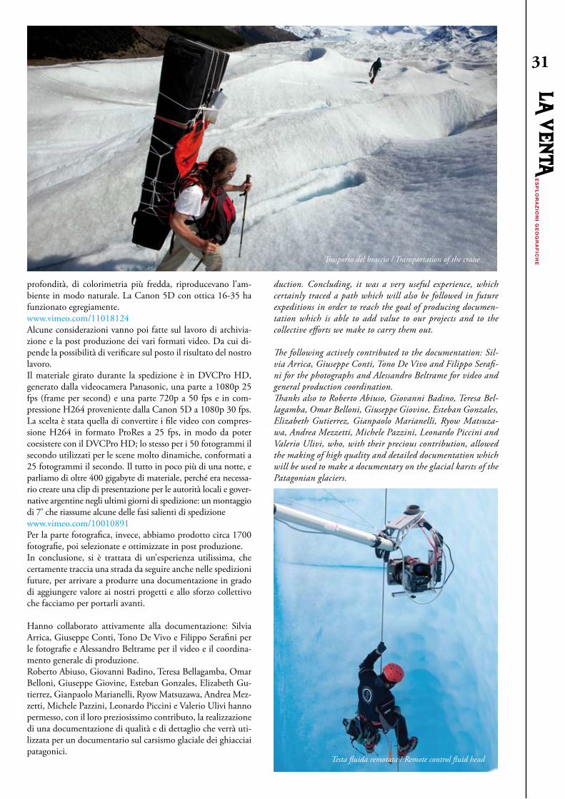
31
profondità, di colorimetria più fredda, riproducevano l’am-biente in modo naturale. La Canon 5D con ottica 16-35 ha funzionato egregiamente. www.vimeo.com/11018124Alcune considerazioni vanno poi fatte sul lavoro di archivia-zione e la post produzione dei vari formati video. Da cui di-pende la possibilità di verificare sul posto il risultato del nostro lavoro.Il materiale girato durante la spedizione è in DVCPro HD, generato dalla videocamera Panasonic, una parte a 1080p 25 fps (frame per second) e una parte 720p a 50 fps e in com-pressione H264 proveniente dalla Canon 5D a 1080p 30 fps.La scelta è stata quella di convertire i file video con compres-sione H264 in formato ProRes a 25 fps, in modo da poter coesistere con il DVCPro HD; lo stesso per i 50 fotogrammi il secondo utilizzati per le scene molto dinamiche, conformati a 25 fotogrammi il secondo. Il tutto in poco più di una notte, e parliamo di oltre 400 gigabyte di materiale, perché era necessa-rio creare una clip di presentazione per le autorità locali e gover-native argentine negli ultimi giorni di spedizione: un montaggio di 7’ che riassume alcune delle fasi salienti di spedizionewww.vimeo.com/10010891Per la parte fotografica, invece, abbiamo prodotto circa 1700 fotografie, poi selezionate e ottimizzate in post produzione.In conclusione, si è trattata di un’esperienza utilissima, che certamente traccia una strada da seguire anche nelle spedizioni future, per arrivare a produrre una documentazione in grado di aggiungere valore ai nostri progetti e allo sforzo collettivo che facciamo per portarli avanti.
Hanno collaborato attivamente alla documentazione: Silvia Arrica, Giuseppe Conti, Tono De Vivo e Filippo Serafini per le fotografie e Alessandro Beltrame per il video e il coordina-mento generale di produzione.Roberto Abiuso, Giovanni Badino, Teresa Bellagamba, Omar Belloni, Giuseppe Giovine, Esteban Gonzales, Elizabeth Gu-tierrez, Gianpaolo Marianelli, Ryow Matsuzawa, Andrea Mez-zetti, Michele Pazzini, Leonardo Piccini e Valerio Ulivi hanno permesso, con il loro preziosissimo contributo, la realizzazione di una documentazione di qualità e di dettaglio che verrà uti-lizzata per un documentario sul carsismo glaciale dei ghiacciai patagonici.
duction. Concluding, it was a very useful experience, which certainly traced a path which will also be followed in future expeditions in order to reach the goal of producing documen-tation which is able to add value to our projects and to the collective efforts we make to carry them out.
The following actively contributed to the documentation: Sil-via Arrica, Giuseppe Conti, Tono De Vivo and Filippo Serafi-ni for the photographs and Alessandro Beltrame for video and general production coordination.Thanks also to Roberto Abiuso, Giovanni Badino, Teresa Bel-lagamba, Omar Belloni, Giuseppe Giovine, Esteban Gonzales, Elizabeth Gutierrez, Gianpaolo Marianelli, Ryow Matsuza-wa, Andrea Mezzetti, Michele Pazzini, Leonardo Piccini and Valerio Ulivi, who, with their precious contribution, allowed the making of high quality and detailed documentation which will be used to make a documentary on the glacial karsts of the Patagonian glaciers.
Trasporto del braccio / Transportation of the crane
Testa fluida remotata / Remote control fluid head
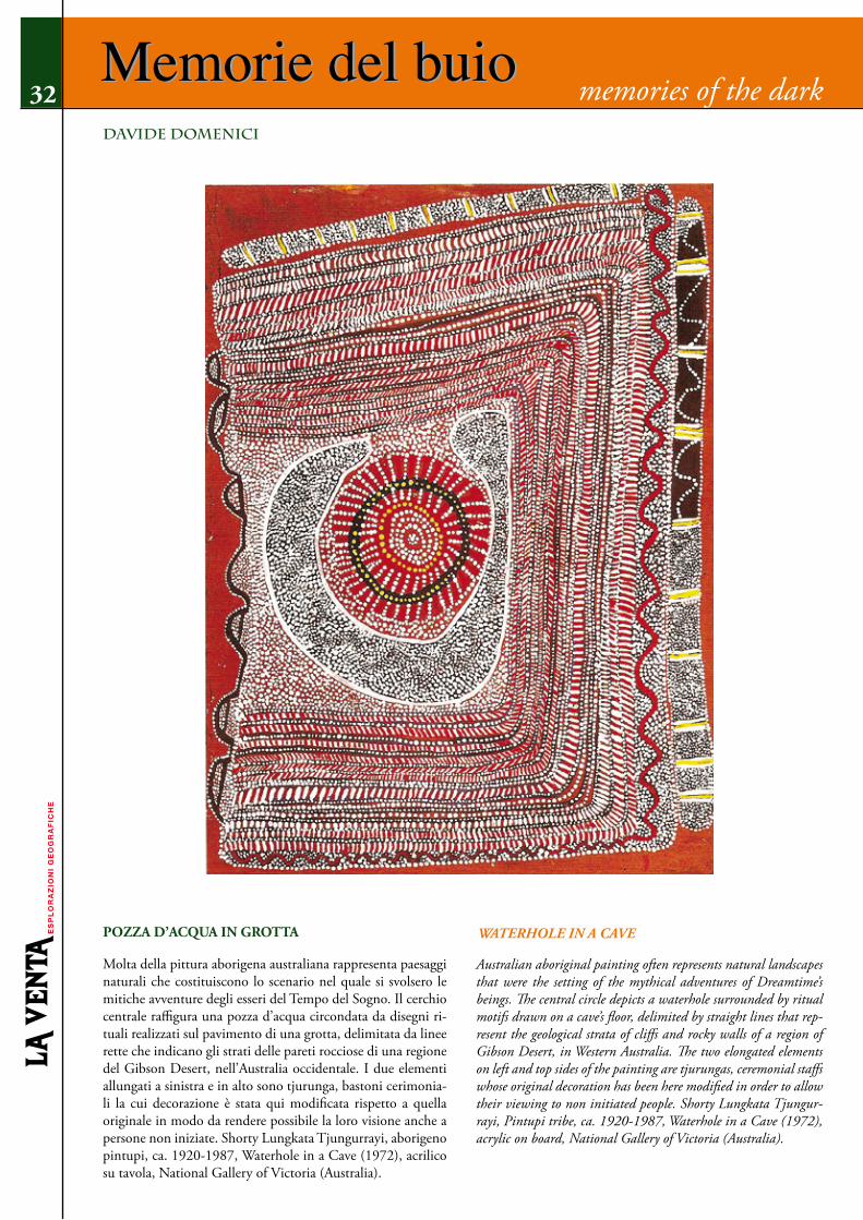
Memorie del buio
Molta della pittura aborigena australiana rappresenta paesaggi naturali che costituiscono lo scenario nel quale si svolsero le mitiche avventure degli esseri del Tempo del Sogno. Il cerchio centrale raffigura una pozza d’acqua circondata da disegni ri-tuali realizzati sul pavimento di una grotta, delimitata da linee rette che indicano gli strati delle pareti rocciose di una regione del Gibson Desert, nell’Australia occidentale. I due elementi allungati a sinistra e in alto sono tjurunga, bastoni cerimonia-li la cui decorazione è stata qui modificata rispetto a quella originale in modo da rendere possibile la loro visione anche a persone non iniziate. Shorty Lungkata Tjungurrayi, aborigeno pintupi, ca. 1920-1987, Waterhole in a Cave (1972), acrilico su tavola, National Gallery of Victoria (Australia).
Australian aboriginal painting often represents natural landscapes that were the setting of the mythical adventures of Dreamtime’s beings. The central circle depicts a waterhole surrounded by ritual motifs drawn on a cave’s floor, delimited by straight lines that rep-resent the geological strata of cliffs and rocky walls of a region of Gibson Desert, in Western Australia. The two elongated elements on left and top sides of the painting are tjurungas, ceremonial staffs whose original decoration has been here modified in order to allow their viewing to non initiated people. Shorty Lungkata Tjungur-rayi, Pintupi tribe, ca. 1920-1987, Waterhole in a Cave (1972), acrylic on board, National Gallery of Victoria (Australia).
memories of the dark32Memorie del buiodAvIde dOMenIcI
POzzA D’ACquA IN GROTTA WAtErHolE iN A CAvE

Novità NewEsiste un Messico fatto di spiagge magnifiche, vulcani innevati, can-yon enormi, deserti interminabili, città perdute nelle foreste erette da culture passate. Ma ne esiste un altro più nascosto, che si estende nel sottosuolo dei deserti, delle città in rovina, dei canyon, e ne è la sua faccia nascosta: è il Messico delle grotte.La strabiliante varietà paesaggistica e culturale di questo paese è ri-specchiata nel suo mondo sotterraneo, che annovera alcune delle più profonde grotte al mondo e altre che sono le più vaste mai esplorate sott’acqua, altre percorse da enormi fiumi, altre vastissime e tropicali, altre uniche dal punto di vista biologico, altre unicum assoluti, come la Cueva de los Cristales.A tutta questa poliedricità della dimensione fisica delle grotte, spesso si sovrappone il loro interesse archeologico perché, lungi dal considerarle luoghi infernali, le culture pre-colombiane le hanno incluse nel loro mondo religioso e pratico trasformandole spesso in depositi archeolo-gici, porte appena socchiuse d’immensi archivi del passato.Gli speleologi La Venta si dedicano alle esplorazioni di queste grotte da oltre vent’anni, spingendosi in luoghi lontani non solo dal turismo, ma proprio dalla frequentazione umana. Con gli anni si è delineato un complesso tessuto di storie e di geo-grafie, ancora incompiuto: questo libro ne dà una prima descrizione complessiva.
Most people know Mexico for its fantastic beaches, snow-clad volca-noes, huge canyons, endless deserts, and lost cities in the forest erected by past civilizations. But there is a more hidden aspect, spreading below the surface of the deserts, of the cities ruins, and of the canyons: it is the world of Mexican caves.The amazing cultural and landscape variety of this country is reflected in its underground world, a world which contains some of the deepest
caves on Earth and the longest ever explored underwater; others that are traversed by huge rivers, vast and tropical, others which are unique from a biological point of view, oth-ers that are just unique, like Cueva de los Cristales.The great polyhedric nature of the caves physical aspect is often enriched by their archaeological interest: in fact, far from being considered as in-fernal regions, caves were included by pre-Columbian civilizations in their religious and practical world. These then transformed into archaeological deposits, open doors on huge archives of time. The cavers of La Venta have devoted themselves to the exploration of these caves for decades, pushing not only to places far from tourism but even to areas far from any human settlement.Over the years these explorations have drawn a complex web of stories and geographies. It is not yet completed but this book offers its first general description.
quarta di copertina / Pronti per la cena, rifugio Viedma Back cover / Ready for dinner, Viedma Hut, Argentina

Related Documents