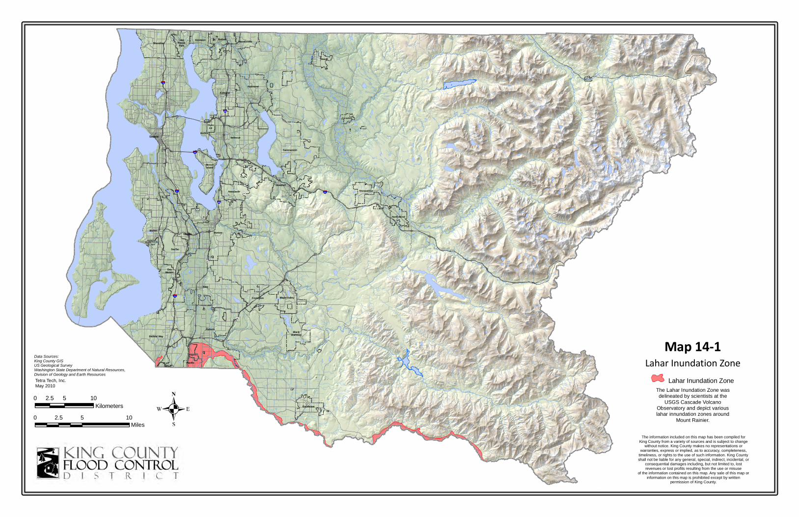
§ ¨ ¦ 5 § ¨ ¦ 405 § ¨ ¦ 90 § ¨ ¦ 90 U V 520 § ¨ ¦ 5 § ¨ ¦ 405 § ¨ ¦ 5 U V 167 U V 18 Algona Auburn Black Diamond Bellevue Bothell Burien Carnation Clyde Hill Covington Des Moines Duvall Enumclaw Federal Way Hunts Point Issaquah Kent Kirkland Kenmore Lake Forest Park Medina Mercer Island Milton Maple Valley North Bend Newcastle Normandy Park Pacific Redmond Renton Seattle Shoreline Skykomish Sammamish Snoqualmie SeaTac Tukwila Woodinville Yarrow Point Lahar Inundation Zone The information included on this map has been compiled for King County from a variety of sources and is subject to change without notice. King County makes no representations or warranties, express or implied, as to accuracy, completeness, timeliness, or rights to the use of such information. King County shall not be liable for any general, special, indirect, incidental, or consequential damages including, but not limited to, lost revenues or lost profits resulting from the use or misuse of the information contained on this map. Any sale of this map or information on this map is prohibited except by written permission of King County. 0 5 10 2.5 Miles 0 5 10 2.5 Kilometers . Data Sources: King County GIS US Geological Survey Washington State Department of Natural Resources, Division of Geology and Earth Resources Lahar Inundation Zone The Lahar Inundation Zone was delineated by scientists at the USGS Cascade Volcano Observatory and depict various lahar innundation zones around Mount Rainier. Map 14-1 Tetra Tech, Inc. May 2010

Welcome message from author
This document is posted to help you gain knowledge. Please leave a comment to let me know what you think about it! Share it to your friends and learn new things together.
Transcript
§̈¦5
§̈¦405
§̈¦90
§̈¦90
UV520
§̈¦5
§̈¦405
§̈¦5
UV167
UV18
Algona
AuburnBlack
Diamond
Bellevue
Bothell
Burien
Carnation
ClydeHill
Covington
DesMoines
Duvall
Enumclaw
Federal Way
HuntsPoint
Issaquah
Kent
Kirkland
KenmoreLakeForestPark
Medina
MercerIsland
Milton
Maple Valley
North Bend
Newcastle
Norm an dyPark
Pacific
Redmond
Renton
Seattle
Shoreline
Skykomish
Sammamish
Snoqualmie
SeaTac
Tukwila
Woodinville
YarrowPoint
Lahar Inundation Zone
The information included on this map has been compiled forKing County from a variety of sources and is subject to change
without notice. King County makes no representations orwarranties, express or implied, as to accuracy, completeness,
timeliness, or rights to the use of such information. King Countyshall not be liable for any general, special, indirect, incidental, or
consequential damages including, but not limited to, lostrevenues or lost profits resulting from the use or misuse
of the information contained on this map. Any sale of this map orinformation on this map is prohibited except by written
permission of King County.
0 5 102.5Miles
0 5 102.5Kilometers .
Data Sources:King County GISUS Geological SurveyWashington State Department of Natural Resources,Division of Geology and Earth Resources
Lahar Inundation ZoneThe Lahar Inundation Zone wasdelineated by scientists at the
USGS Cascade VolcanoObservatory and depict variouslahar innundation zones around
Mount Rainier.
Map 14-1Tetra Tech, Inc.May 2010
Related Documents