Government of Ethiopia Water Resources Development Authority UN DP/FAQ Development of Irrigated Agriculture Contract No. DP/ETH/82/008-1/AGOE KESEM IRRIGATION PROJECT FEASIBILITY STUDY Inception Report Sir M Macdonald & Partners Limited Demeter House, Station Road.. Cambridge CB1 2RS, England March 1986

Welcome message from author
This document is posted to help you gain knowledge. Please leave a comment to let me know what you think about it! Share it to your friends and learn new things together.
Transcript
Government of EthiopiaWater Resources Development Authority UN DP/FAQ
Development of Irrigated Agriculture Contract No. DP/ETH/82/008-1/AGOE
KESEM IRRIGATION PROJECT FEASIBILITY STUDY
Inception Report
Sir M Macdonald & Partners LimitedDemeter House, Station Road.. Cambridge CB1 2RS, England
March 1986
Government of EthiopiaWater Resources Development Authority U N DP/FAO
Development of Irrigated Agriculture Contract No. DP/ETH/82/008-1/AGOE
KESESVS IRRIGATION PROJECT FEASIBILITY STUDY '
Inception Report
Sir M Macdonald & Partners LimitedDemeter House, Station Road, Cambridge CB1 2RS, England
M a r c h 1 9 8 6
LIST OF CONTENTS
INTRODUCTION
1.1 The Project1.2 The Study1.3 Thi s Report
PROGRESS OF THE STUDY TO DATE
2.1 Chronology2.2 Logi st i cs2.3 The Inception Studies2.4 Field Investigations2.5 Counterpart Staff
PREVIOUS STUDIES AND REPORTS
THE PRESENT SITUATION
4.1 People, Livestock and Environment4.2 Soils and Land Capability4.3 Groundwater and Hydrogeology4.4 Hydro!ogy and Sedimentation4.5 Geology and Dams4.6 Agriculture4.7 Institutions4.8 Existing Irrigation Schemes4.9 Health, Services and In-frastructure
INITIAL IDEAS ON PROJECT DEVELOPMENT
5.1 The Project and the Pastoralist System5.2 Agriculture5.3 Institutions5.4 Irrigation and Drainage5.5 Water Storage and Dams5.6 Water Conveyance and Hydropower5.7 Water Supply5.8 Health, Services and Infrastructure
PROGRAMME FOR THE REMAINDER Of THE STUDY
6 . 1 Background6.2 Factors Affecting the Programme6.3 Likely Consequences
HATTERS FOR THE ATTENTION OF THE STEERING COMMITTEE

Annex
A Sociology and Livestock
B Environmental Aspects
C Soils
D Hydrology and Sedimentation
E Geology
F Hydrogeology ar.d Groundwater
G Dams and Hydropower
H Agriculture
I Institutions
J Inf restructure
K Health
L Irrigation and Drainage
M Drainage and Salinity
N Adrainistrative and Contractual Matters
LIST OF ANNEXES
7 Ref erences
F T
i
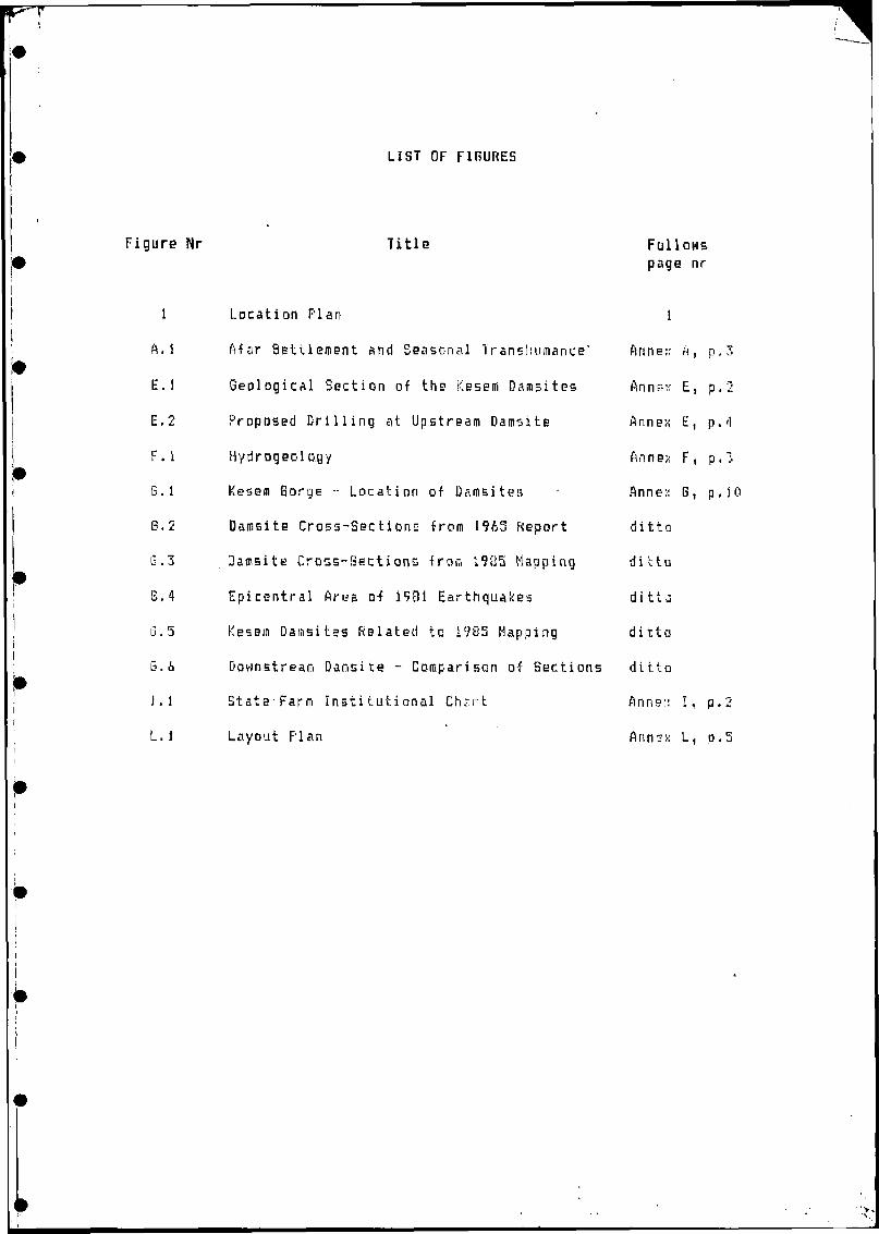
Figure Nr
LIST OF FIGURES
Title Follows page nr
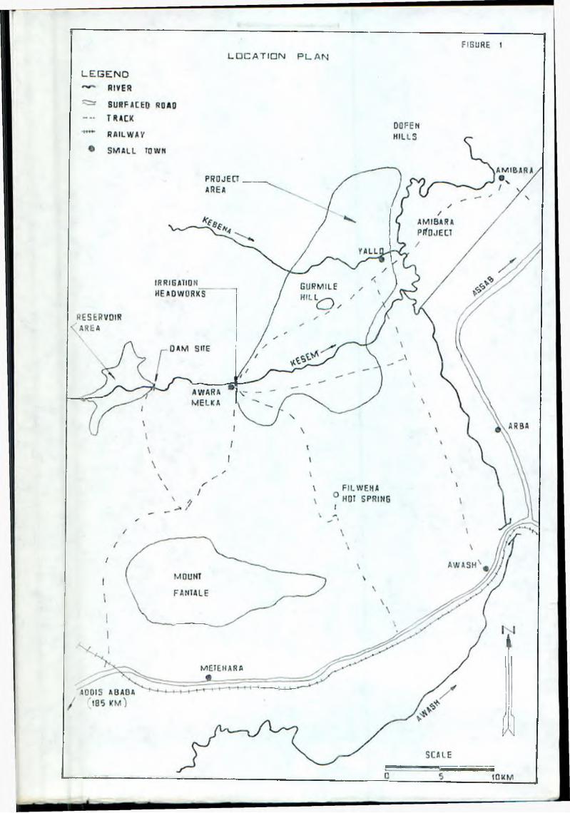
1 Location Plan 1
ft. 1 Afar Settlement and Seasonal Trsnstiumance* ftnnen p . 3
E. 1 Geological Section of the Kesem Damsites Anne:< E, p. 2
E.2 Proposed Drilling at Upstream Damsite Annex E, p . <1
F. 1 Hydrogeol o.gy fin n ex F, p . 3
G . 1 Kesem Gorge •• Location of Damsitea Anne:: B. p , i 0
B. 2 Damsite Cross-Sections from 1963 Report ditto
G . 3 Damsite Cross-Sections from 1985 Happing ditto
B. 4 Epicentral Area o-f 1981 Earthquakes d i t t g
G. 5 Kesem Damsites Related to 1985 Mapping ditto
b . & Downstream Damsite - Comparison o-f Sections ditto
I . 1 Stats Farm Institutional Ch*.rt Anns:: I, P-2
L. i Layout plan ft n n x L,„ e p . J
[
A&BREVIR rIONS
fu tash H i j i cu. 11 u r e.! D evr ! cp.T. n i - r1: -:r = ' i o n
a \ r photo interpretation
"• I ectr i c a; co nduct: vi ty
t n i opi an >i J bc ‘ r i c Power ind L < qii ■;: ng Author i ty
Food and P.gri culture Organisation s f the United Motion
Horticultural Deve)op men t Cor por a:i on
Institute of ftgr i cultur ? i R s s e :h
Kesem Irr:gaLion Project
I a r g e s c a 1 e nechanised -f «? in i n g (system)
Middle ftwash Agricultural Development Enterprise
Kiddle Awash Development Corporation
,11 i t e r n a ] and child health
Sir II Mac Den a Id and Pe.rtn£r = Limits? a (tha Consul t A n t )
Ministry of Agriculture
Ministry of State? Farm D e v■=:■ Iopmant
t'l & 1 k a II era Research Centre
Project Control Centre
Relief and Rehabilitation Coiiiission
b1 at e Farm
sine 11 hoi der rained farming (system)
tr ee crop p 1 an t ati or.s
Terms o-f Reference
H a t e r R e s o u r c e s D e v e l opu ien t A u t h o r i t y
dll units are SI units except the f o l lowing;-
quinta] (100 I: g )
ve = r
CHAPTER 1
INTRODUCTION
1.i The Project
The Kesem Irrigation Project is a proposed development aimed at irrigating ci5 iiiuch as possible of the gross area of about 16 000 ha of Ethiopia'sMiddle Awash Valley that is commanded by the Kesem River. The Kesem is alt-ft bank tributary of the Awash with an annual catchment yield of thieorder o-f 700 hiii , and previous studies indicate that a 7 0 - m high dam some10 i:m upstream of the irrigable area would regulate the flow sufficiently to si low the irrigation of the whole available area. It would also provide scmi? flood regulation and hydropower.
The Kesem Irrigation Project was identified in a study of the whole Awash basin in the early 1960's (ref. 1, Annej: Z), and was further investigated in the course of other basin-wide studies in the early 1970's (ref.2). A pre-feasibility study in 1930 (ref. 3) concentrated on this project alone but was based mainly on the 1965 information.
1.2 The Study
in 1985 Ttirms of Reference for a comprehensive feasibility study were issued by the Hater Resources Development Authority (IflRDA) of theProvisional Military Government of Socialist Ethiopia. In January 1996 this study, financed by UNDP with FftQ as executing agency, was entrusted to Sir M MacDonald & Partners Limited of Cambridge, England (MNP).
The Terms of Reference place emphasis not only on technical aspects of agriculture and engineering, but also on social aspects (particularly the position of the semi-nomadic pastoralists who now use the project area) and on infrastructure and services. The study is scheduled to take about 12 months to complete, although most of the consultant's work is to be concentrated in the first 9 months which lead to the draft final report. It includes extensive subsurface investigations and topographic surveysconducted by WRDA. The study involves about fifty technical and support personnel of which MNP provides thirty.
Main Report page 1
! 1 f' F B , Inception Report, March 1996
1.3 This Report
The study-is divided into seven functions! phases (which overlap in Lime to some ex te n t ) :-
- i ncep t i on st ud i es- field investigations- analysis of resou: es and constraints
- design of project components, and cost E s t i m a t e s
- project evaluation- review by the Ethiopian Government and the FAQ- Final Report.
As well as periodic progress reports the consultant is to submit three intermediate reports:-
- an inception report at the end of the inception phase- an interim report after the analysis of resources and constraints- a draft of the final report.
This is the study's Inception Report, submitted by the Consultant on 10March 1906, six weeks after the start of the worli. Its purposes are tosummarise the Consultant's review o-f previous studies and his initialfindings in the field, and to set out ideas about the project's development which need to be discussed by the Bovernment and the FfiO. It is therefore timed for and aimed at the first meeting o-f the Steering Committee, scheduled for II to 18 March 1986. The satisfactory progress cl the studyrequires that the consultant should receive guidance from the committee at this stage.
The report, though bound in one volume, is divided into this main report ind a number o-f annexes each dealing with a particular aspcct of the prL-’^ct or the study. The mil in report discusses each aspect very briefly, siiiphc. -:i si ng points o-f particular significance and, wh~re necessary, referring the reader to annexes for details.
The structure of the mfein report is as follows:-
- introduction (Chapter 1)- progress of the study to date (Chapter 2)- previous studies and reports (Chapter 3}- the present situation (Chapter 4)- initial ideas for project development (Chapter 5)- programme’ for the remainder of the study (Chapter 6 )- main points for discussion in the March 1986 meetings (Chapter 7).
Main Report page 2
K I P I'S > Inception Report, March 1906
CHAPTER 2
PROGRESS OF THE STUDY TO DATE
2.1 Chronology
Tlie study was the subject of an invitation issued by FAO in I'U.y 1905, using Terms of Reference (TOR) produced by WRDA in March 1985. The Consultant (Sir H MacDonald & Partners Ltd, or "I1MP") responded with a technicalproposal in July 1985, and this resulted in a contract which became effective on 4 February 1936. WRDfl was formally notified of HMP'sappointment on 18 January 1986.
liesnwhi 1 e , on 9 January, (IMP suggested that, to avoid unnecessary delay,
the "start date" from which the study programme runs should be regarded as being 12 January 1986, although the contract was not yet valid on that day. This was accepted by FAO. The consultant's team began arriving in Ethiopia on 10 January and reached a total of eleven persons after the three-weekmobilisation period. After consultation with FAO and WRDA , MNP modifiedthe staffing programme slightly to reduce the concentration Df nor I; in the first two months. This report is submitted at the end of week U.
Further details of the timing of the project start are given in Annex N.
7. 2 Logistics
WRDA provided excellent accomroodatian for the consultant's staff at Ami bar a, on the right bank of the Awash River just to the north-east of the project area, and also an office in Addis Ababa. The consultant chose to use I.lie A fit i bar a office as his main base, and this report has been prepared there. From late February WRDA provided'a ferry across the Awash River between Ami bar a and the Keeem Irrigation Project (KIP) area near Valo,which reduces the time lost in daily travelling. After some e£.riydifficulties in arranging for vehicles on the left (KIP) bc'nK, this lias bc-!-n generally satisfactory.
The Authority also provided transport in the form of an estate tir in AddisAbaba and six. new four-wheel-drive (4WD) vehicles. The FAO in Addis Ababaprovided a seventh 4 WD vehicle from 26 February (week 7).
The subject of logistics is covered in more detail by Annex M.
Main Report page 3
K I P F B , Inception Report, March 1986
2.3 The Inception Studies
The study programme is summarised in Annex VI of the contract, which was Figure 2 of the Consultant's technical proposal of July 19S;j which non forms Annex I of the Contract. (The Consultant apologises for two drafting errors in the Key of this diagram: the label “Latest start dais" shouldread "Latest end date", and the "Probable critical path" shoula be shown by a thick arrow, as it is in the chart itself.)
The inception studies, as described in the Methodology (Chapter 3 af Annex I of the proposal or the contract), consist of the review of previous reports arid immediately available data, initial field inspections and observations, and the preparation of this report. These studies have been carried out during weeks 2 to 8 of the study (19 January to 9 March 1986), nhile the field investigations have also begun in the same period. Specialist contributions in the fields of fluvial geomorphology and sedimentation, of economics, and of potable water supply have not been included in this phase, partly to reduce the the concentration of work at this time and partly because they depend on initial work in other disciplines. These topics are however mentioned in this report.
The initial findings of the study have not thrown the overall concept orfeasibility of the project into serious doubt, but some unexpected issues have arisen, such as the need for different topographic surveys from those nnviseaged in the Terms of Reference. These are discussed in Chapters 4 and5 below, and the consequences for the study programme are discussed inChapter 6 .
2.4 Field Investigations
In most disciplines, the consultant's team members continued from the inception studies into the main field work, and the early observations from this are included here. The drilling needed for dams and hydrogeology was specified by the end of week h as p r o g r a m m e d , and the consultant assisted WKDA in preparing the necessary documents for drilling contractors. Surveywort: was also defined, and WRDA surveyors were able to start worf: at thedams i t e on 24 February, three weeks ahead of sciiedul e.
Soil survey field work was prepared in week 6 and got under way in week 7,though progress is not up to full speed yet because of access problems, partly due to the early and heavy start of the short rainy season during February, and also due to inception work and the setting up of laboratory arrangements.
Main Report page 4
K T P I-!i I n c e p t i o n fi e p c r t , March 1936
Fallowing the field inspection of the darosite anc reservoir are, ano thediversion weir site, by the specialists in weeks ‘I and 5, n?ol ng iC5lmapping began by the H y d r o g e o l o g i e t , assisted by two V)RDA geologists; this work has been hampered by some accomodation problems but It is hop-:d that Hie1/ will be solved soon so that the personnel can live near the west -jnd of the project area and start early each day. The rain has also made it ini possible to cross the Kesem on some days. Hydrogeological and groundwater work in the irrigable area lias been planned and initiated, and unw awaitsthe appointment and mobilisation of the drillers.
Ike sociology and livestock field work has been split into two visits so that the A-fars' pastoralist economy can be observed in different seasons; the first was in January and Febraury and the second is scheduled ^ar J'jr<3 - July. Field work on environmental aspects was done in weeks 4 to 7, though further work will be done by the Fluvial Georoorphclogist whose visit has fcefn postponed to April (weeks 13 - 14). Agricul tural field work is still in progress. Medical and environmental health data collection hav? been completed, except for the complementary study offered by the Environmental Health Unit, as explained in Section 4.8 belGw.
Data collection on hydrology and sediment was well advanced by the end of v,eb If B (the date of this report), though the latter aspect will be further itudied in April.
lie field work on irrigation and drainage is in progress, a preliminaryis/out having been prepared so that the survey work for particularstructure sites and canal and drain alignments can begin. Study of nearbyexisting schemes has also been done and has produced useful guidance.
P', h. Jropower, an initial visit has been made to the relevant authorities, t'.'i further contact will follow soon, after the initial estimates of !- -i Sral agical parameters and dam height.
T.-.e field observations and data coller.ted so far are summarised endo , in Chapters 4 and S, and in the technical Annexes A to M.
2.5 Counterpart Staff
fc<'-•£)A has assigned some twenty professional and technical staff to the study t£«iii, and their contribution has been most valuable, especially since many o; ti.etii had worked in the Middle Awash before. The Consultant is i nta'jrating them into the work of the study as much as possible, the czubined team being subdivided into groups assigned to each discipline. T:\-is r.ot only assists the progress of the study but also gives training tc t* : i^ss experienced counterparts.
It h?d been hoped to involve counterpart staff in the analysis and design activities o-f the study, and so far as these are carried out in Ethiopia this, is being done, The originally proposed integration of some Ethiopian staff in the work in the Consultant's head office in England was, htvjever, excluded from the Contract by FAO. It is recommended that this bs restored.
Main Report page 5
! !!' I• *, incepti on ftepcr t . Jlarch 1?!<6
CHAPTER 3
PREVIOUS STUDIES AND REPORTS
i r r i g a t e d agricultural devel opment in the Awaiih Va.11 t?v has been t i j s u . b j - c l g ( much study in the last 25 years. The ;nors important reports arg listed• r. Annex I . The technical Annexes A to H contain an account of the Consultant's review of this body of literature, n d this chapter' is confined to some general and i rttroduc t ury c o m m e n t s .
The- first and most significant report is the study carried out for FAG and 1 I'rT in the early 1 9 & 0 ’s by SOGREAH (ref. 1 in Annex I ) . This covered the
Awash basin so that the Kesem developroent was only one g 1 em^nU of the::i..dy. It was however one of the two major storage schemes protas^d (the [jJ. her being Tendaho), and as such received considerabls fLti-ntion,
ir:.Juding -geological drilling at one of two possible damsites anc a sail strvey, A dam on the Kesem was to store 370 htti3 and rooulate the river for thc-> irrigation of a gross area of 17 550 ha in the Kesem project, ta augment the dry-season flow of the Awash downstream of tho Keseoi's confluence for the benefit of other irrigation schemes, to reduce flooding, s.rd to generate hydropower. This report alone is mentioned in the- Terms of Reference, which state that it provides comprehensive information on all .rs.tfvsnt factors and i s ’ considered to provide suitable background information for this study. The review of this report has revealed some dc, (tts about the accuracy of the topographical i nf ormati on in the dam and reservoir area, but its value as a starting-point is not in doubt.
Ir, the early 1770's FAO commissioned further studies of the Awash basin, ft iNi the Australian organisation "The State Rivers and Hater SupplyConmi ss i o n 11. This produced a series of some 32 separate Informal TechnicalR e po rt l and Assignment Notes, dated from 1972 ‘o 1974, which arc? here r-ij f.?rrud to collfc-ctivaly as reference 2. These also are commented or. in the Annexes of this report: the most significant point was a market* downwardrevision of the estimate nf the area of land suitable for irrigation, to only 52'/. of the 1965 (SDBREfiH) figure.
t.s ter as reports dealing directly with the Kesem Irrigation Project iKiP) ?r: concerned, these two large basin-Hide were followed by two specifici ? '■ 'j r t s which however were more in the nature of reviews and updatijiq 'p^jrts, aased on very little new investigation. They are the MSFD's Ethio- Pl’:?• V study of 1980 (ref. 3) arid WRDA's Updated Profile of flay 1985 !ref.4),
Ar.re,-; Z also lists a considerable number of reports dealing with projects and research work in the general region, which are very valuable for this s U ^ y and are reviewed in some detail in the thirteen technical annexes of m i £ report. Of particular significance are those concerning the Amibara Irrigation Project and associated undertakings (Angelele, Boiharao, Melka Csdil. This projt-ct, which has been operating far a few yaars, has
per i t*nc ed some problems, particularly rising water tables and : a 1i n ii scation, whose diagnosis and remedies are very relevant to KIP. lrt tnc fields of hydrology, sedimentation anti agriculture, the literature rsv.?w extends beyond the Awash Viilley, as can be seen from Annex 7,
Main Report page 6
KIl F S , Inception Report, March 1986
CHAPTER 4
THE PRESENT SITUATION
4.1 People, Livestock and Environment
The Project area and its surroundings at present support three ecolological silt systems: the Afar pa st or a’.ists with their livestock, the two relativelysir 11 existing irrigation schemes, and the Awash National Park. The first
particular are very important for the project's planning and dc.elopment: to design it without suitable provision for the Afars could be :i z. fatal as to ignore geological conditions at the damsite. Study of these as:ccts has accordingly been given high priority in the inception studies, sn- they are the subjects of Annexes A and B.
it 15 impossible to arrive at accurate figures for the numbers of people as mobile as the Afars, but the best estimate is that about 12 000 of them,.i •-h animals numbering anything from 30 000 to 60 000 (recent draughts make• . . u r e s from years as recent as 1983 of little relevance, and in any case
number will have changed again by the time the project can be implemented). They all belong to one tribe, the Debine, which is subdivided
■ zj clans whose elders undertake most contact with outsiders. They are :r n shumant pastoral i s t s , living mainly on the products of their animals,• ih:ch include cattle, camels, sheep and goats, in their dry-season grazing sreas, low-lying land flooded annually by the Awash and its tributaries.
y maintain semi-permanent settlements; this area coincides with the area ;r. igable by the Project. In the dry season they all live here with all their animals, but in the wet season they take most of the animals to hi:ier and more extensive grazing grounds to the north, west and south. The
mobile members of their communities, such as the old, the very young :he sick, stay in the dry-season areas with the less mobile animals.
recent years the A f a r s ’ economy and lifestyle has come under heavy and int.-easing pressure and some of them augment their traditional livelihood by taking employment or by small-scale agriculture. Sources of this pressure include encroachment by other pastoralist tribes, reduction of flooding due to river regulation, loss of land to irrigation schemes,livestock diseases, and drought. The pressure has had the effect ofc ?nging the attituces of many of the Afars towards agriculture. Some take paid work on the state farms in the area, while some farm on small scaleirrigation systems on the fringes of those farms. One group has taken theremarkable step of calling in people of another tribe to teach them :r-:gated agriculture and to share in its development. The other tribe i volved is that of the Soudanis, a small number of whom live in the catchment area of the proposed Kesem Dam.
T-i= attitude of the Afars to the Project is variable and generally c. :i o u s . There has been considerable conflict on the nearby modern l :gation schemes on the right bank of the Awash, where dry-season grazing l.v was used for irrigation and the measures taken to provide for the n -5ss of the Afars were seen by them as unsatisfactory. The Afars in the f- : P area are generally cooperating with this study, but they are not all of ora mind and some have interupted the soil survey briefly. WRDA personnel
Main Report page 7
K I P F S , Inception Report, March 1986
and local officials have taken great care to explain the principle of a feasibility study to them, and they have been consulted in depth about ways in which their interests can be safeguarded.
In the Project's wider environment, the Awash National Park is significant. It encompasses about 440 km2 of land, including Fantale volcano, an area of hot springs, and a spectacular gorge on the Awash River. The animals whose conservation forms its main purpose include some 46 mammal species and many more birds, reptiles, etc. It is however not extensively used tor tourism at present. Part of its area is not effectively controlled, being gr a:ec by the livestock of a pastoralist tribe (Kerayu).
4.2 Soils and Land Capability
After only two weeks of a three-month soil survey programme, the assessment
of the present situation is based partly on the review of previous reports. As mentioned in Chapter 3, however, this is one point on which they disagree among themselves: the 1965 SOGREAH report (ref. 1) estimates agross irrigable ares of 17 550 ha, while the Australian report of 1973 (ref. 2, Informal Technical Report 14) estimates barely more than half of this. The difference, as discussed in Annex C, lies mainly in the latter report's assertion that certain large tracts of the central and northern blocks are skeletal gravel terraces or saline fans and are unsuitable tor irrigated agriculture. After field reconnaissance, air photo interpretation of the whole area (except the northern strip that was not photographed, see Annex L), and the initial results of the systematic augering programme, the Consultant has made a very tentative preliminary estimate of the irrigable area. This lies midway between the two previous estimates at 13 200 ha gross, about 7 5 ’/. of the 1965 estimate. This is likely to correspond to about 10 000 ha net. The estimate will of course be revised in later repor ts.
Major factors limiting the irrigable area m c l u d e : -
• high salt and alkali concentrations in some places:
gravel and boulder beds from a previous course of the Kebena;
- undulations, sheet gravels and gullying in the west:
heavy clay vertisols on the Awash flood plain in the north.
Tain Report page 8
IF' F S , Inception Report, M - c h 19 S 6
4.3 Groundwater and Hydrogeology.
In this field there is very little information from previous reports. One borehole reported in ref. 2, and others reported in ref. 5. though net located in the KIP area, lead to the following tentative conc 1 us : e n s : -
- The ares probably does contain aquifers capable of producing water in quantities suitable for domestic supplies;
- water quality may be a significant constraint;
- low p e r m ea bi1ity sediments in the east are likely to suffer water table problems if appropriate precautions are net taken.
These conclusions are consistent with obervations made during : .. r k , well measurements, and sir photo interpretation. ThE testing programme has been defined and specified, and furt: er will fallow as soon as the drilling programme starts. The discussed in more detail in Annex F.
m 11a 1 field drilling and field work subject is
4.4 Hydrology and Sedimentation
The data collection ana review of previous reports is still in the time of this report's preparation, but some preliminary
given in Annex D. Previous estimates of the Kesem Reservoi yield lie in the range 600 to 850 hm3 per year, which must be the 1965 report's suggested total reservoir storage of 370 possibility of raising this to 500 hm3 if it proves economical The reservoir should therefore be capable of effective seasons and likely to overflow almost every year. The need for dead accommodate sedimentation will however be large: the 1965 (refo 6 hm3 lost per year is probably much too low and the new es w e ; 1 over 10 h m 3 / y r .
progress at comments are
catchment ' s compared with hm3 and the ly desir a o l e . 1 regulation
'torage to . 1) estimate timate may be
Previous estimates of extreme flood flows at Kesem Damsite have been based or, probability analyses and have given figures below 2000 <n3/s. An analysis of the "Probable Maximum Flood" will be made for the design of the spillway, and is expected to show at least 10 000 m3/s; the spillway costs in the 1965 report appear to have been seriously underestimated.
Estimates of flood flows in the Awash along the eastern edge of the project area are generally in the range 1000 to 2000 m3/s. Flood levels arevariously estimated at up to 744m above sea level, which is probably 7m above the lower parts of the irrigable area, requiring high bunds and pimped drainge if all that area is to be used.
This study is concerned not only with M cod protection along the Awash, l.esem and Kebena rivers, but also with the use of regulated I esec. flows, including drain return flows, further down the Awash. The construction ofthe Keseme x ta nt.
Dam will of course reduce flood levels in tie Awash to =0:ie
Main Report page 9
K I P F B , Inception Rupert, March 19S6
4.5 Geology and Dams
At this stage o-f the study, the -first of two visits by the Dams Specialist and the Engineering Geologist has taken place, the drilling of the damsite has been specified but has not yet begun, and the geological capping has started. The results of the visit, the review of previous reports, and the initial field work and analysis are presented in some detail in Annexes t and G .
The Kessm Gorge is about 80m deep, 1.5 km long, and 250m wide at the two narrow points which form the alternative damsites. Its sides consist mainly of basalt and ignimbrite beds dipping at 6 upstream and, in places,sep arated by layers of weaker material. Large faults are common in the area (it being part of the west escarpment of the Great f-ifl Valley), striking generally across the gorge: one of them lies betwEJtn the twociamsites and results in their having similar geology because the strata are repeated. Either site appears at this stage to be possible for a dam of the order of 80m high. Details are in Anne/. E.
The area is subject to crustal extension of about 20 mm/yr which is associated not only with faulting but also volcanism: two quiescentvolcanoes border the project area. The likelihood of future lava flowsaffecting the dam, though finite, is very small and should not prevent the project from going ahead. Seismicity is significant, and a swarm of shallow earthquakes in early 1981, for which data have been obtained from the Geophysical Observatory in Addis Ababa, will be considered as well as
spectral analysis of deep earthquakes. This seismicity will affect damdesign but is not expected to render the project unfeasible,
306REAH, in tfiE 1965 study (ref. 1), concentrated on the downstream site and conducted some drilling and permeability testing there. The report proposed a dam about 70m high to store 370 hm3. No subsequent report has added significant new site information. The topographical information used and presented in the 1965 report is inconsistent with the 1905 mapping done far this study, and new survey work now in progress indicates that thelatter is probably correct. The 1965 reservoir map is also in doubt, andanyway has a very large contour interval, so the Consultant has requested WRDA to arrange new mapping using the January 1984 air photography.
The 1965 report proposed a hydropower station at the Kesem Dam, with an installed capacity of 12 MW, firm power of 8.5 MW, and energy output equivalent to about 5 MW continuous. These seem reasonable but will of course be reconsidered in the later stages of this study. Apart from a preliminary visit, discussions with the energy authorities have not yet be g u n ,
There is also the possibility of a dam on the Kebena River. The site offersonly about 50 to 75 h m3 of storage for a 70 to 80m high dam, sr it is notlikely to be worth while for seasonal regulation.
Main Report page 10
I,IP F!3, Inception Report, March 1986
4.6 Agriculture
A great deal o-f information is now available about iriigated agriculture .n and near the project area. from study, research and progress reports on various proposed and existing enterprises, and from their personnel. Inis is still being collected and analysed, largely by visits and discussions, bjt a preliminary summary of the information i = included in Anne.: H.
The project area contains a state farm and a small settlement farm, irrigated by run-of-river abstractions from the Kesem and Kebena Rivers. They produce cotton, tobacco, citrus, bananas and some food crops for local consumption. Yields are relatively law.
irrigation schemes in the area include the Ami bar a tha Awash opposite the KIP area, being gained both from the state farm
system and much and the
Otherright bank of information is= ta t;on there. Yields are better than
schemes in the KIP area, but are limited by /arious constraints labour shortage, salinity, and management difficulties. Some of discussed in the Annex.
on the relevant research
,n the smaller and main! ysuch
these
11 d g r as
are
4.7 Institutions
As described in Annex I, the main institutions relevant to the pro .ct are the various parts of the Ministry of State Far.n Development (MSFD), an' t-e Water Resources Development Authority. The former runs state farms ;■ Middle Awash Valley, including a small one ir the project area. The latter operates the irrigation water supply systems in the biggor schemes like the Ami bar a Irrigation Project.
Th:i system of dual responsibility, though much more successful than many such systems around the world, suffers from the fragmentation of day-to-day scheme management. A consequence is high requirements of sliilea manpower, which is anyway difficult to attract to the area.
The existing o r g a n i s a t :on? suffer to some extenc from a lack iianagement decisions, often being tightly controllec offices. At the same f supervised in technicalknowledge or experience.
of autonomy on by distant head
ime some technical personnel are not effectively matters, because their superiors lac! the necessary
4.8 Existing Irrigation Schemes
The project area contains two small schemes irrigated by run-of-river abstractions from tne Kesem and Kebena. They are naturally limited in sice, and often hampered in operation, by the seasonal low flows o ‘" those rivers. The Awara Nelka scheme, on the Kesem, comprises three of the four units of the State Farm (cotton 110 ha, tobacco 300 ha, fruit 270 ha) plus the 80 ha of the settlement farm. The Kebena provides water for the Yalo unit of the sa:v,e state farm, growing 400 ha of cotton. Neither of these schemes has a drainage system, shallow or deeo. Salinificatior anchor rising watertables
Main heport page 11
K I P P'S, Inception Report, March 1956
appear to have caused abandonment of considerable areas, and probably still causes significant yield reductions despite the apparent good natural drainage of most of the Anar a Melka scheme,
Outside the project area, but near enough and similar enough in manyrespects to give useful information, there are the state farms and research station of the Amibara system, irrigated by gravity from the Awash River on its right ban!;, just north-east of the KIP are?., This is a modern schemewhich, partly because it has had problems with rising water tables andsalinity, has been the subject of much study and several reports (see Annex I ) ,
Annex L describes the irrigation and drainage systems of these schemes, and reviews the literature about them, while Anne* M does the same -for salinity aspects and deep drainage.
The doroimant type of irrigation is furrows, typically fed from relatively large field canals by siphon pipes. Irrigation is normally done day and night, fill schemes have flood protection works of soma sort, and in the case of areas near the Awash River these constitute a major part of the i nvestment.
fl.9 Health, Services and Infrastructure
A study has been made of the health hazards, disease patterns, and existinghealth services of the project area and nearby schemes. This is briefly summarised in Annex K, while the bulk of the information gathered will appear in the later reports, The existing irrigation schemes in the area have provided relevant information on the likely future situation on the Kesem project, and the records of the former NOMADEP project, which provided various services to the Afar population until a few years ago, havtr also been useful (ref. 11),
The main diseases whose incidence may be markedly affected by the project are schistosomiasis <"bi1ha r z i a " ) and malaria, whose snail and mosquito vectors live or breed in water, particularly stagnant or saline water. Both are already present in the area, Ottrer significant present health problems include trachoma, anaemia, tuberculosis, malnutrition, intestinal parasites, and di <irrhoeal, respiratory and sexually transmitted diseases.
The information collected by the consultant in the course of field trips and many meetings and interviews, and from reports, is to be supplementedby further investigations to be undertaken during the next few months bythe Government's Environmental Health Unit. These will cover the schistosomiasis and malaria vectors and the people at risk in the area.
Communications and infrastructural services are only very sparsely provided in the project area at present, which is one of the fjiain reasons why the existing schemes find it hard to attract and keep suitably experienced staff. There is an all-weather road to Awara Melka (Saboret), but other parts are served only by roads and tracks that become impassable after, rairi or during floods. There are no postal or telephone services.
Main Report page 12
T K I P F B , Inception Report, March 19B£
CHAPTER 5
INITIAL IDEAS ON PROJECT DEVELOPMENT
5.1 The Project and the Pastoralist System
As described in Annex A, there are several instances o-f Afar turning spontaneously to irrigated agriculture in the Kesem Kebena. At the very least they are clear indications of the willingness of some Afar to le^rn the techniques of intensive cultivation. If carefully and sensitively fostered, this willingness could be a key to the gradual integration of the Afars into the project. Those engaged in these- small schemes insist that agriculture was not an alternative to pastoralisra, but a complementary activity.
There are several considerations upon which the Consultant's recofliinendaU ons are based:
- The project will occupy most of the area currently used for dry season grazing by the Afar. Their wet season grazing extends over some 2500 square kilometers, but cannot be used in the dry season.
- It is necessary to establish a mutually satisfactory relationship between the ftfar and the project if strife and subsequent economic penalties are to be avoided.
- It is possible for the Afar and the project to contribute to each o t h e r .
- Even with their nascent tendencies towards agriculture the Afar are far from being ready for integration into a large scale irrigation scheme. If they are not adequately prepared, over a sufficiently long period, there is a likelihood of their reacting against the project, with potentially damaging consequences for all parties.
The project can be designed and implemented in such a way as to support the pastoralists " livestock industry and to assist in its development towards higher levels of production. The project should aim to produce forage equivalent in mass and value to the natural pasture it destroys. This could be achieved by means of irrigated pastures and of crop residues coming off the large-scale mechanised farming system. (See also Annexes B and H . )
The ftfar should participate directly in the management of their irrigated pastures, otherwise there would be no way of controlling access to the pastures , and they would remain the permanent responsibility at the scheme authority which would lead to conflict. It is preferrabls to keep livestock separate from crops not grown specifically for their consumption, and from canals and other structures which they could damage. In practice this means that Afar should live around the perimeter of the scheme, just outside its boundaries, and that their irrigated pastures and gardens should, as far as passible, occupy a band around the outer edge of the irrigated area.
Main Report page 13
K I P F!j, Inception report, March
It should be emphasise:: that this model ct ths ::heme, in wni-n it pr: liesa substitute for the natural dr, season grazi-g, is highlv ..fied. itnevertheless offers an approach to the 1 ntegr ;• t : on of the A ; ar and the;rlivestock into the project, and of the project into the pastoral system ofthe Afar.
!t is unlikely that very l a r g e numbers of A-ar will wisn to integrate themselves into the project immediately. T e rate of integration will depend very largely on the way in which the Afar develop during the period of preparation leading up to the implementation of the project. and or,success of the first people to take up the use ot irrigated pastures andgardens. Provision should therefore be made for a variaole rate of development of project facilties for Afar, neither lagging too far behind, nor beinq too far in advance of the demand from the Afar t h e m - : 1 ves.
The period from now until the Kesem Irrigation Scheme is commissionedrepresents an opportunity, which will not be repeated, for developing aworking relationship between the Afar and the project authority. If this is left to the time when the bulldozers move in, the chances cf cooperation :. e slender indeed.
It is therefore recommended, as a matter o-f urgency, that a low levelprogramme cf support, assistance and basic services be mounted in the project area. The design and implementation of this advance programme should be carried out with care and sensitivity. Large or ambitious projects should be avoided, as they would probably engender apathy and dependency among the Afar. The programme should be prepared in collaboration with the Atar themelves, as well as with the appropriate Government bodies. It should be presented for funding as soon as possiile.
5.2 Agr i culture
Initial concepts for the agricultural development are discussed in sectionH.4 of Anne:: H. There are four main factors to be considered;-
- the Government's objectives and policies:
- the existing land use by the pastoralist system;
- agrcnomic criteria for choice of crops;
- economic criteria.
The economic studies have not yet begun, and these criteria, which will invoi.e the valuation of exports and imports as well as the domestic economy, will be discussed in later reports.
Main Report page 1'1
TP F S , Inception Report, March !
The Consultant understands that the Government s objectives for this development are fourfold:-
- use of all the resources (land, water, human, financial) to ma.imise agricultural production potential;
- loca: self-sufficiency in -food producticn:
- alternative provision tor the displaced Af^r pastoralists -md their an i m a 1s ;
- integration cf the Afar into the project in the future.
It is clear that the- concept of gradual ir.tegration of the Afars, ay means of irrigated pastures around the periphery of the irrigation system as outlined above, is entirely consistent with these objectives. As regards '“ t "hoice between food and other craps, these objectives snow no preference t-ither way.
Agronomic criteria for crop selection are set out in Ann- H, section Three distinct farming systems are enviseaged (H.4.4 . namely:
large-scale mechanised farming, generally on the lines now practised cn the state farms;
- smallholder mixed farming, constituting irrigated pastures and arable cropping:
- tree crops, probably only on an area of the order of 5X of the p r o j e c t .
1: is intended that the large-scale mechanised farming system should.nclude double-cropping on part of the area, with a food crop such as wheat in the cool season. Intensities will be conditioned by crop cnoice and by ne economics of having additional capital expenditure for second-cropping:
the range of prelimary estimates is 115 to 130’/..
The proportion of the smallholder mixed farming area (expected to be around two or three thousand hectares) that is used far irrigated pasture is e pected to start at about 9 OX and drop slowly as tha Afars become ■ccustomed to agriculture and increase their p'oduction of annual crops.
here are * number of areas of concerr. and potential constraints on future agricultural production, which are discussed in section H.5 of tne Annex, "hey will be considered in detail in the remainder of the study.
Main Repor t page 15
K I P F S , Inception Report, March 1986
5.3 Institutions
Detailed consideration of institutional arrangements for the project s . implementation and then operation await the results of further work Q[-
other aspects. Since the project would be larger than most others in the country, the possibility will be considered of placing responsibility for both agricultural and engineering activities in the hands of a single Project Authority. This could reduce running C G s t s and raise efficiency. Other aspects such as roads and potable water supply could be included in
such a body's scope if appropriate, though health and education serviceswould probably need to be run by the national Ministries, -?ven if project provided the initial investment.
5.4 Irrigation and Drainage
Thes-; subjet s are discussed in Annexes L and M. Planning is a: an eariystage as yet because much depends on the results of the soil survey, but some initial ideas have been formulated for discussion. The recommended irrigation method will probably be surface, though others are underconsideration. All or most canals will probably be unlined. A basic field
ur.it of 20 to 25 ha is envisaged. Land slopes are adequate *or furrowgradients of up to 0.5 7., and sample areas are to be surveyed to give a sound basis for estimating the costs of bush clearance, land levelling anddistribution canals. The consultant has doubts about the appropriateness ofnight irrigation, and this is receiving further study: the question haswide implications for efficiency, costs, layout and environmental health.
Surface (shallow) drainage wil! be require4.throughout. Although in the long run a significant proportion of the KIP area may need deep drainage, much of this land will probably not need it for several years. Delayed expenditure may prove economically attractive. Vertical drainage with ubewells is a possobility that will be studied when the soils and
> hydrogeological field war!: is finished, but horizontal drainage byperforated pipe field drains at a depth of i .8 to 2 .0m seems more likely be preferred. Some of the drain water would probably have to be pumped up into the rivers at some times of year, and various ways of limiting the cost cf this are being studied. The drain water may be saline, but it is possible that its salinity will decline (at a predictable rate) after a few
k years of leaching, so that by the time other schemes further down the Awashare ready to use the water, its quality could be acceptable. Flood •rotection works, mainly bunds but possibly a Kebena Dam, are likely torepresent a major part of the project s cc-st.
U •fortunately the 1934 air photograph'/, and the 1985 1:10 000 maps prepared ^ ‘ am it, do not cover a strip of potentially good lend at the north of the
area. The study car. be completed without photographs, but the mapping ishiving to be extended by ground survey.
Conjunctive use of other sources of irrigation water are being studied, t'.nugh initial indications are that they will not offer economic
lternatives to stored Kesem water. Such soirees include both pumped andh-t-spring groundwater as well as the Kebena River.
Main Report page 16
IK J. i lnLutvt..vjn cuwi March 1986
a saddle dam at a new site (east of, narrower and higher 1965 report), the total storage will probably be able to
5.5 Water Storage and Dans
Although much will depend on the topographic and geological it pp.ng now in progress, and the drilling and testing which is to start shortly, some initial ideas are set out in Annex G and summarised here.
After the initial field work and checking of topography, the upstream Kesc-m damsits has been chosen for investigation and cost estimates. It is more symmetrical than the other, and geologically preferable because of the prcbable higher permeability of the abutments at the downstream site and the proximity of the prominent fault scarp immediately downstream thereof. This scarp also turns upstream into the mouth of the gorge on the left side. The downstream site's slightly narrower cross-section is outweighed by these disadvantages and by the steepness of the cliffs, which wouid have to be cut back in places. The upstream site, having a higher bed level, is as efficient as the other, the lost storage between the two sites beingnealigable. With than that of thebe raised to about 500 hm3 if this proves economic, but this figure awaits confirmation by the new reservoir area mapping that has been requested. The shape of the reservoir is such that every extra metre of dam height addsroughly 25 hm3 to the storage.
Dam types considered include ro ck fi11 (central core or upstream membrane), concrete or rollcrete gravity type, and concrete arch. The feasibility of each type remains to be studied in the light of information on geology and seismicity. Construction materials have been tentatively located, with the exception of that for the impervious core of a central core r o ck fi11 dam, which is still being sought. Once any unfeasible options have been eliminated, cost estimates will be used to decide the best dam type.
The Kebena Dam has yet to be studied, but from the previous report (ref.l) it seems unlikely to be economic and no drilling is proposed. At best it would be a minor option or addition to the KIP. The site offers too little storage to be attractive for river regulation, but a pure flood attenuation dam might be worth while in comparison with flood bunds alor.g the lowercourse of the river. For this purpose watertightness would not be necessaryso that the dam would be cheaper than a storage dam.
5.6 Water Conveyance and Hydropower
It seems likely that a hydropower station at the Kesem Dam will prove feasible, and that its installed capacity will be similar to the 12 MW proposed by the 1965 report. Operating at a plant factor of about 0.3 it would need a re-regulating pond of about 0.8 hm3 capacity downstream, to produce a steady discharge for the irrigation scheme. A structure will anyway be needed where the Kesem cuts through the marked horst ridge just
the r e can be a weir at is* not because
■)5Sl of Awara Melka, for the offtakes to the canals. Either regulating pondage can be provided by a dam at that site, or there re-regulating dam further upstream and a low, separate diversion the canal head. (Leading canals through or past the horst ridge i:r act i cabl e . ) The choice is not obvious and is still being studied,the combined structure the graben to the south
would require of the pond.
a fair-sized saddle dam to close off
Main Report page 17
I I P F B , Inctpticn r'Dr t , K:rch 1 'Bt
The routing of a transmission line to lin): the proposed power station to the national system :s not difficult, iince an e i s t i n g line pa? ?s close south of the project area, ft considerable proportion of the station's output might be needed by the project, especially it pumped drainage is used on a significant scale.
5.7 Water Supply
Since the Water Supply Engineer is not scheduled to make his input untilApril, no specific work has been done on this topic as yet. Initialindications from the hydrogeological work (Anns:: F) indicate cood prc-.pectsfor potable water supply from groundwater in the r.estern and central partsof the irrigable a r e a .
5.8 Health, Services and Infrastructure
Unless deliberate measures are taken to prevent it, the project might tend to increase the incidence o-f water -related diseases, particularly malaria and schistosomiasis. To cater for the large expected population and to help attract goad staff, the project will also need to provide a health service. Recommendations, which have been discussed and agreed in principle with the relevant authorities in Addis Ababa, are summarised in Annex K. The emphasis is on preventive health care, with systems specially designed for the needs of the mobile Afar as well as the settled inhabitants. The traditional midwives would play an important part, and conventionally trained staff would comprise about 15 nurses and a similar number cf health assistants, Sanitarians, and laboratory assistants.
Infrastructure and communications will form a significant part of the project because the present provision in the area is so sparse. Initial ideas are set out in Annex J; they cannot be developed much further until the size and layout of the project are known, and these await completion of th? soil survey. The population is expected to reach some 40 000 to 50 000; a central settlement or town is expected to house about halt cf these people, the rest being in satellite villages and scattered At ar encampments. Two possible sites are under consideration -for the central township: the volcanic hill of Gurmile which lies within the central blockof irrigable land, and the high ground west of the irrigable area near the existing village ot Awara Melka, which is also called Saboret.
The'’, could be two or three main access roads linking the project to the Add.. Ababa - Assat highway, one of the routes being via t.ne proposed Bolha.no project and its new bridge over the Awash north of Dofen. Service %nd field roads would give access to all parts of the project.
The people will also need schools, shops and leisure facilities, which will ie included in the planning of the township and villages.
Main Report page 18
I.IP F'S, Inception Report, March 1986
CHAPTER 6
PROGRAMME FOR THE REMAINDER OF THE STUDY
6.1 Background
As mentioned in the sections on chronology in Chapter 2 and Annex N, the
study programme was prepared in July 1985 when the work was expected tostart in September or October of that year. That programme is part ot theconsultancy Contract which became effective on 4 FeDruary 1966, and is setout in Chapter 4 of Annex I thereof (Figure 2 of the Contract s Annex I isbound as Attachment A of Annex VI of the same document).
The chronology of the prepartory process has had several consec ences tar the .tudy programme, such as:-
- the field work is being affected by the spring rainy season, which unfortunately has started early with considerable amounts of rain in Februdi y and early March;
- WRDA and FAO in Ethiopia were not able to start making practical preparations until the consultant's three-week mobilisation was already under way.
These factors have slowed down the start of the field work, particularly the soil survey.
-or convenient reference, the relationship between the calendar and the weeks of the study programme, with its start date at 12 Januar 1986, are as follows:-
February 1986: w e e k s 4 to • 7March: week s 8 to 11Apr i ! : weeks 1 2 t 0 16May: weeks 16 to 20June: weeks 21 to 24July: w e e k s 25 to 29
A u g u s t : weeks 29 to 33S e pt em be r: wee k s 34 to 37October: weeks 38 to 42N o v e m b e r : weeks 43 to 46D e ce mb er: w e e k s 47 to 50January 1987: weeks 51 to c: c •J w
Main Report page 19
K I T ’ f7!3, Int. eption f-iiport, March 19Si-
6.2 Factors Affecting the Programme
These include:-
(a) the slow start to some o-f the field work due to the factors mentioned in the previous section;
(b) the e o iI survey is expected to take roughly three weeks longer than planned, because of unexpectedly thick vegetation, more soilvariability than expected from study of previous reports, and rain;
(c) the drilling and associated testing work at the damsite and in the irrigable area seems likely to be delayed in star ting (scheduled far 16 March) and to take longer to complete than programmed (3 months), though the extent of any delay is not yet known;
<d) the topographical survey may not be finished by the programmed critical dates (1 June at the damsite and 29 June for the irrigation area), both because of access and logistics problems and because of the extra survey and mapping work that turns out to be needed due to the evident errors in the 1965 reservoir map and to the absence of mapping of the northern strip of the irrigation area;
(e) the proposed split of the sociology and livestock field work, with the second visit in June Dr July, probabJy around week 2 ‘i:
(f> as part of the very limited recheduling of the initial field inputs, the Fluvial Geomorphologist is to come to Ethiopia in April (weeks 13 and 14) instead of February;
(g) the geological mapping may be delayed by access difficulties after rain, though this work is anyway interdependent with the drilling, whose possible delay has been mentioned above;
(h) the vehicles listed in the Contract have to provide transport for the topographic surveyors as well as the Consultant's staff, which nas not expected at the time the programme was made.
Main Report page 20
K I P FES., Inception Report, Herth 1936
6.3 Likely Consequences
It is still hoped to keep to the programme based on a start date of 12January, though the Contract provides for its modification if work outsidethe Consultant's control, namely drilling, topographic survey and report review, take longer than assumed in the preparation of the programme. Nodefinite conclusions can be drawn until the starting dates and likelydurations of the two drilling programmes. It seems likely however that drilling will remain on the critical path, so that of the factors listed above only !c), and (a) which affects (ci , will affect the completion af the Interim Report (due 10 August) and the Draft Final Report (due 12 October). It must be borne in Rind that the drilling programme alone could delay these deadlines by some months.
As well as consequences for the study's completion date and intermediate deadlines, the possible delays to some of the investigations would effect the Consultant's staff inputs. Any prolongation of the drilling and associated testing programmes beyond June 1986 would require e::tra supervision inputs by the Hydrogeologist or by someone else with suitable experience. Any postponement of overall deadlines would necessitate more supervision by the Project Manager and/or his Deputy, and might require substitution of staff in other posts if the longer inputs conflict with other committments.
Although the programme necessarily remains conjectural until the drilling dates become known, the Consultant has begun to make contingency plans to minimise future problems. The slight rescheduling of inputs in the first three months has reduced the total field input in this stage by a few man- weeks, and this can be taken into account in re-arranging the staff programme if necessary. Despite this, however, it may become necessary to request changes in that programme, which is reflected in Figure 6 of Annex 1 of the Contract, and therefore in Annexes 11 -A and VII. It is hoped that this, can be agreed by discussion as soon as the relevant facts are known. Any extra supervision time can be minimised by introducing gaps in the inputs of the Project Manager and his Deputy, as far as other committments allow. They do not both need to be on site throughout the drilling period.
Apart from aspects mentioned above Dr in the technical Annexes, it is proposed to follow the programme and methodology set out in Annex I of the Contr a c t ,
Main Report page 21
K I P F B , Inception Reprrt, March ■’rSt.
CHAPTER 7
HATTERS FOR THE ATTENTION OF THE STEERING COMMITTEE
£ Dr.s of the purposes o-f this report ie to enable the Steering Commi 11.e>■= togive guidance to the Consultant on matters affecting the study at this relatively early stage. Some of the technical annexes have sections devoted to this purpose, but this brief chapter brings together the more important
1 points on which the Consultant requests guidance or comment. TK ;;/ are:-
£ ' - the proposed approach to the gradual settlement and integration ofthe Afar people, particularly the advance programme (page J4 and Anne>: A);
- the Consultant's understanding of Government policy and priorities (page 15 and Annex H ! ;
• '~ the proposed farming systems (page 15 and Anne>: H);
- crop selection, and the proposed agronomic criteria (Annex H sections H.4.2 and H.4.3):II
|# i - the C o n s u l t a n t ’s understanding of the institutional structures;
i \ .
~ the proposals for decentralisation and for a project authority (page 16 and Annex Iij
- the siting of the central township (Annex J);
- the emphasis on preventive health care (page 18 and Anne* K ) ;
- operation of health services by the project rather than by theMinistry of Health (Annex Kt;
- the possible ex tension of the Awash National Pari; and the alignmentof KIP access roads outside it (Annex 6 j ;
- inclusion of rangeland improvements, livestock watering point?-:,fisheries, and/or forestry in the project (Annex, B ) ;
- irrigation at night (Annex U ;
- the delayed introduction of deep drainage (page 16, Annexes L , Hi;
- the disposal of saline drainage water (Annex H);
- the manufacture of perforated drainage pipe in Ethiopia (Anne;; M);
- criteria for hydropower planning;
- the request to see the Final Design Report on the A n g c 1e 1e-tolhamo Irrigation Project (Annex D)j
- the inclusion of counterpart staff in work in the C o n s u l t a n t ’s HeadOffice (page 5).
Mai n R e p o r t p a g e 2 ?
KIP •' , Inception Report. March l9St
ANNEX ft
SOCIOLOGY AND LIVESTOCK
A.l Introduction
This ,nne:: presents some at the findings ot the first ot two visits by the Zscio: iqist, and considers means of integrating tne pastoral Afar into the 1 »sem rr i gat 1 on Project (I.IP). A -further visit will tie made during thcmain i s of !986.
arief period of field work existing Afar -ett1ements and the sites of pr /ious attempts at settlement were studied. It evident fr was seen and heard at these places, from the statements of the Afar, from thi comments o-f the officials responsible for these settlements, and from a number of recent publications on the subject, that attempts to introduce the ijr£r to a settled agricultural existence na/r n.jt so far succeeded in the rcudle Awash. Amibara in particul r nas a turr lent history. There are therefore no local models upon which a settlement : : ogr amme for the f IP cojld be based.
There . however, a fairly general agreement among tnose who have worked among tne Afar that the traditional Afar mode of living , consisting of -.ranshumant pastoralism, is coming under increasingly heavy strain, and is
gmented with income from employment, trading, casual work on state- us, and in a few cases with craps grown under small scale lrrigatlon.In iddition to this many Afar are dependent on famine relief food. Oner .an: :.tion, at Amibara, is providing 5000 Afar with taie-away rations andi - j provides 4000 Afar women and children with twice daily meals, u e livestock losses were reported during the eat 1y 1970s. Some
authorities estimate that Afar lost up to 90'/. of their cattle at this time. Many people also died following on these losses. Since then recovery has een slow, due to the loss of grazing land to irrigation schemes, the
control of the floods which inundated and nourished the Afars dry season naitures, encroachment on their grazing by other tribes, stocl diseases, and finally by the drought of the 1980s. These experiences have convinced -t least some of the Afar that economic diversification is preferable to if prospect of destitution. This change in attitude , away from an
;ive pre-occupation with livestock, towards a more open-minded view of ‘.hi iternatives, could make the opportunities offered them by the KIP more• •.tractive than has been the case with previous irrigation scheme:..
There is nevertheless a belief, widespread and strongly held among the afai . that in the past Government irrigation schemes have always been es* 1: :hed at their expense. They have lost some of their most valuable g a::ng, and access to water for their stock has been restricted. The
rr«ngements for their settlement on the schemes have been unacceptable to i=jority of Afar, and there has been friction with the auth rities anc
' ne predominantly Highland workforce, s o m e t . ••• escalating to armed ::i*i:ct in which many people on each side have di»j, along with numbers of
1 i V i-stock.
Annex A page 1
3 , I nct?p 1 1 on R e p o r t , M a r c h ! S e t
The •/1. *. emp t s made at fimibara to set 11'.- the Afar o i s p 1 seed by the scheiv: .i:’?:n r, j n y ways relevant for the proposed K.I.P.. ten t1 e merit started in IV a 7wit); 6 0 families and by 197'1 had increased to 21 h . Yields of cotton or: tne set 11 ement were initially Ion, but built up to cvsr "■ tonnes per hectare. In combination with a large increase in the cotton price this gave -:,n rverags settler income in 1975 tit some 4000 Birr. This encouraging per ( d ; rtc e was not due to the A f a r s ’ ability j s ;-y r i c til t Ur al i s t s , foralmost all the nor I: was car r i ed out by the Awa sh Valley Au t hor i t y ' stfcC-lunpry and labour force. Most of the Hfar '■ ieltl a t s " appeared on tne ia 111 ■/mb (i t only to collect the i r cheqites.
To c i > cj s g e the A i a r more directly in t h 2 work of the- = c 1 1 1 e m e n t scheme t h 3 P. 1 n : s. 1 ? ci Mechanisation Afar Set fcluiiirnt Experimental Pr 0 .tec t was establi 1 ;> 1 rt 7 5. But attendance by the Alai- remained m 5 r>: » « i jud aos t of the work ho.i still to be done by o t h e r s . Yields ware repu*. «.• Ji y very low.
T:m 511 nation in 1936 i s that a a it s 1 200 AT *r f a«u 1 2 ui are settled ort tl; t schemi:. They are organised into production brirudc-s, each responsible for c-jrUun agricultural operations, and t£ieir =it tendance is registered. They a^e pftid a share of the out put according to the wrri: they have contributed. The tyr-tere is said to be highly unpopular aiitonij nivssl Afar. They complainthe benefits of the scheme have been denied them, and they have lost theirtraditional grazing land. After almost 20 years of “settlement" the Anita; a Afars, with few exceptions, ora alienated fro™, even hostile to the
si»111 3&snt scheme and the adjoining state farm.
Such difficulties in incorporating nomads into irrigation schemes are by no means unique to Ethiopia. They are frequent in the pastoral areas of Africa. An experience common to all such schemes is that nomads take time to settle and to become adjusted to the d i s c i p 1incr and routine of irrigated agriculture. Initially they may combine their new skills as farmers with M i e n traditional skills as stockmen; the family divides , leaving many ofthe women and children and some of the men on tit* scheme, working theirirrigated land and enjoying the benefits of schooling, medical services and other aspects of the settled life, while the others follow the livestock to the pasture. In this way two vital sectors of the national economy may ce strengthened, as both irrigated crop production and animal prodcution are mutually supportive. Ultimately the livestock aisy d p drawn in to the intensive production system on the irrigation schesfff, as the advantages of- irrigated pastures and the lisp of stored crop res: flues become apparent to tne ^tock owners. But this process may take a decade or more of patient cooper ii L i on between the authorities and the nomad:;.
Ap<?rt from Awara Hell:a and Yalo state farms and the :Tu hectares of the sp : i i emsn t at iloho the propsed KIP area is an i nt sqr »i part of a gra^ino nystesii which envers up to 2500 square kilometers. Ihe srea to be occupied by t !h;- 1.1P contains most of the permanent set t ! eflien t s and the dry season pastures of an estimated 12000 Afar. Without H i p use nf these dry season
Liras the rest of the 2500 sijuare !; i 1 ome t er ss hi.'Comes largely unuseabI c- s i least under the present system of grazing. Here the KIP to occupy its :urr '?n11 y scheduled area of some 17500 hectarer., u: thout providing an1/ t ' ' d i a l measures for the lost dry season grazing, It could effectively
KIP inception Report, M-,: ;:ii 190A
sterilize the larger area. Alternatively, it could force ttie Afar and their lives toe I: into year round grazing oft their wet season pas tun?;,r.* using accelerated denuda*:i if: and e.osion , especially in those areas accessible from permanent water sources.
Such A v e r s e sidt; effects of the project might be avoided by planning it i r, the context of its own natural and social environment. In practice this would mean that the project would provide the Afar with opportunities far diversification of their economy and a strengthening o-f each of its major e x p o n e n t s - livestock and irrigated agriculture.
ft*2 The Human Population
ft.2.1 Settlement and Movement
Th? project area is occupied by the Afar, a transhumant pastoral people, vihu clitim to have arrived here some 80 years ago. There is also a substantial population of narl^rs on the A war a Helka and Valo state? farms. This consists mainly of taigtil anders,
The Afar have semi “permanent settlements within their dry-season ijrainHi area, which coincides almost exactly with the area designated for K.l.P. During the r a m s they movs towards higher ground with their livestock, leaving the less mobile member’: o-f their cotnmun 11ies with some lac tat inn animals at the semi-permanent camps. The range of movement between dry am! wet season grazing is seldom more than 30 km. An indication of thc-?s movements is given in Figure A , 1.
lhe details of settlement and movement are in practice more complex than the figure suggests. The establishment of irrigation schemes along the river banks, overgrazing of the low-lying pastures, the desire by some to avoid and by others to avail themselves of the cotton-piclang jobs and many other factors have introduced many variations into the simple dry season - wet season transhumance suggested by the Figure. Despite these qualifications, however, it is generally the case that the proposed K.l.P. would occupy most of the dry season grazing and nearly all the sites of permanent or semi-per man en t settlement of the Afar living in the Keseia Kebena area.
A. 2.2 Population Size and Increase
A national population census w;s conducted in 1VEH. " Its results for the Kesem Kebena area are not available to the consultants. This enumeration was preceded in 1981 by a cartographic survey which included some parts rjf the K.l.P. area. Both counts were hampered by disturbances in the area,
and full enumerations of the Afar could not he taken.
The niDst recent detailed demographic statistics are Voelkners (UNDP/FAO/ETH 72/00a, Informal Technical Report Ho 2 3) dating from 177T. Since that time the 5rea has been affected by two severe and protracted droughts which are thought i (j have caused high mortalities: among people and livestock.
inn-;,-; A page 3
I ] F i j, Inception Report, Marih l°Rf;
The Afar population ot the I,. I. P. area , derive a from Vuelkner'£ da to. Wft- BfcvO if- 1974. If this figure is inflated by 2 . I-’V. p.*. <as recommended by tbOi it becomes 12100 in 17136 and 13600 :n 1990. I e this should be added the population of the mainly highland worker 5 on the State Farms, er.u.in'M- 1 ted by the cartographic census in 1981 at
It .-7 worth stressing that these figures are presented here only because there: appear to be none more reliable at the present time. Very littleconfidence should be placed in them, and it is worth considering the necessity for and the timing of a new cenus of Lhe Afar population of the & ri?3 . if this were done soon it would allow much more accurate planning of tne ichene in relation to the Afar population than is possible at present. Tne information would however become rapidly obsolete, 50 that another census flight have to be taken shortly before project implementation.
ft.2.3 The People of the Project Area
The ;wo main groups are the Afars and the immigrant workforce on the state farms. Friction lie tween these is common and has in the past erupted into violence. There is also a smaller group, known as ‘Soudanis* who live in Tadecka Hell:a on the banks of the Kesem River upstream of Sabouret. Theyare taid to be descended from a group of slaves (some say bodyguards ormessengers of the then emperor), who originated in the south east of the country, close to the Sudanese border. They were liberated by the emperorand settled in their present location, a part of which may be flooded bythe proposed reservoir. They are skilled in agriculture and small scaleirrigation 1 and plough with oxen.
Until recently the Afar were represented by two tribes in the project area, the Dabine and the Maima. It is said that the Dabine came first to thisa: •.‘•a ;*nd that the Wauna came later and in small numbers until pressure fromthe Issa on the Ailedeg hi Plains to the east caused an m l f u x to theI.E-saiiTi/Kebena area of Waima. In the early 1980s, however, a battle wasfought between the two tribes, the Waima Inst, and moved away from thearea, leaving the Dabine in virtually full possession.
This is an example of the tribal conflict which is prevalent among theA U r . !t has upset many previous attempts to introduce development programmes requiring a degree of inter-tribal cooperation. The presence of or, ! / one tribe in the KIP area could therefore be conducive ta cooperation among the local Afar.
Tne clan is the largest Afar gcoup which cooperates on economic and judicial isues. For example, the clan can constrain an individual from sailing his cattle without good cause; if he loses his stock through drcught or othjer misfortune, and if his own neighbours and family are unable to help him restock, the clan will do so; if he incurs liability far
the death of a member of another clan, his awr< clan will muster the customary payment in cattle to absolve him and the entire clan from blood- guilt. The clan is, however, not a co-residential unit, and is too laige at up to ISO househol d s , to form an effective unit of cooperation on a day to day basis.
Annex A page 4
The Lamp' consisting basically of a single lineage, and 10 (.:■ :■<>;icii:s5hol d s , who usually spend at least the dry season together, is !rn? largest unit which cooperates in everyday decisions on the management of n ves ■. o c k , fnovemen ts to grazing, the sharing at labour, etc. It is bo in a production and a management unit.
TIi g s -j levels of organisation within ft far society will strongly influence the manner in which the people integrate themselves into the project.
A.3 Livestock
ft.3.1 Numbers
As far as can be determined no accurate figures for livestock numbers in the project area are available. Even estimates ;re rare and probably have no reliable base. The Afar themselves are averse to revealing the si:e oftheir herds anti flocks.
NOHADEP, a French Technical Assistance project which operated in theKeseiR/Kebena area -for some tan years up te 198*1, estimates the livestocknumb or' 'j in this area as follows:
Cattle 30 000Sheep and Goats 10 000
Camels lu 000
The as:- figures date from 1935, since when drought and stock movements have doubtless modified the numbers of stack in the project area, The veterinary services in the area are sporadic and hence ns ;iata on stock numbers is available from vaccination camp aign e. ihe veterinary office in Harare th .i-csicn serves the Kesem Kebena area, claims recently tn have vaccinated
000 calves against rinderpest at eight stations in this area, If tins f:rji!Mi is accurate there could i 00 000 head of cattle in total i n the ii; o j cm: t area. This is highly improbable.
[■.•inns all the species of livestock kept by the Afar are mobile, in varying degrees, the stock population of the project area will vary substantially tn. tli seasonally arid annually. In determining the effect which the loss offir tiitre to the project will have on the Afar pastoral system, it will tie. • 1 ant to know how many animals of each species they keep, in ‘normal'?:>■:! :n drought, years, in various parts of the project area. Qn this basis .1..: rest the calculation of the area of irrigated pasture required on the .)i ;< : * to replace that which is tu be destroyed.
A . H e r d Composition
. 1 : r. pres si on of c a tile herd composition was gained from three herds ;u >,] in thtf )irojet:t Area. These were protvuii y amal gaitiated henls,:• r ,.ri . i 11 q tn several owners. Calves are her d Ml = r? ;i .s. r atel y and are not :ri. in these counts. The object was to find cum., if the herds contained:1 i • animals in the' f or in a f m alure □ e n o r 'j Id, a ri (I theref o re p e r h a pi s
r r? i -1 ; el y infertile, cows. The results we re:
Anne •: A page f.<
, Inception fiiipur t , !1 t, C;
Hard A H I head; > bulls, 2 o::eri (about ;• yo^rs old}, 136female?,.
Herd Et 29 head; 1 o;: 2 years old, 28 females.
Herd C 100 head; 4 bulls, 2 o::en, 102 females.
Btr i 1;; ng features of these herds were the small number at males, apart from jctive bulls, suggesting a very high rate of ofitake in this category, and the small number of old cows, indicating fairly strict cullinq nf unproductive females. Herdsmen confirmed these impressions, stating that hunger had driven them to sell all but their breeding females, calYG5 and a f«sw bulls. They bought mainly grain with the proreeeds of these sales, and also some goats far milt: and m e a t .A p p a r e n U y , therefore, the Afar are irnil'inq a strong contribution to the national economy through the sale of their li vest d c I:. According to the herdsmen t hemsel ves they sell mainly to buyers in Awash, Saboret or Metehara, from where the meat enters the urban market, or to farmers from the highlands, who come to this area spec i fical1y to buy young oxen for ploughing.
A.3.3 Livestock Products
Apart from donkeys the Afar slaughter all classes of animal for their meat, though slaughterings are usually reserved for ceremonial occasions. Goats are probably more frequently killed for home consumption than any other class cif stock.
The milk of c d w s , camels, sheep and goats is used for a variety of purposes by (War households. Sheep and goat mill: is considered especially valuable for children. Cows' and camels' milk is drunk fri.*3h or made into yoghurt, ar converted into butter and cheese in which forms it is often sold in the
? r I. e t s to non- Afar.
r.Hmels are used as pad: animals. Nomadep attempted to introduce camel - draught to small scale irrigated agricu-lture, and a single trained raiuc-i i? i- ;i i n s , in Y a 1 o ,
0 i:11 arc not customarily used for draught by the lilir, but the Soudanis are M i l l e d at training them and use them for ploughing,
ft.'I Irrigated Pastures
I11 :i : ti< :i i ons ni th the pasture agronomist at Mel Id Weri;r research station r ur : tf; • r a t ed on irrigated pastures which are easily managed, not easily
uj i-:! by direct grazing, and are reasonably productive.
it j£:f. felt that indigenous grasses such C en c h r u ; C ' i l i a r i s , C h l o r i s fiyuan;io.- i'. y;i J o n D a d y lott might he suitable. They could yield 30 to 40 tonnes or dry .uai tsr a year under reasonable management.
Anne;: A page 6
Ill' ■ 'i, Inception e p c j ■' L , Hem: ft ivv.e.
t'torc productive grasses such as P a tw ■; u is ffa.vzaan would not withstand hea/y gracing well. Elephant grass or Columbus grass might be .grown as bordtiiS,, for cutting and feeding, though Afsr are net accustomed to this practice g k c d i . * for si cl; animals and other special cases.
Mixing legumes such as alfalfa iri with these grasses cart pose problems. The ci :.sses are usually more vigorous, especially in the early stages, and with lit and grazing better. As a result the legume population may be reduced dr a s'; i •: all y , or survive in small patches. Animals tend to graze these patc!il* = selectively, thereby running the risk of bloat. If pasture legumes art to be grown as a supplement to the grass pastures they might be grown in purs stands and cut and fed.
i e u l j ■■ in its various forms may provide browse, as leaves and puds, tint bo! , fuel, and a convenient windbreak. It does well in the middle Awash area.
Thy tiinpler the management procedures, and the mors resistant to grazing arul variable irrigation regimes, the more likely is a pasture or other fodder crop to match the needs and capabi 1 i ties of the Afar, anti to engage tliem directly in its ma na ge me nt.
A.5 Adoption of Agriculture by the Afar
There were several attempts made by groups of Afar in the Kesem Kebena areaduring the 1970s to start small scale irrigation schemes. NQMADEp established a garden in Sabouret in 3 975, using water supplied by the state farm. The Afar were receptive to this example, having suffered acutely during the drought in the previous years, anti some at least saw that continued dependence on livestock alone would leave them exposed to hunger. Other irrigated gardens followed. NGMADEP's own analysis of this movement 15 rturth quoting.
'■Thirty A f a r s betaoe jnt'oiked in t/is S a h^ ur ef garden, uhich soon c inured f i v e h e c t a r e s , Bui- nest were d i scouraged by the hard wo r k f fry
the c r i t i c s oi the i i t f iovat ioti arid .by the share l e v i e d by the e l d e r s . Moreover , sobs cadres fe.it that gar den ing f avoured i nd i i' i du a 1 1 sn aga i ns t co l l e d i ve mi rk . N0I1ADEP o f f e r e d loans but these Mere harJiy tu'er r ep a i d . Tlie <:ui t i t'3 ted area decreased r a p i d l y uhen fewer workers showed up. floti ( 19 a .3) on l y one garden remains .
hi 1976 garden tug was a l s o a t t e p a t e d at Doho (RRC s e t t l e m e n t ) s e p a r a t e l y wj th &sti and wuaeit. The no sen kept it up f o r two years and then men ( young A f a r s ) w/hj no r e a t f i r s t e n t h u s i a s t i c a l s o abandoned t h e i r p r o j e c t f o r the a l n n ' ex e n t i o n e d r e a s o n s , Hou o n l y one A f a r uses the p l o t 11) c u l t i v a t e c h a t .
Ih /977 f/OMDff had i t s g r e a t e s t g a r de n i n g s u c c e s s 2 ft Y a l e nea r the ■state far a. Af t e r o n l y cine year f o u r hectares- were under c u l t i v a t i o n . HDHADEP p r o v i d e d the seeds and i n t r o d u c e d har nes s ed c u l t i v a t i o n m t h cargeJs t r a i n e d by tlOHADEP f o r t ha t p u r p o s e . T h i s in i t s e l f was reaij ft ti fd'a t ion f o r i he A f a r s . The f i r s t c r op was good enough to e s t a b l i sha s e r v i c e cooper a t i v e . but q u a r r e l l i n g s im r appea r ed aaongs t the .41 i!
Anne:; A page 7
f-: i J ' I n c i? [j1 : j i i fin p(.!r I, K.ircii Ivy 6
I n 19 DO : i t c i / a r dens t i e r e f l o o d e d a n d t h e g a r de n e r s abandoned t <i ? ; r
i U ' i k . die c ane t s bought by UOH/lDtP Here s l a u g h t e r e d or stoic//. tu-ufaft er tuo y e a r s o f r e s t the p r e s i d e n t o f the cooper at i v e has connricsJ r u e A t ar : to r e s ux e g a r de n i n g w j t ft one h e c t a r e under o a i z e , u' r r? e k
p e p p e r , t u;:-31 oes and cabbage . The A t a r i bought t h e i r own t o o l s .
Another a 11 o a p t at gardening na$ Bade at Hassara Nit/ifiut thei n t e r v e n t i o n o f HOtlAOEP but a f t e r fwo y e a r ? it p e t e r e d o u t .
t h i s out 2 j he ft as n e c e s s a r y f o r the f o J I o u i n g c o n c l u s i o n s :
- I I0 ti [>!. f d i d i t ; at r. os I Si encourage about 100 A f a r tn i tndft : )ke q a r i *.• n ; u g and introduce h a r n e i s e d c u l t i v a t : it it,
- F. v e i y garden nas s t a t t ed w i t h en thus i asm th r, t soon c o o l e d do w n , t h e r' j r i re t u r n i n g to t h e i r ( r aa i i i o J.-/ he r ■:> m g .
- The v a s t s i i c c s s i u J afte.spt rtas nade at f a i o where the : r » p cons r ; ; ■” { vd the f i r s t l a p i t a l i h v e s t n e r i t ^ ' t o r a c o o p e r a t i v e .
- I n s p i t e o f the nen i n t e r e s t 5/)own in g a i d e n i n g f e n A f a r s p roveds u f f : c 1 en t ) y t e n a c i o u s . l t shows n e i'er t he 1 ? s s t h a t th is : o c c u p a t i o ni s h v t i r r e m e d i a b l y condemned. tie can f o r e s e e in t h i s f i e l dg r e a t e r and more s pont aneous d e v e l o p m e n t , "
This ^hort history of Afar efforts at small scale irrigation in the Kessem/Kebena area illustrates the obstacles they have encountered rather than their achievements. It is easy to underestimate the sheer physicall a b o u r required to construct, maintain and operate one of these schemes,s m a l 1 though they are. Those which extract their water directly from the Kesem and Kebena Rivers require intakes and canals 1000 meters ar more in length. The irrigated areas are generally close to the rivers themselves and are prone to flooding. The floods also remove the intakes and silt up the canals. If the water level in the rivers sinks too low the schemes are starved of water, for there is no storage capacity and no lifting mechanism. The land is cultivated, ridged, levelled and bunded entirely by hand. Hand tools are scarce and are often worn down to mere stubs of me ■„'>!. Wart hogs, monkeys f baboons, other peoples' livestock, birds and jr.si-cts all ravage Uie crops. Brush fences are inadequate to keep these marauders out and ;;ofne Afar hav*: built stockades to protect their crops.
Mien n crop f.nis or is destroyed much of this Id hour is in vain. It is h a r rf 1 v s u r p r 1 5 j n g then t h a t some participants get discouraged and a b a n d 0 rtthe- l5e!:. When 1. i: i s happens those who want to continue may be unable Ui doso, a-; '.hey cat,not nandie the additional burden ;? i work.
1 iilJ'i!:<ii)EP r-;p«i; I. de-ipitn i t = sombre tone, eniis on <<n optimistic note.T !i »= i r -fforts in the lv>0s seemed to have produced little at tasting value, rn". . I9BA one group of Af ar j: ri gators told u "When HCrHADEP showed usU s u \itings we did not want to see them. Mow wo » eoieroher, and are doing
‘ I;? ,ri L' Li r £ e 1 v es , ”
Annex A page 8
I; ii'' i Incept tor. j-r • , I'U.'tn '.96*
Di'rin.i the i rr i on studies, 1 n f nnrie i.: on was collected on threefarmiiiq communiiies , at Carre, fii f odds am) Hi do:, it will bi? present'.-1 : nInter reports, r t h r the second field visit o-f tiin Sociologist.
Tlipst.1 imd utlie; instances of Afar turning spontaneously to irrinoted agriculture in the Kesem Kebena ?.rea may be the precursors of a v:i -Jar move.nent. 0n the other hand they (nay be a response to the recent years of d r o li ci it t and hunger, to be rel i m qu i shed when good rains return and the <n 111: flows abundantly again. At the very least they are clear indications of the w i l l m o n e s s of some Afar to learn the techniques nf intensive cultivationand tl-» put in the almost inordinate amount of hard labour which thate n t a u j under their present ci r curastances. They have done this with virtu; M y no external support whatever. Carefully and sensitively fostered this could be on invaluable asset to the ftfar as they prepare for arrival o? I:lr»r proposed Lasero irrigation scheme.
A;! t.he A-far engaged in these small schemes, to whom we spoke, insisted that sericulture was not an alternative, but a comp 1eroentary activity, to pastoral i sdt. Each supported the other and both would in the future contribute to the welfare of the Afar.
ft.6 The Keseo Irrigation Project and the Afar
fl.6.1 General
There »re several considerations upon which the recommendations of this section are based:
- it is necessary to establish a mutually satisfactory relationshipbetween the Afar anti the project if strife and subsequent economic penalties are to be avoided.
- it is po'sihle for the Afar and the project to contribute towards» ach other: economic welfare.
- i: v ?n with ific-ir nascent tendencies towards agriculture the Afar areM r from he: rtu prepared for integration into a large stitle irrigation r '-t h? :ii e . !f they are not adequately prepared, over a sufficiently loncji- i o d , thfii'B is a livelihood of their reacting against the project,'•t: th potentially damaging consequences.
- Ih« project will occupy most o-f the area currently used for dry season-7ing by fchs Afar. Their net season grazing extends aver some 2500
■;i;uare kilometers, but cannot be used in the dry season due to lad: of s-.-: face water. The only exceptions are the pastures which are ( .i?ssible from the perennial rivers and permanent water sources.
Annex A page 9
I Ii ‘ I ' 7 Incep ' ! -jj. Report, Ur-; » 11 ! Vifo
In iho event ut the project occupying the dry season grazing, without providing a roughly equivalent amount and >.-£iJi.ie of forage from irriii^.od pastures and crop residues, one of two consequences would foliow:-
I, Ihe live 5 toe I; economy of the area would virtually collapst, without dry reason pasture the livestock could not survive.
since
2. The entire livestock population would be thrown bad; on to the perennial water sources, including those on the project itself. The result would be very rapid denudation and erosion of the immediate catchments of the Kesem and Kebena rivers, and constant incursions into the scheme in pursuit of water and green crops.
The economic, environmental and social implications of either of these consequences would be extremely severe.
The project c t-n however be designed And implemented in such a. way as to support the local livestock industry and to assist in its development towards higher levels of production. At the same t i me the project's own considerable labour force could benefit directly frara the local availability oF livestock products.
keep livestockIt is preferrahl e to specifically for their consumption and
separate from crops not or ownfrom canals and other structures
which they could damage. In practice this means that Afar should berelocated around the perimeter of the scheme, just outside its boundaries, and that their irrigated pastures and gardens should, as far as passible, occupy a band around the outer edge of the irrigated area.
A . 6.2 Model for a new Grazing System
; 1 fts far as possible the project as a whole should aim to produce forage! i equivalent in mass and value to the natural pasture it destroys. This could0 i be achieved by means of irrigated pastures and of crop residues coming off
| the large-scale mechanised farming system.
It •.'i essential that Afar participate directly in the management of their
irrig.ited pastures. If they do not there will be no way of controlling st.L'ss to the pastures , and they will oi thr- scheme authority. In that case
iln>ir use.
remain the permanent responsibility there is likely to be much conflict
iii j be appropriate to designate a given block of pasture for the ve use of a single clan. More than one clan gracing a single block
is iii.i/ly to gent?rate conflict, and the strength nf corporate control would [jii reJLced, i i a u u n g of ftfar elders, pasture managers, anti of all stock owners using the irrigated pastures, at their appropriate levels of r c-f p tin = ! b 11 i t y , won id be necessary.
hi; : . :..sc of haw g r a z i n g r i g h t s on t h e p a s t u r e s a r e t o b e a s s i g n e d , a n d or i. t-i! ( w h e t h e r i n d i v i d u a l g r a z i n g f e e s , o r c o l l e c t i v e w a t e r f e e s , a r e t o
:><? l e v i e d , a n d many o t h e r s u c h pr a c t i c a l n a t t e r s r e m a i n t n be r e s o i v e d . Tht. i ' s : i | Li i re f n t i Arid p r o t r a c t e d d i s c u s s i o n s w i t h t h e f t f a r e l d e r s .
Anne:: A page 10
li 1 P !' L;, Inception Popart, March I tJ ■’)
If the project is to qrou wheat, pulses or other crops producing r e s i d m , useful as animal fodder, thc-ie could bo made j '/ill able, to the Afar supplement their irrigated pastures. Careful c cm r, i Her at i an should be ai.'^n to the advanatgc-s of charging fur the residues, a r supplying them free.
The longer the livestock stay away from the scheme, on the wet seascn grazing, the less irrigated pasture they need during the dry season. fit present it is shortage of water rather than of grass that forces the henJs b a d to the dry season pastures, ky con true ting ha firs in the waterless j.ncl underutilised areas of the wet season grazing, the period spent away tr jiH the* project could be protracted, possibly by a month or two, w > < !i consequent savings in the area of the project needed for dry season g r £>.21 rrg on irrigated pasture. The same general approach has been pioneered with considerable success tiy the Third Livestock Devel oprtient Project in Sidamo.
!f tii-: scheme is able to meet the abjective of replacing the natural drysea e on pasture witn its artifically raised equivalent in forage, tneli.'psturl: production system might continue, according to this model,m-.hout major structural change. lhe project's acceptance by the Afar (nigi:t
♦ tiL'K !iw g r e a t l y e n h a n c e d .
The data is not available at present to calculate the area of irrigated pasture, or the volumes of crop residue required to accomodate all the Afjr mill oil 1 their livestock on the project. There are no valid estimates of the human or animal populations, and no basis for calculating the carrying capcity of the project area under present conditions. Guessing at these e n t i r e ! parameters will only give rise to misleading conclusions. If the guc-ss is too high it will lead to unecenomically large areas of he projectbe;ng ssigned to the Afar for their irrigated pastures and gardens; if too! ow the pastures will immediately be overloaded, or some Afar will find t h e m s e i a n d their animals excluded - a recipe for aggravation.
!' nili be necessary to conduct a detailed survey of the people and thinr :i>es!:oi.. I: in the project area. The livestock survey may have to be
•! .• r. by air, during the dry season. The timing of the survey i s : in r or 1 1 ;i I . It may or may not be used as the occasion for registering those hit Is v-!id claims to pasture and other rights of usage in the project area.
U siimiiti emphasised that this model of the scheme, in which it provides a .ui. i1 i • : 1 a for the natural dry season grazing, is highly simplified. It nevertheless offers an approach to the integration of the Afar and thejr ! i vesUn: I: into the project, and of the project into the pastoral system ofihe Af £1 r .
A.6.J Hodel for Progressive Integration
11 Oil ■; i the Alar now inhabiting the Kesem Kebena area will have to movt?l.hsir dry season dwellings to new sites when the scheme is constructed. Eafii'j oi them have occupied the same sites for generations and have e»r a i n ■ rr) l; there , which have to be respected.
I : 1 unlikely that vary larg;> numbers of Afar m i l wish ta integrateLne.nssrl-.es into the project, or to avail themselves of the opportunities it oft-1;-, immediately. The rate of integration will depend very largely on
Annex A page 11
I ; F B , Inception Report, March 198es
t r. - way in which the Afar develop during the period of preparation . d i n q u;: to the implementation of the project, and c-r, the success of the first■ . to tale up the- use of irrigated pastures and Gardens. They will be
carefully watched by the others.
. •i l o r i should therefore be sr.ade for a v a r i o l a rate cf develops • of pt t'.ct facilties for Afar, neither lagging too t ar behind, nor be: tooi : r in advance of the demand from the Afar themselves.
0seems provable that existing communities would wish to move and emain
together and not to have to integrate with other communities. It is -i' guested that each residential community, or group of communities f - r....-.g a clan, be assigned a block cf irrigated land, adjacent to their newr . lential site, where they would have their pastures and irrigated
,s.As far as possible each community should have no need to cross thel -'- j of neighbouring communities, or of the state farm, in moving betweeni i . garden and pasture. It is especially desirable to keep the livestock o jf the way of other peoples land and crops (including pastures). To
1 for progressive uptake ot land on the scheme, each block would beJl . eloped in pace with the demand.
A.6.4 An Advance Programme
At _ conservative estimate it will be at least five years before the Kesem I:rigation Scheme is commissioned. This period is an opportunity, which
not be repeated, for developing a working relationship between theAfar and the- project authority. If this is left to the time when theI. m 1 I dozers move in, the chances of cooperation are slender indeed.
It .s therefore recommended, as a matter of some urgency, that a low level programme of support, assistance and basic services is mounted in ther.t ivct area. It could begin by fostering those efforts at development beinga J: by the Afar themselves. The design and implementation of this advance p i.-aflime should be carried out with the utmost care and sensitivity,
it or ambitious projects should be avoided at all costs, as they are fat- likely to engender apathy and. dependency among the Afar than to
c ivate a spirit of self -r el i ance and determination to embrace new• P I jr t ur. 111 e s .
. programme should be prepared in collaboration with the Afar themc-lves,:e 11 as with the appropriate Government bodies. It should be presented
for funding as soon as possible.
Anne;: A page 12
K I P F S , Inception Report, March 1986
ANNEX B
ENVIRONMENTAL ASPECTS
B . 1 The Present Ecological System
B. 1.1 General
The present ecological systems in the area are not in balanced equilibrium.Three main competing systems are found in and near the project area.
ti) the Awash National Pari: and its wildife;
(ii) the rangeland populated by the pastoralist peoples and their grazing ani dial s ;
(iii) the irrigated farms.
None of these three subsystems operates without interference from it3 neighbours. The original overall system in the area must have been not
unlit:e the National Park, the fodder resources heing exploited solely by the wildlife of the area. With the advent of human immigration together with domesticated grazing animals, the grazier initially lived in balance with the system. As the human population increased, however, the numbers of domestic animals increased to the detriment of the wild animals. Finally came the era of the irrigated farms which competed directly with both the human grazier and the wildlife, in that areas of relatively high dry season productivity were taken out of the grazing system.
8.1.2 The National Pari:
The Awash National Park was established in 1966 with the avowed aim of conserving the flora and fauna of a sample of the semi-arid environment. At the time that the part: was established the area was already heavily grazed by the p a s t o r a l i s t s ' ruminant animals, and indeed permanent
habitations of these peoples were already well entrenched in the south-west part of the park, in the region of Fan tale mountain. Apparently no provision was made to compensate these people for loss of grazing or in any way to alleviate the hardship that would be caused to them by loss of grazing rights. A -fairly substantial payment was made to the land owner, but since he was not actively utilising the land in the area, this didnothing to adjust the situation.
The result might have been prophesied, namely that this area of the National Pari: is in fact a National Park only in name, the graziers being :n cfa T'ac^o control. Much the same situation t?::ist£ in the northern part of the park, where pastoralist ' s grazing animals periodically invade the area taking much of the available fodder. In this case however the habitations of the people are outside the park boundary. These problems have resulted in something less than half of the park area being under fullcontrol of the park management. Even this situation has only beenmaintained by the tactful, patient approach of the Park staff.
Annex B page 1
I■ TP l"S, Inception Report, March I1?5a
In spite of the pr ob 1 ems , the par I: is conserving wildlife; *16 rn a m m p, 1 species have been identified and over *100 species of birds, and over a period of 13 years the grazing incursion has net deteriorate:! and may have improved a little. H o w e v e r , there are losses, such as the Grevy's Zebra which has hardly been seen during the last three years.
Annually during the rainy season large amounts of standing grass are produced within the controlled part of the park. This grass cannot be fully utilised by the present game population of the park and goes to waste; it also presents a fire hazard, and if it is iiot used there viill be a progress inn towards less productive species of grass and shrubs. Grass standing at the end of the dry season tends to invite invasion by the pastoralists ‘ herds from the overgrazed areas outside the park.
The Awash National Park is also an area of considerable natural beauty. It has three main attractions:-
- the Awash falls and gorge;
- the Filweha hot springs and the associated pools;
- the crater of Fantale Mountain.
B.1.3 The Pastoralist Subsystem
A more or less self-contained pastoralist system e::ists from Uofan Mountain in the North to the Fantale volcano in the south, it is bounded on the west by the foothills of the escarpment of the Rift Valley, and on the east hy the Awash River. This area is populated by the Dehir.e trilis or Afar paople, dBscribed in Annex A. They are transhmaants rather than nomads, having permanent settlements in the dry-season grazing areas and moving out frgm there for seasonal^graiing. Their grazing system covers about 1550 though some 1J> Inn has alredy been taken by irrigation schemes and a further 440 km" is included in the national park. It is roughly estimated that some 12 000 Afar use the area, Kith cattle, camels, goats and shoep totalling around 50 000 livestock units.
There is another pastoralist subsystem nearby, namely tnat of the i erayu who graze their animals in the south-west part of the national park. This however lies outside the area involved with the KIP.
B.1.4 The Irrigated Farms
The tmcj irrigated farms in t^e p r o j e c t ’s irrigable area, at Awara Melfca and Yalo, cover only about 12km . Some lessons for the future can however be learned from these and other schemes in the vicinity. These generally occupy low and flat areas such as were formerly flooded each year and therefore represented the A f a r s ’ precious dry-season grazing. Their operation involves continuing conflict between the farm authorities and the pastoralists over the rights to use the land. The main crop is cotton, and it has been traditional to allow the Afar to graze the cotton residues after harvest. Growing juat one crop makes it possible far the Afar to
TK I P F ' G, I n c e p t i o n R e p o r t , Ma r c h 1 9 D t
■
continue their aye-old practice ot grazing these areas during t h e dry season, _ and they are usually willing to wait until the end of the dry season for this. But when pressures on their other grazing ares are heavy, such as following years of drought, they are not so patient afid tend to invade the cotton before harvest.
One o-f the suggested reasons for the apparent reluctance of farm management to initiate double cropping is that the Afar would not accept the resulting exclusion from the -fields. The Melka Sedi State Farm reports annual crop losses due to grazing animals averaging 40 kg/ha and 450 kg/ha of bananas. The problem is less severe at the ftwara Melka SF because it is relatively small and surrounded fay extensive grazing areas.
B.2 The Kesem Irrigation Project and its Environment
B.2.1 Probahle Effects of the Project
If the project (KIP) is developed in such a way as to occupy the previously identified area of about 17 000 ha (ref. 1), it will remove an essential part of tlie grazing land currently used by the Afars a* the Debine tribe. It0 is estimated that they now utilise a total grazing area of about 1100 km'- but, as explained in Annex A, they use the lower land, which is annually flooded, for dry-season grazing. The 175 km that would be taken by the project would remove nearly all this dry-season grazing area and would thus have an effect on };he Afars' pastoralist system out .of all proportion to the area of 175 km in 1100. Unless the dry-season grazjnq is replaced by the project in some way, their already precarious source of livelihood would be drastically reduced. At best they would overgraze and ruin other land elsewhere, and in any case conflict and bloodshed wouldprobably occur, both between nomads and highlanders and between nomadtribes. It lias happened before.
The Kesem Reservoir would occupy an area of the order of 20 km*. It would flood the fields and homes of a small number of people (Soudanis), who would have to be resettled; they live by both irrigated agriculture and livestock. Its fluctuating water level would result in a strip of land being annually submerged and exposed,' and some of this land might be used for growing crops ori the residual soil moisture. The reservoir would also of-fer an additional tourist attraction.
The use of insecticides on the project, especially for cotton, might affectsurrounding areas if enough care is not taken in their application.
Access roads to the project might cross the national park, and the large additional population inunediately north of the park would certainly make conservation of wildlife more difficult.
B.2.2 Possible Modification of the Project's Effects
I t i s e s t i m a t e d , on t h e b a s i s o f t h e l i t t l e i n f o r m a t i o n a v a i l a b l e , t h a t t £■ a r c s s u p p o r t s a b o u t 50 000 l i v e s t o c k u n i t s o f n r a i i n g and b r o w s i n q .'in i m i l s u i t , h a d a i l y i n t a k e o f a b o u t i . 5 l ;q o f d r y (sat t e r p e r u n i t . L i v i n g on i l u 0 1: si" p l u s p a r t o f t h e n a t i o n a l p a r k t h e y w o u l d a s g r a z i n g a t an ^ v e r ac:c- a n n u a l r a t e o f j u s t t i n d e r 1 t / h a o f d r y m a t t e r . I f i t i s assumed t h a t t h e p r r i e c t ' s i r r i g a b l e a r e a p r o d u c e s a t l i t t l e l i mr c t h a n t h e a v e r a g e ' vt h i c h w o u l d p r o b a b 1 y tj e an u n d e r e s t i m a t e ) , t h e n t h e l o s s o f 1 ?>l I; ,Ti ** u r r g a t i on sen erne p l u s r e s e r v o i r ) i m p l i e s a l o s s o f t h e o r d e r o f 20 000 t o n n e s o f d r y s u t l e r p e r y e a r .
Tin 5 deficit could not be made up simply by reducing animal numbers, j.;nce tl-.e particular ares lost would be the dry-season grazing area. It is recommended that the project follow the alternative approach of replacing Li,e lost dry-season grazing. As discussed in Annex A and elsewhere in this . c-por t , it is unrealistic to aspect the n far to become settled aijr i cul tural i st& in a time span less than several qener at ions, despite the fid' that some of them have already begun the transition. ii they can use irrigated pasture on the project (and some crop residues) to replace their traditional dry-season grazing, and can gradually learn to grow food crops a£ well, a balance with the surrounding environment can be maintained.
1/i addition to irrigated pasture and crop residues on the (..roject, soue contribution to to animal feed could come from the following improvements in the surrounding land;:-
- eradication of invasive need species. One- species useless for t udder is very invasive but can be destroyed by severing a fc-u centimetres below ground level (T'aca.rzs yetotaceia. called Aniemaro bv the Afars);
- water harvesting techniques on the rangeland could .-educe runoff andconcentrate rainwater in furrows where more product:/- fodder plants could be grown (e.g. /ItripJeA', S i y l o x a n t h e s . and Ceac/ir‘.i ?ci 1 iar is) i
- provision of watering paints in areas away from e;:;s.ting watersupplies, to make available some fodder that at present goes towaste (care would be needed to avoid overgrazing) .
These measures, if built into the project, might produce an extra V 0 00ioii!'il*s of dry matter per year.
Annex 2 p<..qe
!' F S , Inception Report, March 19Sg
B.3. Possible Modifications to the Awash National Park
construction o-f the Kesem Dam and its reservoir will offer an opportunity t: add to the touristic attractions of the pari;. It would be possible toe i-.nd the park to include most of the southern shoreline of the lake and; rhaps cne or more islands, and this would linl the lata to the northernflank of Fantale mountain, whose spectacular crater would represent ac'dip 1 ementary centre of interest for tourists.
;>:_ess to the Project poses a threat to the park. At this early stage of the it dy, the possibility is being considered of avoiding an :cess through the
park. This would imply reliance on some of the three rema: . r. g access lines:-
- from the main highway west of Metehara a road could pass west ofFantale, west and north of the reservoir, and give access to the damfrom the north and to the irrigation area from the w t;
- from Awash town a road could pass northward along the igh ground closeto the Awash River, approximately following the e' : ting track, andgive access to the irrigation area from the south-e.- t :
- to the north of the irrigation area, a road could 1: i to ‘he proposed Bolhamo project area, which is expected to be servsc by a new bridgeover the Awash just north of Dofan Mountain.
Jse of these routes rather than any which pass through the park would help to minimise the effect on the latter of the large new populati associated with the Project.
B.4 The Reservoir Catchment Area
I ho catchments of the Kesem and Kebena Rivers may be divided into three parts: the upper, relatively flat or rolling country of the high plateau;the middle mountains, deeply dissected terrain, dropping steeply; and the iower gentle plains. The upper catchment is intensively cultivated and/or grazed and is particularly vulnerable to erosion. The middle catchment is cultivated fairly intensively when conditions allow, with an imperfect terrace system which causes considerable erosion, and with steep denuded hillsides, overgrazed and deforested. The lower plains are less significant from the point of view of erosion.
In spite of much work on soil conservation in recent years in many parts of Ethiopia, no system can be said to be proven in reducing the sediment load in streams. Much of the erosion of the escarpment must be considered to be of a geological nature and beyond the ability of man to prevent, though some measures might reduce it slightly. On the uplands bunding has been said to have some effect, though grass strips are sometimes advocated instead.
Annex B page 5
K I P F S , Inception Report, March 1986
To reduce erosion over the whole catchment enough to reduce reservoir Eed;mentation significantly would be an enormous tasl requiring many years of work. Access into the central area is almost impossible e:;cept by mule, mating supervision difficult and expensive. But the area should be given some priority in the future programme of the MOA ‘ s Soil and Water Conservation Division.
2The Kesem Reservoir, with an average surface area of about 15 km , should have a potential fish production of more than 100 tonnes per year. This could provide employment for 15 to 30 fishermen. It is possible that some of the Sudanis now inhabiting the area might take up fishing. Fishing would however require that the reservoir area be completely cleared of trees and scrubs before impounding water, to avoid damage to fishing nets. Whether this would be worth while remains to be studied.
The drawdown area on the north side may provide opportunities for farmingor. the receding flood. The area involved would be of the order of 200 ha;
average slope is only 2.5 7. and the land is well suited. The growingseason could range from 3 months at the lower levels to 7 i higher and.F.easures to avoid the build-up of water-related diseases w^uld be needed (see Annex K ) .
Tie area above the top reservoir level could be used for fuel wood p.antations if a suitable variety can be found. Little wort has been done at this altitude by local forestry researchers. The Indian species A z i d i r a c h t a i u d i c a and D a l b e r g i a s i s o o i might De successful.
B.5 Matters for the Attention of the Steering Committee
The Consultant would like to know the reactions of the committee to thefollowing su gg estions:-
- extension of the National Pari, to reach the southern bank of theKesem Reservoir;
- avoidance of project access roads passing through the Park;
- inclusion of rangeland improvements in the project;
- livestock watering points remote from the irrigation scheme;
- fishery development on the reservoir;
- agriculture and forestry on the reservoir edge.
B.6 Further Work in the Study
Apart from reviewing and refining the proposals in the light of theS t o r i n g Committee's views and of new information from cth?r parts of *’iestudy, the Consultant intends to improve the estimates of numan and animal numbers, and to investigate sources of browse for camels.
Anne:: B page 6
K I P F S , Inception Repcrt, March 1986
ANNEX C
SOILS
C. 1 Review of Previous Studies
The project area has been the subject of several earlier studies, notabiy t'rt by SOGREAH (UNS: 'FA0, 1965), described as ' semi-detai 1 ed . t pe-haps
re accurately designated "reconnaissance" sines :-e product .as soiliiaD at a scale of only 1:100 000. 50GREAH concluded that 7-sem - J ebenapresented good opportunities for irrigatior development wi- extsnsi aareas of class II land within the command of d. : sites on l . ,-.er *ivsr.Only a volcanic complex (Gurmile, 470 ha) »r.d one oiir.c strip of Hsline/alkaline lar,d '210 h a ) were considered obstruct the proposed ir.tr = 1 block of 7500 ha gross. This is bounded to the north by North
soena <4400 ha) and to the south by South Kesem (5650 ha:. giving a ccatined area proposed for irrigation of 17550 ha .
H: ever, a subsequent FAQ Report (ref. 2 , I n f o r m a l Technic:: Report 14, . " 7 3 ) cast so.r.e dcubt on the SOGREAH conclusions owing to t h e reputed presence in both the N.Kebena and Gurmile areas of of extensive skeletal gravel terraces and associated saline fans. Nevertheless, this Report did a l s o point to the presence of an additional a r e a o f 500 ha c f i r r i g a n l e l a n d under (Awash) riverine forest which had not been included by S06REAH.
1973 Report concluded that only 52V. c f the a r e a proposed b y SOGREAH was i t fact suitable for irrigation. A pre-feasibility study by t n e M i n i s t r y
State Farms Development (ref. 3 , 1 9 8 0 > a c ' : cd little t o t h e totalnowledge on the s o i l s but emphasised t n e p o t e n t i a l local i m p o r t a n c e of
• M - . a l i n i t y in downgrading soils for irrigation.
1 s r . n w h i l e , d e v e l o p m e n t s d u r i n g t h e 1 9 7 0 ' s i n t h e M e l k a S a d i / A m i b a r a a r e a s j t h e e a s t o f t h e A wa s h , f o l l o w i n g f e a s i b i l i t y s t u d i e s by i t a l c o n s u l t
( ' S t . 5 , 1 9 6 9 ) , w e r e h i g h l i g h t i n g a m a j o r p r o b l e m o f s o i l s a l i n i t ya p p a r e n t l y r e l a t e d t o =-> r a p i d l y r i s i n g w a t e r t a b l f . A t A n i b a r a I r r i g a t i o n P r o j e c t t h e d e p t h t o g r o u n d w a t e r d e c r e a s e d f r o m 1 0 - 2 0 m t o l e s s t h a n 3m o v e r a 2 - y e a r p e r i o d l e a d i n g t o s o i l w a t e r s a l i o n . C l e a r l y , a l t h o u g ht h e a l l u v i u m a t A m i b a r a i s c o n s i o e r e d t o be m. i t? : i l y d i f f e r e n t f r o m t h a t i n t h e K e s e m - K e b e n a a r e a , t h e r e w i l l be u s e f u l l e s s o n s t o be l e a r n t f r o m t h i s e x p e r i e n c e ; i n t h i s r e s p e c t , i t i s mos t f o r t u i t o u s t h a t , a t t t e l i a > l e r e r n e a r b y , t h e r e a r e c o m p e t e n t s o i l s and d r a i n a g e r e s e a r c h u n : * s ' . I n s t i t u t e o f A g r i c u l t u r a l R e s e a r c h , I AR) w i t h 2 ! y e a r s o f E x p e r i e n c e i n o p e r a t i o n . C o n t a c t made w i t h b o t h o r g a n i s a t i o n s and t h e s ebe p u r s u e d .
i l i t h i n the P r o j e c t A r e a i t s e l f , t w o S t a t e F a r . : : p r o v i d e e v i d e n c e f o r l o c a l s o i l behaviour unde- irrigation. The p l a n t a t i o n at Awara M e l k a ( 8 5 0 ha) s a t e s back to 1904; h e r e , air photography ar.c s e c o n d a r y v e g e t a t i o n r e v e a l •.he abandonment of large irrigation blocks, a p p a r e n t l y o w i n g t o i n t e n s e s u r f a c e salinity perhaps also associated w i t h s v s - s u r f ace alkali. At t h e ' o r e recent Yallo development (400 ha) h o w e v e r , i t i s possible t h a t c c t t o n
as oeen going o u t o f p r o d u c t i o n due t o w a t e r l o g g i n g as w e l l as s a l i n i t y s e . In any event, particular attention w i l l be d e v o t e d t o t h e s e t wo
:r o b i e m areas with a high density of pitting, s a m p l i n g and dee p a u g e r i n g .
Anne:: C page
K I P P S , Inception Report, M ~ : ?26
It is concluded that, throughout t h e survey a r e a , much emphas;s will need to be given to three- potential soil constraints! salinity, a l i m t y and vertical drainage.
•C.2 Progress to Date
In ;-.e inception stage o-f the study, much effort has beer, . r .; • :; tode.ising an efficient methodology for undertaking the large v ,v. s of auger holes that are to be done. Concurrent I. , prelimina-y a:r ohoto
• interpretation (API) has been undertaken using the 1:2Cand some quicl: reconnaissance visits have been -ade tc selec.e" p- *.s ofthe Project Area.
E ;. 1 / wor. in the tracelines showed that, at -;,any site., auu. ■ hcielocation could be determined directly from the photograph rather :nan by
• g-j.md measurement. 'his is therefore the preferred method o f operation,the- aim being wherever possible to wor!; with 2 teams in each l i n e , t n e r o i lsurveyor being preceded by a survey assistant to site and undertake theappropriate augeri ng. In thicker bush, however, there have been difficulties over siting survey points: under a closed canopy o f /Icacian 1 1ot i c a (occuri ng over 57. of the Area) it is o f course impossible to site oneself using air photos. Here the approach w i l l be for survey teams to 1 rate the trace lir.es and related auger point:. Under closed canopy forest a l o n g the Awash and Kesem rivers, plans have s e e n drawn up f o r t n e initialc t t i n g of some 45 km o f traces by sub-contractors.
C=rtain soils have already been characterised at pit faces and (as at 4• March) 27 samples have been talen for duplicate analysis in Addis and in
t,u " 'JK. Meanwhile, steps have been taken to re-activate the field soils M o r a t o r y at Amibara where soil salinity screening and other tests will be undertaken. Provisional arrangements have been made for sail moisturedeterminations to be undertalen at 1/3 and 15 bar pressure on up to 1 2 v s c i l samples at the IA R Me 11: a Werer Research Station. These w i l l provide data on the available moisture holding capacity o f representative soil hr;ri:ons in the Project Area.
Gi /en that the Kesem-! ebena area lies within the East African E c o c l :m a t : c Zone V, it is realistic to expect that t h e r e should be l o c a l i s e dcorrelation between the vegetation associations, and at least some of t h e soil types, soil moisture being a seriously l i m i t i n g factor to vegetation distribution during the long dry season (someti flies extending f ro'G Octoberthrough to April). Consequently, emphasis has been g i v e n duringo al :,T.inary API to distinguishing separate vegetation types with a view to using the vegetation distribution as a guide t c sail distribution at the subsequent stage of soil mapping. API has th 5 r e fore been undertaken to define what are at this stage essentially hypothetical land units, being :Cme combination of geomorphic postion, inferred soil type and vegetation c o v e r .
Annex C pace
I IP F S , Inception Report, March 1v?S'
4I»
C.2 Constraints
A c ; i c,st the customary administrative cor, t r a m t s inevi s b l e nception of such a large and compl f: : t u d , , short ige o-f tr ~rt r. =*
c i t e d as the most critical. Each f i e l d s u r v e y t e a m needs t o l e b i : k e d bv its rwn transport. without this facilit/, ti'.e ;; lnevitafc . l e s t . t : 3 beginning and end of each field day as t r a n s p o r t s c v - s from s : t e t o . l e .tne ijush trying to locate survey parties. Because of the ihorte e oftransport, and the difficulty of arranging for vehicles ana - .vers t h e ! e f • bank of the Awash, which lead to curta; irient cf field t i m e , cn dav.sc has the required rate of augeri :g been achieved. 8ecau ? o f delayedclearance of the a : r freight, it has not yet proved possible- .o establish t!-.a field laboratory in an operational state, other than for merel\ crying r.d ]rinding samples.
r ?- r; n unexpected physical constraints in the Project Area had not been■ 1. 1 v appreciated before arrival. The..1 have included:
the density jf ground vegetation, cuch as in piacea totally to impede progress cn foot;
- unseasonal early rains which have hampered access;
- a greater degree of variability in the soils than was indicated in the SOGREAH Report.
Because of the priority given to the Inception Report, logistics, and field operations, the visit to Addis Ababa to appraise the central soil laboratories has only taken place in week 9, too late to be reported here.
C.4 Information Gained to Date
T‘-.c survey work undertaken so tar has served to indicate the wide .-asi.re of ariability in the surface alluvial materials laid down r, - * only by tr,-:- ; e . 5:3 and Kebena rivers but also by the numerous minor wadis that ent-.r th are from the basalt and lgnimbrite footslopes to the w==t. Mater:a = .ccated ha e \aried from boulders, through med:u:n end very fine sands, lj he?vy clay. There is also wide variation within short dietaries in sci 1
salinity.
I'a jr physical constraints in the Project urea include:
- high concentrations of salt and all:;. apparently associated withhot springs to the south of the Scut!, Kc-sem area;
- gra.-el and boulder beds in the Gurmile area, associated with aformer course of the l-etena;
undul :.n? topography, sheet grav is and gullying 'lose tc t ,e westErr edge of the area;
- heav. clay vertisols on the Awash River s flood plain in the NorthKebena bloc!;.
Anne:: C page 3
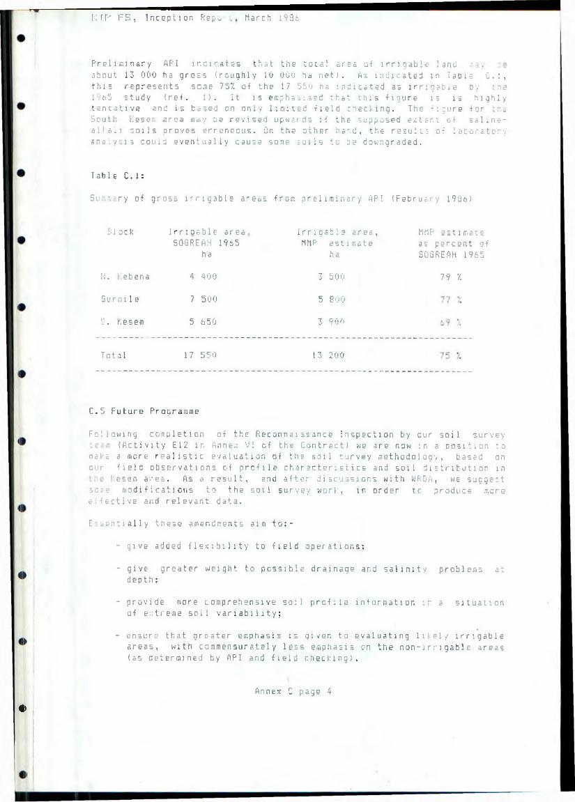
K I P F S , Inception Repo. March i93i
Preliminary API indicates that the total area of 1 r r ; qab I e- land about 13 000 ha gross (roughly 10 000 ha net). As indicated in Table C.l, this represents seme 757. of the 17 550 ha indicated as irritable by tne 1 65 study (ref. 1). It is emphab.ssd that this figure is is highly tentative and is based on only limited field checking. The *: ;ure for th. South Kesem area may be revised upwards if the supposed extsr. t of saline- alkali soils orovc-s erroneous. On the other hand, the results of laboratory ar.a ; y _l s could eventually cause soie coils to re downgraded.
Table C.l:
S u ,,- ry of gross irrigable a^eas from preliminary API (February 193b)
Bloc k
M . f e b e n a
6 u r m i 1 e
v . Kesem
Irrigable area, 50GREAH 1965
ha
4 400
7 500
5 650
Irriaabi e area, MMP estimate
h s.
3 500
5 300
3 9 0 0
MMP estimate as percent of S0GREAH 1965
7 9 •/.
Total 1 7 550 13 200
C.5 Future Programme
Following completion of the Reconnaissance Inspection by our soil survey(Activity E12 in Anne;: VI of the Contract) we are now in a position to
make a more realistic evaluation of the soil survey methodology, based on our field observations of profile characteristics and soil distribution in
esem area. As a result, and after discussions with WRDft, we suggest so,i.e modifications to the soil survey work, in order tc produce more e l e c t i v e and relevant data.
E sentially these amendments aim t o :-
- give added flexibility to field operations;
- give greater weight to possible drainage and salinity problems at depth;
- provide more comprehensive soil profile information in a situation of extreme soil variability;
- ensure that greater emphasis is given to evaluating likely irrigable areas, with ccmmensuratsly less emphasis on the non-irrigable areas (as determined by API and field checking).
Annex C page 4
<>
The praPQSE?d changes are the following:-
tl) Soil pits
Additional, and de ep er -s am pl ed, pits would be most desirable, especially in view of the highly varied nature of many of the soils in the Kesem area. He therefore propose to double the number of- pits -from50 to 100, and to sample (by means of augering below 2rn tiepth) to 3mrather than the previously proposed 2m.
(2) Soil augerings
The two key criteria for the soil augerings are their depth and intensity, fls stated in the Contract, a basic 600m x 300m grid of 975
observations is to be supplemented by 500 augerings on a free survey basis. However, because o.f the complexity of the soil pattern in the survey area, where highly variable alluvia! fans coalesce arid thin tfspos i t i r.=n s 1 bands of contrasting textures are common in the profiles, we feel that a more flexible approach is necessary.
We therefore propose that, on the soils which are suitable i c irrigation, the 6 00 os 300m grid (equivalent to a survey intensity f
12.5 ha per angering) should be maintained. On obviously unsuitable ioils - mainly where there are steep slopes, rocks nr boulders on the surface and/or saline/alkali h e profiles - the grid should be expanded to 600m 600m to reduce the number of unnecessary observations. Byjudicious siting of the 500 or so free survey augerings, this willpermit a greater proportion of the total to be devoted to the marginally suitable areas, where mare detailed investigation will be necessary to determine the final suitability rating. We propose that each auger hole- should initially be taken to 2m depth and that the individual soil surveyors should then assess whether to continue to 3m. Their judgement will be based on the evidence found at 2m of salinity ■ind/or impeded drainage at lower levels; if such soil problems are ■■pparent, the angering will be extended to 3m.
The hasic auger survey will be supported by the programme of deep iugerings, of which we propose to carry out 50, equivalent to just aver cue angering in every 20 located on the new grid. Such deep augerings
:-ii 11 be made on all soil types of significance, to the increased depth of 5.0 m rather than the 4.5m planned before.
Our choice of 2m as the initial auger depth is based in part on the normal standard set by FA0 1979 (ret.29) for detailed irrigation studies, which recommends augering to 2in or to a shallower impenetrable j;.ysr. Indeed, for routine soil observations (intended "to identify the kinds of soil present in the area and, once provisional soil boundaries haV3 bean recognised, t'j check an the homogeneity of thg sail units
enclosed") FAQ r e? com mend a s ha 11 oner standard depth of 1.5m, wh i ch encompasses the bulk of most crop roots.
Annex C page 5
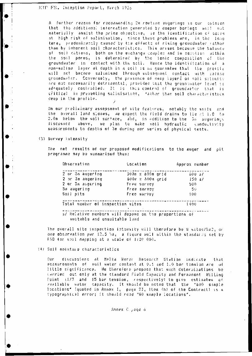
K TP FS., Inception Pep art, March 1 9 j t
fl further reason far r s c o in m & n a i n 2 in routine auyerings i; our opinion tli at the addition a] information generated by deeper borings m i ! nut materially assist the prime objective, is the identification of s o u s at high risk of s a l i n i s s t i o n , since these problems are, in the lena terra, predominantly caused by the effect; of rising groundwater rather than by inherent soil characteristics. This arises because the balance of soil cations, both on the exchange ccinpls:: and in soivtio;: withinthe soil pores, is determined by the ionic compa^i ti on of the groundwater in contact with the soil. H.enr.e Lhe identification of anon-sal ins? layer at depth in a soil is no guar.in tee that the profilewill net become sal i n i sed through sub seguen t contact with £ a ! i r.e grountlviater. Conversely, the presence of deep layers of soil silinitv are not necessarily detrimental, provided that the groun-j water level e adequately controlled. It is this control of g r o u n d w a 1 . ar that is critical in preven ting sal inisat \ n n , raihsjr than soil characteristics deep in the profile.
On our preliminary assessment of site -features, notably the sr.ils and the overall land slopes, we expect the field drains to lie r\t 1.8 to 2.0m below the soil surface, and, in addition to the 3;ii angering* discusscd above, we plan to make soil hydraulic conductivitymeasurements to depths of 3m during our series of physical tests.
(3) Survey intensity
The net results of our proposed modifications to the auger and pit programme may be summarised thus:
Observation Location Approx number
?. or 3m angering 300m n 600m grid 600 a/2 or 3m augering 600m i: 600m grid 150 a /2 or 3m augering Free survey 5005m augering Free survey 50S o i 1 p i ts Free survey 100
Total nudiber of inspection sites 1400
a/ Relative numbers will depend on the proportions of suitable and unsuitable land
The overall site inspection intensity will therefore be ti sites/km2, oi one observation per 12.5 tia, a figure well within the standards set by HAD for soil mapping at a scale of 1:20 000.
M ) Soil moisture charar.teristics
Our discussions at He! I: a W s r e r Research Station indicate that measurements of soil water content at 0.1 and t.O bar tension are nf little significance. We therefore propose thai such determinations becarried out only at the standard Field Capacity and Permanent W i l t i n gPoint i1/3 and 15 bar tension, respectively) to give estimates ofavailable water capacity. It should be noted that the "600 sample locations" [quoted in Annex I, pays 23, Item (h) of the Contract) is s. t ypograph i c a 1 e r r o r ; it should read "60 sample 1 oc at i ons “ .
A n n e >: C page 6
i ,
K I P F S , Inception Report, March !98i
ANNEX D
HYDROLOGY AND SEDIMENTATION
D.l General Comssents on Information Gained
D . 1.1 Introducti on
The data collection and review o-f previous reports is still :n progress at the time o-f this report s preparation, but seme preliminary comments can be made. The drafting of a much more detailed account is well advanced, and it will appear in the Interim Report.
D.1.2 Reservoir Size
Previous estimates of the Kesem Reservoir catchment's yield lie in the range 600 to 850 hm3 per year, which must be compared with the 1965 report's suggested total reservoir storage of 370 hm3 and the possibility cf raising this to 500 hm3 if it proves economically desirable. The reservoir should therefore be capable cf effective seasonal regulation and likely to overflow almost every year.
The need for dead storage to accommodate sedimentation will however be large; the 1965 (ref. 1) estimate of 6 hm3 lost per year is probably much too low and the new estimate may be well over 1( -i .r 3 / y r . Various report; provide a wealth of new information <refs. 7, 2 5 , 26, 27) and betterestimates will be made using a locally modified version of the Universal Soil Loss Equation, and perhaps a version cf the Stanford Model t r at includes sediment movement. The Soil Conservation Project of the M0A is interested in the Kesem catchment and in this study, and has valuable d a t a and ex peri e n c e .
D . 1.3 FIoods
Previous estimates of extreme flood flows at Kesem Damsite ha.e Deen based on probability analyses and have given figure; below 2000 m 3 / s . An analysis of the "Probable Maximum Flood" will be made for the design of thespillway, and is expected to show at least 10 000 m3/s; the spillway costs in the 1965 report appear to have been seriously underestimated.
Estimates of flood flows in the Awash along the eastern edge of the project area are generally in the range 1000 to 2000 m 3 / s . The Halcrow 1935 report, using a mathematical model, estimates flood levels of about 744m above sea level in the relevant reach, compared with irrigable land levels down to 737<t, in the north-east. The Consultant understands that the Final Design Report by NEDEC0 on the Angel ele-Bolhamo Irrigation Project, which i s now under review but has not been released, contain; an additional section (ret in the Draft Preliminary version, r s f . 8 ' reporting t h e use o f amathematical model t o simulate the river bed s degradation and aggradation due to regulation by reservoirs upstream. I t i s recommended that this section be released t o us immediately sc that a c c o u n t can be taken cf its
Annex D page 1
K I P F S , Inception R e p or t , March 1986
contents. This study is concerned not oniy with •flood protection along the Awash, Keseir. and Kebena rivers, but also with the use of regulated Kesem flows, including drain return flows, further down the Awash. The 1972 report of Meacham (ref. 2), the Gibbs report of 1973 (ref.23.’ and the 1982 NEDECO report (ref. 7) all consider the operation of the whol Awash system. The construction of the Kesem Dam will of course reduce flood levels in the Awash to some extent.
Various wadis enter the irrigable area from the west, with flood fiows of the order of 100 m3/s, and will have to be either diverted into the rivers or flanked by flood protection bunds: new estimates of their M o o d flowswill be made.
D.1.4 Drainage Design
Rainfall intensities used to derive internal drainage crite-.a on otherprojects in the area include 30 mm in in and 75 mm in 24h. !t has beendiscovered however that the Helka Wera recording gauge, on which these estimates were partially based, has Seen defective and has under-measured .. i q h intensities, so the new estimates may be higher.
D.2 Future Work
7he collection and quality checking of all necessary data, which is in .regress, will be completed along with the remaining visits to relevant technical experts in Ethiopia. Both the Hydrologist and the Fluvial Leomorpholegist will visit the Kesen Reservoir's catchment area. Data will b? brought up to date and quality control will be carried out: some ratingcurves need review, especially at low flows.
G-.'. -,ent estimates will be at least a = important as those of water yield.well as using all available relevant data (of which there is much: refs.
-3 to 27), we intend to use the Modified Soil Loss Equation which has ready been adapted' to Ethiopian conditions (ref. 25). The more general
irethods of Hudson and of Wischmeyer and Smith (ref. 28) rT:: also orovehelpful. Since we would anyway use a hydrological model for 'ter yield a"d reliability estimates, it may prove desirable to use the Strathclyde Land Sediment Model, which we have in our computer library, to model both water
sediment movement. This node! was built round the Stanford Watershed Model, of which .e would use the Type IV version which divides the :atchment into upland, midland and lowland segments: this should r.roveappropriate to the Kesem catchment (see Anne:: Bi. If necessar,, Landsat : T.agery can be used to determine the distribution of catchment chcracteristirs.
Fo ■ reservoir operation studies we will probably use our program ONRFS 1 wit-, monthly flow series. and program SILTUP will compute sediment deposition using the trap efficiencies of Brume. Flood studies ill use unit hydrograph and frequency analysis methods.
Annex D p.-ae 2
ANNEX E
GEOLOGY
E.l Geology of the Area
The oldest geological formations in the area are the Early Tertiary(Palaeocene to Miocene) Ashangi Group of olivine basalt, tuff and rarerhyolite, including dolerite sills and gabbroic intrusions; known generally as "trap" (layered complexes of mainly basalt lava flows), these form theeastern and western escarpments on the respective sides of the EthiopianRift, which here is about 70 km wide. The same rock group extends over
much of central, western and northern Ethiopia and may once have covered the south and east also because erosional remnants are present there. Cretaceous and Jurassic sedimentary strata, with Precambrian rocks beneatn,underlie the Ashangi Group in those areas but are not seen in the KesemProject Area.
The Ethiopian Rift itself, however, is floored by younger sedimentary strata and volcanic formations, with numerous volcanic plugs and massifs
cutting through them. The Late Tertiary Magdala Group includes the Nazret6roup (Upper Miocene to Pliocene) of ash-flow tuffs, ignimbrites andunwelded tuffs of trachytic (acidic intermediate) composition. This is overlain in most of the rift valley in this area by a series of basalt lava flows dating from the Pleistocene to the present day. Lacustrine sediments and alluvium of the same age range are the only sedimentary formations, the former being localized in a few lake basins. Volcanic cones, mostly cinder cones with larger (usually rhyolitic) complexes, such as Fantale, occur in :>any areas, many in lines parallel to the Rift.
Information on the geology of the area was taken from the Geological Map of Ethiopia (1973) and the Geological Map of the Nazret Sheet Area (1978). The latter is one of the few 1:250,000-scale geological maps to have been produced in Ethiopia, and its northern margin, at 9 00'N., is only 13 kmfrom the Kesem River dam sites and therefore provides essential information on the geology of the area. Cross-section A-B on that map commences near the river 42 km upstream from the dam sites, and traverses the rift •.outheastwards to the eastern escarpment; the structural style and stratigraphy shown by it are a valuable guide to the site and reservoir ^eclogy. Near-vertical faults at spacings of 500 m to 4 km, oriented ir,ainly parallel to the Rift margin, cause the formations and the land surface on them to step down progressively towards the rift floor. Some have vertical displacements as much as 200 m but most are less than 100 it., ana a few actually show movement in the reverse direction; where these occur, small horst and graben structures are formed as uplifted and downfaulted sections respectively. Within the Rift, there is no information on whether the older formations are more faulted than the younger ones, so
it 15 not possible to decide whether the faulting occurred at one particular time or took place throughout the period of deposition of both oider and younger formations. The latter is mors likely, however, with e^rly faults in older formations extending upwards into younger ones as they were formed. Evidence of faults cutting surface was seen where a lava s - r a c e showed "roll-over" on a scissors fault, indicating movements ot very recent date, possibly within one or two thousand years as the lava
Annex E page 1
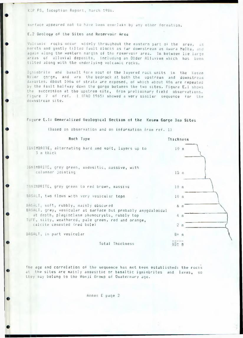
KIP FS, Inception Report, Narch 1986.
su'face appeared not to ha >3 been overlain by any other formation.
E.2 Geology of the Sites and Reservoir Area
Volcanic rocks occur widely throughout the eastern part of the area, as horsts and gently tilted fault blocks as far downstream as Awara M e l k a , and again along the western margin of the reservoir area. In between lie large areas of alluvial deposits, including an Older Alluvium which has been tilted along with the underlying volcanic rocks.
Ic imbrite and basalt form most of the layered rock units in the Kesem Ri.er gorge, and are the bedrock at both the upstream and downstream da:.sites. About 100m of strata are exposed, of which about 40m are repeated by the fault halfway down the gorge between the two sites. Figure E . 1 shows the succession at the upstrem site, from preliminary field observations. r lgur e 7 of ref. 1 (FAO 1965) showed a very similar sequence for the downstream site.
Figure E.l: Generalized Geological Section of the Kesera Gorge Dam Sites
(Based on observation and on information from ref. 1)
Rock Type Thickness
10 mIGNIMBRITE, alternating hard and soft, layers up to 3 m thick
.GNIMBRITE, grey green, andesitic, massive, with columnar jointing
;GMIMBRITE, grey green to red brown, massive
BASALT, two flows with very vesicular top.s
BAS h LT. soft, rubbly, mainly obscuredBASALT, grey, vesicular at surface but probably amygdaloidal
it depth, plagioclase phenocrysts, rubbly top TUFT, silty, weathered, pale green, red and orange,
calcite cemented (red bole)
BASALT, in part vesicular
Total Thickness
The age and correlation of the sequence has not been established: the rocks at the sites are mainly andesitic or basaltic ignimbrites and lavas, so they may belong to the Wonji Group of Quaternary age.
Annex E page
KIP FS, Inception Report, March 198s
Mor e than half the succession consists of ignirabrite (welded tuff), a r o d formed by the explosive eruption of a very hot mixture of gases and s o l i d particles which settles as a blanket over the flanks of a volcanic v e n t and, being hot, sets hard; depending on temperature, the resulting material may have the firmness of anything from loosely consolidated sand through heavily fractured weak rock to material approaching lava - in which case it catt show columnar jointing similar to that formed during the cooling of a lava flow. Much of the ignimbrite is reddish, possibly trachytic, but higher up it is greenish-grey and probably andesitic.
Basalt lava flows are present in the lower part of the sucession, commonly vesicular with vesicles (gas bubble holes) being most common at the tops of individual flows. Some vesicles are filled with calcite which means that, at depth, the vesicles are all filled and the rod; should be called am/gdaloidal rather than vesicular.
Thfc layer of coloured tuff is interesting in that it represents an interval of volcanic quiescence in the area when a blanket of (unwelded) tuff was subjected to tropical weathering for a period of several thousand years. This is probably the weakest material in the succession and occurs at both sites; it is mostly covered with talus except at river level where scoured and undercut by floods.
he Older Alluvium consists of bedded silts and conglomerates, with the former predominant. These dip upstream at 4 to 6 like the underlyingolcanic rocks. They are poorly exposed and form rolling grassy hills. The
around surface is covered with pebbles and cobbles, giving the impression that the whole area is underlain by conglomerate, but these are presumably c-r. ;ional debris derived from former beds and now strewn over ground mainly tarned of bedded silt. Initial observations revealed calcareous nodules in the bedded silt, formimg a calcrete, and also layers of vesicular basalt lapilli. This formation was described in somewhat different terms, partlyin pedological terms, in the 1965 report (ref. 1).
Younger alluvial deposits occur between the Older Alluvium and the WesternE. . m o m e n t , from which they appear to be derived. From initial obser vat l ons tne/ appear to consist of a large, partly dissected piedmont alluvial fan close to the foot of the escarpment, and younger deposits extending to theci;*-f of the Kesem River and overlying the Older Alluvium.
River alluvium is present along the gorge and in the flatter reach through the reservoir area. Near the downstream end of the gorge, the 1965 r e p o r t ’s borehole No 1 showed 6.5m depth of gravel, but it may be deeper at the sited of plungepools. The material includes pebbles and cobbles of river gra/el, rounded and commonly up to 200mm in length. There are also angular blocks derived from rockfalls in the gorge, up to 5m in length but usually smal1e r .
Upstream of the gorge there are significant deposits of grey river sand, medium to fine-grained and well bedded, forming whale-baci islands s t rewn with tree debris and often vegetated. No deposits of clay have been seen asy e t .
Annex E page 3
KIP FS, Inception Report, March 198&.
E.3 Construction Materials
The strongest material in the area is basalt lava, though where vesicular it would be weaker. A source of basalt for a possible rockfill dam has been tentatively identified at the upstream end of the gorge where the river flows in a narrow pass between two cliffs: to the east is a sloping surface of basalt that could contain a sufficient quantity. The deposit is in the reservoir area and has relatively easy access.
Ignimbritii- is more abundant than basalt in the area, but its strength not only is significantly lower but also tends to vary from bed to bed, depending on the temperature of formation.
5 rid for filters may be obtained from the river alluvium, butthe quantities present are probably inadequate: further search will be made. Anotherpossible source is the matrix of conglomerate beds, which would produce cccrser material but would require screening.
Wo source of clay has been found as yet, but the search continues in conjunction with the geological mapping.
E.4 Drilling Prograarae
Although the decision needs to be confirmed in the light of topographic survey results, it is almost certain that the upstream damsite will be chosen. This section describes a drilling programme for that site. If the other site were to be drilled, the programme would be similar but withnodifications due to the existence of records (but not cores) from thedrilling undertaken for the 3965 report.
ror this feasibility study at the upstream site, eight boreholes are•ecommended. They are shown on Figure E.2. The holes fall into two groups:-
- Hrles in the Abutments:
Initially two holes on each side (.KU1, KU2, KU6, and KU7), inclined at 15 towards the river, to determine the rock sequence close to the valley sides and remote from them. If these four holes yield insufficient information to decide the requirement for a groutcurtain, a further hole (KUS) can be drilled on either abutment, ifthis hole KU8 is not required for grout curtain delineation, a hole, nr KUBa, should be drilled at 45 inclination beneath the smallvalley that forms a saddle in the south abutment ridge some 500mfrom the gorge: this is to test for a possible fault zone.
- Holes drilled from the valley floor:
Borehole KU3 should be drilled from the side of the valley floor directly into bedrock and taken to 70m below river level (the approximate height of the dam). If however drilling difficulties have prevented holes KU2 and KU6 from reaching their target depth of20m below river level, then hole KU3 should start from a pont ashigh on up one valley side as possible, so as to evaluate that partof the succession not reached by the other holes.
Annex E page 4
''
L O C A T I O N O F B O R E H O L E S A T D A M S I T E
NORTHBANK
LEFT
ABUTMENT
R i ght
a b u t m e n t
SD'JTHBANK
9 5 Q .
900 J pm<
B 5 0 _ £
BOO.
SCA LE
50 100 M
S M A L L V A L L E Y 5 0 0 M F RO M RIGHT ABUTMENT
POSSI BL EFAULT
7*7/-
4 %
950'
SQO JCTCXI
tip FS, Inception Report, March 1986.
Hole KU4 in the valley floor should also be drilled directly into bedrock, at 45 and from a position that is not likely to result in its intersecting river gravel. This hole is to test for fractures beneath the river bed.
Borehole KU5 is to evaluate the depth of river gravels and should be continued 10m below rockhead, probably resulting in a depth of 16 to 20m.
These recommendations imply a total drilling length of about 610 to b50ra,d.pending whether KUB is chosen or KU8a. The programme may be amended in the light cf all information available just before drilling commences. Two other holes may be recommended during the drilling period, to evaluate conditions for structures or tunnels. Their combined drilled length would nut exceed 140m.
Water pressure testing is to be undertaken in all holes in bedrock below 9.6m a.s.l., in 5m stages with a single packer. I/ilatometer testing is to be done in holes KU2, KU3 and KU6: all individual rock types, andvariations in rock types, should be tested in each of these holes.
A detailed specification and bill of quantities for this drilling and testing programme was prepared by the consultant and passed to WRDA on 24 February for issue to potential drilling contractors. The drilling is expected to be on the critical path for the whole study, and the study programme would have to be changed if the drilling and testing is not completed by about 15 June 1986.
E.4 Geomorphoiogy
Initial observations and study of the area's geomorphoiogy have been made, and will be described in later reports, after the Fluvial Geomorphologist's viiit which is scheduled for April.
E.5 Volcanicity
he crustal extension which gave rise to the Ethiopian Rift system has also created many lines of weakness for volcanic activity. The extension is continuing at a rate of about 20 mm per year across the Rift Valley, but ir.a', have been more rapid in the past. Faults resulting from extension are : opinion throughout the Rift Valley, most of them being parallel or subparallel to the trend of the Rift. Volcanic activity is also concentrated along this trend, though a number of larger volcanic centres with more complex crater systems do not show such alignment. Two volcanoes, both quiescent, affect the project area: Fantale to the south of the damsites;nd the smaller Dofen which bounds the potential irrgation area to tnenorth. In this area the only evidence of current volcanic activity is a fewexamples of hot springs and fumaroles, though the extrusion of basalt atFar. • . 1 e and elsewhere shows that such events couid nappen again at anytime.
Annex E page 5
IIP FS, Inception Report, March 198&.
Although the likelihood of significant volcanic activity in the arej is very small, its consequences need to bo mentioned. The least unlikely event would be basalt lava extrusion. Any activity would probably centre arouna antale or Dofen and would not approach the dam or reservoir. Any new
volcanic activity would be presaged Dy extensive tumarole activity, - : oriccal earth tremors, and cinder cone formation: lava extrusion wouldprobably not be extensive until several months or years after the on- t. Sufficient warning would thus be given for the reservoir's water level to be drawn down before a lava flow reached it: even without this precaution,boiling of the reservoir water would quickly cool the lava and slow its
/ance. In the extremely unlikely event of the lava reaching the dam, itluld either pond behind it or overtop it, and in either case direct damage
the area by the lava, which would occur with or without the project,■ ould be much more serious than any consequence of dam failure.
he likelihood of ignimbrite activity is remote since both Fantale and iofen have been quiescent for a very long time. If however a red-hot cloudf volcanic ash were to sweep across the area, the dam would be one of the
tew structures remaining once it had settled. The reservoir water would bepartly vaporised but could well act to slow or even halt the cloud'sprogress.
It must be emphasised that basaltic volcanic activity is of rare occurrence, and the ignimbrite virtually unknown in the whole region, sotnat the possibilities outlined here do not necessarily threaten the feasibility of the project.
E.6 Geological Conditions at the Damsites
T e succession shown in Figure E.l occurs at the upstream damsite and istruncated by a fault, oriented N 30 E, about I20m downstream from theprovisional dam axis. The layered rocks dip upstream at an almost constant6 , ■ and no faulting affects them between the intermediate faults and the ipstream end of the gorge, though several fracture zones cross the river just downstream of the fault. This fault has an estimated downthrow of 40 m or; the downstream side, so that the downstream site repeats that amount of the succession and its axis lies approxiraately on the same detailed geology a^ the upstream.
East of the downstream site a major fault crosses the valley and the course of the river is deflected to the northeast, following the fault line for a distance of 1100 m before resuming an easterly course. The position of tne fault is visible both on the ground and in aerial photographs, and :s marked by a prominent fault scarp south of the river and for much of itslength to the north: just north of the river, however, the scarp cuts backup5trean in a way that suggests control by a subsidiary fault splitting off the main one, and possibly running upriver in the gorge mouth for a short distance. On the south side the fault is vertical and oriented N.25°E.,and a corresponding fault notch is present on the north side, but talus obscures the area where the supposed’ subsidiary fault would have come out 5:0 it is not possible as yet to decide on its presence. If present, it
Annex E page 6
IIP FS, Inception Report, March 1936.
would explain the relatively hign degree of heavy jointing and shattering present in the right abutment at the downstream site, which is presumably the explanation of the high permeabilities found in the drilling at reconnaissance stage (1965 report).
E.7 Kesem Diversion Weir or Re-regulating Dam
A re-regulating dam or diversion weir is proposed for the Kesem River near an existing offtake weir at Awara Mell.a, about 21 km downstream from the dam sites (see also Annex G). This lies at the mouth of a sinuous gorge which cuts through an elevated horst of basalt lava flows, 400 m wide and bounded by faults aligned NNE, parallel to the Rift Valley trend. The s*eep-sided gorge is about 60 m wide ana 40 m deep.
T:e topmost lava flow on the horst shows hummocky surface features which s g g e s t that the lava has either not been covered since its formation or has only had soft sedimentary rocks above it; probably the former is the c se, as no traces of sediment could be seen, with the implication that the lavas are of recent origin and the faulting even more recent.
The faults are of tensional origin and, on aerial photographs, show gently curved outlines indicating that what is now seen is the surface at the time of formation. Similar faults in the vicinity also indicate this, especially the scissors fault previously referred to. A smaller fault is present within the gorge itself, aligned N.22° E. and dipping 70° westward, downthrowing about 15 m to the east.
Upstream of the fault, the succession of lava flows is unbroken except for a gravel layer beneath the upper flow; this is at least 3 m thick,discontinuously exposed, and ends abruptly in the middle of the sectionwhere it appears the uppermost flow spilled over an eroded (gully) margin of the gravel 1a y e r .
Lower in the gorge there was no sign of any weak layers but a geological survey is necessary to establish this, and to note any discontinuities between lava flows, zones of rubbly lava and any other weak areas.
•!o rock ledges were seen linking one side of the gorge to the other, so aLu'ied channel along the whole length is a virtual certainty. Its depth isi> e 1y to be in the range 6 ~ 10 m; material filling it will be river gravel, robably coarser on average than that above or below the gorge. together
with much larger fallen blocks from the gorge sides which could be as much as 5 m in size.
E.8 Kebena River Darasite
The Kebena darasite lies 14 km north of Awara Melka at a point where the ri.er has cut a gorge through an escarpment (half-horst) of basaltic rock,creating a pronounced feature about 30 m high. FAO 1965 (ref.l) identifiedthis as a possible dam site and a detailed description is given in thatreport. The following geological assessment is made on the basis of thatdescr i pt i o n .
Annex E page 7
KIP FS, Inc&ption Report, March 1786.
The rocks at the site dip downstream (SE) at 12° and consist mainly of two basalt lava flows, 30-40 m thick; interbedded with them, however, are layers of tuff which, just below river level, includes 7-8 m thickness of ashy tuff which includes a bed described as "not very coherent and breaks down completely in w a t e r 11 consisting of montmori 11 onite. The lava flow above this layer is “irregular and criss-crossed by fractures". Two faults cross the valley, and the location of the dam axis is constrained by these and the need to achieve a suitable crest height; as the top of the ridye is coincides with the upper surface of the basalt, moving the a::is downstream involves loss of height at 1 in 5 gradient. The axis chosen lay 65 m
downstream of the large fault which terminates the ridge, with the "crevasse" fault lying 40 it downstream, and at this paint the soft ashy tuff layer lies about 5 m belaw river level. Other tuffs underlie to a depth of about 25 m .
The geological situation is not favourable for founding a dam, though removal of the unsuitable tuff material could alleviate the- instability problem; but there is very little scape for adjusting the design to take advantage of the thick basalt flows present in the side of the gorge. Although not definitely ruled out at this stage, the Kabena damsite does not appear suitable. Further site inspection will be marie.
E.9 Further Work
As programmed, geological mapping began in week 7 of the study and is in progress. It covers the Kesem gorge, the upstream damsite and its adjacent interfluves, and the reservoir areas. It is combined with the search for construction materials,
As mentioned in section £.4 above, the drilling and testing programme has been initiated during February and is to be completed in June.
The Engineering Geologist is to return to the project area towards the end of the drilling period, to assess the results, help with the mapping, and complete his field observations. Meanwhile the mapping is being undertaken, as planned, by the Hydrogeologist and the WFlDA counterpart Geologists. The drilling and testing programme is under the control of the Deputy Project Manager, who has extensive experience of such work, and the description oi cores and day-to-day supervision of that programme will be carried out by the Geologists and the Hydrogeologist. The topographical uncertainties discussed in Anne>: G will be resolved by further survey (already inprogress), and the Kabena damsite will be considered further.
Annex £ page 8
K I P I S, Inception Report, March 1986
ANNEX F
HYDROGEOLOGY AND GROUNDWATER
F.l Review of Previous Reports
f;epcrts and data concerning hydrogeological conditions ;n the Project Area are very limited, but some information is available -for areas near or adjacent to the Project.
"he most relevant document is FAO report UNDP/FAO;ETH72/006 of 1973 (ret. j.'. This mainly concerns the area to the south ano east of the present pro i act, although the the geological map at 1:100 000 scale does cover part of the area in the northeastern sector. No drilling was conducted in the kessem area but some boreholes were drilled on the Alledeghi Plain, east of the Awash River. One borehole was reported to yield 4 l/s from a gravel a qui:er at about 90m depth. Water quality was not indicated. It is reasonable to e::pect that similar conditions, or better, will apply in the I -sem-t'ebena area.
T:,e Mel I: a Sadi-Amibara Feasibility Study Report (Italconsult 1969, ref. 5) gives much more detailed information including borehole logs, permeabilities and water quality for the area on the east bank of the Awash which may be indicative of conditions in the east of the Project Area. The logs show a seqence of mainly fine sediments exceeding 100m depth, but permeabilities were found to be uniformly low, averaging about O.lm/d. Water quality was reported to be very variable, ranging from 400 to over 10 000 mg/1 of total dissolved solids.
This very limited available data allows the following tentative conclusions to be drawn regarding groundwater conditions in the Project Area:
1. Productive aquifers are likely to be present in the alluvial sediments particularly in the west of the area.
2. Water quality may form a significant constraint to development in some areas.
3. Low permeability sediments in the east of the area are particularly likely to be affected by a rising watertable when irrigation commences.
F.l Field Observations
F.2.1 Geology
n initial examination of the air photographs and some limited field chrcking have been used to prepare the preliminary hydrogeological map shown in Figure F.l. This map is for planning purposes and subject to mendment during the course of the project.
Annex F page 1
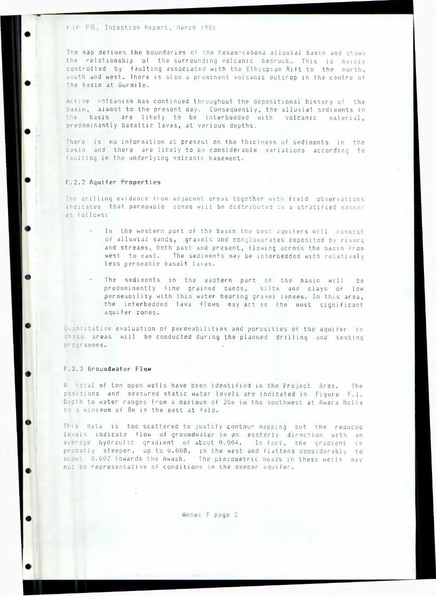
I I P F S , Inception Report, March 1986
The map defines the boundaries of tne Kesem-Kebena alluvial basin and shows the relationship of the surrounding volcanic bedrock.. This is mainly controlled by faulting associated with the Ethiopian Rift to the north, south and west. There is also a prominent volcanic outcrop in the centre of the basin at Gu r m i 1e .
Active volcanism has continued throughout the depositional history of the Dasin, almost to the present day. Consequently, the alluvial sediments in the basin are likely to be interbedded with volcanic material, predominantly basaltic lavas, at various depths.
There is no information at present on the thickness of sediments in the basin and there are likely to bf> considerable variations according to faulting in the underlying volcanic basement.
F.2.2 Aquifer Properties
7*.e drilling evidence from adjacent areas together with tisld observations indicates that permeable zones will be distributed in a stratified manner as follows:
In the western part of the basin the best aquifers will consist
of alluvial sands, gravels and conglomerates deposited by rivers and streams, both past and present, flowing across the basin from west to east. The sediments may be interbedded with relatively less permeable basalt lavas.
The sediments in the eastern part of the basin will be predominently fine grained sands, silts and clays of low permeability with thin water bearing gravel lenses. In this area, the interbedded lava flows may act as the most significant aquifer zones.
. n 1 1tative evaluation of permeabilities and porosities of the aquifer in hcse areas will be conducted during the planned drilling and testing
programmes.
F.2.3 Groundwater Flow
A otal of ten open wells have been identified in the Project Area. The positions and measured static water levels are indicated in Figure F.l. D:pth to water ranges from a maximum of 20m in the southwest at Awara Melka t a minimum of 8m in the east at Yalo.
This data is too scattered to justify contour mapping but the reducsa levels indicate flow of groundwater in an easterly direction with an average hydraulic gradient of about 0.004. In fact, the gradient isprobably steeper, up to 0.008, in the west and flattens considerably toaL:u' 0.002 towards the Awash. The piezometric heads in these wells may not oe representative of conditions in the deeper aquifer.
Anne;: F page 2

I IF' F S , Inception Report, March !93s
Groundwater recharge will occur during the wet season primarily in thepresent river channels and over wider areas after flooding. This is likely to produce a significant rise in groundwater levels particularly in the finer sediments near the Awash river. During the dry season, the base flow of the Kesem and Kebena rivers is fully utl 11 i sed for irrigation and the river beds are dry downstream of the farms. Recharge must, however, occur in the irrigated farm areas.
Groundwater discharge is probably mainly controlled by evaporation andt-anspirat 1 on in the lower eastern and southern parts of the basin. There is a prominent area with several large hot springs at Filweha in theextreme south of the Project Area. However, these springs draw on thevolcanic aquifer to the south and have little bear i ny on flow patterns or groundwater balance within the alluvial basin.
There are probably also significant inflows and outflows of deep groundwater between the alluvial basin and the surrounding volcanics. These flows are likely to be fault controlled and may have an important influence on groundwater quality in the Project Area.
F.3 Project Developaent
'.3.1 Mater Supply
The avaialable evidence indicates good prospects for potable water supply from groundwater in the western and central parts of the Project Area. However, water quality is uncertain and treatment may be required in order to achieve international standards of purity.
The drilling programme calls for three deep wells to assess water supply potential. The approximate sites have already been selected and are shown in Figure F.l. The sites are located close to present or probable future concentrations of population at Awara Melka, Yallo and Gurmile.
F.3.2 Irrigation
The potential for groundwater irrigation is uncertain at present. However, it is considered rather unlikely that the aquifers in the area will be capable of sustaining the large yields, in excess of 30 1/s, necessary tor economic development. In any event, pumped groundwater would probably not be economically justifiEd in areas which can be served by gravity supplies from the dam.
It i 3 possible that groundwater irrigation might be considered in areas :i.tside the surface water command if soil conditions, aquifer properties ar,d water quality are favourable.
'h; possibility of irrigation development at the filweha springs e;uires examination. The springs have a reported discharge of ..re 1000 1 /s. However, the reported water quality of approximately 1000
-g.1 total dissolved solids (ref. 1) may not be suitable for irrigation se. New samples will be analysed and tiie question will be reviewed when he r esul ts are known.
Annex F page 3
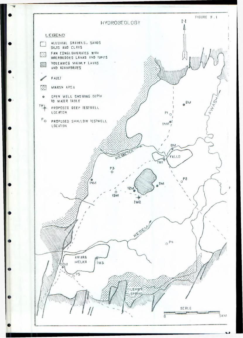
H Y D R 0 6 E 0 L 0 6 Y
L E G E N D
I----- | A LL U VI AL G R A V E L S , 5 A HO 3
SILTS AND CLAVS
[771 FAN CO NGL OMERAl ES WITH
IN1E.RBEDOE 0 L AV AS AND TUFF S
r — j VOLCAMICS M A I N L Y LAVAS
AND I GNIM8RITE5
FAULT
( 2 j ] MARSH AREA
© OPEN W E L L SHOWING BEPlH
TO WATER TABLETW I
* - PROPOSEO DEEP IE ST WE L L LOCATION
P 0 PROPOSED S H A L L O W I ESTWELL
LOCATION
(,!!' I B , Inception Export, !'5 a r c r, l'/bl:
F.3.3 Watertable Control
'litf initial study results suggest that uaterlogoinq and sal i iu sat i ori tine to r : sing watertables are most likely to occur in t hi? east of ttip Project. Ar^a ne^r Lhe Awash river; the watertable here is relatively shallow and the low permeability of the sediments will impede natural drainage.
The drilling evidence from the adjacent I'lelka Sadi - Ami bar a Project indicates that high permeability aquifers favourable for vertical drainage using wells probably do not exist in this eastern area. It therefore seems moi»t likely that watertable control, i f required, should be effected by a horiiontal drainage system. This is discussed in Anne?. 11.
It watertable control is required in the western and central areas, vertical drainage may be a possibility there. The assessment will depend
on aquifer properties, groundwater salinity and relative costs.
The drilling programme includes- five b o r e h o l e to assess deep drainage characteristics and measures for watertable control. Approximate sites have been located and are indicated in Figure F.!. Two sites are planned in t.ho South Kesem area, two in th= North Kessm area and one in the North Ko|)>:'n» area.
F.l Areas o-f Concern
F .0.[ Mater Supply
'i he- main concern with regard to potable water supplies is quality rather tliv.n quantity. Previous drilling in adjacent areas showed wide quality varrations with up to 10 000 mg/1 of total dissolved solids. It is likely Uuit this saline groundwater is present in the shallow superficial deposits .■snd that -fresh groundwater may be extracted in the deeper aquifers. Ho never, even the -fresh groundwater may contain high concentrations of, for e :: imp 1 e , fluoride or sulphates where influenced by circulation of deep volcanic groundwater. In this case,.treatment of the water may have to he c c-ns i d e r e d .
F.4.2 Watertable Control
:>-j noted in Section F.3.3, the evidence points to significant drainage .icblems developing in the east of the planned irrigation area, which has ii!;i!ar properties to the Melka Sadi - Pimibara area. It is likely that
,i n s u r e s for watertable control will be required in the area, and possibly :• 1 : t.'wher e .
Annex F page '5
I ’I1 I S , Ince p t i o n !i c-,) c r i , !1 a r •: h 1 v 5 K-
F.5 Guidance Needed fron the Steering Cor,mi t tee
ihth the p re s e n t limited k no w l e d g e of the n y d r o q ea lo gy of the i'r i1.-j eu , there aru 1e u area?. in which ;[.y s l q a i f i c a n t d e c i s i on s can Le tr. = d t* = ' the
i ni-ep t i on stage.
The question of locating the Project headquarters lines require at t sr, t i on , i >. 'j o far as it ci a y effect '.he siting of water supply i r» v e e 111; r-1: ionboreholes. At prose nt it has been assumed that the headquarters will heirci-.ted on the unirrigable hilly land at hurrtiile, and one well h.-'.sp h . ordinql y been si >;od in that area. H the tieactquarter?. are to he located &l -=f where, far instance near Awara Melka (Sahor^tl, this borehole- site isiiilil need I:a he re-positioned.
in addition, the c o m m ttee should consider vi hat standards are to he ad tip led l :»r potable water quality so that any treatment requirements c?n he i (ivMi t i f i ed .
F.6 PrDyraiflBe for the Rest of the Study
Yin.! main components of the hydrogeological study programme concerns drilling and testing o f :
3 deep boreholes to access potable wal«r supply and i rr i gat i on potent i a l ;
5 shallow boreholes to define deep drainage characteriEtics and water table control requirements.
1 • vi siotial s i I es fur the*-.* boreholes havr t. s?ei: selected ,v; ncit:J i -ir, e L i o n F . 3,
c u i I a h J e - specification wan prepared by 24 February for issue L ' . h e iii ; 1 ! i n g contractor. It is hoped that mob i 11 5 st i on can commence tr, nn.!- '■Iji'::h and the work be completed by the end nf Hay.
i-.K: boreholes vj ill be logged and tested to determine aquifer propertse-,•»■ ! yields and water quality.
l'! o",: tori no of water levels in the existing wells and any newly constructed :.mji L'hol es m i l he carried out during the course of the Study.
•;JtV or quality and flow measurements will he conducted at the i-ilweha s p n n q determine the potential -for irrigation Use.
/in lit:;: F page !5
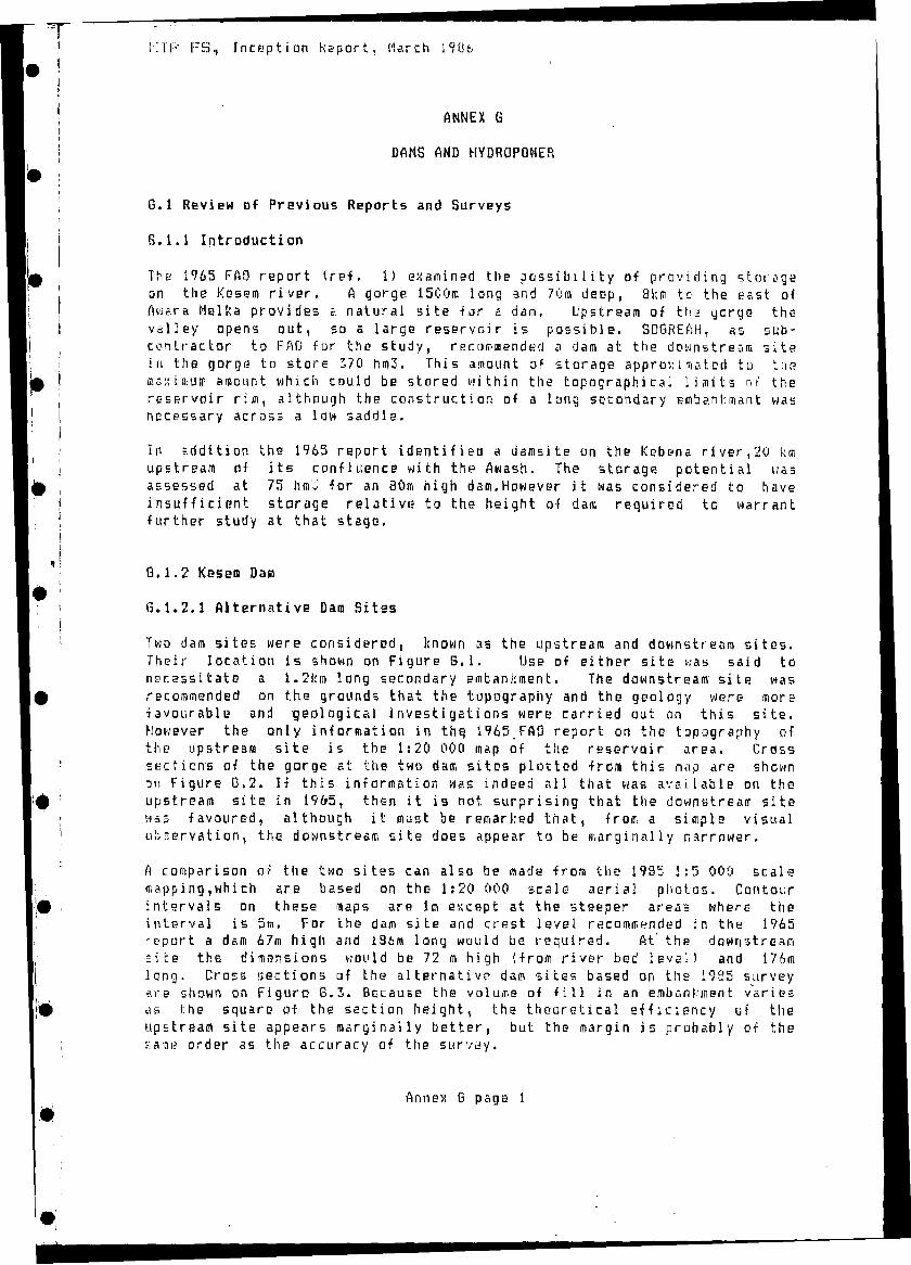
K I P FS., Inception keport, March 19Ufa
ANNEX G
DAMS AND HYDROPOWER
G.l Review of Previous Reports and Surveys
S . 1.1 Introduction
The 1965 FAO report (ref. 1) examined the possibility of providing storage on the Kesem river. A gorge 1500m long and 70m deep, 8km tc the east of Awara Melka provides a natural site for a dam. Upstream of the gorge the valley opens out, so 5 large reservoir is possible. SDGREftH, as subcontractor to PAD for the study, recommended a dam at the downstream site in the gorge to store 370 hui3. This amount of storage approximated to tne? siax t aiUHi amount which could be stored within the topographical limits ot' the reservoir rim, although the construction of a long secondary embankmant was necessary across a law saddle.
In addition the 1965 report identified a darasite on the Kebena river,20 km upstream of its confluence with the Awash. The storage potential wasassessed at 75 lira3 for an 80ra high dam.However it was considered to haveinsufficient storage relative to the height o-f dam required to warrantfurther study at that stage.
G . 1.2 Kesen Dam
G . 1.2.1 Alternative Dam Sites
Two dam sites were considered, known as the upstream and downstream sites. Their location is shown on Figure G.l. Use of either site was said to necessitate a 1.2l;ro long secondary embankment. The downstream site was recommended on the grounds that the topography and the geology were more •favourable and geological Investigations were carried out on this site. However the only information in th^ 1965 PAD report on the topography of the upstream site is the 1:20 000 map of the reservoir area. Cross sections of the gorge at the two dam sites plotted -from this map are shown on Figure B.2. If this information was indeed all that was available on the upstream site in 1965, then it is not surprising that the downstream site was favoured, although it must he remarked that, from a simple visual observation, the downstream site does appear to be marginally narrower.
A comparison of the two sites can also be <nade from the 1985 1:5 000 scale mapping Twhich are based on the 1:20 000 scale aerial photos. Contour intervals on these maps are lm except at the steeper areas where the interval is 5m. For the dam site and crest level recommended in the 1965 -sport a dam 67m high and 196m long would be required. At the downstream = ite the dimensions would be 72 m high (from river bed level) and 176m long. Cross sections of the alternative dam sites based on the 1925 survey are shown on Figure 6.3. Because the volume of fill in an embantinent varies a s i:he square of the section height* the theoretical efficiency uf the upstream site appears marginally better, but the margin is probably of the "Sim? order as the accuracy of the survey.
Annex 6 page 1
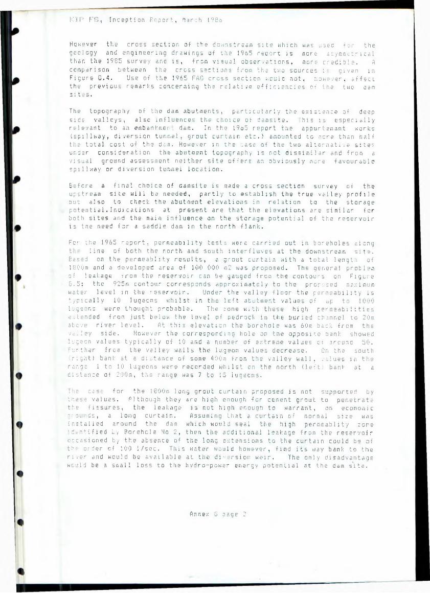
K )P F S , Inception Report, Mar:h I°S6
However the cross section of the downstream site which was .see! * . the geology and engineering drawings of the 1965 r=port is more asymmetrical than the 1985 survey and is, from visual observations, more credible. A comparison between the cross sections from the two sources : given in Figure G.4. Use of the 1965 FAO cross section would not, however, affect the previous remarks concerning the relative efficiencies of the two can si t s .The topography of the dam abutments, particularly the existence of deep
side valleys, also influences the choice of damsi te. his is e s pe c i a l 1y relevant to an embankmer- dam. In the 1965 report the appurtenant works (spillway, diversion tunnel, grout curtain etc.) amounted to .-ore than naif the total cost of the dim. However in the :ase of the two alternative site? under consideration the abutment topography is not dissimilar and from a visual ground assessment neither site offers an obviously more favourable spillway or diversion tunriei location.
Before a final choice of damsite is made a cross section survey of theupstream site will be needed, partly to establish the true valley profile but also to check the abutment elevations in relation to the storagepote nt ia l.Indications at present are that the elevations are similar for both sites and the main influence on the storage potential of the reservoir is the need far a saddle dam in the north flank.
For- the 1 965 report, permeability test:, were carried out in boreholes alongline of both the rorth and south interfluves at the downstream site.
Based on the permeablity results, a grout curtain with a total length of 1?00m and a developed area of 100 000 m2 was proposed. The general problem of leakage from the reservoir can be gauged from the contours on Figure G.5; the 925m contour corresponds approximately to the proposed maximumwater level in the reservoir. Under the valley floor the permeability is typically 10 lugeons whilst in the left abutment values of up to lugs ns were thought probable. The rone with these high permeabilitiese.tended from just below the level of bedrock in the buried channel to 20m above river level. At this elevation the borehole was 60ro back from the vailey side. However the corresponding hole on the opposite bank showed lvgeon values typically of 10 and a number of extreme values ot around 50. ‘:i:rther from the valley walls the lugeon values decrease. On the south right) bank at a distance of some 400m from the valley wall, .;.lues in the
re s .g-: 1 to 10 lugeons were recorded whilst on the north (left bank at adistance of 200m, the range was 7 to 15 lugeons.
c £• = £ for the 1800m long grout curtain proposed is not supported by Lr.ese values. (Although they are high enough for cement grout to penetratethe fissures, the leakage is not high enough to warrant, on economicgrounds, a long curtain. Assuming that a curtain of normal size wasinstalled around the dam which would seal the high permeablity :oneidentified by Borehole No 2, then the additional leakage from the reservoiroccasioned by the absence of the long extensions to the curtain could be ofthf. order cf 100 1/sec. This water would however, find its way bank to the river and would be available at the di-.srsior weir. The only disadvantagewcjld be a small loss to the hydro-power energy potential at the dam site.
Annex G page 2
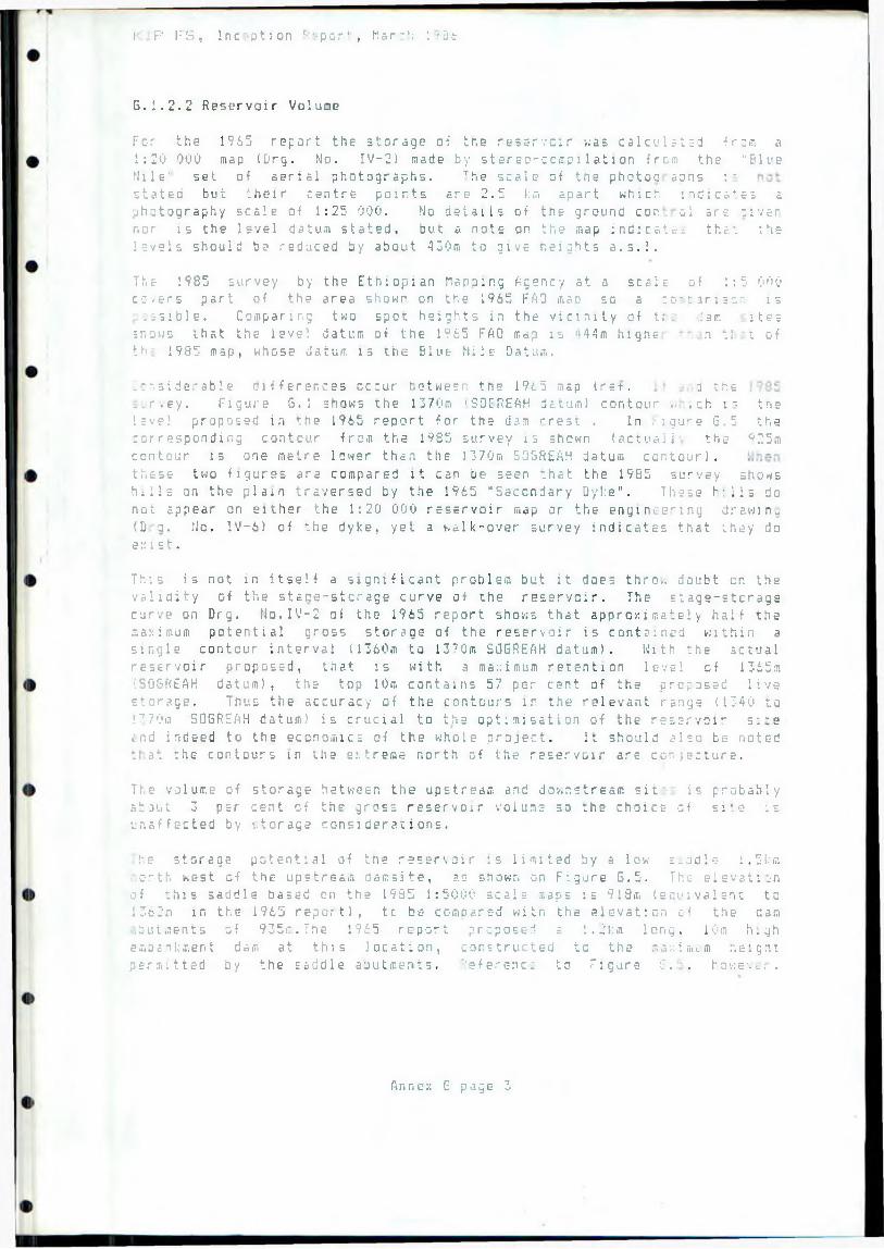
I P l; S , Inception '■■•port, M a r : 1; : -2t
G . 1.2.2 Reservoir Volune
For the 1965 report the storage of the reservoir was calculated from a 1:20 000 map (Drg. No. IV-2) made by stereo-compi1ation from the "Blue Mile' set of aerial photographs. The scale of the photoc a o n s ;• stated but their centre points are 2.5 km apart which indicates a photography scale of 1:25 000. No details of the ground cor.- ol arc tivc-rnor is the level datum stated, but a note on the map i n d i c a t e that thelevels should bo reduced by about 430m to give heights a.s.l.
The 1985 survey by the Ethiopian Mapping Agency at a seals of 1:5 000 cc.ers part of the area shown on the 1965 FAD mao so a co-t.ariscn is ':;sible. Comparing two spot heights in the vicinity of tr. .'am itessnows that the level datum of the 1965 FAD map is ;>44m highe n t! t ofth- 1985 map, whose datum is the Blue Nile Datum.
Considerable differences occur between the 1965 map (ret. i the .-.■r.ey. Figure 6.1 shows the 1370m 'SOGREAH datum) contour ... ch is tne level proposed in the 1965 report for the dam r-rest . In Figure G.5 the corresponding contour from the 1985 survey is shown (actual 1 the Q 25m contour is one metre lower than the 1370m SOGREAH datum contour), these two figures are compared it can be seen that the 1985 survey showshills on the plain traversed by the 1965 "Secondary Dyke". These hills donot appear on either the 1:20 000 reservoir map or the engineering draw in.. ( D a . Mo. IV-6) of the dyke, yet a walk-over survey indicates that they do exist.
This is not in itself a significant problem but it does thro., doubt cn the validity o-f the stane-stcrage curve of the reservoir. The stage-storage curve on Drg. fio.IV-2 of the 1965 report shows that approximately half the maximum potential gross storage of the reservoir is contained within a single contour interval (1360m to 1370m SOGREAH datum). Kith the actual reservoir proposed, that is with a maximum retention level of 1365a \SQSf<EAH datum), the top 10m contains 57 per cent of the proposed livestorage. Thus the accuracy of the contours lr the relevant range (1340 to:7 70ia SOGREAH datum) is crucial to the optimisation of the reservoir s:~e and indeed to the economics of the whole project. It should also be noted f a t the contours in the extreme north of the reservoir are co-jecture.
The volume of storage between the upstream and downstream sit is probablystout 3 per cent of the gross reservoir volume so the choice of si'.e isunaffected by ‘..torage considerations.
:-.e storage potential of tne reservoir is limited by a low s.udle 1,5km icrth west of the upstream damsite, as shown on Figure 6.5. The elevation of this saddle based on the 1985 1:5000 seal:- maps is 918m (equivalent to 13c2m in the 1965 report), tc be compared with the elevation cf the dam,hutments of 935m.The 1 965 report proposed a 1.2km long, 10m highembankment dam at this location, constructed tc the maximum heignt permitted by the saddle abutments. Reference to Figure S . . however,
Annex 6 page 3
I' If-' I"'.., Inception " e. • - t . “ arc';
i nd i c a t e s that 600m east of the saddle tne vailsj sides reac rr e reed an elevation of ?35m.For a main dan crest level of 9 3 5 « a 21 <n hi
350m long would be reguired across the valley. Tr.-: storage potential Df
the reservoir based on the stage-stcrage curve, >.nich roust be regarded as provisional,is summarised in Table 6.1. A freeboard of 8a has beer allowed for : r. these estimates.
Table G.l: Reservoir Storage
Crest Level (m)
Storage (h m 3)
Saddle Dam
91 B 1 362 to S06REAH datum)
175 None
9j6 1370) 310 8m nigh 1000m long or
I2ra high •; 350m long
9 ;• 5 (1379) 520 21m high 400m long
The feasibility of constructing a dam to a level cf 935m will have to be confirmed by topographical survey of the eastern flank of the reservoir, particularly in the area north of the proposed saddle dam which is notcovered by the available 1:5 000 map. The additional storage available at this crest level,in comparison with the 1965 proposal, could beparticularly relevant in view of possible long term siltation of thereservoir. Reserve storage could be provided initially, or alternatively tiie dam could be raised at a later date. Irrespective of this it .s probable that, with the reducing incremental cost of storage for a higher da. , it will prove advantageous to consider storage of over 400hm3,aoth to absorb flood flows and thus reduce the need for protection dykes alone the lower Kesem and also for seasonal regulation for the benefit of future schemes down the Awash River.
G . 1.2.3 Dam Type
Two t g r a v i the power facil centr stage p r a c t dam c -.ci. 1 d
ypes of dam were examined in the 1965 report, a mass concrete hollow t i dam and a rockfill dam with an earth core. The concrete dam had advantage that it could incorporate the spillway, bottom outlet and
station at little additional expense. Mo separate diversion ities were required. It was assumed that the bottom parts of the
* the first is common
e blocks would ti built in two stages and that at the end of
floodwaters could flow ever the uncompleted blocks. This
h e : g h
ice for this type of dam. It was envisaged that the 11 blocks of tne juld each be founded on or.s of the th. ae strongest rock layers, wnicr.involve excavations up to 57m deep and vertical rock faces (prior to
ng concrete) >. to 47.5m high Thus the design philosophy appears adictory: it is likely that roc! strong enough to stand to such at in vertical ::ace would also be adequate to support a gra.ity bloc!.
Annex G page 4
k IT’ F S , Inception l'--n cr t , March !
of lesser height. With such problems a careful distinction has to bs made
between the bearing capacity of rock in uniaxial compression and triaxial comp re ss io n: a rock may be weak in uniaxial compression but in an isotropic stress field its bearing capacity would be high. It is probable therefore that a practical hollow gravity dam would contairi less concrete and require less excavation than indicated in the 1965 report.
In contrast tD the concrete dam, the rock fill dam requires a tunnel for diversion, probably a separate tunnel for the power station (or irrigation releases if a power station is not built) and, of course, a spillwayindependent of the embankment. The 1965 report considered it wise to drive a trial length of tunnel as there was a risk that the diversion tunnel could encounter serious difficulties. Certainly part of the tunnel where it crosses the red bole layer (see finneK E> would present problems in respect of temporary support during driving. Because of the dip of the rod: layers it is impossible to avoid weak bands no matter where the damauis is placed. After completion of construction of the dam it was proposed to use the diversion tunnel as a bottom outlet to the reservoir, gates (and a gate shaft) being installed for this purpose.
The spillway proposed for the r o c k f i 1] dam was in a 30m deep cutting on the right bank. Two 12m wide X 9m high radial gates were shown discharginginto a curved, concrete lined chute which terminated in a flip bucket almost at river bed level. The spillway was designed to take a nominal flow of 1500 m3/s, Such a flow appears small for the size of catchment controlled and the estimate will be revised upwards (see Annex D), which will necessitate a larger spillway. Although the cost of the illustrated design (Drg. No. IV-ll) could be reduced by putting the chute invert at a higher level to minimise excavation and providing a taper section to enable a wider intake to be used to compensate for the higher sill level, it isprobable that any such cost saving would be nullified by the requirementfor a larger spillway,
G . 1.2.4 Power Generation
A 12 MW power station at the Kesem Dam was propesed in the 1965 report (ref. 1). The plant was sized on, the basis that the average releases from the dam at minimum drawdown level were equivalent to 4.7 MW continuously. If the plant was operated at the same load factor as the Koka hydro-power station then the equivalent peak firm power would he B.5MW. To enable the plant to operate at full power when the reservoir is at average pool level, an installed capacity of 12 MW was recommended. This figure is probably a reasonable guide as to the outcome of an optimisation study, although there might be a significant variation depending upon the choice of dam type as explained below.
With the hollow gravity dam considered, mast af the works associated with the hydro plant could be provided at little additional cost apart from the E l a c t r i c a l and mechanical plant. However with the r o ck fi11 dam an additional tunnel with penstocks and an independent power station building together with the electrical and iiachanical plant would be required. According to the estimates contained in the 1965 FAO report, a hydro plant associated with a r o c k f i 11 dam would cost 50 per cent mors than one
Annex G page 5
I IP P S , Inception sport, Mar *. i 9 v
i r.corper ated 1 ii whatever type economic.
a hcilow gravity d c. spiteof jam is finally s ! e c t e d ,
of this i power p 1 a '
Dbabie that will prove
G . 1. 3 Kebena Dan
G . 1.3. 1 Dansi te
The damsite is located in a narrow straight gorge, 500m lone :-nd The reservoir would be contained mainly within a 300m wide stretching for a length of 2.5km upstream of tne damsite.
80m high, oc plain
Th 2 storage capacity of the reservoir was estimated the a 1:20000 scale map with 10m contour intervals, compilation method from the Blue Nile set of aeriali.arrow confines of the gorge itself a 7 0m high dam 130m was envisaged. storing 50 hm3. However a 60m possible storing 75 hm3 but with a significantly longer crest. 00m, due to more gently sloping higher abutments.
in the lv'iS report from produced by the stereo
photographs. Within the with a crest length of high dam was considered
n e ”cess of
The reservoir an* a is outside the coverage of the 1:5 > 0 0 scaler:-ps. However, confined within relatively steep valley sides it is more well defined than tesem and a review of the more recent aerial photocraphs has indicated that the storage estimates are reasonable.
The only alternative damsite on the Kebena river is 3km downstream, where the river enters a short gorge section. However the fiood plain upstream is narrower, average 150m wide, and the dam;ite is less suitable being wider with insufficient abutments for an embankment dam.
G . 1.3.2 Dam Type
(» 1915 report examined alternative dam types only at a very preliminary L-.ei, principally to enable cost estimates to be made.A concrete buttress
was adopted being considered the most suitable for the foundation ■additions. An arch dam was ruled out due to doubts about the stre gth ; 1 t s abutme nt s.
fli)
f?.2 Other Information Reviewed
G.2.1 Sei s k i ci ty
Located in one of the most seisnically active parts of the wor be a critical feature of the design cf any dam.
this nil
Di'iussians have beer, held with the Geophysical Qbsei /atory it Addis Ababa U,. i ■■ e r s i t y , who provided a spectral analysis of past seismic events from
/ear 1900 to the present day, related • e Kesea da si site location. Hesults were given in terms of intensity and acceleration r.lated :o ' the
lability o* oci nee. This information would oe i ncorp . into the design of the dams by either the ps” edostatic or dynami" methods of c n 31 y s i £ .
Anne:: G page 6
! 'r F S , Inception Peport, March :
I a d d i t i o n the- G e o p h y s i c a l O b s e r v a t o r y p r o v i d e d d a t a i n t h e • • • a o * ■ i o u e 5 . : on a s e r i e s o f e a r t h q u a k e s w h i c h o c c u r r e d i n t h e g e n e r ■ 1 a r e 'p r o j e c t , i n c l u d i n g t h e Kesem dam s i f = i n t h e p e r i o d J a n u a r y t c M a r c h 19B1. The swarm o f e a r t h q u a k e s shown on t h i s f i g u r e i n d i c a t e s t r p a t t e r n c fs t r e s s r e l i e f w h i c h o c c u r r e d and d e m o n s t r s t e s t h a t t h e e s u e r r e s o fs h a l l o w d e p t h e a r t h q u a k e s a r e p r o b a b l y r a n d o m l y d i s t r i b u t e d i n t h i s a r e a . One e p i c e n t r e was l o c a t e d a d j a c e n t t o t h e Kesem d a m s i t e and s i c m c a n ts u r f a c e m o v e m e n t s r e s u l t i n g i n t h e o p e n i n g o f f i s s u r e s o c c u r r e d i n t h e v i c i n i t y o( Awa r a M e l k a w h e r e t h e d i v e r s i o n s t r u c t u r e / r e g u l a t i n g po".d w o u l d be l o c a t e d . The p a r t i c u l a r s i g n i i i c a n c e o f t h i s d a t a : ; t o e it.n p -• ■ t h e need t o e x a m i n e , i n a d d i t i o n t o deap s e a t e d e v e n t s , t h e e f f e c t s Df s h a l l o w d e p t h e a r t h q u a k e s l o c a t e d l r , t h e i m m e d i a t e v i c i n i t y o f t h e - ; nh e a d w o r k s s t r u c t u r e s .
G . 2.2 Power Demand
In a brief discussion with a representative o-f the Planning and Programming Department of the Ethiopian Electric Lighting and Power Authority (EELPA) i •; was ascertained that the Authority would accept all the power(12MW) which could be generated at the Kesem site. Because this amount of power issms!; compared to the capacity ot the grid tnere appeared to be nodifficulty in phasing it into the Authority's expansion programme. The reprssntative made the point that the Kesem gorge plant could generate whatever type of unit was most beneficial to the Froject (peak ioad, average or base load units).The Authority will supply the prices at which thev •ou5 types of unit will be b r o u g h t .Further discussions will be held with
(§ EELPA once the irrigation reguirements are more firmly established.
i
G.3 Comments on Future Work
G . 3.1 Kesea Dao
<»G . 3 . 1.1 Reservoir Storage
I. has been recommended that the reservoir area be remapped using the.-ting 1:20 000 scale aerial photographs and with new ground control.
' : 1 000 scale mapping with 2.5m contour intervals is envisaged, from which# a revised stage-storage curve can be produced.
Additionally the watershed at the eastern flank of the reservoir will be surveyed on either side of the river to establish the need for saddle dams and confirm the storage potential.
Annex G page 7
I
G.3.1.2 Choice of Daasite
Assuming that the initial topographical surveys show ‘he abutmentelevations at the two sites to be comparable, the upstream site viill beselected to be taken to full -feasibility level design and castings. Geologically this site is considered preferable, particularly with respect to potential leakage through the abutments, and although marginally wider than the downstream site it is more symmetrical and thus mors suitable for a concrete structure. For a roc I; fill embankment the steep cliffs at either site would need to be cut back to avoid unacceptably high differential settl esssnt, which would reouce any advantage of the narrower gorge at the downstream site. Due to the fall in the river the height of the dam would beapproximately 6m less than at the down stream site.
G.3. 1.3 Dam Types
Dam types which would be considered include a r o ck fi11 embankment with e:Lher a central impermeable core or upstream membrane, concret* arch and concrete yravityfor rollcrete).
For a roct.fill embankment the rockfill for the shoulders could be obtained by quarrying the nearby basalt lavs flows. However a suitable source of core material will be more difficult to locate, the two most probable areas being a flood plain in the reservoir area, 5km upstream of the site, or the alluvial fan in the area of the saddle dam. In the event of naturally occurring material not being available and as a cheaper alternative to milling of rock niaterial, an upstream membrane, probably concrete faced, irockf i11 dam will be considered. This type of dam would be more suitable for raising at a later date if required, although particular consideration will have to be in the embankment zoning to the possibility of fracturing of the membrane due to a severe earthquake.
With a crest length / height ratio of 3, the site is topographically very suitable for an arch dam. However the feasibility of such a dam will be determined by the strength of the weaker rocks forming the abutments, particularly the ignimbrite and volcanic tuff strata. If proved feasible an arch dam is likely to be the mast economical solution and to establish the suitability of the foundations a programme of dilatometer testing, to determine the deformation moduli of the rock, is being proposed as part of the site investigations.
If the foundations a r e shown to be unacceptable for an arch dam, a concrete gravity dam, most probably rollcrete, would be an alternative with an integral spillway. F o r the concrete dams particular attention will have to be given to the effects of localised shallow depth earthquakes.
Preliminary layouts and designs will be produced for all dam types and
castings made to identify the most favourable solution. In the case of the arch dam alternative this will be carried forward anyhow at this stage as its feasibility will not be known until the later stages oi the site i nvesti gati ons.
A cost storage curve for the selected dam type will be produced as part of the economic analyses to determine the optimum dam height. This will
Annex G page Q
K I P I n c e p t i o n Ffer*or t . Ma r c h 198f>
include the cost of the saddle a am, which would be an sar':h-fill embankment. Following upon this and the results of the site investigations, full feasibility level designs and detailed costings will be product;! for the selected dam height.
G.3.2 Kebena Dam
It is improbable that a large dam on the Kebena river will prove a viable component of the Project in view of the limited storage potential in relation to the height of dam. In addition the danisits is regarded as beingun? at i s-f a.c tor y geologically for a high dam (refer to Annex E) .
In view o-f these factors site investigations are not proposed. However for the economic analyses alternative dam types will be examined and costed and a co*■ t function curve produced for the preferred arrangement.
Rather than a storage reservoir, a smaller dam, probably a concrete oravity
structure, could be constructed at this site solely far flood controlpurposes, thereby reducing the need for dykes along the Kebena river. Fro,n the- stage-storage curve, the following heights and storages are indicated:
Costs of structures of various heights, sized in relation to the flood volumes and their return periods, will he compared to the costs of the equivalent protection dykes.
G.3.3 Diversion Heir or Re-regulating Dan
The diversion structure would be located about 8km downstream of Kesem dam, close to the existing weir for the ft w s r e Melka State Farm, where the river1 eaves a 10 to 30m high gorge and enters the flood plain.
if releases from Kesem Dam are constant, i.e. with no peal: load powergeneration, the diversion structure would be solely a concrete weir about j iti high to obtain the required command for tile two primary canal s.The weir would be founded on the basalt lava bedrock.
If peak load hydropower is generated at the dam, the diversion weir will be required to serve as a regulating pond to balance the releases from the daa. Assuming at this stage a typical load factor of 0.33, the required storage will be about 0.8hm3, based on a peak irrigation drawoff of 14m3/s. With a minimum proposed drawoff level of B02m, this will require, based on fetage-sturags estimates from the 1:5000 scale maps, a 7.0m high overflow weir with an additional height for freeboard.in addition a dam will be required across a saddle in a graben at elevation BtOm on the south side of the valley some BOOm upstream of the diversion site.
20m height30in,40m
3 hm3 storage8 hni3 16 htn3.
Annex G page 9
K T F F S , Inception f3 p q r t , Mar-zh
At the proposed Diversion site the. river gorge is about 6On uics with besalt lava flows exposed at the sides and alluvial deposits of unknown depth in the river tied. It would be expected that depths to bedrock hare m i l be less than IOiti t o be confimeti by the site investigations.fi 20- 30m high concrete gravity structure -founded on the bedrock is t'nvisagsd. For fchi= height of dan leakages through the basalt lava bedrock could be significant and a grout stay well be necessary. Thp need for this will be djse&sed by permeability testing as part o-f the site investigation p r o g r a m m e .
With the storage dam upstream, silt build-up at the diversion structure hbculd not be significant. However de-si 1 ting works would be incorporated into the structure to prevent this.
The saddle dam would be- an earthfill or r o c H i l l embankment with a height of 15 - 2 0 in, to avoid overtopping and a length of about 600m, T o avoid this saddle dam, alternative sites upstream of the Aware Melka gorge are being e;;amined but as yet have been found to have inadequate storage.
Annex G page 10
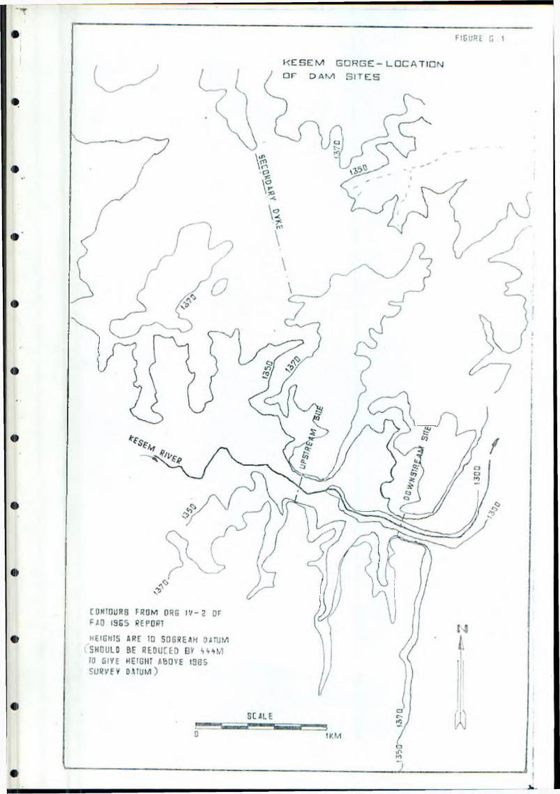
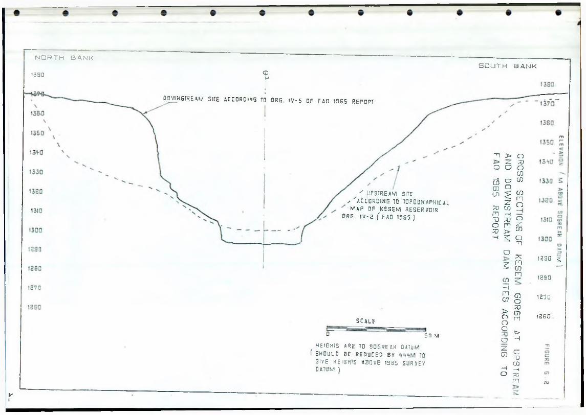
V
' UPSTREAM SITE
✓ ' a c c o r d i n g i d t o p o g r a p h i c Almap o f k e s e m RESERVOIR
DRG. IV - 2 ( FAO 13B5 )
N O R T H B A N K
1330
fIDOWNSTREAM SUE ACCORDING TO DRG 1 V - 5 OF FAO ! 9 E 5 REPORT
S O U T H S A N K
SCALE
50 M
HEIGHTS ARE TO SOGREAH DATUM ( 5H0UL 0 3E REDUCED BY TO
GIVE HEIGHTS ABOVE 1335 SURVEY OATUM |
■n > o7D
o u OCD
5 o CDCD o
COnOl :>
X)m
:zID —1
a
T) 33 oo m Z!;o > CD—i 2
D
a~n
Xz
rn01m
cn—im CDU) O
70> CDo noG t>a —izCD C
UCD—i —i
o 33m
S.
1250 %
1290
1270
12G0
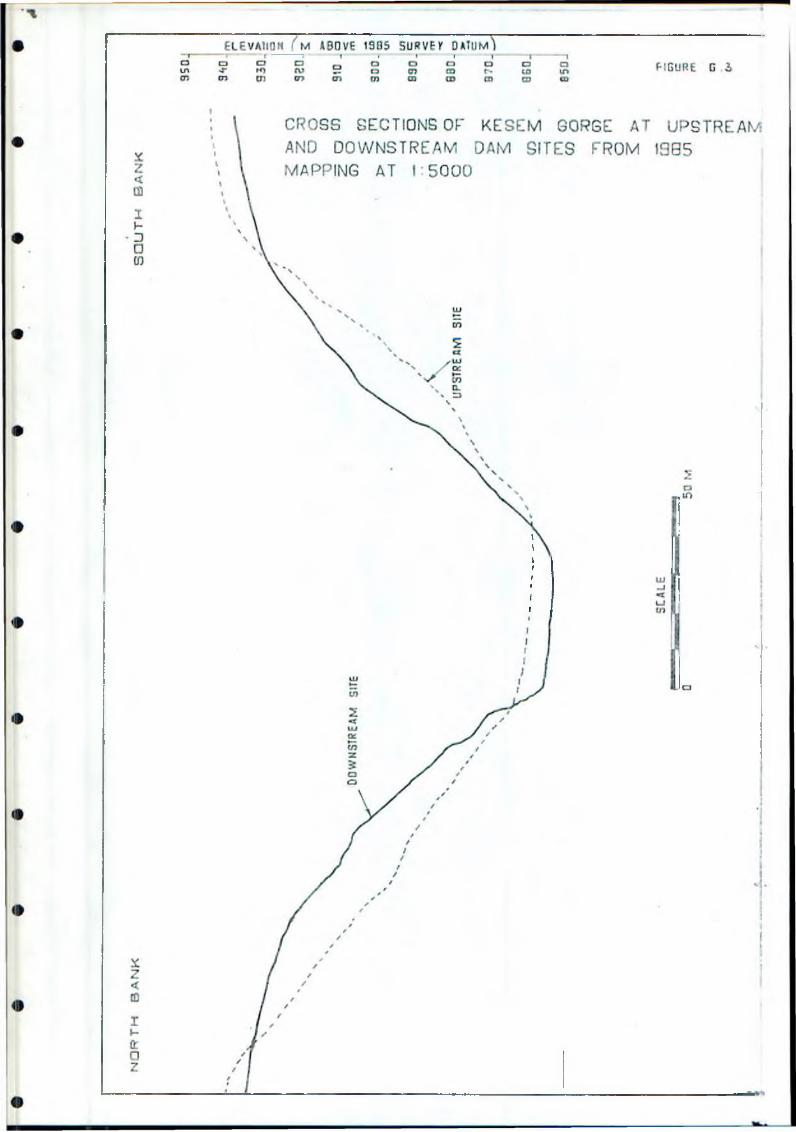
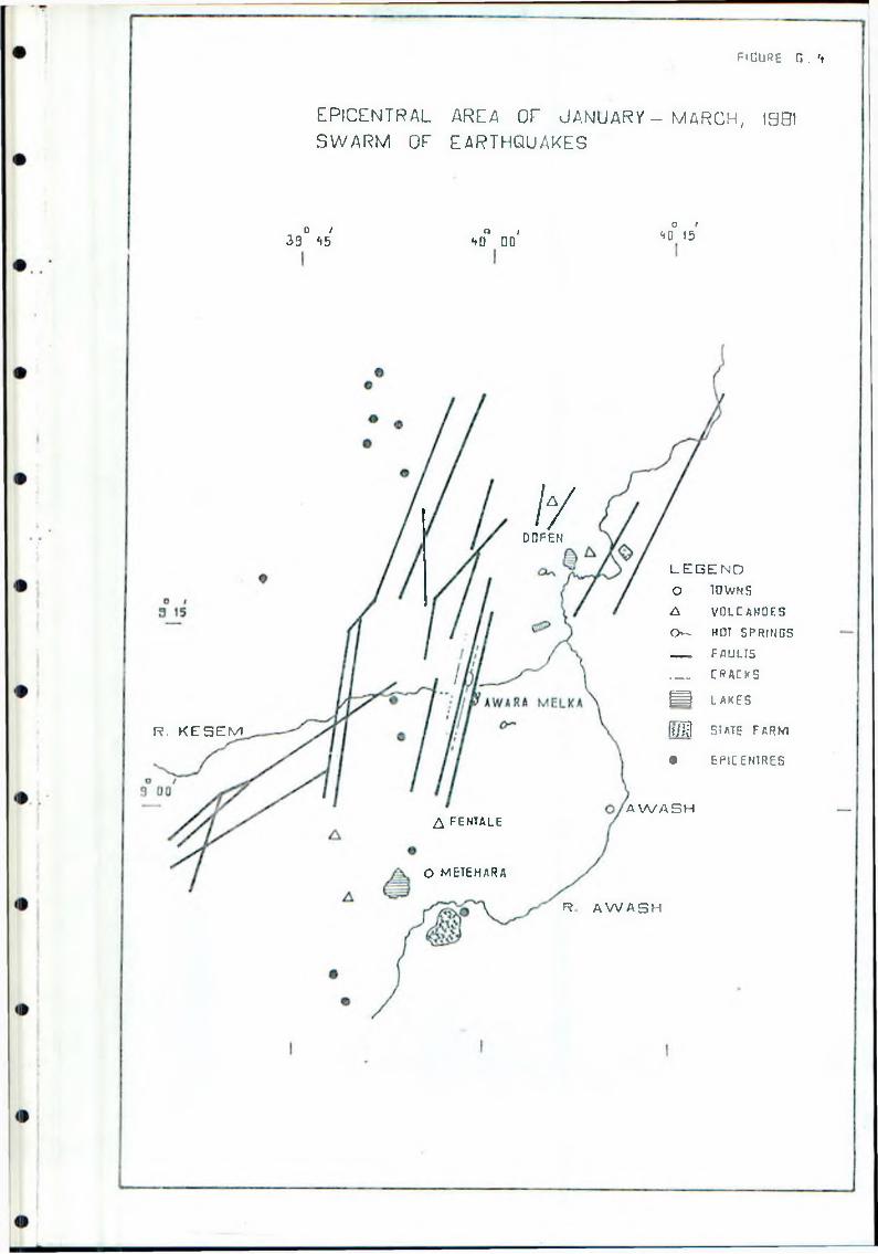
f i g u r e g . 't
E P lC E N T R A L AREA OF J A N U A R V - M A R C H , 1901
S W A R M OF E A R T H Q U A K E S
D I39 *i5
Q I‘tQ DO
O I<<0 15
/ /DOFEN
R. K E S E M
L E G E N D
O TOWNS A VOLCANOES O - HOT SPRINGS___ _ FAULTS___ CRACKS
H I LAKES
ft/1 SI ATE FARM
O EPICENTRES
A fentale
O METEHARA
A W A S H
R A W A S H
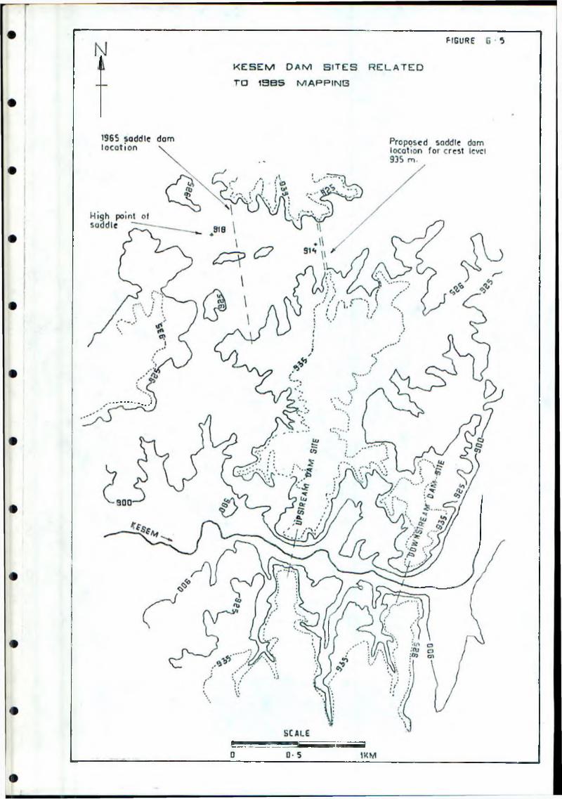
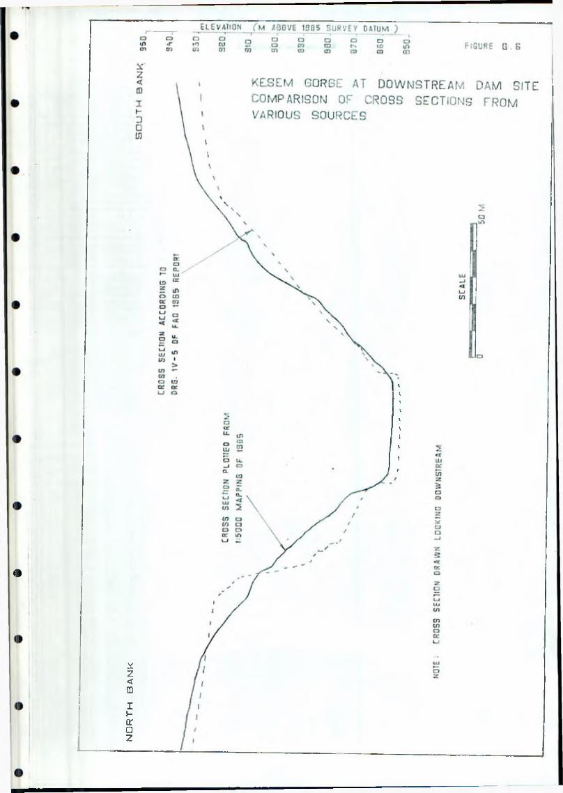
north
ba
nk
<»
I I' |-S, Inception Report, March 1986
ANNEX H
AGRICULTURE
H . 1 Introduction
The i n c e p t i o n p h a s e and t h e f i r s t f e w we e k s o f t h e ma i n f i e l d w o r k h a . es ?en t h e f o l l o w i n g a c t i v i t i e s i n t h e f i e l d o f a g r 1 c u l t u r e : -
- v i s i t i n g and r e v i e w i n g t h e e x i s t i n g a g r i c u l t u r a l p r o j e c t s i n t h e M i d d l e Awash a r e a ;
- c o l l e c t i n g d a t a and i n f o r m a t i o n f r o m o r g a n i s a t i o n s and p e o p l e i n v o l v e d i n p l a n n i n g and ma n a g e me n t o f a g r i c u l t u r e ;
- r e v i e w i n g p r e v i o u s s t u d i e s , r e s e a r c h p a p e r s arid p r o g r e s s r e p o r t s ;
- f a m i 1 1 a r 1 s a t i o n v i s i t s t o t h e p r o j e c t a r e a and n e a r b y s t a t e f a r m s ;
- c o l l e c t i o n o f r e s e a r c h d a t a and t r i a l r e s u l t s on r e l e v a n t c r o p s .
H.2 Existing Reports and Study Papers
p r e v i o u s r e p o r t s h a v e p r o v i d e d a b a s i s o f a g r i c u l t u r a l i n f o r m a t i o n and a h i s t o r y o f d e v e l o p m e n t i n r e c e n t y e a r s . E a r l i e r r e p o r t s s u c h as H a l c r o w 1 ' 75 ( r e f . 6 ) , w h i c h d i d n o t h a v e t h e a d v a n t a g e c f b e i n g a b l e t o d r a w on p r e v i o u s e x p e r i e n c e i n t h e a r e a , p r o v i d e some wh a t h y p o t h e t i c a l p r o p o s a l s . S i n c e t h a t t i m e a l a r g e and i n c r e a s i n g r e s e r v e o f d a t a and i n f o r m a t i o n has a c c u m u l a t e d a t s t a t e f a r m and r e s e a r c h c e n t r e s , on c u l t u r a l p r a c t i c e s , y i e l d s , p r o d u c t i o n t r e n d s , c o s t s and r e s e a r c h r e s u l t s .
T h i s s t u d y w i l l r e f e r t o a n d , when a p p r o p r i a t e , u s e t h e i n f o r m a t i o n f r o m t h e mor e r e c e n t r e p o r t s and s t u d i e s . Much o f t h i s i n f o r m a t i o n h a s h o w e v e r be e n s u p e r s e d e d by a c t u a l f i e l d e x p e r i e n c e on t h e s t a t e f a r m s . P a r t i c u l a r a t t e n t i o n w i l l t h e r e f o r e be g i v e n t o t h e p r a c t i c a l a s p e c t s o f a g r o n o m y , p a r t i c u l a r l y f a r m mana g e me n t m e h t o d s and t e c h n i q u e s .
T,— ee r e p o r t s c o n t a i n i n g p a r t i c u l a r l y r e l e v a n t i n f o r m a t i o n f o r t h i s s t u d y a r e : -
- A n g e l e l e - B o l h a m o and A m i b a r a I r r i g a t i o n E x p a n s i o n P r o j e c t , F i n a l R e p o r t , NEDECO 1982 ( r e f . 7 ) ; v o l s I I and I V , Annex I B .
- A n g e l e l e - B o l h a m o I r r i g a t i o n P r o j e c t , D r a f t P r e l i m i n a r y D e s i g n R e p o r t , NEDECO 1985 ( r e f . 8 ) .
- M a s t e r D r a i n a g e P l a n f o r M e l k a S e d i and A m i b a r a A r e a s , F i n a l R e p o r t , H a l c r o w 1985 ( r e f 9 ) ; v o l B, Annex E.
T e c h n i c a l d a t a and t r i a l r e s u l t s r e l a t i n g t o v a r i o u s c r o p s a r e c o n t a i n e d i n t : , e n u m e r o u s p r o g r e s s r e p o r t s and s t u d y p a p e r s p r o d u c e d by t h e M e l k a Wera R s e a r c h C e n t r e (MWftC). I n f o r m a t i o n g a t h e r e d f r o m t h e s e s o u r c e s h a s been
Annex H page 1
I i 1 1 F B , Inception Report, March 19 B £
augmented by long discussions with research agronomists and by visits to the trials in progress.
This update of i nf ormat i on -from MWRC, coupled with that obtained from the state -farms in the area, provides a good basis on which proposals will be developed for some of the crops relevant to the KIP.
H.3 Field Observations and Information Collected
H.3.1 Observations within the Project area
Preliminary visits have been made to the Awara Melka State Farm, the only
formal agricultural enterprise within the project's irrigable area. This farm, whose main area lies on the right bank of the Kesem near the headwords site, is part of the Nura-Era Agricultural Development Enterprise within the Horticultural Development Corporation. The farm is divided onto four units, one of which is the Yalo farm on the Kabena, some 12 l;m nort heast of the rest of the enterprise, which grows 400 ha of irrigated cotton.The other three ares-
- cotton (110 ha in 1985)- tobacco (300 ha)
- citrus and banana (currently 268 ha of citrus of which 50 ha is 27years old the rest 1 to 4 years; bananas 66 ha).
The -following observations are, at this stage of the study, of a generalnature.
Citrus:
[(us is the primary activity of the farm and attempts have been made tn rehabilitate the irrigation of the older trees. Numerous trees have d i e - bach and this is reaching economic levels. Boitie trees show symptoms of possible micronutrient deficiencies, and this may be due to alkaline soils. Lime, lemon and grape-fruit trees have been planted over the past four years. Maintenance of the new plantations is not of the highest standard, especially when compared with that of Tibi la State Farm. This can only be attributed to poor management and/or supervisi o n ,and is not irretrieveable. There will however be a delay in the trees reaching full maturity.
Bananas:
The original plantation area of 122 ha has been reduced to 66 ha. Theproductive life of the trees is reported as seven years. Yields for thelast two years are reported to be as low as 76 quintals (qt) per hectare in19B5 and 57 in 1984, Targets of 150 qt/ha are set for 19B6 and 1987, and
even this is about half the yield that may be expected under optimumconditions, Annual -fertiliser application is 4 qt/ha of urea, whichprovides adequate nitrogen but no potassium; bananas require considerablywore K than N- Soils in the plantation are yet to be surveyed, but itappears that most of the bananas are on either silty clays or silty clayloams. These are not considered to be the best soils for bananas,especially if drainage is poor. There is no nematode control and
Annex H page 2
I I P F S , Inception Report, March 1986
i n f e s t a t i o n l e v e l s a r e n o t known: the use ot r i e m a t o c i d e s c o u l d increasep r o d u c t i o n . The g e n e r a l i m p r e s s i o n i s t h a t c u l t u r a l p r a c t i c e s could be c o n s i d e r a b l y i m p r o v e d .
T o b a c c o :
300 ha o f V i r g i n i a t o b a c c o i s b e i n g g r o w n by an a l m o s t c o n t i n u o u s c r o p p i n g s y s t e m , w i t h p l a n t i n g b e i n g done f o r t e n m o n t h s o f t h e y e a r . I t i s a mono - c r a p p i n g s y s t e m , t o b a c c o h a v i n g been g r o w n on t h e l a n d s f o r t h r e e y e a r s w i t h o u t a b r e a k . Y i e l d s o f 1 200 k g / h a o f d r i e d l e a f a r e r e p o r t e d f o r l a s t y e a r , b u t t h e q u a n t i t y o f l e a f e x c e e d s t h e c a p a c i t y o f t h e c u r i n g b a r n s . I t i s e s t i m a t e d t h a t y i e l d s o f 1 600 k g / h a c o u l d be a t t a i n e d i f t h i s c o n s t r a i n t w e r e r e m o v e d .
Y i e l d i n c r e a s e s c o u l d be a c h i e v e d by i m p r o v e d f i e l d and c u l t u r e m a n a g e m e n t , b u t t h e i m p r o v e m e n t o f q u a l i t y i s mor e i m p o r t a n t . T h e r e i s s c o p e f o r t h i s by u s e o f s u i t a b l e f e r t i l i s e r s , u p d a t e d and a d e q u a t e c u r i n g b a r n s , i m p r o v e d g r a d i n g s h e d s , and t h e u s e o f s a n d y l o a m s o i l s .
F u e l wood f o r t h e c u r i n g i s c u r r e n t l y b e i n g b r o u g h t f r o m B a l e , s e v e r a l h u n d r e d km a wa y , w h i c h c a n n o t h a v e any e c o n o m i c j u s t i f i c a t i o n . A l t e r n a t i v e f u e l s w i l l h a v e t o be c o n s i d e r e d i f f l u e - c u r e d t o b a c c o p r o d u c t i o n i s t o c o n t i n u e , and t h i s w i l l f o r m p a r t o f t h e o v e r a l l r e v i e w o f t h i s c r o p .
C o t t o n :
The e s t i m a t e d y i e l d s o f t h e 510 ha o f c o t t o n i n 1 9 8 5 / 8 6 a r e 23 q t / h a a t Awa r a M e l k a and 16 a t Y a l o . The h i g h e s t y i e l d s a t Y a l o w e r e i n i t s f i r s t and e i g h t h y e a r s o f p r o d u c t i o n , a t 19 and 20 q t / h a . Y i e l d s a t MAADE, by c o m p a r i s o n , h a v e r i s e n f r o m 25 q t / h a i n 1 9 8 2 / 8 3 t o an e s t i m a t e d 33 q t / h a i n 1 9 8 5 / 8 6 . P r o b a b l e r e a s o n s f o r t h e l o w y i e l d s a t Awa r a M e l k a and Y a l o a r e w a t e r s h o r t a g e s , w a t e r 1 o g g i n g , and p o s s i b l y s a l i n i t y : t h e f a r m s a r e t o be i n v e s t i g a t e d i n mo r e d e t a i l as t h e s t u d y p r o g r e s s e s .
T h e r e a r e a l s o A f a r s e t t l e m e n t a r e a s a s s o c i a t e d w i t h t h e t w o p a r t s o f t h e s t a t e f a r m , and some i n f o r m a t i o n a b o u t t hem i s c o n t a i n e d i n Annex A. T h e i r a g r i c u l t u r a l p r o b l e m s a r e b e i n g s t u d i e d as p a r t o f t h e f i e l d i n v e s t i g a t i o np h a s e.
H.3.2 Observations outside the Project Area
H 3.2.1 Middle Awash Agricultural Developaent Enterprise (MAADE)
D i s c u s s i o n s h a v e b e e n h e l d w i t h Farm and S e c t i o n M a n a g e r s , and f i e l d visits h a v e been made , a t MAADE' s s t a t e f a r m s a t : -
- D o f e n B o l h a m o- Amibara- Melka Wera- Melka S ed i .
Annex H page 3
! F S , Inception Repart, March 198s
I n f o r m a t i o n on t h e i r e x p e r i e n c e in r e c e n t y e a r s h a s been r e l a t e d t o farm, f i e l d and c u l t u r a l a c t i v i t i e s . L o g i s t i c , l a b o u r and m a c h i n e r y mai nti.riance p r o b l e m s a r e common t o a l l t h e f a r m s . A l l t h e m a n a g e r s v i s i t e d w e r ee n t h u s i a s t i c and h a v e good "bool," k n o w l e d g e and r e c o r d - k e e p i n g a b i l i t i ' , but t h e i r i n - f i e l d p r a c t i c a l e x p e r i e n c e and i n t e r e s t i s l e s s i m p r e s s ; . ? . T h e i r k n o w l e d g e on s u b j e c t s o u t s i d e t h e i r own d i s c i p l i n e s i s a l s o l i m i t e d , ' h e r e s u l t i s t h a t s e c t i o n h e a d s or s u b j e c t m a n a g e r s t e n d to r e c e i v e no : ; r e c t i o n and t h e r e f o r e t o a c t a u t o n o m o u s l y .
I n MAADE h e a d q u a r t e r s a t M e l k a S e d i , s e n i o r managemen t s t a f f and subject . r a t t e r s p e c i a l i s t s h a v e been i n t e r v i e w e d . T h e i r k n o w l e d g e and e x p e r i e n c e of t h e f a r m s and o f t h e i r own s u b j e c t s a r e impressive. The e f f e c t i v e n e s s of t e i r managemen t o f the e n t e r p r i s e i s h o w e v e r l i m i t e d by t h e l o w d e g r e e o f a u t o n o m y g r a n t e d t c t h e m w i t h i n t h e i n s t i t u t i o n .
H . 3 . 2 . 2 Melka Wera Agricultural Research Centre (MWRC)
L ong d i s c u s s i o n s w i t h r e s e a r c h s t a f f c o v e r e d a w i d e r a n g e o f a g r o n o m i cs Djects, e s p e c i a l l y i r r i g a t e d c r o p p r o d u c t i o n i n t h e Awash V a l l e y . The i n f o r m a t i o n g a i n e d on c o t t o n , w h e a t , p u l s e s , o i l c r o p s , p a s t u r e and l e g u m e s Mill be o f c o n s i d e r a b l e v a l u e i n t h i s s t u d y . I t i s t o be h o p e d t h a t t h e me t hod o f p a s s i n g r e s e a r c h r e s u l t s t o u s e r a g e n c i e s can be i m p r o v e d ; a tp - e s e r . t i t t e n d s t o d e p e n d on i n f o r m a l o r p e r s o n a l c o n t a c t s . A d a p t i v e f i e l dt r i a l s u n d e r t h e d i r e c t i o n o f IAR i n t h e u s e r s ' own f i e l d s c o u l d be e t r e m e l y b e n e f i c i a l i n a r e a s s u c h as p l a n t p r o t e c t i o n , weed c o n t r o l and c u l t u r a l t e c h n i q u e s .
H.3.2.3 Head Offices in Addis Ababa
D s c u s s i o n s h a v e been h e l d w i t h s e n i o r m a n a g e m e n t , p l a n n e r s and t e c h n i c a l e x p e r t s i n C o r p o r a t i o n and D e p a r t m e n t head o f f i c e s i n t h e c a p i t a l . The o b j e c t i v e s w e r e : -
- t o e s t a b l i s h g o v e r n m e n t p o l i c i e s on a g r i c u l t u r a l d e v e l o p m e n t :- t o c o l l e c t e c o n o m i c d a t a n o t a v a i l a b l e i n t h e p r o j e c t a r e a :- t o e v a l u a t e a s p e c t s r e l a t i n g t o i n p u t s u p p l i e s , m a r k e t i n g ,
f o r e s t r y , h o r t i c u l t u r e , and a g r i c u l t u r e .
To d a t e some e l e v e n i n s t i t u t i o n s h a v e been v i s i t e d , and mor e v i s i t s , a r e b e i n g made d u r i n g M a r c h .
Annex H page 4
t i p F S , Inception Rep art, March 1 ’? £J 6
H.4 Concepts far The Kesem Irrigation Project
H.4.1 The Governnent's Objectives
IK is understood that the Government's objectives lor the development ot agriculture in the Awash Valley have the following framework:-
- utilisation of the land, water, human resources and financialinvestments by maximising the potentials of agricultural production;
- self-sufficiency in food production for local inhabitants and casual labour working in the area;
- provision of alternative habitats and grazing areas for the Afar andtheir livestock which are displaced by Irrigation projects;
- utilisation of the available local manpower by finding means ofattracting the Afar to participate in projects in the future.
H.4.2 Crop Selection
The range of crops to be considered in order to determine which are suitable for the KIP is governed by certain agronomic criteria, which are discussed in the next section. Crops thus selected will be further screened by the financial and economic analyses, and final selection will determine cropping patterns and intensities appropriate to the farming systems. Other factors affecting the selection are:-
- Government policies, described above;- the presence of the Afar population, their pastoral systems, and
their possible gradual adaptation to settled farming (discussed in Annexes A and B ) .
H.4.3 Agronomic Criteria
The initial selection of crops will be governed by the following agronomic cr i ter i a: -
- ecological conditions in and around the project area;
- suitability of crops either For mechanised production or for manual cultivation and harvesting methods;
- existing knowledge and experience of the performance of each crop under the expected irrigated conditions;
- availability of suitable varieties;
- adequate supplies of planting material of selected varieties;
- availability of inputs: fertilizers,' chemicals, labour;
Annex H page 5
I 1 1 ' l': S , I ncep 13 on Rep or t , liar ch 198A
- storage, handling and perish ability characteristics of the crop pr od uc ts;
- managerial and technical knowledge of the user agencies.
M.4.4 Farming Systens
Three farming systems are enviseaged for the Kesem Irrigation Project:-
- large scale mechanised farming <L S M F );
- smallholder (peasant) mixed farming (SHF);
- tree crop plantations (TCP).
The LSKF system, which corresponds to that of most of the state farms presently operating in the region, is expected to constitute the project's major activity and to occupy the irrigable land in the centre of tfie project. Whether it will be fully or partially mechanised has yet tG be determined.
The SHF system is enviseaged as occupying blocks of land on the periphery of the irrigation system, a total area of the order of two or three thousand hectares.
H.4.5 Preliainary Selection of Craps
Tahing into account the criteria mentioned above, the following crops are being considered for their agronomic suitability for use in the three farming systems;—
fibre crops:
grain crops:
ail and protein crops:
st i mulant c r op s :
fruit and vegetable crops:
cotton, kenaf
wheat, maize, sorghum
i,groundnuts, sesame, safflower, cowpea
tobacco
banana, chillie, citrus(grapefruit, le/non, lime).
This list is expected to be reduced in the course of the agronomic assessment and in the light of soils and water availability, and then in the financial and economic evaluation.
H.4.6 Cropping Patterns
The cropping patterns proposed will depend on the final selection of crops, but initial indications for the three farming systems are given below.
Annex H page 6
IP F S , Inception Report, March 1996
L a r g e s c a l e m e c h a n i s e d - f a r m i n g s y s t e m ( L S M F ) : -
Ma i n c a s h c r o p ( p r o b a b l y c o t t o n ) f o l l o w e d by a s e c o n d , c o o l - s e a s o nc r o p ( p o s s i b l y w h e a t ) . I n t e n s i t y o f t h e ma i n s e a s o n c r o p w o u l d be100'/.. Land p r e p a r a t i o n and c u l t i v a t i o n f o r t h e s e c o n d c r o p w o u l d ber e s t r i c t e d t o a p e r i o d o f 4 t o 6 weeks b e t w e e n t h e c l e a r a n c e o f
e a r l i e s t - s o w n ma i n c r o p and t h e o p t i m u m s o w i n g d a t e o f t h e s e c o n d c r o p .T r a c t o r s and m a c h i n e r y a v a i l a b l e d u r i n g t h i s p e r i o d may be b e t w e e n 50 and757. o f t h e t o t a l p r o v i s i o n r e q u i r e d f o r t h e ma i n c r o p . W i t h o u t p r o v i s i o n o fe x t r a m a c h i n e r y i t i s e x p e c t e d t h a t b e t w e e n 15 and 307. o f t h e a r e a c o u l d bep r e p a r e d f o r t h e s e c o n d c r o p , g i v i n g a t o t a l i n t e n s i t y o f 115 t o 1307..
S m a l l h o l d e r m i x e d f a r m i n g s y s t e m <SMF) : -
The a r e a s a l l o c a t e d f o r t h i s s y s t e m w o u l d be u s e d f o r p e r e n n i a l i r r i g a t e d p a s t u r e s and s e a s o n a l f o o d o r c a s h c r o p s . I t i s e n v i s e a g e d t h a t i n t h e f i r s t f e w y e a r s t h e A f a r s w o u l d u s e l e s s t h a n 107. o f t h e a r e a f o r a n n u a l c r o p s . T h i s p r o p o r t i o n w o u l d t h e n i n c r e a s e as t h e y d e v e l o p i n t e r e s t and c a b i 1 i t y i n s e d e n t a r y a r a b l e f a r m i n g , p e r h a p s r e a c h i n g 257. a f t e r mor e t h a n t e n y e a r s . S i n c e w a t e r w o u l d be made a v a i l a b l e t h r o u g h o u t t h e y e a r f o r t h e p a s t u r e , i t w o u l d a l s o be a v a i l a b l e a t a l l t i m e s f o r t h e a n n u a l c r o p s . So d o u b l e c r o p p i n g o f t h e s e a r e a s w o u l d be p o s s i b l e . C h o i c e o f c r o p s w i l l d e p e n d m a i n l y on f a r m e r p r e f e r e n c e s : p r o b a b l y i n c l u d i n g g r a i n s , p u l s e s , p r o t e i n c r o p sand m i x e d v e g e t a b l e s .
T r e e c r o p s : -
The t r e e c r o p s w o u l d f o r m a s e c t i o n o f t h e ma i n m e c h a n i s e d f a r m . C r o p s e n v i s e a g e d a r e c i t r u s , p r o b a b l y t o t a l l i n g n o t mor e t h a n 500 h a .
H.5 Areas of Concern
4!>
A t h i s s t a g e i n t h e s t u d y , s e v e r a l e x i . s t i n g c o n s t r a i n t s g i v e c o n c e r n t o r t e d e v e l o p m e n t o f t h e K I P , and t h e s e a r e b r i e f l y m e n t i o n e d i n t h i s s e c t i o n .
L a b o u r : -
The p a r t l a l 1 y - m e c h a n i s e d o p e r a t i o n s o f t h e s t a t e f a r m s i n t h e Awash V a l l e y n e c e s s i t a t e t h e u s e o f c a s u a l l a b o u r f o r a numb e r o f f a r m i n g o p e r a t i o n s . The r e q u i r e m e n t f o r t h i s l a b o u r h as o f t e n n o t been m e t . R e a s o n s g i v e n f o r t h i s i n c l u d e l o w d a i l y and p i e c e w o r k r a t e s , p o o r a c c o m o d a t i o n , and t h e a b s e n c e o f a m e n i t i e s s u c h as h o s p i t a l s , s c h o o l s and c o m m u n i c a t i o n s .
«»
r a c t o r and m a c h i n e r y s p a r e s : -
S p a r e s n e e d e d and o r d e r e d by t h e s t a t e f a r m s a r e r e p o r t e d as b e i n g e i t h e r u n a v a i l a b l e o r e x t r e m e l y s l o w i n a r r i v i n g . I t was o b s e r v e d t h a t h a l f o f one t r a c t o r f l e e t was o u t o f o p e r a t i o n a w a i t i n g r e p a i r s .
Annex H page 7
k I P l-S, Inception Report, March 1986
Farm management:-
Inexperience and l a c k of practical -farming knowledge, p l u s t h e cellular structure af the fam) management or ga ni sa ti an s, cannot p r o v i d e the most efficient farm management.
Staff turnover:-
Discussions show that the managers gaining invaluable experience in the ftwash Valley usually wish to move out of the area within a lew years, owing to the lack of amenities for themselves and their fami lies.
Crop management:-
For the crops now grown In the area but secondary in importance to cotton, a number of constraints prevent optimum production. They include the use of inappropriate fertilisers and poor plant protection and cultural practices.
Soils and waters-
Awara Melka and Yalo farms report inadequate irrigation water, though this is of course partly due to inefficient water management. Some lands also suffer from poor land levelling or drainage.
Research and extension:-
Research work on crops other than cotton in the ftwash Valley is still in its early stages, fit present this limits the choice of crops andthe availability of suitable varieties. Extension activities betweenresearch and farmer remain limited.
These c o n s t a n t s , and others intrinsic to the project, will be consideredin the planning process during the rest of this study.
H.6 Guidance Required froa the Steering Canoittee
During the meetings scheduled for March 1986, the Committee is requested to agree the Consultant's interpretatian of the framework of agricultural development policy (section H.4.1 above) and the outline proposals for farminq systems (section H.4.4). Comments are also requested on the selection of crops.
Annex H page B
K I P FS3, Inception Report, March 1986
ANNEX I
INSTITUTIONS
1.1 1ntroducti on
This annes: presents information collected so far on the presentinstitutional arrangements for irrigated farms in and the near the project area, and some initial ideas for the project itself. Hore study will follow, but at this stage it will he useful if the Steering Committee can firstly confirm that the Consultant has correctly understood the present structures, and secondly comment on the tentative proposals for the future.
1.2 Farms Within the Project Area
Tlu-rp are two existing irrigated farms in the area:-
- Awara Melka State Farm, i 100 haj
- Doho Settlement Farm, 00 ha.
ftnsra Melka State Farm <S F > is divided into four operational units; one of '100 ha at Yalo on the Kebena River, separate from the other units, and three at Awara Melka growing cotton (110 ha), citrus and bananas (292 ha) and tobacco (300 ha). The farm is a SF within the Nura Era Agro-Industrial Enterprise, based in M e r t i - J e j u . This is itself under the responsibility of the Horticultural Development Corporation (HDC), which is part of the Ministry of State Farm Development (MSFD).
The Doho Settlement Farm was established in 1976 with 356 ha af irrigated land and 300 settler families, mostly Afars. This has now declined to B0 ha and 167 families. The settlement is nominally run by the Relief and Rehabilitation Cpramission (RRC1, but provision has been made for the Ministry of Agriculture (MDfl) to become responsible for its operation. There was once an extension worker 'who assisted the settlers, but this service has been Withdrawn, Present yields of cotton and maize are poor. Cultivation is done by tractor and this service is paid for out of cotton sales, any remaining proceeds being distributed among the oiembers. Normally, however, there are no remaining proceeds, nor sufficient maize to feed the settlers, and RFtC distributes relief grain.
Annex I page 1
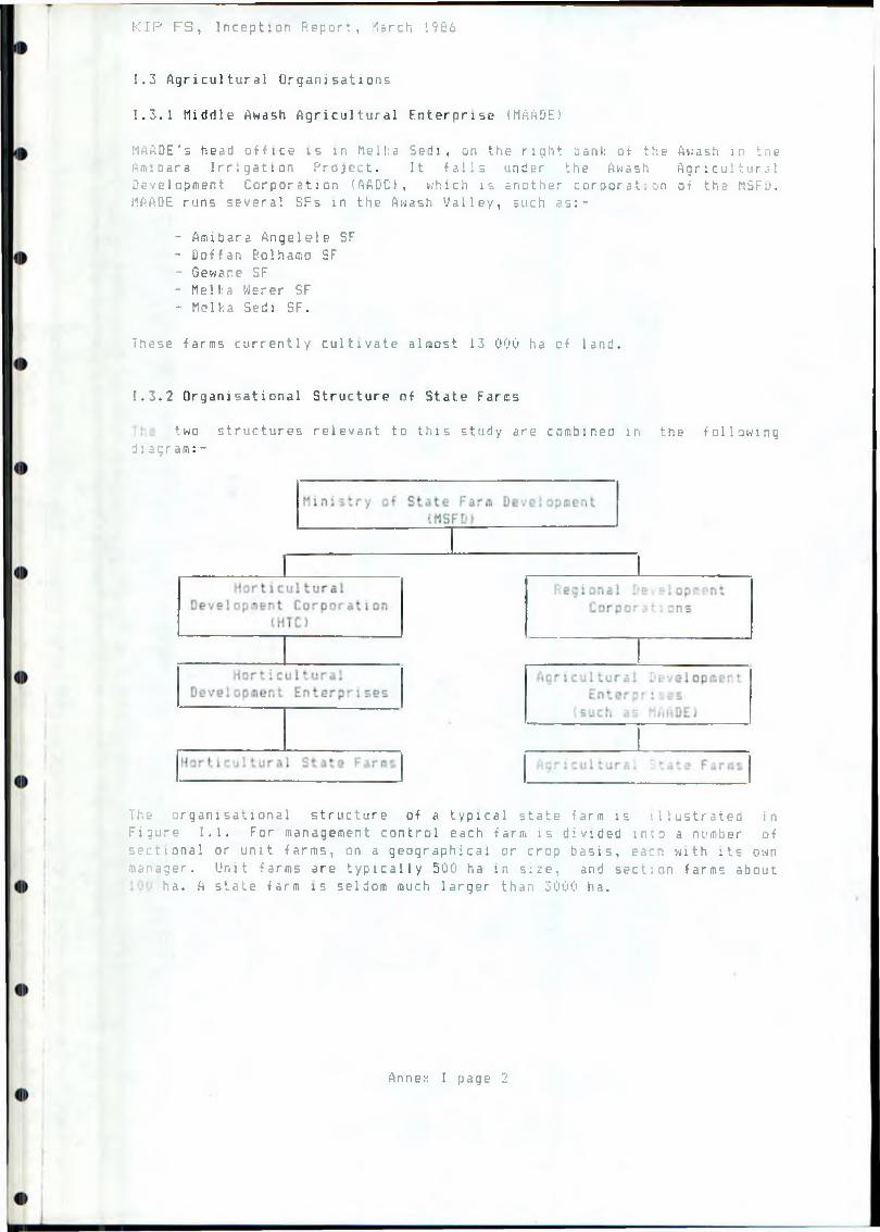
K I P F S , Inception Report, ilarch 1986
1.3 Agricultural Organisations
1 . 3 . 1 Middle Awash Agricultural Enterprise (MAADE)
MAADE' s head o f f i c e i s i n Mel I: a Se d i , on t h e r i g h t bank o f the Awash in tne A m i b a r a I r r i g a t i o n P r o j e c t . I t f a l l s u n d e r t h e Awash A g r i c u l t u r a l D e v e l o p m e n t C o r p o r a t i o n ( AADC) , w h i c h i s a n o t h e r c o r p o r a t e on o f t h e MSFu. MAADE r u n s s e v e r a l SFs i n t h e Awash V a l l e y , s u c h a s : -
- A m i b a r a A n g e l e l e SF- D o f f a n B o l h a m o SF- B e w a r e SF- Mel It a M e r e r SF- M e l k a S ed i SF.
These f a r m s c u r r e n t l y c u l t i v a t e a l m o s t 13 000 ha c f l a n d .
1.3.2 Organisational Structure of State Faros
t w o s t r u c t u r e s r e l e v a n t t o t h i s s t u d y a r e c o m b i n e d i n t h e f o l l o w i n g diagram:-
The o r g a n i s a t i o n a l s t r u c t u r e o f a t y p i c a l s t a t e f a r m i s i l l u s t r a t e d in Figure 1 . 1 . F o r m a n a g e me n t c o n t r o l e a c h f a r m i s d i v i d e d into a numb e r o f s e c t i o n a l o r u n i t f a r m s , on a g e o g r a p h i c a l o r c r o p b a s i s , eacn w i t h i t s own manager. U n i t f a r m s a r e t y p i c a l l y 500 ha i n s i z e , and s e c t i o n f a r m s a b o u t
h a . A s t a t e f a r m i s s e l d o m much l a r g e r t h a n 300 0 ha .
Annex I page 2
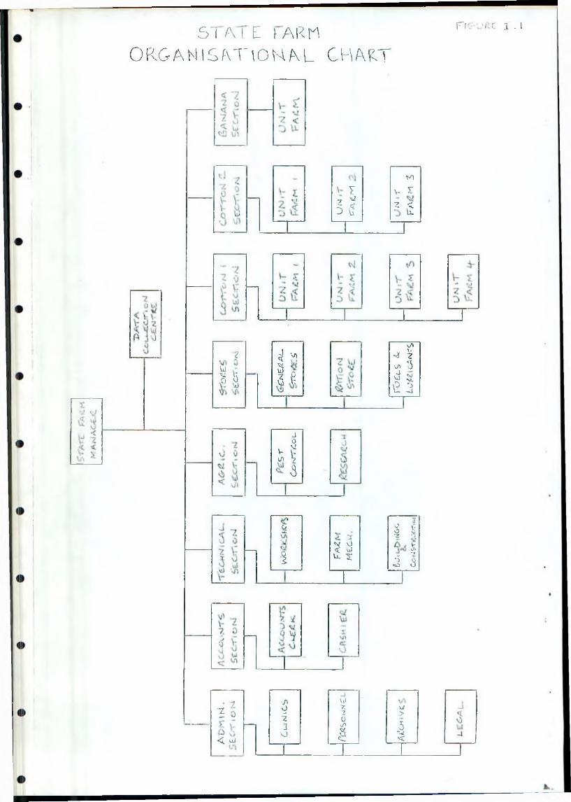
S I A I E \ ARM O R G A N I S f v T \ O N / \ L C H A K T
Fi ■■■;'< i - i
?
Ul
sV0
VO
V/»J < ..
I f
J0\ !\-V-
v/> V3
%
i
jV o< VJu. r
to7 v 5T
-7 •* -5 5
z t u.
\/lJ $■s< tsd w
M.
fi Tj-1
3
0V■V-v/«•?
*>CO 3
■ 7 ■? 0
<£ uJ
J \0i3
VJ
_i\J7.7
0tf*
§
\jI>■5*W<
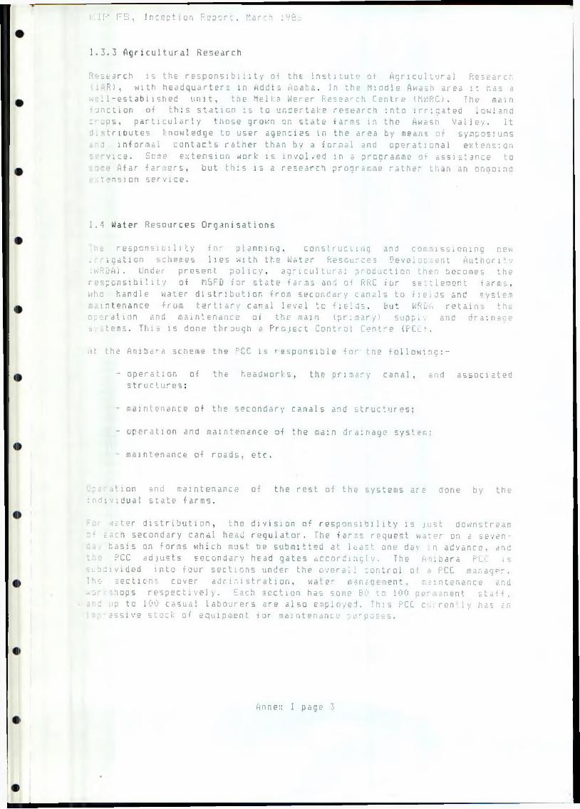
I.IP F S , Inception R e p o r t , March 1982
1.3.3 Agricultural Research
R e s e a r c h i s t h e r e s p o n s i b i l i t y o f t h e I n s t i t u t e o f A g r i c u l t u r a l R e s e a r c n R) , w i t h h e a d q u a r t e r s i n A d d i s A b a b a . I n t h e M i d d l e Awash a r e a i t r.as a
w : I - e s t a b 1 1 shed u n i t , t h e Mel I n W e r e r R e s e a r c h C e n t r e (MWRC). The ma i n • u n c t i o n o f t h i s s t a t i o n i s t o u n d e r t a k e r e s e a r c h i n t o i r r i g a t e d l o w l a n d c - - p s , p a r t i c u l a r l y t n o s e g r o w n on s t a t e f a r m s i n t h e Awasn V a l l e y . I t d. - . t r i b u t e s k n o w l e d g e t o u s e r a g e n c i e s i n t h e a r e a b y means o f s y m p o s i u m s
5 i n f o r m a l c o n t a c t s r a t h e r t h a n by a f o r m a l and o p e r a t i o n a l e x t e n s i o n v i c e . Some e x t e n s i o n w o r k i s i n v o l v e d i n a p r o g r a m m e o f a s s i s t a n c e t o
A f a r f a r m e r s , b u t t h i s i s a r e s e a r c h programme r a t h e r t h a n an o n g o i n g i t e n s i o n s e r v i c e .
1.4 Water Resources Organisations
l ie r e s p o n s i b i l i t y f o r p l a n n i n g , c o n s t r u c t i n g and c o m m i s s i o n i n g new : r i g a t i o n s c h e me s l i e s w i t h t h e W a t e r R e s o u r c e s D e v e l o p m e n t A u t h o r i t y iWRDA). U nder p r e s e n t p o l i c y , a g r i c u l t u r a l p r o d u c t i o n th e n be c o me s t h e r e s p o n s i b i l i t y o f M5FD f o r s t a t e f a r m s a n , a : RRC f o r s e t t l e m e n t f a r e ; , , who h a n d l e w a t e r d i s t r i b u t i o n f r o m s e c o n d a r y c a n a l s t o f i e l d s and s y s t e m
i n t e n a n c e f r o m t e r t i a r y c a n a l l e v e l t o f i e l d s . B u t WRDA r e t a i n s t h e o p e r a t i o n and m a i n t e n a n c e o f t h e ma i n ( p r i m a r y ) s u p p l y and d r a i n a g e s . t erns. T h i s i s d o n e t h r o u g h a P r o j e c t C o n t r o l C e n t r e ( PCCf .
.'it t h e A m i b a r a scheme t h e C'CC i s r e s p o n s i b l e f o r t n e f o l l o w i n g : -
- o p e r a t i o n o f t h e h e a d w o r k s , t h e p r i m a r y c a n a l , and a s s o c i a t e d s t r u c t u r e s ;
- m a i n t e n a n c e o f t h e s e c o n d a r y c a n a l s and s t r u c t u r e s ;
- o p e r a t i o n and m a i n t e n a n c e o f t h e m a m d r a i n a g e s y s t e m ;
• m a i n t e n a n c e o f r o a d s , e t c .
-p .:, . i t i o n and m a i n t e n a n c e i n d i v i d u a l s t a t e f a r m s .
o f t h e r e s t o f t h e s y s t e m s a r e d o n e b y t h e
, ' j . te r d i s t r i b u t i o n , t h e d i v i s i o n o f r e s p o n s i b i l i t y i s j u s t d o w n s t r e a m• Jach s e c o n d a r y c a n a l head r e g u l a t o r . The far . r . s r e q u e s t w a t e r on a s e v e n -
b a s i s on f o r m s w h i c h mu s t t ie s u b m i t t e d a t l e a s t one d a \ n a d v a n c e , andPCC a d j u s t s s e c o n d a r y head g a t e s a c c o r d i n g l y . The A m i b a r a P i ' , is
s u b d i v i d e d i n t o f o u r s e c t i o n s u n d e r t h e o v e r a l l c o n t r o l o f a PCC m a n a g e r . The- s e c t i c n - c o v e r a d m i n i s t r a t i o n , w a t e r m a n ; g e m e n t , m a i n t e n a n c e and •o - h o p s r e s p e c t i v e l y . Each s e c t i o n has some SO to 100 p e r m a n e n t staff.3 d .ip t o 100 c a s u a l l a b o u r e r s a r e a l s o e m p l o y e d . T h i s PCC c . i r e n l y h a s : n
e s s i v e stock o f e q u i p m e n t f o r m a i n t e n a n c s purposes.
Anne:: I page 3
1.5 Suitability of Existing Structures for KIP
At this early stage of the study, the institutional requirement; of the project have yet to be analysed. But from information gathereJ end discussions held so far, some tentative conclusions can be drawn an the appropriateness of the existing organisational structures tor this fairly large and complex project.
The project's objectives are to use the area's resources to maximize agricultural production. Institutions must assist in reaching this objective, and not frustrate or delay it, and they must mini raize their own running costs. The national centralisation of decision-making in the present structure tends both to prevent and to delay effective management action and decisions. The state farms' difficulties with machinery spares illustrates this: orders from farm managers go to enterprise offices, which requisition the corporation to place orders with suppliers. For capital expenditure items the chain is even longer, since the corporation has to pass the decision up to ttie Ministry and the Supreme Council. The procedure can take six months for an item to be procured, even if within the approved budget. This centralisation increases costs and frustrates the good use of
resources. For KIP a degree of decentralisation and autonomy isre co mm en de d.
A further source of inefficiency in the present system is the far-reaching separation between the irrigation water supply organisation (WRDA) and the agricultural production organisations. It may be better for a project of the size of KIP to have these functions under the unified control of a single project authority. Other functions such as roads, envi ronmental health services, agricultural extension, and even educational andrecreation facilities could be included in such an authority's scope, though some of these might be better left with the approprate ministries. It 15 relevant to note that state farms in the a r e s tend to r u n their ownhealth clinics and, in Drder to attract staff, to pay about twice theMinistry of Health's salaries.
1.6 Management
It is noted that managers in the existing enterprises generally have sound academic training but tend to lack experience in practical farm or -field management. State Farm managers are often recruited direct from colleges and universities. To attract and retain the experienced managers that KIP will need, better incentives, services and amenities will have to be pr o vi'ded.
Conversely, field foremen and supervisors often have long and valuable experience hut lack up-to-date technical knowledge, Regular in-service training courses provided or arranged by management would improve tne si tnation.
Annex I pa ge 4
1.7 Extension and Research
fhs project's objectives would be promoted if the activities of theagricultural research institutes were to be guided by the needs and;• c;niiirements of those of the user agencies, rather than the other way round au at present. The recommended link between the farmer, large-scale or smallholder, and the research institute is the extension agent. Two-way communication is essential. The Afar farmers, as relative beginners, will netd one extension agent per about 250 farmers at first. prrjtiably droppingto i per 500 after about ten years.
Annex I page 5
KIP F5, Inception Report, March 17a 6
ANNEX J
INFRASTRUCTURE
J.l Population Projections
Before discussing infrastructure requirements it is necassary to make an estimate of the likely population, both permanent and migratory, within the Project Area. The existing State Farms in the area rely very much on casual bachelor labour migrating from the highlands. Typically the casuallabour force forms about SOX of the total work force, rising to nearly 90'/. at peak periods. Whilst the farms continue to grow predonti nantl y cotton there is bound to be requirement for casual labour at peak periods such as picking, but it is undesirable to have such a large migratory labour force as at present if full social and economic develupment of the area is to take place. It will therefore be necessary to create conditions in the project under which there is a relatively large nucleus of settled workers and their families. This means establishing housing and infrastructure facilities which will attract people to the area.
At Helka Eadi State Farm (3193 ha net) the total labour force in 1783/4 varied from 3217 i n March to 6456 in November. The corresponding percentages of casual labour were 76'/, and 87-K. Based on these figures, and assuming that the casual labour force is reduced, then the preliminary estimates for a 500 ha farm in the project are 500 permanent workers plus a casual labour force ranging from zero in March to 440 in November. Allowing for families, management, and ancillary staff then the total population would very between 1375 and 1815. Extending these figures to the total Project Area and including 12 000 fifars, then the total project population is likely to be of the order of 40 000 to 50 000.
J.2 Township and Village Requirements
One of the most important factors in attracting people to the area wili bethe provision of suitable housing complete with potable water, electricityand basic sanitation facilities. To provide this it is proposed that a new township is establshed together with smaller satellite villages.
A possible site for the new township would be in the vicinity of the old volcanic hill known as Gurmile, preferably on land that is unsuitable for irrigation. This area is ideally located at the centre of the Project, andthe hill itself provides a natural focal point- The greater part of thecentral irrigation area between the Kesem and Kebena would be served directly from the township with satellite areas for casual labour accommodation. The total population of the central township is provisionally estimated at 20 000 to 30 000.
An alternative site for the central township would be near or at the 2,listing settlement of Awara Melka, also called Saboret.
Annex J page 1
Ir.IP FS, Inception R e p o r t , March licit
Satellite villages would be set up to cater for the South Kesein and north Kebena areas. The number, size and location of these villages cannot be assessed at tnis stage, but the existing villages at Yalo and Saboret (Awara Melka) would probably be expanded to meet some of the requirements. The Awara Melka farm already has some basic i nf r astru&tur e including a clinic, school and workers' housing.
At the central township some 9 000 houses will be required. Assuming an average of 20 m* per house viith an additional allowance of 10'/. for roads and community buildings, then the total area of the township would be 20 ha. Permanent buildings with concrete floors, concrete block walls and corrugated iron roofs with steel framed windows and doors are estimated to cost Birr 400-500 per in'2', thus giving a tcta,l cost of some Birr 80-100 million for the township. Similarly the satellite villages would cost Birr 30-40 million with an additional sum of Birr 15 million for casual labour barrac!:-type accommodation.
The total housing and ancillary building cost for the Project is therefore very tentatively estimated at Birr 150 million. This figure could of course be m u c h reduced by the use of lovier quality materials and temporary buildings. However it is probable that workers will not be attracted to the area if housing standards are set too ion,
J.3 Roads
Three types of roads are proposed to serve the project:
Main Access Road
This will be a gravel surfaced road giving access to the daw ana the Project Area from the Addis Ababa - Assab highway. Several feasible routes ejiist, but initially the possiblity is being considered of avoiding any access through the national Pari; which is located south of the Project Area. This leaves three possible main access lines from either just west of Hetahara, Awash or north of the project via the proposed Angelele-Bolhamo scheme.
Service Roads
Those vn 11 be gravel roads within the Project Area connecting the villages and other important centres.
field Roads
These will be unsurfaced roads giving access in and around the Project Area and to individual irrgation field units. They will be aligned adjacent to canals and drains.
To reduce costs it is proposed to keep permanent bridge crossings of the Kesem and Kebena Rivers to a minimum; probabaly only for the main access read. Concrete fords could be provided elsewhere, which would be passable except during floods.
Annex J page 2
n F' FS, Inception Repcr!:, I1ari:ri IfBt
J . 4 Ad d i t i o n a l I n f r a s t r u c t u r a l f t equi re t aent s
As previously men tinned, it i 5 important that the facilities, in the Project Area are attractive to families considering a permanent residence. p.; ■ housing the most important of these .ire:
' Educational facilities: schools should be available to all children of primary school age and initially at least 257. of children of secondary school age.
- Medical facilities; adequate medical facilities in the form of clinics and health centres are required (see Annex Hi.
■- Transport and communications: bus services should tie providedthroughout the Project Area and to the neighbouring towns of Awash arid Metahara. Telecommunications are also required as the present net nor I: ends at Met ahara.
- Leisure facilities: sufficient entertainment and sporting facilitiesshould be made available through the provision of community centres and recreation area's.
- Shops: a suitable number of shops, markets, banks etc. will berequired to meet the demand for foodstuffs, household and cansumar goods. Much of the internal requirement for fruit, vegetaDles and grain could be met from the Project itself thus keeping pricesrelatively low.
I IP F B , Inception Report, March 1986
ANNEX K
HEALTH
K . 1 I n t r o d u c t i on
This annex summarises the results of the Health Specialist's vis:- to Ethiopia, which will be described in much more detail in later r e p o r t . The main sources of information were visits to communities and clinics i r, the project area, to hospitals serving the area (Nazareth and Addis Ababa), and to organisations' head offices in Addis Ababa and elsewhere. The nearby existing Amibara Irrigation Project provided valuable information on environmental health and disease patterns. Data from the Environmental Health Unit, the Ministry of Health, and the Malaria Control Programm. were particularly useful. A complementary study by the Environmental Health Unit has been discussed and planned, and this is described in section K.6 below.
K.2 Health Needs
The Kesera Irrigation Project is to be sited in an area of seasonal grazing land currently used by some 12 000 Afar pastoralists. Their particular health problems are:-
- trachoma (an eye disease)- anaemia- tuberculosis- malnutrition- schistosomiasis (Set) i s t o sos a haena t ob i u s )- malaria.
With project implementation, the area might also contain some 50 000 settlers and migrant workers, mainly highlanders. Data from existing clinics in the area suggest that the main health problems of this group would be-
- malaria- diarrhoeal diseases (especially amoebiasis)- intestinal parasites- respiratory diseases- sexually transmitted diseases.
In both groups maternal and child health (MCH) is currently neglected.
The existing state farm clinic network concentrates on curative services and does not concern itself with preventive aspects and the health of families.
Annex K page 1
1C I P F S , Inception Neport, March 1986
K..3 Proposals for the Development of Health Services
[he majority of diseases affect the whole community and can he prevented. Emphasis should therefore be on preventive health care. For the wandering Afar people special health care systems need to be designed, since those intended for settled people would not be effective. To provide both for them and the settled people the following health network in the project area is proposed:-
- A central health centre with outpatient, I1CH, inpatient and laboratory facilities, It would serve as administrative centre and provide staff and accommodation for preventive health care. It could be located at Gurmile or at Aware Melka (also called Saboret),
- Expansion of the existing clinic at Saboret with staff and facilitiesto provide a training centre for Primary Health Agents and forTraditional Midwives from among the Afar people.
- Three health stations (probably sited at Doho, Yalo and North K e b e n a ) .
Preliminary proposals for trained staff are:
- 3 Senior Nurses- 9 Health Assistants- 3 Sanitarians (environmental health workers)- 2 Laboratory Technicians.
It is suggested that the clinics be built and equipped by the project authority, but staffed and run by the Ministry of Health. Fees need to he Ion enough not to represent a deterrent to the use of the health -faci 1 ities, and certain groups (such as children and pregnant women) should be exempt from fees as under present national policy.
The project should provide drinking water sources that do not involve river or canal water: it is hoped that the hydrogeological investigations willshow adequate and suitable supplies of groundwater. A dry sewage disposal s y st em, such as Ventilated Improved Pit Latrines, is preferble for the bull: of the population; squatting slabs could be mass-produced by the project, an'd subsidies offered to encourage people to undertake the rest of the wdri:. Housing should be of such a quality as to make the elimination of disease carrying arthropods easy, and its quantity adequate to prevent overcrowding. Many of these environmental health hazards will require continitous monitoring by the Sanitarians and action by a health committee containing senior members of the administration and representatives of the p e o p 1e .
Annex K page 2
I'-IF' F S , Inception Report, March 1966
K . ‘i Health Hazards
The roost important disease resulting from irrigation project is schistosomiasis. 5. h a e a a t o b i wa is the predominant speciaes in these p -is, and its intermediate host, the snail B u l i n u s a b y s s : n : c u s , favours s: .>ic clear water of high saline content. Such breeding grounds could be prevented b y : -
- avoiding the use of storage ponds;- designing drainage systems to avoid stagnant water;- keeping water velocities above 0.4 m/s;- reducing salinity;- regular and effective maintenance of canals and drains;- mono-cropping and drying-out of canals once a year;- m o n i t o r i n g o f p o s s i b l e s n a i l b r e e d i n g s i t e s b y t h e S a n i t a r i a n ? :- provision of drinking water and places to wash:- encouragement of the use and maintenance of latrines;- h e a l t h e d u c a t i o n .
All case of schistosomiasis should be identified and treated, and where possible all new arrivals in the area should be screened. Population settlements around the reservoir need to be screened and treated, with safe water points provided, since the reservoir is likely to offer a snail breeding ground.
The extent to which these measures can be implemented will be constrained by other factors, but they should be aimed for throughout the planning and design process.
Malaria is a major problem in the area, principally with P l a s n o d i u o f a l c i p a r u a , but H. v i v a x also occurs. The main vector is the mosquito Auophe l e s g a u b i a e . The measures outlined above in connection with schistosomiasis would do much to reduce mosquito breeding. In addition a continuous check should be kept by the Sanitarians on remaining potential breeding areas. The present malaria control programme sprays all houses w . th DDT every six months, and the health staff must coordinate their . torts with this programme. Prophylaxis is currently given to pregnant
nan, and all positive cases are treated with Chloroquine. This should continue.
: e high level of diarrhoea and dysentry is expected to fall once good drinking water is provided. Water must be checked for high fluoride-ntent. Internal parasites will only decrease when latrine use is
accepted.
Trachoma should be actively treated with tetracycline eye ointment,distributed through the Primary Health Agents and the Traditional Midwives. Th? work of the latter would also be important in improving maternal and child health (MCH). Vaccination must be actively introduced against iLaerculosis, Tetanus, Polio, Diptheria, Whooping cough, and Measles.This -hould reduce measies and whooping cough which are important causes af =spiratory disease. Tuberculosis should be diagnosed at the health centre .nd followed up regularly by the peripheral health services;
'..c i nation at birth would offer some protection.
Annex K page 3
I- (P F S , Inception Report, March 1936
Sexually transmitted diseases can be reduced by limiting ^he use of migrant labour and by encouraging settlement, with facilities provided, for families.
accidents always occur in an enterprise like this, but their incidence is unlikely to be high except in the construction phase. First Aid facilities will need to be provided at the dam site during construction, together with suitable transport for the evacuation of the badly injured.
Occupational illnesses are expected to be minimal, though cotton picking can result in conjunctivitis. Insecticides sprayed on crops could present a health hazard.
K.5 Costs
The initial cost of the proposed health care network described above is provisionally estimated at 4 million Birr and the running cost at 24 000 Birr per year, based on Ministry of Health salaries. These estimates, which exclude water supply and sanitation, will be revised later in the course of the study.
K.& Further Studies Required
The Environmental Health Unit maintained by MRDA and other organisations has offered to undertake investigations into schistosomiasis and malaria vectors in the project area. Recommendations, already discussed with and passed to the Unit, are:-
For snails:
- Kesem River within the proposed reservoir area, especially any swamps;
- Awara llelka and Yalo existing irrigation schemes;
- any areas of stagnant water such as the Filweha swamp.
For S . /laenofofcj'uB:
- the Soudani people living in the reservoir area;
- migrant Afars where possible (they are often reluctant to provi de speci m e n s ) .
For both S, /laeoattibiujj and S . e a n s o n i i
- migrant and settled workers in the Awara and Yalo schemes.
Annex K page 4
K I P F S , Inception Report, March 19B6
K.7 Guidance Needed fron the Steering Conaitt-ee
The Consultant needs guidance on the housing requirewents for the various grades of health staff, and on their salaries. Currently the state farms tend to pay about twice the Ministry of Health rates, and some such inducement may well be necessary for the project too, to attract suitably qualified and motivated people. Comments would also be appreciated on the e-mpliases and preliminary suggestions contained in this Annex.
Annex K page 5
1 !-• F b , Inception Report, March 1986
ANNEX L
IRRIGATION AND DRAINAGE
L.l Review of Previous Reports
The following reports have been reviewed during the inception phase of the
study:
- Report on the Survey of the Awash River Basin, FAO 1965 (ref.I);
- Amibara Irrigation Project - Water Management Manual,Sir William Halcrow Partners, 1983 Cref.12);
- Master Drainage Plan for Meika Sadi and Amibara Areas,Sir William Halcrow !< Partners, 1985 (ref. 9);
- Angele-Bolhamo and Amibara Irigation Expansion Project,
Final Report, NEDECO, 1982 <ref. 7);
- Angele-Bolhamo Irrigation Project, Draft Preliminary Design Report,
NEDECO 1985 (ref. 8);
- Development of the Awash Valley, FAO 1972-73 (ref. 2 ),Informal Technical Reports 5 and 17.
The 1965 SOGREAH/FAO report (ref. 1) covers the Kesem Project atreconnasissance level only as part of a survey of the whole Awash Basin.Additional aspects are covered in a similar way by the 1972-73 reportsref. 2.). The other reports are specific to their particular project, but
have proved most useful in gathering information on irrigation and drainagetechniques in the Awash Valley and establishing preliminary designcriteria. We will of course take great care not to establish falseanalogies between the Kesem Project and other projects, by careful
comparison of conditions.
he gross irrigable area of the Project has been estimated at 17550ha inthe 1965 report. The area is split into three sections by the Kebena and
esem rivers as indicated below:
North Kebena Gurmi 1e South Kesem
4 400ha 7 500ha5 650ha
Total 17 550ha
Annex L page 1
n-' F S , Inception Report, March 1956
he m a j g r components of the irrigation and drainage works were estimated as:
Diversion weir at Awara Melka
Main canal (23km) including siphon under the t.ebena Secondary canals (62km)Tertiary and field canals Main drains (61km)
Flood protection dykes, average 2m high (85km)Gravel roads (120km)Earth roads (75km)Land clearance Land levelling
The proposed cropping pattern incorporated predominantly cotton, with some areas of cereals, pulses, fodder and groundnuts. The overall croppi ,g intensity was 877.. It was proposed that irrigation would take place for l hours per day giving a main canal requirement of 1.1 1/s.ha. This assumed an overall efficiency of 70'/., which is considered much too high; a figure of 40-507. being more realistic. It is therefore likely that both the peak monthly and annual water requirements may have been underestimated.
It was proposed that irrigation would be by furrows some 200m long fed by field canals. Surface drainage would be provided at a design rate of 2.5I. e .ha, which was based on the maximum annual storm and allowing flooding of the fields for one day.
L.2 Field Observations to Date
Various field visits have been made for a general reconnaissance of the project area. As well as the existing farms within the area, others in the region have been visited, particulary the Amibara Project. General observations on irrigated agriculture in and around the project area are given below, followed by a more detailed assessment of that area itself.
Agriculture
Cotton is the predominant crop grown and is planted in the period April- une. It is frequently mono-cropped, but double cropping with short winter
crops such as maize and wheat is being introduced. The Awara Melka State Farri has areas of tobacco, bananas and citrus, and bananas are also grown at Amibara.
Irrigation
Irrigation is generally by furrows 200 to 250m long fed from field canals using siphon pipes. One field canal typically has a capacity of 150 to 2001 i and can apply an irrigation of 100mm net to one field unit of 20-25ha in 2 to 3 days, watering 24 hours per day. Irrigation of field units is rotated, and each field unit is watered every two weeks during the peak month of June. The canals feeding the field canals (main, secondaries and tertiaries) flow continuously and are designed for about 1.3 1/s.ha.
Annex L page 2
K I P F S , Inception Report, March 1986
Hater distribution and management at the older farms appear somewhat unsystematic, but at the recently completed Amibara Project the higher quality canal system allows a more controlled irrigation system to be adopted. Sedimentation of canals is a problem on all the schemes, requiring a considerable maintenance effort.
Drainage
Ho drainage facilities have been provided at the older farms although surface drainage is provided at Amibara and is planned for the Angelels- Kdlhamo Project. Design run-off figures are in the range I to 2 l/s.ha.
Increasing salinity and waterlogging problems at Amibara have led to the abandonment of some land, and a deep sub-surface field drainage system is planned for the near future.
Flood Protection
The existing farms are all prone to flooding from the Awash and its tributaries, and flood protection dykes have been constructed along the farms' perimeters.
Operation and Maintenance
Operation and maintenance procedures have beeen studied at Amibara and the findings summarised here. Basically operation and maintenance is split between the WRDA Project Control Centre (PCC) which deals with the majorworks, engineering and water distribution, and the State and SettlementFarms which are responsible for calculating the amount and timing of irrigation applications and operation and maintenance of the system below secondary canal level. Whilst this sytem appears to worfc relatively well in practice it is very much dependent on close lias-on between the Farm Managers and the Engineers at the PCC.
The Project Area
The Project Area is bounded by escarpments to the north and west and by the Fi 1 i-Jeha/Awash river system to the east. Ground elevations are in the range 800m to 740m with slopes predominantly from west to east. The steepest ground is in the west with slopes in excess of 2 Z, decreasing to less than0.57. in the east. There is a small volcanic hill known as Gurmile in thecentral area which will be out of command. It is probable that the grossirrigable area will be considerably less than the 17 550 ha estimated in the 1765 report; see Annex C on soils.
The area is divided into three sections by the Kesem and Kebena rivers which flow approximately east from the western escarpment to join the Awash. There are also several seasonal wadis running through the area also generally aligned from west to east.
Annex L page 3
K I P F B , I n c e p t i o n R e p o r t , M a rc h 1996
Most of the area has some form of vegetation, ranging from grassland and light bush to more heavily wooded areas. The micro-relief is variable, but it is clear that land levelling will be required throug ho ut.
There are three existing farms in the Project Area, the Awara Melka State and Settlement Farms and the Yallo Unit Farm. The Awara Melka State Farm covers about 850ha and grows citrus, bananas, tobacco and cotton. The Settlement Farm is about BOha growing cotton. The farms are fed by agravity offtake canal from the Kesem, with river level controlled by amasonry weir which has partially collapsed, The water distribution syst[?mis very rudimentary, and there is no drainage system.
The fact that citrus, which is intolerant to both salinity and high
groundwater levels, grows well at Awara Melka implies two things. Firstly that the quality of the Kesem water is good, and secondly that there is good not nral drainage in at least some of the area. The latter may perhapsbe explained by the presence of an underlying gravel fan extending from themouth of the Kesem gorge, and this will be investigated further during field investigations. Water quality samples are also being taken from t!i? Kesem for analysis to determine suitability for irrigation of individual crops. Preliminary field testing has indicated that EC is very low at around 0,5 mmlios/cm.
The Yalo Unit Farm covers about fiOOha although some 200ha are currently abandoned due to increasing soil salinity and flooding from the Kebena. Water for Yallo is abstracted by gravity from the Kebena 3km upstream and distributed around the farm by a network of canals. Water management appears unsystematic, and there are few control structures and no measurement facilities. A single crop of cotton only is grown and yields are low at around 13 qt/ha. Yalo incorporates a 2-ha Afar Settlement Farm which is currently abandoned although some maire lias recently been grown.
L.3 Initial Ideas for Project Development
fit this early stage in the Study it is not possible to state firm design criteria, but we have formulated somp general guidelines which are of course subject to amendment in the light of further investigations.
It is proposed that, in principle, the irrigation network will follow the established system at Amibara and elsewhere in the Awash valley. Briefly this implies surface irrigation by furrows or basins and a network ofunlined earth canals. It is possible that concrete or clay lining will berequired in the sandier areas and this will be investigated further, The basic irrigation field unit will probably be in the range 20 to 25 ha, and each field unit may be used under either a large scale mechanised farming sysleni, 3 small scale mixed farming system that includes irrigated pasture, or perennial tree crops (see also Annex H) .
Annex L p a g e 4
I-: ' IP F S , I n c e p t i o n R e p o r t , March 1986
He have same reservations about the current practice of 24-hour irrigation as commonly used in the Awash Valley. It reportedly 'causes no major
problems, although-in many other parts of the world night -watering is oftendifficult, socially unacceptable, and wasteful of water. The alternative ;s to irrigate during the day time only, the night flows being stared in night i storage reservoirs at the heads of either the secondary or the tertiary canals. There is little doubt that continuous watering would lead to a simpler and cheaper canal system than one with night storage, and it would also help to control malaria and schistosomiasis (see Annex K ). We will study the existing practices further before making firm recommendations.
ftnother area of concern is the typical existing field canal capacity of ISO to 200 1/s. Ttiis may he too high and difficult for the irrigators to handle e f f i c i e n 11y ,
Cropping patterns are discussed in Anne:: H (Agriculture). We will try to ensure that there is sufficient flexibility in the canal system to accommodate future variations in cropping pattern.
We have prepared a preliminary irrigation and drainage system layout on the1:10 000 topographic maps, and the major elements are shown in Figure L.l. Unfortunately neither the 1:10 000 topographic maps nor the 1:20 000 air photographs covers the nothern fringe of the potential irrigable area. Theunmapped land is largely of good quality, and we have asked WRDA to arrangefor surveying of the area.
1m the preliminary layout the canals are aligned along ridges and hiah ground where possible, with the field alignments arranged for a small furrow gradient, ideally less than about 0.4 */., As much irrigable land as possible is included, but not small pieces of land that would beuneconomic, such as those inside tight river loops; such patches may be useable for small-scale vegetable growing. Account will be taken ofgraveyards.
Inverted siphons will be required to carry the main canal under the Kebena River and possibly other major w a te rc ou rs es. The first three km of the northern primary canal passes through extremely difficult and broken ground with roc): outcrops and escarpments. Use of a conventional canal in thisroach would prove very difficult and expensive, and a pipeline or concrete flume may be found preferable. Particular attention will be paid to this area in the remaining field investigations.
Irrigation water will be abstracted from the Kesem at Awara Melka. The headwords may take the form of a diversion weir or a re-regulating dam. In either case we anticipate that the water will be relatively silt free and Lhat canal siltation should not be excessive. However sediment exclusion facilities will be provided at the head works should subsequent investigations into sedimentation prove them to bs necessary.
Thu possible conjunctive use of alternative water supplies from the Kebena River or groundwater are still to be investigated, though it appears unlikely to prove advantageous.
Annex L page 5
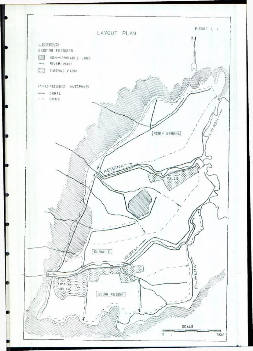
K I P f-S, Inception Report, March 1986
The existing farms at Awara Melka and Yalo will be integrated into the proposed irrigation layout. The present supply arrangements at these farms will be abandoned and replaced by the new feeder canals, and the existing canalisation systems will be remodelled and Upgraded as necessary. Relevelling of some of the fields also probably be needed.
A shallow drainage system will be provided throughout, to dispose of internal run-off from rainfall, excess irrigation flows and canal escapes, and external run-off from the surrounding land. The internal run-off will be predominantly from rainfall and the drains will be sized to accommodate a 1 in 5 year storm without undue ponding of the fields. External run-off will be disposed of either by a perimeter drain and/or cross drainage structures conveying the wadis to a suitable disposal point.
With the possible exception of Yallo Farm it is not envisaged that deep sub-surface drainage will be necessary in the early years of development (see Annex M). However it is likely that deep sub-surface drainage will be required in the future with a correspond!ng deep open drain system. We will investigate the feasibility and economics of constructing the open drainage system to full depth initially or providing only shallow drains with subsequent deepening when the sub-stirface drains are installed.
iDrainage disposal will be to the Awash and its tributaries. It is probable that pumping will be required for those times of the year when river levels are high and gravity disposal is not feasible. This will involve considerable study of the river hydrology and flow characteristics to determine likely maximum levels. This information will also be used to determine the requirements for flood protection difies along the river banks.
Due to the topography of the area, the provision of flood protection works such as dikes, cut-off drains and cross-drainage structures will unavoidably form a sigificant cost item. The relatively steep slopes will necessitate a large number of canal and drain fall structures. These and other structures will he of masonry wherever possible, since this is a proven material in the area and cheaper than the alternative of mass concrete.
A significant amount of existing dry-season grazing land now used by the Afars will be Inst when the project is developed, As discussed in Annexes A, B and H, it is proposed that this be replaced by irrigated pasture in parts of the system around its periphery, with the intention that a gradually increasing proportion of the same area should be used far small- scale annual cropping by the Afars. It is proposed that the appropriate number of standard field units should be designated for this farming system. The area involved will be determined later, on the basis of estimates of grazing requirements and amounts of crop residues. It is expected to be around two or three thousand hectares. The irrigation of these units would be incorporated into the standard distribution and rotation system, and it as also proposed to provide livestock watering points so as to minimise damage to canal banks by animals.
Annex L page 6
K I P F-'S, I n c e p t i o n R e p o r t , M a r c h 1986
The Kesets Project is very large and it is important that a phased(levelopment plan is evolved. It will probably be desirable to constructthe irrigation and drainage works for each of the three geographical areas as separate development phases. When planning the works we will try to ensure that each area is "self-contained" in respect of canalisation and drainage systems, although the headworks and primary canals would bedesigned for full development capacities and levels.
L.4 Prograftoe -for the Remainder of the Study
In general the programme for the remainder of the study will follow themethodology given in the Terms of Reference. The main items of fieldworkare summarised below:
I. Continue review of irrigation methods to determine the up t i mu mirrigation system, efficiences and conveyance losses.
7. Updating of the irrigation and drainage layout on the 1:10 000topographic maps as the detailed soils information becomes available.
3. Confirmation of alignments in the field, and site investigations andsurveys of major structure sites (eg. the Kebena Ftiver crossing).
4. Study of the existing canal systems at Awara Melka and Yalo todetermine rehabilitation requirements.
5. A detailed survey of about 500 ha, probably as two or more separatesample areas, to enable a typical irrigation and drainage layout to hedesigned in detail, so that accurate cost estimates can be made.
6. A detailed survey of sample ' areas to determine land levellingrequi re me n t s .
7. Survey of the northern part of the irrigable area, to complete themappping.
G. Cross-sect ion information of the major rivers to determine floodprotection dyke and drainage disposal requirements.
9. Survey of types and densities of existing vegetation in order toassess land clearance costs.
10. Study of operation and maintenance procedures.
II, Survey of availability of construction materials and the collection of unit rates.
Annex L p a g e 7
K I P F S , Inception Report, March 1986
L.5 Matters far the Attention of the Steering Committee
In addition to the points raised above, the consultant wishes to draw thecommittee's attention to one further matter. This concerns the surveyrequirements set out in the Terms of Reference, for surveying by I'JRDh , Itis of course understood that the purpose is to enable accurate costestimates to be made for canal and drain earthworks, land levelling, etc.To achieve this it may be necessary to amend the detailed surveyrequirements from time to time as the study progresses. Some extra survey requirements have already been noted (the northern area, and reservoirmapping mentioned in Annex 61, and it may not be necessary to survey allthe secondary canals and drain alignments. Additional land levelling sampleareas may be desirable. It is proposed that details be agreed between theConsultant and WRDA on site.
Anne>: L page 3
K I P F S , I n c e p t i o n R e p o r t , Ma rch 1986
ANNEX II
DRAINAGE AND SALINITY
M.l Review of Previous Reports
Four reports were referred to during the course of the Inception Study. These were:-
- Master Drainage Plan for Melka Sadi and Amibara Areas, Sir William Halcrow h Partners, 1985 (ref. 9);
- Draft Final Report Melka Sadi Pilot Drainage Scheme,Executive Director Amibara Irrigation Project II, 19B4 (ref. 10);
- Report on Survey of the Awash River Basin, FAO, 1965 (ref. 1);
- Angel ele-Bolhamo and Amibara Irrigation Expansion Project, Netherlands Engineering Consultants, 1982 (ref. 7).
- Angel ele-Bolhatno Irrigation Project, Draft Preliminary Design Report, NEDECO 1985.
The 1965 SOGREAH report (ref.l) on the Survey of the Awash River Basin was a reconnaissance study and hence mapping was to a fairly small scale. Soil mapping was used to delineate possible saline soils.
The report on the Angel ele-Bolhamo and Amibara Irrigation Expansion Project (ref. 7), and in particular the Draft Preliminary Design Report (ref. 8)were used to help define design criteria that could be applied in theProject Area.
The Master Drainage Plan for Melka Sadi and Amibara Areas (ref. 9) was of immense help because of the detailed analysis of the problems and the proximity of the area to the Project Area. However it is not our intention to apply all the findings because conditions are different in the Project A'ea with large areas of land never having been irrigated. Possibly theunderlying soils are more permeable in part of the Project area than thosein the Amibara area. Of particular relevance were the studies on the rate of rise of the watertable, upward capillary flows in the soil under fallow conditions, and the studies on the adequacy of different types of pipe envelope materials.
Tne report on the Melka Sadi Pilot Drainage Scheme (ref. 10) was extremely interesting because the results, whilst particularly applicable to the Amibara Project, could be used in adjacent areas. Over 160 piezometers were installed in the Pilot Drainage Scheme area of 30 ha giving an immense a mount of data on response of watertable levels to irrigation and drainage. Leaching trials were also carried out and demonstrated the ability to leach the soils which had become extremely saline.
Annex M page 1

f I P F S , Inception Report, March 1986
Of particular interest were field water use efficiencies which gave ar, average value of drainage discharge of 24'/. of the gross irrigation application; this corresponds to a field efficiency of Bl'/.. If it is assumed that 757. of irrigation losses are deep percolation and allowing for losses into the open collector drain which may be unaccounted for, then an overall field efficiency of 70’/. would appear to be a suitable value to use.
Trials using various types of envelope materials for the buried field drains were carried out on the Melka Sadi Pilot Drainage Scheme and showed tnat red vocanic ash was as good, if not better, than gravel. Both these materials were distinctly better than using no filter or a factory produced C ‘,e that was wrapped round the pipe.
M.2 Field Observations
Without irrigation it is be expected that the watertable in the Project Area will be at some depth below the ground surface and observed water levels in the wells confirm this. A water level approximately 8m below the surface was measured at Yallo Unit Farm and depths of 12m to 15m at other wells in the Project Area. At Awara Melka State Farm the measured water level was 20m below ground surface.
Awara Melka State Farm has been established over 80 years and still has no shallow or deep drainage system. The main crops grown are citrus, bananas, tobacco and cotton. Salinity is said not to occur and neither is there any evidence of high watertables, but this will be investigated in the course of the soils and hydrogeological studies. It is thought that a gravel fan may underly the area which would give good dispersion of the water draining below the crop root zone.
At the Yallo Unit Farm the situation is rather different with salinity causing the abandonment of land and reducing cotton yields, this being the only crop grown. The cropped area has been reduced from 550ha to 400ha. It is by no means certain that a high watertable is the cause of the problem although land remote from the river Kebena has gone out of production. However, even though the water level in the well was 8m below ground level this may not reflect conditions under the irrigated area and "iore investigations will be necessary. Yallo Unit Farm, according to the Survey of the Awash river Basin (FAO 1965), is situated on recent saline deposits. Furthermore there is not a plentiful supply of irrigation waterand salinity may have built-up in the root zone because of insufficient,jater for leaching.
The experience on the Melka Sadi and Amibara Areas has been one of a deep watertable before irrigation commenced. Since then there ha.5 been a rise in :roundwater levels and this trend became more critical after the obstruction of the irrigation scheme, producing a watertable rise of about
.m per year. This caused salinisation of the root zone and a need for i e ^ h i n g . Based on the Survey of the Awash River Basin (FAO 1965), theoils of the area are not designated as saline and the salinity in the root
:one will have been caused by the irrigation water depositing salts in the soil. These will have been concentrated by upward capillary flow and evaporation at the soil surface.
Annex M page 2
r I' i , Inception Report, March 1986
H.3 Initial Ideas for Project Development
With the possible exception of the Yallo Unit Farm subsurface drainage will probably not be required in the initial years of irrigation, but significant areas will probably need deep drainage later. However it is essential that an estimate be made of when drainage is required so that this can be installed in sufficient time to control rising watertables adequately. At present there are several wells in the Project Area which can be used to monitor groundwater levels and these should be observed at regular intervals of, say, one month. It may also be expedient to install a limited number of piezometers if it is thought that the wells do not give adequate cover, but a balance has to be struck between collecting adequate data which can be analysed and collecting too much data which may never be
processed. During construction of the Project the number of piezometerssnould be increased to give adequate monitoring of the watertable, atentative spacing is 2km with readings at a minumum frequency of once amonth. It is inadviseable to install too many piezometers before construction of the Project because these may be destroyed by the construction plant.
Subsurface drainage, where required at all, will be either vertical or horizontal. Horizontal drainage would probably consist of buried fieldri -ins and buried collector drains discharging into deep open drains. The choice between buried collector drains and open drains will be based on c:st estimates, including the much larger maintenance cost for open drains. It would be the intention to discharge the open drains into the rivers without pumping wherever possible, and this is being considered in the design of the whole irrigation and drainage layout (see Annex L).
It it is found to be economic to use pumped drainage for some areas, alarge pump station will probably be preferred to a number of smallunattended stations within the Project Area because of the problems ofacequate maintenance. It may be possible to reuse the drainage water but, because the source occurs as small increments throughout the area and pumping would be essential to lift the water into the canals, it will probably prove more satifactory to release the water for downstream users.
Buried drains would utilise plastic pipe and -field drain size will depend on drain spacings and the amount of water draining below the crop root zone. Collector drains would be such a size to accommmodate the incremental field discharges. Minimum slope of the field drain would be 0.17. and collector drain slopes would be chosen to suit ground slopes and pipe size. Because of the silt-free water and generally larger discharges in collector drains compared with field drains, the pipe slope is not so c r itical.
Field drains would be laid at depths of between 1.8m and 2.5m with a bias towards the shallower depth. It can be shown that a least cost solution can oe obtained by placing field drains between 1.3m and 2.5m below the ground surface, with a preference for about 1.8m. Machines able to excavate below -‘.5m do exist but these are generally more expensive, dig a wider trench ;nc wort at a considerably slower speed than the machines that do not worl; to this depth. For adequate maintenance a maximum length of 300m is sua 11 y used but in terrain where the field drains have a considerable
U c p e there is a case for increasing the length because siltation should
Annex M page 3
II-- F S , Inception Report, March 1986
not be a problem. Drain design will be optimised in later stages c; the study.
Vertical drainage consists of a well which abstracts water from an underlying aquifer, inducing downward movement of water below the root zone. The well depth may be controlled by the depth of the aquiferalthough if this is sufficiently large it may not be economic to use the full extent of the aquifer. Well discharge will be controlled by well depth and the ability to provide adequate drain age; a very large well could give a variation in water level that might provide some but inadequate drainage remote from the well and an extremely deep watertable adjacent tothe well. The operating time for a well is usually around 607. and there isconsiderable flexibility provided that the watertable is maintained below the critical value and water is not required at a specific tine for irrigation. This means that pumping can use off-peak electric power. Vertical drainage may be ineffective in areas where impermeable layers give perched watertables and this will be particularly relevant where theseimpermeable layers are at a depth greater than the buried field drains.
If there is an adequate aquifer, in many cases vertical drainage using wells is the preferred choice. The capital cost will be less than for a corresponding horizontal drainage scheme but running costs are usually greater because of greater depths from which the water has to be pumped. The cost comparisons will be made when the necessary data are available.
If the underlying aquifer is saline then the drainage water from a well will be more saline than with a horizontal system, and this may be unacceptable because of downstream users. If the water is reasonably freshthen it can be reused by either blending with surface supplies or directapplication to the field channels. Vertical drainage is more adaptable to water reuse than horizontal drainage because it is always pumped and each well has a discharge of sufficient size to male reuse worthwhile. If thewater from wells is not reused then it is disposed of into a shallowdrainage system which discharges into the river.
Because of the rainfall intensities surface drainage will also be required.
M.Particular Areas of Concern
fhe drainage water will be saline and disposal of this into the rivers will affect downstream users of the water. Mixing of the saline water with the river water will occur and the blended water may be acceptable. At present it is believed that there are few downstream users and by the time that downstream abstractions are significant the salinity of the Project drainage water, particularly from a horizontal drainage scheme, will have reduced because leaching will have been completed and less saline conditions will occur. It is thought that the drainage water will have a
salinity 3 to 4 times that of the irrigation water from the Kesem riv°r and the total discharge will be about 307. of the irrigation discharge. In the long term the salt load from the Kesem entering the river Awash will riot change from no-project conditions, but the quantity of water will 'have decrea se d.
Annex M page 4
I IF' F S , Inception Report, 11 a r ■ h 1936
Red volcanic ash for field drain envelopes is available in the Amibar area and probably occurs in the Project Area because of similar volcanic action. However it is essential that sources of this material are located because
undoubtedly it is a cheap substitute for gravel provided it is not hauled over great distances. Sources will be searched for. Red volcanic ash has been successfully used in the Melia Sadi Pilot Drainage Scheme, but it has not been in place long enough to determine any long term deterioration due to reaction between the ash and drainage water. Although it is believed that the material is inert, a sample has been talen to the United t ingdom for inspection and testing.
The area that initially requires drainage may not be sufficiently large to form a normal component of a contract. A machine might have to be imported
and possibly re-exported at the end of the contract. Approximately 100km of field drain may be required, which could be installed in four months. If timing were suitable the drains could be installed in the fallow period between cotton crops.
M.5 Matters for the Consideration of the Steering Committee
The disposal of saline drainage water has been discussed in the previous section. While the alternatives to disposal in the river would be prohibitively expensive, people need to be aware of the consequences so that suitable provision can be made downstream.
If buried field drains are to be used there may be a case for setting up a manufacturing plant in the country. Indications of the likely market for such a plant would be useful.
M.6 Prograaoe for the Remainder of the Study
A drilling programme will be carried out under the supervision of the Hydrogeologist and will consist of 5 bores to determine the lithology under the area and 3 wells to ascertain the quality and quantity of water for use as a potable supply. The three wells will be test pumped and the 5 bores will allow hydraulic conductivity measurements.
The Hydrogeol ogist will continue collecting information on the depth to watertable because this is required to determine the time before drainagei i required. So far most of the open wells in the area have been visited and regular monitoring of these will show any variation during the Study. The information on the depth to watertable will be supplemented by data from the 5 bores and 3 welis.
Of particular importance to the drainage study is the soil survey which will be carried out throughout the Project Area. This survey will collect
data on the present salinity of the root sone which is an essential requirement for determining initial leaching requirements. This leaching would either be carried out before planting of the first crop or be allowed for as extra water to be applied to the first crop planted; the decision would be based on whether the level of salinity was sufficiently high to significantly affect the crop. The amount of leaching is important because this must be taken into account when determining the rate of rise of the
Annex M page 5
K I P F S , Inception Report, March 1986
watertable and will be extra, over ana above the water draining below the crop root zone under normal irrigation.
During the soil survey hydraulic conductivity of the drainage zone m 1i1 be determined. Because of the present deep watertable in situ tests will be carried out using the constant-head pour-in-augerhole technique. It is recognised that these tests give lower values than the bail-out test and that true values seem to lie between these two extremes (Melka Sadi Pilot Drainage Scheme 1984). Laboratory determination of permeability on undisturbed samples will also be carried out and, while these are performed on small samples, it should be possible to correlate them with soil type ana relate them to an average hydraulic conductivity of a soil profile.
The information from the -field studies will be used to determine the areas that will need drainage and the time when this will be required. Vertical or horizontal drainage will be specified as the mcst suitable and costs will be estimated based on the number of wells or the number and spacing of bur ied field drains.
Surface drainage requirements will be determined and total discharge of the open drain system will be estimated, taking into account escaped water, rainfall and water removed from below the root zone.
Water samples are being taken at the site of the proposed headwords at different times of year, to determine the chemical composition of the dissolved solids.
Annex M page 6
I,IP F S , Inception Report, Harch 19S 6
ANNEX N
ADMINISTRATIVE AND CONTRACTUAL MATTERS
N . 1 Chronology
The study was the subject of an invitation issued by FAO on 16 May 1985, using Terms of Reference (TOR) produced by WRDA in March 1985. The Consultant (Sir M MacDonald & Partners Ltd, or “MMP") responded with a technical proposal dated 22 July 1985, which was valid till 22 January 1986but was aimed at a start in about September 1985. On 23 October 1985 theFAO asked MMP to submit a financial proposal , and this was done on 29 October 1985. After discussion of some financial and logistic details between FAO and MMP in November and December 1985, the FAO issued acontract document on 17 December 1985. MMP signed and returned this on 24December 1985, but with two small modifications which were subsequentlyagreed and countersigned by FAO on 17 January 1986. The wording of the bank guarantee was discussed in December and January and agreed on 17 January.The guarantee itself was accepted by FAO on 4 F e b r u a r y , so the contractbecame effective on that date. WRDA was formally notified of MMP ' sappointment on 18 January 1986.
Meanwhile, on 9 January, MMP suggested that the "start date" from which the study programme runs should be regarded as 12 January 1986. although the contract was not yet valid on that day. This was accepted by FAO. During the 3-ueek mobilisation period five of MMF's team arrived in Ethiopia, and six more arrived on 4 and 5 February. After consultation with FAO in Rome on 17 January and with WRDA in Addis Ab3ba on 29 January, MMP modified the staffing programme slightly to reduce the concentration of work in thefirst two months. At this late stage, however, it was not practicable toreschedule the study to the extent that WRDA would have preferred.
This report is submitted at the end of week 8, the consultant's team inEthiopia having varied between 10 and 13 men during weeks 4 to 8.
N.2 Logistics
WRDA provided excellent accommodation for the consultant's staff atAmibara, on the right bank of the Awash River just to the north-east of the
project area, and also an office in Addis Ababa, with limited secretarial services. The Authority also provided transport in the form of an estate car in Addis Ababa and si;: new four-wheel-drive (4WD) vehicles from the end of January: their availability was slightly restricted by difficulties with drivers during most of February, but generally five of them were available at any one time. It was agreed on 29 January that the truck mentioned in Annex V clause 1.2(b) of the Contract would be required only briefly, if at all, for transport of bulky equipment to the project area: so far it hasnot been called for. A seventh 4WD vehicle was provided by FAQ, in accordance with Annex V clause II (c.i) of the Contract, from 26 February 1986. The eighth 4WD vehicle mentioned in clause II (c.ii), for soilsurvey, had not yet been provided by FAO on 6 March.
Annex N page 1
iK IP F S , Inception Rep Dr t . March 17S6
In Addis Ababa the consultant's staff stayed in hotels, though the availability of rooms was severely restricted by the fact that some hotels were closed, and by the holding of an GAU conference in the city from about23 February. The consultant chose to make Amibara his main base, using the Addis Ababa office mainly for supervising the clearing and transport of equipment and for specialists engaged in visiting WRDA and other Government offices. Daily access tD the project area from Amibara was by road via Awash town until a boat across the Awash River near Yalo was set up by WRDA on about 22 February: thereafter the soil surveyors crossed by boat andware able to avoid the long delay involved in the road route. Satisfactory accommodation for the Consultant's staff working in the western part of the area is being sought.
The consultant's equipment was brought into Ethiopia partly by air freight and partly as excess baggage brought by incoming team members. Customs clearance was handled efficiently by WRDA and the UNDP office. There were however slight delays due to customs formalities, air freight taking about three weeks to clear.
Annex H pa ge 2
KIP FS, Inception Study, 11 arch 1986
ANNEX I
REFERENCES
Ref.
Reports referring to the Project:
1 SOSREAH for FAO, 1965: Survey of the Aw ash River Basin (Report on)
(FAO/SF: 10/ETH),
2 Australian State Rivers and Water Supply Comttii ssi o n , for FAO, 1972-74: Development of the Awash Valley:numerous separate Informal Technical Reports and Assignment Notes.
5 Ministry of State Farms Development, 1980:Ethi o-PIIRY Joint Agricultural Project, a P r ef ea si bi1 ity Study, Part II,
4 WRDA/FAD 1985: An Updated Profile an Kesem Irrigation Project.
Reports on nearby or other relevant projects:
5 ITALCONSULT 1969: Melka Sadi-Ami bar a Proposed Irrigation Project, Feasibility Study.
6 Halcrow 1975: Angelele and Bolhamo Feasibility Study Report.
7 NEDECO 1982: Angelele-Bdlhamo and Amibara Irrigation Expansion Project: re-appraisal and up-dating of previous feasibility studies.
8 NEDECO 1985: Angel ele-Bolhamo Irrigation Project,Draft Preliminary Design Report.
9 Halcrow 19B5: Master Drainage Plan for H eII;a Sadi and Amibara Areas(Draft Final Report of March 1985 and Fin si Report of July 1985).
10 Amibara Irrigation Project II, 1905: Draft Final Report,Melka Sedi Pilot Drainage Scheme.
11 NOMADEP 1978: Health Home-economics S u r v e y , K e s e m - K a b a n a ,Upper Awash Valley, Ethiopia.
12 Halcrow 1983: Amibara Irrigation Project, Hater Management Manual.
15 IAR 1982: Cotton Production under Irrigation - Symposium.
14 IAR 1982: Bread Wheat Progress Report, 1980-82.
15 Kandiah / Endale 1992: Water Requirements of Banana in Middle Awash
Reg i o n .
Annex I pa ge 1
16 Kandiah: Irrigation Requirements of some Lowland Crops in theMiddle Awaah. ^ —
17 Kandiah 1782: Response of Cotton to Irrigation.
18 Kandiah 1901: Evaluation of Furrow Irrigation System of Cotton.
19 IAR 1983’. Soil Science Department Progress Report, 1982-83,
20 ditto, 1930-81.
21 IAR 1983: Field Crops Department Progress Report, 1970-7?.
22 IAR 1984: Lowland Oil Crops Production, Parts I & II, 1780-83.
23 Sir Alexander Bibb and Partners, 1973: Feasibility Study (5f the Lower Awash Valley, Final Report, Part I Anne;: 2.
24 Henrickson B L and Durkin J W 1985: Moisture Availability, Croppinq Period and the Prospects -for Early Warning uf Famine in Ethiopia:ICLA Bulletin 21, January 1985.
25 Hurni , H 1985: Soil Conservation Manual for Ethiopia,Soil Consevation Research Project, HGA.
26 Ethiopian Delegation, Scientific Round Table on the ClimaticSituation and Drought in Africa, Addis Ababa 20-23 February 1984:Climate and Drought Conditions in Ethiopia,
27 University of Berne and UN University, T o k y o , Soil Conservation Research Project, Soil and Conservation Department, I10A, 1982 and 1984:
- Vols 1-4, Compilation of Phase 1 Progress Reports, 1981-63,- Special Issue, Summary Report.
U P F S , I n c e p t i o n S t u d y , M a rch 1986
Other relevant literature:
28 Wischmeyer W H and Smith D D 1962: Soil Loss Estimation inSoil and Water Management Planning, Int. Ass. Sc. H y d r o l ., Pub. Nr 59.
29 FAD 1979: Soil Survey Investigation for Irrigation, Soil Bulletin 42.
Annex 1 page 2

Related Documents