KENYA ELECTRICITY SYSTEM IMPROVEMENT PROJECT (KESIP) ENVIRONMENTAL & SOCIAL MANAGEMENT FRAMEWORK APRIL 2019 Public Disclosure Authorized Public Disclosure Authorized Public Disclosure Authorized Public Disclosure Authorized

Welcome message from author
This document is posted to help you gain knowledge. Please leave a comment to let me know what you think about it! Share it to your friends and learn new things together.
Transcript

KENYA ELECTRICITY SYSTEM IMPROVEMENT PROJECT (KESIP)
ENVIRONMENTAL & SOCIAL MANAGEMENT FRAMEWORK
APRIL 2019
Pub
lic D
iscl
osur
e A
utho
rized
Pub
lic D
iscl
osur
e A
utho
rized
Pub
lic D
iscl
osur
e A
utho
rized
Pub
lic D
iscl
osur
e A
utho
rized

BASIC INFORMATION 1. Country and Project Name: Kenya Electricity System Improvement Project (KESIP)
2. Project Development Objective: To increase the capacity of the transmission system and to
increase access to electricity in Kenya
3. Expected Project Benefits:
Beneficiaries will be households, business enterprises, commercial building and industrial
establishment that will be connected to the electricity network for the first time. A second group of
beneficiaries will be existing electricity consumers for whom the quality and reliability of electricity
service will improve. Improved reliability of electricity service is especially important for existing
business customers since they will experience less service interruptions and consequently their
financial losses will reduce. Kenya Power Electricity & Lighting Company Ltd (KPLC) will be a
beneficiary through the system loss reduction.
4. Identified Project Social Risks:
Minimal adverse social risks are anticipated under this project because the installation of Distribution
systems will take place within existing routes and road reserves. The project will experience some
level of environmental and social risks. Most of the low and medium voltage lines will mainly be
constructed along the road reserve and existing rights of ways. These may not result in physical
relocation but impacts to trees and crops are likely to occur. Anticipated social impacts will be
involving KPLC compensation for crops and or/trees which could be damaged during construction.
Acquisition of land for substations will be on a willing buyer willing seller.
Recipient: Government of Kenya – Ministry of Energy
Responsible Government/Country Agency for ESMF Implementation: Ministry of Energy -Kenya Power
and Lighting Company Limited (KPLC)
Name/Contacts who prepared ESMF: Wilfred Koech, Kenya Power Electricity & Lighting Company Ltd
Total Project Cost: USD 370 million
Date ESMF was Prepared: April, 2019

1 | P a g e
The Environmental & Social Management Framework
(ESMF) has been prepared by Environment & Social Unit of
the Safety, Health & Environment (SHE) Department, Kenya
Power. The ESMF has been prepared based on an overall
outlook of the Environmental & Social issues of KESIP,
which includes:
• Project components
• Evaluation of potential Environmental & Social impacts of
different project components and subcomponents, and
• Assessment of environmental practices in different
ongoing and completed projects.
The ESMF provides guidelines for the preparation of studies
for KESIP sub projects, identify propose measures to avoid,
minimize and manage environmental and social impacts in
line with relevant Kenyan environmental and social
legislation and the World Bank’s safeguards policies once the
project specific sites and routes locations are identified.
2 | P a g e
TABLE OF CONTENTS
Chapter Description Page
BASIC INFORMATION 1
TABLE OF CONTENTS 2
LIST OF TABLES 6
LIST OF ACRONYMS 8
EXECUTIVE SUMMARY 10
1 CHAPTER ONE: INTRODUCTION 16
INTRODUCTION 16
Background to the project 17
2 CHAPTER TWO: KPLC’S KENYA ELECTRICITY SYSTEM IMPROVEMENT PROJECT DESCRIPTION19
Introduction to Kenya Electricity System Improvement Project (KESIP) 19
KESIP Project Components 19 Component 1- Access Expansion and Distribution Network Strengthening
(approximately US$ 235 million equivalent) 19 Component 2 – Transmission Network Expansion and Strengthening (Approximately
US$120 million equivalent): 20 Component 3-Technical Assistance & Capacity building 21
Project Implementation, Supervision and management for KESIP 21 Monitoring and evaluation of Project Implementation 22 Geographic and work Scope 22
3 Baseline information and Environmental and Social characterization 23
Coast Baseline Information (Environmental and Social Characterization) 23 Location and Size 23 Physical Environment 24
3.1.2.1 Climate 24 3.1.2.2 Topography and Drainage 24 3.1.2.3 Soils and Geology 25
Land Use 25 Biological Environment-Ecosystems 25
3.1.4.1 Grasslands 26 3.1.4.2 Mountain vegetation 26 3.1.4.3 Marine and coastal areas 27 3.1.4.4 Forests in Coast region: 27
Nairobi Region Baseline Information (Environmental and Social Characterization) 32 Location and Size 32 Physiographic and Natural Conditions 33
3.2.2.1 Physical and Topographic Features 33 3.2.2.2 Ecological Conditions 34 3.2.2.3 Climatic Conditions 34 3.2.2.4 Drainage 35 3.2.2.5 Soils and Geology 36

3 | P a g e
3.2.2.6 Forestry and Agro Forestry 36 3.2.2.7 Land Use 37 3.2.2.8 Water Resources 38 3.2.2.9 Wildlife 39
Infrastructure development 40 Road, Railway Network and Airports 40 Information, communication and technology 41 Energy access 41 Socio-Economic Background 42
Central Rift Region Environmental and Social Characterization 44 Location and Size 44 Physical Environment 44
3.3.2.1 Climate 44 3.3.2.2 Topography and Drainage 44 3.3.2.3 Hydrology 45 3.3.2.4 Soils and Geology 45 3.3.2.5 Land Use and land ownership 45
Socio-economic 46
South Nyanza Baseline Information (Environmental and Social Characterization) 47 Location and Size 47 Physical Environment 47
3.4.2.1 Climate 47 3.4.2.2 Topography and Drainage 48 3.4.2.3 Soils and Geology 48 3.4.2.4 Land Use 48
Biological Environment-Ecosystems 49 3.4.3.1 Forests in South Nyanza Region 49 3.4.3.2 Wildlife: 49 3.4.3.3 Wetlands: 49
North Rift Baseline Information (Environmental and Social Characterization) 50 Location 50 Physical Environment 50
3.5.2.1 Climate 50 3.5.2.2 Topography and Drainage 50 3.5.2.3 Hydrology 50 3.5.2.4 Soils and Geology 51 3.5.2.5 Land Use 51
Biological Environment-Ecosystems 52 3.5.3.1 Grasslands 52 3.5.3.2 Forests 52 3.5.3.3 Arid and semi-arid lands (ASALS) 52 3.5.3.4 Wetlands 52 3.5.3.5 Wildlife 53
Socio-Economic Background 54
Mt Kenya Baseline Information (Environmental and Social Characterization) 55 Location and Size 55 Physical Environment 55
3.6.2.1 Climate 55 3.6.2.2 Topography and Drainage 55 3.6.2.3 Soils and Geology 55 3.6.2.4 Land Use 56
Biological Environment-Ecosystems 56 3.6.3.1 Grasslands 56 3.6.3.2 Forests 57 3.6.3.3 Arid and semi-arid lands (ASALS) 58 3.6.3.4 Mountain vegetation 58 3.6.3.5 Wetlands 59 3.6.3.6 Wildlife 59
Socio-Economic Background 60
4 | P a g e
West Kenya Region Baseline information 61 Location and size 61 Population 61 Vegetation Distribution 62 Topography 62 Climate 63 Soils 63 Energy access 64 Land use 65 Forestry 65
4 CHAPTER FOUR: DESCRIPTION OF THE LEGAL AND REGULATORY FRAMEWORK 66
Introduction 66
Kenyan Legal and Regulatory Framework 66 The Constitution of Kenya, 2010: Constitutional provisions 66 The Environmental Management and Co-ordination Act, No.8 of 1999/ (2016)69 County Government Act, 2012 69 Land Act, 2012 70 The Land and Environment Court Act, 2011 70 Water Act, 2016 70 Energy Act of 2006 70 The Physical Planning Act, 1996 71 Wildlife Conservation and Management Act, 2013 71
National Museums and Heritage Act 2006 71 The Forestry Conservation and Management Act, 2016 72 Occupational Safety and Health Act, 2007 72 Work Injury and Benefits Act, (WIBA) 2007 73 The Traffic Act Cap 403 0f 2009 73 Electronic Waste Management Regulations-2013 (Draft) 73
Description of World Bank Operational Safeguard Policies 75 Introduction 75 Safeguard Policies relevant to KESIP 75 Alignment of WB and GOK Policies relevant to this ESMF 87 Requirements for Public Disclosure 89
5 CHAPTER FIVE: REVIEW OF RELEVANT INSTITUTIONS 90
Institutional and Implementation Arrangements 90 KPLC mandate and Functions 90 Ministry of Energy 90 Kenya Electricity Transmission Company Limited (KETRACO) 90 National Environment Management Authority (NEMA) 90 Ministry of Lands and Physical Planning 91 Kenya Wildlife Service 91 Kenya Forest Service 91 National Museums of Kenya 91
6 CHAPTER SIX: TYPOLOGY OF POTENTIAL ENVIRONMENTAL AND SOCIAL IMPACTS 93
Introduction 93
Positive Environmental and Social Impacts 93 Expected Impact on Poverty Alleviation 93 Employment and wealth creation 93 Local Material Supplies 93 Up Scaling Electricity Access to the Poor 93 HIV/AIDS 93 Health benefits of the project 94 Benefits to education 94 Improved standard of living 94

5 | P a g e
Security 95 Communications 95 Gender Considerations 95
Potential Negative Environmental and Social Impacts 95 Potential Negative impacts to be handle by the contractor 96
6.3.1.1 Electric shocks and electrocution. 96 6.3.1.2 Working at Heights 96 6.3.1.3 Impact on Natural flora and fauna 96 6.3.1.4 Impacts on air quality from vehicle exhaust emissions and dust 96 6.3.1.5 Solid waste 96 6.3.1.6 Visual and Aesthetic Landscape Impacts 97 6.3.1.7 Negative Cultural exchange and Social ills: 97 6.3.1.8 Occupation safety and health hazards 97 6.3.1.9 Loss of Physical Cultural resources: 97 6.3.1.10 Oil leaks and Spill Hazards 97 6.3.1.11 Social Risks Related to Labour Influx, HIV/AIDs 98 6.3.1.12 Impact on Natural Vegetation: 98 6.3.1.13 Construction material Sourcing: 98 6.3.1.14 Increased water demand: 98 6.3.1.15 Noise and excessive vibration 98 6.3.1.16 Risk of fire: 98 6.3.1.17 Storm water and Waste water 98 6.3.1.18 Temporary Land-take for construction purposes 99 6.3.1.19 Community health and Safety 99
Negative impacts to be handle by client (KPLC) 101 6.3.2.1 Loss of Land and property 101 6.3.2.2 Visual and Aesthetic Landscape Impacts 101 6.3.2.3 Increased Demand for Material Consumption 102
Cumulative Impacts 102 6.3.3.1 Cumulative Impact Analysis 102 6.3.3.2 Cumulative Biophysical Impact 102 6.3.3.3 Cumulative Socio-Economic Impact 102
7 CHAPTER SEVEN: IMPACTS MITIGATION MEASURES 103
Mitigation Measures 103
8 CHAPTER EIGHT: THE ENVIRONMENTAL AND SOCIAL SCREENING PROCESS FOR KESIP PROJECT 120
The Environmental and Social Screening Process and criteria 120
Screening process 120
Screening Form 120
Subproject Risk Levels 120
9 CHAPTER NINE: SUB PROJECTS ESIAs AND ESMPS 122
Introduction 122
Carrying Out Environmental and Social Impact Assessment 122
Preparation of Environmental and Social Management Plan 123
Consultations for ESIA and ESMP 125
10 CHAPTER TEN: MONITORING & REPORTING 127
KPLC ESMF Monitoring 127
site visits 127

6 | P a g e
Subproject Environmental and Social Database 127
Monitoring of Contractors 128
Completion Reports 128
11 CHAPTER TEN: ENVIRONMENTAL AND SOCIAL CLAUSES FOR CONTRACTORS 129
INTRODUCTION 129
EHS Supervisor 129
Environmental and Social Liabilities of Contractors 130
12 CHAPTER ELEVEN: SUMMARY OF CONSULTATIONS 139
Introduction 139
13 CHAPTER THIRTEEN: CAPACITY FOR ENVIRONMENTAL & SOCIAL MANAGEMENT. 141
14 CHAPTER FOURTEEN: GRIEVANCE REDRESS MECHANISM 142
The Grievance Redress Process 142
Grievance Redress Mechanism Budget 146
15 CHAPTER FIFTEEN: AN ESMF IMPLEMENTATION BUDGET 147
16 CHAPTER SIXTEEEN: CONCLUSION AND RECOMMENDATIONS 148
REFERENCE 149
ANNEXES 150
Annex 1: Sample Environmental and Social Screening Form 150
Annex 2: World Bank Classification of Projects 163
Annex 3: Stakeholder Consultation Meeting Minutes 163
Annex 4: Chance Find Procedure 185
Annex 5: Sample of ESMP 186
Annex 5: Generic ESIA Terms of Reference 189
LIST OF TABLES
Table Description Page
Table 1: Operational safeguards triggered by KESIP ........................................................................................................ 11 Table 2: Operational safeguards triggered by KESIP ........................................................................................................ 75 Table 3: Comparative Analysis of World Bank OP 4.12 and Government of Kenya requirements including measures
to address gaps ............................................................................................................................................................ 81 Table 4: ESMP and Mitigation Program to be implemented by the contractor: ............................................................ 104 Table 5: ESMP and monitoring program to be implemented by KPLC .......................................................................... 112 Table 6:Typical impacts and mitigation measures for Way Leave Acquisition Component for the KESIP project... 117

7 | P a g e
Table 7: Summary of Grievance Redress Process .......................................................................................................... 144 Table 8: Estimated level of costs for ESMF implementation .......................................................................................... 147

8 | P a g e
LIST OF ACRONYMS
AIDS Acquired Immunodeficiency Syndrome
EA Environmental Assessment
EIA Environmental Impact Assessment
EMCA Environmental Management Act – 1996
ESAP Environmental and Social Assessment Procedures
ESMF Environmental and Social Management Framework
ESMP Environmental and Social Management Plan
ESMS Environmental and Social Management System
ESSF Environmental and Social Screening Form
HIV Human Immunodeficiency Virus
IESIA Integrated Environmental and Social Impact Assessment
IP Indigenous People
ISTS Integrated Safeguard Tracking System
KESIP Kenya Electricity System Improvement Project
KNES Kenya National Electrification Strategy
KP Kenya Power
KPLC Kenya Power& Lighting Company Ltd
NEC National Environment Council
OP Operational Procedure
OS Operational Safeguards
PBO Project Based Programs
RAP Resettlement Action Plan
RoW Right of Way
RPF Resettlement Policy Framework
PCB polychlorinated biphenyl
PIT Project Implementation Team
PIU Project Implementation Unit
SESA Strategic Environmental & Social Assessment
SHE Safety, Health & Environment department
ToR Terms of Reference
UN United Nations
UNCLOS UN Convention on the Law of the Sea
WB World Bank
WRMA Water Resources Management Authority

9 | P a g e
10 | P a g e
EXECUTIVE SUMMARY
Background
The country’s long-term development blue print, Vision 2030 aims at transforming Kenya into a globally competitive
newly industrialized middle income and prosperous country. The Second Medium Plan 2013-2017 identifies energy
as one of the enablers for transformation into “a newly-industrializing, middle-income country providing a high
quality of life to all its citizens in a clean and secure environment”. Efficient, accessible and reliable infrastructure
is identified as an enabler for achieving sustainable economic growth, development and poverty reduction by
lowering the cost of doing business and improving the country’s global competitiveness.
The Government of the Republic of Kenya is seeking the financial support of US$370 million from the World Bank
for the Kenya Electricity System Improvement Project (KESIP), which includes support to KPLC and Kenya
Electricity Transmission Company Limited (KETRACO). The proposed implementation period is 5 years, from 2019
to 2024. The project would aim to improve the power systems and electricity access and reliability, in line with the
Kenya Growth and Development Strategy.
Scope and Purpose of ESMF
This instrument has been prepared for KESIP component 1 (Access Expansion and Distribution Network
Strengthening) under the responsibility of KPLC. It complies with both, the national law and the WB’s safeguards
policies. It provide a guideline for environmental and social assessment of the proposed Project because the exact
footprint of the project design, locations and other details about the investment are not available prior to appraisal
of the project.
KESIP project objectives
The proposed project development objectives (PDOs) are: (a) to increase the capacity of the transmission system
and (b) to increase access to electricity.
Objectives of ESMF
The Environmental and Social Management Framework (ESMF) seeks to address the environmental and social
impacts associated with the sub-projects to be developed under KESIP by KPLC during implementation. This
ESMF sets out the principles, rules, guidelines and procedures to assess the environmental and social impacts of
each sub-project during Project implementation. Further, it contains measures and plans to reduce, mitigate and/or
offset adverse impacts and enhance positive impacts of sub-projects, provisions for estimating and budgeting the
costs of such measures, and information on the agency or agencies responsible for addressing project impacts.
Description of Kenya Electricity Improvement Project (KESIP)
The proposed project will entail both transmission and distribution power lines and substations including sub-
components for last mile electrification and slum electrification. The project will cover various geographical regions
including western Kenya covering North Rift, Central Rift and West Kenya regions; Nairobi covering Nairobi South,
West and North; Mt. Kenya covering Mt. Kenya and North-Eastern regions and Coast.
Component 1- Access Expansion and Distribution Network Strengthening (approximately US$ 235 million
equivalent)
The proposed project will aim to support mostly grid densification and intensification and some grid expansion to reach about 120,000 new connections benefiting about 450,000 people. The exact lines and substations to be

11 | P a g e
supported under the component will be determined during project implementation. The component has three sub components: (i) new medium and low voltage infrastructure to help address system bottlenecks for reducing losses, improving reliability, and create capacity to support last mile electrification (US$85 million); ii) connections of new consumers through Last Mile electrification (US$130 million); and (iii) Slum Electrification to connect consumers living in informal settlements (US$20 million). The component will be implemented by KPLC. Component 2 –Transmission Network Expansion and Strengthening (Approximately US$120 million
equivalent):
The component is expected to introduce high voltage network to areas that have been serviced by long medium voltage lines to reduce technical losses and reinforce the existing medium voltage networks. The component will also increase transmission adequacy for interconnecting different regions of the country and improve reliability of power transmission and ensure compliance with N-1 contingency criteria. This component will be implemented by Kenya Electricity Transmission Company Limited (KETRACO).
Component 3: Technical Assistance & Capacity building (Approximately US$15 million equivalent):
The component will support a comprehensive feasibility study to be undertaken by KETRACO in accordance with the PPP law to determine technical, financial, legal, social and environmental feasibility of implementing the PPP pilot, including establishing the value for money for PPP. The component will also include sector studies, capacity building, and training activities to help sustain and enhance the policy, institutional and regulatory arrangements and reforms of the GoK as well as gender and citizen engagement. Some of the studies to be supported under the component will include optimal power market design, system operation and dispatch guidelines for the Energy Regulatory Commission (ERC). The capacity building will also include training and activities to strengthen governance, management, technical and operation capacity of the sector agencies including the KPLC, KETRACO, ERC, KenGen, Geothermal Development Company (GDC), and Rural Energy Agency (REA). The Ministry of Energy (MOE) will implement this component in coordination with the sector agencies.
Methodology used in preparation of ESMF.
This was done through a thorough review of the project concept paper, appraisal documents focusing on project
description, project development objective and key indicators, project components, institutional and
implementation arrangement requirements alongside consultations between KPLC and the project financiers and
key stakeholders.
Regulatory, administrative and legal framework
A detailed review of relevant institutional and legal as well as policy framework that bears significance or implication
to the KESIP project is presented in this chapter of the ESMF report. The World Bank Safeguard Operational
Policies applicable to the project as well as the international laws and conventions that bear relevance to the
implementation of this project have also been highlighted. In Kenya, The Environmental Management and Co-
ordination Act, No.8 of 1999 provides for the establishment of an appropriate legal and institutional framework for
the management of the environment and associated matters.
The activities in the KESIP are for the moment expected to trigger OP/BP 4.01 (Environmental Assessment), OP/
4.12: Involuntary Resettlement, and OP/BP 4.04 (Natural Habitats), OP/BP 4.36 (Forests), OP/BP4.11 (Physical
Cultural Resources),OP/BP 4.10 Indigenous Peoples, and OP/BP4.12 (Involuntary Resettelment). The safeguards
instruments prepared for any subprojects will address the requirements of any applicable policies.
Table 1: Operational safeguards triggered by KESIP
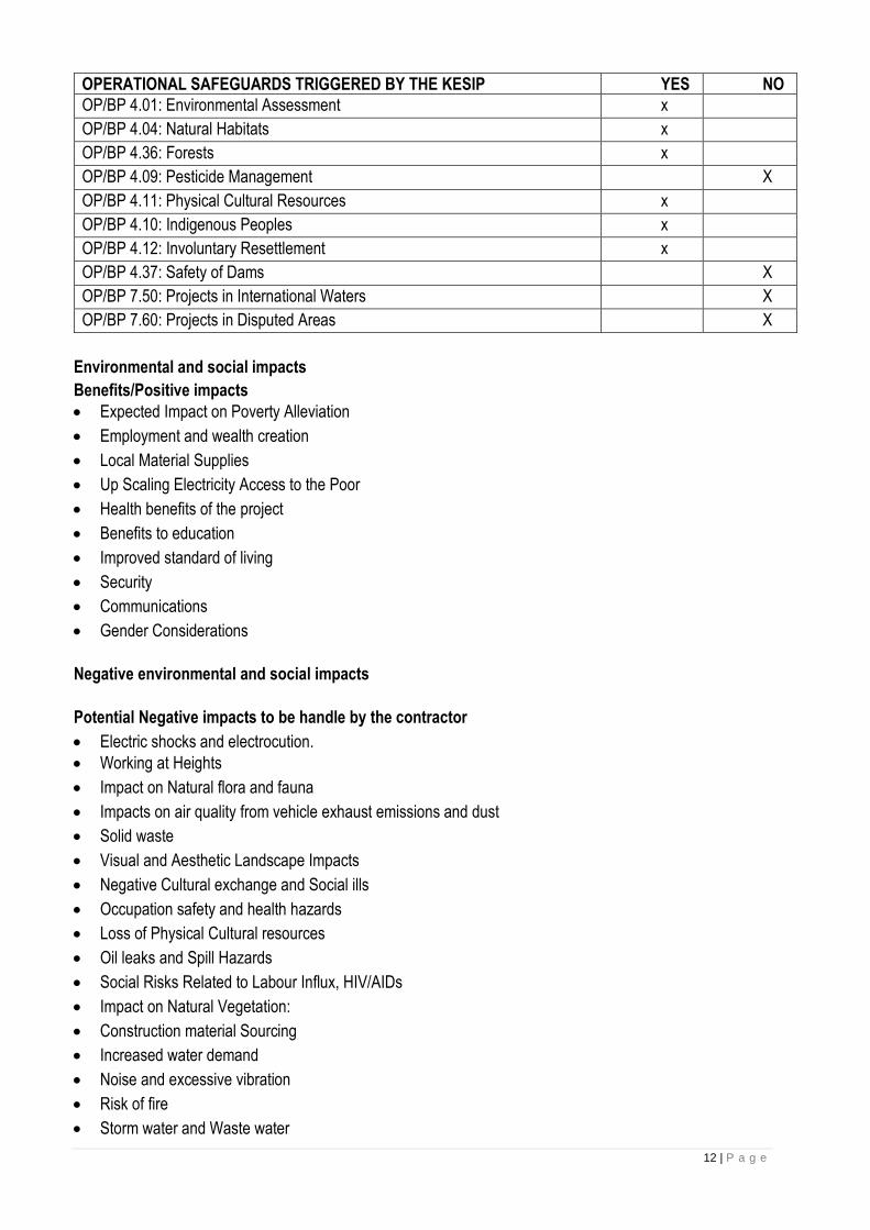
12 | P a g e
OPERATIONAL SAFEGUARDS TRIGGERED BY THE KESIP YES NO
OP/BP 4.01: Environmental Assessment x
OP/BP 4.04: Natural Habitats x
OP/BP 4.36: Forests x
OP/BP 4.09: Pesticide Management X
OP/BP 4.11: Physical Cultural Resources x
OP/BP 4.10: Indigenous Peoples x
OP/BP 4.12: Involuntary Resettlement x
OP/BP 4.37: Safety of Dams X
OP/BP 7.50: Projects in International Waters X
OP/BP 7.60: Projects in Disputed Areas X
Environmental and social impacts
Benefits/Positive impacts
• Expected Impact on Poverty Alleviation
• Employment and wealth creation
• Local Material Supplies
• Up Scaling Electricity Access to the Poor
• Health benefits of the project
• Benefits to education
• Improved standard of living
• Security
• Communications
• Gender Considerations
Negative environmental and social impacts
Potential Negative impacts to be handle by the contractor
• Electric shocks and electrocution.
• Working at Heights
• Impact on Natural flora and fauna
• Impacts on air quality from vehicle exhaust emissions and dust
• Solid waste
• Visual and Aesthetic Landscape Impacts
• Negative Cultural exchange and Social ills
• Occupation safety and health hazards
• Loss of Physical Cultural resources
• Oil leaks and Spill Hazards
• Social Risks Related to Labour Influx, HIV/AIDs
• Impact on Natural Vegetation:
• Construction material Sourcing
• Increased water demand
• Noise and excessive vibration
• Risk of fire
• Storm water and Waste water
13 | P a g e
• Temporary Land-take for construction purposes
• Community health and safety
Negative impacts to be handle by client (KPLC) Loss of Land and property Visual and Aesthetic Landscape Impacts Increased Demand for Material Consumption
Proposed mitigation measures
The mitigations are not intended to be exhaustive in content but rather to indicate in general to the scope of Environment and Social Impact Assessments (ESIAs) and Environment and Social Management Plans (ESMPs). It is entirely possible that additional impacts will be identified during impact assessment studies or audit preparation and will require additional mitigation measures. In the ESIAs and ESMPs, impacts shall be categorized according to project phase (planning, construction, operation, and decommissioning) and for all project types. Mitigation measures involve avoiding of impact altogether, minimizing the impact, rectifying the impact and gradual elimination of impact over time. Mitigation measures are three: physical, socio-cultural and socio-economic. Physical measures relate to issues of project siting, re-vegetation and preventive measures like bush clearing, erosion, sedimentation and pollution control and good construction / farming practices, waste management, and application of Environmental Guidelines for Contractors. Socio-economic measures will include education and awareness, hygiene and sanitation training, rules and regulations, institutional support (including skills training), and recruitment of qualified personnel while socio-cultural measures could include allowing limited and monitored access to restricted areas for cultural reasons where applicable.
The Environmental and Social Screening Process and criteria
The Environmental Management Coordination Act of 1999 and the Environmental (Impact Assessment and Audit) Regulations (June 2003) prescribe the conduct for Environmental Impact Assessment for development projects. Social and environmental sustainability are fundamental to the achievement of development outcomes and must be systematically mainstreamed into all development projects. This section describes the procedures used by KPLC to determine the level of environmental assessment needed for the sub-project based on identified environmental and social impacts.
Subprojects ESIAs and ESMPs
This section details the procedures and accountability for the preparation of ESIAs and ESMPs. Based on the
results of the environmental and social screening, the level of environmental work for the KESIP could range from
application of environmental and social mitigation measures (ESMP) to Environmental Assessment.
The section highlights the process of undertaking ESIA and preparation of ESMP including a sample of their
outlines.
Environmental and Social Clauses for Contractors
The section covers a set of environmental and social clauses for contractors that KPLC will incorporate in
construction contractor’s bids and contract documents. The clauses cover issues such as the preparation of
Contractor ESMPs, specific reporting requirements, occupational health and safety, interactions with neighboring
communities and individuals, transport and access to site, noise and air emissions, soil contamination, surface and
groundwater contamination, and the storage and disposal of hazardous and nonhazardous waste, including
construction debris.
14 | P a g e
These clauses will be included as part of all sub-project ESMPs. Contractors will be legally and financially
accountable for any environmental or social damage or prejudice caused by their staff, and thus are excepted to
put in place controls and procedures to manage their environmental and social performance. Contractors will
prepare a Contractor ESMP that details how they will fulfill these clauses. Sub-project ESMPs will include any
training required for contractors to understand and satisfactorily meet KPLC’ s environmental and social
requirements.
Monitoring and Reporting
This chapter outlines the procedures to monitor the implementation of sub-project ESMPs during sub-project
implementation, including the compliance of contractors with their Contractor ESMPs. It describes monitoring
schedules and accountability, the types of reports, who reports, who gets the reports, when and how frequently
reports are prepared, the management of corrective actions, and defines a set of standard indicators that will
reported on.
Grievance Redress Mechanism
Grievance mechanisms provide a formal avenue for affected groups or stakeholders to engage with the project
implementers or owners on issues of concern or unaddressed impacts. Grievances are any complaints or
suggestions about the way a project is being implemented. They may take the form of specific complaints for
damages/injury, concerns about routine project activities, or perceived incidents or impacts. Identifying and
responding to grievances supports the development of positive relationships between projects and affected
groups/communities, and other stakeholders. The step for grievance redress mechanism are as summarized below
• Grievance submission
• Grievance assessment and log
• Grievance is acknowledged
• Development of response
• Response communication
• Implementation of response
• Grievance closure
Public consultations and participation
Public consultation is a regulatory requirement by NEMA and donors ‘safeguards for new projects by which the
public's input on matters affecting them is sought in regard to the project. Its main objectives is in improving the
efficiency, transparency and public involvement in the proposed projects and hence enhance the compliance of the
environmental laws and policies in regard to the implementation of the projects.
This section summarizes meetings/interviews that will be conducted during ESMF preparation, including dates, list
of participants, and voiced concerns or opinions. They will include interagency consultation meetings with
institutional stakeholders.
Capacity building for KPLC staff
The Safety, Health and Environment and Projects Development departments will be responsible for the
implementation and monitoring of the ESMF. The mentioned departments are currently adequately staffed for the
project implementation. KPLC has put in place a PIU for the purpose of KESIP project implementation. Most of the
staff are qualified for the scope of work under ESMF but in terms of experience there is need to enhance their skills
in some areas to enable them handle EMSF adequately and efficiently.
15 | P a g e
ESMF implementation budget
The ESMF implementation budget refers to all costs that will be incurred to implement the requirements or
recommendations of the ESMF. The ESMF requirements ensure that Project implementation integrates
environmental and social issues for the sustainability of the project as well as the sub-projects. Among other things
the ESMF recommends the following key issues, namely; training, capacity building, screening, reviewing and
monitoring mechanisms. The total cost for training and implementation of the ESMF is estimated at approximately
USD 1,950,000 to be part of the total project cost and funded from IDA. Actual costs will be determined during the
implementation phase, when the specific number of people required for training will be identified and the level of
technical assistance required.
16 | P a g e
1 CHAPTER ONE: INTRODUCTION
INTRODUCTION This Environmental and Social Management Framework (ESMF) was prepared by KPLC to address the
environmental and social impacts and risks of the Kenya Electricity System Improvement Project (KESIP).
The ESMF sets out the principles, rules, guidelines and procedures to assess the environmental and social
impacts of subprojects to be prepared during Project implementation. It includes guidelines to prepare
measures and plans to reduce, mitigate and/or offset adverse impacts and enhance positive impacts of
subprojects, provisions for estimating and budgeting the costs of such measures, and information on the
agencies responsible for addressing project impacts.
KPLC has in parallel prepared a Resettlement Policy Framework (RPF) and a Vulnerable and Marginalized
Group Framework (VMGF) to meet the requirements of the World Bank’s Resettlement Policy (OP 4.12) and
Indigenous Poeples Policy (OP4.10) respectively.
ESMF Requirement Environmental and Social Management Framework (ESMF) is an environmental assessment and
management tool for the Kenya Electricity System Improvement Project (KESIP).
This ESMF was prepared because KESIP consists of a series of subprojects, and the impacts cannot be
determined until the subproject details have been identified during Project implementation. The ESMF
defines how environmental and social safeguards will be considered and managed for all project activities
that may have safeguards requirements.
Scope and Purpose This instrument has been prepared for KESIP component 1 (Access Expansion and Distribution Network
Strengthening) under the responsibility of KPLC. It complies with both, the national law and the WB’s
safeguards policies. It provides a procedure for environmental and social assessment of the proposed
KESIP. ESMF was preferred because the footprint of the project, design and other details about the
investment are not available prior to appraisal of the project. ESMF will guide KPLC in determining the
appropriate level of environmental and social assessment required for the proposed KESIP and in preparing
the necessary environmental and social mitigation measures for the project during the preconstruction,
construction and operational phases.
Objectives of the ESMF The main objective of this ESMF is to ensure that the implementation of the Kenya Electricity System
Improvement Project (KESIP) will be carried out in an environmentally and socially sustainable manner to
ensure that company activities in proposed project implementation sites do not adversely affect the
environment. ESMF will provide the project implementers with an environmental and social management
guide that will enable them to identify, assess and mitigate potential environmental and social impacts of
specific project activities, including through the preparation of a site-specific Environmental and Social
Impact Assessment (ESIA) where applicable.
17 | P a g e
The Environmental and Social Management Framework (ESMF) seeks to institute a consistent and effective
environmental and social management process for application to all components of the Kenya Electricity
System Improvement Project (KESIP). Consequently, the ESMF serves as an environmental and social
safeguards instrument to provide the framework implementing subprojects in an environmental sustainable
manner.
Potential Users of the ESMF This framework has been prepared as a reference document for use by key stakeholders who will be involved
in the planning, implementation, management and operation of the proposed KESIP for KPLC. The main
user of this ESMF will be KPLC through its Safety, Health and Environment (SHE) department who will be
responsible for the ESMF application
As a reference material, the framework is useful to the following proposed project key stakeholders:
• World Bank as the Funding and development partner
• Senior government officials responsible for policy making and project &development planning;
• Government officer in the various ministries
• Non-Governmental Organizations
• MoE and it is implementing agencies
• National government and County officials responsible for environmental planning and management
including NEMA;
• Politicians and other leaders;
• Potential consumers of electricity;
• The general public
• The private sector;
• Planners and engineers for the preparation of plans and designs of the subproject activities;
Engineers, contractors and companies to be involved in implementation of the -project activities.
Background to the project The Government of the Republic of Kenya is seeking the financial support from the World Bank for the Kenya
Electricity System Improvement Project (KESIP). The proposed implementation period is 5 years, from 2019
to 2024. The project would aim to improve the power systems and electricity access and reliability, in line
with the Kenya Growth and Development Strategy.
The energy sector plays a critical role in the socio-economic development of a country. Kenya is committed
to universal access to modern forms of energy by year 2030, as articulated in the national economic
development blueprint, the Vision 2030 (the Vision). The goal of the Vision is to make Kenya a middle-
income country enjoying a high quality of life by the year 2030. The objectives of the Vision have been
adopted as GoK’s national development objectives. Under this Vision, Kenya expects to achieve an
economic growth rate of 10 % and above.
Energy is identified as a critical enabler of this vision. According to the mutil-tier framework survey, total
access to electricity in Kenya through both gird and off-grid options is 75% as of early 2018. . The company
continues to keep up the pace of connections and aims at attaining a universal access by 2022. To attain
these goals, policy and regulatory frameworks have been articulated for the energy sector through energy

18 | P a g e
policy (Sessional Paper No.4 of 2004) and the Energy Act of 2006. A draft Energy Bill 2013 is still under
consideration
The rationale for the project is driven by the imperative to achieve universal access to electricity by the year
2022 and dramatically improve reliability of electricity supply to underpin economic activity. Electricity
service interruptions in recent years have a number of contributing causes. They include inadequate
generation capacity (especially during dry periods when hydropower availability is reduced), congestion in
the transmission infrastructure that constrains power transfers from where there is surplus generation
capacity to regions where there is a deficit, scheduled interruptions for line work and unscheduled
interruptions due to a weak network, inadequate preventive maintenance, vandalism, inadequate
automation, etc. The project is designed to address the transmission and distribution aspects to ensure
reliable supply e.g. scheduled and unscheduled interruptions by building resiliency into the network so to
enable it to react to unexpected events by isolating problematic elements while the rest of the system is
restored to normal operation and by minimizing the impact of scheduled network maintenance on the fewest
number of customers.

19 | P a g e
2 CHAPTER TWO: KPLC’S KENYA ELECTRICITY SYSTEM IMPROVEMENT PROJECT DESCRIPTION
Introduction to Kenya Electricity System Improvement Project (KESIP)
As already noted, the Government of the Republic of Kenya is seeking financial support from the World Bank
for the Kenya Electricity System Improvement Project (KESIP). The project would aim to improve the power
systems and electricity access and reliability, in line with the Kenya Growth and Development Strategy.
The proposed KESIP Project will be coordinated by The Ministry of Energy. The project will be implemented
by KPLC (component 1) and by KETRACO (component 2). However, at this stage, the specific project
sites/locations to be implemented by KPLC have not been fully identified. The project broader scope will
cover mainly limited sub-transmission lines (66kV), several distribution lines (33kV) and associated
substations, and short extensions of 33kV and 11kV lines and installation of transformers for connection of
beneficiaries to electricity supply.
KESIP Project Components The proposed Project aims to address system bottlenecks in the medium voltage (MV) network to reduce technical losses and create capacity to support last mile electrification. The proposed project will directly support connecting 100,000 new consumers in urban, peri urban and rural areas and another 20,000 new consumers in slums and informal settlements. The proposed Project is also expected to support high-voltage transmission network while also providing technical assistance support for a pilot PPP transaction in transmission. Finally, the proposed Project is expected to support technical assistance and capacity building support to KPLC and KETRACO, the two implementing agencies and other sector agencies.
There are three components: (i) Access Expansion and Distribution Network Strengthening; (ii) Transmission network expansion and strengthening; and (iii) technical assistance and capacity building, needed for among others, transaction advisory support for PPP transaction in transmission; sector development and strengthening and sustaining the policy, institutional, and regulatory environment; and enhancing institutional, governance, management, technical and operational capacity of the sector agencies.
Component 1- Access Expansion and Distribution Network Strengthening (approximately US$ 235 million equivalent)
Kenya National Electrification Strategy (KNES) has identified that to achieve universal access by 2022, some
2.3 million connections will need to be made through grid densification (extending the existing distribution
network by 2km). Another 580,000 connections will need to be made through grid intensification within 600m
radius of existing distribution network and some 270,000 connections through grid expansion (within 25km
radial distance around the periphery of the existing distribution system of KPLC). The proposed project will
aim to support mostly grid densification and intensification and some grid expansion to reach about 112,000
new connections benefiting about 450,000 people. The exact lines and substations to be supported under
the component will be determined during project implementation.
The component has three sub components: (i) new medium and low voltage infrastructure to help address
system bottlenecks for reducing losses, improving reliability, and create capacity to support last mile
electrification (US$85 million); ii) connections of new consumers through Last Mile electrification (US$130
million); and (iii) Slum Electrification to connect consumers living in informal settlements (US$20 million).

20 | P a g e
The component will be implemented by KPLC and will also finance the consultants needed to support KPLC
to implement the activities. This component will be implemented by KPLC.
a) Sub-component 1.1: Medium and low voltage infrastructure strengthening (Approximately US$85-million): This sub- component will finance construction of new medium and low voltage infrastructure to address system bottlenecks, reduce technical losses, and crate capacity to support last mile electrification the subcomponent will include substations (around 138 MVA 66/11 kV, 20MVA 33/11kV) and lines (around 118km of 66kV, 860 km km of 33kV and 11 kV and 75km of 11 kV). These substations and lines will extend the grid network to potential customers in seven distinct regions; Nairobi, Western Coast and Mt.
Kenya to enable future customer connection under the Last Mile program. The subcomponent will be implemented by KPLC.
b) Sub-component 1.2: Last Mile Electrification (Approximately US$130 million): This sub-component
will finance the design, materials and construction works required to electrify all households and
businesses in rural and peri-urban areas located close to existing electricity networks. The component
will support extending the distribution network as per the least cost plan identified through geospatial
tool for the KNES to connect some 100,000 new consumers with 2,100 secondary transformers and
3,100 km MV and 5,200 km LV lines. KPLC has identified broad locations in seven geographical regions
where the sub-component will be implemented. The final selection of sites within these locations will be
made by KPLC and MoE during design of the low voltage networks based on population density and
proximity to existing electricity networks, in order to maximize the number of connections in a given area.
c) Sub-component 1.3: Slum Electrification (US$20 million equivalent): This is a scale-up of the
successful component financed under (now closed) Kenya Electricity Expansion Project (KEEP) with
resources from IDA and the Global Partnership on Output Based Aid (GPOBA) providing connections
to low-income households in various informal settlement schemes in urban and peri-urban areas. This
sub-component will reimburse the costs of KPLC for last-mile connections that will include costs of low
voltage network extension, installation of secondary distribution transformers, installation of service lines
and prepaid meters to improve access to electricity to the residents of high-density settlements. It is
proposed that the cost of connection US$1,000 will be reimbursed to KPLC under the Project based
on the verification of the connections by an Independent Verification Agent (IVA). About 20,000
households in densely populated informal settlements are estimated to be connected to electricity under
this subcomponent.
Component 2 – Transmission Network Expansion and Strengthening (Approximately US$120 million equivalent):
This component will be implemented by KETRACO. The component is expected to introduce high voltage
network to areas that have been serviced by long medium voltage lines to reduce technical losses and
reinforce the existing medium voltage networks. The component will also increase transmission adequacy
for interconnecting different regions of the country and improve reliability of power transmission and ensure
compliance with N-1 contingency criteria. KETRACO has identified 6 sub-projects involving 132 kV and 220
kV transmission lines and associated substations and construction of three new 400/220kV substations
estimated at US$298 million. The exact lines and substations that can be supported within the funding

21 | P a g e
allocation for this category under the proposed Project will be determined later based on priority, readiness,
and environmental and social screening and assessment.
The component is also expected to support an owner’s engineer (firm), which will help KETRACO with
preparation of design, bidding documents, bid evaluation, and project supervision during implementation
phase. The funding requirement for the 6 transmission lines and three substations is around US$298 million.
With the funding allocation available (US$120 million), only 2 or 3 lines and 1 or 2 substations can be
supported under the Project. The environment and social screening and assessment following IDA
guidelines is being conducted for all the lines and substations identified.
Component 3-Technical Assistance & Capacity building
This component will be implemented by MOE in coordination with the sector agencies. The component will
support a comprehensive feasibility study in accordance with the PPP law to determine technical, financial,
legal, social and environmental feasibility of implementing the PPP pilot, including establishing the value for
money for PPP. The initial phase of the study will start soon with support from an on-going IDA credit
(Eastern Electricity Highway Project, P126579) while the second phase will be supported under the proposed
Project. This study will be supervised by IFC on behalf of KETRACO and closely coordinated with Africa50
to ensure a consistent approach for all the 5 lines included in the pilot PPP.
The component will also include sector studies, capacity building, and training activities to help sustain and
enhance the policy, institutional and regulatory arrangements and reforms of the GoK as well as gender and
citizen engagement. Some of the studies to be supported under the component will include optimal power
market design, system operation and dispatch guidelines for the ERC. The capacity building will also include
training and activities to strengthen governance, management, technical and operation capacity of the sector
agencies including the ERC, KenGen, GDC, and REA. The Support to KETRACO will enable the company
to develop the basic building blocks for a state-of-the art transmission company able to attract commercial
financing - a cost reflective wheeling tariff, a strong balance sheet through delineation of separation points
of KPLC and KETRACO’s transmission assets, capacity to manage the PPP program improved O&M
practices and standardization of design specifications. The component will also include consultancy support
and incremental operating costs for KPLC and KETRACO PIU. Finally, this component will also support the
incremental operational costs of the planning and coordination unit at MOE.
Project Implementation, Supervision and management for KESIP KPLC will be the Implementing Agency for Component 1 (Access Expansion and Distribution Network
Strengthening) of KESIP Project. KPLC has the necessary technical and managerial ability to implement
projects as demonstrated by the on-going projects financed by development partners. The existing project
implementation unit (PIU), that is responsible for the implementation of IDA financed Kenya Electricity
Modernization Project (KEMP) at KPLC, will be responsible for implementation of KESIP. The PIU is headed
by a Chief Engineer who will report to the Manager Electrification. The Manager Electrification reports to the
General Manager Infrastructure who reports to the CEO/Managing Director. The existing PIU has personnel
responsible for design, engineering; procurement; accounting project works supervision and monitoring and
wayleaves. The PIU receives safeguards support from the Safety Health and Environment (SHE) department
of the company. The SHE department will second a senior Environmental Specialist and a Social Specialist

22 | P a g e
to be integrated into the PIU. KPLC will where necessary recruit/deploy dedicated personnel to strengthen
the PIU to manage KESIP. The required consultants will be recruited, as and when needed, through
competitive bidding process will reinforce the capacity of the Project Implementation Unit. The consultants
will include of the independent verification agent (IVA) for the high-density schemes/slums electrification.
Monitoring and evaluation of Project Implementation KPLC will maintain comprehensive and robust consultation, monitoring and evaluation systems. The PIU will
ensure that the members in the Implementation Units are fully integrated into the management information
processes of the project. The Monitoring and Evaluation System will track the performance indicators,
scheduling and implementation data, and expenditure, as shall be agreed within the framework of the annual
work plan and budget. The PIU will provide regular implementation reports.
Geographic and work Scope The proposed project which will entail both transmission and distribution power lines and substations with a
component for slum electrification. The project will geographical cover various regions selected nationally
including western Kenya covering North Rift, Central Rift and West Kenya regions; Nairobi covering Nairobi
South, West and North; Mt. Kenya covering Mt. Kenya and North-Eastern regions and Coast.
23 | P a g e
3 BASELINE INFORMATION AND ENVIRONMENTAL AND SOCIAL CHARACTERIZATION
This section describes the overall baseline condition of Kenya in terms of bio-physical environment, as well
as the socio-economic and cultural. The proposed project will be rolled out in 7 regions covering Coast,
Nairobi, Mt Kenya, Central Rift, North Rift, Western Kenya and South Nyanza regions. The region specific
baseline information(environmental and socio economic characteristics) covering a given number of counties
has been presented below .
Coast Baseline Information (Environmental and Social Characterization) This section describes the overall baseline condition of Coast region in terms of bio-physical environment,
as well as the socio-economic and cultural.
Location and Size
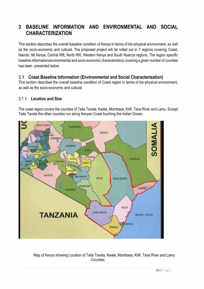
The coast region covers the counties of Taita Taveta, Kwale, Mombasa, Kilifi, Tana River and Lamu. Except Taita Taveta the other counties run along Kenyan Coast touching the Indian Ocean.
Map of Kenya showing Location of Taita Taveta, Kwale, Mombasa, Kilifi, Tana River and Lamu
Counties.

24 | P a g e
Physical Environment
3.1.2.1 Climate The Coast region climate is hot and humid in coast line to temperate and Semi- arid including in Taita Taveta
and Tana River Counties. The average annual temperature for the coastal town of Mombasa (altitude 17
metres) is 30.30 Celsius maximum and 22.40 Celsius minimum, Tana river has a hot and dry climate within
ecological zones ranging from III (in the very high grounds) to VII (in the plains or lowlands) with average
annual temperatures are about 300C with the highest being 410C around January-March and the lowest
being 20.60C around June-July.
3.1.2.2 Topography and Drainage The Coast region has varying topography and drainage characteristics.
Mombasa county lies within the coastal lowland which rises gradually from the sea level in the East to about
132 m above sea level in the mainland. The terrain is characterized by three distinct physiographic features,
which includes; the coastal plains covering parts of the South Coast, the Island, the Hilly areas that rises
gently from 45m to 132m above sea level are found within the Western part of the County and parts of
Changamwe and the North Coast; the Indian Ocean and the Shoreline. Other Notable physical features
includes the fringing coral reefs, cliffs and tidal flats, sandy beaches, the coastal plain and a hilly severely
dissected and eroded terrain.
The major physical features in Tana River County is an undulating plain that is interrupted in a few places
by low hills at Bilibil (around Madogo) and Bura administrative sub-units which are also the highest points in
the county. The land in Tana River generally slopes south eastwards with an altitude that ranges between
0m and 200m above sea level.
The river beds support livestock as well as wildlife during the dry season since they have high ability to retain
water. River beds are most appropriate sites for shallow wells, sub-surface dams as well as earth pans.
However, these lagas are also major bottlenecks to road transport as they cut off roads during rainy seasons
making the county virtually land locked.
Taita Taveta County is divided into three major topographical zones. The upper zone, suitable for
horticultural farming, comprises of Taita, Mwambirwa and Sagalla hills regions with altitudes ranging
between 304 metres and 2,208 metres above sea level. The lower zone consists of plains where there is
ranching, national parks and mining. The third topographical zone is the volcanic foothills zone which covers
the Taveta region with potential for underground water and springs emanating from Mt. Kilimanjaro.
The main rivers in the County are the Tsavo, Lumi and Voi rivers. Mzima springs is the major water supplier
to Voi town and Mombasa City, while small springs and streams include Njukini, Njoro kubwa, Kitobo, Sanite,
Maji Wadeni, Humas Springs and Lemonya Springs. In addition, there are two lakes, Jipe and Challa, both
found in Taveta area. Lake Challa is a crater lake with little economic exploitation, while Lake Jipe is slightly
exploited through small scale fishing. Both lakes are served by springs emanating from Mt. Kilimanjaro.
The County is mainly dry, except for the Taita hills which are considerably wet. The effect of the South-
Easterly winds influences the climate of the County.
Kwale County has four major topographic features namely the Coastal Plain, the Foot Plateau, the Coastal
Uplands and the Nyika Plateau. The coastline in Kwale County is about 250 kilometres. This strip of land
consists of corals, sands and alluvial deposits. The Foot Plateau, which is behind the Coastal Plain, lies at
25 | P a g e
an altitude of between 60 and 135 meters above sea level. The plateau has a flat plain surface with high
potential permeable sand hills and loamy soils. This zone is composed of Jurassic rocks and sandy hills
consisting of Magarini sands ideal for sugar cane growing.
3.1.2.3 Soils and Geology Geologically Palaeozoic and Mesozoic formations in Kenya are found near the coast and in northeastern
Kenya. The earliest of these rocks are Permo-Carboniferous which are mostly sandstones and shales that
form the Duruma series. This is equivalent to the Karroo system in Southern Africa. The local formations are
Taru; Maji-ya-Chumvi; Mariakani and the Mazeras. They extend for about 100 kilometres from Taru to
Mazeras, west of Mombasa. The rocks dip very gently towards the ocean and are heavily faulted in places.
Mesozoic rocks occur in two separate areas, in the north-east part of Kenya and along the Coast belt.
Land Use In all the four counties settlement, small scale farming, trade, and mining is practiced. The counties of Lamu,
Kilifi, Mombasa and Kwale have a blooming tourism industry, Some parts of Taita Taveta county has mineral
prospection and mining, sisal industry. Across all the counties there are scattered forests under
conservation, wildlife conservation like in Shimbahills in Kwale and Tsavo in Taita and part of Tana River
counties. Traditional land uses like hunting and gathering of herbs is common in Taita and Tana River
counties, pastoralism is widely practiced in Tana- River county. Fishing and water sporting is also practiced
along the coast line of the counties touching Indian ocean. Religious practices both traditional like in the
Kaya forests and modern such as Churches, Mosques etc is common across all the counties.
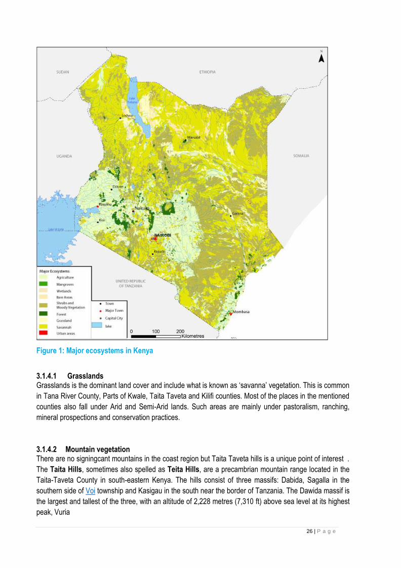
Biological Environment-Ecosystems Different land uses in Coast region is influenced by different types of vegetation according to the climate,
topography, and other bio-physical factors. The major categories are grassland, forests, semi-deserts, and
mountains. Human impacts on the land continue to alter the distribution, amount, and health of these
ecosystems (Survey of Kenya 2003).
26 | P a g e
Figure 1: Major ecosystems in Kenya
3.1.4.1 Grasslands Grasslands is the dominant land cover and include what is known as ‘savanna’ vegetation. This is common
in Tana River County, Parts of Kwale, Taita Taveta and Kilifi counties. Most of the places in the mentioned
counties also fall under Arid and Semi-Arid lands. Such areas are mainly under pastoralism, ranching,
mineral prospections and conservation practices.
3.1.4.2 Mountain vegetation There are no signingcant mountains in the coast region but Taita Taveta hills is a unique point of interest .
The Taita Hills, sometimes also spelled as Teita Hills, are a precambrian mountain range located in the
Taita-Taveta County in south-eastern Kenya. The hills consist of three massifs: Dabida, Sagalla in the
southern side of Voi township and Kasigau in the south near the border of Tanzania. The Dawida massif is
the largest and tallest of the three, with an altitude of 2,228 metres (7,310 ft) above sea level at its highest
peak, Vuria
27 | P a g e
3.1.4.3 Marine and coastal areas Kenya’s marine and coastal environments include the Indian Ocean’s territorial waters and the immediate
areas that border the ocean. The Kenyan coast stretches 550 kilometers from the Somalian border in the
north in a south-westerly direction to the border with Tanzania. The fringing coral reef (comprised of about
140 species of hard and soft corals) runs between 0.5.km and 2km off-shore with occasional gaps at the
mouths of rivers and isolated areas facing creeks.
Beaches, cliffs, or mangrove forests dominate the shoreline in most areas. The coral-reef system, mangrove
swamps, and hinterland provide unique natural landscapes and a wide range of biodiversity resources of
special conservation concern.
3.1.4.4 Forests in Coast region: Major Forests in the coast region: Forests cover 2.9 per cent of Kenya's land area (KFMP 1995). The main forest types are moist highland
forest, dry forest, tropical rain forest, coastal forest, and riverine and mangrove forests (Survey of Kenya
2003). Although they are not extensive land cover, Kenya’s forests provide significant goods and services,
including numerous non-timber forest products that provide local people with food, fibres, medicines, and
shelter. The closed canopy forests are habitat for a disproportionately large percentage of the country’s
wildlife and other biodiversity. It is estimated that they harbor 40 per cent of large mammals, 30 per cent of
birds and 35 per cent of the nation’sbutterflies. About half of Kenya’s threatened mammals and birds are
found in its forests (Survey of Kenya 2003).
In terms of biodiversity, coastal forests in Kenya that together host all globally threatened species occurring
within the coastal strip and therefore the most important blocks are: Shimba Hills, Lower Tana River forests,
Witu Forest Reserve, Arabuko- Sokoke Forest; Diani Forest and Kaya Ribe.
Arabuko Sokoke:
Arabuko-Sokoke Forest Reserve is a 420 km2 coastal forest in Kenya managed by Kenya Forest Service
(KFS). It is the largest and most intact coastal forest in East Africa, with 20% of Kenya's bird species, 30%
butterfly species and at least 24 rare and endemic bird, mammal and butterfly species.
28 | P a g e
Arabuko Forest which is a protected area
The forest has 40 recorded mammal species including African Elephant, African Buffalo, African Civet,
Caracal, Syke’s Monkeys, Yellow Baboons and Lesser Galago (or bushbaby). Some of Kenya’s rarest
mammals are found here, including the Golden-rumped Elephant-shrew, Sokoke Bushy-tailed Mongoose
and Ader’s Duiker.
There are over 270 species of birds recorded in the forest including several rare and endemic species. The
Clarke’s Weaver is only found in Arabuko-Sokoke and another area 30 kms further north of Arabuko-Sokoke
in the whole world. Other globally threatened bird species found in Arabuko-Sokoke include: Amani Sunbird,
East Coast Akalat, Sokoke Scops Owl, Sokoke Pipit, and the Spotted Ground Thrush. The forest is a
protected area and does not fall within the project foot print area.
Shimba hills forest
As one of the largest coastal forests in East Africa after Arabuko-Sokoke Forest, this reserve is rich in flora
and fauna and hosts the highest density of African elephant in Kenya. Other animal species found in the
area are Sable antelope, elephant shrew, bushy tailed mongoose and other small mammals like fruit bats.
The forest is an important bird area and is endowed with forest birdlife while the grasslands hold localized
species such as red-necked-Spur fowl, Croaking Cisticola and Zanzibar Red Bishop. The scenic Sheldrick
Falls and the dense Mwaluganje Forest are also found here along with four campsites. The forest is inside
Shimba hills National park which is a protected area and does not fall on the proposed project foot print.

29 | P a g e
Extract of google map showing Shimba hills National reserve, inside which we have Shimba hills forest.
Witu Forest:
The Witu Forest is a protected area in Lamu District, Kenya, East Africa. It was formed in 1927 by combining
the Utwani Forest Reserve with the adjacent Gongoni Forest Reserve. The previous names remained in
use. The independent Kenyan government confirmed the reservation, gazetting the forest in 1962, with 701
hectares (1,732 acres) more gazetted in 2002. The forest covers 4,639 hectares (11,463 acres) of gazetted
land, with approximately 900 hectares (2,224 acres) of additional un gazetted, but enclosed, forest.
Euphorbia tanaensis is a critically endangered plant found in the Witu Forest Reserve where there are only
20 mature plants according to the IUCN Red List of Threatened Species (IUCN 2009). Although the forest
is a reserve and is therefore legally protected, this has not accorded adequate protection to this and other
endangered tree species that it hosts.
The Witu forest does not fall within the project foot print.
Lower Tana River Forests:
These are riparian forests along the meandering course of the lower Tana river, some 350-km east of
Nairobi and 240 km north of Mombasa. Along the last 65 km of its course, the Tana has a broad flood-
plain, 1–6 km wide, that is covered by alluvial sediment deposited during floods. Such flooding takes place
in response to heavy rains on the Aberdare mountains and Mount Kenya watersheds rather than local
rainfall in this hot, arid region. The lowland evergreen forests are patchy, of different successional stages,
and are dependent on groundwater supplied by the river. Characteristic trees include Ficus spp., Phoenix

30 | P a g e
reclinata, Acacia robusta, Populusilicifolia, Blighia unijugata,Sorindeia madagascariensis, Diospyros
mespiliformis and Mimusops obtusifolia.
The project foot print will not be within the conservations areas.
Kaya forests:
The Mijikenda Kaya Forests consist of 11 separate forest sites spread over some 200 km along the coast
containing the remains of numerous fortified villages, known as kayas, of the Mijikenda people. The kayas,
created as of the 16th century but abandoned by the 1940s, are now regarded as the abodes of ancestors
and are revered as sacred sites and, as such, are maintained as by councils of elders. The site is inscribed
as bearing unique testimony to a cultural tradition and for its direct link to a living tradition.
One such forests is the Kaya Kinondo forest which is a sacred forest in Coastal Kenya originally home to
the Digo people who use the forest as a place of worship.
During implementation of the project the contractors should avoid any interference with the Kaya Forests.
Taita hills Forest:
The Taita Hills cover an area of 1000 km2 and they form the northernmost part of the Eastern Arc Mountains.
They are isolated from other mountainous areas to the southeast (Shimba Hills), south (Pare and Usambara
Mountains), southwest (Mt. Kilimanjaro), west (Ngulia and Chyulu Hills) and northwest (Kenyan highlands)
by the vast plains of Tsavo National Park / Tsavo plains.
The Taita Hills, sometimes also spelled as Teita Hills, are a precambrian mountain range located in
the Taita-Taveta County in south-eastern Kenya.
The hills are known for their moist forests with a unique fauna and flora. More than 20 endemic species
of African violets (e.g., Saintpaulia teitensiss) occur exclusively in that region. Known endemic bird species
are the Taita thrush (Turdus helleri) and the Taita apalis (Apalis fuscigularis). The Taita falcon (Falco
fasciinucha) and the Taita fiscal (Lanius dorsalis) were first discovered at the hills but occur elsewhere, too.
An amphibian in the genus Boulengerula occurs only in the Taita Hills. The Sagala caecilian (Boulengerula
niedeni) is a critically endangered worm-like amphibian that lives in the Taita Hills.
Taita hills has 400 ha of original forest retained in a scatter of three larger remnants, Chawia (80 ha),
Ngangao (123 ha) and Mbololo (220 ha), and nine tiny remnants, embedded in a mosaic of human
settlements, small-holder cultivation plots and exotic plantations.
31 | P a g e
Legend:
The contractor is expected to avoid forested areas and any interference has to be with consent from the
local Kenya Forest Service.

32 | P a g e
Nairobi Region Baseline Information (Environmental and Social Characterization)
This chapter provides description of Nairobi region in terms of the location, size, physiographic and natural
conditions, demographic profiles as well as information on infrastructure and access; land and land use;
forestry, environment and climate change among others.
Location and Size Nairobi region is constituted by four (4) Counties namely Nairobi, Machakos and Kajiado Counties.
Nairobi County is one of the 47 counties in the Republic of Kenya. It borders Kiambu County to the North
and West, Kajiado to the South and Machakos to the East. Among the three neighbouring counties, Kiambu
County shares the longest boundary with Nairobi County. The County has a total area of 696.1 Km2 and is
located between longitudes 36o 45’ East and latitudes 1o 18’ South. It lies at an altitude of 1,798 metres
above sea level.
Machakos County is strategically located as it borders seven counties. To the north it is bordered by Embu,
Muranga and Kiambu Counties, to the west Nairobi and Kajiado counties, to the south Makueni County and
to the East Kitui County. See Map 1 below. In terms of latitude and longitude it lies between latitudes
0º45´South and 1º31´South and longitudes 36º45´East and 37º45´East. The County covers an area of
6208.2 Km² with Machakos covering 925.2 Km², Kangundo covers 177.2 Km², Kathiani covering 207.1 Km²,
Athi River covers 843.2 Km², Yatta covering 1,057.3 Km², Masinga covering 1,402.8 Km², Matungulu
covering 577.5 Km² and Mwala covering 1,017.9 Km².
Kajiado County is located in the southern part of Kenya. It borders Nairobi County to the North East, Narok
County to the West, Nakuru and Kiambu Counties to the North, Taita Taveta County to the South East,
Machakos and Makueni Counties to the North East and east respectively, and the Republic of Tanzania to
the South. It is situated between Longitudes 360 5’ and 370 5’ East and between Latitudes 10 0’ and 30 0’
South. The county covers an area of 21,900.9 square kilometres (Km2 )
Makueni County borders Machakos County to the North, Kitui County to the East, Kajiado County to the
West and Taita Taveta County to the South. The County lies between Latitude 1º 35´ and 30 00 South and
Longitude 37º10´ and 38º 30´East and covers an area of 8,008.7 KM2
33 | P a g e
Map 1: Location of Nairobi region in Kenya
Sketch showing the Nairobi region
Figure 1: Map of Kenya
Physiographic and Natural Conditions This section briefly describes the physical and topographic features, ecological and climatic conditions in the Counties. 3.2.2.1 Physical and Topographic Features The terrain in the eastern side of Nairobi County is gently rolling but divided by steep valleys towards the City boundaries. To the north, there is the Karura forest which is characterized by steep sided valleys. The Karen - Langata area is characterized by plains surrounded by Nairobi National Park on the east and Ngong Forest on the south. Several streams with steep-sided valleys covered with vegetation are a dominant
34 | P a g e
landscape feature of the County. The main rivers in the County are Nairobi River, Ngong River and Kabuthi River. These rivers are highly polluted as open sewers and industrial waste is directed towards them. Nairobi dam, which is along the Ngong River, and Jamhuri dam are the main water reservoirs in the County. The main types of soils are the black cotton and the red soils that form patches in different parts of the County. There are three forests in the County namely Ngong Forest to the south, Karura Forest to the north and the Nairobi Arboretum. The three forests have a total coverage of 23.19 Km2..
Machakos County has very unique physical and topographical features. Hills and a small plateau rising to 1800-2100m above sea level constitute the Central part of the County. To the West, the County has a large plateau elevated to about 1700m which is Southeast Machakos County Integrated Development Plan, 2015 6 sloping. The County rises from 790 to 1594 m above sea level. In the North West the County has stand-alone hills. The main physical features of Kajiado County are plains, valleys and occasional volcanic hills ranging from
an altitude of 500 metres above sea level at Lake Magadi to 2500 metres above sea level in Ngong Hills.
Topographically, the county is divided into three different areas namely; Rift Valley, Athi Kapiti plains and
Central Broken Ground
Makueni County lies in the arid and semi-arid zones of the Eastern region of Kenya. Major physical features
in the County include the volcanic Chyullu hills which lie along the South West border of the County in
Kibwezi West Sub County, Mbooni hills in Mbooni Sub County and Kilungu and Iuani hills in Kaiti Sub County.
The terrain is generally low-lying from 600M above sea level in Tsavo at the southern end of the County.
3.2.2.2 Ecological Conditions The County is predominantly a terrestrial habitat that supports a diverse web of biodiversity ecosystems. It is home to about 100 species of mammals, 527 bird species and a variety of plant species. Although it is endowed with some permanent rivers, the aquatic ecosystems are largely choked by the effects of pollution from different sources. Currently, efforts are underway to ensure a sustainable clean Nairobi River Basin. Machakos County is the home for Yatta plateau which is situated within the Yatta Sub County which Sub
County has a land mass of 1,057 Km² thus the second biggest Sub County. This County has numerous hills
which include Iveti, Lukenya, Komarock, Kavila Koli, Ithanga, Mavoloni, Kangonde, Kamuthamba, Nzii, and
Ekalakala.. Tana River and Athi River are the two permanent rivers within Machakos County. They are also
the main sources of water, however we also have the Masinga dam within Masinga Sun County which is the
largest Sub County with a land mass of 1,402.8 Km².
Kajiado consists of three geological regions: quaternary volcanic, Pleistocene and basement rock soils.
Alluvia soils are also found in some areas. Quaternary Volcanic soil is found in the Rift Valley. Basement
System Rocks which comprise various gneisses, cists, quartzite and crystalline limestone, are found mainly
along the river valleys and some parts of the plains. Pleistocene soils are found in the inland drainage lake
system around Lake Amboseli. Quarrying of building materials is also done within the county.
Makueni County is largely arid and semi-arid and usually prone to frequent droughts. This has negatively
affected agriculture which is the main economic activity. The lower side of the County which is very dry
receives little rainfall ranging from 300 mm to 400 mm
3.2.2.3 Climatic Conditions Nairobi has a fairly cool climate resulting from its high altitude. Temperature ranges from a low of 100C to a high of 290C. It has a bi-modal rainfall pattern. The long rains season fall between Nairobi County Integrated Development Plan, 2018 Page 4 March and May with a mean rainfall of 899 millimeters (mm) while the short rains season falls between October and December with a mean rainfall of 638 mm. The mean annual rainfall is 786.5 mm.

35 | P a g e
Generally the annual rainfall of Machakos County is unevenly distributed and unreliable. The average rainfall
is between 500 mm and 1300 mm. The short rains are expected in October and December while the long
rains are expected in March to May. The highland areas within the County such as Mua, Iveti and Kangundo
receive an average of 1000mm while the lowland areas receive about 500mm; ideally the rainfall within the
County is influence by the latitude. In terms of temperature, July is the coldest month while October and
March are the warmest. Temperature varies between 180C and 29˚C throughout the year
Kajiado County has a bi-modal rainfall pattern. The short rains fall between October and December while
the long rains fall between March and May. There is a general rainfall gradient that increases with altitude.
The bimodal rainfall pattern is not uniform across the County. The long (March to May) rains are more
pronounced in the western part of the County while the short (October to December) rains are heavier in the
eastern part. The rainfall amount ranges from as low as 300mm in the Amboseli basin to as high as 1250mm
in the Ngong hills and the slopes of Mt. Kilimanjaro. Temperatures vary both with altitude and season. The
highest temperatures of about 340 C are recorded around Lake Magadi while the lowest of 100 C is
experienced at Loitokitok on the eastern slopes of Mt. Kilimanjaro.
Makueni County experiences two rainy seasons - long rains occur in March /April while short rains occur in
November/December. The hilly parts of Mbooni and Kilungu receive 800-1200mm of rainfall per year. High
temperatures of 35.80C are experienced in the low-lying areas causing high evaporation which worsens the
dry conditions. The areas to the North such as Kilungu, Iuani and Mbooni hills are usually cool with
temperatures ranging from 20.20C to 24.60C,
3.2.2.4 Drainage Nairobi City lies in the Athi River Drainage Basin. The major rivers that cross the City include Nairobi,
Ruaraka, Ngong, Athi and Mathare River. All these drain from the West and flow towards the Eastern
direction as dictated by the topographical features. As the rivers pass through the City, industrial effluents,
municipal waste and siltation heavily pollute them.
Nairobi‘s main drainage follows the regional slope of the volcanic rocks towards the east, while subsidiary
internal drainage into the Rift region is confined to the western part. The lava plains east of the line Ruiru-
Nairobi-Ngong are underlain by a succession of lava flows alternating with lakebeds, streams deposits, tuffs
and volcanic ash. These plains, comprising mainly the Athi plains and the northern section of the Kapiti plain,
extend westwards, rising from 4900 feet (1493 m) at the Athi River to 6000 feet (1829 m) in the faulted region
near Ngong. The lava plains are crisscrossed with steep-walled gullies and canyon-like gorges, such as
those along the Mbagathi valley. Further east this valley widens slightly where soft material is being actively
eroded. Water draining eastward from the hill area accumulates on the low-lying ground between Parklands
in the north and Nairobi South estate, forming a perched water table above the Nairobi phonolite. The
Kerichwa Valley Tuffs lying to the east of the highway function like a sponge and the contact between them
and the underlying impermeable phonolite thus forms a perfect aquifer, so much so that a number of
channels containing water occur beneath Nairobi.
Tana River and Athi River are the two permanent rivers within Machakos County. They are also the main
sources of water. These rviers drain in Indian ocean, however there is also the Masinga dam within Masinga
Sun County which is the largest Sub County with a land mass of 1,402.8 Km².
Most rivers in the eastern part of the Rift Valley including Kajiado drain toward the east while those within
the floor of the valley are restricted to the small depressions and lakes that have no major outlets. it is within
this region that lake Magadi is found.

36 | P a g e
The main river in Makueni County is Athi River. This river is perennial and is fed by tributaries such as
Thwake, Kaiti, Kikuu, Muooni, Kiboko, Kambu and Mtito Andei which drain from various parts of the County.
A few other streams flow from the Mbooni, Iuani and Kilungu hills but their flow becomes irregular as they
move to the low-lying areas.
3.2.2.5 Soils and Geology The rocks in the Nairobi area mainly comprise a succession of lavas and Pyroclastics of the Cainozoic age
and overlying the foundation of folded Precambrian schist‘s and gneisses of the Mozambique belt. The
crystalline rocks are rarely exposed but occasionally fragments are found as agglomerates derived from
former Ngong volcano. The soils of the Nairobi area are products of weathering of mainly volcanic rocks.
Weathering has produced red soils that reach more than 50 feet (15m) in thickness. A number of subdivisions
are recognized in the Nairobi area according to drainage, climatic regions and slopes, and other categories
have been introduced for lithosols and regosols.
The soils in Machakos are well drained shallow, dark red clay soils particularly in the plains.
Kajiado County consists of three geological regions: quaternary volcanic, Pleistocene and basement rock
soils. Alluvia soils are also found in some areas. Quaternary Volcanic soil is found in the Rift Valley.
Basement System Rocks which comprise various gneisses, cists, quartzite and crystalline limestone, are
found mainly along the river valleys and some parts of the plains. Pleistocene soils are found in the inland
drainage lake system around Lake Amboseli. Quarrying of building materials is also done within the county
3.2.2.6 Forestry and Agro Forestry This section briefly discusses the main forest types, their characteristics and uses. It also highlights some of
the main forest products, level of agro-forestry. .
Forest Types and Size of Forests Nairobi County is home to three gazetted forests managed by Kenya Forest Service namely Karura, Ngong
Road forest and Nairobi Arboretum. Karura forest is the largest of the three with 1,041 hectares and one of
the largest urban gazetted forests in the world. About 632 hectares contain exotic tree plantations while
indigenous trees cover 260 hectares. The rest of the forest is shrubs and other plants. Ngong Road forest
covers 538 hectares with 80 per cent being indigenous trees and 20 per cent exotic eucalyptus plantations.
Nairobi Arboretum is 30 hectares of wooded landscape and situated about 3Kms from the city centre. The
forests are rich in different species of trees, plants and insects.
To achieve the national forest cover target of 10% of land area, the major afforestation effort will have to be
in community and private lands. According to a study by Kenya Forest Service (2013) the national tree cover
is about 7.2% while for Nairobi City County the cover is 7.6%. The challenge facing the tree cover in the
County is the ever-growing demand for land for real estate development, which more often result in the
cutting of trees. The current road expansion programme, currently being undertaken by the National
Government, although good for the city, has also resulted in the reduction of tree cover, especially along the
road corridors.
The forests in Machakos County cover an area of 477.617Km2 which is 7.6 per cent of the County’s total
land. The forests are categorized as gazetted and un-gazetted. The gazetted forest covers 606.97 ha while
the un-gazetted cover 1774 ha. These forests are distributed in various parts of the County.

37 | P a g e
Kajiado County has a total forest area of 16,866.88 Ha comprising of indigenous and exotic forests. A total
of 15,626.8 Ha of the forest land is gazetted forest while 1,240 Ha is trust land. Gazetted forest areas are
found at the border areas of the county, mainly Ngong hills Kajiado County Integrated Development Plan,
2013-2017 19 (3,077 Ha), Loitokitok (765.8 Ha), and Namanga (11,784 Ha). Forest in trust land includes
Embakasi (573 Ha) and Oloolua (667 Ha).
Main Forest products The main forest products in Nairobi County include timber, fuel-wood, and a number of other non-wood
products. The Non-timber forest products include fruits, nuts, vegetables, and game, medicinal plants,
resins, essences and a range of barks and fibres such as bamboo, rattans, and a host of other palms and
grasses.
These products are obtained from both the indigenous and exotic trees. Indigenous tree species include
Brachlean hulies(Muhugu),Warbugia, ugandensis, Croton, neutonia, buchanii, olea, Africana and prunus
africana while exotic species comprise of cypress, eucalyptus, gravelia,bottle brush, cassia spectabils, nandi
flame and jacaranda nimosifolia. There are a number of activities that can be enjoyed in the forests including
forest walks, drives, bird and butterfly watching, cycling, running and picnicking.
The main forest products in Machakos County are firewood, charcoal, timber for building and construction,
poles and posts. Other forest products include production of honey both for domestic and commercial
purposes and wood carving in Wamunyu
The forest resources available in Kajido County include timber, firewood and charcoal. Trees and other
plants are a source of the widely used traditional medicines.
Agro-Forestry Agro forestry is a land use management system in which trees shrubs are grown around or among crops or
pastureland. It combines shrubs and trees in agricultural and forestry technologies to create more diverse,
productive, profitable, healthy, ecologically sound, and sustainable land-use system. Trees are an essential
part of diversified farm production, providing both subsistence products and incomes while contributing to
soil fertility, watershed protection, microclimate, carbon sequestration and soil and water conservation.
Products such as fuel wood or fodder from trees, shrubs or grass contribute significantly to the economies
of the households.
While challenges in tree growing are greater in the lower rainfall areas a variety of species have the potential
to make tree growing in these areas profitable. In the County Agro forestry is practiced in the Peri- urban
areas of Kasarani, Dagoretti and Westlands Sub-counties. Farmers through the help of extension officers
are trained in tree Nursery establishment as well as tree planting in accordance with the farm forestry rules
of 2009. The farmers are encouraged to include appropriate fruit trees for home use.
Income generating activities in Machalos County in this sector include planting of trees such as, eucalyptus,
cypress, gravellie and pine for commercial purposes. Other activities include establishment of tree nurseries
for seedlings. Fruit trees are also grown and include mangoes, papaws, avocadoes, Guavas and oranges
for both income generation and Machakos County Integrated Development Plan, 2015 33 consumption
3.2.2.7 Land Use The Table below shows the land use type and coverage in Nairobi County. Industrial and commercial land
has dwindled in the last decade and most industries have been looking for land in Athi river part of Machakos
County.
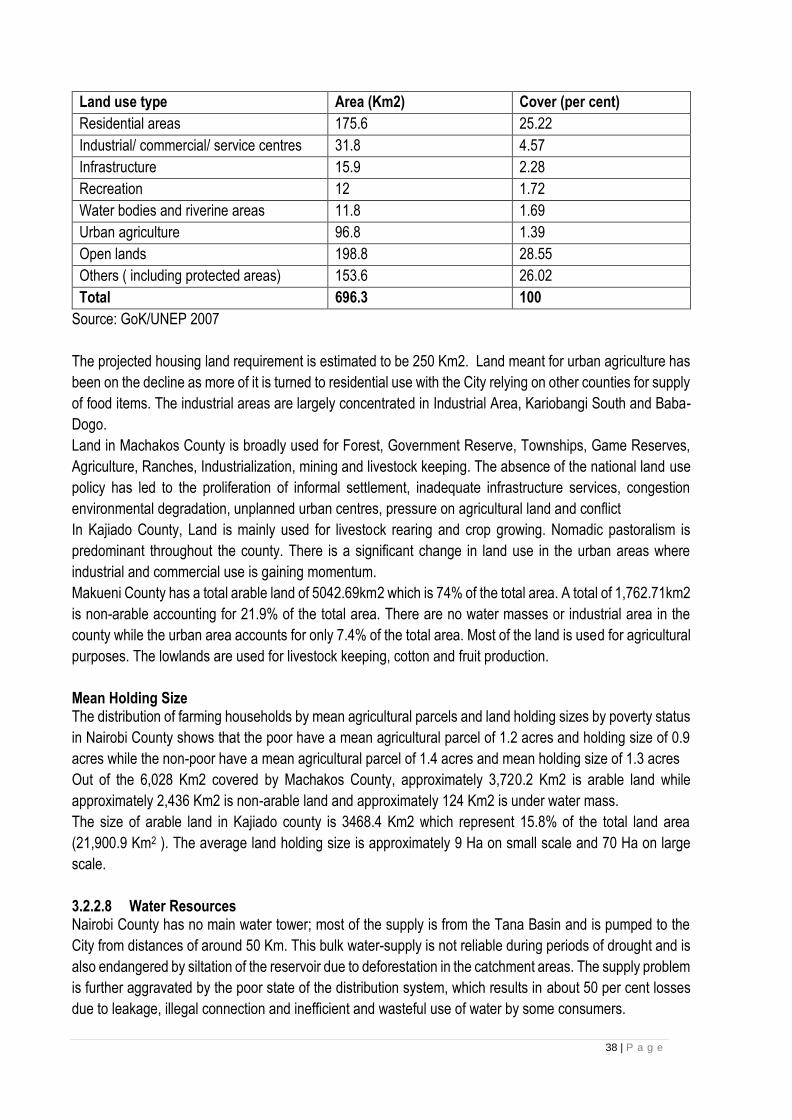
38 | P a g e
Land use type Area (Km2) Cover (per cent)
Residential areas 175.6 25.22
Industrial/ commercial/ service centres 31.8 4.57
Infrastructure 15.9 2.28
Recreation 12 1.72
Water bodies and riverine areas 11.8 1.69
Urban agriculture 96.8 1.39
Open lands 198.8 28.55
Others ( including protected areas) 153.6 26.02
Total 696.3 100
Source: GoK/UNEP 2007
The projected housing land requirement is estimated to be 250 Km2. Land meant for urban agriculture has
been on the decline as more of it is turned to residential use with the City relying on other counties for supply
of food items. The industrial areas are largely concentrated in Industrial Area, Kariobangi South and Baba-
Dogo.
Land in Machakos County is broadly used for Forest, Government Reserve, Townships, Game Reserves,
Agriculture, Ranches, Industrialization, mining and livestock keeping. The absence of the national land use
policy has led to the proliferation of informal settlement, inadequate infrastructure services, congestion
environmental degradation, unplanned urban centres, pressure on agricultural land and conflict
In Kajiado County, Land is mainly used for livestock rearing and crop growing. Nomadic pastoralism is
predominant throughout the county. There is a significant change in land use in the urban areas where
industrial and commercial use is gaining momentum.
Makueni County has a total arable land of 5042.69km2 which is 74% of the total area. A total of 1,762.71km2
is non-arable accounting for 21.9% of the total area. There are no water masses or industrial area in the
county while the urban area accounts for only 7.4% of the total area. Most of the land is used for agricultural
purposes. The lowlands are used for livestock keeping, cotton and fruit production.
Mean Holding Size The distribution of farming households by mean agricultural parcels and land holding sizes by poverty status
in Nairobi County shows that the poor have a mean agricultural parcel of 1.2 acres and holding size of 0.9
acres while the non-poor have a mean agricultural parcel of 1.4 acres and mean holding size of 1.3 acres
Out of the 6,028 Km2 covered by Machakos County, approximately 3,720.2 Km2 is arable land while
approximately 2,436 Km2 is non-arable land and approximately 124 Km2 is under water mass.
The size of arable land in Kajiado county is 3468.4 Km2 which represent 15.8% of the total land area
(21,900.9 Km2 ). The average land holding size is approximately 9 Ha on small scale and 70 Ha on large
scale.
3.2.2.8 Water Resources Nairobi County has no main water tower; most of the supply is from the Tana Basin and is pumped to the
City from distances of around 50 Km. This bulk water-supply is not reliable during periods of drought and is
also endangered by siltation of the reservoir due to deforestation in the catchment areas. The supply problem
is further aggravated by the poor state of the distribution system, which results in about 50 per cent losses
due to leakage, illegal connection and inefficient and wasteful use of water by some consumers.

39 | P a g e
Machakos County has two permanent rivers namely Athi and Tana. Tana River is mainly used for
hydroelectricity generation while Athi River is used for domestic and industrial uses. There are also several
dams that serve as water resources and springs which are found in the hilly areas. Underground water
sources supplement surface water sources
In Kajiado, there are various sources of water in the county, namely, rivers, shallow wells,
protected/unprotected springs, dams, water pans, and boreholes. The water is used for domestic, livestock
and commercial use. Most of the rivers are seasonal hence not reliable and ground water is available
although it contains high salt levels in some parts of the county.
The main sources of water in Makueni County include seasonal and permanent rivers, springs, boreholes,
wells and dams. The county has three permanent rivers - Athi, Kambu and Kiboko. Major seasonal rivers
include Thwake, Tawa, Kiboko, Makindu, Muooni, Kaiti, Usi Unene and Kasikeu. The current water
production is at 14,489.911m3/day against a demand of 40,794.39m3/day leaving a water deficit of
26,304.47 m3/ day.
3.2.2.9 Wildlife Main Wildlife Nairobi County is rich in biodiversity despite the accelerated pace of urbanization and development. The
County is home to about 100 mammal species, 527 bird species and a variety of plant species. Nairobi host
a variety of wildlife such as lions, leopards, cheetahs, hyenas monkeys, buffaloes and birds among others.
Tourists both local and international come to see these animals. Therefore, wildlife is a source of tourist
attraction thus main source of county income.
Machakos County is home to various animals which are in and outside the park. The main wildlife include,
Zebra, Wildbeast, Eland, Giraffes, Thomson’s Gazelle, Grant Gazelle, Elephants, Buffalo, Waterbuck, Lion,
Cheetah, Leopard, Warthogs, Ostriches, Impalas, DikDik, ,Hyena, and Reedbucks.
Most of the wildlife in Kajiado County is found in the Amboseli National Park, and animal conservation areas
of Chyulu hills and Kimana. The main wild animals are elephants, zebra, gnu, hippopotamus, buffalo, spotted
hyena, waterbuck, Maasai giraffe, bush buck, Thompsons and grant gazelle, impala, lion and cheetah. There
is also rare presence of the gerenuk and the fringed-eared Oryx in the arid northern part of the park. There
are also about 420 different species of birds in the park, the largest being the Ostrich.
Wild animals found in Makueni County includes: elephant, buffaloes, lion, leopard, wild dogs, waterbucks,
bird species etc.
Wildlife conservation areas (game parks, reserves, conservancies, game ranches) The main wildlife conservation areas in Nairobi are game parks, reserves, conservancies, and game
ranches. For instance, Nairobi animal orphanage which is located in Nairobi national park serves as a
treatment and rehabilitation centre foe wild animals. It hosts lions, cheetahs, hyenas, jackals, serval cats,
warthogs, leopards, monkeys, baboons, buffalo and various bird species like parrots, guinea fowls and
ostriches.
Main conservation ares in Kajiado are Amboseli National Park, and animal conservation areas of Chyulu
hills and Kimana
Willdlife in Makueni is found in protected areas e.g. Kamungi wildlife concervancy, Chyulu hills national park
and Chyulu hills
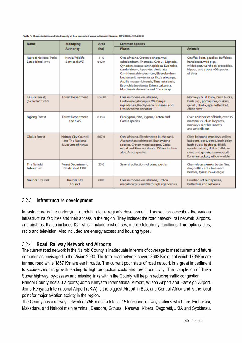
40 | P a g e
Infrastructure development Infrastructure is the underlying foundation for a region`s development. This section describes the various
infrastructural facilities and their access in the region. They include: the road network, rail network, airports,
and airstrips. It also includes ICT which include post offices, mobile telephony, landlines, fibre optic cables,
radio and television. Also included are energy access and housing types.
Road, Railway Network and Airports The current road network in the Nairobi County is inadequate in terms of coverage to meet current and future
demands as envisaged in the Vision 2030. The total road network covers 3602 Km out of which 1735Km are
tarmac road while 1867 Km are earth roads. The current poor state of road network is a great impediment
to socio-economic growth leading to high production costs and low productivity. The completion of Thika
Super highway, by-passes and missing links within the County will help in reducing traffic congestion.
Nairobi County hosts 3 airports; Jomo Kenyatta International Airport, Wilson Airport and Eastleigh Airport.
Jomo Kenyatta International Airport (JKIA) is the biggest Airport in East and Central Africa and is the focal
point for major aviation activity in the region.
The County has a railway network of 75Km and a total of 15 functional railway stations which are: Embakasi,
Makadara, and Nairobi main terminal, Dandora, Githurai, Kahawa, Kibera, Dagoretti, JKIA and Syokimau.
41 | P a g e
The establishment of Makadara and Imara Daima railway stations and expansion of Nairobi platform will
help to improve public transportation in Nairobi for socioeconomic development.
Machakos County has a total road network of 12152.5 Km of which 375 Km is bitumen surface, 10,628Km
is gravel surface, and 1149.5 Km is earth surface. Some are good roads including the Nairobi - Mombasa
road, Machakos - Kitui road, Machakos - Wote road and NairobiKangundo road.
The total length of roads in Kajiado county is 2,344.2 Km which include 300Km of tarmac roads. The five
major tarmac roads in the county are Emali-Loitokitok, Namanga-Athi River, Isinya-Kiserian, Magadi-
Mbagathi and Kiserian-Ngong-Karen roads. The other road network includes 932.3Km of gravel roads and
1111.9 Km of earth roads. The county has a total railway line length of 147Km which connects Tata
Chemicals Ltd (formerly Magadi Soda Company) to the Nairobi-Mombasa railway line.
Makueni is served by several bitumen and earth roads. These roads include Nairobi- Mombasa Highway,
Machakos-Makindu road etc
Information, communication and technology Posts and telecommunication sub-sector has experienced mixed growth in the recent past. While the County
has 38 post office branches, the growth of postal services has rather been declining due to increase in mobile
telephony. Mobile telephony has the highest coverage in Nairobi compared to other parts of the country with
over 95 per cent of the inhabitants having access to mobile communication. The players engaged in mobile
telecommunication include: Safaricom, Orange, Airtel and YU while those in mailing services include Kenya
Postal Corporation, Group 4 Securities (G4S), Direct Handling Limited (DHL), Wells Fargo among others.
The mobile network coverage within the Machakos County is of 85 per cent of the total area. However, areas
such as Kibauni and Yathui in Mwala, and Kalama in Machakos have a poor network coverage. The number
of land line connection is 327 and its use is on the decline particularly because the use of internet as the
main source of communication is on the rise and with the availability of fibre optic then the reliance on the
landlines is on the decrease. . There are 14 post offices and 20 sub-post offices which are fairly distributed
within the County. Radio ownership is 96 per cent which is attributed to low cost of purchase and
maintenance while Television coverage is 58 per cent
There are six post offices situated in Kajiado County. Kitengela, Rongai, Kajiado, Ngong, Namanga, and
Loitokitok. Mashuuru Sub-county, which lacks a post office, uses the one at Kajiado town. The county is also
served by 20 licensed stamp vendors and three private courier service providers. The mobile network
coverage in the county is approximately 60 percent, with all urban areas covered. The mobile telephone
coverage is by four operators namely; Safaricom, Airtel, Orange, and Yu networks. Most of the rural areas
are not covered by mobile network. According to the 2009 census, landline connectivity was 0.9 percent in
Kajiado Central constituency, 0.6 percent in Loitokitok and 10.6 percent in Kajiado North.
Energy access The main sources of energy in Nairobi County are electricity, solar, LPG, biogas paraffin, charcoal and
firewood. Lack of access to clean sources of energy is a major impediment to development through health
related complications such as increased respiratory infections and air pollution. The type of cooking fuel
used by households is related to the socio-economic status of households/individuals.
High level energy sources are cleaner but cost more and are used by households with higher levels of
income compared with simpler sources of fuel, mainly firewood, which are mainly used by households with
a lower socio-economic profile. For instance, 63.2 per cent of the population use paraffin as cooking fuel.
Other sources of energy for cooking include LPG gas (20.2per cent), charcoal (10.5 per cent) and firewood
42 | P a g e
(1.8 per cent). About 68.2 per cent of households use electricity as a means of lighting 28.8 per cent use
paraffin while 2.9 per cent and 1.7 per cent use grass and dry cells respectively.
In Machakos County, Masinga dam is one of the seven forks dams which produces hydroelectricity for the
National Electricity Grid and it is located within the County. The connection to the national grid across the
County is commendable since, 77 per cent of all trading centres have power. Though connection to individual
homes is low and there is need for up scaling the rural electrification programme, the County is keen on
cooperating with the Rural Electrifications Authority to ensure that there is energy access across the County.
The main energy sources in Kajiado County are firewood, electricity, charcoal, solar and petroleum products.
Out of 173,464 households across Kajiado County, only 69,098 households are connected to electricity
accounting for 39.8 percent of the households, with highest number of households being in the urban areas.
Other sources of energy underexploited include wind, solar and geothermal.
Only 7 per cent of households in Makueni County use electricity for lighting compared to a national
average of 22.9 per cent with the distribution of population by mode of lighting is lantern 63.3%, tin
lamp 25.3%, electricity 5.7 per cent and solar 3.8 per cent.
Socio-Economic Background Population In addition to being the capital, Nairobi is also the country’s largest city by population. The last official population was taken in 2009 and at that time was 3,138,369 in the city proper. That number has since grown to approximately 3.5 million. The metro area has over 6.5 million residents. This “Green City in the Sun” has a history dating back to 1899 and continues to grow as rural residents make their way to this big city for employment opportunities. In machakos County, the gender population is almost equally distributed across the different age cohorts.
The male population stands at 543,139 while the female population stands at 555,445. This translates into
a sex ratio of 1:1.02.
Kajiado County has an annual population growth rate of 5.5 percent with population in 2012 estimated at
807,069 of which 401,784 were females and 405,285 males.
As at 2016, the population of Makueni County was projected at 975,590 with an annual population growth
rate of 1.4% and 44% of the population under age 15. The 2017 projected population stands at 988,586
consisting of 481,380 males and 507,206 females
Population Density The city of Nairobi is growing consistently and currently sprawls over a surface area of 696 kilometers
squared (269 square miles). This area size - in combination with the total number of residents - brings us
the current population density which is now approximately 4,850 residents per square kilometer. (12,600
people living per square mile).
The population density and distribution in Machakos County is driven by the economic activity carried out in
the specific sub county. As at 2009 the County had a population density of 177 per Km2 , it was projected at
188 per Km2 as at 2012, 200 per Km2 as at 2015 and 212 per Km2 as at 2017
Kajiado County had a population density of 31 persons per Km2 in 2009 and is expected to increase to 46
persons per Km2 by 2017. Urban areas have relatively high densities compared to rural ones.
The annual population growth rate for Makueni County stands at 1.4 per cent while the male-female sex
ratio stands at 1:1.
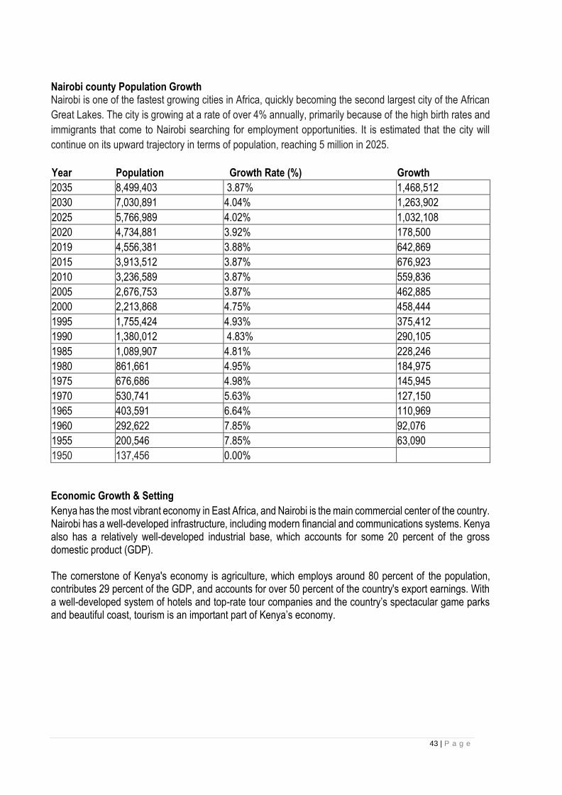
43 | P a g e
Nairobi county Population Growth Nairobi is one of the fastest growing cities in Africa, quickly becoming the second largest city of the African
Great Lakes. The city is growing at a rate of over 4% annually, primarily because of the high birth rates and
immigrants that come to Nairobi searching for employment opportunities. It is estimated that the city will
continue on its upward trajectory in terms of population, reaching 5 million in 2025.
Year Population Growth Rate (%) Growth
2035 8,499,403 3.87% 1,468,512
2030 7,030,891 4.04% 1,263,902
2025 5,766,989 4.02% 1,032,108
2020 4,734,881 3.92% 178,500
2019 4,556,381 3.88% 642,869
2015 3,913,512 3.87% 676,923
2010 3,236,589 3.87% 559,836
2005 2,676,753 3.87% 462,885
2000 2,213,868 4.75% 458,444
1995 1,755,424 4.93% 375,412
1990 1,380,012 4.83% 290,105
1985 1,089,907 4.81% 228,246
1980 861,661 4.95% 184,975
1975 676,686 4.98% 145,945
1970 530,741 5.63% 127,150
1965 403,591 6.64% 110,969
1960 292,622 7.85% 92,076
1955 200,546 7.85% 63,090
1950 137,456 0.00%
Economic Growth & Setting
Kenya has the most vibrant economy in East Africa, and Nairobi is the main commercial center of the country. Nairobi has a well-developed infrastructure, including modern financial and communications systems. Kenya also has a relatively well-developed industrial base, which accounts for some 20 percent of the gross domestic product (GDP).
The cornerstone of Kenya's economy is agriculture, which employs around 80 percent of the population, contributes 29 percent of the GDP, and accounts for over 50 percent of the country's export earnings. With a well-developed system of hotels and top-rate tour companies and the country’s spectacular game parks and beautiful coast, tourism is an important part of Kenya’s economy.

44 | P a g e
Central Rift Region Environmental and Social Characterization This section describes the overall baseline condition of the Central rift region in terms of bio-physical
environment, as well as the socio-economic and cultural.
Location and Size The central rift region is in the great Rift valley region in Kenya and comprises of five counties namely
Kericho, Bomet, Nakuru, Baringo and Narok.
The region is located in the Southern part of the Great Rift Valley. Kericho lies between longitude 35º 02‘and
35º 40‘East and between the equator and latitude 0 23‘South with an altitude of about 2002m above the sea
level. While Nakuru County is located between Longitudes 35.41 º East or 35 º 24’ 36” East and 36.6 ºEast
or 36 º36’ 0” East and Latitude 0.23 º North or 0 º 13’ 48” North and 1.16 º South or 1º 9`36” South. The
Narok county lies between latitudes 0° 50´ and 1° 50´ South and longitude 350 28´ and 36o 25´ East and
Bomet County lies between latitudes 0º 29' and 1º 03' south and between longitudes 35º 05' and 35º 35'
east.
Physical Environment
3.3.2.1 Climate Rainfall patterns in the region vary with a high of 2500mm and a low of 500mm per annum. Bomet, Nakuru
and Baringo counties enjoys relatively uniform rainfall ranging between 1000mm-1500mm per annum
whereby the high-altitude areas like the Mau escarpment receives high rainfall and the lowland areas like
the Kerio Valley experiences low rainfall. The wettest months are between April and June whereas the driest
seasons fall between December and January.
The region experiences varied temperatures ranging from 100c-350c, with the coldest months being between
February and April, while the hot seasons fall between December and January.
The region is generally agriculturally productive with Kericho and part of Bomet county growing tea while
Narok and parts of Nakuru county growing wheat as cash crops. Other crops produced include; maize,
beans, Irish potatoes, sweet potatoes, vegetables, herbs, spices fruits and cut flowers.
Parts of Narok and Baringo County are considered as Semi-Arid and Arid areas therefore not agriculturally
productive but can be improved through irrigation.
3.3.2.2 Topography and Drainage The region lies within the Great Rift Valley, and is serviced by several rivers, flowing from highlands through
arid and undulating landscapes. It is home to numerous volcanic landforms with areas of prominent
geothermal activities. The highland areas of Mau escarpments, rising to an attitude of 3,100m above sea
level provides fertile ground for farming and source to major rivers like Mara and Ewaso Nyiro with Mara
River being the single major river that passes through Maasai Mara Game Reserve and ultimately draining
into Lake Victoria.
The main topographical features in the region are the Mau Escarpment and the Tugen hills, the Rift Valley
floor, Ol-Doinyo Eburru Volcano, Akira Plains, Kerio valley and Menengai Crater. The region boasts of an
elaborate drainage and relief system with various inland lakes on the floor of the Rift Valley where nearly all
the permanent rivers and streams in the region drain into. These rivers include river Njoro and Makalia which

45 | P a g e
drain into Lake Nakuru, Malewa which drains into Lake Naivasha and Molo River which drains into Lake
Baringo among others.
3.3.2.3 Hydrology The floor of the Riftvalley owes its origin to the tectonic and volcanic disturbances which have dislocated
surfaces forming separate ridges. The troughs of the rift have a North South alignment are occupied by lakes
Bogoria, Baringo, Elementaita, Nakuru and Naivasha.
The other main drainage systems in the region are Lake Victoria South catchment basin and Ewaso Nyiro
South drainage area. Rivers in these basins include Mara, Mogor that traverse Narok County from Mau
region through to Kenya-border and into Tanzania draining into Lake Victoria and River Ewaso Ng'iro rising
from the Mau Escarpment, draining into Lake Natron respectively. However, due to continuous deforestation
over a couple of years, the volume of water in the rivers has been decreasing
3.3.2.4 Soils and Geology The region lies in the Lake Victoria Basin. Its geology is characterized by volcanic rocks as well as igneous
and metamorphic complexes and is predominantly underlain by tertiary lavas (phonolites) and intermediate
igneous rocks. A small part of the county is dominated by undifferentiated basement system rock (granites),
volcanic ash admixture and other prolific rocks.
There are also hot springs in Olkaria which are an important source of geothermal power that serves not
only the region but also provides power supply to the national grid. Further explorations are underway at
Menengai Crater and Ol-Doinyo Eburru with a view to generating more electricity.
3.3.2.5 Land Use and land ownership Land is the main source of livelihood for many people in the Central Rift region. All socio-economic activities
depend largely on land hence, rights of land ownership and land use are critical in influencing growth in all
sectors.
The land is mainly utilized for agricultural purposes which include livestock rearing, large and small scale
farming. The region is generally agriculturally productive with Kericho and part of Bomet county growing tea
while Narok and parts of Nakuru county growing wheat. However parts of Narok and Baringo County are
considered as Semi-Arid and Arid areas therefore not agriculturally productive but can be improved through
irrigation.
The highest mean holding size in the region is 263Ha which is in Nakuru County whereas the lowest is
1.55Ha which is in Bomet County. The settlement patterns in the region is largely influenced by the land
productivity.
Land ownership in the region can be classified as follows;
Public land: This is government land registered and set aside for government functions and development.
This land includes land for institutions, government offices, open parks dams and road reserves. The region
owns these lands parcels though it’s crucial to note that some of these institutions don’t have title deeds and
there’s need to have the titles processed in order to avoid grabbing.
Community Land: This is land that is lawfully registered in the name of group representatives, transferred
to a specific community by any process of law, any other land declared community land by an Act of
Parliament, lawfully held, managed or used by specific communities as community forests, grazing areas or
shrines, ancestral land and land occupied by traditionally hunter-gatherer communities and) lawfully held as
trust land by the county governments. Narok County has such lands held in trust by the county government.

46 | P a g e
Private land: This category of land comprises over 95 percent of the total land in the region. It comprises
freehold land and land under private leases. It’s also important to note that land sub divisions have been
done making the land uneconomical for production in some areas of southern parts of the county. Under
private ownership, the land owners are at a desecration to use their land as they wish.
It is also worth noting that Kericho County has large parcels of land which are under lease
Socio-economic
Population Kenya’s population was estimated at 39.8 million in the 2009 Population and Housing Census and growing
at about 2.9 percent per annum. The census depicted Rift Valley Province as the most populous with 10.1
million people while Nairobi, the capital, had 3.1 million people. The central rift region being part of the larger
Rift valley is also highly populated with its population distributed based on several factors like climatic
conditions, topography, soil composition and infrastructure.
In the Central rift region, Nakuru County is the most populated with an estimated population of 1.6 million
people while Baringo County is the least populated with a population of 555,561 people according to the
2009 Housing and Population census. This is attributed to the fact that Nakuru is agriculturally productive
and has more access to social amenities unlike Baringo whose parts are considered as arid and semi-arid.
Human Development Indicators (HDI) The Human Development Index (HDI) is a summary measure for assessing progress in three basic
dimensions of human development; a long and healthy life, access to knowledge and a decent standard of
living. A long and healthy life is measured by life expectancy at birth. Knowledge levels are measured by
mean years of education among the adult population, which is the average number of years of education
received in a life-time by people aged 25 years and older; and access to learning and knowledge by expected
years of schooling for children of school-entry age, which is the total number of years of schooling a child of
school-entry age can expect to receive if prevailing patterns of age-specific enrolment rates stay the same
throughout the child's life. The standard of living is measured by Gross National Income (GNI) per capita.
The national HDI stands at 5.2 while in the central rift region it varies from one county to the other. The
variations are attributed to the climatic and agro-ecological differences.

47 | P a g e
South Nyanza Baseline Information (Environmental and Social Characterization)
This section describes the overall baseline condition of South Nyanza region in terms of bio-physical
environment, as well as the socio-economic and cultural.
Location and Size The South Nyanza region covers the counties of Kisii, Nyamira, Homabay and Migori counties and has its headquarters in Kisii town.
Map of Kenya showing Location of Kisii, Nyamira, Homabay and Migori Counties.
Physical Environment
3.4.2.1 Climate Kisii and Nyamira County exhibit a highland equatorial climate resulting into a bimodal rainfall pattern with
average annual rainfall of 1,500mm. The long rains are between March and June while the short rains are
received from September to November; with the months of January and July being relatively dry. The
maximum temperatures in the County range between 21°C – 30°C, while the minimum temperatures range
between 15°C and 20°C. The high and reliable rainfall coupled with moderate temperatures are suitable for
growing crops like tea, coffee, pyrethrum, maize, beans and bananas as well dairy farming.
Migori county has an inland equatorial climate modified by the effects of altitude, relief and the influence of
the large body of water of Lake Victoria. The existence of favourable agricultural climate favours the
cultivation of cotton, maize and a variety of other food crops. Rainfall is generally continuous with little
distinction between first and second rains. Annual rainfall averages between 700 and 1,800 mm. Long rains
are between March and May while the short rains are between September and November. Dry seasons are
between December and February and June and September. Land preparation for the main food crops which
include maize, cassava, sweet potatoes and pineapples falls between November-February and July-
September. Harvesting is done between June-September and December-February. Nyatike, Karungu,
Kegonga and Muhuru divisions have comparatively harsher climatic conditions than other divisions. The
48 | P a g e
lakeshore divisions experience unreliable and poorly distributed rainfall. Temperatures show mean minimum
of 240C and maximum of 310C, with high humidity and a potential evaporation of 1800 to 2000 mm per year.
Homa Bay County has an inland equatorial type of climate. The climate is however modified by the effects
of altitude and nearness to the lake which makes temperatures lower than in equatorial climate. The county
receives an annual rainfall ranging from 700 to 800 mm.
3.4.2.2 Topography and Drainage Kisii and Nyamira Counties are characterized by a hilly topography with several ridges and valleys. The
counties have a bimodal pattern of annual rainfall that is well distributed, reliable and adequate for a wide
range of crops. Annual rainfall ranges between 1200 mm-2100 mm per annum.
Migori county has an altitude varying between 1140m at the shores of Lake Victoria in Nyatike Subcounty to
4625m in Uriri Sub-county. Undulating hills covers most of the county with a few stretches of flat land. The
county has several rivers with a spectacular water fall “Gogo Falls” found in River Kuja. Most parts of the
county are underlain by relatively ‘acid ‘parent rock.
Homabay county is divided into two main relief regions namely the lakeshore lowlands and the upland
plateau. The lakeshore lowlands lie between 1,163 – 1,219 m above the sea level and comprise a narrow
stretch bordering the Lake Victoria especially in the northern parts of the county. The upland plateau starts
at 1,219 m above the sea level and has an undulating surface which has resulted from erosion of an ancient
plain. It is characterized by residual highlands such as Gwassi and Ngorome hills in Suba, Gembe and Ruri
Hills in Mbita, Wire Hills in Kasipul as well as Homa hills in Karachuonyo. Kodera forest in Kasipul and the
Kanyamwa escarpment that runs along the borders of Ndhiwa and Mbita also form part of the upland plateau.
To the west of the county lies the Lambwe Valley where Ruma National park is located.
3.4.2.3 Soils and Geology In Kisii and Nyamira Counties; the major types of soil are red volcanic (Nitosols) which are deep, fertile and
well-drained accounting for 75 per cent while the remaining 25 per cent are those found in the valley bottoms
and swampy areas suitable for brick making. Though the red volcanic soils are good for farming, they make
construction and road maintenance expensive. Most parts of Migori county are underlain by relatively
‘acid‘parent rock. Granite covers most parts of Kuria East, Kuria West, Nyatike, some parts of Rongo and
Migori Sub-counties. The rest of the county is covered by the Nyanzian and Bukoban rocks. There is also
presence of gold deposits in the county particularly in Macalder in Nyatike sub-county, Masara in Migori sub-
county and some parts of Rongo, Kuria and Uriri sub-counties.
3.4.2.4 Land Use Kisii and Nyamira counties have favourable climates for growing of crops like tea, coffee, maize, beans,
finger millet, potatoes, bananas and groundnuts. In Migori, the small-scale farms are mainly utilised for
subsistence farming while the large-scale farms are utilised for livestock and cash crop farming mainly
tobacco and sugarcane. Homabay has varying agro- ecological zonation supporting Coffee, Maize, millet,
pineapples, sorghum, sunflower, tomatoes, soya beans, sisal, groundnuts, cow peas, sweet potatoes,
simsim, green grams, rice and cotton in some areas. Fishing is practiced at the shores of Lake Victoria in
Homabay and other live supporting activities like business, settlement, schools and religious practice cut
across South Nyanza region.
49 | P a g e
Biological Environment-Ecosystems Different ecosystems in South Nyanza region is influenced by different types of vegetation and according to
the climate, topography, and other bio-physical factors. Gwasi Hills Forest Community Wildlife Conservancy
was established by a Community in the year 2005 in Homabay county. The conservancy supports Baboons,
Monkeys, Birds and Snakes. Kisii, Nyamira and Migori have no significant conservancies but the
government through its arms continues to protect water catchment areas in the area.
The Lake Basin provides a variety of economic and development opportunities, including fisheries,
tourism and transboundary conservation. However, these opportunities are hindered by a number of threats
that include eutrophication, over-fishing, introduced exotic species and the impacts of climate change.
After the project foot print is established the contractor will be advised to take necessary precautions to
protect the Lake basin ecosystem which is very sensitive to environmental stresses.
3.4.3.1 Forests in South Nyanza Region Kisii county does not have a gazzetted forest; however, there are non-gazzetted forests like Nyangweta,
Ritumbe, Ndonyo and Nyansembe forests in Gucha South district, and Keboye hills in Kisii south, Sameta
hills in Sameta district, Nyacheki hills in Nyamache district, Igorera and Ibencho hills in Kenyenya, Taracha
hill in Kisii central, Intamocha hill in Gucha district and Emborogo forest in Masaba South.
Homa Bay, Migori, Nyamira and Kisii counties, which are around Lake Victoria, the world’s second largest
fresh water lake, are ranked among the poorest in forest cover in Kenya.
The region is endowed with a small percentage of forests which are both natural and exotic. The locals
collect firewood from the forest; graze their cattle inside the forest and gather herbs from the forests. There
are 10 non-gazetted forests covering 256.2ha in Nyamira county most of them through reforestation. In
Homabay there is Kodera and Wire forests in Rachuonyo. The forests are generally faced with deforestation
due to the shamba system, human settlements, cultivation, charcoal production and grazing.
3.4.3.2 Wildlife: Nyamira county has no main wildlife but there exists several other fauna and flora species. The wildlife has
been displaced due to the high population. However, along the major rivers and few forests, some monkey,
porcupine and various types of birds exist.
3.4.3.3 Wetlands: The region is blessed with many wetlands thanks to adequate rainfall availability. The once abundant
wetlands are now remnants despite their great value to the locals for grazing, getting reeds for making
baskets and water purification values. Wetlands are fragile and valuable ecosystems supporting a diversity
of species and habitats. They are also excellent purifiers of water and their threatened status may not be
able to control toxicity levels in water and on the arable land
There are a number of wetlands in Kisii county which include Nyaega wetland at Maroo in Nyataro village,
Bomonyama at Bomonyama village, Riokindo and Nyandiwa. The permanent rivers and streams in
Nyamira include Sondu, Eaka, Kijauri, Kemera, Charachani, Gucha , Bisembe, Mogonga, Chirichiro,
Ramacha and Egesagane. These rivers and several other streams in the county drain their water into Lake
Victoria.

50 | P a g e
North Rift Baseline Information (Environmental and Social Characterization) This section describes the overall baseline condition of North Rift region in terms of bio-physical environment,
as well as the socio-economic and cultural.
Location North rift region comprises of six counties which include Uasin Gishu, Nandi, Tranzoia, West Pokot, Elgeyo
Markwet and Turkana counties
Physical Environment
3.5.2.1 Climate The hilly and undulating topographical features of the region coincide with a spatial distribution of ecological zones that define the agricultural and overall economic development potential of the area. The northern parts receive rainfall ranging from 1,300 mm to 1,600 mm per annum. The southern half is affected by Lake Basin atmospheric conditions receiving rainfall as high as 2,000 mm. p.a. Generally, the region receives an average rainfall of about 1200mm to 2000 mm per annum. The long rains start in early March and continue up to end of June. The short rains start in mid-September and end in November. However, there is no single month without some rainfall. The lowest rainfall is experienced in the eastern and north eastern parts of the region. The rainfall distribution and intensity have direct relationship to economic activities. The areas with 1500mm (and above) rainfall per annum, form the extended Agro-Ecological Zone for current and potential tea cultivation). Due to the reliability of the rainfall in the entire region, has the potential to produce various agricultural crops ranging from tree crops, horticultural crops, and pyrethrum, cereals, and fruit trees.
3.5.2.2 Topography and Drainage The region has a relatively cool climate with varied rainfall levels across the area. This is because of the geomorphology/topography that is characterized by three distinct agro-ecological zones namely the highlands to the west, the escarpment (hanging valley) and the lowlands (valley) to the east. The variation in altitude from 900 m above sea level in the Kerio Valley to over 3000 m above sea level in the highlands gives rise to considerable differences in climatic conditions. On the northern and north eastern parts are the dry plains, with an altitude of less than 900 m above sea level. On the southeastern part are Cherangani Hills with an altitude of 3,370 m above sea level. Landscapes associated with this range of altitude include pectacular escarpments of more than700 m Towards the east there are hilly topography that includes an outcrop of basement system rocks. These rocks are distinctly visible as govanite tors in the hills of Sang’alo and Sarura in the north. Southward, they are replaced by thick layers of red soil usually covered by anthills. The dissected scarp at the southern border of the area is another manifestation of rock exposure. The Nandi area is characterized by rolling hills in the west; the Kapsabet Plateau (part of Uasin Gishu Plateau); the wooded highlands and foothills of Tinderet Volcanic mass in the south-east; Kingwal Swamp in the Centre (Baraton-Chepterit); and the dissected Nyando Escarpment to the southern border.
3.5.2.3 Hydrology Rivers in Tinderet form a northwest quadrant of radial drainage pattern. The Kipkurere, Kubos, Kindus and Ainabngetuny Rivers have deeply incised valleys, flowing south-west. The King’wal and Kipterges Rivers and their tributaries drain the northwestern flank of Tinderet Highlands. In the centre of the area, these rivers produce substantial waterfalls, dropping from the top of harder bands in volcanic rocks to the level of a

51 | P a g e
swamp which foots the scarp.Nandi Escarpment is a manifestation of extremely rugged ground containing granite and volcanic rocks. The Equator runs alongside the scarp line in the area. There has been extensive faulting and intrusion both above and below the scarp. The rivers flowing the scarp descend in impressive rapids, dropping from 2,000m to 1,300m through Kibos. North of Nyando Scarp, hills occur at about 2,150 metres and a range of identifically high hills form a ridge westward along Nandi Fault. The rivers, swamps and valleys have varied effects on the regional development. The rivers are the main sources of water supplies. Due to the perennial water-flow in these rivers, enough water sources are available for both domestic use and commercial activities. Some rivers, have rapid falls which can be used to harness hydro-electric power. The swamps have not been put into any economic use. Most of them are poorly drained hence having no economic significance to the development of the region. Most of the valleys are for horticultural production. They are the main topography of the area results in very steep slopes which have a negative effect on transport system, especially during the wet seasons. Towards the drier parts of Turkana area the source of water are unprotected dug wells, streams, boreholes and boreholes. More than half (61%) of rural households in Turkana area use unimproved water sources with majority relying on unprotected wells and streams. Water resources Potential for the area is not yet known for example no proper monitoring installations in permanent rivers and the presumed availability of groundwater only along river lines as attested by shallow wells and boreholes drilled in the area. Access to water greatly affects food security i.e. Level of livestock production, crop production, sanitation, health and nutrition-thus consequently human productivity 3.5.2.4 Soils and Geology The region presents all types of the major geological formations ranging from the basement mostly of metamorphic nature, igneous rocks of both volcanic and plutonic nature. It is important to note that with this kind of geology (see figure1a) all nature of groundwater potential is expected. This ranges from high to moderate to low and even poor groundwater potential.
3.5.2.5 Land Use The main occupation of the residents within the area is small scale agricultural productions, formal employments, businesses and other engagements. The land has high rainfall supporting production of tea, coffee, pyrethrum, horticultural and floriculture, and potatoes, and dairy farming. The semi-arid area has average rainfall and supports mixed crop and livestock rearing. Irrigated flower farming has in the recent past emerged as a major type of land use alongside agropastoralism. Big land is arid with extremely low and erratic rainfall. The expansive land is used for extensive livestock production under nomadic systems. Specific sites along mountains, river valleys, and the unique savannah and grassland ecosystems have been set aside for conservation of indigenous forests, wildlife sanctuaries, water catchments, marine life , monuments and cultural sites. Most of these protected areas are tourist attraction points. Interspersed within the diverse agriculturally potential areas are settlements rural and urban areas. Some parts of the region have limited mineral potential. Other have been set aside for urbanization and industrialization. Fresh and saline water bodies support the fishing industry. Regrettably, they are also used as disposal sites for urban and industrial waste. Rivers are the largest source of hydropower upstream while the lower parts of the larger rivers have made irrigated farming possible the expansive savannahs and grasslands are home to livestock production and wildlife conservation.
52 | P a g e
Biological Environment-Ecosystems
3.5.3.1 Grasslands These grasslands cover mainly the eastern plateau parts, and portions lying below the scarp on Nyando Plains at 1,300 m. Woods, bushes and savanna grassland can be found in Songhor and extreme northern areas. Some land contains swamps, rocks and hills
3.5.3.2 Forests Natural and plantation are the main forest types in the area. The gazetted forest have been occupied by squatters and have not been degazetted for settlement. Various environmental challenges which form the main drivers of forest degradation in the area include overgrazing, deforestation, illegal logging, forest encroachment, forest fires, charcoal burning along the escarpment and Kerio valley. This has led to the destruction of water catchment areas hence leading to reduced water flow and escalating resource-based conflicts among the downstream communities. Forest cover is continuously being depleted due to human activities There are also exotic forests in West Pokot and Pokot South. Farmers also practice tree planting on their farms. However, the area is losing a lot of forests primarily through conversion of forests to agriculture or for development projects. Woody vegetation in these areas is sparse consisting mainly of dry bush and open wooded grassland. Much of the current forest areas are protected as forest reserves and trust lands forests. provide the potential for the production of fuel wood, charcoal, building poles and pasture for dry season grazing
3.5.3.3 Arid and semi-arid lands (ASALS) The region has part of it has arid and semi-arid and is characterized by warm and hot climate. The temperatures range between 20ºC and 41ºC with a mean of 30.5ºC. The rainfall patterns and distribution is erratic and unreliable with an annual mean of 200 mm. The rainfalls are brief and come with violent storms resulting in flush floods. Tarach, Kerio, Kalapata, Malimalite and Turkwel are the major rivers in the areamaking them the most important for water supply. Livestock keeping is the mainstay of the areas people and economy
3.5.3.4 Wetlands wetlands are recognized as important ecosystems providing essential goods and services. They regulate water flow, recharge ground water, store and release water, filter nutrients and other pollutants, stabilize shoreline and microclimate and are of exceptional importance as habitats supporting biodiversity. Wetland habitats are also of high economic importance for provision of water and fisheries and thus supporting livelihoods to riparian and wetland-dependent communities. The expansive King’wal wetland comprises of a system of River Kesses, streams and springs and interconnected to numerous swamps within the region. The vegetation of the wetland consists of forests, grasslands, shrubs and scrubland, Dominant grass species include Andropogon gayanus,Hetero-pogon contortus, Panicum maximum, and Sporobolus pyramidalis Kingwal swamp is renown as a breeding site for the Sitatunga antelope (Tragelaphus spekii) that is both rare and endangered (Sitienei et al, 2012). It is also a habitat for a considerable crane bird population and the Water Berry (Sysygium guineense) which can grow up to 15.30m tall andis valued by community for its medicinal value, edible purple-black fruits, leaves that are used for fodder, it’s red-brown wood that makes excellent firewood and charcoal as well as it’s bark that can be used for tanning and dyeing and for glazing ceramics The swamp is also used for communal grazing during the dry spells and for carrying out the culturally important initiation rites of the Nandi Community. The wetland offers several benefits to the local community in terms of water for livestock and agriculture, grass for livestock and house thatching among
53 | P a g e
others. It is important to note that the potentials of the wetland have not been fully explored to benefit the local community in particular and the environment in general. All efforts need to be made to conserve wetlands by not compromising their functions and existence. This includes alleviating poverty. Riparian reserves/zones need to be respected and where demarcations lack this need to be enforced. One common problem affecting wetlands is Prosopis juliflora which invades the wetlands replacing the indigenous species hence affecting the ecology of wetlands. It is recommended that the ministry should capacity build the local community to be able to conserve the environment manage invasive Prosopis, plant suitable species to protect wetlands like bamboo. Similarly focus should be on best agricultural practices to support functions and existence of wetland ecosystems.
3.5.3.5 Wildlife Turkana Land is a wide and a wild area, where to the south, especially within the South Turkana National Reserve, elephant, leopard, oryx antelope, gazelle, warthog as well as an exceptionally high number of Kori bustard roam. Along the border with South Sudan in the extreme northwest, the massive savannah grassland of the Lotikipi Plains forms another haven for wildlife which is currently undergoing gazetting as National Reserve and definitely is worth visiting. A wilderness with an out-of-this-world flair is Central Island National Park, the home of thousands of birds and crocodiles in the middle of Lake Turkana. Three crater lakes talk of the volcanic origin of Central Island, one offering a home to flamingos, another to tilapia fish and the third to crocodiles. Ferguson Gulf near Kalokol with an abundance in pelicans, flamingos and other waterfowl is a bird watcher’s paradise and so are many other spots of Turkana, making it a prime destination for ‘birdieOther regions of Turkana Land not yet open for tourism offer a refugium to precious wildlife, such as the blistering Suguta Valley or Omo Delta which has a healthy population of massive crocodiles There are also Sitatunga gazelles at Kingwal Swamp, Colobus monkeys found in the South Nandi Forest. There is also a wide variety of different bird species and snakes across the region. Traditionally the only large mammals in Rimoi and Kamnarok were elephants, which wander in and out and up and down the valley at will, in accordance with the availability of water and food. The elephants feed mainly at night. Smaller mammals include dikdik, impala, bush pig, warthog, monkeys, civet, genet, and pangolin. Reptiles include; crocodiles, Agama and other lizards, tortoise and many snakes. Banjoge Game Reserve is home to a small population of wildlife such monkeys, leopards and snakes. Banjoge is endowed with attractive caves that await to be visited.There are also Sitatunga gazelles at Kingwal Swamp, Colobus monkeys found in the South Nandi Forest. There is also a wide variety of different bird species and snakes across the county. There are a variety of wild animals at the Nasolot Game Reserve. The animals include Elephant, Buffalo, Hyena, Impalas, Leopard and Lions. Currently, there are more than 160 elephants and more than 20 leopards in the County. The elephants found in Nasolot game reserve are among the largest Elephants found in the world. Human-wildlife conflict due to drought and encroachment of the wildlife habitat which has led to crop destructions and human deaths is the main challenge.

54 | P a g e
Socio-Economic Background Population
No Area Size Population
1 Uasin Gishu 2,469.90 818,757
2 Nandi 2,884.50 752,965
3 Trans Nzoia 2,955.30 894,179
4 West pokot 8,418.20 512,690
5 Turkana 68,680.3 855,399
6 Elgeyo Marakwet 3,049.70 369,998
55 | P a g e
Mt Kenya Baseline Information (Environmental and Social Characterization) This section describes the overall baseline condition of Mt.Kenya region in terms of bio-physical
environment, as well as the socio-economic and cultural.
Location and Size Mt. Kenya complises of 8 counties Meru, Embu, Kirinyaga, Nyeri, Muranga,Laikipia, isiolo and
marsabit. counties
Physical Environment
3.6.2.1 Climate The region has a climate ranging from tropical climate, equatorial rainfall pattern to arid climate. This climatic
condition is influenced by the region position along the equator and it’s position on the windward and leeward
side of Mt. Kenya. It has two maxima, the main maximum (long rains) occur from March to May while the
minimum (short rain) falls from October to December although sometimes this pattern is occasionally
disrupted by abrupt and adverse changes in climatic conditions. The annual rainfall therefore varies from
600 to 1,000mm during the short rains and 1,200mm to 1,600mm during the long rains with the arid area
receiving less than 300mm. The amount of rainfall declines from high altitude slopes of Mt. Kenya towards
the arid zones of Isiolo and Moyale.
The regional climate for the project area is characterized by hot summers and mild to warm winters, with no
frost. The area is relatively dry in the arid area and with a high evaporation rate. The temperature ranges
from a mean of 8°C in the upper zones to 30°C in the lower zones during the hot season. The unreliable
rainfall supports mobile livestock production systems but cannot support crop farming in the drier parts.
3.6.2.2 Topography and Drainage
Most of the land in the region is flat, low lying plain resulting from weathering and sedimentation. The plains
rise gradually from an altitude of about 200 M above sea level at Lorian swamp (Habaswein) in the northern
part of the county to about 300M above sea level at Merti Plateau.
There are six perennial rivers in the on the arid side namely; Ewaso Ngiro North, Isiolo, Bisan-gurach,,
Bisanadi, Likiundu and Liliaba rivers. Ewaso Ngiro North River has its catchments area in the Aberdare
ranges and Mount Kenya. It also serves as a boundary mark between Isiolo North and Isiolo South
constituencies. Isiolo River originates from Mount Kenya and drains into Ewaso Ngiro River. Bisan- gurach
and Bisanadi Rivers are found in the Southern part of the region and drains into the Tana River. Likiundu
and Liliaba originate from Nyambene hills and drains into Ewaso Ngiro North River.
The region has a combination of metamorphic rocks and other superficial rock deposits. Tertiary rocks (Olive
Basalt) are found in the northern parts of the county, where oil exploration has been going on. The areas
covered with tertiary marine sediments have a high potential for ground water harvesting.
3.6.2.3 Soils and Geology It is important to note that the soil forms in the project area vary widely according to geology and topographical location; however, volcanic and Red loam soils tend to dominate in this region. The geology of the region consists of volcanic rocks, which influences formation of magnificent man made features such
56 | P a g e
as (God’s bridge) along Nyamindi River and spectacular water falls. Most soils are characterized by volcanic soils in the upper parts of the region and red loam soils in the lower parts. The soils have great agricultural potential depending on the climatic condition. The volcanic soils have been ideal for farming of cash crops mainly tea and coffee while red loam soils are ideal for food crops and horticultural crops. The general project area is characterised by soils of well to moderate drainage, redsoils, duplex soils and alluvial soils. The soil depth and condition of the soils also vary widely, with areas of both deep and shallow soils present in the general project area. The study area in general has a low risk soil erosion hazard rating. Agriculture is the main economic mainstay in Nyeri with maize, beans and potatoes being commonly grown for subsistence while coffee, tea and horticulture are the main cash crops.The soil PH ranges from slightly (6.82) to strongly alkaline (8.8) hence suitable for growing maize and should be maintained within this range . to reduce the PH acidic fertilizers should be applied in all the farms. Most area have Total organic Carbon at low levels and therefore inadequate soil organic matter content. The inadequate soil organic matter content results in low water holding capacity and low water infiltration rate which may result in soil erosion by runoff surface water during the rains.
3.6.2.4 Land Use The upper part of the region has high rainfall supporting production of tea, coffee, pyrethrum, horticultural and floriculture, and potatoes, and dairy farming. The semi-arid area receives average rainfall and supports mixed crop and livestock rearing. Irrigated flower farming has in the recent past emerged a major type of land use alongside agropastralism. Big land is arid with extremely low and erratic rainfall. The expansive land is used for extensive livestock production under nomadic systems. Specific sites along mountains, river valleys, and the unique savannah and grassland ecosystems have been set aside for conservation of indigenous forests, wildlife sanctuaries, water catchments, marine life, monuments and cultural sites. Most of these protected areas are tourist attraction points. Interspersed within the diverse agriculturally potential areas are settlements I rural and urban areas. Some parts of the country have limited mineral potential. Others have been set aside for urbanization and industrialization. Fresh and saline water bodies support the fishing industry. Regrettably, they are also used as disposal sites for urban and industrial waste. Rivers are the largest source of hydropower upstream while the lower parts of the larger rivers have made irrigated farming possible. the expansive savannahs and grasslands are home to livestock production and wildlife conservation. The main occupation of the residents within the area is small scale agricultural prodhas uctions, formal employments, businesses and other engagements. Much of the land (80%) is communally owned and is under the trust shipof the county government. Government land constitutes 10 percent of total land and includes land for schools, administration, army barracks, health facilities and game reserves. The remaining 10% of the land is under private ownership and was alienated for private investment in housing, industrial and commercial purposes. Over 80 percent of the land cannot support crop farming and is used as grazing land by the pastoralists. In some wards, areas such as Kinna and along Ewaso Ngiro River, agro-pastoralism is practised on small scale.
Biological Environment-Ecosystems
3.6.3.1 Grasslands Savanna grasslands are found where the rainfall of between 500-1250 mms (20-50 inches) is concentrated
into a few months as it is in Kenya and is followed by a long period of drought. this happens as the rain only
falls in March-May (long rains) and September–October (short rains) and there is a long dry season in
between. There are often thunderstorms in March and once it rains, the grasses grow very rapidly,

57 | P a g e
sometimes as much as an inch a day. Lots of animals are born at this time as, in a good rainy season, there
is plenty of food for animals like the antelope and mothers have plenty of milk for their young. If the rains fail,
the young animals die.
The Kenyan savannas are the home of large numbers of grazing animals, or herbivores, which in turn
support large numbers of carnivores forming what is called a food chain. The savanna is not an easy
environment for animals to survive in so many have adapted to cope with the harsh conditions. Giraffes have
developed long necks to feed on the tall branches of acacia trees, wildebeest migrate thousands of
kilometres to find fresh grass, and antelope get most of the water they need from the grass they eat. Lions,
leopard and cheetah follow the herds of grazing animals such as wildebeest and antelope.
Low to moderate precipitation makes temperate grasslands a difficult place for tall plants such as woody
shrubs and trees to grow. Grasses of this area have adapted to cold temperatures, drought, and occasional
fires. These grasses have deep, massive root systems that take hold in the soil. This allows the grasses to
remain firmly rooted in the ground to reduce erosion and to conserve water. Temperate grassland vegetation
can either be short or tall. In areas that receive little precipitation, grasses remain low to the ground. Taller
grasses can be found in warmer areas that receive more rainfall. Some examples of vegetation in the
temperate grasslands include: buffalo grass, cacti, sagebrush, perennial grasses, sunflowers, clovers, and
wild indigos.
Grasslands are home to many animals. Some of these include bison, gazelles, zebras, rhinoceroses, and
wild horse. Carnivores like lions and wolves are found in temperate grasslands. Other animals of this region
include deer, prairie dogs, mice, jack rabbits, skunks, coyotes, snakes, foxes, owls, badgers, blackbirds,
grasshoppers, meadowlarks, sparrows, quails, and hawks.
The Lewa Wildlife Conservancy and Ngare Ndare Forest Reserve (LWC-NNFR) are located to the north.
The two component parts of the property are connected via a wildlife corridor which is part of the buffer zone
for the property, and which provides vital connectivity for elephants moving between Mount Kenya and the
larger conservation complex of the Somali/Maasai ecosystem. The LWC-NNFR extension incorporates the
forested foothills and steep valleys of the lower slopes of Mount Kenya and extends northwards onto the
relatively flat, arid, volcanic soils supporting grassland and open woodland communities on the Laikipia plain.
3.6.3.2 Forests Mount Kenya is one of the most impressive landscapes in East Africa. The evolution and ecology of its afro-alpine flora provide an outstanding example of ecological and biological processes. Through the Lewa Wildlife Conservancy and Ngare Ndare Forest Reserve, the property also incorporates lower lying scenic foothills and arid habitats of high biodiversity, situated in the ecological transition zone between the mountain ecosystem and the semi-arid savanna grasslands. The area also lies within the traditional migrating route of the African elephant population. Giitune is an indigenous forest with many species of flora and fauna. It retains unique plant species, which include tall trees, bushes, thickets and various species of undergrowths. Geographically, Giitune sacred forest straddles the equator and it’s a highland forest falling within the larger Mt. Kenya forest ecosystem. Some of the most common tree species is Mukui (newtonia buchananii), Mwiiria (prunus africanus) and Muringa (cordial Africana).
58 | P a g e
3.6.3.3 Arid and semi-arid lands (ASALS)
Chalbi Desert is the only area that can truly be classified as a desert in Kenya. But as far as dry arid lands
go, Kenya has plenty of those, and every single one of them has something to offer. From beautiful
horseback safaris in Samburu to Camel back safaris in North Eastern, Kenya thrills as much as it scorches.
3.6.3.4 Mountain vegetation The mountain’s vegetation is zoned by altitude. Above about 2000m, shambas and coniferous plantations cease and the original, dense cloud forest takes over, with the best areas on the mountain’s southern and eastern, rain-facing slopes. At 2400m, forest gives way to giant bamboo, with clumps up to 20m high. The bamboo, a member of the grass family, appears impenetrable, but dark-walled passages are kept open by elephants and buffalo. Again, it’s the south that has the best bamboo areas; on the dry, northern slopes, there’s very little of it. Above the bamboo at about 2800m you come into more open country of scattered, twisted Hagena and St John’s Wort trees (Hypericum), then the tree line (3000m) and the start of peculiar, Afro-Alpine moorlands. Above about 3300m, you reach the land of the giants; giant heather, giant groundsel, giant lobelia. Identities are confusing: the cabbages on stumps and the larger candelabra-like “trees” are the same species, giant groundsel or tree senecio, an intermediate stage of which has a sheaf of yellow flowers. They are slow growers and, for such weedy-looking vegetables, they may be extraordinarily old, up to 200 years. The tall, fluffy, less abundant plants are a species of giant lobelia discovered by the explorer Teleki and found only on Mount Kenya. The name plaque below one of these (there’s a little nature trail along the ridge above the Naro Moru stream) calls it an “ostrich plume plant” (Lobelia telekii), and it’s the only plant that could fairly be described as cuddly. The furriness, which gives it such an animal quality, acts as insulation for the delicate flowers. Mount Kenya is the tallest mountain in Kenya and most famed for its snow-capped peak that is a marvel to tourists and lovers of nature. The mountain has vegetation that is called alpine vegetation and the areas around the top are too cold to support large plants. The progression of vegetation on the mountain is described below;Savannah It is found at the foot of the mountain about 2000 meters above the sea level. The vegetation is scrub and short grass. The vegetation increases with the increase in altitude to form Savannah woodland. This forest starts above the Savannah belt. Trees are of less height and density compared to equatorial rain forests. The heights of the trees reduce with increase in altitude and examples of tree species on the mountain are camphor and cedar. You can also read Top Best destination sites to hang out with your campus AssociatesTemperate forest. This zone is found above the rain forest and the vegetation is characterized by coniferous and deciduous plants examples are oak, chestnut and pines. Other undergrowth are mosses and lichens. Bamboo forest To the top of Mt Kenya, there are a lot of bamboo forests which form very dense thickets. Heath and moorland Above the height of about 3 500 m and the vegetation consists of mainly groundsels, tussock grass and lobelia. This vegetation is referred to as the heath and moorland. These vegetation on Mount Kenya is important because it is a home for a wide variety of wild animals which attract tourists and it is also a center for conservation of biodiversity because a wide range of species of both plants and animals are located on the mountain.

59 | P a g e
3.6.3.5 Wetlands Human-made Kenya’s human-made wetlands comprise a number of disparate artificial structures. These include water impoundment for irrigation (such as the Mwea, Ahero and Bunyala irrigation schemes) or hydroelectric power generation with the attendant major dams; Lorian Swamp, Ewaso Ngiro rivers, Lake Ol Bolossat Shompole swamp, Amala river, Habasweni swamp, Tana River, Tana River Delta and Seven Forks hydropower dams.
3.6.3.6 Wildlife The varied plants and trees support species that change along with the elevation.White and black colobus monkeys are found in the ravines, and Sykes’ monkeys can be viewed along the tracks. Earthen mounds of dirt in the Hinde Valley mark the homes of endemic Ruppell’s root rats, and subtle lines in the earth in the mossy glades show the underground routes that are used by mountain mole shrews. Your guide may also point out large mounds in the glades that are the result of giant mole rats. Common large herbivores include zebras on the Sirimon inclines, and buffalos and elephants are seen at times on the Naro Moru trails and in the dense bamboo forests above 2400 meters. Also, at this elevations are duikers, elands and other antelopes, as well as smaller denizens, such as rock hyraxes. These faunae are joined by more common species, including defassa waterbucks, bushbucks and many more The diversity of Kenya’s people, wildlife and habitats is superbly represented in the country’s many protected areas. While the national parks and reserves aim to protect flora, fauna and ecosystems, the private conservancies give our guests distinctive wholesome experiences that Kenya offers culturally, historically and ecologically. Some regions of Kenya are UNESCO World Heritage Sites, Important Bird Areas and other globally-significant regions. In northern Kenya, we also recommend Samburu, Shaba, Buffalo Springs or the Northern Frontier areas of Namunyak, Lake Turkana, Sibiloi, Chalbi Desert, Kobi For a. Meru National Park in the eastern region is the “Born Free” home of Joy and George Adamson Samburu National Reserve in your bush plans! The 165-square kilometers (64 square miles) reserve is located northeast of Laikipia and is home to some of Africa’s rarest flora and fauna. Samburu Reserve is a community-based wilderness that is preserved and operated by the resident Samburu communities under a centralized local council. By finding successful strategies for balancing the needs of their people with wildlife protection, the Samburu have molded a wilderness that is home to some of the most threatened species in Kenya, Africa and the world. As you travel through Samburu wilderness with AfricanMecca (read more on where to stay), you will see how the diverse terrain transitions from rolling plains to volcanic remnants. The vegetation is concentrated along the Ewaso Nyiro River, the primary source of water in the reserve. Although this mighty river normally courses through the reserve without impedance, the waters stop during the most extreme droughts. When this happens, the animals and communities depend on the Isiolo River that the reserve shares with neighboring Buffalo Springs National Reserve. You may not expect to see wildlife in such a stark landscape, but Samburu is home to an abundance of animal species. The most notable and sought after are known as the Samburu Special Five – Somali ostrich, grevy’s zebra, gerenuk, reticulated giraffe and beisa oryx. Ol Pejeta conservancy is a 90,000 acre wildlife conservancy. Home to over 40 chimpanzees, 73 endangered black rhino, 5 endangered white rhinos, elephants, lion, leopard, buffalo, grevy zebra, giraffe, cheetah, thomson's gazelle, black-back jackals, ostrich, grant's gazelle, baboons, waterbuck, oryx, eland and several hundred bird species.

60 | P a g e
Socio-Economic Background Population
No County size km2 Population
1 Muranga 2,325.80 942,581
2 Nyeri 2,361.00 693,558
3 Kirinyaga 1,205.40 528,054
4 Embu 2,555.90 516,212
5 Meru 6,930.10 1,356,301
6 Isiolo 25,336.10. 143,294
7 Marsabit 66,923.10 291,166
8 Laikipia 8,696.10 399,227
61 | P a g e
West Kenya Region Baseline information Counties that make up west Kenya region include Kisumu, Vihiga, Bungoma, Siaya, Busia and Kakamega.
Some of the environmental and social aspects considered for west Kenya region include; population,
vegetation distribution, topography, climate and soils.
Location and size Kisumu County lies between longitudes 330 20’E and 350 20’E and latitude 00 20’ South and 00 50’ South.
The County is bordered by Homa Bay County to the South, Nandi County to the North East, Kericho County
to the East, Vihiga County to the North West, Siaya County to the West and surrounded by the second
largest freshwater lake in the World; Lake Victoria. Kisumu County covers approximately 567 km2 on water
and 2086km2 land area, representing 0.36% of the total land area of Kenya's 580,367km2 .
Kakamega County is located in the Western part of Kenya and borders Vihiga County to the South, Siaya
County to the West, Bungoma and Trans Nzoia Counties to the North and Nandi and Uasin Gishu Counties
to the East. The County covers an area of 3,051.3 KM2 and is the second populous county after Nairobi with
the largest rural population
Vihiga County is located in the Lake Victoria Basin of western region of Kenya between longitudes 34°30’
and 35°0’E and latitudes 0° and 0°15’N. The County covers an area of 531.0 Km2.
Bungoma County lies between latitude 00 28’ and latitude 10 30’ North of the Equator, and longitude 340
20’ East and 350 15’ East of the Greenwich Meridian. The County covers an area of 3032.4 Km2 . It boarders
the republic of Uganda to the North west, Trans-Nzoia County to the North-East, Kakamega County to the
East and South East, and Busia County to the West and South West.
Siaya County is one of the six counties in the Nyanza region. It has a land surface area of approximately
2,530km² and the water surface area is approximately 1,005 km2 . The county is bordered by Busia County
to the North West, Vihiga and Kakamega counties to the North East, Kisumu County to the South East and
Homa Bay County across the Winam Gulf to the South. The water surface area forms part of Lake Victoria
(the third largest fresh water lake in the world). It approximately lies between latitude 0º 26´ South to 0º 18´
North and longitude 33º 58´ and 34º 33´ east
Busia County is situated in western Kenya and serves as the gateway for Kenya to the neighboring Uganda,
with two border crossing points at Busia and Malaba towns.
Population The western region is mainly characterized by High, medium and low population densities. High population
densities mostly in urban and some peri-urban areas; medium population densities in peri-urban and some
rural areas and Low population densities in rural areas. Some rural areas are also characterized by high
population density. The main communities residing in the western region are sub groups of the Abaluhya
and Luo communities. There are other communities who have settled in the western region because of
employment, commercial activities or intermarriages. The communities mostly speak tribal languages and
due to close interactions and education, Kiswahili and English are also widely spoken. Data collected over
a period of time describe the area population as below:
The 2013 projected population for Bungoma County based on the growth rate of 3.1% is 1,557,236 (Male
760,564 Female 796,672). The projections for 2015 give the County a population of 1,655,281 (Male
808,449, Female 846,832) and by 2017 the population is projected to be 1,759,499 (Male 859,350 and
62 | P a g e
Female 900,149). The Male to Female ratio is 1: 1.2. The county has a growing population with varying
demographics, which include fertility, mortality, birth rates, migrations, immigrations among others.
According to the 2009 National Population and Housing Census, Vihiga County had a population of 554,622,
with a population density of 1044 persons per square km, one of the highest in the country. 7.8 % of the
population were male while 52.2% were female. The county population is estimated to have grown to
572,577 persons in 2012 and is projected to grow to 603,856 persons in 2017 (KNBS 2013).
The 2012 population of Busia was estimated to be 816,452with females numbering 425,622 (53.13%) and
the males 390,830 (47.87%) respectively. By the year 2017, the population is estimated to have grown to a
total of 953,337(456,356 males and 496,981 females). Out of the estimated total population in 2012, a total
of 144,616 (17.71%) people were below the age of five years while in 2017 the number is expected to be
168, 862.
The population of Kisumu County as at 2015 was a total of 1,098,560 (538,231 males and 560,329 female).
The total population of the County is expected to increase to 1,145, 747 (561,351 male and 584, 396 female)
by 2017. The population density of Kisumu County is influenced by climatic conditions, topography, soil
composition, and infrastructure and land ownership in the County.
Demographic Features Settlement patterns in the Siaya county follow agro-ecological zones and fish landing
bays with the high potential areas having the highest population density. The average population density is
350 persons/sq.Km (KNBS 2012 Population projections). High potential areas include South Alego, Ukwala,
North Ugenya, Central Ugenya, Yala, Wagai, Central Sakwa, Mageta Island and Asembo Central locations.
Low potential areas include South West Alego, Usonga, West Sakwa, Usigu and East Uyoma locations.
There are large nuclear settlements along major fish landing beaches such as Misori, Luanda Kotieno and
Kamariga in Rarienda Sub-County; and WichLum, Usenge, Uhunya, Honge and Nango in Bondo sub-
County. 1.3.1 Population size and composition The total county population in 2009 was 842,304 persons
(KNBS 2009 Population census). With an annual population growth rate of 1.7 per cent, the population is
projected to increase to 932,795 persons in 2015 and 998,431 in 2019
Vegetation Distribution The western region has some lowland and montane rainforest in the western highlands and on higher hills
and mountains along the southern border. Highest diversities in vegetation within the area are in Kakamega
forest which has indigenous species such as Elgon Teak, Red stinkwood and African satinwood. Other trees
available in the western region include; woody trees, fruit trees, herbal plants and ornamental plants. The
western region also has tree farms as well as planted forests to enhance tree cover within the area. Most of
the planted forest comprise of exotic tree species such as eucalyptus, Grivellia, pine and cypress among
others. Locally in tree coverage parts of the western region such as Siaya County has an average of 2.9%.
Topography Topographic information of the western region is discussed per county as below:
Kisumu County is divided into 3 topographical zones namely: the Kano Plains, the upland area of Nyabondo
Plateau and the midland areas of Maseno. The Kano Plains lie on the floor of the Rift Valley, which is a flat
stretch bordered to the North and East by the escarpment, while the upland area comprise ridges which rise
gently to an altitude of 1,835m above sea level.
The altitude of Bungoma County ranges from over 4,321m (Mt. Elgon) to 1200m above sea level. Mount
Elgon is a 4,321m high extinct volcano, Kenya’s second highest mountain (after Mount Kenya). The County
63 | P a g e
has only one gazetted forest, the Mt. Elgon forest reserve which measures 618.2Km2, and one National
park, which measures 50.683 Km2. It is the source of major rivers including the Nile, Nzoia, Kuywa, sosio,
Kibisi and Sio-Malaba/Malakisi.
Vihiga County has undulating hills and valleys with streams flowing from northeast to southwest and draining
into Lake Victoria. There are two main rivers, Yala and Esalwa, which drain into Lake Victoria. The County
experiences High River -line erosion. Consequently, the eroded soils are swept to Kisumu County where
they are deposited mainly as building sand.
Most parts of Busia County fall within the Lake Victoria Basin. The altitude is undulating and rises from about
1,130m above sea level at the shores of Lake Victoria to a maximum of about 1,500m in the Samia and
North Teso Hills. The central part of the county, especially Butula and Nambale Sub-counties, are occupied
by a peneplain marked by low flat divides of approximately uniform height, often capped by lateritic and a
shallowly incised swampy drainage system.
Siaya County has three major geomorphologic areas namely: Dissected Uplands, Moderate Lowlands and
Yala Swamp. These have different relief, soils and land use patterns. The altitude of the County rises from
1,140m on the shores of Lake Victoria to 1,400m above sea level on the North. There are few hills found in
the County namely; Mbaga, Odiado, Akala, Regea, Nyambare, Usenge, Ramogi hills, Rambugu, Abiero,
Sirafuongo and Naya hills. River Nzoia and Yala traverse the County and enter Lake Victoria through the
Yala Swamp.
Climate The western region records some of the highest amounts of rainfall in the country with parts of Vihiga,
Bungoma, Busia and Kakamega Counties famed for their evergreen farms. Kisumu County, which is the
heart of Lake Victoria exhibits the most unique climate in the area. It records temperatures as high as 350C
and despite the scorching sun, the county receives a lot of rainfall with weather analysts recording annual
rainfall of 1200mm and above.
Vihiga County records an average annual rainfall of 1900mm with temperature ranging between 140C –
320C. Busia County also records high amounts of rainfall throughout the year; ranging from 760mm in to
2000mm and maximum temperatures between 260C and 300C. Minimum temperatures recorded in the
county range between 140C and 220C.
Bungoma County experiences rainfall ranging between 400mm to 1800mm annually and temperatures
ranging between 00C at Mt Elgon Peak to the highest of 320C at other altitudes of the County. Siaya County
receives rainfall ranging from 800mm to 2000mm in the highlands while lowland areas receive rainfalls
ranging from 800mm to highest of 1600mm.
All counties in the western region experience bi-modal rainfall with long rains falling between March- July
and short rains falling between September-December.
Soils The western region lies on rich agricultural West Kenya counties that are characterized by fertile soils in
most regions. Soils in Kisumu County are dominated by lake sediments commonly sand and clay soils. In
Kano Plains the soils are dark brown and grey, poorly drained and are generally very deep and firm. In the
western part of Kano Plains are dark cotton soils commonly associated with the swampy areas. These types
constitute more than 70 per cent of all soil types found in Kisumu County.

64 | P a g e
Vihiga County is categorized into two main agro ecological zones, the upper and lower midlands. The upper
midland zone comprising of Hamisi, Sabatia and parts of Vihiga Constituencies, is well drained with fertile
soils. The lower midland zone comprising Emuhaya and Luanda constituencies, has mainly the red loamy
sand soils derived from sedimentary and basalt rocks.
Bungoma County has fertile well drained loam soils suitable for agricultural activities. Busia County has
sandy loam soils, dark clay soils covering the northern and central parts of the County. These parts of the
county are suitable for food and cash crops growth. Other soil types are sandy clays and clay.
Soils in Kakamega County are generally Acrisols of low fertility, which are heavily leached, medium to heavy
texture clay loams and clays. These soils are usually acidic with pH below 5.5. The bedrock substrate on
which the forest sits consists of basalt, phenolites, and ancient gneisses. These rock formations are overlaid
by a layer of clay-loam soils.
Energy access The main sources of energy within kisumu are electricity and thermal (firewood, charcoal, kerosene, LPG,
biogas and solar). The County has not fully tapped into the potential of solar power and renewable energy.
Currently, the growth of urban areas requires the installation of floodlights to promote the 24-hour economy
and improve on security. Electricity Consumption The total annual electrical energy consumption in Kisumu
County was estimated at 250.3 GWh as at the year 2015
Wood is the main source of solid fuel for cooking in the Kakamega. According to the Kakamega Multiple
Indicator Cluster Survey report 2013/14, 79.2 % of the county population use wood as their main source of
energy, 1.1 % use LPG, 0.6 % use biogas, 13.8 % use charcoal and 1.2 % use grass/shrub while cooking
as alternative sources of solid fuel. The Kakamega Statistical Abstract (2015) indicates that a paltry 5.6 %
of the county's population use electricity for cooking compared to the country's 22.7 % while a 92.4 % use
paraffin for lighting compared to the Country's 69.5 %. In overall, 95.8 % of the household population in the
county use solid fuels for cooking against a national figure of 82.5 %. About 18 percent of the households
have electricity (29 % urban and 6 % rural areas) and a total of 37 electric high masts lights in major trading
centres such as Kakamega, Mumias urban areas have been erected. Renewable energy is gaining
prominence and is being used by some sectors in their solar powered projected. There is need for the
prioritization of electricity reticulation and use of solar. This will reduce production costs and improve the
livelihoods of the people.
The main sources of lighting in the Siaya include: tin lamps, lantern, electricity, pressure lamps, gas lamps
and solar. The main sources of cooking fuel used in the households include firewood constituting 82.5 per
cent, charcoal at 13.6 per cent while 1.3 per cent of the households use paraffin. These indicate that the
demand for wood fuel is high and continues to rise. This has negatively impacted on the forest cover within
the County and there is urgent need for up scaling agro-forestry programmes and also encouraging
households to use energy conserving jikos and alternative energy sources especially solar energy
The main source of energy in Busia is firewood with 95% of the households of rural population relying on it
for cooking and heating. About 60% of the population in rural areas rely on kerosene as the main source of
lighting. Only 49% of the county residents have access to main grid electricity. The county has not made
sufficient attempts at exploiting the available renewable energy resources
65 | P a g e
Land use Land is the most important natural resource that Kisumu is endowed with. It is critical to economic, social,
political and cultural development. It is also considered as the principal source of livelihood and material
wealth by playing host to natural resources. Secure access to land, sustainable land use planning and
equitable distribution of land remain immensely important for food and nutrition security, attraction of foreign
investors, employment and growth of industries and generally the socio-economic development of the
county. Approximately 50 percent of the county’s land surface is grossly underutilized with sparse or no
development especially in rural areas. In addition, most of the land in the county has not been registered
which hinders people from asserting their rights over land
Kakamega County has 753,745.5 acres of Land. Out of this, the arable land is 545,806.4 acres, non-arable
land is 208, 210.9 acres and urban areas takes 63,011.8 acres. Bungoma County has 2,880.78 Km2 of
arable land mainly for crop farming and livestock production. County land uses include: Agriculture, forestry,
mining, construction of human settlements, business, social and public amenities. Land is also used as
collateral to obtain credit as well as for aesthetic purposes. Spatial Planning should be emphasized to enable
sustainable utilization of land and air spaces
The major land use in the county is for crop production and livestock farming. Other land uses include brick
making, urban settlements, sand harvesting and quarrying. The sandy soil near the lake shores, beaches
and sand from the rivers are harvested for construction purposes. With the increasing population in the
county, the land currently being used for forestry and agriculture is being converted for settlement. It is
expected that as the demand for food and shelter increases the land under forestry will be under more
pressure. This is resulting into deforestation and destruction of water catchment thus drying up of streams
leading to water shortages.
Forestry Less than 1 percent tree cover exists in Kisumu County which is short of the constitutional requirement of at
least 10% of land cover. The County has two gazetted Forest lands; Koguta and Karateng’ which measure
approximately 400 and 25 hectares respectively. Farm forestry and commercial forestry are lowly adopted
in Kisumu County. Forests are a major ecosystem found in Kakamega County. The County has two major
types of forests namely planted and natural forests including the equatorial forest of Kakamega.
In Bungoma county Farmers’ decisions about tree growing are influenced by the advantages to be obtained
from them. Important products obtained include fruit, timber, fuel, medicine and fodder for home consumption
and for sale. A shortage of local forest resources is often the catalyst of spontaneous expansion of
smallholder agroforestry systems.

66 | P a g e
4 CHAPTER FOUR: DESCRIPTION OF THE LEGAL AND REGULATORY FRAMEWORK
Introduction The ESMF is prepared to; comply with national environmental and social laws and regulations and to meet
the requirements of the World Bank’s Environment Assessment Policy (OP 4.01), including the World Bank
Group Environment, Health and Safety (EHS) Guideline. This framework will enable KPLC to assess the
environmental and social impacts of its proposed activities before undertaking them, and to delineate the
mitigation, monitoring and institutional measures to be undertaken during preparation, implementation and
operation of the Project to eliminate adverse environmental and social impacts, offset them, or reduce them
to acceptable minimal levels.
This ESMF has been prepared based on previous experience on more or less similar projects such as the
Kenya Electricity Modernization Project, Kenya Off grid Solar Access Project among others. ESMF will be a
continuous document that will be subject to periodic review to address specific concerns raised by
stakeholders, and emerging policy requirements. It will complement the Environmental Impact Assessment
and Environmental Audits guidelines provided for operationalization of provisions of the Environmental
Management and Coordination Act of 1999 and Amendment Act of 2015 which guide environmental
protection and management.
There is a growing concern in Kenya and at global level that many forms of development activities cause
damage to the environment. Consequently, development partners and governments have come up with
laws, policies and standards geared towards ensuring developments are not carried out at the expense of
the environment with a long-term goal to achieve sustainable development.
A detailed review of relevant legal and regulatory framework that bears significance or implication to the
KESIP project is presented in this chapter. The World Bank Safeguard Operational Policies and national
laws applicable to the project as well as differences between the two is presented at the close of the
chapter.
Kenyan Legal and Regulatory Framework
The Constitution of Kenya, 2010: Constitutional provisions The Constitution of Kenya promulgated in 2010 is the supreme law of the republic and binds all persons
and all State organs at all levels of government. The Constitution provides the broad framework regulating
all existence and development aspects of interest to the people of Kenya, and along which all national and
sectoral legislative documents are drawn.
In relation to the environment, article 42 of chapter four, The Bill of Rights, confers to every person the right
to a clean and healthy environment, which includes the right to have the environment protected for the
benefit of present and future generations through legislative measures, particularly those contemplated in
Article 69, and to have obligations relating to the environment fulfilled under Article 70. Chapter 5 of the
document provides the main pillars on which the 77 environmental statutes are hinged.

67 | P a g e
Part 1 of the chapter dwells on land, outlining the principles informing land policy, land classification as well
as land use and property. Of core importance is the definition of private land as land within the project area
is largely privately owned and would be acquired for irrigation purposes.
The second part of this chapter directs focus on the environment and natural resources. It provides a clear
outline of the state’s obligation with respect to the environment, thus;
“The state shall-
• Ensure sustainable exploitation, utilization, management and conservation of the environment and
natural resources, and ensure the equitable sharing of the accruing benefits;
• Work to achieve and maintain a tree cover of at least ten per cent of the land area of Kenya;
• Protect and enhance intellectual property in, and indigenous knowledge of, biodiversity and the genetic
resources of the communities;
• Encourage public participation in the management, protection and conservation of the environment;
• Protect genetic resources and biological diversity;
• Establish systems of environmental impact assessment, environmental audit and monitoring of the
environment;
• Eliminate processes and activities that are likely to endanger the environment; and
• Utilise the environment and natural resources for the benefit of the people of Kenya.”
There are further provisions on enforcement of environmental rights as well as establishment of legislation
relating to the environment in accordance to the guidelines provided in this chapter.
In conformity with the Constitution of Kenya, 2010, every activity or project undertaken within the republic
must be in tandem with the state’s vision for the national environment as well as adherence to the right of
every individual to a clean and healthy environment.
Section 69 (2) every person has a duty to cooperate with State organs and other persons to protect and
conserve the environment and ensure ecologically sustainable development and use of natural resources.
Every person has the right to a clean and healthy environment which includes the right –
a) To have the environment protected for the benefit of present and future generations through legislative
and other measures, particularly those contemplated in Article69; and
b) To have obligations relating to the environment fulfilled under Article 70
Section 70 provides for enforcement of environmental rights thus:
If a person alleges that a right to a clean and healthy environment recognized and protected under Article
42 has been, is being or is likely to be, denied, violated, infringed or threatened, the person may apply to a
court for redress in addition to any other legal remedies that are available in respect to the same matter.
(1) On application under clause (1), the court may make any order, or give any directions, it considers
appropriate––
a) To prevent, stop or discontinue any act or omission that is harmful to the environment;
68 | P a g e
b) To compel any public officer to take measures to prevent or discontinue any act or omission that is
harmful to the environment; or
c) To provide compensation for any victim of a violation of the right to a clean and healthy environment.
For the purposes of this Article, an applicant does not have to demonstrate that any person has incurred
loss or suffered injury.
Essentially, the new Constitution has embraced and provided further anchorage to the spirit and letter of
EMCA 1999 whose requirements for environmental protection and management have largely informed
Sections 69 through to 71 of this document. In Section 72 however, the new constitution allows for
enactment of laws towards enforcement of any new provisions of the Supreme Law.
The Constitution of Kenya, 2010, is robust on social issues also, with Public participation and consultations
being enshrined in the national values and principles of governance in Article 10. A number of provisions in
the Constitution has set out the principles for public participation and consultation including articles 1
Sovereignty of the people. (2) The people may exercise their sovereign power either directly or through their
democratically elected representatives. Article 10 (2) a, b and c; The national values and principles of
governance include— (a) patriotism, national unity, sharing and devolution of power, the rule of law,
democracy and participation of the people; (b) human dignity, equity, social justice, inclusiveness, equality,
human rights, non-discrimination and protection of the marginalized; (c) good governance, integrity,
transparency and accountability. Article 27; Equality and freedom from discrimination Article 33; Freedom of
expression. (1) Every person has the right to freedom of expression, which includes— (a) freedom to seek,
receive or impart information or ideas; (b) freedom of artistic creativity; and (c) academic freedom and
freedom of scientific research. Article 35; Access to information article 69 (1) (d) Obligations in respect of
the environment. 69. (1) The State shall— (d) encourage public participation in the management, protection
and conservation of the environment; and article 174(d) Objects of devolution. The objects of the devolution
of government are— (d) to recognize the right of communities to manage their own affairs and to further their
development. These should be highlighted and made use of by the project as part of the free, prior and
informed consultations process that has been alluded to in this ESMF.
EMCA
In Kenya, The Environmental Management and Co-ordination Act, No.8 of 1999 amended in 2015 provides for the establishment of an appropriate legal and institutional framework for the management of the environment and associated matters. The general principles include:
1. Every person in Kenya is entitled to a clean and healthy environment in accordance with the Constitution and relevant laws and has the duty to safeguard and enhance the environment.
2. The entitlement to a clean and healthy environment under subsection (1) includes the access by any person in Kenya to the various public elements or segments of the environment for recreational, educational, health, spiritual and cultural purposes.
3. Every person shall cooperate with state organs to protect and conserve the environment and to ensure the ecological sustainable development and use of natural resources.
4. If a person alleges that the right to a clean and healthy environment has been, is being or is likely to be denied, violated, infringed or threatened, in relation to him, then such a person can seek redress from court.
69 | P a g e
The Environmental Management and Co-ordination Act, No.8 of 1999/ (2016) This is an Act that provides for the establishment of an appropriate legal and institutional framework for the
management of the environment and associated matters. Part II of the Environment Management &
Coordination Act, 2016 states that every person in Kenya is entitled to a clean and healthy environment
and has the duty to safeguard and enhance the environment. In order to partly ensure this is achieved,
Part VI of the Act directs that any new programme, activity or operation should undergo an integrated
environmental impact assessment and a report prepared for submission to the National Environmental
Management Authority (NEMA), who in turn may issue a license as appropriate. Part VII in the same spirit
calls for Environmental Audit and Monitoring to ascertain Environmental Quality are achieved as required
in Part VIII of the act.
The Act has subsidiary regulations dealing with specific environmental issues/concerns. Further, EMCA mandates the National Environment Management Authority (NEMA) to exercise general supervision and coordination over all matters relating to the environment and to be the principal instrument of the Government of Kenya in the implementation of all policies relating to the environment.
The Act gives guidelines and direction on management of the following environmental concerns. EMCA 1999
which was amended in 2015 has a number of subsidiary regulations which will be crucial reference
documents during site specific ESIA/ESMP development for various sub projects. The critical regulations
will include the following.
1. Water quality standards
2. Air quality standards
3. Standards for waste Management
4. Regulations of toxic and hazardous materials
5. Standards of pesticides and toxic substances
6. Standards for noise
7. Radiation Standards
8. Standards for the control of noxious smells
Other legislations in Kenya that govern Environmental management and relevant to this project include:
County Government Act, 2012 This Act makes provisions for county governments’ powers, functions and responsibilities to deliver services
and for connected purposes. Part VIII of the act on Citizen Participation (87) (b) emphasizes on the right of
citizens to participate to any development projects prior to their implementation. section 135 (1) states that
the Cabinet Secretary may make regulations for the better carrying out of the purposes and provisions of
this Act and such Regulations may be made in respect of all county governments and further units of
decentralization generally or for any class of county governments and further units of decentralization comply
to the set regulations and by laws.
This is the primary law governing the development of counties and thereby will be key during implementation
of the Kenya Power projects. All organs established under this law should be consulted and approvals sought
from the relevant authorities in relation to the relevant County Government where the project will be
implemented.
70 | P a g e
Land Act, 2012 This Act gives effect to Article 68 of the Constitution, to revise, consolidate and rationalize land laws; to
provide for the sustainable administration and management of land and land-based resources, and for
connected purposes. Section 110(1) of the Act provides that land may be acquired compulsorily under this
if the Commission certifies, in writing, that the land is required for public purposes or in the public interest as
related to and necessary for fulfillment of the stated public purpose. In such an acquisition, this Act, in section
111(1) provides that just compensation shall be paid promptly in full to all persons whose interests in the
land have been determined. The procedure for land acquisition is laid out in Part VIII of the Act.
The Land and Environment Court Act, 2011 This is an Act of Parliament to give effect to Article 162(2) (b) of the Constitution; to establish a superior
court to hear and determine disputes relating to the environment and the use and occupation of, and title to,
land, and to make provision for its jurisdiction functions and powers, and for connected purposes. The
principal objective of this Act is to enable the Court to facilitate the just, expeditious, proportionate and
accessible resolution of disputes governed by this Act. Section 13 (2) (b) of the Act outlines that in exercise
of its jurisdiction under Article 162 (2) (b) of the Constitution, the Court shall have power to hear and
determine disputes relating to environment and land, including disputes:
• Relating to environmental planning and protection, trade, climate issues, land use planning, title,
tenure, boundaries, rates, rents, valuations, mining, minerals and other natural resources;
• Relating to compulsory acquisition of land;
• Relating to land administration and management;
• Relating to public, private and community land and contracts, chooses in action or other instruments
granting any enforceable interests in land; and
• Any other dispute relating to environment and land.
Water Act, 2016 Section 76 states that no person shall discharge any trade effluent from any trade premises into sewers of
a licensee without the consent of the licensee upon application indicating the nature and composition of the
effluent, maximum quantity anticipated, flow rate of the effluent and any other information deemed
necessary. The consent shall be issued on conditions including the payment rates for the discharge as may
be provided under section 77 of the same Act.
Energy Act of 2006 The Energy Act 2006 amongst other issues, deals with all matters relating to all forms of energy including
the generation, transmission, distribution and transmission, supply and use of electrical energy as well as
the legal basis for establishing the systems associated with these purposes. The Energy Act, 2006, also
established the Energy Regulatory Commission (ERC) whose mandate is to regulate all functions and
players in the Energy sector. One of the duties of the ERC is to ensure compliance with Environmental,
Health and Safety Standards in the Energy Sector, as empowered by Section 98 of the Energy Act, 2006.
In this respect, the following environmental issues will be considered before approval is granted:
• The need to protect and manage the environment, and conserve natural resources;
• The ability to operate in a manner designated to protect the health and safety of the project
employees; the local and other potentially affected communities.
71 | P a g e
Licensing and authorization to generate and transmit electrical power must be supported by an
Environmental Impact Assessment Report (EIA) approved by NEMA.
Part IV section 91(1) stipulates that the Energy Regulatory Commission shall, before issuing a permit under
section 90, take into account all relevant factors including the relevant government policies and compliance
with Environment Management and Coordination Act, 1999 and in particular EIA report as per Impact
Assessment and Audit Regulations 2003, the Physical Planning Act, 1996 and the Local Government Act.
Part iv section 100 (1) provides that it is an offence if a person being the owner or operator of a refinery,
pipeline, bulk liquefied Petroleum gas or natural gas facility, service station, filling station or storage depot,
fails to institute appropriate environmental, health or safety control measures. The offence if convicted,
he/she shall be liable to a fine not exceeding two million shillings or to a maximum term of imprisonment of
two years, or to both.
The Physical Planning Act, 1996 An Act of Parliament established to provide for the preparation and implementation of physical development
plans and for connected purposes. Detailed functions include and not limited to hear and determine appeals
on plans; to determine and resolve physical planning matters; to advise on broad physical planning policies;
planning standards and economic viability of any proposed subdivision of urban or agricultural land; and to
study and give guidance and recommendations on issues relating to physical planning for purposes of co-
ordination and integration of physical development.
Wildlife Conservation and Management Act, 2013 This Act provide for the protection, conservation, sustainable use and management of wildlife in Kenya and
for connected purposes. The Act shall apply to all wildlife resources on public, community and private land,
and Kenya territorial waters.
National Museums and Heritage Act 2006 This Act provides for the establishment, control, management and development of national museums and the identification, protection, conservation and transmission of the cultural and natural heritage of Kenya and for connected purposes. The Act outlines the functions of the National Museums as follows;
• Serve as national repositories for things of scientific, cultural, technological and human interest;
• Serve as places where research and dissemination of knowledge in all fields of scientific, cultural, technological and human interest may be undertaken;
• Identify, protect, conserve and transmit the cultural and natural heritage of Kenya; and
• Promote cultural resources in the context of social and economic development.
The Act outlaws’ exploration of monument and antiquity through section 27 part one which states that; Unless authorized by an exploration license issued by the Minister after consultation with the Board, no person shall by means of excavation or surface operations search for a buried monument or buried part of a monument, or for a buried antiquity, whether or not in a protected area.
The Act further notes that if a person discovers a monument or object of archaeological or paleontological interest, the person shall, within seven days, give notice thereof, indicating the precise site and circumstances of the discovery, to the National Museums, and in the case of an object, shall deliver the
72 | P a g e
object to the National Museums or to the District Commissioner now called county commissioner to keep it for any particular purpose or for any particular period.
The Act further notes in subject to section 27, no person shall move a monument or object of archaeological or paleontological interest from the place where it has been discovered otherwise than in such manner and to such place as may be allowed by an exploration license, or by written permit from the Minister after consultation with the National Museums.
Section 52 of the Action describes offences as follows; A person who—
• Without just cause fails to furnish the National Museums with full particulars of all objects in his possession which he knows or believes to be antiquities or protected objects, after being required in writing so to do within the period lawfully specified by a notice, as provided under section 47;
• Willfully destroys or damages an antiquity or protected object;
• Removes an antiquity or protected object contrary to section 48; or Sells or otherwise parts with ownership or possession of a protected object, or sells or buys or gives or takes by way of exchange an antiquity, contrary to section 49, commits an offence and shall on conviction be liable to a fine not exceeding one million shillings or twice the value of the antiquity or protected object concerned, whichever is the greater, or to imprisonment for imprisonment for a term not exceeding twelve months or to both such fine and imprisonment.
The Forestry Conservation and Management Act, 2016 This Act provides for the development and sustainable management, including conservation and rational
utilization of all forest resources for the socioeconomic development of the country and for connected
purposes. the FCM Act, 2016 guarantees the long-term public benefits provided by forests. Generally, the
Act requires the rehabilitation, maintenance, and protection of forestlands for the benefit of all by ensuring
sustainable exploitation, utilization, management and conservation of the environment and natural resources
while working to achieve and maintain a tree cover of at least ten per cent of the land area of Kenya and as
such, every person has a duty to protect and conserve our forests.
Section 43 subsection 1 provides that if mining, quarrying or any other activity carried out in the forest, shall,
where activity concerned is likely to result in forest cover depletion, the person responsible shall undertake
compulsory re-vegetation immediately upon the completion of the activity.
Occupational Safety and Health Act, 2007 The Act provides for the safety, health and welfare of workers and all persons lawfully present at work place,
as well as the establishment of the National Council for Occupational Safety and Health and for connected
purposes. Section 3(1) and (2) of the Act explains that it applies in all workplaces where any person is at
work, either temporarily or permanently. It expounds on the purpose, which is to secure the safety, health
and welfare of persons at work as well as protecting persons other than persons at work against risks
resulting from, or connected to, activities at workplace. Further, sections 43 and 44 of part V give regulations
on registration of work places.
Health: The premise must be kept clean; a premise must not be overcrowded. The circulation of fresh air
must secure adequate ventilation of workrooms. There must be sufficient and suitable lighting in every part
of the premise in which persons are working or passing. There should also be sufficient and suitable sanitary
conveniences separate for each sex, must be provided subject to conformity with any standards prescribed
by rules. Food and drinks should not be partaken in dangerous places or workrooms. Provision of suitable
protective clothing and appliances including where necessary, suitable gloves, footwear, goggles, gas

73 | P a g e
masks, and head covering, and maintained for the use of workers in any process involving exposure to wet
or to any injurious or offensive substances.
Safety: Fencing of premises and dangerous parts of other machinery is mandatory. Training and supervision
of inexperienced workers, protection of eyes with goggles or effective screens must be provided in certain
specified processes. Floors, passages, gangways, stairs, and ladders must be soundly constructed and
properly maintained, and handrails must be provided for stairs. Special precaution against gassing is laid
down for work in confined spaces where persons are liable to overcome by dangerous fumes. Air receivers
and fittings must be of sound construction and properly maintained. Adequate and suitable means for
extinguishing fire must be provided in addition to adequate means of escape in case of fire must be provided.
Welfare: An adequate supply of both quantity and quality of wholesome drinking water must be provided.
Maintenance of suitable washing facilities, accommodation for clothing not worn during working hours must
be provided. Sitting facilities for all female workers whose work is done while standing should be provided
to enable them take advantage of any opportunity for resting. Every premise shall be provided with readily
accessible means for extinguishing fire and persons trained in the correct use of such means shall be present
during all working periods.
Regular individual examination or surveys of health conditions of industrial medicine and hygiene must be
performed, and the cost will be met by the employer. This will ensure that the examination can take place
without any loss of earning for the employees and if possible within normal working hours. The (OSH) Act
provides for development and maintenance of an effective program of collection, compilation and analysis
of occupational safety. This will ensure that health statistics, which shall cover injuries and illness including
disabling during working hours, are adhered. The environmental management plan (EMP) advices the
Proponent on safety and health aspects, potential impacts, personnel responsible for implementation and
monitoring, frequency of monitoring, and estimated cost.
Work Injury and Benefits Act, (WIBA) 2007 This Act provides for compensation to employees for work related injuries and disease contracted in the
course of their employment and for connected purposes. Key sections of the Act include the obligations of
employers; right to compensation; reporting of accidents; compensation; occupational diseases; medical aid
etc.
The Traffic Act Cap 403 0f 2009 This Act consolidates the law relating to traffic on all public roads. Key sections include registration and
licensing of vehicles; driving licenses; driving and other offences relating to the use of vehicles on roads;
regulation of traffic; accidents; offences by drivers other than motor vehicles and other road users.
Electronic Waste Management Regulations-2013 (Draft) Kenya have guidelines for E-waste management since 2013, which are yet to come into force. Further, the
Environmental Management and Coordination (Waste Management Regulations) regulations 2006, may
apply to electronic waste where they can be classified as hazardous waste. In 2013, Kenya completed the
development of E-waste regulations, which are still considered draft pending official gazetted before
enactment into law. Key highlights of the regulations include among others; Registration of Producers where
the draft regulations require producers intending to introduce new or used electrical and electronic equipment
74 | P a g e
into Kenya apply for registration from NEMA and further states that already existing producers operating in
Kenya must register with the Authority within sixty (60) days of the coming into force of this regulation as per
sub-regulation (2);Producers Register Database where the regulations require that NEMA maintain an
Electrical and Electronic Equipment producer’s register as specified in schedule 3 which shall be opened to
the public for inspection. Annual compliance certificate of Producers, the draft regulations, every producer
shall obtain an annual compliance certificate upon-
Declaring the previous year’s weight of electrical and electronic equipment introduced in the market by
product type;
a) Production of an evidence note with a licensed treatment facility;
b) Production of a valid contractual agreement with a licensed treatment facility.
Producer Responsibility
The regulations in regard to producer responsibility require that producer declare to the Authority previous
year’s electrical and electronic equipment products introduced into the market; and provide to NEMA
subsequent year’s projected imports of any electrical and electronic equipment products.
Further the regulations demand that every producer provides information to recyclers on how to dismantle
their product at the end of life and the location of any hazardous substances or items within the product; and
that every producer shall, within their relevant product category and on the basis of their market share, support
the financing of collection and treatment for problematic fractions by the licensed treatment facility to ensure
effective take back and treatment of E-waste.
The draft regulations in terms of electrical and electronic equipment Registry state that a registry shall be
established with the aim of keeping a register on the following; tonnage and categories of E-waste collected
and processed by licensed treatment facilities; the total tonnage and categories of electrical and electronic
equipment placed on the market by all producers; and status of compliance based on percentage of
obligations fulfilled.
Responsibilities of Recyclers
The regulations impose responsibilities to recyclers including the requirement to receive and dismantle E-
waste electrical and electronic equipment into hazardous and non-hazardous components in an
environmentally sound manner and ensuring that the components, which cannot be recycled locally, are
exported as specified in this regulation.
Responsibilities of Generators
The generator shall ensure E-waste is segregated from other forms of waste and is taken to licensed
refurbishes’ collection centres or recyclers.
Importation of Electrical and Electronic Equipment
The regulations require that electrical and electronic equipment imported into the country shall bear a label
indicating the year and country of manufacture and restricts the importation of electrical and electronic
equipment containing Cathode Ray Tubes into the country except for essential services such as medical
equipment.
Prohibitions
The regulations have several prohibitions, which include prohibition against disposal of E-waste through
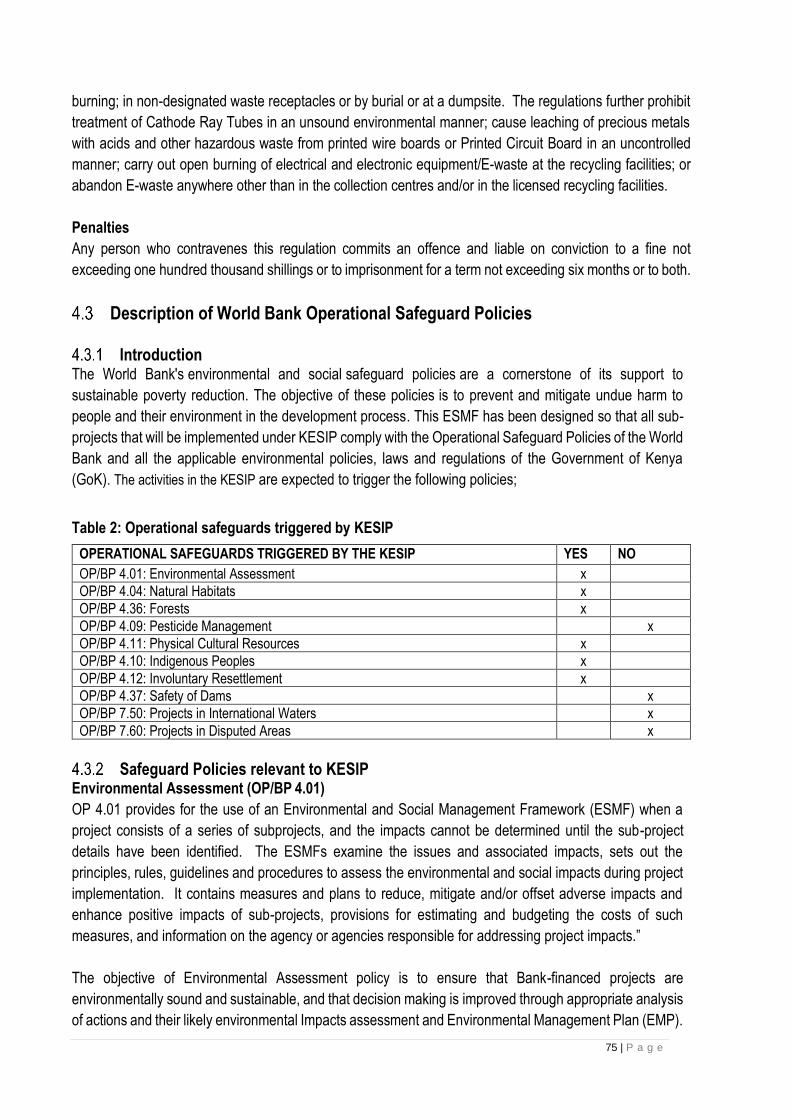
75 | P a g e
burning; in non-designated waste receptacles or by burial or at a dumpsite. The regulations further prohibit
treatment of Cathode Ray Tubes in an unsound environmental manner; cause leaching of precious metals
with acids and other hazardous waste from printed wire boards or Printed Circuit Board in an uncontrolled
manner; carry out open burning of electrical and electronic equipment/E-waste at the recycling facilities; or
abandon E-waste anywhere other than in the collection centres and/or in the licensed recycling facilities.
Penalties
Any person who contravenes this regulation commits an offence and liable on conviction to a fine not
exceeding one hundred thousand shillings or to imprisonment for a term not exceeding six months or to both.
Description of World Bank Operational Safeguard Policies
Introduction The World Bank's environmental and social safeguard policies are a cornerstone of its support to
sustainable poverty reduction. The objective of these policies is to prevent and mitigate undue harm to
people and their environment in the development process. This ESMF has been designed so that all sub-
projects that will be implemented under KESIP comply with the Operational Safeguard Policies of the World
Bank and all the applicable environmental policies, laws and regulations of the Government of Kenya
(GoK). The activities in the KESIP are expected to trigger the following policies;
Table 2: Operational safeguards triggered by KESIP
OPERATIONAL SAFEGUARDS TRIGGERED BY THE KESIP YES NO
OP/BP 4.01: Environmental Assessment x
OP/BP 4.04: Natural Habitats x
OP/BP 4.36: Forests x
OP/BP 4.09: Pesticide Management x
OP/BP 4.11: Physical Cultural Resources x
OP/BP 4.10: Indigenous Peoples x
OP/BP 4.12: Involuntary Resettlement x
OP/BP 4.37: Safety of Dams x
OP/BP 7.50: Projects in International Waters x
OP/BP 7.60: Projects in Disputed Areas x
Safeguard Policies relevant to KESIP Environmental Assessment (OP/BP 4.01)
OP 4.01 provides for the use of an Environmental and Social Management Framework (ESMF) when a
project consists of a series of subprojects, and the impacts cannot be determined until the sub-project
details have been identified. The ESMFs examine the issues and associated impacts, sets out the
principles, rules, guidelines and procedures to assess the environmental and social impacts during project
implementation. It contains measures and plans to reduce, mitigate and/or offset adverse impacts and
enhance positive impacts of sub-projects, provisions for estimating and budgeting the costs of such
measures, and information on the agency or agencies responsible for addressing project impacts.”
The objective of Environmental Assessment policy is to ensure that Bank-financed projects are
environmentally sound and sustainable, and that decision making is improved through appropriate analysis
of actions and their likely environmental Impacts assessment and Environmental Management Plan (EMP).
76 | P a g e
This OP/BP 4.01 is triggered through the mandatory Environmental and Social Screening Process through
which the project is assigned a Category based upon its potential environmental and social risks and
impacts in its area of influence.
KESIP project is proposed as a category A Full Assessment- assigned to projects that are likely to
have limited and reversible environmental impacts, that can be readily be mitigated. There are no significant
and /or irreversible adverse environmental issues anticipated from the project sub components to be
financed under the Project, as the nature of civil works is limited to construction Transmission and
distribution powerlines and Substations. The ESMF includes methodology to apply an environmental and
social screening process that will guide in determining the potential environmental and social impacts of
subprojects and in the application of appropriate mitigation measures. Site-specific ESIAs will be prepared
during implementation and before construction as required for the subprojects.
Screening of KESIP subprojects will be done to determine whether sub-projects would require a full
environmental assessment; NEMA approval will be sought before commencement of detailed design to
ensure that good practices are included in the technical design. The ESMF will serve as the environmental
safeguards document in cases where a full environmental assessment is not deemed necessary based on
the findings of the screening.
Comparison with Kenya law
OP/BP4.01 requirements are in tandem with Kenya Legislation. EMCA 1999 Section 57 A requires
proponents for Plans, Programs and projects to carry out Strategic Environmental Assessment. Section 58
states that “Notwithstanding any approval, permit or license granted under this Act or any other law in force
in Kenya, any person, being a proponent of a project, shall before financing, commencing, proceeding with,
carrying out, executing or conducting or causing to be financed, commenced, proceeded with, carried out,
executed or conducted by another person any undertaking specified in the Second Schedule to this Act,
submit a project report to the Authority, in the prescribed form, giving the prescribed information and which
shall be accompanied by the prescribed fee.
OP 4.04: Natural Habitats
The policy is triggered for KESIP for projects involving construction of Transmission and distribution
powerlines and Substations.
Specific objective of the OP 4.04 includes but not limited to the following
• To preserve biological diversity by avoiding, or if not possible, reducing and minimizing impacts on biodiversity;
• In cases where some impacts are unavoidable, to endeavor to reinstate or restore biodiversity including, where required, the implementation of biodiversity offsets to achieve “not net loss but net gain” of biodiversity;
• To protect natural, modified and critical habitats; and
• To sustain the availability and productivity of priority ecosystem services to maintain benefits to the affected communities and to sustain project performance.
This policy recognizes that the conservation of natural habitats is essential to safeguard their unique
biodiversity and to maintain environmental services and products for human society and for long-term
sustainable development. The Bank therefore supports the protection, management, and restoration of
natural habitats in its project financing, as well as policy dialogue and economic and sector work.

77 | P a g e
This policy is triggered by any project (including any sub-project under a sector investment or financial
intermediary) with the potential to cause significant conversion (loss) or degradation of natural habitats,
whether directly (through construction) or indirectly (through human activities induced by the project).
Further, it is triggered if a project is to be located in a habitat where there may be potential biodiversity
impacts or in areas providing ecosystem services upon which potentially affected stakeholders are
dependent for survival, sustenance, livelihood or primary income, or which are used for sustaining the
project. It is also triggered if the project is designed to extract natural resources as a main purpose (e.g.
plantation forestry, commercial harvesting, agriculture, livestock, fisheries and aquaculture).
The Bank supports, and expects borrowers to apply, precautionary approach to natural resource
management to ensure opportunities for environmentally sustainable development. Natural habitats are
land and water areas where most of the original native plant and animal species are still present. Natural
habitats comprise many types of terrestrial, freshwater, coastal, and marine ecosystems. These could be
affected by clearing various natural habitats to create space for the substations and for the powerlines
wayleave traces.
Due diligence will be carried to prevent routing of powerlines and siting of Substations in sensitive ecological
sites.
Comparison with Kenyan law
According to the Wildlife and conservation act “habitat” means a place or site where wildlife naturally
occurs, and which provides food, cover and water on which wildlife depend directly or indirectly.
Endangered ecosystem” means an ecosystem of exceptional biodiversity value or a habitat of endangered
or endemic species which has undergone severe degradation. Threatened ecosystem” means an
ecosystem of high biodiversity value or habitat of endangered or endemic species that is under threat of
degradation.
The critical habits are accorded distinct attention through a special regulation namely (Wildlife Conservation and Management (Protection of Endangered and Threatened Ecosystems, Habitats and Species) Regulations, 2016. The purpose of these regulation is to implement the classification of ecosystems, habitats and species into the following categories
• Critically endangered;
• Endangered;
• Vulnerable;
• Protected; and
• Threatened. It Provides for protection of ecosystems that are threatened or endangered to maintain their ecological integrity; provide for the protection of species that are threatened, endangered, vulnerable, or protected to ensure their survival in the wild; implement Kenya’s obligations under international agreements regulating international trade in endangered species; and ensure sustainable management and utilization of biodiversity. Section 51 (e) of EMCA prohibits and controls the introduction of alien species into natural habitats. Section 54 of EMCA 1999, The Cabinet Secretary may, in consultation with the relevant lead agencies and in accordance with the Constitution, the Convention on Biological Diversity and other treaties, by notice in the Gazette, declare any area of land, sea, lake, forests or river to be a protected natural environment for the
78 | P a g e
purpose of promoting and preserving specific ecological processes, natural environment systems, natural beauty or species of indigenous wildlife or the preservation of biological diversity in general O.P/B. P 4.36 Forests In the context of forests, the Operational Policy on Forests (OP 4.36) is proactive in both identifying and protecting critical forest conservation areas. The policy aims at assisting clients harness the potential of forests to reduce poverty in a sustainable manner, integrate forests effectively into sustainable economic development, and protect the vital local and global environmental services and values of forests. The policy is triggered proposed projects have the potential to impact the health and quality of forests, affect the rights and welfare of people dependent on forests; or aim to bring about changes in the management, protection, or utilization of natural forests or plantations. Due diligence will be carried out by the PIU to prevent routing of powerlines and siting of Substations in critical forest conservation areas. Comparison of policy with Kenya law This Act provides for the development and sustainable management, including conservation and rational utilization of all forest resources for the socioeconomic development of the country and for connected purposes. The FCM Act, 2016 guarantees the long-term public benefits provided by forests. Generally, the Act requires the rehabilitation, maintenance, and protection of forestlands for the benefit of all by ensuring sustainable exploitation, utilization, management and conservation of the environment and natural resources while working to achieve and maintain a tree cover of at least ten per cent of the land area of Kenya and as such, every person has a duty to protect and conserve our forests. OP/BP 4.36 Help harness the potential of forests and protect vital environmental services and values of forests. It also supports improved forest management just like Forestry conservation and management act.. Section 43 subsection 1 provides that if mining, quarrying or any other activity carried out in the forest, shall, where activity concerned is likely to result in forest cover depletion, the person responsible shall undertake compulsory re-vegetation immediately upon the completion of the activity.
OP/BP 4.10: Indigenous Peoples
This policy is geared towards ensuring that the development process fully respects the dignity, human
rights, economies and cultures of the indigenous people.
The objective of this policy is to; (i) ensure that the development process fosters full respect for the dignity, human rights, and cultural
uniqueness of indigenous peoples; (ii) ensure that adverse effects during the development process are avoided, or if not feasible, ensure that
these are minimized, mitigated or compensated; and ensure that indigenous peoples receive culturally appropriate and gender and inter- generationally inclusive
social and economic benefits.
This may be triggered if the projects are implemented in areas with vulnerable and marginalized groups.
As a precautionary principle a vulnerable and marginalized people’s framework has been prepared to act
as a guide for the preparation of the vulnerable and marginalized peoples plan for the sub projects in the
event the said groups are found within the area of project impacts. During screening, identification of the
groups living within the area will be done to ascertain whether there said groups live within the project area
of impact.
Comparison of policy with Kenya law
The Kenya Constitution 2010 Section 56 on Minorities and Marginalized groups states that “The State shall put in place affirmative action programmes designed to ensure that minorities and marginalised groups-- (a) participate and are represented in governance and other spheres of life; (b) are provided special opportunities in educational and economic fields; (c) are provided special opportunities for access to

79 | P a g e
employment; (d) develop their cultural values, languages and practices; and (e) have reasonable access to water, health services and infrastructure. In Kenya, the people who meet the OP 4.10 criteria or fit the definition of articles 260 of the constitution of
Kenya, 2010 are referred to as vulnerable and marginalized Groups (VMG) instead of indigenous peoples.
The reference does not take away the spirit and intention f the policy.
OP 4.11: Physical Cultural Resource
This policy addresses physical cultural resources, which are defined as movable or immovable objects,
sites, structures, groups of structures, and natural features and landscapes that have archaeological,
paleontological, historical, architectural, religious, aesthetic, or other cultural significance. Physical cultural
resources may be located in urban or rural settings, and may be above or below ground, or under water.
Their cultural interest may be at the local, provincial or national level, or within the international community.
Physical cultural resources are important as sources of valuable scientific and historical information, the
policy is triggered as a precaution, although the sub-projects are not expected to traverse areas of cultural
or historical importance.
The implementing agency will address the impacts on physical cultural resources in KESIP as an integral
part of the environmental assessment (EA) process. This will begin at screening during EIA to identify
presence of cultural property and as an integral part of the EA process, the borrower develops a physical
cultural resources management plan that includes measures for avoiding or mitigating any adverse impacts
on physical cultural resources, provisions for managing chance finds, any necessary measures for
strengthening institutional capacity, and a monitoring system to track the progress of these activities.
The national law (National museums and Heritage Act 2006) requires that Where a person discovers a
monument or object of archaeological or palaeontological interest, the person shall, within seven days, give
notice thereof, indicating the precise site and circumstances of the discovery, to the National Museums,
and in the case of an object, shall deliver the object to the National Museums or to the District Commissioner
to keep it for any particular purpose or for any particular period. Subject to section 27, no person shall move
a monument 'Or object of archaeological or palaeontological interest from the place where it has been
discovered otherwise than in such manner and to such p1ace as may be allowed by an, exploration licence,
or by written permit from the Minister after consultation with the National Museums.”
OP 4.12: Involuntary Resettlement
The objective of this policy is to (i) avoid or minimize involuntary resettlement where feasible, exploring all viable alternative project
designs; (ii) design and implement resettlement as a sustainable development program (iii) assist displaced persons in improving their former living standards, income earning capacity, and
production levels, or at least in restoring them; (iv) pay for lost assets at replacement cost (v) encourage community participation in planning and implementing resettlement; and aid affected people regardless of the legality of land tenure. This policy covers not only physical relocation, but any loss of land or other assets resulting in:
• Relocation or loss of shelter;
80 | P a g e
• loss of assets or access to assets;
• Loss of income sources or means of livelihood, whether the affected people must move to another location.
This policy also applies to the involuntary restriction of access to legally designated parks and protected areas resulting in adverse impacts on the livelihoods of the displaced persons. This policy will be triggered especially for the transmission powerlines. A Resettlement Policy Framework (RPF) has been prepared to guide project investments with regard to land acquisition and compensation of the affected people. The RPF will act as a guide for preparation of the specific RAPs once the project subproject sites and locations are known. Based on the RPF guidance, each sub –project will be screened, and if RAPs are found to be necessary, they will be prepared, cleared, disclosed and implemented prior to the commencement of civil works, in accordance with this policy. For the Substations, we expect land to be sourced through willing seller; willing buyer basis guided by the Public procurement and disposal act and land act including consultations with the families that are selling land.
Comparison with Kenya law According to the Land Act 2012, If land is acquired compulsorily, just compensation shall be paid promptly in full to all persons whose interests in the land have been determined. This is different from OP 4.12 which states that compensation shall be at replacement cost. In this case the policy will be used during compensation since its more specific. The way leaves Act cap 292 states that the Government may carry any works through, over or under any land whatsoever provided it shall not interfere with any existing building or structures of an ongoing activity. Where any developments are affected, the Act recommends for compensation. Section 6 (1), “the Government shall make good all compensation to the owner of any tree or crops destroyed or damaged”. The word good compensation is ambiguous and the principles of OP 4.12 will prevail on compensation.
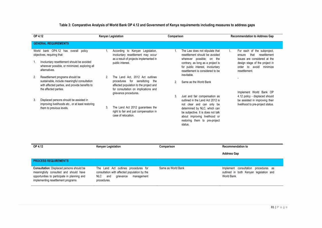
81 | P a g e
Table 3: Comparative Analysis of World Bank OP 4.12 and Government of Kenya requirements including measures to address gaps
OP 4.12 Kenyan Legislation Comparison Recommendation to
Address Gap
PROCESS REQUIREMENTS
Consultation: Displaced persons should be
meaningfully consulted and should have
opportunities to participate in planning and
implementing resettlement programs
The Land Act outlines procedures for
consultation with affected population by the
NLC and grievance management
procedures.
Same as World Bank
Implement consultation procedures as
outlined in both Kenyan legislation and
World Bank.
OP 4.12 Kenyan Legislation Comparison Recommendation to Address Gap
GENERAL REQUIREMENTS
World bank OP4.12 has overall policy
objectives, requiring that:
1. Involuntary resettlement should be avoided
wherever possible, or minimized, exploring all
alternatives.
2. Resettlement programs should be
sustainable, include meaningful consultation
with affected parties, and provide benefits to
the affected parties.
3. Displaced persons should be assisted in
improving livelihoods etc., or at least restoring
them to previous levels.
1. According to Kenyan Legislation,
involuntary resettlement may occur
as a result of projects implemented in
public interest.
2. The Land Act, 2012 Act outlines
procedures for sensitizing the
affected population to the project and
for consultation on implications and
grievance procedures.
3. The Land Act 2012 guarantees the
right to fair and just compensation in
case of relocation.
1. The Law does not stipulate that
resettlement should be avoided
wherever possible; on the
contrary, as long as a project is
for public interest, involuntary
resettlement is considered to be
inevitable.
2. Same as the World Bank
3. Just and fair compensation as
outlined in the Land Act 2012 is
not clear and can only be
determined by NLC, which can
be subjective. It is does not talk
about improving livelihood or
restoring them to pre-project
status.
I. For each of the subproject,
ensure that resettlement
issues are considered at the
design stage of the project in
order to avoid/ minimize
resettlement.
-
Implement World Bank OP
4.12 policy - displaced should
be assisted in improving their
livelihood to pre-project status.

82 | P a g e
OP 4.12 Kenyan Legislation Comparison Recommendation to
Address Gap
Grievance: For physical resettlement,
appropriate and accessible grievance
mechanism will be established.
Land Act 2012 clearly outline the steps and
process for grievance redress that includes
alternative dispute resolution, re-negotiation
with NLC and is backed by the judicial
system through Environmental and Land
Court.
Kenyan legislation meets OP4.12
requirements.
N/A
Eligibility Criteria
Defined as:
(a) those who have formal legal rights to land
(including customary and traditional rights
recognized under the laws of the country);
(b) those who do not have formal legal rights
to land at the time the census begins but
have a claim to such land or assets—
provided that such claims are recognized
under the laws of the country or become
recognized through a process identified in
the resettlement plan (see Annex 10 A, para.
7(f)); and19
(c) those who have no recognizable legal
right or claim to the land they are occupying
To determine eligibility:
Carry out resettlement census. Cut-off date
for eligibility is the day when the census
begins.
The Land Act 2012 provides that written and
unwritten official or customary land right are
recognized as valid land right. The Law
provides that people eligible for
compensation are those holding land tenure
rights
Land Act also recognizes those who have
interest or some claim in the land such
pastoralist or who use the land for their
livelihood.
The constitution recognizes ‘occupants of
land even if they do not have titles’ and
payment made in good faith to those
occupants of land. However, this does not
include those who illegally acquired land
Kenya’s Land Law defines eligibility as both
formal (legal) and informal (customary)
owners of expropriated land. However, it
does not specifically recognize all users of
the land to be compensated.
The constitution of Kenya on the other hand
recognizes ‘occupants of land’ who do not
have title and who the state has an obligation
to pay in good faith when compulsory
acquisition is made.
Ensure ALL users (including illegal
squatters, labourers, rights of access) of
affected lands are included in the census
survey and are paid for loss of assets other
than land.
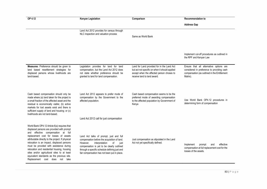
83 | P a g e
OP 4.12 Kenyan Legislation Comparison Recommendation to
Address Gap
Land Act 2012 provides for census through
NLC inspection and valuation process
Same as World Bank
Implement cut-off procedures as outlined in
the RPF and Kenyan Law
Measures: Preference should be given to
land based resettlement strategies for
displaced persons whose livelihoods are
land-based.
Cash based compensation should only be
made where (a) land taken for the project is
a small fraction of the affected asset and the
residual is economically viable; (b) active
markets for lost assets exist and there is
sufficient supply of land and housing; or (c)
livelihoods are not land-based.
World Bank OP4.12 Article 6(a) requires that
displaced persons are provided with prompt
and effective compensation at full
replacement cost for losses of assets
attributable directly to the project. If physical
relocation is an impact, displaced persons
must be provided with assistance during
relocation and residential housing, housing
sites and/or agricultural sites to at least
equivalent standards as the previous site.
Replacement cost does not take
Legislation provides for land for land
compensation, but the Land Act 2012 does
not state whether preference should be
granted to land for land compensation.
Land Act 2012 appears to prefer mode of
compensation by the Government to the
affected population.
Land Act 2012 call for just compensation
Land Act talks of prompt, just and full
compensation before the acquisition of land.
However, interpretation of just
compensation is yet to be clearly outlined
through a specific schedule defining just and
fair compensation has not been put in place.
Land for Land provided for in the Land Act
but act not specific on when it should applied
except when the affected person choses to
receive land to land award.
Cash based compensation seems to be the
preferred mode of awarding compensation
to the affected population by Government of
Kenya
Just compensation as stipulated in the Land
Act not yet specifically defined.
Ensure that all alternative options are
considered in preference to providing cash
compensation (as outlined in the Entitlement
Matrix).
Use World Bank OP4.12 procedures in
determining form of compensation
Implement prompt and effective
compensation at full replacement cost for the
losses of the assets.
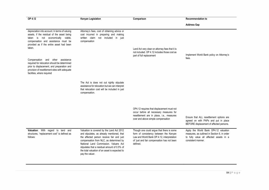
84 | P a g e
OP 4.12 Kenyan Legislation Comparison Recommendation to
Address Gap
depreciation into account. In terms of valuing
assets, if the residual of the asset being
taken is not economically viable,
compensation and assistance must be
provided as if the entire asset had been
taken.
Compensation and other assistance
required for relocation should be determined
prior to displacement, and preparation and
provision of resettlement sites with adequate
facilities, where required
Attorney’s fees, cost of obtaining advice or
cost incurred in preparing and making
written claim not included in just
compensation
The Act is does not out rightly stipulate
assistance for relocation but we can interpret
that relocation cost will be included in just
compensation.
Land Act very clear on attorney fees that it is
not included. OP 4.12 includes those cost as
part of full replacement
OP4.12 requires that displacement must not
occur before all necessary measures for
resettlement are in place, i.e., measures
over and above simple compensation
Implement World Bank policy on Attorney’s
fees.
Ensure that ALL resettlement options are
agreed on with PAPs and put in place
BEFORE displacement of affected persons.
Valuation: With regard to land and
structures, “replacement cost” is defined as
follows:
Valuation is covered by the Land Act 2012
and stipulates, as already mentioned, that
the affected person receive fair and just
compensation from NLC, as determined by
National Land Commission. Valuers Act
stipulates that a residual amount of 0.5% of
the total valuation of an asset is expected to
pay the valuer.
Though one could argue that there is some
form of consistency between the Kenyan
Law and World Bank OP.4.12, interpretation
of ‘just and fair compensation has not been
defined.
Apply the World Bank OP4.12 valuation
measures, as outlined in Section 6, in order
to fully value all affected assets in a
consistent manner.

85 | P a g e
OP 4.12 Kenyan Legislation Comparison Recommendation to
Address Gap
For agricultural land, it is the pre-project or
pre-displacement, whichever is higher,
market value of land of equal productive
potential or use located in the vicinity of the
affected land, plus the cost of preparing the
land to levels similar to those of the affected
land, plus the cost of any registration and
transfer taxes.
For houses and other structures, it is the
market cost of the materials to build a
replacement structure with an area and
quality similar to or better than those of the
affected structure, or to repair a partially
affected structure, plus the cost of
transporting building materials to the
construction site, plus the cost of any labour
and contractors’ fees, plus the cost of any
registration and transfer taxes.
Land Act 2012 talks of fair and just
compensation for the lost assets but it is not
specific of the exact amount or procedures
on the same.
The Land Act 2012 stipulates just and fair
compensation.
Interpretation of just and fair compensation
not clear
Interpretation of just and fair compensation
not clear.
Apply World Bank OP4.12 on valuation and
compensation measures.
Apply World Bank OP4.12 on valuation and
compensation procedures.
Monitor
Adequate monitoring and evaluation of
activities to be undertaken.
According to Land Act can be undertaken
County Land Boards.
Both Kenyan Law and World Bank policy
advocates for Monitoring and Evaluation
Implement as prescribed in the World Bank
OP4.12 and Kenyan Law.

86 | P a g e
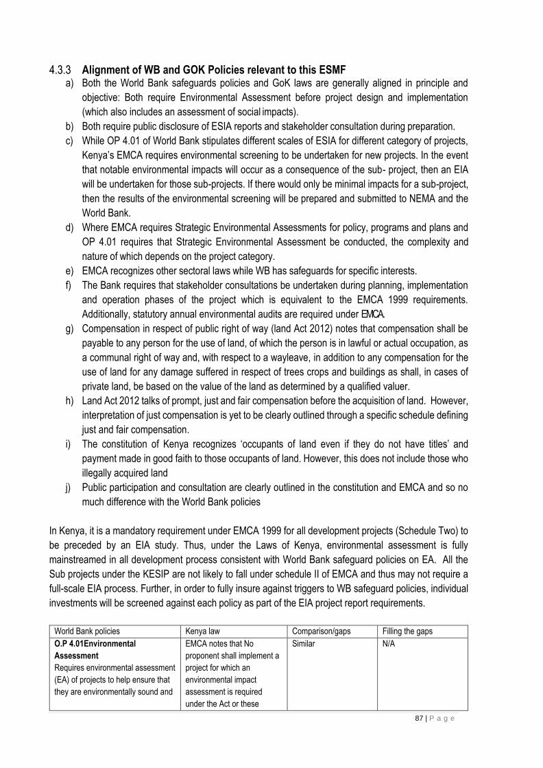
87 | P a g e
Alignment of WB and GOK Policies relevant to this ESMF a) Both the World Bank safeguards policies and GoK laws are generally aligned in principle and
objective: Both require Environmental Assessment before project design and implementation
(which also includes an assessment of social impacts).
b) Both require public disclosure of ESIA reports and stakeholder consultation during preparation.
c) While OP 4.01 of World Bank stipulates different scales of ESIA for different category of projects,
Kenya’s EMCA requires environmental screening to be undertaken for new projects. In the event
that notable environmental impacts will occur as a consequence of the sub- project, then an EIA
will be undertaken for those sub-projects. If there would only be minimal impacts for a sub-project,
then the results of the environmental screening will be prepared and submitted to NEMA and the
World Bank.
d) Where EMCA requires Strategic Environmental Assessments for policy, programs and plans and
OP 4.01 requires that Strategic Environmental Assessment be conducted, the complexity and
nature of which depends on the project category.
e) EMCA recognizes other sectoral laws while WB has safeguards for specific interests.
f) The Bank requires that stakeholder consultations be undertaken during planning, implementation
and operation phases of the project which is equivalent to the EMCA 1999 requirements.
Additionally, statutory annual environmental audits are required under EMCA.
g) Compensation in respect of public right of way (land Act 2012) notes that compensation shall be
payable to any person for the use of land, of which the person is in lawful or actual occupation, as
a communal right of way and, with respect to a wayleave, in addition to any compensation for the
use of land for any damage suffered in respect of trees crops and buildings as shall, in cases of
private land, be based on the value of the land as determined by a qualified valuer.
h) Land Act 2012 talks of prompt, just and fair compensation before the acquisition of land. However,
interpretation of just compensation is yet to be clearly outlined through a specific schedule defining
just and fair compensation.
i) The constitution of Kenya recognizes ‘occupants of land even if they do not have titles’ and
payment made in good faith to those occupants of land. However, this does not include those who
illegally acquired land
j) Public participation and consultation are clearly outlined in the constitution and EMCA and so no
much difference with the World Bank policies
In Kenya, it is a mandatory requirement under EMCA 1999 for all development projects (Schedule Two) to
be preceded by an EIA study. Thus, under the Laws of Kenya, environmental assessment is fully
mainstreamed in all development process consistent with World Bank safeguard policies on EA. All the
Sub projects under the KESIP are not likely to fall under schedule II of EMCA and thus may not require a
full-scale EIA process. Further, in order to fully insure against triggers to WB safeguard policies, individual
investments will be screened against each policy as part of the EIA project report requirements.
World Bank policies Kenya law Comparison/gaps Filling the gaps
O.P 4.01Environmental
Assessment
Requires environmental assessment
(EA) of projects to help ensure that
they are environmentally sound and
EMCA notes that No
proponent shall implement a
project for which an
environmental impact
assessment is required
under the Act or these
Similar N/A

88 | P a g e
sustainable, and thus to improve
decision making
Regulations, unless an
environmental impact
assessment has been
concluded and approved
OP 4.04 Natural habitat
supports the protection,
maintenance, and rehabilitation of
natural habitats and their functions.
The law gives guidance on
habitats and special
treatment is given to
endangered and threatened
species through a special
regulation
Similar N/A
O.P 4.36 Forests: the policy is
proactive in both identifying and protecting critical forest conservation areas and in supporting improved forest management in production forests outside these
areas. It mainly harnesses the
potential of forests to reduce poverty
in
a sustainable manner, integrate
forests effectively into sustainable
economic development, and
protect the vital local and global
environmental services and values
of forests.
Forestry Conservation and
Management Act 2016
the Act requires the
rehabilitation, maintenance,
and protection of forestlands
for the benefit of all by
ensuring sustainable
exploitation, utilization,
management and
conservation of the
environment and natural
resources while working to
achieve and maintain a tree
cover of at least ten per cent
of the land area of Kenya
Similar N/A
OP 4.10 Indigenous people
ensures that the development
process fully respects the dignity,
human rights, economies, and
cultures of Indigenous Peoples
the people who meet the
OP 4.10 criteria are referred
to as vulnerable and
marginalized Groups
(VMG) instead of
indigenous peoples.
Kenyan does not
mention indigenous
people.
The reference in
national law does not
take away the spirit and
intention of the policy
Kenyan law is more
inclusive of other
vulnerable populations
O.P 4.11 Physical Cultural
Property
defined as movable or immovable
objects, sites, structures, groups of
structures, and natural features and
landscapes that have
archaeological, paleontological,
historical, architectural, religious,
aesthetic, or other cultural
significance.
National museums and
heritage Act; to provide for
the establishment, control,
management and
development of national
museums and the
identification, protection,
conservation and
transmission of the cultural
and natural heritage of
Kenya;
Similar N/A
O.P 4.12 Involuntary resettlement.
States that compensation shall be at
replacement cost.
Land Act 2012, If land is
acquired compulsorily, just
compensation shall be paid
promptly in full to all persons
whose interests in the land
have been determined.
Issues of compensation
are more elaborate in
the policy
The O.P 4.12 objectives
will guide resettlement
GENERAL World Bank Group EHS Guidelines The general WBs EHS guidelines underscores that Effective management of environmental, health, and

89 | P a g e
safety (EHS) issues entails the inclusion of EHS considerations into corporate and facility-level business
processes in an organized, hierarchical approach which calls for; Identifying EHS project hazards and
associated risks as early as possible including the incorporation of EHS considerations into the site
selection process, product design process, engineering planning process for capital requests, engineering
work orders, facility modification authorizations, or layout and process change plans; understanding the
likelihood and magnitude of EHS and use of professionals to assess and manage EHS issues. The
guidelines call for a precautionary principle of eliminating hazards at source, use of engineering controls,
building the capacity of workers and communities to respond to accidents and monitoring of project
performance.
Since the EHS guidelines call for a preventive approach to the EHS issues, and KPLC will prepare a
checklist that will guide adherence to EHS issues right from selection of routes for the line and for
substation. The checklist will be annexed in the ESMF and will be used during screening.
EHS Guidelines for Electric Power Transmission and Distribution: These guidelines are adopted by IFC and World bank and cover Environmental, Safety and health issues
that may be attributed to Transmission and Distribution powerlines during Construction, operation and even
during decommissioning phases. Environmental issues covered by these guidelines include: Terrestrial
habitat alteration, Aquatic habitat alteration, Electric and magnetic fields, Hazardous materials.
The guidelines give caution and mitigation measures for the negative impacts. The impacts are further
discussed in the EMP of this report. Occupational health and safety issues during the construction,
operation, maintenance, and decommissioning of electric power Transmission and distribution projects
include exposure to Live power lines, Working at height, Electric and magnetic fields and Exposure to
chemicals. The mitigation of these impacts is discussed in the EMP of this report.
Community Health and safety impacts during the construction and decommissioning of transmission and
distribution power lines include, among others, dust, noise, and vibration from construction vehicle transit,
and communicable diseases associated with the influx of temporary construction labor. The operation of
live power transmission and distribution lines may generate impacts such as Electrocution, Electromagnetic
interference, Visual amenity, Noise and Ozone and Aircraft Navigation Safety. The mitigation measures of
these impacts is discussed in the EMP section of this report.
Requirements for Public Disclosure This ESMF will be disclosed in line with the World Bank requirements through posting on the Kenya Power’s
website www.kplc.co.ke. The final version will be publicly disclosed through the World Bank’s website.

90 | P a g e
5 CHAPTER FIVE: REVIEW OF RELEVANT INSTITUTIONS
Institutional and Implementation Arrangements The timely implementation of KESIP project calls for the commitment and good will of different players in the
energy sector alongside other key government agencies. This section presents the roles and responsibilities
of the key players namely the implementing agency (KPLC) including its relationship with the Ministry of
Energy and other relevant agencies.
KPLC mandate and Functions Kenya Power is a limited liability company which transmits, distributes and retails electricity to customers
throughout Kenya. Kenya Power is a public company and is listed at the Nairobi Stock Exchange (NSE).
The Company’s key mandate is to plan for sufficient electricity generation and transmission capacity to meet
demand; building and maintaining the power distribution and transmission network and retailing of electricity
to its customers.
Kenya Power will provide overall coordination of the specific portion of KESIP project that she had been tasked with. Thus, will be responsible for the implementation, management and monitoring of the following components of KESIP: Transmission and Distribution Powerlines, Primary substations, and Slums & high-density people settlement schemes Electrification. Specifically, KPLC through its Safety Health and Environment (SHE) Department will be key in preparation and implementation of the safeguard documents of KESIP.
• Prepare, implement and monitor the necessary/required safeguards documents
• Select consultants and contractors needed for different tasks
• Carry out relevant studies and designs
• Acquire land and required way leaves
• Oversee construction of sub project components
• Monitor progress of project implementation
• Liaise with other government agencies for needed approvals
• Reporting
Ministry of Energy Kenya Power is an autonomous agency under the ministry of Energy. The ministry is responsible for
formulation and articulation of energy policies through which it provides an enabling environment for all
stakeholders. MoE is responsible for overall coordination and oversight of the project.
Kenya Electricity Transmission Company Limited (KETRACO) The Company was established in 2008 to develop new high voltage electricity transmission infrastructure
that will form the backbone of the National Transmission Grid, in line with Kenya Vision 2030. Its core
business is to plan, design, build and maintain electricity transmission lines and associated substations. The
voltage rating of the transmission lines includes 132kV, 220kV, 400kV and 500kV (HVDC). KETRACO is
also an implementing agency of KESIP
National Environment Management Authority (NEMA) This the principal instrument of the government in the implementation of all policies relating to the
environment. It is mandated to general supervision and co- ordinate over all matters relating to the
environment. In this project NEMA will play a key role in approving the safeguard documents such as ESIA
91 | P a g e
and RAP reports and are free to check compliance of ESMPs during construction of the project.
Ministry of Lands and Physical Planning This ministry through its various departments will be key in this project and will play roles such as,
registration of all land transactions especially for the substations, approval of drawings both for substation
and lines. All matters regarding survey, acquisition of land and wayleaves will be handled through this
ministry.
Kenya Wildlife Service KWS is mandated to conserve and manage wildlife in Kenya, and to enforce related laws and regulations.
Thus, KWS undertakes conservation and management of wildlife resources across all protected areas
systems in collaboration with stakeholders. In the event it will be extremely necessary to have a line pass
in a protected area, KPLC will have to work hand in hand with KWS even before selection of the line route
and during designs, EIA studies and construction.
Kenya Forest Service The Kenya Forest Service has a mandate to provide for the development and sustainable management,
including conservation and rational utilization of all forest resources for the socioeconomic development of
the country and for connected purposes". The role of KFS will be to give approval for clearance of trees
and permits where the line passes through forested areas.
National Museums of Kenya National Museums of Kenya (NMK) is a multi-disciplinary institution whose role is to collect, preserve, study,
document and present Kenya’s past and present cultural and natural heritage. This is for the purposes of
enhancing knowledge, appreciation, respect and sustainable utilization of these resources for the benefit
of Kenya and the world, for now and posterity. This agency will be key in the event of chance find of any
physical cultural property.

92 | P a g e
The various institutions will participate in the project in various ways from the beginning, implementation,
commissioning and operation of the project. The various project stages are as shown in the diagram below
Environmental screening
Project inception- Site and route identification
ESIAs, RAPS and VMGPs
Mapping and surveying
Land acquisition
Preliminary designs
KPLC strategy & planning department
KPLC Surveyors & consultants
KPLC Property Department / NLC
KPLC Design engineers
KPLC SHE Department
KPLC SHE Department / Consultant
Detailed Designs
Wayleave acquisition
Bidding
Construction
Monitoring
ACTORS
KPLC Wayleave Department
KPLC Design engineers / consultants
KPLC Procurement Department
KPLC Projects Department
KPLC SHE Department
93 | P a g e
6 CHAPTER SIX: TYPOLOGY OF POTENTIAL ENVIRONMENTAL AND SOCIAL IMPACTS
Introduction The sub-projects described under KESIP Component on upgrading and refurbishment of existing substation,
construction of new substations and construction and upgrading of transmission and distribution lines are
aimed at reinforcing the system and increase capacity in order to have reliable power supply.
Cumulative environmental impacts are not expected to be significant, as the project -although nationwide -
is relatively limited in geographic scope and environmental impact. Induced impacts will be largely positive
or benign - for example, decreased use of diesel fuel, improved economic welfare as a result of stable and
reliable power supply.
Positive Environmental and Social Impacts
Expected Impact on Poverty Alleviation With the implementation of KESIP all over the Country, the power supply will be stable and reliable hence
more customers will be connected to the system. The people under power supply will engage in income
generating activities in order to improve their economic status.
Employment and wealth creation The KESIP will have positive impact on both direct and indirect employment levels in the Country although
the bulk of them will be on temporary basis during construction stage. The creation of job opportunities has
both economic and social benefits. in the economic benefit, abundant unskilled labour will be used in
economic production while the poor will engage in productive employment hence improving their living
standards.
Local Material Supplies Another positive impact of the project involves local material sourcing mainly sale of materials for use in the
project. Some of these can be expected to be sourced locally and the rest through importation. It is expected
that the project will generate new income revenues for the local population across the Country in harvesting
and transportation of sands, ballast, stones, concrete/wooden poles and gravel. The new income revenues
received will create demand for other goods and services causing a trickledown effect to the entire economy.
Up Scaling Electricity Access to the Poor According to Kenya Power’s annual report of 2012/2013, electricity access stood at 4.8milliom customers
as at June 2016. This translates to about 60% of the total population accessing electricity. Needless to say,
the uptake has been low due to the situation that the cost of connection has to be paid up front keeping in
mind that about 46.6% of the Kenyan population is poor. Furthermore, the slum areas are disadvantaged
due to of network.
HIV/AIDS Kenya Power’s HIV/AIDs policy underscores the fact that HIV/AIDS has no cure and the only way to stop its
spread is through attitudinal and behavioural changes as well as management that can be secured effectively
through education (awareness and information campaigns). One of the positive impacts of this project will

94 | P a g e
be disseminating of HIV/AIDs information to communities and workers who otherwise would not have had
the correct information same.
It is assumed that due to the current unstable state of the power system (frequent blackouts) many people
are not able to get wide education or knowledge on HIV/AIDs through the TVs and radios. Once the system
is reliable benefits will be high because people will be able to access HIV/AIDs information that is reliable,
and which comes from time to time as they can use the T.V and radios at will. People will also benefit from
expert’s opinion on the pandemic such as listening to doctors and nutritionists regarding HIV/AIDs.
The other method of disseminating HIV/AIDs information during project implementation will be through the
contractors. The contactors will be expected to disseminate information to the workers as part of their daily
tool box talks. SHE department will liaise with NACC to get materials (if they are available at the time) on
HIV/AIDS that can be distributed by the contractors during the tool box talk. During the Environment Social
Impact Assessment for other projects the Safety Health and Environment department will disseminates
HIV/AIDs information to the public during public consultations meetings.
Health benefits of the project According to the 2009 population census access to electricity stood at 23%, while 31% used lantern lamps
and 39% was using tin lamps for lighting. This indicates that 70% of the population was using kerosene for
lighting. Although access to electricity has improved a majority of Kenyans are still using kerosene for
lighting. This poses health problems as reported by World Bank report 2008 on the Welfare of Rural
Electrification. The report notes that kerosene lamps emit particles that cause air pollution; these are
measured by the concentration of the smallest particles per cubic meter (PM10). Burning a litre of kerosene
emits PM51 micrograms per hour, which is just above the World Health Organization 24-hour mean standard
of PM10 of 50 micrograms per cubic meter. But these particles do not disperse, so burning a lamp for four
hours can result in concentrations several times the World Health Organization standard. The health risks
posed by this indoor air pollution mainly include acute lower respiratory infections, but also low birth weight,
infant mortality, and pulmonary tuberculosis. Additionally, available data suggest that insufficient illumination
(low light) conditions can cause some degree of eye strain and reading in these conditions over long periods
of time may have the potential to increase the development of near sightedness (myopia) in children and
adults. The KESIP project will result in many families replacing kerosene lamps for lighting with electricity
there-by reducing disease burden at the family level and on the government.
Benefits to education Access to constant and reliable electricity supply at the household level and schools will create opportunities
for children to study. For example, children from homes with electricity have an advantage because they
have more time for study and doing homework in the evening as opposed to children from homes without
electricity. This benefit will in the end translate to better results. Additionally, the project also involves slum
electrification hence it will enable children in these areas access reliable electricity also access T.V. and
radios which gives them an advantage of benefiting from education programs being aired through such
communication channels.
Improved standard of living Access to stable and reliable electricity will change the standard of living of the people as they can use
domestic appliances like iron boxes, fridges, television sets, washing machines to mention but a few. Use of
95 | P a g e
electricity for lighting implies that the people will not be exposed to smoke arising from use of kerosene
lamps which predisposes people to respiratory diseases.
Security There will be enhanced security Country wide arising from well-lit social, commercial, individual premises
and use of electrical surveillance gadgets that use broadband data services. With the implementation of the
project, the level of security will improve across the county. This is as a result of more security flood lights
which helps keep off opportunistic crimes and gender-based violence.
Communications Access to reliable electricity will lead to improved communication. This will be enabled by the fact that
charging of mobile phones will be easier and cheaper. Access also to mass media like radio and T.V will
provide opportunity for people to access a wide range of information which is useful for decision making.
Some of information beneficiaries receive include: information on markets, farm inputs, livestock & crop
management and local affairs, nutrition, diseases, investments and entertainment among others.
Gender Considerations The vision of National Gender and Equality Commission is “A society that upholds gender equality, dignity
and fairness for all”. The Commission is guided by a mission “To effectively and efficiently promote gender
equality and freedom from discrimination of all persons in Kenya”. KPLC Gender mainstreaming policies is
in line with the NGEG Vision and Mission. The company’s gender vision is a world class power provider that
is free from inequality and discrimination. The gender mission is promoting gender equality in powering
people for better lives. The gender policy of Kenya Power is to mainstream gender within the company’s
procedures, management and monitoring and evaluation processes for the equal benefit of men and women
by 2015.
Access to modern electricity will go a long way towards alleviating the daily household burdens of women,
giving them more time, improving their health and enhancing their livelihoods. Available literature on gender
and energy suggests that providing electricity to communities and homes will promote gender equality,
women ‘s empowerment, and women ‘s and girls’ access to education, health care, and employment.
Lighting and television will improve access to information, the ability to study, and extend the effective
working day. This is more so because children can have extended time of study. The women will also benefit
more due to access of information especially on health and nutrition since they also spend more time at
home. The project will also enhance security in the rural areas as most homes will be lit up, a benefit that is
more appreciated by women.
Potential Negative Environmental and Social Impacts Despite the various socio economic and environmental benefits outlined, the project will also have some
negative impacts. In regard to the proposed KPLC projects, potential adverse environmental and social
impacts on the natural and human environment are likely to arise from inputs as well as project processes
at the construction and operation and maintenance phases. The following are the foreseen negative
impacts.
96 | P a g e
Potential Negative impacts to be handle by the contractor
6.3.1.1 Electric shocks and electrocution. These may likely happen during testing and commissioning at construction phase where staff will be working
on live powerlines and substation. The contractor is expected to adhere to safe working procedures in liaison
with KPLC’s project Engineer and to ensure proper communication and operational procedures with National
and Local control centres. This will ensure safe isolation and restoration of power.
6.3.1.2 Working at Heights This poses the risk of fall from heights and normally occurs when workers do any work above ;2.5 meters
especially during tower erection, climbing poles and during stringing. It may happen due to negligence and
failure to follow safe work procedures. Proper testing of power lines to minimize risk or shocks and sounding
of poles to determine whether they are safe coupled with use of the right Personal protective clothing and
equipment will help minimize and or eliminate the risk.
6.3.1.3 Impact on Natural flora and fauna The construction of transmission, and distribution lines together with substations will involve vegetation and
tree clearing along the wayleave and access road/s. Exposed soil surfaces have the potential to erode easily
if left uncovered which could lead to further loss of vegetation. Further vegetation / habitat loss may result
due to the creation of temporary access routes during construction. The clearing of indigenous vegetation
during construction may also result in the further encroachment of alien vegetation onto the site. There is
also the potential for injury or death to animals accessing the site as a result of construction activities i.e.
injury / death resulting from the operation of heavy machinery used to construct the powerline and substation
facilities, falling into foundation excavations, etc.
The project areas are not gazetted as forested area. Clearing of vegetation may interfere with breeding and
displace the animals hence increase animal-human conflict. It should be noted that animals generally avoid
contact with human structures but may get accustomed to structures after a period.
6.3.1.4 Impacts on air quality from vehicle exhaust emissions and dust The main source of the exhaust emissions is likely to be generated during use of fuel-run equipment including
vehicles, generators, and compressors. Oxides of nitrogen, carbon monoxide and oxides of Sulphur emitted
from internal combustion engines will be released during construction. Motor vehicles that will be used to
ferry construction materials would cause air quality impact by emitting pollutants through exhaust emissions.
Dust emission is also likely to occur during the site clearance, excavation and spreading of the topsoil during
construction. They are also likely to occur during materials transportation by motor vehicles accessing the
site.
6.3.1.5 Solid waste The solid wastes in construction period mainly include the construction waste, soil and rock and the domestic
waste from construction staff. solid waste generated will include conductor pieces and tree cuttings. For the
civil works at substations and for the electrification of households in slums, key factors are to ensure that
appropriate safety guidelines are adopted, and that obsolete equipment and construction waste is disposed
of in an environmentally sustainable manner.

97 | P a g e
Inappropriate dumping within the site will interfere with the aesthetic status of the area. This has a direct
effect to the surrounding community. Disposal of the same solid wastes off-site could also be a social
inconvenience if done in the wrong places. The off-site effects could be aesthetic, pest breeding, pollution
of physical environment, invasion of scavengers and informal recycling communities.
6.3.1.6 Visual and Aesthetic Landscape Impacts Visual impacts will occur when changes in the landscape are noticeable to viewers observing the landscape
from their homes or from tourism / conservation areas, travel routes, and important cultural features. This
may result from KPLC’s design of the facility such as transmission, distribution lines and substations.
6.3.1.7 Negative Cultural exchange and Social ills:
Contractors and his workforce may find some cultural differences within the project foot print. Respect and
tolerance even for different religious backgrounds is encouraged throughout the project cycle.
6.3.1.8 Occupation safety and health hazards The development of the proposed projects will involve a number of activities that pose potential health and safety risks to the workers which include, excavation, stripping, laying of cables stringing conductors and backfilling. Risk of accidents and incidents will be heightened with the construction activities. Construction workers will be in direct contact with heavy machinery and equipment. These operations require the use of hoists, heavy duty equipment, machinery and vehicles. Apart from the regular training on health and safety, staff working along the transmission and distribution lines should be sensitized on the work within the varying ecological and social areas traversed.
Health, safety and security are important aspects through all the stages of the project. Occupational health and Safety hazards specific to electric power transmission and distribution projects primarily include:
• Live power lines;
• Working on heights
• Community health and Safety.
The potential occupational health and safety impacts during operation phase include injuries to workers from
routine monitoring and maintenance and deaths and injuries from major disasters caused by third parties
6.3.1.9 Loss of Physical Cultural resources: This may likely happen during vegetation clearance or compaction activities along the wayleave trace for
power lines where an endangered species may be disrupted or destroyed. Cultural places like Shrines,
traditional medicinal herbs or graves may be interfered with. It is highly recommended that Physical Cultural
resources including monuments should be preserved and any chance findings must be reported to the local
community leadership and the National Museums of Kenya.
6.3.1.10 Oil leaks and Spill Hazards The machines at site and subproject vehicles require oils during maintenance. The oils will be transported
and may be stored at project sites. Any major accidental oil spill would impact negatively on the environment
as a whole. Cumulatively, small releases of oil would also impact negatively on the environment. Such
impacts include creation of new sceneries due to destruction of biological diversity and pollution of water
and soil. But these dangers are contained by maintaining the machinery in specific areas designed for this
purpose.

98 | P a g e
Transformers can experience a leak arising from a fault, poor handling and vandalism. These leaks may
result in potential contamination of surface and groundwater as well as soil.
6.3.1.11 Social Risks Related to Labour Influx, HIV/AIDs At project implementation, many new workers will be involved and new interactions between local
communities and workers undertaking the construction and installation of substations and power lines will
take place. These interactions are likely to pose risks to the social fabric of the society. Such risks include
GBV, VAC, SEA, public health related issues such as (HIV/AIDS, communicable and sexually transmitted
diseases (STDs). Other social risks include; Risks of social conflict between communities/clans and within
the workforce; increased illicit behaviour and crime such as substance abuse and theft; prostitution; gender-
based violence; underage pregnancies; child labour and school dropouts.
6.3.1.12 Impact on Natural Vegetation: This is mainly during wayleave trace clearance and movement of trucks which may kill or destroy natural
vegetation. The Contractor should limit way leave areas by ensuring that power lines are routed along the road
reserve and the existing wayleave as much as possible except for transmission lines. There shall be Proper
demarcation and only necessary areas should be cleared.
6.3.1.13 Construction material Sourcing: Construction materials such as sand, stones, and hardware related materials should be sourced locally to reduce distance and pressure on roads/ environment. The contractor should plant more trees to compensate ‘offset’ for the poles used. There should be proper storage and procuring only the required amounts to avoid stock piling. Restrict movement of heavy equipment during wet-soil conditions to prevent subsoil compaction, Rehabilitation of exposed sites as soon as practicable, Source Raw Materials from NEMA approved sites and apply the three ‘R’of Reduce, Re-use and Recycle. Use recycled and recyclable materials where possible 6.3.1.14 Increased water demand: To avoid competition from diminishing tap water, the contractor should use surface, ground water or river water for construction and sprinkling to minimize dust. Options of rainwater harvesting should be factored right from design stage for substations and where possible waste water should be recycled.
6.3.1.15 Noise and excessive vibration Noise and vibrations will occur during transportation and installation of equipment. During the construction
phase construction vehicles including excavation equipment and trucks may produce a noticeable increase
in noise disturbance. Construction vehicles may create some noise and vibration along access routes.
Construction workers may also contribute to noise pollution.
6.3.1.16 Risk of fire: The contractor should ensure no vegetation burning takes place especially after clearing sites for substations
or Wayleave traces. The contractor should also avail fire extinguishers and have a fire marshal on site all
times. Cigarette smoking areas should be demarcated and safe disposal of cigarette buts encouraged
throughout the project cycle.
6.3.1.17 Storm water and Waste water Compaction of surface on the proposed subproject site, access roads and campsite construction will create
impervious surfaces (slab environment). There is a likelihood of increased storm water runoff from these
99 | P a g e
sites, which result in gully erosion with time. In addition to creating unattractive terrain, this may cause flood
incidences along streams downhill during high rainfall times. The construction and production waste water
in the project that will come from concrete mixing and curing processes. The domestic waste water from
construction staff further forms waste water if discharged directly to the environment.
6.3.1.18 Temporary Land-take for construction purposes During construction, some areas may have to be temporarily occupied by the contractors in charge of the transmission lines construction, for storage of materials. As previously mentioned, no contractors camp will not be set up for this particular project. Instead, unskilled labour will be sourced from areas in which the transmission line will traverse. Skilled labour, which is anticipated to be small in size, will be absorbed by the nearest urban/settlement areas. Owners and occupants will be compensated against the loss of crops if any and will receive rent from the contractors for temporary occupation. There will be no transfer of rights in this case.
6.3.1.19 Community health and Safety Community health and safety impacts during the construction/operation and decommissioning of
transmission and distribution power lines are common and include dust, noise, and vibration from
construction vehicles transit. The operation of live power distribution line and substations may generate the
following impacts:
• Electrocution
• Electromagnetic interference
• Noise and ozone
• Tower vandalism
• Aircraft navigation safety
• Communicable diseases
• Health Hazards
Electrocution
Hazards directly related to power transmission occur as a result of electrocution from direct contact with high
voltage electricity or from contact with tools, vehicles, ladders, or other devices that are in contact with high
voltage electricity. Recommended techniques to prevent these hazards include:
• Use of signs, barriers (e.g.) use of steel posts surrounding transmission towers, particularly in urban
areas) and education/public outreach to prevent public contact with potentially dangerous equipment
• Grounding conducting objects (e.g. fences or other metallic structure) installed near power lines to
prevent shock
Electromagnetic interference
The corona of overhead transmission line conductors and high frequency currents of overhead transmission
lines may result in the creation of radio noise. Typically, transmission line rights of way and conductor
bundles are created to ensure radio reception at the outside limits remains normal. Periods of rain, sleet or
freezing rain sharply increases streaming corona on conductors and may affect radio reception in residential
areas near transmission lines.
Noise and ozone

100 | P a g e
Noise in the form of buzzing or humming can often be heard around transformers or high voltage power lines
producing corona. Ozone a colorless gas can also be produced. Neither the noise nor ozone produced by
power distribution lines or transformers carries any known health risk
The acoustic noise produced by transmission line is greater with high voltage power lines (400-800kV). Noise
from transmission lines reaches its maximum during periods of precipitation including rain, sleet, snow or hill
or as the result of fog. The sound of rain typically masks the increase in noise produced by the transmission
lines but during other forms of precipitation (e.g. snow and sleet) and fog, the noise from overhead power
lines can be troubling to nearby residents
Measures to mitigate this impact may be addressed during project planning stage to locate rights of way
away from human receptors to the extent possible.
Tower vandalism
Tower vandalism poses risk of accidents by electrocution. Proposed mitigation measures include
Community sensitization on the need to keep the towers untouched due to the associated risks
• Use of single unit towers instead of currently used lattice composite towers
• KPLC to consider bolting and welding assembled tower parts
• Engaging the community in policing of the towers
Air navigation safety
If power transmission towers are located near an airport or known flight paths can impact aircraft safety
directly thorough collision or indirectly through radar interference. Aircraft collision impacts may be mitigated
by
• Avoiding the siting of transmission lines and towers close to airports and outside of known flight path
envelopes
• Consultation with regulatory air traffic authorities or national safety regulations and
• Use of buried lines when installation is required in flight sensitive areas.
Health hazards to workers and communities The health and safety of construction personnel may be placed at risk as a result of the use of heavy machinery to construct the required powerline infrastructure. There may be injury to people / animals accessing the site i.e. falling into foundation excavations. In addition, there is the potential for loitering and / or attempted theft of construction machinery and equipment present onsite during the construction period. The primary impacts on health and safety during construction are therefore: • Injury to people resulting from the use of machinery and equipment; • Injury to people and animals accessing the site; and • Increase in crime. Such impacts are associated with construction of the powerline and are not anticipated during the operational phase. Hazardous materials in this sector include insulating oil/gases (e.g. polychlorinated Biphenals (PCB) and Sulphur Hexafluoride (SF6), and fuels. Liquid petroleum fuels for vehicles and other equipment may be used and stored at transmission and distribution projects. Polychlorinated Biphenyls (PCB) were widely used as dielectric fluid to provide

101 | P a g e
electrical insulation, although their use has been largely discontinued due to potential harmful effects on human health and the environment. Increasing incidence of communicable diseases Influx of workers from outside communities brings risk of spreading communicable diseases such as HIV/Aids to local communities. Both workers and communities should be made aware of health implications and preventative measures provided by the Project. HIV/AIDS has been declared a national disaster. It has been observed that construction works and projects are a conduit for transmission of the disease through sexual interactions between project staff and local communities.
Negative impacts to be handle by client (KPLC)
6.3.2.1 Loss of Land and property Land affected by the construction and operation of the proposed transmission line falls into two categories:
• Right of Way
• Way leave
• Temporary land-take for construction purposes.
a). Right of Way The ROW is the land required for a maintenance track under the line and the location of the towers. This corridor is 5m (2.5m on either side of the centreline) in width which suffices for both the access part and the four foundations of towers. KPLC will determine whether land falling within 5m wide ROW will remain the property of its current owners (land titles would then not be transferred) or whether it should be fully transferred to KPLC. This land must be accessible at all times by KPLC for maintenance purposes. Whether transferred or not, land falling in the right of way is deemed not to have any residual value for its current owner, and should, therefore, be compensated in full to its present owners. b). Way-Leave The way-leave is recognized as the safety corridor outside of which negative impacts from transmission lines are assumed to be negligible. The width of the corridor depends on the line voltage. The Kenyan standard is a 30m wide corridor for a 132Kv transmission line. Titles for the way-leave land will not be transferred from the present land owners; this land will remain their property. This land is, however, subject to the following restrictions: No construction is allowed in the Corridor; and All vegetation is to be kept below 6ft height (1.8m). In the way-leave outside of the 5m Right of Way, cultivation or other uses of land may continue provided the above –mentioned restrictions are complied with by the owner and the occupants of the land. KPLC is also required to provide the land owners with 3-day notice prior to maintenance works 6.3.2.2 Visual and Aesthetic Landscape Impacts Visual impacts will occur when changes in the landscape are noticeable to viewers observing the landscape
from their homes or from tourism / conservation areas, travel routes, and important cultural features. This
may result from construction of substation and new transmission and distribution lines.
102 | P a g e
6.3.2.3 Increased Demand for Material Consumption During the construction phase of the project water, energy and construction materials will be used. This will
have an impact on the availability of these materials.
Cumulative Impacts Cumulative impacts are impacts that result from the incremental impact of the proposed activity on a common
resource when added to the impacts of other past present or reasonably foreseeable future activities.
This section provides a description and analysis of the potential cumulative effects of the proposed
transmission and distribution powerline and substations project and considers the effects of any such
changes on:
• The biophysical environment; and
• Socio-economic conditions.
6.3.3.1 Cumulative Impact Analysis For the most part, cumulative impacts or aspects thereof are too uncertain to be quantifiable, due to mainly
lack of data availability and accuracy. This is particularly true of cumulative impacts arising from potential or
future projects, the design or details of which may not be finalized or available and the direct and indirect
impacts of which have not yet been assessed. Given the limited detail available regarding such future
developments, the analysis that follows is necessarily of a generic nature and focuses on key issues and
sensitivities for the project and how these might be influenced by cumulative impacts with other activities. In
most cases, only qualitative assessments of cumulative impacts are possible, i.e. they are not formally rated.
6.3.3.2 Cumulative Biophysical Impact The potential cumulative impact associated with the KESIP is the potential loss of biodiversity through a
decrease in vegetation and faunal habitat. A decrease in avifauna as a result of the operation of the facility
may also occur. The clearing of natural vegetation is occurring at an increasing rate within some Flats area
as a result of human population growth and development. The clearing of indigenous vegetation is resulting
in a decrease in biodiversity and suitable habitat for fauna. The development proposed is likely to exacerbate
the loss of biodiversity through the direct loss of natural vegetation within the powerline wayleave, as well
as indirectly through enabling the further construction of the ring feed powerlines and providing an additional
supply of electricity to the area which may facilitate further development initiatives. However, with the
implementation of the proposed mitigation recommendations the cumulative impact on avifauna is
anticipated to below.
6.3.3.3 Cumulative Socio-Economic Impact The proposed powerline development has the potential for positive cumulative socioeconomic impacts. The
construction powerlines and subsations will provide an additional supply of electricity to the several proposed
areas all over the country. This dedicated, additional supply of electricity will enable many previously un-
serviced households to receive electricity, thereby improving the standard of living for the people within the
surrounding rural area. The power outages, which are currently occurring in the area on a relatively frequent
basis, will also decrease accordingly.

103 | P a g e
7 CHAPTER SEVEN: IMPACTS MITIGATION MEASURES
Mitigation Measures A summary of predictable environmental and social impacts and the corresponding typical
mitigation measures for the types of activities likely to be undertaken by KPLC and the
contractors are enumerated below. The mitigations are not intended to be exhaustive in content
but rather to indicate in general to the scope of ESIAs and ESMPs. It is entirely possible that
additional impacts will be identified during impact assessment studies or audit preparation and
will require additional mitigation measures. In the ESIAs and ESMPs, impacts shall be
categorized according to project phase (planning, construction, operation, and
decommissioning) and for all project types.
Mitigation measures involve avoiding of impact altogether, minimizing the impact, rectifying the
impact and gradual elimination of impact over time. Mitigation measures are three: physical,
socio-cultural and socio-economic. Physical measures relate to issues of project sitting, re-
vegetation and preventive measures like bush clearing, erosion, sedimentation and pollution
control and good construction / farming practices, waste management, and application of
Environmental clauses for Contractors. Socio-economic measures will include education and
awareness, hygiene and sanitation training, rules and regulations, institutional support (including
skills training), and recruitment of qualified personnel while socio-cultural measures could
include allowing limited and monitored access to restricted areas for cultural reasons where
applicable. Some of the mitigation measures are briefly described below.
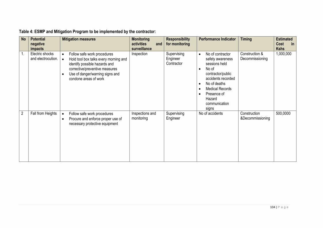
104 | P a g e
Table 4: ESMP and Mitigation Program to be implemented by the contractor:
No Potential negative impacts
Mitigation measures Monitoring activities and surveillance
Responsibility for monitoring
Performance Indicator Timing Estimated Cost in Kshs
1. Electric shocks and electrocution.
• Follow safe work procedures
• Hold tool box talks every morning and identify possible hazards and corrective/preventive measures
• Use of danger/warning signs and condone areas of work
Inspection
Supervising Engineer Contractor
• No of contractor safety awareness sessions held
• No of contractor/public accidents recorded
• No of deaths
• Medical Records
• Presence of Hazard communication signs
Construction & Decommissioning
1,000,000
2 Fall from Heights • Follow safe work procedures
• Procure and enforce proper use of necessary protective equipment
Inspections and monitoring
Supervising Engineer
No of accidents Construction &Decommissioning
500,0000
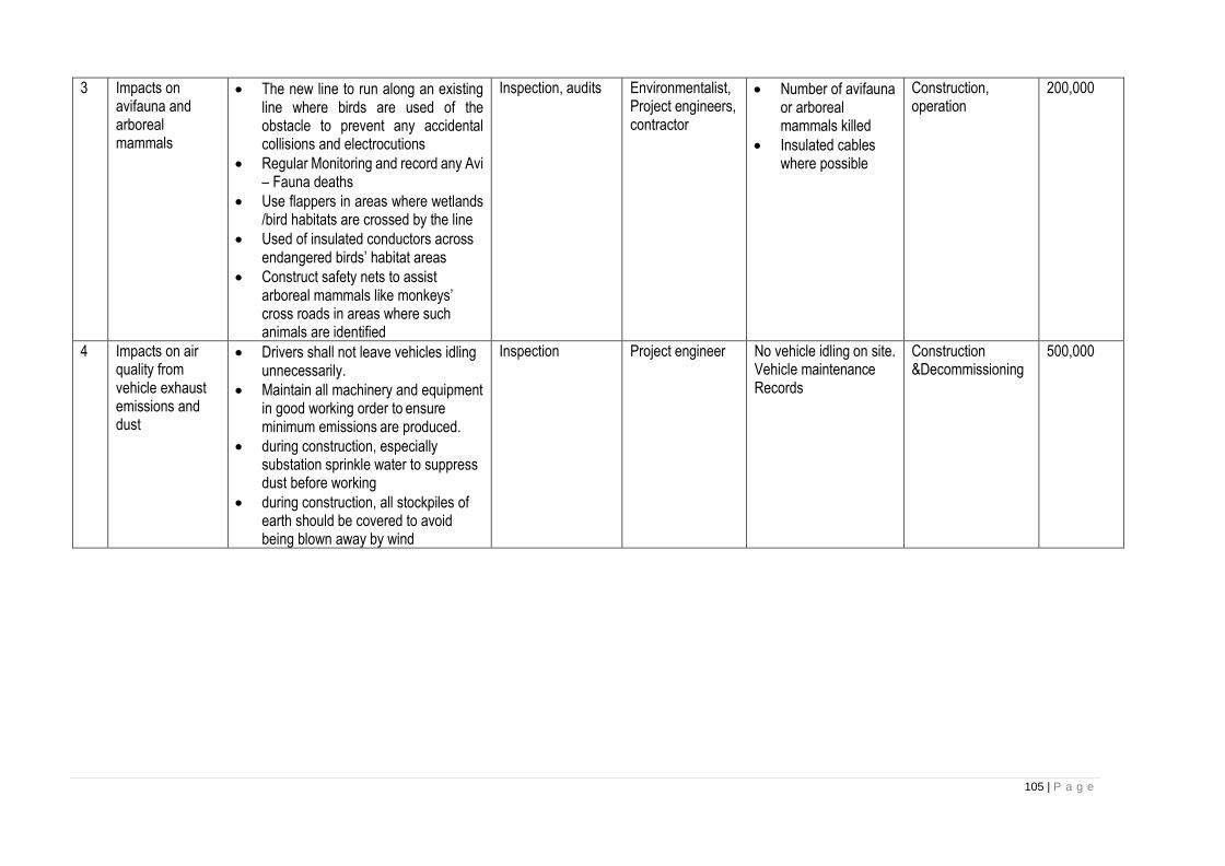
105 | P a g e
3 Impacts on avifauna and arboreal mammals
• The new line to run along an existing line where birds are used of the obstacle to prevent any accidental collisions and electrocutions
• Regular Monitoring and record any Avi – Fauna deaths
• Use flappers in areas where wetlands /bird habitats are crossed by the line
• Used of insulated conductors across endangered birds’ habitat areas
• Construct safety nets to assist arboreal mammals like monkeys’ cross roads in areas where such animals are identified
Inspection, audits Environmentalist, Project engineers, contractor
• Number of avifauna or arboreal mammals killed
• Insulated cables where possible
Construction, operation
200,000
4 Impacts on air quality from vehicle exhaust emissions and dust
• Drivers shall not leave vehicles idling unnecessarily.
• Maintain all machinery and equipment in good working order to ensure minimum emissions are produced.
• during construction, especially substation sprinkle water to suppress dust before working
• during construction, all stockpiles of earth should be covered to avoid being blown away by wind
Inspection Project engineer No vehicle idling on site. Vehicle maintenance Records
Construction &Decommissioning
500,000

106 | P a g e
5 Solid waste Little if any solid waste will be generated which includes scrap conductors, un used poles and tree cuttings.
• All left over conductor cuttings to be disposed appropriately or be returned to the store for proper disposal
• Recover all un used poles after works are completed.
• Proper budgeting of materials to reduce wastage
• practice 3 Rs of waste management: reduce, reuse, recycle of materials
• Any tree cuttings to be left to immediate land owners for their domestic use
Inspection Project Engineer No waste on site Records of material returned to stores if any
Construction & Decommissioning
1,000,000
6. Visual intrusion • Proper fencing and landscaping will be done to within and outside substations
• Follow the road reserve and new power line to run along the existing 11 & 33 KV lines to reduce visual intrusion.
• Maximize straight-line runs to reduce the need for HT poles and stays which are more conspicuous.
Inspection Supervising engineer, environmentalist
• Blended substation
• Aesthetic trees planted along substation outside edges
• Straight lines and less use of stays
Construction, 500,000
7 Negative cultural exchange and social ills
• Respect and tolerate other people’s cultures and religious alienations
• dissemination warning information through billboard on site
• Contractor to apply ethics as required throughout the construction period.
• inspections Supervising engineer, environmentalist
• Harmonious relations with the society
• Documented complaints from the public/workers
Construction, decommissioning
200,000
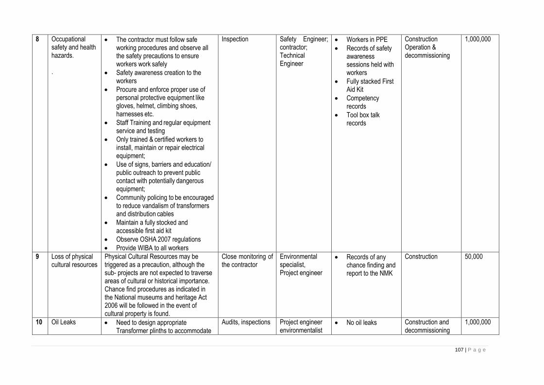
107 | P a g e
8 Occupational safety and health hazards. .
• The contractor must follow safe working procedures and observe all the safety precautions to ensure workers work safely
• Safety awareness creation to the workers
• Procure and enforce proper use of personal protective equipment like gloves, helmet, climbing shoes, harnesses etc.
• Staff Training and regular equipment service and testing
• Only trained & certified workers to install, maintain or repair electrical equipment;
• Use of signs, barriers and education/ public outreach to prevent public contact with potentially dangerous equipment;
• Community policing to be encouraged to reduce vandalism of transformers and distribution cables
• Maintain a fully stocked and accessible first aid kit
• Observe OSHA 2007 regulations
• Provide WIBA to all workers
Inspection Safety Engineer; contractor; Technical Engineer
• Workers in PPE
• Records of safety awareness sessions held with workers
• Fully stacked First Aid Kit
• Competency records
• Tool box talk records
Construction Operation & decommissioning
1,000,000
9 Loss of physical cultural resources
Physical Cultural Resources may be triggered as a precaution, although the sub- projects are not expected to traverse areas of cultural or historical importance. Chance find procedures as indicated in the National museums and heritage Act 2006 will be followed in the event of cultural property is found.
Close monitoring of the contractor
Environmental specialist, Project engineer
• Records of any chance finding and report to the NMK
Construction 50,000
10 Oil Leaks • Need to design appropriate Transformer plinths to accommodate
Audits, inspections Project engineer environmentalist
• No oil leaks Construction and decommissioning
1,000,000
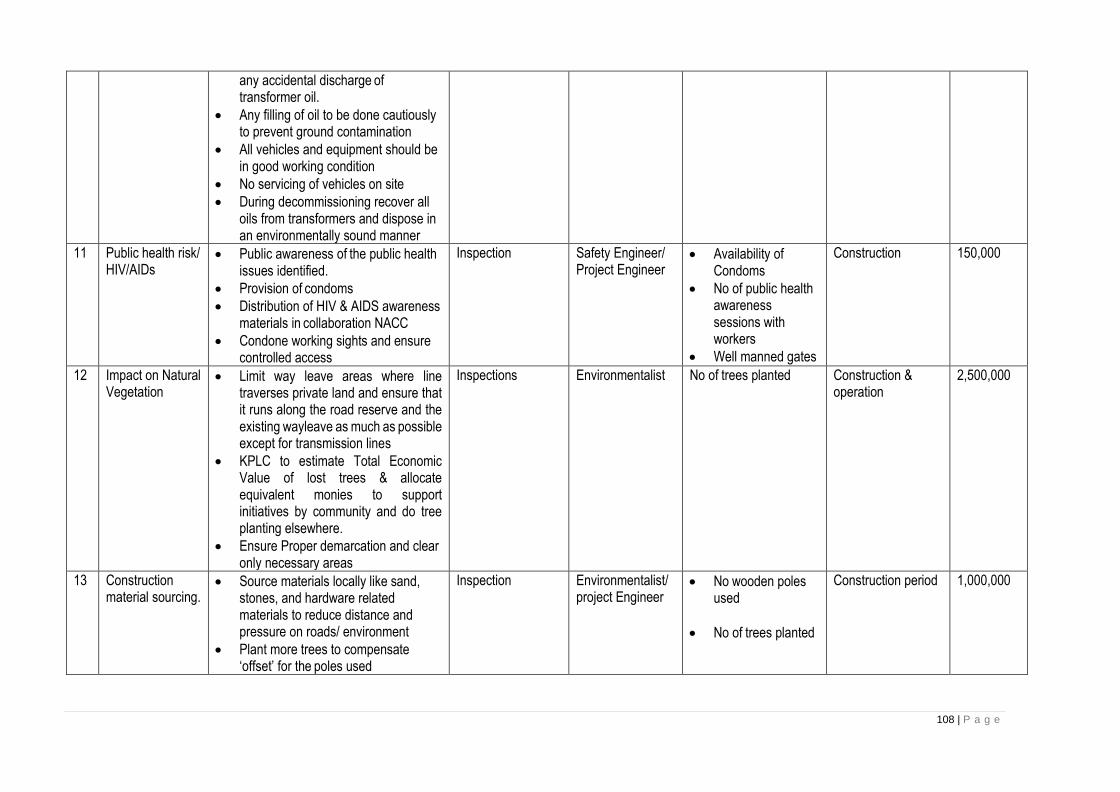
108 | P a g e
any accidental discharge of transformer oil.
• Any filling of oil to be done cautiously to prevent ground contamination
• All vehicles and equipment should be in good working condition
• No servicing of vehicles on site
• During decommissioning recover all oils from transformers and dispose in an environmentally sound manner
11 Public health risk/ HIV/AIDs
• Public awareness of the public health issues identified.
• Provision of condoms
• Distribution of HIV & AIDS awareness materials in collaboration NACC
• Condone working sights and ensure controlled access
Inspection Safety Engineer/ Project Engineer
• Availability of Condoms
• No of public health awareness sessions with workers
• Well manned gates
Construction 150,000
12 Impact on Natural Vegetation
• Limit way leave areas where line traverses private land and ensure that it runs along the road reserve and the existing wayleave as much as possible except for transmission lines
• KPLC to estimate Total Economic Value of lost trees & allocate equivalent monies to support initiatives by community and do tree planting elsewhere.
• Ensure Proper demarcation and clear only necessary areas
Inspections Environmentalist No of trees planted Construction & operation
2,500,000
13 Construction material sourcing.
• Source materials locally like sand, stones, and hardware related materials to reduce distance and pressure on roads/ environment
• Plant more trees to compensate ‘offset’ for the poles used
Inspection Environmentalist/ project Engineer
• No wooden poles used
• No of trees planted
Construction period 1,000,000

109 | P a g e
• Do accurate budgeting to ensure only necessary material is ordered
• Proper storage to ensure minimal loss
• Restrict movement of heavy equipment during wet-soil conditions to prevent subsoil compaction;
• Rehabilitation of exposed sites as soon as practicable
• Source Raw Materials from NEMA approved sites
• Use recycled and recyclable materials where possible
• List of NEMA approved sites
14 Increased water demand
• Sensitize the staff on efficient water use
• Factor storm water harvesting to reduce strain on water resources
• Recycle water where necessary
• Inspection audits
Supervising engineer, technical engineer, environmentalist
Water harvesting in place
Construction, operational, decommissioning
400,000
15 Noise and excessive vibrations
• Proper servicing of vehicles and other machinery
• contractor should ensure minimal noise generation during construction and decommissioning phases
• Maintain all work equipment at optimal operating condition
• Monitor noise and vibration levels at sensitive receptors (residential areas, schools, hospitals)
• Work through community liaison officers to agree on working hours and to respond promptly to complaints.
• The contractor should adhere to Noise and Excessive vibrations regulations of 2009. Contractor to use equipment with sound attenuated
Inspection Project Engineer / Safety Engineer
Minimal noise and Vibrations at work sites
Construction & decommissioning
100,000

110 | P a g e
features, low noise, no raving of trucks, no unnecessary idling and Compactors used should be suitable not to cause damage to the environment, to people or other infrastructure and buildings proximal to the site
16 Risk of Fire from live conductors and Transformers-
• All joints should be fixed firmly to eliminate arcing which can cause sparks and fire on electrical infrastructure
• No burning of vegetation along the distribution lines rights-of-way
Lines and Substations constructed to approved standards
Contractor & Operation and Maintenance Engineer
• Works completion, testing and commissioning certificates
Construction 1,000,000
17 Temporary land take for construction purposes, Vegetation clearance, compacting, soil erosion,
Demarcate such areas and clear only necessary vegetation, do landscaping, rehabilitate the area with suitable tree & grass species
Rehabilitated sites Contractor Rehabilitated grounds End of Construction 600,000
18 Impacts related to labor influx, GBV and SEA
• Client to undertake a project’s social assessment to include assessment of the underlying GBV risks and social situation. The GBV risk assessment will identify and map GBV prevention and response actors/service providers at all levels in the project’s area of influence with particular attention to available capacity to provide quality, GBV response services in the project area of influence. The client will also prepare, in consultation with contractors, a GBV Action Plan to be implemented
Audits and inspections
Client Social safeguards specialist
No GBV cases, Signed copies of GBV codes of conduct and GBV Action Plan,
Construction and operation phase
2,000,000
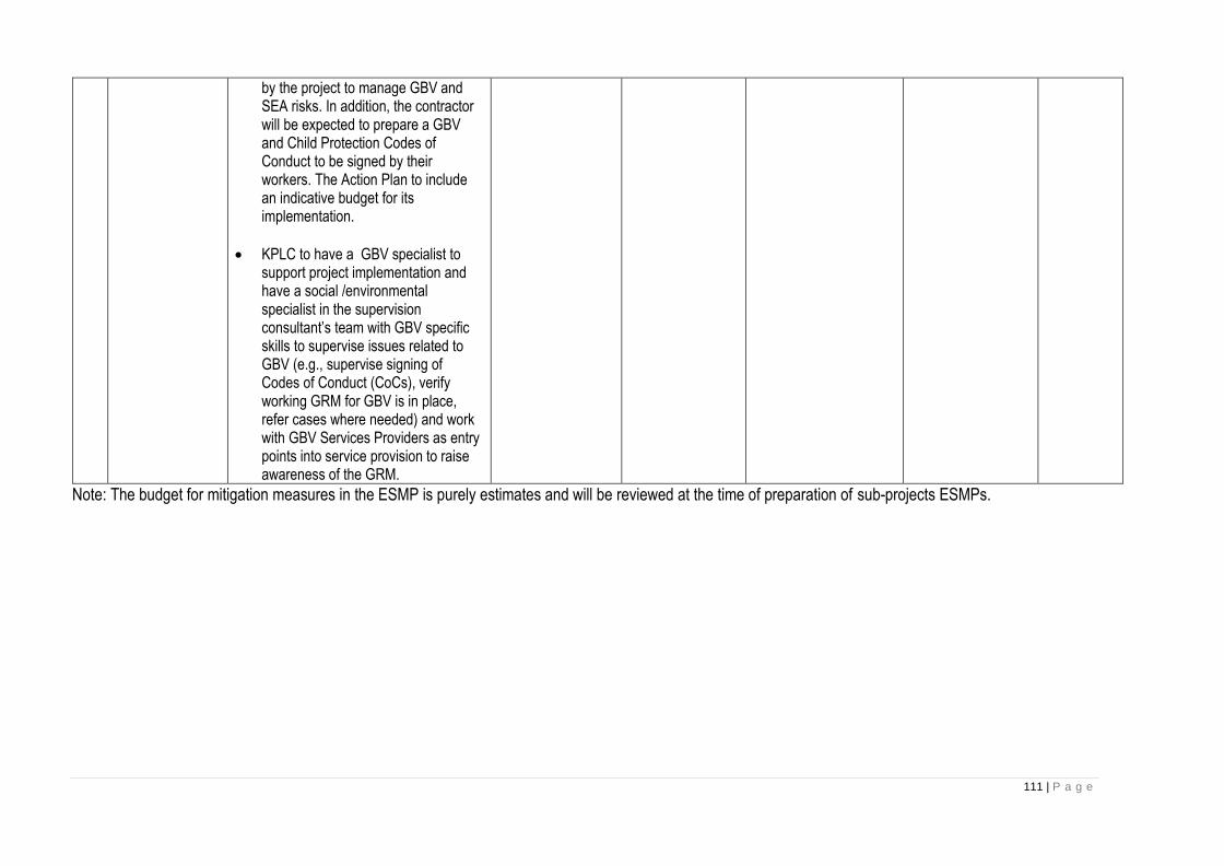
111 | P a g e
by the project to manage GBV and SEA risks. In addition, the contractor will be expected to prepare a GBV and Child Protection Codes of Conduct to be signed by their workers. The Action Plan to include an indicative budget for its implementation.
• KPLC to have a GBV specialist to support project implementation and have a social /environmental specialist in the supervision consultant’s team with GBV specific skills to supervise issues related to GBV (e.g., supervise signing of Codes of Conduct (CoCs), verify working GRM for GBV is in place, refer cases where needed) and work with GBV Services Providers as entry points into service provision to raise awareness of the GRM.
Note: The budget for mitigation measures in the ESMP is purely estimates and will be reviewed at the time of preparation of sub-projects ESMPs.
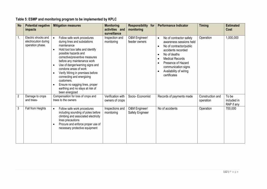
112 | P a g e
Table 5: ESMP and monitoring program to be implemented by KPLC
No Potential negative impacts
Mitigation measures Monitoring activities and surveillance
Responsibility for monitoring
Performance Indicator Timing Estimated Cost
1. Electric shocks and electrocution during operation phase.
• Follow safe work procedures during lines and substations maintenance
• Hold tool box talks and identify possible hazards and corrective/preventive measures before any maintenance work
• Use of danger/warning signs and condone areas of work
• Verify Wiring in premises before connecting and energizing customers.
• Ensure no sagging lines, proper earthing and no stays at risk of been energized
Inspection and monitoring
O&M Engineer/ feeder owners
• No of contractor safety awareness sessions held
• No of contractor/public accidents recorded
• No of deaths
• Medical Records
• Presence of Hazard communication signs
• Availability of wiring certificates
Operation 1,000,000
2 Damage to crops and trees-
Compensation for loss of crops and trees to the owners
Verification with owners of crops
Socio- Economist Records of payments made Construction and operation
To be included in RAP if any
3 Fall from Heights • Follow safe work procedures including sounding of poles before climbing and associated electricity lines precautions
• Procure and enforce proper use of necessary protective equipment
Inspections and monitoring
O&M Engineer/ Safety Engineer
No of accidents Operation 700,000

113 | P a g e
No Potential negative impacts
Mitigation measures Monitoring activities and surveillance
Responsibility for monitoring
Performance Indicator Timing Estimated Cost
4 Impacts on avifauna and arboreal mammals
• Regular Monitoring and record any Avi – Fauna deaths
• Use flappers in areas where wetlands /bird habitats are crossed by the line
• Used of insulated conductors across endangered birds’ habitat areas
• Construct safety nets to assist arboreal mammals like monkeys’ cross roads in areas where such animals are identified
Inspection, audits
Environmentalist, O&M Engineer
• Number of avifauna or arboreal mammals killed
• Insulated cables where possible
operation 200,000
5 Impacts on air quality from vehicle exhaust emissions
• Drivers shall not leave vehicles idling unnecessarily.
• Maintain all machinery and equipment in good working order to ensure minimum emissions are produced.
Inspection O&M Engineer No vehicle idling on site. Vehicle maintenance Records
Operation 500,000
6 Solid waste Mostly tree cuttings during wayleave trace maintenance, recovered poles, broken insulators,
• Recover all poles after replacement and take them to stores awaiting disposal.
• Any vegetation off cuts from wayleave trace maintenance should be left to the immediate land owners for their domestic use
Inspection O&M Engineer No waste on site, Records of material return to store if any
Operation 500,000
7 Occupational safety and health hazards. .
• The Employees must follow safe working procedures and observe all the safety precautions to ensure safety of workers
• Safety awareness creation to the workers
• Procure and enforce proper use of
Inspection Safety Engineer; contractor; Technical Engineer
• Workers in PPE
• Records of safety awareness sessions held with workers
• Fully stacked First Aid Kit
• Competency records
Construction Operation & decommissioning
200,000

114 | P a g e
No Potential negative impacts
Mitigation measures Monitoring activities and surveillance
Responsibility for monitoring
Performance Indicator Timing Estimated Cost
personal protective equipment like gloves, helmet, climbing shoes, harnesses etc.
• Staff Training and regular equipment service and testing
• Only trained & certified workers to install, maintain or repair electrical equipment;
• Use of signs, barriers and education/ public outreach to prevent public contact with potentially dangerous equipment;
• Community policing to be encouraged to reduce vandalism of transformers and distribution cables
• Maintain a fully stocked and accessible first aid kit
• Observe OSHA 2007.
• Provide medical insurance to all workers
• Tool box talk records
8 Oil Leaks • Any oil refills to transformers should be done cautiously to prevent ground contamination
• Frequent inspection and maintenance of the transformers should be done to minimize spilling incidences
• All waste oils from maintenance of transformers and other associated equipment should be segregated and disposed properly by a reputable/registered waste handler in accordance with the waste
Audits, inspections
O&M Engineer environmentalist
• No oil leaks Operation 1,000,000
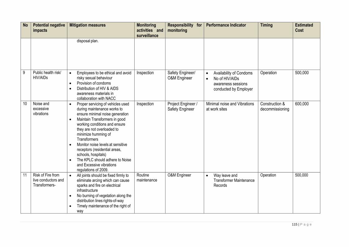
115 | P a g e
No Potential negative impacts
Mitigation measures Monitoring activities and surveillance
Responsibility for monitoring
Performance Indicator Timing Estimated Cost
disposal plan.
9 Public health risk/ HIV/AIDs
• Employees to be ethical and avoid risky sexual behaviour
• Provision of condoms
• Distribution of HIV & AIDS awareness materials in collaboration with NACC
Inspection Safety Engineer/ O&M Engineer
• Availability of Condoms
• No of HIV/AIDs awareness sessions conducted by Employer
Operation 500,000
10 Noise and excessive vibrations
• Proper servicing of vehicles used during maintenance works to ensure minimal noise generation
• Maintain Transformers in good working conditions and ensure they are not overloaded to minimize humming of Transformers
• Monitor noise levels at sensitive receptors (residential areas, schools, hospitals)
• The KPLC should adhere to Noise and Excessive vibrations regulations of 2009.
Inspection Project Engineer / Safety Engineer
Minimal noise and Vibrations at work sites
Construction & decommissioning
600,000
11 Risk of Fire from live conductors and Transformers-
• All joints should be fixed firmly to eliminate arcing which can cause sparks and fire on electrical infrastructure
• No burning of vegetation along the distribution lines rights-of-way
• Timely maintenance of the right of way
Routine maintenance
O&M Engineer • Way leave and Transformer Maintenance Records
Operation 500,000

116 | P a g e
No Potential negative impacts
Mitigation measures Monitoring activities and surveillance
Responsibility for monitoring
Performance Indicator Timing Estimated Cost
• Timely maintenance of transformers
Note: The budget for mitigation measures in the ESMP is purely estimates and will be reviewed at the time of preparation of subproject ESMPs.
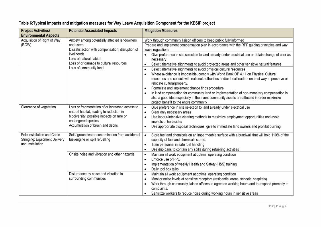
117 | P a g e
Table 6:Typical impacts and mitigation measures for Way Leave Acquisition Component for the KESIP project
Project Activities/ Environmental Aspects
Potential Associated Impacts Mitigation Measures
Acquisition of Right of Way (ROW)
Anxiety among potentially affected landowners and users Dissatisfaction with compensation; disruption of livelihoods Loss of natural habitat Loss of or damage to cultural resources Loss of community land
Work through community liaison officers to keep public fully informed
Prepare and implement compensation plan in accordance with the RPF guiding principles and way leave regulations
• Give preference in site selection to land already under electrical use or obtain change of user as necessary
• Select alternative alignments to avoid protected areas and other sensitive natural features
• Select alternative alignments to avoid physical cultural resources
• Where avoidance is impossible, comply with World Bank OP 4.11 on Physical Cultural resources and consult with national authorities and/or local leaders on best way to preserve or relocate cultural property.
• Formulate and implement chance finds procedure
• In kind compensation for community land or Implementation of non-monetary compensation is also a good idea especially in the event community assets are affected in order maximize project benefit to the entire community
Clearance of vegetation Loss or fragmentation of or increased access to natural habitat, leading to reduction in biodiversity, possible impacts on rare or endangered species Accumulation of brush and debris
• Give preference in site selection to land already under electrical use
• Clear only necessary areas
• Use labour-intensive clearing methods to maximize employment opportunities and avoid impacts of herbicides
• Use appropriate disposal techniques; give to immediate land owners and prohibit burning
Pole installation and Cable Stringing; Equipment Delivery and Installation
Soil / groundwater contamination from accidental fuel/engine oil spill refuelling
• Store fuel and chemicals on an impermeable surface with a bundwall that will hold 110% of the capacity of fuel and chemicals stored.
• Train personnel in safe fuel handling
• Use drip pans to contain any spills during refuelling activities
Onsite noise and vibration and other hazards. • Maintain all work equipment at optimal operating condition
• Enforce use of PPE
• Implementation of weekly Health and Safety (H&S) training
• Daily tool box talks
Disturbance by noise and vibration in surrounding communities
• Maintain all work equipment at optimal operating condition
• Monitor noise levels at sensitive receptors (residential areas, schools, hospitals)
• Work through community liaison officers to agree on working hours and to respond promptly to complaints.
• Sensitize workers to reduce noise during working hours in sensitive areas

118 | P a g e
• All works to be carried out between 8:00 a.m and 6:00 p.m
Risk of accidents to life and property • Set and enforce speed limits
• Mandatory driver training
• Use warning signs and, where necessary, personnel to direct traffic
Damage to roads and other infrastructure caused by transit of heavy trucks
• Routine inspection, and prompt repair of any damage
Working at heights and in confined spaces. • Adequate ladder should be provided
• Provision of climbing shoes
• Provide safety harness
Distribution line operation Risk of electrocution, injury or property damage • Prevent encroachment and enforce restrictions on activities in RoW
• Post warning signs and properly install electrical poles with anti-climbs to prevent access to conductors by unauthorized personnel
• Provide safety belts and include log-out/tag-out procedures
• Create public and staff awareness on the electrical safety rules as set out in Kenya power safety book
Pollution from Improper disposal of solid and liquid wastes
• Operators to practice 3Rs of waste management: reduce, reuse, recycle
• Dispose of wastes and scrapped equipment properly
• Manage storage, transfer, and disposal of transformer oils according to industry standards
Distribution line maintenance Damage to natural habitat • Set and enforce restrictions on hunting by workers
• Minimize width of cleared area
• Use labour-intensive mechanical clearing methods to maximize employment opportunities and avoid impacts of herbicides
Accumulation of brush and debris • Use appropriate disposal techniques; prohibit burning
Soil / groundwater contamination from accidental fuel/engine oil spill refuelling
• Train personnel in safe fuel handling
• Use drip pans to contain any spills during refuelling activities
Risk of accidents to life and property • Set and enforce speed limits
• Mandatory driver training
• Use warning signs and, where necessary, personnel to direct traffic
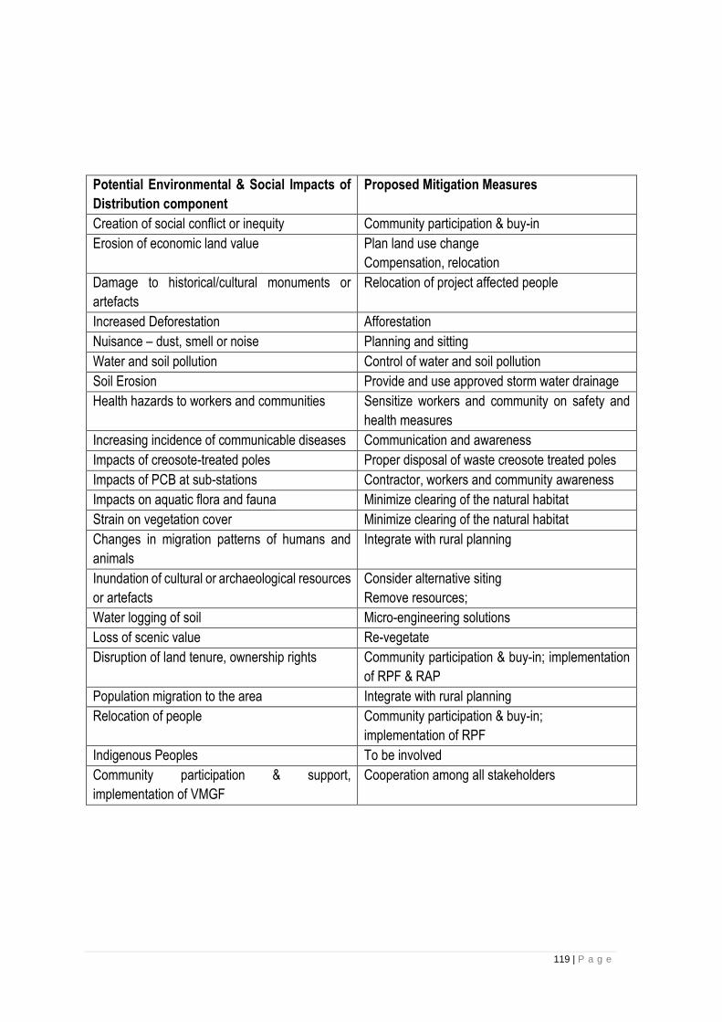
119 | P a g e
Potential Environmental & Social Impacts of
Distribution component
Proposed Mitigation Measures
Creation of social conflict or inequity Community participation & buy-in
Erosion of economic land value Plan land use change
Compensation, relocation
Damage to historical/cultural monuments or
artefacts
Relocation of project affected people
Increased Deforestation Afforestation
Nuisance – dust, smell or noise Planning and sitting
Water and soil pollution Control of water and soil pollution
Soil Erosion Provide and use approved storm water drainage
Health hazards to workers and communities Sensitize workers and community on safety and
health measures
Increasing incidence of communicable diseases Communication and awareness
Impacts of creosote-treated poles Proper disposal of waste creosote treated poles
Impacts of PCB at sub-stations Contractor, workers and community awareness
Impacts on aquatic flora and fauna Minimize clearing of the natural habitat
Strain on vegetation cover Minimize clearing of the natural habitat
Changes in migration patterns of humans and
animals
Integrate with rural planning
Inundation of cultural or archaeological resources
or artefacts
Consider alternative siting
Remove resources;
Water logging of soil Micro-engineering solutions
Loss of scenic value Re-vegetate
Disruption of land tenure, ownership rights Community participation & buy-in; implementation
of RPF & RAP
Population migration to the area Integrate with rural planning
Relocation of people Community participation & buy-in;
implementation of RPF
Indigenous Peoples To be involved
Community participation & support,
implementation of VMGF
Cooperation among all stakeholders

120 | P a g e
8 CHAPTER EIGHT: THE ENVIRONMENTAL AND SOCIAL SCREENING PROCESS FOR KESIP PROJECT
The Environmental and Social Screening Process and criteria Introduction
The Environmental Management Coordination Act of 1999 and the Environmental (Impact Assessment
and Audit) Regulations (June 2003) prescribe the conduct for Environmental Impact Assessment for
development projects. Social and environmental sustainability are fundamental to the achievement of
development outcomes and must be systematically mainstreamed into all development projects. This
section describes the procedures to be used by KPLC to determine if a sub-project might cause
environmental and social impacts. It will include a screening form (annex 1), that will be used to assess
the level of Environmental and Social Risk of proposed sub-projects and recommend the appropriate
safeguard tools to be prepared to manage them. Risk level ratting corresponding applicable safeguard
tools required have been discussed in detail in subsequent section in this chapter.
Screening process
All proposed subproject will be subjected to the screening process to determine and assign them an
environmental and social risk rating and further identify potential sensitive environmental and social
receptors likely to be negatively impacted. The process will also identify critical issues that might be
triggered by the subproject and would need further detailed investigations during environmental and social
assessments. This process will also help in advising what safeguards tools (ESIAs, ESMPs, RAPs,
ARAPs etc) will be required for the various subprojects. Most importantly, it will help in re-aligning, re-
designing and where not possible dropping out sub-projects that have extreme high risk and the potential
to negatively impact the environment, natural habitat and forests.
Screening Form
Once subproject proposal are received, the Environmental Specialist and the Social Safeguards specialist
assigned into the PIU will coordinate and lead the screening process with the help and support the SHE
Department. The environmental and social screening would involve: (i) reconnaissance of the subproject
areas/routes and their surroundings; (ii) identification of the major subproject activities; and (iii) preliminary
assessment of the impacts of these activities on the ecological, physicochemical and socio-economic
environment of the subproject surrounding areas. A template form for that will be used for Environmental
and Social Screening for the proposed subprojects is presented in Annex 1. It will need to be reviewed
and updated as needed during the process to accommodate other variables. All screening forms will be
collated together into a screening report and shared with the Bank for review and clearance.
Subproject Risk Levels
Following the screening process, KPLC will assign each eligible subproject one of the following risk levels.
.

121 | P a g e
Level 1 – Low Risk. Subprojects that do not have a physical footprint. Equivalent to Category C in OP
4.01. These subprojects will not require safeguards instruments preparation, however Environmental and
Social Clauses in the contract will be recommended.
Level 2 – Medium Risk. Subprojects that trigger environmental or social impacts that are site specific,
temporal and reversible in nature. In addition to the Environmental and Social Clauses in the contract,
these subprojects will require an environmental and social assessment that will collate findings into a
detailed project report and ESMP. The Environmental and Social Specialist in the SHE department of
KPLC will prepare the safeguards documents required for this category of sub-projects. These will be
reviewed cleared and disclosed by both NEMA and the Bank respectively. These subprojects might also
require ARAP where involuntary resettlement is anticipated with PAP less than 200, else a full RAP will
be required.
Level 3 – High Risk. Subprojects that trigger significant environmental and social impacts. These
subprojects will require a full ESIA study and Detailed ESMP. They may also require an ARAP or a RAP
depending on the number of Project Affected Persons (PAPs) and resettlement impact anticipated. Where
more than 200 PAPs are affected, a full RAP study will be required. KPLC will engage an independent
Firm of Expert to undertake Full Environmental and Social Impact Assessment for this category of projects
given the nature of environmental and social challenges that they may present thus requiring diversity of E&S specialist that
may not be available internally in the SHE department. Both the ESIA and the RAPs will be reviewed, cleared, and
disclosed by NEMA and the World Bank before submission to NEMA for review and licensing.
This ESMF provides for due mitigation process and actions starting with subproject environmental and
social screening process at the preliminary stage of project identification. Then selection of
environmentally suitable subprojects and/or sites, dropping of others that are not suitable or where
possible re-designing and/or re-alignment them to avoid their E&S risks presented following screening
and finally subjecting them to an environmental assessment as applicable. The PIU Head/Chief
Engineer with the assistance of the Environmental and Social specialist in the PIU will be responsible to
ensuring that the Owners Engineer (OE) and/or the Design and Supervising Engineer (DSE) engaged
by KPLC integrates findings of various safeguards studies conducted into the final design before they
are adopted for implementation by contractors.
The full scope of environmental and social work that will be required, prior to the commencement of
KESIP Projects will depend on the outcome of the screening process making it a critical and important
process.
122 | P a g e
9 CHAPTER NINE: SUB PROJECTS ESIAs AND ESMPS
Introduction This chapter will detail the procedures and accountability for the preparation of ESIAs and ESMPs. Based
on the results of the environmental and social screening, the level of environmental work for the KESIP
could range from application of environmental and social mitigation measures (ESMP) to Environmental
Assessment. Level 3 subprojects will require the preparation of subproject-specific safeguard instruments.
This chapter details the procedures and accountability for their preparation.
Carrying Out Environmental and Social Impact Assessment Once it is determined through screening the level of environmental management needed, the
implementing agency (KPLC) will be responsible for preparation of ESIA and ESMP in line with the issues
or impacts identified during the screening process and scoping. This will be done by registered
environmental experts.
Preparation of specific subproject ESIA will be carried out in consultation with the relevant sector
ministries and potentially affected persons. KPLC environment and social experts registered by NEMA
will conduct ESIA in close consultation with relevant government agencies such as KWS, KFS, National
museums, NEMA and Ministry of Environment, Water and Natural as the case/situation will require.
The following steps will be followed in carrying out ESIA.
• Screening
• Preparation of EIA terms of reference for projects
• Approval of TORs by the world Bank and NEMA
• Approval of the ESIA report by World Bank
• Approval of ESIA report and Issuance of ESIA license by NEMA
• Disclosure of report in KPLC website and World Bank Info Shop
• Recruitment of a service provider to carry out the EIA if need be
Template for preparing ESIA
Executive summary. Concisely discusses significant findings and recommended actions.
Project description. Concisely describes the proposed project and its geographic, ecological, social, and
temporal context, including any offsite investments that may be required (e.g., dedicated pipelines, access
roads, power plants, water supply, housing, and raw material and product storage facilities). Indicates the
need for any resettlement plan or indigenous people’s development plan
Policy, legal, and administrative framework. Discusses the policy, legal, and administrative framework
within which the EA is carried out. Explains the environmental requirements of any co-financiers.
Identifies relevant international environmental agreements to which the country is a party.
Baseline data. Assesses the dimensions of the study area and describes relevant physical, biological,
and socioeconomic conditions, including any changes anticipated before the project commences. It also
123 | P a g e
takes into account current and proposed development activities within the project area but not directly
connected to the project. Data should be relevant to decisions about project location, design, operation,
or mitigatory measures. The section indicates the accuracy, reliability, and sources of the data.
Environmental impacts. Predicts and assesses the project's likely positive and negative impacts, in
quantitative terms to the extent possible. Identifies mitigation measures and any residual negative impacts
that cannot be mitigated. Explores opportunities for environmental enhancement. Identifies and estimates
the extent and quality of available data, key data gaps, and uncertainties associated with predictions, and
specifies topics that do not require further attention.
Analysis of alternatives. Systematically compares feasible alternatives to the proposed project site,
technology, design, and operation--including the "without project" situation--in terms of their potential
environmental impacts; the feasibility of mitigating these impacts; their capital and recurrent costs; their
suitability under local conditions; and their institutional, training, and monitoring requirements. For each
of the alternatives, quantifies the environmental impacts to the extent possible, and attaches economic
values where feasible. States the basis for selecting the particular project design proposed and justifies
recommended emission levels and approaches to pollution prevention and abatement.
Environmental management plan (EMP). Covers mitigation measures, monitoring, and institutional
strengthening;
Annexes
• List of EA report preparers--individuals and organizations.
• References--written materials both published and unpublished, used in study preparation.
• Record of interagency and consultation meetings, including consultations for obtaining the informed
views of the affected people and local nongovernmental organizations (NGOs). The record specifies
any means other than consultations (e.g., surveys) that were used to obtain the views of affected
groups and local NGOs.
• Tables presenting the relevant data referred to or summarized in the main text.
• List of associated reports (e.g., resettlement plan or indigenous people’s development plan)
Preparation of Environmental and Social Management Plan
Guidelines for the preparation of ESMP
The preparation of an ESMP should include the following key sections:
1. Project description: Concisely describes the proposed project and its geographic, ecological, social,
and temporal context, including any offsite investments that may be required
2. Physical, Biological and Social Characteristics: description of the relevant physical, biological,
and socioeconomic conditions, including any changes anticipated before the project commences. It
also takes into account current and proposed development activities within the project area but not
directly connected to the project
3. Summary of Impacts: Anticipated adverse environmental impacts should be identified and
summarized as well as their relationship to social impacts and the appropriate mitigation measures.
124 | P a g e
4. Description of Mitigation measures: The mitigation measures proposed for the various impacts
should be described in relation to the corresponding impacts while stating the conditions under which
they are required. Adequate description of the consultations should be done and justified.
5. Description of monitoring program: A detailed monitoring program should be described in the
ESMP, listing environmental performance indicators and their link with impacts and mitigation
measures. The ESMP should also describe the parameters to be measured, methods to be used,
sampling location and frequency of measurements, detection limits and a clear definition of thresholds
that indicate the need for corrective measures. Monitoring and supervision schedules should be
clearly stated and agreed with the Bank to ensure timely detection of needs for remedial action and
also provide information on the level of compliance with ESMP in accordance with Bank safeguards.
6. Legal requirements and bidding/contract documents: The ESMP should be incorporated in all
legal documents to enforce compliance by all contractors participating in the project. The ESMP
should be summarized and incorporated in the bidding and contract documents. In the event where
the sub project ESMPs are not ready by the time of bidding, the generic ESMP for such a project will
be used for bidding.
7. Institutional arrangements: The ESMP should clearly state who is responsible for monitoring,
execution of remedial action and the reporting order and format to allow for a defined channel of
information flow. It should also recommend institutional strengthening for relevant agencies and the
funding authorities for the various activities.
8. Capacity Development and Training: To support timely and effective implementation of
environmental project components and mitigation measures, the ESMP draws on the EA's
assessment of the existence, role, and capability of environmental units on site or at the ministry level.
If necessary, the ESMP recommends the establishment or expansion of such units, and the training
of staff, to allow implementation of EA recommendations. Specifically, the ESMP provides a specific
description of institutional arrangements i.e. who is responsible for carrying out the mitigation and
monitoring measures (e.g., for operation, supervision, enforcement, monitoring of implementation,
remedial action, financing, reporting, and staff training). To strengthen environmental management
capability in the agencies responsible for implementation, most ESMPs cover one or more of the
following additional topics: (a) technical assistance programs, (b) procurement of equipment and
supplies, and (c) organizational changes.
9. Implementation Schedule: The frequency, timing and duration of mitigation measures and
monitoring should be stated in the implementation schedule. Links between mitigation measures and
development of relevant institutions and legal requirements of the project should be stated.
10. Reporting: The order of information flow as it concerns monitoring reports should be clearly defined.
The relevant officers to receive these reports should be those who have authorities to facilitate
implementation of the results of the monitoring. These reports should also be communicated to the
Bank via media to be agreed and specified in the ESMP. Adequate arrangements should be made
by the Bank to facilitate the circulation of the ESMP through the selected means.
125 | P a g e
11. Cost estimate: The cost of carrying out monitoring and implementation of the mitigation measures
at the various stages of the project should be integrated into the total cost of the project and factored
into financial negotiations. These costs should include administrative, design and consultancy,
operational and maintenance costs – resulting with meeting required standards and project design.
Consultations for ESIA and ESMP
The consultations relative to subproject specific ESIAs which are in the future will be carried out as part
of the preparation of the specific subproject’s ESIA and ESMP. For each subproject, the SHE Department
will organize consultations with individuals and communities that might be affected by the subproject. The
purpose of the consultations will be to: (i) inform them about the activities to be undertaken, their timetable
and possible impacts, and; (ii) document and address their concerns. Consultations should be initiated
as early as possible, as soon as subproject screening has been completed.
The SHE Department will regularly consult with subproject affected persons and communities throughout
subproject implementation, as necessary, to address safeguards-related issues that affect them.
Provisions and specifics for consultations, including budgets, will be included in the relevant ToRs and
subsequent safeguards documents.
The client will engage in meaningful consultations with all stakeholders. The implementing agency will
provide with timely relevant, understandable and accessible information and consult with them in a
culturally appropriate manner free from manipulation, interference, coercion, discrimination and
intimidation.
The process of stakeholder engagement will involve the following: -
i. Stakeholder identification and analysis
ii. Planning how the engagement with stakeholders will take place
iii. Disclosure of information
iv. Consultation with stakeholders
v. Addressing and responding to grievances
vi. Reporting to stakeholders
The process of stakeholder engagement will involve the following: -
Stakeholder identification and analysis
This includes mapping of stakeholders based on the sub projects to be implemented and would be
beneficiaries. The mapping will factor political, economic, gender, vulnerable, marginalized and any
special groups consideration and inclusion that may be affected or may affect the sub-projects.
Planning how the engagement with stakeholders will take place. This will be determined based on the
sub-projects, time, budget and nature of stakeholders to be engaged. As a minimum, the
Disclosure of information
This will be as per the requirements of the constitution, Worldbank and GoK policies and will be per the
safeguard instruments prepared and may range from disclosure and consultation forums, publication on
126 | P a g e
local dailies, disclosure in worldbank info shop and KPLC website, submission of documents to the
National regulator for review and will also be dependent on the sub-projects to be implanted.
Consultation and Disclosure with stakeholders
This will depend on the stakeholders identified with regard to the sub- projects to be implemented and
may vary from documented advertisements on local dailies, radio adverts, face to face interviews, focused
group discussions, Public forums (barazas) among others. As a minimum benchmark, the Subprojects
classified as HIGH risk will carry out at least three participation process, and subprojects classified as
MEDIUM and LOW risk will carry out at least two participation process as per National and OP/BP 4.01
requirement.
Addressing and responding to grievances
Grievances will be addressed according to the Grievance Redress Mechanism (GRM) in Kenya Power
and more emphasis will be recognition and exhaustion of existing local grievance address mechanisms
and structures in the affected communities. Those grievances that can not be resolved at local level will
be elevated as set out in GRM.
Reporting to stakeholders
Feedback to stakeholders will be provided based on the issues raised whether on one on one forums and
documented minutes for all forums filed. Other feedback will be issue based and will be determined as
per the sub-projects and GRM in case of grievances. The client will maintain and disclose as part of the
environmental and social assessment, a documented record of stakeholder engagement including a
description of the stakeholders consulted, a summary of the feedback received and a brief explanation of
how the feedback was taken into account, or the reasons why it was not.
The SHE Department will regularly consult with subproject affected persons and communities throughout
subproject implementation, as necessary, to address safeguards-related issues that affect them.
Provisions and specifics for consultations, including budgets, will be included in the relevant ToRs and
subsequent safeguards documents. The SHE Department will remain responsible for ensuring all that all
safeguards documents prepared and implemented and complied to by all parties implementing the
involved in the project.

127 | P a g e
10 CHAPTER TEN: MONITORING & REPORTING KPLC ESMF Monitoring
This section will detail the procedures to monitor the implementation of sub-project ESMPs during sub-
project implementation, including the compliance of contractors with their Contractor ESMPs. It will
describe monitoring schedules and accountability, the types of reports, who reports, who gets the
reports, when and how frequently reports are prepared, the management of corrective actions, and
define a set of standard indicators that will reported on. The same set of indicators will be included in
every subproject ESMP.
KPLC will monitor the overall implementation of the ESMF, most particularly the:
• Timely preparation of TORs for the ESIAs, ESMPs, RAPs and ARAPs for review and clearance by the Bank;
• Timely preparation of environmental and social screening forms for all subprojects (list of subprojects by risk category by date);
• Timely preparation and clearance of subproject ESIAs and ESMPs, as needed (list of instruments with dates);
• Management of prior review requirements of the World Bank (non-objection requests with dates);
• Monitoring of ESMP implementation, including monitoring of mitigation measures and monitoring of contractors environmental and social performance (indicators);
• Training of project staff, implementing partners, and contractors (list of persons, dates and places); KPLC will prepare:
• quarterly reports summarizing monitoring results, to be included in the Project’s Quarterly Reports to the World Bank
• reports that aggregate and analyze monitoring results ahead of regular World Bank implementation support missions
• annual reports of all environmental and social monitoring activities that will be submitted to the World Bank as part of overall project implementation
site visits The SHE Department will conduct onsite visits of level 2 and 4 subprojects at least once in a quarter to monitor the implementation of their ESMPs.
Subproject Environmental and Social Database KPLC will establish and maintain a database of subprojects. The database will include for each subproject:
• type of subproject, name of subproject
• safeguards risk level
• timeline (clearance of screening form, clearance of ToRs, clearance of safeguard instruments)
• supervision reports by KPLC
• contractor reports
• noncompliance by contractors
• cross references to the Grievance Redress Mechanism’s log of complaints.

128 | P a g e
Monitoring of Contractors As part of their regular activities, KPLC staff will monitor and document (including pictures) contractor
environmental and social performance for each subproject throughout construction. This will involve
both spot check visits to work locations, and reviews of records kept by the contractor and of reports
submitted by the contractor. The frequency of site visits should be commensurate with the magnitude
of activities and their associated environmental and social impacts. Sites where serious accidents are
recorded should be visited within one working day of the accident. Overall, each construction site should
be visited at least once during subproject implementation.
Each visit and interaction with a contractor should be documented in the database, including
identification of contractor noncompliance, the significance of the non-compliance, and guidance
provided on actions to be taken. KPLC will follow up as needed to ensure timely resolution of issues of
noncompliance with environmental and social clauses. This may include additional visits to the
contractor’s site or offices, further communications with contractor personnel, issuance of notices of
deficiency or warnings to the contractor, and other actions as needed (see Section on Contractor
clauses).
Completion Reports Upon completion of subprojects, KPLC will prepare a subproject completion report, to identify any
unresolved environmental or social, with recommended remedial action. This report will be brought to
the attention of the KESIP Manager within KPLC who will decide the way forward.
For subprojects with significant environmental or social impacts, the completion report might recommend
periodic routine inspections/monitoring during operation of the facility by KPLC environmental and social
specialists.

129 | P a g e
11 CHAPTER TEN: ENVIRONMENTAL AND SOCIAL CLAUSES FOR CONTRACTORS
INTRODUCTION Most environmental and social impacts of subprojects result from activities directly under the control of
contractors and will be mitigated directly by the same contractors. For Level 2 subprojects, which might
represent most subprojects, the ESMP will consist solely of measures implemented by subcontractors.
Consequently, ensuring that contractors effectively mitigate construction related impacts is the core of the
Project’s mitigation strategy. This will be done by ensuring that the environmental and social management
of construction activities are mandatory parts of construction works contracts.
KPLC will incorporate environmental and social clauses in tender documentation and contract documents,
so that potential bidders are aware of environmental and social performance requirements expected from
them and are able to reflect that in their bids. KPLC will enforce compliance by contractors with these
clauses.
The section will cover a set of environmental and social clauses for contractors that KPLC will incorporate
in construction contractor’s bids and contract documents. The clauses cover issues such as the
preparation of Contractor ESMPs, specify reporting requirements, occupational health and safety,
interactions with neighboring communities and individuals, transport and access to site, noise and air
emissions, soil contamination, surface and groundwater contamination, and the storage and disposal of
hazardous and nonhazardous waste, including construction debris.
These clauses will be included as part of all sub-project ESMPs. Contractors will be legally and financially
accountable for any environmental or social damage or prejudice caused by their staff, and thus are
excepted to put in place controls and procedures to manage their environmental and social performance.
Contractors will prepare a Contractor ESMP that details how they will fulfill these clauses. Sub-project
ESMPs will include any training required for contractors to understand and satisfactorily meet KPLC’ s
environmental and social requirements.
EHS Supervisor
KPLC will obligate the supervising engineer and the contractor to retain an Environment, Health and
Safety Officer on a full time basis to support the project compliance to the required ESHS obligations
before the commencement of work. The Contractor/subcontractor shall abide by the rules of regulation
of the Occupational Health and Safety as stipulated in the OSHA 2007 and the WBG Environmental,
Health, and Safety (EHS) Guidelines (General and Specific Guidelines for Electric Power Transmission
and Distribution). The contractor shall also abide by the clauses of health and safety in General Conditions
and Particular Conditions of Contract of the bid document including C-ESMPS and provisions of other
safeguards documents prepared for the project.
Contractor Environmental and Social Management Plan

130 | P a g e
Prior to starting construction, the contractor must prepare and submit a Contractor Environmental and
Social Management Plans (CESMPs) to the OE or Supervision Engineer (representing KPLC) for review
and acceptance. The CESMPs will provide a detailed explanation of how the contractor will comply with
the project’s safeguard documents such as the ESMP, and demonstrate that sufficient funds are budgeted
for that purpose. The CESMPs will include specific mitigation measures based on the ESMP, the final
design, the proposed work method statements, the nature of the project site, etc. They will also be
informed by the work risk assessment and impacts identified by the ESIAs study. Primarily the C-ESMP
will include but not limited to:
• Labour Influx Management Plan;
• Workers’ Camp & Accommodation Management Plans (if contractor retains a construction camp);
• Gender-Based Violence action plan including an Accountability and Response Framework
• Stakeholders Engagement and Communication Plan,
• Emergency Response Plan,
• Waste Management Plan,
• Occupational Health and Safety Management Plan,
• Air Quality and Dust Management Plan,
• Water Resources Management Plan,
• Noise and Vibration Management Plan,
• EHS Code of Conduct and
• A working and accessible Grievance Redress Mechanisms.
• Chance find management plan etc
Environmental and Social Liabilities of Contractors Contractors will be legally and financially accountable for any Environmental, Social, Health and Safety damage or prejudice caused by their staff, and thus are excepted to put in place controls and procedures to manage their environmental and social performance. A breakdown for the cost noncompliance of each mitigation measure will be enclosed in bidding documents. Besides the environment, social, health and safety (ESHS) clauses for contractors that define minimum standards of construction practice acceptable to KPLC, contractor will be expected to comply with the ESMF, RPF, VMGP, ESMPs, CESMPs and the WBG Environmental, Health, and Safety (EHS) Guidelines (General and Specific Guidelines for Electric Power Transmission and Distribution).
These will provide for:
• Mitigation measures to be included in the contract will be specified in the subproject ESMP
• Deductions for environmental noncompliance will be added as a clause in the Bill of Quantities (BOQ) section
• Environmental penalties shall be calculated and deducted in each submitted invoice
• Any impact that is not properly mitigated will be the object of an environmental/social notice by KPLC
• For minor infringements and social complaints, an incident which causes temporary but reversible damage, the contractor will be given a notice to remedy the problem and restore the environment. No further actions will be taken if the Project engineer confirms that restoration is done satisfactorily.
• For social notices, the Project engineer will alert the contractor to remedy the social impact and the follow the issue until solved. If the contractor does not comply with the remediation request, work will be stopped and considered under no excused delay
• If the contractor hasn’t remedied the environmental impact during the allotted time, the Project engineer will stop the work and give the contractor a notification indicating a financial penalty according to the non-complied mitigation measure that was specified in the bidding document.
131 | P a g e
• No further actions will be required if the Project engineer sees that restoration is done satisfactorily. Otherwise, if Contractor hasn’t remedied the situation within one day any additional days of stopping work will be considered no excused delay
• Environmental notifications issued by the Project engineer might include one or more environmental penalty
• In the event of repeated noncompliance totalling 5% of the contract value, the Project Engineer will bring the environmental and social notices and the deduction history to KPLC procurement in order to tack a legal action.
General
i. In addition to these general conditions, the Contractor shall comply with any specific Environmental
Management Plan (EMP) for the works he is responsible for. The Contractor shall inform himself
about such an EMP, and prepare his work strategy and plan to fully take into account relevant
provisions of that EMP. If the Contractor fails to implement the approved EMP after written instruction
by the Supervising Engineer to fulfil his obligation within the requested time, the Owner reserves the
right to arrange through the SE for execution of the missing action by a third party on account of the
Contractor.
ii. Notwithstanding the Contractor’s obligation under the above clause, the Contractor shall implement
all measures necessary to avoid undesirable adverse environmental and social impacts wherever
possible, restore work sites to acceptable standards, and abide by any environmental performance
Requirements specified in an EMP. In general these measures shall include but not be limited to:
• Ensure that noise levels emanating from machinery, vehicles and noisy construction activities
(e.g. excavation, blasting) are kept at a minimum for the safety, health and protection of workers
within the vicinity of high noise levels and nearby communities.
• Ensure that existing water flow regimes in rivers, streams and other natural or irrigation channels
is maintained and/or re-established where they are disrupted due to works being carried out.
• Upon discovery of ancient heritage, relics or anything that might or believed to be of
archaeological or historical importance during the execution of works, immediately report such
findings to the Supervising Engineer so that the appropriate authorities may be expeditiously
contacted for fulfilment of the measures aimed at protecting such historical or archaeological
resources.
• Discourage construction workers from engaging in the exploitation of natural resources such as
hunting, fishing, and collection of forest products or any other activity that might have a negative
impact on the social and economic welfare of the local communities.
• Implement soil erosion control measures in order to avoid surface run off and prevents siltation,
etc.
• Ensure that garbage, sanitation and drinking water facilities are provided in construction workers
camps.
• Ensure that, in as much as possible, local materials are used to avoid importation of foreign
material and long-distance transportation.
• Ensure public safety and meet traffic safety requirements for the operation of work to avoid
accidents.
iii. The Contractor shall adhere to the proposed activity implementation schedule and the monitoring
plan /strategy to ensure effective feedback of monitoring information to project management so that

132 | P a g e
Impact management can be implemented properly, and if necessary, adapt to changing and
unforeseen conditions.
iv. Besides the regular inspection of the sites by the Supervising Engineer for adherence to the Contract
conditions and specifications, the Owner may appoint an Inspector to oversee the compliance with
these environmental conditions and any proposed mitigation measures. State environmental
Authorities may carry out similar inspection duties. In all cases, as directed by the Supervising
Engineer, the Contractor shall comply with directives from such inspectors to implement measures.
Required to ensure the adequacy rehabilitation measures carried out on the bio-physical environment
and compensation for socio-economic disruption resulting from implementation of any works.
Work site/Campsite Waste Management
i. All vessels (drums, containers, bags, etc.) containing oil/fuel/surfacing materials and other hazardous
Chemicals shall be bonded in order to contain spillage. All waste containers, litter and any other waste
generated during the construction shall be collected and disposed of at designated disposal sites in
Line with applicable government waste management regulations.
ii. Used oil from maintenance shall be collected and disposed of appropriately at designated sites or be
re-used or sold for re-use locally.
iii. Entry of runoff to the site shall be restricted by constructing diversion channels or holding structures
Such as banks, drains, dams, etc. to reduce the potential of soil erosion and water pollution.
New extraction sites:
i. Vegetation clearing shall be restricted to the area required for safe operation of construction work.
Vegetation clearing shall not be done more than two months in advance of operations.
ii. Stockpile areas shall be located in areas where trees can act as buffers to prevent dust pollution.
Perimeter drains shall be built around stockpile areas. Sediment and other pollutant traps shall be
located at drainage exits from workings.
i. The Contractor shall deposit any excess material in accordance with the principles of these general
conditions, and any applicable EMP, in areas approved by local authorities and/or the Supervising
Engineer.
ii. Areas for depositing hazardous materials such as contaminated liquid and solid materials shall be
approved by the Supervising Engineer and appropriate local and/or national authorities before the
commencement of work. Use of existing, approved sites shall be preferred over the establishment of
new sites.
Soil Erosion Prevention
i. To the extent practicable, the Contractor shall rehabilitate the site progressively so that the rate of
rehabilitation is similar to the rate of construction.
ii. Always remove and retain topsoil for subsequent rehabilitation. Soils shall be stripped when they are
wet as this can lead to soil compaction and loss of structure.
iii. Re-vegetate stockpiles to protect the soil from erosion, discourage weeds and maintain an active
population of beneficial soil microbes.

133 | P a g e
iv. To the extent practicable, reinstate natural drainage patterns where they have been altered or
impaired.
v. Identify potentially toxic overburden and screen with suitable material to prevent mobilization of toxins.
vi. Ensure reshaped land is formed so as to be inherently stable, adequately drained and suitable for the
desired long-term land use and allow natural regeneration of vegetation.
vii. Minimize the long-term visual impact by creating landforms that are compatible with the adjacent
landscape.
viii. Minimize erosion by wind and water both during and after the process of reinstatement.
ix. Re-vegetate with plant species that will control erosion, provide vegetative diversity and, through
succession, contribute to a resilient ecosystem. The choice of plant species for rehabilitation shall be
done in consultation with local research institutions, forest department and the local people.
Water Resources Management
i. The Contractor shall at all costs avoid conflicting with water demands of local communities.
ii. Abstraction of both surface and underground water shall only be done with the consultation of the
local community and after obtaining a permit from the relevant Water Authority.
iii. Abstraction of water from wetlands shall be avoided. Where necessary, authority has to be obtained
from relevant authorities.
iv. No construction water containing spoils or site effluent, especially cement and oil, shall be allowed to
flow into natural water drainage courses.
v. Wash water from washing out of equipment shall not be discharged into water courses or road drains.
vi. Site spoils and temporary stockpiles shall be located away from the drainage system, and surface run
off shall be directed away from stockpiles to prevent erosion.
Traffic Management
i. Location of access roads/detours shall be done in consultation with the local community especially in
important or sensitive environments. Access roads shall not traverse wetland areas.
ii. Upon the completion of civil works, all access roads shall be ripped and rehabilitated.
iii. Access roads shall be sprinkled with water at least five times a day in settled areas, and three times
in unsettled areas, to suppress dust emissions.
Disposal of Unusable Elements
iii. Unusable materials and construction elements such as electro-mechanical equipment, cables,
accessories and demolished structures will be disposed of in a manner approved by the Supervising
Energy Expert (SE). The Contractor has to agree with the SE which elements are to be surrendered
to the Client’s premises, which will be recycled or reused, and which will be disposed of at approved
landfill sites.

134 | P a g e
Health and Safety
i. In advance of the construction work, the Contractor shall mount an awareness and hygiene campaign.
Workers and local residents shall be sensitized on health risks particularly of AIDS.
ii. Adequate road signs to warn pedestrians and motorists of construction activities, diversions, etc. shall
be provided at appropriate points.
iii. Construction vehicles shall not exceed maximum speed limit of 40km per hour.
Repair of Private Property
i. Should the Contractor, deliberately or accidentally, damage private property, he shall repair the
property to the owner’s satisfaction and at his own cost. For each repair, the Contractor shall obtain
from the owner a certificate that the damage has been made good satisfactorily in order to indemnify
the Client from subsequent claims.
ii. In cases where compensation for inconveniences, damage of crops etc. are claimed by the owner,
the Client has to be informed by the Contractor through the Supervising Engineer.
This compensation is in general settled under the responsibility of the Client before signing the Contract.
In unforeseeable cases, the respective administrative entities of the Client will take care of compensation.
Contractor’s Environment, Health and Safety Management Plan (EHS-MP&ESMP)
i. Within 6 weeks of signing the Contract, the Contractor shall prepare an EHS-MP to ensure the
adequate management of the health, safety, environmental and social aspects of the works, including
implementation of the requirements of these general conditions and any specific requirements of an
EMP for the works. The Contractor’s EHS-MP will serve two main purposes:
• For the Contractor, for internal purposes, to ensure that all measures are in place for adequate
EHS management, and as an operational manual for his staff.
• For the Client, supported where necessary by a Supervising Engineer, to ensure that the
Contractor is fully prepared for the adequate management of the EHS aspects of the project, and
as a basis for monitoring of the Contractor’s EHS performance.
ii. The Contractor’s EHS-MP shall provide at least: a description of procedures and methods for
complying with these general environmental management conditions, and any specific conditions
specified in an EMP; a description of specific mitigation measures that will be implemented in order
to minimize adverse impacts; a description of all planned monitoring activities (e.g. sediment
discharges from borrow areas) and the reporting thereof; and the internal organizational,
management and reporting mechanisms put in place for such.
iii. The Contractor’s EHS-MP will be reviewed and approved by the Client before start of the works. This
review should demonstrate if the Contractor’s EHS-MP covers all of the identified impacts as spell
out in the ESMF and has defined appropriate measures to counteract any potential impacts.
EHS Reporting
i. The Contractor shall prepare bi-weekly progress reports to the Supervising Engineer on compliance
with these general conditions, the project ESMP if any, and his own LOT specific EHS-MP. An
135 | P a g e
example format for a Contractor EHS report is given below. It is expected that the Contractor’s reports
will include information on:
EHS management actions/measures taken, including approvals sought from local or national authorities;
• Problems encountered in relation to EHS aspects (incidents, including delays, cost consequences,
etc. as a result thereof);
• Lack of compliance with contract requirements on the part of the Contractor;
• Changes of assumptions, conditions, measures, designs and actual works in relation to EHS aspects;
and
• Observations, concerns raised and/or decisions taken with regard to EHS management during site
meetings.
ii. It is advisable that reporting of significant EHS incidents be done “as soon as practicable”. Such
incident reporting shall therefore be done individually. Also, it is advisable that the Contractor keeps
his own records on health, safety and welfare of persons, and damage to property.
iii. It is advisable to include such records, as well as copies of incident reports, as appendixes to the bi-
weekly reports. Example formats for an incident notification and detailed report are given below.
Details of EHS performance will be reported to the Client through the Supervising Engineer reports to the
Client.
Preventing Gender Based Violence and Violence Against Children
The company shall commit to ensuring that the project is implemented in such a way which minimizes any negative impacts on the local environment, communities, and its workers. This will be done by respecting the environmental, social, health and safety (ESHS) standards, and ensuring appropriate occupational health and safety (OHS) standards are met. The company is also committed to creating and maintaining an environment in which gender-based violence (GBV) and violence against children (VAC) have no place, and where they will not be tolerated by any employee, sub-contractors, supplier, associate, or representative of the company. Therefore, to ensure that all those engaged in the project are aware of this commitment, the company commits to the following core principles and minimum standards of behavior that will apply to all company employees, associates, and representatives, including sub-contractors and suppliers, without exception: General
• The company—and therefore all employees, associates, representatives, sub-contractors and suppliers—commits to complying with all relevant national laws, rules and regulations.
• The company commits to full implementing its ‘Contractors Environmental and Social Management Plan’ (CESMP).
• The company commits to treating women, children (persons under the age of 18), and men with respect regardless of race, color, language, religion, political or other opinion, national, ethnic or social origin, property, disability, birth or other status. Acts of GBV and VAC are in violation of this commitment.
• The company shall ensure that interactions with local community members are done with respect and non-discrimination.

136 | P a g e
• Demeaning, threatening, harassing, abusive, culturally inappropriate, or sexually provocative language and behavior are prohibited among all company employees, associates, and its representatives, including sub-contractors and suppliers.
• The company will follow all reasonable work instructions (including regarding environmental and social norms).
• The company will protect and ensure proper use of property (for example, to prohibit theft, carelessness or waste).
• Acts of GBV or VAC constitute gross misconduct and are therefore grounds for sanctions, which may
include penalties and/or termination of employment, and if appropriate referral to the Police for further
action.
• All forms of GBV and VAC, including grooming are unacceptable, regardless of whether they take
place on the work site, the work site surroundings, at worker’s camps or within the local community.
i. Sexual Harassment—for instance, making unwelcome sexual advances, requests for
sexual favors, and other verbal or physical conduct, of a sexual nature, including subtle
acts of such behavior, is prohibited.
ii. Sexual favors —for instance, making promises or favorable treatment dependent on
sexual acts—or other forms of humiliating, degrading or exploitative behavior are
prohibited.
• Sexual contact or activity with children under 18—including through digital media—is prohibited.
Mistaken belief regarding the age of a child is not a defense. Consent from the child is also not a
defense or excuse.
• Unless there is full consent by all parties involved in the sexual act, sexual interactions between the
company’s employees (at any level) and members of the communities surrounding the work place
are prohibited. This includes relationships involving the withholding/promise of actual provision of
benefit (monetary or non-monetary) to community members in exchange for sex—such sexual activity
is considered “non-consensual” within the scope of this Code.
• In addition to company sanctions, legal prosecution of those who commit acts of GBV or VAC will be
pursued if appropriate.
• All employees, including volunteers and sub-contractors are highly encouraged to report suspected
or actual acts of GBV and/or VAC by a fellow worker, whether in the same company or not. Reports
must be made in accordance with project’s GBV and VAC Allegation Procedures.
• Managers are required to report and act to address suspected or actual acts of GBV and/or VAC as
they have a responsibility to uphold company commitments and hold their direct reports responsible.
To ensure that the above principles are implemented effectively the company commits to ensuring that:
• All managers sign the project’s ‘Manager’s Code of Conduct’ detailing their responsibilities for implementing the company’s commitments and enforcing the responsibilities in the ‘Individual Code of Conduct’.
• All employees sign the project’s ‘Individual Code of Conduct’ confirming their agreement to comply with ESHS and OHS standards, and not to engage in activities resulting in GBV or VAC.
• Displaying the Company and Individual Codes of Conduct prominently and in clear view at workers’ camps, offices, and in in public areas of the work space. Examples of areas include waiting, rest and lobby areas of sites, canteen areas and health clinics.
137 | P a g e
• Ensure that posted and distributed copies of the Company and Individual Codes of Conduct are translated into the appropriate language of use in the work site areas as well as for any international staff in their native language.
• An appropriate person is nominated as the company’s ‘Focal Point’ for addressing GBV and VAC issues, including representing the company on the GBV and VAC Compliance Team (GCCT) which is comprised of representatives from the client, contractor(s), the supervision consultant, and local service provider(s).
• Ensuring that an effective GBV and VAC Action Plan is developed in consultation with the GCCT which includes as a minimum:
i. GBV and VAC Allegation Procedure to report GBV and VAC issues through the project Grievance Redress Mechanism
ii. Accountability Measures to protect confidentiality of all involved iii. Response Protocol applicable to GBV and VAC survivors and perpetrators.
• That the company effectively implements the agreed final GBV and VAC Action Plan, providing feedback to the GCCT for improvements and updates as appropriate.
• All employees attend an induction training course prior to commencing work on site to ensure they are familiar with the company’s commitments to ESHS and OHS standards, and the project’s GBV and VAC Codes of Conduct.
• All employees attend a mandatory training course once a month for the duration of the contract starting from the first induction training prior to commencement of work to reinforce the understanding of the project’s ESHS and OHS standards and the GBV and VAC Code of Conduct.
Training of Contractor’s Personnel
iv. The Contractor shall provide sufficient training to his own personnel to ensure that they are all aware
of the relevant aspects of these general conditions, any project EMP, and his own EHS-MP, and are
able to fulfil their expected roles and functions. Specific training should be provided to those
employees that have particular responsibilities associated with the implementation of the EHS-MP.
General topics should be:
• EHS in general (working procedures);
• Emergency procedures; and social and cultural aspects (awareness raising on social issues).
Cost of Compliance
v. It is expected that compliance with these conditions is already part of standard good workmanship
and state of art as generally required under this Contract. The item “Compliance with Environmental
and Social Management Conditions” in the Bill of Quantities covers these costs. No other payments
will be made to the Contractor for compliance with any request to avoid and/or mitigate an avoidable
EHS impact.
Environmental and Social Monitoring by Contractors
KPLC will require that contractors monitor, keep records and report on the following environmental and
social issues for their subproject:
1. Safety: hours worked, recordable incidents and corresponding Root Cause Analysis (lost time
incidents, medical treatment cases), first aid cases, high potential near misses, and remedial and

138 | P a g e
preventive activities required (for example, revised job safety analysis, new or different equipment,
skills training, and so forth).
2. Environmental incidents and near misses: environmental incidents and high potential near misses and how they have been addressed, what is outstanding, and lessons learned.
3. Major works: those undertaken and completed, progress against project schedule, and key work fronts (work areas).
4. E&S requirements: noncompliance incidents with permits and national law (legal noncompliance), project commitments, or other E&S requirements.
5. E&S inspections and audits: by contractor, engineer, or others, including authorities—to include date, inspector or auditor name, sites visited, and records reviewed, major findings, and actions taken.
6. Workers: number of workers, indication of origin (expatriate, local, nonlocal nationals), gender, and skill level (unskilled, skilled, supervisory, professional, management).
7. Training on E&S issues: including dates, number of trainees, and topics.
8. Footprint management: details of any work outside boundaries or major off-site impacts caused by ongoing construction—to include date, location, impacts, and actions taken.
9. External stakeholder engagement: highlights, including formal and informal meetings, and information disclosure and dissemination—to include a breakdown of women and men consulted and themes coming from various stakeholder groups, including vulnerable groups (e.g., disabled, elderly, children, etc.).
10. Details of any security risks: details of risks the contractor may be exposed to while performing its work—the threats may come from third parties external to the project.
11. Worker grievances: details including occurrence date, grievance, and date submitted; actions taken and dates; resolution (if any) and date; and follow-up yet to be taken—grievances listed should include those received since the preceding report and those that were unresolved at the time of that report.
12. External stakeholder grievances: grievance and date submitted, action(s) taken and date(s), resolution (if any) and date, and follow-up yet to be taken—grievances listed should include those received since the preceding report and those that were unresolved at the time of that report. Grievance data should be gender-disaggregated.
13. Major changes to contractor’s environmental and social practices.
14. Deficiency and performance management: actions taken in response to previous notices of deficiency or observations regarding E&S performance and/or plans for actions to be taken—these should continue to be reported until KPLC determines the issue is resolved satisfactorily.
139 | P a g e
12 CHAPTER ELEVEN: SUMMARY OF CONSULTATIONS
Introduction
Public consultation is a regulatory requirement by NEMA and donors ‘safeguards for new projects by
which the public's input on matters affecting them is sought in regard to the project. Its main objectives
are improving the efficiency, transparency and public involvement in the proposed projects that enhances
the compliance of the environmental laws and policies in regard to the implementation of the projects.
This section summarizes meetings/interviews that were conducted during ESMF preparation, including
dates, list of participants, and voiced concerns or opinions. They will include interagency consultation
meetings with institutional stakeholders such as the Kenya Wildlife Service (KWS), the National Museums
of Kenya (NMK), the Kenya Forestry Service (KFS), the Kenya Civil Aviation Authority (KCAA; for civil
aviation security), the National Environment Management Agency (NEMA), and the Department of
Physical Planning. The draft summary ESMF was made available to potentially affected communities
and individuals, relevant institutional stakeholders and local NGOs at least one week prior to a public
consultation meeting held in Nairobi.
The objectives of consultation were to disclose information on KESIP and disclose the safeguard
document to relevant stakeholders, particularly the communities affected and to provide opportunity to
the stakeholders to voice their opinions and concerns on different aspects of the project. The opinions
and suggestions of the stakeholders would assist in taking appropriate decisions for effective
environmental management of the components. It would help facilitate and streamline decision making
whilst fostering an atmosphere of understanding among individuals, groups and organizations, who could
affect or be affected by the sub-projects. The specific objectives of Public Consultations were:
a) To keep stakeholders informed about the project components at different stages of
implementation,
b) To address the environmental and social concerns/ impacts, and develop mitigation measures
taking into account the opinion/ suggestions of the stakeholders,
c) To generate and document broad community support for the sub-projects,
d) To improve communications among interested parties, and
e) To establish formal complaint submittal / resolution mechanisms.
f) To discuss about KESIP project and document its issues, concerns and mitigation measures.
The stakeholder consultative meeting was held on 12th September 2018 at stima club Nairobi to disclose
and discuss the three environmental and social safeguards frameworks for KESIP. Participants were
drawn from government agencies, civil society, Community based organizations (CBOs), Vulnerable and
Marginalized Groups (VMGs) and Indigenous People (IPs) representatives. The frameworks will outline
how the potential environmental and Social impacts associated with the project will be addressed to
ensure project sustainability.
The main issues addressed included: i) The components of the project which included power distribution
lines, Power Distribution Substations, Customer connectivity, Slum electrification and technical support
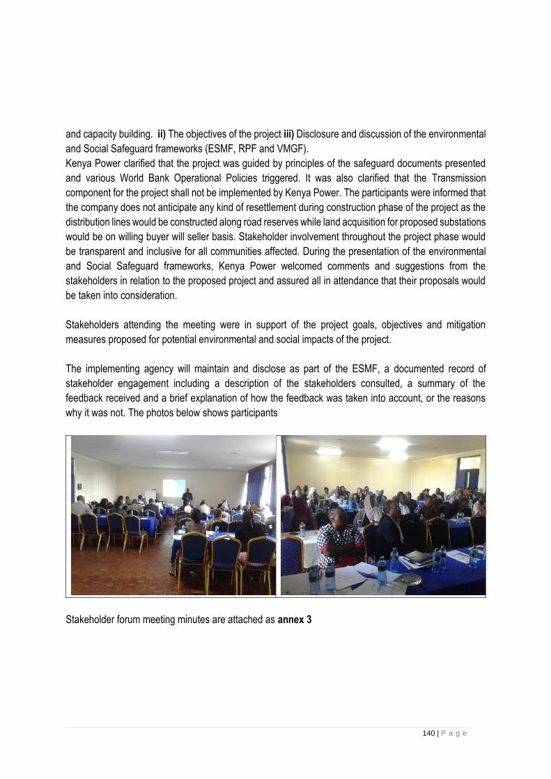
140 | P a g e
and capacity building. ii) The objectives of the project iii) Disclosure and discussion of the environmental
and Social Safeguard frameworks (ESMF, RPF and VMGF).
Kenya Power clarified that the project was guided by principles of the safeguard documents presented
and various World Bank Operational Policies triggered. It was also clarified that the Transmission
component for the project shall not be implemented by Kenya Power. The participants were informed that
the company does not anticipate any kind of resettlement during construction phase of the project as the
distribution lines would be constructed along road reserves while land acquisition for proposed substations
would be on willing buyer will seller basis. Stakeholder involvement throughout the project phase would
be transparent and inclusive for all communities affected. During the presentation of the environmental
and Social Safeguard frameworks, Kenya Power welcomed comments and suggestions from the
stakeholders in relation to the proposed project and assured all in attendance that their proposals would
be taken into consideration.
Stakeholders attending the meeting were in support of the project goals, objectives and mitigation
measures proposed for potential environmental and social impacts of the project.
The implementing agency will maintain and disclose as part of the ESMF, a documented record of
stakeholder engagement including a description of the stakeholders consulted, a summary of the
feedback received and a brief explanation of how the feedback was taken into account, or the reasons
why it was not. The photos below shows participants
Stakeholder forum meeting minutes are attached as annex 3

141 | P a g e
13 CHAPTER THIRTEEN: CAPACITY FOR ENVIRONMENTAL & SOCIAL MANAGEMENT.
The Safety, Health and Environment (SHE) and Projects Development departments will be responsible for the implementation and monitoring of the ESMF. The SHE department is currently adequately staffed for the project implementation. KPLC has put in place a PIU for the purpose of KESIP project implementation. The PIU will include senior Environmental and Social Specialists seconded from the SHE department. These two specialists will represent the SHE department to articulate all Environmental and Social Issues. Most of the staff SHE department are qualified for the scope of work under ESMF but in terms of experience there is need to enhance their skills in some areas to enable them handle EMSF adequately and efficiently. The PIU responsibility is mainly to coordinate the implementation of the entire project including technical, procurement, safeguards and financial aspects but SHE department lead the actual implementation and Monitoring of ESMF requirements.
Currently the department can handle the KESIP project adequately and in the event the work load
increases due to changes in the company portfolio resulting from other financier KPLC will consider either
recruitment of additional staff or use of consultant on need basis. Whenever KPLC will need to engage a
consultant, the selection of the same will be guided by the World bank’s procurement policy framework.
To enhance the capacity for KPLC staff to implement KESIP efficiently the following areas of training are
suggested.
The PIT will be attending various courses towards enhancing capacity building when they are identified.
These courses include;
• Ecological assessment trainings especially on Fauna, Avi-Fauna and Flora
• Social Assessment
• Indigenous people framework and Vulnerable and marginalized people plan
• Environmental sustainability reporting
• ESMF implementation and Monitoring Trainings
• Project Monitoring and Evaluation;
• Occupational Safety & Health;
• Climate Change and Adaptation
• Land Acquisition restrictions on land use and involuntary resettlement
The SHE Department will consider on need basis to
▪ organize awareness workshop with KPLC engineers and procurement officers involved in the Project to explain the ESMF and its implementation
▪ organize specialized and on-the-job training and technical assistance for the field staff involved in monitoring ESMP compliance
▪ organize one-day workshops with contractors to explain the ESMF and the environmental and social clauses for contractors
▪ organize sessions to sensitize the local authorities to the ESMF and its implementation

142 | P a g e
14 CHAPTER FOURTEEN: GRIEVANCE REDRESS MECHANISM
Grievance mechanisms provide a formal avenue for affected groups or stakeholders to engage with the
project implementers or owners on issues of concern or unaddressed impacts. Grievances are any
complaints or suggestions about the way a project is being implemented. They may take the form of
specific complaints for damages/injury, concerns about routine project activities, or perceived incidents or
impacts. Identifying and responding to grievances supports the development of positive relationships
between projects and affected groups/communities, and other stakeholders.
The World Bank Group standards outline requirements for grievance mechanisms for projects. Grievance
mechanisms should receive and facilitate resolution of the affected institutional or communities’ concerns
and grievances. The World Bank Group states the concerns should be addressed promptly using an
understandable and transparent process that is culturally appropriate and readily acceptable to all
segments of affected communities, at no cost and without retribution. Mechanisms should be appropriate
to the scale of impacts and risks presented by a project. Grievances can be an indication of growing
stakeholder concerns (real and perceived) and can escalate if not identified and resolved. The
management of grievances is therefore a vital component of stakeholder management and an important
aspect of risk management for a project. Projects may have a range of potential adverse impacts to people
and the environment in general, identifying grievances and ensuring timely resolution is therefore very
necessary. As such the ESMF has developed a grievance management process to serve as a guide
during project implementation.
The Grievance Redress Process
• Development and Publicizing the grievance management procedures
The grievance mechanism will be introduced to the project stakeholders for inputs as a part of the project
stakeholder engagement program stating the purpose of the projects grievance mechanism and the type
of responses complainants can expect from the GRC. The uptake channels should be publicized and
advertised via public meetings, through provincial administration office and at the implementing agency
local office and where relevant contractors. It is important to note that every sub project will have its own
grievance redress mechanism which will include different users that can submit their claims and will allow
even anonymous claims.
• Receiving and registering the grievance
Any member of the grievance redress committee can receive the complaints from the public either through
direct face-face meetings or in writing.
The members who receive complaints verbally should put them in writing for them to be considered.
Recognizing that many complaints may be resolved ‘on the spot’ and informally by committee, there are
opportunities to encourage these informal resolutions to be registered to (i) Encourage responsiveness;
and
(ii) Ensure that repeated or low-level grievances are being noted in the system. The GRM should have
the ability to handle anonymous complaints.

143 | P a g e
• Documenting the grievance
All grievances received will be documented and records kept. The records should indicate the grievances
received, grievances resolved, and grievances not resolved. Complainants should be handed a receipt
and a flyer that describes the GRM procedures and timeline (staff should be trained to read this orally for
illiterate complainants). Where possible, the grievance log should capture complaints being made via
informal or traditional systems, such as village councils or elders.
• Reviewing and investigating grievances
The grievances shall be screened to determine whether they are eligible for the grievance mechanism.
Ineligible complaints include those that are not project related or those that the community procedures
are more appropriate to address. Eligibility should be a procedural step to ensure that the issue being
raised is relevant to the project. It is often better to ensure a relatively low barrier to entry with quick
turnaround rather than to prevent users having their issues considered. Complaints that cannot be
resolved on the spot should be directed to the grievance focal point who will have a set number of days
to assess the issue and provide a written response to the complainant, acknowledging receipt and
detailing the next steps it will take (one week or less is recommended).
The grievances are categorized in three categories (A, B or C)
Category A: Immediate action-these issues require immediate actions are typically issues which threaten
the short-term safety or the community member’s e.g. chemical spills or accidents near community water
supply or sensitive environments.
Category B: Urgent action-these are issues which cause a nuisance or a long-term safety to the
community members, employees and the environment. They should be communicated to the M (SHE)
within 12 hours after receiving and be responded to within 72 hours.
Category C: action – these are issues requiring action which is not of urgent nature and are typically
procedural or dispute type issues.
• Action and Feedback
This is the development of resolution options taking into consideration the community preferences, project
policy, past experience, current issues and potential outcomes
• Closure
All grievance records and supporting documents will be filled and recorded in the database. Upon
completion of the agreed upon corrective actions, collect proof that these actions have taken place this
includes photos, documentary evidence record of resolution which is signed and dated by the responsible
staff member and if the resolution have been to the satisfaction of the complainant confirmation of this for
the record. These are all included and recorded in the case documentation. If complainants remain
unsatisfied with the grievance process, they have the right of recourse to the courts.
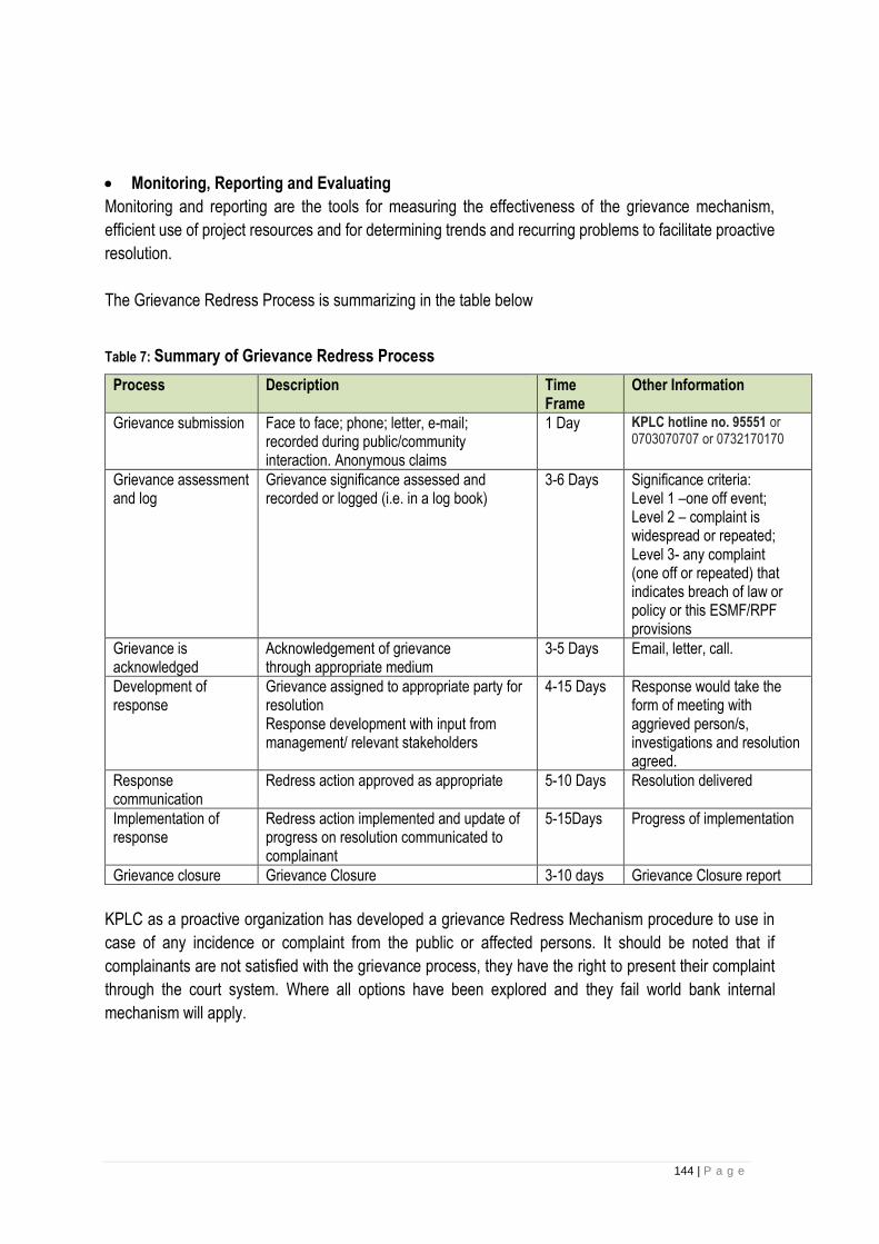
144 | P a g e
• Monitoring, Reporting and Evaluating
Monitoring and reporting are the tools for measuring the effectiveness of the grievance mechanism,
efficient use of project resources and for determining trends and recurring problems to facilitate proactive
resolution.
The Grievance Redress Process is summarizing in the table below
Table 7: Summary of Grievance Redress Process
Process Description Time Frame
Other Information
Grievance submission Face to face; phone; letter, e-mail; recorded during public/community interaction. Anonymous claims
1 Day KPLC hotline no. 95551 or 0703070707 or 0732170170
Grievance assessment and log
Grievance significance assessed and recorded or logged (i.e. in a log book)
3-6 Days Significance criteria: Level 1 –one off event; Level 2 – complaint is widespread or repeated; Level 3- any complaint (one off or repeated) that indicates breach of law or policy or this ESMF/RPF provisions
Grievance is acknowledged
Acknowledgement of grievance through appropriate medium
3-5 Days Email, letter, call.
Development of response
Grievance assigned to appropriate party for resolution Response development with input from management/ relevant stakeholders
4-15 Days
Response would take the form of meeting with aggrieved person/s, investigations and resolution agreed.
Response communication
Redress action approved as appropriate 5-10 Days Resolution delivered
Implementation of response
Redress action implemented and update of progress on resolution communicated to complainant
5-15Days Progress of implementation
Grievance closure Grievance Closure 3-10 days Grievance Closure report
KPLC as a proactive organization has developed a grievance Redress Mechanism procedure to use in
case of any incidence or complaint from the public or affected persons. It should be noted that if
complainants are not satisfied with the grievance process, they have the right to present their complaint
through the court system. Where all options have been explored and they fail world bank internal
mechanism will apply.
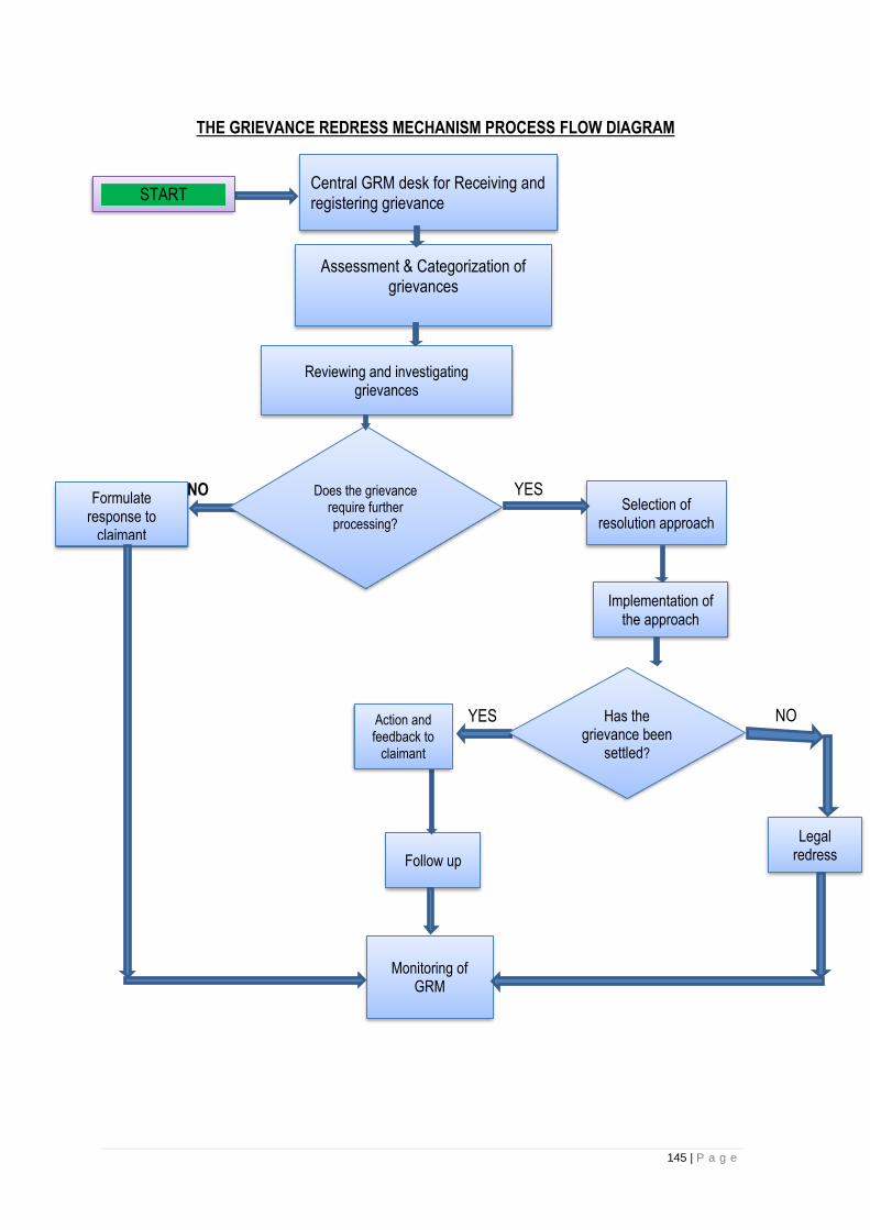
145 | P a g e
THE GRIEVANCE REDRESS MECHANISM PROCESS FLOW DIAGRAM
NO
NO
Central GRM desk for Receiving and registering grievance
Assessment & Categorization of grievances
Reviewing and investigating grievances
Formulate response to
claimant
Selection of resolution approach
Implementation of the approach
Follow up
Monitoring of GRM
START
Does the grievance require further processing?
Action and feedback to
claimant
Has the grievance been
settled?
NO YES
YES
Legal redress
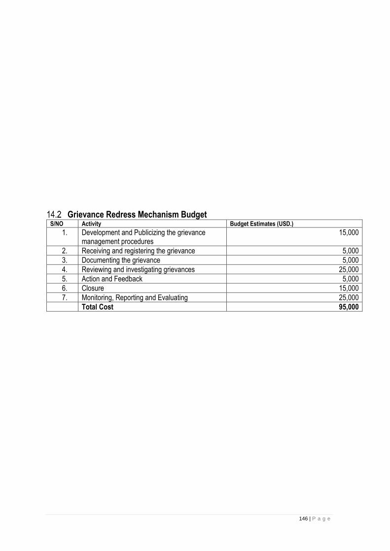
146 | P a g e
Grievance Redress Mechanism Budget S/NO Activity Budget Estimates (USD.)
1. Development and Publicizing the grievance management procedures
15,000
2. Receiving and registering the grievance 5,000
3. Documenting the grievance 5,000
4. Reviewing and investigating grievances 25,000
5. Action and Feedback 5,000
6. Closure 15,000
7. Monitoring, Reporting and Evaluating 25,000
Total Cost 95,000
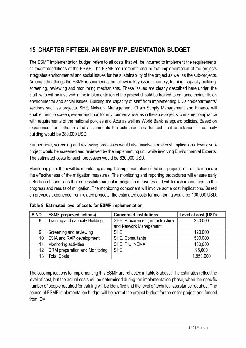
147 | P a g e
15 CHAPTER FIFTEEN: AN ESMF IMPLEMENTATION BUDGET
The ESMF implementation budget refers to all costs that will be incurred to implement the requirements
or recommendations of the ESMF. The ESMF requirements ensure that implementation of the projects
integrates environmental and social issues for the sustainability of the project as well as the sub-projects.
Among other things the ESMF recommends the following key issues, namely; training, capacity building,
screening, reviewing and monitoring mechanisms. These issues are clearly described here under; the
staff- who will be involved in the implementation of the project should be trained to enhance their skills on
environmental and social issues. Building the capacity of staff from implementing Division/departments/
sections such as projects, SHE, Network Management, Chain Supply Management and Finance will
enable them to screen, review and monitor environmental issues in the sub-projects to ensure compliance
with requirements of the national policies and Acts as well as World Bank safeguard policies. Based on
experience from other related assignments the estimated cost for technical assistance for capacity
building would be 280,000 USD.
Furthermore, screening and reviewing processes would also involve some cost implications. Every sub-
project would be screened and reviewed by the implementing unit while involving Environmental Experts.
The estimated costs for such processes would be 620,000 USD.
Monitoring plan: there will be monitoring during the implementation of the sub-projects in order to measure
the effectiveness of the mitigation measures. The monitoring and reporting procedures will ensure early
detection of conditions that necessitate particular mitigation measures and will furnish information on the
progress and results of mitigation. The monitoring component will involve some cost implications. Based
on previous experience from related projects, the estimated costs for monitoring would be 100,000 USD.
Table 8: Estimated level of costs for ESMF implementation
S/NO ESMF proposed actions) Concerned institutions Level of cost (USD)
8. Training and capacity Building SHE, Procurement, infrastructure and Network Management
280,000
9. Screening and reviewing SHE 120,000
10. ESIA and RAP development SHE/ Consultants 500,000
11. Monitoring activities SHE, PIU, NEMA 100,000
12. GRM preparation and Monitoring SHE 95,000
13. Total Costs 1,950,000
The cost implications for implementing this ESMF are reflected in table 8 above. The estimates reflect the
level of cost, but the actual costs will be determined during the implementation phase, when the specific
number of people required for training will be identified and the level of technical assistance required. The
source of ESMF implementation budget will be part of the project budget for the entire project and funded
from IDA.
148 | P a g e
16 CHAPTER SIXTEEEN: CONCLUSION AND RECOMMENDATIONS
This Environmental and Social Management Framework (ESMF) has been prepared to establish the mechanism
to determine and assess future potential adverse environmental and social impacts of sub-projects that are to be
identified and cleared under KESIP.
This ESMF is meant to ensure that the implementation of the KESIP, of which the specific sub-project sites are
unknown at this stage, will be carried out in an environmentally and socially sustainable manner. The ESMF
provides the project implementers with an environmental and social screening process that will enable them to
identify, assess and mitigate potential environmental and social impacts of sub-project activities, including the
preparation of site-specific Environmental and Social Impact Assessments (EIA) where applicable, in accordance
with the EMCA, 1999 as well as World Bank safeguard policies particularly Environmental Assessment (OP/BP
4.01).
Consequently, specific information on the number of sub-projects, site location of subprojects, Land requirements,
geo-physical land features, nature, type and use of equipment, etc. are not available at this stage. Therefore, exact
details and the intensity of social and environmental impacts and their effective mitigation cannot be determined.
The framework delineates the World Bank Operational Safeguards that are likely to be triggered by the proposed
power connectivity project, identifies potential environmental concerns/impacts, environmental and social
management plan, institutional responsibilities, capacity building, training needs, and technical assistance required.
In view of all these the ESMF therefore recommends the following;
• Training needs. Staff who will be appointed to the Project Implementation Unit (PIU), Implementing units and
other sections which will be responsible for coordinating activities across the company for managing sub-
projects for the purpose of maintaining a formative monitoring system throughout the project to assess the
quality of implementation, use of funds, and impacts should have the necessary skills in Environmental and
Social Management. Therefore, they should undertake training in environmental management. Training topics
may include an overview of environmental issues within the power sector, introduction to EIA processes and
methods, impact analysis, EIA review, the role of the public and stakeholders, EIA experience in Kenya, and
case studies. Other training needs are explained in chapter 13.
• The implementation of KESIP sub-projects should strongly integrate environmental and social issues in relation
to the sub-project as outlined in this ESMF. Furthermore, the implementation of the KESIP project as well as
its subprojects must comply with the Kenyan Policies and Laws as well as World Bank Polices as defined in
chapter 4.
• Adherence to ESMF requirement. The ESMF requires this project to ensure that procedures are followed in
relation to environmental and social screening, review and approval prior to Implementation of sub- projects to
be financed under the KESIP. Furthermore, appropriate roles and responsibilities, for managing and monitoring
environmental and social concerns related to sub-projects should also be followed.
149 | P a g e
REFERENCE • Building Code 1968
• County Government Acts, 2012
• Energy Act of 2006
• Environmental Management and Coordination (Fossil Fuel Emission Control) Regulations 2006
• Environmental Management and Coordination (Conservation of Biological Diversity and Resources, Access to
Genetic Resources and Benefit Sharing) Regulations, 2006
• Environmental Management and Coordination (Noise and Excessive Vibration pollution) (Control) Regulations,
2009: Legal Notice 61
• Government of Kenya Wayleave Act
• Government of Kenya Roads Board Act
• Government of Kenya State of Environment 2010
• Government of Kenya Public Procurement and Disposal Act
• Government of Kenya Roads Act
• Government of Kenya Fiscal Management Act (CAP 5) of 2009
• Government of Kenya Antiquities and Monuments Act, Cap 215 of 1983
• Government of Kenya Employment Act, 2007
• Government of Kenya Maritime Authority Act 2006
• Kenya Vision 2030: A Globally competitive and prosperous Kenya 2007
• Land Act, 2012
• Occupational Safety and Health Act, 2007
• Penal Code Act (Cap.63)
• Physical Planning Act, 1996
• Public Health Act (Cap. 242)
• The Civil Aviation Act No. 21 of 2013
• The Constitution of Kenya, 2010: Constitutional provisions
• The Environment Management and Co-ordination Act, 1999
• The Environmental Management Coordination (Water Quality) Regulations): Legal Notice 120
• The Environmental Management Coordination (Waste Management) Regulations): Legal Notice 121
• The Environmental (Impact Assessment and Audit) Regulations, 2003
• The Forestry Services Act, 2005
• The Land and Environment Court Act 2011
• The Traffic Act Cap 403 0f 2009
• Wildlife Conservation and Management Act, 2013
• Urban Areas and Cities Act No. 13 of 2011
• Water Act, 2002
• Work Injury and Benefits Act, (WIBA) 2007
• Kenya power Safety Rules Handbook 2014
• World Bank Project documentation for KESIP
• World Bank Safeguards Policies
• World Bank Group Environmental, Health, and Safety Guidelines
• IFC Performance Standards
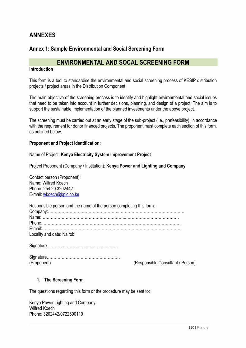
150 | P a g e
ANNEXES
Annex 1: Sample Environmental and Social Screening Form
ENVIRONMENTAL AND SOCAL SCREENING FORM Introduction
This form is a tool to standardise the environmental and social screening process of KESIP distribution projects / project areas in the Distribution Component.
The main objective of the screening process is to identify and highlight environmental and social issues that need to be taken into account in further decisions, planning, and design of a project. The aim is to support the sustainable implementation of the planned investments under the above project.
The screening must be carried out at an early stage of the sub-project (i.e., prefeasibility), in accordance with the requirement for donor financed projects. The proponent must complete each section of this form, as outlined below.
Proponent and Project Identification:
Name of Project: Kenya Electricity System Improvement Project
Project Proponent (Company / Institution): Kenya Power and Lighting and Company
Contact person (Proponent): Name: Wilfred Koech Phone: 254 20 3202442 E-mail: [email protected]
Responsible person and the name of the person completing this form: Company:……………………………………………..………………………………………… Name:……………………………………………………..……………….………………… Phone:………………………………………………………………………………………… E-mail:………………………………………………………………………………………… Locality and date: Nairobi
Signature …………………………………….……… Signature……………………………………………… (Proponent) (Responsible Consultant / Person)
1. The Screening Form
The questions regarding this form or the procedure may be sent to:
Kenya Power Lighting and Company Wilfred Koech Phone: 3202442/0722690119

151 | P a g e
E-mail: [email protected] 1.0 Project Descriptions
1.1 Name and Type of Project:
1.2 Expected start and end date (month/year) and project duration (in months) of the construction
phase:
2.3 List the technology and machinery to be used in the construction and operation phases
1.3 List the materials to be used during the construction and operation phases (e.g., infrastructure,
creosote treated poles, fuels and oils):
2.5 Expected number of workers during construction and during operation:
2.6 Maps (in Annexes):
2.6.1 Provide a map with the geographical location of the project;
2.6.2 Provide an appropriately-scaled map clearly showing:
The project area with existing buildings, infrastructure, vegetation, and land use;
The project area with any planned construction, plants, lines, or access roads.
2.7 Is the project area or its immediate surroundings subject to pollution or environmental damage
caused by other (existing) activities?
Yes ____ No_____
2.8 Is there any other infrastructure in or close to the project area?
Yes_____ No______
Provide an additional description for “yes”
answers:_______________________________________________
The Biological Environment
3 The Natural Environment
3.1 Describe the habitats and flora and fauna in the project area and in the entire area expected to
be affected by the project (e.g., downstream areas, access
roads)_______________________________________---------------------------------------------
3.2 Will the project directly or indirectly affect:
3.2.1 Natural forest types? Yes_____ No_____
3.2.2 Mangroves or swamps? Yes_____ No_____
3.2.3 Wetlands (i.e., lakes, rivers, swamps, seasonally inundated areas)? Yes_______ No________

152 | P a g e
3.2.4 Other habitats of threatened species that require protection under Kenyan laws and/or
international agreements?
Yes______ No_____ If yes, describe____________________________________________________--
--------------------------------------------
___________________________________________________________________________
3.3 Are there according to background research / observations any threatened / endemic species in
the project area that could be affected by the project?
Yes_________ No_____________
___________________________________________________________________________
3.4 Will vegetation be cleared?
Yes________ No___________
3.5 Will there be any potential risk of habitat fragmentation due to the clearing activities?
Yes________ No_________
3.6 Will the project lead to a change in access, leading to an increase in the risk of depleting
biodiversity resources?
Yes__________ No________
3.7 Will the proposed project activity trigger OP 4.04 Natural Habitats?
Yes_________ No___________ If yes, please describe
Provide an additional description for “yes”
answers:_________________________________________________-----------------------------
__________________________________________________________________________________-
-----------------------------------------------------------------------------------------------------
4 Protected Areas
Does the project area or do project activities:
4.1 Occur within or adjacent to any designated protected areas?
Yes_____ No____
4.2 Affect any protected area downstream of the project?
Yes______ No____
4.3 Affect any ecological corridors used by migratory or nomadic species located between any
protected areas or between important natural habitats (protected or not) (e.g., mammals or birds)?

153 | P a g e
Yes______ No_____
4.4 Will the proposed project activity trigger OP 4.04 Natural Habitats?
Yes_____ No_____ If yes, please describe
Provide an additional description for “yes” answers:
_________________________________________---------------------------------------------------
___________________________________________________________________________
5. Invasive Species
5.1 Is the project likely to result in the dispersion of or increase in the population of invasive plants
or animals (e.g., along distribution and transmission lines, access roads, quarry sites or borrow pits)
Yes_________ No_____ If yes, please describe. __________________________________________--
-----------------------------------------------
___________________________________________________________________________
Provide an additional description for a “yes” answer: _______________________________________
___________________________________________________________________________
The Physical Environment
6 River Systems
Will the project affect / change:
6.1 Water quantity? Yes_____ No___
__________________________________________________________________________
6.2 Water quality (i.e., through sedimentation, chemical pollution)?
Yes__________ No___________
___________________________________________________________________________
6.3 River stream pattern? Yes_____ No_____
__________________________________________________________________________
6.4 Seasonal flow variations? Yes______ No_____
___________________________________________________________________________
6.5 Flooding regime? Yes_____ No______

154 | P a g e
__________________________________________________________________________
6.6 River ecology? Yes_____ No_____
6.7 Aquatic habitats? Yes_____ No_____
Provide an additional description for “yes”
answers:_________________________________________________
___________________________________________________________________________
7 Geology / Soils
7.1 Will vegetation be removed and any surface left bare?
Yes____ No______
___________________________________________________________________________
7.2 Will slope or soil stability be affected by the project?
Yes____ No______
___________________________________________________________________________
7.3 Will the project cause physical changes in the project area (e.g., changes to the topography)?
Yes_____ No_____
7.4 Will local resources, such as rocks, sand, gravel, or groundwater be used?
Yes_____ No______
7.5 Could the project potentially cause an increase in soil salinity in or downstream the project
area?
Yes______ No_____
7.6 Could the soil exposed due to the project potentially lead to an increase in lixiviation of metals, clay
sediments, or organic materials?
Yes_____ No____
Provide an additional description for “yes”
answers:_________________________________________________
___________________________________________________________________________
8 Landscape / Aesthetics
8.1 Is there a possibility that the project will adversely affect the aesthetics of the landscape?
Yes_____ No______

155 | P a g e
Provide an additional description for a “yes”
answer:________________________________________________
__________________________________________________________________________
9 Pollution
9.1 Will the project use or store dangerous substances (e.g., large quantities of hydrocarbons,
creosote-treated poles/ PCB)?
Yes_____ No______
9.2 Will the project produce harmful substances?
Yes_____ No______
9.3 Will the project produce solid or liquid wastes?
Yes_____ No_____
9.4 Will the project cause air pollution?
Yes______ No_______
9.5 Will the project generate noise?
Yes______ No________
9.6 Will the project generate electromagnetic emissions?
Yes______ No______
9.7 Will the project release pollutants into the environment?
Yes_____ No_____
Provide an additional description for a “yes”
answer:________________________________________________
___________________________________________________________________________
The Social Environment
10 Land Use, Resettlement, and/or Land Acquisition
10.1 Describe existing land uses on and around the project area (e.g., community facilities,
agriculture, tourism, private property, or hunting
areas):_______________________________________________________
___________________________________________________________________________
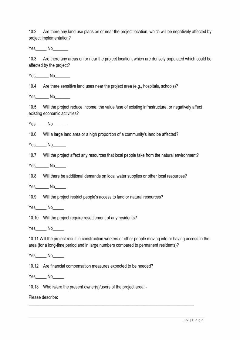
156 | P a g e
10.2 Are there any land use plans on or near the project location, which will be negatively affected by
project implementation?
Yes_____ No_______
10.3 Are there any areas on or near the project location, which are densely populated which could be
affected by the project?
Yes______ No_______
10.4 Are there sensitive land uses near the project area (e.g., hospitals, schools)?
Yes______ No_______
10.5 Will the project reduce income, the value /use of existing infrastructure, or negatively affect
existing economic activities?
Yes_____ No______
10.6 Will a large land area or a high proportion of a community's land be affected?
Yes_____ No______
10.7 Will the project affect any resources that local people take from the natural environment?
Yes______ No_____
10.8 Will there be additional demands on local water supplies or other local resources?
Yes______ No_____
10.9 Will the project restrict people's access to land or natural resources?
Yes_____ No_____
10.10 Will the project require resettlement of any residents?
Yes_____ No_____
10.11 Will the project result in construction workers or other people moving into or having access to the
area (for a long-time period and in large numbers compared to permanent residents)?
Yes_____ No_____
10.12 Are financial compensation measures expected to be needed?
Yes_____ No_____
10.13 Who is/are the present owner(s)/users of the project area: -
Please describe:
___________________________________________________________________________

157 | P a g e
Provide an additional description for “yes” answers:
___________________________________________________________________________
11 Loss of Crops, Fruit Trees, and Household Infrastructure
Will the project result in the permanent or temporary loss of:
11.1 Crops? Yes____ No_____
11.2 Fruit trees / coconut palms? Yes_____ No_____
11.3 Household infrastructure? Yes______ No_______
Provide an additional description for “yes” answers and refer to the Resettlement Policy Framework
(RPF):
___________________________________________________________________________
12. Indigenous Peoples
12.1 Are indigenous peoples present in, or have attachment to, project lands?
Yes_____ No____
12.2 What are the project/component effects ion indigenous peoples? Please describe:
__________________________________________________________________________
Provide an additional description for “yes” answers and refer to the Indigenous Peoples Planning
Framework.
___________________________________________________________________________
___________________________________________________________________________
___________________________________________________________________________
13 Occupational Health and Safety, Health, Welfare, Employment, and Gender
13.1 Is the project likely to affect human / community health or welfare (e.g., through disease
vectors)? Yes______ No_____
13.2 Is the project likely to safeguard worker’s health and safety and public safety (e.g., occupational
health and safety issues)? Yes___ No____
13.3 How will the project minimize the risk of accidents? How will accidents be managed, when they
do occur?
Please describe:
__________________________________________________________________________

158 | P a g e
13.4 Is the project likely to provide local employment opportunities, including employment
opportunities for women? Yes_____ No_____
13.5 Is the project being planned with sufficient attention to local poverty alleviation objectives?
Yes_______ No_______
13.6 Is the project being designed with sufficient local participation (including the
participation of women) in the planning, design, and implementation process?
Yes______ No_______
Provide an additional description for “yes”
answers:_________________________________________________
__________________________________________________________________________
14 Historical, Archaeological, or Cultural Heritage Sites
Based on available sources, consultation with local authorities, local knowledge and/or observations,
could the project alter:
14.1 Historical heritage site(s) or require excavation near the same?
Yes____ No____
14.2 Archaeological heritage site(s) or require excavation near the same?
Yes____ No_____
14.3 Cultural heritage site(s) or require excavation near the same?
Yes____ No_____
14.4 Graves, or sacred locations (e.g., fetish trees or stones) or require excavations near the same?
Yes____ No____
14.5 Will any of the project activities trigger OP 4.11 Cultural Property?
Yes______ No_______
In the case of chance finds, please contact:
_______________________________________________________
• National Museums of Kenya
• Ministry of Sports, Gender and Culture
Provide an additional description for “yes”
answers:________________________________________________
___________________________________________________________________________
159 | P a g e
RECOMMENDATIONS:
Based on the above screening results, the proposed project has been assigned the environmental
category:
(a) 1 – Category 1 projects are likely to induce significant, irreversible adverse environmental and / or
social impacts, or significantly affect environmental or social components that the Bank or the
borrowing country considers sensitive social impacts.
(b) 2– Category 2 projects are likely to have detrimental site-specific environmental and / or social
impacts that are less adverse than those of Category 1 projects and can be minimized by applying
appropriate management and mitigation measures or incorporating internationally recognized design
criteria and standards.
(c) 3 – Category 3 projects do not directly impact the environment adversely and are unlikely to induce
adverse social impacts. They do not require an environmental and social assessment. Beyond
Categorization, no action is required. Nonetheless, to design a Category 3 project properly, it may be
necessary to carry out gender analyses, institutional analyses, or other studies on specific, critical
social issues in order to anticipate and manage unintended impacts on the affected communities.
(d) 4 – Category 4 projects involve Bank lending to Financial Intermediaries (FIs) who on lend or invest
in sub-projects that may produce adverse environmental and social impacts. FIs include banks,
insurance, re-insurance and leasing companies, microfinance providers and investment funds that
use the Bank’s funds to on-lend or provide equity finance to their clients. FIs shall also be understood
to include private or public-sector companies that receive corporate loans or loans for investment
plans from the Bank used to finance a set of sub-projects. However, in cases where a Bank corporate
loan will be used by the client to finance high-risk
(e) Require the preparation of a FRAP or ARAP
Screening Form was completed by:
Name_____________________________________________________________________
Position_____________________________________________________________________
Signature___________________________________________________________________
Date_______________________________________________________________________
Screening Results were reviewed and approved by:
Name_____________________________________________________________________
Position_____________________________________________________________------------
Signature___________________________________________________________________
Date_______________________________________________________________________
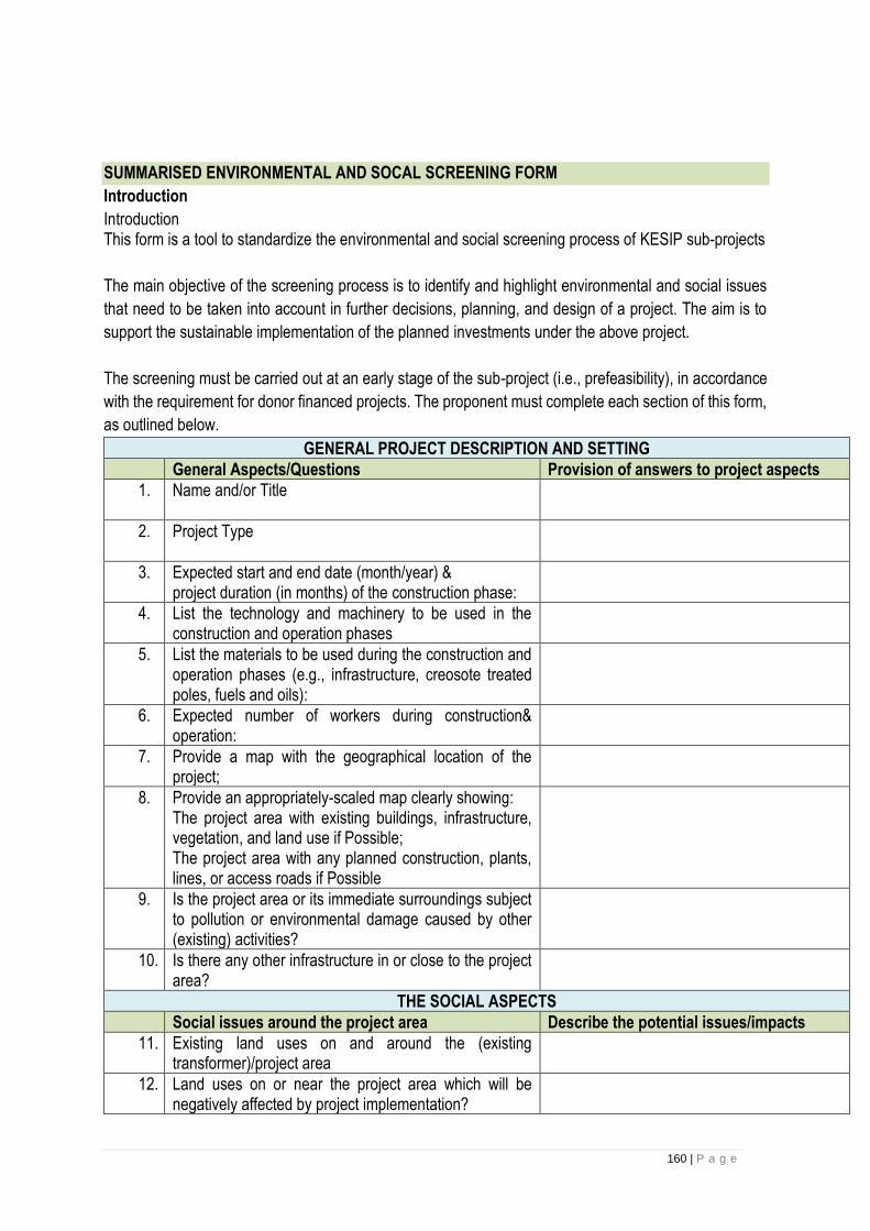
160 | P a g e
SUMMARISED ENVIRONMENTAL AND SOCAL SCREENING FORM
Introduction
Introduction This form is a tool to standardize the environmental and social screening process of KESIP sub-projects
The main objective of the screening process is to identify and highlight environmental and social issues
that need to be taken into account in further decisions, planning, and design of a project. The aim is to
support the sustainable implementation of the planned investments under the above project.
The screening must be carried out at an early stage of the sub-project (i.e., prefeasibility), in accordance
with the requirement for donor financed projects. The proponent must complete each section of this form,
as outlined below.
GENERAL PROJECT DESCRIPTION AND SETTING
General Aspects/Questions Provision of answers to project aspects
1. Name and/or Title
2. Project Type
3. Expected start and end date (month/year) & project duration (in months) of the construction phase:
4. List the technology and machinery to be used in the construction and operation phases
5. List the materials to be used during the construction and operation phases (e.g., infrastructure, creosote treated poles, fuels and oils):
6. Expected number of workers during construction& operation:
7. Provide a map with the geographical location of the project;
8. Provide an appropriately-scaled map clearly showing: The project area with existing buildings, infrastructure, vegetation, and land use if Possible; The project area with any planned construction, plants, lines, or access roads if Possible
9. Is the project area or its immediate surroundings subject to pollution or environmental damage caused by other (existing) activities?
10. Is there any other infrastructure in or close to the project area?
THE SOCIAL ASPECTS
Social issues around the project area Describe the potential issues/impacts
11. Existing land uses on and around the (existing transformer)/project area
12. Land uses on or near the project area which will be negatively affected by project implementation?

161 | P a g e
13. Presence of residential/sensitive areas e.g. community facilities
14. Present owner(s)/users of the project area
15. Population density
16. Job opportunities (for the local people)
17. Effects of project on people's access to land or natural resources
Compensation to property damage
18. Effects of project on incomes, value of land and other economic activities?
19. Construction workers (number and how long they will spend in project area)
20. Exposure of community/public to diseases
21. Safety of workers (e.g. occupational health and safety issues)?
22. Public engagement (role of the project beneficiaries across all phases of the project)
23. Public risk to shocks and electrocution
24. Public awareness on use of the service (electricity)
25. Population density
26. Presence of Indigenous Peoples in the project area
Conclusion from the screening process
ENVIRONMENTAL ASPECTS
Existing environment:
Description –describe features and indicate sensitivity to disturbance
Physical Features
27. Topography/terrain
28. Soil (type & quality)
29. Surface water (presence & quality)
30. Sediments/substance (Type and quality)
31. Ground water (local use & quality)
32. Air quality (any pollution issues)

162 | P a g e
Biological features
33. Vegetation (trees, ground cover, aquatic vegetation)
34. Wetlands (e.g. bogs, fens and marshes)
35. Fish and fish habitant
36. Birds (water fowl, migratory birds and others)
37. Mammals
38. Special habitat areas (special designations or identifies sensitive zones)
39. Archaeological resources (recorded or potential for them to exist)
40. Special designations (parks, protected areas)
41. Traditional economic/cultural activities (trapping, fishing, collection of medicinal plants)
Conclusion from the screening process
Screening Form was completed by:
Name______________________________________________________________________
Position_____________________________________________________________________
Signature___________________________________________________________________
Date_______________________________________________________________________
Screening Results were reviewed and approved by:
Name______________________________________________________________________
Position_____________________________________________________________________
Signature___________________________________________________________________
Date_______________________________________________________________________
163 | P a g e
Annex 2: World Bank Classification of Projects A. Category A: A proposed project is classified as Category A if it is likely to have significant adverse
environmental impacts that are sensitive, diverse, or unprecedented. These impacts may affect an
area broader than the sites or facilities subject to physical works. EA for a Category A project
examines the project's potential negative and positive environmental impacts, compares them with
those of feasible alternatives (including the "without project" situation), and recommends any
measures needed to prevent, minimize, mitigate or compensate for adverse impacts and improve
environmental performance. For a Category A project, the borrower is responsible for preparing a
report, normally an EIA (or a suitably comprehensive or sectoral EA) that includes as necessary,
elements such as environmental audits or hazard or risk assessments.
B. Category B: A proposed project is classified as Category B if its potential adverse environmental
impacts on human populations or environmentally important areas - including wetlands, forests,
grasslands, and other natural habitats - are less adverse than those of Category A projects. These
impacts are site-specific; few if any of them are irreversible; and in most cases mitigatory measures
can be designed more readily than for Category A projects. The scope of EA for a Category B project
may vary from project to project, but it is narrower than that of Category A. Like Category A, it
examines the project's potential negative and positive environmental impacts and recommends any
measures needed to prevent, minimize, mitigate, or compensate for adverse impacts and improve
environmental performance.
Note: The KESIP project is categorized as a Category B project. Given that the project will not have
significant adverse environmental and social impacts. Most of the impacts are reversible and can be
mitigated against.
C. Category C: A proposed project is classified as Category C if it is likely to have minimal or no adverse
environmental impacts. Beyond screening, no further EA action is required for a Category C project.
D. Category FI: A proposed project is classified as Category FI if it involves investment of Bank funds
through a financial intermediary, in subprojects that might result in adverse environmental impacts.
Annex 3: Stakeholder Consultation Meeting Minutes
164 | P a g e
KENYA ELECTRICITY SYSTEM IMPROVEMENT PROJECT (KESIP)
MINUTES OF STAKEHOLDERS CONSULTATIVE MEETING FOR SAFEGUARD DOCUMENTS (ESMF, RPF & VMGF) FOR KENYA
ELECTRICITY SYSTEM IMPROVEMENT PROJECT (KESIP)
VENUE: STIMA MEMBERS CLUB, NAIROBI
DATE: 12TH SEPTEMBER 2018
165 | P a g e
MINUTES OF STAKEHOLDERS CONSULTATIVE MEETING FOR SAFEGUARD DOCUMENTS FOR KENYA
ELECTRICITY SYSTEM IMPROVEMENT PROJECT (KESIP) HELD ON 12th SEPTEMBER 2018 AT STIMA
MEMBERS CLUB, NAIROBI
Summary
The stakeholder consultative meeting was held to disclose and discuss the three environmental and social
safeguards frameworks for KESIP. Participants were drawn from government agencies, civil society, Community
based organizations (CBOs), Vulnerable and Marginalized Groups (VMGs) and Indigenous People (IPs)
representatives. The frameworks will outline how the potential environmental and Social impacts associated with
the project will be addressed to ensure project sustainability.
The main issues addressed included: i) The components of the project which included power distribution lines,
Power Distribution Substations, Customer connectivity, Slum electrification and technical support and capacity
building. ii) The objectives of the project iii) Disclosure and discussion of the environmental and Social Safeguard
frameworks (ESMF, RPF and VMGF).
Kenya Power clarified that the project was guided by principles of the safeguard documents presented and various
World Bank Operational Policies triggered. It was also clarified that the Transmission component for the project
shall not be implemented by Kenya Power. The participants were informed that the company does not anticipate
any kind of resettlement during construction phase of the project as the distribution lines would be constructed
along road reserves while land acquisition for proposed substations would be on willing buyer will seller basis.
Stakeholder involvement throughout the project phase would be transparent and inclusive for all communities
affected.
During the presentation of the environmental and Social Safeguard frameworks, Kenya Power welcomed
comments and suggestions from the stakeholders in relation to the proposed project and assured all in attendance
that their proposals would be taken into consideration.
Stakeholders attending the meeting were in support of the project goals, objectives and mitigation measures
proposed for potential environmental and social impacts of the project.
Specific questions raised during the meeting are part of the minutes
AGENDA OF THE MEETING
1. Preliminaries
2. Overview of KESIP
3. Plenary Session
4. Vulnerable and Marginalized Groups Framework Presentation
5. Plenary Session
166 | P a g e
6. Environmental and Social Management Framework Presentation
7. Plenary Session
8. Resettlement Policy Framework Presentation
9. Plenary Session
10. A.O.B
MIN 1: 12/09/2018- Preliminaries
The meeting started at 0910hrs with welcoming remarks from Mr. Mwangangi who then asked one of the
stakeholders to pray before commencement of the meeting. Mr. Mwangangi then laid down ground rules for the
meeting to ensure that it was successful. The members were asked to introduce themselves and feel free to ask
questions and give suggestions after presentations from Kenya Power team. Mr. Mwangangi also informed
members that the meeting would involve presentations of Environmental and Social safeguard documents for
KESIP and deliberations on the same and emphasized that the stakeholder suggestions would be put into
considerations when improving the documents presented.
The Acting Manager; Network Management and Infrastructure Development-Eng. David Mwaniki gave the opening
remarks for the meeting and welcomed all stakeholders and appreciated them for turning up on time and attending
the meeting in large numbers. He informed the stakeholders that every development activity has an impact on our
surrounding environments and thus environmental and social issues have to be discussed prior to project
implementation. He also informed stakeholders that Kenya Power has the best interest of customers at heart and
aims at supplying quality power to consumers. Eng. Mwaniki informed stakeholders that Kenya Power cannot
achieve its mandate without collaborating with them, thus the meeting. He urged Kenya Power team of experts to
emulate what has been done for KESIP when undertaking other projects.
MIN 2: 12/09/2018- Overview of KESIP
Eng. Njoroge informed stakeholders that World Bank had issued 250 Million USD for implementation of the project.
150 Million USD of the amount issued shall be used for implementation of the Last Mile component of the project
while 100 Million USD shall be used for system reinforcement. He made it clear that the proposed project shall not
have major environmental impacts as it will mainly involve construction of Low voltage lines which shall be done
along road reserves.
Eng. Njoroge also informed the stakeholders that the project was on preliminary stages and the definite areas
where the projects would be implemented had not yet been identified.
Mr. Koech clarified to the stakeholders that KESIP aims at improving power supply in Kenya and supplying power
to all potential consumers. World Bank as a financier, in its requirements shall take into account environmental
and social concerns during implementation of the project. Thus, the meeting was held to create awareness about

167 | P a g e
the project as well as seek stakeholder views. The views sort shall be addressed to ensure that the project is
environmentally and socially sustainable.
MIN 3: 12/09/2018- Plenary Session
King Wario: We have both pre-paid and postpaid services, which one are we discussing today?
Fatuma Kitule: Do other Last Mile projects draw funding from the project we are discussing?
Mr. Otta: Will the public also be involved after identification of specific project sites?
The questions were responded to by Mr. Abaya, Eng. Mwaniki and Eng. Njoroge as follows:
Issues Raised Response
Agenda of the meeting To disclose the three Environmental and Social Safeguard Frameworks
and seek the participants views and comments on how to improve them
to ensure KESIP is implemented in an environmentally and Socially
sustainable manner.
Funding of other Last mile projects Other four Last mile projects are independent of KESIP bust have the
same concept of increasing customer connectivity, system
reinforcement and reduction of technical losses in the electrical
infrastructure system.
Identification of specific project
sites
The company was yet to identify the actual sites where the project
would be implemented, and the Communities shall further be involved
in the implementation process and Kenya Power will also avail more
information about the project with time.
MIN 4: 12/09/2018- Vulnerable and Marginalized Groups Framework (VMGF) Presentation
Mr. Abaya informed members that VMGF is a requirement by World Bank as stipulated under Operational Policy
4.10 and is prepared to take care of the interests and rights of vulnerable and marginalized persons who might be
affected during project implementation. The document highlights how Kenya Power shall interact with vulnerable
and marginalized communities during implementation of the project to preserve their dignity and ensure equal
representation during consultative processes.
Mr. Abaya also informed stakeholders that the document provides the need for incorporating vulnerable and
marginalized people’s views during implementation process of the project as well as while addressing grievances.
He emphasized that the main idea of focusing on the vulnerable and marginalized persons is to enhance project
benefits to them and avoid potential diverse impacts and increased marginalization.
168 | P a g e
In addition, he informed members that the document was prepared as specific project sites had not been identified,
thus it will act as a guide for Kenya Power in the event that such communities are found within the project area or
are among those affected. Specific Vulnerable and Marginalized Plans will then be developed as and when
required.
The presentation of VMGF included purpose of VMGF; screening process of VMGF; social assessment of
vulnerable and marginalized groups; policies and legal frameworks; methodology and consultations in preparation
of VMGF; potential negative and positive impacts of KESIP on vulnerable and marginalized persons; free, prior
and informed consultations; vulnerable and marginalized groups plans; strategy for participation and consultation
of the groups; grievance redress mechanisms; monitoring and reporting arrangements for VMGs.
MIN 5: 12/09/2018- Plenary Session
After presentation of the Vulnerable and Marginalized Framework, stakeholders raised concerns, asked questions
and gave suggestions that were responded to as highlighted below.
King Wario, Mr. Dida Said and Mr. Rop: The tribe I represent is not included in the list of marginalized groups in
the document but since we are present in the meeting it is in order that we are incorporated in the list. Other
vulnerable and marginalized communities not listed should also be concluded and the project seems to affect IPs
and VMGP how will we be involved in the project?
Mr. Chepsoi: Pastoralist communities have concerns with land ownerships as most of them are communally
owned, an issue that can hinder compensation processes during project implementation.
Mr. Chepsoi: Who is the owner of Prior Informed Consent, KPLC or Affected communities?
Eunice Lepariyo and Mr. Chepsoi: Vulnerable and marginalized communities also have technical expertise in
carrying out work during construction of lines thus they should be prioritized for employment opportunities during
construction phase of the project.
Eunice Lepariyo: there is a lot of insecurity in areas occupied by vulnerable and marginalized groups, which
mechanisms are you going to employ to ensure they equally benefit from the project?
Nanta Mpaajei: What criteria will be used in identification of specific area for project implementation without
marginalization?
Nanta Mpaajei: will there be involvement of stakeholders during implementation phase to avoid conflicts?
Nanta Mpaajei: What forms of compensation are you going to implement especially among people with
communally owned land?

169 | P a g e
Nanta Mpaajei: When project passes through a communally owned land, is there a way of considering people
who cannot afford the Kshs. 15,000-connection fee?
Mr. Salau Rogei: it is high time Kenya Power considers benefit sharing with vulnerable and marginalized
communities to prevent continued exposure to poverty even when projects are implemented on their communally
owned land.
Mr. Solola: What mitigations do you have in place to ensure safety of electricity supplied to vulnerable and
marginalized communities?
Please explain the additional taxes that appear on the electricity token purchase receipt.
Representatives of stakeholders currently in the meeting are in most cases excluded from further meetings during
project implementation thus making it difficult for them to continue disseminating information about the project to
the communities.
Mr. Mohamed: some projects are launched by Kenya Power but fail to be implemented in areas where they are
launched thus making us feel marginalized such as the case of KOSAP.
The questions and concerns raised during the plenary session were answered as follows:
Concern Raised Response
Public Consultation process This is the very first consultation done for the proposed KESIP and a
series shall follow during implementation process based on
arrangements with affected communities
Involvement of stakeholder
representatives
Stakeholder representatives present during the first meeting shall
continuously be involved in subsequent meetings at community levels
during project implementation.
Employment opportunities The host community shall be given first priority during employment
especially for semi-skilled labor and contractors shall be made aware of
the requirement as Kenya Power has always done.
Inclusion of Vulnerable and
Marginalized communities
As per the constitution of Kenya, only 14 counties are recognized to
have vulnerable and marginalized communities, but Kenya Power is
moving beyond the constitutionally recognized communities and that is
why communities not listed in the constitution of Kenya are also invited
to the meeting.
Some of the communities present today, although not in the list of
vulnerable and Marginalized groups they do come from the mentioned

170 | P a g e
Concern Raised Response
counties hence they are covered and that is why KPLC welcomed them
to the meeting
Destruction of vegetation cover In areas with dense vegetation cover, the project can always be
redesigned to ensure Kenya Power projects do not result into intense
loss of vegetation cover
Grievance redress In cases of grievances there will be methods for redress while involving
communities. Thus, Kenya Power shall highly work with communities to
ensure their grievances are addressed in timely and satisfactory manner.
The company shall try to avoid areas that face land injustices until such
a time that they are resolved
The GRM will be designed and implemented with the full involvement of
VMGs
Prior Informed Consent Prior Informed Consent shall be consultative between Kenya Power and
Affected Communities. It will be an open and transparent process
Resettlement and Compensation
The proposed project shall mainly involve construction of low voltage
lines and substations thus the company does not anticipate any form of
resettlement to take place as the lines shall be constructed along road
reserves and land for construction of substations shall be acquired on a
willing buyer willing seller basis.
Do not associate land ownership and power connection. But for
community lands affected by Kenya Power projects, the entire
community shall be involved in negotiation process
Kenya Off-grid Solar Access
Project (KOSAP)
KOSAP is an ongoing project though still in preliminary stages.
Is there a way of considering
people who cannot afford the Kshs
15,000 connection fee?
Those who will not afford the connection fee of Kshs 15,000 KPLC will
consider giving them a soft loan called “Stima Loan” which they will apply
directly to the company. They will repay it through their monthly bill
payments for a period of less than two years.
Safety concerns The beneficiaries (IP and VMGs) of this project will be sensitized on safety
measures to be put in place while using electricity. The project engineer
will ensure that all power connection cables to various residential houses
are coated and insulated to reduce electrocutions. Use of plastic conduits

171 | P a g e
Concern Raised Response
during power connections to residential houses, need to the adherence to
KPLC safety standards with quality construction materials workmanship.
Criteria to be used in identifying a
specific area for project
implementation without
marginalization
All areas that will benefit from this project will be considered equally
without favour.
Benefit sharing with vulnerable
and marginalized communities to
prevent continued exposure to
poverty even when projects are
implemented on their communally
owned land.
Implementation of in kind compensation is also a good idea especially in
the event community assets are affected in order maximize project benefit
to the entire community. This can be considered if the project affects a
community land
MIN 6: 12/09/2018-Environmental and Social Management Framework (ESMF) Presentation
Mr. Koech while presenting ESMF document, highlighted the environmental and social impacts of the project to
stakeholders. He went on and informed members that there shall be extensive stakeholder engagement at various
stages of project implementation where informed consent shall be sought for access and way leave acquisition
among others. Mr. Koech also informed members that important bird areas shall be identified, and appropriate
measures will be put in place to prevent negative impacts of the project on migratory bird routes.
The ESMF document presentation included background information of the proposed project, Purpose and
objectives of ESMF, World Bank operational policies that will be triggered by the project, potential environmental
and social impacts, mitigation measures, public consultation and participation and grievance redress mechanism.
Major social and environmental impacts are not anticipated during implementation of the project as it shall not have
direct impacts on stakeholders’ means of livelihood and property.
MIN 7: 12/09/2018- Plenary Session
The session involved questions, suggestions, clarifications and response to raised concerns from stakeholders.
Stakeholders and Kenya Power team of experts engaged extensively in a discussion on ESMF document
presented. Questions and suggestions raised during the session are highlighted below while responses are
presented on a table below.
Mr. Mchombo: insufficient public awareness has been done by Kenya Power in off grid areas thus consumers are
not aware of requirements of electricity safety and safe connections

172 | P a g e
Mr. Kiptum from Nature Kenya: Kenya Power to adopt international best practices to mitigate impacts of
transmission lines on birds.
Kenya Power to do sensitivity mapping during project implementation to ensure that important bird areas are
protected.
Kenya Power in compensating trees that are cut during project implementation should ensure planting of similar
tree species.
Representative of Kifundi Community: Kenya Power to help the Kifundi Community with fishing equipment as
their main economic activity is fishing.
Mr. Faten Hassan: Compensation process should be transparent to allow affected communities understand the
how valuation is done, and the amount of money paid for lost property.
Kenya Power to be transparent on implementation process of projects as some projects were launched in
vulnerable and marginalized communities’ areas but were never implemented.
Mr. Juma from National Museums of Kenya: Does Kenya Power compensate underground artifacts, heritage
sites and burial sites?
There is need for Kenya Power to carry out heritage impact assessment
Kenya Power is concerned about accessibility of power but what about affordability?
Kenya Power should consider non-monetary compensations that benefit an entire community.
Ruth Kariuki from Communication Authority of Kenya (CAK): It would be good for Kenya Power to liaise with
Communications Authority of Kenya while identifying proposed project sites to enable CAK construct masts in
areas with electricity accessibility thus minimizing continued use of generators.
Mr. Muthusi from KURA: World Bank is transitioning from safeguards to standards, yet the document presented
still make reference to safeguards. What is the position?
Mr. Moindi of KETRACO: Kenya Power projects to be designed in such a way that they are integrated to minimize
impacts of construction of distribution lines on environment.
Expand the component of capacity building to other stakeholders.
Dorothy Kahiu from Ministry of Energy: there is a SEA process going on to map sensitive bird areas thus Kenya
Power should acquire information from the report.
What is the relationship between KOSAP and KESIP?
Mr. Ali Mohamed and Mr. Dadi Said: There are many incidences of houses and electrical equipment loss due to
electrical faults.
173 | P a g e
Qsn: we need to have policies on how to compensate people occupying community lands in a satisfactory manner
Mr. Ronoh from ERC: Kenya Power should always submit commencement and completion certificates for projects
undertaken to ERC
It is advisable that Kenya Power used licensed or registered electricians and electrical contractors while
undertaking their projects
It is also important that Kenya Power supervise implementation of their projects to ensure that they are undertaken
as stipulated.
Mr. Koech and Mr. Thiaine responded to questions, suggestions and concerns raised
Issues raised Response
Electrical Safety and Accident
Reporting and Awareness
creation
Danger signs placed on electric poles are meant to warn the public on
danger of electricity as it is transmitted through the conductors and
supporting infrastructure including poles, stay wires, earthings and the
wayleave trace for the power line.
In mitigating electrical accidents, Kenya Power carryout safety awareness
in regions through roadshows, media adverts, public barazas and school
visits
In case of electrical accidents, first report to Kenya Power offices via a
designated phone number 9551/0703070707 and give your details as
required, then a safety engineer shall be sent to your location to
investigate the accident to determine the cause of accident
Safety awareness will be done using local languages through the
interpreters
Kenya Power in compensating
trees that are cut during project
implementation should ensure
planting of similar tree species.
KPLC as a corporate citizen will consider the proposal through the project
funding or through corporate social responsibility where one of the
thematic areas is environmental conservation. Tree species similar to
existing will be planted
Kenya Power to help the Kifundi
Community with fishing
equipment as their main
economic activity is fishing.
Kenya power usually helps communities through CSR activities which is
usually 1% of its profits. The areas covered are mainly education, Health
and Environmental conservation. The community through the office of the
chief can write a proposal for consideration under environmental
conservation component to have appropriate fishing gear for sustainable
fishing practices
World Bank is transitioning from
safeguards to standards, yet the
ESF became effective on October 1, and all new projects with Concept
Notes on or after October 1 will be prepared under the ESF while those –
174 | P a g e
Issues raised Response
document presented still make
reference to safeguards. Clarify
like KESIP – whose preparation started prior to October 1 will continue to
be implemented under the Bank Policies. In practice, this means that the
ESF and the Policies will run concurrently for a few years before the
policies are weeded out
SEA on important bird areas Suggestions for Kenya Power to make reference to the ongoing SEA is
good and shall be beneficial to the company while carrying out projects
Compensation of community
land
Implementation of non-monetary compensation is also a good idea
especially in the event community assets are affected in order maximize
project benefit to the entire community.
Compensations for artifacts As a matter of policy KPLC endeavours to avoid such areas e.g. graves
and work with community members in identification of such sites. Other
cultural property of national importance in case of chance find due
process is followed through contacting the National Museums of Kenya
Integration of projects The need for integration of power lines is a good idea and Kenya Power
has embraced integration of lines in many parts of the country as it helps
minimize on need for way leave. This will continue and is always subject
to technical feasibility before implementation.
KOSAP and KESIP KOSAP is meant for off-grid areas, especially those not connected to
national grid while KESIP is meant to connect the last customer and
increase connectivity within National grid as well as improvement and
stabilization of the power network
MIN 8: 12/09/2018-Resettlement Policy Framework (RPF) Presentation
It is a requirement by the World Bank operational policy 4.12 on Involuntary Resettlement to try and avoid
resettlement. Consequently, Kenya Power prioritizes implementation of projects in unoccupied or less dense areas
to minimize chances of involuntary resettlement. However, the framework has been prepared as a precaution in
the event that any resettlement was to occur during project implementation. On the other hand, the kind of reports
that accompany resettlement would vary based on the potential damages and number of people affected.
In an instance that only property is affected but not persons, a resettlement action plan is not prepared. When a
few people -less than 200- are involuntarily displaced as a result of the project, then an abbreviated Resettlement
Action Plan is prepared. While carrying out resettlement, public consultation is done where project affected persons
are invited to a meeting at a convenient place and continuous consultations are carried out.
175 | P a g e
As already alluded to, KESIP will involve construction of Distribution Lines which will use the road reserve and
therefore resettlement is not envisaged. Land for substation shall be purchased on a willing buyer willing seller
basis.
The presentation included the purpose of the RPF, objectives of the RPF, methodology for RPF preparation;
potential impacts; eligibility for compensation; valuation methods for compensation; resettlement action plans
(RAP); stakeholder consultation and participation; RPF implementation; RPF implementation and monitoring;
implementation budget and the grievance redress mechanism
MIN 9: 12/09/2018- Plenary Session
Mr. Ali Mohammed: we occasionally experience delays while purchasing electricity tokens and Kenya Power
contact lines are also unreliable.
Question: During power connection, when I apply and pay for connection does other customers have to be
connected first before I am connected in a case where we are many people without power connection occupying
the same area?
Mr. Mohammed: There is an electricity supply project in Tana River that stalled after we were asked to purchase
meter boxes and stay wires and await connection
The concerns raised were addressed by Mr. Mwangangi as follows
Issue Raised Response
Delays Delays only occur when there is technical hitch on the system however Kenya
Power system for token purchase is instant and no delays are experience
since its improvement
Power connection Connection is done to customers who apply for the service and pays for the
connection cost as provided in the quotation.
Stalled Projects The stakeholders were requested to provide more details on the stalled
projects including the locations, and their contact numbers after which Kenya
Power would investigate the cause and where possible progress the projects.
MIN 10: 12/09/2018- Way forward
• The participants were assured that their comments from would be incorporated to improve the three
documents i.e. ESMF, RPF and VMGF.
• Once the sites are identified the necessary environmental and social documents will be prepared guided by
the three documents (ESMF, RPF, and VMGF)
• Other departments within KPLC concerned with identification and selection routes for the distribution lines
should adhere to the principles outlined in the three frameworks.

176 | P a g e
• Specific project affected persons would be consulted throughout the project phases once the project sites are
identified.
• The project proponent, Project Affected Persons and other stakeholders should adhere to the Grievance
Redress Mechanism (GRM) prepared for the specific project and utilize all the provided options in the GRM
in a systematic manner.
MIN 11: 12/09/2018- A.O.B and Closing Remarks
Mr. Mwangangi informed stakeholders that World Bank was aware of meeting although they were not able to
attend due to other engagements.
Mr. Mwangangi also informed members that the documents presented to stakeholders shall be updated to
incorporate their views, comments and minutes and will be posted on Kenya Power and World Bank websites.
King Wario from Myoyoya community appreciated Kenya Power for inviting the Vulnerable and Marginalized
communities to the meeting and requested that next time the company should consider having the meeting for two
days to allow for more understanding and comprehension of the concept.
He also informed Kenya Power that representatives of vulnerable and marginalized stakeholders have accepted
the project and shall inform the communities of the same.
Eng. Njoroge also appreciated stakeholders for attending the meeting and openly expressing their views on the
project. He assured them that their views shall be taken into consideration and the company shall ensure that the
project is implemented satisfactorily.
Adjournment
There being no other business the meeting was adjourned at 1620hours with a word of prayer from one of the
stakeholders.
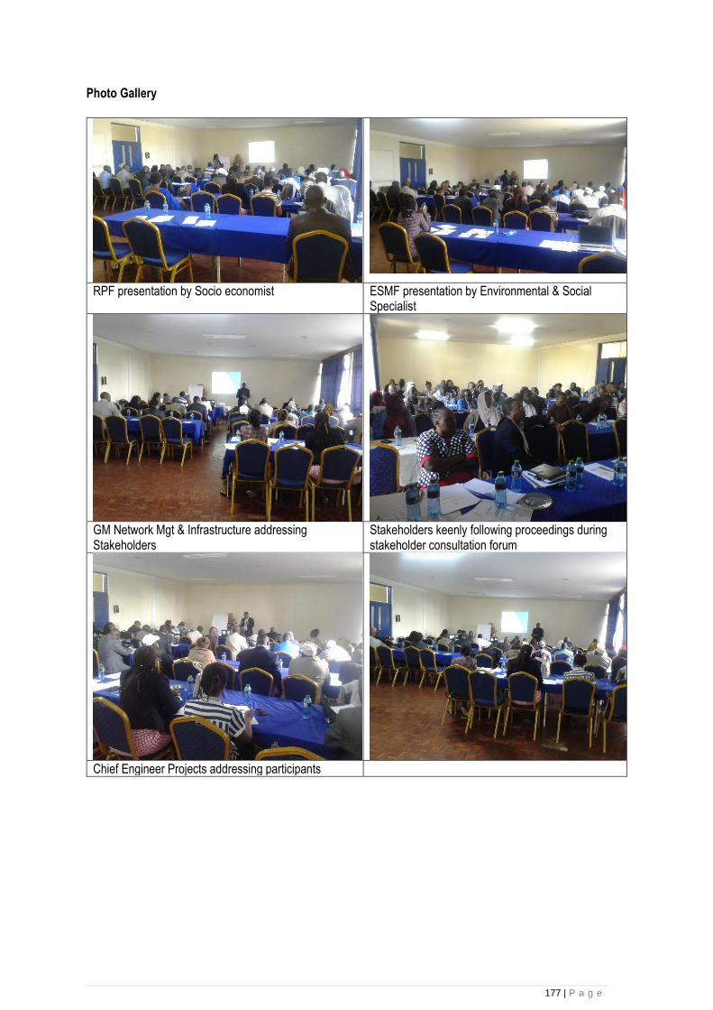
177 | P a g e
Photo Gallery
RPF presentation by Socio economist ESMF presentation by Environmental & Social Specialist
GM Network Mgt & Infrastructure addressing Stakeholders
Stakeholders keenly following proceedings during stakeholder consultation forum
Chief Engineer Projects addressing participants
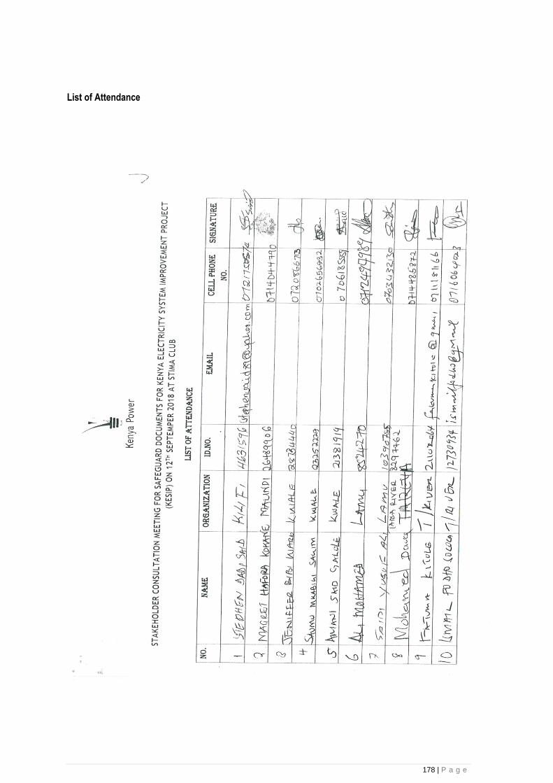
178 | P a g e
List of Attendance
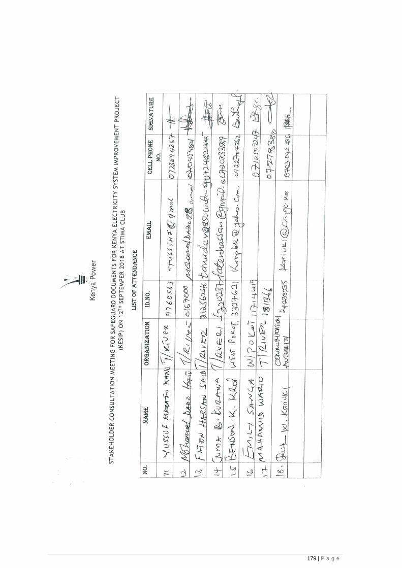
179 | P a g e

180 | P a g e
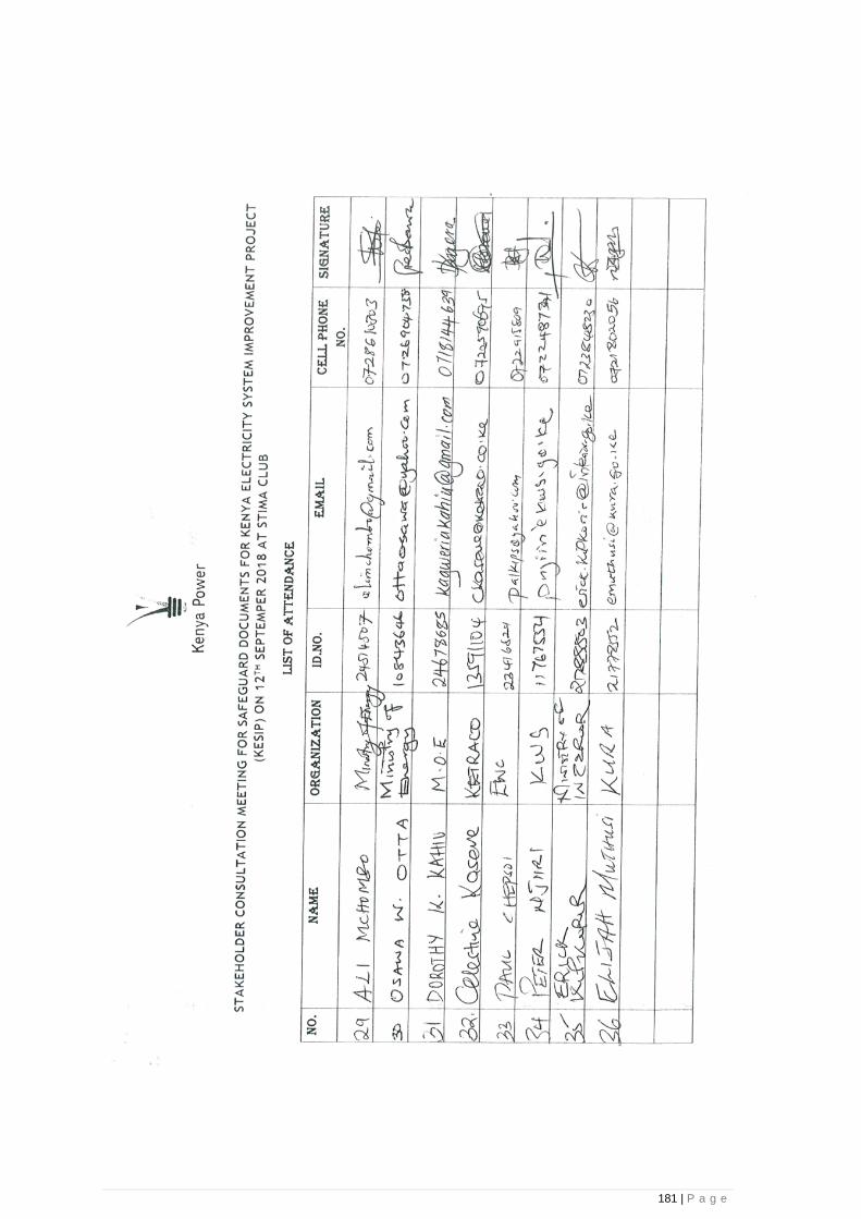
181 | P a g e

182 | P a g e
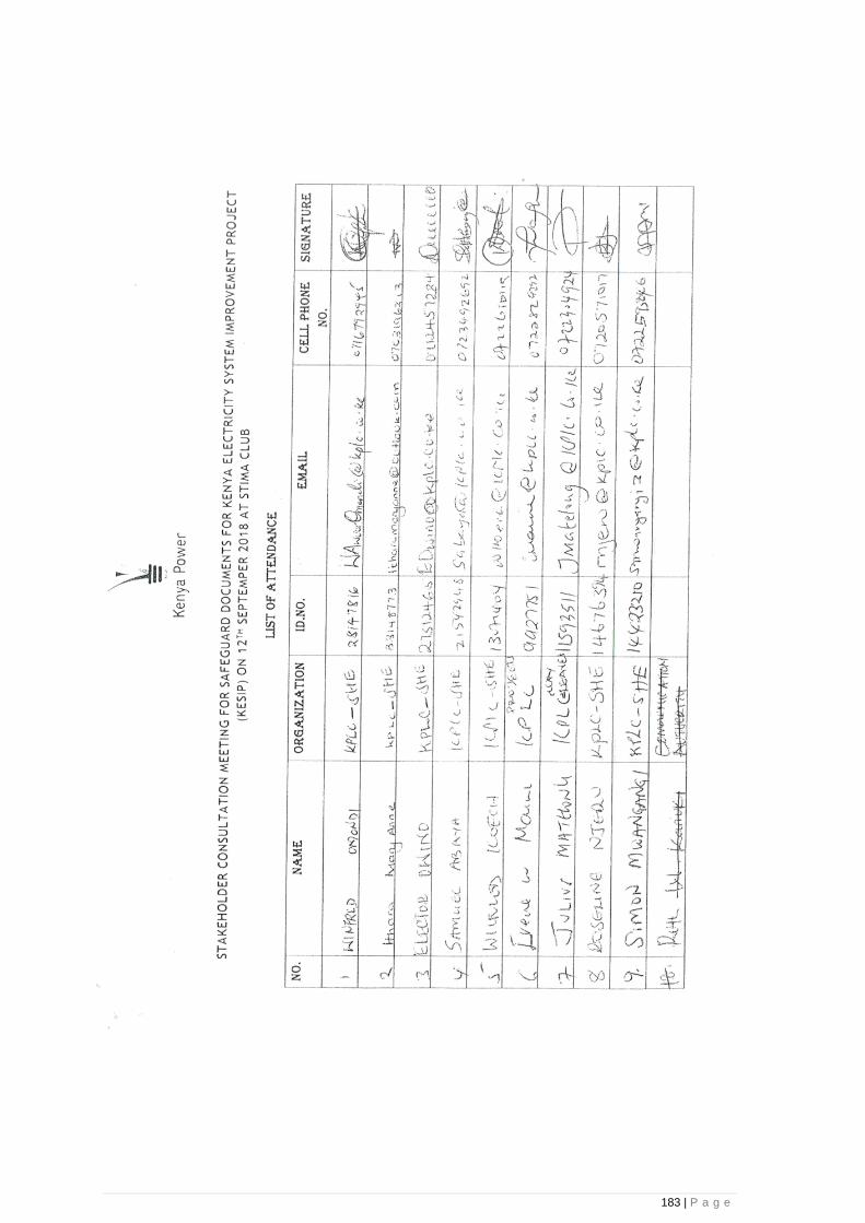
183 | P a g e

184 | P a g e

185 | P a g e
Annex 4: Chance Find Procedure
Regulatory and Other Requirements The primary legislation on cultural heritage issues is the National Museums Heritage Act, 2006 (which updated and replaced the National Museums Act, 1983), the Antiquities Monuments Act 1983 and is enshrined in the requirements the provisions of the Environmental Management and Coordination Act (EMCA) which defines the Environmental and Social Impact Assessment (ESIA) process. The National Museums Heritage Act sets out the overarching administrative processes for protecting and preserving cultural heritage and management by the NMK. As there are no designated monuments or sites within the immediate Project’s area of influence, the heritage legislation only has a limited bearing on the Project’s activities, however the project will take precautionary measures for handling any potentially significant chance finds through its implementation of the chance find procedure and requirement presented in subsequent sections of this procedure. Physical cultural resources (PCR) within Environmental Assessment The Client addresses impacts on PCR as an integral part of the EA process by undertaking an initial screening, developing terms of reference, collecting baseline data, conducting the impact assessment, and formulating mitigating measures and a management plan for PCR. As part of the public consultations required in the EA process, the consultative process for the PCR component of the project will includes relevant project-affected groups, concerned government authorities, and relevant nongovernmental organizations in documenting the presence and significance of PCRs, assessing potential impacts, and exploring avoidance and mitigation options. Normally, the findings of the physical cultural resources component of the EA are disclosed as part of, and in the same manner as, the EA report. However, exceptions to such disclosure would be considered when the Client, in consultation with the Bank and persons with relevant expertise, determines that disclosure would compromise or jeopardize the safety and integrity of the physical cultural resources involved or would endanger the source of information about the PCRs. In such cases, sensitive information relating to these particular aspects may be omitted from the EA report. The national agency responsible for cultural matters in Kenya is the National Museums of Kenya (NMK). Prior to commencement of projects in culturally sensitive areas the proponent would contact NMK who would send representatives to review the site and prepare a report. The report would entail advice on professional approach to the proposed works to ensure minimal damage to the encountered items. In the event that chance finds are encountered the following procedure shall apply: Role of the contractor and Client
• Reporting of chance finds: The contractor or officer supervising the project would report the finds to the local administration such as the local chief or the Assistant County Commissioner;
• The local administration would then report the find to NMK.
• The contractor would report back to client who would notify NMK in the event that further artifacts are encountered
• The client will make budget available for training the contractor and his/her staff and workers on how to go about reporting PCRs and safeguarding these properties until NMK is alerted and further processing of the announcement is made viz-a-viz the formulation and implementation of appropriate avoidance and/or mitigating measures.
Role of NMK
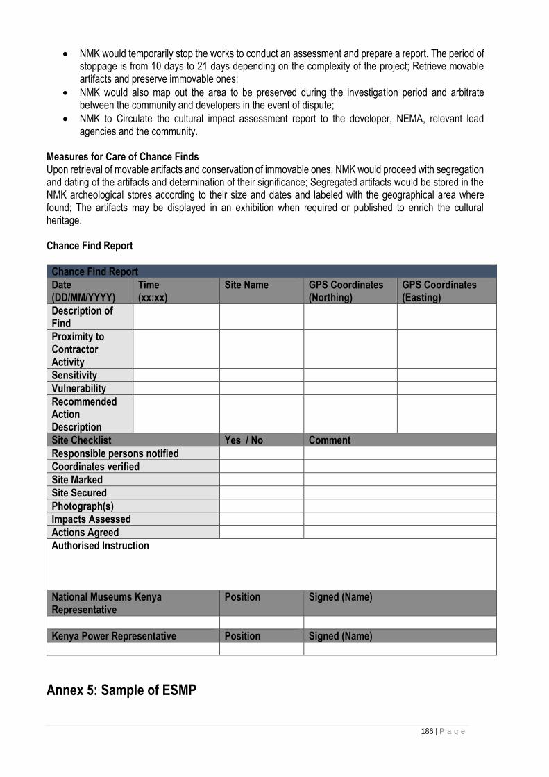
186 | P a g e
• NMK would temporarily stop the works to conduct an assessment and prepare a report. The period of stoppage is from 10 days to 21 days depending on the complexity of the project; Retrieve movable artifacts and preserve immovable ones;
• NMK would also map out the area to be preserved during the investigation period and arbitrate between the community and developers in the event of dispute;
• NMK to Circulate the cultural impact assessment report to the developer, NEMA, relevant lead agencies and the community.
Measures for Care of Chance Finds Upon retrieval of movable artifacts and conservation of immovable ones, NMK would proceed with segregation and dating of the artifacts and determination of their significance; Segregated artifacts would be stored in the NMK archeological stores according to their size and dates and labeled with the geographical area where found; The artifacts may be displayed in an exhibition when required or published to enrich the cultural heritage. Chance Find Report
Chance Find Report
Date (DD/MM/YYYY)
Time (xx:xx)
Site Name GPS Coordinates (Northing)
GPS Coordinates (Easting)
Description of Find
Proximity to Contractor Activity
Sensitivity
Vulnerability
Recommended Action Description
Site Checklist Yes / No Comment
Responsible persons notified
Coordinates verified
Site Marked
Site Secured
Photograph(s)
Impacts Assessed
Actions Agreed
Authorised Instruction
National Museums Kenya Representative
Position Signed (Name)
Kenya Power Representative Position Signed (Name)
Annex 5: Sample of ESMP
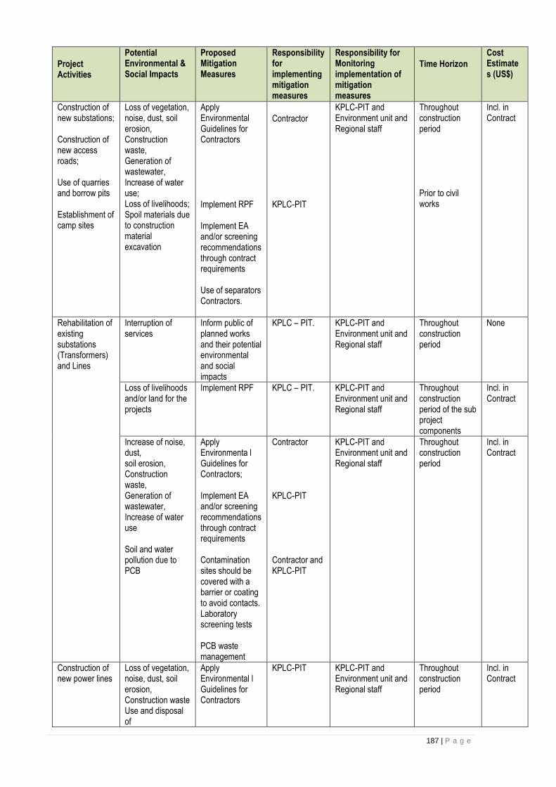
187 | P a g e
Project Activities
Potential Environmental & Social Impacts
Proposed Mitigation Measures
Responsibility for implementing mitigation measures
Responsibility for Monitoring implementation of mitigation measures
Time Horizon
Cost Estimates (US$)
Construction of new substations; Construction of new access roads; Use of quarries and borrow pits Establishment of camp sites
Loss of vegetation, noise, dust, soil erosion, Construction waste, Generation of wastewater, Increase of water use; Loss of livelihoods; Spoil materials due to construction material excavation
Apply Environmental Guidelines for Contractors
Implement RPF
Implement EA and/or screening recommendations through contract requirements Use of separators Contractors.
Contractor
KPLC-PIT
KPLC-PIT and Environment unit and Regional staff
Throughout construction period Prior to civil works
Incl. in Contract
Rehabilitation of existing substations (Transformers) and Lines
Interruption of services
Inform public of planned works and their potential environmental and social impacts
KPLC – PIT. KPLC-PIT and Environment unit and Regional staff
Throughout construction period
None
Loss of livelihoods and/or land for the projects
Implement RPF KPLC – PIT. KPLC-PIT and Environment unit and Regional staff
Throughout construction period of the sub project components
Incl. in Contract
Increase of noise, dust, soil erosion, Construction waste, Generation of wastewater, Increase of water use Soil and water pollution due to PCB
Apply Environmenta l Guidelines for Contractors; Implement EA and/or screening recommendations through contract requirements Contamination sites should be covered with a barrier or coating to avoid contacts. Laboratory screening tests PCB waste management
Contractor
KPLC-PIT
Contractor and KPLC-PIT
KPLC-PIT and Environment unit and Regional staff
Throughout construction period
Incl. in Contract
Construction of new power lines
Loss of vegetation, noise, dust, soil erosion, Construction waste Use and disposal of
Apply Environmental l Guidelines for Contractors
KPLC-PIT
KPLC-PIT and Environment unit and Regional staff
Throughout construction period
Incl. in Contract
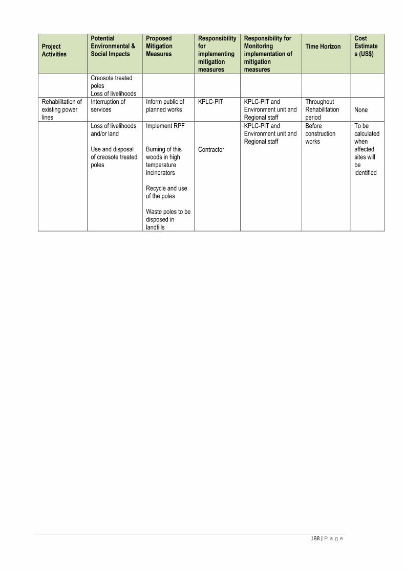
188 | P a g e
Project Activities
Potential Environmental & Social Impacts
Proposed Mitigation Measures
Responsibility for implementing mitigation measures
Responsibility for Monitoring implementation of mitigation measures
Time Horizon
Cost Estimates (US$)
Creosote treated poles Loss of livelihoods
Rehabilitation of existing power lines
Interruption of services
Inform public of planned works
KPLC-PIT
KPLC-PIT and Environment unit and Regional staff
Throughout Rehabilitation period
None
Loss of livelihoods and/or land Use and disposal of creosote treated poles
Implement RPF Burning of this woods in high temperature incinerators Recycle and use of the poles Waste poles to be disposed in landfills
Contractor
KPLC-PIT and Environment unit and Regional staff
Before construction works
To be calculated when affected sites will be identified

189 | P a g e
Annex 5: Generic ESIA Terms of Reference
I. Introduction and context This section will be completed at the appropriate time and will provide the necessary information with respect to the context and methodological approaches to be undertaken. II. Objectives of the study This section will (i) outline the objectives and particular activities of the planned activity; and (ii) indicate which activities are likely to have environmental and social impacts that will require appropriate mitigation. (Adapted to specific activities) III. Terms of Reference The consultant will perform the following tasks:
a) Carry out a description of the biophysical characteristics of the environment in which the planned activity will take place, and highlight the major constraints that need to be taken into account during construction as well as during operation of the facility;
b) Carry out a description of the socio-economic environment of the planned investment, and highlight the major constraints that need to be taken into account during construction as well as during operation of the facility;
c) Assess the potential environmental and social impacts due to construction or rehabilitation activities, and recommend mitigation measures as appropriate, including cost estimates;
d) Assess the potential environmental and social impacts due to the provision of water supply and sanitation facilities that might be needed for the planned facility and make appropriate recommendations;
e) Assess the need for liquid and solid waste collection, disposal and management in the facility, and make recommendations accordingly;
f) Discuss alternative project designs and make recommendations;
g) Assess alternative project designs and make recommendations;
h) Carry out a review of the respective national environmental policies, legislation, regulatory and administrative frameworks in conjunction with the donors’ safeguard policies, indicate which of these policies is triggered by the planned activity, identify any gaps that might exist, and make recommendations as to how potential gaps should be bridged in the context of the planned activity;
i) Review the Conventions and Protocols to which the country is a signatory;
j) Assess the country’s environmental assessment and management capacity, as well as the capacity to implement the proposed mitigation measures, and make appropriate recommendations, including potential capacity building and training needs, and their costs;
k) Prepare an Environmental and Social Management Plan (ESMP) for the planned activity. The ESMP should outline (a) potential environmental and social impacts resulting from the activity; (b) proposed mitigation measures; (c) institutional responsibilities for implementation of the mitigation measures; (d) monitoring indicators; (e) institutional responsibilities for monitoring the implementation of the mitigation measures; (f) cost estimates for these activities; and (g) time horizons for implementing the ESMP.
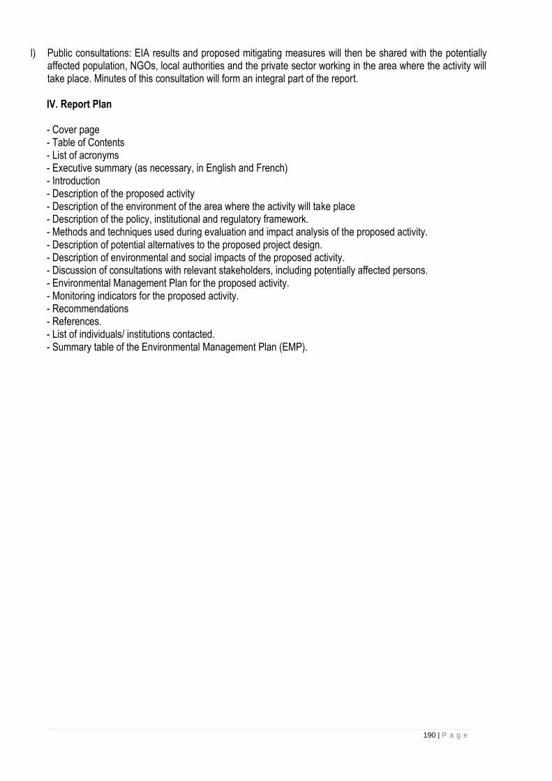
190 | P a g e
l) Public consultations: EIA results and proposed mitigating measures will then be shared with the potentially affected population, NGOs, local authorities and the private sector working in the area where the activity will take place. Minutes of this consultation will form an integral part of the report. IV. Report Plan - Cover page - Table of Contents - List of acronyms - Executive summary (as necessary, in English and French) - Introduction - Description of the proposed activity - Description of the environment of the area where the activity will take place - Description of the policy, institutional and regulatory framework. - Methods and techniques used during evaluation and impact analysis of the proposed activity. - Description of potential alternatives to the proposed project design. - Description of environmental and social impacts of the proposed activity. - Discussion of consultations with relevant stakeholders, including potentially affected persons. - Environmental Management Plan for the proposed activity. - Monitoring indicators for the proposed activity. - Recommendations - References. - List of individuals/ institutions contacted. - Summary table of the Environmental Management Plan (EMP).
Related Documents