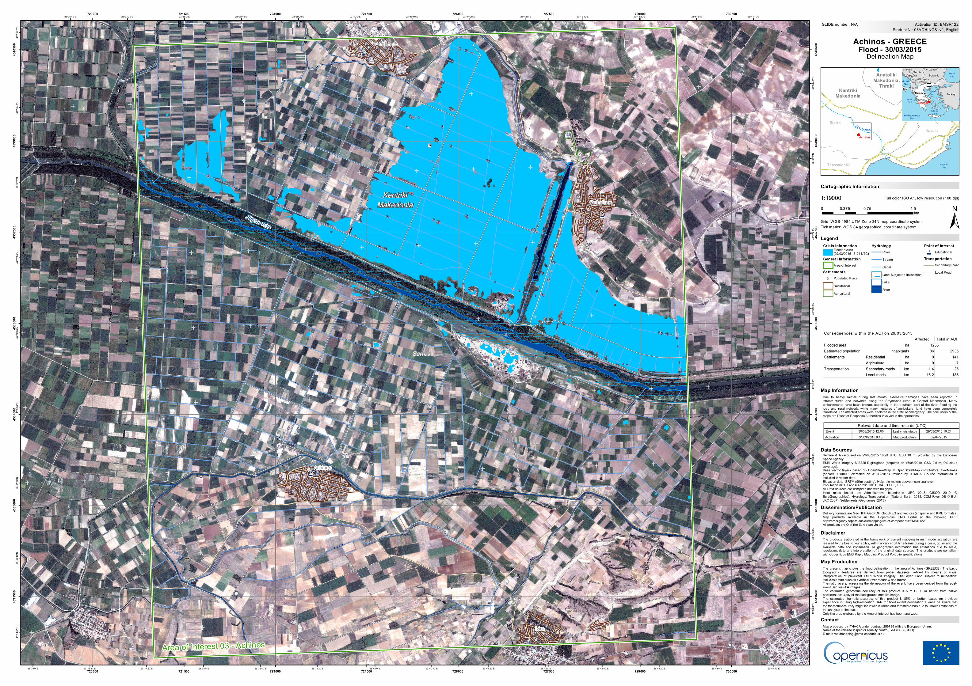
Crisis Information Flooded Area (29/03/2015 16:24 UTC) General Information Area of Interest Settlements ! Populated Place Residential Agricultural Hydrology River Stream Canal Land Subject to Inundation Lake River Point of Interest 4 Educational Transportation Secondary Road Local Road The present map shows the flood delineation in the area of Achinos (GREECE). The basic topographic features are derived from public datasets, refined by means of visual interpretation of pre-event ESRI World Imagery. The layer 'Land subject to inundation' includes areas such as riverbed, river meadow and marsh. Thematic layers, assessing the delineation of the event, have been derived from the post- event Sentinel-1 A images. The estimated geometric accuracy of this product is 5 m CE90 or better, from native positional accuracy of the background satellite image. The estimated thematic accuracy of this product is 85% or better, based on previous experience in using high-resolution SAR for flood extent delineation. Please be aware that the thematic accuracy might be lower in urban and forested areas due to known limitations of the analysis technique. Only the area enclosed by the Area of Interest has been analyzed. ! ! ! ! 4 4 4 Kentriki Makedonia Serres Strymonas Pethelinos Paralimnio Ivira Achinos 23°44'40"E 23°44'40"E 23°44'0"E 23°44'0"E 23°43'20"E 23°43'20"E 23°42'40"E 23°42'40"E 23°42'0"E 23°42'0"E 23°41'20"E 23°41'20"E 23°40'40"E 23°40'40"E 23°40'0"E 23°40'0"E 23°39'20"E 23°39'20"E 23°38'40"E 23°38'40"E 23°38'0"E 23°38'0"E 23°37'20"E 23°37'20"E 23°36'40"E 23°36'40"E 23°36'0"E 40°59'20"N 40°58'40"N 40°58'40"N 40°58'0"N 40°58'0"N 40°57'20"N 40°57'20"N 40°56'40"N 40°56'40"N 40°56'0"N 40°56'0"N 40°55'20"N 40°55'20"N 40°54'40"N 40°54'40"N 40°54'0"N 40°54'0"N 720000 720000 721500 721500 723000 723000 724500 724500 726000 726000 727500 727500 729000 729000 730500 730500 4531500 4531500 4533000 4533000 4534500 4534500 4536000 4536000 4537500 4537500 4539000 4539000 4540500 4540500 GLIDE number: N/A ! ( ! ( ! ( Anatoliki Makedonia, Thraki Kentriki Makedonia Kavala Thessaloniki Serres Achinos St r y m o n a s Aegean Sea ^ the former Yugoslav Republic of Macedonia Montenegro Bosnia Albania Bulgaria Greece Turkey Italy Romania Ser bia Athens Black Sea Mediterranean Sea Adriatic Sea Ionian Sea Aegean Sea Sea of Crete Cartographic Information 1:19000 ± Grid: WGS 1984 UTM Zone 34N map coordinate system Full color ISO A1, low resolution (100 dpi) The products elaborated in the framework of current mapping in rush mode activation are realized to the best of our ability, within a very short time frame during a crisis, optimising the available data and information. All geographic information has limitations due to scale, resolution, date and interpretation of the original data sources. The products are compliant with Copernicus EMS Rapid Mapping Product Portfolio specifications. Due to heavy rainfall during last month, extensive damages have been reported in infrastructures and networks along the Strymonas river, in Central Macedonia. Many embankments have been broken, especially in the southern part of the river, flooding the road and rural network, while many hectares of agricultural land have been completely inundated. The affected areas were declared in the state of emergency. The core users of the maps are Disaster Response Authorities involved in the operations. Delivery formats are GeoTIFF, GeoPDF, GeoJPEG and vectors (shapefile and KML formats). Map products available in the Copernicus EMS Portal at the following URL: http://emergency.copernicus.eu/mapping/list-of-components/EMSR122 All products are © of the European Union. Legend Tick marks: WGS 84 geographical coordinate system Product N.: 03ACHINOS, v2, English Activation ID: EMSR122 Sentinel-1 A (acquired on 29/03/2015 16:24 UTC, GSD 10 m) provided by the European Space Agency. ESRI World Imagery © ESRI Digitalglobe (acquired on 16/08/2010, GSD 2.5 m, 0% cloud coverage). Base vector layers based on OpenStreetMap © OpenStreetMap contributors, GeoNames (approx. 1:10000, extracted on 31/03/2015), refined by ITHACA. Source information is included in vector data. Elevation data: SRTM (90m posting). Height in meters above mean sea level. Population data: Landscan 2010 © UT BATTELLE, LLC. All Data sources are complete and with no gaps. Inset maps based on: Administrative boundaries (JRC 2013, GISCO 2010, © EuroGeographics), Hydrology, Transportation (Natural Earth, 2012, CCM River DB © EU- JRC 2007), Settlements (Geonames, 2013). 0 0.75 1.5 0.375 km Achinos - GREECE Flood - 30/03/2015 Delineation Map Data Sources Map Information Dissemination/Publication Area of Interest 03 - Achinos Disclaimer Map produced by ITHACA under contract 259736 with the European Union. Name of the release inspector (quality control): e-GEOS (ODO). E-mail: [email protected] Contact Relevant date and time records (UTC) Event Activation Last crisis status Map production 30/03/2015 12:00 31/03/2015 9:43 29/03/2015 16:24 02/04/2015 Map Production Affected Total in AOI Flooded area Estimated population 86 2935 Residential ha 0 141 Agriculture ha 0 7 Secondary roads km 1.4 25 Local roads km 16.2 185 Consequences within the AOI on 29/03/2015 Transportation ha 1255 Inhabitants Settlements

Welcome message from author
This document is posted to help you gain knowledge. Please leave a comment to let me know what you think about it! Share it to your friends and learn new things together.
Transcript
Crisis InformationFlooded Area(29/03/2015 16:24 UTC)
General InformationArea of Interest
Settlements! Populated Place
ResidentialAgricultural
HydrologyRiverStreamCanalLand Subject to InundationLakeRiver
Point of Interest4 Educational
TransportationSecondary RoadLocal Road
The present map shows the flood delineation in the area of Achinos (GREECE). The basictopographic features are derived from public datasets, refined by means of visualinterpretation of pre-event ESRI World Imagery. The layer 'Land subject to inundation'includes areas such as riverbed, river meadow and marsh.Thematic layers, assessing the delineation of the event, have been derived from the post-event Sentinel-1 A images.The estimated geometric accuracy of this product is 5 m CE90 or better, from nativepositional accuracy of the background satellite image.The estimated thematic accuracy of this product is 85% or better, based on previousexperience in using high-resolution SAR for flood extent delineation. Please be aware thatthe thematic accuracy might be lower in urban and forested areas due to known limitations ofthe analysis technique.Only the area enclosed by the Area of Interest has been analyzed.
!
!
!
!
4
4
4
KentrikiMakedonia
Serres
Strymonas
Pethelinos
Paralimnio
Ivira
Achinos
23°44'40"E
23°44'40"E
23°44'0"E
23°44'0"E
23°43'20"E
23°43'20"E
23°42'40"E
23°42'40"E
23°42'0"E
23°42'0"E
23°41'20"E
23°41'20"E
23°40'40"E
23°40'40"E
23°40'0"E
23°40'0"E
23°39'20"E
23°39'20"E
23°38'40"E
23°38'40"E
23°38'0"E
23°38'0"E
23°37'20"E
23°37'20"E
23°36'40"E
23°36'40"E
23°36'0"E
40°5
9'20"N
40°5
8'40"N
40°5
8'40"N
40°5
8'0"N
40°5
8'0"N
40°5
7'20"N
40°5
7'20"N
40°5
6'40"N
40°5
6'40"N
40°5
6'0"N
40°5
6'0"N
40°5
5'20"N
40°5
5'20"N
40°5
4'40"N
40°5
4'40"N
40°5
4'0"N
40°5
4'0"N
720000
720000
721500
721500
723000
723000
724500
724500
726000
726000
727500
727500
729000
729000
730500
730500
4531
500
4531
500
4533
000
4533
000
4534
500
4534
500
4536
000
4536
000
4537
500
4537
500
4539
000
4539
000
4540
500
4540
500
GLIDE number: N/A
!(!(!(
AnatolikiMakedonia,
ThrakiKentrikiMakedonia
Drama
Kavala
Thessaloniki
Serres
Achinos
Stry monas
AegeanSea
^
the form er Yugoslav Republ ic o f M acedonia
Montenegro
Bosnia
Albania
Bulgar ia
Greece TurkeyItaly
RomaniaSerbia
Athens
BlackSea
MediterraneanSea
AdriaticSea
IonianSea
AegeanSea
Sea ofCrete
Cartographic Information
1:19000
±Grid: WGS 1984 UTM Zone 34N map coordinate system
Full color ISO A1, low resolution (100 dpi)
The products elaborated in the framework of current mapping in rush mode activation arerealized to the best of our ability, within a very short time frame during a crisis, optimising theavailable data and information. All geographic information has limitations due to scale,resolution, date and interpretation of the original data sources. The products are compliantwith Copernicus EMS Rapid Mapping Product Portfolio specifications.
Due to heavy rainfall during last month, extensive damages have been reported ininfrastructures and networks along the Strymonas river, in Central Macedonia. Manyembankments have been broken, especially in the southern part of the river, flooding theroad and rural network, while many hectares of agricultural land have been completelyinundated. The affected areas were declared in the state of emergency. The core users of themaps are Disaster Response Authorities involved in the operations.
Delivery formats are GeoTIFF, GeoPDF, GeoJPEG and vectors (shapefile and KML formats).Map products available in the Copernicus EMS Portal at the following URL:http://emergency.copernicus.eu/mapping/list-of-components/EMSR122All products are © of the European Union.
Legend
Tick marks: WGS 84 geographical coordinate system
Product N.: 03ACHINOS, v2, EnglishActivation ID: EMSR122
Sentinel-1 A (acquired on 29/03/2015 16:24 UTC, GSD 10 m) provided by the EuropeanSpace Agency.ESRI World Imagery © ESRI Digitalglobe (acquired on 16/08/2010, GSD 2.5 m, 0% cloudcoverage).Base vector layers based on OpenStreetMap © OpenStreetMap contributors, GeoNames(approx. 1:10000, extracted on 31/03/2015), refined by ITHACA. Source information isincluded in vector data.Elevation data: SRTM (90m posting). Height in meters above mean sea level.Population data: Landscan 2010 © UT BATTELLE, LLC.All Data sources are complete and with no gaps.Inset maps based on: Administrative boundaries (JRC 2013, GISCO 2010, ©EuroGeographics), Hydrology, Transportation (Natural Earth, 2012, CCM River DB © EU-JRC 2007), Sett lements (Geonames, 2013).
0 0.75 1.50.375km
Achinos - GREECEFlood - 30/03/2015
Delineation Map
Data Sources
Map Information
Dissemination/Publication
Area of Interest 03 - Achinos
Disclaimer
Map produced by ITHACA under contract 259736 with the European Union.Name of the release inspector (quality control): e-GEOS (ODO).E-mail: [email protected]
Contact
Relevant date and time records (UTC)EventActivation
Last crisis statusMap production
30/03/2015 12:0031/03/2015 9:43
29/03/2015 16:24 02/04/2015
Map Production
Affected Total in AOIFlooded areaEstimated population 86 2935
Residential ha 0 141Agriculture ha 0 7Secondary roads km 1.4 25Local roads km 16.2 185
Consequences within the AOI on 29/03/2015
Transportation
ha 1255Inhabitants
Settlements
Related Documents