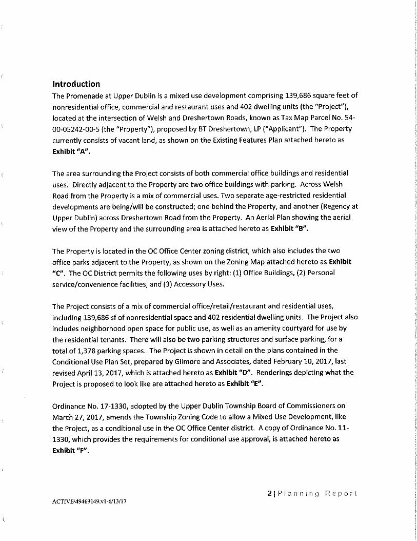
Kennedy &Associates Planners and Land Use Consultants PLANNING REPORT for the THE PROMENADE AT UPPER DUBLIN Prepared for: BT Dreshertown, LP February 10, 2017 Last Revised June 12, 2017 Prepared by: John H. Kennedy, AICP Kennedy & Associates LLC PO Box 175 Mainland, PA 19451 tel 215-513-1720 fax 215-513-1721 www.Landplan.com

Welcome message from author
This document is posted to help you gain knowledge. Please leave a comment to let me know what you think about it! Share it to your friends and learn new things together.
Transcript
Kennedy &Associates
Planners and Land Use Consultants
PLANNING REPORT for the
THE PROMENADE AT UPPER DUBLIN
Prepared for:
BT Dreshertown, LP
February 10, 2017
Last Revised June 12, 2017
Prepared by:
John H. Kennedy, AICP
Kennedy & Associates LLC
PO Box 175 Mainland, PA 19451
tel 215-513-1720 fax 215-513-1721
www.Landplan.com
Introduction
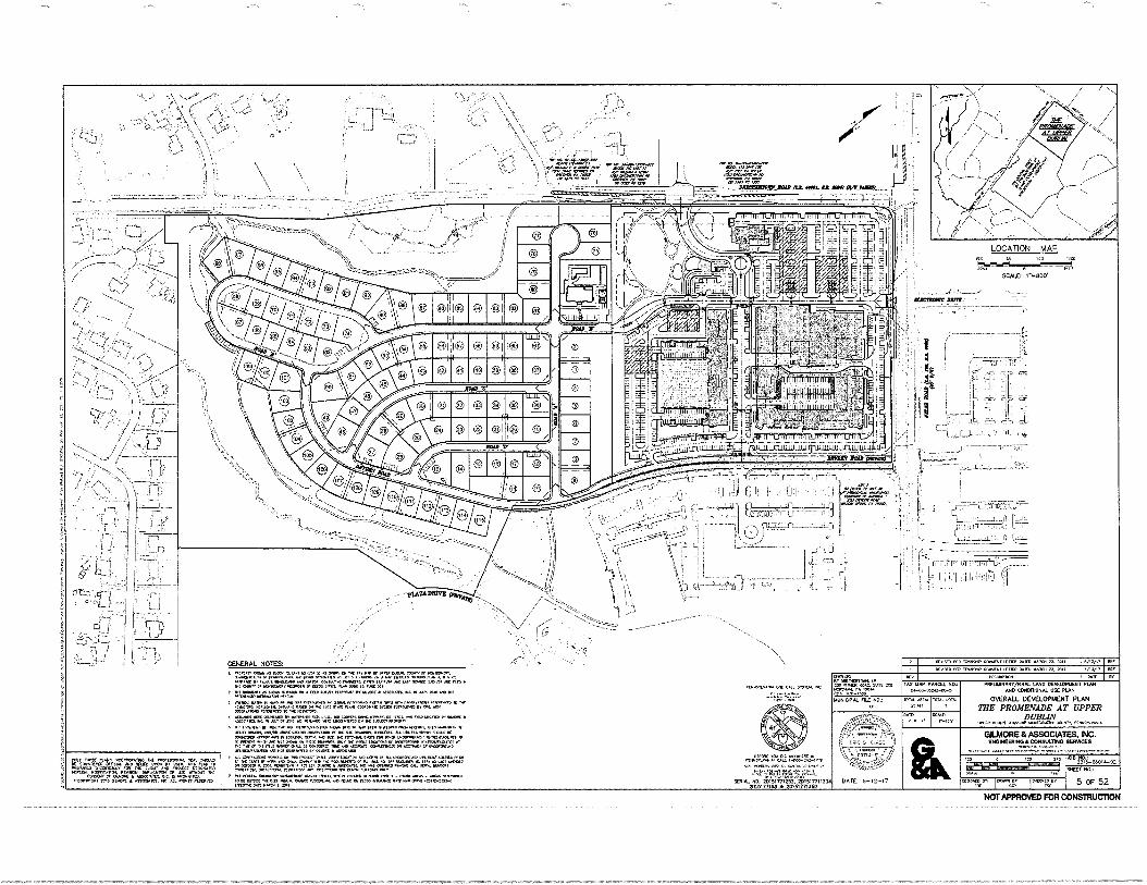
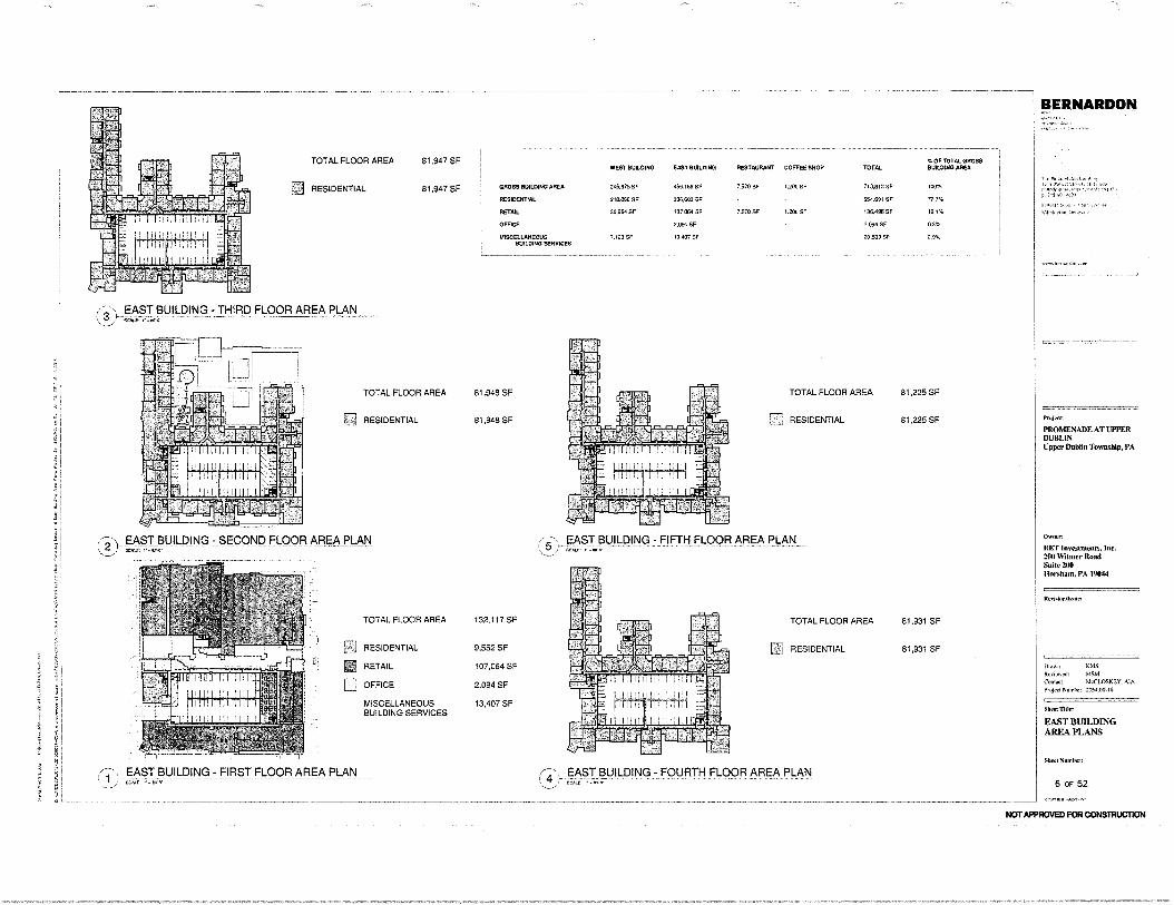
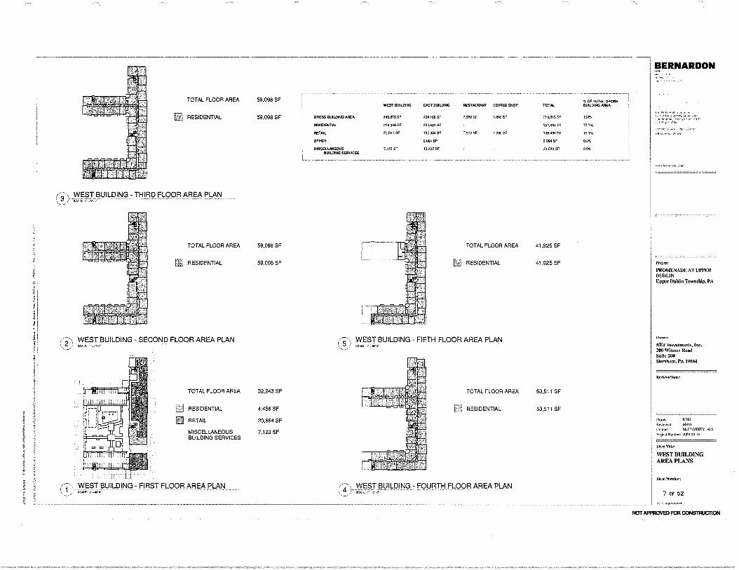
The Promenade at Upper Dublin is a mixed use development comprising 139,686 square feet of
nonresidential office, commercial and restaurant uses and 402 dwelling units (the "Project"),
located at the intersection of Welsh and Dreshertown Roads, known as Tax Map Parcel No. 54-
00-05242-00-5 (the "Property"), proposed by BT Dreshertown, LP ("Applicant"). The Property
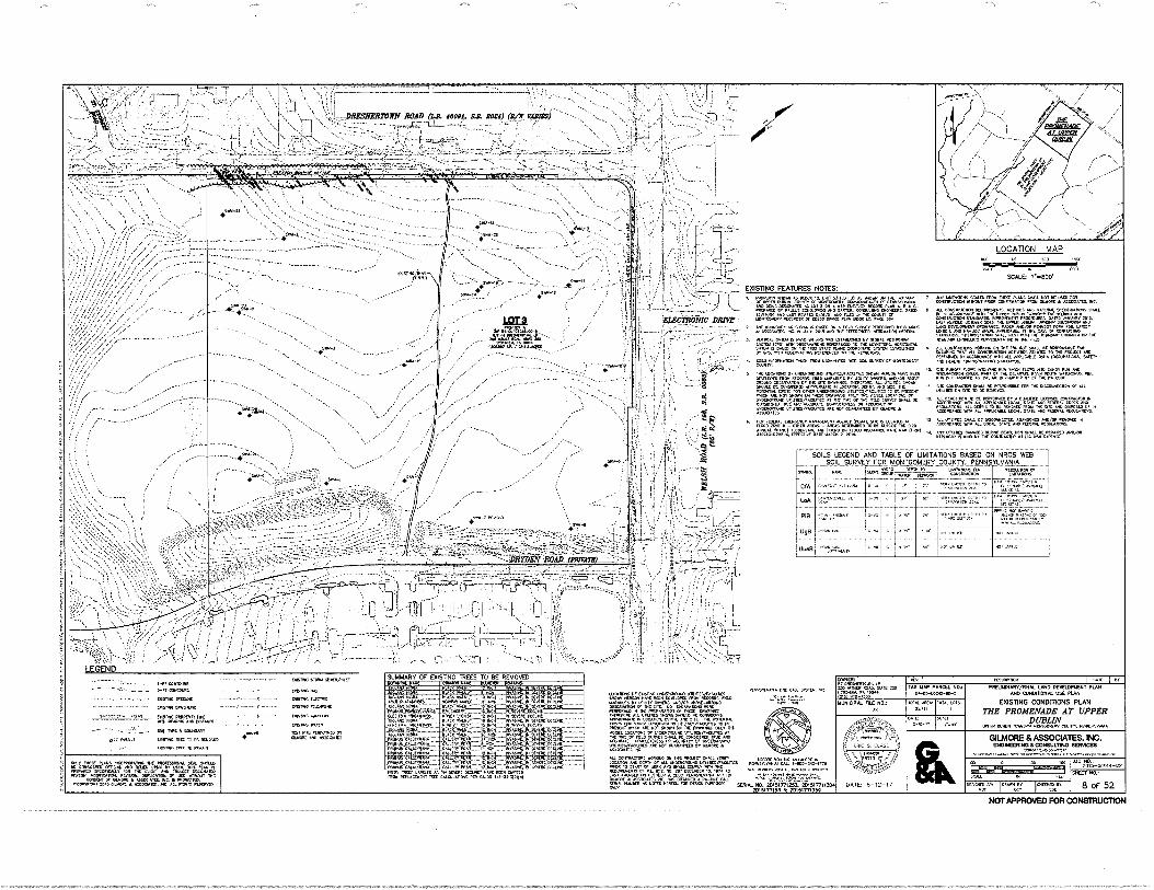
currently consists of vacant land, as shown on the Existing Features Plan attached hereto as
Exhibit "A".
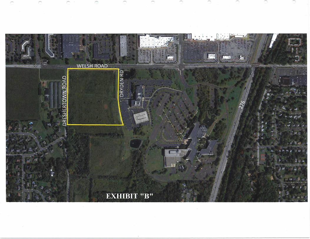
The area surrounding the Project consists of both commercial office buildings and residential
uses. Directly adjacent to the Property are two office buildings with parking. Across Welsh
Road from the Property is a mix of commercial uses. Two separate age-restricted residential
developments are being/will be constructed; one behind the Property, and another (Regency at
Upper Dublin) across Dreshertown Road from the Property. An Aerial Plan showing the aerial
view of the Property and the surrounding area is attached hereto as Exhibit "B".
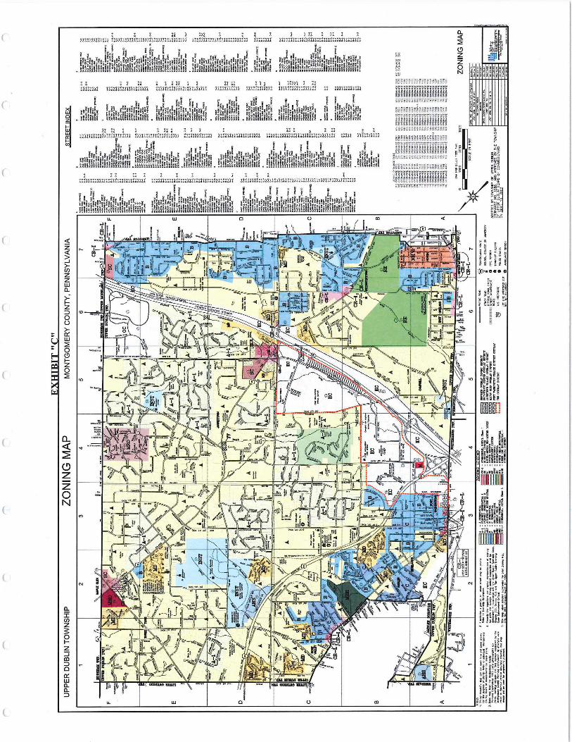
The Property is located in the OC Office Center zoning district, which also includes the two
office parks adjacent to the Property, as shown on the Zoning Map attached hereto as Exhibit
"C". The OC District permits the following uses by right: (1) Office Buildings, (2) Personal
service/convenience facilities, and (3) Accessory Uses.
The Project consists of a mix of commercial office/retail/restaurant and residential uses,
including 139,686 sf of nonresidential space and 402 residential dwelling units. The Project also
includes neighborhood open space for public use, as well as an amenity courtyard for use by
the residential tenants. There will also be two parking structures and surface parking, for a
total of 1,378 parking spaces. The Project is shown in detail on the plans contained in the
Conditional Use Plan Set, prepared by Gilmore and Associates, dated February 10, 2017, last
revised April 13, 2017, which is attached hereto as Exhibit "D". Renderings depicting what the
Project is proposed to look like are attached hereto as Exhibit "E".
Ordinance No. 17-1330, adopted by the Upper Dublin Township Board of Commissioners on
March 27, 2017, amends the Township Zoning Code to allow a Mixed Use Development, like
the Project, as a conditional use in the OC Office Center district. A copy of Ordinance No. 11-
1330, which provides the requirements for conditional use approval, is attached hereto as
Exhibit "F".
2IP anning Report ACTIVE\49469149.v1-6/13/17
The Applicant executed a Declaration of Covenants and Restrictions (the "Declaration"),
relating to the development of the Project, and recorded it against the Property. A copy of the
Declaration of is attached hereto as Exhibit "G".
The Project complies with all of the requirements for conditional use approval for a Mixed Use
Development in the OC District, as follows:
OFFICE CENTER DISTRICT CONDITIONAL USE CRITERIA
§ 255-61.1 Use and Development Requirements for Mixed Use Developments.
A Mixed Use Development shall comply with the following requirements and criteria:
A. The development shall consist of a harmonious selection of uses and groupings
of buildings, service and parking areas, circulation and green areas, planned and
designed as an integrated unit, in such a manner as to constitute a safe, efficient and
convenient center and encourage the use of green building technologies and sustainable
design features.
The Promenade is an integrated development of residential and commercial uses, neighborhood open space and amenities, along with required parking and service areas. Retail, office and restaurant uses are mixed with residential apartments in two main buildings, designed with a common architectural theme and using design elements that minimize the overall scale with visual building breaks and step backs of the building facades. The site plan is configured to mitigate the visual impact of parking typically found in suburban developments. Commercial parking has been distributed around the buildings to provide safe and efficient access, while residential parking is centralized in internal parking garages. The parking fields are therefore small compared to other suburban centers. The development will incorporate numerous green building technologies and sustainable building practices, including green roofs, rain gardens, structured parking, electric vehicle charging stations, bike racks and a bike share program.
B. Permitted Uses. Any of the following uses may be permitted when included in a
Mixed Use Development (see zoning amendment in the appendix for full list of
permitted uses):
(1) Retail and commercial establishments
(2) Residential uses
(3) Accessory uses
The Promenade is composed of 139,686 square feet of retail, restaurant, and commercial/office space, along with 402 residential apartments.
31Planning Report ACTIVE \49469149.v1 -6/13/17
C. Development Requirements. The general plan for a Mixed Use Development
shall comply with the following requirements and criteria:
(1) Lot area. The minimum gross lot area shall be twenty (20) acres.
The Project is located on 25.411 acres.
(2) Road frontages. The site shall have frontage on and road access to at least
two (2) public roads.
The Project has frontage on, and road access to, Welsh Road and Dreshertown Road, both of which are public roads. In addition, the Project has frontage on Dryden Road which is private. The Applicant has rights to access and use this road.
(3) Mix requirements. Every Mixed Use Development shall provide a mix of
office, commercial and residential uses and no one use may utilize more than
eighty percent (80%) of the overall gross building floor area. Accessory parking, including any parking garage, shall not be included as a separate use
and its square footage shall not be counted in the calculation of the mix
requirements. Apartment leasing area and multi-family common space may
be included as residential space in calculating the mix requirements.
Based on the total square footage of the gross building floor areas, the Project contains 77.6% residential space and 22.4% of other non-residential uses. Therefore, no one use utilizes more than eighty percent (80%) of the overall gross building floor area.
(4) Site Plan. A site plan shall be required and shall include a unified
architectural theme, preliminary stormwater management design and
conceptual landscaping.
All buildings proposed on the site will have a unified architectural theme that includes building materials, colors, textures and distinctive architectural elements. The architectural theme is illustrated in the renderings attached as Exhibit "E" to this report.
(5) Neighborhood Open Space. A minimum of ten percent (10%) of the net
developable area of the lot shall be developed as Neighborhood Open Space.
Neighborhood Open Space shall consist of parks, plazas, gardens, water
features and other similarly improved common areas and amenities provided for the benefit of the residents, tenants and/or customers of the Mixed Use
Development, and the general public. Trail and sidewalk connections also
shall be provided to connect Neighborhood Open Spaces. A public access
easement shall be granted in favor of the Township to provide public access
41Planning Report ACTIVE49469149.v1-6/13/17
to the trails and to certain portions of the Neighborhood Open Space within a Mixed Use Development that are appropriate for public access.
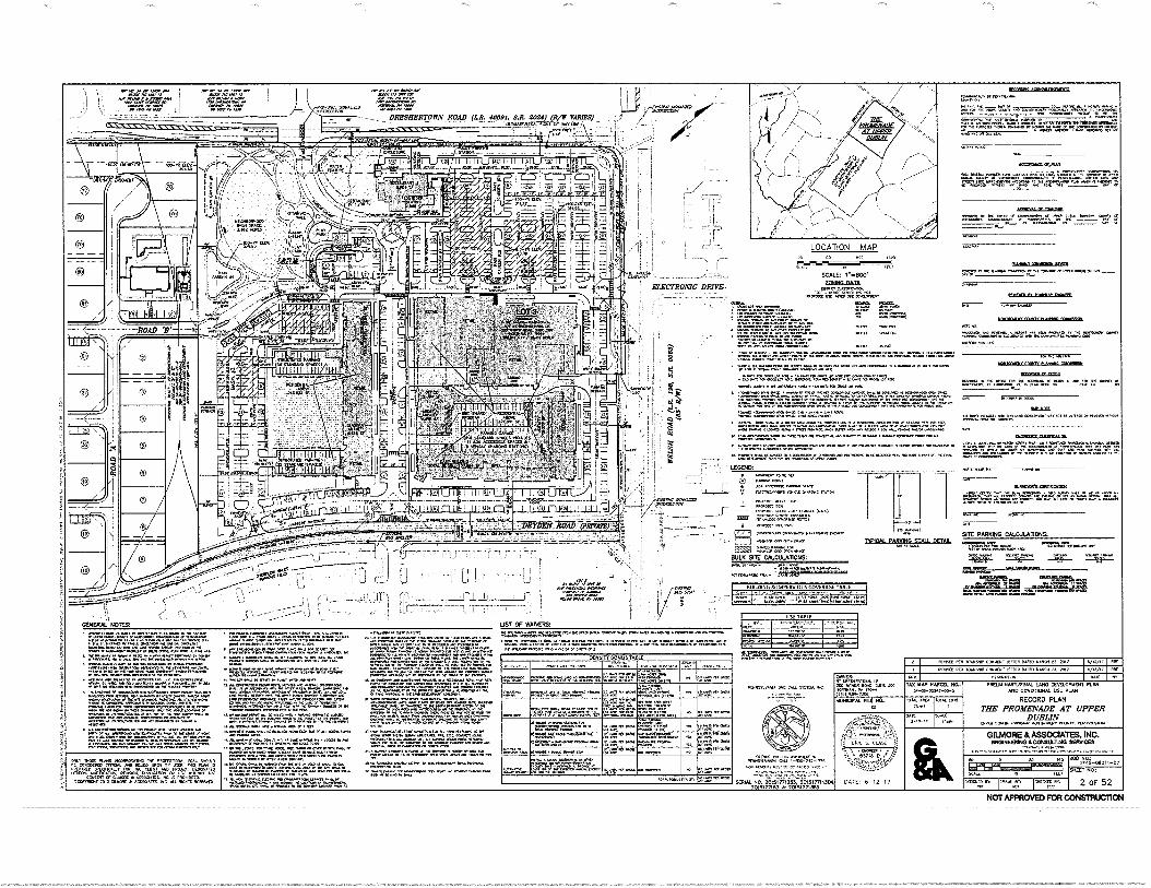
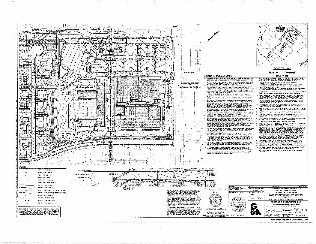
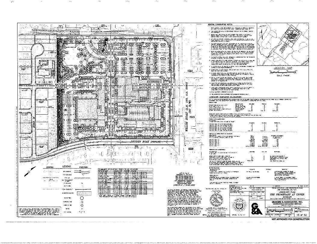
More than 10% of the net developable acreage of the lot (10.20%) is improved neighborhood open space in the proposed project, including a 2.5-acre neighborhood park located at the western end of the development (see conditional use plan set). The park includes landscaping, water features and seating areas and will provide areas for playgrounds, exercise and yoga, and other activities. This park will be open to the general public, as well as residents of the Promenade. The Project also includes public trails, which will connect to the surrounding neighborhoods and provide pedestrian and bike access to the shops at the Promenade. Several of these trail connections are listed on the Township's and/or Montgomery County's open space and trail plan. The extent of the neighborhood open space is shown on sheet 2 of the Conditional Use Plan (Exhibit "D").
(6) Stormwater Facilities. Naturalized stormwater facilities may occupy up to twenty-five percent (25%) of the Neighborhood Open Space if such facilities are designed and landscaped using Best Management Practices (BMPs), as published from time to time by the Pennsylvania Department of Environmental Protection and incorporated into the landscaped area. There shall be no limit on the area of underground stormwater facilities.
Much of the proposed stormwater system will be constructed underground to mitigate the visual impact of stormwater management facilities. However, there are several locations where landscaped rain gardens are proposed. These areas are located within the Neighborhood Open Space and in large islands within the parking field near the intersection of Welsh Road and Dreshertown Road. In these locations, the rain gardens will provide a more aesthetically pleasing stormwater facility, while managing runoff and providing groundwater recharge.
(7) Buffers. There shall be a buffer area along the property line of a residential zoned district of at least fifty (50) feet, which buffer area shall include planting and landscaping. There shall be a buffer area of at least twenty-five (25) feet where parking is located along a street frontage, which buffer area may include a low wall, fencing and/or landscaping.
A 50-foot landscape buffer is proposed along the southwestern boundary of the site, adjacent to the proposed active adult community. A 25-foot buffer is provided along the frontages of Welsh Road, Dreshertown Road and Dryden Road. Typical details for both of these buffers are shown on Sheet 23 of the Conditional Use Plan (Exhibit "D").
5 IP anning Report ACTIVE\49469149.v1-6/13/17
(8) Permitted Density. A Mixed Use Development may contain up to fifteen (15) dwelling units per gross acre of the lot area. To encourage the use of green building technology and sustainable design features, increases in the base density are permitted in accordance with the following table. These increases are cumulative and can be combined up to a maximum density of twenty (20) dwelling units per gross acre of the lot area.
The plan proposes 402 dwelling units on 25.411 acres, which is a density of 15.8 dwelling units per gross acre. The base density allowed under the OC District mixed-use option is 15.0 units per acre. Additional density is permitted by bonus provisions within the ordinance. In order to achieve the proposed 15.8 dwelling units per acre, the applicant will incorporate bonus features into the parking; the provision of electric vehicle charging stations, bike racks, and a bike share program. As noted on sheet 2 of the Conditional Use Plan, the use of these bonus features provides an additional 5 dwelling units per acre maximum. However, the applicant has agreed to limit the density of the Project to 402 dwelling units.
D. Area and Bulk Requirements.
(1) Building coverage. The maximum building coverage shall not exceed forty percent (40%) of the net developable area of the lot.
The Project has 23.9% building coverage.
(2) Impervious coverage. The maximum impervious coverage shall not exceed seventy percent (70%) of the developable acreage of the lot.
The Project has 69.5% impervious coverage.
(3) Building Height. The maximum building height of any residential or mixed use building or structure within a Mixed Use Development shall be sixty-five (65) feet, in accordance with the requirements under § 255-61.F. except that the maximum height for portions of a building comprised of ground floor retail, without residential above, shall be thirty-five (35) feet.
The maximum height of the proposed mixed use buildings on the site is 65 feet. However, any areas of the building where residential is not located above retail, the maximum height does not exceed 35 feet. The two freestanding buildings shall be less than 35 feet in height.
(4) Building setbacks. No building may be located closer than:
(a) Seventy (70) feet to any public highway or ultimate public right-of-way, or to any toll or controlled public highway right-of-way.
6IPianning Report ACTIVE \ 49469149.v1-6/13/17
(b) Fifty (50) feet to any other property line or the center line of any
existing private road.
The proposed building setback from Dreshertown Road is 70.84 feet. The proposed building setback from Welsh Road is 106.19 feet. The proposed building setback from Dryden Road is 129.33 feet. The proposed building setback from the adjacent active adult community is 189.93 feet.
(5) Parking setbacks. No parking area may be located closer than twenty-five
(25) feet to any public highway or ultimate public right-of-way, or to any toll
or controlled public highway right-of-way, or any other property line.
The proposed parking setback from Dreshertown Road is 28.10 feet. The proposed parking setback from Welsh Road is 27.02 feet. The proposed parking setback from Dryden Road is 27 feet. The proposed parking setback from the adjacent active adult community is 50 feet.
(6) Parking requirements.
(a) Nonresidential uses: 4 spaces per 1,000 square feet of gross
building floor area.
(b) Residential uses: 2.0 spaces per dwelling unit, provided that the
applicant may place in reserve up to twenty-five percent (25%) of
the required parking, subject to the approval of the Board of
Commissioners.
Based on the requirement of 4 spaces per 1,000 square feet of building floor area and 2.0 spaces per dwelling unit, a total of 1,363 parking spaces are required. Including all surface and garage parking, a total of 1,378 parking spaces are provided. All spaces shall be built and no parking is proposed to be in reserve.
E. Design Standards. The intent of these standards is to ensure development
contributes to a high-quality, mixed-use environment without limiting design flexibility
and innovation. The applicant shall submit plans, elevations, renderings, reports,
documents and samples as necessary in the form of proposed design guidelines to
demonstrate compliance with the following standards:
(1) Building Design.
Bernardo» Associates Architects has prepared a summary of the proposed
building design and architectural elements used for the Project, which is
attached to this report as Exhibit "H".
7 IPlanning Report ACTIVE\49469149.v1-6/13/17
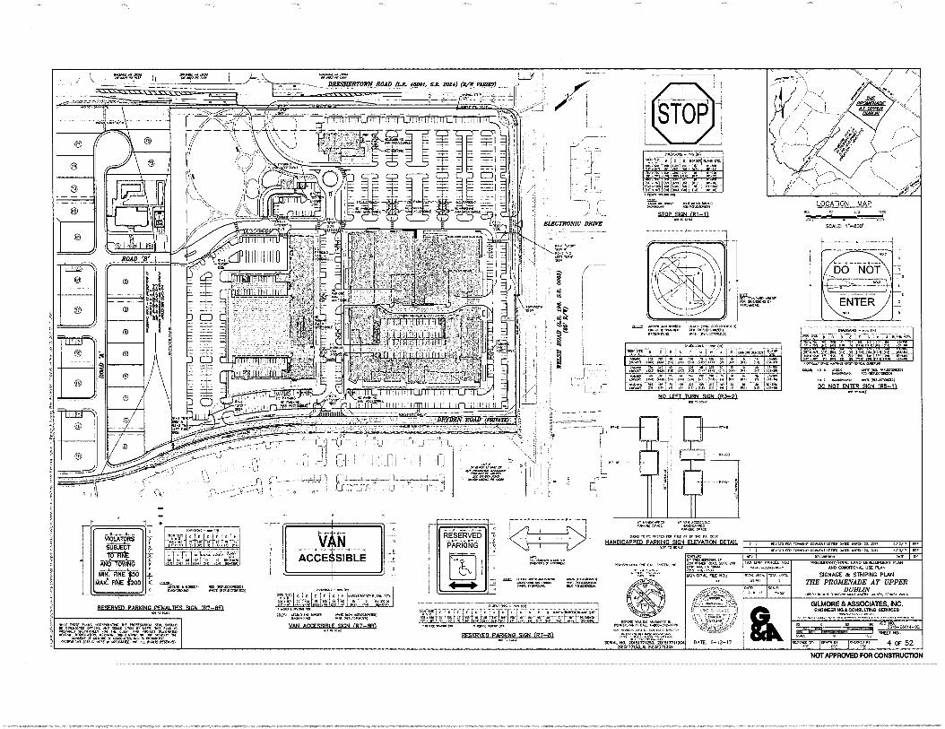
(2) Signage. The applicant for a Mixed Use Development shall submit a sign plan
meeting the requirements of § 255-152.2.H.
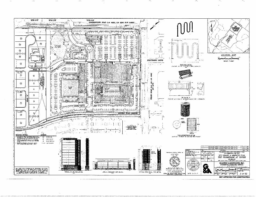
Sign locations and conceptual sign design are located on Sheet 3 of the
Conditional Use Plan (Exhibit "D").
(3) Landscape and Streetscape Standards.
(a) Sidewalks or multi-use trails shall be provided along all street frontages. Sidewalks along public and private street frontages
shall be a minimum of six (6) feet wide. Trails shall be a minimum
of ten (10) feet wide.
(b) A landscape plan prepared by a licensed landscape architect is
required for all Mixed Use Developments. Landscaped areas
include green areas, streetscapes, the interior and perimeter of surface parking areas, greenways, verges, stormwater basins, and
natural areas.
(c) Within 100 feet of a residential zoning district the landscape plan
shall include plantings, decorative fencing or a wall to shield headlights and soften the view of cars from the street and from
adjacent residential areas.
A proposed conceptual landscape design and streetscape elements are located on Sheets 3 and 10 of the Conditional Use Plan (Exhibit "D").
(4) Standards for Neighborhood Open Space.
(a) The minimum width of any land area to be counted as
Neighborhood Open Space shall be fifteen (15) feet.
(b) Neighborhood Open Space shall be landscaped and/or hardscaped with a mix of trees, shrubs, groundcover decorative
paving or walls in accordance with the overall landscape plan
prepared for the development by a registered landscape
architect.
(c) Neighborhood Open Space shall be provided with benches, trash
containers and/or lighting fixtures.
81Planning Report ACTIVE\49469149.v1-6/13/17
The area designated as neighborhood open space and conceptual design elements are depicted on Sheets 2 and 3 of the Conditional Use Plan (Exhibit "D").
(5) Public Transit. Transit facilities and shelters shall be provided in mutually
agreeable location(s) and in accordance with the design standards
established by the Southeastern Pennsylvania Transit Authority (SEPTA).
The Applicant has contacted SEPTA and will work with the agency to
accommodate existing transit facilities.
GENERAL CONDITIONAL USE CRITERIA
§ 255-194 Standards and criteria for approval of use.
The Board of Commissioners may grant approval of a listed conditional use under any district,
provided that the following standards and criteria are complied with by the applicant for the
conditional use. The burden of proving compliance with such standards and criteria shall be on
the applicant.
A. The applicant shall establish by credible evidence that the proposed use or other
subject of consideration for approval complies with the declaration of legislative
intent that may appear at the beginning of the applicable district under which
approval is sought.
The Project provides a diversity of uses, which include residential and nonresidential uses. These uses will complement the existing adjacent office uses by providing access to housing, goods and services in a walkable environment. The Project is located in an appropriate area with access to existing infrastructure. Furthermore, the proposed improvements will not only mitigate the impacts of the development in the immediate area but provide far-reaching benefits for all township residents, including neighborhood open space.
B. The applicant shall establish by credible evidence that the proposed use or other
subject of consideration for approval complies with the conditions enumerated
in that section of this chapter which gives the applicant the right to seek a
conditional use.
9 1 p anning Report ACTIVE \49469149.v1 -6/13/17
As noted above, the Project complies with the requisite minimum acreage, road
frontage, mix of uses and all other requirements for conditional use approval of
a Mixed Use Development in the OC District.
C. The applicant shall establish by credible evidence that the proposed use or other
subject of consideration for approval shall preserve the environmental and
physical assets of the neighborhood, including but not limited to parking, traffic
movement, noise, landscaping, buffering and lighting.
The Project will not have a negative impact on the parking or traffic of the
surrounding neighborhood, and the proposed traffic improvements will
remediate several existing traffic problems. The proposed buildings have been
carefully located away from the existing residential neighbors and closer to
adjacent office uses, with landscaping and buffering, including a minimum 6
feet tall berm near the Dreshertown Road entrance, that will mitigate any
potential impacts from noise and lighting. In addition, lighting fixtures with
cut-off shielding will prevent light leakage from the site in accordance with
Township regulations.
D. The applicant shall establish by credible evidence that the proposed use or other
subject of consideration for approval shall be properly serviced by all existing
public service systems.
The applicant has obtained "will serve" letters from the appropriate utilities.
Copies of these letters are collectively attached hereto as Exhibit "I".
E. The applicant shall establish by credible evidence that the proposed use or other
subject of consideration for approval shall make accommodation for peak traffic
generated by the proposed use.
The proposed traffic improvements will remedy a number of existing traffic
problems. A summary of these improvements is contained in the
Transportation Impact Study, prepared by McMahon and Associates, dated
March 2016, last revised February 2017, a copy of which has been submitted to
the Township.
F. The applicant shall establish by credible evidence that the proposed use or other
subject of consideration for approval is designed in accordance with the
101Planning Report ACTIVE\49469149.v1-6/13/17
Township Code with regard to internal traffic circulation, parking, buffering,
grading, stormwater management, erosion control and all other elements of
proper land planning
A description of internal circulation and parking is contained in the McMahon
Transportation Impact Study. Conceptual buffering, grading, stormwater
management, erosion control and other elements of proper land planning are
contained in the conditional use plan set. All of these design considerations are
in accordance with the Township Code.
G. The Board of Commissioners shall impose such reasonable conditions and
safeguards as are advisable to ensure compliance with the purpose and intent of
this chapter, which may include, without limitation, planting and buffers, special
yards and spaces, construction of fences and walls, special parking and/or
loading and drop-off provisions, together with control of vehicles' egress and
ingress, harmonious design of buildings, protection of watercourses, the
protection of environmental amenities and the elimination of noxious, offensive
or hazardous elements.
Noted.
H. The applicant shall establish by credible evidence that the proposed use or other
subject of consideration for approval will not adversely affect the health, safety
and welfare of the neighborhood and community.
The Project will not have any adverse effect on the health, safety and welfare
of the neighborhood and community. The Project will:
• Provide an economic benefit to both the Township and School District.
• Provide an opportunity to live and work in close proximity to the site.
• Implement critical portions of the Upper Dublin Trail Plan.
• Provide Neighborhood Open Space for use by the general public and
Project residents.
• Diversify the housing stock of the Township.
• Provide remediation for several existing traffic problems.
111P anning Report ACTIVE\49469149.v1-6/13/17
OFFERED CONDITIONS OF APPROVAL
In addition to the above-listed requirements for obtaining Conditional Use approval, the
Applicant is offering certain conditions to the grant of Conditional Use approval of the Project
by the Board of Commissioners, which conditions are set forth in the Declaration attached
hereto. If approval is granted, the Project will comply with these conditions.
Submitted by:
t
John H. Kennedy, AICP
121Planning Report ACTIVE \ 49469149.v1-6/13/17
APPENDIX
Exhibit "A"
Exhibit "B"
Exhibit "C"
Exhibit "D"
Exhibit "E"
Exhibit "F"
Exhibit "G"
Exhibit "H"
Exhibit "I"
Existing Features Plan
Aerial Plan
Zoning Map
Conditional Use Plan Set
Project Renderings
Ordinance No. 17-1330
Declaration of Covenants and Restrictions
Architect Summary
"Will Serve" Letters

LOCATION MAP
SOILS LEGEND AND TABLE OF UMITATIONS BASED ON NRCS DEB SOIL SURVEY FOR MONTGOMERY couNre, PENNSYLVANIA
r Nem Ne INN ewe. C-7 1 Wee Carur . 04•14:4
DeseraLT ose Lem
saDIT:SM.1.11.1
-••••
Weerhylre
'7;4V:A
• At:Le:Z. MDT, 1
„
m•
CIA
LM
PIS
UçB
Uwe
AAA MY. WADY Nee Den
Ler moe•DamtA, •
•••
-eng-i Ira rf E4Rtie- Wore
rg: • reg :ttE :1st 6.2 KWh 24*.0 • e,Aint,r. t4.4.4 Moe
.P•4,..„Csile••• .I C.A..flE ta. "OA.. ZAK. MI. CaLLO. ree• •01-, ; .04 OCCI.K
RIZZ . . ZIP0.111.61.2'4 = tt=;:, • = WO Den :arta At 1 sneer braol• LW reverNO IOW aermAt Derr ea.s.LareeK SDOO nle renea,
-DAM, PAWL
LK.. Or WSW. MLIPOOLLO 41770/74ww• WAN NtRaN NW PCKWILL me• facarx. DOMAIS It MIA ere.. mODS. yeaCeeleasiD DEDIVIAMe NS SAL ete L.L. /Orem. • MDALOOM Le Ness 0•444. swum au Our. Seem DOrlenra
DOMe. me DLL ac OATS OPCP L.POK•eme DTIAMS/rocaors et, sr P•Otre eel Le. WI WPM nit 0, AD•le DOCALDNI LC MOW.. DreiroSte.le, SIC VC ID Winte WEL IC MASC.. SRC We .121.1(..
•st tot 0.4•40203 It Wien •
esaleartan •211.4 OD Me Melee •••• use,
as
•OLVICH Oa 0[PN Ulf,C.41.0./Kf.
1.101.M•13•11 re en COSMO me as MT DOC= GCM1IP Ma .T
LoMee a tUb e2e2,.. 2D15:1:7?%13D4 ODOR • rAnc * ra-pC saL.
2D, 5,771SAa anstrnzio
el,Cirr111. ANAL LA. CCVD.DPULINL PLAN
CINOTONAL Mt PLAN
EXIS1ING CONDITIONS PLAN
THE PROMENADE AT UPPER DUBLIN
WM. 11 ,04,Aron.
GILMORE & ASSOCIATES, INC. IIN33MELIWN0100111111LTNO SERVICES
IWO OW
0105/5 S. f wk. Iv. !moo Pt Rlr r, I CSC 8 OF 52
Pettit r tamer.. • Tf0 maw DAC SILL eler MPS., Da ADD
021.- INA0C04‘. RA ND, NOM MCD
2,011
ow I TAX MAP Pala, NO.:
4-0044.240-1.
SAW,'
AM DODS
Wee I DLNy.p.„,
DATE: 6.02../Y Use>
-08 204-044-02
NOT APPROVED FOR CONSTRUCTION
remelt.m. Dec tau •Ast. 6.2
Allow Au .frobeirr Meel,M,A• C.: '405-2 . 2 ..
Exhil?it "A" .. '--- It'.( ,.. •---. ---...
ss DRESHER/VIM ROAI2firt. 404". it moo pot. ..ir
. - -. 'N... ' -.. ....
•, ..-1.47.1., '
,,,,, „„:1--7.... --1. ... • ... '''. ',, ''.
a .1,-
-
SCALE r..eoe
• gusthl(blac MDT
. r. EXISTING FEATURES NOTES:
7•NRP4 Nee FM 14, PAL D WM 1Nt Lup eret bee OlMere et enelterall.. eameenteo. Or AN
2104Ne •04 etsowel 4 Lel at • LW PIMA =We Own • • • C. Peleat num mow.. No tAtqL teautel DemeDINS, D•2121. 0
0 IDMODerefis Maa t•WLL maNare sr am Wet Re DOM LA att
at MAW. Neve 0•20 w • MP rAeLt7 IDDEM.CO e• Omare • DOSILLOL: L. NOS ye DC riereleCtO Mrpesmerel vel.Deat Orme a casee PI NO 08.161•001111. et0Ose. Ober el tag% DC IUD DAM taSerAll.T.Lraerr. • Ore OAS DIN cosver.c...001.0 er. SC
• SO. Wow.. •mes nese. womeleeS ...KA DMILX•rOn MOD,
D D. "Le r•DOIL/reettell Sem MrsOL re=7.-„zrarreer zzaz, ta nra. 44•74. raw awe .7 Wine Ovol..../e• WV( TeLe D...SeeD Or per
WADS =army. De LA DT MM.. frek7wz. Ln.NeL we. Sea. DC teeteeD NekiNwIt 1.0.nme. Dro an no falt (.....11.cleee rianseallU nY , CeirANKCION redo.. CresS No WO teepee. LAMS/restates To reC mrsrse Deur. Dr see Le cc PD.. emco e.M Mr. sows war COMM Om. Ne DD. !Lemma a
TIZ•M'agt — tur-zr.7.! "IT? oaDkOmme sturC/A.OLecs Do me atom,. Or comae • a...m.6 DE {lams Amp Le gap tryinErlp A ASSOCAleS areDebeer 1.4 ALL •ArsGeor SUR ere eiremert01.1.0.
Off 0•0010. LOAM nem Ur. erme. DAD NOT ler LI. rep MeriverCupd Dos• rennewereee MD MINK • .103.A. se
COKTPJCSCA ICILARKAA. KOKOS DO 1.2.M. DeCC,CLISMS DADa
ZI.g= LeLe *LADD OrMAX 2Di> Toe LOP. DA. •DeDame 44.4. w, •
Orsilooron PASO .3/0. Memo, rm. miL LAW tr'DelserZrAftelatrAeCFP.1-:•.."‘DACtione...2.... DR
CA/LC,40 1.a.sm limedraes AnDryre•ist Pr DELO
•Nwe or. W Weise you Le LLSPIADDLE role W.. Twat eat Ceeittre DRAM SD re Pealee qtr.. krairemee . PPLUL.C.e 01.4 (022.V.C.A,L WV,
.0105-RAMOSTA10005.
I ,• ......
t- . •tteatrrei
2 Dam. MA. comma. 5.sc 301013
....112 el me let CMIN.T. 0.1 AS LIVOne.
••••••••••••-•.„
I %
LEGEND
i-re DOM. 5-el =DSOS
Mo. MAAR
MOM
MST. MONS, LK Leh Mame. me bee..
SOL ADC Do ISL.•••
reeerml Wee TO De P.,. ea.. ER TO Mon
MIL Sett RAM •Crepree.. Ike MOM., tty. te OM, AD DLO WON IA 'AM An M. if
leSCLIC•ml erre Do Q.! DO Notre ...MD MM. weeeter, reeDale. Splaesnl• Oa E. DUCAT SC
CSALDILD; MAW: sECOOLLaerlet 170
.7147..
I 44,,,,i,:7•-,,,-.L.
,..7•7L.MOZ:r.1.1.7:
T-ni.::,40-1.1477,t,
'—a ...-: ... • 1
-...,-, , _.., ...,,,,e,..7,-44,4%.3.74..?..L.M.,L,,,,--t*7•
.:77.,..- TVIiiiirat77-41.kt-:12.ANFiC:41040.9._ ...--. '..-..
7--677---C7rTrt:
' 41:1-47
i
1.-i. i : 111
4 A„,
, : SUMMARY OF MOPING TREES TO BE REMOVED
meson De• MIS
A vorfr..1
EtSEa. 1 Y. MI.r.
.DAN eltelre Mine LWOW
ms• TST Pr, KNIVIO. Dot. AO WOO..
/C
• . • i.•,=.,..4-1?;• f
• ••••••,:r
:
7/21511111111 Imms:1111s111111:21711111aml 5111131171111111111101+1 A aI I4L4:414.14.41/.-..134 IL La .5 .t M
1 i Id It i i! it 1 1 1 I 1 I i I I I i 11111 I IF ID
14[441ge6114H1411101111 !!.111411411 YRIIII Allf[ 41DEOPIfild4Rdefig441124 nv 1E
E 4
1 •
ii . Iiiiiiillii11141111;1111111111111id iiiii !I AINIIiiiilitilighiiP .g:1114 . IliiiiIIIIIIIImiliMilllifliiiii Eg 2 -421!!Plii
z 1 3 2 li 2 1 1 51 1 1 17 77 Mr".."-^4:474
fI132111 11111117111111121n 115111111=1111111711 0111:1111 17.111Ibi1II 1111U/511A 5i 115111111111 ifililitlii ling tutttstott must; [
i % , .
li< 9 H
i , -6223227.16,E, e... ii I i 111 11 i I - , ; Ill i il 1. 1 / 1 11 1,
illligl ! 14,0'61111 ilIttl;13111Ntligtil i 1 ;11: 118"01:1 511101e:1 4 ti5Iii'll 1/ ttililidlifilErila . did; itliegttliiiitiliii . ilillilit1101:11110 . iita iiiii . Milli . indifilhililii . il . Ifillii11:11
Ittlilitlilli " Eta II fIR KR F ,,,
,:i
. 6 9- I
Ng e K
H 0
]
I/ I 3 1 / I 11 1 ; I 11 17.1 211121,..k...LIII/iIII 11311117211111111121 2411112112M .1112118 461711TM 511311111113 110 71111110111212 1III1 11111 1 I " HEIMIliiiMitli
i i d r i 1 Jill I 101105 ii V I 4 ii il i 1 i I 11 [ iMMIMMIUM ,416110,11 /11/0 . 115004 111 [ ifi olign logx elehlip 0/10iI111,110411111 li i 1141 VII 1 I ,F,-u.n.....ik-5.1mifi -
. HI1111111111111111iii! .1441!;111;0141 Vila; . !id:1611111511d . hill11111(111101111:11111111 _ dill .1.1111tel"1 i ' i ° Amt!!..nolzowita :g .1 a z ta a a a a .s. a 1 a a POMITYVVIllir i -
assisg.......u.ia.amillaag .mlizsnammall'ammallaausu aal2a1in2 22 222.1.........=4..1...g11 4IffIfff IIIIIIIII
il lifil 1 f ,i
15/ 11/ 5 / 311-4151/1/11 1111111N11110:11111/1 Tlibil5 II111/111/311W11164111011141°4111111111
. 01115111111/11idit 1 111111111/111111111511111111111111i . dilifilillillillIIIIIIIIIIIIIIM1111111111141/I
; . sq. " :281
VE
UP
PE
R D
UB
LI N
TO
WN
SH
IP
ZO
NIN
G M
AP
M
ON
TG
OM
ER
Y C
OU
NT
Y, P
EN
NS
YLV
AN
I A
A , •
0_ w
r,
M I. /
0 .
US"OE
1 ! wm .. . — s N
- .... ,f4 5, ,- .....* ,,,,,,e,
/
''''.• i• --' '',., i,. l''''71 i .......t, OD :
70 g ' iv ' Ir" 11':•, .. ,
., •T "W 'i, ; ' .. ,,, . ki- .., - - evE s 1
ir_a____
L
_ 6
-... M L7.-" tp.,•.•:
\ • ell:-/g._ f"
-- 0 i qg i
fa 1 4-1 a II
N ki .„,..,
o kiii NM ,o ii,1 to
\,,
-- - i
N NOM
--= • - ID .- bil s. - "Mill Jl .....
. • ..‘• ....„. 4 ii*
•••.. _ kil ' X
6 1 .c
A r rMI i 11
Mit; 1' , 141-fr
-4,..
Ar Pm Al 111111. . - ENE
WNW -It i h t!... 1 9, _ 1 7 _ _ --, . , i ., - ,
gik 1 f hl
, AP
1-k ''''' .4 6 6. i 1 1
IA
A • 'I' _
iwukvki
- -- ' . •;.,.
1 .-- . 4,1r_ % .1 o 1
11W RI g
F
1 - -
1.6A., -,---- - ~ to
v , tit :4-- HUM il 1 it 1.1;7 "aN f
5 '
.,.-t,
L. .-7,74
1414r . , •
1
''
h
E.
,..6„.,
1. , i -
if-kr- 'a i r:-L.
..7.-----", ----\ ---\ . \
1 .1 • ''''
i
db — . ....„„ 40
,.•
,
ilz,--- 4..,
.4...g .4,
. ,. •
E -
/ .1 '''•
21 &
g ex
. 44 Li $
\ .1
MEMitillalt ' " . 1 ;
11 ...
..:
.
' , _,
1 .41rieitttr
_ 1 gi , irft!!!eff
[.. 'al
0_
1 0115110 WWI
lil CR 02 a
%
I i
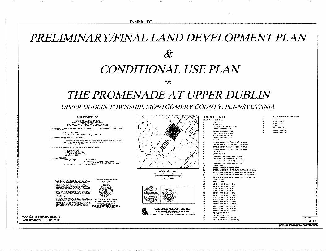
Exhibit "D"
NOT APPROVED FOR CONSTRUCTION
PRELIMTNARY/F1NAL LAND DEVELOPMENT PLAN
CONDITIONAL USE PLAN FOR
THE PROMENADE: AT UPPER DUBLTN UPPER DUBLIN TOWNSHIP, MONTGOMERY COUNTY, PENNSYLVANIA
PLAN SHEET INDEX 45 VEHICLE TURNING PLAN (FIRE MUCK)
MEET NO. MEET intE AC PLAN k PROTILE
COVER SIEET AT STORM PROFILES
2 RECORD PLAN STORM PROFILES
3 SITE SCNAGE AMMENITTES PLAN 413 STORM PROFILES
SIGNAGE e. STRIPING PLAN 50 STORM PROFILES
OVERALL DEVELOPMENT Puri 51 SANITARY PROFILES
EAST BUONO AREA PLANS 52 SANITARY PROFILES
O WEST BUILDING AREA PLANS
a EXISTING CONDITIONS PLAN
9 GRADING sc PM PLAN
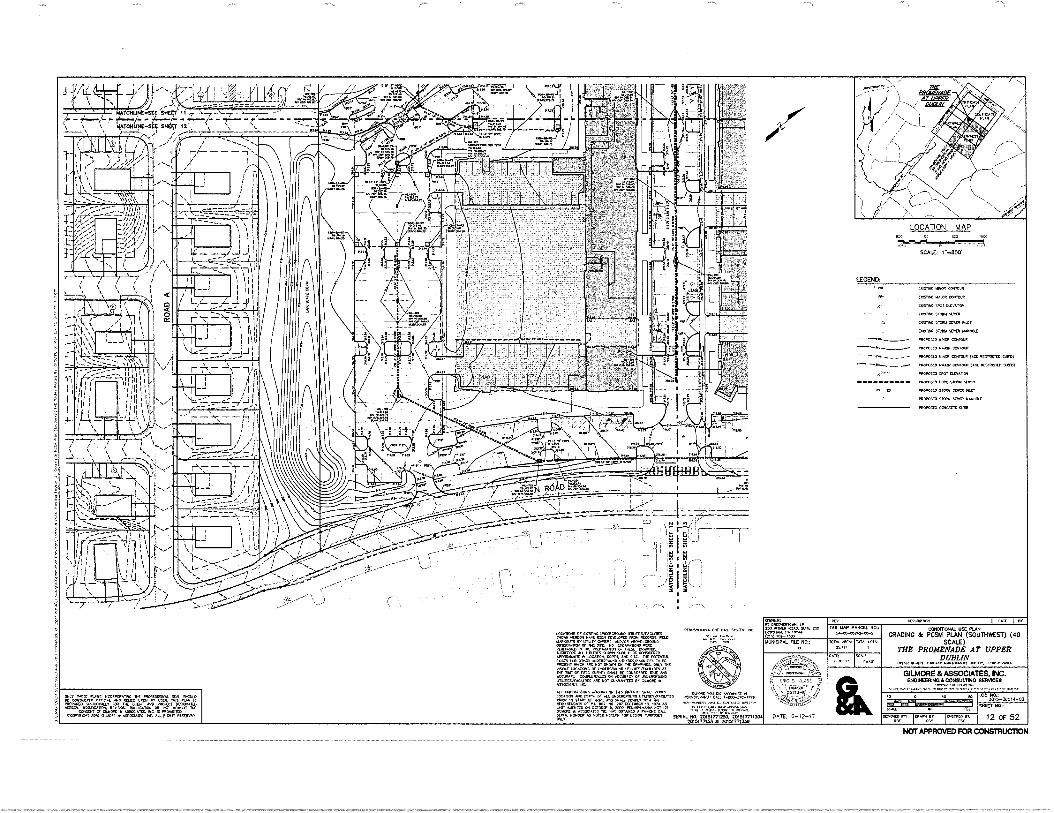
10 CRADNG & POSH PLAN (NORTHEAST) (40 SCALE)
TO GRADING & PCSA1 PLAN (NORTHWEST) (40 SCALE)
12 GRADING 6. PCS/.1 PLAN (SOuTHWEST) NI SCALE)
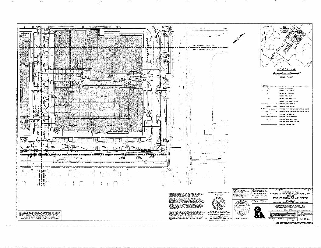
13 GRADING & PCSM PLAN (SOUTHEAST) (40 SCALE)
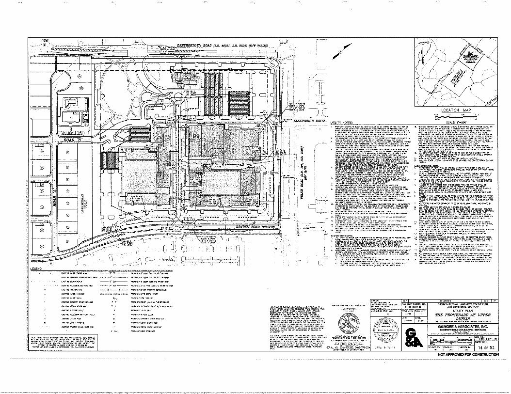
14 UTILITY PLAN
IS LANDSCAPE PLAN
16 LANDSCAPE PLAN (NORTHEAST) (40 54.01) LANDSCAPE PLAN (NORTHWEST) (40 SC.M.L1
111 LANDSCAPE PLAN (SOUTHWEST) OD 000I5) 19 LANDSCAPE PLAN (SOUTHEAST) (so moo° 20 LIGHTING PLAN Al CANNON & SEDIMENT CONTROL PLAN
22 EROSION A SEDIMENT CONTROL PLAN (NORTHEAST) (40 SCALE).
23 EROSION • SEDIMENT CONTROL PLAN (NORTHWEST) (40 SCALE)
24 EROSION le SEDIMENT CONTROL PLAN (SOUTHWEST) (40 SCALE)
25 EROSION Ae SEDIMENT CONTROL PLAN (SOUTHEAST) (AO SCALP
26 DETAILS - ERS
27 DETAILS - ERS
213 CONSTRUCTION [MAILS - STE
40 CONSTRUCTION DETAILS - SOB
30 CONSTRUCTION DETAILS - SOB
31 CONSTRUCTION DETAILS - STE
32 CONSTRUCTION DETAILS - Sit
33 CONSTRUCTION DETAILS - PCSI
34 CONSTRUCTION DETAILS -
33 CONSTRUCTION DETAILS - PCS.
36 CONSTRUCTION DETAILS - PC9.1
37 CONSTRUCITON DETAILS - PESO
OR CONSTRUCTON DETAILS - PESO
AC CONSTRUCTION DETAILS - PESO
40 CONSTRUCTION DETAILS - PESO
Al VEHICLE TURNING PLAN
VEHICLE TURNING PLAN
43 VEHICLE TURNING PLAN (FIRE TRUCK) EMT No,
04 walla. TURNING PLAN (FIRE 011.100) 1 OF 52
SITE INFORMATION
DISTRICT CLASSIFICATION( 'DC" — OFFICE CENTER DISTRICT
PROPOSED USE( MIXED USE DEVELOPMENT SUSECT TRACT MAY BE IDENTIFIED BY MONTGOMERY COUNTY TAR ASSESSMENT NfORMATON AS FOLLOW
UPPER DUBLIN TOWNSHIP TAO MAP 10144-00-00242-00-15 (PREWSES A)
2. RECORDED DEED DATA IS AS FOLLOWS,
AS RECORDED IN THE OFFICE FOR THE RECORDING OF DEEDS, ETC., IN AND FOR THE COUNTY OF MONTGOMERY AT NORRISTOWN, PA. IN PLAN BOON L-5. PACE 364
3. NAME AND ADDRESS OF THE OWNER OF THE SUBJECT TRACT:
AT ORESHERTOWN. LP Die BET INVESTMENTS. INC. 000 WIDER ROAD, SATE 200 HORSDAM, PA 10044
4, AEA SIMMS* CROSS LOT AREA - 75,411 ACRES
- 0.3411 ACRES (ULTIMATE RIONT-OF-YeAY)
NET DEVELOPABLE AREA 4.41}-02 (DRAWN ROAD SLAT-OF-HOE)
ANON AT 07500 .....gzwrgAr.,..0
ARADCCT otr TIP "gr.„%le=147 THEM DRANN40,
iNfrOTArr/7 foll.77448
r2,r411:4;"4YrrAy"p5 Aworyx-„Ju r.,
ASV LOCATORS Or*.OLAWIDIAD LYUICO/PCIAIIHAR AT
F-Ori„,74.4riai,tiarg riEr
PLAN DATE: February 10,2017 LAST REVISED: June 12, 2017
LOCATION MAP KO no WO .4.
SCALE.: r-800.
.; ..0
g
lik
GILMORE & ASSOCIATES, INC. ENGINEERING &CONMONO SERVICES
PONIVILIONIA OIC CALL MICA NC.
"°""Zgg'grg",,,IF417. FEZVZ.Vm. L Z,MO Mr& 01 ALL
. ADI
g.r1Cln ASSOD &MAL 1411911CN NOTCP RCA c..". NO. 201a1771253. 201617711304.
."."" 'M42015177133 k 20150771350
L=1
r L•n• VA.
•••••, DA. 60.7
532. tr. war• e.rwore mem
••• ...01) .0, Icor.. cow." It nt• axo worm 4/0/0
ft •Sainwrew 01I
fat OW • =Veit= a; re ••=.:1•11PaliniVirati="417:1=""44•11"44 tilt= •••'.
r. ••••• inam. ow,. www.•••• ww ••••••••
. rar..a"rerwert=
pore •Tr= Tree'. r•TrZT.I=L;Z:-..." .Tr e"=." = :VIVIVieIstre
• motr... • agatc.V44 wr.110:, 'ern, .•••106•11.••••••• •• MM. r- • LEGEN
L. D:
• mew... ft. al
ribranwPAMMILMILjeal• VT • OM
sum snt CALCULATORS:
BUIL 0014 /4 MARANO. COMA. TABU
LiZ":'44.11Wk ww• .0,4 rbar
WI TABLE
i•••• w
01•101014../.00.1. W10 C0.10•00011 •0AN MIS CC.40110,01. 000 Fun
RECORD PLAN THE PROMENADE AT UPPER
DUBLIN awrm row* •KWICOWOIT 0eurr, Pr•r1....rama
GILMORE ASSOCIATES, NC. IINOMERIP•311CONSULTING SERVICES
„
•
Dame isamW. oso lega
meto sv:
ss. I I
0
' OINERP1 MOM
• :7,...7";W:71 F ;.riE aaat.....•••=1••••:••%••.: 114
• Wr+74**17. 114:77:1;i7*ZUF'.4477".
• -
• ,WW•lie.W.••••••,10. AO II
MD. •••••••• RAW Wir Oft
1:7/0.471.: I
• AO .
..13•410r•
Mall•rw caw
-Tur law./
I I
3; s
•-••••••=--- _
1 a
1"4 c- 0 1. .1 01-
- L-4;Pi . __Ls)
Af7r7".7----'-ur74-•.--7 lj
IsTZ rsr • DRESHERTOWN ROAD (LA 4800I. RR 2024) (R/W VARIER)
uoileir:615.e.—TeEr-ee-my toe
.94.4w.eaw•-•• yOrsall,
00177,
!
• I
. W ••••••••• 1•111••••••
010.4.010 ma,
SCALE: r•sEce i ZONNELIAIL i ELECIRDNIC DRIVE 1•••• ...4•0••
••••• MK .9 . 001..•
Ii ! " I'M rjr‘nal il . ::Z ••••••=or=fs=1":,
.......••••••
• ..-r":75- - -=?..ra:11...
• :',.°77"...“ t.V.V",.:1"•..4.1%===.4.= .7; V=4.
1nrayL • 10.V.0 VIAMIC.U.1 ./0 NW, 000,4 1110.1CAT, KA. to.C11. OA •••tlf <C0,11=0,7=1.4."'TRTZ
LOCATION MAP se,
Salt NO • ••• 20151rn253, 201517711301 20, SI77103 N 2/4517713511
arvVID POI TO•M••• ••••111 LIR* blr0 VAPP4 21
NOTAPPROVED FOR CONSTRUCTION
INOINSIAINdeLl0011Z11
.41
LIST CC WAIVERfe
•
"" • '"`"""' ""'"'"`" 0.1•••••••••••••••••• • ••• • ft
001$110 0011115 TMILL
•••••••••••
=•'" tr=mo"...rw...r
174 •- ,
TZLITLT474="="4:
M"if2:1 •••••
•
L7--•- 3: "
"BMER,154:1.7.r.imma
"
••••110 NW MOM,
"'sr* itrafir 17.4
" irr.r=4 • ...MOW *NIP
owttIZZI rw=grg
Tri:ZZr rw.Far" rwoin
N.Vg 1...7kIgra arr. r
••••• ...,..••••••••••
VT. 1.01$ 100a AR. Ws.
0.00 2,10-
RAI 1,40
TIEP
lemen.•••L.A C. 11000..4
0[1.t WY MC •VVVWCIM •0011,..W• CA, 1-100-20.1118
100 MS PA•00. RCN • • re IRK,.
0:0 IAN PR 000
1110.10011. 01.1 MO,
Z411
•••• •••••
ill100•12.11L
Via •.• two• ea WI MEOW • ,••• ••• • ••••••• ••••••• •••• ado 6.....41.••••••••• NM. • 11.1,01•400 .4.1••• • •11, •
so—
wawa • 114 • ••••••••• ar IMP 0.1111 1••••• 4.0.• 1800•10. •••••=.01,..•• 11.4: g
=raw ing •••••••••••••Cra Pl.
10111112/41111111101•111 1/11
••••••• 0•01.
mom la IWO
K
1100.0Neeraffell•....120M10011
1000011L1T-21116 .0 *MS •• Mows • maaa ••• na at NON. a, •••••%.:, cu. wib •at
amst Wr.
11•-11011
aligna.Marali =A:Olt •••• Oa • 1•••••• =1....w.WW • us/ =ire "." lye WCOMONWIWt
WITIMIT"
1:470/1-
511r PARKING CALCILPIA 11 ONS4
M
4CR 111:L 20,R-0/014 -112
'au
2 OF 52
. : _: . ZWOZZ' I I
j
i 1,1Ms Ts
,/
,..0°..-.
e il
;•
364,2;
V •••
DRESIDIRTOWN ‘59_91. FO24) (R/W VAROSS) • _ _ • (Tr., • - .
_ Ol000110.
(
sr.(
8
• 4. . V. o. 311, L±LC
• ELECTRONIC DRIVE -2/
EMSF.-OACILOICEAL mows METRO ii0CP/7•41118E CAPACITY
0
I[FIifii!
To-A—D moat)
ler I i ij !
NOM, r • POMO • IOVsear
01••••••• Ain. MI MO -
KIMPILINC AN NOV
.• • 0 • ' 01,11 la :V t1 c'S 5\ U!..a....1,U1 Ari: TT 1J
.11
SGNAGE NOTES: 1•0 MM. LeM000 awas rat • fa./ • •••• SiS LLK 000 Ls
(00.0 Lai I• N moo
a• KM. •••• L• NO Mar rEti •••••41._
P SONS 00•09 0 Magee •• .0 maga MP 1.4.14Ano. 111.0
LEGEND: a& KKK MY
▪ KNOLL KA•40
• MAK odui•eos • Lail SINOOK
say Nole 44n •40•••••mc sg SLL& xx !Kw wawa an.. ,se ...we
ingPM:19 .10100.. K OAS , al FMK, Ci(.0. 100. .010,0 KAY OulL.1.0211 usr 01.
(00041 0 0004 • 04.20“. LLLIMISIK tallalOO m.s. mow • •1500•70. /11015 RM.
,, L
rfr'SKO•
[MGM. MONLORILSCILDETAI rocaLen.FiLst.., C:7AL
0.(20.1. 10.0 (Wain :No DLL. (0.1 la. MO 0,0
0400•114 0411
TAX TOP PAACCI. 004 0-0000(.00S
INKLIKLIMVPINAL. 002001100 PUN MO 00031.01. USO RAN
STE SONAGE & AlAkIENITIES PLAN
ME PROMENADE AT UPPER DUBLIN
wns Wan isor0• .00.001. elase0 00001000
30.11
LI 20,5-01014-02
STCCT *R. 3 OF 52
Nor mom, rtreirgfe (0000 OM, DARD ham, 21. 07
PINNSokrm.
...
SOU& NO. 00131771257. 201517711305 701917715.1 A 10 0,77,7..
OKSMOOlna LIL SO N.( 00t. KM AO LaKaili 1100 001 00. L. NIA•CP/4. PILL NO,
r; A0cot
DATE: 6-12-17
GIUAORE & ASSOCIATES. INC. mospozwoloacoNeuLDNO 6E1PACes
VOL WO. ,LOR
.1-40L/
KOOK, V• 0••••• 03.4oull SI 00 I LK
'OCAL.17REC.120.7&_9 SN.DETNL
NOT APPROVED FOR CONSTRUCTION
LOCATION MAP
SC.7L I. 600
r
, ....rT•r7:1-1,.-..ri:-.rrr 1.1..-9
i.... .0- 1 i jöc
10101J2F-leo. ANOVA• LATITUDE 6' CONTOUR BENCH 11114 mows
imam RECCPTACI r 0,-An
ANOVAID LAPTUCC 40 CALLON RECCOTACLC
LOCATION MAP
SCALE 1'.1100*
- TT
3.9 an• Na
I • 4
.014 I-
0600400 •
! cto•ri:
• a... Ora wafts •101, 44•404 0001. .41
.▪ 4
00......006600-90016
X .7_7 Palag.616 Mar EN1ER SIGN nts-il
T 7 - 16-rat
kil-firesiz witait
mot Ent 1200 •
9
_ DREFERTORN ROAD (14. tea% 1'4 Pito Ara rAigg0 .. -}jj
ELECTRONIC DRIVE _
on-.;sx•- 3-2*
woor•
OOP •Ic pew 6.9 004100400 0064•60 10000010
RTrIP SIGN (RI WICIPu
DO NOT _
ENTER 6
won As ann. man (WY mnretafam cam
oto.or • o 1 o , o , (To 1-0-ro 1 • 1.....0.....! vr,, ;Az -,gtir.1.1i,r.IA ZIA :, 4.1.4 I A Itr-A ...., - oo , .. . oo roo oo , m a 0 1 i• I 0 i 040•0
ma ao Noo , an . ro , awn 040n 0101400 , OS, ON WI 09
ri-rird A 74!:rxi..2,42:g14.14,1:-.7 ND La-FT TURN MCA ER3-91
U •-•••1.
0. • C ,c1) 0.1•:;11 .,r) • I I! :••1- • 0
• . • •S\ CI I
• .244. OM. 644•••••oz 600.60102 2424 1.1.40 ▪ aNYOUNN araft MO MAO •• LIO •1.111 •800040 4440106•1 awa roo4C, Moo. .42006 6•0024104 444.42 Yowl. 6. 0:2 6400 94
0000 0 0036 • 00.00 roc s moorto. 40•000 42006. • •9501046 04013 0400000
&F_SERVED PARKING PENAL:RFS SIGN (R7-RFI ftei foa,
CUM_ 00.02 • rms. 0010104.10 •IpiCa.40. re9 0004246X19
-1,7141-Cr-o ii--sotVar lorrox ! a -10 arr4. w. .00 , In 0.04
or t coa
1,0*- a 1 -16 laNZIN
lan WNW
V1,414 Acei4siki
• ele• 04.004•••• 444•004040.11 onomoomonam 60101206000 00100•10,0 00010,00
•1411
RAW=
010
01.0.0•121 .0 .11 •02004
II015 • •• MVO 10 Pat 42 2, ar am liAblgrd1PPCD PARKINC Rlf&I El FVATRIN roFTAII
SC.
PKVOCKI. 102•00.00•• Pe 462 0.004 111,11.1. ROC. 2.1‘ ,e0
r• .1=14,,•40 1.11007VALPLC no:
a
40.0,00•2. 4,22 itro-20-026
an. N0. 10T51771203.2015177(130 20,51771}.)ft 2.51771.15a
6ATL 6-12-'7
• rooTcS. mow tom. YOZO YAM, 200 I aaa,, t rio MP $W$T TW. .1113 1.001 Ti ST I4,0,, a.
0,11 TAX id422 PM.. N. INEDIANANYMNa LANO CEVELOONIDa
MO CafONCeal. Int PLAN SIGNAGE & STRIPING PLAN
THE PROMENADE AT UPPER DUBLIN
VOIR 11,1P1 ,C.41,•COOLO•11,V IV.V.V••••
GIUAORE & ASSOCIATES, INC. ENCIINCalaNO /CONSULT/4a SEMMES
.01 al: 20,5-0040-02
OW Ku
4 OF 52
,atoolgamo zoo, Azzorj.oraso
VAN ACCESSIBLE SIGN (R7-881
20000e1 0•• 424 o c • 2 • .1 • • s • •00711.0, Va.
• 6ast 00•:10, - 660 0404 0
PARKING SIGN (R7-Sl
AN..55771-(1
20,6. Ma& 2201
Se.
.901:015.
eLoagtria Von:: ror
.a.
NOT APPROVED FOR CONSTRUCTION
.-7.- ..r.r.,....er!--
.-r-
.•• ,„___ lii;,
-27FTrnilmr_
ri , I 1 ; °MINH li.L. A IC{
. . .
OLNXII. MI 1004W 440•4044 04W 441.01 21 .0311. 4/42,4
/1.3•07 112.100 •01 10.440•14 .400140 0 rm. D.ru, 0401. 11. 007
VAI• QC C 02,420
0410a vex r42 PP•4011 •11441,040 2.0.4 1-100-1•42-1•••
=UM1. NO. 217.11.5ii:7431."201S1711130. 21:AM,716, 20161771760
0•42/1 21.20.40.0 • 011.• 10.2. 04 X 140
P• 0M-7,00
111,4121. AL
DATE: 6-12-17
04X
00.1/1000/0•1•1 umo 01061610.1 PIM APO C610706AS. Mt PLO
OVERALL DEVELOPMENT PLAN THE PROMENADE AT UPPER
DUBLIN WIT 040,4 40440.0 V1011.4111, OINDITAVAMA
GILMORE & ASSOCIATES, INC. 1663110181610 CONSULTNO 66116106
ra4-06s,.-.17
020001 IA t--15 10.2209 P. 412 GP I Pt
0010 w.„2. 14.1222
IM Ste 00,00. 0. 60.00.40242-00-5
IOW 4.001 100.4 ANA P1.•44
SCOT oao.,
5 OF 52
NOT APPROVED FOR CONSTRUCTION
L WNW WW 114•0 1.1•1 fat 0 •••• 0114.14 or tow 211120. 4100•• e• WOW. 1044•0420•4 12044.0•• •• WNW@ un • 45 GOMM • 104 WSW ••••11 L • • P. 'OWN •• NNW MEW+ 06 SAW. 0.14040 ••••••• 0004. NO WO ORIN W UM •
•••••• 0' WWI" NOM. WOO WOL •••• IL OW W. 01 110••••• 14040 • WO 01* POD ••••• 10•11•11111.0 wax ••••••00L NC MI Li SY W. 10 %WOW ••••••••• POW
• ww •••••• 40 Mt te•••••• ••••••WW04•4001111.01 ••••••••••• •01•1•411, • 44P .2110104, WNW. PPP • NW 411 PM WS 401•4002 PM moms mum WWII. WOOD 110 IS
• 4411•00 40[ 01••••0 ••••••••••• 010. 10 WOO WOL 4•4442. SIM W 0040 WWI • •••••1011. 011 • Wet W. WWI 102 0410•0101 00 W. 141WP WOW
• Int WOW MI 00100401111•1•00•••••X 102.4 4102 WM 10000•010 MS Y004 •• ORM @WM WV NOR 411100 MEMO 142 Si WW1 WOW. 44 WPC ••••• •••• MOWN Al••••••• NW.. W 1104 WM.& 01101•1111101 VIROOMOIND • U1000 OM 01 so ••••01. OW 40•21.10004••• 40110•04. 1411000••0001 W •• Xi 011W111444 00•00 1•112 40 WW1 WNW= 04 4011WWWWWW0 1010.404011 02 W WYNN V* 04012 • WWI=
• WM 01 10 001141 4114.0 NOW W WWI W 02111111040 1112000/00•10 •••• 1K UPI V 1411. 004 MOP 111. 004.4•10 • N. •• WI WINO 1••• tal •0•10
01 WOW L 01100•04 0•01t • 0106•12L EC W 4010010 WWI W. 1001. WWI 0100101.041/02014 211001011 011100•• W144 0.0010 011101100 011•1•5 ••••••••4 WON 001414 sit 0 lawman. ea • . •••• 0.141. WO MONO n aps Scan WWI 10010nsa 4000/101100111140102 OP 4010 4.114.900. MOW NW 10•011
• , 24:21111Z" ; "" "" 2•07VP•
• . • .
/0-00oNNUNI WO N. NUNN
'MONOTONY /0 0 11•0
surasmaya_aw sa. f /4 as saw ova saw_ ....
OP MI NO NO.I.ett
LOCATION MAP
SCALE: 1.6600.
S.
• „,. • •
0 A 0 11 • IF ! .0 !I I!. 0
.
p 2 • 2.. kAL-1,111: r13
\\:
----TT- =
• •
GENERAL NOM&
10.40.12 .1043 .00402w200 art warm., /0/1. 00.40
=1.0 20/200.4. 01.".1014
C1404•4• n3 4 STH. SC MS rwri 01WW1
BERNARDON
r64444644 64.6, n mons ANAL 1.044 649
p. >Is MR 040)
674.141 ,415 FaligiNA.Ints VdrinOwn. 0044o.
PROMENADE ATUPPFR DUBLIN Upper Doblia Towiehlp. PA
Our.
BET lovesIniesbi, 180. 200 Wilmer Road Salle 20 Harahan% PA 19144
Itnishollosn
Drsw0 EMS
R460, cal. 345M
COMO: WCLIVICEY. AIA *1.464 444040,1 M54.00.16
Sheri TINN
EAST BUILDING AREA PLANS
ARK 317NAIren
6 OF 52
c Na4.460.07
NOTPPFFIOVEDPOR commucnow
81,948 SF rd RESIDENTIAL 81.225 SF Ej RESIDENTIAL
81,947 SF
81.947 SF
TOTAL FLOOR AREA
RESIDENTIAL 7.570 St ;700 SF
7.S7SSF 200 SF
GROSS SUILDR7C AREA 24807560 459.76867
RESEENTIAL 31160111 SF 53004035
RETAIL 20.664 SF 107 OFA SF
OFFICE 2.1394 SF
MISCELLANEOUS 7.123 SF 3 407 SE BUILEMIG SERVICES
TOTAL % OF TOTAL 08033 BUILDS.° AREA
(s,...EA,,
ST BUILDING - FIFTH FLOOR AREA PLAN , EAST BUILDING- SECOND FLOOR AREA PLAN 2 , . . • - •-- -
EAST BUILDING - FIRST FLOOR AREA PLAN 1 ! EAST BUILDING - FOURTH FLOOR AREA PLAN k 4 -
wan DUELD010 EAST BUILDING NISI AUR ANT COFFEE SHOP
71342135F 103%
55469, SE 777'4
•36.4118 SF 19 I%
2 094 SF 0.3%
20 530 Sr 297.
EAST BUILDING • THIRD FLOOR AREA PLAN 6744*
1
TOTAL FLOOR AREA
n RESIDENTIAL
81.931 SF
81,931 SF
. li
31 g it"
I I : .1!
1111,11 tilisiorsisrimsgPlia
bid Imo
TOTAL FLOOR AREA 81,948 SF TOTAL FLOOR AREA 81,225 SF
TOTAL FLOOR AREA 132.117 SF
MISCELLANEOUS 13,407 SF BUILDING SERVICES
1!
H
RESIDENTIAL
RETAIL
OFFICE
9,552 SF
107,064 SF
2.094 SF
ow, OW,
r-r7 RESIDENTIAL 4,456 SF
RETAIL 20,664 SF
MISCELLANEOUS 7,123 SF BUILDING SERVICES
BERNARDON
01,2 Prmsylva...3 1.10F
I. MO. 40.) •
1.01....1,10...
•nowInnonlem.010
Itmlau
PI/OMENADEATUPINOt DUBLIN Upper Dublin Township. PA
Otoom
HET I nvestmtots. Inc. ZOO Witmer Rand State 280 lienhank PA 191144
Dnon WAS Rnissal. MSM Comet PASLOSKEY. AIA PnOo Maim DOI00'16
Sh. Mir
WEST BUILDING AREA PLANS
Shwa %maw:
7 OF 52
NW APPROVED FOR CONSTRUCTION
ELI RESIDENTIAL 59.098 SF
TOTAL FLOOR AREA 59,098 SF
EL] RESIDENTIAL 41.925 SF
TOTAL FLOOR AREA 41,925 SF
WEST BUILDING - FIFTH FLOOR AREA PLAN (--\ WEST BUILDING - SECOND FLOOR AREA PLAN
WEST BUILDING - FOURTH FLOOR AREA PLAN •
11 WEST SUILDINg - FIRST FLOOR AREA PLAN
TOTAL FLOOR AREA 59,098 SF WEST GUILIANO OAT REEDING MISTAURANT COPSE SNOB
Fri RESIDENTIAL 59,098 SF GROSS WILMS AREA 245AIS SF GRIM IF 73701F L2018F 713.013 SF IGO
RESICENTIAL RISABSSR SWAN SIF SKR, SE 77.7%
RETAIL 23 6E4 SF 107M1411F TAN e, IBM BF MAN SF 10 1%
OFFICE 2.001 Er 2.09. SF OD%
MISCELLAKOLIS 7 23 Sr I7.40711F 3%630SF ON BUILDING SERVICES
'
% Of TOTAL GROOS TOTAL NUILGING ANL%
• WEST BUILDING - THIRD FLOOR AREA PLAN
TOTAL FLOOR AREA 32,243 SF TOTAL FLOOR AREA 53.511 SF
RESIDENTIAL 53.511 SF
„ •
RaEr• 4p94. 11.A SOU Me! ir.41110 - •
TiT
; \
• , , ) • \
..4••••
0:01.0.1.00 Pak/
D3S1ING FEATURES NOTES,
...... • ••• .•.
-).<• 4,0W-M
41" J!.."="A • j vem,""rirglat•
DRrsz :•=013,1='•'="4,:r•al'4.' -
7 - a H•tC. 010.1..0 NA 00 .5 WAK.4,11. P01110.5 ! M.. 1.51 ME10.1100 0010.11 10 NC 1011410.../1411.
k 1 • 001. 1051:0 11. 1103 Slart RM. 050110•50C •
101.3r7•0•5011011 .40. Mai MA-WI W.. ICC P...•[.
S.S. ars "•••••.• •••
..
•••••.„
¼Y .
..
i
'• \ \.V/
) •11./ i ..... ...."... ! ... ...• • 1 ,z, .
......, ......-- 4..
\ ,,,, / ---
r-----.... ••., , ___,.,,, 4`..o-"•U00
..• C 7=7 = Al...44711 ma Kt. 01.500110 . tat 04 • VA. NW. •CCosso rms • • • C.
C0131.011.1111140411.411 0.01101.1 0-11MI • mcmacrts.... MY 0•10•294, CCOMO 1110 1104 KA. WAIL NM PC MONO
PROM. /05110 5.0.917.1 5.005 .6010 01000. OA= 0 ALL 001.40010.1.00104•05 ANO 101.0. 411/0.10.5 404.1 At 004.1110t •10 11. Mr. 011,1 1•016.• .0.0•40 .0 C0151.0,0111.04.1 ....0.10.1.0000.0. 010,00, L., 16000 001.1 R .1 WC 1010 ham von.. mccomMo. LNG 0.171.090,14 0101.115 100.0 0040 •0•001 MY ..ocr CCM. /09 PA•VCC NICK AP15.4.1.- 1. 00, C0.01.040 1.100.011M 0111110(1,40 MALL 11151 .04 1140.4. 4501111 11. 10.1.11.0•5005 1100,00•4. ISC 400
4410.111.1 NOW. ON Dm PreAcs ma, Pi MM.. 1130 V.A. 114 a, 00.1•000 110.0 10 11.1.0201 /140411:0 .0110.10t 1014 ALL MR.. DMA 1000.41410L
1.4.0 ....1•00.1100.01
1111.1 r.O. MK ..11. W. 1510 Wet.. MO 5 pyr c.a., 0002.0 REMO. 1100 1014001. J11.111 PROM •••3/71 1•01. 44.4140 40 Os 001011 0 Or 11. PA COM
1001.0 1C1r0/11170.44.0:14CV:AVN .90''7.1‘1..tiO°N911r" 911I C0111..114 41.1. at 110.4151.3 01401•00110 CC 41 1541111,.....15 401 151.17141.00,1
,4 1.1,011 10 NOM.
rc. cw,c, m '2. 411 .0 P15C0009 01 • 0,AL/1CD 03.501. C000.5111 C.0.00119 11. 00.1145 COMVIICS: 04.40, Or •00901.0, 010 ALL MK.. =AL VAIL ft< ArcAm acts 010 u.L.9•0•0 'ArL " .100•125
TAO 0T
a. .1.11,41 5 ....11,14•1..
0. 44111C,3 040
.7,0= OCIAPT
.5.1:41. 9C •00•CO
SOILS LEGEND ABS TABLE OF UMITATIONS BASED ON NRCS WEB
_ ,_SOIL_SURXEY_FOLL KourcomERysoptcry.. PkiksnmANIA tam.. AA
ma- COATMATC•Ou MICAMIlm :IMAMS
000.1 .01100 e.s• 3 i m 1••• 41.4.4•01411.•
7•04 4110AIL 10 • 01.
415. elm... NNW coluaL trt
tAWMaYuL 41.1 Mil 0 701
DO
.1•1427' Sr'
; =V.
Apg.•••,2r,
•/...1.1
01 11./1
1.... LeA
:Pie •••/CP 4•541...•••
, paw • ••• 41.1114
....
101MM
c-ca
1•411
090
Uwe
.,,•...„... • • ir) 14; ,_77::r,r_-....H.,...7;...4
._tL..,,. :,;:ftt,..,,,,,,
ti•ii.,
14,5,...
,?...;;It: _,1-
,...--
: , . _
,....,..,_.....„.„
,..5,705,,...; • .::::,...t.,417-7.-../.V:-/J t. 'f•-dr;
••-.3rl••--:-.7y4ii:6';;'"-.';;,',-: 4;-•Lftr:r,,z:.-.:•zz::).. • • ..q. • • •••,,
. .,,,,,:• ..,
1Vret•Vi,^9- .1'1'1 _.. ... ,........ , ....,,' - s... ---,9,--i-r--. 9r•-4.. ,•••01,. cr7 . , i I t.) -
,,i.„-„,..„. '
•Lio !„-f1J.17[..i• b. "S
41: •IC:Z.•
V F , i ? ';:-., • , ...!---• , . ....:,ilir 1.; O., .•1_ ,I ...t i 1. • , ., . •I • .. 2. ....,...---• ,, .. .,. i :.... Lc.,___-.‘ivi A _-. .. .,,.. •,,,t., !• -, n n! : it ,--.. cro-..lori - ' '',.....,$) ; ,...i
LEott:i6
mows. com CsAL 11,10.1.
0.:011.1101 I .1t I trf
indaDromorfirod. LOOT OCNUOINENT PLAN 0)0 CfM011(MML 000 PLAN
EXISTING CCNOIDONS PLAN
THE PROMENADE AT UPPER DUBLIN won. 10•Kmi• 000•1,...100, P.05•1.V.0
GILMORE & ASSOCIATES, INC. DIONWINCISCONSULINO eimicee
_
.114.11.01110 4•0•40,
MAC 103.
IM14.3 =Cm,:
0.00 Cr..
4121 415 140.1. MK. 00 .300011.)
AMCA POWAMPSMOIM. ,<ILICMCM. rAtj-124.,h-V41-1-7•41r7mIgriK !
411.11.0* .0.5. 0.51 • 46 RCN VV. Min
ps mm.r. arm-: A4AXT0CA M •••••.4..MTCKAC MA.C.
CmAtsm.MMILi_e_memtist,T,CAPC:PCCPC__ C0M111.• .PCM •91_.+PM4M.P.MOR
ppm
•Osmicomm. CAL: 1-60-142-140 .00 ND.: 20,5-06014-32
tDc•IMe. .04MMO 1:1~NosIts mom Num gme caw occacom tow NOD 11.40.105 M. 0000 Mt. 411000004110 01,010110 ste ImC se, pc•PAIRIM 1•4•00.0 011.1.11.11. 00, 110.100 10•1110. ALL .1115 5•011. RC CORM.
r• MM. AY sac. 14 ;•• 01.r
.
V4.1V00.1110: 1.101014414
.00.!CM.0.1.1141.55 01 mam.c. w umuccoac w-cmccmcoLocc ro. rc Wen • mcomMli
.A431 MO MM. re ALI mcCemmea MM. MM. Or .6011 00 MAU C.R. 014 14C KOMILVOMS PL K.; Po 211 L1.0.1401 10. 04 M U.:1 WO.. 01 =ROM 9..00 110•010.• 0, 51
" CORAL NW.. 10TC CMOs me cc. "cc. so. TO. VISIT/12SX 201517711304
201507,53 A 07:5,70)50
mom, puma.. CAW", Mu • T. M.." r• um,WInececcase NnomiCoMINNM " cmccM!..f.m. coM".1.comot MOmm ocm:C" .or am Emma www Welk. Atm am cam. .0.1.01104 TOT CA10.110100. OX 54.0 9•9•320,CM
CEO) No.: "CAC
8 OF 52 oolozom rev: lomocrof.
OCATION MAP KO 14 t, 000
SCALE I --ate
scALC• 0•10
(WE. 6-12-17
0000 tr moon.. L• CCO .111.0 9.0. ....11• 1.111•0° ,25.1 00- 1300
.y I TAX SM. Pomal. NO.:
Tm-co-Onsc-co,
111.110:11.4. niZ 144 AK. "IT. Lon.
- -
_ • , • _ • - . • - . • _ _ •
1111•15131150 151.
C0.4115 0010,10111
0134/0 COST. 0.450
CPS?. PmcP0mc smC • •01.. 0.1.1•17
SO5 44t • M.A.
111000 CM 10 CC .00., 40144 TM 10 .10•1
003C RN. 4441•00.1V. KOMPS•Mi. PC. Ws., IC COMM, 0010. •CKO 10.1 .1 109 •.• r) P11.54.0 ./MI .0 00.1 pC:smATID
14.111C•td. 0440 901.0.0 On LPL 1.00.5 C0.1911 0$ 010.4. • 455000.1110.1. 14.411013.
:1519 Ata0.146. MC 41 RIMS 1CM1410
NOT APPROVED FOR CONSTRUCTION
NOT APPROVED FOR CONSMUCRON
tfteuss• I WI I., •Ar I 0110100 Er 5.0.10.0•11.
• 511.0 oN.O. SOC1 ;OM 11.760.*"
UM 44 'MCC/ NW LVSET. • .001610••• O. 041 :WOO AC
R15•5 0.5 •005 35•11
5400005504(1 010.:
to0.1 110 ro A.Moton • M.-16.0. CAA 40,2•2 -OW
9090 91 10.5.1
tfls
111161.11066611111161. WOO 000.61610.151.6/1 IMO 1:0167110166. US PIM
GRADING & PCSIA PLAN THE PROMENADE AT UPPER
DUBLIN .1•10 110.0. 91.611.01.0. 0.1111.10061\WIL\
GILMORE & ASSOCIATES. INC. 11110011111111106120141.11.7610 61717161211
AO NM 7016-08010-07
00*990.
9 OF 52
t0.10•11 Or OM. 000.10.0 LOMOYZ.A.Or
00014.601 MAW WM 11.14090 M. ...IS Sr Vt. MOM ODRA AllOR.M.10 *MCVAY* Cr 'X wIL . tscArontart RS HAIOnl.O so INC PTO.. ,CA tolek 012.1105.
065 rtro or, soStInAisA0 .••SICZYJS SO AS 1,..1. ootog AR 1101 .0... eWm 1. oor4 LC... Cr 6.0•0500 67011CMALILO. A, n6 AK or roc 9.1.115 510al le .0.0(Kle AOC.. COOLLIOCO . ACOA010 OR 1.(.10.0
WS WI 0? 00400= Or COMO. 0
AL1 ccoo.Ofrin Mc lor. 9191.rurs
.A=
m,
Cr vOtter0•••• PGMAGAG cr PP. ICC AG ST m544CA-PAPPAS .51 00.0 Om 07.59 A. KM • ACI Or 10. M.. W 5090095 r. 900 0.0000 09, CC. 101,0200. aorolnhl3o.
701 917413 is 705177,41
Oat
LOCATION MAP SOO
GRADING & DRAINAGE NOTES: SCALE 1'.800e
no:=7,New'44.1Tre'It%.1:4!,12.-ZS • 411.0 AS :V Ars my. Ma A moo 0015. Arrow •,•• A C NJ; AO 110101.591 MO SOHN 00.51.
Commo
MC 40•0•IM •S .0•06 •S ULM fl• • COO Moo. /COM. 00•09C • •10000113. MI 011. •••• •C MCKIM 006.0001
• AOKI. DOW re M00 N MS 4340.00 AG 4415 •06000 MOM WO COOPMACOS 154.0540 M1C A4.1011 .9.0•174 •Ar. 6 14.0 CO. IMO 546 90000.1{ 905.1 r0.6.0 . Mot 1. 0.00.410•4 3141314433 I. 1400015
• K.. 4.4 14.04•30 14 04449 COX U.C. Iwo orcKS 0.MAL rst .00 00 MO o0.100 am ...A • myyrao, •6 wo o COM
S. U. Wawa. 1.• Fs. 0121.916, WO WA faisS• Or .41909.
IL MY 1.1.1.0 UAW.. 1.1.1.000116 u•or 144tors r•u• K.*, •••••:•,, um, ere, •40,90, utnt 0040 OireAv•10. or n• Mum,. 01059.t. ALL 9-50. Yea% SoLO. C060.10 ••••0006 L00•05 00. NO SR 1511000 Re OVA LocC.01040 90.919,000110 WIC WOW .01 MA OM MOM . 0.1.5 .• NALL LCOWOrs co 1.001344401.4.414.0.44 At Ite VC s< r4.3 to, SWAM OW AMA 044.1.4.3.4 •ca.k•cr .444.curs .41000•4043 oases 0,44.013 AG 0.341. • 440:3•42 get 5 000.0 me NOW 906 aoy .0.9551r RAA ..1.00011:0 1111. .1910
,0510410%.1,
A• CY 1•00=10 0.19. Maroc.
IL NO 6.1.0. Watt Mu trrIt Ot•4 .1 et 0.0 o011 C1061111610. CCWOCAPON 0...43 • Ai... o.
• 00•M•CONI MALOR.COVI. AVOWS AmO .161:0 Orni16.05 itt sr 40030/84r 4[1.1413t 044 Pon* a.m., up 14frautnei 04•040t. 41040., W70 urusr ..17 4,44 430Ote VL urn, 0.0 TOASCAG MOA.AM AS Laws
3004.4. nuosi row •s•500220 •••-uts grOt 0.3.44a. ea. 0, OW1.4.4 Ael•Arra•01. er.3 . cow.. ro..141. Ca 55 0.W 0•441.4 •11•430.1ASK . • t‘s
▪ •4 44344141•tems 4.ct 0.0.o. OA S.A. COltr:11411
..10
e•ICA 10.10 10 115
..11=4,111,or=
OAVOCW.00 5.90005 IS, on' AstAl 4,134/14.4.06 *5 PP Dar.t ma. nas APT IR
Wirt VO MOM 1.05•1101. ••r• Cr MVO AR or .LL9.4 Mr MOW. yr MOOED OM .1.5 TM% 1.5.4.5090 MOL. • ormy.5.0 Or Mr OM MY, moo., 10 :COON AM Cr 116 609 .101 We 4404 Ara....r. mu, Or OStuto sr CallAVsc s• (0. 0.101006, 11001(0. ao.. my aro: or misir es,: or OM..
04 MC 0507. ... rum mAS MIA Le. LO Derr OA 90000.1 06.45 C0.06... WOL• com 004. O.. WOW •0060 015009- Alm•060 ro MM.. DOW.
IS 1100.00A Somm 1St MOO. 0160 WA.. 1.14044 kusts • 440A•ar UM.? 454 90 . 1.05.50.69. or05.919 AMU .010 /11., 10.117 C.1.70al cat ;woo. woo rim moo or Ty ...Fen tad MO .41 C0160.1 WM. lop AM 107000 0100006.11 •00.1 •6115.0.
• 501 011 040.11*(0 1.1% Mk..., MAL, orr. c•
roOlKolg,,
Of. rao. M.O. OR ...• acme.
N•717r4: :Au: • ae MSC or no. Nyillart. 11006 Soh col O 1-7. OR.509:491 9060.611.9 ono Coo
••• w".r. "mom ssiks 114 50•403 ,o • wear Km,. - rrac• IS S•444•3
worm Co CORT.Cr OF MOW 09 $1.15 UM 6 P901165.0 .040. 171.1 Coo My 1.9.4090ALL•530:010 •ro =MN NAM 010. NI. :IX. 1404 CO 01042.""01 Arn.o'.0•71•010. " 1.10 ACCOW.C4 Wal t• 4i1S 1.001.06 1604.06. AW/011 Aorr WOntroa LOOM. MIX TIVO.4 111.50.45 WALL. 10500. MOD ....
x)0A
um11•619 .17.0 200 er Mon.
evorto OR MCA.. AT I ie tow. roc .m.0 tow. 10 moor 01mAy.
Cr 0.05 01 WALLA,. Or .11090010. SonLe.... MM. MC N. Or SM. Mo..
te. Statom. 1.1.4.11VO 00 olocrw. MOO . 0.00 A. orSeVaC Wier. C0050.1. -A-
O 0.01 •05. num, swam= 15-oe 4. MM. flto. OWN WO 500 To( .05 ••rs Klan 004 05116.0 M. COMA. MAW. PGA, OCAS ON= AS
LA V.,!,4,...549404 WALL el L.1104..,15 MK mu
•Li.../4 sna.41,04 ;Au ma. 3, Au 00•00611.100 SAWA S.Om 01•1400. .0020511.
.010 0.064 AOC,. CY ny • 00.7 Aryozotr.amg.t..0.1AM
Cue. OW W WO. AAC If .01.. PIIIMINTO so •60.0.2 my Om.. nom Pogo • il.11.111/30•041 PI I,. CV L.. OM& mus..• re 906Y1 now., ran 1.001.2 1.1.123 . Zo.dgt %A
.LI 1.4.,
01.4.43.70.
49.411.
111(5107CC 0 gt", 41.1r. k"•=7111;.....Ot° IS r•I"' 000" . 'Von, loft 1.05509 COMIC. .5•10•121 11011. •0011.0. MOV1110 Ow.
CA- 50 09519405 SAGA foOl 00 40* LAWIIR - AGAG79PA NO
• 9.0 44.4 Pa AG 4.014 4•53 St • (Ws. 109 9909997' owl • .1 510.1140 99 ADO ROW 010011101 ft. 90. • 1..0 Or $ 0,
1010 .15 NU 11i 005 0/1.130 WAD 0404 110„00 . 51.0 51<••••0115 2.01•1 01 05•10 010.100 VW 50 11.455.1
LEGO* .10104
14.otOOLCOOSI MITOR- ms.
Or Wm. RM. I -
0.05 LIAM C0410. Af• 01190 11.60A .100,
MOM WS , =ASS.
rot,. MOON VACS
06.0 Woo 1960 0.1 MO. MO. OOP ..014 m5.610 C.V.
com. COYDO ootrOZI, saCrE CarbrOgo OW 16010-60
•••••••• •Oas•JISO WOO. COMO OR et095110 SOO: Aeceowto ntutroo oiC•OSO Woot MOM 10411
. O-1.• NW . 0.60 MO. RAO .0.01.
0.4 RA. .0.051.0 le PO7r390101 101. 0040 0.10060 CYO. MO MOO LS. 11, 0101 ore 11. .9090 .1196.411 .0 MORO 090.90 Oloroo. PC.0.1. M.O. CO tedr comm.. or
0.0.1 Cr WOW • .400114 . 5 150.612. COMO./ MS 0006 AWOCCIA.. ALL 006 WOO.
6 o V — 0
•O' e
C E
; 11
E5555,
0111i EtttEi
\I"
•11//
.1 ,
a a
a
s
a
a.
•
... •
n • ..4..e-Inmirsg.g.
--.....-
Oet We rate) Nee, Mae • 1•4.0 I I ee: .
-
*Nkomo ..O.NMOIRoN
- _
TAx MAP ARCEL NO., 54-0E-OESEE-00-5
OHNE.
grO'?';',41.197t.'LlE SOO TIOPParE. PE IRE. (HT) RTH-THTO
11 OF 52 oesolgre, IDRADV:. ICMCCIM
.DY:
-.arm
:
LEGEND:
MS= MAJOR COMA
CIOSIND HEOT DISVAPRO
COMO STOVE
=TM STDMIR SOILIt
1.191114 VORIS Oa WOOL
MOM= EriNOR =MO
19019111 INJOrt ONION
MM. kmai COMA 4001 ROPOORD SOO
MOM ,N.NR COMM OM KOK= ION)
NOON. SPOT UM*.
POOPOSED ECM WOW 5001
14101010 SONO SOO otr
RCM= SION snot Lam.,
POMO OCNOVOC COO
, ?.) ,
- - 7— — 777 \ \ 10704116,1E-69 smicT 12 ,
MIRMAI
NOON.NNA OK OM SOON
SERIAL NO. 2015177125.0. 201517711304 2015177103 20151771350
MUNICIPAL FILE NO.:
DATE.
Ti.C. CLESs.
DATE 6-12-17
°Cana,.
CONDITIONAL USE PlAN GRADING de PCSM PLAN (NORTHWEST) (40
SCALE) ME PROMENADE AT UPPER
DUBLIN LaPPE Nara towlsra oar, Etraaavom...
GILMORE & ASSOCIATES, INC. ENGINEERING &CONSULTING EERVICF-6
40 NO.:
SHEET NO
Ks,.1 SW. KIM NNIROVTO Or mni TREaRIVO N mamma, APPODEINATE ECCOOM.
DEPORAND VTUTYS/TEMOTICS CCvLSOPOD PRO. MCCORD'S. 160
M=0 POMDCER.
T OE
'4,7Aegral ACELPAIL CORPLEIDIESS ACCDRECr
NOSE KERS NCO, IL GNAW. 0,1
T HOOK
taux,041,1:15 Eft NOT COMPRI. Or Cr
EEL CORIRROTORS ROOK. ON Na.
OMR.. OP P
ArT OS. POReSavERSE. -70rAlt.117.
APCm. ar
TWEE LOTS
AD
PLE.
Ai
7/— —
LOCATION MAP
SCALE:
NOT APPROVED FOR CONSTRUCTION
ISMITIMP/04 OC CUL STSID/,
OMEN: 011C,ICOTO-01, ,
200 nrilar 11010, NAM
)201 I00-000 01,,,o00 J 0^.
40 40 4" 00.: -06014-02
r.
=LINE-SEE 's;;E:$11 -
'RATCHNTIE:str""'/' GNEcT 12 "*.r - \ ,
THORC FLOM HCORFIORAT1100 /11r 1111.0ff
NW" r,/,""1.14-7VICA'71-%"117115110ii.'' 10100,011-01
rCC=TO-FOrCT1r0q:ATOtl'.:47:olT ROM RISK/610
LOCATIC,S 0 OCK/10.11 MACS, WKS MTN Kn. M.O. mom Acomol. 1.0.0
.0.01Z.V;Or4 P,T0111.00 INC FRTPARAO "73...05;
ARCratr 41. ,40,11 AMMO AC CCOISCrPrO 04 10.1101, AVO S. 1,C nom.
VSIOLC 10.110.15 Cr 0101,710.110, ltr,CS/TACILITC5 011_
7,cUfecltr"..rAfgrig04.1 rAINMAND NOT CriA10000010V 001010
COT,PACT40/5 w01,01,0 ITIA,110X, wit mor 00000C 000
MUNICIPAL ME NO.:
DATE: 5-12-17
CONDMONAL USE PLAN GRADING & PCSM PLAN (SOUTHWEST) (40
SCALE) THE PROMENADE AT UPPER
DUBLIN
GILMORE & ASSOCIATES, INC. ENGINEERING & CONSULTING SERVICES
To.= mrSill-o. FILT
RR:0O,BV 10N101
,g.. 1011CCIr
LOCATION MAP
SCALE: 1"...aoo•
IDADDIO molt CcorDLIN
MOW sr.,' =WPM
Mad STo. *IV
▪ STOTOI mug IN.
O0160 Nom M. .01.
1.014[1? COW.
PPM= .4011 COMM
11010S0 mom ZONfOle (//2 MM. Mb)
MP.. MAJOR 00.11OL. 04 MAK= 1.11.0)
MVO. 9.1101- ULM=
19.00,0 5INIM
MANUA Aroma MCA Fltil
MR. SWIM WM YAM=
AmomoNDO COMM DUAS
—7-
LEGEND:
•
TM MAP NOVEL NOT t+-0,-cry/q-e0-5
TOTAL ARCA. 254"
Ky I
SCIit
53,1tET
12 OF 52 NOT APPROVED FOR CONSTRUCTION
MATGRUNE-36 31131CT 10
NATIRIUNC-333 31111T 13
CD ' H •
1r Li i
- ' n
. .. • v-Torm•••••
I 122 MAY AfetLl. 1104
T-00.0.41-40,5
WTI. WIN TOW. 1104 2.01
DATE 6-12-1?
SCAM
1,42
0.16
TS co. SCII.
OCAT1ON MAP
SCALE: 1. 000.
LEGILM coco COTT.
w.Cet ONMAA
INSIO. T21 .1.2.
OTIMC TTJOM
mt.
MOW I.KIT KT" vv..
PeovoTo.uov
•MTCr. c.C. MCOVICO o0M. CONC. .32.20 CAM
c.c re,TCD 10202 MOO. (CC KOMI= 2022 .YMT4 Tro/ ICYANIDI
MTV.. WPC On. :OCR
,10, noT01.0 tn. ItoP
1.0.122 CI. cum.,
TOSO
LetvINTS OP LWOW IMOOMPOL•01.22.000M•CS TM. Koca. Ott. Otvetline MT KOMI. 1...coon ev Mr, MOM ANO/Oe .0.4.4/40.0
e, P•13.0.0. MC TERM. Ala OWNS TOT Taut. OP urea.. ee use.. NOR .0 MIL DC POMO.
nel on.** vliv•tefiva.ser. ,...1..140.1 vet CT SOP. N. ot Or*. wAnt LOPAro. v•OK40.0 ....ra
nfonte v••
et. ma %TO TAU IC MMC •CCO.C2 COILL2.2.23 attvevt•P to,
Me .9 0.14.14111, WON • 27.2.1•21 oo2
Totnio-TIV. am Ms nose, Ia. 211.2, NICK v0.1 CC ...CC Di LOU,. CO Kim vy uoilteteau. toluTIVOLIVIS scocc-000-1/7.
• Ogn • •15•04%., ••C. W.. • .4-04 CYO 9.r.k. *PI .3 MOM 10.04 Mk On. PINTO wiy. mgm.,30.
20151,7153 2015177135.
e• cargenno.k. 200 WW1. MCC. TM /CO .2.2.2. rt.
•ep- rTo 1.1VMOrol. INZ NO:
I ocgt I Ot
CC110111.201AL U PUN GRADING & POSH PLAN (SOUTHEAST) (40
SCALE) ME PROMENADE AT UPPER
DUBLIN L.21. Moaci .10•22. v222220z• COV11,10.11.001i
GILMORE &ASSOCIATES. 140. 101011111EFINO &CONSULT** =MEI
Tbr Mrt.SOlov. ...00 la OTTO. cm*. eta. vPO4 MP rf NOW) 1.02CMIT foe 112 MOO .0 matt,
utent.tev, at v. orMaul CTIPT CO Our= • •1240421 MC 2 MOO.=
CCCI1.02 ITO 01.K • otO02.22 MC /CI COM ICIOVIO
lima5 i=m
ao
Mt, IMAM 112 [OCT. et
cc• rx
MO MU 201.•1111014-02
sea
13 or 52
NOT APPROVED FOR CONSTRUCRON
1.5.4uNkfarek0.40.10.01. 00 00001 P. 0C 4. ca.. el. 1 . 0.2 asse.v *IR 06
,11r01 401•010=21
.0,004
.... ..„....n, .., MP MCP IP CoMPAPI U. .20001. NO 72 KIK 4.10 vo
. 404070 IVA.. 40.4r40:40 AC TOO MT
. ..2.0. , ..,,
44.10 00 1001.100 NM.. WYO. - ,s0S41100101..C. WOO 9040 IC 40 ..044 0 00. 4.040.140.2. 00. aarr Org. CO 00000 10.0 KA 200 4.4. 01.0000 0000 • KKK. W.. de 40 0.4 4. • 4200 ,,,,. 0 MO 6001 Kw 10 140 04.
r,....-4. ; 31 gr.: te...t 1400 CA I
C C•IC SC 0.C,r4404: 1410 1,72.10
...„111.. sc. r. 4.•
L
674644.10*444 <46 sr4x47
..0,445%;,174! .,••••
,L.011 40404110.
6.04 YUMA, • Al 041 140.4
a•
DATE: 6-12-47
010 SCSI 1,110.
_ I:PRES:HER 'TOW ROAD (Llk. 0001., saw. WA
• • • • ,•-•-s•-
----7-7-- 7t--.-Rra .-..45P,="7" 46
. 4 .-----*U- •
... II - Raw • ant
- t
0: . ... • 0 J 01 1 1 : 1' +01.: -. 1 . U
Ci. .: :.:: . ' n 04--'-•--1 ::11.) P117-1-11----r1 i ; 1 :4 „ ,...,---- 1 t. .. ,. ..... i. Cu.7.77.7-MT-1.17--- r7;-J
IZIRCIRONIC DRAT u.nuTy wits: . . I. .0001,2 KAN 0 OM 12 010.3 OP •3 KM 0 et my o.
WV 060 0.11 00.100•101. 0004.1.1.1. 0.1144,4.4 400 0104110 AM 3 lot • c• DAUS WOK .0 . • • a pew. 64 002 1010004 40.10604 0000 OM O/4044001.0' KKK vamo.e 41.01 0 PC COAT 0 1.00000Re 0000 KOS 016; 11004 6 00 M.
• et MM.. 1000. 4 00 0 • I. 1400 0001140 02 010•C • 0400. 0C os 041 MC 00 K. 11111.0.10 siOng•saN WOWS 1. O•ss, 0014.10 re 00 1.6100.40 0.0•44 MOO. M.
/12110:."4"73= .41.'71/r40.0."11 i=41=114.4.1.4. 1300.0.214111000 10 0 1.01.02
4 414 1.0.0401 Or 4•400300 4014.0000001400 0000.1.0C 40.1 006000 MO 0006 /Ma KKK, CO 4/14,2 0003. 410/01 0000 000.60.0 K 4400004. 1001041. •44 01100 0040 KKK at ...ras 40000014 0000. Ase S.6 1.00.04 00343 CO 010 10000000 1.04400,0001 0 0 MVP Kos . VP 11400. 0 lent K.. 1/01.4 04C KW 4001084 1.10.000. 0010/0011121 0 10 Pt 04 6.1 110.1.4 K KKK. MC AO KKK, ...La a maw. Of 40011.000.0 uStelin0.01C11 ••C 0100400 0110100 • •16036‘11.
• . apawraa 110100 COI 64 01041 004.1..ry 0.04.00 op. . 001040.0 044.40/10400 41110 PC VAS, C0 M., .0 as• 44,01.4.10, II03 NO 040011 6 VO
0. KT ..00 avarr0 a. 00441.2... 441.041 • 09.16 00. ••• tsti. 21.4a 0003 300.013. 00101304. 30607.323 0007000 1100. •4010001 Kr
• IK 000011.0 *1.00 200 0 AA 4.0 0..60 0 10 04.1
40
4.000 •••• rode cos. ea. 60.1.10.04 KAM 00.0 OKI 40 0002-0102.4. 0001144 00 WOW 3 NM
66.4 mew. e pato - arce ma* • Asc 1000041 0•40 100 K. 0 0 4014
co4040. •nee. Ks dec.. Roe Om. • caouts. K 0000/00. 00.00001. 0.00 4.00. pc040.00 ▪ 11 400000 note 100 01/11.0 0000 00000.4 00
1. 01.410.00110010. 010410.4 MOON. t•eto du•Air, Mc. 4•21 0.410 0101411 114 4001 0•000 0.00 01200. 4.0 LAO 00.12000 006.410 0410. AK. 40001100 CPI.. MP M MCC MCPC K CP. 43, COMUCrm VAMANDS IMEMACTAACP IP. PCP AM 114 100.0. 000 co 40 roomer 010402110001•10 1.0
0 44 40 .00100 61:00 40.0.004 0.12 4434.34 *WOWS. 04.44 .044 402006 Or 1.0004.4 1.1 00. PC 314. eC 00400 10 et 0000. 0040 14.0 To
0003 0 00 00
=r0401i• 0,04 0.410240 040 .0.40 4.0 00 3•0004 0466. 010. OC •cr 41 0.0.1 or uiplo 0.0.4. 04.
17 400.1011.403 mot 00000 mt AMY .$14,4 •44.or 40. Am, CM et MOP. MO 00.0 et 04 Pao,
O 0 0000 1.0. 5•014. • 44.11,6,,cc :4•400. 10 70111C 00404 0040.010C AK P.MACC 0.0
00. eel L. MCC 0100 200 co outs. 20. 1.40 OM MK 10 el 4000 dulon 0004 1.3244-0-KY
LOCATION MAP
•
NALL 1..800.
0 .104 400•06. - 40000 01003 00.401 400 1010 4•00. 00 041. 0 00 N. MK. N. 1K RP 10004 Or PC 00 6 .1041 41 K.64 160. PC KKK 04041 Or NI 460 O0 0.04.0. Co 10 X. 40401 It KM 0 .4 40 000 00004. MC) SAPA lC MACAW 10 MP. TM 000. . MOAK *.1.7 0101100 Os KM elt 0 0 00 • WOW.
111•40 C .440 so, 114000 080.0 00 PC 100 SO lbw 00. fir 04 0 .40.4111ro 114140 400.01. 1
0.1.01.11
KC KC 100. 204001 043 0 1.10006 10.19 TO MAC 00014034.013 0010 NO.. 04•C KA WOK 000 10.••••34 0.111 WYO. NC m‘lt . OK 10 001 40t 04 et Menet 000 1110..1.001 40.40040.00 We et 1010 400 04. 0110 1.41C Or et 1.0 401.
In AIL 41416v. systart 640004.1. K 30-20 04 mess .66 • war MEM •C, MA KIK. K. 01 COO COMM 40 0.1. POCK •00 K. 0.04 KC. 0.0
/0 •470.44 01010 OK Ku Or 0000 00 Jo KC. M. .0407 000 4010 OP.. 10 K 400114 0/ Or POI 140003
• * 0:004 10 ((400000 ••••• 10030 PAL 0 ON 10.3 RCS 00 WOK 00.0006 OC OK OAK 0,00. 4004 10 40.10 OPP. D. 11760 Ir r weir Ms. noitS ISsal. SC ',WM. at. au r . taw ow. 44. 00112 CNC. 001. 0.01 (100 100 COMM 04000.1.04 0,0/00 043/014
3. 0101 2.• et 00110 OK =On 400 70 0000. KKK .0 PC 0010044 00.00014 . 4140.0 50000
• it•tfiV, Cr Odst= 00 toe... 400 PAL 0 MOAK r0.4 4.17 010M Or MOO 410140. 40.0 0400103 0041 OM WC 1.4 teal Oat ..32 Or 10 0040 104 1010 Or 1K aas 6.000 0.0 OKI.
3 orn NO 00 Pm 0 00 04010. 0.1. OK TO. •.417 4.0 00 a K.113. 00301.041. et .110 CO 01000 NOOK 01 KM 00000 O. TWO 10010.0.. el 4. 00640 aft NM COO. OAK 0 001104 MK 101041104 (0). 00 41. 00111011C06 040
005 00 .00311.41014 10 0 VAC. 1040040 00 000 1.4 000
• 44*041130 40211 0 20 406 0 • MISPOS••• Oust 1 4004011003 30300019 CHM PC CCIMCD 400.4014(040 1001.12
PAL 0 .00. AO 4141.0 001 •600104 01010141. 0400C 004 COOT 0 1.40.410 MOO NO CO.. 0 KV 030.. 40000.0 6.10000 10 00 03 PC 0.4N CCNICSSvC 31.00. PAL 0 020.40. 000.0 KC K. 0040.0. 10 00040 OUCt 40 101 6.24 OP 011 000 OR MI6 00 .01C. 0 11 4 0
T4CC•tcps'men oleo. eo ACM PA .01 10 MMAMOK 11 ALSCA 001 el 0 KO AAA. KoC 00100400 ••••••
OW.. MAW IM ..1•MtiM1 OWL mama a4 46 4000 A 0 acorn 00114 KT. KIM 014 10 0 X' 000 . el •410 • 0 0044 Oa. s, • ••• 01640 440 000 601 01.0 •••• mAAMA
'3 M• M RPM MIMI Ct 0010440 .0 10 400.410140 CO 0.04.
•To=TtraCragorteretTor•410•17V317= /VV. KAMM., Kea Ks 04. I. =six o. 6.113 K. 0 goo
gr.% r'rit 71' ".""ZY04 0 3 tVg=lr f
101,1704, 20.4 .0044,4.140.
110003.
471.20 x 11.01 0004. 904,t. 414
LEGD40:
CosSICS: 0190.01. 41.
OM V." NO MAMMA. Fa IIMA WI, OKA,.
5006 10. 20151771253, 701417714304 2049177454 744154771350
CAP. coo POO 14. r
tarra .-.0 CV
£451044400040.04
CAP. fie 4.400.1 $
cre.rwe •••ss MIMI! Manlin•
041.42 0.10 43„,
000 Ws" ...al 0 cc. cc. 44401 04 4.
0400 WC. Ku, •44
C4202 444400002004 Act
0302 0704.4 •OLL 0 0246 usk? 4100.0
NOT 000. KT 0.
KY 1042 6.01 0.40.0.402 M.SC. 541. P000 -2 0 0.10040 4040 K2 00 04•1 P
4.10414. 00CM0*1.0000.001 ISO 4014.1 0 WOK If •$10$1,ill. 40.010.
voyKon coif [COO • 030000. . ROOS 0300
~Ms r 40 444 110000 001
avow •• ct. 446 00010 0.4
n on. am 006PM KIK Kw
novae r ow 212 cog 4.0
awzo r %wow,. SKR Lum
00.000 KW 4.204.
rep,.
44,0400 0401 lo Nem Roo(
4*04200 tlf /KAM 00011 000
MOW, 044.1
,4c006C0 P0.616..
442010 00.4.4 00 sm.. sysler Vt. %on Ail O0010 Pd. 100.4.01
04•040 1.4•40.:
40000 04 0010 LM0004000 411,033444.1401 $$$$1.04M8 00006 0.01. KAKIS 111120 0.400. 004-0.0 00401.0. dr et moo. KM 2=2 * Itiztos4.40.4 .0 00•06.0 400. 200. 00 Kt PC 4.0.1. 0414 n0 010 c.a... ultyYP/IMILLMS 'AA le MUM •1401 API WM WM OP PC PAM.. NA. 1.0410.13 0.0.00011 04.....1=44142
Ot MO SAW,. sou 0 KC 00 .420.0 0001.1.0012 400.24 40 0044000.00 .44.1104.011. 04 WOW= 0. 00104C • •640410
.0.11.0.4 M PKACCI SIPPV WC,. Op M.COKPANAO PI$PCSAAPAKCS •1300.02.12 023. In 4000 O. •3 Lc, 000 0 WOK b. moo 42070•04 17. cum • KAMM, •K COM.. • M-ZIC CY! 20, 41141. M MTV 4.C. CC. POIMISC3
10* PRELAISONT/VINX 1.640 40*1109401 KAN
SOlO C00110.1. 11.0 PlAti
UTILITY PLAN THE' PROMENADE AT UPPER
DURUM tATIA pimp Vonern AmeLMIM MOAK" v•KA
C3IUAORE &ASSOCIATES, INC. 611011111111401CrUL7140 SERYCfilt
IN FCC. 011041/ 110044 IMINID
j WI CW
at RN 44447: 6.444-444a4-ro,
324 140.: 200-0C1•-2.2
CCU 02.:
14 OF 52
NOTAPPROVED FOR CONSTRUCTION
tr,12 D•
LOCATION MAP
_ SCALE r.S00'
000 4.4•0/Pst ••••••••••••••0w-4-44.0
AsOlIa4PA•0 OAST
00.0C
COOK APO
AFROUN
Woo
104,10
0
.01100 W Spl.
2040 MM. Preuwa•A OGIOITN DIGO NA C0110 W. WWI. Otot RIP MILIR FF. ON 0100. 00,0010 Zgt= 4,4, ..z.n IWO Ko• miKK
KM PUNK* 10 Illatt KOK KKK KKK .1.1•KD KumllarK. . Kr. me "OM •VI II0 1111 Or w10•01W *40(00 In IWO NA GOtra0N1 MIMS 0, KOK
on WNW .03005)
KR. 200.0
DATE 6 -12 -17
M ATCHUNE., - SEE SHEET 17i 7. • MATCHUNE - SEE SHEET 18
I e
U.1"-=7.7itI/ • MATOHLINE - SEE SHEET 16
. 404 MATCHL61K, SEE SHEET ?
. •,-11 t EN: 1
000)L LANDSCOPING NOM:
1 PAW NOON. ORA IC R.N. AND AWN. AI POTATO PCALC40 AN WPC ANTWA ROM AGNWNI• TWO. NO GILA 1.4,
2 IC GO•Tat. root CC 00•04.0 AO PLA.0. Al GM./ MOO /40 ALOWN
0 RAW Wu OA OCT 'COS NO roc, 00 'WM oto. •NoM KAA. DOCORD ON.. WM, WO. 01.00 AO CC Mr 1.01,.. I. WARM
4 04 ON PUNK( 000100 GOOCCRO 00,00,10 APC PANO WOW Ow CC PO.. PO IC CONIJON ONO. WM 10 00.00, at PAW 0,11111,
S 4=7. won 27.‘4
.1c
. %ow.. to Fo
ncota•go
.,11
.54,..
0 AT WO DOOM On 10110 rat OXTO oN WOK 10.0100 /WOW IC OW. 1,00.00 Pula le AT In ICOR. a' 0 ort, wanept, wow 1,0000101 INta
Nowa row 10 Rao to. ow. •Crya e. wooed
Poor AN, Oro Woo. CO LOCO RNA • WM 0)
.1001 NOWA 1.0l. NG DOWEI, N WO.. on so maw, nom. :ono*:
• wolf AM 120 Ort.00...0 POR A. IS (0 WAS IWO FA OW.. OR DC 100.• IWO. 'WI DOR. snore on
" 1101 (1.141"'" :170 Nv PC CP 0 !GP • zAor
,r,, not At WOW. ••00, ••••
••••••3,••• OA 11 WA OD on non (*7(0 1*.
IA WNW 0.100 OW. CC AGOWCO .0 POWS 010, WOW a•ON wt. NO DO 001•00 NAG *non me ro KKK= KA KA. /WM.
11 .1 ma nom PK* AND nr•con TO 0 0•24 • con nal UK %KKK NatINA OP 0.4 Dow.. TO RC OOP CP 10 WM NO 40 woo ontiott .7•411tra 4. tcort Polo 04 ws wan RNARN
8.0074,00
WON" An 41AC .r,.. WIA. IC DOC NO GUAR M... ID.
WOW. Ow ,ON• NCO. ALt AWN 0 r•OTADVAll= 7=NUIrr•'4?
OPAKIK KORN .• ••••M•R KM IV IMMO .011 WOLK MAK= DIM
LANDSCAPE COMPIJANCE CAUMILMICOIS A.0.0 ONO 400.111 W 0.01.7 Cr PIWOCD
.
RIN
..
1
.
00014...01010 TO 10 WO Ono -0000 IWO PAD OCCOODA NO ANO OC.G000 01004•00. 00 10 C.051•AT GOODAACC PAO 1.1C MC, M3
NOAPIONIN PtI00000 no, ROI. L
[non roonar
c"*Ort. r o rlrerito. MA 10 n
44001 F1 PPO. D.. AND Ob 01 TON
wo NoNto wow RIAN.D04 AO DOR DOW. 4•046/10115 K‘t KA MAGID RAT. K. If 'Km K
V 0.1 CaroC, 0,100 OOP 04.1.00 0.0 0. Lwow.: wowtoot
oNOG POI DO. .10 ramoc 9.7IS ••••oc
V A/CA AO Or PARDO IFIKS, .1. .30 KKK !KM
FAMK. AKA V nag Wan PM* MK V CM /4110.0 KAKI 06. V IN MANI ra OK. KA roe ••••016 •••443) MAL
MM. 011206 CALS4110•• Ort•Ktifyl
UM YAK Me SAN MYR Mt .41.1. ...wit • •••••••• •••WAIM f• NIKO KA V NOOK K. V NOMBAVIAV MI. YU I" ••••••11 au.
mna Axon e• ••••••• 0•0e0•1 1.01 000111D 10
405 OO WOO 40
12.0042 SAMS
'VAT, KM. MOM 0.11•01
lOW. MA Mit OW
DRYDEN ROAD (pRrvArr)-
EASING SUMMARY Or etesmic TREES TO SE REMOVED
KV KC KNOOKTIK 110 030.04 100* 11 ammo, noon No nun roor• on• rus nAnoroo WIWCANI tat GON1 NO WW1 DOR.. WOO WOW., WOW ORONO A. lAt owe. Re
001. CI WOK ADICOOLL 0 I 00010. CO0,0401 71,0 0000 • AWN... . WAR WOW
Aool, CA4
or, ono POO , _
...L.A.K.11.4. -on c • Vr:
mulsookr.ftur, itm_;_pkoomely04..:441._.• ^Km vat. As zNan OCGUNco
.40CA.4.7.
.D
.,
MON OGROWN, 1•6 W.0000.0,
MOP. 10f
TWalc KOD 01140X lOW MOS • PISA
Krzzor,:x=jers...,
- DAR oos, or son ono on or ze, MOM .4 rt0•010 MS al SONS AA %MN
LOTS 4 • 5 MOMS • r
111. .14-00-0514,40-$ 100 5O-00-01?10-470.4
51-00-01M-017-1 NA. MCOZAltet OoSillaer CCSIIVIP ear WSW. 04901100 1/240
.1.0050 / 1331, AMY
0,0100 OF 00.1100 IPONTIO10 ORITWOUICS sow won nog toot O04.0.41nrcai MOW. ACID 001.0 00.1.3. KAY 4KKKUND 01001KK. SIG OVAKKS OICK WNW& na Ng: KKK.. or ot roorrotoror or oral ono.. KKK KKK 1.40•8 KOK 011KIVA0 MKOAIMIt KAPOK WK. MO SK. K woo, non •ok ono toronnover DROC10.0.0 10 CC ..011 O. Ott on son a Ort Groom an• yogi ...en woon0000 oanakrots OK K WK... et MK MD *KKK. *KKR., OR KKK. KIVADVOK K.MOOKOK MC MN 6.41.611111D 111.1.0.4 • KOKID,
COOKKOK KM/4 Om IKAWK. MK AUK Cm KKK.. m MONO NC IOW Or ALL to001000 00000/. WA 1-11C0-70,40 MO 10 ONO 0/ *OW AO C000 RIR IC 400.0001 Or RI. 01 AO DIN RIX.100 • Ill I&
000. OM (CROP O ICAO 000011.0. 01 PT o vow. ow. WSW • 02140. WI. P.MCK SOW. 11.11,11 •S KIK Kn. (010.50. 20,S!Th2, 201317711304
201 51,71D3 M 20.5Orn351
LEGEND PRCPOSED
00(1000
OKA: conoonon
on =nor ono 011 MO 10440
so-r.
ROAM VORA Olm•050,
Cowelsa NANO WIC nn. norm. 1,00.
•1,4 94.0 POO. 1/2 KANTO Winn°
TAX 1/04. P0701. NO, 54-00-D5M-135-1
N,
KM LOPS ON,
OC1WT.11,, IMFA0r locoor•
pmutemorow.,. Inc DOLLOPILDIT MD CONDITIO.W. WC VV.
LANDSCAPE PLAN ME PROMENADE AT UPPER
DUBLIN LK& Kam ,G•Vad. Kotmelt• 'KKK"
GILMORE& ASSOCIATES, INC. INOINIIIIMOSCOMILILTWO WPM=
..orroor••••••••ro ro"."..`":=1.% -
COWAN.
oar we.
15 OF 52
0:10 NO.: 20,S-060t4rr1i
NOTAPPIS3VED FOR CONSTRUCTION
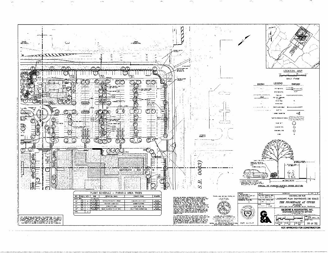
PLANT SCHEDULE - PARKING AREA TREES •r• Imo*. ow. ser IlOWISAY. ri•MC I CONON rrAle IOW=
sue( Inn sr oft. w
07, .-.12,.. 42....; ammo armor. wars 1,000.09 00,1µ0001 V • LI v., .......
PAO.* x Alamo woes Augurs ...11 .1.4.3...
W
i
: .orra. µCA. OCR& 504(.0 ore .1 ...1=1.1...
• —,".".,'.78.•• r rm. AAA •6104.4• wµtt. raw VW /OM MOW. lti,
.2
(000100 CC 52. .11020.00. VIONSe.31001 "PA KAM .00 etVeLOAD MOO =MS. MO “0.000µ 00 WAIF MOS. A0/04 •00µ-01000 00100410,8 Or 0C AR C041•160 µMe. mi 1,1µµ/µ301 (0 m% AMMO& µMOW At MK. SOF SM. 4001011µ0 01000(Me IC SOW. OPPL Ca IAL 0011/001.
,04 onal 000,400.00 µ Or FAKOK 10401 US 031 WON 13c .{ WIWI 00.0 rot 0304 ‘00•1106 40000.10110 1.1C1,200., 0.• VC AC 0, Ma 9A01 OWL IC SPer• Illat
M.A.+ or INSVM0.40 .0.010µ0111.11 1010/410,009 OS WOK • L13004.01.K.
0011.µ.(01 Om Ms Mee, NM sar•V 041,4 µA 00 uns4C0C WO., AO CCM Or AL 0.04:00.0010 010101(0•001C4 peµµAu•Ato µAA 10 SAM ar 1µ1.1. OMR, AIN 0C marrerrans or PL. M. 00 AP =MOS µ AS ArA 10. gow,,A • ,..01 AMMO On (0101... 00µµ1.40•• •e1 63, •••••• • µWM" un ems. • e•-(sC eft( CAA MOM wl 1.1.19 MOW AA (0401 MAKS sus,. wo. 20thronss. 20,3,7mx. Cm, 201344713) 2015,7.35•
ow se; rArirs orrooramtwo morsorous sera sotto 0µ10001 OM. MO PICO 10.0, 00 VW 00 AA, IS
Apra; arsancator oA_ vow AA MOW 0000,(0 101100,00. ou.s..µ1 04 use wean SC
Amon sr omen • LOSOOLICI PC. K 140001111. 000.0110. APS 4001t • •3000,01. AC AL NOM IMMO
00004: 11. 003,000.• t• AO 0041 IWO SO* 300 ,00.1µ now (30( 430.0011 KAMM MIL MA
MN MAP 1,0001 4111 0µ10-012.0-03,3
OGL MCA: ISA•11
orr OtteamPli..
mow or. ;or-
roo Irmo. or. orr rso
010:4110.4% VIC W.
LANDSCAPE PLAN (40R1W-AS1) (40 SCALE)
THE PROMENADE AT UPPER DUBLIN
v/00t AMA IO•AAO .1100.1.•• 011•111, SPINSAVAPAA
GILMORE & ASSOCIATES, MC. IDOCIPIEERING /CCNIULT1110 SERSOCU
sok's Po, 16 OF 52
.ssa o0.; 1OrS-000er-os
LOCATION MAP
=Pm: r.soo•
7
SOW-0 • ACISICHA•A
VT\ V
osInA
611 ,
‘,.12
61411 ,3
zr;41 • • •( etio
v C,701'
•
- - . *S: CZ
• %
04
• 7.7%.
0 0040
LEGEND PROPOSED
▪ 03100143
S t (LEAVY
(44
St SINSOONS • LAO
NUN MC CC
,•••.µ 200e 15 1100)—
MCKIM IOW IX COMM OAP KA
µOM SAILL inn
(Aunost3 00. , •••4011, MA. 10•400 µOA
041331(4/00, .0 IOC MIN /0 (ALE MAL (0.10. VAV
DEICAL-25:201049.1111711-CECIS-MEZIE
•;0-`,
DAZE; 6-22-17
000130.4.040 OC AO
01.
NOT APPROVED FOR CONSTRUCIION
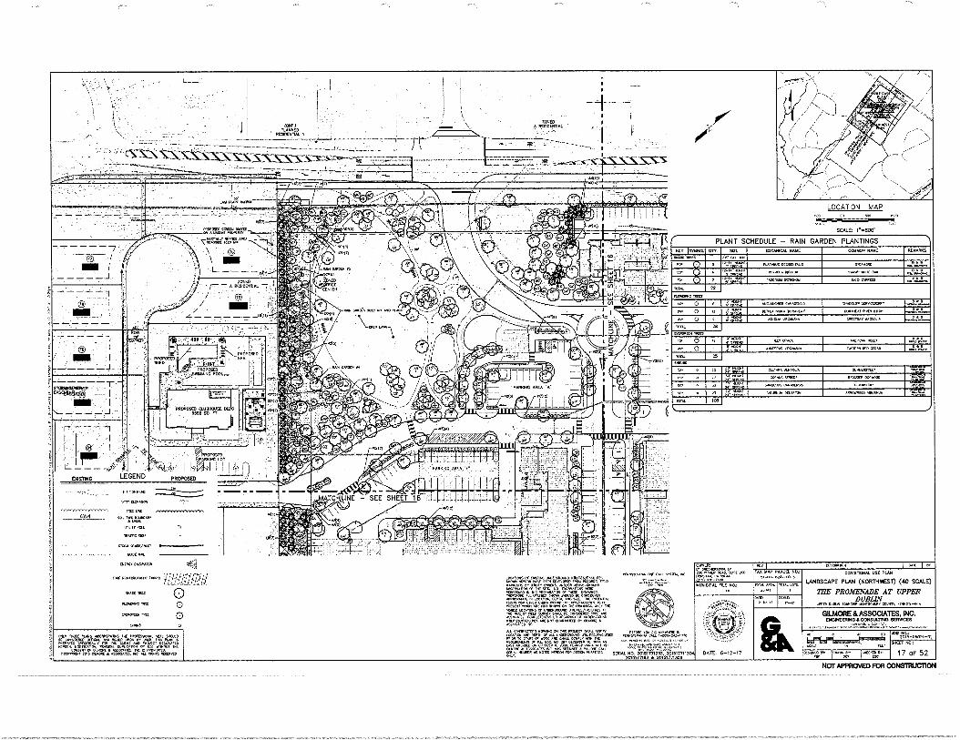
LOCATION MAP
SCALE: 1- 800'
0 11111 I
,
7,02,1,Tr 7;MitligTem" —
L
A PPIDIDIDAL
cvs: -
,
TTE .•
i I
A xpoRipa. SONO
-
t- •
7
*20 240011400 ;
/ 111E- /
c c 4.,• 4o
egto % asit
4,Nie 0,0
4,191 14.0 a Quo rei
'I 1v., KIM ..
i*AFF Ire' 916
SNIND1010110VIER •
• PPOPOSE1 SHED
.PPOPOSED CLUBHOUSE 0 5500 sa
m7,
004 tptAt
AREA
attel, al71 r4
fin minvggro.z.„.4 „._ aria
CASTING LEGEND
YARS
OfININIA.
5,011:114,411011
WON SCIRAMA.
INAK
RAW MA'AM
A
DAM SCA,.
DATE: 6-12-17
523* PENI,M111041 WPC 6y.ittlaA
INAAC ,IngL
110401114
[NCR...C[01.Ra
0 0
0
DM, NOW *LAS "400,1•01"1,14 "IMMO., ft AL ""DULD
tt.o.:t."TS:1-g-4347:41T(VAW:. T'Atlr7101111iiaVeD
PLANT SCHEDULE — RAIN GARDEN PLANTINGS
HET j505825 or, sac BOTANICAL NAME COMMON NAME 01.0001102.er
A ,2,.",„1.3. RAY.. OCVDENTALIS S.C.AuDatr 0
PIANO,. RCM. swum IIIIHRE OM tl
,N. li-Irg/I,
TOT. 22
.c. o r, ' o 420-403101 CANON, 0302500 .orNocr.DcoNy o
Mor 0 13 P ...-."' 302504 10112 02040011. 25001401830 080" ,66.26.6"466.
0 V.Z.1° , """AD loovnuA .Roxv"" 04411000 MT. za Lyn.. rap
“X CPA. AtmccAN naL. .
"711 1131. 25
SPONDS ...RA 000011 0ond.1.41,- 4040
KV,. 00"1000 ;214S. Piga
V.,.
...Dm. "ANA..., GINEINIONIIIN
'''' . itrreS ;,' •par rt, von.don A.14...0 MAK"
mix. ICO
ALL CONIRAZ.1^5 wano. ox Tv: PPOOTO, Kra. vat ma Av..cat 1116.
LOGN111,1 f.ler Dan" Of ALL t".60171.016r3,1,i11
„;6.4Acilrfle,
PLO -TInn.L'15"z"2.1Picfmarft , AurNDT60. 0.7roon, 200"
50041 110. 20251771253. 201517711304 2016477153* 20151711354
VISCRWDON CONDITIONAL USE PLAN
LANDSCAPE PLAN (NORTHWEST) (40 SCALE)
THE PROMENADE AT UPPER DUBLIN
DMA 0.101 1-011.151+IN PlNorsrtvANIA
GILMORE & ASSOCIATES, INC. ENGINEERING 1 CONSULTING SERVICES
!."1.11r461,
°MDT: EACoMAIOAN. , D30 "TAR ROAC. WOE :OD
047.1414 -r;V.""
I TAX MAP JAMMU. ND:
5.-0J-C000-<0.,
MUNICIPAL PILE ND, MIA NNE,. 25.N11
TOTAL I.01O.
300 IVS-08014-02
041000 NO: WALL
400030 825 'MAN: j0.00Ig,DA 17 OF 52
000015 Of CaSTNC Intallt.O.A1D UtILMNTAOLAIS re.40. NAVE O. DEKLOPED RIM.. MD
=;10VorCsr. WVA""All7g-Zr ;;,ralp vnagr.z.":—Tic gri3=D .401.1.Alt "ILLCATOI, DC", AND V2C. Po.^^/ fZIA;TAITTIRrtirr VD74 oln,174=ro'42.'"Ig .anct
012 03 t
2> 2 03 ArrAv
1 2an
LITC2 a
^ca"A. aft AcNix^Oro, uNDERWOJIA, la.M(67VCS AFC Mt" .AAANTEID Dy atk^.1.
•01.51%..•• OK CALL 5,1105411
NOT APPROVED FOR CONSTRUCTION
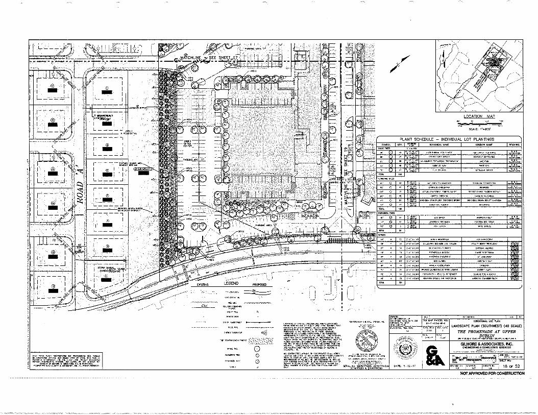
LI
20%-orm a
DATE: 6-12-17 7711305 360
pA1.14.0. APFA ,
LOCATION MAP HLO .
T-= SCALE, 14800' A PESSEN
CON05515
SPOT 0.1VAION
MU LK SUL 9P5=000500
EA= 11119M1191.5
1191/1C 00.
SP= 1.109/541,
511= SM.
909, OPAPATOR
AVArOIKURNT r
suADC Virr
ILMAIM
rWROPerN IR.
SNRU0
PLANT SCHEDULE - INDIVIDUAL LOT PLANTINGS
5132201 CIV. I I BOTANICAL NAME COMMON NAME REMARKS
..".0
C00,5EIRCE WI 0. 0 LOUIDANOAR 51'00ACIILVA ItOTU=.025. Va.. In
'. 10 D DUEDLOS .A 1.15. OAK °
05A {000DATA 1.1,11.6.50 WM .
TOTAl D0
PA 0 55 0. .ELANCNFED CAN.., .ADDL05 srpmccDERRY B
It 0 NIV 060.dit CARR.. CARO... 3753350 0..041.,..0.0.0.
,,,, 0 75 i; Ztl , CIRCA LA330.95 YOR[ST lOAN, TOR[Cr 0.0, [Mr. R009/0 0..,-,L.%......5.. u 04.0 MA155IA CAPOUNA CANOURA 9L.NDELL ...
a...40..
ID 0.:.,,,0„ 5.404.4 ORA00010. VA0.[N5 DPITe MAC.. BRO. SEAL15 WA...
TOTAL [wpm. TMDIS
10. 0 1.55 MACA ..10AN =L./ V
' 0 ID I Min., NRWMANA [A515. DLO =AP 0
RO' 0 10 Pi0A GLAUCA Nan 910.150 0 A 0 wa"1.5 TOTAL
4 5 5..-0. Hr.? ARM. APOUV51.1* PM CRORMESIVI CC 3.30 55015 CAW... OCDIN101 VAR. ORAL. Ka., 0[PPY LPROFUPON. .
Cr 0 30. 3.-.6. Nri. CAL.M.US FLOPLUS CAW. 55.3 AliNkli, SaT AffiVI
35.41. MORT FOTN[1105LA DARDEN0 ...iii 10515KILLA re so 2,r 50001 73 .5,00,00. PPOL.9.4 St J.105VOICT
0 ,67 .5503. NOW .5 MARRA I.DE.5 NOL. NOW WON. R[NSYLVANCA BODE=
PL • . .5.0.5.1 •1450.1. LAUDO.A.a. 'OTTO W... <NM. LAU,. RIS
PA .5-5.• 755511 P.505.005 OP0,500.51US .10/ADO' 5551.1E0 DINE 50.500 Zrft. IT 50 0 0,-4.1.15.41 ‘NDUIDAD1 0{0.5 VAR .ERCANUM AP[PICAN MANDMI.0094
TOTAL
Xt.. \IVO( 200
CET oso
IACR0C CON. 18 OF 52
2
PLAN 15 05.91.50
VOLD. L =LAM
T•
I 7:9:at:Err' (2) I
I LEGEND PROPOSED
larAlow: 0, 09.50N5 OU 5115,5/05.95S 9.. =CDR NAV( OMN 05.1.0= FRO. 05CORDS. ran
ausocmcp IN mt. 0.0ARAIION 51,A. NMI= Mt= .0. DC .45105.0 APP00..15 IN =AMU, M.5.0 S. TR0
VTA0107=15N17.4:11trOZIK LOSNANACr UNDED51.1150 U.00$.005/0.1,50 A/
ACGURAM <MK= '07'1.0gF5dP('077.01=0,13 LaTaZnyjE5 CUMANTEM OV CILUOR[
110.10105 .515. ON 11.5 0150A-CT .1.0
KW. 20> =El. 10. IDA AS.
SAPS saw No, 20153775253 2015377153 or
,
ronenvrAum aft. CAA Vrilar. WA FARcES. NO.: 55-0,0520-50-5
NOT APPROVED FOR CONSTRUCTION
- grow
I
0
0
CONDIT., USC PLAN
LANDSCAPE PLAN (SOUTHWEST) (40 SCALE)
THE PROMENADE AT UPPER DUBLIN
LIR'R 111 PL
GILMORE & ASSOCIATES, INC. CNOREENNO CONSUL:ONO SER0ICOS
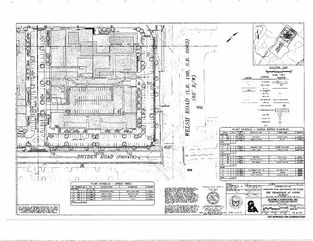
"
DRYDEXP Lis4e0AD
LOCATION MAP
LEGEND - 'Tx.%
peoposr.%
NO OOP.
Per UMW :31.6
MP LOC P. es sue. • wee. Mn 1PVC 90.
SlOW 11•9•Kr •JK
werweves twee ...711/.;;;f:-
.171:11Iii
PSC IP
110•3•0 116
MCC. IR 0
PLANT SCHEDULE - SCREEN BUFFER PLANTINGS
I
.
SNION. 1000 BOTANICAL PK COMMON MN INONANS PP MP 3 COPP
WV.. OVA. S.0.11. KW.
U. ; Pre BANN ANYLON rr•
IOUL •
r 0 PraPt• Kvls aallrer WrotIft•or • •
U. o anio,. Irma ROMA ROMP KOKO 1094
CNINIZA BCD Ir I
•••• Plow PON ratIrla• 'swerve. NNIVA 00.0.1 on *WOW
Or a 1r a• ••••• op. tap0 00. 'v. *Kt
-05 IN
PUN • gla ..9.03Latt PnI• KW PIPPO. .at, • LIKOK maw PCP.,
s• • .0100 0.10030, 0•213.1• 1.1300./
MC. IAN LOW Ir. • . Kr 3)
10.1.
-7,
CM
NOT APPROVED FOR CONSMUCOON
Ur. •03 4.10.1•I rosserve....-Oe0-1.1-1/.
WPM. Or Orn. PPP" 000nitr..0. POP PCP Pt MP MOP. MP MOP IUD u..0.5 LAM OK. PAN Pvtiellae 0013.1.00 Pt . PP..* MC pr0.0 K Kra.. 0, KZ WPM. KOK . Malt 0•010 PAP et PPP. /0•000.‘ 14 L.P. 0179.1. Kt tKIS 0.10 KKK.. 014.1"..... KW/ 09.• 1C vOCK 100•0/0.0 I1Kra1±01/t3 . Ort SC Or IND 90ner 9/. K soap. •K /U.K. OPOUPL. PUNK cr antrICTPIrt K 01. IPPIRt0 /PIK • Par PIC
terunan ••••• Ms •MCC1 Pu .1.1100 . POPP* .31.4•01.01. MOKPO. •/- . Aff PPM O. IP 1.4/ Aria r Orate O. • 00.0.• • ...RS DK Or.p • r•-•C t. SOK Par 43 OOP KICK PP OUP IWO= w., ws.Thm.
2013,T7133 * 2015077,35*
PLANT SCHEDULE - STREET TREES Icer tratomf art lac OOTINCAL PK KIPP NW WANKS •••• nos 3.1 0./... rs.
Ar r .i.t.Z.r KM 11.1...“ %no., KOK, 0.4.• NAN
.. OOPS /Pr VP/ MK 005 • • • ..3 0.o.
i
IRra e craw NNW. SOW Pa • • 6 Sea Oar. :S.• 10 • •
1.10.••
10. .
OVOILIt r PPM L• NO Ir. roa AM AN
0130•In. Dag I rr tAlt NAP P. NO.:
P-03-0320-01. ONCNI5014. USD PUN LANDSCAPE PLAN (SOUDIEAST) (40 SCAI-E)
THE PROMENADE AT UPPER DUBLIN OuPs Ups. 000.0.3. abrn. 1.0•Pr..•
NOMA& TLC WA 3101
/OM :On
DATE. 6-12-07
OlUAORE & AS$OCIATES, INC. DNOINWINDACCOSAILINIO SEANCES
20,5-01011.02 SW NO..
19 OF 52 0(00000 r-- Or I LOC
PK KM IV. .1•••••••• 1101.9.1.6 frl 00100 1301.0.0 KC. ANA 1,11CO VP O. .3 nr. m.t. Karp. Olt UPI MO r•PC01 MCP!. 1,0.0a 0.1301.
Unt0/11. WPC • POPP. I. It .410.091. eutprn OPOK • POPP. Me . •0.3 PPP
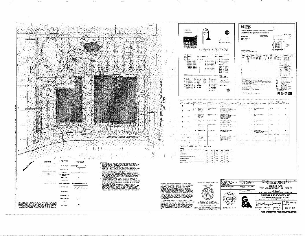
'".
".'
drO
DAIL 6-12-17
LC:1-(K MOM." II dotiltectural 1ED AIOZ rorMorite—r AR IS M2 Sorkd SpdOldrIon Did SMot
•••••• "••••
• •
—1.d.rz—dtaddd
=tr..
rtirig
• Foer-oda,..
„
ioci icon reniiiisi iiZokir.54Acoiori %PM
OUTING LEGEND PRCPCISED
rs•Wdddid
CM
roved dd dr (Au 0:110. gre. LECALIGIVI. OF m.o. Ao LOIC.C.0001.10 111.LISSLIAG•JVCS 10,0. L.,< 6.4.00 FPO. le00005.
OdrUr: dedoded.
110 MP. SOLI 20 P00,10. Po II., LK,
Ni NO,
oty
IAN 11.1 6.045).-10-3
.0401. LOIS
00LA 140,0> n. 000 0.14 4.'047= 197 00,4e01 SIT around 7, morofortoorocc
3 ALF.0.7., 00 Fp:fr. 10' "
eVrres W.AT 4"" rcrcc=';‘;':= me MM." "MT AL. CM*. *Pt {4.040 i• co
d• ClotaPIPLCFO. LILL,01 ALL 1...L.L.,• odds, PIL INITILD KN.
• ,Lrhl PLOCKMEL AM MO Cu. Car mr. LOILLA.
oT OL% dr. nownro twoore. terflA M. 001 L/111.
▪ 04.31a.....,1..,01,101 ALLTIMIL.
Korea, o L.L0,0 4,001,0 ernietica-7.7.&.;eiciW
3c:
33..r,
.11 Lang..
mr L. SOL tv01 07.100,
• LAP, LAMY oar
aax
N' m %RN. rr
LATTOONCLAD 04.
0.0t ,013
/odd. rnt
tordnu mr,
dr oder.,
I WC I Ill drEulurro.d/MIAL IMO OVIII011011 PLAN
MO COOKVIONAL U PUS
UGHING PLAN
ME PROMENADE AT UPPER DUBLIN
WK. OM.
GILMORE & ASSOCIATES. NC. 1113041111NOLCONIULTNO 'OWES
10/0,‘ TOO PO PIL.4110 ILL 0.11 ,=• =• z."
20 OF 52
OW PLOW RAMS .0.01,AFFIC Vfil f0AD %demo drod. .14f 0 00 la• trOLO M. V!
Irc.,:
„1/0
,302=0.
3.7=Ldl .004
,11W1 Lt..001
.4,
01=fel1WIL
0000.0 lid 04 PLIX.4,10, 0.1,16.11. Nit
405.1 002 NOT 9.4 . WOLF.00. 0.4.• ,V1 01411 LALL.V.,..." To
.00 LOCATIMS 1.CILI•Pro 0,0.LISSfia.LI00 ol .L OF RIC 5..e, sdri or do ',woo omst artr
ACV.011.. C0,01.1,40101, 000.1.00 0, L.K1..2,0.0 u•tratIffm.f. .037 .4.0150 OIL CIL.L.L • ..7,00•LK FL. tal. 03.04 11,0 We, *OM, fr ouratoons or or. oo ror ro.00rMLN411. •040:0 r.t.• ro-Pe LLNLrultilt
(0. 5 flO25 SCAM MO. 2015VMM. 201117711301 205,7715., 201517713
NOTAPPRCNED FOR CONSTRUCTION
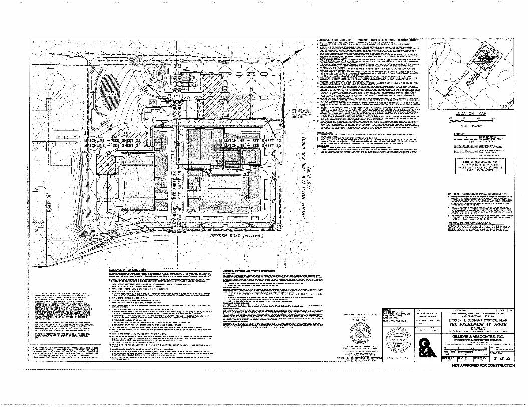
Sr.. • •MCV•In rt0 on COIN. • g•-aler S. .L, Wen SMOV• AS g•Mr• Nee. MO Irn.C.
V:r.artr :•=rertrX/Olnr•ON410=0:1=:1:1•19271: =XS VI' ••••• P•er TO( WM. WO WM. 0.111.•
• OM wee wIt IMP • • Wm VW POW. W• moo. ar 011.....••••••••••••••••••••••••
•N's" = " 4%.7="0 reallorNsamosenmaam. • MON Pl. ••• Now... ow. On..
•nr• ••••••.O. NO. a* IWO. Mfr. WI, WM. AO.
Nay W. MOO.. INS .4.1. 11. .001.1.0 ONS. snni in .0. On NAN PS
.10,1 .0411V1
.1arra•
C.C. Cr NOOK • oiLSOCarii. NC ..0131' STS Oatt. • .02•105. NC Ail .trr
PRIIIMMANT *54100450 01.53 AND CONDIRCRIAL USC PUN
EROSCN & SEDIMENT CCNTROL PLAN ME PROMENADE AT UPPER
DUBLIN C.I•14
GILMORE & ASSOCIATES, INC. ormernowa C9P.SULTNO 111011A0IS
615;e5;ie=,-
M0M WWI O. IMMO h. *WIWI RAC
-TT.niI;TYs.173,77:1/:rA
40041. 140. in 51 irriii-E15177.354 201517657 • TIRRITTISOT
Kt. .060 MM.. WI 771457030* 0(4* i•Ree...NR-TIRs
o•NER:
DA WW1. ... 200 1.0.1
MUMICIAL FiLL 60.:
• : ta•c
\ VANto /
‘V.:.".-orkTolf
DATE 6-12-17
'P••••X
*144*.
3141
TAX IMP PINQL
0.00.000.0•40.0
N. I
NINON
.00 .04 70,7-06166-62 NW 604
21 CF 52
LOC•11G.E or rntrorr v...ncsino.uxt 010. NON. •••• MN ON.. 111. fill0 1.10.•1 U1J17 0.06 00. ...O. MOM. Cr •14 SO. NO S}C.1.0 orSi MM., • YIK Ws.. WPM ni SWOTS Pl. •41.0 Or Mr..
rengt VII rein NMI menran. Llitnrrir.1.: re Or MUM ••••• •••S ton. ON .•• WOOS ter-ertre. Of VIII200016114
r(tO Won IN. NS ..0107 nO • CI f If OLLIRLSSS KR. ••Cf O• WPM.. MIMS /TAW SU O. NOT C.NOSSO Or We. • ornOSWES OC
NI ...ORE NOON. PM. Pr. •••• Ora. Cr Na NIPACWO•as.:
•• non er No. no or. Call, ION IR
SEQUENCE OF CCNSTRUCTION
t'A• rg CAVALMZ:=C"' • a.. OOP .1144. slum otos wer.•Tro • r •••• 1 MONA KV OMR. ••••I ••••• •••• ow •••• •••••04 • N. •••••••1.• Pm rum
rt ON Nt moo notra.•••••••••••••• iong • AMIK ••• • .1* W. ••••• sr gig kn.. ger re ...I. nag..
S roaern ••• no, • on* ...a no.. 1.••• •••• •••••••P r•V•••••
w • Awe.. w IN. • el. • • ••••••••• ••••••• go, MTEWN goo • No.on•• wow As
• os....•••• ofm•Lo<o• •••••••• ea..161{1.R •6=1,4"0110
.41:
.....0011•1.. MID OS:=1:K= ge
.r.=
.1.&:::::•;:g5 g• Fr% ••• og
0.••••••••.• .••••
p.p., • au wo *woo w ...am a ow ma or pia. 40110
• mat. aw• • ow. atom ••• • ww sawwww..• .2 /1••• 0.114 ma •••••• ••••••• •Pt• 01.0.16.004.0..111.0.
inzirnaurny cn arm MST STANOARII FROSION Jr WM/NT cnomert NOTPO
7.r.....
"."1.1.ArraSF.,..
..."Y=.=.:01=-4; Tru=s==°:conr:s•
:I.Z...:::•;FT=.1:7"...M7.4:111:41r.":=i4::A4". ":=4:1:27,7X11:414:
.• ...7Agit.F.M
.4.:24.7.1:22;RE:yr/-..."..".. ....e.r.-:=4". IrrArZaA.."'
....CraT wows. Wm 0..1 gore ion
••• • Me, • • 4••••3 ...I. ans
:XV... '717.61"-'6.=.2:774.t.._,_.P7,7,..,:'..17,..."St.... • .. =:::,,,,i4s7.17
.L.7.......,,,,sze-6
.7. •••-• .4 •••••••••••:::::
,
O7fe •SO•:••l• •••
' i ff.=. . I" TO rfr= r 0 A 0 • 4 74, '.7741: Tr."``.... :"...".1.= .7"--cr.-....0.2 74•47,4q... IL ••
,..46.
0•11,...4 f:r.f..• WV.. ••••••1• Ell• d•Xls•
.,• • •••••4•4,14..• Cf •[••• mew loos 0Y us,
.
140 7.%7 %TV= UtP21..•1•-•2_,_".":44% r=="wft... m,r.....'...•,.a......
. ENTRANCE " 'VA.? "r"."*.Z.:ArWr''''' .." ''•:' 4 gr"""•:;'; :24%.""` •"'"'"
- " ••• z,
'"'"F:fir....°••74,"'".....M.=:::::•=1.:•<•:".1=.7. ". r"....s V=1":41,...."="
......... `" :','....a.a
..... Z="4
.4 .•=*';',.."41.'4,71:.:FV:F=TV::,,•24,...`"" •: ""....'4.,
• =Tory -.4 non ••• 4r. 4...T,V•40ter.....r...." ""'' "` "' "'•""' ""'''' " •
somasiss
....':',.'•- f.,TW.i.W41. :
MATCHLINE - SEE SHEET 221 : • ' p701 ."Tr..."1.-S247.:T.DA t'S Z141:17,11 ..01.1-NOMIti WM Or WM ...Ns
MATCHLINE - SEE SHEET 25T . . - 0 • agt.,,;:i " ' - ....- 1 • I
, C4
' :11114,7=4:7.= t'-',V.:.•==.:4:FitrAr'="7
,....=::.:.....•
.,7".
MOPZIRILSICESKIL
FIT:77.1 44:
^ 77-
---=:rn.--r.. .7.:.:-.;:a•r-z.-rzi.t.--rm.r.L
;
LOCATION MAP
SCALE 1.7670'
!REPO.
Ff. m.c, MK.
5153113111=1 CZ% cTM°L-11 '
amo
DRYD101 ROAD:anugus)::;, -
LIMIT Of DISTURBANCE FOR CONSTRUCTION: 25.24 ACRES
SPOCS LUNT SMALL DE V OUTSIDE 1.0.0.1 29.50 ACRES.
MITSUI. WRIT, INSAISNORAT nrntranown.
INERTIAL IMPACT CONSIDOTATICRIft
NOT APPROVED FOR CONSTRUCTION
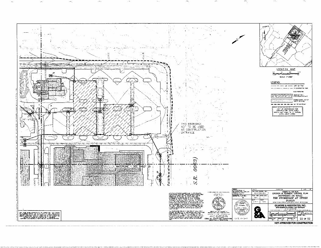
LEGEND: — 57, 571. 5/1417 511, MCC
LONITRV[110113.11Noort
nnycoN mi.:D*144.1 (120 75 Ort cow
NIT or =WM'S
EPF.F'7971g1 r.
ICIJ OwNER: Onet717/110M. 717
200 5171471,170,AC. WOG 250
.3:1101-7100"“
I G7,777,1711.
10 ••41,
' • •
••• •••71•••••,,,.......
LOCATION MAP
SCALE: 1.**•800.
X X — X — CONSIIRLICTO1 fl%Cr
*Ai+ Pnewesof
LIMIT OF DISTURBANCE FOR CONSTRUCTION: 24.90 ACRES
HIDES LIMIT SHALL BE 5' OUTSIDE LOS.: 25.50 ACRES.
THIS ENTRANCE NOT TO BE USED AS CONSTRUCTION ENTRANCE
Ci)
PLIOVILVANK PC ((Al. MILK "'"VP5d1741(747=707.40711i1B
=250
5157.15701175 1111711, MGM. AND/07 MOW-M. OP217577.7.21 Or 71‘ 511T. NO CXCAVATION5
7.17171=7C 17I .A7,44 DV, AND SIC. Dic conND.R. wa,m.vream=4.,"yzlig.g.Invi.
u-Oa'AgcrWX5 ich,c4-5.'crAqtroto0 OR ACG517155 mcomEDAn NOT 007.19175170 11, 51511On
(501
N
.15754[771/7 5 7,51,7.“17 MS mist, RIAD ‘ToTE__
00011)2507 111451 11105 (IT (1101
IIIPAP256.1177 Or P35 ro. 747 .71.85X
SCRIAL No, 26i5r1'77125.3.:201SI2011304 2015007163 Ile 20151771939
TOTAL ,LOTS. TOTAL MO.
25 •77
DAM 2-70-17
MUNICIPAL Fox
DATE 6-12-17
CONDITONAL USE PLAN EROSION & SEDIMENT CONTROL PLAN
(NORTHEAST) (40 SCALE) THE PROMENADE AT UPPER
DUBLIN OPP717 1731.74,77.7 u07417757.7177 cam, PINNSIIV7711A
GILMORE & ASSOCIATES, INC. ENCINEEIIING & CONSULTING SERVICES
LEO PA-7161514-02 9111 01
5CALL
22 or 52
TAX MAP PARCEL 710.: 57-07-05242,0-5
"'gr'" SNCET
.1.0=71MPIZT:4171510'141171r7"Z....,.....' n"'715. 4,....,,
A77517,
414g7X.77.17.7Z. _744:51iNi 711.,57'DC771.1.77v
CONftli,T7771.17.1r4540TAg.'6'1:C.75 rif41:14T" '"
07.07( ALLOCIA125. MC. ALL 11.75 17,0,215
d
NOT APPROVED FOR CONSTRUCTION
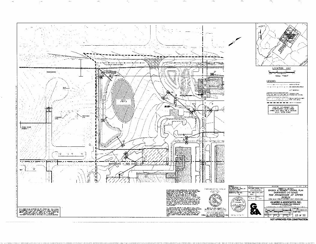
It Aoo CANER: 1114071
.
11401le-
.HAHH•Arra.....
' . •
I 77-7777
47—
.1,--..,
CR
V( WA 2 Araer-c+a 99X29911.94
I L.-----
11A1.147110.1r11.1111.11110M1
I I ,
t ;; fp
A
mixoFF—' noTN.... le
'01 •
STOCKPILE
PROPOSED./ SHED
. . LSTONIA SEWER
- *4444.4
,
SlIIIRMEM1113:111•XR3311.1.111XMIII.11F•11",11/111•ArnrialliliSLIWII1011411M1011{11.11711E
OWNS Or MTN, .011.00.0 trIVITSRACUALS 94001 NVILON I1A4R 2901 0C151.0.0 TROY 0CCOR01,1MO
'''ODIZAT4I'OnI7V1q90tVA1Virg-MTRT" PENFONYED INC PRIPARAIKRI 0, trICUC .CAA warn. Au. dilLITCS .01.,NrAPOLO C0,7031% APPRO.,C 14 ..,00N, DMA, A. PSG rue rOITNTAL PAVAN' nrAP;":9A ,."%"; =trAl nirgir" " 15150 10001050 ACCURAIL. 00.441.1C.C. AC.. 0.711
,,COjt;.T
..ik.IT, ARC NOT COARANITE0 OV
t01411.T0r. W1,101.1 ON 11.5 PRO.R, WM'
Vogl T.1%.7ELIZI:V;
00091.20114 CALL 992015 00
Kn. rov HNHALAL N FENKAvAtivl iHroo-.51F-FF/6
AL NO. 2015&71255. 2015I7111304 2011%77135 & 20151711350
MINCIPAL FILE NO.: AA
OATL!
GATE, 6-12-17
PE5.41PLION
COMMON& USE PLAN EROSION de SEDIMENT CONTROL PLAN
(NORTHWEST) (40 SCALE) ME PROMENADE AT UPPER
DUBLIN OMAN P.M, ..01•1100.10. CONN, PCNIISRV411,1
GILMORE & ASSOCIATES, INC. ENGINEERING &CONSULTING SERVICES
•
000C,
On j0FTX4B 1021000ctrt
NOT APPROVED FOR CONSTRUCTION
LOCATION MAP
SCALE: l*H800.
LEGEND: • sar FENCE
RENSINUCTIoN rA5co
our pmenTeraN
[ZIFFWU
UNFI of 0,311•11416
140,C koW5 NO,R,ORATI AL ocANONALO OIrCIAL
=.01%glfgr ,4941WITOT gl..= :5=
TAX MAP pARCEL 5A-Ov-.147-00-5
Taint ARCA: 2,411
SHEET NO.:
23 OF 52
LIMIT OF DISTURBANCE FOR CONSTRUCTION: 24.90 ACRES
ROES UNIT SHALL BE 5' OUTSIDE L.0.0, 25.50 ACRES.
ME 6-12-17
LOCATION MAP
scue
— — •S• — !V Mar —•—•—•— 0050/00. MCC
MOT MORI.
R.00•10• orrc 000.007C• turPuir{
005101 COn•Cin •••••17 C00 no, !CVO.,
01,1 Or 0110sOu2
1 MOT Or COSTUNIAICC rort
C005T10071011. 21.90 ACRES WOES LOOT SOUL OE s' OWSICE
26410 ACRES.
Calf •01e 0.0 P6C00004 aelcr10/0 00Cot •ItrINAT'"'"' poo ••za,••
,•ga• .4, .7
,1 on:O* 10.01 OE
0.00:.0500MIS Au' 01121. TOCO.V5. 0 ALL •G•fil WNW.
LOCA•Dr5 Or C•510 on000100 tr..0%.01105
00.1 .0[0. 010 C0f..V00 /Oa WirrOuri er 001[15. 00/0 410001000 OC901.0. Cr 0 OR C000.01.> 0000 • 0 .01,0104 ,10i IA. C01000 furcaar un orutart 2•20 onou.0 COMM* ••••••0‘ 104•0. 000 40 Inr. •011010 Oen roil 0051,000001 0005/••0005 a_ 00r co0 nOr 000 MC ON00.5. n•E rrnrra LOW.: .011.0400_Valc
.t. .1.4454r
.
rur MO 50%• R aC001%. CO•01,L0SO ...0000 ortIA009 u4r...•Clinkr404r(5 art YO• 000.1.0.1 000•C •
COrlluZinn ON On $00, 00 NIP, OtTOIC •Or 00.0% • net••:• ane C0 • Or 0 000000 0•002/0010% 00.0,00 0004.,•• MOR Vornt 0 00 00 00 C00, 01.4
Oronaer • avet,m erC 06 COUP. • 0.-OU Orn • •••••• 410 0001 KO= rUKCO OCS01 MOMS so, •0.7123=117711302
20.$177113 20,51,7,3.9
OWICA: Or C05.000 n• SO %NM 00 20
(1.51 00,40 11,40/. NZ NO:
5rAnt
A •
TAO WI 0021. 1104 O•40-000005
0100.
CCHC41106. VA PIM EROSON & SEDIMENT CON1ROL PLAN
(SOLEMNEST) (40 SCALE) THE PROMENADE AT UPPER
DUBUN
INUAORE & ASSOCIATES, ENC. DIGIMISONO aCONOUL11NO SERVICES
100011 022 Rao.. IMMOs
et J c
5C0. 9611
24 OF 52
axt NO, 20,3-O*Ol•-•;.,
NOT APPROVED FOR CONSTRUCTION
r-- URIT OF DISTURBANCE FOR 100STRUCT1ON: 21.90 ACRES
WO MOT SNAL1 BE S' OUTSIDE 1.0.01 2540 ACRES.
:-=--.=,-.^=."7.1....,7.--7.•=7.;7.--;".71=;.r."--
• L 0 Pf?Eitel.5 ;4' !0-400--6,5. -2.42-004
-
D ..•
• a
6r. tAX fur PARCEL 1101
01-00-020.0.4
1,0CATION MAP
SCALD 1".1100.
LEGEND:
—•—•—•—.<0.0000.0.046
Ian MaRC10.
MONA. WA 011.04.10.1.000.1
.1 Or Din.RA.mics
t.„„..7,....-„,..,, -.--- . ...-:.---,-....-- . ,
- - - I- .•-• - = • -DRY EN ROAD (PRIVATE) : '--- -.
..- ik
LOYIO.S Erma 1.00.005 r01.1./YOunta yak Wk. KW KY [CLOW raw PE .01.0,5 MY Owen. 0.0/0• 40.-ekey. arOmarts YE WC Pa ra.0.10.2 HAWK° k .
01 6/6.66,
wo, :aura. 0 1:00.0000 ke Ana IkTer nal Or 0000, Waini..0441 ..0.7400 ulantseYounts wr 0.0.60 •0400 • way., 01.
. wwlewray .1.1.0 au ar. new, Ow.. V., Kraft. vaa. Awykrat Lwow. AnO DON Or w uanc.0.0 unwrisfraawlill •D.,••••• 1.111 ,41..212-.91/ 1191 tO rat 11 •90R 9..9. au., ROM 11. 0.0.001 or A. 02. w at cicuma WA Le, wisom a. coysio0 v. loy row.000 KV IV "..41t0: ouwe • wax wo +As WIWI, • WOW OW 415191041041111004909141 Wein roma saw, NO 20051i,j4713950rm304
1018177163 20161771419
INKY r PKWYCAOL zoO 0r49 tIC. 444 41 wow.. r• yak 0.51. •*-
11.11.0.11. FILL NO,
PAM
.11
LW R. CLAS, ;
DATE: 6-12-17
I CORNROWS. CSC PUN
EROSION & SEDINDIT CONTROL PLAN (COWNEAST) (40 SCALE)
THE PROMENADE AT UPPER DUBLIN
WOW 0.00 100.0. eanotaIlk 0.01, 0.00.00.
GILMORE & ASSOCIATES. INC. 001141116904CONDILT4O SIM=
111 "OW 01101 Walkway. sr, 014.09014 WIL •4100 .111;04. anny Onta One fia
„SOW ULM PO
1.0.410.1 WYK., .01 MO CWOok•RO 621.1., 000. ook.a. a OW./ 114 corsorr Cr iworOW • Anaroert. .100.4110}
!wawa, IV, Ot.t • WWWIla ine W MOW MIAOW
901* 4010.
Taki 102/4. LOS
r.aer
AI AS: 20.5•00014-02
arrazr, 17677...r.
100 ow .0.
25 OF 52
orr66+66. se
•=ilt7
I
•
NOT APPROVED FOR CONSTRUCTION
ti i n 1: P
ill 1; • !i..,;4:4' I ' '` ' 1,..,, Nil I 1111
V.
01 O.?. yi let !
p i! 1 I", !! ii 1:11
,: il isithi "I I
I 1 ! rip,;;1411.(711-14-11:0
,,,= BillifyliM hAiih:1 kr iitiilli i 3 414h DP bit 11 1111 Pi 1 gilthiliHily1 zr,
.2 If
t _
g.
' I ' '
1 1 3
d.1
I : ail: il
X 5 IP I i f 2 hiVi Pi *lig 1 1 IlY 4 1g i 15 it A110.11; it
I 1 tIPI i5.1111x1g11! P VP .111'4 I t lith-;11ftlivati. 0 iv 5vi ktlii
I
5 1: 13hlivnilgilli thi IfiAtI4i 1e lh! 404 tli1itinv Ili 1111110; 45 1!,1
I i i 1 i 1,g. li! 414 eigifi 4 itii)i Aig NIP MI I IN% iii gal
1 org .
In , h 2
‘(51
a
sp. 1 p.IIo sops goo S11 - V wari, or. La bita.rwiI,flIbE S. r
4..1 .
.72
TAX MOP P.M. NO 0-0.0.140005
-OTAT.,ROTS MO. MK.
270 4[447
AS SOT"
OATT• 6-12-.7
csNFRAL FROVON & CFMAWNT CON7MC NOTES: , COr&TA01. ru. Awn 6..1 A.A... PO. • CPO. 0.0 Ta.. 0 MO .0400 mg Au 040C
• T 0.417 afT44.0 IT; 4,0 ro10/707 CC 00,11.001
• r 107... .64?....c, IC. dow. Pun. Lar,r4
,14•74
A... TS. 0000.07 AS/0011. r. T04 Forfn
, .1.1
.0.7.
„1.0000.14
. (41.4
.01:00110, rilarrATTS •40.r
.C.1 TO 10
onuac, ooruuo 00 T. ocurca Oho./
010A.:1 Too ..E0 Orr araral.7 a TT. 20C4r. V DK
W." '4474g =94 4".4"r 974 re 4! 4.4'4Lr' 7.1..M;144Arl= 07.0100.700. 0101. 0004 STOO !WO NOM EVATI.
0;;$11.470711CT trif..1.0701:4011 DTI.. 10 • 'TR. ETA 1.00.*000.12701. -000.1)
K • 1• =e' "r" "."." 744.0V '"01 N"="" '4".'"'":4744" "'""Tr404 471164: 00111.11011 0, *CC 7.00 300 TOOLCARO PECITCOLY MOT 00/00 00.10,01 040000 CrO0C .0 ASSCOARS
TOr ACC. TOr 000.70.0 FOP 0.0.. • Oriat ICWK. 00000.0.000 WO... or 0.00 CO, 01011.11.
•••00. 010 04.00 •0•01410... re. NM". Ise • MOM 40/101... O000101013 00 CC 011. 515101110 •00/4.41•00 IC 00044. FON 1.00 MW ORO 1/ ,0 011.0. 0, N.= Or 4.00. ra, roc.. no 017.0 .070.0 mop Tor RR TO 1.• TT. HO 0sr.co 00170.1 0.071.0 Fure
Pi PC er7,47..... IC001.71. ANY 00 47 .0,0 OnIAKSS rrl nfrl • 44444 KV It o23.0. fa. TO 040. 0114 fur s•00.1.04 • vo•Tar or IC ono .4.N. LA• Arb c. AA. KT. AC.
KNI.A11TO =KM 1100.0 011. roir 00 MOOT A. !DOW 00.1 1.1010 WO. IC 090$0 CF • POON.00 WO! Or .111. CO. 1•11.10. /1.00.4.10 Or 0100. OR. PORN. 7.0001 74. IC CCM 0.000 WOO., TO.z..0tO„ lINCOlN
01.:041•14 T
.=
,,,,,,uog
ing.43.1 of To
10.4,11.0 .rutg. Ersor
.
.
.., 7 Tr: 110=1 ENT.fter. riTSL-M .TyPOT
,:r
ot 50
00.1120 CO POI MC 0.44.NO • 2i
,f.T.
„•=1.0=0:1,1.4.= 0.070, z0X...110.3,
110 Cf
'WWI_ UTILITY TRENCHING NOTES: roT =ORM orrocioRri•
nr•Er'"‘Tofl'21".‘ rfro".:‘ OSIN.300. CAT CM OE C.C. 7 0.• Or.
/ 017z1.
04C 114000. 0.01110 SW W.0 00 010417 1.1 SO OW..
44. VC 1.0.0174-11.0.001 OKRA..
Urn 7.0-1.0. Or . 0.11 PC SW ON ot 10.1%. F
.C.Fre.040.0,
110.0„, 11000%
✓oo To.170 ,0. • uor (oar 0140, PC.1. A .1007.
11.1.10. 00.007 rot C. 010.7.72 TOC OANIE
• ."'"Cri7ri "4'40Z' 14..C74
.0g1111.11700TIC 01 110/0.
TURA.* K. 7 MT OR r0c000.00 64.4.411 4440 TR.
0R1=4 TOCA au .7070 T0 .00.43 'ROW • Oil.. K..,
• .001. 11170 M.. 0.1 ESC 1.4,00 Af. .• ...Po. DK. N6 •0140: Or IC 1.000 IC ...ROO . 0071,
RFCYCIING/OIVOSAI RFC:NW/F*4;747S;
Ng 4... KIN 001 010 TERIC .0.00 ¢0.4.7 00/00 M.. O. O. COWL 701.11.0 00.0 4413
.10•111 07
.7.21840•40R 0.0 0.1.
1 OE 004. woo NOOK !KV I. SOL 1.04
TI
rem mat COCK l'aRA.011. OA OteCVC iTITV VT 14 c0.07.1 ..14 Tor a.40 04. 70107. OT
.T1C 1050•1110 4101. 5,0 404610.1 10 K 4.146.41. D.C. ASK
TT,11Tri TotrI 'atoor. cl'or'r ""`""
THERMAL IMPACT CONSIDERATIONS:
=-Vrerglf =VI or'111L51.TI:r. '" 0.0. MOTO. AVD AS KU ORM TO Roc co 001000,000 44.0<rr 44041 nit TO RAOT 246141PANK
SEQUENCE OF CONSTRUCTION: NI. Goo 0.1111•107 AR.VC• 114...000 Nid COOTOTOE TON . T.0.0.003 U. Suar OOP. Caloroso WON 01,7 RUA. MCC • MUM .440 OCT TO BCC Mr. K.= NI 64441 DON. 111311•1401 7 . 01144.4.61.14-14 FRO 0.1 01 01.100 PCOOLII 10.0.11.41. 0 WO 7 0.1114. .0 M. . LON MI.. 0.00. • 40.20414.61.4 100.1.44. .0 14.4.0 7/1C POOL . VOW P.. 004.44,7 0041. • 1.101100 7001334. • .1.4.4 ICI.IC 1.070 .0 7, 07130000 or* TO tre74.7 Tor
4614444 000( Cadiddd Wood. R wed. Coo Rd 1 Abed MOOR. 001, 00.1 mar V To 1.. 00.00.0 • POI. 9.0 ./ 17. Tilx nor
• DOW 7000.10, 0. of 00 TO 0.0. TilaiSron M. TO PS.A. Or 074 UT K. 70 W. CONN., MI OKA LOKC MOOS/ at Cared word". fed K KOK CO Rh. •for 0.1.0 n troor
•07•11. 001. TOMO. 0.011. • Okla •00.0 00 7. OSIFIL 1.010 CIRO pi • 1104.40 10 1.07/.0. RON.
0001. TT. Y. IIITW Ri • 00.17‘01 n WM. 00017 0.17TIOTIONC VT. K 00010 At so. Tol, As TOT NrC mount. 00.0 01.11.07 301.0.0 0.70.00 10.0.13. &COOL. CVS11....001. rrE 00.31,01 0. AS TOM . R. 00
IhetOrlOrd Odd,. Ordedo KT 446.4,4 Win NOON OTTO. ar 44.4 040r .1.00Y.To70 Mad AS dels hCGOASYS dalidl • dd loradd dad.
SO, RCM MK WM. 70 Sua. .rte. A41 TOVI 00.10 T. sit• P. LOCA.0 Or AU 001.07.1
0 60 on Doc 0. FE •Tocerco Aro Odd. 00•01.101 AT Id CV 0 [Ad rd dr & .0501/C10. CI dld. dr •C1 eV, •ASE Y. NCO 0..0
.14.007.• 1.1•110710. 064.4.00 GASCOO ...Tr Au •101 00001 rti 0.. 00. R. S.C. reS11.1 COP. 11.0.1 . 00110.00
MOO IS 0.31C 0073,00. Or 01 PA.. C.600. Ifsl.
.1.00 AKA, 44. IC SR.. TOY STou..... R. • royou or le or AACNKO SOL KC 000, AK. IN. ic S.N.00 AS SON . TOO NO ids noo ISOM 2, Or
Wore. au 4.•o• odd 0001C d•AdO Sada NO wo•00.0 00•A•K miC ND. TVS. ATO :1•00. .1070.7
111 CIO 0TE ECM ... Cr WC 000C... 007., Toddso Ad corms ,. 'do IV Wolo
•CONN6•1io COON 1S OKA K dd. 0 Pt deddIS odd 00.01. OS $01•600on 0.040 05 00.00 0 O. 00.. • 5110 0152 00 IT OP OR MVO. 1.1.000
CO.. 0 LA. ANC. 00 or 0.1 001 • 0.90 10.00 0.110.1TO 9/10.40C 0070.0.0.1000., TO C., 107. Awe Or....
▪ 0101 al•II‘e,r3 AI• CO TO NI 00.47. 0, •Ta 71.00, POMO AKIK Odd MOO. 000410. O. Odd.
IIC6=66, DOOPFC1136 AND 16111021410 RVIIIINFAHN 01.0.1001.0 `..7=4.1==.4."2"' „--Ira.=••••t",='...,1,42224'.'=":4=7:42;=. • `"`"'" • , • Norm us or oddeeod hidrot ▪ coo No ; yrs sass rr.p sr sre s.rosson ss rargr.s.
OSITHISIMIL109.11 7•4•^47.4...' ".1744.124.277:r• ooL•'.'"="f6:2•12:Tat=7. QAT'.
r Mel. SS Sql MSC, let 10. Is0.111, Moe d d hod dd. lor• rod a dd. s Ise doe dorddost. odd Gad d• hr. Add 40.414 Kr K AK. on. • 4.4.4.
no Of. 40 is Won or. To sired 100 deddi , 01( •Nrav .44.:AND 46.400. noon mos
11.0011100076100
EA*77.441.7:74-YZENTigiAMat'S-47--74.4:
cots dr 0.4 end - CSC
HAARnimicr OF F40116.4
T. col 4.0....47 K • Kt.. '"'r" "•':?2,•tr,P". ••••.' "
••••• • r222Zalt=t72.1r:=7"*. • • Kau NA .7 Taos •••••••0
MOO ...00.10 FON rto •00. 010 00 s 0.. 0. Nat Pre.. Rao TOT EON. . or. 0. • seo ••• mo moo .0.0. um co.. re Ro. roe cco o 0. • od do As • sods 00 • zriz.io..
0.1:4T.Ranzy......0.4.0. 04:E rt....se • row a. 0.4.10
' • - - •
argaintoPY COT _cram mt. qTANOAR11 FROSiON & SFOINFNT CONTROL NO/Fs• STOUP3. ...7.1.01 MUD . RV. SOW. 7SC OAK CC I I d eL•MOL Id roof dope du dd. ha Odd. dd. 001 Odd, 07.. TR /0000• a. ce0•303
• OTA. IC LTC 0.0 00, 0.0ATIOR 00.70010•01I AXS loC 10, ..000 72°Trity. Oir° "r'n !"..r."“100 OrT•'``` "Ta.111
44. 4,44.419 40 4.14.43K1rr f6.4.444,071
.65.14. Au. .0000. •40.0.0 Coded Med
• LORLIIIIIG. CIAASZIIG 4.4.7=4=444.4: n'Ict4:4144..74114.. ra nTei•coom move. oson OCON•41 Frou.i.j. Ono. 0.4 00.411 047 000.1 14•NATE •01000 7011 00.00
• 140. 46.114 KNX444' 146 KAKA.D 0109.4 .4.11 Kail Oil Ky.. TO 0001.. O. VAT WIC 0.000.1 1.4 M.. E. CON. 0.4 OR•ATO• 4013 ROCK 0.041. Or TIC OROOn 04 or... 0.0614. • To 0.007. 0ot AK. 1404 KO KOK. Cada Rd od AledooCIA Add. •C AeherdIr COOdvdd orroct 00 0 WOO. . 1[4. 00/40 MAL
1142 040. 7 tt
,:r1000 1600:0
....0. KZ:. 4 K KIND. • =NON con, No. sox no • nom on* root No
rs pry.. lar Wry. rmscs.s• Says. els Myr.. a PO aesfirrarm H. dd. oho. dr, •d KOOK., K dot 00001.1 OS 1100100004 POOKKR heed. C MIKA. 0 KOK 10.0•00, Ad. dd 0000101 T. LOUP COO. • • 9d/1F rd feed. Ad IMMO COMM Rd K AddI At Id nod, Ialt d MKS
IS dr LAKI0 M•011•010 K Odd" o0 e•Odt KM. •CI 01744.4 70, 0.0411 00 •01.00 10 MIOTNCCT TOTS POP W. see CCCIV POI 00114 0010.00. 3505010. CC 'Imam sow 76
71S0 nod 111 SOXY1•4•"' .47•P'h'.'41"•=r. Soddradd stio•o• No INC1 NON. NCO L'''••11L'inrr. O.. cow oo OMSK rhSOUCOLOw AO Odo 41:.(lthooS • n POLtddliond 00000,3 TS NC.. ...or. oiloorar.
ALI. 0,0 .1110 • 11.0.0.104 r0•1001.0 KOMI= CIT•21.00 ALIY•SSID=ronldo COOKS Id •coeCt tOot•anu ho01 loOd • Ode nd 1,0.7 • 0. 0.0 RATI COM.. W.7 . 0100100 Wood, AII•OdALIKEKII odd • K •Vddll d MOTO. OK KOOK 6.10. Al.A. fort KM( •Orr EA. Ion... C..: Au. •• Aorran. kirrer Kr... c. ddr, copeolocs Al
II Owl TPT orS10..4 17.0.4 fir Torolt mow own n• S 0o. TO W.I. 00.10. PC •0.110 03.1.04 00.11.0 E.
tot.‘"7:4ETO*ParliNE. NIFI:101S,ZCmeVI
TA! T370•I'rrOTrforVol 10TITiircr4,17i;
prze. ":"' "1 o0 r11
r551215 50
,ot-7.::. FC 01.0 ITC SRO. AA. sar....f or AT On. M. AND h.. Or
1.4010 OC ,C•• SC ST.= A000.0.0 .00 . 10.3100 CoCIA0C .101.0% Mr.. MAI O. AM Odd Ades sle do. K. K1 1
,Of Odd= ••••• dr KAN to. K .1.70
ir 47 • 00•17 OM 0001 ot▪ ooNON NONOOLVONI OMR TOO 4 Mr. :70001.170 PCIr. •0000.0 .40C MO.
.7 rt.'7::fi‘. ''''Vrairmor•Vgrit AT's4:0'.00.00.• apio. Tor DIVOT KOPOISKIIIK dal 0 P.M 000.0 TIC PORI Tp. mow Ie SE.S. fr . To. 0
dude. KR SAG Mold VIC LCD= FROCrldo KALI KOK d MOS 000Ird d RA•44•0 Kd "frofd.:KVIIr' "". 7:r0C 70!1"' 7."10'07,-A7.071. •04:KVIS:. IC:adt AS • Act,. Er TO •01.0. .01 5.05 ToT mie 00
nagellasalain *pas, ts SIC VA Cr. WAY,. KO 101 s•SSIOrl Orro• Irt•SVIS ;KV r'Orr :r ▪ 440 LA. 0•01.1.7 r• ro ALLON 11. acrorn. A. 00.
T• V1C741.11r:11r11r02;..7m grog's VgaracrTrat.70•170•:r2 Tn"sit.7G Ty‘ • SCR., VOWS K Kr.dodeor d 0.010110 Old KWh.= Wog KII0 Odd =Lima I dodo NIT'S COOP ors• 5.44 0001 MACON ON) C•O ao, (00
t' Tr" IT' Tfri "Tro"Z-6:=16116', ir,o'"'"1"."-o.r2=?:.TorATT 041 eR.G. WOK IOC SEM. 1011.00. .1110.0 000.0 00.0 Our. Cr 0.401
CL6614 flu. REOURENENTS _
rAzret....7ZrAZITTr"....4% rert= Co=COO
04.01.1,014 Of 1.7 120.00 040.1 001100171 • Cad 0 di Reser 1 avAdd doIr dedCh01 KAVIROK
1. woo Mr.. 104-40:11 STA. 0.00000110 On. .0 RTATOTIAL TM O.. 700.- VOC.040 WELL W.I. or MO. W. ..41 Tr. 0..40 R. ,,14•1,5 r :KAKIS 401T •RS,C 110.0.03 AS EARN TO VO 0. 00 00. TrAIL.A3 ROO To DO 41/01 00.0044.1. 0.10 olorOF pOoti. VW VICO OCCS PO' NV. 1030 AK., K Add/ hAt KIN
reat rt-KK
"At= " n4147 ."."4.1' "tr:t4 414,41.“ An4
iv. 40. • "^".° •111.'"' iv on, KKR., dr id =CO d Older. OMR 0 Add re-Lo r44-4D 7.4, 410, 00, 10.14.
• :frs'iTTor=rtip.'gt'oleV•gi: Arirg: 4.1,"NrPror'''' rr"TloVor' Iflat="7.2.": T.1:12 tofr"otg r 'rrTr'7JoiT(';=‘,.1.7,11,'"‘"
=="61=1.7: olfr="rraA TaAll."1".7rAT44747 ,Troo. <ogoo.
, Cr: .4441.04.11...4.44 %KIK 4644KK0* KKK
I. 173V''''•=4"4""""'=Dral'VerPree
tg."tog.Vtgto'otor-4142.4:1 T"r1=16clor6TATIVrilots e' o o 0.0.7 TN. 410.1.21 K 4.4444. raper 444.444.411.61 KV
I. RN .704•4 Oaf 151 407 awn. K 13. FAL I Nr.....00. TCORATID Oa MIMIC .0 CIT K
rir= tirlATCKV.OL"'”,r''' 0 Oa 0.
00.0 1.17 0.040. 00.A. & C. WO •00.0 CoOSE TIM II 010.10 rn rm. 0.111.0.
• AC. to RTC /1.2.0 Oa T. WC.. NO.
Or dr) Too. 10100 • O.. CPAIIISKY*1 WWI= NO Mt Or 1,14410.42 Ire Oe. F. AN• Ki K.( tie ter.. Ou00. er 0.10.00
4.1. M.P. a - PL. STO. 3.010.3 01.10 Mr. M.O. RM.. norTAR wear rITSCIler, ND. NM. 5.Y. r./Zt
.Or S.SPNKVS MIAS rrar, PROMO AK. we. a.
• 00. oast. To • RI.. 4.00 00 100. err. op. 00 10.••or d •711 0000dOr COCred
KRIEL 10,0•101) elooKIA
S... KAKI 1.7.44444 - rEICOorA11.41 4405:01....
LitTUIS Tal o TS IOC
Ladd. 0 orld dedhC 40. 700N OC.00 0,00 11f... 0.0.. 1.11. D.0
00/0.• 010.07000 010.11. Or TO Ort 44.1. •OR 0.00140 •1 lOre iriVOIOUSION or -.or, ro. roc,. 10000. Au. OWNS 0004 MA, .4187.0 Ar•INCKA. N or, • oN, •OIONot loSO Ooto ....c6rganes .6 anonL0 6166 mon. oar NC mOryl WAN., olotolocoo oNortsiroloCs Nt MD OKAY K CdSKO• Od ad KOPKO 011011101/d d Kord ...Co 110.001/401MS St WO 0.0010 1 C.0.1 • ASS.51 00 /11. COONNooro mos on 11. 4007 .07 ...An. A. don 00 00
0 ,6•0101%04.1
.„.
KOK FA 000000.0 0040C5C4KICS nod O0 dal rt.. OLVOIN /004 mors6v6vo, n• .2e. • r
FRAM • osarota 14.•••SONoore • ••-oo cf • Non NNW. FO ONO NOWA Id ode RAOhl. SLAM NO. 10151T/1233. 20IS12711X6.
20,51,716.3 k F0*51771351
0107 .0! .01•04.0 llif 40...010 OUR 000.0 16 COML. OTOO NO MU R. Orr 00. NM IS .1.0
..010.14010 Ofr..0,0
.1.017„
tr 0.00C:..00.07C 00 1.14.19.
r awromr. 2111, WV. UM Xr3
1.• MI) .3.- IVO 16111101•AL OLE OW
• I
co.gr, 10401: I wog,.
14 11111.411.14 LAND OCOLCONNN1 KAN ONO CCODOICNOL IX PLAN
DETAILS - E&S
771E PROMENADE Al' UPPER DUBLIN
.00 eTion I0110411.
OlUAORE & ASSOCIATES, INC. E060M1060 &CCC#LLTPSO 612MCIES
trr
"' 505 IWO-06014-02
SOCCT
27 OF 52
NOT APPROVED FOR OONSTAUCTION
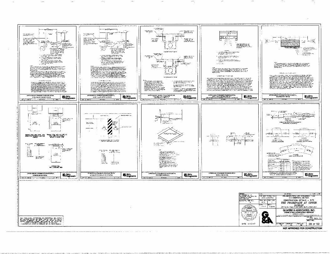
Tref:171, i I
Aria06 amy. WV CUM VW !Ka apir ilentt. ape ae,
MON.
MOM Nu ..n. OAS is eft MO .0 ON.JE *PO. Gus vier
AMMON. NM UMW, MG
IILIFS114:17
EV.17:6.7r. gat
111,
• =I ..,T=r,=;74,47.4%.
CooNANANC10•.%
-
4 '
104.41.
..... r ,...•••,•
"..;••••••
!RC. um+ musil TOWNIMPrtitiON0041. yoU....4 ARV.. NOW
WEIM111•810••••••1W.WOOMit .011.4.1c .i.r.V.V.141
No. RM.
I I
ririzU`'
loweitOulue1owlewfrvu5me00.4. 61.11=ggrgert
-- I non 1 1 ••••
wresateule.M.8•0/0•4.0110.2. •••••••••••••21nInno
LOPINIOU•terrevotro.elioirom01:1111Na. Yeauana
••••• %W. row 1 non 1
%Engineers 1 • PA 1
u.ra
•••••••
1914 411
.01,1,1.013
re...,atind I Ws. I in PRELAINNITAINAL 1.65 SEIELONINNS PLAN
AND CONDITIONAL PSC PLAN
CONSTRUCTION DETAILS — SITE THE PROMENADE AT UPPER
DUBLIN vinIGC.••• 00..nnvoN
28 OF 52 Comz sgarr!:
ONWC 010.1.0.1.
WK. 110101.0. P• 11.••
NUNCIPOL 16C 11CL:
..;i14111A4
-
DATE 6-12-17
A.. I TAX id*, utak NO...
0.12 NOWO
GILMORE & ASSOCIATES, INC. E1101116136NO 17:111661.71.1.2 ISENVIC£6
LOB
.11,101011•LsonialiMPA.MAIIINIA• NVOINVO000 INOOMOIONV Oina
11.11.1116111NINNANANN NVANOMO MAW aNTOLAY,RAMISOONOttokOoo0
APINN 1111.0117111111611.1 MONO OZPAl PANEL MAMMA
WPM MIN IINNIMIPPTANDANDOCTAA. 1111011.6011111111.111.11
I mi•a• WC. rtiMeE41.
giMe. Ihroneas 1 Non 1 .4.1 I •••• I •••••••• I ••••
/.. •31%— J.
• 1-'•441=2.int:
7- i▪ =3 .7g- • 747.4:
WM Om. TorifeWir 1111.04•0 Oirtfol ',AVM MOLL KM
-I I I N.
'f! SOO NOIO OJOS OLOYOMINO MM.. MP. Neu° Ot COMO. On,Col OCIO.0 LPN In LOO. ool Km. n
MC. FINCO, offoOn.r., on2.0. oNnICANN OLosoarow fp 04 1•124.11
(.5.011 01.1.0t • •P10.0[1. M 004 01.01 .71:00•24 1:100•P •5661•1”.. At won Kle.0
• i e , - •
• it • •-• !
1-
:17:117.7.
I
'
• X.:;2•74,411",..
Nenwomowtann..onoorononenNvononnonomm..roSoNno• MVO.. •00010.0.0..........••••..11••••••••••••••••••1•••••••••••••••
1.414.1 1..1.1111.10•Vrir•hr•v••••.a.••••••••=••••=•••••11.1
...V.
.•••••••1........1.0"..••••••••••••••••••••••100.11.••••••• l•••••••••••••••••••••••••........•••....••••••••••••••nat ••••1*••••••••••1"••••••••••••••••e • Nr0/14•02........01101•1•4
/0arte••••••••••••••••••••••••••••••••••••••••••••,• .n....o..o.o.oftoWOloonnommoroonononnwont... womt•NoNNNOoomooano•Proorpol000NOONnonNonnr. ii*Ii•ft•••••••.••••••••••••••••1•1•1•001.••••••••••••••••••••• onow.M.00NlownooNownoNoom INNO ewe.. Ore,•••••••••••• 1.•••••••••••••••••••••••••.......0........ owo•d•rein•••••••1•1•••1•••••••11.1••=100.....•••••••+.•
=0"1:10=1•7:=•"""‘ I •••••••••••••en.,.•••••••••••••••••••,..•••••,.......
=1. ,!•41W., 4 661•171
WON. IL92,,,y
, eat% CW,
" • 4- 7
. - • -
*0441061101A0101
mem. althS 120r
••-•
r- :-1121.11
NOT APPROVED FOR CONSTRUCTION
Prian
amM
OTN
. 1.1.10
DEV
ELO
PIA
IN1
MA
N
.0 CO
.C41
01.1
K
N .
CO
NST
RU
CTI
ON
DE
TAILS
- S
E1E
T
HE
PR
OM
EN
AD
E A
T U
PP
ER
D
UB
LIN
um
* (m
a 0.
94,
uool
ow. c
on
, pgr
.sn
I
-.1 ! 4
Cs,
gP. t 2,3, 4 X
1 !, 'i 4144 ii ,,, 1:1_,J, ,.•
\ , )3. , i i ; ,..r, a dip, : . It tit lei
1 4 1 1 II' . :41 :
I
I i
l
l
t
II ! :
r
i
[ I 13
. *: -,1
-L.- - • .: ,-...::-.-z
kill ' L -,•))
l• 1 1 1
Mk: 1 ., ,.... •.
' -,.,-
I. 1 , I:i I. • , .]
IQ:: 1 Ili 1 11i
1311111: Ill til I
ii ' iiifilifilMi-
,;11
I -i ill fli ill'il
• 31"e iIi
a
11 sill 11
/ '" 5
I
, : ggt
IP .6.1,,
,,
1 1 1 1 ' 1
r
li
1 i 1 11
-7-.---1 „ ', ,
I 1
. . , - .
g 1 ' I 7
(A
. 1 I,
•• K' n•
IP . 4, OiD
,,
4•,"47,Z..:•`• 4A- '•
3 !t i; s il il •
ft.5-1 i %
it(' i f, 4 ha
t "
Ili P.ii , ell i
:. '
„
' -s-z,
A ,....4
f
•
• /
ki,i thil 4111 • 'ili:—
b il ; 1
. iitih• 1..1F 11 • . f in! I-. f
3 i ti. p I
MilltiDliiit 1......,...
;
1 i f•
' . iiii
j el
-
i CIO 1 .1
; it I - I i
0 11 III .) 1,,
i s
f 1 •
14
00 111 Ein 11 -. ill - .1 r 11, Altri,1 i
I . lit :!,
—
i p . ,
„
_ 7 - •
5, : .,-a---,----11_,.... , i . t 1- .....;:r: -- : , . e ii./.5g.t.E) ;
- Y1 sf•
1 i
' - '
, '
1 q 1 I t
1 ' , I I 0 1.-
t 1110 4 .
\ \ ';'' • f= '
.' 1' ' ' 0" ,.., - - 4t i 51! g
„
'LI
iti I
i'll . 111 Tit pi fig r tilt 1 Cop
I 'Li
•;141 pidert; ' 1 latili N...k , FT( ? 1110 N i't geN i•I
IhRlIji ill
i 0 i J Pl. ,{Biliare r 1144 iii.ii‘hilli II ., - e 2.st
1 64! 4111 Hiplii.1 Lin fel i i 11 .
HIM r !hilt .r a „
I . g
te i
1 ill. a jf 1 _
1 - -ra.----
1--1
Of 111
, J ,i
. - i • ;
1
, , 1 .o- • • Rd 1-• ,.
i ...It!
4, f
I t al i
l• - g " 11
' 1
f, ill - • 4f I F17- 1 Ir. N 11- 4.
i N ,..,IL
II h
....... -•-f•-.•
fi iiiii„ 4 ifetii
.J. •
P
lifittglivL nilliii#11
. +01 Npil .11 i-
14; i
0 $ 1
iht hid #.1Li
;I iti
1 o i
[4. Zii,7 1
14 1
..)$ 0 I i i'
,., I
d 1 1 I
1 t i: - .1. , il, . 5; ill
't t
,..,,„,,,, ii%
3 411 '1? 01114 ..1..f,
I i 3
, i i
I 1
F II ;
1
xt.
.._
0 .Pt
\:\ , As4 \ - \\
it li
•'' li &•
•
4 g: io, lir
IL
4- Iti.. WRI
\ ;Pet \ 4;4;
\ r7, --I tri:d -7. gall
.1
3
•--
I
h
li ir riatill ..,1 1 I .:, i. ..: 0 •.• le 5,1?/;!, J II leilto
i iL,, ,c. : t , ..„„ .
1M pi i 0 f; 011(4 14)"I''
. I if.,All Pitc-ivi.1 .. ilig;i1;i:
/1 iP 3g130.1 •
A
1 g - , I* 1 1 ; I; i 1 z I - i I
I
- I - i
t•- i . i »ii - ,
' I
J
--c_. V
4 , 4
i i! a. ••, o
- (I I
. ..,
ir g _
I L i
1
11
.;--- ''':. -''
• i - .
. :.' ,—;' iliTill
6 i .,1
. i c q I - i
4. Ali
lilL kill ' di;
I ii
I Isfil. 1 r„ I HO ! .
11101041i I i it gNilliti It il
ttteltiit iii .1 II hitriliiill'ri in'ililf ii -;f? .or....!. : ..• ... •
1 0,1411114iiigliPL
II
1 1 -
, i I I f I
g i i i T •
1
i '• ' t ; 11 AN, it il 1141 , .,3 1 4•. ' !I !.. rt ill ail Mil ' • It! #11 P ii • i 1 4,1
j,
N
i atitiiti it; ile.
1 P"
VilA twX 50
1Ii
4Iii
ii,ti ••
' 3- .
' .f '- ''—'= ti ji re ill '
• - !il ii. 11111101
1
_ . . " 3' ''
- - - " '
i I i :
'''' i
' • "
—
• ' x
. '
. lit 4,0 ilt4tIlipi)iiIR 11 Ilit4 ir , t NI ; . • i i , . :To.
P" thL "' 5 iflill , , !' .• • . . ...
i I?,
iv
i i
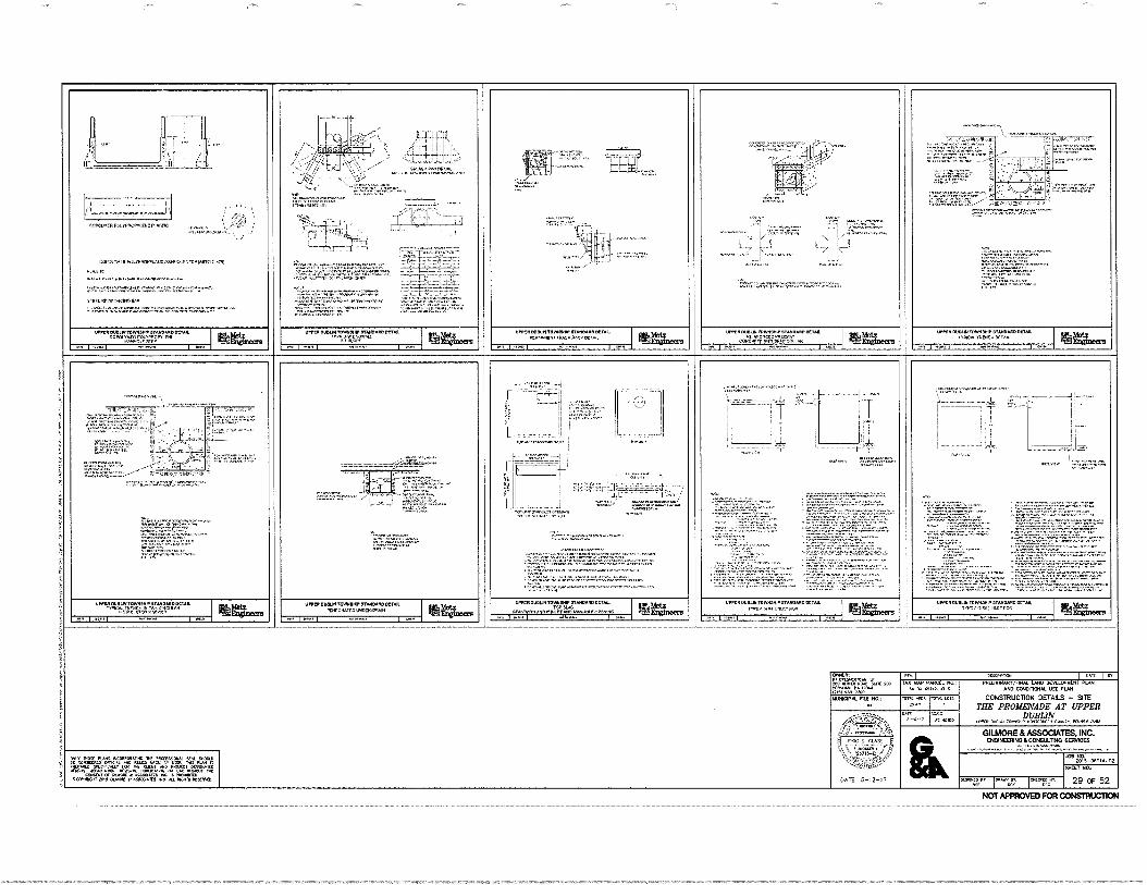
.............. •-••• • Lit
- 1 . ,, LI
— P.
....,10......o.03,4.
a
. .""'".."
:Ira 11=
'; Zil..!J
:..."7-1L.,72'
7-,..,
.
.....
zt,r '
.C.T:It
4--
!
,.:.:a //,'
.... ;ma,. m........
..,„ ..r.µ..p.,.............
:VITA 7.7"'"'"` •
- • zr.i.-:•-r -liv 4 .. .,- RI LL
'EMS t
4,===.4••
• ......, i'.... r'".....147.1142r.1...Zrr.72>
::-...r T.,..W. ..1e2mmu..,,,..-- .r.r 11••••
---s1 I/ '.".*-"" . L..) C3 l'" ...m....4 Ly---
.......7.7r....
1,...fti". IZI:797.""" '-''''''''''''''
uP.IPOL•amm./..
'A•••.“--......, ,c., ci
Vractir="...". .....
7..,* ....... . .
".". s......,.....:17..r".'""'
Fri'... .i.'•"'1"":::1*.
. .... ..._.___.... I \ • _.
exatodouromeoaftneWane ...a..... X 47 i 1 . • ' t
COPOL•14111.0.VP•OPPLIKV LWOW LITPMPIPIC.10 • '!"•:•:':7647.67..j.!i:,
a.... ••••••••••••••.1.1.0......npoinroeunina
.........av g....s.106.0.....*.m. VW,
"1:1A.: ...... :•=tr.......=.1.-...=..........7.=....r"."
"••^T.='""1:. "•.:44"`"1
08101111•010,04.
.....%V..".:Vatt:::::=7".4.1tir=:•=7==""''''''.
............u.........•••••••• ..=:,..„.=‘,......................... ............,,........,„.......
•P=.="............i...c.•••• tligiritri..=a1=
.g....2........"•=r4i ".•
V.C.113.11.0110•411310. famealaf arrui. .0....e.n FINPOPKP KVA RM.. UPP.IMPIPAI 'OW 07•110.110M4
PrftraaCra MCA= 00.4C•PIP MT 'PPP Ca LAM %C.
10•2•OVIPLOITIVONDWP IL/PNOPPaneaut rar, ria.c.a.m.
efthiSe
MP 14/00110.14.11, ItP49•40 OR. covolaratotmarv.r.a
ip.v...I.• SW 11111ftneers
WPM INIOUNIIIPAIM, PPPINIMIDOV•11. "'"AIM"" elillimmis
re I .... I ........ , ...• ... I ..... I ........ I •••• I •••• ..., I ......1 ......... I .... ... I .....
-..._._ 7 0:4•16p...... ..................--
• I ! r- -... E.'2:711 .,_ ...,-‘• :. --
.4 -: • 1 1 . . . , I -
- r . . : .1—Z---* 1,4
--;
.....
: i
. ..
.. •.
, .
, . !
1 I
1 ,
t... :_ SiF.-..Z....7; .. :..„.r...„, -• ... 1 ,.. , ..,......„.„....„,.,..„:,..,
Pt::.7.7=17i, .1
r- 4-
.,......,F,,........... .
g, ;.....q...v.,,,...7.=.--•
.PI ir==•Valia
ToP,ORISO•440.1.r. . WINO,
i .0....P... •
' . ...'" -.4 '
•14.1•CP i i .
.1" r ......,.. ....7527.i,m,
... • 17=',417,744,...17.74.17.4.177:7. .... . --r;•';.?..aira:Ff.""=".:.:ZZA.
• '1/4" 1:: re': 7. I .ii'‘r;'. ZS Z : ..= mr.t.r.
1: - -1-.7.7!:' ..... ..........
.iiii...,:= .4:•,....7: .. . "I• .r..,-,--..r.,:c. . . i 1.7. ..-.-. -. : .7:::i r: - -7. : - ---47;•-r-......1:.--- • '.........r.M?:=:.r.f.r.•
11....“,
,,,
.'17474...rrXi:17.4.r.r"*. : ".......,".'........'"'":1332.Cii:41-41:1 1.
....,?•••••":"
..,Mr•••:= t.:r•=a74Z=7,7==.1.1.•
• -.766:474.:7r.". 4:41= "1.7.11.1=7.7'.7,7...... ........ .............-6:6un. ....1.1•••,...Z.1,,,, .----7.2.-..,..i......%--- ..r.....12...4:1---......----•
Mr. wzren.r.a. I...-.
• ....
I 1 IP ' ::,.."115.a•F ..... - - , • ..""L'........ :'-'' ..7....NPV...A1•1*=,...e.
:=••"7.:=1.:467p1==g" ,:•=1:.:7A.,.... 4
i''
I li rrltr...qr.g.... F-. ..-1.",fa,.a--1....
-.7
' 1 '..."....." 1.11 - • • • 7.7,... i
*V.... ••••••C•P‘,4110.0%,,••••••... alea.......01.1•••..... •••••I••••=1:7•40
Wm.. -soomireePpip.o. •••••
narr•LO.
.7,--47.1..=::—
.
••••••,.... - ==!!!!•••
"- .., ... J rgt.'71-Z.
....•
.7.*"....===......
•2'.4.27.1.F:z-
,
ra...a.laifPOLP OM. 1•1,111,11.1.0141111POCO 101•100
"ii.7.1.--r.-...r -- :,..................,
..?...r"-. ....!....r..........r........1.....-..... :'''.47:• -707:ge:7:`'••••••••••'InT"'"* ..,• -.........,.......‘,...........-,. ..........11:z.vg...-:::::-...7..r.,•=a4.--... -• .... ....... • 7-.......r.-4•*------- .."---
7::"..;44767"•- -•••••••
.`472.777,:.!...=?An....n.......- --.....7....--r-za..-4E-7,:g.-.1==. .......... ---........... .......... • • •=.--- -,7.-- —.4.4:-. --...--.7":1,-...,••••••-• ...an.. -t:L=7=7.7•7471:=711=1!:
. rz..:.r-iF.Z..1. - - — • 12:17.:-?.... .•=--1===--'•--- • ...------.--:::::-.--. - r.--7.-.4....r..-.r...74:rra==•- : t.1.2F•i", tr.T.tTJ::%..,--7. -...... 1- ..i.;"r.,1V-ifIF.r.--r..-... ,- - -4:4-,:ri'v-41-4•••:.--...-14zr-
OPPPILLIMUI1100.11.1,11PAROMO MN. CTMAYM MO w arTIPZIWPWON• er•Profte freEurinma
WPC. DUIPLIM 19691:141. MINIM 0 OM. FP( .4 :4 (.1,P•rT/UP Itt6l
ati.Z . VIR•01•11..• 10,0.0140. 11M404.0[1.11.
*47, 7nnn crtoox ilftra.
; ....w.,.....10.111.10 STMOMOKIM r v..107;1`grjrArgr" RM.,
UPPe• a UnP1,0.1111.1.111•MMLO OMR nArtAP,LIKPoar.P.I. aggnearg
en i tun i ....AL i Lon i uu L. i Lnn i L."... i L., •••••". i un ...Lt. 1 L..
E,
i
i :
i
: MM. PCP POsaa.Pen WI In
' LP
Parlaa. P. nem MI as- Me
. 0-0.0.11.6-3
PPLEMPLARY/P•Ip• LMLO AND C01011KNAL UR MAP
.
WNW& PIE Mt 0
mu Ana 2.,
nut Lon ,
CMISIRUCTION DETAILS Sit
ME PROMENADE AT UPPER :
PAL
.....•• !Ott-
..,. ...... r...x... ...en* wawa. c........ w.m...... , i • GILMORE & ASSOCIATES. NC. i . 003•40010 ACOMIXIINO 6136/16161
.......c.......p. Ison•
*WI bele •LJon Wand 0,40 I< MITS•JOCK NAL "Cub .: LK aPnlVaP ona. Nd. NG. NW P.: Ma Irn .L.vi n
' :. fi'' L. an NW 20,5-011014-02
..en•20 2.,..1CP1, on !La 13.001 .0 FIRACT DOPTUTID i Mi. ieplex.m.p.. Pr... PLIPMPT. a. usr ...art nu , caeXart a mom • ar...60.11,. PC IS .0.019,1
91117 MO:
,:. CCON•Ks, :0.5 al....[ f ASSONAITS. NC . OPPIS WW1,. DATE 6-12-17 sm. r. itwom im peon 1ft *V II 11C+ I Pe
29 OF 52
NOT APPROVED FOR CONSTRUCTION
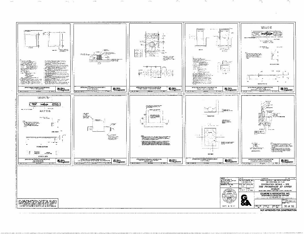
I I
orTo • nor.. yono. in
orni•oronse.. infooni •••••011..1.81.11. rforini...orroinc.
;
•
."1.7tairaig"-
.
VIVINIONVII 'WNW MAIIMOO•UM. 1`.0 sow:emote.
•••••••••
L'ir=r4T•t.
Paro k41 0.
• Xt.'1"at`ZZT.
VICW
-Ii
CON =Mx ......... .. ..... ....
a •ftenn, ......... MYRON VICW
10•11111011111.11110•111MPRAMAIMINTYL
4.1.1.<1.1.7111.
110.1.10411.LIM 10,4.1100 •Ton0o. DV. Toff., C Co.CIT CoC.Crion OCT.
noer
inntli corona. •Toxeores 0•T•ro • N•rn ne.vr Lit Ne
eoranser.
onn
Loren ofouno lOrni.r•V.0.00Crifl
lEgg. 0410
UnoIrri TOMO. STANDARD OtT. ricl,
ono
WWI MAW. ST in.., On. UM.... le., FP* fltrisi ITO o TO TT or:`,23 SM.
WOOION11.01Mvarfts. srAimmo Tool.
•••••••••• I *ono oro 1 ••••• I o.in
ATorT•
I i
. - - i • 1:;_i___": - .1_ ' .2,_ 1 '
• tr.74.""rn"...
-En L+1._—
gat:"4-2171.1:74.44 7*.:2ff4".
flr
x
if-::$7.-:.' li :' ' . • • I TA
: • 1
1.• HAW
INOWIL'W
Mambo.
nor
71- •
CACAO MCI..
ragt:Z=7, air;
rtrrarZt St1101.0E1.1.
tiortfil 0.1011.SISsin STAR•0•10 CCT.
Orn.COVUT/0401.061190MOCT•ii
I on. --lEaginecra
Offoal) rixot.o. fon—. •
.orrons
• ▪ .▪ .....0401.1.•
•• Omot
C.1104 RECTrift
IIP.1011.1.1•1/0.111.01•10...T.
diCRINTC C • o.0 WU. ni.C. ••••••
11111.- Metz -.mEafelneers I urn
t
TAT ri.C. .1(0.00,0,4 nefirtSTT. MY. Xt. tertento OrriC. 14(0 Wt. in v. niro Kon if
.Tron. Coof.r.onai OD oc. • einif MSC. Cir Cur. • IS o•Cn
11...Cort 2,5 tanoteC • ...ITT .
NOT APPROVED FOR CONSTRUCTION
oicv 1 Hoare,. ONIUL 11, anotorro. ti•
IOW T. 200 ... Cieco
•30- P.
TAX YIP paw. ha: PRIELAPARV/FINAL WO DEVELOPMENT PLAN 031011101100 USE RAM
COVSTRUCION DETAILS - Silt THE PROMENADE AT UPPER
DUBLIN ri..11. •Pre.r. nom. or MCP, •(.0414,4•4
WNW* nlE OM :IPS 'WA TS.
OAR
GILMORE & ASSOCIATES INC 00.0000SU.TING EDITMGES
2"09'.i9 -060,4-02
SKEET
1-1°7 30 OF 52
NOM
DATE -12-17
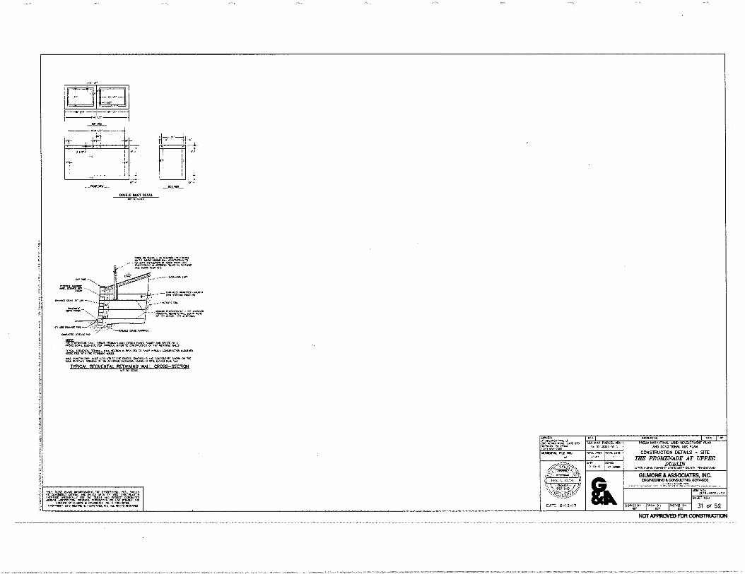
',2171ACI: -
1.1 DC. PL. APM
NM. APS
50,re.AMIAIMPSYEAV SPIPPRO WThArld=11. •
°ItI,V,I'147gr°4`4711&042:47'41.1=
IIPPAIOSS 01C40
MINN.L1-1
ONLY SVIX UIC="SaMPIT WPC. 00ASCAT
CONSUP CV CS01001 111 A PCS M ORD SCOPARMPT 2005 CILM0PC • ASASCIAMS MOLD
PASCPP000 lJ Ar PRELIMINARVFINAL LAND DEVELOPLIENT PLAN
AND CONDITIONAL USE PLAN
CONS1RUC1ION DETAILS - $ITE THE PROMENADE AT UPPER
DUBLIN W. CUMIN TOW,ASVP maocaumr CCU., P(APMAIV4111
GILMORE & ASSOCIATES, INC. ENGINEERING & CONSUL11110 SERVICES
48 M-06014-02.
SHEET NO.:
DATE, 5-12-17 ors.11;tv. I cArov;T jNTTNAlIUT 31 OF 52
SAM AGALS POIVP
TAX MAP PARCEL NO.; PA-00-03
OMER: SP CALMIMI10011 LP 4IgO L0
,11,
CPp
k00,A2, WIC 100
(717tti-A100"" POYAL LOPS MUNICIPAL FILE NO.: MAL Allt,
2,10
I I,
101 MVO
10PITASSW —PURL—
DOUBLE INLET DETAIL 00110 4114l
Mr.
4C,,X01
,..011
.0,11•1
,1:04
...MCAO PAVAPP0 TO UM* V.CIPS ccreattonel maims
7.11± P.1717=17.111VAZ AIT21."' TYPICAL SECMFNTAL RETAINING WALLCROSS-SECTIOR
NOT APPROVED FOR CONSTRUCTION
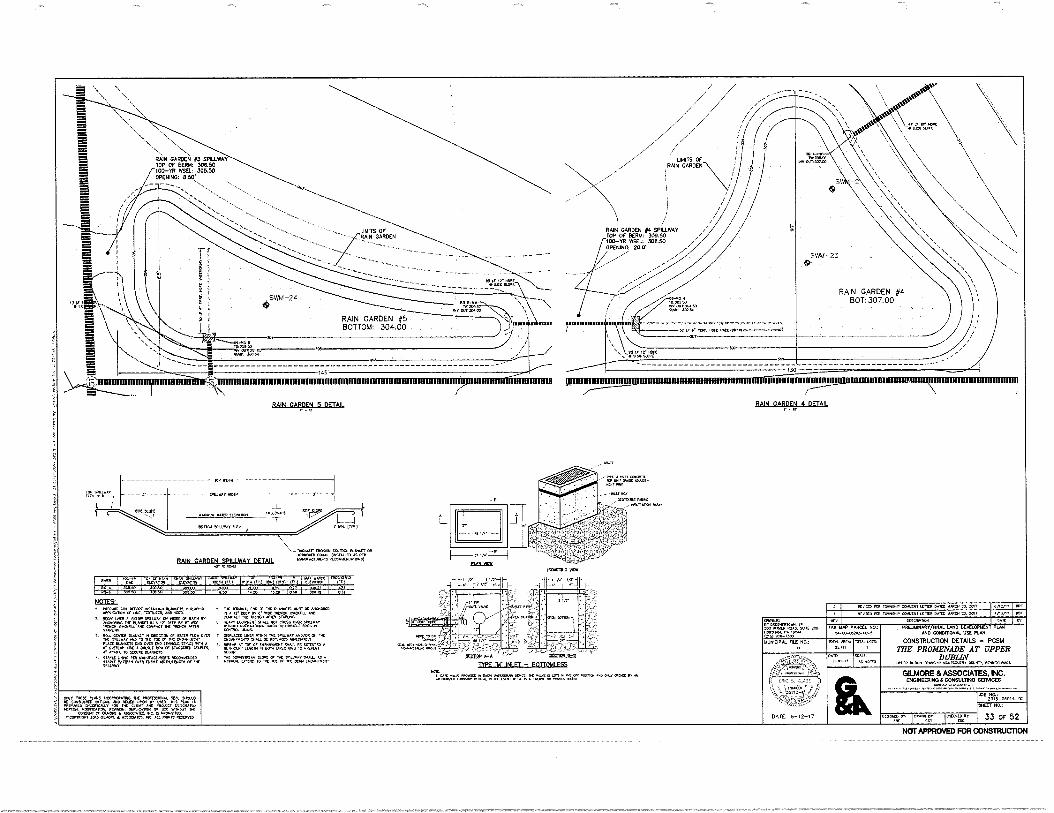
MN DAWN 5 OFTAII PAIN GARDEN 4 11F7All
"L. 12/61 GARDEN #3 SPILLWAY TOP OF BERM: 30050 100—YR INSEL: 305.50 OPENING: 8,50'
RAIN GARDEN #4 SPILLWAY TOP OF BERM: 309.50 100-30 WSEL: 308.50 OPENING: 20.0'
.43
INV "OFigil
RAIN GARDEN #5 BOTTOM: 304.00
HIMMUMUMMIUMWRIRMIRTIMMIRIMMITMIMMUNIFIRMII,WORDMnitilMIMIRMI wimmumminui imummumim
.... MuNl r POS. kw isencoom
4.1
I
I — ,,,,I,.___•
LIMITS OF RAIN GARDEN
• 11321904—A SLOIION
TYPE 'M 241 FT — BOTTOMIF95
' L.w.11earw` "102,731IgnI
TOP MOM
gusty wen.
_L rISCLIMINt
wrroy SNI.LWAY ILI, -7
RP I
LAIN GARDEN SPII I WAY °ETA!! co.1.4fflmaan
NOT TOWN/
0,5N 'ow HoZITO 0('IN1(STII
MIS I, CP XV I/
OMER: ORLS.110...
r,10 200
MUNICIPAL FILE NO.:
TAO MAP PARCEL NO.: 5.4-05-052.12-40-5
MY In, 2,11
SCALE, N.ra
DESCNPI.CN PREISIINART/FINAL LAND DEVELOPMENT PLAN
0710 000011101101 USE PLAN CONSTRUCTION DETAILS - PCSM
THE PROMENADE AT UPPER DUBLIN
UPPER OURIAN POIN5YLVArna. 10
GILMORE & ASSOCIATES, INC. ENGINEERING &CONSULTING &EFFACES
08 204N-00114-02 SHEET NO.:
DATE: 6-12-17 orr.mgro, g." 33 OF 52
MN= 10,4,011P ONYZNi Lmr,, owo 11ARCX 23.. 2017 oxY,' RYA,. frIt 1•014NO.11P COMIENT 1[Rril DA= UMW 23. 20,7 4/1,1
NOTES:
";" ""4.T orglf r4V47.°Zo'Vo.
7,fg7o4:74;T: ner,ro:VZF4e:FZ
SU. COMA OLANkt, N PPLCIION Cr MI. ROW 0411 Tilt TILLY/AY MO TO INC Mr Or TMC C40...01/41:Nt e=n1VooTa r.,":.T:tVa'AXA
A^N1f. TO MOIRE M.AfihrtS.
1,7417.g NUM,
• rg-IrtVgj,:o‘c %,";."oraLf c..r.v 'NC Aritt 5TOU.10.
t',.f,1411124:LIMZ: ;A:fio?-eggir C0,01. UMN.t.
2ff."«Zo=ifi'",:c Z.,14-olLtrat',"" "
Mo'T t4""p"oVIZ7o't ralf "
• r.:44%."4,t4ineoet, Vatieatatetn.
OAT SIO5C comanD
PHIPAPED OKC lalrrON. NOOVIC
CONS. Cr OW.. CLOP/MOW .20,5 OLVOAL &
RFO.K.Ci 4MONARO
c"),L=Psitvro
NOT APPROVED FOR CONSTRUC110N
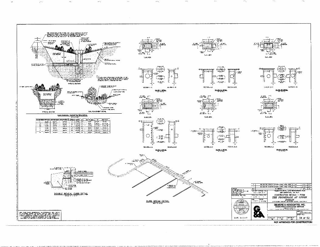
flIRR RRFAK flFTAli 1101 IS Staf
.••••••••00 TOP IILMV SIMON WV PIRSTMVNIV INI•114 •10.11 171/.. SW nr. WI, To my{ 13:3 •
p,
2L.Z?!... .040
•:, _. .: . • •073 I
I a RI. I • ,,..,
•
OS., A.
01.114 ,
‘,......:.,
! ••rn . Iv:. 0341110 p.c. .... baelft —I .
[..__;....f.so pela• --.36,...... _Sr—
OSO• ppm.
: .
a.
r. :
r " r.i =fr
VOSS OLI•Prj=
_IT aa. aft
aolL1•PP L0
CIAILNKSI
=rr
I WC=
1-r"rin
0.65-111
:12-1
-I..-
ft
21511L2.11:011. No • w.
I
9541515-arA
7,r2r 000
—I I— r-
7.00111
1.--...t-7..... 0.0110
1.-f-ft -4 .“' 0.
r ViAllip
=TTAAt
-Lj 1
van
"Rfe=
4- J 0 la
I I
4511011.5.-.11 0551111•211.111315.
10 NAL
V V
51:011111A-tfi =MULL
•• I 30 ',ad
51X2C11L5=5. 9.51155-fta 511515L4-1CUL
.6•11.
SECIE111.4 20011-11IAL
1.0. NUM
0,OK r WILK POL
&HUM
ro 5•01.[(03•_30.1c •31.
giC••••.• ert.at
reaTo,•.• P*044
AM We. Dab ,0 II UT. • Cal.a4•10 163
.30.11r17• C.Ir357. /Orterar.'•3" 0.1.0•3,04 OE 0.33SIC 3.4 16•903.4•1•01•431.
.3.1.,• 6311
- Lad
gy 1.0,1-16
• 13.2vZ 44.13• - "moo oaf:. rar.464-
•••330 aaaa L••••
3 .3 ••‘• 4 12.40.9.194 1•••03 etafer.43.0• nolta
n7= 2.4"•=tri=
SECISCXI
MIN GARDEN 8IME1ENT1014 DETAIL
11/12, PE03323 rt• 30•43.•• cm•Ch. MR. Da= ed.. 23 33.7
( Alp, IR Tow,. c.a.., LIMY 3•130 1.1.1.C• 2.3 204.
OOK/C er wawa. to Pa IMO PL. :WC KONA, pa nc. (MI •No.,I. 141•01•1. M.:
a
DATE: 5-12-17
V
100 110 MCC/ 1.0.,
••••••-03.2...3.113-3
30,3 •33.. 33 4.1
••• IS 0
IL
04 K
PAILDINANY/TWAL LAND 000600100 PIM CPCITIONAL06 PLIM
CONSTRUCION DETAILS - PCSIA ME PROMENADE AT UPPER
DUBLIN mom •••••••• lanceam, Wont Krentrom
GUAM & ASSOCIATES, NC. 5/520555,51/50511.5.71110 SUM=
AO NW 20*-0101.-02
Peva:, loin:: lamp.;
3.3,13713.
1104
34 OF 52
DOUBLE REVEAL CURB OFTAII
oro, ..et •coreatme ng 3.34.330 K tarSKPLO Man NO KW uoCv •n n ALPO° ...Ur a* Kg MAW ma 14.0.K. •Ouart0 alitan leentate, KoSO• ...anao Nir 1,...11
<0.504T Or KKK • AlsoLain n• avant. •nanaan SOP annAL • olKann •C MiP.an MUM
NOT APPROVED FOR CONSMUCTON
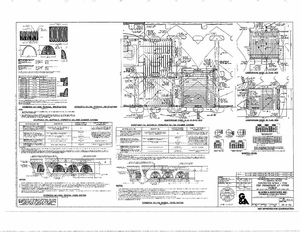
NC. rom10,
6.00.fx ...' .. uos-,2 w .020‘ ,ft.....,.........:44j
SONOst0 o.r. ...
is“,
INIVe ...m.........
....../%1Lere -----33Vels -- v. - so. Me *AMA
IINDFRGROUNCI BASIN IA & 111 PI AIN VIFW
•If
,22 NDFDIDDMIHILRISIN FR Pt AN Virg
DAIL 6-12-17
41W' 4 ,11
di 11 FA I
II I] 11 1111111111111111111I1 11111111111
••••••••••••••••••••••••••••••••••••• •• •••1[1>•••••••••714 moves.a• 01•041[1.118.40/3.1•SININI.01. •••••••••11.1.00.01.
rIT:ZIAZ:Tr
ursaa0MMIN19411
V11/10.10Ur
.91 T 'MOW ' .Z.Tesr r . 1 ilr'
10.4111 artjt2;11
,
.1•4101.
we Ortattal 0' Mt Pemes•CD oPe
low. MN
W ak* 4dgraW..1
1I 7"' 3Or
i.
3 -.-
1 1
01. C 10001i0. SC-7
rrs:„ /".nrenttgergir n• ra..• •••••••• Use.
••••••••••.1.1.1... 0••• Gm*,
.i."&"14117.'1fl'
Zir..1.•::..nAtrarei6 o="".".
0ART• 00/0 0 u........
0
::. .....K63r.". ...
....t.
.....1
.3. a • ....
. ••••• ..
.........'......r....
, ....... ... ”".".''''
..0 '''..".". . ,,...,...,
..• ...."
w p.....-...
P.M
a,....
NI I Ng. 0.111011.110.1•10.11 WV.
STORIITFrli W t 1dflll TFCHNICAL 010RWICATION0 CTORMTFCN SC-740 TFCHNICAL SDFFIFICATIONS XMl U.'. WA.
• .,7,4::=X:t
.V.Z•11,3 0.11.1•• M. 01 .1 0.100.1. 114..0.21 S10•11.1
Z.V.:L.127:"Ajt: Igs,`"2::"Intt7I7c; • s CIPUTIO, .1,11.1100
Acarrisair nil MATFRIALS: smanrcH 1112-1100 CHAMFCR SYSITHR
UtEIESMOUNI-SASILTA-ELAILIIDE
RNA OM 1.2•4.10
102.0 I
or-I
111•1100.0
roigir
••-••••
ir•X•.00 elete
no,
TAX NA/ 'AMU 10.-00-05:42 -O.
MO019.01. LOCATION DESCRPTION •ASMIO CIA6b0K00000
COMUCTION 106.0317 REOUIREKNT
rAt1.111.1:74.20.0.1.1
=T. = 1
""-•`"T.T:=17."`""'" ZIT •
Cr..44:04, re•••••••••••••••••••••••• •0•01,0r, • • let....••••1.00
OF VI ..101•0, CUM 000.1.0.10110. MIRO!
••••••••ent be •••••••••OWNLIDOOMOMINOLOW P<••••••••(••••••• 0.1••• Milne Amen MOM.. 10150I0001100.s.. ••••••14110 40.1•016.010, 4•1••••••••••••••••••••••••••••••••••••••••10•••••••••••••••••••esseatle•MR••••••• ••1•111•1•1•2nMeerel.01•Ve•••••••••••••••eev• •••••••••••••••••••••••••00.1••••••••0•••M•11031411Yelelle.•••••••111010. 1141.e0MOWNOV•Heeee•••••••••••••••••• 000.4••• 1•••••••41.0.14•14100/4e0.1•66•4•UP•1011•044••••••••••
41 Mel •
• 1.11••••••••••••••••••••••••16.•••••••••••••••.••••••••••••••••••••••••••••••••••••••••••••••••••••••••••• ••••••••••••••••••••••••••••••• KJ01•0••••••••••••••“60.40..400•41.••••••••••••••••••••••••04•0•141••••••041.4.••••••••••600••••••10.166•.•••••••44.0•10Verls•V
DK Vat ••••"" Veer ••• •Er • r• =ma.. <0110111100100,....NROM.C100101,901010.0.010.11.
• 0,00.1..0011..11 .200‘....111.••••••••••Peik•-• ••••• OfAUW ....10.015.01.00.1.11uVC 010141.,‘ ..11.0 416•141101.0 s. 04011Merelagrelarnee•••••••
STBRIITFCH 11(1- FFNIFRAL CROSS SECTICK
ONLY bee Mon ••••••••••••3 ler .0Y(SSOlk. 0C. aw0N. ViKar I,
=Ogip. MOM*, MC
1.0TC•7,04. 1101..... 01 V../ Tr Mean Ouiei eleetieei. we 2 ••••••111,
Ce01.03•T ee.5 Crt•e•r ...C. b2C eteele
• -.Ale 1•.
0
WIWI& LOCATION DESCRIPTION PASIRO WILMA
AS ClS010.7300$ COMPACOON,00.S.,
FeCOOMMCNT
-.'"'"'"...4.":14 4:3710%:••••• =Ms/ 1•••••••••••••••••••e•ronnee
••••••••••••••••••••••••••••••.110.19
•••••••••••••• en: ••••••:47••• in ••• .0•01.0.10.00.01.0.... ,V.C..,........1 h... au... •••••••••••••••••••••••••
.
2•011.10,111.600.01•11••••••C ................
.... ....."....7...........':: irr•ra;..zr le•••••••
••=er•••••=••• OM,. us+
......enninerumcwoomgooNN•olt ..
•••••••••••• al...
0. .....,Na
.
...........11.........1
............ ,,,,,,..=
.1.1.001.0.6•10 ...............1.10,1, .„„..,_,A.............
emerarroltr.......;i...
• ...../......40.0.0.0.1. C•••••••••••••••••••••••••••• 1..... 0.00.0.4
ens •••••••••••••••••••• ••••••••7:7, ......u.c
• 1.100.010110101.0010/0•400.0 ••••••••• C••••••• ure•••••••••••••• e•••••••••••
Cu. CM.0.1.0.0.1000 .1.7:137: ON ••••••••••1•••••••• •e•s.••••ur
.."14%20.2.00/115.1.0.1011........01,1••••••10.0.12,1•,...60.10.0 6.0•••••••• • ••••••••••••••••••••• 110.•••••• •1•••• "gr. a,
======•1•MT: r•r•=7=0"=.1=1.0.1.• •• ••=.1f.1:10=======r, MOM. 1001101,••1001.01.1lq0.0.100.0.1.11.1....100.11.0.•
nwaliN0s.0 ows,01.11
CV=
EMS. I
I .601.. ••••••••••••••••••••••••••••••••••••••emoterecrom. men", • ....../
....410••••::•••;;:q
.:•.••:: out.. U., .10 yd.
• •••••••••••••••••••••••••••••••••••••••••••••••••••••••••••••••••••••••••••••••••••••••
STORIA7F21•1 10'.140 CFNFRAI CROSS SFCT2( ie. al,
l[ II1I!j 1 1111111111141
it*So le.,•••• =wort .11I• pen], 0•010,3. •e,
11.4.0 110 IOW.. MAW. WV. Deep “Allew Y. ZOO HeIA et•
1.£1.111SIAW 01.1 1610 0EV0.000040 PIM SN CONOTROKIL SC PUN
CONSTRUCTION DETAILS - PCSAI
THE PROMENADE AT UPPER DUBLIN tom Nam le•eeede •081.10•te• Came, Oftelek.1••
GILMORE & ASSOCIATES. INC. IICOMMATNO SEWED
430 IS. 2015-00014-02
Oto0o9 1..°g, 35 OF 52
0001Cie e• OteLletleme er ES. P.a. •••••••••• •••••• We) "Co
WADI AL MI NO..
""117.11. .••••••••••
MANIPO1O OFTAll W.102 I , T.
tele
NOT APPROVED FOR CONSTRUCTION
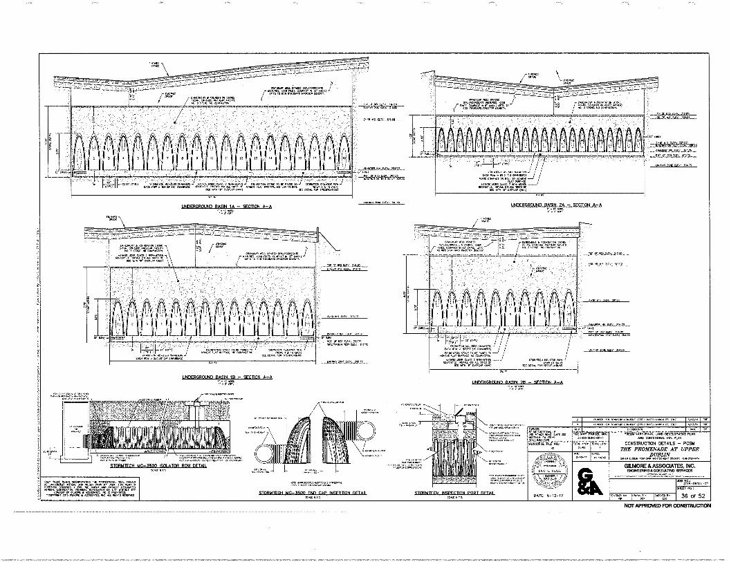
O.= 100/000R0o2
I vtv P. • 2.01211.2011 • MAW., W.
0.0•02. sot.. 0,0•2 .700•41•20
RD al. or artatt,toa I
. • testaalnetaantattasetnet
1
UNDERGROUND BASIN IA - SECTION A-A
• . •
Uolt•l•• • 0:000.0100.110.2 10,1%...02 COO' *La
' arrft'Zurt“'.7.= 100 ono 01- 0•0100 OM)
g g s00000 ?I
i
f guar
MANILA SU 0.0020 20.040•20M i f '7,:"To rn 17.41.414741.4,14
1
i,... . ...
, • • • . , .. . . -- • • . . . . • • . • . . . • • -
- " • . . a . , :
-i.
A 3 1
IT 02.0
._ , in
k_.;;;Ik12. 00" .00n 0/00( 1.0 1,0 *on ,.0 01(10,0o, ........,..• . sOa 11.•1 WOOL •0 cooK•Oo
..,.,(r
,0,4
,14
,1•0
‘.V
..
cia. 90 . ,)01; U. oaTSSl ' ....
JINOWIlleaM6111 AMON 201
• Ita IC••••••• co00.0, aro. Da. ...I 21. 311.7 Cm/. 100
••••••sore•••00••• 000,00000.00.antee• l.aul•r/e•
1111031•••
•
1.0011,141N• ma•Ver164.1
IMINVI• los cow."
TOIS•••• el.51.0••••••
STOPUTFeblir,WIR FNI1 CAP INSERTION fliTAII tat 0.11
SICIRMITON INSPECTION PORT EFTA° Y.IL Id V.
STEIRUTFON UC.M.1111 KM ALTAR ROW DEMO
90. .0•00 ataratilt ••=33c.... .00.0.11.0 •01.0204.1. .46:7•„;;;;;,„„-.2,
COROn •20 Cowan • •10010.70..,
22.5 00.102 • .0500Art..
WWII) PI* florlf Conins, LIMO 2017 'Iv
'''.;0% -06014-02
tescatz lorntr:: 10(07:
TM mkt, 00,0001. Pita
ne. LOIS 11,1. MK,
DAM 6-12-17
OINER: ▪ ettna.n. SW WWI 413.a. WTI kWh.. 1.00.•• CP:1 ear ma ulAatttOt. rtIZ
ORD.110,001171001.4/ tnt DEVELOVISDIT PUN MC COMM.. 115C MAN
CONSTRUCTION DETAILS - PCSIA
ME PROMENADE AT UPPER DUBLIN
WV. Max ,forra. va.6.611.. MO, 01•11.511V.V.
GIU.40RE & ASSOCIATES. INC. ENOINEERNO CONISULTINO OM=
Satt't Pita
36 OF 52
f - .
2100•00.• le-.0 00.01000
.0•02 <0.41 01 Mt .0 tea, G. 00• • 0. V Of 04•0420.11 i
sson0 MO 0.0.15 / 000...0.1. .100:Vet. 00.0.1. On OA 100 Or
NO ••• W 200..0 100.1
ORM.* .0,1, MOO 10,040.2.12 •000001 Otai
-7frofjeltact:14%.*
0.00
LrzUt•tlf - „ (HAYTI Vo4 v 05, 1.0 C.0 0.0'0
Lona 20•0 It•
ettv
arm. ent Mi sate 0.0
- 610 Wit
Imago* Arse 1114`• .10.02 UNDERGROUND BASIN 2A - SECTION A-A
Ii (...1111.. 'Ca.' 0, aCiCaCt
VOWEL* IK,TOD
maw,. PDX SO It V. 011 402K .0. Mo.. 0000•4000
4.1010 Me WT. 000-00.0. c001.0.2 000sat Os 4:
earn. taao)
• 0.0240 setjth• , Ir
slut'
Ter o .20 21.0.• ‘,2 00
MOMS 00,00 000
OWL 0110 WOW.03
IT Mk.
ro...-Funt• -Er 01, 102.1,
OLV 3.11.X 1.1. QM at.,
10>>>
0••••••• ••• .1119.1n
NOT APPROVED FOR CONSTRUCTION
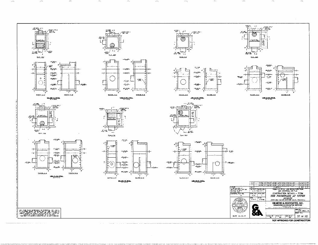
2NO%-060”-02
ocvcrze, ODNAIITiCoMgc
ovvo
ovr.umnort BY (141.0
OkiE SCAlC . 0101211
DATE. 6-12-17
TM HAP PARCEL NO.:
,OTAL 1111.5 10114. ARCA 25.11
OMER: .11:017.91 `L.5c2co (NAl rIC11,10.1, rr. 191;44
VX1-1,170 MUNICOME FILE NO.;
PREUMIHART/FINAL LAND DEVELOP.. PLAN AND CONDITIONAL. USE PUN
CONSTRUCTION DETAILS — PCSM THE PROMENADE AT UPPER
DUBLIN WPC', MAIM 1.011,149, 40111GOHIPY LW, PrWSYLVANIA
GILMORE St ASSOCIATES, INC. ENGINEERING &CONSULTING SERVICES
SHEET NO.:
37 OF 52
,trrra, r'
IMU.6.1122C21. nal' TO VAS reov
NM, KR MOM. CONuCtli 130.-. 2C,17 1/11,11 nor
PLAN NEW
'1,1fr
--I 1—
ELETION_kr.A ECCTIOLLE1,1
0,11EIS In 011011 rOl H4C Mk oHo/v,
tE017,
11,3701
ROM, PC le.41,11P COMYLIO .111/1 CPAID MARC. 21. DX/
-gst.
—1 1—
SELTICELET,
5,7:R
SECTEA_A=A
5,110N k—A
—1 I-- I '-
5FC1ILIN 11-11
M—ZTT ?or.'"
r0NDO
t-- I 1— SFETION A—A `ol—ftHN 13—P
pc—; IA
Arrsac r"
ellott-11L11
11011-1A-114 MT. NOI la /er.Lr
NOT APPROVED FOR CONSTRUCTION
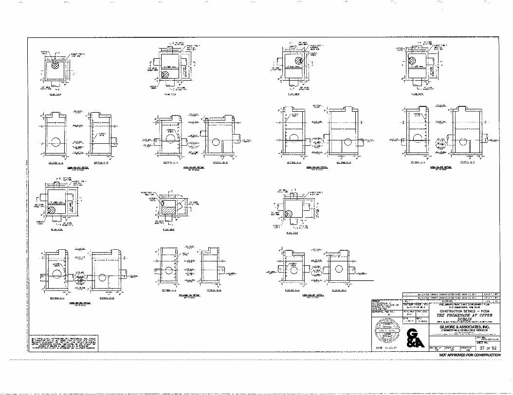
KAP. lOPPI,IIP LPTIPP PAIILD 61.0.1 Pl. 2017 con/+, in-P UM". POO.N.la LE TIPP OPIPO YARN 23 17
OWNER: olket.Nunom.
PrV OLPCPIPliON PA. TAX MAP ANGEL NO,
5.-PD-PD2PP-P0-1 PREUMINANIWINAL LAND DEVELOPMENT PLAN
AND CONDITIONAL USE PLAN
CONSTRUCTION DETAILS — PCSM THE PROMENADE AT UPPER
DUBLIN LPPLP VL.P.PIP 401.11.L.0, OWL, PINP:11.vm.
GILMORE & ASSOCIATES, INC. ENCIINEMING S. CONSULTING SERVICES
PO%-061314-02 SMUT NO.:
37 OF 52 Aw.„gr IIXTT
Zr".«Vgcr'Ar.74P4 "7, 41P- =',/•=g 'alifigP.431,To",,,"Fewir,a.me:Vwer, ,c4Z5S,T=7:=7.j.0,2r=1;";42ifne
snnoN A TCDON A-.
1109-10-R4 OFTAII NC110 PC.L.LE
ogr7°At PLAN )dayi
52017,
1417„
rts nrran
d
11,71ON A-A 7,11. B-a
1101-/A-PI 1,1411 ppL1 r.P.P1r.
,71,11.,1 A-A
rmS-IZVA PRAII
.00, Mt 4 P1127110.
IV WPC Conn AWE
r
PI AN V1FW
TOTAL 1.075 MUNICIPAL FILE NO., 'LOP& APIA PSPIL
NOT APPROVED FOR CONSTRUCTION
CLAhLMEW
Wip-1R-R1 VIAL
PI AN WE
— rrcilov nip PiCVON P-a
nem WTI IA KLLI.
DATE
DATE 6-12-17
AS
2qers12' — 7 —
a-
vr.11 A-A 71,10N S--fl
WM-tit-RI DRAB POP IP KALE
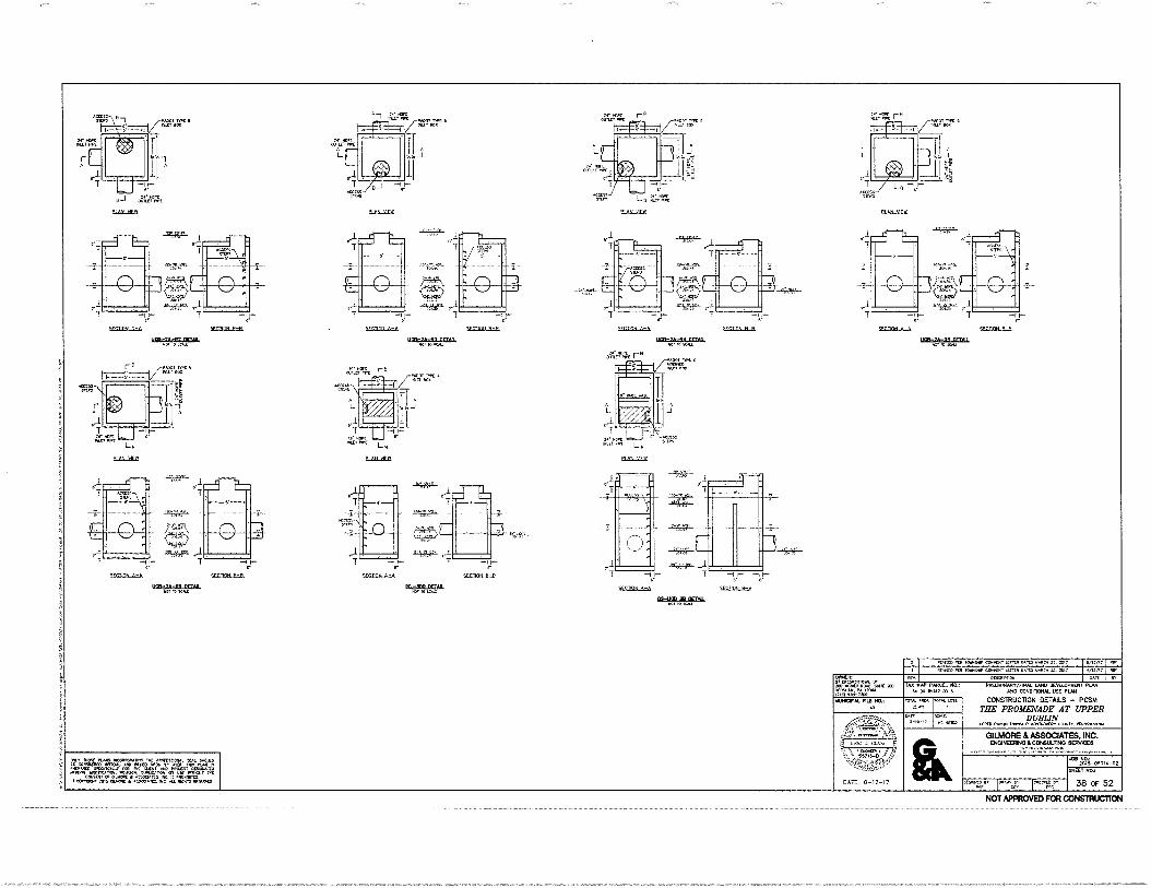
1.90?„.jrnCog ICREGN&I.
01.11, 0107 .....”0104040 110 .101100. MAL 1.100101
11"°.7.4"; LITIRL"0=11 0.001 11.31.1111, UM. 1.1.1.11.
ft=:41rARNIf.
SCILMO PLR 10.0110 CD.ILI. Ler. 0.0.0 0.0,1 .7 6,7,1 RE,..0 10.1010 RO,
001.911.4 O.,12 RV
TAX PAP PARCEL NO.:
00AL LOIS 0,01. ARCA: 25.1
DATE 5-12-17
Al ITO
OWNER: .1.;01=4128 L. r.R00. RA 00. (MI ult,M0 IAUMCIPAL FILE NO.:
PRELIMINARY/FINAL 1.10 DEWLOPUENT PLAN AND CONDITIONAL USE PLAN
CONSTRUCTION DETAILS — PCSM THE PROMENADE AT UPPER
DUBLIN WPM 0.110i LOWISPIP 11000000! COLD, P001.1,00
GILMORE & ASSOCIATES, INC. ENGINEERING &CONSULTING SEANCES
SHEEN NO,:
38 OF 52
PJOOT TWtS
15.1
T4
P, AN Alit
DECRINL_Ash SECTION_D=9.
UDS-2A-116 DrTAD 'Mina tr.4,
ISLML11125
VrlifiN A-A SrPTIGN R-P
255-15-111 nrun WI 10 0011
'VDU'
—
SEDIVLA,A SECDOIL
DrTAL R.
'SAP- r j" T ---1 I-- ,, 7 , 1- —I I—
SFMCD fl-fl SIVIDIN A-A, WI-DON fl-f.
1121:21a1.12:51/L MU' ri, LULL
(0)-1A-R4 DRAM WU. TO LeAll
15.512_11125
1.4.S OUILL,•PE MOOT s
MILT uoIc
IOPE OUN.VI POIL
SI
2115L21121
p, AN '4FIT
NOT APPROVED FOR CONSTRUCTION
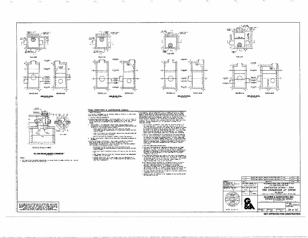
MODE MC 5 MILT OCM
MOH VIM
DE.R.211-ftl MIAs
11100105 41111050
E10.1_01rit
1--
51,11011 A- k Ort-ENN C-rl
"NM 10
'- I
Inn,. A-A
Ulah_21h_110-0111AIL
I.-
',COON 0-8
ELESLIIER
ULP-IA-R4 SATAN R4,110 KAU
PER Tomoirc..00 T11101 DAIMM.11. MIT 0/12/,, Kn. VOX TOVAINP COON./ LC11FR DAVID MARCH 23, 2017 MOP T ROf
N07741= N010.0.4 PA 00.4 (2,4 MUNICIPAL FILE NO:
• T:A
DATE 0-12-17
TAT MAP PRIM NO,: DA-00-0524,00-5
10, ARC, 25,11
DAM AS NOITO
OESCMPRCH PRELMONAM/NNAL LAND DEVELOPMENT PLAN
AND CONDIDONAL USE PLAN
CONSTRUCTION DETAILS — PCSM
THE' PROMENADE AT UPPER DUBLIN
orPrR MANN ,OVISHP MKITOOKRY Cam, KHNS,VANIA
GILMORE & ASSOCIATES, INC. ENGINEERING &CONSULTING SERVICES
4'1010406115-02
Devalvn, recx,r.r;c
ar:
/MAL ,LOTS
SHEET NO.:
39 OF 52
el.NOLOPLEX
SILLIM32BEG651-02103=-2MBIKEES8M Kt TO SCALt
.iPSE
L SIC 15500515055001015 DTOPICIPMFO, M 50515 05 MANN $131115, 5.11551505 WIMP. At IN-NO. 001-301 AM MM.
I. CAD,/ VAIN12NAHS. CR. 0•2001., - KqJLAR MAINTINAHLE VriAti K 00.40.1t0 OH AN An MOM'
It 1g To, .1, KVS.1.11.1, OF MC PROKA 10 CORDESTC ALL wAMITHANCE 1111,9 AND 1.1 OCSMKO KKK LI RREAS Or SPONIREO MANITNANSE
ASK% STOKIVRES ARC IKONOCO 10 NEW PER/ORUANCL 01. 1HC /41ILTRATION nySKIJ.
i%Ot.,00 DCWIA1120 ROK. SHALL CC INKCC,C0 =1:0.11
,4 PLONNENNMONS
u. INSKCT Eq. 0 M04.5 E4 ME MIT YEAR. INSPECIICN SCKOOLL IKTIVAIMI SMALL K /OLMSTED DAKD 04 MCASDROMITS NAM mi DM NPR yCAP SONICE.
O. 04K Of SEMPNT HAS Att.0.11ED. ISCLAFOR PM NALL OL NIELD WARCO DANN STRUCTAKS
cliNSRE01 ANO CIGAR ALL URSIKAII 01CRINIAl. YOE, 0.0
,ORP,Z.
11...1101044CE - NO./ CLOUT SOPOCNOIS POP 130013 ASO PINCH AD
ORAKIrKID., RECOIKIKAllq15, D,NO 1.1A4LSACIAC4 /MOWED COMMINI AOCOMMO /0 NIC COLLOMINO OCKPAL ra,IN.ECT M. MK YEAR. WIRIC1ION SCKIALC
.IC.01011444 Ot ADJUSTED DAS° 04 IALADURCIACHTS PI DM MST EGA Of :NAM
I. IrffMUTANT NMCCT VORCrP1O1 10:1101 AMER Mr CO, MI EN CKIMAL
• ONCE XORENT ITEACHOS 111/ Or MN. flOMC CAPROM SIONSMITIM 001.4. 0011M VANANTI.
4. KAIOVAL AND 0,0,AL K OIL 4.111 SODOM 9MLL IX MCCAW DT • IZNED 15
,1=EVENT NON ACM.. 005 M ROOM VAR
PCSM OPERATONS & MAINTENANCE MANUAL
REMOVAL ROCCO MIN, PLR'AIRS Or PHYSICAL DAMAGE. OtA.I. trAr DEOK1 MMOVAL 54. Ol..K MKPATCLY rOLLORIK . 1.1CA,..11CAME EVENTS OP MN MN PA.MLO ARS ,16 PALL SE., ANT YARD DRk42 OR INLETS C.W.O. CAOLAT SHAtt RC <KOKO AND C.A. A P..1.1.1.1AN ONE (1) 11K PPR HON. ,OH. IIAT UTTER SOS OMER MUMS 1.GPI API 0.00 MKS. 00(nor ONNIENANN, .41 Or ',VOWED ACCORD. 10 ME
5060.- 1140 (/).PC.NC mortar. C.C. Pr COMM. Amu./ 115 THE 0401P/OrESATON. Tor POST MN/ 551 TAlUS NISSAN 05 APRI. AMP 114 V4OW RA. Ilk: CCAIRLCRLY SECOND Virtl, MEM
OETOOER OR NOWIRICR A... ALL LEAH, NAYS PAL. MOM OE TOMB ▪ PRio0 TO NE 0.0 or mi. 4.114P 004MOM. ALL mauT00. IVENTS BOLL OE CDM01.1CIED RV TSr OVKR/COC1AT04, 040 RROOLPAS BOMB Oultim‘IM krAs.01ANCE IKRIS 'MALL OC MKNATCLT CONKOICI,
ONO (P) ANNUAL 05111011015 WU OE ...MO BY 1K OVILII/OPCITA,OR MR K rACI.11105. N.C1045 PALL DC rOP ALL awl 46 LISTEC THE 40111AL 4ANTEPONCE CANTS ALL PIN ro, MNERE ID MC KCCINC NORD . ANY OWE. NO. 0.10 0110 OE itIrED,All-LY COM.= NCLUDNO ANY ANO AIL ROUTHE 1,AAN/CHARK A COMSAT. MM. Mt BE COMO/CD I, • Ant ANT 51.11:40 MAL. OMCND SoOM Or R..
0 PON R. a.F.6.10 NON LANINEN BOO,. 1ODX VCCCTKOK COKMAK DIY HERBACEOUS SKr,. MOST RC um.= linouprouy ArtroS Or 710C Kral ANC ANGE or MY, MAN. TO tor BEIM A. AREAS 1.01 Bea. AND OP rECE000.1 AMP OC 0.00TELY COMCCO0 for REPLANTNO OR DOM RECOJATE PCAMAICI MKS,. IP PREVENT CK,10.4 MA' MAY .r.OPARDIIC Tot sotucTonAL P.110.01 0, OK PAOLI,. • =AT. OiRoNcHour ALL ARMS Cr 1K rKtLIN ROST BC um. RI
Dr TM 10 TIME loAES PEN YEAR. MS 1/14C1 ARC TO OE AMMO CR RANIANCo 4.0.01 FACILItY SUa.I 1K.Y ORSMUCI 1-K at ROW Min. 70 rot 0.,[1 'TRUCE.. 41000 Mi. OP TCPCTASON MEN NOM SNALL DEMUR PA. NO. ANY EKS104,11,04140 OMER SqL DISTADANCES 0114,*1 CAOUCE NAT WC H012, 011/1144 R4.11MC YNNINAKS AI. Dr RAMAT, RIPArRED ADOMONAL Atl PCOTTO A KOMI,. MOPES.. SM1L OE MR. MICK NYCLOSA. 10 RERPIS MOOED ARC. /0 MAK REPNRCO AmCAS 91All, BC CIT. POM-LINCO I, .6,AT, Ri-KMIAMA WIN RCCORKNPID KRIIACSOUS "IOC.
• RAM POLL OE VEGETA. 0.00. BY A PNALMED EPODERPOI M ACCONOME TM MS. PLANT wartnnox 10540 at xrroavo AT UL otos.* Gomm 5*955
ICIVAXI 0 KIRD
stP
ESC MCNETNETS RE it A040A23.
NOT APPROVED FOR CONSTRUCTION
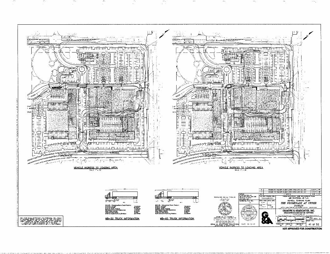
1'111. .111U111 . _ I ailLrli I IJ III I 1711.1111111111-11 11 11111'l
VEHICLE INGRESS TO LOADING AREA SCALE • •S'
VEHICLE INGRESS TO LOADING AREA.
•I ; I !'
v ----
1.1,==.•
•
201iLi11111715131M131/4 X0151171}4 I 20111771330
DATE, 13-12-17
•• tr.r.
me. In: 101u. Or•On IMMO On ntf CSC 41 OF 52
4$,,', KKX0 KO 1.1.06.10 nos•O• SA MO ••T
•111-113 - tntarstale SonnS-irsile• *....r.9••rell 1-E ,11.511Oft war. W Kept ti24}'R Min bd• n• Charm. L UR Man Traci WWI 4.50001 LonInto-nstla Iwo CT. TO Ca. TO.. Itaidna• 4.90001
B-65 ws-65 TRUCK INFORMATION
Ownit r CIPT12.1..
•.• NO rx
(PSI OUT- TKO
rt.r
K
TAX loP ;MACE, MIL: N-00-0,241.40-$
Ket. PKTT 2X41.
KATI
IL
.112-lemIART/1101,4,1400 0111101,101 MO CONC,TIONAL USE VIM
VDOCLE TURNING PLAN
ME PROMENADE AT UPPER DUBLIN
TO. rawe. ccanr, ro•K••••••
GUAM & ASSOCIATES, INC. OIONIIIMINO&COMIULIIMP INERVICE3
AB Raz 20,S-011014 -
SKEET 140.,
KTMO 0.9•T Ctn., UT. TATO N.C.. 21 Xs?
TITTAL
TK. PO ID,
'CA9 _
:K...
ITTTITT T. L. TTP.K • ••••• Tu. CAL; 1-Tif•TTX..
wl,.50 • Int•••••••••• 5.114ION•r
I
S
i
f
7
7 1,,
541 Ileffiy N.
My Cazt• Cifortneat
Mir= Vann,. R.. ir0001t
03-50 TRUCK INFORMATION • T./ Tlx. 010.0.1. ffMDT.. 111/4 ▪ <0.0,1,01. 01.4. Iry 1,46 NM 6 OTIDTAND . TM, IXTAKT. W.A. OP we mon nur T.= • TSLOOKTI. •K MO.=
.0•10. TINT OTIT. •K . MK% PCI.110
NOT APPROVED FOR CONSTRUCTION
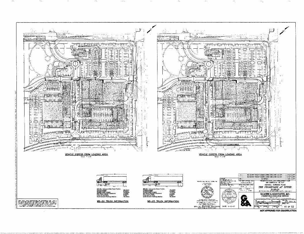
VEHICLE EGRETS FROM LOADIND AREA WALD 5..Or
VEHICLE EGRESS FROM LOADING AREA
•...
nit i. ii 11111 I II
".01111111— ,
—1:
walcIals.4441144g4114441110, 0.0404 .=1• 1,1•=late osn•Tralter
= rat N = r•00/ntiO4 Ifit Sed, QOM.
Tol..40 =X 3.
1.0004e0 C(T(OA(AXO( 5OAAA 005
YA3-50 TRUCK INFORMATION we-65 TRUCK INFORMATION
t00, tor Kozo on TO•or. CanCor Orgit 0•40 wo•Co ti 2017 •Erwo . Too. 0001 WINO 010:; wool, 01, •P
00C•ro. O 05 WO ARM 110;
5.-Ce-004O-00-5
10.1010.1.n.E If. .4 0•4
Off. no Do 0.40 0 0010.0. VoL AO 110a 2015-00011-02 40
SICCI 103.: 304 ILO 5004- 20151-771233. 201517111301
70,7,1053 0 20051071251 41 OF 52 ft107
,10 100.4
.• 14.10
x0
141110411M1101,44. we 1:0110.101311 PLAN 0010011004.41. UM KAN
VEHICLE TURNING PLAN THE PROIDOIADE AT UPPER
DUBLIN
GILMORE a ASSOCIATES, INC. 211011•11111N00ICO03U311G OERVICIES
0•000 r rerret44..
uncO.00. Oa op.0 MST 00 OM
rolOY
;
DATE: 0-12-17
INC, WOE it 40.00. •if 010.140. 000 .001 44 .0 WO Iry Oft NS". II . 440, Mao.
011,1Y., M.S. 000. no Oa" Of C.. 0 0.4 • •00000. 10 4 4000 ,;;;• (0.0( f; M.O. ow .0 •bat 40040
NOT APPROVED FC411:014STRUCTION
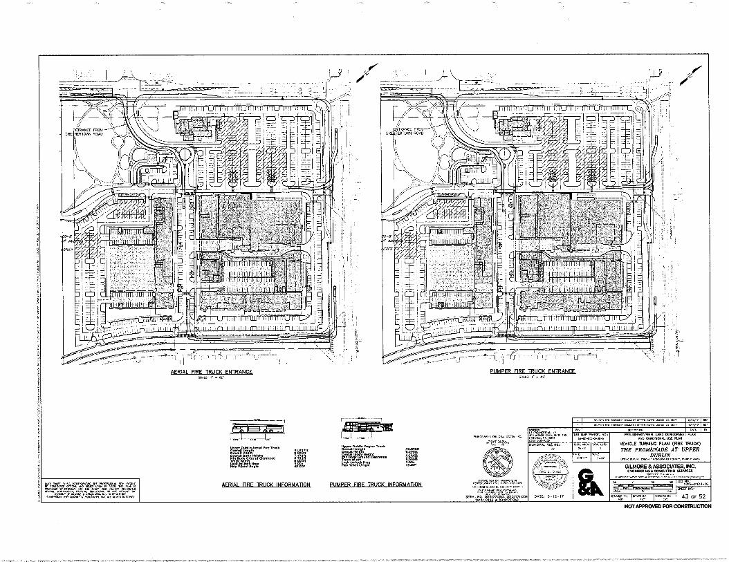
1.11•TrIge1
=I/
Vt114"
PERK FIRE TRUCK ENTRANCE ScAt :"
PUMPER FIRE TRUCK ENTRANCE.
VISP , IIKK.ED PIA Wag*, ante OK= ...CD 2017 4DV" 111.0 10••••• COAK1/1 n••• 21 TOD
PrTVI Yrbar 30.•.11 0.00011
FIE:fir.71..v"« 411= S.▪ 00•
•5.00.
MI SAP PANEL NO.: .0.441.1-00-$
0AFA.AolAAT/iWALLMC OEW:LOPWW1 PUS MO COMMONAL u PUY.
VEHICLE 1URNING PLAN (FRE 1RUCK)
THE PROMENADE AT UPPER DUBLIN
War Sam lex.. monleout. enewswas•
1111Fr
1.11111.11.1.1LL11.1
AERIAL FIRE TRUCK INFORMATION PUMPER _FIRE TRUCK INFORMATION
01•110t 0.111.1.• undIa.O. IOD r• .10.•
(T51 OD,.
grUDON.1. Ott NO,
41C4t3t.
• . •
•-*dt2r.".1'
DATE: 0-12-17
GILMORE & ASSOCIATES. NC. BIONIOW:1011COMUL1IND AMES
as NO« 205-01014-02
NW NO.:
43 cr 52
Dv
orti :DAD, •K
• MIK WY 111'0,
Wit
441 It7.1,21714 .••• irr• St WOK. Vert •
IOU 50.4 0O. 27•SR/411.3.713151771130.
20,51713.3 • 2015,771398 10g..
,01,
0, I 001010,•11 rwam
mon
COD 40:( 1.1.1•1114 .1•15.• grA. .111gb Dg crt. D. .0, Vr. D nfl, •LAN es DOW. .Darcrur MO. MO MI, 1.12.1111 groOnrr.. Ca DD.
CODLOK Or • DC • DO.. ODD., MIT C10•70 , • MO.. •K oat RPM WIWI,
NOT APPROVED FOR CONEITRUC710N
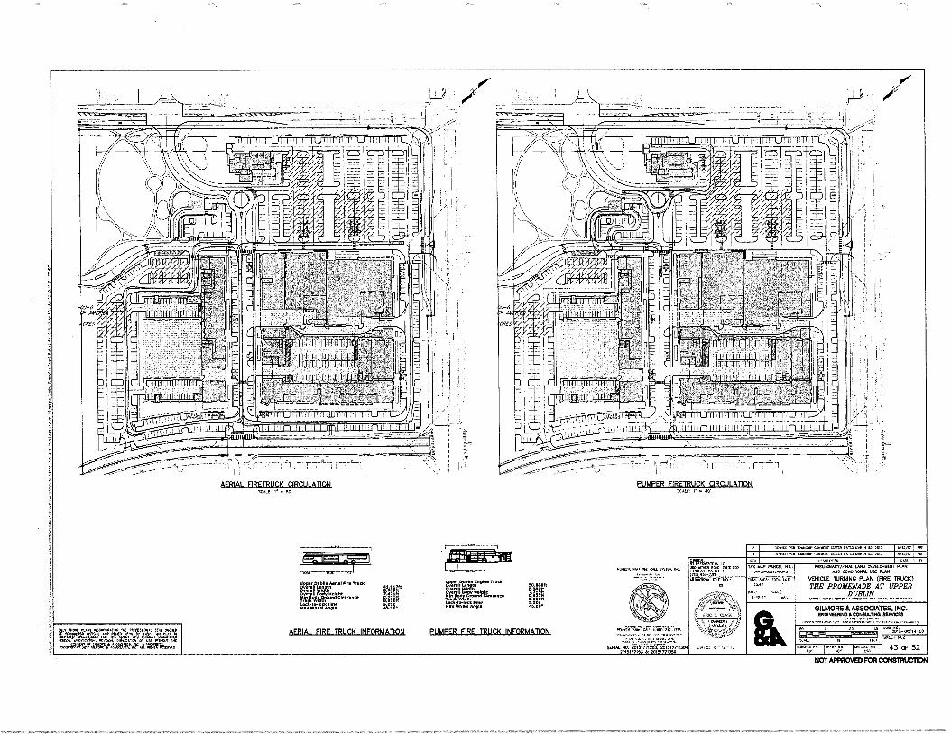
h°11.
AF-RIAL_FlRE TRUCK INFORMATION PUMPER FIRE TRUCK INFORMATION rev.rit /VN1
7aFi sFm
l
XE:zitZlieriall4re Try.
Itit4r
rZIWNK .0.4.
Vg. ;MOT
likar71=814.111. g:I1B11 0.000/1
LockW-R011 Ow Aw0 .1iTo•
:441}:2174,..24:11:" SO0?. 00. 2015177122.3. 201517711304
20l517000R 2cns,rresD0 xmog
ro, 'pow w
la rrto 0 lowe tor., lAW PARD WW1 . 1017 .111.1,1?
,N020 PC. worP0 <WOO IRWIN. +WI fa. 300 I
P1EW3IART/P000 LAW OEVCLOPWP PI 3120 CONOMONAL UZ RAN
VEHICLE TURNING PLAN (FIRE TRUCK)
THE PROMENADE AT UPPER DUBLIN
Woo towa PLI01:11,11.
GILMORE & ASSOCIATES, INC. ENONEEW10 &CONSULTING agronces
IR/ 0/0/0
sr,
NIT
POW... 00 300 :nu", 01.
poNILZA",IAT NO.: 20,0-29010-02
NW 901
43 OF 52
TAR OAP PARCEL NO . 0-0P-952.0-WS
f.0.
0111101. OKNO.W.
oo vow wo. T...1 Wen., N.110. fRO •No-7.00
WOO AL Oil NO,
AFE3A1 _MERRICK CIRCULATION Wit SO'
PUMPER FIREIRLIOC CIRCULATION WPM r.si
NOT APPROVED FOR CONSTRUCTION
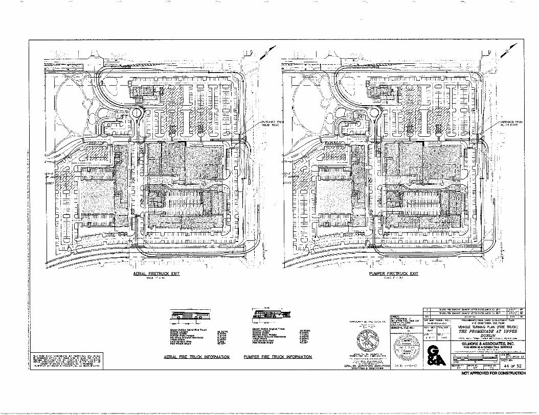
ENTRANCE FROM 11ELSH ROAD
ENTRANCE FROM MIN ROAD
- TP-8 ril"
IliIII!!!!!!!!!!!
LU.iJ II
lofiLaatit
tiu H
AERIAL FIRETRUCK EXIT SCALE '• • SD'
PUMPER FIREIRUCK EXIT
mittlint:!!!!!! 1i-1.:111111!!!flitimitut
r
1::Tcpp
Kw Whoa Ang••
AERIAL FIRE TRUCK INFORMATION PUMPER FIRE TRUCK INFORMATION
Nor 6 /111, WOW RD Maya awaor RION boX0 WK. SA •10/1> avero Oat Room& coTTool .t1T11.1[0:0010. II_ MT
•C,,r1coo toon TAX MO. NW
5.-Co-Osla-00-5
-Do. Lots ma.. art.
ORT
20:S-0014 -02
7um. TO. 20181771250 20161771130. 705:71183 a 20105771358
MOWN w loom To Iwato::: w• or
otrr , 44 ce 52
1. ••••
OrIntit r wawww.
• neX40,4C. WTI TOD
(WI wo• uuwx:N. RE ROA
KarMas. CM CR: SR•11,...c. oftwwwW/fINAL 1.8110 CCSOILOP1104 76077 80110:11WAL 1.16( 06700
VEHICLE TURNING PLAN (FIRE 1RUCK) THE PROMENADE AT UPPER
DUBLIN •AVYA OM. 10•04.: elioneeklav 01NnWvan•
GILMORE & ASSOCIATES, PC. D07WEEN074C?N54A.IT66 DIIMIXII
70*
F1:21"1/4":•=orooco •
Pl. rm.: woo
411,M11.
41:0411 oVroce
10.1440 TAMS
667 WIT Oa. wormr. vo aW73607w. MS rmo k.tolatateD TRW. A. POW •Wri ••••• r•fi.
lacerilia foot OR Cala •hp tRavalto ooROnat, •••:•••••W wIteut
Ca•W• twaS. • TAWaLL •••C aCautO ecoRlooa ato avow • anno.ARR OW< MM.
NOTAPPROVED FOR CONSDIUCTION
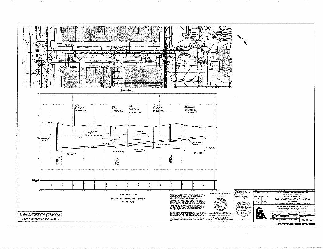
DA1r: sc&e,
DATE: 6-12-17
pl AN VIEW .4 NOR. I" Art
.111-1011 . RAM. 111. 111
11%.1011111C1/1-30,
ge.„: Sm 3110.14100-011
3011ANSOPIAMI
TAM 10.
Sm : 31-11r-,03.g
3011ZIRINALSO
(TA .111. IV /Iv .11.1
ere. 7lTit
•41.7,1=7 01‘ EuAEOP-S111
.11.3 LP SP MR 1.11.0031,010
"•41774
.11.;F'' •
mckrollot. I ONE Ierr
PREARNANT/FINK LAND DEVELDPMENT PLAN AND CDNOITIDNAL USE PLAN
PLAN & PROFILE THE PROMENADE AT UPPER
DUBLIN 0.1.01,01,015,1P 40111C0.1, InVISYLVANIA
105.00 10.00 10, Do 102.0D .0.14.00 1111.0
MOOS BY OWNS. MVO N10,2-.00110 of...v.00RX lie WM NO DCA AU,. KM
gOralo
DARER: OPCNtirMMX,
MO MM. ROA. TAU 700 HUM., Pa 1A0.
4,f}-7,40 MUNICIPAL PILE ND.;
ArV TAX MAP P/.1117.1. /10..
101N. /PM 25.11.
OK CALL ASH, FNTRANCF RI VD
STATION 100+00.00 TO 108+12.67
GILMORE & ASSOCIATES, INC. ENGINEERING&CONSULTING SERVICES
ON M-06019-02 40
50201 50.: ILL* 5,41 or Acr.z.ru,flAUNTS cur cx
,rD.
E... 46 OF 52
.41,01,001,C LOW.. +.,40 INC P01911141.
T,V,Igrf."% %47497,Taa'414.1;,24 Oft A.M., or4PCBCROMO
uaLIZICT:k.r. AK NOY WNW,. OD SWOTS 1.
WO.. ON RV.
,1,°rITA %%LAI 01.1/01L A5,104-25 HArl colAncv A Pk-bfr Lott
SERIAL ND. 20I5I77I2S3. 4S1517711304 2O1S(fl15$U 21,15177535R
-azzrzr,,n,rpr4. -4.facr 01.1.11oc ABIICGATC, ,11,10.4.311i0.
1 IV/ Alk 0.4,111ICSON20
"516-g"
NOT APPROVED FOR CONSTRUCTION
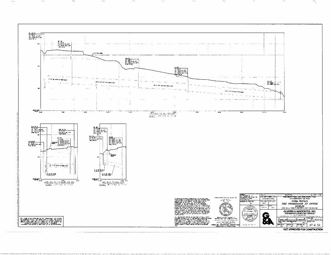
.0 0.5_,IiSR IR TO ViW-14..(r
NALL H:1".40 41 1,04.
7.0 •440 5+05 1.00
205477153 Al 20151771X0
144bioUts N..10/55 Aenwt-OROV55 Mr1,47,4.
NORM. NU MINATO .0Nti GONSILOATO APPROINANIIIN LOCAPOO, DV, NNE/ TIC 7 II4004
II;414ITITTON=40: 'ONt9 7 =14
7O77
II34
T1/0
`4.7Vgn`g Z,LTETSATTET0N30504T/a AccuR41E. Compurvar.ss eft or 030R
ogq40470 RC Nor GUMMI. MOM EA.
A.Lt CON/TONOTORN NOWA. ON 114: mar, 1-4A)) I6SPINT No,
'4fgT, nr.7.17:ArvntgLvtz'4" rIc:SSZT:1,:Taa'tak. ES"VF4::FL - 34 WAAL NO. 20151771253. 201517711304 47 OF 52 4064):40 ICRAN,I
rg ONECNE
,I0,c
071
FUT OCALE
tr2"4,Z.P.IIInallr,„"IVAWIg="%. 'Az NAP PARCEL NO.,
42-o0-5
TOTAL /Mk 3-,11
OATT, 3-10-1/
DM:NINON
PRE111.416040/4I004. LANO OVELOPILEN1 PLAN 060 00410404414. 051 PLAN
STORM PROFILES THE PROMENADE AT UPPER
DUBLIN OLIVA OtIaLIN (COWIN, mONII.W.1, COUNT, PONNSNIA,NIA
GILMORE & ASSOCIATES, INC. ENGINEERING CONSULTING SERVICES
400 rOt-O0 014-02
91001 50,
k• I .:.
LPN: CU, )
•
DAM 6-12-17
MAL ).0.13
04144
14351571.v.4 CALL 541114
FfiF MUNICIPAL nix NO,
312.011 MST (01.1,2
1,110,53315
113
11 /NIT '`41145'
10 CO INCO 5440
401 01034 1st 30670 (14 24)
9a5.75 10.0-0r1) IIRAS10374
'VI 11; FM .5X
I !
4'113.r„„ )c-B -26-R1 TO 1.2B-25-P, 52,ALL; 11;1-.40 V:
In 3..3 0/4 104.41 44-7e(
• ofV. 335.24 0,51 3J5.24 0).4.-15-)
1NY, 104, tt/A-141 104,102,4
2. ON-T01 310 MAO
NY. 0.03 Oar 51 510.11431,1.05
41) 404.44 (007..24")
•• •
7,v-4 .41 .:Nr40-4
Iql/ !)Cfr • 0508 PAK
/1.1401
maw. Waitr
440) 7
on. 40000(01)134)
,•__ 21
.1•11 34, •Itos EON
216 LI Wien •D.305121.0re
4434' IRK • 0.7>s liers
TM Ma% 30.0 (.3.1 £0.24 (01)II-04.)
elm, SOO 25.
grvATZVAre2r4114,74"Al` ZW`g Lg4.7.-°,,Xiggtr.M.`,04%4,,?.."TrAAITI,T
NOT APPROVED FOR CONSTRUCTION
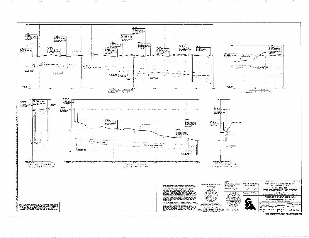
7*00 00
(1,0 3 .033 L 0
14.2114. 1.100TIO
L SCAL R.NOULD
MRS.. 07.900,0.00 JORAY01
.1.3 DATE; 6-12-17 48 OF 52
oveNER.
" '''(72frilOTa rc
•
ORSCRin. 1 TAX MAP PARESL
5R--0,-092•2-00-5 PRE.A.A./FINAL LANO CEVELOPLIENT PLAN
ANO CONOITIONN. USE PLAN
STORM PROFILES ME PROMENADE AT UPPER
DUBLIN WPM RM. 1.054,RP ‘/00,00.4-RR
MUNICIPAL ritE NO.: Mint MR.
25 tit
TOTAL
,L01,
OR SCALE.
GILMORE & ASSOCIATES, INC. ENGINEERING CONSULTING SERVICES
JOB NO, 2015-060,4-02
mall 3, NM SKEET 730.: ,CAL.4 FLU
bROO 0,101.00 HOD 1303 SOO V93-18 -RI TO 1,4H -191
SALE; E1:1 - 4O V: 1" -
OFIN3 5 IN JONA Vo. MAO KO, 1.700.44.
PRRPORA
1100-1.1 10. 310,00 311,, 310.27 (11,-(0. 014 Moo (01.17.7 0.1300.13,
3
310.-00- (01-2e1
302.75 (0.1,341.) vvvin
It
18 -IV 1 70_05 -.121! 18 11,1.,40 V: 1 "=
AgATer OS-PG 5 TO 1 2-104.
SCALE, 1: 1.., 40' V: 1"-e
(9110
:357 .1
7700.0 (01J7-307 SURIP..0513
0.051,0 LIIAN
v 31.1.01)
Mt 300.00 00-141
91.30100
U01.1.1 A NU&
20.110(CM NIZIN
310
(114-24 5N.
J00 JO.
•
NV N.P0.37
min • am up,
3(1 4* Of KIK • Wm +Lan
_
211.01 00/. P0.01 (0070) *002037 (13(7-23() .11R302 10
le. -10
L-204
300.03 (N-2,11 T 309.33 01,1,44,1
Fs- INA 397.03 (N-1,1 WA 30blel 0411-24, MN..
O.,.
00 Rrt-Ial OfV...3. 0/..,-,
.. R00.20 (0411-151 ' IINI,J05.20
'Ick-iren0
i0. 314. 2 NV. 307.45 0N-2..) INV. Fn. OX11-2.1
.
. INV. 300.2i 0 4-141 ! 1.201 INV 300.03 (040-P,
ta1
. T. VIM .7
• i RN 709-07 ON-Vi NV. a00.07 (01,13.1 11....09
OR . 301.05 (111.161 NV 30R.09 (00,1,)
" 6414,307.05
la M.,
INK 30,411 (Ovi-2r) ./1305.40
as t.3 3,r( MAL • at.
oiele '..f.'" -• -
ON. 394.1111(01.11-241 ti..302..
. . - --
104 v., Nelcet•aneattOin
.......
L
--4--- .
- , -.... Iv WV' MR • GAM
: 14111" :rair.111, , ,,•
INI.,711 TO (JDB.- , Rr sckE. v. 0 ":-4:
310
.0
PITAISTI.v.ve. STSrt10.. •c..
,R.,131,1
:44111ALT.. VIORRAG 014......,IHRMRF. Olt.t VW Oic R....1-1. 113
F19,..1,Nerr=04
,1.6,,45:140. 207" RLID(7.1'071'E RA
7cLil'..te 45ROCIR1r. NC ,1%,t2'' "'""'ICIIETLIT ..- . .100 NURIORit o1.5 00175 HO.. 010S2 SERIN- AS 20151771253. 20151T/1120S 0.0, 2015177113 00 20151111350
310
POL-31
INN
IRVIN
320
010. 300.71 <00 VAN.110.741
311. 7/10.9 (MT-
ILwa00.31
55.0 2,00 NI 712 TO MI-1-7:1,
0070
SCALE( H; 1"-40' V: 1"..
202 OPt (4; • up.i.;.o PC-
ON. 307.01 300Z4.:IXT-14.)
1.005.9 Of MI. INORNYOU ,/1(33.106 /15PEON /OW OM OLVIL0090 RCCOROC.
AINNOMS MUT, AND/OR
,,Otrg.{1VAMORVT
.21C
INRRITON MRPONst,C N LOC . It 11Re POR01... '"NIIROU'i":RIT0111'4.4 Ouol 4tVgg',A!'n;ZA.
V9IN
"
F LOCA1.9 Cr LNIXNEMORAO L/11.111[9/.1LETS.: .
1"kanC.. C'OTRAW, '07M:2411-`154M613 1.,110
.1=4
.5C9 ARC NOT CuRiaNt. 00 01.00 RI
047004 tOY .410
NOT APPROVED FOR CONSTRUCTION
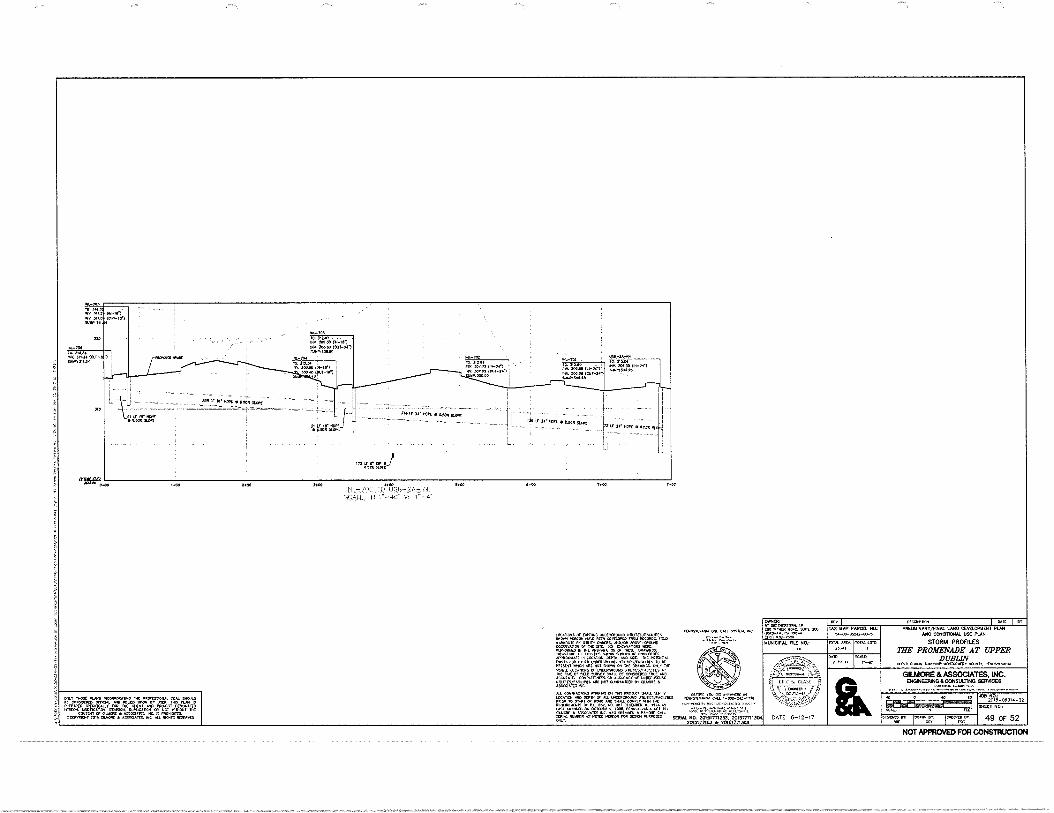
ON-01 NO Num, (NM." 51.111,0611,1
1141,04 No. 11054
100.0o 00040 LOUT-IN)
IN
7'014'4'14 ...-NN
IM-ien- . LIORYARIN
. 70. TUN Z Iffti, P.2.1 IA NUN • . I
111V. XN,N3 (00-ine) ' ' - ' • ...fa..
NNA,Nw AA .
YM14703
Z.1t1 Ott (0174-101
NNITNI. 4
1 . 1
1
I te NOR • ii.SON RON '0 LI 24 MP( •11
Mil Sr ot, • 0I0 test
• 42=
--
1:4117A-i
' Mir Te WS • anietilan
NONatomm. ant 5540 N.... No
40 JOB NO.: 2075-06014-02
49 OF 52 JCSO0f0,01
1IT ICMPC.VO
PV I TAX MAP PARCEL NO.:
tx-oa-Ps2H-oo-s
MIPL APC4a 20.01
TONOPI10.4 I PRUMANANV/FINAL LANO DEVELOPMENT PLAN
ANO CCNCIDONAL USE PLAN
STORM PROFILES THE PROMENADE AT UPPER
DUBLIN MTV 000104 TONG,. MONTONOR7 MYR, PERRNIv474.4
GILMORE 8, ASSOCIATES, INC. ENGINEERING CONSUL-TING SERVICES
SHEET No,
/TM LNO
SCALL
OWNEM
Ko'f:j1r437:C.';..NC 2co
MUNICIPAL FILE NO,
V • f..57-11-C'
DATE 6-12-17
1.00 N.00 IJ1L 705 TO*1.1GI3.-ZA-R4
POO 6700 14700
5ratiL l-51-4cf VI 1-
='1.=1,1=t4VgnggITA., TAPROOT 07 Loam 07.17ORT. 0.,040410
,4.4;77CROUNO
MLFOROVIZILIZI4X41 TILTA MARTON T.0410R7 TILLITCS RICAN CROON BC ONNICC1.40 71717TORRATC IT LOGAN). OMR, ARC MIL 714r MINT,
PtC24;14.===g1WaVgggrOXAM 47740a LOCATORS cr 1.70CPCROOND ILTUIRT/74LINTR7i 4.41_
larr 07 MO AIR427 SON PC 7C.77.07.,j,,RU
,6R:
00
ACCT./C. CORPLCINICS: OR ACCURACY 07 lafg/L.1.
,1000 Aft NOT WARM= DV
CaLTIALNAT oh IRS TAOS, 04.4.7 TM, RUNK vouc
C10 ARYNO.R.1!4_ LOONTN INNT or ALL 7.44.0.4cRou.
LILL:ivLiCR4ACIANN IRNR511.10.0 0.1..
PIZZ° " • LAST NAINC733 0C10004 /COO
sow ttttt ISIs, 105 51004 ........ SOUL NO. ZSINIflIZNO, O01517711301 2014177153 N 2015177130
Tr=a1T4TRZIMJUMU3'41q= 2=7°,==e,,TUNgUnnt=rZ
=,m4g,TA=IT:=T,T.,Ir"g76.,,m NOT APPROVED FOR CONSTRUCTION
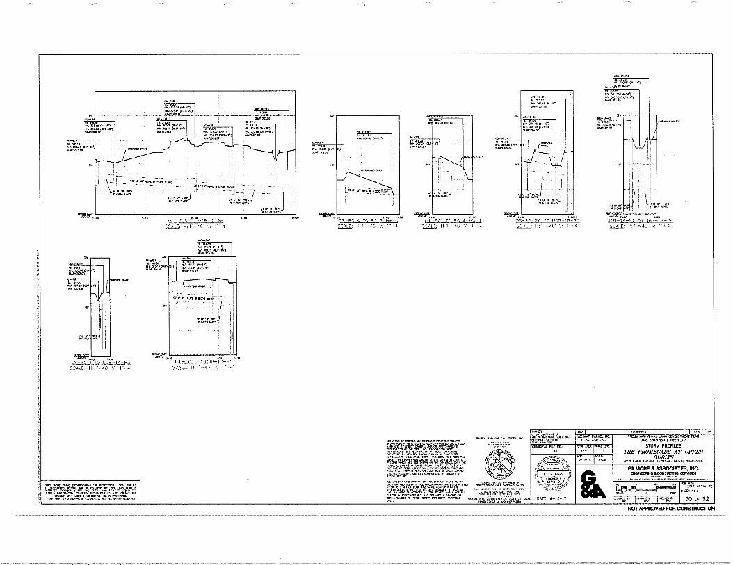
oPau PILAW
311.2a INN MVP NAN 11411530521.1
NH. Mu° On, 1.1.00230
PONPIVANIA we 6341. 115004 INC
Ut0-10-113 ID. 312. ,11, 306.41 LN-11,1 9JU,S11.
40248 10.1*1 AN. 306 60
(WOO On la onto
307.7.5 (001-1 MOM. BMX
714°,3%1.42 01-16, 741 200 42 ton-tun scootuo.0
30$- 134 23*21 Mt MOO MOT 1111141k3.419
SO. 31114 Was 1241161
RI, 306.14 puy-oll 11111.1,30/0.1
.-403 It 041.40 ISO 007.07 (114.11r)
"CO 5.41M (00,
TO1111.0
Ilallotoar.
-H- ;TY
51.11.10:301.. ;7l-10 0
On 311.26 MY. 304.16 r111-1 MN MAO lour
r)-ie)
Mtn bum
IJC0-1(1-114 TO. 31,03 111, 303.30 (0 1 -241
0411Nr.'" 111. JAM. 362. 403.70 074-041
40175 Mir-24.) 31110J0L13
MONM-IN ge au* Nv. 201/51001 MANIX,22
4.7101-111, 2.87 (001-111.)
11,0,61
rfordr20 C11.
10
Iv P.?, • amp
\ -Nu LI Tr MR • 0,;-OX 111.'
glca
14.00 .A000 41.70o 00 '5UP' 13'Zif"2. -PG 4 TO 74(7 5111W-I TO RG 4 -MIN 1 P.5.-2A TO um-1M
5..GAz; 1.1:1^1o40. v: rails; Ii: 1'.4O 500) F: H: 1o40 V: l`o.4'
aft vGB- I TO U0,R-IB-04 5CALE, ml1..40. V: I"=4'
(NI "OF, ItrI:GR-2-R6 NO0
II.1"-40' VI 1-4
WPM. In 114.20 fun Nno, 01-01
NAPO (anr-70 9.01,300,6
LIAM
AO 33*
It MO .114 NINO 00-153 001.1,3151,0
470. 47000(3411141)
t1 44:41!,P17-'''
DIP 310
I TT r ROW • 1, T01111.
:WM
Alro/ au, FOI.00
41;41,"
mitiriN2 ILST POP-IA-Pa
S.G8I,L; H:1"-40. iNL - 502 TO. LIfuL32.4.11,-iii
tiCALE: H,1"-40. V: 1"-4:
PF.47454`74,. co RUC
I LOMICIIS Or [1515111•5 1.1110CRCROIJNO 11111,ESAMMES
NERZON MAK OEN VEK,OPED FROM RECORDS. MO llrarDWIS BY OW, 0,14015, AND/OB
ArBOVE-CROUNO
Par1=1,7.,MTIA;'; gCrlan1117,1415 NEW= /1,111,111E% 0,011t1 61,11,0 C1,1,0EDir APP1111.1.12 IN LOCAT.011. DV, .0 1,01, 111C ronN11.11.
"0$iI2040444 V70744 70l'1ZYg„t01'e410175
-Prm7 04410 70 I707404P400 402 ACCVRA1C. 111.001.5 CR KC1/1,1C, UNCER,11011. 0LgI ..144
, MK 401400170W V 41.1.10RE
CCNIP4CTCR: *11111a10 IN, PRar, friro. VP,
V'RT70' t°417$11W:1,' Ai.11rt.r1rettonLTPira"'" 4E01RE2401 OF PA- 650 110. 267 61013001 I, 1070 rf
74400 00444143 40710011101 01 70 r,:e477.;;;:g`7,`,7 L3cgjiLWATV`LcT 0.10, .11 SOVIAL NO. 20151771253. 20151771130V
00517053 Cr 0051771357
OWNEM 11111CRE.:11/06, 1.0
rZP" 110TAL ;XI"
°ATE:
DATE: 5-12-17
tr-SCRIPBOR PREULINANY/FINAL LANO OEVELOPIENT PLAN
0140 C0110110401 UNE ot.00 STORM PROFILES
THE' PROMENADE AT UPPER DUBLIN
Loom Duo. Moo., ...11c.r, rr.11,v.,
GILMORE & ASSOCIATES, INC. ENGINEERING &CONSULTING 5E42231315
20g. -0801.1.02 10131041100-
50 OF 52
ORAL `VI.
NC. M 1,10411/11103. (1 AL RIMS 11,110111.0
1 TAX MAP 17.1011.1. NO
54-00-05242-00-3
Off
MUNICIPAL FILE NO TOTALARCk 2,411
Nocugrav j03401MI loce04p
,c0.
ID DO
NOT APPROVED FOR CONSTRUCTION
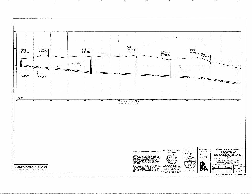
1001211.140. 0.‘ EEL 1101101. fly
twxrta°,7•1,z3, =at, AP04011111.70 14 .040014 OCPT, 4110 LI. 111C POIS1014L
;=TP{11'07=0;NIT=r411.124' .1.1n1V(71= glgrr="1170Q0Mar
001111421.4.14, . 40014,1104 1,100 ,counr, 40 NOT 114141411160 0Y 111414011(
:0401
corauctorn womoic at, TA: ma,rc, gprrolu"'.iiirtr,rgAriniir "&'"
0.070 •400•CrAiLS PIC..1144,001/11211 • 1,040 0.44.r '"" " 000W SERIAL NO. 201S1771 201517711304
2016077153 2 20101771350
9 ••
Ai grli INt,,IVVIN-P.) 10 ...St 100. scomour-ol 11V• At .00.4.1 .
SIN MX SE
30.311.1-0.) .1 MI • Iry swat< our-n
Z1111 3551M41-55 35104(041-45
RA WV/
AVM' 01-11 POE 3112.5500-2,1
110:0 144101004-1.1
V. 1011410041-111
53 31535 PIM 233,12(111-25 EL, 00373(000-,)
116 01.151"Iiiii • 5.35 ELMS- \
Ide"'
oret
0 1400 1100 3400 OHO 1.00 3AN 1,64 A TO SAN M1-1
S.CALE: 1-1:1"-4o' 1"
0.00 0.00 t0.0.
OMER:
goronng070% '1.m 5 40o :145.115 P. 010,4 011) 41E1-1100
.v TOP WM. TAX MAP PARCEL NO.:
54,10-1011.2-0,3 PREUMINARTAINAL IMO DEVELOPMENT PLAN
ANO CONOTIONAL USE PLAN
SANITARY PROFILES THE PROMENADE AT UPPER
DUBLIN 1,10 111.1111 111100000 4.10016, CO., 11,114,104/114
MUNICIPAL FILE NO.: 1014. 0.11[A, 21411
101114 LOIS
0/1101
GILMORE & ASSOCIATES, INC. ENGINEERING & CONSULTING SERVICES
• 5 0113-E
DATE: 6-12-17
10
SHEET 140.:
51 OF 52 0000.2.130 0000007 j0010010 fill
NOT APPROVED FOR CONSTRUCTION
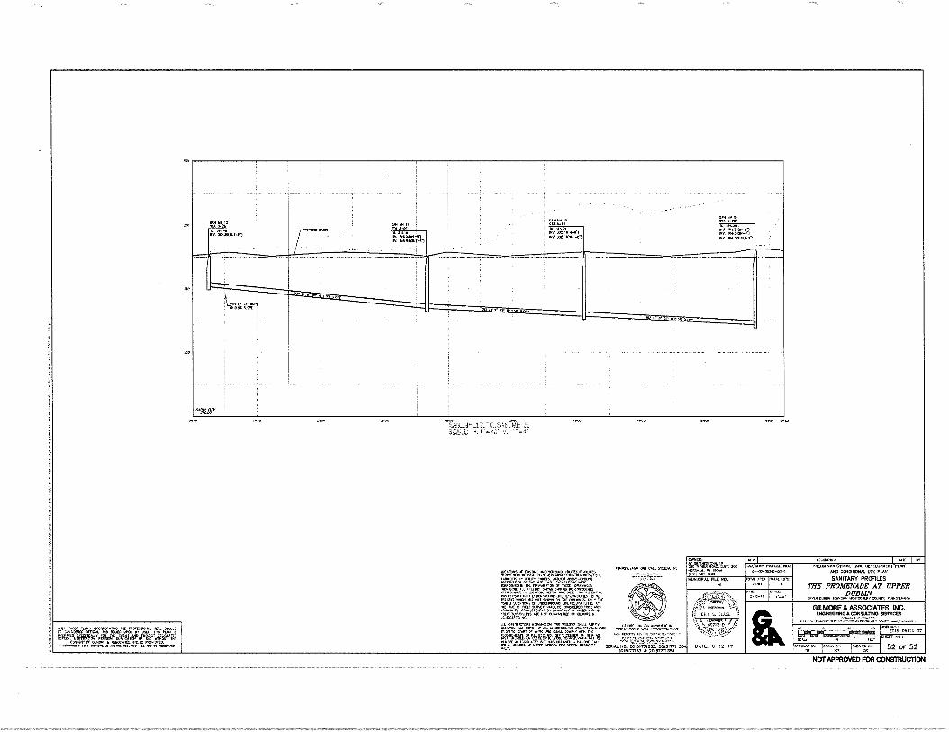
mttcr ZIVACCUI-r)
.00 ▪ AS,NIN-V1 ▪ /10X0-.1
WI PM II al MG' Al VA% 40:0*094.-01 niv saeo664-r)
411 3 VA SOW
ir4211:1 000 004340077-77
-
OWNER: 0/ OPL0.00010101, .10 ,4114.9 ROAO, ..41( 200 MON10/0., 100.4 4:1)000-0:0
4001 TAX MAP PARCEL NO.:
MUNICIPAL FILE NO.: MCA, 20 40
70TAL LOTS,
LOCATCNS ensnwl uuDOWPouvO vntut5/1,e01112. 00000 KAM! 00.0 44404000*00040004401004400000 1.1.Mr011.3:r140p01001, A140/0,1 .030,0-0100N0 Mira.. IX 1140 110A/AIN '0',,CgrrIg.rDPM10107, 40PIZOKM.101 IN I.CCAMON. °CPT, MID CIL NE POTINT.
`r.TAP=.1.17=4M7=E0:11';,.c `,Ter`41:rM ACC1.1.10. COM,LIINC50 ‘/S000040'.0•Z00-0.E0-00i.i VZI*00CT4.1
c000. MT NOT c.0.41000 01.000
AVM WM OM CAM
0A1, T.C.0
DATE: 6-12-17
000
ONLY ?MOW PL.M3 N4031.0040010 PROFESVONAL 0[00 51.001. CONSIOCK0 COTLIAL MD MILO 4,1 0, 400.t.,r0j,pd.N
., n!,
"MOO CI 00,11000 ALLOCIl., WC, IS PROMID1120. iC0M100.10 2013 01.40,0 n0:00CIA26. 0/0 10WD RLEVMD
2100 S.81L.MtL12._1(L.5tML.ML4.. scALL; 44O V 1"=.4'
0000 7.00D .10 9.0 9+23
0.0010110N 0410 I er PRELIMINARVFINAL LAM CEVELOPMENT PLAN
MOO CONOMONAL USE PLAN
SANITARY PROFILES THE PROMENADE AT UPPER
DUBLIN utt,lt DuriUN 1,10.00 u0N1.0.000, PCNN0.0,e0A
GILMORE & ASSOCIATES, INC. ENOINEERI000C000013310 SERVICES
LEO 00*0 .10 80
%AU DEPT
, en I op 'AN: I cr.rol,v,
SHEET NO.:
52 OF 52 047..f.v40%va,gar.•
altC4'.',11git'Z'ZigiAtR•741YVC11"1"TAPO,14." — - - SERIAL .1.4.0!..2.01.517772S.37:01;177711304 7010177153 20101771353
NOT APPROVED FOR CONSTRUCTION
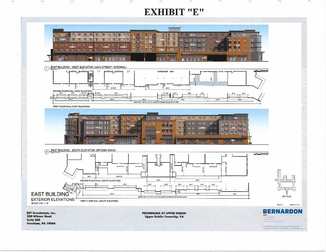
0 EAST BUILDING - WEST ELEVATION (MAIN STREET/ INTERNAL)
SECOND FLOOR WALL (WEST ELEVATION)
----- --- PIGSP9.0220,9966
FIRST FLOOR WALL (WEST ELEVATION)
una,„ „ ,IFVF11; i;
liii II II
i i 4131'
7c773- 71 79 9Yfl 9
1351
, I, UI Ii III
ill Prni ii ii FIZIM H '
21,
1.2=5.0.;::41 61:54
FIRST FLOOR WALL (SOUTH ELEVATION)
EAST BUILDING "1 EXTERIOR ELEVATIONS
40,2 IGNY 16 2 WO'
WV' 19052
KEY PLAN “560,11121+ (17.71/2).(21,112).1,125,91/211.1.10,...E.§BiGIAZNO
106,12 27/2.
(-2- EAST BUILDING - SOUTH ELEVATION (DRYDEN ROAD)
II 1LS,
SECOND FLOOR WALL (SOUTH ELEVATION) BZ-0' 10,
Li
A
EXHIBIT "E"
SCALE 1/16" =1'.0" 7034 IEPPLIAPP7. pp,
BERNARDON BET Investments, Inc. 200 Witmer Road Suite 200 Horsham, PA 19044
PROMENADE AT UPPER DUBLIN Upper Dublin Township, PA
TAN Prpta.blaryln U.. . Marto Spine, Suite 600
Pilliatlpip., PA I APO POI AvA, OcA.pom
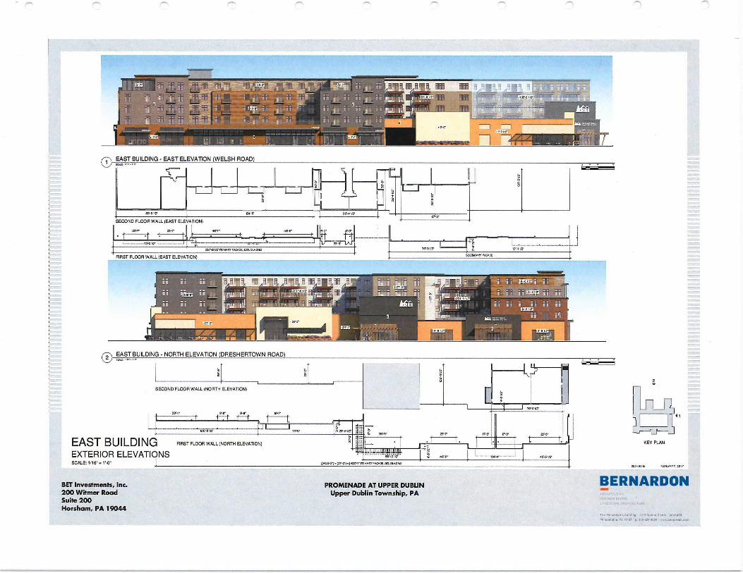
BET Investments, Inc. 200 Witmer Road Suite 200 Horsham, PA 19044
BERNARDON PROMENADE AT UPPER DUBUN Upper Dublin Township, PA
98-112. 2.er ee,e
0 EAST BUILDING - EAST ELEVATION (WELSH ROAD)
67.6. SECOND FLOOR WALL (EAST ELEVATION)
FIRST FLOOR WALL (EAST ELEVATION)
i i I
I jjI I 330F; jid
i II II II
ii c 1.75333
® EAST BUILDING - NORTH ELEVATION (DRESHERTOWN ROAD)
SECOND FLOOR WALL (NORTH ELEVATION)
1 10 .01II
*7'
---- ----- ----- WI- 24,
EAST BUILDING EXTERIOR ELEVATIONS SCALE. 1/16" . 1,0"
FIRST FLOOR WALL (NORTH ELEVATION)
a [(4..614.(77.2).]63,114 FY AMC.
:1, Walnut 5110, Suite 000
2
KEY PLAN
:0510046 IfdlYJAPV7,1017
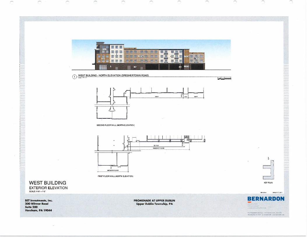
EE . '11t1,71t1t1 L_L
mmm mm mm r, t
1.1415-Wirg—grs9
ffi .0.191
0 WEST BUILDING - NORTH ELEVATION (DRESHERTOWN ROAD)
SECOND FLOOR WALL (NORTH ELEVATION)
5150NOARYFACAD!
FIRST FLOOR WALL (NORTH ELEVATION)
WEST BUILDING EXTERIOR ELEVATION
KEY PLAN
2034 ramJAPY 20,
BERNARDON BET Investments, Inc. 200 Witmer Road Suite 200 Horsham, PA 19044
PROMENADE AT UPPER DUBUN Upper Dublin Township, PA
1.6114.101. Nuomi 11131.n. Suroet. Sulte POO .M1.14.1p1114. 19107 p.21509 .1600
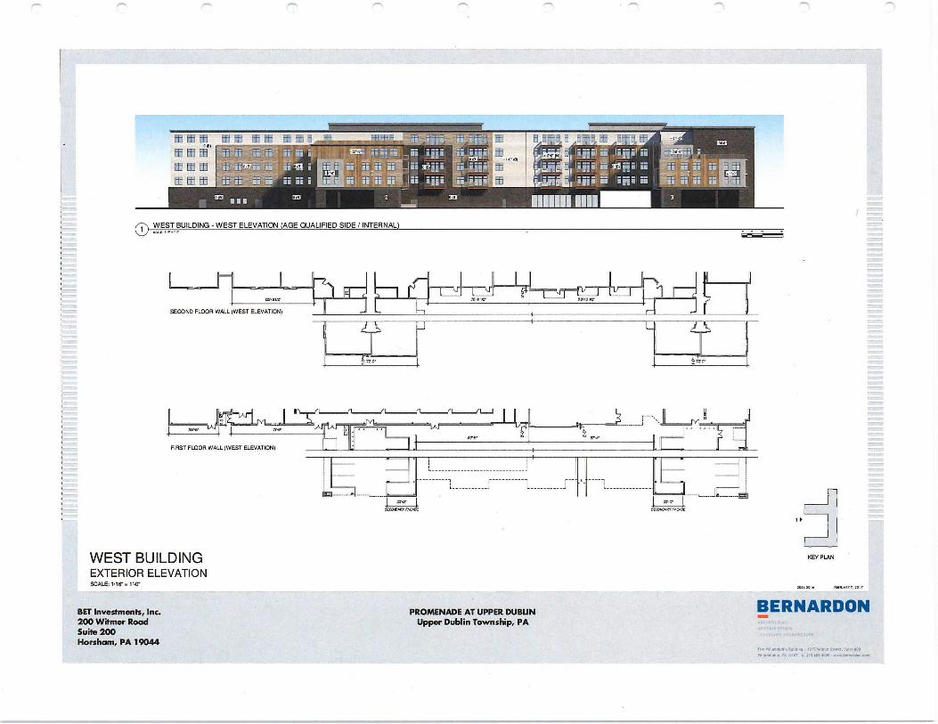
BET Investments, Inc. 200 Witmer Road Suite 200 Horsham, PA 19044
BERNARDON
the Tliedirlphia 11..4 • 13 71 Walnut lara..11,1•• TOO PA MO p. VS 1.09 .04 ....,bernartion.com
PROMENADE AT UPPER DUBLIN Upper Dublin Township, PA
]Th 1ThAt t Et t .7E1. 1t- tEl t t
tItt t
UI 1110 Ui' 3001 ri
koi
11111111111
0 WEST BUILDING - WEST ELEVATION (AGE QUALIFIED SIDE / INTERNAL)
SECOND FLOOR WALL (WEST ELEVATION)
FIRST FLOOR WALL (WEST ELEVATION)
L- C.10ACI FACADE
f ..
-- SEMI •IU7.
WEST BUILDING EXTERIOR ELEVATION SCALE: 1/16" V-0"
KEY PLAN
nsa (1•61e rfereu.V7, 2017.
1 I
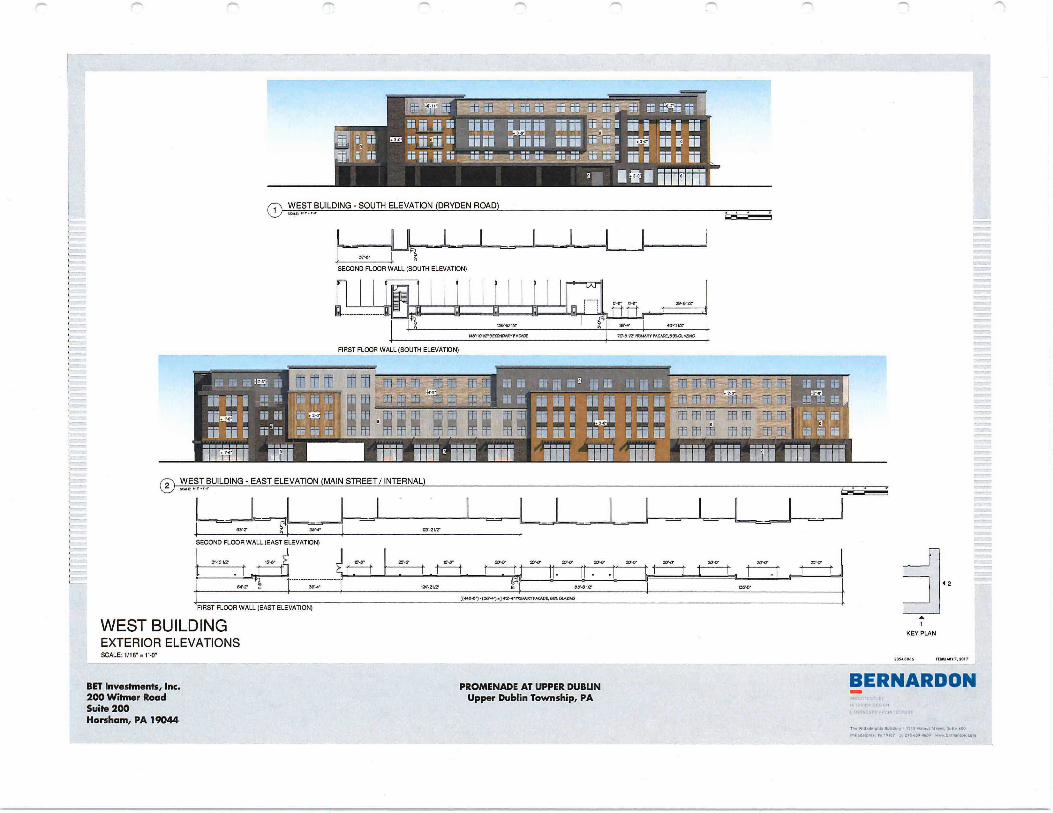
3
150,10 1/21 87-111/2
118,101/2980.0481'11888110 70'3 Vr 1181AARYPACA08,5014041980
IN IIIrt. 111
i ii • ms jjj ii
i jj j jj j jj
® WEST BUILDING - SOUTH ELEVATION (DRYDEN ROAD)
SECOND FLOOR WALL (SOUTH ELEVATION)
71 FR ,fr Fr IT
1 7 7,1
0,210
smo 18•64
30,4` 8 0 1
BET Investments, Inc. 200 Witmer Road Suite 200 Horsham, PA 19044
PROMENADE AT UPPER DUBUN Upper Dublin Township, PA
t(0800,11(88,,..] 410,808188,88808.881.
FIRST FLOOR WALL (EAST ELEVATION)
WEST BUILDING EXTERIOR ELEVATIONS SCALE: 1/16'
20.-P Z80.
t
12
7
KEY PLAN
.205,30.18 MOLAR, 2017
BERNARDON
Th. 810188810.8 08041180 ' , •
FIRST FLOOR WALL (SOUTH ELEVATION)
0 WEST BUILDING - EAST ELEVATION (MAIN STREET/ INTERNAL)
30,
SECOND FLOOR WALL (EAST ELEVATION)
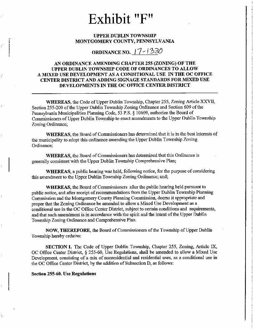
Exhibit "F" UPPER DUBLIN TOWNSHIP
MONTGOMERY COUNTY, PENNSYLVANIA
ORDINANCE NO. ii I 23O
AN ORDINANCE AMENDING CHAPTER 255 (ZONING) OF THE UPPER DUBLIN TOWNSHIP CODE OF ORDINANCES TO ALLOW
A MIXED USE DEVELOPMENT AS A CONDITIONAL USE IN THE OC OFFICE CENTER DISTRICT AND ADDING SIGNAGE STANDARDS FOR MIXED USE
DEVELOPMENTS IN THE OC OFFICE CENTER DISTRICT
WHEREAS, the Code of Upper Dublin Township, Chapter 255, Zoning Article XXVII, Section 255-200 of the Upper Dublin Township Zoning Ordinance and Section 609 of the Pennsylvania Municipalities Planning Code, 53 P.S. § 10609, authorize the Board of Commissioners of Upper Dublin Township to enact amendments to the Upper Dublin Township Zoning Ordinance;
WHEREAS, the Board of Commissioners has determined that it is in the best interests of the municipality to adopt this ordinance amending the Upper Dublin Township Zoning Ordinance;
WHEREAS, the Board of Commissioners has determined that this Ordinance is generally consistent with the Upper Dublin Township Comprehensive Plan;
WHEREAS, a public hearing was held, following notice, for the purpose of considering this amendment to the Upper Dublin Township Zoning Ordinance; and;
WHEREAS, the Board of Commissioners after the public hearing held pursuant to public notice, and after receipt of recommendations from the Upper Dublin Township Planning Commission and the Montgomery County Planning Commission, deems it appropriate and proper that the Zoning Ordinance be amended to allow a Mixed Use Development as a conditional use in the OC Office Center District, subject to certain conditions and requirements, and that such amendment is in accordance with the spirit and the intent of the Upper Dublin Township Zoning Ordinance and Comprehensive Plan.
NOW, THEREFORE, the Board of Commissioners of the Township of Upper Dublin Township hereby ordains:
SECTION 1. The Code of Upper Dublin Township, Chapter 255, Zoning, Article IX, OC Office Center District, § 255-60, Use Regulations, shall be amended to allow a Mixed Use Development, consisting of a mix of nonresidential and residential uses, as a conditional use in the OC Office Center District, by the addition of Subsection D, as follows:
Section 255-60. Use Regulations
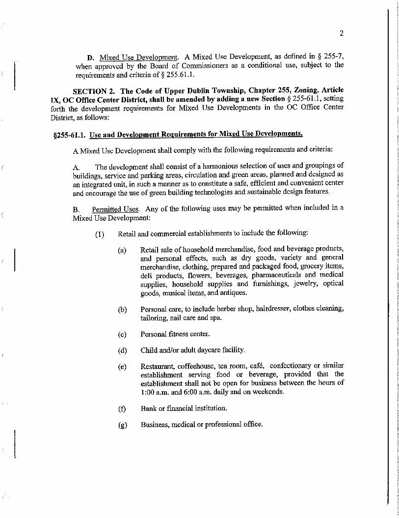
2
D. Mixed Use Development. A Mixed Use Development, as defined in § 255-7, when approved by the Board of Commissioners as a conditional use, subject to the requirements and criteria of § 255.61.1.
SECTION 2. The Code of Upper Dublin Township, Chapter 255, Zoning, Article IX, OC Office Center District, shall be amended by adding a new Section § 255-61.1, setting forth the development requirements for Mixed Use Developments in the OC Office Center District, as follows:
§255-61.1. Use and Development Requirements for Mixed Use Developments.
A Mixed Use Development shall comply with the following requirements and criteria:
A. The development shall consist of a harmonious selection of uses and groupings of buildings, service and parking areas, circulation and green areas, planned and designed as an integrated unit, in such a manner as to constitute a safe, efficient and convenient center and encourage the use of green building technologies and sustainable design features.
B. Permitted Uses. Any of the following uses may be permitted when included in a Mixed Use Development:
(1) Retail and commercial establishments to include the following:
(a) Retail sale of household merchandise, food and beverage products, and personal effects, such as dry goods, variety and general merchandise, clothing, prepared and packaged food, grocery items, deli products, flowers, beverages, pharmaceuticals and medical supplies, household supplies and thrnishings, jewelry, optical goods, musical items, and antiques.
(b) Personal care, to include barber shop, hairdresser, clothes cleaning, tailoring, nail care and spa.
(c) Personal fitness center.
(d) Child and/or adult daycare facility.
(e) Restaurant, coffeehouse, tea room, café, confectionary or similar establishment serving food or beverage, provided that the establishment shall not be open for business between the hours of 1:00 a.m. and 6:00 a.m. daily and on weekends.
(f) Bank or fmancial institution.
(g) Business, medical or professional office.
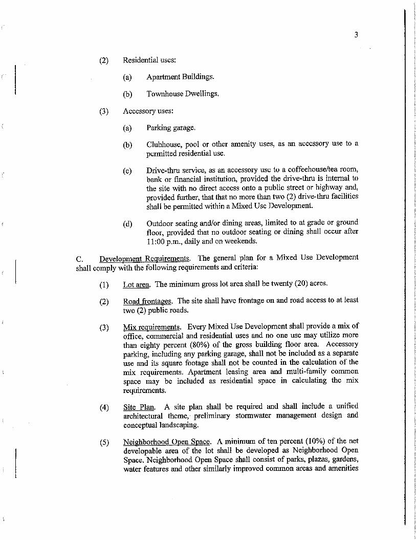
3
(2) Residential uses:
(a) Apartment Buildings.
(b) Townhouse Dwellings.
(3) Accessory uses:
(a) Parking garage.
(b) Clubhouse, pool or other amenity uses, as an accessory use to a permitted residential use.
(c) Drive-thru service, as an accessory use to a coffeehouse/tea room, bank or financial institution, provided the drive-thru is internal to the site with no direct access onto a public street or highway and, provided further, that that no more than two (2) drive-thru facilities shall be permitted within a Mixed Use Development.
(d) Outdoor seating and/or dining areas, limited to at grade or ground floor, provided that no outdoor seating or dining shall occur after 11:00 p.m., daily and on weekends.
C. Development Requirements. The general plan for a Mixed Use Development shall comply with the following requirements and criteria:
(1) Lot area. The minimum gross lot area shall be twenty (20) acres.
(2) Road frontages. The site shall have frontage on and road access to at least two (2) public roads.
(3) Mix requirements. Every Mixed Use Development shall provide a mix of office, commercial and residential uses and no one use may utilize more than eighty percent (80%) of the gross building floor area. Accessory parking, including any parking garage, shall not be included as a separate use and its square footage shall not be counted in the calculation of the mix requirements. Apartment leasing area and multi-family common space may be included as residential space in calculating the mix requirements.
(4) Site Plan. A site plan shall be required and shall include a unified architectural theme, preliminary stormwater management design and conceptual landscaping.
(5) Neighborhood Open Space. A minimum of ten percent (10%) of the net developable area of the lot shall be developed as Neighborhood Open Space. Neighborhood Open Space shall consist of parks, plazas, gardens, water features and other similarly improved common areas and amenities
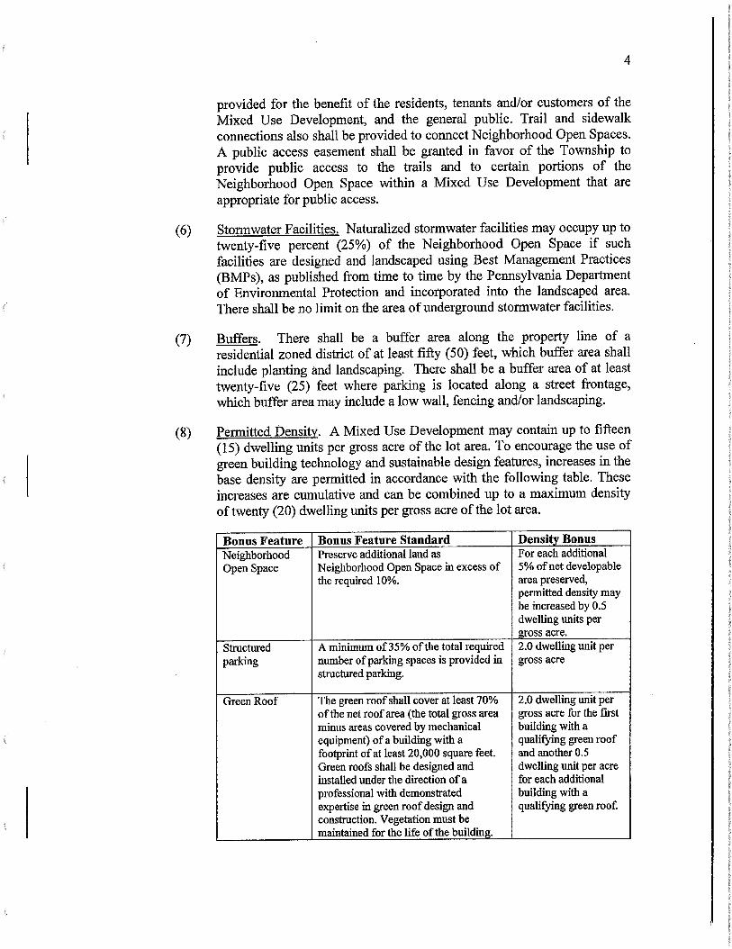
4
provided for the benefit of the residents, tenants and/or customers of the Mixed Use Development, and the general public. Trail and sidewalk connections also shall be provided to connect Neighborhood Open Spaces. A public access easement shall be granted in favor of the Township to provide public access to the trails and to certain portions of the Neighborhood Open Space within a Mixed Use Development that are appropriate for public access.
(6) Stormwater Facilities. Naturalized stormwater facilities may occupy up to twenty-five percent (25%) of the Neighborhood Open Space if such facilities are designed and landscaped using Best Management Practices (BMPs), as published from time to time by the Pennsylvania Depaitment of Environmental Protection and incorporated into the landscaped area. There shall be no limit on the area of underground stormwater facilities.
Buffers. There shall be a buffer area along the property line of a residential zoned district of at least fifty (50) feet, which buffer area shall include planting and landscaping. There shall be a buffer area of at least twenty-five (25) feet where parking is located along a street frontage, which buffer area may include a low wall, fencing and/or landscaping.
(8) Permitted Density. A Mixed Use Development may contain up to fifteen (15) dwelling units per gross acre of the lot area. To encourage the use of green building technology and sustainable design features, increases in the base density are permitted in accordance with the following table. These increases are cumulative and can be combined up to a maximum density of twenty (20) dwelling units per gross acre of the lot area.
Bonus Feature Bonus Feature Standard Density Bonus Neighborhood Open Space
Preserve additional land as Neighborhood Open Space in excess of the required 10%.
For each additional 5% of net developable area preserved, permitted density may be increased by 0.5 dwelling units per gross acre.
Structured parking
A minimum of 35% of the total required 2.0 dwelling unit per gross acre number of parking spaces is provided in
structured parking.
Green Roof The green roof shall cover at least 70% of the net roof area (the total gross area minus areas covered by mechanical equipment) of a building with a footprint of at least 20,000 square feet. Green roofs shall be designed and installed under the direction of a professional with demonstrated expertise in green roof design and construction. Vegetation must be maintained for the life of the building.
2.0 dwelling unit per gross acre for the first building with a qualifying green roof and another 0.5 dwelling unit per acre for each additional building with a qualifying green roof.
(7)
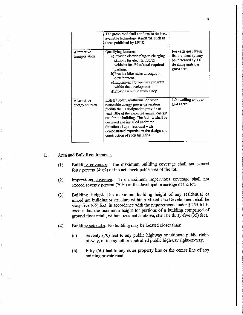
5
The green roof shall conform to the best available technology standards, such as those published by LEED.
Alternative Qualifying features: For each qualifying transportation a)Provide electric plug-in charging feature, density may
stations for electric/hybrid be increased by 1.0 vehicles for 1% of total required dwelling units per parking.
b)Provide bike racks throughout development.
c)Implement a bike-share program within the development.
d)Provide a public transit stop.
gross acre.
Alternative Install a solar, geothermal or other 1.0 dwelling unit per energy sources renewable energy power-generation
facility that is designed to provide at least 10% of the expected annual energy use for the building. The facility shall be designed and installed under the direction of a professional with demonstrated expertise in the design and construction of such facilities.
gross acre
D. Area and Bulk Requirements.
(1) Building coverage. The maximum building coverage shall not exceed forty percent (40%) of the net developable area of the lot.
(2) Impervious coverage. The maximum impervious coverage shall not exceed seventy percent (70%) of the developable acreage of the lot.
Building Height. The maximum building height of any residential or mixed use building or structure within a Mixed Use Development shall be sixty-five (65) feet, in accordance with the requirements under § 255-61.F. except that the maximum height for portions of a building comprised of ground floor retail, without residential above, shall be thirty-five (35) feet.
(4) Building setbacks. No building may be located closer than:
(a) Seventy (70) feet to any public highway or ultimate public right-of-way, or to any toll or controlled public highway right-of-way.
Fifty (50) feet to any other property line or the center line of any existing private road.
(3)
(b)
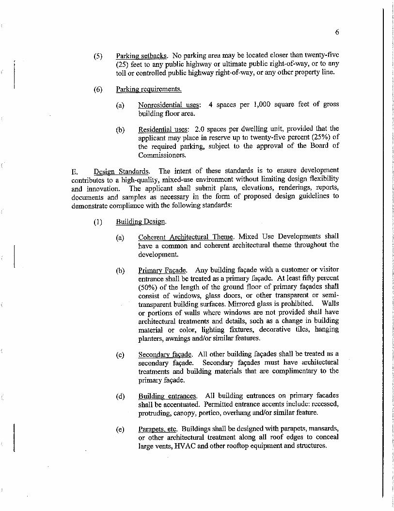
6
(5) Parking setbacks. No parking area may be located closer than twenty-five (25) feet to any public highway or ultimate public right-of-way, or to any toll or controlled public highway right-of-way, or any other property line.
(6) Parking requirements.
(a) Nonresidential uses: 4 spaces per 1,000 square feet of gross building floor area.
(b) Residential uses: 2.0 spaces per dwelling unit, provided that the applicant may place in reserve up to twenty-five percent (25%) of the required parking, subject to the approval of the Board of Commissioners.
E. Design Standards. The intent of these standards is to ensure development contributes to a high-quality, mixed-use environment without limiting design flexibility and innovation. The applicant shall submit plans, elevations, renderings, reports, documents and samples as necessary in the form of proposed design guidelines to demonstrate compliance with the following standards:
(1) Building Design.
(a) Coherent Architectural Theme. Mixed Use Developments shall have a common and coherent architectural theme throughout the development.
(b) Primary Façade. Any building facade with a customer or visitor entrance shall be treated as a primary façade. At least fifty percent (50%) of the length of the ground floor of primary façades shall consist of windows, glass doors, or other transparent or semi-transparent building surfaces. Mirrored glass is prohibited. Walls or portions of walls where windows are not provided shall have architectural treatments and details, such as a change in building material or color, lighting fixtures, decorative tiles, hanging planters, awnings and/or similar features.
(c) Secondary façade. All other building façades shall be treated as a secondary façade. Secondary façades must have architectural treatments and building materials that are complimentary to the primary façade.
(d) Building entrances. All building entrances on primary facades shall be accentuated. Permitted entrance accents include: recessed, protruding, canopy, portico, overhang and/or similar feature.
(e) Parapets, etc. Buildings shall be designed with parapets, mansards, or other architectural treatment along all roof edges to conceal large vents, HVAC and other rooftop equipment and structures.
7
(f) Building breaks.
[1] Buildings must have at least a three (3) foot break in depth, for the full height of the building, every 150 feet of continuous primary façade.
[2] For buildings greater than four (4) stories tall, the façade of the building shall step back a minimum of three (3) feet above the first floor of the building.
(g) Balconies. Balconies or Juliette style balconies shall be provided for every residential unit.
(2) Signage. The applicant for a Mixed Use Development shall submit a sign plan meeting the requirements of § 255-152.2.11.
(3) Landscape and Streetscape Standards.
a) Sidewalks or multi-use trails shall be provided along all street frontages. Sidewalks along public and private street frontages shall be a minimum of six (6) feet wide. Trails shall be a minimum of ten (10) feet wide.
b) A landscape plan prepared by a licensed landscape architect is required for all Mixed Use Developments. Landscaped areas include green areas, streetscapes, the interior and perimeter of surface parking areas, greenways, verges, stormwater basins, and natural areas.
c) Within 100 feet of a residential zoning district the landscape plan shall include plantings, decorative fencing or a wall to shield headlights and soften the view of cars from the street and from adjacent residential areas.
(4) Standards for Neighborhood Open Space.
(a) The minimum width of any land area to be counted as Neighborhood Open Space shall be fifteen (15) feet.
(b) Neighborhood Open Space shall be landscaped and/or hardscaped with a mix of trees, shrubs, groundcover decorative paving or walls in accordance with the overall landscape plan prepared for the development by a registered landscape architect.
(c) Neighborhood Open Space shall be provided with benches, trash containers and/or lighting fixtures.
8
Public Transit. Transit facilities and shelters shall be provided in mutually agreeable location(s) and in accordance with the design standards established by the Southeastern Pennsylvania Transit Authority (SEPTA).
SECTION 3. The Code of the Township of Upper Dublin, Chapter 255, Zoning, Article XXI, Signs, shall be amended by the addition of a new subsection H to § 255-155.2 to provide for signage related to a Mixed Use Development, as follows:
255-155.2. OC Office Center District.
H. In conjunction with a Mixed Use Development any combination of the following types of signs shall be permitted:
(1) Freestanding Signs. One freestanding sign shall be permitted for every four hundred and fifty feet (450') of property frontage along Welsh Road. Such freestanding signs shall be of a complimentary architectural style to the buildings of the Mixed Use Development, shall not exceed twenty-five feet (25') in height, nor contain more than two hundred square feet (200 sq. ft.) of sign area per side (maximum two (2) sides).
(2) Monument Signs. One monument sign shall be permitted for every five hundred feet (500') of property frontage along Dreshertown Road. Such monument signs shall be of a complimentary architectural style to the buildings of the Mixed Use Development, shall not exceed six feet (6') in height, nor contain more than one hundred twenty square feet (120 sq.ft.) of sign area per side (maximum two (2) sides).
(3) Wall Signs.
(a) Individual retail or commercial establishments within a Mixed Use Development shall be permitted signs on each exterior wall facing a public street or a private street or driveway. Such signs shall not exceed ten percent (10%) of the façade on which the signs are located or two hundred square feet (200 sq. ft.), whichever is less.
(b) Residential identification signage shall be permitted on each exterior wall facing a public street or private street or driveway. Such identification signage shall not exceed two hundred square feet (200 sq.ft.) per facade.
(4) Directional Signs. Directional signs within the Mixed Use Development shall be permitted, either freestanding or building mounted. Such signs may contain the names of specific tenants as well as other public information to direct both pedestrians and motorists through the site to the location of various uses including but not limited to general tenant parking areas, residential parking structures, parks, exits and entrances to the development. Signs shall be sized appropriately to be visible to pedestrians, motorist or both depending on location, but in no event shall
(5)
9
any one sign be larger than thirty-two square feet (32 sq.ft.) in area. The total number of directional signs and their location shall be determined by the Board of Commissioners.
Project Identification Signs. Project identification signs containing the project name or other identifying feature, but no other tenant advertising shall be permitted within the development which also may be visible outside the development. Such signage shall be of a complimentary style to the development and shall be no larger than two hundred square feet (200 sq.ft.) in area. The total number of project identification signs and their location shall be determined by the Board of Commissioners.
SECTION 4. To the extent that the provisions of this Ordinance are inconsistent or conflict with any other provision of Chapter 255, the Upper Dublin Township Zoning Ordinance, the specific regulations contained in § 255-61.1 shall control and take precedence over such other regulations.
SECTION 5. The provisions of this Ordinance are severable, and if any sentence, clause, section or part of the ordinance is for any reason found to be unconstitutional, illegal, or invalid, such unconstitutionality, or invalidity shall not affect or impair any of the remaining provisions, sentences, or parts of this ordinance. It is hereby declared to be the express intent of the Board of Commissioners that this Ordinance would have been adopted had such unconstitutional, illegal, or invalid sentence, clause, section, or parts thereof had not been included herein.
SECTION 6. This Ordinance repeals and replaces Ordinance 16-1326.
SECTION 7. This Ordinance shall take effect and be in force from and after its approval as required by law. ENAC lED by the Board of Commissioners of Upper Dublin Township, this
cAff7 day of Olanh ,2017.
BOARD OF COMMISSIONERS OF THE TOWNSHIP OF UPPER DUBL
Paul Leonard, Secretary and Township Manager
Ira S. Tackel, President
(5)
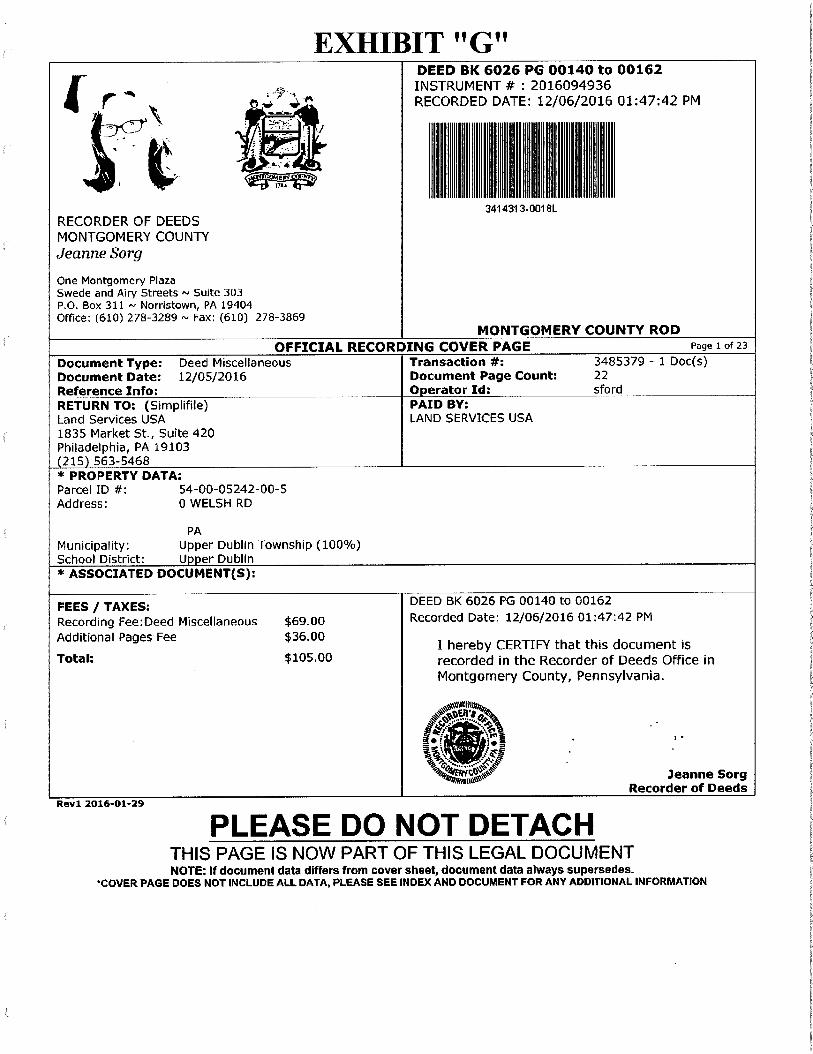
EXHIBIT "G"
:.y.. r '• ... „ie".
i
DEED
RECORDED INSTRUMENT
BK 6026 #
3414313-0018L
MONTGOMERY
DATE: : PG 2016094936 12/06/2016
00140 to
COUNTY
00162
01:47:42 PM
ROD
1 - "741;174
RECORDER OF DEEDS MONTGOMERY COUNTY Jeanne Sorg
One Montgomery Plaza Swede and Airy Streets ,,, Suite 303 P.O. Box 311 — Norristown, PA 19404 Office: (610) 278-3289 — Fax: (610) 278-3869
OFFICIAL RECORDING COVER PAGE Page 1 of 23
Document Type: Deed Miscellaneous Transaction #: 3485379 - 1 Doc(s) Document Date: 12/05/2016 Document Page Count: 22 Reference Info: Operator Id: sford RETURN TO: (Simplifile) PAID BY: Land Services USA LAND SERVICES USA 1835 Market St., Suite 420 Philadelphia, PA 19103 (215) 563-5468 * PROPERTY DATA: Parcel ID #: 54-00-05242-00-5 Address: 0 WELSH RD
PA Municipality: Upper Dublin Township (100%) School District: Upper Dublin * ASSOCIATED DOCUMENT(S):
FEES / TAXES: DEED BK 6026 PG 00140 to 00162
Recording Fee:Deed Miscellaneous $69.00 Recorded Date: 12/06/2016 01:47:42 PM
Additional Pages Fee $36.00 I hereby CERTIFY that this document is
Total: $105.00 recorded in the Recorder of Deeds Office in Montgomery County, Pennsylvania.
togiii
'/' .
Iet jr,:si a . : •
%moo* Jeanne Sorg Recorder of Deeds
Rev1 2016-01-29
PLEASE DO NOT DETACH THIS PAGE IS NOW PART OF THIS LEGAL DOCUMENT NOTE: If document data differs from cover sheet, document data always supersedes.
*COVER PAGE DOES NOT INCLUDE ALL DATA, PLEASE SEE INDEX AND DOCUMENT FOR ANY ADDITIONAL INFORMATION
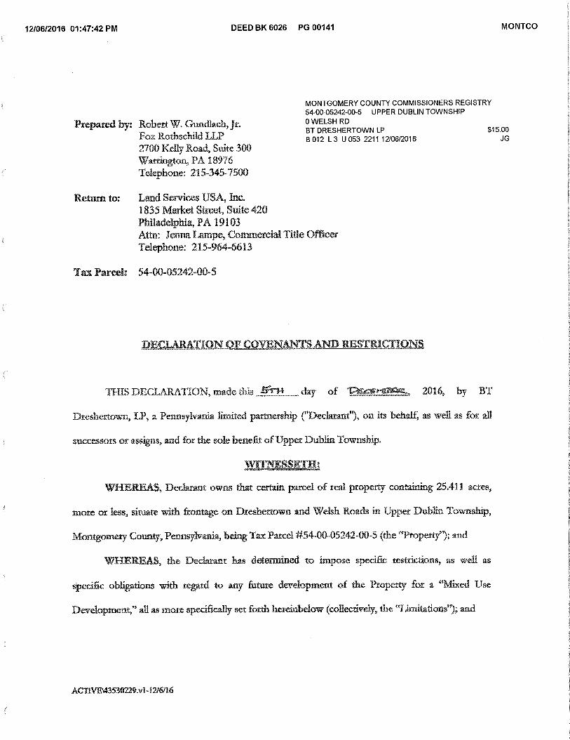
12/06/2016 01:47:42 PM DEED BK 6026 PG 00141 MONTCO
Prepared by: Robert W. Gundlach, jr. Fox Rothschild LI2 2700 Kelly Road, Suite 300 Warrington, PA 18976 Telephone: 215-345-7500
MONTGOMERY COUNTY COMMISSIONERS REGISTRY 54-00-05242-00-5 UPPER DUBLIN TOWNSHIP 0 WELSH RD BT DRESHERTOWN LP $15.00 B 012 L 3 U 053 221112/06/2016 JG
Return to: Land Smices USA, Inc. 1835 Market Street, Suite 420 Philadelphia, PA 19103 Attn: *Term Lampe, Commercial Title Officer Telephone: 215-.964-6613
Tax Parcel: 54-00-05242-00-5
DECLARATION OF COVENANTS AND RESTRICTIONS
THIS DECLARATION, made this -Trr14 day of VIructsaloar, 2016, by BT
Dreshertown, LP, a Pennsylvania limited partnership ("Decigram"), on its behalf, as well as for all
successors or assigns, and for the sole benefit of Upper Dublin Township.
WITNESSETH:
WHEREAS, Declarant owns that certain parcel of real property conoining 25.411 acres,
more or less, situate with frontage on Dreshertown and Welsh Roads in Upper Dublin Township,
Montgomery County, Pennsylvania, being Tar Parcel #54-00-05242-00-5 (the "Property"); and
WHEREAS, the DeclAt-2nt has determined to impose specific restrictions, as well as
specific obligations with regard to any future development of the Property for a 'Mixed Use
Development," all as more specifically set forth hereinbelow (collectively, the "Limitations"); and
ACTIVM43530'229.v1-12/6/16
12/06/2016 01:47:42 PM DEED BK 6026 PG 00142 MONTCO
WHEREAS, the Declarant acknowledges that the Limitations must ran with the had and,
therefore, it is necessary that the Declarant create and impose covenants and restrictions setting
forth the Limitations for the development of the Property; and
WHEREAS, .the Deckrant, for itself, as well as its successors and assigns, by this
Declaration hereby establishes as specific covenants running with. the Property, in perpetuity, the
Limitations as set forth below herein.
NOW, THEREFORE, intending to be legally bound hereby, Declarant hereby declares as
follows:
I. WHEREAS Clauses, The WHEREAS clauses are incorporated by reference as if
set forth in full in the body of Declaration.
2. ofi Use Zs.,,nimOniinance Amendment, It is the intention of the Declarant that
the Property be developed in accordance with a Zoning Ordinance amendment currently under
consideration by the Board of Commissioners ("Board") of Upper Dublin Township
("Township") allowing for a "Mixed Use Development" (the "Community"). The development
criteria for the Community is set forth in Exhibit "A," attached hereto and incorporated herein as
if set forth in full. If the Board enacts an Ordinance containing the provisions substantially as set
forth on Exhibit "A," and upon expiration of the time period for the filing of an appeal from the
enactment, or in the event of an appeal, following the ultimate sustaining of the enactment of
said Ordinance by the appropriate court of competent jurisdiction, all terms and provisions of
this Declaration shall be deemed fully binding upon the Declarant, its successors and assigns, in
regard to any development of the Community on the Property. If the Board does not adopt an
Ordinance before January 31, 2017 allowing for development of the Community, or in the event
of an appeal from enactment of the Ordinance which appeal is ultimately sustained, then this
Declaration shall automatically be deemed null, void and have no further force or effect
ACTIVEN43530229.v1-12/6116 2
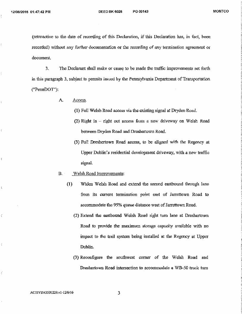
12/06/2016 01:47:42 PM DEED BK 6026 PG 00143 MONTCO
(retroactive to the date of recording of this Declaration, if this Declaration has, in fact, been
recorded) without any further documentation or the recording of any termination agreement or
document.
3 The Declarant shall make or cause to be made the traffic improvements set forth
in this paragraph 3, subject to permits issued by the Pennsylvania Department of Transportation
("PermDOT"):
A. ACSMI,
(1) Full Welsh Road access via the existing signal at Dryden Road.
(2) Right in — right out access from a new driveway on Welsh Road
between Dryden Road and Dreshertown Road.
(3) Full Dreshertown Road access, to be aligned with the Regency at
Upper Dublin's residential development driveway, with a new traffic
signal.
B. Welsh Road -improvements:
(1) Widen Welsh Road and extend the second eastbound through lane
from its current termination point east of Jarrettown Road to
accommodate the 95% queue distance west ofJarrettown Road.
(2) Extend the eastbound Welsh Road right turn lane at Dreshertown
Road to provide the maximum storage capacity available with no
impact to the trail system being installed at the Regency at Upper
(3) Reconfigure the southwest corner of the Welsh Road and
Dreshertown Road intersection to accommodate a WB-50 truck turn
ACHVE\43530229.v1-12i6116 3
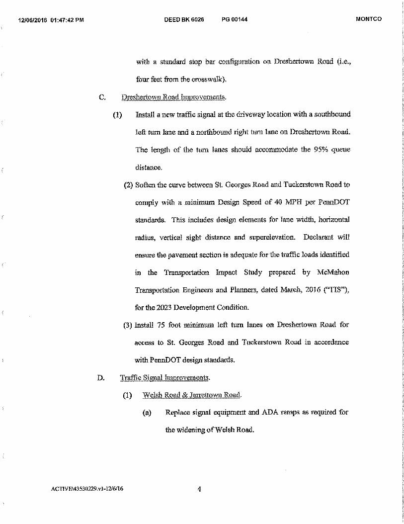
12/06/2016 01:47:42 PM DEED BK 6026 PG 00144 MONTCO
with a standard stop bar configuration on Dreshertown Road
four feet from the crosswalk).
C. Dreshertown Road hawrovemeids,
(1) Install a new traffic signal at the driveway location with a southbound
left turn lane and a northbound right turn lane on Droshei town Road.
The length of the turn lanes should accommodate the 95% queue
distance.
(2) Soften the curve between St. Georges Road and Tuckerstown Road to
comply with a minimum Design Speed of 40 MPH per PcanDOT
standards. This includes design elements for lane width, horizontal
radius, vertical sight distance and superelevation. Declarant will
ensure the pavement section is adequate for the traffic loads identified
in the Transportation Impact Study prepared by McMahon.
Transportation Engineers and Planners, dated March, 2016 ("TIS"),
for the 2023 Development Condition.
(3) Install 75 foot nainimum left turn lanes on Dresheitown Road for
access to St, Georges Road and Tuckerstown Road in accordance
with PemaDOT design standards.
D. Traffic Signal trn, roveractits,
(1) Welsh ROUX] & 3as-renown .Road,
(a) Replace signal equipment and ADA ramps as required for
the widening of Welsh Road.
ACTIVEA43530229x1-1216/16 4
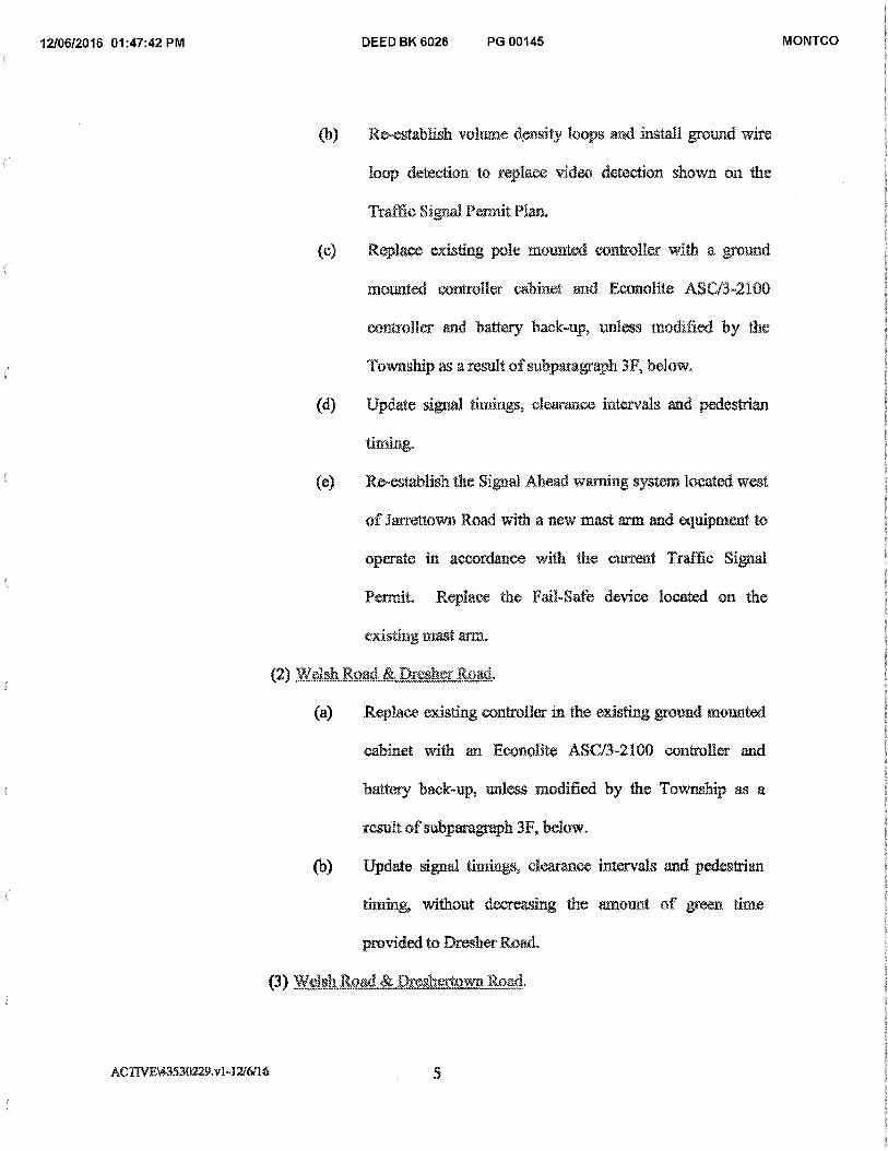
12/06/2016 01:47:42 PM DEED BK 6026 PG 00145 MONTCO
(b) Rets.tablish volume density loops and install ground wire
loop detection to replace video detection shown on the
Traffic Signal Permit Plan.
(e) Replace existing pole mounted controller with a ground
mounted controller cabinet and Eeonolite ASC13-2100
controller and battery back-up, unless modified by the
Township as a result of subparagraph 3F, below.
(d) Update signal timings, clearance intervals and pedestrian
(e) Re-establish the Signal Ahead warning system located west
of Jarrettown Road with a new mast arm and equipment to
operate in accordance with the current Traffic Signal
Permit. Replace the Fail-Safe device located on the
existing mast arm.
(2) Welsh Road --ther Road.
(a) Replace existing controller in the existing ground mounted
cabinet with an Econolite ASC/3-2100 controller and
battery back-up, unless modified by the Township as a
result of subparagraph 3F, below.
(b) Update signal timings, clearance intervals and pedestrian
timing, without decreasing the amount of green time
provided to Dresher Road.
(3) Welsh Rd & Dreshertown RDA
ACTIVB43530229.v1-1216/16 5
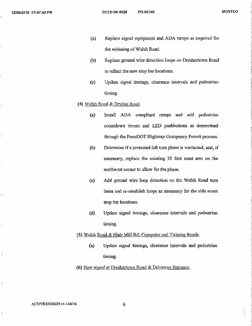
12/06/2016 01:47:42 PM DEED BK 6026 PG 00146 MONTCO
(a) Replace signal equipment and ADA ramps as required for
the widening of Welsh Road.
(b) Replace ground wire detection loops on Dreshertown Road
to reflect the new stop bar locations.
(c) Update signal timings, clearance intervals and pedestrian
timing.
(4) Welsh Road & Dryden It4-)ad.
(a) Install ADA compliant ramps and add pedestrian
countdown timers and LED pushbuttons as determined
through the Penn:DOT Highway Occupancy Permit process.
(b) Determine if a protected left turn phase is warranted, and, if
necessary, replace the existing 35 foot mast arm on the
northwest corner to allow for the phase.
(c) Add ground wire loop detection on the Welsh Road turn
lanes and re-establish loops as necessary for the side street
stop bar locations.
(d) Update signal timings, clearance intervals and pedestrian
liming.
(5) Welsh Road & Blair Mill Rd: Computer and Twining Roads.
(a) Update signal timings, clearance intervals and pedestrian
timing.
(6) New signal at Dreshf.vtown Road &jyw E aricp„
ACTIVE143530229.1:1-12/6/16 6
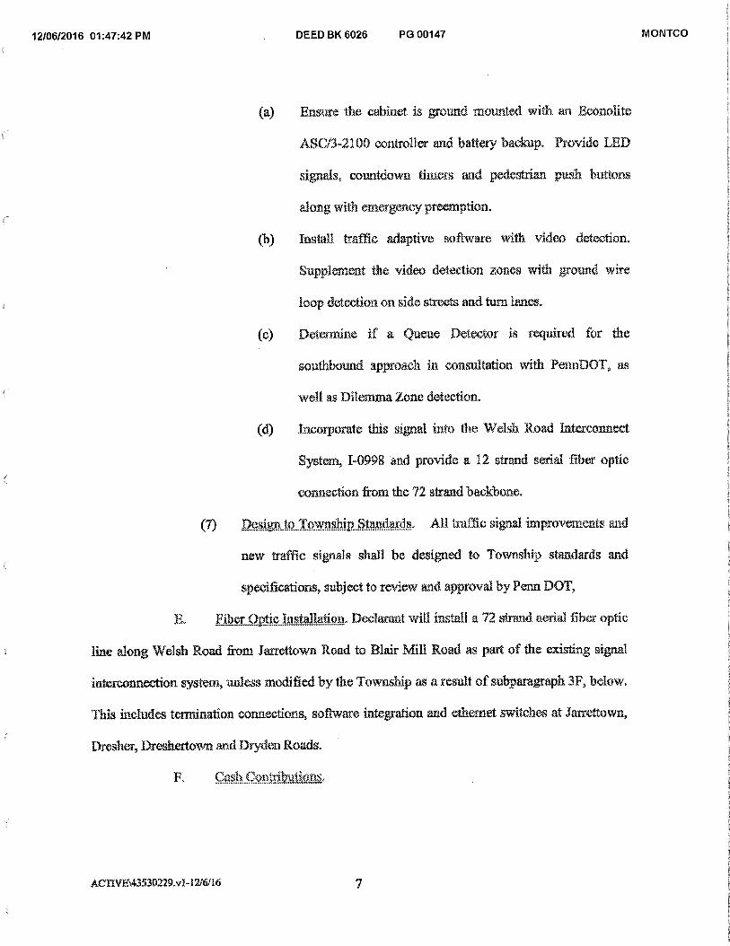
12/06/2016 01:47:42 PM DEED BK 6026 PG 00147 MONTCO
(a) Ensure the cabinet is ground mounted with an Econolite
ASCI3-2100 controller and battery backup. Provide LED
signals, countdown timers and pedestrian push buttons
along with emergency preemption.
(b) Install traffic adaptive software with video detection.
Supplement the video detection zones with ground wire
loop detection on side streets and turn lanes.
(c) Determine if a ueue Detector is required for the
southbound approach in consultation with PennDOT, as
well as Dilemma Zone detection.
(d) Incorporate this signal into the Welsh Road Interconnect
System, 1-0998 and provide a 12 strand serial fiber optic
connection from the 72 strand backbone.
(7) Design to Township Standards. All traffic signal improvements and
new traffic signals shall be designed to Township standards and
specifications, subject to review and approval by Penn DOT,
F. Fiber Optic Installation. Declarant will install. a 72 strand aerial fiber optic
line along Welsh Road from Jarrettown Road to Blair Mill Road as part of the existing signal
interconnection system, unless modified by the Township as a result of subparagraph 3F, below.
This includes termination connections, software integration and ethernet switches at Jarrettown,
Dresher, Dreshertown and Dryden Roads.
F. Cash Contributions,
ACrIVE\43530229.v1-12.16116 7
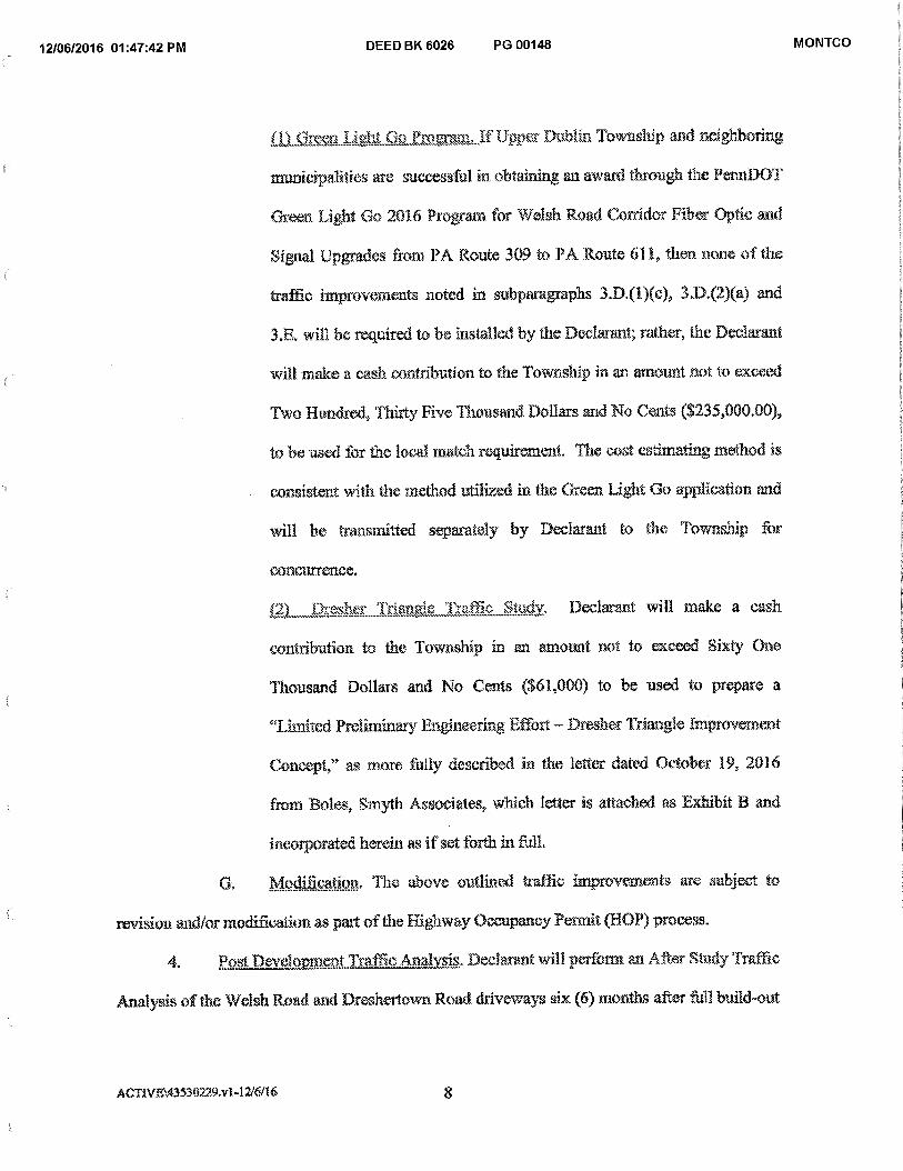
12/06/2016 01:47:42 PM DEED BK 6026 PG 00148 MONTCO
(11,Grom ght Proeraim If Upper Dublin Township and neighboring
municipalities are successful in obtaining an award through the PennDOT
Green Light Go 2016 Program for Welsh Road Corridor Fiber Optic and
Signal Upgrades from PA Route 309 to PA Route 611., then none of the
traffic improvements noted in subparagraphs 3.D.(1)(c), 3.D.(2)(a) and
3.E. will be required to be installed by the Declarant; rather, the Declarant
will make a cash contribution to the Township in an amount not to exceed
Two Hundred, Thirty Five Thousand Dollars and No Cents ($235,000.00),
to be used for the local match requirement. The cost estimating method is
consistent with the method utilized in the Green Light Go application and
will be transmitted separately by Declarant to the Township for
concurrence.
(2) Dresher . -hawk Traffic Studv, I)eclarant will make a cash
contribution to the Township in an amount not to exceed Sixty One
Thousand Dollars and No Cents ($61,000) to be used to prepare a
"Limited Preliminary Engineering Effort Dresher Triangle Improvem.ent
Concept," as more My described in the letter dated October 19, 2016
from Boles, Smyth Associates, which letter is attached as Exhibit B and
incorporated herein as if set forth in full.
Modification. The above outlined traffic improvements are subject to
revision and/or modification as part of the Highway Occupancy Permit (HOP) process.
4. Post Development Traffic .AnalVSif_4. Declarant will perform an After Study Traffic
Analysis of the Welsh Road and Dreshertown Road driveways six (6) months after full build-out
ACTIVEM3530229x14216/16 8
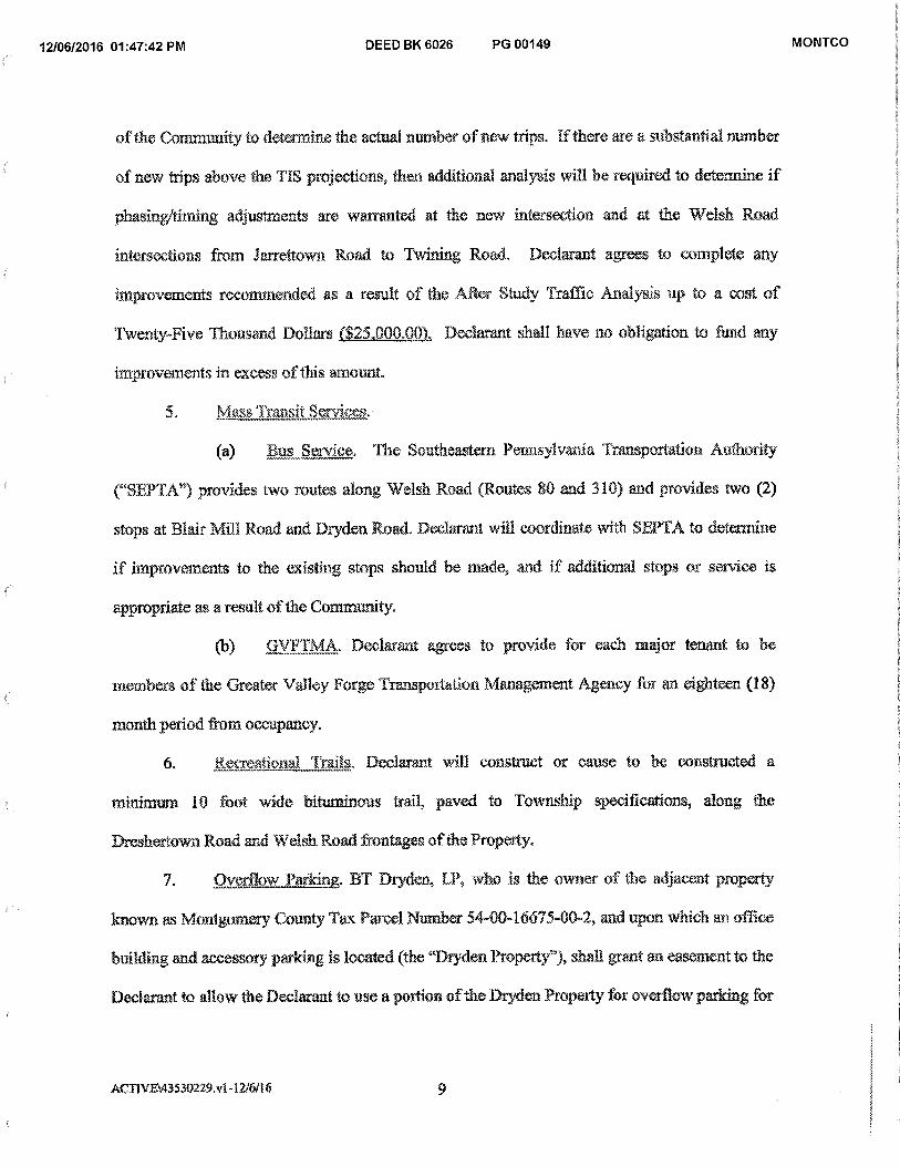
12/06/2016 01:47:42 PM DEED BK 6026 PG 00149 MONTCO
of the Comnmnity to determine the actual number of new trips. If there are a substantial number
of new trips above the TIS projections, then additional analysis will be required to determine if
phasing/timing adjustments are warranted at the new intersection and at the Welsh Road
intersections from Jarrettown Road to Twining Road. Declarant agrees to complete any
improvements recommended as a result of the After Study Traffic Analysis up to a cost of
Twenty-Five Thousand Dollars ($25..000.00). Declarant shall have no obligation to fund any
improvements in excess of this amount.
5. Mass Transit Services.
(a) Bus Service. The Southeastern Pennsylvania Transportation Authority
("SEPTA") provides two routes along Welsh Road (Routes 80 and 310) and provides two (2)
stops at Blair Mill Road and Dryden Road. Declarant will coordinate with SEPTA to determine
if improvements to the existing stops should be made, and if additional stops or service is
appropriate as a result of the Community.
(b) GVF"rMA. Declarant agrees to provide for each major tenant to be
members of the Greater Valley Forge Transportation Management Agency for an eighteen (18)
month period from occupancy.
6. Recreational Trails. Declarant will construct or cause to he constructed a
minimum 10 foot wide bituminous trail, paved to Township specifications, along the
Drcshertown Road and Welsh Road frontages of the Property.
7. Overflow Parking. BT Dryden, LP, who is the owner of the adjacent property
known as Montgomery County Tax Parcel Number 54-0046675-00-2, and upon which an office
building and accessory parking is located (the "Dryden Property"), shall grant an easement to the
Declarant to allow the Declarant to use a portion of the Dryden Property for overflow parking for
ACTIVE43530229.v1-12/6/16 9
12/06/2016 01:47:42 PM DEED BK 6026 PG 00150 MONTCO
the Property during nights and weekends when such parking is not needed by the office building
located on the Dryden Property. The temis of this easement shall be finalized prior to the
submission of a land development application for the project proposed for the Property,
8. .Apartment Units,
(a) Declarant contemplates the construction of approximately 402 apartment
units as part of the anumunity, together with the other improvements proposed as part of the
Community. In no event shall the Community exceed 402 apartment units.
(b) Declarant covenants to construct only one and two bedroom apartment
units as part of the Commimity, and further, covenants that no less than 40% of the apartments
be one (1) bedroom apartments. In no event will Declarant construct apartments that have more
than two (2) bedrooms.
9, Miscellaneous.
(a) This Declaration shall be a covenant running with the land and shall be
binding upon. and inure to the parties hereto and their respective successors and assigns.
Notwithstanding the foregoing, the Board of Commissioners of Upper Dublin Township shall
have the right to amend, waive, modify and/or remove any of the terms contained herein at any
time in its sole discretion and without having to obtain approval of any party other than the then
current owner of the Property,
(b) The restrictions contained in the Declaration shall inure to the sole benefit
of the municipality of Upper Dublin Township, and shall be only enforceable by the municipality
of Upper Dublin Township. This Declaration is not intended to benefit any other parties.
(c) All of the Declarant's obligations hereunder are contingent upon the
Property being developed as a Mixed Use Development under the proposed Ordinance, Exhibit
MI1VE:4353 0229. v 1 -12/611 6 10
12/06/2016 01:47:42 PM DEED BK 6026 PG 00151 MONTCO
A to this Declaration. If the Property is developed for any other use currently permitted under the
Upper Dublin Township Zoning Ordinance, then the developer for such other permitted use (i.e.,
such as offices), shall not be subject to the terms of this Declaration.
(d) This Declaration shall be recorded in the Office of the Recorder of Deeds
of Montgomery County, Pennsylvania, and shall constitute a covenant running with the Property,
and shall be binding on the Declarant, its administrators, executors, assigns, heirs and all other
successors in interest, in petpetuity,
ACT1V \43530229. v1-12/6/16 11
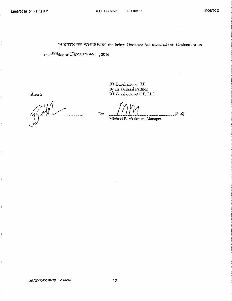
12/06/2016 01:47:42 PM DEED BK 6026 PG 00152 MONTCO
IN WITNESS WHEREOF, the below Derbrant has executed this Declaration oi
day of ,2016
Attest:
BT Dreshertown, LP By Its General Partner BT Dreshettown GP, TLC
By: eta) Michael P. Markman, ItefarlRget
ACTIVE\43530229x142,16/16 12
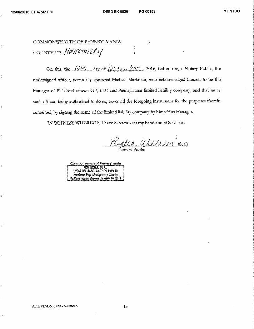
12/06/2016 01:47:42 PM DEED BK 6026 PG 00153 MONTCO
COMMONWEALTH OF PENNSYLVANIA
COUNTY OF Hatirif
On this, the J0Cfl day o „
-2-tAlt./Xt2arl„ 2016, before me, a .Notary Public, the
undersigned officer, personally appeared Michael Markman, who acknowledged himself to he the
Manager of BT Dresh.ertown OF, LIE and Pennsylvania. limited liability company, and that he as
such officer, being authorksed to do so, executed the foregoing Mg/In:tient for the purposes therein
contained, by signing the name of the limited liability company by himself as Manager.
IN WITNESS WHEREOF, I have hereunto set my hand and official seal.
\s . . 4 , I : . . ..?: .474 4'' ‘.61 1 1 / ..., r ..•1 *S.c14
? ' : ;%,,-:7:. tv.,,..., .zw.' .- a..4Z......-- \ . r ,.. Now.); Public
Conmentaesith of Pennsylvania NOTARIAL SEAL
1 LYDIA ViILLIAMS, NOTARY PUBLIC Pkilealt Twa,Montoomy Ctairgy
#ity.CanitisskA Eitzires Jackey R017
ACTIVEV13530229.v I-12/6116 13
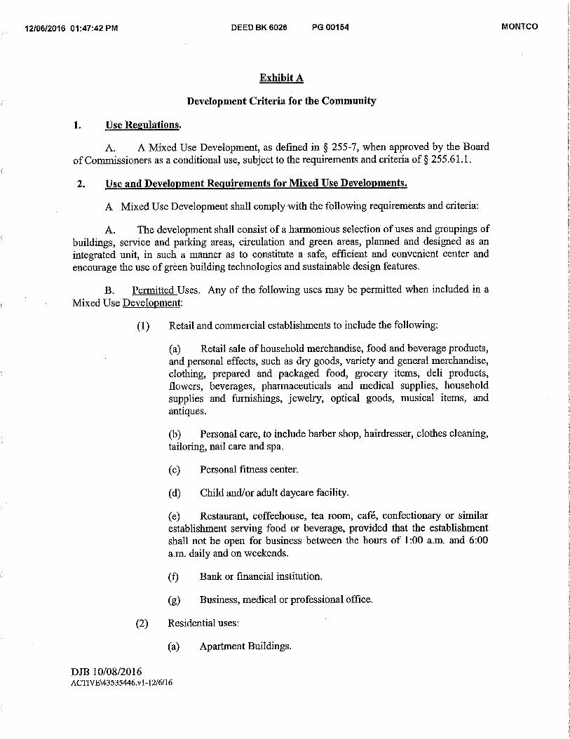
12/06/2016 01:47:42 PM DEED BK 6026 PG 00154 MONTCO
Exhibit A
Development Criteria for the Community
1. Use Regulations.
A. A Mixed Use Development, as defined in § 255-7, when approved by the Board of Commissioners as a conditional use, subject to the requirements and criteria of § 255.61.1.
2. Use and Development Requirements for Mixed Use Developments.
A Mixed Use Development shall comply with the following requirements and criteria:
A. The development shall consist of a harmonious selection of uses and groupings of buildings, service and parking areas, circulation and green areas, planned and designed as an integrated unit, in such a manner as to constitute a safe, efficient and convenient center and encourage the use of green building technologies and sustainable design features.
B. Permitted Uses. Any of the following uses may be permitted when included in a Mixed Use Development:
(1) Retail and commercial establishments to include the following:
(a) Retail sale of household merchandise, food and beverage products, and personal effects, such as dry goods, variety and general merchandise, clothing, prepared and packaged food, grocery items, deli products, flowers, beverages, pharmaceuticals and medical supplies, household supplies and furnishings, jewelry, optical goods, musical items, and antiques.
(b) Personal care, to include barber shop, hairdresser, clothes cleaning, tailoring, nail care and spa.
(c) Personal fitness center.
(d) Child and/or adult daycare facility.
(e) Restaurant, coffeehouse, tea room, café, confectionary or similar establishment serving food or beverage, provided that the establishment shall not be open for business between the hours of 1:00 a.m. and 6:00 a.m. daily and on weekends.
(f) Bank or fmancial institution.
(g) Business, medical or professional office.
(2) Residential uses:
(a) Apartment Buildings.
DJB 10/08/2016 ACTI'VE\43535446.v1-12/6/16
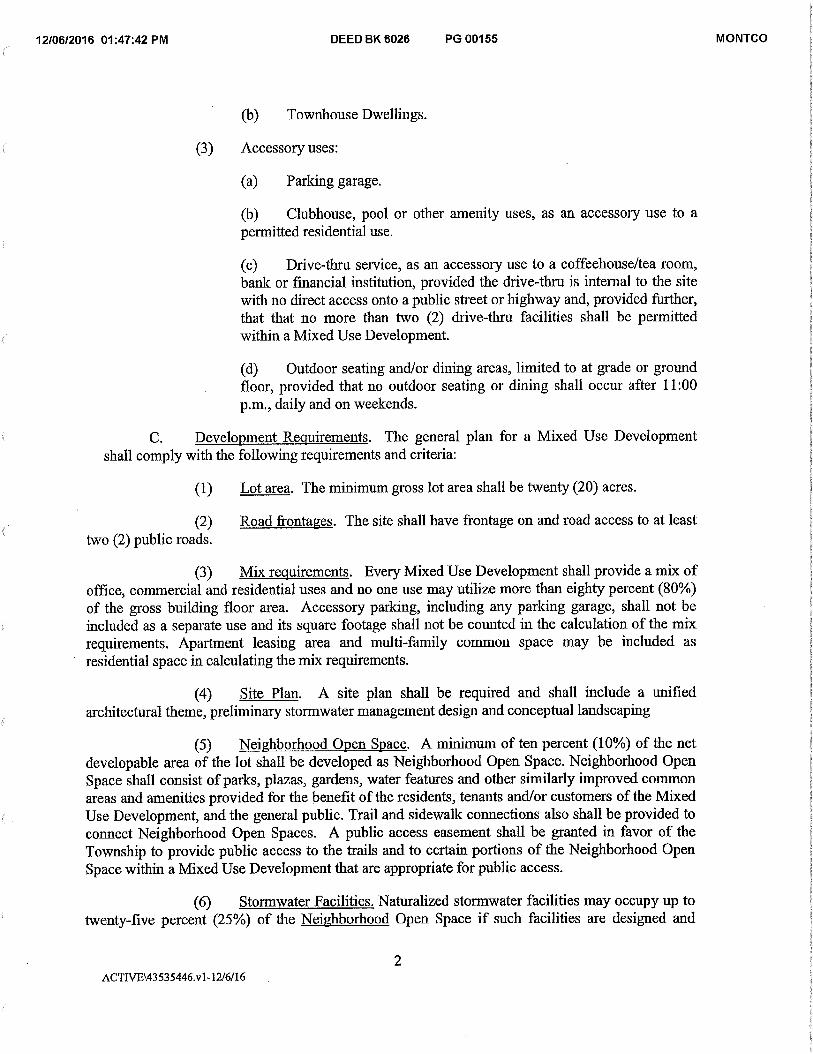
12/06/2016 01:47:42 PM DEED BK 6026 PG 00155 MONTCO
(b) Townhouse Dwellings.
(3) Accessory uses:
(a) Parking garage.
(b) Clubhouse, pool or other amenity uses, as an accessory use to a permitted residential use.
(c) Drive-thru service, as an accessory use to a coffeehouse/tea room, bank or financial institution, provided the drive-thru is internal to the site with no direct access onto a public street or highway and, provided further, that that no more than two (2) drive-thru facilities shall be permitted within a Mixed Use Development.
(d) Outdoor seating and/or dining areas, limited to at grade or ground floor, provided that no outdoor seating or dining shall occur after 11:00 p.m., daily and on weekends.
C. Development Requirements. The general plan for a Mixed Use Development shall comply with the following requirements and criteria:
(1) Lot area. The minimum gross lot area shall be twenty (20) acres.
(2) Road frontages. The site shall have frontage on and road access to at least two (2) public roads.
(3) Mix requirements. Every Mixed Use Development shall provide a mix of office, commercial and residential uses and no one use may utilize more than eighty percent (80%) of the gross building floor area. Accessory parking, including any parking garage, shall not be included as a separate use and its square footage shall not be counted in the calculation of the mix requirements. Apai talent leasing area and multi-family common space may be included as residential space in calculating the mix requirements.
(4) Site Plan. A site plan shall be required and shall include a unified architectural theme, preliminary stormwater management design and conceptual landscaping
(5) Neighborhood Open Space. A minimum of ten percent (10%) of the net developable area of the lot shall be developed as Neighborhood Open Space. Neighborhood Open Space shall consist of parks, plazas, gardens, water features and other similarly improved common areas and amenities provided for the benefit of the residents, tenants and/or customers of the Mixed Use Development, and the general public. Trail and sidewallc connections also shall be provided to connect Neighborhood Open Spaces. A public access easement shall be granted in favor of the Township to provide public access to the trails and to certain portions of the Neighborhood Open Space within a Mixed Use Development that are appropriate for public access.
(6) Stormwater Facilities. Naturalized stormwater facilities may occupy up to twenty-five percent (25%) of the Neighborhood Open Space if such facilities are designed and
2 ACTIVE\43535446.v1-12/6/16
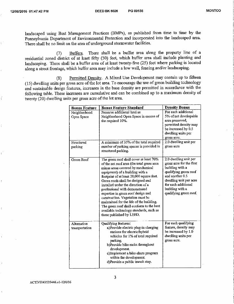
12/06/2016 01:47:42 PM DEED BK 6026 PG 00156 MONTCO
landscaped using Best Management Practices (BMPs), as published from time to time by the Pennsylvania Department of Environmental Protection and incorporated into the landscaped area. There shall be no limit on the area of underground stormwater facilities.
(7) Buffers. There shall be a buffer area along the property line of a residential zoned district of at least fifty (50) feet, which buffer area shall include planting and landscaping. There shall be a buffer area of at least twenty-five (25) feet where parking is located along a street frontage, which buffer area may include a low wall, fencing and/or landscaping.
(8) Permitted Density. A Mixed Use Development may contain up to fifteen (15) dwelling units per gross acre of the lot area. To encourage the use of green building technology and sustainable design features, increases in the base density are permitted in accordance with the following table. These increases are cumulative and can be combined up to a maximum density of twenty (20) dwelling units per gross acre of the lot area.
Bonus Feature Bonus Feature Standard Density Bonus Neighborhood Open Space
Preserve additional land as Neighborhood Open Space in excess of the required 10%.
For each additional 5% of net developable area preserved, permitted density may be increased by 0.5 dwelling units per gross acre.
Structured parking
A minimum of 35% of the total required number of parking spaces is provided in structured parking.
2.0 dwelling unit per gross acre
Green Roof The green roof shall cover at least 70% of the net roof area (the total gross area minus areas covered by mechanical equipment) of a building with a footprint of at least 20,000 square feet. Green roofs shall be designed and installed under the direction of a professional with demonstrated expertise in green roof design and construction. Vegetation must be maintained for the life of the building. The green roof shall conform to the best available technology standards, such as those published by LEED.
2.0 dwelling unit per gross acre for the first building with a qualifying green roof and another 0.5 dwelling unit per acre for each additional building with a qualifying green roof.
Alternative transportation
Qualifying features: a)Provide electric plug-in charging
stations for electric/hybrid vehicles for 1% of total required parking.
b)Provide bike racks throughout development.
c)Implement a bike-share program within the development.
d)Provide a public transit stop.
For each qualifying feature, density may be increased by 1.0 dwelling units per gross acre.
3 ACTIVE\43535446.v1-12/6/16
12/06/2016 01:47:42 PM DEED BK 6026 PG 00157 MONTCO
Alternative energy sources
Install a solar, geothermal or other renewable energy power-generation facility that is designed to provide at least 10% of the expected annual energy use for the building. The facility shall be designed and installed under the direction of a professional with demonstrated expertise in the design and construction of such facilities.
1.0 dwelling unit per gross acre
D. Area and Bulk Requirements.
(1) Building coverage. The maximum building coverage shall not exceed forty percent (40%) of the net developable area of the lot.
(2) Impervious coverage. The maximum impervious coverage shall not exceed seventy percent (70%) of the developable acreage of the lot.
(3) Building Height. The maximum building height of any residential or mixed use building or structure within a Mixed Use Development shall be sixty-five (65) feet, in accordance with the requirements under § 255-61(F), except that the maximum height for portions of a building comprised of ground floor retail, without residential above, shall be thirty-five (35) feet.
(4) Building setbacks. No building may be located closer than:
(a) Seventy (70) feet to any public highway or ultimate public right-of-way, or to any toll or controlled public highway right-of-way.
(b) Fifty (50) feet to any other property line or the center line of any existing private road.
(5) Parking setbacks. No parking area may be located closer than twenty-five (25) feet to any public highway or ultimate public right-of-way, or to any toll or controlled public highway right-of-way, or any other property line.
(6) Parking requirements.
(a) Nonresidential uses: 4 spaces per 1,000 square feet of gross building floor area.
(b) Residential uses: 2.0 spaces per dwelling unit, provided that the applicant may place in reserve up to twenty-five percent (25%) of the required parking, subject to the approval of the Board of Commissioners.
E. Design Standards. The intent of these standards is to ensure development contributes to a high-quality, mixed-use environment without limiting design flexibility and innovation. The applicant shall submit plans, elevations, renderings, reports, documents and
4 ACTIVE\43535446.v1-12/6/16

12/06/2016 01:47:42 PM DEED BK 6026 PG 00158 MONTCO
samples as necessary in the form of proposed design guidelines to demonstrate compliance with the following standards:
(1) Building Design.
(a) Coherent Architectural Theme. Mixed Use Developments shall have a common and coherent architectural theme throughout the development.
(b) Primary Façade. Any building facade with a customer or visitor entrance shall be treated as a primary facade. At least fifty percent (50%) of the length of the ground floor of primary façades shall consist of windows, glass doors, or other transparent or semi-transparent building surfaces. Mirrored glass is prohibited. Walls or portions of walls where windows are not provided shall have architectural treatments and details, such as a change in building material or color, lighting fixtures, decorative tiles, hanging planters, awnings and/or similar features.
(c) Secondary facade. All other building facades shall be treated as a secondary facade. Secondary facades must have architectural treatments and building materials that are complementary to the primary façade.
(d) Building entrances. All building entrances on primary facades shall be accentuated. Permitted entrance accents include: recessed, protruding, canopy, portico, overhang and/or similar feature.
(e) Parapets, etc. Buildings shall be designed with parapets, mansards, or other architectural treatment along all roof edges to conceal large vents, HVAC and other rooftop equipment and structures.
(f) Building breaks.
[1] Buildings must have at least a three (3) foot break in depth, for the full height of the building, every 150 feet of continuous primary facade.
[2] For buildings greater than four (4) stories tall, the facade of the building shall step back a minimum of three (3) feet above the first floor of the building.
(g) Balconies. Balconies or Juliette style balconies shall be provided for every residential unit.
(2) Signage. The applicant for a Mixed Use Development shall submit a sign plan meeting the requirements of § 255-152.2.H.
(3) Landscape and Streetscape Standards.
5 ACTIVE\43535446.v1-12/6/16
12/06/2016 01:47:42 PM DEED BK 6026 PG 00159 MONTCO
(a) Sidewalks or multi-use trails shall be provided along all street frontages. Sidewalks along public and private street frontages shall be a minimum of six (6) feet wide. Trails shall be a minimum of ten (10) feet wide.
(b) A landscape plan prepared by a licensed landscape architect is required for all Mixed Use Developments. Landscaped areas include green areas, streetscapes, the interior and perimeter of surface parking areas, greenways, verges, stormwater basins, and natural areas.
(c) Within 100 feet of a residential zoning districtthe landscape plan shall include plantings, decorative fencing or a wall to shield headlights and soften the view of cars from the street and from adjacent residential areas.
(4) Standards for Neighborhood Open Space.
(a) The minimum width of any land area to be counted as Neighborhood Open Space shall be fifteen (15) feet.
(b) Neighborhood Open Space shall be landscaped and/or hardscaped with a mix of trees, shrubs, groundcover decorative paving or walls in accordance with the overall landscape plan prepared for the development by a registered landscape architect.
(c) Neighborhood Open Space shall be provided with benches, trash containers and/or lighting fixtures.
(5) Public Transit. Transit facilities and shelters shall be provided in mutually agreeable location(s) and accordance with the design standards established by the Southeastern Pennsylvania Transit Authority (SEPTA).
3. OC Office Center District.
A. In conjunction with a Mixed Use Development any combination of the following types of signs shall be permitted:
(1) Freestanding Signs. One freestanding sign shall be permitted for every four hundred and fifty feet (450') of property frontage along Welsh Road. Such freestanding signs shall be of a complimentary architectural style to the buildings of the Mixed Use Development, shall not exceed twenty-five feet (25') in height, nor contain more than two hundred square feet (200 sq. ft.) of sign area per side (maximum two (2) sides)
(2) Monument Signs. One monument sign shall be permitted for every five hundred feet (500') of property frontage along Dreshertown Road. Such monument signs shall be of a complimentary architectural style to the buildings of the Mixed Use Development, shall not exceed six feet (6') in height, nor contain more than one hundred twenty square feet (120 sq.ft.) of sign area per side (maximum two (2) sides).
6 ACTIVE\43535446.v1-12/6/16
12/06/2016 01:47:42 PM DEED BK 6026 PG 00160 MONTCO
(3) Wall Signs.
(a) Individual retail or commercial establishments within a Mixed Use Development shall be permitted signs on each exterior wall facing a public street or a private street or driveway. Such signs shall not exceed ten percent (10%) of the façade on which the signs are located or two hundred square feet (200 sq. ft.), whichever is less.
(b) Residential identification signage shall be permitted on each exterior wall facing a public street or private street or driveway. Such identification signage shall not exceed two hundred square feet (200 sq.ft.) per façade.
(4) Directional Signs. Directional signs within the Mixed Use Development shall be permitted, either freestanding or building mounted. Such signs may contain the names of specific tenants as well as other public information to direct both pedestrians and motorist through the site to the location of various uses including but not limited to general tenant parking areas, residential parking structures, parks, exits and entrances to the development. Signs shall be sized appropriately to be visible to pedestrians, motorist or both depending on location, but in no event shall any one sign be larger than thirty-two square feet (32 sq.ft.) in area. The total number of directional signs and their location shall be determined by the Board of Commissioners.
(5) Project Identification Signs. Project identification signs containing the project name or other identifying feature, but no other tenant advertising shall be permitted within the development which also may be visible outside the development. Such signage shall be of a complimentary style to the development and shall be no larger than two hundred square feet (200 sq.ft.) in area. The total number of project identification signs and their location shall be determined by the Board of Commissioners.
7 ACTIVE\43535446.v1-12/6/16
12/06/2016 01:47:42 PM DEED BK 6026 PG 00161 MONTCO
40* EXHIBIT B
Boles, Smyth Associates, Inc. Consulting Civil Engineers Since 1972
October 19, 2016
Upper Dublin Township 801 Loch Alsh Avenue Fort Washington, PA 19034
Attn: Mr. Paul Leonard Township Manager
Ref: Limited Preliminaiy Engineering Efforts - Dresher Triangle Improvement Concept
Dear Mr. Leonard:
Boles, Smyth Associates (BSA) is appreciative in submitting this Technical & Price Proposal for tasks to perform limited Preliminary Engineering services on the Dresher Triangle Improvement Concept. See the attached figures for the anticipated project limits. We have prepared the following proposal based on an expected duration of three (3) months. This phase is tasked with defining the overall improvement program, performing traffic analysis services, cost estimating and identifying Right of Way requirements.
We are transmitting a Price Proposal in the total amount not to exceed $60,963.00. Below is a summary of
work activities for each firm.
Prime Consultant: Boles, Smyth Associates Billing Amount: $54,963.00 Sub Consultant - TEL Inc (Survey, Professional Land Surveyor) Billing Amount: $6,000.00
The following are a list of tasks and deliverables:
Aerial Base 'Warming Coordination and Property Plot Plan Preparation 1. This proposal will utilize Final Design level base mapping obtained by Upper Dublin Township via a
flight in April, 2016. Therefore, this effort includes three (3) field survey days to supplement the flight effort and establish Control Points/Benchmark. These services are 'performed by TEI, Inc.
2. BSA will prepare a Property Plot Plan for 1668 Susquehanna Road (Wells Fargo property) based on the Required Right of Way determined for this property. This includes inputting property lines into the AutoCad environment based on the metes and bounds shown on the ALTA/ASCM Title Survey Plan dated 12/10/2010 supplied by BET Investments.
3. TEI, Inc. will review and provide a Professional Land Surveyor seal on the Plot Plan which will provide the basis for executing a Right of Way Agreement.
Traffic Analysis I. This effort will utilize pre-existing peak hour traffic count information previously obtained by BSA
and McMahon Associates and does not include obtaining any updated traffic counts. 2. This task includes the construction of AM/PM peak period Synchro 8.0 models for the Existing
Condition, No Build 2040 Condition, Build Condition with Existing Volumes and Build Condition with 2040 Volumes. The No Build 2040 and Build 2040 Conditions will utilize percentages projected by the Delaware Valley Regional Planning Commission (DVRPC) for the PA Turnpike Corridor Reinvestment Study.
2400 Chestnut Street Philadelphia, PA 19103 215-561-2644 www.bolessrnyth.corn
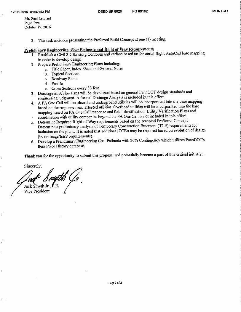
Jack Stilyth Jr., Vice President
12/06/2016 01:47:42 PM DEED BK 6026 PG 00162 MONTCO
Mr. Paul Leonard Page Two October 19, 2016
3. This task includes presenting the Preferred Build Concept at one (1) meeting.
Preihninary Engineering, Cost Estimate and Right of Way Requirements 1. Establish a Civil 3D Existing Contours and surface based on the aerial flight AutoCad base mapping
in order to develop design. 2. Prepare Preliminary Engineering Plans including:
a. Title Sheet, Index Sheet and General Notes b. Typical Sections c. Roadway Plans d. Profile e. Cross Sections every 50 feet
3. Drainage inlet/pipe sizes will be developed based on general PennDOT design standards and engineering judgment. A formal Drainage Analysis is included in this effort.
4. A PA One Call will be placed and underground utilities will be incorporated into the base mapping based on the response from affected utilities. Overhead utilities will be incorporated into the base mapping based on PA One Call response and field identification. Utility Verification Plans and coordination with utility companies beyond the PA One Call is not included in this effort.
5. Determine Required Right-of-Way requirements based on the accepted Preferred Concept. Determine a preliminary analysis of Temporary Construction Easement (TCE) requirements for inclusion on the plans. It is noted that additional TCE's may be required based on evolution of design (ie. drainage/E&S requirements).
6. Develop a Preliminary Engineering Cost Estimate with 20% Contingency which utilizes PennDOT's Item Price History database.
Thank you for the opportunity to submit this proposal and potentially become a part of this critical initiative.
Sincerely,
Page 2 of 2
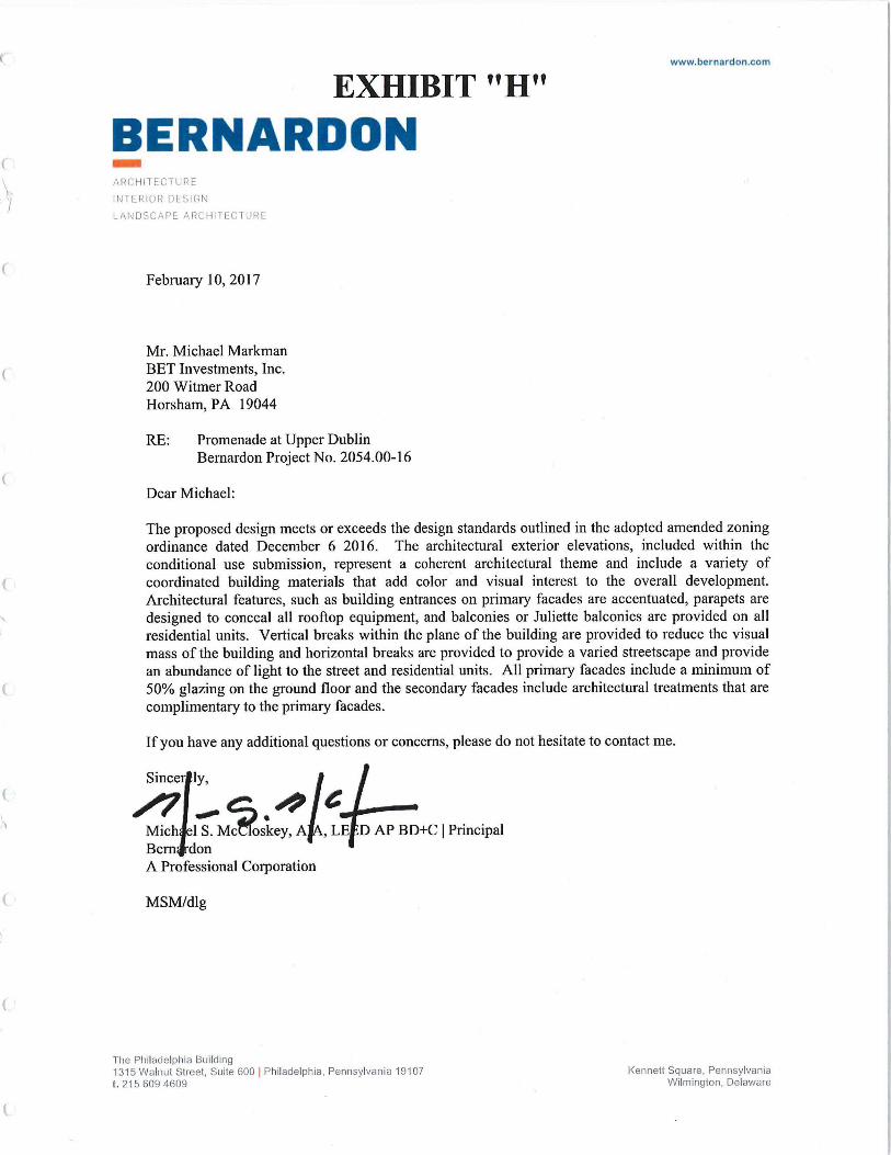
www.bernardon.com
EXHIBIT "H"
BERNARDON ARCHITECTURE
INTERIOR DESIGN
LANDSCAPE ARCHITECTURE
February 10, 2017
Mr. Michael Markman BET Investments, Inc. 200 Witmer Road Horsham, PA 19044
RE: Promenade at Upper Dublin Bemardon Project No. 2054.00-16
Dear Michael:
The proposed design meets or exceeds the design standards outlined in the adopted amended zoning ordinance dated December 6 2016. The architectural exterior elevations, included within the conditional use submission, represent a coherent architectural theme and include a variety of coordinated building materials that add color and visual interest to the overall development. Architectural features, such as building entrances on primary facades are accentuated, parapets are designed to conceal all rooftop equipment, and balconies or Juliette balconies are provided on all residential units. Vertical breaks within the plane of the building are provided to reduce the visual mass of the building and horizontal breaks are provided to provide a varied streetscape and provide an abundance of light to the street and residential units. All primary facades include a minimum of 50% glazing on the ground floor and the secondary facades include architectural treatments that are complimentary to the primary facades.
If you have any additional questions or concerns, please do not hesitate to contact me.
Sincer ly,
...• le Mich 1 S. Mc oskey, A , LE D AP BD+C I Principal
•
Bern don A Professional Corporation
MSM/dlg
The Philadelphia Building 1315 Walnut Street, Suite 600 I Philadelphia, Pennsylvania 19107 Kennett Square, Pennsylvania t. 215 609 4609 Wilmington, Delaware
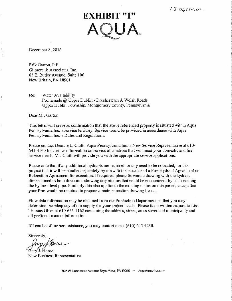
EXHIBIT "I"
A,JJA December 8, 2016
Erik Garton, P.E. Gilmore & Associates, Inc. 65 E. Butler Avenue, Suite 100 New Britain, PA 18901
Re: Water Availability Promenade @ Upper Dublin - Dreshertown & Welsh Roads Upper Dublin Township, Montgomery County, Pennsylvania
Dear Mr. Garton:
This letter will serve as confirmation that the above referenced property is situated within Aqua Pennsylvania Inc.'s service territory. Service would be provided in accordance with Aqua Pennsylvania Inc.'s Rules and Regulations.
Please contact Deanne L. Ciotti, Aqua Pennsylvania Inc.'s New Service Representative at 610-541-4160 for further information on service alternatives that will meet your domestic and fire service needs. Ms. Ciotti will provide you with the appropriate service applications.
Please note that if any additional hydrants are required, or any need to be relocated, for this project that it will be handled separately by me with the issuance of a Fire Hydrant Agreement or Relocation Agreement for execution. If required, please forward a drawing with the hydrant dimensioned in both directions showing any utilities that could be encountered by us in running the hydrant lead pipe. Similarly this also applies to the existing mains on this parcel, except that your firm would be required to prepare a main relocation drawing for us.
Flow data information may be obtained from our Production Department so that you may determine the adequacy of our supply for your project needs. Please fax a written request to Lisa Thomas Oliva at 610-645-1162 containing the address, street, cross street and municipality and all pertinent contact information. .
If I can be of further assistance, you may contact me at (610) 645-4230.
Sincerely,
--GaryJ. Iorne New Business Representative
762 W. Lancaster Avenue Bryn Mawr, PA 19010 • AquaAmerica.corn
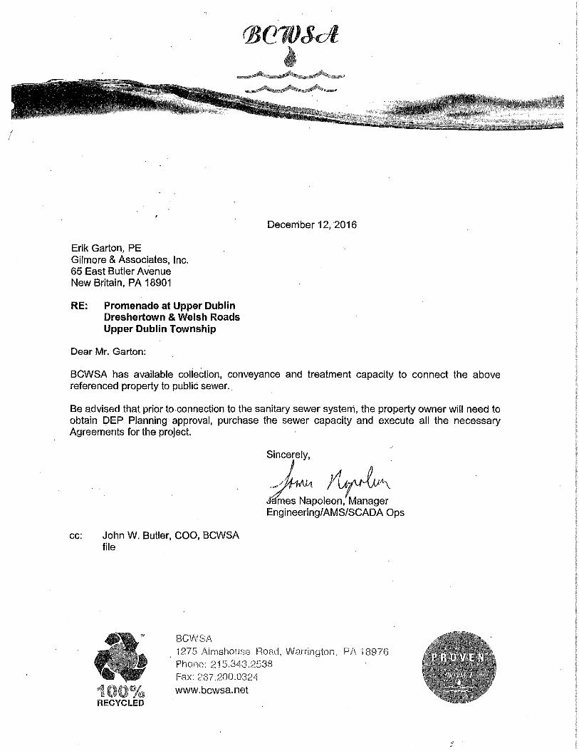
(20
December 12,2016
Erik Garton, PE Gilmore & Associates, Inc. 65 East Butler Avenue New Britain, PA 18901
RE: Promenade at Upper Dublin Dreshertown & Welsh Roads Upper Dublin Township
Dear Mr. Garton:
BCWSA has available collection, conveyance and treatment capacity to connect the above referenced property to public sewer.
Be advised that prior to connection to the sanitary sewer system, the property owner will need to obtain DEP Planning approval, purchase the sewer capacity and execute all the necessary Agreements for the project.
Sincerely,
Mmes Napoleon, Manager Engineering/AMS/SCADA Ops
cc: John W. Butler, COO, BCWSA file
BCWSA 1275 Almshouse Road, Warrington, PA 18976 Phone: 215.343,2538 Fax: 267.200.0324 www.bcwsa.net
Related Documents