INSPECTION COPY for schools only Topic 17.9E “Plate Tectonics” PhotoMaster copyright © 2013 KEEP IT SIMPLE SCIENCE www .keepit simplescience.com.au Page 1 KISS Resources for the Australian Curriculum - Science KEEP IT SIMPLE SCIENCE Resources for Science Teaching & Learning for the Australian Curriculum You have downloaded an inspection copy of the “PhotoMaster ” version of a KISS topic. Schools may use this inspection copy for evaluation of KISS Resources, as permitted by the applicable copyright law. “OnScreen ” versions are formatted for computer or projection and designed to be: • used in class via computer networks, data projectors, IWB’s, etc. • accessed by students (eg via Moodle) for study in their laptop, tablet, iPad or home PC. The “PhotoMaster ” version of this topic covers the same content, but is formatted for economical photocopying for paper “hand-outs”, or preparing “topic booklets”. The “W orksheets ” file for this topic is also formatted for photocopying so that worksheets may be used as in-class paper exercises, quiz tests or homework assignments. They can also be converted for use as Microsoft W ord TM documents, or with software allowing annotations, (eg Microsoft OneNote TM ) or apps, such as “Notability ” TM and “iAnnotate PDF ” TM in tablets & iPads. This allows KISS Worksheets to be completed by students in their computer, then submitted by email, for example. Please check the KISS website for details of our topic range, prices and how to order. TM. Software titles underlined above are registered trademarks of Microsoft Corp., GingerLabs, Branchfire Inc. ® keep it simple science

Welcome message from author
This document is posted to help you gain knowledge. Please leave a comment to let me know what you think about it! Share it to your friends and learn new things together.
Transcript

INSPECTION COPY forschools only
Topic 17.9E “Plate Tectonics” PhotoMastercopyright © 2013 KEEP IT SIMPLE SCIENCEwww.keepitsimplescience.com.au
Page 1
KISS Resources for the Australian Curriculum - Science
KEEP IT SIMPLE SCIENCE
Resources for Science Teaching & Learningfor the Australian Curriculum
You have downloaded an inspection copy of the “PhotoMaster”
version of a KISS topic. Schools may use this inspection copyfor evaluation of KISS Resources, as permitted by the applicable
copyright law.
“OnScreen” versions are formatted for computer or projection
and designed to be:• used in class via computer networks, data projectors, IWB’s, etc.• accessed by students (eg via Moodle) for study in their laptop, tablet,iPad or home PC.
The “PhotoMaster” version of this topic covers the same content, but is formatted for economical photocopying for paper
“hand-outs”, or preparing “topic booklets”.
The “Worksheets” file for this topic is also formatted for photocopying sothat worksheets may be used as in-class paper exercises, quiz tests orhomework assignments.
They can also be converted for use as Microsoft WordTM documents, orwith software allowing annotations, (eg Microsoft OneNoteTM) or apps,
such as “Notability”TM and “iAnnotate PDF”TM in tablets & iPads. Thisallows KISS Worksheets to be completed by students in their computer,
then submitted by email, for example.
Please check the KISS website for details of our topic range,prices and how to order.
TM. Software titles underlined above are registered trademarks of Microsoft Corp., GingerLabs, Branchfire Inc.
®
keep it simple science

KISS Resources for the Australian Curriculum - Science
INSPECTION COPY forschools only
Topic 17.9E “Plate Tectonics” PhotoMastercopyright © 2013 KEEP IT SIMPLE SCIENCEwww.keepitsimplescience.com.au
KEEP IT SIMPLE SCIENCEPhotoMaster Format
Plate TectonicsYear 9 Earth & Space Sciences
®
keep it simple science
Page 2
Topic 17.9E
KISS topicnumber
Year level designation inNat.Curriculum
Science Understanding StrandB = Biological SciencesC = Chemical Sciences E = Earth & Space SciencesP = Physical SciencesTopic Outline
What is this topic about?To keep it as simple as possible, (K.I.S.S. Principle) this topic covers:
Structure of the EarthReview of Earth structure.
Moving PlatesThe Theory of Plate Tectonics, including a little history.
Sea-floor spreading, subduction, mountain building. The driving forces for the moving plates.
The EvidenceSome of the reasons we believe this theory is correct.
Tectonic AustraliaBrief history of how the Australian continent was formed and what is
happening now.
Tectonic ImpactsEffects of tectonic events on the Earth, on people and on other living things.
Alfred Wegener& Continental
Drift
Sea-FloorEvidence
Fossil & MineralEvidence
Locations ofVolcanoes &Earthquakes
Evidence forthe Moving
Plates
Structureof the Earth
The MovingPlates
TectonicAustralia
TectonicImpacts
Plate Tectonics
New Technology,New Evidence
Spreading,Collision &Subduction
INSPECTION COPYfor schools only
KISS Resources for the Australian Curriculum - Science
INSPECTION COPY forschools only
Topic 17.9E “Plate Tectonics” PhotoMastercopyright © 2013 KEEP IT SIMPLE SCIENCEwww.keepitsimplescience.com.au
®
keep it simple science
Page 3
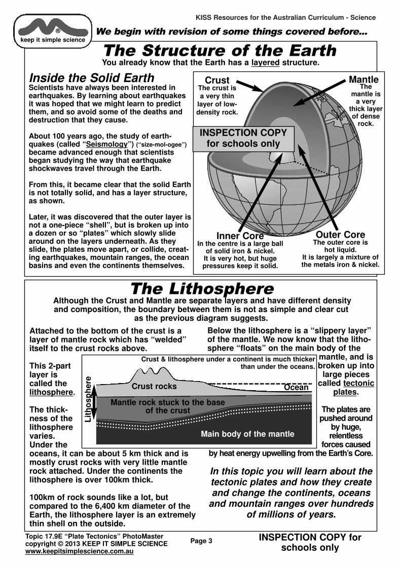
The Structure of the Earth You already know that the Earth has a layered structure.
Inside the Solid EarthScientists have always been interested inearthquakes. By learning about earthquakesit was hoped that we might learn to predictthem, and so avoid some of the deaths anddestruction that they cause.
About 100 years ago, the study of earth-quakes (called “Seismology”) (“size-mol-ogee”)
became advanced enough that scientistsbegan studying the way that earthquakeshockwaves travel through the Earth.
From this, it became clear that the solid Earthis not totally solid, and has a layer structure,as shown.
Later, it was discovered that the outer layer isnot a one-piece “shell”, but is broken up intoa dozen or so “plates” which slowly slidearound on the layers underneath. As theyslide, the plates move apart, or collide, creat-ing earthquakes, mountain ranges, the oceanbasins and even the continents themselves.
We begin with revision of some things covered before...
Crust The crust isa very thin
layer of low-density rock.
Mantle The
mantle isa very
thick layerof dense
rock.
Inner Core In the centre is a large ball
of solid iron & nickel. It is very hot, but huge pressures keep it solid.
Outer Core The outer core is
hot liquid. It is largely a mixture ofthe metals iron & nickel.
The LithosphereAlthough the Crust and Mantle are separate layers and have different density and composition, the boundary between them is not as simple and clear cut
as the previous diagram suggests.
Attached to the bottom of the crust is alayer of mantle rock which has “welded”itself to the crust rocks above.
This 2-partlayer iscalled thelithosphere.
The thick-ness of thelithospherevaries.Under theoceans, it can be about 5 km thick and ismostly crust rocks with very little mantlerock attached. Under the continents thelithosphere is over 100km thick.
100km of rock sounds like a lot, but compared to the 6,400 km diameter of theEarth, the lithosphere layer is an extremelythin shell on the outside.
Below the lithosphere is a “slippery layer”of the mantle. We now know that the litho-sphere “floats” on the main body of the
mantle, and isbroken up into
large piecescalled tectonic
plates.
The plates arepushed around
by huge, relentless
forces causedby heat energy upwelling from the Earth’s Core.
In this topic you will learn about the tectonic plates and how they createand change the continents, oceans
and mountain ranges over hundredsof millions of years.
Lit
ho
sp
here
Crust rocks Ocean
Mantle rock stuck to the baseof the crust
Main body of the mantle
Crust & lithosphere under a continent is much thicker than under the oceans.
INSPECTION COPYfor schools only

KISS Resources for the Australian Curriculum - Science
Page 4
Seismology (Greek, “seismo”= shaking)
Seismology is the study of earthquakes and their shock waves.
EarthquakesEarthquakes are caused by sudden movements in the Earth’s crust. The sudden release of enormous energies sends out shock waveswhich radiate out from the “focus”of the ‘quake.
The shock waves are detected and recorded by a seismometer.
The photo shows an old-fashioned seismometer recording the vibrationson paper. Modern seismometers useelectronic detectors and record datadigitally for computer analysis.
Seismic WavesThe shock waves are refracted by different density rocks, and some types of waves cannotpass through the liquid Outer Core.
Our understandingof the structure ofthe Earth is based onstudying the seismicwaves and howthey behave asthey pass throughthe different layers.
There are thousandsof seismometers allover the world, including the ocean floor.Most are automatic stations sending data to central computers by radio or phone links.
Many are warning systems to alert people topossible volcanic eruptions or tsunami waves inthe oceans.
EarthquakeFocus
Earthquakeshockwavestravel
through the
Earth
®
keep it simple science
Locating an EarthquakeWithin minutes of an earthquake occurring, modern seismometers can tell you exactly
where it occurred. Here is a simplified explanation of how.
P and S WavesEarthquakes give off several types of shockwave which have different properties andtravel at different speeds.
The fastest waves, called “Primary” (P)waves always arrive at a seismometer first, followed by“Secondary” (S) waves.
The time-gap between themgives the distance from seismometer to earthquake. Each 1.0 second P-S gap equatesto a distance = 7 km.
If 3 or more seismometersrecord the earthquake, it can belocated by triangulation. Studythe diagram to get the idea.
S-wavesP-waves
Seismic Station A
P-S time gap = 150 sDistance = 1050 km
Seismic Station BP-S time gap = 193 sDistance = 1350 km
Seismic Station C
P-S time gap = 343 sDistance = 2400 km
Earthquakeoccurred
where circles
overlap.
1350 km
1050 km
2400 k
m
Record of seismicshock waves,
showing time gap(arrow) between
S & P waves.
Topic 17.9E “Plate Tectonics” PhotoMastercopyright © 2013 KEEP IT SIMPLE SCIENCEwww.keepitsimplescience.com.au
INSPECTION COPY forschools only
Please completeWorksheets 1 & 2before going on.
INSPECTION COPYfor schools only
KISS Resources for the Australian Curriculum - Science
INSPECTION COPY forschools only
Topic 17.9E “Plate Tectonics” PhotoMastercopyright © 2013 KEEP IT SIMPLE SCIENCEwww.keepitsimplescience.com.au
Page 5
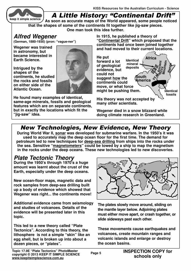
A Little History: “Continental Drift”As soon as accurate maps of the World appeared, some people noticed
that the shapes of some of the continents fit together like jig-saw pieces. One man took this idea further.
Alfred Wegener(German, 1880-1930) (pron: “vague-ner”)
Wegener was trainedin astronomy, butbecame interested in Earth Science.
Intrigued by theshapes of the continents, he studiedthe rocks and fossilson either side of theAtlantic Ocean.
He found many examples of identical,same-age minerals, fossils and geologicalfeatures which are on separate continents,but in exactly the locations which fit the“jig-saw” idea.
In 1915, he published a theory of“Continental Drift” which proposed that thecontinents had once been joined togetherand had moved to their current locations.
He put forward a lotof geological evidence, butcould not suggest how thecontinents couldmove, or what forcemight be pushing them.
His theory was not accepted bymany other scientists.
Wegener died in a snow blizzard whiledoing climate research in Greenland.
Africa
Identicalfossils
Identicalmineraldeposits
SouthAmerica
An
cie
nt
Mo
un
tain
Ran
ge
XX
XXXXX
XX
®
keep it simple science
New Technologies, New Evidence, New TheoryDuring World War II, sonar was developed for submarine warfare. In the 1950’s it was
used to accurately map the deep ocean floor for the first time. The demand for petroleum led to new techniques for deep-sea drilling from ships into the rocks underthe sea. Sensitive “magnetometers” could be towed by a ship to map the magnetism in the rocks under the deep oceans. These new technologies led to new discoveries.
Plate Tectonic TheoryDuring the 1950’s through 1970’s a hugeamount was learnt about the crust of theEarth, especially under the deep oceans.
New ocean-floor maps, magnetic data androck samples from deep-sea drilling builtup a body of evidence which showed thatWegener was right... the continents move!
Additional evidence came from seismologyand studies of volcanoes. Details of theevidence will be presented later in thistopic.
This led to a new theory called “PlateTectonics”. According to this theory, thelithosphere is not a simple “skin” like anegg shell, but is broken up into about adozen pieces, or “plates”.
The plates slowly move around, sliding on
the mantle layer below. Adjoining plates
must either move apart, or crash together, or
slide sideways past each other.
These movements cause earthquakes and
volcanoes, create mountain ranges and
volcanic islands and enlarge or destroy
the ocean basins.
KISS Resources for the Australian Curriculum - Science
INSPECTION COPY forschools only
Topic 17.9E “Plate Tectonics” PhotoMastercopyright © 2013 KEEP IT SIMPLE SCIENCEwww.keepitsimplescience.com.au
Page 6
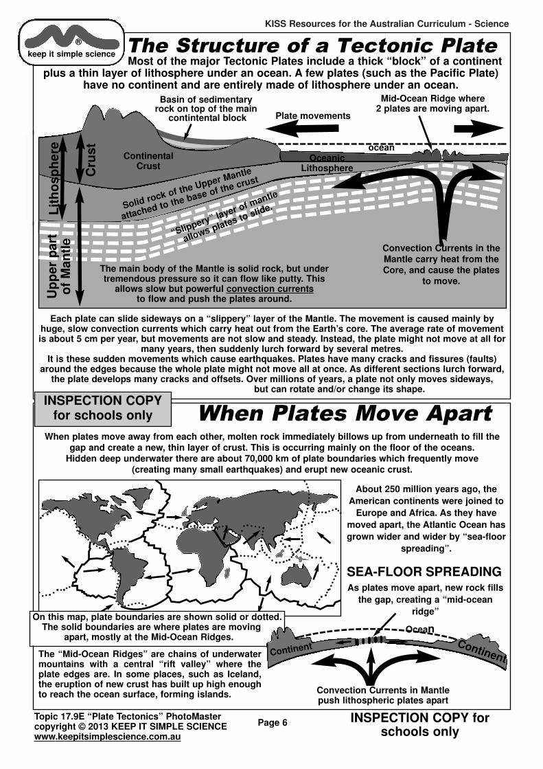
The Structure of a Tectonic PlateMost of the major Tectonic Plates include a thick “block” of a continent
plus a thin layer of lithosphere under an ocean. A few plates (such as the Pacific Plate)have no continent and are entirely made of lithosphere under an ocean.
ocean
Basin of sedimentaryrock on top of the main
contintental block
Mid-Ocean Ridge where 2 plates are moving apart.
OceanicLithosphere
ContinentalCrust
Solid rock of the Upper Mantle
attached to the base of the crust
Plate movements
“Slippery” layer of mantle
allows plates to slide.
The main body of the Mantle is solid rock, but under tremendous pressure so it can flow like putty. This
allows slow but powerful convection currentsto flow and push the plates around.
Lit
ho
sp
here
Up
per
pa
rto
f M
an
tle
Cru
st
Convection Currents in theMantle carry heat from theCore, and cause the plates
to move.
Each plate can slide sideways on a “slippery” layer of the Mantle. The movement is caused mainly byhuge, slow convection currents which carry heat out from the Earth’s core. The average rate of movementis about 5 cm per year, but movements are not slow and steady. Instead, the plate might not move at all for
many years, then suddenly lurch forward by several metres. It is these sudden movements which cause earthquakes. Plates have many cracks and fissures (faults)
around the edges because the whole plate might not move all at once. As different sections lurch forward,the plate develops many cracks and offsets. Over millions of years, a plate not only moves sideways,
but can rotate and/or change its shape.
®
keep it simple science
When Plates Move ApartWhen plates move away from each other, molten rock immediately billows up from underneath to fill the
gap and create a new, thin layer of crust. This is occurring mainly on the floor of the oceans. Hidden deep underwater there are about 70,000 km of plate boundaries which frequently move
(creating many small earthquakes) and erupt new oceanic crust.
About 250 million years ago, the
American continents were joined to
Europe and Africa. As they have
moved apart, the Atlantic Ocean has
grown wider and wider by “sea-floor
spreading”.
The “Mid-Ocean Ridges” are chains of underwatermountains with a central “rift valley” where theplate edges are. In some places, such as Iceland,the eruption of new crust has built up high enoughto reach the ocean surface, forming islands.
On this map, plate boundaries are shown solid or dotted. The solid boundaries are where plates are moving
apart, mostly at the Mid-Ocean Ridges.
SEA-FLOOR SPREADINGAs plates move apart, new rock fills
the gap, creating a “mid-ocean
ridge”
Continent
Convection Currents in Mantlepush lithospheric plates apart
Continent
Ocean
INSPECTION COPYfor schools only

KISS Resources for the Australian Curriculum - Science
INSPECTION COPY forschools only
Topic 17.9E “Plate Tectonics” PhotoMastercopyright © 2013 KEEP IT SIMPLE SCIENCEwww.keepitsimplescience.com.au
Page 7
When Plates CollideThe tectonic plates cover the surface of a sphere. If they are moving
apart in some places, then they have to be colliding somewhere else. Exactly what happens in a collision zone depends on what type of lithosphere is involved.
SubductionIf one of the colliding plates is made of oceaniclithosphere it will be pushed down under the otherplate and destroyed by being re-melted into theMantle. This is called “Subduction”.
This type of collision is occurring north ofAustralia where the plate under the Pacific Oceanis being destroyed. The many volcanic islands ofthe western Pacific have formed in chains alongthe subduction zones. Deep ocean trenches occurwhere the plate is bent sharply downwards.
Each time a plate lurches forward, an earthquakeoccurs. Large under-sea ‘quakes can set off atsunami, or seismic water wave, in the ocean. TheBoxing-Day tsunami of 2004, which killed over200,000 people, was caused by a ‘quake in the subduction zone north-west of Australia.
In March 2011, a huge earthquake near the coast ofJapan (where the Pacific Plate is being subducted)set off a tsunami which devastated parts of Japanand killed thousands more.
Ocean
Deep oceantrench
Colliding Oceanic Plates
This plate is being forced down
under the other.
“Island Arc” of volcanic islandserupt from the seafloor
As the plate is subductedinto the mantle, melting
occurs and bodies ofmagma rise through theupper plate and erupt as
volcanoes.Upper Mantle
Composite photo of a ficticious tsunami about todestroy a coastal city. Real tsunamis are more like a
“wall of water” rather than a giant surf wave.
®
keep it simple science
If one of colliding plates is carrying a continent things happen differently. The crust rocks in a continent are too thick & low in density to be subducted.
The South American plate is colliding with theplate under the eastern Pacific Ocean. There aredeep ocean trenches just off the coast and a massive mountain range (the Andes) along thewestern edge of the continent.
The mountains are formed by the “crumpling” ofthe continent’s crust in the collision. There arealso many volcanoes and earthquakes.
Deep oceantrench
Oceanic-Continental Collision
Oceanic platesubducted
Mountain Chain with volcanoes
Melting occurs & bodiesof magma rise through theupper plate and erupt as
volcanoes.Upper Mantle
Continental Plate iscrumpled by the
collision, forming amountain chain.
Mountain BuildingIf both colliding plates carry the thick lithosphere ofa continent, neither plate is subducted. Instead, thecontinents are crumpled by the collision. The crumpling effect folds and fractures the crust rocksand pushes them up to form a chain of mountains.The Himalaya mountains formed this way as theplate carrying India has collided with Asia. Rockswhich were once under the sea are now 9 km high.
Ocean
Continent - Continent Collision... NO SUBDUCTION
Upper Mantle
Joint betweencontinents
Mountain Rangeformed by folding
and faulting
INSPECTION COPYfor schools only

KISS Resources for the Australian Curriculum - Science
INSPECTION COPY forschools only
Topic 17.9E “Plate Tectonics” PhotoMastercopyright © 2013 KEEP IT SIMPLE SCIENCEwww.keepitsimplescience.com.au
®
keep it simple science
Page 8
More ImagesStudy these for a greater understanding.
The diagram above is a more detailed and accurate map of the tectonic plates than the earlier sketches.
The diagram below shows all the types of plate boundaries at once. Of course, there is no place on Earth exactly like this.
Please completeWorksheets 3 & 4before going on.
INSPECTION COPYfor schools only

KISS Resources for the Australian Curriculum - Science
INSPECTION COPY forschools only
Topic 17.9E “Plate Tectonics” PhotoMastercopyright © 2013 KEEP IT SIMPLE SCIENCEwww.keepitsimplescience.com.au
Page 9
Convection Currents in the MantleWe believe that the Earth’s core is very hot dueto the energy released from radioactive decay.
It is so hot down in the core (around 6,000oC)that the iron-nickel metal mixture should becompletely molten. However, the immensepressure forces the Inner Core to be solid, despite the heat.
Since the outer core is liquid, convection currents flow inthe liquid and carry the heat outwards.
This heat transfers into the mantle rocks. Although theseare thought of as “solid” rock, the mantle is really athick, semi-liquid. The immense heat and pressureforces the rock to flow like putty in huge convection“cells”.
The flow is so slow that it takes many millions of yearsfor the heat to flow from the core to the crust.
These huge, slow-flowing currents hit the base of the lithosphere and flow sideways. The currents drag on the bottom of the tectonic plates causing them to move. Mantleconvection current are the “prime movers”, but there are alsoother forces acting...
What Makes the Plates Move?Each tectonic plate can be thousands of kilometers long and wide
and 100 km thick. Made of solid rock, each plate weighs billions of billions of tonnes.What forces can make it move?
®
keep it simple science
Convection Currents
ocean
Mid-ocean ridge at a spreading boundary.
Volcanic islands & deep ocean trenchat a collision (subduction) zone.
Crust Rock
Upper-Mantle rock sticks to base of
the plate to form Lithosphere.
Plate movementPlate movement
Plate movement
22 1 1
3
“Convection Drag”As the convection currents reach the top of the
mantle they flow sideways before cooling anddescending again. Friction pulls on the plates,
dragging them sideways.
1
Lithosphere
Inner Core
Mantle Convection Cells
Convection Currentsinside the Earth
“Ridge Push” Gravitational SlidingWhen new crust material forms at the mid-ocean ridge it is only a relatively thin layer of crust rock.
As the plate moves outwards from the ridge it becomes thicker because upper mantle rock solidifiesonto the base to form complete “lithosphere”. Its density increases, so the plate sinks lower into theunderlying mantle. This causes the plate to slope like a dinner plate on a tilted table... gravity exerts a
force which makes it slide sideways across the “slippery layer” underneath.The “tilting” of plates is a fact... the sea floor at a Mid-Ocean Ridge can be several kilometres higher
(closer to the sea surface) than the sea floor 500km away from the ridge.
2
“Slab Pull” At a subduction zone, the descending plate is sinking into the mantle because ofits high density. As it descends, it pulls the rest of the
plate behind it. It is probably the increased density of anold oceanic plate which first fractures it and creates a
new subduction zone. Density increases because mantlerock keeps solidifying onto the base of the plate. By thetime an oceanic plate is “old” (about 200my) it may be
too dense to stay “afloat” any longer.
3
INSPECTION COPYfor schools only

KISS Resources for the Australian Curriculum - Science
INSPECTION COPY forschools only
Topic 17.9E “Plate Tectonics” PhotoMastercopyright © 2013 KEEP IT SIMPLE SCIENCEwww.keepitsimplescience.com.au
Page 10
Evidence for Moving PlatesThe Tectonic Plate Theory explains many things such as earthquakes
& volcanoes, mountain ranges, island chains & deep ocean trenches. But is it reallytrue? We believe it is true because there is a huge body of evidence to say so.
Some evidence was noted by Alfred Wegener almost 100 years ago, but a lot was onlydiscovered after the 1950’s when new technologies allowed us to study the ocean floor,
accurately measure the age of rocks and so on.
The Shape of the ContinentsThe continents of the Earth are like jig-sawpuzzle pieces... they fit together quite well,
especially along the lines of the “continental shelf” rather than the actual
coastline.
The continental shelf is the true edge ofeach continent. In most cases it is underwater today, but has been mapped using
sonar.
When the continents are fitted togetheralong their continental shelf margins, the
fit is almost perfect.
This cannot be just coincidence! It stronglysuggests that the modern continents were
once joined together.
Modern coastlines
Edge of continental shelf
THE ANCIENT SOUTHERN CONTINENTGONDWANA
Africa
South America
India
Aus
tralia
Antarctica
®
keep it simple science
Alfred Wegener discovered some of thisevidence and used it to support his“Continental Drift” idea. Since his time,many more discoveries have been madeof this same type of evidence.
FossilsThere are many examples of fossilplants and animals that arefound on separate continents. These were landplants, or freshwater animals which could nothave crossed an ocean.
The fossils are the same age,and identical specimens arefound across (for example)Africa, South America, India,Australia and Antarctica. Theymust have evolved and livedright across an ancient continent. The movingplates later separated thefossil deposits.
Geological EvidenceThere are many examples of rock layers and
mineral deposits on different continentswhich are identical and are in locations
which fit the “jig-saw” pattern.
Wegener noted evidence of the eroded“stump” of an ancient mountain range which
is present in South America and Africa.
Scientists have evenfound scratch markson rocks caused by
ancient glacierswhich gouged the
rocks. The pattern ofthe scratches line up
perfectly acrosswhat are now
different continents.Of course, when theglaciers were doingthe scratching, the
continents werejoined together.
Africa
Identical
fossils
Identicalmineraldeposits
SouthAmerica
AncientMountain
Range
XX
XXXXX
XX
X
The Fossil & Mineral Evidence
INSPECTION COPYfor schools only

KISS Resources for the Australian Curriculum - Science
INSPECTION COPY forschools only
Topic 17.9E “Plate Tectonics” PhotoMastercopyright © 2013 KEEP IT SIMPLE SCIENCEwww.keepitsimplescience.com.au
Page 11
Evidence From the Ocean FloorWhen scientists began mapping the ocean floor with sonar, they quickly
discovered that there is a “Mid-Ocean Ridge” of underwater mountains running for70,000 km through the world’s oceans. New deep-water drilling equipment allowed rocksamples to be collected, and new methods involving radio-activity allowed the age of
rocks and sediments to be measured. New magnetic equipment allowed the magnetism in the rocks to be measured accurately.
The picture which emerged was clear evidence for the moving plates.
The “residual magnetism” in the rocks (whichwas aligned as the rock hardened from moltenlava) shows a symmetry on either side of thecentral ridge. Each matching band of magnetism represents a line of new rockformed as the crust plates moved apart.
Later, these bands were split and separated byeven newer rock injected in themiddle as the crust plates continued to be pushed apart.
While some rocks on the continents are billions of years old,the rocks of the oceanic crust areall relatively young. This isbecause oceanic crust is createdwhere plates move apart, and thendestroyed again by subductionwithin a few hundred million years.There is no really ancient rockunder the oceans.
Mid-Ocean RidgesThe rocks of the parallel ridges areyoungest in the middle and get progressively older as you move outward. The sediments which settleon top of the rock are thinnest at themid-ocean ridge and get thicker asyou move away from it.
®
keep it simple science
Mantle ConvectionCurrents push plates apart.
Central Rift
Symmetrical patterns of magnetism
on either side of the central rift.Parallel
undersea ridges
New molten rock fills the rift
YoungestrocksOlder
rocks
Olderrocks
Evidence From SeismologyEven several hundred years ago, it was realised that earthquakes and volcanic eruptions
occur most often in certain “active zones”, such as the edge of the Pacific Ocean which is called the “Pacific Ring of Fire”.
When data from modern seismology is analysed a clear
pattern emerges.
The vast majority of earthquakes(and volcanoes) are locatedalong the boundaries of the
tectonic plates.
On this map you can clearly seethe line of the mid-ocean ridgesand the heavy concentration ofearthquakes where the plates
are colliding.
Notice that, while Australia has relatively few earthquakes, there is a very active region to our north. In 2004 and 2011, massive earthquakes in this region caused tsunamis.
Each dot on this map is the focus of one of the350,000 earthquakes that occurred 1963-1998.
Please completeWorksheets 5 & 6before going on.
INSPECTION COPYfor schools only

KISS Resources for the Australian Curriculum - Science
INSPECTION COPY forschools only
Topic 17.9E “Plate Tectonics” PhotoMastercopyright © 2013 KEEP IT SIMPLE SCIENCEwww.keepitsimplescience.com.au
®
keep it simple science
Page 12
A Changing Map of the World
Supercontinent PangaeaThe evidence indicates that
200 million years ago, allthe continents were joined
together in one “super- continent” called Pangaea,
which means “whole Earth”.
About 180 million years ago,Pangaea split into 2 parts asshown. Later, North America
separated from Europe, creatingthe Atlantic Ocean as it moved away.
In the south, the ancient continent we callGondwana also began breaking up. Until 45 million years ago Australia was stilljoined to Antarctica. Today Australia is slowlymoving north.
Asia
Antarctica
India
Oz
Europe
Africa
Greenland
NthAmerica
SthAmerica
Super-ContinentPangaea
Asia
India
Oz
Europe
Africa
NthAmerica
SthAmerica
Pangaeabreaks up
Laurasia
Gondwana
If all the tectonic plates keep movingthe way they are now (no guarantees!)we can predict what the world mightlook like in 100 million years time:
Africa will join completely onto Europe, destroying the Mediterranean Sea.
The eastern one-third of Africa will split-off to form a separate continent.
North America will connect to Asia and the north Pacific Ocean will shrink.
Eventually, all thecontinents may collide and join
together to form anew “super-
continent” likePangaea, but with allthe parts in different
places. The newsupercontinent
might later crack upinto new
fragments.
This cycle hasoccurred over andover in the past.
Western Australiawas once joined to
Canada in a previous super-continent long before Pangaea was formed.
The breakup ofGONDWANA
Africa
South America
India
Australia
Antarctica
NZ islands furtherapart and larger
Part of Africabreaks away
Future Map of East Asia?
Equator
Indonesian islands become mountainous land bridge
connecting Australia to Asia
Japanjoined to
Asian mainland
NorthAmericajoined to
Asia.
Pacific Oceansmaller.
Australia further
north.
INSPECTION COPYfor schools only

KISS Resources for the Australian Curriculum - Science
INSPECTION COPY forschools only
Topic 17.9E “Plate Tectonics” PhotoMastercopyright © 2013 KEEP IT SIMPLE SCIENCEwww.keepitsimplescience.com.au
®
keep it simple science
Page 13
Supercontinents & SupercyclesWe now know that all the modern continents were oncejoined together in one “supercontinent” called Pangaea(= “whole Earth”). The rest of the Earth was covered with aglobal ocean called Panthalassa (= “whole ocean”).
But how did Pangaea form in the first place?
It is thought that Pangaea formed from the collisions ofpreviously separate continents. Those previous continents were totally different to the modern ones.
Evolution of the Continents
Original Supercontinent
New Supercontinent formsSupercontinent splits apart. Sea-floorspreading creates new oceans as
continents move apart.
Eventually, continents approach each otheragain... possibly on the other side of theworld. Subduction shrinks the old, previousoceans, until the continents collide.
Oceanic
Lithosphere
A
A
A
A
B
B
B B
C
C
CC
The entire “supercycle” is thought to takeapproximately 400-500my and has majorimpacts on global climate.
Asia
Antarctica
India
Oz
Europe
Africa
Greenland
NthAmerica
SthAmerica
Super-ContinentPangaea
Those pre-Pangaea continents are thoughtto have come from the breakup of anotherprevious supercontinent, and so on... acontinuous cycle of forming and breakingup of supercontinents... a “supercycle” ofPlate Tectonics.
1.
2.
3.
4.
Global Climate & Plate TectonicsAs scientists have gathered information about ancientplate movements and the “continental supercycle” theyhave noticed an interesting general correlation withglobal climate.
When there is a singlesupercontinent, the
world climate is colderand drier, with lower
sea levels.
This is because volcanic activity is at a
minimum (less riftingand subduction
occurring) and CO2 levels
are low. A reduced greenhouseeffect lowers the average world temperature.
Low temperature means less evaporation, and lowerrainfall. Formation of a permanent ice-cap lowers sea
levels for many millions of years. The world becomes cold & dry.
SingleSupercontinent
Permanent ice caps at the poles
When there are manycontinents split upall over, theremust be morerifting and subductiongoing on, andso volcanicactivity increases CO2
levels.
The Greenhouse Effect increases global temperatures, so there is more evaporationand more rainfall. Unless a continent driftsover a pole it is unlikely there are ice caps,
so sea levels are higher.At the moment, we are somewhere
in-between these situations.
There is evidence that our ice-caps are melting. If they melted completely, sea-levels
would rise by 60m or more.
Many separatecontinents
rotated

KISS Resources for the Australian Curriculum - Science
INSPECTION COPY forschools only
Topic 17.9E “Plate Tectonics” PhotoMastercopyright © 2013 KEEP IT SIMPLE SCIENCEwww.keepitsimplescience.com.au
Page 14
CratonsA “craton” is a mass of continental rock which is ancient & stable. A craton rarely seemsto be broken up by tectonic movements, probably because it is too thick. It is a chunk of
lithosphere which has survived many “supercycles” and been part of many “supercontinents”, but still manages to stay in one piece.
Australia contains some of the oldest cratons on Earth. Parts of Western Australia haveprobably been through many continental supercycles, although we have
little knowledge of events more than 2 cycles back.
Tectonic History of Australia
The diagram above shows the most ancient part ofAustralia that we know about. The Pilbara andYilgarn Cratons were already ancient when theyjoined together about 2,300 mya, possibly as partof the formation of a new supercontinent.
Over the following billionyears, several youngercratons were added tothe east to make a larger,stable continental mass.Presumably, these additions occurred during successiveperiods of collisions to form new supercontinents.
Outline ofmodern
coastline.
EasternAustraliadid notexist.
PilbaraCraton
YilgarnCraton
An
cie
nt
Su
perc
on
tin
en
t?
We know that Australia’scratons were once connected to cratonsfound today in Canada.
The supercontinent priorto Pangaea, “Rodinia”, isthought to have formed
before 700 mya. It began to break up again about 600mya, but the Australian cratons remained together.
As supercontinent “Rodinia” broke up, the areathat is now the eastern states of QLD, NSW, Vicand Tassie became a collision zone.
By 500mya, the Australian cratons were collidingwith another plate, so that a subduction zoneformed.
By 400mya, volcanic island arcs erupted from thesea floor. Huge amounts of sediments weredeposited in the shallowing sea, from erosion ofthe continent and islands. (diagram 3, above right)
700 mya
EasternAust.
did notexist
Evolution of the Australian Continent
1,700mya
®
keep it simple science
1.
2.
3.
4.
Subduction
zone &
volcanic
islands
Vast sedimentarydeposits
PlateMovements
Sea levels were higher than today, so many areasof the continent were under shallow seas.
Vast sedimentary deposits formed in easternAustralia, including the great coal seams of QLD,NSW & Victoria, and the great “Hawkesbury” sand-stone deposits around Sydney. The collision alsocreated the Great Dividing Range.
By 250mya, a new super-continent had formed andAustralia was just one corner of“Pangaea”.
Later, Pangaea broke apart. Later still, the southernportion “Gondwana” split up as described earlier.
For the past 200 million years or so, Australia hasbeen a very quiet place tectonically. The main geological process operating has been erosion, soour land is broad and flat. Sediment washed fromthe mountains has formed the coastal plains wheremost Australians live.
Great DividingRange formed.
XX
XX
XXXXXX
XX
XX
XX
XXXX

KISS Resources for the Australian Curriculum - Science
INSPECTION COPY forschools only
Topic 17.9E “Plate Tectonics” PhotoMastercopyright © 2013 KEEP IT SIMPLE SCIENCEwww.keepitsimplescience.com.au
Page 15
Tectonic Australia TodayAustralia seems to be a very quiet place in terms of tectonic activity.
We have no volcanoes and only a few, mostly small, earthquakes. Why?
Pacific Island ChainsLook at a map of this region. Thereare many Deep Ocean Trenches andhundreds of Volcanic Islands.Another Subduction Zone.
New ZealandThey aren’t called the “ShakeyIsles” for nothing! Many earthquakes & active volcanoes. NZ sits on the edge of our platewhere it slides sideways past thePacific Plate.
3
AustralianPlate
Antarctic Plate
IndianPlate
Eurasian Plate
PacificPlate
2
5
13
4
4
AustraliaWe are surrounded by tectonic activity, but we experience almost none.That’s because we are in the quiet centre of our tectonic plate. All the
exciting, but dangerous and violent things happen at the edges where 2 plates meet.
5
®
keep it simple science
The Australian PlateThe diagram shows the approximate position of the “Australian Plate” and
its neighbours. The arrows show the plate movements.
IndonesiaMany active volcanoes. Earthquakesare common. On Boxing Day 2004,an under-sea ‘quake made a tsunamiwhich killed an estimated 200,000people. This is a Subduction Zone.
Southern Ocean FloorMapping of the ocean floor reveals aMid-Ocean Ridge with many smallearthquakes. Sea-Floor Spreading ispushing Australia and Antarctica further apart.
1
2
Please completeWorksheet 7
before going on.
INSPECTION COPYfor schools only
KISS Resources for the Australian Curriculum - Science
INSPECTION COPY forschools only
Topic 17.9E “Plate Tectonics” PhotoMastercopyright © 2013 KEEP IT SIMPLE SCIENCEwww.keepitsimplescience.com.au
Page 16
Impacts of Tectonic EventsWhat effects do the movements of Tectonic Plates have on people & on the Earth?
Effects of Volcanoes on Earth Climate
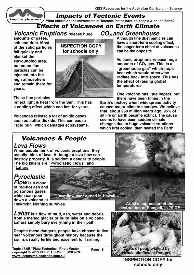
Volcanic Eruptions release hugeamounts of gases,ash and dust. Mostof the solid particlesfall quickly andblanket the surrounding area,but some fine particles can be injected into thehigh atmosphereand remain there foryears.
These fine particlesreflect light & heat from the Sun. This hasa cooling effect which can last for years.
Volcanoes release a lot of acidic gasessuch as sulfur dioxide. This can cause“acid rain” which damages ecosystems.
CO2 and GreenhouseAlthough fine dust particles canhave a short-term cooling effect,the longer-term effect of volcanoescan be the opposite.
Volcanic eruptions release hugeamounts of CO2 gas. This is a
“greenhouse gas” which trapsheat which would otherwise radiate back into space. This hasthe effect of raising global temperatures.
One volcano has little impact, butthere have been times in the
Earth’s history when widespread activitycaused major climate changes. We believethat, about 250 million years ago, 95% ofall life on Earth became extinct. The causeseems to have been sudden climatechanges due to huge volcanic eruptionswhich first cooled, then heated the Earth.
®
keep it simple science
Volcanoes & People
Lava FlowsWhen people think of volcanic eruptions, they usually think of lava. Although a lava flow candestroy property, it is seldom a danger to people.The big killers are “Pyroclastic Flows” and“Lahars”.
PyroclasticFlow is a cloud of red-hot ash andpoisonous gaseswhich can pourdown a volcano at100km/hr. Nothing survives.
Lahar is a flow of mud, ash, water and debrisfrom a melted glacier or burst lake on a volcano.Lahars simply bury everything in their path.
Despite these dangers, people have chosen to livenear volcanoes throughout history because thesoil is usually fertile and excellent for farming.
Casts of people killed by pyroclastic flow at Pompeii.
Lava flow over a road in Hawaii
Artist’s impression of the destruction of Pompeii, in 79 CE
INSPECTION COPYfor schools only

KISS Resources for the Australian Curriculum - Science
INSPECTION COPY forschools only
Topic 17.9E “Plate Tectonics” PhotoMastercopyright © 2013 KEEP IT SIMPLE SCIENCEwww.keepitsimplescience.com.au
Page 17
Earthquakes & PeopleIn a severe earthquake the ground heavesso that you cannot stand upright.However, this ground motion is not themain hazard to people. The big killers inany earthquake are collapsing structures,fires & tsunamis.
When major earthquakes hit large cities,the death toll can be enormous. Mostcasualties result from collapsing buildings. Multi-storey apartment blockscan “concertina” downwards: each floor isa block of concrete which can fall onto thenext in a downward “domino effect”.
Knowing the danger, many people rush out into the streets and are then showered withfalling roof tiles and broken glass from buildings that have not collapsed, but are shaking violently.
As the ground moves, pipes carrying water, power & gas are ruptured. Fires break out, & broken water mains make it difficult to fight the blaze. In the great San Franciscoearthquake of 1906 large areas of the city survived the ‘quake but were destroyed byuncontrollable fires.
In hilly or mountainous areas, earthquakes can trigger landslides which can bury entirevillages. When the earthquake occurs under the sea, the crust movements can causedestructive water waves called “tsunamis”. In recent years there have been 2 majortsunamis in the Asian region.
San Francisco 1906. Massive ‘quake, then fire.
®
keep it simple science
Indonesia, Boxing Day 2004A massive undersea earthquake in the subduction zonenear Sumatra, Indonesia set off a tsunami which killedabout 200,000 people in Indonesia, Thailand, Malaysia, SriLanka and other nations around the Indian Ocean.
In many places there was no warning before a wall ofwater wiped out entire towns, beach resorts and ruralfarming communities.
Japan, March 2011One of the largest earthquakes ever recorded occurred in the subduction zone just offthe Japanese east coast. There was considerable earthquake damage, thenwithin an hour a 30m tsunami washed upto 10km inland. About 15,000 people died.This death toll was considered to be quitelow due to Japan having excellent buildingcodes, warning systems, tsunami defencesand emergency refuges.
Despite all defences, the tsunami damagedthe Fukushima Nuclear Power Plant. Thisled to a later explosion and leakage ofradioactivity from the reactors.
A tourist took this photo as the 2004 Asian Tsunami hit thecoast of Thailand. Moments later, most of these people died.
The day after the tsunami: Sendai International Airport, Japan
INSPECTION COPYfor schools only
KISS Resources for the Australian Curriculum - Science
INSPECTION COPY forschools only
Topic 17.9E “Plate Tectonics” PhotoMastercopyright © 2013 KEEP IT SIMPLE SCIENCEwww.keepitsimplescience.com.au
Page 18
Sea-Floor SpreadingWhere plates move apart, new crust is created at the mid-ocean ridges. Thiswidens the ocean basins.
200 million years ago, theAtlantic Ocean did notexist because NorthAmerica was joined toEurope. As the lithosphere fractured intoseparate plates whichmoved apart, the AtlanticOcean was created, andis still growing wider.
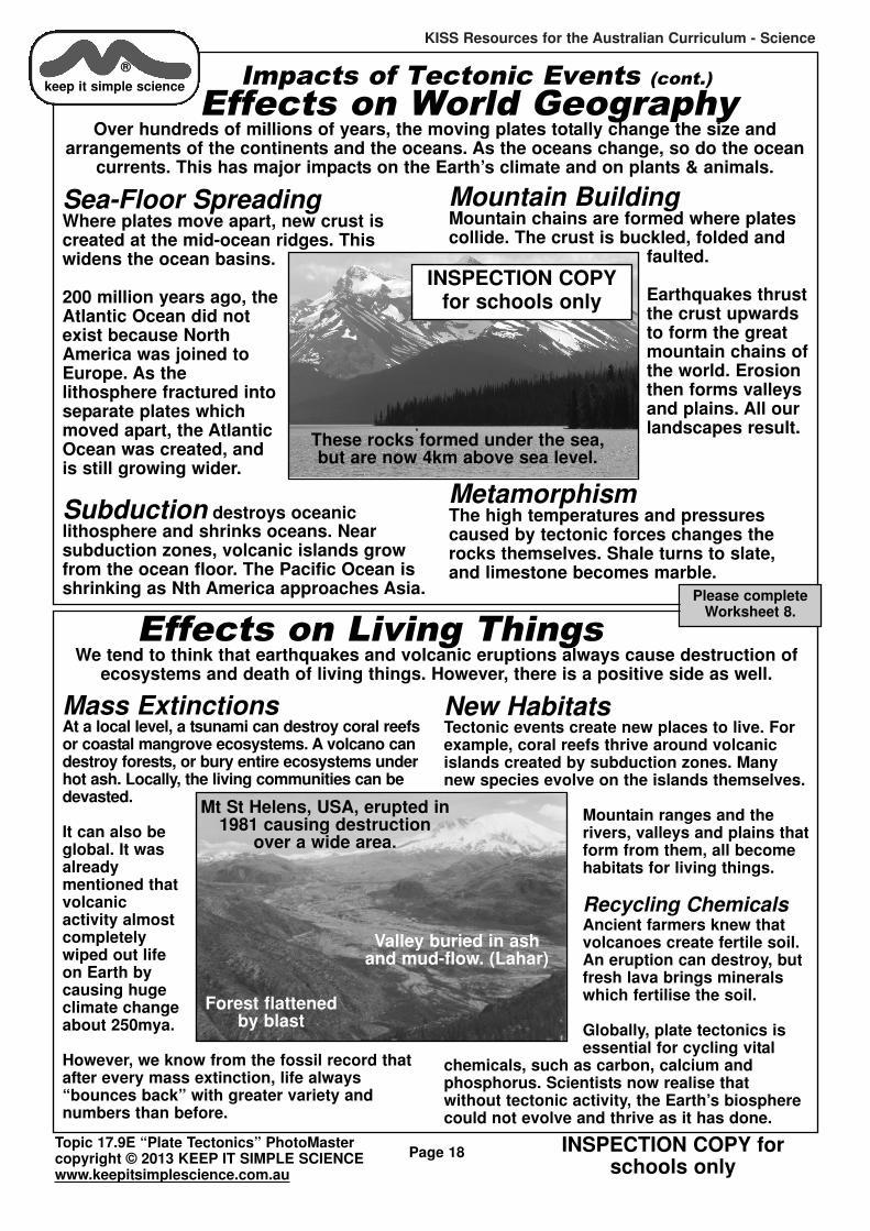
Subduction destroys oceanic lithosphere and shrinks oceans. Near subduction zones, volcanic islands growfrom the ocean floor. The Pacific Ocean isshrinking as Nth America approaches Asia.
Mountain BuildingMountain chains are formed where platescollide. The crust is buckled, folded and
faulted.
Earthquakes thrustthe crust upwardsto form the great mountain chains ofthe world. Erosionthen forms valleysand plains. All ourlandscapes result.
MetamorphismThe high temperatures and pressurescaused by tectonic forces changes therocks themselves. Shale turns to slate,and limestone becomes marble.
These rocks formed under the sea,but are now 4km above sea level.
Impacts of Tectonic Events (cont.)
Effects on World GeographyOver hundreds of millions of years, the moving plates totally change the size and
arrangements of the continents and the oceans. As the oceans change, so do the oceancurrents. This has major impacts on the Earth’s climate and on plants & animals.
®
keep it simple science
Effects on Living ThingsWe tend to think that earthquakes and volcanic eruptions always cause destruction of
ecosystems and death of living things. However, there is a positive side as well.
Mass ExtinctionsAt a local level, a tsunami can destroy coral reefsor coastal mangrove ecosystems. A volcano candestroy forests, or bury entire ecosystems underhot ash. Locally, the living communities can bedevasted.
It can also beglobal. It wasalready mentioned thatvolcanic activity almostcompletelywiped out lifeon Earth bycausing hugeclimate changeabout 250mya.
However, we know from the fossil record thatafter every mass extinction, life always“bounces back” with greater variety and numbers than before.
New HabitatsTectonic events create new places to live. Forexample, coral reefs thrive around volcanicislands created by subduction zones. Manynew species evolve on the islands themselves.
Mountain ranges and therivers, valleys and plains thatform from them, all becomehabitats for living things.
Recycling ChemicalsAncient farmers knew thatvolcanoes create fertile soil.An eruption can destroy, butfresh lava brings mineralswhich fertilise the soil.
Globally, plate tectonics isessential for cycling vital
chemicals, such as carbon, calcium and phosphorus. Scientists now realise that without tectonic activity, the Earth’s biospherecould not evolve and thrive as it has done.
Forest flattenedby blast
Valley buried in ashand mud-flow. (Lahar)
Mt St Helens, USA, erupted in1981 causing destruction
over a wide area.
Please completeWorksheet 8.
INSPECTION COPYfor schools only
Related Documents