keep it simple science Photocopy Master Sheets Years 9-10 Earth Science Disk filename = “21.EarthScience” Usage & copying is permitted according to the Site Licence Conditions only ABN 54 406 994 557 PO Box 2575 PORT MACQUARIE NSW 2444 (02) 6583 4333 FAX (02) 6583 9467 www.keepitsimplescience.com.au [email protected] keep it simple science ®

Welcome message from author
This document is posted to help you gain knowledge. Please leave a comment to let me know what you think about it! Share it to your friends and learn new things together.
Transcript
keep it simple sciencePhotocopy Master Sheets
Years 9-10
EarthScience
Disk filename = “21.EarthScience”
Usage & copying is permitted according to theSite Licence Conditions
only
ABN 54 406 994 557
PO Box 2575PORT MACQUARIE NSW 2444
(02) 6583 4333 FAX (02) 6583 9467www.keepitsimplescience.com.au [email protected]
kkeeeepp iitt ssiimmppllee sscciieennccee®
2
Topics Available
Year 11-12 Science CoursesBiologyPreliminary CoreLocal EcosystemPatterns in NatureLife on EarthEvolution Aust. BiotaHSC CoreMaintain. a BalanceBlueprint of LifeSearch for Better HealthOptionsCommunicationGenetics:Code Broken?
ChemistryPreliminary CoreChemical EarthMetalsWaterEnergyHSC CoreProduction of MaterialsAcidic EnvironmentChem.Monit.&MngmentOptionsShipwrecks, Corrosion...Industrial Chemistry
Earth & Envir.Science
Preliminary CorePlanet Earth...Local EnvironmentWater IssuesDynamic EarthHSC CoreTectonic ImpactsEnvirons thru TimeCaring for the CountryOptionIntroduced Species
PhysicsPreliminary CoreWorld CommunicatesElectrical Energy...Moving AboutCosmic EngineHSC CoreSpaceMotors & GeneratorsIdeas to ImplementationOptionsQuanta to QuarksAstrophysics
Year 7-8 General ScienceDisk Filename Topic Name01.Energy Energy02.Forces Forces03.Matter Solids, Liquids & Gases04.Mixtures Separating Mixtures05.Elements Elements & Compounds06.Cells Living Cells07.Life Living Things08.LifeSystems Plant & Animal Systems09.Astronomy Astronomy10.Earth The Earth11.Ecosystems Ecosystems
Year 9-10 General ScienceDisk Filename Topic Name12.Waves Wave Energy (inc. Light)13.Motion Forces & Motion14.Electricity Electricity15.Atoms Atoms & Elements16.Reactions Compounds & Reactions17.DNA Cell Division & DNA18.Evolution Evolution of Life19.Health Health & Reproduction20.Universe The Universe21.EarthScience Earth Science22.Resources Resources & Technology
Site Licence ConditionsA school (or other recognised educationalinstitution) may store the disk contents inmultiple computers (or other data retrievalsystems) to facilitate the following usages ofthe disk contents:
• School staff may print unlimited copies onpaper and/or make unlimited photocopies atone school and campus only, for use bystudents enrolled at that school and campusonly, for non-profit, educational use only.
• School staff may use the disk contents tomake audio-visual displays, such as viacomputer networks, or by using dataprojectors or overhead projectors, at oneschool and campus only, for viewing bystudents enrolled at that school and campusonly, for non-profit, educational use only.
• School staff may allow students enrolled atthat school and campus only to obtaincopies of the disk files and store them ineach student’s personal computer for non-profit, educational use only.
IN SUCH CASE, THE SCHOOLSHOULD MAKE PARTICIPATING
STUDENTS AWARE OF THESE SITELICENCE CONDITIONS AND ADVISE
THEM THAT COPYING OF DATAFILES BY STUDENTS MAY
CONSTITUTE AN ILLEGAL ACT.
• In every usage of the disk files, the KISSlogo and copyright declaration must beincluded on each page, slide or frame.
Please Respect Our Rights Under Copyright Law
All Topics Available as PHOTOCOPY MASTERS and/or KCiCPhotocopy Masters (PDF files)
Black & White, A4 portrait-orientationfor clear, economical photocopying.
KCiC = Key Concepts in ColourFull colour, formatted for on-screen studyand data projection. PDF + Powerpoint®
Powerpoint is a trademark of Microsoft Corp.
Usage & copying is permitted according to the Site Licence Conditions only
keep it simple science®
Years 9-10 Topic 21 Earth Sciencecopyright © 2009 keep it simple sciencewww.keepitsimplescience.com.au
3
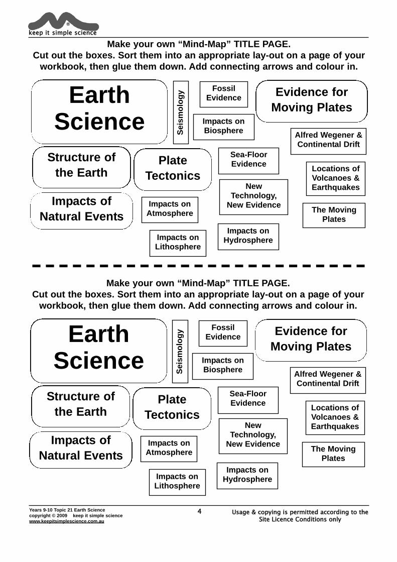
Impacts onAtmosphere
Impacts onHydrosphere
Impacts onBiosphere
Impacts onLithosphere
Sea-FloorEvidence
Alfred Wegener &Continental Drift
FossilEvidence
Locations ofVolcanoes &Earthquakes
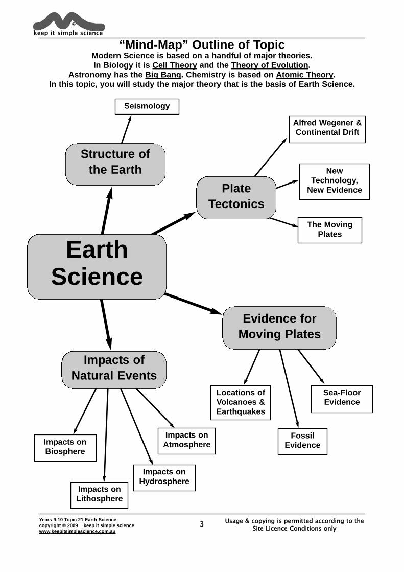
Seismology
NewTechnology,
New Evidence
The MovingPlates
EarthScience
Structure ofthe Earth
PlateTectonics
Evidence forMoving Plates
Impacts ofNatural Events
“Mind-Map” Outline of TopicModern Science is based on a handful of major theories. In Biology it is Cell Theory and the Theory of Evolution.
Astronomy has the Big Bang. Chemistry is based on Atomic Theory. In this topic, you will study the major theory that is the basis of Earth Science.
Usage & copying is permitted according to the Site Licence Conditions only
4Years 9-10 Topic 21 Earth Sciencecopyright © 2009 keep it simple sciencewww.keepitsimplescience.com.au
keep it simple science®
Make your own “Mind-Map” TITLE PAGE.Cut out the boxes. Sort them into an appropriate lay-out on a page of your
workbook, then glue them down. Add connecting arrows and colour in.
Impacts onAtmosphere
Impacts onHydrosphere
Impacts onBiosphere
Impacts onLithosphere
Sea-FloorEvidence
Alfred Wegener &Continental Drift
FossilEvidence
Locations ofVolcanoes &Earthquakes
Seis
mol
ogy
NewTechnology,
New Evidence The MovingPlates
EarthScience
Structure ofthe Earth
PlateTectonics
Evidence forMoving Plates
Impacts ofNatural Events
Usage & copying is permitted according to the Site Licence Conditions only
Years 9-10 Topic 21 Earth Sciencecopyright © 2009 keep it simple sciencewww.keepitsimplescience.com.au
5
The LithosphereAlthough the Crust and Mantle are separate layers in terms of their density and
composition, the boundary between them is not so simple and clear-cut.
keep it simple science®
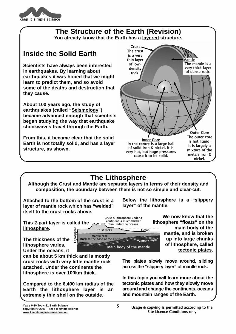
The Structure of the Earth (Revision)You already know that the Earth has a layered structure.
Inside the Solid EarthScientists have always been interestedin earthquakes. By learning aboutearthquakes it was hoped that we mightlearn to predict them, and so avoidsome of the deaths and destruction thatthey cause.
About 100 years ago, the study ofearthquakes (called “Seismology”)became advanced enough that scientistsbegan studying the way that earthquakeshockwaves travel through the Earth.
From this, it became clear that the solidEarth is not totally solid, and has a layerstructure, as shown.
CrustThe crustis a verythin layerof low-densityrock.
MantleThe mantle is avery thick layerof dense rock.
Inner CoreIn the centre is a large ballof solid iron & nickel. It is
very hot, but huge pressurescause it to be solid.
Outer CoreThe outer coreis hot liquid. It is largely a
mixture of themetals iron &
nickel.
Attached to the bottom of the crust is alayer of mantle rock which has “welded”itself to the crust rocks above.
This 2-part layer is called thelithosphere.
The thickness of thelithosphere varies.Under the oceans, itcan be about 5 km thick and is mostlycrust rocks with very little mantle rockattached. Under the continents thelithosphere is over 100km thick.
Compared to the 6,400 km radius of theEarth the lithosphere layer is anextremely thin shell on the outside.
Below the lithosphere is a “slipperylayer” of the mantle.
We now know that thelithosphere “floats” on the
main body of themantle, and is brokenup into large chunksof lithosphere, called
tectonic plates.
The plates slowly move around, slidingacross the “slippery layer” of mantle rock.
In this topic you will learn more about thetectonic plates and how they slowly movearound and change the continents, oceansand mountain ranges of the Earth.
LLiitthh
oosspphh
eerree
CCrruusstt rroocckkss OOcceeaann
MMaannttllee rroocckk ssttuucckk ttoo tthhee bbaassee ooff tthhee ccrruusstt
Main body of the mantle
CCrruusstt && lliitthhoosspphheerree uunnddeerr aaccoonnttiinneenntt iiss mmuucchh tthhiicckkeerrtthhaann uunnddeerr tthhee oocceeaannss..
““SSlliipppperryy LLaayyerr””
Years 9-10 Topic 21 Earth Sciencecopyright © 2009 keep it simple sciencewww.keepitsimplescience.com.au
6
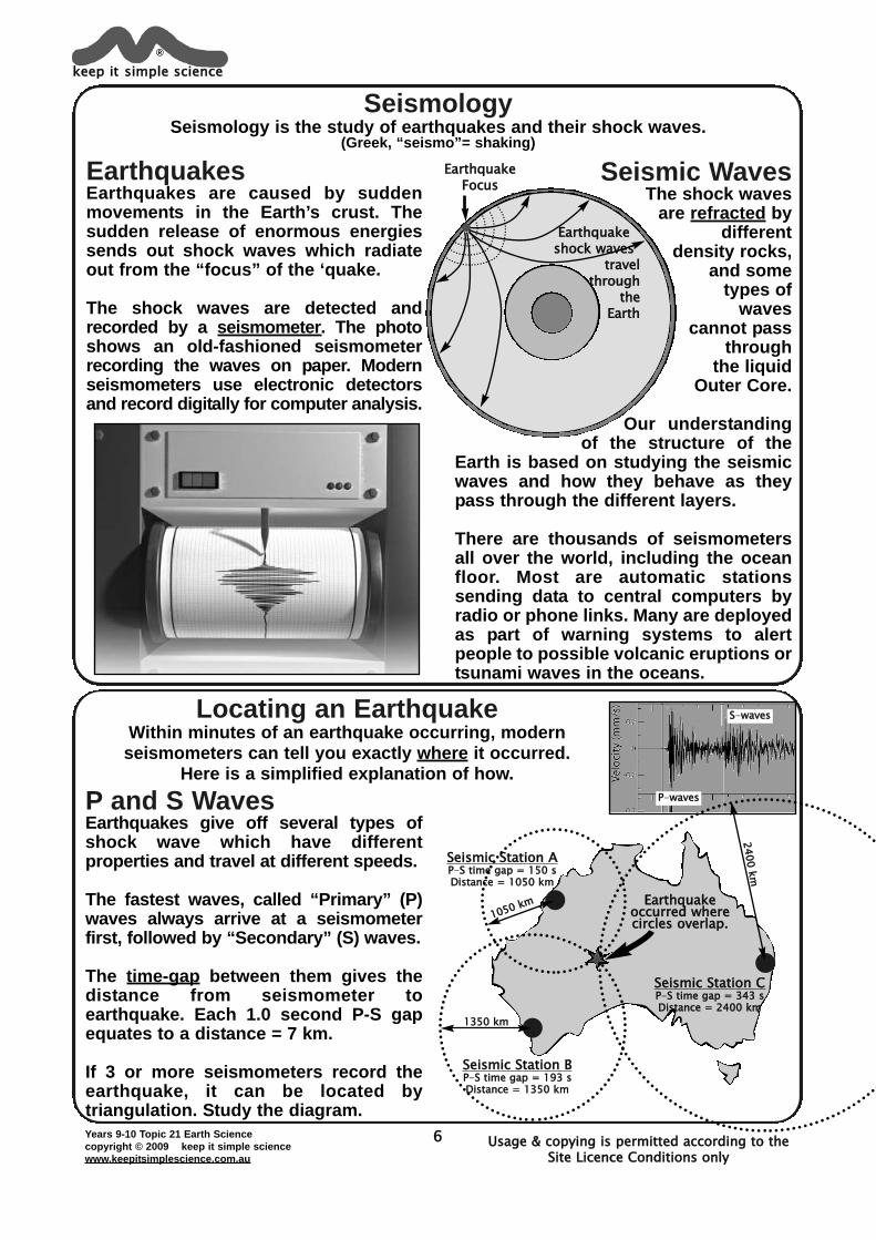
Seismology Seismology is the study of earthquakes and their shock waves.
(Greek, “seismo”= shaking)
Locating an Earthquake Within minutes of an earthquake occurring, modernseismometers can tell you exactly where it occurred.
Here is a simplified explanation of how.
EarthquakesEarthquakes are caused by suddenmovements in the Earth’s crust. Thesudden release of enormous energiessends out shock waves which radiateout from the “focus” of the ‘quake.
The shock waves are detected andrecorded by a seismometer. The photoshows an old-fashioned seismometerrecording the waves on paper. Modernseismometers use electronic detectorsand record digitally for computer analysis.
Seismic WavesThe shock waves
are refracted bydifferent
density rocks,and some
types ofwaves
cannot passthrough
the liquid Outer Core.
Our understandingof the structure of the
Earth is based on studying the seismicwaves and how they behave as theypass through the different layers.
There are thousands of seismometersall over the world, including the oceanfloor. Most are automatic stationssending data to central computers byradio or phone links. Many are deployedas part of warning systems to alertpeople to possible volcanic eruptions ortsunami waves in the oceans.
keep it simple science®
Usage & copying is permitted according to the Site Licence Conditions only
EarthquakeFocus
Earthquakeshock waves
travel through
the Earth
P and S WavesEarthquakes give off several types ofshock wave which have differentproperties and travel at different speeds.
The fastest waves, called “Primary” (P)waves always arrive at a seismometerfirst, followed by “Secondary” (S) waves.
The time-gap between them gives thedistance from seismometer toearthquake. Each 1.0 second P-S gapequates to a distance = 7 km.
If 3 or more seismometers record theearthquake, it can be located bytriangulation. Study the diagram.
PP-wwaavveess
SS-wwaavveess
Seismic Station APP-SS ttiimmee ggaapp == 115500 ssDDiissttaannccee == 11005500 kkmm
Seismic Station BPP-SS ttiimmee ggaapp == 119933 ssDDiissttaannccee == 11335500 kkmm
Seismic Station CPP-SS ttiimmee ggaapp == 334433 ssDDiissttaannccee == 22440000 kkmm
Earthquakeoccurred wherecircles overlap.
11335500 kkmm
110550 kmm
2400 km
Usage & copying is permitted according to the Site Licence Conditions only
Years 9-10 Topic 21 Earth Sciencecopyright © 2009 keep it simple sciencewww.keepitsimplescience.com.au
7
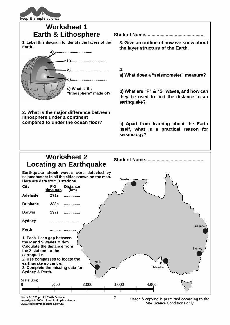
1. Label this diagram to identify the layers of theEarth.
a)....................................
b)................................
c)....................................
d)....................................
e) What is the“lithosphere” made of?
2. What is the major difference betweenlithosphere under a continentcompared to under the ocean floor?
3. Give an outline of how we know aboutthe layer structure of the Earth.
4. a) What does a “seismometer” measure?
b) What are “P” & “S” waves, and how canthey be used to find the distance to anearthquake?
c) Apart from learning about the Earthitself, what is a practical reason forseismology?
Worksheet 1Earth & Lithosphere Student Name.............................................
Earthquake shock waves were detected byseismometers in all the cities shown on the map.Here are data from 3 stations.City P-S Distance
time gap (km)Adelaide 271s ...............
Brisbane 238s ...............
Darwin 137s ...............
Sydney .......... ..............
Perth .......... ...........
1. Each 1 sec gap betweenthe P and S waves = 7km.Calculate the distance fromthe 3 stations to theearthquake.2. Use compasses to locate theearthquake epicentre.3. Complete the missing data forSydney & Perth.
Scale (km)0 1,000 2,000 3,000 4,000
Worksheet 2Locating an Earthquake
Student Name.............................................
keep it simple science®
AAddeellaaiiddee
PPeerrtthh
BBrriissbbaannee
DDaarrwwiinn
SSyyddnneeyy
Years 9-10 Topic 21 Earth Sciencecopyright © 2009 keep it simple sciencewww.keepitsimplescience.com.au
8
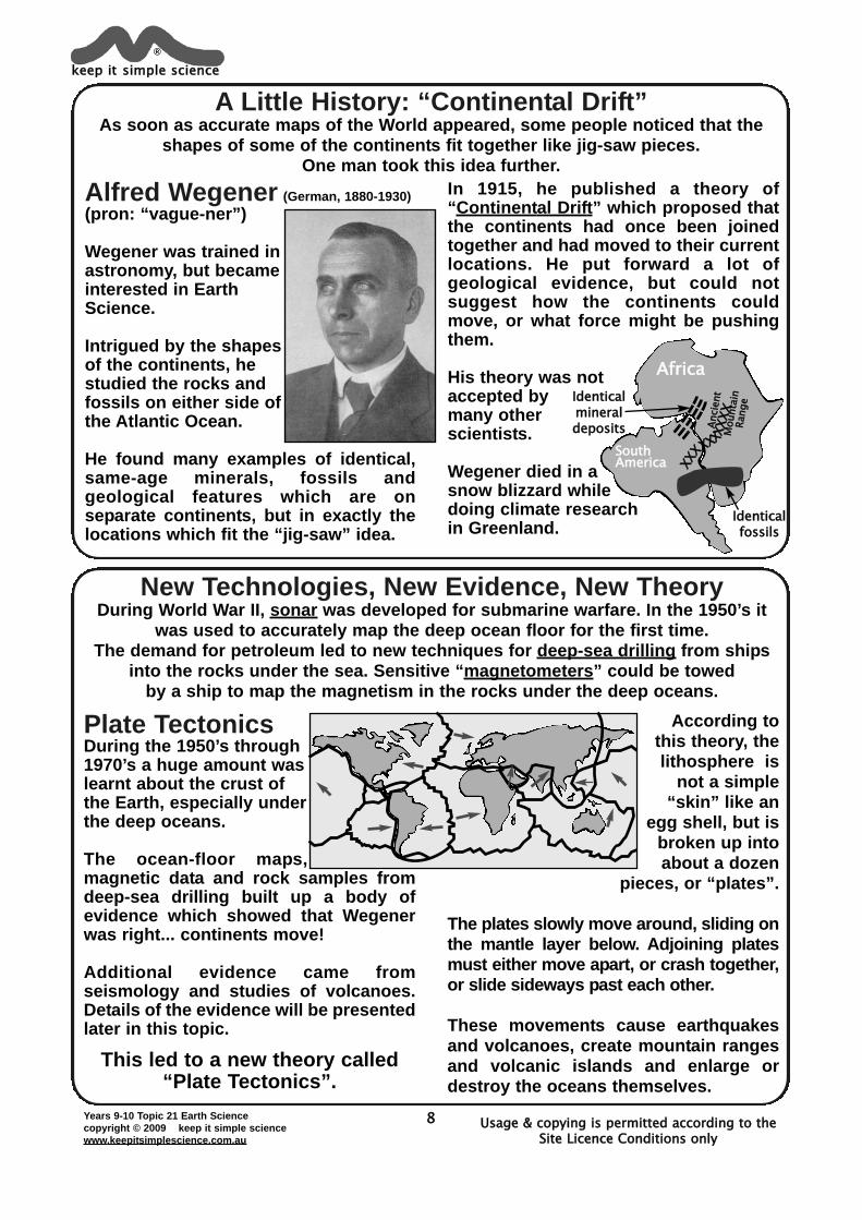
A Little History: “Continental Drift”As soon as accurate maps of the World appeared, some people noticed that the
shapes of some of the continents fit together like jig-saw pieces.One man took this idea further.
New Technologies, New Evidence, New TheoryDuring World War II, sonar was developed for submarine warfare. In the 1950’s it
was used to accurately map the deep ocean floor for the first time.The demand for petroleum led to new techniques for deep-sea drilling from ships
into the rocks under the sea. Sensitive “magnetometers” could be towed by a ship to map the magnetism in the rocks under the deep oceans.
Alfred Wegener (German, 1880-1930)(pron: “vague-ner”)
Wegener was trained inastronomy, but becameinterested in EarthScience.
Intrigued by the shapesof the continents, hestudied the rocks andfossils on either side ofthe Atlantic Ocean.
He found many examples of identical,same-age minerals, fossils andgeological features which are onseparate continents, but in exactly thelocations which fit the “jig-saw” idea.
In 1915, he published a theory of“Continental Drift” which proposed thatthe continents had once been joinedtogether and had moved to their currentlocations. He put forward a lot ofgeological evidence, but could notsuggest how the continents couldmove, or what force might be pushingthem.
His theory was notaccepted bymany otherscientists.
Wegener died in asnow blizzard whiledoing climate research in Greenland.
keep it simple science®
Usage & copying is permitted according to the Site Licence Conditions only
Africa
Identicalfossils
Identicalmineraldeposits
SouthAmerica
Annci
ennt
MMou
nntaai
nnRaa
nnge
Plate TectonicsDuring the 1950’s through1970’s a huge amount waslearnt about the crust ofthe Earth, especially underthe deep oceans.
The ocean-floor maps,magnetic data and rock samples fromdeep-sea drilling built up a body ofevidence which showed that Wegenerwas right... continents move!
Additional evidence came fromseismology and studies of volcanoes.Details of the evidence will be presentedlater in this topic.
This led to a new theory called “Plate Tectonics”.
According tothis theory, thelithosphere is
not a simple“skin” like an
egg shell, but isbroken up intoabout a dozen
pieces, or “plates”.
The plates slowly move around, sliding onthe mantle layer below. Adjoining platesmust either move apart, or crash together,or slide sideways past each other.
These movements cause earthquakesand volcanoes, create mountain rangesand volcanic islands and enlarge ordestroy the oceans themselves.
XXXXXXXXXXX
XXXXX
Years 9-10 Topic 21 Earth Sciencecopyright © 2009 keep it simple sciencewww.keepitsimplescience.com.au
9
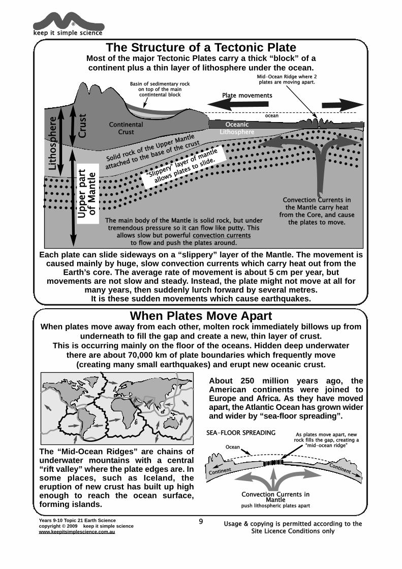
The Structure of a Tectonic PlateMost of the major Tectonic Plates carry a thick “block” of a continent plus a thin layer of lithosphere under the ocean.
When Plates Move ApartWhen plates move away from each other, molten rock immediately billows up from
underneath to fill the gap and create a new, thin layer of crust.This is occurring mainly on the floor of the oceans. Hidden deep underwater
there are about 70,000 km of plate boundaries which frequently move (creating many small earthquakes) and erupt new oceanic crust.
About 250 million years ago, theAmerican continents were joined toEurope and Africa. As they have movedapart, the Atlantic Ocean has grown widerand wider by “sea-floor spreading”.
The “Mid-Ocean Ridges” are chains ofunderwater mountains with a central“rift valley” where the plate edges are. Insome places, such as Iceland, theeruption of new crust has built up highenough to reach the ocean surface,forming islands.
keep it simple science®
Usage & copying is permitted according to the Site Licence Conditions only
oocceeaann
BBaassiinn ooff sseeddiimmeennttaarryy rroocckkoonn ttoopp ooff tthhee mmaaiinnccoonnttiinntteennttaall bblloocckk
MMiidd-OOcceeaann RRiiddggee wwhheerree 22ppllaatteess aarree mmoovviinngg aappaarrtt..
OceanicLithosphere
ContinentalCrust
SSooliidd roocck oof tthee Uppeer Maanttlee
aattttaaccheedd ttoo tthee bbaassee oof tthee ccruusstt
Plate movements
““SSliippppeerry”” laayeerr ooff mmaannttlee
aalloowwss pplaatteess ttoo ssliiddee..
The main body of the Mantle is solid rock, but undertremendous pressure so it can flow like putty. This
allows slow but powerful convection currentsto flow and push the plates around.
LLiitthh
oosspphh
eerree
UUppppee
rr ppaa
rrttooff
MMaann
ttlleeCCrr
uusstt
Convection Currents inthe Mantle carry heat
from the Core, and causethe plates to move.
Each plate can slide sideways on a “slippery” layer of the Mantle. The movement iscaused mainly by huge, slow convection currents which carry heat out from the
Earth’s core. The average rate of movement is about 5 cm per year, but movements are not slow and steady. Instead, the plate might not move at all for
many years, then suddenly lurch forward by several metres. It is these sudden movements which cause earthquakes.
SEA-FFLOOR SPREADING
OOcceeaann
AAss ppllaatteess mmoovvee aappaarrtt,, nneewwrroocckk ffiillllss tthhee ggaapp,, ccrreeaattiinngg aa
““mmiidd-oocceeaann rriiddggee””
CCoonnttiinneenntt
Convection Currents inMantle
ppuusshh lliitthhoosspphheerriicc ppllaatteess aappaarrtt
CContineent
Years 9-10 Topic 21 Earth Sciencecopyright © 2009 keep it simple sciencewww.keepitsimplescience.com.au
10
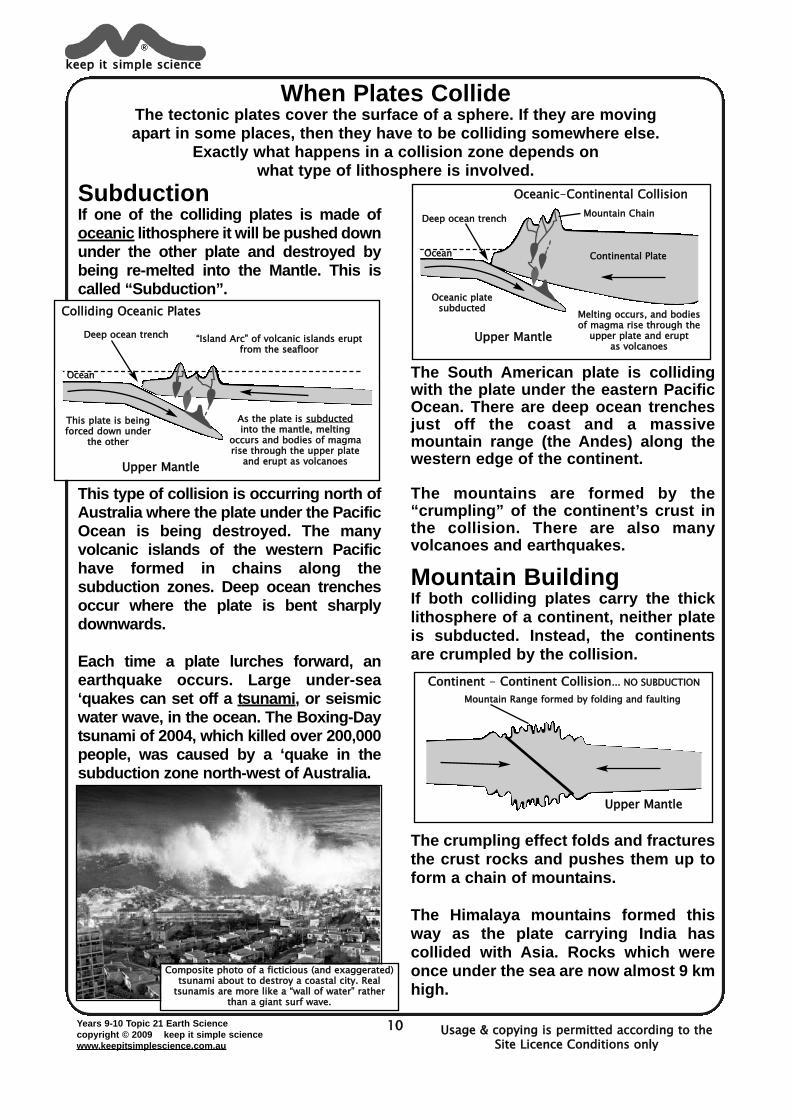
When Plates CollideThe tectonic plates cover the surface of a sphere. If they are moving apart in some places, then they have to be colliding somewhere else.
Exactly what happens in a collision zone depends on what type of lithosphere is involved.
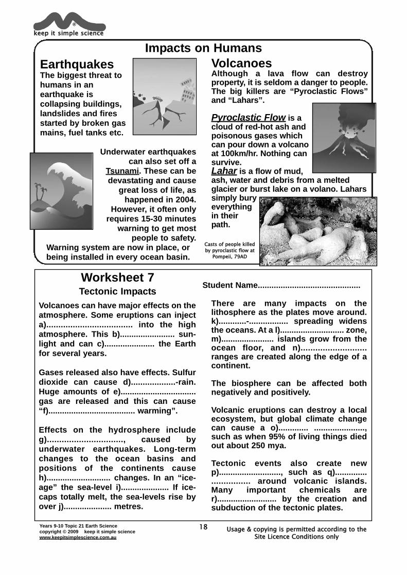
SubductionIf one of the colliding plates is made ofoceanic lithosphere it will be pushed downunder the other plate and destroyed bybeing re-melted into the Mantle. This iscalled “Subduction”.
This type of collision is occurring north ofAustralia where the plate under the PacificOcean is being destroyed. The manyvolcanic islands of the western Pacifichave formed in chains along thesubduction zones. Deep ocean trenchesoccur where the plate is bent sharplydownwards.
Each time a plate lurches forward, anearthquake occurs. Large under-sea‘quakes can set off a tsunami, or seismicwater wave, in the ocean. The Boxing-Daytsunami of 2004, which killed over 200,000people, was caused by a ‘quake in thesubduction zone north-west of Australia.
The South American plate is collidingwith the plate under the eastern PacificOcean. There are deep ocean trenchesjust off the coast and a massivemountain range (the Andes) along thewestern edge of the continent.
The mountains are formed by the“crumpling” of the continent’s crust inthe collision. There are also manyvolcanoes and earthquakes.
Mountain BuildingIf both colliding plates carry the thicklithosphere of a continent, neither plateis subducted. Instead, the continentsare crumpled by the collision.
The crumpling effect folds and fracturesthe crust rocks and pushes them up toform a chain of mountains.
The Himalaya mountains formed thisway as the plate carrying India hascollided with Asia. Rocks which wereonce under the sea are now almost 9 kmhigh.
keep it simple science®
Usage & copying is permitted according to the Site Licence Conditions only
OOcceeaann
DDeeeepp oocceeaann ttrreenncchh
Colliding Oceanic Plates
TThhiiss ppllaattee iiss bbeeiinnggffoorrcceedd ddoowwnn uunnddeerr
tthhee ootthheerr
““IIssllaanndd AArrcc”” ooff vvoollccaanniicc iissllaannddss eerruuppttffrroomm tthhee sseeaafflloooorr
AAss tthhee ppllaattee iiss ssuubbdduucctteeddiinnttoo tthhee mmaannttllee,, mmeellttiinngg
ooccccuurrss aanndd bbooddiieess ooff mmaaggmmaarriissee tthhrroouugghh tthhee uuppppeerr ppllaattee
aanndd eerruupptt aass vvoollccaannooeessUpper Mantle
OOcceeaann
DDeeeepp oocceeaann ttrreenncchh
Oceanic-CContinental Collision
OOcceeaanniicc ppllaatteessuubbdduucctteedd
MMoouunnttaaiinn CChhaaiinn
MMeellttiinngg ooccccuurrss,, aanndd bbooddiieessooff mmaaggmmaa rriissee tthhrroouugghh tthhee
uuppppeerr ppllaattee aanndd eerruupptt aass vvoollccaannooeess
Upper Mantle
CCoonnttiinneennttaall PPllaattee
MMoouunnttaaiinn RRaannggee ffoorrmmeedd bbyy ffoollddiinngg aanndd ffaauullttiinngg
Continent - Continent Collision...... NNOO SSUUBBDDUUCCTTIIOONN
Upper Mantle
CCoommppoossiittee pphhoottoo ooff aa ffiiccttiicciioouuss ((aanndd eexxaaggggeerraatteedd))ttssuunnaammii aabboouutt ttoo ddeessttrrooyy aa ccooaassttaall cciittyy.. RReeaall
ttssuunnaammiiss aarree mmoorree lliikkee aa ““wwaallll ooff wwaatteerr”” rraatthheerrtthhaann aa ggiiaanntt ssuurrff wwaavvee..
Years 9-10 Topic 21 Earth Sciencecopyright © 2009 keep it simple sciencewww.keepitsimplescience.com.au
11
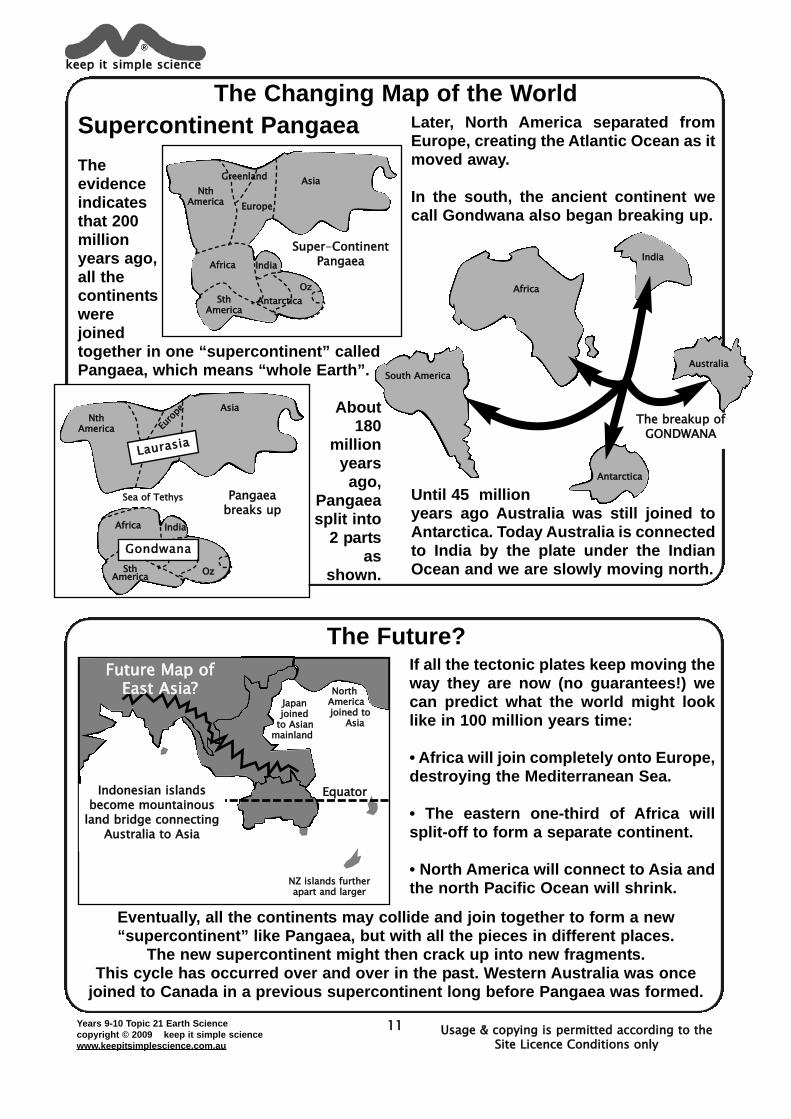
The Changing Map of the World
The Future?
Supercontinent PangaeaTheevidenceindicatesthat 200millionyears ago,all thecontinentswerejoinedtogether in one “supercontinent” calledPangaea, which means “whole Earth”.
About180
millionyears
ago,Pangaeasplit into
2 partsas
shown.
Later, North America separated fromEurope, creating the Atlantic Ocean as itmoved away.
In the south, the ancient continent wecall Gondwana also began breaking up.
Until 45 millionyears ago Australia was still joined toAntarctica. Today Australia is connectedto India by the plate under the IndianOcean and we are slowly moving north.
keep it simple science®
Usage & copying is permitted according to the Site Licence Conditions only
AAssiiaa
AAnnttaarrccttiiccaa
IInnddiiaa
OOzz
EEuurrooppee
AAffrriiccaa
GGrreeeennllaannddNNtthh
AAmmeerriiccaa
SStthhAAmmeerriiccaa
Super-CContinentPangaea
AAssiiaa
IInnddiiaa
OOzz
EEuurroopp
ee
AAffrriiccaa
LLaauurraassiiaa
Gondwana
NNtthhAAmmeerriiccaa
SStthhAAmmeerriiccaa
SSeeaa ooff TTeetthhyyss Pangaeabreaks up
The breakup ofGONDWANA
AAffrriiccaa
SSoouutthh AAmmeerriiccaa
IInnddiiaa
AAuussttrraalliiaa
AAnnttaarrccttiiccaa
JJaappaannjjooiinneedd
ttoo AAssiiaannmmaaiinnllaanndd
NNoorrtthhAAmmeerriiccaajjooiinneedd ttoo
AAssiiaa
NNZZ iissllaannddss ffuurrtthheerraappaarrtt aanndd llaarrggeerr
Future Map of East Asia?
If all the tectonic plates keep moving theway they are now (no guarantees!) wecan predict what the world might looklike in 100 million years time:
• Africa will join completely onto Europe,destroying the Mediterranean Sea.
• The eastern one-third of Africa willsplit-off to form a separate continent.
• North America will connect to Asia andthe north Pacific Ocean will shrink.
EquatorIndonesian islandsbecome mountainous
land bridge connectingAustralia to Asia
Eventually, all the continents may collide and join together to form a new“supercontinent” like Pangaea, but with all the pieces in different places.
The new supercontinent might then crack up into new fragments.This cycle has occurred over and over in the past. Western Australia was once
joined to Canada in a previous supercontinent long before Pangaea was formed.
Years 9-10 Topic 21 Earth Sciencecopyright © 2009 keep it simple sciencewww.keepitsimplescience.com.au
12
Fill in the blank spaces.
The theory of “a)..................................Drift” was proposed by Alfredb)......................... in 1915. He thoughtthat the continents had once beenjoined together and had moved apart.His evidence included identicalc)..................... and rock formationswhich are now separated by oceans.His theory was not well accepted,mainly because he could not explaind).................................................................
During 1950-1970’s new technologiesproduced new evidence. e)......................allowed mapping of the f).................................................
Deep-sea drilling allowed g)................................ to be collected, and theh).............................. in the rocks couldbe measured by magnetometers.
From the accumulation of evidence wenow believe that the lithosphere is madeup of a number of separate i)....................which slide across the j)..........................being pushed by slow-movingk).............................................. whichcarry heat from the earth’s l)...................
Two adjoining plates must eitherm).......... ....................., or n).....................,or slide sideways past each other.
It is the sudden movement of a platewhich causes most o)...............................
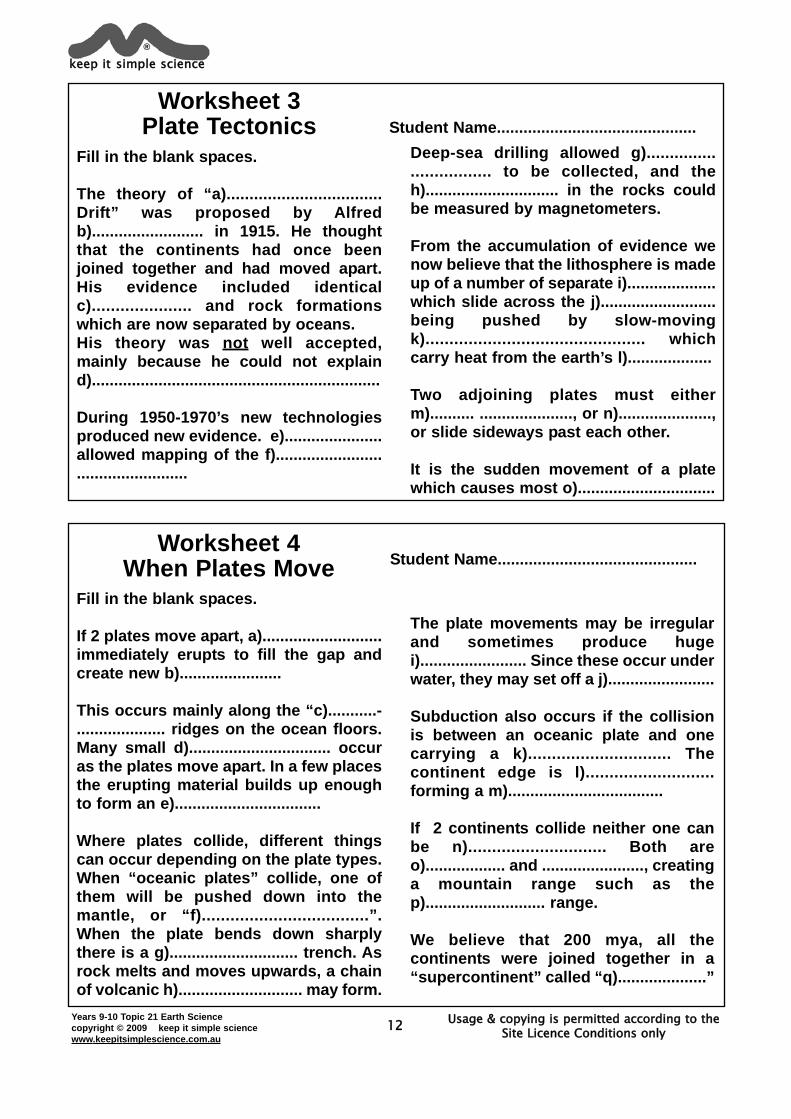
Worksheet 3Plate Tectonics Student Name.............................................
Fill in the blank spaces.
If 2 plates move apart, a)...........................immediately erupts to fill the gap andcreate new b).......................
This occurs mainly along the “c)...........-.................... ridges on the ocean floors.Many small d)................................ occuras the plates move apart. In a few placesthe erupting material builds up enoughto form an e).................................
Where plates collide, different thingscan occur depending on the plate types.When “oceanic plates” collide, one ofthem will be pushed down into themantle, or “f)...................................”.When the plate bends down sharplythere is a g)............................. trench. Asrock melts and moves upwards, a chainof volcanic h)............................ may form.
The plate movements may be irregularand sometimes produce hugei)........................ Since these occur underwater, they may set off a j)........................
Subduction also occurs if the collisionis between an oceanic plate and onecarrying a k).............................. Thecontinent edge is l)...........................forming a m)...................................
If 2 continents collide neither one canbe n)............................. Both areo).................. and ......................., creatinga mountain range such as thep)........................... range.
We believe that 200 mya, all thecontinents were joined together in a“supercontinent” called “q)....................”
Worksheet 4When Plates Move Student Name.............................................
keep it simple science®
Usage & copying is permitted according to the Site Licence Conditions only
Years 9-10 Topic 21 Earth Sciencecopyright © 2009 keep it simple sciencewww.keepitsimplescience.com.au
13
The Evidence for Moving PlatesThe Tectonic Plate Theory explains many things such as earthquakes & volcanoes,
mountain ranges, island chains & deep ocean trenches. But is it really true?
We believe it is true because there is a huge body of evidence to say so.Some evidence was noted by Alfred Wegener almost 100 years ago, but a lot wasonly discovered after the 1950’s when new technologies allowed us to study the
ocean floor, accurately measure the age of rocks and so on.
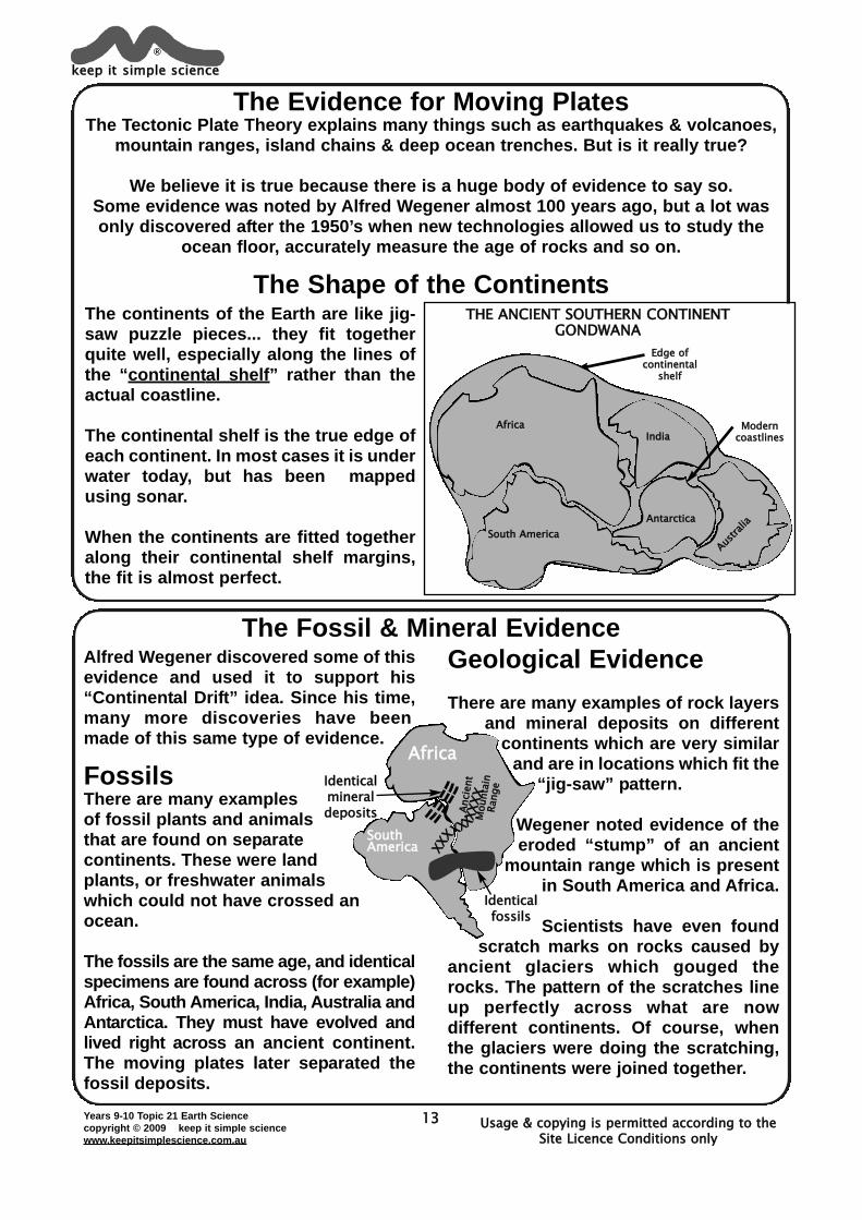
The Shape of the Continents
The Fossil & Mineral Evidence
The continents of the Earth are like jig-saw puzzle pieces... they fit togetherquite well, especially along the lines ofthe “continental shelf” rather than theactual coastline.
The continental shelf is the true edge ofeach continent. In most cases it is underwater today, but has been mappedusing sonar.
When the continents are fitted togetheralong their continental shelf margins,the fit is almost perfect.
Alfred Wegener discovered some of thisevidence and used it to support his“Continental Drift” idea. Since his time,many more discoveries have beenmade of this same type of evidence.
FossilsThere are many examplesof fossil plants and animalsthat are found on separatecontinents. These were landplants, or freshwater animalswhich could not have crossed anocean.
The fossils are the same age, and identicalspecimens are found across (for example)Africa, South America, India, Australia andAntarctica. They must have evolved andlived right across an ancient continent.The moving plates later separated thefossil deposits.
Geological EvidenceThere are many examples of rock layers
and mineral deposits on differentcontinents which are very similar
and are in locations which fit the“jig-saw” pattern.
Wegener noted evidence of theeroded “stump” of an ancient
mountain range which is presentin South America and Africa.
Scientists have even foundscratch marks on rocks caused by
ancient glaciers which gouged therocks. The pattern of the scratches lineup perfectly across what are nowdifferent continents. Of course, whenthe glaciers were doing the scratching,the continents were joined together.
keep it simple science®
Usage & copying is permitted according to the Site Licence Conditions only
MMooddeerrnn ccooaassttlliinneess
EEddggee ooffccoonnttiinneennttaall
sshheellff
THE ANCIENT SOUTHERN CONTINENTGONDWANA
AAffrriiccaa
SSoouutthh AAmmeerriiccaa
IInnddiiaa
Aussttrraa
lliiaaAAnnttaarrccttiiccaa
Africa
Identicalfossils
Identicalmineraldeposits
SouthAmerica
Annci
ennt
MMou
nntaai
nnRaa
nnge
XXXXXXXXXXX
XXXXX
Usage & copying is permitted according to the Site Licence Conditions only
Years 9-10 Topic 21 Earth Sciencecopyright © 2009 keep it simple sciencewww.keepitsimplescience.com.au
14
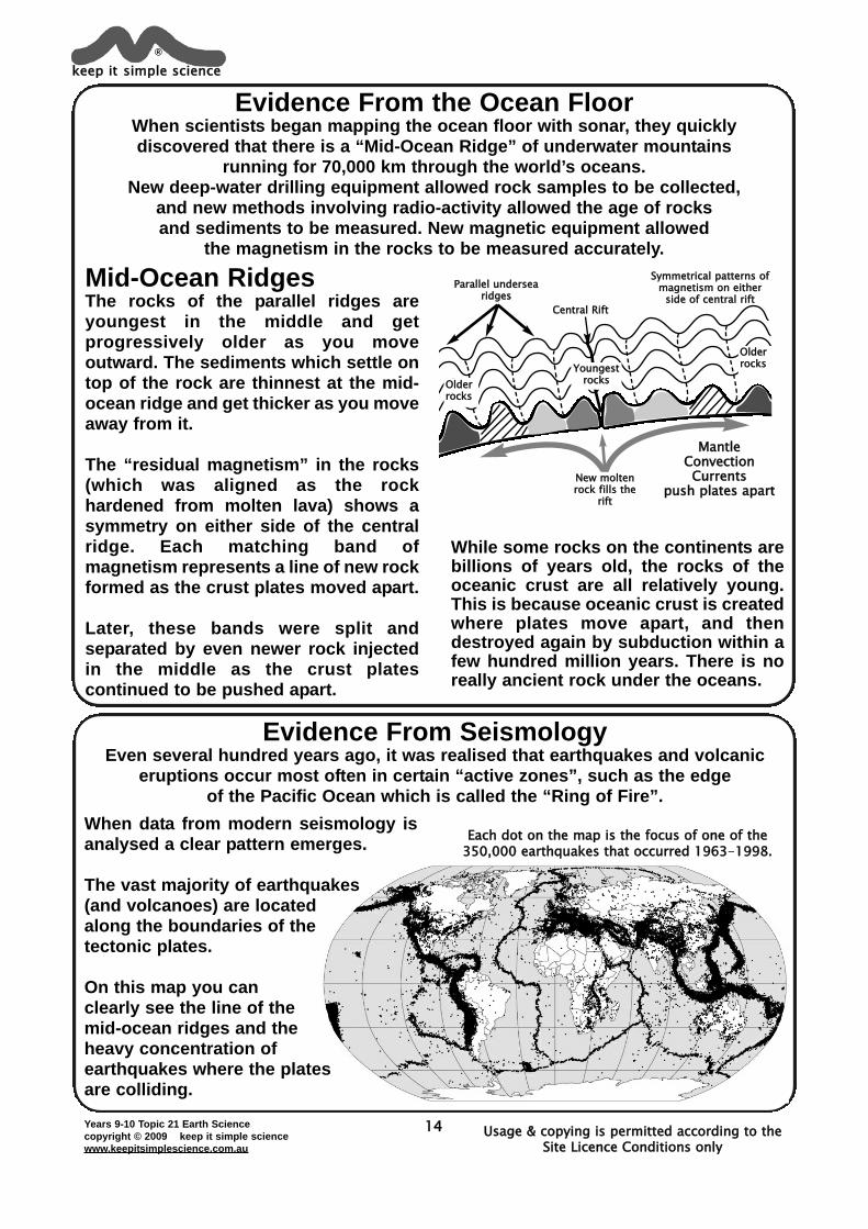
Evidence From the Ocean FloorWhen scientists began mapping the ocean floor with sonar, they quicklydiscovered that there is a “Mid-Ocean Ridge” of underwater mountains
running for 70,000 km through the world’s oceans.New deep-water drilling equipment allowed rock samples to be collected,
and new methods involving radio-activity allowed the age of rocks and sediments to be measured. New magnetic equipment allowed
the magnetism in the rocks to be measured accurately.
Evidence From SeismologyEven several hundred years ago, it was realised that earthquakes and volcanic
eruptions occur most often in certain “active zones”, such as the edge of the Pacific Ocean which is called the “Ring of Fire”.
While some rocks on the continents arebillions of years old, the rocks of theoceanic crust are all relatively young.This is because oceanic crust is createdwhere plates move apart, and thendestroyed again by subduction within afew hundred million years. There is noreally ancient rock under the oceans.
Mid-Ocean RidgesThe rocks of the parallel ridges areyoungest in the middle and getprogressively older as you moveoutward. The sediments which settle ontop of the rock are thinnest at the mid-ocean ridge and get thicker as you moveaway from it.
The “residual magnetism” in the rocks(which was aligned as the rockhardened from molten lava) shows asymmetry on either side of the centralridge. Each matching band ofmagnetism represents a line of new rockformed as the crust plates moved apart.
Later, these bands were split andseparated by even newer rock injectedin the middle as the crust platescontinued to be pushed apart.
keep it simple science®
MantleConvectionCurrents
push plates apart
CCeennttrraall RRiifftt
SSyymmmmeettrriiccaall ppaatttteerrnnss ooffmmaaggnneettiissmm oonn eeiitthheerr
ssiiddee ooff cceennttrraall rriiffttPPaarraalllleell uunnddeerrsseeaa
rriiddggeess
NNeeww mmoolltteennrroocckk ffiillllss tthhee
rriifftt
YYoouunnggeessttrroocckkss
OOllddeerrrroocckkss
OOllddeerrrroocckkss
Each dot on the map is the focus of one of the350,000 earthquakes that occurred 1963-11998.
When data from modern seismology isanalysed a clear pattern emerges.
The vast majority of earthquakes(and volcanoes) are locatedalong the boundaries of thetectonic plates.
On this map you can clearly see the line of the mid-ocean ridges and the heavy concentration of earthquakes where the platesare colliding.
Years 9-10 Topic 21 Earth Sciencecopyright © 2009 keep it simple sciencewww.keepitsimplescience.com.au
15
Fill in the blank spaces.
The most obvious evidence is thea).................. of some continents whichseem to fit together like a jig-saw. This isespecially true along the“b)........................... ...........”, rather thanthe coastlines.
There are many examples of identicalc)................ of plants and animals foundon different continents. Similarly, thereare identical d)............ and mineraldeposits now on separate continents.
Many pieces of evidence have comefrom studies of the deep ocean floor,especially along the “e)...........................Ridges”.
There are a series of parallel ridges, witha central f)........................... The rocks inthe centre are the g)..........................(age) and they get progressivelyh)......................... as you move furtherfrom the ridge.
The ocean sediments are very i)..............at the ridge and get j)....................... asyou move outwards.
There are a series of matching “bands”of k)............................. in the rocks oneither side of the rift. All these factspoint to the oceanic crust being createdand spreading from the central rift.
Seismology patterns give moreevidence. The vast majority ofl)............................ and .........................occur along the plate m)...........................
Worksheet 5Evidence of Moving Plates Student Name.............................................
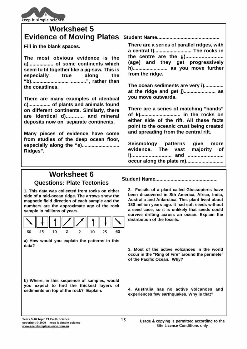
1. This data was collected from rocks on eitherside of a mid-ocean ridge. The arrows show themagnetic field direction of each sample and thenumbers are the approximate age of the rocksample in millions of years.
a) How would you explain the patterns in thisdata?
b) Where, in this sequence of samples, wouldyou expect to find the thickest layers ofsediments on top of the rock? Explain.
2. Fossils of a plant called Glossopteris havebeen discovered in Sth America, Africa, India,Australia and Antarctica. This plant lived about180 million years ago. It had soft seeds withouta seed case, so it is unlikely that seeds couldsurvive drifting across an ocean. Explain thedistribution of the fossils.
3. Most of the active volcanoes in the worldoccur in the “Ring of Fire” around the perimeterof the Pacific Ocean. Why?
4. Australia has no active volcanoes andexperiences few earthquakes. Why is that?
Worksheet 6Questions: Plate Tectonics
Student Name.............................................
keep it simple science®
Usage & copying is permitted according to the Site Licence Conditions only
2 2 10 2525 6060 10
Years 9-10 Topic 21 Earth Sciencecopyright © 2009 keep it simple sciencewww.keepitsimplescience.com.au
16
Impacts of Natural EventsWhat effects do the movements of Tectonic Plates have on the air,
the oceans, the lithosphere itself and on living things?
Impacts on the Atmosphere
Impacts on the Hydrosphere
Of the tectonic events, it is volcanoesthat are likely to have the greatestimpact on the atmosphere.
Volcanic Eruptionsrelease huge quantitiesof gases, ash and dust.Most of the solidparticles fall quickly andblanket the surroundingarea, but some fineparticles can be injectedinto the highatmosphere and remainthere for years.
These fine particles reflect light & heatfrom the Sun and can have a coolingeffect which lasts several years.
Volcanoes release a lot of acidic gasessuch as sulfur dioxide. This can cause“acid rain” which damages thebiosphere ecosystems.
CO2 and GreenhouseAlthough fine dust particles can have ashort-term cooling effect, the longer-termeffect of volcanoes can be the opposite.
Volcanic eruptions releasehuge amounts of CO2.CO2 is a “greenhousegas” which traps heat
which would otherwiseradiate back into space.
This has the effect ofraising globaltemperatures.
One volcano has littleimpact, but there have
been times in the Earth’s history whenwidespread activity caused majorclimate changes. We believe that, about250 million years ago, 95% of all life onEarth became extinct. The cause seemsto have been climate changes due tohuge volcanic eruptions which firstcooled, then heated the Earth.
keep it simple science®
Usage & copying is permitted according to the Site Licence Conditions only
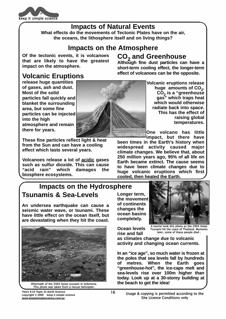
Tsunamis & Sea-LevelsAn undersea earthquake can cause aseismic water wave, or tsunami. Thesehave little effect on the ocean itself, butare devastating when they hit the coast.
Longer term,the movementof continentschanges theocean basinscompletely.
Ocean levelsrise and fallas climates change due to volcanicactivity and changing ocean currents.
In an “ice age”, so much water is frozen atthe poles that sea levels fall by hundredsof metres. When the Earth goes“greenhouse-hot”, the ice-caps melt andsea-levels rise over 100m higher thantoday. Look up at a 30-storey building atthe beach to get the idea!AAfftteerrmmaatthh ooff tthhee 22000044 AAssiiaann ttssuunnaammii iinn IInnddoonneessiiaa..
TThhiiss pphhoottoo wwaass ttaakkeenn ffrroomm aa rreessccuuee hheelliiccoopptteerr..
AA ttoouurriisstt ttooookk tthhiiss pphhoottoo aass tthhee 22000044 AAssiiaannTTssuunnaammii hhiitt tthhee ccooaasstt ooff TThhaaiillaanndd.. MMoommeennttss
llaatteerr,, ssoommee ooff tthheessee ppeeooppllee ddiieedd ..
Years 9-10 Topic 21 Earth Sciencecopyright © 2009 keep it simple sciencewww.keepitsimplescience.com.au
17
Impact on the LithospherePlate Tectonics is all about changes to the lithosphere.
Volcanic eruptions and earthquakes are the results of plate movements, and are the major causes of change to the surface of the Earth.
Sea-Floor SpreadingWhere plates move apart, new crust iscreated at the mid-ocean ridges. Thiswidens the ocean basins.
200 million years ago, the Atlantic Oceandid not exist because North America wasjoined to Europe. As the lithospherefractured into separate plates whichmoved apart, the Atlantic Ocean wascreated, and is still growing wider.
Subductiondestroys oceaniclithosphere andshrinks oceans.Near subductionzones, volcanicislands grow fromthe ocean floor.
Mountain BuildingMountainchains areformed whereplates collide.
The crust isbuckled,folded andfaulted. Earthquakes thrust the crust upwards toform the great mountain chains of theworld. Erosion then forms valleys andplains. All our landscapes result.
MetamorphismThe high temperatures and pressurescaused by tectonic forces changes therocks themselves. Shale turns to slate,limestone becomes marble.
Impacts on the BiosphereWe tend to think that earthquakes and volcanic eruptions always cause destructionof ecosystems and death of living things. However, there is a positive side as well.
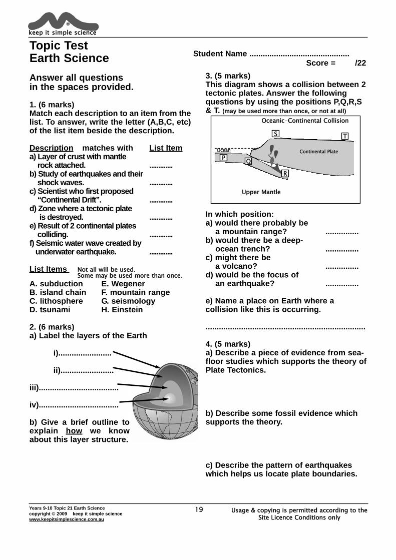
Mass ExtinctionsAt a local level, a tsunami can destroycoral reefs or coastal mangroveecosystems. A volcano can destroyforests, or bury entire ecosystems underhot ash. Locally, the living communitiescan be devasted by a tectonic event.
It can also beglobal. It wasalready mentionedthat volcanicactivity almostcompletely wipedout life on Earthby causing hugeclimate changes about 250 mya.
However, we know from the fossilrecord that after every mass extinction,life always “bounces back” with greatervariety and numbers than before.
New HabitatsTectonic events create new places tolive. For example, coral reefs thrivearound volcanic islands created bysubduction zones. Many new speciesevolve on the islands themselves.
Mountain ranges and the rivers, valleysand plains that form from them, allbecome habitats for living things.
Recycling ChemicalsAncient farmers knew that volcanoescreate fertile soil. An eruption candestroy, but fresh lava brings mineralswhich fertilise the soil.
Globally, plate tectonics is essential forcycling vital chemicals, such as carbon,calcium and phosphorus. Scientistsnow realise that without tectonicactivity, the Earth’s biosphere could notevolve and thrive as it has done.
keep it simple science®
Usage & copying is permitted according to the Site Licence Conditions only
TThheessee rroocckkss ffoorrmmeedd uunnddeerr tthhee sseeaa,, bbuutt aarreennooww 44kkmm aabboovvee sseeaa lleevveell..
FFoorreessttffllaatttteenneedd bbyy
bbllaasstt
VVaalllleeyy bbuurriieeddiinn aasshh aannddmmuudd-ffllooww..
((LLaahhaarr))MMtt SStt HHeelleennss
Years 9-10 Topic 21 Earth Sciencecopyright © 2009 keep it simple sciencewww.keepitsimplescience.com.au
18
Impacts on HumansEarthquakesThe biggest threat tohumans in anearthquake iscollapsing buildings,landslides and firesstarted by broken gasmains, fuel tanks etc.
Underwater earthquakescan also set off a
Tsunami. These can bedevastating and cause
great loss of life, ashappened in 2004.
However, it often onlyrequires 15-30 minutes
warning to get mostpeople to safety.
Warning system are now in place, orbeing installed in every ocean basin.
VolcanoesAlthough a lava flow can destroyproperty, it is seldom a danger to people.The big killers are “Pyroclastic Flows”and “Lahars”.
Pyroclastic Flow is acloud of red-hot ash andpoisonous gases whichcan pour down a volcanoat 100km/hr. Nothing cansurvive.Lahar is a flow of mud,ash, water and debris from a meltedglacier or burst lake on a volano. Laharssimply buryeverythingin theirpath.
keep it simple science®
Usage & copying is permitted according to the Site Licence Conditions only
CCaassttss ooff ppeeooppllee kkiilllleeddbbyy ppyyrrooccllaassttiicc ffllooww aatt
PPoommppeeiiii,, 7799AADD
Volcanoes can have major effects on theatmosphere. Some eruptions can injecta).................................... into the highatmosphere. This b)........................ sun-light and can c)...................... the Earthfor several years.
Gases released also have effects. Sulfurdioxide can cause d)...................-rain.Huge amounts of e).................................gas are released and this can cause“f)...................................... warming”.
Effects on the hydrosphere includeg)..............................., caused byunderwater earthquakes. Long-termchanges to the ocean basins andpositions of the continents causeh)............................ changes. In an “ice-age” the sea-level i)..................... If ice-caps totally melt, the sea-levels rise byover j)..................... metres.
There are many impacts on thelithosphere as the plates move around.k)............-................. spreading widensthe oceans. At a l)............................ zone,m)....................... islands grow from theocean floor, and n)...........................ranges are created along the edge of acontinent.
The biosphere can be affected bothnegatively and positively.
Volcanic eruptions can destroy a localecosystem, but global climate changecan cause a o)............. ......................,such as when 95% of living things diedout about 250 mya.
Tectonic events also create newp)..........................., such as q).............................. around volcanic islands.Many important chemicals arer).......................... by the creation andsubduction of the tectonic plates.
Worksheet 7Tectonic Impacts
Student Name.............................................
19Years 9-10 Topic 21 Earth Sciencecopyright © 2009 keep it simple sciencewww.keepitsimplescience.com.au
Topic Test Earth ScienceAnswer all questionsin the spaces provided.
1. (6 marks)Match each description to an item from thelist. To answer, write the letter (A,B,C, etc)of the list item beside the description.
Description matches with List Itema) Layer of crust with mantle
rock attached. .............b) Study of earthquakes and their
shock waves. .............c) Scientist who first proposed
“Continental Drift”. .............d) Zone where a tectonic plate
is destroyed. .............e) Result of 2 continental plates
colliding. .............f) Seismic water wave created by
underwater earthquake. .............
List Items Not all will be used. Some may be used more than once.
A. subduction E. WegenerB. island chain F. mountain rangeC. lithosphere G. seismologyD. tsunami H. Einstein
2. (6 marks)a) Label the layers of the Earth
i)........................
ii)........................
iii)....................................
iv)....................................
b) Give a brief outline toexplain how we knowabout this layer structure.
3. (5 marks)This diagram shows a collision between 2tectonic plates. Answer the followingquestions by using the positions P,Q,R,S& T. (may be used more than once, or not at all)
In which position:a) would there probably be
a mountain range? ...............b) would there be a deep-
ocean trench? ...............c) might there be
a volcano? ...............d) would be the focus of
an earthquake? ...............
e) Name a place on Earth where acollision like this is occurring.
........................................................................
4. (5 marks)a) Describe a piece of evidence from sea-floor studies which supports the theory ofPlate Tectonics.
b) Describe some fossil evidence whichsupports the theory.
c) Describe the pattern of earthquakeswhich helps us locate plate boundaries.
keep it simple science®
Usage & copying is permitted according to the Site Licence Conditions only
Student Name ............................................. Score = /22
OOcceeaann
Oceanic-CContinental Collision
Upper Mantle
CCoonnttiinneennttaall PPllaatteeP Q
R
S T
20Years 9-10 Topic 21 Earth Sciencecopyright © 2009 keep it simple sciencewww.keepitsimplescience.com.au
Answer SectionWorksheet 11. a) crust b) mantlec) outer core d) inner core
2.Thickness. Very thick under a continent,much thinner under the ocean floor.
3. Knowledge has come from seismology,from studying the way that earthquakeshock waves behave as they passthrough the Earth.
4. a) Earthquake shock waves.b) They are different types of shockwaves which travel at different speeds. Pwaves always arrive before S waves. Thetime difference allows measurement ofdistance to the ‘quake.c) To predict possible tsunamis orvolcanic eruptions and allow evacuationof danger areas.
Worksheet 21. Distances (nearest 10km)
Adelaide 1900 kmBrisbane 1670 kmDarwin 960 km
2. Epicentre is on southern coast of Gulfof Carpentaria.
3. Missing data (approx)Sydney 295 s 2060 kmPerth 410 s 2860 km
Worksheet 3a) Continental b) Wegenerc) fossilsd) what could make the continents move.e) Sonar f) ocean floorg) rock samples h) magnetismi) plates j) mantlek) convection currentsl) core m) move apartn) collide o) earthquakes
Worksheet 4a) molten rock b) crustc) mid-ocean d) earthquakese) island f) subductedg) deep ocean h) islandsi) earthquakes j) tsunamik) continent l) buckled/foldedm) mountain range n) subductedo) folded & faulted p) Himalayaq) Pangaea
Worksheet 5a) shape b) continental shelfc) fossils d) rockse) mid-ocean f) rift valleyg) youngest h) olderi) thin j) thickerk) magnetisml) earthquakes & volcanoesm) boundaries
keep it simple science®
Usage & copying is permitted according to the Site Licence Conditions only
21Years 9-10 Topic 21 Earth Sciencecopyright © 2009 keep it simple sciencewww.keepitsimplescience.com.au
Worksheet 61.a) The crust keeps splitting open in themiddle and new crust rock forms in thegap. This is why the rock is youngest inthe middle and gets older outwards. Thisalso explains the symmetrical pattern ofmagnetism on either side of middle.
b) Furthest away from the centre,because the oldest rocks have had moretime for sediments to settle.
2. The plant grew all across the super-continent and fossils formed. Later, thefossil deposits have been separated bymovements of the plates.
3.There are plate boundaries all around theocean perimeter. Volcanoes occur(mostly) near the edges of plates.
4.Australia is not near the edge of a plate,so no volcanoes.
Worksheet 7a) fine dust particlesb) reflects c) coold) acid e) carbon dioxidef) greenhouse g) tsunamish) climate i) falls.j) 100 k) sea-floorl) subduction m) volcanicn) mountain o) mass extinctionp) habitats q) coral reefsr) recycled
Topic Test1.a) C b) G c) E d) A e) F f) D
2.a) i) crust
ii) mantleiii) outer coreiv) inner core
b) Seismology studies.Layer structure figured out from the wayearthquake waves behave as they travelthrough the Earth.
3.a) S b) Q c) S d) Q or Re) Pacific coast of Sth america. (Andes Mtns)
4.a) Rocks are youngest at the mid-oceanridges and get older as you move away ineach direction. This is evidence for “sea-floor spreading”.
b) Fossils are found on differentcontinents which match the “jig-saw”idea. The plant/animal lived all over anancient super-continent, and fossils havebeen separated by plate movements.
c) Most earthquakes occur along the plateboundaries.
keep it simple science®
Usage & copying is permitted according to the Site Licence Conditions only
Related Documents


