Karst geomorphology of carbonatic conglomerates in the Folded Molasse zone of the Northern Alps (Austria/Germany) Nadine Goeppert a, ⁎, Nico Goldscheider a , Herbert Scholz b a Karlsruhe Institute of Technology (KIT), Institute for Applied Geosciences (AGW), Chair for Hydrogeology, Kaiserstr. 12, D-76131 Karlsruhe, Germany b Technische Universität München (TUM), Chair for Engineering Geology, Arcisstr. 21, D-80333 Munich, Germany abstract article info Article history: Received 21 January 2011 Received in revised form 11 April 2011 Accepted 12 April 2011 Available online 22 April 2011 Keywords: Karstification Carbonatic conglomerate Folded Molasse Alps The Folded Molasse zone of the Northern Alps consists of clastic sedimentary rocks that are usually not considered to be karstifiable. However, large areas within this zone are composed of carbonatic conglomerates. Numerous karst landforms have recently been discovered but are not recorded on official maps and in the literature. Therefore, a research programme was initiated at the Hochgrat site (Austria/ Germany) that included geomorphological mapping and characterisation of the karst phenomena. Both fracture-controlled and hydrodynamically-controlled karren were observed on conglomerate outcrops. The predominant karst landforms, dolines, are typically circular, funnel shaped, most often 2 to 9 m in diameter, 1 to 6 m deep, and frequently act as swallow holes. Poljes that are atypically small (~ 1 ha) occur in either glacial cirques or syncline depressions, are flat floored and lined with sediment and soil, and drain underground via swallow holes. Short caves, springs with marked discharge variations and estavelles are further evidence for karst development. Karstic landforms are widespread in carbonatic conglomerate terrains, but their dimensions are smaller than in typical limestone karst. The practical implications of these findings are also briefly mentioned in this paper. © 2011 Elsevier B.V. All rights reserved. 1. Introduction Karstification typically occurs in biogenic, biochemical and chemical sedimentary rocks, mostly in carbonate rocks, such as limestone and dolomite (Johnson and Stieglitz, 1990; Groves and Meiman, 2005; De Waele et al., 2009), but also in sulphate rocks, such as gypsum and anhydrite (Black, 1997; Calaforra and Pulido-Bosch, 2003). Characteristic karst landforms include solutionally-enlarged factures and channels (karren), as well as closed depressions of differing origins, structure and dimensions (dolines, poljes). Cvijic (1893) described dolines as “the diagnostic karst landforms” (Ford, 2007). Karst aquifers are characterised by rapid, often turbulent groundwater flow in a network of fractures, conduits and caves (Goppert and Goldscheider, 2008; Plan et al., 2009; Worthington, 2009 Karst landforms usually indicate the presence of a karst aquifer, but a karst aquifer can also be present when such landforms are absent, for example in confined settings Huntoon, 2000); (Goldscheider et al., 2003. Karstification has many practical implications: • Sinkholes in karst areas are geotechnical hazards for houses, streets and other infrastructure (Field, 2010; Vigna et al., 2010); • Reservoirs and other hydraulic infrastructure in karst often exhibit leakage problems (Bonacci and Roje-Bonacci, 2008; Bonacci et al., 2009a); • Karst areas exhibit significant biodiversity, at the surface, under- ground, and in groundwater-dependent ecosystems (Humphreys, 2006; Bonacci et al., 2009b); • Karst aquifers are valuable freshwater resources but highly vulnerable to contamination; they consequently require special protection (Ravbar and Goldscheider, 2007); • Deep karst aquifers are valuable geothermal resources (Goldscheider et al., 2010). Therefore, the scientific investigation of karst landscapes and aquifers is important. The first step is to recognise karst areas as such. Areas consisting of clastic sedimentary rocks, such as sandstone, breccia and conglomerate, are usually not considered to be karstifiable. Orogenic foreland basins (Molasse basins) generally include shallow marine to continental sediments documenting the uplift and erosion of the mountain range. Coarse-grained clastic sediments can be found near the orogenic belt and have often been deposited in large alluvial fans. Most mountain ranges include carbonate rocks. Carbonatic sand and gravel are therefore widespread in the sandstones and conglomerates in their foreland basins (DeCelles and Giles, 1996; Sinclair, 1997). As a result of late-orogenic tectonics and uplift, these formations are today often in an elevated position, exposed to weathering and groundwater recharge. Geomorphology 130 (2011) 289–298 ⁎ Corresponding author. Tel.: +49 721 608 43280; fax: +49 721 606 279. E-mail addresses: [email protected] (N. Goeppert), [email protected] (N. Goldscheider), [email protected] (H. Scholz). 0169-555X/$ – see front matter © 2011 Elsevier B.V. All rights reserved. doi:10.1016/j.geomorph.2011.04.011 Contents lists available at ScienceDirect Geomorphology journal homepage: www.elsevier.com/locate/geomorph

Welcome message from author
This document is posted to help you gain knowledge. Please leave a comment to let me know what you think about it! Share it to your friends and learn new things together.
Transcript
Geomorphology 130 (2011) 289–298
Contents lists available at ScienceDirect
Geomorphology
j ourna l homepage: www.e lsev ie r.com/ locate /geomorph
Karst geomorphology of carbonatic conglomerates in the Folded Molasse zone of theNorthern Alps (Austria/Germany)
Nadine Goeppert a,⁎, Nico Goldscheider a, Herbert Scholz b
a Karlsruhe Institute of Technology (KIT), Institute for Applied Geosciences (AGW), Chair for Hydrogeology, Kaiserstr. 12, D-76131 Karlsruhe, Germanyb Technische Universität München (TUM), Chair for Engineering Geology, Arcisstr. 21, D-80333 Munich, Germany
⁎ Corresponding author. Tel.: +49 721 608 43280; faE-mail addresses: [email protected] (N. Goep
(N. Goldscheider), [email protected] (H. Scholz).
0169-555X/$ – see front matter © 2011 Elsevier B.V. Adoi:10.1016/j.geomorph.2011.04.011
a b s t r a c t
a r t i c l e i n f oArticle history:Received 21 January 2011Received in revised form 11 April 2011Accepted 12 April 2011Available online 22 April 2011
Keywords:KarstificationCarbonatic conglomerateFolded MolasseAlps
The Folded Molasse zone of the Northern Alps consists of clastic sedimentary rocks that are usually notconsidered to be karstifiable. However, large areas within this zone are composed of carbonaticconglomerates. Numerous karst landforms have recently been discovered but are not recorded on officialmaps and in the literature. Therefore, a research programme was initiated at the Hochgrat site (Austria/Germany) that included geomorphological mapping and characterisation of the karst phenomena. Bothfracture-controlled and hydrodynamically-controlled karren were observed on conglomerate outcrops. Thepredominant karst landforms, dolines, are typically circular, funnel shaped, most often 2 to 9 m in diameter, 1to 6 m deep, and frequently act as swallow holes. Poljes that are atypically small (~1 ha) occur in either glacialcirques or syncline depressions, are flat floored and lined with sediment and soil, and drain underground viaswallow holes. Short caves, springs with marked discharge variations and estavelles are further evidence forkarst development. Karstic landforms are widespread in carbonatic conglomerate terrains, but theirdimensions are smaller than in typical limestone karst. The practical implications of these findings are alsobriefly mentioned in this paper.
x: +49 721 606 279.pert), [email protected]
ll rights reserved.
© 2011 Elsevier B.V. All rights reserved.
1. Introduction
Karstification typically occurs in biogenic, biochemical andchemical sedimentary rocks, mostly in carbonate rocks, such aslimestone and dolomite (Johnson and Stieglitz, 1990; Groves andMeiman, 2005; DeWaele et al., 2009), but also in sulphate rocks, suchas gypsum and anhydrite (Black, 1997; Calaforra and Pulido-Bosch,2003). Characteristic karst landforms include solutionally-enlargedfactures and channels (karren), as well as closed depressions ofdiffering origins, structure and dimensions (dolines, poljes). Cvijic(1893) described dolines as “the diagnostic karst landforms” (Ford,2007). Karst aquifers are characterised by rapid, often turbulentgroundwater flow in a network of fractures, conduits and caves(Goppert and Goldscheider, 2008; Plan et al., 2009; Worthington,2009 Karst landforms usually indicate the presence of a karst aquifer,but a karst aquifer can also be present when such landforms are absent,for example in confined settings Huntoon, 2000); (Goldscheider et al.,2003. Karstification has many practical implications:
• Sinkholes in karst areas are geotechnical hazards for houses, streetsand other infrastructure (Field, 2010; Vigna et al., 2010);
• Reservoirs and other hydraulic infrastructure in karst often exhibitleakage problems (Bonacci and Roje-Bonacci, 2008; Bonacci et al.,2009a);
• Karst areas exhibit significant biodiversity, at the surface, under-ground, and in groundwater-dependent ecosystems (Humphreys,2006; Bonacci et al., 2009b);
• Karst aquifers are valuable freshwater resources but highlyvulnerable to contamination; they consequently require specialprotection (Ravbar and Goldscheider, 2007);
• Deep karst aquifers are valuable geothermal resources (Goldscheideret al., 2010).
Therefore, the scientific investigation of karst landscapes andaquifers is important. The first step is to recognise karst areas as such.Areas consisting of clastic sedimentary rocks, such as sandstone, brecciaand conglomerate, are usually not considered to be karstifiable.
Orogenic foreland basins (Molasse basins) generally includeshallow marine to continental sediments documenting the upliftand erosion of the mountain range. Coarse-grained clastic sedimentscan be found near the orogenic belt and have often been deposited inlarge alluvial fans. Most mountain ranges include carbonate rocks.Carbonatic sand and gravel are therefore widespread in thesandstones and conglomerates in their foreland basins (DeCellesand Giles, 1996; Sinclair, 1997). As a result of late-orogenic tectonicsand uplift, these formations are today often in an elevated position,exposed to weathering and groundwater recharge.

290 N. Goeppert et al. / Geomorphology 130 (2011) 289–298
Carbonatic conglomerates are predisposed to karstification, butonly a few studies have reported karst development in these rocks,probably because karst researchers usually study limestone, whileother geoscientists pay little attention to karst. Bergadà et al. (1997)have studied karst landforms and caves in carbonatic conglomeratesof the southern foreland of the Pyrenees, Spain. Karstified conglom-erates have also been reported north of the Pyrenees, in France (Bès,1994). Scholz and Strohmenger (1999) mapped doline-like structuresin conglomerate areas in the northern foreland of the Alps, Germany,which are not reported in any of the official geological maps orpublications. South of the Alps, karst landforms and caves inconglomerates have been studied in Italy (Ferrarese and Sauro,2005) and Slovenia (Gabrovšek, 2005). Gabrovšek also mentions thelack of knowledge concerning karstification of these rocks. Other thanthese scarce publications dealing with specific test sites, there is nosystematic study describing the karst geomorphology of carbonaticconglomerates.
Therefore, a research programme was established in the conglom-erate areas of the Molasse Basin near the northern margin of the Alps(Fig. 1). The study was done at two scales: detailed investigations atthe most spectacular karst area within this zone, the Hochgrat Chainat the Austro-German border (rectangle in Fig. 1, map in Fig. 3); andregional-scale mapping accompanied by selected site investigationsto obtain a more complete picture of karst phenomena in carbonaticconglomerates (main map in Fig. 1).
The study at the Hochgrat site included hydrogeological andgeomorphological methods. Tracer tests from swallow holes tosprings suggested flow velocities in excess of 100 m/h. High levels
Fig. 1. Small map: Location of the wider study area at the northern margin of the Alps, in themap showing the distribution of conglomerates in the large Hochgrat-Adelegg Fan and partsFig. 3 are also shown.Modified after Scholz, 1995.
of faecal bacteria were found in springwaters, which can be attributedto the short transit times in the aquifer. These findings demonstratethat karstified conglomerates show similar hydrogeological charac-teristics typical of limestone karst aquifers, and the same spring watercontamination problems (Goeppert and Goldscheider, 2011).
The geomorphological investigations included the mapping anddetailed characterisation of karst landforms in the Hochgrat site andat selected other sites in the wider region, along with mineralogicaland petrographical analyses. The goals of this study were:
• Make an inventory of karst landforms at different scales incarbonatic conglomerates, characterise their shape and dimensions,and compare and contrast them with corresponding landforms inclassical limestone karst areas;
• Analyse the geomorphological and hydrological processes thatcreated these landforms, again in comparisonwith typical limestonekarst terrains;
• Highlight the consequences of these findings for groundwatersource protection, geotechnical hazards, and other environmentaland engineering aspects.
2. Geological setting
The Molasse Basin north of the Alps (Switzerland, Germany,Austria) formed during the Oligo-Miocene and includes a sequence ofmarine and freshwater sediments (Berge and Veal, 2005). Thewestern and central part of the basin (from Geneva to Munich) wasflooded twice by the sea and became fluviatile and continental
border region of Germany (D), Austria (A) and Switzerland (CH). Large map: Geologicalof two smaller, adjacent fans. The location of the section in Fig. 2 (A-A′) and the map in
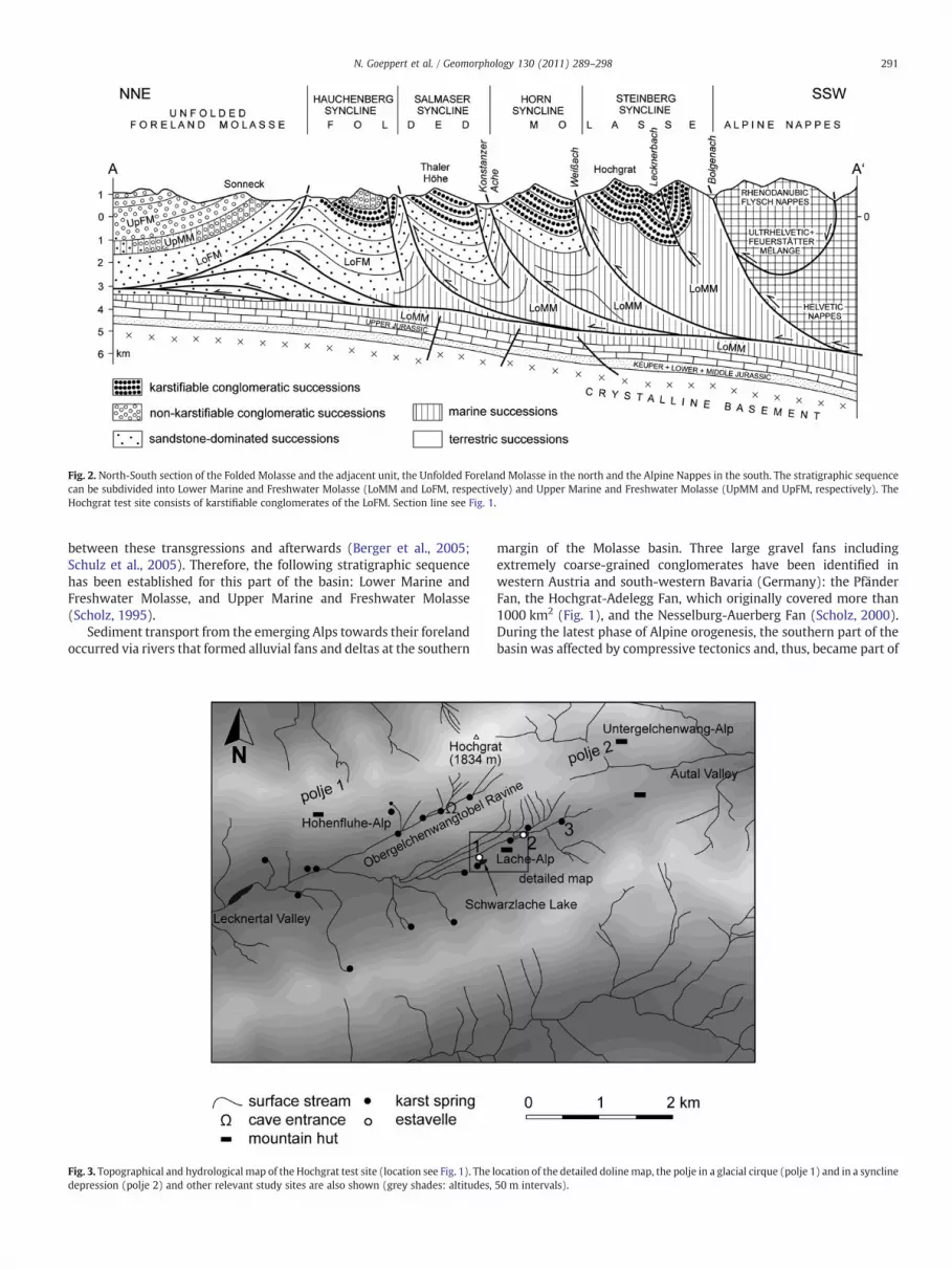
Fig. 2. North-South section of the Folded Molasse and the adjacent unit, the Unfolded Foreland Molasse in the north and the Alpine Nappes in the south. The stratigraphic sequencecan be subdivided into Lower Marine and Freshwater Molasse (LoMM and LoFM, respectively) and Upper Marine and Freshwater Molasse (UpMM and UpFM, respectively). TheHochgrat test site consists of karstifiable conglomerates of the LoFM. Section line see Fig. 1.
291N. Goeppert et al. / Geomorphology 130 (2011) 289–298
between these transgressions and afterwards (Berger et al., 2005;Schulz et al., 2005). Therefore, the following stratigraphic sequencehas been established for this part of the basin: Lower Marine andFreshwater Molasse, and Upper Marine and Freshwater Molasse(Scholz, 1995).
Sediment transport from the emerging Alps towards their forelandoccurred via rivers that formed alluvial fans and deltas at the southern
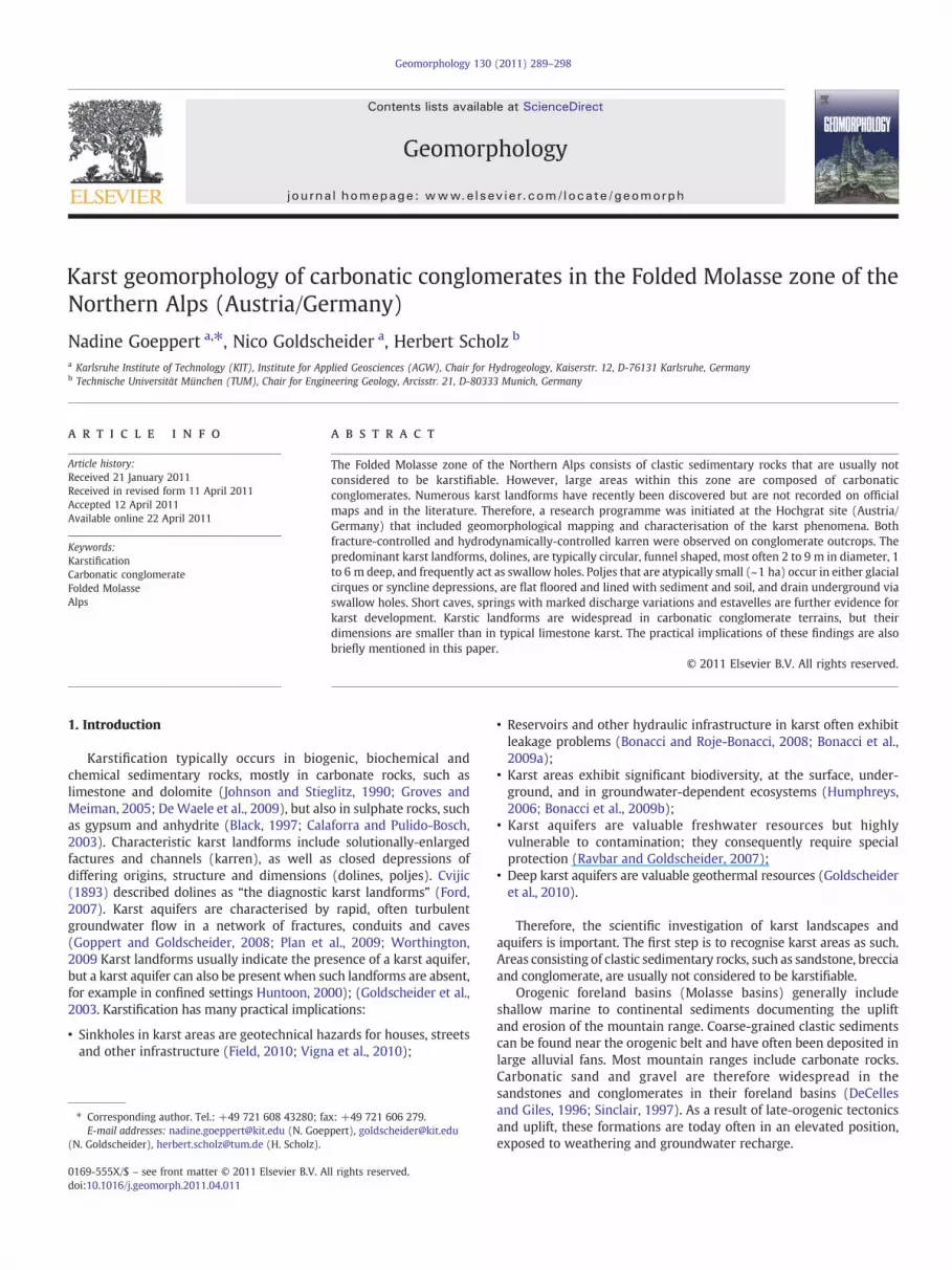
Fig. 3. Topographical and hydrological map of the Hochgrat test site (location see Fig. 1). The ldepression (polje 2) and other relevant study sites are also shown (grey shades: altitudes,
margin of the Molasse basin. Three large gravel fans includingextremely coarse-grained conglomerates have been identified inwestern Austria and south-western Bavaria (Germany): the PfänderFan, the Hochgrat-Adelegg Fan, which originally covered more than1000 km2 (Fig. 1), and the Nesselburg-Auerberg Fan (Scholz, 2000).During the latest phase of Alpine orogenesis, the southern part of thebasin was affected by compressive tectonics and, thus, became part of
ocation of the detailed dolinemap, the polje in a glacial cirque (polje 1) and in a syncline50 m intervals).

Fig. 4. Schematic illustration of weathering processes in conglomerates: a) mechanical weathering disintegrates the rock fabric and results in erosional channels; b) chemicaldissolution of well-cemented carbonate conglomerates leads to the formation of karren and can be classified as true karstification; c) typical karren in the Hochgrat area, with non-soluble components that protrude during karstification.
292 N. Goeppert et al. / Geomorphology 130 (2011) 289–298
the Alpine fold and thrust belt; this zone is called Folded Molasse(Fig. 2) (Scholz, 1995).
The Hochgrat (high ridge) test site is located at the borderbetween the federal states of Vorarlberg (Austria) and Bavaria(Germany) and attains an altitude of 1834 m (Fig. 3). Structurally, itbelongs to the so-called Steinberg Syncline, the southernmost thrustsheet of the Folded Molasse. The WSW-ENE-oriented Hochgrat Chainis separated from the parallel, southward adjacent chain by twoaligned valleys that follow the axis of a regional syncline. TheLecknertal Valley drains towards the west, while the Autal Valleydrains eastwards. The mountain pass between them is part of thecontinental water divide between the drainage basins of the Rhine(west) and Danube River (east).
The test site belongs to the Lower Freshwater Molasse (LoFM) andis located in the very centre of the Hochgrat-Adelegg Fan, to which itgave its name (Fig. 1). It consists of an alternation of coarse-grainedconglomerate layers with a thickness up to 60 m and marl in-tercalations of usually less than 15 m. The conglomerates mostlyconsist of carbonatic components (limestone and dolomite pebbles)in a carbonatic matrix, but chert pebbles and other non-soluble grainsoccur as well. The pebbles are usually 5 to 10 cm in diameter but someattain 50 cm or more. The marls are of low permeability and lowmechanical resistance, and are thus subject to erosion, while theconglomerates often crop out and form ridges and steps. Thealternation of conglomerates and marls, the inclination of the strataand the glacial and post-glacial deepening of the valleys lead to slopeinstabilities. Several landslides, rock falls and other mass movementsoccurred in this zone (Seijmonsbergen et al., 2005).
Fig. 5. Typical karren on a conglomerat
3. Inventory and analysis of karst landforms
3.1. Karren
The Lexicon of Cave and Karst Terminology (Field, 2002) defineskarren as “channels or furrows, caused by solution on massive barelimestone surfaces” and lists several types of karren. Although theHochgrat site is not a limestone terrain, a wide range of channels andfurrows can be observed. Channels on rock surfaces can form bymechanical erosion, chemical dissolution, or a combination of the twoprocesses. Conventional weathering and erosion would primarilyaffect the matrix and cement, destabilise and disintegrate the rockfabric and eventually transform the solid conglomerate into loosegravel (Fig. 4a). Pure chemical dissolution of carbonatic conglomer-ates, i.e. true karstification, would affect both the components and thematrix or cement (Fig. 4b).
At the Hochgrat site, both processes can be observed, but mostoutcrops show clear dissolution phenomena that can be classified askarren. The conglomerates also include non-carbonatic components,such as chert and sandstone pebbles, which are resistant todissolution and, thus, protrude during karstification (Fig. 4c). Hydro-dynamically-controlled karren are frequent on inclined, poorly-fractured conglomerate outcrops. The channels are often ca. 10 cmwide, several metres long and separated by moderately roundedridges (Fig. 5). Straight, parallel karren predominate on steep surfaces,while curved forms and herringbone patterns occur on gentler slopes.Fracture-controlled karren are less frequent but occur at places wherethe rock is intensely cut by fractures. Karren formation on surfaces of
e outcrop in the Hochgrat test site.
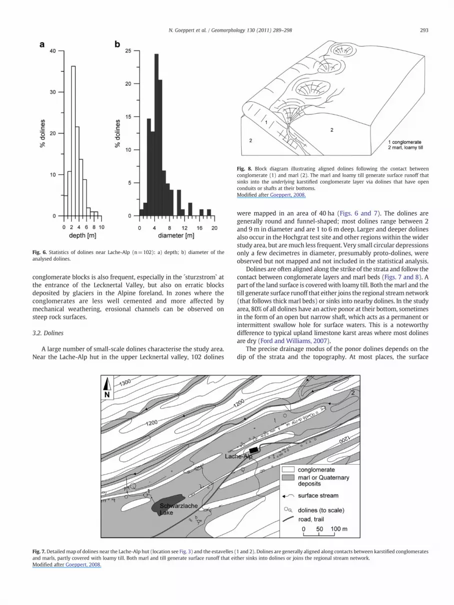
Fig. 8. Block diagram illustrating aligned dolines following the contact betweenconglomerate (1) and marl (2). The marl and loamy till generate surface runoff thatsinks into the underlying karstified conglomerate layer via dolines that have openconduits or shafts at their bottoms.Modified after Goeppert, 2008.
Fig. 6. Statistics of dolines near Lache-Alp (n=102): a) depth; b) diameter of theanalysed dolines.
293N. Goeppert et al. / Geomorphology 130 (2011) 289–298
conglomerate blocks is also frequent, especially in the ´sturzstrom` atthe entrance of the Lecknertal Valley, but also on erratic blocksdeposited by glaciers in the Alpine foreland. In zones where theconglomerates are less well cemented and more affected bymechanical weathering, erosional channels can be observed onsteep rock surfaces.
3.2. Dolines
A large number of small-scale dolines characterise the study area.Near the Lache-Alp hut in the upper Lecknertal valley, 102 dolines
Fig. 7.Detailedmap of dolines near the Lache-Alp hut (location see Fig. 3) and the estavelles (and marls, partly covered with loamy till. Both marl and till generate surface runoff that eiModified after Goeppert, 2008.
were mapped in an area of 40 ha (Figs. 6 and 7). The dolines aregenerally round and funnel-shaped; most dolines range between 2and 9 m in diameter and are 1 to 6 m deep. Larger and deeper dolinesalso occur in the Hochgrat test site and other regions within the widerstudy area, but aremuch less frequent. Very small circular depressionsonly a few decimetres in diameter, presumably proto-dolines, wereobserved but not mapped and not included in the statistical analysis.
Dolines are often aligned along the strike of the strata and follow thecontact between conglomerate layers and marl beds (Figs. 7 and 8). Apart of the land surface is coveredwith loamy till. Both themarl and thetill generate surface runoff that either joins the regional streamnetwork(that follows thick marl beds) or sinks into nearby dolines. In the studyarea, 80% of all dolines have an active ponor at their bottom, sometimesin the form of an open but narrow shaft, which acts as a permanent orintermittent swallow hole for surface waters. This is a noteworthydifference to typical upland limestone karst areas where most dolinesare dry (Ford and Williams, 2007).
The precise drainage modus of the ponor dolines depends on thedip of the strata and the topography. At most places, the surface
1 and 2). Dolines are generally aligned along contacts between karstified conglomeratesther sinks into dolines or joins the regional stream network.

294 N. Goeppert et al. / Geomorphology 130 (2011) 289–298
streams that form on marl sink into the underlying conglomeratelayer, as shown in the block diagram in Fig. 8. However, when both thedip of the strata and the slopes are steep, drainage sometimes occursinto the overlying conglomerate layer, as shown on the photo in Fig. 9.
Fig. 10. Structural setting of small-scale poljes in the Hochgrat study area: a) polje thatdeveloped from a glacial cirque; b) polje that developed along the axis of a syncline(locations see Fig. 3).Modified after Goeppert, 2008.
3.3. Small-scale poljes
Poljes are closed depressions with a flat floor in karst terrains. Thepolje floor is often covered with soil and sediments. There is noexternal surface drainage but all surface waters, if present, sink intothe aquifer via swallow holes, some of which transform into springsduring high-water conditions (the latter are referred to as estavelles).Typical poljes in the Dinaric and other classical karst regions rangebetween tens and many hundreds of square kilometres. Poljes areassociated with a wide range of geological settings, such as tectonicgrabens, pull-apart basins, broken anticlines or synclines (Ford andWilliams, 2007).
In the study area, there are several small-scale depressions withflat floors covered with soil and sediments that drain underground viaswallow holes into karstified conglomerates. In terms of geomorpho-logical structure and hydrological behaviour, these depressionsexhibit all the typical characteristics of poljes, but their size is onlyabout 1 hectare. Gracia et al. (2003) present a short discussion ondifferent size-criteria that have been proposed for poljes, such as400 m or 1000 m as the minimum diameter of the polje floor. Weargue that many geomorphological phenomena exist over a widerange of dimensions, such as all landforms associated with glaciers.Size is thus an inappropriate criterion. Therefore, we classify thedescribed depressions in the Hochgrat area as small-scale (but real)poljes. These poljes are more than large dolines, because they areassociated with more complex geological settings and not just funnel-shaped solution phenomena in karstifiable rocks. Although small insize, their dimensions are larger than the thickness of the individualconglomerate layers.
Two types of poljes have been identified. The first type occurs athigh altitudes and developed from small glacial cirques (polje 1 inFig. 3, Figs. 10a, 11). The depression is circular and ca. 100 m indiameter. The floor is covered with soil. Inflowing streams sink intothe conglomerate karst aquifer via swallow holes. Paleo-swallowholes, ca. 2 m above the polje floor, indicate recent deepening of thispolje by the combined action of carbonate dissolution andmechanical
Fig. 9. Doline on the southern slope of the Hochgrat Chain at ca. 1600 m a.s.l., near the principmarl zone (right) sinks into the overlying conglomerate layer (left) via a swallow hole at th
erosion of marl. Both the dissolved and suspended loads are drainedvia swallow holes.
The second type is associated with fold structures and developedin the axial depression of a syncline (polje 2 in Fig. 3, Figs. 10b, 12).The polje is elongated along the fold axis; it is ca. 50 m wide, 250 mlong, and its flat floor is covered with soil. Small intermittent streamsfrom the bordering slopes sink underground via swallow holes at themargin of the polje floor.
3.4. Caves
Caves are characteristic underground phenomena of karst (Palmer,1991), although they can also develop by other processes and in othergeologic settings, such as lava tubes in volcanic areas (Calvari andPinkerton, 1998). During this study and as a consequence of itspreliminary findings, speleologists took notice of caves in theHochgrat area. Today, six small caves have been explored but notyet surveyed in detail (A. Wolf, personal communication). The largestcave is a more than 100 m-long sub-horizontal water cave associatedwith a karst spring, located in a ravine SW of the Hochgrat summit
al ridge. The dip of the strata is slightly steeper than the slope dip. Surface runoff from ae bottom of this doline.

Fig. 11. Small-scale polje that developed in a glacial cirque. The recent depression drains underground via swallow holes.
295N. Goeppert et al. / Geomorphology 130 (2011) 289–298
(Obergelchenwangtobel Ravine, location see Fig. 3, impressions seeFig. 13a–c). Vertical cave shafts have also been discovered (Fig. 13d).The conduits often follow fractures and/or bedding planes, just as intypical limestone karst. The cross-sections of cave passages are oftencircular, sometimes oval or lemon-shaped, i.e. elongated along thefracture or bedding plane that controls the conduit development.Rectangular sections also occur, geometrically determined by beddingplanes and fractures. At some places, speleothems have beendiscovered, such as the stalagmite in Fig. 13c. Similar to that shownfor karren (Fig. 4), the combined action of mechanical erosion andchemical dissolution can be observed on the conduit walls, butchemical dissolution predominates. Therefore, the caves in thisconglomerate area are classified as true karst caves. Several caveentrances act as springs; other caves are closely associated withnearby springs.
3.5. Swallow holes, estavelles and springs
From a hydrological point of view, karst areas are characterised bypredominant underground drainage, indicated by a scarcely devel-
Fig. 12. Small-scale polje that developed along the axial depression of a syncline. Th
oped or entirely absent surface stream network, even under humidclimatic conditions (Ford and Williams, 2007). In parts of the studyarea, there is a surface drainage network (Fig. 3), which seems tocontradict the hypothesis concerning karstification of conglomerates.However, the streams mostly follow marl beds and partly flow overloamy till (Fig. 7), while large conglomerate outcrops drain under-ground, such as the dip slopes of the Hochgrat Chain (partly visible inFigs. 9, 10, 12). In the wider study area (Fig. 1), there are large areaswithout any surface drainage, despite the high precipitation in thisregion (1500–2000 mm/year). Swallow holes are frequent and oftenassociated with dolines and poljes (Figs. 7–10). With few exceptions,swallow holes only occur in karst.
Estavelles, i.e. swallow holes that transform into springs duringhigh-flow conditions, occur rarely and almost exclusively in karsticterrain. The largest estavelle in the Alps is located in the Hochifen-Gottesacker karst system, 20 km south of the Hochgrat. It is associatedwith a cave entrance at the side of the stream.When the estavelle actsas a swallow hole, up to approximately 500 l/s of stream water sinkinto the cave entrance. During high-flow conditions, the estavelle actsas a spring with a maximum discharge of approximately 4000 l/s
e summits on the right side belong to the principal ridge of the Hochgrat Chain.

Fig. 13. Impressions from recently discovered but not yet surveyed small caves in the Hochgrat area: a–c) impressions from the water cave at the Obergelchenwangtobel Ravine;a) karst water near the cave entrance, b) typical cave sections, c) stalagmite; d) oval section in a vertical cave shaft (photos: R. Heinig).
296 N. Goeppert et al. / Geomorphology 130 (2011) 289–298
(Goldscheider, 2005). Two smaller estavelles have also been discov-ered in the Hochgrat area. One is located ca. 350 mNE of the Lache-Alp(#2 in Figs. 3 and 7) and consists of an open fracture partly filled withboulders and gravel, ca. 1 m beside a stream bed. The block diagram inFig. 14 illustrates the setting and functioning of this estavelle. It issituated at a geological contact and forms the hydraulic connectionbetween a surface stream on marl and an underground conduit in asteeply inclined conglomerate layer. During extreme low-flowconditions, the stream bed is dry, while there might be undergroundflow in the karst conduit (Fig. 14a). During low to moderate flowconditions, the stream sinks completely or partially underground,with a maximum observed sink rate of 20 l/s (flow rates weremeasured using the salt-dilution method) (Fig. 14b,c). Under high-flow conditions, flow in the conduit exceeds its through-flow capacity,which causes the estavelle to transform into a spring capable ofdischarging flows of approximately 100 l/s (Fig. 14d).
Another estavelle associated with a doline was identified 400 mSW of Lache-Alp (#1 in Figs. 3 and 7). During low-flow conditions, thestream draining the nearby Schwarzlache Lake sinks undergroundinto this doline. During high-flow conditions, the doline fills withwater and eventually overflows. During extreme high-flow condi-tions, the discharge downstream from this doline is higher than theone upstream, thus confirming that the doline sometimes acts as aspring.
Springs discharging from conglomerates show the typical hydro-logical characteristics of karst springs, such as highly variabledischarge in response to precipitation events and snowmelt. Thespring orifices are sometimes covered with boulders or rock debris,but may also be associated with open fractures or cave-like conduits.During moderate-flow conditions, the discharge of these karst springsis approximately 10 l/s. In long, dry periods, some of the springs run
dry. For example, storm events resulted in a discharge of 415 l/s at akarst spring near the Lache-Alp mountain hut (spring #3 in Fig. 3).
4. Discussion and conclusions
Carbonate conglomerates are widespread in the southern part ofthe Molasse Basin near the northern margin of the Alps. These clasticsedimentary rocks have been deposited in large alluvial fans duringthe Oligocene and Miocene, when rivers transported carbonate gravelfrom the emerging Alps northwards into their foreland basin.Subsequently, these formations were folded and thrusted and nowform the Folded Molasse, a narrow mountainous strip between themain body of the Alps and their foreland.
Carbonate conglomerates of the Molasse Basin near the northernmargin of the Alps are karstifiable, but few studies have actuallyinvestigated karst landforms in this area or other regions formed bycarbonatic conglomerates. The Hochgrat Chain is a prominentmountain chain belonging to the Folded Molasse and arguably thearea with the most spectacular karst development within this zone.Extensive and detailed fieldwork allowed the karst landforms in thisarea to be characterised, analysed and classified.
There is a wide range of surface geomorphological and hydrolog-ical karst landforms at different scales, such as karren, dolines, smallpoljes, swallow holes and estavelles. These phenomena indicatethe presence of an underground karst drainage network, whichcan be directly accessed via small caves at some places. There arealso transitions to landforms created by mechanical erosion andlandforms due to mass movements, which are widespread in theFoldedMolasse. However, in most cases, chemical dissolution, i.e. truekarstification, is the predominant geomorphological process. Karstlandforms in carbonatic conglomerates show many similarities but

Fig. 14. Block diagram illustrating the geologic setting and hydraulic functioning of estavelle 2 near Lache-Alp (location see Fig. 7), during extreme low-flow to high-flow conditions:a) the streambed is dry; b) the estavelle acts as a swallow hole and the stream sinks completely underground; c) the stream sinks partly underground; d) the estavelle transformsinto a karst spring.Modified after Goeppert, 2008.
297N. Goeppert et al. / Geomorphology 130 (2011) 289–298
also salient differences to typical karst phenomena in limestoneterrains, both in terms of genesis and morphology. However, due tothe large variety of karst landforms and the lack of research onconglomerate karst, the following rules have to be considered aspreliminary observations:
• Karren on conglomerate rock surfaces exhibit transitions betweenpure chemical carbonate rock dissolution and mechanicalweathering.
• Dolines are widespread and relatively small but compared to typicallimestone karst, conglomerate dolines are smaller, often 2 to 9 m indiameter, and they frequently act as swallow holes, while dolines inmountainous limestone karst regions are more often dry.
• Poljes in conglomerate karst are much smaller than their equivalentsin limestone karst, typically only about 1 hectare, but they showall thediagnostic characteristics, i.e. closed depressions with a flat floor thatdrain underground via swallow holes. These depressions are morethan just large dolines, as they are associated with more complexgeological structures and/or have a more complex history. Two typesof poljes have been identified: poljes that developed from a glacialcirque, and poljes in syncline depressions.
• Caves are mostly small, narrow and straightforward, but morespeleological research is required before general regularities can beformulated.
• Outcrops of carbonate conglomerates mostly drain underground,while a network of surface streams is developed on marl in-tercalations and loamy till.
• A variety of karst hydrological phenomena were identified, such asswallow holes, springs with highly-variable discharge, and esta-velles, all of which are typical hydrological expressions of anunderground karst conduit system. However, compared to typicallimestone karst aquifers, the dimensions of these phenomena aresmaller.
Karstification has many practical implications, such as springwater contamination problems associated with rapid and turbulentflow in conduits (Pronk et al., 2007). Tracer tests in the Hochgratstudy area have demonstrated very high underground flow velocitiesthat often exceed 100 m/h. Seasonal spring water sampling formicrobiological analyses have revealed that nearly all springs in thearea show high levels of faecal bacteria, up to 65 Escherichia coli in a100 ml sample (Goeppert and Goldscheider, 2011). These findings

298 N. Goeppert et al. / Geomorphology 130 (2011) 289–298
underline the practical relevance of karstification of these Molasseconglomerates for drinking water supply and protection.
In conclusion, carbonatic conglomerates in parts of the FoldedMolasse and probably in other regions of the world are karstifiable.Similar to biochemical carbonate rocks, karstification starts when thecarbonate content exceeds about 75%, as recently demonstrated byfield and laboratory studies in the Hochgrat-Adelegg Fan (Flechtner,2009) Karstified conglomerates show a wide range of geomorpho-logical karst landforms, but also the same high vulnerability andwatercontamination problems as limestone karst aquifers. Therefore, theregional distribution and the specific characteristics of this type ofkarst landscape should be further investigated. Karstification of clasticsedimentary rocks of predominantly carbonatic composition has to beexpected and should be considered for groundwater managementand other practical issues.
Acknowledgements
The project was partly funded by BWPLUS, grant BWR 23008. Wethank Andreas Wolf, German Speleological Federation, for up-to-dateinformation on caves in our study area, and Robert Heinig for the cavephotos in Fig. 13. We also thank Klaus Haas (TUM) for the technicalassistance concerning Figs. 1 and 2.
References
Bergadà, M.M., Cervello, J.M., Serrat, D., 1997. Karst in conglomerates in Catalonia(Spain): morphological forms and sedimentary sequence types recorded onarchaeological sites. Quaternaire 8, 267–277.
Berge, T.B., Veal, S.L., 2005. Structure of the Alpine foreland. Tectonics 24, articlenumber TC5011.
Berger, J.P., Reichenbacher, B., Becker, D., Grimm, M., Grimm, K., Picot, L., 2005.Paleogeography of the Upper Rhine Graben (URG) and the Swiss Molasse Basin(SMB) from Eocene to Pliocene. International Journal of Earth Sciences 94,697–710.
Bès, C., 1994. Fracturation et karstification dans les Hautes-Corbières. Spélé Aude 3,28–52.
Black, T.J., 1997. Evaporite karst of northern lower Michigan. Carbonates and Evaporites12, 81–83.
Bonacci, O., Gottstein, S., Roje-Bonacci, T., 2009a. Negative impacts of grouting on theunderground karst environment. Ecohydrology 2, 492–502.
Bonacci, O., Pipan, T., Culver, D.C., 2009b. A framework for karst ecohydrology.Environmental Geology 56, 891–900.
Bonacci, O., Roje-Bonacci, T., 2008. Water losses from the Ricice reservoir built in theDinaric karst. Engineering Geology 99, 121–127.
Calaforra, J.M., Pulido-Bosch, A., 2003. Evolution of the gypsum karst of Sorbas (SESpain). Geomorphology 50, 173–180.
Calvari, S., Pinkerton, H., 1998. Formation of lava tubes and extensive flow field duringthe 1991–1993 eruption of Mount Etna. Journal of Geophysical Research-SolidEarth 103, 27291–27301.
Cvijic, J., 1893. Das Karstphänomen. Versuch einer morphologischen Monographie.Geographische Abhandlungen Wien 5, 218–329.
De Waele, J., Plan, L., Audra, P., 2009. Recent developments in surface and subsurfacekarst geomorphology: an introduction. Geomorphology 106, 1–8.
DeCelles, P.G., Giles, K.A., 1996. Foreland basin systems. Basin Research 8, 105–123.Ferrarese, F., Sauro, H., 2005. TheMontello hill: the “classical karst” of the conglomerate
rocks. Acta Carsologica 34, 439–448.Field, M.S. (Ed.), 2002. A Lexicon of Cave and Karst Terminology with Special Reference
to Environmental Karst Hydrology, Tech. Rep. EPA/600/R-02/003 and EPA/600/CR-02/003, U.S. Environmental Protection Agency, Washington, D.C. 214 pp.
Field, M.S., 2010. Simulating drainage from a flooded sinkhole. Acta Carsologica 39,361–378.
Flechtner, F., 2009. Untersuchungen zur Verkarstungsfähigkeit von Konglomeraten derUnteren Süßwassermolasse im Allgäu. MSc. Thesis, Chair for Engineering Geology,TU München, 73 p.
Ford, D., 2007. Jovan Cvijic and the founding of karst geomorphology. EnvironmentalGeology 51, 675–684.
Ford, D., Williams, P., 2007. Karst hydrogeology and Geomorphology. John Wiley &Sons, New York, Toronto.
Gabrovšek, F., 2005. Caves in conglomerate: case of Udin Borst, Slovenia. ActaCarsologica 34, 517–519.
Goeppert, N., 2008: Advances in colloidal and solute groundwater tracing for hygienicrisk assessment. Dissertation. Univ. Karlsruhe, 283 p.
Goeppert, N., Goldscheider, N., 2011. Transport and variability of fecal bacteria incarbonate conglomerate aquifers. Ground Water 49, 77–84.
Goldscheider, N., 2005. Fold structure and underground drainage pattern in the alpinekarst system Hochifen-Gottesacker. Eclogae Geologicae Helvetiae 98, 1–17.
Goldscheider, N., Hötzl, H., Käss, W., Ufrecht, W., 2003. Combined tracer tests in thekarst aquifer of the artesian mineral springs of Stuttgart, Germany. EnvironmentalGeology 43, 922–929.
Goldscheider, N., Madl-Szonyi, J., Eross, A., Schill, E., 2010. Review: thermal waterresources in carbonate rock aquifers. Hydrogeology Journal 18, 1303–1318.
Goppert, N., Goldscheider, N., 2008. Solute and colloid transport in karst conduits underlow- and high-flow conditions. Ground Water 46, 61–68.
Gracia, F.J., Gutierrez, F., Gutierrez, M., 2003. The Jiloca karst polje-tectonic graben(Iberian Range, NE Spain). Geomorphology 52, 215–231.
Groves, C., Meiman, J., 2005. Weathering, geomorphic work, and karst landscapeevolution in the Cave City groundwater basin, Mammoth Cave, Kentucky.Geomorphology 67, 115–126.
Humphreys, W.F., 2006. Aquifers: the ultimate groundwater-dependent ecosystems.Australian Journal of Botany 54, 115–132.
Huntoon, P.W., 2000. Variability of karstic permeability between unconfined andconfined aquifers, Grand Canyon region, Arizona. Environmental & EngineeringGeoscience 6, 155–170.
Johnson, S.B., Stieglitz, R.D., 1990. Karst features of a glaciated dolomite peninsula, DoorCounty, Wisconsin. Geomorphology 4, 37–54.
Palmer, A.N., 1991. Origin and morphology of limestone caves. Geological Society ofAmerica Bulletin 103, 1–21.
Plan, L., Filipponi, M., Behm, M., Seebacher, R., Jeutter, P., 2009. Constraints on alpinespeleogenesis from cave morphology— a case study from the eastern Totes Gebirge(Northern Calcareous Alps, Austria). Geomorphology 106, 118–129.
Pronk, M., Goldscheider, N., Zopfi, J., 2007. Particle-size distribution as indicator for fecalbacteria contamination of drinking water from karst springs. EnvironmentalScience & Technology 41, 8400–8405.
Ravbar, N., Goldscheider, N., 2007. Proposed methodology of vulnerability andcontamination risk mapping for the protection of karst aquifers in Slovenia. ActaCarsologica 36, 397–411.
Scholz, H., 1995. Bau und Werden der Allgäuer Landschaft. E. Schweizerbart'scheVerlagsbuchhandlung (Nägele u. Obermiller), Stuttgart.
Scholz, H., 2000. Coarse-grained Tertiary sediments at the southern margin of theMolasse Basin in Southwestern Bavaria — a synopsis. Neues Jahrbuch für Geologieund Palaontologie-Abhandlungen 218, 61–84.
Scholz, H., Strohmenger, M., 1999. Dolinenartige Sackungsstrukturen in den Molasse-bergen des südwestbayerischen Alpenvorlandes. Jahresberichte und Mitteilungendes Oberrheinischen Geologischen Vereins 81, 275–283.
Schulz, H.M., Bechtel, A., Sachsenhofer, R.F., 2005. The birth of the Paratethys during theEarly Oligocene: from Tethys to an ancient Black Sea analogue? Global andPlanetary Change 49, 163–176.
Seijmonsbergen, A.C., Woning, M.P., Verhoef, P.N.W., de Graaff, L.W., 2005. The failuremechanism of a late glacial sturzstrom in the subalpine Molasse (Leckner valley,Vorarlberg, Austria). Geomorphology 66, 277–286.
Sinclair, H.D., 1997. Tectonostratigraphic model for underfilled peripheral forelandbasins: an Alpine perspective. Geological Society of America Bulletin 109, 324–346.
Vigna, B., Fiorucci, A., Banzato, C., Forti, P., De Waele, J., 2010. Hypogene gypsum karstand sinkhole formation at Moncalvo (Asti, Italy). Zeitschrift für Geomorphologie54, 285–306.
Worthington, S.R.H., 2009. Diagnostic hydrogeologic characteristics of a karst aquifer(Kentucky, USA). Hydrogeology Journal 17, 1665–1678.
Related Documents