KANSAS CORPORATION COMMISSION OIL & GAS CONSERVATION DIVISION WELL COMPLETION FORM WELL HISTORY - DESCRIPTION OF WELL & LEASE Form ACO-1 January 2018 Form must be Typed Form must be Signed All blanks must be Filled OPERATOR: License # Name: Address 1: Address 2: City: State: Zip: + Contact Person: Phone: ( ) CONTRACTOR: License # Name: Wellsite Geologist: Purchaser: Designate Type of Completion: New Well Re-Entry Workover Oil WSW SWD Gas DH EOR OG GSW CM (Coal Bed Methane) Cathodic Other (Core, Expl., etc.): If Workover/Re-entry: Old Well Info as follows: Operator: Well Name: Original Comp. Date: Original Total Depth: Deepening Re-perf. Conv. to EOR Conv. to SWD Plug Back Liner Conv. to GSW Conv. to Producer Commingled Permit #: Dual Completion Permit #: SWD Permit #: EOR Permit #: GSW Permit #: Spud Date or Date Reached TD Completion Date or INSTRUCTIONS: The original form shall be filed with the Kansas Corporation Commission, 266 N. Main, Suite 220, Wichita, Kansas 67202, within 120 days of the spud date, recompletion, workover or conversion of a well. If confidentiality is requested and approved, side two of this form will be held confidential for a period of 2 years. Rules 82-3-130, 82-3-106 and 82-3-107 apply. Drill Stem Tests, Cement Tickets and Geologist Report /Mud Logs must be attached. API No.: Spot Description: - - - Sec. Twp. S. R. East West Feet from North / South Line of Section Feet from East / West Line of Section Footages Calculated from Nearest Outside Section Corner: NE NW SE SW GPS Location: Lat: , Long: Datum: NAD27 NAD83 WGS84 County: Lease Name: Well #: Field Name: Producing Formation: Elevation: Ground: Kelly Bushing: Total Vertical Depth: Plug Back Total Depth: Amount of Surface Pipe Set and Cemented at: Feet Multiple Stage Cementing Collar Used? Yes No If yes, show depth set: Feet If Alternate II completion, cement circulated from: feet depth to: w/ sx cmt. Drilling Fluid Management Plan (Data must be collected from the Reserve Pit) Chloride content: ppm Fluid volume: bbls Dewatering method used: Location of fluid disposal if hauled offsite: Operator Name: Lease Name: License #: Quarter Sec. Twp. S. R. East West County: Permit #: KCC Office Use ONLY Confidentiality Requested Date: Confidential Release Date: Wireline Log Received Drill Stem Tests Received Geologist Report / Mud Logs Received UIC Distribution ALT I II III Approved by: Date: AFFIDAVIT I am the affiant and I hereby certify that all requirements of the statutes, rules and regulations promulgated to regulate the oil and gas industry have been fully complied with and the statements herein are complete and correct to the best of my knowledge. Signature: Title: Date: Recompletion Date Recompletion Date Confidentiality Requested: Yes No (e.g. xx.xxxxx) (e.g. -xxx.xxxxx) KOLAR Document ID: 1431344 Submitted Electronically

Welcome message from author
This document is posted to help you gain knowledge. Please leave a comment to let me know what you think about it! Share it to your friends and learn new things together.
Transcript
KANSAS CORPORATION COMMISSIONOIL & GAS CONSERVATION DIVISION
WELL COMPLETION FORMWELL HISTORY - DESCRIPTION OF WELL & LEASE
Form ACO-1January 2018
Form must be TypedForm must be Signed
All blanks must be Filled
OPERATOR: License #
Name:
Address 1:
Address 2:
City: State: Zip: +
Contact Person:
Phone: ( )
CONTRACTOR: License #
Name:
Wellsite Geologist:
Purchaser:
Designate Type of Completion:
New Well Re-Entry Workover
Oil WSW SWD
Gas DH EOR
OG GSW
CM (Coal Bed Methane)
Cathodic Other (Core, Expl., etc.):
If Workover/Re-entry: Old Well Info as follows:
Operator:
Well Name:
Original Comp. Date: Original Total Depth:
Deepening Re-perf. Conv. to EOR Conv. to SWD
Plug Back Liner Conv. to GSW Conv. to Producer
Commingled Permit #:
Dual Completion Permit #:
SWD Permit #:
EOR Permit #:
GSW Permit #:
Spud Date or Date Reached TD Completion Date or
INSTRUCTIONS: The original form shall be filed with the Kansas Corporation Commission, 266 N. Main, Suite 220, Wichita, Kansas 67202, within 120 days of the spud date, recompletion, workover or conversion of a well. If confidentiality is requested and approved, side two of this form will be held confidential for a period of 2 years. Rules 82-3-130, 82-3-106 and 82-3-107 apply. Drill Stem Tests, Cement Tickets and Geologist Report / Mud Logs must be attached.
API No.:
Spot Description:
- - - Sec. Twp. S. R. East West
Feet from North / South Line of Section
Feet from East / West Line of Section
Footages Calculated from Nearest Outside Section Corner:
NE NW SE SW
GPS Location: Lat: , Long:
Datum: NAD27 NAD83 WGS84
County:
Lease Name: Well #:
Field Name:
Producing Formation:
Elevation: Ground: Kelly Bushing:
Total Vertical Depth: Plug Back Total Depth:
Amount of Surface Pipe Set and Cemented at: Feet
Multiple Stage Cementing Collar Used? Yes No
If yes, show depth set: Feet
If Alternate II completion, cement circulated from:
feet depth to: w/ sx cmt.
Drilling Fluid Management Plan(Data must be collected from the Reserve Pit)
Chloride content: ppm Fluid volume: bbls
Dewatering method used:
Location of fluid disposal if hauled offsite:
Operator Name:
Lease Name: License #:
Quarter Sec. Twp. S. R. East West
County: Permit #:
KCC Office Use ONLY
Confidentiality Requested
Date:
Confidential Release Date:
Wireline Log Received Drill Stem Tests Received
Geologist Report / Mud Logs Received
UIC Distribution
ALT I II III Approved by: Date:
AFFIDAVITI am the affiant and I hereby certify that all requirements of the statutes, rules and regulations promulgated to regulate the oil and gas industry have been fully complied with and the statements herein are complete and correct to the best of my knowledge.
Signature:
Title: Date:
Recompletion Date Recompletion Date
Confidentiality Requested:
Yes No
(e.g. xx.xxxxx) (e.g. -xxx.xxxxx)
KOLAR Document ID: 1431344
Submitted Electronically
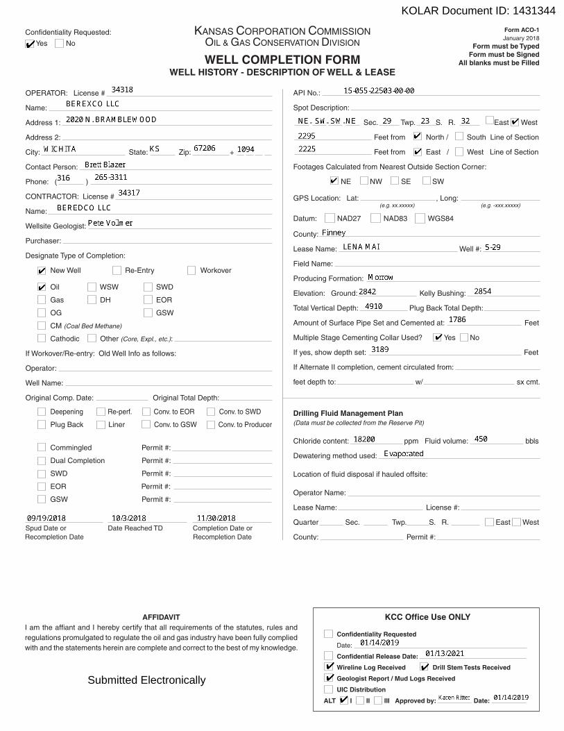
Operator Name: Lease Name: Well #:
Sec. Twp. S. R. East West County:
INSTRUCTIONS: Show important tops of formations penetrated. Detail all cores. Report all final copies of drill stems tests giving interval tested, time tool open and closed, flowing and shut-in pressures, whether shut-in pressure reached static level, hydrostatic pressures, bottom hole temperature, fluid recovery, and flow rates if gas to surface test, along with final chart(s). Attach extra sheet if more space is needed.
Final Radioactivity Log, Final Logs run to obtain Geophysical Data and Final Electric Logs must be emailed to [email protected]. Digital electronic log files must be submitted in LAS version 2.0 or newer AND an image file (TIFF or PDF).
Page Two
Drill Stem Tests Taken Yes No (Attach Additional Sheets)
Samples Sent to Geological Survey Yes No
Cores Taken Yes NoElectric Log Run Yes NoGeologist Report / Mud Logs Yes No
List All E. Logs Run:
Log Formation (Top), Depth and Datum Sample
Name Top Datum
CASING RECORD New UsedReport all strings set-conductor, surface, intermediate, production, etc.
Purpose of String Size HoleDrilled
Size CasingSet (In O.D.)
WeightLbs. / Ft.
SettingDepth
Type of Cement
# SacksUsed
Type and PercentAdditives
ADDITIONAL CEMENTING / SQUEEZE RECORD
Purpose:
Perforate Protect Casing Plug Back TD Plug Off Zone
DepthTop Bottom
Type of Cement # Sacks Used Type and Percent Additives
Shots PerFoot
Acid, Fracture, Shot, Cementing Squeeze Record(Amount and Kind of Material Used)
TUBING RECORD: Set At:Size: Packer At:
Mail to: KCC - Conservation Division, 266 N. Main, Suite 220, Wichita, Kansas 67202
1. Did you perform a hydraulic fracturing treatment on this well? Yes No (If No, skip questions 2 and 3)
2. Does the volume of the total base fluid of the hydraulic fracturing treatment exceed 350,000 gallons? Yes No (If No, skip question 3)
3. Was the hydraulic fracturing treatment information submitted to the chemical disclosure registry? Yes No (If No, fill out Page Three of the ACO-1)
Date of first Production/Injection or Resumed Production/Injection:
Producing Method:
Flowing Pumping Gas Lift Other (Explain)
Estimated ProductionPer 24 Hours
Oil Bbls. Gas Mcf Gas-Oil Ratio Gravity
DISPOSITION OF GAS: METHOD OF COMPLETION: PRODUCTION INTERVAL:
Vented Sold Used on Lease
(If vented, Submit ACO-18.)
Open Hole Perf. Dually Comp. (Submit ACO-5)
Commingled(Submit ACO-4)
Water Bbls.
Top Bottom
PerforationTop
PerforationBottom
Bridge PlugType
Bridge PlugSet At
KOLAR Document ID: 1431344
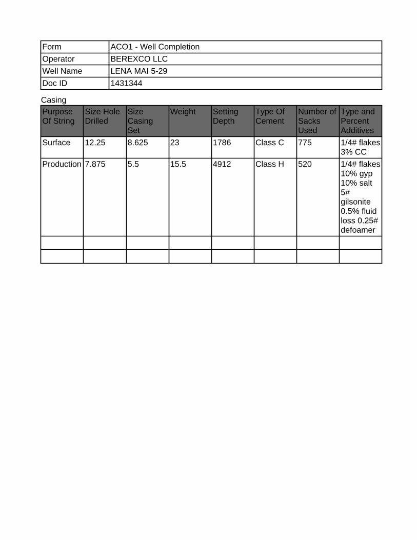
Casing
Form ACO1 - Well Completion
Operator BEREXCO LLC
Well Name LENA MAI 5-29
Doc ID 1431344
Purpose Of String
Size Hole Drilled
Size Casing Set
Weight Setting Depth
Type Of Cement
Number of Sacks Used
Type and Percent Additives
Surface 12.25 8.625 23 1786 Class C 775 1/4# flakes 3% CC
Production 7.875 5.5 15.5 4912 Class H 520 1/4# flakes 10% gyp 10% salt 5# gilsonite 0.5% fluid loss 0.25# defoamer
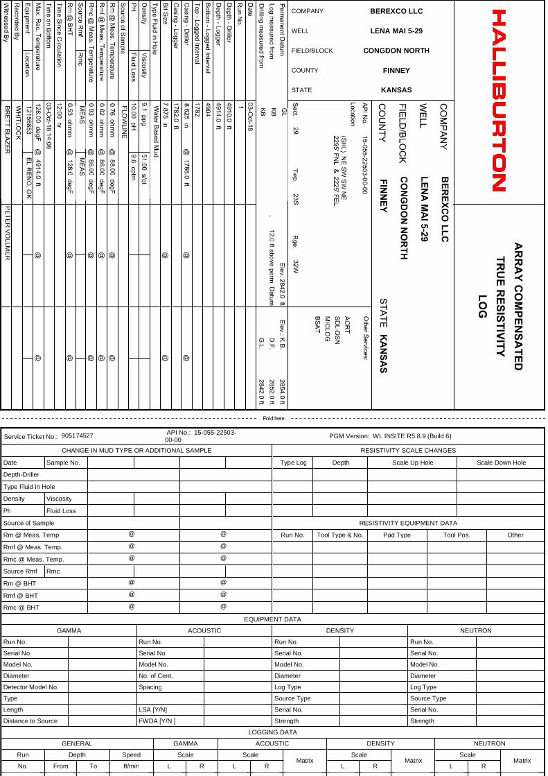
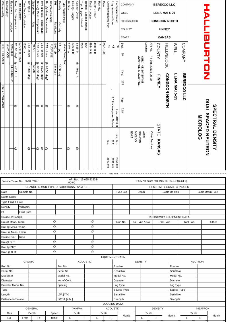
COMPANY BEREXCO LLC
WELL LENA MAI 5-29
FIELD/BLOCK CONGDON NORTH
COUNTY FINNEY
STATE KANSAS
Fold here
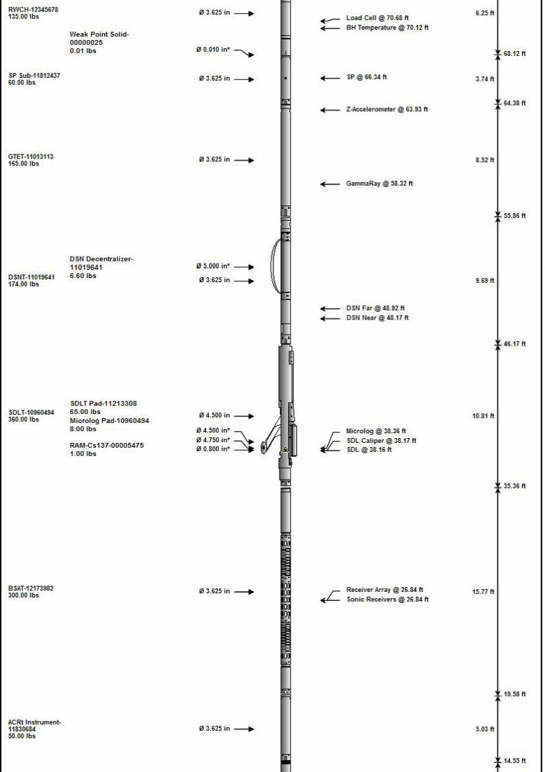
Service Ticket No.: 905174527 API No.: 15-055-22503-00-00 PGM Version: WL INSITE R5.8.9 (Build 6)
CHANGE IN MUD TYPE OR ADDITIONAL SAMPLE
Date Sample No.
Depth-Driller
Type Fluid in Hole
Density Viscosity
Ph Fluid Loss
Source of Sample
Rm @ Meas. Temp @ @
Rmf @ Meas. Temp. @ @
Rmc @ Meas. Temp. @ @
Source Rmf Rmc
Rm @ BHT @ @
Rmf @ BHT @ @
Rmc @ BHT @ @
RESISTIVITY SCALE CHANGES
Type Log Depth Scale Up Hole Scale Down Hole
RESISTIVITY EQUIPMENT DATA
Run No. Tool Type & No. Pad Type Tool Pos. Other
EQUIPMENT DATA
GAMMA ACOUSTIC DENSITY NEUTRON
Run No. Run No. Run No. Run No.
Serial No. Serial No. Serial No. Serial No.
Model No. Model No. Model No. Model No.
Diameter No. of Cent. Diameter Diameter
Detector Model No. Spacing Log Type Log Type
Type Source Type Source Type
Length LSA [Y/N] Serial No. Serial No.
Distance to Source FWDA [Y/N ] Strength Strength
LOGGING DATALOGGING DATA
GENERAL GAMMA ACOUSTIC DENSITY NEUTRON
Run Depth Speed Scale ScaleMatrix
ScaleMatrix
ScaleMatrix
No. From To ft/min L R L R L R L R
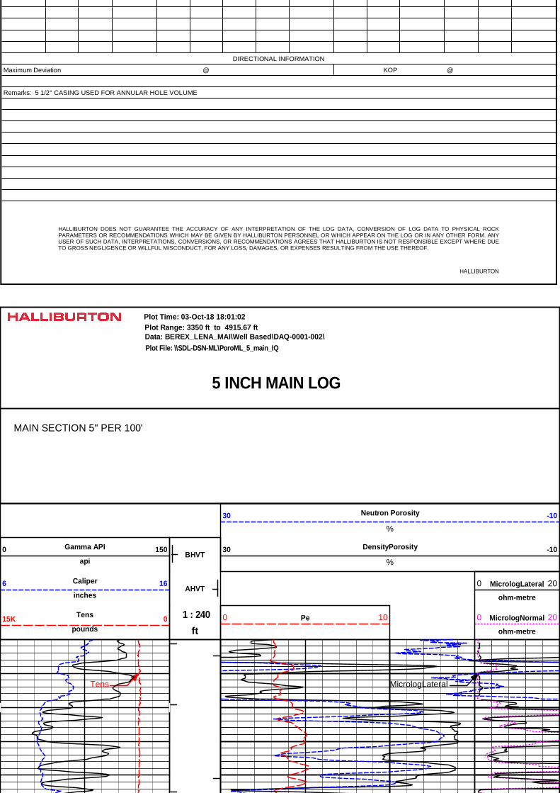
DIRECTIONAL INFORMATION
Maximum Deviation @ KOP @
Remarks: 5 1/2'' CASING USED FOR ANNULAR HOLE VOLUME
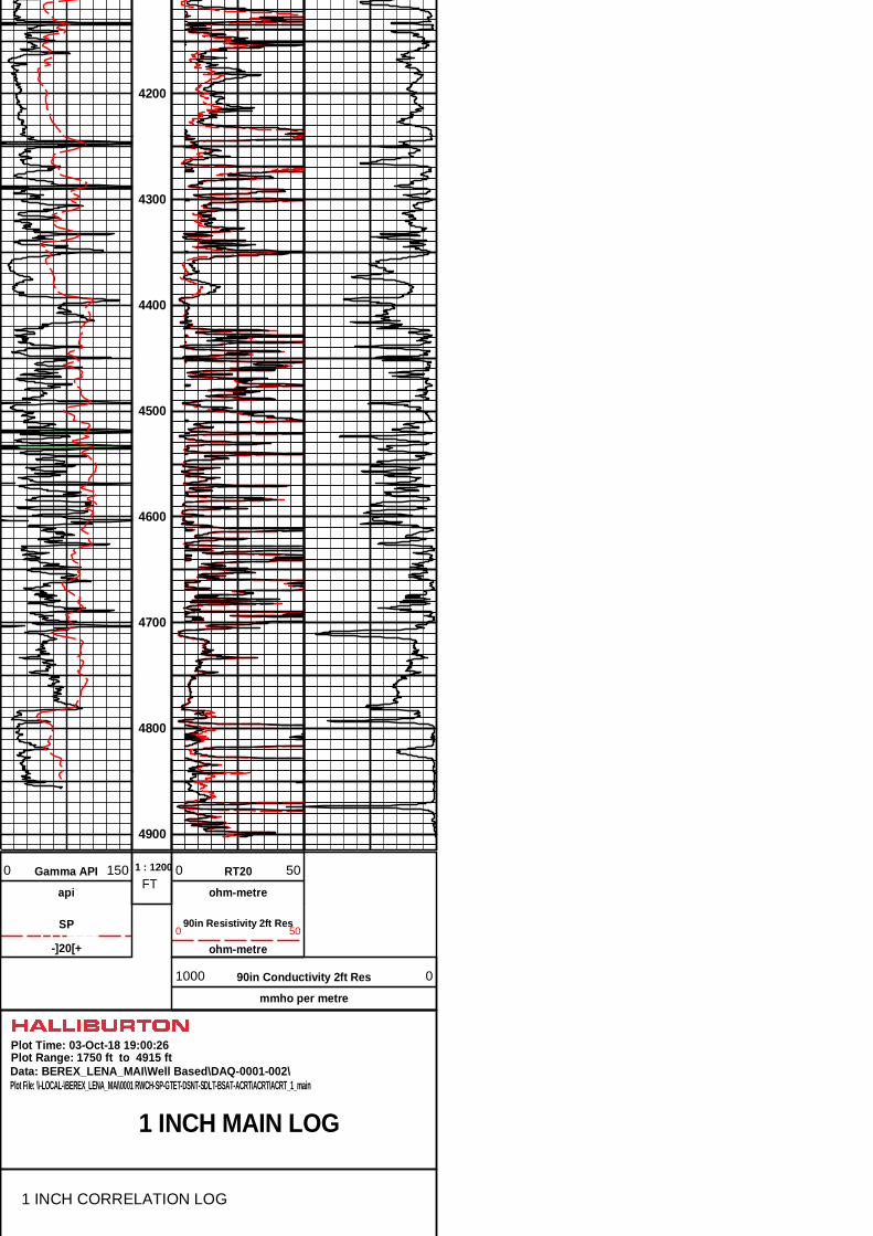
HALLIBURTON DOES NOT GUARANTEE THE ACCURACY OF ANY INTERPRETATION OF THE LOG DATA, CONVERSION OF LOG DATA TO PHYSICAL ROCK PARAMETERS OR RECOMMENDATIONS WHICH MAY BE GIVEN BY HALLIBURTON PERSONNEL OR WHICH APPEAR ON THE LOG OR IN ANY OTHER FORM. ANY USER OF SUCH DATA, INTERPRETATIONS, CONVERSIONS, OR RECOMMENDATIONS AGREES THAT HALLIBURTON IS NOT RESPONSIBLE EXCEPT WHERE DUE TO GROSS NEGLIGENCE OR WILLFUL MISCONDUCT, FOR ANY LOSS, DAMAGES, OR EXPENSES RESULTING FROM THE USE THEREOF.
HALLIBURTON
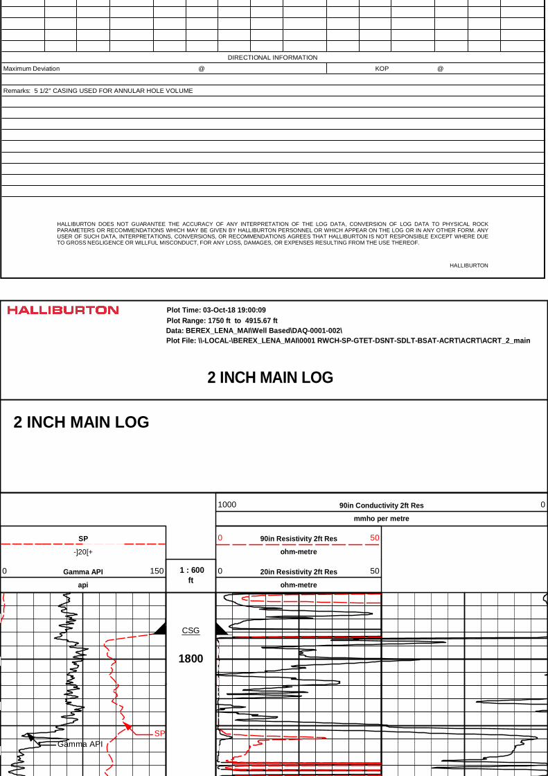
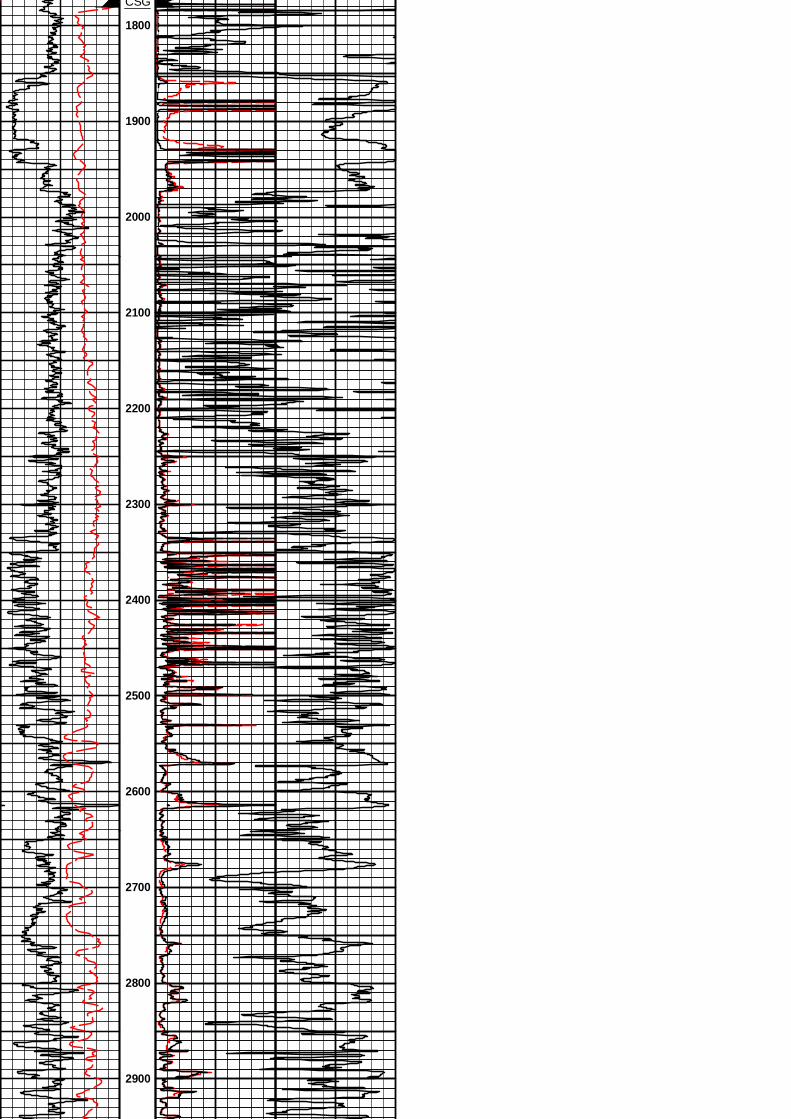
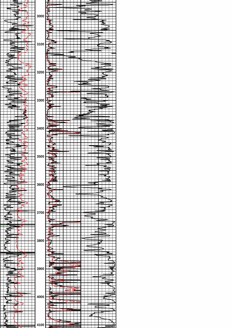
2 INCH MAIN LOG
Data: BEREX_LENA_MAI\Well Based\DAQ-0001-002\Plot Range: 1750 ft to 4915.67 ft
Plot File: \\-LOCAL-\BEREX_LENA_MAI\0001 RWCH-SP-GTET-DSNT-SDLT-BSAT-ACRT\ACRT\ACRT_2_main
Plot Time: 03-Oct-18 19:00:09
2 INCH MAIN LOG
90in Conductivity 2ft Res
mmho per metre
1000 0
-]20[+
SP 90in Resistivity 2ft Res
ohm-metre
0 50
ft 1 : 600Gamma API
api
0 150 20in Resistivity 2ft Res
ohm-metre
0 50
1800
CSG
Gamma APISP
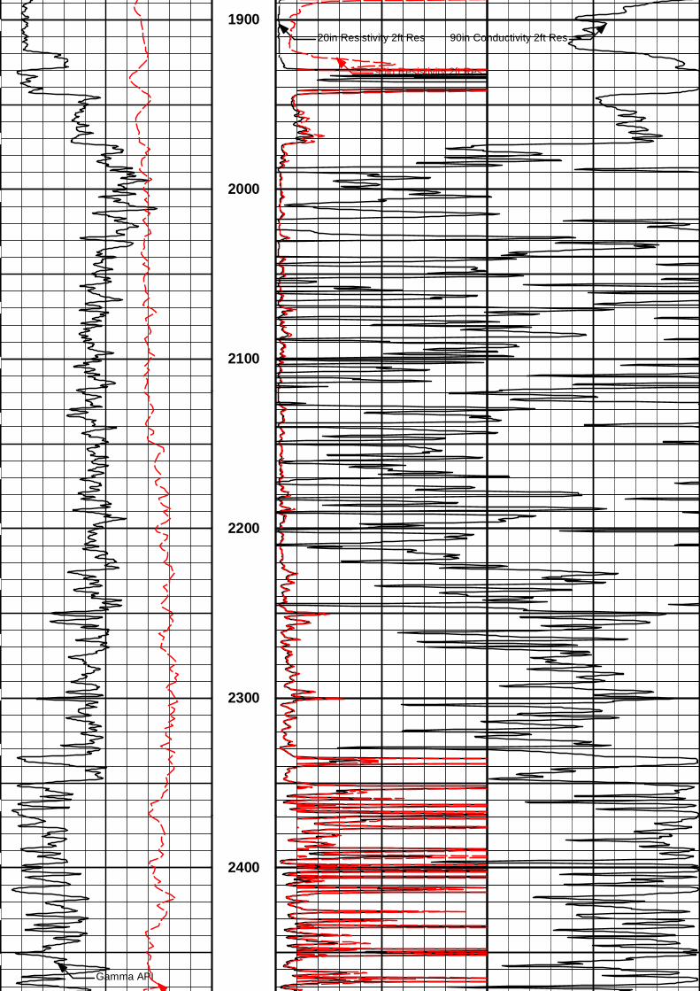
20in Resistivity 2ft Res
90in Resistivity 2ft Res
90in Conductivity 2ft Res1900
2000
2100
2200
2300
Gamma API
2400
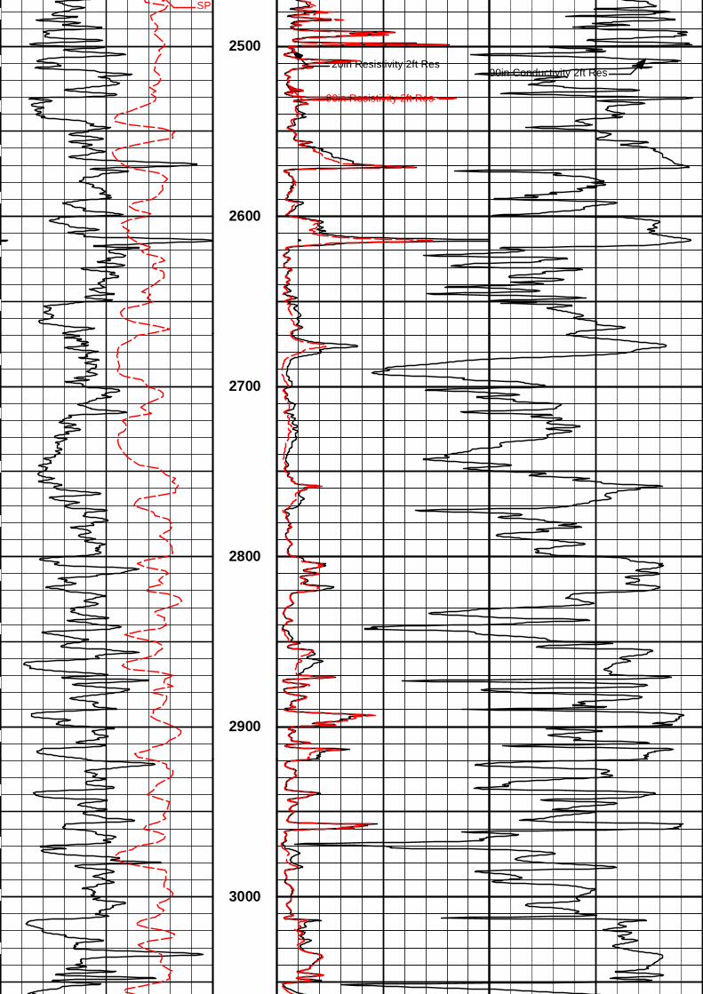
20in Resistivity 2ft Res
90in Resistivity 2ft Res
SP
90in Conductivity 2ft Res
2500
2600
2700
2800
2900
3000
20in Resistivity 2ft Res
90in Resistivity 2ft Res
Gamma API
SP
90in Conductivity 2ft Res
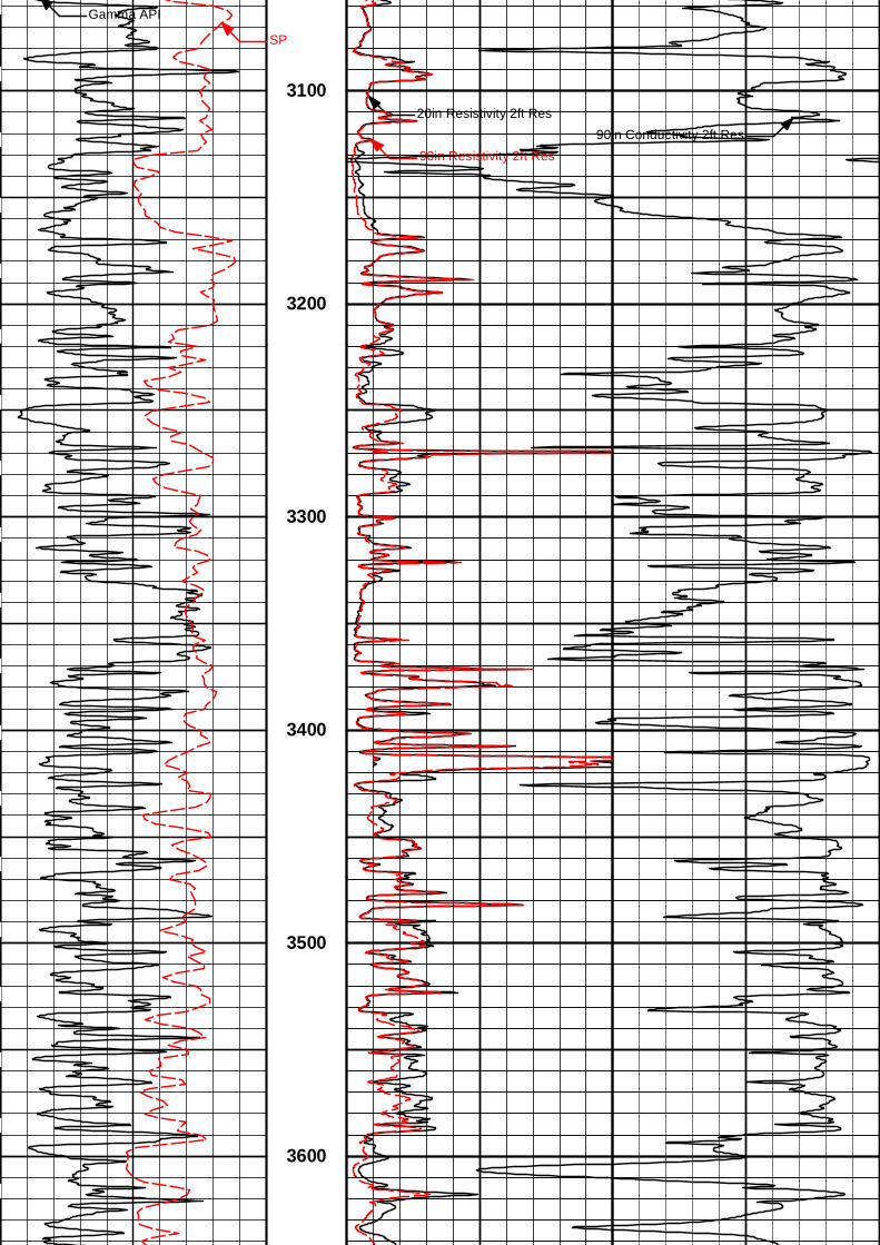
3100
3200
3300
3400
3500
3600
20in Resistivity 2ft Res
90in Resistivity 2ft Res
Gamma API
SP
90in Conductivity 2ft Res
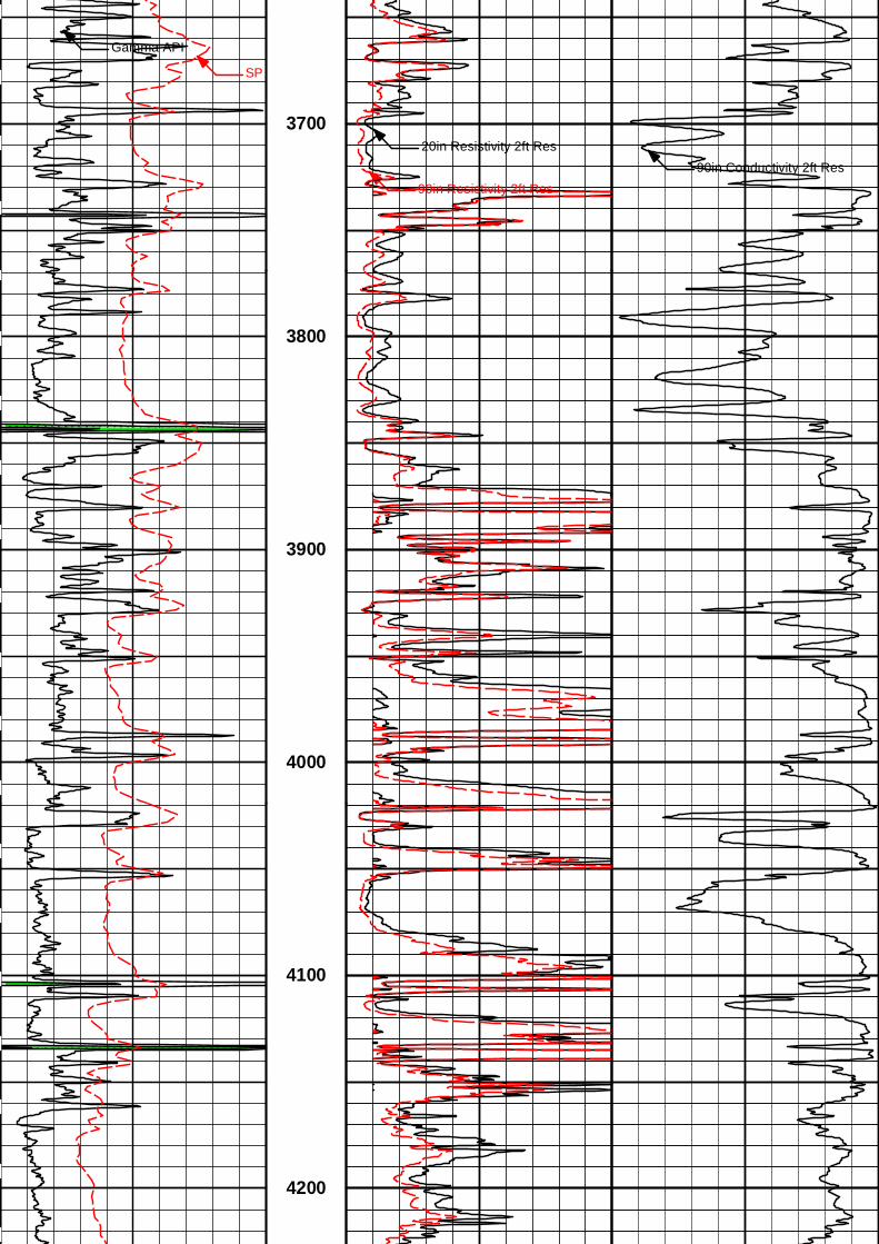
3700
3800
3900
4000
4100
4200
20in Resistivity 2ft Res
Gamma API
SP
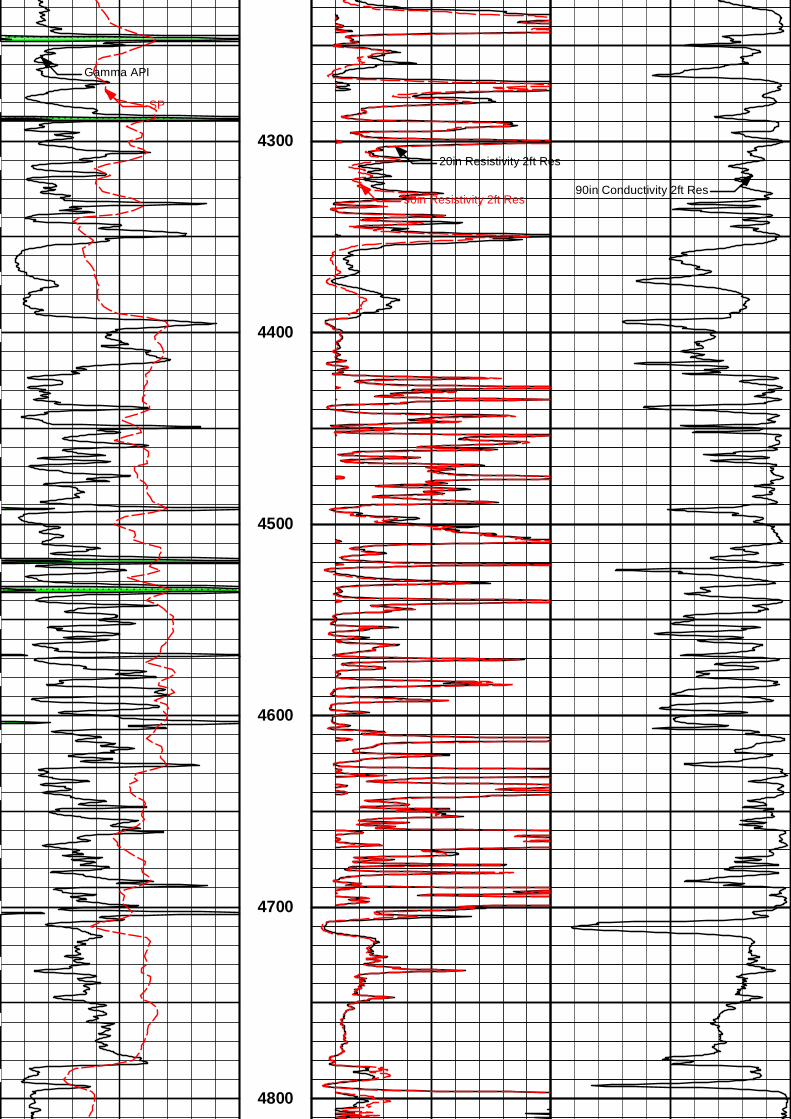
4300
90in Resistivity 2ft Res90in Conductivity 2ft Res
4400
4500
4600
4700
4800
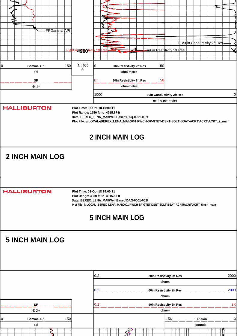
FRGamma API
4900 FR20in Resistivity 2ft ResFR90in Resistivity 2ft Res
FR90in Conductivity 2ft Res
4900
ft 1 : 600Gamma API
api
0 150 20in Resistivity 2ft Res
ohm-metre
0 50
-]20[+
SP 90in Resistivity 2ft Res
ohm-metre
0 50
90in Conductivity 2ft Res
mmho per metre
1000 0
2 INCH MAIN LOG
Data: BEREX_LENA_MAI\Well Based\DAQ-0001-002\Plot Range: 1750 ft to 4915.67 ft
Plot File: \\-LOCAL-\BEREX_LENA_MAI\0001 RWCH-SP-GTET-DSNT-SDLT-BSAT-ACRT\ACRT\ACRT_2_main
Plot Time: 03-Oct-18 19:00:11
2 INCH MAIN LOG
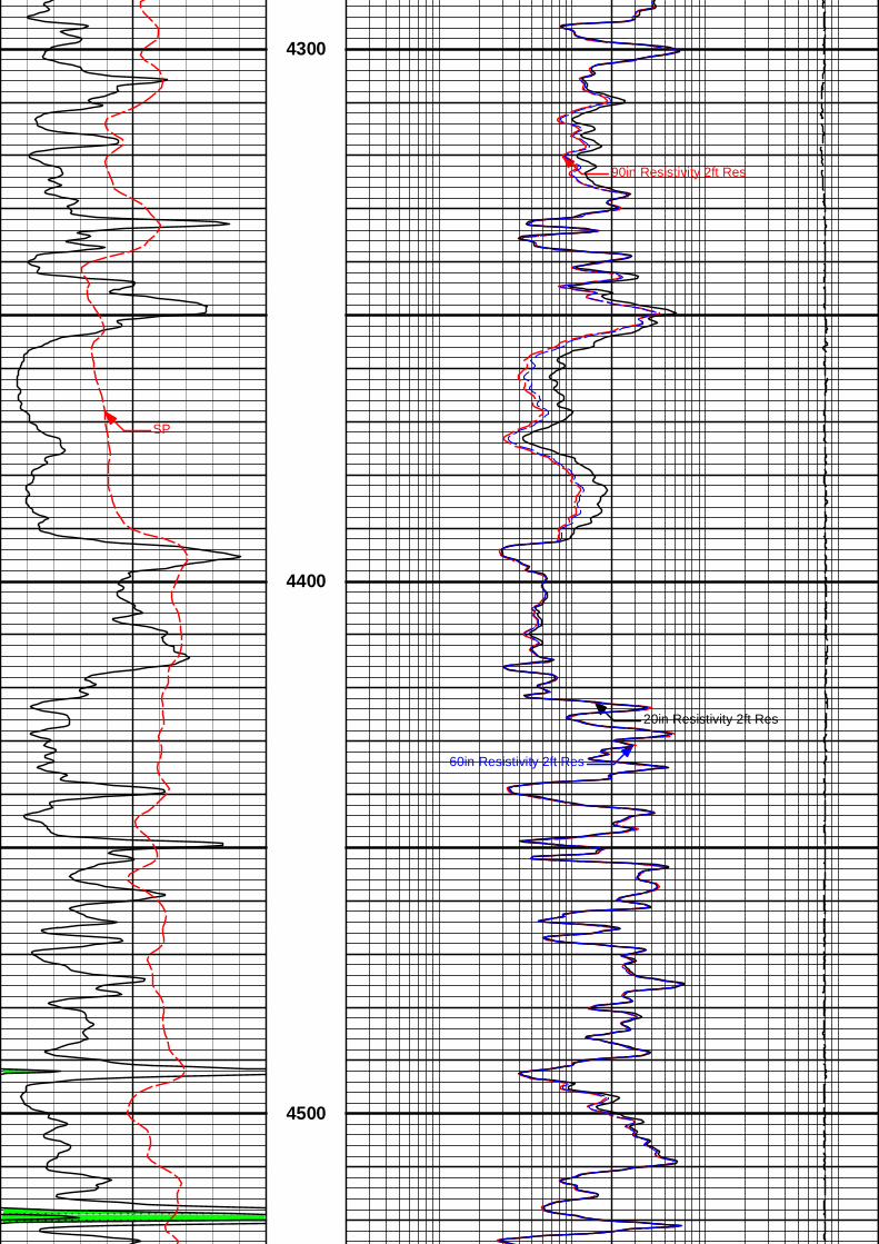
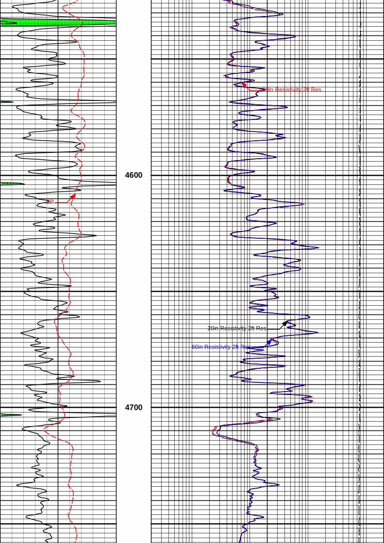
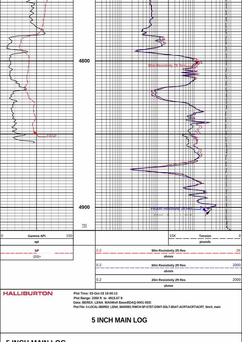
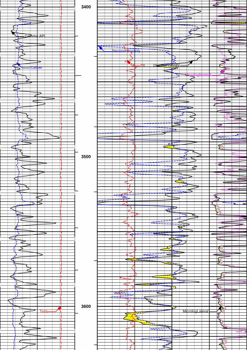
5 INCH MAIN LOG
Data: BEREX_LENA_MAI\Well Based\DAQ-0001-002\Plot Range: 3350 ft to 4915.67 ft
Plot File: \\-LOCAL-\BEREX_LENA_MAI\0001 RWCH-SP-GTET-DSNT-SDLT-BSAT-ACRT\ACRT\ACRT_5inch_main
Plot Time: 03-Oct-18 19:00:11
5 INCH MAIN LOG
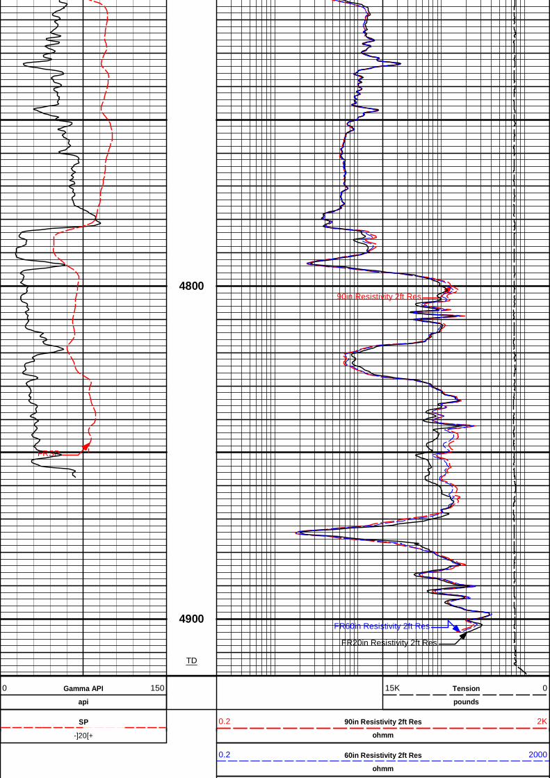
20in Resistivity 2ft Res
ohmm
0.2 2000
60in Resistivity 2ft Res
ohmm
0.2 2000
-]20[+
SP 90in Resistivity 2ft Res
ohmm
0.2 2K
Gamma API
api
0 150 Tension
pounds
15K 0
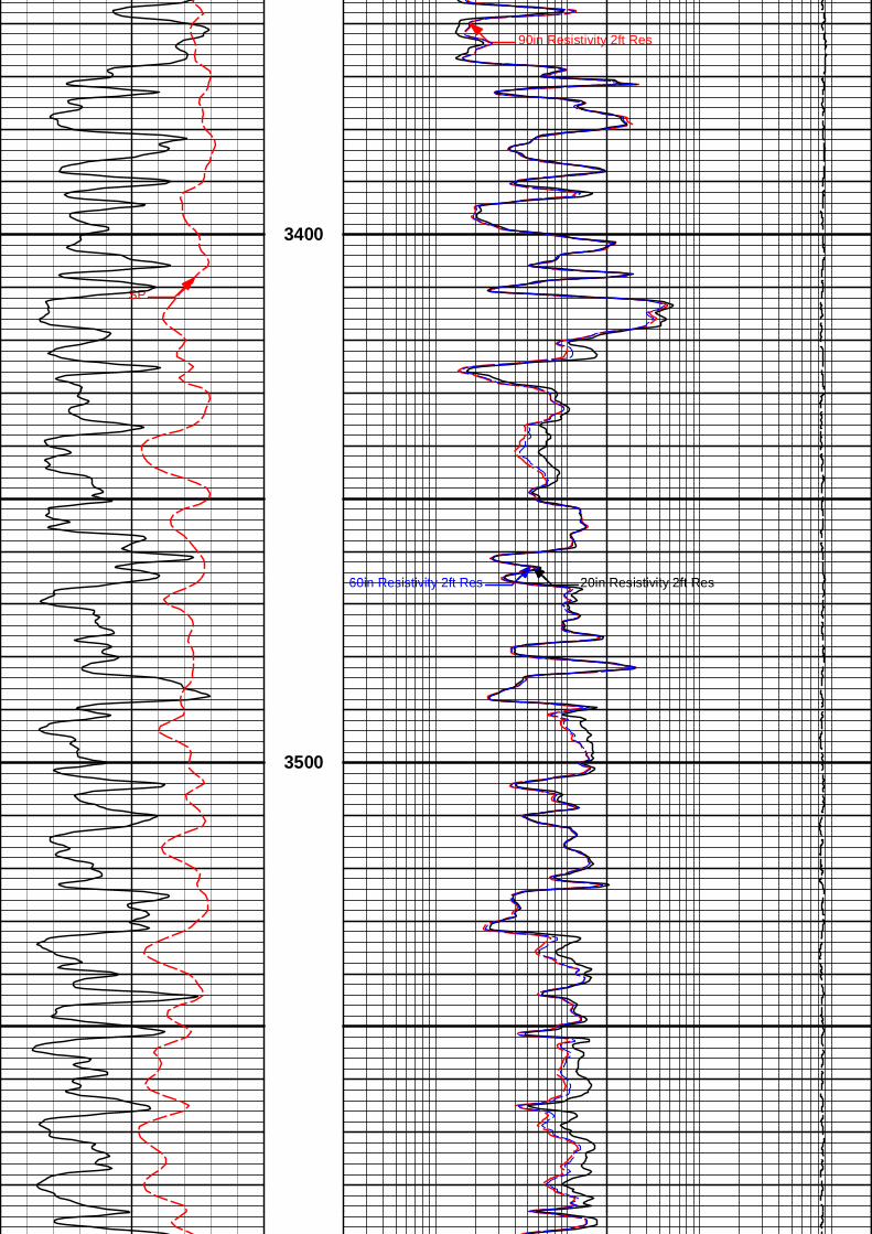
90in Resistivity 2ft Res
20in Resistivity 2ft Res60in Resistivity 2ft Res
SP
3400
20in Resistivity 2ft Res60in Resistivity 2ft Res
3500
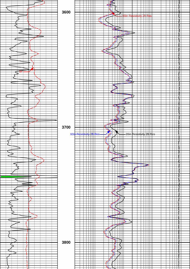
90in Resistivity 2ft Res
SP
3600
20in Resistivity 2ft Res60in Resistivity 2ft Res
3700
3800
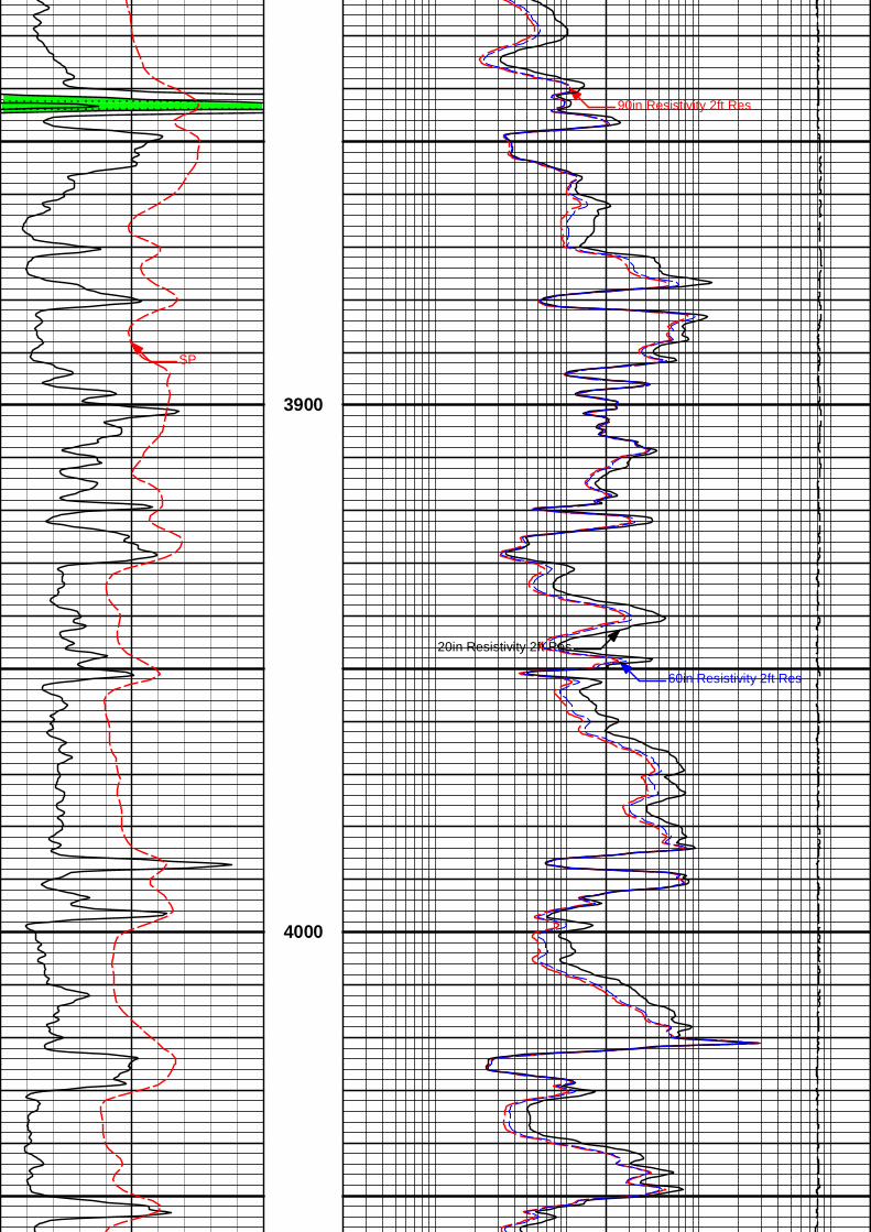
90in Resistivity 2ft Res
SP
3900
20in Resistivity 2ft Res
60in Resistivity 2ft Res
4000
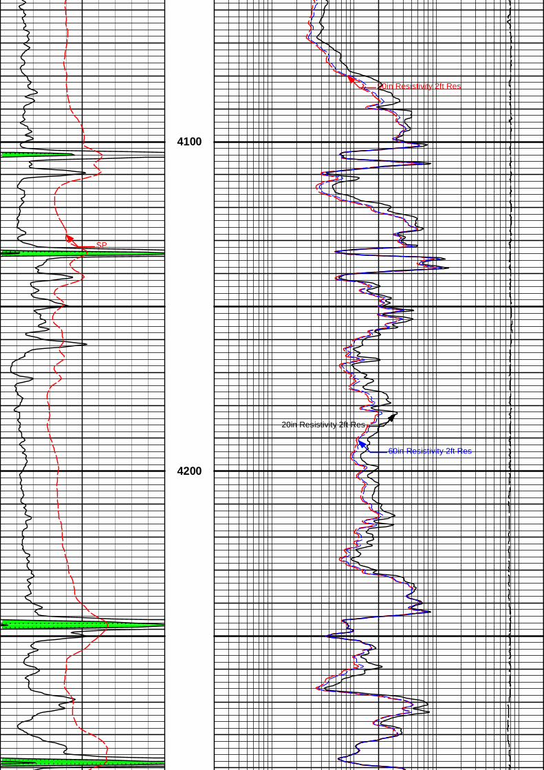
90in Resistivity 2ft Res
4100
20in Resistivity 2ft Res
60in Resistivity 2ft Res
SP
4200
90in Resistivity 2ft Res
4300
20in Resistivity 2ft Res
60in Resistivity 2ft Res
SP
4400
4500
90in Resistivity 2ft Res
20in Resistivity 2ft Res
60in Resistivity 2ft Res
SP
4600
4700
90in Resistivity 2ft Res
FR20in Resistivity 2ft Res
FR60in Resistivity 2ft Res
FRSP
4800
4900
TD
Gamma API
api
0 150 Tension
pounds
15K 0
-]20[+
SP 90in Resistivity 2ft Res
ohmm
0.2 2K
60in Resistivity 2ft Res
ohmm
0.2 2000
20in Resistivity 2ft Res
ohmm
0.2 2000
5 INCH MAIN LOG
Data: BEREX_LENA_MAI\Well Based\DAQ-0001-002\Plot Range: 3350 ft to 4915.67 ft
Plot File: \\-LOCAL-\BEREX_LENA_MAI\0001 RWCH-SP-GTET-DSNT-SDLT-BSAT-ACRT\ACRT\ACRT_5inch_main
Plot Time: 03-Oct-18 19:00:13
5 INCH MAIN LOG
5 INCH MAIN LOG
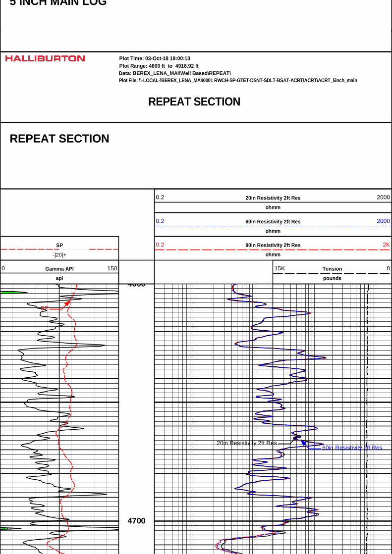
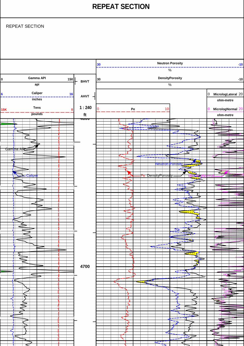
REPEAT SECTION
Data: BEREX_LENA_MAI\Well Based\REPEAT\Plot Range: 4600 ft to 4916.92 ft
Plot File: \\-LOCAL-\BEREX_LENA_MAI\0001 RWCH-SP-GTET-DSNT-SDLT-BSAT-ACRT\ACRT\ACRT_5inch_main
Plot Time: 03-Oct-18 19:00:13
REPEAT SECTION
20in Resistivity 2ft Res
ohmm
0.2 2000
60in Resistivity 2ft Res
ohmm
0.2 2000
-]20[+
SP 90in Resistivity 2ft Res
ohmm
0.2 2K
Gamma API
api
0 150 Tension
pounds
15K 0
20in Resistivity 2ft Res60in Resistivity 2ft Res
SP
4600
4700
90in Resistivity 2ft Res4800
FR20in Resistivity 2ft Res
FR60in Resistivity 2ft Res
FRSP
4900
TD
Gamma API
api
0 150 Tension
pounds
15K 0
SP 90in Resistivity 2ft Res0.2 2K
-]20[+ ohmm
60in Resistivity 2ft Res
ohmm
0.2 2000
20in Resistivity 2ft Res
ohmm
0.2 2000
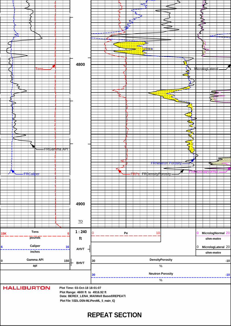
REPEAT SECTION
Data: BEREX_LENA_MAI\Well Based\REPEAT\Plot Range: 4600 ft to 4916.92 ft
Plot File: \\-LOCAL-\BEREX_LENA_MAI\0001 RWCH-SP-GTET-DSNT-SDLT-BSAT-ACRT\ACRT\ACRT_5inch_main
Plot Time: 03-Oct-18 19:00:14
REPEAT SECTION
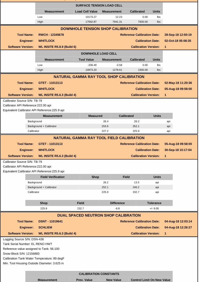
CALIBRATION REPORTSURFACE TENSION SHOP CALIBRATION
Tool Name: Depth Panel - 12345678 Reference Calibration Date: 27-Sep-18 12:42:20
Engineer: SEAN WOLTEMATH Calibration Date: 28-Sep-18 12:48:18
Software Version: WL INSITE R5.8.9 (Build 6) Calibration Version: 1
SURFACE TENSION LOAD CELL
Measurement Load Cell Value Measurement Calibrated UnitsLow 10173.27 12.23 0.00 lbs
High 17562.87 7941.31 7830.00 lbs
DOWNHOLE TENSION SHOP CALIBRATIONTool Name: RWCH - 12345678 Reference Calibration Date: 28-Sep-18 12:50:19
Engineer: WHITLOCK Calibration Date: 02-Oct-18 05:08:35
Software Version: WL INSITE R5.8.9 (Build 6) Calibration Version: 1
DOWNHOLE LOAD CELL
Measurement Tool Value Measurement Calibrated UnitsLow -336.49 -3.58 0.00 lbs
High 10973.20 1278.61 1500.00 lbs
NATURAL GAMMA RAY TOOL SHOP CALIBRATIONTool Name: GTET - 11013113 Reference Calibration Date: 02-May-18 11:20:36
Engineer: WHITLOCK Calibration Date: 05-Aug-18 09:58:00
Software Version: WL INSITE R5.6.3 (Build 4) Calibration Version: 1
Calibrator Source S/N: TB-79Calibrator API Reference:222.00 apiEquivalent Calibrator API Reference:225.9 api
Measurement Measured Calibrated UnitsBackground 26.4 26.2 api
Background + Calibrator 253.6 252.1 api
Calibrator 227.2 225.9 api
NATURAL GAMMA RAY TOOL FIELD CALIBRATIONTool Name: GTET - 11013113 Reference Calibration Date: 05-Aug-18 09:58:00
Engineer: WHITLOCK Calibration Date: 30-Sep-18 10:17:04
Software Version: WL INSITE R5.6.3 (Build 4) Calibration Version: 1
Calibrator Source S/N: TB-79Calibrator API Reference:222.00 apiEquivalent Calibrator API Reference:225.9 api
Field Verification Shop Field UnitsBackground 26.2 13.5 api
Background + Calibrator 252.1 246.2 api
Calibrator 225.9 232.7 api
Shop Field Difference Tolerance225.9 232.7 -6.8 +/- 9.00
DUAL SPACED NEUTRON SHOP CALIBRATIONTool Name: DSNT - 11019641 Reference Calibration Date: 04-Aug-18 12:03:14
Engineer: SCHLIEM Calibration Date: 04-Aug-18 12:26:27
Software Version: WL INSITE R5.6.3 (Build 4) Calibration Version: 1
Logging Source S/N: DSN-436Tank Serial Number: EL RENO HWTReference value assigned to Tank: 56.100Snow Block S/N: 12156883Calibration Tank Water Temperature: 89 degFMin. Tool Housing Outside Diameter: 3.625 in
CALIBRATION CONSTANTS
Measurement Prev. Value New Value Control Limit On New ValueGain: 0.97922 0.97742 0.900 - 1.100
WATER TANK SUMMARY (Horizontal Water Tank)
Measurement Current Reading(Previous Coef.)
Calibrated(New Coef.) Change Control Limit
On ChangePorosity (decp): 0.2364 0.2358 0.0006 +/- 0.0020
Calibrated Ratio: 10.5794 10.5599 0.019 +/- 0.050
VERIFIER
Measurement Value Control LimitSnow-Block Porosity (decp): 0.0667 0.02000 - 0.09000
PASS/FAIL SUMMARYBackground Check: Passed
Gain-Range Check: Passed
Snow-Block Check: Passed
DUAL SPACED NEUTRON FIELD CALIBRATIONTool Name: DSNT - 11019641 Reference Calibration Date: 04-Aug-18 12:26:27
Engineer: WHITLOCK Calibration Date: 30-Sep-18 09:21:36
Software Version: WL INSITE R5.6.3 (Build 4) Calibration Version: 1Software Version: WL INSITE R5.6.3 (Build 4) Calibration Version: 1
Logging Source S/N: DSN-436Snow Block S/N: 12156883
NEUTRON FIELD-CHECK SUMMARY
Shop Field Difference Control LimitOn Change
Snow-Block Porosity (decp): 0.0667 0.0665 -0.0002 +/- 0.0150
PASS/FAIL SUMMARYBlock Change Check: Passed
Snow Block Stat Check: Passed
Snow Block Stat Check: Passed
Temperature Check: Passed
DENSITY CALIPER SHOP CALIBRATIONTool Name: SDLT - 10960494 Reference Calibration Date: 01-Jan-70 00:00:00
Engineer: WHITLOCK Calibration Date: 08-Jun-18 16:19:27
Software Version: WL INSITE R5.6.3 (Build 4) Calibration Version: 1
Host Tool Name: DSNT - 11019641
CALIBRATION COEFFICIENTS
Measurement Previous Value New Value Control Limit On New Value
Pad Offset -3977.11 -3977.11 -7000.00 - -1000.00
Pad Gain 0.0003897 0.0003897 0.0002000 - 0.0006000
Arm Offset -3073.13 -3073.13 -5000.00 - 3000.00
Arm Gain 0.0005210 0.0005210 0.000300 - 0.000700
Arm Power -0.000005094 -0.000005094 -0.000010000 - 0.000010000
The ring diameter is computed from: DIAMETER = PAD EXTENSION + ARM EXTENSION + TOOL DIAMETERTool Diameter: 4.50 in
CALIBRATION RINGS
Measurement Current Reading(Previous Coeff.)
Calibrated(New Coeff.) Change Control Limit On
New ValuePAD EXTENSION:
Small Ring (in) 2.00 2.00 0.00 +/- 0.20
Medium Ring (in) 3.75 3.75 0.00 +/- 0.20
RING DIAMETER:
Small Ring (in) 6.50 6.50 0.00 +/- 0.20
Medium Ring (in) 8.25 8.25 0.00 +/- 0.20Large Ring (in) 15.00 15.00 0.00 +/- 0.20
PASS/FAIL SUMMARY
Calibration-Coefficients Range Check: Passed
Ring-Measurement Check: Passed
PASS/FAIL SUMMARYCalibration-Coefficients Range Check: Passed
SDLT CALIPER FIELD CALIBRATIONTool Name: SDLT - 10960494 Reference Calibration Date: 08-Jun-18 16:19:27
Engineer: WHITLOCK Calibration Date: 30-Sep-18 09:40:30
Software Version: WL INSITE R5.6.3 (Build 4) Calibration Version: 1
MEASURED CALIPER VALUES
Measurement Shop Field Change Control Limit OnNew Value
Pad Extension 3.75 3.79 0.04 +/- 0.10
Ring Diameter 8.25 8.25 -0.00 +/- 0.15Ring Diameter 8.25 8.25 -0.00 +/- 0.15
PASS/FAIL SUMMARYPad Extension Check: Passed
Diameter Check: Passed
ARRAY COMPENSATED TRUE RESISTIVITY SHOP CALIBRATIONTool Name: ACRt Sonde - 11830728 Reference Calibration Date: 23-Feb-18 10:15:37
Engineer: WHITLOCK Calibration Date: 06-Jun-18 13:24:46
Software Version: WL INSITE R5.6.3 (Build 4) Calibration Version: 1
Host Tool Name: ACRt Instrument - 11830684
TYPICAL GAIN RANGE
Subarray R12KHz R36KHz R72KHz
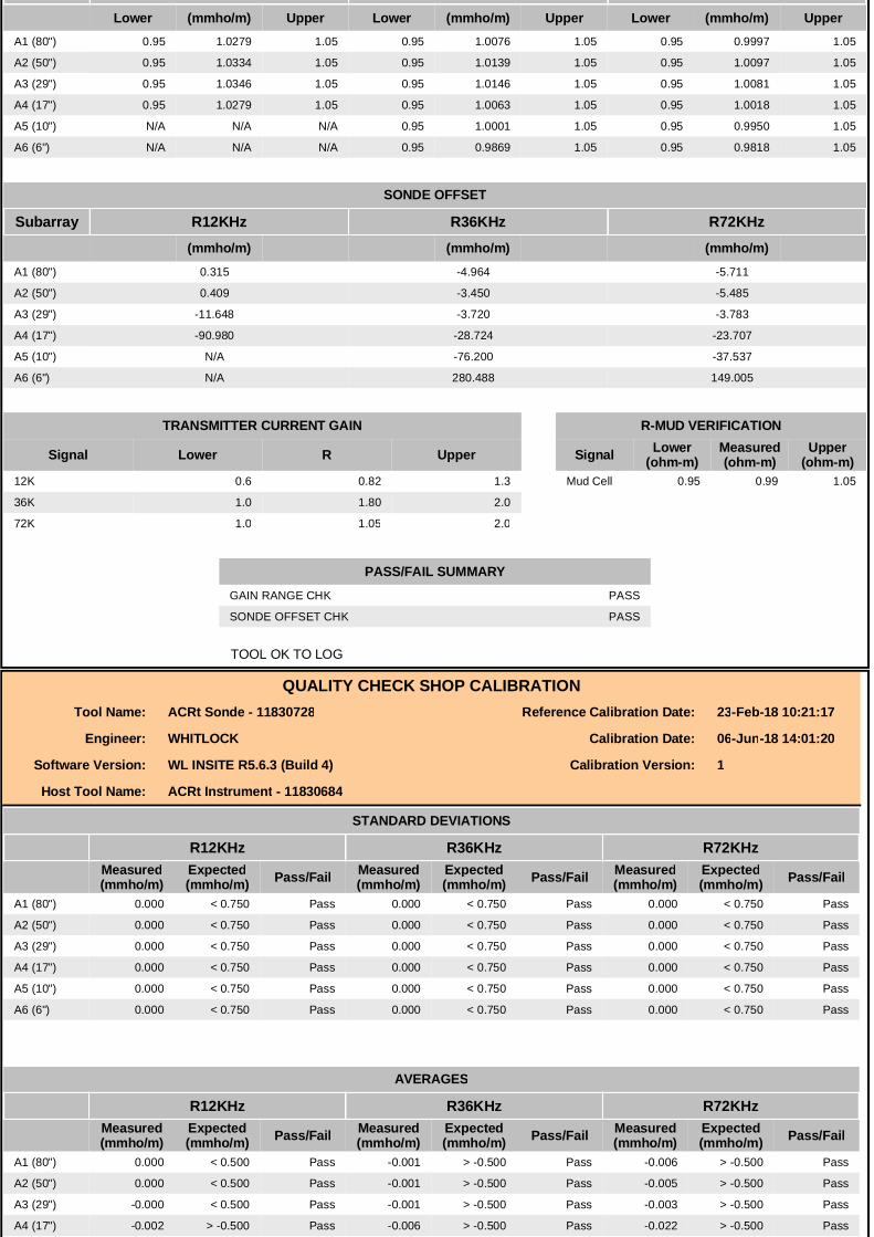
Lower (mmho/m) Upper Lower (mmho/m) Upper Lower (mmho/m) UpperA1 (80") 0.95 1.0279 1.05 0.95 1.0076 1.05 0.95 0.9997 1.05
A2 (50") 0.95 1.0334 1.05 0.95 1.0139 1.05 0.95 1.0097 1.05
A3 (29") 0.95 1.0346 1.05 0.95 1.0146 1.05 0.95 1.0081 1.05
A4 (17") 0.95 1.0279 1.05 0.95 1.0063 1.05 0.95 1.0018 1.05
A5 (10") N/A N/A N/A 0.95 1.0001 1.05 0.95 0.9950 1.05
A6 (6") N/A N/A N/A 0.95 0.9869 1.05 0.95 0.9818 1.05
SONDE OFFSET
Subarray R12KHz R36KHz R72KHz(mmho/m) (mmho/m) (mmho/m)
A1 (80") 0.315 -4.964 -5.711
A2 (50") 0.409 -3.450 -5.485
A3 (29") -11.648 -3.720 -3.783
A4 (17") -90.980 -28.724 -23.707
A5 (10") N/A -76.200 -37.537
A6 (6") N/A 280.488 149.005
TRANSMITTER CURRENT GAIN R-MUD VERIFICATION
Signal Lower R Upper Signal Lower(ohm-m)
Measured(ohm-m)
Upper(ohm-m)
12K 0.6 0.82 1.3 Mud Cell 0.95 0.99 1.05
36K 1.0 1.80 2.0
72K 1.0 1.05 2.0
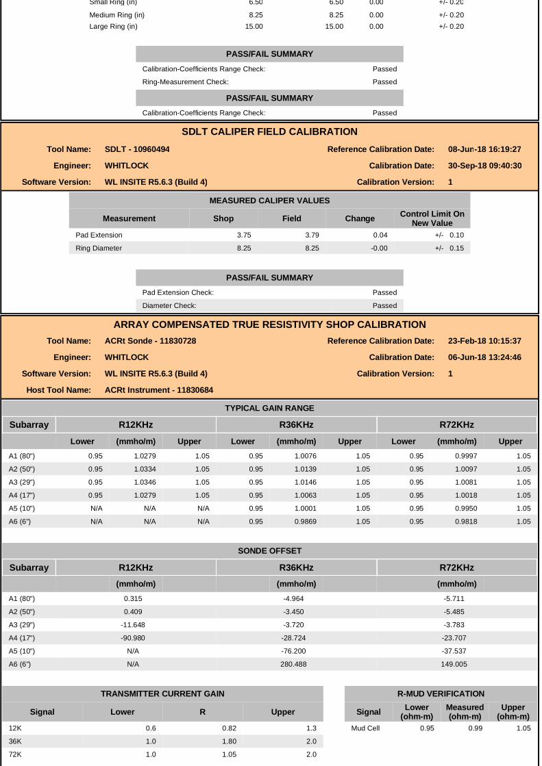
PASS/FAIL SUMMARYGAIN RANGE CHK PASS
SONDE OFFSET CHK PASS
TOOL OK TO LOG
QUALITY CHECK SHOP CALIBRATIONTool Name: ACRt Sonde - 11830728 Reference Calibration Date: 23-Feb-18 10:21:17
Engineer: WHITLOCK Calibration Date: 06-Jun-18 14:01:20
Software Version: WL INSITE R5.6.3 (Build 4) Calibration Version: 1
Host Tool Name: ACRt Instrument - 11830684
STANDARD DEVIATIONS
R12KHz R36KHz R72KHzMeasured Expected Measured Expected Measured ExpectedMeasured(mmho/m)
Expected(mmho/m) Pass/Fail Measured
(mmho/m)Expected(mmho/m) Pass/Fail Measured
(mmho/m)Expected(mmho/m) Pass/Fail
A1 (80") 0.000 < 0.750 Pass 0.000 < 0.750 Pass 0.000 < 0.750 Pass
A2 (50") 0.000 < 0.750 Pass 0.000 < 0.750 Pass 0.000 < 0.750 Pass
A3 (29") 0.000 < 0.750 Pass 0.000 < 0.750 Pass 0.000 < 0.750 Pass
A4 (17") 0.000 < 0.750 Pass 0.000 < 0.750 Pass 0.000 < 0.750 Pass
A5 (10") 0.000 < 0.750 Pass 0.000 < 0.750 Pass 0.000 < 0.750 Pass
A6 (6") 0.000 < 0.750 Pass 0.000 < 0.750 Pass 0.000 < 0.750 Pass
AVERAGES
R12KHz R36KHz R72KHzMeasured(mmho/m)
Expected(mmho/m) Pass/Fail Measured
(mmho/m)Expected(mmho/m) Pass/Fail Measured
(mmho/m)Expected(mmho/m) Pass/Fail
A1 (80") 0.000 < 0.500 Pass -0.001 > -0.500 Pass -0.006 > -0.500 Pass
A2 (50") 0.000 < 0.500 Pass -0.001 > -0.500 Pass -0.005 > -0.500 Pass
A3 (29") -0.000 < 0.500 Pass -0.001 > -0.500 Pass -0.003 > -0.500 Pass
A4 (17") -0.002 > -0.500 Pass -0.006 > -0.500 Pass -0.022 > -0.500 Pass
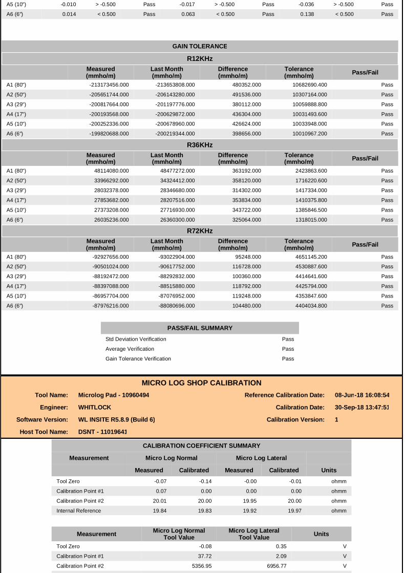
A5 (10") -0.010 > -0.500 Pass -0.017 > -0.500 Pass -0.036 > -0.500 Pass
A6 (6") 0.014 < 0.500 Pass 0.063 < 0.500 Pass 0.138 < 0.500 Pass
GAIN TOLERANCE
R12KHzMeasured(mmho/m)
Last Month(mmho/m)
Difference(mmho/m)
Tolerance(mmho/m) Pass/Fail
A1 (80") -213173456.000 -213653808.000 480352.000 10682690.400 Pass
A2 (50") -205651744.000 -206143280.000 491536.000 10307164.000 Pass
A3 (29") -200817664.000 -201197776.000 380112.000 10059888.800 Pass
A4 (17") -200193568.000 -200629872.000 436304.000 10031493.600 Pass
A5 (10") -200252336.000 -200678960.000 426624.000 10033948.000 Pass
A6 (6") -199820688.000 -200219344.000 398656.000 10010967.200 Pass
R36KHzMeasured(mmho/m)
Last Month(mmho/m)
Difference(mmho/m)
Tolerance(mmho/m) Pass/Fail
A1 (80") 48114080.000 48477272.000 363192.000 2423863.600 Pass
A2 (50") 33966292.000 34324412.000 358120.000 1716220.600 Pass
A3 (29") 28032378.000 28346680.000 314302.000 1417334.000 Pass
A4 (17") 27853682.000 28207516.000 353834.000 1410375.800 Pass
A5 (10") 27373208.000 27716930.000 343722.000 1385846.500 Pass
A6 (6") 26035236.000 26360300.000 325064.000 1318015.000 Pass
R72KHzMeasured(mmho/m)
Last Month(mmho/m)
Difference(mmho/m)
Tolerance(mmho/m) Pass/Fail
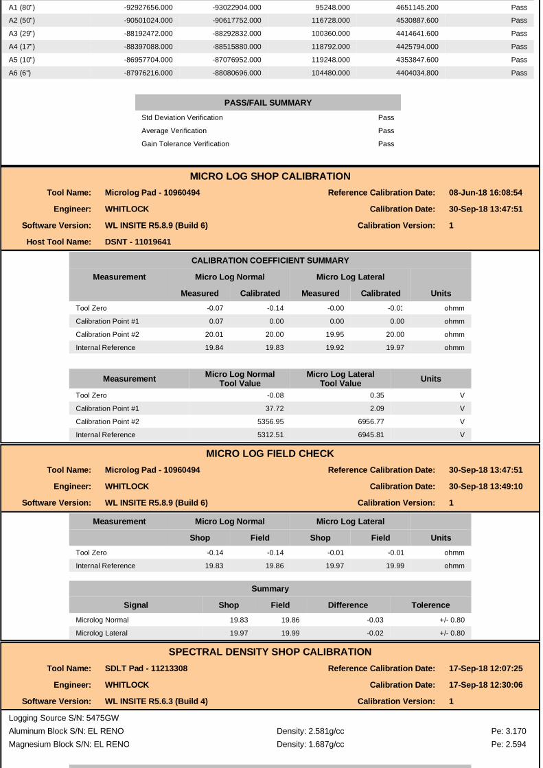
A1 (80") -92927656.000 -93022904.000 95248.000 4651145.200 Pass
A2 (50") -90501024.000 -90617752.000 116728.000 4530887.600 Pass
A3 (29") -88192472.000 -88292832.000 100360.000 4414641.600 Pass
A4 (17") -88397088.000 -88515880.000 118792.000 4425794.000 Pass
A5 (10") -86957704.000 -87076952.000 119248.000 4353847.600 Pass
A6 (6") -87976216.000 -88080696.000 104480.000 4404034.800 Pass
PASS/FAIL SUMMARYStd Deviation Verification Pass
Average Verification Pass
Gain Tolerance Verification Pass
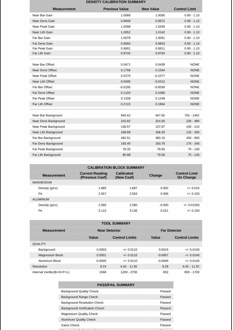
MICRO LOG SHOP CALIBRATIONTool Name: Microlog Pad - 10960494 Reference Calibration Date: 08-Jun-18 16:08:54
Engineer: WHITLOCK Calibration Date: 30-Sep-18 13:47:51
Software Version: WL INSITE R5.8.9 (Build 6) Calibration Version: 1
Host Tool Name: DSNT - 11019641
CALIBRATION COEFFICIENT SUMMARY
Measurement Micro Log Normal Micro Log Lateral
Measured Calibrated Measured Calibrated UnitsTool Zero -0.07 -0.14 -0.00 -0.01 ohmm
Calibration Point #1 0.07 0.00 0.00 0.00 ohmm
Calibration Point #2 20.01 20.00 19.95 20.00 ohmm
Internal Reference 19.84 19.83 19.92 19.97 ohmm
Measurement Micro Log NormalTool Value
Micro Log LateralTool Value Units
Tool Zero -0.08 0.35 V
Calibration Point #1 37.72 2.09 V
Calibration Point #2 5356.95 6956.77 V
Internal Reference 5312.51 6945.81 V
Internal Reference 5312.51 6945.81 V
MICRO LOG FIELD CHECKTool Name: Microlog Pad - 10960494 Reference Calibration Date: 30-Sep-18 13:47:51
Engineer: WHITLOCK Calibration Date: 30-Sep-18 13:49:10
Software Version: WL INSITE R5.8.9 (Build 6) Calibration Version: 1
Measurement Micro Log Normal Micro Log Lateral
Shop Field Shop Field UnitsTool Zero -0.14 -0.14 -0.01 -0.01 ohmm
Internal Reference 19.83 19.86 19.97 19.99 ohmm
Summary
Signal Shop Field Difference TolerenceMicrolog Normal 19.83 19.86 -0.03 +/- 0.80
Microlog Lateral 19.97 19.99 -0.02 +/- 0.80
SPECTRAL DENSITY SHOP CALIBRATIONTool Name: SDLT Pad - 11213308 Reference Calibration Date: 17-Sep-18 12:07:25
Engineer: WHITLOCK Calibration Date: 17-Sep-18 12:30:06
Software Version: WL INSITE R5.6.3 (Build 4) Calibration Version: 1
Logging Source S/N: 5475GWAluminum Block S/N: EL RENO Density: 2.581g/cc Pe: 3.170Magnesium Block S/N: EL RENO Density: 1.687g/cc Pe: 2.594
DENSITY CALIBRATION SUMMARY
Measurement Previous Value New Value Control LimitNear Bar Gain 1.0089 1.0095 0.90 - 1.10
Near Dens Gain 0.9949 0.9972 0.90 - 1.10
Near Peak Gain 1.0098 1.0259 0.90 - 1.10
Near Lith Gain 1.0052 1.0142 0.90 - 1.10
Far Bar Gain 1.0078 1.0061 0.90 - 1.10
Far Dens Gain 0.9950 0.9953 0.90 - 1.10Far Peak Gain 0.9901 0.9911 0.90 - 1.10Far Peak Gain 0.9901 0.9911 0.90 - 1.10Far Lith Gain 0.9745 0.9764 0.90 - 1.10
Near Bar Offset 0.0471 0.0438 NONE
Near Dens Offset 0.1758 0.1544 NONE
Near Peak Offset 0.0270 -0.1077 NONE
Near Lith Offset 0.0345 -0.0412 NONE
Far Bar Offset -0.0195 -0.0036 NONE
Far Dens Offset 0.1103 0.1086 NONE
Far Peak Offset 0.1339 0.1248 NONE
Far Lith Offset 0.2115 0.1964 NONE
Near Bar Background 945.62 947.60 700 - 1450
Near Dens Background 315.82 314.50 230 - 480
Near Peak Background 136.57 137.87 100 - 210
Near Lith Background 168.89 168.30 125 - 260
Far Bar Background 482.51 480.15 450 - 900
Far Dens Background 193.40 193.79 175 - 345
Far Peak Background 78.35 78.65 70 - 140
Far Lith Background 80.88 79.56 75 - 145
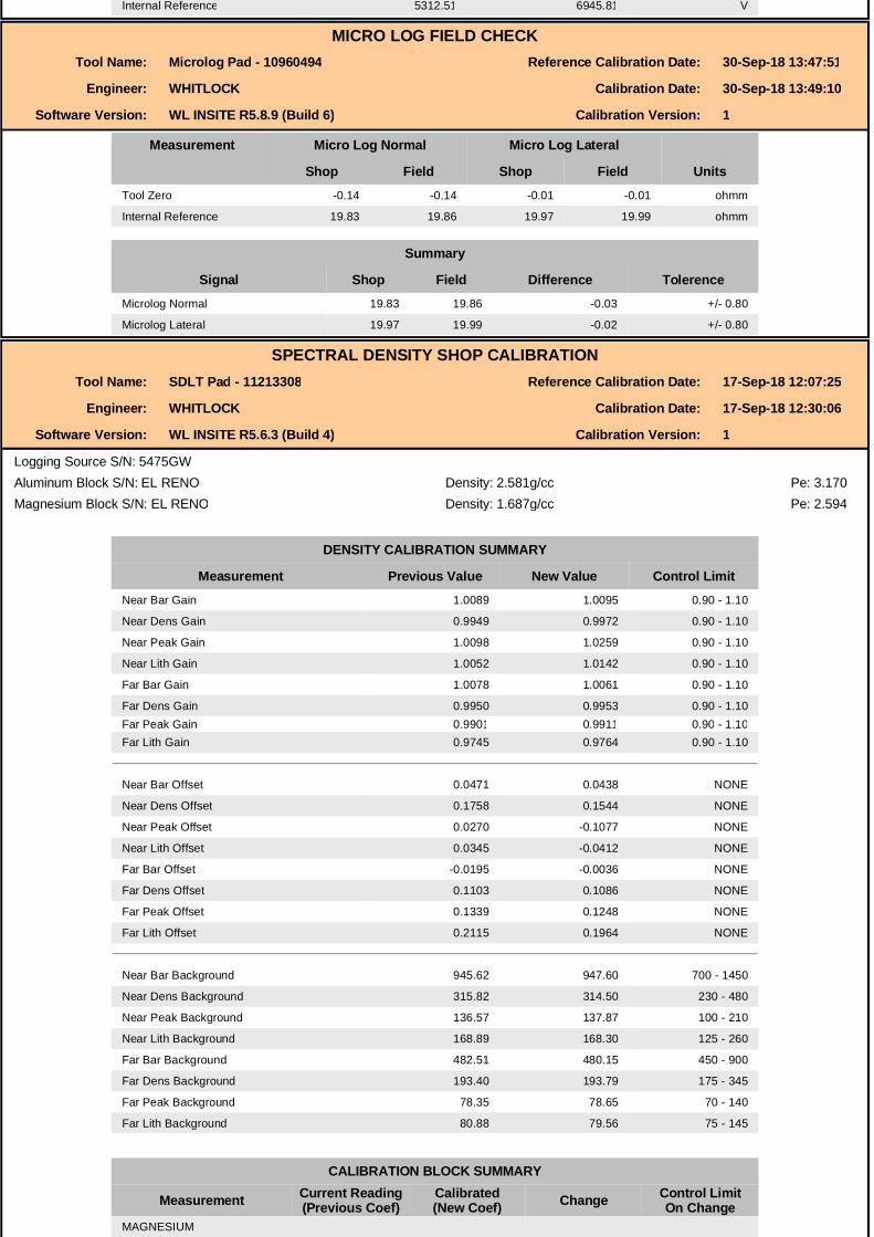
CALIBRATION BLOCK SUMMARY
Measurement Current Reading(Previous Coef)
Calibrated(New Coef) Change Control Limit
On ChangeMAGNESIUM
Density (g/cc) 1.685 1.687 0.002 +/- 0.015
Pe 2.557 2.563 0.006 +/- 0.150
ALUMINUM
Density (g/cc) 2.580 2.580 -0.000 +/- 0.01500
Pe 3.115 3.136 0.021 +/- 0.150
TOOL SUMMARY
Measurement Near Detector Far Detector
Value Control Limits Value Control Limits
QUALITY
Background 0.0003 +/- 0.0110 0.0015 +/- 0.0140
Magnesium Block 0.0001 +/- 0.0110 -0.0007 +/- 0.0140
Aluminum Block -0.0000 +/- 0.0110 -0.0006 +/- 0.0140
Resolution 9.24 6.00 - 11.50 9.28 6.00 - 11.50
Internal Verifier(B+D+P+L) 1568 1200 - 2700 832 800 - 1700
PASS/FAIL SUMMARYBackground Quality Check: Passed
Background Range Check: Passed
Background Resolution Check: Passed
Background Verification Check: Passed
Magnesium Quality Check: Passed
Aluminum Quality Check: Passed
Gains Check: Passed
Changes in Calibration Blocks: Passed
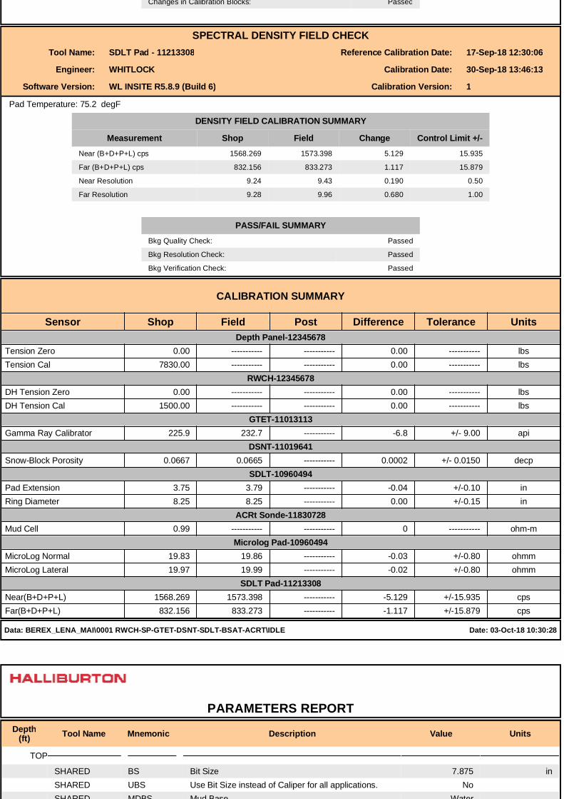
SPECTRAL DENSITY FIELD CHECKTool Name: SDLT Pad - 11213308 Reference Calibration Date: 17-Sep-18 12:30:06
Engineer: WHITLOCK Calibration Date: 30-Sep-18 13:46:13Engineer: WHITLOCK Calibration Date: 30-Sep-18 13:46:13
Software Version: WL INSITE R5.8.9 (Build 6) Calibration Version: 1
Pad Temperature: 75.2 degF
DENSITY FIELD CALIBRATION SUMMARY
Measurement Shop Field Change Control Limit +/-Near (B+D+P+L) cps 1568.269 1573.398 5.129 15.935
Far (B+D+P+L) cps 832.156 833.273 1.117 15.879
Near Resolution 9.24 9.43 0.190 0.50
Far Resolution 9.28 9.96 0.680 1.00
PASS/FAIL SUMMARYBkg Quality Check: Passed
Bkg Resolution Check: Passed
Bkg Verification Check: Passed
CALIBRATION SUMMARY
Sensor Shop Field Post Difference Tolerance Units Depth Panel-12345678
Tension Zero 0.00 ----------- ----------- 0.00 ----------- lbsTension Cal 7830.00 ----------- ----------- 0.00 ----------- lbs
RWCH-12345678 DH Tension Zero 0.00 ----------- ----------- 0.00 ----------- lbsDH Tension Cal 1500.00 ----------- ----------- 0.00 ----------- lbs
GTET-11013113 Gamma Ray Calibrator 225.9 232.7 ----------- -6.8 +/- 9.00 api
DSNT-11019641
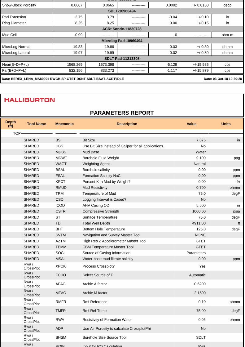
DSNT-11019641 Snow-Block Porosity 0.0667 0.0665 ----------- 0.0002 +/- 0.0150 decp
SDLT-10960494 Pad Extension 3.75 3.79 ----------- -0.04 +/-0.10 inRing Diameter 8.25 8.25 ----------- 0.00 +/-0.15 in
ACRt Sonde-11830728 Mud Cell 0.99 ----------- ----------- 0 ----------- ohm-m
Microlog Pad-10960494 MicroLog Normal 19.83 19.86 ----------- -0.03 +/-0.80 ohmmMicroLog Lateral 19.97 19.99 ----------- -0.02 +/-0.80 ohmm
SDLT Pad-11213308 Near(B+D+P+L) 1568.269 1573.398 ----------- -5.129 +/-15.935 cpsFar(B+D+P+L) 832.156 833.273 ----------- -1.117 +/-15.879 cps
Data: BEREX_LENA_MAI\0001 RWCH-SP-GTET-DSNT-SDLT-BSAT-ACRT\IDLE Date: 03-Oct-18 10:30:28
PARAMETERS REPORTDepth
(ft) Tool Name Mnemonic Description Value Units
TOP
SHARED BS Bit Size 7.875 inSHARED UBS Use Bit Size instead of Caliper for all applications. NoSHARED MDBS Mud Base WaterSHARED MDWT Borehole Fluid Weight 9.100 ppgSHARED WAGT Weighting Agent NaturalSHARED BSAL Borehole salinity 0.00 ppmSHARED FSAL Formation Salinity NaCl 0.00 ppmSHARED KPCT Percent K in Mud by Weight? 0.00 %SHARED RMUD Mud Resistivity 0.700 ohmmSHARED TRM Temperature of Mud 75.0 degFSHARED CSD Logging Interval is Cased? NoSHARED ICOD AHV Casing OD 5.500 inSHARED CSTR Compressive Strength 1000.00 psiaSHARED ST Surface Temperature 75.0 degFSHARED TD Total Well Depth 4911.00 ftSHARED BHT Bottom Hole Temperature 125.0 degFSHARED SVTM Navigation and Survey Master Tool NONESHARED AZTM High Res Z Accelerometer Master Tool GTETSHARED TEMM CBM Temperature Master Tool GTETSHARED SOCI Source of Casing Information ParametersSHARED MSAL Water-base mud filtrate salinity 0.00 ppmRwa / CrossPlot XPOK Process Crossplot? Yes
Rwa / CrossPlot FCHO Select Source of F Automatic
Rwa / CrossPlot AFAC Archie A factor 0.6200
Rwa / CrossPlot MFAC Archie M factor 2.1500
Rwa / CrossPlot RMFR Rmf Reference 0.10 ohmm
Rwa / CrossPlot TMFR Rmf Ref Temp 75.00 degF
Rwa / CrossPlot RWA Resistivity of Formation Water 0.05 ohmm
Rwa / CrossPlot ADP Use Air Porosity to calculate CrossplotPhi No
Rwa / CrossPlot BHSM Borehole Size Source Tool SDLT
Rwa / CrossPlot ROIN Input for RO Calculation Rwa
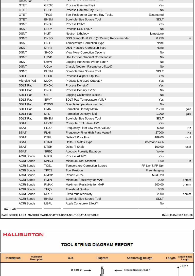
CrossPlot ROIN Input for RO Calculation Rwa
GTET GROK Process Gamma Ray? YesGTET GEOK Process Gamma Ray EVR? NoGTET TPOS Tool Position for Gamma Ray Tools. EccenteredGTET BHSM Borehole Size Source Tool SDLTDSNT DNOK Process DSN? YesDSNT DEOK Process DSN EVR? NoDSNT NLIT Neutron Lithology LimestoneDSNT DNSO DSN Standoff - 0.25 in (6.35 mm) Recommended 0.250 inDSNT DNTT Temperature Correction Type NoneDSNT DPRS DSN Pressure Correction Type NoneDSNT SHCO View More Correction Options NoDSNT UTVD Use TVD for Gradient Corrections? NoDSNT LHWT Logging Horizontal Water Tank? NoDSNT UCLA Classic Neutron Parameter utilized? NoDSNT BHSM Borehole Size Source Tool SDLTSDLT CLOK Process Caliper Outputs? YesMicrolog Pad MLOK Process MicroLog Outputs? YesSDLT Pad DNOK Process Density? YesSDLT Pad DNOK Process Density EVR? NoSDLT Pad CB Logging Calibration Blocks? NoSDLT Pad SPVT SDLT Pad Temperature Valid? YesSDLT Pad DTWN Disable temperature warning NoSDLT Pad DMA Formation Density Matrix 2.710 g/ccSDLT Pad DFL Formation Density Fluid 1.000 g/ccSDLT Pad BHSM Borehole Size Source Tool SDLTBSAT MBOK Compute BCAS Results? YesBSAT FLLO Frequency Filter Low Pass Value? 5000 HzBSAT FLHI Frequency Filter High Pass Value? 27000 HzBSAT DTFL Delta -T Pore Fluid 189.00 uspfBSAT DTMT Delta -T Matrix Type Limestone 47.6BSAT DTSH Delta -T Shale 100.00 uspfBSAT SPEQ Acoustic Porosity Equation WylieACRt Sonde RTOK Process ACRt? YesACRt Sonde MNSO Minimum Tool Standoff 1.50 inACRt Sonde TCS1 Temperature Correction Source FP Lwr & FP UprACRt Sonde TPOS Tool Position Free HangingACRt Sonde RMOP Rmud Source Mud CellACRt Sonde RMIN Minimum Resistivity for MAP 0.20 ohmmACRt Sonde RMAX Maximum Resistivity for MAP 200.00 ohmmACRt Sonde THQY Threshold Quality 0.50ACRt Sonde MRFX Fixed mud resistivity 2000 ohmmACRt Sonde BHSM Borehole Size Source Tool SDLTACRt Sonde MBFL Apply Corkscrew Effect? No
BOTTOM
Data: BEREX_LENA_MAI\0001 RWCH-SP-GTET-DSNT-SDLT-BSAT-ACRT\IDLE Date: 03-Oct-18 10:31:38
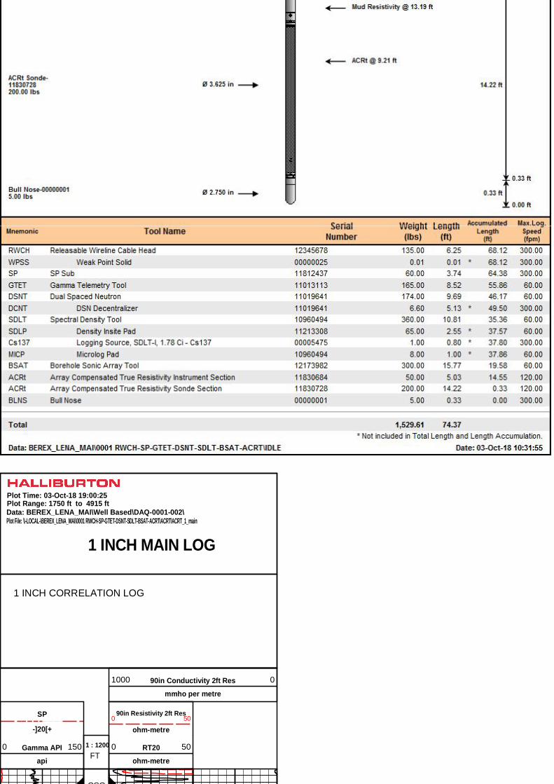
1 INCH MAIN LOG
Data: BEREX_LENA_MAI\Well Based\DAQ-0001-002\Plot Range: 1750 ft to 4915 ft
Plot File: \\-LOCAL-\BEREX_LENA_MAI\0001 RWCH-SP-GTET-DSNT-SDLT-BSAT-ACRT\ACRT\ACRT_1_main
Plot Time: 03-Oct-18 19:00:25
1 INCH CORRELATION LOG
90in Resistivity 2ft Res
ohm-metre0 50
-]20[+
SP
RT20
ohm-metre
0 50Gamma API
api
0 150FT
1 : 1200
90in Conductivity 2ft Res
mmho per metre
1000 0
CSG
1800
1900
2000
CSG
2100
2200
2300
2400
2500
2600
2700
2800
2900
3000
3100
3200
3300
3400
3500
3600
3700
3800
3900
4000
4100
4200
4300
4400
4500
4600
4700
4800
4900
Gamma API
api
0 150FT
1 : 1200
90in Conductivity 2ft Res
mmho per metre
1000 0
-]20[+
SP
RT20
ohm-metre
0 50
90in Resistivity 2ft Res
ohm-metre0 50
1 INCH MAIN LOG
Data: BEREX_LENA_MAI\Well Based\DAQ-0001-002\Plot Range: 1750 ft to 4915 ft
Plot File: \\-LOCAL-\BEREX_LENA_MAI\0001 RWCH-SP-GTET-DSNT-SDLT-BSAT-ACRT\ACRT\ACRT_1_main
Plot Time: 03-Oct-18 19:00:26
1 INCH CORRELATION LOG

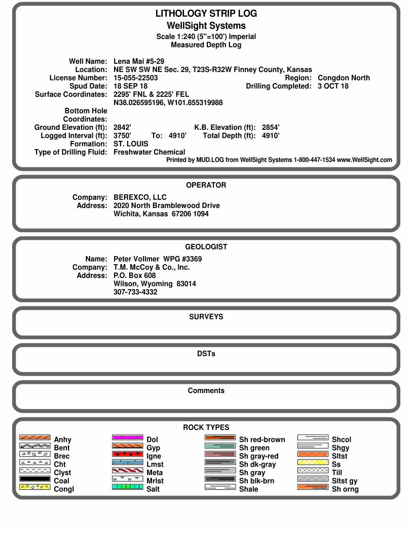
LITHOLOGY STRIP LOG
WellSight SystemsScale 1:240 (5"=100') Imperial
Measured Depth Log
Well Name: Lena Mai #5-29Location: NE SW SW NE Sec. 29, T23S-R32W Finney County, Kansas
License Number: 15-055-22503 Region: Congdon NorthSpud Date: 18 SEP 18 Drilling Completed: 3 OCT 18
Surface Coordinates: 2295' FNL & 2225' FELN38.026595196, W101.855319988
Bottom HoleCoordinates:
Ground Elevation (ft): 2842' K.B. Elevation (ft): 2854'Logged Interval (ft): 3750' To: 4910' Total Depth (ft): 4910'
Formation: ST. LOUISType of Drilling Fluid: Freshwater Chemical
Printed by MUD.LOG from WellSight Systems 1-800-447-1534 www.WellSight.com
OPERATOR
Company: BEREXCO, LLCAddress: 2020 North Bramblewood Drive
Wichita, Kansas 67206 1094
GEOLOGIST
Name: Peter Vollmer WPG #3369Company: T.M. McCoy & Co., Inc.
Address: P.O. Box 608Wilson, Wyoming 83014307-733-4332
SURVEYS
DSTs
Comments
ROCK TYPES
AnhyBentBrecChtClystCoalCongl
DolGypIgneLmstMetaMrlstSalt
Sh red-brownSh greenSh gray-redSh dk-graySh graySh blk-brnShale
ShcolShgySltstSsTillSltst gySh orng
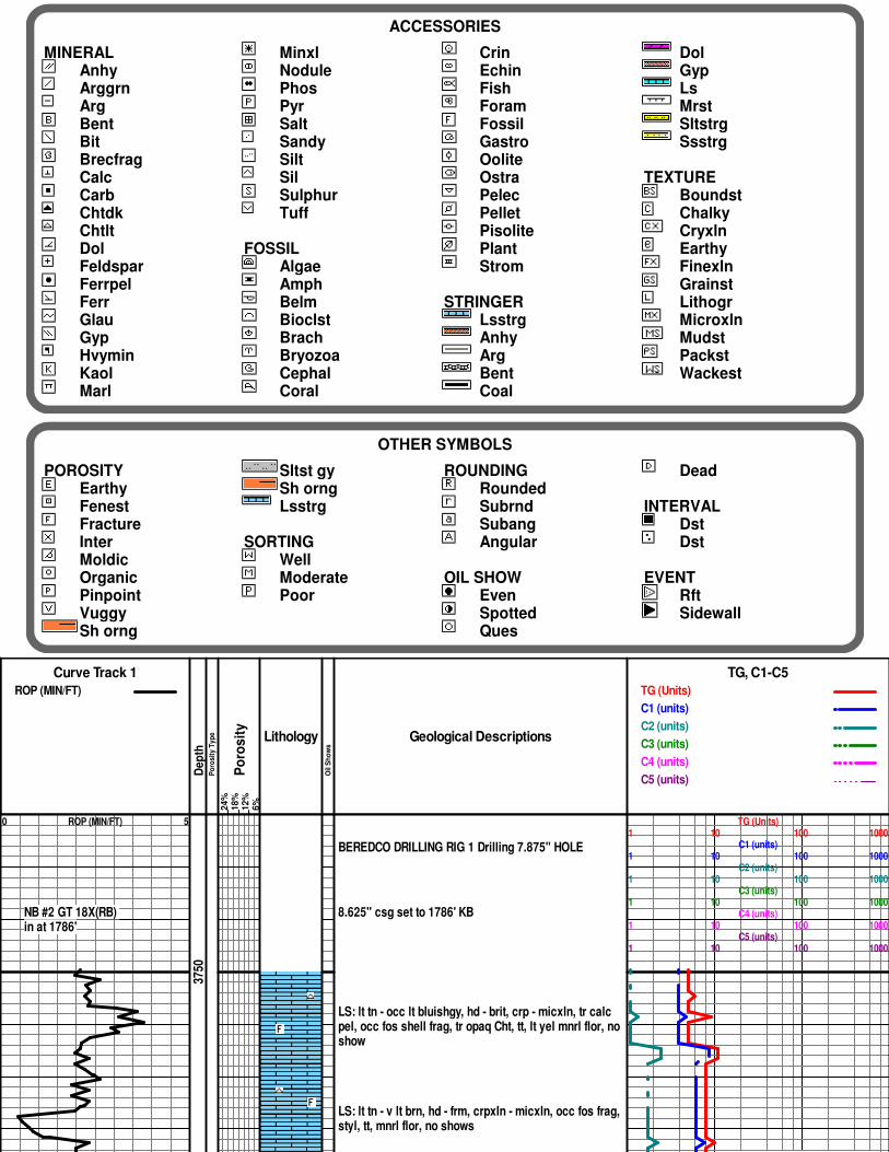
ACCESSORIES
MINERALAnhyArggrnArgBentBitBrecfragCalcCarbChtdkChtltDolFeldsparFerrpelFerrGlauGypHvyminKaolMarl
MinxlNodulePhosPyrSaltSandySiltSilSulphurTuff
FOSSILAlgaeAmphBelmBioclstBrachBryozoaCephalCoral
CrinEchinFishForamFossilGastroOoliteOstraPelecPelletPisolitePlantStrom
STRINGERLsstrgAnhyArgBentCoal
DolGypLsMrstSltstrgSsstrg
TEXTUREBoundstChalkyCryxlnEarthyFinexlnGrainstLithogrMicroxlnMudstPackstWackest
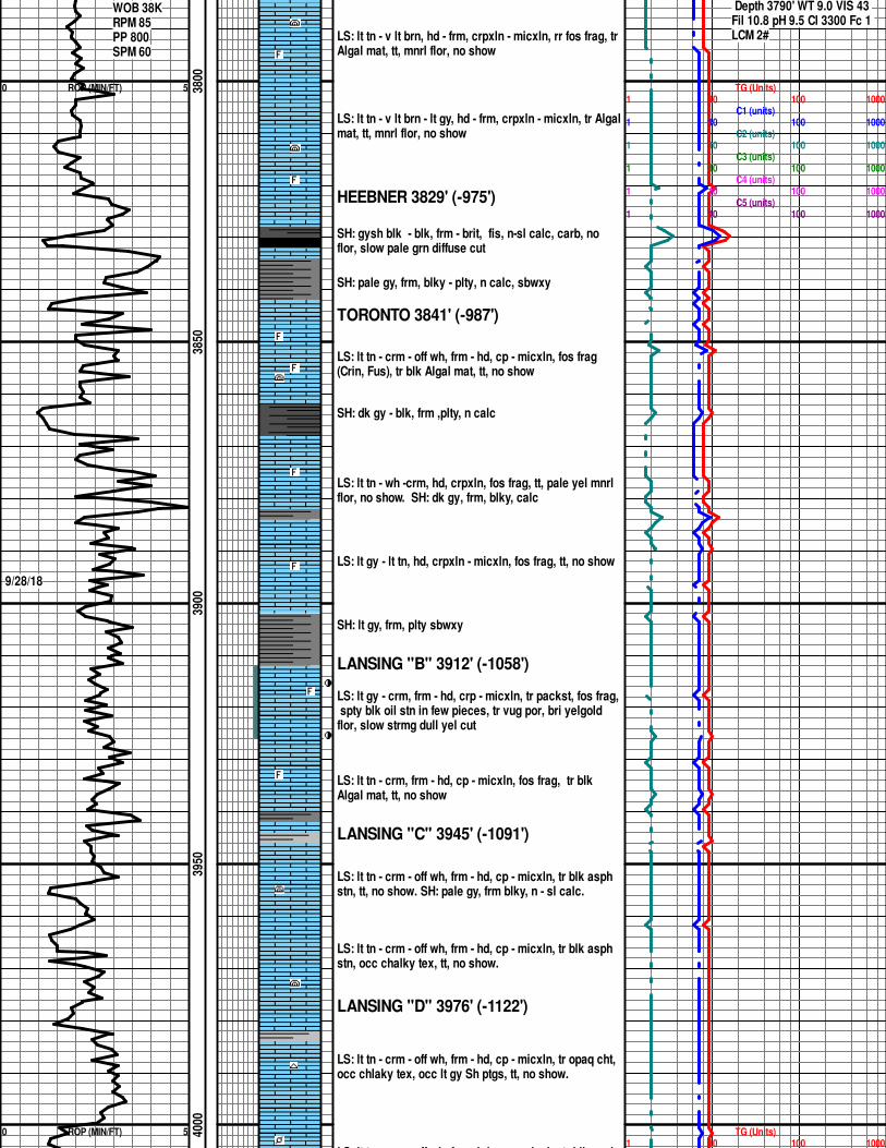
OTHER SYMBOLS
POROSITYEarthyFenestFractureInterMoldicOrganicPinpointVuggySh orng
Sltst gySh orngLsstrg
SORTINGWellModeratePoor
ROUNDINGRoundedSubrndSubangAngular
OIL SHOWEvenSpottedQues
Dead
INTERVALDstDst
EVENTRftSidewall
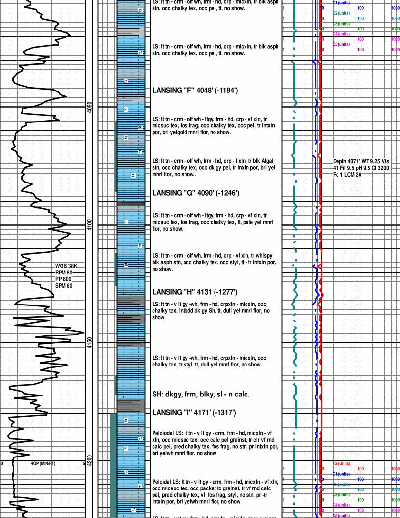
Curve Track 1
ROP (MIN/FT)
De
pth
Po
ros
ity
Ty
pe
Po
ros
ity
24
%1
8%
12
%6
%
Lithology
Oil
Sh
ow
s
Geological Descriptions
TG, C1-C5
TG (Units)
C1 (units)
C2 (units)
C3 (units)
C4 (units)
C5 (units)
0 ROP (MIN/FT) 5
NB #2 GT 18X(RB) in at 1786'
3750
BEREDCO DRILLING RIG 1 Drilling 7.875" HOLE
8.625" csg set to 1786' KB
LS: lt tn - occ lt bluishgy, hd - brit, crp - micxln, tr calc pel, occ fos shell frag, tr opaq Cht, tt, lt yel mnrl flor, no show
LS: lt tn - v lt brn, hd - frm, crpxln - micxln, occ fos frag, styl, tt, mnrl flor, no shows
TG (Units)1 10 100 1000
C1 (units)1 10 100 1000
C2 (units)1 10 100 1000
C3 (units)1 10 100 1000
C4 (units)1 10 100 1000
C5 (units)1 10 100 1000
Depth 3790' WT 9.0 VIS 43
0 ROP (MIN/FT) 5
0 ROP (MIN/FT) 5
WOB 38KRPM 85PP 800SPM 60
9/28/18
3800
3850
3900
3950
4000
LS: lt tn - v lt brn, hd - frm, crpxln - micxln, rr fos frag, tr Algal mat, tt, mnrl flor, no show
LS: lt tn - v lt brn - lt gy, hd - frm, crpxln - micxln, tr Algalmat, tt, mnrl flor, no show
HEEBNER 3829' (-975')
SH: gysh blk - blk, frm - brit, fis, n-sl calc, carb, no flor, slow pale grn diffuse cut
SH: pale gy, frm, blky - plty, n calc, sbwxy
TORONTO 3841' (-987')
LS: lt tn - crm - off wh, frm - hd, cp - micxln, fos frag (Crin, Fus), tr blk Algal mat, tt, no show
SH: dk gy - blk, frm ,plty, n calc
LS: lt tn - wh -crm, hd, crpxln, fos frag, tt, pale yel mnrl flor, no show. SH: dk gy, frm, blky, calc
LS: lt gy - lt tn, hd, crpxln - micxln, fos frag, tt, no show
SH: lt gy, frm, plty sbwxy
LANSING "B" 3912' (-1058')
LS: lt gy - crm, frm - hd, crp - micxln, tr packst, fos frag, spty blk oil stn in few pieces, tr vug por, bri yelgold flor, slow strmg dull yel cut
LS: lt tn - crm, frm - hd, cp - micxln, fos frag, tr blk Algal mat, tt, no show
LANSING "C" 3945' (-1091')
LS: lt tn - crm - off wh, frm - hd, cp - micxln, tr blk asph stn, tt, no show. SH: pale gy, frm blky, n - sl calc.
LS: lt tn - crm - off wh, frm - hd, cp - micxln, tr blk asph stn, occ chalky tex, tt, no show.
LANSING "D" 3976' (-1122')
LS: lt tn - crm - off wh, frm - hd, cp - micxln, tr opaq cht, occ chlaky tex, occ lt gy Sh ptgs, tt, no show.
LS: lt tn - crm - off wh, frm - hd, crp - micxln, tr blk asph
TG (Units)1 10 100 1000
C1 (units)1 10 100 1000
C2 (units)1 10 100 1000
C3 (units)1 10 100 1000
C4 (units)1 10 100 1000
C5 (units)1 10 100 1000
TG (Units)1 10 100 1000
Depth 3790' WT 9.0 VIS 43 Fil 10.8 pH 9.5 Cl 3300 Fc 1 LCM 2#
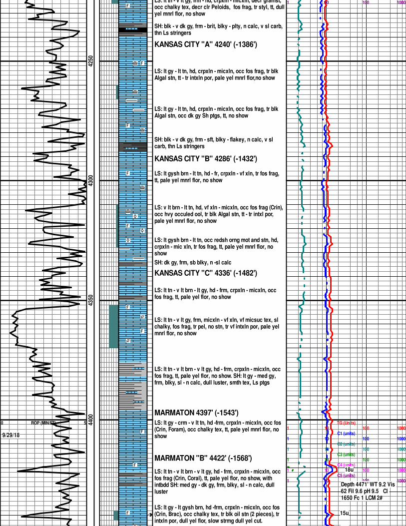
0 ROP (MIN/FT) 5
WOB 38KRPM 80PP 800SPM 60
4050
4100
4150
4200
LS: lt tn - crm - off wh, frm - hd, crp - micxln, tr blk asph stn, occ chalky tex, occ pel, tt, no show.
LS: lt tn - crm - off wh, frm - hd, crp - micxln, tr blk asph stn, occ chalky tex, occ pel, tt, no show.
LANSING "F" 4048' (-1194')
LS: lt tn - crm - off wh - ltgy, frm - hd, crp - vf xln, tr micsuc tex, fos frag, occ chalky tex, occ pel, tr intxln por, bri yelgold mnrl flor, no show.
LS: lt tn - crm - off wh, frm - hd, crp - f xln, tr blk Algal stn, occ chalky tex, occ dk gy pel, tr inxln por, bri yel mnrl flor, no show..
LANSING "G" 4090' (-1246')
LS: lt tn - crm - off wh - ltgy, frm - hd, crp - vf xln, tr micsuc tex, fos frag, occ chalky tex, tt, pale yel mnrl flor, no show.
LS: lt tn - crm - off wh, frm - hd, crp - vf xln, tr whispy blk asph stn, occ chalky tex, occ styl, tt - tr intxln por, no show.
LANSING "H" 4131 (-1277')
LS: lt tn - v lt gy -wh, frm - hd, crpxln - micxln, occ chalky tex, intbdd dk gy Sh, tt, dull yel mnrl flor, no show
LS: lt tn - v lt gy -wh, frm - hd, crpxln - micxln, occ chalky tex, tr styl, tt, dull yel mnrl flor, no show
SH: dkgy, frm, blky, sl - n calc.
LANSING "I" 4171' (-1317')
Peloiodal LS: lt tn - v lt gy - crm, frm - hd, micxln - vf xln, occ micsuc tex, occ calc pel grainst, tr clr vf rnd calc pel, pred chalky tex, fos frag, no stn, pr intxln por, bri yelwh mnrl flor, no show
Peloidal LS: lt tn - v lt gy - crm, frm - hd, micxln - vf xln, occ micsuc tex, occ packst to grainst, tr vf rnd calc pel, pred chalky tex, vf fos frag, styl, no stn, pr -tr intxln por, bri yelwh mnrl flor, no show
LS: lt tn - v lt gy, frm - hd, crpxln - micxln, decr grainst,
1 10 100 1000C1 (units)
1 10 100 1000C2 (units)
1 10 100 1000C3 (units)
1 10 100 1000C4 (units)
1 10 100 1000C5 (units)
1 10 100 1000
TG (Units)1 10 100 1000
C1 (units)1 10 100 1000
C2 (units)1 10 100 1000
C3 (units)1 10 100 1000
C4 (units)1 10 100 1000
C5 (units)
Depth 4071' WT 9.25 Vis 41 Fil 9.5 pH 9.5 Cl 3200 Fc 1 LCM 2#
0 ROP (MIN/FT) 5
9/29/18
4250
4300
4350
4400
LS: lt tn - v lt gy, frm - hd, crpxln - micxln, decr grainst, occ chalky tex, decr clr Peloids, fos frag, tr styl, tt, dullyel mnrl flor, no show
SH: blk - v dk gy, frm - brit, blky - plty, n calc, v sl carb, thn Ls stringers
KANSAS CITY "A" 4240' (-1386')
LS: lt gy - lt tn, hd, crpxln - micxln, occ fos frag, tr blk Algal stn, tt - tr intxln por, pale yel mnrl flor,no show
LS: lt gy - lt tn, hd, crpxln - micxln, occ fos frag, tr blk Algal stn, occ dk gy Sh ptgs, tt, no show
SH: blk - v dk gy, frm - sft, blky - flakey, n calc, v sl carb, thn Ls stringers
KANSAS CITY "B" 4286' (-1432')
LS: lt gysh brn - lt tn, hd - fr, crpxln - vf xln, tr fos frag, tt, pale yel mnrl flor, no show
LS: v lt brn - lt tn, hd, vf xln - micxln, occ fos frag (Crin), occ hvy occuled ool, tr blk Algal stn, tt - tr intxl por, pale yel mnrl flor, no show
LS: lt gysh brn - lt tn, occ redsh orng mot and stn, hd, crpxln - mic xln, tr fos frag, tt, pale yel mnrl flor, no show
SH: dk gy, frm, sb blky, n -sl calc
KANSAS CITY "C" 4336' (-1482')
LS: lt tn - v lt brn - lt gy, hd - frm, crpxln - micxln, occ fos frag, tt, pale yel flor, no show
LS: lt tn - v lt gy, frm, micxln - vf xln, vf micsuc tex, sl chalky, fos frag, tr pel, no stn, tr vf intxln por, pale yel mnrl flor, no show
LS: lt tn - v lt brn - v lt gy, hd - frm, crpxln - micxln, occ fos frag, tt, pale yel flor, no show. SH: lt gy - med gy, frm, blky, sl - n calc, dull luster, smth tex, Ls ptgs
MARMATON 4397' (-1543')
LS: lt gy - crm - v lt tn, hd -frm, crpxln - micxln, occ fos (Crin, Foram), occ chalky tex, tt, pale yel mnrl flor, no show
MARMATON "B" 4422' (-1568')
LS: lt tn - v lt brn - v lt gy, hd - frm, crpxln - micxln, occ fos frag (Crin, Coral), tt, pale yel flor, no show, with intbdd SH: med gy - dk gy, frm, blky, sl - n calc, dull luster
LS: lt gy - lt gysh brn, hd -frm, crpxln - micxln, occ fos (Crin, Brac), occ chalky tex, tr blk oil stn (2 pieces), tr intxln por, dull yel flor, slow strmg dull yel cut.
1 10 100 1000
TG (Units)1 10 100 1000
C1 (units)1 10 100 1000
C2 (units)1 10 100 1000
C3 (units)1 10 100 1000
C4 (units)1 10 100 1000
C5 (units)1 10 100 1000
18u
Depth 4471' WT 9.2 Vis 62 Fil 9.6 pH 9.5 Cl 1650 Fc 1 LCM 2#
15u
15u
0 ROP (MIN/FT) 10
Scale Change0 ROP (MIN/FT) 10
CFS
WOB 38KRPM 80-85PP 800SPM 60
Dev 4530' 3/4 deg
SLM - No Corr.
CFS 9/30/18NB #3 GT 28Y
WOB 38KRPM 80-85PP 800SPM 60
10/1/18
4450
4500
4550
4600
4650
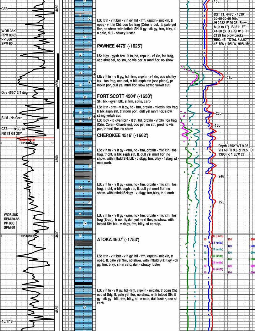
LS: lt tn - v lt brn - v lt gy, hd - frm, crpxln - micxln, tr opaq - v lt tn Cht, occ fos frag (Crin), tr ool, tt, pale yel flor, no show, with intbdd SH: lt gy - dk gy, frm, blky, sl -n calc, dull - sbwxy luster
PAWNEE 4479' (-1625')
LS: lt gy - gysh brn - lt tn, hd, crpxln - vf xln, fos frag, occ abnt pel, no stn, no vis por, tr mnrl flor, no show
LS: v lt tn - v lt gy, hd - frm, crpxln - vf xln, occ chalky tex, fos frag, occ ool, rr blk asph stn (one piece), pr intxln por, dull yel mnrl flor, slow strmg yelwh cut.
FORT SCOTT 4504' (-1650')SH: blk - gysh blk, sl frm, sbfis, carb
LS: lt tn - crm - v lt gy, hd - frm, crpxln - micxln, fos frag,tr blk asph stn, tr intxln por, dull yel mnrl flor, slow strmg yelwh cut.
LS: lt gy - lt gysh brn - lt tn, hd, crpxln - vf xln, fos frag (Crin, Coral - Chaetetes), occ pel, no stn, pred no vis por, tr mnrl flor, no show
CHEROKEE 4516' (-1662')
LS: v lt tn - v lt gy - crm, hd - frm, crpxln - mic xln, fos frag, tr cht, rr blk asph stn, tt, dull yel mnrl flor, no show. with intbdd SH: blk - v dkgy, frm, blky - flakey, sl -mod carb.
LS: v lt tn - v lt gy - crm, hd - frm, crpxln - mic xln, fos frag, tr cht, rr blk asph stn, tt, dull yel mnrl flor, no show. with intbdd SH: gy - v dkgy, frm,blky, tr sl carb
LS: v lt tn - v lt gy - crm, hd - frm, crpxln - mic xln, fos frag (Brac), tr ool, tt, dull yel mnrl flor, no show. with intbdd SH: blk - v dkgy, frm, blky, sl carb ip.
ATOKA 4607' (-1753')
LS: lt tn - v lt brn - v lt gy, hd - frm, crpxln - micxln, tr opaq, tt, pale yel flor, no show, with intbdd SH: lt gy - dkgy, frm, blky, sl - n calc, dull - sbwxy luster
LS: v lt tn - v lt gy, hd - frm, crpxln - micxln, tr opaq Cht, occ sl Sdy, tt, pale yel flor, no show, with intbdd SH: lt gy - dk gy - blk, frm, blky, sl - n calc, dull luster, occ sl carb
TG (Units)1 10 100 1000
C1 (units)1 10 100 1000
C2 (units)1 10 100 1000
C3 (units)1 10 100 1000
C4 (units)1 10 100 1000
C5 (units)1 10 100 1000
15u
DST #1, 4470' - 4530', 30-60-30-60 MIN.IH 2232 IF 20-36 (Blow built to 1") ISI 811 FF 41-50 (S. B.) FSI 816 FH 2199 No blow backsREC: 45' TOTAL FLUID45' MW (10% W, 90% M)
53u
23u
18u
Depth 4552' WT 9.05 Vis 60 Fil 9.6 pH 9.5 Cl1300 Fc 1 LCM 2#
24u
27u
0 ROP (MIN/FT) 10
CFS
CFS
Dev = 1 deg
CFS 10/2/18
WOB 38KRPM 80PP 800SPM 58
10/3/18
4700
4750
4800
4850
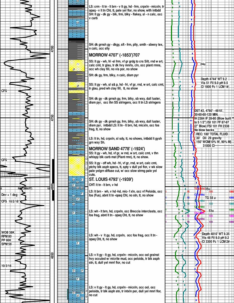
LS: crm - lt tn - lt brn - v lt gy, hd - frm, crpxln - micxln, tropaq - v lt tn Cht, tt, pale yel flor, no show, with intbdd SH: lt gy - dk gy - blk, frm, blky - flakey, sl - n calc, occ v carb
SH: dk grnsh gy - dkgy, sft - frm, plty, smth - sbwxy tex, n calc, occ slty
MORROW 4707' (-1853')707
SS: lt gy - wh, fri -sl frm, vf gr grdg to crs Silt, rnd w srt, calc cmt, tr glau, tr dk hvy mnrls, cln, occ plant rmns, occ wh clay fill, no vis por, no show
SH: dk gy, frm, blky, n calc, dism pyr
SS: lt gy - wh, sl s& p, hd - fri, vf gr, rnd, w srt, calc cmt,tr glau, pred wh clay fill, tt, no show
SH: dk gy - dk grnsh gy, frm, blky, sb wxy, dull luster, dism pyr, occ thn SS stringers, occ lt tn LS stringers
SH: dk gy - dk grnsh gy, frm, blky, sb wxy, dull luster, dism pyr, intbdd LS: lt tn - lt brn, hd, micxln, occ fos frag, tt, no show
LS: lt tn, hd, crpxln, sl sdy, tt, no shows, intbdd lt gysh grn wxy Sh.
MORROW SAND 4778' (-1924')SS: lt gy - wh, hd, vf gr, w rnd, w srt, calc cmt, v thn whispy blk carb mat (Plant rmn), tt, no show.
SS: lt gy - off wh, hd - fri, vf gr, rnd, w srt, calc cmt, ptchy blk asph specs, tt, spty v dull yel flor, v wk slow pale yelgrn diffuse cut, w/ occ slow strmg pale yel cuts.
ST. LOUIS 4793' (-1939')CHT: lt tn - lt brn, v hd
LS: lt brn - wh, v hd -hd, mic- f xln, occ vf Peloids, occ fos (Fus), abnt lt tn -opaq Cht, no stn, tt, no show
LS: wh - lt brn, hd, crpxln, occ Breccia interclasts, occ fos frag, abnt lt tn - opaq Cht, tt, no show
LS: wh - v lt gy, hd, crpxln, occ fos frag, occ lt tn - opaq Cht, tt, no show
LS: v lt gy - lt gy, hd, crpxln - micxln, occ ool grainst hvy occuled w/ micrite mud, occ peloids, tr blk asph stn, tt, dull yel mnrl flor, no cut
LS: v lt gy - lt gy, hd, crpxln - micxln, occ ool, occ peloids, tr blk asph stn, tr intxln por, dull yel mnrl flor, no cut
TG (Units)1 10 100 1000
C1 (units)1 10 100 1000
C2 (units)1 10 100 1000
C3 (units)1 10 100 1000
C4 (units)1 10 100 1000
C5 (units)1 10 100 1000
24u
Depth 4744' WT 9.2 Vis 51 Fil 9.0 pH 9.5 Cl 1800 Fc 1 LCM 1#
DST #2, 4780' - 4810',30-60-60-120 MIN.IH 2384 IF 28-80 (Blow built to 5 1/2") ISI 101 FF 87-97 (2" Blow) FSI 101 FH 2338 No blow backs
REC: 180' TOTAL FLUID30' Oil 29 gravity150' WCM(10% W, 90% M) 31000 Cl
35u
TG 58 u
53u
Depth 4810' WT 9.35 Vis 48 Fil 9.0 pH 9.2 Cl 3300 Fc 1 LCM 2#
4900
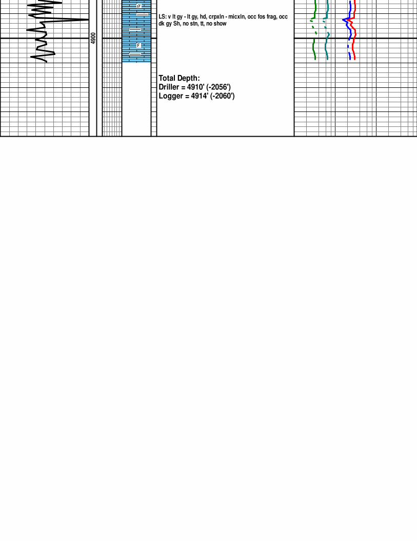
LS: v lt gy - lt gy, hd, crpxln - micxln, occ fos frag, occ dk gy Sh, no stn, tt, no show
Total Depth:Driller = 4910' (-2056')Logger = 4914' (-2060')
COMPANY BEREXCO LLC
WELL LENA MAI 5-29
FIELD/BLOCK CONGDON NORTH
COUNTY FINNEY
STATE KANSAS
Fold here
Service Ticket No.: 905174527 API No.: 15-055-22503-00-00 PGM Version: WL INSITE R5.8.9 (Build 6)
CHANGE IN MUD TYPE OR ADDITIONAL SAMPLE
Date Sample No.
Depth-Driller
Type Fluid in Hole
Density Viscosity
Ph Fluid Loss
Source of Sample
Rm @ Meas. Temp @ @
Rmf @ Meas. Temp. @ @
Rmc @ Meas. Temp. @ @
Source Rmf Rmc
Rm @ BHT @ @
Rmf @ BHT @ @
Rmc @ BHT @ @
RESISTIVITY SCALE CHANGES
Type Log Depth Scale Up Hole Scale Down Hole
RESISTIVITY EQUIPMENT DATA
Run No. Tool Type & No. Pad Type Tool Pos. Other
EQUIPMENT DATA
GAMMA ACOUSTIC DENSITY NEUTRON
Run No. Run No. Run No. Run No.
Serial No. Serial No. Serial No. Serial No.
Model No. Model No. Model No. Model No.
Diameter No. of Cent. Diameter Diameter
Detector Model No. Spacing Log Type Log Type
Type Source Type Source Type
Length LSA [Y/N] Serial No. Serial No.
Distance to Source FWDA [Y/N ] Strength Strength
LOGGING DATALOGGING DATA
GENERAL GAMMA ACOUSTIC DENSITY NEUTRON
Run Depth Speed Scale ScaleMatrix
ScaleMatrix
ScaleMatrix
No. From To ft/min L R L R L R L R
DIRECTIONAL INFORMATION
Maximum Deviation @ KOP @
Remarks: 5 1/2'' CASING USED FOR ANNULAR HOLE VOLUME
HALLIBURTON DOES NOT GUARANTEE THE ACCURACY OF ANY INTERPRETATION OF THE LOG DATA, CONVERSION OF LOG DATA TO PHYSICAL ROCK PARAMETERS OR RECOMMENDATIONS WHICH MAY BE GIVEN BY HALLIBURTON PERSONNEL OR WHICH APPEAR ON THE LOG OR IN ANY OTHER FORM. ANY USER OF SUCH DATA, INTERPRETATIONS, CONVERSIONS, OR RECOMMENDATIONS AGREES THAT HALLIBURTON IS NOT RESPONSIBLE EXCEPT WHERE DUE TO GROSS NEGLIGENCE OR WILLFUL MISCONDUCT, FOR ANY LOSS, DAMAGES, OR EXPENSES RESULTING FROM THE USE THEREOF.
HALLIBURTON
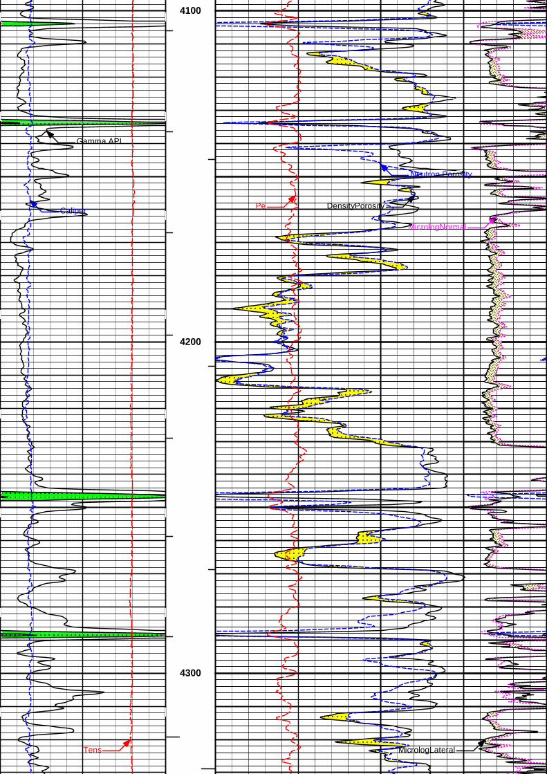
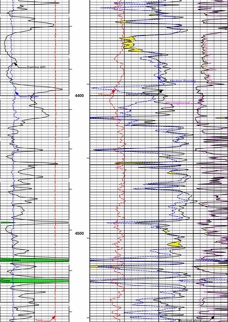
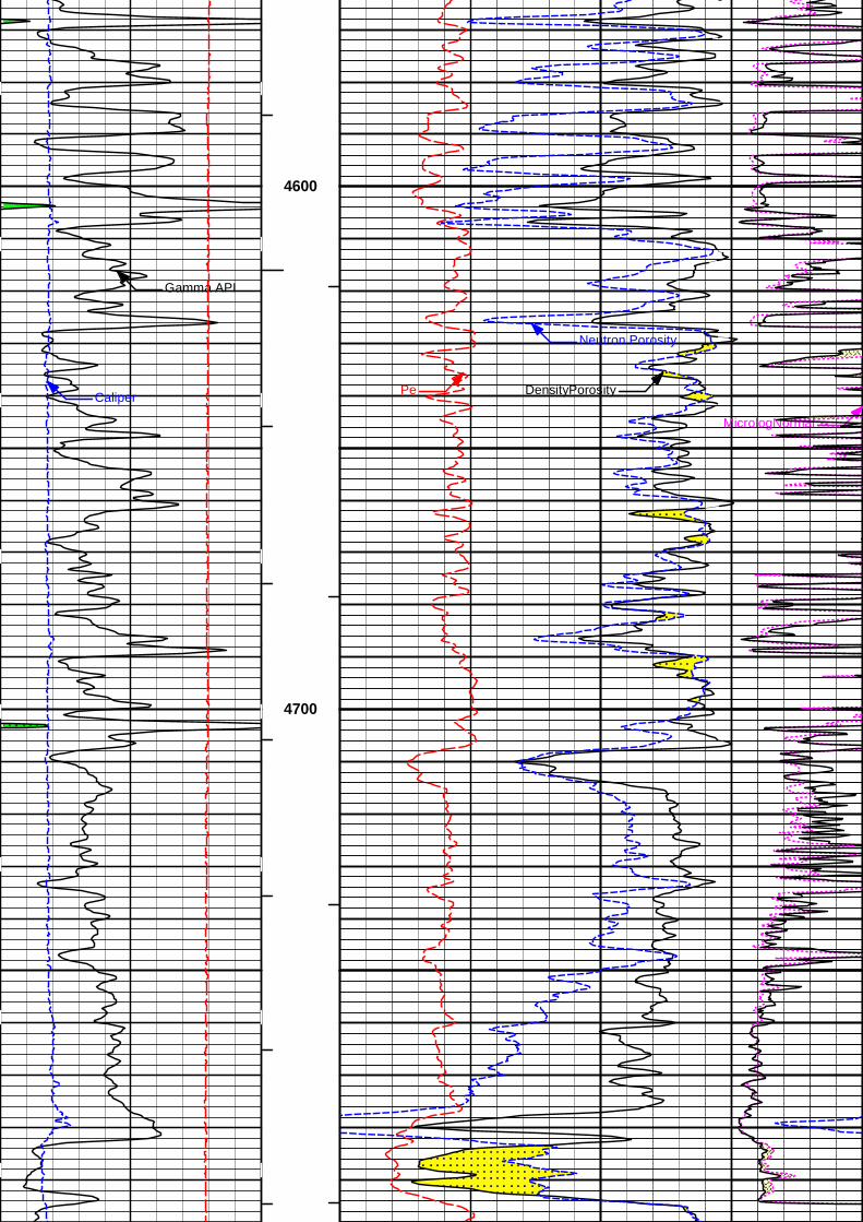
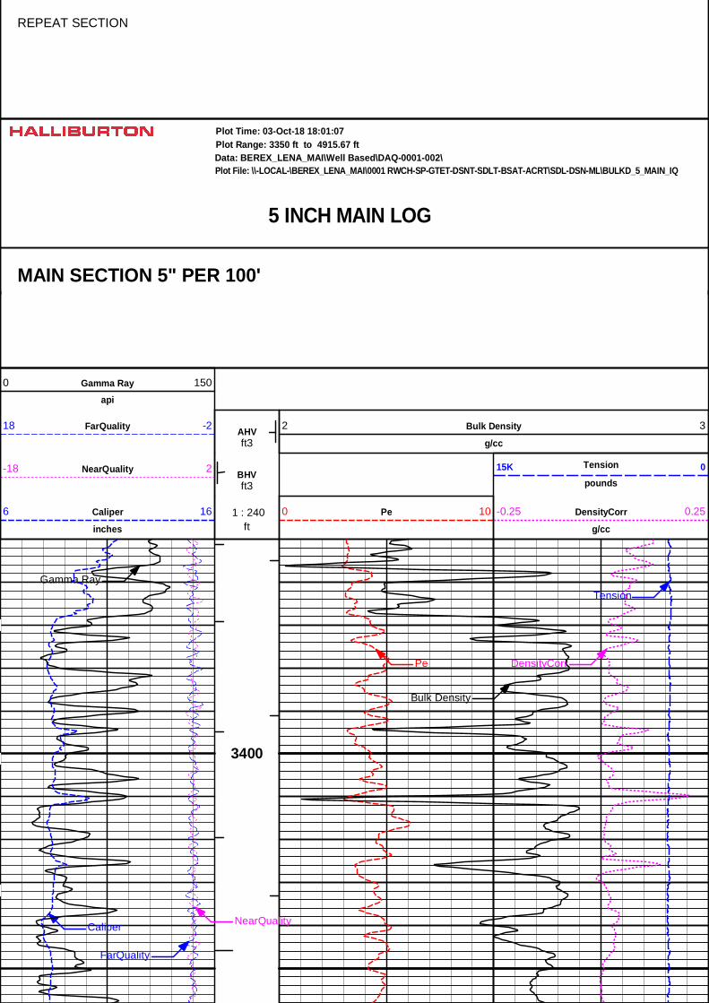
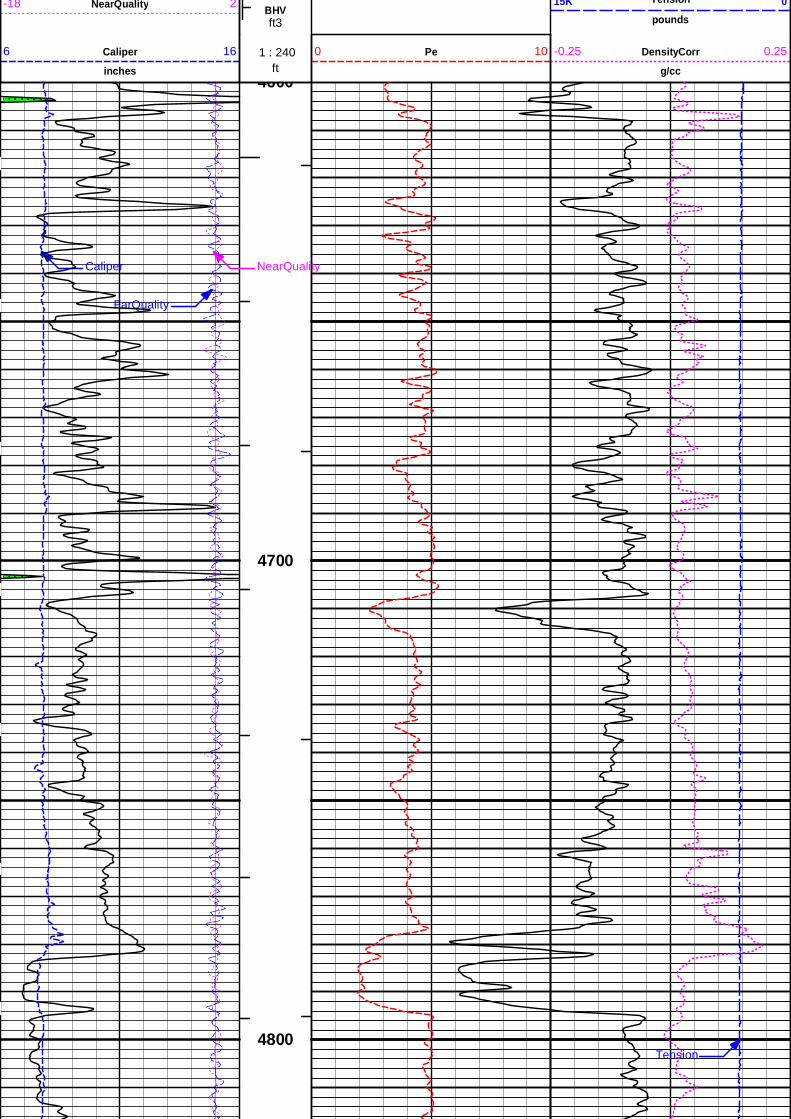
5 INCH MAIN LOG
Data: BEREX_LENA_MAI\Well Based\DAQ-0001-002\Plot Range: 3350 ft to 4915.67 ft
Plot File: \\SDL-DSN-ML\PoroML_5_main_IQ
Plot Time: 03-Oct-18 18:01:02
MAIN SECTION 5" PER 100'
%
Neutron Porosity30 -10
BHVTGamma API
api0 150
%
DensityPorosity30 -10
AHVT MicrologLateral
ohm-metre
0 20Caliper
inches6 16
ft 1 : 240 MicrologNormal
ohm-metre
0 20Tens
pounds15K 0 Pe0 10
Tens MicrologLateral
DensityPorosity
Neutron Porosity
Pe
Gamma API
Caliper
MicrologNormal
3400
3500
Tens MicrologLateral3600
DensityPorosity
Neutron Porosity
Pe
Gamma API
Caliper
MicrologNormal
3700
3800
Tens MicrologLateral
DensityPorosity
Neutron Porosity
Pe
Gamma API
Caliper
MicrologNormal
3900
4000
Tens MicrologLateral
Gamma API
4100
DensityPorosity
Neutron Porosity
PeCaliper
MicrologNormal
4200
Tens MicrologLateral
4300
DensityPorosity
Neutron Porosity
Pe
Gamma API
Caliper
MicrologNormal
4400
Tens MicrologLateral
4500
Tens MicrologLateral
DensityPorosity
Neutron Porosity
Pe
Gamma API
Caliper
MicrologNormal
4600
4700
Tens MicrologLateral4800
FRDensityPorosity
FRNeutron Porosity
FRPe
FRGamma API
FRCaliper FRMicrologNormal
4900
TD
ft 1 : 240 MicrologNormal
ohm-metre
0 20Tens
pounds15K 0 Pe0 10
AHVT MicrologLateral
ohm-metre
0 20Caliper
inches6 16
BHVTGamma API
api0 150
%
DensityPorosity30 -10
%
Neutron Porosity30 -10
5 INCH MAIN LOG
Data: BEREX_LENA_MAI\Well Based\DAQ-0001-002\Plot Range: 3350 ft to 4915.67 ft
Plot File: \\SDL-DSN-ML\PoroML_5_main_IQ
Plot Time: 03-Oct-18 18:01:05
MAIN SECTION 5" PER 100'
Data: BEREX_LENA_MAI\Well Based\REPEAT\Plot Range: 4600 ft to 4916.92 ft
Plot File: \\SDL-DSN-ML\PoroML_5_main_IQ
Plot Time: 03-Oct-18 18:01:05
REPEAT SECTION
REPEAT SECTION
%
Neutron Porosity30 -10
BHVTGamma API
api0 150
%
DensityPorosity30 -10
AHVT MicrologLateral
ohm-metre
0 20Caliper
inches6 16
ft 1 : 240 MicrologNormal
ohm-metre
0 20Tens
pounds15K 0 Pe0 10
4600
DensityPorosity
Neutron Porosity
Pe
Gamma API
Caliper MicrologNormal
4700
Tens MicrologLateral4800
FRDensityPorosity
FRNeutron Porosity
FRPe
FRGamma API
FRCaliperFRMicrologNormal
4900
TD
ft 1 : 240 MicrologNormal
ohm-metre
0 20Tens
pounds15K 0 Pe0 10
AHVT MicrologLateral
ohm-metre
0 20Caliper
inches6 16
BHVTGamma API
api0 150
%
DensityPorosity30 -10
%
Neutron Porosity30 -10
REPEAT SECTION
Data: BEREX_LENA_MAI\Well Based\REPEAT\Plot Range: 4600 ft to 4916.92 ft
Plot File: \\SDL-DSN-ML\PoroML_5_main_IQ
Plot Time: 03-Oct-18 18:01:07
REPEAT SECTION
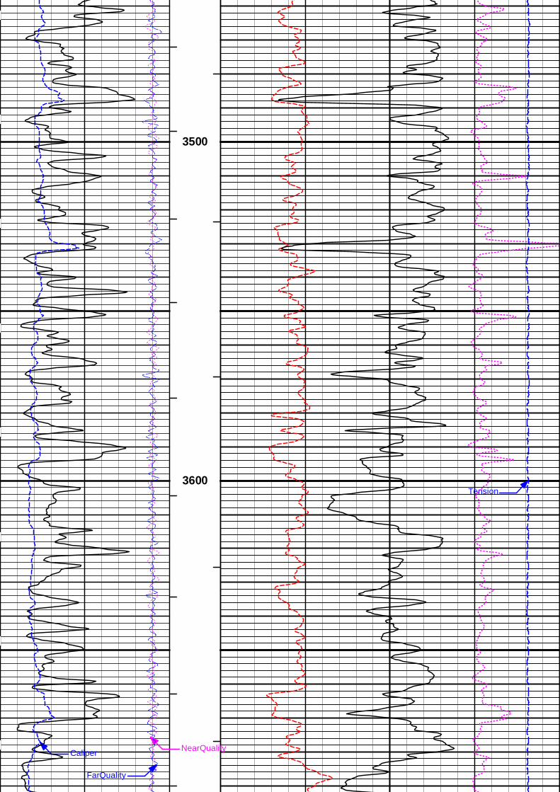
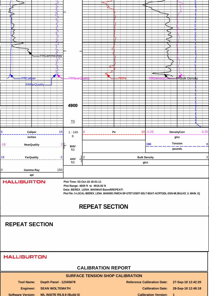
5 INCH MAIN LOG
Data: BEREX_LENA_MAI\Well Based\DAQ-0001-002\Plot Range: 3350 ft to 4915.67 ft
Plot File: \\-LOCAL-\BEREX_LENA_MAI\0001 RWCH-SP-GTET-DSNT-SDLT-BSAT-ACRT\SDL-DSN-ML\BULKD_5_MAIN_IQ
Plot Time: 03-Oct-18 18:01:07
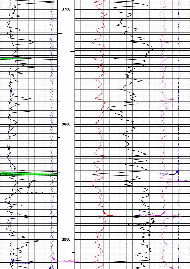
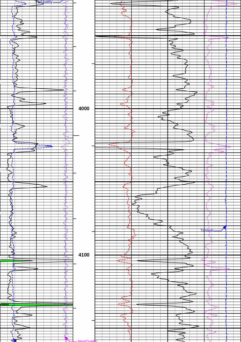
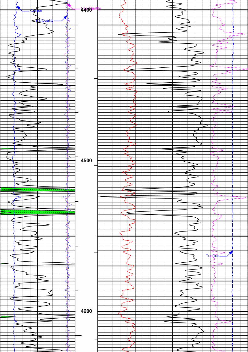
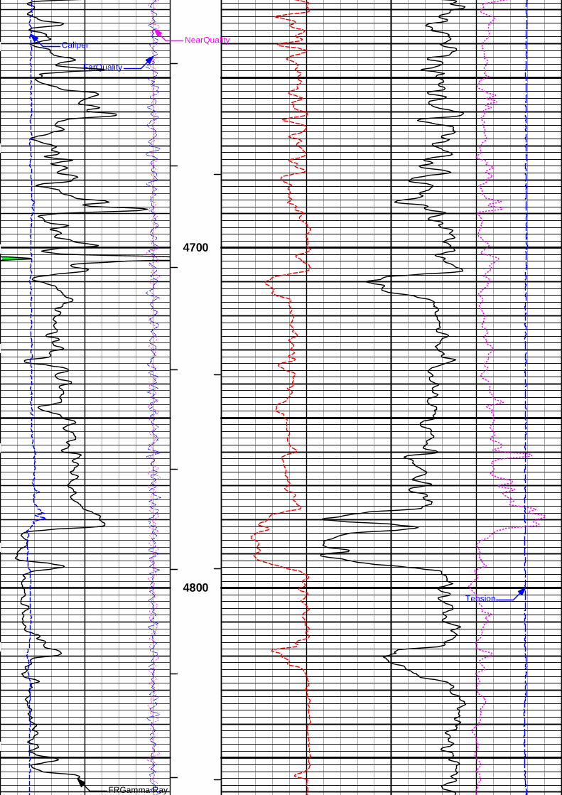
MAIN SECTION 5" PER 100'
Gamma Rayapi
0 150
AHVft3
FarQuality18 -2 Bulk Density
g/cc
2 3
BHVft3
NearQuality-18 2 Tension
pounds15K 0
ft 1 : 240Caliper
inches
6 16 Pe0 10 DensityCorr
g/cc
-0.25 0.25
DensityCorr
Tension
Pe
Gamma Ray
Caliper NearQuality
FarQuality
Bulk Density
3400
3500
Tension3600
Caliper NearQuality
FarQuality
3700
Tension
3800
DensityCorrPe
Gamma Ray
Caliper NearQuality
FarQuality
Bulk Density
3900
FarQuality
4000
Tension
Caliper NearQuality
4100
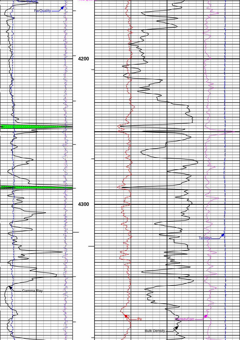
Caliper NearQuality
FarQuality
4200
DensityCorr
Tension
Pe
Gamma Ray
Bulk Density
4300
Caliper NearQuality
FarQuality
4400
4500
Tension
4600
Caliper NearQuality
FarQuality
4700
Tension4800
FRGamma Ray
FRDensityCorrFRPeFRCaliper FRNearQuality
FRFarQuality
FRBulk Density
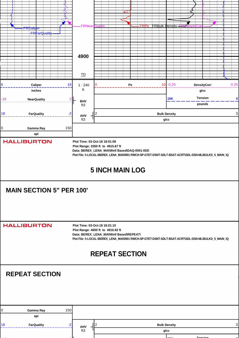
4900
TD
ft 1 : 240Caliper
inches
6 16 Pe0 10 DensityCorr
g/cc
-0.25 0.25
BHVft3
NearQuality-18 2 Tension
pounds15K 0
AHVft3
FarQuality18 -2 Bulk Density
g/cc
2 3
Gamma Rayapi
0 150
5 INCH MAIN LOG
Data: BEREX_LENA_MAI\Well Based\DAQ-0001-002\Plot Range: 3350 ft to 4915.67 ft
Plot File: \\-LOCAL-\BEREX_LENA_MAI\0001 RWCH-SP-GTET-DSNT-SDLT-BSAT-ACRT\SDL-DSN-ML\BULKD_5_MAIN_IQ
Plot Time: 03-Oct-18 18:01:09
MAIN SECTION 5" PER 100'
REPEAT SECTION
Data: BEREX_LENA_MAI\Well Based\REPEAT\Plot Range: 4600 ft to 4916.92 ft
Plot File: \\-LOCAL-\BEREX_LENA_MAI\0001 RWCH-SP-GTET-DSNT-SDLT-BSAT-ACRT\SDL-DSN-ML\BULKD_5_MAIN_IQ
Plot Time: 03-Oct-18 18:01:10
REPEAT SECTIONREPEAT SECTION
Gamma Rayapi
0 150
AHVft3
FarQuality18 -2 Bulk Density
g/cc
2 3
NearQuality-18 2 Tension15K 0
BHVft3
NearQuality-18 2 Tension
pounds15K 0
ft 1 : 240Caliper
inches
6 16 Pe0 10 DensityCorr
g/cc
-0.25 0.25
Caliper NearQuality
FarQuality
4600
4700
Tension4800
FRDensityCorrFRPe
FRGamma Ray
FRCaliper FRNearQuality
FRFarQuality
FRBulk Density
49004900
TD
ft 1 : 240Caliper
inches
6 16 Pe0 10 DensityCorr
g/cc
-0.25 0.25
BHVft3
NearQuality-18 2 Tension
pounds15K 0
AHVft3
FarQuality18 -2 Bulk Density
g/cc
2 3
Gamma Rayapi
0 150
REPEAT SECTION
Data: BEREX_LENA_MAI\Well Based\REPEAT\Plot Range: 4600 ft to 4916.92 ft
Plot File: \\-LOCAL-\BEREX_LENA_MAI\0001 RWCH-SP-GTET-DSNT-SDLT-BSAT-ACRT\SDL-DSN-ML\BULKD_5_MAIN_IQ
Plot Time: 03-Oct-18 18:01:11
REPEAT SECTION
REPEAT SECTION
CALIBRATION REPORTSURFACE TENSION SHOP CALIBRATION
Tool Name: Depth Panel - 12345678 Reference Calibration Date: 27-Sep-18 12:42:20
Engineer: SEAN WOLTEMATH Calibration Date: 28-Sep-18 12:48:18
Software Version: WL INSITE R5.8.9 (Build 6) Calibration Version: 1
Software Version: WL INSITE R5.8.9 (Build 6) Calibration Version: 1
SURFACE TENSION LOAD CELL
Measurement Load Cell Value Measurement Calibrated UnitsLow 10173.27 12.23 0.00 lbs
High 17562.87 7941.31 7830.00 lbs
DOWNHOLE TENSION SHOP CALIBRATIONTool Name: RWCH - 12345678 Reference Calibration Date: 28-Sep-18 12:50:19
Engineer: WHITLOCK Calibration Date: 02-Oct-18 05:08:35
Software Version: WL INSITE R5.8.9 (Build 6) Calibration Version: 1
DOWNHOLE LOAD CELL
Measurement Tool Value Measurement Calibrated UnitsLow -336.49 -3.58 0.00 lbs
High 10973.20 1278.61 1500.00 lbs
NATURAL GAMMA RAY TOOL SHOP CALIBRATIONTool Name: GTET - 11013113 Reference Calibration Date: 02-May-18 11:20:36
Engineer: WHITLOCK Calibration Date: 05-Aug-18 09:58:00
Software Version: WL INSITE R5.6.3 (Build 4) Calibration Version: 1
Calibrator Source S/N: TB-79Calibrator API Reference:222.00 apiEquivalent Calibrator API Reference:225.9 api
Measurement Measured Calibrated UnitsBackground 26.4 26.2 api
Background + Calibrator 253.6 252.1 api
Calibrator 227.2 225.9 api
NATURAL GAMMA RAY TOOL FIELD CALIBRATIONTool Name: GTET - 11013113 Reference Calibration Date: 05-Aug-18 09:58:00
Engineer: WHITLOCK Calibration Date: 30-Sep-18 10:17:04
Software Version: WL INSITE R5.6.3 (Build 4) Calibration Version: 1
Calibrator Source S/N: TB-79Calibrator API Reference:222.00 apiEquivalent Calibrator API Reference:225.9 api
Field Verification Shop Field UnitsBackground 26.2 13.5 apiBackground 26.2 13.5 api
Background + Calibrator 252.1 246.2 api
Calibrator 225.9 232.7 api
Shop Field Difference Tolerance225.9 232.7 -6.8 +/- 9.00
DUAL SPACED NEUTRON SHOP CALIBRATIONTool Name: DSNT - 11019641 Reference Calibration Date: 04-Aug-18 12:03:14
Engineer: SCHLIEM Calibration Date: 04-Aug-18 12:26:27
Software Version: WL INSITE R5.6.3 (Build 4) Calibration Version: 1
Logging Source S/N: DSN-436Tank Serial Number: EL RENO HWTReference value assigned to Tank: 56.100Snow Block S/N: 12156883Calibration Tank Water Temperature: 89 degFMin. Tool Housing Outside Diameter: 3.625 in
CALIBRATION CONSTANTS
Measurement Prev. Value New Value Control Limit On New Value
Gain: 0.97922 0.97742 0.900 - 1.100
WATER TANK SUMMARY (Horizontal Water Tank)
Measurement Current Reading(Previous Coef.)
Calibrated(New Coef.) Change Control Limit
On ChangePorosity (decp): 0.2364 0.2358 0.0006 +/- 0.0020
Calibrated Ratio: 10.5794 10.5599 0.019 +/- 0.050
VERIFIER
Measurement Value Control LimitSnow-Block Porosity (decp): 0.0667 0.02000 - 0.09000
PASS/FAIL SUMMARYBackground Check: Passed
Gain-Range Check: Passed
Snow-Block Check: Passed
DUAL SPACED NEUTRON FIELD CALIBRATIONTool Name: DSNT - 11019641 Reference Calibration Date: 04-Aug-18 12:26:27
Engineer: WHITLOCK Calibration Date: 30-Sep-18 09:21:36
Software Version: WL INSITE R5.6.3 (Build 4) Calibration Version: 1
Logging Source S/N: DSN-436Snow Block S/N: 12156883
NEUTRON FIELD-CHECK SUMMARY
Shop Field Difference Control LimitOn Change
Snow-Block Porosity (decp): 0.0667 0.0665 -0.0002 +/- 0.0150
PASS/FAIL SUMMARYBlock Change Check: Passed
Snow Block Stat Check: Passed
Temperature Check: Passed
DENSITY CALIPER SHOP CALIBRATIONTool Name: SDLT - 10960494 Reference Calibration Date: 01-Jan-70 00:00:00
Engineer: WHITLOCK Calibration Date: 08-Jun-18 16:19:27
Software Version: WL INSITE R5.6.3 (Build 4) Calibration Version: 1
Host Tool Name: DSNT - 11019641
CALIBRATION COEFFICIENTS
Measurement Previous Value New Value Control Limit On New Value
Pad Offset -3977.11 -3977.11 -7000.00 - -1000.00
Pad Gain 0.0003897 0.0003897 0.0002000 - 0.0006000
Arm Offset -3073.13 -3073.13 -5000.00 - 3000.00
Arm Gain 0.0005210 0.0005210 0.000300 - 0.000700
Arm Power -0.000005094 -0.000005094 -0.000010000 - 0.000010000
The ring diameter is computed from: DIAMETER = PAD EXTENSION + ARM EXTENSION + TOOL DIAMETERTool Diameter: 4.50 in
CALIBRATION RINGS
Measurement Current Reading(Previous Coeff.)
Calibrated(New Coeff.) Change Control Limit On
New ValuePAD EXTENSION:
Small Ring (in) 2.00 2.00 0.00 +/- 0.20
Medium Ring (in) 3.75 3.75 0.00 +/- 0.20
RING DIAMETER:
Small Ring (in) 6.50 6.50 0.00 +/- 0.20
Small Ring (in) 6.50 6.50 0.00 +/- 0.20
Medium Ring (in) 8.25 8.25 0.00 +/- 0.20Large Ring (in) 15.00 15.00 0.00 +/- 0.20
PASS/FAIL SUMMARY
Calibration-Coefficients Range Check: Passed
Ring-Measurement Check: Passed
PASS/FAIL SUMMARYCalibration-Coefficients Range Check: Passed
SDLT CALIPER FIELD CALIBRATIONTool Name: SDLT - 10960494 Reference Calibration Date: 08-Jun-18 16:19:27
Engineer: WHITLOCK Calibration Date: 30-Sep-18 09:40:30
Software Version: WL INSITE R5.6.3 (Build 4) Calibration Version: 1
MEASURED CALIPER VALUES
Measurement Shop Field Change Control Limit OnNew Value
Pad Extension 3.75 3.79 0.04 +/- 0.10
Ring Diameter 8.25 8.25 -0.00 +/- 0.15
PASS/FAIL SUMMARYPad Extension Check: Passed
Diameter Check: Passed
ARRAY COMPENSATED TRUE RESISTIVITY SHOP CALIBRATIONTool Name: ACRt Sonde - 11830728 Reference Calibration Date: 23-Feb-18 10:15:37
Engineer: WHITLOCK Calibration Date: 06-Jun-18 13:24:46
Software Version: WL INSITE R5.6.3 (Build 4) Calibration Version: 1
Host Tool Name: ACRt Instrument - 11830684
TYPICAL GAIN RANGE
Subarray R12KHz R36KHz R72KHz
Lower (mmho/m) Upper Lower (mmho/m) Upper Lower (mmho/m) UpperA1 (80") 0.95 1.0279 1.05 0.95 1.0076 1.05 0.95 0.9997 1.05
A2 (50") 0.95 1.0334 1.05 0.95 1.0139 1.05 0.95 1.0097 1.05
A3 (29") 0.95 1.0346 1.05 0.95 1.0146 1.05 0.95 1.0081 1.05
A4 (17") 0.95 1.0279 1.05 0.95 1.0063 1.05 0.95 1.0018 1.05
A5 (10") N/A N/A N/A 0.95 1.0001 1.05 0.95 0.9950 1.05
A6 (6") N/A N/A N/A 0.95 0.9869 1.05 0.95 0.9818 1.05
SONDE OFFSET
Subarray R12KHz R36KHz R72KHz(mmho/m) (mmho/m) (mmho/m)
A1 (80") 0.315 -4.964 -5.711
A2 (50") 0.409 -3.450 -5.485
A3 (29") -11.648 -3.720 -3.783
A4 (17") -90.980 -28.724 -23.707
A5 (10") N/A -76.200 -37.537
A6 (6") N/A 280.488 149.005
TRANSMITTER CURRENT GAIN R-MUD VERIFICATION
Signal Lower R Upper Signal Lower(ohm-m)
Measured(ohm-m)
Upper(ohm-m)
12K 0.6 0.82 1.3 Mud Cell 0.95 0.99 1.05
36K 1.0 1.80 2.0
72K 1.0 1.05 2.0
PASS/FAIL SUMMARYGAIN RANGE CHK PASS
SONDE OFFSET CHK PASS
TOOL OK TO LOG
QUALITY CHECK SHOP CALIBRATIONTool Name: ACRt Sonde - 11830728 Reference Calibration Date: 23-Feb-18 10:21:17
Engineer: WHITLOCK Calibration Date: 06-Jun-18 14:01:20
Software Version: WL INSITE R5.6.3 (Build 4) Calibration Version: 1
Host Tool Name: ACRt Instrument - 11830684
STANDARD DEVIATIONS
R12KHz R36KHz R72KHzMeasured(mmho/m)
Expected(mmho/m) Pass/Fail Measured
(mmho/m)Expected(mmho/m) Pass/Fail Measured
(mmho/m)Expected(mmho/m) Pass/Fail
A1 (80") 0.000 < 0.750 Pass 0.000 < 0.750 Pass 0.000 < 0.750 Pass
A2 (50") 0.000 < 0.750 Pass 0.000 < 0.750 Pass 0.000 < 0.750 Pass
A3 (29") 0.000 < 0.750 Pass 0.000 < 0.750 Pass 0.000 < 0.750 Pass
A4 (17") 0.000 < 0.750 Pass 0.000 < 0.750 Pass 0.000 < 0.750 Pass
A5 (10") 0.000 < 0.750 Pass 0.000 < 0.750 Pass 0.000 < 0.750 Pass
A6 (6") 0.000 < 0.750 Pass 0.000 < 0.750 Pass 0.000 < 0.750 Pass
AVERAGES
R12KHz R36KHz R72KHzMeasured(mmho/m)
Expected(mmho/m) Pass/Fail Measured
(mmho/m)Expected(mmho/m) Pass/Fail Measured
(mmho/m)Expected(mmho/m) Pass/Fail
A1 (80") 0.000 < 0.500 Pass -0.001 > -0.500 Pass -0.006 > -0.500 Pass
A2 (50") 0.000 < 0.500 Pass -0.001 > -0.500 Pass -0.005 > -0.500 Pass
A3 (29") -0.000 < 0.500 Pass -0.001 > -0.500 Pass -0.003 > -0.500 Pass
A4 (17") -0.002 > -0.500 Pass -0.006 > -0.500 Pass -0.022 > -0.500 Pass
A5 (10") -0.010 > -0.500 Pass -0.017 > -0.500 Pass -0.036 > -0.500 Pass
A6 (6") 0.014 < 0.500 Pass 0.063 < 0.500 Pass 0.138 < 0.500 Pass
GAIN TOLERANCE
R12KHzMeasured(mmho/m)
Last Month(mmho/m)
Difference(mmho/m)
Tolerance(mmho/m) Pass/Fail
A1 (80") -213173456.000 -213653808.000 480352.000 10682690.400 Pass
A2 (50") -205651744.000 -206143280.000 491536.000 10307164.000 Pass
A3 (29") -200817664.000 -201197776.000 380112.000 10059888.800 Pass
A4 (17") -200193568.000 -200629872.000 436304.000 10031493.600 Pass
A5 (10") -200252336.000 -200678960.000 426624.000 10033948.000 Pass
A6 (6") -199820688.000 -200219344.000 398656.000 10010967.200 Pass
R36KHzMeasured(mmho/m)
Last Month(mmho/m)
Difference(mmho/m)
Tolerance(mmho/m) Pass/Fail
A1 (80") 48114080.000 48477272.000 363192.000 2423863.600 Pass
A2 (50") 33966292.000 34324412.000 358120.000 1716220.600 Pass
A3 (29") 28032378.000 28346680.000 314302.000 1417334.000 Pass
A4 (17") 27853682.000 28207516.000 353834.000 1410375.800 Pass
A5 (10") 27373208.000 27716930.000 343722.000 1385846.500 Pass
A6 (6") 26035236.000 26360300.000 325064.000 1318015.000 Pass
R72KHzMeasured(mmho/m)
Last Month(mmho/m)
Difference(mmho/m)
Tolerance(mmho/m) Pass/Fail
(mmho/m) (mmho/m) (mmho/m) (mmho/m)A1 (80") -92927656.000 -93022904.000 95248.000 4651145.200 Pass
A2 (50") -90501024.000 -90617752.000 116728.000 4530887.600 Pass
A3 (29") -88192472.000 -88292832.000 100360.000 4414641.600 Pass
A4 (17") -88397088.000 -88515880.000 118792.000 4425794.000 Pass
A5 (10") -86957704.000 -87076952.000 119248.000 4353847.600 Pass
A6 (6") -87976216.000 -88080696.000 104480.000 4404034.800 Pass
PASS/FAIL SUMMARYStd Deviation Verification Pass
Average Verification Pass
Gain Tolerance Verification Pass
MICRO LOG SHOP CALIBRATIONTool Name: Microlog Pad - 10960494 Reference Calibration Date: 08-Jun-18 16:08:54
Engineer: WHITLOCK Calibration Date: 30-Sep-18 13:47:51
Software Version: WL INSITE R5.8.9 (Build 6) Calibration Version: 1
Host Tool Name: DSNT - 11019641
CALIBRATION COEFFICIENT SUMMARY
Measurement Micro Log Normal Micro Log Lateral
Measured Calibrated Measured Calibrated UnitsTool Zero -0.07 -0.14 -0.00 -0.01 ohmmTool Zero -0.07 -0.14 -0.00 -0.01 ohmm
Calibration Point #1 0.07 0.00 0.00 0.00 ohmm
Calibration Point #2 20.01 20.00 19.95 20.00 ohmm
Internal Reference 19.84 19.83 19.92 19.97 ohmm
Measurement Micro Log NormalTool Value
Micro Log LateralTool Value Units
Tool Zero -0.08 0.35 V
Calibration Point #1 37.72 2.09 V
Calibration Point #2 5356.95 6956.77 V
Internal Reference 5312.51 6945.81 V
MICRO LOG FIELD CHECKTool Name: Microlog Pad - 10960494 Reference Calibration Date: 30-Sep-18 13:47:51
Engineer: WHITLOCK Calibration Date: 30-Sep-18 13:49:10
Software Version: WL INSITE R5.8.9 (Build 6) Calibration Version: 1
Measurement Micro Log Normal Micro Log Lateral
Shop Field Shop Field UnitsTool Zero -0.14 -0.14 -0.01 -0.01 ohmm
Internal Reference 19.83 19.86 19.97 19.99 ohmm
Summary
Signal Shop Field Difference TolerenceMicrolog Normal 19.83 19.86 -0.03 +/- 0.80
Microlog Lateral 19.97 19.99 -0.02 +/- 0.80
SPECTRAL DENSITY SHOP CALIBRATIONTool Name: SDLT Pad - 11213308 Reference Calibration Date: 17-Sep-18 12:07:25
Engineer: WHITLOCK Calibration Date: 17-Sep-18 12:30:06
Software Version: WL INSITE R5.6.3 (Build 4) Calibration Version: 1
Logging Source S/N: 5475GWAluminum Block S/N: EL RENO Density: 2.581g/cc Pe: 3.170Magnesium Block S/N: EL RENO Density: 1.687g/cc Pe: 2.594
DENSITY CALIBRATION SUMMARY
DENSITY CALIBRATION SUMMARY
Measurement Previous Value New Value Control LimitNear Bar Gain 1.0089 1.0095 0.90 - 1.10
Near Dens Gain 0.9949 0.9972 0.90 - 1.10
Near Peak Gain 1.0098 1.0259 0.90 - 1.10
Near Lith Gain 1.0052 1.0142 0.90 - 1.10
Far Bar Gain 1.0078 1.0061 0.90 - 1.10
Far Dens Gain 0.9950 0.9953 0.90 - 1.10Far Peak Gain 0.9901 0.9911 0.90 - 1.10Far Lith Gain 0.9745 0.9764 0.90 - 1.10
Near Bar Offset 0.0471 0.0438 NONE
Near Dens Offset 0.1758 0.1544 NONE
Near Peak Offset 0.0270 -0.1077 NONE
Near Lith Offset 0.0345 -0.0412 NONE
Far Bar Offset -0.0195 -0.0036 NONE
Far Dens Offset 0.1103 0.1086 NONE
Far Peak Offset 0.1339 0.1248 NONE
Far Lith Offset 0.2115 0.1964 NONE
Near Bar Background 945.62 947.60 700 - 1450Near Bar Background 945.62 947.60 700 - 1450
Near Dens Background 315.82 314.50 230 - 480
Near Peak Background 136.57 137.87 100 - 210
Near Lith Background 168.89 168.30 125 - 260
Far Bar Background 482.51 480.15 450 - 900
Far Dens Background 193.40 193.79 175 - 345
Far Peak Background 78.35 78.65 70 - 140
Far Lith Background 80.88 79.56 75 - 145
CALIBRATION BLOCK SUMMARY
Measurement Current Reading(Previous Coef)
Calibrated(New Coef) Change Control Limit
On ChangeMAGNESIUM
Density (g/cc) 1.685 1.687 0.002 +/- 0.015
Pe 2.557 2.563 0.006 +/- 0.150
ALUMINUM
Density (g/cc) 2.580 2.580 -0.000 +/- 0.01500
Pe 3.115 3.136 0.021 +/- 0.150
TOOL SUMMARY
Measurement Near Detector Far Detector
Value Control Limits Value Control Limits
QUALITY
Background 0.0003 +/- 0.0110 0.0015 +/- 0.0140
Magnesium Block 0.0001 +/- 0.0110 -0.0007 +/- 0.0140
Aluminum Block -0.0000 +/- 0.0110 -0.0006 +/- 0.0140
Resolution 9.24 6.00 - 11.50 9.28 6.00 - 11.50
Internal Verifier(B+D+P+L) 1568 1200 - 2700 832 800 - 1700
PASS/FAIL SUMMARYBackground Quality Check: Passed
Background Range Check: Passed
Background Resolution Check: Passed
Background Verification Check: Passed
Magnesium Quality Check: Passed
Aluminum Quality Check: Passed
Gains Check: Passed
Changes in Calibration Blocks: Passed
Changes in Calibration Blocks: Passed
SPECTRAL DENSITY FIELD CHECKTool Name: SDLT Pad - 11213308 Reference Calibration Date: 17-Sep-18 12:30:06
Engineer: WHITLOCK Calibration Date: 30-Sep-18 13:46:13
Software Version: WL INSITE R5.8.9 (Build 6) Calibration Version: 1
Pad Temperature: 75.2 degF
DENSITY FIELD CALIBRATION SUMMARY
Measurement Shop Field Change Control Limit +/-Near (B+D+P+L) cps 1568.269 1573.398 5.129 15.935
Far (B+D+P+L) cps 832.156 833.273 1.117 15.879
Near Resolution 9.24 9.43 0.190 0.50
Far Resolution 9.28 9.96 0.680 1.00
PASS/FAIL SUMMARYPASS/FAIL SUMMARYBkg Quality Check: Passed
Bkg Resolution Check: Passed
Bkg Verification Check: Passed
CALIBRATION SUMMARY
Sensor Shop Field Post Difference Tolerance Units Depth Panel-12345678
Tension Zero 0.00 ----------- ----------- 0.00 ----------- lbsTension Cal 7830.00 ----------- ----------- 0.00 ----------- lbs
RWCH-12345678 DH Tension Zero 0.00 ----------- ----------- 0.00 ----------- lbsDH Tension Cal 1500.00 ----------- ----------- 0.00 ----------- lbs
GTET-11013113 Gamma Ray Calibrator 225.9 232.7 ----------- -6.8 +/- 9.00 api
DSNT-11019641 Snow-Block Porosity 0.0667 0.0665 ----------- 0.0002 +/- 0.0150 decp
SDLT-10960494 Pad Extension 3.75 3.79 ----------- -0.04 +/-0.10 inRing Diameter 8.25 8.25 ----------- 0.00 +/-0.15 in
ACRt Sonde-11830728 Mud Cell 0.99 ----------- ----------- 0 ----------- ohm-m
Microlog Pad-10960494 MicroLog Normal 19.83 19.86 ----------- -0.03 +/-0.80 ohmmMicroLog Lateral 19.97 19.99 ----------- -0.02 +/-0.80 ohmm
SDLT Pad-11213308 Near(B+D+P+L) 1568.269 1573.398 ----------- -5.129 +/-15.935 cpsFar(B+D+P+L) 832.156 833.273 ----------- -1.117 +/-15.879 cps
Data: BEREX_LENA_MAI\0001 RWCH-SP-GTET-DSNT-SDLT-BSAT-ACRT\IDLE Date: 03-Oct-18 10:30:28
PARAMETERS REPORTDepth
(ft) Tool Name Mnemonic Description Value Units
TOP
SHARED BS Bit Size 7.875 inSHARED UBS Use Bit Size instead of Caliper for all applications. NoSHARED MDBS Mud Base Water
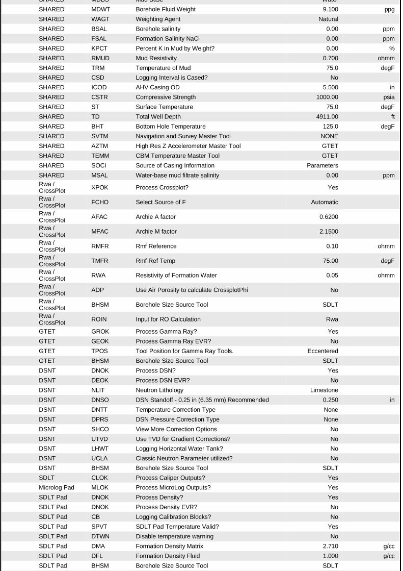
SHARED MDBS Mud Base WaterSHARED MDWT Borehole Fluid Weight 9.100 ppgSHARED WAGT Weighting Agent NaturalSHARED BSAL Borehole salinity 0.00 ppmSHARED FSAL Formation Salinity NaCl 0.00 ppmSHARED KPCT Percent K in Mud by Weight? 0.00 %SHARED RMUD Mud Resistivity 0.700 ohmmSHARED TRM Temperature of Mud 75.0 degFSHARED CSD Logging Interval is Cased? NoSHARED ICOD AHV Casing OD 5.500 inSHARED CSTR Compressive Strength 1000.00 psiaSHARED ST Surface Temperature 75.0 degFSHARED TD Total Well Depth 4911.00 ftSHARED BHT Bottom Hole Temperature 125.0 degFSHARED SVTM Navigation and Survey Master Tool NONESHARED AZTM High Res Z Accelerometer Master Tool GTETSHARED TEMM CBM Temperature Master Tool GTETSHARED SOCI Source of Casing Information ParametersSHARED MSAL Water-base mud filtrate salinity 0.00 ppmRwa / CrossPlot XPOK Process Crossplot? Yes
Rwa / CrossPlot FCHO Select Source of F Automatic
Rwa / CrossPlot AFAC Archie A factor 0.6200
Rwa / CrossPlot MFAC Archie M factor 2.1500
Rwa / CrossPlot RMFR Rmf Reference 0.10 ohmm
Rwa / CrossPlot TMFR Rmf Ref Temp 75.00 degF
Rwa / CrossPlot RWA Resistivity of Formation Water 0.05 ohmm
Rwa / CrossPlot ADP Use Air Porosity to calculate CrossplotPhi No
Rwa / CrossPlot BHSM Borehole Size Source Tool SDLT
Rwa / CrossPlot ROIN Input for RO Calculation Rwa
GTET GROK Process Gamma Ray? YesGTET GEOK Process Gamma Ray EVR? NoGTET TPOS Tool Position for Gamma Ray Tools. EccenteredGTET BHSM Borehole Size Source Tool SDLTDSNT DNOK Process DSN? YesDSNT DEOK Process DSN EVR? NoDSNT NLIT Neutron Lithology LimestoneDSNT DNSO DSN Standoff - 0.25 in (6.35 mm) Recommended 0.250 inDSNT DNTT Temperature Correction Type NoneDSNT DPRS DSN Pressure Correction Type NoneDSNT SHCO View More Correction Options NoDSNT UTVD Use TVD for Gradient Corrections? NoDSNT LHWT Logging Horizontal Water Tank? NoDSNT UCLA Classic Neutron Parameter utilized? NoDSNT BHSM Borehole Size Source Tool SDLTSDLT CLOK Process Caliper Outputs? YesMicrolog Pad MLOK Process MicroLog Outputs? YesSDLT Pad DNOK Process Density? YesSDLT Pad DNOK Process Density EVR? NoSDLT Pad CB Logging Calibration Blocks? NoSDLT Pad SPVT SDLT Pad Temperature Valid? YesSDLT Pad DTWN Disable temperature warning NoSDLT Pad DMA Formation Density Matrix 2.710 g/ccSDLT Pad DFL Formation Density Fluid 1.000 g/ccSDLT Pad BHSM Borehole Size Source Tool SDLT
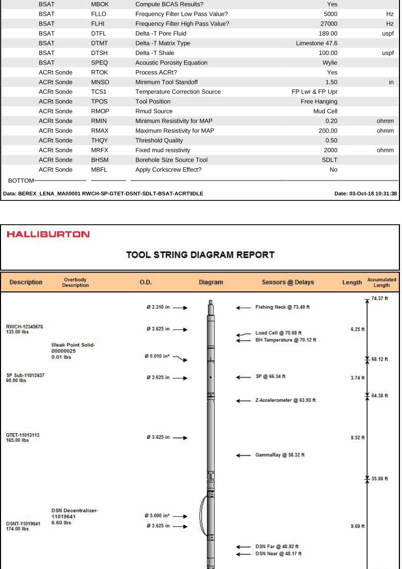
BSAT MBOK Compute BCAS Results? YesBSAT FLLO Frequency Filter Low Pass Value? 5000 HzBSAT FLHI Frequency Filter High Pass Value? 27000 HzBSAT DTFL Delta -T Pore Fluid 189.00 uspfBSAT DTMT Delta -T Matrix Type Limestone 47.6BSAT DTSH Delta -T Shale 100.00 uspfBSAT SPEQ Acoustic Porosity Equation WylieACRt Sonde RTOK Process ACRt? YesACRt Sonde MNSO Minimum Tool Standoff 1.50 inACRt Sonde TCS1 Temperature Correction Source FP Lwr & FP UprACRt Sonde TPOS Tool Position Free HangingACRt Sonde RMOP Rmud Source Mud CellACRt Sonde RMIN Minimum Resistivity for MAP 0.20 ohmmACRt Sonde RMAX Maximum Resistivity for MAP 200.00 ohmmACRt Sonde THQY Threshold Quality 0.50ACRt Sonde MRFX Fixed mud resistivity 2000 ohmmACRt Sonde BHSM Borehole Size Source Tool SDLTACRt Sonde MBFL Apply Corkscrew Effect? No
BOTTOM
Data: BEREX_LENA_MAI\0001 RWCH-SP-GTET-DSNT-SDLT-BSAT-ACRT\IDLE Date: 03-Oct-18 10:31:38
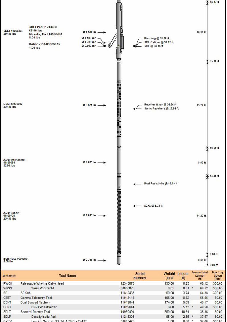
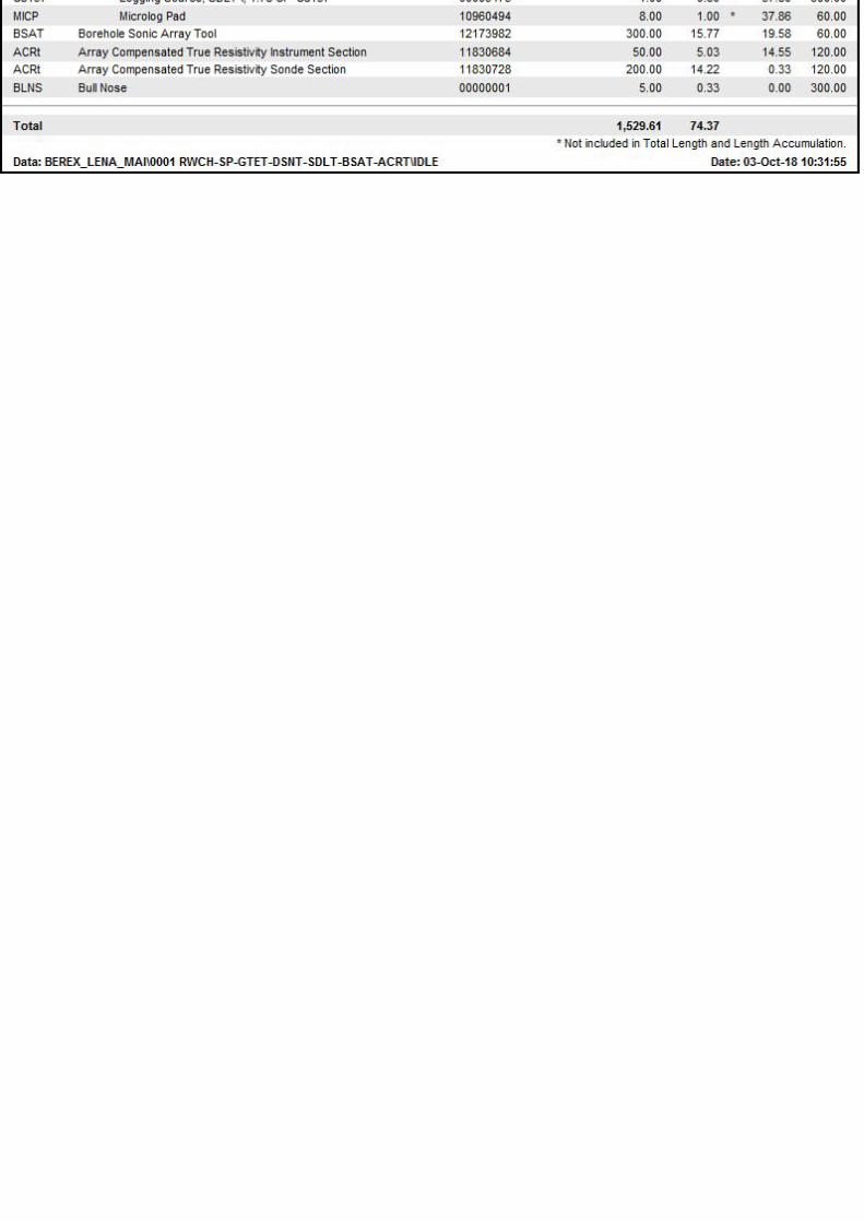
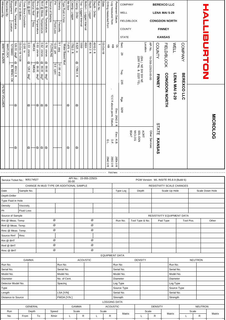
COMPANY BEREXCO LLC
WELL LENA MAI 5-29
FIELD/BLOCK CONGDON NORTH
COUNTY FINNEY
STATE KANSAS
Fold here
Service Ticket No.: 905174527 API No.: 15-055-22503-00-00 PGM Version: WL INSITE R5.8.9 (Build 6)
CHANGE IN MUD TYPE OR ADDITIONAL SAMPLE
Date Sample No.
Depth-Driller
Type Fluid in Hole
Density Viscosity
Ph Fluid Loss
Source of Sample
Rm @ Meas. Temp @ @
Rmf @ Meas. Temp. @ @
Rmc @ Meas. Temp. @ @
Source Rmf Rmc
Rm @ BHT @ @
Rmf @ BHT @ @
Rmc @ BHT @ @
RESISTIVITY SCALE CHANGES
Type Log Depth Scale Up Hole Scale Down Hole
RESISTIVITY EQUIPMENT DATA
Run No. Tool Type & No. Pad Type Tool Pos. Other
EQUIPMENT DATA
GAMMA ACOUSTIC DENSITY NEUTRON
Run No. Run No. Run No. Run No.
Serial No. Serial No. Serial No. Serial No.
Model No. Model No. Model No. Model No.
Diameter No. of Cent. Diameter Diameter
Detector Model No. Spacing Log Type Log Type
Type Source Type Source Type
Length LSA [Y/N] Serial No. Serial No.
Distance to Source FWDA [Y/N ] Strength Strength
LOGGING DATALOGGING DATA
GENERAL GAMMA ACOUSTIC DENSITY NEUTRON
Run Depth Speed Scale ScaleMatrix
ScaleMatrix
ScaleMatrix
No. From To ft/min L R L R L R L R
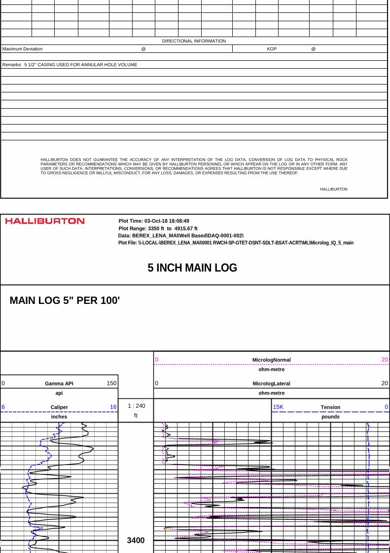
DIRECTIONAL INFORMATION
Maximum Deviation @ KOP @
Remarks: 5 1/2'' CASING USED FOR ANNULAR HOLE VOLUME
HALLIBURTON DOES NOT GUARANTEE THE ACCURACY OF ANY INTERPRETATION OF THE LOG DATA, CONVERSION OF LOG DATA TO PHYSICAL ROCK PARAMETERS OR RECOMMENDATIONS WHICH MAY BE GIVEN BY HALLIBURTON PERSONNEL OR WHICH APPEAR ON THE LOG OR IN ANY OTHER FORM. ANY USER OF SUCH DATA, INTERPRETATIONS, CONVERSIONS, OR RECOMMENDATIONS AGREES THAT HALLIBURTON IS NOT RESPONSIBLE EXCEPT WHERE DUE TO GROSS NEGLIGENCE OR WILLFUL MISCONDUCT, FOR ANY LOSS, DAMAGES, OR EXPENSES RESULTING FROM THE USE THEREOF.
HALLIBURTON
5 INCH MAIN LOG
Data: BEREX_LENA_MAI\Well Based\DAQ-0001-002\Plot Range: 3350 ft to 4915.67 ft
Plot File: \\-LOCAL-\BEREX_LENA_MAI\0001 RWCH-SP-GTET-DSNT-SDLT-BSAT-ACRT\ML\Microlog_IQ_5_main
Plot Time: 03-Oct-18 18:08:49
MAIN LOG 5" PER 100'
MicrologNormal
ohm-metre
0 20
Gamma API
api
0 150 MicrologLateral
ohm-metre
0 20
ft
1 : 240Caliper
inches
6 16 Tension
pounds
15K 0
3400
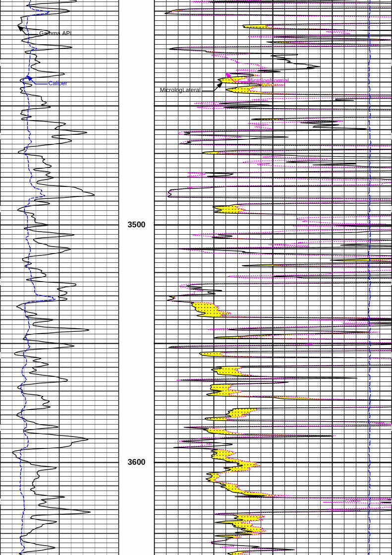
Gamma API
Caliper MicrologNormalMicrologLateral
3500
3600
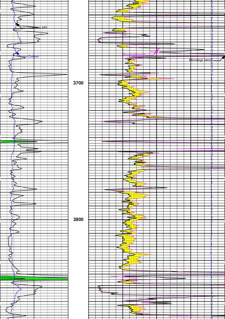
Gamma API
Caliper MicrologNormalMicrologLateral
3700
3800
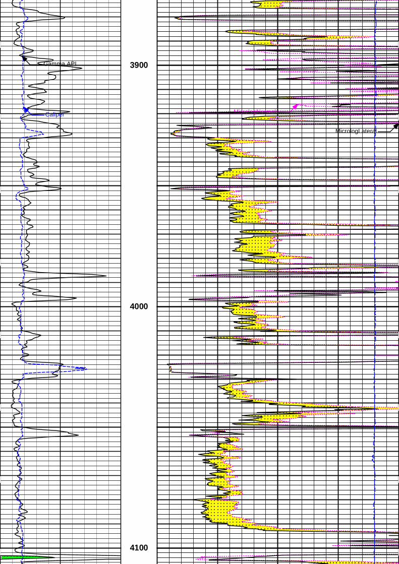
Gamma API
Caliper MicrologNormal
MicrologLateral
3900
4000
4100
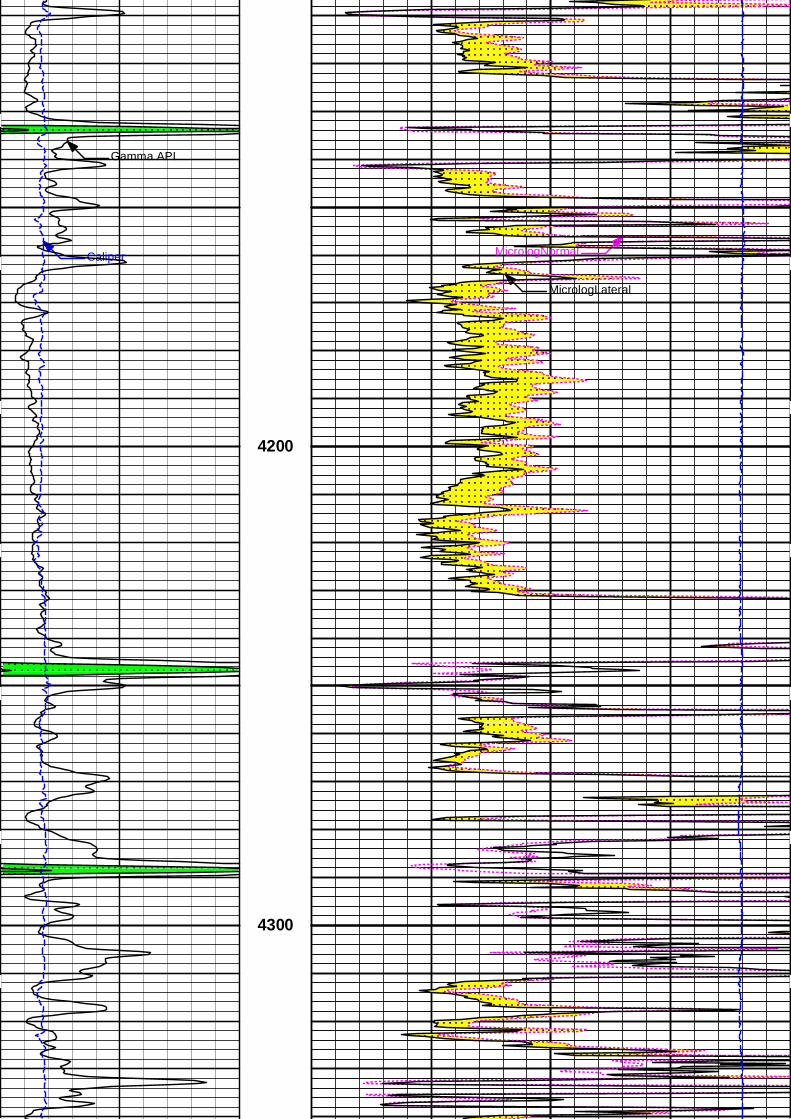
Gamma API
Caliper MicrologNormal
MicrologLateral
4200
4300
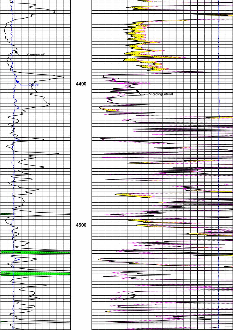
Gamma API
Caliper MicrologNormal
MicrologLateral
4400
4500
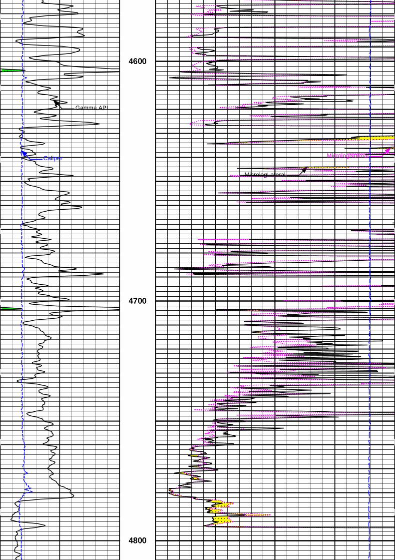
Gamma API
Caliper MicrologNormal
MicrologLateral
4600
4700
4800
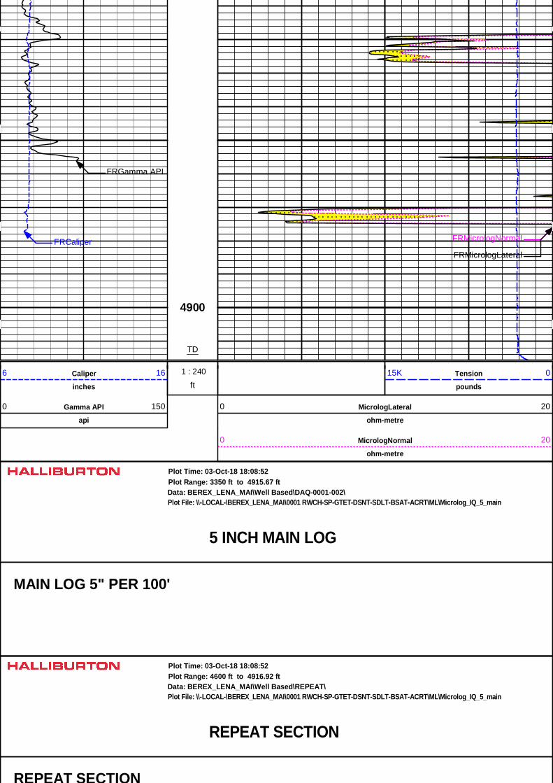
FRGamma API
FRCaliper FRMicrologNormal
FRMicrologLateral
4900
TD
1 : 240ft
1 : 240Caliper
inches
6 16 Tension
pounds
15K 0
Gamma API
api
0 150 MicrologLateral
ohm-metre
0 20
MicrologNormal
ohm-metre
0 20
5 INCH MAIN LOG
Data: BEREX_LENA_MAI\Well Based\DAQ-0001-002\Plot Range: 3350 ft to 4915.67 ft
Plot File: \\-LOCAL-\BEREX_LENA_MAI\0001 RWCH-SP-GTET-DSNT-SDLT-BSAT-ACRT\ML\Microlog_IQ_5_main
Plot Time: 03-Oct-18 18:08:52
MAIN LOG 5" PER 100'
REPEAT SECTION
Data: BEREX_LENA_MAI\Well Based\REPEAT\Plot Range: 4600 ft to 4916.92 ft
Plot File: \\-LOCAL-\BEREX_LENA_MAI\0001 RWCH-SP-GTET-DSNT-SDLT-BSAT-ACRT\ML\Microlog_IQ_5_main
Plot Time: 03-Oct-18 18:08:52
REPEAT SECTION
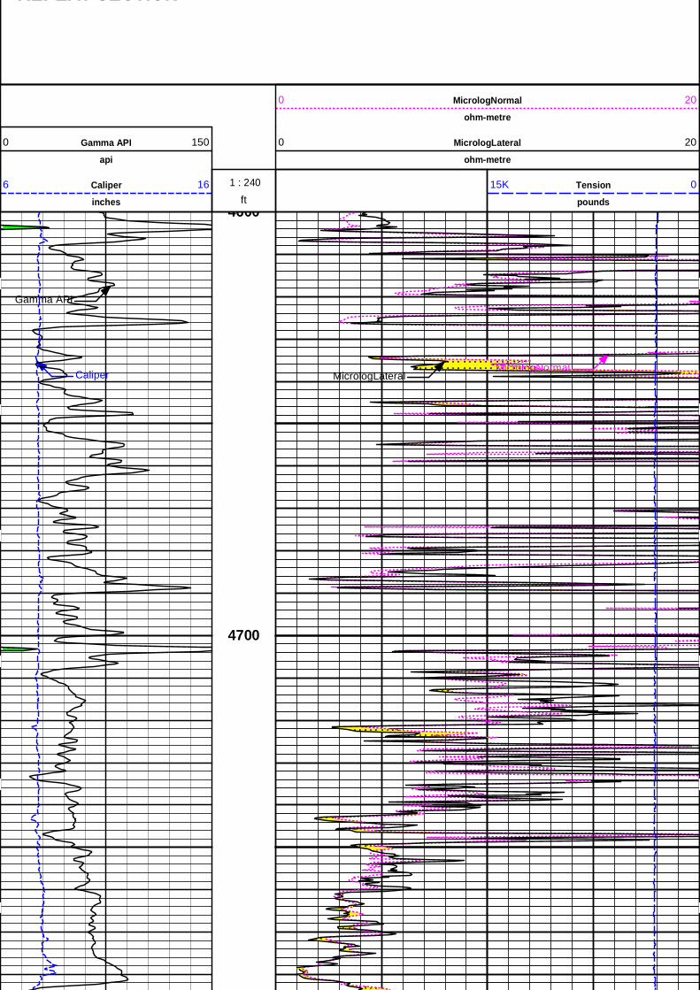
REPEAT SECTION
MicrologNormal
ohm-metre
0 20
Gamma API
api
0 150 MicrologLateral
ohm-metre
0 20
ft 1 : 240Caliper
inches
6 16 Tension
pounds
15K 0
Gamma API
CaliperMicrologNormal
MicrologLateral
4600
4700
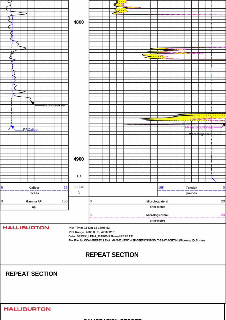
FRGamma API
4800
4900
FRCaliperFRMicrologNormal
FRMicrologLateral
4900
TD
ft
1 : 240Caliper
inches
6 16 Tension
pounds
15K 0
Gamma API
api
0 150 MicrologLateral
ohm-metre
0 20
MicrologNormal
ohm-metre
0 20
REPEAT SECTION
Data: BEREX_LENA_MAI\Well Based\REPEAT\Plot Range: 4600 ft to 4916.92 ft
Plot File: \\-LOCAL-\BEREX_LENA_MAI\0001 RWCH-SP-GTET-DSNT-SDLT-BSAT-ACRT\ML\Microlog_IQ_5_main
Plot Time: 03-Oct-18 18:08:53
REPEAT SECTION
CALIBRATION REPORT
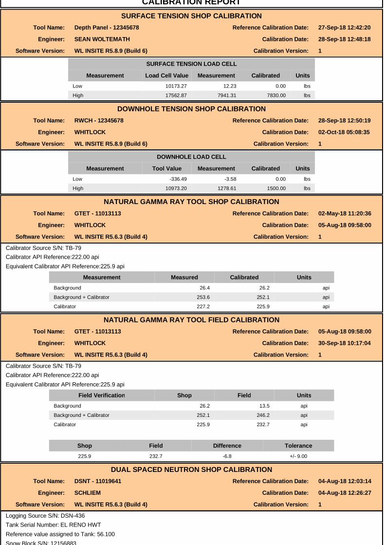
CALIBRATION REPORTSURFACE TENSION SHOP CALIBRATION
Tool Name: Depth Panel - 12345678 Reference Calibration Date: 27-Sep-18 12:42:20
Engineer: SEAN WOLTEMATH Calibration Date: 28-Sep-18 12:48:18
Software Version: WL INSITE R5.8.9 (Build 6) Calibration Version: 1
SURFACE TENSION LOAD CELL
Measurement Load Cell Value Measurement Calibrated UnitsLow 10173.27 12.23 0.00 lbs
High 17562.87 7941.31 7830.00 lbs
DOWNHOLE TENSION SHOP CALIBRATIONTool Name: RWCH - 12345678 Reference Calibration Date: 28-Sep-18 12:50:19
Engineer: WHITLOCK Calibration Date: 02-Oct-18 05:08:35
Software Version: WL INSITE R5.8.9 (Build 6) Calibration Version: 1
DOWNHOLE LOAD CELLDOWNHOLE LOAD CELL
Measurement Tool Value Measurement Calibrated UnitsLow -336.49 -3.58 0.00 lbs
High 10973.20 1278.61 1500.00 lbs
NATURAL GAMMA RAY TOOL SHOP CALIBRATIONTool Name: GTET - 11013113 Reference Calibration Date: 02-May-18 11:20:36
Engineer: WHITLOCK Calibration Date: 05-Aug-18 09:58:00
Software Version: WL INSITE R5.6.3 (Build 4) Calibration Version: 1
Calibrator Source S/N: TB-79Calibrator API Reference:222.00 apiEquivalent Calibrator API Reference:225.9 api
Measurement Measured Calibrated UnitsBackground 26.4 26.2 api
Background + Calibrator 253.6 252.1 api
Calibrator 227.2 225.9 api
NATURAL GAMMA RAY TOOL FIELD CALIBRATIONTool Name: GTET - 11013113 Reference Calibration Date: 05-Aug-18 09:58:00
Engineer: WHITLOCK Calibration Date: 30-Sep-18 10:17:04
Software Version: WL INSITE R5.6.3 (Build 4) Calibration Version: 1
Calibrator Source S/N: TB-79Calibrator API Reference:222.00 apiEquivalent Calibrator API Reference:225.9 api
Field Verification Shop Field UnitsBackground 26.2 13.5 api
Background + Calibrator 252.1 246.2 api
Calibrator 225.9 232.7 api
Shop Field Difference Tolerance225.9 232.7 -6.8 +/- 9.00
DUAL SPACED NEUTRON SHOP CALIBRATIONTool Name: DSNT - 11019641 Reference Calibration Date: 04-Aug-18 12:03:14
Engineer: SCHLIEM Calibration Date: 04-Aug-18 12:26:27
Software Version: WL INSITE R5.6.3 (Build 4) Calibration Version: 1
Logging Source S/N: DSN-436Tank Serial Number: EL RENO HWTReference value assigned to Tank: 56.100Snow Block S/N: 12156883
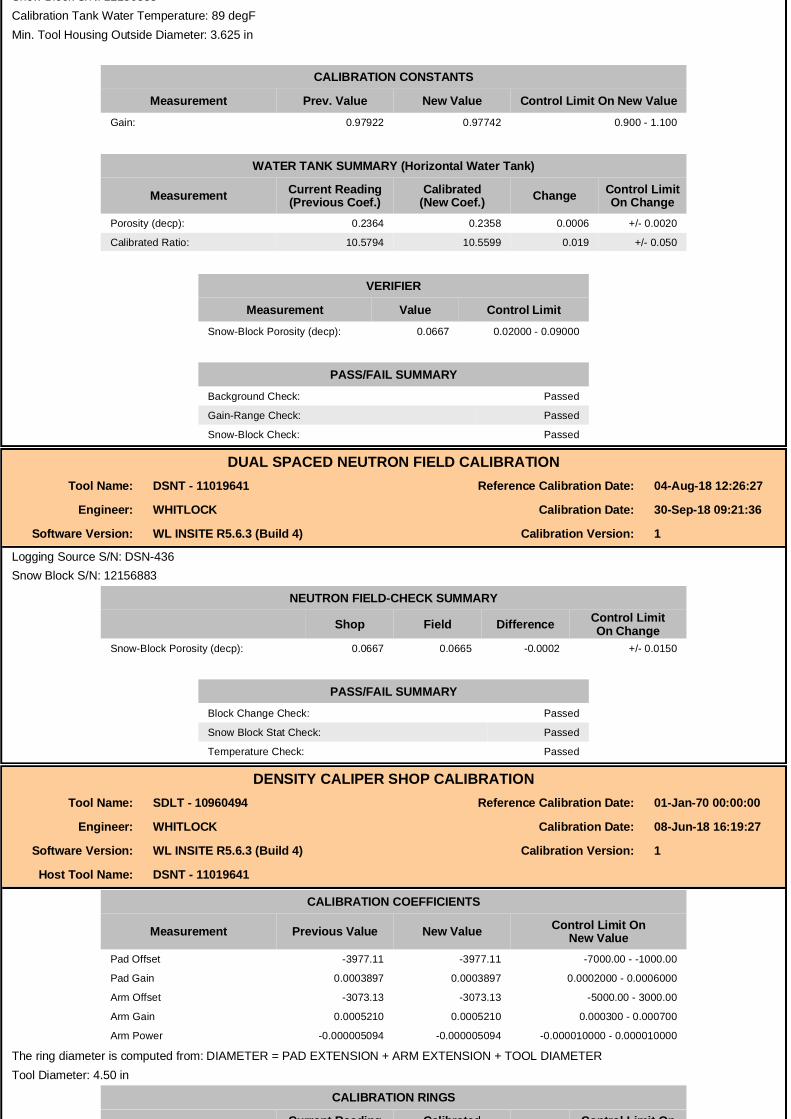
Snow Block S/N: 12156883Calibration Tank Water Temperature: 89 degFMin. Tool Housing Outside Diameter: 3.625 in
CALIBRATION CONSTANTS
Measurement Prev. Value New Value Control Limit On New ValueGain: 0.97922 0.97742 0.900 - 1.100
WATER TANK SUMMARY (Horizontal Water Tank)
Measurement Current Reading(Previous Coef.)
Calibrated(New Coef.) Change Control Limit
On ChangePorosity (decp): 0.2364 0.2358 0.0006 +/- 0.0020
Calibrated Ratio: 10.5794 10.5599 0.019 +/- 0.050
VERIFIER
Measurement Value Control LimitSnow-Block Porosity (decp): 0.0667 0.02000 - 0.09000
PASS/FAIL SUMMARYBackground Check: Passed
Gain-Range Check: Passed
Snow-Block Check: Passed
DUAL SPACED NEUTRON FIELD CALIBRATIONTool Name: DSNT - 11019641 Reference Calibration Date: 04-Aug-18 12:26:27
Engineer: WHITLOCK Calibration Date: 30-Sep-18 09:21:36
Software Version: WL INSITE R5.6.3 (Build 4) Calibration Version: 1
Logging Source S/N: DSN-436Snow Block S/N: 12156883
NEUTRON FIELD-CHECK SUMMARY
Shop Field Difference Control LimitOn Change
Snow-Block Porosity (decp): 0.0667 0.0665 -0.0002 +/- 0.0150
PASS/FAIL SUMMARYBlock Change Check: Passed
Snow Block Stat Check: Passed
Temperature Check: Passed
DENSITY CALIPER SHOP CALIBRATIONTool Name: SDLT - 10960494 Reference Calibration Date: 01-Jan-70 00:00:00
Engineer: WHITLOCK Calibration Date: 08-Jun-18 16:19:27
Software Version: WL INSITE R5.6.3 (Build 4) Calibration Version: 1
Host Tool Name: DSNT - 11019641
CALIBRATION COEFFICIENTS
Measurement Previous Value New Value Control Limit On New Value
Pad Offset -3977.11 -3977.11 -7000.00 - -1000.00
Pad Gain 0.0003897 0.0003897 0.0002000 - 0.0006000
Arm Offset -3073.13 -3073.13 -5000.00 - 3000.00
Arm Gain 0.0005210 0.0005210 0.000300 - 0.000700
Arm Power -0.000005094 -0.000005094 -0.000010000 - 0.000010000
The ring diameter is computed from: DIAMETER = PAD EXTENSION + ARM EXTENSION + TOOL DIAMETERTool Diameter: 4.50 in
CALIBRATION RINGS
Current Reading Calibrated Control Limit On
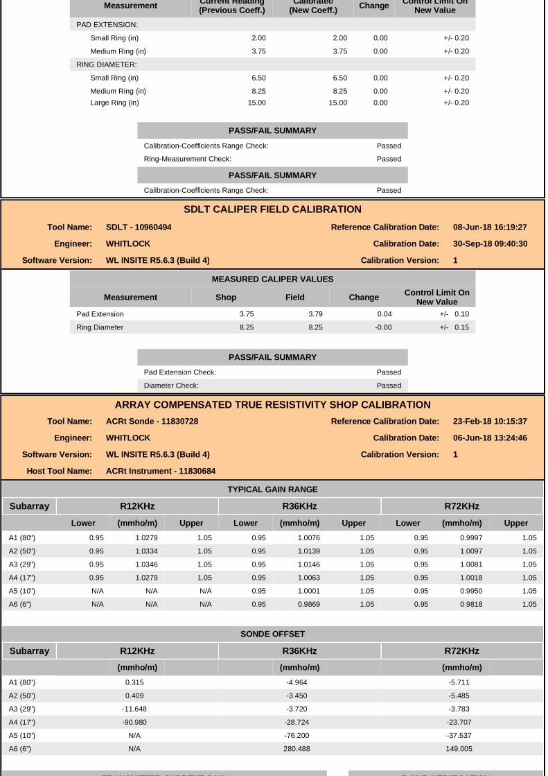
Measurement Current Reading(Previous Coeff.)
Calibrated(New Coeff.) Change Control Limit On
New ValuePAD EXTENSION:
Small Ring (in) 2.00 2.00 0.00 +/- 0.20
Medium Ring (in) 3.75 3.75 0.00 +/- 0.20
RING DIAMETER:
Small Ring (in) 6.50 6.50 0.00 +/- 0.20
Medium Ring (in) 8.25 8.25 0.00 +/- 0.20Large Ring (in) 15.00 15.00 0.00 +/- 0.20
PASS/FAIL SUMMARYPASS/FAIL SUMMARY
Calibration-Coefficients Range Check: Passed
Ring-Measurement Check: Passed
PASS/FAIL SUMMARYCalibration-Coefficients Range Check: Passed
SDLT CALIPER FIELD CALIBRATIONTool Name: SDLT - 10960494 Reference Calibration Date: 08-Jun-18 16:19:27
Engineer: WHITLOCK Calibration Date: 30-Sep-18 09:40:30
Software Version: WL INSITE R5.6.3 (Build 4) Calibration Version: 1
MEASURED CALIPER VALUES
Measurement Shop Field Change Control Limit OnNew Value
Pad Extension 3.75 3.79 0.04 +/- 0.10
Ring Diameter 8.25 8.25 -0.00 +/- 0.15
PASS/FAIL SUMMARYPad Extension Check: Passed
Diameter Check: Passed
ARRAY COMPENSATED TRUE RESISTIVITY SHOP CALIBRATIONTool Name: ACRt Sonde - 11830728 Reference Calibration Date: 23-Feb-18 10:15:37
Engineer: WHITLOCK Calibration Date: 06-Jun-18 13:24:46
Software Version: WL INSITE R5.6.3 (Build 4) Calibration Version: 1
Host Tool Name: ACRt Instrument - 11830684
TYPICAL GAIN RANGE
Subarray R12KHz R36KHz R72KHz
Lower (mmho/m) Upper Lower (mmho/m) Upper Lower (mmho/m) UpperA1 (80") 0.95 1.0279 1.05 0.95 1.0076 1.05 0.95 0.9997 1.05
A2 (50") 0.95 1.0334 1.05 0.95 1.0139 1.05 0.95 1.0097 1.05
A3 (29") 0.95 1.0346 1.05 0.95 1.0146 1.05 0.95 1.0081 1.05
A4 (17") 0.95 1.0279 1.05 0.95 1.0063 1.05 0.95 1.0018 1.05
A5 (10") N/A N/A N/A 0.95 1.0001 1.05 0.95 0.9950 1.05
A6 (6") N/A N/A N/A 0.95 0.9869 1.05 0.95 0.9818 1.05
SONDE OFFSET
Subarray R12KHz R36KHz R72KHz(mmho/m) (mmho/m) (mmho/m)
A1 (80") 0.315 -4.964 -5.711
A2 (50") 0.409 -3.450 -5.485
A3 (29") -11.648 -3.720 -3.783
A4 (17") -90.980 -28.724 -23.707
A5 (10") N/A -76.200 -37.537
A6 (6") N/A 280.488 149.005
TRANSMITTER CURRENT GAIN R-MUD VERIFICATION
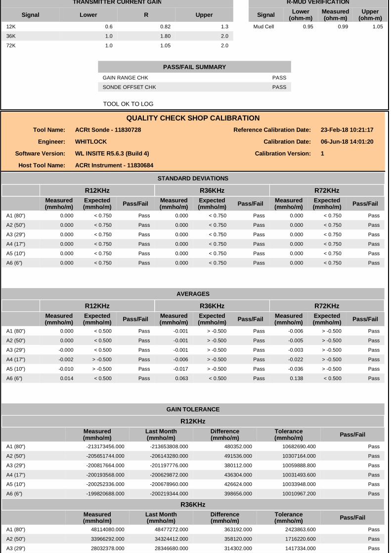
TRANSMITTER CURRENT GAIN R-MUD VERIFICATION
Signal Lower R Upper Signal Lower(ohm-m)
Measured(ohm-m)
Upper(ohm-m)
12K 0.6 0.82 1.3 Mud Cell 0.95 0.99 1.05
36K 1.0 1.80 2.0
72K 1.0 1.05 2.0
PASS/FAIL SUMMARYGAIN RANGE CHK PASS
SONDE OFFSET CHK PASS
TOOL OK TO LOG
QUALITY CHECK SHOP CALIBRATIONTool Name: ACRt Sonde - 11830728 Reference Calibration Date: 23-Feb-18 10:21:17
Engineer: WHITLOCK Calibration Date: 06-Jun-18 14:01:20
Software Version: WL INSITE R5.6.3 (Build 4) Calibration Version: 1
Host Tool Name: ACRt Instrument - 11830684
STANDARD DEVIATIONS
R12KHz R36KHz R72KHzMeasured(mmho/m)
Expected(mmho/m) Pass/Fail Measured
(mmho/m)Expected(mmho/m) Pass/Fail Measured
(mmho/m)Expected(mmho/m) Pass/Fail
A1 (80") 0.000 < 0.750 Pass 0.000 < 0.750 Pass 0.000 < 0.750 Pass
A2 (50") 0.000 < 0.750 Pass 0.000 < 0.750 Pass 0.000 < 0.750 Pass
A3 (29") 0.000 < 0.750 Pass 0.000 < 0.750 Pass 0.000 < 0.750 Pass
A4 (17") 0.000 < 0.750 Pass 0.000 < 0.750 Pass 0.000 < 0.750 Pass
A5 (10") 0.000 < 0.750 Pass 0.000 < 0.750 Pass 0.000 < 0.750 Pass
A6 (6") 0.000 < 0.750 Pass 0.000 < 0.750 Pass 0.000 < 0.750 Pass
AVERAGES
R12KHz R36KHz R72KHzMeasured(mmho/m)
Expected(mmho/m) Pass/Fail Measured
(mmho/m)Expected(mmho/m) Pass/Fail Measured
(mmho/m)Expected(mmho/m) Pass/Fail
A1 (80") 0.000 < 0.500 Pass -0.001 > -0.500 Pass -0.006 > -0.500 Pass
A2 (50") 0.000 < 0.500 Pass -0.001 > -0.500 Pass -0.005 > -0.500 Pass
A3 (29") -0.000 < 0.500 Pass -0.001 > -0.500 Pass -0.003 > -0.500 Pass
A4 (17") -0.002 > -0.500 Pass -0.006 > -0.500 Pass -0.022 > -0.500 Pass
A5 (10") -0.010 > -0.500 Pass -0.017 > -0.500 Pass -0.036 > -0.500 Pass
A6 (6") 0.014 < 0.500 Pass 0.063 < 0.500 Pass 0.138 < 0.500 Pass
GAIN TOLERANCE
R12KHzMeasured(mmho/m)
Last Month(mmho/m)
Difference(mmho/m)
Tolerance(mmho/m) Pass/Fail
A1 (80") -213173456.000 -213653808.000 480352.000 10682690.400 Pass
A2 (50") -205651744.000 -206143280.000 491536.000 10307164.000 Pass
A3 (29") -200817664.000 -201197776.000 380112.000 10059888.800 Pass
A4 (17") -200193568.000 -200629872.000 436304.000 10031493.600 Pass
A5 (10") -200252336.000 -200678960.000 426624.000 10033948.000 Pass
A6 (6") -199820688.000 -200219344.000 398656.000 10010967.200 Pass
R36KHzMeasured(mmho/m)
Last Month(mmho/m)
Difference(mmho/m)
Tolerance(mmho/m) Pass/Fail
A1 (80") 48114080.000 48477272.000 363192.000 2423863.600 Pass
A2 (50") 33966292.000 34324412.000 358120.000 1716220.600 Pass
A3 (29") 28032378.000 28346680.000 314302.000 1417334.000 Pass
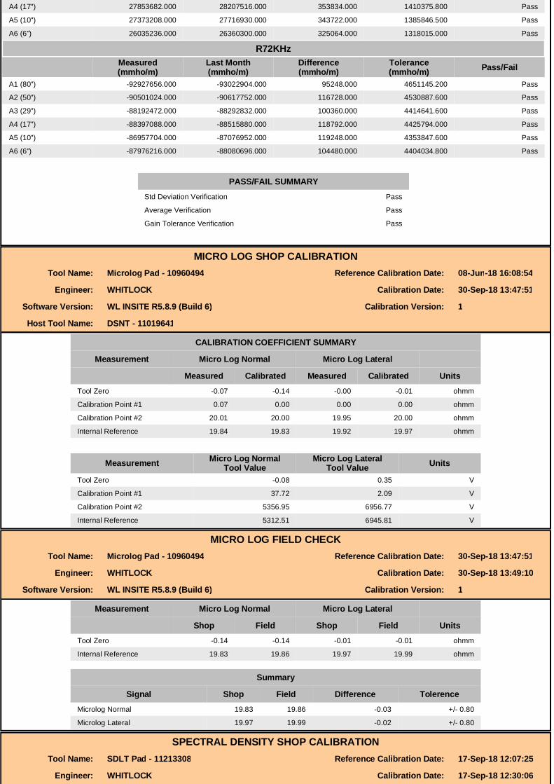
A4 (17") 27853682.000 28207516.000 353834.000 1410375.800 Pass
A5 (10") 27373208.000 27716930.000 343722.000 1385846.500 Pass
A6 (6") 26035236.000 26360300.000 325064.000 1318015.000 Pass
R72KHzR72KHzMeasured(mmho/m)
Last Month(mmho/m)
Difference(mmho/m)
Tolerance(mmho/m) Pass/Fail
A1 (80") -92927656.000 -93022904.000 95248.000 4651145.200 Pass
A2 (50") -90501024.000 -90617752.000 116728.000 4530887.600 Pass
A3 (29") -88192472.000 -88292832.000 100360.000 4414641.600 Pass
A4 (17") -88397088.000 -88515880.000 118792.000 4425794.000 Pass
A5 (10") -86957704.000 -87076952.000 119248.000 4353847.600 Pass
A6 (6") -87976216.000 -88080696.000 104480.000 4404034.800 Pass
PASS/FAIL SUMMARYStd Deviation Verification Pass
Average Verification Pass
Gain Tolerance Verification Pass
MICRO LOG SHOP CALIBRATIONTool Name: Microlog Pad - 10960494 Reference Calibration Date: 08-Jun-18 16:08:54
Engineer: WHITLOCK Calibration Date: 30-Sep-18 13:47:51
Software Version: WL INSITE R5.8.9 (Build 6) Calibration Version: 1
Host Tool Name: DSNT - 11019641
CALIBRATION COEFFICIENT SUMMARY
Measurement Micro Log Normal Micro Log Lateral
Measured Calibrated Measured Calibrated UnitsTool Zero -0.07 -0.14 -0.00 -0.01 ohmm
Calibration Point #1 0.07 0.00 0.00 0.00 ohmm
Calibration Point #2 20.01 20.00 19.95 20.00 ohmm
Internal Reference 19.84 19.83 19.92 19.97 ohmm
Measurement Micro Log NormalTool Value
Micro Log LateralTool Value Units
Tool Zero -0.08 0.35 V
Calibration Point #1 37.72 2.09 V
Calibration Point #2 5356.95 6956.77 V
Internal Reference 5312.51 6945.81 V
MICRO LOG FIELD CHECKTool Name: Microlog Pad - 10960494 Reference Calibration Date: 30-Sep-18 13:47:51
Engineer: WHITLOCK Calibration Date: 30-Sep-18 13:49:10
Software Version: WL INSITE R5.8.9 (Build 6) Calibration Version: 1
Measurement Micro Log Normal Micro Log Lateral
Shop Field Shop Field UnitsTool Zero -0.14 -0.14 -0.01 -0.01 ohmm
Internal Reference 19.83 19.86 19.97 19.99 ohmm
Summary
Signal Shop Field Difference TolerenceMicrolog Normal 19.83 19.86 -0.03 +/- 0.80
Microlog Lateral 19.97 19.99 -0.02 +/- 0.80
SPECTRAL DENSITY SHOP CALIBRATIONTool Name: SDLT Pad - 11213308 Reference Calibration Date: 17-Sep-18 12:07:25
Engineer: WHITLOCK Calibration Date: 17-Sep-18 12:30:06
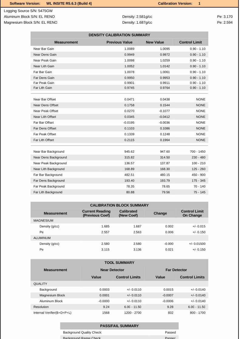
Software Version: WL INSITE R5.6.3 (Build 4) Calibration Version: 1
Logging Source S/N: 5475GWAluminum Block S/N: EL RENO Density: 2.581g/cc Pe: 3.170Magnesium Block S/N: EL RENO Density: 1.687g/cc Pe: 2.594
DENSITY CALIBRATION SUMMARY
Measurement Previous Value New Value Control LimitNear Bar Gain 1.0089 1.0095 0.90 - 1.10
Near Dens Gain 0.9949 0.9972 0.90 - 1.10
Near Peak Gain 1.0098 1.0259 0.90 - 1.10
Near Lith Gain 1.0052 1.0142 0.90 - 1.10
Far Bar Gain 1.0078 1.0061 0.90 - 1.10
Far Dens Gain 0.9950 0.9953 0.90 - 1.10Far Peak Gain 0.9901 0.9911 0.90 - 1.10Far Lith Gain 0.9745 0.9764 0.90 - 1.10
Near Bar Offset 0.0471 0.0438 NONE
Near Dens Offset 0.1758 0.1544 NONE
Near Peak Offset 0.0270 -0.1077 NONE
Near Lith Offset 0.0345 -0.0412 NONE
Far Bar Offset -0.0195 -0.0036 NONE
Far Dens Offset 0.1103 0.1086 NONE
Far Peak Offset 0.1339 0.1248 NONE
Far Lith Offset 0.2115 0.1964 NONE
Near Bar Background 945.62 947.60 700 - 1450
Near Dens Background 315.82 314.50 230 - 480
Near Peak Background 136.57 137.87 100 - 210
Near Lith Background 168.89 168.30 125 - 260
Far Bar Background 482.51 480.15 450 - 900
Far Dens Background 193.40 193.79 175 - 345
Far Peak Background 78.35 78.65 70 - 140
Far Lith Background 80.88 79.56 75 - 145
CALIBRATION BLOCK SUMMARY
Measurement Current Reading(Previous Coef)
Calibrated(New Coef) Change Control Limit
On ChangeMAGNESIUM
Density (g/cc) 1.685 1.687 0.002 +/- 0.015
Pe 2.557 2.563 0.006 +/- 0.150
ALUMINUM
Density (g/cc) 2.580 2.580 -0.000 +/- 0.01500
Pe 3.115 3.136 0.021 +/- 0.150
TOOL SUMMARY
Measurement Near Detector Far Detector
Value Control Limits Value Control Limits
QUALITY
Background 0.0003 +/- 0.0110 0.0015 +/- 0.0140
Magnesium Block 0.0001 +/- 0.0110 -0.0007 +/- 0.0140
Aluminum Block -0.0000 +/- 0.0110 -0.0006 +/- 0.0140
Resolution 9.24 6.00 - 11.50 9.28 6.00 - 11.50
Internal Verifier(B+D+P+L) 1568 1200 - 2700 832 800 - 1700
PASS/FAIL SUMMARYBackground Quality Check: Passed
Background Range Check: Passed
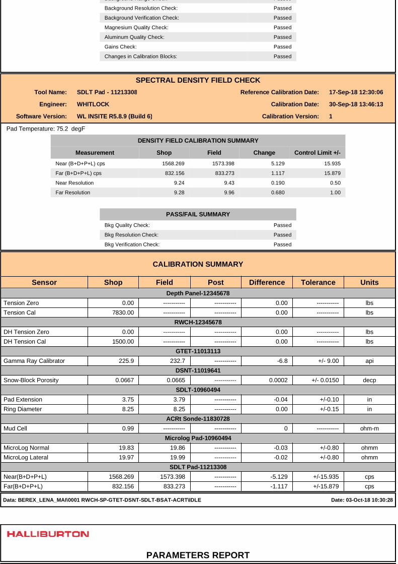
Background Range Check: Passed
Background Resolution Check: Passed
Background Verification Check: Passed
Magnesium Quality Check: Passed
Aluminum Quality Check: Passed
Gains Check: Passed
Changes in Calibration Blocks: Passed
SPECTRAL DENSITY FIELD CHECKTool Name: SDLT Pad - 11213308 Reference Calibration Date: 17-Sep-18 12:30:06
Engineer: WHITLOCK Calibration Date: 30-Sep-18 13:46:13
Software Version: WL INSITE R5.8.9 (Build 6) Calibration Version: 1
Pad Temperature: 75.2 degF
DENSITY FIELD CALIBRATION SUMMARY
Measurement Shop Field Change Control Limit +/-Near (B+D+P+L) cps 1568.269 1573.398 5.129 15.935
Far (B+D+P+L) cps 832.156 833.273 1.117 15.879
Near Resolution 9.24 9.43 0.190 0.50
Far Resolution 9.28 9.96 0.680 1.00
PASS/FAIL SUMMARYBkg Quality Check: Passed
Bkg Resolution Check: Passed
Bkg Verification Check: Passed
CALIBRATION SUMMARY
Sensor Shop Field Post Difference Tolerance Units Depth Panel-12345678
Tension Zero 0.00 ----------- ----------- 0.00 ----------- lbsTension Cal 7830.00 ----------- ----------- 0.00 ----------- lbs
RWCH-12345678 DH Tension Zero 0.00 ----------- ----------- 0.00 ----------- lbsDH Tension Cal 1500.00 ----------- ----------- 0.00 ----------- lbs
GTET-11013113 Gamma Ray Calibrator 225.9 232.7 ----------- -6.8 +/- 9.00 api
DSNT-11019641 Snow-Block Porosity 0.0667 0.0665 ----------- 0.0002 +/- 0.0150 decp
SDLT-10960494 Pad Extension 3.75 3.79 ----------- -0.04 +/-0.10 inRing Diameter 8.25 8.25 ----------- 0.00 +/-0.15 in
ACRt Sonde-11830728 Mud Cell 0.99 ----------- ----------- 0 ----------- ohm-m
Microlog Pad-10960494 MicroLog Normal 19.83 19.86 ----------- -0.03 +/-0.80 ohmmMicroLog Lateral 19.97 19.99 ----------- -0.02 +/-0.80 ohmm
SDLT Pad-11213308 Near(B+D+P+L) 1568.269 1573.398 ----------- -5.129 +/-15.935 cpsFar(B+D+P+L) 832.156 833.273 ----------- -1.117 +/-15.879 cps
Data: BEREX_LENA_MAI\0001 RWCH-SP-GTET-DSNT-SDLT-BSAT-ACRT\IDLE Date: 03-Oct-18 10:30:28
PARAMETERS REPORT
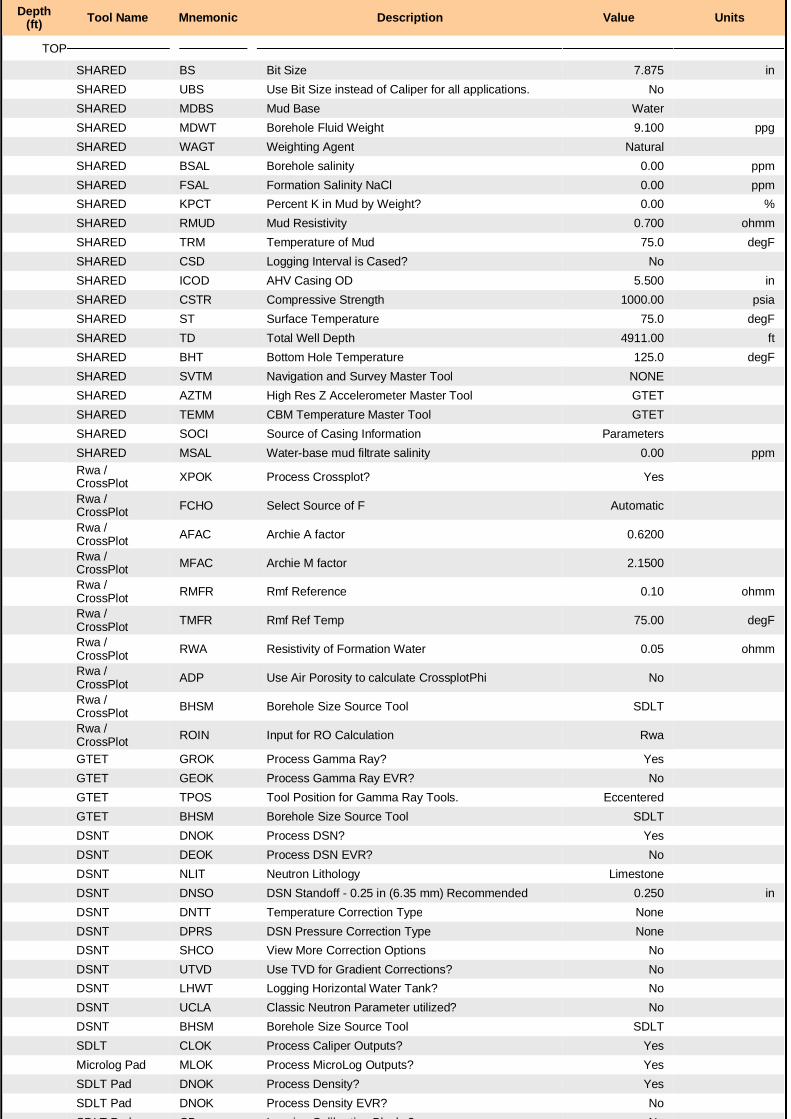
Depth(ft) Tool Name Mnemonic Description Value Units
TOP
SHARED BS Bit Size 7.875 inSHARED UBS Use Bit Size instead of Caliper for all applications. NoSHARED MDBS Mud Base WaterSHARED MDWT Borehole Fluid Weight 9.100 ppgSHARED WAGT Weighting Agent NaturalSHARED BSAL Borehole salinity 0.00 ppmSHARED FSAL Formation Salinity NaCl 0.00 ppmSHARED KPCT Percent K in Mud by Weight? 0.00 %SHARED RMUD Mud Resistivity 0.700 ohmmSHARED TRM Temperature of Mud 75.0 degFSHARED CSD Logging Interval is Cased? NoSHARED ICOD AHV Casing OD 5.500 inSHARED CSTR Compressive Strength 1000.00 psiaSHARED ST Surface Temperature 75.0 degFSHARED TD Total Well Depth 4911.00 ftSHARED BHT Bottom Hole Temperature 125.0 degFSHARED SVTM Navigation and Survey Master Tool NONESHARED AZTM High Res Z Accelerometer Master Tool GTETSHARED TEMM CBM Temperature Master Tool GTETSHARED SOCI Source of Casing Information ParametersSHARED MSAL Water-base mud filtrate salinity 0.00 ppmRwa / CrossPlot XPOK Process Crossplot? Yes
Rwa / CrossPlot FCHO Select Source of F Automatic
Rwa / CrossPlot AFAC Archie A factor 0.6200
Rwa / CrossPlot MFAC Archie M factor 2.1500
Rwa / CrossPlot RMFR Rmf Reference 0.10 ohmm
Rwa / CrossPlot TMFR Rmf Ref Temp 75.00 degF
Rwa / CrossPlot RWA Resistivity of Formation Water 0.05 ohmm
Rwa / CrossPlot ADP Use Air Porosity to calculate CrossplotPhi No
Rwa / CrossPlot BHSM Borehole Size Source Tool SDLT
Rwa / CrossPlot ROIN Input for RO Calculation Rwa
GTET GROK Process Gamma Ray? YesGTET GEOK Process Gamma Ray EVR? NoGTET TPOS Tool Position for Gamma Ray Tools. EccenteredGTET BHSM Borehole Size Source Tool SDLTDSNT DNOK Process DSN? YesDSNT DEOK Process DSN EVR? NoDSNT NLIT Neutron Lithology LimestoneDSNT DNSO DSN Standoff - 0.25 in (6.35 mm) Recommended 0.250 inDSNT DNTT Temperature Correction Type NoneDSNT DNTT Temperature Correction Type NoneDSNT DPRS DSN Pressure Correction Type NoneDSNT SHCO View More Correction Options NoDSNT UTVD Use TVD for Gradient Corrections? NoDSNT LHWT Logging Horizontal Water Tank? NoDSNT UCLA Classic Neutron Parameter utilized? NoDSNT BHSM Borehole Size Source Tool SDLTSDLT CLOK Process Caliper Outputs? YesMicrolog Pad MLOK Process MicroLog Outputs? YesSDLT Pad DNOK Process Density? YesSDLT Pad DNOK Process Density EVR? NoSDLT Pad CB Logging Calibration Blocks? No
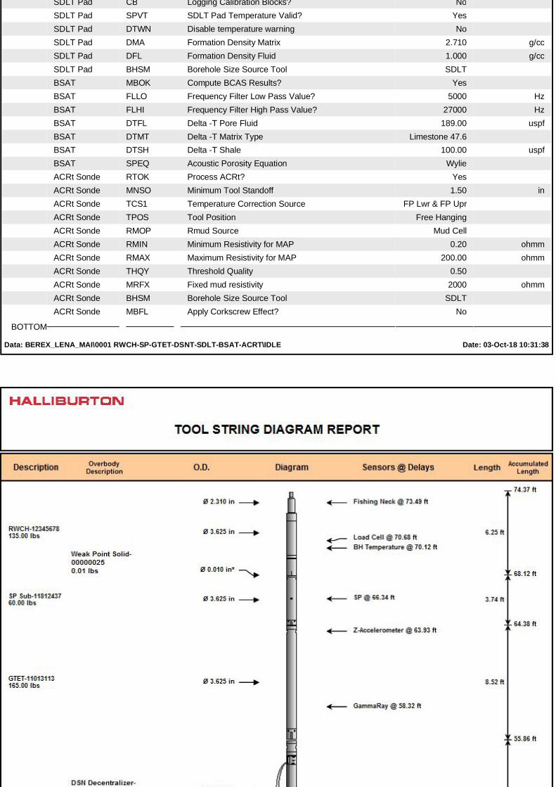
SDLT Pad CB Logging Calibration Blocks? NoSDLT Pad SPVT SDLT Pad Temperature Valid? YesSDLT Pad DTWN Disable temperature warning NoSDLT Pad DMA Formation Density Matrix 2.710 g/ccSDLT Pad DFL Formation Density Fluid 1.000 g/ccSDLT Pad BHSM Borehole Size Source Tool SDLTBSAT MBOK Compute BCAS Results? YesBSAT FLLO Frequency Filter Low Pass Value? 5000 HzBSAT FLHI Frequency Filter High Pass Value? 27000 HzBSAT DTFL Delta -T Pore Fluid 189.00 uspfBSAT DTMT Delta -T Matrix Type Limestone 47.6BSAT DTSH Delta -T Shale 100.00 uspfBSAT SPEQ Acoustic Porosity Equation WylieACRt Sonde RTOK Process ACRt? YesACRt Sonde MNSO Minimum Tool Standoff 1.50 inACRt Sonde TCS1 Temperature Correction Source FP Lwr & FP UprACRt Sonde TPOS Tool Position Free HangingACRt Sonde RMOP Rmud Source Mud CellACRt Sonde RMIN Minimum Resistivity for MAP 0.20 ohmmACRt Sonde RMAX Maximum Resistivity for MAP 200.00 ohmmACRt Sonde THQY Threshold Quality 0.50ACRt Sonde MRFX Fixed mud resistivity 2000 ohmmACRt Sonde BHSM Borehole Size Source Tool SDLTACRt Sonde MBFL Apply Corkscrew Effect? No
BOTTOM
Data: BEREX_LENA_MAI\0001 RWCH-SP-GTET-DSNT-SDLT-BSAT-ACRT\IDLE Date: 03-Oct-18 10:31:38
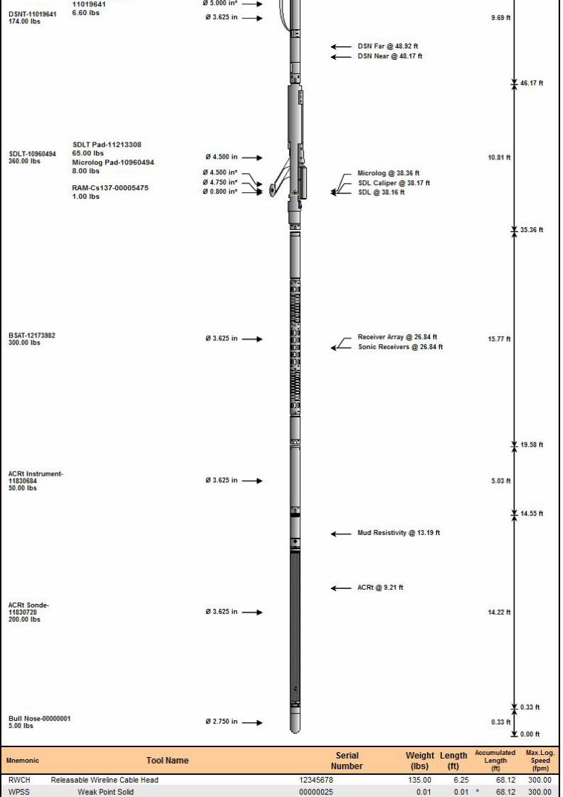
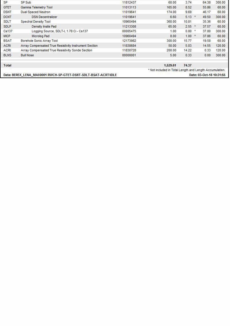
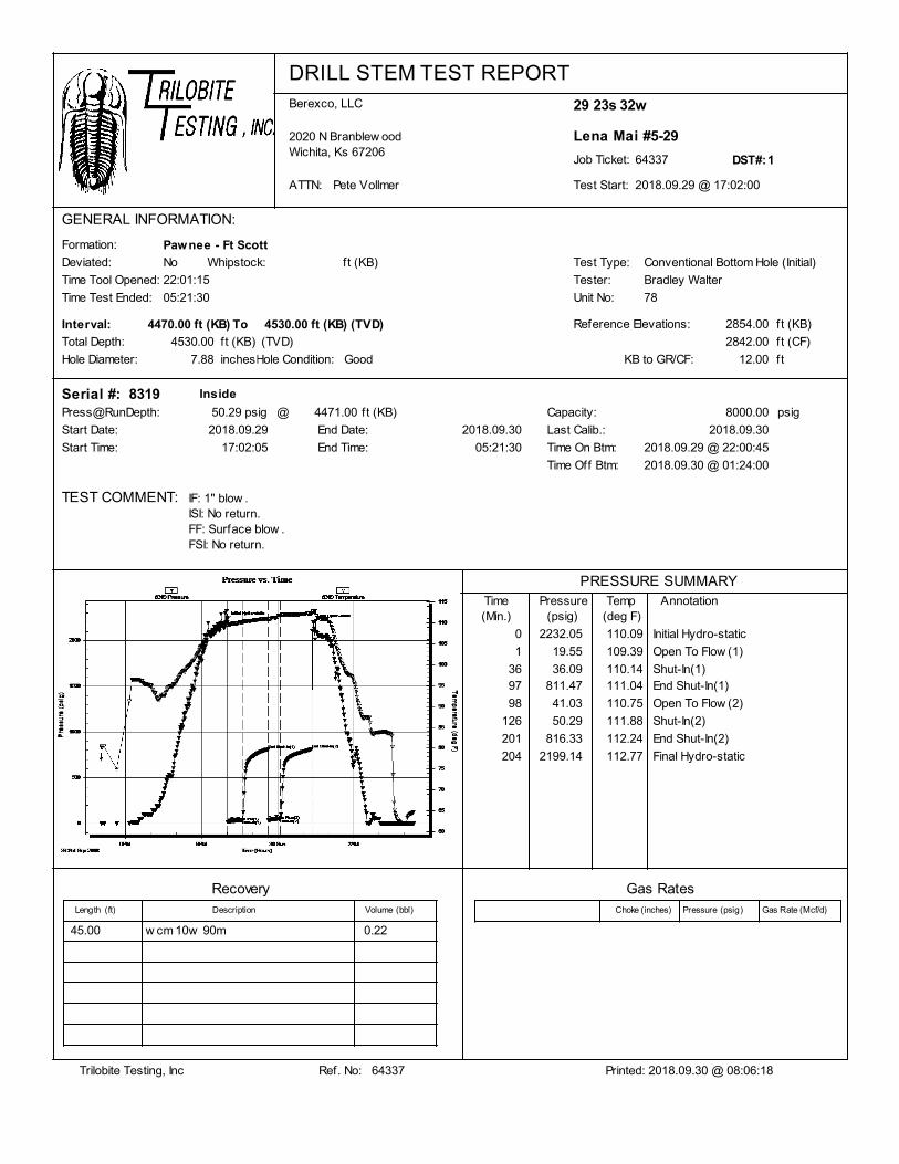
DRILL STEM TEST REPORTBerexco, LLC
2020 N Branblew oodWichita, Ks 67206
ATTN: Pete Vollmer 2018.09.29 @ 17:02:00
64337Job Ticket:
Lena Mai #5-29
29 23s 32w
Test Start:
DST#:1
GENERAL INFORMATION:
Formation:
Reference Elevations:
Total Depth:
Test Type:
Tester:
Unit No:
Hole Diameter: Hole Condition:
Time Tool Opened:
Time Test Ended:
PRESSURE SUMMARY
(deg F)AnnotationTemp
(psig)PressureTime
(Min.)
22:01:15
05:21:30
Pawnee - Ft Scott
7.88
4530.00
Good
Conventional Bottom Hole (Initial)
Bradley Walter
78
2854.00
2842.00
Deviated: No Whipstock: ft (KB)
12.00KB to GR/CF:
ft (KB)
ft (CF)
ft
Start Date:
83194471.00
2018.09.29
ft (KB)
End Date: 2018.09.30
Start Time: 17:02:05
Capacity: 8000.00 psig
Serial #:
Last Calib.: 2018.09.30
End Time: 05:21:30
Press@RunDepth: psig50.29
Time On Btm:
Time Off Btm: 2018.09.30 @ 01:24:00
2018.09.29 @ 22:00:45
TEST COMMENT:
Inside
@
Interval: 4530.00ft (KB)4470.00 ft (KB) (TVD)To
inches
ft (KB)
IF: 1" blow .ISI: No return.FF: Surface blow .FSI: No return.
(TVD)
2232.05 110.090 Initial Hydro-static
19.55 109.391 Open To Flow (1)
36.09 110.1436 Shut-In(1)811.47 111.0497 End Shut-In(1)
41.03 110.7598 Open To Flow (2)
50.29 111.88126 Shut-In(2)
816.33 112.24201 End Shut-In(2)
2199.14 112.77204 Final Hydro-static
RecoveryLength Description Volume
Gas RatesChoke Pressure Gas Rate(psig) (Mcf/d)(inches)(ft) (bbl)
45.00 w cm 10w 90m 0.22
Trilobite Testing, Inc Printed: 2018.09.30 @ 08:06:18Ref. No: 64337
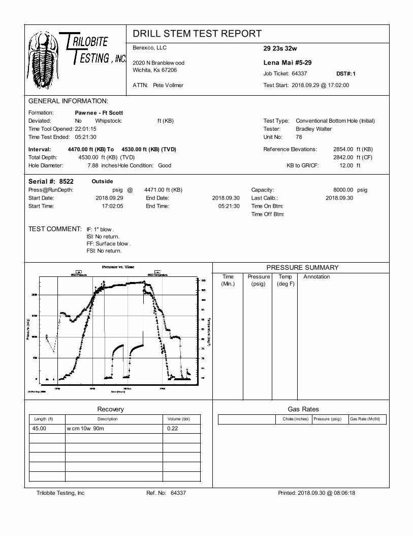
DRILL STEM TEST REPORTBerexco, LLC
2020 N Branblew oodWichita, Ks 67206
ATTN: Pete Vollmer 2018.09.29 @ 17:02:00
64337Job Ticket:
Lena Mai #5-29
29 23s 32w
Test Start:
DST#:1
GENERAL INFORMATION:
Formation:
Reference Elevations:
Total Depth:
Test Type:
Tester:
Unit No:
Hole Diameter: Hole Condition:
Time Tool Opened:
Time Test Ended:
PRESSURE SUMMARY
(deg F)AnnotationTemp
(psig)PressureTime
(Min.)
22:01:15
05:21:30
Pawnee - Ft Scott
7.88
4530.00
Good
Conventional Bottom Hole (Initial)
Bradley Walter
78
2854.00
2842.00
Deviated: No Whipstock: ft (KB)
12.00KB to GR/CF:
ft (KB)
ft (CF)
ft
Start Date:
85224471.00
2018.09.29
ft (KB)
End Date: 2018.09.30
Start Time: 17:02:05
Capacity: 8000.00 psig
Serial #:
Last Calib.: 2018.09.30
End Time: 05:21:30
Press@RunDepth: psig
Time On Btm:
Time Off Btm:
TEST COMMENT:
Outside
@
Interval: 4530.00ft (KB)4470.00 ft (KB) (TVD)To
inches
ft (KB)
IF: 1" blow .ISI: No return.FF: Surface blow .FSI: No return.
(TVD)
RecoveryLength Description Volume
Gas RatesChoke Pressure Gas Rate(psig) (Mcf/d)(inches)(ft) (bbl)
45.00 w cm 10w 90m 0.22
Trilobite Testing, Inc Printed: 2018.09.30 @ 08:06:18Ref. No: 64337
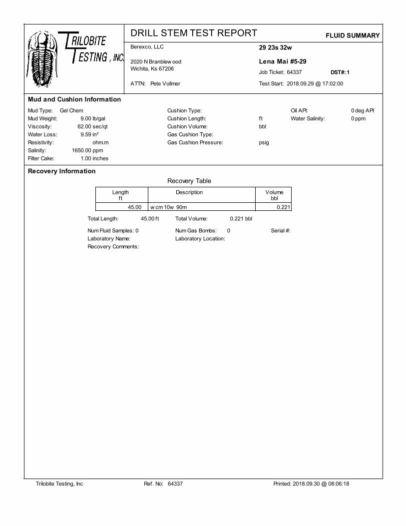
DRILL STEM TEST REPORTBerexco, LLC
2020 N Branblew oodWichita, Ks 67206
ATTN: Pete Vollmer 2018.09.29 @ 17:02:00
64337Job Ticket:
Lena Mai #5-29
29 23s 32w
Test Start:
DST#:1
Mud and Cushion Information
Mud Type:
Mud Weight:
Viscosity:
Filter Cake:
Salinity:
Resistivity:
Water Loss:
Gel Chem
9.00
62.00
9.59
1650.00
1.00
Cushion Type:
Cushion Length:
Cushion Volume:
Gas Cushion Type:
Gas Cushion Pressure:
lb/gal
sec/qt
ohm.m
ppm
inches
bbl
ft
psig
Recovery Table
Length Description Volumeft bbl
Recovery Information
FLUID SUMMARY
Oil API:
Water Salinity:
0
0 ppm
deg API
in³
45.00 w cm 10w 90m 0.221
Total Length: 45.00 ft Total Volume: 0.221 bbl
Num Fluid Samples: Num Gas Bombs:0 0
Laboratory Name: Laboratory Location:
Recovery Comments:
Serial #:
Trilobite Testing, Inc Printed: 2018.09.30 @ 08:06:18Ref. No: 64337
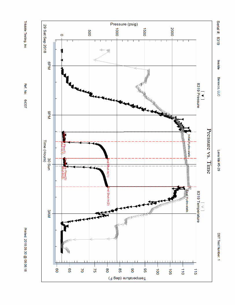
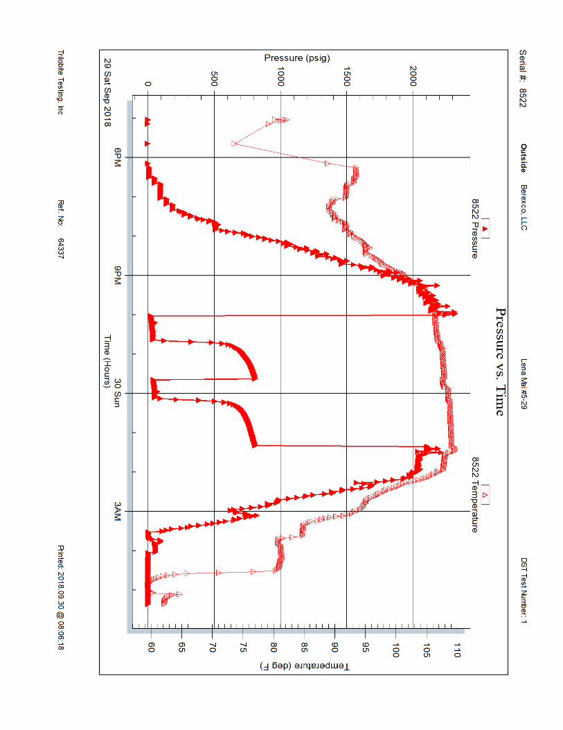

DRILL STEM TEST REPORTBerexco, LLC
2020 N Branblew oodWichita, Ks 67206
ATTN: Pete Vollmer 2018.10.02 @ 01:44:00
64338Job Ticket:
Lena Mai #5-29
29 23s 32w
Test Start:
DST#:2
GENERAL INFORMATION:
Formation:
Reference Elevations:
Total Depth:
Test Type:
Tester:
Unit No:
Hole Diameter: Hole Condition:
Time Tool Opened:
Time Test Ended:
PRESSURE SUMMARY
(deg F)AnnotationTemp
(psig)PressureTime
(Min.)
07:51:30
15:08:45
Morrow Sand - St lou
7.88
4810.00
Good
Conventional Bottom Hole (Reset)
Bradley Walter
78
2854.00
2842.00
Deviated: No Whipstock: ft (KB)
12.00KB to GR/CF:
ft (KB)
ft (CF)
ft
Start Date:
85224781.00
2018.10.02
ft (KB)
End Date: 2018.10.02
Start Time: 01:44:05
Capacity: 8000.00 psig
Serial #:
Last Calib.: 2018.10.02
End Time: 15:08:45
Press@RunDepth: psig96.50
Time On Btm:
Time Off Btm: 2018.10.02 @ 12:28:30
2018.10.02 @ 07:51:00
TEST COMMENT:
Outside
@
Interval: 4810.00ft (KB)4780.00 ft (KB) (TVD)To
inches
ft (KB)
IF: 5 1/2 " blow .ISI: No returnFF: 2" blow .FSI: No return.
(TVD)
2383.85 112.940 Initial Hydro-static
28.49 112.551 Open To Flow (1)
79.68 115.6837 Shut-In(1)100.92 115.8396 End Shut-In(1)
87.16 115.8096 Open To Flow (2)
96.50 116.07155 Shut-In(2)
100.61 116.32276 End Shut-In(2)
2338.12 115.89278 Final Hydro-static
RecoveryLength Description Volume
Gas RatesChoke Pressure Gas Rate(psig) (Mcf/d)(inches)(ft) (bbl)
150.00 w cm 40w 60m 0.74
30.00 oil 100o 0.15
0.00 90' GIP 0.00
Trilobite Testing, Inc Printed: 2018.10.02 @ 15:37:10Ref. No: 64338
* Recovery from multiple tests
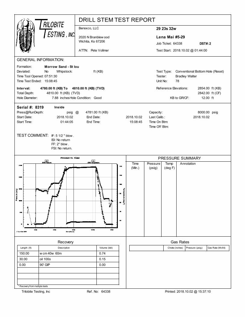
DRILL STEM TEST REPORTBerexco, LLC
2020 N Branblew oodWichita, Ks 67206
ATTN: Pete Vollmer 2018.10.02 @ 01:44:00
64338Job Ticket:
Lena Mai #5-29
29 23s 32w
Test Start:
DST#:2
GENERAL INFORMATION:
Formation:
Reference Elevations:
Total Depth:
Test Type:
Tester:
Unit No:
Hole Diameter: Hole Condition:
Time Tool Opened:
Time Test Ended:
PRESSURE SUMMARY
(deg F)AnnotationTemp
(psig)PressureTime
(Min.)
07:51:30
15:08:45
Morrow Sand - St lou
7.88
4810.00
Good
Conventional Bottom Hole (Reset)
Bradley Walter
78
2854.00
2842.00
Deviated: No Whipstock: ft (KB)
12.00KB to GR/CF:
ft (KB)
ft (CF)
ft
Start Date:
83194781.00
2018.10.02
ft (KB)
End Date: 2018.10.02
Start Time: 01:44:05
Capacity: 8000.00 psig
Serial #:
Last Calib.: 2018.10.02
End Time: 15:08:45
Press@RunDepth: psig
Time On Btm:
Time Off Btm:
TEST COMMENT:
Inside
@
Interval: 4810.00ft (KB)4780.00 ft (KB) (TVD)To
inches
ft (KB)
IF: 5 1/2 " blow .ISI: No returnFF: 2" blow .FSI: No return.
(TVD)
RecoveryLength Description Volume
Gas RatesChoke Pressure Gas Rate(psig) (Mcf/d)(inches)(ft) (bbl)
150.00 w cm 40w 60m 0.74
30.00 oil 100o 0.15
0.00 90' GIP 0.00
Trilobite Testing, Inc Printed: 2018.10.02 @ 15:37:10Ref. No: 64338
* Recovery from multiple tests
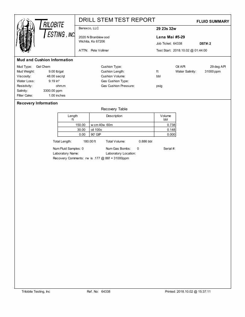
DRILL STEM TEST REPORTBerexco, LLC
2020 N Branblew oodWichita, Ks 67206
ATTN: Pete Vollmer 2018.10.02 @ 01:44:00
64338Job Ticket:
Lena Mai #5-29
29 23s 32w
Test Start:
DST#:2
Mud and Cushion Information
Mud Type:
Mud Weight:
Viscosity:
Filter Cake:
Salinity:
Resistivity:
Water Loss:
Gel Chem
9.00
48.00
9.19
3300.00
1.00
Cushion Type:
Cushion Length:
Cushion Volume:
Gas Cushion Type:
Gas Cushion Pressure:
lb/gal
sec/qt
ohm.m
ppm
inches
bbl
ft
psig
Recovery Table
Length Description Volumeft bbl
Recovery Information
FLUID SUMMARY
Oil API:
Water Salinity:
29
31000 ppm
deg API
in³
150.00 w cm 40w 60m 0.738
30.00 oil 100o 0.148
0.00 90' GIP 0.000
Total Length: 180.00 ft Total Volume: 0.886 bbl
Num Fluid Samples: Num Gas Bombs:0 0
Laboratory Name: Laboratory Location:
Recovery Comments: rw is .177 @ 86f = 31000ppm
Serial #:
Trilobite Testing, Inc Printed: 2018.10.02 @ 15:37:11Ref. No: 64338
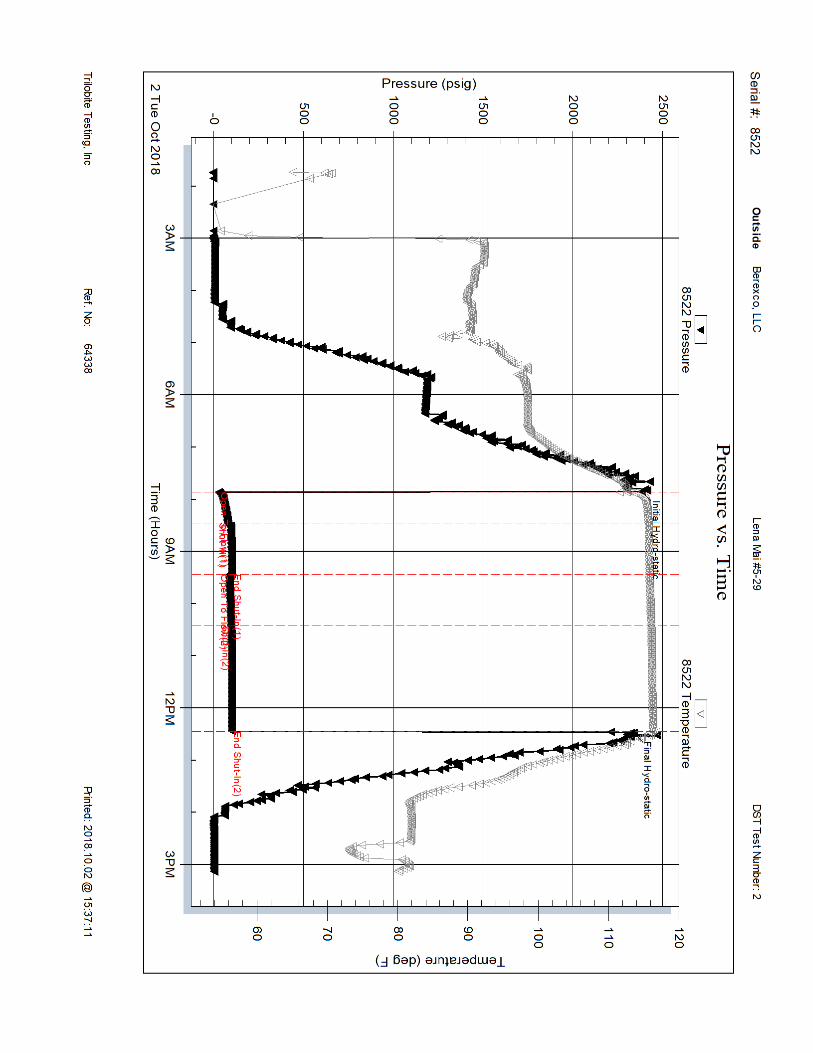
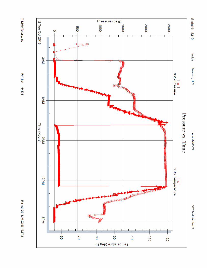
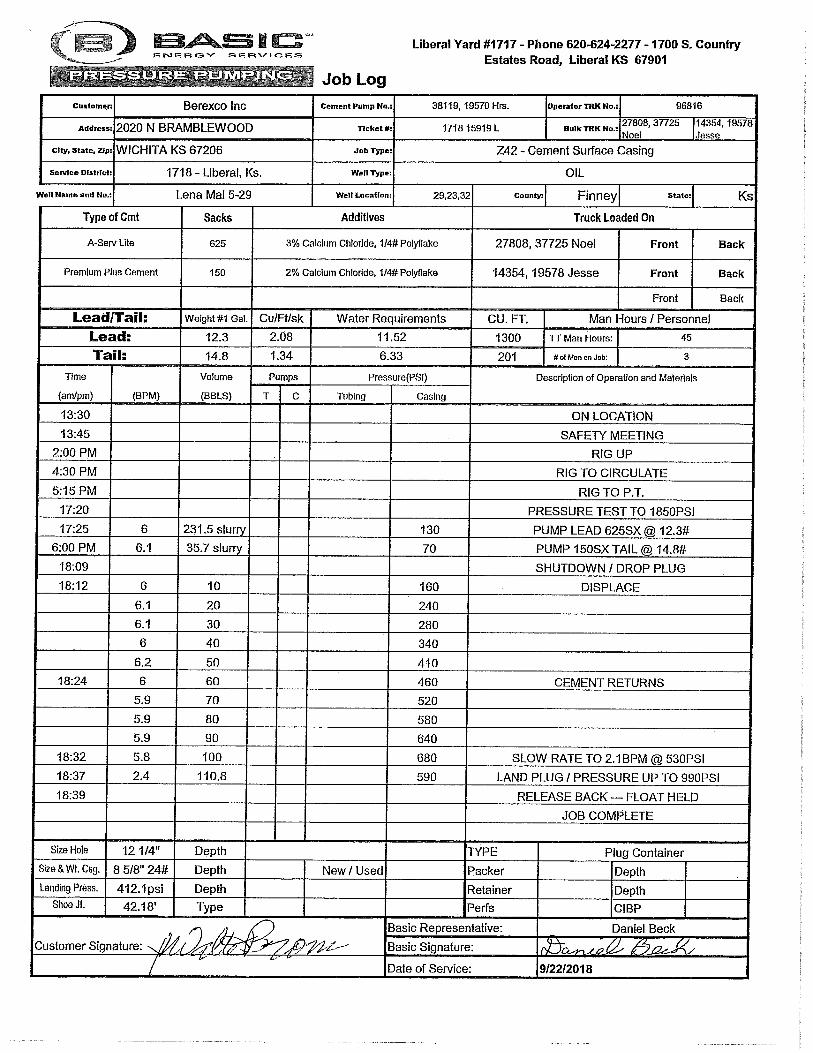
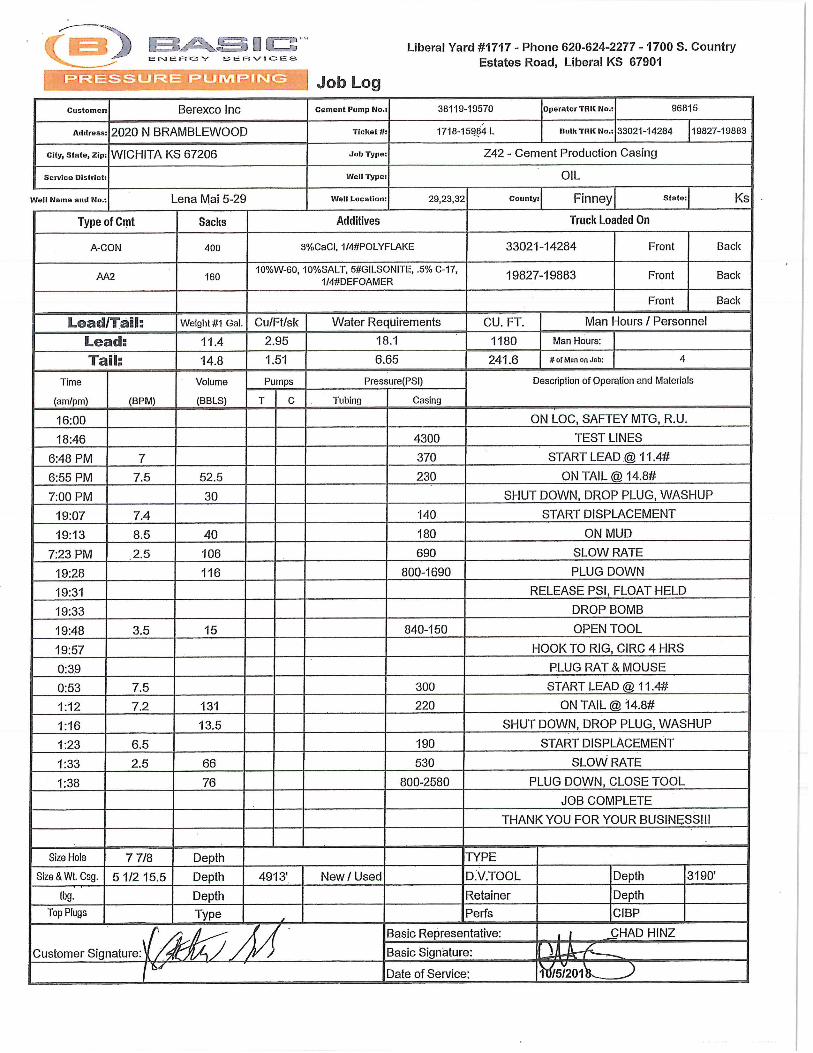
Related Documents