Smart Solutions for Today’s Geoscientist DGPC BLOCK BIDDING ROUND 2021 BLOCK: Kambar

Welcome message from author
This document is posted to help you gain knowledge. Please leave a comment to let me know what you think about it! Share it to your friends and learn new things together.
Transcript
Smart Solutions for Today’s Geoscientist
DGPC BLOCK BIDDING ROUND 2021
BLOCK: Kambar
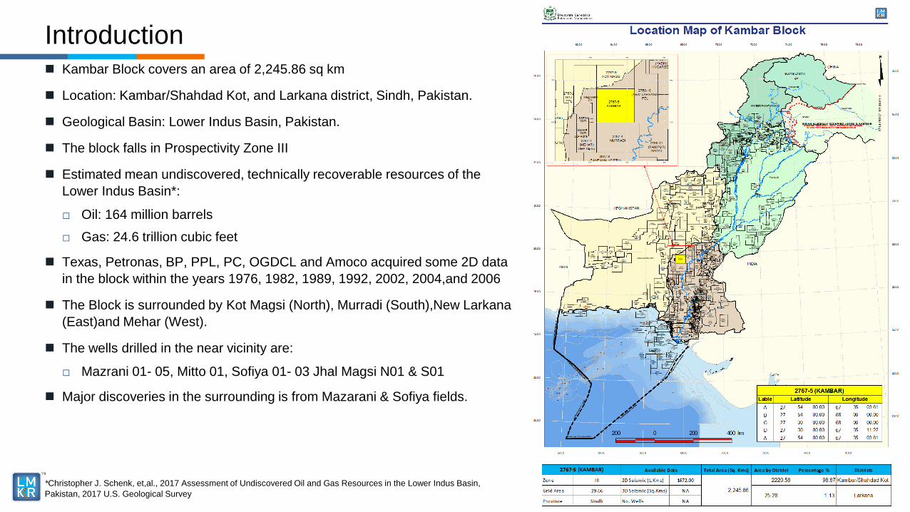
Kambar Block covers an area of 2,245.86 sq km
Location: Kambar/Shahdad Kot, and Larkana district, Sindh, Pakistan.
Geological Basin: Lower Indus Basin, Pakistan.
The block falls in Prospectivity Zone III
Estimated mean undiscovered, technically recoverable resources of the
Lower Indus Basin*:
□ Oil: 164 million barrels
□ Gas: 24.6 trillion cubic feet
Texas, Petronas, BP, PPL, PC, OGDCL and Amoco acquired some 2D data
in the block within the years 1976, 1982, 1989, 1992, 2002, 2004,and 2006
The Block is surrounded by Kot Magsi (North), Murradi (South),New Larkana
(East)and Mehar (West).
The wells drilled in the near vicinity are:
□ Mazrani 01- 05, Mitto 01, Sofiya 01- 03 Jhal Magsi N01 & S01
Major discoveries in the surrounding is from Mazarani & Sofiya fields.
Introduction
*Christopher J. Schenk, et,al., 2017 Assessment of Undiscovered Oil and Gas Resources in the Lower Indus Basin,
Pakistan, 2017 U.S. Geological Survey
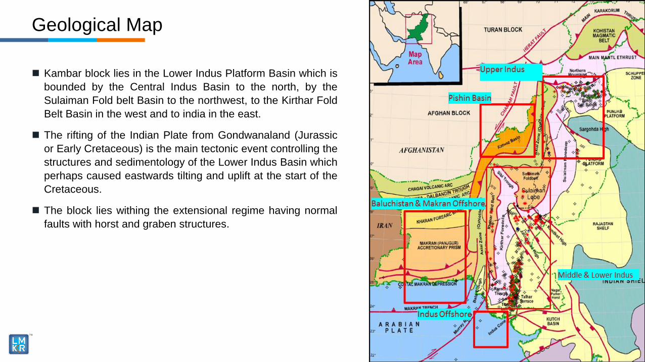
Kambar block lies in the Lower Indus Platform Basin which is
bounded by the Central Indus Basin to the north, by the
Sulaiman Fold belt Basin to the northwest, to the Kirthar Fold
Belt Basin in the west and to india in the east.
The rifting of the Indian Plate from Gondwanaland (Jurassic
or Early Cretaceous) is the main tectonic event controlling the
structures and sedimentology of the Lower Indus Basin which
perhaps caused eastwards tilting and uplift at the start of the
Cretaceous.
The block lies withing the extensional regime having normal
faults with horst and graben structures.
Geological Map
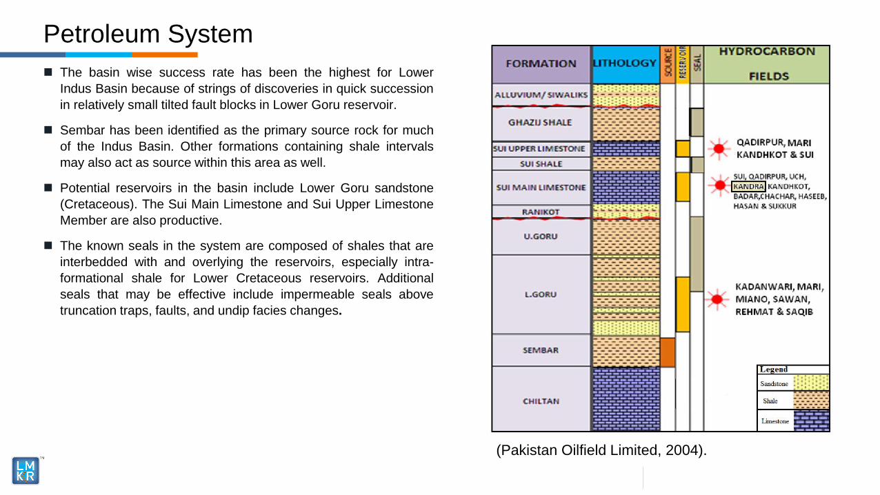
The basin wise success rate has been the highest for Lower
Indus Basin because of strings of discoveries in quick succession
in relatively small tilted fault blocks in Lower Goru reservoir.
Sembar has been identified as the primary source rock for much
of the Indus Basin. Other formations containing shale intervals
may also act as source within this area as well.
Potential reservoirs in the basin include Lower Goru sandstone
(Cretaceous). The Sui Main Limestone and Sui Upper Limestone
Member are also productive.
The known seals in the system are composed of shales that are
interbedded with and overlying the reservoirs, especially intra-
formational shale for Lower Cretaceous reservoirs. Additional
seals that may be effective include impermeable seals above
truncation traps, faults, and undip facies changes.
Petroleum System
(Pakistan Oilfield Limited, 2004).
Prospectivity
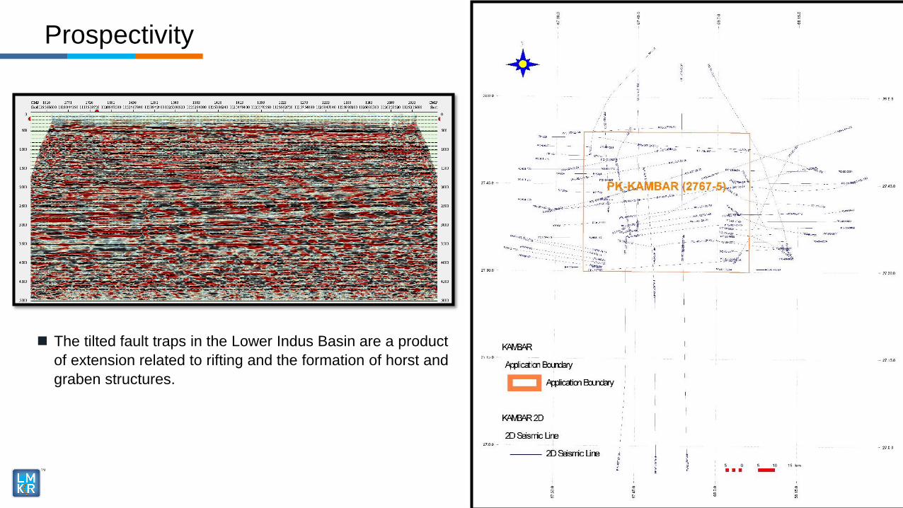
The tilted fault traps in the Lower Indus Basin are a product
of extension related to rifting and the formation of horst and
graben structures.
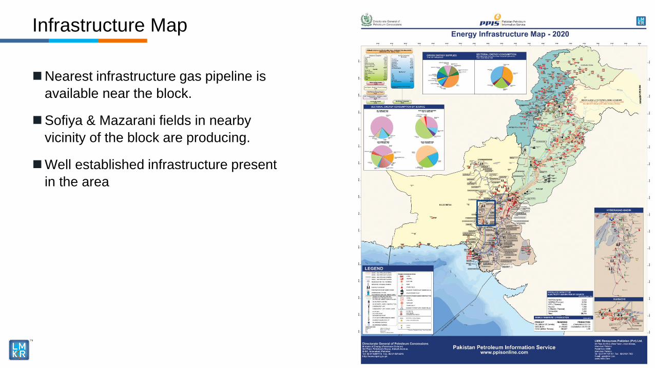
Nearest infrastructure gas pipeline is
available near the block.
Sofiya & Mazarani fields in nearby
vicinity of the block are producing.
Well established infrastructure present
in the area
Infrastructure Map
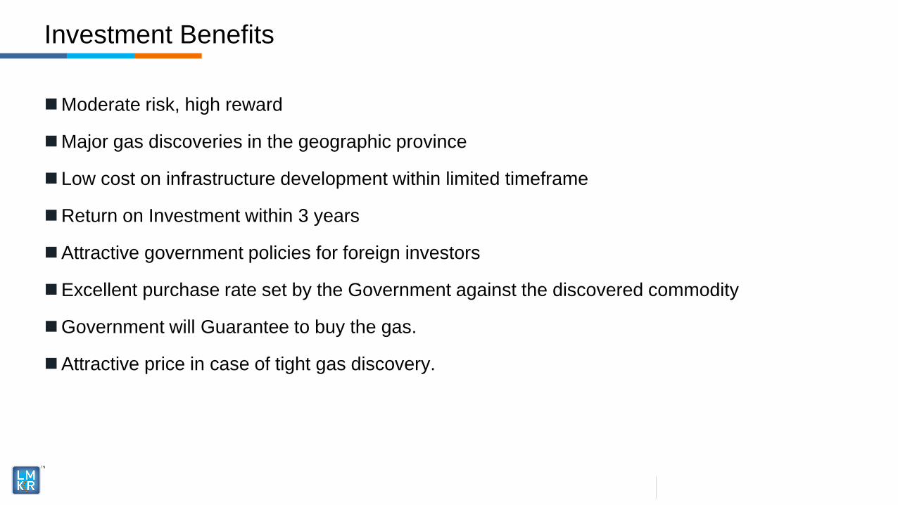
Moderate risk, high reward
Major gas discoveries in the geographic province
Low cost on infrastructure development within limited timeframe
Return on Investment within 3 years
Attractive government policies for foreign investors
Excellent purchase rate set by the Government against the discovered commodity
Government will Guarantee to buy the gas.
Attractive price in case of tight gas discovery.
Investment Benefits
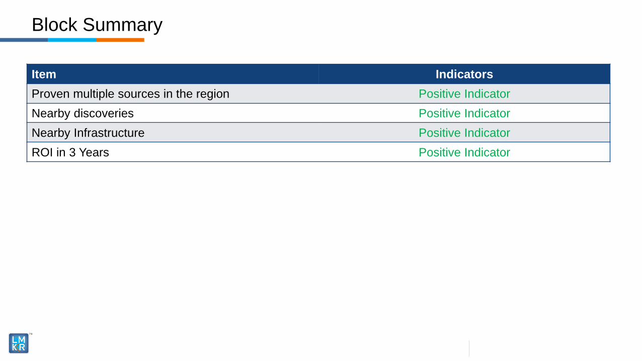
Item Indicators
Proven multiple sources in the region Positive Indicator
Nearby discoveries Positive Indicator
Nearby Infrastructure Positive Indicator
ROI in 3 Years Positive Indicator
Block Summary
Related Documents