1 If you require an auxiliary aid or accommodation due to a disability, please contact 808-447-8919 (voice/tty) or email at [email protected]. NEIL ABERCROMBIE NEIL ABERCROMBIE NEIL ABERCROMBIE NEIL ABERCROMBIE GOVERNOR DEAN H. SEKI DEAN H. SEKI DEAN H. SEKI DEAN H. SEKI COMPTROLLER MARIA E. ZIELINSKI MARIA E. ZIELINSKI MARIA E. ZIELINSKI MARIA E. ZIELINSKI DEPUTY COMPTROLLER STATE OF HAWAI‘I DEPARTMENT OF ACCOUNTING AND GENERAL SERVICES Enhanced 911 Communications/Technical/Finance Committee Meeting Tuesday, January 14, 2014 Kalanimoku Bldg., Room 322B 1151 Punchbowl St., Honolulu 10 am to 12 noon Agenda I. Call to Order, Public Notice, Quorum II. Public testimony on all agenda items III. Introductions IV. Review and Approval of Last Months’ Meeting Minutes V. Items for Discussion, Consideration, and Action a. Communications Committee i. 2014 Legislative Investigative Committee update ii. Others b. Technical Committee i. Update on status of PSAP projects and funds pending expenditure 1. HFD – Fire/EMS CAD update 2. Kauai CAD update 3. HPD CAD update 4. Others ii. State of Hawaii NG9-1-1 project update iii. Request updates for Enhanced 9-1-1 Timeline continuum

Welcome message from author
This document is posted to help you gain knowledge. Please leave a comment to let me know what you think about it! Share it to your friends and learn new things together.
Transcript
1 If you require an auxiliary aid or accommodation due to a disability, please contact 808-447-8919
(voice/tty) or email at [email protected].
NEIL ABERCROMBIENEIL ABERCROMBIENEIL ABERCROMBIENEIL ABERCROMBIE
GOVERNOR
DEAN H. SEKIDEAN H. SEKIDEAN H. SEKIDEAN H. SEKI
COMPTROLLER
MARIA E. ZIELINSKIMARIA E. ZIELINSKIMARIA E. ZIELINSKIMARIA E. ZIELINSKI
DEPUTY COMPTROLLER
STATE OF HAWAI ‘ I
DEPARTMENT OF ACCOUNTING AND GENERAL SERVICES
Enhanced 911 Communications/Technical/Finance Committee Meeting
Tuesday, January 14, 2014
Kalanimoku Bldg., Room 322B
1151 Punchbowl St., Honolulu
10 am to 12 noon
Agenda
I. Call to Order, Public Notice, Quorum
II. Public testimony on all agenda items
III. Introductions
IV. Review and Approval of Last Months’ Meeting Minutes
V. Items for Discussion, Consideration, and Action
a. Communications Committee
i. 2014 Legislative Investigative Committee update
ii. Others
b. Technical Committee
i. Update on status of PSAP projects and funds pending
expenditure
1. HFD – Fire/EMS CAD update
2. Kauai CAD update
3. HPD CAD update
4. Others
ii. State of Hawaii NG9-1-1 project update
iii. Request updates for Enhanced 9-1-1 Timeline continuum

2 If you require an auxiliary aid or accommodation due to a disability, please contact 808-447-8919
(voice/tty) or email at [email protected].
iv. Investigative Regulatory Committee update
v. FCC updates
vi. Request for approval:
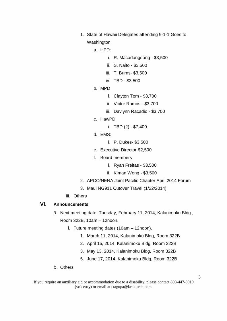
1. State of Hawaii Delegates attending 9-1-1 Goes to
Washington:
a. HPD:
i. R.Macadangdang - $3,500
ii. S. Naito - $3,500
iii. T. Burns- $3,500
iv. TBD - $3,500
b. MPD
i. Clayton Tom - $3,700
ii. Victor Ramos - $3,700
iii. Davlynn Racadio - $3,700
c. HawPD
i. TBD (2) - $7,400.
d. EMS:
i. P. Dukes- $3,500
e. Executive Director-$2,500
f. Board members
i. Ryan Freitas - $3,500
ii. Kiman Wong - $3,500
2. APCO/NENA Joint Pacific Chapter April 2014 Forum
3. Maui NG911 Cutover Travel (1/22/2014)
vii. Request approval for the presentation at the NENA 2014
conference by Sonny Bhagowalia of The Synergy between
E9-1-1/Next Generation 9-1-1 and FirstNet
viii. Others
c. Finance Committee
i. Review of Monthly Cash Flow & Budget Financial Report
ii. Request for funding:
3 If you require an auxiliary aid or accommodation due to a disability, please contact 808-447-8919
(voice/tty) or email at [email protected].
1. State of Hawaii Delegates attending 9-1-1 Goes to
Washington:
a. HPD:
i. R. Macadangdang - $3,500
ii. S. Naito - $3,500
iii. T. Burns- $3,500
iv. TBD - $3,500
b. MPD
i. Clayton Tom - $3,700
ii. Victor Ramos - $3,700
iii. Davlynn Racadio - $3,700
c. HawPD
i. TBD (2) - $7,400.
d. EMS:
i. P. Dukes- $3,500
e. Executive Director-$2,500
f. Board members
i. Ryan Freitas - $3,500
ii. Kiman Wong - $3,500
2. APCO/NENA Joint Pacific Chapter April 2014 Forum
3. Maui NG911 Cutover Travel (1/22/2014)
iii. Others
VI. Announcements
a. Next meeting date: Tuesday, February 11, 2014, Kalanimoku Bldg.,
Room 322B, 10am – 12noon.
i. Future meeting dates (10am – 12noon).
1. March 11, 2014, Kalanimoku Bldg, Room 322B
2. April 15, 2014, Kalanimoku Bldg, Room 322B
3. May 13, 2014, Kalanimoku Bldg, Room 322B
5. June 17, 2014, Kalanimoku Bldg, Room 322B
b. Others

4 If you require an auxiliary aid or accommodation due to a disability, please contact 808-447-8919
(voice/tty) or email at [email protected].
VII. Open Forum: Public comment on issues not on the agenda for
consideration for Committee agenda at the next meeting
VIII. Adjournment

1 If you require an auxiliary aid or accommodation due to a disability, please contact 808-447-8919
(voice/tty) or email at [email protected].
NEIL ABERCROMBIENEIL ABERCROMBIENEIL ABERCROMBIENEIL ABERCROMBIE
GOVERNOR
DEAN H. SEKIDEAN H. SEKIDEAN H. SEKIDEAN H. SEKI
COMPTROLLER
MARIA E. ZIELINSKIMARIA E. ZIELINSKIMARIA E. ZIELINSKIMARIA E. ZIELINSKI
DEPUTY COMPTROLLER
STATE OF HAWAI ‘ I
DEPARTMENT OF ACCOUNTING AND GENERAL SERVICES
Enhanced 911 Communications, Technical, Finance Committee Meeting
Tuesday, January 14, 2014
Kalanimoku Bldg., Room 322B
1151 Punchbowl St., Honolulu
10 am to 12 noon
Meeting Minutes
Communications Committee members present: Thalia Burns, Paul Ferreira, Marshall Kanehailua, Davlynn Racadio,
Victor Ramos, and Clayton Tom.
Communications Committee members absent: Steven Schutte (Chair).
Technical Committee members present: Victor Ramos (Chair), Clement Chan, Aaron Correia, Marshall Kanehailua,
Gary Lum, Brandon Raines, Tony Ramirez, Clayton Tom, and Kiman Wong
Technical Committee members absent: Steven Schutte.
Finance Committee members present: Mark Begley, Paul Ferreira, Lisa Hiraoka, Sherwin Perez, Roy Irei, and
Clayton Kau.
Finance Committee members absent: Kiman Wong (Chair).
Board staff members: Thera Bradshaw and Courtney Tagupa
Observers: Mary Boyd (Intrado), Eric Butler (Pictometry), Patrick Chau (HPD), Diana Chun (EMS), Ryan Freitas
(HTEL), Rob Gausepohl (Kauai), Travis Ing (Hawaii PD), Kevin Konczal (Tritech), Dave Peck (Pictometry), Randal
Macadangdang (HPD), Ben Morgan (HTEL), Sean Naito (HPD), Caprice Ng (HTEL).
I. Call to Order, Public Notice, Quorum
a. The meeting was called to order at 10:00 am.
II. Public testimony on all agenda items

2 If you require an auxiliary aid or accommodation due to a disability, please contact 808-447-8919
(voice/tty) or email at [email protected].
a. The Board Chair requested if anyone in attendance who wished to
provide testimony on any agenda item to please come forward. There
was no one who came forward.
III. Introductions
a. Introductions were made of all in attendance.
IV. Review and Approval of Last Meeting’s Minutes
a. Roy Irei motioned to accept the minutes of December 2013. The
motion was seconded by Ryan Freitas and approved unanimously by
voice vote without discussion.
V. Items for Discussion, Consideration, and Action
a. Communications Committee – Thera Bradshaw
i. 2014 Legislative Investigative Committee Update.
1. Paul Ferreira reported the committee met with DAGS to
discuss the prepaid wireless and utilizing eHawaii.gov to
collect the .66 cents surcharge.
2. The Executive Director drafted procedures and guiding
polices for the collection of the surcharge which is
currently under review. Once the initial review is
completed, the guidelines will be forwarded to the
Committee for review.
ii. Others – none
b. Technical Committee – Victor Ramos
i. Update on status of PSAP projects with funds pending
expenditure.
1. HFD – Fire/EMS CAD update – Gary Lum
i. Nothing to report at this time.
2. Kauai CAD update – Brandon Raines
i. Continuing to work with Tritech on remaining
issues.
ii. Work will resume on the alternate dispatch center
after the Maui and Molokai cutover is completed.

3 If you require an auxiliary aid or accommodation due to a disability, please contact 808-447-8919
(voice/tty) or email at [email protected].
3. HPD CAD update – Aaron Correia
i. Motorola verified that problems reported by HPD is
very serious and requires Motorola to do major
revisions.
ii. Fix due in April but no firm date as of yet. Once
the fix is applied, the system must be tested then
training can be conducted. Earliest go live will be
August 2014.
iii. Courtney Tagupa contacted to request funding be
encumbered in the next fiscal year.
iv. Clayton Tom inquired if HPD will require additional
funding to which Aaron Correia responded in the
negative.
4. Others
i. State of Hawaii NG9-1-1 project update.
1. Caprice Ng reported that:
i. The project is on schedule for the
Maui and Molokai PSAPs.
ii. Maui will go live January 22, 2014
and Molokai on January 28, 2014.
2. The Executive Director stated that:
i. The reports filed with the FCC
indicated Hawaii will be 100% at the
end of January. Should the go live
dates change, she requested to be
notified immediately.
ii. There are four main topics on the
FCC’s January agenda, one of which
is texting to 9-1-1.
iii. The FCC hearing will include
discussion on an overall texting
4 If you require an auxiliary aid or accommodation due to a disability, please contact 808-447-8919
(voice/tty) or email at [email protected].
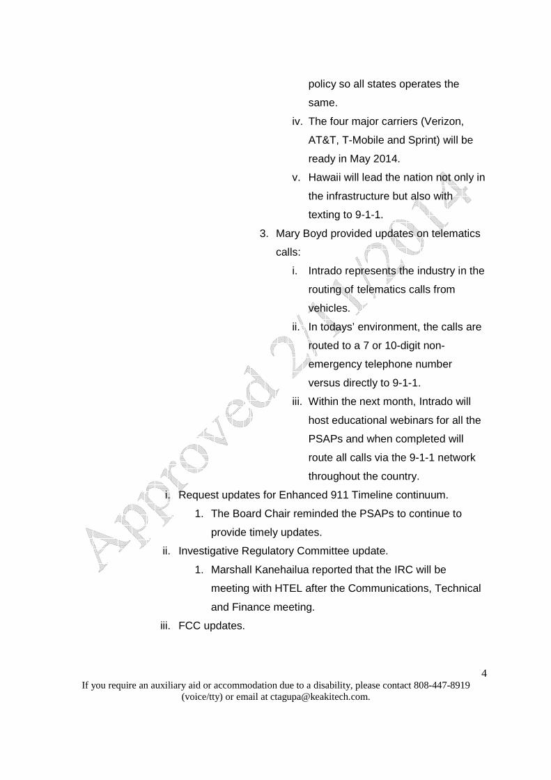
policy so all states operates the
same.
iv. The four major carriers (Verizon,
AT&T, T-Mobile and Sprint) will be
ready in May 2014.
v. Hawaii will lead the nation not only in
the infrastructure but also with
texting to 9-1-1.
3. Mary Boyd provided updates on telematics
calls:
i. Intrado represents the industry in the
routing of telematics calls from
vehicles.
ii. In todays’ environment, the calls are
routed to a 7 or 10-digit non-
emergency telephone number
versus directly to 9-1-1.
iii. Within the next month, Intrado will
host educational webinars for all the
PSAPs and when completed will
route all calls via the 9-1-1 network
throughout the country.
i. Request updates for Enhanced 911 Timeline continuum.
1. The Board Chair reminded the PSAPs to continue to
provide timely updates.
ii. Investigative Regulatory Committee update.
1. Marshall Kanehailua reported that the IRC will be
meeting with HTEL after the Communications, Technical
and Finance meeting.
iii. FCC updates.

5 If you require an auxiliary aid or accommodation due to a disability, please contact 808-447-8919
(voice/tty) or email at [email protected].
1. Update provided and incorporated in the State of Hawaii
NG9-1-1 project update section.
iv. Request for approval:
1. Paul Ferreira motioned to approve the State of Hawaii
Delegates attendance to 9-1-1 Goes to Washington. The
motion was seconded by Lisa Hiraoka and approved
unanimously by voice vote. The matter was forwarded to
the Finance Committee for approval.
i. HPD:
1. R. Macadangdang - $3,500
2. S. Naito - $3,500
3. T. Burns - $3,500
4. TBD - $3,500
ii. MPD:
1. C. Tom - $3,700
2. V. Ramos - $3,700
3. D. Racadio - $3,700
iii. EMS:
1. P. Dukes - $3,500
iv. Executive Director - $2,500
v. Board Members:
1. R. Freitas - $3,500
2. K. Wong - $3,500
vi. Kauai PD:
3. TBD - $3,700
vii. Hawaii PD:
1. TBD - $3,700
2. TBD - $3,700
2. APCO/NENA Joint Pacific Chapter April 2014 Forum.
i. The Executive Director stated that:
6 If you require an auxiliary aid or accommodation due to a disability, please contact 808-447-8919
(voice/tty) or email at [email protected].
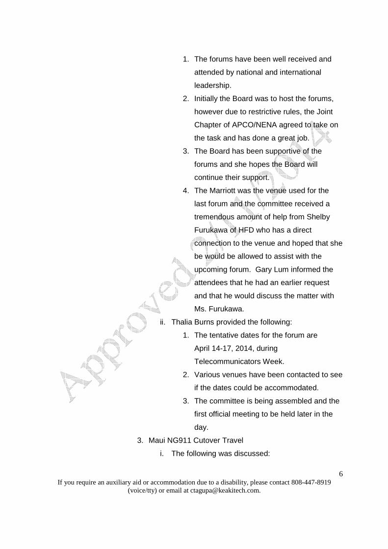
1. The forums have been well received and
attended by national and international
leadership.
2. Initially the Board was to host the forums,
however due to restrictive rules, the Joint
Chapter of APCO/NENA agreed to take on
the task and has done a great job.
3. The Board has been supportive of the
forums and she hopes the Board will
continue their support.
4. The Marriott was the venue used for the
last forum and the committee received a
tremendous amount of help from Shelby
Furukawa of HFD who has a direct
connection to the venue and hoped that she
be would be allowed to assist with the
upcoming forum. Gary Lum informed the
attendees that he had an earlier request
and that he would discuss the matter with
Ms. Furukawa.
ii. Thalia Burns provided the following:
1. The tentative dates for the forum are
April 14-17, 2014, during
Telecommunicators Week.
2. Various venues have been contacted to see
if the dates could be accommodated.
3. The committee is being assembled and the
first official meeting to be held later in the
day.
3. Maui NG911 Cutover Travel
i. The following was discussed:

7 If you require an auxiliary aid or accommodation due to a disability, please contact 808-447-8919
(voice/tty) or email at [email protected].
1. Request to fund individuals from Kauai,
Honolulu and the Big Island to attend the
Maui and Molokai cutover.
2. It is a benefit to the PSAPs and an
opportunity to learn from each other.
3. Cost of $600 for 2 individuals per PSAP to
attend.
4. Request for consideration for Kauai
attendees as the travel will require an
additional leg.
ii. Tony Ramirez motioned for 2 individuals from
each PSAP to travel to Maui and Molokai for the
cutover to include lodging for those who travel to
Molokai. The motion was seconded by Clayton
Tom and approved unanimously by voice vote
without discussion. The matter was forwarded to
the Finance Committee for approval.
v. Request approval for the presentation at the NENA 2014
conference by Sonny Bhagowalia of the Synergy between
E9-1-1/Next Generation 9-1-1 and FirstNet
1. Sonny Bhagowalia was to make a presentation, however
he was unavailable.
2. Victor Ramos indicated that this item will be removed
from the agenda as it has been on the agenda for the
past two months. Should the CIO wish to make the
presentation he can request the item be placed back on
the agenda.
c. Finance Committee – Kiman Wong (absent)
i. Review of Monthly Cash Flow & Budget Financial report was
presented by Courtney Tagupa.
1. Receipts - $517,205

8 If you require an auxiliary aid or accommodation due to a disability, please contact 808-447-8919
(voice/tty) or email at [email protected].
2. Cash Flow - $10,522,587
3. Disbursements - $491,406
5. Unencumbered Cash - $9,200,480
ii. Additional information regarding the report was provided:
1. Courtney Tagupa stated that two checks from the
wireless service providers were lost in the mail and the
amounts will be reflected on next months’ report. He also
stated that the Board is unable to assess a penalty as the
law does not allow it.
2. The Executive Director stated that the Board may want to
consider legislative changes in the next legislative
session since there is no penalty when a bill is not paid
and she will follow up with DAGS should this become an
issue.
3. Clayton Tom indicated that amendments could be made
to the administrative rules to include some type of
penalty.
4. Roy Irei stated that we should analyze the cost, benefits,
and trend.
iii. Request for funding:
1. State of Hawaii Delegates attending 9-1-1 Goes to
Washington:
i. HPD:
1. R. Macadangdang - $3,500
2. S. Naito - $3,500
3. T. Burns - $3,500
4. TBD - $3,500
ii. MPD:
1. C. Tom - $3,500
2 V. Ramos - $3,500
3. D. Racadio - $3,500
9 If you require an auxiliary aid or accommodation due to a disability, please contact 808-447-8919
(voice/tty) or email at [email protected].
iii. EMS:
1. P. Dukes - $3,500
iv. Executive Director - $2,500
v. Board Members:
1. R. Freitas - $3,500
2. K. Wong - $3,500
vi. Kauai PD:
1. TBD - $3,700
vii. Hawaii PD:
1. TBD - $3,700
2. TBD - $3,700
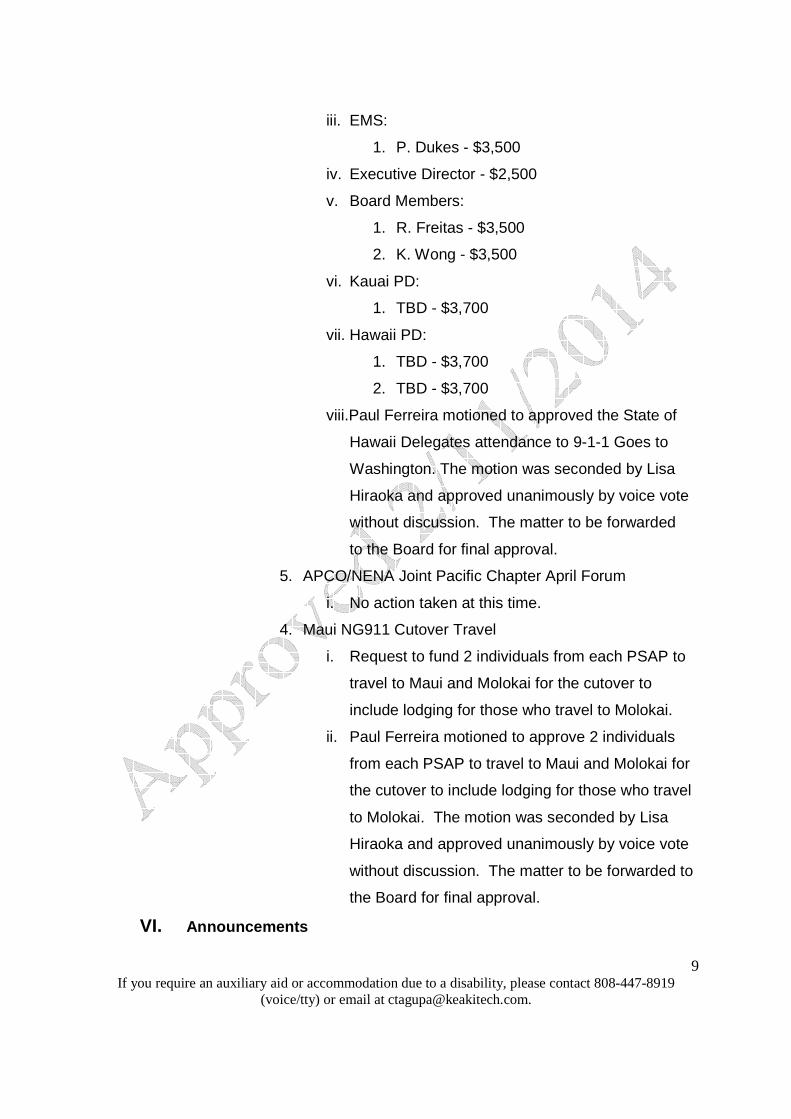
viii.Paul Ferreira motioned to approved the State of
Hawaii Delegates attendance to 9-1-1 Goes to
Washington. The motion was seconded by Lisa
Hiraoka and approved unanimously by voice vote
without discussion. The matter to be forwarded
to the Board for final approval.
5. APCO/NENA Joint Pacific Chapter April Forum
i. No action taken at this time.
4. Maui NG911 Cutover Travel
i. Request to fund 2 individuals from each PSAP to
travel to Maui and Molokai for the cutover to
include lodging for those who travel to Molokai.
ii. Paul Ferreira motioned to approve 2 individuals
from each PSAP to travel to Maui and Molokai for
the cutover to include lodging for those who travel
to Molokai. The motion was seconded by Lisa
Hiraoka and approved unanimously by voice vote
without discussion. The matter to be forwarded to
the Board for final approval.
VI. Announcements

10 If you require an auxiliary aid or accommodation due to a disability, please contact 808-447-8919
(voice/tty) or email at [email protected].
a. Next meeting date: Tuesday, February 11, 2014, Kalanimoku Bldg.,
Room 322B, 10am – 12noon.
i. Future meeting dates (10am – 12noon).
1. March 11, 2014, Kalanimoku Bldg, Room 322B
2. April 15, 2014, Kalanimoku Bldg, Room 322B
3. May 13, 2014, Kalanimoku Bldg, Room 322B
4. June 17, 2014, Kalanimoku Bldg, Room 322B
5. July 15, 2014, Kalanimoku Bldg, Room 322B
b. Others - none
VII. Open Forum: Public comment on issues not on the agenda for
consideration for Committee agenda at the next meeting.
a. There was no one who came forward to testify.
VIII. Adjournment
a. The meeting was adjourned at 10:38 am.

HAWAII ENHANCED 911 BOARD STATEMENT OF CASH FLOWS
For month ending December 31, 2013
1
FIRST HAWAIIAN BANK ACCOUNT:
General Fund
Annual % of Budget
DECEMBER Fiscal YTD Budget Expended
Receipts:Enhanced 911 Surcharge Collection 516,853 4,094,989 9,050,000 45.2%
Interest Income 352 1,191 2,000 59.6%
Receipts 517,205 4,096,180 9,052,000 45.3%
Disbursements:
Conference Travel (6,587) (11,312) (159,132) 7.1%
Non-Recurring Expenses (24,924) (83,092) (2,066,254) 4.0%
Recurring Expenses:
Administration (138,148) (439,277) (1,240,904) 35.4%
Maintenance (144,898) (965,522) (3,278,600) 29.4%
Telecommunications (176,850) (676,549) (1,927,936) 35.1%
Other (7,600) 0.0%
Disbursements (491,406) (2,175,752) (8,680,426) 25.1%
Net Receipts/(Disbursements) 25,799 1,920,428 371,574
Net Receipts/(Disbursements) 25,799$ 1,920,428
Encumbrance Paydowns: Encumb. Bal.
FY 2011 (Kauai) (133,218) (133,218) 490,307
FY 2012 (HFD/EDS/HPD) (197,106) 841,800
FY 2013 (405,266)
Total Cash Outflow (133,218) (735,590)
Net Cash Inflow/(Outflow) (107,419) 1,184,838
Bank Balance Analysis:
ADD: July 1, 2013 Beginning Balance 9,347,748
Net Bank Balance 10,532,587
Outstanding Ecumb/Accruals (1,332,107)
Unencumbered Cash Balance 9,200,480
Actuals
Budget Analysis
FY 2014
Cash Flow Analysis

HAWAII ENHANCED 911 BOARD STATEMENT OF CASH FLOWS
For month ending December 31, 2013
2
Hawaii PSAP
Kauai PSAP
Maui PSAP
Oahu PSAP ADMIN TOTAL
Total RECEIPTS - - - - 517,205 517,205
DISBURSEMENTS:
6200 CONFERENCES
6204 APCO Conference - 5,223 - - - 5,223
6225 VIPER CUTOver 764 - 600 - - 1,364
Total 6200 CONFERENCES 764 5,223 600 - - 6,587
6300 Non-RECURRING
6303 Computers
6303.18 PWC Tech cutover Supp 3,229 - - - - 3,229
Total 6303 Computers 3,229 - - - - 3,229
6306 Training
6306.13 OT Viper Training - - - 21,694 - 21,694
Total 6306 Training - - - 21,694 - 21,694
Total 6300 Non-RECURRING 3,229 - - 21,694 - 24,924
6400 RECURRING EXPENSES
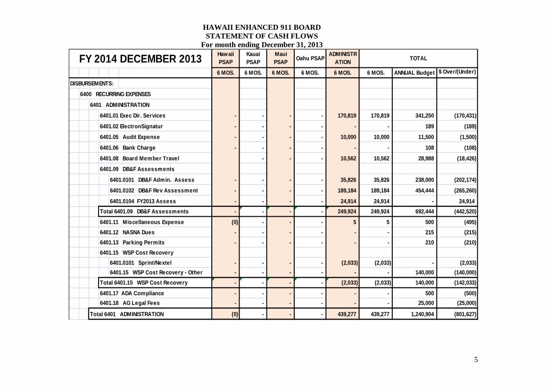
6401 ADMINISTRATION
6401.01 Exec Dir. Services - - - - 28,438 28,438
6401.08 Board Member Travel - - - - 2,475 2,475
6401.09 DB&F Assessments
6401.0101 DB&F Admin. Assess - - - - 20,236 20,236
6401.0102 DB&F Rev Assessment - - - - 86,993 86,993
Total 6401.09 DB&F Assessments - - - - 107,229 107,229
6401.11 Miscellaneous Expense - - - - 6 6
Total 6401 ADMINISTRATION - - - - 138,148 138,148
6402 MAINTENANCE
6402.07 0011 9-1-1MSAG Maint. 25,637 - 28,971 90,290 - 144,898
Total 6402 MAINTENANCE 25,637 - 28,971 90,290 - 144,898
6403 Other RECURRING
6403.01 Telcom Charges
6403.0102 Long Distance 28 128 34 - - 189
6403.0103 Mileage - - - 959 - 959
6403.0109 Telcom Trunk 25,529 46,416 23,208 80,087 - 175,240
6403.0110 Ocean Safety
6403.0110.2 Centrex - - - 394 - 394
6403.0110.3 Mileage - - - 68 - 68
Total 6403.0110 Ocean Safety - - - 462 - 462
Total 6403.01 Telcom Charges 25,557 46,543 23,241 81,509 - 176,850
Total 6403 Other RECURRING 25,557 46,543 23,241 81,509 - 176,850
Total 6400 RECURRING EXPENSES 51,194 46,543 52,212 171,799 138,148 459,896
Total DISBURSEMENTS 55,187 51,766 52,812 193,493 138,148 491,406
MONTH OF DECEMBER 2013

HAWAII ENHANCED 911 BOARD STATEMENT OF CASH FLOWS
For month ending December 31, 2013
3
Fiscal Year-to-date 2014 Disbursements Detail by Account, PSAP & Administration

HAWAII ENHANCED 911 BOARD STATEMENT OF CASH FLOWS
For month ending December 31, 2013
4
Oahu PSAPADMINISTR
ATIONTOTAL
6 MOS. 6 MOS. 6 MOS. 6 MOS. 6 MOS. 6 MOS. ANNUAL Budget $ Over/(Under) BudgetTotal Income - - - - 4,096,180 4,096,180 9,052,000 (4,955,820)
DISBURSEMENTS:
6200 CONFERENCES
6204 APCO Conference - 5,223 - 6,544 2,507 14,273 24,698 (10,425)
6212 NASNA Conference - - - - 2,810 2,810 2,810 -
6214 Nena Conference 3,134 - 2,329 (10,605) (3,500) (8,643) - (8,643)
6225 VIPER CUTOver 1,625 458 600 189 - 2,872 3,715 (843)
6200 CONFERENCES - Other - - - - - - 127,909 (127,909)
Total 6200 CONFERENCES 4,759 5,680 2,929 (3,872) 1,817 11,312 159,132 (147,820)
6300 Non-RECURRING
6301 CAD Replac/Upgrade
6301.01 EMS - - - - - - 99,000 (99,000)
6301.02 Hawai'i Police Dept - - - - - - 1,500,000 (1,500,000)
6301.03 Honolulu Fire Dept.
6301.031 Licensing - - - - - - 6,105 (6,105)
6301.032 Consulting - - - 1,625 - 1,625 2,500 (875)
6301.03 Honolulu Fire Dept. - Other - - - - - - 72,000 (72,000)
Total 6301.03 Honolulu Fire Dept. - - - 1,625 - 1,625 80,605 (78,980)
Total 6301 CAD Replac/Upgrade - - - 1,625 - 1,625 1,679,605 (1,677,980)
6303 Computers
6303.06 GeoComm - - - 26,324 - 26,324 150,000 (123,676)
6303.15 NG911 Record Syst. - - - - - - 110,000 (110,000)
6303.16 ViperInstall - - - 30,220 - 30,220 30,320 (100)
6303.17 Intrado Phone - - - - - - 5,000 (5,000)
6303.18 PWC Tech cutover Supp 3,229 - - - - 3,229 3,229 -
6303.19 Reposition of Consoles - - - - - - 5,100 (5,100)
Total 6303 Computers 3,229 - - 56,544 - 59,773 303,649 (243,876)
6306 Training
6306.11 Training (CAD) HPD - - - - - - 8,000 (8,000)
6306.12 TriTechCADSystAdm
6306.121 CAD Tritech HFD - - - - - - 20,000 (20,000)
6306.122 CAD TriTech EMS - - - - - - 7,000 (7,000)
Total 6306.12 TriTechCADSystAdm - - - - - - 27,000 (27,000)
6306.13 OT Viper Training - - - 21,694 - 21,694 48,000 (26,306)
Total 6306 Training - - - 21,694 - 21,694 83,000 (61,306)
Total 6300 Non-RECURRING 3,229 - - 79,863 - 83,092 2,066,254 (1,983,162)
Maui PSAPFY 2014 DECEMBER 2013 Hawaii
PSAPKauai PSAP
HAWAII ENHANCED 911 BOARD STATEMENT OF CASH FLOWS
For month ending December 31, 2013
5
Oahu PSAPADMINISTR
ATIONTOTAL
6 MOS. 6 MOS. 6 MOS. 6 MOS. 6 MOS. 6 MOS. ANNUAL Budget $ Over/(Under) Budget
DISBURSEMENTS:
6400 RECURRING EXPENSES
6401 ADMINISTRATION
6401.01 Exec Dir. Services - - - - 170,819 170,819 341,250 (170,431)
6401.02 ElectronSignatur - - - - - - 189 (189)
6401.05 Audit Expense - - - - 10,000 10,000 11,500 (1,500)
6401.06 Bank Charge - - - - - - 108 (108)
6401.08 Board Member Travel - - - 10,562 10,562 28,988 (18,426)
6401.09 DB&F Assessments
6401.0101 DB&F Admin. Assess - - - - 35,826 35,826 238,000 (202,174)
6401.0102 DB&F Rev Assessment - - - - 189,184 189,184 454,444 (265,260)
6401.0104 FY2013 Assess - - - - 24,914 24,914 - 24,914
Total 6401.09 DB&F Assessments - - - - 249,924 249,924 692,444 (442,520)
6401.11 Miscellaneous Expense (0) - - - 5 5 500 (495)
6401.12 NASNA Dues - - - - - - 215 (215)
6401.13 Parking Permits - - - - - - 210 (210)
6401.15 WSP Cost Recovery
6401.0101 Sprint/Nextel - - - - (2,033) (2,033) - (2,033)
6401.15 WSP Cost Recovery - Other - - - - - - 140,000 (140,000)
Total 6401.15 WSP Cost Recovery - - - - (2,033) (2,033) 140,000 (142,033)
6401.17 ADA Compliance - - - - - - 500 (500)
6401.18 AG Legal Fees - - - - - - 25,000 (25,000)
Total 6401 ADMINISTRATION (0) - - - 439,277 439,277 1,240,904 (801,627)
Maui PSAPFY 2014 DECEMBER 2013 Hawaii
PSAPKauai PSAP
HAWAII ENHANCED 911 BOARD STATEMENT OF CASH FLOWS
For month ending December 31, 2013
6
Oahu PSAPADMINISTR
ATIONTOTAL
6 MOS. 6 MOS. 6 MOS. 6 MOS. 6 MOS. 6 MOS. ANNUAL Budget $ Over/(Under) Budget
DISBURSEMENTS:
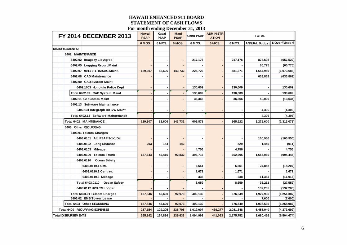
6402 MAINTENANCE
6402.02 Imagery Lic Agree - - - 217,176 - 217,176 874,698 (657,522)
6402.05 Logging RecordMaint - - - - - - 60,775 (60,775)
6402.07 0011 9-1-1MSAG Maint. 129,307 82,606 143,732 225,726 - 581,371 1,654,959 (1,073,588)
6402.08 CAD Maintenance - - - - - - 633,862 (633,862)
6402.09 CAD System Maint
6402.1003 Honolulu Police Dept - - - 130,609 - 130,609 - 130,609
Total 6402.09 CAD System Maint - - - 130,609 - 130,609 - 130,609
6402.11 GeoComm Maint - - - 36,366 - 36,366 50,000 (13,634)
6402.13 Software Maintenance
6402.131 Integraph DB S/W Maint - - - - - - 4,306 (4,306)
Total 6402.13 Software Maintenance - - - - - - 4,306 (4,306)
Total 6402 MAINTENANCE 129,307 82,606 143,732 609,878 - 965,522 3,278,600 (2,313,078)
6403 Other RECURRING
6403.01 Telcom Charges
6403.0101 Alt. PSAP 9-1-1 Del - - - - - - 100,950 (100,950)
6403.0102 Long Distance 203 184 142 - - 529 1,440 (911)
6403.0103 Mileage - - - 4,756 4,756 - 4,756
6403.0109 Telcom Trunk 127,643 46,416 92,832 395,715 - 662,605 1,657,050 (994,445)
6403.0110 Ocean Safety
6403.0110.1 CML - - - 6,651 - 6,651 24,858 (18,207)
6403.0110.2 Centrex - - - 1,671 - 1,671 - 1,671
6403.0110.3 Mileage - - - 338 - 338 11,353 (11,015)
Total 6403.0110 Ocean Safety - - - 8,659 - 8,659 36,211 (27,552)
6403.0112 HPD CML Viper - - - - - - 132,285 (132,285)
Total 6403.01 Telcom Charges 127,846 46,600 92,973 409,130 - 676,549 1,927,936 (1,251,387) 6403.02 EMS Tower Lease - - - - - - 7,600 (7,600)
Total 6403 Other RECURRING 127,846 46,600 92,973 409,130 - 676,549 1,935,536 (1,258,987)
Total 6400 RECURRING EXPENSES 257,154 129,205 236,705 1,019,007 439,277 2,081,348 6,455,040 (4,373,692)
Total DISBURSEMENTS 265,142 134,886 239,633 1,094,998 441,093 2,175,752 8,680,426 (6,504,674)
Maui PSAPFY 2014 DECEMBER 2013 Hawaii
PSAPKauai PSAP
HAWAII ENHANCED 911 BOARD STATEMENT OF CASH FLOWS
For month ending December 31, 2013
7
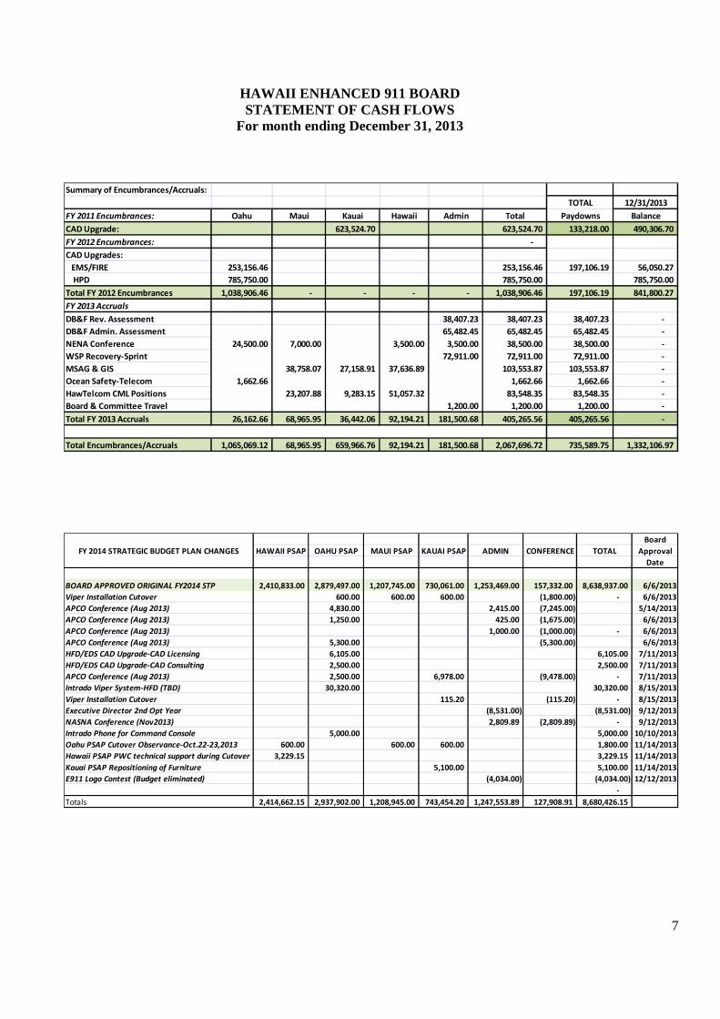
Summary of Encumbrances/Accruals:
TOTAL 12/31/2013
FY 2011 Encumbrances: Oahu Maui Kauai Hawaii Admin Total Paydowns Balance
CAD Upgrade: 623,524.70 623,524.70 133,218.00 490,306.70
FY 2012 Encumbrances: -
CAD Upgrades:
EMS/FIRE 253,156.46 253,156.46 197,106.19 56,050.27
HPD 785,750.00 785,750.00 785,750.00
Total FY 2012 Encumbrances 1,038,906.46 - - - - 1,038,906.46 197,106.19 841,800.27
FY 2013 Accruals
DB&F Rev. Assessment 38,407.23 38,407.23 38,407.23 -
DB&F Admin. Assessment 65,482.45 65,482.45 65,482.45 -
NENA Conference 24,500.00 7,000.00 3,500.00 3,500.00 38,500.00 38,500.00 -
WSP Recovery-Sprint 72,911.00 72,911.00 72,911.00 -
MSAG & GIS 38,758.07 27,158.91 37,636.89 103,553.87 103,553.87 -
Ocean Safety-Telecom 1,662.66 1,662.66 1,662.66 -
HawTelcom CML Positions 23,207.88 9,283.15 51,057.32 83,548.35 83,548.35 -
Board & Committee Travel 1,200.00 1,200.00 1,200.00 -
Total FY 2013 Accruals 26,162.66 68,965.95 36,442.06 92,194.21 181,500.68 405,265.56 405,265.56 -
Total Encumbrances/Accruals 1,065,069.12 68,965.95 659,966.76 92,194.21 181,500.68 2,067,696.72 735,589.75 1,332,106.97
Board
HAWAII PSAP OAHU PSAP MAUI PSAP KAUAI PSAP ADMIN CONFERENCE TOTAL Approval
Date
BOARD APPROVED ORIGINAL FY2014 STP 2,410,833.00 2,879,497.00 1,207,745.00 730,061.00 1,253,469.00 157,332.00 8,638,937.00 6/6/2013
Viper Installation Cutover 600.00 600.00 600.00 (1,800.00) - 6/6/2013
APCO Conference (Aug 2013) 4,830.00 2,415.00 (7,245.00) 5/14/2013
APCO Conference (Aug 2013) 1,250.00 425.00 (1,675.00) 6/6/2013
APCO Conference (Aug 2013) 1,000.00 (1,000.00) - 6/6/2013
APCO Conference (Aug 2013) 5,300.00 (5,300.00) 6/6/2013
HFD/EDS CAD Upgrade-CAD Licensing 6,105.00 6,105.00 7/11/2013
HFD/EDS CAD Upgrade-CAD Consulting 2,500.00 2,500.00 7/11/2013
APCO Conference (Aug 2013) 2,500.00 6,978.00 (9,478.00) - 7/11/2013
Intrado Viper System-HFD (TBD) 30,320.00 30,320.00 8/15/2013
Viper Installation Cutover 115.20 (115.20) - 8/15/2013
Executive Director 2nd Opt Year (8,531.00) (8,531.00) 9/12/2013
NASNA Conference (Nov2013) 2,809.89 (2,809.89) - 9/12/2013
Intrado Phone for Command Console 5,000.00 5,000.00 10/10/2013
Oahu PSAP Cutover Observance-Oct.22-23,2013 600.00 600.00 600.00 1,800.00 11/14/2013
Hawaii PSAP PWC technical support during Cutover 3,229.15 3,229.15 11/14/2013
Kauai PSAP Repositioning of Furniture 5,100.00 5,100.00 11/14/2013
E911 Logo Contest (Budget eliminated) (4,034.00) (4,034.00) 12/12/2013
-
Totals 2,414,662.15 2,937,902.00 1,208,945.00 743,454.20 1,247,553.89 127,908.91 8,680,426.15
FY 2014 STRATEGIC BUDGET PLAN CHANGES
HAWAII ENHANCED 911 BOARD STATEMENT OF CASH FLOWS
For month ending December 31, 2013
8
Fiscal Year-to-date 2014 Disbursements Detail by PSAP & Administration

HAWAII ENHANCED 911 BOARD STATEMENT OF CASH FLOWS
For month ending December 31, 2013
9
Hawaii PSAP
6 MOS.ANNUAL Budget
$ Over/(Under) Budget
DISBURSEMENTS:
6200 CONFERENCES
6204 APCO Conference - - -
6212 NASNA Conference - - -
6214 Nena Conference 3,134 - 3,134
6225 VIPER CUTOver 1,625 600 1,025
6200 CONFERENCES - Other - - -
Total 6200 CONFERENCES 4,759 600 4,159
6300 Non-RECURRING
6301 CAD Replac/Upgrade
6301.01 EMS - - -
6301.02 Hawai'i Police Dept - 1,500,000 (1,500,000)
6301.03 Honolulu Fire Dept.
6301.031 Licensing - - -
6301.032 Consulting - - -
6301.03 Honolulu Fire Dept. - Other - - -
Total 6301.03 Honolulu Fire Dept. - - -
Total 6301 CAD Replac/Upgrade - 1,500,000 (1,500,000)
6303 Computers
6303.06 GeoComm - - -
6303.15 NG911 Record Syst. - 55,000 (55,000)
6303.16 ViperInstall - - -
6303.17 Intrado Phone - - -
6303.18 PWC Tech cutover Supp 3,229 3,229 -
6303.19 Reposition of Consoles - - -
Total 6303 Computers 3,229 58,229 (55,000)
6306 Training
6306.11 Training (CAD) HPD - - -
6306.12 TriTechCADSystAdm
6306.121 CAD Tritech HFD - - -
6306.122 CAD TriTech EMS - - -
Total 6306.12 TriTechCADSystAdm - - -
6306.13 OT Viper Training - - -
Total 6306 Training - - -
Total 6300 Non-RECURRING 3,229 1,558,229 (1,555,000)
6400 RECURRING EXPENSES
6402 MAINTENANCE
6402.02 Imagery Lic Agree - - -
6402.05 Logging RecordMaint - - -
6402.07 0011 9-1-1MSAG Maint. 129,307 480,444 (351,137)
6402.08 CAD Maintenance - 64,255 (64,255)
6402.09 CAD System Maint
6402.1003 Honolulu Police Dept - - -
Total 6402.09 CAD System Maint - - -
6402.11 GeoComm Maint - - -
6402.13 Software Maintenance
6402.131 Integraph DB S/W Maint - 4,306 (4,306)
Total 6402.13 Software Maintenance - 4,306 (4,306)
Total 6402 MAINTENANCE 129,307 549,005 (419,698)
6403 Other RECURRING
6403.01 Telcom Charges
6403.0101 Alt. PSAP 9-1-1 Del - - -
6403.0102 Long Distance 203 480 (277)
6403.0103 Mileage - - -
6403.0109 Telcom Trunk 127,643 306,348 (178,705)
6403.0110 Ocean Safety
6403.0110.1 CML - - -
6403.0110.2 Centrex - - -
6403.0110.3 Mileage - - -
Total 6403.0110 Ocean Safety - - -
6403.0112 HPD CML Viper - - -
Total 6403.01 Telcom Charges 127,846 306,828 (178,982) 6403.02 EMS Tower Lease - - -
Total 6403 Other RECURRING 127,846 306,828 (178,982)
Total 6400 RECURRING EXPENSES 257,154 855,833 (598,679)
Total DISBURSEMENTS 265,142 2,414,662 (2,149,521)
FY 2014 DECEMBER 2013

HAWAII ENHANCED 911 BOARD STATEMENT OF CASH FLOWS
For month ending December 31, 2013
10
Kauai PSAP
6 MOS.ANNUAL Budget
$ Over/(Under) Budget
DISBURSEMENTS:
6200 CONFERENCES
6204 APCO Conference 5,223 6,978 (1,755)
6212 NASNA Conference - - -
6214 Nena Conference - - -
6225 VIPER CUTOver 458 1,315 (857)
6200 CONFERENCES - Other - - -
Total 6200 CONFERENCES 5,680 8,293 (2,613)
6300 Non-RECURRING
6301 CAD Replac/Upgrade
6301.01 EMS - - -
6301.02 Hawai'i Police Dept - - -
6301.03 Honolulu Fire Dept.
6301.031 Licensing - - -
6301.032 Consulting - - -
6301.03 Honolulu Fire Dept. - Other - - -
Total 6301.03 Honolulu Fire Dept. - - -
Total 6301 CAD Replac/Upgrade - - -
6303 Computers
6303.06 GeoComm - - -
6303.15 NG911 Record Syst. - - -
6303.16 ViperInstall - - -
6303.17 Intrado Phone - - -
6303.18 PWC Tech cutover Supp - - -
6303.19 Reposition of Consoles - 5,100 (5,100)
Total 6303 Computers - 5,100 (5,100)
6306 Training
6306.11 Training (CAD) HPD - - -
6306.12 TriTechCADSystAdm
6306.121 CAD Tritech HFD - - -
6306.122 CAD TriTech EMS - - -
Total 6306.12 TriTechCADSystAdm - - -
6306.13 OT Viper Training - - -
Total 6306 Training - - -
Total 6300 Non-RECURRING - 5,100 (5,100)
6400 RECURRING EXPENSES
6402 MAINTENANCE
6402.02 Imagery Lic Agree - 186,810 (186,810)
6402.05 Logging RecordMaint - - -
6402.07 0011 9-1-1MSAG Maint. 82,606 330,423 (247,817)
6402.08 CAD Maintenance - - -
6402.09 CAD System Maint
6402.1003 Honolulu Police Dept - - -
Total 6402.09 CAD System Maint - - -
6402.11 GeoComm Maint - - -
6402.13 Software Maintenance
6402.131 Integraph DB S/W Maint - - -
Total 6402.13 Software Maintenance - - -
Total 6402 MAINTENANCE 82,606 517,233 (434,627)
6403 Other RECURRING
6403.01 Telcom Charges
6403.0101 Alt. PSAP 9-1-1 Del - 100,950 (100,950)
6403.0102 Long Distance 184 480 (296)
6403.0103 Mileage - - -
6403.0109 Telcom Trunk 46,416 111,398 (64,982)
6403.0110 Ocean Safety
6403.0110.1 CML - - -
6403.0110.2 Centrex - - -
6403.0110.3 Mileage - - -
Total 6403.0110 Ocean Safety - - -
6403.0112 HPD CML Viper - - -
Total 6403.01 Telcom Charges 46,600 212,828 (166,228) 6403.02 EMS Tower Lease - - -
Total 6403 Other RECURRING 46,600 212,828 (166,228)
Total 6400 RECURRING EXPENSES 129,205 730,061 (600,856)
Total DISBURSEMENTS 134,886 743,454 (608,568)
FY 2014 DECEMBER 2013

HAWAII ENHANCED 911 BOARD STATEMENT OF CASH FLOWS
For month ending December 31, 2013
11
6 MOS. ANNUAL Budget $ Over/(Under) Budget
DISBURSEMENTS:
6200 CONFERENCES
6204 APCO Conference - - -
6212 NASNA Conference - - -
6214 Nena Conference 2,329 - 2,329
6225 VIPER CUTOver 600 1,200 (600)
6200 CONFERENCES - Other - - -
Total 6200 CONFERENCES 2,929 1,200 1,729
6300 Non-RECURRING
6303 Computers
6303.06 GeoComm - - -
6303.15 NG911 Record Syst. - 55,000 (55,000)
6303.16 ViperInstall - - -
6303.17 Intrado Phone - - -
6303.18 PWC Tech cutover Supp - - -
6303.19 Reposition of Consoles - - -
Total 6303 Computers - 55,000 (55,000)
6306 Training
6306.11 Training (CAD) HPD - - -
6306.12 TriTechCADSystAdm
6306.121 CAD Tritech HFD - - -
6306.122 CAD TriTech EMS - - -
Total 6306.12 TriTechCADSystAdm - - -
6306.13 OT Viper Training - - -
Total 6306 Training - - -
Total 6300 Non-RECURRING - 55,000 (55,000)
6400 RECURRING EXPENSES
6402 MAINTENANCE
6402.02 Imagery Lic Agree - 387,888 (387,888)
6402.05 Logging RecordMaint - - -
6402.07 0011 9-1-1MSAG Maint. 143,732 302,350 (158,618)
6402.08 CAD Maintenance - 169,607 (169,607)
6402.09 CAD System Maint
6402.1003 Honolulu Police Dept - - -
Total 6402.09 CAD System Maint - - -
6402.11 GeoComm Maint - - -
6402.13 Software Maintenance
6402.131 Integraph DB S/W Maint - - -
Total 6402.13 Software Maintenance - - -
Total 6402 MAINTENANCE 143,732 859,845 (716,113)
6403 Other RECURRING
6403.01 Telcom Charges
6403.0101 Alt. PSAP 9-1-1 Del - - -
6403.0102 Long Distance 142 480 (338)
6403.0103 Mileage - - -
6403.0109 Telcom Trunk 92,832 292,420 (199,588)
6403.0110 Ocean Safety
6403.0110.1 CML - - -
6403.0110.2 Centrex - - -
6403.0110.3 Mileage - - -
Total 6403.0110 Ocean Safety - - -
6403.0112 HPD CML Viper - - -
Total 6403.01 Telcom Charges 92,973 292,900 (199,927) 6403.02 EMS Tower Lease - - -
Total 6403 Other RECURRING 92,973 292,900 (199,927)
Total 6400 RECURRING EXPENSES 236,705 1,152,745 (916,040)
Total DISBURSEMENTS 239,633 1,208,945 (969,312)
Maui PSAPFY 2014 DECEMBER 2013

HAWAII ENHANCED 911 BOARD STATEMENT OF CASH FLOWS
For month ending December 31, 2013
12
Oahu PSAP
6 MOS. ANNUAL Budget $ Over/(Under) Budget
DISBURSEMENTS:
6200 CONFERENCES
6204 APCO Conference 6,544 13,880 (7,336)
6212 NASNA Conference - - -
6214 Nena Conference (10,605) - (10,605)
6225 VIPER CUTOver 189 600 (411)
6200 CONFERENCES - Other - - -
Total 6200 CONFERENCES (3,872) 14,480 (18,352)
6300 Non-RECURRING
6301 CAD Replac/Upgrade
6301.01 EMS - 99,000 (99,000)
6301.02 Hawai'i Police Dept - - -
6301.03 Honolulu Fire Dept.
6301.031 Licensing - 6,105 (6,105)
6301.032 Consulting 1,625 2,500 (875)
6301.03 Honolulu Fire Dept. - Other - 72,000 (72,000)
Total 6301.03 Honolulu Fire Dept. 1,625 80,605 (78,980)
Total 6301 CAD Replac/Upgrade 1,625 179,605 (177,980)
6303 Computers
6303.06 GeoComm 26,324 150,000 (123,676)
6303.15 NG911 Record Syst. - - -
6303.16 ViperInstall 30,220 30,320 (100)
6303.17 Intrado Phone - 5,000 (5,000)
6303.18 PWC Tech cutover Supp - - -
6303.19 Reposition of Consoles - - -
Total 6303 Computers 56,544 185,320 (128,776)
6306 Training
6306.11 Training (CAD) HPD - 8,000 (8,000)
6306.12 TriTechCADSystAdm
6306.121 CAD Tritech HFD - 20,000 (20,000)
6306.122 CAD TriTech EMS - 7,000 (7,000)
Total 6306.12 TriTechCADSystAdm - 27,000 (27,000)
6306.13 OT Viper Training 21,694 48,000 (26,306)
Total 6306 Training 21,694 83,000 (61,306)
Total 6300 Non-RECURRING 79,863 447,925 (368,062)
6400 RECURRING EXPENSES
6402 MAINTENANCE
6402.02 Imagery Lic Agree 217,176 300,000 (82,824)
6402.05 Logging RecordMaint - 60,775 (60,775)
6402.07 0011 9-1-1MSAG Maint. 225,726 541,742 (316,016)
6402.08 CAD Maintenance - 400,000 (400,000)
6402.09 CAD System Maint
6402.1003 Honolulu Police Dept 130,609 - 130,609
Total 6402.09 CAD System Maint 130,609 - 130,609
6402.11 GeoComm Maint 36,366 50,000 (13,634)
6402.13 Software Maintenance
6402.131 Integraph DB S/W Maint - - -
Total 6402.13 Softw are Maintenance - - -
Total 6402 MAINTENANCE 609,878 1,352,517 (742,639)
6403 Other RECURRING
6403.01 Telcom Charges
6403.0101 Alt. PSAP 9-1-1 Del - - -
6403.0102 Long Distance - - -
6403.0103 Mileage 4,756 - 4,756
6403.0109 Telcom Trunk 395,715 946,884 (551,169)
6403.0110 Ocean Safety
6403.0110.1 CML 6,651 24,858 (18,207)
6403.0110.2 Centrex 1,671 - 1,671
6403.0110.3 Mileage 338 11,353 (11,015)
Total 6403.0110 Ocean Safety 8,659 36,211 (27,552)
6403.0112 HPD CML Viper - 132,285 (132,285)
Total 6403.01 Telcom Charges 409,130 1,115,380 (706,250) 6403.02 EMS Tower Lease - 7,600 (7,600)
Total 6403 Other RECURRING 409,130 1,122,980 (713,850)
Total 6400 RECURRING EXPENSES 1,019,007 2,475,497 (1,456,490)
Total DISBURSEMENTS 1,094,998 2,937,902 (1,842,904)
FY 2014 DECEMBER 2013

HAWAII ENHANCED 911 BOARD STATEMENT OF CASH FLOWS
For month ending December 31, 2013
13
ADMINISTRATION
6 MOS. ANNUAL Budget
$ Over/(Under) BudgetTotal Income 4,096,180 9,052,000 (4,955,820)
DISBURSEMENTS:
6200 CONFERENCES
6204 APCO Conference 2,507 3,840 (1,333)
6212 NASNA Conference 2,810 2,810 -
6214 Nena Conference (3,500) - (3,500)
6225 VIPER CUTOver - - -
6200 CONFERENCES - Other - 127,909 (127,909)
Total 6200 CONFERENCES 1,817 134,559 (132,742)
6400 RECURRING EXPENSES
6401 ADMINISTRATION
6401.01 Exec Dir. Services 170,819 341,250 (170,431)
6401.02 ElectronSignatur - 189 (189)
6401.05 Audit Expense 10,000 11,500 (1,500)
6401.06 Bank Charge - 108 (108)
6401.08 Board Member Travel 10,562 28,988 (18,426)
6401.09 DB&F Assessments
6401.0101 DB&F Admin. Assess 35,826 238,000 (202,174)
6401.0102 DB&F Rev Assessment 189,184 454,444 (265,260)
6401.0104 FY2013 Assess 24,914 - 24,914
Total 6401.09 DB&F Assessments 249,924 692,444 (442,520)
6401.11 Miscellaneous Expense 5 500 (495)
6401.12 NASNA Dues - 215 (215)
6401.13 Parking Permits - 210 (210)
6401.15 WSP Cost Recovery
6401.0101 Sprint/Nextel (2,033) - (2,033)
6401.15 WSP Cost Recovery - Other - 140,000 (140,000)
Total 6401.15 WSP Cost Recovery (2,033) 140,000 (142,033)
6401.17 ADA Compliance - 500 (500)
6401.18 AG Legal Fees - 25,000 (25,000)
Total 6401 ADMINISTRATION 439,277 1,240,904 (801,627)
Total 6400 RECURRING EXPENSES 439,277 1,240,904 (801,627)
Total DISBURSEMENTS 441,093 1,375,463 (934,370)
FY 2014 DECEMBER 2013
Oahu Civilian E9-1-1 Status Report December 1, 2013 – December 31, 2013
Oahu Civilian Page 1 of 90 December 2013
PSAP Operations
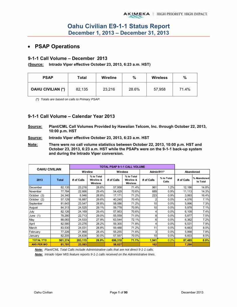
9-1-1 Call Volume – December 2013 (Source: Intrado Viper effective October 23, 2013, 6:23 a.m. HST)
PSAP Total Wireline % Wireless %
OAHU CIVILIAN (*) 82,135 23,216 28.6% 57,958 71.4%
(*) Totals are based on calls to Primary PSAP.
9-1-1 Call Volume – Calendar Year 2013 Source: Plant/CML Call Volumes Provided by Hawaiian Telcom, Inc. through October 22, 2013,
10:00 p.m. HST
Source: Intrado Viper effective October 23, 2013, 6:23 a.m. HST
Note: There were no call volume statistics between October 22, 2013, 10:00 p.m. HST and October 23, 2013, 6:23 a.m. HST while the PSAPs were on the 9-1-1 back-up system and during the Intrado Viper conversion.
Note: Plant/CML Total Calls include Administrative calls that are not direct 9-1-1 calls.
Note: Intrado Viper MIS feature reports 9-1-1 calls received on the Administrative lines.
2013 Total # of Calls% to Total Wireline & Wireless
# of Calls% to Total Wireline & Wireless
# of Calls % to Total Calls # of Calls % Abandoned
to Total
December 82,135 23,216 28.6% 57,958 71.4% 961 1.2% 12,186 14.8%November 77,784 22,666 29.4% 54,429 70.6% 689 0.9% 11,113 14.3%October (3) 24,340 6,946 28.8% 17,171 71.2% 223 0.9% 3,993 16.4%October (2) 57,129 16,887 29.6% 40,240 70.4% 2 0.0% 4,076 7.1%September 81,643 23,547 28.8% 58,086 71.2% 10 0.0% 5,996 7.3%August 84,313 24,525 29.1% 59,778 70.9% 10 0.0% 5,978 7.1%July 82,126 24,169 29.4% 57,953 70.6% 4 0.0% 6,109 7.4%June (1) 78,280 22,713 29.0% 55,559 71.0% 8 0.0% 5,877 7.5%May 88,083 24,533 27.9% 63,544 72.1% 6 0.0% 6,362 7.2%April 82,580 23,276 28.2% 59,300 71.8% 4 0.0% 6,531 7.9%March 83,530 24,031 28.8% 59,488 71.2% 11 0.0% 6,663 8.0%February 77,226 21,968 28.4% 55,255 71.6% 3 0.0% 5,998 7.8%January 82,205 24,638 30.0% 57,557 70.0% 10 0.0% 6,603 8.0%
TOTAL YTD 981,374 283,115 28.9% 696,318 71.1% 1,941 0.2% 87,485 8.9%AVG PER MO 81,781 23,593 58,027 162 7,290
OAHU CIVILIANTOTAL PSAP 9-1-1 CALL VOLUME
Wireline Wireless Admin/911* Abandoned

Oahu Civilian E9-1-1 Status Report December 1, 2013 – December 31, 2013
Oahu Civilian Page 2 of 90 December 2013
PSAP Operations (continued)
9-1-1 Call Volume – Calendar Year 2013 (continued) (1) There were no statistics from midnight to 9:30 a.m. HST on June 3, 2013 as reported by Hawaiian
Telcom due to corruption in the file. (2) There are no statistics following the transfer of the 9-1-1 traffic to the Hawaiian Telcom, Inc. 9-1-1
back-up system on October 22, 2013 at approximately 10:00 p.m. (HST). (3) The Intrado Viper system began collecting call statistics on October 23, 2013 at approximately
6:23 a.m. HST.
Note: Plant/CML Total Calls include Administrative calls that are not direct 9-1-1 calls.
Note: Intrado Viper MIS feature reports 9-1-1 calls received on the Administrative lines.
Note: HPDCT does not receive Abandoned call statistics via the Intrado Viper system.
(1) There were no statistics captured between March 24, 2013 (5:30 a.m. HST) and March 31, 2013 (11:59 p.m. HST) while Dispatch was at the alternate site in Kapolei.
(2) There were no statistics captured between April 1, 2013 (12:00 a.m. HST) and April 7, 2013 (5:30 a.m. HST) while Dispatch was at the alternate site in Kapolei.
(3) There were no statistics from midnight to 9:30 a.m. HST on June 3, 2013 as reported by Hawaiian Telcom due to corruption in the file. There were no statistics captured on June 11, 2013 from 5:30 a.m. to 9:30 p.m. HST while Dispatch was at the alternate site in Kapolei.
(4) There were no statistics captured between July 7, 2013 (1:30 p.m. HST) and August 3, 2013 (9:30 p.m. HST) while Dispatch was at the alternate site in Kapolei.
(5) There are no statistics following the transfer of the 9-1-1 traffic to the Hawaiian Telcom, Inc. 9-1-1 back-up system on October 22, 2013 at approximately 10:00 p.m. (HST).
(6) The Intrado Viper system began collecting call statistics on October 23, 2013 at approximately 6:23 a.m. HST.
2013 Total # of Calls% to Total Wireline & Wireless
% of Total Wireline # of Calls
% to Total Wireline & Wireless
% of Total Wireless # of Calls % to Total
Calls # of Calls % Abandonedto Total
December 39,566 10,472 26.7% 45.1% 28,739 73.3% 49.6% 355 0.9% N/A N/ANovember 36,588 9,410 26.0% 41.5% 26,732 74.0% 49.1% 446 1.2% N/A N/AOctober (6) 11,250 2,913 26.5% 41.9% 8,091 73.5% 47.1% 246 2.2% N/A N/AOctober (5) 28,544 7,474 26.3% 44.3% 20,957 73.7% 52.1% 113 0.4% 703 2.5%September 40,597 10,701 26.4% 45.4% 29,824 73.6% 51.3% 72 0.2% 1,355 3.3%August (4) 37,794 9,974 26.5% 40.7% 27,687 73.5% 46.3% 133 0.4% 1,207 3.2%July (4) 8,797 2,343 26.8% 9.7% 6,415 73.2% 11.1% 39 0.4% 298 3.4%June (3) 39,073 10,087 25.9% 44.4% 28,857 74.1% 51.9% 129 0.3% 1,038 2.7%May 45,673 11,234 24.7% 45.8% 34,306 75.3% 54.0% 133 0.3% 1,663 3.6%April (2) 32,275 8,371 26.0% 36.0% 23,825 74.0% 40.2% 79 0.2% 1,173 3.6%March (1) 30,899 8,101 26.3% 33.7% 22,713 73.7% 38.2% 85 0.3% 1,021 3.3%February 37,587 9,829 26.2% 44.7% 27,632 73.8% 50.0% 126 0.3% 1,282 3.4%January 40,357 11,013 27.4% 44.7% 29,171 72.6% 50.7% 173 0.4% 1,001 2.5%
TOTAL YTD 429,000 111,922 26.2% 39.5% 314,949 73.8% 45.2% 2,129 0.5% 10,741 2.5%AVG PER MO 35,750 9,327 26,246 177 976
OAHU CIVILIANTRANSFERRED TO CALL TAKERS (HPDCT )
Wireline Wireless Admin/911* Abandoned
Oahu Civilian E9-1-1 Status Report December 1, 2013 – December 31, 2013
Oahu Civilian Page 3 of 90 December 2013
PSAP Operations (continued)
9-1-1 Call Volume – Calendar Year 2013 (continued)
Note: Plant/CML Total Calls include Administrative calls that are not direct 9-1-1 calls.
Note: Intrado Viper MIS feature reports 9-1-1 calls received on the Administrative lines.
(1) There were no statistics from midnight to 9:30 a.m. HST on June 3, 2013 as reported by Hawaiian Telcom due to corruption in the file.
(2) There are no statistics following the transfer of the 9-1-1 traffic to the Hawaiian Telcom, Inc. 9-1-1 back-up system on October 22, 2013 at approximately 10:00 p.m. (HST).
(3) The Intrado Viper system began collecting call statistics on October 23, 2013 at approximately 6:23 a.m. HST.
2013 Total # of Calls% to Total Wireline & Wireless
% of Total Wireline # of Calls
% to Total Wireline & Wireless
% of Total Wireless # of Calls % to Total
Calls # of Calls % Abandonedto Total
December 19,747 5,797 30.3% 25.0% 13,344 69.7% 23.0% 606 3.1% 12,186 61.7%November 19,419 4,970 27.3% 21.9% 13,250 72.7% 24.3% 1,199 6.2% 11,113 57.2%October (3) 5,949 1,441 25.6% 20.7% 4,184 74.4% 24.4% 324 5.4% 3,993 67.1%October (2) 12,354 4,013 32.7% 23.8% 8,253 67.3% 20.5% 88 0.7% 432 3.5%September 17,772 5,458 30.9% 23.2% 12,193 69.1% 21.0% 121 0.7% 704 4.0%August 18,628 5,997 32.4% 24.5% 12,526 67.6% 21.0% 105 0.6% 1,096 5.9%July 20,050 6,824 34.1% 28.2% 13,193 65.9% 22.8% 33 0.2% 4,112 20.5%June (1) 15,788 5,254 33.5% 23.1% 10,429 66.5% 18.8% 105 0.7% 1,038 6.6%May 17,891 5,565 31.3% 22.7% 12,209 68.7% 19.2% 117 0.7% 627 3.5%April 18,191 5,179 28.7% 22.3% 12,897 71.3% 21.7% 115 0.6% 683 3.8%March 17,427 5,488 31.7% 22.8% 11,823 68.3% 19.9% 116 0.7% 678 3.9%February 15,225 5,016 33.3% 22.8% 10,066 66.7% 18.2% 143 0.9% 544 3.6%January 16,177 5,502 34.3% 22.3% 10,520 65.7% 18.3% 155 1.0% 652 4.0%
TOTAL YTD 214,618 66,504 31.5% 23.5% 144,887 68.5% 20.8% 3,227 1.5% 37,858 17.6%AVG PER MO 17,885 5,542 12,074 269 3,155
OAHU CIVILIANTRANSFERRED TO URGENT RESPONSE (HPDURS)
Wireline Wireless Admin/911* Abandoned

Oahu Civilian E9-1-1 Status Report December 1, 2013 – December 31, 2013
Oahu Civilian Page 4 of 90 December 2013
PSAP Operations (continued)
9-1-1 Call Volume – Calendar Year 2013 (continued)
Note: Plant/CML Total Calls include Administrative calls that are not direct 9-1-1 calls.
Note: Intrado Viper MIS feature reports 9-1-1 calls received on the Administrative lines.
(1) There were no statistics captured between March 24, 2013 (5:30 a.m. HST) and March 31, 2013
(11:59 p.m. HST) while Dispatch was at the alternate site in Kapolei. (2) There were no statistics captured between April 1, 2013 (12:00 a.m. HST) and April 7, 2013
(5:30 a.m. HST) while Dispatch was at the alternate site in Kapolei. (3) There were no statistics from midnight to 9:30 a.m. HST on June 3, 2013 as reported by Hawaiian
Telcom due to corruption in the file. There were no statistics captured on June 11, 2013 from 5:30 a.m. to 9:30 p.m. HST while Dispatch was at the alternate site in Kapolei.
(4) There were no statistics captured between July 7, 2013 (1:30 p.m. HST) and August 3, 2013 (9:30 p.m. HST) while Dispatch was at the alternate site in Kapolei.
(5) There are no statistics following the transfer of the 9-1-1 traffic to the Hawaiian Telcom, Inc. 9-1-1 back-up system on October 22, 2013 at approximately 10:00 p.m. (HST).
(6) The Intrado Viper system began collecting call statistics on October 23, 2013 at approximately 6:23 a.m. HST.
2013 Total # of Calls% to Total Wireline & Wireless
% of Total Wireline # of Calls
% to Total Wireline & Wireless
% of Total Wireless # of Calls % to Total
Calls # of Calls % Abandonedto Total
December 12,186 3,315 27.3% 14.3% 8,849 72.7% 15.3% 22 0.2% 12,186 100.0%November 11,013 2,912 26.7% 12.8% 7,984 73.3% 14.7% 117 1.1% 11,013 100.0%October (6) 3,993 968 24.7% 13.9% 2,948 75.3% 17.2% 77 1.9% 3,993 100.0%October (5) 6,455 2,267 35.1% 13.4% 4,184 64.9% 10.4% 4 0.1% 5,250 81.3%September 8,286 2,714 32.8% 11.5% 5,568 67.2% 9.6% 4 0.0% 6,997 84.4%August (4) 7,744 2,521 32.6% 10.3% 5,218 67.4% 8.7% 5 0.1% 6,271 81.0%July (4) 1,816 596 32.9% 2.5% 1,218 67.1% 2.1% 2 0.1% 1,475 81.2%June (3) 8,263 2,822 34.2% 12.4% 5,436 65.8% 9.8% 5 0.1% 6,893 83.4%May 9,085 3,043 33.5% 12.4% 6,041 66.5% 9.5% 1 0.0% 7,617 83.8%April (2) 7,031 2,173 30.9% 9.3% 4,855 69.1% 8.2% 3 0.0% 5,934 84.4%March (1) 7,435 2,385 32.1% 9.9% 5,047 67.9% 8.5% 3 0.0% 5,906 79.4%February 8,364 2,514 30.1% 11.4% 5,839 69.9% 10.6% 11 0.1% 6,488 77.6%January 8,855 2,791 31.6% 11.3% 6,053 68.4% 10.5% 11 0.1% 7,246 81.8%
TOTAL YTD 100,526 31,021 30.9% 11.0% 69,240 69.1% 9.9% 265 0.3% 87,269 86.8%AVG PER MO 8,377 2,585 5,770 22 7,272
OAHU CIVILIANTRANSFERRED TO DROP
Wireline Wireless Admin/911* Abandoned

Oahu Civilian E9-1-1 Status Report December 1, 2013 – December 31, 2013
Oahu Civilian Page 5 of 90 December 2013
PSAP Operations (continued)
9-1-1 Call Volume – Calendar Year 2013 (continued)
Note: Plant/CML Total Calls include Administrative calls that are not direct 9-1-1 calls.
Note: Intrado Viper MIS feature reports 9-1-1 calls received on the Administrative lines.
(1) There were no statistics from midnight to 9:30 a.m. HST on June 3, 2013 as reported by Hawaiian
Telcom due to corruption in the file. (2) There are no statistics following the transfer of the 9-1-1 traffic to the Hawaiian Telcom, Inc. 9-1-1
back-up system on October 22, 2013 at approximately 10:00 p.m. (HST). (3) The Intrado Viper system began collecting call statistics on October 23, 2013 at approximately
6:23 a.m. HST.
2013 Total # of Calls% to Total Wireline & Wireless
% of Total Wireline # of Calls
% to Total Wireline & Wireless
% of Total Wireless # of Calls % to Total
Calls # of Calls % Abandonedto Total
December 1,871 724 40.4% 3.1% 1,066 59.6% 1.8% 81 4.3% 66 3.5%November 2,096 661 33.7% 2.9% 1,299 66.3% 2.4% 136 6.5% 51 2.4%October (3) 779 239 33.0% 3.4% 485 67.0% 2.8% 55 7.1% 30 3.9%October (2) 1,473 526 37.0% 3.1% 896 63.0% 2.2% 51 3.5% 35 2.4%September 2,758 831 31.3% 3.5% 1,824 68.7% 3.1% 103 3.7% 91 3.3%August 3,344 1,071 34.1% 4.4% 2,068 65.9% 3.5% 205 6.1% 287 8.6%July 5,105 1,919 40.8% 7.9% 2,779 59.2% 4.8% 407 8.0% 1,201 23.5%June (1) 4,467 1,655 39.6% 7.3% 2,523 60.4% 4.5% 289 6.5% 1,088 24.4%May 4,790 1,828 41.4% 7.5% 2,592 58.6% 4.1% 370 7.7% 1,124 23.5%April 4,539 1,853 43.5% 8.0% 2,403 56.5% 4.1% 283 6.2% 1,301 28.7%March 5,025 2,008 42.8% 8.4% 2,679 57.2% 4.5% 338 6.7% 1,345 26.8%February 4,752 1,910 44.4% 8.7% 2,392 55.6% 4.3% 450 9.5% 1,298 27.3%January 5,749 2,390 45.2% 9.7% 2,893 54.8% 5.0% 466 8.1% 1,499 26.1%
TOTAL YTD 46,748 17,615 40.5% 6.2% 25,899 59.5% 3.7% 3,234 6.9% 9,416 20.1%AVG PER MO 3,896 1,468 2,158 270 785
OAHU CIVILIANTRANSFERRED TO FIRE (HFD)
Wireline Wireless Admin/911* Abandoned

Oahu Civilian E9-1-1 Status Report December 1, 2013 – December 31, 2013
Oahu Civilian Page 6 of 90 December 2013
PSAP Operations (continued)
9-1-1 Call Volume – Calendar Year 2013 (continued)
Note: Plant/CML Total Calls include Administrative calls that are not direct 9-1-1 calls.
Note: Intrado Viper MIS feature reports 9-1-1 calls received on the Administrative lines.
(1) There were no statistics from midnight to 9:30 a.m. HST on June 3, 2013 as reported by Hawaiian
Telcom due to corruption in the file. (2) There are no statistics following the transfer of the 9-1-1 traffic to the Hawaiian Telcom, Inc. 9-1-1
back-up system on October 22, 2013 at approximately 10:00 p.m. (HST). (3) The Intrado Viper system began collecting call statistics on October 23, 2013 at approximately
6:23 a.m. HST.
2013 Total # of Calls% to Total Wireline & Wireless
% of Total Wireline # of Calls
% to Total Wireline & Wireless
% of Total Wireless # of Calls % to Total
Calls # of Calls % Abandonedto Total
December 7,402 2,499 36.2% 10.8% 4,396 63.8% 7.6% 506 6.8% 144 1.9%November 6,896 2,735 40.4% 12.1% 4,033 59.6% 7.4% 128 1.9% 91 1.3%October (2) 2,021 780 39.8% 11.2% 1,179 60.2% 6.9% 62 3.1% 36 1.8%October 5,029 1,939 39.2% 11.5% 3,008 60.8% 7.5% 82 1.6% 70 1.4%September 7,251 2,835 39.8% 12.0% 4,287 60.2% 7.4% 129 1.8% 138 1.9%August 7,309 2,857 40.3% 11.6% 4,238 59.7% 7.1% 214 2.9% 123 1.7%July 6,854 2,788 41.8% 11.5% 3,887 58.2% 6.7% 179 2.6% 110 1.6%June (1) 6,651 2,665 41.2% 11.7% 3,806 58.8% 6.9% 180 2.7% 92 1.4%May 7,550 2,960 40.2% 12.1% 4,401 59.8% 6.9% 189 2.5% 154 2.0%April 7,288 2,939 41.3% 12.6% 4,169 58.7% 7.0% 180 2.5% 114 1.6%March 7,670 3,124 41.8% 13.0% 4,348 58.2% 7.3% 198 2.6% 119 1.6%February 6,965 2,909 42.8% 13.2% 3,890 57.2% 7.0% 166 2.4% 119 1.7%January 8,006 3,217 41.6% 13.1% 4,512 58.4% 7.8% 277 3.5% 183 2.3%
TOTAL YTD 86,892 34,247 40.6% 12.1% 50,154 59.4% 87.1% 2,490 2.9% 1,493 1.7%AVG PER MO 7,241 2,854 4,180 208 124
OAHU CIVILIANTRANSFERRED TO EMS
Wireline Wireless Admin/911* Abandoned

Oahu Civilian E9-1-1 Status Report December 1, 2013 – December 31, 2013
Oahu Civilian Page 7 of 90 December 2013
PSAP Operations (continued)
9-1-1 Call Volume – Calendar Year 2013 (continued)
Note: Miscellaneous Call Volumes may be higher since no call volume statistics were captured for HPDCT and Drop queues from March 24 – 31, 2013 while Dispatch was at the alternate site in Kapolei. The other call queues are complete since Kapolei has the ability to transfer calls via CML to these queues. Note: Miscellaneous Call Volumes may be higher since no call volume statistics were captured for HPDCT and Drop queues from April 1 - 7, 2013 while Dispatch was at the alternate site in Kapolei. The other call queues are complete since Kapolei has the ability to transfer calls via CML to these queues. Note: Miscellaneous Call Volumes may be higher since no call volume statistics were captured on June 3, 2013 from midnight to 9:30 a.m. HST as reported by Hawaiian Telcom due to corruption in the file. Note: Miscellaneous Call Volumes may be higher since no call volume statistics were captured for HPDCT and Drop queues on June 11, 2013 while Dispatch was at the alternate site in Kapolei. The other call queues are complete since Kapolei has the ability to transfer calls via CML to these queues. Note: Miscellaneous Call Volumes may be higher since no call volume statistics were captured for HPDCT and Drop queues from July 7, 2013 through August 3, 2013 while Dispatch was at the alternate site in Kapolei. The other call queues are complete since Kapolei has the ability to transfer calls via CML to these queues. Note: There are no statistics following the transfer of the 9-1-1 traffic to the Hawaiian Telcom, Inc. 9-1-1 back-up system on October 22, 2013 at approximately 10:00 p.m. (HST).
Note: The Intrado Viper system began collecting call statistics on October 23, 2013 at approximately 6:23 a.m. HST.
TOTAL YTD January February March April May June
102,073 3,061 4,333 15,074 13,256 3,094 4,038
AVG PER MO July August September October November December
10,207 39,504 9,494 4,979 3,622 1,216 402
OAHU CIVILIANMISCELLANEOUS CALLS
(Total includes, but not limited to, calls transferred to Poison Control, Crisis Center, RDC, or Neighbor Islands, and non-transferred calls such as wrong number or test calls)
2013

Oahu Civilian E9-1-1 Status Report December 1, 2013 – December 31, 2013
Oahu Civilian Page 8 of 90 December 2013
PSAP Operations (continued) Intrado Viper 9-1-1 Call Volume Statistics
The Oahu PSAPs received training on the Intrado Viper Management Information System (MIS) in November 2013 and are able to access and retrieve Call Volume Statistics at the PSAP level. During the month of December 2013, all PSAPs in the State of Hawaiʻi will collaborate and agree upon a standardized method to report PSAP Call Volume beginning in 2014.
911 CALL VOLUME COMPARISON 2012 - 2013
Call Center E9-1-1 Call Volume statistics for 2013 are 981,374 total calls; 283,115 (28.9%) Wireline and 696,318 (71.1%) Wireless. Total PSAP 9-1-1 Call Volumes decreased by 14,154 in 2013 from 2012 – with Wireline calls further declining by .5% and Wireless calls increasing by .5%.
Call Volume statistics transferred to Call takers (HPDCT) for 2013 are 429,000 total calls; 111,922 (26.2%) Wireline and 314,949 (73.8%) Wireless. Total PSAP 9-1-1 Call Volumes increased by 16,762 in 2013 from 2012 – with Wireline calls further declining by 1.8% and Wireless calls increasing by 1.8%.
2013 Total # of Calls% to Total Wireline & Wireless
# of Calls% to Total Wireline & Wireless
# of Calls % to Total Calls # of Calls % Abandoned
to Total
OAHU CIVILIANTOTAL PSAP 9-1-1 CALL VOLUME
Wireline Wireless Admin/911* Abandoned
TOTAL YTD 981,374 283,115 28.9% 696,318 71.1% 1,941 0.2% 87,485 8.9%AVG PER MO 81,781 23,593 58,027 162 7,290
2012 Total # of Calls% to Total Wireline & Wireless
# of Calls% to Total Wireline & Wireless
# of Calls % to Total Calls # of Calls % Abandoned
to Total
OAHU CIVILIANTOTAL PSAP 9-1-1 CALL VOLUME
Wireline Wireless Admin Abandoned
TOTAL YTD 995,528 292,647 29.4% 702,724 70.6% 157 0.0% 87,707 8.8%AVG PER MO 82,961 24,387 58,560 13 7,309
2013 Total # of Calls% to Total Wireline & Wireless
% of Total Wireline # of Calls
% to Total Wireline & Wireless
% of Total Wireless # of Calls % to Total
Calls # of Calls % Abandonedto Total
OAHU CIVILIANTRANSFERRED TO CALL TAKERS (HPDCT )
Wireline Wireless Admin/911* Abandoned
TOTAL YTD 429,000 111,922 26.2% 39.5% 314,949 73.8% 45.2% 2,129 0.5% 10,741 2.5%AVG PER MO 35,750 9,327 26,246 177 976
2012 Total # of Calls% to Total Wireline & Wireless
% of Total Wireline # of Calls
% to Total Wireline & Wireless
% of Total Wireless # of Calls % to Total
Calls # of Calls % Abandonedto Total
AbandonedOAHU CIVILIAN
TRANSFERRED TO CALL TAKERS (HPDCT )
Wireline Wireless Admin
TOTAL YTD 412,238 115,262 28.0% 39.4% 295,776 72.0% 42.1% 1,200 0.3% 10,478 2.5%AVG PER MO 34,353 9,605 24,648 100 873

Oahu Civilian E9-1-1 Status Report December 1, 2013 – December 31, 2013
Oahu Civilian Page 9 of 90 December 2013
Call Volume statistics transferred to Urgent Response (HPDURS) for 2013 are 214,618 total calls; 66,504 (31.5%) Wireline and 144,887 (68.5%) Wireless. Total PSAP 9-1-1 Call Volumes increased by 30,957 in 2013 from 2012 – with Wireline calls further declining by 4% and Wireless calls increasing by 4%.
Call Volume statistics transferred to Drop for 2013 are 100,526 total calls; 31,021 (30.9%) Wireline and 69,240 (69.1%) Wireless. Total PSAP 9-1-1 Call Volumes decreased by 1,931 in 2013 from 2012 – with Wireline calls increasing by .7% and Wireless calls decreasing by .7%.
Call Volume statistics transferred to FIRE (HFD) for 2013 are 46,748 total calls; 17,615 (40.5%) Wireline and 25,899 (59.5%) Wireless. Total PSAP 9-1-1 Call Volumes decreased by 16,103 in 2013 from 2012 – with Wireline calls further declining by 1.8% and Wireless calls increasing by 1.8%.
2013 Total # of Calls% to Total Wireline & Wireless
% of Total Wireline # of Calls
% to Total Wireline & Wireless
% of Total Wireless # of Calls % to Total
Calls # of Calls % Abandonedto Total
OAHU CIVILIANTRANSFERRED TO URGENT RESPONSE (HPDURS)
Wireline Wireless Admin/911* Abandoned
TOTAL YTD 214,618 66,504 31.5% 23.5% 144,887 68.5% 20.8% 3,227 1.5% 37,858 17.6%AVG PER MO 17,885 5,542 12,074 269 3,155
2012 Total # of Calls% to Total Wireline & Wireless
% of Total Wireline # of Calls
% to Total Wireline & Wireless
% of Total Wireless # of Calls % to Total
Calls # of Calls % Abandonedto Total
Wireless
TRANSFERRED TO URGENT RESPONSE (HPDURS)
AdminOAHU CIVILIAN
AbandonedWireline
TOTAL YTD 183,661 64,734 35.5% 22.1% 117,833 64.5% 16.8% 1,094 0.6% 9,525 5.2%AVG PER MO 15,305 5,395 9,819 91 794
2013 Total # of Calls% to Total Wireline & Wireless
% of Total Wireline # of Calls
% to Total Wireline & Wireless
% of Total Wireless # of Calls % to Total
Calls # of Calls % Abandonedto Total
OAHU CIVILIANTRANSFERRED TO DROP
Wireline Wireless Admin/911* Abandoned
TOTAL YTD 100,526 31,021 30.9% 11.0% 69,240 69.1% 9.9% 265 0.3% 87,269 86.8%AVG PER MO 8,377 2,585 5,770 22 7,272
2012 Total # of Calls% to Total Wireline & Wireless
% of Total Wireline # of Calls
% to Total Wireline & Wireless
% of Total Wireless # of Calls % to Total
Calls # of Calls % Abandonedto Total
Wireline Admin AbandonedWirelessOAHU CIVILIAN
TRANSFERRED TO DROP
TOTAL YTD 102,457 30,972 30.2% 10.6% 71,437 69.8% 10.2% 48 0.0% 79,316 77.4%AVG PER MO 8,538 2,581 5,953 4 6,610
2013 Total # of Calls% to Total Wireline & Wireless
% of Total Wireline # of Calls
% to Total Wireline & Wireless
% of Total Wireless # of Calls % to Total
Calls # of Calls % Abandonedto Total
OAHU CIVILIANTRANSFERRED TO FIRE (HFD)
Wireline Wireless Admin/911* Abandoned
TOTAL YTD 46,748 17,615 40.5% 6.2% 25,899 59.5% 3.7% 3,234 6.9% 9,416 20.1%AVG PER MO 3,896 1,468 2,158 270 785
2012 Total # of Calls% to Total Wireline & Wireless
% of Total Wireline # of Calls
% to Total Wireline & Wireless
% of Total Wireless # of Calls % to Total
Calls # of Calls % Abandonedto Total
AbandonedAdminWireline WirelessOAHU CIVILIAN
TRANSFERRED TO FIRE (HFD)
TOTAL YTD 62,851 24,767 42.3% 8.5% 33,729 57.7% 4.8% 4,355 6.9% 16,829 26.8%AVG PER MO 5,238 2,064 2,811 363 1,402

Oahu Civilian E9-1-1 Status Report December 1, 2013 – December 31, 2013
Oahu Civilian Page 10 of 90 December 2013
Call Volume statistics transferred to EMS for 2013 are 86,892 total calls; 34,247 (40.6%) Wireline and 50,154 (59.4%) Wireless. Total PSAP 9-1-1 Call Volumes increased by 2,481 in 2013 from 2012 – with Wireline calls further declining by 1.3% and Wireless calls increasing by 1.3%.
Call Volume statistics for Miscellaneous Calls 2013 are 102,073. Total Call Volumes decreased by 47,837 in 2013 from 2012.
2013 Total # of Calls% to Total Wireline & Wireless
% of Total Wireline # of Calls
% to Total Wireline & Wireless
% of Total Wireless # of Calls % to Total
Calls # of Calls % Abandonedto Total
OAHU CIVILIANTRANSFERRED TO EMS
Wireline Wireless Admin/911* Abandoned
TOTAL YTD 86,892 34,247 40.6% 12.1% 50,154 59.4% 87.1% 2,490 2.9% 1,493 1.7%AVG PER MO 7,241 2,854 4,180 208 124
2012 Total # of Calls% to Total Wireline & Wireless
% of Total Wireline # of Calls
% to Total Wireline & Wireless
% of Total Wireless # of Calls % to Total
Calls # of Calls % Abandonedto Total
Wireline Wireless Admin
TRANSFERRED TO EMS OAHU CIVILIAN
Abandoned
TOTAL YTD 84,411 34,448 41.9% 11.8% 47,670 58.1% 81.6% 2,293 2.7% 1,520 1.8%AVG PER MO 7,034 2,871 3,973 191 127
TOTAL YTD January February March April May June
102,073 3,061 4,333 15,074 13,256 3,094 4,038
AVG PER MO July August September October November December
10,207 39,504 9,494 4,979 3,622 1,216 402
OAHU CIVILIANMISCELLANEOUS CALLS
(Total includes, but not limited to, calls transferred to Poison Control, Crisis Center, RDC, or Neighbor Islands, and non-transferred calls such as wrong number or test calls)
2013
TOTAL YTD January February (1) March (2) April May June
149,910 6,099 10,546 9,830 6,711 5,821 5,866
AVG PER MO July August Sept (3) October Nov (4) Dec (5)
12,493 6,782 5,239 13,401 7,657 22,148 49,810
2012
OAHU CIVILIANMISCELLANEOUS CALLS
(Total includes, but not limited to, calls transferred to Poison Control, Crisis Center, RDC, or Neighbor Islands, and non-transferred calls such as wrong number or test calls)

Oahu Civilian E9-1-1 Status Report December 1, 2013 – December 31, 2013
Oahu Civilian Page 11 of 90 December 2013
Wireless Test – December 2013
Date WSP Sites Tested Sectors Tested Tested By: Test
Pass/Fail
12/16/13 AT&T Mobility 3 7 Oahu PSAP Pass
12/17/13 AT&T Mobility 5 13 Oahu PSAP Pass
12/19/13 Sprint 1 3 Oahu
PSAP/Akimeka Pass
12/20/13 AT&T Mobility 3 31 Oahu PSAP Pass
Current Month PSAP Operations Activities – December 2013 12/15/2013 A Holiday "No Cell Tower/Sector Testing" period was scheduled between the PSAP and
Wireless Service Providers for 12/15/13 to 01/04/14. Notification was sent on 11/07/2013.
2013 Wireless E9-1-1 Database has added/modified/deleted on 400 towers and 1,170 sectors
to the Wireless E9-1-1 database this calendar year. Annual quality assurance audits on 774 towers and 4,611 sectors to the Wireless E9-1-1 database. The MSAG maintenance program provided 5,009 MSAG Database transactions to the Oahu Civilian MSAG Database. A monthly average of 455 transactions.
Oahu Civilian E9-1-1 Status Report December 1, 2013 – December 31, 2013
Oahu Civilian Page 12 of 90 December 2013
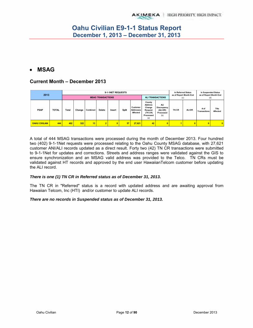
MSAG Current Month – December 2013
A total of 444 MSAG transactions were processed during the month of December 2013. Four hundred two (402) 9-1-1Net requests were processed relating to the Oahu County MSAG database, with 27,621 customer ANI/ALI records updated as a direct result. Forty two (42) TN CR transactions were submitted to 9-1-1Net for updates and corrections. Streets and address ranges were validated against the GIS to ensure synchronization and an MSAG valid address was provided to the Telco. TN CRs must be validated against HT records and approved by the end user HawaiianTelcom customer before updating the ALI record. There is one (1) TN CR in Referred status as of December 31, 2013.
The TN CR in "Referred" status is a record with updated address and are awaiting approval from Hawaiian Telcom, Inc (HTI) and/or customer to update ALI records.
There are no records in Suspended status as of December 31, 2013.
OAHU CIVILIAN 444 402 322 13 2 8 57 27,621 42 0 1 0 0 0
Change Combined
2013
PSAP TOTAL TNsAffected
In Referred Statusas of Report Month End
(c)
In Suspended Statusas of Report Month End
(d)
TN CR ALI-DR # ofTransactionsSplit
Customer Addresses Affected
County Address Change Request (TN CR)
Processed(a)
9-1-1NET REQUESTS
MSAG TRANSACTIONS ALI TRANSACTIONS
Delete InsertTotal
ALI Discrepancy
(ALI-DR) Processed
(b)

Oahu Civilian E9-1-1 Status Report December 1, 2013 – December 31, 2013
Oahu Civilian Page 13 of 90 December 2013
MSAG (continued) Year-to-Date (YTD) Summary – 2013
Note: Revised categories and report format changes effective May 2012 with new Intrado TN CR functionality.
(a)
(b)
(c)
(d)
Definitions:
Represents address corrections on a specific TN or group of TNs. These "invalid" TNs usually have an associated ESN x99 attached to them which indicates the need for validation.
Represents an address discrepancy discovered during a live 9-1-1 call. These record corrections are treated with a higher priority and should be processed within 48 hours as a general guideline.
Represents correction requests that have been referred by Intrado to the appropriate service provider and is awaiting approval to be updated in 9-1-1Net.
Represents correction requests that have been "paused" due to TN fallouts, range overlaps, or not having a valid address point. Intrado requires additional information from Akimeka/PSAP before the Telco approves the change.
The MSAG maintenance program provided 5,009 MSAG Database transactions to the Oahu MSAG Database in 2013. A monthly average of 455 transactions.
December 444 402 322 13 2 8 57 27,621 42 0 1 0 0 0November 352 350 280 1 0 2 67 59,589 0 2 1 0 0 0October 625 614 579 11 3 2 19 27,719 10 1 1 0 0 0September 355 349 334 0 1 2 12 10,720 3 3 4 1 0 0August 431 429 422 0 0 5 2 19,758 1 1 4 1 0 0July 324 296 277 5 6 3 5 4,306 27 1 4 1 0 0June 664 295 284 2 7 2 0 11,378 366 3 11 0 0 0May 497 335 292 4 4 8 27 4,253 162 0 361 0 0 0April 489 390 288 6 82 3 11 4,115 99 0 1 0 0 0March 424 326 277 7 11 9 22 4,917 98 0 60 0 0 0February 234 209 160 5 24 8 12 6,471 25 0 9 0 0 0January 170 140 95 14 14 6 11 9,173 29 1 0 0 0 0
TOTAL YTD 5,009 4,135 3,610 68 154 58 245 190,020 862 12 AVG PER MO 455 376 328 6 14 5 22 17,275 78 1
OAHU CIVILIAN
2013 TOTAL TNsAffected
9-1-1NET REQUESTS In Referred Statusas of Report Month End
(c)
In Suspended Statusas of Report Month End
(d)MSAG TRANSACTIONS ALI TRANSACTIONS
TN CR
ALI Discrepancy
(ALI-DR) Processed
(b)
Total Change Combined Delete ALI-DR # of TransactionsInsert Split
Customer Addresses Affected
(*)
County Address Change Request (TN CR)
Processed(a)

Oahu Civilian E9-1-1 Status Report December 1, 2013 – December 31, 2013
Oahu Civilian Page 14 of 90 December 2013
MSAG (continued) MSAG Communities Project
MSAG Community and Street Segment Sweep – Phase II Status
Based on a verbal agreement between the Honolulu Police Department, as the Primary Civilian PSAP, and Akimeka, it was agreed that the Military MSAG should be updated to reflect the standardized and approved MSAG Community Names approved jointly by the Military and Oahu Civilian PSAPs to ensure interoperability. It was also agreed that this work effort will be completed by Akimeka on an “as we can get to it” basis.
Below is the latest status of the Phase II work effort as of December 31, 2013:
OMIL ExistingCommunity Name
New Approved Community Name
MSAG Transactions
RequiredStatus Notes/Comments
Bellows Airforce Station BELLOWS 65 COMPLETED -- 03/31/13
Kaneohe MCAS MCBH 356 COMPLETED -- 06/19/13
Helemano Military Res HELEMANO 33 COMPLETED -- 06/24/13
Naval Comm Sat Wahiawa NCTAMS PAC 3 COMPLETED -- 07/01/13
NCTAMS NCTAMS PAC 12 COMPLETED -- 07/09/13
Naval Comm Stat Wahiawa NCTAMS PAC 38 COMPLETED -- 07/16/13
Camp Stover SCHOFIELD 9 COMPLETED -- 07/16/13
East Range SCHOFIELD 3 COMPLETED -- 07/16/13
Schofield Barracks SCHOFIELD 2 COMPLETED -- 07/16/13
Hicham AFB HICKAM 2 COMPLETED -- 07/17/13
Manana Naval Quarters MANANA 37 COMPLETED -- 07/17/13
TAMC TRIPLER 9 COMPLETED -- 07/19/13
Fort Kam HICKAM 27 COMPLETED -- 07/31/13
Fort Derussy FT DERUSSY 6 COMPLETED -- 07/31/13
Hospital Point PEARL HBR 2 COMPLETED -- 08/12/13
Naval Magazine Lualualei PEARL HBR 2 COMPLETED -- 08/12/13
Hale Alii PEARL HBR 3 COMPLETED -- 08/12/13
Oahu Civilian E9-1-1 Status Report December 1, 2013 – December 31, 2013
Oahu Civilian Page 15 of 90 December 2013
MSAG (continued) MSAG Communities Project (continued)
MSAG Community and Street Segment Sweep – Phase II Status (continued)
OMIL ExistingCommunity Name
New Approved Community Name
MSAG Transactions
RequiredStatus Notes/Comments
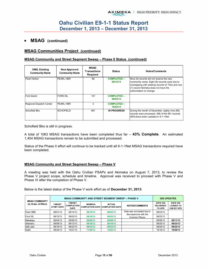
Schofield Bks is still in progress. A total of 1063 MSAG transactions have been completed thus far – 43% Complete. An estimated 1,404 MSAG transactions remain to be submitted and processed. Status of the Phase II effort will continue to be tracked until all 9-1-1Net MSAG transactions required have been completed.
MSAG Community and Street Segment Sweep – Phase V
A meeting was held with the Oahu Civilian PSAPs and Akimeka on August 7, 2013, to review the Phase V project scope, schedule and timeline. Approval was received to proceed with Phase V and Phase VI after the completion of Phase V. Below is the latest status of the Phase V work effort as of December 31, 2013:
Pearl Harbor PEARL HBR 86 COMPLETED -- 08/12/13
Nine (9) records did not receive the new community name. Eight (8) records were due to overlapping with existing records (0 TNs) and one (1) record Akimeka does not have the authorization to change.
Ford Island FORD ISL 147 COMPLETED -- 09/03/13
Regional Dispatch Center PEARL HBR 3 COMPLETED -- 10/03/13
Schofield Bks SCHOFIELD 661 IN PROGRESS During the month of December, eighty nine (89) records were processed. 596 of the 661 records (89%)have been updated in 9-1-1Net.
TARGET START DATE
TARGET COMPLETION
DATE
AKIMEKA COMPLETION DATE
ACTUAL COMPLETION DATE NOTES/COMMENTS
DATE GIS DELIVERED
TO HPD
DATE GIS LOADED TO CAD BY HPD
Pearl HBR 08/01/13 08/14/13 08/12/13 09/03/13 08/23/13
Ford ISL 08/15/13 09/03/13 08/19/13 09/03/13 08/23/13
Makalapa 09/04/13 09/06/13 09/06/13 09/06/13 09/06/13 09/11/13Aliamanu 09/09/13 09/13/13 09/18/13 09/19/13 09/20/13 09/23/13Salt Lake 09/16/13 09/23/13 09/23/13 09/23/13 09/20/13 09/23/13Kalihi 09/24/13 10/21/13 11/08/13 12/02/13 10/18/13 10/29/13
MSAG COMMUNITY(In Order of Effort)
MSAG COMMUNITY AND STREET SEGMENT SWEEP -- PHASE V GIS UPDATES
Data was not loaded due to discrepancies with the
Common Places

Oahu Civilian E9-1-1 Status Report December 1, 2013 – December 31, 2013
Oahu Civilian Page 16 of 90 December 2013
MSAG (continued) MSAG Communities Project (continued)
MSAG Community and Street Segment Sweep – Phase V (continued)
In the month of December 2013, Ala Moana, Honolulu, and Punchbowl MSAG Communities were completed. Phase V is tracking according to the planned schedule with no major issues to date.
TARGET START DATE
TARGET COMPLETION
DATE
AKIMEKA COMPLETION DATE
ACTUAL COMPLETION DATE NOTES/COMMENTS
DATE GIS DELIVERED
TO HPD
DATE GIS LOADED TO CAD BY HPD
MSAG COMMUNITY(In Order of Effort)
MSAG COMMUNITY AND STREET SEGMENT SWEEP -- PHASE V GIS UPDATES
Nuuanu 10/22/13 11/06/13 11/12/13 11/12/13
In 11/1/13 data, a discrepancy was identified with Beat recommendations within the CAD, therefore a new set of data was sent on 11/7/13 to resolve this
11/1/2013, 11/7/13 11/12/13
Downtown 11/07/13 11/18/13 11/21/13 11/21/13 11/15/13 11/25/13Kakaako 11/19/13 11/26/13 11/27/13 11/27/13Ala Moana 11/27/13 12/04/13 12/04/13 12/11/13Honolulu 12/05/13 12/16/13 12/13/13 12/20/13 12/13/13 12/19/13Punchbowl 12/17/13 12/26/13 12/20/13 12/27/13Makiki 12/27/14 01/07/14 IN PROGRESSManoa 01/08/14 01/23/14McCully 01/24/14 02/04/14Ft DeRussy 02/05/14 02/06/14Waikiki 02/07/14 02/20/14Kaimuki 02/21/14 03/10/14Kapahulu 03/11/14 03/18/14Kahala 03/19/14 03/27/14Waialae 03/28/14 04/08/14Aina Haina 04/09/14 04/18/14Hawaii Kai 04/21/14 05/09/14
12/27/13
11/29/13 12/06/13

Oahu Civilian E9-1-1 Status Report December 1, 2013 – December 31, 2013
Oahu Civilian Page 17 of 90 December 2013
MSAG Community and Street Segment Sweep Summary for 2013
The 2013 year summary of the MSAG Community and Street Segment Sweep project, includes work activity from Phase III, IV, and V. The completion of each MSAG Community were officially marked as complete once the entire processing took place within 911 Net by Intrado; to ensure a complete and accurate synchronization within the MSAG and GIS. GIS data deliverables were scheduled and delivered on a routine bi-monthly basis to ensure the synchronization effort was available to the PSAPs during the completion of the various MSAG Communities in the MSAG Community and Street Segment Sweep project.
TARGET START DATE TARGET COMPLETION DATE
AKIMEKA COMPLETION DATE
ACTUAL COMPLETION DATE OF 911 NET PROCESSING BY
INTRADO
NOTES/COMMENTS DATE GIS DELIVERED TO HPD
DATE GIS LOADED TO CAD BY HPD
12/14/12 Not loaded by AVS12/28/12 Not loaded by AVS
PC PEN (Pearl City Peninsula) 01/14/13 01/28/13 03/27/13 03/27/13 PHASE III 02/08/13 Not loaded by AVS
Aiea 01/17/13 02/15/13 04/24/13 05/01/13 PHASE III 02/08/13; 02/22/13 02/28/13
Punaluu 03/01/13 03/05/13 03/05/13 03/05/13 PHASE IV 03/08/13 03/14/13
Kahuku 03/06/13 03/15/13 03/15/13 03/15/13 PHASE IV 03/08/13 03/14/13Kahuku RNG 03/16/13 03/20/13 03/20/13 03/20/13 PHASE IV 03/22/13 03/28/13Makaha 03/21/13 04/03/13 05/15/13 06/12/13 PHASE IV 03/22/13 03/28/13Maili 04/04/13 04/18/13 05/23/13 05/31/13 PHASE IV 04/05/13 04/10/13Sunset 04/19/13 04/30/13 04/24/13 05/01/13 PHASE IV 04/19/13 04/23/13Hauula 04/19/13 04/30/13 04/17/13 05/01/13 PHASE IV 05/03/13 05/07/13Mokuleia 04/19/13 04/30/13 05/24/13 05/31/13 PHASE IV 05/03/13 05/07/13Waianae 05/01/13 05/16/13 05/24/13 06/25/13 PHASE IV 05/17/13 05/23/13Nanakuli 05/17/13 05/30/13 05/22/13 05/31/13 PHASE IV 05/31/13 06/04/13Laie 05/31/13 06/07/13 05/16/13 05/31/13 PHASE IV 05/31/13 06/04/13Makua 06/10/13 06/19/13 05/21/13 05/21/13 PHASE IV 05/31/13 06/04/13Lualualei 06/20/13 07/03/13 06/12/13 06/12/13 PHASE IV 06/14/13 06/19/13Makakilo 07/05/13 07/18/13 06/24/13 06/27/13 PHASE IV 06/28/13 07/02/13Waipio 07/05/13 07/18/13 07/11/13 07/31/13 PHASE IV 07/12/13 07/17/13Kahaluu 07/05/13 07/18/13 07/11/13 07/31/13 PHASE IV 07/12/13 07/17/13Pearl HBR 08/01/13 08/14/13 08/12/13 09/03/13 PHASE V 08/23/13
Ford ISL 08/15/13 09/03/13 08/19/13 09/03/13 PHASE V 08/23/13
Makalapa 09/04/13 09/06/13 09/06/13 09/06/13 PHASE V 09/06/13 09/11/13Aliamanu 09/09/13 09/13/13 09/18/13 09/19/13 PHASE V 09/20/13 09/23/13Salt Lake 09/16/13 09/23/13 09/23/13 09/23/13 PHASE V 09/20/13 09/23/13Kalihi 09/24/13 10/21/13 11/08/13 12/02/13 PHASE V 10/18/13 10/29/13Nuuanu 10/22/13 11/06/13 11/12/13 11/12/13 PHASE V 11/1/2013, 11/7/13 11/12/13Downtown 11/07/13 11/18/13 11/21/13 11/21/13 PHASE V 11/15/13 11/25/13Kakaako 11/19/13 11/26/13 11/27/13 11/27/13 PHASE VAla Moana 11/27/13 12/04/13 12/04/13 12/11/13 PHASE VHonolulu 12/05/13 12/16/13 12/13/13 12/20/13 PHASE V 12/13/13 12/19/13Punchbowl 12/17/13 12/26/13 12/20/13 12/27/13 PHASE VMakiki 12/27/14 01/07/14 IN PROGRESS PHASE V
04/22/13
12/27/13
Ewa Beach
MSAG COMMUNITY(In Order of Effort)
MSAG COMMUNITY AND STREET SEGMENT SWEEP -- 2013 GIS UPDATES
Discrepancy identified, held on upload for next
data deliverable
11/29/13 12/06/13
12/10/12 01/14/13 05/01/13 PHASE III

Oahu Civilian E9-1-1 Status Report December 1, 2013 – December 31, 2013
Oahu Civilian Page 18 of 90 December 2013
Geographic Information System (GIS)
Mapping Layers Updated – Calendar Year Summary 2013 (Includes December 2013 Activity) 9-1-1 GIS layers provided by Akimeka to the PSAP are designed for use on E9-1-1 systems.
Akimeka GIS Server
Date Created/ Edits Performed
Added seventy-five (75) new address points in PC Pen.
Added eleven (11) new address points in Waimanalo.
Spatially corrected 263 address points and added one (1) alias address in Kaneohe.
Spatially corrected twenty-seven (27) address points in Kailua. Identified one (1) alias and identified addresses that require site visits.
Spatially corrected one (1) address point in Waimanalo.
Spatially corrected four (4) address points in Waimanalo.
Deleted record ID 64012 41-1537 Kalanianaole Hwy in Waimanalo; duplicate address.
Spatially corrected four (4) address points and corrected one (1) TMK in Waimanalo.
Deleted record ID 304380 41-518 Kumuniu Pl, record ID 304349 41-523 Kumuniu Pl, and record ID 304364 41-526 Kumuniu Pl in Waimanalo; incorrect house numbers. Created three (3) new address points with correct house numbers.
Added seventy-eight (78) new address points in PC Pen.
Spatially corrected one (1) address point in Waimanalo. Added one (1) new address point in Waimanalo.
Spatially corrected 275 address points in Kaneohe. Added one (1) apartment letter, added one (1) alias address, identified addresses that require site visits.
Spatially corrected thirty-six (36) address points in Kailua. Added two (2) alias addresses, identified five (5) aliases, and identified addresses that require site visits.
12/27/2013
12/30/2013
12/31/2013
12/23/2013
12/26/2013
12/24/2013
OAHU CIVILIAN
Other/RemarksType of Layer Date Uploadedto ftp Site
CRITICAL 9-1-1 PUBLIC SAFETY LAYERS(Listed Alphabetically)
Address Points

Oahu Civilian E9-1-1 Status Report December 1, 2013 – December 31, 2013
Oahu Civilian Page 19 of 90 December 2013
Geographic Information System (GIS)
Mapping Layers Updated – Calendar Year Summary 2013 (Includes December 2013 Activity) 9-1-1 GIS layers provided by Akimeka to the PSAP are designed for use on E9-1-1 systems.
Akimeka GIS Server
Date Created/ Edits Performed
Spatially corrected (1) address point in Waimanalo and added one (1) routing ID.
Deleted record ID 86634 41-253 Lupe St in Waimanalo; incorrect addressing.
Deleted record ID 25919 510 Kokea St in Kalihi; located in the middle of Kapalama Canal.
Deleted thirty-nine (39) address points in Waimanalo; incorrect addressing.
Deleted record ID 64018 41-1050 Kalanianaole Hwy in Waimanalo; incorrect house number. Created one (1) new address point with correct house number.
Added one (1) new address point in Waimanalo.
12/18/2013 Updated site visit spreadsheet for address points that need to be verified by GPS.
12/17/2013 Added 202 new address points in PC Pen.
Spatially corrected 260 address points in Kaneohe. Added (3) alias addresses, corrected (1) TMK, and identified addresses that require site visits.
Deleted record ID 73112 45-232 Kokokahi Pl and 184599 45-205 Kokokahi Pl in Kaneohe; duplicate addresses.
Added one (1) new address point and added three (3) alias addresses in Waimanalo.
Corrected address from 410852 Ala Koa to 410853 Ala Koa in Waimanalo.
Received new development Kapolei Lofts. Georeferenced building plan and added sixteen (16) new address points in Kapolei.
Added 100 new address points in PC PEN.
12/16/2013
12/19/2013
12/20/2013
12/11/2013
12/13/2013
OAHU CIVILIAN
Other/RemarksType of Layer Date Uploadedto ftp Site
CRITICAL 9-1-1 PUBLIC SAFETY LAYERS(Listed Alphabetically)
Address Points (continued)

Oahu Civilian E9-1-1 Status Report December 1, 2013 – December 31, 2013
Oahu Civilian Page 20 of 90 December 2013
Geographic Information System (GIS) (continued)
Mapping Layers Updated – Calendar Year Summary 2013 (Includes December 2013 Activity) 9-1-1 GIS layers provided by Akimeka to the PSAP are designed for use on E9-1-1 systems.
Akimeka GIS Server
Date Created/ Edits Performed
Spatially corrected 218 address points in Kaneohe. Identified one (1) alias and identified addresses that require site visits.
Spatially corrected five (5) address points in Kailua.
Spatially corrected 240 address points in Kaneohe. Added three (3) alias addresses and identified addresses that require site visits.
Deleted record ID 78609 45-206 Keana Rd in Kaneohe; duplicate address.
Populated addresses to ninety-six (96) address points in Halawa.
Spatially corrected thirty-four (34) address points in Kailua. Added three (3) alias addresses and identified addresses that require site visits.
Deleted record ID 71116 30 Kihapai St and record ID 70277 105 Oneawa St in Kailua; duplicate addresses.
12/4/2013 Added ninety-six (96) new address points in Halawa.
12/3/2013 Spatially corrected thirteen (13) address points in Waimanalo and added three (3) alias addresses.
Spatially corrected seven (7) address points in Waimanalo and identified addresses that require site visits.
Spatially corrected sixty (60) address points in Kailua. Added three (3) alias addresses, identified three (3) aliases, and identified addresses that require site visits.
Spatially corrected 201 address points in Kaneohe. Added one (1) alias address and identified addresses that require site visits.
11/25/13 -- 11/26/13Spatially corrected 389 address points in Kaneohe. Added three (3) alias addresses.
11/25/13Corrected record ID 316490 address from Waipio Point Acc to Waipio Point Acc Rd in Mililani
12/2/2013
12/5/2013
12/9/2013
12/10/2013
OAHU CIVILIAN
Other/RemarksType of Layer Date Uploadedto ftp Site
CRITICAL 9-1-1 PUBLIC SAFETY LAYERS(Listed Alphabetically)
Address Points (continued)

Oahu Civilian E9-1-1 Status Report December 1, 2013 – December 31, 2013
Oahu Civilian Page 21 of 90 December 2013
Geographic Information System (GIS) (continued)
Mapping Layers Updated – Calendar Year Summary 2013 (Includes December 2013 Activity) 9-1-1 GIS layers provided by Akimeka to the PSAP are designed for use on E9-1-1 systems
Akimeka GIS Server
Date Created/ Edits Performed
11/21/13 -- 11/29/13
Spatially corrected thirty-five (35) address points in Waimanalo. Added one (1) routing ID to record ID 62792, TMK to record ID 316397, three (3) alias addresses and identified addresses that require site visits. Completed spatial correction of Waimanalo.
11/21/13Deleted record ID 179868 41-756 Ahiki St, record ID 67416 41-689 Ahiki St, and record ID 87984 41-592 Poalima St in Waimanalo; duplicate addresses.
11/20/13 -- 11/27/13Added 364 new address points in Hale Moku. Completed Hale Moku.
11/20/13Added 144 new address points in Hokulani and identified address points located in incorrect MSAG Communities. Completed Hokulani.
11/18/13 -- 11/26/13
Spatially corrected 716 address points in Kailua. Added nine (9) alias addresses, added two (2) apartment letters, identified one (1) alias, corrected one (1) address, corrected one (1) TMK, and identified addresses that require site visits.
11/18/13 -- 11/20/13Deleted record ID 73035 44-096 Ikeanani Dr and record ID 81701 1489 Ulupii St in Kailua; duplicate addresses.
11/14/13 Deleted record ID 85650 770 Auloa Rd; duplicate address.
11/13/13Deleted record ID 69321 917 Maunawili Cir; duplicate address point.
11/07/13 Added 254 new addresses points in Moanalua T.
11/06/13 Added 100 new addresses points in Moanalua.
11/05/13Deleted record ID 73645 710 Old Mokapu Rd, record ID 73646 714 Old Mokapu Rd, record ID 73644 718 Old Mokapu Rd, and record ID 73620 720 Old Mokapu Rd; duplicate address points.
11/04/13 -- 11/15/13
Spatially corrected 1,466 address points in Kailua. Added twenty (20) alias addresses, corrected one (1) TMK, identified one (1) alias, corrected one (1) address, and identified addresses that require site visits.
11/01/13Spatially corrected twenty-six (26) address points in Waimanalo. Added two (2) alias addresses, corrected one (1) TMK, and identified missing addresses that require site visits.
OAHU CIVILIAN
Other/RemarksType of Layer Date Uploadedto ftp Site
CRITICAL 9-1-1 PUBLIC SAFETY LAYERS(Listed Alphabetically)
Address Points (continued)

Oahu Civilian E9-1-1 Status Report December 1, 2013 – December 31, 2013
Oahu Civilian Page 22 of 90 December 2013
Geographic Information System (GIS) (continued)
Mapping Layers Updated – Calendar Year Summary 2013 (Includes December 2013 Activity) 9-1-1 GIS layers provided by Akimeka to the PSAP are designed for use on E9-1-1 systems.
Akimeka GIS Server
Date Created/ Edits Performed
10/31/13 Spatially corrected 200 address points in Kailua and added three (3) alias addresses.
10/30/13Populated 505 addresses and twenty-eight (28) building numbers in Halsey T
10/25/13 Added 505 new address points in Halsey T
10/23/13Corrected eleven (11) street names from Alaeloa St to Alealoa Pl per Street Centerline correction.
10/22/13Deleted record ID 68288 146 1 Malunui Ave, record ID 70255 411A Oneawa St, and record ID 71421 555 Auwai St; duplicate address points.
10/22/13 -- 10/24/13
Spatially corrected 840 address points in Kailua. Added four (4) alias addresses, corrected one (1) address, added one (1) apartment letter, corrected one (1) TMK, and identified missing addresses that require a site visit.
Deleted record ID 70735 316 Keaniani St; duplicate address point.
Corrected thirty (30) street names from Mailiilii Rd to Mailiili Rd per Street Centerline correction.
10/17/13 Deleted record ID 70242 112 Oneawa St and record ID 70871 401A-1 Kawainui St; duplicate address points.
10/16/13 Deleted record ID 70627 350 Ulupaina St and record ID 70558 430B1 Manono St; duplicate address points.
10/16/13 -- 10/18/13
Spatially corrected 925 address points in Kailua. Added eleven (11) alias addresses, added two (2) apartment number, corrected one (1) address, corrected two (2) TMKs, and identified missing addresses that require a site visit.
Address Points (continued)
OAHU CIVILIAN
Other/Remarks
10/18/13
Type of Layer Date Uploadedto ftp Site
CRITICAL 9-1-1 PUBLIC SAFETY LAYERS(Listed Alphabetically)
Oahu Civilian E9-1-1 Status Report December 1, 2013 – December 31, 2013
Oahu Civilian Page 23 of 90 December 2013
Geographic Information System (GIS) (continued)
Mapping Layers Updated – Calendar Year Summary 2013 (Includes December 2013 Activity) 9-1-1 GIS layers provided by Akimeka to the PSAP are designed for use on E9-1-1 systems.

Oahu Civilian E9-1-1 Status Report December 1, 2013 – December 31, 2013
Oahu Civilian Page 24 of 90 December 2013
Geographic Information System (GIS) (continued)
Mapping Layers Updated – Calendar Year Summary 2013 (Includes December 2013 Activity) 9-1-1 GIS layers provided by Akimeka to the PSAP are designed for use on E9-1-1 systems.
Akimeka GIS Server
Date Created/ Edits Performed
Deleted record ID 72023 567 Kaimake Loop; duplicate address.
Added 170 new address points in Moanalua T
Spatially corrected sixty-one (61) address points in Waimanalo. Added two (2) alias addresses, added two (2) apartment letters, and identified missing address that require site visits.
Spatially corrected 1,564 address points in Kailua. Added two (2) routing keys, corrected three (3) TMKs, added two (2) apartment letters, corrected one (1)apartment letter, corrected one (1) address, added five (5) alias addresses, and identified missing addresses that require site visits.
10/03/13 Populated 5232 Location Names and 5185 Location Types. Reviewed and corrected comments that were inconsistent.
10/01/13
Spatially corrected 422 address points in Kailua and twenty-three (23) address points in Waimanalo. Added three (3) alias addresses, added one (1) apartment letter, corrected one (1) address, corrected one (1) TMK and identified missing addresses that require site visits. Deleted record ID 87624 265 N Kalaheo Ave, record ID 87531 425 N Kalaheo Ave, record ID 86675 410860 Kakina St; duplicate address points.
09/26/13 Added seventy-eight (78) new address points in Moanalua T
09/23/13 -- 09/30/13
Spatially corrected 1,031 address points in Kailua, and fifty (50) address points in Waimanalo. Added eighteen (18) alias addresses, three (3) apartment numbers, and one (1) apartment letter, corrected one (1) address, and identified missing addresses that require site visits.
09/12/13 -- 09/20/13
Spatially corrected 1,242 address points in Kailua and seventy-five (75) address points in Waimanalo. Added sixty-one (61) new address points in Maloelap and twenty-two (22) in Moanalua T. Added eighteen (18) alias addresses and identified missing addresses that require site visits. Added two (2) apartment letter. Deleted record ID 84924 1376 Kehaulani Dr which was a duplicate address location. Deleted sixteen (16) addresses that were not identifiable. Corrected record ID 313440 from 1234 Mokulua Dr to 1232 Mokulua Dr.
Address Points (continued)
OAHU CIVILIAN
Other/RemarksType of Layer Date Uploadedto ftp Site
CRITICAL 9-1-1 PUBLIC SAFETY LAYERS(Listed Alphabetically)
10/03/13 -- 10/15/13

Oahu Civilian E9-1-1 Status Report December 1, 2013 – December 31, 2013
Oahu Civilian Page 25 of 90 December 2013
Akimeka GIS Server
Date Created/ Edits Performed
09/11/13Received new development Ewa by Gentry Area 14. Georeferenced blueprint and added 235 new address points.
09/03/13 -- 09/11/13
Spatially corrected 2,236 address points in Kailua and 119 in Waimanalo. Added eighty-six (86) new address points in Maloelap. Added eighteen (18) alias addresses and identified missing addresses that require site visits. Corrected record ID 86738 TMK from 41018024 to 41018043. Corrected record ID 84354 frtom 47-674 Paopua Loop to 674 Paopua Loop. Deleted record ID 103231 47-740A Ahuimanu Loop which was a duplicate record that was geocoded and populated incorrectly. Corrrected record ID 87325 TMK from 42021062 to 42051062.
08/29/13 -- 08/30/13 Spatially corrected 406 address points in Kailua. Added five (5) alias addresses.
08/28/13
Spatially corrected seventy-seven (77) address points in Waimanalo and 135 in Kailua. Added nine (9) alias addresses. Deleted record ID 316561 41-1741 Kalanianaole Hwy and record ID 88266 495 Wanaao Rd.
08/26/13 Corrected spatial and MSAG Community for address point 3375 Salt Lake Blvd
08/22/13 -- 08/23/13 Added 319 new address points in Catlin Pk
08/21/13 Spatially corrected 531 address points in Waimanalo
08/02/13 -- 08/05/13
Spatially corrected 347 address points in Waimanalo. Deleted record ID 86772 410544 Kumuhau St and record ID 67327 410609 Humuniki St. Added addresses to their corresponding address points.
08/02/13 Added fifty-six (56) new address points in Miller PkAdded 130 new address points in Miller Pk
Parsed out street type for address points 911768 Pepper Row, 1104 Fort Street Mall and 280 Beach Walk. These were mandatory corrections as identified by Intrado.
07/30/13
Spatially corrected 205 address points in Waimanalo. Corrected record ID 64012, 41-1511 Kalanianaole Hwy to 41-1537 Kalanianaole Hwy. Populated attributes for one (1) address point in Wahiawa, one (1) address point in Waipahu, and 254 address points in Waimanalo.
Address Points (continued)
07/31/13
OAHU CIVILIAN
Other/RemarksType of Layer Date Uploadedto ftp Site
CRITICAL 9-1-1 PUBLIC SAFETY LAYERS(Listed Alphabetically)

Oahu Civilian E9-1-1 Status Report December 1, 2013 – December 31, 2013
Oahu Civilian Page 26 of 90 December 2013
Geographic Information System (GIS) (continued)
Mapping Layers Updated – Calendar Year Summary 2013 (Includes December 2013 Activity) 9-1-1 GIS layers provided by Akimeka to the PSAP are designed for use on E9-1-1 systems.
Akimeka GIS Server
Date Created/ Edits Performed
07/22/13 Added 204 new address points in Radford T07/18/13 Corrected the prefix for an address previously at 641048807/12/13 Added Routing Key to 941383 Waipahu St address
07/10/13Spatially corrected one (1) address point in Kaneohe, two (2) address points in Kahaluu, and eighty-three (83) address points in Waimanalo. Also, identified three (3) missing address points.
07/08/13 -- 07/12/13 Spatially corrected 366 address points in Waimanalo
06/28/13 Added routing keys for Kam Hwy addresses on Saddle City Rd
06/26/13 Corrected address points that had a concatenated subhouse
06/18/13 Added fifty-two (52) new address points
06/14/13 Spatially corrected 129 address points to the proper location
06/13/13 Added routing keys to 4304, 4206,4204 and 4208 Diamond Head Rd addresses
06/11/13 Moved address point for 351 Elliot St to the proper location at the Federal Prison Bureau
06/06/13 Added 114 new address points06/05/13 Added thirty-two (32) new address points in Radford T06/03/13 Corrected Post Office address in Waimanalo
05/21/13 -- 05/24/13Spatially corrected 545 address points and populated the location type.
05/20/13Spatially corrected thirty-seven (37) address points in Waimanalo. Added location names for Makapuu Lighthouse, Makai Ocean Research Facility and Sea Life Park.
05/06/13 Corrected MSAG Community names in Maili
04/17/13 -- 04/18/13 Updated MSAG Community codes, populated State codes, and calculated XY coordinates
Address Points (continued)
OAHU CIVILIAN
Other/RemarksType of Layer Date Uploadedto ftp Site
CRITICAL 9-1-1 PUBLIC SAFETY LAYERS(Listed Alphabetically)

Oahu Civilian E9-1-1 Status Report December 1, 2013 – December 31, 2013
Oahu Civilian Page 27 of 90 December 2013
Geographic Information System (GIS) (continued)
Mapping Layers Updated – Calendar Year Summary 2013 (Includes December 2013 Activity) 9-1-1 GIS layers provided by Akimeka to the PSAP are designed for use on E9-1-1 systems.
Akimeka GIS Server
Date Created/ Edits Performed
Created seven (7) new address points on 911471 Miula St, moved address point 911471 Miula St to correct location and added Bldg 7 as the building, and created fifty (50) new address points on 850295 Kauiokalani Pl.
Georeferenced Franciscan Vistas Ewa Senior Rental Apartments and Community Center, Kamakana at Hoakalei, Kaupuni Village, and Seawinds Apartments for HSI building plans and reviewed ten (10) additional building plans to verify existing address points.
04/12/13
Georeferenced Awakea at Mehana and Hale Wai Vista building plans, moved address point 860082 and 860084 Farrington Hwy to their correct location, and created three (3) new address points on 860082 Farrington Hwy based off of the Hale Wai Vista building plan.
Created seventeen (17) address points for the Kapolei Trade Center
Added building numbers to seventeen (17) address points for the Awakea at Mehana subdivision
Corrected 2043 to 2034 for address point 2043A Iholena St, added Rd to address point 19 Sand Island Acc and 5 Sand Island Acc, corrected Pl to St for address point 3545 Waakauak Pl, and added Pl to address point 3647 Woodlawn Terrace in the Master Address Points feature class.
Added 331 new address points in the Master Address Points feature class. Populated address point fields in the attribute table according to the Motorola PremierOne Geofile Build Requirements.
02/05/13
Corrected a to A for address point 660441 Pikai St, corrected Ahulimanu to Ahuimanu for address point 470396 Ahulimanu Pl, corrected Rd to Pl for eighteen (18) address points in Kaneohe, and added Rd to address point 480161 Waiahole Valley and 480226 Waiahole Valley in the Master Address Points feature class
02/01/13 -- 02/05/13Added 774 new address points and populated the corresponding fields in the Master Address Points feature class
Address Points (continued)
OAHU CIVILIAN
Other/Remarks
02/06/13 -- 02/07/13
04/10/13
Type of Layer Date Uploadedto ftp Site
CRITICAL 9-1-1 PUBLIC SAFETY LAYERS(Listed Alphabetically)
04/15/13

Oahu Civilian E9-1-1 Status Report December 1, 2013 – December 31, 2013
Oahu Civilian Page 28 of 90 December 2013
Geographic Information System (GIS) (continued)
Mapping Layers Updated – Calendar Year Summary 2013 (Includes December 2013 Activity) 9-1-1 GIS layers provided by Akimeka to the PSAP are designed for use on E9-1-1 systems.
Akimeka GIS Server
Date Created/ Edits Performed
Corrected Dr to Rd for address point 910760 Papipi Dr and corrected the city from Barbers Point NAS to Kalaeloa for two address points
Added forty-eight (48) new address points for Ewa Beach, two (2) for Kalaeloa, one (1) for Kapolei, fourteen (14) for Waimanalo, and eleven (11) for Laie. Populated the remaining fields in the attribute table according to Motorola PremierOne Geofile Build Requirements.
Address point 980673 Kilinoe St was not geocoded correctly in the DPP Address Points data. No structure existed for that address. The address point was moved to the correct street range.
Added twenty (20) new address points for Aiea and one for Haleiwa. Populated the remaining fields in the attribute table according to Motorola PremierOne Geofile Build Requirements.
Address Points (continued)
OAHU CIVILIAN
Other/Remarks
01/30/13
Type of Layer
01/31/13
Date Uploadedto ftp Site
CRITICAL 9-1-1 PUBLIC SAFETY LAYERS(Listed Alphabetically)
12/27/13 Delivered updated Common Places to HPD
12/13/13 Delivered updated Common Places to HPD
11/29/13 Delivered updated Common Places to HPD
11/15/13 Delivered updated Common Places to HPD
11/01/13 Delivered updated Common Places to HPD
10/18/13 Delivered updated Common Places to HPD
10/04/13 Delivered updated Common Places to HPD
Common Place Name

Oahu Civilian E9-1-1 Status Report December 1, 2013 – December 31, 2013
Oahu Civilian Page 29 of 90 December 2013
Geographic Information System (GIS) (continued)
Mapping Layers Updated – Calendar Year Summary 2013 (Includes December 2013 Activity) 9-1-1 GIS layers provided by Akimeka to the PSAP are designed for use on E9-1-1 systems.

Oahu Civilian E9-1-1 Status Report December 1, 2013 – December 31, 2013
Oahu Civilian Page 30 of 90 December 2013
Geographic Information System (GIS) (continued)
Mapping Layers Updated – Calendar Year Summary 2013 (Includes December 2013 Activity) 9-1-1 GIS layers provided by Akimeka to the PSAP are designed for use on E9-1-1 systems.
Akimeka GIS Server
Date Created/ Edits Performed
Corrected name for SEARS KANEOHE WINDWARD, updated ENCHANTED LAKE SC address, corrected name from PIPELINE CAFÉ to BJ PENN UFC GYM due to business change at this location
Deleted COMPADRES, TOWER RECORDS KAHALA, SEARS AMSC as these locations are no longer in business
Added LAW TOW PC, SHORELINE HOTEL, PETCO KAPOLEI, BBQ KAI, and HOALAUNA COMM PK
Corrected address for Hoakalei Country Club in Kapolei and deleted LAW TOW KALIHI
Added 7ELEVEN KANEOHE, BARBERS PT GC, LAW TOW MAPUNAPUNA
09/20/13 Delivered updated Common Places to HPD
Utilizing the Common Place Alias extract from the PremierOne CAD, built new database and joined tables to the Common Place layer. Extracted the CAD information to the necessary fields for the PremierOne CAD system alias tables.
Spatially corrected Library Moanalua to structure
09/06/13 Delivered updated Common Places to HPD
09/04/13Corrected fourteen (14) location names. Deleted DIST CRT WAIANAE.
Deleted records for ASB Pearl City, Windward Town & Coun, Sizzler Kailua, BOH Kapolei SC, CPB Kailua Do Quijo, and Pali Ctr
Corrected names for forty-seven (47) common places records
Added new common places for DH State Monument and Kapolei Hale
Corrected address for BOH Kapolei
Common Place Name
(continued)
10/03/13
09/17/13
OAHU CIVILIAN
Other/Remarks
10/04/13
Type of Layer Date Uploadedto ftp Site
CRITICAL 9-1-1 PUBLIC SAFETY LAYERS(Listed Alphabetically)
08/30/13

Oahu Civilian E9-1-1 Status Report December 1, 2013 – December 31, 2013
Oahu Civilian Page 31 of 90 December 2013
Geographic Information System (GIS) (continued)
Mapping Layers Updated – Calendar Year Summary 2013 (Includes December 2013 Activity) 9-1-1 GIS layers provided by Akimeka to the PSAP are designed for use on E9-1-1 systems.
Akimeka GIS Server
Date Created/ Edits Performed
08/29/13 Corrected MSAG Community Name of ninety-nine (99) common places in AMR, NCTAMS PAC, and Salt Lake.
08/23/13 Delivered updated Common Places to HPD
08/22/13Corrected MSAG Community Name of six (6) common places in Hickam and MCBH
08/20/13 Reviewed JUL 30 2013 TCAD errors. All errors were military or freeway. There were no new errors to correct.
Created three (3) new common places based off of the GIS Corrections JUL 26 2013 report: H1E Wakea Off, H1W Kalaeloa Off, and H2S Honolulu Off.
Corrected MSAG Community Name of twenty (20) common places in Pearl Hbr, Makalapa, and Aliamanu.
08/12/13 Edited thirteen (13) common places.
08/09/13Reviewed the GIS Corrections JUL 25 2013 report and added aliases to seventy-three (73) freeway common places.
08/07/13 -- 08/09/13Edited 280 common places for the Freeway Renaming project and completed the project. Deleted duplicate record ID 10593 H2N Wahiawa Off and record ID 549 MFE H1E.
08/01/13 -- 08/07/13
Edited 149 and added eight (8) common places for the Freeway Renaming project. Deleted record ID 10957 MFE from H1W since the route did not exist. Deleted duplicate record ID 173274 H1E Pearl City W and record ID 11055 H3E from H1E.
07/30/13Spatially corrected one (1) common place and added one (1) alias name both in Waimanalo to their corresponding address points
Common Place Name
(continued)
OAHU CIVILIAN
Other/RemarksType of Layer Date Uploadedto ftp Site
08/19/13
CRITICAL 9-1-1 PUBLIC SAFETY LAYERS(Listed Alphabetically)

Oahu Civilian E9-1-1 Status Report December 1, 2013 – December 31, 2013
Oahu Civilian Page 32 of 90 December 2013
Geographic Information System (GIS) (continued)
Mapping Layers Updated – Calendar Year Summary 2013 (Includes December 2013 Activity) 9-1-1 GIS layers provided by Akimeka to the PSAP are designed for use on E9-1-1 systems.
Akimeka GIS Server
Date Created/ Edits Performed
07/26/13 Delivered updated Common Places to HPD
Completed nineteen (19) corrections from the JUL 16 2013 TCAD report
Reviewed the GIS Corrections JUL 12 2013 report. Corrected JITB Oneawa to JITB Kailua, Fed Waldron Feedmil to Land of Lakes, and added aliases.
Deleted duplicate record ID 14538 Luana Hills Country
Spatially corrected ten (10) common places in Kailua, corrected name of four (4) common places and added alias names to five (5) common places
07/12/13 Delivered updated Common Places to HPD
Deleted duplicate record ID 13568 Kailua Baptist Chris
Spatially corrected twenty-six (26) common places in Kailua, corrected address to one (1) common place, added addresses to two (2) common places, corrected name of two (2) common places, corrected police subbeat to four (4) common places, and added alias names to sixteen (16) common places
Corrected name of seven (7) common places and added nine (9) alias names to common places in Kailua.
Reviewed the GIS Corrections JUN 28 2013 report and corrected one (1) common place.
Corrected MSAG Community name(s) of one (1) common place from Pearl City to Waipahu, one (1) common place from Pearl City to Waipio, 358 common places from Waipahu to Waipio, and thirty-one (31) common places from Kaneohe to Kahaluu
07/09/13Spatially corrected twenty-five (25) common places in Kailua, corrected name of two (2) common places, added alias name to eight (8) common places, and added one (1) room number.
Common Place Name
(continued)
07/10/13
07/11/13
07/15/13
07/26/13
OAHU CIVILIAN
Other/RemarksType of Layer Date Uploadedto ftp Site
CRITICAL 9-1-1 PUBLIC SAFETY LAYERS(Listed Alphabetically)

Oahu Civilian E9-1-1 Status Report December 1, 2013 – December 31, 2013
Oahu Civilian Page 33 of 90 December 2013
Geographic Information System (GIS) (continued)
Mapping Layers Updated – Calendar Year Summary 2013 (Includes December 2013 Activity) 9-1-1 GIS layers provided by Akimeka to the PSAP are designed for use on E9-1-1 systems.
Akimeka GIS Server
Date Created/ Edits Performed
Deleted record ID 11478 Aloha Gas Kailua, record ID 12627 Finance Factors Kail, record ID 17011 Tiares Bar, and duplicate record ID 13574 Kailua Foodland MP
Corrected police beat, police subbeat, and address and added alias name to BWS Pohakupu
Spatially corrected twenty-six (26) common places in Kailua, corrected police subbeat for four (4) common places, corrected name of four (4) common places, added seven (7) alias names, and added one (1) suite number.
Spatially corrected four (4) common places in Waimanalo to its corresponding address point
Corrected MSAG Community names of forty-four (44) common places.
Created ten (10) new common places: Bellows AFS Gate, Bellows AFS Res Ofc, Turtle Cove, Bellows Field Bch Pk, two (2) for the Ka Iwi Scenic Shoreline Park and two (2) along street centerline Trail Makapuu Lighthouse, and two (2) for the Makapuu Tom Tom Trail along street centerline Trail Makapuu Koolau Summit.
Spatially corrected one (1) common place in Kahuku and two (2) in Mokuleia. Corrected location, address, and added alias for one (1) common place in Kunia, six (6) in Schofield, four (4) in Bellows, three (3) in Waimanalo, and two (2) in Mapalapa.
06/27/13
Corrected DH State Monument to Trail Diamond Head. Deleted duplicate record ID 13584 Kailua Treatment Pla. Added alias name to WWTP Kailua. Spatially corrected five (5) common places in Kailua.
06/26/13
Corrected Koko Crater Railway to Trail Koko Head and Koko Crater Blowhole to Trail Koko Head Arch. Corrected addresses for five (5) common places in Waimanalo. Corrected twenty-six (26) common places. Created two (2) new common places: Pizza Hut Oneawa and 7Eleven Oneawa.
Common Place Name
(continued)
OAHU CIVILIAN
Other/RemarksType of Layer Date Uploadedto ftp Site
CRITICAL 9-1-1 PUBLIC SAFETY LAYERS(Listed Alphabetically)
06/28/13
07/08/13
06/28/13

Oahu Civilian E9-1-1 Status Report December 1, 2013 – December 31, 2013
Oahu Civilian Page 34 of 90 December 2013
Geographic Information System (GIS) (continued)
Mapping Layers Updated – Calendar Year Summary 2013 (Includes December 2013 Activity) 9-1-1 GIS layers provided by Akimeka to the PSAP are designed for use on E9-1-1 systems.
Akimeka GIS Server
Date Created/ Edits Performed
06/25/13
Corrected name of Verizon Waimanalo to HTCO Central Office and added alias names to four (4) common places. Spatially corrected eight (8) common places in Waimanalo. Created one (1) new common place: Makapuu Tidepools.
Spatially corrected three (3) common places in Hickam and nine (9) in Pearl Hbr. Corrected MSAG Community name for four (4) common places from Honolulu to Airport.
Corrected 283 freeway addresses to correspond with HPD's freeway naming convention. Additionally, corrected addresses for RS Puupapaa, RS Kapaa, and OTS Kapolei Transit.
Deleted duplicate record ID 15829 Pearl Harbor Nimitz and record ID 17429 Waianae Treatment Pl; added alias name to WWTP Waianae; and corrected alias name of WWTP Waimanalo.
06/21/13Corrected MSAG Community name of eighty-one (81) common places from Kapolei to Makakilo and three (3) from Ewa Beach to Makakilo.
06/20/13Corrected location, name, and added alias to Koko Kai Mini Pk, Kokee Mini Bch Pk, Duke Kahanamoku Pk, and Silva Channel Bch
06/19/13 -- 06/21/13Created eighty-one (81) new Emergency Response Location common places and corrected six (6) additional common places.
Created five (5) new Emergency Response Location common places and spatially corrected Kaluanui Bch.
Spatially corrected Highway Mauka Kahuku from Laie to Kahuku on a temporary basis until a site visit can verify its true spatial location.
Corrected five (5) errors from the JUN 17 2013 TCAD report.
Common Place Name
(continued)
OAHU CIVILIAN
Other/RemarksType of Layer Date Uploadedto ftp Site
CRITICAL 9-1-1 PUBLIC SAFETY LAYERS(Listed Alphabetically)
06/24/13
06/18/13
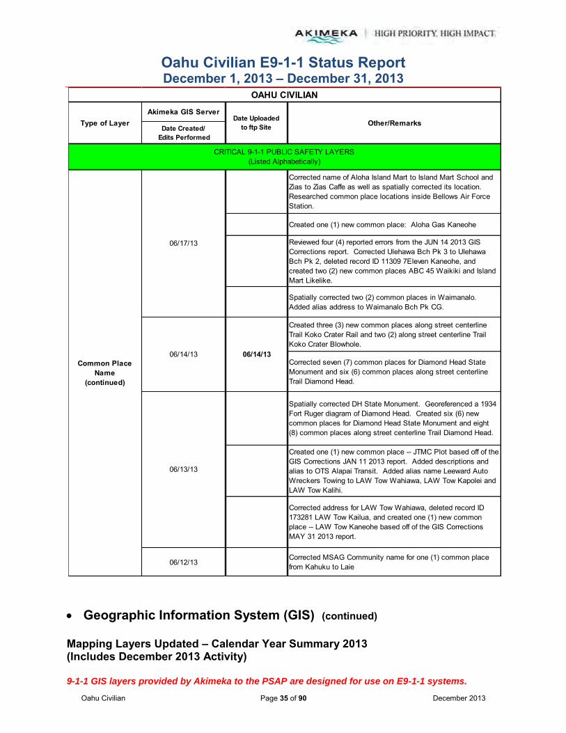
Oahu Civilian E9-1-1 Status Report December 1, 2013 – December 31, 2013
Oahu Civilian Page 35 of 90 December 2013
Geographic Information System (GIS) (continued)
Mapping Layers Updated – Calendar Year Summary 2013 (Includes December 2013 Activity) 9-1-1 GIS layers provided by Akimeka to the PSAP are designed for use on E9-1-1 systems.
Akimeka GIS Server
Date Created/ Edits Performed
Corrected name of Aloha Island Mart to Island Mart School and Zias to Zias Caffe as well as spatially corrected its location. Researched common place locations inside Bellows Air Force Station.
Created one (1) new common place: Aloha Gas Kaneohe
Reviewed four (4) reported errors from the JUN 14 2013 GIS Corrections report. Corrected Ulehawa Bch Pk 3 to Ulehawa Bch Pk 2, deleted record ID 11309 7Eleven Kaneohe, and created two (2) new common places ABC 45 Waikiki and Island Mart Likelike.
Spatially corrected two (2) common places in Waimanalo. Added alias address to Waimanalo Bch Pk CG.
Created three (3) new common places along street centerline Trail Koko Crater Rail and two (2) along street centerline Trail Koko Crater Blowhole.
Corrected seven (7) common places for Diamond Head State Monument and six (6) common places along street centerline Trail Diamond Head.
Spatially corrected DH State Monument. Georeferenced a 1934 Fort Ruger diagram of Diamond Head. Created six (6) new common places for Diamond Head State Monument and eight (8) common places along street centerline Trail Diamond Head.
Created one (1) new common place -- JTMC Plot based off of the GIS Corrections JAN 11 2013 report. Added descriptions and alias to OTS Alapai Transit. Added alias name Leeward Auto Wreckers Towing to LAW Tow Wahiawa, LAW Tow Kapolei and LAW Tow Kalihi.
Corrected address for LAW Tow Wahiawa, deleted record ID 173281 LAW Tow Kailua, and created one (1) new common place -- LAW Tow Kaneohe based off of the GIS Corrections MAY 31 2013 report.
06/12/13Corrected MSAG Community name for one (1) common place from Kahuku to Laie
Common Place Name
(continued)
06/14/13
OAHU CIVILIAN
Other/RemarksType of Layer Date Uploadedto ftp Site
06/14/13
06/13/13
CRITICAL 9-1-1 PUBLIC SAFETY LAYERS(Listed Alphabetically)
06/17/13
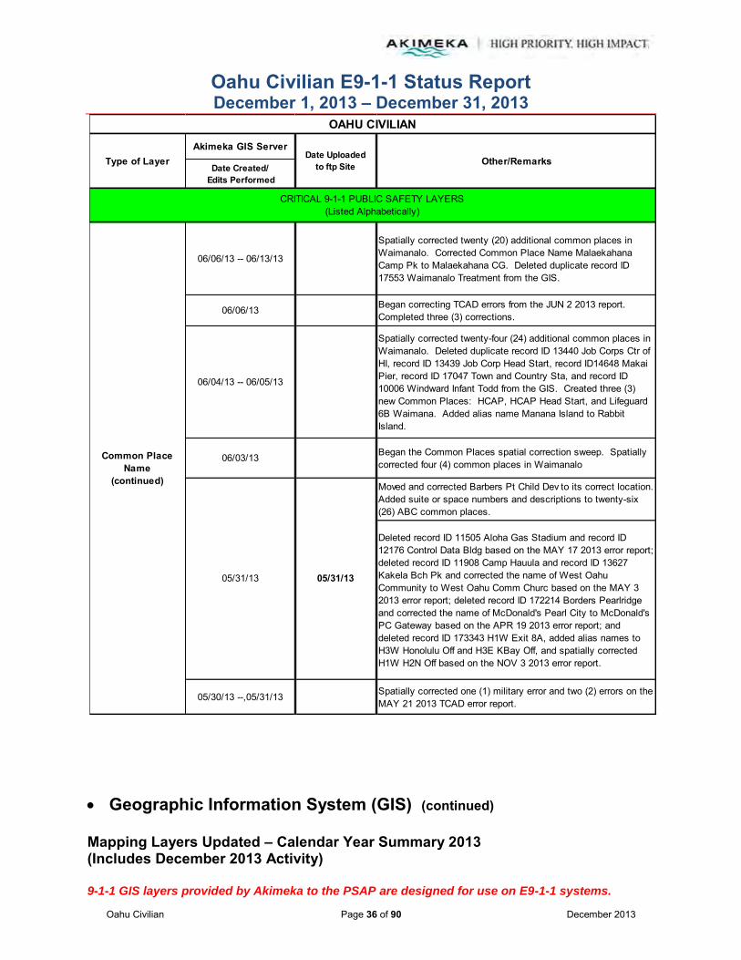
Oahu Civilian E9-1-1 Status Report December 1, 2013 – December 31, 2013
Oahu Civilian Page 36 of 90 December 2013
Geographic Information System (GIS) (continued)
Mapping Layers Updated – Calendar Year Summary 2013 (Includes December 2013 Activity) 9-1-1 GIS layers provided by Akimeka to the PSAP are designed for use on E9-1-1 systems.
Akimeka GIS Server
Date Created/ Edits Performed
06/06/13 -- 06/13/13
Spatially corrected twenty (20) additional common places in Waimanalo. Corrected Common Place Name Malaekahana Camp Pk to Malaekahana CG. Deleted duplicate record ID 17553 Waimanalo Treatment from the GIS.
06/06/13 Began correcting TCAD errors from the JUN 2 2013 report. Completed three (3) corrections.
06/04/13 -- 06/05/13
Spatially corrected twenty-four (24) additional common places in Waimanalo. Deleted duplicate record ID 13440 Job Corps Ctr of HI, record ID 13439 Job Corp Head Start, record ID14648 Makai Pier, record ID 17047 Town and Country Sta, and record ID 10006 Windward Infant Todd from the GIS. Created three (3) new Common Places: HCAP, HCAP Head Start, and Lifeguard 6B Waimana. Added alias name Manana Island to Rabbit Island.
06/03/13 Began the Common Places spatial correction sweep. Spatially corrected four (4) common places in Waimanalo
Moved and corrected Barbers Pt Child Dev to its correct location. Added suite or space numbers and descriptions to twenty-six (26) ABC common places.
Deleted record ID 11505 Aloha Gas Stadium and record ID 12176 Control Data Bldg based on the MAY 17 2013 error report; deleted record ID 11908 Camp Hauula and record ID 13627 Kakela Bch Pk and corrected the name of West Oahu Community to West Oahu Comm Churc based on the MAY 3 2013 error report; deleted record ID 172214 Borders Pearlridge and corrected the name of McDonald's Pearl City to McDonald's PC Gateway based on the APR 19 2013 error report; and deleted record ID 173343 H1W Exit 8A, added alias names to H3W Honolulu Off and H3E KBay Off, and spatially corrected H1W H2N Off based on the NOV 3 2013 error report.
05/30/13 --,05/31/13 Spatially corrected one (1) military error and two (2) errors on the MAY 21 2013 TCAD error report.
Common Place Name
(continued)
05/31/13 05/31/13
OAHU CIVILIAN
Other/RemarksType of Layer Date Uploadedto ftp Site
CRITICAL 9-1-1 PUBLIC SAFETY LAYERS(Listed Alphabetically)
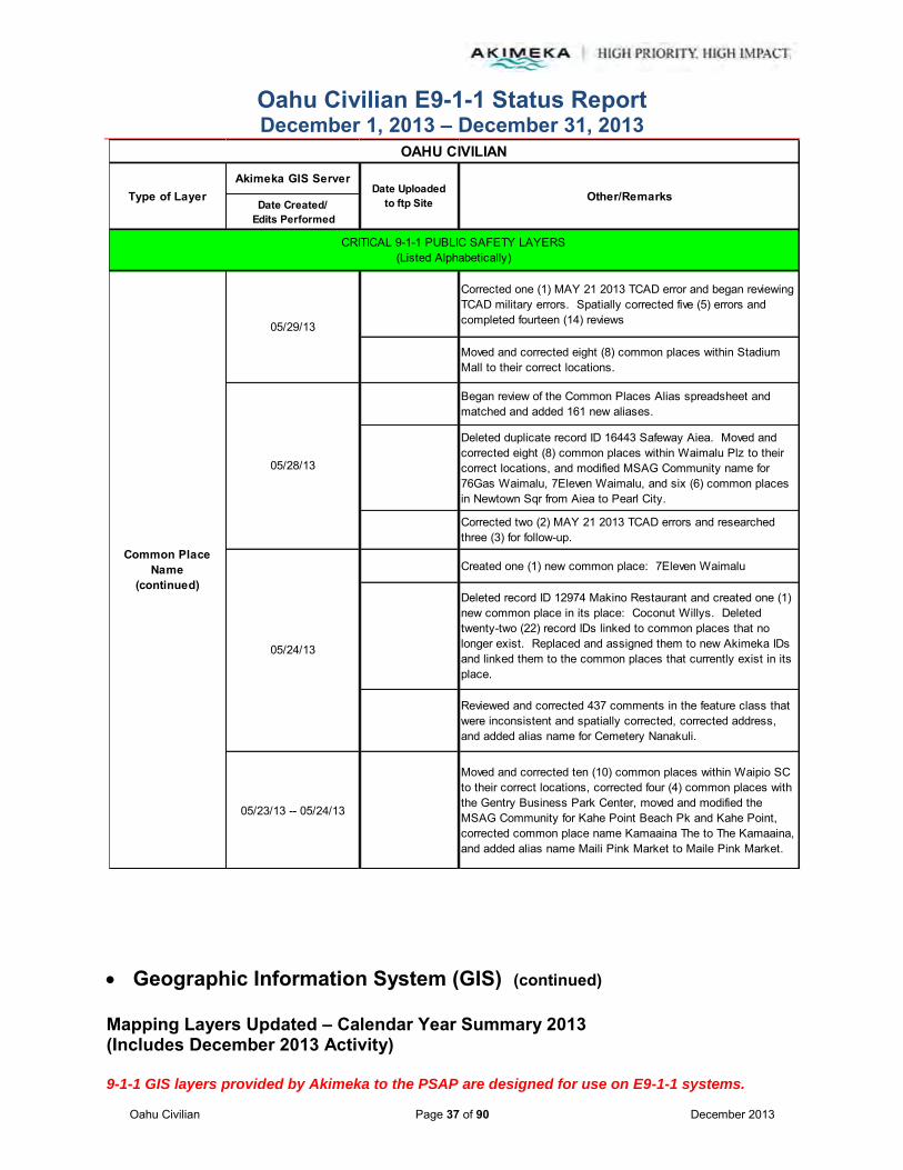
Oahu Civilian E9-1-1 Status Report December 1, 2013 – December 31, 2013
Oahu Civilian Page 37 of 90 December 2013
Geographic Information System (GIS) (continued)
Mapping Layers Updated – Calendar Year Summary 2013 (Includes December 2013 Activity) 9-1-1 GIS layers provided by Akimeka to the PSAP are designed for use on E9-1-1 systems.
Akimeka GIS Server
Date Created/ Edits Performed
Corrected one (1) MAY 21 2013 TCAD error and began reviewing TCAD military errors. Spatially corrected five (5) errors and completed fourteen (14) reviews
Moved and corrected eight (8) common places within Stadium Mall to their correct locations.
Began review of the Common Places Alias spreadsheet and matched and added 161 new aliases.
Deleted duplicate record ID 16443 Safeway Aiea. Moved and corrected eight (8) common places within Waimalu Plz to their correct locations, and modified MSAG Community name for 76Gas Waimalu, 7Eleven Waimalu, and six (6) common places in Newtown Sqr from Aiea to Pearl City.
Corrected two (2) MAY 21 2013 TCAD errors and researched three (3) for follow-up.
Created one (1) new common place: 7Eleven Waimalu
Deleted record ID 12974 Makino Restaurant and created one (1) new common place in its place: Coconut Willys. Deleted twenty-two (22) record IDs linked to common places that no longer exist. Replaced and assigned them to new Akimeka IDs and linked them to the common places that currently exist in its place.
Reviewed and corrected 437 comments in the feature class that were inconsistent and spatially corrected, corrected address, and added alias name for Cemetery Nanakuli.
05/23/13 -- 05/24/13
Moved and corrected ten (10) common places within Waipio SC to their correct locations, corrected four (4) common places with the Gentry Business Park Center, moved and modified the MSAG Community for Kahe Point Beach Pk and Kahe Point, corrected common place name Kamaaina The to The Kamaaina, and added alias name Maili Pink Market to Maile Pink Market.
Common Place Name
(continued)
05/24/13
OAHU CIVILIAN
Other/RemarksType of Layer Date Uploadedto ftp Site
05/28/13
CRITICAL 9-1-1 PUBLIC SAFETY LAYERS(Listed Alphabetically)
05/29/13

Oahu Civilian E9-1-1 Status Report December 1, 2013 – December 31, 2013
Oahu Civilian Page 38 of 90 December 2013
Geographic Information System (GIS) (continued)
Mapping Layers Updated – Calendar Year Summary 2013 (Includes December 2013 Activity) 9-1-1 GIS layers provided by Akimeka to the PSAP are designed for use on E9-1-1 systems.
Akimeka GIS Server
Date Created/ Edits Performed
Began correcting MAY 21 2013 TCAD errors. Completed two (2) corrections and researched one (1) for follow-up.
Corrected MSAG Community names of seventy-seven (77) common places from Waianae to Nanakuli
05/22/13Corrected three (3) TCAD Freeway errors and researched one (1) for follow-up from the MAY 6 2013 error report. Work was halted pending receipt of the street matrix standards from HPD PMT.
05/21/13Corrected location and address for Kaena Point Waialua and the location for Kaena Point Waianae
05/20/13 -- 05/21/13 Reviewed TCAD Freeway errors on the MAY 6 2013 error report and corrected twelve (12) errors.
05/20/13Added alias name, Oahu Baptist Network, to nineteen (19) common places.
Created two (2) new common places: H1W Exit 8A and H1E Makakilo OP based off of the NOV 3 2012 report and moved Longs Mililani Mauka to its correct location based off of a site visit performed on the GIS Corrections MAR 8 2013 report
Created one (1) new common place: West Oahu Community based on a site visit and deleted record ID 173266 Oahu Baptist Network.
Created one (1) new common place: Burger King AMR based off of the GIS Corrections NOV 3 2012 report
Completed four (4) corrections, deleted two (2), and created two (2) new common places: Mililani Missionary and H2N Exit 8 based off of the GIS Corrections MAY 3 2013 report
Common Place Name
(continued)
05/17/13
OAHU CIVILIAN
Other/RemarksType of Layer Date Uploadedto ftp Site
05/23/13
CRITICAL 9-1-1 PUBLIC SAFETY LAYERS(Listed Alphabetically)
05/17/13
05/16/13

Oahu Civilian E9-1-1 Status Report December 1, 2013 – December 31, 2013
Oahu Civilian Page 39 of 90 December 2013
Geographic Information System (GIS) (continued)
Mapping Layers Updated – Calendar Year Summary 2013 (Includes December 2013 Activity) 9-1-1 GIS layers provided by Akimeka to the PSAP are designed for use on E9-1-1 systems.
Akimeka GIS Server
Date Created/ Edits Performed
Moved eight (8) common places within Aiea SC to their correct locations
Updated names and alias names for three (3) common places and created four (4) new common places: Nancy's Kitchen, BWS Kunia 2, BWS Kunia Rsvr, and OTS Alapai Transit based off of site visits performed on the GIS Corrections APR 19 2013 report
05/10/13 Reviewed the MAY 6 2013 TCAD errors and completed four (4) corrections
05/08/13 -- 05/09/13Corrected the address for eleven (11) common places and the MSAG Community names of twenty-six (26) common places from Waialua to Mokuleia
05/06/13
Added building numbers to twenty-one (21) common places for Kuhio Homes and corrected location, address, police beat, police subbeat, tow boundary and MSAG Community name for H1E Hickam Off and H1E Nimitz Off PH based off the GIS Corrections JAN 13 2013 report.
Created two (2) new common places: CCH DPR Storage and Friendship Christian; corrected Hickam Off From H1E and PFE Puuloa based off of the GIS Corrections NOV 2 2012 report; and corrected MSAG Community name from Honolulu to Mapunapuna for MFE Puuloa OP.
Moved Hongwanji Ewa to its correct location and deleted duplicate record ID 13230; corrected subbeat and name of Mahiko Ewa Co to Ewa Mahiko Pk Cmplex; corrected address from 911205 Renton Rd to 911145 Renton Rd, police subbeat from 326F to 326E, and the location of the Ewa Mahiko Pk; corrected location and name of Lanakila Baptist MS to Lanakila Baptist HS and added alias names of Lanakila Baptist Intermediate and High School and Lanakila Baptist MS; and moved Post Office Ewa, FCU Ewa, Ewa Sugar Mill to their correct locations.
Common Place Name
(continued)
05/03/13
OAHU CIVILIAN
Other/RemarksType of Layer Date Uploadedto ftp Site
CRITICAL 9-1-1 PUBLIC SAFETY LAYERS(Listed Alphabetically)
05/15/13
05/03/13

Oahu Civilian E9-1-1 Status Report December 1, 2013 – December 31, 2013
Oahu Civilian Page 40 of 90 December 2013
Geographic Information System (GIS) (continued)
Mapping Layers Updated – Calendar Year Summary 2013 (Includes December 2013 Activity) 9-1-1 GIS layers provided by Akimeka to the PSAP are designed for use on E9-1-1 systems.
Akimeka GIS Server
Date Created/ Edits Performed
Reviewed the APR 22 2013 TCAD errors and completed three (3) corrections
Corrected MSAG Community names for three (3) common places from Laie to Hauula
Moved HFD Kahuku 13, CC Yard Kahuku, HPD Kahuku, and RS Kahuku to their correct locations
Reviewed the APR 9 2013 TCAD errors and completed five (5) corrections
Created one (1) new common place: Gunstock Ranch based off of the APR 19 2013 GIS Corrections report
Added alias names to TJMaxx Pearlridge and Honolulu Intl Countr
Moved Womens Alcohol Treat and two (2) Aloha Gas Kalihi locations to their correct locations
Researched twenty-one (21) reported errors, corrected seven (7) and deleted three (3) based off of the GIS Corrections APR 19 2013 report
Replaced alias name for Queen's Med Ctr West based off of the GIS Corrections MAR 22 2013 report
Corrected name of Arizona Off from H1W to Arizona from H1W based off of the GIS Corrections NOV 3 2012 report
Corrected location of Waianae Store, Safeway Ewa Beach, Ewa Mahiko Pk, Mahiko Park Ewa Co, and Foodland Kapolei. Added alias names for Safeway Ewa Beach and Foodland Kapolei.
Created two (2) new common places: Petco Ewa Beach and BOH Ewa Beach Safewa.
04/30/13
Common Place Name
(continued)
OAHU CIVILIAN
Other/RemarksType of Layer Date Uploadedto ftp Site
05/01/13
CRITICAL 9-1-1 PUBLIC SAFETY LAYERS(Listed Alphabetically)
05/02/13

Oahu Civilian E9-1-1 Status Report December 1, 2013 – December 31, 2013
Oahu Civilian Page 41 of 90 December 2013
Geographic Information System (GIS) (continued)
Mapping Layers Updated – Calendar Year Summary 2013 (Includes December 2013 Activity) 9-1-1 GIS layers provided by Akimeka to the PSAP are designed for use on E9-1-1 systems.
Akimeka GIS Server
Date Created/ Edits Performed
Created one (1) new common place, HPD Ewa Warehouse (GIS Corrections FEB 22 2013 error report) and created one (1) new common place, Ross Ewa Beach (GIS Corrections MAR 22 2013 error report) as validated by site visits.
Corrected name and location of Wells Fargo Waianae to Pacific Justice Ctr and FBI HQ Development to FBI Headquarters from the GIS Corrections APR 19 2013 error report and validated by site visits.
04/26/13Researched eleven (11) reported errors and corrected one (1) from the GIS Corrections APR 19 2013 error report. Corrected location of seven (7) common places inside the Waikele Ctr.
04/25/13Corrected MSAG Community Names for fifty-two (52) common places from Haleiwa to Sunset. Corrected Castle Junction from the APR 19 2013 GIS Corrections error report.
04/23/13 Reviewed thirteen (13) TCAD errors for follow-up on the APR 9 2013 report.
04/18/13 Corrected eleven (11) MSAG Community Names from FT Shafter and Honolulu to Moanalua V respectively.
04/15/13Corrected MSAG Community Names for forty-seven (47) common places from Waianae to Maili
04/12/13
Deleted record ID 12150 CompUSA Waikele as confirmed with site visit. Created sixteen (16) new common places for: Home Maluhia, Dennys Kaneohe, 7Eleven Bishop, and the subdivision homes of Awakea at Mehana based on the GIS Corrections MAR 22 2013 error report.
Moved FHB Hawaii Kai, FCU Eke HI Dental, and Territorial Dwntwn to their correct location.
Reviewed thirteen (13) and corrected five (5) from the MAR 22 2013 GIS Corrections error report. Also created two (2) new common places: 24HR Fitness Hawaii and 24HR Fitness Dwntwn. Deleted record ID 17438 Waiau Power Plant (H and record ID 73161 CompuUSA Pearl Highla.
04/30/13
Common Place Name
(continued)
OAHU CIVILIAN
Other/RemarksType of Layer Date Uploadedto ftp Site
CRITICAL 9-1-1 PUBLIC SAFETY LAYERS(Listed Alphabetically)
04/11/13
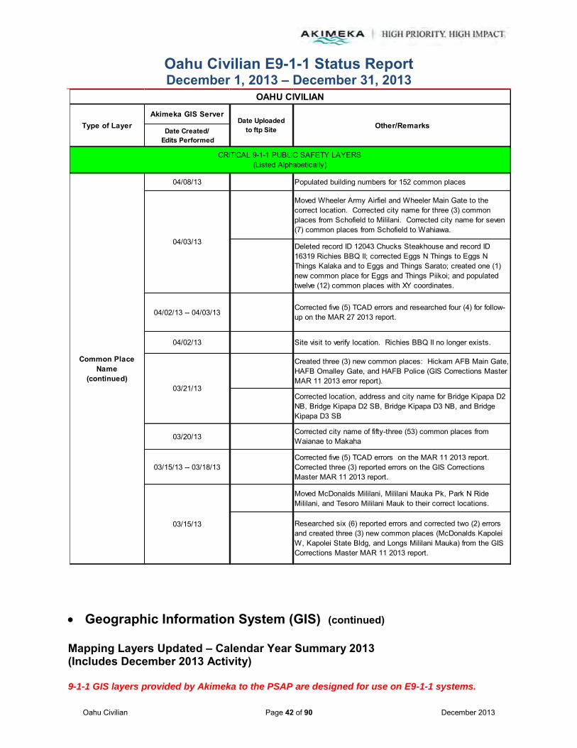
Oahu Civilian E9-1-1 Status Report December 1, 2013 – December 31, 2013
Oahu Civilian Page 42 of 90 December 2013
Geographic Information System (GIS) (continued)
Mapping Layers Updated – Calendar Year Summary 2013 (Includes December 2013 Activity) 9-1-1 GIS layers provided by Akimeka to the PSAP are designed for use on E9-1-1 systems.
Akimeka GIS Server
Date Created/ Edits Performed
04/08/13 Populated building numbers for 152 common places
Moved Wheeler Army Airfiel and Wheeler Main Gate to the correct location. Corrected city name for three (3) common places from Schofield to Mililani. Corrected city name for seven (7) common places from Schofield to Wahiawa.
Deleted record ID 12043 Chucks Steakhouse and record ID 16319 Richies BBQ II; corrected Eggs N Things to Eggs N Things Kalaka and to Eggs and Things Sarato; created one (1) new common place for Eggs and Things Piikoi; and populated twelve (12) common places with XY coordinates.
04/02/13 -- 04/03/13Corrected five (5) TCAD errors and researched four (4) for follow-up on the MAR 27 2013 report.
04/02/13 Site visit to verify location. Richies BBQ II no longer exists.
Created three (3) new common places: Hickam AFB Main Gate, HAFB Omalley Gate, and HAFB Police (GIS Corrections Master MAR 11 2013 error report).
Corrected location, address and city name for Bridge Kipapa D2 NB, Bridge Kipapa D2 SB, Bridge Kipapa D3 NB, and Bridge Kipapa D3 SB
03/20/13Corrected city name of fifty-three (53) common places from Waianae to Makaha
03/15/13 -- 03/18/13Corrected five (5) TCAD errors on the MAR 11 2013 report. Corrected three (3) reported errors on the GIS Corrections Master MAR 11 2013 report.
Moved McDonalds Mililani, Mililani Mauka Pk, Park N Ride Mililani, and Tesoro Mililani Mauk to their correct locations.
Researched six (6) reported errors and corrected two (2) errors and created three (3) new common places (McDonalds Kapolei W, Kapolei State Bldg, and Longs Mililani Mauka) from the GIS Corrections Master MAR 11 2013 report.
Common Place Name
(continued)
04/03/13
03/15/13
03/21/13
OAHU CIVILIAN
Other/RemarksType of Layer Date Uploadedto ftp Site
CRITICAL 9-1-1 PUBLIC SAFETY LAYERS(Listed Alphabetically)
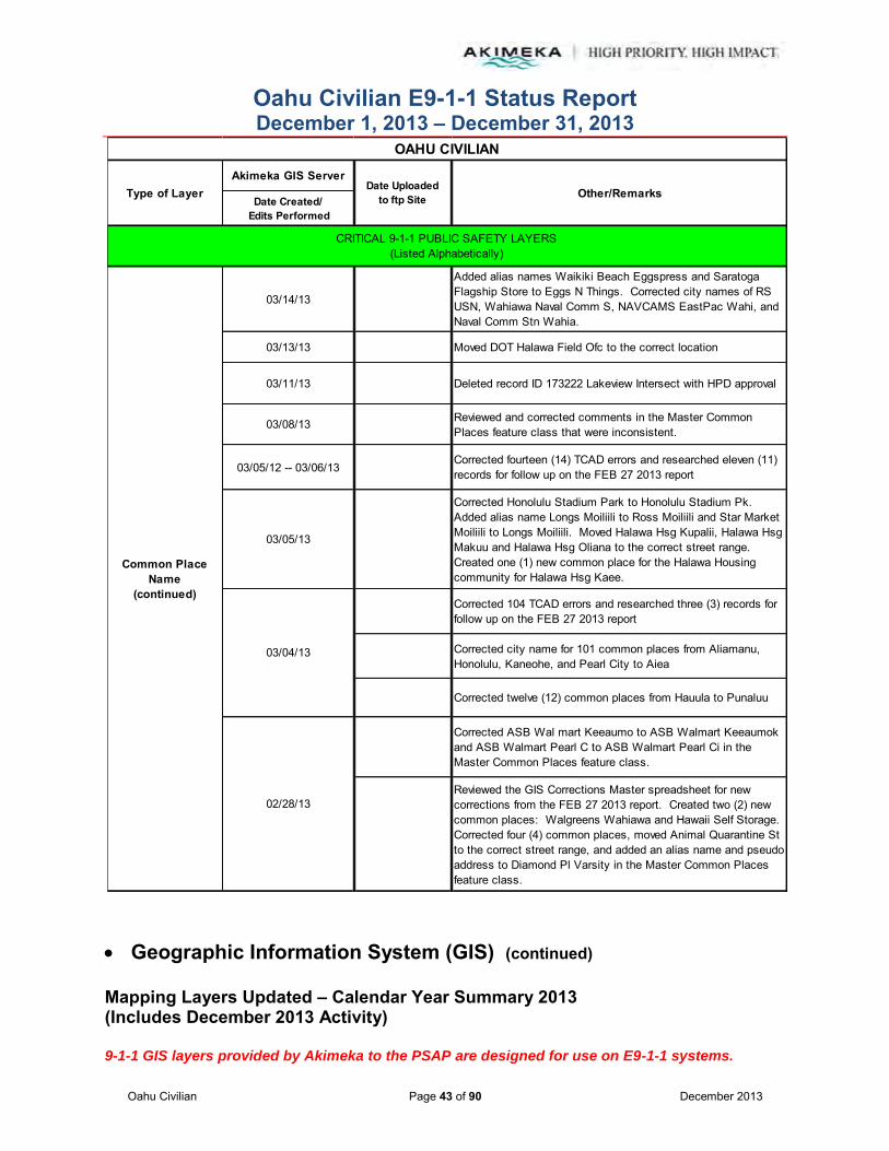
Oahu Civilian E9-1-1 Status Report December 1, 2013 – December 31, 2013
Oahu Civilian Page 43 of 90 December 2013
Geographic Information System (GIS) (continued)
Mapping Layers Updated – Calendar Year Summary 2013 (Includes December 2013 Activity) 9-1-1 GIS layers provided by Akimeka to the PSAP are designed for use on E9-1-1 systems.
Akimeka GIS Server
Date Created/ Edits Performed
03/14/13
Added alias names Waikiki Beach Eggspress and Saratoga Flagship Store to Eggs N Things. Corrected city names of RS USN, Wahiawa Naval Comm S, NAVCAMS EastPac Wahi, and Naval Comm Stn Wahia.
03/13/13 Moved DOT Halawa Field Ofc to the correct location
03/11/13 Deleted record ID 173222 Lakeview Intersect with HPD approval
03/08/13 Reviewed and corrected comments in the Master Common Places feature class that were inconsistent.
03/05/12 -- 03/06/13Corrected fourteen (14) TCAD errors and researched eleven (11) records for follow up on the FEB 27 2013 report
03/05/13
Corrected Honolulu Stadium Park to Honolulu Stadium Pk. Added alias name Longs Moiliili to Ross Moiliili and Star Market Moiliili to Longs Moiliili. Moved Halawa Hsg Kupalii, Halawa Hsg Makuu and Halawa Hsg Oliana to the correct street range. Created one (1) new common place for the Halawa Housing community for Halawa Hsg Kaee.
Corrected 104 TCAD errors and researched three (3) records for follow up on the FEB 27 2013 report
Corrected city name for 101 common places from Aliamanu, Honolulu, Kaneohe, and Pearl City to Aiea
Corrected twelve (12) common places from Hauula to Punaluu
Corrected ASB Wal mart Keeaumo to ASB Walmart Keeaumok and ASB Walmart Pearl C to ASB Walmart Pearl Ci in the Master Common Places feature class.
Reviewed the GIS Corrections Master spreadsheet for new corrections from the FEB 27 2013 report. Created two (2) new common places: Walgreens Wahiawa and Hawaii Self Storage. Corrected four (4) common places, moved Animal Quarantine St to the correct street range, and added an alias name and pseudo address to Diamond Pl Varsity in the Master Common Places feature class.
Common Place Name
(continued)
03/04/13
OAHU CIVILIAN
Other/RemarksType of Layer Date Uploadedto ftp Site
CRITICAL 9-1-1 PUBLIC SAFETY LAYERS(Listed Alphabetically)
02/28/13

Oahu Civilian E9-1-1 Status Report December 1, 2013 – December 31, 2013
Oahu Civilian Page 44 of 90 December 2013
Geographic Information System (GIS) (continued)
Mapping Layers Updated – Calendar Year Summary 2013 (Includes December 2013 Activity) 9-1-1 GIS layers provided by Akimeka to the PSAP are designed for use on E9-1-1 systems.
Akimeka GIS Server
Date Created/ Edits Performed
02/27/13Reviewed the GIS Corrections Master spreadsheet for new corrections. Corrected six (6) out of the seven (7) reported errors. Created one new common place for St Roch Church.
Reviewed the GIS Corrections Master spreadsheet for new corrections from the JAN 25 2013 report. Corrected three (3) common places and added Safeway Ewa Bch.
Corrected subclass for thirty-two (32) common places from Drug Store to Store in the Master Common Places feature class
02/07/13Corrected city name for Pearl City Comm Ctr from PC Peninsula to PC Pen in the Master Common Places feature class
01/28/13
Reviewed sixty-four (64) Address Location Error Forms, corrected seven (7) Common Place errors, and added three (3) new Common Places for ASB Makiki, Ross Moiliili, and Kaiser Mapunapuna. Deleted two (2) out of date records: ASB Makiki and Pizza Hut Stadium Ma.
Corrected the address for White Plains Bch for the JAN 17 2013 report
Researched seventeen (17) reported errors and corrected sixteen (16) errors on the GIS Corrections JAN 24 2013 report
Researched nineteen (19) reported errors, corrected thirteen (13) and deleted five (5) on the GIS Corrections JAN 14 2013 report
Corrected six (6) TCAD errors and researched three (3) for follow up from the JAN 17 2013 report
Removed Family Court Kapolei as an alias from Dist Crt Kapolei on the GIS Corrections JAN 23 2013 report
Corrected nine (9) TCAD errors and corrected five (5) TCAD errors from the JAN 17 2013 report with a correction of a street city name from Kapolei to Waianae
Common Place Name
(continued)
01/23/13
01/24/13
OAHU CIVILIAN
Other/RemarksType of Layer Date Uploadedto ftp Site
02/08/13
CRITICAL 9-1-1 PUBLIC SAFETY LAYERS(Listed Alphabetically)
01/25/13
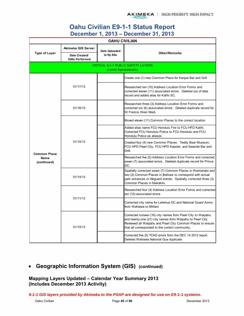
Oahu Civilian E9-1-1 Status Report December 1, 2013 – December 31, 2013
Oahu Civilian Page 45 of 90 December 2013
Geographic Information System (GIS) (continued)
Mapping Layers Updated – Calendar Year Summary 2013 (Includes December 2013 Activity) 9-1-1 GIS layers provided by Akimeka to the PSAP are designed for use on E9-1-1 systems.
Akimeka GIS Server
Date Created/ Edits Performed
Create one (1) new Common Place for Kanpai Bar and Grill
Researched ten (10) Address Location Error Forms and corrected eleven (11) associated errors. Deleted out of date record and added alias for Kalihi SC.
01/16/13Researched three (3) Address Location Error Forms and corrected six (6) associated errors. Deleted duplicate record for St Francis West Medi.
Moved eleven (11) Common Places to the correct location
Added alias name FCU Honolulu Fire to FCU HFD Kalihi. Corrected FCU Honolulu Police to FCU Honolulu and FCU Honolulu Police as aliases.
Created four (4) new Common Places: Teddy Bear Museum, FCU HPD Pearl City, FCU HPD Kapolei, and Seaside Bar and Grill.
Researched five (5) Address Location Error Forms and corrected seven (7) associated errors. Deleted duplicate record for Prince GC.
01/14/13
Spatially corrected seven (7) Common Places in Waimanalo and two (2) Common Places in Bellows to correspond with actual park entrances or lifeguard stands. Spatially corrected three (3) Common Places in Makakilo.
Researched four (4) Address Location Error Forms and corrected ten (10) associated errors
Corrected city name for Leilehua GC and National Guard Armor from Wahiawa to Mililani
Corrected sixteen (16) city names from Pearl City to Waipahu and twenty-one (21) city names from Waipahu to Pearl City. Reviewed all Waipahu and Pearl City Common Places to ensure that all corresponded to the correct community.
Corrected five (5) TCAD errors from the DEC 14 2012 report. Deleted Wahiawa National Gua duplicate.
Common Place Name
(continued)
01/15/13
01/11/13
OAHU CIVILIAN
Other/RemarksType of Layer Date Uploadedto ftp Site
CRITICAL 9-1-1 PUBLIC SAFETY LAYERS(Listed Alphabetically)
01/17/13
01/10/13

Oahu Civilian E9-1-1 Status Report December 1, 2013 – December 31, 2013
Oahu Civilian Page 46 of 90 December 2013
Geographic Information System (GIS) (continued)
Mapping Layers Updated – Calendar Year Summary 2013 (Includes December 2013 Activity) 9-1-1 GIS layers provided by Akimeka to the PSAP are designed for use on E9-1-1 systems.
Akimeka GIS Server
Date Created/ Edits Performed
Created Pseudo Address field for the Master Common Places feature class. The State field was missing so re-created and re-populated.
Corrected Park N Ride Wahiawa from the TCAD DEC 14 2012 report
Reviewed Common Place discrepancies that fell on streets with corrected gaps between NOV 16 2012 and DEC 10 2012 reports. Corrected Wahiawa Dist Pk and Wahiawa Rec Ctr and deleted Wahiawa Rec Ctr and Wahiawa Gym duplicates.
01/08/13
Reviewed Address Location Error Forms to ensure corrections were made in GIS. Added Holiday Inn Wkk as an alias to Waikiki Beachcomber. Also corrected Police Beat 467 to 464 for Sat City Hall Kaneo.
01/03/13 -- 01/08/13Researched and verified TCAD errors from the DEC 14 2012 report.
01/03/13Identified Makakilo Cliff blank-to-blank ranges. Relocated three (3) associated Common Places. Follow up with populating street range.
01/02/13 -- 01/03/13Completed review of spatially corrected Common Places in Waimanalo and discovered three (3) discrepancies. Follow up about lifeguard stands.
04/19/13 -- 04/23/13 Updated all boundaries for the Fire Battalions which included correcting the coastlines and interior boundaries in accordance with the written HFD Policies and Procedures.
Common Place Name
(continued)
Fire Beats
Emergency Callboxes
Fire Districts
OAHU CIVILIAN
Other/RemarksType of Layer Date Uploadedto ftp Site
CRITICAL 9-1-1 PUBLIC SAFETY LAYERS(Listed Alphabetically)
01/09/13

Oahu Civilian E9-1-1 Status Report December 1, 2013 – December 31, 2013
Oahu Civilian Page 47 of 90 December 2013
Geographic Information System (GIS) (continued)
Mapping Layers Updated – Calendar Year Summary 2013 (Includes December 2013 Activity) 9-1-1 GIS layers provided by Akimeka to the PSAP are designed for use on E9-1-1 systems.
Akimeka GIS Server
Date Created/ Edits Performed
12/13/13 Corrected boundary at STA12/STA36 and STA41/STA4210/29/13 Updated boundaries for STA14 and STA1610/16/13 Corrected boundaries at the Kam Hwy/H2S Exit 9 intersection
10/09/13 Corrected STA14 and STA16 boundary along Wahiawa Water Company flume
08/19/13 Corrected boundary for Station 39 and Station 18 at Keolu Intersection
04/26/13 Added coloration values for CAD display purposes04/23/13 Updated RA for Paawa to be included in Battalion 2
03/25/13 -- 03/29/13 Corrected layer with the corrected coastline. Completed on March 29, 2013.
03/22/13 Edited HFD RA sort orders
03/21/13Removed multiple park polygons and battalion codes in preparation for the TriTech CAD upgrade.
Ran topology to identify gaps and overlaps. Made minor corrections as needed.
Added metadata to new HFD Response Areas layer
03/04/13 Made adjustments to Engines 5 and 12
03/01/13 Corrected boundaries for Engine 41 (Mililani Mauka), Engine 42 (Waikele), and Engine 43 (East Kapolei)
02/01/13 -- 02/27/13
Corrected boundaries for Engine 4 (Kuakini), Engine 5 (Kaimuki), Engine 6 (Kalihi), Engine 7 (Waikiki), Engine 8 (Mokulele), Engine 9 (Kakaako), Engine 10 (Aiea), Engine 11 (Sunset), Engine 12 (Waipahu), Engine 13 (Kahuku), Engine 14 (Waialua), Engine 15 (Hauula), Engine 16 (Wahiawa), Engine 17 (Kaneohe), Engine 18 (Kailua), Engine 19 (Aikahi), Engine 20 (Pearl City), Engine 21 (Kaaawa), Engine 22 (Manoa), Engine 23 (Wailupe), Engine 24 Ewa Beach), Engine 25 (Nuuanu), Engine 26 (Waianae), Engine 27 (Waimanalo), Engine 28 (Nanakuli), Engine 29 (McCully), Engine 30 (Moanalua), Engine 31 (Kalihi Kai), Engine 32 (Kalihi Uka), Engine 33 (Palolo), Engine 34 (Hawaii Kai), Engine 35 (Makakilo), Engine 36 (Mililani), Engine 37 (Kahaluu), Engine 38 (Waiau), Engine 39 (Olomana), Engine 40 (Kapolei), Engine 41 (Mililani Mauka), Engine 42 (Waikele), and Engine 43 (East Kapolei).
Fire Response Areas
OAHU CIVILIAN
Other/RemarksType of Layer Date Uploadedto ftp Site
03/07/13
CRITICAL 9-1-1 PUBLIC SAFETY LAYERS(Listed Alphabetically)

Oahu Civilian E9-1-1 Status Report December 1, 2013 – December 31, 2013
Oahu Civilian Page 48 of 90 December 2013
Geographic Information System (GIS) (continued)
Mapping Layers Updated – Calendar Year Summary 2013 (Includes December 2013 Activity) 9-1-1 GIS layers provided by Akimeka to the PSAP are designed for use on E9-1-1 systems.
Akimeka GIS Server
Date Created/ Edits Performed
01/31/13 Performed edits to the Engine 1 (Central Station) boundaries based on HFD written Policies and Procedures
01/15/13 Cleaned up the boundaries around parcels at Kunia Camp
01/08/13Clipped out old ocean response boundaries from Fire responses and used updated Coastlines in order to apply a more precise 3-mile buffer for ocean rescues
01/07/13Completed correcting gaps and overlaps in preparation for the HFD TriTech CAD upgrade
08/19/13 Added address to one (1) Fire Station record08/14/13 Removed special characters and HQ from five (5) records.
12/31/13 Corrected Mililani/Waipahu boundary
12/12/13 Updated Mililani/Waipio boundary
12/11/13 Updated Mililani/Waipio boundary
10/24/13Corrected Makakilo/Kunia boundary. Corrected Wahiawa/Schofield boundary.
10/17/13Corrected Ft Shafter/Kalihi and Ft Shafter/Moanalua V boundaries to the correct military fence line.
10/16/13Corrected Mililani/Wahiawa boundary, Kunia/Waipahu boundary, Kunia/Mililani boundary, and Schofield/Mililani boundary.
10/11/13 Corrected Pearl Hbr/Hale Moku boundary to military fenceline10/1/13 -- 10/9/13 Corrected Wahiawa/Waialua boundary along Police Beat 266
09/23/13 -- 09/26/13 Corrected Haleiwa/sunset boundary and Haleiwa/Waialua boundary
Fire Response Area
MSAG Communities(aka Towns)
MSAG Address Points
(aka Pseudo Address Points)
Major Roads
OAHU CIVILIAN
Other/RemarksType of Layer Date Uploadedto ftp Site
CRITICAL 9-1-1 PUBLIC SAFETY LAYERS(Listed Alphabetically)
Fire Stations

Oahu Civilian E9-1-1 Status Report December 1, 2013 – December 31, 2013
Oahu Civilian Page 49 of 90 December 2013
Geographic Information System (GIS) (continued)
Mapping Layers Updated – Calendar Year Summary 2013 (Includes December 2013 Activity) 9-1-1 GIS layers provided by Akimeka to the PSAP are designed for use on E9-1-1 systems.
Akimeka GIS Server
Date Created/ Edits Performed
09/10/13 -- 09/13/13 Corrected boundary to Kaneohe/Kahuluu, Hauula/Punaluu, Hauula/Laie and Kahuku/Laie
08/27/13 Corrected boundary for Waimanalo, Kailua, and Kaneohe
Updated boundaries to Miller Pk, Halsey T, Aliamanu, and Catlin Pk
Corrected Makalapa and Aiea boundary to military fence line
07/19/13 Corrected boundary at Pearl Hbr/Ford Isl/Aiea on the bridge07/01/13 Corrected boundary between Pearl Hbr and Aiea06/28/13 Corrected entrance to Bellows per HPD06/27/13 Corrected boundary for Schofield.
06/26/13Corrected boundary for Waimanalo/Bellows to military fence line.
06/21/13Corrected boundary for Pearl Harbor, Hickam, and Airport to fence line.
06/12/13 Corrected Iroquios and Pearl Hbr to the military fence line
05/10/13 Updated border between Mokuleia and Waialua and Ewa Beach and Kalaeloa
04/10/13 -- 04/17/13Updated border of Lualualei to the military fence line, border between Pearl Harbor and Aiea, border between Pearl City and Waipahu, and border at coastline between Bellows and Kailua.
04/08/13
Validated topology on MSAG Communities and marked thirty-four (34) errors as exceptions. Deleted the original MSAG Communities feature class and created a new feature class with the corrected MSAG Communities containing the updated coastlines.
04/04/13 -- 04/05/13Corrected additional MSAG Communities based off of the updated coastline layer.
04/01/13 -- 04/03/13
Corrected MSAG Communities for Hawaii Kai, Aina Haina, Waialae, Kahala, Waikiki, Ft DeRussy, Ala Moana, Kakaako, Downtown, Kalihi, Airport, Hickam, and Pearl Harbor based off of the updated coastline layer.
03/19/13 Modified boundary of Makua03/13/13 Edited boundary of NCTAMS PAC03/11/13 Minor correction to the border of Aiea and Camp Smith
MSAG Communities
OAHU CIVILIAN
Other/RemarksType of Layer Date Uploadedto ftp Site
CRITICAL 9-1-1 PUBLIC SAFETY LAYERS(Listed Alphabetically)
08/16/13
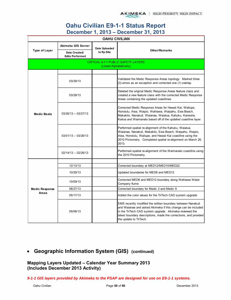
Oahu Civilian E9-1-1 Status Report December 1, 2013 – December 31, 2013
Oahu Civilian Page 50 of 90 December 2013
Geographic Information System (GIS) (continued)
Mapping Layers Updated – Calendar Year Summary 2013 (Includes December 2013 Activity) 9-1-1 GIS layers provided by Akimeka to the PSAP are designed for use on E9-1-1 systems.
Akimeka GIS Server
Date Created/ Edits Performed
03/29/13Validated the Medic Response Areas topology: Marked three (3) errors as an exception and corrected one (1) overlap
03/28/13Deleted the original Medic Response Areas feature class and created a new feature class with the corrected Medic Response Areas containing the updated coastlines.
03/26/13 -- 03/27/13
Corrected Medic Response Areas for Hawaii Kai, Wailupe, Honolulu, Aiea, Waipio, Wahiawa, Waipahu, Ewa Beach, Makakilo, Nanakuli, Waianae, Waialua, Kahuku, Kaneohe, Kailua and Waimanalo based off of the updated coastline layer.
03/01/13 -- 03/26/13
Performed spatial re-alignment of the Kahuku, Waialua, Waianae, Nanakuli, Makakilo, Ewa Beach, Waipahu, Waipio, Aiea, Honolulu, Wailupe, and Hawaii Kai coastline using the 2010 Pictometry. Completed spatial re-alignment on March 26, 2013.
02/14/13 -- 02/26/13 Performed spatial re-alignment of the Waimanalo coastline using the 2010 Pictometry.
12/13/13 Corrected boundary at MED12/MED10/MED22
10/29/13 Updated boundaries for MED6 and MED12
10/09/13 Corrected MED6 and MED12 boundary along Wahiawa Water Company flume
08/27/13 Corrected boundary for Medic 3 and Medic 9
05/17/13 Added the color values for the TriTech CAD system upgrade
05/06/13
EMS recently modified the written boundary between Nanakuli and Waianae and asked Akimeka if this change can be included in the TriTech CAD system upgrade. Akimeka reviewed the latest boundary descriptions, made the corrections, and provided the update to TriTech.
Medic Response Areas
Medic Beats
OAHU CIVILIAN
Other/RemarksType of Layer Date Uploadedto ftp Site
CRITICAL 9-1-1 PUBLIC SAFETY LAYERS(Listed Alphabetically)

Oahu Civilian E9-1-1 Status Report December 1, 2013 – December 31, 2013
Oahu Civilian Page 51 of 90 December 2013
Geographic Information System (GIS) (continued)
Mapping Layers Updated – Calendar Year Summary 2013 (Includes December 2013 Activity) 9-1-1 GIS layers provided by Akimeka to the PSAP are designed for use on E9-1-1 systems.
Akimeka GIS Server
Date Created/ Edits Performed
12/18/13 Delivered Aloha geodatabase with updated Net Junctions to HPD
12/18/13Populated Net Junctions with the latest MSAG Community and Police Beat updates
12/02/13 Populated Net Junctions with the latest MSAG Community and Police Beat updates
11/19/13 Delivered Aloha geodatabase with updated Net Junctions to HPD
11/18/13Populated Net Junctions with the latest MSAG Community and Police Beat updates
11/08/13 Delivered updated Net Junctions to HPD for new upload process
11/08/13 Populated with latest MSAG Communities and Police Beat updates.
11/05/13 Delivered Net Junctions to HPD
11/05/13 Populated with latest MSAG Community updates
10/22/13 Delivered Aloha geodatabase to HPD with Net Junctions updates
10/22/13Populated with the most recent MSAG Community updates -- part of Phase V
10/07/13 Delivered Aloha geodatabase to HPD with Net Junctions updates
10/07/13 Populated with the latest MSAG Community updates
09/23/13 Populated with the most recent MSAG Community updates and delivered Aloha geodatabase to HPD
09/09/13Populated with the most recent MSAG Community updates and delivered Aloha geodatabase to HPD
08/27/13 Populated with the most recent MSAG Community updates and delivered Aloha geodatabase to HPD
Net Junctions
Medic Stations
Milepost Markers
OAHU CIVILIAN
Other/RemarksType of Layer Date Uploadedto ftp Site
CRITICAL 9-1-1 PUBLIC SAFETY LAYERS(Listed Alphabetically)
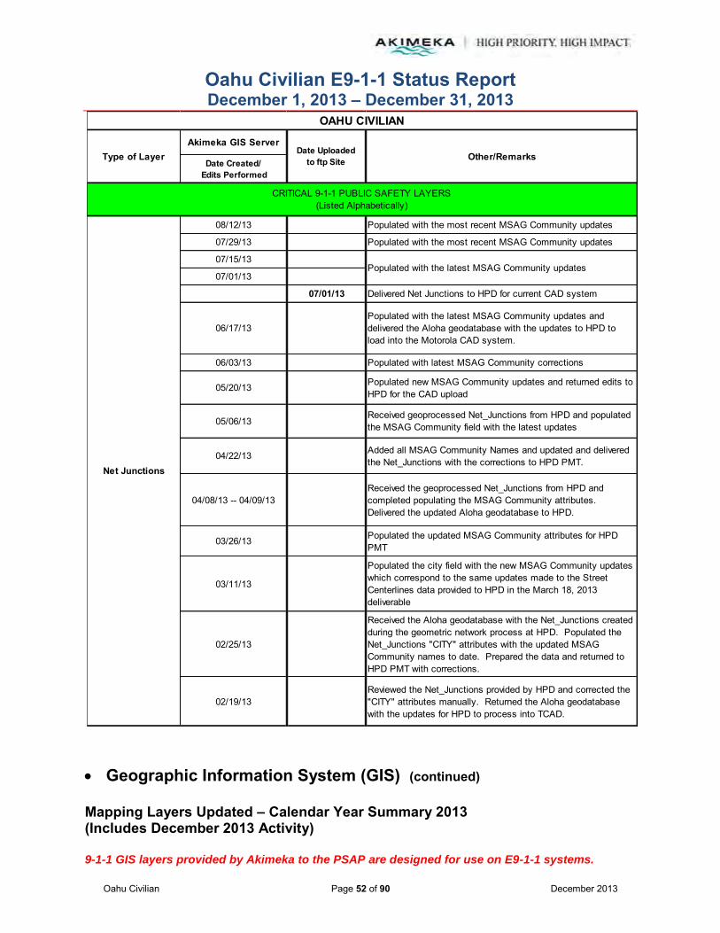
Oahu Civilian E9-1-1 Status Report December 1, 2013 – December 31, 2013
Oahu Civilian Page 52 of 90 December 2013
Geographic Information System (GIS) (continued)
Mapping Layers Updated – Calendar Year Summary 2013 (Includes December 2013 Activity) 9-1-1 GIS layers provided by Akimeka to the PSAP are designed for use on E9-1-1 systems.
Akimeka GIS Server
Date Created/ Edits Performed
08/12/13 Populated with the most recent MSAG Community updates
07/29/13 Populated with the most recent MSAG Community updates
07/15/13
07/01/13
07/01/13 Delivered Net Junctions to HPD for current CAD system
06/17/13Populated with the latest MSAG Community updates and delivered the Aloha geodatabase with the updates to HPD to load into the Motorola CAD system.
06/03/13 Populated with latest MSAG Community corrections
05/20/13 Populated new MSAG Community updates and returned edits to HPD for the CAD upload
05/06/13Received geoprocessed Net_Junctions from HPD and populated the MSAG Community field with the latest updates
04/22/13 Added all MSAG Community Names and updated and delivered the Net_Junctions with the corrections to HPD PMT.
04/08/13 -- 04/09/13Received the geoprocessed Net_Junctions from HPD and completed populating the MSAG Community attributes. Delivered the updated Aloha geodatabase to HPD.
03/26/13 Populated the updated MSAG Community attributes for HPD PMT
03/11/13
Populated the city field with the new MSAG Community updates which correspond to the same updates made to the Street Centerlines data provided to HPD in the March 18, 2013 deliverable
02/25/13
Received the Aloha geodatabase with the Net_Junctions created during the geometric network process at HPD. Populated the Net_Junctions "CITY" attributes with the updated MSAG Community names to date. Prepared the data and returned to HPD PMT with corrections.
02/19/13Reviewed the Net_Junctions provided by HPD and corrected the "CITY" attributes manually. Returned the Aloha geodatabase with the updates for HPD to process into TCAD.
Net Junctions
Populated with the latest MSAG Community updates
OAHU CIVILIAN
Other/RemarksType of Layer Date Uploadedto ftp Site
CRITICAL 9-1-1 PUBLIC SAFETY LAYERS(Listed Alphabetically)

Oahu Civilian E9-1-1 Status Report December 1, 2013 – December 31, 2013
Oahu Civilian Page 53 of 90 December 2013
Geographic Information System (GIS) (continued)
Mapping Layers Updated – Calendar Year Summary 2013 (Includes December 2013 Activity) 9-1-1 GIS layers provided by Akimeka to the PSAP are designed for use on E9-1-1 systems.
Akimeka GIS Server
Date Created/ Edits Performed
Deleted Hono Dist Crt (duplicate), Added HFD 43 Kapolei, and HFD Kapolei 43Populated new MSAG Community of Punchbowl and Makiki
12/20/13 Added Kapolei Knolls Pk in Kapolei
12/13/13 Spatially corrected Harano Tunnel H3, H1E Kaahumanu OP, and H1W Kaahumanu OPAdded Ke Kula O Samuel in KaneohePopulated with new MSAG Community of Ala Moana
11/25/13 Populated with updated MSAG Community of Kakaako11/19/13 Populated MSAG Community information for Downtown
Added Dennys Kapolei and Law Tow Kalihi
Corrected name of Waikiki Hana Htl to Waikiki Stay Htl and added old name to alias
Corrected name of Makaha Drive In to Lahilahi Drive In and added old name to alias
11/14/13 Added Walgreens Nuuanu
11/05/13 Updated to include the new MSAG Community of Nuuanu
10/31/13 Spatially corrected Honolulu Towing to correct geocoding issue
10/21/13 Corrected name for Chuck E Cheese Kalihi
Spatially corrected locations to buildings at UH Manoa campus -- UH ART BLDG, UH EDMONDSON HALL, UH HAMILTON LIBRARY, UH HAWAII INST OF GE, UH KELLER HALL, UH KENNEDY THEATRE, UH KUYKENDALL HALL, UH MARINE SCIENCES BL, UH PARADISE PALMS, UH PHYSICAL SCIENCE, UH SYNDER HALL, UH STUDENT HEALTH SE, UH WATANABE HALL, UH WEBSTER HALL
Deleted MACYS HILTON HAWN VI -- no longer in business
Added UH CHEMISTRY BLDG in Manoa and CROSSPOINTE BLDG 18 in Aiea
Populated with updates to new Kalihi MSAG Community
10/16/13Spatially corrected locations at H2S exits and on ramps in Mililani
12/27/13
10/18/13
Points of Interest
OAHU CIVILIAN
Other/RemarksType of Layer Date Uploadedto ftp Site
CRITICAL 9-1-1 PUBLIC SAFETY LAYERS(Listed Alphabetically)
11/15/13
11/29/13
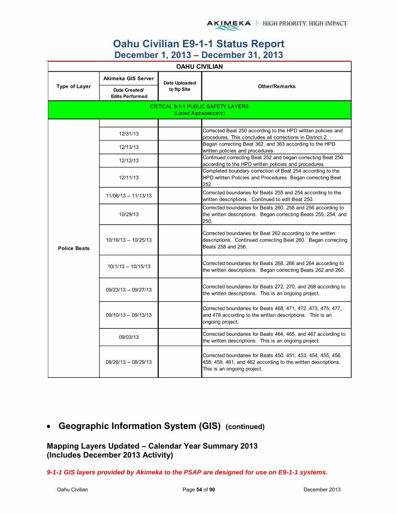
Oahu Civilian E9-1-1 Status Report December 1, 2013 – December 31, 2013
Oahu Civilian Page 54 of 90 December 2013
Geographic Information System (GIS) (continued)
Mapping Layers Updated – Calendar Year Summary 2013 (Includes December 2013 Activity) 9-1-1 GIS layers provided by Akimeka to the PSAP are designed for use on E9-1-1 systems.
Akimeka GIS Server
Date Created/ Edits Performed
12/31/13 Corrected Beat 250 according to the HPD written policies and procedures. This concludes all corrections in District 2.
12/13/13 Began correcting Beat 362, and 363 according to the HPD written policies and procedures
12/12/13 Continued correcting Beat 252 and began correcting Beat 250 according to the HPD written policies and procedures
12/11/13Completed boundary correction of Beat 254 according to the HPD written Policies and Procedures. Began correcting Beat 252
11/06/13 -- 11/13/13 Corrected boundaries for Beats 255 and 254 according to the written descriptions. Continued to edit Beat 250.
10/29/13Corrected boundaries for Beats 260, 258 and 256 according to the written descriptions. Began correcting Beats 255, 254, and 250.
10/16/13 -- 10/25/13Corrected boundaries for Beat 262 according to the written descriptions. Continued correcting Beat 260. Began correcting Beats 258 and 256.
10/1/13 -- 10/15/13 Corrected boundaries for Beats 268, 266 and 264 according to the written descriptions. Began correcting Beats 262 and 260.
09/23/13 -- 09/27/13 Corrected boundaries for Beats 272, 270, and 268 according to the written descriptions. This is an ongoing project.
09/10/13 -- 09/13/13Corrected boundaries for Beats 468, 471, 472 ,473, 475, 477, and 478 according to the written descriptions. This is an ongoing project.
09/03/13 Corrected boundaries for Beats 464, 465, and 467 according to the written descriptions. This is an ongoing project.
08/26/13 -- 08/29/13Corrected boundaries for Beats 450, 451, 453, 454, 455, 456, 458, 459, 461, and 462 according to the written descriptions. This is an ongoing project.
Police Beats
OAHU CIVILIAN
Other/RemarksType of Layer Date Uploadedto ftp Site
CRITICAL 9-1-1 PUBLIC SAFETY LAYERS(Listed Alphabetically)

Oahu Civilian E9-1-1 Status Report December 1, 2013 – December 31, 2013
Oahu Civilian Page 55 of 90 December 2013
Geographic Information System (GIS) (continued)
Mapping Layers Updated – Calendar Year Summary 2013 (Includes December 2013 Activity) 9-1-1 GIS layers provided by Akimeka to the PSAP are designed for use on E9-1-1 systems.
Akimeka GIS Server
Date Created/ Edits Performed
06/18/13Continued to edit the Police Beat boundaries according to the written descriptons. This is an ongoing project.
06/04/13 -- 06/10/13Began the correction process to follow the boundaries identified in HPD's written policies and procedures. Corrected Beat boundaries for 151,152, 154, 156, 157, and 158.
04/23/13 --04/25/13Corrected Police Beats and Subbeats based off of the updated coastline layer.
Deleted the original Police Beats feature class and created a new feature class with the corrected Police Beats containing the updated coastlines.
Validated topology on Police Beats and marked thirty-four (34) errors as exceptions.
Reviewed nine (9) bookmarks regarding Police Beat conflicts. Corrected land boundaries between Police Beat 375 and 380, 464 and 462, and 772 and 774.
Deleted the original Police Districts feature class and created a new feature class with the corrected Police Districts layer containing the updated coastlines.
Validated topology on Police Districts: marked thirty-three (33) gaps as an exception with no gaps or overlaps to correct.
05/21/13 -- 05/22/13Corrected Police Districts for District 7, District 6, District 1, District 5, District 3, District 8, District 2, and District 4 based off of the updated coastline layer.
05/16/13
Corrected one (1) overlap in Police Subbeat 431X. Police Subbeat 085E has two duplicate, inconsistent and overlapping polygons. Marked four (4) overlaps related to this conflict as an exception.
05/14/13Deleted original Police Subbeat feature class and created a new feature class with the corrected Police Subbeats containing the updated coastlines
Police Beats
Police Response Areas
Police Districts
OAHU CIVILIAN
Other/RemarksType of Layer Date Uploadedto ftp Site
04/16/13
CRITICAL 9-1-1 PUBLIC SAFETY LAYERS(Listed Alphabetically)
05/22/13
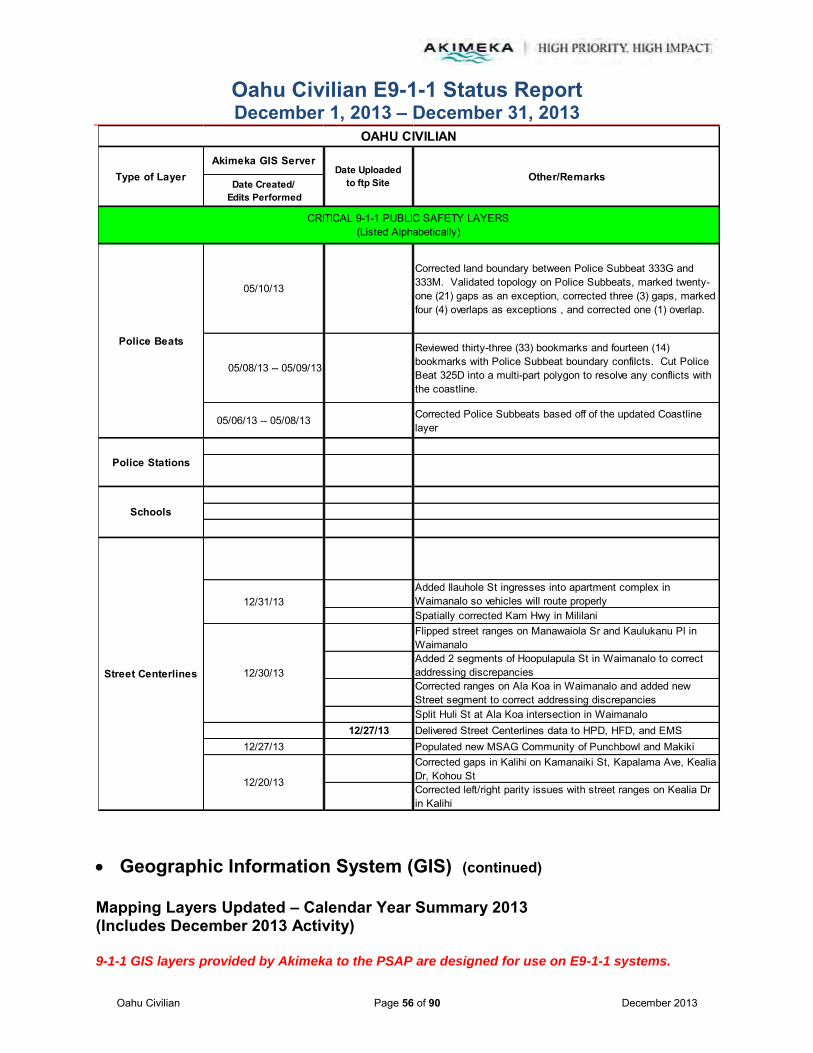
Oahu Civilian E9-1-1 Status Report December 1, 2013 – December 31, 2013
Oahu Civilian Page 56 of 90 December 2013
Geographic Information System (GIS) (continued)
Mapping Layers Updated – Calendar Year Summary 2013 (Includes December 2013 Activity) 9-1-1 GIS layers provided by Akimeka to the PSAP are designed for use on E9-1-1 systems.
Akimeka GIS Server
Date Created/ Edits Performed
05/10/13
Corrected land boundary between Police Subbeat 333G and 333M. Validated topology on Police Subbeats, marked twenty-one (21) gaps as an exception, corrected three (3) gaps, marked four (4) overlaps as exceptions , and corrected one (1) overlap.
05/08/13 -- 05/09/13
Reviewed thirty-three (33) bookmarks and fourteen (14) bookmarks with Police Subbeat boundary confilcts. Cut Police Beat 325D into a multi-part polygon to resolve any conflicts with the coastline.
05/06/13 -- 05/08/13 Corrected Police Subbeats based off of the updated Coastline layer
Added Ilauhole St ingresses into apartment complex in Waimanalo so vehicles will route properlySpatially corrected Kam Hwy in MililaniFlipped street ranges on Manawaiola Sr and Kaulukanu Pl in WaimanaloAdded 2 segments of Hoopulapula St in Waimanalo to correct addressing discrepanciesCorrected ranges on Ala Koa in Waimanalo and added new Street segment to correct addressing discrepanciesSplit Huli St at Ala Koa intersection in Waimanalo
12/27/13 Delivered Street Centerlines data to HPD, HFD, and EMS12/27/13 Populated new MSAG Community of Punchbowl and Makiki
Corrected gaps in Kalihi on Kamanaiki St, Kapalama Ave, Kealia Dr, Kohou StCorrected left/right parity issues with street ranges on Kealia Dr in Kalihi
Police Beats
Street Centerlines
Police Stations
12/20/13
12/30/13
12/31/13
OAHU CIVILIAN
Other/RemarksType of Layer Date Uploadedto ftp Site
CRITICAL 9-1-1 PUBLIC SAFETY LAYERS(Listed Alphabetically)
Schools
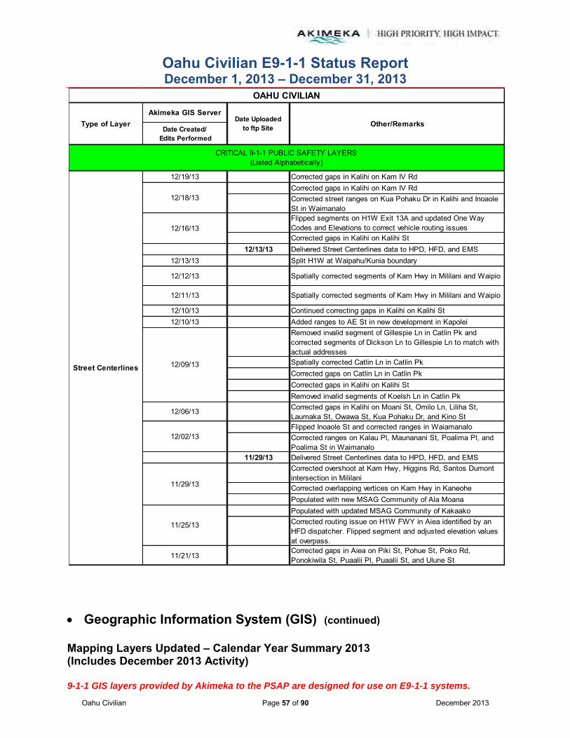
Oahu Civilian E9-1-1 Status Report December 1, 2013 – December 31, 2013
Oahu Civilian Page 57 of 90 December 2013
Geographic Information System (GIS) (continued)
Mapping Layers Updated – Calendar Year Summary 2013 (Includes December 2013 Activity) 9-1-1 GIS layers provided by Akimeka to the PSAP are designed for use on E9-1-1 systems.
Akimeka GIS Server
Date Created/ Edits Performed
12/19/13 Corrected gaps in Kalihi on Kam IV RdCorrected gaps in Kalihi on Kam IV RdCorrected street ranges on Kua Pohaku Dr in Kalihi and Inoaole St in WaimanaloFlipped segments on H1W Exit 13A and updated One Way Codes and Elevations to correct vehicle routing issuesCorrected gaps in Kalihi on Kalihi St
12/13/13 Delivered Street Centerlines data to HPD, HFD, and EMS12/13/13 Split H1W at Waipahu/Kunia boundary
12/12/13 Spatially corrected segments of Kam Hwy in Mililani and Waipio
12/11/13 Spatially corrected segments of Kam Hwy in Mililani and Waipio
12/10/13 Continued correcting gaps in Kalihi on Kalihi St12/10/13 Added ranges to AE St in new development in Kapolei
Removed invalid segment of Gillespie Ln in Catlin Pk and corrected segments of Dickson Ln to Gillespie Ln to match with actual addressesSpatially corrected Catlin Ln in Catlin PkCorrected gaps on Catlin Ln in Catlin PkCorrected gaps in Kalihi on Kalihi StRemoved invalid segments of Koelsh Ln in Catlin Pk
12/06/13 Corrected gaps in Kalihi on Moani St, Omilo Ln, Liliha St, Laumaka St, Owawa St, Kua Pohaku Dr, and Kino StFlipped Inoaole St and corrected ranges in WaiamanaloCorrected ranges on Kalau Pl, Maunanani St, Poalima Pl, and Poalima St in Waimanalo
11/29/13 Delivered Street Centerlines data to HPD, HFD, and EMSCorrected overshoot at Kam Hwy, Higgins Rd, Santos Dumont intersection in MililaniCorrected overlapping vertices on Kam Hwy in KaneohePopulated with new MSAG Community of Ala MoanaPopulated with updated MSAG Community of KakaakoCorrected routing issue on H1W FWY in Aiea identified by an HFD dispatcher. Flipped segment and adjusted elevation values at overpass.
11/21/13Corrected gaps in Aiea on Piki St, Pohue St, Poko Rd, Ponokiwila St, Puaalii Pl, Puaalii St, and Ulune St
Street Centerlines
12/02/13
12/09/13
12/16/13
12/18/13
OAHU CIVILIAN
Other/RemarksType of Layer Date Uploadedto ftp Site
CRITICAL 9-1-1 PUBLIC SAFETY LAYERS(Listed Alphabetically)
11/29/13
11/25/13

Oahu Civilian E9-1-1 Status Report December 1, 2013 – December 31, 2013
Oahu Civilian Page 58 of 90 December 2013
Geographic Information System (GIS) (continued)
Mapping Layers Updated – Calendar Year Summary 2013 (Includes December 2013 Activity) 9-1-1 GIS layers provided by Akimeka to the PSAP are designed for use on E9-1-1 systems.
Akimeka GIS Server
Date Created/ Edits Performed
11/20/13Corrected gaps in Aiea on Lania Pl, Manako St, Moanalua Loop, Naulu Pl, Ohekani Loop, Olena St, Oliwa St, Palaialii Pl, Pali Momi St,and Piikea St
11/19/13 Populated MSAG Community information for Downtown
11/18/13 Flipped Ieie Pl street direction in Aiea and switched segment ranges to match with address points
11/15/13 Delivered Street Centerlines data to HPD, HFD, and EMSAdded streets in new developments: Ae St, Maweke St and Maunakapu St in KapoleiSplit Manawai St and Wakea St for new street addition in KapoleiSplit Palehua RdCorrected gaps in Aiea on Lehia St and Malualua StSpatially corrected Kam Hwy and Meheula Pkwy in Mililani
11/08/13 Corrected gaps in Aiea on Kahapili St, Kanuku St, Kaonohi St, Kukila St, Kupukupu St, Laakea St, Laulima St, and Uila St
11/07/13 Corrected gaps in Aiea on Hulumanu St, Ilee St, and Ipuala Loop
Corrected gaps in Aiea on Honomanu St, and Huakanu St
Corrected elevation values on Puowaina Dr and Tantalus Dr to fix a routing issue with the overpassing street
Updated to include new MSAG Community of Nuuanu
Connected Waikupanaha St/Mahailua St intersection
Corrected gaps in Waipio on Meahale St and Pumaia Pl
Corrected gaps in Aiea on Hapaki St, Hoala St, and Hoapono Pl
Spatially corrected Puliki Pl
11/04/13 Corrected gaps in Waipahu on Loaa St, and Pupukahi St
11/01/13 Delivered Street Centerlines data to HPD, HFD, and EMS
Corrected gaps in Pearl City on Hoomoana St, Hoomoe St, Hoopai St, Laauhuahua Pl, Makamua St, and Nanakai St
Corrected gaps in Salt Lake on Kahikolu Pl, and Salt Lake Blvd
Corrected gaps in Waipahu on Kahualii St, Kaiewa St, and Kuahui St
Flipped odd/even ranges to correct geocoding discrepancy with address points on Hoopai St
Street Centerlines(continued)
11/01/13
OAHU CIVILIAN
Other/RemarksType of Layer Date Uploadedto ftp Site
CRITICAL 9-1-1 PUBLIC SAFETY LAYERS(Listed Alphabetically)
11/05/13
11/06/13
11/12/13
11/15/13

Oahu Civilian E9-1-1 Status Report December 1, 2013 – December 31, 2013
Oahu Civilian Page 59 of 90 December 2013
Geographic Information System (GIS) (continued)
Mapping Layers Updated – Calendar Year Summary 2013 (Includes December 2013 Activity) 9-1-1 GIS layers provided by Akimeka to the PSAP are designed for use on E9-1-1 systems.
Akimeka GIS Server
Date Created/ Edits Performed
11/01/13Flipped street direction for Kaiewa St in Waipahu and re-addressed ranges to accurately reference address point locations
Corrected gaps in Pearl City on Hoohulu St
Corrected gaps in Mokuleia on Hopemanu St
Corrected gaps in Moanalua V on Haku St, Lalamilo St, Maalahi St, and Mahiole St
Corrected gaps in Mililani on Naholoholo St, Paikauhale St, Puaheahe St, Puneki St, Waihonu St, Waikalani Dr, Wailawa St, Waimakua Dr, Waipuka St, Waipono St and Wekiu St.
Populated 146 Census Tract attributes in support of HFD and EMS operations with the new TriTech CAD system
Spatially corrected Kam Hwy in Mililani
Split Ka Uka Blvd at Pearl City/Waipio boundary
Populated 128 Census Tract attributes in support of HFD and EMS operations
Corrected gaps in Mililani on Mahinahou St, Makapipipi St, Makaunulau St, Makohilani St, Meanui St, and Poiki St
Deleted segment of Glen Ave crossing through Baseball Field
Spatially corrected Walker Ave, California Ave, N Cane St, Kilani Ave and Glen Ave in Wahiawa
Populated 132 Census Tract attributes in support of HFD and EMS operations
Corrected gaps in Mililani on Keahilele St, Kealohi St, Kipapa Dr, Kowa St, Kuahelani Ave, Kuaoa St, Lanikuhana Ave, Lauae St, and Lehuakona St
10/24/13 Corrected gaps in Mililani on Kamalei St and Kupuahi St
Street Centerlines(continued)
10/29/13
10/30/13
10/28/13
10/25/13
OAHU CIVILIAN
Other/RemarksType of Layer Date Uploadedto ftp Site
CRITICAL 9-1-1 PUBLIC SAFETY LAYERS(Listed Alphabetically)

Oahu Civilian E9-1-1 Status Report December 1, 2013 – December 31, 2013
Oahu Civilian Page 60 of 90 December 2013
Geographic Information System (GIS) (continued)
Mapping Layers Updated – Calendar Year Summary 2013 (Includes December 2013 Activity) 9-1-1 GIS layers provided by Akimeka to the PSAP are designed for use on E9-1-1 systems.
Akimeka GIS Server
Date Created/ Edits Performed
10/23/13 -- 10/24/13 Populated 150 Census Tract attributes in support of HFD and EMS operations
Corrected gaps on Holaniku St, Kahela St and Hookupu St in Mililani
Corrected range for Adams Ln in Honolulu. Corrected street name for portion of Alaeloa St to Alaeloa Pl in Honolulu.
Populated eighty-nine (89) Census Tract attributes in support of HFD and EMS operations
Corrected gaps in Mililani on Hikikaulia St, Hinalii St, Hoakula St, and Holani St.
10/21/13Corrected gaps in Kapolei on Owakalena St, in Maili on Manuu St,and in Makaha on Hanalei St, Lahaina St, and Makaha Valley Rd
10/18/13 Delivered Street Centerlines data to HPD, HFD, and EMS
Corrected gaps on S Beretania St in McCully (HONOLULU)
Corrected street name for Mailiilii Rd to Mailiili Rd
Deleted De Haven St
Added Moanalua Ridge in order to correctly address Pearl Harbor Elementary School which was an error identified on the TCAD report.
Corrected one way codes on N King St
Corrected gaps on N School St and Palama St in Kalihi
Corrected gaps on Lanakila Ave and Likelike Hwy in Kalihi
Flipped segments on Likelike Hwy and Liliha St in Kalihi to correct routing and addressing issues
Populated new Kalihi MSAG Community
Spatially corrected Kunia Rd at Kunia/Waipahu boundary
Street Centerlines(continued)
10/17/13
10/18/13
10/23/13
10/22/13
OAHU CIVILIAN
Other/RemarksType of Layer Date Uploadedto ftp Site
CRITICAL 9-1-1 PUBLIC SAFETY LAYERS(Listed Alphabetically)
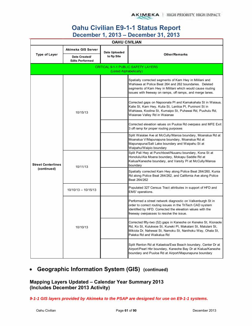
Oahu Civilian E9-1-1 Status Report December 1, 2013 – December 31, 2013
Oahu Civilian Page 61 of 90 December 2013
Geographic Information System (GIS) (continued)
Mapping Layers Updated – Calendar Year Summary 2013 (Includes December 2013 Activity) 9-1-1 GIS layers provided by Akimeka to the PSAP are designed for use on E9-1-1 systems.
Akimeka GIS Server
Date Created/ Edits Performed
Spatially corrected segments of Kam Hwy in Mililani and Wahiawa at Police Beat 264 and 262 boundaries. Deleted segments of Kam Hwy in Mililani which would cause routing issues with freeway on ramps, off ramps, and merge lanes.
Corrected gaps on Napoonala Pl and Kamakahala St in Waiaua, Kalie St, Kam Hwy, Kulia St, Laniloa Pl, Puninoni St in Wahiawa, Koolina St, Kumaipo St, Puhawai Rd, Puuhulu Rd, Waianae Valley Rd in Waianae
Corrected elevation values on Puuloa Rd overpass and MFE Exit 3 off ramp for proper routing purposes
Split Waialae Ave at McCully/Manoa boundary, Moanalua Rd at Moanalua V/Mapunapuna boundary, Moanalua Rd at Mapunapuna/Salt Lake boundary and Waipahu St at Waipahu/Waipio boundarySplit Pali Hwy at Punchbowl/Nuuanu boundary, Kona St at Honolulu/Ala Moana boundary, Mokapu Saddle Rd at Kailua/Kaneohe boundary, and Varsity Pl at McCully/Manoa boundary
Spatially corrected Kam Hwy along Police Beat 264/260, Kunia Rd along Police Beat 264/262, and California Ave along Police Beat 264/262
10/10/13 -- 10/15/13Populated 327 Census Tract attributes in support of HFD and EMS' operations.
Performed a street network diagnostic on Valkenburgh St in order to correct routing issues in the TriTech CAD system identified by HFD. Corrected the elevation values with the freeway overpasses to resolve the issue.
Corrected fifty-two (52) gaps in Kaneohe on Keneke St, Kionaole Rd, Ko St, Kulukeoe St, Kuneki Pl, Makalani St, Malulani St, Mikiola Dr, Nahewai St, Namoku St, Nanihoku Way, Ohala St, Paleka Rd and Waikalua Rd
Split Renton Rd at Kalaeloa/Ewa Beach boundary, Center Dr at Airport/Pearl Hbr boundary, Kaneohe Bay Dr at Kialua/Kaneohe boundary and Puuloa Rd at Airport/Mapunapuna boundary
Street Centerlines(continued)
10/10/13
OAHU CIVILIAN
Other/RemarksType of Layer Date Uploadedto ftp Site
10/11/13
CRITICAL 9-1-1 PUBLIC SAFETY LAYERS(Listed Alphabetically)
10/15/13

Oahu Civilian E9-1-1 Status Report December 1, 2013 – December 31, 2013
Oahu Civilian Page 62 of 90 December 2013
Geographic Information System (GIS) (continued)
Mapping Layers Updated – Calendar Year Summary 2013 (Includes December 2013 Activity) 9-1-1 GIS layers provided by Akimeka to the PSAP are designed for use on E9-1-1 systems.
Akimeka GIS Server
Date Created/ Edits Performed
10/09/13Corrected forty (40) gaps in Kaneohe on Halekou Rd, Hinapu St, Haokaa St, Hololio St, Hui Iwa St, Hulupala Pl, Kalali St, and Keaahala Rd
10/04/13 Delivered Street Centerlines data to HPD (current system), HFD (new upgrade system), and EMS (new upgrade system)
Added street ranges for Essex Rd so Barbers Point Golf Course can be located and responded to
Deleted Pau Ln and Makaoe Ln -- no longer existing. Hotel built here in Waikiki
Corrected gaps on Haamaile St, Haiku Plantation Dr, Haiku Rd and Halaulani St in Kaneohe
Corrected gaps on Kailua Rd, Lihiwai Rd and Halia St in Kailua
Spatially corrected Waialua Beach Rd, Kam Hwy, Weed Cir at Haleiwa/Waialua boundary
Split Haleiwa Rd at Police Beat boundary
09/27/13 Corrected gaps on Humupaa St
09/24/13
Populated 231 Census Tract boundaries in support of HFD and EMS operations. Added hiking trail for Koko Crater Botanical Gardens. Corrected gaps on Nakini St, Ilauhole St, and Oluolu St. Flipped segment of Arizona St to correct flipped link errors.
09/23/13 Split Managers Dr at boundary. Added street ranges for Koaleo St.
09/20/13 Delivered Street Centerlines data to HPD, HFD, and EMS
09/20/13Split Moanalua Rd, E Moanalua Fwy, and Ala Napunani at the Salt Lake boundary. Corrected gaps on Whitmore Ave, Pakui St, and Nomilo St.
Street Centerlines(continued)
10/01/13
10/03/13
OAHU CIVILIAN
Other/RemarksType of Layer Date Uploadedto ftp Site
CRITICAL 9-1-1 PUBLIC SAFETY LAYERS(Listed Alphabetically)

Oahu Civilian E9-1-1 Status Report December 1, 2013 – December 31, 2013
Oahu Civilian Page 63 of 90 December 2013
Geographic Information System (GIS) (continued)
Mapping Layers Updated – Calendar Year Summary 2013 (Includes December 2013 Activity) 9-1-1 GIS layers provided by Akimeka to the PSAP are designed for use on E9-1-1 systems.
Akimeka GIS Server
Date Created/ Edits Performed
09/17/17 Corrected gaps on Gulick Ave, Ginger St, and Glen Ave
09/13/13 Corrected gaps on Pakini St. Split Radford Dr, Namur Rd, and Marshall Rd at respective boundaries.
09/11/13 Corrected fifteen (15) gaps on Dole St, Elelupe Rd, Farmers Rd, Farrington Hwy, Forest Ridge Way, and Kamilo St
09/09/13 Corrected fifty-four (54) Flipped Link errors
09/06/13 Delivered Street Centerlines data to HPD, HFD, and EMS
09/06/13 Split Kikania St, Makakilo Dr, Center Dr, and N Nimitz Hwy at associated MSAG Community and Police Beat boundaries
Identified valid overlap on Funston Rd -- flagged as an exception
Corrected forty-seven (47) mixed parity issues
Split segments of H1W FWY, H1E FWY, and 11TH ONTO H1W
Added two (2) segments for 10th Ave underpass
09/04/13Corrected D St range on Hickam to accommodate address for HAFB Police based on HPD's approval and direction
09/03/13Corrected street name for Honolulu International Airport Departures
08/29/13 Updated AMR, Salt Lake, and NCTAMS PAC. Spatially corrected segments of Kam Hwy.
08/28/13Spatially corrected segments on Kailua Rd, Kamahele St, Kaumana Pl, Kawainui St, Kuulei Rd, Maluniu Ave, Kalaheo Ave, and Wanaao Rd.
08/27/13 Calculated cost for twenty-seven (27) new Street Centerlines. Spatially corrected segments of Pali Hwy and Kapaa Quarry Rd.
Street Centerlines(continued)
OAHU CIVILIAN
Other/RemarksType of Layer Date Uploadedto ftp Site
09/05/13
CRITICAL 9-1-1 PUBLIC SAFETY LAYERS(Listed Alphabetically)

Oahu Civilian E9-1-1 Status Report December 1, 2013 – December 31, 2013
Oahu Civilian Page 64 of 90 December 2013
Geographic Information System (GIS) (continued)
Mapping Layers Updated – Calendar Year Summary 2013 (Includes December 2013 Activity) 9-1-1 GIS layers provided by Akimeka to the PSAP are designed for use on E9-1-1 systems.
Akimeka GIS Server
Date Created/ Edits Performed
08/26/13 Spatially corrected forty-seven (47) Street Centerlines
08/23/13 Delivered Street Centerlines data to HPD, HFD, and EMS
08/23/13Increased range on Kaikohola St to accommodate new TNs -- pending approved development maps prior to feature additions
Corrected one way codes for freeway exits
Continued to populate census tract information for HFD and EMS CAD systems
Corrected gaps on Awiki St, Bell St, Boothe Rd, Carlos Long St, Center St, Claudine St, College Walk, Crater Rd, and Diamond Head Rd.
Split Luapele Dr at boundary to Makalapa
Updated streets in Makalapa
08/06/13 Added new exit for H1W Exit 27
08/01/13 -- 08/06/13
Worked on Freeway Renaming project. Corrected one way codes, elevations, and speed limits for on ramps and off ramps. Reconstructed the Honolulu International Airport on ramp and off ramp system. Completed the Freeeway Renaming project.
07/30/13Corrected street type for Pepper Row. Corrected eighteen (18) intersection issues identified in topology. This also addresses the Intrado recommendations.
07/26/13 Delivered Street Centerlines data to HPD, HFD, and EMS
Corrected right MSAG Community for Kaahumanu St
Added street names and ranges to Arizona Memorial Pl (ingress to the Arizona Memorial). Spatially corrected segment of Ford Island Blvd.
Street Centerlines(continued)
07/26/13
OAHU CIVILIAN
Other/RemarksType of Layer Date Uploadedto ftp Site
CRITICAL 9-1-1 PUBLIC SAFETY LAYERS(Listed Alphabetically)
08/16/13
08/19/13

Oahu Civilian E9-1-1 Status Report December 1, 2013 – December 31, 2013
Oahu Civilian Page 65 of 90 December 2013
Geographic Information System (GIS) (continued)
Mapping Layers Updated – Calendar Year Summary 2013 (Includes December 2013 Activity) 9-1-1 GIS layers provided by Akimeka to the PSAP are designed for use on E9-1-1 systems.
Akimeka GIS Server
Date Created/ Edits Performed
07/25/13 Spatially corrected 42 Street Centerlines in Kailua.
07/24/13
Diana Chun of EMS reported that there was an addressing issue identified for 95-1375 Wikao St that did not plot correctly in the TriTech CAD. Corrections were made to the street segment to correct the mapping issue. The length of Wikao St was extended in to the private road area so that the last house would geocode correctly. Address Points require attention and this was added to the drive list.
07/23/13 Corrected gaps on Awiki St
07/22/13Corrected gaps on Alohilani st, Anakua St, Analii ST, Anolike, Anuanu St, Apelekoa St, Apii St, Apio Ln, Armstrong St, Auina St, Aukauka Rd, Auwaiolimu St, and Awapuhi St.
07/19/13 Corrected gaps on alapai St, Alaula Way, Ala Puumalu, Alewa Dr, and Alogea Ave. Added missing ext on H2S.
07/18/13 Corrected gaps on Ala Pili Loop, Ala Noe Pl, and Alani Dr. Updated Ford Isl.
07/17/13Corrected gaps on Ala Ilima, Ala Iolani, Ala Kapua, Ala Lani, Ala Lehua, Ala Iilikoi St, Ala Mahamoe, and Ala Napunani. Flipped segments on Apuakea St. Corrected gaps on Funston St.
07/16/13 Corrected one way codes on Kalihi St
07/12/13 Delivered Street Centerlines data to HPD, HFD, and EMS
07/12/13 Corrected gaps on Lumiaina St
Updated streets in Pearl Harbor to new MSAG Community name of Pearl HBR
Re-created the trail for Makapuu Koolau Summit in order to correct a fuzzy tolerance error
Split H2N and H2S at the Waipio/Pearl City/Mililani borders. Split Plantation Dr between the Mililani and Waipio boundary.
Updated the MSAG Community attributes for Waipio, Schofield (remaining East Range) and Kahaluu
Street Centerlines(continued)
07/08/13
07/09/13
OAHU CIVILIAN
Other/RemarksType of Layer Date Uploadedto ftp Site
CRITICAL 9-1-1 PUBLIC SAFETY LAYERS(Listed Alphabetically)

Oahu Civilian E9-1-1 Status Report December 1, 2013 – December 31, 2013
Oahu Civilian Page 66 of 90 December 2013
Geographic Information System (GIS) (continued)
Mapping Layers Updated – Calendar Year Summary 2013 (Includes December 2013 Activity) 9-1-1 GIS layers provided by Akimeka to the PSAP are designed for use on E9-1-1 systems.
Akimeka GIS Server
Date Created/ Edits Performed
07/03/13 Cut street segments on Waipio Point. Spatially corrected segments of Paala Uka Pupukea Rd
07/02/13 Corrected border issues between Civilian and Military jurisdictions
07/01/13 Continued adding Census Tract information. This is an ongoing project.
06/28/13 06/28/13Split Santos Dumont Ave at Schofield boundary. Split Tinker Rd at entrance to Bellows. Spatially corrected segments of Kam Hwy in Kahaluu that were causing alignment errors.
06/27/13 Corrected spatial accuracy for segments of Macomb Rd. Split Wright Ave and LyMan Rd at entrances to Schofield.
06/26/13 Corrected ranges on Kunia Rd to include the Kahana Fou Church.
06/25/13 Calculated cost attributes.
06/24/13 Corrected parity errors on Kohea Pl.
06/21/13 Corrected MSAG Community names for Makakilo. Split segment of Nimitz Hwy at MSAG Community boundary.
06/20/13 Coded Ft St Mall as a walkway and lowered speed limit to 1 so that it remains routable.
06/19/13 -- 06/20/13Corrected the freeway names to the new naming convention as approved by HPD. Identified and classified all on ramps and off ramps.
06/18/13 -- 06/19/13
Added new hiking trail for Makapuu Koolau Summit, corrected gaps on Akamai St and Ainapo St, corrected parity errors on Forward Ave and corrected gaps on Ala Hapuu and Ala Aoloa Loop.
06/14/13
Street Centerlines(continued)
OAHU CIVILIAN
Other/RemarksType of Layer Date Uploadedto ftp Site
CRITICAL 9-1-1 PUBLIC SAFETY LAYERS(Listed Alphabetically)
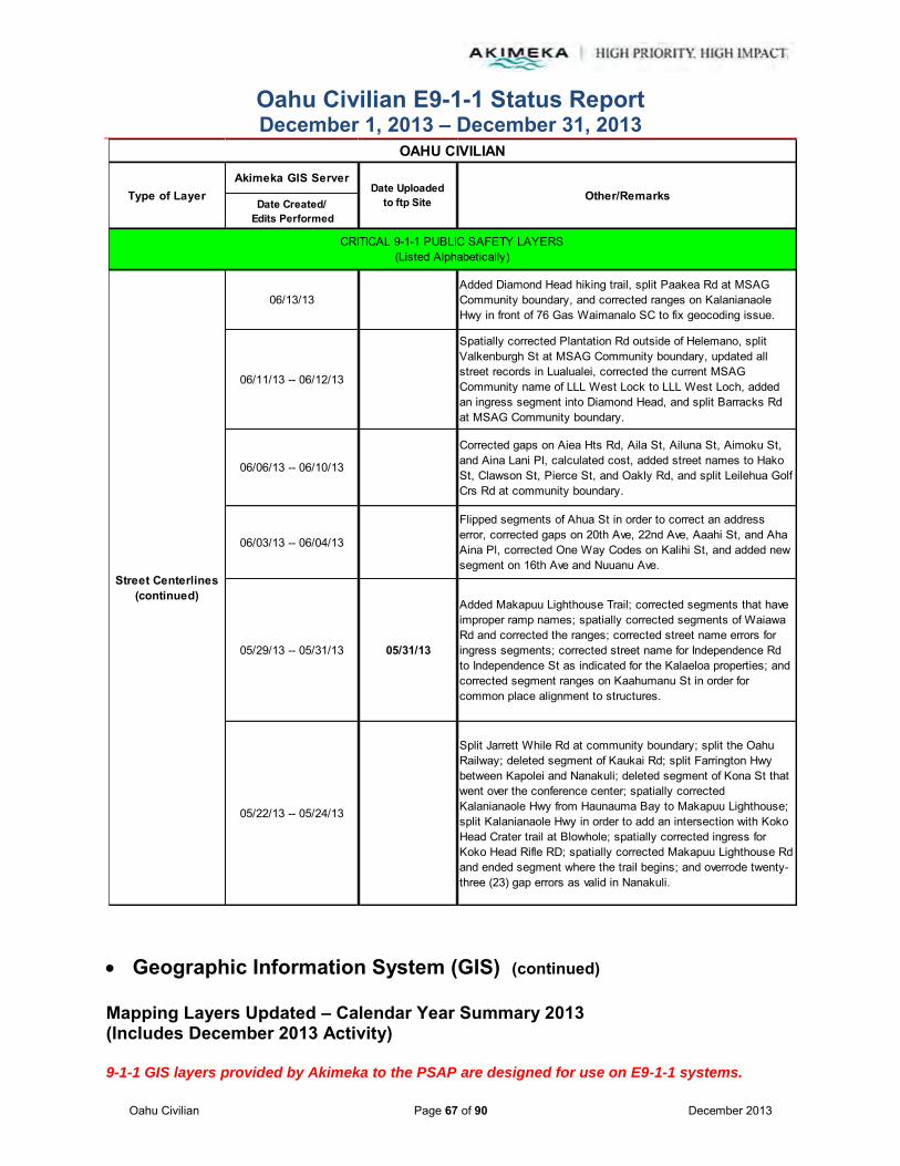
Oahu Civilian E9-1-1 Status Report December 1, 2013 – December 31, 2013
Oahu Civilian Page 67 of 90 December 2013
Geographic Information System (GIS) (continued)
Mapping Layers Updated – Calendar Year Summary 2013 (Includes December 2013 Activity) 9-1-1 GIS layers provided by Akimeka to the PSAP are designed for use on E9-1-1 systems.
Akimeka GIS Server
Date Created/ Edits Performed
06/13/13Added Diamond Head hiking trail, split Paakea Rd at MSAG Community boundary, and corrected ranges on Kalanianaole Hwy in front of 76 Gas Waimanalo SC to fix geocoding issue.
06/11/13 -- 06/12/13
Spatially corrected Plantation Rd outside of Helemano, split Valkenburgh St at MSAG Community boundary, updated all street records in Lualualei, corrected the current MSAG Community name of LLL West Lock to LLL West Loch, added an ingress segment into Diamond Head, and split Barracks Rd at MSAG Community boundary.
06/06/13 -- 06/10/13
Corrected gaps on Aiea Hts Rd, Aila St, Ailuna St, Aimoku St, and Aina Lani Pl, calculated cost, added street names to Hako St, Clawson St, Pierce St, and Oakly Rd, and split Leilehua Golf Crs Rd at community boundary.
06/03/13 -- 06/04/13
Flipped segments of Ahua St in order to correct an address error, corrected gaps on 20th Ave, 22nd Ave, Aaahi St, and Aha Aina Pl, corrected One Way Codes on Kalihi St, and added new segment on 16th Ave and Nuuanu Ave.
05/29/13 -- 05/31/13 05/31/13
Added Makapuu Lighthouse Trail; corrected segments that have improper ramp names; spatially corrected segments of Waiawa Rd and corrected the ranges; corrected street name errors for ingress segments; corrected street name for Independence Rd to Independence St as indicated for the Kalaeloa properties; and corrected segment ranges on Kaahumanu St in order for common place alignment to structures.
05/22/13 -- 05/24/13
Split Jarrett While Rd at community boundary; split the Oahu Railway; deleted segment of Kaukai Rd; split Farrington Hwy between Kapolei and Nanakuli; deleted segment of Kona St that went over the conference center; spatially corrected Kalanianaole Hwy from Haunauma Bay to Makapuu Lighthouse; split Kalanianaole Hwy in order to add an intersection with Koko Head Crater trail at Blowhole; spatially corrected ingress for Koko Head Rifle RD; spatially corrected Makapuu Lighthouse Rd and ended segment where the trail begins; and overrode twenty-three (23) gap errors as valid in Nanakuli.
Street Centerlines(continued)
OAHU CIVILIAN
Other/RemarksType of Layer Date Uploadedto ftp Site
CRITICAL 9-1-1 PUBLIC SAFETY LAYERS(Listed Alphabetically)
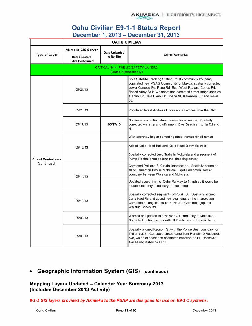
Oahu Civilian E9-1-1 Status Report December 1, 2013 – December 31, 2013
Oahu Civilian Page 68 of 90 December 2013
Geographic Information System (GIS) (continued)
Mapping Layers Updated – Calendar Year Summary 2013 (Includes December 2013 Activity) 9-1-1 GIS layers provided by Akimeka to the PSAP are designed for use on E9-1-1 systems.
Akimeka GIS Server
Date Created/ Edits Performed
05/21/13
Split Satellite Tracking Station Rd at community boundary; populated new MSAG Community of Makua; spatially corrected Lower Campus Rd, Pope Rd, East West Rd, and Correa Rd; flipped Army St in Waianae; and corrected street range gaps on Alamihi St, Hale Ekahi Dr, Hoaha St, Kamailenu St and Kawili St.
05/20/13 Populated latest Address Errors and Overrides from the CAD
05/17/13 05/17/13Continued correcting street names for all ramps. Spatially corrected on ramp and off ramp in Ewa Beach at Kunia Rd and H1.
With approval, began correcting street names for all ramps
Added Koko Head Rail and Koko Head Blowhole trails
Spatially corrected Jeep Trails in Mokuleia and a segment of Pump Rd that crossed over the shopping center
Corrected Pali and S Kuakini intersection. Spatially corrected all of Farrington Hwy in Mokuleia. Split Farrington Hwy at boundary between Waialua and Mokuleia.
Updated speed limit for Oahu Railway to 1 mph so it would be routable but only secondary to main roads
05/10/13
Spatially corrected segments of Puuiki St. Spatially aligned Cane Haul Rd and added new segments at the intersection. Corrected routing issues on Kaiwi St. Corrected gaps on Waialua Beach Rd.
05/09/13 Worked on updates to new MSAG Community of Mokuleia. Corrected routing issues with HFD vehicles on Hawaii Kai Dr.
05/08/13
Spatially aligned Kaonohi St with the Police Beat boundary for 375 and 378. Corrected street name from Franklin D Roosevelt Ave, which exceeds the character limitation, to FD Roosevelt Ave as requested by HPD.
Street Centerlines(continued)
OAHU CIVILIAN
Other/RemarksType of Layer Date Uploadedto ftp Site
05/16/13
05/14/13
CRITICAL 9-1-1 PUBLIC SAFETY LAYERS(Listed Alphabetically)
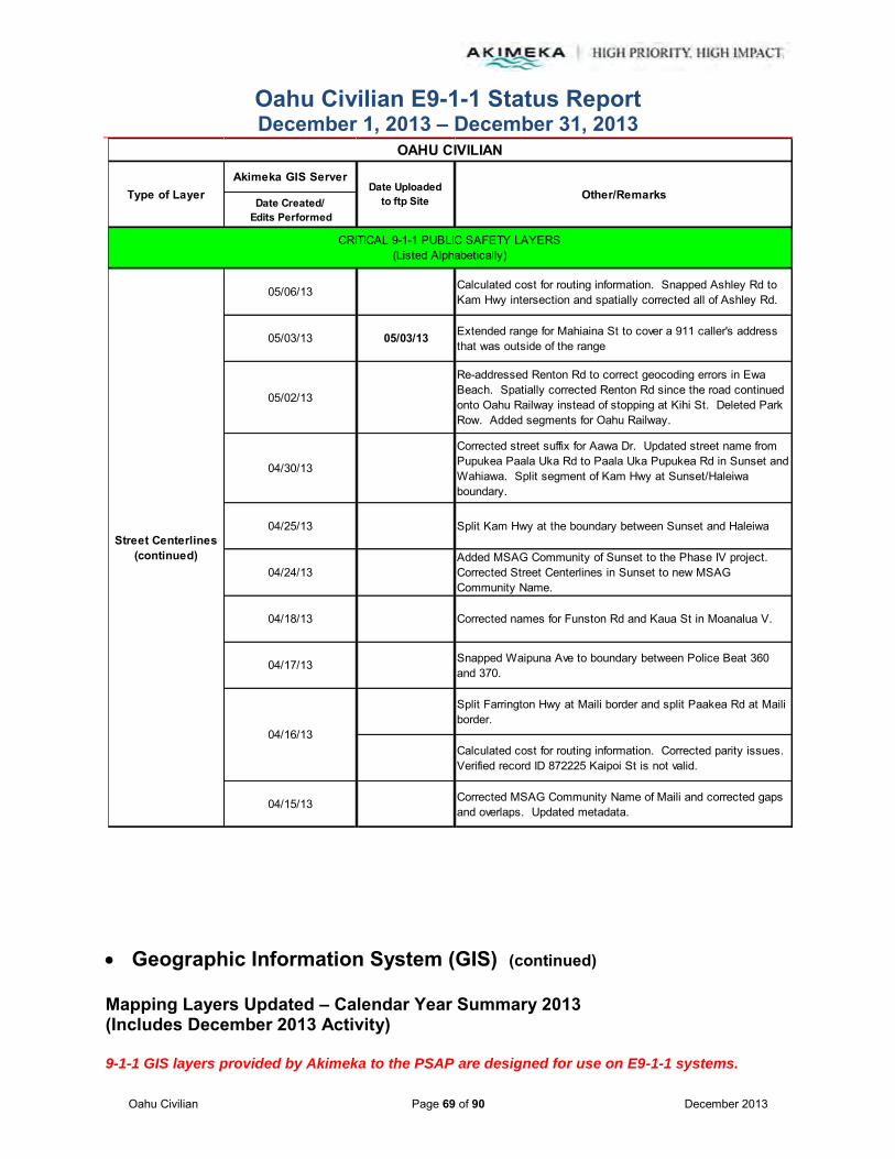
Oahu Civilian E9-1-1 Status Report December 1, 2013 – December 31, 2013
Oahu Civilian Page 69 of 90 December 2013
Geographic Information System (GIS) (continued)
Mapping Layers Updated – Calendar Year Summary 2013 (Includes December 2013 Activity) 9-1-1 GIS layers provided by Akimeka to the PSAP are designed for use on E9-1-1 systems.
Akimeka GIS Server
Date Created/ Edits Performed
05/06/13 Calculated cost for routing information. Snapped Ashley Rd to Kam Hwy intersection and spatially corrected all of Ashley Rd.
05/03/13 05/03/13 Extended range for Mahiaina St to cover a 911 caller's address that was outside of the range
05/02/13
Re-addressed Renton Rd to correct geocoding errors in Ewa Beach. Spatially corrected Renton Rd since the road continued onto Oahu Railway instead of stopping at Kihi St. Deleted Park Row. Added segments for Oahu Railway.
04/30/13
Corrected street suffix for Aawa Dr. Updated street name from Pupukea Paala Uka Rd to Paala Uka Pupukea Rd in Sunset and Wahiawa. Split segment of Kam Hwy at Sunset/Haleiwa boundary.
04/25/13 Split Kam Hwy at the boundary between Sunset and Haleiwa
04/24/13Added MSAG Community of Sunset to the Phase IV project. Corrected Street Centerlines in Sunset to new MSAG Community Name.
04/18/13 Corrected names for Funston Rd and Kaua St in Moanalua V.
04/17/13 Snapped Waipuna Ave to boundary between Police Beat 360 and 370.
Split Farrington Hwy at Maili border and split Paakea Rd at Maili border.
Calculated cost for routing information. Corrected parity issues. Verified record ID 872225 Kaipoi St is not valid.
04/15/13 Corrected MSAG Community Name of Maili and corrected gaps and overlaps. Updated metadata.
Street Centerlines(continued)
04/16/13
OAHU CIVILIAN
Other/RemarksType of Layer Date Uploadedto ftp Site
CRITICAL 9-1-1 PUBLIC SAFETY LAYERS(Listed Alphabetically)

Oahu Civilian E9-1-1 Status Report December 1, 2013 – December 31, 2013
Oahu Civilian Page 70 of 90 December 2013
Geographic Information System (GIS) (continued)
Mapping Layers Updated – Calendar Year Summary 2013 (Includes December 2013 Activity) 9-1-1 GIS layers provided by Akimeka to the PSAP are designed for use on E9-1-1 systems.
Akimeka GIS Server
Date Created/ Edits Performed
04/11/13 -- 04/12/13 Added new developments identified from latest DPP maps. Worked on adding census tract data.
04/04/13
Deleted two (2) segments on Center Dr in Hale Moku that were in the middle of a valid street range. Deleted Casablanca St and corrected ranges on Old Fort Weaver Rd. Populated Street Owner information for the TriTech centerline export at the request of Mike Ito from HPD Stats.
04/03/13 Flipped ranges for Kaonohi St and Bennington St and deleted bogus segment on Keana Rd. Corrected gaps on Wilikina Dr.
04/02/13 Worked on overlap issues and error overrides. Continued work on the tract census data inputs.
Added new street segments in new Awakea at Mehana development and spatially corrected segments for Aawa Dr due to routing issues.
Populated the census tract date at the request of EMS. Eliminated the Point in Polygon ((PnP).
03/25/13 Snapped Kamakila to Renton Rd intersection
03/21/13 Corrected street ranges for Kam Hwy on Kipapa Bridge. Split segments at the MSAG Community boundary.
03/20/13 Spatially corrected street segments of Farrington Hwy toward Kaena Point
03/18/13Corrected MSAG Community name for streets in the new MSAG Community of Makaha. Split Kaulawaha Rd at the MSAG Community boundary.
Extended Ala Puumalu street segment to correct geocoding errors
Split E H1 FWY, W H1 FWY, and E Moanalua FWY segments at the Police Beat boundaries
Corrected gaps on Moanalua Rd in Pearl City and on Arizona Rd in Halsey T. Corrected ranges on Beach Walk in order to correct an error identified in the TCAD report.
Street Centerlines(continued)
03/14/13
OAHU CIVILIAN
Other/RemarksType of Layer Date Uploadedto ftp Site
CRITICAL 9-1-1 PUBLIC SAFETY LAYERS(Listed Alphabetically)
04/01/13
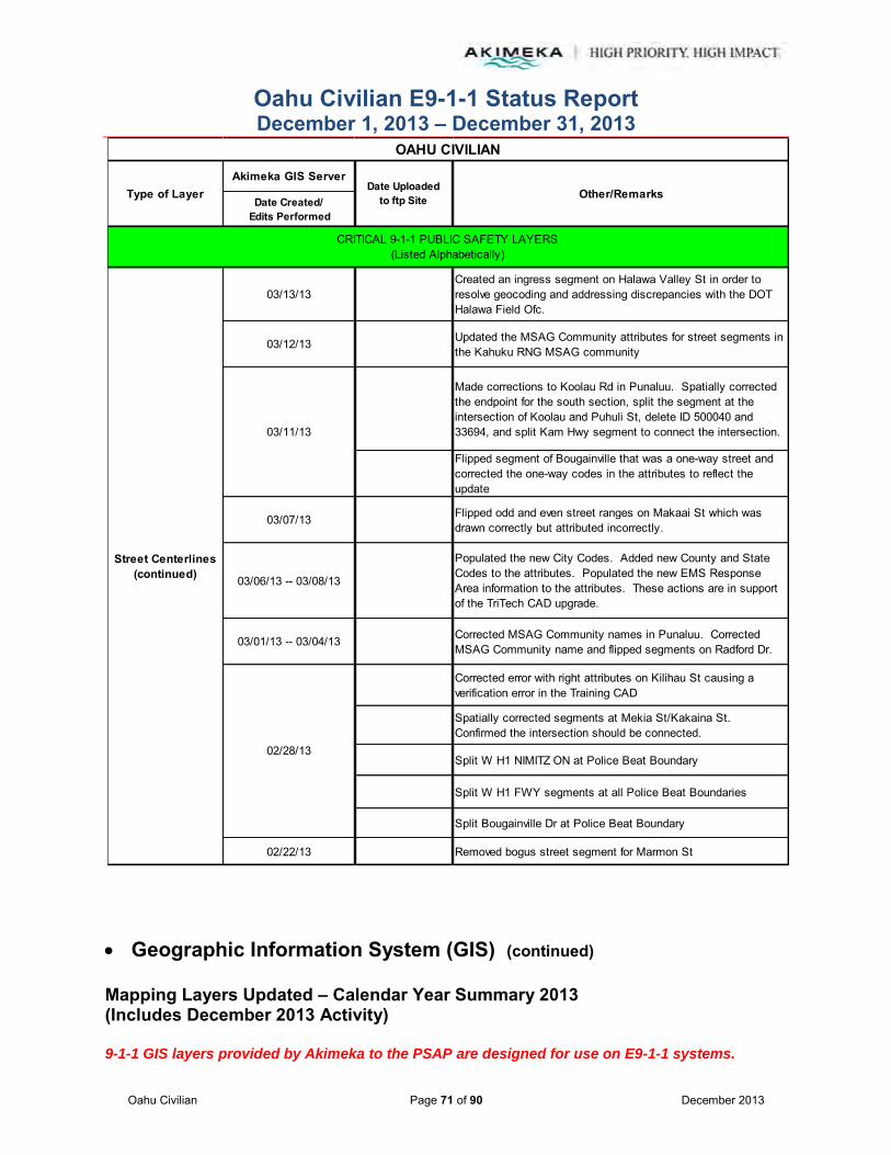
Oahu Civilian E9-1-1 Status Report December 1, 2013 – December 31, 2013
Oahu Civilian Page 71 of 90 December 2013
Geographic Information System (GIS) (continued)
Mapping Layers Updated – Calendar Year Summary 2013 (Includes December 2013 Activity) 9-1-1 GIS layers provided by Akimeka to the PSAP are designed for use on E9-1-1 systems.
Akimeka GIS Server
Date Created/ Edits Performed
03/13/13Created an ingress segment on Halawa Valley St in order to resolve geocoding and addressing discrepancies with the DOT Halawa Field Ofc.
03/12/13 Updated the MSAG Community attributes for street segments in the Kahuku RNG MSAG community
Made corrections to Koolau Rd in Punaluu. Spatially corrected the endpoint for the south section, split the segment at the intersection of Koolau and Puhuli St, delete ID 500040 and 33694, and split Kam Hwy segment to connect the intersection.
Flipped segment of Bougainville that was a one-way street and corrected the one-way codes in the attributes to reflect the update
03/07/13 Flipped odd and even street ranges on Makaai St which was drawn correctly but attributed incorrectly.
03/06/13 -- 03/08/13
Populated the new City Codes. Added new County and State Codes to the attributes. Populated the new EMS Response Area information to the attributes. These actions are in support of the TriTech CAD upgrade.
03/01/13 -- 03/04/13 Corrected MSAG Community names in Punaluu. Corrected MSAG Community name and flipped segments on Radford Dr.
Corrected error with right attributes on Kilihau St causing a verification error in the Training CAD
Spatially corrected segments at Mekia St/Kakaina St. Confirmed the intersection should be connected.
Split W H1 NIMITZ ON at Police Beat Boundary
Split W H1 FWY segments at all Police Beat Boundaries
Split Bougainville Dr at Police Beat Boundary
02/22/13 Removed bogus street segment for Marmon St
Street Centerlines(continued)
03/11/13
02/28/13
OAHU CIVILIAN
Other/RemarksType of Layer Date Uploadedto ftp Site
CRITICAL 9-1-1 PUBLIC SAFETY LAYERS(Listed Alphabetically)
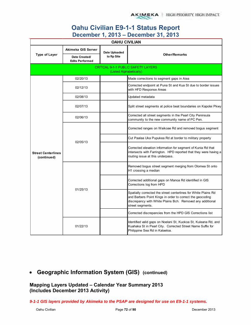
Oahu Civilian E9-1-1 Status Report December 1, 2013 – December 31, 2013
Oahu Civilian Page 72 of 90 December 2013
Geographic Information System (GIS) (continued)
Mapping Layers Updated – Calendar Year Summary 2013 (Includes December 2013 Activity) 9-1-1 GIS layers provided by Akimeka to the PSAP are designed for use on E9-1-1 systems.
Akimeka GIS Server
Date Created/ Edits Performed
02/20/13 Made corrections to segment gaps in Aiea
02/12/13Corrected endpoint at Puna St and Kua St due to border issues with HFD Response Areas
02/08/13 Updated metadata
02/07/13 Split street segments at police beat boundaries on Kapolei Pkwy
02/06/13 Corrected all street segments in the Pearl City Peninsula community to the new community name of PC Pen.
Corrected ranges on Waikoae Rd and removed bogus segment
Cut Paalaa Uka Pupukea Rd at border to military property
Corrected elevation information for segment of Kunia Rd that intersects with Farrington. HPD reported that they were having a routing issue at this underpass.
Removed bogus street segment merging from Olomea St onto H1 crossing a median
Corrected additional gaps on Manoa Rd identified in GIS Corrections log from HPD
Spatially corrected the street centerlines for White Plains Rd and Barbers Point Kings in order to correct the geocoding discrepancy with White Plains Bch. Removed any additional street segments.
Corrected discrepancies from the HPD GIS Corrections list
01/22/13Identified valid gaps on Noelani St, Kuokoa St, Kuleana Rd, and Kuahaka St in Pearl City. Corrected Street Name Suffix for Philippine Sea Rd in Kalaeloa.
Street Centerlines(continued)
01/25/13
02/05/13
OAHU CIVILIAN
Other/RemarksType of Layer Date Uploadedto ftp Site
CRITICAL 9-1-1 PUBLIC SAFETY LAYERS(Listed Alphabetically)

Oahu Civilian E9-1-1 Status Report December 1, 2013 – December 31, 2013
Oahu Civilian Page 73 of 90 December 2013
Geographic Information System (GIS) (continued)
Mapping Layers Updated – Calendar Year Summary 2013 (Includes December 2013 Activity) 9-1-1 GIS layers provided by Akimeka to the PSAP are designed for use on E9-1-1 systems.
Akimeka GIS Server
Date Created/ Edits Performed
01/18/13 Corrected gaps in Aiea
01/17/13 -- 01/18/13 Corrected gaps in Pearl City
Added a field to the Master Street Centerlines in order to identify "true" exceptions from the MSAG database compare such as freeways and ingress segments
Added Street Ownership field to the attributes and populated City, Federal, Ingress, Private, and MSAG streets
Split ten (10) street segments on H1 where crossing police boundary at Pearl City borders and assigned new Akimeka Unique ID
Added street ranges to thirteen (13) street segments on Kikani St in Halawa. These were previously blank-to-blank ranges.
Completed creating the Ko Olina Exit in Kapolei. Edited the elevation attributes to identify overpasses and underpasses for routing purposes.
Split Waipuna Ave at Police Beat boundary
Created new on ramp and off ramp at Aliinui Dr and Farrington Hwy for Ko Olina Exit. Modified segment ranges since there are nineteen (19) new street segments that make up the merging lanes, lane splits, ramps and overpasses.
01/09/13Corrected ranges for Nou St in Makakilo due to bad addressing in the Makakilo Cliffs apartment complex
Split street segments crossing Police boundaries in Pearl City, Kapolei and Waipahu
Corrected segments at a new boundary between Pearl City and Waipahu
Corrected a segment break on Lusitana St which was creating a routing issue
01/02/13 Corrected gaps on streets in Pearl City
Street Centerlines (continued)
01/16/13
01/08/13
01/10/13
OAHU CIVILIAN
Other/RemarksType of Layer Date Uploadedto ftp Site
CRITICAL 9-1-1 PUBLIC SAFETY LAYERS(Listed Alphabetically)
01/11/13

Oahu Civilian E9-1-1 Status Report December 1, 2013 – December 31, 2013
Oahu Civilian Page 74 of 90 December 2013
Geographic Information System (GIS) (continued)
Mapping Layers Updated – Calendar Year Summary 2013 (Includes December 2013 Activity) 9-1-1 GIS layers provided by Akimeka to the PSAP are designed for use on E9-1-1 systems.
Akimeka GIS Server
Date Created/ Edits Performed
08/19/13Removed special character and corrected the name of one (1) Hiking Trail record
08/15/13 Removed special characters from seventy-five (75) Hiking Trail records and corrected the name of sixty-seven (67).
12/30/1312/23/1312/16/1312/09/13
12/09/13 Per AT&T CRS12/06/13 Per VZW CRS12/05/13 Per AT&T CRS12/03/13 Per AT&T CRS
12/02/1311/26/13
11/22/13 Per T-Mobile CRS11/18/1311/12/1311/04/1310/28/13
10/25/13 Per T-Mobile CRS10/23/13 Per AT&T Mobility CRS
10/21/1310/21/13 Per AT&T Mobility CRS10/15/13 Per AT&T Mobility CRS
10/15/1310/09/13
10/02/13 Per AT&T Mobility CRS10/01/13
09/27/13 Per AT&T Mobility CRS
WSP Cell Sectors
Trails
OAHU CIVILIAN
Other/RemarksType of Layer Date Uploadedto ftp Site
CRITICAL 9-1-1 PUBLIC SAFETY LAYERS(Listed Alphabetically)

Oahu Civilian E9-1-1 Status Report December 1, 2013 – December 31, 2013
Oahu Civilian Page 75 of 90 December 2013
Geographic Information System (GIS) (continued)
Mapping Layers Updated – Calendar Year Summary 2013 (Includes December 2013 Activity) 9-1-1 GIS layers provided by Akimeka to the PSAP are designed for use on E9-1-1 systems.
Akimeka GIS Server
Date Created/ Edits Performed
09/23/1309/17/13 Per VZW CRS
09/16/1309/12/13 Per Sprint CRS
09/09/1309/04/13
08/27/13 Per VZW CRS08/26/13
Per T-Mobile CRSPer VZW CRS
08/23/13 Per AT&T Mobility CRS08/19/13
08/14/13 Per VZW CRS08/13/13
08/05/13 08/05/13 Per VZW CRS07/30/13
07/25/13 -- 07/26/13 Per AT&T Mobility CRS07/22/13
Per AT&T Mobility CRSPer Nextel CRS/Annual Audit
07/15/1307/10/13 Per Sprint CRS
07/08/1307/05/13 Per Sprint CRS07/03/13 Per Mobi PCS CRS
07/01/1306/24/13
06/20/13 Per VZW CRS06/17/13
06/10/13 06/10/13 Per VZW CRS06/05/13 Per VZW CRS
06/03/13
WSP Cell Sectors
07/18/13
08/26/13
OAHU CIVILIAN
Other/RemarksType of Layer Date Uploadedto ftp Site
CRITICAL 9-1-1 PUBLIC SAFETY LAYERS(Listed Alphabetically)

Oahu Civilian E9-1-1 Status Report December 1, 2013 – December 31, 2013
Oahu Civilian Page 76 of 90 December 2013
Geographic Information System (GIS) (continued)
Mapping Layers Updated – Calendar Year Summary 2013 (Includes December 2013 Activity) 9-1-1 GIS layers provided by Akimeka to the PSAP are designed for use on E9-1-1 systems.
Akimeka GIS Server
Date Created/ Edits Performed
12/30/1312/23/1312/16/1312/09/13
12/09/13 Per AT&T CRS12/06/13 Per VZW CRS12/05/13 Per AT&T CRS12/03/13 Per AT&T CRS
12/02/1311/16/13
11/22/13 Per T-Mobile CRS11/18/1311/12/1311/04/1310/28/13
10/25/13 Per T-Mobile CRS10/23/13 Per AT&T Mobility CRS
10/21/1310/21/13 Per AT&T Mobility CRS10/15/13 Per AT&T Mobility CRS
10/15/1310/09/13
10/02/13 Per AT&T Mobility CRS10/01/13
09/27/13 Per AT&T Mobility CRS09/23/13
09/17/13 Per VZW CRS09/16/13
09/12/13 Per Sprint CRS09/09/1309/04/13
WSP Cell Towers
OAHU CIVILIAN
Other/RemarksType of Layer Date Uploadedto ftp Site
CRITICAL 9-1-1 PUBLIC SAFETY LAYERS(Listed Alphabetically)
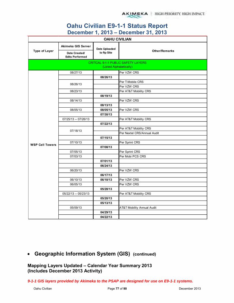
Oahu Civilian E9-1-1 Status Report December 1, 2013 – December 31, 2013
Oahu Civilian Page 77 of 90 December 2013
Geographic Information System (GIS) (continued)
Mapping Layers Updated – Calendar Year Summary 2013 (Includes December 2013 Activity) 9-1-1 GIS layers provided by Akimeka to the PSAP are designed for use on E9-1-1 systems.
Akimeka GIS Server
Date Created/ Edits Performed
08/27/13 Per VZW CRS08/26/13
Per T-Mobile CRSPer VZW CRS
08/23/13 Per AT&T Mobility CRS08/19/13
08/14/13 Per VZW CRS08/13/13
08/05/13 08/05/13 Per VZW CRS07/30/13
07/25/13 -- 07/26/13 Per AT&T Mobility CRS07/22/13
Per AT&T Mobility CRSPer Nextel CRS/Annual Audit
07/15/1307/10/13 Per Sprint CRS
07/08/1307/05/13 Per Sprint CRS07/03/13 Per Mobi PCS CRS
07/01/1306/24/13
06/20/13 Per VZW CRS06/17/13
06/10/13 06/10/13 Per VZW CRS06/05/13 Per VZW CRS
05/28/1305/22/13 -- 05/23/13 Per AT&T Mobility CRS
05/20/1305/13/13
05/09/13 AT&T Mobility Annual Audit04/29/1304/22/13
WSP Cell Towers
07/18/13
08/26/13
OAHU CIVILIAN
Other/RemarksType of Layer Date Uploadedto ftp Site
CRITICAL 9-1-1 PUBLIC SAFETY LAYERS(Listed Alphabetically)

Oahu Civilian E9-1-1 Status Report December 1, 2013 – December 31, 2013
Oahu Civilian Page 78 of 90 December 2013
Geographic Information System (GIS) (continued)
Mapping Layers Updated – Calendar Year Summary 2013 (Includes December 2013 Activity) 9-1-1 GIS layers provided by Akimeka to the PSAP are designed for use on E9-1-1 systems.
Akimeka GIS Server
Date Created/ Edits Performed
04/19/13 Corrected Tower IDs04/18/13 Per AT&T Mobility CRS04/17/13 AT&T Mobility Annual Audit04/16/13 Per AT&T Mobility CRS
Per Sprint CRSPer AT&T Mobility CRSPer VZW CRS
04/12/13 AT&T Mobility Annual Audit04/04/13 Per VZW CRS
04/01/13 -- 04/02/13 VZW Annual Audit04/01/13
T-Mobile Annual AuditPer AT&T Mobility CRS
03/22/13 Per VZW CRS03/20/13 Corrected Community Name for Sprint towers
03/18/13Per AT&T Mobility CRSPer VZW CRSNextel Annual Audit
03/04/13 Per VZW CRS03/01/13 Sprint Annual Audit02/27/13 Per Sprint CRS02/22/13 Per AT&T Mobility CRS02/20/13 Per AT&T Mobility CRS02/07/13 Per Mobi PCS CRS
02/04/13 -- 02/05/13 Per VZW CRS01/29/13 Mobi PCS Annual Audit01/28/1301/25/1301/25/13 Per Mobi PCS CRS01/18/13 Per T-Mobile CRS01/18/1301/15/1301/04/13
WSP Cell Towers
Per VZW CRS
03/25/13
Per VZW CRS
04/15/13
03/05/13
03/25/13
OAHU CIVILIAN
Other/RemarksType of Layer Date Uploadedto ftp Site
CRITICAL 9-1-1 PUBLIC SAFETY LAYERS(Listed Alphabetically)
04/15/13

Oahu Civilian E9-1-1 Status Report December 1, 2013 – December 31, 2013
Oahu Civilian Page 79 of 90 December 2013
Geographic Information System (GIS) (continued)
Mapping Layers Updated – Calendar Year Summary 2013 (Includes December 2013 Activity) 9-1-1 GIS layers provided by Akimeka to the PSAP are designed for use on E9-1-1 systems.
Akimeka GIS Server
Date Created/ Edits Performed
08/16/13Removed special characters from eight (8) Hospital records. Deleted and re-created Kaiser Kahuku Clinic record with complete attributes.
08/19/13Removed special characters from five (5) Lifeguard Tower names and a trailing space from one (1) name.
11/29/13Converted two (2) KMZ files per Ocean Safety into DiveLocation and SurfBreak shapefiles respectively.
Populated metadata and attributes for Dive Locations and removed special characters from eight (8) names
Parsed out Dive Locations by County for the State of Hawaii
10/28/13Created a Dive Locations shapefile in support of Ocean Safety operations
Dive Locations
Hospitals
Food & Beverage
OTHER SUPPORTING 9-1-1 PUBLIC SAFETY LAYERS(Listed Alphabetically)
Churches
Medical Facilities
Lodging
Ocean Rescue Boundaries
Ocean Safety(Includes Lifeguard
Stands)
Gas Stations
OAHU CIVILIAN
Other/RemarksType of Layer Date Uploadedto ftp Site
CRITICAL 9-1-1 PUBLIC SAFETY LAYERS(Listed Alphabetically)
10/31/13
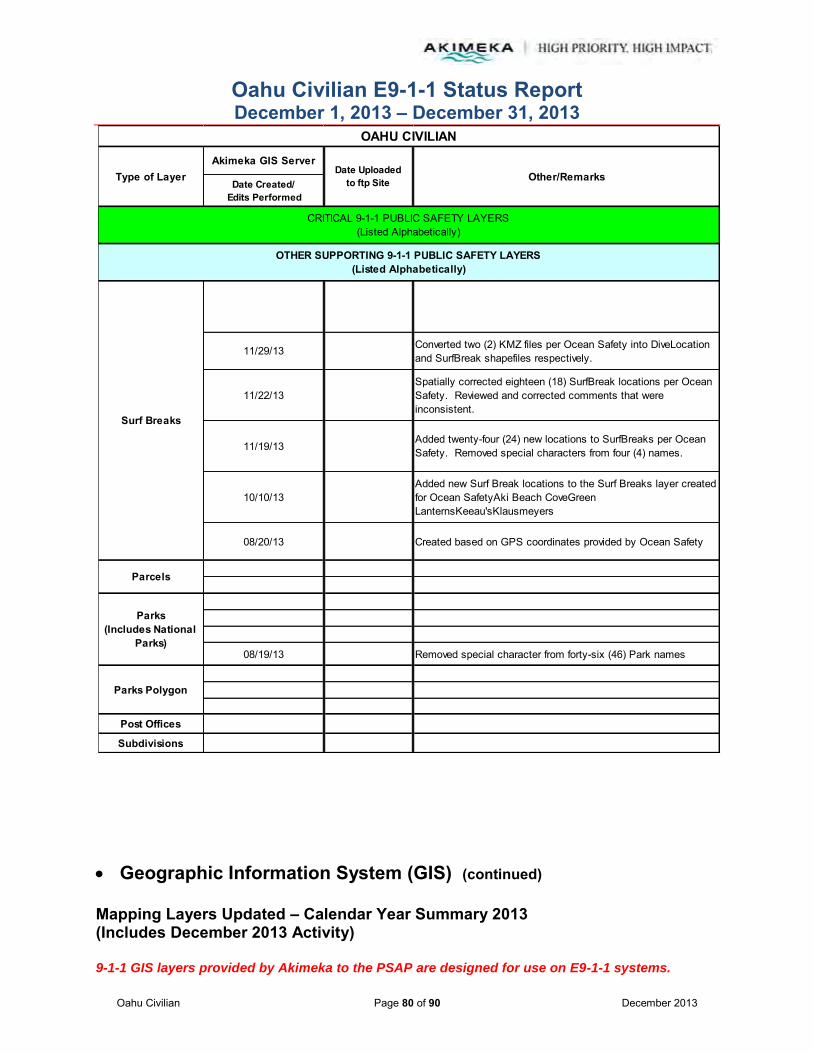
Oahu Civilian E9-1-1 Status Report December 1, 2013 – December 31, 2013
Oahu Civilian Page 80 of 90 December 2013
Geographic Information System (GIS) (continued)
Mapping Layers Updated – Calendar Year Summary 2013 (Includes December 2013 Activity) 9-1-1 GIS layers provided by Akimeka to the PSAP are designed for use on E9-1-1 systems.
Akimeka GIS Server
Date Created/ Edits Performed
11/29/13 Converted two (2) KMZ files per Ocean Safety into DiveLocation and SurfBreak shapefiles respectively.
11/22/13Spatially corrected eighteen (18) SurfBreak locations per Ocean Safety. Reviewed and corrected comments that were inconsistent.
11/19/13Added twenty-four (24) new locations to SurfBreaks per Ocean Safety. Removed special characters from four (4) names.
10/10/13Added new Surf Break locations to the Surf Breaks layer created for Ocean SafetyAki Beach CoveGreen LanternsKeeau'sKlausmeyers
08/20/13 Created based on GPS coordinates provided by Ocean Safety
08/19/13 Removed special character from forty-six (46) Park names
Post Offices
Subdivisions
Parcels
OTHER SUPPORTING 9-1-1 PUBLIC SAFETY LAYERS(Listed Alphabetically)
Parks Polygon
Parks(Includes National
Parks)
Surf Breaks
OAHU CIVILIAN
Other/RemarksType of Layer Date Uploadedto ftp Site
CRITICAL 9-1-1 PUBLIC SAFETY LAYERS(Listed Alphabetically)

Oahu Civilian E9-1-1 Status Report December 1, 2013 – December 31, 2013
Oahu Civilian Page 81 of 90 December 2013
Geographic Information System (GIS) (continued)
Mapping Layers Updated – Calendar Year Summary 2013 (Includes December 2013 Activity) 9-1-1 GIS layers provided by Akimeka to the PSAP are designed for use on E9-1-1 systems.
Akimeka GIS Server
Date Created/ Edits Performed
Bridges
Coastline
Hydrology Layers
08/16/13 Removed special characters from six (6) Dam records
DISASTER/HOMELAND SECURITY LAYERS(Listed Alphabetically)
Helipads
Government Buildings
Coastal Names
Airports
Critical Infrastructure
- Streams (Includes Rivers)
- Dams
- Ponds
Emergency Shelters
OAHU CIVILIAN
Other/RemarksType of Layer Date Uploadedto ftp Site
CRITICAL 9-1-1 PUBLIC SAFETY LAYERS(Listed Alphabetically)
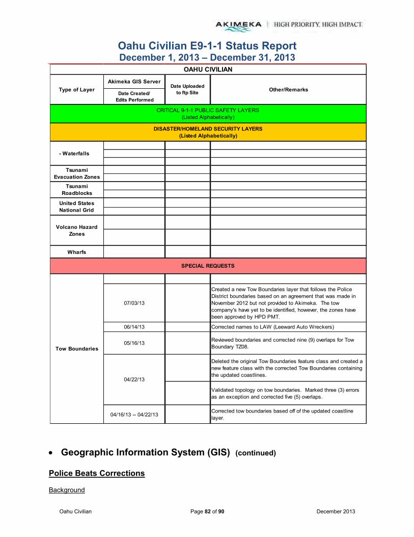
Oahu Civilian E9-1-1 Status Report December 1, 2013 – December 31, 2013
Oahu Civilian Page 82 of 90 December 2013
Geographic Information System (GIS) (continued)
Police Beats Corrections
Background
Akimeka GIS Server
Date Created/ Edits Performed
Wharfs
07/03/13
Created a new Tow Boundaries layer that follows the Police District boundaries based on an agreement that was made in November 2012 but not provided to Akimeka. The tow company's have yet to be identified, however, the zones have been approved by HPD PMT.
06/14/13 Corrected names to LAW (Leeward Auto Wreckers)
05/16/13 Reviewed boundaries and corrected nine (9) overlaps for Tow Boundary TZ08.
Deleted the original Tow Boundaries feature class and created a new feature class with the corrected Tow Boundaries containing the updated coastlines.
Validated topology on tow boundaries. Marked three (3) errors as an exception and corrected five (5) overlaps.
04/16/13 -- 04/22/13Corrected tow boundaries based off of the updated coastline layer.
DISASTER/HOMELAND SECURITY LAYERS(Listed Alphabetically)
Volcano Hazard Zones
04/22/13
SPECIAL REQUESTS
Tsunami Evacuation Zones
Tsunami Roadblocks
- Waterfalls
United States National Grid
Tow Boundaries
OAHU CIVILIAN
Other/RemarksType of Layer Date Uploadedto ftp Site
CRITICAL 9-1-1 PUBLIC SAFETY LAYERS(Listed Alphabetically)
Oahu Civilian E9-1-1 Status Report December 1, 2013 – December 31, 2013
Oahu Civilian Page 83 of 90 December 2013
The Police Beats was previously identified as a layer requiring corrective action in preparation for the ESZ/ESN project and ensuring spatial accuracy.
Subsequent to the Police Beat corrections that took place during the month of August 2013, upon loading the GIS data for Street Centerlines in the current Motorola Premier CAD, HPD PMT confirmed that there were no issues with regards to the CAD system recommendations. HPD PMT also reviewed the Police Beats corrections worksheet and confirmed that there were no issues with the document. As such, Akimeka proceeded to make corrections to the Police Beats layer utilizing HPD’s written Policies and Procedures document for boundary descriptions.
Status To Date
Based on HPD PMT’s confirmation, Akimeka continued to make corrections to the Police Beats during the month of December 2013. Akimeka completed an additional two (2) Police Beats (252 and 250) boundary corrections which completes all corrections required for District 2 (Central Oahu).
Upload Process
It was agreed that the Police Beats layer will not be uploaded to the current Motorola CAD system and will only be uploaded to the new Motorola PremierOne CAD system. Although the Police Beats layer (with the corrections) will not be uploaded to the current CAD system, the Street Centerlines are impacted by these boundary updates.
As such, Akimeka assisted with creating a new upload process which mirrors a step similar to the updates with the MSAG Communities. The new process was run successfully in November 2013, and has been successful throughout December 2013. In addition, the new upload process for the Premier CAD, also resolved other discrepancies with recommendations which were previously identified. It was agreed that this new process will be implemented and used going forward. Subsequent to this process improvement, there have been no issues and the Police Beat corrections project continues to move forward.

Oahu Civilian E9-1-1 Status Report December 1, 2013 – December 31, 2013
Oahu Civilian Page 84 of 90 December 2013
Geographic Information System (GIS) (continued)
Motorola PremierOne CAD
On December 4, 2013 HPD, Akimeka and Motorola met to hold discussions with regards to GIS data and the Premier One CAD system. Prior to the December 4, 2013 meeting, a discrepancy was identified by HPD with address validation in Premier One, where subsequently Motorola identified some discrepancy with regards to Zip Code attributes in the Street Centerline data causing an issue with address validation. Once it was brought to Akimeka’s attention, they performed the necessary research and analysis of the data and determined the incorrect zip codes were existent in the old zip code layer and were being geoprocessed during the upload process in the current CAD, causing the incorrect attribution. The layer had since been corrected using the new Zip Code layer Akimeka had created earlier in 2013. Also prior to the December 4, 2013 meeting Akimeka stated that the data for Premier One CAD has been in State Plane as requested by Motorola last year, and since that time Akimeka has identified major discrepancies in the system using this coordinate system in Premier One and brought this to HPD and Motorola’s attention. Motorola agreed with the concerns on December 4, 2013 and requested that it be delivered in WGS84 moving forward, which was Akimeka’s original recommendation in 2012 which at that time was declined by Motorola. In preparation for the December 4, 2013 meeting, Akimeka prepared the latest GIS data to be uploaded in the Premier One CAD. 1. Potential routing issues were identified by Motorola during the December 4, 2013 meeting.
Motorola stated that when routing, there is a 40FT buffer that is applied. When Address Points and Common Places are placed outside of that 40ft buffer from Street Centerlines, routing may come up as unavailable.
a. Akimeka noted that the NENA industry standard for spatial accuracy is for addresses to be spatially accurate by 10FT, and Akimeka follows the guidelines set forth by NENA with regards to 911 addressing. If structures which lie outside of this 40ft buffer create discrepancies with routing, this is a system limitation not an industry limitation with addressing.
1) Motorola acknowledged understanding.
2. Motorola requested validation of GIS accuracy and reviewed examples during the December 4, 2013 meeting.
a. A select number of Address Points and Common Places chosen by Motorola were reviewed.
b. GIS data was confirmed valid by both HPD and Akimeka. Examples that were provided were specific points located in communities that have yet to be corrected in accordance to the Spatial Accuracy Sweep. All such discrepancies will be resolved once the sweep is performed. The current correction process, as agreed with the Honolulu PSAPs is to correct addressing in a counter clockwise pattern around the island.
Oahu Civilian E9-1-1 Status Report December 1, 2013 – December 31, 2013
Oahu Civilian Page 85 of 90 December 2013
Motorola PremierOne CAD (Continued)
c. Using the example Motorola provided, HPD confirmed that two points with different
addresses can share the same geographic coordinates because in many cases it indicates that the establishment in that location has two different entrances and that it is not an issue.
1) Akimeka further noted that it is helpful to have two different points identifying that there are two different entrances.
d. HPD noted that there can be multiple establishments with the same address and geographic coordinates because individual businesses can be located within larger facilities.
e. Akimeka stated that exceptions also exist within areas such as shopping centers where multiple addresses may fall in different locations.
f. Motorola, HPD, and Akimeka all agreed that Address Points and Common Places should be placed in the same X, Y geographic coordinates for points that reflect the same address and are of the same location. Exceptions may include addresses located at the same establishment and locations in shopping centers.
3. Source of MSAG Community names in the Street Centerline data.
a. Motorola noted that the Premier One data does not match the MSAG Community names identified within the Street Centerline data in Premier CAD.
b. Akimeka confirmed that the data is not supposed to match what is currently in the Premier CAD. HPD requested that Akimeka prepare all data for Premier One CAD to include the new MSAG Communities so that when the Premier One CAD goes live the data is ready to go. The current CAD is undergoing a sweep, so that MSAG Communities can be updated one at a time and synchronized with changes in the MSAG. The synchronized GIS data is then uploaded on a bi-monthly basis and timed for when the changes are to take place in the ALI feed.
a. Motorola was unaware that this synchronized effort is taking place and that Akimeka also synchronizes the MSAG database with the GIS data.
c. Motorola, HPD, and Akimeka concluded that by unselecting MSAG Community in Premier CAD it prevents the incorrect “Cities” in the City layer from going through during uploads. This process was previously worked into the Premier CAD Upload Process under Motorola’s discretion. Based on previous discussions, the feed will be turned on prior to the March 3, 2014 live date only for testing purposes. Once the ALI feed is turned on, all MSAG and Street Centerline data will be complete and updated.
4. Motorola requests that roads such as private driveways and routes within parking lots go in for routing to assist Public Safety officials.
a. Akimeka confirmed that ingress and egress data is already present with the Street Centerline layer.
b. Motorola suggested that ingress and egress roads should not be added directly into the Street Centerline layer that is being sent up to the CAD because it will create false intersections and low and high cross street issues that will cause inaccurate addressing.

Oahu Civilian E9-1-1 Status Report December 1, 2013 – December 31, 2013
Oahu Civilian Page 86 of 90 December 2013
c. Akimeka agreed to remove all ingress and egress data from the Street Centerline layer that goes to CAD for address validation. Akimeka will create a new GIS layer strictly for routing purposes which includes the ingress and egress roads.
d. HPD stated that these ingresses and egresses have been included in the current CAD and routing at the intersections of established streets has not been an issue.
e. Akimeka confirmed that HFD has also been utilizing the ingress and egress roads to maneuver in and out of shopping centers with their fire vehicles. Akimeka also noted that there are plans to work with the PSAPs to come up with naming standards for these private roads but for now they are being identified by generic names named after the shopping centers.
5. Map Display - Motorola emphasized that the PremierOne CAD is visual and predicts that the PSAPs will begin to rely heavily on the visual aspects. Therefore, all visual discrepancies or improvements should be worked out now, prior to the PremierOne go-live date to present a better display that is more user-friendly.
a. Motorola pointed out the difficulty of reading the labels when multiple Common Places share the same geographic coordinates and suggested inserting aliases into the data so that only one location or address is represented in the map display for ease of visualization.
b. HPD and Akimeka both agreed that some Common Place points are aliases but that some should not be inserted into the data as aliases because they are separate stand along entities that share the same location.
1) Motorola suggested that HPD utilize aliases if possible.
c. Motorola suggested an option of converting all the labels to annotation but acknowledged the fact that doing so would be very labor intensive.
6. Akimeka brought to Motorola’s attention that during previous PremierOne CAD uploads, the data and map display being uploaded did not correspond. Akimeka believes that the map is pulling from a local server instead of the map server. Both need to be updated alongside the data.
a. Motorola concluded that the data should be re-sourced to the map server. In addition, that when changing the source, the .mxds will also have to corresponding change.
7. Akimeka brought to Motorola’s attention that HPD could not complete the last PremierOne upload of GIS data because of an issue with the Network Dataset Parameters xml file.
a. In reviewing the Street Centerline attribute table, Motorola identified that the street names were not parsed out. In a previous meeting with HPD and Motorola in October 2012, it was agreed that Akimeka will concatenate the street names within the Street Centerline layer.
Oahu Civilian E9-1-1 Status Report December 1, 2013 – December 31, 2013
Oahu Civilian Page 87 of 90 December 2013
b. Motorola edited target sources relating to street names and cost, within the Network Dataset Parameters xml file, to account for the street name concatenation change that was agreed and performed on in October 2012.
1) Motorola noted that this change only has to be performed once.
8. Akimeka requested information from Motorola on best means for going about managing the alias tables are.
a. Export the aliases in an excel file, make the necessary changes, create a new table geodatabase and then use that table to open in ArcMap and delete the contents because you don’t want the table that is already populated, it will create duplicates.
b. Take the Common Place layer and import the points to a Common Place Alias table, you will see aliases in Street Centerlines and Common Places. It is matched by the Name field, Address field, and Community field. If none of those fields match then no alias will be inputted.
c. If exporting into a .dbf file then all column names and sizes need to be checked for consistency.
9. Motorola re-sourced the maps to the correct map server. HPD and Akimeka completed the PremierOne upload.
a. Layer names and geodatabase sources were edited and updated.
b. Motorola concluded that any edits that are going to be made to the map display need to be completed before the PremierOne CAD training and before the PremierOne CAD goes live.
In order to assist with preparation of the GIS data and tables for Premier One, using the extract of Common Place aliases, Akimeka performed an analysis of the PremierOne alias table on December 20, 2013 against the GIS data to identify any discrepancies between the two sets of information. Akimeka identified discrepancies among the Common Place names, addresses, and cities; all of which must have an identical match in order to effectively work together.
1. On December 20, 2013, Akimeka provided HPD with the results of the comparison and identified a correction process that may assist with cleaning the alias information.
a. Agreement between HPD and Akimeka was made to review the discrepancies in January 2014 to decide on the best approach prior to the cleanup effort.
b. Once the priorities are agreed to and established, Akimeka will assist HPD with cleaning up the aliases to ensure proper assignment in the PremierOne CAD.
Oahu Civilian E9-1-1 Status Report December 1, 2013 – December 31, 2013
Oahu Civilian Page 88 of 90 December 2013
Geographic Information System (GIS) (continued)
Ocean Safety Requirements
Subsequent to Akimeka’s meetings with Ocean Safety, Akimeka continued to work on Ocean Safety’s layers in order to assist with Ocean Safety’s dispatch and response operations. In addition to all of Akimeka’s priorities and deliverables, Akimeka completed all items identified during the initial kickoff meeting. Since September 2013, Akimeka has worked with Ocean Safety in a continued effort to make any additions or corrections to the Ocean Safety layers in order to move the project along.
1. On December 3, 2013, after converting the KMZ files provided by Ocean Safety, Akimeka requested permission to align all existing Ocean Safety data inside the GIS to match coordinates already established in the KMZ files.
a. Ocean Safety approved Akimeka’s request to proceed.
b. Ocean Safety noted progress on the Ocean Safety Response Areas and confirmed that the data will include an Ocean Safety naming convention along with boundary descriptions.
c. Ocean Safety will submit the Ocean Safety Response Areas to Akimeka as they develop.
2. On December 12, 2013, Akimeka performed corrections needed for existing Surf Breaks as requested by Ocean Safety. In addition, Akimeka aligned all Surf Break coordinates inside the GIS with those in the KMZ files as agreed upon. No updates or corrections were needed for Dive Locations.
a. Akimeka identified Surf Breaks in the GIS that do not currently exist in the KMZ file, found conflicting Surf Break names, and possible duplicates.
b. To remain compliant with NENA standards, Akimeka removed all special characters in the Surf Break and Dive Location layers. Special characters were replaced by spaces and in some cases names were spelled out as needed.
3. On December 18, 2013, Akimeka added the third batch of coordinates to the Surf Breaks layer that were not previously added. In addition, Akimeka created the Ocean Safety Response Area template in preparation for the Ocean Safety Response Areas layer.
a. Upon completion of the latest Surf Break coordinates, Akimeka provided Ocean Safety with questions regarding conflicts found between the GIS and KMZ files along with updated Surf Break coordinates.
During the month of January 2014, Akimeka will await Ocean Safety’s response about the updated coordinates and questions regarding conflicts found between the GIS and the KMZ files. Akimeka plans to add new Surf Breaks and/or Dive Locations per Ocean Safety’s request as part of an ongoing effort for this project. Pending additional information from Ocean Safety, Akimeka also plans to begin the creation of Ocean Safety Response Areas in January 2014.
Oahu Civilian E9-1-1 Status Report December 1, 2013 – December 31, 2013
Oahu Civilian Page 89 of 90 December 2013
Intrado PowerMap Upload
On December 27, 213, email correspondence was held between Akimeka and Intrado in order to establish a GIS data deliverable and schedule for the new PowerMap mapping system at each Honolulu PSAP. Previous discussions were held in September and October 2013 relating to this upload process however at the time HPD and Akimeka were concerned that shipment of a CD was probably not the best means of file transfer available, given the confidential and proprietary nature of the data delivered.
1. On December 27, 2013, Akimeka agreed to have GIS data available by the following Friday, January 3, 2014.
a. Akimeka will prepare an ftp login for Intrado to access the GIS data and prepare the upload for PowerMap by January 3, 2014.
SPAWAR Meeting on Addressing for MCBH
There has been no further information or correspondence with regards to this project.
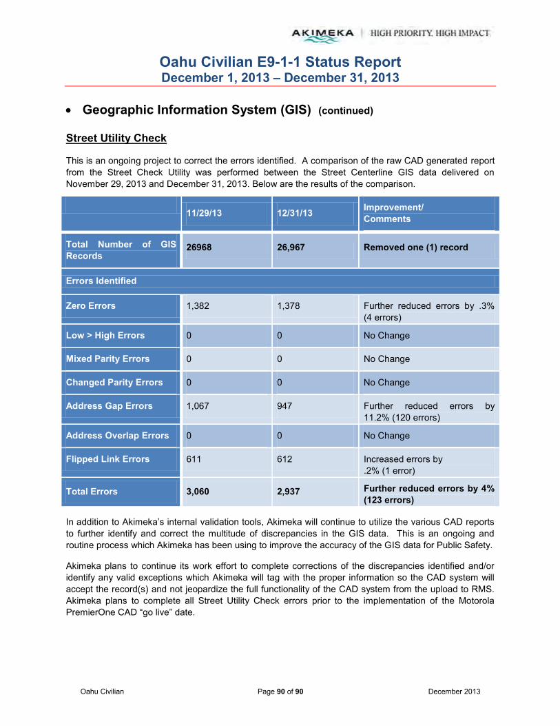
Oahu Civilian E9-1-1 Status Report December 1, 2013 – December 31, 2013
Oahu Civilian Page 90 of 90 December 2013
Geographic Information System (GIS) (continued)
Street Utility Check
This is an ongoing project to correct the errors identified. A comparison of the raw CAD generated report from the Street Check Utility was performed between the Street Centerline GIS data delivered on November 29, 2013 and December 31, 2013. Below are the results of the comparison.
11/29/13 12/31/13 Improvement/
Comments
Total Number of GIS Records
26968 26,967 Removed one (1) record
Errors Identified
Zero Errors 1,382 1,378 Further reduced errors by .3% (4 errors)
Low > High Errors 0 0 No Change
Mixed Parity Errors 0 0 No Change
Changed Parity Errors 0 0 No Change
Address Gap Errors 1,067 947 Further reduced errors by 11.2% (120 errors)
Address Overlap Errors 0 0 No Change
Flipped Link Errors 611 612 Increased errors by .2% (1 error)
Total Errors 3,060 2,937 Further reduced errors by 4% (123 errors)
In addition to Akimeka’s internal validation tools, Akimeka will continue to utilize the various CAD reports to further identify and correct the multitude of discrepancies in the GIS data. This is an ongoing and routine process which Akimeka has been using to improve the accuracy of the GIS data for Public Safety.
Akimeka plans to continue its work effort to complete corrections of the discrepancies identified and/or identify any valid exceptions which Akimeka will tag with the proper information so the CAD system will accept the record(s) and not jeopardize the full functionality of the CAD system from the upload to RMS. Akimeka plans to complete all Street Utility Check errors prior to the implementation of the Motorola PremierOne CAD “go live” date.
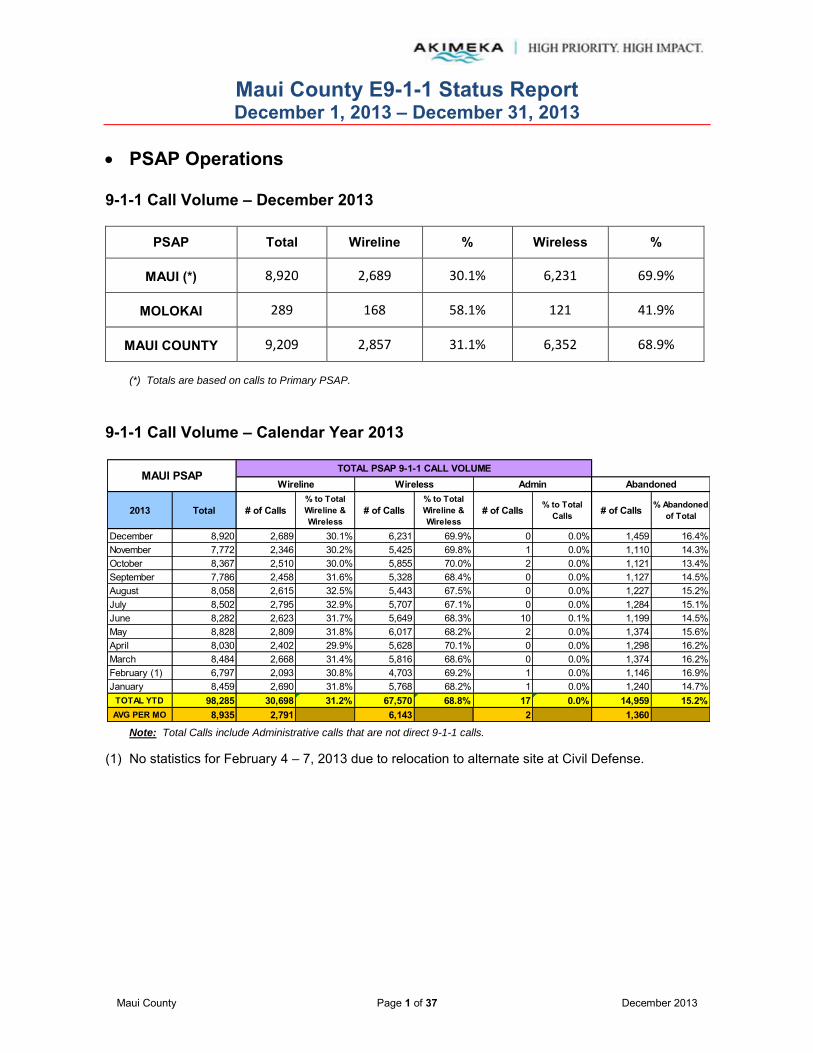
Maui County E9-1-1 Status Report December 1, 2013 – December 31, 2013
Maui County Page 1 of 37 December 2013
PSAP Operations
9-1-1 Call Volume – December 2013
PSAP Total Wireline % Wireless %
MAUI (*) 8,920 2,689 30.1% 6,231 69.9%
MOLOKAI 289 168 58.1% 121 41.9%
MAUI COUNTY 9,209 2,857 31.1% 6,352 68.9%
(*) Totals are based on calls to Primary PSAP.
9-1-1 Call Volume – Calendar Year 2013
Note: Total Calls include Administrative calls that are not direct 9-1-1 calls.
(1) No statistics for February 4 – 7, 2013 due to relocation to alternate site at Civil Defense.
2013 Total # of Calls% to Total Wireline & Wireless
# of Calls% to Total Wireline & Wireless
# of Calls % to Total Calls # of Calls % Abandoned
of Total
December 8,920 2,689 30.1% 6,231 69.9% 0 0.0% 1,459 16.4%November 7,772 2,346 30.2% 5,425 69.8% 1 0.0% 1,110 14.3%October 8,367 2,510 30.0% 5,855 70.0% 2 0.0% 1,121 13.4%September 7,786 2,458 31.6% 5,328 68.4% 0 0.0% 1,127 14.5%August 8,058 2,615 32.5% 5,443 67.5% 0 0.0% 1,227 15.2%July 8,502 2,795 32.9% 5,707 67.1% 0 0.0% 1,284 15.1%June 8,282 2,623 31.7% 5,649 68.3% 10 0.1% 1,199 14.5%May 8,828 2,809 31.8% 6,017 68.2% 2 0.0% 1,374 15.6%April 8,030 2,402 29.9% 5,628 70.1% 0 0.0% 1,298 16.2%March 8,484 2,668 31.4% 5,816 68.6% 0 0.0% 1,374 16.2%February (1) 6,797 2,093 30.8% 4,703 69.2% 1 0.0% 1,146 16.9%January 8,459 2,690 31.8% 5,768 68.2% 1 0.0% 1,240 14.7%
TOTAL YTD 98,285 30,698 31.2% 67,570 68.8% 17 0.0% 14,959 15.2%AVG PER MO 8,935 2,791 6,143 2 1,360
Wireline Wireless Admin AbandonedMAUI PSAP
TOTAL PSAP 9-1-1 CALL VOLUME

Maui County E9-1-1 Status Report December 1, 2013 – December 31, 2013
Maui County Page 2 of 37 December 2013
PSAP Operations (continued)
9-1-1 Call Volume – Calendar Year 2013 (continued)
Note: Total Calls include Administrative calls that are not direct 9-1-1 calls.
Notes:
(1) Total call volumes include Administrative calls. (Administrative calls = Calls made between 911 positions but are not 911 calls.)
(2) "Abandoned" calls represent the number of incoming 9-1-1 calls for which the caller had hung up before a call-taker answered.
(3) "Abandoned" calls are included in the "Wireline" and "Wireless" counts respectively. The standard CML reports do not provide a break-out of "Abandoned" calls between "Wireline" and "Wireless" calls.
2013 Total # of Calls% to Total Wireline & Wireless
# of Calls% to Total Wireline & Wireless
# of Calls % to Total Calls # of Calls % Abandoned
of Total
December 289 168 58.1% 121 41.9% 0 0.0% 35 12.1%November 247 128 51.8% 119 48.2% 0 0.0% 29 11.7%October 289 152 52.6% 137 47.4% 0 0.0% 36 12.5%September 238 148 62.2% 90 37.8% 0 0.0% 36 15.1%August 266 157 59.0% 109 41.0% 0 0.0% 32 12.0%July 247 143 57.9% 104 42.1% 0 0.0% 46 18.6%June 243 146 60.1% 97 39.9% 0 0.0% 39 16.0%May 328 177 54.0% 151 46.0% 0 0.0% 44 13.4%April 254 150 59.1% 104 40.9% 0 0.0% 42 16.5%March 339 189 55.8% 150 44.2% 0 0.0% 58 17.1%February 213 140 65.7% 73 34.3% 0 0.0% 24 11.3%January 262 147 56.1% 115 43.9% 0 0.0% 39 14.9%
TOTAL YTD 3,215 1,845 57.4% 1,370 42.6% 0 0.0% 460 14.3%AVG PER MO 292 168 125 0 42
MOLOKAI PSAPTOTAL PSAP 9-1-1 CALL VOLUME
Wireline Wireless Admin Abandoned

Maui County E9-1-1 Status Report December 1, 2013 – December 31, 2013
Maui County Page 3 of 37 December 2013
PSAP Operations (continued) 911 Call Volume Comparison 2012 - 2013 (Maui)
Call Center E9-1-1 Call Volume statistics for 2013 are 98,285 total calls; 30,698 (31.2%) Wireline and 67,570 (68.8%) Wireless. Total PSAP 9-1-1 Call Volumes increased by 2,626 in 2013 from 2012 – with Wireline calls further declining by 1.3% and Wireless calls increasing by 1.3%. 911 Call Volume Comparison 2012 - 2013 (Molokai)
Call Center E9-1-1 Call Volume statistics for 2013 are 3,215 total calls; 1,845 (57.4%) Wireline and 1,370 (42.6%) Wireless. Total PSAP 9-1-1 Call Volumes decreased by 346 in 2013 from 2012 – with Wireline calls further declining by 1.8% and Wireless calls increasing by 1.6%.
2013 Total # of Calls% to Total Wireline & Wireless
# of Calls% to Total Wireline & Wireless
# of Calls % to Total Calls # of Calls % Abandoned
of Total
Wireline Wireless Admin AbandonedMAUI PSAP
TOTAL PSAP 9-1-1 CALL VOLUME
TOTAL YTD 98,285 30,698 31.2% 67,570 68.8% 17 0.0% 14,959 15.2%AVG PER MO 8,935 2,791 6,143 2 1,360
2012 Total # of Calls% to Total Wireline & Wireless
# of Calls% to Total Wireline & Wireless
# of Calls % to Total Calls # of Calls % Abandoned
of Total
MAUI PSAPTOTAL PSAP 9-1-1 CALL VOLUME
Wireline Wireless Admin Abandoned
TOTAL YTD 95,659 31,077 32.5% 64,576 67.5% 6 0.0% 15,540 16.2%AVG PER MO 7,972 2,590 5,381 1 1,295
2013 Total # of Calls% to Total Wireline & Wireless
# of Calls% to Total Wireline & Wireless
# of Calls % to Total Calls # of Calls % Abandoned
of Total
MOLOKAI PSAPTOTAL PSAP 9-1-1 CALL VOLUME
Wireline Wireless Admin Abandoned
TOTAL YTD 3,215 1,845 57.4% 1,370 42.6% 0 0.0% 460 14.3%AVG PER MO 292 168 125 0 42
2012 Total # of Calls% to Total Wireline & Wireless
# of Calls% to Total Wireline & Wireless
# of Calls % to Total Calls # of Calls % Abandoned
of Total
MOLOKAI PSAPTOTAL PSAP 9-1-1 CALL VOLUME
Wireline Wireless Admin Abandoned
TOTAL YTD 3,561 2,109 59.2% 1,452 40.8% 0 0.0% 507 14.2%AVG PER MO 297 176 121 0 42
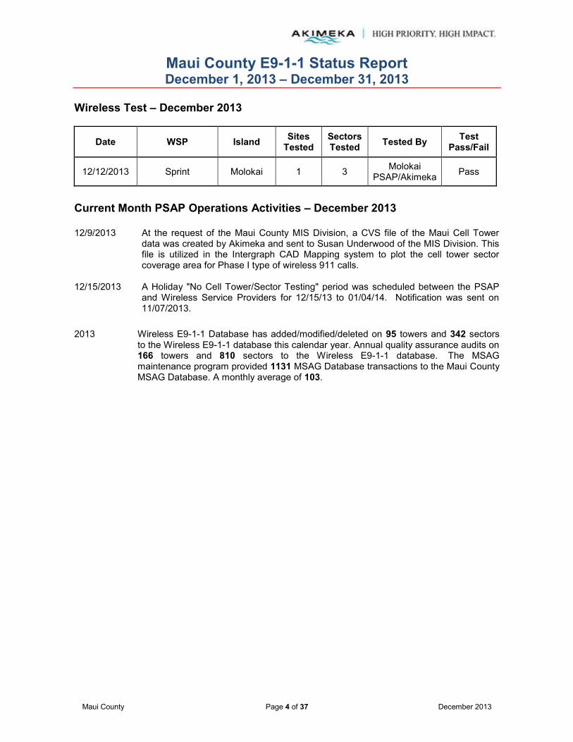
Maui County E9-1-1 Status Report December 1, 2013 – December 31, 2013
Maui County Page 4 of 37 December 2013
Wireless Test – December 2013
Date WSP Island Sites Tested
Sectors Tested Tested By Test
Pass/Fail
12/12/2013 Sprint Molokai 1 3 Molokai PSAP/Akimeka Pass
Current Month PSAP Operations Activities – December 2013 12/9/2013 At the request of the Maui County MIS Division, a CVS file of the Maui Cell Tower
data was created by Akimeka and sent to Susan Underwood of the MIS Division. This file is utilized in the Intergraph CAD Mapping system to plot the cell tower sector coverage area for Phase I type of wireless 911 calls.
12/15/2013 A Holiday "No Cell Tower/Sector Testing" period was scheduled between the PSAP
and Wireless Service Providers for 12/15/13 to 01/04/14. Notification was sent on 11/07/2013.
2013 Wireless E9-1-1 Database has added/modified/deleted on 95 towers and 342 sectors
to the Wireless E9-1-1 database this calendar year. Annual quality assurance audits on 166 towers and 810 sectors to the Wireless E9-1-1 database. The MSAG maintenance program provided 1131 MSAG Database transactions to the Maui County MSAG Database. A monthly average of 103.

Maui County E9-1-1 Status Report December 1, 2013 – December 31, 2013
Maui County Page 5 of 37 December 2013
MSAG Current Month – December 2013
A total of 214 MSAG transactions were processed during the month of December 2013. Eighty-seven (87) 9-1-1Net requests were processed relating to the Maui County MSAG database, with 1,696 customer ANI/ALI records updated as a direct result. 127 TN CR transactions were processed in 9-1-1Net for updates and corrections relating to the ESN 359/399 clean-up effort. Streets and address ranges were validated against the GIS to ensure synchronization and an MSAG valid address was provided to the Telco. TN CRs must be validated against HT records and approved by the end user HawaiianTelcom customer before updating the ALI record. There are no ALI DR records in Referred status as of December 31, 2013.
There are 214 TN CRs in Referred status as of December 31, 2013.
The TN CRs in "Referred" status are a direct result of the ESN 359/399 clean-up and are awaiting approval from Hawaiian Telcom, Inc (HTI) and/or customer to update ALI records. No explanation has been provided as to why these TN CRs have not been corrected for 9-1-1 purposes. Akimeka continues to monitor and track the progress of Referred TN CRs.
There are no records in Suspended status as of December 31, 2013.
MAUI COUNTY 214 87 60 7 6 6 8 1,696 127 0 214 0 0 0
2013
PSAP TOTAL Total Change Delete Insert
ALI Discrepancy
(ALI-DR) Processed
(b)
Customer Addresses
Affected
County Address Change Request (TN CR)
Processed(a)
9-1-1NET REQUESTS
MSAG TRANSACTIONS ALI TRANSACTIONS
In Referred Statusas of Report Month End
(c)
Combined Split
In Suspended Statusas of Report Month End
(d)
TN CR ALI-DR # ofTransactions
TNsAffected

Maui County E9-1-1 Status Report December 1, 2013 – December 31, 2013
Maui County Page 6 of 37 December 2013
MSAG (continued) Year-to-Date (YTD) – 2013
Note: Revised categories and report format changes effective May 2012 with new Intrado TN CR functionality.
(1) The Intrado 9-1-1Net was not available on August 20, 2013 from 12:00 p.m. – 12:30 p.m. (HST)
(a)
(b)
(c)
(d)
Definitions:
Represents address corrections on a specific TN or group of TNs. These "invalid" TNs usually have an associated ESN x99 attached to them which indicates the need for validation.
Represents an address discrepancy discovered during a live 9-1-1 call. These record corrections are treated with a higher priority and should be processed within 48 hours as a general guideline.
Represents correction requests that have been referred by Intrado to the appropriate service provider and is awaiting approval to be updated in 9-1-1Net.
Represents correction requests that have been "paused" due to TN fallouts, range overlaps, or not having a valid address point. Intrado requires additional information from Akimeka/PSAP before the Telco approves the change.
December 214 87 60 7 6 6 8 1,696 127 0 214 0 0 0November 39 37 18 6 0 9 4 745 1 1 116 0 0 0October 55 47 28 5 1 6 7 371 7 1 115 0 1 1September 167 18 4 2 4 8 0 5 148 1 223 0 0 0August (1) 109 14 1 0 4 9 0 8 95 0 108 1 0 0July 32 13 1 0 5 5 2 19 13 6 42 1 0 0June 44 26 10 4 5 6 1 209 15 3 27 0 0 0May 172 48 16 2 23 4 3 250 123 1 35 12 0 0April 72 52 19 0 27 5 1 295 18 2 27 12 0 0March 120 35 6 1 14 14 0 33 79 6 28 11 0 0February 44 39 9 1 17 12 0 44 5 0 29 11 1 1January 63 61 11 0 43 6 1 405 2 0 52 18 0 0
TOTAL YTD 1,131 477 183 28 149 90 27 4,080 633 21 AVG PER MO 103 43 17 3 14 8 2 371 58 2
9-1-1NET REQUESTS
Customer Addresses
Affected(*)
MAUI COUNTY
2013 TOTAL
In Referred Statusas of Report Month End
(c)
In Suspended Statusas of Report Month End
(d)MSAG TRANSACTIONS ALI TRANSACTIONS
Total Change Combined Delete ALI-DR # of Transactions
TNsAffected
ALI Discrepancy
(ALI-DR) Processed
(b)
TN CRInsert Split
County Address Change Request (TN CR)
Processed(a)
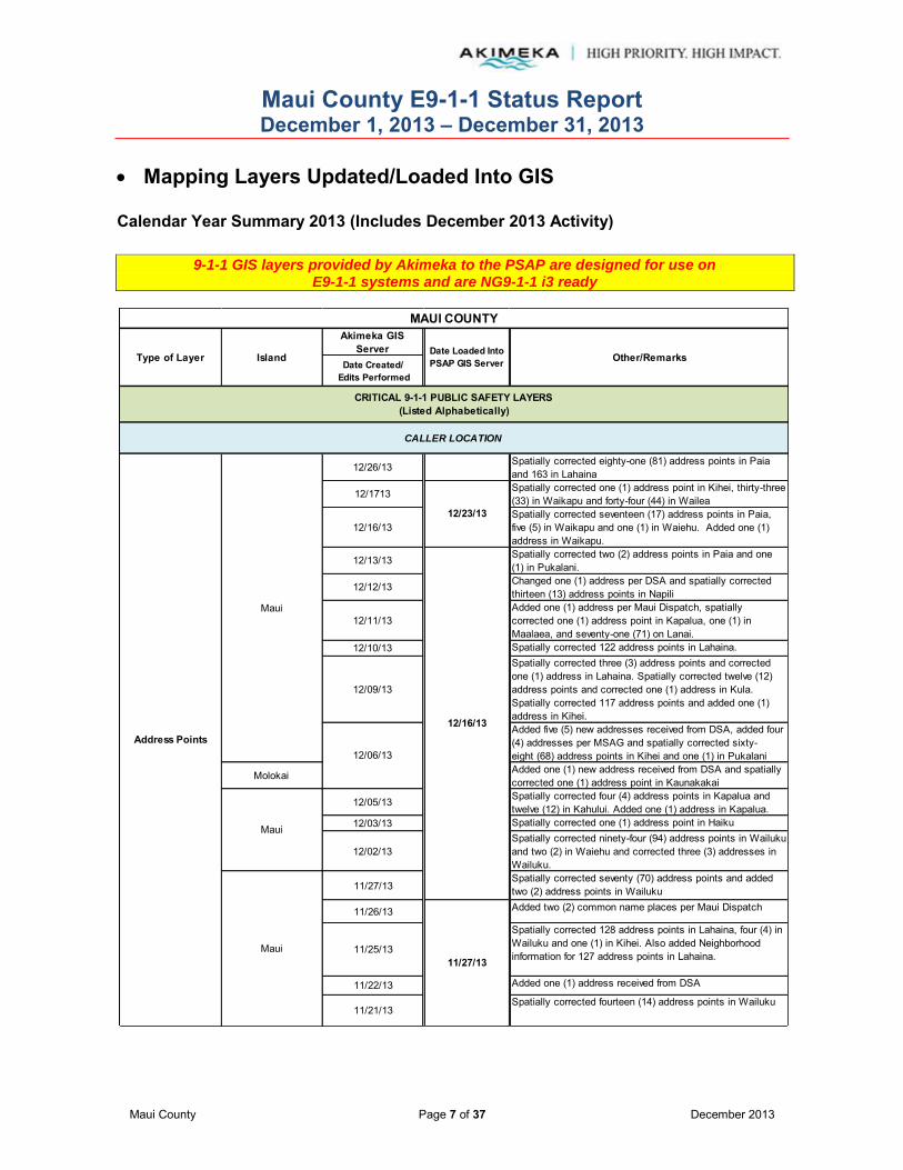
Maui County E9-1-1 Status Report December 1, 2013 – December 31, 2013
Maui County Page 7 of 37 December 2013
Mapping Layers Updated/Loaded Into GIS Calendar Year Summary 2013 (Includes December 2013 Activity)
9-1-1 GIS layers provided by Akimeka to the PSAP are designed for use on
E9-1-1 systems and are NG9-1-1 i3 ready
Akimeka GIS Server
Date Created/ Edits Performed
12/26/13 Spatially corrected eighty-one (81) address points in Paia and 163 in Lahaina
12/1713 Spatially corrected one (1) address point in Kihei, thirty-three (33) in Waikapu and forty-four (44) in Wailea
12/16/13Spatially corrected seventeen (17) address points in Paia, five (5) in Waikapu and one (1) in Waiehu. Added one (1) address in Waikapu.
12/13/13 Spatially corrected two (2) address points in Paia and one (1) in Pukalani.
12/12/13 Changed one (1) address per DSA and spatially corrected thirteen (13) address points in Napili
12/11/13Added one (1) address per Maui Dispatch, spatially corrected one (1) address point in Kapalua, one (1) in Maalaea, and seventy-one (71) on Lanai.
12/10/13 Spatially corrected 122 address points in Lahaina.
12/09/13
Spatially corrected three (3) address points and corrected one (1) address in Lahaina. Spatially corrected twelve (12) address points and corrected one (1) address in Kula. Spatially corrected 117 address points and added one (1) address in Kihei.Added five (5) new addresses received from DSA, added four (4) addresses per MSAG and spatially corrected sixty-eight (68) address points in Kihei and one (1) in Pukalani
Molokai Added one (1) new address received from DSA and spatially corrected one (1) address point in Kaunakakai
12/05/13 Spatially corrected four (4) address points in Kapalua and twelve (12) in Kahului. Added one (1) address in Kapalua.
12/03/13 Spatially corrected one (1) address point in Haiku
12/02/13Spatially corrected ninety-four (94) address points in Wailuku and two (2) in Waiehu and corrected three (3) addresses in Wailuku.
11/27/13Spatially corrected seventy (70) address points and added two (2) address points in Wailuku
11/26/13 Added two (2) common name places per Maui Dispatch
11/25/13
Spatially corrected 128 address points in Lahaina, four (4) in Wailuku and one (1) in Kihei. Also added Neighborhood information for 127 address points in Lahaina.
11/22/13 Added one (1) address received from DSA
11/21/13Spatially corrected fourteen (14) address points in Wailuku
Address Points
11/27/13Maui
12/06/13
12/16/13
Maui
12/23/13
CALLER LOCATION
Maui
MAUI COUNTY
Other/Remarks
CRITICAL 9-1-1 PUBLIC SAFETY LAYERS(Listed Alphabetically)
IslandType of Layer Date Loaded Into PSAP GIS Server

Maui County E9-1-1 Status Report December 1, 2013 – December 31, 2013
Maui County Page 8 of 37 December 2013
Mapping Layers Updated/Loaded Into GIS (continued) Calendar Year Summary 2013 (Includes December 2013 Activity)
9-1-1 GIS layers provided by Akimeka to the PSAP are designed for use on E9-1-1 systems and are NG9-1-1 i3 ready
Akimeka GIS Server
Date Created/ Edits Performed
Maui 11/20/13
Added six (6) addresses received from DSA. Corrected street name from Olua St to Olina St for two (2) addresses received from incorrect information provided by DSA the day prior.
Molokai 11/20/13 Added one (1) address received from DSA
MauiAdded three (3) addresses received from DSA. Filled in the ID for six (6) addresses
Molokai Added two (2) addresses received from DSA
Maui 11/15/13 Added two (2) addresses received from DSA
Molokai 11/13/13 Added one (1) address received from DSA
11/8/13Spatially corrected twenty-two (22) address points in Wailuku
11/7/13Spatially corrected sixty-seven (67) addresses in Wailuku. Added one (1) address received from DSA
11/06/13Did the following work in Wailuku: Spatially corrected 135 address points, added one (1) address received from DSA and corrected one (1) address.
Maui Added four (4) addresses received from DSA
Molokai Added one (1) address received from DSA
Added two (2) common names per Maui Dispatch and verified three (3)
Added two (2) common names per Maui Dispatch and verified three (3)
Added five (5) common names and one (1) message requested by Maui Dispatch.
Added two (2) addresses received from DSA. Spatially corrected five (5) address points in Makawao.
Added one (1) address received from DSA.
Maui 10/22/2013Added three (3) addresses received from DSA, one (1) address from the DSA Address layer and spatially corrected six (6) address points.
Corrected four (4) Structure on wrong block in Haiku. Also corrected data which is required for the Intergraph CAD.
Added two (2) addresses received from DSA, two (2) addresses from the DSA Address layer, corrected one (1) address per DSA and spatially corrected thirty-one (31) address points.
11/27/13
Address Points
10/23/13
MAUI COUNTY
Type of Layer Island Date Loaded Into PSAP GIS Server Other/Remarks
CRITICAL 9-1-1 PUBLIC SAFETY LAYERS(Listed Alphabetically)
CALLER LOCATION
10/21/2013
Maui 10/24/13
Maui
Maui
Maui
11/4/2013
11/19/13
10/28/2013
11/13/13

Maui County E9-1-1 Status Report December 1, 2013 – December 31, 2013
Maui County Page 9 of 37 December 2013
Mapping Layers Updated/Loaded Into GIS (continued) Calendar Year Summary 2013 (Includes December 2013 Activity)
9-1-1 GIS layers provided by Akimeka to the PSAP are designed for use on E9-1-1 systems and are NG9-1-1 i3 ready
Akimeka GIS Server
Date Created/ Edits Performed
Corrected seven (7) Structure on wrong side of street and one (1) Structure on Wrong Block in Haiku.
Added ten (10) addresses received from DSA and corrected one (1) address received from DSA. Added three (3) address from the DSA Address layer and spatially corrected thirty-two(32) addresses. These are ongoing projects.
Maui/Molokai 10/17/2013Corrected thirteen (13) no matching street range, three (3) no matching street name and seven (7) Structure on Wrong Side of Street in Haiku.
Maui 10/16/2013 Corrected eight (8) no matching street range and one (1) no matching street name address in Haiku.
Maui 10/11/2013 Added The Breakers as a common name for five (5) addresses
Spatially corrected one (1) address point in Kualapuu
Added one (1) new address received from DSA. Added one (1) address in Maunaloa from the DSA Address layer. This is an ongoing project.
Added six (6) new addresses received from DSA. Corrected one (1) address per DSA.
Spatially corrected one (1) address point in Kahului, two (2) in Haiku and five (5) in Kihei
Molokai 10/7/2013 Spatially corrected thirteen (13) address points in Kualapuu
Molokai Added two (2) addresses per DSA
Maui Spatially corrected one (1) address on Lanai
Maui 10/03/13Added one (1) address in Kapalua from the DSA Address layer. This is an ongoing project.
Added two (2) addresses received from DSA
Added two (2) common names per Maui Dispatch and verified three (3)
MauiAdded two (2) addresses received from DSA -- one (1) in Waihee and one (1) in Paia.
Maui Updated six (6) common names for The Breakers, Lahaina, as requested by Maui Dispatch
Maui 09/26/13Added three (3) new addresses in Haiku, one (1) address in Kula, and two (2) addresses in Lahaina as received by DSA
10/9/2013
Address Points
CRITICAL 9-1-1 PUBLIC SAFETY LAYERS(Listed Alphabetically)
CALLER LOCATION
10/23/13
MAUI COUNTY
Type of Layer Island Date Loaded Into PSAP GIS Server Other/Remarks
10/8/2013
Maui 10/28/2013
09/27/13
10/4/2013
Molokai
Maui 10/18/2013
Maui

Maui County E9-1-1 Status Report December 1, 2013 – December 31, 2013
Maui County Page 10 of 37 December 2013
Mapping Layers Updated/Loaded Into GIS (continued) Calendar Year Summary 2013 (Includes December 2013 Activity)
9-1-1 GIS layers provided by Akimeka to the PSAP are designed for use on E9-1-1 systems and are NG9-1-1 i3 ready
Akimeka GIS Server
Date Created/ Edits Performed
Maui/Molokai 09/25/13
Maui 09/25/13
Changed the attribute data for sixteen (16) addresses affected by the Street Centerlines splits. This work is necessary for the Intergraph CAD. Addresses affected were on Hana Hwy, Hana, Hana Hy 360, Hana Hwy, Haiku, Hana Hy 360, Haiku, Kahekili Hwy, Wailuku and Piilani Hwy, Hana and Piilani Hy 31, Hana.
Maui 09/24/13Added The Breakers as a common name for five (5) addresses
Maui/Molokai 09/18/13 Edited to meet Intergraph CAD requirements
Maui/Molokai 09/11/13
Maui 09/10/13 -- 09/11/13 Added fourteen (14) addresses received from DSA
Maui 09/03/13 --09/16/13 Added eight (8) addresses received from DSA and spatially corrected seven (7) address points
Maui/Molokai 08/28/13
Maui 08/26/13 -- 08/30/13Added six (6) new address points, corrected one (1) address point, and added seven (7) address points per DSA
Maui/Molokai 08/14/13
Added one (1) address point per DSA
Updated address for TMK 27012121 from 1770 Kauhikoa Rd to 1208 Kane Rd per DSA
Deleted 210 Pico Tract Rd, Haiku per DSA
08/05/13 Updated address for TMK 257001003 back to 10249 KAMEHAMEHA V HWY per DSA request
08/02/13Added 10413 Kamehameha V Hwy, Kaunakakai, 10061 Kamehameha V Hwy, Kauanakakai, and 10263 Kamehameha V Hwy per DSA
Added 2473 Upper Kanaio Rd, Kula, 204 Waipalani Rd, Haiku, and 1008 Anapuni PL, Kaanapali per DSA
Updated 423 Kanai PLk Wailuku to 523 Kanai PL and added 523A Kanai PL, Wailuku per DSA
Updated 17 Burns Rd, Haiku to 7 Maluaina Rd, Haiku from DSA
Maui 07/31/13 Updated 0 Haleakala Hwy to 0 Science City Rd
CRITICAL 9-1-1 PUBLIC SAFETY LAYERS(Listed Alphabetically)
CALLER LOCATION
MAUI COUNTY
Type of Layer Island Date Loaded Into PSAP GIS Server Other/Remarks
Address Points
Maui
08/09/13Maui
08/02/13
Molokai

Maui County E9-1-1 Status Report December 1, 2013 – December 31, 2013
Maui County Page 11 of 37 December 2013
Mapping Layers Updated/Loaded Into GIS (continued) Calendar Year Summary 2013 (Includes December 2013 Activity)
9-1-1 GIS layers provided by Akimeka to the PSAP are designed for use on E9-1-1 systems and are NG9-1-1 i3 ready
Akimeka GIS Server
Date Created/ Edits Performed
Maui/Molokai 09/25/13
Maui 07/18/13 Added three (3) addresses received from DSA
Maui 07/12/13 Added one (1) address received from DSA
Maui/Molokai 07/11/13
Maui/Molokai 06/26/13
Maui 06/26/13 Made corrections to meet the Intergraph CAD requirements
Maui 06/18/13 -- 06/27/13
Added ten (10) addresses received from DSA and seventy-two (72) addresses from the DSA Address layer. Added one (1) address and common name as requested by Maui Dispatch. This is an ongoing project.
Molokai 06/17/13 Added one (1) address received from DSA
06/12/13
Maui 05/31/13 Added multiple addresses from the DSA Address layer. This is an ongoing project.
Made corrections to meet the Intergraph CAD requirements
Corrected the street name for Pokakaa Loop, Kahului, per the Maui County Street Naming Authority
Maui/Molokai 05/29/13
Maui 05/21/13 -- 05/28/13 Added 103 addresses from the DSA Address layer. This is an ongoing project.
Maui/Molokai 05/15/13
Maui 05/07/13 Added and changed common name and added one (1) POI address point as requested by Maui Dispatch.
Maui 05/06/13 -- 05/20/13Added three (3) addresses received from DSA and 205 addresses from the DSA Address layer. This is an ongoing project.
Maui 04/29/13 Added an alias common name, Maui Oral Health Center for 752 Lower Main St as requested by Maui Dispatch.
Maui 04/26/13 -- 04/30/13Added four (4) addresses received from DSA and forty-nine (49) addresses from the DSA Address layer. This is an ongoing project.
Maui/Molokai 04/24/13
Address Points
Other/Remarks
CRITICAL 9-1-1 PUBLIC SAFETY LAYERS(Listed Alphabetically)
CALLER LOCATION
MAUI COUNTY
Type of Layer Island
Maui 05/30/13
Date Loaded Into PSAP GIS Server

Maui County E9-1-1 Status Report December 1, 2013 – December 31, 2013
Maui County Page 12 of 37 December 2013
Mapping Layers Updated/Loaded Into GIS (continued) Calendar Year Summary 2013 (Includes December 2013 Activity)
9-1-1 GIS layers provided by Akimeka to the PSAP are designed for use on E9-1-1 systems and are NG9-1-1 i3 ready
Akimeka GIS Server
Date Created/ Edits Performed
Maui 04/23/13Added multiple addresses from the DSA Address layer. This is an ongoing project.
Maui 04/15/13 -- 04/22/13Added 161 addresses from the DSA Address layer. This is an ongoing project.
Maui/Molokai 04/10/13
Molokai 04/05/13 -- 04/15/13
Added ninety-one (91) addresses from the DSA Address layer. Added six (6) addresses received from DSA. Added ninety-seven (97) addresses from the MSAG ALI report. Added multiple addresses from the DSA Address layer and from the MSAG ALI report.
Maui 04/02/13 -- 04/11/13 Added five (5) addresses received from DSA. This is an ongoing project.
Molokai 04/01/13 -- 04/04/13
Added forty-one (41) addresses from the DSA Address layer. Added one (1) address received from DSA. Added sixty-nine (69) addresses from the MSAG ALI report. This is an ongoing project.
Maui 03/29/13Added one (1) address from the DSA Address layer. This is an ongoing project.
Maui 03/27/13Akimeka re-designed PowerMap. The new design included implementation of a consistent naming schema and formatting layers to construct a robust and user friendly map.
Maui 03/25/12 -- 03/29/13 Added five (5) addresses received from DSA. Removed one (1) common place name as requested by Maui Dispatch.
Molokai 03/15/13 Added new address received from DSA
Maui/Molokai 03/13/13
Maui 03/08/13 -- 03/12/13Added five (5) addresses received from DSA. Added two (2) common place names and corrected three (3) common place names as requested by Maui Dispatch
Molokai 03/04/13 Added one (1) address received from DSA
Maui 03/04/13 Added sixty (60) addresses from the DSA Address layer. This is an ongoing project.
Maui 02/27/13
Address Points
CRITICAL 9-1-1 PUBLIC SAFETY LAYERS(Listed Alphabetically)
CALLER LOCATION
MAUI COUNTY
Type of Layer Island Date Loaded Into PSAP GIS Server Other/Remarks
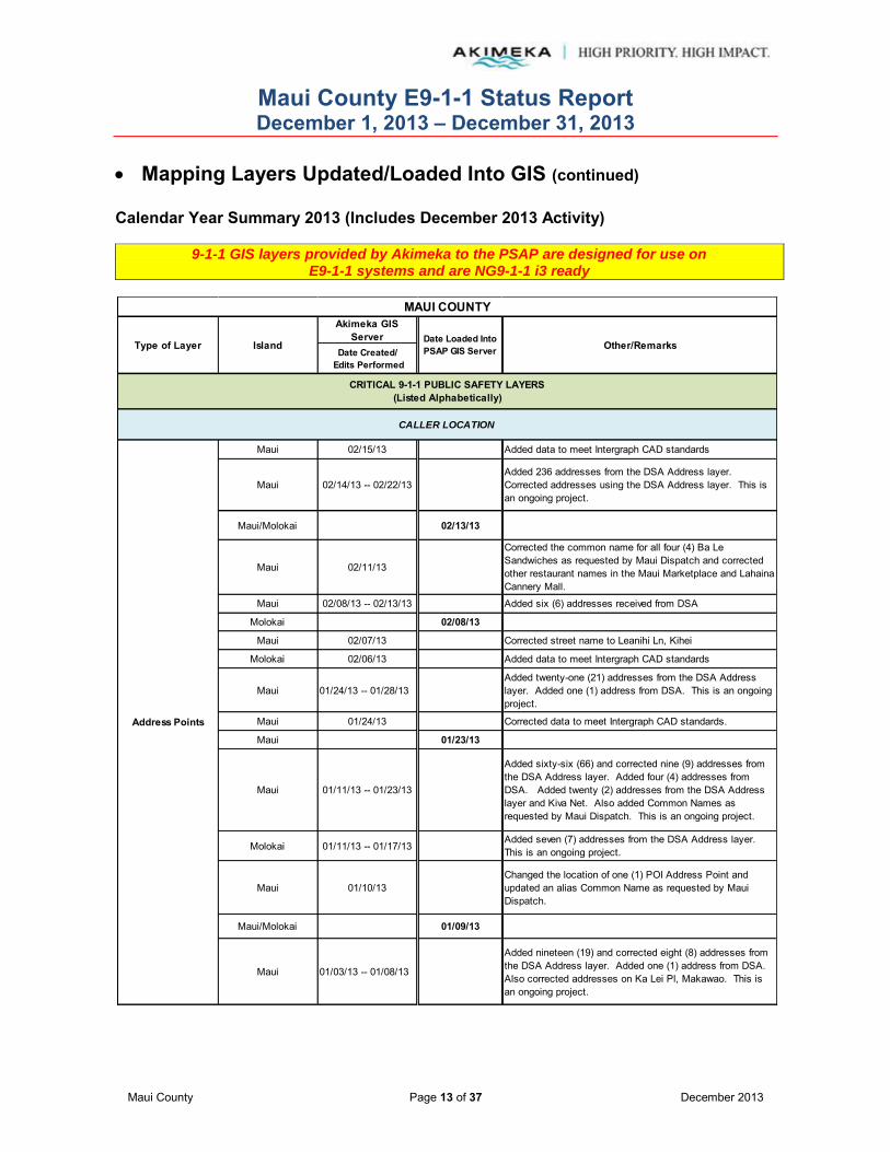
Maui County E9-1-1 Status Report December 1, 2013 – December 31, 2013
Maui County Page 13 of 37 December 2013
Mapping Layers Updated/Loaded Into GIS (continued) Calendar Year Summary 2013 (Includes December 2013 Activity)
9-1-1 GIS layers provided by Akimeka to the PSAP are designed for use on E9-1-1 systems and are NG9-1-1 i3 ready
Akimeka GIS Server
Date Created/ Edits Performed
Maui 02/15/13 Added data to meet Intergraph CAD standards
Maui 02/14/13 -- 02/22/13Added 236 addresses from the DSA Address layer. Corrected addresses using the DSA Address layer. This is an ongoing project.
Maui/Molokai 02/13/13
Maui 02/11/13
Corrected the common name for all four (4) Ba Le Sandwiches as requested by Maui Dispatch and corrected other restaurant names in the Maui Marketplace and Lahaina Cannery Mall.
Maui 02/08/13 -- 02/13/13 Added six (6) addresses received from DSA
Molokai 02/08/13
Maui 02/07/13 Corrected street name to Leanihi Ln, Kihei
Molokai 02/06/13 Added data to meet Intergraph CAD standards
Maui 01/24/13 -- 01/28/13Added twenty-one (21) addresses from the DSA Address layer. Added one (1) address from DSA. This is an ongoing project.
Maui 01/24/13 Corrected data to meet Intergraph CAD standards.
Maui 01/23/13
Maui 01/11/13 -- 01/23/13
Added sixty-six (66) and corrected nine (9) addresses from the DSA Address layer. Added four (4) addresses from DSA. Added twenty (2) addresses from the DSA Address layer and Kiva Net. Also added Common Names as requested by Maui Dispatch. This is an ongoing project.
Molokai 01/11/13 -- 01/17/13Added seven (7) addresses from the DSA Address layer. This is an ongoing project.
Maui 01/10/13Changed the location of one (1) POI Address Point and updated an alias Common Name as requested by Maui Dispatch.
Maui/Molokai 01/09/13
Maui 01/03/13 -- 01/08/13
Added nineteen (19) and corrected eight (8) addresses from the DSA Address layer. Added one (1) address from DSA. Also corrected addresses on Ka Lei Pl, Makawao. This is an ongoing project.
CRITICAL 9-1-1 PUBLIC SAFETY LAYERS(Listed Alphabetically)
CALLER LOCATION
Address Points
MAUI COUNTY
Type of Layer Island Date Loaded Into PSAP GIS Server Other/Remarks

Maui County E9-1-1 Status Report December 1, 2013 – December 31, 2013
Maui County Page 14 of 37 December 2013
Mapping Layers Updated/Loaded Into GIS (continued) Calendar Year Summary 2013 (Includes December 2013 Activity)
9-1-1 GIS layers provided by Akimeka to the PSAP are designed for use on E9-1-1 systems and are NG9-1-1 i3 ready
Akimeka GIS Server
Date Created/ Edits Performed
Molokai 01/02/13 -- 01/07/13Added four (4) addresses from the DSA Address layer. This is an ongoing project.
Maui 01/02/13Added eighteen (18) addresses and corrected two (2) addresses from the DSA Address layer. Also added a Common Name. This is an ongoing project.
Maui 05/07/13 A special PowerMap update was performed at the request of T-Mobile and Maui Dispatch
Maui 03/27/13Akimeka re-designed PowerMap. The new design included implementation of a consistent naming schema and formatting layers to construct a robust and user friendly map.
Maui 03/27/13Akimeka re-designed PowerMap. The new design included implementation of a consistent naming schema and formatting layers to construct a robust and user friendly map.
Medic Stations Maui 03/27/13Akimeka re-designed PowerMap. The new design included implementation of a consistent naming schema and formatting layers to construct a robust and user friendly map.
Maui 03/27/13Akimeka re-designed PowerMap. The new design included implementation of a consistent naming schema and formatting layers to construct a robust and user friendly map.
Maui/Lanai 12/13/13 12/16/13Changed the name of one (1) hotel to Four Seasons Resort Lanai at Manele Bay
11/25/13Added two (2) subdivisions, Opukea at Lahaina and Hoonanea at Lahaina requested by Maui Dispatch
11/19/13Added The Parkways subdivision, added the address for Pomaikai Elementary, filled in the Neighborhood field for all subdivisions
Molokai 10/15/13 10/23/13 Spatially corrected Kaunakakai Post Office
Maui 09/24/13 10/09/13 Corrected a misspelled park -- Keonekai Park, Kihei
Maui 08/29/13 09/11/13 Added Puu Kukui Elementary School
Emergency Callboxes
Address Points
Points of Interest(POI)
CRITICAL 9-1-1 PUBLIC SAFETY LAYERS(Listed Alphabetically)
CALLER LOCATION
Type of Layer Island Date Loaded Into PSAP GIS Server Other/Remarks
MAUI COUNTY
Milepost Markers
11/27/13
Fire Stations
Maui
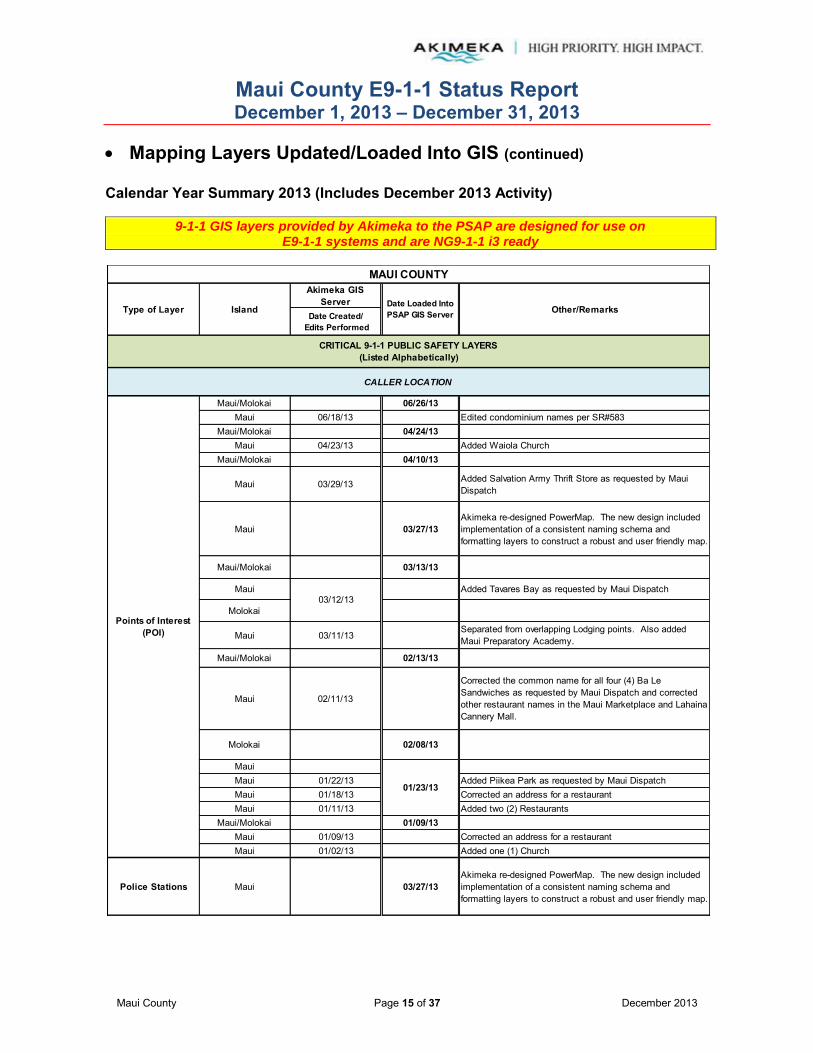
Maui County E9-1-1 Status Report December 1, 2013 – December 31, 2013
Maui County Page 15 of 37 December 2013
Mapping Layers Updated/Loaded Into GIS (continued) Calendar Year Summary 2013 (Includes December 2013 Activity)
9-1-1 GIS layers provided by Akimeka to the PSAP are designed for use on E9-1-1 systems and are NG9-1-1 i3 ready
Akimeka GIS Server
Date Created/ Edits Performed
Maui/Molokai 06/26/13Maui 06/18/13 Edited condominium names per SR#583
Maui/Molokai 04/24/13Maui 04/23/13 Added Waiola Church
Maui/Molokai 04/10/13
Maui 03/29/13 Added Salvation Army Thrift Store as requested by Maui Dispatch
Maui 03/27/13Akimeka re-designed PowerMap. The new design included implementation of a consistent naming schema and formatting layers to construct a robust and user friendly map.
Maui/Molokai 03/13/13
Maui Added Tavares Bay as requested by Maui Dispatch
Molokai
Maui 03/11/13Separated from overlapping Lodging points. Also added Maui Preparatory Academy.
Maui/Molokai 02/13/13
Maui 02/11/13
Corrected the common name for all four (4) Ba Le Sandwiches as requested by Maui Dispatch and corrected other restaurant names in the Maui Marketplace and Lahaina Cannery Mall.
Molokai 02/08/13
MauiMaui 01/22/13 Added Piikea Park as requested by Maui DispatchMaui 01/18/13 Corrected an address for a restaurantMaui 01/11/13 Added two (2) Restaurants
Maui/Molokai 01/09/13Maui 01/09/13 Corrected an address for a restaurantMaui 01/02/13 Added one (1) Church
Police Stations Maui 03/27/13Akimeka re-designed PowerMap. The new design included implementation of a consistent naming schema and formatting layers to construct a robust and user friendly map.
Points of Interest(POI)
MAUI COUNTY
Type of Layer Island Date Loaded Into PSAP GIS Server Other/Remarks
CRITICAL 9-1-1 PUBLIC SAFETY LAYERS(Listed Alphabetically)
CALLER LOCATION
03/12/13
01/23/13

Maui County E9-1-1 Status Report December 1, 2013 – December 31, 2013
Maui County Page 16 of 37 December 2013
Mapping Layers Updated/Loaded Into GIS (continued) Calendar Year Summary 2013 (Includes December 2013 Activity)
9-1-1 GIS layers provided by Akimeka to the PSAP are designed for use on E9-1-1 systems and are NG9-1-1 i3 ready
Akimeka GIS Server
Date Created/ Edits Performed
Maui 08/29/13 09/11/13 Added Puu Kukui Elementary School
Maui 03/27/13Akimeka re-designed PowerMap. The new design included implementation of a consistent naming schema and formatting layers to construct a robust and user friendly map.
12/27/13 Per T-Mobile CRS12/10/13 Per SPPCS CRS12/06/13 Per VZW CRS
11/27/2013Maui 11/1/2013 11/13/13 Per Verizon CRS
10/23/13
10/09/13
Maui/Molokai 09/25/13Maui 09/23/13 Per VZW CRS
Maui/Molokai 07/24/13Maui 07/18/13 Per AT&T Mobility - decommission
Maui/Molokai 07/18/13 Per Nextel CRS - decommission entire networkMaui 07/16/13 Per Sprint CRS
Maui/Molokai 06/12/13Maui 06/10/13 Per VZW CRS
Maui/Molokai 05/15/13
Maui 05/07/13 A special PowerMap update was performed at the request of T-Mobile and Maui Dispatch
Maui 05/02/13 Performed a special PowerMap update at the request of T-Mobile
Per T-Mobile CRS
AT&T Mobility Annual Audit
Maui/Molokai 04/24/13
Maui 04/16/13 -- 04/17/13 VZW Annual Audit
Schools
MAUI COUNTY
Type of Layer Island Date Loaded Into PSAP GIS Server
Maui12/16/13
Tsunami Roadblocks N/A for Maui County
Other/Remarks
CRITICAL 9-1-1 PUBLIC SAFETY LAYERS(Listed Alphabetically)
CALLER LOCATION
WSP Cell Towers
Tsunami Evacuation Zones
Maui 05/01/13

Maui County E9-1-1 Status Report December 1, 2013 – December 31, 2013
Maui County Page 17 of 37 December 2013
Mapping Layers Updated/Loaded Into GIS (continued) Calendar Year Summary 2013 (Includes December 2013 Activity)
9-1-1 GIS layers provided by Akimeka to the PSAP are designed for use on E9-1-1 systems and are NG9-1-1 i3 ready
Akimeka GIS Server
Date Created/ Edits Performed
Maui/Molokai 04/10/13
Maui 04/01/13 VZW Annual Audit
Maui 03/27/13Akimeka re-designed PowerMap. The new design included implementation of a consistent naming schema and formatting layers to construct a robust and user friendly map.
Maui/Molokai 03/13/13
Maui 03/04/13 Nextel Annual AuditMaui 03/01/13 Sprint Annual AuditMaui 02/27/13Maui 02/27/13 Per VZW CRSMaui 02/19/13 Corrected sector numbers
Maui/Molokai 02/13/13Maui 02/07/13 Per Mobi PCS CRSMaui 01/29/13 Mobi PCS Annual AuditMaui 01/16/13 Per VZW CRS
Maui 01/11/13 Corrected X-Y coordinates for T-Mobile tower. Changed radiuses.
Maui/Molokai 01/09/13Maui 01/04/13 Per VZW CRS
Maui 09/27/13 Updated ESZ 301, 305, 315, 327, and 328 boundaries
Maui 09/27/13 Updated Eng 1 and Eng 3 Fire Beat boundariesMaui/Molokai 06/26/13
Maui 06/14/13 Updated coastlineMolokai 06/13/13 Updated coastline
Maui 03/27/13Akimeka re-designed PowerMap. The new design included implementation of a consistent naming schema and formatting layers to construct a robust and user friendly map.
Maui/Molokai 02/13/13Maui 01/22/13 Changed to match corrected Coastline
CALLER LOCATION
WSP Cell Towers
Type of Layer Island Date Loaded Into PSAP GIS Server Other/Remarks
CRITICAL 9-1-1 PUBLIC SAFETY LAYERS(Listed Alphabetically)
MAUI COUNTY
DISPATCH AND RESPONSE
Fire Beats
ESZ/ESN

Maui County E9-1-1 Status Report December 1, 2013 – December 31, 2013
Maui County Page 18 of 37 December 2013
Mapping Layers Updated/Loaded Into GIS (continued) Calendar Year Summary 2013 (Includes December 2013 Activity)
9-1-1 GIS layers provided by Akimeka to the PSAP are designed for use on E9-1-1 systems and are NG9-1-1 i3 ready
Akimeka GIS Server
Date Created/ Edits Performed
Maui 06/14/13 Updated coastline
Molokai 06/13/13 Updated coastline
Maui 01/22/13 Changed to match corrected Coastline
Maui 09/27/13 Updated Fire Response Area 100 and 301 boundariesMaui 06/14/13 Updated coastline
Molokai 06/13/13 Updated coastlineMaui 01/22/13 Changed to match corrected Coastline
Maui 06/14/13 Updated coastlineMolokai 06/13/13 Updated coastline
Maui 03/04/13 Corrected topology errors
Maui 09/27/13 Updated Medic Beat 1, 4 and 15 boundaries
Maui 09/11/13Updated Medic Beat 1 and Beat 3 boundaries to create new Medic Beat 15
Maui 06/14/13 Updated coastlineMaui 01/22/13 Changed to match corrected Coastline
Maui/Molokai 06/26/13Maui/Molokai 06/18/13 Edited to fit coastline
Molokai 06/13/13 Updated coastline
Maui 03/27/13Akimeka re-designed PowerMap. The new design included implementation of a consistent naming schema and formatting layers to construct a robust and user friendly map.
CRITICAL 9-1-1 PUBLIC SAFETY LAYERS(Listed Alphabetically)
DISPATCH AND RESPONSE
MAUI COUNTY
Type of Layer Island Date Loaded Into PSAP GIS Server Other/Remarks
Fire Districts
Medic Response Areas
MSAG Communities
(aka Towns)
Fire Response Areas
Medic Beats
Ocean Rescue Boundaries

Maui County E9-1-1 Status Report December 1, 2013 – December 31, 2013
Maui County Page 19 of 37 December 2013
Mapping Layers Updated/Loaded Into GIS (continued) Calendar Year Summary 2013 (Includes December 2013 Activity)
9-1-1 GIS layers provided by Akimeka to the PSAP are designed for use on E9-1-1 systems and are NG9-1-1 i3 ready
Akimeka GIS Server
Date Created/ Edits Performed
Maui 09/27/13 Updated Police Beats 4 - 10, 6 - 40, and 1 - 12Maui/Molokai 06/26/13
Maui 06/14/13 Updated coastlineMolokai 06/13/13 Updated coastline
Maui 03/27/13Akimeka re-designed PowerMap. The new design included implementation of a consistent naming schema and formatting layers to construct a robust and user friendly map.
Maui/Molokai 02/13/13Maui 02/08/13 Corrected boundary between Beat 12 & 21 according to the
General OrdersMaui 01/22/13 Changed to match corrected Coastline
Maui 09/27/13 Updated Lahaina and Kihei Police District boundariesMaui 06/14/13 Updated coastline
Molokai 06/13/13 Updated coastlineMaui 01/22/13 Changed to match corrected Coastline
Maui 06/25/13 -- 06/26/13 Corrected to match coastlineMaui 06/14/13 Updated coastline
Molokai 06/13/13 Updated coastlineMaui 02/08/13 Corrected boundary between Beat 12 & 21 according to the
General OrdersMaui 01/22/13 Changed to match corrected Coastline
12/27/13 12/23/13 Per T-Mobile CRS12/10/13 Per SPPCS CRS12/06/13 Per VZW CRS
11/27/13Maui/Lanai 11/1/2013 11/13/13 Per Verizon CRS
10/23/13
10/09/13Maui/Molokai
Maui 09/23/13 09/25/13 Per VZW CRSMaui/Molokai
Maui 07/18/13 07/24/13 Per AT&T Mobility - decommissionMaui/Molokai 07/18/13 Per Nextel CRS - decommission entire network
Maui 07/16/13 Per Sprint CRSMaui/Molokai
Maui 06/10/13 06/12/13 Per VZW CRSMaui/Molokai
CRITICAL 9-1-1 PUBLIC SAFETY LAYERS(Listed Alphabetically)
DISPATCH AND RESPONSE
WSP Cell Sectors
MAUI COUNTY
Type of Layer Island Date Loaded Into PSAP GIS Server Other/Remarks
12/16/13Maui
Police Beats
Police Response Areas
Police Districts

Maui County E9-1-1 Status Report December 1, 2013 – December 31, 2013
Maui County Page 20 of 37 December 2013
Mapping Layers Updated/Loaded Into GIS (continued) Calendar Year Summary 2013 (Includes December 2013 Activity)
9-1-1 GIS layers provided by Akimeka to the PSAP are designed for use on E9-1-1 systems and are NG9-1-1 i3 ready
Akimeka GIS Server
Date Created/ Edits Performed
Maui 05/15/13 A special PowerMap update was performed at the request of T-Mobile and Maui Dispatch
Maui 05/07/13 Performed a special PowerMap update at the request of T-Mobile
05/02/13 Per T-Mobile CRSAT&T Mobility Annual Audit
Maui/MolokaiMaui 04/16/13 -- 04/17/13 04/24/13 VZW Annual Audit
Maui/MolokaiMaui 04/01/13 04/10/13 VZW Annual Audit
MauiAkimeka re-designed PowerMap. The new design included implementation of a consistent naming schema and formatting layers to construct a robust and user friendly map.
Maui/Molokai 03/27/13Maui 03/04/13 03/13/13 Nextel Annual AuditMaui 03/01/13 Sprint Annual AuditMauiMaui 02/27/13 02/27/13 Per VZW CRSMaui 02/19/13 Corrected sector numbers
Maui/MolokaiMaui 02/07/13 02/13/13 Per Mobi PCS CRSMaui 01/29/13 Mobi PCS Annual AuditMaui 01/16/13 Per VZW CRS
Maui 01/11/13 Corrected X-Y coordinates for T-Mobile tower. Changed radiuses.
Maui/MolokaiMaui 01/04/13 01/09/13 Per VZW CRS
CRITICAL 9-1-1 PUBLIC SAFETY LAYERS(Listed Alphabetically)
DISPATCH AND RESPONSE
WSP Cell Sectors
MAUI COUNTY
Type of Layer Island Date Loaded Into PSAP GIS Server Other/Remarks
Maui 05/01/13

Maui County E9-1-1 Status Report December 1, 2013 – December 31, 2013
Maui County Page 21 of 37 December 2013
Mapping Layers Updated/Loaded Into GIS (continued) Calendar Year Summary 2013 (Includes December 2013 Activity)
9-1-1 GIS layers provided by Akimeka to the PSAP are designed for use on E9-1-1 systems and are NG9-1-1 i3 ready
Akimeka GIS Server
Date Created/ Edits Performed
12/26/13Spatially corrected one (1) street centerline segment in Kahului, ninety-seven (97) in Lahaina and 108 in Paia
12/23/13 Spatially corrected street centerlines in Kahului
12/18/13Corrected the range for one (1) street centerline segment in Kapalua, one (1) on Lanai and two (2) in Haiku
Corrected the street name for Pineapple Hill Dr, Kapalua and shortened the range for Ridge Rd, Kapalua. Spatially corrected one (1) street centerline segment in Pukalani, two (2) in Spreckelsville, five (5) in Waikapu and twenty-three in Waiehu. Partial spatial correction to two (2) street centerline segments in Pukalani, three (3) in Spreckelsville, three (3) in Waihee, two (2) in Waikapu and seventeen (17) in Waiehu. Modified the range for three (3) street centerline segments in Paia and two (2) in Waiehu. Corrected one (1) parity and parity code in Paia, Waikapu and Waiehu. Flipped three (3) street centerline segments in Waiehu.
Molokai
Spatially corrected four (4) street centerline segments in Kaunakakai. Partial spatial correction to four (4) street centerline segments in Kaunakakai. Flipped one (1) street centerline segment in Kaunakakai.
12/13/13
Spatially corrected two (2) street centerline segments in Pukalani and twenty-two (22) street centerline segments in Paia. Modified the range for three (3) street centerline segments, flipped two (2) street centerline segments, corrected the parity & parity code of one (1) street centerline segment and partial spatial corrections to six (6) street centerline segments, all in Paia.
12/12/13
Extended the range to Hio Pl, Pukalani to accommodate a newly assigned address. Spatially corrected six (6) street centerline segments and partial spatial corrected one (1) street centerline segment in Napili
MAUI COUNTY
Type of Layer Island Date Loaded Into PSAP GIS Server Other/Remarks
Maui
12/16/13
RESPONSE ROUTING
CRITICAL 9-1-1 PUBLIC SAFETY LAYERS(Listed Alphabetically)
Street Centerlines
Maui
12/23/13
12/16/13

Maui County E9-1-1 Status Report December 1, 2013 – December 31, 2013
Maui County Page 22 of 37 December 2013
Mapping Layers Updated/Loaded Into GIS (continued) Calendar Year Summary 2013 (Includes December 2013 Activity)
9-1-1 GIS layers provided by Akimeka to the PSAP are designed for use on E9-1-1 systems and are NG9-1-1 i3 ready
Akimeka GIS Server
Date Created/ Edits Performed
12/11/13
Flipped one (1) street centerline segment in Maalaea. Corrected parity and parity codes for five (5) street centerline segments, spatially corrected six (6) street centerline segments and corrected the one way for one (1) street centerline segment in Makawao. Split one (1) street centerline segment to add one (1) street centerline segment to correspond with a newly added address in Kapalua. Modified the range for one (1) range in Kihei. Corrected parity and parity codes for one hundred two (102) street centerline segments, spatially corrected twenty-seven (27) street centerline segments, flipped three (3) street centerline segments and modified the range of four (4) street centerline segments on Lanai.
12/10/13
Spatially corrected fifty-seven (57) and partially corrected fifty-five (55) street centerline segments, flipped three (3) street centerline segments, modified four (4) ranges and corrected the parity and parity codes for two (2) street centerline segments in Lahaina. Corrected the parity and parity codes for twenty-four (24) street centerline segments in Lanai.
12/09/13
Spatially corrected eleven (11) street centerline segments, modified three (3) ranges, flipped one (1) street centerline segment and corrected three (3) parity and parity codes in Kihei. Spatially corrected six (6) street centerline segments and flipped one (1) street centerline segment in Lahaina. Spatially corrected two (2) street centerline segments and corrected one (1) parity and parity code in Kula.
12/06/13
Corrected the parity & parity codes for Eena St, Kahului. Assigned a range for One Hali Ln and extended range for Kai Ani Ln, Kihei. Flipped one street centerline segment, corrected the parity and parity codes for nine (9) street centerline segments and modified the range for six (6) street centerline ranges in Kihei. Akimeka's MSAG Coordinator was notified of all these changes.
12/05/13
Corrected the parity and parity codes of two (2) street centerline segments and flipped one (1) street centerline segment in Wailuku. Corrected the parity and parity codes for nine (9) street centerline segments, flipped four (4) street centerline segments and modified three (3) street centerline segment ranges in Haiku. Corrected parity and parity codes for one (1) street centerline segment and flipped one (1) street centerline segment in Kahului. Corrected parity and parity codes for four (4) street centerline segments and modified the ranges in Kapalua. Akimeka's MSAG Coordinator was notified of range changes to Awapuhi Pl, Wailuku, Koeli St, Wailuku, Woodrose Pl, Kapalua, Cook Pine Dr, Kapalua, Pacific Dr, Kapalua and Fairway Dr, Kapalua.
CRITICAL 9-1-1 PUBLIC SAFETY LAYERS(Listed Alphabetically)
RESPONSE ROUTING
Street Centerlines Maui 12/16/13
MAUI COUNTY
Type of Layer Island Date Loaded Into PSAP GIS Server Other/Remarks
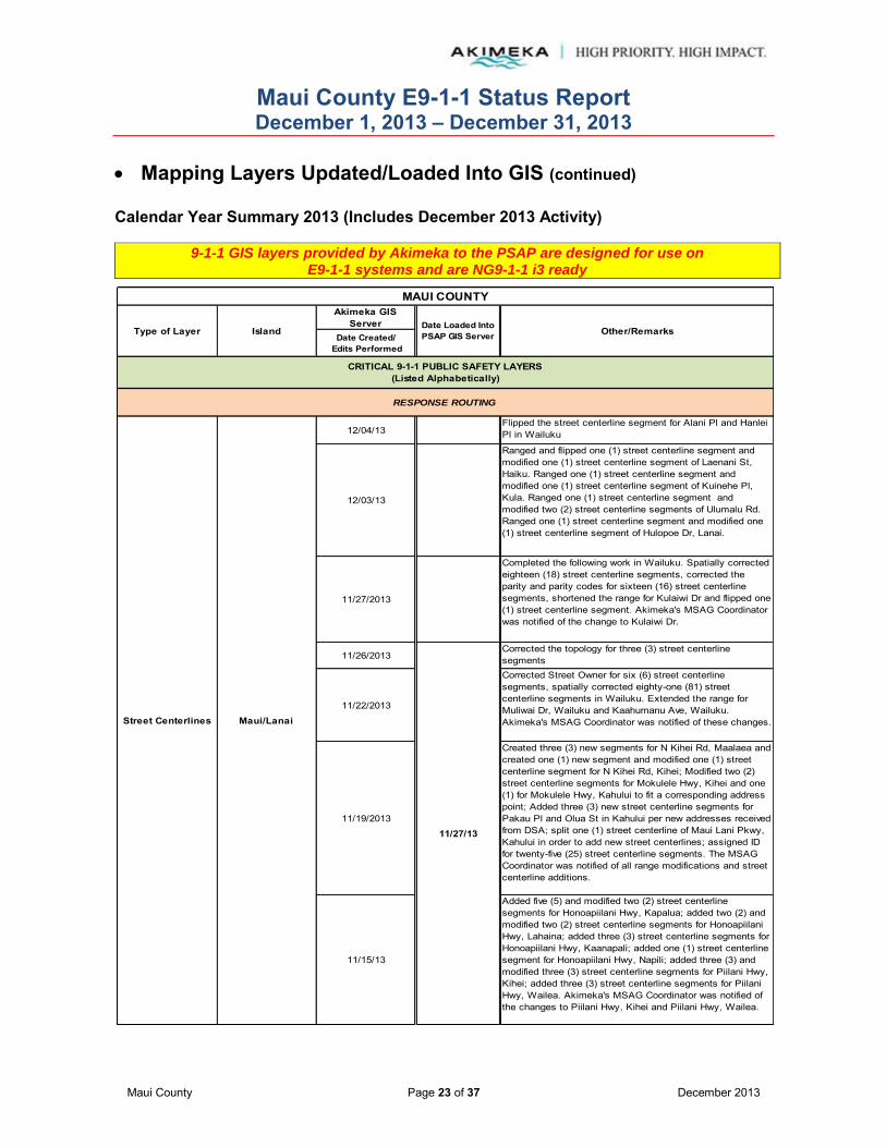
Maui County E9-1-1 Status Report December 1, 2013 – December 31, 2013
Maui County Page 23 of 37 December 2013
Mapping Layers Updated/Loaded Into GIS (continued) Calendar Year Summary 2013 (Includes December 2013 Activity)
9-1-1 GIS layers provided by Akimeka to the PSAP are designed for use on E9-1-1 systems and are NG9-1-1 i3 ready
Akimeka GIS Server
Date Created/ Edits Performed
12/04/13Flipped the street centerline segment for Alani Pl and Hanlei Pl in Wailuku
12/03/13
Ranged and flipped one (1) street centerline segment and modified one (1) street centerline segment of Laenani St, Haiku. Ranged one (1) street centerline segment and modified one (1) street centerline segment of Kuinehe Pl, Kula. Ranged one (1) street centerline segment and modified two (2) street centerline segments of Ulumalu Rd. Ranged one (1) street centerline segment and modified one (1) street centerline segment of Hulopoe Dr, Lanai.
11/27/2013
Completed the following work in Wailuku. Spatially corrected eighteen (18) street centerline segments, corrected the parity and parity codes for sixteen (16) street centerline segments, shortened the range for Kulaiwi Dr and flipped one (1) street centerline segment. Akimeka's MSAG Coordinator was notified of the change to Kulaiwi Dr.
11/26/2013Corrected the topology for three (3) street centerline segments
11/22/2013
Corrected Street Owner for six (6) street centerline segments, spatially corrected eighty-one (81) street centerline segments in Wailuku. Extended the range for Muliwai Dr, Wailuku and Kaahumanu Ave, Wailuku. Akimeka's MSAG Coordinator was notified of these changes.
11/19/2013
Created three (3) new segments for N Kihei Rd, Maalaea and created one (1) new segment and modified one (1) street centerline segment for N Kihei Rd, Kihei; Modified two (2) street centerline segments for Mokulele Hwy, Kihei and one (1) for Mokulele Hwy, Kahului to fit a corresponding address point; Added three (3) new street centerline segments for Pakau Pl and Olua St in Kahului per new addresses received from DSA; split one (1) street centerline of Maui Lani Pkwy, Kahului in order to add new street centerlines; assigned ID for twenty-five (25) street centerline segments. The MSAG Coordinator was notified of all range modifications and street centerline additions.
11/15/13
Added five (5) and modified two (2) street centerline segments for Honoapiilani Hwy, Kapalua; added two (2) and modified two (2) street centerline segments for Honoapiilani Hwy, Lahaina; added three (3) street centerline segments for Honoapiilani Hwy, Kaanapali; added one (1) street centerline segment for Honoapiilani Hwy, Napili; added three (3) and modified three (3) street centerline segments for Piilani Hwy, Kihei; added three (3) street centerline segments for Piilani Hwy, Wailea. Akimeka's MSAG Coordinator was notified of the changes to Piilani Hwy, Kihei and Piilani Hwy, Wailea.
CRITICAL 9-1-1 PUBLIC SAFETY LAYERS(Listed Alphabetically)
11/27/13
Street Centerlines Maui/Lanai
RESPONSE ROUTING
MAUI COUNTY
Type of Layer Island Date Loaded Into PSAP GIS Server Other/Remarks
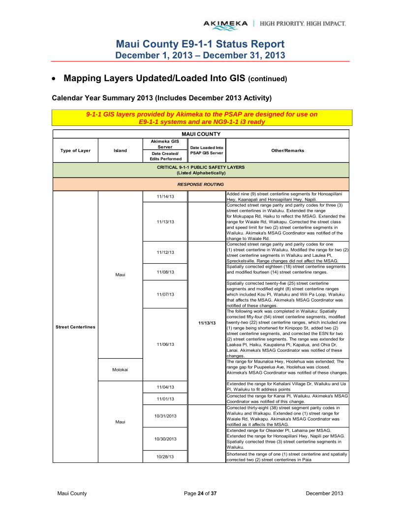
Maui County E9-1-1 Status Report December 1, 2013 – December 31, 2013
Maui County Page 24 of 37 December 2013
Mapping Layers Updated/Loaded Into GIS (continued) Calendar Year Summary 2013 (Includes December 2013 Activity)
9-1-1 GIS layers provided by Akimeka to the PSAP are designed for use on E9-1-1 systems and are NG9-1-1 i3 ready
Akimeka GIS Server
Date Created/ Edits Performed
11/14/13 Added nine (9) street centerline segments for Honoapiilani Hwy, Kaanapali and Honoapiilani Hwy, Napili.
11/13/13
Corrected street range parity and parity codes for three (3) street centerlines in Wailuku. Extended the range for Mokupapa Rd, Haiku to reflect the MSAG. Extended the range for Waiale Rd, Waikapu. Corrected the street class and speed limit for two (2) street centerline segments in Wailuku. Akimeka's MSAG Coordinator was notified of the change to Waiale Rd.
11/12/13
Corrected street range parity and parity codes for one (1) street centerline in Wailuku. Modified the range for two (2) street centerline segments in Wailuku and Laulea Pl, Spreckelsville. Range changes did not affect the MSAG.
11/08/13Spatially corrected eighteen (18) street centerline segments and modified fourteen (14) street centerline ranges.
11/07/13
Spatially corrected twenty-five (25) street centerline segments and modified eight (8) street centerline ranges which included Kou Pl, Wailuku and Wili Pa Loop, Wailuku that affects the MSAG. Akimeka's MSAG Coordinator was notified of these changes.The following work was completed in Wailuku: Spatially corrected fifty-four (54) street centerline segments, modified twenty-two (22) street centerline ranges, which included one (1) range being shortened for Kinipopo St, added two (2) street centerline segments, and corrected the ESN for two (2) street centerline segments. The range was extended for Laakea Pl, Haiku, Kaupalena Pl, Kapalua, and Ohia Dr, Lanai. Akimeka's MSAG Coordinator was notified of these changes.
Molokai
The range for Maunaloa Hwy, Hoolehua was extended; The range gap for Puupeelua Ave, Hoolehua was closed. Akimeka's MSAG Coordinator was notified of these changes.
11/04/13Extended the range for Kehalani Village Dr, Wailuku and Ua Pl, Wailuku to fit address points
11/01/13Corrected the range for Kanai Pl, Wailuku. Akimeka's MSAG Coordinator was notified of this change.
10/31/2013
Corrected thirty-eight (38) street segment parity codes in Wailuku and Waikapu. Extended one (1) street range for Waiale Rd, Waikapu. Akimeka's MSAG Coordinator was notified as it affects the MSAG.
10/30/2013
Extended range for Oleander Pl, Lahaina per MSAG. Extended the range for Honoapiilani Hwy, Napili per MSAG. Spatially corrected three (3) street centerline segments in Wailuku.
10/28/13 Shortened the range of one (1) street centerline and spatially corrected two (2) street centerlines in Paia
Other/Remarks
11/13/13
Date Loaded Into PSAP GIS ServerIsland
11/06/13
Type of Layer
MAUI COUNTY
CRITICAL 9-1-1 PUBLIC SAFETY LAYERS(Listed Alphabetically)
RESPONSE ROUTING
Maui
Maui
Street Centerlines

Maui County E9-1-1 Status Report December 1, 2013 – December 31, 2013
Maui County Page 25 of 37 December 2013
Mapping Layers Updated/Loaded Into GIS (continued) Calendar Year Summary 2013 (Includes December 2013 Activity)
9-1-1 GIS layers provided by Akimeka to the PSAP are designed for use on E9-1-1 systems and are NG9-1-1 i3 ready
Akimeka GIS Server
Date Created/ Edits Performed
Maui 10/22/2013
Shortened the range for Keawa Pl, Hana and changed the street name from Keawa Pl to Hana Bay Rd, Hana and a range was assigned. Extended the range for Ohia Dr, Lanai to fit a newly assigned address. The MSAG Coordinator was notified of these changes. Spatially corrected one (1) street centerline in Haiku.
Maui 10/21/2013
Corrected the parity of one (1) street range and shortened the range for Kaluhea Pl, Haiku. Akimeka's MSAG Coordinator was notified of this change as it affects the MSAG.
Maui 10/18/2013
Corrected two (2) parity errors in Haiku. Spatially corrected five (5) street centerline segments. Extended the range for Kahaapo Loop, Kihei. The MSAG Coordinator was notified of the range change for Kahaapo Loop.
Maui 10/17/2013
Corrected the range for the following street centerlines in Haiku: Maluna Pl, Mai Pl, Kauhikoalani Pl, Laenani St, Kamalii Pl, Lihiwai Pl, Haupoa Pl, Waipalani Pl, and Waipalani Rd. Akimeka's MSAG Coordinator was notified of these changes. Also corrected the parity for two (2) centerlines.
Maui 10/16/2013Extended the range for Kalanikahua Rd, Haiku. Akimeka's MSAG Coordinator was notified of this change as it affects the MSAG.
Maui 10/09/13
Corrected two (2) range gaps in Paia; corrected one (1) range gap and one (1) segment too short error in Pukalani; corrected three (3) range overlaps and one (1) range gap error in Waiehu; corrected three (3) range gaps and one (1) range overlap in Waihee; corrected one (1) range gap error in Waikapu; corrected one (1) range gap error in Wailuku. Extended the range for Pohu St, Waiehu which affected the MSAG. Akimeka's MSAG Coordinator was notified of this change.
Molokai 10/8/2013
Corrected one (1) TO Address Less Than FROM range error, two (2) range overlap errors, five (5) address range gap errors on Molokai. Some of these corrections affected the MSAG, so Akimeka's MSAG Coordinator was notified of the following range extensions on Pakala Pl, Kualapuu, Akeu Way, Kualapuu and Kalama Rd, Kualapuu.
MauiValidated seven (7) range errors and corrected three (3) range overlaps in Napili. All validations are not errors, but rather deemed exceptions.
MauiRemoved Pukalani Byp as the alias name for Haleakala Bypass Hwy, Makawao as requested by Maui Police Dispatch
10/23/13
MAUI COUNTY
Island Other/Remarks
CRITICAL 9-1-1 PUBLIC SAFETY LAYERS(Listed Alphabetically)
RESPONSE ROUTING
Street Centerlines
10/09/13
Type of Layer Date Loaded Into PSAP GIS Server
10/8/13

Maui County E9-1-1 Status Report December 1, 2013 – December 31, 2013
Maui County Page 26 of 37 December 2013
Mapping Layers Updated/Loaded Into GIS (continued) Calendar Year Summary 2013 (Includes December 2013 Activity)
9-1-1 GIS layers provided by Akimeka to the PSAP are designed for use on E9-1-1 systems and are NG9-1-1 i3 ready
Akimeka GIS Server
Date Created/ Edits Performed
Maui 10/7/2013 Corrected one (1) range gap and (1) range overlap in Makawao.
Maui 10/4/2013
Corrected one (1) range gap, two (2) overlaps, one (1) segment too short on Lanai; made one (1) range gap correction in Maalaea; made one (1) range gap correction in Makawao. Changed the range for Keomuku Hwy, Lanai which affected the MSAG. This change was communicated to Akimeka's MSAG Coordinator for action.
Maui 10/3/2013
Corrected four (4) range overlaps, two (2) street pointing wrong direction in Kapalua; corrected two (2) range gaps, one (1) range overlap in Lahaina. Changed the following ranges to correctly fit their respective address points. These changes affected the MSAG so it was communicated to Akimeka's MSAG Coordinator for action: Liloa Dr, Kihei, Office Rd, Kapalua, Mehani Cir, Kihei, Manino Cir, Kihei, N Kihei Rd, Kihei, and Kai Pali Pl, Lahaina. Mehani Pl, Kihei was also corrected to reflect all the addresses. This correction was also communicated to Akimeka's MSAG Coordinator for action.
Maui 10/2/2013
Corrected five (5) range gaps and one (1) range overlap in Haiku, made three (3) range corrections in Kaanapali. Shortened the street range for Kainoe St, Lahaina to correctly reflect the address points. This change affected the MSAG so it was reported to Akimeka's MSAG Coordinator for action.
Maui 10/1/2013Corrected low range 10108 to 10106 on N Kihei Rd, Maalaea.
Maui 09/26/13 Extended street segment for Awalau Rd, HaikuMaui/Molokai 09/25/13
Maui 09/24/13 -- 09/25/13
Split ten (10) Street Centerlines segments at Fire, Medic, and Police Beat boundaries. Street Centerlines affected were on Hana Hwy and Hana Hy 360, Hana & Haiku, Kahekili Hwy, Wailuku and Piilani Hwy and Pililani Hy, Hana and changed the ranges.
Maui/Molokai 09/18/13 Edited data to meet Intergraph CAD requirements
Maui 09/12/13 Added new street -- Kawai Ola Pl, Hana
Maui 08/29/13Changed Waiinu Rd, Wailuku Street Centerline range to accommodate newly added addresses
Maui/Molokai 08/28/13
Maui/Molokai 08/14/13Adjusted high range on Kanai PL from 423 to 523Adjusted low range on Maluaina Rd, Haiku
Molokai 06/28/13 Split Kolekole Ave at boundary entrance to Schofield
08/02/13Maui
MAUI COUNTY
Island Other/Remarks
CRITICAL 9-1-1 PUBLIC SAFETY LAYERS(Listed Alphabetically)
RESPONSE ROUTING
Type of Layer Date Loaded Into PSAP GIS Server
Street Centerlines

Maui County E9-1-1 Status Report December 1, 2013 – December 31, 2013
Maui County Page 27 of 37 December 2013
Mapping Layers Updated/Loaded Into GIS (continued) Calendar Year Summary 2013 (Includes December 2013 Activity)
9-1-1 GIS layers provided by Akimeka to the PSAP are designed for use on E9-1-1 systems and are NG9-1-1 i3 ready
Akimeka GIS Server
Date Created/ Edits Performed
Maui 06/18/13 -- 06/19/13Modified street centerline ranges according to new addresses assigned
Maui/Molokai 06/12/13
Made corrections to meet the Intergraph CAD requirements
Corrected the street name for Pokakaa Loop, Kahului, per the Maui County Street Naming Authority
Maui/Molokai 05/29/13Maui 05/24/13Maui 05/20/13 Modified ranges to fit new address pointsMaui 05/16/13 Extended range for Wiliokai Way, Lahaina
Maui/Molokai 05/15/13Maui 05/10/13 Modified range for Napoko Pl, Kula
Maui 05/07/13Added the first phase of the Lahaina Bypass which stretches from Lahainaluna Rd to Keawe St. Also extended the range for Lakau Pl, Kihei.
Maui 05/06/13 Corrected range for Niheu St and Upper Kimo Dr
Maui 05/01/13 Extended range for Lower Kula Rd to fit the new addresses added from the DSA Address layer
Maui/Molokai 04/24/13
Maui 04/23/13 Extended range to fit newly assigned addresses
Maui 04/18/13 Shortened range for Malina Pl, Wailea according to addresses
Maui 04/17/13 Extended and adjusted ranges to accommodate newly added addresses
Maui/Molokai 04/15/13Modified and corrected street ranges according to newly added addresses
Maui/Molokai 04/10/13
Molokai 04/09/13Changed range for Kalae Hwy, Kualapuu according to new address point added
Maui 03/27/13Akimeka re-designed PowerMap. The new design included implementation of a consistent naming schema and formatting layers to construct a robust and user friendly map.
Maui 03/27/13 Extended range to accommodate newly assigned address
Maui/Molokai
Maui 03/12/13Extended range for Aina Mahiai St, Kaanapali to fit a new address
Maui 03/04/13 Extended range for Waileia Pl, Wailea
Maui 05/30/13
CRITICAL 9-1-1 PUBLIC SAFETY LAYERS(Listed Alphabetically)
MAUI COUNTY
Type of Layer Island Date Loaded Into PSAP GIS Server Other/Remarks
RESPONSE ROUTING
Street Centerlines

Maui County E9-1-1 Status Report December 1, 2013 – December 31, 2013
Maui County Page 28 of 37 December 2013
Mapping Layers Updated/Loaded Into GIS (continued) Calendar Year Summary 2013 (Includes December 2013 Activity)
9-1-1 GIS layers provided by Akimeka to the PSAP are designed for use on E9-1-1 systems and are NG9-1-1 i3 ready
Akimeka GIS Server
Date Created/ Edits Performed
Maui 02/27/13
Maui 02/22/13 Adjusted ranges according to the new addresses added.
Maui 02/21/13 Extended street segments and adjusted ranges according to the new address points added.
Maui 02/19/13
Maui/Molokai 02/13/13
Molokai 02/08/1302/07/13 Corrected the street name for Leanihi Ln, Kihei
Molokai 02/06/13 Modified street centerline range
Maui 02/06/13Extended the street centerline range for Maika Pl, Wailuku and Kopiko St, Wailuku to fit the new addresses added
Maui 01/24/13 Corrected data to meet Intergraph CAD standardsMaui 01/23/13
Maui 01/23/13 Extended two (2) Street Centerline ranges to fit all addresses
Maui 01/18/13 Assigned a range to Hemaloa St, Kahului to fit a new address
Maui 01/14/13 -- 01/15/13 Modified ranges to fit new address pointsMaui/Molokai 01/09/13
Molokai 01/07/13Adjusted the range for Maunaloa Hwy, Kaunakakai to fit a new address
Maui 01/07/13 Corrected the Street Name for Ka Lei Pl, Makawao
Maui/Molokai 06/26/13Molokai 06/11/13 -- 06/12/13 Edited coastline to fit imagery. This is an ongoing project.
Maui 06/03/13 -- 06/14/13 Edited coastline to fit imagery. This is an ongoing project.
Maui 03/27/13Akimeka re-designed PowerMap. The new design included implementation of a consistent naming schema and formatting layers to construct a robust and user friendly map.
Molokai 02/08/13Maui 01/23/13Maui 01/22/13 Corrected to include a Street Centerline
Major Roads Maui 03/27/13Akimeka re-designed PowerMap. The new design included implementation of a consistent naming schema and formatting layers to construct a robust and user friendly map.
VISUAL REFERENCE
Coastline
Street Centerlines
CRITICAL 9-1-1 PUBLIC SAFETY LAYERS(Listed Alphabetically)
RESPONSE ROUTING
MAUI COUNTY
Type of Layer Island Date Loaded Into PSAP GIS Server Other/Remarks

Maui County E9-1-1 Status Report December 1, 2013 – December 31, 2013
Maui County Page 29 of 37 December 2013
Mapping Layers Updated/Loaded Into GIS (continued) Calendar Year Summary 2013 (Includes December 2013 Activity)
9-1-1 GIS layers provided by Akimeka to the PSAP are designed for use on E9-1-1 systems and are NG9-1-1 i3 ready
Akimeka GIS Server
Date Created/ Edits Performed
Maui/Molokai 06/26/13
018/13 -- 06/20/13 Updated parcels
Maui 06/03/13Updated according to new County Parcels layer. This is an ongoing project.
Maui 05/28/13 -- 05/31/13 Updated according to new County Parcels layer. This is an ongoing project.
Maui 03/27/13Akimeka re-designed PowerMap. The new design included implementation of a consistent naming schema and formatting layers to construct a robust and user friendly map.
Molokai 03/13/13 Updated according to new County Parcels layer. This is an ongoing project.
Maui 03/04/13 -- 03/28/13 Updated according to new County Parcels layer. This is an ongoing project.
Trails
Maui/Molokai 08/28/13
Maui 08/27/13 Added a new gate code per SR#595
Added new gate code for Koa Subdivision per SR#598
Updated gate code for Puunoa Subdivision per SR#608
Maui/Molokai 07/24/13
Maui 07/23/13 Updated gate code per SR#595
Maui 07/22/13 Updated gate code per SR#593
Maui/Molokai 05/29/13
Maui Added a new gate code for Pineapple Hill per SR#581
Maui/Molokai 04/24/13
Maui 04/16/13 Added gate codes, SR#572 and SR#573
Maui 03/27/13Akimeka re-designed PowerMap. The new design included implementation of a consistent naming schema and formatting layers to construct a robust and user friendly map.
Maui/Molokai 02/13/13Maui 02/13/13 Changed the gate code for Kapalua Mauka, SR#547Maui 02/11/13 Changed the gate code for Kapalua Ironwoods, SR#546
Maui/Molokai 01/09/13
Gate Codes
08/26/13Maui
SPECIAL REQUESTS
VISUAL REFERENCE
CRITICAL 9-1-1 PUBLIC SAFETY LAYERS(Listed Alphabetically)
MAUI COUNTY
Type of Layer Island Date Loaded Into PSAP GIS Server Other/Remarks

Maui County E9-1-1 Status Report December 1, 2013 – December 31, 2013
Maui County Page 30 of 37 December 2013
Mapping Layers Updated/Loaded Into GIS (continued) Calendar Year Summary 2013 (Includes December 2013 Activity)
9-1-1 GIS layers provided by Akimeka to the PSAP are designed for use on E9-1-1 systems and are NG9-1-1 i3 ready
Note: The Parcels layer is provided by Maui County. Akimeka performs edits on the spatial information of the layer for 9-1-1 purposes. Changes to the attribute table are made when needed. The Parcels layer uploaded to the PSAP GIS server is intended for 9-1-1 purposes only and should not be disseminated to other county agencies.
Current Month GIS Activities – December 2013 12/20/13 -- 12/23/13 --
Akimeka prepared the following layers to the Intergraph CAD Map: Address Points, Common Name Lookup Table, Lodging, Street Centerlines, Points of Interest, and WSP Cell Towers. Akimeka pushed the following layers to the Intergraph CAD Map: Address Points, Common Name Lookup Table, Lodging, Street Centerlines, Points of Interest, and WSP Cell Towers.
Everytime the GIS Update tool is used, Indexes and Cache have to be built. The Positron system configurator is adjusted every time a layer is loaded in the PowerMap database. Each PSAP position is updated accordingly.
Akimeka GIS Server
Date Created/ Edits Performed
Maui 03/27/13Akimeka re-designed PowerMap. The new design included implementation of a consistent naming schema and formatting layers to construct a robust and user friendly map.
Maui 06/26/13 Changed to fit coastline
Maui 01/22/13 Changed to match corrected coastline
Coastal Names Maui 09/27/13Deleted Keonekai Park, Kihei, since it does not belong on this layer
HCS Monsanto Fields
Tow Boundaries
CAD REQUIREMENT
CRITICAL 9-1-1 PUBLIC SAFETY LAYERS(Listed Alphabetically)
SPECIAL REQUESTS
MAUI COUNTY
Type of Layer Island Date Loaded Into PSAP GIS Server Other/Remarks
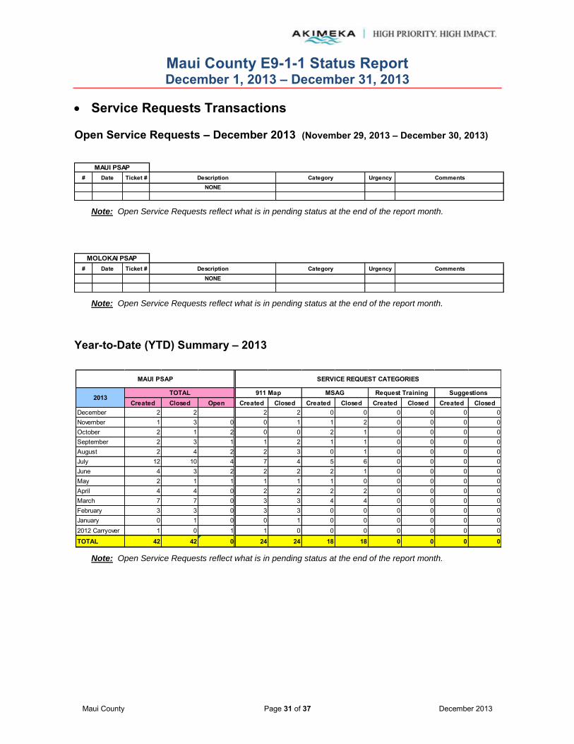
Maui County E9-1-1 Status Report December 1, 2013 – December 31, 2013
Maui County Page 31 of 37 December 2013
Service Requests Transactions Open Service Requests – December 2013 (November 29, 2013 – December 30, 2013)
# Date Ticket # Description Category Urgency CommentsNONE
MAUI PSAP
Note: Open Service Requests reflect what is in pending status at the end of the report month.
# Date Ticket # Description Category Urgency CommentsNONE
MOLOKAI PSAP
Note: Open Service Requests reflect what is in pending status at the end of the report month.
Year-to-Date (YTD) Summary – 2013
Note: Open Service Requests reflect what is in pending status at the end of the report month.
Created Closed Open Created Closed Created Closed Created Closed Created ClosedDecember 2 2 2 2 0 0 0 0 0 0November 1 3 0 0 1 1 2 0 0 0 0October 2 1 2 0 0 2 1 0 0 0 0September 2 3 1 1 2 1 1 0 0 0 0August 2 4 2 2 3 0 1 0 0 0 0July 12 10 4 7 4 5 6 0 0 0 0June 4 3 2 2 2 2 1 0 0 0 0May 2 1 1 1 1 1 0 0 0 0 0April 4 4 0 2 2 2 2 0 0 0 0March 7 7 0 3 3 4 4 0 0 0 0February 3 3 0 3 3 0 0 0 0 0 0January 0 1 0 0 1 0 0 0 0 0 02012 Carryover 1 0 1 1 0 0 0 0 0 0 0
TOTAL 42 42 0 24 24 18 18 0 0 0 0
MAUI PSAP
TOTAL
SERVICE REQUEST CATEGORIES
2013911 Map SuggestionsMSAG Request Training

Maui County E9-1-1 Status Report December 1, 2013 – December 31, 2013
Maui County Page 32 of 37 December 2013
Service Requests Transactions (continued)
Note: Open Service Requests reflect what is in pending status at the end of the report month
Suggestions
Mapping computer not functioning or displaying properlyDescription
Discrepancies with 9-1-1 MSAG addressesE-911 Operations training needsVehicle to share suggestions
911 MapDefinitions:
Category
MSAGRequest Training
Created Closed Open Created Closed Created Closed Created Closed Created ClosedDecember 0 0 0 0 0 0 0 0 0 0 0November 0 0 0 0 0 0 0 0 0 0 0October 0 0 0 0 0 0 0 0 0 0 0September 0 0 0 0 0 0 0 0 0 0 0August 0 0 0 0 0 0 0 0 0 0 0July 0 0 0 0 0 0 0 0 0 0 0June 0 0 0 0 0 0 0 0 0 0 0May 0 0 0 0 0 0 0 0 0 0 0April 0 0 0 0 0 0 0 0 0 0 0March 0 0 0 0 0 0 0 0 0 0 0February 0 0 0 0 0 0 0 0 0 0 0January 0 0 0 0 0 0 0 0 0 0 02012 Carryover 0 0 0 0 0 0 0 0 0 0 0TOTAL 0 0 0 0 0 0 0 0 0 0 0
MSAG2013
TOTAL 911 Map
MOLOKAI PSAP SERVICE REQUEST CATEGORIES
SuggestionsRequest Training

Maui County E9-1-1 Status Report December 1, 2013 – December 31, 2013
Maui County Page 33 of 37 December 2013
E9-1-1 Database Synchronization
(Reference: NENA 71-501, Version 1.1 – NENA Information Document for Synchronizing Geographic Information System databases with MSAG & ALI)
As part of Akimeka's value added services, Akimeka conducted the next quarterly database synchronization audit for Maui County in March 2013.
The database synchronization effort included comparing Maui County's 9-1-1 MSAG against its GIS Street Centerline data. A total number of 2,684 9-1-1 MSAG (ESN 300 – 357) records were reviewed in the audit and analyzed. Results of the database synchronization audit completed on December 9, 2013 for Maui County are reported below.
Database synchronization should be part of an ongoing and continuous process to ensure that the databases remain current and synchronized. Since neither database is static in nature, the synchronization process will never yield a 100 percent match rate. As such, NENA's recommended minimum match rate is 98%.
The database synchronization process is essential to monitor and ensure the level of accuracy of the E9-1-1 databases and prepare for Next Generation 9-1-1 (NG9-1-1). As such, Akimeka will perform database synchronization audits on a quarterly basis as part of its ongoing maintenance process. Results of the database synchronization audit will be included and reported in the Monthly Status Report (MSR) accordingly.
Audit Summary Results – 2013
Objective: NENA Recommended Match Rate = 98%
# of Records % # of
Records % # of Records % # of
Records %
2,669 2,671 2,675 2,684 (1) 60 2.2% 60 2.2% 60 2.2% 60 2.24%
2,609 2,611 2,615 2,624
2,595 99.5% 2,609 99.9% 2,611 99.8% 2,580 98.32%
(2) 6 0.2% 2 0.1% 2 0.1% 37 1.41% (3) 8 0.3% 0 0.0% 2 0.1% 7 0.27%
14 0.5% 2 0.1% 4 0.2% 44 1.68%
As of December 09, 2013 9-1-1 MSAG
Dated 12-01-13
As of September 11, 2013 9-1-1 MSAG
Dated 06-01-13 9-1-1 MSAG
Dated 9-01-13
Less: 9-1-1 MSAG Exception Records
Total 9-1-1 MSAG Records Match (9-1-1 MSAG -- GIS Match -- No Corrections Required)
As of June 14, 2013
9-1-1 MSAG -- GIS No Match - Minor Correction Required
9-1-1 MSAG Dated 03-01-13
Total 9-1-1 MSAG Records Reviewed
Net 9-1-1 MSAG Records Eligible for Comparison
9-1-1 MSAG TO GIS STREET CENTERLINE AUDIT COMPARISON RESULTS Notes
As of March 24, 2013
9-1-1 MSAG Record With No GIS Record
Total 9-1-1 MSAG Records No Match

Maui County E9-1-1 Status Report December 1, 2013 – December 31, 2013
Maui County Page 34 of 37 December 2013
E9-1-1 Database Synchronization (continued)
(Reference: NENA 71-501, Version 1.1 – NENA Information Document for Synchronizing Geographic Information System databases with MSAG & ALI)
Audit Summary Results – 2013 (continued)
Notes:
(1) An MSAG Record that will not have a corresponding GIS Street Centerline Record but is required for the routing of E9-1-1 calls (i.e., Emergency Call Box, Foreign Exchange Records, Wireless Shell Records, etc.). No further action is required.
(2) An MSAG Record that requires minor MSAG attention in 9-1-1Net to correct MSAG Records (i.e., Reassignment of an MSAG Community, modification of the Site Address Range, assignment of an ESN, performing a combine or insert of an existing MSAG Record, etc.).
(3) An MSAG Record that does not have a corresponding GIS Record and will require additional research and validation. The GIS Section will assist with this effort.
Audit Summary Results – December 1, 2013 vs. September 1, 2013 MSAG
Maui County's level of accuracy or 9-1-1 Match percentage remained fairly constant
from 99.85% as of September 1, 2013 to 98.32% as of December 1, 2013
98.32%
1.68%
9-1-1 MSAG Dated 12-01-13
Match
No Match
Maui County E9-1-1 Status Report December 1, 2013 – December 31, 2013
Maui County Page 35 of 37 December 2013
E9-1-1 Database Synchronization (continued)
(Reference: NENA 71-501, Version 1.1 – NENA Information Document for Synchronizing Geographic Information System databases with MSAG & ALI)
Audit Summary Results – December 1, 2013 vs. September 1, 2013 MSAG (continued) “MSAG - GIS Minor Corrections” The minor MSAG records requiring corrective action increased
by thirty-five (35) this Quarter. This was primarily the result of edits made to the GIS Street Centerlines layer in order to meet new NG9-1-1 requirements. In order to reflect changes in the GIS database, MSAG records will be combined, split or new records will be inserted, to match the Street Centerlines. Corrections to the GIS street Centerline Low and High Street Ranges also created a situation whereby the MSAG records are required to be corrected to match the GIS record.
“MSAG Record With No GIS Record” During the last Quarter of 2013, the number of MSAG records increased by five (5) records. The increase appears to be erroneous findings in the comparison report, as it has been verified that these MSAG records match the GIS database. An inquiry with the Akimeka GIS Analyst will be made to ensure an invalid flag has not been inserted to the GIS record and will be reported correctly during the next database synchronization report. Two of the identified seven (7) MSAG records have been corrected in 9-1-1 Net during the month of December.
“GIS Record With Minor Corrections” There was an increase of twenty-nine (29) GIS Records requiring minor correction during the past quarter. These records were investigated and as a result, all 31 GIS records were confirmed to have a corresponding MSAG record, however, was not an exact match. The increase of the number of GIS Records not matching the MSAG database increased is a result of new street segments, Street Name changes/updates, Street low/high range updates, MSAG Community and ESN updates, etc. which had not yet been processed within 9-1-1 Net at the time of this data analysis. The GIS Analyst will monitor these records to ensure they are corrected prior to the February 2014 re-analysis.
“MSAG records that don’t match GIS” The number of MSAG records that do not match the GIS database includes both the MSAG records that do not have a matching GIS record; and MSAG records that are not synchronized to the GIS database. The increase of the number of MSAG Records not matching the GIS database is a result of missing GIS records, newly assigned street segments, street name changes or updates, street range updates, MSAG Community and ESN changes, etc. which have resulted in the non-match condition.
The non-match condition may also be a result in which MSAG records submitted in 9-1-1Net were not completed prior to the running of the MapSAG comparison. The MSAG section will monitor these records to ensure they are processed in 9-1-1Net prior to the February 2014 re-analysis.
Ongoing maintenance is critical to ensure the database synchronized level of address accuracy is maintained each time an MSAG or GIS record is “last modified”.

Maui County E9-1-1 Status Report December 1, 2013 – December 31, 2013
Maui County Page 36 of 37 December 2013
Invalid MSAG Streets and Address Ranges – ESN 399/359 Records Hawaiian Telcom, Inc. (HTI) provides Maui County and Akimeka, as the PSAP’s agent, with access and visibility to the ESN 359/399 MSAG records which are “known” invalid streets and address ranges. Results of the data provided are as follows:
Note: The number of 359/399 MSAG records for Maui/Lanai and Molokai were inadvertently reported in reverse. The chart above has been corrected accordingly for the 9-1-1 MSAG Dated 03-01-13.
# of Records
% of Total MSAG
Records(Valid and Invalid)
# of Records
% of Total MSAG
Records(Valid and Invalid)
# of Records
% of Total MSAG
Records(Valid and Invalid)
# of Records
% of Total MSAG
Records(Valid and Invalid)
MAUI 399 257 9.5% 233 8.7% 220 7.9% 211 7.9%
MOLOKAI 359 110 32.8% 78 25.8% 77 25.6% 78 26.1%
367 12.1% 311 10.4% 297 10.0% 289 9.7%
9-1-1 MSAG Dated 12-01-13
Invalid MSAG Records
PSAP ESN
9-1-1 MSAG Dated 03-01-13 9-1-1 MSAG Dated 06-01-13 9-1-1 MSAG Dated 09-01-13
TOTAL MAUI COUNTY
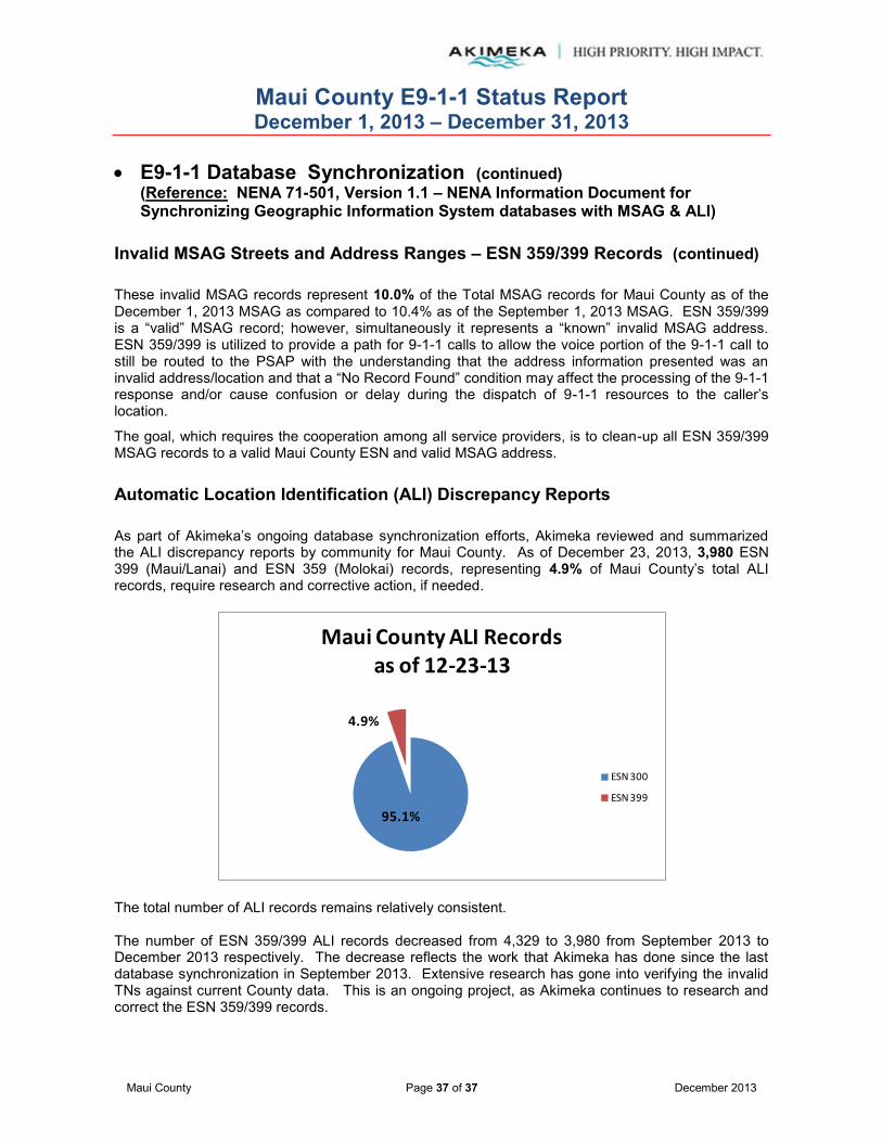
Maui County E9-1-1 Status Report December 1, 2013 – December 31, 2013
Maui County Page 37 of 37 December 2013
E9-1-1 Database Synchronization (continued)
(Reference: NENA 71-501, Version 1.1 – NENA Information Document for Synchronizing Geographic Information System databases with MSAG & ALI)
Invalid MSAG Streets and Address Ranges – ESN 359/399 Records (continued)
These invalid MSAG records represent 10.0% of the Total MSAG records for Maui County as of the December 1, 2013 MSAG as compared to 10.4% as of the September 1, 2013 MSAG. ESN 359/399 is a “valid” MSAG record; however, simultaneously it represents a “known” invalid MSAG address. ESN 359/399 is utilized to provide a path for 9-1-1 calls to allow the voice portion of the 9-1-1 call to still be routed to the PSAP with the understanding that the address information presented was an invalid address/location and that a “No Record Found” condition may affect the processing of the 9-1-1 response and/or cause confusion or delay during the dispatch of 9-1-1 resources to the caller’s location.
The goal, which requires the cooperation among all service providers, is to clean-up all ESN 359/399 MSAG records to a valid Maui County ESN and valid MSAG address. Automatic Location Identification (ALI) Discrepancy Reports As part of Akimeka’s ongoing database synchronization efforts, Akimeka reviewed and summarized the ALI discrepancy reports by community for Maui County. As of December 23, 2013, 3,980 ESN 399 (Maui/Lanai) and ESN 359 (Molokai) records, representing 4.9% of Maui County’s total ALI records, require research and corrective action, if needed.
The total number of ALI records remains relatively consistent. The number of ESN 359/399 ALI records decreased from 4,329 to 3,980 from September 2013 to December 2013 respectively. The decrease reflects the work that Akimeka has done since the last database synchronization in September 2013. Extensive research has gone into verifying the invalid TNs against current County data. This is an ongoing project, as Akimeka continues to research and correct the ESN 359/399 records.
95.1%
4.9%
Maui County ALI Recordsas of 12-23-13
ESN 300
ESN 399
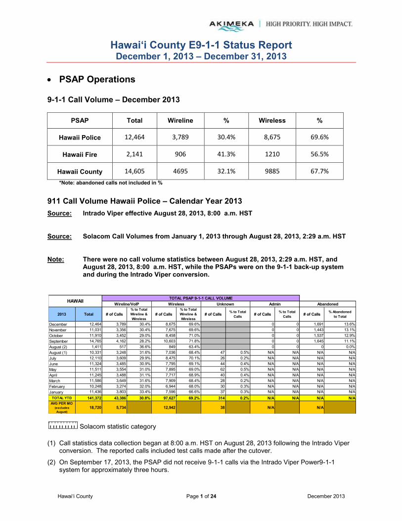
Hawai‘i County E9-1-1 Status Report December 1, 2013 – December 31, 2013
Hawai‘i County Page 1 of 24 December 2013
PSAP Operations 9-1-1 Call Volume – December 2013
PSAP Total Wireline % Wireless %
Hawaii Police 12,464 3,789 30.4% 8,675 69.6%
Hawaii Fire 2,141 906 41.3% 1210 56.5%
Hawaii County 14,605 4695 32.1% 9885 67.7%
*Note: abandoned calls not included in %
911 Call Volume Hawaii Police – Calendar Year 2013 Source: Intrado Viper effective August 28, 2013, 8:00 a.m. HST
Source: Solacom Call Volumes from January 1, 2013 through August 28, 2013, 2:29 a.m. HST
Note: There were no call volume statistics between August 28, 2013, 2:29 a.m. HST, and August 28, 2013, 8:00 a.m. HST, while the PSAPs were on the 9-1-1 back-up system and during the Intrado Viper conversion.
Solacom statistic category
(1) Call statistics data collection began at 8:00 a.m. HST on August 28, 2013 following the Intrado Viper
conversion. The reported calls included test calls made after the cutover.
(2) On September 17, 2013, the PSAP did not receive 9-1-1 calls via the Intrado Viper Power9-1-1 system for approximately three hours.
2013 Total # of Calls% to Total Wireline & Wireless
# of Calls% to Total Wireline & Wireless
# of Calls % to Total Calls # of Calls % to Total
Calls # of Calls % Abandonedto Total
December 12,464 3,789 30.4% 8,675 69.6% 0 0 1,691 13.6%November 11,031 3,356 30.4% 7,675 69.6% 0 0 1,443 13.1%October 11,910 3,452 29.0% 8,458 71.0% 0 0 1,537 12.9%September 14,765 4,162 28.2% 10,603 71.8% 0 0 1,645 11.1%August (2) 1,411 517 36.6% 849 63.4% 0 0 0 0.0%August (1) 10,331 3,248 31.6% 7,036 68.4% 47 0.5% N/A N/A N/A N/AJuly 12,110 3,609 29.9% 8,475 70.1% 26 0.2% N/A N/A N/A N/AJune 11,324 3,485 30.9% 7,795 69.1% 44 0.4% N/A N/A N/A N/AMay 11,511 3,554 31.0% 7,895 69.0% 62 0.5% N/A N/A N/A N/AApril 11,245 3,488 31.1% 7,717 68.9% 40 0.4% N/A N/A N/A N/AMarch 11,586 3,649 31.6% 7,909 68.4% 28 0.2% N/A N/A N/A N/AFebruary 10,248 3,274 32.0% 6,944 68.0% 30 0.3% N/A N/A N/A N/AJanuary 11,436 3,803 33.4% 7,596 66.6% 37 0.3% N/A N/A N/A N/A
TOTAL YTD 141,372 43,386 30.8% 97,627 69.2% 314 0.2% N/A N/A N/A N/AAVG PER MO
(excludes August)
18,720 5,734 12,942 38 N/A N/A
HAWAII TOTAL PSAP 9-1-1 CALL VOLUMEWireline/VoIP Wireless Unknown Admin Abandoned

Hawai‘i County E9-1-1 Status Report December 1, 2013 – December 31, 2013
Hawai‘i County Page 2 of 24 December 2013
PSAP Operations (continued)
9-1-1 Call Volume Hawaii Fire – Calendar Year 2013 Source: Intrado Viper effective August 28, 2013, 8:00 a.m. HST
Source: Solacom Call Volumes from January 1, 2013 through August 28, 2013, 2:29 a.m. HST
Note: There were no call volume statistics between August 28, 2013, 2:29 a.m. HST, and August 28, 2013, 8:00 a.m. HST, while the PSAPs were on the 9-1-1 back-up system and during the Intrado Viper conversion.
Solacom statistic category
(1) On September 17, 2013, the PSAP did not receive 9-1-1 calls via the Intrado Viper Power9-1-1 system for approximately three hours.
Note: Total Calls include Administrative calls that are not direct 9-1-1 calls.
2013 Total # of Calls% to Total Wireline & Wireless
# of Calls% to Total Wireline & Wireless
# of Calls % to Total Calls # of Calls % to Total
Calls # of Calls % Abandonedto Total
December 2,141 906 42.3% 1,210 56.5% 0 0 25 1.2%November 2,008 830 41.3% 1,178 58.7% 0 0 21 1.0%October 2,043 832 40.7% 1,211 59.3% 0 0 18 0.9%September 1,902 792 41.6% 1,110 58.4% 0 0 20 1.1%August (2) 305 N/A N/A N/A N/A 0 0 7 2.3%August (1) 1,826 764 42.4% 1,038 57.6% 24 1.3% N/A N/A N/A N/AJuly 2,340 931 40.4% 1,374 59.6% 35 1.5% N/A N/A N/A N/AJune 2,004 804 40.6% 1,178 59.4% 22 1.1% N/A N/A N/A N/AMay 2,221 924 42.0% 1,276 58.0% 21 0.9% N/A N/A N/A N/AApril 2,205 934 42.9% 1,244 57.1% 27 1.2% N/A N/A N/A N/AMarch 2,255 954 42.9% 1,268 57.1% 33 1.5% N/A N/A N/A N/AFebruary 2,135 947 44.8% 1,167 55.2% 21 1.0% N/A N/A N/A N/AJanuary 2,425 1,057 44.1% 1,339 55.9% 29 1.2% N/A N/A N/A N/A
TOTAL YTD 25,810 10,675 42.2% 14,593 57.8% 212 0.8% N/A N/A N/A N/AAVG PER MO
(excludes August)
3,426 1,416 1,936 27 N/A N/A
HAWAII TRANSFERRED TO FIREUnknown Admin AbandonedWireline/VoIP Wireless
Notes:
(1)
(2)
(3)
"Abandoned" calls represent the number of incoming 9-1-1 calls for which the caller had hung up before a call-taker answered.
"Abandoned" calls are included in the "Wireline" and "Wireless" counts respectively. The standard CML reports do not provide a break-out of "Abandoned" calls between "Wireline" and "Wireless" calls.
Total call volumes include Administrative calls. (Administrative calls = Calls made between 911 positions but are not 911 calls.)
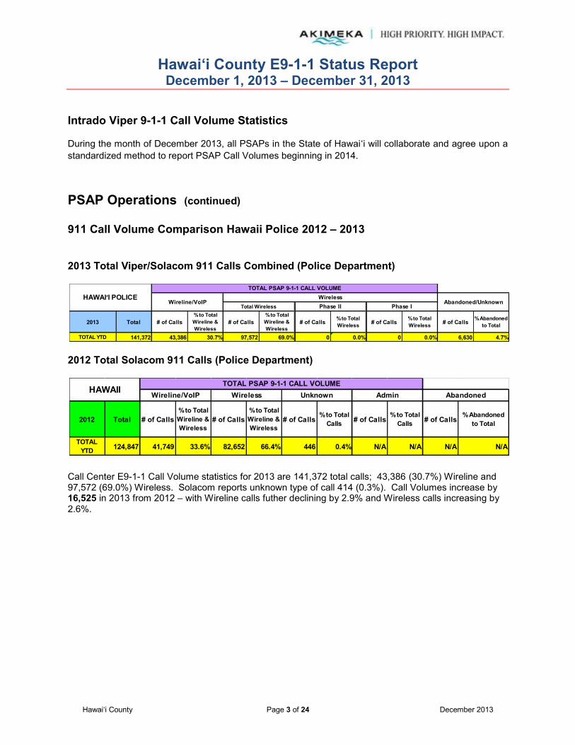
Hawai‘i County E9-1-1 Status Report December 1, 2013 – December 31, 2013
Hawai‘i County Page 3 of 24 December 2013
Intrado Viper 9-1-1 Call Volume Statistics
During the month of December 2013, all PSAPs in the State of Hawaiʻi will collaborate and agree upon a standardized method to report PSAP Call Volumes beginning in 2014. PSAP Operations (continued)
911 Call Volume Comparison Hawaii Police 2012 – 2013 2013 Total Viper/Solacom 911 Calls Combined (Police Department)
2012 Total Solacom 911 Calls (Police Department)
Call Center E9-1-1 Call Volume statistics for 2013 are 141,372 total calls; 43,386 (30.7%) Wireline and 97,572 (69.0%) Wireless. Solacom reports unknown type of call 414 (0.3%). Call Volumes increase by 16,525 in 2013 from 2012 – with Wireline calls futher declining by 2.9% and Wireless calls increasing by 2.6%.
2013 Total # of Calls% to Total Wireline & Wireless
# of Calls% to Total Wireline & Wireless
# of Calls % to Total Wireless # of Calls % to Total
Wireless # of Calls % Abandonedto Total
TOTAL YTD 141,372 43,386 30.7% 97,572 69.0% 0 0.0% 0 0.0% 6,630 4.7%
HAWAI‘I POLICETOTAL PSAP 9-1-1 CALL VOLUME
Wireline/VoIPWireless
Abandoned/UnknownTotal Wireless Phase II Phase I
2012 Total # of Calls% to Total Wireline & Wireless
# of Calls% to Total Wireline & Wireless
# of Calls % to Total Calls # of Calls % to Total
Calls # of Calls % Abandonedto Total
TOTAL YTD 124,847 41,749 33.6% 82,652 66.4% 446 0.4% N/A N/A N/A N/A
AbandonedHAWAIITOTAL PSAP 9-1-1 CALL VOLUME
Wireline/VoIP AdminWireless Unknown
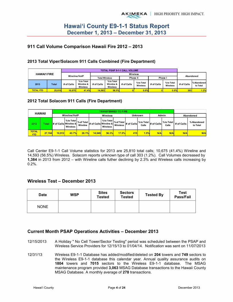
Hawai‘i County E9-1-1 Status Report December 1, 2013 – December 31, 2013
Hawai‘i County Page 4 of 24 December 2013
911 Call Volume Comparison Hawaii Fire 2012 – 2013 2013 Total Viper/Solacom 911 Calls Combined (Fire Department)
2012 Total Solacom 911 Calls (Fire Department)
Call Center E9-1-1 Call Volume statistics for 2013 are 25,810 total calls; 10,675 (41.4%) Wireline and 14,593 (56.5%) Wireless. Solacom reports unknown type of call 303 (1.2%). Call Volumes decreased by 1,384 in 2013 from 2012 – with Wireline calls futher declining by 2.3% and Wireless calls increasing by 0.2%. Wireless Test – December 2013
Date WSP Sites Tested
Sectors Tested Tested By Test
Pass/Fail
NONE
Current Month PSAP Operations Activities – December 2013 12/15/2013 A Holiday " No Cell Tower/Sector Testing" period was scheduled between the PSAP and
Wireless Service Providers for 12/15/13 to 01/04/14. Notification was sent on 11/07/2013 12/31/13 Wireless E9-1-1 Database has added/modified/deleted on 204 towers and 749 sectors to
the Wireless E9-1-1 database this calendar year. Annual quality assurance audits on 1804 towers and 7015 sectors to the Wireless E9-1-1 database. The MSAG maintenance program provided 3,063 MSAG Database transactions to the Hawaii County MSAG Database. A monthly average of 278 transactions.
2013 Total # of Calls% to Total Wireline & Wireless
# of Calls% to Total Wireline & Wireless
# of Calls % to Total Wireless # of Calls % to Total
Wireless # of Calls % Abandonedto Total
TOTAL YTD 25,810 10,675 41.4% 14,593 56.5% 0 0.0% 0 0.0% 303 1.2%
HAWAI‘I FIRETOTAL PSAP 9-1-1 CALL VOLUME
Wireline/VoIPWireless
AbandonedTotal Wireless Phase II Phase I
2012 Total # of Calls% to Total Wireline & Wireless
% of Total Wireline # of Calls
% to Total Wireline & Wireless
% of Total Wireless # of Calls % to Total
Calls # of Calls % to Total Calls # of Calls % Abandoned
to Total
TOTAL YTD 27,194 10,912 43.7% 26.1% 14,049 56.3% 17.0% 415 1.5% N/A N/A N/A N/A
HAWAIIWireless AbandonedAdminUnknownWireline/VoIP
TRANSFERRED TO FIRE

Hawai‘i County E9-1-1 Status Report December 1, 2013 – December 31, 2013
Hawai‘i County Page 5 of 24 December 2013
MSAG Current Month – December 2013
A total of 278 MSAG transactions were processed in 9-1-1 Net during the month of December 2013. Sixty-eight (68) requests were processed relating to the MSAG database, with fifty-two (52) customer's telephone ANI/ALI records updated as a direct result. 208 TN CR transactions and two (2) ALI-DR transaction were also processed to 9-1-1Net for updates and corrections. The 208 TNCRs were submitted with MSAG valid address, as a result of the ESN 299 clean-up effort. Streets and address ranges were validated against the GIS to ensure synchronization and an MSAG valid address was provided to the Telco. TN CRs must be validated against HT records and approved by the end user Hawaiian Telcom customer before updating the ALI record. There are no suspended requests in the system at this time.
See attached spreadsheet for a detailed description of changes and additions.
HAWAII 278 68 16 0 32 13 7 52 208 2 706 1 0 0
2013
PSAP TOTAL
9-1-1NET REQUESTS
MSAG TRANSACTIONS ALI TRANSACTIONS
Customer Addresses
AffectedSplitChange Combined Delete
County Address Change Request (TN CR)
Processed(a)
ALI Discrepancy
(ALI-DR) Processed
(b)
Total Insert TNsAffected
In Referred Statusas of Report Month End
(c)
In Suspended Statusas of Report Month End
(d)
TN CR ALI-DR # ofTransactions

Hawai‘i County E9-1-1 Status Report December 1, 2013 – December 31, 2013
Hawai‘i County Page 6 of 24 December 2013
MSAG (continued) Current Month – December 2013 (continued) There are 706 TN CRs and one (1) ALI-DR in Referred status as of December 31, 2013.
The ALI DR in “Referred” status was submitted on November 21, 2013. The ALI DR was the result of a 9-1-1 call from a residence in Kealakekua. Hawaii County Fire submitted a request to Akimeka to update the customer street name from Mamalahoa Hwy to Hawaii Belt Rd. Akimeka submitted the ALI DR to Intrado and the transaction is awaiting approval from the telco.
Intrado will notify Akimeka when the TN has been updated in 9-1-1Net.
118 of the TN CRs in “Referred” status are the remainder of the TNs submitted to Intrado in October 2012 as a result of the Puako Beach Road address changes per the Hawai‘i County Planning Department. These TN CRs deal primarily with house numbers. See Service Request #225.
Numerous follow-ups have been made by Akimeka inquiring as to why these TN CRs remain in “Referred” status. No explanation has been provided as to why these house numbers are not being updated for 9-1-1 purposes.
Intrado will notify Akimeka when the TNs have been updated in 9-1-1Net.
The remaining 588 "Referred" records are a direct result of the ESN 299 clean-up and are awaiting approval from Hawaiian Telcom, Inc. Akimeka continues to monitor and track the progress of the Referred records. Once a telephone number is submitted to Intrado for correction, it must be verified against HT records and/or approved by the customer. Intrado's internal process requires calling each telephone customer individually for approval to update an address in the 9-1-1 database.
Intrado will notify Akimeka when each TN has been updated in 9-1-1 Net.
There are no records in Suspended status as of December 31, 2013.

Hawai‘i County E9-1-1 Status Report December 1, 2013 – December 31, 2013
Hawai‘i County Page 7 of 24 December 2013
MSAG (continued) Year-to-Date (YTD) Summary – 2013
Note: Revised categories and report format changes effective May 2012 with new Intrado TN CR functionality.
2012 TOTAL# of
Transactions
TNsAffected
December 466 465 349 8 78 17 13 4,920 0 1 0 0November 1,765 1,705 1,596 17 17 24 51 31,976 44 16 1 1October 1,057 1,046 957 15 24 13 37 3,178 8 3 1 1September 791 754 673 15 16 19 31 24,836 35 2 1 1August 789 780 736 2 22 12 8 12,107 4 5 3 3July 733 509 392 12 17 17 71 6,517 221 3 5 5June 453 408 259 34 30 33 52 2,899 39 6 5 5May 428 259 179 7 21 16 36 5,530 158 11 8 8April 444 361 225 17 36 23 60 7,591 83 8 8March 348 72 33 6 2 27 4 292 276 11 25February 337 226 142 7 17 49 11 8,574 111 21 37January 203 60 32 0 3 23 2 298 143 40 75
TOTAL YTD 7,814 6,645 5,573 140 283 273 376 108,718 509 660 AVG PER MO 651 554 464 12 24 23 31 9,060 64 55
Split
ALI Discrepancy
(ALI-DR) Submitted
(b)
ChangeTotal
HAWAII COUNTY MSAG TRANSACTIONS ALI TRANSACTIONS
Combined Delete Insert
In Suspended Statusas of Report Month End
(c)
9-1-1NET REQUESTS
County Address Change Request (TN CR)
Submitted(a)
Customer Addresses
Affected(*)
(a)
(b)
(c)
(d)
Definitions:
Represents address corrections on a specific TN or group of TNs. These "invalid" TNs usually have an associated ESN 299 attached to them which indicates the need for validation.
Represents an address discrepancy discovered during a live 9-1-1 call. These record corrections are treated with a higher priority and should be processed within 48 hours as a general guideline.
Represents correction requests that have been referred by Intrado to the appropriate service provider and is awaiting approval to be updated in 9-1-1Net.
Represents correction requests that have been "paused" due to TN fallouts, range overlaps, or not having a valid address point. Intrado requires additional information from Akimeka/PSAP before the Telco approves the change.

Hawai‘i County E9-1-1 Status Report December 1, 2013 – December 31, 2013
Hawai‘i County Page 8 of 24 December 2013
Mapping Layers Updated/Loaded Into GIS
Calendar Year Summary 2013 (Includes December 2013 Activity)
9-1-1 GIS layers provided by Akimeka to the PSAP are designed for use on E9-1-1 systems and are NG9-1-1 i3 ready
Akimeka GIS Server
Date Created/ Edits Performed
12/31/2013Changed Routing ID to seven (7) addresses on Operations St in Hilo.
12/30/13Corrected Routing ID of one (1) address on Haakoa Rd in Laupahoehoe.
Changed Routing ID to eleven (11) addresses in Papaaloa.
Readdressed two (2) street addresses on Hakuma St in Pahoa.Readdressed two (2) street addresses on Hawaii Belt Rd in Paauilo.Readdressed nine (9) addresses on Waiono Ranch Rd in Holualoa.
12/26/13Changed routing ID to four (4) addresses on Pahoa Kalapana Rd in Pahoa and 13 addresses on Mamalahoa Hwy in Holualoa.
12/24/13
12/23/13Changed street name and routing id for nine (9) addresses on Hualalai Rd in Holualoa. Changed routing id for eight (8) addresses on Lolo Ln in Holualoa.
Changed number to one (1) address on Halewili Pl in Holualoa.Completed monthly update on address points. Received 12/10/13 from Hawaii County Planning.
12/17/13Changed suffix to address point on Catamaran from DR to LN in Ocean View.
12/16/13Changed street name and number to two (2) addresses in Kealakekua and changed street name to one (1) address in Papaaloa.
Address Points
CALLER LOCATION
HAWAII
Other/Remarks
CRITICAL 9-1-1 PUBLIC SAFETY LAYERS(Listed Alphabetically)
Type of Layer Date Loaded Into PSAP GIS Server
12/19/13
12/27/13
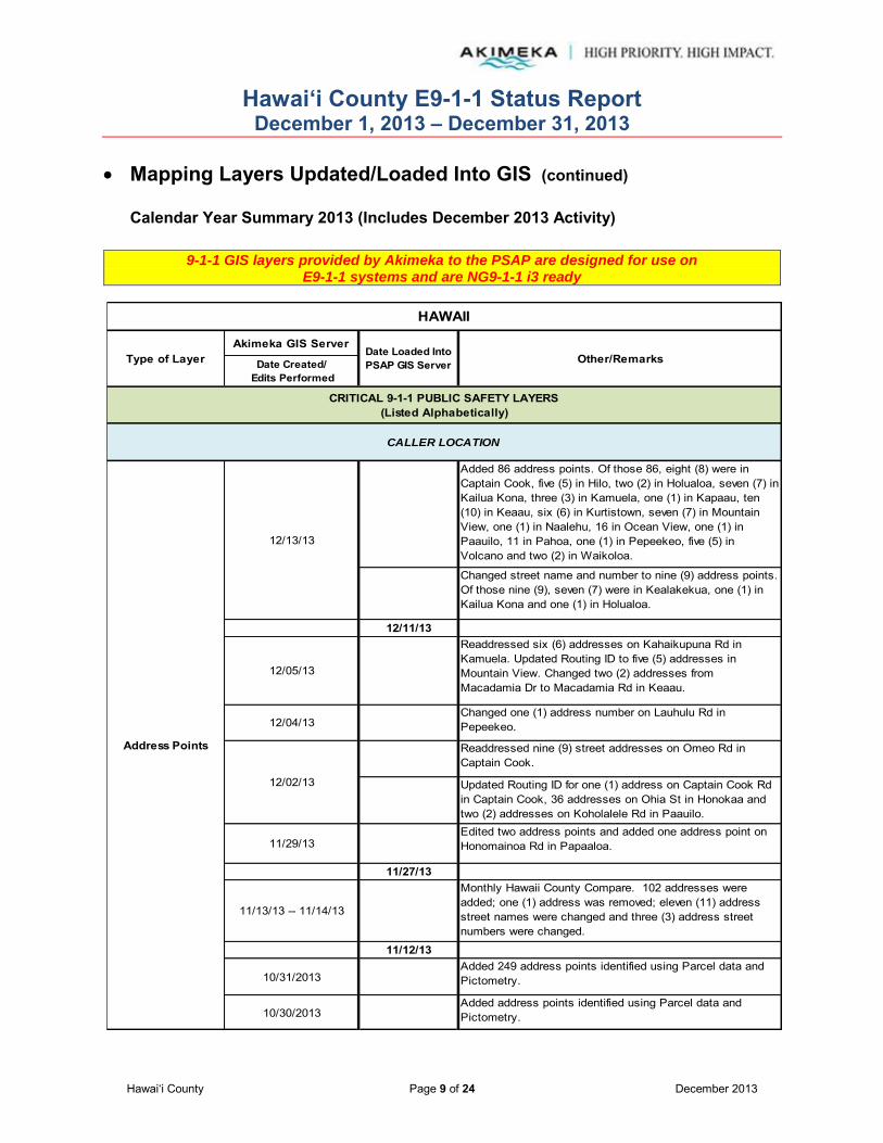
Hawai‘i County E9-1-1 Status Report December 1, 2013 – December 31, 2013
Hawai‘i County Page 9 of 24 December 2013
Mapping Layers Updated/Loaded Into GIS (continued)
Calendar Year Summary 2013 (Includes December 2013 Activity)
9-1-1 GIS layers provided by Akimeka to the PSAP are designed for use on
E9-1-1 systems and are NG9-1-1 i3 ready
Akimeka GIS Server
Date Created/ Edits Performed
Added 86 address points. Of those 86, eight (8) were in Captain Cook, five (5) in Hilo, two (2) in Holualoa, seven (7) in Kailua Kona, three (3) in Kamuela, one (1) in Kapaau, ten (10) in Keaau, six (6) in Kurtistown, seven (7) in Mountain View, one (1) in Naalehu, 16 in Ocean View, one (1) in Paauilo, 11 in Pahoa, one (1) in Pepeekeo, five (5) in Volcano and two (2) in Waikoloa.
Changed street name and number to nine (9) address points. Of those nine (9), seven (7) were in Kealakekua, one (1) in Kailua Kona and one (1) in Holualoa.
12/11/13
12/05/13
Readdressed six (6) addresses on Kahaikupuna Rd in Kamuela. Updated Routing ID to five (5) addresses in Mountain View. Changed two (2) addresses from Macadamia Dr to Macadamia Rd in Keaau.
12/04/13Changed one (1) address number on Lauhulu Rd in Pepeekeo.
Readdressed nine (9) street addresses on Omeo Rd in Captain Cook.
Updated Routing ID for one (1) address on Captain Cook Rd in Captain Cook, 36 addresses on Ohia St in Honokaa and two (2) addresses on Koholalele Rd in Paauilo.
11/29/13Edited two address points and added one address point on Honomainoa Rd in Papaaloa.
11/27/13
11/13/13 -- 11/14/13
Monthly Hawaii County Compare. 102 addresses were added; one (1) address was removed; eleven (11) address street names were changed and three (3) address street numbers were changed.
11/12/13
10/31/2013Added 249 address points identified using Parcel data and Pictometry.
10/30/2013Added address points identified using Parcel data and Pictometry.
CALLER LOCATION
Address Points
HAWAII
Type of Layer Date Loaded Into PSAP GIS Server Other/Remarks
12/13/13
12/02/13
CRITICAL 9-1-1 PUBLIC SAFETY LAYERS(Listed Alphabetically)
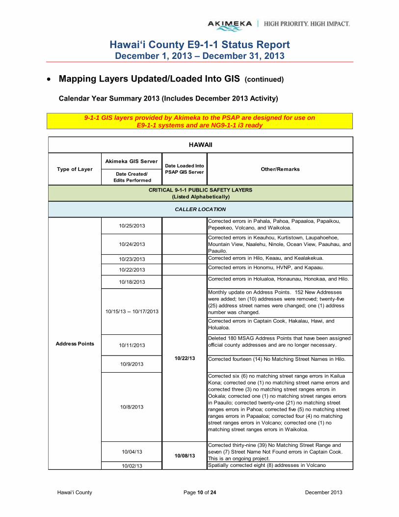
Hawai‘i County E9-1-1 Status Report December 1, 2013 – December 31, 2013
Hawai‘i County Page 10 of 24 December 2013
Mapping Layers Updated/Loaded Into GIS (continued)
Calendar Year Summary 2013 (Includes December 2013 Activity)
9-1-1 GIS layers provided by Akimeka to the PSAP are designed for use on E9-1-1 systems and are NG9-1-1 i3 ready
Akimeka GIS Server
Date Created/ Edits Performed
10/25/2013Corrected errors in Pahala, Pahoa, Papaaloa, Papaikou, Pepeekeo, Volcano, and Waikoloa.
10/24/2013Corrected errors in Keauhou, Kurtistown, Laupahoehoe, Mountain View, Naalehu, Ninole, Ocean View, Paauhau, and Paauilo.
10/23/2013 Corrected errors in Hilo, Keaau, and Kealakekua.
10/22/2013 Corrected errors in Honomu, HVNP, and Kapaau.
10/18/2013 Corrected errors in Holualoa, Honaunau, Honokaa, and Hilo.
Monthly update on Address Points. 152 New Addresses were added; ten (10) addresses were removed; twenty-five (25) address street names were changed; one (1) address number was changed.
Corrected errors in Captain Cook, Hakalau, Hawi, and Holualoa.
10/11/2013Deleted 180 MSAG Address Points that have been assigned official county addresses and are no longer necessary.
10/9/2013Corrected fourteen (14) No Matching Street Names in Hilo.
10/8/2013
Corrected six (6) no matching street range errors in Kailua Kona; corrected one (1) no matching street name errors and corrected three (3) no matching street ranges errors in Ookala; corrected one (1) no matching street ranges errors in Paauilo; corrected twenty-one (21) no matching street ranges errors in Pahoa; corrected five (5) no matching street ranges errors in Papaaloa; corrected four (4) no matching street ranges errors in Volcano; corrected one (1) no matching street ranges errors in Waikoloa.
10/04/13Corrected thirty-nine (39) No Matching Street Range and seven (7) Street Name Not Found errors in Captain Cook. This is an ongoing project.
10/02/13 Spatially corrected eight (8) addresses in Volcano
HAWAII
Type of Layer Date Loaded Into PSAP GIS Server Other/Remarks
CRITICAL 9-1-1 PUBLIC SAFETY LAYERS(Listed Alphabetically)
CALLER LOCATION
10/08/13
10/15/13 -- 10/17/2013
10/22/13
Address Points
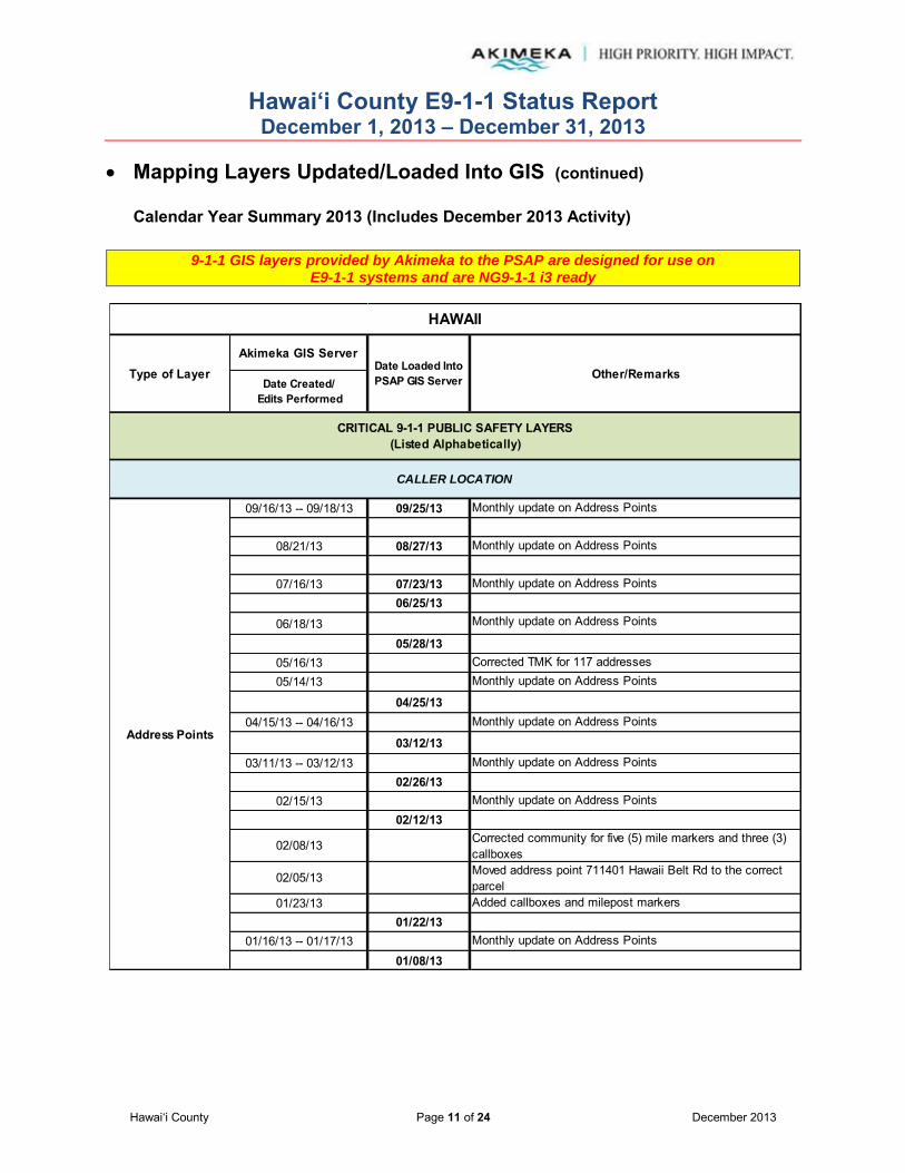
Hawai‘i County E9-1-1 Status Report December 1, 2013 – December 31, 2013
Hawai‘i County Page 11 of 24 December 2013
Mapping Layers Updated/Loaded Into GIS (continued)
Calendar Year Summary 2013 (Includes December 2013 Activity)
9-1-1 GIS layers provided by Akimeka to the PSAP are designed for use on E9-1-1 systems and are NG9-1-1 i3 ready
Akimeka GIS Server
Date Created/ Edits Performed
09/16/13 -- 09/18/13 09/25/13 Monthly update on Address Points
08/21/13 08/27/13 Monthly update on Address Points
07/16/13 07/23/13 Monthly update on Address Points06/25/13
06/18/13 Monthly update on Address Points
05/28/1305/16/13 Corrected TMK for 117 addresses05/14/13 Monthly update on Address Points
04/25/1304/15/13 -- 04/16/13 Monthly update on Address Points
03/12/1303/11/13 -- 03/12/13 Monthly update on Address Points
02/26/1302/15/13 Monthly update on Address Points
02/12/13
02/08/13 Corrected community for five (5) mile markers and three (3) callboxes
02/05/13 Moved address point 711401 Hawaii Belt Rd to the correct parcel
01/23/13 Added callboxes and milepost markers01/22/13
01/16/13 -- 01/17/13 Monthly update on Address Points
01/08/13
Type of Layer Date Loaded Into PSAP GIS Server Other/Remarks
CRITICAL 9-1-1 PUBLIC SAFETY LAYERS(Listed Alphabetically)
CALLER LOCATION
Address Points
HAWAII

Hawai‘i County E9-1-1 Status Report December 1, 2013 – December 31, 2013
Hawai‘i County Page 12 of 24 December 2013
Mapping Layers Updated/Loaded Into GIS (continued)
Calendar Year Summary 2013 (Includes December 2013 Activity)
9-1-1 GIS layers provided by Akimeka to the PSAP are designed for use on E9-1-1 systems and are NG9-1-1 i3 ready
Akimeka GIS Server
Date Created/ Edits Performed
Medic Stations
10/21/2013 10/22/13 Spatially corrected Kona Adventist School.
09/04/13 09/10/13Added records for the Wal-Mart and Lowe's in Kona and Home Depot and KTA Superstore in Hilo
Police Stations
Schools
Fire Stations
Points of Interest (POI)
Emergency Callboxes
Milepost Markers
Tsunami Roadblocks
HAWAII
Type of Layer Date Loaded Into PSAP GIS Server Other/Remarks
CRITICAL 9-1-1 PUBLIC SAFETY LAYERS(Listed Alphabetically)
CALLER LOCATION
Tsunami Evacuation Zones
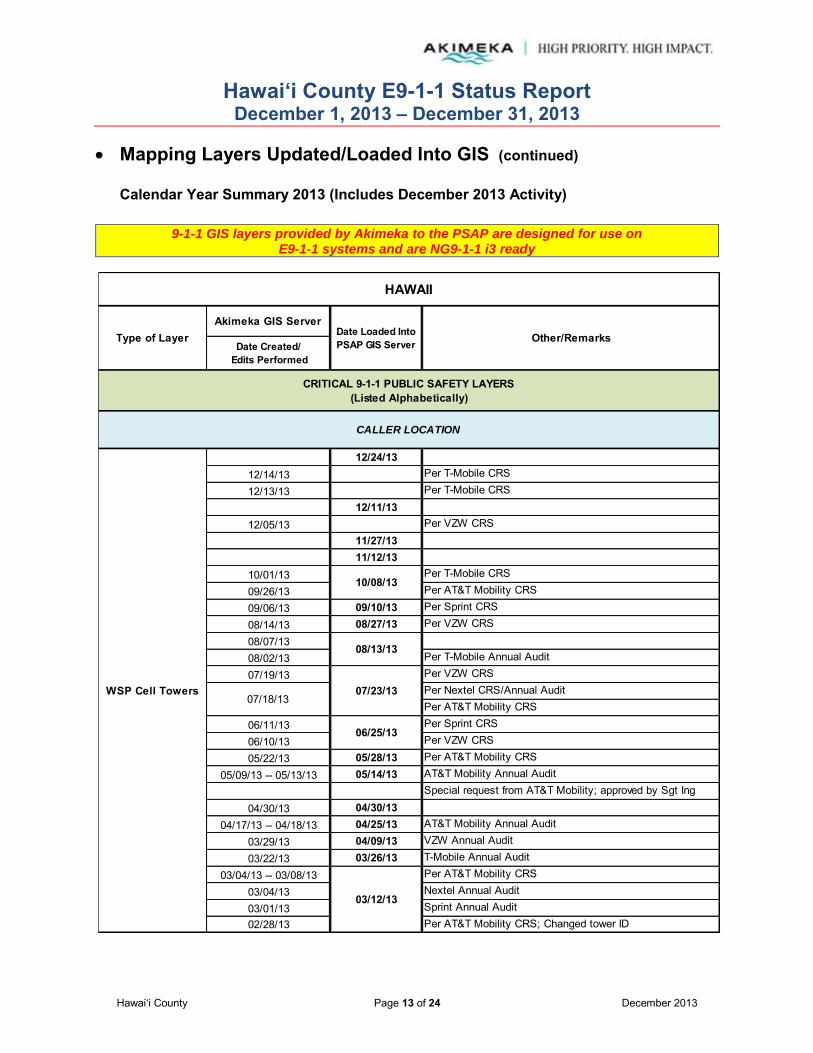
Hawai‘i County E9-1-1 Status Report December 1, 2013 – December 31, 2013
Hawai‘i County Page 13 of 24 December 2013
Mapping Layers Updated/Loaded Into GIS (continued)
Calendar Year Summary 2013 (Includes December 2013 Activity)
9-1-1 GIS layers provided by Akimeka to the PSAP are designed for use on E9-1-1 systems and are NG9-1-1 i3 ready
Akimeka GIS Server
Date Created/ Edits Performed
12/24/1312/14/13 Per T-Mobile CRS
12/13/13 Per T-Mobile CRS12/11/13
12/05/13 Per VZW CRS11/27/1311/12/13
10/01/13 Per T-Mobile CRS
09/26/13 Per AT&T Mobility CRS
09/06/13 09/10/13 Per Sprint CRS
08/14/13 08/27/13 Per VZW CRS
08/07/1308/02/13 Per T-Mobile Annual Audit
07/19/13 Per VZW CRSPer Nextel CRS/Annual AuditPer AT&T Mobility CRS
06/11/13 Per Sprint CRS
06/10/13 Per VZW CRS
05/22/13 05/28/13 Per AT&T Mobility CRS
05/09/13 -- 05/13/13 05/14/13 AT&T Mobility Annual AuditSpecial request from AT&T Mobility; approved by Sgt Ing
04/30/13 04/30/1304/17/13 -- 04/18/13 04/25/13 AT&T Mobility Annual Audit
03/29/13 04/09/13 VZW Annual Audit
03/22/13 03/26/13 T-Mobile Annual Audit
03/04/13 -- 03/08/13 Per AT&T Mobility CRS
03/04/13 Nextel Annual Audit
03/01/13 Sprint Annual Audit02/28/13 Per AT&T Mobility CRS; Changed tower ID
Type of Layer Date Loaded Into PSAP GIS Server Other/Remarks
CRITICAL 9-1-1 PUBLIC SAFETY LAYERS(Listed Alphabetically)
CALLER LOCATION
WSP Cell Towers
HAWAII
10/08/13
03/12/13
06/25/13
07/23/13
08/13/13
07/18/13

Hawai‘i County E9-1-1 Status Report December 1, 2013 – December 31, 2013
Hawai‘i County Page 14 of 24 December 2013
Mapping Layers Updated/Loaded Into GIS (continued)
Calendar Year Summary 2013 (Includes December 2013 Activity)
9-1-1 GIS layers provided by Akimeka to the PSAP are designed for use on E9-1-1 systems and are NG9-1-1 i3 ready
Akimeka GIS Server
Date Created/ Edits Performed
02/26/13 02/26/13 Per AT&T Mobility CRS
02/14/13 02/14/13 Corrected tower name for three (3) sectors
02/08/13
Corrected spelling of community name for ten (10) sectors
02/05/13 Per AT&T Mobility CRSMobi PCS Annual AuditPer AT&T Mobility CRS
01/25/13 Standardized field names
01/18/1301/15/1301/10/13 Corrected X-Y coordinates for T-Mobile towers
01/08/13 01/08/13 Per VZW CRS
11/20/2013 Edited ESN boundaries 205 and 208 in Kamuela and Honokaa.
07/03/13 07/23/13 Corrected ESN boundary
06/10/13 Updated coastline
06/10/13 Updated coastline
Other/Remarks
CRITICAL 9-1-1 PUBLIC SAFETY LAYERS(Listed Alphabetically)
CALLER LOCATION
WSP Cell Towers
DISPATCH AND RESPONSE
Fire Beats(Includes Medic
Beats)
Fire Districts(Includes Medic
Districts)
01/28/13
Per AT&T Mobility CRS
ESZ/ESN
HAWAII
Type of Layer
01/22/13
02/12/13
Date Loaded Into PSAP GIS Server
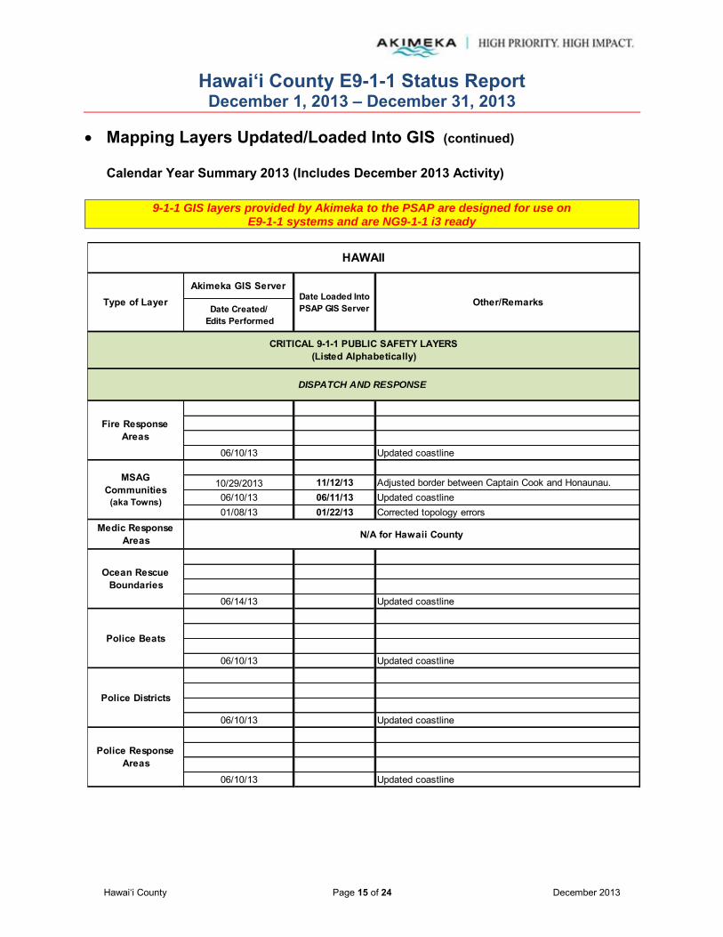
Hawai‘i County E9-1-1 Status Report December 1, 2013 – December 31, 2013
Hawai‘i County Page 15 of 24 December 2013
Mapping Layers Updated/Loaded Into GIS (continued)
Calendar Year Summary 2013 (Includes December 2013 Activity)
9-1-1 GIS layers provided by Akimeka to the PSAP are designed for use on E9-1-1 systems and are NG9-1-1 i3 ready
Akimeka GIS Server
Date Created/ Edits Performed
06/10/13 Updated coastline
10/29/2013 11/12/13 Adjusted border between Captain Cook and Honaunau.06/10/13 06/11/13 Updated coastline01/08/13 01/22/13 Corrected topology errors
06/14/13 Updated coastline
06/10/13 Updated coastline
06/10/13 Updated coastline
06/10/13 Updated coastline
DISPATCH AND RESPONSE
HAWAII
Type of Layer Date Loaded Into PSAP GIS Server Other/Remarks
CRITICAL 9-1-1 PUBLIC SAFETY LAYERS(Listed Alphabetically)
Fire Response Areas
Medic Response Areas
Police Beats
N/A for Hawaii County
Police Response Areas
Police Districts
Ocean Rescue Boundaries
MSAG Communities
(aka Towns)

Hawai‘i County E9-1-1 Status Report December 1, 2013 – December 31, 2013
Hawai‘i County Page 16 of 24 December 2013
Mapping Layers Updated/Loaded Into GIS (continued)
Calendar Year Summary 2013 (Includes December 2013 Activity)
9-1-1 GIS layers provided by Akimeka to the PSAP are designed for use on E9-1-1 systems and are NG9-1-1 i3 ready
Akimeka GIS Server
Date Created/ Edits Performed
12/17/13 Per T-Mobile CRS
12/13/13 Per T-Mobile CRS
12/05/13 12/11/13 Per VZW CRS11/27/1311/12/13
10/01/13 Per T-Mobile CRS09/26/13 Per AT&T Mobility CRS09/06/13 09/10/13 Per Sprint CRS08/14/13 08/27/13 Per VZW CRS08/07/1308/02/13 Per T-Mobile Annual Audit07/19/13 Per VZW CRS
Per Nextel CRS/Annual AuditPer AT&T Mobility CRS
06/11/13 06/25/13 Per Sprint CRS06/10/13 06/11/13 Per VZW CRS05/22/13 05/28/13
05/09/13 -- 05/13/13 05/14/13 AT&T Mobility Annual Audit04/30/13 04/30/13
04/17/13 -- 04/18/13 04/29/13 AT&T Mobility Annual Audit03/29/13 04/09/13 VZW Annual Audit03/22/13 03/26/13 T-Mobile Annual Audit
03/04/13 -- 03/08/13 Per AT&T Mobility CRS03/04/13 Nextel Annual Audit03/01/13 Sprint Annual Audit02/28/13 Per AT&T Mobility CRS; Changed tower ID02/26/13 Per AT&T Mobility CRS02/14/13 02/26/13 Corrected tower name for three (3) sectors
02/08/13 02/14/13 Corrected spelling of community name for ten (10) sectors
WSP Cell Sectors
HAWAII
Type of Layer Date Loaded Into PSAP GIS Server Other/Remarks
CRITICAL 9-1-1 PUBLIC SAFETY LAYERS(Listed Alphabetically)
DISPATCH AND RESPONSE
03/12/13
10/08/13
07/23/13
08/13/13
07/18/13
12/24/13

Hawai‘i County E9-1-1 Status Report December 1, 2013 – December 31, 2013
Hawai‘i County Page 17 of 24 December 2013
Mapping Layers Updated/Loaded Into GIS (continued)
Calendar Year Summary 2013 (Includes December 2013 Activity)
9-1-1 GIS layers provided by Akimeka to the PSAP are designed for use on E9-1-1 systems and are NG9-1-1 i3 ready
Akimeka GIS Server
Date Created/ Edits Performed
02/05/13 Per AT&T Mobility CRS01/28/13 Per AT&T Mobility CRS01/25/13 Standardized field names01/18/13 Per AT&T Mobility CRS01/15/1301/10/13 Changed radiuses01/08/13 01/08/13 Per VZW CRS
Corrected range to two (2) segments of Puhala St in Mountain View.
Spatially adjusted Service St in Hilo. Corrected overlap, ranges and direction to segments of Operations St in Hilo.
Corrected range and overlap to two (2) street segments of Honaunau Rd in Honaunau.Corrected range and overlap to two (2) segments of Haakoa Rd in Laupahoehoe.Flipped one (1) segment, corrected range to two (2) segments, and corrected overlap to two (2) segments of Laupahoehoe Point Rd in Laupahoehoe.Added Maluhia Rd and split segment of Piha Kahuku Rd in Papaaloa.Added range to two (2) segments of Hakuma St in Pahoa.Corrected parity to three (3) segments of Omeo Rd in Captain Cook.Added Waiono Ranch Rd and split segment of Mamalahoa Hwy in Holualoa.Added Hakuma St (two segments) and split segment of Pahoa Kalapana Rd in Pahoa.Corrected the range to three (3) segments of Derby Ln in Hilo.Corrected the range and parity to four (4) segments of Kohola St in Hilo.Corrected range and parity to two (2) segments of Manini St in Hilo.
RESPONSE ROUTING
Street Centerlines
WSP Cell Sectors
HAWAII
Type of Layer Date Loaded Into PSAP GIS Server Other/Remarks
CRITICAL 9-1-1 PUBLIC SAFETY LAYERS(Listed Alphabetically)
DISPATCH AND RESPONSE
02/12/13
01/22/13
12/31/13
12/27/13
12/30/13
12/24/13
12/26/13
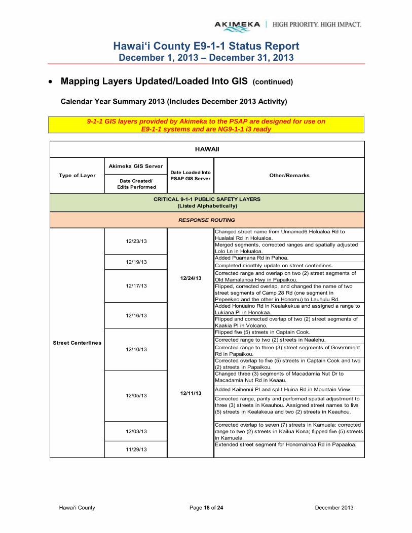
Hawai‘i County E9-1-1 Status Report December 1, 2013 – December 31, 2013
Hawai‘i County Page 18 of 24 December 2013
Mapping Layers Updated/Loaded Into GIS (continued)
Calendar Year Summary 2013 (Includes December 2013 Activity)
9-1-1 GIS layers provided by Akimeka to the PSAP are designed for use on E9-1-1 systems and are NG9-1-1 i3 ready
Akimeka GIS Server
Date Created/ Edits Performed
Changed street name from Unnamed6 Holualoa Rd to Hualalai Rd in Holualoa.Merged segments, corrected ranges and spatially adjusted Lolo Ln in Holualoa.Added Puamana Rd in Pahoa.Completed monthly update on street centerlines.Corrected range and overlap on two (2) street segments of Old Mamalahoa Hwy in Papaikou.Flipped, corrected overlap, and changed the name of two street segments of Camp 28 Rd (one segment in Pepeekeo and the other in Honomu) to Lauhulu Rd. Added Honuaino Rd in Kealakekua and assigned a range to Lukiana Pl in Honokaa.Flipped and corrected overlap of two (2) street segments of Kaakia Pl in Volcano.Flipped five (5) streets in Captain Cook.Corrected range to two (2) streets in Naalehu.Corrected range to three (3) street segments of Government Rd in Papaikou.Corrected overlap to five (5) streets in Captain Cook and two (2) streets in Papaikou.Changed three (3) segments of Macadamia Nut Dr to Macadamia Nut Rd in Keaau.
Added Kaihenui Pl and split Huina Rd in Mountain View.
Corrected range, parity and performed spatial adjustment to three (3) streets in Keauhou. Assigned street names to five (5) streets in Kealakeua and two (2) streets in Keauhou.
12/03/13Corrected overlap to seven (7) streets in Kamuela; corrected range to two (2) streets in Kailua Kona; flipped five (5) streets in Kamuela.
11/29/13Extended street segment for Honomainoa Rd in Papaaloa.
Street Centerlines
RESPONSE ROUTING
HAWAII
Type of Layer Date Loaded Into PSAP GIS Server Other/Remarks
12/11/13
12/24/13
12/05/13
12/10/13
CRITICAL 9-1-1 PUBLIC SAFETY LAYERS(Listed Alphabetically)
12/16/13
12/17/13
12/19/13
12/23/13

Hawai‘i County E9-1-1 Status Report December 1, 2013 – December 31, 2013
Hawai‘i County Page 19 of 24 December 2013
Mapping Layers Updated/Loaded Into GIS (continued)
Calendar Year Summary 2013 (Includes December 2013 Activity)
9-1-1 GIS layers provided by Akimeka to the PSAP are designed for use on E9-1-1 systems and are NG9-1-1 i3 ready
Akimeka GIS Server
Date Created/ Edits Performed
11/26/13
Corrected address ranges to two (2) street segments of Hospital Rd in Kapaau and two (2) street segments of Tobacco Rd in Captain Cook.
Assigned street name 'Omeo Rd' and extended three (3) of its segments and extended two (2) segments to unnamed street in Captain Cook.
Edited left/right ESN boundary information for Waokele St in Kamuela and Honokaa.
11/19/13Added Lukiana Pl and split Ohia St in Honokaa. Added Nani Koa Pl and split Koholalele in Paauilo.
11/13/14 -- 11/14/13
Completed Hawaii County Compare. Four (4) new street segments were added; thirteen (13) street segment ranges were changed; and five (5) street segment names were changed.
10/30/2013Extended six (6) ranges to include new addresses.
10/28/2013Flipped direction of 2 street segments in Kailua Kona.
10/15/13 -- 10/17/2013 10/22/13Monthly update on Street Centerlines. Four (4) New Street Segments were added; fourteen (14) Street Ranges were changed; five (5) Street Names were changed.
10/7/2013
Corrected nine (9) no matching street range errors in Keaau; corrected one (1) no matching street range errors in Kurtistown; corrected one (1) no matching street name errors in Mountain View.
10/2/2013 10/08/13 Corrected one (1) street parity error in Kailua Kona.
09/16/13 -- 09/18/13 09/25/13 Monthly update on Street Centerlines09/09/13 Corrected a duplicate street segment name
09/04/13Created Ingress/Egress street segments to aid first responders
Street Centerlines
RESPONSE ROUTING
HAWAII
Type of Layer Date Loaded Into PSAP GIS Server Other/Remarks
CRITICAL 9-1-1 PUBLIC SAFETY LAYERS(Listed Alphabetically)
09/10/13
11/12/13
11/20/13
11/27/13

Hawai‘i County E9-1-1 Status Report December 1, 2013 – December 31, 2013
Hawai‘i County Page 20 of 24 December 2013
Mapping Layers Updated/Loaded Into GIS (continued)
Calendar Year Summary 2013 (Includes December 2013 Activity)
9-1-1 GIS layers provided by Akimeka to the PSAP are designed for use on E9-1-1 systems and are NG9-1-1 i3 ready
Akimeka GIS Server
Date Created/ Edits Performed
08/27/1308/21/13 Monthly update on Street Centerlines
07/16/13 07/23/13 Monthly update on Street Centerlines
06/18/13 06/25/13 Monthly update on Street Centerlines
05/14/13 05/28/13 Monthly update on Street Centerlines
04/15/13 04/25/13 Monthly update on Street Centerlines
03/11/13 -- 03/12/13 03/12/13 Monthly update on Street Centerlines
02/15/13 02/26/13 Monthly update on Street Centerlines
01/23/13 02/12/13 Added two (2) street segments
01/16/13 -- 01/17/13 01/22/13 Monthly update on Street Centerlines01/08/13
06/04/13 -- 06/07/13 Edited coastline to fit imagery. This is an ongoing project.
Street Centerlines
HAWAII
Type of Layer Date Loaded Into PSAP GIS Server Other/Remarks
CRITICAL 9-1-1 PUBLIC SAFETY LAYERS(Listed Alphabetically)
RESPONSE ROUTING
VISUAL REFERENCE
Coastline
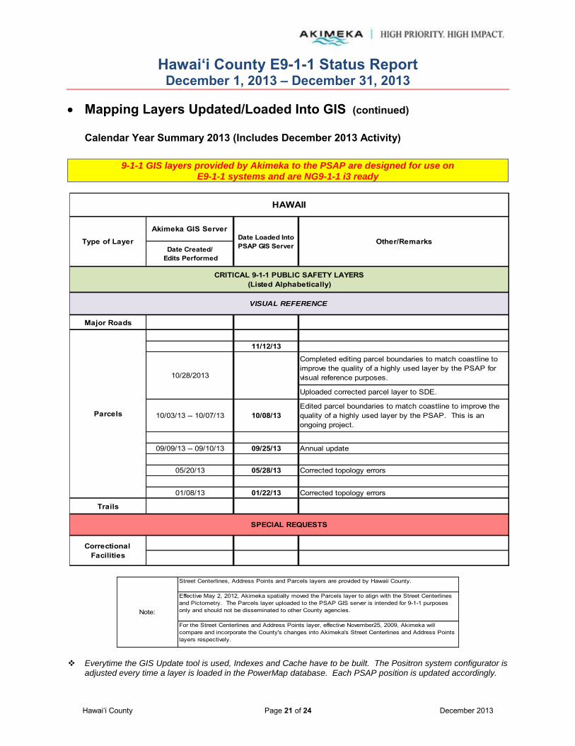
Hawai‘i County E9-1-1 Status Report December 1, 2013 – December 31, 2013
Hawai‘i County Page 21 of 24 December 2013
Mapping Layers Updated/Loaded Into GIS (continued)
Calendar Year Summary 2013 (Includes December 2013 Activity)
9-1-1 GIS layers provided by Akimeka to the PSAP are designed for use on E9-1-1 systems and are NG9-1-1 i3 ready
Note:
Street Centerlines, Address Points and Parcels layers are provided by Hawaii County.
Effective May 2, 2012, Akimeka spatially moved the Parcels layer to align with the Street Centerlines and Pictometry. The Parcels layer uploaded to the PSAP GIS server is intended for 9-1-1 purposes only and should not be disseminated to other County agencies.
For the Street Centerlines and Address Points layer, effective November25, 2009, Akimeka will compare and incorporate the County's changes into Akimeka's Street Centerlines and Address Points layers respectively.
Everytime the GIS Update tool is used, Indexes and Cache have to be built. The Positron system configurator is
adjusted every time a layer is loaded in the PowerMap database. Each PSAP position is updated accordingly.
Akimeka GIS Server
Date Created/ Edits Performed
Major Roads
11/12/13
Completed editing parcel boundaries to match coastline to improve the quality of a highly used layer by the PSAP for visual reference purposes.
Uploaded corrected parcel layer to SDE.
10/03/13 -- 10/07/13 10/08/13Edited parcel boundaries to match coastline to improve the quality of a highly used layer by the PSAP. This is an ongoing project.
09/09/13 -- 09/10/13 09/25/13 Annual update
05/20/13 05/28/13 Corrected topology errors
01/08/13 01/22/13 Corrected topology errors
Trails
VISUAL REFERENCE
HAWAII
Type of Layer Date Loaded Into PSAP GIS Server Other/Remarks
CRITICAL 9-1-1 PUBLIC SAFETY LAYERS(Listed Alphabetically)
Correctional Facilities
SPECIAL REQUESTS
Parcels
10/28/2013

Hawai‘i County E9-1-1 Status Report December 1, 2013 – December 31, 2013
Hawai‘i County Page 22 of 24 December 2013
Mapping Layers Updated/Loaded Into GIS – December 2013 (continued)
Address Points and Street Centerlines Update Comparison On a routine basis, upon receipt of Hawai‘i County Planning Department’s Address Points and Street Centerlines layer updates, Akimeka compares and incorporates any of the County’s additions, changes, and deletions into the Akimeka Address Points and Street Centerlines layers. In the month of May 2012, Akimeka added a process to identify changes to the Street Segment Names which has been included in the chart below. The Address Points and Street Centerlines layer comparative analysis was completed on the updates received from the Hawai‘i County Planning Department on December 19, 2013. Results are as follows:
Note: Some Address Points have its street name and street number changed at the same time. These are counted as separate actions since these changes are needed to make the layers “9-1-1 capable” for dispatch and response.
Address Points and Street Centerlines Update Comparison 2013 Year Totals
HAWAII COUNTY Address PointsLayer
Street CenterlinesLayer
# of New Street Segments Added 0
# of Street Segments Removed 0
# of New Addresses Added 86
# of Addresses Removed 0
# of Street Segment Range Changes 0
# of Street Segment Name Changes 0
# of Address Street Name Changes 9
# of Address Street Number Changes 9
HAWAII COUNTY Address PointsLayer
Street CenterlinesLayer
# of New Street Segments Added 66# of Street Segments Removed 1# of New Addresses Added 1342# of Addresses Removed 91# of Street Segment Range Changes 150# of Street Segment Name Changes 54# of Address Street Name Changes 295# of Address Street Number Changes 126

Hawai‘i County E9-1-1 Status Report December 1, 2013 – December 31, 2013
Hawai‘i County Page 23 of 24 December 2013
Service Requests Transactions Open Service Requests – November 2013 (October 30, 2013 – November 27, 2013)
# Date Ticket # Description Category Urgency Comments1 06/03/10 225 Verify addresses on Puako Beach Road MSAG - ANI/ALI
DiscrepancyNormal Customer records were researched and update
requests were sent to Sprint via Intrado and Hawaiian Telcom, Inc. (HTI).
Verification of Puako Beach Road addressing information in the GIS database along with the MSAG record information will be compared. MSAG and GIS clean-up process began on October 1, 2012.
Field work was conducted in October 2012 to correct the address number discrepancies on Puako Beach Road. Akimeka submitted TN CRs to HTI via Intrado in 9-1-1Net and the County of Hawai`i Planning department mailed out re-addressing forms to all homeowners, providing the updated 6-digit address numbers.
Akimeka sent an email follow-up to Intrado on September 11, 2013 requesting a status update. A follow-up email was sent to Intrado on November 20, 2013 requesting a status update. The 118 TNs remain in "Referred" status as of November 26, 2013.
The status of these pending TN CRs will be tracked until all TNs are updated to their correct locations.
2 11/21/13 621 Incorrect Address: TN= (808) 322-2921 MSAG - ANI/ALI Discrepancy
Normal TN informationhas been submitted to 9-1-1Net.
Note: Open Service Requests reflect what is in pending status at the end of the report month.
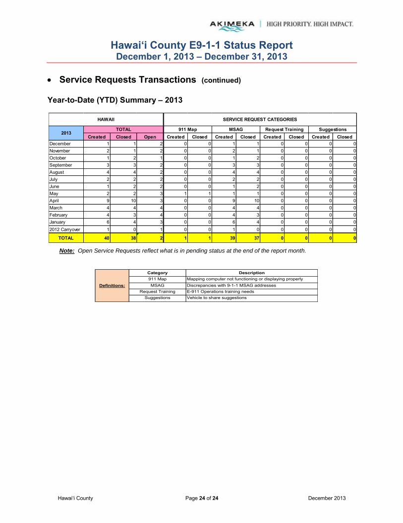
Hawai‘i County E9-1-1 Status Report December 1, 2013 – December 31, 2013
Hawai‘i County Page 24 of 24 December 2013
Service Requests Transactions (continued) Year-to-Date (YTD) Summary – 2013
Note: Open Service Requests reflect what is in pending status at the end of the report month.
Suggestions
Mapping computer not functioning or displaying properlyDescription
Discrepancies with 9-1-1 MSAG addressesE-911 Operations training needsVehicle to share suggestions
911 MapDefinitions:
Category
MSAGRequest Training
Created Closed Open Created Closed Created Closed Created Closed Created ClosedDecember 1 1 2 0 0 1 1 0 0 0 0November 2 1 2 0 0 2 1 0 0 0 0October 1 2 1 0 0 1 2 0 0 0 0September 3 3 2 0 0 3 3 0 0 0 0August 4 4 2 0 0 4 4 0 0 0 0July 2 2 2 0 0 2 2 0 0 0 0June 1 2 2 0 0 1 2 0 0 0 0May 2 2 3 1 1 1 1 0 0 0 0April 9 10 3 0 0 9 10 0 0 0 0March 4 4 4 0 0 4 4 0 0 0 0February 4 3 4 0 0 4 3 0 0 0 0January 6 4 3 0 0 6 4 0 0 0 02012 Carryover 1 0 1 0 0 1 0 0 0 0 0
TOTAL 40 38 2 1 1 39 37 0 0 0 0
911 Map
HAWAII
TOTAL
SERVICE REQUEST CATEGORIES
2013MSAG SuggestionsRequest Training
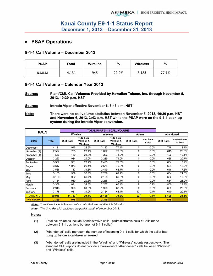
Kauai County E9-1-1 Status Report December 1, 2013 – December 31, 2013
Kauai County Page 1 of 19 December 2013
PSAP Operations
9-1-1 Call Volume – December 2013
PSAP Total Wireline % Wireless %
KAUAI 4,131 945 22.9% 3,183 77.1%
9-1-1 Call Volume – Calendar Year 2013 Source: Plant/CML Call Volumes Provided by Hawaiian Telcom, Inc. through November 5,
2013, 10:30 p.m. HST Source: Intrado Viper effective November 6, 3:43 a.m. HST Note: There were no call volume statistics between November 5, 2013, 10:30 p.m. HST
and November 6, 2013, 3:43 a.m. HST while the PSAP were on the 9-1-1 back-up system during the Intrado Viper conversion.
2013 Total # of Calls% to Total Wireline & Wireless
# of Calls% to Total Wireline & Wireless
# of Calls % to Total Calls # of Calls % Abandoned
to Total
December 4,131 945 22.9% 3,183 77.1% 0 0.0% 748 18.1%November (2) 2,577 705 27.4% 1,872 72.6% 0 0.0% 645 25.0%November (1) 556 160 28.8% 396 71.2% 0 0.0% 106 19.1%October 3,223 934 29.0% 2,289 71.0% 0 0.0% 668 20.7%September 3,367 931 27.7% 2,435 72.3% 1 0.0% 604 17.9%August 3,647 1,073 29.4% 2,574 70.6% 0 0.0% 664 18.2%July 3,566 1,117 31.3% 2,449 68.7% 0 0.0% 616 17.3%June 3,165 959 30.3% 2,206 69.7% 0 0.0% 664 21.0%May 3,130 962 30.7% 2,168 69.3% 0 0.0% 622 19.9%April 3,134 919 29.3% 2,215 70.7% 0 0.0% 664 21.2%March 3,356 1,091 32.6% 2,257 67.4% 8 0.2% 800 23.8%February 2,916 926 31.8% 1,990 68.2% 0 0.0% 659 22.6%January 3,178 1,011 31.9% 2,154 68.1% 13 0.4% 640 20.1%
TOTAL YTD 39,946 11,733 29.4% 28,188 70.6% 22 0.1% 8,100 20.3%AVG PER MO 3,329 978 2,349 2 675
KAUAI TOTAL PSAP 9-1-1 CALL VOLUMEWireline Wireless Admin Abandoned
Note: Total Calls include Administrative calls that are not direct 9-1-1 calls. Note: The “Avg Per Mo” excludes the partial month of November 2013.
Notes:
(1) Total call volumes include Administrative calls. (Administrative calls = Calls made between 9-1-1 positions but are not 9-1-1 calls.)
(2) "Abandoned" calls represent the number of incoming 9-1-1 calls for which the caller had hung up before a call-taker answered.
(3) "Abandoned" calls are included in the "Wireline" and "Wireless" counts respectively. The standard CML reports do not provide a break-out of "Abandoned" calls between "Wireline" and "Wireless" calls.
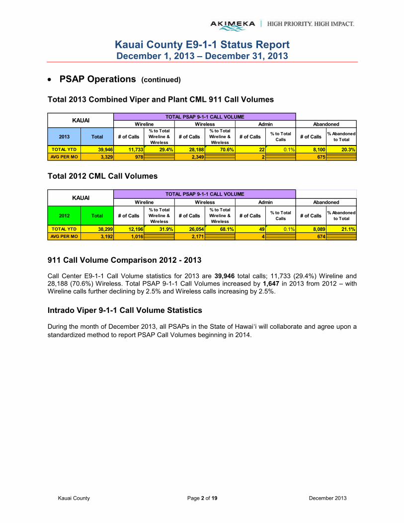
Kauai County E9-1-1 Status Report December 1, 2013 – December 31, 2013
Kauai County Page 2 of 19 December 2013
PSAP Operations (continued)
Total 2013 Combined Viper and Plant CML 911 Call Volumes
2013 Total # of Calls% to Total Wireline & Wireless
# of Calls% to Total Wireline & Wireless
# of Calls % to Total Calls # of Calls % Abandoned
to Total
KAUAI TOTAL PSAP 9-1-1 CALL VOLUMEWireline Wireless Admin Abandoned
TOTAL YTD 39,946 11,733 29.4% 28,188 70.6% 22 0.1% 8,100 20.3%AVG PER MO 3,329 978 2,349 2 675
Total 2012 CML Call Volumes
2012 Total # of Calls% to Total Wireline & Wireless
# of Calls% to Total Wireline & Wireless
# of Calls % to Total Calls # of Calls % Abandoned
to Total
KAUAITOTAL PSAP 9-1-1 CALL VOLUME
Wireline Wireless Admin Abandoned
TOTAL YTD 38,299 12,196 31.9% 26,054 68.1% 49 0.1% 8,089 21.1%AVG PER MO 3,192 1,016 2,171 4 674
911 Call Volume Comparison 2012 - 2013 Call Center E9-1-1 Call Volume statistics for 2013 are 39,946 total calls; 11,733 (29.4%) Wireline and 28,188 (70.6%) Wireless. Total PSAP 9-1-1 Call Volumes increased by 1,647 in 2013 from 2012 – with Wireline calls further declining by 2.5% and Wireless calls increasing by 2.5%. Intrado Viper 9-1-1 Call Volume Statistics
During the month of December 2013, all PSAPs in the State of Hawaiʻi will collaborate and agree upon a standardized method to report PSAP Call Volumes beginning in 2014.

Kauai County E9-1-1 Status Report December 1, 2013 – December 31, 2013
Kauai County Page 3 of 19 December 2013
PSAP Operations (continued)
Wireless Test – December 2013
Date WSP Sites Tested
Sectors Tested Tested By Test
Pass/Fail
12/13/13 Sprint 3 3 Kauai PSAP/ Akimeka Pass
12/14/13 Sprint 1 1 Kauai PSAP Pass
Current Month PSAP Operations Activities – December 2013 12/15/2013 A Holiday " No Cell Tower/Sector Testing" period was scheduled between the PSAP and
Wireless Service Providers for 12/15/13 to 01/04/14. Notification was sent on 11/07/2013
12/31/2013 County of Kauai annual statistics: Call Center E9-1-1 Call Volume statistics are 39,381
total calls; 11,777 (29.9%) Wireline and 27,582 (70.1%) Wireless. Total PSAP 9-1-1 Call Volumes increased by 1,082 in 2013 from 2012 – with Wireline calls further declining by 2% and Wireless calls increasing by 2%. Wireless E9-1-1 Database has added/modified/deleted on 85 towers and 254 sectors to the Wireless E9-1-1 database this calendar year. Annual quality assurance audits on 119 towers and 584 sectors to the Wireless E9-1-1 database. The MSAG maintenance program provided 1317 MSAG Database transactions to the Kauai County MSAG Database. A monthly average of 110.
12/31/2013 To date, there have been no major problems experienced by the PSAPs due to the
implementation of the Intrado Viper Platform.

Kauai County E9-1-1 Status Report December 1, 2013 – December 31, 2013
Kauai County Page 4 of 19 December 2013
MSAG Current Month – December 2013
KAUAI 84 15 5 1 5 2 2 192 69 0 141 0 0 0
In Suspended Statusas of Report Month End
(d)
TN CR ALI-DR # ofTransactions
TNsAffectedChange Combined Delete Insert Split
Customer Addresses
Affected
County Address Change Request (TN CR)
Processed(a)
In Referred Statusas of Report Month End
(c)
9-1-1NET REQUESTS
MSAG TRANSACTIONS ALI TRANSACTIONS
ALI Discrepancy
(ALI-DR) Processed
(b)
Total
2013
PSAP TOTAL
A total of eighty-four MSAG transactions were processed during the month of December 2013. Fifteen (15) 9-1-1Net requests were processed relating to the MSAG database, with 192 customer ANI/ALI records updated as a direct result. Sixty-nine (69) TN CR transactions were processed in 9-1-1Net for updates and corrections to the ALI database. The TN CRs were submitted as a result of the ESN 499 clean-up effort. Streets and address ranges were validated against the GIS to ensure synchronization and an MSAG address was provided to the Telco. TN CRs must be validated against HT records and approved by the end user Hawaiian Telcom customer before updating the ALI record. There are 141 TN CRs in Referred status as of December 31, 2013.
141 TN CRs that remain in "Referred" status are a direct result of the ESN 499 clean-up and are awaiting approval from end user Hawaiian Telcom customer in order to update the ALI records. No explanation has been provided by HTI as to why these TN CRs have not been processed for 9-1-1 purposes.
Intrado will notify Akimeka when each TN has been updated in 9-1-1Net
There are no ALI-DRs in Referred status as of December 31, 2013.
There are no records in Suspended status as of December 31, 2013.

Kauai County E9-1-1 Status Report December 1, 2013 – December 31, 2013
Kauai County Page 5 of 19 December 2013
MSAG (continued) Year-to-Date (YTD) Summary – 2013
December 84 15 5 1 5 2 2 192 69 0 141 0 0 0November 32 25 9 6 0 8 2 291 7 0 113 0 0 0October 14 14 8 0 3 2 1 321 0 0 116 0 0 0September 27 5 1 0 0 4 0 44 22 0 125 1 0 0August 58 1 1 0 0 0 0 12 57 0 114 1 0 0July 161 9 2 0 5 2 0 5 150 2 78 1 0 0June 123 5 1 0 3 1 0 14 118 0 60 0 0 0May 44 6 1 0 1 4 0 231 38 0 39 5 0 0April 76 11 1 0 9 0 1 2 65 0 39 5 5 5March 480 17 2 0 10 5 0 3 461 2 102 6 5 5February 16 16 2 0 10 4 0 3 0 0 28 6 5 5January 202 7 1 0 5 1 0 15 195 0 206 11 3 3
TOTAL YTD 1,317 131 34 7 51 33 6 1,133 1,182 4 AVG PER MO 110 11 3 1 4 3 1 94 99 0
County Address Change Request (TN CR)
Processed(a)
ALI Discrepancy
(ALI-DR) Processed
(b)
9-1-1NET REQUESTS
MSAG TRANSACTIONS ALI TRANSACTIONS
Delete
In Suspended Statusas of Report Month End
(d)
TN CR # of Transactions
KAUAI
2013 TOTAL Insert Split
Customer Addresses
Affected(*)
Total Change Combined
In Referred Statusas of Report Month End
(c)
TNsAffectedALI-DR
Note: Revised categories and report format changes effective May 2012 with new Intrado TN CR functionality.
(a)
(b)
(c)
(d)
Definitions:
Represents address corrections on a specific TN or group of TNs. These "invalid" TNs usually have an associated ESN x99 attached to them which indicates the need for validation.
Represents an address discrepancy discovered during a live 9-1-1 call. These record corrections are treated with a higher priority and should be processed within 48 hours as a general guideline.
Represents correction requests that have been referred by Intrado to the appropriate service provider and is awaiting approval to be updated in 9-1-1Net.
Represents correction requests that have been "paused" due to TN fallouts, range overlaps, or not having a valid address point. Intrado requires additional information from Akimeka/PSAP before the Telco approves the change.
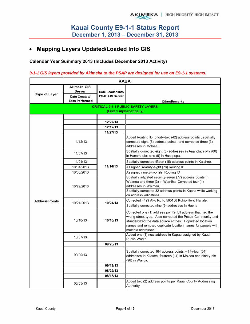
Kauai County E9-1-1 Status Report December 1, 2013 – December 31, 2013
Kauai County Page 6 of 19 December 2013
Mapping Layers Updated/Loaded Into GIS Calendar Year Summary 2013 (Includes December 2013 Activity)
9-1-1 GIS layers provided by Akimeka to the PSAP are designed for use on E9-1-1 systems.
Akimeka GIS Server
Date Created/ Edits Performed
12/27/1312/12/1311/27/13
11/12/13Added Routing ID to forty-two (42) address points , spatially corrected eight (8) address points, and corrected three (3) addresses in Moloaa.
11/07/13 Spatially corrected eight (8) addresses in Anahola; sixty (60) in Hanamaulu; nine (9) in Hanapepe.
11/04/13 Spatially corrected fifteen (15) address points in Kalaheo.10/31/2013 Assigned seventy-eight (78) Routing ID10/30/2013 Assigned ninety-two (92) Routing ID
Spatially adjusted seventy-seven (77) address points in Waimea and three (3) in Wainiha. Corrected four (4) addresses in Waimea.Spatially corrected 32 address points in Kapaa while working on address validations. Corrected 4499 Aku Rd to 505156 Kuhio Hwy, Hanalei. Spatially corrected nine (9) addresses in Haena
10/10/13 10/10/13
Corrected one (1) address point's full address that had the wrong street type. Also corrected the Postal Community and standardized the data source entries. Populated location names and removed duplicate location names for parcels with multiple addresses.
10/07/13Added one (1) new address in Kapaa assigned by Kauai Public Works
09/26/13
09/20/13Spatially corrected 164 address points -- fifty-four (54) addresses in Kilauea, fourteen (14) in Moloaa and ninety-six (96) in Wailua.
09/12/1308/29/1308/15/13
08/05/13 Added two (2) address points per Kauai County Addressing Authority
Address Points
CRITICAL 9-1-1 PUBLIC SAFETY LAYERS(Listed Alphabetically)
10/29/2013
KAUAI
Type of Layer Date Loaded Into PSAP GIS Server
Other/Remarks
11/14/13
10/21/2013 10/24/13
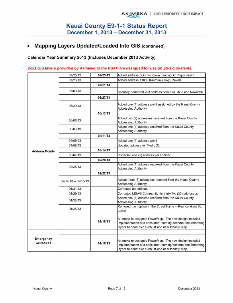
Kauai County E9-1-1 Status Report December 1, 2013 – December 31, 2013
Kauai County Page 7 of 19 December 2013
Mapping Layers Updated/Loaded Into GIS (continued) Calendar Year Summary 2013 (Includes December 2013 Activity)
9-1-1 GIS layers provided by Akimeka to the PSAP are designed for use on E9-1-1 systems.
07/25/13 07/25/13 Added address point for Koloa Landing At Poipu Beach07/23/13 Added address 11000 Kaumualii Hwy, Pakala
07/11/13
07/08/13 Spatially corrected 203 address points in Lihue and Nawiliwili
06/27/13
06/20/13 Added one (1) address point assigned by the Kauai County Addressing Authority
06/13/13
06/06/13Added two (2) addresses received from the Kauai County Addressing Authority
06/03/13Added one (1) address received from the Kauai County Addressing Authority
04/11/1304/09/13 Added one (1) address point04/08/13 Updated address for Medic 22
03/14/1303/07/13 Corrected one (1) address per SR#556
02/28/13
02/25/13Added one (1) address received from the Kauai County Addressing Authority
02/22/13
02/14/13 -- 02/15/13 Added three (3) addresses received from the Kauai County Addressing Authority
01/31/13 Corrected an address01/29/13 Corrected MSAG Community for thirty-five (35) addresses
01/28/13Added one (1) address received from the Kauai County Addressing Authority
01/25/13Removed the hyphen in the Street Name -- Pua Kenikeni St, Lawai
01/10/13Akimeka re-designed PowerMap. The new design included implementation of a consistent naming schema and formatting layers to construct a robust and user friendly map.
01/10/13Akimeka re-designed PowerMap. The new design included implementation of a consistent naming schema and formatting layers to construct a robust and user friendly map.
Address Points
Emergency Callboxes

Kauai County E9-1-1 Status Report December 1, 2013 – December 31, 2013
Kauai County Page 8 of 19 December 2013
Mapping Layers Updated/Loaded Into GIS (continued) Calendar Year Summary 2013 (Includes December 2013 Activity)
9-1-1 GIS layers provided by Akimeka to the PSAP are designed for use on E9-1-1 systems.
06/12/13 Updated coastline03/12/13
06/12/13 Updated coastline03/12/13
06/12/13 Updated coastline03/12/13
03/14/13
01/10/13Akimeka re-designed PowerMap. The new design included implementation of a consistent naming schema and formatting layers to construct a robust and user friendly map.
06/14/13 Updated coastline02/06/13 Corrected the IRA boundary between Lihue and Nawiliwili
Major Roads 01/10/13Akimeka re-designed PowerMap. The new design included implementation of a consistent naming schema and formatting layers to construct a robust and user friendly map.
10/23/2013 Corrected MSAG Community Hanapepe boundary to include 3905 Hanapepe Rd.
06/27/1306/13/13 -- 06/14/13 Updated coastline
03/14/1303/04/13 Corrected MSAG Community topology errors
02/06/13 Corrected the community boundary between Lihue and Nawiliwili
01/29/13Corrected the boundary between Hanapepe and Eleele and between Mana and Kekaha
01/10/13Akimeka re-designed PowerMap. The new design included implementation of a consistent naming schema and formatting layers to construct a robust and user friendly map.
Fire Beats
Fire Stations
MSAG Communities
(aka Towns)
Fire Response Areas
IncidentResponse Area
Adjusted the MSAG boundary between Mana and Kekaha so 6900 Kaumualii Hwy would be within the boundary of Kekaha; Adjusted the MSAG boundary between Nawiliwili and Lihue to include 3132 Ninini Point St within the boundary of Lihue.11/14/13
Fire Districts
11/13/2013

Kauai County E9-1-1 Status Report December 1, 2013 – December 31, 2013
Kauai County Page 9 of 19 December 2013
Mapping Layers Updated/Loaded Into GIS (continued) Calendar Year Summary 2013 (Includes December 2013 Activity) 9-1-1 GIS layers provided by Akimeka to the PSAP are designed for use on E9-1-1 systems.
06/12/13 Updated coastline
06/12/13 Updated coastline
04/11/1304/08/13 Updated address for Medic 22
01/10/13Akimeka re-designed PowerMap. The new design included implementation of a consistent naming schema and formatting layers to construct a robust and user friendly map.
01/10/13Akimeka re-designed PowerMap. The new design included implementation of a consistent naming schema and formatting layers to construct a robust and user friendly map.
09/12/1309/06/13 Added Kealia Post Office
04/11/1304/09/13 Added one (1) address point04/08/13 Updated address for Medic 22
01/10/13Akimeka re-designed PowerMap. The new design included implementation of a consistent naming schema and formatting layers to construct a robust and user friendly map.
06/27/1306/14/13 Updated coastline
03/14/1303/12/13
02/22/1302/06/13 Corrected the Police Beats between 150 and 156
01/10/13Akimeka re-designed PowerMap. The new design included implementation of a consistent naming schema and formatting layers to construct a robust and user friendly map.
Police Beats
Milepost Markers
Medic Response Areas
Medic Stations
Points of Interest
Medic Districts
Medic Beats
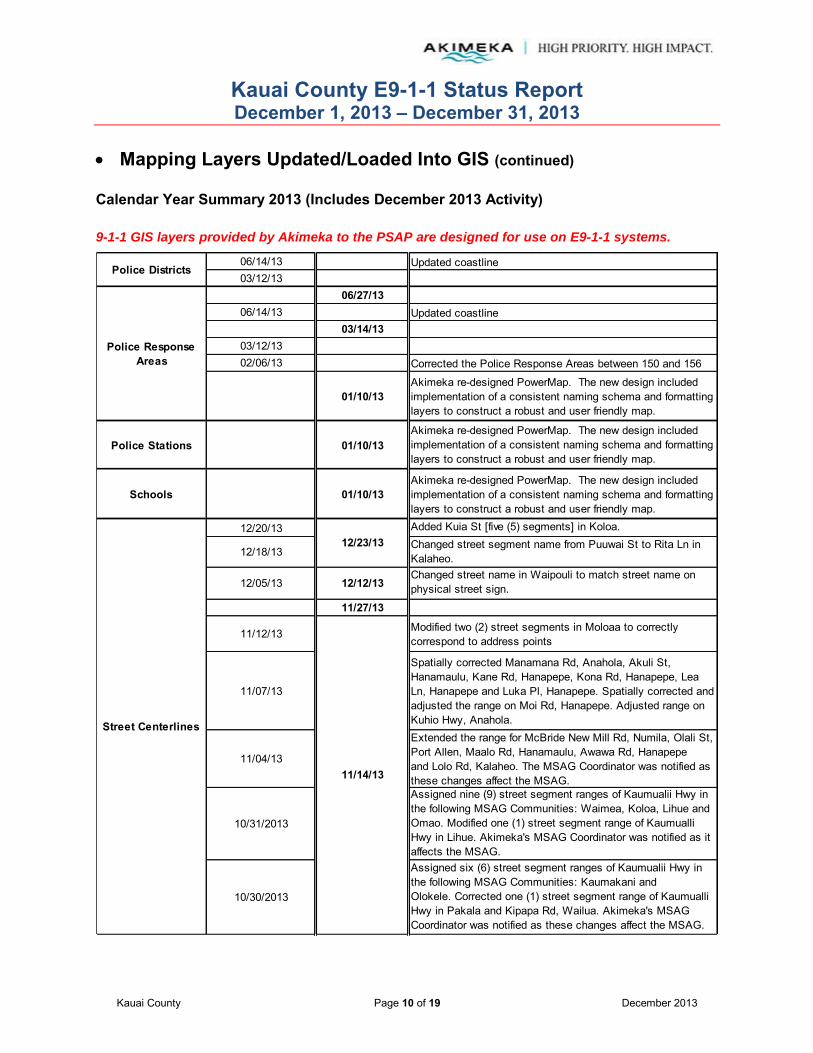
Kauai County E9-1-1 Status Report December 1, 2013 – December 31, 2013
Kauai County Page 10 of 19 December 2013
Mapping Layers Updated/Loaded Into GIS (continued) Calendar Year Summary 2013 (Includes December 2013 Activity) 9-1-1 GIS layers provided by Akimeka to the PSAP are designed for use on E9-1-1 systems.
06/14/13 Updated coastline03/12/13
06/27/1306/14/13 Updated coastline
03/14/1303/12/1302/06/13 Corrected the Police Response Areas between 150 and 156
01/10/13Akimeka re-designed PowerMap. The new design included implementation of a consistent naming schema and formatting layers to construct a robust and user friendly map.
Police Stations 01/10/13Akimeka re-designed PowerMap. The new design included implementation of a consistent naming schema and formatting layers to construct a robust and user friendly map.
Schools 01/10/13Akimeka re-designed PowerMap. The new design included implementation of a consistent naming schema and formatting layers to construct a robust and user friendly map.
12/20/13 Added Kuia St [five (5) segments] in Koloa.
12/18/13Changed street segment name from Puuwai St to Rita Ln in Kalaheo.
12/05/13 12/12/13Changed street name in Waipouli to match street name on physical street sign.
11/27/13
11/12/13 Modified two (2) street segments in Moloaa to correctly correspond to address points
11/07/13
Spatially corrected Manamana Rd, Anahola, Akuli St, Hanamaulu, Kane Rd, Hanapepe, Kona Rd, Hanapepe, Lea Ln, Hanapepe and Luka Pl, Hanapepe. Spatially corrected and adjusted the range on Moi Rd, Hanapepe. Adjusted range on Kuhio Hwy, Anahola.
11/04/13
Extended the range for McBride New Mill Rd, Numila, Olali St, Port Allen, Maalo Rd, Hanamaulu, Awawa Rd, Hanapepe and Lolo Rd, Kalaheo. The MSAG Coordinator was notified as these changes affect the MSAG.
10/31/2013
Assigned nine (9) street segment ranges of Kaumualii Hwy in the following MSAG Communities: Waimea, Koloa, Lihue and Omao. Modified one (1) street segment range of Kaumualli Hwy in Lihue. Akimeka's MSAG Coordinator was notified as it affects the MSAG.
10/30/2013
Assigned six (6) street segment ranges of Kaumualii Hwy in the following MSAG Communities: Kaumakani and Olokele. Corrected one (1) street segment range of Kaumualli Hwy in Pakala and Kipapa Rd, Wailua. Akimeka's MSAG Coordinator was notified as these changes affect the MSAG.
Police Districts
Street Centerlines
11/14/13
12/23/13
Police Response Areas

Kauai County E9-1-1 Status Report December 1, 2013 – December 31, 2013
Kauai County Page 11 of 19 December 2013
Mapping Layers Updated/Loaded Into GIS (continued) Calendar Year Summary 2013 (Includes December 2013 Activity) 9-1-1 GIS layers provided by Akimeka to the PSAP are designed for use on E9-1-1 systems.
10/29/2013 11/14/13
Spatially corrected two street segments in Waimea. Modified eight (8) street segment ranges in Waimea, one (1) in Hanalei and one (1) in Wainiha according to their corresponding address points.
10/21/2013 10/24/13 Updated ranges on Aku Rd and Weke Rd, Hanalei.
Corrected the MSAGException code to "1" for seven (7) street centerline segments with 0-0 ranges. These errors were part of a Kauai No Match and Error Report for September.
Corrected Postal Community, MSAG Owner, and Data Source attributes for all Street Centerline segments.
10/08/13
Corrected one (1) range overlap in Hanamaulu; two (2) street pointing the wrong direction and one (1) range gap in Kapaa; one (1) To less than From and two (2) street pointing in the wrong direction in Kalaheo; one (1) street pointing in the wrong direction in Kekaha; eight (8) street pointing in the wrong direction and four (4) range overlaps in Lihue; and two (2) range overlaps in Nawiliwili.
09/26/1307/25/13
07/23/13 Edited high range on Kaumualii Hwy, Pakala to 1110106/13/13
06/06/13 Altered low range on Kakela Makai Dr per the Kauai County Addressing Authority
05/24/1305/09/13 Assigned ranges for Nohili Rd and Tartar Dr, Mana05/06/13 Assigned ranges for Nohili Rd, Mana
03/28/13
03/15/13 Added ranges for Kahalawai St and Kalahiki St, Kukuiula as assigned by the Kauai County Addressing Authority
03/14/1303/12/1303/04/13
02/28/13
02/22/13
02/15/13 Added one (1) street centerline received from the Kauai County Addressing Authority
02/13/13 Extended the range for Aulima Rd, Lawai as received from the Kauai County Addressing Authority
01/25/13Removed the hyphen in the Street Name -- Pua Kenikeni St, Lawai
Street Centerlines
Trails
10/10/1310/10/13
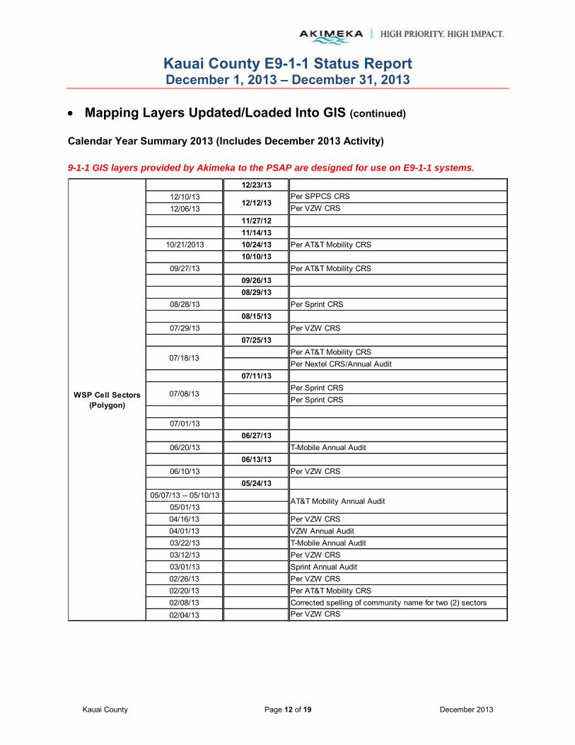
Kauai County E9-1-1 Status Report December 1, 2013 – December 31, 2013
Kauai County Page 12 of 19 December 2013
Mapping Layers Updated/Loaded Into GIS (continued) Calendar Year Summary 2013 (Includes December 2013 Activity) 9-1-1 GIS layers provided by Akimeka to the PSAP are designed for use on E9-1-1 systems.
12/23/1312/10/13 Per SPPCS CRS12/06/13 Per VZW CRS
11/27/1211/14/13
10/21/2013 10/24/13 Per AT&T Mobility CRS10/10/13
09/27/13 Per AT&T Mobility CRS09/26/1308/29/13
08/28/13 Per Sprint CRS08/15/13
07/29/13 Per VZW CRS07/25/13
Per AT&T Mobility CRSPer Nextel CRS/Annual Audit
07/11/13Per Sprint CRSPer Sprint CRS
07/01/1306/27/13
06/20/13 T-Mobile Annual Audit06/13/13
06/10/13 Per VZW CRS05/24/13
05/07/13 -- 05/10/1305/01/1304/16/13 Per VZW CRS04/01/13 VZW Annual Audit03/22/13 T-Mobile Annual Audit03/12/13 Per VZW CRS03/01/13 Sprint Annual Audit02/26/13 Per VZW CRS02/20/13 Per AT&T Mobility CRS02/08/13 Corrected spelling of community name for two (2) sectors02/04/13 Per VZW CRS
07/18/13
12/12/13
AT&T Mobility Annual Audit
07/08/13WSP Cell Sectors(Polygon)

Kauai County E9-1-1 Status Report December 1, 2013 – December 31, 2013
Kauai County Page 13 of 19 December 2013
Mapping Layers Updated/Loaded Into GIS (continued) Calendar Year Summary 2013 (Includes December 2013 Activity) 9-1-1 GIS layers provided by Akimeka to the PSAP are designed for use on E9-1-1 systems.
12/23/1312/10/13 Per SPPCS CRS12/06/13 Per VZW CRS
11/27/1211/14/13
10/21/2013 10/24/13 Per AT&T Mobility CRS10/10/13
09/27/13 Per AT&T Mobility CRS09/26/1308/29/13
08/28/13 Per Sprint CRS08/15/13
07/29/13 Per VZW CRS07/25/13
Per AT&T Mobility CRSPer Nextel CRS/Annual Audit
07/11/13Per Sprint CRSPer Sprint CRS
07/01/13 Per AT&T Mobility CRS06/27/13
06/20/13 T-Mobile Annual Audit06/13/13
06/10/13 Per VZW CRS05/07/13 -- 05/10/13
05/01/1304/23/13
04/19/13 AT&T Mobility Annual Audit04/16/13 Per VZW CRS
04/11/1304/01/13 VZW Annual Audit
03/28/1303/22/13 T-Mobile Annual Audit
03/14/1303/12/13 Per VZW CRS03/04/13 Nextel Annual Audit03/01/13 Sprint Annual Audit
02/28/1302/26/13 Per VZW CRS
02/22/13
07/18/13
12/12/13
AT&T Mobility Annual Audit
WSP Cell Towers(Points)
07/08/13
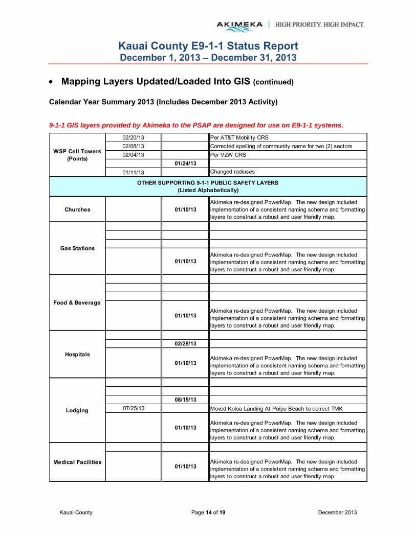
Kauai County E9-1-1 Status Report December 1, 2013 – December 31, 2013
Kauai County Page 14 of 19 December 2013
Mapping Layers Updated/Loaded Into GIS (continued) Calendar Year Summary 2013 (Includes December 2013 Activity) 9-1-1 GIS layers provided by Akimeka to the PSAP are designed for use on E9-1-1 systems.
02/20/13 Per AT&T Mobility CRS02/08/13 Corrected spelling of community name for two (2) sectors02/04/13 Per VZW CRS
01/24/1301/11/13 Changed radiuses
Churches 01/10/13Akimeka re-designed PowerMap. The new design included implementation of a consistent naming schema and formatting layers to construct a robust and user friendly map.
01/10/13Akimeka re-designed PowerMap. The new design included implementation of a consistent naming schema and formatting layers to construct a robust and user friendly map.
01/10/13Akimeka re-designed PowerMap. The new design included implementation of a consistent naming schema and formatting layers to construct a robust and user friendly map.
02/28/13
01/10/13Akimeka re-designed PowerMap. The new design included implementation of a consistent naming schema and formatting layers to construct a robust and user friendly map.
08/15/1307/25/13 Moved Koloa Landing At Poipu Beach to correct TMK
01/10/13Akimeka re-designed PowerMap. The new design included implementation of a consistent naming schema and formatting layers to construct a robust and user friendly map.
01/10/13Akimeka re-designed PowerMap. The new design included implementation of a consistent naming schema and formatting layers to construct a robust and user friendly map.
OTHER SUPPORTING 9-1-1 PUBLIC SAFETY LAYERS(Listed Alphabetically)
WSP Cell Towers(Points)
Gas Stations
Food & Beverage
Hospitals
Lodging
Medical Facilities
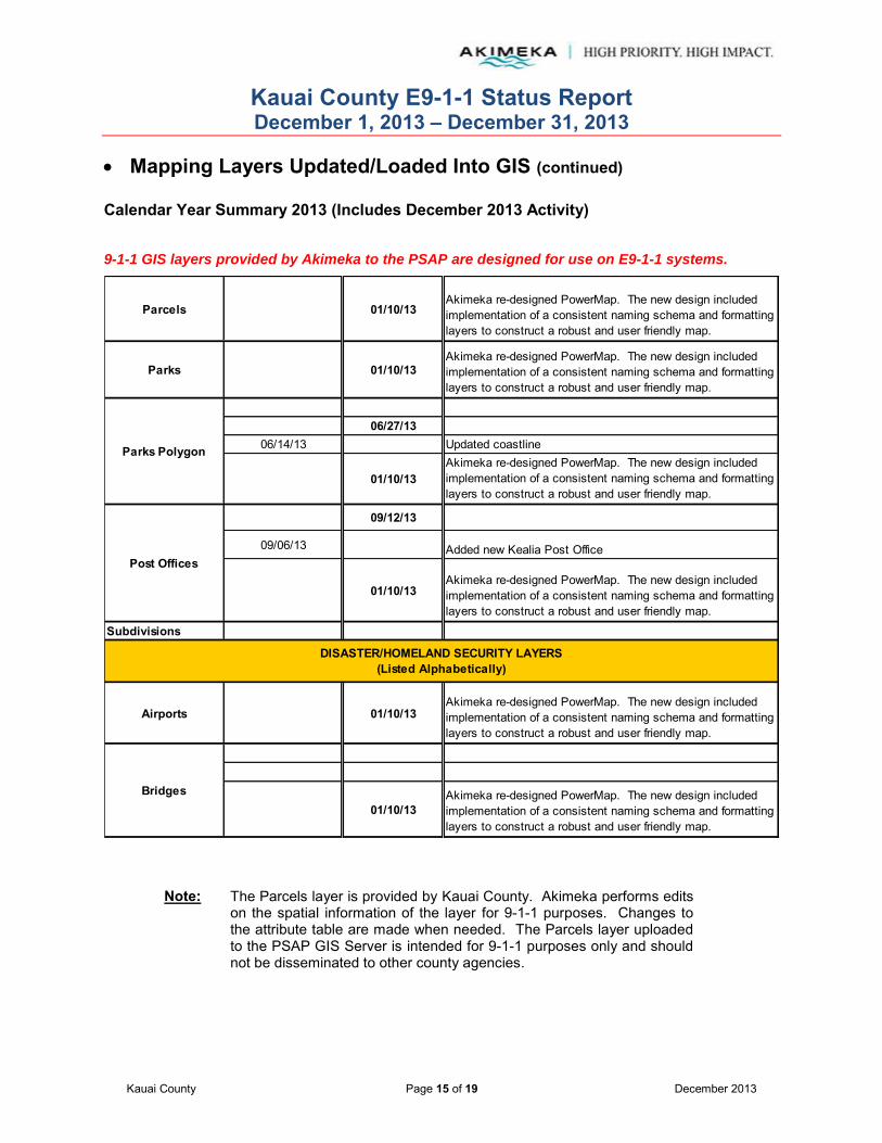
Kauai County E9-1-1 Status Report December 1, 2013 – December 31, 2013
Kauai County Page 15 of 19 December 2013
Mapping Layers Updated/Loaded Into GIS (continued) Calendar Year Summary 2013 (Includes December 2013 Activity) 9-1-1 GIS layers provided by Akimeka to the PSAP are designed for use on E9-1-1 systems.
Parcels 01/10/13Akimeka re-designed PowerMap. The new design included implementation of a consistent naming schema and formatting layers to construct a robust and user friendly map.
Parks 01/10/13Akimeka re-designed PowerMap. The new design included implementation of a consistent naming schema and formatting layers to construct a robust and user friendly map.
06/27/1306/14/13 Updated coastline
01/10/13Akimeka re-designed PowerMap. The new design included implementation of a consistent naming schema and formatting layers to construct a robust and user friendly map.
09/12/13
09/06/13 Added new Kealia Post Office
01/10/13Akimeka re-designed PowerMap. The new design included implementation of a consistent naming schema and formatting layers to construct a robust and user friendly map.
Subdivisions
Airports 01/10/13Akimeka re-designed PowerMap. The new design included implementation of a consistent naming schema and formatting layers to construct a robust and user friendly map.
01/10/13Akimeka re-designed PowerMap. The new design included implementation of a consistent naming schema and formatting layers to construct a robust and user friendly map.
Bridges
DISASTER/HOMELAND SECURITY LAYERS(Listed Alphabetically)
Parks Polygon
Post Offices
Note: The Parcels layer is provided by Kauai County. Akimeka performs edits on the spatial information of the layer for 9-1-1 purposes. Changes to the attribute table are made when needed. The Parcels layer uploaded to the PSAP GIS Server is intended for 9-1-1 purposes only and should not be disseminated to other county agencies.
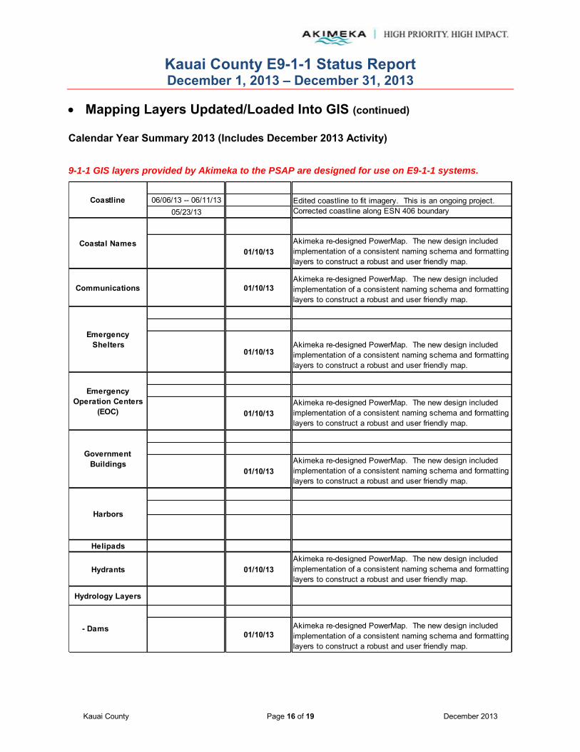
Kauai County E9-1-1 Status Report December 1, 2013 – December 31, 2013
Kauai County Page 16 of 19 December 2013
Mapping Layers Updated/Loaded Into GIS (continued) Calendar Year Summary 2013 (Includes December 2013 Activity) 9-1-1 GIS layers provided by Akimeka to the PSAP are designed for use on E9-1-1 systems.
06/06/13 -- 06/11/13 Edited coastline to fit imagery. This is an ongoing project.05/23/13 Corrected coastline along ESN 406 boundary
01/10/13Akimeka re-designed PowerMap. The new design included implementation of a consistent naming schema and formatting layers to construct a robust and user friendly map.
Communications 01/10/13Akimeka re-designed PowerMap. The new design included implementation of a consistent naming schema and formatting layers to construct a robust and user friendly map.
01/10/13Akimeka re-designed PowerMap. The new design included implementation of a consistent naming schema and formatting layers to construct a robust and user friendly map.
01/10/13Akimeka re-designed PowerMap. The new design included implementation of a consistent naming schema and formatting layers to construct a robust and user friendly map.
01/10/13Akimeka re-designed PowerMap. The new design included implementation of a consistent naming schema and formatting layers to construct a robust and user friendly map.
Helipads
Hydrants 01/10/13Akimeka re-designed PowerMap. The new design included implementation of a consistent naming schema and formatting layers to construct a robust and user friendly map.
Hydrology Layers
01/10/13Akimeka re-designed PowerMap. The new design included implementation of a consistent naming schema and formatting layers to construct a robust and user friendly map.
Harbors
Coastline
Emergency Shelters
Coastal Names
Emergency Operation Centers
(EOC)
- Dams
Government Buildings

Kauai County E9-1-1 Status Report December 1, 2013 – December 31, 2013
Kauai County Page 17 of 19 December 2013
Mapping Layers Updated/Loaded Into GIS (continued) Calendar Year Summary 2013 (Includes December 2013 Activity) 9-1-1 GIS layers provided by Akimeka to the PSAP are designed for use on E9-1-1 systems.
- Ponds 01/10/13 Akimeka re-designed PowerMap. The new design included implementation of a consistent naming schema and formatting layers to construct a robust and user friendly map.
- Waterfalls
06/27/1306/17/13 Updated coastline
01/10/13Akimeka re-designed PowerMap. The new design included implementation of a consistent naming schema and formatting layers to construct a robust and user friendly map.
01/10/13Akimeka re-designed PowerMap. The new design included implementation of a consistent naming schema and formatting layers to construct a robust and user friendly map.
Tsunami Heights
01/10/13Akimeka re-designed PowerMap. The new design included implementation of a consistent naming schema and formatting layers to construct a robust and user friendly map.
01/10/13Akimeka re-designed PowerMap. The new design included implementation of a consistent naming schema and formatting layers to construct a robust and user friendly map.
KCC Callboxes 01/10/13Akimeka re-designed PowerMap. The new design included implementation of a consistent naming schema and formatting layers to construct a robust and user friendly map.
SPECIAL REQUESTS
Tsunami Evacuation Zones
KCC Building Outline
United States National Grid (50K)
Waste Water Plants
Ocean Safety(Includes Lifeguard
Stands)
- Streams (Includes Rivers)
Ocean Rescue Boundaries
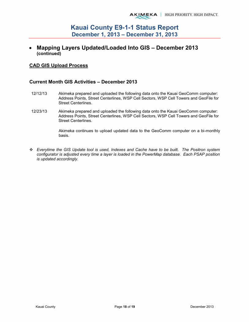
Kauai County E9-1-1 Status Report December 1, 2013 – December 31, 2013
Kauai County Page 18 of 19 December 2013
Mapping Layers Updated/Loaded Into GIS – December 2013
(continued) CAD GIS Upload Process Current Month GIS Activities – December 2013 12/12/13 Akimeka prepared and uploaded the following data onto the Kauai GeoComm computer:
Address Points, Street Centerlines, WSP Cell Sectors, WSP Cell Towers and GeoFile for Street Centerlines.
12/23/13 Akimeka prepared and uploaded the following data onto the Kauai GeoComm computer: Address Points, Street Centerlines, WSP Cell Sectors, WSP Cell Towers and GeoFile for Street Centerlines. Akimeka continues to upload updated data to the GeoComm computer on a bi-monthly basis.
Everytime the GIS Update tool is used, Indexes and Cache have to be built. The Positron system configurator is adjusted every time a layer is loaded in the PowerMap database. Each PSAP position is updated accordingly.

Kauai County E9-1-1 Status Report December 1, 2013 – December 31, 2013
Kauai County Page 19 of 19 December 2013
Service Requests Transactions Open Service Requests – December 2013 (November 30, 2013 – December 31, 2013)
# Date Ticket # Description Category Urgency Comments
NONE
Note: Open Service Requests reflect what is in pending status at the end of the report month.
Year-to-Date (YTD) Summary – 2013
Created Closed Open Created Closed Created Closed Created Closed Created ClosedDecember 0 0 0 0 0 0 0 0 0 0 0November 0 0 0 0 0 0 0 0 0 0 0October 0 0 0 0 0 0 0 0 0 0 0September 0 0 0 0 0 0 0 0 0 0 0August 0 1 0 0 0 0 1 0 0 0 0July 1 0 1 0 0 1 0 0 0 0 0June 0 0 0 0 0 0 0 0 0 0 0May 0 0 0 0 0 0 0 0 0 0 0April 0 0 0 0 0 0 0 0 0 0 0March 1 1 0 0 0 1 1 0 0 0 0February 0 0 0 0 0 0 0 0 0 0 0January 0 1 0 0 0 0 1 0 0 0 02012 Carryover 1 0 1 0 0 1 0 0 0 0 0
TOTAL 3 3 0 0 0 3 3 0 0 0 0
Request Training
SERVICE REQUEST CATEGORIESKAUAI
TOTAL2013
911 Map MSAG Suggestions
Note: Open Service Requests reflect what is in pending status at the end of the report month.
Suggestions
Mapping computer not functioning or displaying properlyDescription
Discrepancies with 9-1-1 MSAG addressesE-911 Operations training needsVehicle to share suggestions
911 MapDefinitions:
Category
MSAGRequest Training
Related Documents


