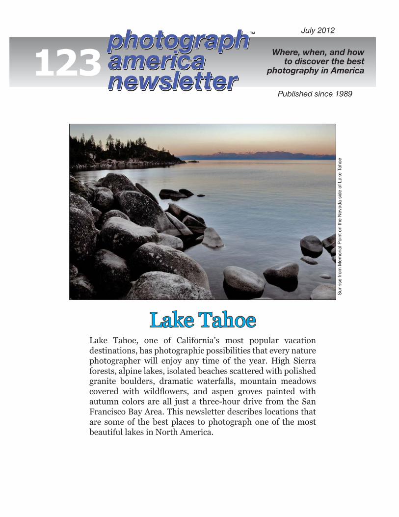
™ Lake Tahoe, one of California’s most popular vacation destinations, has photographic possibilities that every nature photographer will enjoy any time of the year. High Sierra forests, alpine lakes, isolated beaches scattered with polished granite boulders, dramatic waterfalls, mountain meadows covered with wildflowers, and aspen groves painted with autumn colors are all just a three-hour drive from the San Francisco Bay Area. This newsletter describes locations that are some of the best places to photograph one of the most beautiful lakes in North America. Lake Tahoe Sunrise from Memorial Point on the Nevada side of Lake Tahoe 123 July 2012 Where, when, and how to discover the best photography in America Published since 1989

Welcome message from author
This document is posted to help you gain knowledge. Please leave a comment to let me know what you think about it! Share it to your friends and learn new things together.
Transcript
™
Lake Tahoe, one of California’s most popular vacation destinations, has photographic possibilities that every nature photographer will enjoy any time of the year. High Sierra forests, alpine lakes, isolated beaches scattered with polished granite boulders, dramatic waterfalls, mountain meadows covered with wildflowers, and aspen groves painted with autumn colors are all just a three-hour drive from the San Francisco Bay Area. This newsletter describes locations that are some of the best places to photograph one of the most beautiful lakes in North America.
Lake TahoeSu
nris
e fro
m M
emor
ial P
oint
on
the
Nev
ada
side
of L
ake
Taho
e
123July 2012
Where, when, and howto discover the best
photography in America
Published since 1989
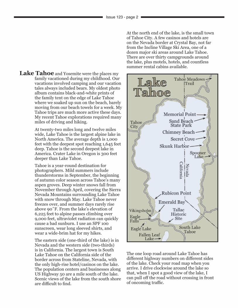
At twenty-two miles long and twelve miles wide, Lake Tahoe is the largest alpine lake in North America. The average depth is 1,000 feet with the deepest spot reaching 1,645 feet deep. Tahoe is the second deepest lake in America. Crater Lake in Oregon is 300 feet deeper than Lake Tahoe.Tahoe is a year-round destination for photographers. Mild summers include thunderstorms in September, the beginning of autumn color season across Tahoe’s many aspen groves. Deep winter snows fall from November through April, covering the Sierra Nevada Mountains surrounding Lake Tahoe with snow through May. Lake Tahoe never freezes over, and summer days rarely rise above 90˚F. From the lake’s elevation of 6,225 feet to alpine passes climbing over 9,000 feet, ultraviolet radiation can quickly cause a bad sunburn. I use an SPF 100 sunscreen, wear long sleeved shirts, and wear a wide-brim hat for my hikes.The eastern side (one-third of the lake) is in Nevada and the western side (two-thirds) is in California. The largest town is South Lake Tahoe on the California side of the border across from Stateline, Nevada, with the only high-rise hotel/casinos on the lake. The population centers and businesses along US Highway 50 are a mile south of the lake. Scenic views of the lake from the south shore are difficult to find.
At the north end of the lake, is the small town of Tahoe City. A few casinos and hotels are on the Nevada border at Crystal Bay, not far from the Incline Village Ski Area, one of a dozen major ski areas around Lake Tahoe. There are over thirty campgrounds around the lake, plus motels, hotels, and countless summer rental cabins available.
The one loop road around Lake Tahoe has different highway numbers on different sides of the lake. Check your road map when you arrive. I drive clockwise around the lake so that, when I spot a good view of the lake, I can pull off the road without crossing in front of oncoming traffic.
Lake Tahoe and Yosemite were the places my family vacationed during my childhood. Our vacations involved camping and our vacation tales always included bears. My oldest photo album contains black-and-white prints of the family tent on the edge of Lake Tahoe where we soaked up sun on the beach, barely moving from our beach towels for a week. My Tahoe trips are much more active these days. My recent Tahoe explorations required many miles of driving and hiking.
431
28
50
207
50
89
89
89
28
Issue 123 - page 2
Traveling around the lakeThe southwest corner of Lake Tahoe, on the edge of the Desolation Wilderness, has the most scenic landscapes. The northeast corner of Lake Tahoe has the most dramatic beach scenes.Six highways access Lake Tahoe. Coming from the west, I prefer driving the slower, more scenic Highway 50 over Echo Summit to the southern end of the lake. At a major intersection in South Lake Tahoe called the “Y,” head east or west to circle the lake. Head west for the clockwise tour. One of my favorite places to photograph Lake Tahoe is in the area of Emerald Bay, ten miles northwest of the town of South Lake Tahoe.There are countless rental cottages, motels, hotels, and condos around Lake Tahoe with most located along the north shore and the south shore. An Internet search will find overnight lodgings near the locations you plan to explore and photograph. South Lake Tahoe has lodgings nearest Emerald Bay, and Incline Village is the town closest to Nevada-side beaches. A dozen campgrounds are scattered around the lake, some with lake front views.This rode to Emerald Bay climbs narrow ridges to overlooks facing Cascade Lake on one side and above Emerald Bay on the other side–hundreds of feet below.Inspiration Point Vista is definitely worth a stop. You’ll find excellent viewpoints high above Fannette Island in Emerald Bay. Follow the raised walkway along the parking lot to find a tripod location not blocked by the forest.
Eagle FallsOne mile farther north around the west side of Lake Tahoe is Eagle Falls, flowing from alpine lakes high in the Desolation Wilderness, passing under a highway bridge, and dropping from the edge of the road to cascade hundreds of feet into Emerald Bay.
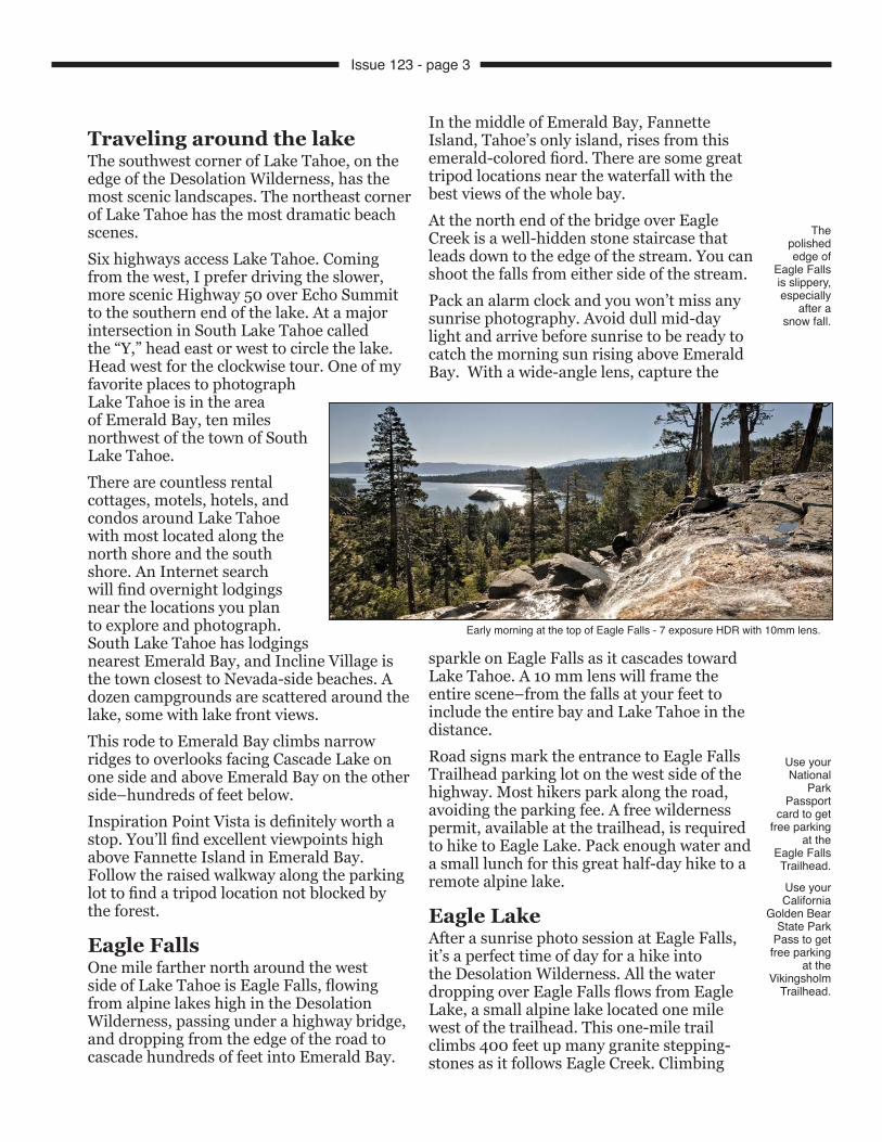
In the middle of Emerald Bay, Fannette Island, Tahoe’s only island, rises from this emerald-colored fiord. There are some great tripod locations near the waterfall with the best views of the whole bay.At the north end of the bridge over Eagle Creek is a well-hidden stone staircase that leads down to the edge of the stream. You can shoot the falls from either side of the stream.Pack an alarm clock and you won’t miss any sunrise photography. Avoid dull mid-day light and arrive before sunrise to be ready to catch the morning sun rising above Emerald Bay. With a wide-angle lens, capture the
sparkle on Eagle Falls as it cascades toward Lake Tahoe. A 10 mm lens will frame the entire scene–from the falls at your feet to include the entire bay and Lake Tahoe in the distance. Road signs mark the entrance to Eagle Falls Trailhead parking lot on the west side of the highway. Most hikers park along the road, avoiding the parking fee. A free wilderness permit, available at the trailhead, is required to hike to Eagle Lake. Pack enough water and a small lunch for this great half-day hike to a remote alpine lake.
Eagle LakeAfter a sunrise photo session at Eagle Falls, it’s a perfect time of day for a hike into the Desolation Wilderness. All the water dropping over Eagle Falls flows from Eagle Lake, a small alpine lake located one mile west of the trailhead. This one-mile trail climbs 400 feet up many granite stepping-stones as it follows Eagle Creek. Climbing
The polished edge of
Eagle Falls is slippery, especially
after a snow fall.
Use your National
Park Passport
card to get free parking
at the Eagle Falls Trailhead.
Use your California
Golden Bear State Park
Pass to get free parking
at the Vikingsholm
Trailhead.
Early morning at the top of Eagle Falls - 7 exposure HDR with 10mm lens.
Issue 123 - page 3
this trail is moderately strenuous. Seeing whole families with infants and dogs on this trail may encourage you. Hiking back down will be faster. Use caution in both directions.
Halfway to the lake, this trail follows several level stretches through a narrow canyon at the base of vertical granite walls rising thousands of feet to ragged peaks–Jake’s Peak to the north and Maggie’s Peak to the south.When you reach the end of the trail, move down close to the edge of Eagle Lake for a wide-angle view including the rocky bottom, very visible beneath crystal-clear mountain water. A polarizer will improve this composition. Move close to the lake’s outlet where Eagle Creek begins its cascade to Emerald Bay. In the other direction, the trail continues around the south side of the lake, ending at a stream flowing from Lower Velma Lake, 2000 feet above Eagle Lake. Steep talus slopes drop from black-streaked peaks on the north and west sides of Eagle Lake.
Velma LakesAfter photographing the shoreline of Eagle Lake, return a short distance back down the trail to a junction marker pointing south toward Velma Lakes, 2,000 feet higher and deeper into the Desolation Wilderness. It’s a four-mile hike to Upper Velma Lake. A quarter mile up the trail is a high viewpoint where you can frame a different composition of Eagle Lake with a better view of its small rocky island–just a few boulders and two trees.Watch for wildflowers along the trail as you head back. I shoot them in the shade of a small folding reflector blocking the high midday sun.Start your hike to Eagle Lake early in the morning when the parking lot is empty and the trails are all yours. Midweek hikes are even quieter.
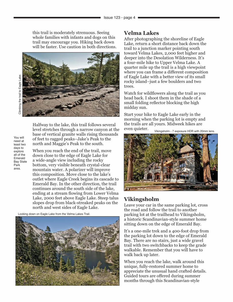
VikingsholmLeave your car in the same parking lot, cross the road and follow the trail to another parking lot at the trailhead to Vikingsholm, a historic Scandinavian-style summer home sitting down on the edge of Emerald Bay.It’s a one-mile trek and a 400-foot drop from the parking lot down to the edge of Emerald Bay. There are no stairs, just a wide gravel trail with two switchbacks to keep the grade walkable. Remember that you will have to walk back up later.When you reach the lake, walk around this unique, fully-restored summer home to appreciate the unusual hand crafted details. Guided tours are offered during summer months through this Scandinavian-style
You will need at least two days to explore all of the Emerald Bay State Park area.
Clim
bing
the
trail
to E
agle
Lak
e.
Looking down on Eagle Lake from the Velma Lakes Trail.
Vikingsholm - 7 exposure HDR with 20mm lens.
Issue 123 - page 4
fantasy estate built in 1929 in less than a year by Mrs. Lora Josephine Knight and 200 skilled craftsmen.Great rooms with high ceilings are adorned with dragonheads carved into rafters. Sod roofs are planted with wildflowers. Vikingsholm was completely furnished with authentic Scandinavian antiques. Priceless museum pieces were carefully reproduced.Mountain ridges, rising a thousand feet above Emerald Bay, are the focal point from Vikingsholm’s picture windows. On the top of Fannette Island, in the middle of Emerald Bay, is a tiny castle-like teahouse, also built by Mrs. Knight. Mrs. Knight and her husband, just before his death, were the primary financial backers of Charles Lindbergh’s solo Atlantic flight in 1927.Vikingsholm was always filled with guests. A staff of fifteen took care of Mrs. Knight, her guests, her home and the grounds. It all belongs to the State of California now and will be preserved as part of the Emerald Bay State Park.On the beach at Vikingsholm, flocks of geese with their goslings can be seen in pools near the bottom of Eagle Falls–a few of the many things to photograph here. You’ll find trail guides, maps, ice cream, and guided tour tickets at the Visitor Center located near the bottom of Eagle Falls.
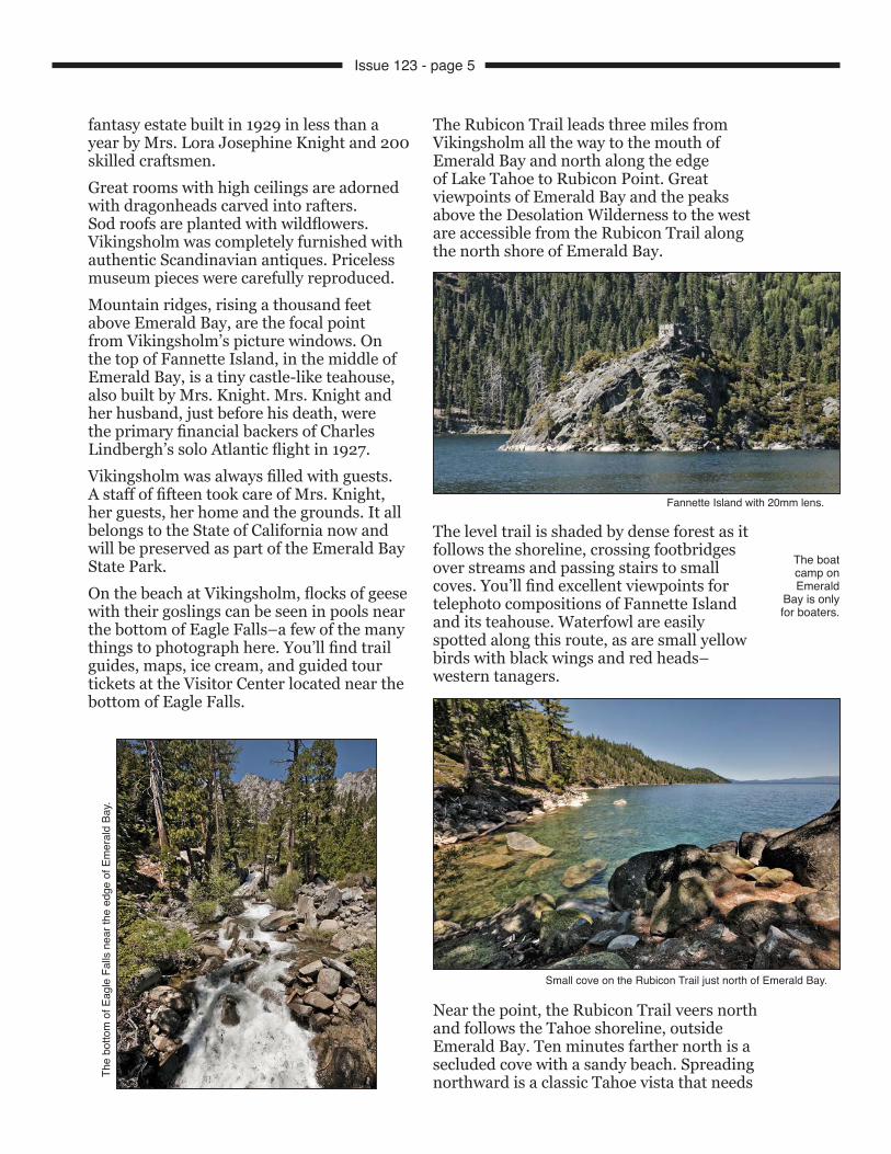
The Rubicon Trail leads three miles from Vikingsholm all the way to the mouth of Emerald Bay and north along the edge of Lake Tahoe to Rubicon Point. Great viewpoints of Emerald Bay and the peaks above the Desolation Wilderness to the west are accessible from the Rubicon Trail along the north shore of Emerald Bay.
The level trail is shaded by dense forest as it follows the shoreline, crossing footbridges over streams and passing stairs to small coves. You’ll find excellent viewpoints for telephoto compositions of Fannette Island and its teahouse. Waterfowl are easily spotted along this route, as are small yellow birds with black wings and red heads–western tanagers.
Near the point, the Rubicon Trail veers north and follows the Tahoe shoreline, outside Emerald Bay. Ten minutes farther north is a secluded cove with a sandy beach. Spreading northward is a classic Tahoe vista that needs
The boat camp on Emerald
Bay is only for boaters.
The
botto
m o
f Eag
le F
alls
nea
r the
edg
e of
Em
eral
d Ba
y.
Small cove on the Rubicon Trail just north of Emerald Bay.
Fannette Island with 20mm lens.
Issue 123 - page 5
a super wide-angle lens to capture. This cove is one of only two locations on the National Geographic map of Lake Tahoe with a camera symbol, signifying a major scenic viewpoint. After an hour on this beach, I turned around, headed back to Vikingsholm and walked back up the long grade to the parking lot.This six-hour hike was filled with photo stops and ended back at the top of the trail with another hour of afternoon light as I photographed the top of Eagle Falls again.I carry the lightest load possible on these hikes. With a carbon fiber tripod, a very lightweight ball head and a new lightweight Think Tank backpack, I never feel overloaded on the trail. A water bottle, one foil pack of tuna, a plastic fork, and a small box of raisins are packed into a zip-up bag that is also used to pack out any trash. Sixty-four gigs of digital image storage on four CF cards is much lighter than carrying a portable hard drive for storage and far lighter than carrying that much film.A campground in D.L. Bliss State Park at Rubicon Point is conveniently located near the north end of the Rubicon Trail. From Rubicon Point northward, the view from the highway is of pine forests. All the way north to Tahoe City, private roads lead to a lakeshore lined with upscale summer homes well hidden from view.
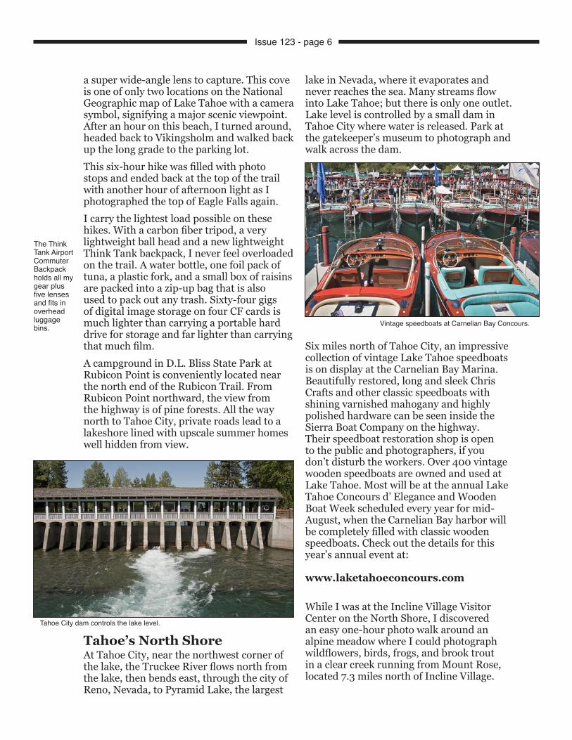
Tahoe’s North ShoreAt Tahoe City, near the northwest corner of the lake, the Truckee River flows north from the lake, then bends east, through the city of Reno, Nevada, to Pyramid Lake, the largest
lake in Nevada, where it evaporates and never reaches the sea. Many streams flow into Lake Tahoe; but there is only one outlet. Lake level is controlled by a small dam in Tahoe City where water is released. Park at the gatekeeper’s museum to photograph and walk across the dam.
Six miles north of Tahoe City, an impressive collection of vintage Lake Tahoe speedboats is on display at the Carnelian Bay Marina. Beautifully restored, long and sleek Chris Crafts and other classic speedboats with shining varnished mahogany and highly polished hardware can be seen inside the Sierra Boat Company on the highway. Their speedboat restoration shop is open to the public and photographers, if you don’t disturb the workers. Over 400 vintage wooden speedboats are owned and used at Lake Tahoe. Most will be at the annual Lake Tahoe Concours d’ Elegance and Wooden Boat Week scheduled every year for mid-August, when the Carnelian Bay harbor will be completely filled with classic wooden speedboats. Check out the details for this year’s annual event at:
www.laketahoeconcours.com
While I was at the Incline Village Visitor Center on the North Shore, I discovered an easy one-hour photo walk around an alpine meadow where I could photograph wildflowers, birds, frogs, and brook trout in a clear creek running from Mount Rose, located 7.3 miles north of Incline Village.
The Think Tank Airport Commuter Backpack holds all my gear plus five lenses and fits in overhead luggage bins.
Tahoe City dam controls the lake level.
Vintage speedboats at Carnelian Bay Concours.
Issue 123 - page 6
Tahoe Meadows Trail is a 1.3 mile loop trail that circles an alpine meadow at 8,700 feet, just below the summit of Mount Rose. If you are driving north or south on Mount Rose
Highway connecting Lake Tahoe with Reno, watch for the Tahoe Meadows Trail sign and the short side road to the trailhead.In mid-June, patches of melting snow still lingered in the shadows of ponderosa pine on the edge of an immense meadow. Ophir Creek, flowing from Mount Rose spreads across the meadow and creates an environment for many living things, right on the edge of the tree line. Bring your binoculars and sit in the sun on the overlook at the far end of the loop trail. It’s cold up there in the middle of June. Wildflowers were waiting for July. Bright red snow plants were easy to spot, pushing up through pine-covered slopes around the meadow. Snow plants seem to photograph better with a little fill flash.
Waterfront summer homes at Incline Village are spectacular. Walk their trail along Lakeshore Boulevard to check out their “rustic cottages” or to find a cafe for lunch. Incline Village, the town closest to Sand Point, has only a few inexpensive lodgings. Five miles west, casino hotels at the Nevada state line in North Tahoe offer very inexpensive rates on discount hotel websites, especially for last minute bookings.
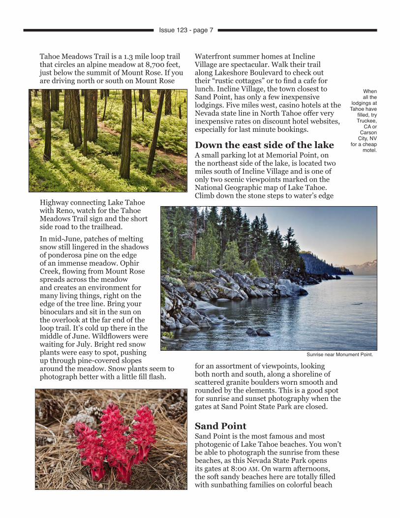
Down the east side of the lakeA small parking lot at Memorial Point, on the northeast side of the lake, is located two miles south of Incline Village and is one of only two scenic viewpoints marked on the National Geographic map of Lake Tahoe. Climb down the stone steps to water’s edge
for an assortment of viewpoints, looking both north and south, along a shoreline of scattered granite boulders worn smooth and rounded by the elements. This is a good spot for sunrise and sunset photography when the gates at Sand Point State Park are closed.
Sand PointSand Point is the most famous and most photogenic of Lake Tahoe beaches. You won’t be able to photograph the sunrise from these beaches, as this Nevada State Park opens its gates at 8:00 AM. On warm afternoons, the soft sandy beaches here are totally filled with sunbathing families on colorful beach
When all the
lodgings at Tahoe have
filled, try Truckee,
CA or Carson
City, NV for a cheap
motel.
Sunrise near Monument Point.
Issue 123 - page 7
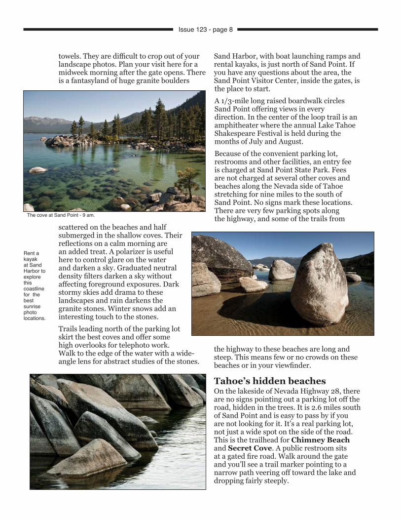
towels. They are difficult to crop out of your landscape photos. Plan your visit here for a midweek morning after the gate opens. There is a fantasyland of huge granite boulders
scattered on the beaches and half submerged in the shallow coves. Their reflections on a calm morning are an added treat. A polarizer is useful here to control glare on the water and darken a sky. Graduated neutral density filters darken a sky without affecting foreground exposures. Dark stormy skies add drama to these landscapes and rain darkens the granite stones. Winter snows add an interesting touch to the stones.Trails leading north of the parking lot skirt the best coves and offer some high overlooks for telephoto work. Walk to the edge of the water with a wide-angle lens for abstract studies of the stones.
Sand Harbor, with boat launching ramps and rental kayaks, is just north of Sand Point. If you have any questions about the area, the Sand Point Visitor Center, inside the gates, is the place to start.A 1/3-mile long raised boardwalk circles Sand Point offering views in every direction. In the center of the loop trail is an amphitheater where the annual Lake Tahoe Shakespeare Festival is held during the months of July and August.Because of the convenient parking lot, restrooms and other facilities, an entry fee is charged at Sand Point State Park. Fees are not charged at several other coves and beaches along the Nevada side of Tahoe stretching for nine miles to the south of Sand Point. No signs mark these locations. There are very few parking spots along the highway, and some of the trails from
the highway to these beaches are long and steep. This means few or no crowds on these beaches or in your viewfinder.
Tahoe’s hidden beachesOn the lakeside of Nevada Highway 28, there are no signs pointing out a parking lot off the road, hidden in the trees. It is 2.6 miles south of Sand Point and is easy to pass by if you are not looking for it. It’s a real parking lot, not just a wide spot on the side of the road. This is the trailhead for Chimney Beach and Secret Cove. A public restroom sits at a gated fire road. Walk around the gate and you’ll see a trail marker pointing to a narrow path veering off toward the lake and dropping fairly steeply.
Rent a kayak at Sand Harbor to explore this coastline for the best sunrise photo locations.
The cove at Sand Point - 9 am.
Issue 123 - page 8
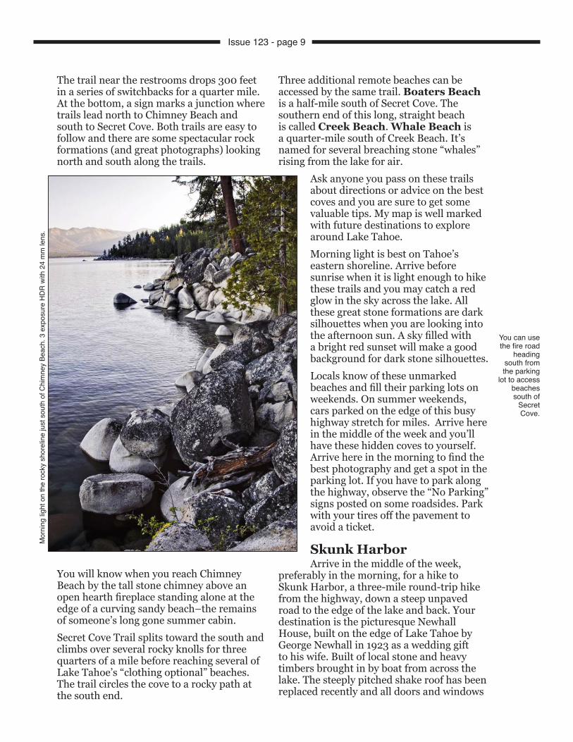
The trail near the restrooms drops 300 feet in a series of switchbacks for a quarter mile. At the bottom, a sign marks a junction where trails lead north to Chimney Beach and south to Secret Cove. Both trails are easy to follow and there are some spectacular rock formations (and great photographs) looking north and south along the trails.
You will know when you reach Chimney Beach by the tall stone chimney above an open hearth fireplace standing alone at the edge of a curving sandy beach–the remains of someone’s long gone summer cabin.Secret Cove Trail splits toward the south and climbs over several rocky knolls for three quarters of a mile before reaching several of Lake Tahoe’s “clothing optional” beaches. The trail circles the cove to a rocky path at the south end.
Three additional remote beaches can be accessed by the same trail. Boaters Beach is a half-mile south of Secret Cove. The southern end of this long, straight beach is called Creek Beach. Whale Beach is a quarter-mile south of Creek Beach. It’s named for several breaching stone “whales” rising from the lake for air.
Ask anyone you pass on these trails about directions or advice on the best coves and you are sure to get some valuable tips. My map is well marked with future destinations to explore around Lake Tahoe.Morning light is best on Tahoe’s eastern shoreline. Arrive before sunrise when it is light enough to hike these trails and you may catch a red glow in the sky across the lake. All these great stone formations are dark silhouettes when you are looking into the afternoon sun. A sky filled with a bright red sunset will make a good background for dark stone silhouettes.Locals know of these unmarked beaches and fill their parking lots on weekends. On summer weekends, cars parked on the edge of this busy highway stretch for miles. Arrive here in the middle of the week and you’ll have these hidden coves to yourself. Arrive here in the morning to find the best photography and get a spot in the parking lot. If you have to park along the highway, observe the “No Parking” signs posted on some roadsides. Park with your tires off the pavement to avoid a ticket.
Skunk HarborArrive in the middle of the week,
preferably in the morning, for a hike to Skunk Harbor, a three-mile round-trip hike from the highway, down a steep unpaved road to the edge of the lake and back. Your destination is the picturesque Newhall House, built on the edge of Lake Tahoe by George Newhall in 1923 as a wedding gift to his wife. Built of local stone and heavy timbers brought in by boat from across the lake. The steeply pitched shake roof has been replaced recently and all doors and windows
You can use the fire road
heading south from the parking
lot to access beaches south of
Secret Cove.
Mor
ning
ligh
t on
the
rock
y sh
orel
ine
just
sou
th o
f Chi
mne
y Be
ach.
3 e
xpos
ure
HD
R w
ith 2
4 m
m le
ns.
Issue 123 - page 9

have been boarded up. The view from the small beach below the veranda is sublime.
This trailhead is 2.5 miles north of the junction with the Spooner Summit Road to Carson City, Nevada. There are no Skunk Harbor signs here. This is one of the most beautiful small beaches on the east side of Lake Tahoe. Watch along the highway for a metal pipe gate across a steep road heading down to the lake. There are two small parking areas. If the first lot (a wide, paved shoulder) is filled, drive north a quarter mile to the second parking lot. Walk past the gate and start down the steepest part of the gravel road. When you reach the first junction, continue straight ahead. When you reach other junctions, stay on the widest, most traveled route. The walk down takes a half-hour. At the bottom of the road, you will see the Newhall House through the pines. The path narrows and splits to go around the house and down to the beach.
Rough trails from the front of the house lead through the woods to several other small beaches around this cove. The remains of the original pier are visible out in the cove. Weathered and sculpted granite stones are stacked everywhere from the shoreline to small islands rising from the middle of the cove. I packed my 10-20 mm zoom and my 24-120 mm zoom and needed both lenses. The arranging of these abstract sculptures as part of compositions including sky, forest, and water is what attract photographers here. The trick is to add the perfect light–sunrise or sunset. That will require hiking in or out in the dark.
Spooner LakeA half-mile north of the junction with U.S. Highway 50 is the entrance into the Lake Tahoe–Nevada State Park. Pay the entry fee at the gate and drive to the end of the parking lot near the trailhead where a 2.1 mile loop trail circles Spooner Lake.
A number of round granite boulders sit near the water on the north side of the lake. Several have deep holes made many years ago by Washoe people, the local Indians, while grinding grain, seeds and acorns. These stone patterns make an interesting foreground for photos of Spooner Lake.Aspens cover the west side of Spooner Lake. Two large groves can be seen on the south side. The largest and oldest aspen trunks have been carved with the initials of earlier visitors.More aspen groves can be found on the Spooner Highway Summit. Parking areas, located on both sides of the highway, connect
Much of Tahoe’s eastern shore drops steeply to the lake’s edge. Some hiking is necessary to find the best spots for your tripod.
Skunk Harbor.
Skunk Harbor.
On the edge of Spooner Lake.
Issue 123 - page 10
with a trail heading north to Spooner Lake on the hillside above the larger southeastern grove. Park along Highway 50 at Spooner Summit and avoid the park entry fee.The last week of September is the best time to photograph bright yellow aspen foliage across the Sierra Nevada Range. Lundy Lake and the Monitor Pass are my favorite aspen sites. The middle of October is the best time to photograph the yellow-orange foliage of cottonwoods across the Owens Valley in the Bishop, California, area, where a two-thousand-foot lower elevation creates a different climate.
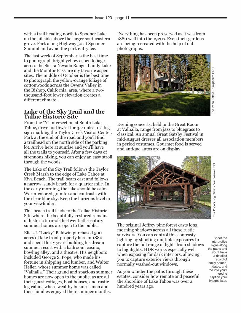
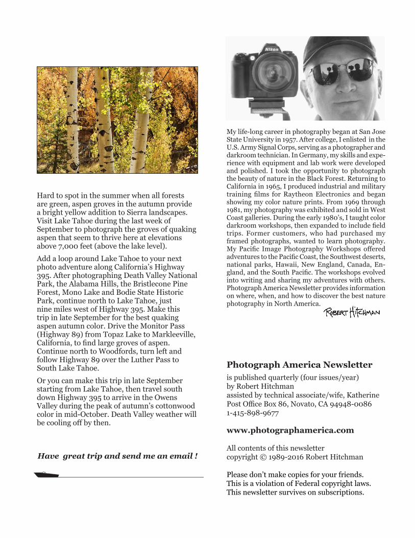
Lake of the Sky Trail and the Tallac Historic SiteFrom the “Y” intersection at South Lake Tahoe, drive northwest for 3.2 miles to a big sign marking the Taylor Creek Visitor Center. Park at the end of the road and you’ll find a trailhead on the north side of the parking lot. Arrive here at sunrise and you’ll have all the trails to yourself. After a few days of strenuous hiking, you can enjoy an easy stroll through the woods.The Lake of the Sky Trail follows the Taylor Creek Marsh to the edge of Lake Tahoe at Kiva Beach. The trail bears east and follows a narrow, sandy beach for a quarter mile. In the early morning, the lake should be calm. Warm-colored granite sand contrasts with the clear blue sky. Keep the horizons level in your viewfinder.This beach trail leads to the Tallac Historic Site where the beautifully-restored remains of historic turn-of-the-twentieth-century summer homes are open to the public.Elias J. “Lucky” Baldwin purchased 500 acres of lake front property here in 1880 and spent thirty years building his dream summer resort with a ballroom, casino, bowling alley, and a theatre. His neighbors included George S. Pope, who made his fortune in shipping and lumber, and Walter Heller, whose summer home was called “Valhalla.” Their grand and spacious summer homes are now open to the public, as are all their guest cottages, boat houses, and rustic log cabins where wealthy business men and their families enjoyed their summer months.
Everything has been preserved as it was from 1880 well into the 1920s. Even their gardens are being recreated with the help of old photographs.
Evening concerts, held in the Great Room at Valhalla, range from jazz to bluegrass to classical. An annual Great Gatsby Festival in mid-August dresses all association members in period costumes. Gourmet food is served and antique autos are on display.
The original Jeffrey pine forest casts long morning shadows across all these rustic survivors. You can control this contrasty lighting by shooting multiple exposures to capture the full range of light–from shadows to highlights. HDR works especially well when exposing for dark interiors, allowing you to capture exterior views through normally washed-out windows.As you wander the paths through these estates, consider how remote and peaceful the shoreline of Lake Tahoe was over a hundred years ago.
Shoot the interpretive signs along
the paths and you’ll have a detailed record of
family names, dates, and
the info you’ll need to
caption your images later.
The
Pope
Est
ate
- 5 e
xpos
ure
HD
R.
The
Pope
’s Lo
g C
abin
- 5
expo
sure
HD
R.
Issue 123 - page 11
Hard to spot in the summer when all forests are green, aspen groves in the autumn provide a bright yellow addition to Sierra landscapes. Visit Lake Tahoe during the last week of September to photograph the groves of quaking aspen that seem to thrive here at elevations above 7,000 feet (above the lake level).Add a loop around Lake Tahoe to your next photo adventure along California’s Highway 395. After photographing Death Valley National Park, the Alabama Hills, the Bristlecone Pine Forest, Mono Lake and Bodie State Historic Park, continue north to Lake Tahoe, just nine miles west of Highway 395. Make this trip in late September for the best quaking aspen autumn color. Drive the Monitor Pass (Highway 89) from Topaz Lake to Markleeville, California, to find large groves of aspen. Continue north to Woodfords, turn left and follow Highway 89 over the Luther Pass to South Lake Tahoe.Or you can make this trip in late September starting from Lake Tahoe, then travel south down Highway 395 to arrive in the Owens Valley during the peak of autumn’s cottonwood color in mid-October. Death Valley weather will be cooling off by then.
Have great trip and send me an email !
My life-long career in photography began at San Jose State University in 1957. After college, I enlisted in the U.S. Army Signal Corps, serving as a photographer and darkroom technician. In Germany, my skills and expe-rience with equipment and lab work were developed and polished. I took the opportunity to photograph the beauty of nature in the Black Forest. Returning to California in 1965, I produced industrial and military training films for Raytheon Electronics and began showing my color nature prints. From 1969 through 1981, my photography was exhibited and sold in West Coast galleries. During the early 1980’s, I taught color darkroom workshops, then expanded to include field trips. Former customers, who had purchased my framed photographs, wanted to learn photography. My Pacific Image Photography Workshops offered adventures to the Pacific Coast, the Southwest deserts, national parks, Hawaii, New England, Canada, En-gland, and the South Pacific. The workshops evolved into writing and sharing my adventures with others. Photograph America Newsletter provides information on where, when, and how to discover the best nature photography in North America.
Photograph America Newsletteris published quarterly (four issues/year)by Robert Hitchmanassisted by technical associate/wife, KatherinePost Office Box 86, Novato, CA 94948-00861-415-898-9677
www.photographamerica.com
All contents of this newslettercopyright © 1989-2016 Robert Hitchman
Please don’t make copies for your friends.This is a violation of Federal copyright laws.This newsletter survives on subscriptions.
Related Documents