Jürgen Walther Office of the Interministerial Committee for Geo Information (IMAGI) Coordination Office GDI-DE Federal Agency for Cartography and Geodesy [email protected] Test suite for Test suite for OpenGIS® Catalogue Services Specification 2.0.2 - ISO OpenGIS® Catalogue Services Specification 2.0.2 - ISO Metadata Application Profile 1.0 Metadata Application Profile 1.0 based on TEAM-Engine based on TEAM-Engine

Jürgen Walther Office of the Interministerial Committee for Geo Information (IMAGI) Coordination Office GDI-DE Federal Agency for Cartography and Geodesy.
Dec 30, 2015
Welcome message from author
This document is posted to help you gain knowledge. Please leave a comment to let me know what you think about it! Share it to your friends and learn new things together.
Transcript

Jürgen WaltherOffice of the Interministerial Committee for Geo Information (IMAGI)
Coordination Office GDI-DEFederal Agency for Cartography and Geodesy
Test suite forTest suite forOpenGIS® Catalogue Services Specification 2.0.2 - ISO OpenGIS® Catalogue Services Specification 2.0.2 - ISO
Metadata Application Profile 1.0Metadata Application Profile 1.0based on TEAM-Enginebased on TEAM-Engine

2
Agenda
Who we are… Our motivation to develop the test suite… Overview and content of the test… discussion…

3
Who we are…Who we are…
Coordination Office SDI-GermanyCoordination Office SDI-Germany
Network of partners in public administration and
software companies
Working Group Metadata in SDI Germany The coordination of Germany’s network of distributed catalog-services. members: public administration and software companies.
Tasks:- Coordination of setting up a SDI in Germany- national point of contact for INSPIRE
Pilot Project: “Geocatalog-DE” Within this project the network of Germany’s major catalog services shall beimproved. The aim is to link distributed catalog services – e.g. hosted on the federal or regional level – in a way that all distributed metadata can be quickly accessed from a single entry point.

4
Motivation for setting up a software-testMotivation for setting up a software-test
Status Quo:The linkage of distributed catalog services is not sufficiently solved-> It shall be improved by a pilot project.-> Decision: technical baseline is OpenGIS® Catalogue Services Specification 2.0.2 - ISO Metadata Application Profile 1.0
lessons learned:- We need tools to better control standards compliance ! - Implementers and software developers need a common accepted tool for compliance checks.
-> develop Interoperability Test Suite for CSW2.0.2AP ISO 1.0

5
Content of the ATS / Conformance-levelContent of the ATS / Conformance-level
Level name detail obligation Sample data required ?
1.1 Interface- and Binding-Availability
operations and binding (HTTP GET/-POST, SOAP)
Mandatory for OGC-conformance
none
1.2 Correctness of Request- and Response-Structures
Conformity of XML-structure (including filter encoding)
Mandatory for OGC-conformance
none
1.3 Correctness of Results GetCapabilites (Content)
GetRecords (serveral)
Mandatory for OGC-conformance
DataSet, DataSetCollection, Application
1.4 Support for Service-Metadata GetRecords(filter iso:ServiceType
and iso:OperatesOn)
optional Service-Metadata (WMS,WFS)
1.5 Support for Multi-Language GetRecords-Multilingual
optional Application (same as level 1.3)
Level 1: Discovery
Level 2: Publication Not part of ATS 1.0

6
test suite consists of …test suite consists of …
3 Documents:
1. Document: Abstract Test Suite for OGC CSW 2.0.2 AP ISO 1.0
2. Document: CTL-scipts (CTL=Compliance-Test-Language)
3. Document: sample metadata (XML-files ISO 19139)
1. Test-Software: TEAM Engine (Test, Evaluation and Measurement Engine)
CTL samplemetadata
Response
Request
CatalogueCatalogue-Service-Service
Team-Team-EngineEngine

7
ATS für OGC CSW 2.0.2 AP ISO 1.0ATS für OGC CSW 2.0.2 AP ISO 1.0

8
Level 1.1Level 1.1

9
Level 1.2Level 1.2

10
Level 1.3Level 1.3

11
Level 1.3Level 1.3

12
Level 1.4Level 1.4
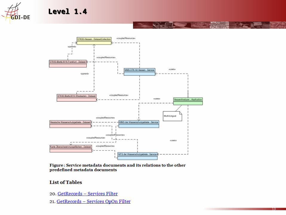
13
Level 1.4Level 1.4

14
Level 1.5 MultilingualityLevel 1.5 Multilinguality
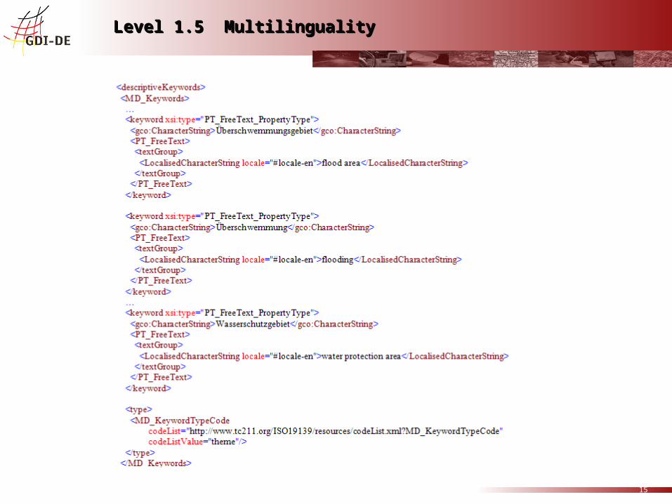
15
Level 1.5 MultilingualityLevel 1.5 Multilinguality

16
TestTest
http://www.gdi-de.org:8080/teamengine/
http://gdi-de.sdisuite.de/soapServices/CSWStartup?request=GetCapabilities&service=CSW intergraph: http://213.68.43.138:8080/mdk_csw/mdk_csw

17
To be tested / monitored:
- Standard compliance (interoperability)- Performance and availability
Standards and special arrangements in CFP:Catalog: ISO 23950, OGC CSW ebRIM-, ISO ProfilesWMS 1.3, 1.1?WFS –1.1, ..WCS– 1.1.2, ..SLD– 1.1.0, ..GML– 3.1.1, ..Sensor WebServices– 1.0.0
Performance requirements on Services: b.e. 3 seconds for the 1st record, 1st byte.....Availability requirements: 99%

18
Test Facility
• Primary Participants: BKG, ESA, USGS• Contributing Participants: CIESIN, ICT4EO• Topics • ESA SSE - Workflow, Conformance Testing and Test Environment: WMS, WFS, WCS, GML/SLD, CSW• ESA SSE - Dedicated test clients (catalogue, ordering and programming interfaces).• USGS Geospatial web service status facility for testing standards-based services at the time of registration
and elsewhere in the operational lifecycle.• USGS At present, testing of the OGC WMS and ArcIMS image services; WFS and WCS in the coming months• BKG Catalog-test based on OGC's TEAM engine for interoperability testing • CIESIN offers support for testing of service chaining and interoperability arrangements for WPS• Usability testing / recommendations for IOC
Related Documents