(ISSN: 0794-9154) Volume 8, Number 1, 2017

Welcome message from author
This document is posted to help you gain knowledge. Please leave a comment to let me know what you think about it! Share it to your friends and learn new things together.
Transcript

(ISSN: 0794-9154)Volume 8, Number 1, 2017
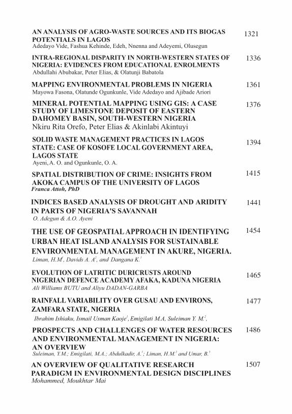
AN ANALYSIS OF AGRO-WASTE SOURCES AND ITS BIOGAS POTENTIALS IN LAGOSAdedayo Vide, Fashua Kehinde, Edeh, Nnenna and Adeyemi, Olusegun
1321
INTRA-REGIONAL DISPARITY IN NORTH-WESTERN STATES OF NIGERIA: EVIDENCES FROM EDUCATIONAL ENROLMENTS Abdullahi Abubakar, Peter Elias, & Olatunji Babatola
1336
MAPPING ENVIRONMENTAL PROBLEMS IN NIGERIAMayowa Fasona, Olatunde Ogunkunle, Vide Adedayo and Ajibade Ariori
1361
MINERAL POTENTIAL MAPPING USING GIS: A CASE STUDY OF LIMESTONE DEPOSIT OF EASTERN DAHOMEY BASIN, SOUTH-WESTERN NIGERIANkiru Rita Orefo, Peter Elias & Akinlabi Akintuyi
1376
SOLID WASTE MANAGEMENT PRACTICES IN LAGOS STATE: CASE OF KOSOFE LOCAL GOVERNMENT AREA, LAGOS STATE
Ayeni,A. O. and Ogunkunle, O. A.
1394
SPATIAL DISTRIBUTION OF CRIME: INSIGHTS FROM AKOKA CAMPUS OF THE UNIVERSITY OF LAGOSFranca Attoh, PhD
1415
INDICES BASED ANALYSIS OF DROUGHT AND ARIDITY IN PARTS OF NIGERIA'S SAVANNAHO. Adegun & A.O. Ayeni
1441
THE USE OF GEOSPATIAL APPROACH IN IDENTIFYING URBAN HEAT ISLAND ANALYSIS FOR SUSTAINABLE ENVIRONMENTAL MANAGEMENT IN AKURE, NIGERIA.
1 2 1Liman, H.M , Davids A. A , and Dangana K.
1454
EVOLUTION OF LATRITIC DURICRUSTS AROUND NIGERIAN DEFENCE ACADEMY AFAKA, KADUNA NIGERIAAli Williams BUTU and Aliyu DADAN-GARBA
1465
RAINFALL VARIABILITY OVER GUSAU AND ENVIRONS, ZAMFARA STATE, NIGERIA
1 2Ibrahim Ishiaku, Ismail Usman Kaoje , Emigilati M.A, Suleiman Y. M. ,
1477
PROSPECTS AND CHALLENGES OF WATER RESOURCES AND ENVIRONMENTAL MANAGEMENT IN NIGERIA: AN OVERVIEW
1486
1 2 3Suleiman, Y.M.; Emigilati, M.A.; Abdulkadir, A. ; Liman, H.M. and Umar, B.
AN OVERVIEW OF QUALITATIVE RESEARCH PARADIGM IN ENVIRONMENTAL DESIGN DISCIPLINES Mohammed, Moukhtar Mai
1507
Nigerian Journal of Tropical Geography Adedayo et al. Vol. 8, No. 1, 2017
1321
AN ANALYSIS OF AGRO-WASTE SOURCES AND
ITS BIOGAS POTENTIALS IN LAGOSAdedayo Vide, Fashua Kehinde, Edeh, Nnenna and Adeyemi, Olusegun
Department of Geography University of Lagos Akoka, NigeriaEmai:[email protected] Phone:08023442466
ABSTRACT: Other source of energy is regularly being agitated for due to over dependence on existing hydro power supply activities, centralization of power generation system and huge waste management challenges Nigerians experience in spite of its huge gas potentials. This paper takes inventory of the sources of cow dung-abattoirs and cattle stock, maps the distribution of cow dung volume and analyse the possible biogas yield in the study area. The inventory and mapping of cattle stock and cow dung source were ascertained from field visits and estimation of the number of cows slaughtered daily in each abattoir. In addition, the use of expert judgment, Global Positioning System to collect coordinates of point of interests and secondary data were also deployed. To have a comparative yield of biogas, samples of other agro-waste (poultry dropping and food wastes) were collected using appropriate method and analyzed in addition to cow dung, using the water displacement method in a laboratory scale experiment. A batch-load digester was replicated in three places (digester A- cow dung, digester B- poultry
0dropping and digester C- food waste) all at a mesophilic temperature of 20 C to 045 C for sixteen days retention period. The results showed that there exist 9
approved abattoirs in Lagos State with Oko-Oba abattoir having the highest stock of cattle of 1000 cows per day and 294,000kg cow dung generation respectively. The lowest cattle stock and dung generation was Epe abattoir with 2 cows per day and 200kg per day. The biogas yield analysis revealed that poultry droppings produced the highest total biogas with 46.2ml followed by cow dung 34.6ml with no yield for food waste. The average daily biogas yield was 2.3ml for digester A-cow dung, 3.08ml for digester B-poultry droppings and 0ml for digester C – food waste which reflects the fact that the difference in the production of biogas to a large extent depends on the nature of the agro-wastes. The result shows that Oko-Oba abattoir has the highest average stock of cows with 1000 per day, Ajegunle 200, Itire- 100, Igando- 10, Bariga-25 and Epe-2. Biogas estimation revealed a total biogas yield for digesters cow dung, poultry droppings and cooked food waste are 34.6ml, 46.2ml and 0.0ml respectively. The translation of the yield gave an estimation of 210.6 cubic metres gas per day from a total of 1592 cattle stock. The paper recommends enlightenment of stakeholder about the need to focus on the potentials that could be generated from agricultural waste as alternative source of energy.
Keywords: Agro-waste, Sources, Biogas, Potentials
1.0 BACKGROUNDAn alternative source of energy is progressively being canvassed for due to over dependence on existing hydro power supply activities and the national grid system which centralises power generation because of the fact that energy drives the society. Other sources of energy (solar, wind, biodegradable waste) have been b r o u g h t t o t h e f o r e a s complementary options with energy from biodegradable waste having the lead in Africa. In Nigeria, particularly in Lagos, there have been increasingly steady generation of large quantities of cow dung, poultry waste, food waste, fruits and kitchen wastes among others over the last two decades as a result of population explosion, increase in agricultural practices as a result of food demand (Ojolo, 2007). According to LAWMA, (2011), Lagos alone generates about 9000 tons of waste daily of which over 5 0 % o f t h i s w a s t e a r e biodegradable and if converted to biogas could reduce some of the energy challenges.
In many societies, agro wastes such as cattle dung and poultry droppings are converted to biogas to generate electricity or energy for domestic and industrial use. According to Abubakar (1999),
agro-waste has continually been used to generate biogas because of its widespread availability, handling and ease of managing as it is widely used as fuel to power car, heating purposes or electricity generat ion (Raymond and Okezie, 2011). It possesses a great potential for the harnessing of energy and in the efforts to combat, environmental pollution, compliment energy production. Agro- wastes also serve as a greenhouse gas saving tool to help reduce greenhouse gas emissions by over 1.1 million metric tons of carbon dioxide equivalent. As stated by Guendouz et al, (2010), biogas is an inexpensive, none- polluting gas and can be used as a supplement for non renewable fossil energy and can be produced from almost all organic materials that could be decomposed or processed (Crow, 2006).
In Nigeria, the exploitation of animal dung for production of biogas is still at its infancy, the
3pioneer biogas plants are 10m biogas plants constructed in 1995 by the Sokoto Energy Research Centre (SERC). There is also the
318m biogas plant constructed in 1996 at Ojokoro Ifelodun Piggery Farm, Lagos by the Federal Institute of Industrial Research Oshodi (FIIRO) Lagos. In several households, the knowledge to
1322
Nigerian Journal of Tropical Geography Adedayo et al. Vol. 8, No. 1, 2017
convert household waste to biogas has also been on the increase. Owing to the enormous benefits and interests in energy potentials from agro-waste. Zuru et al. (1998) and Eze et al. (2007) reported that if all the livestock waste in Nigeria is recovered and utilized to produce methane, approximately 7-10% of the total energy consumption could be replaced. Eze et al (opcit) further stated that Nigeria's biogas potentials (minimum value) from solid waste and l ivestock excrements in 1999 is about
31.382×10⁹ m of biogas/year or an annual equivalent of 4.81 million barrels of crude oil.
Practically, the usage of cow dung for biogas generation in Nigeria has been demonstrated at the Bodija Market abattoir in Ibadan, Oyo state in 2007, where about 1,000 cows are slaughtered on a daily basis. This practice could provide 1,500 cubic metres of biogas (900 cubic metres of pure methane) per day. At this proportion and with rising population, rising demand for food (crops and animals) and other agro-waste in Nigeria, with its direct consequence on rise in demand for energy, it is obvious that alternative sources of energy is critical and cattle farms offer so much energy potentials if properly
and sustainably managed.
Be as it may, information about the distribution and pattern of cattle stock and agro-waste sources, volume of agro-waste g e n e r a t e d b a s e d o n t h e geographical location is blurred, underestimated and undermined. Hence, this paper aims at examining the distribution of cattle stock, cow dung sources (abattoirs) and estimating the volume of cow dung generated, as well as determining the possible potential of biogas yield from the cow dung in the study area. This is in order to suggest the possible alternative sources energy and gas potential embedded in cattle dung and other agricultural waste in the study area.
2.0 CONCEPTUAL FRAMEWORKThe paper relies on the concept of energy security which is a multidimensional concept with internal policy dimension, economic dimension, geopolitical dimension and security policy dimension at either short term or long term measures. Energy s e c u r i t y h a s s e v e r a l interpretations and dimensions to different people. In her view, the International Energy Agency defines energy security as uninterrupted availability of
1323
Nigerian Journal of Tropical Geography Adedayo et al. Vol. 8, No. 1, 2017
energy sources at an affordable p r i c e i n c l u d i n g e n e r g y p r o d u c t i o n , s u p p l y a n d consumption, Whereas, Ned Haluzan (2013), posited that energy security can be refers to as the availability of natural resources for energy consumption in a given period of time which could be either short or long-term period. For Florian Baumann (2008) and the Asia Pacific E n e rg y R e s e a r c h C e n t r e (APERC, 2007), energy security can be synthesized variously such that four main components of energy security which are ava i lab i l i ty, access ib i l i ty, affordability and acceptability can be identified. Again, Jewell et al. (2014) instead, recognized energy ava i lab i l i ty, access ib i l i ty, accommodation, affordability and acceptability as the component of energy security. The above definitions thus reveal that energy security is tightly knitted with the energy system involving energy policy problems, equitable access to modern energy and mitigating climate change (Groldthau, 2011). It could as well be interpreted as stability and plenty flow of energy t h a t p r o m o t e s m a s s i v e l y economic output, political stability and the personal wellbeing. Lack of energy security is thus linked to the negative economic and social
impacts of either physical unavailability of energy or prices that are not competitive or are overly volatile. Be as it may, the interest of this paper relies on the fact that energy is central to human existence and thus requires constant supply and increasing diversification of sources through local generation. In fact, as stated in the Holy Bible at Ezekiel 4 Vs 12 KJV “And thou shalt eat … barley cakes, and thou shalt bake it with dung …” It is a commandment from God for man to use his/her local generated waste for energy generation and perhaps man's disobedient must have positioned man in his current energy crises. The current concerns about alleviating the physical unavailability of energy supply could therefore be tackled by promoting energy policies that encourage diversification, both of energy types and supply sources, and tha t fac i l i t a te be t te r functioning and more integrated energy markets for a steady transmission and supply system. This could further contribute to flexible energy system resistance to minimize the Nigeria energy c r i s e s b e i n g c u r r e n t l y experienced. The concept of energy security with its emphasis on energy production is thus adopted as the bases for this paper.
1324
Nigerian Journal of Tropical Geography Adedayo et al. Vol. 8, No. 1, 2017
3.0. STUDY AREA AND RESAECRH METHODSAn integrated research method approach was adopted involving field survey- collection of spatial and non-spatial data, Geographic Information System, Laboratory analysis and measurement.
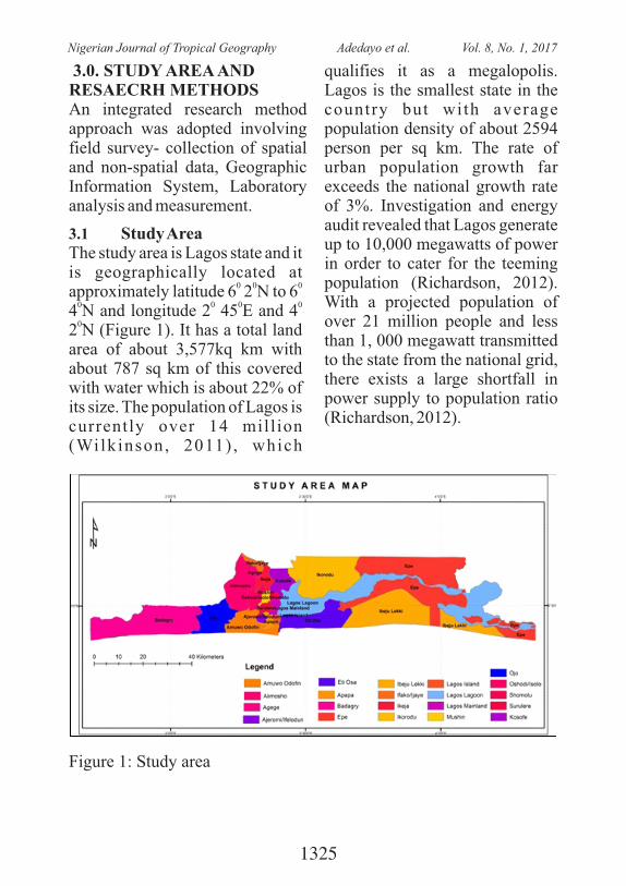
3.1 Study Area The study area is Lagos state and it is geographically located at
0 0 0approximately latitude 6 2 N to 6
0 0 0 04 N and longitude 2 45 E and 4 0
2 N (Figure 1). It has a total land area of about 3,577kq km with about 787 sq km of this covered with water which is about 22% of its size. The population of Lagos is currently over 14 mill ion (Wilkinson, 2011) , which
qualifies it as a megalopolis. Lagos is the smallest state in the country but with average population density of about 2594 person per sq km. The rate of urban population growth far exceeds the national growth rate of 3%. Investigation and energy audit revealed that Lagos generate up to 10,000 megawatts of power in order to cater for the teeming population (Richardson, 2012). With a projected population of over 21 million people and less than 1, 000 megawatt transmitted to the state from the national grid, there exists a large shortfall in power supply to population ratio (Richardson, 2012).
Figure 1: Study area
1325
Nigerian Journal of Tropical Geography Adedayo et al. Vol. 8, No. 1, 2017
The state government has hence embarked on alternative energy g e n e r a t i o n s u c h a s t h e development of biogas from the enormous b io waste being generated daily in the state as well as building an Independent Power Projects (IPPs) which is a campaign to efficiently manage the inadequate supply of power. Thus, the exploitation of animal dung for production of biogas is still in its infancy. The pioneer
3 biogas plant is the 18m biogas plant constructed in 1996 at Ojokoro Ifelodun Piggery Farm, Lagos by the Federal Institute of Industrial Research Oshodi (FIIRO) Lagos. There exist also the LAWMA – Ketu Ikosi biogas project which involves the conversion of market waste to electricity. This biogas is being used to provide electricity for market dwellers particularly in the early hours of the morning when their trucks come in to off load fruits brought in from different parts of the country. The Ketu biogas plant has a 26,000-litre capacity system, producing enough biogas to run a 10kw generator daily (Midori, 2013). The chal lenges remain the unavailability of biogas facilities to convert these wastes.
3.1 Sample Collection Samples of agro-wastes (poultry
droppings and cow dung) were collected from the abattoir and poultry farm in Oko-Oba while sample of food waste (control) was collected from the University of Lagos Cafeterias. The samples were co l l ec t ed in a b l ack polythene bag to retain in situ m o i s t u r e n e e d e d f o r p r e -laboratory analysis. The samples were sun-dried prior to being used f o r b i o g a s e x p e r i m e n t a l production. A weighing scale was then used to determine the mass (g) of each waste. The dried substrates were then crushed mechanically using a grinder and weighted before discharging into the digesters.
3.2 Inventory, dung volume and map of agro-waste locations in Lagos
The locational addresses of abattoirs and cattle stock statistics were collected from the Lagos State Ministry of Agriculture. On-field visit was done to determine the number and operations of abattoirs as well as the average daily stocks of cattle in abattoirs. An inventory map of abattoirs was developed having collected the geographical coordinates of all abattoirs using GPS. The base map was digitized from the administrative map of Lagos and geo-referenced within the ArcGis 10.3 environment to depict the site
1326
Nigerian Journal of Tropical Geography Adedayo et al. Vol. 8, No. 1, 2017
of agro-wastes locations using overlay analysis, the abattoir sites were then mapped to depict the cattle dung locations and their corresponding cattle stocks.
3.3 Experimental DesignA set of three batch conical flasks were used as digesters. Each digester contained cow dung, poultry droppings and kitchen wastes all without co-digestion.
The digesters were labelled A, B, and C in a 500 ml conical flask bottle. Afterwards, delivery tubes were inserted in the holes above the layer of the digester with the other end running through another cork enclosing a 400 ml beaker, another tube with a rubber host was immersed in the solution which ran through the same cork into an empty 10ml calibrated tube.
S/N Name Material Specications Quantity1 Digester Calibrated Conical Flask 500ml 3
2
Water tank
Calibrated Conical Flask
500ml 3
3
Measuring cylinder
Calibrated Tube
10ml 3
4
Mixer
Manual (by hand)
1
5
Cork
Rubber stoppers
-
6
6
Pipes
Infusion pipe
4mm diameter 6
7 Weighting scale Electric weighing scale - 1
8 Adehesive UHU-all purpose
3.1 E s t i m a t i o n o f b i o g a s potentials from Agro-wastes
The Mattocks (1994) and Kumar, (1989) recommendation for substrate dilution for biogas production, which states that 2.5 ml part of water should be diluted with every one part of dry waste was adopted for this study (I tuen et al , 2007). With the assistance of a laboratory specialist, biogas potential was measured for a total of 16-day retention period and
volume of gas produced was determined using water displacement method. According to Illic and Mitelic, (2006) a digester can operate on different temperature ranges depending on the stage of digestion. They argued that the temperature range for different stages of digestion will either occur in a Psychophilic (below 20°C), Mesophilic (20 to 45°C) or Thermophilic (45 to 65°C) environment. For the purpose of this
Table 1: Construction Materials
1327
Nigerian Journal of Tropical Geography Adedayo et al. Vol. 8, No. 1, 2017
study, the biogas yield experiment was carried out under a mesophilic environment due to the absence of an artificial heater. Gas yield was d e t e r m i n e d u s i n g t h e w a t e r displacement method, which is a technique used to measure the volume of objects by calculating how much water it displaces, or pushes aside when it is placed into a sample of water. This was read daily by subtracting the volume of the water without the object from the new measurement with the object which is typically measured in a graduated cylinder or other measuring device.
4.0 RESULTS AND DISCUSSION
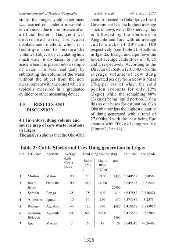
4.1 Inventory, dung volume and source map of cow waste locations in LagosThe analysis shows that the Oko-Oba
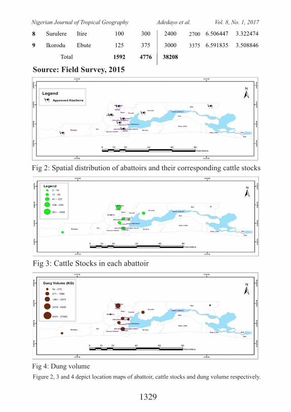
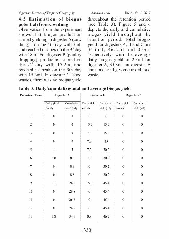
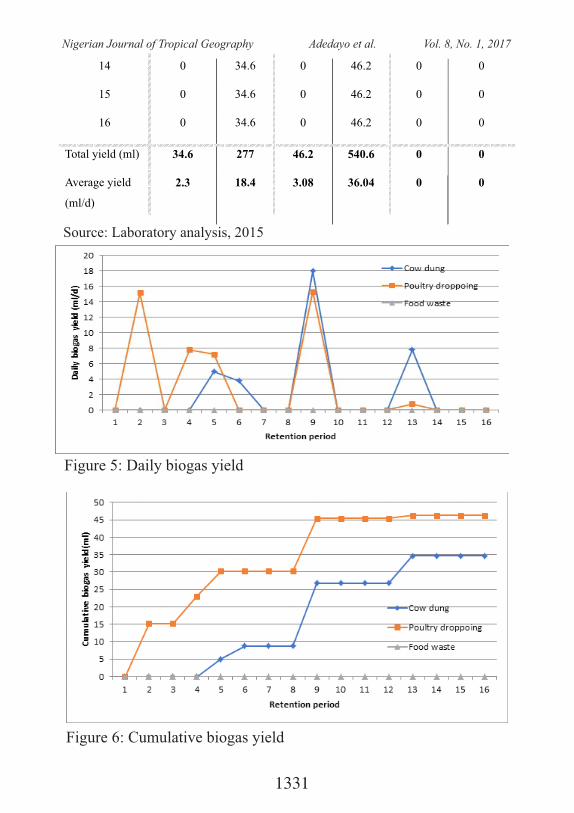
abattoir located in Ifako Ijaiye Local Government has the highest average stock of cows with 1000 per day, this is followed by the abattoirs in Ajegunle and Itire with an average catt le s tocks of 200 and 100 respectively (see Table 2). Abattoirs in Igando, Bariga and Epe have the lowest average cattle stock of 10, 25 and 2 respectively. According to the Director of abattoir (2015-03-15), the average volume of cow dung generated per day from a cow is put at 27kg per day of which the solid portion accounts for only 12% (3kg/d) while the remaining 88% (24kg/d) being liquid portion. Using this as our bases for estimation, Oko Oba abattoir has the highest quantity of dung generated with a total of 27,000kg/d with the least being Epe abattoir with 200kg of dung per day (Figure 2, 3 and 4).
S/n L/G Area Abattoir Average daily Cattle Stock
Total dung volume (kg) Latitude Longitude
Solid 12%
(×3kg)
Liquid88%
(×24kg)
total
1 Mushin Matori 90 270 2160 2430 6.540557 3.350563
2
Ifako-Ijaiye
Oko Oba
1000
3000
24000
27000
6.645505 3.31546
3
Somolu
Bariga
25
75
600
675 6.647552 3.316421
4
Alimosho
Igando
10
30
240
270 6.574584 3.2573
5
Badagry
Agbalata
40
120
960
1080 6.418568 2.883016
6
Ajeromi-Ifelodun
Ajegunle
200
600
4800
5400
6.453563 3.352088
7
Epe
Marina
2
6
48
54 6.649316 4.026468
Table 2: Cattle Stocks and Cow Dung generation in Lagos
1328
Nigerian Journal of Tropical Geography Adedayo et al. Vol. 8, No. 1, 2017
8 Surulere Itire 100 300 2400 2700 6.506447
3.322474
9
Ikorodu
Ebute
125
375
3000
3375
6.591835
3.508846
Total
1592
4776
38208
Source: Field Survey, 2015
Fig 2: Spatial distribution of abattoirs and their corresponding cattle stocks
Fig 3: Cattle Stocks in each abattoir
Fig 4: Dung volume
Figure 2, 3 and 4 depict location maps of abattoir, cattle stocks and dung volume respectively.
1329
Nigerian Journal of Tropical Geography Adedayo et al. Vol. 8, No. 1, 2017
4 .2 Es t imat ion o f b iogas potentials from cow dungObservation from the experiment shows that biogas production started yielding in digester A (cow dung) - on the 5th day with 5ml,
thand reached its apex on the 9 day with 18ml. For digester B (poultry dropping), production started on
ndthe 2 day with 15.2ml and reached its peak on the 9th day with 15.3ml. In digester C (food waste), there was no biogas yield
throughout the retention period (see Table 3). Figure 5 and 6 depicts the daily and cumulative biogas yield throughout the retention period. Total biogas yield for digesters A, B and C are 34 .6ml , 46 .2ml and 0 .0ml respectively, with the average daily biogas yield of 2.3ml for digester A, 3.08ml for digester B and none for digester cooked food waste.
Table 3: Daily/cumulative/total and average biogas yield
Retention Time Digester A Digester B Digester C
Daily yield
(ml/d)
Cumulative
yield (ml)
Daily yield
(ml/d)
Cumulative
yield (ml)
Daily yield
(ml/d)
Cumulative
yield (ml)
1 0
0
0
0
0
0
2 0
0
15.2
15.2
0
0
3 0
0
0
15.2
0
0
4 0
0
7.8
23
0
0
5 5
5
7.2
30.2
0
0
6 3.8
8.8
0
30.2
0
0
7 0
8.8
0
30.2
0
0
8 0
8.8
0
30.2
0
0
9 18 26.8 15.3 45.4 0 0
10 0
26.8
0
45.4
0
0
11 0
26.8
0
45.4
0
0
12 0
26.8
0
45.4
0
0
13 7.8 34.6 0.8 46.2 0 0
1330
Nigerian Journal of Tropical Geography Adedayo et al. Vol. 8, No. 1, 2017
14 0
34.6
0
46.2
0
0
15 0
34.6
0
46.2
0
0
16 0
34.6
0
46.2
0
0
Total yield (ml) 34.6 277 46.2 540.6 0 0
Average yield
(ml/d)
2.3 18.4 3.08 36.04 0 0
Source: Laboratory analysis, 2015
Figure 5: Daily biogas yield
Figure 6: Cumulative biogas yield
1331
Nigerian Journal of Tropical Geography Adedayo et al. Vol. 8, No. 1, 2017
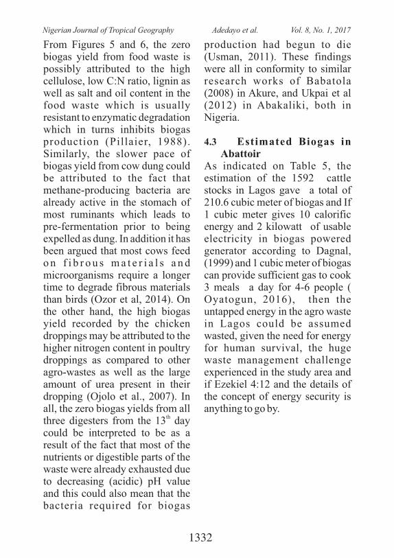
From Figures 5 and 6, the zero biogas yield from food waste is possibly attributed to the high cellulose, low C:N ratio, lignin as well as salt and oil content in the food waste which is usually resistant to enzymatic degradation which in turns inhibits biogas production (Pillaier, 1988). Similarly, the slower pace of biogas yield from cow dung could be attributed to the fact that methane-producing bacteria are already active in the stomach of most ruminants which leads to pre-fermentation prior to being expelled as dung. In addition it has been argued that most cows feed o n f i b r o u s m a t e r i a l s a n d microorganisms require a longer time to degrade fibrous materials than birds (Ozor et al, 2014). On the other hand, the high biogas yield recorded by the chicken droppings may be attributed to the higher nitrogen content in poultry droppings as compared to other agro-wastes as well as the large amount of urea present in their dropping (Ojolo et al., 2007). In all, the zero biogas yields from all
ththree digesters from the 13 day could be interpreted to be as a result of the fact that most of the nutrients or digestible parts of the waste were already exhausted due to decreasing (acidic) pH value and this could also mean that the bacteria required for biogas
production had begun to die (Usman, 2011). These findings were all in conformity to similar research works of Babatola (2008) in Akure, and Ukpai et al (2012) in Abakaliki, both in Nigeria.
4.3 Estimated Biogas in Abattoir
As indicated on Table 5, the estimation of the 1592 cattle stocks in Lagos gave a total of 210.6 cubic meter of biogas and If 1 cubic meter gives 10 calorific energy and 2 kilowatt of usable electricity in biogas powered generator according to Dagnal, (1999) and 1 cubic meter of biogas can provide sufficient gas to cook 3 meals a day for 4-6 people ( Oyatogun, 2016), then the untapped energy in the agro waste in Lagos could be assumed wasted, given the need for energy for human survival, the huge waste management challenge experienced in the study area and if Ezekiel 4:12 and the details of the concept of energy security is anything to go by.
1332
Nigerian Journal of Tropical Geography Adedayo et al. Vol. 8, No. 1, 2017
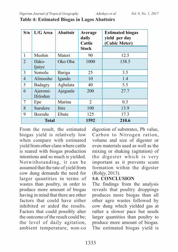
Table 4: Estimated Biogas in Lagos Abattoirs
S/n L/G Area Abattoir Average daily Cattle Stock
Estimated biogas yield per day (Cubic Meter)
1 Mushin Matori 90 12.5 2 Ifako-
Ijaiye
Oko Oba 1000 138.5
3
Somolu
Bariga
25
3.5
4
Alimosho
Igando
10
1.4
5
Badagry
Agbalata
40
5.5 6
Ajeromi-Ifelodun
Ajegunle
200
27.7
7
Epe
Marina
2
0.3 8
Surulere
Itire
100
13.9
9
Ikorodu
Ebute
125
17.3
Total 1592 210.6
From the result, the estimated biogas yield is relatively low when compare with estimated yield from other clans where cattle is reared with biogas production intentions and so much is yielded. Notwithstanding, i t can be assumed that the rate of yield from cow dung demands the need for larger quantities in terms of wastes than poultry, in order to produce more amount of biogas having in mind that there are other factors that could have either inhibited or aided the results. Factors that could possibly alter the outcome of the result could be; the level of daily agitation, ambient temperature, non-co
digestion of substrates, Ph value, Carbon to Nitrogen ration, volume and size of digester or even materials used as well as the mixing or shaking (agitation) of the digester which is very important as it prevents scum formation within the digester (Rohjy, 2013). 5.0. CONCLUSIONThe findings from the analysis reveals that poultry droppings produces more biogas than all other agro wastes followed by cow dung which yielded gas at rather a slower pace but needs larger quantities than poultry to produce more amount of biogas. The estimated biogas yield is
1333
Nigerian Journal of Tropical Geography Adedayo et al. Vol. 8, No. 1, 2017
relatively low when compared with estimated gas yield per cow in other societies where cattle is reared with biogas production intentions. Notwithstanding, various agriculture waste could be mixed for a viable and better biogas generation and yield. T r a i n i n g f o r e f f e c t i v e management of livestocks and other agricultural waste for biogas intentions could be invested in and budgeted for and the public should be enlightened. Factors that could possibly alter the biogas yield such as the level of daily agitation, ambient temperature, non-co digestion of substrates, Ph value, Carbon to Nitrogen ration, volume and size of digester or even materials used as well as the mixing or shaking (agitation) of the digester should be considered as very important input that could influence yield (Rohjy, 2013).
6. REFERENCESAbubabar (, M. M. (1999) Biogas generat ion from Animal
Wates. Nigeria Journal of Renewable Energy 1:69-73.
B a b a l o l a , J . O . ( 2 0 0 8 ) , Comparative study of Biogas Yield Pattern in some Animal a n d H o u s e h o l d Wa s t e . African Research Review 2(4):54-68
Crow, J (2006). 'Biogas Energy, Arizona Public Service Co.,
Arizona, USAFry, (1974) Practical Building of
Methane Power Plants for Rural Energy Independence. Santa Barbara, CA, 93103
Guendouz, J., Buffière, P., Cacho, J. Carrère, M., and Delgènes, J.P. (2010). “Dry anaerobic digestion in batch mode: Design and operation of a laboratory scale, completely m i x e d r e a c t o r ” , Wa s t e Management, Article in press (4 pages)
Illic, M. and Mitelic, S (2006). 'Biogas Production from Manure': International Solid Waste Association.Ituen, E.E., John, M.M., and
Bassey, B.E. (2007) “Biogas Production from Organic Waste in Akwa Ibom State of N i g e r i a . A p p r o p r i a t e T e c h n o l o g i e s f o r Environmental Protection in t h e D e v e l o p i n g Wo r l d . Selected Papers from ERTEP, July 17 -19, Ghana.
Madu, C. and Sodeinde, O.A. ( 2 0 0 1 ) “ R e l e v a n c e o f Biomass in Sus ta inable Energy Development In Nigeria” Proceedings of the N a t i o n a l E n g i n e e r i n g Conference and Annual General Meet ing of the N i g e r i a n S o c i e t y o f Engineers, 220-227
O j o l o S . J . , O k e S . A . ,
1334
Nigerian Journal of Tropical Geography Adedayo et al. Vol. 8, No. 1, 2017
Animasahun K. and Adesuyi B. K.,(2007) Utilisation of poultry, cow and kitchen wastes for biogas production: A comparative analysis, Iran J. Environ. Health. Sci. Eng., 4(4), 223
Raymond,O and Okezie, U (2011) The significance of Biogas Plant in Nigria's Energy Strategy. Journal of Physical Science and Innovation 2:34-43.
Rohjy, H.A, Aduba, J.J., Manta, I.H, Pandayo, Y (2013), Development of Anaerobic Digester for the Production of Biogas using Poultry and Cattle Dung: A case study of F e d e r a l U n i v e r s i t y o f Technology Minna Cattle and
Poultry Pen. International Journal of Life Sciences Vol.2 No.3 pp139-149.
Se r f a s s , P. ( 2012) B iogas Processing for Utili t ies. American biogas council Smith, R. J., Hein, M. E. and G r e i n e r , T. H . ( 1 9 7 9 ) . E x p e r i m e n t a l m e t h a n e production from Animal excreta in pit scale and farm-size units. Journal of Animal Science, 8: 202 – 217.
Zuru, A.A, Saidu, H, Odum, E.A, and Onuorah, O.A. (1998). A Comparative Study of Biogas Production from Horse, Goat and Sheep Dungs. Nigerian Journal of Renewable Energy. Vol 6
1335
Nigerian Journal of Tropical Geography Adedayo et al. Vol. 8, No. 1, 2017
INTRA-REGIONAL DISPARITY IN NORTH-WESTERN STATES OF NIGERIA: EVIDENCES FROM EDUCATIONAL
ENROLMENTS
Abdullahi Abubakar, Peter Elias, & Olatunji Babatola Department of Geography, University of Lagos, NigeriaCorresponding Author: E-mail: [email protected]
ABSTRACT: The paper examines regional disparity in North-Western Nigeria by providing evidences from educational enrolments, using three educational levels: adult literacy, secondary school and primary school. Measuring regional disparity is key to evolving interventionist strategies for addressing inequalities among places. The paper uses statistical measures of Lorenz Curve and Gini Co-efficient to compute intra-regional disparity in North Western states of Nigeria. It also hypothesizes that the age of state creation and the distance of the other states from FCT, Abuja, do not influence intra-regional disparities in North Western Nigeria. The paper uses 2006 and 2010 educational enrolments data obtained from National Bureau of Statistics to analyse the intra-regional disparities in North Western states of Nigeria. This is due to paucity of recent data for the same period and scale in the selected states. The results show that, the regional Gini coefficient of the adult literacy in 2006 is at 55.46 while in 2010 it is at 36.36. The same trend is observed with respect to secondary school enrolment which indicates that in 2006 the Gini coefficient is at 42.72 while in 2010 is at 40.24 while the case of primary school enrolment indicates that in 2006 the Gini coefficient is at 28.22 and in 2010 is higher at 37.62 in the region. This shows that the adult literacy and secondary school enrolment were closer to equity line between 2006 and 2010 compared to that of primary school enrolment which was not so encouraging. The implication is that, there is need for conscious and concerted efforts to increase primary school enrolment in the sub-region. Similarly, the age of state creation is largely directly related to the Gini Coefficient and school enrolments. Also, it was discovered that, there is fairly inverse relationship between the distance between each state's capital city and the Federal Capital Territory, Abuja and the Gini Coefficient for each state. Similarly, the number of years of the state creation in the region is mainly directly related with the Gini Coefficient and consequently on school enrolments in each state.
Key words: Intra-regional disparity; educational enrolment, development, North Western Nigeria
1336
Nigerian Journal of Tropical Geography Abdullahi et al. Vol. 8, No. 1, 2017
1. Introduction
Education is the bedrock of sustainable development in any country. Regional disparity in educational enrolment will limit even development in Nigeria. This paper examines regional dispari ty in North Western Nigeria using evidences from school enrolments into adult literacy education, secondary schools and primary schools. Regional disparities in Nigeria has both historical and structural underpinnings. The history of Niger ia f rom pre-colonial , colonial and post-independence indicates that, there have been regional disparities in various sectors including educational, economic, political, and social. These have led to a relative high level of development in some regions of the country compared t o c l e a r s t a g n a t i o n o r underdevelopment in other regions. There is also marked intra-regional disparity in the country. History has proved that the British colonial masters wittingly or u n w i t t i n g l y i n i t i a t e d t h e disparities in the regions of the country. It has been observed that persistent regional disparities are likely to have evolved during the one-hundred-year colonial period in Nigeria (Nneli, 1978; Ayeni and Mabogunje, 1982). It can be
argued that the southern region was accorded much attention in education and economic sectors perhaps because of the locational o f t h e c e n t r e o f c o l o n i a l administration and its closeness to t h e A t l a n t i c O c e a n . T h i s unarguably helped in given the region some initial economic advantage over the Northern region which has proximity to the desert.
A s tudy in to the Niger ian educational system also reveals levels of disparities. There is obvious disparity between urban and rural schools, among schools c o n t r o l l e d b y t h e f e d e r a l government, states government and pr iva te organiza t ions . Disparities can also be observed b e t w e e n m a l e a n d f e m a l e enrolments at both primary and s e c o n d a r y l e v e l s , a n d i n admiss ions among federa l government and privately owned tertiary institutions (UNESCO, 2013). The objective of the Universal Basic Education (UBE) Scheme, launched in 1999 and passed into law in May 2004, was to significantly reform and address generally the lapses of the Universal Primary Education ( U P E ) a n d t h e i s s u e s o f admis s ion , pa r i t y, equ i t y, inclusiveness, affordability and excellence UNESCO (2013). In the Nigerian context, Universal
1337
Nigerian Journal of Tropical Geography Abdullahi et al. Vol. 8, No. 1, 2017
Basic Education includes primary and junior secondary education with the goal to provide universal free and compulsory education at the primary and the first three years of secondary school as well as to provide functional literacy for adult population.
According to UNESCO (2013), t he ma in goa l o f p r ima ry education is focused on functional literacy and numeracy, the ability to communicate effectively, and the impacting of positive values towards co-operation, work, c o m m u n i t y / n a t i o n a l development, and continuing learning. The general aim of secondary education within the overall national objectives is the preparation for valuable living within the society and for higher education. It was set up to endow students to live effectively in the modern age of science and technology; nurture a generation of people who can think for themselves, respect the views and feelings of others, respect the dignity of labour, and live as noble citizens; foster the Nigerian unity with an emphasis on the common ties that unite despite obvious diversity; and foster the desire for a c h i e v e m e n t a n d s e l f -i m p r o v e m e n t . S e c o n d a r y education lasts six years and is divided into two three-year cycles: junior secondary and
senior secondary UNESCO (2013). In like manner, the adult educat ion system provides education for youths and adults who have hitherto missed the primary/secondary education or dropped out along the way. Adult education allows for exit and re-entry at desired points or times in life. This provides room for movement from non-formal to the formal system UNESCO (2013).This paper focuses on the disparity in the North-western Nigeria using evidences from educational enrolments in the seven states, namely Sokoto, Zamfara, Kebbi, Kaduna, Kano, Katsina and Jigawa. These states were created at different periods of political history of Nigeria and are located at different distances away from the major urban area in the northern Nigeria, Federal Capital Territory of Nigeria, Abuja. The specific objectives of the paper are to: examine the pattern of educational enrolments in primary, secondary and adult educational levels; examine the causative factors of intra-regional disparity in levels of educational e n r o l m e n t s ; a s s e s s t h e implications of intra-regional disparity and develop practical strategies for reducing intra-regional disparity in North-western Nigeria.
1338
Nigerian Journal of Tropical Geography Abdullahi et al. Vol. 8, No. 1, 2017
2. Statement of the Problem
The principle of education in Nigeria is to provide the citizen with the requisite knowledge, skills, attitudes and values as to enable individuals to derive maximum benefits from his/her participation in the country, to lead an accomplishing life and c o n t r i b u t e t o t h e g r o w t h development of the nation. To achieve the above principle therefore, enrolment in schools is very paramount because among other importance, it combats disparity among states in every region. Historically, regional disparity in Nigeria, according to Gboyega et al. (2004) can be traced back to the beginning of the twentieth century to the creation of the Southern and Northern Protectorate and the persistent squabbles between the two colonial administrations over t r ans fe r s . In l ike manner, Mustapha (2005) suggested that misguided colonial educational policy in Northern Nigeria and d i f f e r e n t l e v e l s o f e t h n i c receptivity to western education, produced a huge development gap between Northern and Southern regions of Nigeria from the early 1900s. Notwithstanding the unfavourable interplay of hostile geography and biased colonial policies, the persistence and often
the widening gap between the North and South in Ghana and Nigeria also raises serious questions about the effectiveness o f p o s t - i n d e p e n d e n c e g o v e r n m e n t s ' p o l i c i e s i n producing an inclusive society (Luca Mancini, 2009).
However, there are various efforts towards the reduction of regional and intra-regional disparity in the country, within the various periods of leadership change in N i g e r i a i n t e r m s o f decentralization and devolution of power, especially, with the creation of states as well as Local Government Areas in the country. This started with the creation of twelve states in 1967, which latter increased to nineteen in 1976, twenty-one in 1987, thirty in 1991 and thirty-six in 1996. In addition, the gradual creation of Local Government Areas numbering up to 774 presently aimed to halt the persistent evidences of disparity.
Thus, the nation is faced with several challenges with respect to in t ra - reg iona l d i spar i ty in e d u c a t i o n a l e n r o l m e n t , educat ional fac i l i t i es , and manpower development. These manifest in the proliferation of radical ideologies, armed robbery, k i d n a p p i n g , a n d p o l i t i c a l thuggery which generally stem
1339
Nigerian Journal of Tropical Geography Abdullahi et al. Vol. 8, No. 1, 2017
from unemployment in all regions of the country in general and Northwest region in particular where some states appeared to be m o r e e d u c a t i o n a l l y a n d economically advantageous than the others. This necessitates an interrogation of the pattern of intra-regional disparity in North Western region with a focus on educational enrolments especially in primary, secondary and adult literacy schools.
3.0 Review of Literature and Conceptual Framework
There are persistent evidences of disparities between and within regions of the world in various aspects of development including education (Cole, 1987). This imbalance is noticeable in gender enrolment at all levels and types of education as well as across v a r i o u s d i s c i p l i n e s a n d programmes, especially at the tertiary level (Opatoyinbo and Babatunde, 2016). Regional polarity is of global concern as it has been observed in most nations, but, more pronounced in developing countries like Nigeria. Enrolment in primary schools in most northern Nigeria has been challenging. In a report made available by United Nations I n t e r n a t i o n a l C h i l d r e n Educational Fund (UNICEF), it was discovered that forty per cent
of Nigerian children aged 6-11 do not attend any primary school w i t h t h e N o r t h e r n r e g i o n recording the lowest school attendance rate in the country, p a r t i c u l a r l y f o r t h e g i r l s (UNICEF, 2013). Despite a s ignif icant increase in net enrolment rates in recent years, according to the report it is estimated that about 4.7 million children of primary school age are still not in school in Nigeria. However, some do enrol in schools but many do not complete the primary school cycle. The international agency further indicated that 30% of pupils drop out of primary school and only 54% transit to Junior Secondary Schools in Nigeria and some of the reasons for this include child labour, economic hardship and early marriage for girls. In Indian, disparity occurs because of the existence of backward areas even within states that have grown faster and are at relatively high income levels on average (Debroy and Bhandari, 2003). Indeed, regional disparities in India shows that the pattern has persisted despite the hope that the gap could n a r r o w ( H i r s c h m a n a n d Rothschild, 1973).
Meanwhile, earlier analyses on spatial economic development stipulates that regional disparities
1340
Nigerian Journal of Tropical Geography Abdullahi et al. Vol. 8, No. 1, 2017
in terms of income, education or health services tend to diminish over time due to market forces (Kuznets, 1955; Hirschman, 1958). Some of these experts submitted that with increased factor of mobility, physical capital tends to move from more affluent to less affluent regions while human capital move from less affluent to more affluent regions. In modern complex society, several forces are contending against these expectations even with political decentralization. Indeed, persistent regional disparities in countries such as Brazil or Russia have led several authors to question the validity of t h e p o s i t i v e e f f e c t o f decentralization on economic performance and hence on interregional equity.
Governments at different levels in various countries have been putting policies in place to combat the menace of regional disparity in their countries. Regarding the Italian case, it has been indicated that there was positive effect of the devo lu t iona ry p rocess beginning in 1995 which led to the streamlining of spatial disparities, even if indirectly (Calamai, 2009). Over the period of 10 years, after the preliminary measures of regionalization in Italy, a noticeable decrease of
regional disparities happened which led to some decline in the 'North–South divide' (Calamai, 2009). Though, just one year later (1996), evidences began to emerge that there was vivid closing up of the North–South gap w h i c h h a d b e e n r i s i n g continuously since the 1980s.
Efforts to trace the determinants
of regional disparity has received
c o n s i d e r a b l e a t t e n t i o n i n
literature. One of the easily
identifiable factor is regional
resource endowments (Teriba
(2013) leading to differences in
growth processes and indicators.
It is noticeable that states and
regions which can catch up with
the growth processes are getting
rich just as those which are
excluded, remain poor. Thus,
world regions are being classified
a s t h e b a c k w a r d a n d t h e
prosperous. As it relates to
Nigeria, the inherent geographical
endowments are aiding or limiting
g r o w t h p r o c e s s e s a n d
c o n s e q u e n t l y l e v e l s o f
developments. With respect to
Nigeria, some peculiar situations
abound account ing for the
persistence of the regional
1341
Nigerian Journal of Tropical Geography Abdullahi et al. Vol. 8, No. 1, 2017
disparities because, in each region
of the country there are some
inherent conditions such as
geographical endowments which
os t ens ib ly gave economic
advantages to some region over
the other. The North-west and
North-central of Nigeria blessed
with well-watered arable land
account for 90 per cent of food
production. Similarly, the South-
south which has access to the
coastal oil and gas deposits
accounts for 91.5 per cent of oil
product ion (Teriba, 2013) .
Further, according to Teriba, the
historic ports of Lagos and the
money-spinning land borders
make the South-west to account
for 60 per cent of trading and
commercial activities when
compared to the North-central and
South-south which combine to
contribute about 30 per cent. The
other two regions, namely, the
semi -a r id Nor th -eas t wi th
immense metal ores, and the
landlocked South-east with
immense coal deposits, seem to be
excluded f rom the present
economic growth trajectory.
In terms of economic prosperity,
the division among regions in Nigeria is further highlighted. For instance, Teriba (2013) observed that the South-west gross regional output outpaced the rest regions with an absolute nominal increase of N1.4 trillion (or 21.8% nominal growth), followed by the North-west with N1 trillion (16.38%), and North-central with N800 billion (14.27%) in 2012. In contrast, the author showed that regional output for the South east shows an increase of N123 billion (10.89%) and N100 billion (8.19%) for the North-east during the same period. Meanwhile, the regional output for the South-south witnessed a slight decline of about N268.9 billion (-1.69%) due to a slight dip in oil price in 2012 after remarkable growth in the earlier three years. Overall, Teriba further indicated that the South-south recorded the highest gross regional product (GRP) which amount to N15.65 trillion (38.6% of Nigeria 's GDP), followed by the North-west's N8.4 trillion (20.65%), South-west's N8.2 trillion (20.26%), and North-central's N5.7 trillion (15%). It is noticeable that the South-east's N1.4 trillion (3.27%) and North-central's N1.2 trillion (3.11%) were the smallest GRPs in 2012 (Teriba, 2013).
T h e r e h a v e b e e n s e v e r a l
1342
Nigerian Journal of Tropical Geography Abdullahi et al. Vol. 8, No. 1, 2017
theoretical postulations to explain the phenomenon of regional disparity. The primacy theory has b e e n a d o p t e d b y v a r i o u s disciplines to show that regional disparity is inevitable as various nations undertake political and socioeconomic development and growth. The theory indicates that in urban primacy, socio-spatial and individual inequalities first increase then decrease with time as socioeconomic and political development and growth progress within a nation or region. Some of t h e n o t a b l e s c h o l a r s l i k e Hirschman (1958); Kuznets (1963); Mera, (1965); EI Shakhs (1972); Mera (1975); and Gilbert (1976) equivocally observed that in any capitalist society, there is regional disparity at all levels of national development especially dur ing the ear ly s tages of socioeconomic growth and political development.
Meanwhile, both Myrdal (1957) and Dicken & Lloyd (1990) argued that it was difficult for the equilibrium forces of market mechanisms to erase regional disparity once it occurs during the process of socioeconomic growth and political development. They further added that the spatial and socioeconomic divergence in prosperity among regions and individuals persist rather than
fade over time, unless some concerted efforts are taken to combat the monster. Evidences of disparity and polarization have persisted in most developing countries despite their quest for p a r i t y . T h e r e s u l t i n g consequences include hyper-urbanization, over-urbanization, underemployment , income inequality and poverty, persistent food insecurity, deteriorating e n v i r o n m e n t a n d o v e r -dependence on foreign aids.
3.1 The Concept of DisparityDisparity is multidimensional as it deals with various variables of h u m a n d e v e l o p m e n t . T h e variables include but not limited to health, economic, income and wealth, education, regional development, technology, and gender. In terms of spatial scale, the dimension of disparity covers global, intrastate, interstate, r e g i o n a l , l o c a l w h i l e t h e demographic scale includes p o p u l a t i o n s a n d t h e i r characteristics (Elias, et al, 2015). All these indicate that, there are various definitions of disparity that demonstrates its wide scope.
3.2 Income Disparity
Income disparity or inequality is viewed as the unequal distribution of household or individual income
1343
Nigerian Journal of Tropical Geography Abdullahi et al. Vol. 8, No. 1, 2017
across various population groups in a society. Income inequality is often expressed as the percentage o f i n c o m e t o p o p u l a t i o n ( R a j a l a k s h m i , 2 0 1 3 ) . F o r example, if 20% of a country's population controls 70% of its wealth this depicts income inequality. Income inequality is often associated with the idea of income reality, that is, the true situation in a society. It is g e n e r a l l y c o n s i d e r e d "inequitable" if the rich have a disproportionately larger portion of a country's income compared to the population. However, the cause of income inequality can vary significantly by region, gender, education and social status. Economists are divided as to whether income inequality is ultimately positive or negative and what are the implications of such disparity (Fletcher, 2015).
3.3 Educational Inequality
Solga, et al (2014) submits that a lot of educational inequality is attributed to economic disparities which often fall along racial lines and much modern conversation about educational equity conflates the two, showing how they are inseparable from geographical location and, more recently, language. For example, in the
Uni ted S ta tes o f Amer ica , educational inequality between white students and minority students continue to perpetuate social and economic inequality. In the developing world, one may expect a more intense inequality along social and economic c o n d i t i o n s o f t h e v a r i o u s population groups. Some earlier educational policies including those of colonial and post-independence regimes may have strengthened the educational inequality between urban and rural areas and between the elites and the under-privileged in Africa.
3.4 Social Disparity Social disparity occurs when resources in a typical society are distributed unequally sometimes by natural processes or through the norms of resource allocation which cause specific patterns to be noticeable in different social groups. Indeed, Goldthrope (2009), emphasises that economic inequality is usually described as the unequal distribution of income or wealth which is an aspect of social inequality. Scott (2013), while explaining the concept of social inequality, elucidated that, both academic disciplines of economics and sociology usually use different theoretical methods
1344
Nigerian Journal of Tropical Geography Abdullahi et al. Vol. 8, No. 1, 2017
t o i n t e r roga t e and c l a r i fy economic inequality, they both participate in social inequality research. The outcome of both researches indicates that, social and natural resources are visibly unevenly distributed in most societies and could contribute to differences in social status.
3.5 Measures of DisparityDisparity entails the computing of dissimilar amounts of income, wealth or consumption, in the real sense. It is also applicable to other variables such as standards of living among people because of its continuous process. Disparity in such variables is generally summarized by an inequality index which can be expressed as the degree of dispersion in the distribution (McKay, 2002). D i s p a r i t y i s c o n t i n u o u s l y measured using various means of statistical measurement with the application of identified human development indices, the outcome usually expose lopsidedness and areas needing to be balanced for holistic development in the society.
T h e f o l l o w i n g h a v e b e e n identified as some of the means by w h i c h i n e q u a l i t y c a n b e measured:
3.5.1 The Lorenz Curve: This is
a measure of the quantitative relationship between cumulative income received and the total income in a typical year. A country is said to be experiencing greater degree of inequality where the Lorenz Curve line is farther away from the diagonal line.
3.5.2 Gini-coefficient or Gini Index: This is the most commonly used measure of inequality. The coefficient varies between 0, which reflects complete equality and 1, which indicates complete inequality (one person has all the income or consumption, all others have none). Graphically, the Gini c o e f f i c i e n t c a n b e e a s i l y represented by the area between the Lorenz curve and the line of equality. The Lorenz curve maps the cumulative income share on the vertical axis against the distribution of the cumulative population on the horizontal axis. The Gini coefficient is also calculated as the area A divided by the sum of areas A and B. The area A is represented by the portion between the line of equality and the Lorenz curve while Area B is the portion below the Lorenz curve. Thus, Gini Index is computed as G=A/A+B. If income is distributed completely equally, then the Lorenz curve and the line of total equality are merged and the Gini coefficient is zero. If one individual receives all
1345
Nigerian Journal of Tropical Geography Abdullahi et al. Vol. 8, No. 1, 2017
the income, the Lorenz curve would pass through the points (0,0), (100,0) and (100,100), and the surfaces A and B would be similar, leading to a value of one for the Gini-coefficient. It is sometimes argued that one of the d i sadvan tages o f the Gin i coefficient is that it is not preservative across groups, i.e. the total Gini of a society is not equal to the sum of the Gini for its sub-groups.
3.5.3 Theil-Index: While this is less commonly used than the Gini coefficient, the Theil-index of inequality has the advantage of being additive across different subgroups or regions in the coun t ry. The The i l i ndex , however, does not have a straight forward representation and lacks the appealing interpretation of the Gini coefficient. The Theil index is part of a larger family of measures referred to as the General Entropy class.
3.5.4 Decile Dispersion Ratio: This is also sometimes used to present the ratio of the average consumption or income of the r i c h e s t 1 0 p e r c e n t o f t h e populat ion, divided by the average income of the bottom 10 percent. This ratio can also be calculated for other percentiles
(for instance, dividing the average consumption of the richest 5
thpercent – the 95 percentile – by that of the poorest 5 percent – the
th5 percentile). This ratio is readily interpretable, by expressing the income of the rich as multiples of that of the poor.
4.0 Materials and Method
4.1 Study Area: North-Western Nigeria
The North-West region of Nigeria offers a wide range of Islamic beauty and culture, from the Seat of Caliphate in Sokoto to the Land of Equity to the Free Trade Zone in Jigawa and Kano the ancient city of Tran Sahara trade route. It was formed from parts of the old Northern Region. The total estimated population of the North-western region is 44, 194, 143 inhabitants. This area of the country covers seven states, namely: Jigawa, Kaduna, Kano, Katsina, Kebbi, Sokoto, and Zamfara. The majority of the inhabitants are Hausas and Fulani and the dominant religion in the region is Islam. However, there are fringes of minority tribes and some percentages of Christians especially in Kaduna state.
1346
Nigerian Journal of Tropical Geography Abdullahi et al. Vol. 8, No. 1, 2017
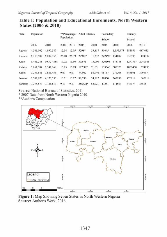
Table 1: Population and Educational Enrolments, North Western States (2006 & 2010)
State Population **Percentage Population
Adult Literacy Secondary
School
Primary
School
2006 2010 2006 2010 2006 2010 2006 2010 2006 2010
Jigawa 4,361,002 4,897,387 12.14 12.05 5298* 33,817 31645 1,155,973 384056 487,633
Kaduna 6,113,502 6,892,955 26.18 26.39 22912* 11,237 242495 134087 855595 1124732
Kano 9,401,288 10,727,888 17.02 16.96 30,675 13,000 320304 378788 1277767 2040045
Katsina 5,861,584 6,541,268 16.15 16.09 117,982 7,165 133360 505373 1059450 1374693
Kebbi 3,256,541 3,686,456 9.07 9.07 74,902 56,940 95167 271208 348591 399697
Sokoto 3,702,676 4,176,756 10.31 10.27 86,796 24,112 38850 265936 470118 1065918
Zamfara 3,278,873 3,726,613 9.13 9.17 286624* 52,921 47281 114563 347174 36508
Source: National Bureau of Statistics, 2011* 2007 Data from North Western Nigeria 2010**Author's Computation
Figure 1: Map Showing Seven States in North Western NigeriaSource: Author's Work, 2016
1347
Nigerian Journal of Tropical Geography Abdullahi et al. Vol. 8, No. 1, 2017
4.2 Data Sources The paper utilized data obtained mainly from National Bureau of Statistics (2011) to compare inequality between the years 2006 and 2010 for adult literacy, primary and secondary school enrolments in the North-Western region of Nigeria. This is as a result of the unavailability of data at the required temporal and spatial resolution across the states which implied that only three educational levels (adult literacy, secondary school and primary school enrolments) were analysed for two time periods. Indeed, the absence of 2006 data on adult literacy for Jigawa, Kaduna and Zamfara in the National Bureau of Statistics (2011) necessitated the use of 2007 data published in the National Bureau of Statistics (2010).
4.3 Data Analysis
T h e s t u d y a d o p t e d b o t h descriptive and quantitative analyses. The descriptive analysis entails the use of percentages, graphs and tables to analyse and present the three stages of educational enrolment data for the North-Western States. Also, Lorenz curve and Gini-coefficient were used to analyse the extent of disparity in the North-Western states evidenced in the three stages of educational enrolments.
The Lorenz Curve ut i l ized cumulative percentages of the population in 2006 and 2010 from the largest to the smallest plotted a l o n g t h e x a x i s a n d t h e cumulative percentage of each level of educational enrolment for 2006 and 2010 plotted on the y axis. It is usually drawn within a square with a diagonal line drawn from the lowest left corner to the topmost right corner. Thus, at every point the cumulative pe rcen tage o f educa t iona l enrolment is corresponding to the cumulative percentages of the respective populations.
The Gini Co-efficient was derived by using the formula, G=A/A+B or mathematically represented as:
The correlation analysis was also deployed to examine the effect of age of state creation and the distance between each state and the nearest major urban center in the region, FCT Abuja on intra-regional disparity among the North-Western states. A model of the Gini coefficient =
1348
Nigerian Journal of Tropical Geography Abdullahi et al. Vol. 8, No. 1, 2017
5.0 Results and Discussion
5.1 Share of Educational EnrolmentsT h e s h a r e o f e d u c a t i o n a l enrolments is discussed under the following educational levels: Adult Literacy, Primary School Enrolment and Secondary School Enrolment. Table 2 below shows the percentage distribution of education enrolment for adult literacy, secondary school and primary schools in 2006 and 2010 respectively. The analysis shows that Jigawa and Kebbi had the lowest and highest adult literacy enrolments in 2006 was Jigawa while the highest was Zamfara. Likewise, Katsina and Zamfara had the lowest and highest percentages of adult literacy enrolments in 2010. The analysis
of Secondary School enrolments reveals that Jigawa and Kaduna had the lowest and highest percentage respectively in 2006 while Kano and Jigawa had the lowest and highest percentages in 2010. In the same vein, the pattern of primary school enrolments depicts that Zamfara and Kaduna had the lowest and the highest percentages in 2006 while Zamfara and Kano had the lowest and the highest respectively in 2010. This revelation shows that the percentages of adult literacy, secondary and primary schools enrolments in North West states were inconsistent within and between the two years which may be unconnected with priorities, policies and programmes of the various governments.
Table 2: Percentage Educational Enrolments in North Western Nigeria
State Adult Literacy (%)
Secondary School (%)
Primary School (%)
2006
2010
2006
2010
2006 2010
Jigawa
0.85
16.98
3.48
40.91
8.10 7.47
Kaduna
4.91
6.53
35.23
13.40
26.94 07.23
Kano
3.66
5.64
26.67
4.74
18.04 31.24
Katsina
18.87
3.60
14.67
17.88
22.34 21.05
Kebbi
11.98
28.59
10.47
9.60
7.35 6.12
Sokoto 13.98 12.10 4.27 9.41 9.91 16.33
Zamfara 45.85 26.57 5.20 4.05 7.32 0.56
NW 2.08 29.58 68.34
Source: Computed with Data from National Bureau of Statistic, 2011
1349
Nigerian Journal of Tropical Geography Abdullahi et al. Vol. 8, No. 1, 2017
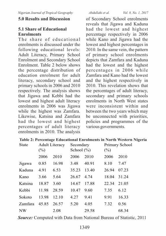
5.2 Regional Disparity in Educational EnrolmentsT h e r e g i o n a l d i s p a r i t y i n educational enrolments in the North-West states clearly shows the level of divergence in the Lorenz curve computed. The results as depicted in figure 2 revealed that in 2006, the distribution of adult literacy enrolment among the states
indicates that the least 12.24% of the population account for 0.85% of the to ta l adu l t l i t e racy enrolment. The highest literate 90.97% of the population account for 54.16% of total adult literacy enrolment. This displays a divergent pattern of adult literacy enrolment in the region compared to the rest of the population.
Figure 2: Lorenz curve of adult literacy (2006) in North West StatesSource: Author's computation
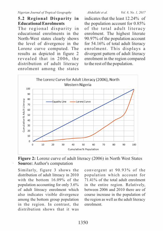
Similarly, figure 3 shows the distribution of adult litreacy in 2010 with the bottom 16.09% of the population accounting for only 3.6% of adult litreacy enrolment which also indicates visible divergence among the bottom group population in the region. In contrast, the distribution shows that it was
convergent a t 90.93% of the population which account for 71.41% of the total adult enrolment in the entire region. Relatively, between 2006 and 2010 there are of course increase in the population of the region as well as the adult literacy enrolment.
1350
Nigerian Journal of Tropical Geography Abdullahi et al. Vol. 8, No. 1, 2017
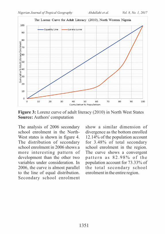
The analysis of 2006 secondary school enrolment in the North-West states is shown in figure 4. The distribution of secondary school enrolment in 2006 shows a more interesting pattern of development than the other two variables under consideration. In 2006, the curve is almost parallel to the line of equal distribution. Secondary school enrolment
show a similar dimension of divergence as the bottom enrolled 12.14% of the population account for 3.48% of total secondary school enrolment in the region. The curve shows a convergent p a t t e r n a s 8 2 . 9 8 % o f t h e population account for 73.33% of the total secondary school enrolment in the entire region.
Figure 3: Lorenz curve of adult literacy (2010) in North West StatesSource: Authors' computation
1351
Nigerian Journal of Tropical Geography Abdullahi et al. Vol. 8, No. 1, 2017
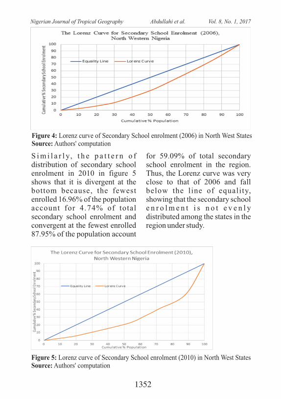
S i m i l a r l y, t h e p a t t e r n o f distribution of secondary school enrolment in 2010 in figure 5 shows that it is divergent at the bottom because, the fewest enrolled 16.96% of the population account for 4.74% of total secondary school enrolment and convergent at the fewest enrolled 87.95% of the population account
for 59.09% of total secondary school enrolment in the region. Thus, the Lorenz curve was very close to that of 2006 and fall below the line of equality, showing that the secondary school e n r o l m e n t i s n o t e v e n l y distributed among the states in the region under study.
Figure 4: Lorenz curve of Secondary School enrolment (2006) in North West StatesSource: Authors' computation
Figure 5: Lorenz curve of Secondary School enrolment (2010) in North West StatesSource: Authors' computation
1352
Nigerian Journal of Tropical Geography Abdullahi et al. Vol. 8, No. 1, 2017
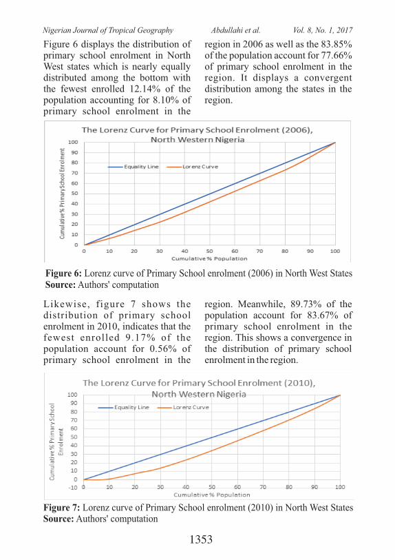
Figure 6 displays the distribution of primary school enrolment in North West states which is nearly equally distributed among the bottom with the fewest enrolled 12.14% of the population accounting for 8.10% of primary school enrolment in the
region in 2006 as well as the 83.85% of the population account for 77.66% of primary school enrolment in the region. It displays a convergent distribution among the states in the region.
Figure 6: Lorenz curve of Primary School enrolment (2006) in North West StatesSource: Authors' computation
Likewise, figure 7 shows the distribution of primary school enrolment in 2010, indicates that the fewest enrolled 9.17% of the population account for 0.56% of primary school enrolment in the
region. Meanwhile, 89.73% of the population account for 83.67% of primary school enrolment in the region. This shows a convergence in the distribution of primary school enrolment in the region.
Figure 7: Lorenz curve of Primary School enrolment (2010) in North West StatesSource: Authors' computation
1353
Nigerian Journal of Tropical Geography Abdullahi et al. Vol. 8, No. 1, 2017
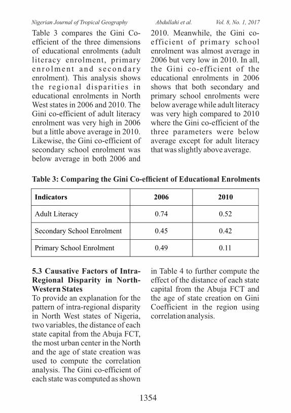
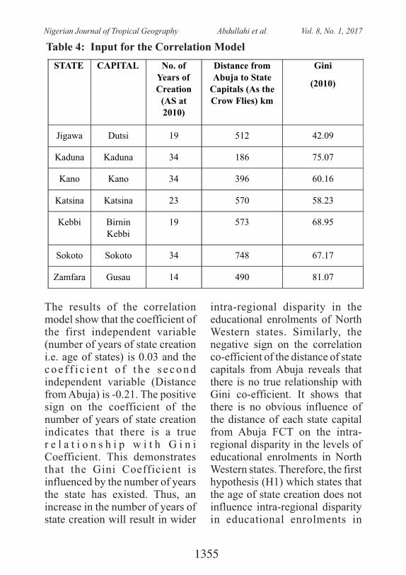
Table 3: Comparing the Gini Co-efcient of Educational Enrolments
Indicators 2006 2010
Adult Literacy
0.74
0.52
Secondary School Enrolment
0.45
0.42
Primary School Enrolment 0.49 0.11
Table 3 compares the Gini Co-efficient of the three dimensions of educational enrolments (adult literacy enrolment, primary e n r o l m e n t a n d s e c o n d a r y enrolment). This analysis shows the regional d ispar i t ies in educational enrolments in North West states in 2006 and 2010. The Gini co-efficient of adult literacy enrolment was very high in 2006 but a little above average in 2010. Likewise, the Gini co-efficient of secondary school enrolment was below average in both 2006 and
2010. Meanwhile, the Gini co-efficient of primary school enrolment was almost average in 2006 but very low in 2010. In all, the Gini co-efficient of the educational enrolments in 2006 shows that both secondary and primary school enrolments were below average while adult literacy was very high compared to 2010 where the Gini co-efficient of the three parameters were below average except for adult literacy that was slightly above average.
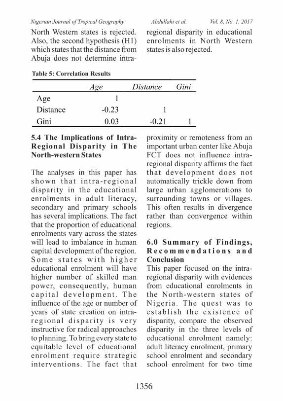
5.3 Causative Factors of Intra-Regional Disparity in North-Western States To provide an explanation for the pattern of intra-regional disparity in North West states of Nigeria, two variables, the distance of each state capital from the Abuja FCT, the most urban center in the North and the age of state creation was used to compute the correlation analysis. The Gini co-efficient of each state was computed as shown
in Table 4 to further compute the effect of the distance of each state capital from the Abuja FCT and the age of state creation on Gini Coefficient in the region using correlation analysis.
1354
Nigerian Journal of Tropical Geography Abdullahi et al. Vol. 8, No. 1, 2017
The results of the correlation model show that the coefficient of the first independent variable (number of years of state creation i.e. age of states) is 0.03 and the c o e f f i c i e n t o f t h e s e c o n d independent variable (Distance from Abuja) is -0.21. The positive sign on the coefficient of the number of years of state creation indicates that there is a true r e l a t i o n s h i p w i t h G i n i Coefficient. This demonstrates that the Gini Coefficient is influenced by the number of years the state has existed. Thus, an increase in the number of years of state creation will result in wider
intra-regional disparity in the educational enrolments of North Western states. Similarly, the negative sign on the correlation co-efficient of the distance of state capitals from Abuja reveals that there is no true relationship with Gini co-efficient. It shows that there is no obvious influence of the distance of each state capital from Abuja FCT on the intra-regional disparity in the levels of educational enrolments in North Western states. Therefore, the first hypothesis (H1) which states that the age of state creation does not influence intra-regional disparity in educational enrolments in
Table 4: Input for the Correlation Model
STATE CAPITAL No. of Years of Creation
(AS at 2010)
Distance from Abuja to State
Capitals (As the Crow Flies)
km
Gini (2010)
Jigawa Dutsi
19
512
42.09
Kaduna
Kaduna
34
186
75.07
Kano Kano
34
396
60.16
Katsina
Katsina
23
570
58.23
Kebbi Birnin Kebbi
19
573
68.95
Sokoto Sokoto 34 748 67.17
Zamfara Gusau 14 490 81.07
1355
Nigerian Journal of Tropical Geography Abdullahi et al. Vol. 8, No. 1, 2017
North Western states is rejected. Also, the second hypothesis (H1) which states that the distance from Abuja does not determine intra-
regional disparity in educational enrolments in North Western states is also rejected.
Table 5: Correlation Results
Age
Distance Gini
Age
1
Distance -0.23 1
Gini 0.03 -0.21 1
5.4 The Implications of Intra-Regional Disparity in The North-western States
The analyses in this paper has s h o w n t h a t i n t r a - r e g i o n a l disparity in the educational enrolments in adult literacy, secondary and primary schools has several implications. The fact that the proportion of educational enrolments vary across the states will lead to imbalance in human capital development of the region. S o m e s t a t e s w i t h h i g h e r educational enrolment will have higher number of skilled man power, consequently, human c a p i t a l d e v e l o p m e n t . T h e influence of the age or number of years of state creation on intra-r eg iona l d i spa r i ty i s ve ry instructive for radical approaches to planning. To bring every state to equitable level of educational enrolment require strategic interventions. The fact that
proximity or remoteness from an important urban center like Abuja FCT does not influence intra-regional disparity affirms the fact that development does not automatically trickle down from large urban agglomerations to surrounding towns or villages. This often results in divergence rather than convergence within regions.
6.0 Summary of Findings, R e c o m m e n d a t i o n s a n d ConclusionThis paper focused on the intra-regional disparity with evidences from educational enrolments in the North-western states of Niger ia . The ques t was to e s tab l i sh the ex i s t ence o f disparity, compare the observed disparity in the three levels of educational enrolment namely: adult literacy enrolment, primary school enrolment and secondary school enrolment for two time
1356
Nigerian Journal of Tropical Geography Abdullahi et al. Vol. 8, No. 1, 2017
per iods and examined the statistical relationship between disparity and some of its causative factors using number of years of state creation and the distance of each state from Abuja FCT (an urban centre in the region). It also s u g g e s t e d t h e p o s s i b l e implications of intra-regional d i s p a r i t y i n e d u c a t i o n a l e n r o l m e n t s f o r r e g i o n a l development planning in the region. This was done using the Lorenz curve, Gini coefficient and correlation analysis. The results show that the regional Gini coefficient of adult literacy enrolment in North West States was 0.74 and 0.52 in 2006 and 2010 respectively. Similarly, the Gini co-efficient for secondary school enrolment was 0.45 and 0 . 4 2 i n 2 0 0 6 a n d 2 0 1 0 respectively. And the Gini co-efficient for primary school enrolment was 0.49 and 0.11 in 2006 and 2010 respectively. Likewise, the Gini co-efficient for each of the North-Western states indicates that it 42.09, 75.07, 60.16, 58.23, 68.17 and 81.07 for Jigawa, Kaduna, Kano, Katsina, Kebbi, Sokoto and Zamfara respectively.
This shows that the adult literacy and secondary school enrolment were closer to equity line between 2006 and 2010, there were
improvement while, that of primary school enrolment was not encouraging, the implication is that, there is a need for frantic efforts to increase the primary enrolment to meet up with development in the entire region. The paper also reveals that there is a justly inverse relationship between the distance of each state's capital city and Federal Capital Territory, Abuja and the Gini Coefficient for each state. Similarly, the number of years of state creation in the region is mainly directly related with the G i n i C o e f f i c i e n t a n d consequently on the level of education development obtained in each state. It can be concluded from this paper that in spite of the relative homogeneity in the culture, language and geography of the states in the North-western region of Nigeria, there are noticeable dissimilarities in their l e v e l s o f e d u c a t i o n a l development. These disparities have been explained in terms of their level of school enrolment in primary, secondary and adult literacy, also, it was expressed in their proximity to FCT, Abuja as well as the number of years of state creation. The closer states to Abuja such as Kaduna state was the more developed than the others while the older states have performed better on the Gini
1357
Nigerian Journal of Tropical Geography Abdullahi et al. Vol. 8, No. 1, 2017
Index. Thus, it suggests that the factors of number of years of state creation and proximity are important causative factor of intra-regional disparities and the performance of the regions using Gini Index. The above findings are essential guidance in policy fo rmula t ions and reg iona l p l a n n i n g f o r e n h a n c e d development, quality of life and poverty reduction via a balanced school enrolment in all the states of the region. Furthermore, it was discovered that the more recently created states such as Zamfara, Kebbi and Katsina have not achieved substantial development in terms of school enrolment compared to the older states like Kano, Sokoto and Kaduna. As a result of the outcomes, it is also recommended that, there is need for sustainable policies; strategic planning and programmes for increased access to education in the region. Also, state creation viability and sustainability should be ascertained before its creation. This will curtail the consequences of haphazard creation of states being used as a strategy for regional development.
7.0 ReferencesAka, Ebenezer O., Jr. (2000),
Regional Disparit ies in Nigeria 's Development: Lessons and Challenges for
the Twenty-first Century. Lanham, MD: University Press of America.205 pp.
A n g o t t i , T h o m a s ( 1 9 9 3 ) Metropolis, 2000: Planning, P o v e r t y a n d P o l i t i c s , Routledge, London & New York.
Ayandele, E A (1979) Nigerian Historical Studies, Frank Cass & Company Limited, London.
Ayeni & Mabogunje (1982) "Political Processes and Reg iona l Deve lopmen t P l a n n i n g i n N i g e r i a " , UNCRD Working Paper No 82-7, (January), United Nations Center for Regional Deve lopmen t , Nagoya , Japan. Baker, Jonathan (ed) (1990) Small Town Africa, Studies in Rural-Urban I n t e r a c t i o n , T h e Scandinavian Institute of African Studies, Uppsala, Sweden.
Barbour, et al (1982) Nigeria in Maps, Hodder & Stoughton, London
B o o t h & S e l i g s o n ( 1 9 7 9 ) ''Peasants as Activists" in Comparative Political Studies 12 (April ) pp 29-59..
Oladunni Oyetola Opatoyinbo at a l (2016): Comparat ive Analysis of Gender Disparity Enrolment in Surveying T r a i n i n g i n T e r t i a r y
1358
Nigerian Journal of Tropical Geography Abdullahi et al. Vol. 8, No. 1, 2017
Institutions Collins, Carole (1993)"Growth
not benefiting people: UNDP Human Development Report calls for new patterns of n a t i o n a l a n d g l o b a l governance" , i n Af r i ca Recovery, United Nations, Vol. 7, No I, June, pp 4-5.
Crowder, Michael (1973) the Story of Nigeria, Faber &Faber Limited, London
Dicken, Peter & Lloyd, E Peter (1990) Location in Space: Theoretical Perspectives in Economic Geography, Third Edition, Harper & Row Publishers, London.
Dike, KO (1957) 100 Years of British Rule in Nigeria, 1851-1951, Clarendon Press , Oxford.
Dudley, BJ (1976) "Implications of the 19-5tate System", Business Times March 2, Lagos, P 9
EBENEZER 0 AKA, JR: Journal of Social Development in Africa, (1995), 10, 2, 61-80
Regional Inequalities in the P r o c e s s o f N i g e r i a ' s Development: Socio-Political a n d A d m i n i s t r a t i v e Perspective
Elias P., Afolayan O. and Babatola O. (2014): Intra-Regional Disparity in South-Western States of Nigeria and its Implications for Regional
Development Planning. The L a g o s J o u r n a l o f Environmental Studies, 7 (3), 37-52
Egunjobi, Layi (1990) ' 'The Development Potentials of Local Central Places in Nigeria", in Jonathan Baker (ed) Small Town Africa, Studies in Rural-Urban I n t e r a c t i o n , T h e Scandinavian Institute of African Studies, Uppsala, Sweden.
E I - S h a k h s , S a l a h ( 1 9 7 2 ) "Development, Primacy and System of Cities", in The Journal of Developing Areas 7: I (October), PP 11-35.
EI-Shakhs, Salah (1983) ''The Role of Intermediate Cities in Nat iona l Deve lopment : Research Issues”, Mimeo~ D e p a r t m e n t o f U r b a n Planning, Rutgers University.
Ezera, Kalu (1960) Constitutional Developments in Nigeria, University of London Press, London Federal Office of S ta t i s t i cs (1975-1978) , Industrial Survey of Nigeria, Lagos.
Federal Ministry of Education: Education for Al l 2000 Assessment: country report of Niger ia . Under the co-o r d i n a t i o n o f M . O . A . Olorunfunmi; Abuja, 1999
Friedman, J (1973): Urbanization,
1359
Nigerian Journal of Tropical Geography Abdullahi et al. Vol. 8, No. 1, 2017
P l a n n i n g a n d N a t i o n a l D e v e l o p m e n t , S a g e Publishers, Newbury Park California.
G e a r y G o l d t h r o p e , 2 0 0 9 : Analysing Social Inequality: A critique of Two Recent C o n t r i b u t i o n s f r o m E c o n o m i c s a n d Apisdemiology: European Sociological Review Journal Published 22 October
Hirschman, A. 0 (1958): the S t r a t e g y o f E c o n o m i c Development, Yale University Press, New Haven.
Kamla-Raj (2008) Regional Dispari t ies in Nigeria 's Development: Lessons and Challenges for the Twenty-F i r s t Cen tury ( r ev i ew) Mathurin C. Houngnikpo J. Soc. Sci., 16(2): 135-140 (2008)
Kuznets, S. (1955) “Economic G r o w t h a n d I n c o m e Inequality”; The American Economic Review 45(1), March, pp 1-28
Luca Mancini (2009) Comparative Trends in Ethno-Regional Inequalities in Ghana and Niger ia : Evidence f rom Demographic and Health Surveys WORKING PAPER No. 72 November 2009
Michael A. Fletcher (2015) ( i ncome inequa l i t y has squeezed the middle class out of the majority, Washington
Post article)Overman, G. Henry & Patricia
Rice (2008). Resurgent Cities and Regional Economic Performance. Retrieved on November 26, 2016 at
Solga, et al 2014) Education, Economic inequality and the promises of social investment state; Journal published by Oxford University Press and t h e S o c i e t y f o r t h e Advancement o f Soc ia l Economics.
Teriba, A (2013) Confronting Inter-regional Disparities in N i g e r i a . R e t r i e v e d o n 0 1 / 0 3 / 2 0 1 7 a t www.nigerianseminarsandtrainings.com.
U N E S C O ( 2 0 1 3 ) : M a k i n g Education a Priority in the Post -2015 Development Agenda Report of the Global Thematic Consultation on Education in the Post-2015 Development Agenda United N a t i o n s E d u c a t i o n a l , Sc ien t i f i c and Cu l tu ra l Organization (UNESCO) September 2013 © United Nations Children's Fund (UNICEF) September 2013
Wantchekon and Tamar Asadurian (2002) Transfer Dependence and Regional Disparities: the Case of Nigeria1 by Leonard New York University Working Paper No. 152
1360
Nigerian Journal of Tropical Geography Abdullahi et al. Vol. 8, No. 1, 2017
MAPPING ENVIRONMENTAL PROBLEMS IN NIGERIA
Mayowa Fasona, Olatunde Ogunkunle, Vide Adedayo and Ajibade ArioriDepartment of Geography, University of Lagos
Akoka -Yaba, Lagos, 101017Corresponding E Mail: [email protected]
ABSTRACT: Net degradation of the environment occurs whenever the degradation process significantly exceeds nature's restorative capacity. Continuous and sustained land transformation which aid ecological degradation is influenced by a host of proximate and underlying factors. To address these challenges requires an understanding of a full range of causes contributing to a given problem or effect through interdisciplinary research. This paper reviewed the contexts of environmental degradation and the importance of the geographer as an integrator of space and his ability to handle multiple drivers contributing to a given process which has been made realistic by the modern tools of GIS, remote sensing and spatial statistics. This paper posits that studies and mapping of environmental and ecological degradation conducted in Nigeria have not harnessed these tools to the fullest. Most of the studies conducted in Nigeria have been aimed at investigating ecological degradation over time and space with little attention on the proximate and underlying drivers of the process and the possible future dimensions of the problems. The paper highlights the importance of the use of spatially explicit spatial-statistical models with the view to generating the extent to which causal factors drive the process. This is the current trend in environmental degradation mapping which enables complete diagnostics and recommendation of appropriate and place specific measures to tackle the problem.
Keyword: Environmental degradation, mapping, degradation drivers, spatial-statistical models, GIS, Nigeria
1. INTRODUCTION Environmental degradation refers to a state of disruption or decline in the quality of the basic life support systems set in motion by n a t u r a l o r a n t h r o p o g e n i c influences or combination of both. They are adjustment between man
and nature and sometimes with results that are beyond the capacity of the human system to m a n a g e . E n v i r o n m e n t a l degradation affects the quality and functioning of land, water and air. Continued and sustained impacts of the degradation elements
1361
Nigerian Journal of Tropical Geography Mayowa et al. Vol. 8, No. 1, 2017
generate hazards which may trigger disaster. In general, environmental degradat ion problems can be grouped into three categories based on the type of resources affected. Land resource degradation refers to actions which reduce the amount or quality of land. Examples include erosion, flooding, sea level rise, soil acidification and salinization, agricultural land degradation, etc. Renewable resource degradation includes species depletion and habitat f r a g m e n t a t i o n , l o s s o f biodiversity, deforestation and forest degradation, and habitat expansion by invasive species (e.g. nympha and water hyacinth). E n v i r o n m e n t a l p o l l u t i o n including water pollution/water contamination, oil pollution, toxic and hazardous was tes , a i r pollution and pollution from poor solid waste management spread quickly with rapid impacts on man and ecosystem components.
The object of geography is the n e a r s u r f a c e s p h e r e s o f l i t h o s p h e r e , h y d r o s p h e r e , atmosphere, biosphere and the s o c i o s p h e r e o r n e o s p h e r e ( G r e g o r y , 1 9 8 5 ) . A l l environmental problems are geographic problems because they occur at these near spheres. G e o g r a p h y d e a l s w i t h
environment at the meso scale of resolution where the natural i n t e r a c t i o n s w i t h i n t h e environment are most visible. The f a c t t h a t g e o g r a p h y i s environment - a complex web of interconnectivities - makes the systems approach to problem solving fit hand in glove to geographic research. Increase in knowledge has continuously exposed the environment as a c o m p l e x w e b o f interconnectivities which is best understood through the systems app roach (Grego ry, 1985 , Longley et al., 1999) and this has i n c r e a s e d t h e n e e d f o r understanding the earth as an integrated system.Landscapes normally undergo some transformation processes that include some form of natural degradation, but these processes are usually compensated for and counterbalanced by nature's in-bui l t recovery abi l i ty. Net degradation occurs whenever the d e g r a d a t i o n p r o c e s s e s significantly exceed nature's restorative capacity. The onset, spread and intensity of ecological degradation is a function of the interactions or interplay between the compositions of the physical (soil, terrain/elevation, geology, hydrology and geomorphology), biological (land-cover/ecology) a n d h u m a n ( l a n d - u s e a n d
1362
Nigerian Journal of Tropical Geography Mayowa et al. Vol. 8, No. 1, 2017
dominant human activities) components . Whi le na ture induced degradation tends to progress at very slow rate because nature i tse l f has a way of countervailing negative effects within the natural-physical systems, degradation that poses serious threat to the environment are direct or indirect result of human actions. This paper reviewed the contexts of environmental degradation and assessment generally and the state and extent of environmental degradation assessment and mapping in Nigeria in particular. It also presents a case study of the use of modern remote sensing and GIS-derived environmental assessment toolkit to generate spatially explicit spatial-statistical probabilistic surface map and statistics for predicting likely future degradation across the landscape.
2. THE NTERDISCIPLINARY NATURE OF ENVIRONMENTAL DEGRADATION AND TOOLS OF ASSESSMENT The environment is a complex interconnected web (Longley et a l , 1999) . Cont inuous and sustained land transformation which aid ecological degradation is inf luenced by a host of
proximate and underlying factors. Proximate causes may be natural and/or human act ivi t ies or immediate actions at local level. This includes climate related processes and b iophys ica l attributes of land including soil, geology, and hydrology. It also includes human activities such as agriculture, lumbering, and dredging/constructions (for oil, transportation, manufacturing, etc). The underlying drivers are fundamental social processes (Geist and Lambin, 2002). They are external drivers which include population and economic change influences such as urbanization, transport infrastructure and development, globalization of m a r k e t s a n d e c o n o m i e s , agricultural changes, economic p o l i c y c h a n g e s ( e . g . industrialization, changing from agriculture to petroleum driven economy), social changes (family size, labour, wages, consumption s t y l e s a n d p a t t e r n s , ) p o l i t i c a l / a d m i n i s t r a t i v e f r a m e w o r k ( l a n d - u s e demand/allocation, coastal zone management policy/programme) etc. They have remote and yet powerful influence on land transformation and environmental degradation.
R e s e a r c h i n e c o l o g i c a l degradation thus shares the task of
1363
Nigerian Journal of Tropical Geography Mayowa et al. Vol. 8, No. 1, 2017

addressing the complex web linking social and biophysical drivers of change. To address these challenges requires an understanding of a full range of causes contributing to a given problem or e ffec t th rough in te rd isc ip l inary research . Although geography has perhaps been the most beneficial from the concourse of various disciplines in the natural, physical and social sc iences , in te rd isc ip l inary approach to research in geography was an exception rather than the rule until not too long ago. Gregory (1985) noted that the inability of geographers to handle successfully the simultaneous operations of a number of causes contributing to a given effect has b e e n o n e o f t h e g r e a t e s t impediments to the advancement of geography as a discipline. This lack of interdisciplinarity was traced to the dichotomy between physical and human geography. Dury (1962) observed that there was a time when the soil nexus held the promise of unifying physical and human geography, but that did not happen. He conceived that the union (of physical and human geography) might conceivably come through a common technique of analysis. Dury's prediction was completely right. The birth of remote sensing (RS) and geographic information
s y s t e m s ( G I S ) w h i c h a r e techniques of spatial analysis- has provided the geographer with a toolset for integrating physical and human geography. GIS and remote sensing also fit hand in glove with the systems analysis paradigm which is required for understanding the dimensions of t h e e n v i r o n m e n t a n d environmental degradation. GIS with remote sensing today provide the necessary tools for environmental and resource management at meso and macro s p a t i a l s c a l e s . A l t h o u g h geography does no t c la im monopoly of studies of spatial, regional and ecological analyses, it is the only discipline that incorporates the geographic coordinates that facilitates spatial explicitness and linkage with other datasets generated even by the various other disciplines (Verburg, et al., 2000; Mitchell, 1989).
Geospatial information which are a class of geographic information that are obtained from remote sensing and global positioning systems (GPS) platforms and managed within a GIS framework has imbued the geographer with the skill of an integrator (Mitchell, 1989) and a manager with ability to coordinate the mapping, modeling and management of
1364
Nigerian Journal of Tropical Geography Mayowa et al. Vol. 8, No. 1, 2017

environmental degradation. Geographic information refers to information which can be related to specific locations on the earth (Department of Environment, D O E , 1 9 8 7 ) . T h i s m e a n s information about a place or an a r e a o r t h e l o c a t i o n s o f p h e n o m e n a a n d t h e i r characteristics on which much h u m a n a c t i v i t i e s d e p e n d . Geographic informat ion is handled by GIS which has been described as the biggest step forward in handling geographic data since the invention of the map (DOE, 1987). The innovations in the field of geospatial technology and mapping have contributed immensely to decision making and knowledge-based economy (Kufoniyi, 2009). The arrays of disciplines that are connected to geospat ia l data product ion include cartography, remote s e n s i n g , p h o t o g r a m m e t r y, physical sciences, satel l i te t e c h n o l o g y a n d d a t a b a s e management. The application areas include those that are critical to environment and natural resource management including a g r i c u l t u r e , e n v i r o n m e n t , hydrology, disaster management, land-use planning and land management. The maps and other spatial data generated from g e o i n f o r m a t i o n g u i d e t h e p lann ing , implementa t ion ,
evaluation and monitoring of d e v e l o p m e n t a l a c t i v i t i e s i n c l u d i n g m o n i t o r i n g a n d managing environmental and ecological degradation.According to Jack Dangermond, GIS is important today because it offers an important – perhaps even a critically important – means of understanding and dealing with some of the most pressing problems of our time: problems like tropical deforestation, the future of the global climate, the need for the ecologically sensitive development of global natural resources, acid rain, and rapid urbanization to name but a few…….. GIS technology helps us organize the data about such problems and understand their spatial associations, and provides a powerful means for analyzing and synthesizing information about them (Dangermond, 1989). The GIS approach is useful in environmental degradat ion analysis and environmental change assessment requirement s u c h a s c o l l e c t i n g a n d sys temizing basel ine data , identifying or isolating the drivers, estimating the impacts (particularly cumulative historical and likely future impacts) on the d i f f e r e n t e n v i r o n m e n t a l components, and managing data during monitoring. GIS is highly indispensable because of its
1365
Nigerian Journal of Tropical Geography Mayowa et al. Vol. 8, No. 1, 2017
ability to conduct spatial analysis on input data, generate terrain maps for slope and drainage a n a l y s i s , l a n d r e s o u r c e s information system for land management, soil information system, geoscientific modeling of geological formations, disaster planning related to geographically localized catastrophe, monitoring development, risk and hazard m a p p i n g , c o n t a m i n a t i o n , pollution and toxicity monitoring, f l o o d s t u d i e s , l i n k i n g o f environmental databases and constructing global database for environmental modeling (Jones, 1 9 9 7 ; R o d r i g u e z -Bauchiller,1995.
3. ENVIRONMENTAL DEGRADATION PROBLEMS MAPPING IN NIGERIASpace remote sensing make available quantitative means of monitoring the growth and degradation of natural forest, effects of deforestation on soil, watersheds, underground water recharge and green house gases w h e n c o m b i n e d w i t h t h e information on the present as well as projected growth of population (Rao, 1990). Like most countries o f A f r i c a , t h e t e r r e s t r i a l ecosystems of Nigeria are facing increasing pressure from global change drivers including land-use change, land degradation and
fragmentation, pollution of the n a t u r a l s y s t e m s a n d overexploitat ion of natural resources. According to FAO (2011) , the annual ra te of deforestation is about 4% in Nigeria. Expansion of agricultural land, overharvesting of industrial wood, fuel wood and pole wood extraction, charcoal production for rural as well as urban uses and overgrazing remain the key drivers of deforestation (UNEP, 2002, Geist and Lambin, 2001). Resource surveys and mapping provide first hand information for a s s e s s i n g e n v i r o n m e n t a l degradation and ecological problems. According to Balogun (2003), topographic mapping in Nigeria dated back to 1910 when the 1:125,000 map series was started. The most comprehensive of these was the 1:50,000 started in 1946. The bulk of this was undertaken through the 1960-63 aerial photographic campaign carried out by the Canadian Aero Services Limited on behalf of the Canadian Government for the Government of Nigeria under the Commonweal th Afr ica Aid Programme. The same set of maps were in i t i a l ly p lo t t ed and produced by the Directorate of O v e r s e a s S u r v e y s ( D O S ) Depar tment o f the Br i t i sh Government and later taken over by the Nigerian Federal Surveys
1366
Nigerian Journal of Tropical Geography Mayowa et al. Vol. 8, No. 1, 2017
Department. Although they were never completed, the 1:50,000 topographic map series which remains the most available resource data in the country today has never been updated. Although Uluocha (2012) reported that the digitization of the analogue topographic maps was started in 2004, there is yet nothing in the public domain to show the availability of digital topographic maps for Nigeria.
The Land Degradation Mapping and Assessment for Prevention and Control of Potential Erosion Hazards in Nigeria (LADEMA) project carried out by the Federal Ministry of Environment in 2009-2010 can be described as the only study at a national scale on land and environmental degradation. The objectives of the study were to examine land degradation identified as the most serious environmental problems, describe and document the types, causes, degree and impact of land d e g r a d a t i o n , a n d o u t l i n e appropriate recommendations and strategies for environment and natural resources management to stem land degradation. In addition to producing a map of erosion severity, the study also attempts to c a t a l o g u e t h e m a j o r l a n d degradation types in Nigeria including soil fertility depletion,
f l o o d i n g , d r o u g h t a n d d e s e r t i f i c a t i o n , l o s s o f biodiversity, salinization and a l k a l i z a t i o n , c o a s t a l l a n d degradation and earth mining.
Several small scale assessment of environmental degradation have been carried out in different parts across the nation. Such works include Omojola (1997) using archival remote sensing data and GIS in parts of the Sokoto-Rima basin, Jande and Nsofor (2002) using multi date Landsat TM and SPOT XS satellite in the Makurdi area, Nwadialor and Nsofor (2002) in Afaka forest reserve using multi-date panchromatic aerial photographs of 1962, Landsat MSS (1970), Landsat TM (1987), and SPOT (XS) of 1994, and Fasona and Omojola (2009) which assessed land degradation in the coast of Ondo state from 1965 to 2001 using archived base maps and multidate Landsat TM imageries. Some other studies including Maiangwa et al. , (2007), and Audu (2012) used the context of theories and evidence and empirical social surveys to e x a m i n e e f f e c t s o f l i v i n g conditions of rural people on land degradation and desertification. The causes and impacts of the erosion and gully problem in the southeast - one of the greatest ecological disaster in Nigeria - has
1367
Nigerian Journal of Tropical Geography Mayowa et al. Vol. 8, No. 1, 2017
received some attention from authors such as Egboka and Okpoko (1984), Igbokwe et al. (2008), Ajaero and Mozie (2011), Hudec et al. (2006), and Osadebe and Akpokodje (2008). Other ecological or environmental degradation types including the influence of artisanal mining and more impor tan t ly, o i l and hazardous chemical spill in the Niger delta has also received some attention. Perhaps the most comprehensive work on the likely accumulated impact of o i l exploration activities on the Niger delta environment was from the Niger Delta Environmental Surveys (NDES) which combined remote sensing, GIS and mapping tools with rural appraisals and social surveys to document the impact of oil activities on the environment and people and of the Niger delta.
4. U S E O F S P A T I A L E X P L I C I T M U L T I -C R I T E R I A M O D E L I N G T O O L K I T F O R E N V I R O N M E N T A L D E G R A D A T I O N ASSESSMENTThe factors responsible for different types of environmental degradation are many and varied as no ted . I t thus becomes important to isolate the causal factors and determine the most
important driver(s) for the environmental problem under investigation. Despite the claim to interdisciplinary approach in most of the studies cited above, and the use of modern tools of remote sensing and GIS, there remains t h e i n a b i l i t y t o h a n d l e successfully the simultaneous operations of a number of causes contributing to a given effect. None of the study was able to isolate the predictor variables of the specific land degradation and what the pattern will look like in future under different scenarios or trajectories of change. This can be provided by employing spatially explicit, spatial-statistical multi-criteria models which can be developed within a GIS (Fasona et a l . 2 0 11 ) . T h i s h a s b e e n demonstrated in mapping erosion and gully process in the Anambra-Enugu axis of Southeast Nigeria as reported by Fasona (2011). Part of the study is reported here as a case study of assessment of environmental problem using spatial explicit spatial-statistical models.
The interplay between physical and human factors has been linked as the key drivers of erosion and gully formation process in southeast Nigeria. Egboka and Okpoko (1984), Hudec et al. (2006), Osadebe and Akpokodje
1368
Nigerian Journal of Tropical Geography Mayowa et al. Vol. 8, No. 1, 2017
(2008), and Ajaero and Mozie (2011) identified the primary causes of the erosion problem to include hydrogeological and geotechnical properties of the complex aquifer system, soil, surface runoff, high intensity rainfall, removal of forest/canopy c o v e r, l a n d - u s e p r e s s u r e , topography, geo logy and construction activities.
4.1 PARAMETERIZATION O F T H E C A N D I D A T E DRIVERS OF EROSIONAn attempt was made to establish a spatial-statistical relationship between erosion and some of the key dr ivers . Due to da ta limitations, the candidate drivers considered are mainly proximate physical factors and they include the following:
· Elevation· Slope· Geology· Soil· Population distribution · Drainage network· Road network· Rainfall · Canopy cover (land-
cover)
The selection of these variables was based, f i rs t ly on data a v a i l a b i l i t y a n d e a s e o f parameterisation, and secondly on the perceived connection between
these drivers and the location of erosion and gully areas. The data were generated from different sources including base maps, administrative record data and satellite imageries. All the data were processed and integrated within a GIS.
The supplementary spatial data (soil, geology, rainfall, population density, etc) were prepared for analysis of drivers. The surfaces o r c o n t i n u o u s v a r i a b l e s (elevation, slope, population dens i ty and ra infa l l ) were converted into 100m resolution G R I D d a t a f i l e s . F o r t h e discrete/categorical variables (soil, geology, distances from road and rivers networks) Scores were assigned based on the perceived contribution of their different sub-categories to erosion and gully formation. For distances from road and rivers in particular, the allocation of scores was based on inverse distance weight (IDW) principle. The data was then converted into 100m resolution GRID using the assigned score as basis. The underlying values in the GRID files for both the surfaces and discrete/categorical data were transferred directly into the polygon attribute table (PAT) of the land-cover (LULC) file through a collocation process. This extended LULC PAT file was
1369
Nigerian Journal of Tropical Geography Mayowa et al. Vol. 8, No. 1, 2017
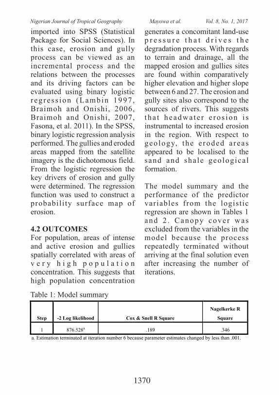
imported into SPSS (Statistical Package for Social Sciences). In this case, erosion and gully process can be viewed as an incremental process and the relations between the processes and its driving factors can be evaluated using binary logistic r eg re s s ion (Lambin 1997 , Braimoh and Onishi, 2006, Braimoh and Onishi, 2007, Fasona, et al. 2011). In the SPSS, binary logistic regression analysis performed. The gullies and eroded areas mapped from the satellite imagery is the dichotomous field. From the logistic regression the key drivers of erosion and gully were determined. The regression function was used to construct a probabil i ty surface map of erosion.
4.2 OUTCOMES For population, areas of intense and active erosion and gullies spatially correlated with areas of v e r y h i g h p o p u l a t i o n concentration. This suggests that high population concentration
generates a concomitant land-use p r e s s u r e t h a t d r i v e s t h e degradation process. With regards to terrain and drainage, all the mapped erosion and gullies sites are found within comparatively higher elevation and higher slope between 6 and 27. The erosion and gully sites also correspond to the sources of rivers. This suggests t ha t headwa te r e ro s ion i s instrumental to increased erosion in the region. With respect to geo logy, the e roded a reas appeared to be localised to the sand and sha le geo logica l formation.
The model summary and the performance of the predictor variables from the logist ic regression are shown in Tables 1 and 2 . Canopy cove r was excluded from the variables in the model because the process repeatedly terminated without arriving at the final solution even after increasing the number of iterations.
Table 1: Model summary
Step -2 Log likelihood
Cox & Snell R Square
Nagelkerke R
Square
1 876.528a
.189
.346
a. Estimation terminated at iteration number 6 because parameter estimates changed by less than .001.
1370
Nigerian Journal of Tropical Geography Mayowa et al. Vol. 8, No. 1, 2017
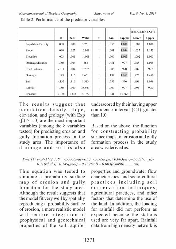
T h e r e s u l t s s u g g e s t t h a t popu la t ion dens i ty, s lope , elevation, and geology (with Exp (β) > 1.0) are the most important variables (among the 8 variables tested) for predicting erosion and gully formation process in the study area. The importance of d r a i n a g e a n d s o i l i s a l s o
underscored by their having upper confidence interval (C.I) greater than 1.0.
Based on the above, the function for constructing probability surface maps for erosion and gully formation process in the study area was derived as:
Table 2: Performance of the predictor variables
B
S.E.
Wald
df
Sig.
Exp(B)
95% C.I.for EXP(B)
Lower Upper
Population Density
.000
.000
3.751
1
.053
1.000 1.000 1.000
Slope
.090
.027
10.968
1
.001
1.094 1.037 1.153
Elevation
.003
.001
14.008
1
.000
1.003 1.002 1.005
Drainage distance
-.003
.004
.568
1
.451
.997 .988 1.005
Road distance
-.011
.004
7.787
1
.005
.990 .982 .997
Geology
.149
.116
1.661
1
.197
1.161 .925 1.456
Soil -.132 .116 1.313 1 .252 .876 .699 1.099
Rainfall -.003 .000 38.921 1 .000 .997 .996 .998
Constant 2.338 1.143 4.185 1 .041 10.362
P=1/[1+exp(-1*(2.338 + 0.000(p-density)+0.09(slope)+0.003(elv)–0.003(riv_d)-0.11(rd_dis)+0.149(geol) – 0.132(sol) – 0.003(rain90) …….(iii)
This equation was tested to simulate a probability surface map o f e ros ion and gu l ly formation for the study area. Although the result suggests that the model fit very well by spatially reproducing a probability surface of erosion, a more realistic model wil l require integrat ion of geophysical and geotechnical properties of the soil, aquifer
properties and groundwater flow characteristics, and socio-cultural p r a c t i c e s i n c l u d i n g s o i l c o n s e r v a t i o n t e c h n i q u e s , agricultural practices, and other factors that determine the use of the land. In addition, the loading for rainfall did not perform as expected because the stations used are very far apart. Rainfall data from high density network is
1371
Nigerian Journal of Tropical Geography Mayowa et al. Vol. 8, No. 1, 2017
also important for a more realistic modelling of gully formation process especially in the light of the changing climate.
5. CONCLUSIONThis paper has reviewed the contex ts of envi ronmenta l degradation from global to local. The importance of space and the geographer as an integrator of space has also been reviewed. Of immense importance to the geographer is the ability to handle multiple drivers contributing to a given process. This has been made realistic by the modern tools of GIS and remote sensing and spatial statistics. Evidence from most studies and mapping of environmental and ecological degradation conducted in Nigeria suggests that these tools have not been harnessed to the fullest. Most of the studies have been aimed at i n v e s t i g a t i n g e c o l o g i c a l degradation over time and space with little or no attention on the proximate and underlying drivers of the process and the possible future dimensions of the problems being investigated. Integration of the causal factors with the view to generating the extent to which each causal factor drives the process could be achieved by employing spatially explicit spatial-statistical models which could be loosely or tightly coupled
with other models including non-spatial statistical models. This subjects several land degradation drivers into a multi-criteria analysis, isolate the important predictors and use the generated function to derive probability surface maps which can are also useful for future prediction of environmental degradation across space and over time. This is the current trend in environmental degradation mapping which enables complete diagnostics and recommendation of appropriate and place specific measures to tackle the problem. Mapping and assessment of environmental problems in Nigeria must now begin to follow this trend.
ReferencesAjaero, C.K, Mozie, A.T (2011):
The Agu lu -Nanka Gu l ly Erosion Menace In Nigeria: What Does the Future Hold for the Popu la t ion a t R i sk? Michelle Leighton, Xiaomeng Shen, and Koko Warner (ed): C l i m a t e C h a n g e a n d Migration: Rethinking Policies for Adaptation and Disaster Risk Reduction. SOURCE No.15/2011, UNU
Audu, E.B (2012): Fuel Wood C o n s u m p t i o n a n d Desertification in Nigeria. In te rna t iona l Journa l o f Science and Technology, Vol.
1372
Nigerian Journal of Tropical Geography Mayowa et al. Vol. 8, No. 1, 2017
3, No.1, ISSN 2224-3577, 2013.
Balogun, O.Y (2003): Enter the World of Maps: You can never miss your way. University of Lagos Inaugural Lecture Series.
Braimoh, A.K, Onishi, T (2006): Spatial Determinants of urban landuse change in Lagos, Nigeria. Landuse Policy. doi:10.1016/j.landusepol.2006.09.001.
Braimoh, A.K, Onishi, T (2007): Geostatistical techniques for i n c o r p o r a t i n g s p a t i a l correlation into land use change models. International Journal of Applied Earth O b s e r v a t i o n a n d Geoinformation 9 (2007) 438–446.
Dangermond, J (1989): Foreword. In Aronoff S: Geographic I n fo r m a t io n S y s t em s : A Management Perspective , WDL Publications, Ottawa, Canada.
Department of Environment (DOE, 1987 ) : Hand l ing Geographic Information- Report of the Committee of Enquiry chaired by Lord Chorley, HMSO, London.
Dury, G.H (1972) – Some recent views on the nature, location, needs and po ten t i a l s o f geomorphology, Professional geographer, 452B.
Egboka, B.C.E and Okpoko, E.I (1984): Gully erosion in the Agulu-Nanka reg ion of Anambra State, Nigeria. C h a l l e n g e s i n A f r i c a n H y d r o l o g y a n d Wa t e r Resources, Proc Harare Symposium, July 1984. IAHS Publ No 144.
FAO (2011): Global Forest Resource Assessment (FRA 2010). FAO Yearbook-r e s o u r c e s – l a n d u s e : http://www.fao.org/economic/ess / e s s - p u b l i c a t i o n s / e s s -y e a r b o o k / e s s -yearbook2010/yearbook2010-reources/en/.
Fasona, M and Omojola, A (2009): Land cover change and land degradation in parts of the southwest coast of Nigeria. Afr. J. Ecol., 47 (S1), p 3 0 – 3 8 , doi.wiley.com/10.1111/j.1365- 2 0 2 8 . 2 0 0 8 . 0 1 0 4 7 . http://onlinelibrary.wiley.com/do i / 1 0 . 1 1 1 1 / j . 1 3 6 5 -2028.2008.01047.x/full.
Fasona, M, Omojola, A & Soneye, A (2011): A study of land degradation pattern in the Mahin mud-beach coast of southwest Niger ia wi th spatial-statistical modelling geostatistics. Journal of Geography and Geology, 3(1), p141-159. ISSN 1916-9 7 7 9 . http://www.ccsenet.org/journal/i
1373
Nigerian Journal of Tropical Geography Mayowa et al. Vol. 8, No. 1, 2017
ndex.php/jgg/article/view/7453.
Fasona, M (2011): Mapping Landuse/Landcover Change. N i g e r i a n E r o s i o n a n d Watershed Mapping Project (NEWMAP, 124905), The World Bank, Abuja, June 2011.
Geist Helmut J. & Eric F. Lambin (2001). What Drives Tropical D e f o r e s t a t i o n ? A m e t a -analysis of proximate and u n d e r l y i n g c a u s e s o f d e f o r e s t a t i o n b a s e d o n s u b n a t i o n a l c a s e s t u d y evidence. LUCC Report Series No. 4. CIACO Louvain-la-Neuve.
Gregory, K.J (1985): The Nature o f Phys ica l Geography , London: Edward Arnold (Pub) Ltd, 262p.
H u d e c , P. P, S i m p s o n , F, A k p o k o d j e , E . G , a n d Umenweke, M.O (2006): Te r m i n a t i o n o f G u l l y Processes , Sou theas te rn
t hNigeria. Proc 8 Federal Interagency Sedimentation Conference (8thFISC), Reno, NV, USA April2-6, 2006.
Igbokwe, J.I, Akinyede, J.O, Dang, B.A, Alaga, A.T, Nnodu, V.C, Ojiako, J.C, Obienus, E.A, Onwuka, S (2008): Estimating Soil Loss in Gully Eros ion in Southeas tern Nigeria from Remotely Sensed Imageries. Nigerian Journal of
Space Research 5: 132 - 150.Jande, J. A and Nsofor, G.N
( 2 0 0 2 ) : A s s e s s m e n t o f Vegetation Degradation in Makurdi A r e a a n d i t s Environs Using Remotely
thSensed Data. Proc. 4 AARSE conf: Geoinformation for sustainable development in Africa, Abuja, Nigeria.
Jones, Christopher (1997): GIS and Computer Cartography. Longman Press.
Kufoniyi, O (2009): Enabling environment for geospatial information technology uptake in Africa. UNECA Committee on Development Information, Science and Technology, Addis Ababa, 28 April - 1 May 2009.
Lambin, E.F (1997): Modeling and monitoring landcover change processes in tropical regions. Progress in Physical Geography 21 (3), 375-393.
Longley, P.A, Goodchild, M.F, Maguire, D.J, and R h i n d , D . W ( e d . ) G e o g r a p h i c Information Systems, Vol 1, John Wiley and Sons.
Maiangwa M. G (2007): Land Degradation: Theory and Evidence from the North-West Zone of Nigeria. Journal of Applied Sciences 7 (6): 785-795, ISSN 1812-5654, 2007.
M i t c h e l l , B r u c e ( 1 9 8 9 ) : Geography and Resource Analysis, Longman Group, U.K. 309p.
1374
Nigerian Journal of Tropical Geography Mayowa et al. Vol. 8, No. 1, 2017
Nwadialor, J.I and Nsofor, G.N ( 2 0 0 2 ) : M o n i t o r i n g A g r i c u l t u r a l I m p a c t o f Deforestation in Afaka Forest Reserve in Northern Nigeria Using Remote S e n s i n g
t hand GIS Approach. Proc. 4 AARSE conf: Geoinformation for sustainable development in Africa. Abuja, Nigeria 14-18 October, 2002.
Omojola, A. (1997): Use of R e m o t e S e n s i n g a n d Geographic Informat ion Techniques i n L a n d Use and Land cover Inventory and Change Assessment in a Semi- Arid Region o f Nigeria, PhD Thesis (unpl), University of Lagos. 184p.
Osadebe, C. C, Akpokodje, E.G (2008): Factor Analysis of Soil Spatial Variability in Gully Erosion Area of Southeastern Nigeria: A Case Study of Agulu-Nanka-Oko Area . Scientia Africana, 7 (2), 39-45.
R a o , U . R ( 1 9 9 0 ) : S p a c e Te c h n o l o g y a n d F o r e s t Management with Specific Relevance t o D e v e l o p i n g Nations, Space and Forest Management. In: Special Current Event Session of International Astronautical
stFederation, 41 IAF Congress, Dresden Germany.
Reynolds, J.F; Stafford, S; and Lambin, E (2003): ARIDnet: Seeking novel approaches t o
deser t i f ica t ion and land degradation. Global Change newsletter, Issue No 54, June 2003, pp5-9.
Rodriguez – Bauchiller, A (1995): Geographic Informat ion System. In Peter Morris and Riki Therivel (eds): Methods of Environmental Impacts Assessment, London: UCL Press Limited.
Uluocha, N (2012): Fifty Years of Post-Colonial Mapping in N i g e r i a : A n O v e r v i e w. Cartographica, 47 (3), 179-194.
U N E P 2 0 0 2 : G l o b a l Environmental Outlook 3 – Past , present and future pe r spec t ives . Syn thes i s Report. UNEP, Earthscan United Nations Environment Programme, UNEPWCMC, Cambridge, UK
Verburg, P.H, Chen, Y, Soepboer, W and Veldkamp, T.A (2000): GIS-based modeling o f h u m a n - e n v i r o n m e n t in te rac t ions fo r na tu ra l r e s o u r c e m a n a g e m e n t
thapplications in Asia. Proc 4 International Conference on i n t e g r a t i n g G I S a n d Environmental Modelling: Prob lems , Prospec t and Research Needs , Banff , Alberta, Canada.
1375
Nigerian Journal of Tropical Geography Mayowa et al. Vol. 8, No. 1, 2017
MINERAL POTENTIAL MAPPING USING GIS: A CASE STUDY OF LIMESTONE DEPOSIT OF EASTERN
DAHOMEY BASIN, SOUTH-WESTERN NIGERIA
Nkiru Rita Orefo, Peter Elias & Akinlabi AkintuyiDepartment of Geography, University of Lagos, Akoka – Yaba, Lagos
Corresponding Author's email: [email protected]
ABSTRACT: Other source of energy is regularly being agitated for due to over dependence on existing hydro power supply activities, centralization of power generation system and huge waste management challenges Nigerians experience in spite of its huge gas potentials. This paper takes inventory of the sources of cow dung-abattoirs and cattle stock, maps the distribution of cow dung volume and analyse the possible biogas yield in the study area. The inventory and mapping of cattle stock and cow dung source were ascertained from field visits and estimation of the number of cows slaughtered daily in each abattoir. In addition, the use of expert judgment, Global Positioning System to collect coordinates of point of interests and secondary data were also deployed. To have a comparative yield of biogas, samples of other agro-waste (poultry dropping and food wastes) were collected using appropriate method and analyzed in addition to cow dung, using the water displacement method in a laboratory scale experiment. A batch-load digester was replicated in three places (digester A- cow dung, digester B- poultry
0dropping and digester C- food waste) all at a mesophilic temperature of 20 C to 045 C for sixteen days retention period. The results showed that there exist 9
approved abattoirs in Lagos State with Oko-Oba abattoir having the highest stock of cattle of 1000 cows per day and 294,000kg cow dung generation respectively. The lowest cattle stock and dung generation was Epe abattoir with 2 cows per day and 200kg per day. The biogas yield analysis revealed that poultry droppings produced the highest total biogas with 46.2ml followed by cow dung 34.6ml with no yield for food waste. The average daily biogas yield was 2.3ml for digester A-cow dung, 3.08ml for digester B-poultry droppings and 0ml for digester C – food waste which reflects the fact that the difference in the production of biogas to a large extent depends on the nature of the agro-wastes. The result shows that Oko-Oba abattoir has the highest average stock of cows with 1000 per day, Ajegunle 200, Itire- 100, Igando- 10, Bariga-25 and Epe-2. Biogas estimation revealed a total biogas yield for digesters cow dung, poultry droppings and cooked food waste are 34.6ml, 46.2ml and 0.0ml respectively. The translation of the yield gave an estimation of 210.6 cubic metres gas per day from a total of 1592 cattle stock. The paper recommends enlightenment of stakeholder about the need to focus on the potentials that could be generated from agricultural waste as alternative source of energy.
Keywords: Agro-waste, Sources, Biogas, Potentials
1376
Nigerian Journal of Tropical Geography Peter et al. Vol. 8, No. 1, 2017
1. IntroductionMining industries have been viewed as key drivers of economic growth and development process (Bradshaw, 2005). The Nigerian mineral sector is undergoing radical structural reforms to allow for maximal exploitation, in view of its potential in diversifying the national economy (Murtala, 2011 and Onuiri et al., 2015). Nigeria is endowed with numerous minerals but they are grossly underdeveloped. This has been mainly attributed to the shortage of accurate and reliable database with respect to the location, quantity, and spatial characteristics of mineral deposits (Joshi et al., 2006 and Murtala, 2011). Such data are produced at the mineral exploration s tage , and are necessary for feasibility, planning and production decisions. The required geological, g e o p h y s i c a l , g e o g r a p h i c a l , geochemical and geotechnical investigations often generate large volumes of data, and complex analysis and decisions are involved. The need for computerization is therefore inevitable (Michael and DeVerle, 2006).
The variability of geological features and factors, in space and time have led to various attempts to solve complicated geological problems using multivariate and geostatistical methods (Hawkins et al., 2003). This has eventually resulted in the development of specialized mining packages in the late 70s and 80s for geological data analysis ranging f r o m s i m p l e d a t a interpolation/extrapolation to 3-D
visualization (Juraj et al., 2015 and Geospatial World, 2015). However, the costs of the packages were prohibitive and thus were not easily accessible to the general geological c o m m u n i t y . G e o g r a p h i c a l Information System (GIS) which was essential ly developed for the geographica l communi ty has therefore become attractive to the solid minerals industry because of its recent advancements involving the incorporation of multivariate, geo-statistical modules and powerful 3D analysis (Chartterjee et al., 2006 and Geospatial World, 2015). The more recent applications of GIS integrate intelligent systems to enhance its capabilities for complex modelling, simulation and predictive decisions often encountered in mineral exp lora t ion and explo i ta t ion (Nduwumuremyi et al., 2013). Juraj et al. (2015) carried out Limestone Quarry Reserve Estimation by Laser Scanning and GIS Tools. The 3D survey of the open-pit mine was carried out to develop a 3D digital model for ident i f ica t ion and quantification of the limestone deposits. The study calculated the volumes of the limestone mass and overburden mass in the quarry using the 3D models developed from the laser scanning.
The distribution of l imestone (volume) varies laterally and vertically on a given deposit. Similarly, understanding the spatial distribution (vertically and laterally) of limestone deposits in a mine can give an optimal way of harnessing the
1377
Nigerian Journal of Tropical Geography Peter et al. Vol. 8, No. 1, 2017
deposits at different locations to achieve an economical quantity for a more stable production of cement. Prior to the use of GIS for mining, reserve estimation of deposits were most t imes done with simple m a t h e m a t i c a l f o r m u l a a n d c o r r e l a t i o n o f n e i g h b o u r i n g boreholes (Clark et al., 1983; Sutphin et al., 2002). These methods are not only cumbersome and inadequate but can make it difficult to correlate large sets of data and integrate different data sets. GIS a l s o p r o v i d e s a n e n h a n c e d visualisation of datasets for optimal decision to be taken. This paper e m p l o y e d G I S i n m a p p i n g subsurface geology to evaluate the varying quantities of limestone deposits in Ibese Area, South West Nigeria and to appraise the mineral potentials of the reserve deposits from the exploratory boreholes for cement production. The specific objectives of the paper are to create a geological database using borehole information, identify the scrapping zones of overburden materials, map the distribution of limestone deposits and determine the reserve estimation of limestone deposits for cement production in the Eastern Dahomey Basin, South Western Nigeria.
2. The Statement of the ProblemIn the past, reserve estimation of mineral deposits were most times done with simple mathematical f o r m u l a a n d c o r r e l a t i o n o f neighbouring boreholes which could be time-wasting, cumbersome and
error-prone. The application of GIS in the process of estimating reserve quantity of the deposits is becoming an efficient approach yet to be popularised in Nigeria. This paper therefore demonstrates the use of GIS techniques for the estimation of limestone deposits and to appraise the potentials of the deposits for cement production. The application of GIS for the limestone deposits using borehole data can help in implementing, handling, planning, costing, decision-making and future projection of cement production. Exploration of limestones for cement production involves huge amount of money which requires accurate, reliable and timely information before exploitation. GIS technique provides better understanding of the underlying sub-surface geology such as mineral deposits or reserves for proper decision-making and accurate planning.
3.0 A Brief Review of Literature
3.1 The Use of Geographic Information System (GIS) in Mineral Resources ManagementThe use of GIS in mineral resources management is an emerging issue. Anifowose et al (2006) analysed a GIS database of the mineral resources of Igarra, South-Western Nigeria to update an existing geological map. This was expected to contribute to accurate and up-to-date metadata for Nigeria's National Geospatial
1378
Nigerian Journal of Tropical Geography Peter et al. Vol. 8, No. 1, 2017
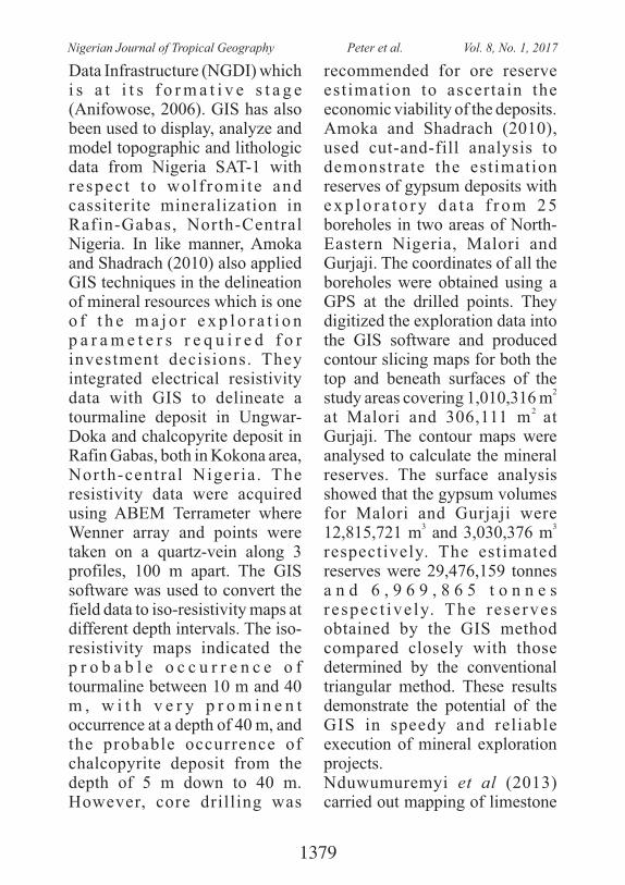
Data Infrastructure (NGDI) which i s a t i t s f o r m a t i v e s t a g e (Anifowose, 2006). GIS has also been used to display, analyze and model topographic and lithologic data from Nigeria SAT-1 with respec t to wol f romi te and cassiterite mineralization in Rafin-Gabas, North-Central Nigeria. In like manner, Amoka and Shadrach (2010) also applied GIS techniques in the delineation of mineral resources which is one o f t h e m a j o r e x p l o r a t i o n p a r a m e t e r s r e q u i r e d f o r investment decisions. They integrated electrical resistivity data with GIS to delineate a tourmaline deposit in Ungwar-Doka and chalcopyrite deposit in Rafin Gabas, both in Kokona area, North-central Nigeria . The resistivity data were acquired using ABEM Terrameter where Wenner array and points were taken on a quartz-vein along 3 profiles, 100 m apart. The GIS software was used to convert the field data to iso-resistivity maps at different depth intervals. The iso-resistivity maps indicated the p r o b a b l e o c c u r r e n c e o f tourmaline between 10 m and 40 m , w i t h v e r y p r o m i n e n t occurrence at a depth of 40 m, and the probable occurrence of chalcopyrite deposit from the depth of 5 m down to 40 m. However, core drilling was
recommended for ore reserve est imation to ascertain the economic viability of the deposits.Amoka and Shadrach (2010), used cut-and-fill analysis to demonstrate the estimation reserves of gypsum deposits with e x p l o r a t o r y d a t a f r o m 2 5 boreholes in two areas of North-Eastern Nigeria, Malori and Gurjaji. The coordinates of all the boreholes were obtained using a GPS at the drilled points. They digitized the exploration data into the GIS software and produced contour slicing maps for both the top and beneath surfaces of the
2study areas covering 1,010,316 m
2 at Malori and 306,111 m at Gurjaji. The contour maps were analysed to calculate the mineral reserves. The surface analysis showed that the gypsum volumes for Malori and Gurjaji were
3 312,815,721 m and 3,030,376 m respectively. The estimated reserves were 29,476,159 tonnes a n d 6 , 9 6 9 , 8 6 5 t o n n e s respec t ive ly. The reserves obtained by the GIS method compared closely with those determined by the conventional triangular method. These results demonstrate the potential of the GIS in speedy and reliable execution of mineral exploration projects.Nduwumuremyi et al (2013) carried out mapping of limestone
1379
Nigerian Journal of Tropical Geography Peter et al. Vol. 8, No. 1, 2017
deposits and determination of quality of locally available limestone in Rwanda where the available limestone deposits were mapped to determine their quality. The global positioning system (GPS) coordinates of limestone deposits were taken. The collected data were processed using ArcMap 9.2 version. The map showed that the l imestone deposi ts were scat tered in Northern and Western provinces with more concentration in the Northern region. The difference in lime quality observed in this study was possibly due to the origin of the limestone rocks. In like manner, Juraj et al (2015) carried out Limestone Quarry Reserve Estimation by Laser Scanning and GIS tools. The 3D
survey of the open-pit mine was carried out to develop a 3D digital model for identification and quantification of the limestone deposits. The GIS techniques for data processing and creation of 3D digital model were applied and quantification of 3D analysis tool were used to classify deposits in the a rea o f in te res t . They calculated the volumes of the limestone mass and overburden mass in the quarry using the 3D models developed from the laser scanning.
4.0 Materials and Methods
4.1 Materials Table 1 presents the characteristics and sources of data and their usage in the paper.
Table 1: Data sources and characteristics
S/N DATA SCALE USAGE Sources1
Borehole logs
Reserve estimate
Field Data
2
Borehole Coordinates
Borehole location
GPS Readings3
Topographical map of Lagos NW, sheet 279 NW
1:50,000
Base map
Geography Department, University of Lagos
4 Elevation dataset Elevation map Extracted from the Topo Map
4.2 Method4.2.1 Data conversion and feature extractionTopographical map, sheet 279 was scanned, geo-referenced and digitized to create the base map of study area and other dataset (i.e.
access roads, river, settlements and vegetation type). Thereafter, borehole coordinates which were collected from the study area using GPS were downloaded and formatted. The GPS readings were then integrated and overlaid
1380
Nigerian Journal of Tropical Geography Peter et al. Vol. 8, No. 1, 2017
on the digitized base map to generate spatial distribution m a p s . B o r e h o l e l o g s a n d geological information were linked with borehole coordinates. These were then used for surface interpolation (Bayesian Kriging interpolation). Locations or units where no depth values were recorded means there were no continuous deposition at those spots. So, these places were represented with zero value to avoid over exaggerated surfaces.
4 . 2 . 2 D a t a A n a l y s i s a n d Interpretation The study area has two limestone beds classified as upper limestone and lower limestone separated by a layer of marlstone or marl which is considered as immature l imes tone . Es t imates were calculated for the upper and lower limestone beds using petrel (Figure 3). The determination reserve volume was carried out by using the top and base of the limestone layers.
Figure 1: Petrel interface used for estimating the volumes (inset is the volume output)
4.2.3 Trend AnalysisTrend analysis was used to determine the trend of deposition and measuring its dipping angle and striking direction of the upper and lower limestone formation picks. Continuous geological surfaces were generated from the formation peaks of the borehole using interpolation techniques.
Several lines were drawn to form a fence on the study area to determine the trend of deposition. Based heights and extrusions were built for the different surfaces.
4 . 2 . 4 V i s u a l i z a t i o n f o r Geological SolidsT h i s i n v o l v e d c r e a t i n g a
1381
Nigerian Journal of Tropical Geography Peter et al. Vol. 8, No. 1, 2017
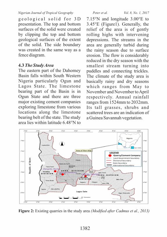
g e o l o g i c a l s o l i d f o r 3 D presentation. The top and bottom surfaces of the solid were created by clipping the top and bottom geological surfaces of the extent of the solid. The side boundary was created in the same way as a fence diagram.
4.3 The Study AreaThe eastern part of the Dahomey Basin falls within South Western Nigeria particularly Ogun and Lagos State. The limestone bearing part of the Basin is in Ogun State and there are three major existing cement companies exploring limestone from various locations along the limestone bearing belt of the state. The study area lies within latitude 6.48°N to
7.15°N and longitude 3.00°E to 3.45°E (Figure1). Generally, the relief of the area is of gently rolling highs with intervening depressions. The streams in the area are generally turbid during the rainy season due to surface erosion. The flow is considerably reduced in the dry season with the smallest stream turning into puddles and connecting trickles. The climate of the study area is basically rainy and dry seasons which ranges from May to November and November to April respectively. Annual rainfall ranges from 1524mm to 2032mm. Its tall grasses, shrubs and scattered trees are an indication of a Guinea Savannah vegetation.
Figure 2: Existing quarries in the study area (Modied after Cadmus et al., 2013)
1382
Nigerian Journal of Tropical Geography Peter et al. Vol. 8, No. 1, 2017
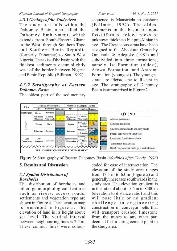
Figure 3: Stratigraphy of Eastern Dahomey Basin (Modied after Coode, 1996)
4.3.1 Geology of the Study AreaThe study area falls within the Dahomey Basin, also called the Dahomey Embayment , which extends from South-Eastern Ghana in the West, through Southern Togo and Southern Benin Republic (formerly Dahomey) to South West Nigeria. The axis of the basin with the thickest sediments occur slightly west of the border between Nigeria and Benin Republic (Billman, 1992).
4.3.2 Stratigraphy of Eastern Dahomey BasinThe oldest part of the sedimentary
sequence is Maastrichtian onshore (B i l lman , 1992) . The o ldes t sediments in the basin are non-fossil iferous, folded rocks of unknown thickness but pre-Albian in age. The Cretaceous strata have been assigned to the Abeokuta Group by Omatsola & Adegoke (1981) and subdivided into three formations, namely, Ise Formation (oldest), Afowo Formation, and Araromi Formation (youngest). The youngest strata are Pleistocene to Recent in age. The stratigraphy of Dahomey Basin is summarised in Figure 2.
5. Results and Discussion
5.1 Spatial Distribution of BoreholesThe distribution of boreholes and other geomorphological features such as r ivers , access roads, settlements and vegetation type are shown in Figure 4. The elevation map is presented in Figure 5. The elevation of land is its height above sea level. The vertical interval between neighbouring lines is 2.5 m. These contour lines were colour-
coded for ease of interpretation. The elevation of the study area ranges from 47.5 m to 63 m (Figure 5) and generally increases southwards in the study area. The elevation gradient is in the ratio of about 15.5 m to 8500 m (elevation to distance ratio) and this will pose little or no gradient c h a l l e n g e i n e n g i n e e r i n g construction of conveyor belts that will transport crushed limestone from the mines to any other part deemed fit for citing cement plant in the study area.
1383
Nigerian Journal of Tropical Geography Peter et al. Vol. 8, No. 1, 2017
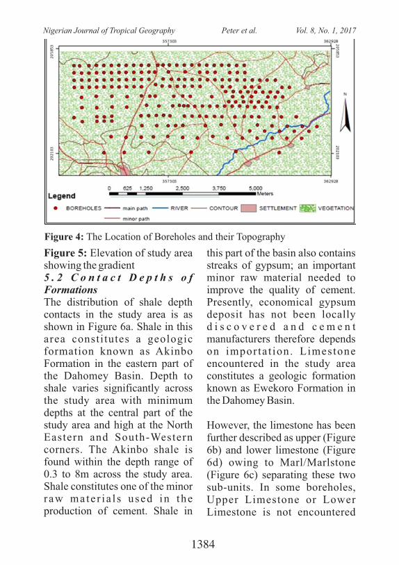
Figure 5: Elevation of study area showing the gradient5 . 2 C o n t a c t D e p t h s o f FormationsThe distribution of shale depth contacts in the study area is as shown in Figure 6a. Shale in this area constitutes a geologic formation known as Akinbo Formation in the eastern part of the Dahomey Basin. Depth to shale varies significantly across the study area with minimum depths at the central part of the study area and high at the North Eastern and South-Western corners. The Akinbo shale is found within the depth range of 0.3 to 8m across the study area. Shale constitutes one of the minor raw mate r i a l s used in the production of cement. Shale in
this part of the basin also contains streaks of gypsum; an important minor raw material needed to improve the quality of cement. Presently, economical gypsum deposit has not been locally d i s c o v e r e d a n d c e m e n t manufacturers therefore depends on importat ion. Limestone encountered in the study area constitutes a geologic formation known as Ewekoro Formation in the Dahomey Basin.
However, the limestone has been further described as upper (Figure 6b) and lower limestone (Figure 6d) owing to Marl/Marlstone (Figure 6c) separating these two sub-units. In some boreholes, Upper Limestone or Lower Limestone is not encountered
Figure 4: The Location of Boreholes and their Topography
1384
Nigerian Journal of Tropical Geography Peter et al. Vol. 8, No. 1, 2017
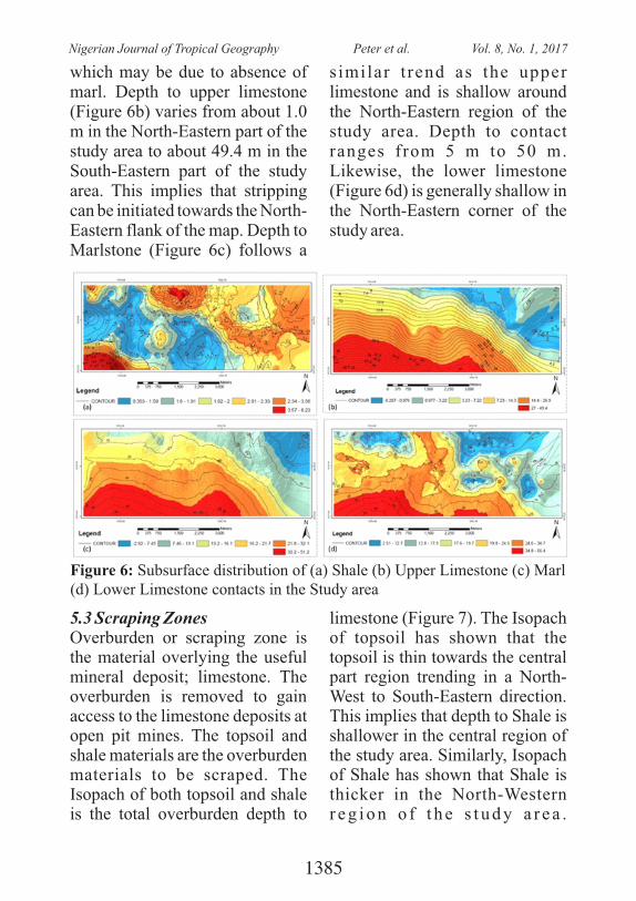
which may be due to absence of marl. Depth to upper limestone (Figure 6b) varies from about 1.0 m in the North-Eastern part of the study area to about 49.4 m in the South-Eastern part of the study area. This implies that stripping can be initiated towards the North-Eastern flank of the map. Depth to Marlstone (Figure 6c) follows a
s imilar t rend as the upper limestone and is shallow around the North-Eastern region of the study area. Depth to contact ranges from 5 m to 50 m. Likewise, the lower limestone (Figure 6d) is generally shallow in the North-Eastern corner of the study area.
Figure 6: Subsurface distribution of (a) Shale (b) Upper Limestone (c) Marl (d) Lower Limestone contacts in the Study area
5.3 Scraping ZonesOverburden or scraping zone is the material overlying the useful mineral deposit; limestone. The overburden is removed to gain access to the limestone deposits at open pit mines. The topsoil and shale materials are the overburden materials to be scraped. The Isopach of both topsoil and shale is the total overburden depth to
limestone (Figure 7). The Isopach of topsoil has shown that the topsoil is thin towards the central part region trending in a North-West to South-Eastern direction. This implies that depth to Shale is shallower in the central region of the study area. Similarly, Isopach of Shale has shown that Shale is thicker in the North-Western r e g i o n o f t h e s t u d y a r e a .
1385
Nigerian Journal of Tropical Geography Peter et al. Vol. 8, No. 1, 2017
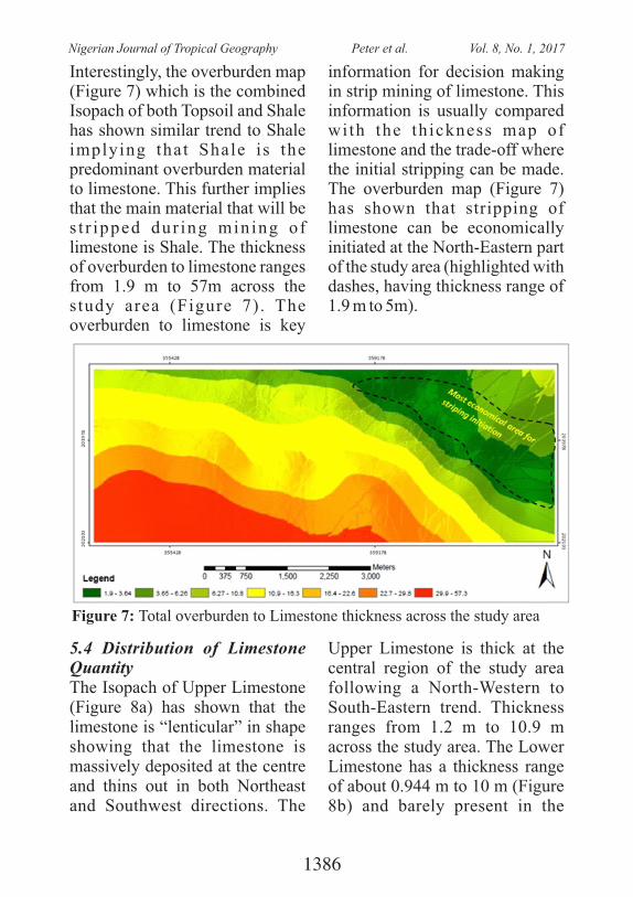
Interestingly, the overburden map (Figure 7) which is the combined Isopach of both Topsoil and Shale has shown similar trend to Shale implying that Shale is the predominant overburden material to limestone. This further implies that the main material that will be s t r ipped dur ing min ing of limestone is Shale. The thickness of overburden to limestone ranges from 1.9 m to 57m across the study area (Figure 7). The overburden to limestone is key
information for decision making in strip mining of limestone. This information is usually compared with the thickness map of limestone and the trade-off where the initial stripping can be made. The overburden map (Figure 7) has shown that stripping of limestone can be economically initiated at the North-Eastern part of the study area (highlighted with dashes, having thickness range of 1.9 m to 5m).
Figure 7: Total overburden to Limestone thickness across the study area
5.4 Distribution of Limestone Quantity The Isopach of Upper Limestone (Figure 8a) has shown that the limestone is “lenticular” in shape showing that the limestone is massively deposited at the centre and thins out in both Northeast and Southwest directions. The
Upper Limestone is thick at the central region of the study area following a North-Western to South-Eastern trend. Thickness ranges from 1.2 m to 10.9 m across the study area. The Lower Limestone has a thickness range of about 0.944 m to 10 m (Figure 8b) and barely present in the
1386
Nigerian Journal of Tropical Geography Peter et al. Vol. 8, No. 1, 2017
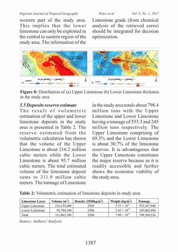
western part of the study area. This implies that the lower limestone can only be exploited in the central to eastern region of the study area. The information of the
Limestone grade (from chemical analysis of the retrieved cores) should be integrated for decision optimization.
Figure 8: Distribution of (a) Upper Limestone (b) Lower Limestone thickness in the study area
5.5 Deposits reserve estimateT h e r e s u l t o f v o l u m e t r i c estimation of the upper and lower limestone deposits in the study area is presented in Table 2. The reserve estimated from the volumetric calculation has shown that the volume of the Upper Limestone is about 216.2 million cubic meters while the Lower Limestone is about 95.7 million cubic meters. The total estimated volume of the limestone deposit sums to 311.9 million cubic meters. The tonnage of Limestone
in the study area totals about 798.4 million tons with the Upper Limestone and Lower Limestone having a tonnage of 553.3 and 245 million tons respectively. The Upper Limestone comprising of 69.3% and the Lower Limestone is about 30.7% of the limestone reserves. It is advantageous that the Upper Limestone constitutes the major reserve because as it is readily accessible and further shows the economic viability of the study area.
Table 2: Volumetric estimation of limestone deposits in study area
Limestone Layer
Volume (m3)
Density (2560kg/m3) Weight (kg/m3)
Tonnage
Upper Limestone 216,159,000 2560 5.53 × 10¹¹
553,367,040
Lower Limestone 95,704,100 2560 2.45 × 10¹¹
245,002,496
Total 311,863,100 2560 7.98 × 10¹¹ 798,369,536
Source: Authors' Analysis
1387
Nigerian Journal of Tropical Geography Peter et al. Vol. 8, No. 1, 2017
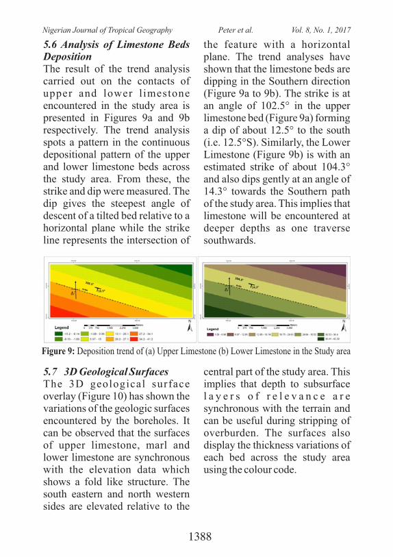
Figure 9: Deposition trend of (a) Upper Limestone (b) Lower Limestone in the Study area
5.6 Analysis of Limestone Beds Deposition The result of the trend analysis carried out on the contacts of upper and lower l imestone encountered in the study area is presented in Figures 9a and 9b respectively. The trend analysis spots a pattern in the continuous depositional pattern of the upper and lower limestone beds across the study area. From these, the strike and dip were measured. The dip gives the steepest angle of descent of a tilted bed relative to a horizontal plane while the strike line represents the intersection of
the feature with a horizontal plane. The trend analyses have shown that the limestone beds are dipping in the Southern direction (Figure 9a to 9b). The strike is at an angle of 102.5° in the upper limestone bed (Figure 9a) forming a dip of about 12.5° to the south (i.e. 12.5°S). Similarly, the Lower Limestone (Figure 9b) is with an estimated strike of about 104.3° and also dips gently at an angle of 14.3° towards the Southern path of the study area. This implies that limestone will be encountered at deeper depths as one traverse southwards.
5.7 3D Geological SurfacesThe 3D geological surface overlay (Figure 10) has shown the variations of the geologic surfaces encountered by the boreholes. It can be observed that the surfaces of upper limestone, marl and lower limestone are synchronous with the elevation data which shows a fold like structure. The south eastern and north western sides are elevated relative to the
central part of the study area. This implies that depth to subsurface l a y e r s o f r e l e v a n c e a r e synchronous with the terrain and can be useful during stripping of overburden. The surfaces also display the thickness variations of each bed across the study area using the colour code.
1388
Nigerian Journal of Tropical Geography Peter et al. Vol. 8, No. 1, 2017

Figure 10: 3D Visualization of Geologic Surfaces with their borehole overlay. (Topsoil, Shale, Upper Limestone, Marl, Lower Limestone and Sandstone)
The surfaces generated from the depths at which the boreholes encountered different geologic units h a v e s h o w n t h e s u b s u r f a c e distributions of these geologic unit's contacts. These maps (Figures 11a to 11d) represent a 3-D landscape on a 2-D surface. It is noteworthy that the base of each geologic unit is the top of another, for example the base of the topsoil is the surface/contact of shale except where not encountered.
G e n e r a l l y, t h e p r e d o m i n a n t l i t hos t r a t i g r aphy succes s ion encountered in the boreholes are topsoil, Shale, Limestone (upper), Marl , Limestone ( lower) and Sandstone. However, some of the geologic units are not encountered in the boreholes of some part of the study area and in such cases, it will be underlain by the next successive lithology.
Figure 11: 3D Visualization of (a) Upper Limestone (b) Marl (c) Lower Limestone (d) Sandstone surface with its borehole overlay
1389
Nigerian Journal of Tropical Geography Peter et al. Vol. 8, No. 1, 2017
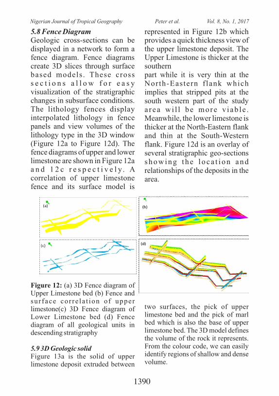
5.8 Fence DiagramGeologic cross-sections can be displayed in a network to form a fence diagram. Fence diagrams create 3D slices through surface based models . These cross s e c t i o n s a l l o w f o r e a s y visualization of the stratigraphic changes in subsurface conditions. The lithology fences display interpolated lithology in fence panels and view volumes of the lithology type in the 3D window (Figure 12a to Figure 12d). The fence diagrams of upper and lower limestone are shown in Figure 12a a n d 1 2 c r e s p e c t i v e l y . A correlation of upper limestone fence and its surface model is
represented in Figure 12b which provides a quick thickness view of the upper limestone deposit. The Upper Limestone is thicker at the southernpart while it is very thin at the North-Eastern f lank which implies that stripped pits at the south western part of the study a rea wi l l be more v i ab le . Meanwhile, the lower limestone is thicker at the North-Eastern flank and thin at the South-Western flank. Figure 12d is an overlay of several stratigraphic geo-sections s h o w i n g t h e l o c a t i o n a n d relationships of the deposits in the area.
Figure 12: (a) 3D Fence diagram of Upper Limestone bed (b) Fence and sur face cor re la t ion o f upper limestone(c) 3D Fence diagram of Lower Limestone bed (d) Fence diagram of all geological units in descending stratigraphy
5.9 3D Geologic solidFigure 13a is the solid of upper limestone deposit extruded between
two surfaces, the pick of upper limestone bed and the pick of marl bed which is also the base of upper limestone bed. The 3D model defines the volume of the rock it represents. From the colour code, we can easily identify regions of shallow and dense volume.
1390
Nigerian Journal of Tropical Geography Peter et al. Vol. 8, No. 1, 2017
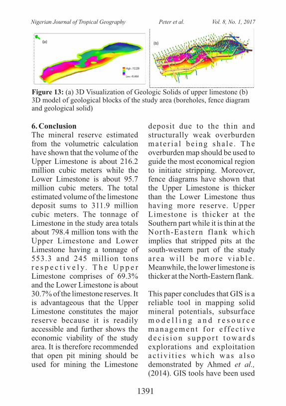
Figure 13: (a) 3D Visualization of Geologic Solids of upper limestone (b) 3D model of geological blocks of the study area (boreholes, fence diagram and geological solid)
6. ConclusionThe mineral reserve estimated from the volumetric calculation have shown that the volume of the Upper Limestone is about 216.2 million cubic meters while the Lower Limestone is about 95.7 million cubic meters. The total estimated volume of the limestone deposit sums to 311.9 million cubic meters. The tonnage of Limestone in the study area totals about 798.4 million tons with the Upper Limestone and Lower Limestone having a tonnage of 553.3 and 245 million tons r e s p e c t i v e l y . T h e U p p e r Limestone comprises of 69.3% and the Lower Limestone is about 30.7% of the limestone reserves. It is advantageous that the Upper Limestone constitutes the major reserve because it is readily accessible and further shows the economic viability of the study area. It is therefore recommended that open pit mining should be used for mining the Limestone
deposit due to the thin and structurally weak overburden ma te r i a l be ing sha le . The overburden map should be used to guide the most economical region to initiate stripping. Moreover, fence diagrams have shown that the Upper Limestone is thicker than the Lower Limestone thus having more reserve. Upper Limestone is thicker at the Southern part while it is thin at the North-Eastern f lank which implies that stripped pits at the south-western part of the study a rea wi l l be more v i ab le . Meanwhile, the lower limestone is thicker at the North-Eastern flank.
This paper concludes that GIS is a reliable tool in mapping solid mineral potentials, subsurface m o d e l l i n g a n d r e s o u r c e managemen t f o r e f f ec t i ve d e c i s i o n s u p p o r t t o w a r d s explorations and exploitation ac t i v i t i e s wh ich was a l so demonstrated by Ahmed et al., (2014). GIS tools have been used
1391
Nigerian Journal of Tropical Geography Peter et al. Vol. 8, No. 1, 2017
for effective design of the geological database system which allows for updating, editing and querying of attributes of the borehole data. It is also an eff ic ient tool for accura te mapping of spatial distributions of overburden materials which ranged from 1.9m to 57.3m across the study area and deposits quanti t ies at several depth intervals. It is recommended from the trend analysis that future exploration for limestone should be in the direction of the strike. Finally, chemical analysis of the retrieved cores should be carried out to ascertain the limestone quality and verify if the calcite percentage in the marl is viable for cement production.
REFERENCES Ahmed Abul Fazal and A.T.M.
Shahidul Huqe Muzemder ( 2 0 1 4 ) . 3 - D i m e n s i o n a l A n a l y s i s a n d R e s e r v e Estimation of Barapukuria C o a l B a s i n , D i n a j p u r , Bangladesh. International Research Journal of Geology and Mining (IRJGM), 4(7), 176-187.
Billman, H. (1992). Offshore Stratigraphy and Paleontology of the Dahomey Embayment, We s t A f r i c a n . N . A . P. E Bulletin, 7(2), 121 – 130.
Cadmus, S., Alabi, P., Adesokan,
H., Dale, E., and Stack, J. ( 2 0 1 3 ) . S e r o l o g i c a l inves t iga t ion o f bov ine brucellosis in three cattle production system in Yewa Divis ion , south-western Nigeria. Journal of the South A f r i c a n V e t e r i n a r y Association, 84(1), 6.
Chatterjee S., Bhattacherjee A., Samanta B., and Pal S., (2006). Ore Grade Estimation of a Limestone Deposit in India Using an Artificial Neural Network. Applied GIS, 2(1), 4-5.
Coode Blizard Ltd., (1996). Hydrogeological Investigation of Lagos State. Final report, volume I, submitted to Lagos State Water Corporation.
Geospa t ia l Wor ld , (2015) . Sticking together GIS and Cement industry: A holistic technological roadmap that encompasses IT, automation and geospatial technology is empowering Reliance Cement Company to e ff i c i en t ly moni tor and manage i ts m i n i n g o p e r a t i o n s . http://geospatialworld.net/Regions/ArticleView.aspx?aid=31561
Hawkins, P. , Tennis, P. , & Detwiler, R., (2003). The Use of Limestone in Portland Cement: A State-of-the-Art Review, EB227, Portland
1392
Nigerian Journal of Tropical Geography Peter et al. Vol. 8, No. 1, 2017
Cement Association, Skokie, Illinois, USA, 2003, 44 pages.
Jones, H., & Hockey, R. (1964). The geology of part of south western Nigeria. Geol. Survey. Nigeria, Bull., 31, 1-101.
Joshi, G., Dwivedi, S., & Sah, R., (2006). Geology, Reserve Es t ima t ion and Qua l i ty Assessment of the Sindhali Limestone Deposit, Nepal. 6th In terna t iona l Sc ien t i f i c Conference - SGEM2006, www.sgem.org, SGEM2006 Conference Proceedings/ ISBN: 954-918181-2, June 12-16, 2006, 1, 153-162.
Juraj, M., Terezie, V., Dana, S., Jan, P., & Josef, M. (2015). Limestone Quarry Reserve Estimation by Laser Scanning and GIS Tools. Procedia Earth and Planetary Science, 15, 382–388.
Michael, S. & DeVerle, H. (2006). Dynamic Mineral Resources Management: A Practioner's Guide for publication in N o v e m b e r 2 0 0 6 . U . S . Geological Survey.
Murtala, C., (2011). An Extensive Analysis of Mining in Nigeria Using a GIS. Journal of Geography and Geology, 3(1).
Nduwumuremyi, A., Mugwe, N., Rusanganwa, C., & Mupenzi, J . ( 2 0 1 3 ) . M a p p i n g o f l i m e s t o n e d e p o s i t s a n d determination of quality of
locally available limestone in Rwanda. Journal of Soil Science and Environmental Management, 4(5), 87-92.
Omatsola, M.E., & Adegoke, S. O. (1981). Tectonic Evolution and Cretaceous Stratigraphy of the Dahomey Basin. Min. Geol., 18(1), 130 – 136.
Onuiri, E. E., Ogbonna, A. E., A l l i - S h e h u , B . , & Maduakolam, C. (2015). M i n e r a l R e s o u r c e s Management Information System. European Journal of C o m p u t e r S c i e n c e a n d Information System, 3(2), 13-23.
Sutphin, D.M., Drew, L.J. , Fowler, B.K., & Goldsmith, R. ( 2 0 0 2 ) , Te c h n i q u e s f o r assessing sand and gravel resources in glaciofluvial deposits—An example using the surficial geologic map of the Loudon quadrangle , Merr imack and Belknap Counties, New Hampshire. U.S . Geolog ica l Survey Professional Paper, 1627(21), 1.
1393
Nigerian Journal of Tropical Geography Peter et al. Vol. 8, No. 1, 2017
SOLID WASTE MANAGEMENT PRACTICES IN LAGOS STATE: CASE OF KOSOFE LOCAL GOVERNMENT AREA,
LAGOS STATE
Ayeni,A. O. and Ogunkunle, O. A.Department of Geography, University of Lagos, Lagos, Nigeria
ABSTRACT: The population of the Lagos State will exceed 25 million in 2020 as predicted, as a result Lagos State will be one of the largest cities of the world. Based on this prediction, an effective waste management strategy should be put in place in order to properly reduce the future implication of poor waste management. It is on this note that this study examines the solid waste management practices in Lagos State. The study focused on Kosofe LGA based on her strategic location which tends to harbor more dirt environments that which promote health hazard and amongst many other problems. The study was carried out using primary and secondary methods of data gathering. The non-probability - simple random sampling technique was adopted in the distribution of structured questionnaire within the stratified twenty-seven (27) administrative wards in the LGA. A total of 474 households were randomly picked from the streets that were selected from each of the 27 wards using systematic sampling method. The study also carried out measurement of daily waste generated waste in each of the houses. It was observed that there are variations in the types of wastes generated by household's classes i.e. High Class, Middle Class and Low Class which was noted as factors contributed to irregular waste disposal that characterized some parts of the study area. The study revealed that high class generates more wastes of over 10kg per week per building which constituents mainly of Food/Kitchen ruminants, Plastic, Rubber wastes etc. The study attributed the volume of wastes generated in each ward to the two factors vis-à-vis the number of individuals living in a building and the type of waste generated. The study therefore concluded that there are poor management practices by the operatives of waste management (PSP/LAWMA) while cart pushers contributed to unprecedented disposal of wastes in canals and on the public right of way.
1394
Nigerian Journal of Tropical Geography Ayeni and Ogunkunle Vol. 8, No. 1, 2017

INTRODUCTIONIn succinct, solid material which is discarded is termed solid waste ( G r a i s e r , 2 0 0 7 ) w h i l e i t s m a n a g e m e n t a c c o r d i n g t o Rogdgers (2011) is the systematic control of generation, storage, co l l e c t i on , t r an spo r t a t i on , separation, processing, recovery and disposal of solid waste. Solid waste management is accepted as a major aspect of the indigenous community organization and traditional home management (Sanda, 2008; Chukwuemeka et al., 2012). As a result, households have resulted to design an area for solid waste collection/disposal and or incineration (Sanda, 2008; Thompson et al . , 2009). In developing countries, typical problem can be identified with M u n i c i p a l S o l i d W a s t e M a n a g e m e n t ( M S W M ) . According to Zurbrugg, (2003), these problems include but not limited to: inadequate service c o v e r a g e a n d o p e r a t i o n a l inefficiencies of services; limited utilization of recycling activities; inadequate landfill disposal, and inadequate management of hazardous and healthcare waste. The current global trend of waste management problems stems from unsustainable methods of waste disposal, which is ultimately a as result of inadequate planning and implementation (Amado et al., 2007; Abbas et al., 2011; Idowu et
al., 2011).
A review of existing literature reveals that a great number of studies on SWM have been undertaken, even prior to 1970 (van Beukering et al., 1999; Richardson, 2003, Omran et al., 2006, Omran & Gavrilescu, 2008). Solid waste management is traditionally the responsibility of the local Council. However, the task appeared to be enormous for the local Government because of the amount of money involved thus necessitating the intervention of the state Government (Longe et al. , 2009). Waste collection activities are the most expensive in waste management systems and its efficiency would have immediate impact on the level of municipal s o l i d w a s t e m a n a g e m e n t (Ogwueleka, 2009; Zaini, 2011). Cur ren t ly, the Lagos s t a te government is into pact with the private sector in waste collection a n d d i s p o s a l . To e n s u r e sustainable urban development the need for efficient solid waste management is inevitable.
The continuous increase in Nigeria population over the year has inversely affected the environment of urban centers most especially Lagos metropolis. This is due to enormous generation of wastes through various human activities without effective and efficient
1395
Nigerian Journal of Tropical Geography Ayeni and Ogunkunle Vol. 8, No. 1, 2017
knowledge of management processes. The population of the Lagos State will exceed 25 million in 2020 as predicted, as a result Lagos State will be one of the la rges t c i t ies of the wor ld (Nwambuonwo and Mughele 2 0 1 2 ; U N E S A , 2 0 1 4 ) . Consequently, tonnage of waste generation will continue to increase if an effective waste management strategy that will p roper ly reduce the fu ture implication is not put in place. For instance, as at 2012, the absolute volume of wastes generation in Lagos State per day was about 9,000 tons and rose to about 12,000 tons (Nwambuonwo and Mughe l e 2012 ; Ezeah and Roberts, 2014; Uchendu, 2016; Adekomaya and Ojo (2016). It is on this note that this study e x a m i n e s t h e s o l i d w a s t e management practices in Lagos State. The study focused on Kosofe LGA based on her strategic location which characterized by p o o r w a s t e d i s p o s a l a n d management as well as dirty environments that can promote health hazard amongst residents.
STUDY AREAKosofe LGA is one of the twenty (20) local government areas in Lagos State and located on the
o olongitude (3.395 E & 3.395 E) and o olatitude (6.637 N & 6.527 N).
Kosofe LGA is bounded by Ikeja,
Ikorodu and Somolu LGAs. The total land mass of the Local Government expands up to 74.4sqkm with almost 10sqkm covered with water body. In 2006,
thKosofe LGA was the 9 most populous LGA in Lagos state with a population figure of 665,393 (NPC, 2007
The study area shares the general climate and weather condition of the Lagos State. It has a tropical wet and dry climate with two dis t inct rainy seasons. The drainage system of the study area is characterized by maze of water from the Lagos Lagoon and creeks while the vegetation pattern is the swamp forest. The geographical location of the LGA has fostered the development of trade within its hinterland as well as with the neighboring communities. As might be expected, the rate of growth has been spectacular in recent years. The people of Kosofe were noted for massive trade in vegetables, fruits, maize, cassava and fish. Due to the availability of water ways in the LGA, a number of people prefer inland water transportation because it's cheaper and cost effective while majority use road transportation
1396
Nigerian Journal of Tropical Geography Ayeni and Ogunkunle Vol. 8, No. 1, 2017
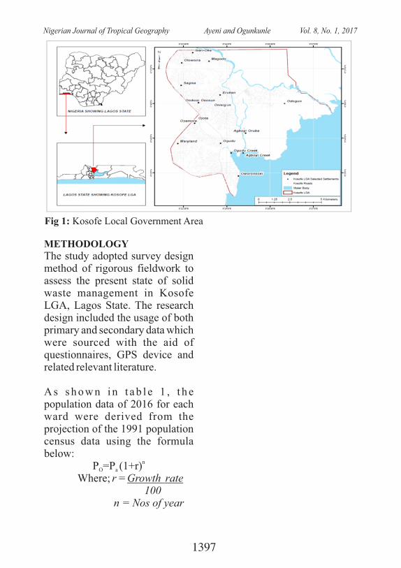
METHODOLOGYThe study adopted survey design method of rigorous fieldwork to assess the present state of solid waste management in Kosofe LGA, Lagos State. The research design included the usage of both primary and secondary data which were sourced with the aid of questionnaires, GPS device and related relevant literature.
A s s h o w n i n t a b l e 1 , t h e population data of 2016 for each ward were derived from the projection of the 1991 population census data using the formula below:
nP =P (1+r)O a
Where; r = Growth rate � � 100 � n = Nos of year
Fig 1: Kosofe Local Government Area
1397
Nigerian Journal of Tropical Geography Ayeni and Ogunkunle Vol. 8, No. 1, 2017
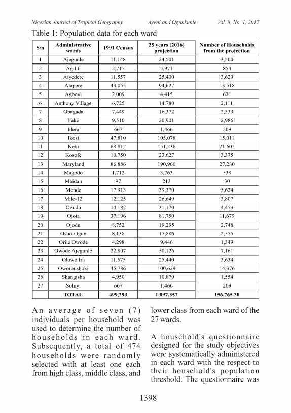
S/nAdministrative
wards1991 Census
25 years (2016) projection
Number of Households from the projection
1 Ajegunle 11,148 24,501 3,500
2 Agiliti 2,717 5,971 853
3 Aiyedere
11,557
25,400
3,629
4 Alapere
43,055
94,627
13,518
5 Agboyi
2,009
4,415
631
6 Anthony Village
6,725
14,780
2,111
7 Gbagada
7,449
16,372
2,339
8 Ifako
9,510
20,901
2,986
9 Idera
667
1,466
209
10 Ikosi
47,810
105,078
15,011
11 Ketu
68,812
151,236
21,605
12 Kosofe 10,750 23,627 3,375
13 Maryland
86,886
190,960
27,280
14 Magodo
1,712
3,763
538
15 Maidan
97
213
30
16 Mende
17,913
39,370
5,624
17 Mile-12
12,125
26,649
3,807
18 Ogudu
14,182
31,170
4,453
19 Ojota
37,196
81,750
11,679
20 Ojodu
8,752
19,235
2,748
21 Osho-Ogun
8,138
17,886
2,555
22 Orile Owode
4,298
9,446
1,349
23 Owode Ajegunle
22,807
50,126
7,161
24 Olowo Ira
11,575
25,440
3,634
25 Oworonshoki 45,786 100,629 14,376
26 Shangisha 4,950 10,879 1,554
27 Soluyi 667 1,466 209
TOTAL 499,293 1,097,357 156,765.30
Table 1: Population data for each ward
A n a v e r a g e o f s e v e n ( 7 ) individuals per household was used to determine the number of househo lds i n each wa rd . Subsequently, a total of 474 households were randomly selected with at least one each from high class, middle class, and
lower class from each ward of the 27 wards.
A household's questionnaire designed for the study objectives were systematically administered in each ward with the respect to their household's population threshold. The questionnaire was
1398
Nigerian Journal of Tropical Geography Ayeni and Ogunkunle Vol. 8, No. 1, 2017
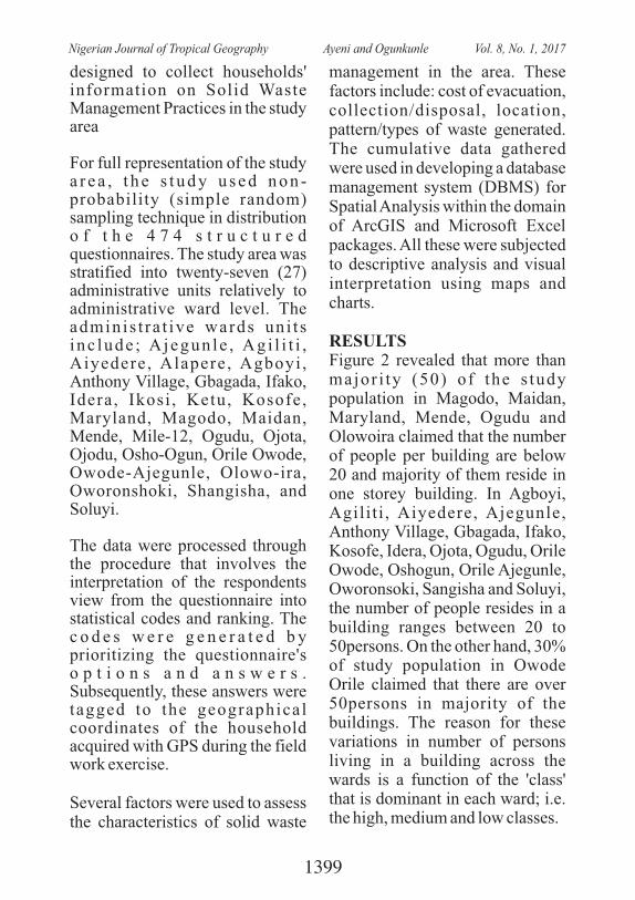
designed to collect households' information on Solid Waste Management Practices in the study area
For full representation of the study a r e a , t h e s t u d y u s e d n o n -probability (simple random) sampling technique in distribution o f t h e 4 7 4 s t r u c t u r e d questionnaires. The study area was stratified into twenty-seven (27) administrative units relatively to administrative ward level. The adminis t ra t ive wards uni t s i nc lude ; A jegun le , Ag i l i t i , Aiyedere, Alapere, Agboyi , Anthony Village, Gbagada, Ifako, Idera, Ikosi , Ketu, Kosofe, Maryland, Magodo, Maidan, Mende, Mile-12, Ogudu, Ojota, Ojodu, Osho-Ogun, Orile Owode, Owode-Ajegunle, Olowo-ira, Oworonshoki, Shangisha, and Soluyi.
The data were processed through the procedure that involves the interpretation of the respondents view from the questionnaire into statistical codes and ranking. The c o d e s w e r e g e n e r a t e d b y prioritizing the questionnaire's o p t i o n s a n d a n s w e r s . Subsequently, these answers were tagged to the geographical coordinates of the household acquired with GPS during the field work exercise.
Several factors were used to assess the characteristics of solid waste
management in the area. These factors include: cost of evacuation, collection/disposal, location, pattern/types of waste generated. The cumulative data gathered were used in developing a database management system (DBMS) for Spatial Analysis within the domain of ArcGIS and Microsoft Excel packages. All these were subjected to descriptive analysis and visual interpretation using maps and charts.
RESULTSFigure 2 revealed that more than major i ty (50) of the s tudy population in Magodo, Maidan, Maryland, Mende, Ogudu and Olowoira claimed that the number of people per building are below 20 and majority of them reside in one storey building. In Agboyi, Agilit i , Aiyedere, Ajegunle, Anthony Village, Gbagada, Ifako, Kosofe, Idera, Ojota, Ogudu, Orile Owode, Oshogun, Orile Ajegunle, Oworonsoki, Sangisha and Soluyi, the number of people resides in a building ranges between 20 to 50persons. On the other hand, 30% of study population in Owode Orile claimed that there are over 50persons in majority of the buildings. The reason for these variations in number of persons living in a building across the wards is a function of the 'class' that is dominant in each ward; i.e. the high, medium and low classes.
1399
Nigerian Journal of Tropical Geography Ayeni and Ogunkunle Vol. 8, No. 1, 2017
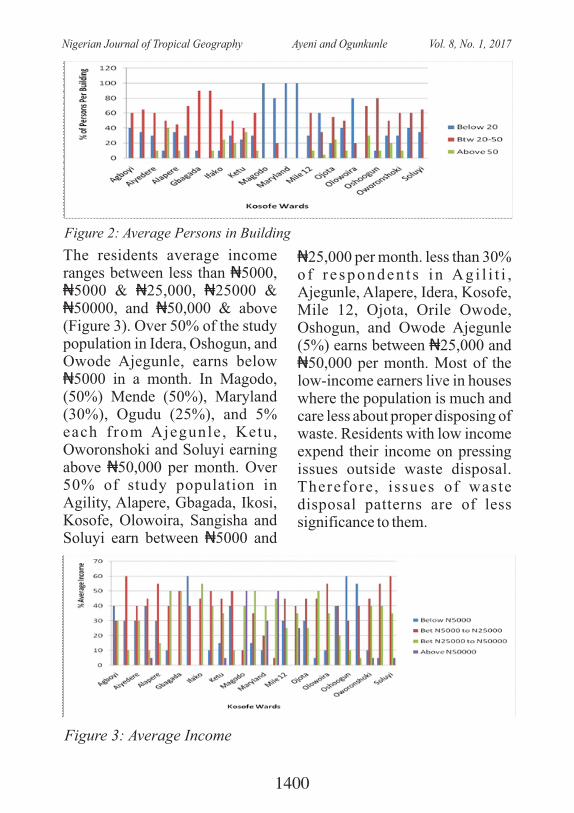
Figure 2: Average Persons in Building
The residents average income ranges between less than ₦5000, ₦5000 & ₦25,000, ₦25000 & ₦50000, and ₦50,000 & above (Figure 3). Over 50% of the study population in Idera, Oshogun, and Owode Ajegunle, earns below ₦5000 in a month. In Magodo, (50%) Mende (50%), Maryland (30%), Ogudu (25%), and 5% each from Ajegunle, Ketu, Oworonshoki and Soluyi earning above ₦50,000 per month. Over 50% of study population in Agility, Alapere, Gbagada, Ikosi, Kosofe, Olowoira, Sangisha and Soluyi earn between ₦5000 and
₦25,000 per month. less than 30% o f r e sponden t s i n Ag i l i t i , Ajegunle, Alapere, Idera, Kosofe, Mile 12, Ojota, Orile Owode, Oshogun, and Owode Ajegunle (5%) earns between ₦25,000 and ₦50,000 per month. Most of the low-income earners live in houses where the population is much and care less about proper disposing of waste. Residents with low income expend their income on pressing issues outside waste disposal. Therefore, issues of waste disposal patterns are of less significance to them.
Figure 3: Average Income
1400
Nigerian Journal of Tropical Geography Ayeni and Ogunkunle Vol. 8, No. 1, 2017
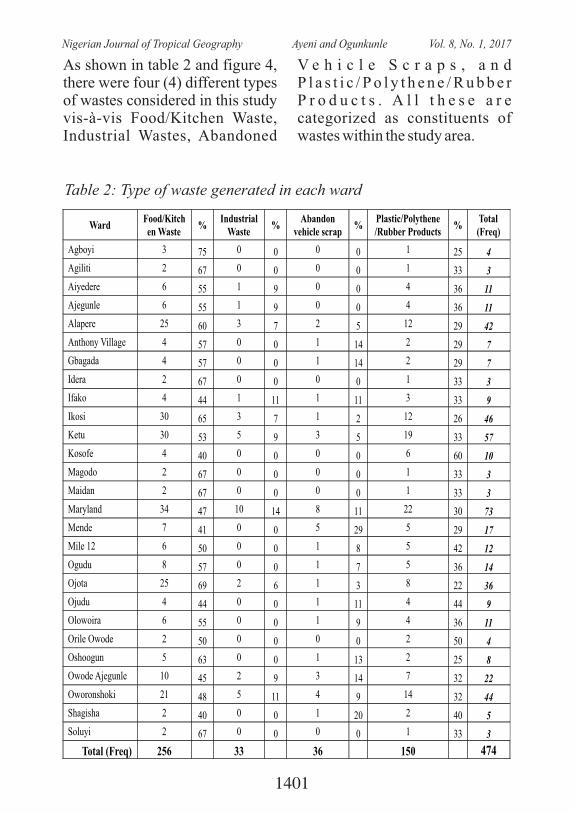
Table 2: Type of waste generated in each ward
WardFood/Kitchen Waste
%Industrial
Waste%
Abandon vehicle scrap
%Plastic/Polythene /Rubber Products
%Total (Freq)
Agboyi 3 75 0 0 0 0 1 25 4
Agiliti 2 67 0 0 0 0 1 33 3
Aiyedere 6 55 1 9 0 0 4 36 11
Ajegunle 6 55 1 9 0 0 4 36 11
Alapere 25
60
3
7
2
5
12
29 42
Anthony Village
4
57
0
0
1
14
2
29 7
Gbagada 4
57
0
0
1
14
2
29 7
Idera 2
67
0
0
0
0
1
33 3
Ifako 4
44
1
11
1
11
3
33 9
Ikosi 30
65
3
7
1
2
12
26 46
Ketu 30
53
5
9
3
5
19
33 57
Kosofe 4
40
0
0
0
0
6
60 10
Magodo 2
67
0
0
0
0
1
33 3
Maidan 2
67
0
0
0
0
1
33 3
Maryland 34
47
10
14
8
11
22
30 73
Mende 7
41
0
0
5
29
5
29 17
Mile 12 6
50
0
0
1
8
5
42 12
Ogudu 8
57
0
0
1
7
5
36 14
Ojota 25
69
2
6
1
3
8
22 36
Ojudu 4
44
0
0
1
11
4
44 9
Olowoira 6
55
0
0
1
9
4
36 11
Orile Owode 2
50
0
0
0
0
2
50 4
Oshoogun 5
63
0
0
1
13
2
25 8
Owode Ajegunle
10
45
2
9
3
14
7
32 22
Oworonshoki 21 48 5 11 4 9 14 32 44
Shagisha 2 40 0 0 1 20 2 40 5
Soluyi 2 67 0 0 0 0 1 33 3
Total (Freq) 256 33 36 150 474
As shown in table 2 and figure 4, there were four (4) different types of wastes considered in this study vis-à-vis Food/Kitchen Waste, Industrial Wastes, Abandoned
V e h i c l e S c r a p s , a n d P l a s t i c / P o l y t h e n e / R u b b e r P r o d u c t s . A l l t h e s e a r e categorized as constituents of wastes within the study area.
1401
Nigerian Journal of Tropical Geography Ayeni and Ogunkunle Vol. 8, No. 1, 2017
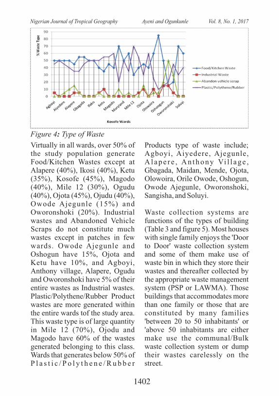
Figure 4: Type of Waste
Virtually in all wards, over 50% of the study population generate Food/Kitchen Wastes except at Alapere (40%), Ikosi (40%), Ketu (35%), Kosofe (45%), Magodo (40%), Mile 12 (30%), Ogudu (40%), Ojota (45%), Ojudu (40%), Owode Ajegunle (15%) and Oworonshoki (20%). Industrial wastes and Abandoned Vehicle Scraps do not constitute much wastes except in patches in few wards. Owode Ajegunle and Oshogun have 15%, Ojota and Ketu have 10%, and Agboyi, Anthony village, Alapere, Ogudu and Oworonshoki have 5% of their entire wastes as Industrial wastes. Plastic/Polythene/Rubber Product wastes are more generated within the entire wards tof the study area. This waste type is of large quantity in Mile 12 (70%), Ojodu and Magodo have 60% of the wastes generated belonging to this class. Wards that generates below 50% of P l a s t i c / P o l y t h e n e / R u b b e r
Products type of waste include; Agboyi, Aiyedere, Ajegunle, A l a p e r e , A n t h o n y Vi l l a g e , Gbagada, Maidan, Mende, Ojota, Olowoira, Orile Owode, Oshogun, Owode Ajegunle, Oworonshoki, Sangisha, and Soluyi.
Waste collection systems are functions of the types of building (Table 3 and figure 5). Most houses with single family enjoys the 'Door to Door' waste collection system and some of them make use of waste bin in which they store their wastes and thereafter collected by the appropriate waste management system (PSP or LAWMA). Those buildings that accommodates more than one family or those that are constituted by many families 'between 20 to 50 inhabitants' or 'above 50 inhabitants are either make use the communal/Bulk waste collection system or dump their wastes carelessly on the street.
1402
Nigerian Journal of Tropical Geography Ayeni and Ogunkunle Vol. 8, No. 1, 2017
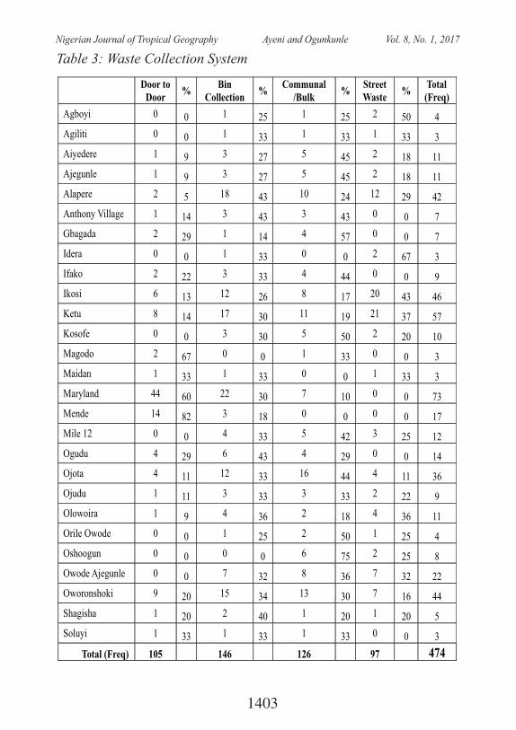
Table 3: Waste Collection System
Door to Door
%Bin
Collection%
Communal /Bulk
%Street Waste
%Total (Freq)
Agboyi 0 0 1 25 1 25 2 50 4
Agiliti 0 0 1 33 1 33 1 33 3
Aiyedere 1
9
3
27
5
45
2
18
11
Ajegunle 1
9
3
27
5
45
2
18
11
Alapere 2
5
18
43
10
24
12
29
42
Anthony Village
1
14
3
43
3
43
0
0
7
Gbagada 2
29
1
14
4
57
0
0
7
Idera 0
0
1
33
0
0
2
67
3
Ifako 2
22
3
33
4
44
0
0
9
Ikosi 6
13
12
26
8
17
20
43
46
Ketu 8
14
17
30
11
19
21
37
57
Kosofe 0
0
3
30
5
50
2
20
10
Magodo 2
67
0
0
1
33
0
0
3
Maidan 1
33
1
33
0
0
1
33
3
Maryland 44
60
22
30
7
10
0
0
73
Mende 14
82
3
18
0
0
0
0
17
Mile 12 0
0
4
33
5
42
3
25
12
Ogudu 4
29
6
43
4
29
0
0
14
Ojota 4
11
12
33
16
44
4
11
36
Ojudu 1
11
3
33
3
33
2
22
9
Olowoira 1
9
4
36
2
18
4
36
11
Orile Owode
0
0
1
25
2
50
1
25
4
Oshoogun 0
0
0
0
6
75
2
25
8
Owode Ajegunle
0
0
7
32
8
36
7
32
22
Oworonshoki 9 20 15 34 13 30 7 16 44
Shagisha 1 20 2 40 1 20 1 20 5
Soluyi 1 33 1 33 1 33 0 0 3
Total (Freq) 105 146 126 97 474
1403
Nigerian Journal of Tropical Geography Ayeni and Ogunkunle Vol. 8, No. 1, 2017
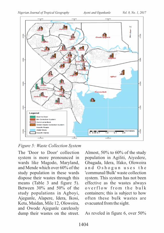
Figure 5: Waste Collection System
The 'Door to Door' collection system is more pronounced in wards like Magodo, Maryland, and Mende which over 60% of the study population in these wards dispose their wastes through this means (Table 3 and figure 5). Between 30% and 50% of the study populations in Agboyi, Ajegunle, Alapere, Idera, Ikosi, Ketu, Maidan, Mile 12, Olowoira, and Owode Ajegunle carelessly dump their wastes on the street.
Almost, 50% to 60% of the study population in Agiliti, Aiyedere, Gbagada, Idera, Ifako, Olowoira a n d O s h o g u n u s e s t h e 'communal/Bulk' waste collection system. This system has not been effective as the wastes always o v e r f l o w f r o m t h e b u l k containers; this is subject to how often these bulk wastes are evacuated from the sight.
As reveled in figure 6, over 50%
1404
Nigerian Journal of Tropical Geography Ayeni and Ogunkunle Vol. 8, No. 1, 2017
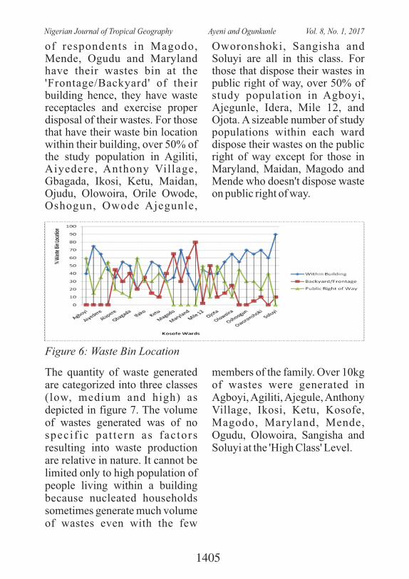
of respondents in Magodo, Mende, Ogudu and Maryland have their wastes bin at the 'Frontage/Backyard' of their building hence, they have waste receptacles and exercise proper disposal of their wastes. For those that have their waste bin location within their building, over 50% of the study population in Agiliti, Aiyedere, Anthony Village, Gbagada, Ikosi, Ketu, Maidan, Ojudu, Olowoira, Orile Owode, Oshogun, Owode Ajegunle,
Oworonshoki, Sangisha and Soluyi are all in this class. For those that dispose their wastes in public right of way, over 50% of study population in Agboyi, Ajegunle, Idera, Mile 12, and Ojota. A sizeable number of study populations within each ward dispose their wastes on the public right of way except for those in Maryland, Maidan, Magodo and Mende who doesn't dispose waste on public right of way.
Figure 6: Waste Bin Location
The quantity of waste generated are categorized into three classes (low, medium and high) as depicted in figure 7. The volume of wastes generated was of no speci f ic pat tern as fac tors resulting into waste production are relative in nature. It cannot be limited only to high population of people living within a building because nucleated households sometimes generate much volume of wastes even with the few
members of the family. Over 10kg of wastes were generated in Agboyi, Agiliti, Ajegule, Anthony Village, Ikosi, Ketu, Kosofe, Magodo, Maryland, Mende, Ogudu, Olowoira, Sangisha and Soluyi at the 'High Class' Level.
1405
Nigerian Journal of Tropical Geography Ayeni and Ogunkunle Vol. 8, No. 1, 2017
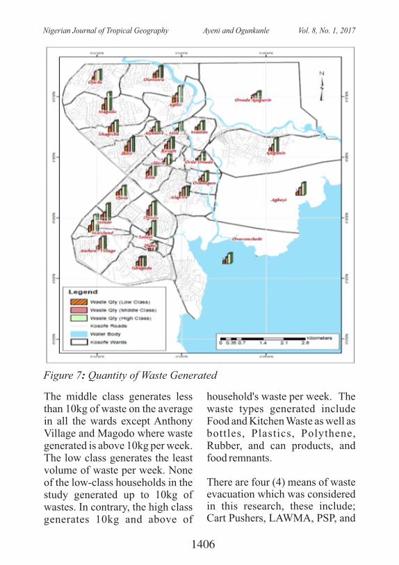
Figure 7: Quantity of Waste Generated
The middle class generates less than 10kg of waste on the average in all the wards except Anthony Village and Magodo where waste generated is above 10kg per week. The low class generates the least volume of waste per week. None of the low-class households in the study generated up to 10kg of wastes. In contrary, the high class generates 10kg and above of
household's waste per week. The waste types generated include Food and Kitchen Waste as well as bottles, Plastics, Polythene, Rubber, and can products, and food remnants.
There are four (4) means of waste evacuation which was considered in this research, these include; Cart Pushers, LAWMA, PSP, and
1406
Nigerian Journal of Tropical Geography Ayeni and Ogunkunle Vol. 8, No. 1, 2017
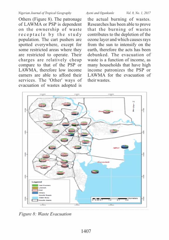
Others (Figure 8). The patronage of LAWMA or PSP is dependent on the ownership of waste r e c e p t a c l e b y t h e s t u d y population. The cart pushers are spotted everywhere, except for some restricted areas where they are restricted to operate. Their charges are relatively cheap compare to that of the PSP or LAWMA, therefore low income earners are able to afford their services. The 'Other' ways of evacuation of wastes adopted is
the actual burning of wastes. Researches has been able to prove that the burning of wastes contributes to the depletion of the ozone layer and which causes rays from the sun to intensify on the earth, therefore the acts has been debunked. The evacuation of waste is a function of income, as many households that have high income patronizes the PSP or LAWMA for the evacuation of their wastes.
Figure 8: Waste Evacuation
1407
Nigerian Journal of Tropical Geography Ayeni and Ogunkunle Vol. 8, No. 1, 2017
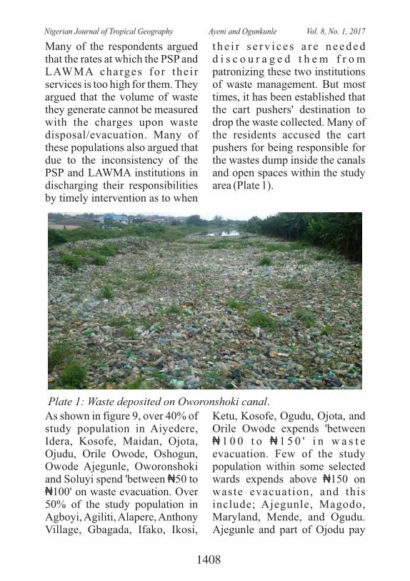
Many of the respondents argued that the rates at which the PSP and LAWMA charges for the i r services is too high for them. They argued that the volume of waste they generate cannot be measured with the charges upon waste disposal/evacuation. Many of these populations also argued that due to the inconsistency of the PSP and LAWMA institutions in discharging their responsibilities by timely intervention as to when
t h e i r s e r v i c e s a r e n e e d e d d i s c o u r a g e d t h e m f r o m patronizing these two institutions of waste management. But most times, it has been established that the cart pushers' destination to drop the waste collected. Many of the residents accused the cart pushers for being responsible for the wastes dump inside the canals and open spaces within the study area (Plate 1).
Plate 1: Waste deposited on Oworonshoki canal.
As shown in figure 9, over 40% of study population in Aiyedere, Idera, Kosofe, Maidan, Ojota, Ojudu, Orile Owode, Oshogun, Owode Ajegunle, Oworonshoki and Soluyi spend 'between ₦50 to ₦100' on waste evacuation. Over 50% of the study population in Agboyi, Agiliti, Alapere, Anthony Village, Gbagada, Ifako, Ikosi,
Ketu, Kosofe, Ogudu, Ojota, and Orile Owode expends 'between ₦ 1 0 0 t o ₦ 1 5 0 ' i n w a s t e evacuation. Few of the study population within some selected wards expends above ₦150 on waste evacuation, and this include; Ajegunle, Magodo, Maryland, Mende, and Ogudu. Ajegunle and part of Ojodu pay
1408
Nigerian Journal of Tropical Geography Ayeni and Ogunkunle Vol. 8, No. 1, 2017
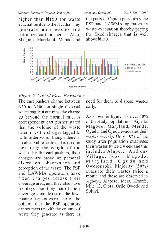
higher than ₦150 for waste evacuation due to the fact that they genera te more was tes and patronize cart pushers. Also, Magodo, Maryland, Mende and
the parts of Ogudu patronizes the PSP and LAWMA operators in waste evacuation thereby paying the fixed charges that is well above ₦150.
Figure 9: Cost of Waste EvacuationThe cart pushers charge between ₦50 to ₦100 on single disposal waste bag, but at times, the charge go beyond the normal rate. A correspondent cart pusher stated that the volume of the waste determines the charges tagged to it. In order word, though there is no observable scale that is used in measuring the weight of the wastes by the cart pushers, their charges are based on personal discretion, observation and perception of the waste. The PSP and LAWMA operators have f ixed charges across the i r coverage area, and they also have fix days that they patrol their coverage zone. Most of the low-income earners were also of the opinion that the PSP operators cannot meet up with the volume of waste they generate as there is
need for them to dispose wastes daily.
As shown in figure 10, over 50% of the study population in Aiyede, Magodo, Maryland, Mende, Ogudu, and Ojudu evacuates their wastes weekly. Only 10% of the study area population evacuates their wastes twice a week and this inc ludes Alapere , Anthony Vi l l a g e , I k o s i , M a g o d o , M a r y l a n d , O g u d u a n d Oworonsoki. Majority (50%) evacuate their wastes twice a month and these are observed in Agboyi, Alapere, Idera, Kosofe, Mile 12, Ojota, Orile Owode and Soluyi.
1409
Nigerian Journal of Tropical Geography Ayeni and Ogunkunle Vol. 8, No. 1, 2017
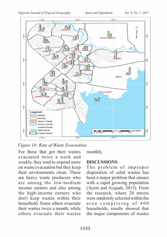
Figure 10: Rate of Waste Evacuation
For those that got their wastes evacuated twice a week and weekly, they tend to expend more on waste evacuation but they keep their environments clean. These are heavy waste producers who are among the low/medium income earners and also among the high-income earners who don't keep wastes within their household. Some others evacuate their wastes twice a month, while others evacuate their wastes
monthly.
DISCUSSIONST h e p r o b l e m o f i m p r o p e r disposition of solid wastes has been a major problem that ensues with a rapid growing population (Ayeni and Acquah, 2015). From the research, where 20 streets were randomly selected within the a r e a c o m p r i s i n g o f 4 0 0 households, results showed that the major components of wastes
1410
Nigerian Journal of Tropical Geography Ayeni and Ogunkunle Vol. 8, No. 1, 2017
generated are food remains and paper with an average of 2.5Kg of wastes being generated per day. This corroborates a study by Abur et al., (2014) on 'Characterization of Municipal Solid Waste in the Federal Capital Abuja, Nigeria'. The charac te r i s t i c s o f the municipal solid waste were determined in terms of the components' average mass (kg) and percentage generated per household. On the average, about 54.1% of the solid waste generated in the area is made up of food/ particles; rubber 6.85%; paper 11.2%; glass/ceramics 4.5%; plastics 5.1%; metals 2.15% and other forms of waste 16.1% (dust particle, Ash, stones) and ranges b e t w e e n 0 . 5 9 t o 0.79kg/capita/day.
This current studies revealed the households task collaboration with waste disposal agency and cart pusher in ensuring adequate waste disposal in Kosofe LGA over the years. Many (about 93.7%) of the respondents claimed the use of cart pushers as well as LAWMA in the past. About 48% make use of cart pushers while few others use illegal dumping grounds in the past. This corroborates with a study carried out Idowu et al., ( 2 0 1 1 ) o n s o l i d w a s t e management pract ices is a
collective collaborative task by both the residence and the waste collectors. On the other hand, about 90.4% the households have resorted to using PSP in the recent time while about 5.1% of the residents still use cart pusher. This revealed that waste disposal using PSP operation has been widely accepted majority of the residents.
CONCLUSIONBased on the fact that there are poor management practices by the operatives of waste management (PSP/LAWMA), there has been efficiency gap in waste evacuation probably because evacuation is p a r t i a l l y i n t h e h a n d s o f unprofessional (the Cart Pushers). These cart pushers have been accused of contr ibut ing to unprecedented disposal of wastes in canals and on the public right of way. Average income has been proved to be proportional directly or inversely to livelihoods which includes, the type of dwelling house, number of persons in a building and ultimately the pattern of waste disposal. Some of the wards that are extremely dirty within the study area include; Agiliti, Aiyedere, Ajegunle, Oworonsoki, Soluyi, Owode Ajegunle, Oshoogun, Orile Owode amongst others. The cleaner wards include, Mende, Maryland, Magodo, Ogudu etc. As a result, there is need proper
1411
Nigerian Journal of Tropical Geography Ayeni and Ogunkunle Vol. 8, No. 1, 2017

and efficient disposal agency which will enable the waste management team to understand the hierarchy of need of their services across the study area. Government should play an active role in waste management by subsidizing the cost of waste d i sposa l t h rough PSP and LAWMA, and if possible, make available standard and accessible waste collection points at ward levels to enable households to deposit their wastes for timely e v a c u a t i o n b y t h e w a s t e management agencies. With the understanding of the types of waste generated in each ward, r e c y c l i n g p r o c e s s c a n b e introduced to some of the wastes so as to use them in producing other useful materials.
References Abbas , I . I , Na i ' ya , R and
Arigbede, Y.A, (2011). Use of remote sensing and GIS in effective and efficient solid management planning (a case study of Samara, Zaria, Nigeria) Research Journal of Earth and Planetary Studies 2:046-052.
Abur, B. T., E. E. Oguche and G. A . D u v u n a ( 2 0 1 4 ) : C h a r a c t e r i z a t i o n o f Municipal Solid Waste in the �Federa l Cap i t a l Abu ja , NigeriaGlobal Journal of Science Frontier Research, 14
(2): 1-6Adekomaya, O. and K. Ojo
(2016): Adaptation of plastic waste to energy development in Lagos : an overv iew assessment. Nigerian Journal of Technology (NIJOTECH) 35 (2): 778 – 784
Amado, M. P., M. R. Rebeiro, A. J. Pinto and C. V. Santo (2007): O p e r a t i v e p r o c e s s i n sustainable � u r b a n p lanning . XXXV IAHS Congress on Housing Science – Melbourne.
Ayeni A.O and E Acquah (2015): An Evaluation of Municipal Solid Waste Management in Agboyi– � K e t u L o c a l Council Development Area (LCDA), Lagos State, Sokoto J. Soc., Sc., 5(1): 43 - 57
Chang, N.B, Parvathinathan, G, B r e e d e n , B . J . , ( 2 0 0 7 ) . Combining GIS with fuzzy mult i cr i ter ia decis ion-making for landfill siting in a fast-growing urban region, Journal of Environmental Management, 1:11,1-15.
Chukwuemeka, E. E.O., M. O. Ebele and O M. Chiekezie (2012): Lopsidedness in solid w a s t e m a n a g e m e n t i n N i g e r i a : O b s t a c l e t o sustainable development, OIDA International Journal of Sustainable Development 5 (4): 61-68
1412
Nigerian Journal of Tropical Geography Ayeni and Ogunkunle Vol. 8, No. 1, 2017
Ezeah, C. and C. L. Roberts, Waste governance agenda in N i g e r i a n c i t i e s : A comparative analysis. Habitat International, 2014. 41(0): p. 121-128.
Graiser, S., (2007): The Best way to manage solid waste in development nations. Int. J. Environ., 4(3):39-40.
Longe, E. O., Longe, O. O. & Ukpebor, E . F. (2009) : Peop le ' s pe rcep t ion on h o u s e h o l d s o l i d w a s t e management in Ojo local Government a rea . I ran Journal of Environmental Health SC. Eng. 6 (3), 209-216.
Nishanth, T., Prakash, M.N. and Vijith, H., (2010). Suitable site determination for urban solid waste disposal using GIS and Remote sensing techniques in Kottayam M u n i c i p a l i t y , I n d i a , International Journal of Geomatics and Geosciences, 1(2): 197-209.
Nwambuonwo, O. J. and E. S. Mughele (2012): Using Geographic Information System to Select Suitable Landfill Sites for Megacities (Case S tudy o f Lagos , N i g e r i a ) . C o m p u t i n g , Information Systems & Development Informatics 3(4): 48-57
O g w u e l e k a T. C . ( 2 0 0 9 ) : Munic ipa l So l id Was te C h a r a c t e r i s t i c s a n d Management in Nigeria, Iran. J. Environ. Health. Sci. Eng., 6 (3): 173-180
Omran A. and A. D. Read (2008): “Waste Not, Want Not” A Study of Household Attitude toward Recycling of Solid Was tes , Env i ronmenta l E n g i n e e r i n g a n d Management Journal, 7, 1-8, 2008.
Idowu, O. B. A., M. M. Omirin, and U. J. Osagie, (2011): Outsourcing for Sustainable Waste Disposal � in Lagos Metropolis: Case Study of Agege Local Government, Lagos, Journal of Sustainable �Development, 4 (6): 116 - 131
R i c h a r d s o n D . ( 2 0 0 3 ) : Community-based sol id waste management systems in Hanoi, Vietnam, MSc Thesis, Toronto, Ontario, Canada, 2003.
R o g d g e r s , M . , ( 2 0 1 1 ) : F u n d a m e n t a l s o f D e v e l o p m e n t A d m i n i s t r a t i o n . S . K . Publishers, London.
Rosenbaum, W.A. (1974): The Politics of Environmental Concern. New York, Praeger (pub).
S a n d a , L . , ( 2 0 0 8 ) : T h e Organisational and Efficiency
1413
Nigerian Journal of Tropical Geography Ayeni and Ogunkunle Vol. 8, No. 1, 2017
of Solid Waste Collection. Lexington Books, Toronto.
Sumathi, R.V., Natesan, U., Sarkar, C., (2008). GIS-based approach for optimized siting of municipal solid waste landfill, Waste Management, 28: 2146-2160.
Thompson, R. C., C. J. Moore, F. S. vom Saal and S. H. Swan ( 2 0 0 9 ) : P l a s t i c s , t h e environment and human health: current consensus and future trends, Phil. Trans. R. Soc. B, 364: 2153–216
U c h e n d u , O . H . ( 2 0 1 6 ) : "Household Waste Disposal Laws in the Federal Republic of Nigeria", Georgia State U n i v e r s i t y , 2 0 1 6 . http://scholarworks.gsu.edu/iph_capstone/38
U N E S A . ( 2 0 1 4 ) : Wo r l d urbanization prospects. The 2014 revision, highlights (United Nations, Department of Economic and Social Affairs, Population Division). R e t r i e v e d f r o m https://esa.un.org/unpd/wup/publications/files/wup2014-highlights.Pdf
Van Beukering P., Sehker M., Reyer Gerlagh R., Kumar V., (1999): Analyzing urban solid waste in developing cuntries: a pespective on Bangalore, India, Working Paper No 24, Collaborative Research in the
Economics of Environment and Development (CREED), Inst i tute for Social and Economic Change (ISEC), Nagarbhavi , Bangalore , India.
Zaini, S. (2011): Municipal solid w a s t e m a n a g e m e n t i n Malaysia. Journal of Applied Sciences in Environmental Sanitation. 6 (1), 29-38.
Zurbrugg C., (2003): Solid Waste Management in Developing Countries, EAWAG, On line a t : http://www.eawag.ch/organisation/abteilungen/sandec/publikationen/publications_swm/downloads_swm/basics_of_SWM.pdf 273
1414
Nigerian Journal of Tropical Geography Ayeni and Ogunkunle Vol. 8, No. 1, 2017
SPATIAL DISTRIBUTION OF CRIME: INSIGHTS FROM AKOKA CAMPUS OF THE UNIVERSITY OF LAGOS
Franca Attoh, PhDDepartment of Sociology
University of Lagos, Akoka-Yaba LagosEmail: [email protected], [email protected]
ABSTRACT: The paper interrogates the phenomenon of crime in the University of Lagos, Nigeria using the Akoka campus as a case study. The paper is premised on the assumption that the rising criminality in the external environment of the campus such as Bariga and Ilaje is likely to affect the prevalence of crime in the university campus. The data for the chapter were generated through triangulation consisting of cross sectional survey, in-depth interviews and key informant interviews. Anchoring the discourse on the Broken Window and Defensible Space theories the chapter avers that the phenomenon of crime in Akoka campus of University of Lagos is still insignificant even though crimes such as theft and drug use are rampant in the hostels. Other places where crime is relatively high are the walkways, the classrooms and the offices. The most secure place on campus is the staff quarters where the members of staff reside. The architectural designs of Jaja, Mariere and new halls were found to be aiding theft in hostels and helping cult members hang out in front of those halls in spite of the university's zero tolerance for cultism. In addition, leaving hostels unrepaired give the impression that no one cares thus allowing criminals to hang out in such places especially cult members. The data from the survey show that the time of crime is usually between 12.00 am and 6.00 am. Evidence from the qualitative data show that the presence of security personnel on campus has reduced the incidence of crime. However, members of the security unit believe that a higher level of security could be achieved with the recruitment of more personnel and provision of logistics such as lamps, more telephone lines within a closed user group (CUG) to aid communication and facilitate the apprehension of criminals. And the provision of vehicles to increase motorized patrol on campus should be encouraged. Finally, it is suggested that prompt prosecution and sanction of convicted criminals will serve as deterrent to potential criminals on campus.
1415
Nigerian Journal of Tropical Geography Attoh Vol. 8, No. 1, 2017
1. INTRODUCTIONThe University of Lagos which was established in 1962 was specifically created to offer day and night courses to meet the man power needs of the newly independent country-Nigeria. At inception, an unusually large number of candidates applied to the evening and day programmes to study courses in commerce, b u s i n e s s a d m i n i s t r a t i o n , e c o n o m i c s a n d h i g h e r management studies. However, of the three thousand candidates that applied for admission, only s e v e n t y - t w o w e r e o f f e r e d admiss ion . The number of students grew progressively that at the moment an average of one hundred thousand candidates apply yearly to study in the University of Lagos. Presently, the University has a student population of about forty-five thousand (45, 000) offering both full-and part-time courses with a College of Medicine, twelve (12) Faculties and a Distance Leaning Institute. The total staff strength is about four thousand (4, 000) made up of academic and non-teaching staff. The University of Lagos is fully accredited by the National University Commission (NUC) and with the Webometrics ranking of universities placing UNILAG in the number one position in
Nigeria, the pressure is on the rise in terms of more applicants wishing to study in UNILAG. This has increased the pressure on f a c i l i t i e s a n d t h e b u i l t environment as the population c o n t i n u e s t o i n c r e a s e . Significantly, the growth in urban crime rate in Nigeria is one of the major social problems facing the country in recent times and the built environments such as universities have not been spared this social malaise as there exist incidences of theft, burglary, armed robbery, drug use and cultism especially for a university whose main campus is surrounded by a ghetto and slums (Bariga and Ilaje). The work of Newman (1975) as cited by Groff (2005) and (Jeffrey (1978) as cited by Groff (2005) examined the physical characteristics of the built environment that promoted or impeded criminal behaviour. They found out that the specific characterist ics of the buil t environment were associated with h ighe r c r ime r a t e s . These observations spanned the crime p r e v e n t i o n t h r o u g h environmental design (CPTED) movement that advocates making c h a n g e s i n t h e p h y s i c a l characteristics of a place to reduce crime. The contradictions that stem from a growing urban population characterized by a
1416
Nigerian Journal of Tropical Geography Attoh Vol. 8, No. 1, 2017
rising urban criminality impelled this chapter to ascertain whether external environments such as the sprawling ghetto and slums of Bariga and Ilaje where crimes such as cultism, drug use and peddling including armed robbery are rife could affect a built environment such as the Akoka campus of the University of Lagos. The paper was impelled by the following objectives to:-· Ascertain the spatial
distribution of crimes on the A k o k a c a m p u s o f t h e University of Lagos. Other specific objectives include:-
· Identify architectural d e f e c t s o f t h e s t u d y environment that promote crime and fear of crime on campus.
· Proffer/design specific c r ime/a t tack preven t ion through environmental design, strategic and tactical responses which can be deployed in the study environment to improve its defensive capacities.
· And finally, to advise the study environment/institution through programmes and recommendations on the d e f e n s i b l e a n d s a f e t y capacities of Akoka campus and suggest policy directions f o r s e c u r e c a m p u s development.
· To a c h i e v e t h e s e t
objectives the chapter is divided into five sections. Section one discusses the e s t a b l i s h m e n t o f t h e University of Lagos and how t h e r a p i d i n c r e a s e i n population has created some social problems on campus. It also includes the raison d'etre for the chapter. Section two anchors the discourse on two e n v i r o n m e n t a l t h e o r i e s namely the Broken Window theory and the Defensible Space theory. Section three discusses the method deployed to generate the data which was a triangulation namely of a cross sectional survey, in-depth interviews and key informant interviews. Section four discusses the results of the generated data while section five concludes the chapter with necessary recommendations to h e l p s e c u r e t h e b u i l t environment.
2. T H E O R E T I C A L UNDERPINNINGS
The Broken Window Theory is an environmental theory of crime c a u s a t i o n a n d p r e v e n t i o n developed by James Wilson and George Kelling in 1982. They argued that physical deterioration results in anxiety for personal safety which in turn leads to further deterioration and higher
1417
Nigerian Journal of Tropical Geography Attoh Vol. 8, No. 1, 2017
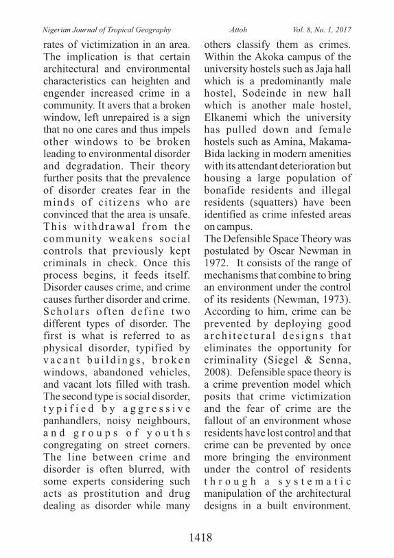
rates of victimization in an area. The implication is that certain architectural and environmental characteristics can heighten and engender increased crime in a community. It avers that a broken window, left unrepaired is a sign that no one cares and thus impels other windows to be broken leading to environmental disorder and degradation. Their theory further posits that the prevalence of disorder creates fear in the minds of c i t izens who are convinced that the area is unsafe. Th i s w i thd rawa l f rom the community weakens social controls that previously kept criminals in check. Once this process begins, it feeds itself. Disorder causes crime, and crime causes further disorder and crime. Scholars o f ten def ine two different types of disorder. The first is what is referred to as physical disorder, typified by v a c a n t b u i l d i n g s , b r o k e n windows, abandoned vehicles, and vacant lots filled with trash. The second type is social disorder, t y p i f i e d b y a g g r e s s i v e panhandlers, noisy neighbours, a n d g r o u p s o f y o u t h s congregating on street corners. The line between crime and disorder is often blurred, with some experts considering such acts as prostitution and drug dealing as disorder while many
others classify them as crimes. Within the Akoka campus of the university hostels such as Jaja hall which is a predominantly male hostel, Sodeinde in new hall which is another male hostel, Elkanemi which the university has pulled down and female hostels such as Amina, Makama-Bida lacking in modern amenities with its attendant deterioration but housing a large population of bonafide residents and illegal residents (squatters) have been identified as crime infested areas on campus. The Defensible Space Theory was postulated by Oscar Newman in 1972. It consists of the range of mechanisms that combine to bring an environment under the control of its residents (Newman, 1973). According to him, crime can be prevented by deploying good a r ch i t e c tu r a l de s igns t ha t eliminates the opportunity for criminality (Siegel & Senna, 2008). Defensible space theory is a crime prevention model which posits that crime victimization and the fear of crime are the fallout of an environment whose residents have lost control and that crime can be prevented by once more bringing the environment under the control of residents t h r o u g h a s y s t e m a t i c manipulation of the architectural designs in a built environment.
1418
Nigerian Journal of Tropical Geography Attoh Vol. 8, No. 1, 2017
The theory avers that crime is a product of spatiality, an outcome of the interaction between a potential criminal or a criminal and the architectural designs of a built environment. The defensible space theory is traced to the Chicago School of Criminology founded by Robert Part and Ernest Burgess in their quest to find a s o l u t i o n t o t h e s o c i a l disorganization that characterized the city of Chicago in the 1920s. Defensible space theory therefore is a range of real and symbolic barriers, strongly defined areas of i n f l u e n c e a n d i m p r o v e d opportunities for surveillance that h e l p r e s i d e n t s o w n t h e i r environment (Newman, 1972, Emmitt, 2002). According to Baskanligi (2011), the theory is anchored on two models namely the situational model and the community model. He argues that the situational model prevents c r i m e b y e l i m i n a t i n g t h e opportunities for crime to happen whereas the community model brings the environment under the control of the residents who defend their space to achieve greater security. This is achieved by deploying three main strategies namely natural surveillance, natural access control and territoriality. Natural surveillance is the ability to see into or out from the space (Baskanligi, 2011).
S u r v e i l l a n c e i s t h e c l o s e observation of persons and events. For instance, when buildings are designed with doors and windows that look into streets and parks, parking lots, pedestrian friendly streets with adequate lighting, etc. c r ime i s t hus de t e r r ed by i n c r e a s i n g t h e o f f e n d e r ' s perception of greater risk of recognition or apprehension. Natural access control consists of symbolic and real barriers that prevents crime by increasing the risk of apprehension when a criminal enters a building. With the use of architectural landscape, access to private or privatised areas is denied. This is achieved by placing entrances, exits, perimeter fencing, lighting, l andscap ing and boundary markers to increase the possibility of apprehension or recognition. Terri torial i ty is the use of architectural and landscape structural elements to create a sense of ownership in residents and legitimate users. Territoriality enables residents to recognise fellow residents from strangers and to determine what constitutes acceptable norms of behaviour within the sphere of influence. The territorial space is further reinforced through environmental laundry which is improving the physical appearance of a space by cleaning and cleansing it from
1419
Nigerian Journal of Tropical Geography Attoh Vol. 8, No. 1, 2017
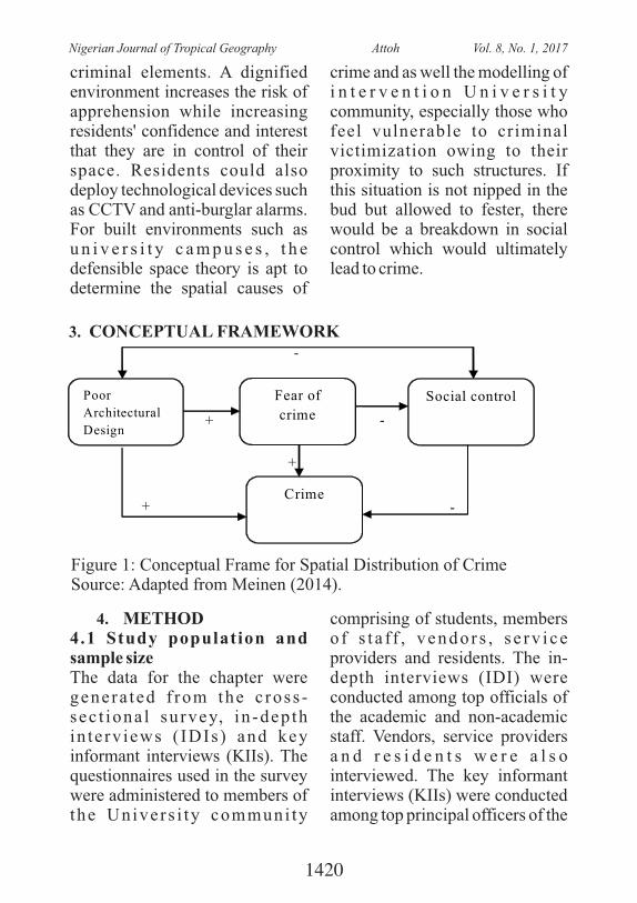
criminal elements. A dignified environment increases the risk of apprehension while increasing residents' confidence and interest that they are in control of their space. Residents could also deploy technological devices such as CCTV and anti-burglar alarms. For built environments such as u n i v e r s i t y c a m p u s e s , t h e defensible space theory is apt to determine the spatial causes of
crime and as well the modelling of i n t e r v e n t i o n U n i v e r s i t y community, especially those who feel vulnerable to criminal victimization owing to their proximity to such structures. If this situation is not nipped in the bud but allowed to fester, there would be a breakdown in social control which would ultimately lead to crime.
3. CONCEPTUAL FRAMEWORK
Poor
Architectural
Design
Fear of
crime
Social control
Crime
+
+
- +
-
-
4. METHOD4.1 Study population and sample sizeThe data for the chapter were genera ted f rom the c ross -sec t iona l su rvey, in -dep th in te rv iews ( IDIs ) and key informant interviews (KIIs). The questionnaires used in the survey were administered to members of the Univers i ty communi ty
comprising of students, members o f s t a f f , v en d o r s , s e r v i ce providers and residents. The in-depth interviews (IDI) were conducted among top officials of the academic and non-academic staff. Vendors, service providers a n d r e s i d e n t s w e r e a l s o interviewed. The key informant interviews (KIIs) were conducted among top principal officers of the
Figure 1: Conceptual Frame for Spatial Distribution of CrimeSource: Adapted from Meinen (2014).
1420
Nigerian Journal of Tropical Geography Attoh Vol. 8, No. 1, 2017
University, top security officials and security officers posted in strategic locations on campus such as hostels, staff school, and other strategic areas on campus. The reason for selecting these g r o u p s o f p e o p l e f o r t h e qualitative data was that they will be able to share their experiences and their views will reflect the general perception of the people in the study area about the spatial distribution of crime in the University of Lagos.
4.2 Sampling TechniquesFor the cross sectional survey a quota sampling technique was adopted. A quota sampling technique is one in which certain proportions of the sample are reserved for certain groups or categories of respondents. In using quota sampling technique, the researcher first of all decides on how many of the elements in different classes or categories will be included in the sample. Having decided this, the subjects who match the quota factors are se lec ted non- randomly. In adopting this technique, the population was categorized into students, members of staff, and others. The category of others inc luded t raders , a r t i sans , vendors, and other persons who are on campus. A sample size of 550 respondents was selected
comprising 400 students, 100 m e m b e r s o f s t a f f a n d 5 0 categorized as others.
4.3 In-Depth Interview (IDI) and Key Informant Interview (KII)
The In-Depth Interview (IDI) and Key Informant Interview were two qualitative research methods adopted to complement the generated quantitative data from the cross-sectional survey. KII and IDI are research methods w h e r e e v e r y s t a k e h o l d e r identified by the researcher is asked specific questions in a discussion atmosphere about his/her perception and opinion on spatial distribution of crime on campus, how environmental and architectural designs on campus influence crime and the general s e c u r i t y s i t u a t i o n o f t h e University community. The essence of the KII and IDI are to allow respondents share their divergent views about the subject matter of the study. Unlike the questionnaire which may not allow the respondents give details of their experiences of crime, witness to crime and their views about the architectural designs and crime on campus, the KII and I D I g a v e r e s p o n d e n t s t h e opportunity to air their views freely and elaborately. Thus, a total number of 30 IDIs and 18
1421
Nigerian Journal of Tropical Geography Attoh Vol. 8, No. 1, 2017
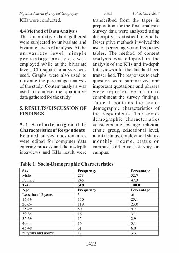
KIIs were conducted.
4.4 Method of Data AnalysisThe quantitative data gathered were subjected to univariate and bivariate levels of analysis. At the u n i v a r i a t e l e v e l , s i m p l e p e r c e n t a g e a n a l y s i s w a s employed while at the bivariate level, Chi-square analysis was used. Graphs were also used to illustrate the percentage analysis of the study. Content analysis was used to analyse the qualitative data gathered for the study.
5. RESULTS/DISCUSSION OF FINDINGS
5 . 1 S o c i o d e m o g r a p h i c Characteristics of RespondentsReturned survey questionnaires were edited for computer data entering process and the in-depth interviews and KIIs result were
transcribed from the tapes in preparation for the final analysis. Survey data were analyzed using descriptive statistical methods. Descriptive methods involved the use of percentages and frequency tables. The method of content analysis was adopted in the analysis of the KIIs and In-depth Interviews after the data had been transcribed. The responses to each question were summarized and important quotations and phrases were repor ted verbat im to compliment the survey findings. Table 1 contains the socio-demographic characteristics of the respondents. The socio-demographic characteristics considered are sex, age, religion, ethnic group, educational level, marital status, employment status, monthly income, s tatus on campus, and place of stay on campus.
Table 1: Socio-Demographic Characteristics
Sex Frequency Percentage Male 273 52.7 Female 245 47.3 Total 518 100.0 Age Frequency Percentage Less than 15 years 3 .6 15-19 130 25.1 20-24 119 23.0 25-29 50 9.7 30-34 16 3.1 35-39 15 2.9 40-44 16 3.1 45-49 31 6.0 50 years and above 17 3.3
1422
Nigerian Journal of Tropical Geography Attoh Vol. 8, No. 1, 2017
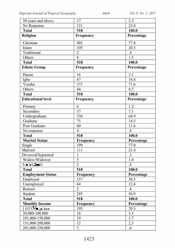
50 years and above 17 3.3 No Response 121 23.4 Total 518 100.0 Religion Frequency Percentage
Christian 403 77.8 Islam 105 20.3 Traditional 2 .4 Others 8 1.5 Total 518 100.0 Ethnic Group Frequency Percentage
Hausa 16 3.1 Igbo 87 16.8 Yoruba 371 71.6 Others 44 8.5 Total 518 100.0 Educational level Frequency Percentage
Primary 6 1.2 Secondary 37 7.1 Undergraduate 336 64.9 Graduate 75 14.5 Post Graduate 60 11.6 No response 4 .8 Total 518 100.0 Marital Status Frequency Percentage Single 399 77.0 Married 111 21.4 Divorced/Separated 1 .2 Widow/Widower 5 1.0
b ◘ ʼnśℓ♫◘■ℓś 2 .4 Total 518 100.0 Employment Status Frequency Percentage Employed 157 30.3 Unemployed 64 12.4 Retired 2 .4 Student 295 56.9 Total 518 100.0 Monthly Income Frequency Percentage
[ śℓℓ Ċ╙Ă■ ھھھھي 105 20.3 50,000-100,000 18 3.5 101,000-150,000 19 3.7 151,000-200,000 12 2.3 201,000-250,000 3 .6
1423
Nigerian Journal of Tropical Geography Attoh Vol. 8, No. 1, 2017
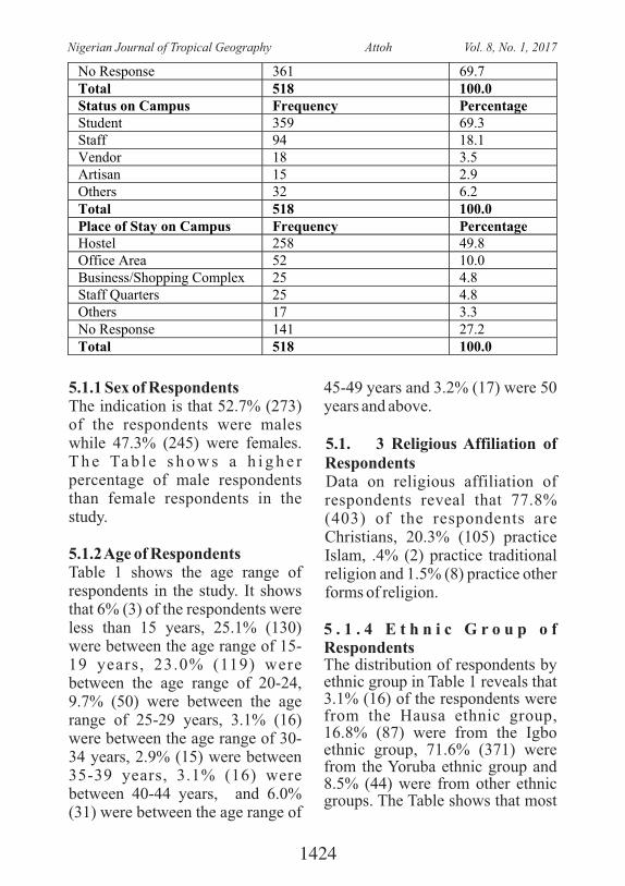
5.1.1 Sex of RespondentsThe indication is that 52.7% (273) of the respondents were males while 47.3% (245) were females. T h e Ta b l e s h o w s a h i g h e r percentage of male respondents than female respondents in the study.
5.1.2 Age of RespondentsTable 1 shows the age range of respondents in the study. It shows that 6% (3) of the respondents were less than 15 years, 25.1% (130) were between the age range of 15-19 years, 23.0% (119) were between the age range of 20-24, 9.7% (50) were between the age range of 25-29 years, 3.1% (16) were between the age range of 30-34 years, 2.9% (15) were between 35-39 years, 3.1% (16) were between 40-44 years, and 6.0% (31) were between the age range of
45-49 years and 3.2% (17) were 50 years and above.
5.1. 3 Religious Affiliation of RespondentsData on religious affiliation of respondents reveal that 77.8% (403) of the respondents are Christians, 20.3% (105) practice Islam, .4% (2) practice traditional religion and 1.5% (8) practice other forms of religion.
5 . 1 . 4 E t h n i c G r o u p o f RespondentsThe distribution of respondents by ethnic group in Table 1 reveals that 3.1% (16) of the respondents were from the Hausa ethnic group, 16.8% (87) were from the Igbo ethnic group, 71.6% (371) were from the Yoruba ethnic group and 8.5% (44) were from other ethnic groups. The Table shows that most
No Response 361 69.7 Total 518 100.0 Status on Campus Frequency Percentage Student 359 69.3 Staff 94 18.1 Vendor 18 3.5 Artisan 15 2.9 Others 32 6.2 Total 518 100.0 Place of Stay on Campus Frequency Percentage Hostel 258 49.8 Office Area 52 10.0 Business/Shopping Complex 25 4.8 Staff Quarters 25 4.8 Others 17 3.3 No Response 141 27.2 Total 518 100.0
1424
Nigerian Journal of Tropical Geography Attoh Vol. 8, No. 1, 2017
of the respondents were from the Yoruba ethnic group. And this is not surprising since the university is domiciled in the South-west of Nigeria.
5.1.5 Educational Level of RespondentsData on educational level of respondents show that 1.2% (6) of the respondents had completed their primary education, 7.1% (37) had secondary level education, 64.9% (336) were undergraduate students, 14.5% (75) had a first degree certificate and 11.6% (60) had post graduate certificate. The Table reveals that most of the respondents were undergraduate students and this is due to the fact that they constitute the major c a t e g o r y i n t h e U n i v e r s i t y community.
5 . 1 . 6 M a r i t a l S t a t u s o f RespondentsThe distribution of respondents by marital status shows that 77.0% (399) of the respondents were single, 21.4% (111) were married, .2% (1) was divorced and 1.0% (5) were widowed. The Table shows that majority of the respondents was single. This could be attributed to the fact that most of them were undergraduate students. 5.1.7 Employment and Monthly Income of RespondentsWith respect to the employment status of respondents, Table 1 indicates that 30.0% (157) was employed , 12 .4% (64 ) was unemployed, .4% (2) was retired
and 56.9% (295) were students. Similarly, the distribution of respondents by monthly income reveals that 20.3% (105) of the respondents earned less than #50,000, 3.5% (18) earned between #50,000-#100,000, 3.7% (19) e a r n e d b e t w e e n # 1 0 1 , 0 0 0 -#150,000, 2.3% (12), earned between #151,000-#200,000 and .6% (3) earned between #201,000-#250,000.
5.1.8 Status of Respondents on CampusData on status of respondents on campus shows that 69.3% (359) of the respondents were students, 18.1% (94) were staff, 3.5% (18) were vendors, 2.9% (15) were artisans and 6.2% (32) formed other categories such as service providers like cleaners, laundry men and women.
5.1.9 Respondents' Place of Stay on CampusTable 1 shows the distribution of respondents by place of stay on campus. The Table reveals that 49.8% of the respondents stayed in the hostel, 10.0% (52) stayed in the office area, 4.8% (25) stayed in the business/shopping complex in school, and 4.8% (25) stayed in staff quarters while 3.3% (17) stayed in other locations in the school such as in their faculty.
1425
Nigerian Journal of Tropical Geography Attoh Vol. 8, No. 1, 2017
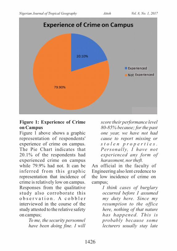
Figure 1: Experience of Crime on CampusFigure 1 above shows a graphic representation of respondents' experience of crime on campus. The Pie Chart indicates that 20.1% of the respondents had experienced crime on campus while 79.9% had not. It can be inferred f rom this graphic representation that incidence of crime is relatively low on campus. Responses from the qualitative study also corroborate this o b s e r v a t i o n . A c o b b l e r interviewed in the course of the study attested to the relative safety on campus;
To me, the security personnel have been doing fine. I will
score their performance level 80-85% because; for the past one year, we have not had cause to report missing or s t o l e n p r o p e r t i e s . Personal ly, I have not experienced any form of harassment, nor theft.
An official in the faculty of Engineering also lent credence to the low incidence of crime on campus;
I think cases of burglary occurred before I assumed my duty here. Since my resumption to the office here, nothing of that nature has happened. This is probably because some lecturers usually stay late
1426
Nigerian Journal of Tropical Geography Attoh Vol. 8, No. 1, 2017
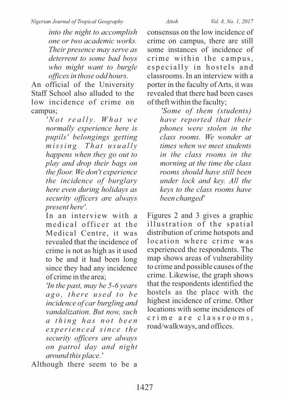
into the night to accomplish one or two academic works. Their presence may serve as deterrent to some bad boys who might want to burgle offices in those odd hours.
An official of the University Staff School also alluded to the low incidence of crime on campus;
' N o t r e a l l y . W h a t w e normally experience here is pupils' belongings getting m i s s i n g . T h a t u s u a l l y happens when they go out to play and drop their bags on the floor. We don't experience the incidence of burglary here even during holidays as security officers are always present here'.In an interview with a med ica l o f f i c e r a t t he Medical Centre, i t was revealed that the incidence of crime is not as high as it used to be and it had been long since they had any incidence of crime in the area;'In the past, may be 5-6 years a g o , t h e re u s e d t o b e incidence of car burgling and vandalization. But now, such a t h i n g h a s n o t b e e n e x p e r i e n c e d s i n c e t h e security officers are always on patrol day and night around this place.'
Although there seem to be a
consensus on the low incidence of crime on campus, there are still some instances of incidence of c r ime w i th in t he campus , e s p e c i a l l y i n h o s t e l s a n d classrooms. In an interview with a porter in the faculty of Arts, it was revealed that there had been cases of theft within the faculty;
'Some of them (students) have reported that their phones were stolen in the class rooms. We wonder at times when we meet students in the class rooms in the morning at the time the class rooms should have still been under lock and key. All the keys to the class rooms have been changed'
Figures 2 and 3 gives a graphic i l l u s t r a t i on o f t he spa t i a l distribution of crime hotspots and loca t ion where c r ime was experienced the respondents. The map shows areas of vulnerability to crime and possible causes of the crime. Likewise, the graph shows that the respondents identified the hostels as the place with the highest incidence of crime. Other locations with some incidences of c r i m e a r e c l a s s r o o m s , road/walkways, and offices.
1427
Nigerian Journal of Tropical Geography Attoh Vol. 8, No. 1, 2017
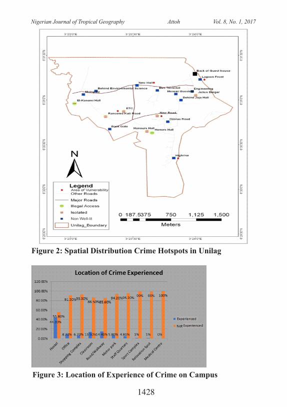
Figure 2: Spatial Distribution Crime Hotspots in Unilag
Figure 3: Location of Experience of Crime on Campus
1428
Nigerian Journal of Tropical Geography Attoh Vol. 8, No. 1, 2017
5.2 Locational Pattern of Crimes in the University of Lagos5.2.1 Experience of Crime in the HostelsIt is shown in Figure 2 that out of t h e r e s p o n d e n t s w h o h a d experienced crime, 44.2% (46) had experienced crime in the hostels while 55.7% (58) had not. The Figure shows that almost half of the respondents who had experienced crime on campus had their experience in the hostels.5.2.2 Experience of Crime in the OfficeData on experience of crime in the office shows that 8.7% (9) of the respondents had experienced crime in the office while 91.3% had not. The data presents a relatively low percentage of experience of crime in the office. This implies that office areas are relatively secure compared to hostels on campus.5.2.3 Experience of Crime in the Shopping ComplexFigure 2 shows that 6.7% (7) of the respondents had experienced crime in the shopping complex areas while 93.3% (97) had not. This finding suggests that there is a relatively low incidence of crime in the shopping complex areas.5.2.4 Experience of Crime in the ClassroomData on experience of crime in the classroom shows that 13.5% (14)
o f t h e r e s p o n d e n t s h a d experienced crime in the class rooms while 86.5% (90) had not. This shows that fewer students had experienced crime in the class rooms.5.2.5 Experience of Crime on the Road/Walkway and Motor ParkFigure 2 indicates that 14.4% of the respondents had experienced crime on the road/walkways while 85.6% had not. In like manner, the distribution of respondents based on experience of crime at the motor park shows that 5.8% (6) of the respondents has experienced crime at the motor park while 94.2% (98) had not. 5.2.6 Experience of Crime in Staff QuartersData on experience of crime in staff quarters reveal that 4.8% (5) o f t h e r e s p o n d e n t s h a d experienced crime in the staff quarters while 95.2% had not. 5.2.7 Experience of Crime at Sports ComplexFigure 2 shows that 1% (1) of the respondents had experienced crime at the sports center while 99% (103) had not. This data indicates a very low incidence of crime at the sports center.5.2.8 Experience of Crime at the Relaxation CentreThe distribution of respondents on experience of crime at the relaxation center shows that 1%
1429
Nigerian Journal of Tropical Geography Attoh Vol. 8, No. 1, 2017
(1) of the respondents had e x p e r i e n c e d c r i m e a t t h e relaxation center while 99% (103) had not. 5.2.9 Experience of Crime at the Medical CentreFigure 2 shows that none of the respondents had experienced crime at the medical center.S o m e r e s p o n s e s f r o m t h e qualitative study (IDI and KII) with respect to locations on campus with incidence of crime corroborate the data from the quantitative survey. According to a top member of staff:
'The issue of petty theft is quite common in the students' hostels. They always come up w i t h c o m p l a i n t s l i k e , 'somebody stole my laptop', 'somebody stole my wallet', 'and somebody stole my phone'. This is very common usually in the students ' hostels. There is also the issue of breaking into people's cars. This is rampart around the sport centre, and occasionally in some faculties'. 'People park their cars and go away, and come and discover that someone has broken into their cars. Of course, there is the issue of drug on campus. Quite a number of students have been apprehended smoking marijuana, been intoxicated by some other
more potent drugs. These are some of the challenges we face in terms of securi ty on campus.'
Similarly, an insider in the Faculty of Arts identified hostel areas as being prone to crime;
'Crime prone areas on campus are those close to the students' hostels, especially now that substance abuse is a common p h e n o m e n o n a m o n g students'. And drug abuse is something perpetrated by cult boys and girls. On the surface i t seems tha t cu l t s are nonexistent because of the university zero tolerance on cultism. This has driven them underground. You find them hanging out in isolated places on campus.
According to a security officer in Sodehinde hall, more security officers should be posted to hostels to ensure security within the hostels;
'You don't expect the security man monitoring the entrance of this hostel to know what is going on inside. And not two or three officers should be posted to this hostel; at least four at a time. Because when two officers are at the gate checking people in, the other two would be inside moving a ro u n d , w a t c h i n g t h e
1430
Nigerian Journal of Tropical Geography Attoh Vol. 8, No. 1, 2017
movement of the students. In fac t , some s tuden t s do challenge us when we move around telling us there is no problem. In female hostels, male security officers have limits to their movement around the hostel as some of them don't normally dress well and they can allege that you are peeping at them. That is the challenge in the female hostels. But crime is minimal in the female hostels'. We only record cases of theft of p h o n e s , d r e s s e s a n d occasionally a laptop.
In the same vein, a security officer in Jaja hall also expressed the view that more security personnel should be posted to the hostels for effective security of lives and properties;
'You won't have issues with students once you know what you are doing. There is shortage of staff. Work that is supposed to be done by 3 people would be done by one person and you expect perfect p e r f o r m a n c e . I t i s n o t possible. The work cannot be perfect. He would only try his best. If they can post to this Jaja hall 5 persons in the morning, 5 in the afternoon, and 5 in the evening is not too much. The stress of checking people coming in alone is not something 2 persons can
handle. We are just using our brain. How will 2 of us here be able to go round the hall to see what is happening inside? We just manage to do that' and mind you this Jaja and Sodeinde are places where you find some of these cult boys hanging out but we accost them once we notice such movements.
For a top official in the Engineering Faculty, the faculty and staff quarters are relatively secure. He also noted that proper identification of people in the University community would help in reducing incidence of crime on campus;
'The s ta f f quarters are re l a t i v e l y s e c u re . T h e problem of security in this community is lack of proper identification of who is who. The University of Lagos is a public property where a large number of people visit every day. The University authority is trying to address the problem of identification through the introduction of bio metrics for both the staff and the students. But that gesture has not been extended to other members of the community like business owners on campus'. And this I consider a big challenge.
In a key informant interview with
1431
Nigerian Journal of Tropical Geography Attoh Vol. 8, No. 1, 2017
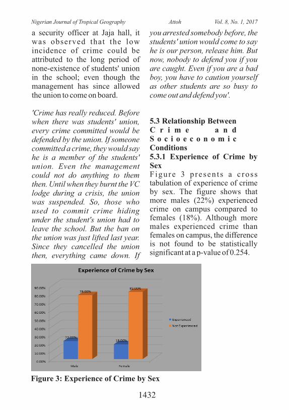
a security officer at Jaja hall, it was observed that the low incidence of crime could be attributed to the long period of none-existence of students' union in the school; even though the management has since allowed the union to come on board.
'Crime has really reduced. Before when there was students' union, every crime committed would be defended by the union. If someone committed a crime, they would say he is a member of the students' union. Even the management could not do anything to them then. Until when they burnt the VC lodge during a crisis, the union was suspended. So, those who used to commit crime hiding under the student's union had to leave the school. But the ban on the union was just lifted last year. Since they cancelled the union then, everything came down. If
you arrested somebody before, the students' union would come to say he is our person, release him. But now, nobody to defend you if you are caught. Even if you are a bad boy, you have to caution yourself as other students are so busy to come out and defend you'.
5.3 Relationship Between C r i m e a n d S o c i o e c o n o m i c Conditions5.3.1 Experience of Crime by SexFigure 3 p re sen t s a c ros s tabulation of experience of crime by sex. The figure shows that more males (22%) experienced crime on campus compared to females (18%). Although more males experienced crime than females on campus, the difference is not found to be statistically significant at a p-value of 0.254.
Figure 3: Experience of Crime by Sex
1432
Nigerian Journal of Tropical Geography Attoh Vol. 8, No. 1, 2017
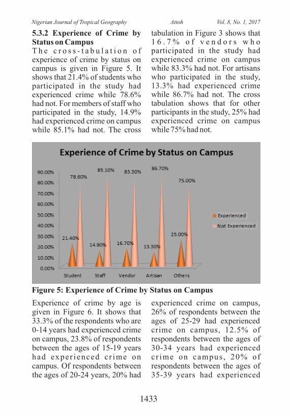
5.3.2 Experience of Crime by Status on CampusT h e c r o s s - t a b u l a t i o n o f experience of crime by status on campus is given in Figure 5. It shows that 21.4% of students who participated in the study had experienced crime while 78.6% had not. For members of staff who participated in the study, 14.9% had experienced crime on campus while 85.1% had not. The cross
tabulation in Figure 3 shows that 1 6 . 7 % o f v e n d o r s w h o participated in the study had experienced crime on campus while 83.3% had not. For artisans who participated in the study, 13.3% had experienced crime while 86.7% had not. The cross tabulation shows that for other participants in the study, 25% had experienced crime on campus while 75% had not.
Figure 5: Experience of Crime by Status on Campus
Experience of crime by age is given in Figure 6. It shows that 33.3% of the respondents who are 0-14 years had experienced crime on campus, 23.8% of respondents between the ages of 15-19 years had exper ienced c r ime on campus. Of respondents between the ages of 20-24 years, 20% had
experienced crime on campus, 26% of respondents between the ages of 25-29 had experienced crime on campus, 12.5% of respondents between the ages of 30-34 years had experienced c r ime on campus , 20% of respondents between the ages of 35-39 years had experienced
1433
Nigerian Journal of Tropical Geography Attoh Vol. 8, No. 1, 2017
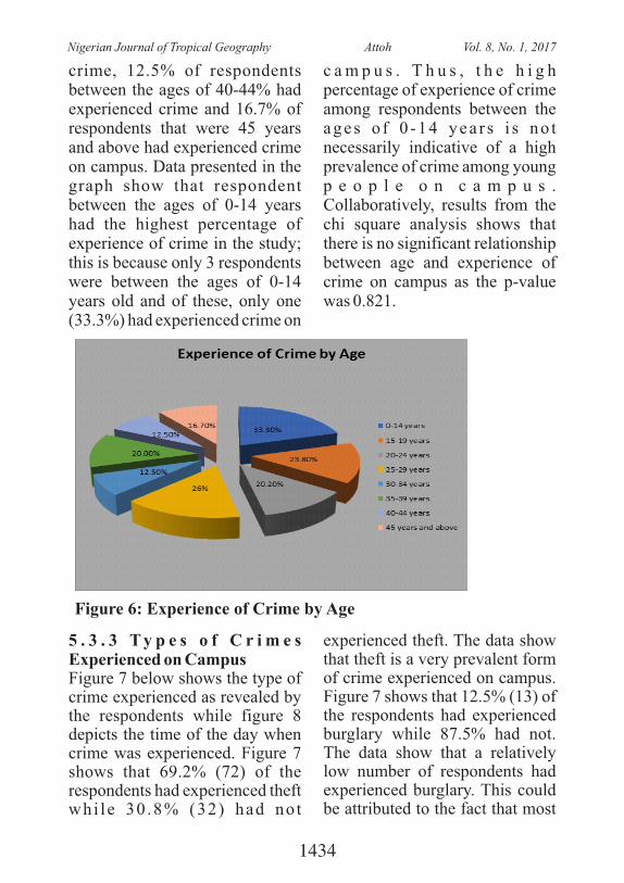
crime, 12.5% of respondents between the ages of 40-44% had experienced crime and 16.7% of respondents that were 45 years and above had experienced crime on campus. Data presented in the graph show that respondent between the ages of 0-14 years had the highest percentage of experience of crime in the study; this is because only 3 respondents were between the ages of 0-14 years old and of these, only one (33.3%) had experienced crime on
c a m p u s . T h u s , t h e h i g h percentage of experience of crime among respondents between the ages o f 0 -14 yea r s i s no t necessarily indicative of a high prevalence of crime among young p e o p l e o n c a m p u s . Collaboratively, results from the chi square analysis shows that there is no significant relationship between age and experience of crime on campus as the p-value was 0.821.
Figure 6: Experience of Crime by Age
5 . 3 . 3 T y p e s o f C r i m e s Experienced on CampusFigure 7 below shows the type of crime experienced as revealed by the respondents while figure 8 depicts the time of the day when crime was experienced. Figure 7 shows that 69.2% (72) of the respondents had experienced theft whi le 30 .8% (32) had no t
experienced theft. The data show that theft is a very prevalent form of crime experienced on campus. Figure 7 shows that 12.5% (13) of the respondents had experienced burglary while 87.5% had not. The data show that a relatively low number of respondents had experienced burglary. This could be attributed to the fact that most
1434
Nigerian Journal of Tropical Geography Attoh Vol. 8, No. 1, 2017
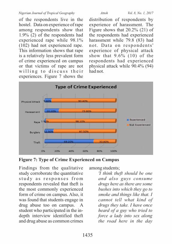
of the respondents live in the hostel. Data on experience of rape among respondents show that 1.9% (2) of the respondents had experienced rape while 98.1% (102) had not experienced rape. This information shows that rape is a relatively less prevalent form of crime experienced on campus or that victims of rape are not w i l l i n g t o d i s c u s s t h e i r experiences. Figure 7 shows the
distribution of respondents by experience of harassment. The Figure shows that 20.2% (21) of the respondents had experienced harassment while 79.8 (83) had no t . Da ta on responden t s ' experience of physical attack show that 9.6% (10) of the respondents had experienced physical attack while 90.4% (94) had not.
Figure 7: Type of Crime Experienced on Campus
Findings from the qualitative study corroborate the quantitative s t u d y a s r e s p o n s e s f r o m respondents revealed that theft is the most commonly experienced form of crime on campus. Also, it was found that students engage in drug abuse too on campus. A student who participated in the in-depth interview identified theft and drug abuse as common crimes
among students;'I think theft should be one and also guys consume drugs here as there are some bushes into which they go to smoke and things like that. I cannot tell what kind of drugs they take. I have once heard of a guy who tried to force a lady into sex along the road here in the day
1435
Nigerian Journal of Tropical Geography Attoh Vol. 8, No. 1, 2017
break. The lady screamed and the security men around came to arrest the situation'
Also, a medical officer at the Medical Centre alluded to the cases of assault and drug abuse among students;
'I have been working here for the past 15 years. Here we have received victims of assault and all that. When we are to compare the level of security in the university w i t h t h e s u r ro u n d i n g environments , we may conclude that some areas need to be addressed here. The area of substance abuse needs to be addressed. Whenever a pat ient is brought here, we normally run urine tests and the results are always amazing'.
With respect to incidence of drug abuse, a principal officer of the University stated that measures are put in place to deter students from getting involved in the act;
' T h e r e i s a l o t o f enlightenment on campus especially in relation to drug abuse by students, and the university has also acquired some tes t ing equipment at the Medical Centre. What they do there is that, if a student is suspected t o h a v e b e e n t a k i n g marijuana etc. they expose
the student to a critical test and the result comes out positive or negative as the case may be. These are things to have a check on the students, and once you are found to have been engaging in such practices, it now enters in to the soc ia l misconduct panel; you face the university panel.'
5 . 3 . 4 T i m e C r i m e w a s ExperiencedD a t a o n t i m e c r i m e w a s experienced is shown in Figure 8. The data reveal that 16.8% (17) of the respondents experienced crime between 12:00am-3:00am, 17.3% (18) experienced crime between 3:00am-6:00am, 12.5% (13) experienced crime between 6 : 0 0 a m - 9 : 0 0 a m , 5 . 8 % ( 6 ) experienced crime between 9:00am-12:00pm, 14.4% (15) of the respondents experienced crime between 12:00pm-3:00pm, 11.5% (12) experienced crime between 3:00-6:00pm, 10.6% (11) experienced crime between 6:00pm-9:00pm and 11.5% experienced crime between 9:00pm-12:00am. It can be seen that most of the crime experienced on campus occurred in the night between the hours of 12:00 am to 6:00 am.
1436
Nigerian Journal of Tropical Geography Attoh Vol. 8, No. 1, 2017
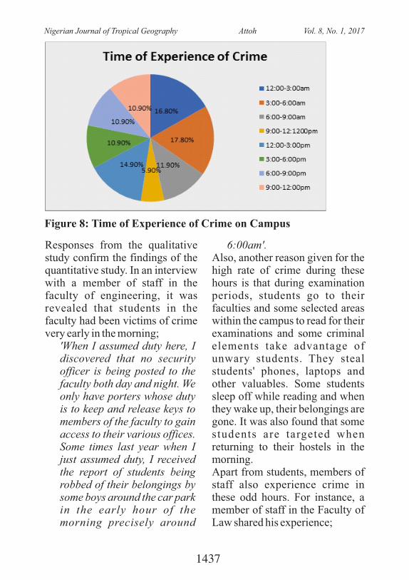
Figure 8: Time of Experience of Crime on Campus
Responses from the qualitative study confirm the findings of the quantitative study. In an interview with a member of staff in the faculty of engineering, it was revealed that students in the faculty had been victims of crime very early in the morning;
'When I assumed duty here, I discovered that no security officer is being posted to the faculty both day and night. We only have porters whose duty is to keep and release keys to members of the faculty to gain access to their various offices. Some times last year when I just assumed duty, I received the report of students being robbed of their belongings by some boys around the car park in the early hour of the morning precisely around
6:00am'.Also, another reason given for the high rate of crime during these hours is that during examination periods, students go to their faculties and some selected areas within the campus to read for their examinations and some criminal elements take advantage of unwary students. They steal students' phones, laptops and other valuables. Some students sleep off while reading and when they wake up, their belongings are gone. It was also found that some students are targeted when returning to their hostels in the morning. Apart from students, members of staff also experience crime in these odd hours. For instance, a member of staff in the Faculty of Law shared his experience;
1437
Nigerian Journal of Tropical Geography Attoh Vol. 8, No. 1, 2017
'I have had time to invite the security officers and they were cooperative. My house has been robbed three times in three years at the Ransom Kuti staff quarters. One of t he robbery happened around 3:00am. The robbers came into the house but couldn't get into my room. So, I was hearing their voices from inside my room. The burglary experience took place 4 months ago. The security officers were called a n d t h e y r a n s a c k e d everywhere in the house and asked if there was any suspect. I didn't really have any suspect'.
The resu l t s f rom both the quantitative and qualitative data show tha t despi te the low incidence of crime on campus that there are some areas on campus such as the hostels where the crime rate is worrisome especially as evidenced by the qualitative data. According to some of the respondents such places could do with more policing and logistics to further deter potential criminals.6 . C O N C L U S I O N S A N D RECOMMENDATIONSThe findings from the survey showed that theft is the most commonly reported crime on campus and this stems from the fact that the designs of some
bui ldings on campus offer criminals the cover to perpetrate crimes. Significantly, leaving hostels unrepaired gives the impression that the environment is now owned by anyone thus allowing cult members to hang out in front of such hostels. Examples are the Jaja, Mariere and new halls especially Sodeinde in the new hall. While some faculty buildings like Education and Arts were designed with too many entrances a n d e x i t s t h u s h a m p e r i n g surveillance to stem crime. The a b o v e c o r r o b o r a t e t h e postulations of (Newman,1972, Baskanligi, 2011) that residents have to own their environments by increasing guardianship. Certain fundamentals are imperative to increase security in a built environment such as a university campus. These include adequate pe rsonne l , communica t ion equipments, vehicles and other logistics to aid the work of the security unit. Evidence from the qualitative data revealed that there are some areas on campus that are not well lit. Some faculties experience challenges with good lighting at night while some faculties have not installed CCTV. In the light of the foregoing the following recommendations are made:-· T h e i n t r o d u c t i o n o f
motorized and foot patrols
1438
Nigerian Journal of Tropical Geography Attoh Vol. 8, No. 1, 2017
within the hostel areas especially the Amina hall axis, Jaja, Mariere and New hall between the hours of 12.00 am and 6.00 am to deter criminals.
· There is a need for all hostels to be fitted with CCTV cameras in order to capture daily activities in the hostel areas.
· The road from the AP filling station to the ISL round-about should be well lit and equally patrolled from 12.00 am to 6.00 am as there are reports of isolated assaults on that road.
· The un ive r s i t y shou ld e n d e a v o u r t o p r o v i d e telephone lines within a 'Closed User Group' (CUG) to all security personnel as they all complained of inadequate logist ics to facilitate their work.
· There is an urgent need to prosecute and sanction arrested criminals to act as a deterrent to others. Security e d u c a t i o n s h o u l d b e i n c o r p o r a t e d i n t o t h e orientation programme for freshmen to create security c o n s c i o u s n e s s a m o n g students.
Finally, the security unit should go beyond orthodox policing
stand embrace 21 century
policing which is anchored on intelligence gathering.
ReferencesBaskanligi, P.A.(2011). The Role
of Opportunity in Crime Prevention and Possible Threats of Crime Control Benefits. Turkish Journal of Police Studies, 13,(1), 77-114.
Emitt, S. (2002). Architectural Te c h n o l o g y. L o n d o n , Blackwell Science Ltd.
Groff, E. R. (2005). Simulating C r i m e P r e v e n t i o n Strategies: A Look at the P o s s i b i l i t i e s . I n https//www.researchgate.net/publication/228817396 viewed 10/11/16
M e i n e n , T . ( 2 0 1 4 ) . Neighbourhood disorder, cr ime and the Broken Wi n d o w s T h e o r y : A n e x a m i n a t i o n i n t o t h e r e l a t i o n s h i p b e t w e e n neighbourhood disorder and crime in the city districts of Rotterdam. MS.c Thesis Submitted to the Faculty of M a n a g e m e n t a n d Governance, University of Twente, Enschede
Newman, O. (1972). Defensible Space: Crime Prevention Through Urban Design. New York, Macmillan.
Sigel, L.J. and Senna, J.J. (2008).
1439
Nigerian Journal of Tropical Geography Attoh Vol. 8, No. 1, 2017
Introduction to Criminal J u s t i c e . C E N G A G E Learning.
Wilson, J.Q. and Kelling, G.L. (2003). Broken Windows: T h e P o l i c e a n d Neighbourhood Safety. In McLaughlin, E., Maurice, J. and Hughes, G. (eds). C r i m i n o l o g i c a l Perspectives: Essential Readings (2nd Edition). London, Sage Publications Ltd.
1440
Nigerian Journal of Tropical Geography Attoh Vol. 8, No. 1, 2017
INDICES BASED ANALYSIS OF DROUGHT AND
ARIDITY IN PARTS OF NIGERIA'S SAVANNAHO. Adegun & A.O. Ayeni
Department of Geography, University of Lagos, [email protected]@unilag.edu.ng
ABSTRACT: The study assessed the occurrence of drought and levels
of aridity at 5 selected areas in Nigeria's savannah region, between 1980
and 2010. The assessment of drought was based on Percent of Normal
Index, Rainfall Anomaly Index, and Normalised Rainfall Index, while
Budyko Aridity Index and De Martonne Aridity Index were used to
characterise the degree of dryness. The results showed a generally lower
occurrence of drought. Results based on the Percent of Normal Index
categorised 19, 13, 18, 13 and 21 years as being near normal and 4, 5, 4,
3, and 3 years as years in which slight drought was experienced at
Bauchi, Ilorin, Kaduna, Maiduguri and Minna respectively. The
Rainfall Anomaly Index classified a total of 5, 3, 7, 6, and 6 years as
extremely dry, while the Normalized Rainfall Index categorised 5, 9, 7,
9, and 6 years as being extremely below normal at Bauchi, Ilorin,
Kaduna, Maiduguri and Minna respectively. The annual level of aridity
based on Budyko Index showed that the areas experienced a
predominantly semi-humid phase during this period. Based on De
Martonne Aridity Index, a total of 9, 2, and 6 years were characterised
as semi-arid at Bauchi, Ilorin and Kaduna respectively, 29 years were
categorised as dry at Maiduguri, while 4 years were classified as semi-
arid at Minna. In spite of the normal to wet conditions that is currently
prevalent in this drought prone region, the study recommends that a
proactive drought management approach should be adopted. This would
assist in forestalling some of the negative consequences of drought and
ensure sustainable management of water resources at all times.
Keywords: Aridity; Drought; Index; Savannah; Water Resources
1441
Nigerian Journal of Tropical Geography Adegun and Ayeni Vol. 8, No. 1, 2017
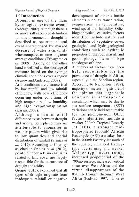
1.0 IntroductionDrought is one of the main hydrological extreme events (Adeaga, 2002). Although there is no universally accepted definition for this phenomenon, drought is described as recurrent natural event characterised by marked decrease of water availability when compared to some long term average conditions (Eriyagama et al, 2009). Aridity on the other hand is defined as the shortage of moisture based on the average climatic conditions over a region (Agnew and Anderson, 2009).Arid conditions are characterised by low rainfall and low rainfall efficiency, with low efficiency occurring under conditions of high temperature, low humidity and high evapotranspiration (Kassas, 2008).A l t h o u g h a f u n d a m e n t a l difference exists between drought and aridity, both phenomena are attributable to anomalies in weather pattern which gives rise to low quantities and spatial distribution of rainfall (Srinias et al, 2012). According to Charney as cited in Srinias et al (2012), positive feedback mechanisms related to land cover are largely responsible for the occurrence of drought and aridity. Gregor (2013), explained that all types of drought originate from inadequate rainfall or negative
development of other climatic elements such as transpiration, evaporation, air temperature, wind speed and humidity. Other biogeophysical causative factors identified include nature and distribution of vegetative cover, geological and hydrogeological conditions such as hydraulic properties of the rock massif, and geomorphology in terms of slope and degree of slope. A number of factors have been h e l d r e s p o n s i b l e f o r t h e prevalence of drought in Africa, especially in the Sahelian region. According to Nicholson (1989), majority of meteorologists are of the opinion that large-scale a n o m a l y i n a t m o s p h e r i c circulation which may be due to sea surface temperature (SST) variations can be held accountable for this phenomenon. Other factors identified include a weaker 200mb Tropical Easterly Jet (TEJ) , a s t ronger mid-tropospheric (700mb) African Easterly Jet (AEJ), a weaker shear in the 700mb Easterly Jet south of the equator, enhanced Hadley-type overturning and weaker Wa l k e r - t y p e o v e r t u r n i n g , increased geopotential of the 700mb surface, increased vertical shear over West Africa and the virtual disappearance of the 850mb trough through West Africa (Kidson, 1997; Tanka et
1442
Nigerian Journal of Tropical Geography Adegun and Ayeni Vol. 8, No. 1, 2017
a l . , 1 9 7 5 ; K a n a m i t s u a n d Krishnamurti, 1978; Newell and Kidson, 1979, 1984; Denett et al., 1985 as cited in Nicholson, 1989).With regards to aridity, Some´e et a l ( 2 0 1 2 ) n o t e d t h a t a r i d conditions are prevalent at l o c a t i o n s o f p e r s i s t e n t anticyclonic regime. It is caused by four main factors namely high a t m o s p h e r i c p r e s s u r e , continentality, rain shadow effect a n d c o l d o c e a n c u r r e n t s (Thompson, 1975; Agnew and Anderson, 1992). This condition is further sustained when the Hadley circulation is affected by negative net radiation balance due to increased surface reflectivity caused by loss of vegetal cover (Srinias et al, 2012).The preponderance of drought in many places across the world, as well as the need for identification, characterisation, quantification, assessment, monitoring and management of the drought phenomenon has therefore led to the development of several drought indices. Similarly, different aridity indices have been devised over time to quantify the degree of dryness of a climate at a given location.In the savannah region of Nigeria, especially in the North, aridity and drought are significant features of the climate. The three types of d r o u g h t ; m e t e o r o l o g i c a l ,
hydrological and agricultural drought is recurrent in this region, and these have often resulted in water stress and low agricultural productivity. In recognition of these facts and the need to provide adequate information for drought monitoring and management, indices based approaches were used to assess and characterise the level of drought severity and aridity at five selected locations in central and Northern Nigeria.2.0 Study AreaB a u c h i , I l o r i n , K a d u n a , Maiduguri and Minna bounded by
0 0Longitude 4 E and 14 E Latitude 0 0
8 N and 15 N are located in the savannah region of Nigeria (Fig.1). The climate of the region is subject to the control of the Tropical Maritime Air Mass in the rainy season and the Tropical Continental Air mass in the Dry season. Average rainfall varies between 500 mm and 1,000mm, and the number of rain days is be tween 40 and 100 days (Tarhule, 1997; Woo and Tarhule, 1994).The rainfall regime is unimodal, with shorter and lower magnitude rainy season. This situation is attributed to late onset and early cessation of the rains (Hess, 1999). The rainy season lasts from May to October. The intensity of rainfall in this region is highly variable with most intense rains
1443
Nigerian Journal of Tropical Geography Adegun and Ayeni Vol. 8, No. 1, 2017
falling between July and August. T h e a m o u n t a n d s e a s o n a l distribution of rainfall over the region is controlled by rainfall producing systems such as the disturbance lines, squall lines, and two tropospheric jet streams all of which are part of the Tropical
Maritime Air Mass (Ati, et al, 2007). The region is characterised b y a l l y e a r r o u n d h i g h temperature, with an average
0 0minimum range of 12 C to 18 C and an average maximum range of
0 035 C to 34 C (Chima, 2011).
3.0 MethodologyRainfall and temperature data for the period 1980 to 2010 for B a u c h i , I l o r i n , K a d u n a , Maiduguri and Minna were obtained from the Nigerian Meteorological Agency. The rainfall data was used to assess and characterise the severity of drought, while a combination of
the rainfall and temperature data were used to determine the degree of aridity at these locations.3.1 Drought Assessment and CharacterisationThree meteorological drought indices namely the Percent of Normal Index (PNI), Rainfall Anomaly Index (RAI), and
Fig.1: Study Locations
1444
Nigerian Journal of Tropical Geography Adegun and Ayeni Vol. 8, No. 1, 2017
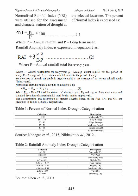
Normalised Rainfall Index (NRI) were utilised for the assessment and characterisation of drought at
the selected locations. The percent of Normal Index is expressed as:
PNI = Pi
P* 100 …………………… (1)
Where P = Annual rainfall and P = Long term meani
Rainfall Anomaly Index is expressed in equation 2 as:
Where P = Annual rainfall total for every year;
Table 1: Percent of Normal Index Drought Categorisation
Criterion Description = 110 Moderately Wet
80 - 110 Near Normal 70 - 80 Slight Drought 55 - 70 Moderate Drought 40 - 55 Severe Drought ? 40 Extreme Drought
Source: Nohegar et al., 2015; Nikbakht et al., 2012.
Table 2: Rainfall Anomaly Index Drought CategorisationCriterion Description
= 3.00 Extremely Wet 2 to 2.99 Very Wet 1 to 1.99 Moderately Wet
0.5 to 0.99 Slightly Wet 0.49 to – 0.49 Near Normal -0.50 to – 0.99 Slightly Dry -1.00 to – 1.99 Moderately Dry -2.00 to -2.99 Very Dry
= -3.00 Extremely Dry
Source: Shen et al., 2003.
1445
Nigerian Journal of Tropical Geography Adegun and Ayeni Vol. 8, No. 1, 2017
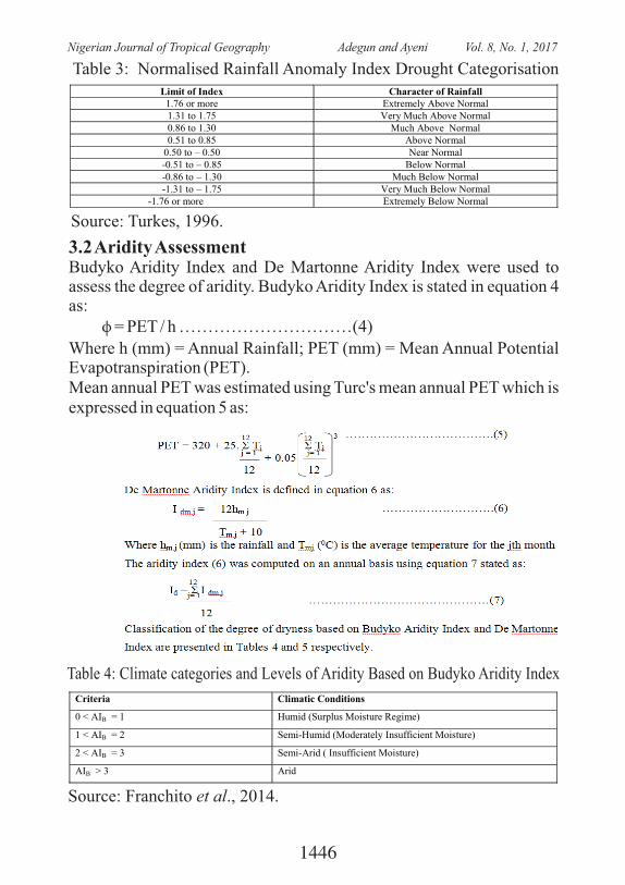
3.2 Aridity AssessmentBudyko Aridity Index and De Martonne Aridity Index were used to assess the degree of aridity. Budyko Aridity Index is stated in equation 4 as: ϕ = PET / h …………………………(4)
Where h (mm) = Annual Rainfall; PET (mm) = Mean Annual Potential Evapotranspiration (PET).Mean annual PET was estimated using Turc's mean annual PET which is expressed in equation 5 as:
Table 3: Normalised Rainfall Anomaly Index Drought CategorisationLimit of Index Character of Rainfall
1.76 or more Extremely Above Normal 1.31 to 1.75 Very Much Above Normal 0.86 to 1.30 Much Above Normal 0.51 to 0.85 Above Normal
0.50 to – 0.50 Near Normal -0.51 to – 0.85 Below Normal -0.86 to – 1.30 Much Below Normal -1.31 to – 1.75 Very Much Below Normal
-1.76 or more Extremely Below Normal
Source: Turkes, 1996.
Table 4: Climate categories and Levels of Aridity Based on Budyko Aridity Index
Criteria Climatic Conditions
0 < AIB = 1 Humid (Surplus Moisture Regime)
1 < AIB = 2 Semi-Humid (Moderately Insufficient Moisture)
2 < AIB = 3 Semi-Arid ( Insufficient Moisture)
AIB > 3 Arid
Source: Franchito et al., 2014.
1446
Nigerian Journal of Tropical Geography Adegun and Ayeni Vol. 8, No. 1, 2017
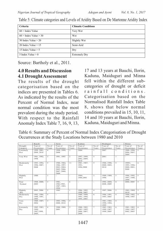
Table 5: Climate categories and Levels of Aridity Based on De Martonne Aridity Index
Criteria Climatic Conditions
60 > Index Value Very Wet
60 > Index Value > 30 Wet
30 Index Value > 20 Slightly Wet
20 Index Value > 15 Semi-Arid
15 Index Value > 5 Dry
5 Index Value > 0 Extremely Dry
Source: Bartholy et al., 2011.
4.0 Results and Discussion4.1 Drought AssessmentThe results of the drought categorisation based on the indices are presented in Tables 6. As indicated by the results of the Percent of Normal Index, near normal condition was the most prevalent during the study period. With respect to the Rainfall Anomaly Index Table 7, 16, 9, 13,
17 and 13 years at Bauchi, Ilorin, Kaduna, Maiduguri and Minna fell within the different sub-categories of drought or deficit r a i n f a l l c o n d i t i o n s . Categorisation based on the Normalised Rainfall Index Table 8, shows that below normal conditions prevailed in 15, 10, 11, 14 and 10 years at Bauchi, Ilorin, Kaduna, Maiduguri and Minna.
Table 6: Summary of Percent of Normal Index Categorisation of Drought Occurrences at the Study Locations between 1980 and 2010�
�
� B auchi Ilorin K aduna M aiduguri M inna D rought Category
Y ear of O ccurrence
N o of Y ears
Y ear of O ccurrence
N o of Y ears
Y ear of O ccurrence
N o of Y ears
Y ear of O ccurrence
N o of Y ears
Y ear of O ccurrence
N o of Y ears
Extremely W et
1999, 2001, 2009, 2010
4 1998, 1999, 2008
3 2004 1 2007 1 1988, 1994, 2006, 2007, 2009
5
V ery W et 1981, 1992, 1998
3 1991, 1995 2 1997, 1999, 2002, 2009, 2010
5 2001 1 - -
M oderately W et
1993, 1994, 1996, 2007, 2008
5 1980, 1984, 1986, 1997, 2003, 2004, 2005, 2006, 2007, 2008, 2009
11 1981, 1987, 1991, 1996,2000
5 1988, 1998, 2000, 2003, 2010
5 19991, 1995, 1996, 2000, 2001, 2008
6
Slightly W et
1980 1 - - 1984, 1988,2001
3 1980, 1989, 1996
3 1986, 1992, 1997, 1998, 1999
5
N ear N ormal
1988, 2000, 2005
3 1981, 1982,1983, 1987, 1993, 1994
6 - - 1992, 2004, 2008, 2009
4 2004, 2005 5
Slightly D ry
2003, 2006 2 1985 1 1986, 1992, 1998, 2003
4 1997, 2006 2 1985, 1989, 2010
3
M oderately D ry
1982, 1986, 1990, 1991, 1995
5 - - 1989, 1990, 1993, 1994, 1995, 2005
6 1986, 1991, 1993, 2002
4 1980, 1982, 1990, 1993
4
V ery D ry
1989, 1997, 2004
3 1992, 1996, 2000, 2010
5 - - 1981, 1985, 1990, 1994, 1995
5 - -
Extremely D ry
1982, 1983, 1984, 1987,1999, 2005,
6 1988, 1989, 2001
3 1980, 1982, 1983, 1985, 2006, 2007, 2008
7 1982, 1983, 1984, 1987, 1999, 2005
6 1981, 1983, 1984, 1987, 2002, 2003
6
1447
Nigerian Journal of Tropical Geography Adegun and Ayeni Vol. 8, No. 1, 2017
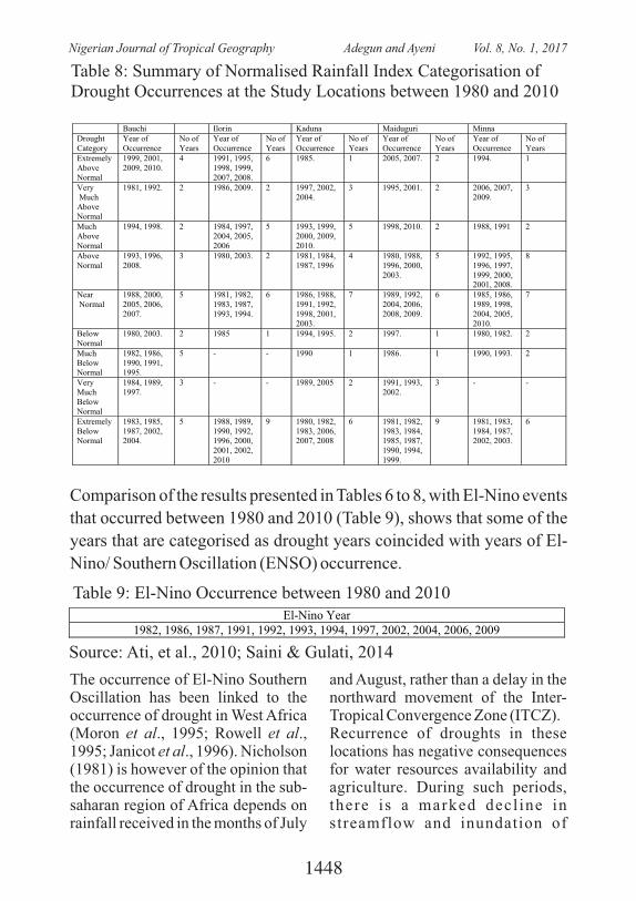
Table 8: Summary of Normalised Rainfall Index Categorisation of Drought Occurrences at the Study Locations between 1980 and 2010
Bauchi Ilorin Kaduna Maiduguri Minna Drought Category
Year of Occurrence
No of Years
Year of Occurrence
No of Years
Year of Occurrence
No of Years
Year of Occurrence
No of Years
Year of Occurrence
No of Years
Extremely Above Normal
1999, 2001, 2009, 2010.
4 1991, 1995, 1998, 1999, 2007, 2008.
6 1985. 1 2005, 2007. 2 1994. 1
Very Much Above Normal
1981, 1992. 2 1986, 2009. 2 1997, 2002, 2004.
3 1995, 2001. 2 2006, 2007, 2009.
3
Much Above Normal
1994, 1998. 2 1984, 1997, 2004, 2005, 2006
5 1993, 1999, 2000, 2009, 2010.
5 1998, 2010. 2 1988, 1991 2
Above Normal
1993, 1996, 2008.
3 1980, 2003. 2 1981, 1984, 1987, 1996
4 1980, 1988, 1996, 2000, 2003.
5 1992, 1995, 1996, 1997, 1999, 2000, 2001, 2008.
8
Near Normal
1988, 2000, 2005, 2006, 2007.
5 1981, 1982, 1983, 1987, 1993, 1994.
6 1986, 1988, 1991, 1992, 1998, 2001, 2003.
7 1989, 1992, 2004, 2006, 2008, 2009.
6 1985, 1986, 1989, 1998, 2004, 2005, 2010.
7
Below Normal
1980, 2003. 2 1985 1 1994, 1995. 2 1997. 1 1980, 1982. 2
Much Below Normal
1982, 1986, 1990, 1991, 1995.
5 - - 1990 1 1986. 1 1990, 1993. 2
Very Much Below Normal
1984, 1989, 1997.
3 - - 1989, 2005 2 1991, 1993, 2002.
3 - -
Extremely Below Normal
1983, 1985, 1987, 2002, 2004.
5 1988, 1989, 1990, 1992, 1996, 2000, 2001, 2002, 2010
9 1980, 1982, 1983, 2006, 2007, 2008
6 1981, 1982, 1983, 1984, 1985, 1987, 1990, 1994, 1999.
9 1981, 1983, 1984, 1987, 2002, 2003.
6
Comparison of the results presented in Tables 6 to 8, with El-Nino events
that occurred between 1980 and 2010 (Table 9), shows that some of the
years that are categorised as drought years coincided with years of El-
Nino/ Southern Oscillation (ENSO) occurrence.
Table 9: El-Nino Occurrence between 1980 and 2010El-Nino Year
1982, 1986, 1987, 1991, 1992, 1993, 1994, 1997, 2002, 2004, 2006, 2009
Source: Ati, et al., 2010; Saini & Gulati, 2014
The occurrence of El-Nino Southern Oscillation has been linked to the occurrence of drought in West Africa (Moron et al., 1995; Rowell et al., 1995; Janicot et al., 1996). Nicholson (1981) is however of the opinion that the occurrence of drought in the sub-saharan region of Africa depends on rainfall received in the months of July
and August, rather than a delay in the northward movement of the Inter-Tropical Convergence Zone (ITCZ).Recurrence of droughts in these locations has negative consequences for water resources availability and agriculture. During such periods, there is a marked decl ine in streamflow and inundation of
1448
Nigerian Journal of Tropical Geography Adegun and Ayeni Vol. 8, No. 1, 2017
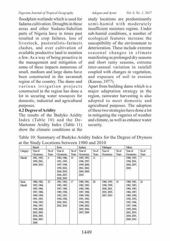
floodplain wetlands which is used for fadama cultivation. Droughts in these areas and other Sudano-Sahelian parts of Nigeria have in times past resulted in crop failures, loss of livestock, pastoralists-farmers clashes, and over cultivation of available productive land to mention a few. As a way of being proactive in the management and mitigation of some of these impacts numerous of small, medium and large dams have been constructed in the savannah region of the country. The dams and v a r i o u s i r r i g a t i o n p r o j e c t s constructed in the region has done a lot in securing water resources for domestic, industrial and agricultural purposes.4.2 Degree of AridityThe results of the Budyko Aridity Index (Table 10) and the De-Martonne Aridity Index (Table 11) show the climatic conditions at the
study locations are predominantly semi-humid wi th modera te ly insufficient moisture regime. Under sub-humid conditions, a number of ecological features increase the susceptibility of the environment to deterioration. These include extreme seasona l changes in c l ima te manifesting as prolonged dry seasons and short rainy seasons, extreme inter-annual variation in rainfall coupled with changes in vegetation, and exposure of soil to erosion (Kassas, 1977). Apart from building dams which is a major adaptation strategy in the region, rainwater harvesting is also adopted to meet domestic and agricultural purposes. The adoption of these two strategies have done a lot in mitigating the vagaries of weather and climate, as well as enhance water security.
Table 10: Summary of Budyko Aridity Index for the Degree of Dryness
at the Study Locations between 1980 and 2010
Bauchi Ilorin Kaduna Maiduguri Minna Category Year of
Occurrence No of Years
Year of Occurrence
No of Years
Year of Occurrence
No of Years
Year of Occurrence
No of Years
Year of Occurrence
No of Years
Humid 1981, 1992, 1999, 2001, 2009. 2010.
6 1984, 1986, 1991, 1995, 1997, 1998, 1999, 2003, 2004, 2005, 2006, 2007, 2008, 2009
14 1985, 1993, 1996, 1997, 1999, 2000, 2001, 2002, 2004, 2009, 2010
11 - - 1988, 1991, 1994, 2001, 2006, 2007, 2009.
7
Semi-Humid
1980, 1982, 1983, 1984, 1985, 1986, 1987, 1988, 1989, 1990, 1991, 1993, 1994, 1995, 1996, 1997, 1998, 2000, 2002, 2003, 2004, 2005, 2006, 2007, 2008.
25 1981, 1982, 1983, 1985, 1987, 1988, 1989, 1990, 1992, 1993, 1994, 1996, 2000, 2001, 2002, 2010
17 1980, 1981, 1982, 1983, 1984, 1986, 1987, 1988, 1989, 1990, 1991, 1992, 1994, 1995, 1998, 2003, 2005, 2006, 2007, 2008
20 1988, 1995, 1998, 1999, 2000, 2001, 2003, 2005, 2007, 2010
10 1980, 1981, 1982, 1983, 1984, 1985, 1986, 1987, 1989, 1990, 1992, 1993, 1995, 1996, 1997, 1998, 1999, 2000, 2002, 2003, 2004, 2005, 2008, 2010
24
1449
Nigerian Journal of Tropical Geography Adegun and Ayeni Vol. 8, No. 1, 2017
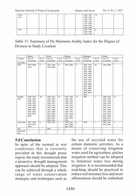
Semi-Arid
- - - - - - 1980, 1981, 1986, 1989, 1992, 1993, 1994, 1996, 1997, 2002, 2004, 2006, 2008, 2009.
15 - -
Arid - - - - - - 1982, 1983, 1984, 1985, 1987, 1990
6 - -
Table 11: Summary of De Martonne Aridity Index for the Degree of Dryness at Study Location
Bauchi Ilorin Kaduna Maiduguri Minna Category Year of
Occurrence No of Years
Year of Occurrence
No of Years
Year of Occurrence
No of Years
Year of Occurrence
No of Years
Year of Occurrence
No of Years
Very Wet - - - - - - - - - Wet 1999, 2009,
2010 3 1991, 1998,
1999, 2008 4 1985, 2004 2 1980, 1981,
1982, 1983, 1984, 1985, 1986, 1986, 1988, 1989, 1990, 1991, 1992, 1993, 1994, 1995, 1996, 1997, 1998, 2000, 2001, 2002, 2003, 2004, 2005,2006, 2008, 2009, 2010
29 1994, 2009.
Slightly Wet
1980, 1981, 1982, 1986, 1988, 1991, 1992, 1993, 1994, 1995, 1996, 1998, 2000, 2001, 2003, 2005, 2006, 2007, 2008
20 1980, 1981, 1982, 1983, 1984, 1985, 1986, 1987, 1990, 1992, 1993, 1994, 1995, 1996, 1997, 2000, 2002, 2003, 2004, 2005, 2006, 2007, 2009, 2010.
24 1981, 1984, 1986, 1987, 1988, 1989, 1990, 1991, 1992, 1993, 1994, 1995, 1996, 1997, 1998, 1999, 2000, 2001, 2002, 2003, 2005, 2009, 2010.
23 2007 1 1980, 1981, 1982, 1983, 1985, 1986, 1988, 1989, 1990, 1991, 1992, 1993, 1995, 1996, 1997, 1998, 1999, 2001, 2004, 2005, 2006, 2007, 2008, 2010
25
Semi-Arid 1983, 1984, 1985, 1987, 1989,
8 1988, 1989 2 1980, 1982, 1983, 2006, 2007, 2008
6 1999 1 1984, 1987, 2002, 2003
4
Dry - - 2001 1 - - - - - - Extremely Dry
- - - - - - - - - -
5.0 ConclusionIn spite of the normal to wet conditions that is currently prevalent in this drought prone region, the study recommends that a proactive drought management approach should be adopted. This can be achieved through a whole range of water conservation strategies and techniques such as
the use of recycled water for certain domestic activities. As a means of conserving irrigation water used for agriculture, pitcher irrigation method can be adopted to minimise water loss during irrigation. It is recommended that mulching should be practiced to reduce soil moisture loss and more afforestation should be embarked
1450
Nigerian Journal of Tropical Geography Adegun and Ayeni Vol. 8, No. 1, 2017
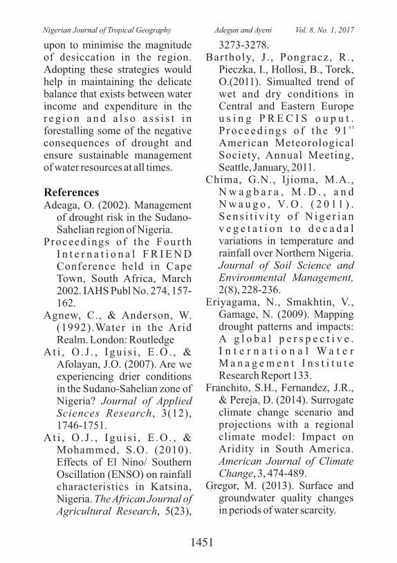
upon to minimise the magnitude of desiccation in the region. Adopting these strategies would help in maintaining the delicate balance that exists between water income and expenditure in the r e g i o n a n d a l s o a s s i s t i n forestalling some of the negative consequences of drought and ensure sustainable management of water resources at all times.
ReferencesAdeaga, O. (2002). Management
of drought risk in the Sudano-Sahelian region of Nigeria.
Proceedings of the Four th I n t e r n a t i o n a l F R I E N D Conference held in Cape Town, South Africa, March 2002. IAHS Publ No. 274, 157-162.
Agnew, C., & Anderson, W. (1992).Water in the Arid Realm. London: Routledge
At i , O . J . , I gu i s i , E .O . , & Afolayan, J.O. (2007). Are we experiencing drier conditions in the Sudano-Sahelian zone of Nigeria? Journal of Applied Sciences Research, 3(12), 1746-1751.
At i , O . J . , I gu i s i , E .O . , & Mohammed, S.O. (2010). Effects of El Nino/ Southern Oscillation (ENSO) on rainfall characteristics in Katsina, Nigeria. The African Journal of Agricultural Research, 5(23),
3273-3278.Bartholy, J . , Pongracz, R. ,
Pieczka, I., Hollosi, B., Torek, O.(2011). Simualted trend of wet and dry conditions in Central and Eastern Europe u s i n g P R E C I S o u p u t .
s tP r o c e e d i n g s o f t h e 9 1 American Meteorological Society, Annual Meeting, Seattle, January, 2011.
Chima, G.N., Ijioma, M.A., N w a g b a r a , M . D . , a n d N w a u g o , V. O . ( 2 0 1 1 ) . S e n s i t i v i t y o f N i g e r i a n v e g e t a t i o n t o d e c a d a l variations in temperature and rainfall over Northern Nigeria. Journal of Soil Science and Environmental Management, 2(8), 228-236.
Eriyagama, N., Smakhtin, V., Gamage, N. (2009). Mapping drought patterns and impacts: A g l o b a l p e r s p e c t i v e . I n t e r n a t i o n a l W a t e r M a n a g e m e n t I n s t i t u t e Research Report 133.
Franchito, S.H., Fernandez, J.R., & Pereja, D. (2014). Surrogate climate change scenario and projections with a regional climate model: Impact on Aridity in South America. American Journal of Climate Change, 3, 474-489.
Gregor, M. (2013). Surface and groundwater quality changes in periods of water scarcity.
1451
Nigerian Journal of Tropical Geography Adegun and Ayeni Vol. 8, No. 1, 2017
S p r i n g e r T h e s e s , D O I : 10.1007/978-3-642-32244-0_2,. Ó Springer-Verlag
Hess, T.M. (1999). The impact of climate variability over the period 1961-1990 on the soil water balance of upland soils in Northeast arid zone of Nigeria. (Doctoral theses). I n s t i t u t e o f Wa t e r a n d Env i ronmen t , C ran f i e ld University
Janicot, S. (1997). Impacts of w a r m E N S O e v e n t s o n atmospheric circulation and convection over the tropical Atlantic and West Africa. Annales Geophysicae, 15, 471-475.
Kassas, M. (2008). Aridity, drought and desertification. In Tolba, M.K., & Najib, W.S. (Eds).,
A r a b e n v i r o n m e n t , f u t u r e challenges. 2008 Report of the Arab Forum for Environment and Development
Kassas, M. (1977). Arid and semi-arid lands: problems and prospects. Agro-Ecosystems,
3(1977), 185-204.Moron, V., Bigot, S., Roucou, P.
(1995). Rainfall variability in Subequatorial America and
Africa and relationships with the main SST modes (1951-1990). International Journal of Climatology, 15, 1297-1322
Nicholson, S.E. (1981). Rainfall
and atmospheric circulation during drought periods and wetter years in West Africa. Monthly Weather Review, 109, 2191-2208.
Nicholson, S.E. (1989). African Drought: Characteristics, causal theories and global teleconnections. In Berger Berger, A., Dickinson, R.E., Kidson, J.W. Understanding climate change, 52, 79-100.
Nikbakht, J., Tabari, H., & Talee, P.H. (2012). Streamflow drought severity analysis by percent of normal index (PNI) in Northwest Iran. Theoretical and Applied Climatology, 109 (1-2).
Nohegar, A., Mahmoodabadi, S., N o r o u z i , A . ( 2 0 1 5 ) . Comparison of the suitability of SPI, PNI and DI drought index in Kahurestan watershed (Hormozgan Province/South o f I r a n ) . J o u r n a l o f E n v i ro n m e n t a n d E a r t h Science, 5(8), 71-76.
Roswell, D.P., Folland, C.K., Maskell, K., and Ward, M.N. (1992). Variability of summer rainfall over tropical North A f r i c a ( 1 9 0 6 - 1 9 9 2 ) : Observations and modelling. Q u a r t e r l y J o u r n a l o f Meteorological Society, 121, 669-704.
Saini, S., & Gulati, A. (2014). El Nino and Indian droughts- A
1452
Nigerian Journal of Tropical Geography Adegun and Ayeni Vol. 8, No. 1, 2017
scoping exercise. Indian Council for Research on In t e rna t i ona l Economic Relations.
Shen, S., Howard, A., Yin, H., Khurshed, F., & Akbar, M. (2003). Statistical analysis of drought indices and Alberta drought monitoring. Alberta Agriculture, Food and Rural Development..
Some´e, B.S., Ezani, A., & Tabari, H. (2013). Spatiotemporal trends of aridity index in arid and semi-arid regions of Iran. Theoret ical and Applied Climatology, 111, 149-160.
Srinias, C.V., Vittal-Murty, K.P.R., & Krishna-Murty, Y.V.N. (2012). Identification of arid and
drought prone areas from remote sensing based land parameters- A study from tropical region, Maharashtra, India. Asian Journal of Geoinformatics, 12(3), 2-16.
Tarhule, A. (1997). Drought, rainfall and water supply in Northern Nigeria. Available from
Open Access Dissertation and Theses. Paper 1235.
Thompson, R.D. (1975). The Climatology of Arid World. University of Reading, UK,
Department of Geography Paper No. 35.
T u r k e s , M . ( 1 9 9 6 ) . Meteorological drought in T u r k e y : A H i s t o r i c a l Perspective, 1930-93.
Drought Network..Woo, M., & Tarhule, A. (1994).
S t r e a m f l o w d r o u g h t o f northern Nigerian rivers. Hydrological Sciences, 39(1), 19-34.
1453
Nigerian Journal of Tropical Geography Adegun and Ayeni Vol. 8, No. 1, 2017
THE USE OF GEOSPATIAL APPROACH IN IDENTIFYING URBAN HEAT ISLAND ANALYSIS FOR SUSTAINABLE
ENVIRONMENTAL MANAGEMENT IN AKURE, NIGERIA.1 2 1
Liman, H.M , Davids A. A , and Dangana K.1. Department of Geography, Ibrahim Badamasi Babangida University, Lapai, Nigeria
2. Department Of Geography, Federal University Of Technology, Minna, NigeriaEmail: [email protected]
Mobile +2348035973758, +2348098199175
ABSTRACT: Urbanization is the conversion of land to uses associated with growth of populations and economy, is responsible for major land use and land cover change in human history. By covering land with buildings, roads and other impervious surfaces, urban areas generally have higher solar radiation absorption, reflectivity and a greater thermal capacity and conductivity (Mather, 1986). In Akure, land use and land cover patterns have undergone a fundamental change due to accelerated expansion since 1976. This is so as vast agricultural land is disappearing each year, being converted to urban or related uses. Akure has seen remarkable growth in size and population in recent years with the population more than doubled from 239,124 in 1991 to 484,798 in 2006 (Balogun et al, 2009). Studies on the urban microclimate of tropical regions are scarce; the few that are available in Nigeria used mean monthly climatologically data or 2-3 hourly interval short term manual measurements (Balogun et al. 2009). However, remote sensing technology with its earth monitoring sensors has made it possible to study the effects of Urban Heat Island remotely on both micro and macro global scales. Also, monitoring the effect of UHI using In-situ measurement usually involves a huge amount of Resources but Remotely Sensed images with its areal coverage is cost effective and can provide a spatio-temporal resolution of the UHI in an Area. This study is aimed at analyzing the spatial extent of the Heat Island development, in Akure using Geospatial techniques. ArcGIS was used in producing both the boundary maps of the study area and also that of the Land Surface Temperature. ILWIS 3.3 software, the bands 2, 3 and 4 of the Landsat ETM+ image was enhanced using histogram equalization, rectified to a common UTM coordinate system (WGS84), and then radiometrically corrected. The imageries were then classified using three bands of green (2), red (3), and near-infrared (4). In this study, land surface temperatures were analyzed and it was found that the highest temperatures were restricted to the center of the city, but also in the outskirt. The new built-up areas, because of fewer trees and green lands and more black asphalt concrete pavements, have higher surface temperature. Also the Central Business District of Akure extending from the popular market (Oja-Oba) through Alagbaka government Area have the most significant UHI effect and this can be attributed to the closely packed buildings with dark surfaces, roads with asphalts on it and other materials with very low albedo, rather than emitting, they absorb the greater part of the electromagnetic radiation that falls on them. Temperature comparison of the different land cover shows a great difference between them, Built up area has the highest temperature with 34.5�C, closely followed by the bare surfaces with 32�C, while Water bodies and Vegetations are 4�C and 7�C lesser than that of the built up area. These are all because different land cover has different albedo and thermal capacity.it is therefore recommended that It is recommended that a similar analysis for several other cities in different regions of the country be performed in order to expand our understanding of urban heat island and It is quite possible to design a lowcost tree-planting program that utilizes and employs the full voluntary participation of the population.
keywords: Remote sensing, Geographic Information system, In Situ, Urban Heat Island, Land
use, Land cover, vegetation index.
1454
Nigerian Journal of Tropical Geography Liman et al. Vol. 8, No. 1, 2017
IntroductionU r b a n i z a t i o n i s t h e
conversion of land to uses assoc ia ted wi th growth of populations and economy, is responsible for major land use and land cover change in human history. By covering land with bui ldings, roads and other impervious surfaces, urban areas generally have higher solar radiation absorption, reflectivity and a greater thermal capacity and conductivity. This is because substantial heat is stored during the day and released by night. Therefore, urban areas tend to experience a relatively higher temperature compared to the surrounding rural areas. This thermal difference, in conjunction with waste heat released from urban houses, transportation, and industries, contribute to the development of Urban Heat Island (UHI). The temperature difference between the urban and the rural areas are rising to several degrees with special urban, t o p o g r a p h i c a l , a n d me teoro log ica l cond i t ions (Mather, 1986).
It is important to acquire a r e a - w i d e t e m p e r a t u r e information when the thermal environment problems of the city are being investigated. Satellite data is also useful for providing information on land cover. The
recent development of high-resolution satellite images means that detailed analyses can now be expected. Brightness temperature information from satellite data together with simultaneous satellite land use/ land cover data is very useful to understanding surface conditions of urban areas. It make it possible to evaluate the relationship between the ground c o v e r s i t u a t i o n a n d c i t y temperature using satellite data.
S t u d i e s o n s u r f a c e temperature characteristics of urban areas using satellite remote sensing data have been conducted primarily using NOAA AVHRR data (Gallo et al. 1993a). The spatial resolution of NOAA (1.1KM) data is found suitable only for small-scale urban temperature mapping. The much higher resolution (120m) Landsat TM and (60m) Landsat ETM+ thermal infrared data were seldom used to derive surface temperature because of their relativity problem
In Akure, land use and l a n d c o v e r p a t t e r n s h a v e undergone a fundamental change due to accelerated expansion since 1976. This is so as vast agricultural land in the city is disappearing each year, being converted to urban or related uses. Akure has seen remarkable growth in size and population in recent years with the population
1455
Nigerian Journal of Tropical Geography Liman et al. Vol. 8, No. 1, 2017
more than doubled from 239,124 in 1991 to 484,798 in 2006 (Balogun et al, 2009).
UHIs develop when a large fraction of the natural land-cover in an area are replaced by built surfaces that trap incoming solar radiation during the day and then re-radiate it at night. The rapid growth in human population and economic activities has been an unprecedented features of this industrial era impacting great consequences on the global environment over the past century (Tan K.C., 2010).
Urbanisation has been the m a j o r c a u s e o f c l i m a t e modification and it results in surface temperature difference between urban and sub-urban areas. Urbanisation brings about the removal of natural surfaces and replacing them with man-made materials such as buildings, roads (Asphalt) which have high thermal properties. The thermal properties of buil t-up land surfaces, soil and impervious surface result in more solar energy being stored and converted to sensible heat, and the removal of shrubs and trees reduces the natural cooling effects of shading a n d e v a p o t r a n s p i r a t i o n (Southworth J., 2004). Urban topography, surface roughness, morphology of buildings and a n t h r o p o g e n i c a c t i v i t i e s
contribute by reducing outgoing longwave radiation, hinder sens ib le hea t lo s s , h inde r distribution of heat and generate heat respectively (Oke, 1982 and Ifatimehin, 2007). All these alter the surface energy balance with a consequent increase in land surface temperature. This then leads to the increase in sensible heat flux at the expense of latent heat flux, thereby forcing the development of meteorological e v e n t s s u c h a s i n c r e a s e d precipitation, which poses threat to the environment and the human population (Wang et al, 1994). It exacerbate urban air pollution alter rainfall pattern in and around urban centers, and change the composition of biodiversity. It a l so con t r ibu tes to g loba l warming (Carnahan et al, 1990).
Studies on the urban microclimate of tropical regions are scarce, the few that are available in Nigeria used mean monthly climatologically data or 2-3 hourly interval short term manual measurements (Balogun et al. 2009). Until recently, the in s i t u m e a s u r e m e n t s o f a i r temperatures were conducted in the various studies of Urban Heat Island effects. This approach has major limiting factors in the quantitative description of the areal extent and in ascertaining the exact distribution of the variation
1456
Nigerian Journal of Tropical Geography Liman et al. Vol. 8, No. 1, 2017
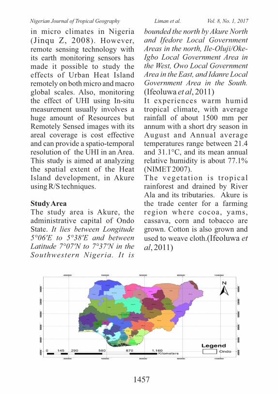
in micro climates in Nigeria (Jinqu Z, 2008). However, remote sensing technology with its earth monitoring sensors has made it possible to study the effects of Urban Heat Island remotely on both micro and macro global scales. Also, monitoring the effect of UHI using In-situ measurement usually involves a huge amount of Resources but Remotely Sensed images with its areal coverage is cost effective and can provide a spatio-temporal resolution of the UHI in an Area. This study is aimed at analyzing the spatial extent of the Heat Island development, in Akure using R/S techniques.
Study AreaThe study area is Akure, the administrative capital of Ondo State. It lies between Longitude 5°06'E to 5°38'E and between Latitude 7°07'N to 7°37'N in the Southwestern Nigeria. It is
bounded the north by Akure North and Ifedore Local Government Areas in the north, Ile-Oluji/Oke-Igbo Local Government Area in the West, Owo Local Government Area in the East, and Idanre Local Government Area in the South. (Ifeoluwa et al, 2011)It experiences warm humid tropical climate, with average rainfall of about 1500 mm per annum with a short dry season in August and Annual average temperatures range between 21.4 and 31.1°C, and its mean annual relative humidity is about 77.1% (NIMET 2007). The vegeta t ion i s t ropica l rainforest and drained by River Ala and its tributaries. Akure is the trade center for a farming region where cocoa, yams, cassava, corn and tobacco are grown. Cotton is also grown and used to weave cloth.(Ifeoluwa et al, 2011)
1457
Nigerian Journal of Tropical Geography Liman et al. Vol. 8, No. 1, 2017
Materials and MethodsThe digital data used in this study were collected by Landsat ETM+ on
rd3 of January 2002 with 30m spatial resolution. The spectral characteristics are shown in Table 1 below.
Figure.1: The study area(Akure Town) Ondo state
INSERT IMAGE
Table1: Land sat ETM 2002 spectral consideration and source.
BAND NO WAVELENGTH(m) SPECTRAL REGION
SPATIAL RESOLUTION(m)
SOURCE
2 0.52 – 0.60 Green 30 GLCF 3 0.63 – 0.69 Red 30 GLCF 4 0.76 – 0.90 Near infra-red 30 GLCF 6 10.4 – 12.5 Thermal infra-
red 60 GLCF
· A r c G I S w a s u s e d i n producing both the boundary maps of the study area and also that of the Land Surface Temperature..
· ILWIS 3.3 software, the bands 2, 3 and 4 of the Landsat ETM+ image was enhanced using histogram equalization, rectified to a common UTM coordinate system (WGS84), and then radiometrically corrected. The imageries were then classified using three bands
of green (2), red (3), and near- in f ra red (4 ) . The imageries were classified into 4 features namely:
Built-upBare-SurfaceVegetation, andWater Body
To examine the spatial pattern of Surface Temperature in Akure, twenty transects were drawn across Akure. This transects passes over various landscapes with different environmental settings
1458
Nigerian Journal of Tropical Geography Liman et al. Vol. 8, No. 1, 2017
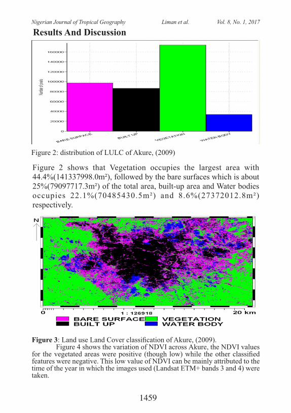
Results And Discussion
Figure 2: distribution of LULC of Akure, (2009)
Figure 2 shows that Vegetation occupies the largest area with 44.4%(141337998.0m²), followed by the bare surfaces which is about 25%(79097717.3m²) of the total area, built-up area and Water bodies occupies 22.1%(70485430.5m²) and 8.6%(27372012.8m²) respectively.
Figure 3: Land use Land Cover classication of Akure, (2009).Figure 4 shows the variation of NDVI across Akure, the NDVI values
for the vegetated areas were positive (though low) while the other classied features were negative. This low value of NDVI can be mainly attributed to the time of the year in which the images used (Landsat ETM+ bands 3 and 4) were taken.
1459
Nigerian Journal of Tropical Geography Liman et al. Vol. 8, No. 1, 2017
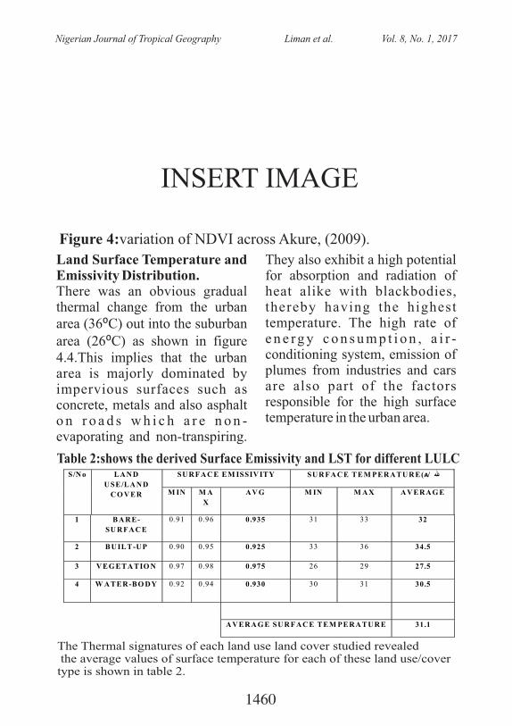
Figure 4:variation of NDVI across Akure, (2009).
INSERT IMAGE
Land Surface Temperature and Emissivity Distribution. There was an obvious gradual thermal change from the urban area (36⁰C) out into the suburban area (26⁰C) as shown in figure 4.4.This implies that the urban area is majorly dominated by impervious surfaces such as concrete, metals and also asphalt o n r o a d s w h i c h a r e n o n -evaporating and non-transpiring.
They also exhibit a high potential for absorption and radiation of heat alike with blackbodies, thereby having the highest temperature. The high rate of e n e rg y c o n s u m p t i o n , a i r -conditioning system, emission of plumes from industries and cars are also part of the factors responsible for the high surface temperature in the urban area.
Table 2:shows the derived Surface Emissivity and LST for different LULC
S/N o LA N D
U SE/LA N D
C O V ER
SU R FA C E EM ISSIV ITY SU R FA C E TEM PER A TU R E(�/ هللا
M IN M A
X
A V G M IN M A X A V ER A G E
1 B A R E-
SU R FA C E
0.91 0.96 0.935 31 33 32
2 B U ILT-UP 0.90 0.95 0.925 33 36 34.5
3 V EG ETA TIO N 0.97 0.98 0.975 26 29 27.5
4 W A TER -BO D Y 0.92 0.94 0.930 30 31 30.5
A V ER A G E SU R FA C E TEM PER A TU R E 31.1
The Thermal signatures of each land use land cover studied revealed the average values of surface temperature for each of these land use/cover type is shown in table 2.
1460
Nigerian Journal of Tropical Geography Liman et al. Vol. 8, No. 1, 2017
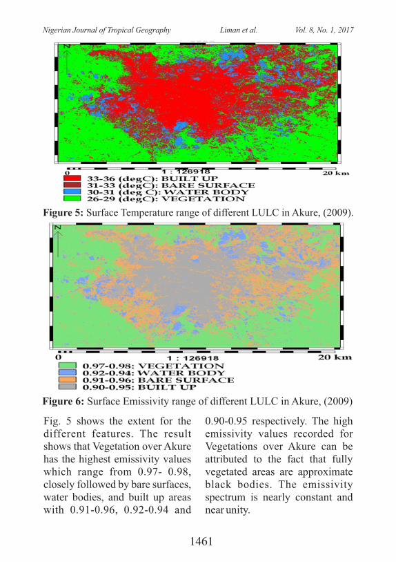
Fig. 5 shows the extent for the different features. The result shows that Vegetation over Akure has the highest emissivity values which range from 0.97- 0.98, closely followed by bare surfaces, water bodies, and built up areas with 0.91-0.96, 0.92-0.94 and
0.90-0.95 respectively. The high emissivity values recorded for Vegetations over Akure can be attributed to the fact that fully vegetated areas are approximate black bodies. The emissivity spectrum is nearly constant and near unity.
Figure 5: Surface Temperature range of different LULC in Akure, (2009).
Figure 6: Surface Emissivity range of different LULC in Akure, (2009)
1461
Nigerian Journal of Tropical Geography Liman et al. Vol. 8, No. 1, 2017
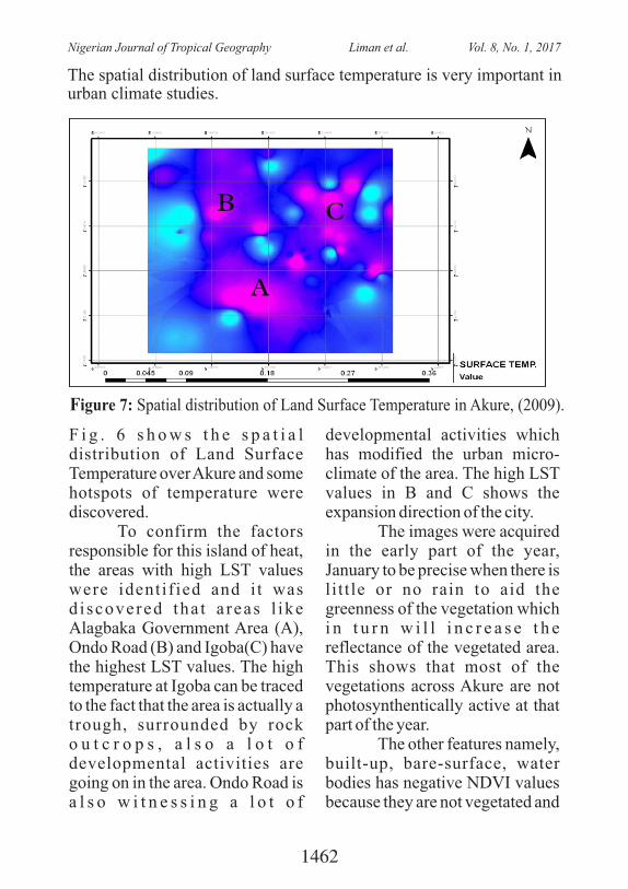
The spatial distribution of land surface temperature is very important in urban climate studies.
Figure 7: Spatial distribution of Land Surface Temperature in Akure, (2009).
F i g . 6 s h o w s t h e s p a t i a l distribution of Land Surface Temperature over Akure and some hotspots of temperature were discovered.� To confirm the factors responsible for this island of heat, the areas with high LST values were identif ied and i t was d i scovered tha t a reas l ike Alagbaka Government Area (A), Ondo Road (B) and Igoba(C) have the highest LST values. The high temperature at Igoba can be traced to the fact that the area is actually a trough, surrounded by rock o u t c r o p s , a l s o a l o t o f developmental activities are going on in the area. Ondo Road is a l s o w i t n e s s i n g a l o t o f
developmental activities which has modified the urban micro-climate of the area. The high LST values in B and C shows the expansion direction of the city.
The images were acquired in the early part of the year, January to be precise when there is l i t t le or no rain to aid the greenness of the vegetation which i n t u r n w i l l i n c r e a s e t h e reflectance of the vegetated area. This shows that most of the vegetations across Akure are not photosynthentically active at that part of the year.
The other features namely, built-up, bare-surface, water bodies has negative NDVI values because they are not vegetated and
1462
Nigerian Journal of Tropical Geography Liman et al. Vol. 8, No. 1, 2017
the reflectance value in the red band is higher than reflectance value in Near Infra-red band.The most extensive UHI was distributed in the Central part of the CBD, comprising of the popular market (Oja-Oba), High Cour t Road and Alagbaka Government Area.From the distribution of LST in Fig. 4.6, it can be found that the surface urban heat island is not always located in the center of the city, but sometimes in the outskirt. It was mainly because of the urban e x p a n s i o n a n d t h e n e w development sites were always in the outside of the city. The new developing sites destroyed the original ground land cover and e n h a n c e t h e l a n d s u r f a c e temperature.
Conclusion and recommendationIn this s tudy, land surface temperatures were analyzed and it was found that the highest temperatures were restricted to the center of the city, but also in the outskirt. The new built-up areas, because of fewer trees and green lands and more black asphalt concrete pavements, have higher surface temperature. Also the Central Business District of Akure extending from the popular marke t (Oja-Oba) th rough Alagbaka government Area have
the most significant UHI effect and this can be attributed to the closely packed buildings with dark surfaces, roads with asphalts on it and other materials with very low albedo, rather than emitting, they absorb the greater part of the electromagnetic radiation that falls on them. Temperature comparison of the different land cover shows a great difference between them, Built up area has the highest temperature with 34.5⁰C, closely followed by the bare surfaces with 32⁰C, while Water bodies and Vegetations are 4⁰C and 7⁰C lesser than that of the built up area. These are all because different land cover has different albedo and thermal capacity
ReferencesBalogun A.A, Balogun I.A,
Adefisan A.E, Abatan A.A ( 2 0 0 9 ) . O b s e r v e d � characteristics of the urban h e a t i s l a n d d u r i n g t h e harmattan and monsoon in �A k u r e , N i g e r i a . E i g h t Conferences on the Urban Environment. AMS 89th �Annual Meeting, 11 – 15 January, 2009, Phoenix, AZ. Paper JP4.6.
Carnahan, W. h and Larson, R.C., 1990, an analysis of an urban heat sink. Remote �Sensing of Environment, 33, pp. 65-71.
1463
Nigerian Journal of Tropical Geography Liman et al. Vol. 8, No. 1, 2017
Gallo, K.P., McNab, A.L.,Karl, T.R., Brown, J.F., Hood, J.J.
and Tarpley, J.D., 1993, � the use of a vegetation index for assessment of the urban heat i s l a n d e f f e c t . �International Journal of Remote Sensing. 14: 2223-2230.
Ifatimehin, O. O. (2007).An Assessment of Urban Heat Island of Lokoja Town and �Surroundings Using Landsat ETM data.
Ifeoluwa A. Balogun, Ahmed A. Balogun, and Zachariah D. Adeyewa (2009), A note � o n the effect of urbanization on air temperature and humidity of Akure, � Nigeria.
Ifeoluwa A. Balogun, Ahmed A. Balogun, and Zachariah D . A d e y e w a ( 2 0 1 1 ) , �A n a l y s i s o f u r b a n expansion and land use changes in Akure, Nigeria, �using remote sensing and geographic information s y s t e m ( G I S ) �techniques.
Jinqu Z (2008), Study of the Relationships between the Spatial Extent of Surface Urban Heat Islands and U r b a n C h a r a c t e r i s t i c Factors Based on Landsat ETM+ Data.
Oke, T.R. (1982), the energetic basis of the urban heat island. Quarterly Journal of � the Royal Meteorological Society, Vol.108, Pp1-24.
Mather R.M. (1986). Comparing Tradit ional methods for Selecting Class Intervals on �C h l o r o p l e t h m a p s . Professional Geographer, 38 (1): 62– 67.
Southworth J. (2004), an assessment of Landsat TM band 6 thermal data for �analyzing land cover in tropical dry forest regions. International Journal � for Remote sensing, Vol. 25, Pp 689-706.
Tan K.C. (2010), Land Surface Temperature Retrieval by U s i n g A T C O R 3 _ T �and Normalized Difference Vegetation Index Methods i n P e n a n g I s l a n d . �A m e r i c a n J o u r n a l o f Applied Sciences, vol.7, Pp717-723.
Wang, S.; Zhao Y.; and Wang, Y. (1994), Analyses of climatic variation and heat � i s l a n d o n Lanzhou. Journal of Lanzhou University, Vol.30 (4), Pp. 161-167.
1464
Nigerian Journal of Tropical Geography Liman et al. Vol. 8, No. 1, 2017
EVOLUTION OF LATRITIC DURICRUSTS AROUND NIGERIAN DEFENCE ACADEMY AFAKA, KADUNA NIGERIA
Ali Williams BUTU and Aliyu DADAN-GARBADepartment of Geography Nigerian Defence Academy Kaduna
Email: [email protected]: +2348034525879
ABSTRACT: The formation and transformation of ferricrete or lateritic duricrust in Afaka-Kaduna in a Savanna region of Northern Nigeria has been investigated. The various scenes of the lateritic duricurst were visited and a cross profile of the soil in the vicinity was examined. The result of the study shows that lateritic duricrusts developed as a clay horizon that is rich in Fe Oxides within the soil profile in the area. The clearing of the vegetation and subsequent removal of the top soil exposed the well weathered laterite to harden into a crust due to continue wetting and drying occasioned by the distinct wet and dry season experienced in the zone.The alternate wetting and drying process drains the clay and crystallizes the Fe as ferricretes. Saprolitilization process also account for formation and transformation process of the ferricrete or lateritic duricurst in the area. The saprolitilization and ferruginization process gradually lead to aggraded and degrade ferruginous layer formation as a result of morpho – pedoclimatic changes in the zone. The result also shows that the brownish – reddish bands on the surface of the soil that finally developed into hard pans is as a result of oxidation of possible pyrites, chloride and abundant precipitation of Fe hydroxides. The study shows that the development of lateritic duricrust is fast increasing in Nigerian Defence Academy Afaka, Kaduna Metropolis as a result of increasing exposure of the top soil by anthropogenetic activities. There is therefore urgent need to reduce the exposure and removal of top soil around the region to avoid further degradation of the soil.
Key words: Duricrust, ferricrete, ferruginization, lateritic, saprotilization, weathering.
1465
Nigerian Journal of Tropical Geography Ali and Aliyu Vol. 8, No. 1, 2017
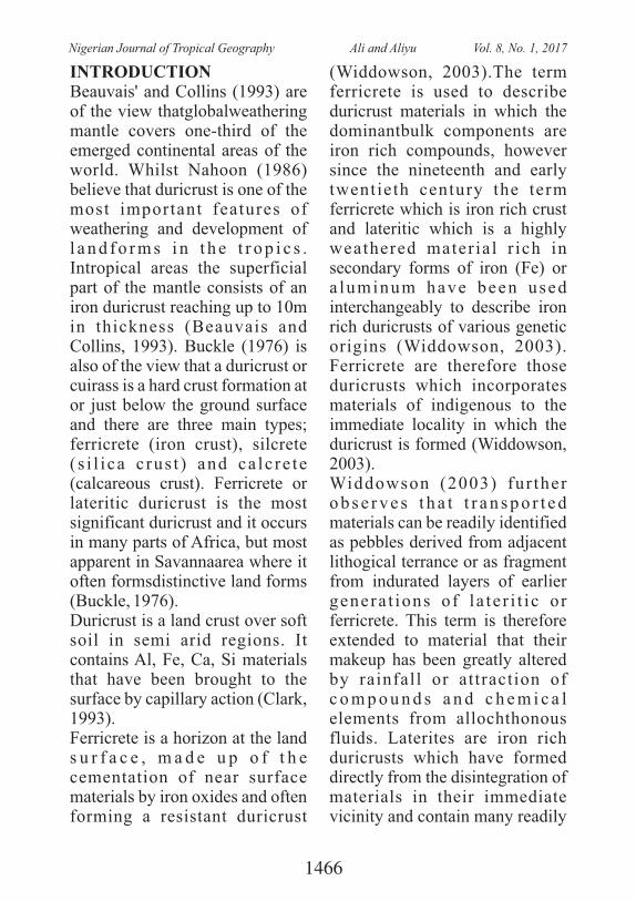
INTRODUCTIONBeauvais' and Collins (1993) are of the view thatglobalweathering mantle covers one-third of the emerged continental areas of the world. Whilst Nahoon (1986) believe that duricrust is one of the most important features of weathering and development of l a n d f o r m s i n t h e t r o p i c s . Intropical areas the superficial part of the mantle consists of an iron duricrust reaching up to 10m in thickness (Beauvais and Collins, 1993). Buckle (1976) is also of the view that a duricrust or cuirass is a hard crust formation at or just below the ground surface and there are three main types; ferricrete (iron crust), silcrete ( s i l i ca c rus t ) and ca lc re te (calcareous crust). Ferricrete or lateritic duricrust is the most significant duricrust and it occurs in many parts of Africa, but most apparent in Savannaarea where it often formsdistinctive land forms (Buckle, 1976).Duricrust is a land crust over soft soil in semi arid regions. It contains Al, Fe, Ca, Si materials that have been brought to the surface by capillary action (Clark, 1993). Ferricrete is a horizon at the land s u r f a c e , m a d e u p o f t h e cementation of near surface materials by iron oxides and often forming a resistant duricrust
(Widdowson, 2003).The term ferricrete is used to describe duricrust materials in which the dominantbulk components are iron rich compounds, however since the nineteenth and early twentieth century the term ferricrete which is iron rich crust and lateritic which is a highly weathered material r ich in secondary forms of iron (Fe) or a luminum have been used interchangeably to describe iron rich duricrusts of various genetic origins (Widdowson, 2003). Ferricrete are therefore those duricrusts which incorporates materials of indigenous to the immediate locality in which the duricrust is formed (Widdowson, 2003).Widdowson (2003) fur ther o b s e r v e s t h a t t r a n s p o r t e d materials can be readily identified as pebbles derived from adjacent lithogical terrance or as fragment from indurated layers of earlier genera t ions of la te r i t ic or ferricrete. This term is therefore extended to material that their makeup has been greatly altered by rainfall or attraction of c o m p o u n d s a n d c h e m i c a l elements from allochthonous fluids. Laterites are iron rich duricrusts which have formed directly from the disintegration of materials in their immediate vicinity and contain many readily
1466
Nigerian Journal of Tropical Geography Ali and Aliyu Vol. 8, No. 1, 2017
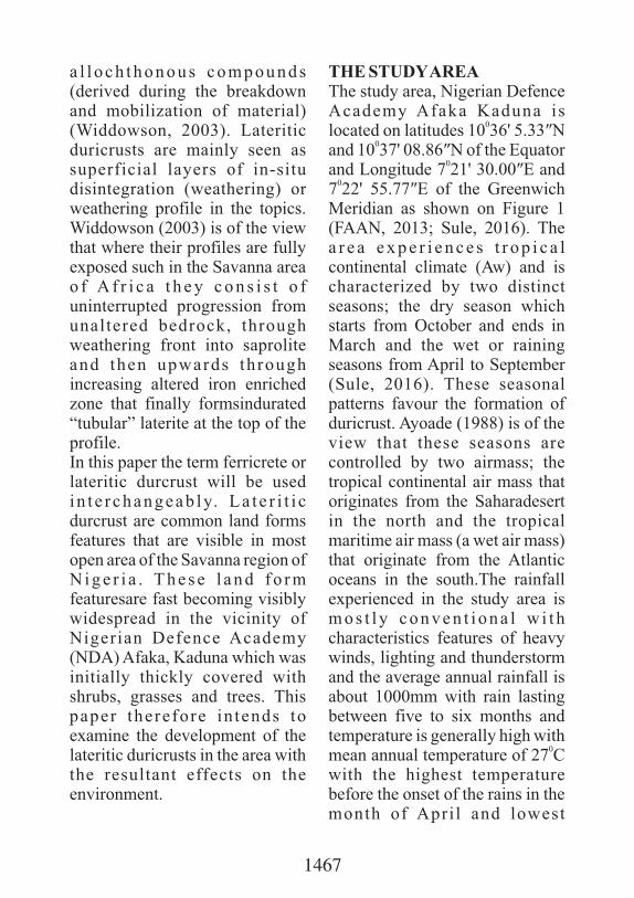
a l l o c h t h o n o u s c o m p o u n d s (derived during the breakdown and mobilization of material) (Widdowson, 2003). Lateritic duricrusts are mainly seen as superficial layers of in-situ disintegration (weathering) or weathering profile in the topics. Widdowson (2003) is of the view that where their profiles are fully exposed such in the Savanna area o f A f r i c a t h e y c o n s i s t o f uninterrupted progression from unaltered bedrock, through weathering front into saprolite and then upwards through increasing altered iron enriched zone that finally formsindurated “tubular” laterite at the top of the profile.In this paper the term ferricrete or lateritic durcrust will be used in t e r changeab ly. La t e r i t i c durcrust are common land forms features that are visible in most open area of the Savanna region of N i g e r i a . T h e s e l a n d f o r m featuresare fast becoming visibly widespread in the vicinity of Nigerian Defence Academy (NDA) Afaka, Kaduna which was initially thickly covered with shrubs, grasses and trees. This paper therefore in tends to examine the development of the lateritic duricrusts in the area with the resultant effects on the environment.
THE STUDY AREAThe study area, Nigerian Defence Academy Afaka Kaduna is
0located on latitudes 10 36' 5.33″N 0
and 10 37' 08.86″N of the Equator 0and Longitude 7 21' 30.00″E and
07 22' 55.77″E of the Greenwich Meridian as shown on Figure 1 (FAAN, 2013; Sule, 2016). The a r e a e x p e r i e n c e s t r o p i c a l continental climate (Aw) and is characterized by two distinct seasons; the dry season which starts from October and ends in March and the wet or raining seasons from April to September (Sule, 2016). These seasonal patterns favour the formation of duricrust. Ayoade (1988) is of the view that these seasons are controlled by two airmass; the tropical continental air mass that originates from the Saharadesert in the north and the tropical maritime air mass (a wet air mass) that originate from the Atlantic oceans in the south.The rainfall experienced in the study area is m o s t l y c o n v e n t i o n a l w i t h characteristics features of heavy winds, lighting and thunderstorm and the average annual rainfall is about 1000mm with rain lasting between five to six months and temperature is generally high with
0mean annual temperature of 27 C with the highest temperature before the onset of the rains in the month of Apri l and lowest
1467
between December and January that is during harmattan period (Hore 1970; Sule, 2016).The study area is largely underlain by undifferentiated basement complex format ions which comprises of both igneous and metamorphic rocks and the former are mainly biotite, gneises and older granites, while the latter include quartzite and schist found in stream valleys, alluvial deposits of laterites overlie most of the area (Braima, 1997: Sule, 2016). The soil of the area isa typically red brown ferruginous soil that is rich in red clay and sand, but poor in inorganic matter (Yusuf, 2004). Sule (2016) is of the view that the tropical soil profile of the area shows presence of mineral materials from the weathered gneisses and still possesses some
pieces of quartz and mica and the p r o f i l e a l s o s h o w s a n accumulation of clay and iron deposits that signified the red or brown coloration.The area lies in the Guinea Savanna vegetation zone of Nigeria characterized by more shrubs and grasses than trees; constituting about 80% of the vegetation cover while the remaining 20% is covered by trees (Olatunde, 2009; Sule, 2016). The grasses in the area include elephant grass. The vegetation consists of short woodland.The plants are green only during the raining season but dry up during the dry season and are often cleared or burnt by fires. The trees in the area are deciduous generally fire resistant.
Fig.1.1: Kaduna State Source: Kaduna State Ministry of Land and Survey
Figure. 1: The Study Area (Kaduna Metropolis showing location of NDA Afaka) Source: Oshoke (2016)
1468
Nigerian Journal of Tropical Geography Ali and Aliyu Vol. 8, No. 1, 2017
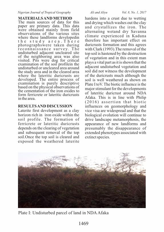
MATERIALS AND METHODThe main sources of data for this paper are primary data. This data were obtained mainly from field observations of the various sites where these landforms developedin t h e s t u d y a r e a . T h e r e photographswere taken during r e c o n n a i s s a n c e s u r v e y. T h e undisturbed adjacent uncleared site of the neighboring area was also visited. Pits were dog for critical examination of the soil profilein the undisturbed or uncleared area around the study area and in the cleared area where the lateritic duricrusts are developed. The entire process of examination is purely descriptive based on the physical observations of the cementation of the iron oxides to form ferricrete or lateritic duricrusts in the area.
RESULTS AND DISCUSSIONLaterite first development as a clay horizon rich in iron oxide within the soil profile. The formation of ferricrete or lateritic duricrusts depends on the clearing of vegetation and subsequent removal of the top soil.Once the top soil is cleared and exposed the weathered laterite
hardens into a crust due to wetting and drying which washes out the clay and crystallizes the iron. The alternating wetand dry Savanna climate experienced in Kaduna therefore has important effect on duricrusts formation and this agrees with Clark (1993).The removal of the top soil is hastened by the destruction of vegetation and in this extent man plays a vital part as it is shown that the adjacent undisturbed vegetation and soil did not witness the development of the duricrusts much although the soil is well weathered as shown on Plate I toV. The biotic influence is the major stimulant for the developments of lateritic duricrust around NDA Afaka. This is in line with Philip ( 2 0 1 6 ) a s s e r t i o n t h a t b i o t i c influences on geomorphology and vice visa are widespread and that the biological evolution will continue to drive landscape metamorphosis, the appearance of new landforms and presumably the disappearance of extended phenotypes associated with extinct species.
Plate I: Undisturbed parcel of land in NDA Afaka
1469
Nigerian Journal of Tropical Geography Ali and Aliyu Vol. 8, No. 1, 2017
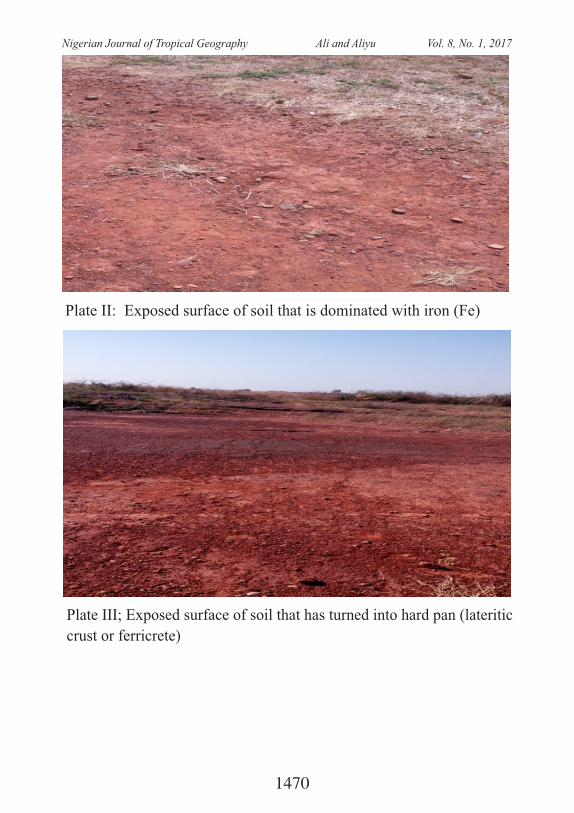
Plate II: Exposed surface of soil that is dominated with iron (Fe)
Plate III; Exposed surface of soil that has turned into hard pan (lateritic
crust or ferricrete)
1470
Nigerian Journal of Tropical Geography Ali and Aliyu Vol. 8, No. 1, 2017
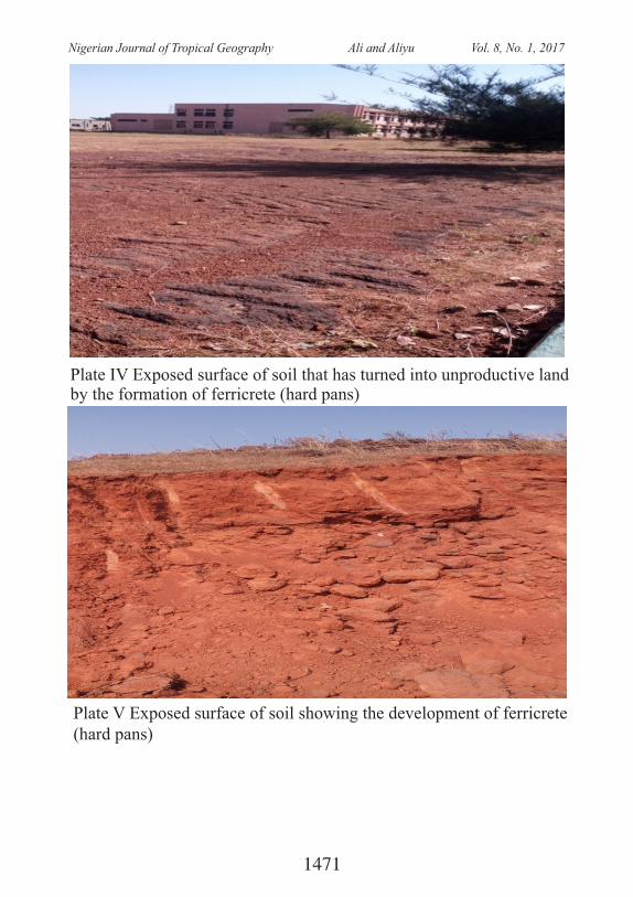
Plate IV Exposed surface of soil that has turned into unproductive land by the formation of ferricrete (hard pans)
Plate V Exposed surface of soil showing the development of ferricrete (hard pans)
1471
Nigerian Journal of Tropical Geography Ali and Aliyu Vol. 8, No. 1, 2017
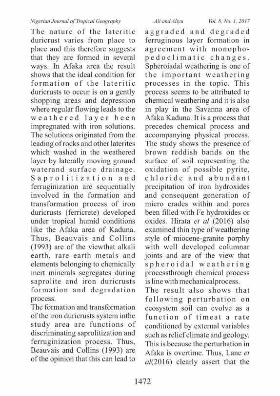
The nature of the later i t ic duricrust varies from place to place and this therefore suggests that they are formed in several ways. In Afaka area the result shows that the ideal condition for f o r m a t i o n o f t h e l a t e r i t i c duricrusts to occur is on a gently shopping areas and depression where regular flowing leads to the w e a t h e r e d l a y e r b e e n impregnated with iron solutions. The solutions originated from the leading of rocks and other laterites which washed in the weathered layer by laterally moving ground waterand surface drainage. S a p r o l i t i z a t i o n a n d ferruginization are sequentially involved in the formation and transformation process of iron duricrusts (ferricrete) developed under tropical humid conditions like the Afaka area of Kaduna. Thus, Beauvais and Collins (1993) are of the viewthat alkali earth, rare earth metals and elements belonging to chemically inert minerals segregates during saprolite and iron duricrusts format ion and degradat ion process.The formation and transformation of the iron duricrusts system inthe study area are functions of discriminating saprolitization and ferruginization process. Thus, Beauvais and Collins (1993) are of the opinion that this can lead to
a g g r a d e d a n d d e g r a d e d ferruginous layer formation in agreement wi th monopho-p e d o c l i m a t i c c h a n g e s . Spheroiadal weathering is one of t h e i m p o r t a n t w e a t h e r i n g processes in the topic. This process seems to be attributed to chemical weathering and it is also in play in the Savanna area of Afaka Kaduna. It is a process that precedes chemical process and accompanying physical process. The study shows the presence of brown reddish bands on the surface of soil representing the oxidation of possible pyrite, c h l o r i d e a n d a b u n d a n t precipitation of iron hydroxides and consequent generation of micro crades within and pores been filled with Fe hydroxides or oxides. Hirata et al (2016) also examined thin type of weathering style of miocene-granite porphy with well developed columnar joints and are of the view that s p h e r o i d a l w e a t h e r i n g processthrough chemical process is line with mechanicalprocess.The result also shows that fo l lowing pe r tu rba t ion on ecosystem soil can evolve as a f u n c t i o n o f t i m e a t a r a t e conditioned by external variables such as relief climate and geology. This is because the perturbation in Afaka is overtime. Thus, Lane et al(2016) clearly assert that the
1472
Nigerian Journal of Tropical Geography Ali and Aliyu Vol. 8, No. 1, 2017
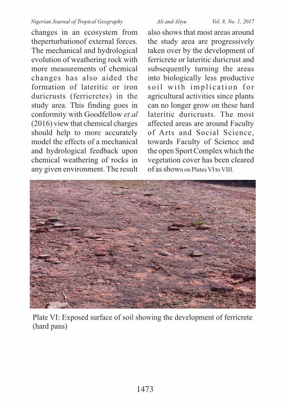
changes in an ecosystem from theperturbationof external forces. The mechanical and hydrological evolution of weathering rock with more measurements of chemical changes has also aided the formation of lateritic or iron duricrusts (ferricretes) in the study area. This finding goes in conformity with Goodfellow et al (2016) view that chemical charges should help to more accurately model the effects of a mechanical and hydrological feedback upon chemical weathering of rocks in any given environment. The result
also shows that most areas around the study area are progressively taken over by the development of ferricrete or lateritic duricrust and subsequently turning the areas into biologically less productive s o i l w i t h i m p l i c a t i o n f o r agricultural activities since plants can no longer grow on these hard lateritic duricrusts. The most affected areas are around Faculty of Arts and Social Science, towards Faculty of Science and the open Sport Complex which the vegetation cover has been cleared of as shown on Plates VI to VIII.
Plate VI: Exposed surface of soil showing the development of ferricrete (hard pans)
1473
Nigerian Journal of Tropical Geography Ali and Aliyu Vol. 8, No. 1, 2017
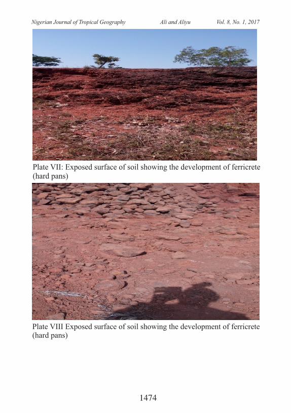
Plate VII: Exposed surface of soil showing the development of ferricrete (hard pans)
Plate VIII Exposed surface of soil showing the development of ferricrete (hard pans)
1474
Nigerian Journal of Tropical Geography Ali and Aliyu Vol. 8, No. 1, 2017
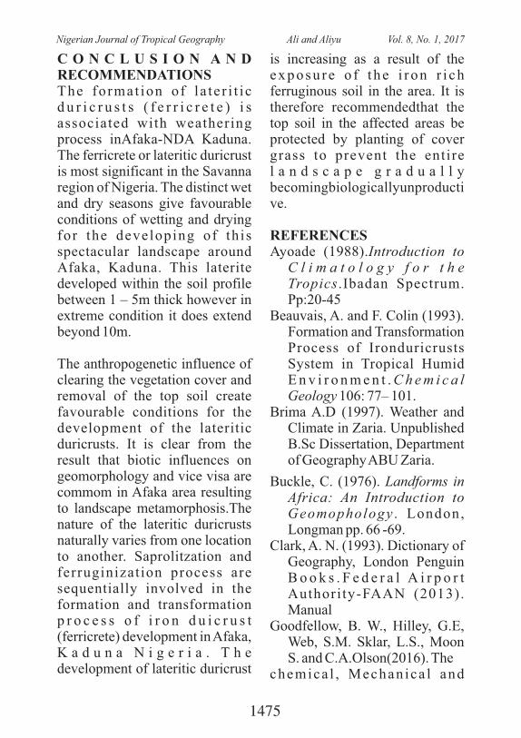
C O N C L U S I O N A N D RECOMMENDATIONSThe format ion of l a te r i t i c d u r i c r u s t s ( f e r r i c r e t e ) i s associated with weathering process inAfaka-NDA Kaduna. The ferricrete or lateritic duricrust is most significant in the Savanna region of Nigeria. The distinct wet and dry seasons give favourable conditions of wetting and drying for the developing of th is spectacular landscape around Afaka, Kaduna. This laterite developed within the soil profile between 1 – 5m thick however in extreme condition it does extend beyond 10m.
The anthropogenetic influence of clearing the vegetation cover and removal of the top soil create favourable conditions for the development of the lateritic duricrusts. It is clear from the result that biotic influences on geomorphology and vice visa are commom in Afaka area resulting to landscape metamorphosis.The nature of the lateritic duricrusts naturally varies from one location to another. Saprolitzation and ferruginization process are sequentially involved in the formation and transformation p r o c e s s o f i r o n d u i c r u s t (ferricrete) development in Afaka, K a d u n a N i g e r i a . T h e development of lateritic duricrust
is increasing as a result of the exposu re o f t he i r on r i ch ferruginous soil in the area. It is therefore recommendedthat the top soil in the affected areas be protected by planting of cover grass to prevent the entire l a n d s c a p e g r a d u a l l y becomingbiologicallyunproductive.
REFERENCESAyoade (1988).Introduction to
C l i m a t o l o g y f o r t h e Tropics.Ibadan Spectrum. Pp:20-45
Beauvais, A. and F. Colin (1993). Formation and Transformation Process of Ironduricrusts System in Tropical Humid E n v i r o n m e n t . C h e m i c a l Geology 106: 77– 101.
Brima A.D (1997). Weather and Climate in Zaria. Unpublished B.Sc Dissertation, Department of Geography ABU Zaria.
Buckle, C. (1976). Landforms in Africa: An Introduction to Geomophology . London, Longman pp. 66 -69.
Clark, A. N. (1993). Dictionary of Geography, London Penguin B o o k s . F e d e r a l A i r p o r t Authori ty-FAAN (2013). Manual
Goodfellow, B. W., Hilley, G.E, Web, S.M. Sklar, L.S., Moon S. and C.A.Olson(2016). The
chemica l , Mechan ica l and
1475
Nigerian Journal of Tropical Geography Ali and Aliyu Vol. 8, No. 1, 2017
Hydrological Evolution of Weathering granitoid, Journal of Geophysical Research. 121(8): 1410 – 1435.
Hirata, Y,Chigira, M. and Y. Chen ( 2 0 1 6 ) . S p h e r r o i d a l We a t h e r i n g o f G r a n i t e Porphyry with
WellDevelopedColumnar Joints b y O x i d a t i o n , I r o n p r e c i p i t a t i o n a n d rindletOxfoliation . Earth S u r f a c e P r o c e s s a n d Landforms.JohnWilley and Sons Ltd. 41(14): 2006 – 2165.
Lane, S.N., Borgeard, L. and P.Vittoz (2016). Emergent of Geomophic – Vegetation Interaction
OnSubalphine Alluvial fan.Earth Surface Process and Land Forms.Willey and Sons Ltd. 41(1): 72– 56.
Nahoon, D.B. (1986). Evolution of Iron crusts in Tropical Landscape.In S.M. Colman and D.P.
Detheir (Eds). Rates of Chemical Weathering of Rocks and Materials.London Academic Press pp. 169 – 187.
Olatunde, A.F (2009). Temporal Characteristics of Drought in Sudano-Sahelian Regionof
Nigeria and its Implications on A g r i c u l t u r a l A c t i v i t i e s , Unpublished M.Sc Thesis, Department of Geography NDA Kaduna.
Oshoke, I.B. (2016). Effects of Urban Land use on the soil p h y s i c a l a n d chemicalproperties in
some parts of Kaduna Metropolis. U n p u b l i s h e d M . S c Dissertation, Department of Geography Nigerian Defence Academy, Kaduna
Philips, J.D. (2016). Landforms as E x t e n d e d C o m p o s i t e Phenotypes.Earth Surface Process and
Landforms. John Willey and Sons Ltd. 41(1): 16 – 26.
Sule B. (2016). Effects of visibility on flight Operations in Kaduna In ternat ional AirportKaduna.
Unpublished M.Sc dissertation, Department of Geography Nigerian Defence Academy.
Widdson, M.(2003). Ferricrete.In G o u d u , A . S ( E d s ) . E n c y c l o p e d i a o f Geomorphology vol. 1.
London, Routledgepp. 365 – 367.Yusuf A. (2004). Nature of Waste
Generation and management in Kaduna Refinery and,�Petrochemical Company, Kaduna.UnpublishedB.Sc Dissertation. Department of
Geography ABU Zaria.
1476
Nigerian Journal of Tropical Geography Ali and Aliyu Vol. 8, No. 1, 2017
RAINFALL VARIABILITY OVER GUSAU AND ENVIRONS, ZAMFARA STATE, NIGERIA
1 2Ibrahim Ishiaku, Ismail Usman Kaoje , Emigilati M.A, Suleiman Y. M. ,1 Department of Geography, Federal University, Birnin Kebbi, Nigeria
2 Department of Geography, Federal University of Technology, Minna, [email protected]
ABSTRACT: This study aims to determine trends in long-term monthly rainfall using nonparametric methods (i.e. the Mann–Kendall and Sen's T tests) in Gusau North-Western Nigeria. Monthly rainfall records of Gusau synoptic stations for a period 60 years (1953-2012), were acquired from the Nigerian Meteorological Agency. The result revealed that the monthly rainfall recorded downward trend in the months of April, June, July, August and September within 1953-2012. While an upward trend in May, and October was recorded but they were not significance at 95% confidence level. The s Sen's slope estimator revealed that of the seven (7) rainy months considered (April, May. June, July, August, September and October) only two months May and October showed upward trends with rainfall of 0.028mm and 0.182mm as obtained by Sen's slope estimator, while from of month of June, July, August and September there were downward trends of -0.492mm, -0.580mm, -0.069mm and -0.716mm. The implication of the findings is that the area experience some basic indices of climate change.
Keywords: Rainfall, Trends, Climate, environment, variability
1. Introduction Yavuz and Erdoğan ( ) 2012confirmed that global warming and climate change is significantly altering various environmental variables in many countries around the world. It has been documented severally that the Earth's climate has been changing notably at a fast pace since the last century and the changes are expected to continue ( , et al. Huang2014). Rainfall being one of the
important climatic elements is found to be changing on both the global (Dore, 2005) and the regional scales (Kayano and Sans´ıgolo, 2008). It is understood that projected global climate changes have the potential to alter precipitation patterns. Changes in precipitation patterns is believed to directly affect hydrology, agriculture, ecosystems and water resources management. It is argued that to meet the future
1477
Nigerian Journal of Tropical Geography Ibrahim et al. Vol. 8, No. 1, 2017
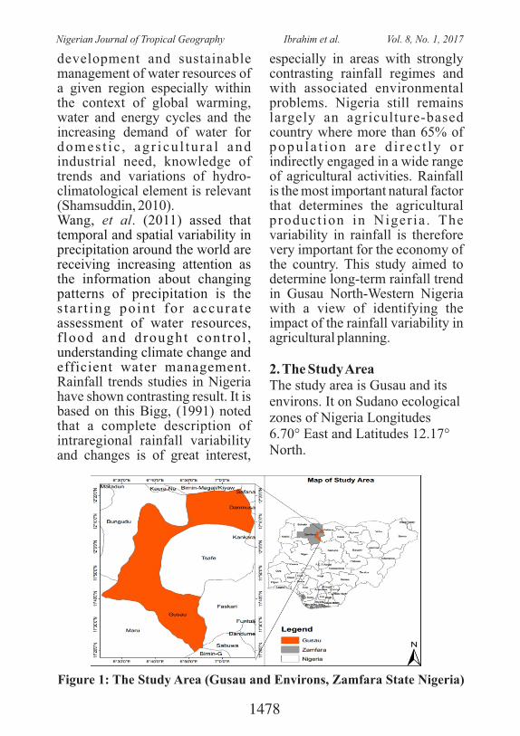
development and sustainable management of water resources of a given region especially within the context of global warming, water and energy cycles and the increasing demand of water for domes t i c , ag r i cu l tu ra l and industrial need, knowledge of trends and variations of hydro-climatological element is relevant (Shamsuddin, 2010). Wang, (2011) assed that et al.temporal and spatial variability in precipitation around the world are receiving increasing attention as the information about changing patterns of precipitation is the s ta r t ing poin t for accura te assessment of water resources, f lood and drought control , understanding climate change and efficient water management. Rainfall trends studies in Nigeria have shown contrasting result. It is based on this Bigg, (1991) noted that a complete description of intraregional rainfall variability and changes is of great interest,
especially in areas with strongly contrasting rainfall regimes and with associated environmental problems. Nigeria still remains largely an agriculture-based country where more than 65% of popu la t ion a r e d i r ec t ly o r indirectly engaged in a wide range of agricultural activities. Rainfall is the most important natural factor that determines the agricultural product ion in Nigeria . The variability in rainfall is therefore very important for the economy of the country. This study aimed to determine long-term rainfall trend in Gusau North-Western Nigeria with a view of identifying the impact of the rainfall variability in agricultural planning.
2. The Study AreaThe study area is Gusau and its environs. It on Sudano ecological zones of Nigeria Longitudes 6.70° East and Latitudes 12.17° North.
Figure 1: The Study Area (Gusau and Environs, Zamfara State Nigeria)
1478
Nigerian Journal of Tropical Geography Ibrahim et al. Vol. 8, No. 1, 2017
The climate is dominated by Tropical Maritime (mT) air mass, and the Tropical Continental (cT) air mass. The rainy season in this region is associated with late onset and earlier cessation. The onset a n d c e s s a t i o n a r e a l s o characterized by destructive storms which destroy life and property (AbdulKadir, et al., 2 0 1 3 ) . T h e s e a s o n a l a n d l a t i t u d i n a l v a r i a t i o n s a r e understood to affect diurnal and seasonal temperature ranges. The highest maximum air temperature is recorded in the northern part usually areas north of latitude 9° and occur in March /April and minimum temperatures are recorded in December/January North of latitude 9°N (AbdulKadir et al, 2013).
3 Materials and Methods3.1 Data Monthly rainfall records of Gusau
synoptic stations for a period 60 years (1953-2012), is acquired. The data were collected from the Nigerian Meteorological Agency3.2 Trend AnalysisIn this research, trend detection is carried out by the Mann-Kendall test and Sen's slope estimator a n a l y s i s . T h e d e t a i l e d explanations of these methods are:
3.3 Mann-Kendall testMann-Kendall test (Mann, 1945; Kendall, 1975) is applied to detect the trend in rainfall time series. Confidence levels of 95% is taken as thresholds to classify the significance of positive and n e g a t i v e t r e n d s . T h e Mann–Kendall (MK) test is a non-parametric test, commonly used to detect significant trends in hydrological and meteorological time series (example Tabari and Hosseinzadeh Talaee, 2011). The MK test is given as:
1479
Nigerian Journal of Tropical Geography Ibrahim et al. Vol. 8, No. 1, 2017
A positive value of Z will i n d i c a t e s t h a t t h e r e i s a n increasing trend and a negative value indicates a decreasing trend while zero value indicates no trends.
2.3.2� Magnitude of Rainfall Trend ChangesIt is observed that some trends may not be evaluated to be statistically significant while they might be of practical interest (Basistha, et al, 2007). In the instance where climate change component is present, it may not be detected by statistical tests at a satisfactory significance level (Radziejewski and Kundzewicz,
2 0 0 4 ) . To o v e r c o m e t h i s challenge, linear trend analysis will be carried out and the magnitude (change per unit time) will be estimated by using a non-parametric procedure developed by Sen (1968). The Sen's slope approach is adjudge to gives a robust estimate of the magnitude of a trend (Yue, Pilon, Phinney, Cavadias 2002) and for this reason, it has been preferred above the regression slope approach in recent hydrologic studies ( Huang et al. 2014; Zhang, Zheng, Wang, Yao 2015). The trend magnitude by this method is computed as follows:
(5)
and if N is even, Sen's estimator is computed by
Where: Q = slope between data points x jand x x , x = data values at k, j k
times j and k j>k respectivelyN is the number of calculated slopes4.0 R e s u l t s a n d
DiscussionThe Mann Kendall trends test for monthly rainfall is shown in table 1. The result revealed that the monthly rainfall recorded downward trend in the months
of April, June, July, August and September within the study period. The above months all showed a negative sign. While an upward trend in May and October was recorded. The month of May and October revealed a positive sign. The resu l t however show no significance at 95% confidence level.
1480
Nigerian Journal of Tropical Geography Ibrahim et al. Vol. 8, No. 1, 2017
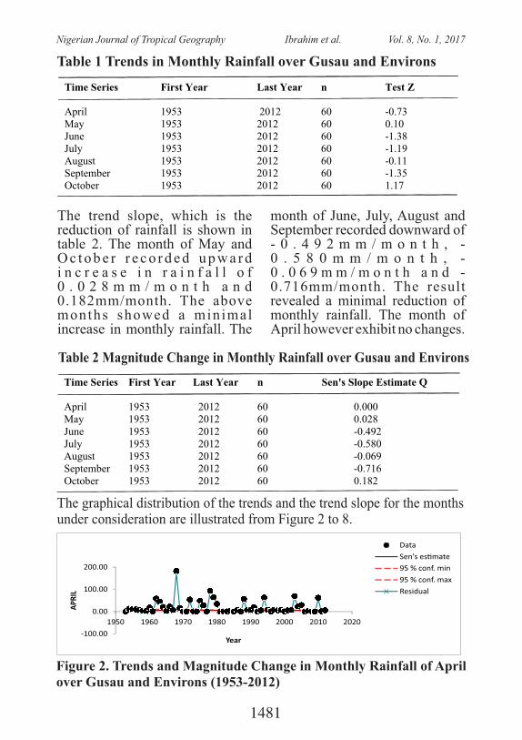
Time Series First Year Last Year n Test Z
April 1953 2012 60 -0.73 May 1953 2012 60 0.10 June 1953 2012 60 -1.38 July 1953 2012 60 -1.19 August 1953 2012 60 -0.11 September 1953 2012 60 -1.35 October 1953 2012 60 1.17
Table 1 Trends in Monthly Rainfall over Gusau and Environs
The trend slope, which is the reduction of rainfall is shown in table 2. The month of May and O c t o b e r r e c o r d e d u p w a r d i n c r e a s e i n r a i n f a l l o f 0 . 0 2 8 m m / m o n t h a n d 0.182mm/month. The above months showed a minimal increase in monthly rainfall. The
month of June, July, August and September recorded downward of - 0 . 4 9 2 m m / m o n t h , -0 . 5 8 0 m m / m o n t h , -0 . 0 6 9 m m / m o n t h a n d -0.716mm/month. The result revealed a minimal reduction of monthly rainfall. The month of April however exhibit no changes.
Table 2 Magnitude Change in Monthly Rainfall over Gusau and Environs Time Series First Year Last Year n Sen's Slope Estimate Q
April 1953 2012 60 0.000 May 1953 2012 60 0.028 June 1953 2012 60 -0.492 July 1953 2012 60 -0.580 August 1953 2012 60 -0.069 September 1953 2012 60 -0.716 October 1953 2012 60 0.182
The graphical distribution of the trends and the trend slope for the months under consideration are illustrated from Figure 2 to 8.
-100.00
0.00
100.00
200.00
1950 1960 1970 1980 1990 2000 2010 2020
APR
IL
Year
Data
Sen's es�mate
95 % conf. min
95 % conf. max
Residual
Figure 2. Trends and Magnitude Change in Monthly Rainfall of April over Gusau and Environs (1953-2012)
1481
Nigerian Journal of Tropical Geography Ibrahim et al. Vol. 8, No. 1, 2017
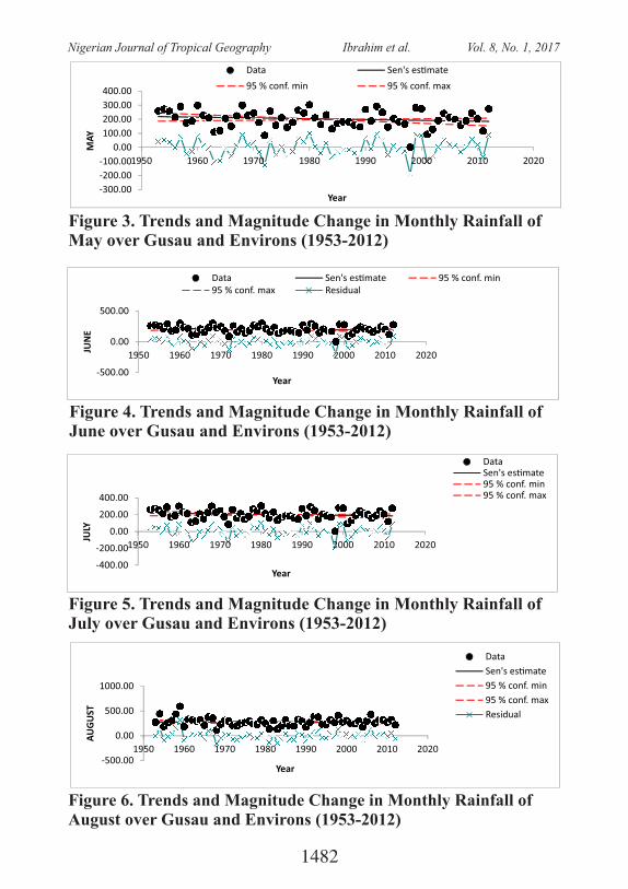
-300.00
-200.00
-100.00
0.00
100.00
200.00
300.00
400.00
1950 1960 1970 1980 1990 2000 2010 2020
MA
Y
Year
Data Sen's es�mate
95 % conf. min 95 % conf. max
Figure 3. Trends and Magnitude Change in Monthly Rainfall of May over Gusau and Environs (1953-2012)
-500.00
0.00
500.00
1950 1960 1970 1980 1990 2000 2010 2020
JUN
E
Year
Data Sen's es�mate 95 % conf. min95 % conf. max Residual
Figure 4. Trends and Magnitude Change in Monthly Rainfall of June over Gusau and Environs (1953-2012)
-400.00
-200.00
0.00
200.00
400.00
1950 1960 1970 1980 1990 2000 2010 2020
JULY
Year
DataSen's es�mate95 % conf. min95 % conf. max
Figure 5. Trends and Magnitude Change in Monthly Rainfall of July over Gusau and Environs (1953-2012)
-500.00
0.00
500.00
1000.00
1950 1960 1970 1980 1990 2000 2010 2020
AU
GU
ST
Year
Data
Sen's es�mate
95 % conf. min
95 % conf. max
Residual
Figure 6. Trends and Magnitude Change in Monthly Rainfall of August over Gusau and Environs (1953-2012)
1482
Nigerian Journal of Tropical Geography Ibrahim et al. Vol. 8, No. 1, 2017
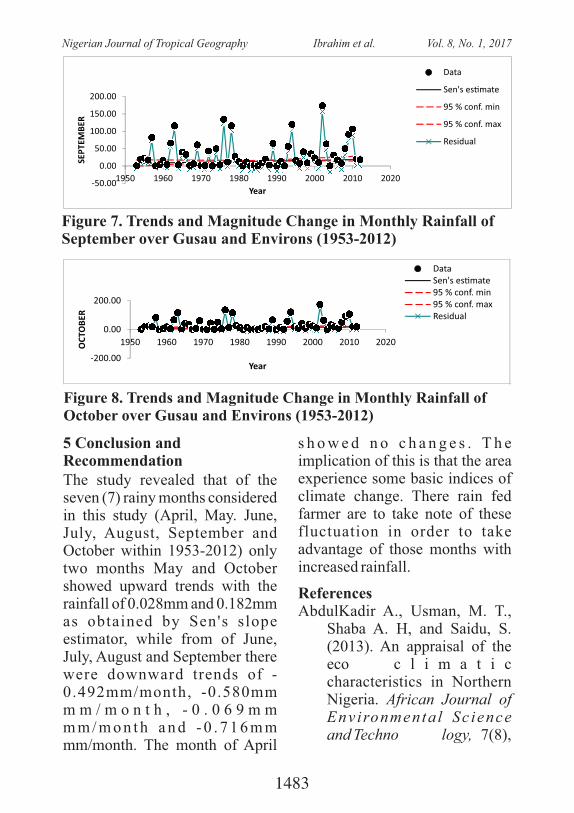
-50.00
0.00
50.00
100.00
150.00
200.00
1950 1960 1970 1980 1990 2000 2010 2020
SEP
TEM
BER
Year
Data
Sen's es�mate
95 % conf. min
95 % conf. max
Residual
Figure 7. Trends and Magnitude Change in Monthly Rainfall of September over Gusau and Environs (1953-2012)
-200.00
0.00
200.00
1950 1960 1970 1980 1990 2000 2010 2020OC
TOB
ER
Year
DataSen's es�mate95 % conf. min95 % conf. maxResidual
Figure 8. Trends and Magnitude Change in Monthly Rainfall of October over Gusau and Environs (1953-2012)
5 Conclusion and RecommendationThe study revealed that of the seven (7) rainy months considered in this study (April, May. June, July, August, September and October within 1953-2012) only two months May and October showed upward trends with the rainfall of 0.028mm and 0.182mm as obtained by Sen's slope estimator, while from of June, July, August and September there were downward trends of -0.492mm/month, -0.580mm m m / m o n t h , - 0 . 0 6 9 m m m m / m o n t h a n d - 0 . 7 1 6 m m mm/month. The month of April
s h o w e d n o c h a n g e s . T h e implication of this is that the area experience some basic indices of climate change. There rain fed farmer are to take note of these fluctuation in order to take advantage of those months with increased rainfall.
ReferencesAbdulKadir A., Usman, M. T.,
Shaba A. H, and Saidu, S. (2013). An appraisal of the eco� c l i m a t i c characteristics in Northern Nigeria. African Journal of Environmenta l Sc ience�and Techno� logy, 7(8),
1483
Nigerian Journal of Tropical Geography Ibrahim et al. Vol. 8, No. 1, 2017
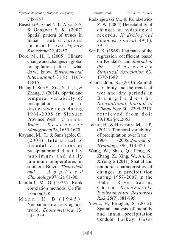
748-757Basistha A., Goel N. K, Arya D. S,
& Gangwar S. K. (2007) Spatial pattern of trends in Indian� s u b d i v i s i o n a l r a i n f a l l . J a l v i g y a n Sameeksha 22, 47-57
Dore, M., H., I. (2005). Climate change and changes in global precipitation patterns: what do�we know. Environmental International 31(8), 1167-11815
Huang J., Sun S., Xue, Y., Li, J., & Zhang, J. (2014). Spatial and temporal var iabi l i ty of�precipitation� a n d dryness/wetness during 1 9 6 1 - 2 0 0 8 i n S i c h u a n Province, West� C h i n a .�Water� R e s o u r c e s Management 28, 1655-1670
Kayano, M., T., & Sans´ıgolo, C., ( 2008) . In t e r annua l t o d e c a d a l v a r i a t i o n s o f precipitation and� d a i l y m a x i m u m a n d d a i l y minimum temperatures in southern Brazil. Theoretical and� A p p l i e d Climatology 97(12), 81-90.
Kendall, M. G (1975). Rank correlation methods. Griffin, London, UK
M a n n , H . B ( 1 9 4 5 ) . Nonparametric tests against trend. Econometrica 13, 245–259
Radziejewski M., & Kundzewicz Z. W. (2004) Detectability of changes in hydrological�r e c o r d s . H y d ro l o g i c a l Sciences Journal 49(1), 39–51
Sen P. K. (1968). Estimates of the regression coefficient based on Kendall's tau. Journal of the� A m e r i c a n Statistical Association 63, 1379-1389
Shamsuddin, S., (2010) Rainfall variability and the trends of wet and dry periods in B a n g l a d e s h .�International Journal of Climatology 30, 2299-2313, r e t r i e v e d f r o m d o i :�10.1002/joc.2053
Tabari, H., & Hosseinzadeh, T. P, (2011). Temporal variability of precipitation over Iran:�1966� -2005. Journal of Hydrology, 396, 313-320
Wang, W., Shao, Q., Peng, S., Zhang, Z., Xing, W., An, G., &Yong B (2011) Spatial and�temporal characteristics of changes in precipitation during 1957–2007 in the Haihe� R i v e r b a s i n , C h i n a . S t o c h a s t i c Environmental Resources Risk, 25(7), 881-895
Yavuz, H, Erdoğan, S. (2012). Spatial analysis of monthly and annual precipitation trends in� Tu r k e y. Wa t e r�
1484
Nigerian Journal of Tropical Geography Ibrahim et al. Vol. 8, No. 1, 2017
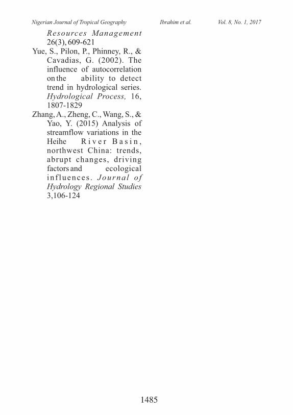
Resources Management 26(3), 609-621
Yue, S., Pilon, P., Phinney, R., & Cavadias, G. (2002). The influence of autocorrelation on the� ability to detect trend in hydrological series. Hydrological Process, 16, 1807-1829
Zhang, A., Zheng, C., Wang, S., & Yao, Y. (2015) Analysis of streamflow variations in the�Heihe� R i v e r B a s i n , northwest China: trends, abrupt changes, driving factors and� ecological i n f luences . Journa l o f Hydrology Regional Studies 3,106-124
1485
Nigerian Journal of Tropical Geography Ibrahim et al. Vol. 8, No. 1, 2017
PROSPECTS AND CHALLENGES OF WATER RESOURCES AND ENVIRONMENTAL MANAGEMENT IN NIGERIA:
AN OVERVIEW 1 2 3Suleiman, Y.M.; Emigilati, M.A.; Abdulkadir, A. ; Liman, H.M. and Umar, B.
1. Department of Geography, Federal University of Technology, Minna, Nigeria2.D epartment of Geography, Ibrahim Badamasi Babangida University, Lapai3. National Weather Forecasting and Climate Research Centre, Abuja, Nigeria
0 0ABSTRACT: Nigeria; located between latitude 4 N and 14 N and
0 0longitude 3 E and 15 E is endowed with vast water resources both proven and potential. The country is well drained with a close network of rivers and streams. Some of these, particularly the smaller ones in the north, are seasonal. There are four principal surface water basins in Nigeria; the Niger River, the Lake Chad, the West Coast and the West Central Coast. There is a very large groundwater potential in Nigeria, far greater than the surface water resources, estimated to be 224 trillion l/year (Hanidu, 1990). This picture of availability leads to reckless use of water resources as if the flow will never cease. Both surface and groundwater sources are often polluted through anthropogenic activities. This overview examines the prospects of water resources in Nigeria, the challenges of availability, accessibility and affordability; and environmental management concerns of water resources. The conclusion is that Nigeria as a nation is endowed with huge water resources with the capacity to meet our burgeoning requirements across all facets of life given the requisite resources and a focused plan of action managed by competent and committed professionals within a well orchestrated institutional framework. To mitigate threats to our water resources, government must step up Integrated Water Resources management where all sectors must synergize to achieve results.
Keywords: Water resources, Groundwater, Environment, Prospects, Challenges
1. IntroductionWater resources are sources of
water that are useful or potentially useful. Uses of water include agricultural, industrial household, recreational and environmental activities; the majority of human uses require 97% of fresh water. the water on the Earth is salt water
and only three percent is fresh water; slightly over two thirds of this is frozen in glaciers and polar ice caps. The remaining unfrozen fresh water is found mainly as groundwater, with only a small fraction present above ground or in the air (Earth Water Distribution, 2009). Fresh water is a renewable
1486
Nigerian Journal of Tropical Geography Suleiman et al. Vol. 8, No. 1, 2017
resource, yet the world's supply of g r o u n d w a t e r i s s t e a d i l y decreas ing , wi th dep le t ion occurring most prominently in Asia and North America, although it is still unclear how much natural renewal balances this usage, and w h e t h e r a r e e c o s y s t e m sthreatened.
Surface water is water in a river, or fresh water . lake wetlandSur face wa te r i s na tu ra l ly replenished by and precipitationnaturally lost through discharge to the , , oceans evaporat ione v a p o t r a n s p i r a t i o n a n d groundwater recharge. Although the only natural input to any s u r f a c e w a t e r s y s t e m i s precipitation within its , watershedthe total quantity of water in that system at any given time is also dependent on many other factors. These factors include storage capacity in lakes, wetlands and a r t i f i c i a l , t h e r e s e r v o i r spermeability of the beneath soilthese storage bodies, the runoffcharacteristics of the land in the watershed, the timing of the precipitation and local evaporation rates (Green facts, 2008). All of these factors also affect the proportions of water loss.
Human activities can have a large and sometimes devastating impact on these factors. Humans often increase storage capacity by constructing reservoirs and decrease it by draining wetlands.
Humans often increase runoff quantities and velocities by paving areas and channelizing stream flow. The total quantity of water available at any given time is an important consideration. Some human water users have an intermittent need for water. For example, many require large farmsquantities of water in the spring, and no water at all in the winter. To supply such a farm with water, a surface water system may require a large storage capacity to collect water throughout the year and release it in a short period of time. Other users have a continuous need for water, such as a power plant that requires water for cooling. To supply such a power plant with water, a surface water system only needs enough storage capacity to fill in when average stream flow is below the power plant's need.
Nevertheless, over the long t e r m t h e a v e r a g e r a t e o f precipitation within a watershed is the upper bound for average consumption of natural surface water from that watershed. Natural surface water can be augmented by importing surface water from another watershed through a canalor . Humans can also cause pipelinesurface water to be "lost" (i.e. become unusab le ) th rough pollution
2. Water Resources o f
1487
Nigerian Journal of Tropical Geography Suleiman et al. Vol. 8, No. 1, 2017
Nigeria: Spatial and Temporal Distribution
Nigeria is by far the most populous country in Africa, with its 127 million people accounting for about one-seventh of the total population of Africa's 53 countries (Spon, 1997)). Realizing that the single most important necessity for man is water, the Nigerian Government ' s p r io r i ty and investment in water resource d e v e l o p m e n t , s u p p l y a n d distribution is borne out of the realization that water is not only a critical human need but also a major factor of socio-economic development. Also, it assists in the eradicat ion of water borne diseases like guinea worm, which has plagued certain areas of the country.2.1 Surface Water Resources
Nigeria has four large main surface water basins, providing oppor tun i t i e s fo r i r r iga ted agriculture as well as fisheries. The two largest basins with their tributaries and distributaries are the Niger River Basin and Lake Chad Basin, covering about 83% of the country. Rivers and lakes make up approximately 16% of Nigeria's total surface area. Two surface water systems, the Chad and Niger-Benue complexes d o m i n a t e t h e c o u n t r y ' s H y d r o l o g y / H y d r o g e o l o g y. Nigeria has extensive fadama areas or flood plains found along
the country's rivers, especially the Niger, Benue, Sokoto, Rima, Hadeija/Jamaare, Yobe in the North; and Anambra, Imo, Ebonyi, Cross River, Idemili, Benin, Ogun, Osun etc. rivers in the Southern parts. The fadama areas provide rich grazing and agricultural lands and are internationally important areas for all season farming and biodiversity.
Nigeria has annual internal renewable water resources of 221 cubic kilometers. Sixty-nine percent of water is used for agriculture, 21% for domestic uses and 10% for industries. Potable water supplies are scarce and irregular; in many areas water service is intermittent, sanitation facilities unavailable and water quality is substandard nationwide, suggesting that more than half the population is unable to access sufficient clean water on a regular basis. Nigeria's water resources have been degraded by floods, soil/gully erosion, siltation, salinization, saltwater incursion, pollution and contamination from industrial and agricultural sources, human and an imal was tes . Nigeria's rapid population growth has not been accompanied by an increase in the delivery of water supply, sewerage and sanitation services.
The country of Nigeria is well drained with a close network
1488
Nigerian Journal of Tropical Geography Suleiman et al. Vol. 8, No. 1, 2017
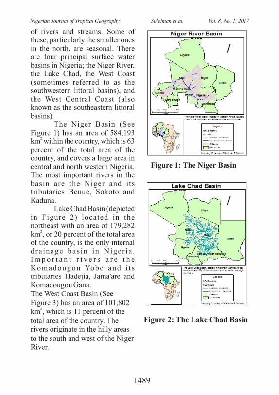
of rivers and streams. Some of these, particularly the smaller ones in the north, are seasonal. There are four principal surface water basins in Nigeria; the Niger River, the Lake Chad, the West Coast (sometimes referred to as the southwestern littoral basins), and the West Central Coast (also known as the southeastern littoral basins).
The Niger Basin (See Figure 1) has an area of 584,193
2km within the country, which is 63 percent of the total area of the country, and covers a large area in central and north western Nigeria. The most important rivers in the basin are the Niger and its tributaries Benue, Sokoto and Kaduna.
Lake Chad Basin (depicted in Figure 2) located in the northeast with an area of 179,282
2km , or 20 percent of the total area of the country, is the only internal d ra inage bas in in Niger ia . I m p o r t a n t r i v e r s a r e t h e Komadougou Yobe and i t s tributaries Hadejia, Jama'are and Komadougou Gana.The West Coast Basin (See Figure 3) has an area of 101,802
2km , which is 11 percent of the total area of the country. The rivers originate in the hilly areas to the south and west of the Niger River.
Figure 1: The Niger Basin
Figure 2: The Lake Chad Basin
1489
Nigerian Journal of Tropical Geography Suleiman et al. Vol. 8, No. 1, 2017
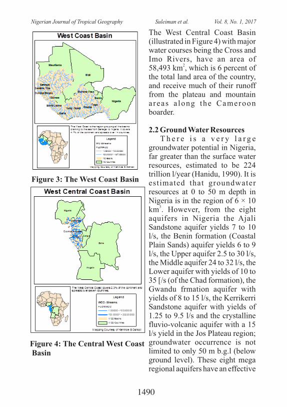
The West Central Coast Basin (illustrated in Figure 4) with major water courses being the Cross and Imo Rivers, have an area of
258,493 km , which is 6 percent of the total land area of the country, and receive much of their runoff from the plateau and mountain a reas a long the Cameroon boarder.
2.2 Ground Water Resources T h e r e i s a v e r y l a r g e groundwater potential in Nigeria, far greater than the surface water resources, estimated to be 224 trillion l/year (Hanidu, 1990). It is estimated that groundwater resources at 0 to 50 m depth in Nigeria is in the region of 6 × 10
3km . However, from the eight aquifers in Nigeria the Ajali Sandstone aquifer yields 7 to 10 l/s, the Benin formation (Coastal Plain Sands) aquifer yields 6 to 9 l/s, the Upper aquifer 2.5 to 30 l/s, the Middle aquifer 24 to 32 l/s, the Lower aquifer with yields of 10 to 35 [/s (of the Chad formation), the Gwandu frmation aquifer with yields of 8 to 15 l/s, the Kerrikerri Sandstone aquifer with yields of 1.25 to 9.5 l/s and the crystalline fluvio-volcanic aquifer with a 15 l/s yield in the Jos Plateau region; groundwater occurrence is not limited to only 50 m b.g.l (below ground level). These eight mega regional aquifers have an effective
Figure 3: The West Coast Basin
Figure 4: The Central West Coast Basin
1490
Nigerian Journal of Tropical Geography Suleiman et al. Vol. 8, No. 1, 2017
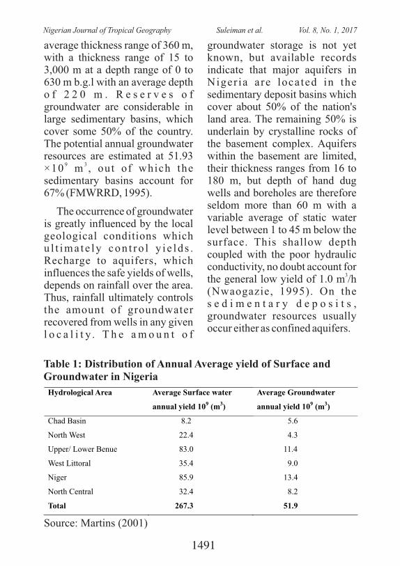
average thickness range of 360 m, with a thickness range of 15 to 3,000 m at a depth range of 0 to 630 m b.g.l with an average depth o f 2 2 0 m . R e s e r v e s o f groundwater are considerable in large sedimentary basins, which cover some 50% of the country. The potential annual groundwater resources are estimated at 51.93
9 3×10 m , out of which the sedimentary basins account for 67% (FMWRRD, 1995).
The occurrence of groundwater is greatly influenced by the local geological conditions which u l t ima te ly con t ro l y i e ld s . Recharge to aquifers, which influences the safe yields of wells, depends on rainfall over the area. Thus, rainfall ultimately controls the amount of groundwater recovered from wells in any given l o c a l i t y . T h e a m o u n t o f
groundwater storage is not yet known, but available records indicate that major aquifers in Niger ia are located in the sedimentary deposit basins which cover about 50% of the nation's land area. The remaining 50% is underlain by crystalline rocks of the basement complex. Aquifers within the basement are limited, their thickness ranges from 16 to 180 m, but depth of hand dug wells and boreholes are therefore seldom more than 60 m with a variable average of static water level between 1 to 45 m below the surface. This shallow depth coupled with the poor hydraulic conductivity, no doubt account for
3the general low yield of 1.0 m /h (Nwaogazie, 1995). On the s e d i m e n t a r y d e p o s i t s , groundwater resources usually occur either as confined aquifers.
Table 1: Distribution of Annual Average yield of Surface and Groundwater in Nigeria
Hydrological Area Average Surface water
annual yield 109 (m3)
Average Groundwater
annual yield 109 (m3)
Chad Basin
8.2
5.6
North West
22.4
4.3
Upper/ Lower Benue
83.0
11.4
West Littoral
35.4
9.0
Niger 85.9 13.4
North Central 32.4 8.2
Total 267.3 51.9
Source: Martins (2001)
1491
Nigerian Journal of Tropical Geography Suleiman et al. Vol. 8, No. 1, 2017
Groundwater resources are c o n t r o l l e d b y t h e hydrostratigraphy of the country and fo l low the pa t t e rn o f occurrence of the aquifers, aquitards or aquicludes. More than half of the country is made up of igneous and metamorphic r o c k s w h i c h m a k e u p t h e basement complex. Even though these hard rocks are essentially non-water bearing (aquiclude) there are areas of weathered basement rocks which have acquired secondary porosity due to weathering over geologic time. These areas furnish moderate to marginal water yields at depths of 20-100 m. normally, weathering and compaction processes are followed by fracturing which is a major factor of incompetent rocks at depths. These secondary aquifers are characterized by their non-extensive nature, susceptibility to anthropogenic pollution and c l ima t i c vaga r i e s . As one proceeds towards the south, The prospects of good aquifers i nc rea se . Thus w i th in t he Anambra basins and Niger delta bas ins ground water y ie ld becomes extensive to the extent that free flow conditions occur in confined areas.. Unlike surface w a t e r t h a t c u t s a c r o s s geographical boundaries, the occurrence of groundwater in
terms of quantity and quality displays spatial variability being driven by the geology and climate. On this premise, we can chronicle the availability based on three hydro-meteorological a r e a s : T h e S a h e l R e g i o n : Although the Sahel region comprises areas above latitude 11°, there is gradual southward advancement of the Sahara to now cover areas down to 10° latitude. As a result, three River basins are considered to lie within the Sahel; the Sokoto basin, the Hadejia-Yobe basin and the South-east C h a d b a s i n . T h e m a i n characteristics of the area are low annual precipitation of 500-750 mm. The region is also associated w i t h g r e a t e r e x t r e m e s o f temperature as high as 44°C before the onset of the rains or drop to as low as 6°C during the cool harmat tan a i r a round December to February. The Sokoto basin is drained by the River Sokoto with the Ka, Zamfara and Rima as tributaries. The groundwater resources are furnished by the fractured meta-sediments within the basement complex. Boreholes in these meta-sediments are shallow (30-40 m). Borehole yields are low (0.5-0.8 lit/sec), with steep drawdown. The Gundumi and Illo Formations are aquiferous but occasionally deeply confined.
1492
Nigerian Journal of Tropical Geography Suleiman et al. Vol. 8, No. 1, 2017
Y i e l d s o f 8 l i t / s e c a n d transmissivity of up to 978 m2/day have been reported at Gusau-Sokoto road by Anderson et al. (Anderson, 1973). Another borehole in the same town (Bakura Farm) was 85 m deep and gave 3 lit/sec. The Rima group comprising the Taloka (poor a q u i f e r ) a n d D u k a m a j e (aquiclude) Formations are not impressive hydrogeologically. The Wurno Formation is a moderate water yielding aquifer in the Sokoto basin. The thickness varies from 5-30 m and the recharge is restricted to only 330
2km (Ofofordile, 2002). The Sokoto Group consists of the Dange (aquitard), the kalambiana (perched aquifer, furnishing water seasonally) and the Gwandu Formation (best known aquifer in the Sokoto basin). The Gwandu consists of two main aquifers-an upper sandy aquifer and a lower confined sandy aquifer. For the water table aquifer, water levels average 21 m, though in the uplands, near the Niger border, depths of 100 m can be recorded. Further west, and down dip, the aquifer is confined by 20 m of clay and lignite, giving rise to artesian conditions. The aquifer itself varies in thickness from 13-60 m. The Hadejia-Yobe basin is drained by the Hadjia-Yobe River. The tributaries rise from Kano,
Katsina and the Jos Plateau, with relatively higher rainfall than the rest of the region. The rivers flow from the area of high rainfall in the Southwest to the area of lesser rainfall towards the Lake Chad. The geo logy o f t he ba s in comprises (from the oldest to the youngest); the basement complex, the younger granite complex, the G u n d u m i F o r m a t i o n , t h e Kerrikerri Formation and the Chad Formation.
Within the basement complex and younger granite complex areas, boreholes are shallow (20-35 m), Specific capacity of about 8-9 lit/m/min have been recorded (Offordile, 2002). In the overlying Gundumi Formation borehole depths average 45 m wi th maximum yield of 6.25 lit/sec and average of 3.2 l i t /sec. The Kerrikerri Formation of thickness of up to 200 m is considered to be unpredictable and inadequately explored. It is however associated with deep water levels (165 m Southeast of Bauchi). It appears to b e l o n g t o t h e s a m e hydrostratigraphic unit with the Chad Formation which overlies it. The Chad basin sediments are reported to be 132 m at Gumel, 115 m at Nguru, and 132 m at Marguba. Yields of 3.3-5 lit/sec h a v e b e e n r e c o r d e d . T h e separation of the Chad Formation
1493
Nigerian Journal of Tropical Geography Suleiman et al. Vol. 8, No. 1, 2017
into an upper, middle and lower aquifer cannot be defined in this part of the basin. The upper 20-30 m of the alluvial sands of the Hadejia-Yobe basin, holds a lot of water as bank storage, directly recharged from river flows. The Chad basin is described as the largest area of inland drainage basin in Africa and occupies parts of Nigeria, Chad, Central Africa Republic and the Cameroon. Most of the rivers flowing into lake Chad rise from the watershed areas of the Jos plateau and the Adamawa highlands. The rivers include the Hadejia-Yobe, Alo and yedsaram from the southwest, and the Bambassa, Chari, Illi and lagone from the south east. The rivers Yedseram-Ngadda flow from the south to the northwest, and with all the minor tributaries and rivulets empty into Lake Chad. The Hadejia-Yobe, the Yedseram and all the other tributaries are seasonal. The yedseram wi th i t s smal le r catchment area, starts to flow a little later, after the beginning of the rainy season, than the Hadejia-Yobe drainage system. There is practically no surface flow from the more arid regions of the north (Offordile, 2002). Two Formations are important, hydraulically, in the Chad basin . These are the k e r r i k e r r i a n d t h e C h a d
Formations. While the kerrikerri is too deep to be of general hydrogeological interest, the Chad formation is well explored and demarcated into upper, middle and lower aquifers. In Maiduguri, the upper aquifer has a depth limit of 105 m. The aquifer consists of lenses of fine to very coarse, often, pebbly sands alternating with clays and sandy clays. The aquifer may be either water table or semi confined. The water levels vary from 10 m to 15 m in wells tapping the aquifer with yields ranging from 2.5 lit/sec to 30 lit/sec. The middle zone aquifer is separated from the upper by about 150 m of plastic clays. It has a thickness of 300 m and is underlain by another 120 m of clay and shale. It is thus highly confined. The recharge areas of the middle confined aquifer all fall o u t s i d e t h e g e o g r a p h i c a l boundaries of Nigeria, making it a trans-boundary aquifer.
The Guinea Savannah Zone: This zone covers the area with mean annual precipitation of 1000-1250 mm and about 80 to 60 days of rainy days northwards. About five River basins fall within this zone, namely; the Kaduna River basin, the Benue River basins(upper and lower), the Upper and lower Niger Basins. The Kaduna River basin is drained
1494
Nigerian Journal of Tropical Geography Suleiman et al. Vol. 8, No. 1, 2017
by the River Kaduna and its tributaries. The River has its headwaters at the Jos Plateau. The climate is typical of most northern areas of Nigeria, except areas bordering the Jos Plateau which feature the orographic influence of highland areas of the Plateau. The temperature shows a mean annual of 24 °C to 30 °C. Precipitation shows a mean of 1120 mm but attain 1500 mm around the plateau area. Over 80% of the Kaduna basin is underlain by basement complex rock with shallow well yields of 0.2-1 lit/sec. The rest of the basin is underlain by the Nupe sandstone and alluvial deposits [ ]. The 4Nupe sandstone underlies most of t h e s o u t h e a s t i n c l u d i n g Kontagora,, Mokwa and Bida areas. It consists of slightly c e m e n t e d f i n e t o c o a r s e sandstones and siltstones with i n t e r b e d d e d t h i n b e d s o f carbonaceous shale and clays. Yields of 1.8-4 lit/sec have been reported in the Nupe sandstone (Du Preeze, 1965).
The Benue River is a continuous elongated geological s t r u c t u r e , c o n v e n i e n t l y subdivided into Upper, Middle and lower basins. The upper Benue River basin occupies the upper reaches of the Benue valley. I ts main drainage network
comprises numerous streams and rivers flowing into the River Benue from the north and South. The major river systems include the Gongola, Kilunga, and Pai to the north and the Faro and Taraba from the south of the River Benue. The temperature in the Benue valley is relatively high. It is typified by the recording from Yola where the mean daily maximum ranges from 29°C to 32°C in May to October, 32°C to 40°C in October to April. The h i g h e s t m e a n m a x i m u m temperatures, of 38°C to 40°C, are recorded in February to April. The mean minimum ranges from 18°C to 21°C from November to February. Rainfall is limited, with a mean annual of 750 mm to 1000 mm. The Upper Benue basin is underlain by patches of the b a s e m e n t c o m p l e x r o c k s , including a number of volcanic p lugs , basa l t i c f lows , and sedimentary rocks of cretaceous age. The geological sequence comprises the basement overlain by the thick sequence of shale of the Asu River group, continental sandstones of the Bima sandstone and shale, clays and limestone. The upper Benue is separated from the Chad basin by the Z a m b u k r i d g e . O f hydrogeological interest are the wea the red basa l t s i n B iu , Longuda and Sugu plateau areas.
1495
Nigerian Journal of Tropical Geography Suleiman et al. Vol. 8, No. 1, 2017
Of more hydrogeological interest i s t h e B i m a s a n d s t o n e outcropping in Yola, Jimeta,, Dabore areas. It is essentially feldspar sandstone with grit, pebbles and clay beds. It is highly cemented and behaves like crystalline rocks, hence its constraints hydrologically. Yields of 2 lit/sec to 8 lit/sec have been recorded. The Lower Benue River basin includes the lower reaches of the Benue valley, stretching from about river Wase down to the confluence of the Benue and Niger to the south. This part is drained by a number of River systems, including the River Wase, Shemankar, Dep and Mada, flowing northeast wards and the Donga, Bantaji and Katsina Ala drainage network flowing in the opposite direction, all the river systems emptying into the River Benue. The climate is characterized by high temperature regimes, like in the upper Benue, ranging from between 27°C as mean annual. The altitude influences the situation in Jos. Rainfall is moderate with a range of 1120-1500 mm on the Plateau. The geology of the Lower Benue is related to the Upper Benue with close similarity in lithology of the geological formations. These i n c l u d e t h e I n t e r b e d d e d Sandstones of the Awe Formation,
the Sandstones of the Makurdi and Ezeakku Formation, sandstones of the Awgu Formation and the basal sandstones of the Lafia Formation. A number of boreholes have been drilled into the Makurdi Formation with varying degree of success. Yields of 2.5 lit/sec 8.7 lit/sec have been reported. A borehole of about 150 m drilled into the Awgu formation furnished artesian flow at Assakio, north of Lafia. The Lafia formation has highly permeable sandstone of thickness 10-150 m and gives rise to various springs at the contact with underlying Awgu formation.
The Niger Basin consists of the broad valley of the River Niger, from the confluence of the Rivers Niger and Benue to the north western border with Benin Republic. The Basin is sub-divided into Upper and Lower Niger Basins. The Upper Basin represents the upper arm of the drainage area of the River Niger covering an area of about 116,300
2km . The River Niger, in the upper Niger Basin of Nigeria, is charged with water, from mainly, the Sokoto-Rima and kaduna River systems. Responsibility for potable water supply is entrusted to State Water Agencies (SWAs) or state water departments in the 36 Nigerian states. The SWAs are r e s p o n s i b l e t o t h e i r s t a t e
1496
Nigerian Journal of Tropical Geography Suleiman et al. Vol. 8, No. 1, 2017
governments, generally through a S t a t e M i n i s t r y o f Wa t e r Resources. SWAs are responsible for urban water supply, and in some states also for rural water supply. As of 2000, 22 States had separate State Rural Water and S a n i t a t i o n A g e n c i e s (RUWASSA), mostly set up to i m p l e m e n t a U N I C E F p r o g r a m m e . T h e L o c a l Government Authorities (LGAs), of which there are 774, are responsible for the provision of rural water supplies and sanitation facilities in their areas although only a few have the resources and skills to address the problem. The most important external partners in the Nigerian water supply and sanitation sector are the African Development Bank, the European Union, Japanese JICA, UNICEF, USAID, the NGO WaterAid and the World Bank. The African Development Bank and the World Bank provide loans to the government; the European Union, JICA and USAID provide grants to the government ; UNICEF and WaterAid receive grants from governments and donations from the public to implement their projects in cooperation with, but n o t t h r o u g h t h e g o v e r n m e n t . Wa t e r p o l i c y
Nigeria's National Water
Supply and Sanitation Policy, approved in 2000, encourage private-sector participation and envisages institutional and policy reforms at the s ta te level . However, little has happened in both respects. As of 2007, only four of the 37 states - Lagos, Cross River, Kaduna and Ogun States - began to introduce public-private partnerships (PPP) in the form of service contracts, a form of PPP where the responsibility of the private sector is limited to operating infrastructure without performance incentives. While t h e g o v e r n m e n t h a s a decentralization policy, little actual decentral izat ion has happened. The capacity of local governments to plan and carry out investments, or to operate and maintain systems, remains low despi te effor ts a t capaci ty development. Furthermore, the national policy focuses on water supply and neglects sanitation.
In 2003 a “Presidential Water Initiative (PWI): Water for People, Water for Life” was launched by then President O lusegun Obasan jo . The initiative had ambitious targets to increase access, including a 100 percent water access target in state capitals, 75 percent access in other urban areas, and 66 percent access in rural areas. Little has been done
1497
Nigerian Journal of Tropical Geography Suleiman et al. Vol. 8, No. 1, 2017
to implement the initiative and targets have not been met In 2011 the government voted in the United Nations in favour of a resolution making water and s a n i t a t i o n a h u m a n r i g h t . However, it has not passed legislation to enshrine the human right to water and sanitation in national law. With the above scenario, it is doubtful if the country will be able to attain the Millennium Development Goal for water and sanitation.
3. Water Resources and Environment: Challenges and Prospects Water resources deve lopmen t i nc ludes t he Cons t ruc t i on , ha rnes s ing , distribution and protection of both surface and groundwater infrastructures for the domestic, agricultural and industrial needs of the society. The exploitation of Nigeria's water resources has progressively increased with the return to civil rule. Despite the progress that has been made in water supply development since the first waterworks in Nigeria was commissioned in Lagos in 1915, many Nigerians still have inadequate access to modern water supply. Water shortages exist periodically in almost every major town and are present in many rural areas of the country. Areas that are provided with
water more often than not revert to water distress due to the unsustainable nature of the infrastructures, making statistics of access unreliable. The turning point for water resources development and management in Nigeria occurred after the severe drought of the 1960s. The Government's response to the catastrophe was the initiation of strategies for co-ordinated and e f f e c t i v e w a t e r r e s o u r c e s development, culminating in the mid-1970s in the creation of the Federal Minis t ry of Water Resources and the River Basin Development Authorities. The activities of these institutions were further strengthened in 1981 by the establishment of the National Committee on Water Resources, and by the Water Boards at the state level. Later the Nat iona l Wate r Resources Institute (NWRI), the Nigerian Hydrological Services Agency (NIHSA), the Rural Water Supply a n d S a n i t a t i o n A g e n c i e s (RUWASSA) were added. These bodies were charged with taking an inventory, and ensuring rational and systematic planned management and conservation, of the country's water resources. This is further boosted by the v a r i o u s i n t e r v e n t i o n s b y government, donor agencies and
1498
Nigerian Journal of Tropical Geography Suleiman et al. Vol. 8, No. 1, 2017
the setting up of many agencies at the national and sub-national levels. However, despite the robust structure in place for the development of Nigeria's Water Resources, there are numerous environmental threats militating a g a i n s t w a t e r r e s o u r c e s d e v e l o p m e n t i n N i g e r i a . Development is threatened when the quantity and quality of water available in an environment is insufficient to meet the various needs of the population and future expansion is hampered by the d e p l e t i o n a n d o r q u a l i t y deterioration of the resources resulting in water poverty or distress.
T h e r e a r e n u m e r o u s environmental factors that affect water resources. These includes:
(a) Climate ChangeClimate Change manifesting in increased evapo-transpiration and the attendant moisture deficit, decreasing precipitation with accompanying water leve l lowering in shallow aquifers and decreasing surface flows. These threats impact more on the sub-sahelian region. Climate change manifesting in increased coastal floods and saline water intrusion into upper coastal aquifers e spec i a l l y i n t he t rop i ca l rainforest zones.
Part of Northern Nigeria falls within the Sahel or sub-sahelian region characterized by scanty rainfall, vegetation and extreme temperatures. The groundwater systems in the area are such that the aqui fe rs - basement o r sedimentary, shallow or deep are all under one form of threat or the other. The Sahel region is populated by farmers who depend on wa te r supp ly fo r the i r livelihood. They need water for their crops and animals. Because o f t h e s c a n t y v e g e t a t i o n , overgrazing has further depleted the soil cover exposing the soil to denudation and moisture deficit. These farmers often resort to the digging of wells in the shallow basement aquifers to augment surface water resources furnished by various dams in the area.
D u e t o d w i n d l i n g precipitation, the water levels of these shallow wells are being lowered. The surface water quality is often impaired by excess ive use o f su lpha te fertilizers and the authorities are not immediately sensitized to the present and future implication of the leachate into surface and ground water systems. The implication of the state of affairs is that both surface and ground water systems in the north are under threat of impairment and or depletion. A well-articulated
1499
Nigerian Journal of Tropical Geography Suleiman et al. Vol. 8, No. 1, 2017
Integrated Water Resources Management involving the Ministry of Agriculture, Ministry of Water Resources and the Ministry of Environment must be vigorously pursued to adapt to the natural threats and prevent the human threats.
(b) Groundwater degradation Excessive exploitation, for example where groundwater l e v e l s f a l l t o o f a s t o r t o unacceptable levels. This not only reduces available water resources and borehole yields but can result in other serious and potentially costly side effects including saline intrusion and subsidence. Inappropriate or uncontrolled activities at the land surface, including disposal of waste and spillage of chemicals, which contaminate the underlying aquifer. This can arise from diffuse sources, which results in widespread but generally less intense contamination, or from a point source, which causes more intense but localized problems. Major change of land use, for example in Sahel, the removal of natural vegetat ion through overgrazing led to water logging and salinization problems. The nature of the aquifer will also inf luence the sca le of the contamination problem. Thus, in
a highly fractured aquifer where groundwater flow is easy and relatively rapid, contamination may become more wide ly dispersed in a given time than where flow is inter granular, especially if the strata have only a m o d e s t p e r m e a b i l i t y . Salinization: Salinity is the major threat to aquifer sustainability because it does not reduce n a t u r a l l y , a n d s a l i n i z e d groundwater can only be made fit for purpose by energy-intensive desalination or by dilution. Salinization can occur as a result of poor irrigation practice in agricultural areas, and as a result of over-abstraction inducing saline intrusion. The latter occurs usually, but not exclusively, in coastal aquifers. Mixing with just 3 to 4 per cent sea water (or groundwater of equivalent sa l in i ty) wi l l render f resh groundwater unfit for many uses, and once this rises to 6 per cent the water is unfit for any purpose other than cooling and flushing. Once salinized, aquifers are slow to recover. In inter granular-flow aquifers, the enormous volumes of water in storage have to be displaced, and in some fracture-flow systems where the matrix is also porous, it is difficult to drain relatively immobile water that has entered by diffusion from the
1500
Nigerian Journal of Tropical Geography Suleiman et al. Vol. 8, No. 1, 2017

f r a c t u r e n e t w o r k .
(c) Indiscriminate disposal of i n d u s t r i a l e f f l u e n t s i n t o Surface water bodies Studies carried out in most cities in Nigeria had shown that industrial effluent is one of the main sources of surface water pollution in Nigeria (Ekiye, 2010). Industrial effluents when discharged directly into the rivers without prior treatment have capacity of Increasing water quality parameters. Dada (1997) indicated that less than 10 % of industries in Nigeria treat their effluents before being discharged into the rivers. This has led to high load of inorganic metals such as Pb, Cr and Fe in most of water bodies (Ahmed, 2000; Wakawa,2 0 0 8 ) . The poorly managed drainage system in the country had caused the surface water impairment due to erosions during rainfall. Rainfall runoff carries all sorts of p o l l u t a n t s f r o m h o u s e s , industries, farmland and dumping sites. Industries are the major sources of pollution in all environments. Based on the type of industry, various levels of pollutants can be discharged into the environment directly or indirectly through public sewer lines. Wastewater from industries
includes employees' sanitary waste, process wastes from manufacturing, wash waters and relatively uncontaminated water f r o m h e a t i n g a n d c o o l i n g operat ions . High levels of pollutants in river water systems causes an increase in biological oxygen demand (BOD), chemical oxygen demand (COD), total dissolved solids (TDS), total suspended solids (TSS), toxic metals such as Cd, Cr, Ni and Pb and faecal coliform and hence make such water unsuitable for drinking, irrigation and aquatic life. Industrial wastewaters range from high biochemical oxygen d e m a n d ( B O D ) f r o m biodegradable wastes such as those from human sewage, pulp and paper industries, slaughter houses, tanneries and chemical industry. Others include those from plating shops and textiles, which may be toxic and require on-site physiochemical pre-treatment before discharge into municipal sewage system. Research has shown that some of the water quality parameters of both ground and surface water often rise up during rainfall with high values of turbidity, solids and anionic species often been recorded (Taiwo, 2011; Jaji, 2007; Taiwo, 2010; Mustapha, 2008 & Izonfuo, 2001). Agricultural run-
1501
Nigerian Journal of Tropical Geography Suleiman et al. Vol. 8, No. 1, 2017
off of pesticides, plant and animals wastes is also a major contributing source of organic pollution to water bodies in Nigeria. Agricultural run-off of pesticides, plant and animals wastes is also a major contributing source of organic pollution to water bodies in Nigeria. The work of Mustapha (2008) had Linked the periodic eutrophication of Oyun Reservoir in Offa, Kwara state to run-off of phosphate fertilizers from nearby farms in addition to cow dung washing from the watershed into the Reservoir. Water pol lut ion through surface run-off has been reported in Literatures with subsequent effects on nutrient en r i chmen t , wa te r qua l i ty i m p a i r m e n t , m a r i n e l i v e s spawning ground destruction and fish kill (Izonfuo, 2001 & Martins, 1998).
(d) Threats to existing water infrastructures from erosion and contamination of water pipelinesDue to regulation lapses and mining is a common business in eastern Nigeria. These activities often lead to severe erosion of the pipelines leading to excavation and collapse of the pipelines (Figure 8) . Eff luents f rom industrial and domestic activities usually enter the network through
the joints of the collapsed pipes. The situation is further aggravated by the activities of cattle men who take advantage of the leakages from the pipes to provide water for their herds. Unfortunately these activities take place in areas far from residential areas such that detection may take months to occur.
4 Conclusion and Recommendations The Nigeria Water Sector has significant potentials to contribute to the development of the economy. The provision of potable water for cooking and drinking; and the construction of dams for hydro-electricity are all r e l e v a n t f o r e c o n o m i c development while irrigation facilities across the country have helped the nation to support its growing population without solely depending on rain-fed agriculture. Additionally, the existence of dams and irrigation schemes has contributed to suburban development of several communities and induced socio-economic improvement of the residents. Clearly, the Water Sector has a major role to play in the sustenance and further development of the nation's industrial sector especially in food a n d b e v e r a g e s , t e x t i l e , pharmaceutical among others.
1502
Nigerian Journal of Tropical Geography Suleiman et al. Vol. 8, No. 1, 2017
The supply of potable water holds the key to the elimination of water-related diseases such as cholera, typhoid, dysentery, river blindness and malnutrition. Fortunately, Nigeria as a nation is endowed with huge water resources with the capacity t o m e e t o u r b u r g e o n i n g requirements across all facets of life given the requisite resources and a focused plan of action managed by competent and committed professionals within a well orchestrated institutional framework. This will require significant capital to transform the s t a t e d o b j e c t i v e s a n d requirements into available water resources for domestic and industrial consumption. The amount of resources required to maintain the dams and irrigation facilities as well as keep the taps running would require the private sector participation.
I n v i e w o f t h e s e considerations, Government needs to take the first step of articulating a holistic roadmap for the development and management of the nation's water resources towards the actualization of the sector's potentials. We believe that with the support of private sector i n v e s t o r s a n d o t h e r k e y s t a k e h o l d e r s , f o c u s e d implementation of the roadmap will facilitate the achievement of
water target objectives and create the enabling environment to attract private investments in this sector. To mitigate threats to our water resources, government must step up Integrated Water Resources management where all sectors must synergize to achieve results. The Federal Ministry of Environment must strengthen the present environmental laws such that the polluters of water bodies could be prosecuted. Industrial and agricultural sectors should also be compelled to treat their wastes before being discharged into the water bodies. Drastic measures must be taken by all authorities concerned to minimize children morbidity and mortality due to poor sanitation and water quality problems. The threats to water resources are variable and many. The variation in water quality experienced in Nigeria reflects differences in l and managemen t and t he physical environment. These differences occur both as a result of natural variability, societal development and pollutant inputs. In addition, water quality in the v ic in i ty o f u rban a reas i s influenced by industrial and urban development. Understanding the condition of rivers and streams and their relation to ground water
1503
Nigerian Journal of Tropical Geography Suleiman et al. Vol. 8, No. 1, 2017
is critical to effective mitigation of threats to water development. The River basins and Research Institutes must evolve custom mitigation measures s u i t a b l e f o r t h e h y d r o meteorological environment. Education of the benefitting masses is also likely to help in reducing anthropogenic threats to our water bodies. The Ministry of Environment should take up the c h a l l e n g e b y s t e p p i n g u p regulations.
REFERENCESA d e b a y o O T , B a l o g u n ,
AM,Olub iy i OA (2007) Chemical analysis of some i n d u s t r i a l e f f l u e n t s t h a t discharge into Lagos Lagoon, Nigeria. Research Journal of Environmental Sciences 1:196-199.
Ahmed K, Tanko A I (2000) Assessment of water quality changes for irrigation in the River Hadejia Catchment. Journal of Arid Agriculture 10: 89-94.
Anderson H R, Ogilbee W (1973) Aquifers in the Sokoto Basin northwestern Nigeria, with a description of the general hydrogeology of the region. Water Supply paper 1757-L 79p.
Dada AY (1997) Evaluation of Kano S t a t e E n v i r o n m e n t a l Management Programme-1995
on industrial pollution: Case study of Challawa and Sharada Industrial areas. Postgraduate D i p l o m a D i s s e r t a t i o n , Department of Geography, Bayero University, Kano.
Du Preeze J W, Barber W (1965)The distribution and C h e m i c a l Q u a l i t y o f G r o u n d w a t e r i n Northern.Geological Survey of Nigeria Bulletin 36: 1-20.
Egborge A B M (1994) Water p o l l u t i o n i n N i g e r i a - Biodiversity and Chemistry of Warri River. Ben Miller Books (Nig) Ltd.
Ekiye E, Zejiao L (2010)' Water quality monitoring in Nigeria; Case Study of Nigerias industrial cities. Journal of American Science 6: 22-28.
Earth's Water Distribution" (2009) United States Geological Survey.
http://ga.water.usgov.gov/ed/water distribution Retrieved 2009-05-13. Facts
FMWRRD (1995). The Study on the National Water Resources M a s t e r P l a n . J a p a n International Cooperation (JICA) and Federal Ministry of Water Resources and Rural D e v e l o p m e n t , F e d e r a l Republic of Nigeria, Abuja.
GreenFacts (2008) Scientific on Water: State of the Resource" Website.http://greenfacts.org/
1504
Nigerian Journal of Tropical Geography Suleiman et al. Vol. 8, No. 1, 2017
en/water-reourses/index/hml#2Retrieved 2008-01- 31.
Hanidu, J.A. (1990). National growth, water demand and supply strategies in Nigeria in the 1990s. Water Resources, 2:1–6.
Izonfuo LWA,Bar iweni AP (2001) The effect of urban runoff water and human activities on s o m e p h y s i c o - c h e m i c a l parameters of the Epie Creek in the Niger Delta. Journal of A p p l i e d S c i e n c e a n d Environmental Management 5: 47-55.
Jaji M O, Bamgbose O, Odukoya OO,Arowolo TA (2007) Water quality assessment of Ogun River, South West Nigeria. Environmental Monitor ing Assessment 33: 473-482.
K e h i n d e S O s h o d i ( n d ) H y d r o l o g i c a l S t u d y o f Nigeria: GIS Term Project
M u s t a p h a M K ( 2 0 0 8 ) Assessment of the Water quality of Oyun Reservoir, Offa, Nigeria, using Selected P h y s i c o - C h e m i c a l Parameters. Turkish Fishery and Aquatic Science 8: 309-319.
Martin J, Hoggart C,Matissa A (1998) Improvement priorities for sewage Treatment in Latvian small and medium sized towns. Water Science Technology 37:
137-144.Martins O (2001) Water Resources
Management and Development in Nigeria: Issues and Challenges in a new Millennium. Paper Presented at the University of Abeokuta, Nigeria.
Nwaogozie, I.L (1990) “Pollution Modeling. A Necessity for Provision of Water for all in Nigeria” Nig. J. Tech Res. Vol. 2 pp 49-55.
Offodile M E (2002) Groundwater study and development in Nigeria. Mecon Services Ltd Jos Nigeriapp: 30-36,76-103.
Spon E F (1997) In:Richard Helmer, Ivan i ldoHespanhol (eds.), Water Pollution Control - A guide to the use of water quality management principles. St Edmundsbury Press, Bury St Edmunds, Suffolk.
Taiwo A M (2011) Composting as a sustainable waste management t e c h n i q u e i n d e v e l o p i n g c o u n t r i e s . J o u r n a l o f Environmental Science and Technology 4: 93-102.
Taiwo A M (2010) Environmental i m p a c t o f p o u l t r y f a r m operations on Alakata stream at Isolu in Abeokuta, Nigeria. Masters Thesis. University of Agriculture, Abeokuta.
Wakawa R J, Uzairu A, Kagbu J A, Balarabe M L (2008) Impact assessment of effluent discharge on physico-chemical parameters
1505
Nigerian Journal of Tropical Geography Suleiman et al. Vol. 8, No. 1, 2017

a n d s o m e h e a v y m e t a l concentrations in surface water of River Challawa Kano, Nigeria. African Journal of Pure and Applied Chemistry 2: 100-106.
1506
Nigerian Journal of Tropical Geography Suleiman et al. Vol. 8, No. 1, 2017
AN OVERVIEW OF QUALITATIVE RESEARCH PARADIGM IN ENVIRONMENTAL DESIGN
DISCIPLINES Mohammed, Moukhtar Mai
Department of Architectural Technology, Federal Polytechnic, Nasarawa [email protected] [email protected]
ABSTRACT:This paper is a sketch of the qualitative research as it applies to environmental disciplines like housing, architecture and urban design. It outlines similarities and differences between qualitative and quantitative paradigms. Qualitative research involves the establishment of concepts, themes, and categories of the phenomenon under investigation. The paper explains qualitative data collection, as well as coding same (means of deciphering or making sense of information), starting from concept formation and conceptualization, through analytic memo writing and outcroppings, up to the generation of grounded theory. Its rival technique, quantitative paradigm employs numerical manipulation in developed format involving inferential statistics. However, qualitative approach analyses text systematically by interweaving data with appropriate theory, to make sense out of the nonsense. Apart from grounded theory, other qualitative analytic strategies include narrative, identification of ideal types, successive approximation, i l lustrative method, path dependency/contingency, analytic comparison and domain analysis. Both qualitative and quantitative methods have their strength and weaknesses tied sample size, sampling techniques, analytical tools and validity challenges. Therefore, paradigm choice depends upon circumstances of research resources and accessibility to appropriate information. This presentation contributes to a better understanding of interactive research procedures in natural setting, especially by novice environmental designers.
1507
Nigerian Journal of Tropical Geography Muhammed M. Vol. 8, No. 1, 2017
1.0 Introduction Qualitative research is
a type of scientific enquiry which seeks to answer ques t ions s y s t e m a t i c a l l y. I t u s e s a predefined set of procedures such as collection of evidence, to produce findings that were not determined in advance; findings are often applicable beyond the immediate boundaries of the study. This paper aims at early c a r e e r r e s e a r c h e r s a n d architecture students the basic facets of qualitative research as this are often inappropriately applied in case studies and similar research methods common in architectural research. It also seeks to understand a given research problem or topic from the p e r s p e c t i v e s o f t h e l o c a l population involved. Such an approach is especially effective in obtaining culturally specific information about the values, opinions, behaviors, and social contexts of particular populations. I t s d a t a s o u r c e i n v o l v e s participants' observation, focus and in-depth interviews. The three (3) data sources are normally generated through field notes ( a l s o c a l l e d m e m o s ) , photographs, audio (occasionally video) taping, and transcript (record or copying). Qualitative research could be analyzed using content analysis, grounded theory, and successive approximation,
ideal types, etc. Computer-assisted qualitative data analysis is equally possible. This involves the application of packages that could create, apply, and refine ca tegor ize ; t r ace l inkages between concepts; and compare between cases and events.
This paper is in seven (7) sections. Following this introduction is a review of p r e c e d e n t q u a l i t a t i v e methodologies. The determinants of research methodology follows su i te in the th i rd sec t ion . Distinctions between quantitative a n d q u a l i t a t i v e r e s e a r c h approaches are dealt with in section four (4). The fth part e x p l a i n s q u a l i t a t i v e d a t a collection plus analysis, as well as the conceptualization of social phenomenon. Part six (6) outlines the seven (7) strategies of qualitative data analysis. Finally, section eight (8) concludes the paper.
2.0 Review of Precedent Qualitative Methodologies
Mai's (2008) review of the past researches in housing in developing countries shows three approaches. These are qualitative, quantitative and theoretical approaches. Qualitative research paradigm involves l imi ted samples, but intensive interviews, close interaction with respondents
1508
Nigerian Journal of Tropical Geography Muhammed M. Vol. 8, No. 1, 2017
and careful transcription of verbal and textual data. The front-runner of this type of housing research is Amos Rapoport, whose work on the 'House form and culture' (1969) identied how primitive and vernacular dwellings were shaped by forces, which mould their characteristics. Rapoport proposed a conceptual framework of cul tural determinism of housing, with climate as a m o d i e r . O t h e r h o u s i n g researchers with inclinations for qualitative approach include Nancy Duncan and Rober t Sommer, Shiferaw, D. (1998), Chokor, B. (2005), Jee-Eun Kim (2002) , Huba M. Nguluma (2003). Others are Paul Oliver (1971, 2003, and 2007).
On the other hand, quantitative research paradigm emphasizes on large samples of data collection, and statistical analysis of same. It could be argued that descriptive statistics o f b o t h q u a l i t a t i v e a n d quantitative data does not amount to analysis. Qualitatively, such descriptive statistics output could only be used as supporting evidence to qualitative outputs l ike con ten t ana lys i s , and g r o u n d e d t h e o r y. T h o u g h debatable, descriptive statistical
output like frequency, bar charts and histogram, are mere data reduction, which a vital stage leading to inferential statistics.
Proponents of quantitative research are Graham Tipple (2005), Peter Kellett and Ann G a n r h a m ( 1 9 9 5 ) , a n d Kowaltowski (1999). Theoretical housing research is similar to the qualitative type, but evaluates housing trends, patterns, and twist from available literature. It is similar to content analysis, but differs in a way. For instance, content analys is combines qualitative and quantitative techniques to make inferences by systematically and objectively i d e n t i f y i n g s p e c i e d characterist ics within text . Theoretical research seldom involves quantitative method. Protagonists of theoret ical research are Alex Walker (2001), Mustafa Pultar (1997), Jon Lang (1987) and Peter Kellett (2002). This paper reviews of qualitative r e s e a r c h a s o u t l i n e d i n Kowaltowski et al. (2006, 1995a) and similar others to establish constructs (measurable items) therein.
Kowaltowski et al. (2006:1100-1114) reviewed some methods of evaluating housing in
1509
Nigerian Journal of Tropical Geography Muhammed M. Vol. 8, No. 1, 2017
low income public housing in Brazil by testing the population's views on quality of life and sustainability issues. The results show that the population related quality of life to economic factors, and sustainability is associated with reduced utility bills and security. Therefore, the research constructs of the low income public housing are i) quality of life, ii) sustainability issues, iii) utility bills, and iv) security. Kowaltowski's (1999:300-302) r e s e a r c h o n s p o n t a n e o u s settlements looked at the process leading to the products, the house and the urban context, the suburb, with emphasis on the non-architectural issues. Hence, the f a c t o r s c o n s i d e r e d i n t h e spontaneous settlements are non-architectural issues of housing development process and the spatial identity of the product (the residential unit). The assessment parameters are (Kowaltowski et a l , 2006 :1100 -1114 ) we re n e i g h b o r h o o d e v a l u a t i o n , existence of community spirit, home evaluation, quality of life, residents' perception of security and safety. However, Kellett and N a p i e r ( 1 9 9 5 : 2 2 ) o n t h e architectural features referred to here as posi t ive aesthet ics
parameters. Positive aesthetics
elements are based primarily on a visual coherence of the settlement generated by regular street layout, vegetation, uniform single storey height, and the use of building materials (Kellett and Napier, 1995:22). Kellett and Napier, (1995) cited studies in Brazil of self-built houses on subdivisions with some security of tenure by Motta (1975) and Sampaio and Lemos (1984) dealt primarily with family habits and their comfort satisfaction. Sampaio and Lemos (1993), Ornstein et al. (1995:249-258) in Kowaltowski et al. (1995a) analyzed in terms of constructs of house area, plan conguration, construction detailing and environmental comfort issues.
Monzeglio (1990) in Kowaltowski et al. (1995a) evaluated the Brazilian scene, specically in outer suburbs of Sao Paulo in terms of 'perceived beauty.' The street was considered predominantly 'beautiful,' linked to 'perceived beauty due to socialization, and, 'perceived ugliness' due to the lack of in f ras t ruc tu re and lack o f maintenance. Rapoport (1989), Kel le t t and Napier (1995) searched for order in the apparent messiness of self-built settlements
1510
Nigerian Journal of Tropical Geography Muhammed M. Vol. 8, No. 1, 2017
by methodological assessment of their vernacular products.
The selection of a research strategy is crucial, for it could affect the validity and re l i ab i l i ty o f da ta . Le r i se (1996:198) points out factors that determine the choice of method to include scope and nature of research, the availability of funds and access rich information, a m o n g o t h e r s . T h e comprehension of the process of t r a n s f o r m a t i o n r e q u i r e s a systematic approach to evaluate the variety of changes taking place within a given space, time and context. This involves identifying the stakeholders or actors, artefacts, program and prospects of the transformation process.
The selection of a case study strategy is justied by the nature of the research problem, objectives and research questions. The focus is on the transformation of houses, process and the effects on the built environment micro a n d m a c r o s c o p i c a l l y. T h e appropriate questions are 'why', 'how' and 'what' taking place in r e l a t i o n t o h o u s i n g b u i l t environment before and after Abuja became the sea t o f Nigeria's administration. The focus therefore, is a combination of descriptive and exploratory accounts towards understanding
the process , problems and outcomes of housing pattern transformation. Housing pattern transformation involves a chain of actions and actors.
The case study strategy is signicant in a study of this nature, since it brings to light t h e p r o c e s s e s o f h o u s i n g transformation together with the actors in the real life situation within the specic context of this study. These processes may remain hidden in a large-scale survey but could be important to the success or failure of systems or organization (Yin, 1994). Case s t u d i e s m a y s u p p l e m e n t information on a survey or are u s u a l l y c a r r i e d o u t a s a freestanding exercise (Yin, 1994). However, they can be conducted before a survey, as a means of identifying key issues, which merit further investigation. Therefore, it is evident from the previous studies on this topic that the approach to the research can be undertaken quantitatively, qualitatively or theoretically. It is also apparent that to study the housing transformation of an indigenous cultural group, the stakeholders' views are most desired to establish their housing features; the changes observed over time, and the motivation for transformation. In addition, eld
1511
Nigerian Journal of Tropical Geography Muhammed M. Vol. 8, No. 1, 2017
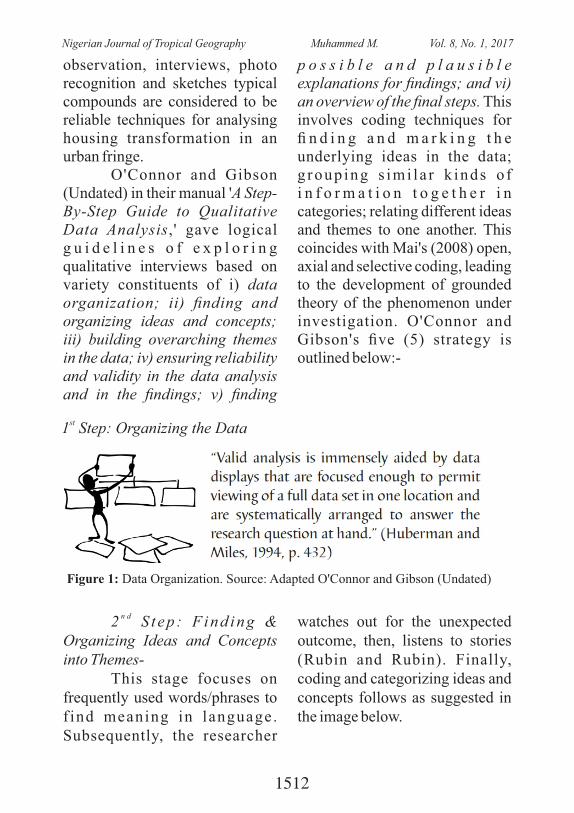
observation, interviews, photo recognition and sketches typical compounds are considered to be reliable techniques for analysing housing transformation in an urban fringe.
O'Connor and Gibson (Undated) in their manual 'A Step-By-Step Guide to Qualitative Data Analysis,' gave logical g u i d e l i n e s o f e x p l o r i n g qualitative interviews based on variety constituents of i) data organization; ii) nding and organizing ideas and concepts; iii) building overarching themes in the data; iv) ensuring reliability and validity in the data analysis and in the ndings; v) nding
p o s s i b l e a n d p l a u s i b l e explanations for ndings; and vi) an overview of the nal steps. This involves coding techniques for n d i n g a n d m a r k i n g t h e underlying ideas in the data; g roup ing s imi la r k inds o f i n f o r m a t i o n t o g e t h e r i n categories; relating different ideas and themes to one another. This coincides with Mai's (2008) open, axial and selective coding, leading to the development of grounded theory of the phenomenon under investigation. O'Connor and Gibson's ve (5) strategy is outlined below:-
st1 Step: Organizing the Data
Figure 1: Data Organization. Source: Adapted O'Connor and Gibson (Undated)
n d2 S t ep : F ind ing & Organizing Ideas and Concepts into Themes-
This stage focuses on frequently used words/phrases to f ind meaning in language. Subsequently, the researcher
watches out for the unexpected outcome, then, listens to stories (Rubin and Rubin). Finally, coding and categorizing ideas and concepts follows as suggested in the image below.
1512
Nigerian Journal of Tropical Geography Muhammed M. Vol. 8, No. 1, 2017
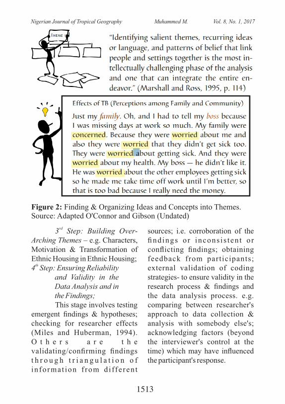
rd3 Step: Building Over-
Arching Themes – e.g. Characters, Motivation & Transformation of Ethnic Housing in Ethnic Housing;
th4 Step: Ensuring Reliability
and Validity in the Data Analysis and in the Findings; This stage involves testing
emergent ndings & hypotheses; checking for researcher effects (Miles and Huberman, 1994). O t h e r s a r e t h e validating/conrming ndings t h r o u g h t r i a n g u l a t i o n o f in format ion f rom d i ffe ren t
sources; i.e. corroboration of the ndings o r incons i s ten t o r conicting ndings; obtaining feedback from participants; external validation of coding strategies- to ensure validity in the research process & ndings and the data analysis process. e.g. comparing between researcher's approach to data collection & analysis with somebody else's; acknowledging factors (beyond the interviewer's control at the time) which may have inuenced the participant's response.
Figure 2: Finding & Organizing Ideas and Concepts into Themes. Source: Adapted O'Connor and Gibson (Undated)
1513
Nigerian Journal of Tropical Geography Muhammed M. Vol. 8, No. 1, 2017
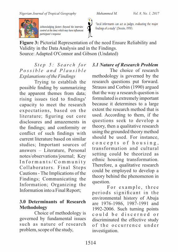
Figure 3: Pictorial Representation of the need Ensure Reliability and Validity in the Data Analysis and in the Findings.Source: Adapted O'Connor and Gibson (Undated)
S t e p 5 : S e a r c h f o r P o s s i b l e a n d P l a u s i b l e Explanations of the Findings
Trying to establish the possible nding by summarizing the apparent themes from data; rising issues tied to ndings' capacity to meet the research expectat ions, based on the literature; guring out core disclosures and amazements in the ndings; and conformity or conict of such ndings with current literature based on similar studies; Important sources of answers – Literature, Personal notes/observations/journal; Key I n f o r m a n t s / C o m m u n i t y Col labora tors . F inal Steps Cautions - The Implications of the Findings; Communicating the Information; Organizing the Information into a Final Report;
3.0 Determinants of Research Methodology
Choice of methodology is governed by fundamental issues such as nature of research problem, scope of the study,
3.1 Nature of Research Problem The choice of research methodology is governed by the research questions put forward. Strauss and Corbin (1990) argued that the way a research question is formulated is extremely important because it determines to a large extent the research method that is used. According to them, if the questions seek to develop a theory, then a qualitative research using the grounded theory method should be used. For instance, c o n c e p t s o f h o u s i n g , transformation and cultural setting could be theorized as ethnic housing transformation. Therefore, a qualitative research could be employed to develop a theory behind the phenomenon in question.
F o r e x a m p l e , t h r e e p e r i o d s s i g n i c a n t i n t h e environmental history of Abuja are 1976-1986, 1987-1991 and 1992-2006. Such turning points c o u l d b e d i s c e r n e d o r discriminated the effective study o f t h e o c c u r r e n c e u n d e r investigation.
1514
Nigerian Journal of Tropical Geography Muhammed M. Vol. 8, No. 1, 2017
A case study research
i n v o l v e s s e t t l e m e n t s o r neighborhoods that constitute the research site. The research themes could helpful in limiting the research scope, especially in developing appropriate theories. F o r t h e e t h n i c h o u s i n g transformation study, the themes c o u l d b e c h a r a c t e r s , t ransformat ion , mot iva t ion acculturation and self-help. According to Gilham (2000:10), a qualitative research focuses on people's views as they are told, as well as their action (or behavior pattern). Quantitative research is g e n e r a l l y c o n c e r n e d w i t h measurements and is characterized b y a m o r e s t r u c t u r e d a n d standardized data collection.
3.2 Scope of the Research Mai's (2008) research examines the pattern of Ethnic hous ing t r ans fo rma t ion a s observed in peri-urban Abuja. It assesses the transformation of spatial identity as manifested in housing. Consequently, it could discover the driving force behind these changes from point of view socio-cultural values the of Abuja indigenous community. To this end purposive stratied sampling of r e s p o n d e n t s i n c l u d e s a l l ( c o m m u n i t y l e a d e r s a n d
compounds considered oldest in the opinion of the leaders were sampled) gatekeepers. The unit of analysis for this study is the compound. A compound is a group of dwelling units sharing common entrance, toilets, kitchens and other services. This is because of the African practice of extended environment family dwelling makes it difcult for a visitor to easily identify extent of each household's dwelling unit. Denyer (1978:165) declares that African housing boundaries are more imaginary than real. More so, decisions to modify involve all members of the compound. Even in rental housing, the cooperation of tenants is usually sought prior to any alteration.
4.0 Distinctions between Quantitative and Qualitative Research Approaches
The pair differs primarily in:-i. Their analytical intentions ii. The natures of questions they pose iii. The procedure of data col lect ion the instruments applied iv. The forms of data they produce v. The degree of elasticity built into study design
1515
Nigerian Journal of Tropical Geography Muhammed M. Vol. 8, No. 1, 2017
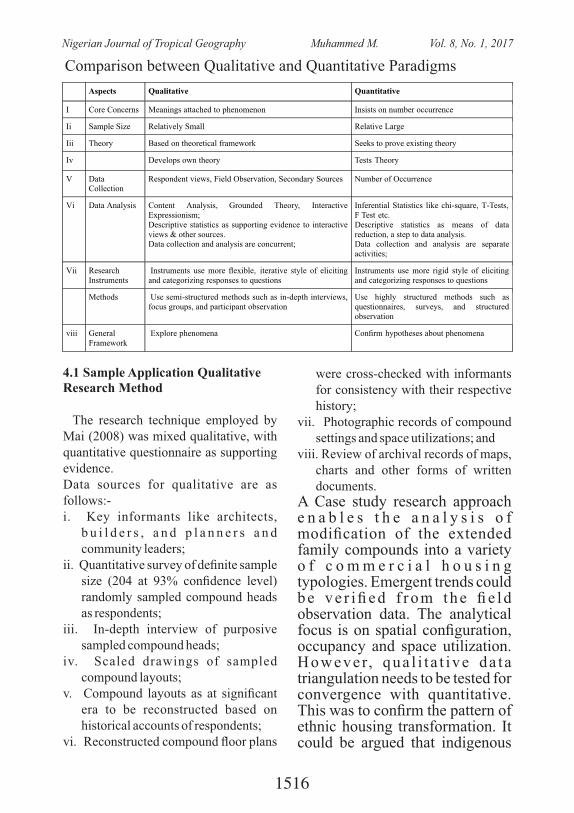
Comparison between Qualitative and Quantitative Paradigms
Aspects Qualitative Quantitative
I Core Concerns Meanings attached to phenomenon Insists on number occurrence
Ii Sample Size Relatively Small Relative Large
Iii Theory Based
on
theoretical
framework
Seeks
to
prove
existing
theory
Iv Develops
own
theory
Tests
Theory
V DataCollection
Respondent
views,
Field
Observation,
Secondary
Sources
Number
of
Occurrence
Vi Data Analysis Content
Analysis,
Grounded
Theory, Interactive
Expressionism; Descriptive statistics as supporting evidence to interactive views
&
other
sources.
Data
collection
and
analysis
are
concurrent;
Inferential
Statistics
like chi-square, T-Tests,F Test etc. Descriptive statistics as means of datareduction,
a
step
to
data analysis.
Data
collection
and
analysis are separate
activities;
Vii ResearchInstruments
Instruments
use
more
exible,
iterative
style
of
eliciting
and
categorizing
responses
to
questions
Instruments
use
more
rigid style of elicitingand
categorizing
responses to questions
Methods
Use
semi-structured
methods
such
as
in-depth
interviews,
focus
groups,
and
participant
observation
Use
highly
structured methods such asquestionnaires,
surveys, and structuredobservation
viii GeneralFramework
Explore phenomena Conrm hypotheses about phenomena
4.1 Sample Application Qualitative Research Method
The research technique employed by Mai (2008) was mixed qualitative, with quantitative questionnaire as supporting evidence.Data sources for qualitative are as follows:-i. Key informants like architects,
b u i l d e r s , a n d p l a n n e r s a n d community leaders;
ii. Quantitative survey of denite sample size (204 at 93% condence level) randomly sampled compound heads as respondents;
iii. In-depth interview of purposive sampled compound heads;
iv. Scaled drawings of sampled compound layouts;
v. Compound layouts as at signicant era to be reconstructed based on historical accounts of respondents;
vi. Reconstructed compound oor plans
were cross-checked with informants for consistency with their respective history;
vii. Photographic records of compound settings and space utilizations; and
viii. Review of archival records of maps, charts and other forms of written documents.
A Case study research approach e n a b l e s t h e a n a l y s i s o f modication of the extended family compounds into a variety o f c o m m e r c i a l h o u s i n g typologies. Emergent trends could be ve r i ed f rom the e ld observation data. The analytical focus is on spatial conguration, occupancy and space utilization. However, qua l i t a t ive da ta triangulation needs to be tested for convergence with quantitative. This was to conrm the pattern of ethnic housing transformation. It could be argued that indigenous
1516
Nigerian Journal of Tropical Geography Muhammed M. Vol. 8, No. 1, 2017
housing features may be broken down into physical, social, and p s y c h o l o g i c a l r e s i d e n t i a l elements as follows: -
• Physical: Nature of original compound, Dwell ing layout, Location and Plot demarcation
• S o c i a l : Ty p o l o g y, a n d Occupancy, and
• Psychological: Urbanization, Acculturation and Self-help housing delivery.
4.2 Selection of a Denite Research Paradigm
The choice appropriate community of research subjects may be governed by: -i. P e c u l i a r a d v a n t a g e s o f
population;ii. P r o x i m i t y t o e c o n o m i c
activities and iii. Retent ion of the e thnic
indigenous habitat For example, Mai (2008)
selected Karu community of Abuja to study the ethnic housing transformation on the basis of economic change as reected in t h e Wo r l d B a n k r e p o r t i n CASSAD (2002). Therefore, information richness in terms of culture change seems to be eminent. Patton (2002) and Flyvberg's (1999) decisive factors for the selection of a case study area is information abundance cases are those from which one
can learn a lot about the issues that are in the study focus. The relevant question relates here is tied to changing traditional housing pattern due urbanization.
A casual observation indicates that, property owners in such areas tend to maximize prot at m i n i m u m i n v e s t m e n t , b y maximizing tenants. Therefore, they resort to increasing the number of rooms and other modications to meet demand. The selection of Karu community as a case study area is motivated by apparent social and physical transformation of the built environment.
4.3 Comparison between Qualitative and Quantitative
The pair of paradigm is contrasted in terms of similarities and differences as follows:-
4.3.1 Similari t ies between Qualitative and Quantitative
According to Newton (2003), the following similarities manifest:-i. Inference: Both infer or make
judgment f rom empir ical evidence apparent from the examination of empirical information.
ii. Public Method: means of data collection and analysis in both r e s ea r ch ap p r o ach es a r e accessible to public security as and when required. King et al
1517
Nigerian Journal of Tropical Geography Muhammed M. Vol. 8, No. 1, 2017
(1998:118) believes that though qualitative research design may not be explicit, “but are implicit in every piece of research”.
iii. Comparison: This is central process to every data analysis, be it quantitative or qualitative. It compares features of evidence gathered.
iv. Avoidance of Misleading Inferences: Researchers sort the variety of explanations and d i s c u s s i o n s t h r o u g h t h e evaluation of merits of rivals; to establish the authenticity, validity and worthiness of each of them.
4.3.2 Differences between Qualitative and Quantitative
They differ in four ways (Newton, 2003):- viz:-i. Quantitative employ standard
statistical analysis techniques. And hypothesis of statistical methods vary little across different social and natural sciences. Quantitative analysis is highly developed and involves applied mathematics.
ii. Qualitative analysis is less developed and it matched by a variety of approaches to data analysis. Quantitative research is more inductive. It enjoys less operational advantages than its qualitative counter part
iii. Quantitative research analysis only starts after the whole data
is collected. Then numerical data set is manipulated for patterns and relationship between variables. On the o t h e r h a n d , q u a l i t a t i v e researchers could search for patterns and relationship between factors early in the research effort. It data analysis is not a distinct a stage in the qualitative undertaking.
iv. Social theory:- Quantitative research manipulate numbers as representative of empirical f a c t s ( s e e i n g , h e a r i n g , teaching, tasting and smelling) to test abstract hypothesis of va r iab le cons t ruc t s ( e .g y=a+bx).
Y = dependent variable, and x is an independent variable qualitative research creates new concepts and theories based on empirical evidence and abstract concepts.i. Quantitative tests theories
from data ii. Qualitative develops theories
from dataiii. Q u a n t i t a t i v e p a r a d i g m
i n v o l v e s n u m b e r m a n i p u l a t i o n b a s e d o n variables hypothesis and inferential statistics.
iv. Quantitative analysis use word (text) to manipulate research factors and assumptions, such word content analysis could be refuse, relatively imprecise and con tex t spec ic in
1518
Nigerian Journal of Tropical Geography Muhammed M. Vol. 8, No. 1, 2017
meaning.
5.0 Explanations of Qualitative Datai. No choice between universal
and specic laws; instead, explanations or generalizations are based on concrete data and contexts, devoid of simple descriptions.
ii. Uses less abstract views grounded in concrete details.
iii. Applies rich details which are context sensitive to portray the complexity of social processes and sentences.
iv Explanations aim at organizing specic details into a coherent picture, model and theory of social life.
5.1 Principles of Sampling in Qualitative Research
It has been argued that for some types of qualitative research, the case selection is not a matter for which principles can be laid down, since cases are simply 'given' aspects of the research question. For example, Stake (1995) in his discussion of case study methodology, distinguishes between intrinsic casework (where the case is pre-specied, not chosen, because a particular case is the focus of the research question) and instrumental or collective casework, requiring one or more cases to be chosen from a number of possible alternatives in order to explore a
research theme. Stake (1995:243) suggests that, if qualitative research requires cases to be chosen, then "…nothing is more important than making a proper selection of cases. It is a sampling problem." Even in intrinsic casework, there may be issues of select ion and choice to be resolved with respect to within-case sampling.
To ensure ethical sampling strategy, a feasible sampling plan of moderate cost, was drawn. This involves training of research assistants, identication and interaction with gate-keepers (community leaders and security agents). Some funds were set aside for tips, consent inducement
1519
Nigerian Journal of Tropical Geography Muhammed M. Vol. 8, No. 1, 2017
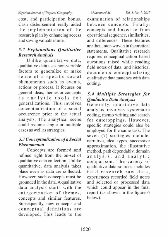
cost, and participation bonus. Cash disbursement really aided the implementa t ion of the research plan by enhancing access and saving valuable time.
5.2 Explanations Qualitative Research Analysis
Unlike quantitative data, qualitative data uses non-variable factors to generalize or make s ense o f a spec ic soc i a l phenomenon such as events, actions or process. It focuses on general ideas, themes or concepts a s a n a l y t i c t o o l s f o r generalizations. This involves conceptualization of a social occurrence prior to the actual analysis. The analytical scene could assume single or multiple cases as well as strategies.
5.3 Conceptualization of a Social Phenomenon
Concepts are formed and rened right from the on-set of qualitative data collection. Unlike quantitative, data analysis takes place even as data are collected. However, such concepts must be grounded in the data. A qualitative data analysis starts with the c a t e g o r i z a t i o n o f t h e m e s , concepts and similar features. Subsequently, new concepts and concep tua l den i t ions a re developed. This leads to the
examination of relationships between concepts . Final ly, concepts and linked to from operational sequence, similarities, and differences. These features are then inter-woven in theoretical statements. Qualitative research requires conceptualization based questions raised while reading eld notes of data, and historical documents conceptual izing qualitative data matches with data coding.
5.4 Multiple Strategies for Qualitative Data Analysis General ly, qual i ta t ive data analysis involves systematic coding, memo writing and search for outcroppings. However, specic strategies could also be employed for the same task. The seven (7) strategies include: narrative, ideal types, successive approximation, the illustrative method, path dependably, domain a n a l y s i s , a n d a n a l y t i c comparison. The variety of qualitative data sources includes e l d r e s e a r c h r a w d a t a , experiences recorded eld notes and selected or processed data which could appear in the nal report (as shown in the gure 6 below).
1520
Nigerian Journal of Tropical Geography Muhammed M. Vol. 8, No. 1, 2017
Key: Data 1 = Raw sense data + researcher's experiences; Data 2 = Recorded data +
physical record of experiences. Data 3 = Selected processed data in the nal report
Figure 6: Stages of Qualitative Data Analysis. Source: Adapted from Neuman (2003:501)
6.0 Seven Strategies of Qualitative Data Analysisi. The seven (7) qualitative data
analysis strategies include (Newton, 2003): -
ii. The Narrative: Tells a story about a particular aspect of social life;
iii. I d e a l Ty p e s : C o m p a r e s qualitative data with a real-life model;
iv. Successive Approximation: Repeatedly commutes between data and theory to carefully bridge the gap between them;
v. Illustrative Method: Fills in the gap in theory with qualitative data similar to successive approximation;
vi. P a t h D e p e n d e n c y a n d Cont ingency : Traces the sequence of events that triggers or creates the deterministic path. Here, events are mapped
out from outcome back to the origin.
vii. D o m a i n A n a l y s i s : Locates the themes of a cultural setting; then combines ideas or concepts into categories of relationships to explain an aspect of social life.
viii. A n a l y t i c C o m p a r i s o n : Identies variety of factors that determine a key outcome. Subsequently, similarities and differences are discriminated in order to establish the key features responsible for the outcome.
6.1 The Narrative The narrative is also called
natural history or realist tale approach. It is a theoretical description in which the research is presented in a chronological order in naturally unfolding
1521
Nigerian Journal of Tropical Geography Muhammed M. Vol. 8, No. 1, 2017
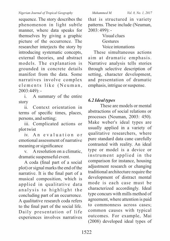
sequence. The story describes the phenomenon in light subtle manner, where data speaks for themselves by giving a graphic picture of the occurrence. The researcher interjects the story by introducing systematic concepts, external theories, and abstract models. The explanation is grounded in concrete details manifest from the data. Some narratives involve complex e l e m e n t s l i k e ( N e u m a n , 2003:449): -
i. A summary of the entire story
ii. Context orientation in terms of specic times, places, persons, and setting;
iii. Complicated actions or plot twist
iv. A n e v a l u a t i o n o r emotional assessment of narrative meaning or signicance
v. A resolution on a climatic, dramatic suspenseful event.
A coda (nal part of a social plot) or signal marks the end of the narrative. It is the nal part of a musical composition, which is applied in qual i tat ive data a n a l y s i s t o h i g h l i g h t t h e concluding part of an occurrence. A qualitative research coda refers to the nal part of the social life. Da i ly p resen ta t ion o f l i f e experiences involves narratives
that is structured in variety patterns. These include (Neuman, 2003: 499): -
Visual clues Gestures Voice intonationsThese simultaneous actions
a im at dramat ic emphasis . Narrative analysis tells stories through selective description of setting, character development, and presentation of dramatic emphasis, intrigue or suspense.
6.2 Ideal types These are models or mental
abstractions of social relations or processes (Neuman, 2003: 450). Make weber's ideal types are usually applied in a variety of qualitative researchers, where pure standard data cane carefully contrasted with reality. An ideal type or model is a device or i n s t rumen t app l i ed i n t he comparison for instance, housing adjustment research or changing traditional architecture require the development of distract mental mode is each case must be characterized accordingly. Ideal type concurs with mills method of agreement, where attention is paid to commonness across cases; common causes with typical outcomes. For example, Mai (2008) developed ideal types of
1522
Nigerian Journal of Tropical Geography Muhammed M. Vol. 8, No. 1, 2017
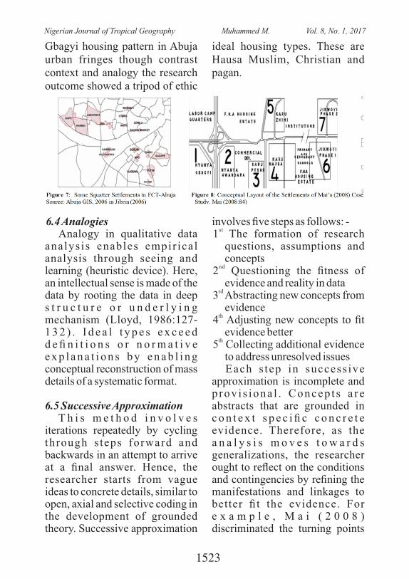
Gbagyi housing pattern in Abuja urban fringes though contrast context and analogy the research outcome showed a tripod of ethic
ideal housing types. These are Hausa Muslim, Christian and pagan.
6.4 AnalogiesAnalogy in qualitative data
analys is enables empir ical analysis through seeing and learning (heuristic device). Here, an intellectual sense is made of the data by rooting the data in deep s t r u c t u r e o r u n d e r l y i n g mechanism (Lloyd, 1986:127-1 3 2 ) . I d e a l t y p e s e x c e e d d e n i t i o n s o r n o r m a t i v e e x p l a n a t i o n s b y e n a b l i n g conceptual reconstruction of mass details of a systematic format.
6.5 Successive ApproximationT h i s m e t h o d i n v o l v e s
iterations repeatedly by cycling through s teps forward and backwards in an attempt to arrive at a nal answer. Hence, the researcher starts from vague ideas to concrete details, similar to open, axial and selective coding in the development of grounded theory. Successive approximation
involves ve steps as follows: - st
1 The formation of research questions, assumptions and concepts
nd2 Questioning the tness of evidence and reality in data
rd3 Abstracting new concepts from
evidenceth4 Adjusting new concepts to t
evidence betterth
5 Collecting additional evidence to address unresolved issues Each s tep in success ive
approximation is incomplete and p rov i s iona l . Concep t s a r e abstracts that are grounded in c o n t e x t s p e c i c c o n c r e t e evidence. Therefore, as the a n a l y s i s m o v e s t o w a r d s generalizations, the researcher ought to reect on the conditions and contingencies by rening the manifestations and linkages to better t the evidence. For e x a m p l e , M a i ( 2 0 0 8 ) discriminated the turning points
1523
Nigerian Journal of Tropical Geography Muhammed M. Vol. 8, No. 1, 2017
or epochs of FCT-Abuja as 1976 – 1986, 1987 – 1991, and 1992 – 2006 theoretically based on archival records.
6.6 Domain Analysis James Spradley (1979a)
dened domain as the basic unit of cultural setting, which organizes an idea or concept. Such a system is built upon the analysis of domains (organized concepts typical of a culture). These domains are combined to form taxonomies or categories as well broader themes (subjects) for the total interpretation of the cultural se t t ing. Spradley 's domain analysis assumes six (6) steps as follows (Newman, 2003): -i. Rereading rich data notes full of details;ii. Mentally repackaging details into organized ideas;iii. Developing fresh ideas or constructs from the eld notes o n s u b j e c t i v e m e a n i n g s manifesting from the organized ideas;iv. Identifying relationships b e t w e e n i d e a s ( t h e m e s ) , categorized according to logical similarities;v. Organizing sets of ideas or themes into larger groups or categories on the basis of comparison; andvi. Organizing and l inking groups together with broader integrating themes.
7.0 Conclusion Qualitative research is an
interact ive val id means of appraising actions, events and process especially of human s e t t i n g s , w h e r e m e a n i n g s associated with such occurrences are paramount. Such meanings could be emic or etic. Emic refers to representation of settings based on par t ic ipants ' te rms and viewpoints. Etic, on the other hand relates to representation tied t o r e s e a r c h e r s ' t e r m s a n d viewpoints. The application of either of these stand points is clearly stated appropriately. The na l r epor t o f qua l i t a t ive paradigm usually summarizes why the research question(s), the methods applied in arriving at answers the set questions, what y o u r n d i n g s w e r e , t h e implications of those ndings, recommendations, and strategies, and areas of future research that you were able to ident i fy. Q u a l i t a t i v e d i f f e r s f r o m quantitative in their intentions, appl icat ions , ndings , and frameworks. It could be argued tha t qual i ta t ive paradigms generally cover narrow scope, but broader depth.
1524
Nigerian Journal of Tropical Geography Muhammed M. Vol. 8, No. 1, 2017
ReferencesCASSAD (2002). The Economy
and Employment Structure a n d T r e n d s i n K a r u : Overview of Findings. Center for
Chokor, B. A. (2005). Changing Urban Housing Form and Organization in Nigeria: Lessons for Community p l a n n i n g . P l a n n i n g Perspectives, 20 (January 2005), p. 69-96.
C r e s w e l l , J . W. ( 2 0 0 2 ) . E d u c a t i o n a l R e s e a r c h : Planning, Conducting, and Evaluating Quantitative and Qualitative Research. New Jersey: Merrill Prentice Hall.
Denyer, S. (1978). African Traditional Architecture. N e w Y o r k : A f r i c a n a Publishing Company.
Denzin , N. and Lincoln Y. ( 1 9 9 4 ) . H a n d b o o k o f Q u a l i t a t i v e R e s e a r c h . Ssgepublications: U.K. p. 65.
Flyvbjerg, B. (1999). Case Study Research and Narratology, Course Document, UCLAS, Dar es Salaam, Tanzania.
F l y v b j e r g , B . ( 2 0 0 1 ) .
MakingSocial Science Matter. Why Social Inquiry Fails and How It can Succeed Again. Cambridge University Press, United Kingdom, p. 74.
Francescati, G. Et Al. (1979). Residents' Satisfaction in HUD Assisted Housing: Design and Management Factors, Us Dept. Of Housing and Urban Development (Document Proceedings 390, Washington, D.C.
Furby, L. (1978). Possession in Humans: An Exploratory Study of its Meaning and Motivation. Social Behavior and Personality. Volume 6(1), pp 49-65.
Garba, S. (1997). Public land ownership and urban land management effectiveness in metropolitan Kano, Nigeria Habitat International, 21(3): 305-317.
G e r s o n , E . ( 1 9 9 1 ) . Supplementing Grounded Theory. In D. Maines (Ed.), Social Organization and Social Process. New York: Aldine de Gruyter. p.285-301.
G i b s o n , J . ( 1 9 7 9 ) . T h e
1525
Nigerian Journal of Tropical Geography Muhammed M. Vol. 8, No. 1, 2017
Ecological Approach to P e r c e p t i o n . B o s t o n : Haughton Mif�lin.
Gilbert, A. (1981). Pirates and Invaders: Land Acquisition in U r b a n C o l o m b i a a n d Ve n e z u e l a . I n : W o r l d D e v e l o p m e n t . Vo l u m e (7):657-678. Great Britain.
Gillham, B. (2000). Case Study R e s e a r c h M e t h o d . Continuum: London, p.10.
Gilliland, J. and Pierre, G., (2006). The study of urban fo r m i n C a n a d a . U rb a n Morphology (2006) 10(1), 51-66.
Glaser, B. G. & Strauss, A. L. (1967). The Discovery of Grounded Theory. Chicago: Aldine Publishing Company.
Jibril, I.U. (2006). 'Resettlement Issues, Squatter Settlements and the Problems of Land Administration in Abuja, Nigerias Federal Capital. 5th FIG Regional Conference Accra, Ghana, March 8-11, 2006. Retrieved on 2007-08-10.
Kellett, P and Napier, M. (1995) Squatter Architecture? A
c r i t i c a l exa m i n a t i o n o f ve r n a c u l a r t h e o r y a n d spontaneous settlement with reference to South America and South Africa. Traditional Dwellings and Settlements Review, Volume 6(2): 7-24.
K e l l e t t , P. ( 2 0 0 2 ) . T h e Construction of Home in informal City. Journal of Romance Studies. Volume 2(3):17-31.
Kellett, P. and Ganrham, A. (1995). The role of culture and gender in mediating the i m p a c t o f o f � i c i a l interventions in informal settlements: A study from C o l o m b i a . H a b i t a t International, 14(1), 53- 60.
Kowaltowski, D.C.C.K (1999). Aesthetics of Sel f Bui lt Houses: An Analysis of a Brazilian Setting. Habitat International. Volume 22(3): 299-322.
Kowaltowski, D.C.C.K., Gomes da Silva, V., Pina, S.A.M.G.; Labaki , L .C . , Regina , C . (2006). Quality of life and sustainability issues as seen
1526
Nigerian Journal of Tropical Geography Muhammed M. Vol. 8, No. 1, 2017
by the population of low-income housing in the region of Campinas, Brazil. Habitat International 30 (2006) 1100 -1114.
L a n g , J . ( 1 9 8 7 ) . C re a t i n g Architectural Theory: The Ro l e o f t h e B e h av i o ra l Sciences in Environmental Design. Van
Miles, M., & Huberman, A. M. (1994). Qualitative data a n a ly s i s : A n E x p a n d e d S o u r c e b o o k ( 2 n d e d . ) . Thousand Oaks, CA: Sage. P. 25-30.
Neuman, W. L. (2003). Social r e s e a r c h m e t h o d s : Qualitative and quantitative a p p r o a c h e s ( 5 t h e d . ) . Boston: Allyn & Bacon.
Nguluma, H. M. (2003). Housing T h e m s e l v e s : T r a n s f o r m a t i o n s , Modernization and Spatial Q u a l i t i e s i n I n f o r m a l Settlements in Dar es Salaam, Tanzania. Royal Institute of Technology, Stockholm: Ph.D. Thesis.
O'Connor, H., and Gibson, N. (Undated). A Step-by-Step
Guide to Qualitative Data Analysis. Pimatiziwin: A Journal of Aboriginal and I n d i g e n o u s C o m m u n i t y Health 1(1). Accessed from http://www.pimatisiwin.com/uploads/1289566991.pd
thf on November 14 , 2015. Pp 64-90.
Oliver, P. (1971). Shelter in Africa. London: Barrie & Jenkins Ltd.
Oliver, P. (2003). The Vernacular House Worldwide. London: Phaidon Inc Ltd. P. 7.
Patton, M. (1987). How to Use Q u a l i t a t ive M e t h o d s i n Eva l u a t i o n s , U. K . : S a g e Publications, p.9-10.
Patton, M. Q. (2002). Qualitative research and evaluation methods (3rd ed.). Thousand Oaks: Sage.
Patton, M.Q. (2002). Qualitative Re s e a rc h & Eva l u a t i o n Methods. London, New Delhi, & C a l i f o r n i a : S a g e Publications, Inc.
Paul Oliver (1971). Shelter in Africa. London: Barrie & Jenkins Ltd.
Payne, Geoffrey (1977). Urban
1527
Nigerian Journal of Tropical Geography Muhammed M. Vol. 8, No. 1, 2017
Housing in the Third World. London: Leonard Hill.
Peil, M. (1995). Urban Housing and Services in Anglophone West Africa: Coping with an Inadequate Environment. In: H. Main and S. Williams (Eds.), Environment and Housing in Third World Cities. Chichester: Wiley.
Peil, M., & Sada, P. (1984). A f r i c a n U r b a n S o c i e t y . London: Wiley.
Perin, C. (1970). With Man in Mind: An Interdisciplinary P r o s p e c t u s f o r E n v i r o n m e n t a l D e s i g n Cambridge: MIT Press.
Pultar, M. (1997). A Structured Approach to Cultural Studies o f A rc hi tec t u ra l S p a c e . Culture and Space in the Home Environment: Critical E v a l u a t i o n s a n d N e w Paradigms. Ünügür, S.M.; H a c ı h a s a n o ğ l u , O. ; a n d Turgut, H. (Eds). İstanbul: İ s t a n b u l T e c h n i c a l University, 1997. p. 27-32.
Quercia, R. and Rohe, W. (1993). M o d e l s o f H o u s i n g A d j u s t m e n t & t h e i r
Implications for Planning a n d P o l i c y. J o u r n a l o f P l a n n i n g L i t e r a t u r e . Vol.8(1): 20-31.
Ramirez, R; J Fiori; H Harms & K M a t h e y ( 1 9 9 2 ) . T h e Commodi�ication of Self-Help Housing and State Intervention. In: Mathéy, Kosta (ed) (1992). Beyond Self-Help Housing. London: Mansell.
R a p o p o r t , A , ( 1 9 8 8 ) . Spontaneous Settlements as Ve r n a c u l a r D e s i g n . I n : S p o n t a n e o u s S h e l t e r : International Perspectives and Prospects. C Patton (ed) P h i l i d e l p h i a : Te m p l e University Press.
Rapoport, A. (1969). House Form and Culture. New Jersey: Prentice-Hall, Inc Eaglewood Cliff. P.16.
Shiferaw, D. (1998): Self-Initiated Transformations of Public Dwellings. Cities, Vol. 15(6):437–448.
Spradley, J.P. (1979a). The Ethnographic Interview. New York, Holt, Rinehart and Winston.
1528
Nigerian Journal of Tropical Geography Muhammed M. Vol. 8, No. 1, 2017
Strauss, A. & Corbin, J. (1990). B a s i c s o f Q u a l i t a t i v e Research: Grounded theory procedures and techniques. Newbury Park, CA: Sage. p. 3, 22, 24, 27,102, 116, 132 and 181.
Walker, A. (2001). The Social Context of Built Form: the Case of Informal Housing Production in Mexico City,
Yin, R. (1994): Case Study R e s e a r c h . D e s i g n a n d Methods, London: SAGE Publications, p. 10, 23, 36, 38, 85.
1529
Nigerian Journal of Tropical Geography Muhammed M. Vol. 8, No. 1, 2017
Related Documents