Joint Polar Satellite System (JPSS) Cross-Track Infrared Microwave Sounding Suite (CrIMSS) Environmental Data Record Validation Status Nicholas R. Nalli, 1,2 Christopher D. Barnet, 1 Murty Divakarla, 1,2 Lihang Zhou, 1,3 Degui Gu, 4 Xu Liu, 5 Susan Kizer, 5 Xiaozhen Xiong, 1,2 Guang Guo 1,6 , Tony Reale, 1 Bill Blackwell, 7 et al. 1 NOAA/NESDIS Center for Satellite Applications and Research (STAR), Camp Springs, MD, USA 2 I.M. Systems Group, Inc., Rockville, MD, USA 3 Algorithms and Data Products Program, NOAA/NESDIS/STAR, Silver Spring, MD, USA 4 Northrop Grumman Aerospace Systems (NGAS), Redondo Beach, CA, USA 5 NASA Langley Research Center, Hampton, VA, USA 6 Riverside Technology, Inc., Silver Spring, MD, USA 7 MIT Lincoln Laboratory, Lexington, MA, USA

Welcome message from author
This document is posted to help you gain knowledge. Please leave a comment to let me know what you think about it! Share it to your friends and learn new things together.
Transcript

Joint Polar Satellite System (JPSS) Cross-Track Infrared Microwave Sounding Suite (CrIMSS) Environmental Data Record Validation Status
Nicholas R. Nalli,1,2 Christopher D. Barnet,1
Murty Divakarla,1,2 Lihang Zhou,1,3 Degui Gu,4 Xu Liu,5 Susan Kizer,5 Xiaozhen Xiong,1,2 Guang Guo1,6, Tony Reale,1 Bill Blackwell,7 et al.
1 NOAA/NESDIS Center for Satellite Applications and Research (STAR), Camp Springs, MD, USA
2 I.M. Systems Group, Inc., Rockville, MD, USA 3 Algorithms and Data Products Program, NOAA/NESDIS/STAR, Silver Spring, MD, USA
4 Northrop Grumman Aerospace Systems (NGAS), Redondo Beach, CA, USA 5NASA Langley Research Center, Hampton, VA, USA 6Riverside Technology, Inc., Silver Spring, MD, USA
7MIT Lincoln Laboratory, Lexington, MA, USA

Et al. …
• Bomin Sun, Frank Tilley, Michael Pettey (NOAA/NESDIS/STAR NPROVS developers)
• M. D. Goldberg, A. Gambacorta, E. Maddy, (NOAA/NESDIS/STAR)
• D. Tobin, R. Knuteson, H. Revercomb (UW/CIMSS)
• L. Strow (UMBC)
• J. Susskind (NASA/GSFC)
• E. Joseph and V. Morris (Howard Univ./NCAS)
24-Jan-12 Nalli, Barnet, et al. - AMS Jan-12 2

24-Jan-12 Nalli, Barnet, et al. - AMS Jan-12 3
Outline
• CrIMSS (CrIS/ATMS) EDR Product Overview – AVTP, AVMP (KPPs), AVPP, O3 (IP)
– JPSS Specification Performance Requirements
• Cal/Val Program Status Highlights – Overview
• Team Members
• Phases
– Pre-Launch Phase Efforts
– EOC–ICV Phase Near-Term Efforts
3
Presenter
Presentation Notes
CrIMSS – Cross-track Infrared Microwave Sounding Suite ATMS – Advanced Technology Microwave Sounder
PRODUCT OVERVIEW CrIMSS EDR
24-Jan-12 Nalli, Barnet, et al. - AMS Jan-12 4
Presenter
Presentation Notes
The NGAS CrIMSS EDR operational algorithm is optimal estimation (OE) approach with minimization achieved using with a modified (linearized, instead of 2nd derivative) Levenbrg-Marquart (1940s): obs − calc residual high = more damping; no regression front-end. NGAS is “more theoretically sound” but is just beginning to be tested. CrIMSS LaRC v1.5 implementation of NGAS algorithm is run off-line at STAR.

24-Jan-12 Nalli, Barnet, et al. - AMS Jan-12 5
Atmospheric Vertical Temperature, Moisture and Pressure Profile (AVTP, AVMP, AVPP) Environmental Data Records (EDRs)
5
CrIMSS AVTP EDR retrieved from SDR Proxy Data, 19-Oct-07 • AVTP and AVMP EDRs
– Used for initialization of NWP models, forecasting / nowcasting weather, severe weather, cloud info and winds, basic science research, etc.
– Key Performance Parameter (KPPs) for lower troposphere
• AVPP EDR – Derived from AVTP and AVMP
• Non-precipitating scenes
• O3 intermediate product (IP)
– Necessary for optimal EDR retrieval – Trace gas retrievals from IR sounders
are desirable for basic science (e.g., greenhouse gases)
CrIMSS AVMP EDR retrieved from SDR Proxy Data, 19-Oct-07
Presenter
Presentation Notes
These retrievals are prior to bias corrections KPP – key performance parameter SOAT – Sounder Operational Algorithm Team “Partly Cloudy” – ≤50% cloudiness “Cloudy” – >50% cloudiness Clear – the CrIMSS EDR retrieval algorithm detected no cloud within a FOR; Cloudy – the CrIMSS EDR algorithm detected overcast cloud or more than three layers of clouds within a FOR; Partly Cloudy – the CrIMSS algorithm detected one to three layers of clouds. By design, the horizontal cell size (HCS) for the CrIMSS EDRs can be: 1. 1x1 (single) FOV (14km at nadir) for “clear” conditions 2. 2x2 FOVs (28km at nadir) for partly “cloudy” conditions 3. 3x3 FOVs (40km) for cloudy “conditions.”

JPSS Specification Performance Requirements
24-Jan-12 Nalli, Barnet, et al. - AMS Jan-12 6
Atmospheric Vertical Temperature Profile (AVTP) Measurement Uncertainty – Layer Average Temperature Error
PARAMETER THRESHOLD
AVTP Clear, surface to 300 mb 1.6 K / 1-km layer
AVTP Clear, 300 to 30 mb 1.5 K / 3-km layer
AVTP Clear, 30 mb to 1 mb 1.5 K / 5-km layer
AVTP Clear, 1 mb to 0.5 mb 3.5 K / 5-km layer
AVTP Cloudy , surface to 700 mb 2.5 K / 1-km layer
AVTP Cloudy, 700 mb to 300 mb 1.5 K / 1-km layer
AVTP Cloudy, 300 mb to 30 mb 1.5 K / 3-km layer
AVTP Cloudy, 30 mb to 1 mb 1.5 K / 5-km layer
AVTP Cloudy, 1 mb to 0.5 mb 3.5 K/ 5-km layer
Atmospheric Vertical Moisture Profile (AVMP) Measurement Uncertainty – 2-km Layer Average Mixing Ratio % Error
PARAMETER THRESHOLD
AVMP Clear, surface to 600 mb Greater of 20% or 0.2 g/kg / 2-km layer
AVMP Clear, 600 to 300 mb Greater of 35% or 0.1 g/kg / 2-km layer
AVMP Clear, 300 to 100 mb Greater of 35% or 0.1 g/kg / 2-km layer
AVMP Cloudy, surface to 600 mb Greater of 20% of 0.2 g/kg / 2-km layer
AVMP Cloudy, 600 mb to 400 mb Greater of 40% or 0.1 g/kg / 2-km layer
AVMP Cloudy, 400 mb to 100 mb Greater of 40% or 0.1 g/kg / 2-km layer
Bold = KPP
Presenter
Presentation Notes
KPPs in boldface Old NPOESS Requirements: IORD – Integrated Operational Requirements Document NGAS – Northrop Grumman Aerospace Systems “Partly Cloudy” – ≤50% cloudiness “Cloudy” – >50% cloudiness Clear – the CrIMSS EDR retrieval algorithm detected no cloud within a FOR; Cloudy – the CrIMSS EDR algorithm detected overcast cloud or more than three layers of clouds within a FOR; Partly Cloudy – the CrIMSS algorithm detected one to three layers of clouds.
CAL/VAL PROGRAM STATUS HIGHLIGHTS
CrIMSS EDR
24-Jan-12 Nalli, Barnet, et al. - AMS Jan-12 7

24-Jan-12 Nalli, Barnet, et al. - AMS Jan-12 8 8
• NPP CrIMSS EDR Cal/Val Plan: Ensure the data products comply with the requirements of the sponsoring agencies and have met global performance specifications.
– Incorporated the IPO and NGAS plans
• Draws on validation experience from AIRS/AMSU and IASI/AMSU/MHS systems.
– Use proven datasets for global validation (ECMWF, NCEP/GFS, RAOBs, etc)
– Leverage Team of Subject Matter Experts (SME) for heritage knowledge, experience
– Leverage existing capabilities wherever possible • Assess against heritage sensors and algorithms
– Hyperspectral AIRS and IASI processing and validation systems – NOAA Unique CrIS ATMS Processing Systems (NUCAPS) – ATOVS (HIRS/AMSU) legacy products to demonstrate the value of hyperspectral
» NOAA Products Validation System (NPROVS) • Intensive field campaign cal/val experience
– Roll-up regional assessments to assess that EDRs have met global spec
• Validation methods typically characterize the performance of the EDRs in various ensembles • Stratifying specs according to various bins
– day/night and latitude bands (i.e., polar, midlatitude, tropical) – land/ocean/ regional, and (possibly) altitude and surface characteristics
CrIMSS Cal/Val Overview
Presenter
Presentation Notes
The CrIMSS operational algorithm is an optimal estimation (OE) approach with minimization achieved using with a modified (linearized, instead of 2nd derivative) Levenbrg-Marquart (ca. 1940s): obs − calc residual high = more damping; no regression front-end. NGAS is “more theoretically sound” but never been tested.

24-Jan-12 Nalli, Barnet, et al. - AMS Jan-12 9
Team Members – Roles & Responsibilities
Cal/Val Name Organization Funding Agency Task
NOAA Team Members
Lead Chris Barnet NOAA/NESDIS/STAR NJO Lead CrIMSS EDR Team
AVTP/AVMP Changyong Cao NOAA/NESDIS/STAR NJO Coordination w/ GSICS
AVTP/AVMP Mitch Goldberg NOAA/NESDIS/STAR NJO & NOAA-PSDI NGAS-code, NUCAPS
AVTP/AVMP Anthony Reale NOAA/NESDIS/STAR NJO NPROVS
AVTP/AVMP Fuzhong Weng NOAA/NESDIS/STAR NOAA-PSDI MiRS
CrIS SDR Yong Han NOAA/NESDIS/STAR NJO Lead CrIS SDR
ATMS SDR Tsan Mo NOAA/NESDIS/STAR NJO Lead ATMS SDR
NOAA-External Team Members
AVTP/AVMP Bill Blackwell MIT NJO Microwave products
AVTP/AVMP Allan Larar NASA/LaRC NJO EDR Validation
AVTP/AVMP Xu Liu NASA/LaRC NJO IASI proxy, EDR validation
AVTP/AVMP Hank Revercomb SSEC NJO SDR, PEATE
AVTP/AVMP Dave Tobin SSEC NJO ARM-RAOBS
AVTP/AVMP Larrabee Strow UMBC NJO OSS validation
AVTP/AVMP Joel Susskind NASA/GSFC NJO AIRS proxy
CrIMSS SDR Steven Beck Aerospace Corp. external RAOB, LIDAR
CrIMSS SDR Steven English UKMET external UKMET analysis
CrIMSS SDR William Bell ECMWF external ECMWF analysis
AVTP/AVMP Steve Friedman NASA/JPL NASA Sounder PEATE
AVTP/AVMP CrIS SDR
Denise Hagan Degui Gu
NGAS NG Prime EDR Validation / SDR coordination 9
Presenter
Presentation Notes
NJO – NOAA JPSS Office

24-Jan-12 Nalli, Barnet, et al. - AMS Jan-12 10 10
Cal/Val Phases
• Pre-Launch
• Early Orbit Checkout (EOC) – L + 90 days, as sensors are activated
• Intensive Cal/Val (ICV)
– Stable SDR out to L + 24 months – Validation of EDRs against multiple correlative datasets
• Long-Term Monitoring (LTM)
– From end of ICV (L + 24 months) to the end of operational lifetime – Characterization of all EDR products and long-term demonstration of
performance

24-Jan-12 Nalli, Barnet, et al. - AMS Jan-12 11 11
EDR Validation Activities by Phase (1/2) Pre-Launch – Early Orbit Checkout
• Pre-launch – Global synthetic datasets
• Tests algorithm for theoretical robustness – self-consistent profiles are “controlled” • Simulated for a wide range of environmental scenes
– Proxy datasets • Data derived from existing satellite systems with similar specs (here AIRS/AMSU and
IASI/AMSU) • Support launch readiness (functionality of the code, developing methods of empirical bias
correction)and porting of algorithms) • AIRS (9 IR FOVs and 01:30 orbit); IASI (exact IR radiance spectral transform and MHS channels)
• Early Orbit Checkout – Model comparisons
• Sanity checks on “obs − calc” using ECMWF and NCEP/GFS
– Simultaneous nadir overpass and double differencing
– Inter-compare with operational AIRS and/or IASI products • Useful to identify and mitigate issues with the operational EDRs
– PCA analysis of noise characteristics and instrument monitoring
Presenter
Presentation Notes
EOC – first 90 days The ultimate purpose of the proxy data is to prepare and be launch ready for the EOC, ICV and LTM phases. IDPS – Integrated Data Processing System
24-Jan-12 Nalli, Barnet, et al. - AMS Jan-12 12 12
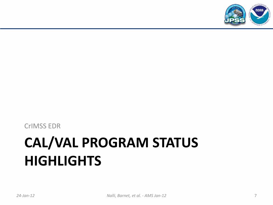
EDR Validation Activities by Phase (2/2) Intensive Cal/Val – Long-Term Monitoring
• Operational RAOBs – Useful for global latitude representation and long-term characterization. Statistical
significance after a couple months’ accumulation.
• Dedicated RAOBs – Useful for regional characterization. – Will take many months (years?) to accumulate for statistics. – Funding for large number of RAOBs at ARM sites; ideally GCOS Reference Upper Air
Network (GRUAN) volunteer coordination
• Intensive Field Campaigns (e.g., Tobin et al. 2006, Nalli et al. 2006, JGR, 111; Taylor et al. 2008, BAMS, 89; Blackwell et al. 2001, TGARS, 39)
– Project-coordinated aircraft campaign using NAST-I, -M and/or S-HIS – Coordinate with other NASA missions (e.g., SEAC4RS) – Useful for regional characterization and SDR cal/val; state specification for “cal/val
dissection” – Scientific campaigns of opportunity
• Low cost, low risk; synergism; engages science community • NOAA Aerosols and Ocean Science Expeditions (AEROSE) (Nalli et al. 2011, BAMS, 92(6))
Presenter
Presentation Notes
ICV up to 18 months GCOS – Global Climate Observing System

24-Jan-12 Nalli, Barnet, et al. - AMS Jan-12 13
Pre-Launch Phase Efforts (1/3)
• Proxy Data Results – CrIS/ATMS proxy SDR datasets
• IASI/AMSU based – Focus Day 19-Oct-07 global granules – NOAA AEROSE 2010-11 campaigns – Include matched ECMWF/NCEP-GFS, IASI/AMSU, and
proxy CrIS/ATMS SDRs – Available on NOAA/STAR FTP
ftp://ftp2.orbit.nesdis.noaa.gov/smcd/tking/CrIMSS_CALVAL/
• AIRS/AMSU based – Raytheon Plantinum-72 (P72) data package – IDPS operational CrIMSS SDR/EDR – Available on GRAVITE FTP during JPSS Rehearsal
– CrIMSS EDR runs • IDPS operational algorithm and environment; NGAS
ADA environment; LaRC v1.5 algorithm, STAR offline environment ; STAR NUCAPS algorithm
• CrIMSS EDR products retrieved from proxy data were seen to compare reasonably against ECMWF/RAOB matchups and current products
• Divakarla et al. (AMS, HISE, 2011); Gu et al. (AMS, 2011); Oral 3.8 (Divakarla et al.) this session
– CrIS Radiance Bias Tuning • The NOAA-unique IASI radiance bias-tuning
procedures are being used for CrIS radiance bias tuning.
• Focus day (19 Oct 2007) ECMWF (original and “improved” for RTM) data are being used for CALC using the OSS model
13
Focus Day Proxy Data Prelaunch CrIS Tuning
RET vs. ECMWF (Focus-Day , 48, granules)
Presenter
Presentation Notes
ADA = algorithm development area IDPS – Integrated Data Processing System 1 Granule = 9 FOV * 30 scanlines * 45 = 12150 FOV Bias Tuning Notes AER OSS Model – Optimal Spectral Sampling (OSS) is a rapid and accurate technique developed at AER for the numerical modeling of narrow band transmittances in media with non-homogeneous thermodynamic properties containing a mixture of absorbing gases with variable concentrations. The method has been specifically designed for the modeling of radiances measured by Earth-orbiting down-looking microwave and infrared radiometers, but can be applied to any spectral domain and instrument viewing geometry. Excellent match in the LW band Excellent match in the upper channels in the MW band, but up to ~1.5 K bias near the surface Excellent match except near 2260 cm-1 and 2380 cm-1 It is likely due to the spectroscopy differences in OSS vs. SARTA.
AVTP
AVMP
Performance for LaRC CrIMSS v1.5.04 (with bias correction)
Pre-Launch Phase Efforts (2/3)
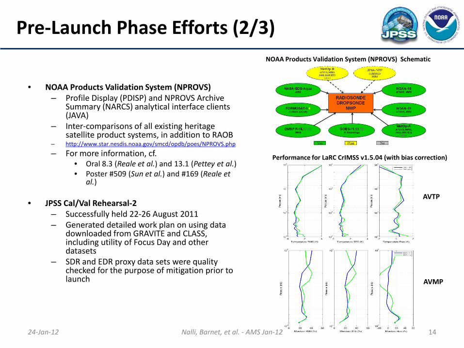
• NOAA Products Validation System (NPROVS) – Profile Display (PDISP) and NPROVS Archive
Summary (NARCS) analytical interface clients (JAVA)
– Inter-comparisons of all existing heritage satellite product systems, in addition to RAOB
– http://www.star.nesdis.noaa.gov/smcd/opdb/poes/NPROVS.php
– For more information, cf. • Oral 8.3 (Reale et al.) and 13.1 (Pettey et al.) • Poster #509 (Sun et al.) and #169 (Reale et
al.)
• JPSS Cal/Val Rehearsal-2 – Successfully held 22-26 August 2011 – Generated detailed work plan on using data
downloaded from GRAVITE and CLASS, including utility of Focus Day and other datasets
– SDR and EDR proxy data sets were quality checked for the purpose of mitigation prior to launch
24-Jan-12 Nalli, Barnet, et al. - AMS Jan-12 14
NOAA Products Validation System (NPROVS) Schematic
24-Jan-12 Nalli, Barnet, et al. - AMS Jan-12 15
Pre-Launch Phase Efforts (3/3)
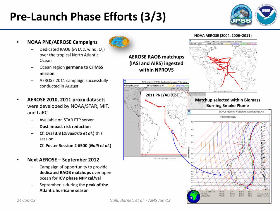
• NOAA PNE/AEROSE Campaigns – Dedicated RAOB (PTU, z, wind, O3)
over the tropical North Atlantic Ocean
– Ocean region germane to CrIMSS mission
– AEROSE 2011 campaign successfully conducted in August
• AEROSE 2010, 2011 proxy datasets were developed by NOAA/STAR, MIT, and LaRC
– Available on STAR FTP server
– Dust impact risk reduction
– Cf. Oral 3.8 (Divakarla et al.) this session
– Cf. Poster Session 2 #500 (Nalli et al.)
• Next AEROSE – September 2012 – Campaign of opportunity to provide
dedicated RAOB matchups over open ocean for ICV phase NPP cal/val
– September is during the peak of the Atlantic hurricane season
AEROSE RAOB matchups (IASI and AIRS) ingested
within NPROVS
2011 PNE/AEROSE Matchup selected within Biomass
Burning Smoke Plume
NOAA AEROSE (2004, 2006–2011)
EOC–ICV Phase Near-Term Efforts
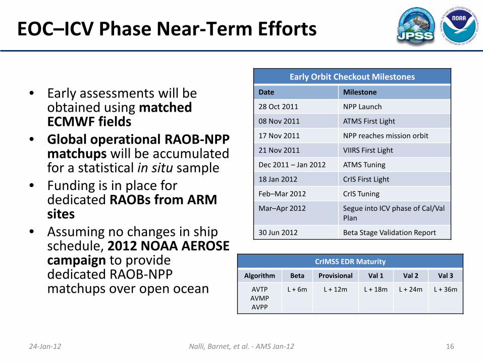
• Early assessments will be obtained using matched ECMWF fields
• Global operational RAOB-NPP matchups will be accumulated for a statistical in situ sample
• Funding is in place for dedicated RAOBs from ARM sites
• Assuming no changes in ship schedule, 2012 NOAA AEROSE campaign to provide dedicated RAOB-NPP matchups over open ocean
24-Jan-12 Nalli, Barnet, et al. - AMS Jan-12 16
Early Orbit Checkout Milestones
Date Milestone
28 Oct 2011 NPP Launch
08 Nov 2011 ATMS First Light
17 Nov 2011 NPP reaches mission orbit
21 Nov 2011 VIIRS First Light
Dec 2011 – Jan 2012 ATMS Tuning
18 Jan 2012 CrIS First Light
Feb–Mar 2012 CrIS Tuning
Mar–Apr 2012 Segue into ICV phase of Cal/Val Plan
30 Jun 2012 Beta Stage Validation Report
CrIMSS EDR Maturity
Algorithm Beta Provisional Val 1 Val 2 Val 3
AVTP AVMP AVPP
L + 6m L + 12m L + 18m L + 24m L + 36m
24-Jan-12 Nalli, Barnet, et al. - AMS Jan-12 17
Summary
• The status of the NPP CrIMSS EDR Cal/Val Program for Sounding EDRs was overviewed in this presentation. The validation program is to ensure the data products comply with the requirements of the sponsoring agencies (i.e., meet spec).
• Pre-launch Cal/Val efforts have been successful for demonstrating launch readiness in exercising and performing initial tests of the IDPS EDR algorithm using proxy datasets, including focus days and intensive campaigns-of-opportunity.
• Early-Orbit Checkout Cal/Val efforts are currently underway in preparation for the Intensive Cal/Val (ICV) phase to follow.
Related Documents