INTERNATIONAL UNION OF GEODESY AND GEOPHYSICS INTERNATIONAL ASSOCIATION OF GEODESY JAPAN Report of the Geodetic Works in Japan for the Period January 2003 to December 2006 NATIONAL REPORT TO THE XXIV GENERAL ASSEMBLY PERUGIA, ITALY JULY 2 – JULY 13, 2007 Edited by the Geodetic Society of Japan THE GEODETIC SOCIETY OF JAPAN

Welcome message from author
This document is posted to help you gain knowledge. Please leave a comment to let me know what you think about it! Share it to your friends and learn new things together.
Transcript
INTERNATIONAL UNION OF GEODESY AND GEOPHYSICS INTERNATIONAL ASSOCIATION OF GEODESY
JAPAN
Report of the Geodetic Works in Japan for the Period January 2003 to December 2006
NATIONAL REPORT TO THE XXIV GENERAL ASSEMBLY PERUGIA, ITALY
JULY 2 – JULY 13, 2007
Edited by the Geodetic Society of Japan
THE GEODETIC SOCIETY OF JAPAN

This report is compiled by Yuki Kuroishi (Geographical Survey Institute), Takeshi Sagiya (Nagoya University), Arata Sengoku (Japan Coast Guard), and Peiliang Xu (Disaster Prevention Research Institute, Kyoto University). The electronic file of this report is available at the following Web site.
http://wwwsoc.nii.ac.jp/geod-soc/iugg2007
i
Contents page
1. Introduction 1
2. Positioning 3
2.1 Single Technique 3
2.2 Multiple Techniques 4
3. Development in Technology 7
3.1 VLBI 7
3.2 SLR 12
3.3 GPS 13
3.3.1 GEONET 13
3.3.2 Kinematic GPS and RTK 14
3.3.3 Analysis Method 15
3.3.4 REGMOS 16
3.4 SAR 18
3.5 Other Techniques 19
3.5.1 Leveling 19
3.5.2 APS 19
3.5.3 Orbit Determination of Satellites 20
3.5.4 Remote Monitoring of Gravity 20
3.5.5 Technology Development for a Future Satellite Gravity Mission 20
4. General Theory and Methodology 21
5. Determination of the Gravity Field 24
5.1 International and Domestic Gravimetric Connections 24
5.2 Absolute Gravimetry 25
5.3 Gravimetry in Antarctica 26
5.4 Tidal Gravity Changes and Loading Effects 27
5.5 Non-tidal Gravity Changes 27
5.5.1 Gravity Changes Associated with Crustal Deformation
and Seismic and Volcanic Activity 27
5.5.2 Gravity Changes Associated with Groundwater Level 30
5.5.3 Gravity Changes Associated with Sea Level Variation 30
5.6 Gravity Survey in Japan 31
5.6.1 General 31
5.6.2 Hokkaido Area 31
5.6.3 Honshu Area 32
5.6.4 Shikoku and Kyushu Area 33

ii
5.7 Gravity Survey in Foreign Countries 35
5.8 Marine Gravimetry 36
5.9 Data Handling and Gravity/Geoid Maps 38
5.10 Gravity Data Analysis 40
5.11 Theoretical Studies on Geoid and Gravity Field 40
5.12 Space Gravimetry 43
5.12.1 Lunar and Planetary Gravimetry 43
5.12.2 Satellite Gravity Missions 44
5.13 Superconducting Gravimetry 46
5.14 Air-borne Gravimetry 47
6. Crustal Deformation 59
6.1 Secular Movements 59
6.1.1 Plate Motion 59
6.1.2 Interseismic Motion 60
6.2 Transient Movements 64
6.2.1 Coseismic Movements 64
6.2.2 Slow/Silent Deformation 68
6.2.3 Volcanic Activities 73
6.3 Periodic Movements 77
6.4 In-situ Deformation Observations 78
6.5 Geophysical Studies in Antarctica 81
6.6 Sea-level Change and Post-glacial Rebound 81
7. Marine Geodesy 82
7.1 Marine Geodetic Control 83
7.2 Sea-floor Geodesy 83
8. Earth Tides and Ocean Tidal Loading 87
9. Earth Rotation 88
10. Application to Atmospheric, Ionospheric and Hydrological Researches 89
11. Planetary Geodesy 94
1
1. Introduction
This report summarizes the geodetic activities in Japan for the period from January 2003 to
December 2006. It is to be submitted, on behalf of the Geodetic Society of Japan (GSJ), to the XXIV
General Assembly of the International Union of Geodesy and Geophysics (IUGG) to be held in
Perugia, Italy, July 2007.
During this four years period, GSJ, together with the Science Council of Japan and 15 other
learning societies in Japan, hosted the IUGG XXIII General Assembly in Sapporo in 2003. More
than 4600 researchers from about 80 countries and regions attended the Assembly and a number of
outreach programs for the public were intensively undertaken in Sapporo and its surrounding areas.
GSJ was deeply involved with two programs. The first program consisted of two public lectures.
Prof. Shuzo Takemoto, Kyoto University, delivered the first lecture on global changes as detected by
satellites and recent surface observation techniques such as gravity meters, extensometers and
tiltmeters, while Prof. Erwin Groten from Germany delivered the second lecture on remarkable
advancement of the recent space-borne observation techniques. The second program was aimed at
inspiring and motivating the interest of school children in science. As a result, the program was
especially organized at an elementary school in Sapporo. Prof. James E. Faller from the United
States of America provided a lesson on measurement of gravity and Prof. Shuhei Okubo, University
of Tokyo on volcanoes and gravity.
GSJ holds scientific meetings twice a year and a tutorial summer school for young geodesists
annually. In addition, GSJ awards the Tsuboi Prize to a young geodesist for his/her significant
contributions to geodetic science and the Group Tsuboi Prize to a group of geodesists for their joint
contributions every year. In the past four years, Drs. K. Matsumoto, T. Otsubo, Y. Hatanaka and S.
Miyazaki were the winners of the Tsuboi Prize, and the GEONET Group of the Geographical Survey
Institute (GSI) represented by Y. Kumaki, the Gravity Research Group in Southwest Japan
represented by R. Schichi and A. Yamamoto, the Satellite Laser Ranging Research Group of the
Japan Coast Guard (JCG) represented by M. Sasaki, and GSI and Hydrographic and Oceanographic
Department, JCG (JHOD) represented by M. Murakami and A. Sengoku, respectively, were the
awardees for the Group Tsuboi Prize. GSJ also celebrates the best presentation student awards at its
fall meeting. K. Yamamoto, M. Irwin, I. Hirose, Y. Kobayashi, K. Takatani, Y. Fukushima, H.
Takiguchi, T. Kazama, S. Yui, R. Ogawa, and S. Yoshii were the recipients of the best presentation
awards in the last four years.
In 2004, GSJ celebrated its fiftieth anniversary. As part of the commemorative activities, GSJ
published two books in Japanese: an introductory book on geodesy for the general public (Okubo ed.,
2004) and a CD-ROM textbook on geodesy for researchers and university students (Geodetic
Society of Japan, 2004).
2
During the period 2003 to 2006 a variety of geodetic activities have been undertaken in Japan.
We may name some major ones out of them. In August 2003, the first absolute gravity measurement
was successfully made on the top of Mt. Fuji (at elevation of about 3800 m).
The Japanese continuous GPS observation network called the GPS Earth Observation Network
System (GEONET) has been reinforced in both qualitatively and quantitatively. The number of
continuous sites grew up to about 1200, and the acquired data are transferred on a real time basis.
Analysis strategy has been updated to realize a better accuracy. GEONET, the world’s largest
regional GPS network, is serving for not only geodesy but also various subjects in Earth science.
Another new important geodetic facility to be noted is the Advanced Land Observing Satellite
(ALOS) “Daichi”, which was successfully launched in January 2006. The satellite is equipped with
the L-band Synthetic Aperture Rader (SAR) sensor and can be used to monitor changes in the
deformation of the surface regardless of vegetation.
International geodetic activities have also been made intensively. In addition to the continued work
under the Global Geodynamics Project (GGP) that was initiated as an international project during the
period described in the previous national report, the Absolute Gravity Standard Station Network in
East and South-East Asia has been established as a part of the Asia-Pacific Space Geodynamics
Project cooperation campaigns in the International Association of Geodesy (IAG) and the Permanent
Committee on GIS Infrastructure for Asia and the Pacific (PCGIAP). A joint team of Japanese and
U.S. researchers has begun a four year project of integrated geodetic observation in 2005, called
International geodetic project on South Eastern Alaska, for detecting the crustal deformation and
studying the viscoelastic structure of the Earth in that area.
During those four years, there occurred many significant geophysical events such as the 2004
Sumatra-Andaman earthquake. In Japan, the 2003 Tokachi-oki earthquake was the first M8
interplate earthquake after the installation of dense nationwide geophysical monitoring systems.
Thorough analyses of multi-disciplinary data have been conducted to reveal unprecedented details of
this typical plate boundary earthquake.
Technological development in geodetic measurements now opens a new stage toward better
understanding of the Earth’s figure, internal structure and dynamics, and their temporal evolution.
More and more new findings are anticipated in the next several years.
Bibliography
Geodetic Society of Japan (2004): Commemorative CD-ROM Textbook on Geodesy for the fiftieth
anniversary of Geod. Soc. Japan. (in Japanese)
Also found at http://wwwsoc.nii.ac.jp/geod-soc/web-text/index.html
Okubo, S. (ed.) (2004): Chikyu ga Maruitte Honto Desu ka ? (Is the Earth Really Round ?) ~ 50
Questions to Geodesists, Asahi Sensho 752, Asahi Shimbun-sha, 278p. (in Japanese)
3
2. Positioning
2.1 Single Technique
GSI has been operating the Tsukuba 32-m Very Long Baseline Interferometry (VLBI) station
(TSUKUB32) and the Tsukuba VLBI Correlator Facility to participate in the international 24-hour
sessions that are carried out as a collaborative program organized by the International VLBI Service
for Geodesy and Astrometry (IVS). One of the major tasks assigned to GSI is the observation using
the 32-m-diameter antenna and the data processing for the sessions (IVS-INT02) over the baseline
between TSUKUB32 – WETTZELL (Germany) baseline for the purpose of monitoring UT1-UTC.
GSI has also conducted geodetic VLBI sessions with a domestic VLBI network in order to control
and monitor the consistency of the Geodetic Reference System of Japan. Fujisaku et al. (2005),
Fujisaku et al. (2006), Kokado et al. (2006), Kurihara et al. (2003), Machida et al. (2004), Machida
et al. (2005), Machida et al. (2006), Miyagawa and Kurihara (2003), Takashima et al. (2005),
Takashima et al. (2006a) and Takashima et al. (2006b) reported those activities.
GSI repeated precise leveling surveys in Tokai and South Kanto Regions. It also carried out
precise leveling and GPS surveys in Muroto and Kii areas to monitor interseismic deformations of
Tonankai and Nankai earthquakes.
GSI also carried out oversea GPS measurements between Japan and Republic of Korea.
Yokokawa et al. (2004) concluded that the difference of the relative coordinates between Japan and
Korea given by the old Tokyo Datum System and GPS measurements was about 40 cm. For this
comparison they used the precise GPS measurement results obtained as a collaborative project
between GSI and National Geographic Information Institute, South Korea.
JHOD has been conducting continuous GPS observation at 39 onshore GPS stations for
monitoring crustal deformation (Hydrographic and Oceanographic Department, 2003a; 2003b; 2004;
2005; 2006). They improved their continuous GPS observation system in 2004 (Fuchinoue et al.,
2005). Besides continuous observation, they carried out campaign observations on Zeni Su, in the
vicinity of Izu Islands in 2003, 2004 and 2005 (Hydrographic and Oceanographic Department, 2004;
2005; 2006).
Shibuya et al. (2003) summarized progress of geodetic observations at Syowa Station in recent
10 years. Shibuya et al. (2005) also summarized location coordinates of geodetic sensors at Syowa
Station. Jike et al. (2005) determined station coordinates from the first year observation of Antarctic
VLBI. Doi et al. (2004) carried out GPS observations at three points on Antarctic ice sheet, and
determined their coordinates and velocities.
The Geological Survey of Japan and National Institute of Advanced Industrial Science and
Technology (GSJ/AIST) established GPS array in and around Kinki District (Ohtani et al., 2003).
4
2.2 Multiple Techniques
GSI contributed to the adoption of the Japanese New Geodetic Datum 2000 (JGD2000), which
was made effective by amendment of the Japanese Survey Act in the national parliament in 2002,
through providing backup and supporting work forces together with JHOD. The tasks included
intensive studies on the theoretical background of the reference frame, recalculation of the positions
horizontal reference points and vertical benchmarks, negotiations with local and municipal
governments, and public communications.
Tobita et al. (2003) calculated and compiled datum conversion vectors for 57 Japanese islands
to translate coordinates from the old Tokyo Datum system to the new Datum, which is consistent
with the International Terrestrial Reference Frame (ITRF). Tsuji and Matsuzaka (2004) reviewed the
procedures taken by the GSI to accomplish the establishment of horizontal part of the new system,
which included the calculation of the new coordinates of horizontal control points including VLBI
and GPS permanent stations. Imakiire and Hakoiwa (2004) reviewed the construction of the new
height system highlighting the procedures of the calculation of the new vertical coordinates
including islands. Matsumura et al. (2004) described the framework of the new geodetic reference
system of Japan adopted in 2002 including basics concepts of the new system and reformations
made in related legislature. GSI (2004) described impacts of adoption of the new geodetic datum of
Japan on the survey community and downstream influences on other social sectors.
Masaki et al. (2006) determined the local-tie translation parameters between the GPS (S003;
CCJM) and VLBI (S005; VERA-Ogasawara) antennae at Chichijima (DOMES site number 21732)
using relative positions derived from their on-site survey. They also reported results of error budgets
in their analysis. They concluded that more precise GPS survey was necessary to achieve further
accuracy in local tie parameters.
GSI conducted various surveys to maintain the national geodetic frame to accommodate
permanent crustal deformations caused by the seismic and volcanic events. GSI carried out surveys
over the areas affected by the 2003 Tokachi-oki, the 2004 Mid Niigata Prefecture and the 2005
Fukuoka-ken Seiho-oki earthquakes (e.g. Tsuji et al., 2004; Numakawa et al., 2003). Doi et al.
(2005) reported the processes of revision of the coordinates for a total of 6700 survey stations
(continuous GPS, horizontal and vertical) to remedy the permanent crustal deformations due to the
2003 Tokachi-oki earthquake.
Sato et al. (2004) presented horizontal motions of four mobile SLR stations and showed that all of
them were consistent with the results derived from GPS and VLBI observation by GSI.
Bibliography
Doi, K., N. Imae, N. Iwata, and N. Seo (2004): GPS observations on the Antarctic ice sheet

5
conducted during JARE-41, Antarctic Record, 48, 7-18. (in Japanese with English abstract)
Doi, H., Y. Shirai, M. Ohtaki, T. Saito, T. Minato, H. Chiba, T. Inoue, K. Sumiya, J. Sugawara, Y.
Tanaka, H. Saita, T. Yahagi, H. Kojima, T. Yutsudo, T. Amagai, and M. Iwata (2005): The
Revision of Geodetic Coordinates of Control Points Associated with the Tokachi-oki Earthquake
in 2003, J. Geogr. Surv. Inst., 108, 1-10.
Fuchinoue, H., K. Kawai, and M. Fujita (2005): Continuous GPS observation by Japan Coast Guard
– A new system for automatic data download and analysis -, Tech. Bull. Hydrogr. Oceanogr., 23,
61-65. (in Japanese)
Fujisaku, J., S. Kurihara, and K. Takashima (2005): Tsukuba 32-m VLBI station, in D. Behrend and
K. D. Baver (eds.), IVS 2004 Annual Rep., NASA/TP-2005-212772, 115-118.
Fujisaku, J., K. Kokado, and K. Takashima (2006): Tsukuba 32-m VLBI station, in D. Behrend and
K. D. Baver (eds.), IVS 2005 Annual Rep., NASA/TP-2006-214136, 133-136.
Hydrographic and Oceanographic Department (2003a): DATA Rep. Hydrogr. Oceanogr. Observ.,
Ser. Satellite Geod., 15. (in Japanese) (http://www1.kaiho.mlit.go.jp/jhd-E.html)
Hydrographic and Oceanographic Department (2003b): DATA Rep. Hydrogr. Oceanogr. Observ.,
Ser. Satellite Geod., 16. (in Japanese) (http://www1.kaiho.mlit.go.jp/jhd-E.html)
Hydrographic and Oceanographic Department (2004): DATA Rep. Hydrogr. Oceanogr. Observ., Ser.
Satellite Geod., 17. (in Japanese) (http://www1.kaiho.mlit.go.jp/jhd-E.html)
Hydrographic and Oceanographic Department (2005): DATA Rep. Hydrogr. Oceanogr. Observ., Ser.
Satellite Geod., 18. (in Japanese) (http://www1.kaiho.mlit.go.jp/jhd-E.html)
Hydrographic and Oceanographic Department (2006): DATA Rep. Hydrogr. Oceanogr. Observ., Ser.
Satellite Geod., 19. (in Japanese) (http://www1.kaiho.mlit.go.jp/jhd-E.html)
Imakiire, T. and E. Hakoiwa (2004): JGD2000 (vertical) -The New Height System of Japan-, Bull.
Geogr. Surv. Inst., 51, 31-51.
Jike, T., Y. Fukuzaki, K. Shibuya, K. Doi, S. Manabe, D. Jauncey, G. Nicolson, and P. McCulloch
(2005): The first year of Antarctic VLBI observations, Polar Geosci., 18, 26-40.
Kokado, K., M. Machida, and K. Takashima (2006): High precision determination of earth
orientation parameter by VLBI global solutions, J. Geogr. Surv. Inst., 110, 11-25. (in Japanese, in
press)
Kurihara, S., K. Takashima, T. Tanabe, H. Kawawa, and K. Miyagawa (2003): IVS Intensive VLBI
Experiments for UT1 determination between Tsukuba and Wettzell, J. Geogr. Surv. Inst., 102,
3-10. (in Japanese)
Machida, M., M. Ishimoto, S. Kurihara, and K. Takashima (2004): Tsukuba VLBI Correlator, in N.
R. Vandenberg and K. D. Baver (eds.), IVS 2003 Annual Rep., NASA/TP-2004-212254, 136-139.
Machida, M., M. Ishimoto, S. Kurihara, and K. Takashima (2005): Tsukuba VLBI Correlator, in D.
Behrend and K. D. Baver (eds.), IVS 2004 Annual Rep., NASA/TP-2005-212772, 162-165.
6
Machida, M., M. Ishimoto, K. Takashima, T. Kondo, and Y. Koyama (2006): K5/VSSP data
processing system of small cluster computing at Tsukuba VLBI Correlator, in D. Behrend and K.
D. Baver (eds.), IVS 2006 General Meeting Proc., NASA/CP-2006-214140, 117-126.
Masaki, Y., S. Matsuzaka, and Y. Tamura (2006): Local Tie Survey at VERA Ogasawara Station at
Site Chichijima, in D. Behrend and K. D. Baver (eds.), IVS 2006 General Meeting Proc.,
NASA/CP-2006-214140, 366-370.
Matsumura, S., Msk. Murakami, and T. Imakiire (2004): Concept of the New Japanese Geodetic
System, Bull. Geogr. Surv. Inst., 51, 1-9.
Miyagawa, K. and S. Kurihara (2003): Tsukuba VLBI Correlator, in N. R. Vandenberg and K. D.
Baver (eds.), IVS 2002 Annual Rep., NASA/TP-2003-211619, 197-200.
Numakawa, K., Y. Hirai, Y. Shirai, H. Shimo, K. Nemoto, M. Ohtaki, H. Doi, T. Saitou, H. Shinno, T.
Minato, S. Tanoue, M. Tokudome, J. Sugawara, H. Kawawa, Y. Takashima, and S. Kurihara
(2003): Tsukuba 32-m VLBI station, in N. R. Vandenberg and K. D. Baver (eds.), IVS 2002
Annual Rep., NASA/TP-2003-211619, 157-160.
Ohtani, R., N. Matsumoto, N. Koizumi, M. Takahashi, T. Sato, Y. Kitagawa, E. Tsukuda, T. Satoh,
H. Ito, and Y. Kuwahara (2003): The continuous GPS array observation by the Geological Survey
of Japan, AIST, Bull. Geol. Surv. Japan, 54(5/6), 193 - 212.
Sato, M., H. Fukura, and M. Fujita (2004): Horizontal motions derived from satellite laser ranging
observations, Rep. Hydrogr. Oceanogr. Res., 40, 73-84. (in Japanese with English abstract)
Shibuya K., K. Doi, and S. Aoki (2003): Ten years' progress of Syowa Station, Antarctica, as a
global geodesy network site, Polar Geosci., 16, 29-52.
Shibuya, K., K. Doi, Y. Fukuzaki, and M. Iwata (2005): Geodesy reference points within Syowa
Station, Antarcica, and their local geodetic ties, Polar Geosci., 18, 130-161.
Takashima, K. (2006a): Open house of VLBI facility and PR technique, VLBI Conf. Symp. 2005
Proc., 124-127. (in Japanese)
Takashima, K. (2006b): International observations of VLBI in GSI, Tech. Rep. Geogr. Surv. Inst.,
A1-313, 13-22. (in Japanese)
Takashima, K., M. Ishimoto, M. Machida, J. Fujisaku, and S. Kurihara (2005): The practical
operation of eVLBI session to obtain UT1 solution rapidly, in M. Honma (ed.), VLBI Conf. Symp.
2004 Proc., 102-103. (in Japanese)
Tanaka, K., Sumiya, T. Inoue, K. Chiba, A. Yamada, K. Iwata, S. Chida, H. Saita, I. Saitou, J. Itou,
and M. Yamanaka (2004): Responses of Geodetic Department of GSI to the Mid Niigata
Prefecture Earthquake in 2004, J. Geogr. Surv. Inst., 107, 35-44. (in Japanese)
Tobita M., H. Tsuji, Y. Takahashi, and T. Kawahara (2003): Correction Vectors for Island Positions in
Tokyo Datum, J. Geod. Soc. Japan, 49, 181-192. (in Japanese with English abstract)
Tsuji, H. and S. Matsuzaka (2004): Realization of Horizontal Geodetic Coordinates 2000, Bull.
7
Geogr. Surv. Inst., 51, 11-30.
Tsuji, H., Y. Shirai, M. Ohtaki, K. Sugihara, R. Kawamoto, I. Kimura, and T. Inoue (2004): The
Response of the Geodetic Department of GSI to the Tokachi-oki Earthquake in 2003, J. Geogr.
Surv. Inst., 105, 3-15. (in Japanese)
Yokokawa, K., S. Tanoue, K. An, and J. Park (2004): Joint Re-measurement of Japan-Korea
Connecting Triangulation Network by GPS, J. Geogr. Surv. Inst., 103, 63-72. (in Japanese)
3. Development in Technology
3.1 VLBI
In the past, the VLBI technique was severely hampered because the data had to be recorded onto
tape and then shipped to a central processing facility for analysis. However, a standard personal
computer (PC), hard drive-based storage, and advanced networks are now making the real-time
electronic transmission of VLBI data a reality (Kondo, 2005). The e-VLBI technique has enabled us
to perform software-based correlation processing using PCs (Kondo et al., 2003; Kondo et al., 2004;
Kondo et al, 2006). Kondo et al. (2004) presented K5 VLBI system equipped with a PCI-bus
Versatile Scientific Sampling Processor (VSSP) board (K5/VSSP). The K5/VSSP system is
compatible with the former tape-based VLBI system and it is the multiple PC-based VLBI system on
the FreeBSD and Linux operating system. The K5/VSSP system also includes the original software
packages for data sampling and acquisition, real-time IP data transmission, and correlation analysis.
Kimura et al. (2003) developed another PC-based K5 system, which is called "K5/PC-VSI
system". The K5/PC-VSI system consists of a high performance PC equipped with a specific
PCI-bus board for data acquisition, raid data storage, and a gigabit class A/D sampler (Kimura et al.,
2004). The PCI-bus board has a VLBI hardware standard interface (VSI-H) data port and keeps
complete compatibility between recent VLBI data recording systems. Recently, Kimura (2005)
developed a high performance software correlator, which is able to perform correlation processing of
gigabit class data sets in real-time.
One of the objectives of e-VLBI is to improve the accuracy of measurements of Earth's
orientation parameters (EOP), where the latency of the observations can be reduced dramatically
through rapid turn-around of the data processing (Koyama et al., 2003; Koyama et al., 2004; McCool
et al., 2006). In June 2004, the National Institute of Information and Communication Technology
(NICT, formerly called Communications Research Laboratory) performed a one-hour e-VLBI
session on the baseline between the Kashima 34-m antenna of NICT and the Westford 18-m of the
Haystack Observatory, Massachusetts Institute of Technology to estimate UT1, and succeeded to
obtain UT1 estimate 4.5 hours after the session was over (Koyama et al., 2005). In this experiment,
8
the K5 software correlator combined with the network-distributed processing system named
VLBI@home developed by NICT (Takeuchi et al., 2004) was used.
The development of a state-of-the-art one-channel A/D sampler "ADS3000" was successfully
accomplished in order to improve the signal sensitivity of VLBI experiments (Takeuchi et al., 2006).
The ADS3000 is equipped with a high performance FPGA processor, and a variety of sampling
modes up to 4 Gbps are available. FPGA code is rewritable so that it can be used for multiple
applications such as a digital base band converter (DBBC) for multi-channel geodetic VLBI, as a
software demodulator for spacecraft downlink signal in spacecraft VLBI or satellite communications,
or as a spectrometer for broadband astronomical observations.
Differential VLBI (DVLBI) technique for spacecraft navigation using e-VLBI is under
development (Kikuchi et al., 2004; Sekido et al., 2004a; Sekido et al., 2004b). NICT performed six
VLBI experiments for tracking HAYABUSA spacecraft on its descending phase towards asteroid
Itokawa for 4 -26 November 2005 (Sekido et al., 2006). The main purpose of these observations was
to evaluate the accuracy of spacecraft position determined by DVLBI. Concerning the delay
observables of the spacecraft, there are two sorts of delay observables -group delay and phase delay-
which are currently under investigation. The bandwidth of the spacecraft's signal is too narrow to
achieve enough precision using group delay observables. Thus phase delay is thought as alternative
choice to get higher delay resolution, even the ambiguity of phase is an issue to be solved (Sekido et
al., 2004b; Sekido et al., 2004b). Phase delay observables are extracted with a special correlation
software using the signal around transmitting frequency. In addition, a relativistic delay model for
Earth-based VLBI observation of sources at finite distances was developed in order to obtain an
accurate spacecraft position (Sekido and Fukushima, 2004; Sekido and Fukushima, 2006).
The presence of radio frequency interference (RFI) due to the IMT-2000 mobile phone service
systems has become one of the severe problems in S-band signal observations. Thus a
high-temperature superconductor (HTS) filter development for RFI mitigation was developed and is
now operationally used at Kashima 34-m antenna station (Kawai et al., 2003a; Kawai et al., 2003b).
Fey et al. (2004) presented the milliarcsecond (mas)-accurate radio positions for 22 southern
hemisphere extragalactic sources in order to better define the International Celestial Reference
Frame and to provide additional phase-reference sources with accurate positions for use in
astrophysical observations. Ojha et al. (2005) also presented the X-band VLBI survey results of
southern hemisphere extra-galactic sources at milliarcsecond resolution to quantify the magnitude of
the expected effect of intrinsic source structure on astrometric bandwidth synthesis VLBI
observations. Niell et al. (2005) presented the new perspective of geodetic VLBI, which is called
"VLBI2010".
National Astronomical Observatory of Japan (NAOJ) is operating a domestic VLBI network
VERA (VLBI Exploration of Radio Astrometry). The VERA network consists of four stations and
9
each station has a 20-m-diameter antenna. They are located at Mizusawa (Iwate Prefecture), Iriki
(Kagoshima Pref.), Ogasawara (Ogasawara Islands, Tokyo) and Ishigakijima (Okinawa Pref.). The
range of the baseline length in the network is 1020 km to 2270 km. The main goal of the VERA is to
explore three-dimensional (3-D) structure of the Galaxy by measuring the annual parallax of
Galactic maser sources with the accuracy of 10 micro arc second levels. In order to practice
high-precision astrometry, VERA is required to keep the accuracy of the 3-D coordinate within 10-9
of the baseline length, that is 2 mm. VERA also aims at studying geophysical phenomena with
high-precision positioning (Manabe et al, 2004; Tamura and VERA group, 2002).
Each VERA station is equipped with 2 GHz and 8 GHz bands (S/X bands) receivers for geodetic
VLBI observations, and dual receiver system of 22 GHz and 43 GHz bands (K/Q bands) for
astrometry observations. The dual receiver (dual beam) system in K/Q bands is designed for relative
VLBI observations. The single beam of K band system is also used for geodetic VLBI. The backend
recording system is original designed for VERA. The maximum recording rate is 1 Gbps using
magnetic tape recorder. One of the VERA station Mizusawa has a disk recording system named K5
developed by NICT. Its maximum recording rate is 256 Mbps and it is used mainly domestic VLBI
outside of VERA network.
The first geodetic VLBI observation within VERA network was carried out in November 2004
and regular observations started in December 2004. The regular observations are usually scheduled
three times per month and each one has 24-hour observation duration. Once a month, VERA stations
join the domestic JADE (JApanese Dynamic Earth observation by VLBI) experiments which are
organized by GSI. Those observations are objective to linking the VERA station coordinates to the
ITRF2000 (International Terrestrial Reference Frame 2000). Other observations are carried out
within the VERA internal network almost twice a month. VERA network attains the observation
precision of 2 mm in horizontal coordinates and 7-8 mm in vertical ones with one 24-hour
observation in S/X bands (Jike et al, 2005a, 2005b; Jike et al. 2006). Since 2006, geodetic
observations in K band are attempted and we get better precision than S/X bands. The daily positions
of VERA stations are also monitored by continuous GPS observations. Local tie among VLBI, GPS
and ground survey is discussed by Masaki et al. (2006).
Bibliography
Fey, A. L., R. Ojha, D. L. Jauncey, K. J. Johnston, J. E. Reynolds, J. E. J. Lovell, A. K. Tzioumis, J.
F. H. Quick, G. D. Nicolson, S. P. Ellingsen, P. M. McCulloch, and Y. Koyama (2004): Accurate
Astrometry of 22 Southern Hemisphere Radio Sources, Astron. J., 127, 1791-1795.
Fukuzaki, Y., K. Shibuya, K. Doi, T. Ozawa, A. Nothnagel, T. Jike, S. Iwano, D. L. Jauncey, G. D.
Nicolson, and P. McCulloch (2005): Results of the VLBI experiments conducted with Syowa
Station, Antarctica, J. Geodesy, 79, 379-388.
10
Jike, T., Y. Fukuzaki, K. Shibuya, K. Doi, S. Manabe, D. L. Jauncey, G. D. Nicolson, and P.
McCulloch (2005a): First year of Antarctic VLBI observations, Polar Geosci., 18, 26-40.
Jike, T., Y. Tamura, S. Manabe, N. Kawaguchi, K. Iwadate, O. Kameya, Y. Kan-ya, S. Kuji, H.
Kobayashi, S. Sakai, K. Sato, K. Shibata, T. Hirota, T. Fujii, K. Horiai, M. Honma, T. Miyaji, T.
Omodaka, and H. Imai (2005b): Start of regular geodetic VLBI observations within VERA
network, Annual Rep. Nat. Astron. Observatory Japan, 7, 48.
Jike, T., Y. Tamura, S. Manabe, and NAOJ VERA Group (2006): The First Year of VERA Geodetic
Experiments, in D. Behrend and K. Baver (eds.), IVS 2006 General Meeting Proc.,
NASA/CP-2006-214140, USA, 56-57.
Kawai, E., J. Nakajima, H. Takeuchi, H. Kuboki, and T. Kondo (2003a): Wide-band
High-temperature Superconductor Filter on 2.2GHz RFI Mitigation, IVS CRL-TDC News, 22,
2-4.
Kawai, E., J. Nakajima, H. Takeuchi, H. Kuboki, and T. Kondo (2003b): High-temperature
Superconductor Filter on 2.2GHz operating status against RFI, IVS CRL-TDC News, 23, 10-11.
Kikuchi, F., Y. Kono, M. Yoshikawa, M. Sekido, M. Ohnishi, Y. Murata, J. Ping, Q. Liu, K.
Matsumoto, K. Asari, S. Turuta, H. Hanada, and N. Kawano (2004): VLBI observation of narrow
bandwidth signals from the spacecraft, Earth Planets Space, 56, 1041-1047.
Kimura, M. (2005): Development of the software correlator for the VERA system, IVS NICT-TDC
News, 26, 26-27.
Kimura, M., J. Nakajima, H. Takeuchi, and T. Kondo (2003): 2-Gbps PC architecture and Gbps data
processing in K5/PC-VSI, IVS CRL-TDC News, 23, 12-13.
Kimura, M., J. Nakajima, H. Takeuchi, and T. Kondo (2004): High Performance PC Based Gigabit
VLBI System, IVS NICT-TDC News, 25, 64-68.
Kondo, T. (2005): Development of geodetic VLBI system and direct measurements of plate motion,
J. Geod. Soc. Japan, 50, 245-262.
Kondo, T., Y. Koyama, J. Nakajima, M. Sekido, and H. Osaki (2003): Internet VLBI system based
on the PC-VSSP (IP-VLBI) board, New Technologies in VLBI, ASP Conf. Ser., 306, 205-216.
Kondo, T., M. Kimura, Y. Koyama, and H. Osaki (2004): Current status of software correlators
developed at Kashima Space Research Center, in N. R. Vandenberg and K. D. Baver (eds.), IVS
2004 General Meeting Proc., NASA/CP-2004-212255, 186-190.
Kondo, T., Y. Koyama, H. Takeuchi, and M. Kimura (2006): Development of a new VLBI sampler
unit (K5/VSSP32) equipped with a USB 2.0 interface, in D. Behrend and K. Baver (eds.), IVS
2006 General Meeting Proc., NASA/CP-2006-214140, 195-199.
Koyama, Y., T. Kondo, H. Osaki, A. E. Whitney, and K. A. Dudevoir (2003): Rapid turn around eop
measurements by VLBI over the internet, in E. Sanso (ed.), IAG Symposia 128, A Window on the
Future of Geodesy, Springer, 119-124.
11
Koyama, Y., T. Kondo, H. Osaki, M. Hirabaru, K. Takashima, K. Sorai, H. Takaba, K. Fujisawa, D.
Lapsley, K. Dudevoir, and A. Whitney (2004): Geodetic VLBI Experiments with the K5 System,
Third IVS General Meeting, February 9-11, 2004, Ottawa, Canada.
Koyama, Y., T. Kondo, M. Hirabaru, M. Kimura, and H. Takeuchi (2005): Research and
Developments for e-VLBI Utilizing Global High Speed Network Connections, J. Nat. Inst. Info.
Comm. Tech., 52, 131-139.
Manabe, S., Y. Tamura, T. Jike, K. Horiai, and VERA Team (2004): Status and Plan of Geodetic and
Astrometric Observations with VERA, in N. R. Vandenberg and K. D. Baver (eds.), IVS 2004
General Meeting Proc., NASA/CP-2004-212255, 151-156.
Masaki, Y., S. Matsuzaka, and Y. Tamura (2006): Local tie survey at VERA Ogasawara station at site
Chichijima, in D. Behrend and K. Baver (eds.), IVS 2006 General Meeting Proc.,
NASA/CP-2006-214140, 366.
McCool, R., R. Spencer, S. Kumar, R. Beresford, S. Durand, Y. Koyama, S. Parsley, A. Whitney,
and P. Maat (2006): Enhancing the Sensitivity of Radio Telescopes Using Fiber-Optic Networks,
Radio Sci. Bull., 317, 9-18.
Niell, A., A. Whitney, W. Petrachenko, W. Schlueter, N. Vandenberg, H. Hase, Y. Koyama, C. Ma,
H. Schuh, and G. Tuccari (2005): VLBI2010: A Vision for Future Geodetic VLBI, Proc. Joint
Assembly of IAG, IAPSO, and IABO, August, 2005, Cairns (submitted).
Ojha, R., A. L. Fey, P. Charlot, D. L. Jauncey, K. J. Johnston, J. E. Reynolds, A. K. Tzioumis, J. F.
H. Quick, G. D. Nicolson, S. P. Ellingsen, P. M. McCulloch, and Y. Koyama (2005): VLBI
Observations of Southern Hemisphere ICRF Sources. II. Astrometric Suitability Based on
Intrinsic Structure, Astron. J., 130, 2529-2540.
Sekido, M. and T. Fukushima (2004): Relativistic VLBI Delay Model for Finite Distance Radio
Source, in E. Sanso (ed.), IAG Symposia 128, A Window on the Future of Geodesy, Springer,
141-145.
Sekido, M. and T. Fukushima (2006): A VLBI delay model for radio sources at a finite distance, J.
Geodesy, 80, 137-149, doi:10.1007/s00190-006-0035-y.
Sekido, M., R. Ichikawa, H. Osaki, T. Kondo, Y. Koyama, M. Yoshikawa, T. Ohnishi, W. Cannon,
A. Novikov, and M. Berube (2004a): Astrometry observation of spacecraft with very long
baseline interferometry - a step of VLBI application for spacecraft navigation -, URSI
Commission-F Triennium Open Symp. Proc., 163-170.
Sekido, M., R. Ichikawa, H. Osaki, T. Kondo, Y. Koyama, M. Yoshikawa, T. Ohnishi, W. Cannon,
A. Novikov, M. Berube, and NOZOMI VLBI group (2004b): VLBI Observation for Spacecraft
Navigation (NOZOMI) - Data Processing and Analysis Status Report, in N. R. Vandenberg and K.
D. Baver (eds.), IVS 2004 General Meeting Proc., NASA/CP-2004-212255, 258-262.
12
Sekido, M., R. Ichikawa, M. Yoshikawa, N. Mochizuki, Y. Murata, T. Kato, T. Ichikawa, H.
Takeuchi, and T. Ohnishi (2006): DVLBI Test Observation at HAYABUSA's approach to
ITOKAWA, Proc. 16th Workshop on Astrodynamics and Flight Mechanics (in press).
Takeuchi, H., T. Kondo, Y. Koyama, and J. Nakajima (2004): VLBI@home - VLBI Correlator by
GRID Computing System, in N. R. Vandenberg and K. D. Baver (eds.), IVS 2004 General
Meeting Proc., NASA/CP-2004-212255, 200-204.
Takeuchi, T., M. Kimura, J. Nakajima, T. Kondo, Y. Koyama, R. Ichikawa, M. Sekido, and E.
Kawai (2006): Development of 4-Gbps Multi-functional VLBI Data Acquisition System, Publ.
Astron. Soc. Pacific (in press).
Tamura, Y. and VERA Group (2002): Geodetic Observation System in VERA, in N. R. Vandenberg
and K. D. Baver (eds.), IVS 2002 General Meeting Proc., NASA/TP-2003-211619, 167-170.
3.2 SLR
Precise orbit analysis, mainly of satellite laser ranging (SLR) data, has been studied in NICT.
Otsubo and Appleby (2003) quantified the optical response of spherical laser ranging satellites such
as LAGEOS, AJISAI and ETALON, and revealed that the center-of-mass correction of these
satellites can be dependent on the types of terrestrial SLR systems. The result of this study is listed
in the website of International Laser Ranging Service (http://ilrs.gsfc.nasa.gov/). Crustal deformation
is monitored in a regional SLR network around Tokyo. Significant change of site coordinates caused
by the volcanic activities was detected (Schillak et al., 2006).
The spin motion of LAGEOS satellites was intensively investigated in collaboration with
worldwide institutes. Otsubo et al. (2004) developed a photometry system at the Natural
Environment Research Council Space Geodesy Facility at Herstmonceux, UK, to monitor the spin
axis orientation and the spin rate of LAGEOS-2 satellite. Andres et al. (2004), on the other hand,
explained the spin motion of the two LAGEOS satellites by developing a mathematical model called
LOSSAM, at Delft University of Technology, the Netherland.
Observation performance at Shimosato Hydrographic Observatory has been improved, i.e., the
single-shot precision of SLR observation has been improved: from 9.5 cm for LAGEOS-1 yearly
root-mean-square (RMS) in 1986 to 1.5 cm in 2005, the total number of passes obtained at
Shimosato has increased from, e.g., 541 passes of 4 satellites in 1986 to 2331 passes of 24 satellites
in 2005 (Satellite Laser Ranging Group of the Japan Coast Guard, 2006). Matsushita and Sato
(2005) updated terrestrial reference system and gravity model for data analysis, which improved
accuracy of the estimated range biases and station position.
Japan Aerospace Exploration Agency (JAXA) developed a satellite laser ranging system with an

13
optical telescope of 1 m in diameter. The station is located in Tanega-shima Island approximately
1000 km south-west of Tokyo. The system is able to be remotely controlled from Tsukuba Space
Center of JAXA (Uchimura et al., 2004). The ranging accuracy is better than 10 mm RMS in
single-shot for LAGEOS satellite.
Bibliography
Andres, J. I., R. Noomen, G. Bianco, D. Currie, and T. Otsubo (2004): Spin axis behaviour of
LAGEOS satellites, J. Geophys. Res., 109, B06403, 1-12, doi:10.1029/2003JB002692.
Matsushita, M. and M. Sato (2005): Update of terrestrial reference system and gravity model for
SLR data analysis, Tech. Bull. Hydrogr. Oceanogr., 23, 73-77. (in Japanese)
Otsubo, T. and G. M. Appleby (2003): System-dependent centre-of-mass correction for spherical
geodetic satellites, J. Geophys. Res., 108(B4), 2201, doi:10.1029/2002JB002209.
Otsubo, T., R. A. Sherwood, P. Gibbs, and R. Wood (2004): Spin motion and orientation of
LAGEOS-2 from photometric observation, IEEE Trans. Geoscience and Remote Sensing, 42, 1,
202-208.
Otsubo, T. (2005): Improving the analysis precision of satellite laser ranging data from centimeter to
millimeter range, J. Geod. Soc. Japan, 51, 1-16. (in Japanese)
Satellite Laser Ranging Group of the Japan Coast Guard (2006): Contribution to geodesy, orbit
determination of artificial satellites, and establishment of the World Geodetic System as the
national geodetic coordinate system of Japan by means of satellite laser ranging, J. Geod. Soc.
Japan, 52, 21-36. (in Japanese with English abstract)
Schillak, S., E. Wnuk, H. Kunimori, and T. Yoshino (2006): Crustal deformation in the key stone
network detected by satellite laser ranging, J. Geod., 79, 682-688.
Uchimura, T., M. Sawabe, S. Murata, Y. Matsuoka, T. Oldham, and J. Maloney (2004): Remote
Operation of GUTS-SLR, 14th Int. Laser Ranging Workshop: Proc., 419-422.
3.3 GPS
3.3.1 GEONET
GEONET has been reinforced and revised stepwise. The first overall revision of GEONET
routine analysis system was done in 2001 by utilizing the state of the art models of the GPS analysis
(Hatanaka et al., 2003). After eliminating linear, annual and semiannual trends, the root mean square
error of baselines of the updated system were about 3 mm for horizontal components and 1 cm for
vertical component in average, and the total variance was reduced by about 50 %.
14
GSI (2004) summarized the recent enhancements of GEONET in 2003. They are the increase of
the number of the stations to 1200 stations, introduction of a real-time capability, and the second
upgrade of computing system for routine analysis. Hatanaka et al. (2005) evaluated the precision of
the revised routine solutions and concluded that inconsistency of noise characteristics between
different antenna types was significantly reduced by the re-designing of the network clustering. The
effect of thermal deformation of antenna pillar was identified by careful analysis of time series data
obtained by the near real-time solution with 6-hour sessions.
By comparing the previous height solutions with the newest ones after the revisions described in
GSI (2004), Yutsudo et al. (2005) detected systematic errors in the previous solutions. They
attributed the causes of those errors to modeling error of phase center variation in the previous
system. They showed that the closure of land survey by GPS observation from a GEONET station to
another GEONET station was improved when they used new height datum obtained by the new
GEONET solutions.
GEONET Group (2004) reviewed the steps of construction of GEONET and highlighted its
contributions on Earth science. Hatanaka (2006) reviewed technical developments of analysis system
of GEONET along with the background history of improvements of signal/noise ratio of GPS
observation in the 1990s.
3.3.2 Kinematic GPS and RTK
Hatanaka et al. (2004) briefly summarized the status of enhancement of real-time capability to
GEONET done by GSI in 2003. After discussion on GSI’s motivation to start such a huge project,
they also explained the technical aspects of data flow, and analysis system. Yamagiwa et al. (2006)
illustrated the new GEONET with real-time capability in more detail and demonstrated successful
test results of 1-Hz analysis of the 2003 Tokachi-oki earthquake with this system in post-processing
mode.
Yahagi et al. (2005) tested performance of the real-time analysis system and the near real-time
system with 3-hour sessions. The variance of baseline time series of 3-hours solutions is 2-3 times
larger than that of the 6-hour solutions, which is a standard product of the routine analysis. Seismic
waves exited by the 2004 Sumatra-Andaman earthquake was detected by post-processing kinematic
analysis of the GEONET data and comparison with seismogram record showed good agreement.
Miyazaki et al. (2004) processed 1-Hz GPS data at the time of the 2003 Tokachi-oki main
rupture. Comparisons of GPS displacement waveform with double integrated strong motion record
show significant similarities during the shake, but the integrated seismic records suffer from artificial
low frequency noise. This suggests that GPS would constrain the cumulative slip distribution better
than the seismic records. Then they inverted 1-Hz GPS with multiple time window inversion. The

15
slip distribution is in principle similar to that obtained from strong motion data, but their solution
shows a better contrast to the afterslip distribution. Irwan et al. (2004) analyzed both the 1-Hz and
the 30-second sampling data associated with the 2003 Tokachi-oki earthquake. They successfully
obtained the seismic waveform. They also concluded that there was no recognizable precursory
displacement before the arrival of seismic wave.
Ohta et al. (2006a) analyzed 1-Hz data of IGS stations associated with the 2004
Sumatra-Andaman earthquake. They succeeded in detecting large surface wave for both short (~ 10
km) and long (5000 ~ 10,000 km) baselines. The analysis was effective in discussing long period
coseismic signals over the seismologically detectable frequency band. Also, the analysis
demonstrated the limitation of the relative mode positioning that the analysis is no longer useful after
the arrival of coseismic signal to the reference site. From this experience, importance of precise
point positioning in kinematic mode (kinematic PPP) became evident. Ohta et al. (2006b) studied the
error characteristics of kinematic PPP analysis by analyzing GEONET 30-second sampling data with
GIPSY/OASIS-II software.
Another important application of kinematic GPS is positioning of moving object. Such
technique comprises the core of marine geodesy and seafloor geodetic measurements. Terai (2003;
2004) discussed vertical positioning accuracy of survey vessels with kinematic GPS positioning
technique for hydrographic surveys. Precise height determination with sub-decimeter accuracy in the
sea area will be useful for the sea bottom survey. Tozawa et al. (2004) discussed vertical positioning
accuracy of survey vessels with VRS-RTK (virtual reference station – realtime kinematic) technique.
Kawai et al. (2005; 2006) discussed positioning accuracy of kinematic GPS for long baselines used
for seafloor geodetic observations.
As an application of real-time GPS positioning, Kato et al. (2005) applied the RTK-GPS to GPS
buoy to detect tsunami before its arrival to the coast and succeeded to detect the tsunami that was
generated by the September 2004 earthquake that occurred offshore Kii Peninsula, central Japan.
Advances of scientific research technology over the last decade have enabled progressively
better navigation positioning. The Dynamic Positioning System (DPS) is installed on the Deep
Ocean Drilling Vessel “Chikyu” to keep positioning and control motions (Murata et al., 2005) and by
Remote Operating Vehicle (ROV) (Yamamoto, 2005).
3.3.3 Analysis Method
Hatanaka (2003) investigated systematic difference between two different sets of coordinate
solutions of GEONET, and found that there was a weak point of the network combination in the old
analysis strategy of GEONET. He concluded that it magnified the inconsistency between noise
characteristics of two sources of reference frame realization, which are GPS satellite orbits and a
16
priori coordinates of fiducial sites. This finding contributed the revision of the analysis strategy
resulting in improvement of the solution consistency as reported by GSI (2004). Tanaka et al. (2003)
calibrated the phase characteristics of GPS antennas to improve the accuracy of the GPS positioning
computation.
Koshimizu et al. (2005) found anomalous transient change in the GPS continuous observation
on Asama Volcano and attributed the cause of the fluctuation to the attenuation of microwave signal
from the satellite due to snow stacked on the antenna radome. They also concluded that the tilt of
monument due to freeze of soil at the base causes artifacts. They showed that masking of
observation data from the satellite of high elevation angles, that was affected by the stacked snow,
and correction of the tilt by using data of tiltmeter of the pillar were partly effective.
Shimada (2005) analyzed GPS data observed in the Tsukuba 2000 and 2001 GPS/MET dense
network campaigns, and found that the relationship between the baseline length and vertical
repeatability of the baseline vector among the network sites was strong. Iwabuchi et al. (2004)
investigated the characteristics of post-fit residuals computed using three types of software, and
evaluated the behavior of multipath errors in the post-fit phase residuals.
3.3.4 REGMOS
GSI developed automated standalone remote GPS monitoring systems (REGMOS) for the
deployment on volcanoes to monitor crustal deformations of volcanoes, where neither power supply
nor cabled communication is available. GSI has been operating those systems on nine volcanoes in
Japan. Machida et al. (2003) reported the recent experiences gained through field operations. They
described problems encountered, and some countermeasures developed to solve those problems. In
2004, GSI deployed REGMOS to Asama volcano, which erupted in September 2004. Numakawa et
al. (2005) described technical details of the instrumentation.
Bibliography
Geographical Survey Institute (2004): Establishment of the nationwide observation system of 1,200
GPS-based control stations, J. Geogr. Surv. Inst., 103, 1-51. (in Japanese)
GEONET Group (2004): GEONET (GPS Earth Observation Network System) and its Prospect, J.
Geod. Soc. Japan, 50, 53-65. (in Japanese with English abstract)
Hatanaka, Y. (2003): Remarks on Network Cluster Topology for Distributed Analyses of Wide Area
GPS Networks, Technical Report, J. Geod. Soc. Japan, 49, 143-152.
Hatanaka, Y. (2006): Enhancement of Continuous GPS Observation Networks as Geoscientific
Sensors, - Resolving Signal/Noise of GPS Observable-, J. Geod. Soc. Japan, 52, 1-19. (in
Japanese with English abstract)
17
Hatanaka, Y., T. Iizuka, M. Sawada, A. Yamagiwa, Y. Kikuta, J. M. Johnson, and C. Rocken (2003):
Improvement of the Analysis Strategy of GEONET, Bull. Geogr. Surv. Inst., 49, 11-34.
Hatanaka, Y., A. Yamagiwa, M. Iwata, and S. Otaki (2004): Addition of real-time capability to the
Japanese dense GPS Network, Proc. IGS workshop.
Hatanaka, Y., A. Yamagiwa, T. Yutsudo, and B. Miyahara (2005): Evaluation of Precision of Routine
Solutions of GEONET, J. Geogr. Surv. Inst., 108, 49-56. (in Japanese)
Irwan, M., F. Kimata, K. Hirahara, T. Sagiya, and A. Yamagiwa (2004): Measuring Ground
Deformation with 1-Hz GPS Data: the 2003 Tokachi-oki Earthquake (Preliminary Report), Earth
Planets Space, 56, 389-393.
Iwabuchi, T., Y. Shoji, S. Shimada, and H. Nakamura (2004): Tsukuba GPS Dense Net Campaign
observation : Improvement in GPS stacking maps of post-fit phase residuals estimated from three
software packages, J. Meteor. Soc. Japan, 82, 315-330.
Kato, T., Y. Terada, K. Ito, R. Hattori, T. Abe, T. Miyake, S. Koshimura, and T. Nagai (2005):
Tsunami due to the 2004 September 5th off the Kii peninsula earthquake, Japan, recorded by a
new GPS buoy, Earth Planets Space, 57, 297-301.
Kawai, K., Y. Narita, M. Fujita, T. Ishikawa, H. Fuchinoue, and M. Nagaoka (2005): Machine
(antenna) - dependency of long baseline KGPS positioning accuracy, Tech. Bull. Hydrogr.
Oceanogr., 23, 66-72. (in Japanese)
Kawai K., M. Fujita, T. Ishikawa, Y. Matsumoto, and M. Mochizuki (2006): Accuracy evaluation of
the long baseline KGPS, Tech. Bull. Hydrogr. Oceanogr., 24, 80-88. (in Japanese)
Koshimizu, H., N. Ishikura, T. Amagai, M. Nemoto, K. Iwata, A. Yamada, K. Numakawa, and H.
Shimo (2005): Investigation and Countermeasure against the obstacle to measurement at mobile
observation, J. Geogr. Surv. Inst., 109, 55-63. (in Japanese)
Machida, M., Y. Ebina, H. Shinno, and T. Akiyama (2003): Some aspects and its improvement of
remote GPS monitoring system for volcanic activities, J. Geogr. Surv. Inst., 102, 71-80. (in
Japanese)
Miyazaki, S., K. M. Larson, K. Choi, K. Hikima, K. Koketsu, P. Bodin, J. Haase, G. Emore, and A.
Yamagiwa (2004): Modeling the rupture process of the 2003 September 25 Tokachi-Oki
(Hokkaido) earthquake using 1-Hz GPS data, Geophys. Res. Lett. , 31, L21603,
doi:10.1029/2004GL021457.
Murata, K., H. Ozawa, T. Tsubokawa, M. Yoshitake, and J. Takeshina (2005): Dynamic Positioning
System for Deep Ocean Drill Ship CHIKYU", 7th Int. Symp. on Mar. Engineering (ISME
TOKYO 2005).
Numakawa, K., H. Shimo, K. Nemoto, T. Akiyama, H. Shinno, K. Iwata and A.Yamada (2005):
Remote GPS monitoring system at Asama Volcano, J. Geogr. Surv. Inst., 107, 5-8. (in Japanese)
Ohta, Y., M. Irwan, T. Sagiya, F. Kimata, and K. Hirahara (2006a): Large surface wave of the 2004

18
Sumatra-Andaman earthquake captured by the very long baseline kinematic analysis of 1-Hz GPS
data, Earth Planets Space, 58, 153-157.
Ohta, Y., T. Sagiya, and F. Kimata (2006b): Assessment of the long-term stability of the PPP
kinematic GPS, J. Geod. Soc. Japan, 52, 309-318. (in Japanese with English abstract)
Shimada, S. (2005): Vertical repeatability of the GPS measurements in the Tsukuba GPS/MET
dense-network campaigns, in E. Sanso (ed.), IAG Symposia 128, A Window on the Future of
Geodesy, Springer, 21-25.
Tanaka, Y., A. Kagawa, T. Kawahara, and H. Tsuji (2003): GPS Antenna Calibration and Its Issues, J.
Geogr. Surv. Inst., 102, 63-69. (in Japanese)
Terai, K. (2003): The accuracy estimation of vertical kinematic GPS positioning on shipboard and an
attempt to grasp of top and bottom exercise of ship by kinematic GPS observation, Tech. Bull.
Hydrogr. Oceanogr., 21, 51-61. (in Japanese)
Terai, K. (2004): Precise vertical position fixing by kinematic GPS, Hydro International, 8(10), 7-9.
Tozawa, M., Y. Matsumoto, T. Yabuki, T. Chujo, Y. Amemiya, and T. Ueki (2004): Evaluation of
vertical positioning accuracy by VRS-RTK system on S/V, Tech. Bull. Hydrogr. Oceanogr., 22,
13-19. (in Japanese)
Yahagi, T., T. Yutsudo, H. Kojima, and Y. Hatanaka (2005): Status of Emergency Analysis of
GEONET, J. Geogr. Surv. Inst., 108, 29-37. (in Japanese)
Yamagiwa, A., Y. Hatanaka, T. Yutsudo, and B. Miyahara (2006): Real-time capability of GEONET
system and its application to crust monitoring, Bull. Geogr. Surv. Inst., 53, 27-33.
Yamamoto, I. (2005): Deep sea crusing underwater vehicle construction technology, Bull. Naval
Architects Japan, 5, 885, 107-110. (in Japanese)
Yutsudo, T., M. Iwata, T. Amagai, H. Kojima, T. Yahagi, B. Miyahara, and Y. Hatanaka (2005):
Altitudes of GPS-based Control Stations, J. Geogr. Surv. Inst., 106, 21-30. (in Japanese)
3.4 SAR
SAR Interferometry (InSAR) has become a popular tool to monitor crustal deformation due to
tectonic, volcanic, and hydrological processes. In vegetated regions like Japan, however, SAR
satellite with C-Band sensors were not quite useful. There had been no L-Band satellites since
operation of JERS-1 has stopped in 1998. JAXA has successfully launched ALOS on 24 January
2006, and the routine operation has started in October 2006. ALOS is equipped with three remote
sensing instruments including a Phased Array type L-band SAR (PALSAR). PALSAR is quite useful
in monitoring vegetated area like Japan, and is used to investigate crustal movements all over the
world on a routine bases. Image data taken by ALOS can be utilized to international scientific

19
community on the proposal basis. For more information, please visit the Earth Observation Research
Center (EORC) of JAXA at http://www.eorc.jaxa.jp/ALOS/.
Tobita (2003) developed software for InSAR. The software has been contributing to mapping of
crustal deformations associated with earthquakes and volcanism. Using interferometric data obtained
with his software, he studied coherence of JERS-1 SAR interferograms and showed that L-band
InSAR was preferable over vegetated and mountainous regions like most of Japan. He gave an
empirical equation to relate the attainable coherence and the orbital distance. This equation is useful
to select pairs of reasonable coherence before processing. Tobita et al. (2005) developed an
algorithm for integration of InSAR and GPS. The vertical displacements derived from a combination
of JERS-1 InSAR and GEONET GPS agreed well with the leveling survey in areas of ground
subsidence due to ground water pumping in Kanto Plain, Japan.
Omura promoted two domestic workshops on InSAR, supported by the Earthquake Research
Institute, University of Tokyo (ERI), Cooperative Research Program on September 2004 (Omura,
2005) and October 2006.
Bibliography
Omura, M. ed. (2005): Proc. 2004 ERI Workshop on Evolution of Interferometric SAR (Workshop:
2004-W-09), September 29-30, 2004, Earthq. Res. Inst., Univ. Tokyo. (in Japanese)
http://www.eri.u-tokyo.ac.jp/KOHO/KYODORIYO/report/2004-W-09/index.html
Tobita, M. (2003): Development of SAR Interferometry Analysis and its Application to Crustal
Deformation Study, J. Geod. Soc. Japan, 49, 1-23. (in Japanese with English abstract)
Tobita, M., H. Munekane, S. Matsuzaka, M. Kato, H. Yarai, Mak. Murakami, S. Fujiwara, H.
Nakagawa, and T. Ozawa (2005): Studies on InSAR data processing technique, J. Geogr. Surv.
Inst., 106, 37-49. (in Japanese)
3.5 Other Techniques
3.5.1 Leveling
Ohtaki (2003) developed an improved method to correct a refraction error of precise leveling.
The first step of his method is to calculate a refraction error for individual reading using the data,
such as distance between the spirit level and staff, height difference, and atmospheric temperature,
and to sum up each error of individual reading. He concluded that this method gave better closure
residual than existing methods.
3.5.2 APS

20
GSI has been using APS (Automated EDM Measurement Unit) for continuous crustal
deformation monitoring. Shinno et al. (2003) described the technical improvements applied for the
control mechanism and electric circuits for power supply and data telemetry of the instrument, which
has been operating on Iwate Volcano since 1998. They also reported the technical detail of APS unit
that was deployed and installed to monitor the deformation of the caldera of Izu-Oshima Volcano
since 2002.
3.5.3 Orbit Determination of Satellites
The orbit determination study was extended to low Earth orbit satellites. The twin satellites of
Gravity Recovery And Climate Experiment (GRACE), for instance, are monitored by GPS, SLR and
K-band inter-satellite range. Gotoh et al. (2006) applied various orbit determination methods to the
GRACE data, and confirmed cm-order agreements.
3.5.4 Remote Monitoring of Gravity
Ikeda et al. (2005) constructed a system to monitor the state of a superconducting gravimeter
(SG) at Syowa Station remotely from Japan via satellite communication.
3.5.5 Technology Development for a Future Satellite Gravity Mission
The current accuracy of satellite-to-satellite ranging measurements is limited by the wavelength
of microwave used. To improve the performance of ranging measurements, a development was
considered for satellite-to-satellite laser interferometer technique. As a feasibility study of future
satellite gravity mission, a ground simulator was developed at NICT in cooperation with NAOJ and
Niigata University (Nagano et al., 2004; 2005), and demonstrated that the system reached nearly the
required noise level.
Bibliography
Gotoh, T., T. Otsubo, and T. Kubo-oka (2006): GPS based precise orbit determination of low earth
orbiters evaluated with SLR and K-band range observations, IEICE Trans. on Communications,
J89-B, 7, 1151-1157. (in Japanese)
Ikeda, H., K. Doi, Y. Matushima, F. Kishida, K. Iimura, and K. Shibuya (2005): Monitoring system
for the superconducting gravimeter at the Syowa Station, Antarctica, J. Cryo. Soc. Japan, 40(9),
368-371. (in Japanese with English abstract)

21
Nagano, S., T. Yoshino, H. Kunimori, M. Hosokawa, S. Kawamura, T. Sato, and M. Ohkawa (2004):
Displacement measuring technique for satellite-to-satellite laser interferometer to determine
Earth’s gravity field, Meas. Sci. Technol. 15, 2406-2411.
Nagano, S., M. Hosokawa, H. Kunimori, T. Yoshino, S. Kawamura, M. Ohkawa, and T. Sato (2005):
Development of a simulator of a satellite-to-satellite interferometer for determination of the
Earth’s gravity field, Rev. Scientific Instruments, 76, 124501.
Ohtaki, M. (2003): Influence of Errors by Refraction on Precise Leveling, J. Geogr. Surv. Inst., 101,
9-21. (in Japanese)
Shinno, H., A. Yamada, K. Morita, S. Okamura, and Y. Takabatake (2003): Improvement of APS
Continuous Observation Unit, J. Geogr. Surv. Inst., 102, 81-90. (in Japanese)
4. General Theory and Methodology
Various studies have been done to develop special methodology to study crustal deformation
and stress associate with tectonic and seismic deformation. Iinuma et al. (2005) applied Hori’s
method for stress inversion without knowledge of full constitutive relation between strain and stress
and estimated stress field of the Japanese Islands based on GPS velocity field derived from
GEONET. Fukuda et al. (2004) introduced Monte Carlo Mixture Kalman Filter to the geodetic
inversion analysis to derive more accurate estimates for the transient phenomena compared with
conventional approach using the Kalman filter. Okada (2003) carried out a theoretical consideration
about the character of vertical displacement due to a fault model. Kobayashi (2005) propose a spatial
monitoring procedure of GPS data using smoothing method.
Although there are many previous works to estimate crustal deformations around a subduction
zone during one or over many repeated seismic cycles, they are not free from unrealistic assumptions
to avoid intrinsic numerical difficulties; some ignore the Earth's self-gravitation, some
compressibility, and others radial stratification. Okubo et al. (2003) and Okuno et al. (2004)
developed a new recipe to compute postseismic deformation in a realistic, spherically symmetric,
non-rotating, visco-elastic, and isotropic (SNRVEI) Earth. The calculation is done without the
above-mentioned unrealistic approximations. The essential point of the new algorithm is to perform
Laplace inversion integration without evaluating contribution from the innumerable poles. Using this
method, they presented a complete set of the Green function, i.e. time variations of displacement,
gravity, geoid height on the surface for four independent types of point dislocation: strike-slip on a
vertical plane, dip-slip on a vertical plane, tensile faulting on a horizontal plane and tensile faulting
on a vertical plane. As an Earth model, they employ the 1066A Earth model together with the
standard viscosity profiles. The result shows a diverse spatial pattern due to a viscous structure or a
22
source depth. In particular, ratio of the source depth to the lithosphere thickness governs the
evolution of the postseismic deformation. Of particular interest is that the far-field deformation
(epicentral distance > a few hundreds of km) clearly reveals transient behavior. This makes a
contrast to the near field deformation where coseismic change dominates. It follows that postseismic
gravity change might be detected with satellite missions because the wavelength exceeds 100 km, if
a sufficiently large earthquake occurs. If the back-slip hypothesis holds at a subduction zone,
integration of the Green functions over a finite fault plane allows us to compute both transient and
secular displacement and gravity change. They compared the theoretical result with the observed
secular uplift and gravity change at Tokai Region where a large earthquake is anticipated to occur in
a near future.
Sun (2004) presented an asymptotic solution of static displacements excited by a point
dislocation in a spherical symmetric Earth model as an approximation of the dislocation theory for a
spherical Earth model (Sun et al., 1996). The solution is mathematically simple and physically
reasonable since it reflects Earth’s sphericity and radial structure. Comparison of the asymptotic
results with both the exact results and the corresponding flat-Earth results shows that for any
distances the exact results are approximated better by the asymptotic results than by the flat-Earth
results. For a homogeneous sphere, both theoretical and numerical investigations indicate that the
solution is valid for all types of seismic sources and for an epicentral distance of at least 20° with a
relative error less than 1 % compared to results calculated for a spherical Earth model (Sun et al.,
1996). For a vertical strike-slip source, the asymptotic solution is valid for the entire Earth surface.
For the 1066A Earth model, it is found that the asymptotic solutions are sensitive to the vertical
derivatives of model parameters. The sensitivity can be used to study the vertical structure of the
Earth. It is also found that the sphericity effect can be well reflected in the asymptotic solution, and
can reach 20 % discrepancy in the near field for a deep source. Owing to its mathematical simplicity,
this solution can be applied easily to calculate coseismic displacement, just as the theory for a half
space Earth model like Okada (1985).
Sun et al. (2006) presented a set of Green’s functions for calculating the coseismic strain caused
by four independent seismic sources in a spherically symmetric, non-rotating, perfectly elastic, and
isotropic (SNREI) Earth model. Corresponding expressions are derived assuming that the seismic
sources are located at the polar axis. The proper combination of these expressions allows calculation
of the coseismic strain components resulting from an arbitrary seismic source at any position on the
Earth. Calculations of strain components in the near field agree well with those calculated for a
half-space Earth model, thus confirming the validity of their theory. Furthermore, they investigated
effects of spherical curvature and the stratified structure of the Earth on coseismic strain changes.
Curvature effects are small for three types of seismic sources, but extremely large for the horizontal
tensile opening on the vertical fault plane. Because a general coseismic deformation comprises four
23
independent solutions, the large curvature effect on the horizontal tensile opening source contributes
to the general result. Effects of Earth’s stratified structure are large for all depths and epicentral
distances. They reach a discrepancy greater than 30% almost everywhere, and 100 % in a very far
field. Results show that effects of crustal structure mainly exist in the near field; they do not affect
results for a far field.
Fu and Sun (2004) presented a segment-summation scheme for calculating coseismic
deformations caused by a seismic model with spatial distribution of fault slip. The basic idea is to
divide such a fault plane into limited sub-faults, so that the coseismic deformations caused by each
sub-fault can be evaluated by applying Okada’s formulation (Okada, 1985) and summing up the
individual contributions from the whole sub-faults. Two case studies of the 1999 Chi-Chi earthquake
(Mw7.6) and the 2001 Kunlun earthquake (Mw7.8) show that there exists a big discrepancy between
the results calculated for the two dislocation models. It implies that the mean dislocation model
remarkably affect the calculating results. The results of RMS errors show that the coseismic
displacements calculated by the fault with spatial distribution of fault slip improve the results by
over 50 % compared to the mean dislocation results.
Fu and Sun (2006) presented and discussed the global coseismic displacements caused by the
2004 Sumatra-Andaman earthquake, using quasi-static dislocation theory for a spherically
symmetric Earth model (Sun et al., 1996). Theoretical calculations are performed with a
heterogeneous slip distribution fault model based on Ammon et al. (2005). Results show that the
coseismic horizontal displacements are large to the north-east and south-west of the fault plane.
Even as far as 6000 km from the epicenter, more than 1 mm coseismic horizontal displacements
raised from the earthquake. Their work has three contributions: to validate the fault model (Ammon
et al., 2005) by geodetic data; to interpret the displacements observed by GPS; and to provide a
reference for other researchers or for other geodetic applications. Overall, the modelled and observed
displacements basically agree with each other in both the near field and far field. The calculated
displacements are generally smaller than the observed ones, since considerable moment is released
by slow-slips and/or aftershocks which has not been included in the fault model.
Nakamura and Takenaka (2004) developed software, which searches fault parameters on the
plate interface by using observed strain data.
Bibliography
Fu, G. and W. Sun (2004): Effects of spatial distribution of fault slip on calculating co-seismic
displacements – case studies of the Chi-Chi earthquake (m=7.6) and the Kunlun earthquake
(m=7.8), Geophys. Res. Lett., 31, L21601, doi:10.1029/2004GL020841.
Fu, G. and W. Sun (2006): Global co-seismic displacements caused by the 2004 Sumatra-Andaman
Earthquake, Earth Planets Space, 58, 149-152.
24
Fukuda, J., T. Higuchi, S. Miyazaki, and T. Kato (2004): A new approach to time-dependent
inversion of geodetic data using a Monte Carlo mixture Kalman filter, Geophys. J. Int., 159, 17-39,
doi: 10.1111/j.1365-246X.2004.02383.x.
Iinuma, T., T. Kato, and M. Hori (2005): Inversion of GPS velocity and seismicity data to yield
changes in stress in the Japanese Islands, Geophys. J. Int., 160, 417-434.
Kobayashi, A. (2005): Spatial monitoring of GPS coordinates using 3-hour analysis in the Tokai area,
Quarterly J. Seism., 68, 99-104. (in Japanese)
Nakamura, K. and J. Takenaka (2004): The support software for estimation of interplate slip,
Quarterly J. Seism., 68, 25-35. (in Japanese)
Okada, Y. (2003): Paradox on vertical displacement due to a fault model, J. Geod. Soc. Japan, 49,
99-119.
Okubo, S., J. Okuno, and Y. Tanaka (2003): Viscoelastic deformations during a seismic cycle and
over cycles around a subduction zone, - simulation for a realistic SNRVEI Earth -, IUGG,
Sapporo.
Okuno, J., S. Okubo, and Y. Tanaka (2004): Secular changes of displacement and gravity around
subduction and collision zones, - Simulation for a realistic SNRVEI earth -, European Geosciences
Union General Assembly, 2004.
Sun, W. (2004): Asymptotic solution of static displacements caused by dislocations in a spherically
symmetric Earth, J. Geophys. Res., 109, B05402, doi:10.1029/2003JB002793.
Sun, W., S. Okubo, and G. Fu (2006): Green's functions of coseismic strain changes and
investigation of effects of Earth's spherical curvature and radial heterogeneity, Geophys. J. Int.,
167, 1273-1291.
5. Determination of the Gravity Field
5.1 International and Domestic Gravimetric Connections
GSI has been responsible for national gravity connection surveys in Japan by using LaCoste and
Romberg (LCR) gravimeters model-G together with absolute gravity meters. The third nationwide
survey, started in April 2001, has basically been completed, except for Hokkaido Island, which
included relative gravity measurements at 18 Fundamental Gravity Stations (FGSs), 64 first-order
gravity stations and 17 benchmarks between April 2002 and December 2006.
GSI has also conducted an international gravity connection survey in East and South-East Asia by
relative gravity measurements in conjunction of the establishment of the Absolute Gravity Standard
Station Network in East Asia and South-East Asia, which will be described in more detail in Section
5.2. The resulting gravity values in the region show a tendency that they are larger than those

25
reported in the International Gravity Standardization Net 1971. Nevertheless, they agree within
about 100 micro-gal.
GSJ/AIST conducted a gravity survey at Vulcano and Lipari Volcanoes, Eolia Islands, southern
Italy, in 2004. The total number of measurement points amounted to about 510, and stations were
arranged at a very short interval of about 200 m to 1 km. The surface density of Vulcano Volcano
was estimated to be about 1.8 x 10³ kg/m3, which is very small compared to those of other volcanoes.
The Disaster Prevention Research Institute, Kyoto University (DPRI) and GSJ/AIST, in
cooperation with Seismological Bureau of Yunnan Province, conducted a series of gravity survey in
Lijiang Basin, Yunnan Province, China, in 2003 and 2004, respectively. The total number of
measurement points amounted to about 700. A 3-D bedrock-model was obtained from gravity
analysis, so the underground structure, i.e. thickness of the sedimentary layer or the location of an
active fault which caused the 1996 Lijiang earthquake, was defined.
5.2 Absolute Gravimetry
GSI carried out absolute gravity measurements at 18 FGSs with three FG5 absolute gravimeters
(Micro-g LaCoste Inc.: No.104, No.201 and No. 203). Four of these 18 stations were newly
established, namely, Hakodate, Iida, Sendai, and Okayama FGSs. The existing FGSs are: Obihiro,
Hirosaki, Esashi, Matsushiro, Nagaoka, Tsukuba, Kanozan, Mt. Fuji, Omaezaki, Kanazawa,
Kyoto-C, Matsue, Hiroshima, and Naha FGSs.
Kyoto University and GSI have collaborated to establish the Absolute Gravity Standard Station
Network in East Asia and South-East Asia as a part of the Asia-Pacific Space Geodynamics Project
cooperation campaigns in IAG and PCGIAP, using FG5 absolute gravimeters. From 2002 to 2005,
they measured absolute gravity values in the accuracy of micro-gal in Wuhan, Nanning, Shanghai,
Beijing, Kunming, Lhasa, Hong-Kong, Wulumuqi, Xi’an and Xining in China, Hsinchu in Taiwan,
Bandung, Yogyakarta, Cibinong and Pontianak in Indonesia, Kuala Lumpur and Kota Kinabalu in
Malaysia, Bangkok and Cheng-Mai in Thailand, and Manila in the Philippines as well as Kyoto,
Esashi, Matsushiro, Kamioka, Muroto, Aso, Mizunami, and Naha in Japan. As an extension of these
campaigns in the southern hemisphere, they have conducted absolute gravity measurements in Perth
and Canberra in Australia, and at Syowa Station in Antarctica in 2003-2004 (Higashi et al., 2002;
Higashi et al., 2003; Fukuda et al., 2004; Kimura et al., 2004; Takemoto and Sun, 2004: Fukuda et
al., 2005a; Hiraoka et al., 2006; Takemoto et al., 2006a; Takemoto et al., 2006b).
GSJ/AIST carried out the so-called hybrid gravity measurements at Ogiri Geothermal Field in
March and April 2003, and detected small changes in gravity less than five micro-gal. Field wide
shut-in of production/reinjection wells of the geothermal power plant took place during the
measurements, and the distribution of the stations with gravity increase and decrease during shut-in
26
is consistent with the locations of main production and re-injection zones, respectively. It can be
reproduced by numerical simulation based on a reservoir model constructed from various reservoir
engineering data.
5.3 Gravimetry in Antarctica
GSI and Kyoto University conducted absolute gravity measurements with both FG5 No. 203 and
No. 210 at the International Absolute Gravity Basestation Network (IAGBN) A 0417 and its backup
site at Syowa Station, Antarctica, from December 24, 2003 to January 31, 2004 as an activity of the
45th Japanese Antarctica Research Expedition (JARE) (Fukuda et al. 2005a; Hiraoka et al., 2005).
Nearly continuous observation was carried out for one month. The gravity values obtained by both
FG5s agree within 1 to 3 micro-gal at these two sites.
The temporal gravity changes obtained in comparison with the previous absolute gravity
measurements collected with FG5 in 1994/1995 and in 2000/2001 show a gravity trend of - 0.27
micro-gal/yr, which agrees with the tendency of ground uplift. However, the error of the estimated
rate of gravity decrease is quite large, when compared to the prediction of a crustal deformation
model associated with post glacial rebound or the estimated rate of vertical changes obtained from
VLBI and GPS observation.
Iwano et al. (2003) and Fukuda et al. (2005b) carried out observations at Syowa Station with a SG
and an absolute gravimeter FG5 in parallel for the purpose of calibration of the SGs, and determined
the scale factor for TT70 No. 016 and CT No. 043, respectively.
Kobayashi et al. (2004) made a detailed coastline data set along Lutzow-holm Bay, Antarctica,
and calculated oceanic tidal effects on gravity, radial and horizontal displacements at Syowa Station
and in nearby areas.
Iwano and Fukuda (2004) reported the possibility of using SG observations without a tilt
compensation system. Iwano et al. (2005) determined long period gravimetric tidal parameters from
10 years of SG observations at Syowa Station. They showed that the combination of an inelastic
Earth model with Schwiderski’s ocean model gave the best agreement with the observations.
In April 2003, a new SG CT No. 043 was installed at Syowa Station as a successor to TT-70 No.
016 (Ikeda et al., 2004; 2005). The gravity changes associated with the 2004 Sumatra-Andaman
earthquake were recorded by the gravimeter CT No. 043, and the tsunami induced by the earthquake
was also observed by tide gauge at Syowa Station. Nawa et al. (2006a; 2006b) and Nawa (2006)
investigated influences of the tsunami on gravity changes associated with the earthquake.
For detecting ice sheet mass movements, Fukuda et al. (2003) proposed an effective configuration
of in-situ precise gravity measurements in combination with GPS measurements on ice sheet, and
conducted several experiments of the precise gravity measurements on ice sheet near Syowa Station

27
during JARE-45. They concluded that the measurements with an appropriate data processing can
reach a 10-micro-gal-accuracy even on the moving ice sheet.
5.4 Tidal Gravity Changes and Loading Effects
ERI and GSI have continued absolute gravity measurement several times a year since 1996 at
Omaezaki FGS; in this area, the Tokai earthquake is anticipated to occur in a near future. GSI made
continuous absolute gravity measurements with FG5 No. 104 from September 2002 to April 2003
and re-occupied the station with FG5 No. 203 or No. 201 three times afterwards. The gravity values
there appear to remain unchanged, although the ground is subsiding at a rate of 5-10 mm/yr during
the last 10 years.
In order to detect the gravity changes associated with the 2003 Tokachi-oki earthquake, GSI made
absolute gravity measurements with FG5 No. 201 at Obihiro FGS in March 2004 (Tsuji et al., 2004).
The results reveal a gravity increase of about 20 micro-gal in comparison with the 1998
measurement, correspond to a subsidence of 7 cm, and are in good accordance with those obtained
by leveling and tidal observations between 1997 and 2003.
When the number of low-frequency earthquakes increased in Mt. Fuji area in October 2000, GSI
made absolute gravity measurements with FG5 No. 203 at Mt. Fuji FGS and relative measurements
with LCR model-G gravimeters at Mt. Fuji FGS and surrounding 21 benchmarks repeatedly in
May-July 2001, June 2002, and July 2003 (Hiyama et al., 2003), respectively. The results reveal that
at Mt. Fuji FGS the gravity increased by about 9 micro-gal between 2001 and 2002 and by about 4
micro-gal between 2002 and 2003. The gravity measurements do not show any common trend of
increase/decrease in the surrounding area between 2001 and 2002. However, a trend of increase of
gravity was indeed measured at most of the sites in the area between 2002 and 2003.
5.5 Non-tidal Gravity Changes
5.5.1 Gravity Changes Associated with Crustal Deformation and Seismic and Volcanic Activity
JHOD carried out gravity surveys at volcanic islands of the Izu-Ogasawara arc in 2002 in order to
detect a vertical crustal movement (Hydrographic and Oceanographic Department, 2003).
Repeated gravity measurements at Iwo-jima caldera detected a gravity change of 0.23 mgal in
association with the uplift of about 1 m from 2000 to 2002, suggesting the significant contribution of
magma intrusion (Ukawa et al., 2006).
ERI repeated absolute gravity measurements at selected sites along the coast of the Japan Islands.
The target of the campaign is to detect gravity changes around the subduction zones (Kurile and
Japan Trenches, and Tonankai and Nankai Troughs).
28
GGP Japan and ERI have detected changes in gravity acceleration associated with the 2003
Tokachi-oki earthquake of M8.0 using high-resolution continuous gravity recordings from a local
network of SGs (Imanishi et al., 2004). Detected changes in gravity acceleration are smaller than 1
micro-gal and agree well with theoretical values calculated from the dislocation model. This proves
that precise gravimetry with a network of superconducting gravimeters can contribute significantly
to the study of earthquake source processes.
ERI, Hokkaido University and GSI detected a much larger (>10 micro-gal) gravity change due to
the same earthquake around the source area (Okubo et al., 2005a). They inverted the gravity changes
and the displacements from GPS to construct a fault model.
Okubo (2005) summarized recent development of gravity observation and theoretical works on
gravity changes that enable us to infer mass transport during volcanism with reasonable accuracy.
Combination of both absolute and relative gravity measurement, namely hybrid gravity measurement,
provides us with “absolute” gravity data on local to regional scales. The data, together with crustal
movement, can be inverted for physical models of volcanism. The strategy gives us invaluable
information on how underground masses were transported during the event of Miyake-jima eruption
in 2000 and that of Mt. Asama in 2004.
Many low-frequency earthquakes were observed under Mt. Fuji in 2000 and 2001. Shizuoka
University carried out precise relative gravity measurements over Mt. Fuji to monitor temporal
gravity changes associated with its volcanic activity between 2002 and 2004, jointly with ERI, Tokai
University and Tohoku University (Satomura et al., 2005). The number of the low-frequency
earthquakes decreased after 2001 and no significant gravity changes were observed.
Eruptive and caldera-forming activity at Miyake-jima Island, Japan, commencing on 26 June 2000,
was accompanied by more than 40 days of seismic swarms and significant crustal deformation in the
nearby islands and sea region besides those at Miyake-jima itself. The migration of the hypocenters
at the early stage suggests that they were triggered by magma intrusion from Miyake-jima. However,
it remains uncertain whether the long-lasting seismic swarms and ground displacements in the
northern Izu Islands were totally maintained by the magma flow from Miyake-jima, because another
magma source near Kozu-shima, located at 40 km northwest of Miyake-jima, was suggested
previously on the basis of anomalous ground displacements. ERI and Nagoya University reported
the detection of changes in both absolute gravity and elevation associated with the 2000 activity at
Kozu-shima and Miyake-jima. Combining these data with horizontal GPS displacements, they
extended the analysis of Nishimura et al. (2001) and constructed an optimum source model, so that
they could account for the observed changes in geodetic data and determined the mass budget of the
magma flow. The total mass of the newly intruded dike offshore of Miyake-jima and nearby
Kozu-shima turned out to be 130 % or greater than the lost mass at Miyake-jima. As long as there
are no other source elements, another magma reservoir near Kozu-shima is required and is suggested
29
to have been activated, causing the seismic swarms and crustal deformation. We may speculate as a
phenomenology that the rapid lateral magma flow from Miyake-jima in the very beginning of the
unrest awakened a dormant reservoir offshore of Miyake-jima and Kozu-shima.
The 2000 eruption of Miyake-jima Volcano surprised the world with the rapid caldera formation
(1600 m in diameter and 400 m in depth) in two months without ejecting the corresponding mass to
the surface. ERI and Hokkaido University reported the spatio-temporal gravity changes before and
after caldera collapse at Miyake-jima Volcano in 2000 (Furuya et al., 2003b). A gravity decrease of
as much as 145 micro-gal at the summit area since June 1998 had been detected 2 days before the
collapse, interpreted as reflecting the formation of a large void beneath the volcano. Gravity changes
detected after the initiation of collapse can mostly be corrected by the effect of collapsed topography,
from which a rapid rate of collapse at more than 1.6 x 10⁷ m3/day can be inferred. Correcting for the
effect of topographical change, they identified a temporal decrease in gravity from the middle of July
to the late August despite ground subsidence. The gravity decrease is interpreted as a reduction of
the density in a cylindrical conduit, attributed to water inflow from an ambient aquifer that also
promoted intensive magma-water interaction and subsequent explosive eruptions. From September
to, at least, November 2000, gravity values at all the sites increased significantly to a degree that
cannot be explained by ground displacement alone. They attributed this temporal evolution primarily
to magma ascent and refilling of the conduit.
Asama Volcano, one of the most active andesitic volcanoes in Central Japan, started a series of
eruptions on 1 September 2004, and the eruptive activity lasted about three months. Tohoku
University, ERI, and Hokkaido University have carried out microgravity measurements at the
volcano three times; one year before, immediately after the eruption and one and a half months later
(Ueki et al., 2005). They combined relative measurements over the area with an absolute
measurement at a reference station to observe temporal changes in absolute gravity value. The data
obtained before and after the eruption show that the gravity changes preceding the eruption are from
- 6 to + 9 micro-gal, which are of about the same as the accuracy of observations. The gravity
changes predicted from the tensile fault models and Mogi models proposed that the ground
deformations are always less than 1 micro-gal at any gravity station. The observational fact that
gravity changes did not exceed 10 micro-gal provides some constraints on the magma accumulation
in the conduit. A numerical examination suggests that the volume of the magma accumulated in one
year preceding the eruption may be less than 2 x 10⁷ m3.
DPRI and ERI began absolute gravity measurements with a FG5 and relative gravity
measurements with LCR gavimeters in 1998 at Sakura-jima Volcano, South Kyushu, Japan, in order
to clarify both spatial and temporal changes of gravity accurately in the absolute sense. Yamamoto et
al. (2003) summarized and evaluated the observed gravity changes during the period from 1998 to
2002. They found that the observed gravity increase in the central region of the volcano during the
30
period of active stage with continuous summit eruptions since 1975 stopped during almost all their
observation periods. The phenomenon seems to be related to the decreased activities of summit
eruptions in recent years.
DPRI has been carried out gravity measurements in Tokai District, Central Japan, in Kii Peninsula,
West Japan, and in Muroto Peninsula, South-Eastern part of Sikoku Island, West Japan every year
for more than 30 years by using LCR gavimeters. The gravity in the inland part of Tokai District
shows a gradual increase at a rate of 3 micro-gal/yr with respect to that in the coastal area, which
correlates well with that of the ground subsidence in Tokai District. It is revealed that the spatial
pattern of the gravity change rates inflects at about 30 km inland from the coast line of Omaezaki
Cape. In Kii Peninsula or in Muroto Peninsula, however, no clear gravity increase was observed,
which might be caused by the crustal deformation associated with the preparatory processes of the
anticipated Tonankai or Nankai earthquake.
5.5.2 Gravity Changes Associated with Groundwater Level
Tanaka et al. (2006) performed repeated absolute gravity measurements at the Mizunami
Underground Research Institute construction site where continuous pore water pressures had been
monitoring at different depths. They found that the gravity variations were caused mostly by both
coseismic pore water pressure changes in deep confined aquifers and meteoric pore water pressure
changes in shallow unconfined aquifers.
Laboratory of Geothermics, Kyushu University, carried out repeated gravity measurements at
some geothermal power plants in Kyushu. Ehara and Nishijima (2004) suggested that the repeated
gravity measurement is an effective technique to detect the recharge of fluid to geothermal reservoir.
Therefore it can contribute to the discussion of sustainable development of geothermal energy.
Nishijima et al. (2005a) and Saito et al. (2006) detected a gravity decrease of about 250 micro-gal in
the production zone of Hatchobaru Geothermal Power Plant. There were characteristic patterns of
the gravity change in the geothermal fluid production process. In other words, a rapid decrease of
gravity immediately follows the commencement of geothermal power plant before the decrease
becomes gradual. According to the inversion result of gravity changes from 1994 to 2000, the
geothermal reservoir pressure is estimated to have decreased by more than 1.0 Mpa.
5.5.3 Gravity Changes Associated with Sea Level Variation
Ocean bottom pressure (OBP) data observed at two stations off Sanriku were compared with ocean
tide models, altimetry, and barotropic signals from ocean models (Matsumoto et al., 2006). Tidal
signals observed show that recent ocean tide models are of accuracy better than 1.3 cm in terms of

31
RMS errors of vector differences for eight principal constituents. The comparison between the OBP
data and a wind-driven ocean model as well as a pressure driven model suggested that the
combination of the both models can reproduce the observed non-tidal ocean mass variability better,
in particular, at the periods shorter than 30 days.
Nawa et al. (2003) and Nawa and Suda (2003) observed sea level variations in seismic normal
mode band with a tide gauge and GPS on the sea ice at Syowa Station and discussed their effect on
gravity and seismic observations.
5.6 Gravity Survey in Japan
5.6.1 General
In order to reveal the brief feature of gravity anomalies, GSJ/AIST conducted gravity surveys at
about 3500 stations in Chugoku-Shikoku area from 2003 to 2006, at about 200 stations in and
around Usu and Iwate Volcanoes from 2003 to 2005, and at about 436 stations in and around the
eastern area of Itoigawa-Shizuoka Tectonic Line (ITL) (Komazawa, 2004) in October 2002 and
December 2003, respectively. The data from East Kyushu were published (Nawa et al., 2005). For
the survey of ITL, 326 stations were co-located at seismic survey points.
Gravity research group in southwest Japan (2005) released a gravity database that was constructed
by the group and published in 2001. More than 140 data sets collected by 37 organizations are
compiled and 90,000 point data from 32 organizations are published.
In the past four years, Chubu University conducted an extensive gravity survey in the areas where
the gravity data were voids or sparsely distributed. This survey was executed as a cooperative work
with Ehime University. The areas were extended from Kyushu to Northeast Honshu and about
20,000 data were recently supplemented to their gravity database.
JHOD conducted gravity surveys in the vicinities of Fukutoku-Okanoba Submarine Volcano
located in the volcanic front of the Izu-Ogasawara arc in 1999. The observation result suggests that
Fukutoku-Okanoba is a part of an active submarine caldera accommodating magma beneath it
(Onodera et al., 2003).
5.6.2 Hokkaido Area
Geological Survey of Hokkaido (GSH) performed gravity surveys around Furano Active Fault
Zone, Central Hokkaido (Hokkaido Government, 2003). In order to study a relationship between the
gravity anomaly field and the active fault structure, they conducted a regional survey around Furano
Basin and a profile survey along the seismic observation line across the fault. Gravity stations
number 110 for the regional survey and 135 for the profile survey. Tamura et al. (2003) produced a
32
regional Bouguer anomaly map, estimated a two-dimensional (2-D) subsurface structure along the
profile across the fault, and found the existence of a few steep gravity gradients originated from the
reverse faulting.
GSH also carried out gravity surveys at 298 stations along three profiles across Shibetsu Active
Fault Zone, East Hokkaido (Hokkaido Government, 2004). As a result, they detected the existence of
gentle gradients in gravity anomaly that is caused by the basement subsidence, but did not find any
feature corresponding to a thrusting fault structure. In addition, GSH conducted gravity surveys at
161 stations along two profiles across Tokachi-Heiya Fault Zone, East Hokkaido (Hokkaido
Government, 2005).
5.6.3 Honshu Area
ERI and Meteorological Research Institute (MRI) carried out the first absolute gravity
measurement on the top of Mt. Fuji in August 2003 (Okubo et al., 2005). The most difficult part of
this campaign was, without doubt, the safe transport of the delicate FG5 components (Laser,
Interferometer, Dropping Chamber, etc.). The harsh weather environment in the summit of Mt. Fuji
(annual average wind speed of 20 m/sec, snowfall during September through May, rainy season in
June, and so on) only allows them to plan the campaign in July/August - the highest season for the
climbers/tourists to Mt. Fuji. Careful consideration of severe vibration exceeding 1G during
transportation and low barometric pressure (2/3 of that on the sea level) enables them to run the FG5
successfully: 4959 drops with a standard deviation of only 14.2 micro-gal. After applying
geophysical corrections (barometric correction/ocean tide/polar motion), they obtained 978,867.6569
± 0.00020 [mgal] at 130 cm above the floor of Japan Meteorological Agency (JMA) weather station.
Relative gravity measurement between the absolute gravity point and the Kengamine Triangulation
Point (KTP) gives them g=978,865.398 ± 0.003 [mgal] at KTP. The measurement will be used to
study long term volcanism of Mt. Fuji and tectonics of the Philippine Sea/Eurasian Plate boundary
through monitoring the time change of gravity.
To reveal a possible active fault in Nobi Plain, Central Japan, Nagoya University conducted a
dense gravity survey. About 1400 newly obtained data were supplemented to their gravity database.
Chubu University conducted gravity surveys in Honshu Area. The surveyed areas include Atera
Fault and its vicinity, Chubu District, wide areas in Kanto District, Niigata Plain and its vicinity,
Niigata Prefecture, the surrounding area of the seismic source region of the 2004 Mid Niigata
Prefecture earthquake, Aizu Basin, Fukushima Prefecture, Shonai Plain, and Yamagata Prefecture.
Kusumoto et al. (2004) carried out a microgravity survey across the estuary of Fuji-kawa River in
Shizuoka Prefecture in order to get the information on the shallow subsurface structures of
Fuji-kawa Fault System (active faults), and identified the location of Iriyamate Fault as one of
33
Fuij-kawa Fault System from the discontinuity of the Bouguer gravity anomalies derived from the
survey.
Tanaka et al. (2004) revealed a subsurface structure under a basaltic monogenetic volcano near the
southern part of Atera Fault. They estimated from a 3-D gravity inversion and reflection survey
results that the volcanic vents (or fissures) were along the line of 1-1.5 km southwest of Atera Fault.
Tanaka et al. (2005) carried out a precise gravity survey at the southern tip of Atera Fault as an
additional survey by Tanaka et al. (2004). The fault feature in the Dendahara study area is different
from the common features found in the Atera Fault area in terms of strike, dipping direction,
bifurcation, and so on. They suggested that a high density material (basalt dyke or alike) caused such
peculiar characters. However, Fig.4 is misprinted. The correct one can be found on the following
URL: (http://www.tries.jp/~tanaka/).
Tanaka, K. et al. (2006) carried out gravity surveys at four active volcanoes in Tohoku District,
Northeast Japan. High Bouguer anomalies are observed at three strato-volcanoes of Iwaki, Iwate,
and Bandai. This suggests the intrusion of volcanic rocks with higher density into the basement of
these volcanoes. No noticeable anomaly was observed for Akita-Komagatake Volcano.
Along the Horikawa-Oguraike and Kuzebashi seismic reflection and refraction profiles in Kyoto
Basin, Inoue et al. (2004) conducted gravity measurements at 50 - 300 m intervals, and estimated the
sediment density in the basin.
Akamatsu and Komazawa (2003) and Akamatsu et al.(2004a; 2004b) estimated basement structure
of Osaka, Kyoto and Nara Basins using their own gravity data as well as pre-existing gravity
database published. The results show that the boundary between Kyoto and Nara Basins is deviated
by about 12 km between the topographic boundary and the estimated model. Moreover, the shape
and size of the boundary are significantly different in some areas between the topographic boundary
and the estimated model. In this area, the horizontal-to-vertical spectral ratio (H/V) derived from
microseisms correlates well with that corresponding to the depth of gravity basement (Akamatsu and
Komazawa, 2003; Akamatsu et al., 2004a). The same characteristics are also found in the ground
vibration structure in intra-mountain basin (Akamatsu et al., 2004b).
DPRI and GSJ/AIST has completed precise gravity survey densely for investigating the structure
around Arima-Takatsuki Fault System, which is one of the main active faults in Kinki District, West
Japan. It is found that graben-type structure does not correspond simply to the known active fault,
but, extends further along the no-more-active segment in the eastern part of the fault system
(Akamatsu et al., 2006).
5.6.4 Shikoku and Kyushu Area
Kagoshima University carried out two gravity surveys in South Kyushu. In 1997 two
34
Northwestern Kagoshima earthquakes (M6.5 and M6.7) occurred. Miyamachi et al. (2004) measured
gravity at 782 sites in the aftershock area (30 km x 30 km) and created gravity anomaly maps. They
found that aftershocks occurred in the low gravity anomaly area but no aftershocks occurred in the
high gravity anomaly area even if the area was located in the central part of aftershock area.
Miyamachi et al. (2006) carried out a highly-dense gravity survey at 323 sites in Amami-Oshima
Island, Kagoshima, in order to study the detailed gravity anomaly distribution. The results show that
Amami-Oshima Island has the positive anomalies between + 32 and + 66 mgal, with a trend in the
direction of NE to SW parallel to Ryukyu Trench. The trend-corrected gravity anomaly field also
indicates that the northern and southern areas in the island have negative gravity anomalies.
Chubu University conducted gravity surveys in Kyushu Area. The surveyed areas consist of Osumi
and Satsuma Peninsulas in the south, the northwest part, and isolated islands in the west
(Koshiki-jima, Iki, Hirado, Ikitsuki-jima, and Azuchi-Oshima Islands and the Goto Island Chain).
Laboratory of Geothermics, Kyushu University carried out a dense gravity survey around an active
fault, namely, Kego Fault. They measured gravity at 1259 points using Scintrex CG3 and CG3M
gravimeters. The high gradient zone of Bouguer anomaly was detected along Kego Fault. They
suggested that the detailed Bouguer anomaly map can be utilized for making the earthquake hazard
map (Nishijima et al., 2005b; Nishijima et al., 2005c; Fujimitsu et al., 2006). Saibi et al. (2005)
carried out a gravity survey at Obama Geothermal Field, West Kyushu. They applied an analytic
signal method of Euler deconvolution to the Bouguer anomaly map, and estimated the underground
structure (Saibi et al., 2006a; 2006b; 2006c).
Nozaki et al. (2005) carried out a microgravity survey for engineering purposes along a breakwater
of the box caisson type of 890-m-long, off-shore Kochi, Shikoku. The survey was performed for the
first time at least in Japan, aimed at detecting the cavities within caisson chambers that might be
arisen below the overburden concrete slab with 3-m-thick and might reduce the stability of the
breakwater. In the survey, a technique of the synchronized micro-gravimetry is introduced,
employing two profile lines: one is the measurement line and the other is the reference line. The
separation between the two profile lines is 10 – 15 m. The spacing of the gravity stations is settled at
every 2 m interval for each profile line. The total number of stations amounts to 892 (446 for each
line). Gravity measurements were performed by using a couple of Scintrex CG3M meters, the
sampling rates being synchronized within one second to evaluate the coherent noises. The results of
the survey were critically evaluated over a 200-m calibration interval where the top of filled-in sands
for each chamber is monitored. The results show that gravity lows corresponding to the locations of
relatively large cavities with heights of more than about 3 m, whose horizontal section is 4 m x 4 m,
are successfully detected by microgravity anomalies with the amplitudes of 0.01 mgal to 0.05 mgal
over the anomalous intervals of 20 - 40 m. The authors emphasize that this kind of microgravity
survey method provides a quite effective tool for non-destructive detection of the cavities.
35
5.7 Gravity Survey in Foreign Countries
ERI and China Seismological Administration (CSA) (Institute of Seismology and Yunnan
Earthquake Bureau) jointly carried out absolute/relative gravimetric campaign for 1 -14 September
2005 in Yunnan Province, China. They established a reliable gravity network consisting of 4 absolute
and 40 relative points. The purpose of this project is to detect gravity changes caused by earthquakes
in the area and by geodynamic processes of Tibetan Plateau through repeated measurements for a
long period.
Southeast Alaska is undergoing a rapid ice-melting and land uplift due to the effect of global
warming in the last three hundred years. The corresponding crustal deformation caused by the
post-glacial rebound (PGR) has been clearly detected by modern geodetic techniques, e.g., GPS and
tidal gauge measurements (Larsen et al., 2005; Sato et al., 2006). The geodetic deformation provides
us useful information in evaluating ice-melting rate, effect of global warming, and even the viscosity
beneath the crust. For this purpose, integrated geodetic observation, especially including gravity
measurement, is very important. Therefore, to detect the crustal deformation caused by PGR and to
study the viscoelastic structure of the Earth in Southeast Alaska and to refine the viscoelastic model
derived by Larson et al. (2005), a joint team of Japanese and U.S. researchers has begun a four-year
project of GPS, Earth tide, and absolute gravity measurements in 2005, called ISEA (International
geodetic project in SouthEastern Alaska).
As a partner, ERI joined in the project and performed the first absolute gravity observation for 3
-18 June 2006 (Sun et al., 2006a). During the 2006 observation campaign, they established an
absolute gravity network comprising of five sites in an area of about 100 km x 100 km around
Juneau, i.e. (1) Bartlett Cove at Gustavus, (2) Russell Island, (3) Hains Fairground at Hains, (4) UAS
Egan Library at Juneau and (5) Mendenhall Glacier Visitors Center at Juneau, Alaska. Sasagawa et al.
(1989) made a gravity observation in 1987 at Hains and revealed a gravity decrease of about 100
micro-gal for 19 years. A typical occupation recorded a set of 100 single measurements every 30
minutes. At each site data were collected over a 48 - 62 hour period. The final results show that the
precision of observation is pretty high, less than one micro-gal for all the five sites. These gravity
data will be of fundamental importance when studying related geophysical studies on the southeast
Alaska area.
Gravity tide observation using a Scintrex CG3M gravimeter was started in the campus of
University of Alaska, Southeast to provide precise corrections for the effect of ocean tide loading,
which are the keys to increase the observation accuracy of absolute gravimetry (Sato et al., 2006c).
Laboratory of Geothermics, Kyushu University analyzed existing Bouguer anomaly data for
northwest Java Island, Indonesia. They made some filtered maps and compared them with the heat
36
flow data. A very high heat flow area corresponds to the fault zone mapped from the gravity data
(Suryantini et al., 2006).
The disaster caused by the earthquake (M7.0), occurred near Lijiang Basin in 1996, was very large
and was distributed irregularly. DPRI and GSJ/AIST conducted a gravity survey in Lijiang and
Hochin Basins in Yunnan Province, China, in the summers of 1998, 1999, 2002, 2003 and 2004 in
cooperation with Seismological Bureau of Yunnan Province. A gravity-basement-model of the basins
was obtained from gravity anomaly analysis. The model shows the elongated feature in the north and
the south, corresponding to a big graben structure of the basins. The determined thickness of the
sedimentary layer exceeds 2 km. The shape of the gravity basement is in accordance with that of the
results of micro-tremors and seismic-refraction exploration. But there exists no clear structure with a
NE-SW gradient, suspected from the movement of active Lijiang-Jianchan Fault (Komazawa et al.,
2005).
5.8 Marine Gravimetry
GSJ/AIST has been conducting marine gravity surveys since 1974 as a part of the geological
mapping program for the continental margin around the Japanese Islands. The survey vessel
“Hakurei-maru No.2” has been used since 2000. The cruises from 2003 through 2006 are listed in
Table 1.
The gravity measurements were conducted using the same straight-line sea gravimeter, LCR SL-2,
in all the cruises. Free-air and Bouguer anomaly maps have been published as appendices of "Marine
Geology Map Series" at a scale of 1:200,000 (Geological Survey of Japan, 2003a).
Table 1. Cruises for marine gravimetry by the GSJ from 2003 to 2006.
Cruise ID Cruise period Survey Area
______________________________________________________________________
GH03 May. - Jun. 2003 South of Hokkaido
GH04 July. - Aug. 2004 South of Hokkaido
GH05 July. - Aug. 2005 Northwestern Pacific east of Tohoku
GH06 Aug. - Sep. 2006 Southwest of Hokkaido
______________________________________________________________________
JHOD carried out marine gravity surveys using three survey vessels “Shoyo” (3128 gross tons),
“Takuyo” (2600 gross tons) and “Meiyo” (550 gross tons) during the period of FY 2002 to FY2005.
These vessels are equipped with the sea gravimeter Bodenseewerk KSS-31 or KSS-30. The cruises
from April 2002 through March 2006 are listed in Tables 2, 3 and 4 (Hydrographic and
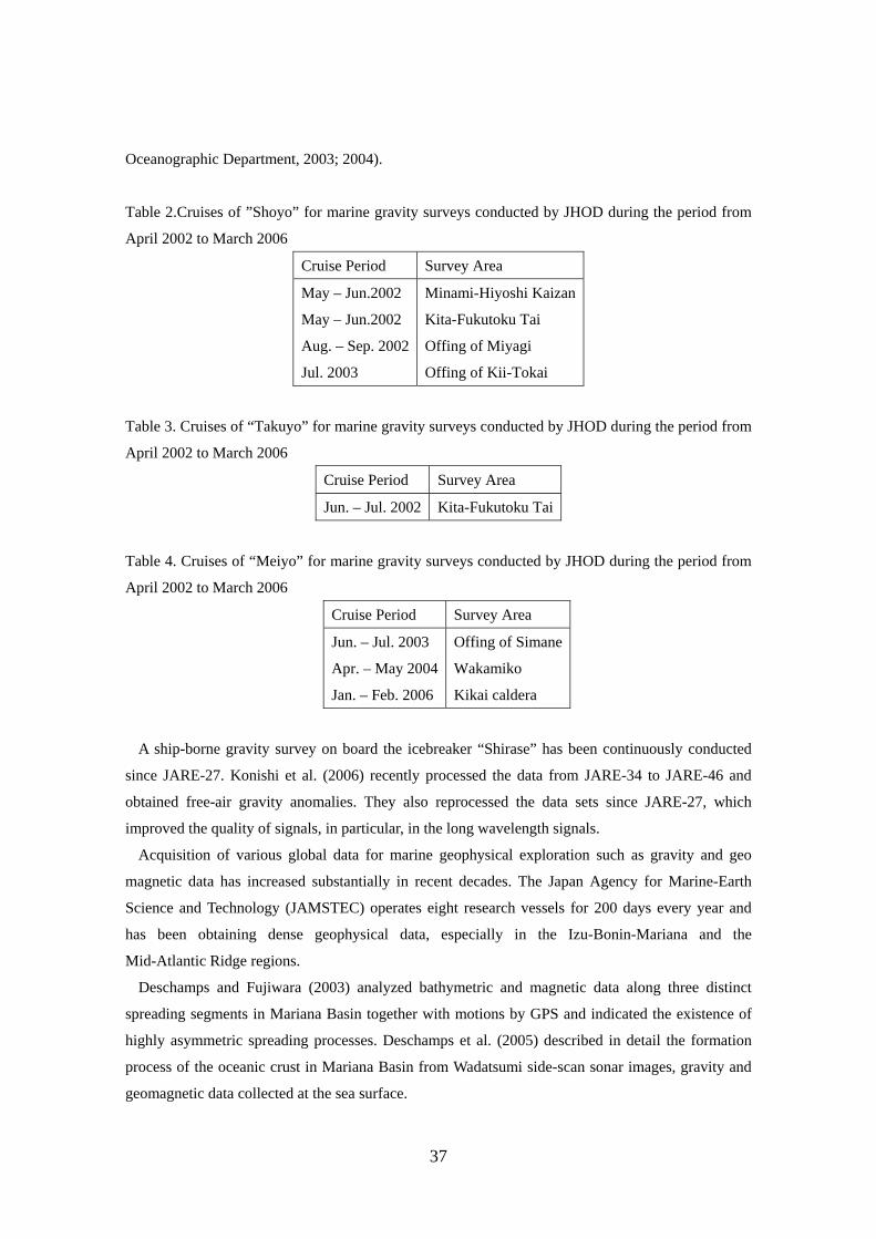
37
Oceanographic Department, 2003; 2004).
Table 2.Cruises of ”Shoyo” for marine gravity surveys conducted by JHOD during the period from
April 2002 to March 2006
Cruise Period Survey Area
May – Jun.2002
May – Jun.2002
Aug. – Sep. 2002
Jul. 2003
Minami-Hiyoshi Kaizan
Kita-Fukutoku Tai
Offing of Miyagi
Offing of Kii-Tokai
Table 3. Cruises of “Takuyo” for marine gravity surveys conducted by JHOD during the period from
April 2002 to March 2006
Cruise Period Survey Area
Jun. – Jul. 2002 Kita-Fukutoku Tai
Table 4. Cruises of “Meiyo” for marine gravity surveys conducted by JHOD during the period from
April 2002 to March 2006
Cruise Period Survey Area
Jun. – Jul. 2003
Apr. – May 2004
Jan. – Feb. 2006
Offing of Simane
Wakamiko
Kikai caldera
A ship-borne gravity survey on board the icebreaker “Shirase” has been continuously conducted
since JARE-27. Konishi et al. (2006) recently processed the data from JARE-34 to JARE-46 and
obtained free-air gravity anomalies. They also reprocessed the data sets since JARE-27, which
improved the quality of signals, in particular, in the long wavelength signals.
Acquisition of various global data for marine geophysical exploration such as gravity and geo
magnetic data has increased substantially in recent decades. The Japan Agency for Marine-Earth
Science and Technology (JAMSTEC) operates eight research vessels for 200 days every year and
has been obtaining dense geophysical data, especially in the Izu-Bonin-Mariana and the
Mid-Atlantic Ridge regions.
Deschamps and Fujiwara (2003) analyzed bathymetric and magnetic data along three distinct
spreading segments in Mariana Basin together with motions by GPS and indicated the existence of
highly asymmetric spreading processes. Deschamps et al. (2005) described in detail the formation
process of the oceanic crust in Mariana Basin from Wadatsumi side-scan sonar images, gravity and
geomagnetic data collected at the sea surface.
38
Mid-Atlantic Ridge around Fifteen-Twenty Fracture Zone is unique in that outcrops of lower crust
and mantle rocks are extensive on both flanks of the axial valley walls over an unusually long
distance along the valley axis, indicating a high ratio of tectonic to magmatic extension. Based on
newly collected multi-beam bathymetry, magnetic, and gravity data, Fujiwara et al. (2003)
investigated crustal evolution of this unique section of Mid-Atlantic Ridge over the last 5 Ma.
To characterize the crust-mantle boundary (petrogical “Moho”) and to find evidence of ophiolite
model, Matsumoto et al. (2003) reported the lithology and the development process of the oceanic
crust. They carried out geological and geophysical studies of Atlantis Bank core complex located at
the eastern margin of Atlantis-II active transform in Southwest Indian Ridge (SWIR) using deep sea
submersibles and remotely operated vehicles.
Mjelde et al. (2007) has corrected and imaged crustal structure across Jan Mayen Ridge, North
Atlantic with full constraints by using gravity anomaly data.
Underway geophysical observation over the easternmost SWIR was carried out on board the
research vessel “Yokosuka” by JAMSTEC as an international cruise under the InterRidge Program.
Off-axis bathymetry, gravity, and magnetic data obtained suggest that spreading at the ultra-slow
SWIR is dominated by large offset, asymmetric normal faulting, with significant flexural uplift of
the footwalls (Cannat et al., 2003).
Ocean bottom gravity measurements were carried out in Seto Inland Sea by using a gravimeter
jointly developed by ERI and Tohoku University (Joshima et al., 2006).
5.9 Data Handling and Gravity/Geoid Maps
GSI has been conducting GPS survey at benchmarks over isolated islands in order to fill-in the
data voids in a hybrid geoid model, from a gravimetric geoid model and GPS/leveling geoid height
data, GSIGEO2000 (Kuroishi et al., 2002), which was published in 2002 mostly for the major
islands of Japan by GSI as the official national geoid model. As of 1 December 2005, GSIGEO2000
version 4 was published, appending the geoid information newly for 50 isolated islands to the
original model.
GSI has also conducted GPS survey at benchmarks in the edges of 16 peninsular areas that are
located outside of the coverage of the GPS/leveling data used in the development of GSIGEO2000.
The preliminary results obtained in six out of these 16 areas show that the discrepancies of the geoid
heights between GSIGEO2000 and GPS/leveling data reach about 5 cm at maximum.
Nomura et al. (2006a) evaluated effects of the height revision of GEONET site coordinates
associated with the replacement and re-installment of the antenna for GEONET sites, on
GSIGEO2000 in terms of geoid height. In the development of GSIGEO2000, the geoid heights of
GSIGEO2000 were highly constrained with those of the GPS/leveling data, whose ellipsoidal
39
heights were determined by fixing all 108 GEONET sites, available at the time of GPS observation,
at the then-employed official coordinates in ITRF94 epoch 1997.0. The changes of the GPS/leveling
geoid heights yielded by the height revision were estimated: the mean and standard deviation about
the mean are -1.9 and 1.7 cm, respectively and the maximum modulus is less than 7 cm. The effects
are evaluated as minor in the application of GSIGEO2000 to the height conversion from GPS
derived ellipsoidal heights to corresponding orthometric heights within its precision.
GSI conducted gravity survey in Yaku-shima Island and GPS survey at benchmarks in Yaku-shima
and adjacent islands, and computed a hybrid geoid model for that area. Yaku-shima Island is located
on the volcanic front between Ryuku Trench and Okinawa Trough and has a rugged terrain of an
area of about 500 km2 with a highest peak of about 2000 m. Since the land gravity data used in the
development of the gravimetric geoid model are limited along the coast (only at 12 points), the geoid
model is not expected to recover the geoid precisely at short wavelengths. GSI made gravity survey
at 28 points inland and the GSJ provided 190 points of land gravity in Yaku-shima Island, so that
Kuroishi et al. (2004) developed a much improved gravimetric geoid model by using the same
methodology as that employed in the JGEOID2000 development. The improved model reveals that a
geoidal mound exists on the eastern end and the geoid has a tilt to the east, toward the trench axis.
GSI computed a hybrid geoid model for Yaku-shima, Tanega-shima, Kuchinoerabu-jima, and
Satsuma-Iwo-jima Islands by combining the improved gravimetric geoid model with 52 data of
GPS/leveling geoid heights and the model is evaluated to have accuracy comparable to
GSIGEO2000.
GSJ/AIST published eight detailed complete Bouguer anomaly maps at 1:200,000 scale, "Gravity
Map Series", Karatsu, Miyazaki, Kagoshima, Yaku-shima, Nagasaki, and Yamaguchi Districts, from
about fifty thousands of data as part of the gravity mapping program of the Japanese Islands
(Geological Survey of Japan, 2003b; 2004a; 2004b; 2005; 2006a; 2006b).
GSJ/AIST carried out gravity survey in Fukui Plain from 2000 to 2002 for investigation of
underground structure and active faults, and the gravito-tectonic map was published (Komazawa,
2006).
Heliani et al. (2003) determined a precise Indonesian gravity field model from surface gravity,
altimeter data and a digital terrain model. Because the available Indonesian land gravity data were
limited, they employed supplemental land gravity data simulated by using a digital terrain model
(Heliani et al., 2004).
Ueda (2003; 2005) compiled Bouguer gravity anomaly maps of the Japanese Island arcs and its
adjacent seas. Sasahara (2005a; 2005b) and Sasahara et al. (2006a; 2006b) determined a new precise
marine geoid model. The model is given on a grid of 1´ x 1´ in the area 15ºN - 50ºN and 120ºE -
160ºE, compounded from a global geopotential model (for long wavelength), altimetric gravity data
(for middle wavelength), and land and ship-borne gravity data (for short wavelength).

40
5.10 Gravity Data Analysis
Fukunaga et al. (2004) analyzed the gravity database for southwest Japan for studying the
geometry of the Moho discontinuity interface.
Kudo et al. (2004) developed a statistical method to interpret the spatial distribution of topographic
lineaments in Chugoku Area by employing the standard deviations of variations of Bouguer
anomalies as an index of gravity anomaly roughness.
Shichi et al. (2005) analyzed characteristic gravimetric features of Kyushu Area by applying both
gravity databases constructed by Gravity Research Group in Southwest Japan (2001) and by the
Geological Survey of Japan (2000).
5.11 Theoretical Studies on Geoid and Gravity Field
Kuroishi (2003) and Kojiroi and Kuroishi (2004) presented brief reviews on gravity, height
systems and geoid and gave introductory reports of the vertical datum of Japan as part of the Japan
Geodetic Coordinates 2000.
Kuroishi and Denker (2003) investigated the area around Japan regarding the handling of ship and
altimetric gravity data and its effect on local geoid models. They prepared different data sets based
on those data and their hybrid ones, and considered the classical Stokes kernel and its modification
in the geoid computation. The results showed that different adjustments and combinations of ship
and altimetric gravity data could produce biases larger than 1 m in geoid height and tilt the geoid
models by more than 1 parts per million (ppm), and they pointed out the importance of a study of the
spatio-frequency characteristics of the ocean gravity field models.
Kuroishi (2004) reviewed a then-latest gravimetric geoid modeling for Japan, JGEOID2000
(Kuroishi, 2001) and its improvement study and presented expectation of the dedicated satellite
missions for enhancement of the geoid modeling study.
Kuroishi and Keller (2005) developed a semi-discrete wavelet analysis/reconstruction method for
localizing 2-D signal components in the spatio-frequency domain. They employed 2-D Halo
wavelets and demonstrated the effectiveness of the method in screening data as a locally-adjustable
filter. They successfully applied the method to a combination of marine gravity data and an
altimetric gravity model, KMS02 and yielded an improved gravimetric geoid model for Japan,
JGEOID2004. Compared with 816 GPS/leveling benchmarks over Japan, JGEOID2004 exhibited
significant improvement over a previous model, JGEOID2000. The application of the semi-discrete
wavelet method and inclusion of newly acquired terrestrial gravity data supplemented to the data
gaps of JGEOID2000 in inland sea and on the main islands of Japan, effectively removed substantial
41
localized errors, which were due to systematic errors of the marine gravity data as well as data gaps.
Nozaki (2006) proposed a new concept of the generalized Bouguer anomaly (GBA), which is
defined upon the datum level of an arbitrary elevation. The subject of GBA is the generalization of
the classical Bouguer anomaly used in geophysics to study the subsurface density structures. The
classical Bouguer anomaly is a good contrast to the modern Bouguer anomaly defined as an
extension of the geodetic gravity anomaly. By introducing a new concept of the specific datum levels
so that GBA is not affected by the topographic masses, he shows the equations of GBA upon the
specific datum levels become free from the assumed topographic density and/or the terrain
correction and derives an approximate equation for estimating the density. Finally, he gives a method
to compute a Bouguer anomaly on the geoid by transforming GBA at the specific datum level to the
level of the geoid. These procedures yield a new method for obtaining a distribution of the classical
Bouguer anomaly, which is free from the density assumption. He remarks that GBA upon the
density-free datum level yields the gravity disturbance and that its equation has an intimate tie to the
fundamental equation of physical geodesy. Despite that the figure of the Earth is not the main subject
of such a generalization, this approach gives new perspectives to the theory of physical geodesy,
which totally mediates between the geophysical and geodetic gravity anomalies.
Sun (2004a) investigated some discretizations of the Poisson integral. A single mean scheme is
proposed to overcome the disadvantage of the double mean scheme. Basically the single mean
scheme is the same as the double one, but it is numerically simple since it greatly reduces numerical
work. Comparison between the point and mean schemes shows that, for a limit topographical grid
size, the point discrete scheme presents a serious theoretical problem, i.e., it greatly devalues gravity
on geoid, and even gives suspicious result in an extreme case. Sun (2004a) found that difficulty of
dealing with the Poisson integral is due to behaviors of the Poisson kernel. Numerical analysis
indicates that the diagonal values for the point scheme on a 5’ x 5’ division are much larger than
those of the mean scheme. Therefore, a careful consideration of constructing matrix coefficient of
the discrete system of the Poisson integral is much more important. A basic principle of a valid
discretization for any integration is that the discrete kernel function value should well-approximate
the true value on each grid; otherwise discretization will bring a serious error to results.
Sun (2003; 2004b) presented an asymptotic theory for calculating coseismic potential/geoid and
gravity changes, as an approximation of the dislocation theory for a spherical Earth (Sun and Okubo,
1993). This theory is given by a closed form of mathematical expressions, so that it is
mathematically simple and can be applied easily. Moreover, since the asymptotic theory includes
sphericity and vertical structure effects, it is physically more reasonable than the flat-Earth theory. A
comparison between results calculated by using three dislocation theories (the flat-Earth theory, the
theory for a spherical Earth and its asymptotic solution) shows that the true coseismic geoid changes
are approximated better by the asymptotic results than those of a flat-Earth. Numerical results

42
indicate that the spherical effect is obviously large, especially for a tensile source on a vertical fault
plane.
Sun and Okubo (2004a; 2004b) proposed a concept of truncated geoid and gravity changes
together with their expressions for investigating coseismic deformations. They carried out numerical
investigations to observe whether or not coseismic geoid and gravity changes are detectable by
satellite gravity missions. Results of an individual harmonic degree or a summation to interested
degrees are compared with the expected errors of the gravity missions, assuming a seismic source
equivalent to the fault size of the 1964 Alaska earthquake (Mw9.2). Corresponding coseismic
deformations indicate that both the gravity and geoid changes are about two orders larger than the
precision of a dedicated satellite gravity mission, GRACE. Based on these results, the minimum
magnitudes of earthquakes detectable by GRACE are derived. They concluded that coseismic
deformations for an earthquake with a seismic magnitude above M7.5 (for the tensile sources) and
M9.0 (for the shear sources) can be detected by GRACE. Finally, a case study on the 2002 Alaska
earthquake (M7.9) showed that the coseismic geoid and gravity changes are at or below the error
level of GRACE, and are difficult to detect.
Tanaka, T. et al. (2006) introduced a new method to compute global postseismic deformation
(PSD) in a spherically symmetric, self-gravitating viscoelastic Earth model. Previous methods are
based on simplified Earth models that neglect compressibility and/or the continuous variation of the
radial structure of Earth. This is because the previous mode summation technique cannot avoid
intrinsic numerical difficulties caused by the innumerable poles that appear in a realistic Earth model
that considers such effects. In contrast, the proposed method enables both of these effects to be taken
into account simultaneously. They carried out numerical inverse Laplace integration, which allows
evaluation of the contribution from all of the innumerable modes of the realistic Earth model. Using
this method, a complete set of Green’s functions is obtained, including functions of the time
variation of the displacement, gravity change, and the geoid height change at the surface for
strike-slip, dip-slip, horizontal, and vertical tensile point dislocations. As an Earth model, they
employed the preliminary reference Earth model (PREM) and a convex viscosity profile. Further,
they investigated the effects of fine layering of the viscoelastic structure and compressibility on a
time-series of PSD using the Green’s function for a dip-slip fault. The result indicates that the effect
of increasing number of layers is saturated at several tens of layers even when compressibility is
taken into account and that the effect of compressibility is detectable with modern observation
techniques for a shallower large earthquake (~Mw 8). As an application, the PSD due to the 2004
Sumatra-Andaman earthquake (Mw9.3) is estimated. They showed that the rate of postseismic
vertical displacement and gravity change is possibly detected in the far field where the epicentral
distance exceeds 400 km.
43
5.12 Space Gravimetry
Kaula's rule of thumb has been used in producing geopotential models from space geodetic
measurements, including the most recent models from a satellite gravity mission, CHAllenging
Mini-satellite Payload (CHAMP). Although an alternative regularization method by introducing a
number of regularization parameters was proposed in 1992, no numerical tests have ever been
conducted. Xu et al. (2006a) have compared four methods of regularization for the determination of
geopotential from precise orbits of COSMIC satellites through simulations: Kaula's rule of thumb,
one-parameter regularization and its iterative version, and multiple-parameter regularization. The
simulation results have shown that the four methods can indeed produce good gravitational models
from the precise orbits of centimeter level. The three regularization methods perform much better
than Kaula's rule of thumb by a factor of 6.4 on average beyond spherical harmonic degree 5 and by
a factor of 10.2 for the spherical harmonic degrees from 8 to 14 in terms of degree variations of
RMS errors. The maximum component-wise improvement in RMS can be up to a factor of 60. The
simplest version of regularization by multiplying a positive scalar with a unit matrix is sufficient to
better determine the geopotential model. Although multiple parameter regularization is theoretically
attractive and can indeed eliminate unnecessary regularization for some of the harmonic coefficients,
we found that it only improved its one-parameter version marginally with this COSMIC example in
terms of mean squared error.
However, if space geodetic measurements are assumed to be heteroscedastic with different
unknown variance components, all regularization techniques may not be proper to apply, unless
techniques of variance component estimation are directly implemented. Although variance
component estimation techniques have been proposed to simultaneously estimate the variance
components and provide a means of regularization, the regularization parameter is treated as if it
were also an extra variance component. As a result, Xu et al. (2006b) assume no prior information on
the model parameters and do not treat the regularization parameter as an extra variance component.
Instead, they first analyze the biases of estimated variance components due to the regularization
parameter and then propose bias-corrected variance component estimators. The results have shown
that they work very well. Finally they propose and investigate through simulations an iterative
scheme to simultaneously estimate the variance components and the regularization parameter in
order to eliminate the effect of regularization parameter on variance components and the effect of
incorrect prior weights or initial variance components on the regularization parameter.
5.12.1 Lunar and Planetary Gravimetry
Study of the lunar gravity anomaly has not been straightforward since direct tracking data of lunar
44
satellites are available only at the nearside of the Moon. In such a case, direct inversion of the
line-of-sight acceleration data into surface mass distribution has several merits: (1) high resolution
attainable without relying on artificial constraints, and (2) short computation time by estimating
regional parameter sets stepwise. Sugano and Heki (2004a) processed the line-of-sight acceleration
data of the Lunar Prospector extended low-altitude mission after confirming the validity of the
method using synthesized data. They obtained a gravity anomaly map of the lunar nearside with
resolution as high as 0.8º x 0.8º, equivalent to 225th degree/order of spherical harmonics, with less
spurious signatures than previous studies. To take advantage of the high resolution, they calculated
mass deficits for 92 medium-sized craters (50 – 300 km in diameter), and confirmed that the deficits
are nearly proportional to 2.5 power of crater diameter.
Sugano and Heki (2004b; 2004c; 2005) presented high-resolution Bouguer gravity anomalies of
the lunar nearside after applying correction to the Lunar Prospector line-of-sight acceleration data.
They investigated lithospheric thicknesses of the early Moon by comparing the gravity anomalies of
craters and impact basins of various dimensions. The lithosphere was already thick enough to
support craters with diameters up to 300 km in the Pre-Nectarian and Nectarian Periods. Degree of
isostatic compensation of larger impact basins suggested lithospheric thickness of 20 – 60 km at that
time, which depended more on localities rather than on age differences.
5.12.2 Satellite Gravity Missions
GSI initiated study on gravity field recovery from data obtained by satellite gravity missions,
CHAMP and GRACE, in cooperation with the Goddard Space Flight Center, NASA of USA. One of
its main purposes is to determine the static gravity field regionally in the area around Japan for
enhancing improvement of gravimetric geoid modeling in terms of the absolute locations. Kuroishi
and Munekane (2005) processed CHAMP science orbit data for global gravity recovery and
discussed the use of regularization and de-aliasing treatment. Kuroishi et al. (2005; 2006a; 2006b)
have been working with GRACE data for recovery of the gravity field regionally in the area around
Japan as well as globally. The resulting monthly global gravity models, after smoothed with a
Gaussian isotropic filter, represented seasonal gravity changes over major continental river basins
and indicated the necessity of improved de-aliasing over the oceans for practicing the geoid model
refinement at long wavelengths for Japan.
Yamamoto et al. (2005) simulated the recovery of a gravity field from four-week simulated data
and investigated the relation between the recovery precision and the ground track. They showed that
the GRACE ground track in 2003 was in good condition for four-week gravity field recovery, but it
can become worse as the orbit altitude decays. Their simulated results have shown that tracks at the
altitudes of 473, 448, 399, 350 and 337 km could result in insufficient spatial resolutions, even for
45
gravity field recovery up to degree 30.
Sugano (2006) extended the line-of-sight acceleration data analysis described in 5.12.1 to GRACE
gravity field recovery. He applied this method to GRACE Level 1B data. The model for Lunar
Prospector was adapted to low-low-satellite configuration of GRACE. This extension is easily
achieved thanks to the simplicity of the adopted model. Among the GRACE Level 1B data, he
employed KBR range acceleration data as line-of-sight acceleration. Accelerometer data combined
with Star Camera data was used to correct non-gravitational acceleration contained in the range
acceleration data. GPS navigation data was used to obtain information of the satellites positions after
interpolation to 5 second interval. A gravity map on a 3° x 3° grid is obtained using a month of data.
Coseismic deformations observed on the Earth surface or modeled by conventional dislocation
theory cannot be compared directly with those observed by gravity satellite missions because of the
spatial resolution limit of the missions and the signal attenuation of the gravity field. Coseismic
deformations in the spectrum domain should be considered instead. For this purpose, the dislocation
theory (e.g., Sun and Okubo, 1993) for a spherical Earth model can be used because it is expressed
in terms of spherical harmonics. Sun and Okubo (2004a; 2005) derived analytical expressions of
degree variances of the coseismic geoid and gravity changes for shear and tensile sources and
calculated for three real earthquakes. Those results are compared with expected errors of GRACE to
elucidate whether or not coseismic geoid and gravity changes are detectable by gravity satellite
missions. They investigated behaviors of the degree variances for four independent seismic sources
and found that both the gravity and geoid changes are nearly two orders of magnitude larger than the
precision of the gravity missions in low harmonic degrees. Based on these results, they concluded
that coseismic deformations for an earthquake with a seismic magnitude above M7.5 are expected to
be detected by GRACE.
Sun et al. (2006b) presented a new approach to calculate dislocation Love numbers using
observations of a satellite gravity mission (e.g. GRACE). The necessary condition is that the
coseismic potential change be sufficiently large to be detected by the gravity mission. Coseismic
deformations for each spherical harmonic degree n are decoupled. Therefore, dislocation Love
numbers of degree n can be determined independently. The determinable maximum harmonic degree
n depends on the seismic size, source type, magnitude, and the accuracy of a satellite gravity mission.
For an arbitrary seismic source, all four types of dislocation Love numbers can be determined using
data from only one seismic event because all deformation components are involved together. Only
the concerned dislocation Love numbers can be computed for any one of the four types of sources.
To prove the validity of the method proposed in this study, a simulation test is carried out by
considering a similar case to the 2004 Sumatra-Andaman earthquake (Mw 9.1). Results show that
the method works well and guarantee the accuracy.

46
5.13 Superconducting Gravimetry
Routine observations of gravity changes have been conducted in Kyoto and Bandung, Indonesia
by employing SGs. Takemoto et al. (2002) installed groundwater level-meters near the SG stations in
Kyoto and Bandung and reported the effect of groundwater changes on SG observations in Kyoto
and Bandung. The results revealed that in Kyoto and Bandung 1-m upheaval of groundwater level
causes an increase of about 4 micro-gal increase in gravity residual. Abe et al. (2006) reported the
hydrological effects on the SG observation in Bandung. They also installed soil moisture meters and
the rain gauge near the SG station in Bandung and clarified that the model of soil moisture could
explain about 80 % of the variations in gravity.
Fukuda et al. (2004) carried out simultaneous observations with SG and absolute gravimeter FG5
to determine the calibration factor of the SG in Bandung. They obtained the new factor with the
relative precisions of 0.18%. The difference of the value to the previous one was only 0.01
micro-gal/V and was negligible.
An international program, GGP started in July 1997. Initially, GGP had been planned as a six-year
program, but was extended in 2003 and officially integrated in IAG as an Intercommision Project.
GGP is a project with a global network of SGs to study low frequency Earth’s free oscillations, core
under tone, free core resonance, long period tide and inelasticity of the Earth, coupling of the solid
Earth and geophysical fluids, crustal deformation and gravity change, and so on. The Japanese GGP
group organized a GGP-Japan network and established a data center at NAOJ Mizusawa. The
GGP-Japan network consists of seven stations; Kyoto site operated by Kyoto University, Matsushiro
site by Ocean Research Institute, University of Tokyo (ORI), Kamioka and Esashi sites by NAOJ,
Ny-Alesund site in Norway jointly by NAOJ and Norwegian Mapping Authority, Canberra site in
Australia jointly by NAOJ and Australian National University, and Syowa Station, Antarctica, by
National Institute of Polar Research (NIPR). The GGP-Japan data center distributes not only
one-minute sampling data but also high-rate sampling data.
Imanishi et al. (2002) and Tamura et al. (2005) discussed scale factor calibration of SG with
absolute gravimeters. The calibration is essential to the studies of Earth tide, ocean tide loading and
so on. To discuss the inelasticity of the Earth, for example, the scale factor of SG should be
determined at a relative accuracy better than 0.1%. Imanishi et al. (2004) detected coseismic gravity
changes at three SG sites induced by the 2003 Tokachi-oki earthquake of Mw8.3. Iwano et al. (2005)
analyzed long period tides observed at Syowa Station and discussed the inelasticity of the Earth.
Sato et al. (2004) discussed fluid core resonance parameters inferred from SG data. Sato et al.
(2006a) and Sato et al. (2006b) analyzed SG data, and compared them with absolute gravity data,
GPS data, and ice seat data at Ny-Alesund and discussed secular and seasonal changes of gravity
there. They suggested that the gravity change data obtained from stable SGs can supply regional and
47
global information on environmental change from a different view-point of meteorology and
oceanography. Concerning the 2004 Sumatra-Andaman earthquake, Rosat et al. (2005) analyzed low
frequency free oscillations of the Earth with high-resolution. Nawa et al. (2006a; 2006b) analyzed
tsunami waves observed at Syowa Station and discussed gravity changes induced from the waves.
5.14 Air-borne Gravimetry
A new airborne (helicopter-borne) gravimeter, FGA-1 SEGAWA model, has been developed since
1998, and many practical measurements have been carried out over Kashima-Nada, Enshu-Nada,
Suruga Bay and Izu-Bonin Islands (Segawa et al., 2003; Joseph et al., 2003; Segawa et al., 2005a).
In the observation over Kashima-Nada, the SEGAWA model showed that the average bias difference
is 0.5 mgal and standard deviation is 1.5 mgal and that this gravimeter has a potential of finding the
active faults from land to sea floor (Segawa et al., 2003). In fact, in the observation over Enshu-Nada,
Segawa et al. (2005a) found the gravity anomaly pattern reflecting the structure of Akaishi Fracture
Zone.
One of the first significant results was the discovery of disagreement of gravity anomaly between
land and sea. The amount of disagreement is as large as 15 mgal. Such disagreement was confirmed
in the middle of Honshu and the neighboring Pacific Ocean (Segawa et al., 2005b).
The air-borne gravimetry survey was also extended to Izu-Bonin Island areas such as Kozu-shima,
Miyake-jima and Nii-jima Islands (Joseph et al., 2003). It is known that there is an active magma
activity beneath the zone between Kozu-shima and Miyake-jima. But, from the gravity anomaly, it is
not clear whether or not a significant magma block large enough to affect the gravity anomaly is
involved underground. Recently it has become important to make geophysical surveys in the areas of
large power plants for mapping active tectonic faults for safety precautions. To this end the air-borne
gravimeter has been used in the area of Sata Peninsula of Shikoku, Noto Peninsula of Ishikawa
Prefecture and Wakasa Bay of Fukui Prefecture (Nishizaka et al., 2006).
Bibliography
Abe, M., S. Takemoto, Y. Fukuda, T. Higashi, Y. Imanishi, S. Iwano, S. Ogasawara, Y. Kobayashi, S.
Dwipa, and D. S. Kusuma (2006): Hydrological effects on the superconducting gravimeter
observation in Bandung, J. Geodynamics, 41, 288-295.
Akamatsu, J. and M. Komazawa (2003): Vibrational characteristic of microseisms and gravity
basement in Kyoto basin, Annuals of Disast. Prev. Res. Inst., Kyoto Univ., 46 B, 929-936.
Akamatsu, J., M. Komazawa, K. Nakamura, and K. Nishimura (2004a): Gravity Basement of Kyoto
and Nara basin area, Annuals of Disast. Prev. Res. Inst., Kyoto Univ., 47 B, 871-876.
Akamatsu, J., H. Suwa, N. Ichikawa, and M. Komazawa (2004b): Bedrock structure of Kamikochi
48
basin at the foot of Yakedake Volcano inferred from gravity anomaly and vibrational
characteristics of microseisms, Annuals of Disast. Prev. Res. Inst., Kyoto Univ., 47 B, 877-882.
Akamatsu, J., K. Nakamura, K. Nishimura, and M. Komazawa (2006): Crustal density structure
estimated by using gravity data, Final Rep. Special Project for Earthquake Disaster Mitigation in
Urban Areas, Ministry of Education, Culture, Sports, Science and Technology, 571-576.
Cannat, M., C. Rommevaux-Jestin, and H. Fujimoto (2003): Melt supply variations to a magma-poor
ultra-slow spreading ridge (Southwest Indian Ridge 61 to 69 E), Geochem. Geophys. Geosyst., 4
(8), 9104, doi: 10.1029/2002GC000480.
Deschamps, A. and T. Fujiwara (2003): Asymmetric accretion along the slow-spreading Mariana
Ridge, Geochem. Geophys. Geosyst., 4, (10), 8622, doi:10.1029/2003GC000537.
Deschamps, A., T. Fujiwara, M. Asada, L. Montési, and P. Gente (2005): Faulting and volcanism in
the axial valley of the slow spreading center of the Mariana back arc basin from Wadatsumi
side-scan sonar images, Geochem. Geophys. Geosyst., 6, 5, doi:10.1029/2004GC000881.
Ehara, S. and J. Nishijima (2004): Study on Sustainable Development of Geothermal Energy from
Geophysical Monitoring of Geothermal Reservoir - A Case Study of Repeat Gravity Measurement
-, J. Geothermal Res. Soc. Japan, 26, 181-193. (in Japanese)
Fujimitsu, Y., J. Nishijima, and T. Hirano (2006): Densely-arranged Gravity Survey in Fukuoka City,
Japan -Relation between the Subsurface Structure and the Low Temperature Hydrothermal System
of Fukuoka-, Proc. 28th New Zealand Geothermal Workshop 2006, CD-ROM.
Fujiwara, T., J. Lin, T. Matsumoto, P. B. Kelemen, B. E. Tucholke, and J. F. Casey (2003): Crustal
Evolution of the Mid-Atlantic Ridge near the Fifteen-Twenty Fracture Zone in the last 5 Ma,
Geochem. Geophys. Geosyst., 4, 3, doi:10.1029/2002GC000364.
Fukuda, Y., K. Shibuya, K. Doi, and S. Aoki (2003): A Challenge to the Detection of Regional to
Local Scale Ice Sheet Movements in Antarctica by the Combination of In-situ Gravity
Measurements and Gravity Satellite Data, in T. N. Tziavos (ed.), Gravity and Geoid 2002, 3rd
Meeting of the International Gravity and Geoid Commission (IGGC), ZIDI , 243-248.
Fukuda, Y., T. Higashi, S. Takemoto, M. Abe, S. Dwipa, D. S. Kusuma, A. Andan, K. Doi, Y.
Imanishid, and G. Arduino (2004): The first absolute gravity measurements in Indonesia, J.
Geodynamics, 38, 489-501.
Fukuda, Y., T. Higashi, S. Takemoto, S. Iwano, K. Doi, K. Shibuya, Y. Hiraoka, I. Kimura, H.
McQueen, and R. Govind (2005a): Absolute gravity measurements in Australia and Syowa Station,
Antarctica, in C. Jekeli et al. (eds.), IAG Symposia 129, Gravity, Geoid and Space Missions,
Springer, 280-285.
Fukuda, Y., S. Iwano, H. Ikeda, Y. Hiraoka, and K. Doi (2005b): Calibration of the superconducting
gravimeter CT#043 with an absolute gravimeter FG5#210 at Syowa Station, Antarctica, Polar
Geosci., 18, 41-48.
49
Fukuda, Y., Y. Hiraoka, and K. Doi (2006): An experiment of precise gravity measurements on ice
sheet, Antarctica, in C. Tregoning and C. Rizos (eds.), IAG Symposia 130, Dynamic Planet,
Springer, 88-93.
Fukunaga, M., H. Oda, and R. Shichi (2004): Topography of the Moho discontinuity estimated by
column inversion of gravity anomaly data, Earth Sci. Rep., Okayama Univ., 11, No.1, 1-5.
Furuya, M., S. Okubo, F. Kimata, R. Miyajima, I. Meilano, W. Sun, Y. Tanaka, and T. Miyazaki
(2003a): Mass budget of the magma flow in the 2000 volcano-seismic activity at Izu-islands,
Japan, Earth Planets Space, 55, (7), 375-385.
Furuya, M., S. Okubo, W. Sun, Y. Tanaka, J. Oikawa, H. Watanabe, and T. Maekawa (2003b):
Spatio-temporal gravity changes at Miyakejima volcano, Japan: Caldera collapse, explosive
eruptions and magma movement, J. Geophys. Res., 108, B4, 2219, doi:10.1029/2002JB001989.
Geological Survey of Japan (2003a): Geological Map East of Noto Peninsula, 1:200,000, Mar. Geol.
Map Ser., 59.
Geological Survey of Japan (2003b): Gravity Map of Karatsu District (Bouguer anomalies), Gravity
Map Ser., 19.
Geological Survey of Japan (2004a): Gravity Map of Miyazaki District (Bouguer anomalies),
Gravity Map Ser., 20.
Geological Survey of Japan (2004b): Gravity Map of Kagoshima District (Bouguer anomalies),
Gravity Map Ser., 21.
Geological Survey of Japan (2005): Gravity Map of Yakushima District (Bouguer anomalies),
Gravity Map Ser., 22.
Geological Survey of Japan (2006a): Gravity Map of Nagasaki District (Bouguer anomalies),
Gravity Map Ser., 23.
Geological Survey of Japan (2006b): Gravity Map of Yamaguchi District (Bouguer anomalies),
Gravity Map Ser., 24.
Gravity research group in Southwest Japan (Representatives: Shichi, R. and A. Yamamoto) (2005):
Construction and Publication of the Gravity Database of Southwest Japan, J. Geod. Soc. Japan, 51,
17-32.
Higashi, T., Y. Fukuda, S. Ogasawara, and S. Takemoto (2002): Absolute Gravity Changes at the
Fundamental Gravity Station (Kyoto C) in Kyoto University, Kyoto, Japan, J. Geod. Soc. Japan,
48, 149-152. (in Japanese with English Abstract)
Higashi, T., Y. Fukuda, M. Abe, S. Takemoto, S. Dwipa, D. S. Kusuma, A. Andan, K. Doi, Y.
Imanishi, and G. Arduino (2003): Determination of Absolute Gravity Values using a FG5#210 in
Bandung and Yogyakarta, Indonesia, J. Geod. Soc. Japan, 49, 177-180.
Heliani, L. S., Y. Fukuda, and S. Takemoto (2003): Precise Indonesian Gravity Field Determination
from a Combination of Surface Gravity, Altimeter and Digital Terrain Model Data, in T.N.Tziavos
50
(ed.), Gravity and Geoid 2002, 3rd Meeting of the International Gravity and Geoid Commission
(IGGC), ZIDI, 243-248.
Heliani, L. S., Y. Fukuda, and S. Takemoto (2004): Simulation of the Indonesian land gravity data
using a digital terrain model data, Earth Planets Space, 56, 15-24.
Hiraoka, Y., I. Kimura, Y. Fukuda, K. Doi, and K. Shibuya (2005): Gravity measurements with the
portable absolute gravimeter FG5 at Antarctica (III), Bull. Geogr. Surv. Inst., 108, 21-27. (in
Japanese)
Hiraoka, Y., I. Kimura, Y. Hiyama, M. Honda, H. Amemiya, A. Suzuki, S. Takemoto, Y. Fukuda, and
T. Higashi (2006): Collaboration in Establishment of Absolute Gravity Standard Station Network
in East Asia (II), J. Geogr. Surv. Inst., 110, 19-25. (in Japanese)
Hiyama, Y., I. Kimura, and Y. Hiraoka (2003): Gravity Change at Mt. Fuji (2), 100th Meeting Geod.
Soc. Japan Program and Abstracts, 147-148. (in Japanese)
Hokkaido Government (2003): A Report on the Survey for the Tokachi-Heiya Fault Zone, Furano
Fault Zone and Shibetsu Fault Zone, Hokkaido, Japan, Special Issue, March 2003, 407p. (in
Japanese)
Hokkaido Government (2004): A Report on the Survey for the Tokachi-Heiya Fault Zone, Furano
Fault Zone and Shibetsu Fault Zone, Hokkaido, Japan, Special Issue, March 2004, 473p. (in
Japanese)
Hokkaido Government (2005): Tokachi-Plain Active Fault Zone, Active fault Map and its
Explanatory Text, Active Fault Map of Hokkaido, 5, 136p. (in Japanese)
Hydrographic and Oceanographic Department (2003): Data Rep. Hydrogr. Oceanogr. Obs., Ser.
Astron. Geod., 37. (http://www1.kaiho.mlit.go.jp/jhd-E.html)
Hydrographic and Oceanographic Department (2004): Data Rep. Hydrogr. Oceanogr. Obs., Ser.
Astron. Geod., 38. (http://www1.kaiho.mlit.go.jp/jhd-E.html)
Ikeda H., K. Doi, Y. Fukuda, T. Noguchi, T. Nakashima, K. Iimura, and K. Shibuya (2004):
Installation of a superconducting gravimeter in Antarctica and development of its
vibration-isolating mechanism and remote monitoring system, J. Cryo. Soc. Japan, 39(8), 348-353.
(in Japanese with English abstract)
Ikeda, H., K. Doi, Y. Fukuda, Y. Tamura, and K. Shibuya (2005): Installation of the superconducting
gravimeter CT(#043) at Syowa Station, Antarctica, Polar Geosci., 18, 49-57.
Imanishi, Y., T. Higashi, and Y. Fukuda (2002): Calibration of the superconducting gravimeter T011
by parallel observation with the absolute gravimeter FG5 #210 - a Bayesian approach, Geophys J.
Int., 151, 867-878.
Imanishi, Y., T. Sato, T. Higashi, W. Sun, and S. Okubo (2004): A network of superconducting
gravimeters detects submicrogal coseismic gravity changes, Science, 306, 476-478.
51
Inoue, N., Y. Tanaka, H. Itoh, S. Iwano, N. Kitada, Y. Fukuda, and K. Takemura (2004): Density of
sediment in Kyoto Basin Inferred from 2D gravity analysis along Horikawa-Oguraike and
Kuzebahi Seismic survey lines, J. Seism. Soc. Japan, 57, 45-54. (in Japanese with English
Abstract)
Iwano, S. and Y. Fukuda (2004): Superconducting gravimeter observations without a tilt
compensation system, Phys. Earth Planet. Inter., 147, 343-351.
Iwano, S., I. Kimura, and Y. Fukuda (2003): Calibration of the superconducting gravimeter
TT70#016 at Syowa Station by parallel observation with the absolute gravimeter FG5#203, Polar
Geosci., 16, 22-28.
Iwano, S., Y. Fukuda, T. Sato, Y. Tamura, K. Matsumoto, and K. Shibuya (2005): Long-period tidal
factors at Antarctica Syowa Station determined from 10 years of superconducting gravimeter data,
J. Geophys. Res., 110, B10403, doi:10.1029/2004JB003551.
Joseph, E.J., J. Segawa, S. Kusumoto, E. Nakayama, T. Ishihara, M. Komazawa, and H. Sakuma
(2003): Air-borne gravimetry - a new gravimeter system and test results, Exploration Geophys., 34,
82-86.
Joshima, M., T. Ishihara, K. Koizumi, N. Seama, A. Oshida, H. Fujimoto, and T. Kanazawa (2006):
Measurements by ocean bottom gravimeter at Harima-Nada in Seto Inland Sea, Japan, J. Japan
Soc. Mar. Surv. Technol., 18, 17-27. (in Japanese with English abstract)
Kido, M., D. A. Yuen, and A. Vincent (2003): Continuous wavelet-like filter for a spherical surface
and its application to localized admittance function on Mars, Phys. Earth Planet. Inter., 135, 1-16.
Kimura, I., Y. Hiraoka, Y. Hiyama, S. Takemoto, Y. Fukuda, T. Higashi, S. Ogasawara, and H.
Nakagawa (2004): Collaboration in Establishment of Absolute Gravity Standard Station Network
in East Asia, J. Geogr. Surv. Inst., 105, 61-70. (in Japanese)
Kobayashi, Y., S. Iwano, and Y. Fukuda (2004): Detailed Coastline Data around Syowa Station,
Antarctica, and Calculation of the Oceanic Tidal Loading Effects, J. Geod. Soc. Japan, 50, 17-26.
(in Japanese with English Abstract)
Kojiroi, R. and Y. Kuroishi (2004): Introduction of Helmert orthometric heights in the vertical datum
of Japan: another set of the Geodetic Coordinates 2000 of Japan, J. Japan Soc. Photogrammetry
and Remote Sensing, 43 (1), 61-68. (in Japanese with English abstract)
Komazawa, M. (2004): Density structure inferred from gravity anomalies in the eastern area of the
Itoigawa-Shizuoka Tectonic Line, central Japan, Earth Planets Space, 56, 1309-1314.
Komazawa, M. (2006): Gravito-tectonic Map of Fukui District (Bouguer anomalies and gravity
basement), Gravity Map Ser., S2.
Komazawa, M., K. Nakamura, J. Akamatsu, L. Jiang, K. Li, K. Nishimura, H. Morikawa, T. Yano, K.
Sakai, S. Utagawa, and D. Yang (2005): Gravity Basement Structure of Lijiang Basin and Hochin
Basin in Yunnan Province, China, A Report of Research on Conjugate Faults and Basement

52
Structure of Lijiang Basin in Yunnan Province, China for the Purpose of Microzoning the Area,
supported by a Grant in Aid for Scientific Research of the Ministry of Education and Science,
Japan, 10-26.
Konishi, Y., Y. Fukuda, and Y. Nogi (2006): Surface ship gravity data obtained on board the
icebreaker Shirase, Antarctic Record, 50, 251-262. (in Japanese with English Abstract)
Kudo, T., A. Yamamoto, T. Nohara, H. Kinoshita, and R. Shichi (2004): Variations of gravity
anomaly roughness in Chugoku district, Japan: Relationship with distributions of topographic
linearments, Earth Planets Space, 56, e5-e8.
Kuroishi, Y. (2001): A new geoid model for Japan, JGEOID2000, in Sideris (ed.), IAG Symposia
123, Gravity, Geoid and Geodynamics 2000, Springer, 329-333.
Kuroishi, Y. (2003): Reference frames in space geodesy era – Part 1: Gravity and height, J. Geogr.
Surv. Inst., 102, 21-32. (in Japanese)
Kuroishi, Y. (2004): Quality of recent static gravimetric geoid models in and around Japan, Proc.
Symp. on Precise Satellite Positioning: Breakthrough for Geodynamics study by Dedicated
Satellite Gravity Missions, Earthq. Res. Inst., Univ. Tokyo, 129-138. (in Japanese)
Kuroishi, Y. and H. Denker (2003): On the handling of ship and altimetric gravity data and the effect
on local gravimetric geoid models – an investigation around Japan, Les Cahiers de l’ECGS, 20,
123-130.
Kuroishi, Y. and W. Keller (2005): Wavelet approach to improvement of gravity field-geoid
modeling for Japan, J. Geophys. Res., 110, B03402, doi:10.1029/2004JB003371, (15pp).
Kuroishi, Y. and H. Munekane (2005): Recovery of global gravity field from CHAMP precise
science orbit data – Preliminary results, Proc. Symp. on Dedicated Satellite Gravity Missions
observing flow in the Earth system, Earthq. Res. Inst., Univ. Tokyo, 126-135. (in Japanese with
English abstract)
Kuroishi, Y, H. Ando, and Y Fukuda (2002): A new hybrid geoid model for Japan, GSIGEO2000. J.
Geod., 76, 428-436, Springer.
Kuroishi, Y., Y. Hiyama, K. Morita, and M. Watanabe (2004): Improved modeling of the gravimetric
geoid model for Yakushima Island. 102nd Meeting Geod. Soc. Japan Program and Abstracts, 23-24,
Geod. Soc. Japan and Coll. Land, Infrastructure and Transport.
Kuroishi, Y., D. D. Rowlands, and F. G. R. Lemoine (2005): Preliminary results of regional gravity
field modeling from GRACE data in the vicinity of Japan, Prog. and Abst. Book, Dynamic Planet
2005, August 22-26, 2005, Cairns, Australia, 276.
Kuroishi, Y., D. D. Rowlands, and F. G. R. Lemoine (2006a): Regional gravity field modeling from
GRACE data – test case for the vicinity of Japan, Geophys. Res. Abst. 8, 2006, European
Geosciences Union, EGU06-A-03688.
Kuroishi, Y., D. D. Rowlands, and F. G. R. Lemoine (2006b): Regional gravity field modeling from

53
GRACE data for improvement of geoid modeling for Japan, EOS Trans, AGU 87 (36), Western
Pac. Geophys. Meet. Suppl. Abst., G31A-05.
Kusumoto, S., M. Kinugasa, T. Abe, K. Nemoto, and S. Takemoto (2004): Microgravity survey
across the estuary of the Fujikawa River (Fujikawa Fault System), Shizuoka, Japan, J. School Mar.
Sci. Technol., 2, 55-61.
Larsen, C.F., R. J. Motyka, J. T. Freymueller, K. A. Echelmeyer, and E. R. Ivins (2005): Rapid
viscoelastic uplift in southeast Alaska caused by post-Little Ice Age glacial retreat, Earth Planet.
Sci. Lett., 237, 548– 560.
Matsumoto, G., S. Miyashita, S. Arai, T. Morishita, J. Maeda, H. Kumagai, Y. Ohtomo, and H. Dick
(2003): Magmatism and "Crust-mantle boundary" on the ultra-slow spreading ridge as observed in
Atlantis Bank, Southwest Indian ridge, J. Geogr., 112, No. 5, 705-719.
Matsumoto, K., T. Sato, H. Fujimoto, Y. Tamura, M. Nishino, R. Hino, T. Higashi, and T. Kanazawa
(2006): Ocean bottom pressure observation off Sanriku and comparison with ocean tide models,
altimetry, and barotropic signals from ocean models, Geophys. Res. Lett., 33, L16602,
doi:10.1029/2006GL026706.
Miyamachi, H., S. Nakano, S. Hirano, and K. Goto (2004): Spatial relation between the aftershock
distribution of the 1997 Northwestern Kagoshima Earthquakes and gravity anomalies in the
aftershock region, Zisin 2, 56, 383-386.
Miyamachi, H., D. Fujita, A. Yamamoto, S. Hirano, H. Yakiwara, K. Goto, S. Nakao, and T. Kakuta
(2006): Gravity measurement in Amami-Oshima Island, Kagoshima, Japan, Geophys. Bull.
Hokkaido Univ., 69, 51-67.
Mjelde, R., I. Eckhoff, Solbakkenk, S. Kodaira, H. Shimamura, K. Gunnarsson, A. Nakanishi, and H.
Shiobara (2007): Gravity and S-wave modeling across the Jan Mayen Ridge, North Atlantic;
implications for crustal lithology, Mar. Geophys. Res., 28, No.1, 27-41.
Nawa, K. (2006): First observation of tsunami and T-phase using seismometers and a
superconducting gravimeter at Syowa Station, Chikyu Monthly, 28, 632-636. (in Japanese)
Nawa, K. and N. Suda (2003): Influence of sea level variations in seismic normal mode band at
Syowa Station, Chikyu Monthly, 25, 440-444. (in Japanese)
Nawa, K., N. Suda, S. Aoki, K. Shibuya, T. Sato, and Y. Fukao (2003): Sea level variation in seismic
normal mode band observed with on-ice GPS and on-land SG at Syowa Station, Antarctica,
Geophys. Res. Lett., 30, 1402.
Nawa, K., Y. Murata, M. Komazawa, R. Morijiri, T. Hiroshima, M. Makino, F. Murakami, K.
Kishimoto, S. Okuma, and R. Shichi (2005): Bouguer gravity anomalies in the Miyazaki district,
Bull. Geol. Surv. Japan, 56, 5/6, 183-208. (in Japanese)
Nawa, K., N. Suda, K. Doi, K. Shibuya, T. Sato, and K. Satake (2006a): An analysis of sea level and
gravity variations after the 2004 Sumatra earthquake observed at Syowa Station, Antarctica,
54
Advances in Geosciences, 11-16.
Nawa, K., K. Satake, N. Suda, K. Doi, K. Shibuya, and T. Sato (2006b): Sea level and gravity
variation after the 2004 Sumatra Earthquake observed at Syowa Station, Antarctica, in P.
Tregonign and C. Rizos (eds.), IAG Symposia 130, Dynamic Planet, Springer, 536-540.
Nishijima J., Y. Fujimitsu, S. Ehara, E. Kouno, and M. Yamauchi (2005a): Micro-Gravity
Monitoring and Repeated GPS Survey at Hatchobaru Geothermal Field, Central Kyushu, Japan,
Proc. World Geothermal Congress 2005, CD-ROM.
Nishijima J., Y. Fujimitsu, K. Fukuoka, and S. Ehara (2005b): Earthquake off Western Part of
Fukuoka Prefecture on March 20, 2005 and High Density Gravity Anomaly Map, NEWS of
WESTERN JAPAN NDIC, 33, 19-22 . (in Japanese)
Nishijima, J., T. Hirano, and Y. Fujimitsu (2005c): Densed Gravity Survey around Kego Fault,
Fukuoka City, Geothermal Volcanolog. Res. Rep. Kyushu Univ., 14, 41-50. (in Japanese)
Nishizaka, N., H. Ohno, A. Asano, and J. Segawa (2006): Gravity measurement using a
helicopter-mounted gravimeter in Iyo-Nada Sea and the surroundings northwest of Shikoku, Japan,
Electric Power Civil Engineering, 321, 122-126. (in Japanese ).
Nomura, K., M. Watanabe, S. Okamura, and K. Morita (2006a): The Revision of Ellipsoidal height
of GEONET sites and Hybrid Geoid Model, GSIGEO2000, J. Geogr. Surv. Inst., submitted. (in
Japanese)
Nomura, K., M. Watanabe, T. Kikkawa, and K. Morita (2006b): Development of Hybrid Geoid
Model around YAKUSIMA in Japan, J. Geogr. Surv. Inst., submitted. (in Japanese)
Nozaki, K. (2006): The generalized Bouguer anomaly, Earth Planets Space, 58, 287 - 303.
Nozaki, K., S. Mitsuishi, and M. Sano (2005): Detection of cavities within breakwaters using a
method of the synchronized microgravity survey, OYO Tech. Rep., 25, 21-33. (in Japanese with
English abstract)
Okubo S. (2005): Gravity changes associated with volcanism – observation, theory, and analysis,
Kazan, Special Issue for the 50-th Anniversary, S49-S58. (in Japanese)
Okubo S., H. Oshima, J. Koyama, I. Kimura, F. Suga, Y. Hiyama, T. Maekawa, A. Takamori, and T.
Shimoyama (2005a): Hybrid gravity measurement during the 2003 Tokachi-oki earthquake (M8.0),
Chikyu Monthly, Special Issue 49, 112-117. (in Japanese)
Okubo, S., A. Takagi, A. Araya, S. Matsumoto, K. Fukui, and W. Sun (2005b): An absolute
gravimeter climbs to the top of Mt. Fuji, Chikyu Monthly, Special Issue 48, 56-61. (in Japanese)
Onodera, K., T. Kato, and N. Seo (2003): Crustal structure in the vicinities of Fukutoku-okanoba
submarine volcano estimated from gravity and magnetic anomalies, Rep. Hydrogr. Oceanogr. Res.,
39, 23-31. (in Japanese with English abstract)
Rosat, S., T. Sato, Y. Imanishi, J. Hinderer, Y. Tamura, H. McQueen, and M. Ohashi (2005):
High-resolution analysis of the gravest seismic normal modes after the 2004 Mw = 9 Sumatra

55
earthquake using superconducting gravimeter data, Geophys. Res. Lett., 32(13), CiteID L13304.
Saibi, H., J. Nishijima, and S. Ehara (2005): Joint Use of Analytic Signal, Second Vertical Derivative
and Transformation Filter for 2D and 3D Gravity Data Interpretation, Proc. 3rd Int. Workshop on
Earth Sci. Technol., 97-104.
Saibi, H., J. Nishijima, E. Aboud, and S. Ehara (2006a): Euler Deconvolution of Gravity Data in
Geothermal Reconnaissance; the Obama Geothermal area, Japan, Butsuri-Tansa (Geophys.
Exploration), 59, 275-282.
Saibi, H., J. Nishijima, and S. Ehara (2006b): Processing and Interpretation of Gravity Data for the
Shimabara Peninsula Area, Southwestern Japan, Mem. Fac. Engineering, Kyushu Univ., 66,
129-146.
Saibi, H., J. Nishijima, S. Ehara, and E. Aboud (2006c): Integrated Gradient Interpretation
Techniques for 2D and 3D Gravity Data Interpretation, Earth Planets Space, 58, 815-821.
Saito, H., K. Tagomori, M. Honda, J. Kasagi, Y. Fujise, and S. Ehara (2006): Estimation of Fault
Structure Using Densed Gravity Survey Data at Fukuoka City, J. Geothermal Resources Soc.
Japan, 28, 181-197.
Sasagawa, G., M. A. Zumberge, and M. Stevenson (1989): The 1987 Southeastern Alaska Gravity
Calibration Range - Absolute and Relative Gravity Measurements, J. Geophys. Res., 94,
7661-7666.
Sasahara, N. (2005a): A calculation of geoid height and gravity anomaly by using global gravity
models, Tech. Bull. Hydrogr. Oceanogr., 23, 78-82. (in Japanese)
Sasahara, N. (2005b): Comparison of marine gravity datum derived with satellite altimeter in the
Japanese waters, Tech. Bull. Hydrogr. Oceanogr., 23, 83-88. (in Japanese)
Sasahara, N., T. Yabuki, and T. Yanuma (2006a): Determination of marine geoid model around Japan,
Rep. Hydrogr. Oceanogr. Res., 42, 39-47. (in Japanese with English abstract)
Sasahara, N., K. Shiohara, and T. Yabuki (2006b): Accuracy evaluation and error compensation on
the sea gravity data, Tech. Bull. Hydrogr. Oceanogr., 24, 89-93. (in Japanese)
Sato, T., Y. Tamura, K. Matsumoto, Y. Imanishi, and H. McQueen (2004): Parameters of the fluid
core resonance inferred from superconducting gravimeter data, J. Geodynamics, 38, 375-389.
Sato, T., J. Okuno, J. Hinderer, D.S. MacMillan, H.-P. Plag, O. Francis, R. Falk, and Y. Fukuda
(2006a): A geophysical interpretation of the secular displacement and gravity rates observed at
Ny-Alesund, Svalbard in the Arctic - Effects of post-glacial rebound and present-day ice melting,
Geophysical. J. Int., 165, 729-743.
Sato, T., J.P. Boy, Y. Tamura, K. Matsumoto, K. Asari, H.P. Plag, and O. Francis (2006b): Gravity
tide and seasonal gravity variation at Ny-Alesund, Svalbard in Arctic, J. Geodynamics, 41,
231-241.
Sato, T., S. Miura, W. Sun, A. M. Kaufman, R. Cross, J. T. Freymueller, and M. Heavner (2006c):

56
ISEA (International geodetic project in SouthEastern Alaska) for rapid uplifting caused by glacial
retreat: (4) Gravity tide observation, EOS Trans. AGU, 87(52), Fall Meet. Suppl., Abstract
G33B-0067.
Satomura, M., M. Watanabe, S. Okubo, S. Kusumoto, and S. Ueki (2005): Precise relative gravity
measurements over Mt. Fuji, Geosci. Rep., Shizuoka Univ., 32, 25-30. (in Japanese)
Segawa, J., E.J. Joseph, S. Kusumoto, T. Ishihara, E. Nakayama, and M. Satomura (2003):
Development of the helicopter-mounted gravimeter and the study of the active faults running
across the coastal lines over the continental shelves. In I. N. Tziavos (ed.), Gravity and Geoid
2002, 3rd Meeting of the International Gravity and Geoid Commission, ZITI, 30-33.
Segawa, J., E.J. Joseph, E. Nakayama, K.V. Kumar, S. Kusumoto, T. Ito, S. Sekizaki, T. Ishihara, and
M. Komazawa (2005a): Application of gravimetry by helicopter to identify marine active faults
and improve accuracy of geoid at coastal zones, in F. Sanso (ed.), IAG Symposia 128, A Window
on the Future of Geodesy, Springer, 229-235.
Segawa, J., M. Komazawa, K.V. Kumar, E. Nakayama, E.J. Joseph, S. Kusumoto, K. Onodera, and Y.
Kuroishi (2005b): Examination of consistency of marine gravity with land gravity in and around
the Japanese islands using a helicopter-borne gravimeter, Earth Planets Space, 57, 243-252.
Shichi, R., A. Yamamoto, T. Kudo, Y. Murata, K. Nawa, M. Komazawa, M. Nakada, H. Miyamachi,
H. Komuro, Y. Fukuda, T. Higashi, Y. Yusa, I. Nakagawa, H. Watanabe, J. Oikawa, S. Kobayashi,
and I. Ohno (2005): A Gravity Database of Southwest Japan: Application to Bouguer Gravity
Imaging in Kyushu District, Southwest Japan, in F. Sanso (ed.), IAG Symposia 128, A Window on
the Future of Geodesy, Springer, 236-241.
Sugano, T. (2006): Line-of-sight acceleration data analysis extended to GRACE gravity field
recovery, AGU Fall Meeting, San Francisco, abstract #G13A-0027, December 2006.
Sugano, T. and K. Heki (2004a): High Resolution Lunar Gravity Anomaly Map from the Lunar
Prospector Line-of-Sight Acceleration Data, Earth, Planets Space, 56, 81-86.
Sugano, T. and K. Heki (2004b): Isostasy of the Moon from high-resolution gravity and topography
data: Implication for its thermal history, Geophys. Res. Lett., 31, L24703,
doi:10.1029/2004GL022059.
Sugano, T. and K. Heki (2004c): Lunar interior studies using the Lunar Prospector line-of-sight
acceleration data, Lunar and Planet. Sci. Conf., Houston, abstract no.1567, March 2004.
Sugano, T. and K. Heki (2005): High Resolution Lunar Gravity Anomaly Maps, Ann. Rep. Nat.
Astron. Observatory Japan, 6, 28.
Sugihara, M., T. Ishido, and T. Horikoshi (2006): Short-term microgravity changes due to shut-in of
production and reinjection wells, the Ogiri geothermal field, Japan, GRC Trans., 30, 965-970.
Sun, W. (2003): Asymptotic theory for calculating deformations caused by dislocations buried in a
spherical earth – geoid change, J. Geod., 77, 381-387.

57
Sun, W. (2004a): Discretization schemes in downward continuation of gravity, J. Geod.
Geodynamics, 24, 9-18.
Sun, W. (2004b): Short note: asymptotic theory for calculating deformations caused by dislocations
buried in a spherical Earth – gravity change, J. Geod., 78, 76-81, doi 10.1007/s00190-004-0384-3.
Sun W. and S. Okubo (2004a): Truncated co-seismic geoid and gravity changes in the domain of
spherical harmonic degree, Earth Planets Space, 56, 9, 881-892.
Sun W. and S. Okubo (2004b): Coseismic deformations detectable by satellite gravity missions: A
case study of Alaska (1964, 2002) and Hokkaido (2003) earthquakes in the spectral domain, J.
Geophys. Res., 109, B04405, doi:10.1029/2003JB02554.
Sun, W. and S. Okubo (2005): Methods to study co-seismic deformations detectable by satellite
gravity mission GRACE, in C. Jekeli et al. (eds.), IAG Symposia 129, Gravity, Geoid and Space
Missions, 346-351, Springer.
Sun, W., S. Miura, T. Sato, A. M. Kaufman, R. Cross, J. T. Freymueller, and A. Schiel (2006a): ISEA
(International geodetic project in SouthEastern Alaska) for rapid uplifting caused by glacial
retreat: (3) Absolute gravity measurements, EOS Trans. AGU, 87(52), Fall Meet. Suppl., Abstract
G33B-0062.
Sun, W., S. Okubo, and T. Sugano (2006b): Determining dislocation Love numbers using satellite
gravity mission observations, Earth Planets Space, 58, 497-503.
Suryantini, J. Nishijima, S. Ehara, and A. Susilo (2006): Gravity Study of Jatibarang Sub-basin and
Surrounding Area; Implication to Heat Flow Map of Onshore North West Java Basin, Indonesia,
Proc. 4th Int. Workshop on Earth Sci. Technol., 321-328.
Takemoto, S. and H. P. Sun (2004): Japan-China collaboration project on precise gravity
measurements in East Asia, Progress in Geodesy and Geodynamics, (ISBN7-5352-3194-2/P 10),
Hubei Science & Technology Press, 138-144.
Takemoto, S., Y. Fukuda, T. Higashi, M. Abe, S. Ogasawara, S. Dwipa, D. S. Kusuma, and A. Andan
(2002): Effect of groundwater changes on SG observations in Kyoto and Bandung, Marees
Terrestres Bulletin D’Informations, 136, 10839-10848.
Takemoto, S., Y. Fukuda, T. Higashi, I. Kimura, Y. Hiraoka, Y. Hiyama, H. Nakagawa, M. Honda, T.
Tanaka, H. Aoki, M. Hashizume, H. Amemiya, A. Suzuki, H. -P. Sun, Y. Wang, H. Xu, Y. Zhu, W.
Zhang, J. F. Huang, T. K. Yeh, H. C. Yu, C. Hwang, S. Dwipa, D. S. Kusuma, P. Manurung, T. C.
Hua, M. Yosof, S. Hj. Tahir, K. Wattananikorn, R. M. Agaton, and E. Macaspac (2006a):
Establishment of an Absolute Gravity Network in East- and Southeast- Asia, J. Geod. Soc. Japan,
52, 51-95. (in Japanese with English Abstract)
Takemoto, S., Y. Fukuda, T. Higashi, I. Kimura, Y. Hiraoka, H. -P. Sun, Y. Wang, H. Xu, J. F. Huang,
P. Manurung, M. Yosof, B. A. Bakar, S. H. Tahir, and K. Wattananikorn (2006b): Geodetic
Monitoring of Gravity Changes in East- and Southeast-Asia Using Absolute Gravimeters, Proc.

58
2nd Southeast Asian Natural Resources and Environmental Management Conference, November
21-23, 2006, Kota Kinabalu, Sabah, Malaysia, 322-327.
Tamura, M., S. Ohtsu, T. Oka, S. Ishimaru, J. Okada, and A. Yamamoto (2003): Gravity Survey
around the Area of Furano Active zone, Central Hokkaido Area, Abstracts Japan Earth Planet. Sci.
Joint Meeting, D005-P001.
Tamura, Y., T. Sato, Y. Fukuda, and T. Higashi (2005): Scale Factor Calibration of a Superconducting
Gravimeter at Esashi Station, Japan using Absolute Gravity Measurements, J. Geodesy, 78,
481-488.
Tanaka, K., M. Mishina, J. Inoue, T. Hasegawa, T. Honda, T. Takayama, T. Sato, and T. Nomura
(2006): Gravity anomalies of active volcanoes in northeastern Japan, Bull. Fac. Sci. Tech.
Hirosaki Univ., 8, 7-24. (in Japanese)
Tanaka, Y., J. Okuno, and S. Okubo (2006): A new method for the computation of global viscoelastic
post-seismic deformation in a realistic earth model (I)—vertical displacement and gravity
variation, Geophys. J. Int., 164, 2, 273-289.
Tanaka, T., H. Aoki, A. J. Martin, K. Oshita, K. Nozaki, and M. Onishi (2004): Subsurface structure
under a basaltic monogenetic volcano near the active Atera fault, Tectonophysics, 378, 197-208.
Tanaka, T., H. Aoki, K. Oshita, and K. Nozaki (2005): Microgravity survey in the southern tip of the
Atera fault, central Japan, in F. Sanso (ed.), IAG Symposia128, A Window on the Future of
Geodesy, Springer, 567-570.
Tanaka, T., W. Salden, A. J. Martin, H. Saegusa, Y. Asai, Y. Fujita, and H. Aoki (2006): Variations of
absolute gravity accompanying earthquake-induced changes in subsurface pore water pressure at
the Mizunami Underground Research Institute construction site, central Japan, Geochem.
Geophys. Geosys., 7, 3, Q03017.
Tsuji, H., Y. Shirai, M. Ohtaki, K. Sugihara, R. Kawamoto, K. Takashima, I. Kimura, and T. Inoue
(2004): Response of the Geodetic Department of GSI to the Tokachi-oki Earthquake in 2003, J.
Geogr. Surv. Inst., 105, 3-10. (in Japanese)
Ueda, Y. (2003): Gravity terrain correction by automatic interpolation of basi topographic mesh data,
J. Japan Soc. Mar. Surv. Tech., 15(2), 17-27. (in Japanese with English abstract)
Ueda, Y. (2005): Bouguer gravity anomalies (ver. 2004) of Japanese island arcs and its adjacent seas,
Rep. Hydrogr. Oceanogr. Res., 41, 1-26. (in Japanese with English abstract)
Ueki, S., S. Okubo, H. Oshima, T. Maekawa, W. Sun, S. Matsumoto, and E. Koyama (2005): Gravity
Change Preceding the 2004 Eruption of Asama Volcano, Central Japan, Kazan, 50, 377-386. (in
Japanese with English abstract)
Ukawa, M., E. Fujita, H. Ueda, K. Nozaki, and K. Iwamoto (2006): Gravity changes measured by
Scintrex CG-3M gravimeters at Ogasawara Iwo-jima, J. Geod. Soc. Japan, 52, 37-50. (in Japanese
with English abstract)

59
Xu, P. L., Y. Fukuda, and Y. Liu (2006a): Multiple parameter regularization: Numerical solutions and
applications to the determination of geopotential from precise COSMIC orbits, J. Geod., 80,
17-27.
Xu, P. L., Y. Z. Shen, Y. Fukuda, and Y. Liu (2006b): Variance component estimation in linear
inverse ill-posed models, J. Geod., 80, 69-81.
Yamamoto, K., S. Okubo, M. Furuya, A. Araya, S. Matsumoto, T. Takayama, and K. Ishihara (2003):
Absolute gravity measurements at Sakurajima volcano during the period 1998-2002, Disast. Prev.
Res. Inst. Annals, Kyoto Univ., 46(B), 827-833. (in Japanese)
Yamamoto, K., T. Otsubo, T. Kubo-oka, and Y. Fukuda (2005): A simulation study of effects of
GRACE orbit decay on the gravity field recovery, Earth Planets Space, 57, 291-295.
6. Crustal Deformation
Heki (2006) reviewed crustal deformation studies in Japan included in a book that summarizes
review talks given in the 2003 Snowbird Meeting, USA. Sagiya (2004) reviewed variety of crustal
deformation studies based on continuous GPS observation for 10 years.
Bibliography
Heki, K. (2006): Secular, transient and seasonal crustal movements in Japan from a dense GPS
array: Implication for plate dynamics in convergent boundaries, in T. Dixon and C. Moore (eds.),
The Seismogenic Zone of Subduction Thrust Faults, Columbia University Press.
Sagiya, T. (2004): A decade of GEONET: 1994-2003 - The continuous GPS observation in Japan and
its impact on earthquake studies -, Earth Planets Space, 56, xxix-xli.
6.1 Secular Movements
6.1.1 Plate Motion
Munekane and Fukuzaki (2006) made a precise plate motion model for tectonic plates
surrounding Japan by giving the up-to-date GPS velocity fields in the framework of ITRF 2000.
They concluded that the obtained plate motion parameters generally agreed well with those proposed
by the previous studies. They also argued that the precisions of their parameters were improved by
the abundance of the data used for their fitting.
Kato et al. (2003) first discovered the geodetic evidence of back arc spreading of Mariana
Trough using GPS. Special attention was paid in their article that there was a slight arc parallel
60
extension along the Mariana arc. Kato and Kubo (2006) discussed the arc parallel extension at four
island arcs; Mariana, Southwestern Japan, Tonga and Hellenic, using GPS and stress orientation
estimated by earthquake mechanisms. Watanabe and Tabei (2004) divided the Ryukyu arc region,
southwest Japan into several crustal blocks and determined their motions based on GPS horizontal
velocities on land and strain rates translated from seismic moment tensor data at the plate subduction
zone and the back-arc opening zone.
Iwakuni et al. (2004) made GPS observation in Thailand and delineated the velocity field in the
Indo-china Peninsula. Results suggest that the peninsula is mostly rigid and moves toward ESE,
which is in parallel with the Sunda Plate motion. Kato (2003) reviewed the displacement rate field in
East Asia and western Pacific based on GPS measurements.
6.1.2 Interseismic Motion
Japan is situated in an active plate boundary zone. So the observed crustal deformation reflects
interseismic stress accumulation process at subduction zones and active faults. Numerous
observational studies have been conducted in this context.
The Northeastern Japan arc is located in a typical subduction zone, and is a seismically active
region where large interplate earthquakes have occurred repeatedly. Suwa et al. (2006) estimated
three components of displacements at GEONET stations for the period from 1997 to 2001 to reveal
WNW-ESE contraction together with subsidence along the Pacific Ocean coast. Using the 3-D site
velocities as the data for a geodetic inversion analyses, a new model of interplate coupling is
proposed to demonstrate two strongly coupled areas centered at around lat 38˚ N and 42˚ N along
Japan and Kuril Trenches.
Earthquakes with magnitudes of about 7.5 have repeatedly occurred in the southern strongly
coupled area, east off Miyagi Prefecture (Miyagi-oki) with an averaged interval of about 37 years.
Based on historical records of these recurrent earthquakes, the Headquarters of Earthquake Research
Promotion of Japan (HERP) stated that the next Miyagi-oki earthquake will occur with a probability
of about 50 % in the next 10 years after 2003 (HERP, 2003). In response to this assessment, Tohoku
University established 13 new continuous GPS stations around the source area of the 1978 event to
complement GEONET.
Miura et al. (2004) derived a map of the strain rate distribution in NE Japan showing that there
exists a notable strain concentration zone of EW contraction along the Volcanic Front. The area
demonstrates active seismicity including some disastrous earthquakes. Recent seismic tomography
studies have revealed the existence of inclined seismic low-velocity zones (LVZ) at depths shallower
than about 150 km in the mantle wedge sub-parallel to the subducted slab. The inclined LVZ reaches
the Moho right beneath the Volcanic Front, indicating that the formation of the strain concentration

61
zone is closely related to the rheological structure of the island-arc system.
JHOD’s seafloor geodetic observation has revealed an intraplate crustal movement of 7.3 cm/yr
WNW relative to the stable part of Eurasian Continent at a seafloor reference station located off
Miyagi Prefecture, landward of Japan Trench (Fujita et al., 2006a; 2006b).
Ohta et al. (2004) studied the interplate coupling based on continuous GPS data in Tokai
District, central Japan, where a large earthquake has been anticipated since the 1970s. Their
estimation of coupled region on the plate boundary is in good accordance with the hypothetical
source model of the Tokai earthquake.
Tabei et al. (2003) carried out campaign-based dense GPS observations across the Median
Tectonic Line (MTL), southwest Japan and decomposed crustal deformation filed into two different
modes: interseismic crustal shortening in the direction of convergence of subducting Philippine Sea
Plate and permanent lateral slip of the forearc block along MTL. Sagiya et al. (2004) studied crustal
deformation around ITL, another major geologic structure in central Japan, by GPS measurement.
Heterogeneous deformation along the fault line has become evident, which is consistent with
geologically estimated fault types. But there are many unknown factors associated with deformation
processes at the deep portion of the fault. Nishimura et al. (2004) analyzed the data of the dense GPS
network across Nagamachi-Rifu Fault Zone, northeast Japan and found a high strain rate zone in the
western part of the fault zone. Fujimori (2003) clarified that a creep fault extends from Akashi Strait
to the north part of Chubu District through North Biwa Lake.
Murakami and Ozawa (2004) mapped spatial distribution of vertical displacement rate over
Japan and discussed its implications. Among the results they argued the difference of depths of down
dip tip of coupling region along subduction plate boundary between northeast and southwest Japan,
where old and cold Pacific Plate and young and hot Philippine Sea Plate are subducting,
respectively.
Kudo and Yamaoka (2003) discussed the driving force for the basin subsiding against isostatic
balance in and around Lake Biwa in Kinki District, central Japan. The induced mantle flow due to
the subduction of the Philippine Sea Slab and the pressure distribution on the crust-mantle boundary
is simulated.
Iinuma et al. (2004) conducted GPS measurements in Costa Rica. They found velocity field
along the profile perpendicular to the Pacific coast of the country. They analyzed the data and
estimated the area of plate coupling where an earthquake is considered to be imminent.
Hot Spring Research Institute of Kanagawa Prefecture (HSRI) is monitoring crustal deformation
by means of GPS, EDM, tilt, and ground water level in the western Kanagawa area near Odawara,
where a M7 class earthquake has been anticipated (Daita et al., 2003a; 2003b; 2004; Harada et al.,
2004; 2005; 2006; Honda et al., 2006; Itadera et al., 2003; 2004; Itadera and Ito, 2005; 2006; Tanbo
et al., 2005; Tanada et al., 2004). They also tried numerical modeling of the Izu collision zone
62
(Tanbo and Tanada, 2003).
The Needles District in Canyonlands National Park, Utah, is located southeast of the confluence
of Colorado and Green Rivers, and includes elongated, extensional fault blocks that have
accommodated flexure of a thin sequence of sedimentary rock. Furuya et al. (2005) reported their
observational results derived by applying both the standard InSAR analysis and the Interferometric
Point Target Analysis (IPTA) similar to the Permanent Scatterer technique.
Chaman Fault System is an on-land transform separating Indian and Asian Plates. Szeliga et al.
(2006) presented InSAR analyses that suggest that a 110-km segment of Chaman Fault System north
of Quetta may be experiencing shallow aseismic slip (creep). ERS-1/-2 data indicate a change in
range along the 110-km segment by as much as 7.8 mm/yr.
Bibliography
Daita, Y., T. Tanada, and H. Ito (2003a): Tilt observation in the western Kanagawa Prefecture (2002),
Bull. Hot Springs Res. Inst. (Catfish Letters), 53, 33-36.(in Japanease)
Daita, Y., T. Tanada, and H. Ito (2003b): GPS and EDM observations in the western Kanagawa
Prefecture (2002), Bull. Hot Springs Res. Inst. (Catfish Letters), 53, 37-42. (in Japanease)
Daita, Y., T. Tanada, H. Ito, and M. Harada (2004): Tilt observation in the western Kanagawa
prefecture (2003), Bull. Hot Springs Res. Inst. (Catfish Letters), 54, 7-10. (in Japanease)
Fujimori, K. (2003): Tectonics Revealed by GEONET Data in the Kinki District, Annuals Disast.
Prev. Res. Inst. Kyoto Univ., No. 46B, 663-669. (in Japanese with English Abstract)
Fujita, M., T. Ishikawa, M. Mochizuki, M. Sato, S. Toyama, M. Katayama, Y. Matsumoto, T. Yabuki,
A. Asada, and O. L. Colombo (2006a): GPS/Acoustic seafloor geodetic observation: method of
data analysis and its application, Earth Planets Space, 58, 265-275.
Fujita, M., Y. Matsumoto, T. Ishikawa, M. Mochizuki, M. Sato, S. Toyama, K. Kawai, T. Yabuki, A.
Asada, and O. L. Colombo (2006b): Combined GPS/Acoustic seafloor geodetic observation
system for monitoring off-shore active seismic regions near Japan, Proc. ION GNSS-2006, Fort
Worth, Texas.
Furuya, M., K. Mueller, and J. Wahr (2005): Active salt tectonics in the Needles District,
Canyonlands (Utah) detected by Interferometric SAR and Point Target Analysis: 1992-2002, EOS
Trans. AGU, 86(52), Fall Meet. Suppl., Abstract G51C-0854.
Harada, M., T. Tanada, T. Tanbo, and H. Ito (2004): GPS observation in the western Kanagawa
prefecture (2003), Bull. Hot Springs Res. Inst. (Catfish Letters), 54, 11-14.(in Japanease)
Harada, M., T. Tanada, H. Ito, and Y. Daita (2005): Tilt observation in the western Kanagawa
prefecture (2004), Bull. Hot Springs Res. Inst. (Catfish Letters), 55, 7-10. (in Japanease)
Harada, M., T. Tanada, H. Ito, and R. Honda (2006): GPS and EDM observation in the western
Kanagawa prefecture (2005), Bull. Hot Springs Res. Inst. (Catfish Letters), 56, 11-16.(in
63
Japanease)
Honda, R., T. Tanada, M. Harada, and H. Ito (2006): Tilt observation in the western Kanagawa
prefecture (2005), Bull. Hot Springs Res. Inst. (Catfish Letters), 56, 7-10.(in Japanease)
Itadera, K. and H. Ito (2005): Groundwater level changes in the western Kanagawa prefecture (2004),
Bull. Hot Springs Res. Inst. (Catfish Letters), 55, 19-22. (in Japanease)
Itadera, K. and H. Ito (2006): Groundwater level changes in the western Kanagawa prefecture (2005),
Bull. Hot Springs Res. Inst. (Catfish Letters), 56, 17-22. (in Japanease)
Itadera, K., Y. Daita, T. Tanada, and H. Ito (2003): Groundwater level changes in the western
Kanagawa Prefecture (2002), Bull. Hot Springs Res. Inst. (Catfish Letters), 53, 43-46. (in
Japanease)
Itadera, K., Y. Daita, and T. Tanbo (2004): Groundwater level changes in the western Kanagawa
prefecture (2003), Bull. Hot Springs Res. Inst. (Catfish Letters), 54, 17-20. (in Japanease)
Iinuma, T., M. Protti, K. Obana, V. Gonzalez, R. Van der Laat, T. Kato, S. Miyazaki, Y. Kaneda, and
E. Hernandez (2004): Inter-plate coupling in the Nicoya Peninsula, Costa Rica, as deduced from a
trans-peninsula GPS experiment, Earth Planet. Sci. Lett., 223, 203-212.
Ito, T. and M. Hashimoto (2004): Spatiotemporal distribution of Interplate coupling in southwest
Japan from inversion of geodetic data, J. Geophys. Res., 109, B02315,
doi:10.1029/2002JB002358.
Iwakuni, M., T. Kato, H. Takiguchi, T. Nakaegawa, and M. Satomura (2004): Crustal deformation in
Thailand and tectonics of Indochina peninsula as seen from GPS observations, Geophys. Res.
Lett., 31, L11612, doi:10.1029/2004GL020347
Kato, T. (2003): Tectonics of the eastern Asia and the western Pacific as seen by GPS observations,
Geosci. J., 7 (1), 1-8.
Kato, T. and A. Kubo (2006): Present-day tectonics of four active island arcs based on GPS
observations and forearc stress fields, in Back-arc spreading systems: geological, biological,
chemical, and physical interactions, AGU Geophys. Monograph Ser. 166, 193-204.
Kato, T., J. Beavan, T. Matsushima, Y. Kotake, J. T. Camacho, and S. Nakao (2003): Geodetic
evidence of back-arc spreading in the Mariana Trough, Geophys. Res. Lett., 30, 1625, doi:
10.1029/2002GL016757.
Kudo, T. and K. Yamaoka (2003): Pull-down basin in the central part of Japan due to
subduction-induced mantle flow, Tectonophysics, 367, Issues 3-4, 203-217.
Miura, S., T. Sato, A. Hasegawa, Y. Suwa, K. Tachibana, and S. Yui (2004): Strain concentration
zone along the volcanic front derived by GPS observations in NE Japan arc, Earth Planets Space,
56, 1347-1355.
Munekane, H. and Y. Fukuzaki (2006): A plate motion model around Japan, Bull. Geogr. Surv. Inst.,
53, 35-41.
64
Murakami, M. and S. Ozawa (2004): Mapped Vertical Deformation Field of Japan Derived from
Continuous GPS Measurements and Its Tectonic Implications, Zisin 2, 57, 209-231. (Japanese
with English Abstract)
Nishimura, T., T. Sagiya, and S. Miura (2004): Crustal deformation around the Nagamachi-Rifu
Fault zone and its vicinity (central Tohoku), Northeastern Japan, observed by a continuous GPS
network, Zisin 2, 56, 497-509. (in Japanese with English abstract)
Ohta Y., F. Kimata, and T.Sagiya (2004): Reexamination of the interplate coupling in the Tokai
region, Central Japan, based on the GPS data in 1997-2002, Geophys. Res. Lett., 31,
doi:10.1029/2004GL021404.
Sagiya T., T. Nishimura, and Y. Iio (2004): Heterogeneous crustal deformation along the
Central-Northern Itoigawa-Shizuoka Tectonic Line Fault System, central Japan, Earth Planets
Space, 56, 1247-1252.
Suwa, Y., S. Miura, A. Hasegawa, T. Sato, and K. Tachibana (2006): Interplate coupling beneath NE
Japan inferred from three-dimensional displacement field, J. Geophys. Res., 111, B04402,
doi:10.1029/2004JB003203.
Szeliga, W. M., M. Furuya, S. Satyabala, and R. Bilham (2006): Surface Creep along the Chaman
Fault on the Pakistan-Afghanistan Border imaged by SAR interferometry, EOS Trans. AGU,
87(52), Fall Meet. Suppl., Abstract T43D-1661.
Tabei, T., M. Hashimoto, S. Miyazaki, and Y. Ohta (2003): Present-day deformation across the
southwest Japan arc: Oblique subduction of the Philippine Sea plate and lateral slip of the Nankai
forearc, Earth Planets Space, 55, 643-647.
Tanada, T., Y. Daita, H. Ito, T. Tanbo, and M. Harada (2004): EDM observation in the western
Kanagawa prefecture (2003), Bull. Hot Springs Res. Inst. (Catfish Letters), 54, 15-16. (in
Japanease)
Tanbo, T. and T. Tanada (2003): Contact analysis of the plate boundary in the western area of
Kanagawa prefecture with the crustal movement analysis software ”CHIKAKU system¨, Bull. Hot
Springs Res. Inst., 35, 17-28. (in Japanease)
Tanbo, T., T. Tanada, M. Harada, and H. Ito (2005): GPS and EDM observation in the western
Kanagawa prefecture (2004), Bull. Hot Springs Res. Inst. (Catfish Letters), 55, 11-18. (in
Japanease)
Watanabe, T. and T. Tabei (2004): GPS velocity field and seismotectonics of the Ryukyu arc,
southwest Japan, Zisin 2, 57, 1-10. (in Japanese)
6.2 Transient Movements
6.2.1 Coseismic Movements
65
Using geodetic data GSI has been routinely making fault models immediately after medium and
major sized earthquakes occurring around Japan. In recent cases, the most powerful data have been
provided by the temporally continuous crustal deformation results obtained from GEONET
distributed over Japan. For example, Imakiire (2004), Nishimura et al. (2003) together with
Nishimura et al. (2004) and Nishimura et al. (2005), Nishimura et al. (2006) and Imakiire and
Nishimura (2006) summarized fault models for the 2003 Tokachi-oki Eq. M8.0, 2003 Northern
Miyagi Eq. M6.2, Fukuokaken Seiho-oki Eq. 7.0 and 2004 Mid Niigata Prefecture Eq. M6.8,
respectively.
GSI makes fault models also for major earthquakes outside Japan using remote sensing data.
Analyses of satellite radar imagery before and after the 2004 and 2005 Sumatra earthquakes by
Tobita et al. (2006) revealed the uplift and submergence distributions over the islands along the
subduction zone. They outlined the regions that experienced coseismic vertical deformation.
National Research Institute for Earth Science and Disaster Prevention (NIED) carried out
detection of crustal deformations associated with earthquakes using InSAR technique. Ozawa et al.
(2005) applied RADARSAT InSAR and detected coseismic and postseismic deformations related to
the Mid Niigata Prefecture earthquake that occurred on 23 October 2004. Ozawa et al. (2006)
applied ENVISAT InSAR and detected coseismic deformation associated with the Fukuokaken
Seiho-oki earthquake that occurred on 20 March 2005.
An image matching technique at subpixel level was applied to SAR images of northern Pakistan
for the mapping of displacement field (Tobita, 2006). The obtained distribution of 3-D displacement
vectors illustrated the detailed pattern of deformation field associated with the M7.6 Northern
Pakistan earthquake of 8 October 2005. The map demonstrated that the earthquake occurred along
pre-existing active faults.
A great earthquake with M8.0 (the 2003 Tokachi-oki earthquake) occurred on 26 September
2003, in the latter area. Miura et al. (2004) estimated the coseismic slip-distribution using GPS data
to obtain consistent results with that inferred from waveform inversions. The maximum coseismic
slip roughly accounts for the slip-deficit accumulated in the past 51 years, assuming that the
back-slip rate has been nearly constant since 1952, when the 1952 M8.2 Tokachi-oki earthquake
occurred at about the same epicenter.
The 2003 Tokachi-oki earthquake (Mj8.0) is a large inter-plate earthquake. The strain
seismograms caused by the earthquake were successfully recorded by Ishii-type borehole
strainmeters array and quartz-tube extensometers about 1000 km away from the epicenter. Okubo et
al. (2004) compared with the strain seismograms recorded by the Ishii-type borehole strainmeters,
quartz-tube extensometers, and broadband seismograms at the range of frequency of seismic waves
(0.001-1 Hz). The following results were obtained: the Ishii-type borehole instruments have good
66
responses as well as quartz-tube extensometers, Ishii-type borehole strainmeters are more sensitive
than broadband seismometers in very low frequency range (f < 0.003 Hz).
The 2004 off the Kii Peninsula earthquakes (Mj7.1 and Mj7.4) occurred at Nankai Trough, on 5
September 2004. Clear strain-steps associated with these earthquakes were observed with Ishii-type
borehole strainmeters and quartz-tube extensometers in Tokai and Kinki Districts. Asai et al. (2005)
investigated the spatial and depth distribution of the observed principal strain changes and compared
the observed strain-steps and theoretical calculations at all observatories. The following results were
obtained: the observed strain-steps at all observatories are generally consistent with the polarities of
the theoretical values, and the observed strain-step increases with depth at the same place. At the
Togari site, the following relationships are obtained: the strain-step and the tidal strains increase with
depth and increasing of the modulus of elasticity, namely, hardness of rock. Asai et al. (2005)
consider that the geological structure around the observatory may cause a modification of the strain
field. Okubo et al. (2005) also investigated the dynamic strain variations caused by the 2004 off the
Kii Peninsula earthquakes (Mj7.1 and Mj7.4), and clarified the relation between dynamic strain and
velocity. Their results will contribute greatly to seismology. Okubo et al. (2005) also clarified the
strain-step formation process. This result and the concept of dynamic strain will bring more
information to geodetics.
A large earthquake with M7.2 occurred on 16 August 2005 east off Miyagi Prefecture (the 2005
Miyagi-oki earthquake). Coseismic and postsesimic deformations associated with this event were
investigated by Miura et al. (2006) to reveal the causal interplate slips using continuous GPS data
and geodetic inversion. The coseismic slip distribution shows good agreement with that estimated by
seismic waveform inversions. The major slip area is limited to the southeastern part of the rupture
area of the previous 1978 event (M7.4). The postseismic slip extended to the southwest of the
coseismic slip area. These distinctive features of both the coseismic and postseismic slips might be
caused by the existence of the locked plate interface, where seismogenic stress has not released yet,
in the northern part of the 1978 rupture area.
Shizuoka University carried out continuous laser ranging measurements at Shizuoka, central
Japan, and discussed tectonics of the central Japan before and after the 2004 Mid Niigata Prefecture
earthquake with their data (Niitsuma et al., 2005).
Sagiya (2003) studied coseismic displacement of the 1918 Omachi earthquake. He conducted an
integrated analysis of coseismic signals contained in leveling and triangulation data with
contemporary GPS data and structural information. In addition, investigation of original leveling
record revealed an artificial error in the official dataset.
Bibliography
Asai, Y., M. Okubo, H. Ishii, H. Aoki, T. Yamauchi, Y. Kitagawa, and N. Koizumi (2005):
67
Co-seismic strain-steps associated with the 2004 off the Kii peninsula earthquakes-Observed with
Ishii-type borehole strainmeters and quartz-tube extensometers, Earth Planets Space, 57, 309-314.
Imakiire, T. (2004): A Fault Model and Postseismic Deformation of 2003 Tokachi Earthquake
Derived from GEONET Measurements, Seismo, 8, 1, 10-11.
Imakiire, T. and T. Nishimura (2006): Fault model of Chuetsu earthquake based on crustal
deformation data, Chikyu Monthly, Special Issue, 53, 76-18.
Miura, S., Y. Suwa, and A. Hasegawa (2004): The 2003 M8.0 Tokachi-Oki earthquake – How much
has the great event paid back slip debts?, Geophys. Res. Lett., 31, L05613,
doi:10.1029/2003GL019021.
Miura, S., T. Iinuma, S. Yui, N. Uchida, T. Sato, K. Tachibana, and A. Hasegawa (2006): Co- and
post-seismic slip associated with the 2005 Miyagi-oki earthquake (M7.2) as inferred from GPS
data, Earth Planets Space, 58(12), 1567-1572.
Niitsuma, N., S. Toma, H. Itoh, and T. Yashimoto (2005): The 2004 Chuetsu Earthquake in Niigata
Prefecture and strain of the central Japan detected with laser ranging of the Crustal Activity
Observatory of Shizuoka University, Geosci. Rep. Shizuoka Univ., 32, 11-24. (in Japanese)
Nishimura, T., T. Imakiire, H. Yarai, T. Ozawa, M. Murakami, and M. Kaidzu (2003): A preliminary
fault model of the 2003 July 26, M6.4 northern Miyagi earthquake, northeastern Japan, estimated
from joint inversion of GPS, leveling, and InSAR data, Earth Planets Space, 55, 751-757.
Nishimura, T., T. Imakiire, H. Yarai, Mk. Murakami, M. Kaidzu, and T. Ozawa (2004): Crustal
Deformation and a Fault Model Associated with the Northern Miyagi Earthquake on July 26, 2003
- Results from Joint Analysis of Geodetic Data, J. Geogr. Surv. Inst., 104, 101-107.
Nishimura, T., T. Ozawa, T. Imakiire, H. Yarai, Mk. Murakami, and M. Kaidzu (2005): A Fault
Model Associated with the 2003 Northern Miyagi Earthquake estimated from GPS, Leveling, and
InSAR data, Chikyu Monthly, 27, 2, 110-115.
Nishimura, T., S. Fujiwara, M. Murakami, H. Suito, M. Tobita, and H. Yarai (2006): Fault model of
the 2005 Fukuoka-ken Seiho-oki earthquake estimated from coseismic deformation observed by
GPS and InSAR, Earth Planets Space, 58, 51-56.
Okubo, M., H. Ishii, and T. Yamauchi (2004): The 2003 Tokachi-oki Earthquake, Observed by
Borehole Strainmeter Array –Comparison with Broadband Seismogram–, Zisin 2, 57, 105-113. (in
Japanese with English abstract)
Okubo, M., Y. Asai, H. Aoki, and H. Ishii (2005): The seismological and geodetical roles of strain
seismogram suggested from the 2004 off the Kii peninsula earthquakes, Earth Planets Space, 57,
303-308.
Ozawa, T., S. Nishimura, Y. Wada, and H. Ohkura (2005): Coseismic deformation of the Mid Niigata
prefecture Earthquake in 2004 detected by RADARSAT/InSAR, Earth Planets Space, 57,
423-428.

68
Ozawa, T., S. Nishimura, and H. Ohkura (2006): Crustal deformation associated with the 2005 west
off Fukuoka prefecture earthquake derived from ENVISAT/InSAR, Rep. Nat. Res. Inst. Earth Sci.
Disast. Prev., 69, 1-6.
Sagiya, T. (2003): A new fault model for the 1918 Omachi earthquake -leveling data revision and
integrated interpretation of multi-disciplinary data-, Zisin 2, 56, 199-211. (in Japanese with
English abstract)
Suito, H., and S. Ozawa (2006): Crustal Deformation and Afterslip in Eastern Hokkaido since the
Occurrence of 2004 Kushiro-Oki Earthquake, J. Geogr. Surv. Inst., 110, 91-94. (in Japanese)
Tobita, M. (2006): Three-Dimensional Displacement Map of the 2005 Pakistan Earthquake
Measured by SAR Image Offsets, Seismo, October 2006, 8-9. (in Japanese)
Tobita, M., H. Suito, T. Imakiire, M. Kato, S. Fujiwara, and M. Murakami (2006): Outline of vertical
displacement of the 2004 and 2005 Sumatra earthquakes revealed by satellite radar imagery, Earth
Planets Space, 58 (1), e1-e4.
6.2.2 Slow/Silent Deformation
Slow transient deformation occurring associated with plate subduction is attracting international
attention in recent years. Understanding of such slow transients is crucially important in
investigating physical processes at fault zones. GEONET has been playing a leading role in this
research field.
GEONET detected several transient ground displacements associated with slow slip events and
postseismic deformation. Transient motions were found in Tokai Region from late 2000 to 2005. The
results of Ozawa et al. (2002; 2003b; 2003c; 2005) showed that interplate aseismic slip occurred in
the western part of Tokai Region adjacent to the estimated source area of the next Tokai earthquake.
The center of the Tokai slow slip was located beneath Lake Hamana. The estimated moment of the
Tokai slow slip amounted to that of a M7.2 earthquake. Okada (2003) mentioned an interpretation
about seismic activity in recent several years and abnormal crustal deformation in Tokai Region.
Shimada and Kazakami (2005) summarized the time evolution of the slow event in the eastern part
of this highly dynamic region through continuous GPS measurements. Miyazaki et al. (2006)
investigated the 2000 Tokai slow slip event by applying the network inversion filter to continuous
GPS data. The slip locus was found in the downdip extention of the locked zone where Tokai
earthquake is anticipated. We then calculated the shear stress change. The rate dependence of the
stress suggests a velocity weakening friction in the slow slip region.
Kobayashi and Yoshida (2004b) found that the long-term slow slip events in Tokai Region were
occurred in the periods of 1980-1982 and 1988-1990 from tide gauge records at Maisaka. Kobayashi
69
et al. (2006) investigated the data of the strainmeters of JMA and revealed at least more than 30
times strain changes associated with the short-term slow slip event since 1984.
Ozawa et al. (2004b) reported the slow slip events in the Bungo Channel area, southwest Japan.
Their results showed the occurrence of aseismic interplate slips in the Bungo Channel area in 1997
and 2003. Although the both events occurred in a similar area with a similar magnitude (Mw7.1), the
spatio-temporal evolution of the 2003 event was different from that of the 1997 event suggesting the
difference in rupture processes. It took around one year for the both events to end. They argued that
the Bungo Channel area releases strain energy accumulated by the subduction of Philippine Sea
Plate through interplate aseismic slip processes at time intervals of around six years. Miyazaki et al.
(2003) inverted continuous GPS time series with the network inversion filter to infer the space-time
evolution of the 1996 Bungo slow thrust slip event and the afterslip following the 1996 Hyuga-Nada
earthquake. The inversion suggests that those two events are independent in spite of a possibility of
any causal relationship between them.
Similar slow slip events were found offshore of Boso Peninsula, central Japan, in 1996 and 2002
(Ozawa et al., 2003a). The two events occurred in a similar area with time duration of around ten
days. In both cases, slip propagation from north to south was illustrated by spatio-temporal analysis.
The Bungo slow slip event and the Boso slow slip event suggest existence of characteristic slow slip
events at time intervals of around six years. Sagiya (2004a) conducted a detailed analysis of the 1996
Boso slow slip event comparing with the interseismic plate coupling in Kanto District. Based on the
comparison, a general conclusion was obtained that seismic asperity and slow slip show
compensating distribution each other.
Postseismic displacements were detected by GPS after many large earthquakes. Ozawa et al.
(2004b; 2004c) reported that the postseismic slip occurred around the coseismic slip area of the 2003
Tokachi-oki earthquake M8.0. They also point out that the locations of the postseismic area and the
coseismic slip area are complementary. Using continuous GPS data Murakami et al. (2006) revealed
that a slow slip, which was triggered by the 2003 Tokachi-oki earthquake of M8, triggered two
M7-class earthquakes off-Kushiro along Kuril Trench. This result implies a possibility of a
realization of forecasting method of a certain type of earthquake. Time dependent inversion results
by Suito and Ozawa (2006) showed that the postseismic slip in Off-Kushiro Region almost ended in
middle of 2005, but still continues in Tokachi-oki Region.
Miyazaki et al. (2004) and Takahashi et al. (2004) analyzed GPS data after the 2003 Tokachi-oki
earthquake (M8.0) and derived the postseismic crustal deformation due to the earthquake. Miyazaki
et al. (2004) extended that the afterslip distributed around the main rupture region as the delayed
response to the stress step. Their analysis also suggested that the rate dependence of the shear stress
change is related to a velocity strengthening friction on the fault surface.
Sagiya et al. (2005) conducted continuous GPS observations shortly after the occurrence of the
70
2004 Mid-Niigata Prefecture earthquake. They detected significant postseismic movements, which
can be interpreted as a result of fault afterslip.
Ohtani et al. (2003) and Kitagawa et al. (2006) indicated the possibility of an aseismic slip event
at Yasutomi Fault from GPS, strain field and ground water pressure observations.
Nishimura et al. (2004) clarified temporal change of postseismic and interseismic velocity field
of northeast Japan observed by GPS and estimated the annual change of interplate coupling on the
subducting plate boundary. Their result shows transient from afterslip to the locking of the fault in
the source area of the M7.7 1994 Sanriku-haruka-oki earthquake.
Yoshikawa (2003) calculated temporal and spatial variations of the strains caused by the slow
slip event in Tokai Area from the GPS displacement data and evaluated influences on the anticipated
Tokai earthquake. Kobayashi et al. (2003) found that crustal deformation in Chubu Region at and
after the 2000 seismo-volcanic event around the northern Izu Islands. Kobayashi et al. (2005)
interpreted that its deformation was caused by slow slip or a temporary suspension of the plate
subduction in the focal region of the anticipated Tokai earthquake.
An important application of postseismic deformation study is the estimation of viscous property
of the Earth’s lower crust and upper mantle. Ueda et al. (2003) observed postseismic crustal
deformation following the 1993 Hokkaido Nansei-oki earthquake (M7.8), north Japan, by GPS, tide
gauge and leveling measurements in southwest Hokkaido. By analyzing the three kinds of geodetic
data comprehensively, they found that the dominant cause of the postseismic deformation is
viscoelastic relaxation of the coseismic stress change in the uppermost mantle. Nishimura and
Thatcher (2003) found the broad uplift following the 1959 Hebgen Lake earthquake in the western
US was attributed to the visco-elastic relaxation in the uppermost mantle. They estimated that the
visco-elastic structure consists of a 38-km-thick elastic plate over a visco-elastic half-space with
viscosity of 4 x 10¹⁸ Pa s.
Postseismic transients can also be investigated with conventional survey data. Kobayashi and
Yoshida (2004a) found that postseismic crustal deformation with two different relaxation times after
the 1946 Nankai earthquake using tide gauge records. Nyst et al. (2006) re-evaluated the fault model
of the 1923 Kanto earthquake using second order triangulation data as well as first order
triangulation and leveling data. Pollitz et al. (2005) used the same dataset of Nyst et al. (2006) and
found the location of asperities beneath Odawara and Miura Peninsula.
Ozawa et al. (2004d) detected postseismic deformation after the 1995 Hyogo-ken Nanbu
earthquake by JERS-1 SAR interferometry.
Sagiya (2004b) revisit the conventional leveling survey data before the 1944 Tonankai earthquake.
This dataset has been considered as a precursory change just prior to the megathrust event. But the
detailed reanalysis raised several questions. The possibility of a precursory change cannot be denied
but is severely re-questioned.
71
Bibliography
Kitagawa, Y., N. Koizumi, R. Ohtani, K. Watanabe, and S. Itaba (2006): Detection of aseismic slip
on an inland fault by crustal movement and groundwater observations: A case study on the
Yamasaki fault, Japan, PAGEOPH, 163, 657-673.
Kobayashi, A. and A. Yoshida (2004a): Crustal deformation in and extended area after the 1946
Nankai earthquake deduced from tide gauge records, J. Geod. Soc. Japan, 50, 39-42. (in Japanese)
Kobayashi, A. and A. Yoshida (2004b): Recurrence of the Tokai slow slip inferred from the tide
gauge data at Maisaka, J. Geod. Soc. Japan, 50, 209-212. (in Japanese)
Kobayashi, A., T. Yamamoto, H. Takayama, and A. Yoshida (2003): Crustal deformation in the
Chubu-Kanto region at and after the 2000 seismic and volcanic activity around the northern Izu
Islands, J. Geod. Soc. Japan, 49, 121-133. (in Japanese)
Kobayashi, A., A. Yoshida, T. Yamamoto, and H. Takayama (2005): Slow slip in the focal region of
the anticipated Tokai earthquake following the seismo-volcanic event in the northern Izu Islands
in 2000, Earth Planets Space, 57, 507-513.
Kobayashi, A., T. Yamamoto, K. Nakamura, and K. Kimura (2006): Short-term slow slip events
detected by the strainmeters in Tokai region in the period from 1984 to 2005, Zisin 2, 59, 19-27.
Miyazaki, S., J. J. McGuire, and P. Segall (2003): A transient subduction zone slip episode in
southwest Japan observed by the nationwide GPS array, J. Geophys. Res., 108, B2, 2087,
doi:10.1029/2001JB000456.
Miyazaki, S., P. Segall, J. Fukuda, and T. Kato (2004): Space time distribution of afterslip following
the 2003 Tokachi-oki earthquake: Implications for variations in fault zone frictional properties,
Geophys. Res. Lett., 31, L06623, doi:10.1029/2003GL019410.
Miyazaki, S., P. Segall, J. J. McGuire, T. Kato, and Y. Hatanaka (2006): Spatial and temporal
evolution of stress and slip rate during the 2000 Tokai slow earthquake, J. Geophys. Res., 111,
B03409, doi:10.1029/2004JB003426.
Murakami, M., H. Suito, S. Ozawa, and M. Kaidzu (2006):Earthquake Triggering by Migrating
Slow Slip Initiated by M8 Earthquake along Kuril Trench, Japan, Geophys. Res. Lett., 33,
LO09306, doi:10.1029/2006GL025967.
Nishimura, T. and W. Thatcher (2003): Rheology of the lithosphere inferred from postseismic uplift
following the 1959 Hebgen Lake earthquake, J. Geophys. Res., 108, doi:10.1029/2002, JB002191.
(erratum J. Geophys. Res., 109, doi: 10.1029/2003JB002798)
Nishimura, T., T. Hirasawa, S. Miyazaki, T. Sagiya, T. Tada, S. Miura, and K. Tanaka (2004):
Temporal change of interplate coupling in northeastern Japan during 1995-2002 estimated from
continuous GPS observations, Geophys. J. Int., 157, 901-916.
Nyst, M., T. Nishimura, F. F. Pollitz, and W. Thatcher (2006): The 1923 Kanto earthquake
72
reevaluated using a newly augmented geodetic data, J. Geophys. Res., 111,
doi:10.1029/2005JB003628.
Ohtani R., Y. Kitagawa, N. Koizumi, and N. Matsumoto (2003): Verification of a non-secular
change in a borehole strainmeter data using GPS: A case study of the Yasutomi station of the
Geological Survey of Japan, AIST. Bull. Geol. Surv. Japan, 54(5/6), 213 - 220.
Okada, Y. (2003): An interpretation to the anomalies on crustal activities in the Tokai region, Chikyu
Monthly, suppl., 41, 42-48. (in Japanese)
Ozawa, S., M. Murakami, M. Kaidzu, T. Tada, T. Sagiya, Y. Hatanaka, H. Yarai., and T. Nishimura
(2002): Detection and monitoring of ongoing aseismic slip in the Tokai region, Central Japan,
Science, 298, 1009-1012.
Ozawa, S., S. Miyazaki, Y. Hatanaka, T. Imakiire, M. Kaidzu, and M. Murakmai (2003a):
Characteristic silent earthquakes in the eastern part of the Boso peninsula, central Japan, Geophys.
Res. Lett., 30, 1283, doi:10.1029/2002GL016665.
Ozawa, S., M. Murakmai, M. Kaidzu, T. Tada, T. Sagiya, Y. Hatanaka, H. Yarai, and T. Nishimura
(2003b): Monitoring of the ongoing Tokai slow slip, Chikyu Monthly, 25 (1), 70-74.
Ozawa, S., T. Sagiya, M. Murakmai, M. Kaidzu, Y. Hatanaka, and T. Imakiire (2003c): Current state
of the Tokai slow slip and a possibility of coupling change between the Pacific plate and the
Philippine Sea plate off shore of the Boso peninsula, Chikyu Monthly, 41, 118-125.
Ozawa, S., Y. Hatanaka, M. Kaidzu, M. Murakami, T. Imakiire, and Y. Ishigaki (2004a): Aseismic
slip and low-frequency earthquakes in the Bungo Channel, Southwestern Japan, Geophys. Res.
Letters, 31, L07609, doi:10.1029/2003GL019381.
Ozawa, S., M. Kaidzu, M. Murakami, T. Imakiire, and Y. Hatanaka (2004b): Coseismic and
postseismic crustal deformation after the Mw8 Tokachi-oki earthquake in Japan, Earth Planets
Space, 56, 675-680.
Ozawa, S., M. Kaidzu, M. Murakami, T. Imakiire, and Y. Hatanaka (2004c): Crustal Deformation
and interplate slip after the Tokachi-oki earthquake, Bull. Geogr. Surv. Inst., 105, 11-15.
Ozawa, S., M. Murakami, M. Kaidzu, and Y. Hatanaka (2005): Transient crustal deformation in
Tokai region, central Japan, until May 2004, Earth Planets Space, 57 (10), 909-915.
Ozawa, T., M. Tobita, H. Yarai, T. Nishimura, M. Murakami, and H. Ohkura (2004d): Postseismic
deformation of the 1995 Hyogo-ken Nanbu earthquake revealed by JERS-1/InSAR, in C. Huang
and Z. Qian (eds.), Proc. APSG Symp. Space geodesy and its applications to earth sciences,
105-111.
Pollitz, F. F., M. Nyst, T. Nishimura, and W. Thatcher (2005): Coseismic slip distribution of the 1923
Kanto earthquake, Japan, J. Geophys. Res., 110, doi:10.1029/2005JB003638.
Sagiya, T. (2004a): Interplate coupling in the Kanto District, central Japan, and the Boso Silent
earthquake in May 1996, PAGEOPH, 161, 11-12, 2601-2616.
73
Sagiya, T. (2004b): Precursory crustal deformation of the 1944 Tonankai earthquake revisited,
Chikyu Monthly, 26, 746-753. (in Japanese)
Sagiya, T., M. Ohzono, S. Nishiwaki, Y. Ohta, T. Yamamuro, F. Kimata, and M. Sasaki (2005):
Postseismic deformation following the 2004 Mid-Niigata Prefecture earthquake around the
southern part of the source region, Zisin 2, 58, 359-369. (in Japanese with English abstract)
Shimada, S. and T. Kazakami (2005): Time evolution of the eastern part of the ongoing Tokai slow
event, Rep. Nat. Res. Inst. Earth Sci. Disast. Prev., 68, 1-7.
Suito, H. and S. Ozawa (2006): Crustal Deformation and Afterslip in Eastern Hokkaido since the
Occurrence of 2004 Kushiro-Oki Earthquake, J. Geogr. Surv. Inst., 110, 91-94. (in Japanese)
Takahashi, H., S. Nakao, N. Okazaki, J. Koyama, T. Sagiya, T. Ito, F. Ohya, K. Sato, Y. Fujita, M.
Hashimoto, Y. Hoso, T. Kato, T. Iinuma, J. Fukuda, T. Matsushima, Y. Kohno, and M. Kasahara
(2004): GPS observation of the first month of postseismic crustal deformation associated with the
2003 Tokachi-oki earthquake (MJMA8.0), off southeastern Hokkaido, Japan, Earth Planets Space,
56, 377-382.
Ueda, H., M. Ohtake, and H. Sato (2003): Postseismic crustal deformation following the 1993
Hokkaido Nansei-oki earthquake, northern Japan: Evidence for a low-viscosity zone in the
uppermost mantle, J. Geophys. Res., 108, doi:10.1029/2002JB002067.
Yoshikawa, S. (2003): Space and time variation of strain promoted by the slow slip event in the Tokai area revealed by GPS data, Bull. Earthq. Res. Inst., Univ. Tokyo, 78, 255-267. (in Japanese)
6.2.3 Volcanic Activities
During 2003-2006, volcanic activity in Japan was rather quiet. Small eruption occurred at Mt.
Asama in September 2004. Sakura-jima becomes active in 2006, accompanied by a series of small
eruptions. Mt. Meakan had a small eruption in February 2006. In other volcanoes, however, crustal
deformation related to magma inflation or deflation continues. Geodetic measurements are
conducted to monitor volcanic activities at a number of volcanoes on the Japan Islands by several
institutions. NIED is operating the volcano observation networks in several Japanese volcanoes. GSI
monitors volcanoes with their continuous GPS network. In addition, they repeated surveys of
combination of campaign GPS measurements and leveling around 15 volcanoes of Japan.
Murakami (2005) made a model of magma supplying system beneath Asama Volcano, which
erupted in 2004, combining the continuous GPS measurements and other data sets, such as, fumarole
height, seismicity and emitted SO2. He also pointed out that precursory inflation stage preceded by
several months to the unrest stage, which sometimes then leads to an eruption. His results
demonstrated an effectiveness of continuous GPS measurement for a practical eruption forecasting.
74
Oki et al. (2005) estimates volume of magma extruded inside of the summit crater of Asama Volcano
during 2004 eruption using airborne SAR imagery and InSAR data.
Another inland volcano, Mt. Ontake has been monitored by repeated leveling. Kimata et al.
(2004b) detected uplift around the seismic swarm area at the flank of Ontake. Later, volcanic activity
was observed in late 2006 and dilatation was detected by continuous GPS measurements.
In 2000, there occurred volcanogenic seismic activity on a large scale in the Izu Islands,
including the eruptions of Miyake-jima Island. It took around four months for the Izu Islands
earthquakes to decline. GEONET detected transient deformation associated with the Izu Islands
earthquakes. By using the crustal deformation data, Ozawa et al. (2004) estimated spatio-temporal
evolution of a dike intrusion, creeping faults, and changes in pressure of magma chamber beneath
Miyake-jima Island. The results show that magma intrusion occurred beneath Miyake-jima Island
and migrated to Kozu-shima Island within several days. Yamaoka et al. (2005) reinvestigated the
model for the 2000 dike intrusion event between Kozu-shima and Miyake-jima Volcano. The dike
intrusion of large volume was detected by GEONET. The parameters in the dike intrusion models
that reproduce the regional displacements due to the event are searched. Murase et al. (2006)
analyzed GEONET data and their own GPS data on Kozu-shima, Nii-jima, and Miyake-jima to
estimate a time-depnedent magma intrusion model for the 2000 event. In addition to the migrated
magma from Miyake-jima, another direct intrusion from the deeper extension of the swarm area was
estimated.
From continuous ground tilt and GPS observations, Ueda et al. (2005) showed that the 2000
eruptive activity of Miyake-jima Island had begun with an earthquake swarm and crustal
deformation. Based on the crustal deformation data, they estimated the magma migration process at
the initial stage (1830 LT on 26 June – 0600 LT on 27 June in 2000) of the activity. Irwan et al.
(2003; 2006) also studied the initial stage of magma intrusion in the 2000 Miyake-jima eruption.
Bando et al. (2005) studied the crustal deformation of Miyake-jima associated with the 14 July
eruption. On the other hand, Furuya (2004) applied differential InSAR technique to Miyake-jima
Island, south of Japan, and showed two localized significantly deforming areas with a magnitude of
4-6mm/yr in the radar line of sight by stacking radar interferograms between 1992 and 1998.
Izu-Oshima Volcano is a basaltic stratovolcano island on the northern edge of Philippine Sea
Plate, about 100 km SSW of Tokyo, Japan. Recent eruptive activity extends back to November 1986.
Furuya (2005) derived closed analytical solutions for a quasi-static thermoelastic deformation
response to instantaneous point and spherical heat sources in an elastic half space, and then applied
the solution to a radar interferometric observation of post-eruptive deformation associated with the
1986 fissure eruption at Izu-Oshima Volcano. Furuya (2006) apply Interferometric Point Target
Analysis (IPTA) technique developed by Werner et al. (2003) to Izu-Oshima Volcano, using JERS
SAR data from 1992 to 1998.

75
Another volcanic island, Hachijo-jima had a swarm activity in August 2002. Kimata et al.
(2004a) detected a related dilatational change from GPS observation and estimated a dike intrusion
model.
Okada et al. (2003) interpreted a seismic swarm east off Izu Peninsula, crustal deformation
related to a volcanic activity, and so on.
HSRI monitors Hakone Volcano. They investigated tiltmeter record and sattelite data to detect
crustal movement associate with a swarm activity in 2001 (Tanbo et al., 2005; Tanada and Watanabe,
2003).
The geodetic survey at Iwo-jima caldera, the average uplift rate of which is about 25 cm/yr over
several hundred years, for more than 25 years revealed that the crustal deformation is characterized
by two deformation modes: continuous contraction and episodic uplifts (Ukawa et al., 2005). Yarai et
al. (2005) illustrated crustal deformation of Iwo-jima Volcano detected by repeated GPS
observations.
Miyagi et al. (2004) analyzed crustal deformation of Okmok Volcano, Alaska, based on
campaign mode GPS observation. Watanabe et al. (2005) proposed geodetic constraints for the
mechanism of eruption of Anatahan Volcano, Northern Mariana Islands starting in May 2003. They
determined co-eruptive displacement and transient movement during the activity at the sole GPS
station on the island. Then they estimated locations and volume changes of the magma sources from
the time series of the station coordinates.
Bibliography
Bando, N., S. Kariya, F. Kimata, S. Nakao, J. Oikawa, H. Watanabe, M. Ukawa, E. Fujita, K. Kawai,
T. Matsushima, R. Miyajima, and T. Okuda (2005): Crustal deformation associated with the July
14, 2000 eruption of Miyakejima volcano detected by GPS measurements, Kazan, 50, 173-182.
(in Japanese with English abstract)
Furuya, M. (2004): Localized deformation at Miyakejima volcano based on JERS-1 radar
interferometry: 1992-1998, Geophys. Res. Lett., 31, L05605, doi:10.1029/2003GL019364.
Furuya, M. (2005): Quasi-static thermoelastic deformation in an elastic half space: theory and
application to InSAR observations at Izu-Oshima volcano, Japan, Geophys. J. Int., 161, 230-242.
Furuya, M. (2006): Application of JERS Interferometric Point Target Analysis to Izu-Oshima
volcano, Japan, EOS Trans. AGU, 87(52), Fall Meet. Suppl., Abstract G53D-0938.
Irwan, M., F. Kimata, N. Fujii, S. Nakao, H. Watanabe, S. Sakai, M. Ukawa, E. Fujita, and K. Kawai
(2003): Rapid Deformation of Miyakejima Volcano on June 26-27, 2000 Detected by Kinematic
GPS Analysis, Earth Planets Space, 55, e13-e16.
Irwan, M., F. Kimata, and N. Fujii (2006): Time Dependent of Magma Intrusion Model During the
Early Stage of The 2000 Miyakejima Activity, J. Volcanol. Geotherm. Res., 150, 202-212.
76
Kimata, F., M. Irwan, and K. Fukano (2004a): Ground deformation at Hachijo Island, Japan on
13-22 August 2002 observed by GPS measurements and estimate dike intrusion model, Kazan, 49,
13-22. (in Japanese with English abstract)
Kimata, F., R. Miyajima, M. Murase, D. Darwaman, T. Ito, Y. Ohata, M. Irwan, K. Takano, F.
Ibrahim, E. Koyama, H. Tsuji, T. Takayama, K. Uchida, J. Okada, D. Solim, and H. Anderson
(2004b): Ground Uplift Detected by Precise Leveling in the Ontake Earthquake Swarm Area,
Central Japan in 2002-2004, Earth Planets Space, 12, E45-E48.
Miyagi, Y., J.T. Freymueller, F. Kimata, T. Sato, and D. Mann (2004): Surface Deformation Caused
by Shallow Magmatic Activity at Okmok Volcano, Alaska, Detected by GPS Campaigns
2000-2002, Earth Planets Space, 56, E29-E32.
Murakami, M. (2005): Magma Plumbing System of the Asama Volcano Inferred from Continuous
Measurements of GPS, Kazan, 50, (5), 347-361. (Japanese with English Abstract)
Murase, M., M. Irwan, S. Kariya, T. Tabei, T. Okuda, R. Miyajima, J. Oikawa, H. Watanabe, T. Kato,
S. Nakao, M. Ukawa, E. Fujita, M. Okayama, F. Kimata, and N. Fujii (2006): Time dependent
model of magma intrusion in and around Miyake and Kozu islands, central Japan in June-August,
2000, J. Volcanol. Geotherm. Res., 150, 213-231.
Okada Y., E. Yamamoto, Y. Okubo, and M. Ueda (2003): Eastern off Izu Peninsula – So far and
hereafter –, Chikyu Monthly, 283, 41-46. (in Japanese)
Oki, S., Mk. Murakami, N. Watanabe, B. Urabe, and M. Miyawaki (2005): Topographic Change of
the Summit Crater of the Asama Volcano during 2004 Eruption Derived from Repeated Airborne
Synthetic Aperture Radar (SAR) Measurements, Kazan, 50, (5), 401-410.
Ozawa, S., S. Miyazaki, T. Nishimura, M. Murakami, M. Kaidzu, T. Imakiire, and X. Ji (2004):
Creep, dike intrusion, and magma chamber deflation model for the 2000 Miyake eruption and the
Izu islands earthquakes, J. Geophys. Res., 109, B02410, doi:10.1029/2003JB002601.
Tanada, T. and H. Watanabe (2003): An attempt to detect ground temperature and crustal movement
changes during the 2001 Hakone earthquake swarm activity, using satellite imagery, Bull. Hot
Springs Res. Inst., 35, 9-16.(in Japanease)
Tanbo, T., T. Tanada, H. Ito and Y. Daita (2005): The crustal movement associated with the 2001
earthquake swarm activity of Hakone volcano detected by the EDM network, J. Geogr. Soc. Japan,
51, 45-48. (in Japanese)
Ueda, H., E. Fujita, M. Ukawa, E. Yamamoto, M. Irwan, and F. Kimata (2005): Magma intrusion
and discharge process at the initial stage of the 2000 activity of Miyakejima, Central Japan,
inferred from tilt and GPS data, Geophys. J. Int., 116, 891-906.
Ukawa, M., E. Fujita, H. Ueda, T. Kumagai, H. Nakajima, and H. Morita (2006): Long-term
geodetic measurements of large scale deformation at Iwo-jima caldera, Japan, J. Volcanol.
Geotherm. Res., 150, 98-118.
77
Watanabe, T., T. Tabei, T. Matsushima, T. Kato, S. Nakada, M. Yoshimoto, R. Chong, and J. T.
Camacho (2005): Geodetic constraints for the mechanism of Anatahan eruption of May 2003, J.
Volcanol. Geotherm. Res., 146, 77-85.
Yamaoka, K., M. Kawamura, F. Kimata, N. Fujii, and T. Kudo (2005): Dike intrusion associated
with the 2000 eruption of Miyakejima volcano, Japan, Bull. Volcanol., 67, No.3, 231-242.
Yarai, H., Mk. Murakami, H. Mori, and J. Miyamoto (2005): Crustal deformation of Iwojima
volcano detected by GPS campaign observations, J. Geogr. Surv. Inst., 106, 51-55.
6.3 Periodic Movements
Heki (2004) investigated factors responsible for the seasonally changing coordinates of Japanese
GPS points.
Tobita et al. (2004) investigated possible causes of seasonal groundwater level variation found in
GPS continuous measurements. They found that groundwater pumping for paddy field irrigation
during summer caused drawdown of groundwater level by 7 m and this caused temporal subsidence
by about 2 cm at the GPS station in the campus of GSI, Tsukuba. The overall scale error of the
GEONET due to the seasonal height variation of the fixed reference station at GSI is estimated to be
± 0.3 ppb. Munekane et al. (2004) investigated mechanism of these periodic vertical movements at
Tsukuba and concluded that those are due to the elastic deformations in aquifers that are caused by
the pore pressure changes induced by pumping of groundwater at nearby wells. They also
investigated the periodic vertical movements that are observed in the GPS time series at the tip of the
Tsukuba 32-m VLBI antenna. They found that the vertical movements are mainly due to the thermal
expansion of the antenna.
Munekane and Matsuzaka (2004) studied the periodic vertical movements observed in the GPS
time series on the Pacific islands. They found the periodic vertical movements are due to the
non-tidal ocean loading.
Bibliography
Heki, K. (2004): Dense GPS array as a sensor of for seasonal changes of surface loads, in State of
the Planet: Frontiers and Challenges in Geophysics, edited by R. S. J. Sparks and C.J.
Hawkesworth, Geophys. Monograph Ser. 150, 177-196, Am. Geophys. Union, Washington.
Munekane, H. and S. Matsuzaka (2004): Nontidal ocean mass loading detected by GPS observations
in the tropical Pacific region, Geophys. Res. Lett., 31, L08602, doi:10.1029/2004GL019773.
Munekane, H., M. Tobita, and K. Takashima (2004): Groundwater-induced vertical movements
observed in Tsukuba, Japan, Geophy. Res. Lett., 31, L12608, doi:10.1029/2004GL020158.
78
Tobita M., H. Munekane, M. Kaidzu, S. Matsuzaka, Y. Kuroishi, Y. Masaki, and M. Kato (2004):
Seasonal Variation of Groundwater Level and Ground Level Around Tsukuba, J. Geod. Soc. Japan,
50, 27-37. (in Japanese with English abstract)
6.4 In-situ Deformation Observations
NIED is operating the network of seismographs installed with a tiltmeter, and is monitoring
crustal activity in and around Japan (Okada et al., 2004; Obara et al., 2005). One of importnat
outcomes with the tiltmeter network is the detection of tilt changes with deep low frequency tremor
activity, which are called short-term slow slip events
HSRI monitors crustal activity in western Kanagawa Prefecture in terms of borehole
strainmeters and ground water levels (HSRI and Geological Survey of Japan, 2006a; 2006b). Daita
et al. (2003) and Harada et al. (2004) researched the relationship between earth tide and the data of
tiltmeter, Itadera (2003) and Harada et al. (2003) investigated thresholds for determining anomalies
of groundwater and tiltmeter changes, respectively.
Recent development of in-situ measurement technology is remarkable. So-called Ishii-type bore
instrument can be installed as deep as 1 km. Yamauchi et al. (2005) described the instrument and
introduced some interesting results. One such instrument is installed in a borehole drilled through
Nojima Fault, which ruptured in the 1995 Hyogo-ken Nanbu earthquake. Mukai and Fujimori (2003)
reported temporal change in the permeability in fracture zone nearby Nojima Fault estimated using
strain changes due to water injection experiments, which indicates a healing process of Nojima
Fault.
Mukai and Fujimori (2005) re-determined the direction of the strainmeter. The strainmeter
responds to geomagnetic changes because strain changes are measured with a magnetic sensor. We
could determine direction of the strainmeter by the accuracy of several degrees using strain changes
due to large geomagnetic disturbances.
Takemoto et al. (2003a; 2003b; 2004; 2005; 2006) installed a 100-m laser strainmeter system in
a deep tunnel about 1000 m below the ground surface in Kamioka, Gifu, Japan. This strainmeter
system has the resolving power of 10-13 in ground-strain measurements and the reliability to detect
small strain changes of the order of 10-10 in the tidal frequency band. Hayakawa et al. (2006)
developed an efficient method to convert the observed fringes to strain.
In order to detect “nucleation processes” of earthquakes, field experiments have been continued
in gold mines in South Africa. Naoi et al. (2006) examined in high detail the continuous strain
records for hundreds of events within Bambanani Mine, a deep gold mine of South Africa. Using an
Ishii strainmeter installed at a seismically active part of the mine, they found strain release events
79
that occurred over various lengths of time. About 70 % were normal earthquakes, while the
remaining 24 % were slow-step events, which release strain silently without generating seismic
shake. Some of the latter were preceded by nucleation. The authors anticipate that more spatially
comprehensive work relating to mine-induced seismicity will shed light on natural earthquake
generation processes.
A long-term, high-quality seismic ocean floor borehole observatory system, which includes
strainmeter and tiltmeter, were developed and two observatories were installed in ocean bottom
boreholes off Sanriku about 10 km above the seismogenic plate boundary (Araki et al., 2005).
Bibliography
Araki, E., M. Shinohara, S. Sacks, A. Linde, T. Kanazawa, H. Shiobara, H. Mikada, and K. Suyehiro
(2004): Improvement of Seismic Observation in the Ocean by Use of Seafloor Borehole, Bull.
Seism. Soc. Am., 94, 678-690.
Daita, Y., T. Tanada, M.Harada, and H. Ito (2003): Verification of the borehole-type tiltmeters sensor
azimuth in HSRl using tide and teleseismic, Bull. Hot Springs Res. Inst., 35, 33-40.(in Japanease)
Harada, M., T. Tanada, H. Ito, and Y. Daita (2003): Experiment in discerning anomalous change on
tiltmeter data employing STA/LTA ratio, Bull. Hot Springs Res. Inst., 35, 41-46.(in Japanease)
Harada, M., T. Tanada, H. Ito, and T. Tanbo (2004): Earth tide observed at tiltmeter network of Hot
Springs Research Institute of Kanagawa Prefecture, Bull. Hot Springs Res. Inst., 36, 47-52.(in
Japanease)
Hayakawa, H., S. Takemoto, S. Yoshii, A. Araya, A. Takamori, W. Morii, and M. Ohashi (2006):
Improvement of the Fringe- to- Strain Conversion Method of Kamioka Laser Strainmeter, J. Geod.
Soc. Japan, 52, 183-193. (in Japanese with English Abstract)
Hot Springs Research Institute of Kanagawa prefecture and Geological Survey of Japan, AIST
(2006a): Temporal variation in the groundwater level in the western part of Kanagawa prefecture,
Japan (May 2005 – October 2005), Rep. Coord. Comm. Earthq. Pred., 75, 245-247.
Hot Springs Research Institute of Kanagawa prefecture and Geological Survey of Japan, AIST
(2006b): Temporal variation in the groundwater level in the western part of Kanagawa prefecture,
Japan (November 2005 – April 2006), Rep. Coord. Comm. Earthq. Pred., 76, 259-260.
Itadera, K. (2003): A simple method of correcting groundwater level observation data and thresholds
for determining anomalies, Bull. Hot Springs Res. Inst., 35, 47-52. (in Japanease)
Kawakata, H., H. Ogasawara, S. Sekiguchi, S. Uyama, and K. Mino (2006): Stress change prior to
the major events in the 1989 earthquake swarm off the eastern Izu Peninsula, Japan, Earth Planets
Space, 58, 305-314.
Mukai, A. and K. Fujimori (2003): Permeability in Fracture Zone nearby the Nojima Fault Estimated
Using Strain Changes due to Water Injection Experiments, Zisin 2, 56, 171-179. (in Japanese with
80
English abstract)
Mukai, A. and K. Fujimori (2005): Calibration of the Measurement Direction of Strainmeters
Installed at the 800m-deep Borehole in Awaji Island using Geomagnetic Disturbances, Zisin 2, 58,
225-228. (in Japanese with English abstract)
Naoi, M., H. Ogasawara, J. Takeuchi, A. Yamamoto, N. Shimoda, K. Morishita, H. Ishii, S. Nakao, G.
van Aswegen, A. J. Mendecki, P. Lenegan, R. Ebrahim-Trollope, and Y. Iio (2006): Small
slow-strain steps and their forerunners observed in gold mine in South Africa, Geophys. Res. Let.,
33, L12304, doi: 10.1029/2006GL026507.
Obara, K., K. Kasahara, S. Hori, and Y. Okada (2005): A densely distributed high-sensitivity
seismograph network in Japan: Hi-net by National Research Institute for Earth science and
Disaster Prevention, Rev. Scientific Instruments, 76, 021301doi:10.1063/1.1854197.
Ogasawara, H., J. Takeuchi, N. Shimoda, H. Ishii, S. Nakao, G. van Aswegen, A.J. Mendecki, A.
Cichowicz, R. Ebrahim-Trollope, H. Kawakata, Y. Iio, T. Ohkura, M. Ando, and the Research
Group for Semi-controlled Earthquake-generation Experiments in South African deep gold mines
(2005a): High-resolution strain monitoring during M~2 events in a South African deep gold mine
in close proximity to hypocentres, Proc. 6th Int. Symp. Rockburst and Seismicity in Mines,
385-391.
Ogasawara, H., J. Takeuchi, N. Shimoda, M. Nakatani, A. Kato, Y. Iio, H. Kawakata, T. Yamada, T.
Yamauchi, H. Ishii, T. Satoh, K. Kusunose, K. Otsuki, S. Kita, S. Nakao, A. K. Ward, R. McGrill,
S. K. Murphy, A. J. Mendecki, G. van Aswegen, and the Research Group for Semi-controlled
Earthquake-generation Experiments in South African deep gold mines (2005b): Multidisciplinary
monitoring of the entire life span of an earthquake and its practical strategy in South African gold
mines, Proc. 6th Int. Symp. Rockburst and Seismicity in Mines, 393-398.
Okada, Y., K. Kasahara, S. Hori, K. Obara, S. Sekiguchi, H. Fujiwara, and A. Yamamoto (2004):
Recent progress of seismic observation networks in Japan - Hi-net, F-net, K-NET and KiK-net -,
Earth Planets Space, 56, xv-xxviii.
Takemoto, S. (2005): Progress of Laser Strainmeter Observations in Japan, Annuals Disast. Prev.
Res. Inst. Kyoto Univ., No. 48, B, 203-216. (in Japanese with English Abstract)
Takemoto, S., A. Araya, J. Akamatsu, W. Morii, T. Higashi, Y. Fukuda, K. Onoue, N. Ichikawa, I.
Kawasaki, M. Ohashi, S. Terada, and H. Momose (2003a): Installation of 100m laser strainmeters
in Kamioka Mine, Annuals Disast. Prev. Res. Inst. Kyoto Univ., No. 46, B, 749-755. (in Japanese
with English Abstract)
Takemoto, S., H. Momose, K. Fujimori, and T. Higashi (2003b): Crustal Strain Observation with a
Laser Extensometer in a Shallow Tunnel, J. Geod. Soc. Japan, 49, 215-225. (in Japanese with
English Abstract)
Takemoto, S., A. Araya, J. Akamatsu, W. Morii, H. Momose, M. Ohashi, I. Kawasaki, T. Higashi, Y.
81
Fukuda, S. Miyoki, T. Uchiyama, D. Tatsumi, H. Hanada, I. Naito, S. Terada, N. Ichikawa, K.
Onoue, and Y. Wada (2004): A 100 m laser strainmeter system installed in a 1 km deep tunnel at
Kamioka, Gifu, Japan, J. Geodynamics, 38, 477-488.
Takemoto, S., H. Momose, A. Araya, W. Mori, J. Akamatsu, M. Ohashi, A. Takamori, S. Miyoki,
T.Uchiyama, D. Tatsumi, T. Higashi, S. Terada, and Y. Fukuda (2006): A 100 m laser strainmeter
system in the Kamioka Mine, Japan, for precise observations of tidal strains, J. Geodynamics, 41,
23-29.
Yamauchi, T., H. Ishii, Y. Asai, M. Okubo, S. Matsumoto, and S. Azuma (2005): Development of
deep borehole instruments for both multi-component observation and in situ stress measurement,
and some interesting results obtained, Zisin 2, 58, 1-14.
6.5 Geophysical Studies in Antarctica
Continuous GPS observation has been conducted since 1996 at Syowa Station (IGS site) and
campaign GPS observations have also carried out at five sites on outcropped rocks in and around
Syowa Station since 1998. VLBI experiments have been done six to ten times in a year since 1998.
Fukuzaki et al. (2005) obtained lengths of three baselines, that is, Syowa-Hobart (Australia), Syowa-
Hartebeesthoek (South Africa), Syowa-O’Higgins and their changes.
Ohzono et al. (2006) studied plate motion of the Antarctica based on GPS data analysis. The
estimated plate motion is consistent with the previous studies and demonstrated a high rigidity of
Antarctica Plate. In addition, they found a significant difference between GPS and VLBI results at
Showa Station. They inferred a problem in VLBI measurement and suggested a local tie
measurement between GPS and VLBI as a possible cause.
Bibliography
Fukuzaki, Y., K. Shibuya, K. Doi, T. Ozawa, A. Nothnagel, T. Jike, S. Iwano, D. L. Jauncey, G. D.
Nicolson, and P. M. McCulloch (2005): Results of the VLBI experiments conducted with Syowa
Station, Antarctica, J. Geod., 79, 379-388.
Ohzono, M., T. Tabei, K. Doi, K. Shibuya, and T. Sagiya (2006): Crustal movement of Antarctica
and Syowa Station based on GPS measurements, Earth Planets Space, 58, 795-804.
6.6 Sea-level Change and Post-glacial Rebound
82
Sato et al. (2006) have analysed the Ny-Ålesund VLBI data over the period August 1994 to May
2004. They obtained secular displacement rates relative to a NNR-NUVEL-1A reference frame of
0.2 ± 0.5 mm/yr, − 1.7 ± 0.5 mm/yr and 4.8 ± 1.1 mm/yr for the north, east and vertical directions,
respectively. The corresponding GPS station displacement rates relative to the same reference frame
for the north, east, and vertical directions are 0.2 ± 0.6 mm/yr, − 2.3 ± 0.6 mm/yr, and 6.4 ± 1.5
mm/yr at NYA1 and − 0.1 ± 0.5 mm/yr, − 1.6 ± 0.5 mm/yr, and 6.9 ± 0.9 mm/yr at NALL, where
these GPS rates were derived from the ITRF2000 velocity solution by Heflin. From the comparison
at 25 globally distributed collocated sites, they found that the difference in uplift rate between VLBI
and GPS at Ny-Ålesund is mainly due to a GPS reference frame scale rate error corresponding to 1.6
mm/yr in the GPS vertical rates. The uplift rate was estimated to be 5.2 ± 0.3 mm/yr from the
analysis of the tide gauge data at Ny-Ålesund. Hence the uplift rates obtained from three different
kinds of data are very consistent each other. The absolute gravity measurements at Ny-Ålesund,
which were carried out four times (period: 1998–2002) by three FG5s, lead to a decreasing secular
rate of − 2.5 ± 0.9 micro-gal/yr (1 micro-gal = 10−8 m/s2). In this analysis, the actual data obtained
from a superconducting gravimeter at Ny-Ålesund were used in the corrections for the gravity tide
(including the ocean tide effect) and for the air pressure effect. They have estimated three
geophysical contributions to examine the observed rates: (1) the effect of the sea-level (SL) change
on a timescale of a few decades, (2) the effect of the present-day ice melting (PDIM) in Svalbard and
(3) the sensitivity of the computed PGR effects to different choices of the models of past ice history
and Earth’s viscosity parameters. Their analysis indicates that the effect of SL change can be
neglected as the main source of the discrepancy. On the other hand, the effect of PDIM cannot be
ignored in explaining the mutual relation between the observed horizontal and vertical rates and the
predicted ones. A large melting rate of the order of − 75 cm/yr (i.e. roughly 1.6 times larger than the
mean rate derived from glaciology over Svalbard) would explain the observed uplift but only half of
the gravity changes. Their comparison results clearly point out the importance of both the estimation
accuracy of the elastic deformations and better observation accuracy to constrain the size of PGR
effects in the northwestern Svalbard more tightly.
Bibliography
Sato, T., J. Okuno, J. Hinderer, D. S. MacMillan, H. -P. Plag, O. Francis, R. Falk, and Y. Fukuda
(2006): A geophysical interpretation of the secular displacement and gravity rates observed at
Ny-Alesund, Svalbard in the Arctic - Effects of the post-glacial rebound and present-day ice
melting -, Geophys. J. Int., 165, 729-743.
7. Marine Geodesy
83
Japan is surrounded by the ocean and there are active plate boundaries under the sea. So marine
geodetic control is of an essential importance for Japan, and in these days, various challenges have
been conducted to monitor crustal movement and deformation at the ocean bottom.
7.1 Marine Geodetic Control
Studies on marine geodetic controls are done mainly by JHOD. They are responsible for issuing
nautical charts, which employed world geodetic system in 2002. Their SLR observation and data
processing contributed to the establishment of the world geodetic system as the national geodetic
coordinate system of Japan (Satellite Laser Ranging Group of the Japan Coast Guard, 2006). Their
research activities also include positioning of remote islands, and laser ranging observations using a
mobile SLR system have been done for two decades (Hydrographic and Oceanographic Department,
2003a; 2003b; 2005; Sato et al, 2004).
OBP gauges deployed off Kushiro recorded vertical crustal movement and tsunami associated
with some earthquakes including the 2003 Tokachi-oki earthquake and its afterslip (e.g., Hirata et al.,
2003; Baba et al., 2006; Mikada et al., 2006). A noise reduction method has been developed for such
pressure gauges (Hirata and Baba, 2006). The off shore data of OBP gauges can also be used to
estimate tsunami magnitude (Baba et al., 2004).
7.2 Sea-floor Geodesy
Apart from activities based on subaerial geodetic techniques, importance of seafloor positioning
has been increasingly recognized by crustal deformation researchers. JHOD has been engaged in
developing in-situ observation of seafloor crustal movement. Toyama et al. (2005) conducted
experiments of precise direct path acoustic ranging at sea floor in and around Sagami Bay. For these
several years, GPS/Acoustic technology for precise positioning of a seafloor reference point has
progressed remarkably. JHOD and the Institute of Industrial Science, the University of Tokyo has
been carrying out GPS/Acoustic seafloor geodetic observation since 2000 (e.g. Fujita, 2003; 2006;
Fujita et al., 2006a, 2006b; Mochizuki et al., 2003; 2005). They have been carefully examining their
methodology (e.g. Fujita and Yabuki, 2003; Fujita and Sato, 2004; Sato and Fujita, 2004; Ishikawa
et al., 2006; Kawai et al., 2006), and making effort of improving their observation equipment (e.g.
Unemi, 2004; Narita et al., 2005) and method of data analysis (e.g. Toyama, 2003; Fujita et al.,
2004; Ishikawa and Fujita, 2005; Matsumoto et al., 2006). Their observation has revealed an
intraplate crustal movement of 7.3 cm/yr WNW relative to the stable part of Eurasian Continent at a
seafloor reference station located off Miyagi Prefecture, landward of Japan Trench (Fujita et al.,
84
2006b). As a new-generation technique of seafloor geodetic observation, they have started to
develop unmanned seafloor geodetic observation system applying Autonomous Underwater Vehicle
(AUV) (Asada et al., 2005), and conducted the first field experiment in Sagami Bay in May 2006
(Asada et al., 2006; Mochizuki et al., 2006).
Tohoku University developed a seafloor positioning system with the GPS/Acoustic technology in
cooperation with Scripps Institution of Oceanography, University of California, San Diego to
investigate dynamics in the subduction zone. Kido et al. (2006) observed a large southward seafloor
displacement of about 30 cm associated with the 2004 off the Kii Peninsula earthquake, which
occurred in September 2004, between two survey campaigns in August and November 2004. The
observed seafloor displacement is larger than that predicted from a slip model derived solely from
GPS measurements on land. This indicates the GPS/Acoustic system is potential to reinforce source
models of interplate earthquakes that occur far from the land GPS network.
Nagoya University is developing a different methodology of GPS/Acoustic measurement for
detecting seafloor crustal deformation. Nishimura et al. (2005) demonstrated the effectiveness of
seafloor geodetic measurements for improving spatial resolution of fault slip distribution at the
Nankai Trough. Xu et al. (2005) conducted a simulation study for the optimum design of acoustic
measurement to estimate the precise 3-D location of a seafloor station. Tadokoro et al. (2006)
successfully detected a coseismic displacement associated with the 2004 Off the Kii Peninsula
earthquake, demonstrating an importance of offshore geodetic observation near the source region in
resolving the source mechanism.
Observation in southern East Pacific Rise recorded pressure increase at almost the same time as
the termination of the 1997-98 El Nino (Fujimoto et al., 2003). It was also coincident with a
remarkable change in the J2 term of the Earth’s gravity field. The local pressure variation across the
spreading axis suggested thermal contraction of the crust in the inter-eruption period.
Bibliography
Asada, A., T. Ura, M. Mochizuki, K. Asakawa, and M. Fujita (2005): Development of unmanned
seafloor geodetic observation system based on technologies of underwater robotics and seafloor
platform, Chikyu Monthly, supplement 51, 199-203. (in Japanese)
Asada, A., T. Ura, J. Han, M. Mochizuki, M. Fujita, T. Nakagawa, T. Tanaka, H. Zheng, T. Obara,
and K. Nagahashi (2006): First sea-trial of advanced seafloor geodetic observation system using
autonomous underwater vehicle, Proc. Mar. Acoust. Soc. Japan, 2006, 89-92. (in Japanese)
Baba T., K. Hirata, and Y. Kaneda (2004): Tsunami magnitudes determined from ocean-bottom
pressure gauge data around Japan, Geophys. Res. Lett., 31, L08303, doi:10.1029/2003GL019397.
Baba, T., K. Hirata, T. Hori, and H. Sakaguchi (2006): Offshore geodetic data conducive to the
estimation of the afterslip distribution following the 2003 Tokachi-oki earthquake, Earth Planet.
85
Sci. Lett., 241, 281-292.
Fujimoto, H., M. Mochizuki, K. Mitsuzawa, T. Tamaki, and T. Sato (2003): Ocean bottom pressure
variations in the southeastern Pacific following the 1997-98 El Niño event, Geophys. Res. Lett.,
30, (9), 1456, doi:10.1029/2002GL016677.
Fujita, M. (2003): Seafloor geodetic observation - GPS/acoustic combination technique -, Hydro Int.,
7, 41-43.
Fujita, M. (2006): GPS/Acoustic seafloor geodetic observation – Progress by the Japan Coast Guard
(review)-, Rep. Hydrogr. Oceanogr. Res., 42, 1-14. (in Japanese with English abstract)
Fujita, M. and M. Sato (2004): Examination on repeatability of precise seafloor positioning, Rep.
Hydrogr. Oceanogr. Res., 40, 85-92. (in Japanese with English abstract)
Fujita, M. and T. Yabuki (2003): A way of accuracy estimation of K-GPS results in the seafloor
geodetic measurement, Tech. Bull. Hydrogr. Oceanogr., 21, 62-66. (in Japanese)
Fujita, M., M. Sato, and T. Yabuki (2004): Development of seafloor positioning software using
inverse method, Tech. Bull. Hydrogr. Oceanogr., 22, 50-56. (in Japanese)
Fujita, M., T. Ishikawa, M. Mochizuki, M. Sato, S. Toyama, M. Katayama, Y. Matsumoto, T. Yabuki,
A. Asada, and O. L. Colombo (2006a): GPS/Acoustic seafloor geodetic observation: method of
data analysis and its application, Earth Planets Space, 58, 265-275.
Fujita, M., Y. Matsumoto, T. Ishikawa, M. Mochizuki, M. Sato, S. Toyama, K. Kawai, T. Yabuki, A.
Asada, and O. L. Colombo (2006b): Combined GPS/Acoustic seafloor geodetic observation
system for monitoring off-shore active seismic regions near Japan, Proc. ION GNSS-2006, Fort
Worth, Texas.
Hirata, K. and T. Baba (2006): Transient thermal response in ocean bottom pressure measurement,
Geophys. Res. Lett., 33, L10606, doi:10.1029/2006GL026084.
Hirata, K., H. Takahashi, E. Geist, K. Satake, Y. Tanioka, H. Sugioka, and H. Mikada (2003): Source
depth dependence of micro-tsunamis recorded with ocean-bottom pressure gauges:the January 28,
2000 Mw6.8 earthquake off Nemuro peninsula, Japan, Earth Planet. Sci. Lett., 208, 305-318.
Hydrographic and Oceanographic Department (2003a): DATA Rep. Hydrogr. Observ., Ser. Satellite
Geod., 15. (in Japanese)
Hydrographic and Oceanographic Department (2003b): DATA Rep.Hydrogr. Observ., Ser. Satellite
Geod., 16. (in Japanese)
Hydrographic and Oceanographic Department (2005): DATA Rep. Hydrogr. Observ., Ser. Satellite
Geod., 18. (in Japanese)
Ishikawa, T. and M. Fujita (2005): Inverse method and precision improvement for seafloor
positioning, Rep. Hydrogr. Oceanogr. Res., 41, 27-34. (in Japanese with English abstract)
Ishikawa, T., M. Fujita, and Y. Matsumoto (2006): The influence of underwater temperature structure
on seafloor positioning, Rep. Hydrogr. Oceanogr. Res., 42, 15-29. (in Japanese with English
86
abstract)
Kawai, K., M. Fujita, T. Ishikawa, Y. Matsumoto, and M. Mochizuki (2006): Accuracy evaluation of
the long baseline KGPS, Tech. Bull. Hydrogr. Oceanogr., 24, 80-88. (in Japanese)
Kido, M., H. Fujimoto, S. Miura, Y. Osada, K. Tsuka, and T. Tabei (2006): Seafloor displacement at
Kumano-nada caused by the 2004 off Kii Peninsula earthquakes, detected through repeated
GPS/Acoustic surveys, Earth Planet Science, 58, 911-915.
Matsumoto, Y., M. Fujita, K. Kawai, T. Ishikawa, T. Yabuki, M. Mochizuki, and A. Asada (2006):
Utilization of GPS antenna on the mast for seafloor geodetic observation, Tech. Bull. Hydrogr.
Oceanogr., 24, 94-98. (in Japanese)
Mikada, H., K. Mitsuzawa, H. Matsumoto, T. Watanabe, S. Morita, R. Otsuka, H. Sugioka, T. Baba,
E. Araki, and K. Suyehiro (2006): New discoveries in dynamics of an M8 earthquake -Phenomena
and their implications from the 2003 Tokachi-oki Earthquake using a long term monitoring cabled
observatory-, Tectonophys., 426, 95-105.
Mochizuki, M., Z. Yoshida, A. Asada, M. Sato, M. Katayama, and T. Yabuki (2003): Construction of
seafloor geodetic observation network around Japan, Recent advances in marine science and
Technology, 2002, 591-600.
Mochizuki, M., M. Fujita, M. Sato, Z. Yoshida, M. Katayama, T. Yabuki, and A. Asada (2005):
Repeated trials of seafloor geodetic observation around Japan, Recent advances in marine science
and technology, 2004, 11-18.
Mochizuki, M., A. Asada, T. Ura, M. Fujita, and O. L. Colombo (2006): New-generation seafloor
geodetic observation system based on technology of underwater robotics, EOS Trans. AGU,
87(52), Fall Meet. Suppl., Abstract G23B-1275.
Narita, Y., J. Unemi, and M. Mochizuki (2005): The improvement of the seafloor geodetic
observation system, Tech. Bull. Hydrogr. Oceanogr., 23, 53-60. (in Japanese)
Nishimura, S., M. Ando, and K. Tadokoro (2005): An application of numerical simulation
techniques to improve the resolution of offshore fault kinematics using seafloor geodetic methods,
Phys. Earth Planet. Inter., 151, 181-193, 2005.
Satellite Laser Ranging Group of the Japan Coast Guard (2006): Contribution to geodesy, orbit
determination of artificial satellites, and establishment of the World Geodetic System as the
national geodetic coordinate system of Japan by means of satellite laser ranging, J. Geod. Soc.
Japan, 52, 21-36. (in Japanese with English abstract)
Sato, M. and M. Fujita (2004): Effects of sound velocity profiles in the seafloor geodetic observation,
Tech. Bull. Hydrogr. Oceanogr., 22, 42-49. (in Japanese)
Sato, M., H. Fukura, and M. Fujita (2004): Horizontal motions derived from satellite laser ranging
observations, Rep. Hydrogr. Oceanogr. Res., 40, 73-84. (in Japanese with English abstract)
87
Tadokoro, K., M. Ando, R. Ikuta, T. Okuda, G. M. Besana, S. Sugimoto, and M. Kuno (2006):
Observation of coseismic seafloor crustal deformation due to M7 class offshore earthquakes,
Geophys. Res. Lett., 33, L23306, doi:10.1029/2006GL026742.
Toyama, S. (2003): Analysis for acoustic data in sea bottom geodetic observation, Tech. Bull.
Hydrogr. Oceanogr., 21, 67-72. (in Japanese)
Toyama, S., T. Yabuki, K. Terai, and Y. Nagaya (2005): Precise direct path acoustic ranging at sea
floor, Chikyu Monthly, supplement 51, 193-198. (in Japanese)
Unemi, J. (2004): Overview of the seafloor geodetic observation – From the aspect of practical
operations -, Tech. Bull. Hydrogr. Oceanogr., 22, 33-41. (in Japanese)
Xu, P., M. Ando, and K. Tadokoro (2005): Precise, three-dimensional seafloor geodetic deformation
measurements using difference techniques, Earth Planets Space, 57, 795−808.
8. Earth Tides and Ocean Tidal Loading
Takiguchi and Fukuda (2006) and Takiguchi et al. (2006) reported that the corrections of loading
influences on GPS and SLR positioning were evaluated for several combinations of the geophysical
fluid loads. They showed that the influence of the non-tidal ocean load was the largest of all the
loads. They also applied the loading correction to the data of the 1997 Bungo Channel slow slip
event and showed that the correction could benefit the analysis of such a non-periodic event.
Kobayashi et al. (2004) made a detailed coastline data set along Lutzow-holm Bay, Antarctica,
and calculated oceanic tidal effects for gravity, radial displacement and horizontal displacement at
Syowa Station and nearby areas.
Mukai et al. (2004) investigated the effect of fluid core resonance on tidal strains data at the
Rokko-Takao station, Kobe, Japan. Mukai et al. (2006) and Takemoto et al. (2006) reported tidal
strains observed at the Chu-Chie station, Taiwan.
Munekane (2006) made comparison between the GRACE-derived mass variations with those
observed at the OBP recorders deployed as tsunami gauges. He found good correlations between
these time series. This result confirms the quality of the GRACE-derived ocean mass variations, and
also shows the possibility of using tsunami gauges as a mean to calibrate the GRACE-derived mass
variations if one selects sites appropriately.
Bibliography
Kobayashi, Y., S. Iwano, and Y. Fukuda (2004): Detailed Coastline Data around Syowa Station,
Antarctica, and Calculation of the Oceanic Tidal Loading Effects, J. Geod. Soc. Japan, 50, 17-26.
(in Japanese with English Abstract)

88
Mukai, A., S. Takemoto, and T. Yamamoto (2004): Fluid Core Resonance Revealed from a Laser
Extensometer at the Rokko-Takao Station, Kobe, Japan, Geophys. J. Int., 156, 22-28.
Mukai, A., S. Takemoto, M. Lee, C. Y. Chen, M. C. Kao, T. Ikawa, T. Kuroda, T. Abe, and T. Higashi
(2006): Inhomogeneous Tidal Strains Observed at the Chu-Chie Station, Taiwan, J. Geod. Soc.
Japan, 52, 103-113. (in Japanese with English Abstract)
Munekane, H. (2006): Varidation of the ocean mass variations from GRACE by tsunami gauges,
EOS Trans. AGU, 87(36), West. Pac. Geophys. Meet. Suppl., Abstract G34A-0064.
Takemoto, S., M. Lee, C.-Y. Chen, M.-C. Kao, A. Mukai, T. Ikawa, T. Kuroda, and T. Abe (2006):
Tidal strain observations in Chu-Chie, Taiwan, J. Geodynamics, 41, 198-204.
Takiguchi, H. and Y. Fukuda (2006): Reduction of Influences of the Earth’s Surface Fluid Loads on
GPS Site Coordinate Time Series, J. Geod. Soc. Japan, 52, 141-154.
Takiguchi, H., T. Otsubo, and Y. Fukuda (2006): Mass-redistribution-induced crustal deformation of
global satellite laser ranging stations due to non-tidal ocean and land water circulation, Earth
Planets Space, 58, e13-e12.
9. Earth Rotation
The present-day perturbations of the Earth’s rotation are sensitive to the glacial isostatic
adjustment (GIA) arising from the Late Pleistocene glacial cycles and also to the recent mass
balance of polar ice caps. Nakada and Okuno (2003) evaluated the polar wander and the change of
degree two harmonic of the Earth’s geopotential (J.
2), proportional to the rotation rate, for four Late
Pleistocene ice models. They examined these perturbations as a function of lower- and upper- mantle
viscosities and lithospheric thickness and rheology (elastic or viscoelastic), in which a compressible
Earth model with elasticity and density given by the seismological model PREM is used. By
considering the observations and predictions including the GIA process arising from the Late
Pleistocene ice and recent mass balance of polar ice caps, they discussed the recent mass balance of
the Antarctic and Greenland ice sheets. Two solutions are obtained for source areas of the recent
Antarctic melting.
Furuya (2005) showed that, when the damping term is proportional to the wobble amplitude, we
need to multiply the standard excitation term by a correction factor so that we can exactly derive the
observed excitation.
Masaki and Aoyama (2005) compared seasonal and non-seasonal atmospheric angular
momentum (AAM) functions calculated from the NCEP/NCAR, NCEP-DOE and ECMWF
reanalysis data and found differences between these AAM functions, due to differences in the wind
data. Masaki (2006) compared atmospheric angular momentum functions calculated from the
89
NCEP/DOE and ERA-40 reanalysis data and showed that large differences arise from wind
differences in the upper troposphere, especially over the tropics and the southern mid-latitudes.
Bibliography
Furuya, M. (2005): On the damping term in the polar motion equation, in Plag, H.-P., B. Chao, R.
Gross, and T. van Dam (eds.), Proc. Workshop: Forcing of polar motion in the Chandler frequency
band: a contribution to understanding interannual climate variations, Cahiers du Centre Européen
de Géodynamique et de Séismologie, Walferdange, Luxembourg, 24, 57-59.
Masaki, Y. (2006): Comparison of Two AAM Functions Calculated from NCEP/DOE and ERA-40
Reanalysis Data Sets, Proc. Journées 2005: Systèmes de Référence Spatio-Temporels, Sept. 19-21,
2005, Warsaw, Poland. (in press)
Masaki, Y. and Y. Aoyama (2005): Seasonal and Non-seasonal AAM Functions from Different
Reanalysis Data Sets, in Plag, H.-P., B. Chao, R. Gross, and T. van Dam (eds.), Proc. Workshop:
Forcing of polar motion in the Chandler frequency band: a contribution to understanding
interannual climate variations, Cahiers du Centre Européen de Géodynamique et de Séismologie,
Walferdange, Luxembourg, 24, 103-108.
Nakada, M. and J. Okuno (2003): Perturbations of the Earth's rotation and their implications for the
present-day mass balance of both polar ice caps, Geophys. J. Int., 152, 124-138.
10. Application to Atmospheric, Ionospheric and Hydrological Researches
Signals of space geodetic techniques such as GPS and SAR transmit the Earth’s troposhere and
ionosphere. Measurements with these techniques are affected by the tropospheric water vapor
contents and the ionospheric electron contents, and in turn, we can utilize geodetic techniques to
estimate those parameters, which are very useful in meteorology and aeronomy. For this purpose,
various observations as well as data analyses have been conducted.
Japanese geodesists carried out the Tsukuba GPS dense network campaign in collaboration with
meteorologist in order to investigate local scale perturbation of water vapor and its effect on the
positioning error (Aonashi et al., 2004; Shoji et al., 2004). Ichikawa et al. (2004) investigated GPS
positioning errors due to the horizontal variability of water vapor content using a non-hydrostatic
numerical weather model at 1.5 km grid spacing.
Hatanaka (2003) found that there are small annual signals in the north-south component of
troposphere gradients and nearly half of the annual variation of network scale of the routine solution
of GEONET is explained by effect of tropospheric gradient, which is neglected in the routine
analysis. Yamagiwa and Hatanaka (2003) derived troposphere mapping functions from numerical

90
weather models of JMA, and found small deviation from the mapping function of Niell (1996) which
contains nominal seasonal variation.
Miyazaki et al. (2003) estimated tropospheric delay gradient as well as tropospheric zenith delay.
The gradient shows a remarkable correspondence to the positioning error, which would appear
without gradient estimation. This result suggests that, under a certain weather condition, gradient
estimation is critical to precise positioning.
Shizuoka University performed GPS measurements at some stations in Southeast Asia to
investigate water vapor changes in the tropic region with some research institutes (Horikawa et al.,
2004; Satomura et al., 2003; 2004). They also repeated GPS measurements in a mountain area of
central Japan to investigate the reason why GPS is less accurate in mountain areas. Relations of the
coordinates obtained and zenith tropospheric delays were examined, and the results showed that their
relations were different by the shape of the valleys (Satomura et al., 2005). Seko et al. (2004)
investigated large GPS position errors that occurred concomitant with a mountain lee wave. The
coincidence between the large position errors and the mountain lee wave suggests that small-scale
fluctuations in water vapor and air density associated with lee waves could cause large positioning
errors.
Yamanokuchi et al. (2005) estimated grounding line precisely in ice shelf zones from 25˚W to
40˚E of Antarctica by InSAR using SAR data acquired in ERS-1/2 tandem mission. Furuya and
Wahr (2005) detected ground displacements around an ice-dammed lake (Lake Tiningnilik) in west
Greenland, using ERS1/2 and Envisat radar interferograms and associated those displacements with
draining episodes (jokulhlaups in Icelandic) that occurred in 1993 and 2003.
In September 2005, 15 continuous days of VLBI data were observed in the continuous VLBI
2005 (CONT05) campaign. Ichikawa et al. (2006) compared the zenith troposphere delay obtained
from microwave water vapor radiometer (WVR) with concurrent observations made over the 15-day
period by radiosonde, GPS, and VLBI in order to evaluate atmospheric delay effects on the VLBI
experiment.
Tanaka (2007) monitored total water vapor contents along lines of sight at such low elevation
angles as 10 and 15 degrees with two water vapor radiometers, WVR1100TM, WVR05 and 06. They
were installed in two directions of N-S and E-W in Uji city, southwest Japan, in the period from
1997 to 1999. Results show that differences of wet delays between N and S directions, which
correspond to the gradient of wet delays of microwaves, sometimes reach to 3 cm or more and
continue to exist stably for a few days or longer. It is ascertained that the horizontal gradient of
water vapor distribution in the N-S direction is caused by atmospheric conditions, especially by wind
direction and velocity, and also probably by sunlight. Similar correlations are apparent between E-W
gradients of wet delay and wind velocity. However, the data is not enough to draw definite
conclusions on the E-W component.
91
As for the ionospheric studies, Heki and Ping (2005) studied coseismic ionospheric disturbance
using GEONET for the 2003 Tokachi-oki earthquake. Heki et al. (2006) investigated the source
process of the 2004 Sumatra-Andaman earthquake using coseismic ionospheric disturbances
observed with GPS stations in SE Asia. Heki (2006) also discovered ionospheric disturbance caused
by volcanic explosion using GEONET.
Sekido et al. (2003) evaluated the accuracy of total electron content (TEC) derived from GPS
measurements by comparison with TEC obtained from continuous VLBI observations. A study team
comprised of scientists at Institute de Physique de Globe de Paris, France (IPGP), California Institute
of Technology, USA and GSI detected gravity waves excited by tsunamis detecting the propagation
of TEC anomaly in the ionosphere using the continuous GPS measurements data.
Munekane (2005) studied the semi-annual scale changes observed by GEONET. He developed a
semi-analytical method to estimate the effect of the second-order ionospheric delay on GPS
positioning, and with the method, he showed that the semi-annual scale changes are mainly due to
the second-order ionospheric delay.
A study team comprised of scientists at IPGP and GSI developed a method described in Houlie
et al. (2005) to map temperature distribution in a volcanic plume during an eruption. They used
propagation delay anomaly detected in the continuous GPS data. They applied the technique to the
plume of 2000 August eruption of Miyake-jima Volcano and mapped 3-D temperature distribution.
GSI conducted a continuous monitoring of geomagnetism at Kanozan, Mizusawa and Esashi
Geomagnetic Observatories, 11 continuous permanent stations, as well as campaign observations
(repeated regularly over years) at 52 stations distributed in the country during 2003-2006. The
observation data are published yearly in the periodical annual report of geomagnetic observations by
GSI. GSI made a numerical model to represent a standardized geomagnetic field of Japan and a time
dependent model to represent spatio-temporal evolution of geomagnetism around Japan.
Bibliography
Aonashi, K., T. Iwabuchi, Y. Shoji, R. Ohtani, and R. Ichikawa (2004): Statistical Study on
Precipitable Water Content Variations Observed with Ground-Based Microwave Radiometers, J.
Meteor. Soc. Japan, 82, No. 1B, 269-275.
Artru, J., V. Ducic, H. Kanamori, P. Lognonné, and M. Murakami (2005): Ionospheric detection of
gravity waves induced by tsunamis, Geophy. J. Int, 160, 840-848, 2005.
Furuya, M. and J. M. Wahr (2005): Water level changes at an ice-dammed lake in west Greenland
inferred from InSAR data, Geophys. Res. Lett., 32, L14501, doi:10.1029/2005GL023458.
Hatanaka, Y. (2003): Estimation of Troposphere Delay and Accuracy of GEONET Solutions, Proc.
Int. Workshop on GPS Meteorology – GPS Meteorology: Ground-Based and Space-borne
Applications-, Jan. 14-17, 2003, Tsukuba, Japan, Ministry of Education, Culture, Sports, Science
92
and Technology (MEXT) and Japan Int. Sci. Technol. Exchange Center (JAMSTEC), No. 1-02,
1-6.
Heki, K. (2006): Explosion energy of the 2004 eruption of the Asama Volcano, Central Japan,
inferred from ionospheric disturbances, Geophys. Res. Lett., 33, L14303,
doi:10.1029/2006GL026249.
Heki, K. and J. -S. Ping (2005): Directivity and apparent velocity of the coseismic ionospheric
disturbances observed with a dense GPS array, Earth Planet. Sci. Lett., 236, 845-855.
Heki, K., Y. Otsuka, N. Choosakul, N. Hemmakorn, T. Komolmis, and T. Maruyama (2006):
Detection of ruptures of Andaman fault segments in the 2004 Great Sumatra Earthquake with
coseismic ionospheric disturbances, J. Geophys. Res., 111, B09313, doi:10.1029/2005JB004202.
Horikawa, M., M. Satomura, S. Shimada, S. Kingpaiboon, T. Nakaegawa, T. Kato, and T. Oki
(2004): Precipitable water vapor obtained by means of GPS at Khon Kaen, Thailand, Geosci. Rep.
Shizuoka Univ., 31, 33-39. (in Japanese)
Houlié, N., P. Briole, A. Nercessian, and M. Murakami (2005): Sounding the plume of the August 18,
2000 eruption of Miyakejima volcano (Japan) using GPS, Geophys. Res. Lett., 32(5), L05302,
doi:10.1029/2004GL021728
Ichikawa, R., H. Seko, and M. Bevis (2004): An evaluation of geodetic positioning error simulated
using a mesoscale nonhydrostatic model, in M. Bevis, Y. Shoji, and S. Businger (eds.): Proc. SPIE,
5661, Remote Sensing Applications of the Global Positioning System, 37-45.
Ichikawa, R., H. Kuboki, M. Tsutsumi, and Y. Koyama (2006): Zenith wet delay comparisons at
Tsukuba and Kashima VLBI stations during the CONT05 VLBI campaign, IVS NICT-TDC News,
27, 19-22.
Ji, X., M. Utsugi, H. Shirai, A. Suzuki, J. He, S. Fujiwara, and Y. Fukuzaki (2006): Modelling of
spatial-temporal changes of the geomagnetic field in Japan, Earth Planets Space, 58(6), 757-763.
Ji, X., H. Shirai, A. Suzuki, J. He, and H. Hamazaki (2006): Reduction of the data from the
first-order geomagnetic stations with Natural Orthogonal Components method, J.Geogr. Surv.
Inst., 110, 27-32. (in Japanese)
Ji, X., H. Shirai, M. Watanabe, J. He, H. Nakagawa, and M. Utsugi (2004): The geomagnetic model
in Japan area based on the continuous observation data, J. Geogr. Surv. Inst., 103, 89-97. (in
Japanese)
Ji, X., H. Shirai, A. Suzuki, J. He, and M. Utsugi (2004): Three components (X, Y, Z) Regional
Model of Geomagnetic Field Changes in Japan with the Continuous observation data, Proc. XIth
IAGA workshop on geomagnetic observatory instruments, data acquisition and processing,
290-295.
Miyazaki, S., T. Iwabuchi, K. Heki, and I. Naito (2003): An impact of estimating tropospheric delay
gradients on precise positioning in the summer using the Japanese nationwide GPS array, J.
93
Geophys. Res., 108, B7, doi:10.1029/2000JB000113.
Munekane, H. (2005): A semi-analytical estimation of the effect of second-order ionospheric
correction on the GPS positioning, Geophy. J. Int., 163, 10-17.
Nishimura, M., T. Iwabuchi, I. Naito, and M. Satomura (2003): Recomparison of GPS retrieved
precipitable water vapor with radiosonde observation, Tenki, 50, 909-918. (in Japanese)
Satoh, H., T. Yutsudo, T. Kadowaki, M. Ishihara, and S. Fujiwara (2003): Monitoring of crustal
resistivity variations using a stationary wideband MT measurement system, J. Geogr. Surv. Inst.,
101, 23-32. (in Japanese)
Satomura, M., M. Fujita, F. Kimura, T. Nakaegawa, and T. Kato (2003): Precipitable water vapor
variation obtained from GPS data in Thailand, Proc. 2002 Workshop on GAME-Tropics and
Hydrometeorological Studies in Thailand and Southeast Asia, Oct. 29-31, 2002, Chiang Rai,
Thailand, 165-167.
Satomura, M., S. Kingpaiboon, M. Horikawa, T. Nakaegawa, and S. Shimada (2004): Precipitable
water vapor change obtained from GPS data at Khon Kaen in Thailand, Proc. 2003 Int. Symp. on
the Climate System of Asian Monsoon and Its Interaction with Society, Nov. 11-13, 2003, Khon
Kaen, Thailand, 270-271.
Satomura, M., S. Shimada, Y. Goto, and M. Nishikori (2005): GPS measurements to investigate the
reason why GPS is less accurate in mountain areas, in F. Sanso (ed.), IAG Symposia 128, A
Window on the Future of Geodesy, Springer, 44-47.
Sekido, M., T. Kondo, M. Imae, and E. Kawai (2003): Evaluation of GPS-based ionospheric TEC
map by comparison with VLBI data, Radio Science, 38, No.4, 1069.
Seko, H., H. Nakamura, and S. Shimada (2004): An evaluation of atmospheric models for GPS data
retrieval by output from a numerical weather model, J. Meteor. Soc. Japan, 82, 339-350.
Shirai, H. and A. Suzuki (2004): Geomagnetic Survey by Geographical Survey Institute in Japan,
Proc. XIth IAGA workshop on geomagnetic observatory instruments, data acquisition and
processing, 256-260.
Shoji, Y., H. Nakamura, T. Iwabuchi, K. Aonashi, H. Seko, K. Mishima, A. Itagaki, R. Ichikawa,
and R. Ohtani (2004): Tsukuba GPS Dense Net Campaign Observation: Improvement in GPS
Analysis of Slant Path Delay by Stacking One-way Postfit Phase Residuals, J. Meteor. Soc. Japan,
82, No. 1B, 301-314.
Sugawara, Y., T. Kadowaki, and T. Kawahara (2004): Preliminary Observation of Geomagnetic Field
Using dIdD Magnetometer, Proc. XIth IAGA workshop on geomagnetic observatory instruments,
data acquisition and processing, 165-167.
Tanaka, T. (2007): Correlation Analyses of Horizontal Gradients of Atmospheric Wet Delay versus
Wind Direction and Velocity, Dynamic Planet, in P. Tregoning & C. Rizos(Eds.), IAG Symposia
130, Springer, Chapter120, 853-858.

94
Utsugi, M., H. Shirai, M. Watanabe, X. Ji, J. He, T. Nishiki, H. Hamazaki, and S. Fujiwara (2003):
Regional model of the geomagnetic field changes in and around Japan, J. Geogr. Surv. Inst., 102,
11-19. (in Japanese)
Yamagiwa, A. and Y. Hatanaka (2003): Mapping functions generated from numerical model and
their impact on seasonal variations in GPS analysis, Proc. Int. Workshop on GPS Meteorology –
GPS Meteorology: Ground-Based and Space-borne Applications-, 14-17 Jan. 2003, Tsukuba,
Japan, Ministory of Education, Culture, Sports, Science and Technology(MEXT) and Japan Int.
Sci. Technol. Exchange Center (JAMSTEC), No. 1-30, 1-4.
Yamanokuchi, T., K. Doi, and K. Shibuya (2005): Validation of grounding line of the East Antarctic
Ice Sheet derived by ERS-1/2 interferometric SAR data, Polar Geosci., 18, 1-14.
11. Planetary Geodesy
SELENE (SELenological and ENgineering Explorer) is a mission compound in preparation for
launch in 2007 by JAXA. It carries 15 different missions, two of which are gravimetric experiments
using radio waves performed by NAOJ, JAXA and universities (Hanada et al., 2004; Iwata et al.,
2004). The RSAT (Relay Satellite Transponder) mission will undertake 4-way Doppler
measurements of the main orbiter through the Rstar sub-satellite. In addition to 2-way Doppler and
ranging measurements of the satellites, this will realize the first direct observation of the gravity
fields on the far side of the Moon. The VRAD (Differential VLBI Radio Source) mission involves
observing the trajectories of Rstar and Vstar using differential VLBI with both a Japanese network
(VERA), and an international network. The development of the onboard instruments has already
been finished and proto-flight tests are continued under various conditions (Noda et al., 2005a). Test
VLBI observations of orbiters with the international network have also been performed (Kikuchi et
al., 2004). Technologies which contribute to improvement of the experiments have also been
developed, such as precise positioning of spacecraft by multi-frequency VLBI (Kono et al., 2003;
Kawano et al., 2004), attitude estimation for a spin stabilized spacecraft from Doppler shift (Kikuchi
et al., 2003), new method of measuring phase characteristics of antenna using doppler frequency
measurement technique (Liu et al., 2004), same-beam DVLBI technology (Kikuchi, 2006; Liu et al.,
2006).
NAOJ is proposing a selenodetic mission, e.g. in-situ Lunar Orientation Measurement (ILOM)
to study lunar rotational dynamics by direct observations of the lunar physical libration and the free
librations from the lunar surface with an accuracy of 1 mas in the post-SELENE project (Kawano et
al., 2003; Hanada et al., 2004; Noda et al., 2005b). Year-long trajectories of the stars provide
information on various components of the physical librations and they can also be used to possibly
95
detect the lunar free librations in order to investigate the lunar mantle and the liquid core. The PZT
on the moon is similar to that used for latitude observations of the Earth. They have a prospect to
attain an accuracy of positioning of better than 1 mas from simulated experiments in laboratory
using a CCD (Yano et al., 2004; 2006).
Theoretical investigations related to ILOM mission have also been made, and numerical
modeling of lunar multiphase interior dissipation and perspective observation of fine effects at lunar
rotation and free modes libration of the three-layers moon with outer liquid and inner rigid core have
been developed (Gusev et al., 2003; Gusev et al., 2004; Petrova et al., 2004; Gusev et al., 2005).
Harada and Kurita (2003; 2005) investigated the dependence of the surface tidal stress on the
internal structure of Europa and suggested the possibility of the cracking at the icy shell, and also
investigated the effect of the non-synchronous rotation on the surface stress of Europa and put
constraints upon the rotation period and the surface viscosity.
Harada and Heki (2006) calculated secular obliquity variations due to climate friction on Mars
and found that the effect of the climate friction became greater than that concluded by previous
research under an internal structure with a visco-elastic crust and/or a solid core, and that the
possibility of the great effect of the climate friction became stronger than that concluded by previous
research under an internal structure with a heterogeneous mantle.
Bibliography
Gusev, A., N. Kawano, the RISE Project Group, and N. Petrova (2003): Gravitation Investigations
on the SELENE mission and the existence of a lunar core, Astron. & Astroph. Trans., 22, 579-584.
Gusev, A., N. Kawano, and N. Petrova (2004): Modeling of lunar multiphase interior dissipation and
perspective observation of fine effects at lunar rotation, Proc. Int. Conf. "Modern direction of
astronomical evolution in Russia", 269-274.
Gusev, A., N. Kawano, and N. Petrova (2005): Fine Phenomena of the lunar libration, 36th Lunar
Planet. Sci. Conf., 1447, 1-2.
Hanada, H., K. Heki, H. Araki, K. Matumoto, H. Noda, N. Kawano, T. Tsubokawa, S. Tsuruta, S.
Tazawa, K. Asari, Y. Kono, T. Yano, N. Gouda, T. Iwata, T. Yokoyama, H. Kanamori, K.
Funazaki, and T. Miyazaki (2004): Application of PZT telescope to Insitu Lunar Orientation
Measurement (ILOM), in F. Sanso (ed.), IAG Symposia 128, A Window on the Future of
Geodesy, Springer, 163-168.
Harada, Y. and K. Heki (2006): Secular Obliquity Variations Due to Climate Friction on Mars:
Re-Examination in Influence of Martian Internal Viscosity Structure, Proc. 38th ISAS Lunar and
Planet. Symp. (2005), Inst. Space and Astronautical Sci. @ Japan Aerospace Exploration Agency,
38, 232-235.
Harada, Y. and K. Kurita (2003): The Dependence of the Surface Tidal Stress on the Internal

96
Structure of Europa: On the Possibility of the Cracking at the Icy Shell, Proc. 36th ISAS Lunar
and Planet. Symp. (2003), Inst. Space Astronautical Sci. @ Japan Aerospace Exploration Agency,
36, 218-221.
Harada, Y. and K. Kurita (2005): The Effect of the Non-synchronous Rotation on the Surface Stress
of Europa: Constraints for the Rotation Period and the Surface Viscosity, Proc. 37th ISAS Lunar
and Planet. Symp. (2004), Inst. Space Astronautical Sci. @ Japan Aerospace Exploration Agency,
37, 196-199.
Iwata, T., T. Sasaki, T. Izumi, Y. Kono, H. Hanada, N. Kawano, and F. Kikuchi (2004): Results of
the critical design of RSAT/VRAD mission instruments on SELENE sub-satellites Rstar/Vstar for
selenodesy, in F. Sanso (ed.), IAG Symposia 128, A Window on the Future of Geodesy, Springer,
157-162.
Kawano, N., H. Hanada, T. Tsubokawa, and T. Iwata (2003): Research on lunar interior by Japanese
explorer SELENE, Proc. Geon-Kazan-2003 (New Geometry of Nature), 114-119.
Kawano, N., Y. Kono, J. Ping, K. Matsumoto, F. Kikuchi, and Q. Liu (2004): Narrow and width and
INTERNET Linked VLBI (Very Long Baseline Interferometry) for Satellite Tracking, 24th Int.
Symp. on Space Technol. Sci., (Miyazaki, May 30-June 6).
Kikuchi, F. (2006): Differential Phase Delay Estimation by Same-Beam VLBI Method, PhD thesis,
the Graduate University for Advanced Studies, pp78.
Kikuchi, F., Y. Kono, H. Hanada, T. Iwata, T. Ono, and N. Kawano (2003): Attitude Estimation for a
Spin Stabilized Spacecraft from Doppler Shift, IEICE Trans. Commun., J86-B, 959-968. (in
Japanese)
Kikuchi, F., Y. Kono, M. Yoshikawa, M. Sekido, M. Ohnishi, Y. Murata, J. Ping, Q. Liu, K.
Matsumoto, K. Asari, S. Tsuruta, H. Hanada, and N. Kawano (2004): VLBI observations of
narrow bandwidth signals from the spacecraft, Earth Planets Space, 56, 1041-1047.
Kono, Y., H. Hanada, J. Ping, Y. Koyama, Y. Fukuzaki, and N. Kawano (2003): Precise positioning
of spacecraft by multi-frequency VLBI, Earth Planets Space, 55, 581-589.
Liu, Q., S. Tsuruta, K. Asari, J. Ping, F. Kikuchi, K. Matsumoto, and N. Kawano (2004): New
Method of Measuring Phase Characteristics of Antenna Using Doppler Frequency Measurement
Technique, IEEE Trans. A&P, 52, 3312-3318.
Liu, Q., K. Matsumoto, F. Kikuchi, J. Ping, K. Asari, H. Hanada, and N. Kawano (2006):
Same-Beam Differential VLBI Tecknology Using Two Satellites of the SELENE Spacecraft,
IEICE Trans. Commun., J89-B, 602-617. (in Japanese)
Noda, H., K. Asari, N. Namiki, T. Iwata, Y. Kono, H. Hanada, N. Kawano, and Z. Yamamoto
(2005a): Ground-based verification of four-way Doppler measurement for the SELENE mission,
in F. Sanso (ed.), IAG Symposia 128, A Window on the Future of Geodesy, Springer, 152-156.
Noda, H., H. Hanada, T. Iwata, and N. Kawano (2005b): The SELENE mission and Japanese lunar
97
exploration scenario, proceedings of the Sixth East Asian Meeting of Astronomy (EAMA6), J.
Korean Astron. Soc., 38, 311-314.
Petrova, N., N. Kawano, and A. Gusev (2004): SELENE-B: Numerical modeling of free modes
libration of the three-layers Moon with outer liquid and inner rigid core, Proc. Int. Conf. Modern
direction of astronomical evolution in Russia, 275-281.
Yano, T., N. Gouda, Y. Kobayashi, T. Tsujimoto, T. Nakajima, H. Hanada, Y. Kan-ya, H. Araki, S.
Tazawa, K. Asari, S. Tsuruta, and N. Kawano (2004): CCD Centroiding Experiment for JASMINE
(Japan Astrometry Satellite Mission) and ILOM (In-situ Lunar Orientation Measurement), Publ.
Astron. Soc. Pacific, 116, 667-673.
Yano, T., H. Araki, N. Gouda, Y. Kobayashi, T. Tsujimoto, T. Nakajima, N. Kawano, S. Tazawa, Y.
Yamada, H. Hanada, K. Asari, and S. Tsuruta (2006): CCD centroiding experiment for correcting
a distorted image on the focal plane, Publ. Astron. Soc. Pacific, 118. (in press)
Related Documents