Jamaica Protected Area Gap Assessment: Freshwater K. John Draft, June 13, 2006 INTRODUCTION Jamaica’s Ecoregional Plan aims to identify the conservation areas and strategies necessary for conserving the country’s biodiversity. Before updating the conservation area network, existing protected areas were examined against the standards set by the Convention on Biological Diversity (CBD) and other goals. This evaluation of protected area coverage and effectiveness in biodiversity conservation is called a Protected Area Gap Assessment. Jamaica, as a signatory to the CBD, has committed to protect at least 10% of its terrestrial, freshwater and marine biodiversity in ecologically representative protected areas. There have also been recommendations for protection of as much as 30% (IUCN??). This document explains the process and results of the first Gap Assessment for Jamaica’s freshwater biodiversity. Furthermore, recommendations are offered for filling the gaps in the protected area network through improved management of existing protected areas and the expansion of the protected area network. AIM: The gap assessment was conducted to determine the effectiveness of the current protected area network in the conservation of freshwater biodiversity and thus to identify and recommend freshwater priorities for protection in a revised conservation area network. DATA SETS: Protected Areas Spatial data on the type and location of Jamaica’s protected areas were obtained from National Environment and Planning Agency. The GIS layers were first edited to remove protected areas that contained no freshwater biodiversity. The layers were modified to remove areas of overlap which would have resulted in double and in many cases triple counting of the biodiversity in PAs. Because there was considerable spatial overlap among the different protected areas (e.g., most of Blue and John Crow Mountains National Park is also a Forest Reserve), it was necessary to rank the protected areas so that in areas of overlap there would be a primary protected area category followed by a secondary and tertiary if necessary(Table 1). Even then there was still overlap between the Negril Protected Area and Negril Great Morass Protected Area, both of which are declared under the NRCA Act. Consequently the larger of the two, Negril Protected Area was used for the final protected area network shapefile.

Welcome message from author
This document is posted to help you gain knowledge. Please leave a comment to let me know what you think about it! Share it to your friends and learn new things together.
Transcript

Jamaica Protected Area Gap Assessment: Freshwater K. John
Draft, June 13, 2006 INTRODUCTION Jamaica’s Ecoregional Plan aims to identify the conservation areas and strategies necessary for conserving the country’s biodiversity. Before updating the conservation area network, existing protected areas were examined against the standards set by the Convention on Biological Diversity (CBD) and other goals. This evaluation of protected area coverage and effectiveness in biodiversity conservation is called a Protected Area Gap Assessment. Jamaica, as a signatory to the CBD, has committed to protect at least 10% of its terrestrial, freshwater and marine biodiversity in ecologically representative protected areas. There have also been recommendations for protection of as much as 30% (IUCN??). This document explains the process and results of the first Gap Assessment for Jamaica’s freshwater biodiversity. Furthermore, recommendations are offered for filling the gaps in the protected area network through improved management of existing protected areas and the expansion of the protected area network. AIM: The gap assessment was conducted to determine the effectiveness of the current protected area network in the conservation of freshwater biodiversity and thus to identify and recommend freshwater priorities for protection in a revised conservation area network. DATA SETS: Protected Areas Spatial data on the type and location of Jamaica’s protected areas were obtained from National Environment and Planning Agency. The GIS layers were first edited to remove protected areas that contained no freshwater biodiversity. The layers were modified to remove areas of overlap which would have resulted in double and in many cases triple counting of the biodiversity in PAs. Because there was considerable spatial overlap among the different protected areas (e.g., most of Blue and John Crow Mountains National Park is also a Forest Reserve), it was necessary to rank the protected areas so that in areas of overlap there would be a primary protected area category followed by a secondary and tertiary if necessary(Table 1). Even then there was still overlap between the Negril Protected Area and Negril Great Morass Protected Area, both of which are declared under the NRCA Act. Consequently the larger of the two, Negril Protected Area was used for the final protected area network shapefile.

Table 1: Jamaica's protected areas
Description Total Area (Ha) Number Management status *Rank National and Marine Parks declared under the NRCA Act
316,656 9 Managed by NEPA through NGO delegations. Effectiveness unknown.
1
Forest Reserves declared under Forest Act 1996
99,881.27 166 Managed by the Forestry Department**
2
Game reserves declared under the Wild Life Protection Act
18,959 (provisional)
20 Managed by NEPA (off limits for hunting, wardens present to enforce no-hunting)
3
Fish sanctuary declared under Fishing Industry Act
2 Managed by Fisheries Division 4
Proposed Protected Areas*** (as determined in the 1990 Protected Area System plan)
8 5
* Gap assessment rank- There is considerable overlap between Pas. The ranking system assigns one PA category to areas of overlap. ** Forest Reserves are also designated Game Reserves ***These proposed protected areas are those that are mapped and available from the Protected Areas Branch of the National Environment and Planning Agency. There are several others proposed PAs across the island but these have not been mapped and geo-referenced. Freshwater Biodiversity The distribution and status of Jamaica’s freshwater biodiversity are yet to be assessed and mapped on an island-wide basis. Therefore, the island’s freshwater ecosystems (called targets in ecoregional planning) were used as the basis of the gap assessment. 17 ecologically significant freshwater systems were used to represent Jamaica’s total freshwater biodiversity. In order ensure to the representative-ness and ecological significance of these systems, they were developed based on climatic, topographical, hydrological and biogeographical, hydrogeological patterns across Jamaica (John 2005). In many cases, these patterns have produced distinct faunal community distributions across the island, (Hunte 197?) Table 2: Jamaica's freshwater ecosystems (after John 2005)
Freshwater ecosystem targets Unstratified freshwater ecosystems
Coarse-scale freshwater ecosystems
Blue mountain High altitude, headwater streams Western Small high altitude headwater streams: non karstic
High altitude headwater streams
Blue mountain Medium-sized streams Western Medium-sized streams: non karstic
Medium sized streams
Blue Mountain Large low-altitude streams Large low altitude streams
Rivers & Streams

Freshwater ecosystem targets Unstratified freshwater ecosystems
Coarse-scale freshwater ecosystems
Western Large low-altitude streams Western Karstic aquatic systems: Karstic streams Karstic streams
Blue Mountain Coastal springs and streams Western Coastal springs and streams
Coastal Springs
Blue Mountain Springs Western Karstic aquatic systems: Springs
Springs Springs
Blue mountain Freshwater caves Western Karstic aquatic systems: Freshwater caves
Freshwater Caves Freshwater caves
Blue Mountain Freshwater wetlands Western Freshwater wetlands
Freshwater wetlands Freshwater wetlands
Blue Mountain Lakes and ponds
Western Lakes and ponds Ponds and lakes Ponds and lakes
METHODS: Protected Area Attributes Three aspects of the Protected Area Network were analysed:
1) Representation: indicates whether the target is represented and replicated sufficiently in the PA network. This is measured by the amount and percentage of each target’s distribution within each protected area.
2) Ecological Integrity: indicates whether the represented targets are in adequate ecological condition and whether factors such as connectivity particularly for freshwater systems are incorporated in the network.
3) Management: indicates whether the represented targets are protected in reality by the appropriate management systems.
Protection Benchmarks The current protected area network was measured against the “10%” target commitment of the Jamaican Government. This target was based on the concept of terrestrial protected areas which does not apply to linear freshwater ecosystems such as rivers and streams and even subterranean systems. However, the freshwater benchmarks will be refined in the future as the conservation requirements of freshwater ecosystems are understood. A more qualitative standard used in the analysis was “connectivity” which is an important attribute of freshwater ecosystems absolutely critical for their ecological integrity. For this, protected areas with significant freshwater biodiversity were individually evaluated according to how well longitudinal and horizontal connections were preserved in their design.

Freshwater Ecosystem Distribution in PAs GIS software, specifically SPOT (Spatial Optimisation Tool, TNC 2001), was used to calculate the distribution of freshwater ecosystems in the protected area network. The protected areas shapefile prepared as described above was selected as planning units in the SPOT extension in ArcView 3.3. Freshwater ecosystem shapefiles were then extracted (i.e. overlaid and intersected with) the protected area planning units. The amount of each target contained in each protected area was then calculated from the resulting distribution database. RESULTS: Representation (Table 4) 10 of 17 freshwater systems are adequately represented in Jamaica’s protected area network. This implies that 59% of the island’s biodiversity is protected and 41% unprotected. Freshwater ecosystems in the west of the island were relatively well-represented in a network comprising a national park, forest and game reserves. In the east, there were serious gaps. Apart from Blue and John Crow Mountains National Park (BJCMNP) which includes a large proportion of high altitude streams, freshwater systems, such as low altitude streams and wetlands are excluded in the east. Major Gaps in Blue Mountains
• Blue Mountain large streams • Blue Mountain lakes and ponds • Blue Mountain freshwater wetlands • Blue Mountain coastal streams
Major Gaps in Western limestone complex:
• Western springs • Western karstic streams • Western coastal springs
Protection opportunities: Table 3 outlines significant opportunities for freshwater biodiversity conservation that lie within the existing protected area network. It is expected that any modifications to Jamaica’s Protected Area Network would use these protected areas as nuclei.
Table 3: Protected areas containing significant freshwater biodiversity
Category Representation National and Marine Parks
1) BJCMNP- A high altitude national park that protects most of the headwater streams (62%) and much of the medium sized low altitude streams (14%) in eastern Jamaica.

Category Representation 2) Portland Bight Marine Protected Area- a terrestrial and
marine protected area that includes 11% of large streams, 11% ponds and lakes, 7% medium sized streams, freshwater caves and springs in western Jamaica
3) Negril Protected Area- a terrestrial and marine protected area that includes 29% of freshwater wetlands, ponds and lakes (7%) and coastal springs(5%) in western Jamaica
Forest Reserves 1) Rockfort Forest Reserve- This includes 1 of 9 freshwater
caves in Blue Mountains 2) Deeside/Peru Mountain Forest Reserves- protect 13
freshwater caves in the Western Limestone Complex Game reserves 1) The Great Morass Game Reserve, Parottee- includes
5% of Western freshwater wetlands and is < 200m away from Jamaica’s largest natural freshwater lake.
2) Upper Morass Black River Game Reserve- includes 11% of Western freshwater wetlands.
3) The Lower Morass Game Reserve- includes 6% of western large streams and 37% of western freshwater wetlands.
Fish sanctuary 1) Bowden Fish Sanctuary- includes only 2% of Blue Mountain Freshwater Wetlands but is surrounded on its landward edge by a small but significant freshwater wetland which is rare in eastern Jamaica.
Proposed Protected Areas**
Although the list of Proposed Protected Areas is incomplete, two proposed areas are outstanding:
1) Wider Black River Wetlands and Coastal Area- includes 11% of Western ponds and lakes.
2) Port Antonio Marine Protected Area- includes 3 of 9 eastern freshwater caves and 6% of Eastern Coastal streams. Is also adjacent to main stem of Rio Grande, a major eastern river.
Ecological Gaps Freshwater ecosystems are maintained by a specific combination of five ecological factors:
1) Hydrologic Regime 2) Water physico-chemistry
regime 3) Physical habitat conditions
4) Connectivity 5) Biological Composition
and Interactions

The PAs mentioned above were not specifically designed to preserve these ecological factors and the integrity of freshwater ecosystems. Furthermore, the island’s rivers, wetlands and ponds are yet to be regarded as whole systems. This accounts for the fact that no protected areas in Jamaica cover complete river systems from headwaters to the coast. The main ecological gap in the design of Jamaica’s protected areas is that of connectivity.
Category Protected Area Ecological Gaps 4) BJCMNP- A connection with low altitude
streams and coastal areas is required in at least one watershed.
5) Portland Bight Marine Protected Area
A connection with upstream areas along Rio Minho is required to ensure longitudinal connectivity
National and Marine Parks
6) Negril Protected Area
Encompasses an entire watershed.
1) Rockfort Forest Reserve-
Connections are unclear Forest Reserves
2) Deeside/Peru Mountain Forest Reserves-
Connections with downstream Martha Brae and Black River are required to ensure longitudinal connectivity. NB. Black River connectivity and hydrological regime may be compromised by the Magotty Dam.
1) The Great Morass Game Reserve, Parottee-
Excludes major freshwater ecosystem (Wallywash pond) <200m from the PA.
2) Upper Morass Black River Game Reserve-
Connections with upstream and downstream Black River are required to ensure longitudinal connectivity.
Game reserves
3) The Lower Morass Game Reserve-
Connections with upstream Black River and/or YS River are required to ensure longitudinal connectivity.
Fish sanctuary 1) Bowden Fish Sanctuary-
Connections with inland wetlands and streams are required to ensure lateral and longitudinal connectivity.
1) Wider Black River Wetlands and Coastal Area-
Connections with upstream Black River and/or YS River are required to ensure longitudinal connectivity
Proposed Protected Areas
2) Port Antonio Marine Protected Area-
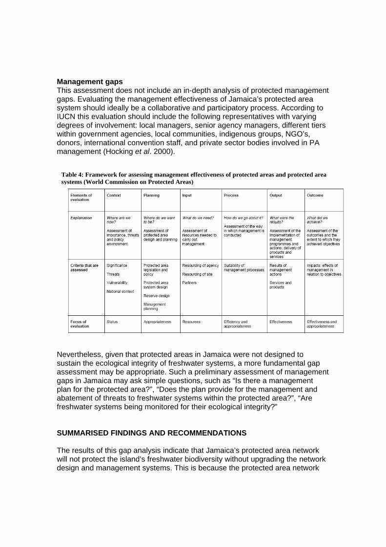
Management gaps This assessment does not include an in-depth analysis of protected management gaps. Evaluating the management effectiveness of Jamaica’s protected area system should ideally be a collaborative and participatory process. According to IUCN this evaluation should include the following representatives with varying degrees of involvement: local managers, senior agency managers, different tiers within government agencies, local communities, indigenous groups, NGO’s, donors, international convention staff, and private sector bodies involved in PA management (Hocking et al. 2000).
Nevertheless, given that protected areas in Jamaica were not designed to sustain the ecological integrity of freshwater systems, a more fundamental gap assessment may be appropriate. Such a preliminary assessment of management gaps in Jamaica may ask simple questions, such as “Is there a management plan for the protected area?”, “Does the plan provide for the management and abatement of threats to freshwater systems within the protected area?”, “Are freshwater systems being monitored for their ecological integrity?” SUMMARISED FINDINGS AND RECOMMENDATIONS The results of this gap analysis indicate that Jamaica’s protected area network will not protect the island’s freshwater biodiversity without upgrading the network design and management systems. This is because the protected area network
Table 4: Framework for assessing management effectiveness of protected areas and protected area systems (World Commission on Protected Areas)

was not designed with freshwater ecosystem functionality in mind although the integrity of freshwater ecosystems and security of freshwater supplies are so intimately linked. However, this can be corrected because a few protected areas already offer some incidental protection (such as BJCMNP, Portland Bight and Negril Protected Area). These protected areas will form the building blocks of a more representative protected area network. The main findings of the gap assessment are:
1) Most FW habitats under or unrepresented in Jamaica’s protected area network.
2) The current PA network fragments freshwater systems and does not preserve the longitudinal and lateral connectivity of freshwater ecosystems.
3) Management effectiveness of existing Protected Area Network with respect to freshwater systems is uncertain but is likely to be a major gap.
Recommendations: Table 5: Recommendations for addressing gaps in Jamaica's protected area system with respect to Freshwater systems
Recommendations Conservation Actions 1) Include un-protected freshwater systems in Protected Area Network across at least 10% of their distribution
Explore existing and future mechanisms for protecting entire river corridors (as protected areas or under watershed protection act, development orders, private land conservation )
Incorporate lower Rio Grande/ Drivers River into wider Blue and John Crow Mountains Protected Area.
2) Redesign established Protected Areas using a watershed approach to restore lateral and longitudinal connectivity in freshwater ecosystems (See figure 3 below).
Protect from Cockpit Country north into downstream Martha Brae watershed and/or south into Black River watershed.
3) Assess and improve the management effectiveness of protected areas with respect to freshwater ecosystems.
Train water resource management and protected area practitioners in freshwater conservation methods (planning, implementation and monitoring).
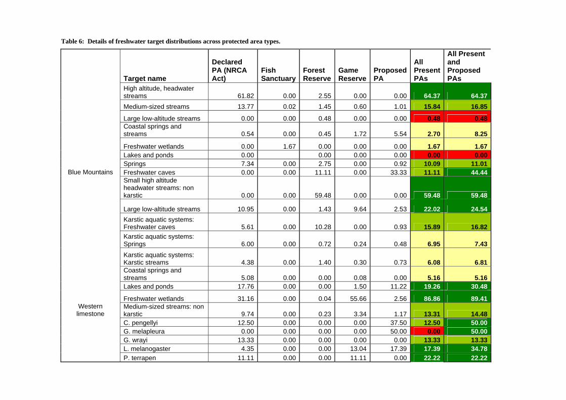
Table 6: Details of freshwater target distributions across protected area types.
Target name
Declared PA (NRCA Act)
Fish Sanctuary
Forest Reserve
Game Reserve
Proposed PA
All Present PAs
All Present and Proposed PAs
High altitude, headwater streams 61.82 0.00 2.55 0.00 0.00 64.37 64.37Medium-sized streams 13.77 0.02 1.45 0.60 1.01 15.84 16.85
Large low-altitude streams 0.00 0.00 0.48 0.00 0.00 0.48 0.48Coastal springs and streams 0.54 0.00 0.45 1.72 5.54 2.70 8.25
Freshwater wetlands 0.00 1.67 0.00 0.00 0.00 1.67 1.67Lakes and ponds 0.00 0.00 0.00 0.00 0.00 0.00Springs 7.34 0.00 2.75 0.00 0.92 10.09 11.01
Blue Mountains Freshwater caves 0.00 0.00 11.11 0.00 33.33 11.11 44.44Small high altitude headwater streams: non karstic 0.00 0.00 59.48 0.00 0.00 59.48 59.48
Large low-altitude streams 10.95 0.00 1.43 9.64 2.53 22.02 24.54Karstic aquatic systems: Freshwater caves 5.61 0.00 10.28 0.00 0.93 15.89 16.82Karstic aquatic systems: Springs 6.00 0.00 0.72 0.24 0.48 6.95 7.43Karstic aquatic systems: Karstic streams 4.38 0.00 1.40 0.30 0.73 6.08 6.81Coastal springs and streams 5.08 0.00 0.00 0.08 0.00 5.16 5.16Lakes and ponds 17.76 0.00 0.00 1.50 11.22 19.26 30.48
Freshwater wetlands 31.16 0.00 0.04 55.66 2.56 86.86 89.41Western limestone
Medium-sized streams: non karstic 9.74 0.00 0.23 3.34 1.17 13.31 14.48
C. pengellyi 12.50 0.00 0.00 0.00 37.50 12.50 50.00 G. melapleura 0.00 0.00 0.00 0.00 50.00 0.00 50.00 G. wrayi 13.33 0.00 0.00 0.00 0.00 13.33 13.33 L. melanogaster 4.35 0.00 0.00 13.04 17.39 17.39 34.78 P. terrapen 11.11 0.00 0.00 11.11 0.00 22.22 22.22
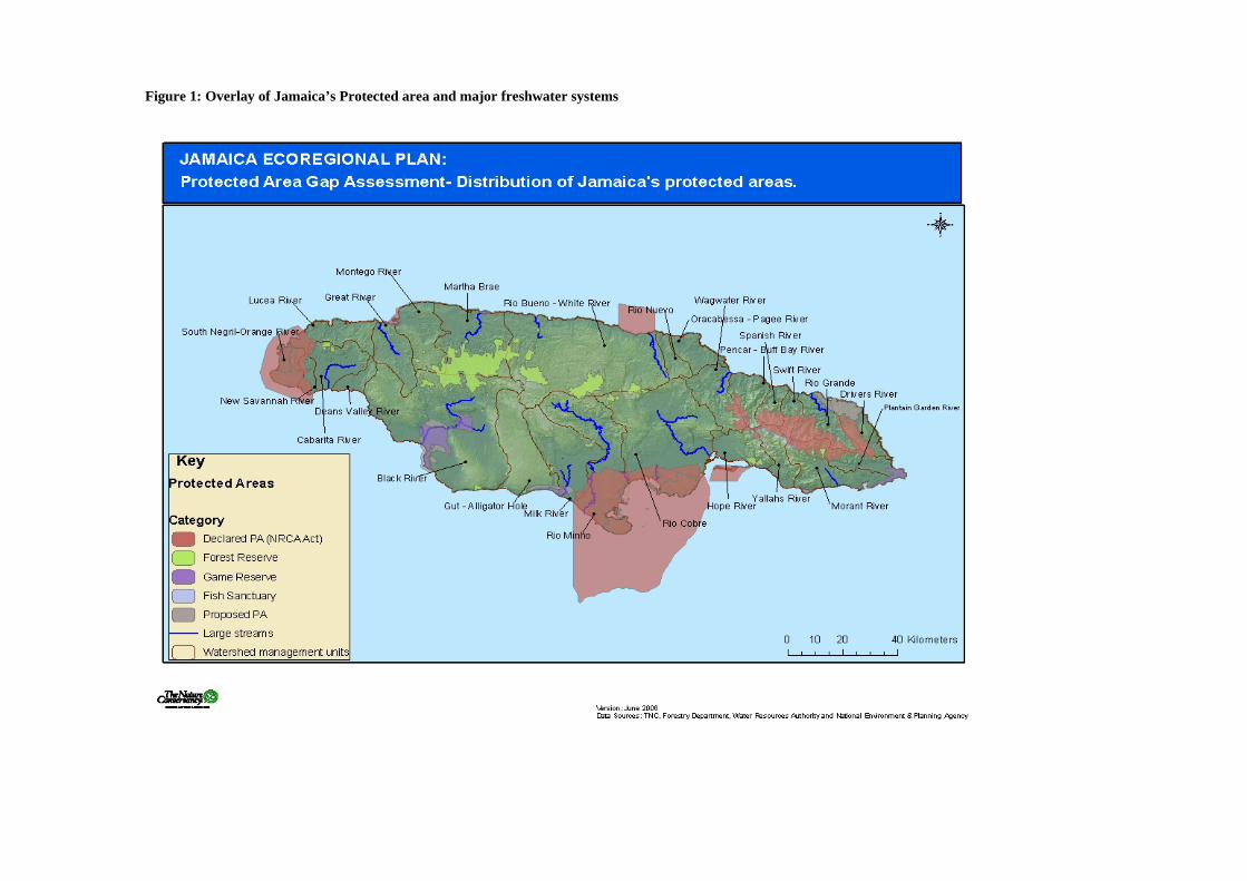
Figure 1: Overlay of Jamaica’s Protected area and major freshwater systems
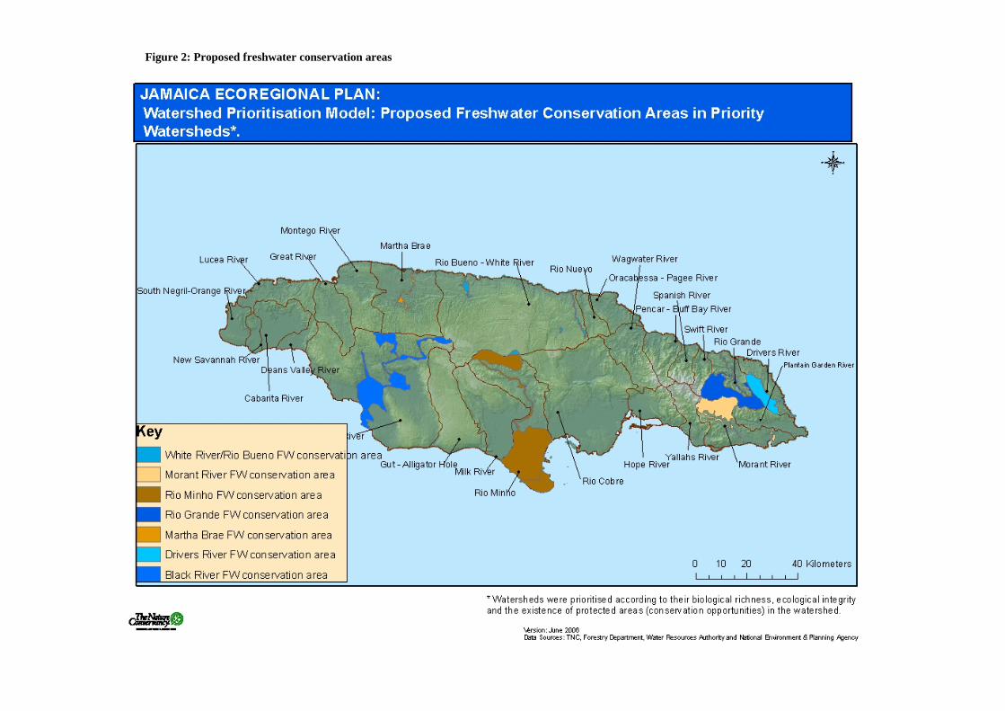
Figure 2: Proposed freshwater conservation areas
Acknowledgements Reference List Hocking, M., Stolton, S. and Dudley, N. (2000) Evaluating Effectiveness: A Framework for Assessing the management of Protected Areas. IUCN, Gland, Switzerland and Cambridge, UK. X + 121pp Hunte 1978 John 2005
Related Documents