Government of Rajasthan Deptt. Of Watershed Development & Soil Conservation District Watershed Development Unit, Jhunjhunu. IWMP (2010-2011) - VIII (CHANANA) Block : -CHIRAWA District :- JHUNJHUNU Gram Panchayat : Chanana,Bhukana,Solana,Gowla,Bhadunda kalan Project Area :-5872 Ha. Project Cost :- 880.8 lac MANOJ KUMAR S.L.MEENA Assistant Engineer (P.I.A.) Executive Engineer (L.R.) Panchayat Samiti,CHIRAWA Cum Project M.WCDC jhunjhunu

Welcome message from author
This document is posted to help you gain knowledge. Please leave a comment to let me know what you think about it! Share it to your friends and learn new things together.
Transcript

Government of Rajasthan
Deptt. Of Watershed Development & Soil Conservation
District Watershed Development Unit, Jhunjhunu.
IWMP (2010-2011) - VIII (CHANANA)
Block : -CHIRAWA District :- JHUNJHUNU
Gram Panchayat : Chanana,Bhukana,Solana,Gowla,Bhadunda kalan
Project Area :-5872 Ha.
Project Cost :- 880.8 lac
MANOJ KUMAR S.L.MEENA Assistant Engineer (P.I.A.) Executive Engineer (L.R.) Panchayat Samiti,CHIRAWA Cum Project M.WCDC jhunjhunu
DPR TEMPLATE Index
S.No Topics Page no.
1 Chapter 1-8 Location
General Features of watershed (Cost and Area details)
Climatic and Hydrological information
Other Development Schemes in the project area
Details of infrastructure in the project areas
Institutional arrangements (WCDC.,PIA,WDT,WC)
2 Chapter Basic Data ,Analysis and Scope 9- 2.1 Demography Details
2.2 Development Indicators
2.3 Land use
2.4 Agriculture status and Productivity Gap Analysis
2.5 Horticulture/Vegetable/Floriculture status
2.6 Land holding pattern
2.7 Livestock status
2.8 Fodder status
2.9 Farm Implements
2.10 NREGA Status
2.11 Migration details
2.12 Livelihood Details.
2.13 Existing SHG
2.14 Ground Water details
2.15 Drinking Water Status
2.16 Water use efficiency
2.17 Slope details
2.18 Water Budgeting
2.19 Soil Details
2.20 Soil erosion status
3 Chapter Proposed Development Plan 4 Chapter Activity wise Total Abstract of cost

5 Chapter Annual Action Plan
5.1 Project fund
5.2 Convergence Plan
6 Chapter Project outcomes 7 Technical designs and estimates for proposed activities 8 Enclosures
8 .1 Maps a. Location –District, block, village, watershed location map
b. Map of Project with Watershed Boundary demarcation in cadastral map
c. Land Use Land Cover map
d. Existing water bodies, DLT
e. PRA Map (along with photos & paper drawing)
f. GIS based intervention map
g. Treatment map ie proposed works on revenue map
8.2 Documents of Agreements:
Proceedings of gram sabha for EPA approval
Proceedings of gram sabha Resolution for committee constitution
Documents related to PRA exercise
Proceedings of gram sabha for DPR approval
Proceedings of Panchayat Samiti General body for DPR approval
Watershed Committee Registration certificate
MoU – PIA – WCDC, PIA – WC(in case of NGO as PIA)

CHAPTER – I INTRODUCTION Location. CHANANA Project is located in CHIRAWA Block, of JHUNJHUNU district. The project area is
between the latitudes 28O 19’ to 28O 25’ N & 75O 44’ to 75O 49’ E longitudes. It is at a distance of
25 km from its Block head quarters and 27 Kms from the district head quarters. There are 20736
no. of habitations in the Project area and other details are given below.
General features of watershed
S.No. Name of Project(as per GOI) IWMP
(a) Name of Catchment CHANANA
(b) Name of watershed area(local
name) CHANANA
© Project Area 5955.07
(d) Net treatable Area 5872
e) Cost of Project 880.80 Lacsg
f) Cost per hectare Rs. 15000
g) Year of Sanction 2010-2011
h) Watershed Code Cluster
i) No. of Gram Panchayats in project
area 5
j) No. of villages in project area 8
k) Type of Project Desert
l) Elevation (metres) 326
m) Major streams -
n) Slope range (%) 0-11 %
Macro/micro Name of
Gram Panchayat
Name of Villages Covered
Census code of villages
Area
CHANANA
1.Chanana 00712400 1076.30
BHUKANA 1.Bhukana 00712600 659.46 2.Lodipura 00712900 376.25 3.Seolalpura 82.27 SHYOLANA 1. Shyolana 00712100 885.76 GOWLA 1.Gowla 00712200 881.27
BHARUNDA
KALAN 1.Bharunda kalan 00692600 1816.60
2.Vrindavan 00692500 177.16
5955.07

1
The watershed falls in Agroclimatic Zone 2A .The soil texture is Sandy & Sandy loam. The average
rainfall is 456.7 mm . The temperature in the area varies between the range 30 to 49.5 centigrade
during summer and 0 to 38 centigrade during winter. The major crops in the area are Bajara, Chanwla, Guar, Wheat, Gram, Mustard. Land is under cultivation 4790.10 ha.(82 %), land fallow,
0% land is wasteland. 1.8% land is irrigated through well, Tube well. 75 No of households are BPL(2.18% total households) 534 are landless households(15.5%
total households) and 2632 household are small and marginal farmers(76.38% total household)
.Average land holding in the area is 1.39 ha. 72.75 % area is single cropped area and 27.25 % is
double cropped. The main source of irrigation is Tube well. The average annual rainfall (10 years) in
the area is 456.70 mm. The major festivals in the village are Holi, Deepawalee & Rakshabandhan.
At present this village is having 20736 population with Communities like
Jat,Rajput,Harijan,Brahmin,Gurjar and Kumawat, Muslim
Climatic and Hydrological information 1 Average Annual Rainfall(mm)
Year Average Annual Rainfall(mm) 1 2002 165.00 2 2003 553.00 3 2004 364.00 4 2005 386.00 5 2006 547.00 6 2007 480.00 7 2008 681.00 8 2009 274.00 9 2010 566.00
10 2011 551.00
2 Average Monthly rainfall (last ten years) Month Rainfall(mm) i) June 62.7 ii) July 107.7 iii) August 109.2 iv) September 63.9 3 Maximum rainfall intensity (mm)
Duration rainfall intensity(mm) i) 15 minute duration 100 ii) 30 minute duration 72 iii) 60 minute duration 65
2

4 Temperature (Degree C) Season Max Min i) Summer Season 49 30 ii) Winter Season 38 0 iii) Rainy Season 42 18
5 Potential Evaporation Transpiration (PET) (mm/day) Season PET i) Summer ii) Winter iii) Rainy
6 Runoff i) Peak Rate (cum/hr) - ii) Total run off volume of rainy season (ha.m.) - iii) Time of return of maximum flood
5 years 10 years In-Year
iv)Periodicity of Drought in village area 2 3 Other Development Schemes in the project area :
The Villages have been benefited by various schemes of rural development. Currently MGNREGA, Indira Awas Yojana, Swa-Jaldhara,
Total Sanitation Campaing, TFC, SFC, MP LAD, MLA LAD etc. This is the first watershed Project in these Villages.
I. MGNREGA (MNREGA) is an Indian Job Guarantee Scheme, enacted by legislation on August 25,2005. The scheme provides a legal
guarantee for one hundred days of employment in every financial year to adult members of any rural household willing to do public work
related unskilled manual work at the statutory minimum wage of Rs.133 Per day. Desilting of Talab, Gravel Road, Ditch cum bund
boundaries, plantation works has been carried out in the Villages under MGNREGA.
II. Total Sanitation Campaigfn (TSC) : Individual toilets are constructed under TSC programme.
III. Indira Awas Yojana : Houses for people under poverty (BPL) have been constructed under Indira Awas Yojana (IAY).
IV. Swa-Jaldhara : Facilitating organization working towards drinking water security and habitat improvement by empowering communities to
manage their local water sources, drinking water supply and environmental sanitation.
V. SFC & TFC : Facilitating works related to drinking water and environmental sanitation related works for rural community.

S.No Scheme
Name of the
department
Key interventions
under the Scheme
Targeted Beneficiaries
Provisions under the Scheme
1 MGNAREG
A Rural Dev. Employment guarantee Labours Employment guarantee
2 SFC Panch.
Raj.
Drinking water &
sanitation Villagers Drinking water &
sanitation
3 TFC Panch.
Raj.
Drinking water &
sanitation Villagers Drinking water &
sanitation
4 SGSY Rural Dev. Self
Employment Villagers Self Employment
5 Swajal Dhara
Central Govt.
Drinking Water Villagers Drinking Water
4 Indira Awas
Yojana Panch. Raj Housing B P L Housing Details of infrastructure in the project areas
Parameters Status (i) No. of villages connected to the main road by an all-
weather road 8
(ii) No. of villages provided with electricity 8 (iii) No. of households without access to drinking water Nil (iv) No. of educational institutions : (P
)
18
(UP) 08
(S) -
(HS)
05
(VI) -
Primary(P)/ Secondary(S)/ Higher Secondary(HS)/ vocational institution(VI)
(v) No. of villages with access to Primary Health Centre 2 (vi) No. of villages with access to Veterinary Dispensary 2 (vii) No. of villages with access to Post Office 5 (viii) No. of villages with access to Banks 1 (ix) No. of villages with access to Markets/ mandis 1 (x) No. of villages with access to Agro-industries Nil (xi) Total quantity of surplus milk 58 Qt./day (xii) No. of milk collection centres (U)
0
(S)
0
(PA)
0
(O) 4
(e.g. Union(U)/ Society(S)/ Private agency(PA)/ others (O))
(xiii) No. of villages with access to Anganwadi Centre 15 (xiv) Any other facilities with no. of villages (please
specify)
(xv) Nearest KVK JHUNJHUNU(ABUSAR) (xvi) cooperative society Bhadunda
Kalan Solana
CHANANA BHUKANA (xvii) NGOs - - - - (xviii) ¤ Credit institutions - -
(i) Bank - - 1 0 (ii) Cooperative Society 1 1 1 1
(xix) Agro Service Centre's - 1 Nil Nil
4 Institutional arrangements (SLNA,WCDC,PIA,WDT,WC, Secretary) The District Watershed cell cum Data Center (WCDC), Jhunjhunu is a district level nodal
agency and was established where area is more than 100000 Ha for the smooth implementation
of watershed projects in the district. The District Collector is the chairman of the WCDC. The
WCDC have dedicated and experience staffs comprising one Project manger (Ex.En.), Technical
Experts (A.En, J.En) and Multidisciplinary team of Agriculture Expert, Community Mobilization
Expert, Animal Science Expert, Computer Operator, Accounts Staff and Clerkical Staff.
The objective of WCDC are supervising, planning, implementing, documenting and
promoting watershed development projects and related development activities in the district, also
WCDC will work as direting to PIA for IWMP projects.
SWOT Analysis of the WCDC: Strength :
1. Dedicated and experienced and unexperience staff and a multi disciplinary team
2. Independent District Level Nodal Agency.
3. Strong linkages with national and state level institutions, agricultural universities as MPUAT,
Udaipur; Raj. Agri. University, Bikaner and NGOs for capacity building and tehnical
guidance.
4. Scientific planning in watershed projects with the help of College of Technology and
Engineerng, Udaipur, KVK Abusar Jhunjhunu and Other related Govt. Departments.
5. District level monitoring, coordination & co-operation Committee.
Weakness : 1. No permanent office building.
2. Project area is Rained Area. Three Year is Drought Out of Five Years.
Opportunities : 1. A Number of different other development schemes of the government are running; so,
there can be horizontal integration and convergence of programmes.
2. Better financial provision under IWMP
3. Usage of new ICT tools like GIS Threats :
1. Rainfall being very scarce and unreliable in the project area, the activities planned to be
taken up may yield limited impact.
2. Irregularities in fund flow can derail the smooth functioning.
3. Lack of contribution and cooperation from local people.
4. Low literacy rate in the project area.

WCDC Details
Each PIA has put in position a dedicated watershed development team (WDT) with the approval of WCDC. The WDTs are hired on contract basis. The Composition of the WDT will be indicated in the contract/MOU. No Program funds for DPR and watershed works under any circumstances should be released to either the PIA or Watershed Committee (WC) unless the composition of the WDT has been clearly indicated in the MOU/contract and the team members are fully in place. Four WDTs viz. agriculture, Engineering, Social Science and Animal Science Experts have been recruited on contract basis.
PIA particulars
S.No Particulars Details of WCDC
1 2 3
1. PM ,WCDC Zila Parishad Jhunjhunu
2. Address with contact no., website Zila Parishad Jhunjhunu
3. Telephone 01592-233773
4. Fax 01592-233773
5. E-mail dwdu. jhunjhunu @gmail.com
S.No Particulars Details of PIA
1 2 3
1 Name of PIA A. En., P.S. CHIRAWA
2 Designation Ass. Eng.
3 Address with contact no., website P.S. :- CHIRAWA
4 Telephone 01596-220597
5 Fax 01596- 224486
6 E-mail [email protected]

WDT Particulars: --
S.No
Name of WDT member M/F Age
(yrs) Qualification
Experience in
watershed (Yrs)
Description of
professional training
Role/ Function
1 2 3 4 5 6 7 8
1 MANOJ KUMAR M 46 B.E.(Ag.) Twenty three year B.E.(Ag.)
All Engineering
activity
2 RAM MEHAR SINGH M 47 M.Sc.Ag Six year M.Sc Agriculture
All Agriculture
activity
3 DHANKUMAR M 33 Two year Diploma Four year M.A. P.Sc.
All Livestoke
activity
4 BALVIR SINGH M 44 M.A Sociology. Six year M.A.Socio. All Social
Activity

Details of Watershed Committee (WC) CHANANA
S.N.
Name of WC
Date of Gram Sabha for WC
Designa tion Name Village M/F Category Name of UG/SHG Educational
qualification
1 2 3 4 5 6 7 8 9 10 1
chanana 06.06.2012
Presidant
Abhay singh/Inder singh Rajput chanana M Gen.
Arable land conservation B.A.
Secratary
Smt.Manju Dhinwa/Jaiparkash Jat chanana F OBC Secretery M.A.B.ED.
Member
Sangram singh/Rekha Ram Jat chanana M OBC
Arable land conservation Secondary
Member
Mohan Lal/Bhura Ram Jat Chanana M OBC
Non-Arable land conservation Sec.
Member
Shri Ram/Shakru Ram Jat chanana M OBC
Non- Arable land Production Sec.
Member Jaikaran Sultan Jat chanana M OBC
Animal Husbandry U.G Sec.
Member
Sajjan Lal/Madan Lal Naik chanana M SC Land-Less U.G Secondary
Member Rajukanwer/Samander singh chanana F OBC SHG,Member Secondary
Member Smt.Santosh /Pursotam Darji chanana F OBC SHG,Member
Member
Gudi /Ramavtar Ragar chanana F SC SHG,Member
Member
Parbhu Ram/Hanumana Ram Meena chanana M ST ST,Member B.A.
Member
Shri Manoj Kumar A,En.(P.I.A) chirawa M OBC Manoneet Member B.E.(Ag.)
8

Details of Watershed Committee (WC) BHUKANA
S.N.
Name of WC
Date of Gram Sabha for WC
Designation Name Village M/F
Categ-ory Name of UG/SHG
Educational qualification
1 2 3 4 5 6 7 8 9 10 1
bhukana 13.05.2011 President Shri Juglal/Heera
Ram Jangir Bhukana M OBC Arabal Land Cioservation
Sacratary Sandeep Kumar Bhukana M OBC Sacratary B.A.
Member Mahaveer Parsad/Sanwal Ram Jat Bhukana M OBC
Non Arabal Land Coservation
Member Liladhar Soni/Hanuman Parsad Bhukana M OBC Land Less U.G.
Member Dharma Pal/Seodan Jat Bhukana M OBC
Arabal Land Conservatin
Member Shahi Ram/Jhutha Ram Jat Lodipura M OBC
Non Arabal Land Conservation
Member Manohar Singh/Durjan Singh Seolalpura M GEN.
Arabal Land Conservation
Mamber Jagdish Singh/Sugan Singh Seolalpura
M. GEN.
Arabal Land Conservation
Member Smt.Birma/Mahaveer Bhukana F ST. SHG,Member
Member Smt.Anpurna/Dinesh Sharma Bhukana F GEN. SHG,Member
Member Smt.Saroj/Subhash Meghwal Bhukana F SC SHG,Member
Member Shri Manoj Kumar Chirawa M OBC
A.En.PIA,Mnoneet Member
9
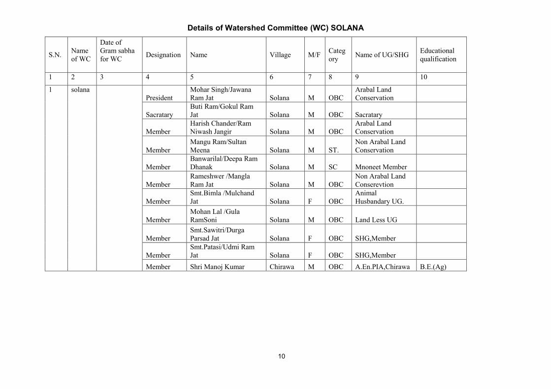
Details of Watershed Committee (WC) SOLANA
S.N. Name of WC
Date of Gram sabha for WC
Designation Name Village M/F Category Name of UG/SHG Educational
qualification
1 2 3 4 5 6 7 8 9 10
1
solana President
Mohar Singh/Jawana Ram Jat Solana M OBC
Arabal Land Conservation
Sacratary Buti Ram/Gokul Ram Jat Solana M OBC Sacratary
Member Harish Chander/Ram Niwash Jangir Solana M OBC
Arabal Land Conservation
Member Mangu Ram/Sultan Meena Solana M ST.
Non Arabal Land Conservation
Member Banwarilal/Deepa Ram Dhanak Solana M SC Mnoneet Member
Member Rameshwer /Mangla Ram Jat Solana M OBC
Non Arabal Land Conserevtion
Member Smt.Bimla /Mulchand Jat Solana F OBC
Animal Husbandary UG.
Member Mohan Lal /Gula RamSoni Solana M OBC Land Less UG
Member Smt.Sawitri/Durga Parsad Jat Solana F OBC SHG,Member
Member Smt.Patasi/Udmi Ram Jat Solana F OBC SHG,Member
Member Shri Manoj Kumar Chirawa M OBC A.En.PIA,Chirawa B.E.(Ag)
10

Details of Watershed Committee (WC)GOWLA
S.N. Name of WC
Date of Gram Sabha for WC
Name Village M/F Category Name of UG/SHG Educational
qualification
1 2 3 4 5 6 7 8 9 10
1
gowla 27.05.2011&13.06.2011
President Smt.Sumitra/Hawa Singh Gowla F OBC Animal Husbandry
Sacratary Smt.Jayoti Jangir/Subhash Gowla F OBC Sacratary
Member Mahaveer/Banwari Kumawat Gowla M OBC
Non –Arabal Land Conservation
Member Hanuman/Pana Ram Gowla M OBC
Arabal Land Conservation
Member Chandgi Ram/Lachu Ram Gowla M OBC
Non-Arabal Land Conservation
Member Smt. Ram Peari Sultan Meghwal Gowla F SC Land Less UG
Member Smt. Tarapati/Madha Ram Jat Gowla F OBC SHG,Member
Member Smt. Nanchi/Dala Ram Jat Gowla F OBC SHG,Member
Member Ram Niwash/Sadara Ram Jat Gowla M OBC
Arabal Land Coservation
Member Shri Manoj Kumar Gowla M OBC A.En.PIA,Chirawa
11

Details of Watershed Committee (WC) BHADUNDA KALAN
S.N. Name of WC
Date of Gram Sabha for WC
Designation Name Village M/F Category Name of UG/SHG Educational
qualification
1 2 3 4 5 6 7 8 9 10
1
Bhadu-nda Kalan
12.05.2011 President
Shri.Nand Lal/Jhutha Ram Jat
Bhadunda Kalan M OBC
Non- Arabal Land Conservation
Sacratary Rajendar/Singh BHadunda Kalan M OBC Sacratary 10+2
Member Kanhya Lal/Sanwat Ram Bhadunda Kalan M OBC
Arabal Land Conservation
Member Sadu Ram /Lekhu Ram Meghwal
Bhadunda Kalan M SC
Animal Husbandary UG
Member Hari Ram/Sanwat Ram Meghwal
Bhadunda Kalan M SC Land Less UG
Member Smt. Mani Devi/Ram Sawroop Meghwal
Bhadunda Kalan F SC SHG, Member
Member Smt.Saroj Devi/Hari Singh Jat
Bhadunda Kalan F OBC SHG, Member
Member Parwati Devi/Mahaveer Parsad Naik
Bhadunda Kalan F SC SHG, Member
Member Durgawati Devi Omparkash Meghwal
Bhadunda Kalan F SC SHG, Member
Member Shiv Kumar /Ram Niwsh Sharma Vrindavan M GEN
Arabal Land Conservation
Member Vijendar /Birdi Chand Vrindavan M GEN Arabal Land Conservation
Member Manoj/Hari Ram Sharma Vrindavan M GEN
Non-Arabal Land Conservation
Member Shri Manoj Kumar Chirawa M OBC A.En.PIA,Chirawa B.E.(Ag.)
12

Problems and scope of improvement in the project area The socio economic conditions of the area can be improved through increased
production which can be achieved through expansion in cultivated area and productivity
enhancement. 173 ha land is arable wasteland that can be brought under cultivation.
3716 ha is only irrigated and with efforts this can be increased to 4023 ha . The
productivity gap of major crops in the area as compared with district and with areas in the
same agro climatic zones indicate potential to increase the productivity. The
demonstration of improved package of practices, improved varieties, increased irrigation
facilities and soil conservation measures under the project can bridge this gap. Due to
small land holdings in the area focus of the project would be on diversification in
agriculture (horticulture, vegetables, green houses, Agro forestry, fodder crops)and
diversification in Livelihoods(Agriculture, Animal husbandry, self employment)
4987.80 Quintal fodder scarcity can be met out through Pasture development
.Improved animal Husbandry practices can increase the productivity of livestock.819 no.
of persons migrate due to not enough livelyhood & poverty , this migration can be
checked through creation of employment opportunities in the project area through
increase in production and diversification in agriculture and Livelihoods as mentioned
above.
Mention specific problem of the area in land degradation, water , Agriculture and in Animal Husbandry
1. In the watershed are 235 ha area comes under small & medium size dunes of sandy soil that can not be used for agriculture purpose,but this area can be used by levelling & agriculture production may increased.
2. There is low production of agricultural products due to adoption of traditional methods of farming and desi varieties of seeds,that may be increased by adopting scientific farming & improved seed varieties of high yielding production.
3. Ground water level in the project area is depleting day by day due to high exploitation and less recharge of ground water with the help of surface water,that may be eliminated by adopting appropriate water conservation measures.
4. Lack of rain and surface water has reduced the fodder and pasture availability for their animals. This leads to migration of people to other parts of the state with their herds of goats and sheep.
5. Farmers are keeping Cows and buffaloes of local breed that leads low productivity of milk in the Chanana watershed area.

CHAPTER – II Socio economic Features, Problems and Scope
Table 2.1 Population & Household Details:
Total Population
Male Female Total SC ST
10915 9821 20736 5120 458
Household Details
L. Less Small Farmer
M. Farmer Total household
SC household
ST household
75 524 786 1846 3446 755 71
Table 2.2 :- Development indicators
S. No. Development Indicators State Project Area 1 Per capita income (Rs.) 16260 14900 2 Poverty ratio 0.22 0.23 3 Literacy (%) 60.4 78.5 4 Sex Ratio 921 936 5 infant mortality rate 63 53 6 maternal mortality ratio 388 336
The table indicates poor socio economic conditions.
14
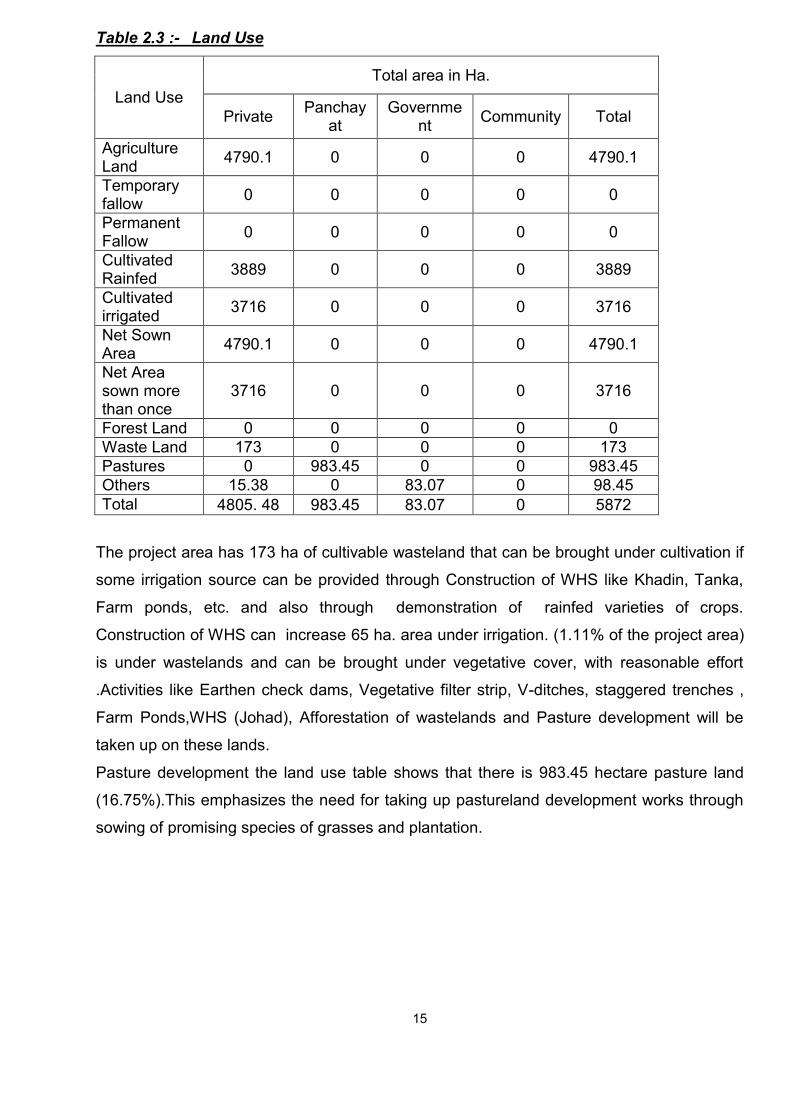
Table 2.3 :- Land Use
Land Use Total area in Ha.
Private Panchayat
Government Community Total
Agriculture Land 4790.1 0 0 0 4790.1
Temporary fallow 0 0 0 0 0
Permanent Fallow 0 0 0 0 0
Cultivated Rainfed 3889 0 0 0 3889
Cultivated irrigated 3716 0 0 0 3716
Net Sown Area 4790.1 0 0 0 4790.1
Net Area sown more than once
3716 0 0 0 3716
Forest Land 0 0 0 0 0 Waste Land 173 0 0 0 173 Pastures 0 983.45 0 0 983.45 Others 15.38 0 83.07 0 98.45 Total 4805. 48 983.45 83.07 0 5872
The project area has 173 ha of cultivable wasteland that can be brought under cultivation if
some irrigation source can be provided through Construction of WHS like Khadin, Tanka,
Farm ponds, etc. and also through demonstration of rainfed varieties of crops.
Construction of WHS can increase 65 ha. area under irrigation. (1.11% of the project area)
is under wastelands and can be brought under vegetative cover, with reasonable effort
.Activities like Earthen check dams, Vegetative filter strip, V-ditches, staggered trenches , Farm Ponds,WHS (Johad), Afforestation of wastelands and Pasture development will be
taken up on these lands.
Pasture development the land use table shows that there is 983.45 hectare pasture land
(16.75%).This emphasizes the need for taking up pastureland development works through
sowing of promising species of grasses and plantation.
15

Table 2.4 .a:-Agriculture and Horticulture status and fuel availability. S.NO.
Season
Crop sown
Rainfed Irrigated Total
Varieties Area
(ha.)
Produc
tion
(Ton)
Producti
vity
(kg/ha)
Varieties Area
(ha.)
Produ
ctin
(Ton)
Product
ivity
(kh/ha)
Area
(ha)
Produ
ction
TON
1 Kharif Bajra Raj-171,
Desi
2294 17000 741 2294 17000
Guawar RGC 197
,Desi
669 1585 237 669 1585
Chounla Desi 592 1172 198
2 Rabi Wheat Desi,Kalya
n sona
1320 37422 2835 1320 37422
Mustard T-59,Desi 1228 18666 1520 1228 18666
Gram C-235,Desi 801 7505 937 801 7505
3 Ziad Bajra
Chari
Desi 50
Rijka 35
Total
The farmers are using RAJ-171 & DESI varieties of Bajra, whereas varieties like
HHB-67,HHB-94,RCB-2 etc. can increase the production. In case of Guar,the farmers are
using Desi varieties whereas varieties like RGC-936,RGC-986, etc. may give high
production. Rabi season crop the farmers are using traditional seed of wheat,whereas
varieties like RAJ-3077,RAJ-3765,WH-147,RAJ-1482,etc may enhance the production.
16
Table 2.4.b Abstract of cropped Area(ha)
Area under Single crop 2304.00
Area under Double crop 2010.29
Area under Multiple crop 475.81

The CHANANA Project area has low Productivity because of the following reasons :-
1. Full dependence on monsoon :-
Chanana Project area is dependent on monsoon. Water is essential input in
agriculture. Due to the absence of proper irrigation facilitiy, 80% of the total cultivated
area depends on the uncertain monsoon. Therefore, the success or failure of the
monsoon determines the success or failure of agriculture production.; The rainfall is
unreliable due to two factors : untimely and inadequate.
2. Low use of fertilizer per unit cropped area :-
Farmers do not use sufficient fertilizer due to lack of water, scarcity of fertilizer in
market and insufficient money for fertilizer. Many a times they don’t get fertilizer at the
right time.
3. Traditional farming methods :-
This also leads to low productivity. There is a lot of ignorance about the use of new
farming methods and technologies such as multiple cropping. They are some use of
FYM and other input in a proper way; that is why they don’t get 90% output. So these
factors contribute to low productivity.
4. Lack of adequate farm machinery :-
Even today a large number of farmers in Chanana watershed area use wooden
ploughs and camels. They don’t have adequate machinery like seed drill. So, old
machineries take more time in tillage practices.
5. Lack of Finances for farmers :-
In Chanana watershed area most of the farmers are marginal and small. They do not
have enough money to buy good quality seeds, machinery and other inputs.
6. Lack of good quality seeds and fertilizers :-
Good quality seed, fertilizer and pesticide are important factor in agriculture
productivity. The use of good quality leads to higher land productivity. In Chanana
cluster, however, there are two limitations in the use of fertilizer. First these fertilizers
17

are most useful in irrigated condition. But in Chanana cluster 66.23% of land depend
on rainfall. In Chanana Cluster mostly farmers use Manual total Organic Farming.
7. Lack of Other facilities such as storage and marketing :-
4-8% of agriculture product damage after harvesting due to scarcity of proper storage
and proper market for sale. So he sale to local traders at the low prices. Farmers
mainly face proper means of transportation. An second problem is farmers don’t have
proper storage facilities.
Crop Rotation of the project area
Bajra - Wheat Bajra - Fallow Moong - Mustered Moong - Fallow Fallow - Wheat Fallow - Onion Fallow - Lucern Cluster Bean - Fallow Fallow - Tarameera Til - Fallow Caster - Caster Moth - Fallow
The table 2.3 shows that only 3716 ha is (63.28%) is double cropped area. Also the crop
rotation shows that fallow lands are there. This indicates that there is scope for change in
crop rotation in fields where there are fallow lands through Soil and Water conservation
measures, crop demonstration and diversification in agriculture.
Soil and Water conservation measures besides putting fallow lands under cultivation
can change the area under single cropping to double and multiple cropping. Table 2.4.c Productivity Gap Analysis:-
Name of the crop
Productivity kg/ha
India Highest
Average in Rajasthan
Highest Average of Agro climatic
zone
JHUNJHUNU District
Project Area
Bajara 1125 1125 853 1050 Green gram 415 415 340 300 Moth 314 305 181 192 Guar 427 410 225 230 Wheat 3600 3600 3540 3150 Mustard 2250 2250 1850 1600 Gram 1220 1218 1145 925
18
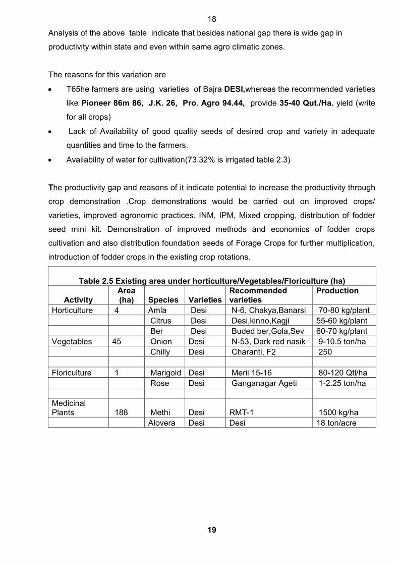
Analysis of the above table indicate that besides national gap there is wide gap in
productivity within state and even within same agro climatic zones. The reasons for this variation are
T65he farmers are using varieties of Bajra DESI,whereas the recommended varieties
like Pioneer 86m 86, J.K. 26, Pro. Agro 94.44, provide 35-40 Qut./Ha. yield (write
for all crops)
Lack of Availability of good quality seeds of desired crop and variety in adequate
quantities and time to the farmers.
Availability of water for cultivation(73.32% is irrigated table 2.3)
The productivity gap and reasons of it indicate potential to increase the productivity through
crop demonstration .Crop demonstrations would be carried out on improved crops/
varieties, improved agronomic practices. INM, IPM, Mixed cropping, distribution of fodder
seed mini kit. Demonstration of improved methods and economics of fodder crops
cultivation and also distribution foundation seeds of Forage Crops for further multiplication,
introduction of fodder crops in the existing crop rotations.
Table 2.5 Existing area under horticulture/Vegetables/Floriculture (ha)
Activity Area (ha) Species Varieties
Recommended varieties
Production
Horticulture 4 Amla Desi N-6, Chakya,Banarsi 70-80 kg/plant Citrus Desi Desi,kinno,Kagji 55-60 kg/plant Ber Desi Buded ber,Gola,Sev 60-70 kg/plant Vegetables 45 Onion Desi N-53, Dark red nasik 9-10.5 ton/ha Chilly Desi Charanti, F2 250 Floriculture 1 Marigold Desi Merii 15-16 80-120 Qtl/ha Rose Desi Ganganagar Ageti 1-2.25 ton/ha Medicinal Plants 188 Methi Desi RMT-1 1500 kg/ha Alovera Desi Desi 18 ton/acre
19

Table 2.6 Land holding Pattern in project area:-
Type of Farmer
Total Households
Land holding (ha) irrigation source wise
Land holding (ha)Social group wise
Irrigated (source)
Rainfed Total
General
SC ST OBC BPL
(i)Large farmer 290 1238 1339 1339 22 4 4 1309 0 (ii) Small farmer 786 1493 1784.1 1784.1
195 35 9 1545.1 0
(iii) Marginal farmer 1846 985 1661 1661
181 30 0 1450 6
(iv) Landless person 524 0 0 0
0 0 0 0 0
(V)No. of BPL households 75 0 6 6
0 0 0 0 0
Total 3446 3716 4790.1 4790.1 398 69 13 4304.1 6
76.38% land holdings belong to small and marginal farmers who own 62.53% of total
cultivated area. Horticulture/vegetables could be more economical to Small and marginal
farmers with irrigation source. For large farmers with no irrigation facility
Horticulture/vegetables will be promoted in a part of land with farm pond/Tanka
construction.
The following activities will be more beneficial for small land holdings and for diversification
and income for large farmers
Horticulture plantation, Medicinal and Aromatic Crops, floriculture: As discussed
earlier . Horticulture/vegetables could be more economical to Small and marginal farmers
with irrigation source. Also the project area has good potential for medicinal & aromatic
crops like Sonamukhi, Isabgol, Ashwagandha, Khus, Mehandi etc.
Agro forestry plantation: To increase the income of farmers and also for shelter belt
plantation as wind velocity is high in the project area.
Setting of Vermi Compost Units - Keeping in view the side effect of residues of chemicals
and fertilizers on human health the emphasis would be on cultivation of organic produce
through motivating farmers and providing assistance for production of organic input, vermi
compost.
Production and distribution of quality seed – There is need to ensure that good quality
seed is available for cultivators for which adequate seed production would be initiated in
watershed areas with the assistance of private sector and agriculture department
technologies
Sprinklers and pipelines for efficient water management practices emphasis on
demonstration of sprinklers with adequate financial support and convergence/private
partnership.
20
Establishment of nurseries: Most of the planting material is procured from other parts of
the State/ country. The procurement of planting material from distant places causes
damage to the planting material and often results in untimely supply. Hence nursery
development activity in area.
Innovative hi-tech/ export oriented activities: innovative hi-tech/ export oriented projects
like mushroom cultivation, elovera cultivation, etc which are in negligible existence at
present, can be implemented by individual farmers / private companies.
Drip irrigation Drip irrigation will be promoted in all horticulture plantations, vegetables,
green houses and in nurseries for rational use of irrigation higher yields and quality
produce.
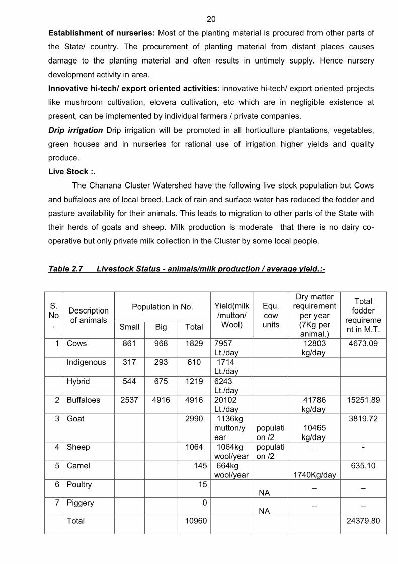
Live Stock :. The Chanana Cluster Watershed have the following live stock population but Cows
and buffaloes are of local breed. Lack of rain and surface water has reduced the fodder and
pasture availability for their animals. This leads to migration to other parts of the State with
their herds of goats and sheep. Milk production is moderate that there is no dairy co-
operative but only private milk collection in the Cluster by some local people.
Table 2.7 Livestock Status - animals/milk production / average yield.:-
S.No.
Description of animals
Population in No. Yield(milk/mutton/Wool)
Equ. cow units
Dry matter requirement
per year (7Kg per animal.)
Total fodder
requirement in M.T. Small Big Total
1 Cows 861 968 1829 7957 Lt./day
12803 kg/day
4673.09
Indigenous 317 293 610 1714 Lt./day
Hybrid 544 675 1219 6243 Lt./day
2 Buffaloes 2537 4916 4916 20102 Lt./day
41786 kg/day
15251.89
3 Goat 2990 1136kg mutton/year
population /2
10465 kg/day
3819.72
4 Sheep 1064 1064kg wool/year
population /2
_ -
5 Camel 145 664kg wool/year 1740Kg/day
635.10
6 Poultry 15 NA
_ _
7 Piggery 0 NA
_ _
Total 10960
24379.80
21
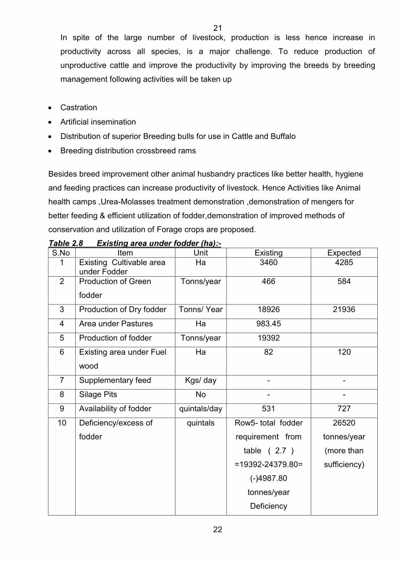
In spite of the large number of livestock, production is less hence increase in
productivity across all species, is a major challenge. To reduce production of
unproductive cattle and improve the productivity by improving the breeds by breeding
management following activities will be taken up
Castration
Artificial insemination
Distribution of superior Breeding bulls for use in Cattle and Buffalo
Breeding distribution crossbreed rams
Besides breed improvement other animal husbandry practices like better health, hygiene
and feeding practices can increase productivity of livestock. Hence Activities like Animal
health camps ,Urea-Molasses treatment demonstration ,demonstration of mengers for
better feeding & efficient utilization of fodder,demonstration of improved methods of
conservation and utilization of Forage crops are proposed.
Table 2.8 Existing area under fodder (ha):- S.No Item Unit Existing Expected
1 Existing Cultivable area under Fodder
Ha 3460 4285
2 Production of Green
fodder
Tonns/year 466 584
3 Production of Dry fodder Tonns/ Year 18926 21936
4 Area under Pastures Ha 983.45
5 Production of fodder Tonns/year 19392
6 Existing area under Fuel
wood
Ha 82 120
7 Supplementary feed Kgs/ day - -
8 Silage Pits No - -
9 Availability of fodder quintals/day 531 727
10 Deficiency/excess of
fodder
quintals Row5- total fodder
requirement from
table ( 2.7 )
=19392-24379.80=
(-)4987.80
tonnes/year
Deficiency
26520
tonnes/year
(more than
sufficiency)
22
The table above shows there is fodder deficiency (Requirement is 24379.80
tonnes/year and availability 19392 tonnes/year)
To minimize the large and expanding gap between feed and fodder resource availability
and demand there is need for
Increase in area under fodder crops
Increase in productivity of fodder crops
Development of pastures
And reduction in large number of livestock production through replacement by few but
productive animals
23

Table 2.9 A Agriculture implements G.P. CHANANA
Table 2.9 B Agriculture implements G.P. BHUKANA
Table 2.9 C Agriculture implements G.P.SOLANA
Table 2.9 D Agriculture Implements G.P. GOWLA
24
S. No Implements Nos. S. No Implements Nos. 1 Tractor 14 7 Drip sets - 2 Sprayers-manual/ power 45 8 Irrigation pipelines 11 3 Cultivators/Harrows 10 9 M.B. plough 14
4 Seed drill 8 10 Indigenous plough 60 5 Threshers 8 11 Tube wells 190 6 Sprinklers 195 12
S. No Implements Nos. S. No Implements Nos. 1 Tractor 7 7 Drip sets - 2 Sprayers-manual/ power 36 8 Irrigation pipelines 8 3 Cultivators/Harrows 7 9 M.B. plough 7
4 Seed drill 7 10 Indigenous plough 13 5 Threshers 6 11 Tube wells 205 6 Sprinklers 205 12
S. No Implements Nos. S. No Implements Nos. 1 Tractor 6 7 Drip sets 2 2 Sprayers-manual/ power 30 8 Irrigation pipelines 9 3 Cultivators/Harrows 6 9 M.B. plough 6
4 Seed drill 6 10 Indigenous plough 22 5 Threshers 5 11 Tube wells 207 6 Sprinklers 210 12
S. No Implements Nos. S. No Implements Nos. 1 Tractor 8 7 Drip sets - 2 Sprayers-manual/ power 36 8 Irrigation pipelines 8 3 Cultivators/Harrows 8 9 M.B. plough 8
4 Seed drill 7 10 Indigenous plough 20 5 Threshers 8 11 Tube wells 210 6 Sprinklers 221 12

Table 2.9 E Agriculture Implements G.P. BHADUNDA KLAN
Farm mechanization and seed banks: As discussed earlier 80.37 % land holdings belong to small and marginal farmers who own only 58.15 % of total cultivated area so owning of big farm implements by individual farmers is not economical so SHG would be promoted to buy farm implements and rent to farmer. Table 2.10 NREGA Status - No. of Card Holder, activities taken so far, employment status.
Sr. no. Name of village
Total No .of job cards
Employment Status
Activity taken up so far
1 CHANANA
440
Johar khudai,Khai khudai,Rasta
durastikaran,Gravel roads etc.
2 BHUKANA 175 do 3 LODI PURA 54 do 4 SEOLAL PURA 40 do 5 SOLANA 278 do 6 GOWLA 284 do
7 BHADUNDA KALAN 491
do 8 VRINDAVAN 95 do Total
25
S. No Implements Nos. S. No Implements Nos. 1 Tractor 17 7 Drip sets - 2 Sprayers-manual/ power 51 8 Irrigation pipelines 20 3 Cultivators/Harrows 14 9 M.B. plough 14 4 Seed drill 14 10 Indigenous plough 45 5 Threshers 14 11 Tube wells 298 6 Sprinklers 320 12
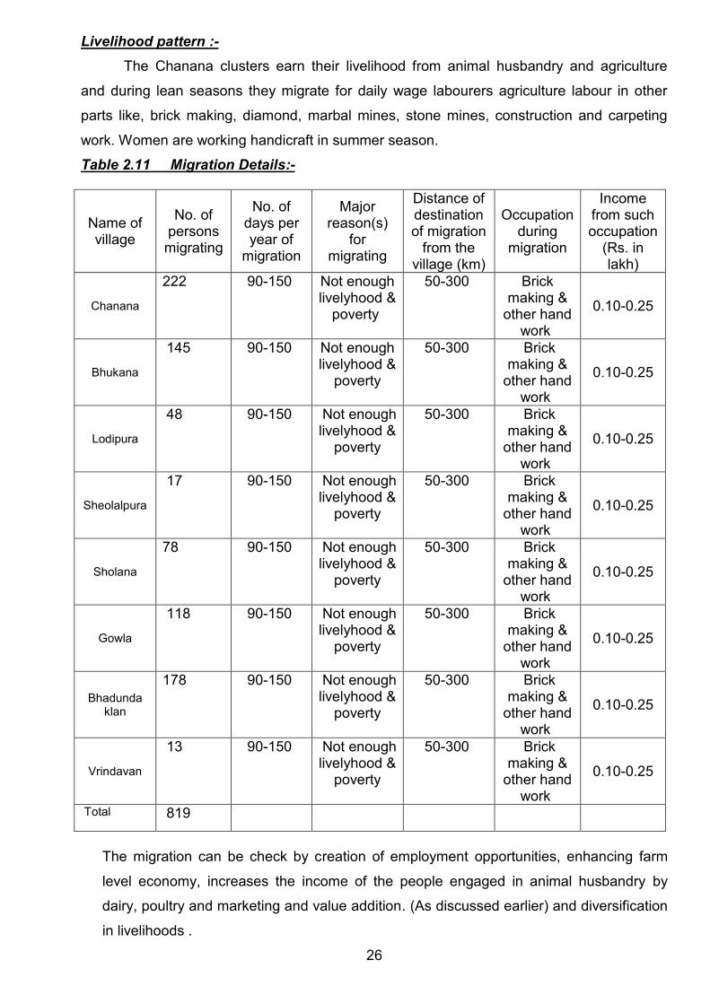
Livelihood pattern :- The Chanana clusters earn their livelihood from animal husbandry and agriculture
and during lean seasons they migrate for daily wage labourers agriculture labour in other
parts like, brick making, diamond, marbal mines, stone mines, construction and carpeting
work. Women are working handicraft in summer season.
Table 2.11 Migration Details:-
Name of village
No. of persons migrating
No. of days per year of
migration
Major reason(s)
for migrating
Distance of destination of migration
from the village (km)
Occupation during
migration
Income from such occupation
(Rs. in lakh)
Chanana
222 90-150 Not enough livelyhood &
poverty
50-300 Brick making &
other hand work
0.10-0.25
Bhukana
145 90-150 Not enough livelyhood &
poverty
50-300 Brick making &
other hand work
0.10-0.25
Lodipura
48 90-150 Not enough livelyhood &
poverty
50-300 Brick making &
other hand work
0.10-0.25
Sheolalpura
17 90-150 Not enough livelyhood &
poverty
50-300 Brick making &
other hand work
0.10-0.25
Sholana
78 90-150 Not enough livelyhood &
poverty
50-300 Brick making &
other hand work
0.10-0.25
Gowla
118 90-150 Not enough livelyhood &
poverty
50-300 Brick making &
other hand work
0.10-0.25
Bhadunda klan
178 90-150 Not enough livelyhood &
poverty
50-300 Brick making &
other hand work
0.10-0.25
Vrindavan
13 90-150 Not enough livelyhood &
poverty
50-300 Brick making &
other hand work
0.10-0.25
Total 819 The migration can be check by creation of employment opportunities, enhancing farm
level economy, increases the income of the people engaged in animal husbandry by
dairy, poultry and marketing and value addition. (As discussed earlier) and diversification
in livelihoods .
26
Not:-
In PPR

The existing livelihoods Village are given below
Table 2.12 (a)Major activities (On Farm)
Name of activity
No of House holds Average annual income from the
Chanana Bhukan-a Solana Gowla Bhadun
da Kalan
Chanan-a Bhukan-a Solana Gowla Bhadund-a
Kalan
Cultivators
690 378 390 382 610 38500 38600 38400 38200
38100
Dairying 495 271 280 208 495 10200 10850 10600 10450
10950
Poultry 1 2 - - - 40000 40300 - - -
Piggery 0 0 0 0 0 0 0 0 0 0 Landless Agri. Labourers
260 51 62 40 170 8400 9000 9300 9000 9100
Table 2.12(b) Major activities (Off Farm):-
Name of activity
Households/individuals Average annual income from the
Chanana Bhukana Solana Gowla
Bhadunda Kala
n
Chanana Bhukana Solana Gowla Bhadunda
Kalan
Barber 12 05 8 3 8 41600 40800 41500 41500 42200
Artisans 12 04 11 8 14 42300 41000 41300 42000 41200
Carpenter 21 17 - 15 25 53600 52800 53200 52400 53000 Blacksmith 2 - - - 1 - 25400 - - 24500 Leather Craft 50 - - - 14 56000 - - - 55500
Tailoring 2 - - 2 2 45000 - - - 45500 Porter
15 3 8 10 9 30000 30100 30400 30000 30600
Mason 58 42 50 46 55 45000 45000 45000 45000 45000
Others specify (Cycle repair, STD,Craft,Tyre puncture, etc)
15 04 7 3 11 33500 32500 33600 34000 34800
The efforts for increase in income through off farm activities will be made under livelihood
component through assistance to SHG or individuals
27

The table indicates existence of number of groups in the area also these need to be strengthened through trainings and financial assistance
28
Table 2.13( a ) Status of Existing SHG:-
S.No Name of SHG Members Activity
involved
Monthly
income
Fund
available
Assistance
available
Source of
assistance
Training
received
1 Jai Karni Mata SHG, Chanana 11 - 1100 20900 30000 - -
2 Gaja Nand SHG Chanana 10 - 500 5000 12000 - -
3 Sarshwati SHG Chanana 10 - 500 1067 12000 - -
4 Arti SHG,Bhukana 10 - 200 3000 5000 - -
5 Sakshi SHG,Bhukana 11 - 550 4000 - - -
6 Badal SHG,Bhukana 11 - 550 31998 - - -
7 Avwal SHG,Solana 10 - 100 3000 - - -
8 Bajrag Bali SHG,Solana 13 - 260 7000 - - -
9 Sapana SHG,Gowla 10 - 100 3000 15000 - -
10 Kajal SHG,Gowla 11 - 110 2000 - - -
11 Vishal SHG,Gowla 10 - 100 3000 - - -
12 Balaji SHG,(BPL)Bhadunda Kalan 10 - 1000 10000 40000 - -
13 Mana Mata SHG,Bhadunda Kalan 10 - 100 4500 - - -
14 Baba Parthawi Raj SHG,BhadunadaKalan 10 - 100 1500 - - -
15 Jeen Mata SHG,Bhadunda Kalan 10 - 200 1600 - - -

Technical Features
Table 2.14 A Ground water :- G.P. Chanana S.no. Source No. Functional
depth (Ft.) Dry Area
irrigated (Ha)
Water Availability (day)
1) Dug wells 162 193 10 210 280-330 2) Shallow
tube wells - - - - -
3) Pumping sets
21 340 - 326 365
4) Deep Tube wells
07 460 - 215 365
Total 190 751 Table 2.14 B Ground water :- G.P. Bhukana S.no. Source No. Functional
depth (Ft.) Dry Area
irrigated (Ha)
Water Availability (day)
1) Dug wells 120 193 10 349.5 280-330 2) Shallow
tube wells - - - - -
3) Pumping sets
72 300-325 2 144 365
4) Deep Tube wells
13 460-480 - 19.5 365
Total 205 513 Table 2.14 C Ground water :- G.P. Solana S.no. Source No. Functional
depth (Ft.) Dry Area
irrigated (Ha)
Water Availability (day)
1) Dug wells 182 190 8 391 280-330 2) Shallow
tube wells - - - - -
3) Pumping sets
20 300-325 2 30 365
4) Deep Tube wells
5 460-480 - 200 365
Total 207 621 Table 2.14 D Ground water :- G.P. Gowla S.no. Source No. Functional
depth (Ft.) Dry Area
irrigated (Ha)
Water Availability (day)
1) Dug wells 186 190 10 415.5 280-330 2) Shallow
tube wells - - - - -
3) Pumping sets
18 300-325 2 36 365
4) Deep Tube wells
13 460-480 - 19.5 365
Total 210 471
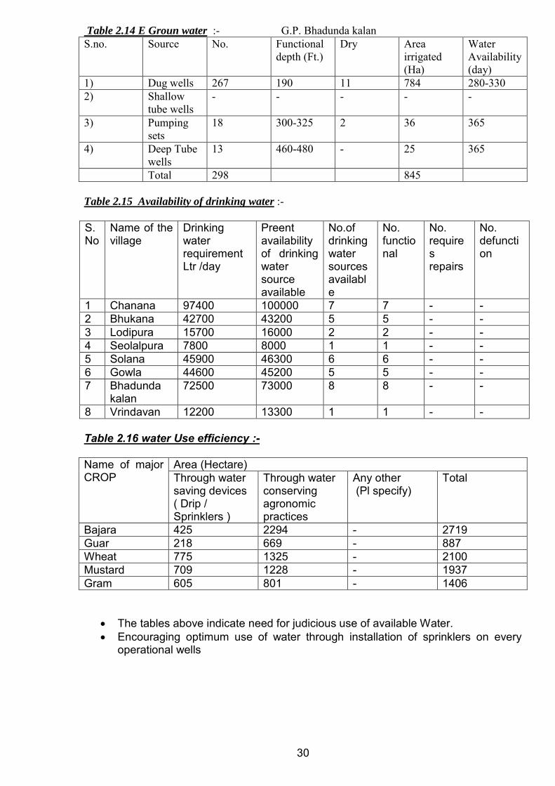
Table 2.14 E Groun water :- G.P. Bhadunda kalan S.no. Source No. Functional
depth (Ft.) Dry Area
irrigated (Ha)
Water Availability (day)
1) Dug wells 267 190 11 784 280-330 2) Shallow
tube wells - - - - -
3) Pumping sets
18 300-325 2 36 365
4) Deep Tube wells
13 460-480 - 25 365
Total 298 845 Table 2.15 Availability of drinking water :- S.No
Name of the village
Drinking water requirement Ltr /day
Preent availability of drinking water source available
No.of drinking water sources available
No. functional
No. requires repairs
No. defunction
1 Chanana 97400 100000 7 7 - - 2 Bhukana 42700 43200 5 5 - - 3 Lodipura 15700 16000 2 2 - - 4 Seolalpura 7800 8000 1 1 - - 5 Solana 45900 46300 6 6 - - 6 Gowla 44600 45200 5 5 - - 7 Bhadunda
kalan 72500 73000 8 8 - -
8 Vrindavan 12200 13300 1 1 - - Table 2.16 water Use efficiency :- Name of major CROP
Area (Hectare) Through water saving devices ( Drip / Sprinklers )
Through water conserving agronomic practices
Any other (Pl specify)
Total
Bajara 425 2294 - 2719 Guar 218 669 - 887 Wheat 775 1325 - 2100 Mustard 709 1228 - 1937 Gram 605 801 - 1406
The tables above indicate need for judicious use of available Water. Encouraging optimum use of water through installation of sprinklers on every
operational wells
30
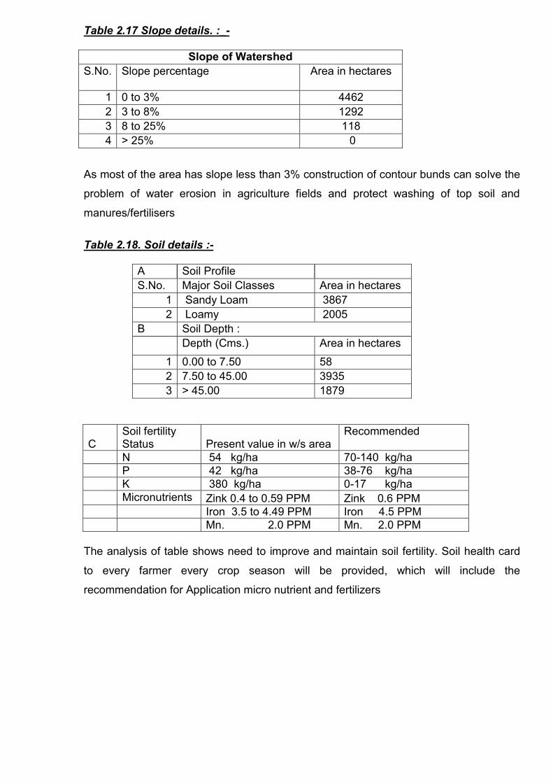
Table 2.17 Slope details. :_-
Slope of Watershed S.No. Slope percentage
Area in hectares
1 0 to 3% 4462 2 3 to 8% 1292 3 8 to 25% 118 4 > 25% 0
As most of the area has slope less than 3% construction of contour bunds can solve the
problem of water erosion in agriculture fields and protect washing of top soil and
manures/fertilisers
Table 2.18. Soil details :-
A Soil Profile S.No. Major Soil Classes Area in hectares
1 Sandy Loam 3867 2 Loamy 2005
B Soil Depth : Depth (Cms.) Area in hectares
1 0.00 to 7.50 58 2 7.50 to 45.00 3935 3 > 45.00 1879
C Soil fertility Status Present value in w/s area
Recommended
N 54 kg/ha 70-140 kg/ha P 42 kg/ha 38-76 kg/ha K 380 kg/ha 0-17 kg/ha Micronutrients Zink 0.4 to 0.59 PPM Zink 0.6 PPM Iron 3.5 to 4.49 PPM Iron 4.5 PPM Mn. 2.0 PPM Mn. 2.0 PPM
The analysis of table shows need to improve and maintain soil fertility. Soil health card
to every farmer every crop season will be provided, which will include the
recommendation for Application micro nutrient and fertilizers

32 D : Soil Salinity/Alkalinity Soil sample collected from field for soil analysis by Agricultural Department from the
Project area and soil pH is a measured for the cluster area and village wise results
obtained are as follows :
Name of the Village Soil pH Range Type of Salinity
(Inherent/Ingress)
CHANANA 8.5 to 9.2 Ingress
BHUKANA 8.4 to 9.2 Ingress
LODIPURA 8.5 to 9.4 Ingress
SEOLAL PURA 8.3 to 9.3 Ingress
SOLANA 8.4 to 9.4 Ingress
GOWLA 8.5 to 9.3 Ingress
BHADUNDA KALAN 8.6 to 9.4 Ingress
VRINDAVAN 8.3 to 9.1 Ingress
Soil pH is a measure of the soil acidity or soil alkalinity. An acid solution has a pH
value less than 7. While a basic solution always has a pH larger than 7, an alkaline
solution (i.e., a solution with positive acid neutralizing capacity), can also be defined as
the negative logarithm of hydroxide ions in the soil. It therefore does not necessarily
have a pH larger than 7. In the project area soil pH ranges from 8.2 to 9.4.
Table 2.19 Erosion details
Erosion status in project Area
Cause
Type of
erosion
Area affected
(ha)
Run off(mm/
year) Average soil loss
(Tonnes/ ha/ year) Water erosion
a Sheet 2770 b Rill 1010 55 3.8 c Gully 175 Sub-Total 3955
Wind erosion 4296 4.5 Total for project 8.3

33 The need is:
To check land degradation
To reduce excessive biotic pressure by containing the number and increase of
livestock
To check cultivation on sloping lands without adequate precautions of soil and water
conservation measures
To discourage cultivation along susceptible nallah beds
To check Faulty agriculture techniques
To check Uncontrolled grazing and developed cattle tracks
To check Deforestation of steep slopes
To check erosive velocity of runoff, store Runoff, to arrest silt carried by runoff and to
recharge Ground Water structures life Earthen check dams, gully plugs, Bank
Stabilisation, Loose stone check Dams, Gabions, Earthen embankment (Nadi) and
Anicuts would be taken up.
34

CHAPTER - III Proposed Development Plan: The Activities are indicative addition /deletion in activities will be as per local conditions
A) Preparatory phase activities Capacity Building Trainings and EPA
The IEC activities like Kalajathas, Group meetings, door to door campaign, slogans and
wall writings etc. were carried out in all the habitations of Jakhod,Pilod_ Micro
Watershed. A series of meetings were conducted with GP members, community and
discussed about the implementation of IWMP programme. User groups were also
formed.
Grama Sabhas were conducted for approval of EPA (Village), for selecting the
watershed committee and approval of DPR.
S.no Name of the Gram Panchayat Date on which Grama Sabha approved EPA
1 Chanana 06-06-2011
2 Bhukana 13-05-2011
3 Solana 12-05-2011
4 Gowla 27-5-2011&13-6-2011
5 Bhadunda kalan 12-5-2011
1 4 5 6 7 8 9 10 11
S. No.
Names of G.P.
Amount earmarked
for EPA
Entry Point Activities planned
Estimated cost
(lacs)
Expenditure incurred Balance Expected
outcome Actual
outcome
1 CHANANA 6.31 Solar Light Peyjal Tanki with
pipeline,&improved savdah grah
6.31 6.31 Good
2 BHUKANA 6.61 Solar light &Peyjal tanki with
pipeline&improved Sawdah grah
6.61 1.50 5.11 Good
3 SOLANA 5.24 Char diwari Samshan
&improved saw dah grah
5.24 5.24 Good
4 GOWLA 5.23 Solar light &Peyjal tanki with
pipeline&improved Sawdah grah
5.23 1.00 4.23 Good
5 BHADUNDA KALAN
11.84 Solar light &Peyjal tanki with
pipeline&improved Sawdah grah,,
11.84 1.0 10.84 Good
35

Capacity Building : Capacity Building is the process of assisting the group or individuals to identify and address
issues and gain the insights, knowledge and experience needed to solve problems and
implement charges.
There is a realization in the development sector that there is a need to appraise the
success of development interventions by going beyond the conventional development targets
and measures of success (e.g. in the form of commodities, goods and services) to take into
account improvement to human potential. Capacity building stakeholders Is also increasingly
viewed as an important factor in developmental projects that involve participation of
stakeholders at all levels for effective implementation of projects.
Scope of capacity building at CHANANA Watershed area :
Alternative Land Use Plan
Scientific technique of soil and moisture conservation
Improved and Scientific agriculture practices
Fodder development and Management
Afforestation
Meteorological Information
Dairy Development and Management
Rural Craft
Income Generaiton Activities
o Stitching
0 Food Processing
o Post Harves Management Practices
0 Making Carpets
The PRA exercise was carried out in all the villages on the dates shown below:
S.no. Name of the G.P. village/Habitation Date on which PRA conducted
1 Chanana 16-4-2012
2 Gowla 17-4-2012
3 Solana 18-4-2012
4 Bhadunda kalan 19-4-2012
5 Vrindavan 19-4-2012
6 Bhukana 20-4-2012
7 Lodipura 23-4-2012
8 sheolalpura 23-4-2012
36
Transact walk were carried out involving the community for Social mapping, Resource
mapping. Detailed discussions and deliberations with all the primary stakeholders were carried
out.
Socio-economic survey was carried out during 16.09.11 to 29.05.12 period covering all the
households and primary data on demography, Land holdings, Employment status, Community
activities etc. was collected as mentioned in chapter 2.
State remote sensing department was assigned the work of preparing various
thematic layers using Cartosat-1 and LISS-3 imageries for Creation, development and
management of geo-spatial database depicting present conditions of land (terrain), water and
vegetation with respect to watershed under different ownerships at village level
Various thematic layers provided by SRSAC are :
Delineation of Macro/Micro watershed boundaries. Digitised Khasara maps of the villages falling in project area. Network of Drainage lines, existing water bodies, falling in the project area. Base maps (transport network, village/boundaries, and settlements). Land Use / Land cover map. Contours at 1 meter interval, slope map
Based on GIS thematic layers, Field visits , PRA and analysis of benchmark data (as
discussed in chapter 2) final Treatment plan on revenue map for implementation has been
framed. Thus each intervention identified has been marked on revenue map (map enclosed
in DPR as annexure------).The GIS based intervention map, PRA based intervention map are
annexed as -----
37
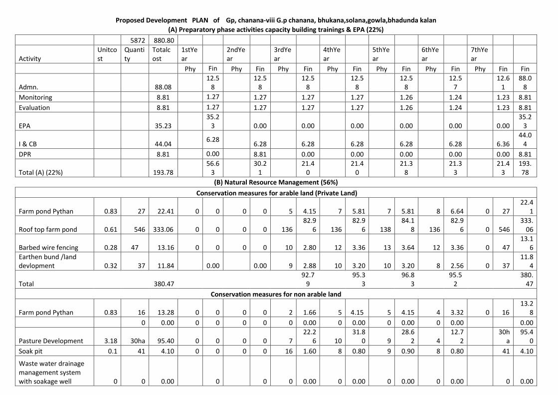
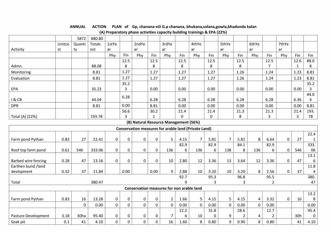
Proposed Development PLAN of Gp, chanana-viii G.p chanana, bhukana,solana,gowla,bhadunda kalan
(A) Preparatory phase activities capacity building trainings & EPA (22%)
5872 880.80
Activity Unitcost
Quantity
Totalcost
1stYear
2ndYear
3rdYear
4thYear
5thYear
6thYear
7thYear
Phy Fin Phy Fin Phy Fin Phy Fin Phy Fin Phy Fin Phy Fin Fin
Admn. 88.08 12.5
8 12.5
8 12.5
8 12.5
8 12.5
8 12.5
7 12.6
1 88.0
8
Monitoring 8.81 1.27 1.27 1.27 1.27 1.26 1.24 1.23 8.81
Evaluation 8.81 1.27 1.27 1.27 1.27 1.26 1.24 1.23 8.81
EPA 35.23 35.2
3 0.00 0.00 0.00 0.00 0.00 0.00 35.2
3
I & CB 44.04 6.28
6.28 6.28 6.28 6.28 6.28 6.36 44.0
4
DPR 8.81 0.00 8.81 0.00 0.00 0.00 0.00 0.00 8.81
Total (A) (22%) 193.78 56.6
3 30.2
1 21.4
0 21.4
0 21.3
8 21.3
3 21.4
3 193.78
(B) Natural Resource Management (56%)
Conservation measures for arable land (Private Land)
Farm pond Pythan 0.83 27 22.41 0 0 0 0 5 4.15 7 5.81 7 5.81 8 6.64 0 27 22.4
1
Roof top farm pond 0.61 546 333.06 0 0 0 0 136 82.9
6 136 82.9
6 138 84.1
8 136 82.9
6 0 546 333.
06
Barbed wire fencing 0.28 47 13.16 0 0 0 0 10 2.80 12 3.36 13 3.64 12 3.36 0 47 13.1
6
Earthen bund /land devlopment 0.32 37 11.84 0.00 0.00 9 2.88 10 3.20 10 3.20 8 2.56 0 37
11.84
Total 380.47 92.7
9 95.3
3 96.8
3 95.5
2 380.
47
Conservation measures for non arable land
Farm pond Pythan 0.83 16 13.28 0 0 0 0 2 1.66 5
4.15 5 4.15 4 3.32 0 16 13.2
8
0 0.00 0 0 0 0 0 0.00 0 0.00 0 0.00 0 0.00 0.00
Pasture Development 3.18 30ha 95.40 0 0 0 0 7 22.2
6 10 31.8
0 9 28.6
2 4 12.7
2 30h
a 95.4
0
Soak pit 0.1 41 4.10 0 0 0 0 16 1.60 8 0.80 9 0.90 8 0.80 41 4.10
Waste water drainage management system with soakage well 0 0 0.00 0 0 0 0.00 0 0.00 0 0.00 0 0.00 0 0.00

Total 0 112.78 0 0.00 0.00 25.5
2
36.7
5
33.6
7 16.8
4 112.
78
Total (B) (56%) 493.25 0.00 0.00 118.
31 132.08
130.50
112.36
493.25
(C) Production System and Micro Enterprise (19%)
Production measures for arable land
Horticulture Plantation 0.000
97 14067 13.64 0 0 0 0 3542 3.43 3442 3.34 3292 3.19 3791 3.68 0 0 13.6
4
Subji mini kit 0.005 469 2.35 0 0 0 0 140 0.70 138 0.69 126 0.63 65 0.33 0 0 2.35
Animal camp 0.15 40 6.00 0 0 0 0 10 1.50 10 1.50 10 1.50 10 1.50 0 0 6.00
Distri. of Goat & Ram 0.1 6 0.60 0 0 0 0 1 0.10 4 0.40 1 0.10 0 0.00 0 0 0.60
Distri. of manger 0.01 633 6.33 0 0 0 0 155 1.55 155 1.55 155 1.55 168 1.68 0 0 6.33
Distri. of chaufcuter 0.03 958 28.74 0 0 0 0 242 7.26 242 7.26 241 7.23 233 6.99 0 0 28.7
4
Crop Demostration 0.01 3042 30.42 0 0 0 0 760 7.60 760 7.60 760 7.60 762 7.62 30.4
2
Total (C) (10%) 88.08 0.00 0.00 0.00 22.1
4 22.3
4 21.8
0 21.8
0
80.08
Livelyhood(D) 9% 79.27 19.8
2 19.8
2 19.8
2 19.8
1
79.2
7
Rev.fund t o SHG 60% 47.56 11.8
9 11.8
9 11.8
9 11.8
9
47.56
Rev.Fund to Ent. Ind. 10% 7.93 1.98 1.98 1.98 1.99 7.93
Grant in aid to SHG Fedration 30% 23.78 5.95 5.95 5.95 5.93
23.78
(E) Consolidation (3%) 26.41 0 0 0 0 0 0.00 0 0.00 0 0.00 0 0.00 0 0.00 26.4
1
Grand Total 880.80 56.6
3 30.2
1 0.00 193.
18 0.00 195.
62 0.00 182.
20 0.00 175.
11 21.4
3 880.
80
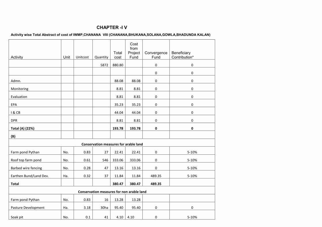
CHAPTER -I V Activity wise Total Abstract of cost of IWMP,CHANANA VIII (CHANANA,BHUKANA,SOLANA,GOWLA,BHADUNDA KALAN)
Activity Unit Unitcost Quantity Total cost
Cost from
Project Fund
Convergence Fund
Beneficiary Contribution*
5872 880.80 0 0
0 0
Admn. 88.08 88.08 0 0
Monitoring 8.81 8.81 0 0
Evaluation 8.81 8.81 0 0
EPA 35.23 35.23 0 0
I & CB 44.04 44.04 0 0
DPR 8.81 8.81 0 0
Total (A) (22%) 193.78 193.78 0 0
(B)
Conservation measures for arable land
Farm pond Pythan No. 0.83 27 22.41 22.41 0 5-10%
Roof top farm pond No. 0.61 546 333.06 333.06 0 5-10%
Barbed wire fencing No. 0.28 47 13.16 13.16 0 5-10%
Earthen Bund/Land Dev. Ha. 0.32 37 11.84 11.84 489.35 5-10%
Total 380.47 380.47 489.35
Conservation measures for non arable land
Farm pond Pythan No. 0.83 16 13.28 13.28
Pasture Development Ha. 3.18 30ha 95.40 95.40 0 0
Soak pit No. 0.1 41 4.10 4.10 0 5-10%
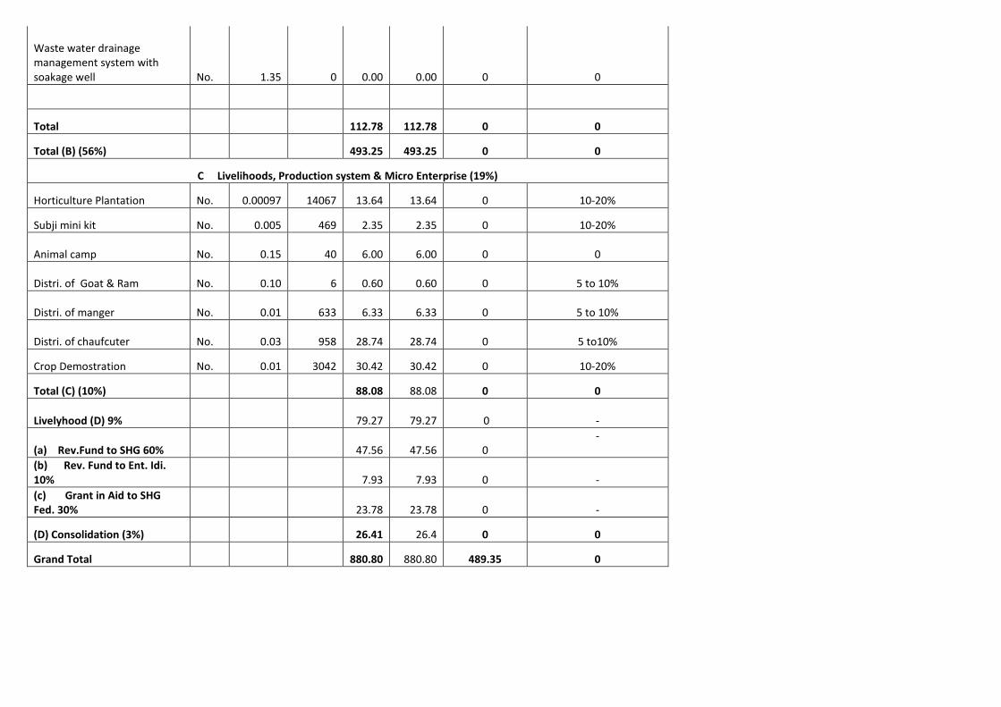
Waste water drainage management system with soakage well No. 1.35 0 0.00 0.00 0 0
Total 112.78 112.78 0 0
Total (B) (56%) 493.25 493.25 0 0
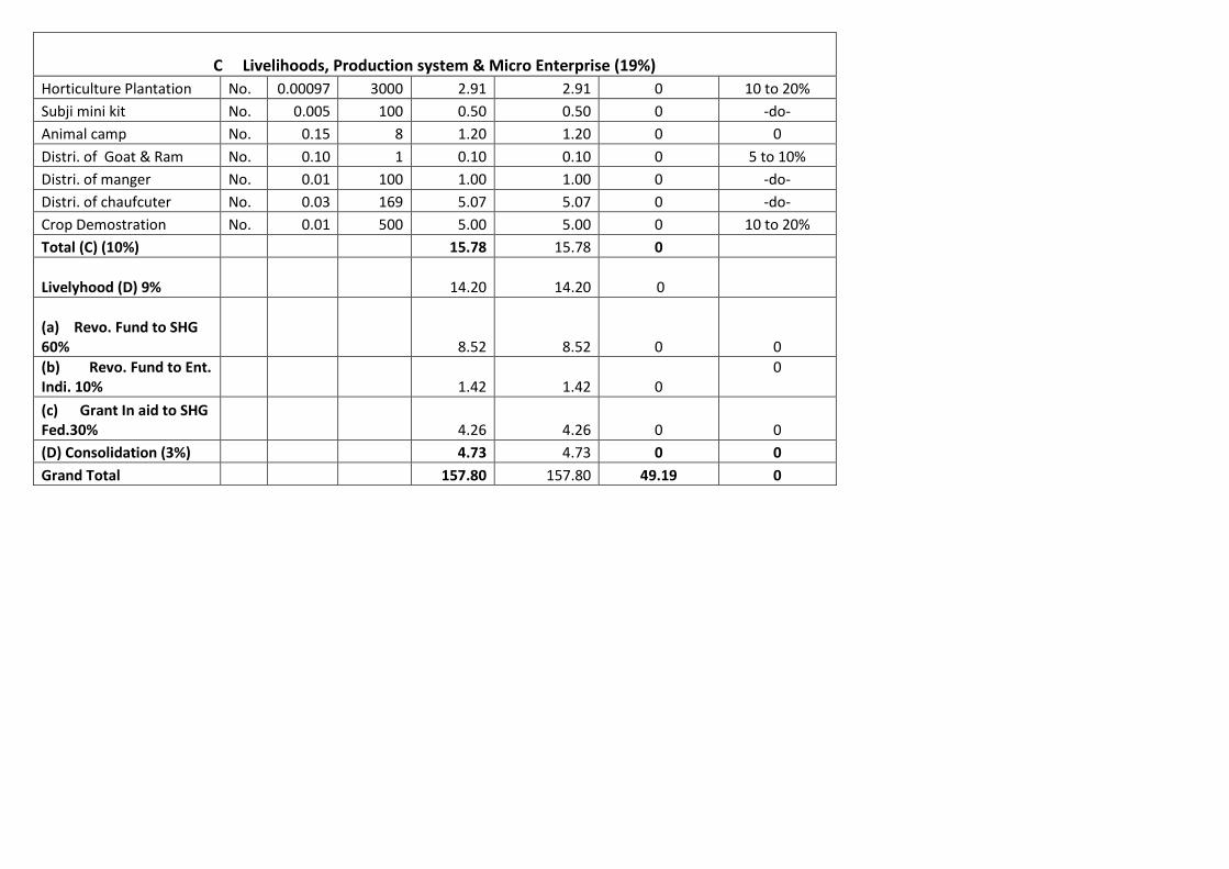
C Livelihoods, Production system & Micro Enterprise (19%)
Horticulture Plantation No. 0.00097 14067 13.64 13.64 0 10-20%
Subji mini kit No. 0.005 469 2.35 2.35 0 10-20%
Animal camp No. 0.15 40 6.00 6.00 0 0
Distri. of Goat & Ram No. 0.10 6 0.60 0.60 0 5 to 10%
Distri. of manger No. 0.01 633 6.33 6.33 0 5 to 10%
Distri. of chaufcuter No. 0.03 958 28.74 28.74 0 5 to10%
Crop Demostration No. 0.01 3042 30.42 30.42 0 10-20%
Total (C) (10%) 88.08 88.08 0 0
Livelyhood (D) 9% 79.27 79.27 0 -
(a) Rev.Fund to SHG 60% 47.56 47.56 0 -
(b) Rev. Fund to Ent. Idi. 10% 7.93 7.93 0
-
(c) Grant in Aid to SHG Fed. 30% 23.78 23.78 0 -
(D) Consolidation (3%) 26.41 26.4 0 0
Grand Total 880.80 880.80 489.35 0

CHAPTER -I V Activity wise Total Abstract of cost of IWMP, CHANANA
Activity Unit Unitcost Quantity Total cost
Cost from Project Fund
Convergence Fund
Beneficiary Contribution*
1052 157.80 0 0
0 0
Admn. 15.78 15.78 0 0
Monitoring 1.58 1.58 0 0
Evaluation 1.58 1.58 0 0
EPA 6.31 6.31 0 0
I & CB 7.89 7.89 0 0
DPR 1.58 1.58 0 0
Total (A) (22%) 34.72 34.72 0 0
(B)
Conservation measures for arable land
Farm pond Pythan No. 0.83 3 2.49 2.49 0 5 to 10%
Roof top farm pond No. 0.61 118 71.98 71.98 0 -do-
Barbed wire fencing No. 0.28 5 1.40 1.40 0 -do-
Earthenbund / land dev. - - - 49.19 -do-
Total 75.87 75.87 49.19
Conservation measures for non arable land
Farm pond Pythan No. 0.83 2 1.66 1.66 0 0
Pasture Development Ha. 3.18 3 9.54 9.54 0 0
Soak pit No. 0.1 13 1.30 1.30 0 0
Waste water drainage management system with soakage well No. 0 0 0.00 0.00 0 0
Total 12.50 12.50 0 0
Total (B) (56%) 88.37 88.37 0 0
C Livelihoods, Production system & Micro Enterprise (19%)
Horticulture Plantation No. 0.00097 3000 2.91 2.91 0 10 to 20%
Subji mini kit No. 0.005 100 0.50 0.50 0 -do-
Animal camp No. 0.15 8 1.20 1.20 0 0
Distri. of Goat & Ram No. 0.10 1 0.10 0.10 0 5 to 10%
Distri. of manger No. 0.01 100 1.00 1.00 0 -do-
Distri. of chaufcuter No. 0.03 169 5.07 5.07 0 -do-
Crop Demostration No. 0.01 500 5.00 5.00 0 10 to 20%
Total (C) (10%) 15.78 15.78 0
Livelyhood (D) 9% 14.20 14.20 0
(a) Revo. Fund to SHG 60% 8.52 8.52 0
0
(b) Revo. Fund to Ent. Indi. 10% 1.42 1.42 0
0
(c) Grant In aid to SHG Fed.30% 4.26 4.26 0 0
(D) Consolidation (3%) 4.73 4.73 0 0
Grand Total 157.80 157.80 49.19 0

CHAPTER -I V Activity wise Total Abstract of cost of IWMP,BHUKANA
Activity Unit Unitcost Quantity Total cost Cost from
Project Fund Convergence
Fund Beneficiary Contribution*
1102 165.30 0 0
0 0
Admn. 16.53 16.53 0 0
Monitoring 1.65 1.65 0 0
Evaluation 1.65 1.65 0 0
EPA 6.61 6.61 0 0
I & CB 8.27 8.27 0 0
DPR 1.65 1.65 0 0
Total (A) (22%) 36.36 36.36 0 0
(B)
Conservation measures for arable land
Farm pond Pythan No. 0.83 5 4.15 4.15 0 5 to 10%
Roof top farm pond No. 0.61 107 65.27 65.27 0 -do-
Barbed wire fencing No. 0.28 12 3.36 3.36 0 -do-
Earthenbund / land dev. - - - 14.37 0
Total 72.78 72.78 14.37 0
Conservation measures for non arable land
Farm pond Pythan No. 0.83 3 2.49 2.49 0
Pasture Development Ha. 3.18 5 15.90 15.90 0 0
Soak pit No. 0.1 14 1.40 1.40 0 0

Waste water drainage management system with soakage well No. 0 0 0.00 0.00 0 0
Total 19.79 19.79 0 0
Total (B) (56%) 92.57 92.57 0 0
C Livelihoods, Production system & Micro Enterprise (19%)
Horticulture Plantation No. 0.00097 2500 2.43 2.43 0 10 to 20%
Subji mini kit No. 0.005 75 0.38 0.38 0 -do-
Animal camp No. 0.15 8 1.20 1.20 0 0
Distri. of Goat & Ram No. 0.10 1 0.10 0.10 0 5 to 10%
Distri. of manger No. 0.01 101 1.01 1.01 0 -do-
Distri. of chaufcuter No. 0.03 197 5.91 5.91 0 -do-
Crop Demostration No. 0.01 550 5.50 5.50 0 10 to 20%
Total (C) (10%) 16.53 16.53 0
Livelyhood (D) 9% 14.88 14.88 0
(a) Revo. Fund to SHG 60% 8.93 8.93 0
0
(b) Revo. Fund to Ent.Indi. 10% 1.49 1.49 0
0
(c) Grant in aid to SHG Fed 30% 4.46 4.46 0 0
(D) Consolidation (3%) 4.96 4.96 0 0
Grand Total 165.30 165.30 14.37 0
CHAPTER -I V Activity wise Total Abstract of cost of IWMP,SOLANA
Activity Unit Unitcost Quantity Total cost Cost from
Project Fund Convergence
Fund Beneficiary Contribution*
873 130.95 0 0
0 0
Admn. 13.10 13.10 0 0
Monitoring 1.31 1.31 0 0
Evaluation 1.31 1.31 0 0
EPA 5.24 5.24 0 0
I & CB 6.54 6.54 0 0
DPR 1.31 1.31 0 0
Total (A) (22%) 28.81 28.81 0 0
(B)
Conservation measures for arable land Farm pond Pythan No. 0.83 5 4.15 4.15 0 5 to 10%
Roof top farm pond No. 0.61 63 38.43 38.43 0 -do-
Barbed wire fencing No. 0.28 10 2.80 2.80 0 -do-
Earthen bund/Land dev. Ha. 0.32 19 6.08 6.08 48.10 -do-
Total 51.46 51.46 48.10
Conservation measures for non arable land
Farm pond Pythan No. 0.83 3 2.49 2.49 0 0
Ha. 3.18 6 19.08 19.08 0 0
Soak pit No. 0.1 3 0.30 0.30 0 0

Waste water drainage management system with soakage well No. 1.35 0 0.00 0.00 0 0
Total 21.87 21.87 0 0
Total (B) (56%) 73.33 73.33 0 0
C Livelihoods, Production system & Micro Enterprise (19%)
Horticulture Plantation No. 0.00097 2000 1.94 1.94 0 10 to 20%
Subji mini kit No. 0.005 70 0.35 0.35 0 -do-
Animal camp No. 0.15 8 1.20 1.20 0 0
Distri. of Goat & Ram No. 0.10 1 0.10 0.10 0 5 to 10%
Distri. of manger No. 0.01 115 1.15 1.15 0 -do-
Distri. of chaufcuter No. 0.03 112 3.36 3.36 0 -do-
Crop Demostration No. 0.01 500 5.00 5.00 0 10 to 20 %
Total (C) (10%) 13.10 13.10
Livelyhood (D) 9% 11.78 11.78
(a) Revo. Fund to SHG 60% 7.07 7.07 0
(b) Revo. Fund to Enter. Indi. 10% 1.18 1.18
0
(c) Grant in Aid to SHG Fed. 30% 3.53 3.53
0
(D) Consolidation (3%) 3.93 3.93 0 0
Grand Total 130.95 130.95 48.10 0

CHAPTER -I V Activity wise Total Abstract of cost of IWMP,GOWLA
Activity Unit Unitcost Quantity Total cost Cost from
Project Fund Convergence
Fund Beneficiary Contribution*
872 130.80 0 0
0 0
Admn. 13.08 13.08 0 0
Monitoring 1.31 1.31 0 0
Evaluation 1.31 1.31 0 0
EPA 5.23 5.23 0 0
I & CB 6.54 6.54 0 0
DPR 1.31 1.31 0 0
Total (A) (22%) 28.78 28.78 0 0
(B)
Conservation measures for arable land
Farm pond Pythan No. 0.83 4 3.32 3.32 0 5 to 10%
Roof top farm pond No. 0.61 66 40.26 40.26 0 -do-
Barbed wire fencing No. 0.28 10 2.80 2.80 0 -do-
Earthen bund/Land Dev. Ha. 0.32 15 4.80 4.80 267.60 -do-
Total 51.18 51.18 267.60
Conservation measures for non arable land
Farm pond Pythan No. 0.83 3 2.49 2.49 0
Pasture Development Ha. 3.18 6 19.08 19.08 0 0
Soak pit No. 0.1 5 0.50 0.50 0 0

Waste water drainage management system with soakage well No. 1.35 0 0.00 0.00 0 0
Total 22.07 22.07 0 0
Total (B) (56%) 73.25 73.25 0 0
C Livelihoods, Production system & Micro Enterprise (19%)
Horticulture Plantation No. 0.00097 2567 2.49 2.49 0 10 to 20%
Subji mini kit No. 0.005 74 0.37 0.37 0 -do-
Animal camp No. 0.15 8 1.20 1.20 0 0
Distri. of Goat & Ram No. 0.10 1 0.10 0.10 0 5 to 10%
Distri. of manger No. 0.01 100 1.00 1.00 0 -do-
Distri. of chaufcuter No. 0.03 100 3.00 3.00 0 -do-
Crop Demostration No. 0.01 492 4.92 4.92 0 10 to 20 %
Total (C) (10%) 13.08 13.08 0 0
Livelyhood 9% (D) 11.77 11.77 0 0
(a) Revo. Fund to SHG 60% 7.06 7.06 0 0
(b) Revo. Fund to Enter.Indi. 10% 1.18 1.18 0
0
(c) Grant In aid to SHG Fed. 30% 3.53 3.53
(D) Consolidation (3%) 3.92 3.92 0 0
Grand Total 130.80 130.80 267.60 0
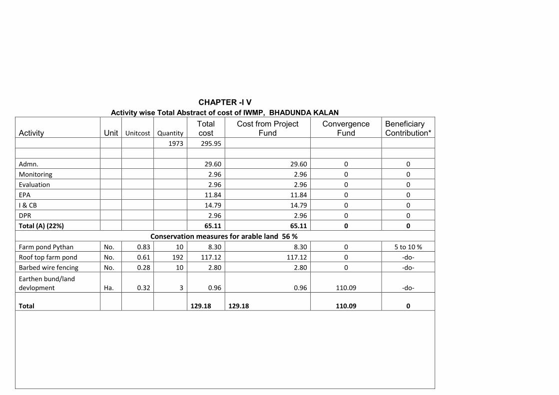
CHAPTER -I V Activity wise Total Abstract of cost of IWMP, BHADUNDA KALAN
Activity Unit Unitcost Quantity Total cost
Cost from Project Fund
Convergence Fund
Beneficiary Contribution*
1973 295.95
Admn. 29.60 29.60 0 0
Monitoring 2.96 2.96 0 0
Evaluation 2.96 2.96 0 0
EPA 11.84 11.84 0 0
I & CB 14.79 14.79 0 0
DPR 2.96 2.96 0 0
Total (A) (22%) 65.11 65.11 0 0
Conservation measures for arable land 56 %
Farm pond Pythan No. 0.83 10 8.30 8.30 0 5 to 10 %
Roof top farm pond No. 0.61 192 117.12 117.12 0 -do-
Barbed wire fencing No. 0.28 10 2.80 2.80 0 -do-
Earthen bund/land devlopment Ha. 0.32 3 0.96 0.96 110.09 -do-
Total 129.18
129.18 110.09 0

Conservation measures for non arable land
Farm pond Pythan No. 0.83 5 4.15 4.15 0 5 to 10%
Pasture Development Ha. 3.18 10 31.80 31.80 0 0
Soak pit No. 0.1 6 0.60 0.60 0 5 to 10 %
Waste water drainage management system with soakage well No. 1.35 0 0.00 0.00 0 0
Total 36.55 36.55 0 0
Total (B) (56%) 165.73 165.73 0 0
Horticulture Plantation No. 0.00097 4000 3.88 3.88 0 10 20 %
Subji mini kit No. 0.005 150 0.75 0.75 0 -do-
Animal camp No. 0.15 8 1.20 1.20 0 0
Distri. of Goat & Ram No. 0.10 2 0.20 0.20 0 5 to 10%
Distri. of manger No. 0.01 217 2.17 2.17 0 -do-
Distri. of chaufcuter No. 0.03 380 11.40 11.40 0 -do-
Crop Demostration No. 0.01 1000 10.00 10.00 0 10 to 20%
Total (C) (10%) 29.60 29.60 0 0
Livelyhood (D) 9% 26.64 26.64 0 0
(a) Revo.Fund to SHG 60% 15.99 5.99 0
0
(b) Revo. Fund to Enter. Indi. 10 % 2.66 2.66 0
0
(c) Grant in aid to SHG Fed .Fed. 30% 7.99 7.99 0 0
(D) Consolidation (3%) 8.87 8.87 0 0
Grand Total 295.95 295.95 110.09 0
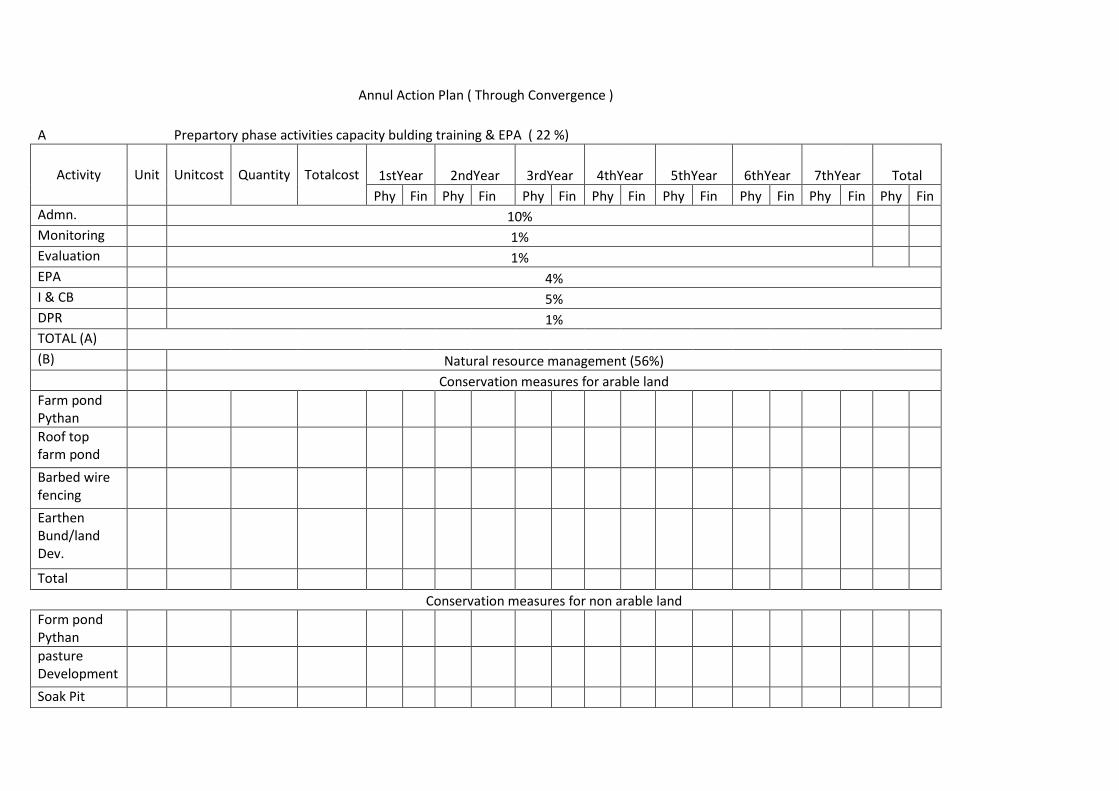
Annul Action Plan ( Through Convergence )
A Prepartory phase activities capacity bulding training & EPA ( 22 %)
Activity Unit Unitcost Quantity Totalcost 1stYear 2ndYear 3rdYear 4thYear 5thYear 6thYear 7thYear Total
Phy Fin Phy Fin Phy Fin Phy Fin Phy Fin Phy Fin Phy Fin Phy Fin
Admn. 10%
Monitoring 1%
Evaluation 1%
EPA 4%
I & CB 5%
DPR 1%
TOTAL (A)
(B) Natural resource management (56%)
Conservation measures for arable land
Farm pond Pythan
Roof top farm pond
Barbed wire fencing
Earthen Bund/land Dev.
Total
Conservation measures for non arable land
Form pond Pythan
pasture Development
Soak Pit

West water drainage management syatem with soakage well
Total
Total (56%)
C Livelihoods, Production system & Micro Enterprise (19%)
Horticulture Plantation
Subji mini kit
Animal camp
Distri.of Goat & Ram
Distri.of manger
Distri. Of chaufcuter
Crop Demostration
Total © 10%
Livelyhood(D) 9%
(a)Revo. Fund to SHG 60%
(b) Revo. Fund to Enter. Indi. 10%
(c) Grant in aid to SHG Fed. 30%
Consolidation
3%
Grand Total

ANNUAL ACTION PLAN of Gp, chanana-viii G.p chanana, bhukana,solana,gowla,bhadunda kalan
(A) Preparatory phase activities capacity building trainings & EPA (22%)
5872 880.80
Activity Unitcost
Quantity
Totalcost
1stYear
2ndYear
3rdYear
4thYear
5thYear
6thYear
7thYear
Phy Fin Phy Fin Phy Fin Phy Fin Phy Fin Phy Fin Phy Fin Fin
Admn. 88.08 12.5
8 12.5
8 12.5
8 12.5
8 12.5
8 12.5
7 12.6
1 88.0
8
Monitoring 8.81 1.27 1.27 1.27 1.27 1.26 1.24 1.23 8.81
Evaluation 8.81 1.27 1.27 1.27 1.27 1.26 1.24 1.23 8.81
EPA 35.23 35.2
3 0.00 0.00 0.00 0.00 0.00 0.00 35.2
3
I & CB 44.04 6.28
6.28 6.28 6.28 6.28 6.28 6.36 44.0
4
DPR 8.81 0.00 8.81 0.00 0.00 0.00 0.00 0.00 8.81
Total (A) (22%) 193.78 56.6
3 30.2
1 21.4
0 21.4
0 21.3
8 21.3
3 21.4
3 193.78
(B) Natural Resource Management (56%)
Conservation measures for arable land (Private Land)
Farm pond Pythan 0.83 27 22.41 0 0 0 0 5 4.15 7 5.81 7 5.81 8 6.64 0 27 22.4
1
Roof top farm pond 0.61
546 333.06 0 0 0 0 136 82.9
6 136 82.9
6 138 84.1
8 136 82.9
6 0 546 333.
06
Barbed wire fencing 0.28 47 13.16 0 0 0 0 10 2.80 12 3.36 13 3.64 12 3.36 0 47 13.1
6
Earthen bund /land devlopment 0.32 37 11.84 0.00 0.00 9 2.88 10 3.20 10 3.20 8 2.56 0 37
11.84
Total 380.47 92.7
9 95.3
3 96.8
3 95.5
2 380.
47
Conservation measures for non arable land
Farm pond Pythan 0.83 16 13.28 0 0 0 0 2 1.66 5 4.15 5 4.15 4 3.32 0 16 13.2
8
0 0.00 0 0 0 0 0 0.00 0 0.00 0 0.00 0 0.00 0.00
Pasture Development 3.18 30ha 95.40 0 0 0 0 7 22.2
6 10 31.8
0 9 28.6
2 4 12.7
2 30h 95.4
0
Soak pit 0.1 41 4.10 0 0 0 0 16 1.60 8 0.80 9 0.90 8 0.80 41 4.10

Waste water drainage management system with soakage well 0 0 0.00 0 0 0 0.00 0 0.00 0 0.00 0 0.00 0 0.00
Total 0 112.78 0 0.00 0.00 25.5
2 36.7
5 33.6
7 16.8
4 112.
78
Total (B) (56%) 493.25 0.00 0.00 118.
31 132.
08 130.
50 112.
36 493.
25
(C) Production System and Micro Enterprise (19%)
Production measures for arable land
Horticulture Plantation 0.000
97 14067 13.64 0 0 0 0 3542 3.43 3442 3.34 3292 3.19 3791 3.68 0 0 13.6
4
Subji mini kit 0.005 469 2.35 0 0 0 0 140 0.70 138 0.69 126 0.63 65 0.33 0 0 2.35
Animal camp 0.15 40 6.00 0 0 0 0 10 1.50 10 1.50 10 1.50 10 1.50 0 0 6.00
Distri. of Goat & Ram 0.1 6 0.60 0 0 0 0 1 0.10 4 0.40 1 0.10 0 0.00 0 0 0.60
Distri. of manger 0.01 633 6.33 0 0 0 0 155 1.55 155 1.55 155 1.55 168 1.68 0 0 6.33
Distri. of chaufcuter 0.03 958 28.74 0 0 0 0 242 7.26 242 7.26 241 7.23 233 6.99 0 0 28.7
4
Crop Demostration 0.01 3042 30.42 0 0 0 0 760 7.60 760 7.60 760 7.60 762 7.62 30.4
2
Total (C) (10%) 88.08 0.00 0.00 0.00 22.1
4 22.3
4 21.8
0 21.8
0 80.0
8
Livelyhood(d)9% 79.27 19.8
2 19.8
1 19.8
1 19.8
3 79.2
7
(a) Revo. Fund to SHG 60% 47.56 0 0 0 0 0
11.89
11.89
11.89
11.89
47.56
(b) Revo. Fund to Ent. Indi.10% 7.93 0 0 0 0 0 1.98 1.98 1.98 1.99
7.93
(c) Grant in aid to SHG Fed. 30% 23.78 0 0 0 0 0 5.95 5.95 5.95 5.93
23.78
(E) Consolidation (3%) 26.41 0 0 0 0 0 0.00 0 0.00 0 0.00 0 0.00 0 0.00 26.4
1
Grand Total 880.80 56.6
3 30.2
1 0.00 181.
67 0.00 195.
63 0.00 193.
49 0.00 175.
32 21.4
3 880.
80


ANNUAL ACTION PLAN of GP, Chanana
(A) Preparatory phase activities capacity building trainings & EPA (22%)
1052 157.80
Activity Unitcost
Quantity
Totalcost
1stYear
2ndYear
3rdYear
4thYear
5thYear
6thYear
7thYear
Total
Phy Fin Phy Fin Phy Fin Phy Fin Phy Fin Phy Fin Phy Fin Phy Fin
Admn. 15.78 2.25 2.2
5 2.25 2.25 2.25 2.25 2.2
8 15.78
Monitoring 1.58 0.23 0.2
3 0.23 0.22 0.22 0.23 0.2
2 1.58
Evaluation 1.58 0.23 0.2
3 0.23 0.22 0.22 0.23 0.2
2 1.58
EPA 6.31 6.31 0.0
0 0.00 0.00 0.00 0.00 0.0
0 6.31
I & CB 7.89 1.13 1.1
3 1.13 1.13 1.13 1.12 1.1
2 7.89
DPR 1.58 0.00 1.5
8 0.00 0.00 0.00 0.00 0.0
0 1.58
Total (A) (22%) 34.72 10.1
5 5.4
2 3.84 3.82 3.82 3.83 3.8
4 34.72
(B) Natural Resource Management (56%)
Conservation measures for arable land (Private Land)
Farm pond Pythan 0.83 3 2.49 0 0 0 0 0 0 1 0.83 1 0.83 1 0.83 0 0 3 2.49
Roof top farm pond 0.61 118 71.98 0 0 0 0 29 17.6
9 29 17.6
9 30 18.3
0 30 18.3
0 0 0 118 71.98
Barbed wire fencing 0.28 5 1.40 0 0 0 0 1 0.28 2 0.56 1 0.28 1 0.28 0 0 5 1.40
75.87 0.00 0.0
0 17.9
7 19.0
8 19.4
1 19.4
1 0.0
0 75.87
Conservation measures for non arable land
Farm pond Pythan 0.83 2 1.66 0 0 0 0 0 0 1 0.83 1 0.83 0 0.00 0 0 2 1.66
0 0
Pasture Development 3.18 3 9.54 0 0 0 0 1 3.18
1
3.18 1 3.18 0 0.00 0 0 3 9.54
Soak pit 0 13 1.30 0 0 0 0 3 0.30 3 0.30 3 0.30 4 0.40 0 0 13 1.30

Waste water drainage management system with soakage well 0 0 0.00 0 0 0 0 0 0.00 0 0.00 0 0.00 0 0.00 0 0 0 0.00
Total 12.50 0 0.00 0.0
0 3.48 4.31 4.31 0.40 0 0.0
0 0 12.50
Total (B) (56%) 88.37 0.00 0.0
0 21.4
5 23.3
9 23.7
2 19.8
1 0 0.0
0 88.37
(C) Production System and Micro Enterprise (19%)
Production measures for arable land
Horticulture Plantation
0.00097 3000 2.91 0 0 0 0 900 0.87 700 0.68 700 0.68 700 0.68 0 0
3000 2.91
Subji mini kit 0.005 100 0.50 0 0 0 0 30 0.15 30 0.15 20 0.10 20 0.10 0 0 100 0.50
Animal camp 0.15 8 1.20 0 0 0 0 2 0.30 2 0.30 2 0.30 2 0.30 0 0 8 1.20
Distri. of Goat & Ram 0.1 1 0.10 0 0 0 0 0 0.00 1 0.10 0 0.00 0 0.00 0 0 1 0.10
Distri. of manger 0.01 100 1.00 0 0 0 0 25 0.25 25 0.25 25 0.25 25 0.25 0 0 100 1.00
Distri. of chaufcuter 0.03 169 5.07 0 0 0 0 42 1.26 42 1.26 42 1.26 43 1.29 0 0 169 5.07
Crop Demostration 0.01 500 5.00 0 0 0 0 125 1.25 125 1.25 125 1.25 125 1.25 0 0 500 5.00
Total (C) (10%) 15.78 0.00 0.0
0 4.08 3.99 3.84 3.87 0.0
0 15.78
Livelyhood(D) 9% 14.20 0.00 0.00 0.0 0.00 3.55 3.55 3.55 3.55 0.00 0.0
0 0.0
0 14.20
(a) Revo. Fund to SHG 60% 8.52 0 0 0 0 2.13 2.13 2.13 2.13 0
8.52
(b) Revo. Fund to Ent. Indi. 10% 1.42 0 0 0 0 0.36 0.36 0.35 0.35 0
1.42
(c) Grant in aid to SHG Fed. 30% 4.26 0 0 0 0 1.07 1.07 1.06 1.06 0
4.26
(E) Consolidation (3%) 4.73 0 0 0 0 0 0.00 0 0.00 0 0.00 0 0.00 0 4.73
Grand Total 157.80 10.1
5 5.4
2 0.00 32.9
2 34.7
5 34.9
3 31.0
6 3.8
4 157.8
0

ANNUAL ACTION PLAN of GP, Bhukana
(A) Preparatory phase activities capacity building trainings & EPA (22%)
1102 165.30
Activity Unitcost
Quantity
Totalcost
1stYear
2ndYear
3rdYear
4thYear
5thYear
6thYear
7thYear
Total
Phy Fin Phy Fin Phy Fin Phy Fin Phy Fin Phy Fin Phy Fin Phy Fin
Admn. 16.53 2.36 2.3
6 2.36 2.36 2.36 2.36 2.3
7 16.53
Monitoring 1.65 0.24 0.2
4 0.24 0.24 0.23 0.23 0.2
3 1.65
Evaluation 1.65 0.24 0.2
4 0.24 0.24 0.23 0.23 0.2
3 1.65
EPA 6.61 6.61 0.0
0 0.00 0.00 0.00 0.00 0.0
0 6.61
I & CB 8.27 1.18 1.1
8 1.18 1.18 1.18 1.19 1.1
8 8.27
DPR 1.65 0.00 1.6
5 0.00 0.00 0.00 0.00 0.0
0 1.65
Total (A) (22%) 36.36 10.6
3 5.6
7 4.02 4.02 4.00 4.01 4.0
1 36.36
(B) Natural Resource Management (56%)
Conservation measures for arable land (Private Land)
Farm pond Pythan 0.83 5 4.15 0 0 0 0 1 0.83 1 0.83 1 0.83 2 1.66 0 0 5 4.15
Roof top farm pond 0.61 107 65.27 0 0 0 0 27 16.4
7 27 16.4
7 27 16.4
7 26 15.8
6 0 0 107 65.27
Barbed wire fencing 0.28 12 3.36 0 0 0 0 3 0.84 3 0.84 3 0.84 3 0.84 0 0 12 3.36
72.78 0.00 0.0
0 18.1
4 18.1
4 18.1
4 18.3
6 0.0
0 72.78
Conservation measures for non arable land
Farm pond Pythan 0.83 3 2.49 0 0 0 0 0 0 1 0.83 1 0.83 1 0.83 0 0 3 2.49
0.00 0 0 0 0 0 0.00 0 0.00 0 0.00 0 0 0.00
Pasture Development 3.18 5 15.90 0 0 0 0 1 3.18 1 3.18 2 6.36 1
3.18 0 0 5 15.90
Soak pit 0.1 14 1.40 0 0 0 0 4 0.40 4 0.40 4 0.40 2 0.20 0 0 14 1.40

Waste water drainage management system with soakage well 0 0 0.00 0 0 0 0 0.00 0 0.00 0 0.00 0 0 0.00
Total 0 19.79 0 0.00 0.0
0 3.58 4.41 7.59 4.21 0 0.0
0 19.79
Total (B) (56%) 92.57 0.00 0.0
0 21.7
2 22.5
5 25.7
3 22.5
7 0 0.0
0 92.57
(C) Production System and Micro Enterprise (19%)
Production measures for arable land
Horticulture Plantation
0.00097 2500 2.43 0 0 0 0 500 0.49 600 0.58 550 0.53 850 0.83 0 0
2500 2.43
Subji mini kit 0.005 75 0.38 0 0 0 0 20 0.10 20 0.10 20 0.10 15 0.08 0 0 75 0.38
Animal camp 0.15 8 1.20 0 0 0 0 2 0.30 2 0.30 2 0.30 2 0.30 0 0 8 1.20
Distri. of Goat & Ram 0.1 1 0.10 0 0 0 0 0 0.00 1 0.10 0 0.00 0 0.00 0 0 1 0.10
Distri. of manger 0.01 101 1.01 0 0 0 0 25 0.25 25 0.25 25 0.25 26 0.26 0 0 101 1.01
Distri. of chaufcuter 0.03 197 5.91 0 0 0 0 50 1.50 50 1.50 49 1.47 48 1.44 0 0 197 5.91
Crop Demostration 0.01 550 5.50 0 0 0 0 200 2.00 150 1.50 125 1.25 75 0.75 0 0 550 5.50
Total (C) (10%) 16.53 0.00 0.0
0 0.00 4.64 4.33 3.90 3.66 0.00 0.0
0 16.52
Livlyhood (d) 9% 14.88 0.00 0.00 0.00 0.0 0.00 3.72 3.72 3.72 3.72 14.88
(a) Revo Fund to SHG 60% 8.93 0 0 0 0 2.23 2.23 2.23 2.24 0 0
8.93
(b) Revo. Fund to Ent.indi. 10% 1.49 0 0 0 0 0.37 0.37 0.37 0.38 0 0
1.49
(c) Grant in aid to SHG Fed. 30% 4.46 0 0 0 0 1.12 1.12 1.11 1.11 0 0
4.46
(E) Consolidation (3%) 4.96 0 0 0 0 0 0.00 0 0.00 0 0.00 0 0.00 0
0.00 4.96
Grand Total 165.30 10.6
3 5.6
7 34.1
0 34.6
2 37.3
5 33.9
6 0.00 4.0
1 165.3
0


ANNUAL ACTION PLAN of GP, Solana
(A) Preparatory phase activities capacity building trainings & EPA (22%)
873 130.95
Activity Unitcost
Quantity
Totalcost
1stYear
2ndYear
3rdYear
4thYear
5thYear
6thYear
7thYear
Total
Phy Fin Phy Fin Phy Fin Phy Fin Phy Fin Phy Fin Phy Fin Phy Fin
Admn. 13.10 1.8
7 1.8
7 1.87 1.87 1.87 1.86 1.8
9 13.10
Monitoring 1.31 0.1
9 0.1
9 0.19 0.19 0.19 0.18 0.1
8 1.31
Evaluation 1.31 0.1
9 0.1
9 0.19 0.19 0.19 0.18 0.1
8 1.31
EPA 5.24 5.2
4 0.0
0 0.00 0.00 0.00 0.00 0.0
0 5.24
I & CB 6.54 0.9
3 0.9
3 0.93 0.93 0.93 0.94 0.9
5 6.54
DPR 1.31 0.0
0 1.3
1 0.00 0.00 0.00 0.00 0.0
0 1.31
Total (A) (22%) 28.81 8.4
2 4.4
9 3.18 3.18 3.18 3.16 3.2
0 28.81
(B) Natural Resource Management (56%)
Conservation measures for arable land (Private Land)
Farm pond Pythan 0.83 5 4.15 0 0 0 0 1 0.83 1 0.83 1 0.83 2 1.66 0 0 5 4.15
Roof top farm pond 0.61 63 38.43 0 0 0 0 16 9.76 16 9.76 16 9.76 15 9.15 0 0 63 38.43
Barbed wire fencing 0.28 10 2.80 0 0 0 0 2 0.56 2 0.56 3 0.84 3 0.84 0 0 10 2.80
Earthen Bund/land dev. 0.32 19 6.08 0
0.00 0
0.00 5 1.60 5 1.60 5 1.60 4 1.28
0.00 19 6.08
Total 51.46 12.7
5 12.7
5 13.0
3 12.9
3 51.46
Conservation measures for non arable land
Farm pond Pythan 0.83 3 2.49 0 0 0 0 0 0 1 0.83 1 0.83 1 0.83 0 0 3 2.49
0 0 0.00 0 0 0 0 0 0.00 0 0.00 0 0.00 0 0.00 0 0 0 0.00
Pasture Development 3.18 6 19.08 0 0 0 0 1 3.18 2 6.36 2 6.36 1 3.18 0 0 6 19.08
Soak pit 0.1 3 0.30 0 0 0 0 3 0.30 0 0.00 0 0.00 0 0.00 0 0 3 0.30

Waste water drainage management system with soakage well 0 0 0.00 0 0 0 0 0 0.00 0 0.00 0 0.00 0 0.00 0 0 0 0.00
Total 0 21.87 0 0.0
0 0.0
0 3.48 7.19 7.19 4.01 0 0.0
0 0 21.87
Total (B) (56%) 73.33 0.0
0 0.0
0 16.2
3 19.9
4 20.2
2 16.9
4 0 0.0
0 73.33
(C) Production System and Micro Enterprise (19%)
Production measures for arable land
Horticulture Plantation
0.00097 2000 1.94 500 0.49 500 0.49 400 0.38 600 0.58 0 0
2000 1.94
Subji mini kit 0.005 70 0.35 24 0.12 24 0.12 22 0.11 0 0.00 0 0 70 0.35
Animal camp 0.15 8 1.20 2 0.30 2 0.30 2 0.30 2 0.30 0 0 8 1.20
Distri. of Goat & Ram 0.1 1 0.10 0 0.00 1 0.10 0 0.00 0 0.00 0 0 1 0.10
Distri. of manger 0.01 115 1.15 30 0.30 30 0.30 30 0.30 25 0.25 0 0 115 1.15
Distri. of chaufcuter 0.03 112 3.36 30 0.90 30 0.90 30 0.90 22 0.66 0 0 112 3.36
Crop Demostration 0.01 500 5.00 125 1.25 125 1.25 125 1.25 125 1.25 0 500 5.00
Total (C) (10%) 13.10 0.00 3.36 3.46 3.24 3.04 0.00 0.0
0 13.10
Livelyhood (D) 9% 11.78 2.94 2.94 2.94 2.96 11.78
(a) Revo. Fund to SHG 60% 7.07 1.77 1.77 1.77 1.78
7.07
(b) Revo. Fund to Ent.indi. 10% 1.18 0.29 0.29 0.29 0.30
1.18
(c)Grant in aid to SHG Fed. 30% 3.53 0.88 0.88 0.88 0.88
3.53
(E) Consolidation (3%) 3.93 0 0 0 0 0 0 0 0
0.00 3.93
Grand Total 130.95 8.4
2 4.4
9 0 25.7
1 0 29.5
2 29.5
8 26.1
0 0.00 3.2
0 130.9
5


ANNUAL ACTION PLAN of GP, G.P Gowla
(A) Preparatory phase activities capacity building trainings & EPA (22%)
872 130.80
Activity Unitcost
Quantity
Totalcost
1stYear
2ndYear
3rdYear
4thYear
5thYear
6thYear
7thYear
Total
Phy Fin Phy Fin Phy Fin Phy Fin Phy Fin Phy Fin Phy Fin Phy Fin
Admn. 13.08 1.8
7 1.8
7 1.87 1.87 1.87 1.87 1.8
6 13.08
Monitoring 1.31 0.1
9 0.1
9 0.19 0.19 0.19 0.18 0.1
8 1.31
Evaluation 1.31 0.1
9 0.1
9 0.19 0.19 0.19 0.18 0.1
8 1.31
EPA 5.23 5.2
3 0.0
0 0.00 0.00 0.00 0.00 0.0
0 5.23
I & CB 6.54 0.9
3 0.9
3 0.93 0.93 0.93 0.94 0.9
5 6.54
DPR 1.31 0.0
0 1.3
1 0.00 0.00 0.00 0.00 0.0
0 1.31
Total (A) (22%) 28.78 8.4
1 4.4
9 3.18 3.18 3.18 3.17 3.1
7 28.78
(B) Natural Resource Management (56%)
Conservation measures for arable land (Private Land)
Farm pond Pythan 0.83 4 3.32 0 0 0 0 1 0.83 1 0.83 1 0.83 1 0.83 0 0 4 3.32
Roof top farm pond 0.61 66 40.26 0 0 0 0 16 9.76 16 9.76 17 10.3
7 17 10.3
7 0 0 66 40.26
Barbed wire fencing 0.28 10 2.80 0 0 0 0 2 0.56 2 0.56 3 0.84 3 0.84 0 0 10 2.80
Earthen Bund/land dev. 0.32 15 4.80 0
0.00
0.00 3 0.96 4 1.28 4 1.28 4 1.28 0
0.00 15 4.80
Total 51.18 12.1
1 12.4
3 13.3
2 13.3
2 51.18
Conservation measures for non arable land
Farm pond Pythan 0.83 3 2.49 0 0 0 0 0 0 1 0.83 1 0.83 1 0.83 0 0 3 2.49
0 0.00 0 0 0 0 0 0.00 0 0.00 0 0.00 0 0.00 0 0 0 0.00
Pasture Development 3.18 6ha 19.08 0 0 0 0 2 6.36 2 6.36 2 6.36 0 0.00 0 0 6ha 19.08
Soak pit 0.1 5 0.50 0 0 0 0 5 0.50 0 0.00 0 0.00 0 0.00 0 0 5 0.50

Waste water drainage management system with soakage well 0 0 0.00 0 0 0 0.00 0 0.00 0 0.00 0 0.00 0 0 0 0.00
Total 0 22.07 0 0.0
0 0.0
0 6.86 7.19 7.19 0.83 0 0.0
0 0 22.07
Total (B) (56%) 73.25 0.0
0 0.0
0 18.9
7 19.6
2 20.5
1 14.1
5 0 0.0
0 73.25
(C) Production System and Micro Enterprise (19%)
Production measures for arable land
Horticulture Plantation
0.00097 2567 2.49 0 0 0 0 642 0.62 642 0.63 642 0.62 641 0.62 0 0
2567 2.49
Subji mini kit 0.005 74 0.37 0 0 0 0 26 0.13 24 0.13 24 0.12 0 0.00 0 0 74 0.37
Animal camp 0.15 8 1.20 0 0 0 0 2 0.30 2 0.30 2 0.30 2 0.30 0 0 8 1.20
Distri. of Goat & Ram 0.1 1 0.10 0 0 0 0 0 0.00 1 0.10 0 0.00 0 0.00 0 0 1 0.10
Distri. of manger 0.01 100 1.00 0 0 0 0 25 0.25 25 0.25 25 0.25 25 0.25 0 0 100 1.00
Distri. of chaufcuter 0.03 100 3.00 0 0 0 0 25 0.75 25 0.75 25 0.75 25 0.75 0 0 100 3.00
Crop Demostration 0.01 492 4.92 0 0 0 0 123 1.23 123 1.23 123 1.23 123 1.23 0 0 492 4.92
Total (C) (10%) 13.08 0.0
0 0.0
0 3.28 3.39 3.27 3.15 0.00 0.0
0 13.08
Livelyhood (D) 9% 11.77 0.0
0 0.00 0.0
0 0.00 2.94 2.94 2.94 2.95 0.00 0.0
0 11.77
(a) Revo. Fund to SHG 60% 7.06 1.76 1.76 1.76 1.78
7.06
(b) Revo. Fund to Ent. Indi. 10% 1.18 0.30 0.30 0.30 0.28
1.18
(c) Grant in aid to SHG Fed. 30% 3.53 0.88 0.88 0.88 0.88
3.53
(E) Consolidation (3%) 3.92 0 0 0 0 0 0.00 0 0.00 0 0.00 0 0
0.00 3.92
Grand Total 130.80 8.4
1 4.4
9 0.00 28.3
7 29.1
3 29.9
0 23.4
2 0.00 3.1
7 130.8
0
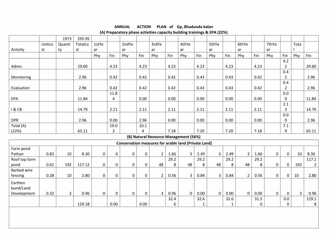
ANNUAL ACTION PLAN of Gp, Bhadunda kalan
(A) Preparatory phase activities capacity building trainings & EPA (22%)
1973 295.95
Activity Unitcost
Quantity
Totalcost
1stYear
2ndYear
3rdYear
4thYear
5thYear
6thYear
7thYear
Total
Phy Fin Phy Fin Phy Fin Phy Fin Phy Fin Phy Fin Phy Fin Phy Fin
Admn. 29.60 4.23 4.23 4.23 4.23 4.23 4.23 4.22 29.60
Monitoring 2.96 0.42 0.42 0.42 0.43 0.43 0.42 0.42 2.96
Evaluation 2.96 0.42 0.42 0.42 0.43 0.43 0.42 0.42 2.96
EPA 11.84 11.8
4 0.00 0.00 0.00 0.00 0.00 0.00 11.84
I & CB 14.79 2.11 2.11 2.11 2.11 2.11 2.11 2.13 14.79
DPR 2.96 0.00 2.96 0.00 0.00 0.00 0.00 0.00 2.96
Total (A) (22%) 65.11
19.02
10.14 7.18 7.20 7.20 7.18
7.19 65.11
(B) Natural Resource Management (56%)
Conservation measures for arable land (Private Land)
Farm pond Pythan 0.83 10 8.30 0 0 0 0 2 1.66 3 2.49 3 2.49 2 1.66 0 0 10 8.30
Roof top farm pond 0.61 192 117.12 0 0 0 0 48
29.28 48
29.28 48
29.28 48
29.28 0 0 192
117.12
Barbed wire fencing 0.28 10 2.80 0 0 0 0 2 0.56 3 0.84 3 0.84 2 0.56 0 0 10 2.80
Earthen bund/Land Development 0.32 3 0.96 0 0 0 0 3 0.96 0 0.00 0 0.00 0 0.00 0 0 3 0.96
129.18 0.00 0.00 32.4
6 32.6
1 32.6
1 31.5
0 0.0
0 129.1
8
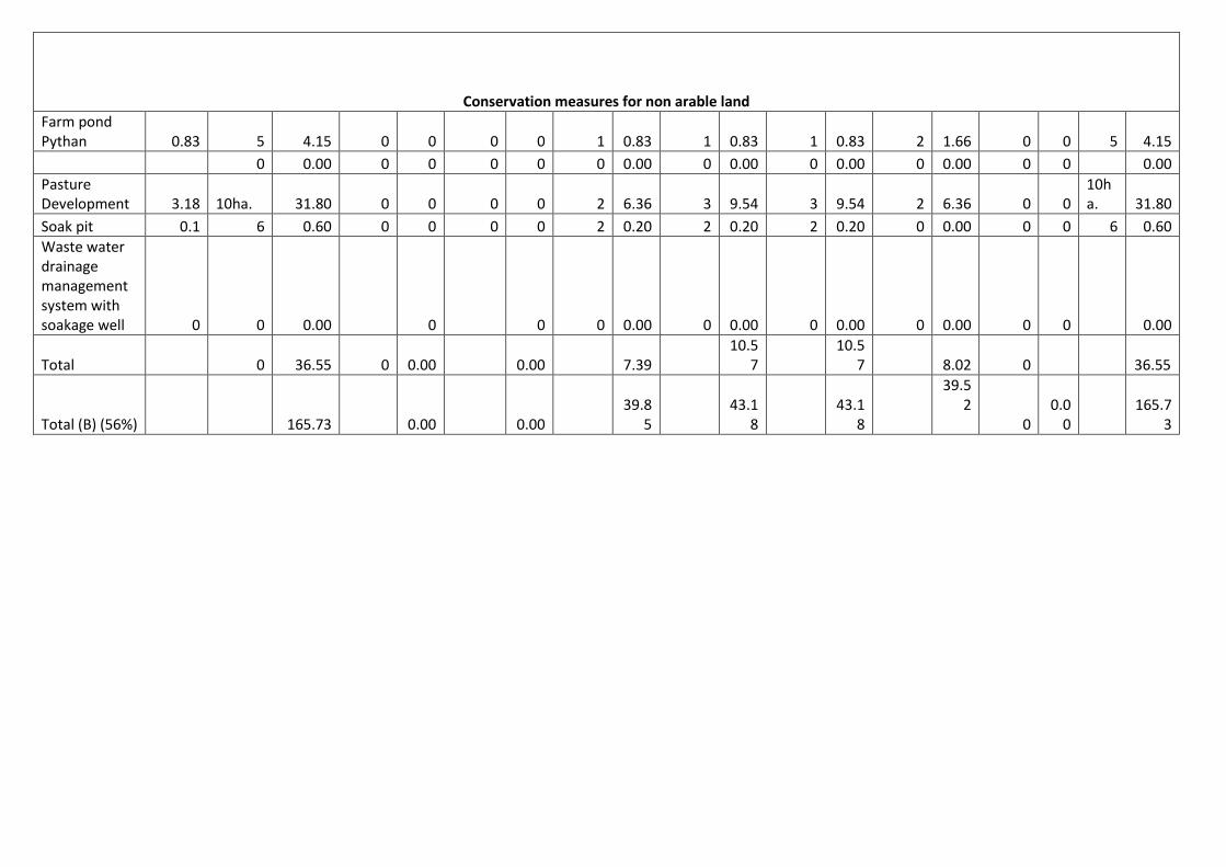
Conservation measures for non arable land
Farm pond Pythan 0.83 5 4.15 0 0 0 0 1 0.83 1 0.83 1 0.83 2 1.66 0 0 5 4.15
0 0.00 0 0 0 0 0 0.00 0 0.00 0 0.00 0 0.00 0 0 0.00
Pasture Development 3.18 10ha. 31.80 0 0 0 0 2 6.36 3 9.54 3 9.54 2 6.36 0 0
10ha. 31.80
Soak pit 0.1 6 0.60 0 0 0 0 2 0.20 2 0.20 2 0.20 0 0.00 0 0 6 0.60
Waste water drainage management system with soakage well 0 0 0.00 0 0 0 0.00 0 0.00 0 0.00 0 0.00 0 0 0.00
Total 0 36.55 0 0.00 0.00 7.39 10.5
7 10.5
7 8.02 0 36.55
Total (B) (56%) 165.73 0.00 0.00 39.8
5 43.1
8 43.1
8
39.52
0 0.0
0 165.7
3

(C) Production System and Micro Enterprise (19%)
Production measures for arable land
Horticulture Plantation
0.00097 4000 3.88 0 0 0 0 1000 0.97 1000 0.97 1000 0.97 1000 0.97 0 0
4000 3.88
Subji mini kit 0.005 150 0.75 0 0 0 0 40 0.20 40 0.20 40 0.20 30 0.15 0 0 150 0.75
Animal camp 0.15 8 1.20 0 0 0 0 2 0.30 2 0.30 2 0.30 2 0.30 0 0 8 1.20
Distri. of Goat & Ram 0.1 2 0.20 0 0 0 0 1 0.10 0 0.00 1 0.10 0 0.00 0 0 2 0.20
Distri. of manger 0.01 217 2.17 0 0 0 0 50 0.50 50 0.50 50 0.50 67 0.67 0 0 219 2.17
Distri. of chaufcuter 0.03 380 11.40 0 0 0 0 95 2.85 95 2.85 95 2.85 95 2.85 0 0 380 11.40
Crop Demostration 0.01 1000 10.00 0 0 0 0 250 2.50 250 2.50 250 2.50 250 2.50 0 0
1000 10.00
Total (C) (10%) 29.60 0.00 0.00 7.42 7.32 7.42 7.44 0.00
0.00 29.60
D Livelyhood (9%) 26.64 0.00 0.00 0.00 0.00 0.00 6.66 6.66 6.66 6.66 26.64
(E) Consolidation (3%) 8.87 0 0 0 0 0 0.00 0 0.00 0 0.00 0 0
0.00 8.87
Grand Total 295.95 19.0
2 10.1
4 0.00 61.1
1 64.3
6 64.4
6 60.8
0 0.00 7.1
9 295.9
5
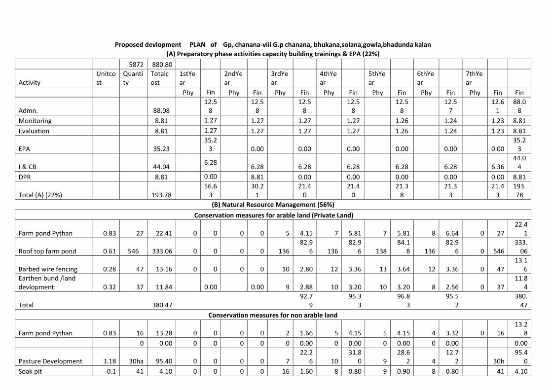
Proposed devlopment PLAN of Gp, chanana-viii G.p chanana, bhukana,solana,gowla,bhadunda kalan
(A) Preparatory phase activities capacity building trainings & EPA (22%)
5872 880.80
Activity Unitcost
Quantity
Totalcost
1stYear
2ndYear
3rdYear
4thYear
5thYear
6thYear
7thYear
Phy Fin Phy Fin Phy Fin Phy Fin Phy Fin Phy Fin Phy Fin Fin
Admn. 88.08 12.5
8 12.5
8 12.5
8 12.5
8 12.5
8 12.5
7 12.6
1 88.0
8
Monitoring 8.81 1.27 1.27 1.27 1.27 1.26 1.24 1.23 8.81
Evaluation 8.81 1.27 1.27 1.27 1.27 1.26 1.24 1.23 8.81
EPA 35.23 35.2
3 0.00 0.00 0.00 0.00 0.00 0.00 35.2
3
I & CB 44.04 6.28
6.28 6.28 6.28 6.28 6.28 6.36 44.0
4
DPR 8.81 0.00 8.81 0.00 0.00 0.00 0.00 0.00 8.81
Total (A) (22%) 193.78 56.6
3 30.2
1 21.4
0 21.4
0 21.3
8 21.3
3 21.4
3 193.78
(B) Natural Resource Management (56%)
Conservation measures for arable land (Private Land)
Farm pond Pythan 0.83 27 22.41 0 0 0 0 5 4.15 7 5.81 7 5.81 8 6.64 0 27 22.4
1
Roof top farm pond 0.61
546 333.06 0 0 0 0 136 82.9
6 136 82.9
6 138 84.1
8 136 82.9
6 0 546 333.
06
Barbed wire fencing 0.28 47 13.16 0 0 0 0 10 2.80 12 3.36 13 3.64 12 3.36 0 47 13.1
6
Earthen bund /land devlopment 0.32 37 11.84 0.00 0.00 9 2.88 10 3.20 10 3.20 8 2.56 0 37
11.84
Total 380.47 92.7
9 95.3
3 96.8
3 95.5
2 380.
47
Conservation measures for non arable land
Farm pond Pythan 0.83 16 13.28 0 0 0 0 2 1.66 5 4.15 5 4.15 4 3.32 0 16 13.2
8
0 0.00 0 0 0 0 0 0.00 0 0.00 0 0.00 0 0.00 0.00
Pasture Development 3.18 30ha 95.40 0 0 0 0 7 22.2
6 10 31.8
0 9 28.6
2 4 12.7
2 30h 95.4
0
Soak pit 0.1 41 4.10 0 0 0 0 16 1.60 8 0.80 9 0.90 8 0.80 41 4.10

Waste water drainage management system with soakage well 0 0 0.00 0 0 0 0.00 0 0.00 0 0.00 0 0.00 0 0.00
Total 0 112.78 0 0.00 0.00 25.5
2 36.7
5 33.6
7 16.8
4 112.
78
Total (B) (56%) 493.25 0.00 0.00 118.
31 132.
08 130.
50 112.
36 493.
25
(C) Production System and Micro Enterprise (19%)
Production measures for arable land
Horticulture Plantation 0.000
97 14067 13.64 0 0 0 0 3542 3.43 3442 3.34 3292 3.19 3791 3.68 0 0 13.6
4
Subji mini kit 0.005 469 2.35 0 0 0 0 140 0.70 138 0.69 126 0.63 65 0.33 0 0 2.35
Animal camp 0.15 40 6.00 0 0 0 0 10 1.50 10 1.50 10 1.50 10 1.50 0 0 6.00
Distri. of Goat & Ram 0.1 6 0.60 0 0 0 0 1 0.10 4 0.40 1 0.10 0 0.00 0 0 0.60
Distri. of manger 0.01 633 6.33 0 0 0 0 155 1.55 155 1.55 155 1.55 168 1.68 0 0 6.33
Distri. of chaufcuter 0.03 958 28.74 0 0 0 0 242 7.26 242 7.26 241 7.23 233 6.99 0 0 28.7
4
Crop Demostration 0.01 3042 30.42 0 0 0 0 760 7.60 760 7.60 760 7.60 762 7.62 30.4
2
Total (C) (10%) 88.08 0.00 0.00 0.00 22.1
4 22.3
4 21.8
0 21.8
0 80.0
8
Livelyhood(d)9% 79.27 19.8
2 19.8
1 19.8
1 19.8
3 79.2
7
(a) Revo. Fund to SHG 60% 47.56 0 0 0 0 0
11.89
11.89
11.89
11.89
47.56
(b) Revo. Fund to Ent. Indi.10% 7.93 0 0 0 0 0 1.98 1.98 1.98 1.99
7.93
(c) Grant in aid to SHG Fed. 30% 23.78 0 0 0 0 0 5.95 5.95 5.95 5.93
23.78
(E) Consolidation (3%) 26.41 0 0 0 0 0 0.00 0 0.00 0 0.00 0 0.00 0 0.00 26.4
1
Grand Total 880.80 56.6
3 30.2
1 0.00 181.
67 0.00 195.
63 0.00 193.
49 0.00 175.
32 21.4
3 880.
80


CHAPTER – VI EXPECTED OUTCOMES
1 2 3 4 5 6
S. No. Item Unit of measurement
Pre-project Status
Expected Post-project
Status Remarks
1 Status of water table (Depth to Ground water level) Meters 58 56 2 Ground water structures repaired/ rejuvenated No. 0 0 3 Quality of drinking water Description Brakish Potable 4 Availability of drinking water Description 11 Months 12 Months 5 Change in irrigated Area Ha 3716 3889 6 Change in cropping/ land use pattern Description Traditional Scientific 7 Area under agricultural crop Ha 4790.10 4805.48 I Area under single
crop Ha 2304 1885
Ii Area under double crop
Ha 2010.29 2320.48
Iii Area under multiple crop
Ha 475.81 600
8 Change in cultivated Area Ha 4790.10 4805.48 9 yield of major crops of area
Yield of Bajra q/ha 7.41 8.65 Yield of Wheat q/ha 28.35 30.80 Yield of Gram q/ha 9.37 10.20 Yield of Mustard q/ha 15.20 16.00
10 production of major crops of area
Production of Bajra ton 1700 1984 Production of Wheat ton 3742 4066 Production of Gram ton 751 817 Production of Mustard ton 1867 1965
11 Area under vegetation Ha 173 237 12 Area under horticulture Ha 4 20 13 Area under fuel Ha 82 120 14 Area under Fodder Ha 3460 4285 15 Fodder production Q/year 19392 26441.48 16 Milk production Litres/day 28059 34195 17 SHGs Active No. 18 No. of livelihoods No. 19 Income Rs.in la 20 Migration No. 819 671 21 SHG Federations formed No. 0 01
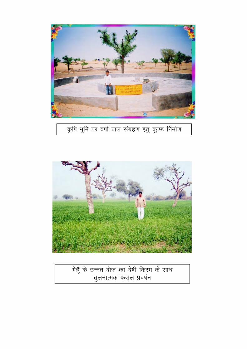
Ñf"k Hkwfe ij o"kkZ ty laxzg.k gsrq dq.M fuekZ.k
xsgw¡ ds mUur cht dk ns’kh fdLe ds lkFk
rqyukRed Qly izn’kZu

fVCck fLFkjhdj.k o`{kkjksi.k
'kSYVj cSYV o`{kkjksi.k
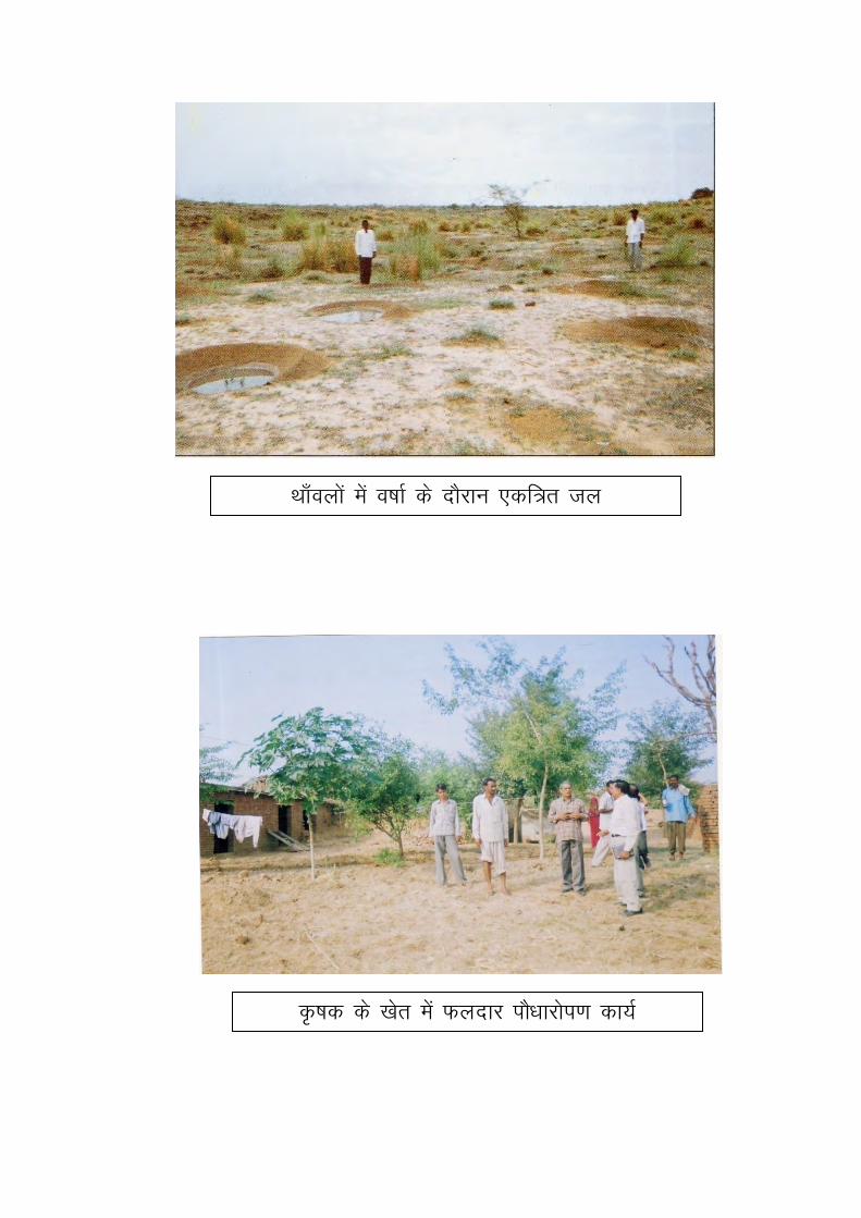
Fkk¡oyksa esa o"kkZ ds nkSjku ,df=r ty
Ñ"kd ds [ksr esa Qynkj ikS/kkjksi.k dk;Z

Critical Assumption
No severe droughts/ unexpected floods/ natural disasters
Adequate funds are allocated for the same and released on time.
There is no significant pest/ disease attack, and if so, then it will have been contained
before irreversible damage is done.
Adverse market conditions do not persist long.
Sound macro-economic and growth conditions continue and the benefits are widely
distributed particularly in the rural areas.
Facilitating agencies and resource providers have the required competent staff so that
timely and appropriate technical advice and services are provided to farmers whenever
required.
The Capacity Building Plan is implemented, monitored and modified to address evolving
needs and feedback from participants.
The execution of the Women’s Empowerment Pedagogy is regularly monitored by the
District and State level Implementing Agencies
Means of Verification of indicators
Baseline surveys like household income ,expenditure, health and nutrition etc at the
beginning, mid-term and end of the project period
Annual participatory assessment by communities during project period.
Regular project monitoring reports prepared by project monitoring teams/ agencies.
Membership and other Records, Minutes of Meetings maintained by the SHGs, WCs/
Individual beneficiaries/project-related village and local bodies/PRIs.
External review missions
Data maintained by Government department (Revenue, Agriculture, Groundwater,
Irrigation, Animal Husbandry

CHAPTER VII TECHNICAL DESIGNS AND ESTIMATES
Technical designs and estimates for proposed activities. For Estimates GKN of the district jhunjhunu is used. For Production System activities, rates
of Agriculture/Horticulture/Animal Husbandry is used.
CHAPTER - VIII Enclosures -
h. Location –District, block, village, watershed location map
i. Map of Jakhod IWMP Project (Watershed Boundary demarcation in cadastral
& Topo Sheet)
j. PRA Map (along with photos & paper drawing)
k. Treatment map (Indicate proposed works)
l. Cadastral Map on watershed boundary
m. Information on Soils, Soil fertility, Land capability, Soil chemical problems like
salinity, alkalinity
n. Land Use Land Cover map
o. Information on existing water harvesting structures & well inventory along with
GPS co-ordinates.
p. High resolution, latest Remote Sensing Satellite data
Documents of Agreements: Proceedings of gram sabha for EPA approval
Proceedings of gram sabha Resolution for committee constitution
Proceedings of gram sabha for DPR approval
DPR approval by district
Watershed Committee Registration certificate
MoU – PIA – DWMA, PIA – WC(in case of NGO as PIA)

H. Location –District, block, village, watershed location map

i.
Model estimate
Name of Plant Horticulture plant
Cost per plant
S.No Discription Total
Qty Unit Rate Amount
Year No./Year
1 Diging of pit (0.90*0.90*0.90) 1 1 0.73 cum 77.00 56.21
2 Apply of manure (A) Compost Khad kg. 5.00 0.4 2.00 (B) S.S.P. (16%) kg. 1.00 5 5.00
(C) Endosulphan (4%) kg. 0.10 30 3.00
3 Applying pestiside for plant treatment 3 2 6 nos 1.00 6.00
4 Plant cost with transportation & loading-unloading 1 1 1 nos 30.00 30.00
5 Planting tree 1 1 1 nos 3.20 3.20
6 Making semi circular thawala 1 1 1 nos 1.9 1.90
7 Repair of semi circular thawala 3 1 3 nos 0.65 1.95
8 watering of plant (15
Ltr) 3 6 18 nos 1.9 34.20 9 Weeding & hoeing 3 2 6 nos 1.3 7.80
10 Protection of plants from frost using pula or other locally available material (including collection of material and local carrige ) 3 1 3 nos 3.5 10.50
TOTAL 161.76 Say 162.00 Cost Share From Project 97.00 From Cultivator 32.40
Note :- Farmer will be traind for Agroforestory palntation in Treaning programme be conducted by watershed (PIA) Farmer will ensured for Watch and Ward by himself

3.5 3.2 8.5 0.45 0.45
p/4(3.80)2X1.50=17.012
17.012 77.00 77.00 1309.91 1309.91
p/4(3.80)2X1.50=17.012 17.012 101.00 101.00 1718.19 1718.19
p /4[(3.80)2 X 0.30 = 3.402 3.402 285.00 2430.00 969.67 8267.72
p /4X{(3.50)2 - ((3.04)2} X 3.20 =7.56 7.56
p /4X{(8.50)2 - ((3.50)2} X0.075 = 3.53 3.53
p X 8.73 X 0.23 X 0.45 = 2.84 2.84
13.93 444.00 2894.00 6186.63 40324.59
2X3.40X0.30 = 2.04 2.04 199.00 676.00 405.96 1379.04
p / 4 (3.50)2 = 9.62 9.62
1 X 0.45 X 0.45 = (-) 0.20 0.20
9.42 456.00 1579.00 4294.90 14872.05

p X 3.04 X 3.20 = 30.56 30.56
p / 4 (3.04)2 = 7.26 7.26
37.82 51.00 123.00 1928.81 4651.84
p X 3.50X0.45 = 4.95 4.95
p / 4 X {(8.50)2 - (3.50)2 }= 47.12 47.12
X . X . = . 18.65
70.72 51.00 107.00 3606.81 7567.23
1 1000.00 1000.00
20420.89 81090.56
2432.72
20420.89 83523.28
20000 83000.00

0.45 0.45 0.6 3.89 77.00 77.00 299.38 299.38
0.45 0.45 0.45 2.92
0.125 0.1 0.45 0.18
2.74 285.00 2430.00 779.76 6648.48
250.00 0.00 8000.00
0.00 78.00 0.00 9750.00
3.50 0.00 48.00 0.00 168.00
480.00 1.88 1.88 902.40 902.40
485.00 1.88 1.88 911.80 911.80

120.00 0.49 0.49 58.80 58.80
0.00 200.00 0.00 200.00
2952.14 26938.86
808.17
G.Total 2952.14 27747.02
Say 3000.00 28000.00

3.50 3.20 8.50 0.45 0.45
p/4(3.80)2X1.50=17.012 17.01 77.00 77.00 1309.91 1309.91
p/4(3.80)2X1.50=17.01217.01
101.00 101.00 1718.19 1718.19
p /4[(3.80)2 X 0.30 = 3.402 3.40 285.00 2430.00 969.67 8267.72
p /4X{(3.50)2 - ((3.04)2} X 3.20 7.56
p /4X{(4.20)2 - ((3.50)2} X0.10 0.42
7.98 444.00 2894.00 3545.02 23106.51
2.04 199.00 676.00 405.96 1379.04
p X 4 (3.50)2 9.62
1 X 0.45 X 0.45 = 0.20
9.42 456.00 1579.00 4294.90 14872.05
p X 3.04 X 3.20 = 30.56 30.56
p / 4 (3.04)2 = 7.26 7.26
37.82 51.00 123.00 1928.81 4651.84
p X 3.50X0.45 = 4.94 4.95
p / 4 X (4.20)2 - (3.50) = . 4.23
9.18 51.00 107.00 468.25 982.40

S.I. Mar
15.00
0.00 125.00 0.00 1875.00
1.5/' x 1.5'
0.00 800.00 200.00 800.00
1.00 700.00 700.00
14840.71 59662.65
1789.88
14840.71 61452.53
61000.00
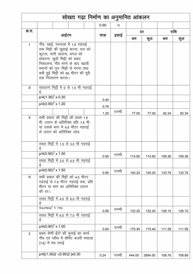
lks[rk x<+k fuekZ.k dk vuqekfur vkadyu
0.90 16
Ø-l-
vkbZVe ek=k bdkbZ nj jkf'k
Je dqy Je dqy
1 uhao] [kkbZ] ijukyk esa 1-5 xgjkbZ
rd feêh dh [kqnkbZ djuk] ry dks
dwVuk] ikuh Mkyuk] cxy dks
laokjuk] [kqnh feêh dks ckgj
fudkyuk] uhao Hkjus ds ckn [kkyh
LFkkuksa dks iqu% feêh ls Hkjuk rFkk
cph gqbZ feêh dks 50 ehVj dh nwjh
rd fuLrkj.k djukA
v lk/kkj.k feêh esa 0 ls 1-5 eh xgjkbZ
esa p/4(1.36)2 x 0.30
0.44 p/4(0.90)2 x 1.20
0.76
1.20 ?kueh- 77.00 77.00 92.34 92.34 c lHkh izdkj dh feêh dh izFke 1-5
eh- mBku ds vfrfjDr izfr 1-5 eh-
;k mlds Hkkx es 4-5 ehVj xgjkbZ
ls mBku dks vfrfjDr tksM+
l[r feêh esa 1-5 ls 3-0 eh xgjkbZ
esa
p/4(0.90)2 x 1.50 0.95 ?kueh- 114.60 114.60 109.36 109.36
l[r feêh esa 3-0 ls 4-5 eh xgjkbZ
esa
p/4(0.90)2 x 1.50
0.95 ?kueh- 140.20 140.20 133.79 133.79 l lHkh izdkj dh feêh dks 4-5 ehVj
xgjkbZ ls 7-5 ehVj xgjkbZ rd] izfr
ehVj ;k Hkkx dk vfrfjDr mBku
dh njA
l[r feêh esa 4-5 ls 6-0 eh xgjkbZ
esa
p/4(0.90)2 x 1.50
0.95 ?kueh- 132.20 132.20 126.15 126.15 l[r feêh esa 6-0 ls 7-0 eh xgjkbZ
esa
p/4(0.90)2 x 1.00
0.64 ?kueh- 175.40 175.40 111.58 111.58 2 izFke Js.kh baZVks dh pqukbZ dk dk;Z
uhao ,oa IyhaFk esa lhesaV ctjh elkyk
¼1%6½ esa e; rjkbZ
p/4[(1.36)2 -(0.90)2 ]x0.30 0.24 ?kueh- 444.00 2894.00 108.76 708.89

3 fizdkLV lhesaV dadzhV (1%1-5%3) fjax 3 fQV O;kl ] 1-25
fQV mapkbZ
16 ux 350.00 0.00 5600.00 4 fizdkLV lhesaV dadzhV (1%1-
5%3) fjax 3 fQV O;kl ] 1-25
fQV mapkbZ dks dqbZ esa Mkyus dk
dk;Z
16 ux 30.00 30.00 480.00 480.00 5 iRFkj dh gkFk ls VwVh gqbZ 90&45
feeh fxVh dh vkiwfÙkZ djuk leLr
mBku ds lkFk 20 fdeh nwjh ls
ifjogu dk [kpkZ lfgrA
p/4(0.90)2 x 0.60 0.38 ?kueh- 650.00 0.00 248.11
20 fdeh ls vf/kd nwjh p/4(0.90)2 x 0.60
0.38 ?kueh- 0.00 0.00 0.00
6 ihohlh ikbZi ,oa cS.M dh vkiwfrZ
dj LFkkuh; ekax vuqlkj yxkus dk
dk;Z
1 yxHkx 100.00 0.00 100.00
7 dV LVksu iV~Vh dh Nr e; [kjatk
Nr ij 50 feeh eksVkbZ esa lhesaV
dadjhV dk;Z ¼1%2%4½ ,oa rjkbZ lfgr
iw.kZ dk;Z
1.2 *1.2 1.44 ?kueh- 355.00 1321.00 511.20 1902.24
8 lhesaV IykLVj ¼12 ,e,e 1 % 6½ esa
p/4(1.36)2 = 1.45 sqm. px1.36 x0.30= 1.28 sqm. . = 2.73
2.73
oxZ
ehVj
51.00 85.00 139.23 232.05
9 vU; dk;Z tSls tkyh]cksMZ]QksVksxzkQh
vkfn 1
yxHkx 200.00 0.00 200.00
G.Total 1812.41 10044.51
Say 1800.00 10000.00

Estimate
0.40 0.40 200.00 200.00
6.60 6.60 3300.00 3300.00
5.00 0.00 300.00 0.00 1500.00
0.00 15.00 0.00 8250.00
3.20 3.20 1600.00 1600.00
1.90 1.90 950.00 950.00
1.90 1.90 950.00 950.00
1.90 1.90 8550.00 8550.00
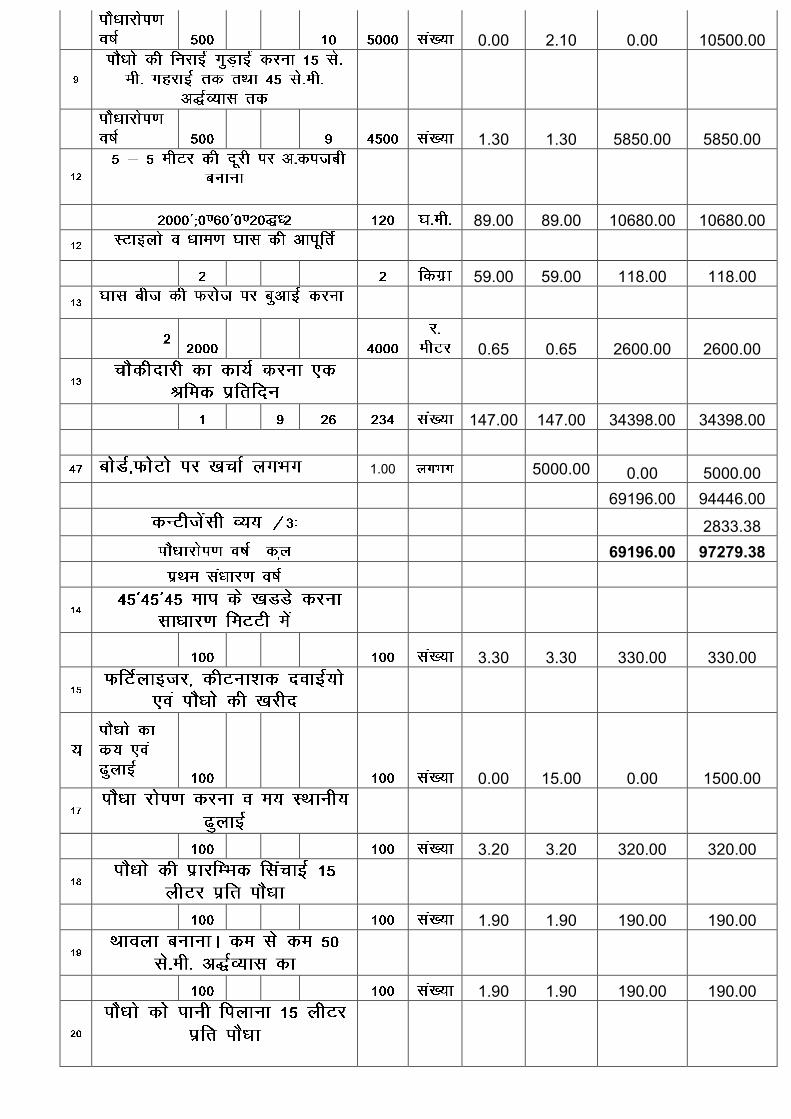
0.00 2.10 0.00 10500.00
1.30 1.30 5850.00 5850.00
89.00 89.00 10680.00 10680.00
59.00 59.00 118.00 118.00
0.65 0.65 2600.00 2600.00
147.00 147.00 34398.00 34398.00
1.00 5000.00 0.00 5000.00
69196.00 94446.00
2833.38 69196.00 97279.38
3.30 3.30 330.00 330.00
0.00 15.00 0.00 1500.00
3.20 3.20 320.00 320.00
1.90 1.90 190.00 190.00
1.90 1.90 190.00 190.00

1.90 1.90 7600.00 7600.00
0.00 2.10 0.00 8400.00
1.30 1.30 5200.00 5200.00
5.00 0.00 300.00 0.00 1500.00
147.00 147.00 45864.00 45864.00
59694.00 71094.00
0.00 2132.82 59694.00 73226.82
1.90 1.90 5700.00 5700.00
0.00 2.10 0.00 6300.00
1.30 1.30 3900.00 3900.00
3.00 0.00 300.00 0.00 900.00
Total 147.00 147.00 45864.00 45864.00
55464.00 62664.00

0.00 1879.92
55464.00 64543.92
184354.00 235050.12
Fencing work 8000.00 83000.00
192354.00 318050.12
192000.00 318000.00

3.5 8.5 0.45
p/4(2.26)2X1.50=6.026.020 77.00 463.54
p/4(2.26)2X1.20=4.81 0.00
p/4(2.05)2X27.30=90.14
94.950 209.00 19844.55
p /4X(2.26)2 - (1.80)2 X 0.30 = 0.44 cum
p /4X(2.26)2 - (1.80)2 X 2.70 = 3.96 cum
p /4X(2.05)2 - (1.80)2 X 1.80 = 1.36 cum
. = 5.76 cum 5.760 3727.00 21467.52
p /4X(2.05)2 - (1.80)2 X 25.50 = 19.28 cum
19.280 4107.00 79182.96
4-75x80
L.S. 3000.00

p / 4 (2.26)2 = 4.01 4.01
1 X 0.60 X 0.60 = (-) 0.360.36
3.65 1579.00 5763.35
L.S. 1500.00
2.5 650.00 1625.00
2' x 2' ) 18 73.00 1314.00
L.S. 500.00
134660.92
135000.00


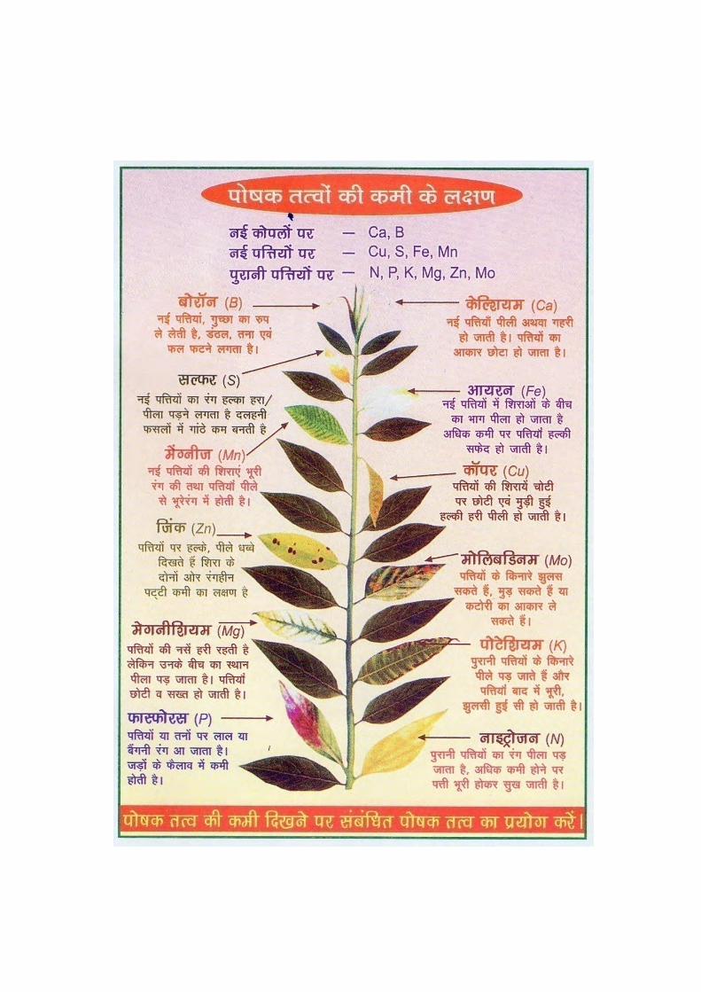
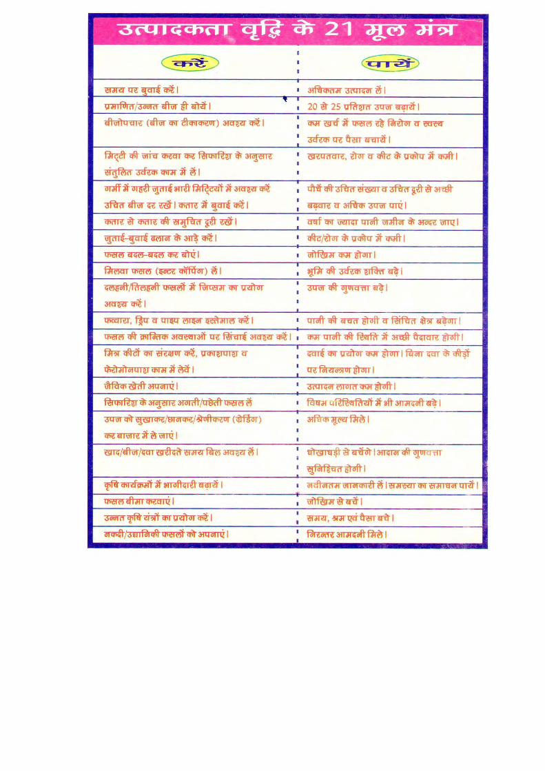
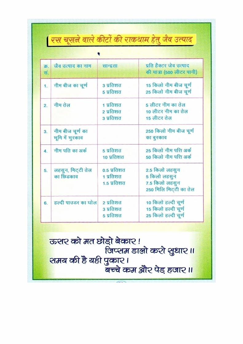


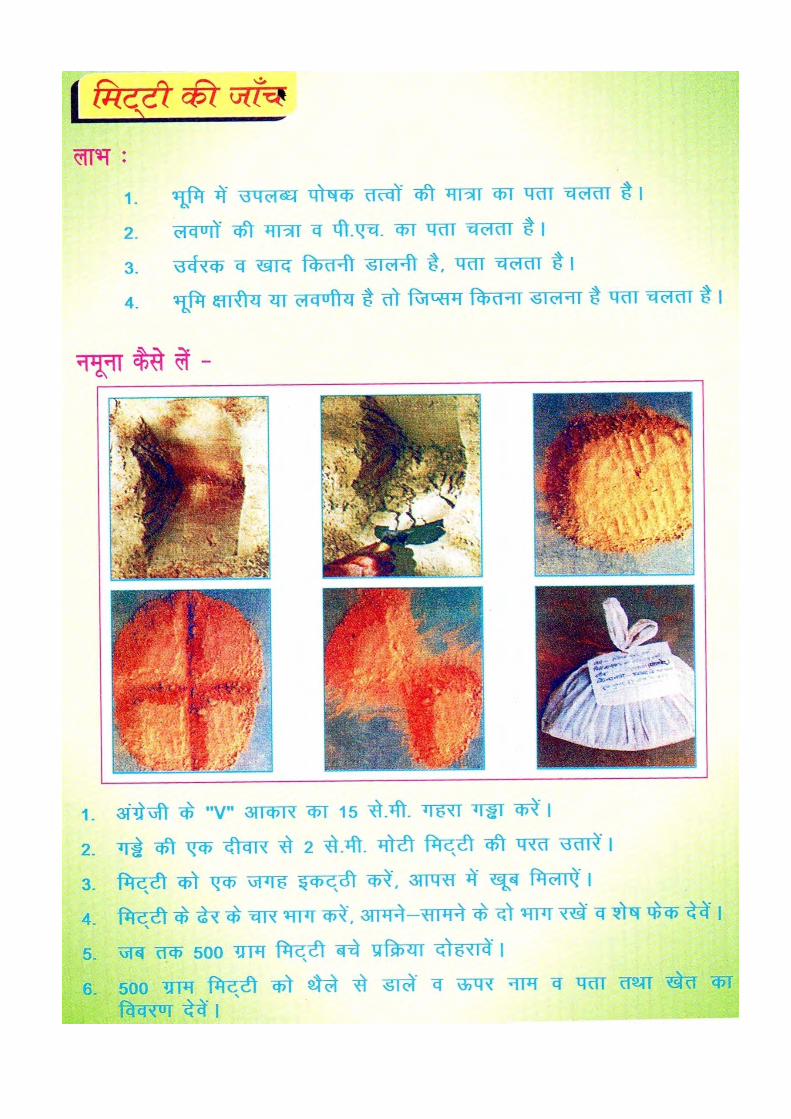
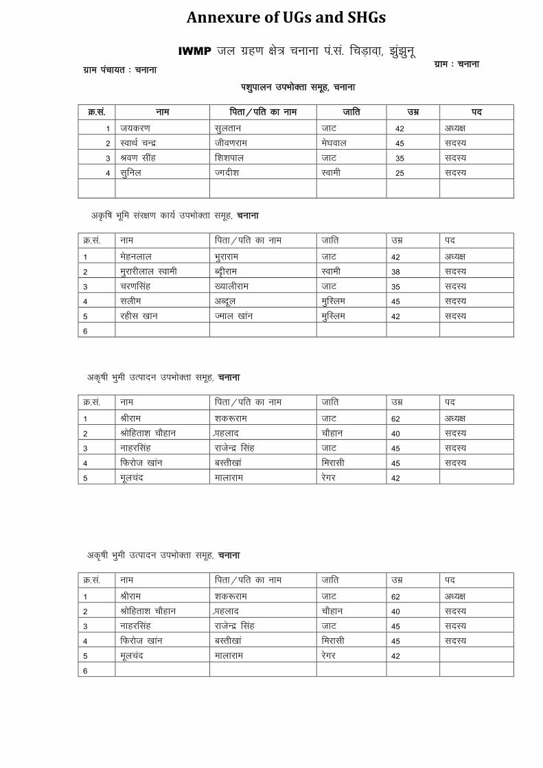
Annexure of UGs and SHGs
IWMP ty xzg.k {ks= pukuk ia-la- fpM+kok+] >qa>quw xzke iapk;r % pukuk
xzke % pukuk
Ik'kqikyu miHkksDrk lewg] pukuk
Ø-la- uke firk@ifr dk uke tkfr mez in
1 t;dj.k lqYkrku tkV 42 v/;{k
2 LokFkZ pUnz tho.kjke es?koky 45 lnL;
3 Jo.k lhag f'k”kiky tkV 35 lnL;
4 lqfuy Txnh'k Lokeh 25 lnL;
vÑf"k Hkwfe laj{k.k dk;Z miHkksDrk lewg] pukuk
Ø-la- uke firk@ifr dk uke tkfr mez in
1 Eksguyky Hkqjkjke tkV 42 v/;{k
2 eqjkjhyky Lokeh Cn`hjke Lokeh 38 lnL;
3 pj.kflag [;kyhjke tkV 35 lnL;
4 lyhe vCnwy eqfLye 45 lnL;
5 jghl [kku Teky [kkau eqfLye 42 lnL;
6
vd`"kh Hkqeh mRiknu miHkksDrk lewg] pukuk
Ø-la- uke firk@ifr dk uke tkfr mez in
1 Jhjke 'kd:jke tkV 62 v/;{k
2 Jksfgrk”k pkSgku Izkgykn pkSgku 40 lnL;
3 Ukkgjflag jktsUnz flag tkV 45 lnL;
4 fQjkst [kkau cLrh[kka fejklh 45 lnL;
5 ewypan ekykjke jsxj 42
vd`"kh Hkqeh mRiknu miHkksDrk lewg] pukuk
Ø-la- uke firk@ifr dk uke tkfr mez in
1 Jhjke 'kd:jke tkV 62 v/;{k
2 Jksfgrk”k pkSgku Izkgykn pkSgku 40 lnL;
3 Ukkgjflag jktsUnz flag tkV 45 lnL;
4 fQjkst [kkau cLrh[kka fejklh 45 lnL;
5 ewypan ekykjke jsxj 42
6

Hkwfeghu miHkksDrk lewg] pukuk
Ø-la- uke firk@ifr dk uke tkfr mez in
1 lTtu yky Enuyky Ukk;d 45 v/;{k
2 Galjkt “;ksizlkn HkkxZo 42 lnL;
3 vykj [kka gqlSu [kka yhyxj 50 lnL;
4 ewwerkt xQqj [kka e.kh;kj 45 lnL;
5 tkQj [kka futkewfnu dkft 41 lnL;
Tk; dj.kh ekrk Lo;a lgk;rk leqg pukuk
Ø-la- uke firk@ifr dk uke tkfr mez in
1 ehuw doaj fodze flag pkSgku 36 v/;{k
2 jktdoaj Leqnzflag pkSgku 40 lfpo
3 :dlkuk lQh eksgEen pksinkj 40 lnL;
4 euHkjh X;kjlhyky ukbZ 45 lnL;
5 ehuk nsoh e[kuyky dqekor 30 lnL;
6 clUrh nsoh Euksgjyky Dqekor 48 lnL;
7 eatw nsoh 'kadjyky ukbZ 28 lnL;
8 eseqnk vykfnu Dqjs'kh 48 lnL;
9 ique lqjsUnz uk;d 25 lnL;
10 izse doaj f'k'kikyflag pkSgku 50 lnL;
xtkuan Lo;a lgk;rk lewg pukuk
Ø-la- uke firk@ifr dk uke tkfr mez in
1 izse nsoh txfn'k jsxj 36 v/;{k
2 X;kjlh Fcyqjke jsxj 29 lfpo
3 lEir lqjsUnz dqekj jsxj 29 lnL;
4 lUrks"k iq:'kksre nthZ 43 lnL;
5 lehe guhQ Dkth 42 lnL;
6 foeyk Ekrqjke jsxj 38 lnL;
7 lko=h x.ks'kkjke jsxj 40 lnL;
8 NksVh egkohj jsxj 34 lnL;
9 :dek f'koukjk;.k jsxj 45 lnL;
10 jtw dq'ksn dkth 30 lnL;
ljlorh Lo;a lgk;rk lewg pukuk
Ø-la- uke firk@ifr dk uke tkfr mez in
1 rhtk HkkxhjFk jsxj 30 v/;{k
2 izse lhrkjke jsxj 30 lfpo
3 ljkst jktdqekj jsxj 33 lnL;
4 fo|k eaxykjke jsxj 45 lnL;
5 xhrk jk/ks”;ke jsxj 25 lnL;
6 laxhrk f'kon;ky jsxj 25 lnL;
7 xqMh jkeqrkj jsxj 39 lnL;
8 dkS”y;k fot; dqekj jsxj 45 lnL;
9 Qqyh js[kkjke jsxj 45 lnL;
10 'kkarh uFkqjke jsxj 42 lnL;

lk{kh Lo;a lgk;rk lewg] Hkqdkuk
Ø-la- uke firk@ifr dk uke tkfr mez in
1 ds'kj ekaxqyky eh.kk 33 v/;{k
2 larks"k vuwi 'kekZ 27 lfpo
3 dkS'y;k iz'kksre 'kekZ 47 lnL;
4 lUrks"k oklqnso 'kekZ 40 lnL;
5 eatw egs'k 'kekZ 38 lnL;
6 xhrk lUrks"k 'kekZ 40 lnL;
7 cukjlh cuokjhyky ukbZ 50 lnL;
8 chjek egkohj eh.kk 38 lnL;
9 lqeu jkds'k eh.kk 21 lnL;
10 lqfe=k gksf'k;kjflag ukbZ 35 lnL;
11 flykspuk uanyky 'kekZ 40
ckny Lo;a lgk;rk leqg Hkqdkuk
Ø-la- uke firk@ifr dk uke tkfr mez in
1 iwtk fotsUnz 'kekZ 28 v/;{k
2 lqfe=k gksf'k;kjflag ukbZ 35 lfpo
3 iwue eukst 'kekZ 26 lnL;
4 eatw jkst'k 'kekZ 26 lnL;
5 vaiw.kkZ fnus'k 'kekZ 35 lnL;
6 lqfurk dj.kflag dqekor 30 lnL;
7 /kekZ vejflag tkV 35 lnL;
8 vfurk ckcqyky 'kekZ 30 lnL;
9 fdj.k izeksn 'kekZ 28 lnL;
10 flykspuk fouksn 'kekZ 30 lnL;
11 vkpqdh xqykc egktu 50 lnL;
vkjrhk Lo;a lgk;rk leqg Hkqdkuk
Ø-la- uke firk@ifr dk uke tkfr mez in
1 yhyk jksfgrk'k es?koky 30 v/;{k
2 ljkst lqHkk’k es?koky 25 lfpo
3 ds'kjh tqxyky es?koky 45 lnL;
4 euh jkes'oj es?koky 50 lnL;
5 jkorh jktsUnz es?koky 21 lnL;
6 xhrk /keZiky es?koky 40 lnL;
7 d`".kk gksf'k;kjflag es?koky 25 lnL;
8 [ktkuh gksf'k;kjflag es?koky 28 lnL;
9 pqdh j/kqohj es?koky 20 lnL;
10 lko=h Nyqjke es?koky 35 lnL;

Ñf"k Hkwfe laj{k.k dk;Z miHkksDrk lewg] Hkqdkuk
Ø-la- uke firk dk uke tkfr mez in
1 tqxyky tkafxM+ fgjkjke [kkrh 45 v/;{k
2 uanyky y{ehukjk;.k 'kekZ 48 lnL;
3 gksf'k;kjflag jkes'ojyky es?koky 44 lnL;
4 lqjsUnz ';ksnku tkV 35 lnL;
5 cls'lj yky ctjaxyky tkV 49 lnL;
vÑf"k Hkwfe laj{k.k dk;Z miHkksDrk lewg] Hkqdkuk
Ø-la- uke firk dk uke tkfr mez in
1 egkohj lkoajjke tkV 55 v/;{k
2 fo|k/kj lkoajjke tkV 52 lnL;
3 nyhi xtkuan 'kekZ 46 lnL;
4 'ksjlhag Ukjk;.kkjke es?koky 50 lnL;
5 cyohj Jhjke tkV 35 lnL;
i'kqikyu miHkksxrk leqg Hkqdkuk
Ø-la- uke firk@ifr dk uke tkfr mez in
1 jkts'k teukjke tkV 35 v/;{k
2 lqfuy egkohj tkV 25 lnL;
3 ekaxsjke cLrhjke es?koky 44 lnL;
4 panxhjke cqtkjke es?koky 56 lnL;
5 yhyk/kj guqekukjke lksuh 42 lnL;
6
Hkwfeghu miHkksDrk leqg Hkqdkuk
Ø-la- uke firk@ifr dk uke tkfr mez in
1 yhyk/kj guqeku lksuh 45 v/;{k
2 jktsUnz ?kM+lhjke ukbZ 42 lnL;
3 foeyk lqHkk"k es?koky 35 lnL;
4 d`".kk gksf'k;kjflag es?koky 37 lnL;
5 txnh'k izlkn ewypan lksuh 42 lnL;
xzke yksnhiqjk ds df̀"k Hkqfe miHkksDrk lewg
Ø-la- uke firk@ifr dk uke tkfr mez in
1 /keZiky ';ksnku tkV 45 v/;{k
2 efgiky uanyky 'kekZ 46 lnL;
3 gtkjhyky Qqypan 'kekZ 42 lnL;
4 cgknqjey eksrhjke es?koky 41 lnL;
5 egsUnz ';kspj.k tkV 43 lnL;
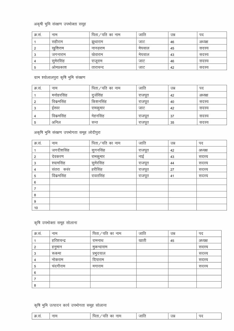
vd`"kh Hkqfe laj{k.k miHkksDrk lewg
Ø-la- uke firk@ifr dk uke tkfr mez in
1 lghjke >qFkkjke tkV 46 v/;{k
2 [kqf'kjke ukuM+jke es?koky 45 lnL;
3 txukjke [ksokjke es?koky 43 lnL;
4 lqesjflag jktwjke tkV 46 lnL;
5 vkseizdk'k rkjkpUn tkV 42 lnL;
xzke “;ksykyiqjk d̀f"k Hkqfe laj{k.k
Ø-la- uke firk@ifr dk uke tkfr mez in
1 euksgjflag nqtZflag jktiwr 42 v/;{k
2 fodzeflag fd'kuflag jktiwr 40 lnL;
3 bZ'oj jkedqekj tkV 42 lnL;
4 fodzeflag Eksguflag jktiwr 37 lnL;
5 vfuy lUr jktiwr 35 lnL;
vd`f"k Hkqfe laj{k.k miHkksxrk lewg yksnhiqjk
Ø-la- uke firk@ifr dk uke tkfr mez in
1 txnh'kflag lqxuflag jktiwr 42 v/;{k
2 nsodj.k jkedqekj ukbZ 43 lnL;
3 ';keflag lqesajflag jktiwr 44 lnL;
4 larjk doaj gjhflag jktiwr 27 lnL;
5 foadzeflag jkorflag jktiwr 41 lnL;
6
7
8
9
10
d`f"k miHkksDrk lewg lksykuk
Ø-la- uke firk@ifr dk uke tkfr mez in
1 gfj'kpUnz jkeukFk [kkrh 45 v/;{k
2 guqeku eqdUnkjke lnL;
3 :dek izHkqn;ky lnL;
4 uksdjke fnikjke lnL;
5 panxhjke exkjke lnL;
6
7
8
d`f"k Hkqfe mRiknu dk;Z miHkksxrk lewg lksykuk
Ø-la- uke firk@ifr dk uke tkfr mez in

1 eksgjflag tokukjke tkV 55 v/;{k
2 dqYMkjke ekykjke tkV 50 lnL;
3 guqeku nksnjke tkV 45 lnL;
4 fdrkc jkeflag tkV 48 lnL;
5 lqjs'k ctjaxyky 'kekZ 40 lnL;
6 lnL;
vÑf"k Hkqfe laj{k.k miHkksxrk lewg lksykuk
Ø-la- uke firk@ifr dk uke tkfr mez in
1 eakxwjke lqyrku fe.kk 41 v/;{k
2 gksf'k;kj Hkksykjke 45 lnL;
3 uksdjke x.kirjke 43 lnL;
4 Qqypan jhNiky 46 lnL;
5 jktsUnz lkxj 29 lnL;
vÑf"k Hkwfe mRiknu miHkksxrk lewg lksykuk
Ø-la- uke firk@ifr dk uke tkfr mez in
1 jkes'oj eaxykjke pkgj tkV 45 v/;{k
2 xqykc tkfxM+ t;jke [kkrh 43 lnL;
3 osnizdk'k jhNiky ukbZ 42 lnL;
4 xhxjkt ekykjke lksuh 52 lnL;
5 cuokjh fnikjke /kkud 48 lnL;
6
i'kqikyu miHkksDrk leqg lksykuk
Ø-la- uke firk@ifr dk uke tkfr mez in
1 foeyk ewypan 36 v/;{k
2 jkes'oj rstkjke 53 lnL;
3 vejflag Lkojjke 49 lnL;
4 eksgjflag Hkksykjke 43 lnL;
5 lRohj Ekykjke 45 lnL;
12
Hkqfefgu miHkksxrk lewg lksykuk
Ø-la- uke firk@ifr dk uke tkfr mez in
1 eksguyky cqykjke lksuh 43 v/;{k
2 ujs'k lqjrkjke tkV 32 lnL;
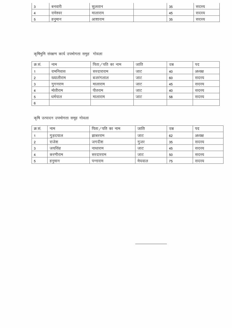
3 cuokjh lqyrku 35 lnL;
4 jkes'oj ekykjke 45 lnL;
5 guqeku vk'kkjke 35 lnL;
d`f"kHkqfe laj{k.k dk;Z miHkksxrk leqg xksoyk
Ø-la- uke firk@ifr dk uke tkfr mez in
1 jkefuokl ljnkjkjke tkV 40 v/;{k
2 [;kyhjke ctjaxyky tkV 60 lnL;
3 xqxujke ekykjke tkV 45 lnL;
4 eksrhjke ihrjke tkV 40 lnL;
5 /keZiky ekykjke tkV 58 lnL;
6
d`f"k mRiknu miHkksxrk lewg xksoyk
Ø-la- uke firk@ifr dk uke tkfr mez in
1 xqM+n;ky >kcjjke tkV 62 v/;{k
2 jkts'k txnh'k xqtj 35 lnL;
3 t;flag UkkFkkjke tkV 45 lnL;
4 dj.khjke ljnkjjke tkV 50 lnL;
5 guqeku iUukjke es?koky 75 lnL;

vd`f"k mRiknu miHkksxrk leqg xksoyk
Ø-la- uke firk@ifr dk uke tkfr mez in
1 ukxjey lkojjke es?koky 80 v/;{k
2 jke/ku ekM+jke es?koky 40 lnL;
3 egkohj fxj/kkjh dqekor 60 lnL;
4 xhrk jkefoykl 'kekZ 58 lnL;
5 euQqy ekykjke eh.kk 26 lnL;
6
vd`f"k Hkqfe laj{k.k dk;Z xksoyk
Ø-la- uke firk@ifr dk uke tkfr mez in
1 panxhjke y{ehjke tkV 60 v/;{k
2 iou dqekj lksguyky ukbZ 28 lnL;
3 jktsUnz nqxkZ lksuh 50 lnL;
4 ltuk egsUnz tkV 50 lnL;
5 lqxuh ekykjke eh.kk 70 lnL;
Hkqfefgu miHkksxrk lewg xksoyk
Ø-la- uke firk@ifr dk uke tkfr mez in
1 jkeI;kjh lqyrku es?koky 70 v/;{k
2 ujs'k cuokjhyky 'kEkkZ 26 lnL;
3 fo|k/kj ekykjke 'kekZ 52 lnL;
4 eq[kjke yknqjke es?koky 40 lnL;
5 fcgkjh xksdyjke es?koky 40 lnL;
6

i'kqikyu miHkksDrk lewg xksoyk
Ø-la- uke firk@ifr dk uke tkfr mez in
1 usdhjke Qqykjke tkV 36 v/;{k
2 cuokjh Mkyqjke tkV 60 lnL;
3 Lkqfe=k gokflag tkV 50 lnL;
4 “;ksckbZ xqM+n;ky tkV 55 lnL;
5 fxfu;k guqeku tkV 55 lnL;
6
liuk Lo;a lgk;rk lewg] xksoyk
Ø-la- uke firk@ifr dk uke tkfr mez in
1 vk'kk eukst 'kekZ 26 v/;{k
2 xhrk vkseizdk'k 'kekZ 28 lfpo
3 m"kk fnipan 'kekZ 26 lnL;
4 pank v'kksd 'kekZ 32 lnL;
5 eatw I;kjsyky 'kekZ 31 lnL;
6 rkjkifr Ekk/kkjke tkV 51 lnL;
7 fouksn ean:i tkV 27 lnL;
8 ladqryk 'kdjyky tkV 36 lnL;
9 xqykch /keZiky tkV 42 lnL;
10 lqfurk vkseizdk'k tkV 40 lnL;

dkty Lo;a Lkgk;rk lewg xksoyk
Ø-la- uke firk@ifr dk uke tkfr mez in
1 ljkst jes'k 'kekZ 29 v/;{k
2 ljkst jkeizrki eh.kk 20 lfpo
3 deys'k Teuflag eh.kk 20 lnL;
4 lqfurk /keZohj eh.kk 21 lnL;
5 jkes'ojh euQqy eh.kk 35 lnL;
6 nqxhZ egsUnz eh.kk 36 lnL;
7 eUtw vkseizdk'k eh.kk 28 lnL;
8 cCyh mejkoflag eh.kk 27 lnL;
9 ikuk lqjs'k eh.kk 30 lnL;
10 jkek ';keyky eh.kk 32 lnL;
11 'kkjnk B.Mqjke eh.kk 28 lnL;
fo'kky Lo;a lgk;rk lewg xksoyk
Ø-la- uke firk@ifr dk uke tkfr mez in
1 lqfe=k ekuflag es?koky 28 v/;{k
2 jkeI;kjh j.kflag tkV 40 lfpo
3 ukuph nYYkkjke tkV 45 lnL;
4 Hkkxorh egkohj tkV 35 lnL;
5 eksguh jkeLo:i tkV 40 lnL;
6 Lkarks"k Qqykjke tkV 42 lnL;
7 Lqfe=k f'k'kjke es?koky 36 lnL;
8 eqfu iw.kZey es?koky 35 lnL;
9 eatw jes'k es?koky 30 lnL;
10 bfUnzk ckcwyky es?koky 36 lnL;
vOoy Loa; lgk;rk lewg lksykuk
Ø-la- uke firk@ifr dk uke tkfr mez in
1 lfe=k lqjsUnz tkV 35 v/;{k
2 ljkstyrk eu:i tkV 34 lfpo
3 lUrks"k egsUnzflag tkV 36 lnL;
4 :dek j?kqohjflag tkV 50 lnL;
5 izfeyk t;izdk'k tkV 35 lnL;
6 fuye lTtu tkV 34 lnL;
7 Lkfo=h nqxkZizlkn tkV 30 lnL;
8 bUnzk gksf'k;kjflag tkV 30 lnL;
9 foeyk xqy>kjhyky tkV 36 lnL;
10 lqferk vfer dqekj tkV 35 lnL;
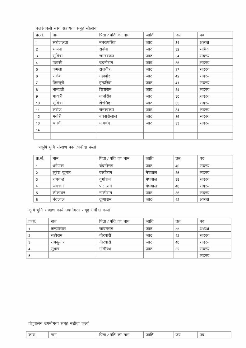
ctjaxcyh Lo;a lgk;rk lewg lksykuk
Ø-la- uke firk@ifr dk uke tkfr mez in
1 ljkstyrk eu:iflag tkV 34 v/;{k
2 ltuk jkds'k tkV 32 lfpo
3 lqfe=k jkeLo:i tkV 34 lnL;
4 irklh mnehjke tkV 35 lnL;
5 deyk jktohj tkV 37 lnL;
6 jkds'k egkohj tkV 42 lnL;
7 fdLrwjh bUnzflag tkV 41 lnL;
8 Hkkuorh f'k'kjke tkV 34 lnL;
9 xk;=h ekuflag tkV 30 lnL;
10 lqfe=k 'ksjflag tkV 35 lnL;
11 ljkst jkeLo:i tkV 34 lnL;
12 euksjh cuokjhyky tkV 36 lnL;
13 pu.kh ekepan tkV 33 lnL;
14
vd`f"k Hkqfe laj{k.k dk;Z]]HkM+kSnk dyka
Ø-la- uke firk@ifr dk uke tkfr mez in
1 /keZiky panxhjke tkV 40 lnL;
2 lqjs'k dqekj cLrhjke es?koky 35 lnL;
3 jkepUnz nqxkZjke es?koky 38 lnL;
4 txjke ikykjke es?koky 40 lnL;
5 yhyk/kj ekyhjke tkV 36 lnL;
6 uanyky tqFkkjke tkV 42 v/;{k
d`f"k Hkqfe laj{k.k dk;Z miHkksxrk lewg HkM+kSSnk dyka
Ø-la- uke firk@ifr dk uke tkfr mez in
1 dU;kyky lkorjke tkV 55 v/;{k
2 lghjke xhj/kkjh tkV 42 lnL;
3 jkedqekj xhj/kkjh tkV 40 lnL;
4 lqHkk"k HkkxhjFk tkV 32 lnL;
5 lnL;
ia'kqikyu miHkksxrk lewg HkM+kSnk dyka
Ø-la- uke firk@ifr dk uke tkfr mez in

1 cychj iw.kZey tkV 32 lnL;
2 fot;flag xqMn;ky tkV 36 lnL;
3 uFkqjke xqMn;ky cykSnk tkV 40 lnL;
4 /keZiky fcjcyjke tkV 38 lnL;
5 lsMqjke ys[kqjke es?koky 50 v/;{k
Hkqfefgu miHkksDrk lewg HkM+kSnk dyka
Ø-la- uke firk@ifr dk uke tkfr mez in
1 bUnjkt ikykjke es?koky 50 v/;{k
2 egkohj Hkxokukjke es?koky 48 lnL;
3 txjke Ikykjke es?koky 47 lnL;
4 fd'kuyky Hkxokukjke es?koky 46 lnL;
5 f'k'kjke dqjMkjke es?koky 50 lnL;
6 gfjflag jkeyky tkV 36 lnL;
7 jk/ks';ke jkeyky tkV 34 lnL;
8 j/kqohj Hkxrkjke es?koky 35 lnL;
9 nqxkZjke lqyrkukjke es?koky 49 lnL;
10 uFkq dqjMkjke es?koky 46 lnL;
11 eksguyky Hkkukjke es?koky 38 lnL;
12 gjhjke lkojjke es?koky 49 v/;{k
13 egsUnz lkoyjke es?koky 46 lnL;
ckykth Lo;a lgk;rk lewg HkM+kSnk dyka
Ø-la- uke firk@ifr dk uke tkfr mez in
1 e.kh jkeLo:i es?koky 50 v/;{k
2 flyksPkUUkk ;knjke es?koky 40 lfpo
3 'kkjnk n;kypUn jsxj 35 lnL;
4 foeyk nsoh ewypUn jsxj 45 lnL;
5 eUHkjh nokjdkizlkn dhj 65 lnL;
6 foeyk fxj/kkjh ukbZ 60 lnL;
7 iwue bZ'oj ukbZ 30 lnL;
8 gjdksjh eksguyky 'kekZ 65 lnL;
9 lesn jkeLo:i tkV 45 lnL;
10 y{eh cuokjh jk.kk 40 lnL;
ekukekrk Lo;a Lkgk;rk lewg HkM+kSnk dyka
Ø-la- uke firk@ifr dk uke tkfr mez in
1 foeyk 'ksjflag tkV 48 v/;{k
2 lqfurk egsUnzflag tkV 35 lfpo
3 yyhrk ctjaxyky Vsyj 50 lnL;
4 izse lqHkk"k tkV 30 lnL;
5 ljhrk fotsUn tkV 27 lnL;
6 ljkst jktsUnz tkV 24 lnL;
7 foeyk egsUnz tkV 34 lnL;
8 ljkst gfjflag tkV 36 lnL;
9 jkts'k /kesZUnz tkV 28 lnL;
10 irklh Eksgjflag tkV 49 lnL;
nknk i`Fohjkt Lo;a lgk;rk lewg HkM+kSnk dyka
Ø-la- uke firk@ifr dk uke tkfr mez in
1 lqfHkrk nsoh c`tyky tkV 39 v/;{k
2 e;korh ekuflag tkV 44 lfpo
3 njluk paUnxhjke Ukk;d 46 lnL;
4 eqUuh eksguyky uk;d 32 lnL;
5 iw.khZ jkes'ojyky Ukk;d 54 lnL;
6 e.kh eksgjflag uk;d 37 lnL;
7 ikoZrh egkohj uk;d 34 lnL;
8 Hkqjhnsoh NksVwjke tkV 74 lnL;
9 foeyk eksgjhyky 'kekZ 30 lnL;
10 laUrks"k Xqy>kjh 'kekZ 36 lnL;
th.kekrk Lo;a lgk;rk lewg HkM+kSnk dyka
Ø-la- uke firk@ifr dk uke tkfr mez in
1 ljorh cuokjhyky es?koky 35 v/;{k
2 ljkst euhjke es?koky 37 lfpo
3 lqfuy jkefuokl es?koky 28 lnL;
4 lqfe=k fo|k/kj es?koky 25 lnL;
5 lqfurk jk/ks';ke es?koky 23 lnL;
6 rkjke.kh lqHkk"k es?koky 26 lnL;
7 nqXkkZorh vkseizdk'k es?koky 38 lnL;
8 eerk lqesjflag es?koky 22 lnL;
9 clarh enuyky es?koky 39 lnL;
10 Hkkxksrh jktsUnzflag es?koky 29 lnL;

100 0.45 0.45 0.6 12.15 77 77 935.55 935.55
100 0.45 0.45 0.45 9.1125
100 0.125 0.1 0.45 0.5625
8.55 285 2430 2436.75 20776.5
250 0 25000
0 78 0 28988.98
0 48 0 356.7874
1.39 1.39 3936.48 3936.48
0.64 0.64 512 512
0 500 0 500
7820.78 81006.29
2430.189
G.Total 7820.78 83436.48
Say 8000 83000
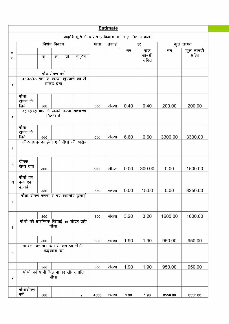
Estimate
0.40 0.40 200.00 200.00
6.60 6.60 3300.00 3300.00
0.00 300.00 0.00 1500.00
0.00 15.00 0.00 8250.00
3.20 3.20 1600.00 1600.00
1.90 1.90 950.00 950.00
1.90 1.90 950.00 950.00

2000*(060*0.20)/2 89.00 89.00 10680.00 10680.00
59.00 59.00 118.00 118.00
0.65 0.65 2600.00 2600.00
147.00 147.00 34398.00 34398.00
5000.00 0.00 5000.00 69196.00 94446.00
2833.38 69196.00 97279.38
3.30 3.30 330.00 330.00
0.00 15.00 0.00 1500.00
3.20 3.20 320.00 320.00
1.90 1.90 190.00 190.00
1.90 1.90 190.00 190.00
1.90 1.90 7600.00 7600.00

0.00 2.10 0.00 8400.00
1.30 1.30 5200.00 5200.00
0.00 300.00 0.00 1500.00
147.00 147.00 45864.00 45864.00
59694.00 71094.00
0.00 2132.82 59694.00 73226.82
1.90 1.90 5700.00 5700.00
0.00 2.10 0.00 6300.00
1.30 1.30 3900.00 3900.00
0.00 300.00 0.00 900.00
Total 147.00 147.00 45864.00 45864.00
55464.00 62664.00
0.00 1879.92
55464.00 64543.92
184354.00 235050.12
Fencing work 8000.00 83000.00
192354.00 318050.12

192000.00 318000.00
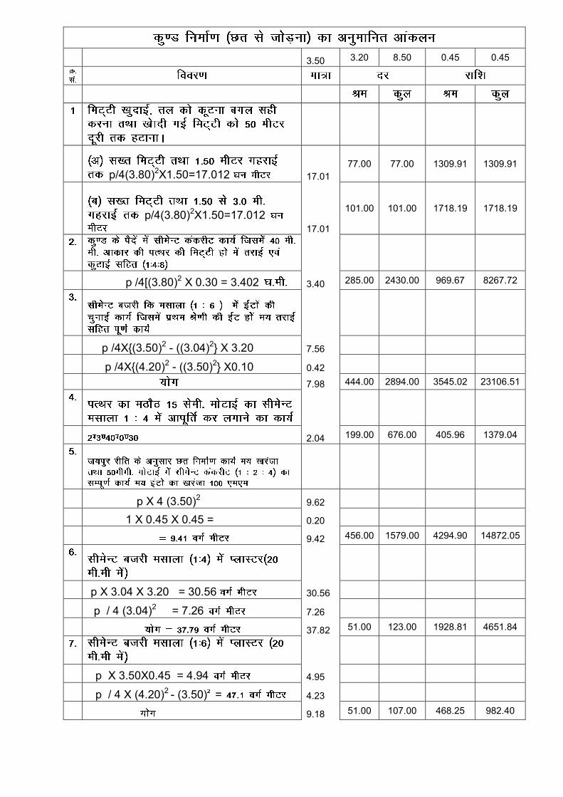
3.50 3.20 8.50 0.45 0.45
p/4(3.80)2X1.50=17.012 17.01 77.00 77.00 1309.91 1309.91
p/4(3.80)2X1.50=17.01217.01
101.00 101.00 1718.19 1718.19
p /4[(3.80)2 X 0.30 = 3.402 3.40 285.00 2430.00 969.67 8267.72
p /4X{(3.50)2 - ((3.04)2} X 3.20 7.56
p /4X{(4.20)2 - ((3.50)2} X0.10 0.42
7.98 444.00 2894.00 3545.02 23106.51
2.04 199.00 676.00 405.96 1379.04
p X 4 (3.50)2 9.62
1 X 0.45 X 0.45 = 0.20
9.42 456.00 1579.00 4294.90 14872.05
p X 3.04 X 3.20 = 30.56 30.56
p / 4 (3.04)2 = 7.26 7.26
37.82 51.00 123.00 1928.81 4651.84
p X 3.50X0.45 = 4.94 4.95
p / 4 X (4.20)2 - (3.50) = . 4.23
9.18 51.00 107.00 468.25 982.40

S.I. Mar
15.00
0.00 125.00 0.00 1875.00
0.00 800.00 200.00 800.00 1.5/' x 1.5'
1.00 700.00 700.00
14840.71 59662.65
1789.88
14840.71 61452.53
61000.00
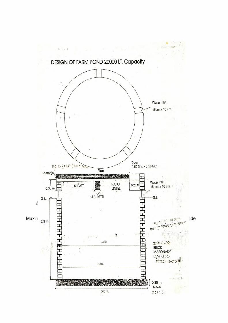
Estimate for Construction of Earthen bund CHANANA IWMP W/S
Earth Bund
Length in m 20
Maximum cross section Minimum cross section on both side

Average Cross section 6.5
Sr.
No
Name of work BSR
itam no
Length Cross
Section
Qty Unit Rate Amount
1 Earth work Excavation in
hard soil up to 1-5 mt
Hight and deposited
excavated material lead
op to 50
120 b 20 6.50 130.0 Cum 85 11050.00
2 Dry stone pitching 23 cm
thick
125 20.00 4.50 20.70 Cum 847 17532.90
3 Vegetation Ls 2500
31082.90
Total 3% contingency 902.49
31984.49
Related Documents