IWI MODELLING INITIATIVE WORKSHOP DATA REQUIREMENTS IN SUPPORT OF MODELLING AND HYDROLOGICAL ANALYSIS CHICAGO, ILLINOIS NOVEMBER 17-19, 2010 R. Halliday & Associates March 31, 2011

Welcome message from author
This document is posted to help you gain knowledge. Please leave a comment to let me know what you think about it! Share it to your friends and learn new things together.
Transcript
IWI MODELLING INITIATIVE WORKSHOP DATA REQUIREMENTS IN SUPPORT OF MODELLING
AND HYDROLOGICAL ANALYSIS CHICAGO, ILLINOIS
NOVEMBER 17-19, 2010
R. Halliday & Associates
March 31, 2011

EXECUTIVE SUMMARY The International Joint Commission (IJC) sponsored a workshop aimed at examining data requirements in support of modelling and hydrological analysis in Chicago on November 17-19, 2010. About 30 people, most of them IJC Board members or associates of IJC boards, attended the workshop. The workshop itself and the preparation of this workshop report were funded under the IJC’s International Watersheds Initiative (IWI). This was the second in a series of three modelling-related workshops. The third workshop will build on the findings of these two workshops and culminate in an IJC modelling framework. The objectives of the workshop were to discuss data challenges and how they can be addressed, to determine the IJC Boards’ current and future data requirements and to obtain IJC’s Boards’ input on the hydrological data framework and hydrographic harmonization effort. The discussions were in the context of the IJC boards’ data requirements pertaining to hydrological, hydraulic and water quality models. The history of international gauging stations in transboundary watersheds is almost as old as the Boundary Waters Treaty itself. Currently there are 66 active and 12 discontinued streamflow stations and 56 active and 6 discontinued water level stations. A new protocol relating to international gauging stations is under discussion. It will contain new procedures for designating international gauging stations, clarify roles and responsibilities and accountabilities for all parties, and provide revised operating principles and standards. This unified binational water level and streamflow dataset is a relative rarity in international watersheds. The IJC’s transboundary data harmonization project represents a major step forward in making consistent, coherent, compatible, quality assured data available to modellers of international watersheds. The current task is to harmonize watershed and sub-watershed delineations as well as stream hydrography across the international boundary. Such seamless, best available datasets are of immense value. Workshop participants identified many other spatial datasets that could be candidates for transboundary harmonization. From a hydrological perspective, gridded climate data, solar radiation, soils, land use, and land cover are all candidate datasets. In the central plains, non-contributing areas are a priority. A key dataset from a hydraulic modelling perspective is a seamless, best available digital elevation model. Aside from the usual problems of combining disparate datasets, this task is made more difficult by the problem of the fundamentally different vertical datums used in the United States and Canada. The IJC should promote the adoption of a contemporary vertical datum in Canada. An IJC “white paper” on the subject could be a useful start towards achieving this goal. Digital elevation models derived from lidar are used within models and for visualization and are often considered the “gold standard”. There are difficulties in assembling a true international lidar data collect, among them are the conduct of international ground truth surveys and data stewardship. A template for specifying lidar surveys in international watersheds would be useful for some IJC boards.

Water quality models are inevitably linked to hydrological or hydraulic models and, as such, have many of the same data harmonization needs. One of the key water quality challenges in the transboundary watersheds relates to nutrient impacts on the environment. Water quality modellers therefore need access to consistent databases related to nutrient sources such as fertilizer use, manure application, point sources such as wastewater treatment plant effluents, and atmospheric sources. Irrespective of the purpose of a modelling task there are issues around the applicability of a specific model under winter conditions. Frozen soils and storage in snowpacks affect runoff, hydraulic roughness and the availability of nutrients and other contaminants. Improvements in chryospheric data as well as improvements in the models themselves are needed. Practitioners in international watersheds need to be aware of the specific challenges of all-season modelling. Another data challenge in international watersheds relates to the configuration and operation of hydraulic structures. This information may be scattered among many sources. Often dates when significant changes in a structure or in operation of a structure occurred are not easily found. The challenge usually must be resolved on a watershed by watershed basis. Another general data need related to water allocation, use and consumption. This would include water abstractions and diversions. The availability of such datasets depends to some extent on whether a state or province bases its water administration on a regulated riparian system or on western water law. Given that appropriate datasets are available there still are a host of issues around stewardship, distribution and viewing of data. The modelling needs of IJC boards suggest distributed data systems as the preferred option. This implies that data custodians would be responsible for acquisition, quality assurance, providing searchable metadata, and serving datasets through links to data portals or data viewing technologies. There is a related challenge for individual boards in providing appropriate stewardship of datasets created specifically for board purposes. Participants saw a role for the IJC in these issues. The notion of an IJC data portal was attractive; that of an IJC data warehouse was not. Another possible task would be the identification of historic IJC reports and other documents that are considered data rich. Recovering the data from paper reports into electronic files would be desirable. There are several pilot projects that could be used to test some of the transboundary data harmonization challenges. The St. Croix, Rainy and Red river basins each present unique challenges and opportunities. Extending the SPARROW model into Canada, perhaps in the Great Lakes basin, would be a useful exercise. A key element in the IJC’s future modelling framework will be harmonized, accessible datasets. For the most part this is a costly and difficult endeavor. The return on that investment will be much improved model output and a better-informed public on both sides of the international boundary.
ii

iii

TABLE OF CONTENTS
Executive Summary .............................................................................................................................. i Table of Contents ............................................................................................................................... iv Introduction .......................................................................................................................................... 1
opsis of Winnipeg Modelling Workshop ................................................................................... 1 SynDefine the application........................................................................................................................................ 2 Model Selection .................................................................................................................................................... 2 Post Model Development ................................................................................................................................. 2Discussion ............................................................................................................................................................... 2
IJC
’s Hydrological Data Framework ................................................................................................. 3Discussion ............................................................................................................................................................... 4
Hy
drographic Data Harmonization .................................................................................................. 4Discussion ............................................................................................................................................................... 5
Di
gital Elevation Data ......................................................................................................................... 5Discussion ............................................................................................................................................................... 6
Da
ta Requirements for Hydraulic Models ........................................................................................ 7Discussion ............................................................................................................................................................... 8
Da
ta Requirements for Hydrological Models .................................................................................. 8Discussion ............................................................................................................................................................... 9
Da
ta Requirements for Water Quality Models .............................................................................. 10Discussion ............................................................................................................................................................ 11
Bo
ard Round Table ............................................................................................................................ 12 Priority Requirements .................................................................................................................................... 12 Current and Forthcoming Data Initiatives ............................................................................................. 13 Modelling Opportunities ............................................................................................................................... 13Portals, Websites and Stewardship .......................................................................................................... 13
Wrap-up ............................................................................................................................................... 14 References ........................................................................................................................................... 15 Appendix A – Acronyms and Abbreviations ................................................................................. 16 Appendix B - Agenda ........................................................................................................................ 17 Appendix C – Persons Attending .................................................................................................... 20
iv

INTRODUCTION The International Joint Commission (IJC) sponsored a workshop aimed at examining data requirements in support of modelling and hydrological analysis in Chicago on November 17-19, 2010. About 30 people, most of them IJC Board members or associates of IJC boards, attended the workshop. The contributions of the presenters and participants are gratefully acknowledged. The workshop itself and the preparation of this workshop report were funded under the IJC’s International Watersheds Initiative (IWI). This was the second in a series of three modelling-related workshops. The objectives of the workshop were three-fold:
• To discuss data challenges and how they can be addressed • To determine the IJC Boards’ current and future data requirements • To obtain IJC’s Boards’ input on the Hydrological Data Framework and
Hydrographic Harmonization Effort A list of acronyms and abbreviations appears in Appendix A. The workshop agenda and the list of persons attending appear in this report as Appendices B and C, respectively. The slides used by all presenters are available through the IJC, as is the report of the first workshop.
SYNOPSIS OF WINNIPEG MODELLING WORKSHOP
Bob Halliday reviewed the proceedings of the first modelling workshop, which was held in Winnipeg in June, 2010 (SLMcLeod Consulting and R. Halliday & Associates, 2010). This Needs Assessment Workshop had as its objectives:
• To determine what are the Boards’ priorities that require a modelling approach to address them,
• To determine the Boards’ level of knowledge and expertise with regards to applying models, and
• To develop a path forward for building an IJC modelling framework. The workshop focused largely on hydrologic, hydraulic and water quality models although it did touch on other models such as water accounting and environmental models. Board needs related to hydrologic models include the need to simulate streamflow, especially peaks, to predict streamflow or lake levels, to compute water balance, to consider scenarios, and to examine specific hydrological processes. Hydrological models may be linked to water quality models. Boards needed both one- and two-dimensional hydrodynamic models for planning and operations. Again there was a link to water quality models. Water quality models were needed for modelling both point source and non-point source inputs and to examine the fate of environmental contaminants. Other models included water accounting models for apportionment, habitat assessment models and socio-economic models. Participants identified a series of model-related questions related to defining the application, model selection and post-model development. Principles for selecting and using a model in international watersheds could be considered as follows:

Define the application
1. Is a model really required, or can the problem be resolved through data analysis and interpretation? What science questions need to be posed to initiate model development?
2. Is the application a one-off or is there a continuing requirement for the model? Is the task considered as planning, operations, or forecasting?
3. Can the scope of the application be refined by running a simple model? Can a structured approach to the development be identified?
Model Selection
4. Is the model widely accepted for the proposed application? 5. Is the model proprietary or open source? 6. Is the model well-documented, peer reviewed or otherwise certified? 7. Is the model currently supported by an agency or vendor? 8. Are the data requirements reasonable? 9. Is the computational effort appropriate to the application? 10. Is the expertise to develop and run the model available? 11. Can other resource constraints be met? 12. What visualization options exist? Consider output to Google Earth?
Post Model Development
13. What arrangements exist for stewardship/archiving of project? 14. How can model output be used to inform the public and decision makers? 15. If the model development was in the realm of research and development, is there a
need to operationalize the model? What steps may be needed? The workshop discussed several data-related matters. These included:
• Data availability, gaps and formats • Data standards and metadata • Data storage and management • Data harmonization across the international boundary • Need for seamless, best available data sets • Data portals
Discussion The St. Croix Board has received IWI funding for air quality modelling. It was noted that the SWAT water quality model is not suitable for large basins such as the Lake Winnipeg basin. The Red River Board is considering an in-stream flow needs project.
2

Debbie Lee briefly described the U.S. Army Corps of Engineers (USACE) modelling framework based on the suite of models from the Hydrologic Engineering Centre (HEC). The Corps uses only approved models and has a board charged with approvals. The U.S. National Weather Service takes a similar approach. Dave Holtschlag briefly described the U.S. Geological Survey (U.S.GS) approach, which is not a rigorous as that of the Corps in formally approving models for use in USGS projects.
IJC’S HYDROLOGICAL DATA FRAMEWORK
Ted Yuzyk and Dr. Mark Colosimo reviewed the transboundary context for the IJC’s operations and the hydrological data framework as it applied to data harmonization and the operation of international gauging stations. The 8900 km international boundary between Canada and the United States features 14 distinct basins containing some 300 lakes and rivers. Forty-three percent of the boundary can be considered boundary waters as defined by the Boundary Waters Treaty. Setting aside the Alaska-Yukon boundary, most of the southern boundary is covered by standing boards of the IJC. This includes 11 boards plus a host of Great Lakes boards. Key issues along the international boundary include climate change and variability, water quality deterioration, invasive species, water apportionment/regulation, floods/droughts, and water security. Concerning the latter, three or four sites along the boundary have been identified by the U.S. Department of Homeland Security. From an IWI perspective there is a strong focus on improving understanding of the hydrology of transboundary basins. Improved hydrological understanding enables key issues to be addressed more effectively. Fundamental to this is ensuring that comprehensive standardized data are collected. Among the challenges are:
• fragmentation of water programs • limited coordination • border truncation of information • lack of essential data to address key issues • existing data usually not consistent, coherent and compatible in the transboundary
basins Two important binational initiatives are the hydrographic data harmonization initiative (to be discussed later by Mike Laitta) and the assembly of comprehensive binational datasets. A subset of the latter is the operation of International Gauging Stations (IGS). The concept of IGSs is almost as old as the IJC itself and was developed in the early days of monitoring the St. Mary and Milk rivers. To reduce duplication of effort and ensure consistent data several hydrometric stations were identified as IGSs and jointly operated by the two countries. Some of these stations were in the United States and others in Canada. Some have been active for about 100 years. A formal agreement on the operation of IGSs was executed in 1985 (Huberman et al. 1985). Currently there are 66 active and 12 discontinued streamflow stations and 56 active and 6 discontinued water level stations. The need for a revised protocol became evident when four new stations were established in the Great Lakes connecting channels. The new protocol will contain new procedures for designating international gauging stations, clarify roles and responsibilities and accountabilities for all parties, and provide revised operating principles and standards.
3

The approaches to funding the operation of IGSs in Canada and the United States are quite dissimilar. In Canada operation is funded directly by Environment Canada and the department largely follows the 1985 protocol. The focus of activity is between the Department and the USGS, with little dialogue involving the IJC. In the United States the United States Section of the IJC provided funding to the USGS for the operation of 46 discharge stations and 12 water level stations. Most, but not all, of these were IGSs. The American process requires that the USGS submit a request for funding through the State Department two years in advance of the fiscal year for which funds are requested. This submission takes place in May/June and must then go through the U.S. process for funding approval. Near the beginning of each fiscal year a funding agreement to prioritize the use of available funds is developed with the USGS. The new protocol will be completed soon and circulated to governments. Annex I pertains to IGSs for flow and Annex II to IGSs for water level. The protocol will contain new annexes pertaining to other essential water data. Discussion Several matters related to international gauging stations were discussed. In general, stations in the Great Lakes basin are not covered by the financial arrangement between the IJC U.S. Section and the USGS. There are about 85 water level stations in the basin. Stations established by special agreement such as many in the Great Lakes system are not included as IGSs. Standardization of the operations of IGSs and inclusion of Great Lakes stations has cost implications. Consider, for example, the effect of a requirement for binational annual inspections of each station.
HYDROGRAPHIC DATA HARMONIZATION
Mike Laitta noted that the concept of hydrographic data harmonization was sublime in its simplicity but that execution is fraught with cascading complexities. The IJC convened a Transboundary Hydrographic Data Harmonization Task Force in 2008 to harmonize drainage basins and hydrography across the international boundary. Five federal agencies are participating with the IJC in the task: Agriculture and Agri-food Canada, Environment Canada, Natural Resources Canada, the U.S. Environmental Protection Agency and the U.S. Geological Survey. In effect, this requires harmonizing the American National Hydrographic Dataset (NHD) and the Canadian National Hydrographic Network (NHN). Harmonization also implies acceptance of the result by both federal governments and by the affected states and provinces. Ultimately when a dataset is extracted the user will receive both U.S. and Canadian portions of the basin. Data will be seamless across the boundary. There are technical issues, interpretation issues and institutional issues that must be addressed. Creating the hybrid dataset is essentially a negotiated process. First, basin and sub-basin level drainages are aligned then streams and water bodies. Finally, the harmonized areas would be populated with finer resolution sub-watersheds and statistics created to assist in further harmonization. The first watershed to be completed will be the Souris River basin. A January 2011 workshop in Winnipeg will consider the basin. The work is generally being conducted at 1:24,000 (1:25,000) and 1:50,000 scales. A later phase will use higher resolution data products when available. The goal is a smart seamless system that can be built on.
4

When a brute merge of datasets is first undertaken there are numerous inconsistencies such as offset and classification problems. Mike illustrated the problem with examples from the Souris and Columbia basins. By 2013 basic watersheds and hydrography should be available and served at federal, state and provincial levels by major data stewards. This has many short-term benefits and is one step towards a binational data stewardship framework. Some near-term questions relate to how to make the project sustainable, creation of a standalone raster product, inclusion of other datasets such as land use/land cover, or elevations. Pete Steeves was unavailable to discuss StreamStats. Craig Johnson gave an overview. StreamStats is a web-based GIS that built on a series of regression equations. It is based on NHD spatial datasets. Clicking on any point will produce the basin delineation, basin characteristics and streamflow statistics. Adjustments are made based on the upstream gauging station, but a downstream station may be used. StreamStats is being implemented on a state-by-state basis. It is complete for most states along the Canadian border except that implementation in North Dakota is currently in progress and Montana has not been started. Discussion There was discussion of how decisions are made. Eventually it will come down to workshops with persons having first-hand knowledge. There is a potential nomenclature issue around “hydrographic”, but that is the accepted term. There is good prairie data from the former Prairie Farm Rehabilitation Administration (PFRA) (Agriculture and Agri-food Canada), and USGS Watershed Boundary Dataset. In general, the quality of PFRA interpretations into the United States could be improved, as could USGS interpretations into Canada. Polygons for even the active Water Survey of Canada gauging stations do not exist. In some cases the differences between currently and previously calculated drainage areas is 40 to 60 percent. Land use in the Lake of the Woods basin has been prepared on a binational basis using Landsat imagery. Could that data migrate to the harmonized data sets?
DIGITAL ELEVATION DATA
Mike Laitta reviewed the fundamental national elevation data sets for Canada and the United States. The national elevation dataset in Canada is Natural Resources Canada’s (NRCan) Canadian Digital Elevation Data (CDED) which is a three arcsecond grid (90 m post spacing) based on the national vertical datum. The source of the CDED is provincial datasets but 1:250,000 or 1:50,000 topographic map sheets have also been used. Higher resolutions are therefore available in some areas. The vertical datum used is CGVD28. The U.S. National Elevation Dataset (NED) is a seamless dataset with the best available raster elevation for the United States. It is distributed in geographic coordinates in decimal degrees at resolutions of one (about 30 m post spacing), one-third (10 m) and one-ninth (3 m) arcseconds. Most of Alaska uses a 60-m post spacing. It is based on the U.S. vertical datum, NAVD 88. These datasets have limited overlap across the international boundary. As well, the different vertical datums prevent data merges.
5
Mike discussed vertical datums used in both countries. The same horizontal datum, NAD 83, is used in both countries so there are no particular datum problems associated with the current harmonization project. (Locally derived datasets could, however, be based on a former horizontal datum.) The United States has adopted a new vertical datum, NAVD 88, based on gravity (geoid) while Canada continues to use CGVD 28, based on mean sea level (Helmut heights). The current Canadian vertical datum is similar to the former U.S. datum, NGVD 29. The difference between NGVD 29 and NAVD 88 at Emerson, Manitoba is 0.387 m or 1.27 ft. At present Canada is considering a change to a gravity-based datum in 2013. The United States will make a further adjustment to its current datum in 2020. The International Great Lakes Datum, IGLD 85, is also based on gravity, but it is used only for the lakes themselves. Other datums are used on tributary streams. Harkness (1999) contains a good discussion of datum issues in an international watershed. There is increasing demand for Lidar data acquisition to support IWI projects. Priority setting can be a challenge. There is no systematic way to determine needs and priorities. Areal redundancies are occurring. Truly binational projects are difficult to organize and co-ordinate. Acquisition of ground truth data on both sides of the boundary using contractors from one country or the other can pose a number of problems. There are also potential problems related to data sustainability and stewardship. High resolution orthoimagery is a very useful adjunct to Lidar as an aide to visualization and large-scale (small area) interpretations. Image acquisition across the boundary can lead to fault lines and stewardship issues. High resolution orthoimagery is available from the USGS and NRCan. Other image sources include Landsat and SPOT. Image 3000 products, flown by NGA for the Great Lakes, will be extended along the international boundary in 2012. Lidar initiatives aimed at improving stewardship include NOAA’s Digital Coast and the USGS’ CLICK. Digital Coast provides data, tools and training aimed at assisting coastal communities, including those in the Great Lakes-St. Lawrence system. The intent is to address coastal issues such as land use, coastal conservation, hazards, marine spatial planning, and climate change. The USGS Center for Lidar Information Coordination and Knowledge (CLICK) is aimed at facilitating data access, user coordination and education. The Canadian Consortium for Lidar Environmental Applications Research (C-Clear) is a Canadian contribution to national stewardship. It was formed in 2000 as a vendor-based initiative but now resides at the Applied Geomatics Research Group at Nova Scotia Community College. There is a strong emphasis on end-user training in the initiative. There are several specific challenges related elevation and modelling in transboundary areas. How best can IJC Boards use national elevation datasets. What is the potential role of the IJC in achieving harmonization? Discussion There is a proposal for a joint remote sensing project in the Skagit and Columbia basins but the cost is high. The utility of Shuttle Radar Topography Mission (SRTM) data was discussed. The data was not sufficiently accurate for most modelling applications. High resolution data is particularly important in modelling small watersheds, say 50,000 acres. In
6

those cases the standard Digital Elevation Models (DEM) from the USGS will be insufficient.
DATA REQUIREMENTS FOR HYDRAULIC MODELS
Dr. Wayne Jenkinson began his presentation by stating that the Canadian Hydraulics Centre is now providing model stewardship services for Watflood, Telemac and UBC models. He discussed data requirements in the context of hydraulic models such as RMA, Telemac and RIV 1-D. Primary data needs are topography/bathymetry. Historical bathymetry measurements may lack supporting methodology and datum may be obscure. He noted that, although Lidar data is considered the gold standard there are some issues. For example, some automated tree removal algorithms will also take out natural or constructed levees. There are also concerns with hydrometric/hydrologic data. These include uncertainty during extreme events (rating curve definition) and data obtained under ice cover. Quality assurance related to data contributed by third parties can pose problems. Data from electrical utilities, for example, may be based on turbine ratings. Aerial photos or Radarsat imagery can also prove useful during model calibration. In some cases structural/anthropogenic data may prove useful. Obtaining engineering drawings and operating histories of older structures can prove a challenge. Sediment/substrate data may be augmented with dredging history information, including estimated quantities. Local knowledge of problems and concerns may also be important, but this kind of knowledge may be lost in a generation. The IJC tends to do a good job of preserving this kind of information. Wayne illustrated his presentation with examples from the lower Pembina basin project, which required multiple data sources and featured emerging issues, and the Rainy River project, which was essentially one-stop shopping for data from the Rainy Board. The lower Pembina project involved hydrodynamic modeling of the lower Pembina River and its confluence with the Red River during flood conditions. Ultimately the knowledge gained will be used to consider mitigation measures. The Rainy River project examined the hydrodynamics of the Rainy Lake exit to determine conveyance and hydraulic controls. As one approach to data management Wayne described Beaufort Sea Environmental Database, a repository for data of various types and character from various sources. David Holtschalg spoke of one- and two-dimensional model applications on the St. Clair River and Ohio River. Both HEC-RAS and RMA2 models were used to examine changes in conveyance of the St. Clair River (IUGLS 2009), including affirming the hypothesis that conveyance has changed. The HEC-RAS one-dimensional model was used to establish a baseline for comparison with other model results. The model used 2007 multi-beam bathymetry and shoreline geometry from NOAA navigational charts. Hourly water level data were used to establish boundary conditions. Both conventional and Acoustic Doppler
7

Current Profiler (ADCP) open-water flow measurements were used in calibration. These are inverse modelling problems in which observed data must be used to determine model parameters. Inverse modelling was also used to characterize sensitivity of the model output to parameters and to assess uncertainty. RMA-2 is a generic depth-averaged, finite element hydrodynamic model that is calibrated and validated using observed water levels and vertically averaged velocities. The model was developed and is supported by the USACE. The code is public domain. For the St. Clair River seven reaches, 360 cross-sections and some 50,000 observations were used. There were 27,477 strongly correlated stage measurements and six flow measurements. Drifting buoys were used to assess model results. The model results were used to reject the hypothesis that there was no change in conveyance over time. In the Ohio River case a 34-mile long reach was modelled. Velocities were much lower than those on the St. Clair River. The model was used to track velocities around a bend. Buoy tracking was used as one basis for comparison. Dye injection was also used. The comparison did degrade going downstream. ADCP measurements were used to adjust the model. Caution should be used in interpreting 2-D model simulations when streams exhibit fast or slow currents and when flow is around sharp bends. Wind effects are extremely difficult to implement as wind-driven currents are a 3-D problem. Discussion The perception that two-dimensional models are better than one-dimensional really depends on the question. In the case of the lower Pembina River basin, flow paths determined using two-dimensional models did not match those assumed in earlier one-dimensional modelling. In calibrating models, a major challenge is understanding the sensitivity of the parameters to the observed data. In the case of the St. Clair River the lack of ice-affected measurements made any modelling of winter flows moot. The two dimensional models do not perform well in contaminant tracking problems.
DATA REQUIREMENTS FOR HYDROLOGICAL MODELS
Erika Klyszejko discussed the use of the HBV-EC lumped model and Watflood distributed hydrological model with MESH, a coupled land-surface scheme. She reviewed the creation of a watershed file using GreenKenue visualization. During the IJC’s Upper Great Lakes Study there were many challenges in spatially distributing one-day forecast data. Geophysical data used in the model set-up included the CDED DEM. (There are some anomalies when watershed boundaries cross provincial boundaries.) Land cover was obtained from Geobase. The original interpretation was conducted by the Canadian Forest Service or Agriculture and Agri-food Canada, with the Canada Centre for Remote Sensing providing coverage for the northern territories. Hydrologic modelling difficulties in Canada are compounded by lack of river roughness data, basin delineations (polygons) for hydrometric stations, and lack of continuous soils data. CaLDAS (Canadian Land Data Assimilation System) is under development.
8
Forcing data include precipitation, temperature and water diversions/abstractions. GreenKenue provides the data interface to climate data. Canadian climate data has been adjusted and homogenized for research purposes. The precipitation analysis will feed 6- and 24-hour accumulations, including ultimately snow water equivalent, on a 15-km grid into CaLDAS. Samples are available on the Environment Canada intranet now. Snow data is currently available from many sources to many standards. Data used for calibration/validation/initialization include streamflow, snow surveys, soil moisture, and isotopes. Erika discussed upgrades to the HYDAT Data Explorer (hydrometric and sediment data). The designation of regulated or natural flow, the treatment of contributed data and criteria for data revisions will be considered. Erika identified a number of data challenges including availability, consistency, assimilation, format and temporal/spatial resolutions. Deborah Lee discussed the USACE Hydrologic Modeling System. HEC HMS is a precipitation-runoff simulation model with a graphical user interface. The model was limited by being deterministic, uncoupled and containing no groundwater interaction. It is designed for dendritic stream structures so dealing with split flows is a challenge. The model can use a six-hour time step in large basins and as short as a 5-minute time step in small basins. Model inputs included GeoHMS digital terrain map, hydrologic, canopy storage, soils from STATSGO (U.S. General Soils Map), and precipitation from a meteorological model. Snowmelt routines are still to come. Deborah discussed the application of the HEC HMS application to the Ohio River Community Model. The model is aimed at reservoir control in the lower Ohio and Mississippi rivers. It involves myriad interests in 12 states. The project linked three HMS models using output from three river forecast centers. (Ohio flows influence flows as far downstream as New Orleans.) Routing was accomplished by linking to HEC RAS – some 2000 cross-sections were used. Modelling challenges included use of data generated over many years, differing data formats, geo-referencing, lock and dam operations, and ungauged basins. Discussion Participants discussed data handling within HMS. There is a data viewer from the EROS data center and add-ons to export to Excel. The current HMS snowmelt routine is based on degree days of cooling or heating. There are models beyond HMS – these are still undergoing testing. The source codes for HMS and RAS are not readily available. RMA2 is being phased out. SMS was developed for the Corps under contract and is largely proprietary. GC 1 and GC 2 are open source. Interoperability of models offers savings in computer time when the complex model is not required for the entire domain. Not really coupling, just one model feeding another. The Ohio River model is one example. Anther is the use of a hydrological model on the Mackenzie River to drive a 1-D river ice model. High-resolution models aren’t always
9
needed. Some routine calculations in the Great Lakes are performed by what might be considered a 0.5 D model. The U.S. National Weather Service has officially adopted HEC RAS to route output from the Sacramento model. An academic consortium is building a suite of models from the ground up. Participants were not aware of the details of the project, known as QUAZZI. Solar radiation is not routinely monitored in Canada. Models are used to generate data. There are no standard routines for mass screening of data for quality assurance/quality control. This is largely up to the modeler. There are screening check lists to assist data assembly and model selection. Can run the model to determine data gaps.
DATA REQUIREMENTS FOR WATER QUALITY MODELS
Craig Johnston reviewed the Sparrow model. The model was developed by the USGS as part of the National Water Quality Assessment Program, Reston and could be considered midway on a range of statistical to deterministic. It uses a stream network linked to a DEM and can predict annual loads at any point based on watershed characteristics, usually related to observed water quality upstream of the point of interest. It includes variables to simulate in-stream processes. Only statistically significant parameters are used. The model incorporates geographic data layers of precipitation, land use, soils, and water velocity in streams and reservoirs. Predictions are made for 62,000 stream reaches. Inputs, usually nutrients, can be both point and spatial. Nutrient management questions related to load, yield or concentration can be examined. Where do nutrients originate? Where should management attention be focused? The model assists in identifying primary sources of nitrogen or phosphorous, including atmospheric sources. The model provides confidence measures for its output. It has been used to examine phosphorous yields in Great Lakes states. Sparrow cannot do baseflow separation. Craig reviewed New England examples that required extension of datasets into Canada. He and Dave Fay discussed issues related to extending it into Canada. The model was used to consider nitrogen and phosphorous. Quebec data were used for the upper St. John basin, part of Lake Champlain and the upper Connecticut River. The work was performed using the 1:100,000 NHDPlus hydrographic data, WBD for watershed boundaries and NED for elevations to generate catchments in the United States. Hydrometric, water quality, landcover, manure/fertilizer sources, and other data were provided by Quebec for the Canadian portions of the basin. American climate data was from PRISM and Canadian obtained from the Canadian Forest Service. Canadian data was a challenge as there was no single portal for access. The model demonstrated that Connecticut River watershed is the primary source of nitrogen loading to Long Island Sound. Atmospheric loading was the single largest source. Other applications discussed included the nutrient fluxes in the United States portions of the Mississippi and Great Lakes basins, and in northern Europe. Canadian data are particularly important to completing understanding of nutrient inputs to the Great Lakes. Data for the St. John and St. Croix basins are also required to complete modelling of those basins. In
10

general the IJC’s harmonization provides some of the information needed to extend SPARROW into Canadian watersheds. Monitoring data, meteorological and hydrometric, is also needed. SPARROW is calibrated to a base year so supporting data layers such as land cover must be relevant to that year. There is a proposal to extend a New England arsenic model aimed at assessing the probability of arsenic in groundwater into Nova Scotia. Luis Leon discussed watershed-stream-lake models providing Great Lakes and Lake Winnipeg examples of sub-watershed scale. Duffins Creek at Ajax, ON was modelled using both AGNPS, essentially an event-based model, and SWAT. Landcover and soil type were both used. The years 1995-2005 were used for calibration and 2007-2009 used for validation. SWAT was used to model very large inputs of agricultural nutrients (both point and distributed) in the Boyne, LaSalle, and Little Saskatchewan watersheds in the Lake Winnipeg basin. The 40-year streamflow record for the LaSalle River was naturalized to take into account diversions to the Assiniboine River. A key challenge was the extent of non-contributing drainage in this prairie pothole landscape. Discussion A harmonized set of data for transboundary watersheds would greatly assist Sparrow and any other water quality modelling. One other transboundary challenge would be to include the Milk River and other Canadian watersheds in the Missouri basin in a Sparrow model of the Mississippi basin. The Lake Winnipeg data portal, now under development, will consider the challenges of accessing transboundary data through a single portal. The Rainy River Board is assembling metadata for the entire basin. One objective is to use water quality modelling to consider changes to monitoring activities, such as minimum sampling determination. In Minnesota 80 percent of the load comes with spring runoff. One other consideration in selecting a water quality model is the provenance of the model. SWAT for examples originates with the U.S. Department of Agriculture. One would expect it to perform better in agricultural areas than, say, forested areas. The model does not distinguish frozen and unfrozen soils. There are scaling issues as well with Sparrow being able to handle very large watersheds while SWAT cannot. Attempting to nest models leads to more complex data requirements. Participants considered the bare minimum requirements for water quality modelling. At the very least one will need hydrometric and land use/land cover data. Version 2 of NHDPlus is expected to be released in 2011. There are considerable differences in the soils databases between Canada and the United States making these databases another candidate for harmonization. One important natural source of nitrogen in the Pacific Northwest is the red alder.
11
The requirements of the Great Lakes Water Quality Agreement may lead to somewhat different approaches and data needs than those of the IJC’s Great Lakes boards. Similarly, study boards may have different needs than standing boards. Participants saw the role of the IJC as being important to influencing government priorities in support of IWI initiatives.
BOARD ROUND TABLE
Participants were asked to summarize key points or additions to the discussion from a board perspective. Their comments have been summarized by subject areas. Priority Requirements Vertical datum is key. Support from the IJC would be useful in Canada transitioning from Helmut (MSL) heights to dynamic (gravity) heights. The complexities around the IGLD and that used on tributary streams is a concern. One approach might be an IJC white paper that would update and elaborate on information in Harkness (1999). To what extent have vertical datum differences affected or prevented seamless modelling? It was noted that the International Boundary Commission is interested only in horizontal datums. There is no real issue there. There has been a demonstrated willingness to gather information pertaining to the Red River basin. Data pertaining to an immediate board mandate is the easiest to achieve. Longer term data to address issues is more difficult. IWI funding has been helpful in this regard. At present Lidar data east of the Red River in Canada is a priority. Other priorities include the Roseau River tributary basin: bathymetric, hydrometric, climate, solar radiation and nutrients. Next generation models modify the grid as a plume moves downstream. Some targeted bathymetry, topography, and precipitation data are needed. Also powerhouse data at Fort Frances: configuration, layout and operating hydraulics. Data acquisition can be considered a shared responsibility of agencies and boards. Groundwater data has been identified as a priority by Great Lakes Governors. Generally the assumption has been that surface-groundwater interaction is small or negligible. Baseflow analysis could improve water budget calculations. Current and historical wetlands and land use/land cover data is a generally high priority. Information concerning endangered species is lacking. There is a need for water consumption data in addition to water permit or licence data to support apportionment calculations for basins in the central plains. This includes industrial facilities and their consumption. There is a lack of groundwater quality data in the Souris basin. Some boards need wet and dry atmospheric deposition data.
12

Canadian and United States fish species taxonomies are fairly compatible. Fish habitat descriptors likely are not. Probably not a priority for harmonization for now. Adoption of adaptive management approaches in the context of integrated water resources management poses many data challenges. Current and Forthcoming Data Initiatives NHD and NHN (Canadian 1:50,000) should harmonize in phase three. Modelling Opportunities Extending the Rainy River modelling through Lake of the Woods to Lake Winnipeg. The water quality monitoring on the Rainy River is essentially load-based. A Souris River pilot project in support of the Red River could be one approach. Applying SPARROW and SWAT in the entire Souris or Red river basins could provide many insights into bi-national water quality modelling. There tends to be a Saskatchewan gap in the available data, however. Sufficient data exist for a Sparrow model of the Great Lakes. Great Lakes data, however, is strongly correlated to population density. Water quality data for tributary streams north of Lake Superior will be scarce. Snow water equivalent data is also lacking. There is a need to connect the dots from models to data requirements to data holders. The need for more data will always exist. How can the model be made to fit the existing data. Be wary of drawing deep conclusions from shallow data. Portals, Websites and Stewardship Updates to the IJC website are in progress. The boundary would feature geospatial graphics with data links. The IJC would not serve data but a portal pointing to metadata could be considered. Most boards are fairly diligent in updating websites, but a few are not. Stewardship of data specifically collected for or by boards poses a problem. Care must be taken to ensure that, where appropriate, data migrate to a responsible agency with a long term commitment to data management. There is a tendency to pitch data that may be more than ten years old, especially data gathered in non-standard formats. Another stewardship approach might be to serve data to a research consortium as was done in a recent Beaufort Sea study. Geospatial document tracking. Could the IJC reports, historical and more recent, having significant geospatial content be identified and be made more readily available?
13

Table 1. Initial Matrix of Transboundary Watersheds Data Requirements Data Set Scale/type/res Steward(s) Purpose Availability Critical
(1 to 5) Board
Hydrography In process 1 Watersheds In process 1 Bathy (1) Basin Rainy/Red
Bathy(2) Connecting Channels
GL
Precipitation National/Local RainyTopography Medium Res? RainyFlow/stage per basin/Hydrometric point
IJC? Rainy/Red Assiniboine
Structures per Basin event IJC? All Temporal Ice Cover event(?) 1 GL Shore line data 1 GL Wetlands Data 1:24k -1:50 (?) GL Land Use/Land Cover 30 m-56 m Res.
1 All
Ground water 1:100k Water budget
3 GL/the Western Boards
Withdrawals quality
Lidar (inventory) 1 Red Met Stations 1 Red/Souris
Solar Radiation Point-surface Red Temp/precipitation
Atmospheric Deposition WQ Data (Index) Soils
Type Temp
Biota (eco-system) species
Sediment (?) Snow data Withdrawals (/?) Industry/Population WQ
WRAP-UP
Consider a discussion of tools that will help operational models at the next workshop. Identify specific forecast needs of the boards. There is a need to identify specific data gaps and model interoperability questions. How should climate change and adaptive management be approached? Overarching questions pertaining to IJC encouragement for governments to acquire and maintain long-term data sets. Models can never replace monitoring. Need to make an investment case for acquisition, dissemination, collaboration.
14

What are the consequences if the IJC endorses specific models? What may or may not be included in such an endorsement? How should open source issues be addressed? Is the best approach to simply identify the desirable characteristics of models? Can models deemed to be particularly useful in considering adaptive management questions be identified? The water quality models SWAT (small basins) and SPARROW (large basins) might be considered as core models. The interaction among board representatives is an asset in shaping priorities and future actions. Inter-board communication very helpful. The Great Lakes poses challenges that are often different from those of other transboundary basins. The Great Lakes data coordinating committee is an important asset. A short summary, possibly with a map, indicating which models are currently being used in transboundary and boundary waters would be useful. The third workshop in this series will be held in 2011 in Vancouver, BC.
REFERENCES
Harkness, R.E 1999. Datum Issues in the Red River of the North Basin, Scoping Document. Prepared
for the International Red River Basin Task Force. Water Resources Division, U.S. Geological Survey. Bismarck, ND. Available from IJC website at http://www.ijc.org/rel/pdf/datum.pdf.
Huberman, S., J.E. Slater and A. Condes, 1985. Procedural Guide for International Gauging
Stations on Boundary Waters between Canada and the United States of America, WRB Report IWD-HQ-WRB-PG-85-1, Internal Environment Canada Report. Ottawa, ON.
International Upper Great Lakes Study 2009. Impacts on Upper Great Lakes Water Levels: St.
Clair River. Final Report to the International Joint Commission. International Joint commission, Washington and Ottawa.
SLMcLeod Consulting and R. Halliday & Associates 2010. IWI Modelling Initiative: Needs
Assessment Workshop. Winnipeg, Manitoba, June 28-30, 2010. International Joint Commission, Washington and Ottawa.
15
APPENDIX A – ACRONYMS AND ABBREVIATIONS
ADCP – Acoustic Doppler Current Profiler AGNPS – Agricultural Non-point Source Pollution CaLDAS – Canadian Land Data Assimilation System C-Clear – Canadian Consortium for Lidar Environmental Applications Research CDED – Canadian Digital Elevation Data CHC – Canadian Hydraulics Centre CLICK – Center for Lidar Information Coordination and Knowledge (United States) DEM – Digital Elevation Model EC – Environment Canada EROS – Earth Resources Observation and Science GIS – Geographic Information System HEC – Hydrologic Engineering Center (USACE) HMS – Hydrologic Modeling System (USACE) HSPF – Hydrologic Simulation Program-Fortran IGS – International Gauging Station IJC – International Joint Commission IUGLS – International Upper Great Lakes Study (IJC) IWI – International Watersheds Initiative (IJC) Lidar – Light Detection and Ranging MSL – Mean Sea Level NED – National Elevation Dataset (United States) NGA – National Geospatial-intelligence Agency (United States) NHD – National Hydrographic Dataset (United States) NHN – National Hydrographic Network (Canada) NOAA – National Oceanic and Atmospheric Administration (United States) NRCan – Natural Resources Canada PFRA – Prairie Farm Rehabilitation Administration (Agriculture and Agri-food Canada) SPARROW – Spatially-Referenced Regression On Watershed Attributes SPOT – Satellite pour l’observation de la terre SRTM – Shuttle Radar Topography Mission SWAT – Soil and Water Assessment Tool Telemac – not an acronym, the name originates in Greek mythology USACE – United States Army Corps of Engineers USEPA – United States Environmental Protection Agency USGS – United States Geological Survey
16

APPENDIX B - AGENDA
IWI Modelling Initiative- Workshop II: Agenda
Data Requirements in Support of Modelling and Hydrological Analysis
U.S. EPA Region 5 77 West Jackson Blvd. Chicago, Illinois 60604
Objectives:
• To discuss data challenges and how they can be addressed • To determine the IJC Boards’ current and future data requirements • To obtain IJC’s Boards’ input on the Hydrological Data Framework and
Hydrographic Harmonization Effort
Wednesday, November 17: Lake Erie Room, 12th Floor 13:00-13:30 Welcome
• Introductions • Workshop Objectives
Bob Reynolds/Ted Yuzyk
13:30-14:00 Synopsis of Winnipeg Modelling Workshop
Bob Halliday
14:00-15:15 IJC’s Hydrological Data Framework • Content • Process • Status
Ted Yuzyk/Mark Colosimo
15:15-15:30 Health Break All 15:30-17:00 Hydrographic Data Harmonization
• Process • Status • Timelines • StreamStats application
Michael Laitta/Pete Steeves
17:00-17:15 Wrap up Facilitator
17

Thursday, November 18: Lake Michigan Room, 12th Floor
8:30-9:15 Digital Elevation Data • Use of Lidar • Transboundary Status
Michael Laitta
9:15-10:15 Data Requirements for Hydraulic Models
• Types of data • Limitations • Guidelines
Dr. Wayne Jenkinson, NRC David Holtschlag, USGS
10:15-10:30 Health Break All 10:30:11:30 Data Requirements for Hydraulic
Models - Continued Discussions
11:30-12:30 Data Requirements for Hydrological Models
• Types of data • Limitations • Guidelines
Deborah Lee. USACE Erika Klyszejko, Environment
Canada
12:30-13:30 Lunch All 13:30- 14:30 Data Requirements for Hydrological
Models- Continued Discussions
14:30-15:30 Data Requirements for Water Quality Models
• Types of data • Limitations • Guidelines
Craig Johnston, USGS Luis Leon, Environment
Canada
15:30-15:45 Health Break All 15:45-16:45 Data Requirements for Water
Quality Models -Continued Discussions
16:45-17:15 Wrap up Facilitator
18
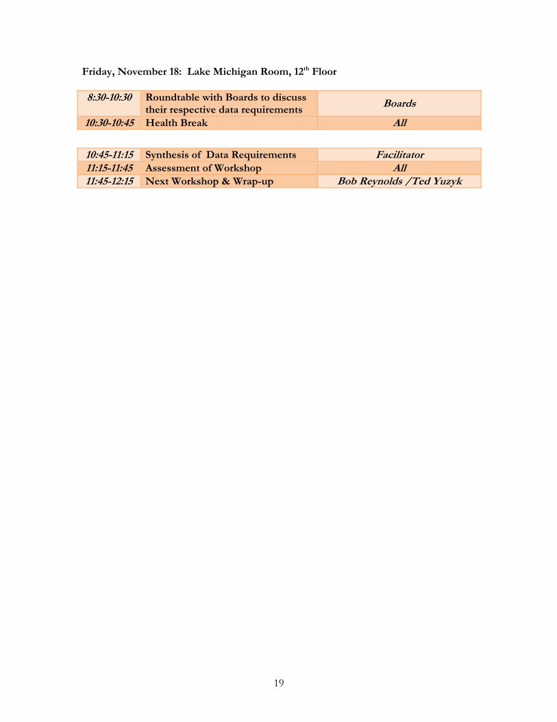
Friday, November 18: Lake Michigan Room, 12th Floor 8:30-10:30 Roundtable with Boards to discuss
their respective data requirements Boards
10:30-10:45 Health Break All
10:45-11:15 Synthesis of Data Requirements Facilitator 11:15-11:45 Assessment of Workshop All 11:45-12:15 Next Workshop & Wrap-up Bob Reynolds /Ted Yuzyk
19

20
APPENDIX C – PERSONS ATTENDING
Armstrong, Nicole
Manitoba Water Stewardship [email protected]
Baratono, Nolan Minnesota Pollution Control Agency
Bell, Gord Agriculture Canada, AESB [email protected] Bruxer, Jacob Environment Canada [email protected] Caldwell, Rob Environment Canada [email protected] Colosimo, Mark International Joint Commission [email protected] Cotroneo, George
U.S. Army Corps of Engineers [email protected]
Dahl, Travis U.S. Army Corps of Engineers [email protected] Dewolfe, Matt Environment Canada [email protected] Fay, David Environment Canada [email protected] Ghamry, Haitham Fisheries & Oceans Canada [email protected] Halliday, Bob Consultant, Rapporteur [email protected] Holtschlag, Dave U.S. Geological Survey [email protected] Jenkinson, Wayne Canadian Hydraulics Centre
(NRC) [email protected]
Johnson, Craig U.S. Geological Survey [email protected] Kamerath, Marcy U.S. Environmental Protection
Agency [email protected]
Kangas, John US Army Corps of Engineers [email protected] Klyszejko, Erika Environment Canada [email protected] Laitta, Mike International Joint Commission [email protected] Lee, Debbie U.S. Army Corps of Engineers [email protected] Leon, Luis Environment Canada [email protected] Moin, Syed International Joint Commission [email protected] Nustad, Rochelle U.S. Geological Survey [email protected] Oyler, Jeff National Oceanic &
Atmospheric Administration [email protected]
Pilon, Paul International Joint Commission [email protected] Renouf, Mike Environment Canada [email protected] Reynolds, Bob International Joint Commission [email protected] Southam, Chuck Environment Canada [email protected] Thompson, Aaron
Environment Canada [email protected]
Tule, Shelley U.S. Army Corps of Engineers [email protected] Yee, Brian Environment Canada [email protected] Yuzyk, Ted International Joint Commission [email protected]
Related Documents