- 22 - IV-A NEIGHBORHOODS ELEMENT The communities of Mid-City are a collection of diverse neighborhoods, each with its own look, feel, history, and culture. Each neighborhood’s assets and opportunities can be used to enhance the area’s overall character and add to the health and vitality of the entire Mid-City. Normal Heights Adams North Adams Park Cherokee Park Kensington-Talmadge Kensington Talmadge City Heights Corridor Teralta West Teralta East Colina Park Cherokee Point Castle Azalea Park Hollywood Park Fairmount Park Bayridge Fairmount Village Swan Canyon Chollas Creek Fox Canyon Islenair Ridgeview Eastern Area Chollas Triangle Darnall El Cerrito Heights Oak Park Rolando Rolando Park Webster

Welcome message from author
This document is posted to help you gain knowledge. Please leave a comment to let me know what you think about it! Share it to your friends and learn new things together.
Transcript
- 22 -
IV-A NEIGHBORHOODS ELEMENT The communities of Mid-City are a collection of diverse neighborhoods, each with its own look, feel, history, and culture. Each neighborhood’s assets and opportunities can be used to enhance the area’s overall character and add to the health and vitality of the entire Mid-City.
Normal Heights Adams North Adams Park Cherokee Park
Kensington-Talmadge Kensington Talmadge
City Heights Corridor Teralta West Teralta East Colina Park Cherokee Point Castle Azalea Park Hollywood Park Fairmount Park Bayridge Fairmount Village Swan Canyon Chollas Creek Fox Canyon Islenair Ridgeview
Eastern Area Chollas Triangle Darnall El Cerrito Heights Oak Park Rolando Rolando Park Webster
- 23 -
BACKGROUND Twenty-seven neighborhoods have been identified within the four communities of Mid-City: Normal Heights, Kensington-Talmadge, City Heights, and Eastern Area. While neighborhood boundaries are not hard and fast, a major determinant of the boundaries and neighborhoods illustrated in this Plan was the existence of active community associations. These organizations help neighborhoods focus on their needs and improvement opportunities, greatly enhancing their chances of success. These neighborhood organizations exist in addition to the recognized community planning groups that represent each of the four subareas. The following is a brief description of each neighborhood and a list of some of the more dominant issues confronted by each. These issues were identified by the community in the development of this Plan, and are addressed in its various elements. Some neighborhoods have developed their own action plans to address neighborhood concerns, in some cases looking at long range planning issues and others focusing also on short-term physical and social needs. More such action plans—or RAPs (Revitalization Action Plans)—are anticipated in the future.
- 24 -
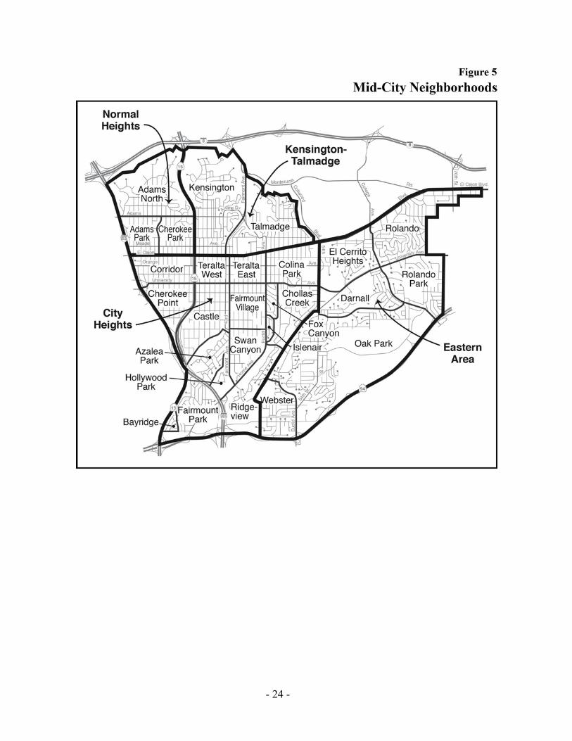
FIGURE 5. MID-CITY NEIGHBORHOODS
- 25 -
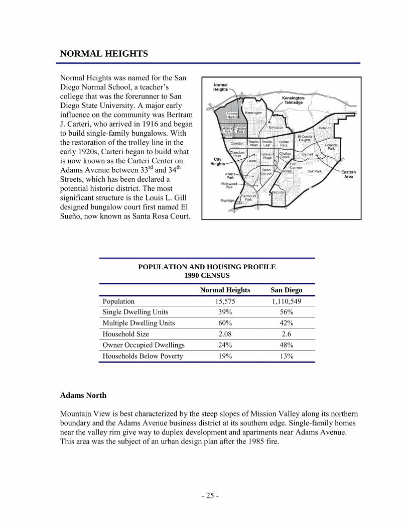
NORMAL HEIGHTS Normal Heights was named for the San Diego Normal School, a teacher’s college that was the forerunner to San Diego State University. A major early influence on the community was Bertram J. Carteri, who arrived in 1916 and began to build single-family bungalows. With the restoration of the trolley line in the early 1920s, Carteri began to build what is now known as the Carteri Center on Adams Avenue between 33rd and 34th Streets, which has been declared a potential historic district. The most significant structure is the Louis L. Gill designed bungalow court first named El Sueño, now known as Santa Rosa Court.
POPULATION AND HOUSING PROFILE 1990 CENSUS
Normal Heights San Diego Population 15,575 1,110,549 Single Dwelling Units 39% 56% Multiple Dwelling Units 60% 42% Household Size 2.08 2.6 Owner Occupied Dwellings 24% 48% Households Below Poverty 19% 13%
Adams North Mountain View is best characterized by the steep slopes of Mission Valley along its northern boundary and the Adams Avenue business district at its southern edge. Single-family homes near the valley rim give way to duplex development and apartments near Adams Avenue. This area was the subject of an urban design plan after the 1985 fire.
- 26 -
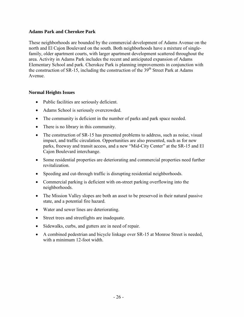
Adams Park and Cherokee Park These neighborhoods are bounded by the commercial development of Adams Avenue on the north and El Cajon Boulevard on the south. Both neighborhoods have a mixture of single-family, older apartment courts, with larger apartment development scattered throughout the area. Activity in Adams Park includes the recent and anticipated expansion of Adams Elementary School and park. Cherokee Park is planning improvements in conjunction with the construction of SR-15, including the construction of the 39th Street Park at Adams Avenue. Normal Heights Issues
• Public facilities are seriously deficient.
• Adams School is seriously overcrowded.
• The community is deficient in the number of parks and park space needed.
• There is no library in this community.
• The construction of SR-15 has presented problems to address, such as noise, visual impact, and traffic circulation. Opportunities are also presented, such as for new parks, freeway and transit access, and a new “Mid-City Center” at the SR-15 and El Cajon Boulevard interchange.
• Some residential properties are deteriorating and commercial properties need further revitalization.
• Speeding and cut-through traffic is disrupting residential neighborhoods.
• Commercial parking is deficient with on-street parking overflowing into the neighborhoods.
• The Mission Valley slopes are both an asset to be preserved in their natural passive state, and a potential fire hazard.
• Water and sewer lines are deteriorating.
• Street trees and streetlights are inadequate.
• Sidewalks, curbs, and gutters are in need of repair.
• A combined pedestrian and bicycle linkage over SR-15 at Monroe Street is needed, with a minimum 12-foot width.
- 27 -
FIGURE 6. NORMAL HEIGHTS COMMUNITY VISION MAP
- 28 -
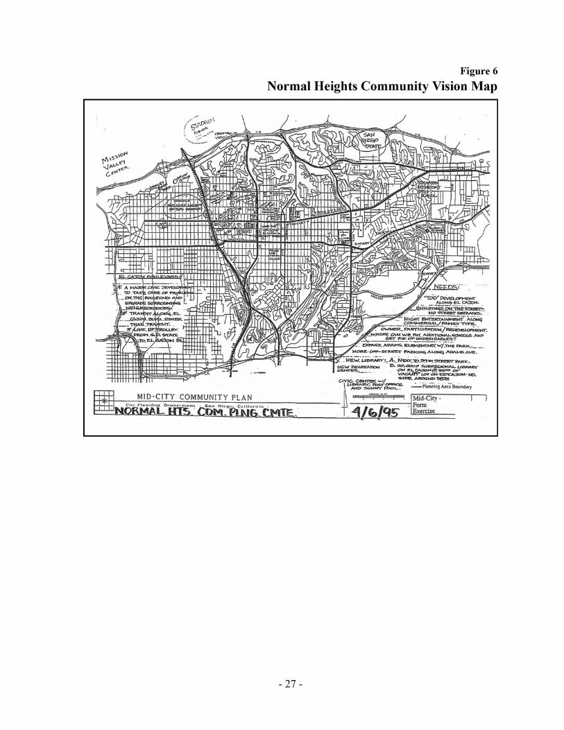
FIGURE 7. NORMAL HEIGHTS COMMUNITY MAP
- 29 -
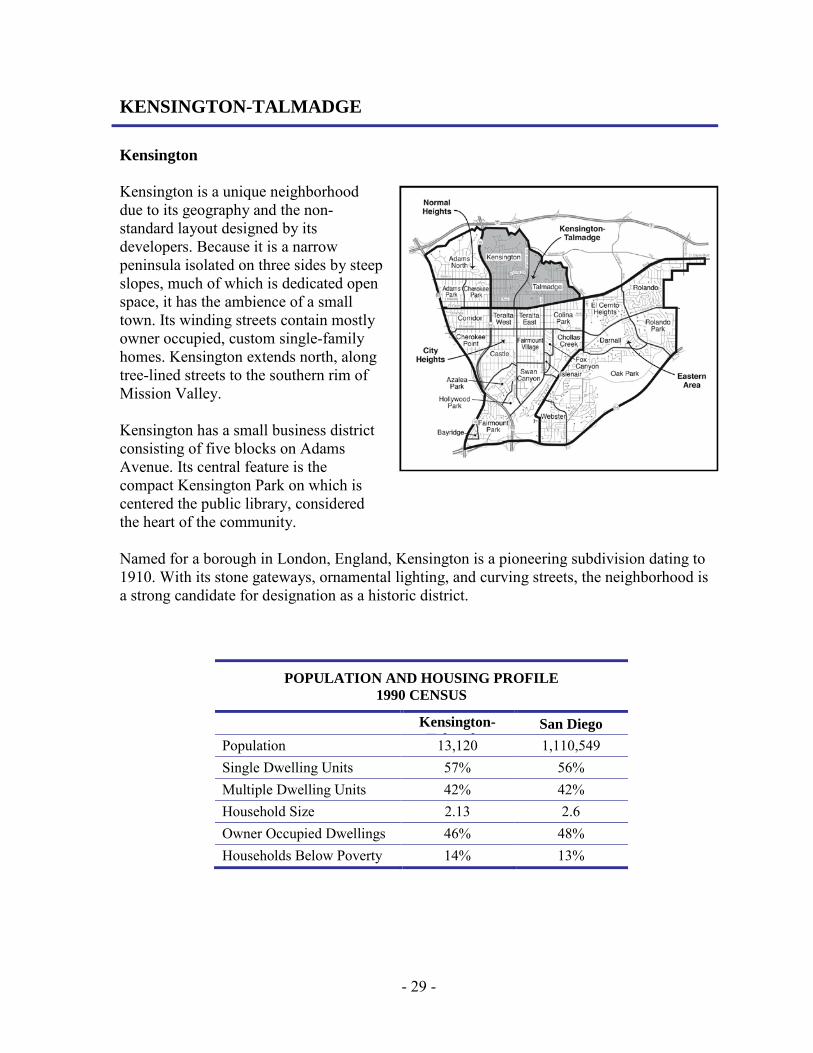
KENSINGTON-TALMADGE Kensington Kensington is a unique neighborhood due to its geography and the non-standard layout designed by its developers. Because it is a narrow peninsula isolated on three sides by steep slopes, much of which is dedicated open space, it has the ambience of a small town. Its winding streets contain mostly owner occupied, custom single-family homes. Kensington extends north, along tree-lined streets to the southern rim of Mission Valley. Kensington has a small business district consisting of five blocks on Adams Avenue. Its central feature is the compact Kensington Park on which is centered the public library, considered the heart of the community. Named for a borough in London, England, Kensington is a pioneering subdivision dating to 1910. With its stone gateways, ornamental lighting, and curving streets, the neighborhood is a strong candidate for designation as a historic district.
POPULATION AND HOUSING PROFILE 1990 CENSUS
Kensington-T l d
San Diego Population 13,120 1,110,549 Single Dwelling Units 57% 56% Multiple Dwelling Units 42% 42% Household Size 2.13 2.6 Owner Occupied Dwellings 46% 48% Households Below Poverty 14% 13%

- 30 -
Talmadge Talmadge is a special hidden neighborhood, the cousin of Kensington and surrounded by beautiful canyons. Iron gates with ornamental lights mark the gateways of Talmadge. Known as the “Movie Girl” tract, some of the streets are named after the Talmadge sisters, famous silent screen movie stars who dedicated the neighborhood in January 1926. The homes are all unique and all with a distinctive individuality acquired over generations of proud home ownership. Homes are located on narrow streets with the garages placed at the rear of the lot or off alleys. This creates a wonderful pedestrian-oriented community where everyone walks and knows their neighbors. Figure 8. Kensington-Talmadge Vision Map
- 31 -
KENSINGTON-TALMADGE ISSUES • Schools are overcrowded and park space is deficient.
• The library does not meet General Plan standards but maintenance of the existing library site and the surrounding park is preferred.
• The construction of SR-15 has presented both problems to address, such as noise, visual impact, and traffic circulation; and opportunities, such as developing new parking areas, freeway and transit access, and a new “Mid-City Center” at the SR-15 and El Cajon Boulevard interchange.
• Some residential properties south of Monroe Avenue are deteriorating, and commercial properties on El Cajon Boulevard are in need of revitalization.
• Speeding and cut-through traffic is disrupting portions of residential neighborhood streets.
• Commercial parking is deficient with on-street parking overflowing into the neighborhoods.
• The slopes surrounding Kensington-Talmadge are both an asset to be preserved in their natural passive state without intrusion, and a potential fire hazard.
• Sidewalks and water and sewer lines are deteriorated.
• Street trees and streetlights are inadequate.
- 32 -
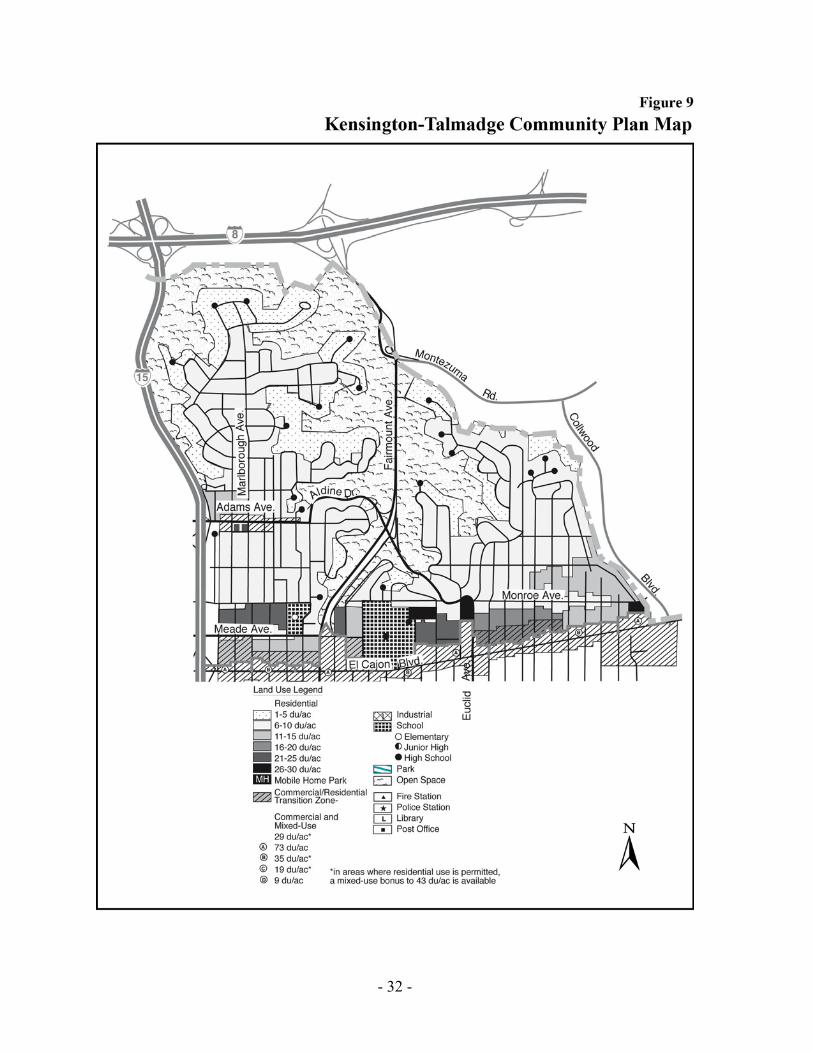
FIGURE 9. KENSINGTON-TALMADGE COMMUNITY PLAN MAP
- 33 -
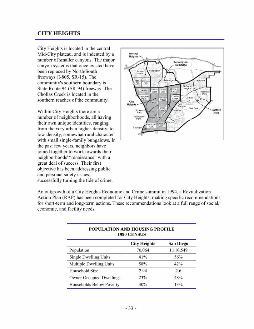
CITY HEIGHTS City Heights is located in the central Mid-City plateau, and is indented by a number of smaller canyons. The major canyon systems that once existed have been replaced by North/South freeways (I-805, SR-15). The community's southern boundary is State Route 94 (SR-94) freeway. The Chollas Creek is located in the southern reaches of the community. Within City Heights there are a number of neighborhoods, all having their own unique identities, ranging from the very urban higher-density, to low-density, somewhat rural character with small single-family bungalows. In the past few years, neighbors have joined together to work towards their neighborhoods' “renaissance” with a great deal of success. Their first objective has been addressing public and personal safety issues, successfully turning the tide of crime. An outgrowth of a City Heights Economic and Crime summit in 1994, a Revitalization Action Plan (RAP) has been completed for City Heights, making specific recommendations for short-term and long-term actions. These recommendations look at a full range of social, economic, and facility needs.
POPULATION AND HOUSING PROFILE 1990 CENSUS
City Heights San Diego Population 70,064 1,110,549 Single Dwelling Units 41% 56% Multiple Dwelling Units 58% 42% Household Size 2.94 2.6 Owner Occupied Dwellings 23% 48% Households Below Poverty 30% 13%

- 34 -
The Corridor, Teralta West, and Teralta East The Corridor, Teralta West, and Teralta East are linear neighborhoods located in the middle strip of the Mid-City plateau. They were originally developed with single-family housing as the suburban addition to San Diego, and located along the east trolley corridor and the original Highway 80 (El Cajon Boulevard) route. The area has been developing since World War II with higher-density apartments and condominium development. These neighborhoods now contain the highest population density in Mid-City. Much of the housing is multifamily combined with older single-family development and some older apartment courts, which are still the best maintained areas. Commercial needs are served by The Boulevard and University Avenue commercial corridors. All residences are within a walking radius of commercial services and potential employment areas. Colina Park Colina Park is located just east of Teralta East. The neighborhood’s single-family residential areas have been encroached upon by large lower income apartment complexes. It is distinguished by hilly terrain, giving the area outstanding views. A large community park—Colina Del Sol Park—includes Colina Park Golf Course, a recently rejuvenated par 3 course that features a very successful Pro Kids Golf Academy for local youth. Cherokee Point With the exception of the University Avenue commercial frontage, Cherokee Point is a residential neighborhood, with primarily single-family homes. Park de La Cruz is being developed as part of the SR-15 construction. Remnant hillsides indent the neighborhood from the freeways which have replaced some of the natural canyon areas. Castle Castle is primarily a single-family home residential neighborhood with the exception of the University Avenue commercial frontage and a few older stores scattered along Fairmount Avenue. Some multifamily development is located along 43rd Street and Fairmount Avenue. The northern rim of Azalea Canyon bounds the residential neighborhood, providing a potential resource for open space and recreation enhancements.
- 35 -
Azalea Park and Hollywood Park Azalea Park is a primarily single-family residential home neighborhood with a few sprinkled low-density multifamily complexes. Poplar Avenue bisects Azalea Park and provides some neighborhood commercial services to the area. Azalea Park is one of the most active residential neighborhoods in City Heights and one of the first in the City of San Diego to implement the neighborhood policing program. Local craftsmen and artists have created unique wood crafted street signs representing the flower names of many of the streets in the neighborhood. The neighborhood of Hollywood Park is bound to the south by Hollywood Park and Canyon. On December 13 and 14, 1996, the Azalea Park neighborhood Association co-sponsored a “Village Charrette” with Hollywood Park neighborhood, to identify neighborhood improvements for revitalization. The vision reached during the event was: the establishment of a “Village in a Park” creating cohesion and place for the two neighborhoods; using the canyon open space and existing Azalea Park and Hollywood Park as a resource to attract business and shops; and the establishment of gateway entrances featuring artwork. Along with these ideas would go improvement of public infrastructure and services, amendments to zoning to permit “live work” artist and commercial space, improved parking and development of a unique village design. Fairmount Park and Bayridge Fairmount Park is located in a promontory surrounded on all sides by hillsides and freeways. Home Avenue bisects it diagonally, linking the neighborhood to both I-805 and SR-94. Chollas Creek runs through it on a southwestern direction towards San Diego Bay. The neighborhood is predominantly single-family homes, with some auto-oriented commercial and industrial uses along Home Avenue. Bayridge is a small neighborhood contained within Fairmount Park on its westernmost knoll, identifiable for its outstanding views and well maintained duplex development. Fairmount Village and Swan Canyon Fairmount Village is located on the mesa south of University Avenue and east of Fairmount Avenue. The area is predominantly single-family homes, with some duplex development and apartment development predominantly near University Avenue. Commercial development is concentrated along University with scattered businesses on Fairmount Avenue and Euclid Avenue. The recent development of the City Links Project, along with the Rosa Parks Elementary School, have brought new life into Fairmount Village. Swan Canyon, located south of Fairmount Village, is predominantly single-family uphill from canyons facing Home Avenue. Monroe-Clarke Middle School was recently constructed in this neighborhood.

- 36 -
Islenair Islenair is an isolated neighborhood just east of Euclid Avenue and bounded on all other sides by hillside remnants of canyons. It is also an island in the sense that it is entirely single-family homes in an otherwise mixed-use area; a very small and tightly knit community. Ridgeview The northern portion of Ridgeview is predominantly single-family residential, with the southern section dedicated to industrial use. Chollas Creek runs through it in a southwesterly direction. Chollas Creek and Fox Canyon Chollas Creek is predominantly single-family homes with some multifamily development in areas off University Avenue. The Fox Canyon neighborhood has developed as its vision a well-integrated residential and business community sensitive to preserving natural, artistic, and historical developments within a well maintained, safe, and friendly environment. City Heights Issues
• In spite of the addition of new facilities, schools remain severely overcrowded and parks are deficient.
• While presenting some problems, the construction of SR-15 presents the opportunity for new business development surrounding the University Avenue interchange.
• The very high demand for public transit outstrips the available service.
• Residential rehabilitation and commercial revitalization are needed.
• Commercial parking is deficient with on-street parking overflowing into the neighborhoods.
• Sidewalks and water and sewer lines are deteriorated.
• Street trees are lacking.
• The social and cultural needs of the culturally diverse sectors of the population need to be addressed.

- 37 -
FIGURE 10. CITY HEIGHTS VISION MAP
- 38 -
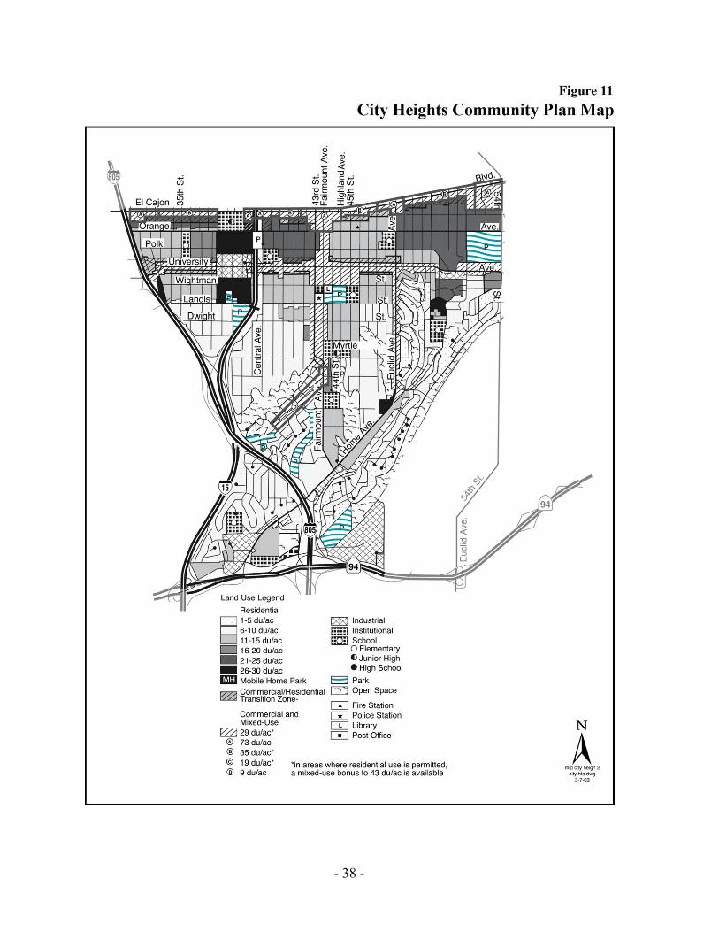
FIGURE 11. CITY HEIGHTS COMMUNITY PLAN MAP

- 39 -
EASTERN AREA
While the Eastern Area shares many of the same issues with Mid-City's other three communities, it is distinguished by its hilly topography and more recent development. But in spite of its age, this area finds itself in need of revitalization as well. In a recent effort to address these needs, most of this subarea along with the College area and portions of City Heights was the subject of the College and Eastern Area Planning and Economic Review (CEAPER), which recommended a series of strategies aimed at attracting business and residents.
POPULATION AND HOUSING PROFILE 1990 CENSUS
Eastern Area San Diego Population 29,176 1,110,549 Single Dwelling Units 59% 56% Multiple Dwelling Units 38% 42% Household Size 2.50 2.6 Owner Occupied Dwellings 54% 48% Households Below Poverty 18% 13%

- 40 -
CHOLLAS TRIANGLE SECTION OF THE EASTERN AREA NEIGHBORHOODS
Chollas Triangle is an approximately 43-acre site within the Eastern Area and is bounded by 54th Street to the west, Chollas Creek to the south and east, and University Avenue to the north. The City, working with the community, prepared a study to provide specific land use, mobility, and urban design recommendations to encourage a mixed-use transit-oriented village supported by public/civic/park space, open space, and creek enhancements within the Chollas Triangle Site. Chollas Triangle is envisioned as a vibrant, mixed-use neighborhood center that celebrates Chollas Creek and promotes the use of multi-modal transit along University Avenue and 54th Street. The site has the potential to serve as a major destination for surrounding neighborhood residents. The Community Plan implements the goals and recommendations developed through the process. This section below provides additional recommendations for implementation.
GOAL • Create an active neighborhood village with an integrated mixture of residential, commercial,
and recreational uses. • Create an open space system and development pattern that connects adjacent neighborhoods
to and through Chollas Triangle. The landscape character of the community is defined by its hills, canyons and bluffs. While these features create a beautiful and dramatic urban pattern, they often create barriers between neighborhoods. A primary goal of this plan is to acknowledge these features and design a harmonious open space system and development pattern that connect adjacent neighborhoods to and through Chollas Triangle.
- 41 -
Chollas Triangle CPIOZ The Community Plan Implementation Overlay Zone (CPIOZ), Type-B applies to the Chollas Triangle Site (Figure 12.1). CPIOZ Type-B applies to the Chollas Triangle site to refine and help implement the policies of the Community Plan. For properties designated Neighborhood Village, development shall conform to the use and development regulations of the CC-3-5 zone except where superseded by this CPIOZ. Development proposals on properties identified as CPIOZ Type B require discretionary review to determine if the development proposal is consistent with the community plan and these supplemental regulations. Exceptions from these regulations for development that is minor, temporary, or incidental and is consistent with the intent of this CPIOZ may be granted by the City Manager in accordance with the procedures of the Community Plan Implementation Overlay Zone within the Municipal Code Section 132.1403. Applications for development on a property located in CPIOZ Type-B will require a Process Three Site Development Permit and shall address the design and compatibility of the project in relation to surrounding development, including conformance with the following regulations.
1. A maximum of 130,000 square feet of non-residential development is allowed within lands designated as Neighborhood Village.
2. Building heights shall not exceed 65 feet.
3. Residential use and residential parking are allowed anywhere on the ground floor, except along University Avenue where the ground floor street wall shall be a commercial use.
4. A minimum of 70 percent of the ground floor street wall shall be developed with commercial uses along University Avenue.
- 42 -
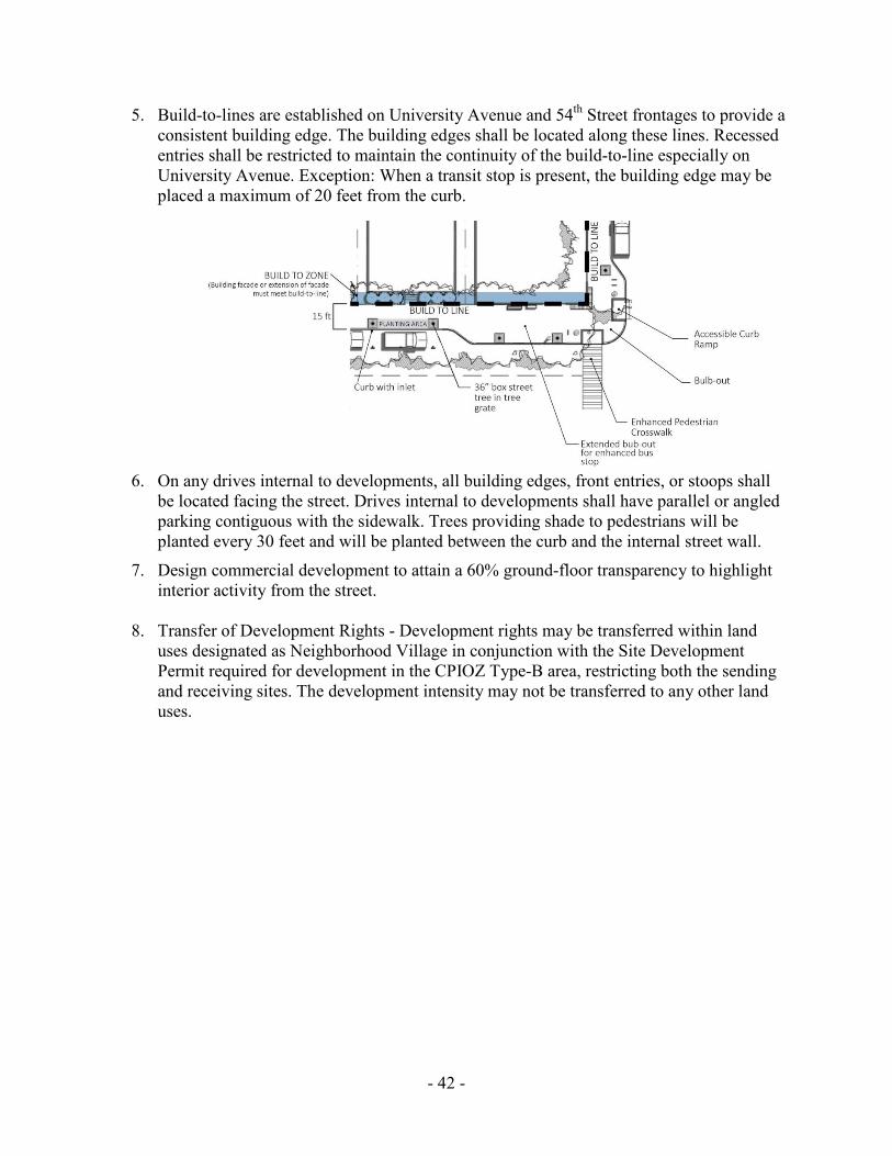
5. Build-to-lines are established on University Avenue and 54th Street frontages to provide a consistent building edge. The building edges shall be located along these lines. Recessed entries shall be restricted to maintain the continuity of the build-to-line especially on University Avenue. Exception: When a transit stop is present, the building edge may be placed a maximum of 20 feet from the curb.
6. On any drives internal to developments, all building edges, front entries, or stoops shall be located facing the street. Drives internal to developments shall have parallel or angled parking contiguous with the sidewalk. Trees providing shade to pedestrians will be planted every 30 feet and will be planted between the curb and the internal street wall.
7. Design commercial development to attain a 60% ground-floor transparency to highlight interior activity from the street.
8. Transfer of Development Rights - Development rights may be transferred within land uses designated as Neighborhood Village in conjunction with the Site Development Permit required for development in the CPIOZ Type-B area, restricting both the sending and receiving sites. The development intensity may not be transferred to any other land uses.
- 43 -
Implementation No new development that exceeds 4,261 driveway average daily trips (ADT) shall proceed within the Chollas Triangle site until the following improvements are completed and accepted by the City Engineer:
• Provide a raised median on University Avenue from 54th Street to 58th Street, satisfactory to the City Engineer;
• Restripe the southbound and northbound approaches at the intersection of College Avenue and University Avenue to provide dual left turn lanes and modify the traffic signal accordingly, satisfactory to the City Engineer. Provide for Class III bicycle lanes on College Avenue north of University Avenue.
Each development proposal shall be required to submit a trip generation table that tracks the average daily trips generated from each development project within the Chollas Triangle site in order to monitor when the 4,261 ADT will be reached.
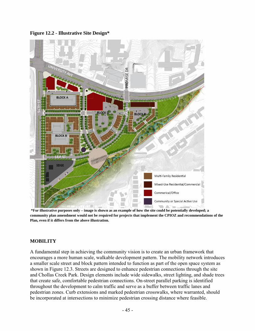
LAND USE The Neighborhood Village designation allows for housing and convenience shopping in a mixed-use setting, public uses and services serving an approximate three mile radius. A more intensive commercial and mixed-use development pattern is identified for the street frontage along University Avenue, with uses transitioning to less intense residential development and Chollas Creek Park to the south. In order to create a vibrant neighborhood, a variety of household types, sizes and price points are encouraged including, rowhomes, condos, apartments, and lofts. The entire site allows for no more than 486 multi-family dwelling units and 130,000 square feet of non-residential square footage. Development along University Avenue should transition from solely commercial uses near the University Avenue / 54th Street intersection to mixed-use residential further east. This pattern is intended to provide suitable sites for commercial users who desire corners at busy intersections as well as to reduce noise impacts on residential units. All commercial uses along University Avenue should have active ground floor uses and transparent facades to promote an active, pedestrian-oriented street. The land use designation allows for a large format commercial building intended to accommodate a neighborhood grocery store. Commercial uses should front the street and locate parking internally. Residential development should include entrances that front public streets, specifically 54th Street and Lea Street, as well as Chollas Creek Park as illustrated in Figure 12.2. Smaller building footprints are better suited along streets with gentle slopes and curves with parking located within the interior of the site.

- 44 -
Figure 12.1 - Land Use Plan
Recommendations • Parcels fronting University Avenue should provide a mixture of multi-family housing and
commercial uses along a major transportation corridor. • Commercial uses along University Avenue should have transparent facades to promote an
active, pedestrian-oriented street. • Commercial uses should front the street and locate parking internally. • Residential development should include entrances that front public streets, specifically 54th
Street and Lea Street, as well as Chollas Creek Park. • Encourage convenience shopping with a pedestrian orientation at the corner of 54th Street and
University Avenue. • Locate more intense uses, such as office and commercial businesses, along University
Avenue. • Allow for the ability to develop commercial anchor retail, such as a neighborhood grocery
store, that fronts University Avenue. • Provide a variety of housing types adjacent to active park uses located at the southern and
eastern areas of Chollas Triangle.
- 45 -
Figure 12.2 - Illustrative Site Design*
*For illustrative purposes only – image is shown as an example of how the site could be potentially developed; a community plan amendment would not be required for projects that implement the CPIOZ and recommendations of the Plan, even if it differs from the above illustration.
MOBILITY
A fundamental step in achieving the community vision is to create an urban framework that encourages a more human scale, walkable development pattern. The mobility network introduces a smaller scale street and block pattern intended to function as part of the open space system as shown in Figure 12.3. Streets are designed to enhance pedestrian connections through the site and Chollas Creek Park. Design elements include wide sidewalks, street lighting, and shade trees that create safe, comfortable pedestrian connections. On-street parallel parking is identified throughout the development to calm traffic and serve as a buffer between traffic lanes and pedestrian zones. Curb extensions and marked pedestrian crosswalks, where warranted, should be incorporated at intersections to minimize pedestrian crossing distance where feasible.
STREET
- 46 -
Lea Street will connect 54th Street to University Avenue to form the fourth leg of the controlled intersection near Promise Drive. The specific location and design of the intersection alignment of Lea Street and University Avenue would be subject to further engineering analysis to the satisfaction of the City Engineer. This alignment forms the northern edge of the park, creating a highly visible and accessible open space. Buildings should front Lea Street to take advantage of creek and park views and provide informal observation on the park. Development within the site should capitalize on the regional bus connectivity, particularly at the intersection of University Avenue & 54th Street. The southeast corner of this intersection is envisioned as an enhanced transit plaza with ample room and comfortable waiting areas for transit patrons. Amenities should include, bus shelters, seating, trash cans, bicycle parking and transit information. Improvements to the University Avenue and 54th Street intersection will enhance pedestrian safety and connect the project site to adjacent neighborhoods, businesses and open space. The University Avenue Mobility Study has identified elimination of the channelized right turns on the westbound and southbound approaches of this intersection. This will improve safety by shortening pedestrian crossing distances, improving visibility and reducing conflicts between all modes of transportation. The plan envisions the vacation of Chollas Parkway and the realignment of Lea Street to a two lane collector street that connects University Avenue and 54th Street to reduce cut-through traffic, improving the pedestrian environment and overall livability for residents. A new signalized intersection will be located along University Avenue, eliminating the need for the existing complicated intersection at University Avenue and Chollas Parkway. Non-contiguous sidewalks with ample landscape zones should be provided to create a safe and pleasant pedestrian environment should be provided on all internal development streets as well as any public streets that interface with the CPIOZ area. On-street parking will provide an additional buffer between traffic lanes and pedestrians. The Chollas Triangle design principles promote an active and pedestrian scale street environment that encourages street activity and walkability. The existing, expansive parking lots will be replaced by dispersed surface lots behind buildings, on street parking, or in parking structures. Ample bike parking should be provided near bus stops, commercial areas and multifamily development. Improved connectivity to adjacent neighborhoods will make cycling more convenient and encourage transit use. Consideration should be given to designating bicycle parking areas for short and long-term use at commercial and residential locations.

- 47 -
Figure 12.3 - Circulation
Recommendations • Vacate Chollas Parkway to allow for active and passive park and open space uses. • Design Lea Street as a two-lane collector that connects 54th Street to University Avenue • Complete the extension of Lea Street through acquisition of right-of-way. The acquisition of
necessary right-of-way from affected property owners could include a transfer of City-owned Neighborhood Village-designated property.
• Provide metered parallel parking along University Avenue. • Provide for an enhanced transit plaza at 54th Street and University Avenue through
comfortable walk and wait environments for transit riders. • Design streets that include pedestrian amenities such as non-contiguous sidewalks, street
trees, and street furniture. • Extend the public realm into the site through the incorporation of pedestrian amenities such
as sidewalks and street trees. • Minimize pedestrian / automobile conflict by creating pedestrian friendly intersections that
incorporate bulb outs, pedestrian refuge areas and reduce crossing distances where appropriate.
• Create a safe, human-scale pedestrian and bicycle network.

- 48 -
URBAN DESIGN The Chollas Triangle site has the opportunity to serve as a destination and focal point within Mid-City that celebrates Chollas Creek. New development that implements this vision should include buildings that front streets with parking located behind buildings or in parking structures. Where feasible, tuck-under parking, underground parking, or parking structures should be situated into the existing topography to minimize visual impact on surrounding uses. Design treatments including quality articulated façades, building step-backs, porches and stoops serve to break up the mass and form of buildings and create an interesting street edge. Residences should include front porches and balconies at upper levels, allowing private exterior space for each dwelling unit. Significant building setbacks should be incorporated along University Avenue to provide space for an expanded transit plaza. A setback distance of 15 - 20 feet from the curb to building face should create a comfortable pedestrian environment along this corridor. Street trees should be provided in a regular interval of 30-35 feet to provide continuous shading for pedestrians. Ground floor transparency should be maximized to create pedestrian level interest and a visual connection between the street and interior spaces, enabling a strong sense of community and increasing informal oversight of public areas. Figure 12.4 – Urban Form
Building heights should transition from lower (1-3 stories) commercial/mixed-use buildings along University Avenue to taller (4-5 stories) residential buildings along the park. Existing grades slope to the south and east, with an existing grade difference of 25’-50’ between University and Chollas Creek. Locating taller buildings at the lower site elevations minimizes both the effect of higher
buildings on the surrounding neighborhoods, and the formation of a potential ‘building canyon’ along University Avenue.

- 49 -
Figure 12.5 – Important Views into the Site
Building location and orientation frame views into the site and to the creek. Special uses and public spaces should be located to take advantage of views to adjacent canyons and hillsides. Signature architecture and/or landscape elements are encouraged at important view termini to strengthen the identity of Chollas Triangle within the community. Recommendations • Encourage signature architecture at major view corridors to establish a unique identity for
Chollas Triangle. • Incorporate green infrastructure (pervious paving, flow through planters, bio-retention
swales, etc.) as a means to cleanse storm water run-off prior to entering Chollas Creek. • Minimize urban heat island affect through building design, roof design and site landscaping. • Design lot and blocks to encourage a pedestrian-scale development pattern. • Utilize topography to enhance views and minimize grading. • Locate parking behind buildings or in park decks. • Utilize topography to enhance prominent views into and out of the site.
- 50 -
NEIGBORHOOD PARK/OPEN SPACE
A primary goal for Chollas Triangle is the creation of an approximately five-acre active use neighborhood park in the location of the vacated Chollas Parkway. The new park will provide an identity for Chollas Triangle. It will include a mix of passive and active park and open space uses, and a restored riparian habitat along Chollas Creek. Chollas Creek Park will serve as a major community focal point, and should be designed to accommodate a variety of users. The over-arching park design concept is to create a series of independent, yet connected spaces along Chollas Creek. These spaces alternate between active/passive uses and native riparian areas. This concept helps create a string of varied experiences as users move through the park. An open space buffer that extends 50 feet from the edge of the natural stream line of Chollas Creek to the lands designated for park use is established to serve as a transition between active and passive open space uses. The open space and creek area will have the potential to serve as a receiver site for storm water management and treatment. Chollas Creek should be restored in a manner that balances the need for native habitat/riparian zones with opportunities for people to interact with the creek. The creek banks should be shallow to allow for creek views and access. The open space is designed as a series of ‘expansion’ and ‘compression’ areas adjacent to the creek channel. The expansion areas are broad zones that allow the creek to meander and braid during low flows and serve as detention areas when the creek floods. The compression areas focus the creek channel at strategic locations that bring people to the water near the plazas or open lawn areas. This pattern creates differing environments that encourage people to engage the creek in a variety of ways. Informal paths or boardwalks in the expansion zones allow people to explore the native landscape and access the creek, with drop structures at strategic locations to create overlooks and places of visual and audible interest within the park. A plaza should be located along Lea Street. The plaza is a highly flexible space intended to serve the community year round, offering both programmed and informal uses such as: public gatherings, outdoor concerts, farmers markets, and informal gathering. A series of open, level lawn areas allow for informal active uses such as soccer, lawn games, picnics, etc. These linked ‘rooms’ create a series of distinct experiences along Chollas Creek. The southwest portion of the park should be reserved for uses that meet specific community needs and activate the park. These uses could include a community garden or dog park.
- 51 -
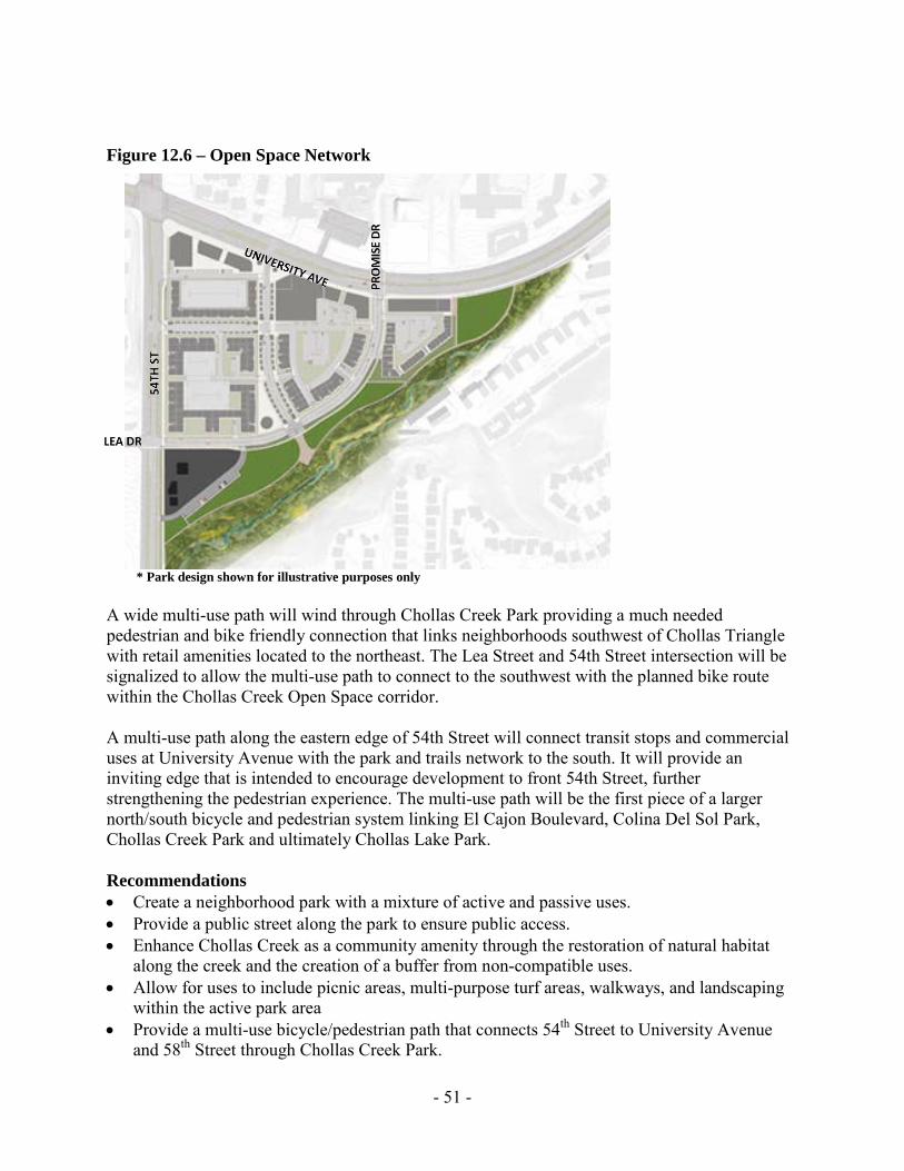
Figure 12.6 – Open Space Network
* Park design shown for illustrative purposes only A wide multi-use path will wind through Chollas Creek Park providing a much needed pedestrian and bike friendly connection that links neighborhoods southwest of Chollas Triangle with retail amenities located to the northeast. The Lea Street and 54th Street intersection will be signalized to allow the multi-use path to connect to the southwest with the planned bike route within the Chollas Creek Open Space corridor. A multi-use path along the eastern edge of 54th Street will connect transit stops and commercial uses at University Avenue with the park and trails network to the south. It will provide an inviting edge that is intended to encourage development to front 54th Street, further strengthening the pedestrian experience. The multi-use path will be the first piece of a larger north/south bicycle and pedestrian system linking El Cajon Boulevard, Colina Del Sol Park, Chollas Creek Park and ultimately Chollas Lake Park. Recommendations • Create a neighborhood park with a mixture of active and passive uses. • Provide a public street along the park to ensure public access. • Enhance Chollas Creek as a community amenity through the restoration of natural habitat
along the creek and the creation of a buffer from non-compatible uses. • Allow for uses to include picnic areas, multi-purpose turf areas, walkways, and landscaping
within the active park area • Provide a multi-use bicycle/pedestrian path that connects 54th Street to University Avenue
and 58th Street through Chollas Creek Park.
- 52 -
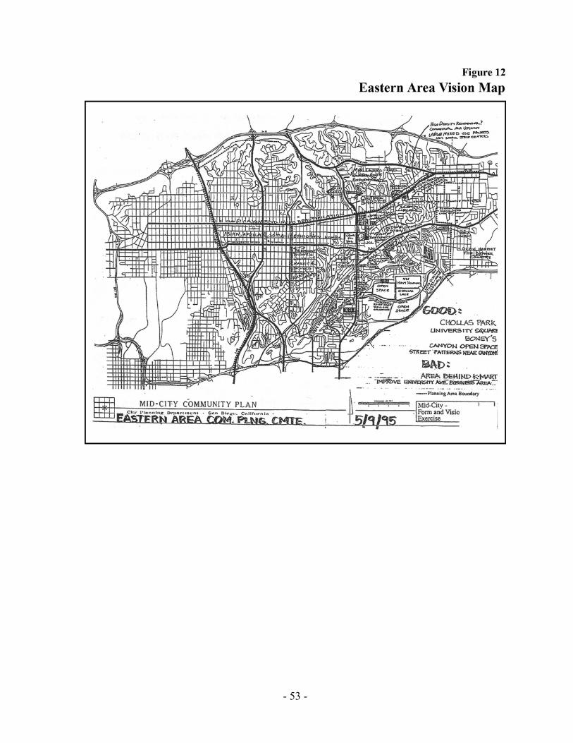
El Cerrito Heights As its name describes, El Cerrito Heights is a hilly neighborhood. El Cerrito Heights is a predominantly single-family homes neighborhood with some multifamily development off the commercial corridors of El Cajon Boulevard and University Avenue. The 54th street corridor contains a substantial acreage of schools with Jackson Elementary, Mann Middle School, and Crawford Senior High School. There is a Jewish Community Center with recreational and meeting facilities, and a convalescent home. A small hospital, Villa View, is located on a knoll overlooking University Avenue and 54th Street. Rolando The rolling hills of Rolando began to develop in the 1930s, as evidenced by the style of the custom single-family homes and the “acorn” style post-top streetlights. The grid street pattern south of the strip commercial development along El Cajon Boulevard gives way to a curvilinear pattern in the hilly southern portions of the neighborhood. While predominantly single-family, some pockets of multifamily development are found adjacent to El Cajon Boulevard. San Diego State University strongly influences commercial uses in this area. Rolando Park Rolando Park is one of the more recently developed neighborhoods of Mid-City, beginning development in the 1950s with predominantly tract housing. Rolando Park shares Rolando’s hilly environment and the commercial services along University Avenue. Open space hillsides largely separate University Avenue from the single-family homes, with only a small pocket of multifamily development along College Avenue. Darnall, Oak Park and Webster These neighborhoods are of recent development in predominantly single-family homes, but also include some large multifamily complexes and a mobile home park in both Oak Park and Webster. Scattered commercial development is found along University Avenue, College Avenue, 54th Street, Euclid Avenue, and Federal Boulevard. Oak Park is home to Chollas Lake Park, with plans in the works for significant expansion as a resource-based park. The area of Streamview Drive, located in a canyon which is the boundary between Darnall and Oak Park, is currently the subject of a revitalization study. Eastern Area Issues • Most schools are overcrowded, some seriously.
• Commercial revitalization is needed, in the area surrounding 54th Street and Federal Boulevard, and the Marketplace at the Grove regional center on College Avenue.
• Residential deterioration is spreading.
• Traffic, parking, and structural deterioration along Streamview Drive need to be addressed.
- 53 -
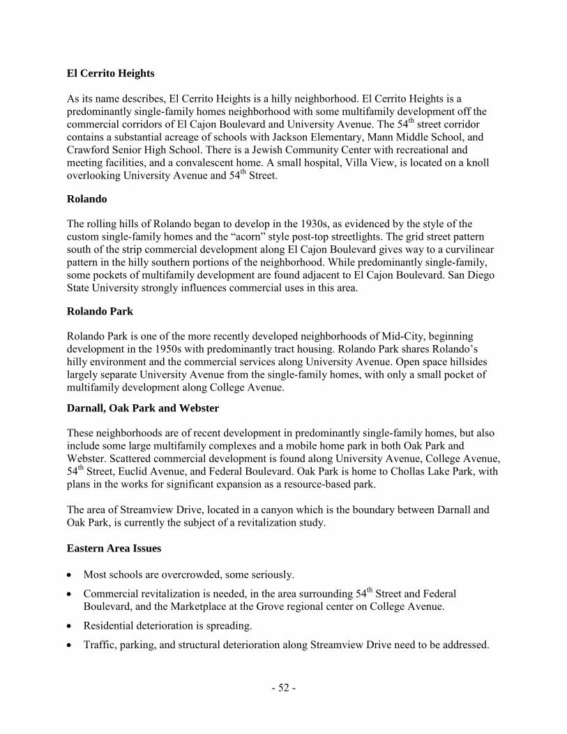
FIGURE 12. EASTERN AREA VISION MAP
FIGURE 13 EASTERN AREA COMMUNITY PLAN MAP
Related Documents